Embed Size (px)
Citation preview
DEPARTMENT OF TRANSPORTATION STATE OF GEORGIA
PROJECT CONCEPT REPORT Project Type: Intersection
Improvement P.I. Number: 0012625
GDOT District: 7 County: Fulton
Federal Route Number: State Route Number: 9
Project Number: (if available)
This is an intersection improvement project at Bethany Bend at SR 9.
Submitted for approval:
Consultant Designer & Firm or GDOT Concept/Design Phase Office Head & Office DATE
Local Government (if applicable) DATE
State Program Delivery Engineer DATE
GDOT Project Manager DATE
Recommendation for approval: (Delete any inapplicable signature lines)
State Environmental Administrator Date
State Traffic Engineer Date
Project Review Engineer Date
State Utilities Engineer Date
District Engineer Date
MPO Area: This project is consistent with the MPO adopted Regional Transportation Plan
(RTP)/Long Range Transportation Plan (LRTP). Rural Area: This project is consistent with the goals outlined in the Statewide
Transportation Plan (SWTP) and/or is included in the State Transportation Improvement Program (STIP).
State Transportation Planning Administrator Date
Project Concept Report – Page 2 P.I. Number: 0012625
County: Fulton
PROJECT LOCATION MAP
LOCATION SKETCH (not to scale)
Project PI No.: 0012625
Fulton County
City of Milton
Intersection of Bethany
Bend and SR 9
Project Concept Report – Page 3 P.I. Number: 0012625
County: Fulton
PLANNING AND BACKGROUND
Project Justification Statement:
This document is prepared for GDOT Office of Planning by Pond & Company. This report was prepared in
conjunction with PI 0007838, the widening of SR 9 from Windward Pkwy to the Forsyth County line.
The existing intersection is located where the arterial roadways SR 9 (Alpharetta Highway) and Bethany
Bend meet at an acute skew angle. The skew is the primary cause of several concerns related to sight
distance, crashes, and pedestrian safety. The intersection currently experiences a high rate of accidents
when compared to other intersections within Milton. This can be attributed to the substandard intersection
geometry. Also as a result of the intersection’s acute skew angle, left turn paths from the north and south
approaches are very close to one another while left turn paths from the east and west are excessively acute.
Additionally, vehicles going across the intersection must travel for a longer distance in order to traverse the
intersection. This prolonged exposure in the intersection is an operational and safety issue. Lastly,
pedestrian traffic is high at the intersection and pedestrian crosswalks are exposed and not readily visible to
drivers due to the skew.
The area has also seen a steady increase in population growth that is supported by various infrastructure
projects already constructed and others that are planned. Cambridge High School was opened in 2012 and
is located west of the intersection along Bethany Bend Rd. A planned new interchange at McGinnis Ferry
Road and SR 400 has the potential to further drive traffic and growth in development. These and other
commercial developments in the area would bring more vehicles through the intersection, which would
potentially increase the already high number of accidents. This intersection was ranked 2nd for most crashes
and 3rd for most injuries in Milton for the years 2006-2008 per the City of Milton’s Transportation Plan of
2009. Furthermore, the latest crash data for the years 2009- 2013 suggest a growing trend of more crashes
occurring year after year as shown in attachment titled Crash Summaries.
The project was identified in the City of Milton’s Comprehensive Transportation Plan of 2009, prioritized in
the ARC funded Highway 9/GA 400 Area Master Plan Livable Centers Initiative Study (LCI) and later
introduced in ARC’s Transportation Improvement Program of 2012-2017 with project number FN-280. The
City of Milton applied for the concept study funding in mid 2012 and received funding approval late 2012.
This project is currently funded up through the concept phase; however, funding is being sought for
construction. The project initially intended to fully address the skew problems; however, limited funding and
scheduling between this project and others, namely PI 007838, required the project’s scope to be reduced
and address some of the operational issues. This project considered to repurpose PI 0007838’s
environmental document findings in order to avoid redundant work efforts. PI 0007838 has a scheduled
environmental document approval of 2017 and a construction let date of 2020 which gives a short amount
of time for the implementation of major improvements at the intersection. Even if this project would be
delivered within that time frame it was estimated that it would be constructed by 2019, only a year prior to
SR 9 widening. Other issues reduced the initial scope. These issues included the potential of extend
disruption in traffic due to the construction of projects in such a short time period, and the multiple right-of-
way negotiations efforts. PI 0007838 would address the intersection’s greater issue which is the adverse
skew. The project looks to minimize the high rate of rear end collisions, improve vehicular and pedestrian
safety in this highly traveled part of the city, and improve traffic flow at the intersection.
Project Concept Report – Page 4 P.I. Number: 0012625
County: Fulton
Existing conditions: The existing intersection between Bethany Bend and SR 9 is located in Fulton County in
the City of Milton. The intersecting arterial roadways meet at an acute angle of 30˚; which does not meet
current skew requirements. SR 9 and Bethany Bend Rd have one lane in each direction at the intersection,
and dedicated left turn lanes at all approaches. There is curb and gutter and sidewalk on either side of both
roadways with crosswalks on all legs. There are 3 quadrants of the intersection which are developed; the
northeast quadrant is currently undeveloped.
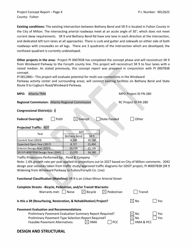
Other projects in the area: Project PI 0007838 has completed the concept phase and will reconstruct SR 9 from Windward Parkway to the Forsyth county line. This project will reconstruct SR 9 to four lanes with a raised median. As stated previously, this concept report was prepared in conjunction with PI 0007838 concept. PI 0012881– This project will evaluate potential for multi-use connections in the Windward Parkway activity center and surrounding areas; will connect existing facilities on Bethany Bend and State Route 9 to Cogburn Road/Windward Parkway. MPO: Atlanta TMA MPO Project ID FN-280 Regional Commission: Atlanta Regional Commission RC Project ID FN-280 Congressional District(s): 6 Federal Oversight: PoDI Exempt State Funded Other Projected Traffic: ADT
Traffic Projections Performed by: Pond & Company Note: 1.6% growth rate per year applied to projections out to 2027 based on City of Milton comments. 2042 design year volumes taken from traffic study/approved traffic diagrams for GDOT project, PI #0007838 (SR 9 Widening from Windward Parkway to Fulton/Forsyth Co. Line) Functional Classification (Mainline): SR 9 is an Urban Minor Arterial Street Complete Streets - Bicycle, Pedestrian, and/or Transit Warrants:
Warrants met: None Bicycle Pedestrian Transit
Is this a 3R (Resurfacing, Restoration, & Rehabilitation) Project? No Yes Pavement Evaluation and Recommendations
Preliminary Pavement Evaluation Summary Report Required? No Yes Preliminary Pavement Type Selection Report Required? No Yes Feasible Pavement Alternatives: HMA PCC HMA & PCC
DESIGN AND STRUCTURAL
Bethany Bend SR 9
Current Year (2013) 8,190 20,130
Expected Open Year (2017) 8,727 21,450
Interim Design Year (2027) 10,228 25,139
SR 9 PI #0007838 Design Year (2042) 13,070 34,180
YearADT
Project Concept Report – Page 5 P.I. Number: 0012625
County: Fulton
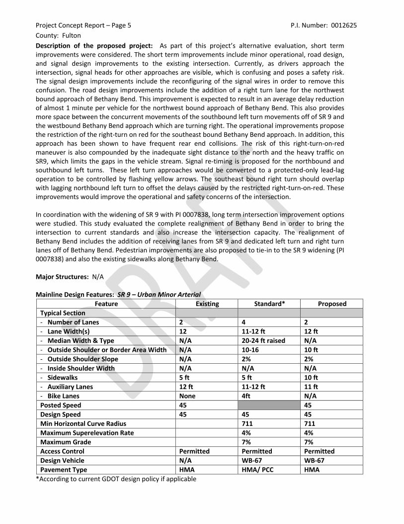
Description of the proposed project: As part of this project’s alternative evaluation, short term improvements were considered. The short term improvements include minor operational, road design, and signal design improvements to the existing intersection. Currently, as drivers approach the intersection, signal heads for other approaches are visible, which is confusing and poses a safety risk. The signal design improvements include the reconfiguring of the signal wires in order to remove this confusion. The road design improvements include the addition of a right turn lane for the northwest bound approach of Bethany Bend. This improvement is expected to result in an average delay reduction of almost 1 minute per vehicle for the northwest bound approach of Bethany Bend. This also provides more space between the concurrent movements of the southbound left turn movements off of SR 9 and the westbound Bethany Bend approach which are turning right. The operational improvements propose the restriction of the right-turn on red for the southeast bound Bethany Bend approach. In addition, this approach has been shown to have frequent rear end collisions. The risk of this right-turn-on-red maneuver is also compounded by the inadequate sight distance to the north and the heavy traffic on SR9, which limits the gaps in the vehicle stream. Signal re-timing is proposed for the northbound and southbound left turns. These left turn approaches would be converted to a protected-only lead-lag operation to be controlled by flashing yellow arrows. The southeast bound right turn should overlap with lagging northbound left turn to offset the delays caused by the restricted right-turn-on-red. These improvements would improve the operational and safety concerns of the intersection. In coordination with the widening of SR 9 with PI 0007838, long term intersection improvement options were studied. This study evaluated the complete realignment of Bethany Bend in order to bring the intersection to current standards and also increase the intersection capacity. The realignment of Bethany Bend includes the addition of receiving lanes from SR 9 and dedicated left turn and right turn lanes off of Bethany Bend. Pedestrian improvements are also proposed to tie-in to the SR 9 widening (PI 0007838) and also the existing sidewalks along Bethany Bend. Major Structures: N/A Mainline Design Features: SR 9 – Urban Minor Arterial
Feature Existing Standard* Proposed
Typical Section
- Number of Lanes 2 4 2
- Lane Width(s) 12 11-12 ft 12 ft
- Median Width & Type N/A 20-24 ft raised N/A
- Outside Shoulder or Border Area Width N/A 10-16 10 ft
- Outside Shoulder Slope N/A 2% 2%
- Inside Shoulder Width N/A N/A N/A
- Sidewalks 5 ft 5 ft 10 ft
- Auxiliary Lanes 12 ft 11-12 ft 11 ft
- Bike Lanes None 4ft N/A
Posted Speed 45 45
Design Speed 45 45 45
Min Horizontal Curve Radius 711 711
Maximum Superelevation Rate 4% 4%
Maximum Grade 7% 7%
Access Control Permitted Permitted Permitted
Design Vehicle N/A WB-67 WB-67
Pavement Type HMA HMA/ PCC HMA
*According to current GDOT design policy if applicable
Project Concept Report – Page 6 P.I. Number: 0012625
County: Fulton
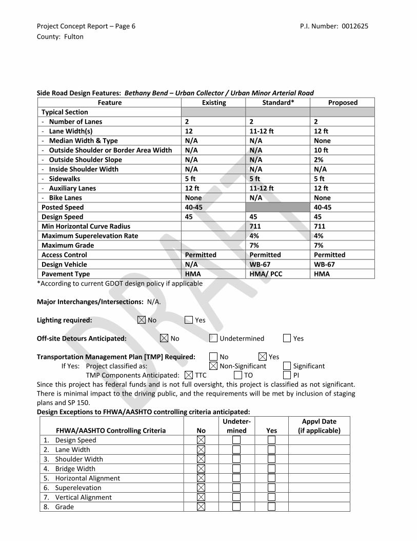
Side Road Design Features: Bethany Bend – Urban Collector / Urban Minor Arterial Road
Feature Existing Standard* Proposed
Typical Section
- Number of Lanes 2 2 2
- Lane Width(s) 12 11-12 ft 12 ft
- Median Width & Type N/A N/A None
- Outside Shoulder or Border Area Width N/A N/A 10 ft
- Outside Shoulder Slope N/A N/A 2%
- Inside Shoulder Width N/A N/A N/A
- Sidewalks 5 ft 5 ft 5 ft
- Auxiliary Lanes 12 ft 11-12 ft 12 ft
- Bike Lanes None N/A None
Posted Speed 40-45 40-45
Design Speed 45 45 45
Min Horizontal Curve Radius 711 711
Maximum Superelevation Rate 4% 4%
Maximum Grade 7% 7%
Access Control Permitted Permitted Permitted
Design Vehicle N/A WB-67 WB-67
Pavement Type HMA HMA/ PCC HMA
*According to current GDOT design policy if applicable Major Interchanges/Intersections: N/A. Lighting required: No Yes Off-site Detours Anticipated: No Undetermined Yes Transportation Management Plan [TMP] Required: No Yes
If Yes: Project classified as: Non-Significant Significant TMP Components Anticipated: TTC TO PI
Since this project has federal funds and is not full oversight, this project is classified as not significant. There is minimal impact to the driving public, and the requirements will be met by inclusion of staging plans and SP 150. Design Exceptions to FHWA/AASHTO controlling criteria anticipated:
FHWA/AASHTO Controlling Criteria No Undeter-
mined Yes Appvl Date
(if applicable)
1. Design Speed
2. Lane Width
3. Shoulder Width
4. Bridge Width
5. Horizontal Alignment
6. Superelevation
7. Vertical Alignment
8. Grade
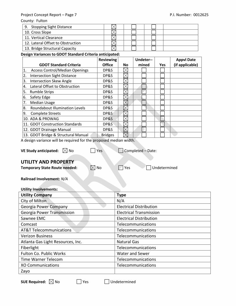
Project Concept Report – Page 7 P.I. Number: 0012625
County: Fulton
9. Stopping Sight Distance
10. Cross Slope
11. Vertical Clearance
12. Lateral Offset to Obstruction
13. Bridge Structural Capacity
Design Variances to GDOT Standard Criteria anticipated:
GDOT Standard Criteria Reviewing
Office No Undeter--
mined Yes Appvl Date
(if applicable)
1. Access Control/Median Openings DP&S
2. Intersection Sight Distance DP&S
3. Intersection Skew Angle DP&S
4. Lateral Offset to Obstruction DP&S
5. Rumble Strips DP&S
6. Safety Edge DP&S
7. Median Usage DP&S
8. Roundabout Illumination Levels DP&S
9. Complete Streets DP&S
10. ADA & PROWAG DP&S
11. GDOT Construction Standards DP&S
12. GDOT Drainage Manual DP&S
13. GDOT Bridge & Structural Manual Bridges
A design variance will be required for the proposed median width. VE Study anticipated: No Yes Completed – Date:
UTILITY AND PROPERTY Temporary State Route needed: No Yes Undetermined
Railroad Involvement: N/A Utility Involvements:
Utility Company Type
City of Milton N/A
Georgia Power Company Electrical Distribution
Georgia Power Transmission Electrical Transmission
Sawnee EMC Electrical Distribution
Comcast Telecommunications
AT&T Telecommunications Telecommunications
Verizon Business Telecommunications
Atlanta Gas Light Resources, Inc. Natural Gas
Fiberlight Telecommunications
Fulton Co. Public Works Water and Sewer
Time Warner Telecom Telecommunications
XO Communications Telecommunications
Zayo SUE Required: No Yes Undetermined
Project Concept Report – Page 8 P.I. Number: 0012625
County: Fulton
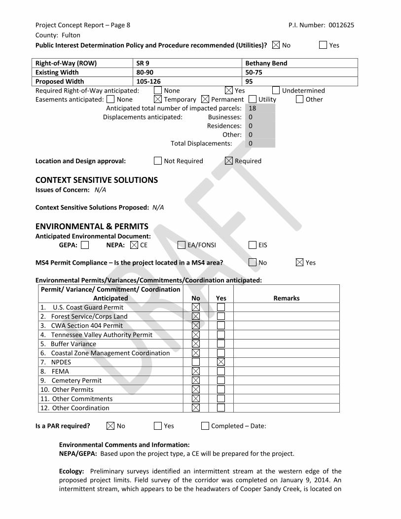
Public Interest Determination Policy and Procedure recommended (Utilities)? No Yes
Right-of-Way (ROW) SR 9 Bethany Bend
Existing Width 80-90 50-75
Proposed Width 105-126 95
Required Right-of-Way anticipated: None Yes Undetermined Easements anticipated: None Temporary Permanent Utility Other
Anticipated total number of impacted parcels: 18 Displacements anticipated: Businesses: 0
Residences: 0 Other: 0
Total Displacements: 0 Location and Design approval: Not Required Required
CONTEXT SENSITIVE SOLUTIONS Issues of Concern: N/A Context Sensitive Solutions Proposed: N/A
ENVIRONMENTAL & PERMITS Anticipated Environmental Document: GEPA: NEPA: CE EA/FONSI EIS MS4 Permit Compliance – Is the project located in a MS4 area? No Yes Environmental Permits/Variances/Commitments/Coordination anticipated:
Permit/ Variance/ Commitment/ Coordination Anticipated No Yes Remarks
1. U.S. Coast Guard Permit
2. Forest Service/Corps Land
3. CWA Section 404 Permit
4. Tennessee Valley Authority Permit
5. Buffer Variance
6. Coastal Zone Management Coordination
7. NPDES
8. FEMA
9. Cemetery Permit
10. Other Permits
11. Other Commitments
12. Other Coordination
Is a PAR required? No Yes Completed – Date:
Environmental Comments and Information: NEPA/GEPA: Based upon the project type, a CE will be prepared for the project.
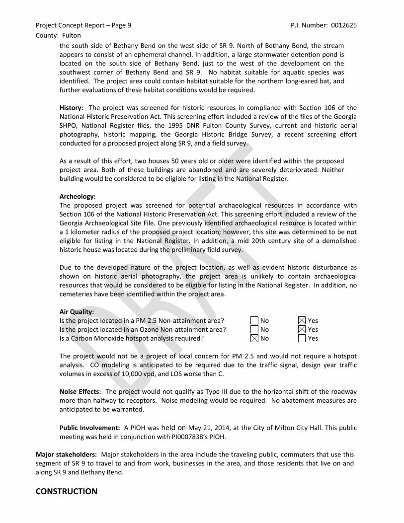
Ecology: Preliminary surveys identified an intermittent stream at the western edge of the proposed project limits. Field survey of the corridor was completed on January 9, 2014. An intermittent stream, which appears to be the headwaters of Cooper Sandy Creek, is located on
Project Concept Report – Page 9 P.I. Number: 0012625
County: Fulton
the south side of Bethany Bend on the west side of SR 9. North of Bethany Bend, the stream appears to consist of an ephemeral channel. In addition, a large stormwater detention pond is located on the south side of Bethany Bend, just to the west of the development on the southwest corner of Bethany Bend and SR 9. No habitat suitable for aquatic species was identified. The project area could contain habitat suitable for the northern long-eared bat, and further evaluations of these habitat conditions would be required. History: The project was screened for historic resources in compliance with Section 106 of the National Historic Preservation Act. This screening effort included a review of the files of the Georgia SHPO, National Register files, the 1995 DNR Fulton County Survey, current and historic aerial photography, historic mapping, the Georgia Historic Bridge Survey, a recent screening effort conducted for a proposed project along SR 9, and a field survey. As a result of this effort, two houses 50 years old or older were identified within the proposed project area. Both of these buildings are abandoned and are severely deteriorated. Neither building would be considered to be eligible for listing in the National Register. Archeology: The proposed project was screened for potential archaeological resources in accordance with Section 106 of the National Historic Preservation Act. This screening effort included a review of the Georgia Archaeological Site File. One previously identified archaeological resource is located within a 1 kilometer radius of the proposed project location; however, this site was determined to be not eligible for listing in the National Register. In addition, a mid 20th century site of a demolished historic house was located during the preliminary field survey. Due to the developed nature of the project location, as well as evident historic disturbance as shown on historic aerial photography, the project area is unlikely to contain archaeological resources that would be considered to be eligible for listing in the National Register. In addition, no cemeteries have been identified within the project area.
Air Quality: Is the project located in a PM 2.5 Non-attainment area? No Yes Is the project located in an Ozone Non-attainment area? No Yes Is a Carbon Monoxide hotspot analysis required? No Yes The project would not be a project of local concern for PM 2.5 and would not require a hotspot analysis. CO modeling is anticipated to be required due to the traffic signal, design year traffic volumes in excess of 10,000 vpd, and LOS worse than C. Noise Effects: The project would not qualify as Type III due to the horizontal shift of the roadway more than halfway to receptors. Noise modeling would be required. No abatement measures are anticipated to be warranted.
Public Involvement: A PIOH was held on May 21, 2014, at the City of Milton City Hall. This public meeting was held in conjunction with PI0007838’s PIOH.
Major stakeholders: Major stakeholders in the area include the traveling public, commuters that use this segment of SR 9 to travel to and from work, businesses in the area, and those residents that live on and along SR 9 and Bethany Bend.
CONSTRUCTION
Project Concept Report – Page 10 P.I. Number: 0012625
County: Fulton
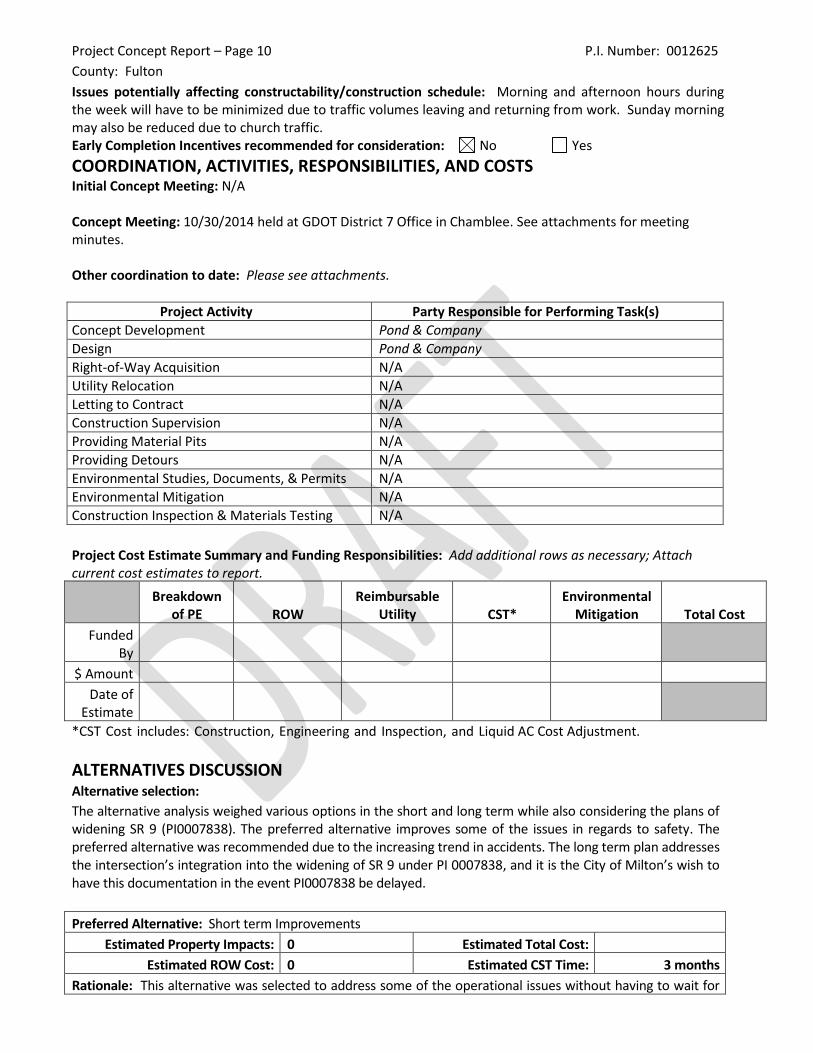
Issues potentially affecting constructability/construction schedule: Morning and afternoon hours during the week will have to be minimized due to traffic volumes leaving and returning from work. Sunday morning may also be reduced due to church traffic. Early Completion Incentives recommended for consideration: No Yes
COORDINATION, ACTIVITIES, RESPONSIBILITIES, AND COSTS Initial Concept Meeting: N/A Concept Meeting: 10/30/2014 held at GDOT District 7 Office in Chamblee. See attachments for meeting minutes. Other coordination to date: Please see attachments.
Project Activity Party Responsible for Performing Task(s)
Concept Development Pond & Company
Design Pond & Company
Right-of-Way Acquisition N/A
Utility Relocation N/A
Letting to Contract N/A
Construction Supervision N/A
Providing Material Pits N/A
Providing Detours N/A
Environmental Studies, Documents, & Permits N/A
Environmental Mitigation N/A
Construction Inspection & Materials Testing N/A
Project Cost Estimate Summary and Funding Responsibilities: Add additional rows as necessary; Attach current cost estimates to report.
Breakdown of PE ROW
Reimbursable Utility CST*
Environmental Mitigation Total Cost
Funded By
$ Amount
Date of Estimate
*CST Cost includes: Construction, Engineering and Inspection, and Liquid AC Cost Adjustment.
ALTERNATIVES DISCUSSION Alternative selection:
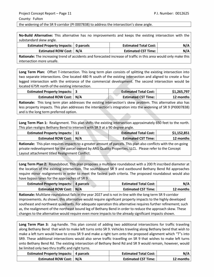
The alternative analysis weighed various options in the short and long term while also considering the plans of widening SR 9 (PI0007838). The preferred alternative improves some of the issues in regards to safety. The preferred alternative was recommended due to the increasing trend in accidents. The long term plan addresses the intersection’s integration into the widening of SR 9 under PI 0007838, and it is the City of Milton’s wish to have this documentation in the event PI0007838 be delayed.
Preferred Alternative: Short term Improvements
Estimated Property Impacts: 0 Estimated Total Cost:
Estimated ROW Cost: 0 Estimated CST Time: 3 months
Rationale: This alternative was selected to address some of the operational issues without having to wait for
Project Concept Report – Page 11 P.I. Number: 0012625
County: Fulton
the widening of the SR 9 corridor (PI 0007838) to address the intersection’s skew angle.
No-Build Alternative: This alternative has no improvements and keeps the existing intersection with the substandard skew angle.
Estimated Property Impacts: 0 parcels Estimated Total Cost: N/A
Estimated ROW Cost: N/A Estimated CST Time: N/A
Rationale: The increasing trend of accidents and forecasted increase of traffic in this area would only make this intersection more unsafe.
Long Term Plan: Offset T-intersection. This long term plan consists of splitting the existing intersection into two separate intersections. One located 480 ft south of the existing intersection and aligned to create a four legged intersection with the entrance of the commercial development. The second intersection would be located 675ft north of the existing intersection.
Estimated Property Impacts: 3 Estimated Total Cost: $1,265,797
Estimated ROW Cost: N/A Estimated CST Time: 12 months
Rationale: This long term plan addresses the existing intersection’s skew problem. This alternative also has less property impacts. This plan addresses the intersection’s integration into the widening of SR 9 (PI0007838) and is the long term preferred option.
Long Term Plan 1: Realignment. This plan shifts the existing intersection approximately 650 feet to the north. This plan realigns Bethany Bend to intersect with SR 9 at a 90 degree angle.
Estimated Property Impacts: 11 Estimated Total Cost: $1,152,851
Estimated ROW Cost: N/A Estimated CST Time: 12 months
Rationale: This plan requires impacts to a greater amount of parcels. This plan also conflicts with the on-going private redevelopment for the parcel owned by ARG Quality Properties, LLCL. Please refer to the Concept Layout attachment titled Realignment Conflict.
Long Term Plan 2: Roundabout. This plan proposes a multilane roundabout with a 200 ft inscribed diameter at the location of the existing intersection. The southbound SR 9 and eastbound Bethany Bend Rd approaches require minor realignments in order to meet the fastest path criteria. The proposed roundabout would also have bypass lanes for the approaches of SR 9.
Estimated Property Impacts: 4 parcels Estimated Total Cost: N/A
Estimated ROW Cost: N/A Estimated CST Time: 12 months
Rationale: Multilane roundabout fails in the year 2027 and is not in-line with the long term SR 9 corridor improvements. As shown, this alternative would require significant property impacts to the highly developed southeast and northwest quadrants. For adequate operation this alternative requires further refinement; such as, the realignment of the northeast bound leg of Bethany Bend in order to reduce the approach skew. These changes to the alternative would require even more impacts to the already significant impacts shown.
Long Term Plan 3: Jug-handle. This plan consist of adding two additional intersections for traffic traveling along Bethany Bend that wish to make left turns onto SR 9. Vehicles traveling along Bethany bend that wish to make a left turn would have to cross SR 9 and make a right turn onto the proposed alignment which “T”s into SR9. These additional intersections would also serve traffic travelling on SR 9 that wishes to make left turns onto Bethany Bend Rd. The existing intersection of Bethany Bend Rd and SR 9 would remain, however, would be limited only two thru traffic and right turns.
Estimated Property Impacts: 4 parcels Estimated Total Cost: N/A
Estimated ROW Cost: N/A Estimated CST Time: 12 months
Project Concept Report – Page 12 P.I. Number: 0012625
County: Fulton
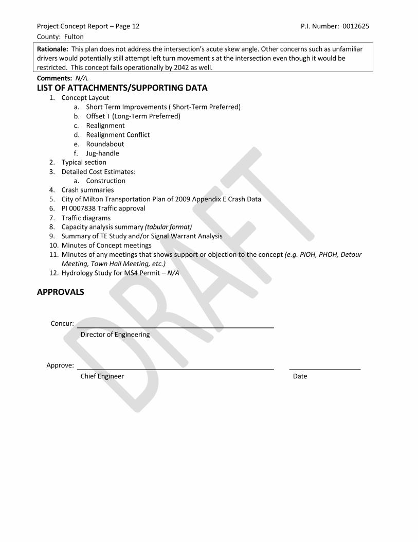
Rationale: This plan does not address the intersection’s acute skew angle. Other concerns such as unfamiliar drivers would potentially still attempt left turn movement s at the intersection even though it would be restricted. This concept fails operationally by 2042 as well.
Comments: N/A.
LIST OF ATTACHMENTS/SUPPORTING DATA 1. Concept Layout
a. Short Term Improvements ( Short-Term Preferred) b. Offset T (Long-Term Preferred) c. Realignment d. Realignment Conflict e. Roundabout f. Jug-handle
2. Typical section
3. Detailed Cost Estimates: a. Construction
4. Crash summaries 5. City of Milton Transportation Plan of 2009 Appendix E Crash Data 6. PI 0007838 Traffic approval
7. Traffic diagrams 8. Capacity analysis summary (tabular format) 9. Summary of TE Study and/or Signal Warrant Analysis 10. Minutes of Concept meetings 11. Minutes of any meetings that shows support or objection to the concept (e.g. PIOH, PHOH, Detour
Meeting, Town Hall Meeting, etc.) 12. Hydrology Study for MS4 Permit – N/A
APPROVALS
Concur:
Director of Engineering
Approve:
Chief Engineer Date
Project Concept Report – Page 20 P.I. Number: 0012625
County: Fulton
Attachements
4. Crash Summaries:
Crash reports from the most recent 5 and a half year period (2009-2014) reveal a total of 135 collisions in
the proximity of the intersection, and an average of 22 crashes per year. Table 1 below summarizes the
crash type and damage sustained for each year in the reporting period. Note that 2014 crash figures are
represented in Table 1 and include all reported incidents through June 30, 2014.
Table 1: Crash Summary, 2009-2014
Table 1 also reveals that over the previous 5 and a half year period, injuries occurred at a rate of approximately one injury per every 3.38 crashes. The most frequent type of collision at the intersection is rear-ends by a large margin (>80%). The crash data also suggests that no collision has involved a pedestrian during this timeframe, even though sightlines are poor and pedestrian traffic is high. The safety concerns that justify this project should be addressed as soon as possible to avoid a potential serious injury or fatal crash involving a pedestrian. A second observed condition at the site is the poor sight distance for right turning vehicles on the south-eastbound approach of Bethany Bend. A potential for high rear-end collisions exists here due to the permitted right turn on red condition paired with poor sight distance. Gaps in traffic on SR 9 during peak hours are limited, and drivers making right turns into traffic flow with infrequent gaps will often hesitate and decide that the gap is not acceptable for the right turn to be completed safely. The following vehicle’s driver may see the lead car moving forward as if to complete the right turn and he or she may anticipate pulling up into the lead position at the stop bar, which can result in rear ends if the lead car suddenly stops because the turn cannot be made. Table 2 below illustrates collisions that occurred on either approach of Bethany Bend. Note that rear-end collisions are the dominant type of crash. Of the 27 rear-end crashes that occur on the south-eastbound approach 13 (48%) involved at least one right-turning vehicle. Prohibiting the right-turn-on-red condition should reduce the frequency of rear-end collisions. Table 2: Crash Summary, Bethany Bend Approaches, 2009-2014
Right
Angle Left Turn
Rear
Ending
Single
Vehicle Other Injuries Fatalaties
Prop. Damage
Only
2014 13 0 0 13 0 0 6 0 7
2013 39 0 2 35 2 0 8 0 31
2012 39 0 2 29 3 5 12 0 30
2011 17 0 1 14 2 0 4 0 13
2010 21 2 3 13 1 2 9 0 13
2009 6 0 0 5 0 1 1 0 5
Total 135 2 8 109 8 8 40 0 99
Total Number
of Incidents
Accident Type Damage
Right
AngleLeft Turn
Rear
Ending
Single
VehicleOther Injuries Fatalaties
Prop. Damage
Only
SEB 31 0 0 27 2 2 9 0 24
NWB 17 0 2 11 3 1 5 0 12
Accident Type DamageTotal Number
of IncidentsDirection
Bethany Bend