Embed Size (px)
Citation preview
DEPARTMENT OF TRANSPORTATION STATE OF GEORGIA
PROJECT CONCEPT REPORT Project Type: Reconstruction/Rehabilitation P.I. Number: 621690
GDOT District: 6 County: Floyd
Federal Route Number: N/A State Route Number: 101
Project Number: STP00-0167-01(013)
SR 101 Widening from 600 feet North of McCord Road to Lombardy Way
Submitted for approval:
Scott Shelton, P.E. – Gresham Smith & Partners DATE
Local Government (if applicable) DATE
State Program Delivery Engineer DATE
GDOT Project Manager DATE
Recommendation for approval: (Delete any inapplicable signature lines)
Program Control Administrator DATE
State Environmental Administrator DATE
State Traffic Engineer DATE
Project Review Engineer DATE
State Utilities Engineer DATE
District Engineer DATE
State Bridge Design Engineer DATE
State Transportation Financial Management Administrator DATE
The concept as presented herein and submitted for approval is consistent with that which is included in the Regional Transportation Plan (RTP) and/or the State Transportation Improvement Program (STIP).
State Transportation Planning Administrator DATE
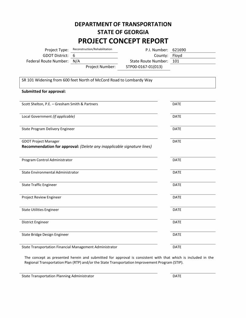
Project Concept Report P.I. Number: 621690
County: Floyd
PROJECT LOCATION MAP
Project Concept Report P.I. Number: 621690
County: Floyd
PLANNING AND BACKGROUND
Project Justification Statement: The proposed project is part of a series of SR 101 projects that each
consist of the widening of SR 101 in order to improve mobility and create a safer roadway
corridor for the growing southern portion of Floyd County. In 1994, the GDOT Office of Planning
performed a study of the entire SR 101 corridor and recommended the route be widened in order
to maintain an acceptable Level of Service (LOS) over the following 20 years. The project was
programmed by GDOT in 1999 and was also added to the Floyd/Rome 2006-2008 Transportation
Improvement Plan (TIP) as project S-92-25.
Currently, the proposed project is listed in the Floyd/Rome 2040 Long Range Transportation Plan
(LRTP) as a short-term priority project scheduled to complete Preliminary Engineering (PE)
between 2016 and 2022. The proposed project is also listed as a mid-term priority project
scheduled to complete right-of-way (ROW) acquisition and construction (CST) between 2023 and
2029.
Existing conditions: This section of SR 101 is currently a 2 lane roadway.
Other projects in the area:
P.I. 0000400 – SR 101 Widening from South Rome Bypass to McCord Road (CR 740)
P.I. 0000401– SR 101 Widening from Pleasant Hope Road (CR 57) to South Rome Bypass
P.I. 0000406 – SR 101 from SR 6/US 278 (Polk Co) to Pleasant Hope Church Road (CR 57)
(Floyd Co)
P.I. 632760 – SR 101 Dean Avenue at SR 1/SR 20/SR 53/US 411 Interchange Reconstruction
in Rome
P.I. 620900 – SR 101/ S of Rome over SR 20
P.I. 662420 – SE Rome Bypass from SR 101 NE on new location to US 411
P.I. 621600 – S Rome Bypass/US 27 from SR 1 along Booze Mountain Road to SR 101 at CR 96
MPO: Floyd - Rome Urban Transportation Study (FRUTS) MPO Project ID S-92-25 Regional Commission: Northwest Georgia RC RC Project ID 05 Congressional District(s): 14 Federal Oversight: Full Oversight Exempt State Funded Other Projected Traffic: AADT
Current Year (2013): 11,800 Open Year (2021): 13,550 Design Year (2041): 19,250 Traffic Projections Performed by: Michael Baker Corp Functional Classification (Mainline): Urban Minor Arterial Street
Project Concept Report P.I. Number: 621690
County: Floyd
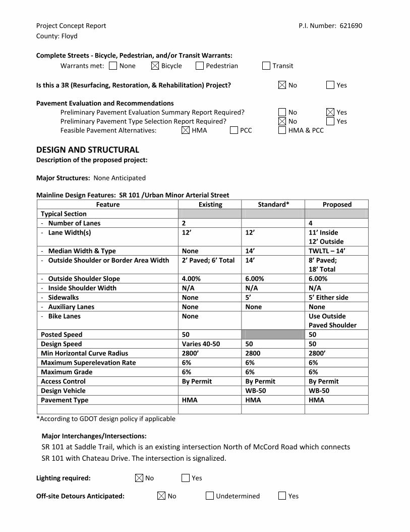
Complete Streets - Bicycle, Pedestrian, and/or Transit Warrants:
Warrants met: None Bicycle Pedestrian Transit
Is this a 3R (Resurfacing, Restoration, & Rehabilitation) Project? No Yes Pavement Evaluation and Recommendations
Preliminary Pavement Evaluation Summary Report Required? No Yes Preliminary Pavement Type Selection Report Required? No Yes Feasible Pavement Alternatives: HMA PCC HMA & PCC
DESIGN AND STRUCTURAL Description of the proposed project: Major Structures: None Anticipated
Mainline Design Features: SR 101 /Urban Minor Arterial Street
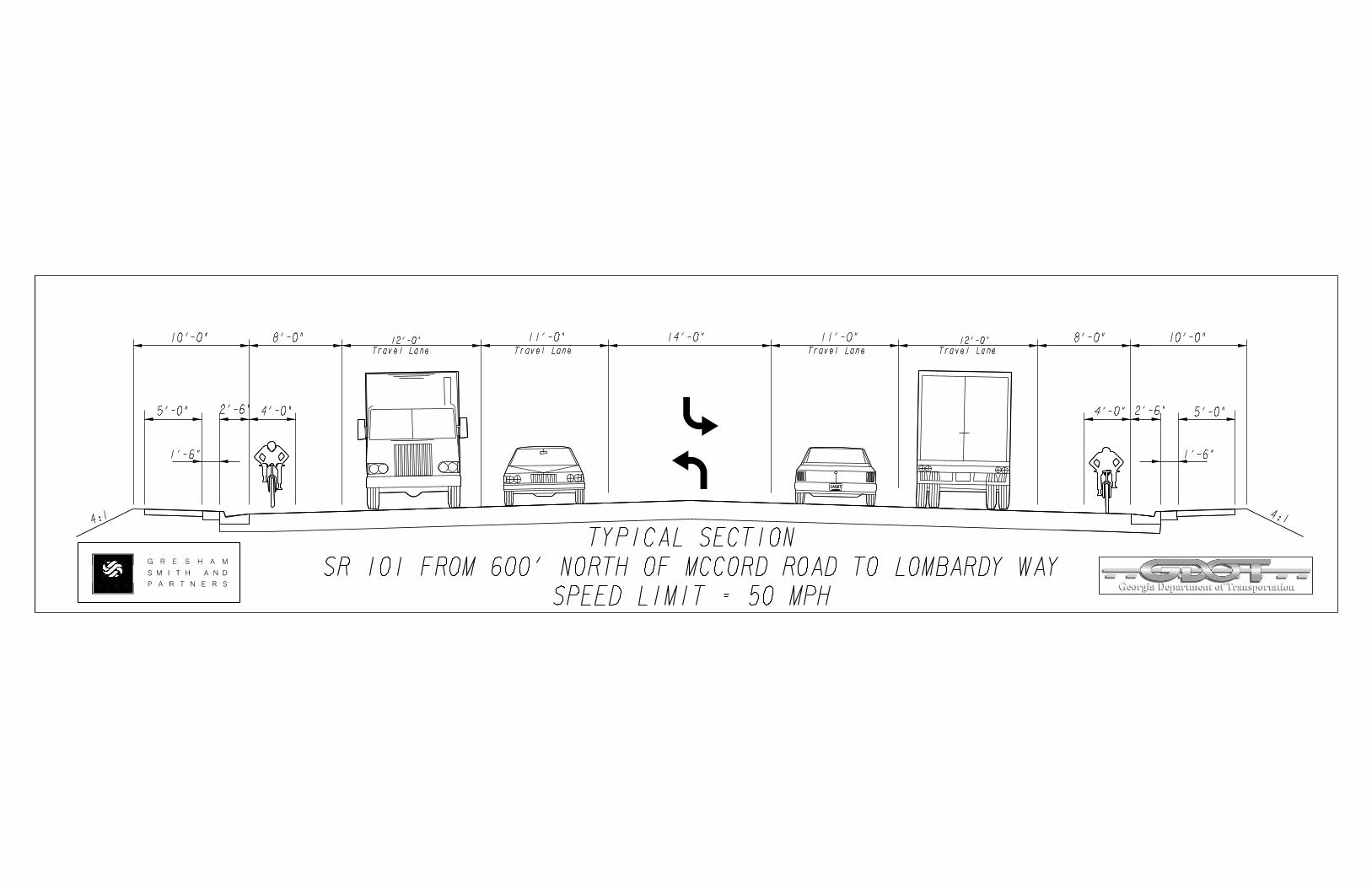
Feature Existing Standard* Proposed
Typical Section
- Number of Lanes 2 4
- Lane Width(s) 12’ 12’ 11’ Inside 12’ Outside
- Median Width & Type None 14’ TWLTL – 14’
- Outside Shoulder or Border Area Width 2’ Paved; 6’ Total 14’ 8’ Paved; 18’ Total
- Outside Shoulder Slope 4.00% 6.00% 6.00%
- Inside Shoulder Width N/A N/A N/A
- Sidewalks None 5’ 5’ Either side
- Auxiliary Lanes None None None
- Bike Lanes None Use Outside Paved Shoulder
Posted Speed 50 50
Design Speed Varies 40-50 50 50
Min Horizontal Curve Radius 2800’ 2800 2800’
Maximum Superelevation Rate 6% 6% 6%
Maximum Grade 6% 6% 6%
Access Control By Permit By Permit By Permit
Design Vehicle WB-50 WB-50
Pavement Type HMA HMA HMA
*According to GDOT design policy if applicable
Major Interchanges/Intersections:
SR 101 at Saddle Trail, which is an existing intersection North of McCord Road which connects
SR 101 with Chateau Drive. The intersection is signalized.
Lighting required: No Yes Off-site Detours Anticipated: No Undetermined Yes
Project Concept Report P.I. Number: 621690
County: Floyd
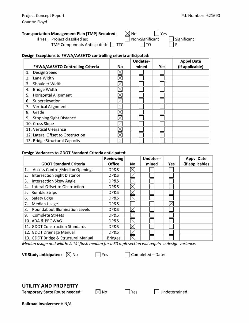
Transportation Management Plan [TMP] Required: No Yes
If Yes: Project classified as: Non-Significant Significant TMP Components Anticipated: TTC TO PI
Design Exceptions to FHWA/AASHTO controlling criteria anticipated:
FHWA/AASHTO Controlling Criteria No Undeter-
mined Yes Appvl Date
(if applicable)
1. Design Speed
2. Lane Width
3. Shoulder Width
4. Bridge Width
5. Horizontal Alignment
6. Superelevation
7. Vertical Alignment
8. Grade
9. Stopping Sight Distance
10. Cross Slope
11. Vertical Clearance
12. Lateral Offset to Obstruction
13. Bridge Structural Capacity
Design Variances to GDOT Standard Criteria anticipated:
GDOT Standard Criteria Reviewing
Office No Undeter--
mined Yes Appvl Date
(if applicable)
1. Access Control/Median Openings DP&S
2. Intersection Sight Distance DP&S
3. Intersection Skew Angle DP&S
4. Lateral Offset to Obstruction DP&S
5. Rumble Strips DP&S
6. Safety Edge DP&S
7. Median Usage DP&S
8. Roundabout Illumination Levels DP&S
9. Complete Streets DP&S
10. ADA & PROWAG DP&S
11. GDOT Construction Standards DP&S
12. GDOT Drainage Manual DP&S
13. GDOT Bridge & Structural Manual Bridges
Median usage and width: A 14’ flush median for a 50 mph section will require a design variance. VE Study anticipated: No Yes Completed – Date:
UTILITY AND PROPERTY Temporary State Route needed: No Yes Undetermined
Railroad Involvement: N/A
Project Concept Report P.I. Number: 621690
County: Floyd
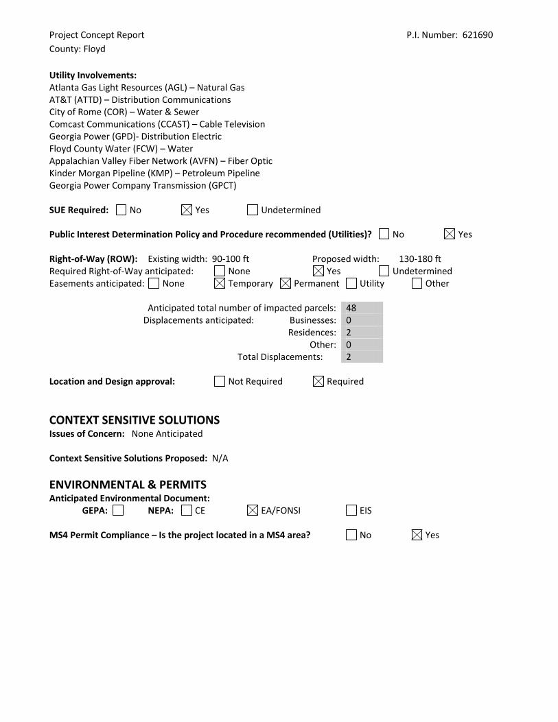
Utility Involvements: Atlanta Gas Light Resources (AGL) – Natural Gas AT&T (ATTD) – Distribution Communications City of Rome (COR) – Water & Sewer Comcast Communications (CCAST) – Cable Television Georgia Power (GPD)- Distribution Electric Floyd County Water (FCW) – Water Appalachian Valley Fiber Network (AVFN) – Fiber Optic Kinder Morgan Pipeline (KMP) – Petroleum Pipeline Georgia Power Company Transmission (GPCT) SUE Required: No Yes Undetermined Public Interest Determination Policy and Procedure recommended (Utilities)? No Yes Right-of-Way (ROW): Existing width: 90-100 ft Proposed width: 130-180 ft Required Right-of-Way anticipated: None Yes Undetermined Easements anticipated: None Temporary Permanent Utility Other
Anticipated total number of impacted parcels: 48 Displacements anticipated: Businesses: 0
Residences: 2 Other: 0
Total Displacements: 2 Location and Design approval: Not Required Required
CONTEXT SENSITIVE SOLUTIONS Issues of Concern: None Anticipated Context Sensitive Solutions Proposed: N/A
ENVIRONMENTAL & PERMITS Anticipated Environmental Document: GEPA: NEPA: CE EA/FONSI EIS MS4 Permit Compliance – Is the project located in a MS4 area? No Yes
Project Concept Report P.I. Number: 621690
County: Floyd
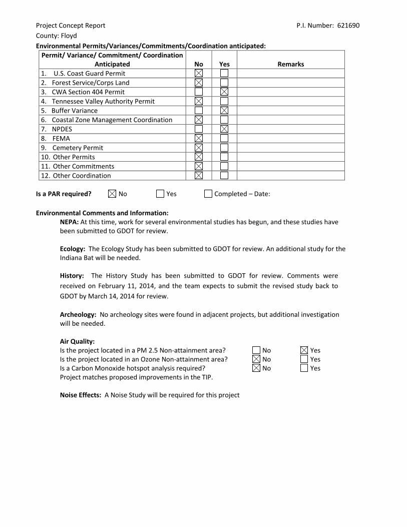
Environmental Permits/Variances/Commitments/Coordination anticipated:
Permit/ Variance/ Commitment/ Coordination Anticipated No Yes Remarks
1. U.S. Coast Guard Permit
2. Forest Service/Corps Land
3. CWA Section 404 Permit
4. Tennessee Valley Authority Permit
5. Buffer Variance
6. Coastal Zone Management Coordination
7. NPDES
8. FEMA
9. Cemetery Permit
10. Other Permits
11. Other Commitments
12. Other Coordination
Is a PAR required? No Yes Completed – Date:
Environmental Comments and Information:
NEPA: At this time, work for several environmental studies has begun, and these studies have been submitted to GDOT for review.
Ecology: The Ecology Study has been submitted to GDOT for review. An additional study for the Indiana Bat will be needed. History: The History Study has been submitted to GDOT for review. Comments were
received on February 11, 2014, and the team expects to submit the revised study back to
GDOT by March 14, 2014 for review.
Archeology: No archeology sites were found in adjacent projects, but additional investigation will be needed.
Air Quality: Is the project located in a PM 2.5 Non-attainment area? No Yes Is the project located in an Ozone Non-attainment area? No Yes Is a Carbon Monoxide hotspot analysis required? No Yes Project matches proposed improvements in the TIP.
Noise Effects: A Noise Study will be required for this project
Project Concept Report P.I. Number: 621690
County: Floyd
Public Involvement:
Stakeholder Meeting with Floyd County School Board – May 13, 2013
The school board expressed their concern about the impacts of this project to
the buses travelling the corridor and the school located on the project. They
named several side streets that need attention as well as other areas of
concern. (Meeting Minutes are attached.)
Stakeholder Meeting with Emergency services – May 13, 2013
Emergency services described many of the common accidents type and locations
that have occurred along the corridor. They identified problem areas where they
would like to see improvements. (Meeting Minutes are attached.)
Stakeholder Meeting with Rome Staff/Elected Officials and Floyd County Staff –
July 25, 2013 The staff and local officials’ did not have many comments
concerning the widening of this portion of SR 101. (Meeting Minutes are
attached.)
Public Interest Open House – November 19, 2013
163 people attended the meeting to learn about the project and offer
comments. Overall the public was in support of the project due to safety
concerns. The comments collected that were against the project focused
mostly on impacts to properties. (Synopsis is attached.)
Major stakeholders: Traveling public, Floyd County Schools and churches along the
corridor
CONSTRUCTION Issues potentially affecting constructability/construction schedule: None at this time Early Completion Incentives recommended for consideration: No Yes
COORDINATION, ACTIVITIES, RESPONSIBILITIES, AND COSTS Initial Concept Meeting:
Initial Concept Team Meeting was held May 21, 2013. This meeting introduced the project
to the district staff. The South Rome Bypass projects were discussed and how they would
impact this project. (Meeting minutes are attached.)
Concept Meeting: April 2014. Other coordination to date: N/A
Project Concept Report P.I. Number: 621690
County: Floyd
Project Activity Party Responsible for Performing Task(s)
Concept Development Gresham, Smith, and Partners
Design GDOT
Right-of-Way Acquisition GDOT
Utility Relocation GDOT
Letting to Contract GDOT
Construction Supervision GDOT
Providing Material Pits GDOT
Providing Detours GDOT
Environmental Studies, Documents, & Permits GDOT
Environmental Mitigation GDOT
Construction Inspection & Materials Testing GDOT
Project Cost Estimate Summary and Funding Responsibilities:
Breakdown of PE ROW
Reimbursable Utility CST*
Environmental Mitigation Total Cost
Funded By
$ Amount $9,364,670
Date of Estimate
3/5/2014
*CST Cost includes: Construction, Engineering and Inspection, and Liquid AC Cost Adjustment.
ALTERNATIVES DISCUSSION Alternative selection:
Preferred Alternative: Widen SR 101 from 2 lane roadway to four lane roadway with two-way left turn lane from McCord Road to Lombardy Way
Estimated Property Impacts: Estimated Total Cost:
Estimated ROW Cost: Estimated CST Time:
Rationale: Met the project requirements with most cost effective design
No-Build Alternative: None
Estimated Property Impacts: 0 Estimated Total Cost: 0
Estimated ROW Cost: 0 Estimated CST Time: 0
Rationale: This Alternative does nothing to help improve the safety of the roadway or any other purpose to the project.
Alternative 1: Widen SR 101 from 2 lane roadway to four lane roadway with raised concrete median from McCord Drive to Lombardy Way.
Estimated Property Impacts: Estimated Total Cost:
Estimated ROW Cost: Estimated CST Time:
Rationale: This was not considered a viable alternative due to additional impacts to meet the speed design of 50 mph and is not recommended per the GDOT design policy manual for 50 mph. Average travel speeds did not warrant lowering the speed to 45 mph.
Project Concept Report P.I. Number: 621690
County: Floyd
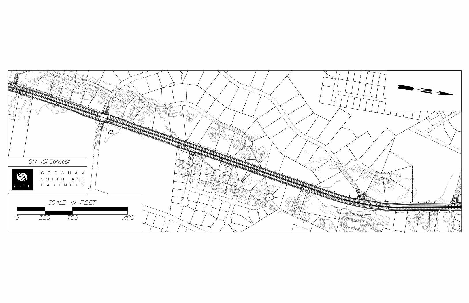
LIST OF ATTACHMENTS/SUPPORTING DATA (List supporting data in attached order) 1. Concept Layout 2. Typical sections
3. Detailed Cost Estimates: a. Construction including Engineering and Inspection b. Completed Fuel & Asphalt Price Adjustment forms c. Right-of-Way d. Utilities
e. Environmental Mitigation (EPD, etc) 4. Crash summaries
5. Traffic diagrams 6. Capacity analysis summary (tabular format) 7. Hydrology Study for MS4 Permit (if applicable) 8. Pavement studies (e.g. Preliminary Pavement Type Selection Report, etc.) 9. Minutes of Concept meetings 10. Minutes of Stakeholder meetings
APPROVALS
Concur:
Director of Engineering
Approve:
Chief Engineer Date
SR 101
SR 101
SR 101
119+00
SR 101
120+00
McC
OR
D
DRIV
E
CS740
121+00
122+00
Curve# 1
123+00
SR 101
124+00
125+00
Curve# 1
126+00
127+00
Curve# 2
128+00
129+00
SR 101
130+00
Curve# 2
SA
DD
LE
TR
AIL
131+00
132+00
133+00
134+00
Curve# 3
SR 101
135+00
136+00
137+00
SA
DD
LE
TR
AIL
138+00
Curve# 3
139+00
140+00
141+00
Curve# 3
SR 101
142+00
143+00
144+00
145+00
146+00
SR 101
147+00
148+00
149+00
DRIV
E
SE
SA
DD
LE
BR
OO
K
150+00
151+00
152+00
SR 101
153+00
154+00
SR 101
155+00
156+00
157+00
158+00
PO
OL
159+00
160+00
161+00
162+00
ROAD
MOUNT
AIN
SAD
DLE
163+00
164+00
165+00
Curve# 4
166+00
167+00
LO
MB
AR
DY
WA
Y
168+00
169+00
178+00
177+00
170+00
171+00
172+00
173+00
174+00
175+00
176+00
LO
MB
AR
DY
WA
Y
Curve# 4
SR 101
G R E S H A M
PL
AY
GR
OU
ND
SM ITH N DA
PO
OL
P A R T N E R S
PL
AY
GR
OU
ND
SR 101 Concept
SCALE IN FEET
0 350 700 1400
GU
Y
PO
OL
PA
RKIN
G
PO
OL
PA
RKIN
G
MB
PA
RKIN
G
PA
RKIN
G
GU
Y
PA
RKIN
G
MB
GU
Y
GU
Y
MB
GU
Y
MB
GU
Y
EJ
B
MB
MB
MB
MB
SIG
N
SIG
N
SIG
N
PO
OL
SIG
N
PO
OL
PO
OL
PO
OL
PO
OL
PO
OL
PO
OL
PO
OL
PO
OL
MB
MB
MB
MB
MB
MB
GU
Y
EJ
B
MB
GU
Y
MB
MB
MB
FL
AG
MB
MB
MB
EJ
B
MB
AR
EA
U/
C
MB
MB
MB
MB
EJ
B
MB
MB
MB
PA
RKIN
G
PA
RKIN
GPA
RKIN
G
PA
RKIN
G
PA
RKIN
G
EJ
B
EJ
B
EJ
B
EJ
B
MB
MB
MB
MB
MB
MB
MB
MB
EJ
B
EJ
B
MB
MB
MB
MB
GADOTLOWNDES
4:14:1
12’-0"8’-0"10’-0" 12’-0"11’-0" 14’-0" 11’-0" 8’-0" 10’-0"
4’-0" 5’-0"
1’-6"
2’-6"4’-0"
1’-6"
2’-6"5’-0"
Travel Lane Travel Lane Travel Lane Travel Lane
SPEED LIMIT = 50 MPH
SR 101 FROM 600’ NORTH OF MCCORD ROAD TO LOMBARDY WAY
TYPICAL SECTION G R E S H A M
S M I T H N D
P A R T N E R S
A
ITEM NO. DESCRIPTION UNIT QUANTITY UNIT PRICE EXTENSION
150-1000 TRAFFIC CONTROL -13-402 LS LUMP $880,000.00 $880,000.00
153-1300 FIELD ENGINEERS OFFICE TP 3 EA 1 $80,743.64 80743.64
201-1500 CLEARING & GRUBBING -0000401 LS LUMP $232,881.31 232881.31
205-0001 UNCLASS EXCAV CY 832300 $1.74 1448202
310-1101 GR AGGR BASE CRS, INCL MATL TN 55022 $15.38 846238.36
402-1812 RECYCLED ASPH CONC LEVELING, INCL BITUM MATL & H LIME TN 59 $69.81 4118.79
402-3121 RECYCLED ASPH CONC 25 MM SUPERPAVE, GP 1 OR 2, INCL BITUM MATL & H LIME TN 20816 $58.31 1213780.96
402-3130 RECYCLED ASPH CONC 12.5 MM SUPERPAVE, GP 2 ONLY, INCL BITUM MATL & H LI M
TN
7812 $67.37 526294.44
402-3190 RECYCLED ASPH CONC 19 MM SUPERPAVE, GP 1 OR 2,INCL BITUM MATL & H LIME TN 10416 $63.53 661728.48
413-1000 BITUM TACK COAT GL 6626 $2.46 16299.96
441-0204 PLAIN CONC DITCH PAVING, 4 IN SY 0 $28.84 0
441-0740 CONCRETE MEDIAN, 4 IN SY 0 $24.32 0
441-0748 CONCRETE MEDIAN, 6 IN SY 0 $42.00 0
441-5002 CONCRETE HEADER CURB, 6 IN, TP 2 LF 0 $14.06 0
441-6222 CONC CURB & GUTTER, 8 IN X 30 IN, TP 2 LF 11205 $11.91 133450.359
446-1100 PVMT REINF FABRIC STRIPS, TP 2, 18 INCH WIDTH LF 11205 $7.75 86837.975
456-2015 INDENTATION RUMBLE STRIPS - GROUND-IN-PLACE (SKIP) GLM 2 $1,234.78 2469.56
441-0104 Concrete Sidewalk, 4IN SY 617 $24.34 $15,021.62
550-1180 STORM DRAIN PIPE, 18 IN, H 1-10 LF 5176 $32.81 169827.5785
550-1240 STORM DRAIN PIPE, 24 IN, H 1-10 LF 1770 $37.31 66026.24965
550-1241 STORM DRAIN PIPE, 24 IN, H 10-15 LF 0 $37.13 0
550-1302 STORM DRAIN PIPE, 30 IN, H 15-20 LF 44 $74.50 3301.04285
550-1480 STORM DRAIN PIPE, 48 IN, H 1-10 LF 0 $90.39 0
550-1540 STORM DRAIN PIPE, 54 IN, H 1-10 LF 0 $133.33 0
550-1600 STORM DRAIN PIPE, 60 IN, H 1-10 LF 0 $127.36 0
668-1100 CATCH BASIN , GP 1 EA 36 $2,114.80 76132.8
668-2100 DROP INLET, GP 1 EA 10 $1,599.32 15993.2
550-3418 SAFETY END SECTION 18 IN, SIDE DRAIN, 4:1 SLOPE EA 1 $336.85 336.85
550-3424 SAFETY END SECTION 24 IN, SIDE DRAIN, 4:1 SLOPE EA 2 $603.47 1206.94
550-3430 SAFETY END SECTION 30 IN, SIDE DRAIN, 4:1 SLOPE EA 1 $856.88 856.88
550-3436 SAFETY END SECTION 36 IN, SIDE DRAIN, 4:1 SLOPE EA 0 $1,060.10 0
550-3442 SAFETY END SECTION 42 IN, SIDE DRAIN, 4:1 SLOPE EA 0 $1,757.17 0
550-4218 FLARED END SECTION 18 IN, STORM DRAIN EA 0 $628.94 0
550-4224 FLARED END SECTION 24 IN, STORM DRAIN EA 0 $639.79 0
550-4230 FLARED END SECTION 30 IN, STORM DRAIN EA 0 $719.71 0
603-2182 STN DUMPED RIP RAP, TP 3, 24 IN SY 70 $43.45 3041.5
610-9099 REM WINGWALLS & PARAPETS, STA - LS LUMP $4,143.11 4143.11
610-9099 REM WINGWALLS & PARAPETS, STA - LS LUMP $4,143.11 4143.11
610-9099 REM WINGWALLS & PARAPETS, STA - LS LUMP $4,143.11 4143.11
610-9099 REM WINGWALLS & PARAPETS, STA - LS LUMP $4,143.11 4143.11
610-9099 REM WINGWALLS & PARAPETS, STA - LS LUMP $4,143.11 4143.11
610-9099 REM WINGWALLS & PARAPETS, STA - LS LUMP $4,143.11 4143.11
610-9099 REM WINGWALLS & PARAPETS, STA - LS LUMP $4,143.11 4143.11
610-9099 REM WINGWALLS & PARAPETS, STA - LS LUMP $4,143.11 4143.11
610-9099 REM WINGWALLS & PARAPETS, STA - LS LUMP $4,143.11 4143.11
610-9099 REM WINGWALLS & PARAPETS, STA - LS LUMP $4,143.11
634-1200 RIGHT OF WAY MARKERS EA 50 $95.26 4763
641-1200 GUARDRAIL, TP W LF 3000 $16.88 50640
ROADWAY
SR 101
03/05/2014
641-5001 GUARDRAIL ANCHORAGE, TP 1 EA 0 $838.41 0
641-5012 GUARDRAIL ANCHORAGE, TP 12 EA 2 $1,989.62 3979.24
700-6910 PERMANENT GRASSING AC 26 769.04 19,995.04
700-7000 AGRICULTURAL LIME TN 78 66.95 5,222.10
700-8000 FERTILIZER MIXED GRADE TN 27 533.28 14,398.56
700-8100 FERTILIZER NITROGEN CONTENT LB 1300 2.57 3,341.00
711-0100 TURF REINFORCING MATTING, TP 1 SY 37000 3.40 125,800.00
716-2000 EROSION CONTROL MATS, SLOPES SY 32000 0.97 31,040.00
BIORETENTION POND #1 LS LUMP 47,740.00 47,740.00
BIORETENTION POND #2 LS LUMP 95,270.00 95,270.00
BIORETENTION POND #3 LS LUMP 124,950.00 124,950.00
163-0232 TEMPORARY GRASSING AC 13 270.80 3,465.29
163-0240 MULCH TN 590 151.50 89,385.00
163-0300 CONSTRUCTION EXIT EA 5 1,240.41 6,202.05
163-0501 CONSTRUCT AND REMOVE SILT CONTROL GATE, TP 1 EA 2 398.90 797.80
163-0503 CONSTRUCT AND REMOVE SILT CONTROL GATE, TP 3 EA 4 440.94 1,763.76
165-0010 MAINTENANCE OF TEMPORARY SILT FENCE, TP A LF 2500 0.49 1,225.00
165-0030 MAINTENANCE OF TEMPORARY SILT FENCE, TP C LF 11000 0.45 4,950.00
165-0085 MAINTENANCE OF SILT CONTROL GATE, TP 1 EA 2 174.60 349.20
165-0087 MAINTENANCE OF SILT CONTROL GATE, TP 3 EA 4 79.74 318.96
165-0101 MAINTENANCE OF CONSTRUCTION EXIT EA 5 479.97 2,399.85
167-1000 WATER QUALITY MONITORING AND SAMPLING EA 3 292.84 878.52
167-1500 WATER QUALITY INSPECTIONS MO 24 448.72 10,769.28
171-0010 TEMPORARY SILT FENCE, TYPE A LF 2500 2.32 5,800.00
171-0030 TEMPORARY SILT FENCE, TYPE C LF 11000 2.81 30,910.00
643-8200 BARRIER FENCE (ORANGE), 4 FT LF 4770 1.55 7,393.50
636-5100 MILEPOST SIGNS EA 2 129.72 259.44
653-0120 THERMOPLASTIC PVMT MARKING, ARROW, TP 2 EA 0 70.71 0.00
653-2501 THERMOPLASTIC SOLID TRAF STRIPE, 5 IN, WHITE LM 2 1,534.33 3,390.87
653-2502 THERMOPLASTIC SOLID TRAF STRIPE, 5 IN, YELLOW LM 2 1,554.84 3,079.90
653-1704 THERMOPLASTIC SOLID TRAF STRIPE, 24 IN, WHITE LF 160 5.72 915.20
653-1804 THERMOPLASTIC SOLID TRAF STRIPE, 8 IN, WHITE LF 2640 1.97 5,200.80
653-3501 THERMOPLASTIC SKIP TRAF STRIPE, 5 IN, WHITE GLF 10459 0.22 2,300.96
653-4502 THERMOPLASTIC SKIP TRAF STRIPE, 5 IN, YELLOW GLM 2 978.96 1,939.17
653-6004 THERMOPLASTIC TRAF STRIPING, WHITE SY 238 3.00 714.00
654-1001 RAISED PVMT MARKERS TP 1 EA 50 2.89 144.50
654-1003 RAISED PVMT MARKERS TP 3 EA 115 3.31 380.65
$7,904,214.36
AC Adjustment $670,063.23
790,421.44
TOTAL: $ $9,364,699.02
PERMANENT EROSION CONTROL
10% Contingencies
SUB-TOTAL ROADWAY:
TEMPORARY EROSION CONTROL
SIGNING AND MARKING
PROJ. NO. CALL NO.
P.I. NO.
DATE
INDEX (TYPE) DATE INDEX Link to Fuel and AC Index:
REG. UNLEADED Mar-14 3.293$
DIESEL 3.909$
LIQUID AC 563.00$
LIQUID AC ADJUSTMENTS
PA=[((APM-APL)/APL)]xTMTxAPL
Asphalt
Price Adjustment (PA) 660449.67 660,449.67$
Monthly Asphalt Cement Price month placed (APM) Max. Cap 60% 900.80$
Monthly Asphalt Cement Price month project let (APL) 563.00$
Total Monthly Tonnage of asphalt cement (TMT) 1955.15
ASPHALT Tons %AC AC ton
Leveling 59 5.0% 2.95
12.5 OGFC 0 5.0% 0
12.5 mm 7812 5.0% 390.6
9.5 mm SP 0 5.0% 0
25 mm SP 20816 5.0% 1040.8
19 mm SP 10416 5.0% 520.8
39103 1955.15
BITUMINOUS TACK COAT
Price Adjustment (PA) 9,613.56$ 9,613.56$
Monthly Asphalt Cement Price month placed (APM) Max. Cap 60% 900.80$
Monthly Asphalt Cement Price month project let (APL) 563.00$
Total Monthly Tonnage of asphalt cement (TMT) 28.45933871
Bitum Tack
Gals gals/ton tons
6626 232.8234 28.4593387
STP00-167-01(013)
621690
3/2/2014
http://www.dot.ga.gov/doingbusiness/Materials/Pages/asphaltcementindex.aspx
PROJ. NO. CALL NO.
P.I. NO.
DATE
STP00-167-01(013)
621690
3/2/2014
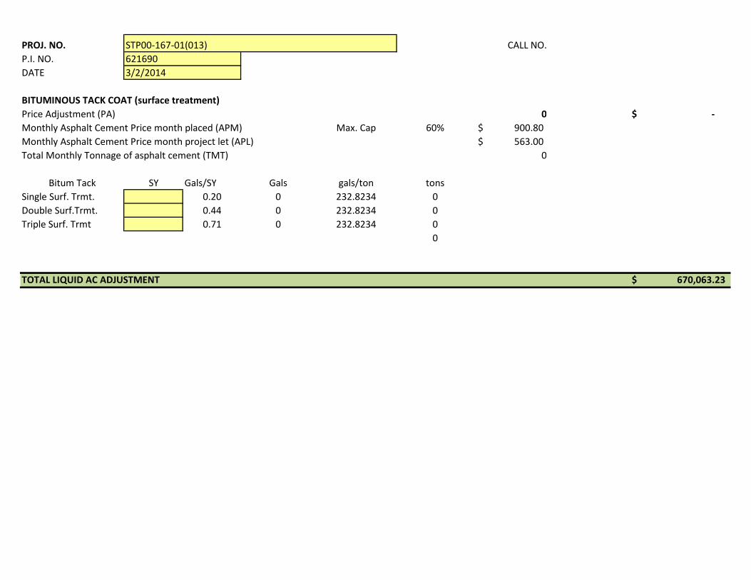
BITUMINOUS TACK COAT (surface treatment)
Price Adjustment (PA) 0 -$
Monthly Asphalt Cement Price month placed (APM) Max. Cap 60% 900.80$
Monthly Asphalt Cement Price month project let (APL) 563.00$
Total Monthly Tonnage of asphalt cement (TMT) 0
Bitum Tack SY Gals/SY Gals gals/ton tons
Single Surf. Trmt. 0.20 0 232.8234 0
Double Surf.Trmt. 0.44 0 232.8234 0
Triple Surf. Trmt 0.71 0 232.8234 0
0
TOTAL LIQUID AC ADJUSTMENT 670,063.23$
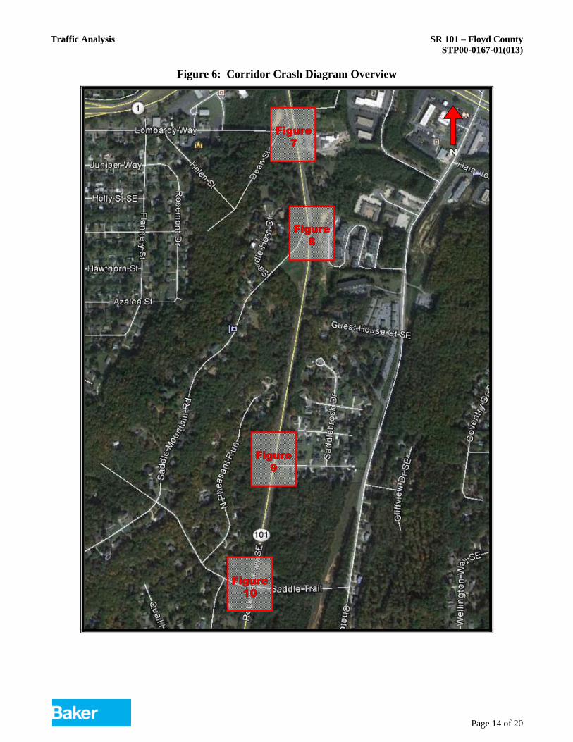
Traffic Analysis SR 101 – Floyd County STP00-0167-01(013)
Page 14 of 20
Figure 6: Corridor Crash Diagram Overview
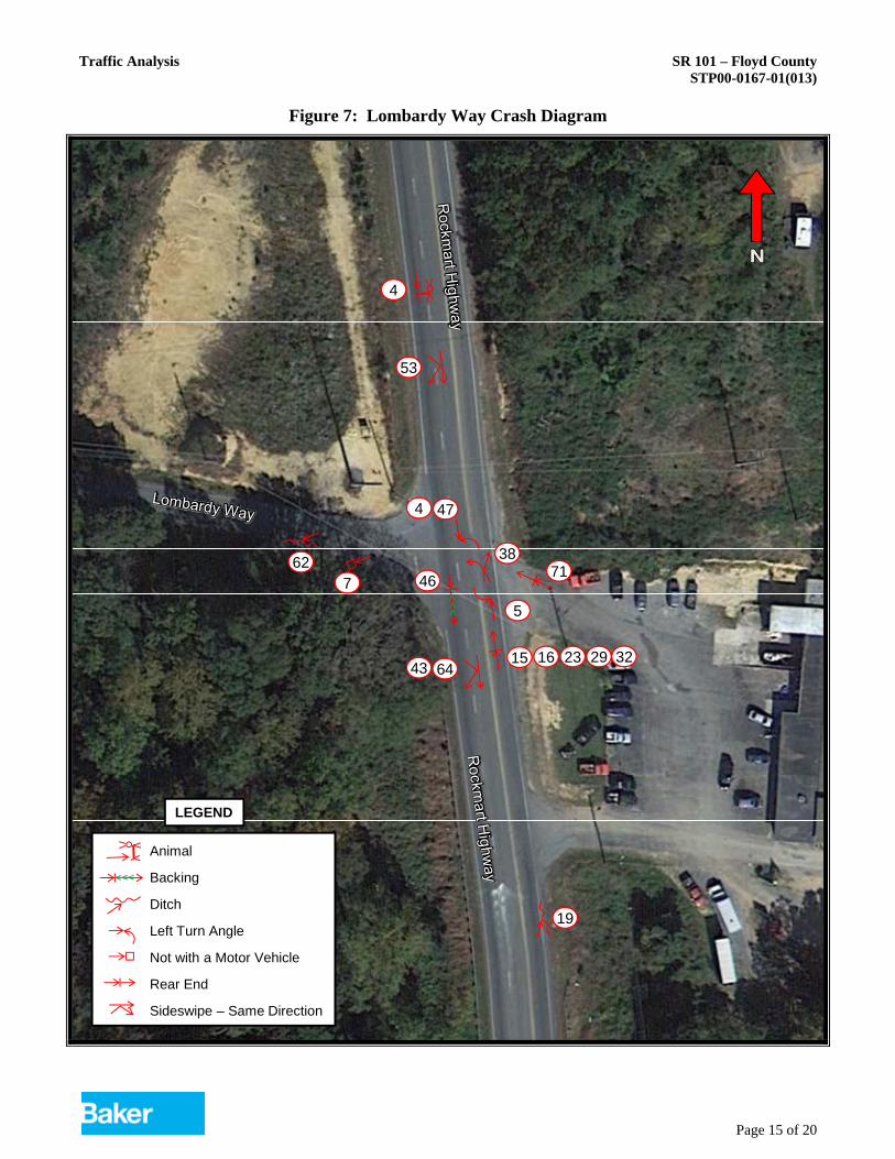
Traffic Analysis SR 101 – Floyd County STP00-0167-01(013)
Page 15 of 20
Figure 7: Lombardy Way Crash Diagram
53
64
47
46
29
19
4
5
4
762
32
71
15 16 2343
38
Animal
Backing
Ditch
Left Turn Angle
Not with a Motor Vehicle
Rear End
Sideswipe – Same Direction
LEGEND
Traffic Analysis SR 101 – Floyd County STP00-0167-01(013)
Page 16 of 20
Figure 8: Saddle Mountain Road Crash Diagram
22
12
6350
65
2R
ockmart H
ighw
ay
Animal
Head On
Not with a Motor Vehicle
Rear End
LEGEND
Traffic Analysis SR 101 – Floyd County STP00-0167-01(013)
Page 17 of 20
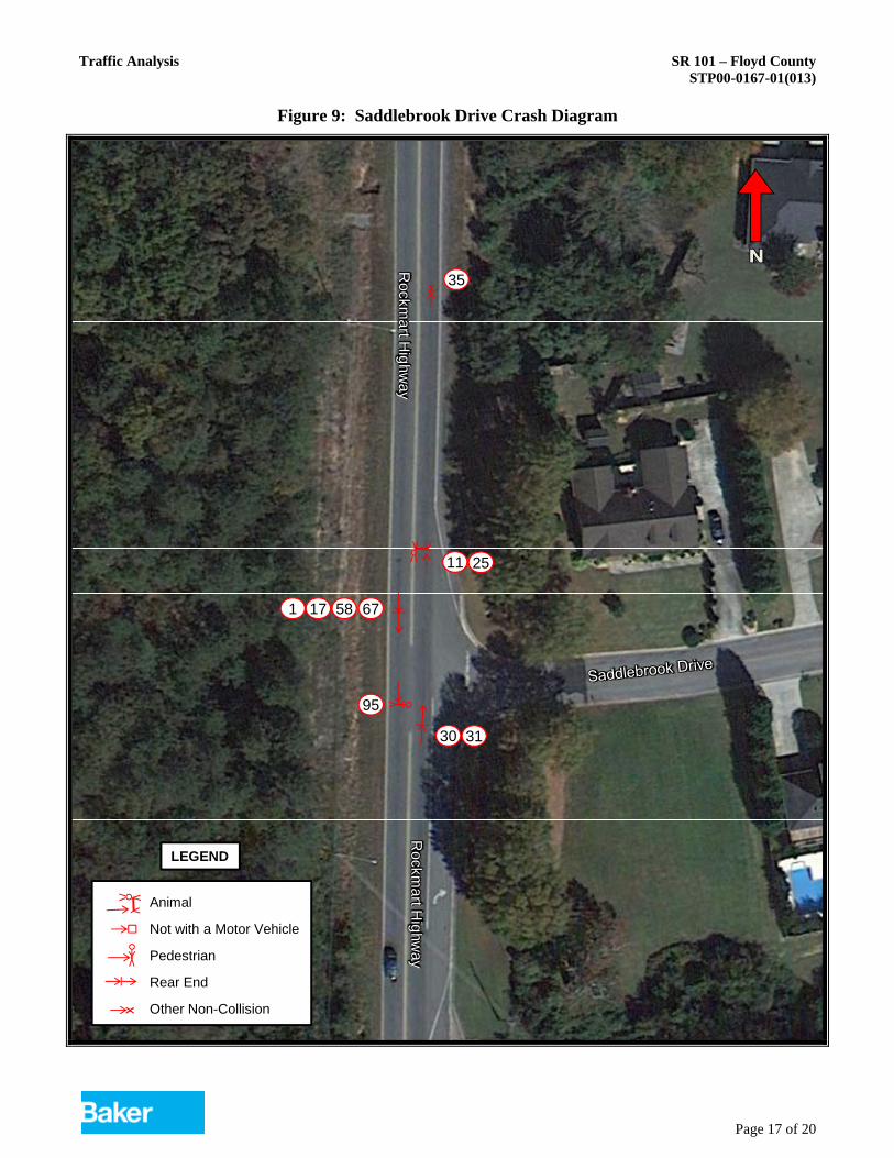
Figure 9: Saddlebrook Drive Crash Diagram
35
30
67
11 25
95
31
58171
Rockm
art Hig
hway
Rockm
art Hig
hway
Animal
Not with a Motor Vehicle
Pedestrian
Rear End
Other Non-Collision
LEGEND
x
x
Traffic Analysis SR 101 – Floyd County STP00-0167-01(013)
Page 18 of 20
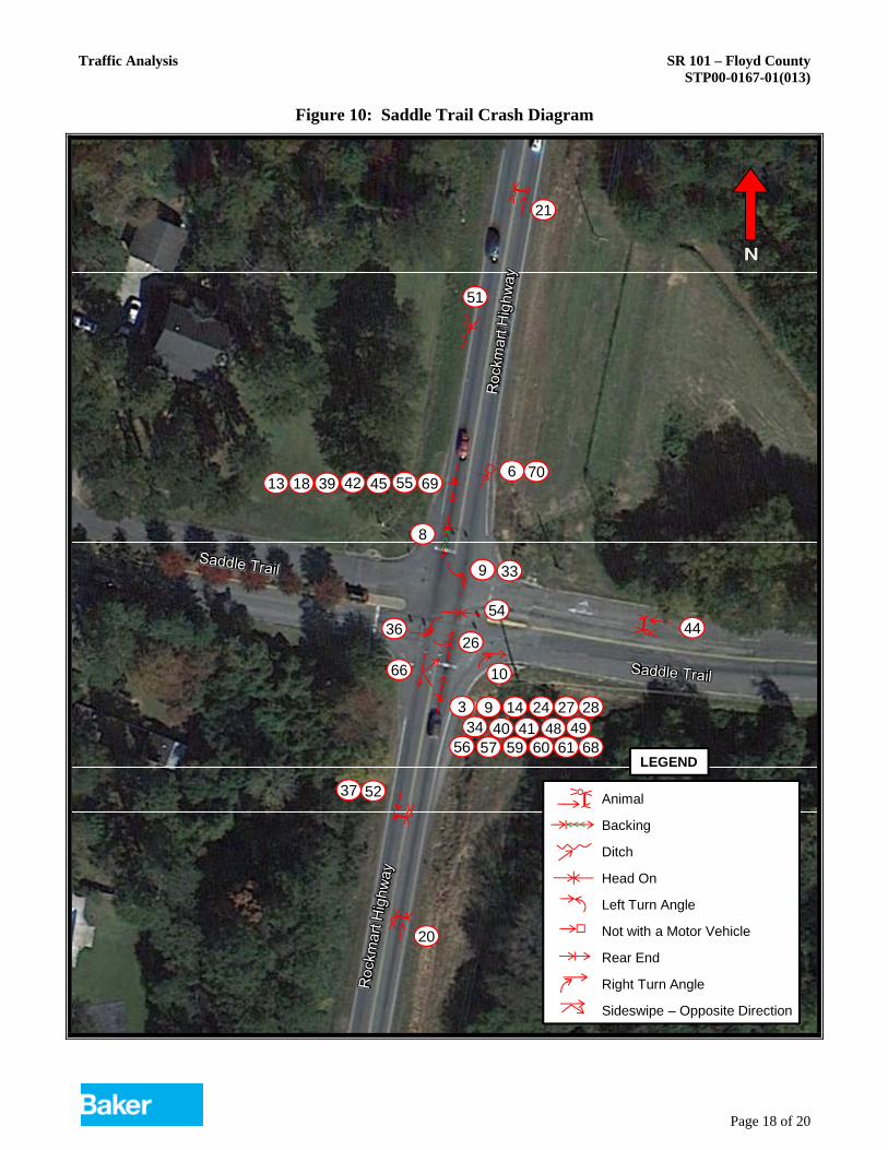
Figure 10: Saddle Trail Crash Diagram
51
26
24 27 2840 41 49
4539
21
20
5237
9
10
33
69
36
6
4454
3 9 14
8
1813 42 55
34 4860 61 6856 57 59
66
70
Animal
Backing
Ditch
Head On
Left Turn Angle
Not with a Motor Vehicle
Rear End
Right Turn Angle
Sideswipe – Opposite Direction
LEGEND
Traffic Analysis SR 101 – Floyd County STP00-0167-01(013)
Crash Diagram Details
CrashLocation
Crash Diagram Number
Crash Report
NumberDate Time Injuries Fatalities
LightCondition
Road Surface
Lombardy Way 4 80890414 3/11/2008 3:45 PM 0 0 Daylight Dry Lombardy Way 5 81520322 4/24/2008 7:50 AM 0 0 Daylight Dry Lombardy Way 7 81790563 5/12/2008 7:34 PM 0 0 Daylight Dry Lombardy Way 15 85180023 12/10/2008 3:11 PM 0 0 Daylight Wet Lombardy Way 16 85370158 12/20/2008 12:00 PM 0 0 Daylight Wet Lombardy Way 19 90150165 1/13/2009 12:04 AM 1 0 Dark-Not Lighted Dry Lombardy Way 23 92990495 7/16/2009 8:49 AM 0 0 Daylight Dry Lombardy Way 29 2603017 1/30/2010 11:24 AM 0 0 Daylight WetLombardy Way 32 3485197 4/5/2010 6:54 PM 0 0 Daylight DryLombardy Way 38 3731628 12/1/2010 6:07 PM 0 0 Dark-Lighted DryLombardy Way 43 3785537 5/23/2011 4:12 PM 0 0 Daylight DryLombardy Way 46 3855367 8/20/2011 2:32 PM 0 0 Daylight DryLombardy Way 47 3977276 9/26/2011 1:10 PM 0 0 Daylight DryLombardy Way 53 3918203 11/14/2011 2:23 PM 1 0 Daylight DryLombardy Way 62 4065665 4/23/2012 7:55 AM 0 0 Daylight DryLombardy Way 64 4192435 9/4/2012 5:35 PM 2 0 Daylight WetLombardy Way 71 4309511 12/27/2012 7:10 AM 0 0 Dark-Lighted Dry
Saddle Mountain Road 2 80210264 1/25/2008 7:45 AM 0 0 Daylight Dry Saddle Mountain Road 12 83460282 9/2/2008 6:03 PM 0 0 Daylight Dry Saddle Mountain Road 22 92420163 6/17/2009 7:45 AM 1 0 Daylight Dry Saddle Mountain Road 50 3898603 10/27/2011 4:04 AM 0 0 Dark-Not Lighted DrySaddle Mountain Road 63 4129947 6/29/2012 5:45 AM 0 0 Dark-Lighted DrySaddle Mountain Road 65 4192468 9/4/2012 3:13 PM 0 0 Daylight Wet
Saddlebrook Drive 1 80180053 1/22/2008 3:42 PM 0 0 Daylight Wet Saddlebrook Drive 11 83100159 8/18/2008 9:46 PM 0 0 Dark-Not Lighted Dry Saddlebrook Drive 17 85400119 12/27/2008 9:33 AM 0 0 Daylight Dry Saddlebrook Drive 25 409072 10/20/2009 11:07 AM 0 0 Daylight DrySaddlebrook Drive 30 3431880 2/5/2010 3:11 PM 1 0 Daylight WetSaddlebrook Drive 31 3459480 3/24/2010 1:28 PM 0 0 Daylight DrySaddlebrook Drive 35 3488003 7/3/2010 6:23 PM 0 1 Daylight DrySaddlebrook Drive 58 3953774 12/26/2011 6:21 PM 0 0 Dark-Not Lighted DrySaddlebrook Drive 67 4231002 10/17/2012 8:26 PM 0 0 Dark-Not Lighted Dry
Saddle Trail 3 80570168 2/22/2008 12:33 PM 0 0 Daylight Wet Saddle Trail 6 81790538 5/7/2008 8:20 AM 0 0 Daylight Dry Saddle Trail 8 81790569 5/13/2008 1:45 PM 0 0 Daylight Dry Saddle Trail 9 82320381 6/15/2008 12:27 PM 1 0 Daylight Dry Saddle Trail 10 83100154 8/18/2008 10:44 PM 1 0 Dark-Lighted Dry Saddle Trail 13 85520450 10/18/2008 7:55 PM 0 0 Daylight Dry Saddle Trail 14 84370269 10/27/2008 5:57 PM 0 0 Daylight Dry Saddle Trail 18 85400124 12/28/2008 3:57 PM 0 0 Daylight Dry Saddle Trail 20 91090082 3/24/2009 8:25 PM 0 0 Dark-Not Lighted Dry Saddle Trail 21 91130407 3/27/2009 7:30 PM 0 0 Dark-Lighted Wet Saddle Trail 24 93280096 8/4/2009 7:32 AM 0 0 Daylight Dry Saddle Trail 26 400607 11/16/2009 10:52 PM 2 0 Dark-Lighted DrySaddle Trail 27 1773554 12/12/2009 3:00 PM 0 0 Daylight DrySaddle Trail 28 1784654 1/25/2010 6:44 AM 0 0 Daylight WetSaddle Trail 33 3479817 4/12/2010 1:16 PM 0 0 Daylight DrySaddle Trail 34 3418377 5/13/2010 9:22 PM 0 0 Dark-Lighted DrySaddle Trail 36 3577671 7/21/2010 4:06 PM 0 0 Daylight DrySaddle Trail 37 3720031 11/8/2010 11:10 PM 0 0 Dark-Lighted DrySaddle Trail 39 3598788 1/4/2011 2:28 PM 0 0 Daylight DrySaddle Trail 40 3606125 1/7/2011 5:28 PM 0 0 Daylight DrySaddle Trail 41 3665445 2/2/2011 7:37 AM 0 0 Daylight WetSaddle Trail 42 3764153 5/3/2011 6:50 PM 0 0 Daylight WetSaddle Trail 44 3819820 7/6/2011 8:35 PM 0 0 Daylight DrySaddle Trail 45 3845945 8/11/2011 4:58 PM 0 0 Daylight DrySaddle Trail 48 3977283 9/27/2011 7:18 AM 0 0 Daylight DrySaddle Trail 49 3906894 10/14/2011 7:25 AM 1 0 Daylight DrySaddle Trail 51 3909838 11/6/2011 2:26 PM 1 0 Daylight DrySaddle Trail 52 3910326 11/8/2011 6:30 PM 0 0 Dark-Not Lighted DrySaddle Trail 54 3921819 11/16/2011 6:22 PM 1 0 Dark-Not Lighted WetSaddle Trail 55 3947481 12/16/2011 5:55 PM 0 0 Dark-Not Lighted WetSaddle Trail 56 3947490 12/16/2011 5:50 PM 0 0 Dark-Not Lighted WetSaddle Trail 57 3951533 12/20/2011 3:30 PM 0 0 Daylight WetSaddle Trail 59 3972672 1/17/2012 4:28 PM 0 0 Daylight WetSaddle Trail 60 3972449 1/17/2012 7:58 AM 1 0 Daylight WetSaddle Trail 61 3972672 1/17/2012 4:28 PM 0 0 Daylight WetSaddle Trail 66 4194912 9/7/2012 7:40 AM 0 0 Daylight DrySaddle Trail 68 4250776 11/7/2012 7:28 AM 0 0 Daylight WetSaddle Trail 69 4293515 12/12/2012 4:03 PM 0 0 Daylight DrySaddle Trail 70 4293579 12/12/2012 4:36 PM 0 0 Daylight Dry
SR 101
TRAFFIC DIAGRAMG R E S H A M
S M I T H N D
P A R T N E R S
A
GEORGIA
TRANSPORTATION
OF
DEPARTMENT
REVISION DATES
DRAWING No.
DEPARTMENT OF TRANSPORTATIONSTATE OF GEORGIA
8/30/2013
USER:gomezn
GPLOT-V8
gplotborder-V8i-PO.tbl
G:\2944201\T_Traffic\GDOT Traffic Diagrams\621690 Sheets\621690_10-001.dgn SHEET NO.PROJECT NUMBER
TOTAL SHEETS
OFFICE: PROGRAM DELIVERY
TRAFFIC DIAGRAM
STP00-0167-01(013)
FLOYD COUNTY 10-001
STP00-0167-01(013)
10:21:39 AM
GPLN
STATE
GA
12/14/2012
2013 PM DHV = (000)
2013 AM DHV = 000
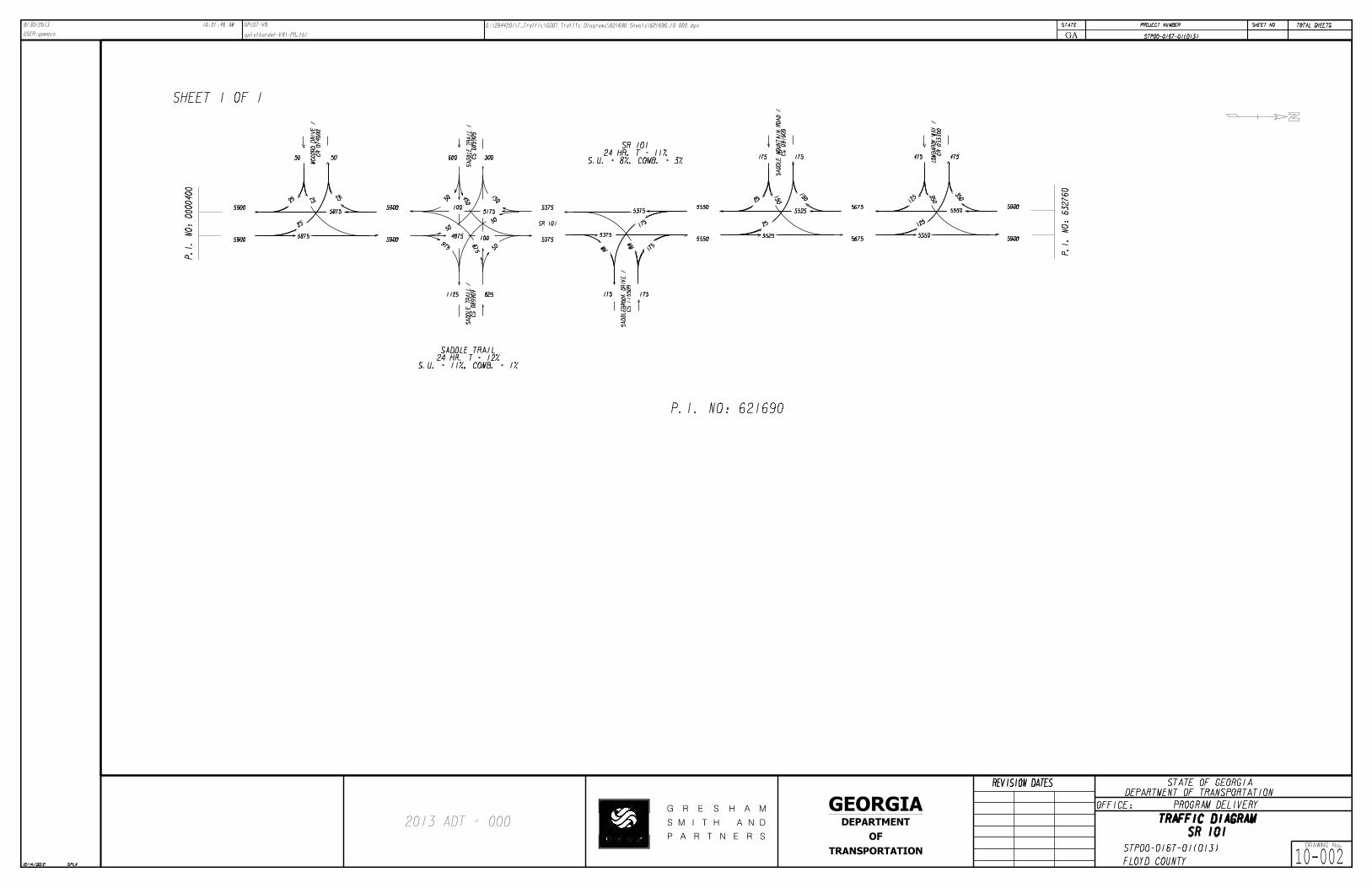
SHEET 1 OF 1
P.I. NO: 621690
N
CR 074000
MC
CO
RD
DRI
VE /
CS 089909
SA
DDLE T
RAIL /
CS 089909
SA
DDLE T
RAIL /
CR 033300
LO
MB
AR
DY
WA
Y /
CS 115509
SA
DDLE
BR
OO
K
DRI
VE /
CS 091609
SA
DDLE
MO
UNT
AI
N
RO
AD /
SR 101
S.U. = 8%, COMB. = 2%T = 10%SR 101
S.U. = 8%, COMB. = 1%T = 9%
SADDLE TRAIL
10(10)
10(10)
285(880)
795(425)
5(5)
5(5) 5
(5)
5(5)
280(875)
790(420)
285(880)
795(425)
75(35)
15(45)
5
(20)
205(730)
5(5)
215(755)
765(395)
110(65)
90(170)
5(5)
5(10)
710(360)
80
(55) 75
(145)
5(15)
10(10)
25(5)
45(25)
15(20)
40(25)
195(740)
770(385)
15(5)2
5(20)10
(15)
755(380)
5(5)
190(735)
15(15)
15(35)
5(5) 1
0(10)
10
(30)
5(5)
765(380)
190(735) 200
(765)
775(390)
50(45)
85(55)
60
(40)
190(755) 250
(795)
790(410)
10(10) 4
0(35)
25(1
5)
750(375)
P.I.
NO: 632760
P.I.
NO: 0000400
SR 101
TRAFFIC DIAGRAMG R E S H A M
S M I T H N D
P A R T N E R S
A
GEORGIA
TRANSPORTATION
OF
DEPARTMENT
REVISION DATES
DRAWING No.
DEPARTMENT OF TRANSPORTATIONSTATE OF GEORGIA
8/30/2013
USER:gomezn
GPLOT-V8
gplotborder-V8i-PO.tbl
G:\2944201\T_Traffic\GDOT Traffic Diagrams\621690 Sheets\621690_10-002.dgn SHEET NO.PROJECT NUMBER
TOTAL SHEETS
OFFICE: PROGRAM DELIVERY
TRAFFIC DIAGRAM
STP00-0167-01(013)
FLOYD COUNTY 10-002
STP00-0167-01(013)
10:21:48 AM
GPLN
STATE
GA
12/14/2012
2013 ADT = 000
P.I. NO: 621690
SHEET 1 OF 1
N
5900
5900
58755900
59005875
600 300
150
51755375
5375100
675
975
1125 825
4875
100
450
53755550
5550
175
175 175
5375
175
175 175
150
55255675
56755525
150
475 475
350
55505900
5900
125
5550
125
350
CR 074000
MC
CO
RD
DRI
VE /
CS 089909
SA
DDLE T
RAIL /
CS 089909
SA
DDLE T
RAIL /
CS 115509
SA
DDLE
BR
OO
K
DRI
VE /
CS 091609
SA
DDLE
MO
UNT
AI
N
RO
AD /
CR 033300
LO
MB
AR
DY
WA
Y /
50 50
25
25
25
25
MMMM
25
2550
50
50
50
SR 101
S.U. = 8%, COMB. = 3%24 HR. T = 11%
SR 101
S.U. = 11%, COMB. = 1%24 HR. T = 12%
SADDLE TRAIL
P.I.
NO: 0000400
P.I.
NO: 632760

SR 101
TRAFFIC DIAGRAMG R E S H A M
S M I T H N D
P A R T N E R S
A
GEORGIA
TRANSPORTATION
OF
DEPARTMENT
REVISION DATES
DRAWING No.
DEPARTMENT OF TRANSPORTATIONSTATE OF GEORGIA
12/16/2013
USER:gomezn
GPLOT-V8
gplotborder-V8i-PO.tbl
G:\2944201\T_Traffic\GDOT Traffic Diagrams\621690 Sheets\621690_10-003.dgn SHEET NO.PROJECT NUMBER
TOTAL SHEETS
OFFICE: PROGRAM DELIVERY
TRAFFIC DIAGRAM
STP00-0167-01(013)
FLOYD COUNTY 10-003
STP00-0167-01(013)
10:31:55 AM
GPLN
STATE
GA
12/14/2012
2021 NO BUILD PM DHV = (000)
2021 NO BUILD AM DHV = 000
SHEET 1 OF 1
P.I. NO: 621690
N
CR 074000
MC
CO
RD
DRI
VE /
CS 089909
SA
DDLE T
RAIL /
CS 089909
SA
DDLE T
RAIL /
CR 033300
LO
MB
AR
DY
WA
Y /
CS 115509
SA
DDLE
BR
OO
K
DRI
VE /
CS 091609
SA
DDLE
MO
UNT
AI
N
RO
AD /
SR 101
S.U. = 8%, COMB. = 2%T = 10%SR 101
S.U. = 8%, COMB. = 1%T = 9%
SADDLE TRAIL
20(20)
20(20)
305(925)
835(450)
10(10) 1
0(10)
10
(10)
10(1
0)295
(915)
825(440)
305(925)
835(450)
90(50)
30(60)
10
(25)
215(760)
10(1
0)
235(795)
805(420)
125(80)
10(10)
10(1
5)
740(375)
85
(60) 80
(155)
10(20)
15(15)
30(10)
50(30)
25(30)
50(35)
215(780)
810(410)
20(10)3
0(25)15
(20)
790(400)
10(1
0)
205(770)
25(25)
25(45)
10(10) 1
5(15)
15
(35)
10(1
0)
800(400)
205(770) 220
(805)
815(415)
60(55)
95(65)
65
(45)
205(790) 270
(835)
830(435)
15(15) 4
5(40)
30(2
0)
785(395)
P.I.
NO: 632760
P.I.
NO: 0000400
105(190)

SR 101
TRAFFIC DIAGRAMG R E S H A M
S M I T H N D
P A R T N E R S
A
GEORGIA
TRANSPORTATION
OF
DEPARTMENT
REVISION DATES
DRAWING No.
DEPARTMENT OF TRANSPORTATIONSTATE OF GEORGIA
12/16/2013
USER:gomezn
GPLOT-V8
gplotborder-V8i-PO.tbl
G:\2944201\T_Traffic\GDOT Traffic Diagrams\621690 Sheets\621690_10-004.dgn SHEET NO.PROJECT NUMBER
TOTAL SHEETS
OFFICE: PROGRAM DELIVERY
TRAFFIC DIAGRAM
STP00-0167-01(013)
FLOYD COUNTY 10-004
STP00-0167-01(013)
10:31:58 AM
GPLN
STATE
GA
12/14/2012
2021 BUILD PM DHV = (000)
2021 BUILD AM DHV = 000
SHEET 1 OF 1
P.I. NO: 621690
N
CR 074000
MC
CO
RD
DRI
VE /
CS 089909
SA
DDLE T
RAIL /
CS 089909
SA
DDLE T
RAIL /
CR 033300
LO
MB
AR
DY
WA
Y /
CS 115509
SA
DDLE
BR
OO
K
DRI
VE /
CS 091609
SA
DDLE
MO
UNT
AI
N
RO
AD /
SR 101
S.U. = 8%, COMB. = 2%T = 10%SR 101
S.U. = 8%, COMB. = 1%T = 9%
SADDLE TRAIL
320(995)
905(480)
330(1005)
915(490)
90(50)
30(60)
10
(25)
240(840)
10(1
0)
260(875)
885(460)
125(80)
10(1
5)
820(415)
85
(60) 80
(155)
10(20)
15(15)
30(10)
50(30)
25(30)
50(35)
240(860)
890(450)
20(10)3
0(25)15
(20)
870(440)
10(1
0)
230(850)
25(25)
25(45)
10(10) 1
5(15)
15
(35)
10(1
0)
880(440)
230(850) 245
(885)
895(455)
60(55)
95(65)
65
(45)
230(870) 295
(915)
910(475)
15(15) 4
5(40)
30(2
0)
865(435)
P.I.
NO: 632760
P.I.
NO: 0000400
330(1005)
915(490)
20(20)
20(20)
10
(10)10
(10)10(10)
10(10)
105(190)
10(1
0)

SR 101
TRAFFIC DIAGRAMG R E S H A M
S M I T H N D
P A R T N E R S
A
GEORGIA
TRANSPORTATION
OF
DEPARTMENT
REVISION DATES
DRAWING No.
DEPARTMENT OF TRANSPORTATIONSTATE OF GEORGIA
12/16/2013
USER:gomezn
GPLOT-V8
gplotborder-V8i-PO.tbl
G:\2944201\T_Traffic\GDOT Traffic Diagrams\621690 Sheets\621690_10-005.dgn SHEET NO.PROJECT NUMBER
TOTAL SHEETS
OFFICE: PROGRAM DELIVERY
TRAFFIC DIAGRAM
STP00-0167-01(013)
FLOYD COUNTY 10-005
STP00-0167-01(013)
10:32:01 AM
GPLN
STATE
GA
12/14/2012
2041 NO BUILD PM DHV = (000)
2041 NO BUILD AM DHV = 000
SHEET 1 OF 1
P.I. NO: 621690
N
CR 074000
MC
CO
RD
DRI
VE /
CS 089909
SA
DDLE T
RAIL /
CS 089909
SA
DDLE T
RAIL /
CR 033300
LO
MB
AR
DY
WA
Y /
CS 115509
SA
DDLE
BR
OO
K
DRI
VE /
CS 091609
SA
DDLE
MO
UNT
AI
N
RO
AD /
SR 101
S.U. = 8%, COMB. = 2%T = 10%SR 101
S.U. = 8%, COMB. = 1%T = 9%
SADDLE TRAIL
20(20)
20(20)
335(1015)
915(490)
10(10) 1
0(10)
10
(10)
10(1
0)325
(1005)
905(480)
335(1015)
915(490)
95(50)
30(60)
10
(25)
235(835)
10(1
0)
255(870)
880(445)
135(85)
10(10)
10(1
5)
810(410)
95
(65) 90
(170)
10(20)
15(15)
30(10)
55(30)
25(30)
50(35)
235(855)
885(445)
20(10)3
0(25)15
(20)
865(435)
10(1
0)
225(845)
25(25)
25(45)
10(10) 1
5(15)
15
(35)
10(1
0)
875(435)
225(845) 240
(880)
890(450)
65(60)
70
(50)
225(865) 295
(915)
910(475)
15(15) 5
0(45)
30(2
0)
860(430)
P.I.
NO: 632760
P.I.
NO: 0000400
115(205)
100(70)

SR 101
TRAFFIC DIAGRAMG R E S H A M
S M I T H N D
P A R T N E R S
A
GEORGIA
TRANSPORTATION
OF
DEPARTMENT
REVISION DATES
DRAWING No.
DEPARTMENT OF TRANSPORTATIONSTATE OF GEORGIA
12/16/2013
USER:gomezn
GPLOT-V8
gplotborder-V8i-PO.tbl
G:\2944201\T_Traffic\GDOT Traffic Diagrams\621690 Sheets\621690_10-006.dgn SHEET NO.PROJECT NUMBER
TOTAL SHEETS
OFFICE: PROGRAM DELIVERY
TRAFFIC DIAGRAM
STP00-0167-01(013)
FLOYD COUNTY 10-006
STP00-0167-01(013)
10:32:03 AM
GPLN
STATE
GA
12/14/2012
2041 BUILD PM DHV = (000)
2041 BUILD AM DHV = 000
SHEET 1 OF 1
P.I. NO: 621690
N
CR 074000
MC
CO
RD
DRI
VE /
CS 089909
SA
DDLE T
RAIL /
CS 089909
SA
DDLE T
RAIL /
CR 033300
LO
MB
AR
DY
WA
Y /
CS 115509
SA
DDLE
BR
OO
K
DRI
VE /
CS 091609
SA
DDLE
MO
UNT
AI
N
RO
AD /
SR 101
S.U. = 8%, COMB. = 2%T = 10%SR 101
S.U. = 8%, COMB. = 1%T = 9%
SADDLE TRAIL
20(20)
20(20)
455(1390)
1295(685)
10(10) 1
0(10)
10
(10)
10(1
0)445
(1380)
1285(675)
455(1390)
1295(685)
95(50)
30(60)
10
(25)
355(1210)
10(1
0)
375(1245)
1260(650)
135(85)
10(10)
10(1
5)
1190(605)
95
(65) 90
(170)
10(20)
15(15)
30(10)
55(30)
25(30)
50(35)
355(1230)
1265(640)
20(10)3
0(25)15
(20)
1245(630)
10(1
0)
345(1220)
25(25)
25(45)
10(10) 1
5(15)
15
(35)
10(1
0)
1255(630)
345(1220) 360
(1255)
1270(645)
65(60)
70
(50)
345(1240) 415
(1290)
1290(670)
15(15) 5
0(45)
30(2
0)
1240(625)
P.I.
NO: 632760
P.I.
NO: 0000400
115(205)
100(70)
SR 101
TRAFFIC DIAGRAMG R E S H A M
S M I T H N D
P A R T N E R S
A
GEORGIA
TRANSPORTATION
OF
DEPARTMENT
REVISION DATES
DRAWING No.
DEPARTMENT OF TRANSPORTATIONSTATE OF GEORGIA
12/16/2013
USER:gomezn
GPLOT-V8
gplotborder-V8i-PO.tbl
G:\2944201\T_Traffic\GDOT Traffic Diagrams\621690 Sheets\621690_10-007.dgn SHEET NO.PROJECT NUMBER
TOTAL SHEETS
OFFICE: PROGRAM DELIVERY
TRAFFIC DIAGRAM
STP00-0167-01(013)
FLOYD COUNTY 10-007
STP00-0167-01(013)
10:32:06 AM
GPLN
STATE
GA
12/14/2012
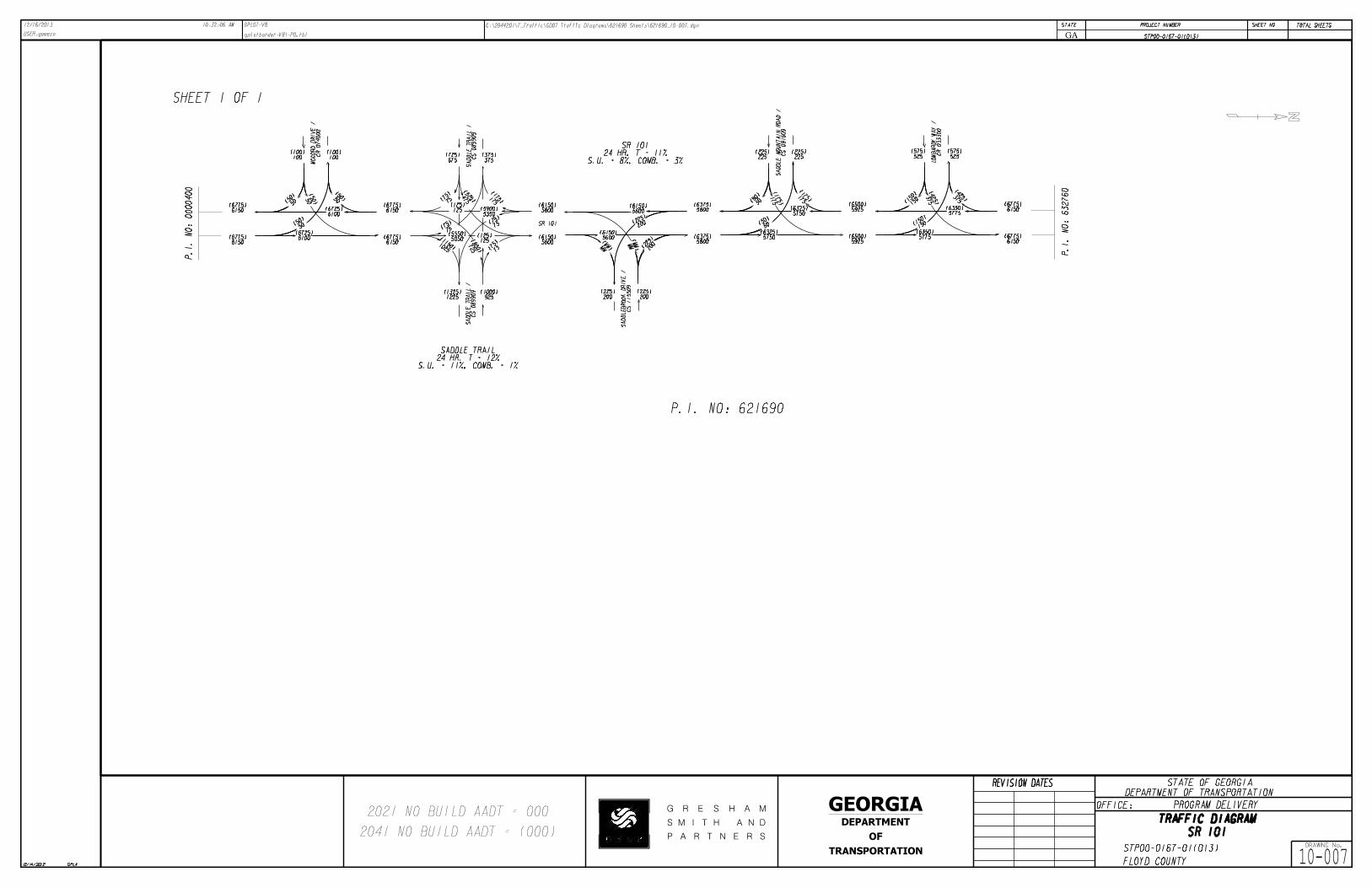
2041 NO BUILD AADT = (000)
2021 NO BUILD AADT = 000
SHEET 1 OF 1
P.I. NO: 621690
N
CR 074000
MC
CO
RD
DRI
VE /
CS 089909
SA
DDLE T
RAIL /
CS 089909
SA
DDLE T
RAIL /
CR 033300
LO
MB
AR
DY
WA
Y /
CS 115509
SA
DDLE
BR
OO
K
DRI
VE /
CS 091609
SA
DDLE
MO
UNT
AI
N
RO
AD /
SR 101
6150(6775)
6150(6775)
50(50) 5
0(50)
50
(50)
50(5
0)6100
(6725)
6100(6725)
6150(6775)
6150(6775)
5350(5900)
75(7
5)
5600(6150)
5600(6150)
75(75)
75(7
5)
5050(5550)
75(75)
5800(6375)
5800(6375)
MM
(M
M)MM
(MM)
5600(6150)
5600(6150)
50(50)
50(5
0)
5750(6325)
5750(6325) 5925
(6500)
5925(6500)
5775(6350) 6150
(6775)
6150(6775)5775
(6350)
P.I.
NO: 632760
P.I.
NO: 0000400
S.U. = 11%, COMB. = 1%24 HR. T = 12%
SADDLE TRAIL
S.U. = 8%, COMB. = 3%24 HR. T = 11%
SR 101
100(100)
100(100)
1025
(1150)
1225(1325)
925(1000)
725
(800)
125(125)
175
(175)
375(375)
675(725)
125(125)
475(525)
200(225)
200(225)
200(2
25)
200
(225)
175
(175)
225(225)
225(225)
175
(175)
150(1
50)
375
(425)
525(575)
525(575)
150
(150) 3
75
(425)

SR 101
TRAFFIC DIAGRAMG R E S H A M
S M I T H N D
P A R T N E R S
A
GEORGIA
TRANSPORTATION
OF
DEPARTMENT
REVISION DATES
DRAWING No.
DEPARTMENT OF TRANSPORTATIONSTATE OF GEORGIA
12/16/2013
USER:gomezn
GPLOT-V8
gplotborder-V8i-PO.tbl
G:\2944201\T_Traffic\GDOT Traffic Diagrams\621690 Sheets\621690_10-008.dgn SHEET NO.PROJECT NUMBER
TOTAL SHEETS
OFFICE: PROGRAM DELIVERY
TRAFFIC DIAGRAM
STP00-0167-01(013)
FLOYD COUNTY 10-008
STP00-0167-01(013)
10:32:09 AM
GPLN
STATE
GA
12/14/2012
2041 BUILD AADT = (000)
2021 BUILD AADT = 000
SHEET 1 OF 1
P.I. NO: 621690
N
CR 074000
MC
CO
RD
DRI
VE /
CS 089909
SA
DDLE T
RAIL /
CS 089909
SA
DDLE T
RAIL /
CR 033300
LO
MB
AR
DY
WA
Y /
CS 115509
SA
DDLE
BR
OO
K
DRI
VE /
CS 091609
SA
DDLE
MO
UNT
AI
N
RO
AD /
SR 101
6775(9625)
6775(9625)
50(50) 5
0(50)
50
(50)
50(5
0)6725
(9575)
6725(9575)
6775(9625)
6775(9625)
5975(8750)
75(7
5)
6225(9000)
6225(9000)
75(75)
75(7
5)
5675(8400)
75(75)
6425(9225)
6425(9225)
MM
(M
M)MM
(MM)
6225(9000)
6225(9000)
50(50)
50(5
0)
6375(9175)
6375(9175) 6550
(9350)
6550(9350)
6400(9200) 6775
(9625)
6775(9625)6400
(9200)
P.I.
NO: 632760
P.I.
NO: 0000400
S.U. = 11%, COMB. = 1%24 HR. T = 12%
SADDLE TRAIL
S.U. = 8%, COMB. = 3%24 HR. T = 11%
SR 101
100(100)
100(100)
1025
(1150)
1225(1325)
925(1000)
725
(800)
125(125)
175
(175)
375(375)
675(725)
125(125)
475(525)
200(225)
200(225)
200
(225)
200(2
25)
175
(175)
225(225)
225(225)
175
(175)
150(1
50)
375
(425)
525(575)
525(575)
150
(150) 3
75
(425)
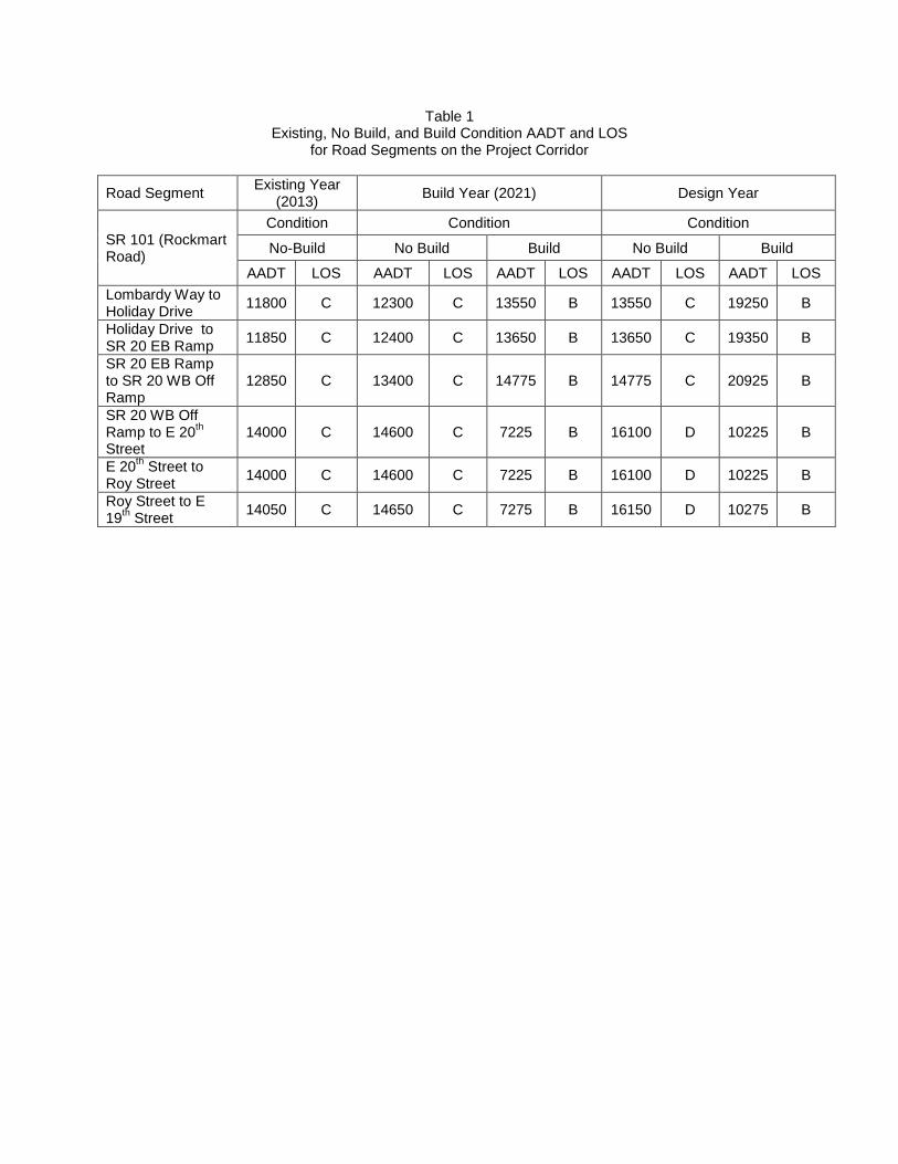
Table 1 Existing, No Build, and Build Condition AADT and LOS
for Road Segments on the Project Corridor
Road Segment Existing Year
(2013) Build Year (2021) Design Year
SR 101 (Rockmart Road)
Condition Condition Condition
No-Build No Build Build No Build Build
AADT LOS AADT LOS AADT LOS AADT LOS AADT LOS
Lombardy Way to Holiday Drive
11800 C 12300 C 13550 B 13550 C 19250 B
Holiday Drive to SR 20 EB Ramp
11850 C 12400 C 13650 B 13650 C 19350 B
SR 20 EB Ramp to SR 20 WB Off Ramp
12850 C 13400 C 14775 B 14775 C 20925 B
SR 20 WB Off Ramp to E 20
th
Street 14000 C 14600 C 7225 B 16100 D 10225 B
E 20th Street to
Roy Street 14000 C 14600 C 7225 B 16100 D 10225 B
Roy Street to E 19
th Street
14050 C 14650 C 7275 B 16150 D 10275 B
Project Number: County: P.I. Number: Date: Page 2
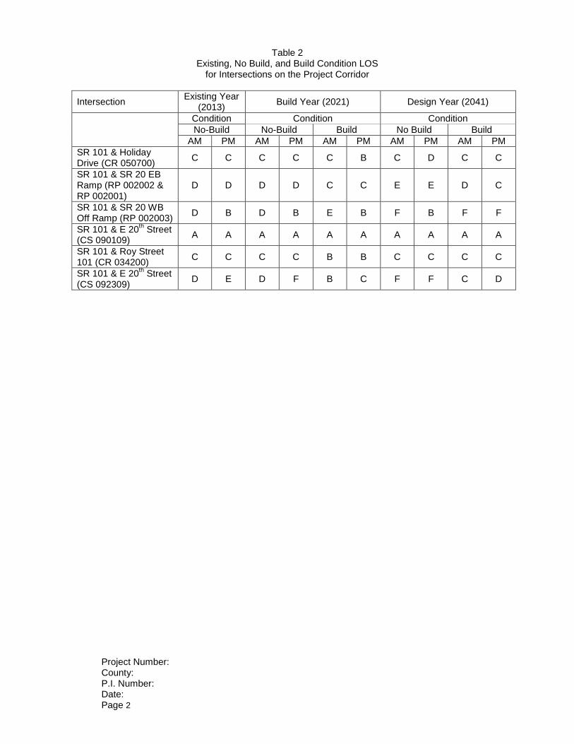
Table 2 Existing, No Build, and Build Condition LOS
for Intersections on the Project Corridor
Intersection Existing Year
(2013) Build Year (2021) Design Year (2041)
Condition Condition Condition
No-Build No-Build Build No Build Build
AM PM AM PM AM PM AM PM AM PM
SR 101 & Holiday Drive (CR 050700)
C C C C C B C D C C
SR 101 & SR 20 EB Ramp (RP 002002 & RP 002001)
D D D D C C E E D C
SR 101 & SR 20 WB Off Ramp (RP 002003)
D B D B E B F B F F
SR 101 & E 20th Street
(CS 090109) A A A A A A A A A A
SR 101 & Roy Street 101 (CR 034200)
C C C C B B C C C C
SR 101 & E 20th Street
(CS 092309) D E D F B C F F C D
� � � � � � � � � � � � � � � � � � � � � � � � � � � � � � � � � � � � � � � � � � � � � � � � � � � � � � � �
� � � ! " # $ % & ' " ( ) * + , , * - ( * . *
/ 0 1 2 3 2 4 5 6 7 4 8 9 : 7 2 ; 8 9 < = 1 2 > 9 < 3 3 0 = >? @ AB 8 C 5 / A @ D E F G 4 @ H 9 5 / I I I J K L I J M I J N O P / 7 4 @ H K Q J K R I9 = J I J 6 S T E U S U V ? 3 W = L X I Y 3 F W @ A T G @ W = N N Z Y ; @ [ \ ] A T ^ 6 ] ^ _? ` @ ^ T W @ a U G ^ _ B E @ A V S ]J H ; @ F ] G S @ U Y8 E b F A S c G S @ U d e f g h i j k l m n f g o j i n e l p f q l r f r s j o t u v w v x j m y n l q g j z n e j o u j { l | } l j i s f y f r ~ x j � q � j z r n �p f n e f r n e l o j x x j p f r s x f { f n g �7 U G E A b E F G S @ U G @ 7 U G E A b E F G S @ U ; @ F ] G S @ U� u � � w � � m � j i q u q n j � u � � � � � j { � y i q � � y � t u v w vd e l n j n y x x l r s n e j o n e f g h i j k l m n f g y h h i j � f { y n l x � v � v { f x l g j o { y f r x f r l l � y x z y n f j r � t l l ? S V a A E Jo j i y h i j k l m n x j m y n f j r { y h � d e l g z i � l � o j i n e f g h i j k l m n f g r j n y � y f x y � x l y n n e f g n f { l | n e l i l o j i lg n y n f j r g y i l r j n y � y f x y � x l �Q H : S b G @ A S F ] `8 ] G ] � e f g n j i f m y x q y n y g l y i m e p y g h l i o j i { l q q z i f r s n e f g g n z q � � d e l B E @ A V S ] 8 E c ] A G [ E U G @ �5 A ] U b c @ A G ] G S @ U p y g m j r n y m n l q o j i y � y f x y � x l y g � z f x n h y � l { l r n q y n y o j i n e l l � f g n f r s t u v w vg l s { l r n � � x y r g o j i h i j k l m n d t � � ~ u v � v � � � | y r q ~ u v � � v � � � p l i l j � n y f r l q p e f m e h i j � f q li j y q p y � h i j o f x l g | h x y r q l n y f x g | y r q n � h f m y x g l m n f j r g o j i n e f g h i j k l m n m j i i f q j i y g p l x x y g g l m n f j r gj o t u v w v y � j � l y r q � l x j p n e l h i j k l m n m j i i f q j i � d e l h x y r g l m n f j r g y r q h i j o f x l g y i l { y i � l qp f n e z n f x f n � x j m y n f j r g | p f q l r f r s g z s s l g n f j r g | i l { j � y x j o l � f g n f r s z n f x f n f l g | y g p l x x y gm j r g n i z m n f j r x f { f n g o j i n e l h i l � f j z g x � { l r n f j r l q f r o j i { y n f j r � t l l 0 c c E U T S � 2 o j i y h h x f m y � x lh x y r g y r q n � h f m y x g l m n f j r g �N H 5 A ] � � S F 8 ] G ] � j n i y o o f m q y n y p y g h i j � f q l q o i j { n e l } � � d o j i n e l h z i h j g l j o n e f g g z i � l � �X H W @ U F E c G= E c @ A G � j h i l x f { f r y i � m j r m l h n h x y r g p l i l h i j � f q l q o j i n e l h z i h j g l j o n e f g g z i � l � �Z H W C / 0 W 2 9 � j { h z n l i f � l q � y � l { l r n � j r q f n f j r � � y x z y n f j r t � g n l { � � � � � � � t � p y g r j n z n f x f � l q f r n e f gl � y x z y n f j r �K H ? S E ` T/ � @ G @ V A ] c � b � z i f r s j z i o f l x q p j i � | h e j n j s i y h e g n j i l m j i q n e l l � f g n f r s h y � l { l r n m j r q f n f j r g p l i l n y � l r y n y{ y � f { z { g h y m f r s j o � { f x l y r q y i l f r m x z q l q f r 0 c c E U T S � W �L H 4 @ U8 E b G A a F G S � E? S E ` T 5 E b G S U V � j r j r q l g n i z m n f � l o f l x q n l g n g p l i l h l i o j i { l q y g h y i n j o n e f g l � y x z y n f j r �� H 8 A ] S U ] V E9 a A � E ^ d e l g l m n f j r j o t u v w v n e y n p y g l � y x z y n l q o j i n e f g g n z q � e y g n p j � � n j o j z i � � � o l l n q l l hs i y g g l q q i y f r y s l q f n m e l g i z r r f r s y x j r s n e l l y g n y r q p l g n g f q l g j o n e l i j y q p y � � t e j z x q l iq i j h j o o g l � m l l q f r s n l r � v w � o l l n p l i l y x g j j � g l i � l q y x j r s n e l h i j k l m n m j i i f q j i � ¡ y g l q j r j z io f l x q i l � f l p | n e l i j y q p y � y h h l y i g n j � l f r s j j q q i y f r y s l m j r q f n f j r � � j g n y r q f r s p y n l i j ij n e l i q i y f r y s l f g g z l g p l i l j � g l i � l q q z i f r s n e l o f l x q p j i � �R H ; @ ] T W A ] F ¢ S U V � l � l x v n j x l � l x � x j y q m i y m � f r s q f g n i l g g p y g j � g l i � l q n e i j z s e j z n n e l x l r s n e j o n e l h i j k l m n f rn e l r j i n e y r q g j z n e � j z r q x y r l g j o t u v w v �
� � � � � � � � � � � � � � � � � � � � � � � � � � � � � � � � � � � � � � � � � � � � � � � � � � � � � � � �
� � � ! " # $ % & ' " ( ) * + , , * - ( * . *
J I H £ ` @ F ¢ Y5 A ] U b � E A b EW A ] F ¢ S U V � l � l x v n j x l � l x � x j m � � n i y r g � l i g l m i y m � f r s q f g n i l g g p y g j � g l i � l q n e i j z s e j z n n e l x l r s n e j o n e lh i j k l m n f r n e l r j i n e y r q g j z n e � j z r q x y r l g j o t u v w v �J J H = E � ` E F G S @ UW A ] F ¢ S U V � j i l o x l m n f j r m i y m � f r s p y g j � g l i � l q f r n e l h i j k l m n m j i i f q j i �J Q H = ] � E ` S U V � l � l x v n j x l � l x i y � l x f r s p y g j � g l i � l q n e i j z s e j z n n e l x l r s n e j o n e l h i j k l m n f r n e l r j i n e y r qg j z n e � j z r q x y r l g j o t u v w v �J N H 2 T V E 8 S b G A E b b � l � l x v n j x l � l x l q s l q f g n i l g g p y g j � g l i � l q f r x j m y x f � l q y i l y g y x j r s n e l g e j z x q l i g j o n e lh i j k l m n m j i i f q j i � � q s l q f g n i l g g f g l g n f { y n l q y n x l g g n e y r v w ¤ j o n e l h i j k l m n x l r s n e �J X H £ ` E E T S U V @ A? ` a b � S U V � j � x l l q f r s j i o x z g e f r s p y g j � g l i � l q p f n e f r n e l h i j k l m n m j i i f q j i �J Z H W @ A A a V ] G S @ U @ A/ a b � S U V � j m j i i z s y n f j r j i h z g e f r s p y g j � g l i � l q p f n e f r n e l h i j k l m n m j i i f q j i �J K H ; @ b b @ �9 E F G S @ U � j x j g g j o g l m n f j r p y g j � g l i � l q p f n e f r n e l h i j k l m n m j i i f q j i �J L H / ] G F � E b @ A/ @ G � @ ` E b � j n e j x l g y r q h y n m e l q h j n e j x l g p l i l j � g l i � l q f r x j m y x f � l q y i l y g n e i j z s e j z n n e l h i j k l m nm j i i f q j i � � y n m e l g j i h j n e j x l g y i l l g n f { y n l q n j � l x l g g n e y r � ¤ j o n e l h i j k l m n x l r s n e � � j n e j x l gp l i l j � g l i � l q y g { j g n x � f r q l h l r q l r n e j x l g f r n e l p e l l x h y n e g | e j p l � l i | j r l n p l r n � � w �o j j n g l m n f j r j o f r n l i m j r r l m n l q h j n e j x l g p y g j � g l i � l q f r n e l o y i i f s e n r j i n e � j z r q x y r ly h h i j � f { y n l x � � � w o l l n g j z n e j o � j { � y i q � � y � �J � H = a G G S U VJ R H = E F @ [ [ E U T] G S @ U b � j i z n n f r s p y g j � g l i � l q y x j r s n e l h i j k l m n m j i i f q j i �� f x x f r s y r q i l g z i o y m f r s f g i l m j { { l r q l q o j i n e l x l r s n e j o n e f g h i j k l m n � ~ f r y x i l m j { { l r q y n f j r go j i { f x x f r s y r q i l g z i o y m f r s p f x x � l h i j � f q l q y o n l i m j i f r s y r q x y � j i y n j i � n l g n f r s f g m j { h x l n l qy r q n i y o o f m q y n y f g y � y f x y � x l �Q I H 9 c E F S ] `W @ U T S G S @ U b ¥ n g e j z x q � l r j n l q n e y n y n y i l y g p e l i l { z x n f h y g g h y � f r s j h l i y n f j r g p l i l h l i o j i { l q � n z i rx y r l g | p f q l r l q f r n l i g l m n f j r g | h y g g f r s x y r l g | l n m � � g n i l g g m i y m � f r s l ¦ z f � y x l r n n j x l � l x v n j x l � l x x j y q m i y m � f r s j m m z i g n e i j z s e j z n n e l x l r s n e j o n e l { z x n f h y g g g l m n f j r � � i y m � g l ¦ z f � y x l r n n jx l � l x � x j y q m i y m � f r s f r { z x n f h y g g g l m n f j r g p l i l j � g l i � l q f r x j m y x f � l q y i l y g j r x � �Q J H ; S [ S G ] G S @ U b d e l f r o j i { y n f j r h i j � f q l q f r n e f g i l h j i n p y g o j i n e l h z i h j g l g j o y p f r q g e f l x q g z i � l � j r x � �� f g n i l g g l � y x z y n f j r g y i l g h l m f o f m n j p f n e f r n e l h i j k l m n x f { f n g x f g n l q f r J H ; @ F ] G S @ U Y 8 E b F A S c G S @ Uy � j � l � § j p l � l i ¨ n e l i l m j { { l r q y n f j r g h i l g l r n l q e l i l f r y h h x � n j n e l t u v w v m j i i f q j i o j i n e lo j x x j p f r s h i j k l m n g � t d � w w w w w w w w � � w v � | t d � w w w w w w w w � � w w � | t d � w w w v � � w v � w v � � | t d � w ww v � � w v � w v � � �= E c @ A G E T £ ^ © ª f { � y x { l i | t n y o o } l j x j s f g n= E � S E « E T £ ^ © t y { l l i � j z g g x � | � i j k l m n � y r y s l i¬ l i { f n t m e { f q n | � � � �
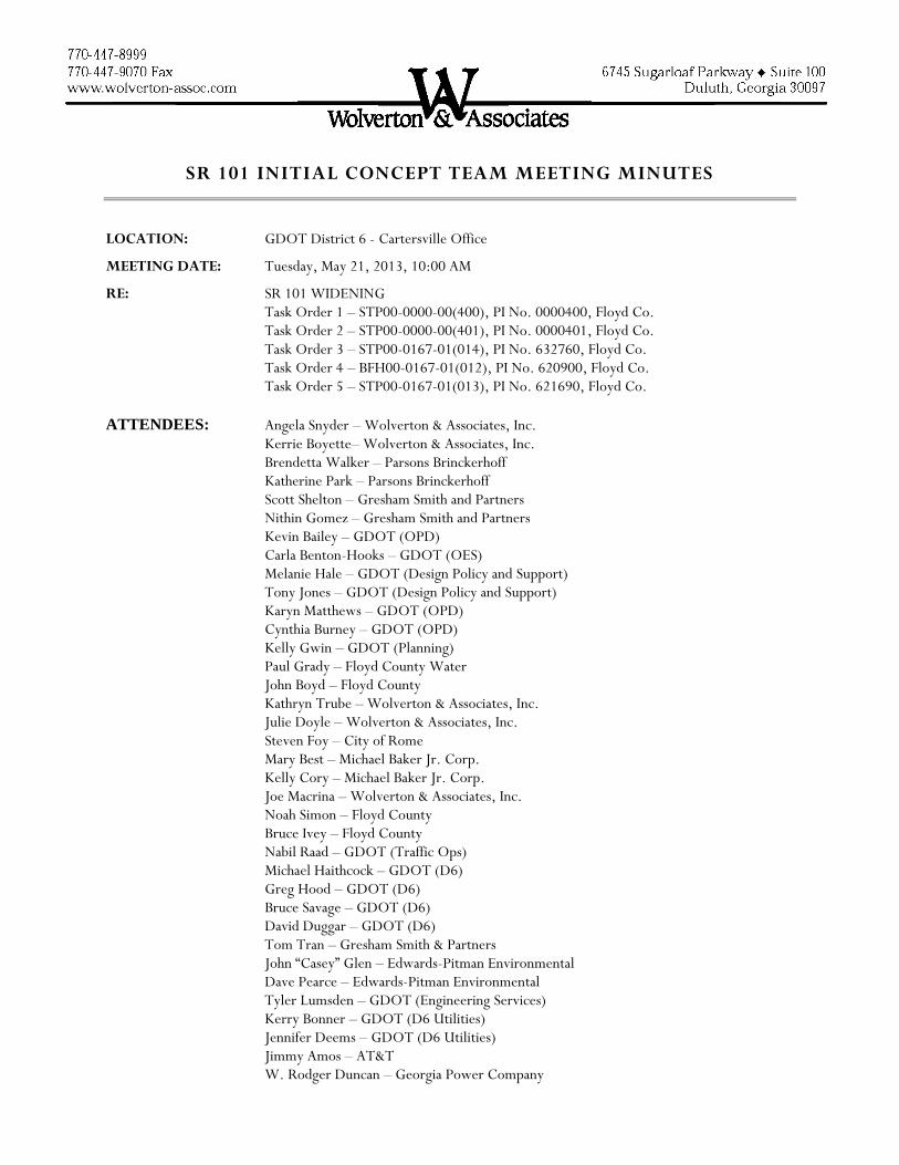
SR 101 INITIAL CONCEPT TEAM MEETING MINUTES
LOCATION: GDOT District 6 - Cartersville Office
MEETING DATE: Tuesday, May 21, 2013, 10:00 AM
RE: SR 101 WIDENING Task Order 1 – STP00-0000-00(400), PI No. 0000400, Floyd Co. Task Order 2 – STP00-0000-00(401), PI No. 0000401, Floyd Co. Task Order 3 – STP00-0167-01(014), PI No. 632760, Floyd Co. Task Order 4 – BFH00-0167-01(012), PI No. 620900, Floyd Co. Task Order 5 – STP00-0167-01(013), PI No. 621690, Floyd Co. ATTENDEES: Angela Snyder – Wolverton & Associates, Inc. Kerrie Boyette– Wolverton & Associates, Inc.
Brendetta Walker – Parsons Brinckerhoff Katherine Park – Parsons Brinckerhoff
Scott Shelton – Gresham Smith and Partners Nithin Gomez – Gresham Smith and Partners Kevin Bailey – GDOT (OPD) Carla Benton-Hooks – GDOT (OES) Melanie Hale – GDOT (Design Policy and Support) Tony Jones – GDOT (Design Policy and Support) Karyn Matthews – GDOT (OPD) Cynthia Burney – GDOT (OPD) Kelly Gwin – GDOT (Planning) Paul Grady – Floyd County Water John Boyd – Floyd County Kathryn Trube – Wolverton & Associates, Inc. Julie Doyle – Wolverton & Associates, Inc. Steven Foy – City of Rome Mary Best – Michael Baker Jr. Corp.
Kelly Cory – Michael Baker Jr. Corp. Joe Macrina – Wolverton & Associates, Inc. Noah Simon – Floyd County Bruce Ivey – Floyd County Nabil Raad – GDOT (Traffic Ops) Michael Haithcock – GDOT (D6) Greg Hood – GDOT (D6) Bruce Savage – GDOT (D6) David Duggar – GDOT (D6) Tom Tran – Gresham Smith & Partners John “Casey” Glen – Edwards-Pitman Environmental Dave Pearce – Edwards-Pitman Environmental Tyler Lumsden – GDOT (Engineering Services) Kerry Bonner – GDOT (D6 Utilities) Jennifer Deems – GDOT (D6 Utilities) Jimmy Amos – AT&T W. Rodger Duncan – Georgia Power Company

SR 101 Initial Concept Team Meeting Minutes May 21, 2013 Page 2 of 8
Dee Corson – GDOT (Traffic Ops)
GENERAL TOPICS Kevin Bailey opened the meeting and introduced himself as the GDOT PM on the project and
explained the purpose of an Initial Concept Team Meeting. Everyone then introduced themselves. Kevin handed it over to Angela Snyder to conduct the meeting. Angela gave a brief overview of the five projects in the corridor and outlined what the consultants
have been scoped for: concept, environmental studies, public involvement, conceptual survey, conceptual pavement analysis, traffic studies, and 20% preliminary plans, as well as a traffic study for a project further south of the corridor. She explained that we were given a very aggressive schedule to complete in 13 months, but that we are likely to need an extension of three months due to the review times needed by the Department due to the magnitude of the project. She explained that the purpose of this project is to address safety and congestion issues along the corridor.
Kerrie Boyette explained that a major concern for us is the South and Southeast Rome Bypass which ties into two of the SR 101 widening projects. Kerrie asked the GDOT PM, Cynthia Burney, to share information to the group about the project schedules.
Cynthia said that the South Rome Bypass is on schedule to be funded for construction in fiscal year 2017. The TIP is still undergoing budgeting review and it is undetermined at this time if this project will be funded, but she believes that it is on schedule to receive funding. The South East Rome Bypass is scheduled to receive funding in fiscal year 2018.
Kerrie asked Cynthia if she could provide the consultant’s plans for the South East Rome Bypass to the Project Team in order to incorporate the proposed design features into the SR 101 concept layouts.
Nithin Gomez then gave an update on the traffic projections. He said they have completed all of the counts along the project starting at SR 6 and extending through the interchange at US 411. They have assembled all the counts and have provided that information to Abby Ebodaghe at GDOT along with the methodology for projections and growth rate. Once this information is approved by Abby, they will begin the traffic projections and diagrams.
Kerrie stated that we have received some of the accident information along the corridor and it is higher than the statewide average. The local police and emergency services confirmed at the stakeholder meeting last week that safety is a major concern along the corridor and that many accidents are occurring. They said there is at least one fatality every year.
o Kerrie was then asked if all of the accidents were occurring at a consistent location or if they were in different places along the corridor.
o Angela answered that the accidents were occurring in various places along the corridor based on the data that we have received and includes many types such as rear-ends, single car, embankment and guardrail face. Emergency services confirmed the data stating that most of the accidents were due to speed.
SR 101 Initial Concept Team Meeting Minutes May 21, 2013 Page 3 of 8
o Angela then explained that a spot speed study had been conducted in March 2013 and it verified that people are driving faster than the posted speed throughout the corridor.
o Kelly said that on Task Order 5 the side road named Saddle Mountain could be a major accident area due to the skew angle and steep grades. She asked if the designers had considered how to address that area.
o Scott Shelton answered that this area will be closely investigated during the concept development phase of the project. He stated that while conducting the site visit, his car bottomed out while turning down that side road. He said they may have to do a design exception at that location, but that it will all depend on the typical section chosen.
Kerrie went over the potential roundabout or traffic signal locations on the corridor including the intersections of: Wax Road, South/Southeast Rome Bypass, and Saddle Trail Road.
Kerrie asked the District for any existing maintenance issues that they are aware of such as drainage or pavement issues. The district said that there were no known issues that they were aware of at this time.
Joe Macrina asked Kerrie to go the methodology used in determining the base and design years (2021 and 2014, respectively) for the traffic projections.
o Kerrie explained that the base year of 2021 was selected based on R/W acquisition to begin in 2016 which would last two years, then two and half years to complete the construction.
o Angela explained that Abby agreed with the methodology for selection 2021 since it is considered a Long Range project.
Kelly Cory then asked if there was any discussion or basis involved in selecting the growth factor and using a constant factor.
o Nithin explained that they considered different models to determine the growth factor including the fact that Rome has a 2040 model.
o Nithin stated that this information was presented to Abby during the methodology discussion held on April 29th, 2013 and she provided direction regarding the model that should be used. Abby explained that the existing growth rate should not be used since there has been a decline in traffic volumes over the last several years.
Angela then provided an update regarding the recent public involvement meetings that have been held and those planned for the future. A stakeholder meeting with Floyd County School System was held in the morning on May 13, 2013 and another meeting with Rome and Floyd County Emergency Services was held that same afternoon. A Local Government Meeting is currently scheduled with the City of Rome and Floyd County Elected Officials on July 25, 2013. A PIOH is tentatively scheduled for August 2013.
o She said that in a meeting with the emergency services, she asked them how they would feel about lowering the speed limit along the corridor. The City of Rome was interested in reducing the speed within the city limits but the County was not interested in reducing the speed outside of the city due to the high number of trucks and lack of ability to enforce a lower speed.
SR 101 Initial Concept Team Meeting Minutes May 21, 2013 Page 4 of 8
o She then stated that during the stakeholder meeting with Floyd County Schools, there was concern regarding the Rome Bypass in that they have not been able to reach an agreement with GDOT for the right of way acquisition for Midway School.
o Bruce Savage with District 6 Right of Way responded that the school is an issue because they are closing their second access point by replacing Preacher Smith Road with the Southeast Rome Bypass. They will be re-routing parents through a neighborhood on a roadway that they believe is sub-standard. The business across the street from the school is also displeased due to the loss of their driveways since the Rome Bypass will be limited access.
Michael Haithcock advised the Project Team of potential issues related to right of way to be anticipated during the PIOH. For the Southeast Rome Bypass, a news article was released in 2008 that GDOT was going to start buying right of way. Those plans required several total takes. Then funding for the project was pulled and the I-Bat issues came up. Those property owners were ready to move and are still waiting seven years later. He said due to this, there may be negative publicity since these projects have taken so long. He suggested that we use caution with giving a time frame for when right of way will be acquired when talking to the public.
Cynthia then provided an update regarding Letting of the Bypass projects. She said that until the locals can help fund construction, there is not much that can be done. She said currently the South Rome Bypass is scheduled to receive funding in 2017 and the Southeast Rome Bypass is scheduled for 2018 based on the TIP.
Bruce explained that the cost to cure for Midway School has been difficult on the Bypass projects because the Bypass is limited access which prohibits driveway access. The school’s biggest concern is the need to separate the parent and bus traffic. Some of the parcels, including the school, may be condemnations.
o He stated that they are currently on hold until spring of 2014 due to the I-Bat. o For the South Rome Bypass they have purchased 170 out of 175 parcels. o For the Southeast Rome Bypass, there are over 100 parcels and right of way acquisition has
not yet begun. Kerrie went over the SUE scope and provided information regarding known facilities along the
corridor. She stated that a SUE Kick off meeting was conducted at GDOT on May 15, 2013 to discuss the deliverables and schedule related to the Quality Level D SUE Submittal. She indicated that the only facilities that were not yet confirmed along the corridor were belonging to AT&T.
o Jimmy Amos with AT&T stated that a field visit would be required to confirm the facilities along the corridor, but that he is aware that SR 101 between Rome and Rockmart is a major artery for their network. He confirmed that it is likely that they have a duct bank along the corridor.
o Joe asked if we would be making any vertical cuts on the projects that could impact the duct bank.
o Angela responded that there were several vertical curves of concern related to sight distance that would most likely require cuts.
o Kerrie added that on Task Order 2, the existing profile mostly meets a speed design of 45 mph with some curves as low as 40 mph even though the roadway is posted 55 mph.
SR 101 Initial Concept Team Meeting Minutes May 21, 2013 Page 5 of 8
Angela then provided an update related to the environmental special studies on the project. She said that there are about 20 potentially eligible historic properties on the corridor, which are mostly set back off the road. HNTB is currently working on the report that will detail the boundaries of the historic properties.
o Joe then asked for the existing Right of Way width along the corridor. o Angela responded that in most places it is approximately 100 feet but that varies in some
areas. o Joe commented that most likely this project will require us to acquire right of way.
Dave Pearce then provided an update related to archeology. A previous report for the Bypass project has been pulled for initial environmental documentation. It is only a background materials check, and if the project is to proceed with plans and an environmental document, a field study will be required for SR 101.
Casey Glen then updated the group on the ecology portion of the scope. He said that with the help of the Environmental Protection Division (EPD), the Team has identified waters along the corridor and determined their classifications.
o The area is within a trout watershed meaning that there will be a 50 foot buffer required for the streams.
o They identified about thirty buffered resources. Some of them will require a 404 permit from the Corps of Engineers. Under current EPD guidance, streams themselves cannot be impacted, but the buffer can be, with an approved buffer variance. However, changes will be made to the requirements of buffer variances possibly as early as July 2013. He is unsure of what those changes might look like.
o The streams are running both parallel and perpendicular to the roadway. The parallel streams are the ones that pose a problem. The stream that is most concerning is one that is near the intersection of SR 101 and Wax Road where the stream is running along the east side of SR 101 for a significant distance. The stream then crosses SR 101 and runs parallel to Wax Road before crossing under it through a multiple barrel CMP.
o Joe then asked what not impacting the stream meant: not being allowed to or having to fill out more forms to do it.
o Casey said we will not be allowed to touch the actual stream at all. Casey then provided an update regarding endangered species along the corridor. He stated that the
only one that is possibly an issue is the Indiana Bat. o Angela said that after conversations with GDOT, it was determined to not conduct the I-
Bat study at this point in the process. Mary Best then provided an update for the Need and Purpose and Logical Termini portion of the
project. She said that safety and congestion are the need and purpose of this project. The need and purpose statement will form the basis of the NEPA document. The logical termini will be determined based on the traffic studies.
o Karyn Matthews asked if the interchange project would address operational improvements or the need to add additional capacity.
o Scott answered that the traffic study will answer that question once the study has begun.
SR 101 Initial Concept Team Meeting Minutes May 21, 2013 Page 6 of 8
o Mary said that based on conversations with OES, one Need and Purpose document will be provided.
Kerrie then talked about the speed limit along the corridor and how it changes from 55 mph at the southern portion to 50 mph then to 45 mph just before the interchange. She then opened up the floor for discussion about the proposed typical section. She pointed out that the Southeast Rome Bypass project includes one mile of widening on SR 101 to a four-lane section with a 20 foot raised median, curb and gutter, bike lanes, and sidewalk. She asked Cynthia to confirm that these improvements are being proposed with the bypass project.
o Cynthia agreed to confirm the improvements needed along SR 101. The Right of Way plans seemed to show that the one mile section of SR 101 is about 0.5 mile on each side of the proposed bypass.
o Joe commented that the typical section for the SR 101 improvements proposed as part of the Bypass project means a design speed of 45 mph.
Kelly asked for clarification on including the Bypass project as being built when determining the logical termini for this project.
o Angela said that based on direction from GDOT, we are to design and develop the concept report for the SR 101 widening project assuming that both Bypass projects are built.
Michael stated that Rome has a good network of multi-use trails. He would really like it if this project had a multi-use trail to connect to the ones already in existence.
o Noah Simon commented that multi-use trails are controversial and tend to have a negative connotation within the County. He asked that the County and City be able to provide input during the Local Government Meeting scheduled for July 25, 2013 regarding this discussion.
o Bruce said that he thinks both Bypass projects will be constructed before the SR 101 widening project, and that during the PIOH, we could get a lot of information from the public about what they would like to see in a typical section.
o Joe said that in order to have a multi-use trail we would have to lower the speed limit to 45 mph and include curb and gutter.
o Kelly suggested that the section north of the Bypass could be lowered to a speed limit of 45 mph and then south of the Bypass could remain at 55 mph. Joe agreed by stating that the ADTs seem to support that suggestion.
Michael then stated that Dwayne Comer (District 6 Engineer) has some innovative ideas regarding the interchange and explained that he had shared those ideas with Gresham Smith previously.
o Scott said they have his sketch and will need to evaluate impacts. They have another idea sketched and will put together a cost to determine a cost/benefit ratio during the concept development.
Nithin responded to Joe saying that the ADTs are the current year ADTs and believes that, based on their preliminary projections, most of the corridor will require a four-lane section in the design year.
o Kelly suggested that the Team determine a logical location to transition the typical section down from a four-lane section.
SR 101 Initial Concept Team Meeting Minutes May 21, 2013 Page 7 of 8
o Nithin responded that based on their current projections, Wax Road will likely be the point for a drop in traffic.
o Kelly stated that since Wax Road is a signalized intersection, it would be a logical transition from a four-lane to a three-lane section.
Karyn said if we lowered the speed to 45 mph and could keep a bike lane, maybe it could connect to the multi-use paths that already exist. She explained that the Silver Comet trail is located in Rockmart which is about 10 miles away from the project, so it may not be unrealistic to connect the trail to Rome.
Angela stated that since the improvements to SR 101 due to the Bypass project would have recently been completed, it does not make sense to reconstruct that one mile section of the road; therefore, the typical section for at least a portion of SR 101, would be a 20 foot median with curb and gutter, bike lanes, and sidewalk adjacent to the bypass.
o Joe said that based on GDOT regulations, from capacity standpoint, we could propose a five-lane section north of the Bypass and transition to a three-lane section south leaving the median at the Bypass.
Angela asked if there was any opposition to a five-lane section or to changing the speed limit to 45 mph.
o Noah suggested that the July 25th meeting would probably be the best place to have the discussion about changing the speed limit.
o Kelly said that if emergency services said they could not enforce the lower speed limit, then maybe adding the curb and gutter would help give a safer place for them to run radar.
o Kerrie confirmed that Floyd County does not currently run radar because there is not an adequate shoulder to pull off the road.
Melanie Hale then asked if we had considered creating curvature and traffic calming measures to the design to force drivers to go slower on the road.
o Karyn said that those measures are controversial at GDOT. o It was then stated that the concern is if we lower the speed limit and provide a place to
enforce, people will start to get more and more tickets. Then, they will complain and request a spot speed study which will show that drivers are using higher speeds. This could cause them to raise the speed limit of the road that was designed at a lower speed.
Kerrie then added that during the stakeholder meetings, the Team learned that SR 101 is used as the main route from Rome to the Atlanta airport. Knowing this, the corridor could be viewed by the public as a highway with higher speeds.
o Angela then asked if Cynthia could provide the concept report for the Bypass project to determine the reason for assuming a speed design of 45 mph along SR 101.
o Cynthia said she was unsure of what went into that decision but that she would provide this information to the Team.
Melanie asked if the design team was hoping to include sidewalks on the project. o Angela replied there are not currently many pedestrians walking out there today, but that
it is probably because they do not feel safe walking out there today. Joe then asked if this project is something that the District wants.
SR 101 Initial Concept Team Meeting Minutes May 21, 2013 Page 8 of 8
o Noah said that they know they want improvements made to SR 101, but were not interested in sidewalks or bike lanes.
o Greg Hood acknowledged that the project was favorable to the District. o Joe said it was one of the top priority projects for the region on the TIA list.
Kevin then asked if anyone had any further questions and thanked everyone for coming. The meeting adjourned at 11:20.
DEPARTMENT OF TRANSPORTATION STATE OF GEORGIA
INTERDEPARTMENT CORRESPONDENCE
FILE: P. I. Nos. 0000400, 0000401, 632760, 620900, 621690
OFFICE: Environmental Services
DATE: November 20, 2013
FROM Glenn Bowman, P.E., State Environmental Administrator TO Distribution Below SUBJECT PUBLIC INFORMATION OPEN HOUSE SYNOPSIS PROJECT Nos. & COUNTIES: STP00-0000-00(400), STP00-0000-00(401), STP00-0167-
01(014), BFH00-0167-01(012), STP00-0167-01(013), Floyd County
PROJECT DESCRIPTION: SR 101 Improvements from Pleasant Hope Road to the US
411 Interchange DATE: November 19, 2013 NUMBER IN ATTENDANCE: 163 OFFICIALS IN ATTENDANCE: None Rome News Tribune and WRGA/South 107 Media in
attendance NUMBER OF COMMENTS: COMMENT THEMES:
31 comment forms were submitted. 9 comment forms expressed opposition to at least one of the projects, mainly related to impacts to property, homes and Saddlebrook Downs Subdivision; not enough congestion to warrant widening; alternating passing lanes preferred. Those supporting at least one of the projects noted the dangerous nature of the road, the need to accommodate traffic, a desire to expedite the project.
PREPARED BY: Leah Vaughan, Sycamore Consulting, Inc. TELEPHONE No.: (404) 377-9147 cc: Kenneth Franks, P.E. DeWayne Comer, P.E. Mohammed Arafa
Sam Pugh
Jenelle Sams
SR 101 Stakeholder Interview Floyd County/City of Rome Emergency Management May 13, 2013 Attendees: Scotty Hancock, Floyd County Debbie Burnett, Rome Police Elaine Snow, Rome Police Robby Hill, Floyd County Michael Patterson, Floyd County Bud Owens, Floyd County Kevin Bailey, GDOT Angela Snyder, Project Team Kerrie Boyette, Project Team Leah Vaughan, Project Team Marissa Martin, Project Team Brendetta Walker, Project Team Kevin Bailey of GDOT opened the meeting by thanking everyone for their participation and asking each
person to introduce him/herself. Following introductions, Angela Snyder briefly reviewed the project,
indicating that the corridor improvements would include 5 separate projects. She further described
the project as being considered as long range. She noted that GDOT is currently in the concept
development phase.
Leah Vaughan asked participants to identify areas where issues with the transportation facility were present. The following responses were given:
Fatalities have occurred at Spur 101 and Pleasant Valley Road. This is a low visibility site with a skewed intersection.
Driver behavior is an issue. People drive like they are on the interstate. There is also an issue with people not paying attention to left turn lanes.
The intersection of SR 101 and Saddle Mountain Road is at the crest of a hill, making it a dangerous intersection.
From SR 101 the turning movement on to US 411 or Lombardy Way results in lots of near miss crashes.
There are issues with people waiting to turn left at the bottom of a hill at Saddle Trail – with vehicles behind them speeding down the hill, trying to beat the light.
A meeting participant asked if the whole corridor would be four-laned. Angela responded that the project is in the concept development phase and that the department is seeking to identify the appropriate improvement.
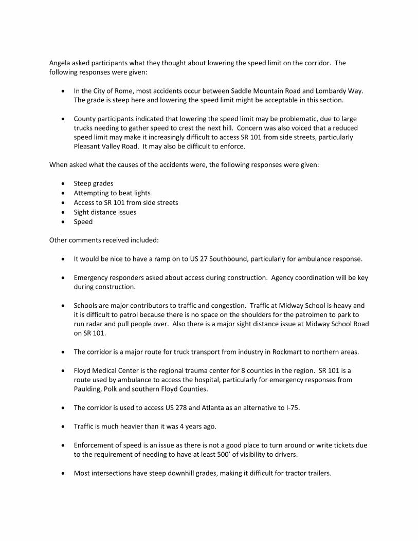
Angela asked participants what they thought about lowering the speed limit on the corridor. The following responses were given:
In the City of Rome, most accidents occur between Saddle Mountain Road and Lombardy Way. The grade is steep here and lowering the speed limit might be acceptable in this section.
County participants indicated that lowering the speed limit may be problematic, due to large trucks needing to gather speed to crest the next hill. Concern was also voiced that a reduced speed limit may make it increasingly difficult to access SR 101 from side streets, particularly Pleasant Valley Road. It may also be difficult to enforce.
When asked what the causes of the accidents were, the following responses were given:
Steep grades
Attempting to beat lights
Access to SR 101 from side streets
Sight distance issues
Speed Other comments received included:
It would be nice to have a ramp on to US 27 Southbound, particularly for ambulance response.
Emergency responders asked about access during construction. Agency coordination will be key during construction.
Schools are major contributors to traffic and congestion. Traffic at Midway School is heavy and it is difficult to patrol because there is no space on the shoulders for the patrolmen to park to run radar and pull people over. Also there is a major sight distance issue at Midway School Road on SR 101.
The corridor is a major route for truck transport from industry in Rockmart to northern areas.
Floyd Medical Center is the regional trauma center for 8 counties in the region. SR 101 is a route used by ambulance to access the hospital, particularly for emergency responses from Paulding, Polk and southern Floyd Counties.
The corridor is used to access US 278 and Atlanta as an alternative to I-75.
Traffic is much heavier than it was 4 years ago.
Enforcement of speed is an issue as there is not a good place to turn around or write tickets due to the requirement of needing to have at least 500’ of visibility to drivers.
Most intersections have steep downhill grades, making it difficult for tractor trailers.

Most accidents at Wax Road are rear end collisions, with people coming down the hill and colliding with vehicles attempting to turn left.
Single car accidents generally occur more often on the northbound route. Speed and weather conditions make it treacherous (i.e. snow, rain).
Several participants indicated that they encourage their family members to use alternative routes (i.e. Preacher Smith Road).
Reducing the speed would increase congestion.
Head on collisions or other wrecks are due to people passing with inadequate sight distance.
When asked if there were short term improvements that should be considered, meeting participants discussed the possibility of warning flashing lights at dangerous intersections. They also noted that full signalization of the intersections may not be the answer, though they suggested it did help at Wax Road. When asked about freight issues, meeting participants described a very active train track. They further noted that trains often sit on the tracks while waiting for another train to pass. This results in several roads being locked in, such as Maple and Donohoo Roads. There being no additional comments, the meeting was adjourned.
SR 101 Stakeholder Interview Floyd County School Board May 13, 2013 Attendees: Derry Richardson, Floyd County Schools Guy Hall, Floyd County Schools Sam Sprewell, Floyd County Schools Tim Hensley, Floyd County Schools Kevin Bailey, Georgia Department of Transportation Angela Snyder, Wolverton & Associates Kerrie Boyette, Wolverton & Associates Leah Vaughan, Sycamore Consulting Marissa Martin, Gresham Smith Partners Leah Vaughan opened the meeting by thanking everyone for their time and asked everyone to introduce
themselves. Following introductions, Angela Snyder briefly reviewed the project, indicating that the
corridor improvements would include 5 separate projects.
A representative from the School Board asked if the projects would be built in the order listed on the
location map. Angela responded not necessarily and further described the project as being considered
as long range. She noted that GDOT is currently in the concept development phase.
A school system employee noted that Midway School, which is located along SR 101, currently has less
than 300 students and is K-3.
When asked about transportation issues and concerns to the School System the following responses
were given:
How much property will be absorbed from Midway School? Our concern is buses entering and
exiting and having to cross multiple lanes of traffic. Coming out of Midway Road and having
decent sight distance is a great concern. A new bus lane will need to be constructed, and we are
land locked.
The South Rome By-Pass will acquire approximately 3.4 acres from the school. You need to get
the plans for the South Rome By-Pass to see how these two projects would affect the school.
The school system carefully selects bus stop locations, as safety is a major concern. All bus stops
along SR 101 would need to be reevaluated in conjunction with the improvements to the
corridor.
The project in yellow (PI 0000406) is the worst part of the corridor. Is there a way to go ahead
and fix that segment? The commenter who suggested this lives along this segment of SR 101.
Hilly nature of the corridor results in limited sight distance and the need for trucks to go fast in
order to get back up the next hill. This in turn makes it difficult for vehicles to enter the SR 101
corridor from side streets. Pleasant Valley Road is a prime example of this issue.
The corridor is a major thoroughfare to Rome and speed is an issue.
There is a paper mill in the western part of the county. If the bypass is completed, the trucks
coming from the mill will drive right past the school.
While in negotiations with the State for right of way associated with the South Rome Bypass, the
School System conducted a Risk Hazard Study. The results of this study indicate that the school
site will be unsafe once the South Rome Bypass is constructed.
SR 101 is the dividing line between school zones. Buses drop kids off at Midway School and then
cross over SR 101 to go to other schools.
Specific intersections that need attention are SR 101 with the following side streets:
Preacher Smith Road
Donahoo Road
Old Rockmart Road
Wax Road
Treemont Drive
Pleasant Hope Road
Buses are interspersed with cars during school rush hours, beginning at 7:00 am. When asked if
the staff was aware of any accidents along SR 101 involving buses, the answer was no.
The corridor is not an isolated rural area any more. It is seen as a viable alternative to I-75 when
trying to access the airport. When asked why there were so many accidents, staff responded
that speed, commuters from Polk attempting to get to Rome for work, pass through truckers
especially to airport, and trucks.
School system staff suggested that the Public Information Open House could be held at the
school.
There being no additional comments the meeting was adjourned.

SR 101 Stakeholder Interview Floyd County/City of Rome Emergency Management May 13, 2013 Attendees: Scotty Hancock, Floyd County Debbie Burnett, Rome Police Elaine Snow, Rome Police Robby Hill, Floyd County Michael Patterson, Floyd County Bud Owens, Floyd County Kevin Bailey, GDOT Angela Snyder, Project Team Kerrie Boyette, Project Team Leah Vaughan, Project Team Marissa Martin, Project Team Brendetta Walker, Project Team Kevin Bailey of GDOT opened the meeting by thanking everyone for their participation and asking each
person to introduce him/herself. Following introductions, Angela Snyder briefly reviewed the project,
indicating that the corridor improvements would include 5 separate projects. She further described
the project as being considered as long range. She noted that GDOT is currently in the concept
development phase.
Leah Vaughan asked participants to identify areas where issues with the transportation facility were present. The following responses were given:
Fatalities have occurred at Spur 101 and Pleasant Valley Road. This is a low visibility site with a skewed intersection.
Driver behavior is an issue. People drive like they are on the interstate. There is also an issue with people not paying attention to left turn lanes.
The intersection of SR 101 and Saddle Mountain Road is at the crest of a hill, making it a dangerous intersection.
From SR 101 the turning movement on to US 411 or Lombardy Way results in lots of near miss crashes.
There are issues with people waiting to turn left at the bottom of a hill at Saddle Trail – with vehicles behind them speeding down the hill, trying to beat the light.
A meeting participant asked if the whole corridor would be four-laned. Angela responded that the project is in the concept development phase and that the department is seeking to identify the appropriate improvement.

Angela asked participants what they thought about lowering the speed limit on the corridor. The following responses were given:
In the City of Rome, most accidents occur between Saddle Mountain Road and Lombardy Way. The grade is steep here and lowering the speed limit might be acceptable in this section.
County participants indicated that lowering the speed limit may be problematic, due to large trucks needing to gather speed to crest the next hill. Concern was also voiced that a reduced speed limit may make it increasingly difficult to access SR 101 from side streets, particularly Pleasant Valley Road. It may also be difficult to enforce.
When asked what the causes of the accidents were, the following responses were given:
Steep grades
Attempting to beat lights
Access to SR 101 from side streets
Sight distance issues
Speed Other comments received included:
It would be nice to have a ramp on to US 27 Southbound, particularly for ambulance response.
Emergency responders asked about access during construction. Agency coordination will be key during construction.
Schools are major contributors to traffic and congestion. Traffic at Midway School is heavy and it is difficult to patrol because there is no space on the shoulders for the patrolmen to park to run radar and pull people over. Also there is a major sight distance issue at Midway School Road on SR 101.
The corridor is a major route for truck transport from industry in Rockmart to northern areas.
Floyd Medical Center is the regional trauma center for 8 counties in the region. SR 101 is a route used by ambulance to access the hospital, particularly for emergency responses from Paulding, Polk and southern Floyd Counties.
The corridor is used to access US 278 and Atlanta as an alternative to I-75.
Traffic is much heavier than it was 4 years ago.
Enforcement of speed is an issue as there is not a good place to turn around or write tickets due to the requirement of needing to have at least 500’ of visibility to drivers.
Most intersections have steep downhill grades, making it difficult for tractor trailers.
Most accidents at Wax Road are rear end collisions, with people coming down the hill and colliding with vehicles attempting to turn left.
Single car accidents generally occur more often on the northbound route. Speed and weather conditions make it treacherous (i.e. snow, rain).
Several participants indicated that they encourage their family members to use alternative routes (i.e. Preacher Smith Road).
Reducing the speed would increase congestion.
Head on collisions or other wrecks are due to people passing with inadequate sight distance.
When asked if there were short term improvements that should be considered, meeting participants discussed the possibility of warning flashing lights at dangerous intersections. They also noted that full signalization of the intersections may not be the answer, though they suggested it did help at Wax Road. When asked about freight issues, meeting participants described a very active train track. They further noted that trains often sit on the tracks while waiting for another train to pass. This results in several roads being locked in, such as Maple and Donohoo Roads. There being no additional comments, the meeting was adjourned.