Embed Size (px)
Citation preview
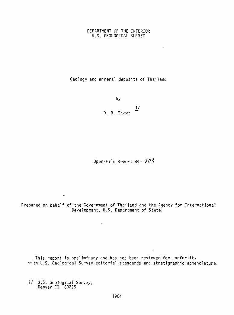
DEPARTMENT OF THE INTERIOR U.S. GEOLOGICAL SURVEY
Geology and mineral deposits of Thailand
by
I/ D. R. Shawe
Open-File Report 84-
Prepared on behalf of the Government of Thailand and the Agency for InternationalDevelopment, U.S. Department of State.
This report is preliminary and has not been reviewed for conformity with U.S. Geological Survey editorial standards and stratigraphic nomenclature,
_]/ U.S. Geological Survey, Denver CO 80225
1984
CONTENTSPage
INTRODUCTION.......................................................... 1GEOLOGY OF THAILAND................................................... ?
Stratigraphy of sedimentary rocks................................ 4Precambrian................................................. 4Cambrian.................................................... 6Ordovician.................................................. 7Silurian-Devonian........................................... I0Carboniferous............................................... 16Permian..................................................... 20Triassic.................................................... 25Jurassic.................................................... 29Cretaceous.................................................. 32Tertiary................................^................... 33Quaternary.................................................. 35
Igneous rocks.................................................... 36Precambrian. ................................................. 36Silurian-Devonian. ........................................... 37Carboniferous-Permian....................................... 37Triassic-Jurassic........................................... 41Cretaceous-Tertiary.......................................... A3Quaternary.................................................. 48
Metamorphic rocks................................................ 48Structure........................................................ 50
Precanbrian basement. ....................................... 50Phanerozoic stratigraphic discontinuities and orogenic
sediments.............................................. 51Folds in Fhanerozoic strata................................. 52Thrust faults............................................... 54Strike-slip faults.......................................... 55Other high-angle faults..................................... 58Structural relations in the Lampang quadrangle.............. 58Structural framework of the region surrounding Thailand..... 63.
Geologic history of Thailand..................................... 63MINERAL DEPOSITS...................................................... 68
Stratiform deposits.............................................. 69Potash and salt............................................. 69Phosphate................................................... 72Oil shale................................................... 7?Lignite and coal. ........................................... 73Marl. ....................................................... 74Diatomite................................................... 75Gypsun...................................................... ^Barite.............................................^........ 76Iron........................................................ 79Manganese................................................... 80Base setals................................................. $0
CONTENTS ContinuedPage
MINERAL DEPOSITS ContinuedStratiform deposits Continued
Sandstone-type copper and uranium........................... 35Replacement deposits............................................. 86
Pa Daeng zinc deposit....................................... 36Fluorspar................................................... SSIron........................................................ 91Base metals................................................. 95Tin......................................................... 95Tungsten.................................................... 96Phosphate................................................... 97
Stockvork and related deposits................................... "Tin......................................................... 98Copper...................................................... 107Molybdenum.................................................. HO
Vein deposits.................................................... 110Fluorspar.................................................... 110Antimony.................................................... 124Manganese................................................... 128Tin.............. ............................................ 131Tungs ten.................................................... 135Base metals................................................. 140Barite...................................................... 153Iron........................................................ 143Gold........................................................ 144
Other bedrock deposits........................................... 146Chromite.................................................... 146Asbestos.................................................... 146Graphite.................................................... 147Quartz and feldspar......................................... 148Clay...............................c........................ 148Uranium..................................................... 150
Residual deposits................................................ 152Nickel...................................................... 152Iron........................................................ 154Manganese................................................... 155Fluorspar................................................... 156Bauxite..................................................... 159Clay........................................................ 159
Placer deposits.................................................. 160Tin and tungsten............................................ 160Monazite and ilnenite sands and related deposits............ 163Gold........................................................ 165Gem minerals................................................ 166
Oil and gas deposits.............................................Geologic environments of mineral deposits........................Mineral resource potential of Thailand........................... 171
REFERENCES............................................................ 174

ILLUSTRATIONS
Page
Figure 1. Map of Thailand and surrounding region showing theposition of the Tibet-Yunnan-Thailand-Malaysia-Indonesia structural belt.......................................... 3
2. Map of Thailand showing the distribution ofPrecambrian rocks........................................ in pocket
3. Map of Thailand showing the distribution of igneous rocksand facies of sedimentary rocks of Carboniferous age..'... in Pocket
4. Map of Thailand showing distribution of igneous rocks...... in pocket5. Map of Thailand showing fold axes in Phanerozoic rocks..... in pocket6. Map of Thailand showing distribution of faults............. in Pocket7. Map showing principal zones of strike-slip faults and
Cenozoic basin in Thailand. ............................... "8. Geologic map of the Lanipang quadrangle, northwestern
Thailand................................................. 599. Major structural elements in the vicinity, of Thailand...... 62
10. Map showing locations of important mineral deposits andsome miscellaneous minor mineral deposits in Thailand.... in pocket
11. Map of the Khorat Plateau, Thailand, and localitiesreferred to in the text..................................
12. Map showing locations of oil shale and lignite depositsin Thailand.............................................. in Pocket
13. Map showing locations of barite deposits in Thailand....... in pocket14. Map showing locations of lead deposits in Thailand......... in pocket15. Map showing locations of fluorspar deposits, major
high-angle faults, and hot springs in Thailand........... in pocket16. Map showing locations of iron deposits and Triassic
granodiorite in Thailand................................. in pocket17. Map showing locations of tin deposits, intrusive igneous
rocks, and tin contents of intrusive igneous rocks in Thailand................................................. in pocket
18. Scatter diagram showing relation of SnOo to Si02 inThailand granitoid rocks................................. 101
19. Scatter diagram showing relation of tin to tungsten inThailand granitoid rocks................................. 102
20. Diagram of stockwork mineralized granite at Ipoo mine,Pilok district, and index map of the Pilok district...... 104
21. Map showing locations of copper deposits,-area ofsandstone-type copper deposits, area of anomalous copperin groundwater, and Triassic granodiorite in Thailand.... in pocket
22. Simplified geologic map of the Loei-Chiang Karn region of northeastern Thailand, showing aeromagnetic contours, mineral prospects, and geochemical and mineral anomalies................................................ in pocket
23. Diagrammatic geologic map of the Huai San fluorspardeposit near Fang........................................ 114
24. Geologic map of the region around the Mae Tha fluorspardistrier., Lacphun province. .............................. H?
25. Geologic iap of ;he Salak Phra fluorspar discrict.......... 12026. Map shewing lo^aticns of ancirr.crr.' izposil? and hot springs
in Thailand.............................................. in pocket
iii
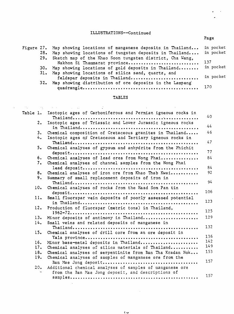
ILLUSTRATIONS ContinuedPage
Figure 27. Map showing locations of manganese deposits in Thailand... in pocket28. Map showing locations of tungsten deposits in Thailand.... in pocket29. Sketch map of the Khao Soon tungsten district, Cha Wang,
Nakhon Si Thannnarat province............................ 13730. Map showing locations of gold deposits in Thailand........ i-n pocket31. Map showing locations of silica sand, quartz, and
feldspar deposits in Thailand........................... in Pocket32. Map showing distribution of ore deposits In the Lampang
quadrangle..............................................
TABLES
Table 1. Isotopic ages of Carboniferous and Permian igneous rocks inThailand.................................................. 40
2. Isotopic ages of Triassic and Lower Jurassic igneous rocksin Thailand............................................... 44
3. Chemical composition of Cretaceous granites in Thailand..... 464. Isotopic ages o.f Cretaceous and Tertiary igneous rocks in
Thailand.................................................. 475. Chemical analyses of gypsum and anhydrite from the Phichit
deposit................................................... 776. Chemical analyses of lead ores from Nong Phai............... 847. Chemical analyses of channel samples from the Nong Phai
lead deposit.............................................. 848. Chemical analyses of iron ore from Khao Thab Kwai........... 929. Summary of small replacement deposits of iron in
Thailand.................................................. 9410. Chemical analyses of rocks from the Haad Som Pan tin
deposit................................................... 10611. Small fluorspar vein deposits of poorly assessed potential
in Thailand............................................... i2312. Production of fluorspar (metric tons) in Thailand,
1962-72................................................... 12513. Minor deposits of antimony in Thailand...................... 12914. Small veins and related deposits of manganese in
Thailand.................................................. 13215. Chemical analyses of drill core from an ore deposit in
Yala province.............................................16. Minor base-metal deposits in Thailand.......................17. Chemical analyses of silica materials of Thailand...........18. Chemical analyses of serpentinite from Ban Tha Kradan Nok... 15319. Chemical analyses of samples of manganese ore from the
Ban Mae Jong deposit...................................... 15720. Additional chemical analyses of samples of manganese ore
from the Ban Mae Jong deposit:, and descriptions of samples................................................... 15
GEOLOGY AND MINERAL DEPOSITS OF THAILAND -
By
Daniel R. Shawe
INTRODUCTION
The Thailand mineral resources evaluation project (P10/T 493-000 2-30123)," PASA SA(IC)03-74, is part of the U.S. Department of State's program to provide aid to developing countries. The project was funded by the rJ.S, Agency for International Development (AID), which provided salaries and trans portation costs for D. R. Shawe and R. L. Rite, U.S.. Geological Survey (USGS), to and from Thailand, and by tbs- Royal Thai Department of 'Mineral Resources (DHR) , which provided per diem and transportation costs in Thailand. Prior to the overseas assignment Shawe spent 2 months during 1973 in the United States reading available information on geology and mineral resources of Thailand, 4 months from mid-November 1973 to mid-March 1974 on the assignment in Thailand, and following the overseas assignment 12 months during 1974-75 in the United States preparing a final report (this report). Kite spent the first 2 1/2 months of 1974 on the assignment in Thailand, and, following the overseas assignment, spent 2 1/2 months during 1974 in the United States preparing a final report.
This report is being open filed now, with the permission of the Department of Mineral Resources, in order to make the contained information available to interested persons. No attempt has been made to update the report since the time it was prepared.
In addition to those in the U.S. Department of State and U.S. Geological Survey who made this project possible, many people in the Royal Thai Department of Mineral Resources were directly responsible for making our studies in Thailand profitable. Mr. Saman Buravas, Director-General of the Department, and Mr. Pisoot Sudasna, Deputy Director-General of the Department, made the full facilities of the Department available to us to support our work. Mr. Sangob Kaewbaidhoon, Chief of the Economic Geology Division of the Department, and Mr. Akanit Suwanasing of the Division, gave much time and effort to arranging working space for us, providing assistance, and planning and conducting field trips for us to mining properties throughout Thailand. Miss Ngarmpis Angkatavanich of the Geological Survey Division was assigned to us fulltime during our stay in Thailand; she provided us with great help in the compilation of data, and also summarized in English a large number of reports of the Department written in the Thai language. Others of the Department gave us much help, and their assistance is acknowledged, in the form of references to published reports and to written and oral communications, in appropriate places throughout this report. Unfortunately in this preliminary report it was impossible to cite all references properly in the bibliography; some references, not listed in the bibliography, are cited as written communications. ^
Thailand is an irregularly shaped country of nearly 500,000 km" (200,000 mi ) in southeast Asia; its bulbous northern part north of the Gulf of Thailand is bordered on the southeast by Kampuchea, on the northeast by
I/ Report prepared in 1975.
Laos, and on the northwest and west by Burma. A peninsular part extends southward on the west side of the Gulf; this part of Thailand is bordered on the west by Burma and the Andaman Sea, and on the south by Malaysia.
The country is divisible into several distinct geographic and geologic provinces. The northeastern part of Thailand is an area about 400 km by 400 kin (250 mi by 250 mi), mostly 100-500 m (330-1,650 ft) in altitude, consisting of the Khorat Plateau, a geologically stable region made up dominantly of flat-lying terrestrial and marine sedimentary rocks of Mesozoic age. Tertiary and Quaternary volcanic rocks occur along the western and southern boundaries of the Khorat Plateau. Northwestern Thailand averages about 600 kin (370 mi) north to south and 300 km (185 mi) east to west and consists of a series of mainly north-trending mountain ranges 500-2000 m (1,650-6,600 ft) high, and intervening basins 200-500 in (660-1,650 ft) high. Strongly folded and faulted sedimentary rocks, mostly marine and of Paleozoic and Mesozoic age, characterize the basin-range type mountains. The sedimentary rocks locally are intruded by batholithic granitic rocks of Carboniferous-Permian, Triassic- Jurassic, and Cretaceous-Tertiary ages, interlayered with mafic igneous rocks of Carboniferous age, or intruded or capped by Tertiary and Quaternary volcanic rocks. Southeastern Thailand is about 150 km by 150 km (100 mi by 100 mi), and Peninsular Thailand is about 800 km (500 mi) north to south and averages 100 km (60 mi) in width; although lower in altitude, these regions are geologically similar to the northwestern part of Thailand. The central part of the country is a broad alluviated plain bounding the Chao Phraya River; from the Gulf of Thailand northward about 400 km (250 mi) the plain rises from sea level to an altitude of 100 m (330 ft).
Much of Thailand is covered with tropical rain forest, and rocks at the surface are deeply weathered.. The Khorat Plateau is generally more arid than most of the remainder of Thailand, and parts are brush covered. The central plain is mainly a cultivated region where rice is the principal crop.
Many parts of Thailand are becoming readily accessible by paved highways, and this condition will have a positive influence on development of natural resources. The country's mineral resources to date have not been extensively exploited, although Thailand appears to be geologically favorable for the occurrence of significant resources of many metallic and noninetallic mineral commodities.
In this report I have found it impossible to be consistent in the use of Thailand place names. Sources of information on the geology and mineral deposits of Thailand that I used gave contradictory English spellings of many Thai names. I have attempted to standardize most of these spellings, but some have not been standardized. It is possible that some place name spellings have differed sufficiently so that I failed to recognize their essential identity, although in a few cases I recognized such identities simply from coincidence of position on the map. I recognized that two or more distinct Thai names have been applied to a few places. I was unable to establish the locations of several places accurately enough to show them or. the maps. A number of such locality names are given in the text even though they are not plotted on the maps.
GEOLOGY Or THAILAND
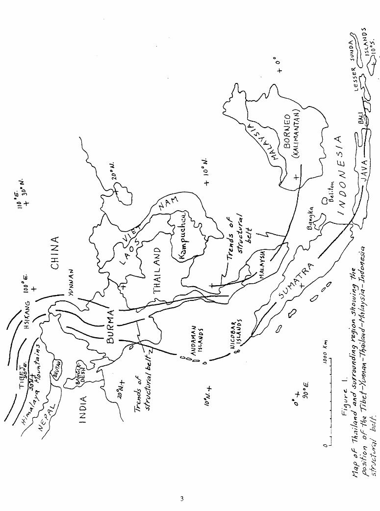
Thailand lies at the east edge of one of the world's major structural zones (fig. 1). N7orthward from northwestern Thailand the zone extends through
'! '£
*
surr
oundin
g r
egio
n
of
northeastern Burma and the Yunnan province of southern China, swings abruptly westward in Hsikang province, and thence extends westward through Tibet as the Himalaya mountain chain. Southward from northwestern Thailand and north eastern Burma the zone extends as two parallel elements, one running through western Burma and the Andaman Islands, curving southeastward through Sumatra, and thence extending eastward through Java and the Lesser Sunda Islands, and the other running southward through Peninsular Thailand and the Malay Peninsula and thence curving eastward through the northern islands of Indonesia. In the latitude of Thailand the structural zone marks a continen tal plate boundary where subduction of the Indian Oceanic subplate (western part of the Indo-Australian plate) recently has, or presently is, occurring at the western edge of the Southeast Asian continental subplate (southeastern part of the Eurasian plate).
The major structural zone extending the length of western Thailand appar ently has been active far into the geologic past. Facies distributions in sedimentary rocks, the presence of large volumes of igneous rocks, and fault and fold relations, indicate intermittent tectonic activity of the zone well back into the Paleozoic Era.
The geology of Thailand will be presented here in four categories: stratigraphy of sedimentary rocks, igneous rocks, metamorphic rocks, and structure.
Stratigraphy of sedimentary rocks
Precambrian
Sedimentary rocks of probable Precambrian age, now metamorphosed, occur widely throughout western Thailand but are unknown in northeastern Thailand and in Peninsular Thailand south of 10° N. latitude (fig. 2; Dheeradilok, 1973). (Town or city names are not given on figure 2, and on most of the other maps of Thailand that show geological data; appropriate town and local ity names are given on maps that show mineral distributions.) These rocks mostly are high-grade metamorphic rocks of ainphibolite facies and consist of a wide variety of types including paragneisses such as micaceous quartz-feldspar gneiss, biotite-inicrocline gneiss, and calc-silicate gneiss, and mica schist, quartz schist, amphibolite, quartzite, and marble. Associated with these metamorphosed sedimentary rocks, and in part indistinguishable from them, are various orthogneisses such as granitic gneiss, foliated granodiorite, and pegmatite as well as amphibolite formed as a result of metamorphism of mafic igneous rocks. The metamorphosed sedimentary rocks initially were shale, siltstone, sandstone (including arkose), and carbonate rocks. Their specific distributions are so poorly known that it is impossible to reconstruct the environments of deposition of the ancient rocks. Nor are their ages known to permit inferences regarding changes in environment with time, and reconstruc tion of the tectonic history of the Precambrian.
Some of the metamorphic rocks in Thailand appear to be younger in age than Precambrian (Campbell, 1973b, p. 1), for example some post-Precambrian sedimentary rocks have been metamorphosed by intrusion of mainly granitic rocks of Carboniferous and younger age. However, in a general way, most masses of inferred Precambrian metamorphic rocks appear to unconformably underlie Paleozoic sedimentary rocks that are unnetamorphosed or only slightly metamorphosed, and so assignment to the Precambrian seems valid.
The Chiang Saen massif in northernmost Thailand and adjacent Laos con sists of granite and granodiorite containing masses of a variety of gneisses, including augen gneiss with minor bands of marble, calcareous schist, and biotite-amphibole schist (Campbell, 1973b, p. 2; Workman, 1972, p. 4).
The Wiang Pa Pao schist about 100 km (60 mi) northeast of Chiang Mai is high-grade biotite-sillimanite schist and biotite schist (P. Nutalaya, quoted by Campbell, 1973b, p. 2).
The Chiang Mai-Tak gneiss belt that extends about 250 km (155 mi) from 50 km (30 mi) northwest of Chiang Mai southward to the vicinity of Tak was described by Baum and others (1970, p. 6-7) as an anticlinorium cored by granite-invaded raetamorphic rocks (anatexites) overlain by a series of biotite schists with marble intercalations up to 10 m (33 ft) thick, in part calc- silicate marble, in turn overlain by distinctive silica-rich rocks, possible meta-chert. Successively above these are about 500 m (1,650 ft) of fine grained schistose augen gneiss with minor chloritized biotite, 20 in (66 ft) of thin-bedded calcareous and quartzitic rocks, and 20 m (66 ft) of biotite- raarble. Northwest of Chiang Mai the massif displays intensely folded coarse gneiss, marble, and biotite-gneiss containing conglomeratic layers with abundant quartz pebbles (Baum and others, 1970, p. 7). West of Sam Ngao, Piyasin (1972b) and Nutalaya (1973a) reported high-grade mica-plagioclase- quartz schist, overlying marble schist containing interbedded quartzite and calc-silicate rock; biotite-microcline gneiss is also present. In the vicinity of Tak, feldspar-rich paragneiss, laminated calc-silicate rocks, marble, and quartzite, all invaded by migmatite and pegmatite, constitute a section perhaps 3 km (2 mi) thick (Campbell, written commun., 1973, p. 4-5). Baum and others (1970, p. 6) pointed out that the Chiang Mai-Tak metamorphic rocks are unconformably overlain by less-metamorphosed Cambrian and Ordovician formations, suggesting that the metasedimentary rocks were deposited and subsequently metamorphosed in Precambrian time.
The Ban Rai metamorphic complex, extending north-northwestward 125 km (80 mi) from 70 km (45 mi) west of Uthai Thani, according to Sripatanawat (quoted by Campbell, written commun., 1973, p. 5) consists of high-grade metamorphic rocks such as biotite gneiss (both paragneiss and orthogneiss reported), biotite schist, calc-silicate rocks, and biotite marble.
Gneisses are known in three small areas near Kanchanaburi (Brown and others, 1951, p. 43; S. Bunopas and P. Dheeradilok, quoted by Campbell, written commun., 1973, p. 6), one about 60 km (35 mi) north, another about 30 km (20 ni) northwest, and the third perhaps 20 km (12 ini) southeast of the city.
The Hua Hin gneiss extends for about 35 km (20 mi) along the coast on the Gulf of Thailand in the vicinity of the village of Hua Hin. According to Campbell (written commun., 1973, p. 6) the exposures consist of layered calc- silicate rocks, feldspar gneiss, and biotite schist; some of these rocks are sillimanitic.
Metamorphic rocks are known in small patches near Thabsake and Ranong in Peninsular Thailand, but no descriptions of these are available.
The Chonburi massif consists of several large masses as much as 60 km (40 mi) long that lie near to and about 50 km (30 mi) east and southeast of the city of Chonburi in southeastern Thailand. Metanorphic rocks of the r.assif are quartzo-feldspathic gneisses, migmatites, and granites of various kinds (Workman, 1972, p. 4), and near Chonburi layered calc-silicate rocks are also present (Canpbell, written cominun., 1973, p. 7).
In summary, it appears that biotite-quartz-feldspar gneisses are the main component and are the most widely distributed of presumed Precambrian metamorphic rocks in Thailand. These are generally believed to be paragneisses and are likely metamorphic equivalents of arkoses. Biotite schists also appear to be abundant and widespread; many of these rocks are metamorphosed clay-rich sedimentary rocks. Layered calc-silicate rocks are common and occur in almost all of the Precambrian metamorphic complexes. They likely are metamorphic equivalents of clayey and calcareous sedimentary rocks. Marble layers, which are metamorphosed carbonate sedimentary rocks, are a common although minor component of all the complexes in northern Thailand from the Ban Rai complex northward. They have not been recognized in the metamorphic rocks south of Ban Rai. Quartzites have been described only in the Chiang Mai-Tak gneiss belt, and occur throughout this complex. Conglomerate and raeta-chert are known only in the northern part of the Chiang Mai-Tak belt.
The metamorphosed sedimentary rocks of probable Precambrian age in Thailand are similar to those described elsewhere in Southeast Asia, with the exception that they do not have abundant aniphibolites associated with them as appears common in other parts of Southeast Asia (Workman, 1972, p. 2-4). Lack of age data also prevents correlation of Precambrian rocks in Thailand with those in adjoining regions. As indicated in later pages, the igneous and structural history of the Thailand part of the Precambrian differed somewhat from that elsewhere in Southeast Asia.
Cambrian
Sedimentary rocks of Cambrian age occur west of Nakhon Si Thammarat and south of Yala in Peninsular Thailand, on Tarutao Island southwest of the peninsula, and in various localities in northwestern Thailand. The geologic map of Thailand (Javanaphet, 1969) depicts Cambrian sedimentary rocks as the Tarutao Formation, consisting of red to brown arenaceous sandstone and quartzitic sandstone on Tarutao Island, and of red shale and sandy shale on the peninsula. Clastic strata also characterize the Cambrian in northwestern Thailand.
Koch (1973; quoted by Stokes, 1973, p. 13) described the Cambrian in northwestern Thailand as a sequence of fine- to coarse-grained sandstone and quartzite, locally grading to fine-grained clastic sedimentary rocks intercalated in the upper part. The rocks are generally somewhat metamorphosed. Thickness of the series seems to be well over 500 m (1,650 ft). South of Sri Sawat, a clastic succession of more than 400 m (1,300 ft) becomes more calcareous toward the top, with occasional impure limestone intercalations.
Piyasin (1972b) indicated that well-bedded white to gray massive quartzite conformably underlies Ordovician limestone in the Uttaradit region.
Sripatanawat (1972) described the Cambrian in the Nakhon Sawan region as consisting of quartz-schist, quartz-mica-schist, quartzite, and massive recrystallized limestone. Rocks considered to be Cambrian and Ordovician in age were described by Sripatanawat (1972) as bedded gray to dark-green quartzite, quartz schist, and slate, partly intercalated with thin-bedded white marble. Some quartzitic sandstone contains chert beds.
Bunopas (1972) described the Cambrian of northwestern Thailand as quartz- mica schist, and (1972) the Cambrian and Ordovician in the vicinity of

Phitsanulok as massive and well bedded quartzite grading upward into argillaceous limestone. S. Bunopas (oral commun., Dec. 1973) indicated that Upper Cambrian quartzite at the Ban Giao Nen damsite 50 km (30 mi) northwest of Kanchanaburi is about 200 m (660 ft) thick. There it has a conformable and gradational contact with overlying Ordovician rocks. About 40 km (25 mi) farther north the Cambrian is about 400 m (1,300 ft) thick.
According to Baum and others (1970, p. 8) Cambrian strata 40 km (25 mi) south of Lamphun consist of 400 m (1,650 ft) of whitish to violet-red crossbedded quartzite with minor layers of conglomerate containing mostly quartz pebbles and a few black chert pebbles. West of Fang and northwest of Hod the Cambrian is more pelitic. There, clayey sandstone (quartz-phyllite) lies above the basal Cambrian quartzite and below limestone of Early Ordovician age.
Baum and others (1970, p. 7) considered the clastic Cambrian strata in northwestern Thailand to be shallow-water marine in origin. S. Bunopas (oral commun., Dec. 1973) described them as miogeosynclinal. Ridd (1971; quoted by Stokes, 1973, p. 7) considered the Cambrian succession in Peninsular Thailand to consist of deltaic deposits overlain conformably by the Thung Song Limestone of Ordovician and Silurian age.
Kobayashi (written commun., 1957) identified brachiopods and trilobites collected from red or variegated hard compact sandstone of the Tarutao Sandstone on Tarutao Island as late Late Cambrian in age. -Wolfart (in Koch, 1973) considered the Tarutao sandstone fauna to be earliest Ordovician In age (Stokes, 1973, p. 8). Koch (1973) considered that the lover Paleozoic clastic strata in northwestern Thailand were of Cambrian age because of correspondence of the section to a succession in the Southern Shan State of China that has yielded olenellid trilobites. He believed that the clastic succession south of Sri Sawat was Cambrian on the basis that brachiopods and trilobites collected from limy layers in the upper part of the conformable sequence are of Early to Middle Ordovician age.
In summary, Cambrian strata in Thailand appear to be a succession of shallow marine clastic deposits, deltaic in Peninsular Thailand and formed on a shelf in northwestern Thailand. Sandstone and quartzite are the dominant lithologic types; clayey sediments are common to the south and limy sediments are common to the north, particularly in the upper part of the Cambrian section. Minor conglomeratic strata are present in northwestern Thailand. Although thickness data are not recorded for the Cambrian in Peninsular Thailand, map patterns suggest the likelihood of several hundred meters of strata. In western Thailand the Cambrian is about 200 m (660 ft) thick and in northern Thailand it is probably more than 500 m (1,650 ft) thick. Throughout Thailand the Cambrian appears to grade conformably into overlying Lower Ordovician strata; the time equivalence of the Cambrian in different parts of Thailand has not yet been established however.
Ordovician
Javanaphet (1969) showed sedimentary rocks of Ordovician age in Peninsular Thailand south of Nakhon Si Thammarat and south of Yala, on Tarutao Island, and in northwestern Thailand east and south of Mae Hong Son, west of Chiang Mai, and south of Lamphun. Workman (1972, p. 5) staced that crystalline dolomitic limestone on the island of Ko Si Chang in che Gulf of Thailand is speculatively correlated with Ordovician limestones of the Thai-
Malay peninsula. The geologic map of Thailand (Javanaphet, 1969) designated Ordovician rocks as belonging to the Thung Song Formation consisting of dark- gray massive limestone interbedded with dark-greenish-gray calcareous shale and sandy shale.
According to 3aum and others (1970, p. 8) strata in northwestern Thailand lying above Cambrian quartzite consist of well bedded siltstone and sandstone grading upward into yellow weathering shaly dolomite interbedded with siltstone and sandstone and into overlying light- to medium-gray thin layered, nodular, and massive fossiliferous limestone, east of Mao Hong Son, east of Mae Sariang, and north of Hod. The limestone sequence, dated as Ordovician, is 80-100 m (260-330 ft) thick. Algal reefs occur in the Ordovician near Mae Sariang. In places north of Mae Sariang, the Ordovician consists of dark arenaceous partly fossiliferous shales. Southwest of Fang, Ordovician rocks are dolomite and limestone containing shaly layers throughout. Bunopas (1972) described the Ordovician in parts of northwestern Thailand as consisting of mica-bearing limestone and interbedded argillite. Everywhere in northwestern Thailand, Ordovician strata are conformable with and transitional into underlying Cambrian rocks (Baum and others, 1970, p. 8),
Near Phitsanulok the Ordovician consists of argillaceous limestone (Bunopas, 1972).
Sripatanawat (1972) reported Ordovician strata in the vicinity of Nakhon Sawan to consist of bedded gray to dark-gray argillaceous limestone, in part interbedded with calcareous sandstone and phyllite. In this area, Cambrian strata grade into overlying Ordovician beds, from arenaceous strata through gray to dark-green quartzite, quartz schist, and slate intercalated with thin marble, quartzitic sandstone, and chert beds, into limestone.
In north-central Thailand, Piyasin (1972a,b) described the Ordovician as light- to medium-gray, well-bedded, laminated limestone containing many calcite veins.
Koch (1973) indicated that the Ordovician in Kanchanaburi province, western Thailand, has a basal part commonly of cross-bedded limestone containing fine- to coarse-grained sand. Above this, the main part of the Ordovician unit is fine-grained gray limestone, commonly with finely inter calated argillaceous layers and some nodular limestone. Reef limestone is found in places. The limestone content of the section decreases toward the top, which consists of fine-grained sandy and micaceous shale. Here the line- stone thickness is estimated to be about 450 m (1,500 ft), with about 100- 150 m (330-500 ft) of clastic strata at the top of the Ordovician.
R. Songsiri (oral comraun., Feb« 1974) stated that Lower and Upper Ordovician rocks northwest of Kanchanaburi include thin-bedded dense gray limestone, and Middle Ordovician strata are thin-bedded to massive fine grained sugary light-gray limestone. I observed that Lower and (or) Upper Ordovician beds there are commonly lenticularly bedded, with lenses of gray lines tone 3-10 nim (1/8-3/8 in) thick and a few centimeters across separated by dark-gray clayey diasterns. Locally the limestone contains intraformational conglomerate* Parts of these rocks have thin-bedded gray limestone layers 10- 50 cm (4-20 in) thick.
Lee (1923c, p. 3-4) measured 2740 m (9,000 ft) of evenly bedded limestone of presumed Ordovician age at Thung Song in Peninsular Thailand. Sand and clay are found on bedding planes in places in this unit. Thin discontinuous chert layers with remnant sponge spicules(?) are known in limestone east of Thung Song. Ordovician rocks on Langkawi Island near the Maiaysian bordar and

northward through Tarutao Island and inland at Amphoe Thungwa, and from Satun northward through Phatthalung to Khao Luang near Nakhon Si Thammarat, are massive black limestone (Royal Thai Deptartment of Mineral Resources, written commun., 1969; hereafter referred to as Thai Department of Mineral Resources). Kobayashi (written commun., 1961) indicated a shale wedge intercalated in the limestone at Amphoe Thungwa. Sethaput (written commun., 1951) described the Thung Song as dark-gray limestone with disseminated crystals of pyrite and thin stringers of brown calcareous material.
Kobayashi (1964a,b) described a stratigraphic sequence along the Thai- Malay border, from the base upward, as unfossiliferous limestone, carbonaceous black shale at Thung Song, Thung Song Limestone consisting of a lower Armenoceras zone and an upper Actinoceras zone, Satun Shale, and gastropod limestone (Pulau Langgong Limestone). I do not know how this section correlates with the thick section measured by Lee (1923c,d) in this region.
S. Bunopas (oral commun., Dec. 1973) stated that Ordovician limestone, mostly thin-bedded, generally has an unconformity at its top.
Ordovician strata at Ban Chao Nen damsite 50 km (30 mi) northwest of Kanchanaburi mark the northernmost known occurrence of Ordovician niegafossils; conodonts characterize the Ordovician farther north (S. Bunopas, oral commun., Dec. 1973). However, graptolitic shales of Middle Ordovician-Middle Silurian age are known in northern Thailand (Kobayashi, 1964b). In Peninsular Thailand Ordovician limestone strata underlie a Lower Silurian graptolite bed (Berry and Boucot, 1972a,b, p. 27; Kobayashi, 1964b).
The Ordovician strata in northern Thailand have been dated as Lower- Middle Ordovician (D. Stoppel and R. Wolfart, in Baum and others, 1970, p. 18) upper Lower-middle Middle Ordovician (Arenig-Llandeilo) (D. Stoppel, in Baum and others, 1970, p. 18), and Middle to Upper Ordovician (R. Wolfart and D. Stoppel, in Baum and others, 1970, p. 18). Piyasin (1972b) described Armenoceras from limestone near Amphoe Li. Kobayashi (written commun., 1961) described Ordovician fossils from limestone strata along the Mae Ping River in northern Thailand. In western Thailand, Koch (1973) identified fossils ranging from Early or Middle Ordovician to Late Ordovician in age. In southern Thailand, Kobayashi (written commun., 1959) identified Ordovician fossils in the Thung Song on Tarutao Island and Kobayashi and Hamada (written commun., 1964) indicated the age equivalence of these rocks and the Satun Shale on the mainland, which is Middle Ordovician (upper Llandeilian). Kobayashi (written commun., 1958) indicated that the Thung Song Limestone at Ron Phibun is probably Ordovician in age.
In summary, strata of Early, Middle, and Late Ordovician age are widespread in Thailand and appear to be present in the northern, western, and Peninsular parts of the country. In northern Thailand a thin sequence (100 ra) of thin-bedded to massive clayey and sandy gray carbonate (limestone and dolomite) strata contains occasional algal reefs. In western Thailand a thicker section (600 m) consists of basal cross-bedded gray limestone overlain by fine-grained thin-bedded gray limestone, with thinly laminated clayey interlayers, that grades up into fine-grained sandy and micaceous shale. Locally algal reefs are found. In southern (Peninsular) Thailand the Ordovician is a thick sequence (2740 in) of evenly bedded to massive dark-gray carbonaceous and pyritic limestone containing some dark-gray shale layers. Everywhere the Ordovician appears to lie conformably on Cambrian strata below, and in places has an unconformity at its top. Ordovician rocks in northern and western Thailand appear to be shallow-water marine in origin, whereas they may be of deeper watar marine origin in Peninsular Thailand,
Silurian-Devonian
Silurian and Devonian sedimentary rocks are widely distributed in Thailand. In the literature generally they have been described together as more or less coherent stratigraphic sequences throughout the country, and they will be so treated here. Nevertheless, specific information on both Silurian and Devonian rocks will be presented in order to clarify as much as possible the geologic history of the sedimentary rocks.
The Thai Department of Mineral Resources (Javanaphet, 1969, p. 4-6) has redefined the former Kanchanaburi Series of Silurian, Devonian, and Carboniferous ages as two formations in the new Tanaosi Group. A lower (metamorphosed) Kanchanaburi Formation and equivalent rocks throughout Thailand are Silurian and Devonian in age. An upper formation (generally unmetaraorphosed) was designated as the new Kaeng Krachan Formation consisting of part of the former Phuket Series and its equivalents (some metamorphosed) of Devonian and early Carboniferous ages. The Kanchanaburi Formation is dominantly clastic sediments, metamorphosed to slate, phyllite, and quartzite and is present throughout Thailand with the exception of the Khorat Plateau in the northeast. The Kaeng Krachan Formation is mostly mudstone, shale, graywacke, sandstone, and quartzite and extends from northern Thailand southward to the Tanaosi Range and parts of Peninsular Thailand.
Kobayashi (1964) indicated that Ordovician strata in northern Thailand are separated from overlying Lower-Middle Silurian shale by an Upper Ordovician-Lower Silurian graptolitic shale.
In northwestern Thailand, a Silurian-Devonian sequence consists of shale, sandstone, graywacke, chert, and minor limestone beds aggregating about 500 ra (1,650 ft) thick (Baum and others, 1970, p. 9). Fossils from the sequence indicate a Late Silurian-Late Devonian age. Between Chiang Dao and Fang, I observed that very strongly contorted thin bedded shale of Early Devonian age is in part black carbonaceous and pyritic rock. Baum and others (1970, p. 9) indicated that west of the longitude of Mae Sariang and Mae Kong Son, the section is dominantly limestone and in places is almost continuous limestone with only subordinate shale horizons, ranging in age from Silurian up to the Carboniferous. From the longitude of Mae Sariang and Mae Hong Son eastward, the shale component of the section increases. Hamada (written commun., 1968) designated two conformable members in the Silurian-Devonian sequence in northwestern Thailand between Chiang Mai and Fang. A lower member (Lower Silurian) (Kobayashi and Igo, 1965) consists of black to gray shale, chert, and sandstone with subordinate greenish siliceous rocks. An upper member (post Middle Devonian) is mainly green chert, shale, and sandstone. Burton (1967) reported that at several localities in northwestern Thailand strata containing Devonian Tenatculites lie upon strata containing lower Lower Silurian (Lower Llandovery) graptolites, indicating a Lower Silurian to Devonian hiatus.
In the region around Lampang, northwestern Thailand, Piyasin (written communs., 1971; 1973) designated the Silurian-Devonian section as the Donchai Group consisting of unfossiliferous low-grade metarnorphic (greenschist facies) phyllite, quartzo-feldspathic schist, chloritic phyllite, lime-silicate phyllite, black slate, chert and tuff. S. Bunopas (oral coramun., Dec. 1973) indicated that the volcanics in this section are Middle and Upper Devonian. Bunopas also stated that andesitic volcanics occur at the base of a Devonian- Carboniferous unit in the eastern part of northwestern Thailand; equivalents in the western part of northwestern Thailand are flysch sediments. Southeast
of Lampang in the vicinity of Uttaradit, Piyasin (1972b) described Silurian- Devonian sedimentary strata as low-grade raetamorphic rocks (greenschist facies) consisting of phyllite, chloritic phyllite, schist, chert, and tuff. S. Bunopas (oral commun., Dec. 1973) stated that the Silurian-Lower Devonian sequence in the eastern part of northwestern Thailand contains volcanic rocks, chert, and white marble ("ophiolites") and in the western part of northwestern Thailand consists of shale and limestone Tentaculites beds.
In the region around Loei west of the Khorat Plateau in northeastern Thailand, a shale and sandstone sequence contains Upper Devonian(?)-Lower Carboniferous fossils (Kobayashi, 1964). A series of volcanic rocks and tuffs east of Chiang Khan is probably Devonian. Bleackley and others (1965) described an Upper Devonian-Lower Carboniferous sequence in the Loei region as consisting of sandstone, shale, limestone, conglomerate, and tuff. These rocks were earlier referred to the Kanchanaburi Series. They are low-grade metamorphic rocks and overlie more highly metamorphosed rocks; but no "structural unconformity" separates the Upper Devonian and Lower Carboniferous strata (Bleackley and others, 1965). Workman (1972) described the section as part of the Tanaosi Group consisting of shale, siltstone, sandstone, graywacke, arkose, tuff, limestone, marl, and layered chert; all the rocks are strongly cleaved, and clayey parts have been metamorphosed to slates and phyllites. Workman (1972, p. 9) indicated that limestone in the section is Middle Devonian in age.
Berry and Boucot (1972b, p. 11-12; fig. 2) reported Upper Silurian shale and limestone and Lower Devonian black carbonaceous shale south of Fang. They also reported (1972b, p. 28) several localities of Upper Silurian shale and limestone in the western part of northwestern Thailand.
Bunopas (1972b) described Silurian rocks along the Tak-Mae Sot highway west of Lansang as quartzitic phyllite and Devonian rocks as unfossiliferous shale, siltstone, slaty shale, and sandstone. East of Lansang, Silurian rocks are phyllite, phyllitic tuff, and chert beds and Devonian rocks are agglomerate, phyllitic tuff, limestone layers, and massive limestone. Bunopas (1972a) also indicated that Silurian and Devonian strata farther east in the vicinity of Phitsanulok are phyllite, argillite, tuff, chert beds, and white marble. Middle and Upper Devonian rocks, the lower part of a Devonian- Carboniferous sequence of argillite and redbeds, consist of rhyolite agglomerate resting on siltstone resting on conglomerate that overlies the Silurian-Lower Devonian sequence southwest of Sukhothai (S. Bunopas, oral commun., Dec. 1973).
Farther south, in the vicinity of Nakhon Sawan, Sripatanawat (1972) described a Silurian-Devonian section of quartzite, phyllite, slate, phyllitic tuff, and agglomerate partly intercalated with bedded green and reddish-brown to gray marble and some sandstone, siltstone, and shale. Southeast of Nakhon Sawan and east of Uthai Thani, the Kanchanaburi is represented by the Ban Muong Formation, mainly limestone of Middle Devonian age (Workman, 1972, fig. 5). Southeast of Uthai Thani are Middle and Upper Devonian-Carboniferous redbeds (S. Bunopas, oral commun., Dec. 1973).
In western Thailand, in the region surrounding Kanchanaburi, fine-grained clastic sedimentation continued from Ordovician into Silurian time according to Koch (1973). Lower Silurian rocks are black, finely stratified and sandy graptolitic shale aggregating about 60 m (200 ft) thick (also reported by Berry and Boucot, 1972b, p. 28-29). Above these strata are shale and minor intercalations of nodular and lenticular limestone. The total Silurian
11
section is 120 m (390 ft). Devonian strata overlie the Silurian without a noticeable break. Near its base, the Devonian section consists of partly dark and mostly calcareous shale containing lowermost Devonian Tentaculites and graptolites« The Devonian is mostly sandy shale, graywacke, and nodular limestone as alternating units 10-100 m (33-330 ft) thick. The total Devonian section is 450 m (1,450 ft) thick. The rocks contain an abundant fauna indicating a practically complete Devonian section. The Devonian sequence is overlain by soft green shale grading up into Lower Carboniferous shale. S. Bunopas (oral coramun., Dec. 1973) described the Kanchanburi Formation in this locality as composed of chert, quartzite, and limestone, and the overlying Devonian-Carboniferous Kaeng Krachen Formation as composed of sandstone.
Kobayashi (1964) reported reddish-gray shale containing Tentaculites and Styliolina indicating a Silurian-Devonian age of part of the Kanchanburi Series or earlier usage near Na Suan, and Workman (1972), p. 9) described Tentaculites shale of Silurian age near Kanchanburi.
From Kanchanaburi south to Phuket, the Kaeng Krachan Formation consists of turbidites and related deepwater strata (S. Bunopas, oral coramun., Dec. 1973). Farther east, equivalent rocks are shallow-water marine arkose and redbeds deposits, as well as some volcanic rocks. In southeastern Thailand, for example, evenly bedded marine redbeds about 1000 m (3,300 ft) thick that are pebbly near the top are overlain by volcanic rocks. Workman (1972, p. 9) described the Tanaosi Group (Silurian-Devonian) in souutheastern Thailand as shale, siltstone, sandstone, graywacke, tuff, limestone, marl, and chert.
In the southern part of Peninsular Thailand, Lee (1923c) described rocks south of Thung Song that can be equated to the presently recognized Silurian- Devonian section. These rocks consist of 2900 m (9,400 ft) of shale with sandstone beds near the top and subordinate sandstone and sandy shale interbedded below. Later, Sethaput and others (written commun., 1951) described the Kanchanaburi Series in the southern part of the peninsula as consisting of 1000-2000 m (3,300-9,500 ft) of Silurian to Lower Carboniferous shale, sandstone, and sandy shale, in many places metamorphosed to phyllite, argillite, quartzite, and slate, with thin beds of limestone locally.
Young and Jantaranipa (written commun., 1970) described the Phuket Group (Series) of earlier usage as consisting of a lower and an upper formation. The lower formation contains an Upper Devonian mudstone near its top, overlying a great thickness (about 3 km or 2 mi) of unfossiliferous beds. The upper formation, about 100-200 m (330-660 ft) thick, is closely similar to the Kanchanaburi Series of Sethaput and others (written commun., 1951), which is a facies of variable age in the Phuket Group. The lower formation was considered to.be Ordovician to Lower Permian, and the upper formation Lower Permian on the basis of a Lower Permian "Bryozoan Bed" at its base. Mitchell and others (1970) reported that the lower formation of the Phuket consists of turbidites and laminated mudstone aggregating more than 3 km (2 mi) thick. Some pebbly mudstone is present, increasing in abundance upward. The turbidites, laminated mudstone as slump units, and pebbly niudstones are interbedded; locally well-sorted sandstone, quartzitic sandstone, and conglomerate are present. I believe that the laminated mudstones are in part glacio-marine and the pebbly mudstones are in part dropstone sediments or tilloids; Ridd (1971) remarked at the similarity of these tilloids, both in age and lithology, to the Talchir Boulder Beds of India. Diamonds weathered out of the Phuket tilloids (Aranyakanon, 1955) are correlated by Ridd to the Golconda diamond area of Andhra Pradesh, India.
12

According to Ridd (1971) in Peninsular Thailand the Ordovician-Silurian Thung Song Formation is overlain unconformably by 1000-2000 m (3,300-6,600 ft) of strata approximately equivalent to the Phuket Group. Burton (in S. Sakagami, written commun., 1971) indicated the Phuket. Group (Series) to be Middle Devonian-Lower Permian. A lithologically similar but older Banuang Sata Group in Peninsular Thailand is Upper Ordovician to Lower or Middle Devonian.
S. Bunopas (oral commun., Dec. 1973) stated that the Kaeng Krachan Formation (Devonian-Carboniferous) of the Phuket Series consists of graywackes and turbidites with some fine-grained volcanic detritus present but no greenstones. The rocks are only slightly metamorphosed.
The Phuket Series (now Kaeng Krachan Formation of Devonian-Carbiniferous age) in the central and western parts of Peninsular Thailand consists of 1220 m (4,000 ft) of dark-colored pebbly shale, shale, and fine-grained sandstone, in many places metamorphosed to schist, quartzite, and argillite. The pebbly shale contains pebbles of quartz, quartzite, slate, and Precambrian granite (S. Bunopas, oral commun., Dec. 1973).
Berry and Boucot (1972b, p. 26) indicated that the Thung Song "graptolite bed" north of Trang in Peninsular Thailand is Lower Silurian. The so-called Trang Shale of this region is equivalent to the tentaculite-trilobite shale unit at the top of the Thung Song Limestone.
Kobayashi (1964) stated that on Langkawi Island off the west coast of the peninsula just south of the Thailand-Malaysia border, a Lower Silurian shelly fauna in the so-called "lower detrital band" of the Setul Formation just above graptolite shale is overlain by 200 m (660 ft) of gray bedded limestone. This, in turn, is overlain by an "upper detrital band", the lower part of which contains a Llandoverian fauna and the upper part of which is red shale containing Devonian(?) fossils.
Faunal data summarized by Stokes (1973, p. 32-35) provide direct evidence of the age of Silurian and Devonian strata in Thailand. In northern Tnailand, Stoppel (_i_n_ Baum and others, 1970) identified Lower Devonian (Gedinnian, Siegenian, and Emsian), Middle Devonian (Givetian), and Upper Devonian (Adorfian-Nehdian, upper Hembergian) fossils. Burton (written commun., 1967) described Devonian fossils and Hamada (written commun., 1968) described post- Middle Devonian, probably Upper Devonian, fossils between Chiang Mai and Fang in northern Thailand. Bourret (1925, quoted by Workman, 1972) described Middle Devonian fossils near Loei in northern Thailand. In western Thailand, Stoppel (_in_ Baum and others, 1970) identified fossils of Early Silurian (early Llandoverian), Early Middle(?) Silurian (early-late(?) Llandoverian), Late Silurian (Ludlow), and latest Silurian age. Pitakpaivan and others (written commun., 1969) described a Silurian-Devonian fauna near Si Sawat in western Thailand, and a similar fauna at Kuan Kamm near Phatthalung, Peninsular Thailand. Young and Jantaranipa (written commun., 1970) identified Upper Devonian fossils in strata near Thung Kha-Ngok in Peninsular Thailand.
The stratigraphy of Silurian rocks in Thailand can be summarized as follows. A thin dark-gray graptolitic shale is widespread at the base of the Silurian, apparently part of a conformable sequence of continuous deposition from Ordovician into Silurian time; it is Late Ordovician-Early Silurian in age in northern Thailand and Early Silurian in age in Peninsular Thailand. It is not reported in many localities however, and locally Ordovician rocks may be separated from overlying rocks by a hiatus..
1 3
Despite the evidence provided by the graptolitic shale for continuous deposition from the Ordovician into the Silurian in northern Thailand, an overlying sequence about 500 m thick of carbonaceous shale, sandstone, graywacke, chert, and limestone is Late Silurian-Late Devonian in age, possibly indicating a Middle Silurian hiatus. Beds stratigraphically equivalent to this dominantly clastic sequence, in the far western part of northwestern Thailand are mostly limestone, and toward the eastern part of northwestern Thailand shale increases in the section. North of Chiang Main in northwestern Thailand, a section of black to gray shale, chert, sandstone, and minor greenish siliceous rocks is Lower Silurian, overlain by post-Middle Devonian strata, suggesting a possible Middle Silurian-Late Devonian hiatus. Also reported in this region and elsewhere in northern Thailand, however, are Upper Silurian shale and limestone overlain by Lower Devonian carbonaceous shale. In yet other places in northern Thailand, Middle and Upper Silurian strata are missing from the section. The incomplete and noncorrelative sections in northern Thailand, in the order of a few hundred meters thick, may reflect either incomplete knowledge of the stratigraphy or a structural complication (possibly thrust faulting) that has eliminated (or duplicated) parts of the sections locally.
Farther south in northwestern Thailand, near Tak, Silurian rocks are quartzitic phyllite, giving way eastward to phyllite, phyllitic tuff, and chert. In the vicinity of Phitsanulok, marble is also present in the Silurian.
In central Thailand (Nakhon Sawan and Uthai Thani), the Kanchanaburi Formation that has been judged to be Silurian-Early Devonian in age consists of quartzite, phyllite, slate, phyllitic tuff, and agglomerate with interbedded green, reddish-brown, and gray marble and some sandstone, siltstone, and shale.
In western Thailand in the vicinity of Kanchanaburi, Lower Silurian rocks are black sandy graptolitic shale about 60 m thick overlain by younger Silurian shale and limestone of comparable thickness. Reddish-gray shale of Silurian-Devonian age lies above these rocks in western Thailand in a conformable sequence.
Silurian-Devonian strata reported in southeastern Thailand are shale, siltstone, sandstone, graywacke, tuff, limestone, marl, and chert, but it is not certain which of these rocks are Silurian and which are Devonian.
In Peninsular Thailand, a thick sequence (about 3 km), locally metamorphosed, of Silurian and Devonian carbonaceous shale and sandstone and minor limestone is known, but how much of this section above the Lower Silurian graptolitic shale is of Silurian age is not certain. A Late Silurian-Early Devonian age might be inferred for the so-called Trang Shale at the top of the Ordovician-Silurian Thung Song Limestone. At the Malaysian border on the peninsula more than 200 m of Lower-Middle Silurian gray limestone overlies the Lower Silurian graptolitic shale.
The stratigraphy of Devonian rocks in Thailand has some uncertainties; like the Silurian sections, the Devonian sequences are in places incomplete and cannot be everywhere correlated, again suggesting either incomplete knowledge of the stratigraphy or structural complications that have modified the original sections. In the western part of northwestern Thailand, Lower Devonian rocks are shale and limestone Tentaculites beds and in the eastern part of northwestern Thailand, rocks of similar age are volcanic rocks, chert, and white marble. Lower Devonian black carbonaceous shale is known near
Fang. Locally in northwestern Thailand, a Lower(?)-Middle-Upper Devonian section of shale, sandstone, graywacke, chert, and minor limestone is present, but north of Chiang Mai a green chert, shale, and sandstone section is post- Middle Devonian in age. Shale content of this sequence increases eastward. Near Lampang, metamorphic equivalents include tuffs and volcanics that are Middle and Upper Devonian.
Shale, sandstone, limestone, conglomerate, and tuff in the vicinity of Loei are a conformable Upper Devonian(?)-Lower Carboniferous sequence that has undergone low-grade raetamorphism. Some limestone is Middle Devonian in age.
In the vicinity of Tak, supposed Devonian rocks are unfossiliferous shale, siltstone, slaty shale, and sandstone, giving way eastward to agglomerate, phyllitic tuff, limestone layers, and massive limestone. Near Sukhothai, Middle and Upper Devonian rocks are conglomerate, siltstone, and rhyolite agglomerate.
The supposed Silurian-Devonian section near Nakhon Sawan is quartzite, phyllite, slate, phyllitic tuff, agglomerate, marble, sandstone, siltstone, and shale, but it is uncertain which of these rocks are Devonian. Middle Devonian Limestone as well as Middle and Upper Devonian redbeds are known southeast of Nakhon Sawan.
In western Thailand near Kanchanaburi, Devonian strata about 450 m thick, conformable with the underlying Silurian, are lowermost Devonian dark calcareous shale overlain by Lower, Middle, and Upper Devonian sandy shale, graywacke, and nodular limestone. These rocks are conformably overlain by Lower Carboniferous shale. Also present in the region is a reddish-gray shale of Silurian-Devonian age.
As already indicated, it is not certain how much of the thick Silurian- Devonian sequence of dark-colored turbidite, laminated raudstone, pebbly mudstone, shale, and sandstone in Peninsular Thailand belongs in the Devonian. Locally the lower part of the Devonian-Carboniferous Phuket Series of earlier usage contains Upper Devonian mudstone near its top, overlying about 3 km of unfossiliferous beds. The upper part has been dated as Lower Permian. The Phuket has been considered to be Middle Devonian-Lower Permian. Lower Devonian strata are also present locally in Peninsular Thailand. Some Devonian(?) rocks in the southeastern part of Peninsular Thailand consist of red shale.
Viewing Silurian sedimentary rocks in Thailand broadly, we see that a thin western shelf facies consisting of limestone and interbedded carbonaceous shale and limestone in northwestern Thailand, and of interbedded carbonaceous shale and limestone in western and Peninsular Thailand, gives way eastward to a more clastic although not clearly thicker eastern facies, in part eugeosynclinal, that locally contains minor volcanic material. Devonian sedimentary rocks in Thailand also show a notable regional distribution of facies. Relatively thin carbonaceous shale and limestone in northwestern, western, and Peninsular Thailand give way eastward, and upward in the section, to more clastic rocks of eugeosynclinal character, including a section evidently no thicker farther east in northern Thailand composed mostly of graywacke, chert, tuff, volcanic rock, agglomerate, and limestone. The Devonian is a thick section of graywacke, turbidites, and glaciomarine sediments in Peninsular Thailand.
Metamorphosed Silurian and Devonian sedimentary rocks seen to occur mostly in regions where extensive Triassic-Jurassic and Carboniferous-Permian batholithic rocks are known; netatnorphism likely resulted largly from regional deformation and haat rise concomitant with magrna emolicement.
15
Carboniferous
The general distribution of sedimentary rocks of Carboniferous age in Thailand is not readily discernible inasmuch as rocks of. this age have been included in the Tanaosi Group, the upper formation of which is the Kaeng Krachan Formation of Devonian and Carboniferous ages, and in the Ratburi Group, which is Upper Carboniferous and Permian (Javanaphet, 1969). Thus the geologic map of Thailand (Javanaphet, 1969) shows no stratified units specifically of Carboniferous age, with the exception of mafic and ultramafic rocks in northern Thailand that belong to an "ophiolite" sequence, as indicated below.
Piyasin (1972b) has described several Carboniferous sections in northwestern Thailand. One near Mae Tha, Lampum province, consists of a lower unit 450 m (1,475 ft) thick of light-gray to white fine-grained quartzitic sandstone that is well-sorted and with subangular to rounded grains; a middle unit 250 m (820 ft) thick of interbedded dark-gray feldspathic sandstone and shale; and an upper unit 100 m (350 ft) thick of interbedded shale and tuff. At San Kampang near Chiang Mai, the basal Carboniferous unit is 250 m (820 ft) of dark-gray, well bedded shale intercalated with thin-bedded tuff; a middle unit consists of more than 500 m (1,640 ft) of greenish-gray to bluish-green andesitic tuff and agglomerate; and an upper unit is 50 m (165 ft) of dark- green to greenish-gray fossiliferous shale and tuff. At Doi Saket near Chiang Mai, the basal unit is 350 m (1,150 ft) of quartzitic sandstone, an overlying unit is 250 m (820 ft) of gray shale, and an upper unit is 150 m (490 ft) of red shale with intercalated fine-grained red sandstone layers. At Long near Phrae, the basal unit of the Carboniferous consists of 400 m (1,300 ft) of rhyolite, andesite, tuff, and agglomerate; a middle unit is 200 m (660 ft) of gray shale that grades into siltstone, sandstone, and conglomerate at its base; and an upper unit is red shale and sandstone 50 m (165 ft) thick. At Muang near Uttaradit, a unit 400 m (1,300 ft) thick at the base of the Carboniferous consists of shelf sediments of quartzitic sandstone, feldspathic sandstone, shale, laminated limestone with interbedded calcareous shale, and fine- to coarse-grained well bedded conglomerate containing pebbles of quartz, sandstone, dark shale, quartzite, phyllite, and granite; an upper unit 150 m (490 ft) thick is well-bedded shale and sandstone with some chert. At Chiang Dao north of Chiang Mai, a lower unit 300 m (985 ft) thick is light-gray to reddish-brown fine-grained conglomerate containing pebbles of limestone, quartz, sandstone, and black shale. The total Carboniferous sections described by Piyasin in northwestern Thailand are 550-850 m (1,800-2,800 ft) thick. Piyasin (written coramun., 1971; 1973a) described the Carboniferous in the vicinity of Lampang as the Mae Tha Group consisting of rhyolite, andesite, tuff, agglomerate, shale, quartzitic and feldspathic sandstone, quartzite, reddish-brown shale, and chert beds.
Baum and others (1970, p. 9-10) described the basal part of the Carboniferous section in northwestern Thailand to be a thick (300-400 m; 985- 1,300 ft) clastic complex of arkose (generally not conglomeratic), graywacke, and shale with some intercalated limestone and chert. Lower Carboniferous faunas (in 3 zones designated successively upward as I, II, and III) were recognized in the section. Local erosion into underlying rocks as old as Silurian took place toward the end of the Early Carboniferous inasmuch as the Lower Carboniferous section is overlain by a limestone conglomerate containing a mixed Silurian to Lower Carbonifarous II-III fauna. The lower part of the
16
Upper Carboniferous in many places in the eastern part of northwestern Thailand consists of igneous rocks (gabbro, pyroxenite, diabase, and andesite) and pyroclastic rocks (compositionally equivalent to the igneous rocks), commonly associated with chert (Baura and others, 1970, p.. 10); Baum and coworkers termed these rocks "ophiolites." Northeast of Chiang Mai, volcanic rocks are directly overlain by claystone and limestone containing a Middle Carboniferous fauna. Higher in the section are Upper Carboniferous interbedded marine chert, sandstone, conglomerate, variegated fossiliferous shale, and some red conglomerate, sandstone, and claystone, aggregating several hundred meters in thickness. Maximum thickness of the redbeds at the top of the section is 200 m (660 ft) north and east of Mae Hong Son. Pebbles in the Upper Carboniferous conglomerates are gneiss, Cambrian quartzite, Ordovician limestone, Lower Paleozoic phyllite, shale, and igneous rocks from the ophiolite sequence. The uppermost Upper Carboniferous strata in northwestern Thailand are supposedly transgressive oolitic and massive reef limestone.
Bunopas (1972) indicated that Carboniferous rocks near Phitsanulok, northern Thailand, comprise a thick sequence of interlayered andesitic agglomerate, red beds, and rhyolitic agglomerate, unconformable upon underlying strata. Bunopas (1973a) defined the Carboniferous Khoa Luang Group in Sukhothai province as mainly andesitic and rhyolitic volcanic debris consisting of coarse- to fine-grained agglomerate tuff with associated conglomerate, siltstone, and redbeds, totaling 1000 m (3,300 ft) thick. Similar rocks known near Tak and near Phrae are unconformable over folded Devonian and Silurian strata. Age of these rocks is uncertain. Haraguchi (written commun., 1957?) described the lower part of the Ratburi Formation in the Mae Sot area as Carboniferous in age.
In the Loei-Chiang Khan region of northern Thailand northwest of the Khorat Plateau, Bleackley and others (1965) indicated complex stratigraphic relations in sedimentary rocks of Carboniferous age. These authors stated that Kobayashi and others (1964) had subdivided clastic strata in the northeast part of the Loei-Chiang Khan region that were earlier described as Kanchanaburi Series into an Upper Devonian to Lower Carboniferous group and a Lower to Middle Carboniferous group. Lower to Middle Carboniferous rocks are chert and subordinate limestone (isoclinally folded?) occurring in strike ridges. In the northeast area, shale, sandstone, quartzite, limestone, volcanic tuff, and lavas including amygdaloidal olivine basalt are interlayered with chert. Bleackley and others (1965) described Upper Carboniferous-Lower Permian clastic strata west of the Loei River as an Argillite Series, and Upper Carboniferous-Lower Permian massive limestone east and southeast of the river as a Calcareous Series. The Argillite Series west of Loei is alternating carbonaceous mudstone and siltstone beds 2-40 cm (1-15 in) thick. Near Loei, minor limestone is present along with gray quartzite and chert. Farther east and southeast the section consists of alternating limestone, shale, siltstone, sandstone, and grit beds, and still farther east it is massive limestone containing some chert, siltstone, and sandstone.
Bleackley and others (1965) reported that Upper Devonian-Lower Carboniferous sandstone, shale, limestone, conglomerate, and tuff below the Argillite and Calcareous Series were jointed and cleaved, and northeast of Loei had undergone low-grade metaraorphism.
Kobayashi (1964) described a Carboniferous stratigraphic section in the Loei -area as follows: At the base is a shale and sandstone formation
1 7
containing Upper Devonian(?)-Lower Carboniferous fossils. Above this is a fossiliferous formation at Huai Luang consisting of sandstone, calcareous sandstone, shale, and intercalated arenaceous conglomeratic sandstone. Next higher is the Upper Carboniferous fusulinid-coralline limestone of Huai Luang. Above this is the Upper Carboniferous-Lower Permian Huai Bun Nak Formation of shale, sandstone, and limestone rich in fossils. Overlying the Huai Bun Nak is the limestone of Ben Pha Noi containing Carboniferous-Permian Triticites* This section appears to be intermediate between what Bleackley and others (1965) termed Argillite Series west of Loei, and Calcareous Series east of Loei.
S. Bunopas (oral coramun., Dec. 1973) stated that the Kaeng Krachan Formation in northeastern Thailand, of Devonian-Carboniferous ages, consists of 1000 m (3,300 ft) of evenly bedded marine redbeds sandstone overlain by pebbly sandstone in turn overlain by volcanics. It is not clear how much of this section belongs in the Carboniferous.
Piyasin (1973a) indicated the presence of Lower and Middle Carboniferous sedimentary rocks in the Loei area. Also, thin bedded dark-gray impure limestone and shale were identified as Middle Carboniferous, and black impure argillaceous limestone and shale were described as uppermost Carboniferous.
Piyasin (1973a) described Upper Carboniferous pale-milky-green siliceous rocks below Permian limestone near Phetchabun south of the Loei area.
In the vicinity of Nakhon Sawan, Sripatanawat (1972) indicated that the Carboniferous section consists of a lower unit of bedded gray to greenish- gray, brown, and reddish-brown sandstone, shale, and graywacke; a middle unit of bedded and laminated white to gray crystalline fine- to medium-grained, partly massive and coarse-grained limestone containing intercalated thin phyllitic layers; and an upper unit of interlayered quartzitic sandstone, red sandstone, red shale, conglomerate, agglomerate, and some tuff. Overlying this is a Carboniferous-Permian unit composed of massive and reef limestone containing layers of sandstone and shale.
Bunopas (1972) described a section of Carboniferous rocks (its upper part is of Permian age) west of Lansang between Tak and Mae Sot consisting of layered limestone containing chert nodules, gray shale, carbonaceous shale, and sandstone.
In western Thailand near Kanchanaburi, S. Bunopas (oral coramun., Dec. 1973) stated that the Devonian-Lower Carboniferous Kaeng Krachan consists of sandstone overlain by the Ratburi Formation that has a basal Lower Carboniferous sandstone unit, a middle Lower Permian limestone unit (Upper Carboniferous strata are missing), and an upper unfossiliferous sandstone unit.
Koch (1973) described an essentially clastic Carboniferous section in western Thailand. These rocks lie with no hiatus upon Upper Devonian rocks; they contain much more sandy and pebbly components than underlying strata. Koch considered the Devonian-Carboniferous boundary to occur where dark-gray sandy shale first appears in the section. In the western and northwestern parts of the area, shales contain well-rounded "phenoclasts" (10 cm; A in) of quartz, sandstone, quartzite, slate, chert, phyllite, and granite. Inter calated in the shale are layers of sandstone, arkosic sandstone, and gray- wacke; some of the sandstones are conglomeratic. In western Thailand, Carbon iferous sedimentary rocks are depositionally continuous into overlying Permian strata. The flyschlike (deposited by turbidity currents) Carboniferous clastic section in western Thailand is 200-400 m (660-1,310 ft) thick.
18
Piyasin (1973a) proposed that the Upper Devonian-Upper Carboniferous Kaeng Krachan Formamtion near the Kaeng Krachan damsite in Phetchaburi province, western Thailand, be redefined as a group consisting of three formations. The lower formation, named Huai Phu Noi, consists of 205 m (670 ft) of carbonaceous shale containing a few rounded pebbles (dropstones?), and fossiliferous shale. The middle Khao Phra Formation consists of 520 m (1,700 ft) of dark-gray shale, pebbly shale and sandstone, and fossiliferous shale. The upper formation, named Khao Chao, is 270 in (890 ft) of mudstone, tuffaceous sandstone, fine-grained rhyolitic tuff, and "protoquartzitic" sandstone. A second section in the area consists of the Huai Phu Noi Formation, 480 m (1,570 ft) thick, resting on quartzite of the underlying Kanchanaburi(?), and the overlying Khao Phra Formation, 344 m (1,130 ft) thick. At Khao Phrik, the Huai Phu Noi Formation is not exposed, and the overlying Khao Phra consisting of dark-gray shale containing a few quartzite pebbles, is not fully exposed. The overlying Khao Chao here totals 760 m (2,500 ft) thick, consisting of a basal light- to medium-gray, fine- to medium-grained, well cemented orthoquartzitic sandstone unit (350 m; 1,150 ft), a middle light- to dark-gray well bedded shale, siltstone, and niudstone unit (180 m; 590 ft), and an upper white to reddish-brown fine- to medium- grained sandstone unit (230 m; 750 ft). Piyasin (1973a) also indicated the presence of mica-rich tuffaceous rocks of Early Carboniferous age in Phetchaburi province, and Lower Carboniferous pale-gray tuffaceous mudstone in Ratburi province.
Sakagami (1966) described dark-gray Upper Carboniferous shale (Khao Chao Formation) at Khao Kok near Ratburi. Sripatanawat (1972) described reddish- brown sandstone and conglomerate of Carboniferous age at Takhli.
In southeastern Thailand near Chantaburi, Siriphokakit and Wongsawat (1972) reported reddish-brown conglomerate (Carboniferous?) underlying the Permian Ratburi Limestone.
Piyasin (1973a) described Lower Carboniferous quartzite, dark-gray mudstone, and siliceous mudstone and siltstone on the Thailand Peninsula near Chumphon.
Stephens and others (written coramun., 1966) indicated the presence of argillaceous and arenaceous sedimentary rocks of Carboniferous age lying unconformably upon the Phuket Series and overlain by massive pale-gray limestone in the Phuket-Phangnga area of Peninsular Thailand. In the north part of this area, the lower part of a Carboniferous-Permian section is interbedded conglomerate, conglomeratic sandstone, sandstone, and fawn-gray shale. Near Phangnga, equivalent strata are shale, mudstone, and siltstone, with subordinate calcareous sandstone and shale.
Faunal data summarized by Stokes (1973) indicate the distribution of well dated Carboniferous strata in Thailand. Stoppel (in Baum and others, 1970) identified Lower Carboniferous (Lower Carboniferous I, II, and III, and Lower Carboniferous III-Nainurian A) faunas in northern Thailand. Stoppel (in Baum and others, 1970) also identified Lower-Middle Carboniferous (Namurian B- Westphalian) faunas and Keniper (in Baum and others, 1970) described Middle- highest Upper Carboniferous faunas in northern Thailand. Hamada (written commun., 1960) identified Lower Carboniferous (Vise'an) fossils in the Loei region, and Hamada (1964) also recognized probably Middle Carboniferous fossils in the same region. Kobayashi (written comraun., 1961) identified probably Middle-Upper Carboniferous fossils in the Loei region. Borax and Stewart (1966) described Upper Carboniferous fossils east of Loei and
19
northeast of Phitsanulok. Sakagami (1966) identified Upper Carboniferous (probably Lower Uralian) fossils near Petchabun. In the vicinity of Ratburi, Sakagani (written coramun., 1965; 1966) identified Lower Carboniferous (Upper Tournaisian-Lower Vis£an) fossils from Songkhla in Peninsular Thailand. Hamada (written commun., 1960) identified Middle(?) Carboniferous fossils near Trang, Peninsular Thailand.
The stratigraphy of Carboniferous strata in Thailand can be summarized by defining the distribution of five distinctive facies of marine rocks (fig. 3). On Peninsular Thailand, northward to the vicinity of Chumphon, strata are clastic rocks (shale, mudstone, siltstone, sandstone, and conglomerate) of Early Carboniferous age, and possibly Middle or younger Carboniferous age. From the vicinity of Petchaburi and the Kaeng Krachan damsite northward to a line extending from southeastern Thailand northwestward to the western part of northwestern Thailand, the rocks are elastics such as shale, mudstone, sandstone (including graywacke), and conglomerate, locally interlayered with tuff, chert, and limestone. Although the ages of these rocks are imperfectly known, they are in part Lower Carboniferous and in part Upper Carboniferous. Northeast of the southeastern Thailand-northwestern Thailand line, and as far as the northeastern part of northwestern Thailand and a small area of northeastern Thailand north of Loei, the Carboniferous section consists of mixed elastics and volcanics with some limestone and chert locally. Commonly shale and sandstone, in part described as red beds, are interlayered with andesite and rhyolite, and with tuffs and agglomerates of andesite and rhyolitic material. Some of the sandstone is graywacke. In places conglomerate, limestone, chert, and basalt are intercalated in the section. The strata are Early, Middle, and Late Carboniferous in age; in northwestern Thailand all ages are represented and in northeastern Thailand in the vicinity of Loei the strata are mostly Middle-Upper Carboniferous. Near Loei, Upper Carboniferous rocks grade eastward from a clayey facies to a limy facies. In the northeastern part of northwestern Thailand and north of Loei, an Upper Carboniferous ophiolite sequence consists of gabbro, pyroxenite, diabase, andesite, and pyroclastic rocks compositionally equivalent to the igneous rocks, in places associated with chert.
Conglomerates of Early, Middle(?), and Late Carboniferous ages in northwestern Thailand contain pebbles of Lower Paleozoic and possibly Precambrian sedimentary and raetamorphic rocks, indicating active tectonism in the region at various times throughout the Carboniferous. Local erosion into underlying rocks as old as Silurian is evidenced by conglomerates, at the top of Lower Carboniferous strata, that contain Silurian-Lower Carboniferous pebbles. Upper Carboniferous conglomerates in northwestern Thailand contain pebbles of the Upper Carboniferous ophiolites, indicating that the ophiolites had been tectonically raised not long after their deposition northeast of the mixed clastics-volcanics belt of Carboniferous rocks.
In northwestern Thailand and in northeastern Thailand, the close proximity of Carboniferous sections with contrasting lithologies but apparently similar ages may indicate a tectonically active environment of sedimentation, or perhaps post-depositional tectonic juxtaposition of contrasting facies.
Permian
Permian sedimentary rocks in Thailand are mostly in the Ratburi Group, defined by the Thai Department of Mineral Resources (Javanaphet, 1969) as
20
Upper Carboniferous and Permian. The Permian strata are chiefly limestone although sandstone and shale are abundant in places, and the Carboniferous strata are chiefly sandstone and shale. Some authors have included Middle and Lower Carboniferous clastic strata in the Ratburi Group. The Permian limestone of the Ratburi is perhaps the most distinctive and widely distributed formation in Thailand. It forms prominent buttes and ridges wherever it is exposed. The formation is found throughout Thailand with the exception of the Khorat Plateau (Javanaphet, 1969).
Transgressive Lower-Middle Permian massive limestone, commonly conglomeratic at the base, is characteristic of the entire region of northwestern Thailand from Mae Hong Son and Chiang Dao as far as Fang and Pai (Baum and others, 1970). It overlaps Upper Carboniferous red beds, marine deposits, and ophiolites. The limestone is almost 100 m (330 ft) thick west of Mae Sariang, mostly is not over 200 m (660 ft) thick, and west of Fang is several hundred meters thick where its basal part is Upper Carboniferous. Piyasin (1973b) described the limestone as 75-350 m (250,1,150 ft) thick in the region. North of Mae Sariang, Baum and others (1970) indicated that sandy sparsely conglomeratic strata with minor chert and generally conglomeratic limestone of Late Carboniferous age is continuous up into the Permian. West of Mae Sariang, sandstone, graywacke, shale, and chert strata extend up into the Lower Permian; limestone deposition did not start before Middle Permian. Baum and others (1970) stated that Permian limestone north of Chiang Rai is stratified, and interfingers with tuff. North of Lanipang and Chiang Rai, the Permian section is argillaceous and arenaceous, with limestone intercalated in the lower and middle parts. Limestone at Chiang Rai is overlain by shale and tuff, possibly as young as Triassic. In the Nan area, lowermost Permian strata are continuous from underlying Carboniferous strata. North of Nan, Lower Permian limestone is overlain by a shaly-sandy sequence continuous into the Triassic. Southwest of Nan, the lower part of the limestone section is Upper Carboniferous; farther east and south, limestone layers are only sporadic and the Permian section is mostly clastic. Upper parts of the Permian resemble marine shale and sandstone of the overlying Triassic.
Konishi (written commun., 1953) identified Lower Permian limestone at Pai and at Mae Hong Son in northwestern Thailand. Toriyama (1944) described dark- gray massive limestone of Early Permian (Sakniarian) age at Chiang Dao north of Chiang Mai.
Piyasin (1972a) described a Permian section in the region of Lampang 1900-2600 m (6,200-8,500 ft) thick. The Lower Permian Kui Lorn Formation (500-600 m; 1,640-1,970 ft) consists of interbedded andesite, rhyolite, tuff, agglomerate, tuffaceous shale and sandstone, sandstone, shale, calcareous shale, and thin-bedded limestone. The Middle Permian Pha Huat Formation (400-500 m; 1,310-1,640 ft) is dense massive cliff-forming light-gray to pinkish crystalline limestone. Chert nodules and bedded chert occur in the massive limestone, and tuff layers are intercalated in the lower part. The Middle-Upper Permian Kungurian-Kazanian Huai Tak Formation (1000-1500 a; 3,300-4,900 ft) consists of brownish-gray to dark-gray shale interbedded with reddish-brown sandstone and conglomerate containing fragments of rhyolite and andesite, intercalated with rhyolite tuff and agglomerate.
In the Loei region of northeastern Thailand northwest of the Khorat Plateau, igo (written commun., 1972) described Lower Permian white to pale- gray massive to thick-bedded limestone. Pitakpaivan (written commun., 1966) described Middle-Upper Permian (Kungurian-Kazanian) calcareous shale. Borax
2 1
and Stewart (1966) indicated a Permian section greater than 2000 m (6,600 ft) thick in the vicinity of Loei containing a Lower Permian sequence made up of a lower limestone member, middle sandstone and shale member (unfossiliferous), and an upper limestone member. The limestone is in part, reefoid. East of Loei, the Lower Permian consists of a lower sandstone member overlain by limestone 450 m (1,480 ft) thick. Southeast of Loei, Borax and Stewart (1966) described the Lower Permian (Sakinarian) massive limestone of Ban Hong Hin, and associated sandstone and shale strata. Asama and others (written commun., 1968) identified Upper Permian carbonaceous shale near Loei. Kobayashi (1964) described a Permian section above the Carboniferous-Permian limestone of Ben Pha Noi in the Loei area as a lowest Permian limestone of Tham Nam Ma Ho Lam, overlain by sandstone and shale of Nam Pao and Huai Yee Leurt, overlain by Middle Permian limestone of Pha Nok Khao. Kobayashi (1964, p. 11) stated: "As noted by Martini (1957) the apparent discordance between the Rat Buri limestone and the Kanchanaburi series may depend on the differential deformation due to difference in competency among rocks. No angular discordance is as yet known in the Paleozoic sequence."
Workman (1972, p. 14) described the Ratburi northwest of Loei in part as Upper Permian black shale and siltstone containing some plant fossils, and the Ratburi southeast of Loei as Lower-Upper Permian massive limestone, bedded limestone, gray shale, siltstone, and sandstone. Limestone is dominant in the upper part and shale and sandstone are dominant in the lower part of the Permian section. An unconformity separates Permian strata from overlying Mesozoic rocks (Workman, 1972, p. 15).
In the vicinity of Petchabun southwest of Loei and west of the Khorat Plateau, Pitakpaivan (written commun., 1966) identified Lower Permian (Sakinarian) limestone. Igo (written commun., 1972) stated that Lower Permian (Sakmarian) limestone south of Petchabun is red, hematitic, partly brecciated and fossiliferous; fossiliferous tuff and tuff breccia are associated with the limestone. At Lorn Sak near Phetchabun, Igo (written comraun., 1972) described Upper Permian massive to thick-bedded pale-gray partly dolomitic and silicic limestone. Kon'no (written commun., 1964) described Middle Permian (Kungurian) plants in carbonaceous shale 50 km (30 mi) south-southwest of Phetchabun. Asana (written commun., 1966) also identified Permian plants in the same locality.
Chonglakmani (written commun., 1973) described a Middle Permian section in the vicinity of Phetchabun greater than 1700 m (5,570 ft) thick. A lower carbonate formation of Middle Permian (Kungurian) age more than 1600 (5,250 ft) thick consists of gray, thick-bedded and massive limestone with chert beds 5-10 cm (2-4 in) thick interbedded in the upper part. An upper clastic formation of Middle Permian (Kungurian) age more than 100 m (330 ft) thick is sandstone, shale, siltstone, and carbonaceous shale interbedded with flaggy- bedded limestone 1-5 m (3-16.5 ft) thick, and partly laminated sandstone with current-ripple marks. The lower part of the formation consists of two layers of andesite porphyry 20-30 cm (8-12 in) thick.
According to Pitakpaivan (written coramuns., 1966, 1969), Lower-Middle Permian, and Lower Permian (Lower Artinskian), limestone is found near Nakhon Sawan southwest of Petchabun. Sanansieng (1972) described an Upper Carboniferous-Permian section about 1000 m (3,300 ft) thick in the region east of Nakhon Sawan. The lower Khao Sompot Formation of Late Carboniferous-Early Permian age, 530 m (1,740 ft) thick, consists of massive limestone interbedded with thin-bedded shale, and light-gray, fine-grained sugary dolomite
22
interbedded with light-gray fine-grained limestone. The middle Khao Luak Formation of Early Permian (Sakmarian) age, greater than 400 m (1,310 ft) thick, consists of conglomerate, in part limy, interbedded with purple-red tuffaceous sandstone, yellowish-green shale, graywacke, .and sandstone with chert and tuff beds, overlain by gray massive limestone intercalated with red siltstone. The upper Chon Saradet Formation of Early-Late Permian (Artinskian-Kazanian) age, of unknown thickness, is bedded fossiliferous reef and massive limestone, shale, chert, and siltstone. Rhyolitic tuff is intercalated in the limestone. Workman (1972, p. 14) described the Ratburi Group southeast of Petchabun as massive limestone interbedded with thin-bedded limestone, marl, shale, siltstone, and sandstone. The limestone is partly pebble conglomerate and partly reefs.
At Lopburi, Pitakpaivan (written commun., 1966) reported Lower Permian (Sakmarian-Artinskian, or Artinskian) limestone, and Toriyama and Pitakpaivan (written commun., 1973) described Lower-Middle and Middle Permian limestone. Borax and Stewart (1966) described Lower Permian massive limestone 865 m (2,840 ft) thick overlying reddish-brown to grayish-green quartzitic sandstone east of Lopburi.
In the vicinity of Saraburi, Lower Permian limestone (in part black) has been reported by Toriyama, Kanmera, and Ingavat (written commun., 1969), and by Toriyama and Sugi (written commun., 1960). Toriyama and Kanmera (written commun., 1968) and Kanmera and Toriyama (written commun., 1968) described upper Lower-lower Middle Permian limestone, and Toriyama and Sugi (written commun., 1960) described lower Middle Permian limestone conglomerate interbedded in shale above the main massive Lower Permian limestone. Borax and Stewart (1966) indicated that slate is intercalated in lower Middle Permian limestone near Saraburi. Pitakpaivan and others (written commun., 1969) and Pitakpaivan (written coramun., 1966) described Middle-Late Permian (Kungurian-Kazanian) limestone near Saraburi and Ingavat and Campbell (written commun., 1972) indicated that claystone of Middle Permian (Kungurian) age containing plant fossils is interbedded with black fine-grained limestone 19 km (12 mi) north of Saraburi. Fusulinids indicated a Middle-Late Permian (Kungurian-Kazanian) age of the limestone.
Angkitavanich and others (1973) described a Permian section at Thab Kwang east of Saraburi more than 3250 m (10,650 ft) thick. A lower formation of Early Permian (Early Sakmarian-Artinskian) age more than 1200 m (3,940 ft) thick consists of purple-red mudstone, volcanic pebbly muds tone and tuff, and gray to brownish-gray limestone interbedded with carbonaceous limestone that contains chert nodules and dark-gray fine-grained limestone that contains a greenstone layer. A middle formation of Middle Permian age more than 750 m (2,460 ft) thick is made up of fossiliferous limestone with chert layers and nodules interbedded with laminated limestone and coarse-grained thick-bedded limestone, overlain by greenish-gray siltstone and very-fine-grained sandstone. An upper formation of Late Permian (Late Kazanian-Tartarian) age more than 1300 m (4,250 ft) thick consists successively of laminated thin- bedded rusty-brown weathering siltstone, black to dark-gray mudstone and siltstone both calcareous and noncalcareous, and dark-gray limestone with shale breccia interbedded with laminated limestone and thick-bedded fossiliferous limestone.
In western Thailand in the vicinity of Ratburi, thick gray, and black to gray, limestone has been described as Middle Permian (Lower-Upper Artinskian) by Sakagami (written coramuns., 1968, 1969, 1973) and by Yanagida (1970).
2 3
Waterhouse and Piyasin (1970) described light-gray fine- to medium-grained limestone with interbedded thin-bedded chert and chert nodules 850 m (2,790 ft) thick at Khao Phrik as Middle Permian (probably Kungurian), and Pitakpaivan and others (written commun., 1969) identified limestone near Ratburi as post-Early Permian (post-Sakmarian) in age. Northwest of Kanchanaburi along the River Kwae Noi between Wang Pho and Tha Khanorn I estimated possibly 2200 m (7,250 ft) of mostly thick-bedded limestone strata in the Ratburi.
On Peninsular Thailand in the vicinity of Prachuap Kirikhan, Sakagami (written communs., 1968, 1969) described Lower Permian limestone, and brownish-gray limestone in slate (Sakmarian), calcareous shale and gray limestone (Sakmarian-Artinskian), and gray limestone and shale (Artinskian). Pitakpaivan and others (written commun., 1969) described Permian (post- Sakmarian) brownish-gray limestone in the area. Farther south, about 50 km (30 mi) north-northeast of Chumphon, Sakagami (written commun., 1971) indicated the presence of Lower Permian (Lower Artinskian) dark-gray fine grained limestone, and near Chumphon, Pitakpaivan and others (written commun., 1969) identified Permian (post-Sakmarian) limestone. Still farther south, Sakagami (1966) described probably Lower Permian gray limestone near Trang. Pitakpaivan and others (written commun., 1969) indicated that Permian limestone occurs near Trang, and probably Permian limestone occurs at Phangnga and at Krabi, and they described a thick sandstone and shale unit between two light-colored Permian limestone units in Peninsular Thailand. Young and Jantaranipa (written commun., 1970) identified Early Permian limestone in the Phangnga-Krabi region. Piyasin (1973b) indicated Lower-Middle-Upper Permian limestone in the region extending from Phangnga to Krabi.
The ages of Permian sedimentary strata described in previous paragraphs have almost universally been established by paleontological data presented by the authors quoted. The Permian strata are in general richly fossiliferous. The interested reader is referred to Piyasin (1973b) for a succinct summary of the numerous fossil data on the Permian in Thailand.
In summarizing the stratigraphy of Permian strata in Thailand, I define two more or less distinctive facies of marine sedimentary rocks. In western and Peninsular Thailand, west of a line from the northern tip of Thailand northwest of Chiang Rai extending south-southeastward to southeastern Thailand, the section is dominantly limestone with local layers of shale and sandstone. Much of the limestone is Early-Middle Permian in age, and in the south part of Peninsular Thailand it is Early-Middle-Late Permian in age. Clastic strata of Early Permian age underlie limestone in much of northwest Thailand. The western (carbonate) shelf facies is relatively thin, a few hundred meters in thickness generally, although locally, as northwest of Kanchanaburi, it appears to exceed 2000 m in thickness. East of the south- southeasterly line, the Permian strata consist of limestone, abundant elastics, and much volcanic material, ranging in age from Early to Late Permian. Lower Permian strata are dominantly elastics interlayered with much volcanic material such as flows, agglomerates, and tuffs, with limestone, and with chert, although in the Loei region much of the Lower Permian is limestone. Middle Permian rocks are mostly limestone, locally with appreciable elastics associated. Upper Permian rocks are mostly elastics with local layers of volcanic material and limestone. The eastern facies is relatively thick, ranging from 2000-3000 m generally. Plant fossils have been recognized only in the eastern facies, suggesting proximity to land source areas, perhaps farther east of the eastern facies depositional basin,
Tr lassie
Sedimentary strata of Triassic age consist of a marine facies known widely in northern Thailand (where it is called Lampang .Group) and at the south end of Peninsular Thailand, and the lower part of a continental facies (generally referred to as Khorat Group) that is known in the Phu Phan Range in the Khorat Plateau, in a broad belt west of the plateau and in the central part of Peninsular Thailand.
The Thai Department of Mineral Resources (written coramun., 1969) described the Lampang Group as ranging in age from Late Permian(?) to Triassic. A basal unit consists of rhyolite, andesite, and tuff above which is a basal conglomerate containing volcanic pebbles, overlain by red sandstone, shale, slaty shale, and tuffaceous sandstone. This sequence was designated the Volcanic Formation. The next higher formation (Marine Formation) consists of massive limestone and thick greenish-gray shale and sandstone units containing marine faunas. The upper part of the group (Red Formation) contains marine and nonmarine reddish-brown to gray sandstone, shale, and conglomerate.
Baum and others (1970) described a conglomerate of Early Triassic (Skythian) age between Mae Sariang and Mae Hong Son, and in the central and eastern parts of northwestern Thailand. Clayey and sandy sedimentary rocks above the conglomerate reach into the Upper Triassic. The average marine Triassic section is 800 m (2,620 ft) thick in the region. The middle part of the sequence contains chert and limestone, increasing in abundance upward. At the top, for example near Payao, is a limestone unit 100 m (330 ft) thick. Southeast of Payao fine- to coarse-grained red marine sedimentary rocks lie above and below the limestone unit. Baum and others (1970) indicated that interbedded tuff and andesite of Triassic age lie on Permian limestone at Chiang Rai. Where the tuff and andesite are absent, a sandy-shaly marine section extends from the Permian into the Triassic. The youngest marine Triassic recognized by Baum and others (1970) is lower Upper Triassic (Carnian).
Pitakpaivan (1955, p. 49) described a section 413 m (1,350 ft) thick of marine Triassic rocks in northwestern Thailand at Mae Moh west of Lampang that consists successively of 100 m (330 ft) of shale and sandstone of Hong Hoi, 100 m of Pha Kap Limestone, 10 m (33 ft) of calcareous sandstone and oolite, 43 m (140 ft) of fossiliferous limestone, 10 m of limestone conglomerate, 100 m of shale and sandstone of Doi Chang, and 50 m (165 ft) of limestone of Doi Chang. North of Doi Chang, a section of similar strata is more than 1250 m (4,100 ft) thick. An angular unconformity separates the marine Triassic from overlying continental beds of Mesozoic age. Kummel (1960) identified fossils of probable early Middle Triassic (Anisian) age in shale and sandstone of Doi Chang and fossils of early Late Triassic (Carnian) age in shale and sandstone of Hong Hoi. The apparent inversion of these units has not been explained; possibly it is structural, having resulted from thrust faulting of older over younger beds.
Gardner (1967c) described the marine Triassic section at Mae Moh as more than 1000 m (3,300 ft) thick consisting of grayish-green sandstone and shale, several conspicuous resistant limestone units, and some mudstone and claystone, of Middle and Late Triassic age. An angular unconformity is developed at the top of the marine Triassic section, below overlying strata.
2 5
Kobayashi (1964) described the Triassic at Mae Moh as interbedded sandstone, shale, limestone, and limestone conglomerate. The Doi Chang shale and sandstone were described as lower Middle Triassic (Anisian) and the Hong Hoi shale and sandstone as lower Upper Triassic (Carnian), repeating the stratigraphic inversion indicated by Kummel (1960). An upper Middle Triassic (Ladinian) shale at Mae Moh lies between the Doi Chang and the Hong Hoi.
East of Lampang at Long near Phrae, Kobayashi and Tokuyama (written commun., 1959) indicated that greenish shale equivalent to the Hong Hoi Formation of Piyasin (1972a) is probably lower Upper Triassic (Carnian), and similar greenish-gray shale between Lampang and Chiang Rai is also probably lower Upper Triassic.
Piyasin (written commun., 1971; 1972a) described the Lampang Group north of Ban Thasi in Lampang province as a succession of formations totaling 2900 m (9,500 ft) thick. At the base is 200 m (660 ft) of interbedded shale, sandstone, calcareous shale, and conglomerate containing rhyolite and andesite pebbles (Phra That Formation). Above this successively is 600 in (1,970 ft) of massive gray to dark-gray limestone (Pha Kan Formation), 1200 in (3,940 ft) of fossiliferous shale, siltstone, sandstone, and conglomerate (Hong Hoi Formation) 400 m (1,310 ft) of gray to grayish-brown limestone and limestone conglomerate (Doi Chang Formation), and 500 m (1,640 ft) of reddish-brown shale, sandstone, and conglomerate (Pha Daeng Formation). All these formations are marine except the Pha Daeng at the top of the section. Piyasin (1973c) considered that the Pha Daeng Formation is probably upper Upper Triassic (uppermost Norian-Rhaetian). Because of a disconformity at the base(?) of the Pha Daeng he excluded the continental Pha Daeng from the Lampang Group.
Piyasin (1973c) stated that north of Ban Thasi the Phra That Formation lies conformably on Permian shale of the Ratburi Group. At several localities in the vicinity of Lampang and Phrae, a basal conglomerate of the Phra That lies upon rhyolite and andesite of Permian-Triassic age. At other localities nearby, the basal conglomerate contains rhyolite and andesite pebbles and lies unconformably on Silurian-Devonian phyllite and slate. At still other places, the basal conglomerate contains no volcanic pebbles and lies unconformably on Lower Permian limestone. I observed basal Triassic(?) rocks that consist of dark-brown, reddish-brown, greenish-gray, and grayish-brown clastic strata, some layers conglomeratic, resting on Permian Ratburi Limestone along the River Kwae Noi northwest of Kanchanburi. On Khao Kaiaw in Khao Yai National Park at the southwest edge of the Khorat Plateau, I observed a probable basal Mesozoic conglomerate that consists of pebbles, cobbles, and boulders, not greatly rounded, in sandstone matrix, overlain by evenly-layered purplish- brown mottled with greenish-gray, mudstone and siltstone and channel-type sandstone lenses, all probably part of the Phu Kadung Formation. Piyasin (1973c) described an interfingering facies change in the Hong Hoi Formation which is gray marine shale at Ngao and reddish-brown continental shale at Phrae farther east.
Chonglakmani (1972) also described the Lampang Group in the region of Lampang and indicated that the Phra That Formation at the bottom of the succession is 200(?) m (660 ft) thick, the overlying Pha Kan is 250 m (820 ft) thick, the Hong Hoi is 1,900 m (6,200 ft) thick, the Doi Chang is 230 m (750 ft) thick, and the Pha Daeng at the top is 600 m (1,970 ft) thick.
East of Jondam between Lampang and Chiang Rai, Kobayashi (1964) described a shale with basal conglomerate as upper Middle Triassic (Ladinian). Kulasing
2 6
(1973) described a Triassic fauna (Halobia and Daonella) in sandstone between Lampang and Chiang Rai.
Gregory and others (written coramun., 1930) reported the presence of Upper Triassic (probably Norian) limestone (Kamawkala) in northwestern Thailand along the Thaungyin (Moei) River on the Burma-Thailand frontier. Haraguchi (written comraun., 1957?) described the Kamawkala Limestone, the principal sedimentary unit surrounding the Mae Sot basin in northwestern Thailand, as mainly impure limestone intercalated with some sandstone, quartzite, and conglomerate containing pebbles from the Permian Ratburi. Kulasing (1973) indicated that the Kamawkala Limestone contains a fauna of Late Triassic age. I observed that the Kamawkala in the Mae Sot basin is thin bedded and some layers are oolitic. East of Mae Sot folded marine Triassic strata consist of thin-bedded limestone and shale; carbonaceous shale and red and tan siltstone(?) are interbedded in the section. Kobayashi (1964) quoted Heim and Hirschi (1939) as describing marly limestone more than 1000 m (3,300 ft) thick included in an otherwise red formation in the region. Bunopas (1973b) described Lower-Middle Triassic strata at Lansang near Tak as three units: a basal unit of conglomerate and red sandstone with uncommon intercalations of limestone layers; a middle unit of tuffaceous sandstone and gray shale with Daonella sumatriensis and Halobia comata; and an upper unfossiliferous limestone unit. Kobayashi (1964) indicated that a limestone lens in the Pha Khan Formation south of Lamphun is Middle-Upper Triassic, approximately equivalent to the Kamawkala Limestone on the Burma-Thailand border.
S. Bunopas (oral comraun., Dec. 1973) summed up the Lampang Group of marine Triassic in northwest Thailand as follows. Andesite and rhyolite lie at the base. These rocks are overlain by a basal conglomerate, and a gray shale, sandstone, and conglomerate section containing two thick limestone units. The limestone units wedge out south of Lampang, where the entire section consists of red-beds sandstone, conglomerate, and shale. The group is overlain by Jurassic rhyolite. According to Bunopas, the marine Triassic fills two geosynclinal basins in northwest Thailand, one in the region of Lampang and the other in the vicinity of Mae Sariang.
Bleackley and others (1965) described pre-Khorat Group volcanic rocks (Lower? or Middle? Triassic) west of the Loei-Chiang Khan area that post-date in age a major Permian-Triassic orogeny. Flat-lying or gently folded lavas 200 m (660 ft) thick intruded by andesite porphyry dikes make up the lower half of the sequence and tuff makes up the upper half. The andesite is similar mineralogically to older Triassic granodiorite intrusives in the region.
Baum and others (1970) reported that marine Triassic strata in the western part of northwestern Thailand were strongly folded and eroded and then overlapped from the east by mostly continental clastic and volcanic rocks of Mesozoic age (lower and middle parts of the Khorat Group). The lower part of the continental section is upper lower Upper Triassic (upper Carnian) and younger Triassic.
Chonglakmani (written commun., 1973, p. 7-14) described two basins of deposition of the marine Triassic in northwestern Thailand separated by a contemporaneous Chiang Mai geanticline. He pointed out the absence of marine Triassic rocks overlying Permian strata throughout the region of the geanticline extending from Mae Hong Son and Chiang Mai in the north to Tak in the south. The eastern (Lampang) trough contains flyschlike sediments together with some volcanic materials totaling nore than 3000 m (10,000 ft) in
27
thickness, in a region extending from Chiang Rai in the north through Lampang and Uttaradit to Sukhothai in the south. Westward and eastward from the trough, the marine sediments grade into continental deposits. West of the Chiang Mai geanticline, a second narrower and shallower trough containing marine Triassic beds extends southward along the Burma border.
Ward and Bunnag (1964) described the Triassic of the Khorat Group on the Khorat Plateau in northeast Thailand as about 2465 m (8,100 ft) of clastic continental red beds. The lower Nara Phong Formation of Early and Middle Triassic age consists of 1465 m (4,800 ft) of mostly pale-red to grayish-red soft siltstone and some pale-red and pale-yellowish-brown medium-fine, and very fine grained thick-bedded, well-cemented to friable, slightly calcareous conglomeratic sandstone. Conglomerate pebbles are quartz, reddish-brown and gray chert, and reddish-brown siltstone as much as 5 cm (2 in) in diameter. Above this is the Upper Triassic (partly Lower Jurassic) Phu Kadung Formation about 1000 m (3,300 ft) thick, consisting of a lower unit of reddish-brown and grayish-red soft micaceous siltstone with minor greenish-gray mottling, a medial pale-red crossbedded fine- to very fine grained sandstone unit 120 m (390 ft) thick, and an upper unit of generally reddish siltstone and calcareous sandstone containing some layers of calcareous conglomerate with pebbles of siltstone and shale as much as 2 cm (1 in) in diameter. Workman (1972, p. 17) stated that the Nam Phong is 0-1465 m (0-4,800 ft) thick and the Phu Kadung is 800-1100 m (2,600-3,600 ft) thick.
Iwai and others (1966) described the Khorat Group on the Khorat Plateau as upper Upper Triassic and Lower Jurassic (Rhaetian-Liassic) to Lower Cretaceous in age. They distinguished a lower Huai Hin Lat Formation (equivalent to the Nam Phong) of Rhaetian-Liassic age. At the base of the formation is about 100 m (330 ft) of limestone conglomerate containing mainly limestone pebbles and angular to subround pebbles of rhyolite, porphyry, and chert. Some dark limestone is intercalated. Above the conglomerate is 40 m (130 ft) of dark-gray sandy shale, dark-gray to black very fine grained calcareous sandstone, and yellowish-gray fine- to medium-grained sandstone with sandy shale and sandy siltstone interbedded. Dark-gray limestone and limestone conglomerate are intercalated in the middle of the upper part. The strata lie unconformably on Permian rocks.
Iwai and others (1968) described the overlying Phu Kadung Formation, considered by them to be Jurassic, in the vicinity of the Phitsanulok-Lom Sak highway, to consist of more than 300 ra (1,000 ft) of reddish-gray shale and siltstone, and light-colored medium- to coarse-grained sandstone and conglomerate with calcareous matrix. The base of the Phu Kadung is not exposed in this locality.
Bunopas (1971) stated that the basal Khorat at the Nam Phrora Dam at the west edge of the Khorat Plateau in northeastern Thailand is the Nam Pha Formation, equivalent to the Huai Hin Lat of Iwai and others (1966); the rocks contain Estheria and are dated as late Late Triassic (Rhaetian) in age. Kon'no and Asama (1973) dated the Huai Hin Lat as middle Late Triassic, probably older Norian, whereas Haile (1973) indicated that the base of the Khorat Group (Nam Pha Formation) at the Nam Phrom Dam is early-middle Late Triassic (Carnian-Norian).
Pitakpaivan and Nakhinbodee (1973) stated that the Nam Phong Formation of Ward and Bunnag (1964) is not known outside its type area. These authors described a section resting above Middle-Upper Permian limestone at the Nan Phrom Dam at the west edge of the Khorat Plateau as consisting of a limestone
28
conglomerate (the Huai Hin Lat Formation of Iwai and others, written coramun., 196A) at the base, overlain by gray to buff strata (the Nam Pha Formation, Haile, 1973), in turn overlain by purplish-red sedimentary rocks of the Phu Kadung.
Specific fossil identifications by Stoppel (written coramun., 1968) indicate late Early Triassic (upper Skythian) and by Wolfart (written commun., 1969) indicate early Late Triassic (Carnian and upper Carnian) ages of some of the sedimentary strata in northwest Thailand.
Kobayashi (196A) indicated that "clayslate" at Songkhla on Peninsular Thailand is lower Upper Triassic (Carnian).
The small island of Nakanoi on the east side of Phuket Island on the west coast of Peninsular Thailand is reported by the Department of Mineral Resources (oral conmun., 1973) to contain red beds of Triassic age.
In summary, the Triassic in the western part of northwest Thailand consists of 800 m (2,600 ft) to more than 1000 m (3,300 ft) of clastic marine strata. In the vicinity of Mae Sot in western Thailand, Upper Triassic marine limestone (Kamawkala) 1000 m thick is contained in a red clastic section. In the central part of northwest Thailand, the Triassic consists of a lower Middle to middle Upper Triassic section that ranges from more than 400 m (1,300 ft) to almost 3200 m (10,500 ft) of mostly clastic marine strata containing two thick limestone units that disappear southward. The lower elastics are in part conglomerate containing abundant volcanic pebbles, and volcanics lie at the base locally. Some clastic units grade from marine to continental toward the east, and the upper part of the Triassic section (upper Upper Triassic) is elastics of continental deposition. Just east of northwest Thailand, the section is about AGO m (1,300 ft) of Lower(?) and MiddleC?) Triassic lav.as and tuffs. Lower, Middle, and Upper Triassic continental red beds about 2,500 m (8,200 ft) thick underlie the Khorat Plateau in northeast Thailand, and similar strata of Late Triassic age are known in western Thailand.
Workman (1972, p. 15) indicated that in parts of Thailand there is a stratigraphic discontinuity between Permian and Middle or Upper Triassic strata. Locally, however, Permian and Lower Triassic strata are transitional. In southeast Thailand, Triassic rocks are strongly folded and overlain by nearly horizontal younger Triassic strata.
Information is inadequate to summarize the stratigraphy of Triassic sedimentary rocks in Peninsular Thailand, although a basin of deposition of marine Triassic rocks has been indicated southeast of Songkhla near the southeast end of Peninsular Thailand (Javanaphet, 1969).
Jurassic
The geologic map of Thailand (Javanaphet, 1969) distinguishes Jurassic sedimentary rocks in the upper part of the Phu Kadung Formation (Triassic part already described), and in the Phu Phan and Phra Wihan Formations making up the middle unit of the Khorat Group. The Phu Phan and Phra Wihan are most widely distributed on the Khorat Plateau where Jurassic rocks more or less encircle the Plateau. These rocks are also known in the eastern part of northwestern Thailand, near the northern part of the Chao Phraya plain about 50 km (30 mi) west of Sukhothai, in southeastern Thailand east of Trat, and in Peninsular Thailand west of Trang.
29

The Phu Phan and Phra Wihan Formations were described by Javanaphet (1969) as yellowish-gray to grayish-pink massive sandstone and conglomerate and grayish-red to olive-gray to white massive sandstone with dark reddish- brown micaceous shale and grayish-red micaceous siltstone. Ward and Bunnag (1964) subdivided the Jurassic interval of the Khorat on the Khorat Plateau in more detail as follows. Lower Jurassic Phra Wihan Formation consists of 55- 135 m (180-440 ft) of grayish-orange, reddish-brown, and light-brown crossbedded sandstone and minor siltstone containing some carbonaceous beds. Lower and Middle Jurassic Sao Khua Formation is made up of 400-720 m (1,300- 2,360 ft) of beds consisting of 40 percent yellowish-gray, brown, and pale-red sandstone and 60 percent grayish-red, reddish-brown, and minor mottled greenish-gray siltstone containing minor conglomeratic or carbonaceous intervals. Some beds in the Sao Khua are calcareous. Middle and Upper Jurassic Phu Phan Formation is 80-180 m (260-590 ft) of yellowish-gray, pale- orange, pinkish-gray, and pale-red crossbedded sandstone, partly conglomeratic, containing carbonaceous beds. Jurassic rocks constitute the main carbon-bearing interval of the Khorat Group. The Khorat Group described by Ward and Bunnag (1964) contains a basal Nam Phong Formation of Triassic age and an uppermost Khok Kruat Formation and overlying evaporite-bearing shale of Cretaceous age.
Prior to Ward and Bunnag's studies, the Khorat strata were considered to be a series subdivided into Phu Kadung, Phra Wihan, and Phu Phan Members, all Triassic in age (LaMoreaux and others, 1958, p. 19-24). Later work has refined and modified Ward and Bunnag's designations. Kobayashi and others (1964, p. 119-134) indicated that the Khorat Group along the Udon Thani-Nong Bua Lampho highway in northern northeastern Thailand is Lower Jurassic (Liassic) and along the Khorat-Krabin Buri road in the south part of northeastern Thailand it is not older than Jurassic. Iwai and others (1966, p. 179-196) divided the Khorat Group into 5 formations. The basal Huai Hin Lat Formation (previously described) was designated Upper Triassic-Lower Jurassic (Rhaetian-Liassic) and is overlain by the Phu Kadung, Phra Wihan, and Ban Na Yo Formations; the Ban Na Yo Formation was dated as uppermost Jurassic- Lower Cretaceous* The Lorn Sak Formation (Upper Cretaceous?) in fault contact with older units of the Khorat, is presumed to be part of the Khorat Group. Hayami (1968, p. 100-108) indicated that the Phu Kadung is probably lower Jurassic. Kobayashi (1968, p. 109-138) identified the Phu Phan Formation at the Nam Phong Dam near Sakon Nakhon in northeast Thailand as Cretaceous, probably middle Cretaceous. Kon'no and Asana (1973, p. 149-172) indicated that the Phra Wihan Formation along the Khon Kaen-Loei highway is Jurassic to Late Cretaceous in age. Pitakpaivan and Nakhinbodee (1973) stated that Iwai and others (written coramun., 1964) had described strata 40 m (130 ft) thick overlying the Triassic Huai Hin Lat at the locality of that name as Late Triassic-Early Jurassic (Rhaetian-Liassic) in age. Kon'no and Asama (1973) later redetermined the age of the Huai Hin Lat Formation as early-middle Late Triassic (Carnian-Norian).
Iwai (written coramun., 1968, p. 151-165) described the Khorat Group along the Phitsanulok-Lom Sam (Sak?) highway in the southeast part of northwestern Thailand as follows. The Phu Kadung Formation at the base (the base of the Khorat is not exposed) consists of more than 300 in (980 ft) of reddish-gray shale, siltstone, medium- to coarse-grained sandstone and conglomerate with calcareous matrix, and some light-colored sandstone. Next higher is the Phra Wihan Formation consisting of a lower unit 500 in (1,640 ft) thick of light-
30
colored orthoquartzite, conglomeratic in part, and light-colored siltstone and shale, and an upper unit 150 m (490 ft) thick of red siltstone and shale and light-reddish-gray sandstone. Above this is the Phu Phan Formation that consists of about 100 m (330 ft) of light-colored medium- to coarse-grained orthoquartzite, in part granule conglomerate. At the top of the section is the Ban Na Yo Formation consisting of more than 300 m (980 ft) of red and reddish-gray shale, siltstone, and sandstone. The Lorn Sak Formation here, whose relation to the Khorat is uncertain because it is found only in fault contact with the Khorat, consists of 3 units. One unit is red conglomerate with a tuff matrix, sandstone, siltstone, and friable shale. The second unit is variegated pyroclastics and some lava. The third unit consists of alternating layers of tan or light-yellowish-gray medium- to fine-grained sandstone and thin-bedded shale and siltstone.
Baum and others (1970, p. 12-13) divided mainly continental strata aggregating as much as 2000 m (6,500 ft) thick and overlying the marine Triassic in northwest Thailand into 5 formations, probably equivalent to the lower and middle parts of the Khorat Group. The lower formation is conglomerate, and red sandstone and claystone, locally marine. Next higher is a unit of rhyolitic to andesitic lavas and tuffs. Above this is a formation of conglomerate, red sandstone and claystone, and locally marine limestone. Overlying this is whitish-gray to greenish-gray arkosic sandstone, with minor conglomerate and shale intercalations containing fresh water fish and pelecypods, and plant remains. At the top is a formation of red sandstone and sandy claystone. The lowest Khorat formation of Baum and others (1970) is possibly equivalent to the Phu Kadung Formation; the next higher is similar lithologically but probably not in age to part of the Lorn Sak Formation of Iwai and others (1966); the third unit may also be equivalent to part of the Lorn Sak; the fourth formation is similar to the Phra Wihan and Phu Phan Formations; and the uppermost unit is possibly equivalent to the Ban Na Yo Formation of Iwai and others (1966).
Bunopas (1971, p. 17-40) described Khorat Group rocks at the Nam Phrom Dam and vicinity at the west edge of the Khorat Plateau. The Nam Pha Formation (Triassic, and correlated with the Huai Hin Lat) is overlain by the Phu Kadung Formation which has been divided into three members, lower Nam Phrora, middle Nam Phong, and upper Phu Kadung. The Phu Kadung Formation here probably correlates with the Phu Kadung Member of LaMoreaux and others (1958) and the Phu Kadung and Nam Phong Formations of Ward and Bunnag (1964). The Nam Phrom Member is a thick unit of sandstone with intercalations of siltstone, conglomerate, and quartzitic sandstone in the lower part. The member is equivalent to the lowest part of the Nain Phong Formation of Ward and Bunnag, and to part of the Phu Kadung Formation of Iwai and others (1966). The Nam Phong Member is alternating thick beds of siltstone and resistant sandstone, and thin beds of conglomerate. The Phu Kadung Member consists of a sequence of soft siltstone layers and widely spaced nonresistant sandstone layers.
According to Piyasin (1972a, p. 62-65) Khorat rocks in the vicinity of Lampang in northwestern Thailand are the Phu Kadung Formation and overlying Phra Wihan Formation. The Phu Kadung consists of a basal conglomerate with pebbles of quartz and red sandstone and shale, and overlying rhyolite, sandstone, and shale. The sandstone is reddish-brown to red, micaceous, and crossbedded. The formation has unknown thickness in this area. The Phra Wihan Formation consists of fine-grained white to light-brown crossbedded
31
well-sorted quartzitic sandstone ranging up to 100 m (330 ft) thick. Age of the Khorat Group here is judged by Piyasin to be Middle-Upper JurassicC?) because the Phu Kadung rests on volcanics (Volcanic Formation-Lower Jurassic?) in turn lying upon the Triassic Lampang Group.
The Jurassic stratigraphy of Thailand is difficult to summarize because the age designations and correlations of various units given in published and unpublished reports are somewhat confused. For example, Bunopas (1971) has stated that his Nam Phrom Member of the Phu Kadung Formation is equivalent to the lowest part of the Nam Phong Formation (Lower and Middle Triassic) of Ward and Bunnag (1964) as well as to part of the Phu Kadung Formation (Lower Jurassic) of Iwai and others (1966). All these stratigraphic units are lithologically similar, but the ages of the various units must be clarified before confident correlations can be made. If certain gross discrepancies such as the one just cited are ignored, some semblance of order can be made of the Jurassic stratigraphy.
In northwestern Thailand, andesitic and rhyolitic lavas and tuffs (Volcanic Formation) lie at the base of the Jurassic section. Such rocks are mostly absent throughout the Khorat Plateau in northeastern Thailand. There, Lower Jurassic(?) rocks 55-300+ m (180-980+ ft) thick consist of reddish sandstones, silts tones, shales, and conglomerates, and in northwestern Thailand similar strata immediately overlie the Volcanic Formation. Above these sedimentary rocks in both northwestern and northeastern Thailand lies a section consisting of Lower-Middle-Upper(?) Jurassic mostly light-colored and in part reddish sandstone, siltstone, conglomerate, and shale 500-1000 m (1,650-3,300 ft) thick. These are mostly continental in origin and locally contain abundant carbonized plant debris. In northwestern Thailand, this part of the section contains some marine limestone. Cretaceous strata overlie the Jurassic everywhere in northern Thailand.
No information is available on the stratigraphy of Jurassic rocks in southeastern and Peninsular Thailand, although strata of the Khorat Group are indicated as widespread from the vicinity of Chumphon south to the vicinity of Krabi and Trang in Peninsular Thailand (Javanaphet, 1969).
Cretaceous
Sedimentary rocks of Cretaceous age are widespread in the Khorat Plateau of northeast Thailand and are otherwise known only in small areas in Peninsular Thailand west of Surat Thani and west and southwest of Trang, according to Javanaphet (1969). The Thai Department of Mineral Resources (Javanaphet, 1969, p. 9-10) considered that Lower Cretaceous strata make up the Khok Kruat Formation and equivalent Ban Na Yo Formation, and Upper Cretaceous strata comprise the Salt Formation (also termed Maha Sarakam Formation). Some workers have considered the upper part of the Phu Phan Formation underlying the Khok Kruat and Ban Na Yo Formations to be Early Cretaceous or younger in age.
The Phu Phan Formation, consisting of mostly light-colored continental sandstone, in part conglomeratic, and previously described, generally has been considered to be Late Jurassic in age. However, Kobayashi (1968, p. 109-138) described the Phu Phan Formation at the Nam Phong dam, at Sakon Nakhon in northeastern Thailand, to be Cretaceous, probably middle Cretaceous.
Ward and Bunnag (1964) described the continental Khok Kruat Formation between Khorat and Sara' Buri as 430-710 m (1,400-2,330 ft) thick. The lower
32

part consists of pale-red and grayish-red to dark-reddish-brown sandstone and the upper thicker part is reddish-brown siltstone and claystone, with some light-greenish-gray mottling. The upper part is calcareous and micaceous, and some conglomerate layers are present. Gypsum occurs near the top of the formation; only minor carbonaceous material is present. Iwai and others (1968, p. 151-165) described the equivalent Ban Na Yo Formation as red and reddish-gray shale, siltstone, and sandstone more than 300 m (980 ft) thick. Kobayashi (1964) described the upper part of the Khorat Group (Khok Kruat equivalent) at Ban Na Yo, Nakhon Phanom, at the east edge of the Khorat Plateau, as Lower Cretaceous nonmarine strata. Iwai and others (1966, p. 179- 196) considered the Ban Na Yo Formation to be uppermost Jurassic and Lower Cretaceous.
Gardner (written coramun., 1967) described the Upper Cretaceous dominantly marine Maha Sarakam Formation as probably 1000 m (3,300 ft) thick (at least 610 m 2,000 ft thick based on drill hole information through an incomplete section). The formation consists of salt-bearing nonresistant gray, light- red, brown, and tan claystone, raudstone, and siltstone, and some friable brown, red, gray, and white fine-grained sandstone. Hite (1971) described details of thick and widespread salt, anhydrite, and gypsum layers in the Maha Sarakam.
Evidence exists of Cretaceous strata outside the Xhorat Plateau in northern Thailand. Baum and others (1970, p. 13) indicated that the upper part of continental Mesozoic strata in northwestern Thailand, consisting of red sandstone and sandy claystone, is Cretaceous.
In places poorly dated strata may be of Cretaceous age. For example, Brown and others (1951) described limestone at Ban Yang Puteh near Mae Sot in western Thailand as containing fossils whose range is Lower Jurassic-Early Cretaceous.
The Lorn Sak Formation just west of the Khorat Plateau is Upper Cretaceous and older on the basis of contained plant fossils (Iwai and others, 1966, p. 179-196; Endo and Fujiyama, 1965).
In summary, Cretaceous sedimentary rocks in Thailand are largely confined to the Khorat Plateau. There they consist of several hundred meters of Lower Cretaceous continental sandstone, siltstone, and claystone, overlain by a thicker Upper Cretaceous mostly marine section of claystone, mudstone, siltstone, and sandstone with thick and extensive interbedded layers of salt, anhydrite, and gypsum. Cretaceous strata are sparse and poorly known in Thailand outside the Khorat Plateau.
Tertiary
Sediment-filled basins of Tertiary age are widespread in northwestern, western, and Peninsular Thailand. Sedimentary rocks at the top of the Khorat Group in places on the Khorat Plateau have been considered to be Tertiary in age. The Thai Department of Mineral Resources (written coramun., 1969) considered all of the Tertiary of Thailand to belong to the Krabi Group. At Krabi on Peninsular Thailand, marine and nonmarine strata of early-late Tertiary age are known; in northern Thailand the Krabi is considered to consist of the lower Tertiary Li Formation and the upper Tertiary Mae Moh Formation (including the Fang and Mao Sot Formations). S. Bunopas (oral commun., Dec. 1973) stated that the Tertiary of northern Thailand is called Mae Sot Group and in southern Thailand, Krabi Group.
33
This summary of the Tertiary deposits of Thailand is based largely on Nutalaya's (1973b) review. Lee (1923c,d) first reported Tertiary strata consisting of conglomerate, soft reddish and gray sandstone, sandy shale, clay, a few thin limestone beds, and lignite on Peninsular Thailand in 5-6 separate depositional basins. Brown and others (1951, p. 40) called these rocks Krabi Series and correlated them with upper Tertiary rocks in the Mae Sot basin of northwestern Thailand. At least 175 m (575 ft) of section was recognized at Krabi. Brown and others (1951, p. 39) named the rocks in northwestern Thailand Mae Moh Series. At Mae Sot, strata at least 430 m (1,400 ft) thick consist of fresh-water limestone interbedded with sandstone and conglomerate. The upper part of the Mae Sot section is limestone, sandstone, oil shale, and calcareous sandstone. Gypsum beds as much as 30 cm (12 in) thick are scattered throughout the section. Fossils indicate that the section ranges in age from Miocene to Pliocene or Pleistocene. Haraguchi (written commun., 1957?) described the Mae Sot "Series" as consisting of lacustrine or fluviatile oil shale, green shale, marl, sandy shale, micaceous or calcareous sandstone, fresh water limestone, gypsum, and conglomerate. Lignite was not known in the section, but S. Lelawongs (written commun., June 1974) stated that lignite is present in the Mae Sot in the north part of the basin. Haraguchi (written commun., 1957?) stated that about 5 oil shale beds 1-6 m (3-20 ft) thick occur in the upper part of the Mae Sot, and lenticular conglomerate, containing pebbles of chert, sandstone, and porphyry occur near the base. S. Lelawongs (written commun., June 1974) indicated that the upper 350-450 m (1,200-1,500 ft) of the Mae Sot is shown by diamond core drilling by the Department of Mineral Resources to contain numerous oil shale beds making up 50-60 percent of the section. I observed tuffaceous lake beds interbedded with oil shale in the Mae Sot basin.
Brown and others (1951, p. 166) reported probable late Tertiary- Quaternary strata in the Fang basin in northwestern Thailand at least 215 m (700 ft) thick consisting of interbedded soft conglomerate or gravel, sand, clay, and seams of lignite. Baum and others (1970, p. 13) indicated that the Tertiary in the Fang area exceeds 1000 m (3,300 ft) in thickness. Buravas (1973b) divided the Tertiary section in the Fang and Chiang Mai basins as follows: The Paleocene Nam Pat Formation 180 m (600 ft) thick is made up of red sandy clay containing pebbles, cobbles, and boulders of red sandstone, red shale, diabase, quartz, marble, quartzite, and schist overlying red shale and dark shale at the base. The Oligocene Li Formation consists of 110 m (360 ft) of interbedded oil shale, mature lignite, shale, and sandstone in the Li basin and brown organic clay shale, thin mature lignite, and oil-impregnated sandstone in the Fang basin. The Miocene Mae Mbh Formation is about 75 m (240 ft) of lignite, calcareous mudstone, shale, and thin limestone beds. Lignite beds at Mae Moh are more than 30 m (100 ft) thick and at Fang 4.5-9 m (15-30 ft) thick. The Pliocene Mae Sod (Sot?) Formation consists of 105 m (350 ft) of sand (Chaiprakarn Member) at the base, 275 m (900 ft) of dark clay and shale with streaks of lignite and sand in the middle, and 90 m (300 ft) of arkosic sand alternating with dark clay and streaks of lignite at the top. Buravas (1973b) and Endo (1964, p. 113-115) reported some details on fossils from the Tertiary at Fang and Li.
Piyasin (1972a, p. 65-72) reported that strata at Mae Moh consisting of gray calcareous shale interbedded with four lignite beds and capped by light- gray to dark-gray mudstone are middle to upper Pliocene. Gardner (1967c) described the section of Pliocene Mae Moh as a basal claystone 40 m (130 ft)
34
thick overlain successively by 6 m (20 ft) of lignite, more than 100 m (330 ft) of claystone, 28 m (95 ft) of lignite, 27.5 m (93 ft) of claystone, 30 m (100 ft) of lignite, more than 35 in (120 ft) of claystone, 0-30 m (0-100 ft) of lignite, and topped by more than 40 in (135 ft) of claystone. Piyasin (1972a) indicated that the Tertiary at Chiang Mai consists of sandstone and conglomerate overlain by claystone, shale, and sandstone interbedded with lignite and capped by unconsolidated sand, gravel, and clay more than 1200 m (4,000 ft) thick. In the Lampang basin, the Tertiary rocks are brownish-gray shale and diatoraite beds. Brown and others (1951, p. 142-143) reported diatomite of probable fresh water origin to be extensive in the Tertiary section near Lampang. Piyasin (1972a) reported shale containing thin-bedded lignite and gypsum beds along the Serm River at Thung Ngam and fresh-water limestone, siltstone, marl, and claystone, capped by gravel at Ngao.
Baum and others (1970, p. 13) stated that the composition of Tertiary strata in northwestern Thailand reflects the lithologies of rocks exposed in mountain ranges bordering the basins.
Ward and Bunnag (1964) reported 600 m (2,000 ft) of Paleocene soft siltstone and sandstone with thick beds of sand and gypsum on the Khorat Plateau. Hite (1971) considered that these beds make up the Cretaceous Maha Sarakam Formation.
To summarize, Tertiary strata of various ages and lithologies occur widely in basins throughout much of Thailand. Paleocene strata (180 m thick) consisting of sandy clay containing pebbles, cobbles, and boulders, and of shale, is known in the Fang-Chiang Mai region. Oligocene oil shale, lignite, shale, and sandstone 110 m thick also occur in the region. Miocene strata 75 m or more thick consisting of lignite, mudstone, sandstone, shale, and limestone are widespread in northwestern Thailand. Pliocene strata 475 m thick locally and consisting of sandstone, claystone, shale, oil shale, and lignite also occur widely in northwestern Thailand. Tuffaceous lake beds and diatomite are known in places. Ages and lithologies of the Tertiary strata in many basins in Peninsular and northern Thailand are poorly known.
Ouaternary
Generally unconsolidated deposits of Quaternary age are known throughout Thailand. These are dominantly river gravels and finer-grained elastics along the major streams, and particularly underlying the large alluvial plain of the Chao Phraya River, and widespread laterites developed as a result of extreme tropical weathering. Beach, deltaic, estuarine, lacustrine, and eluvial deposits are significant in some areas. This summary is based in part on Nutalaya's (1973b) review, which emphasized the classification of Quaternary deposits in the Chao Phraya plain presented by Alekseev and Takaya (1967, p. 106-124) and Takaya (1968, p. 7-68).
Oldest deposits on the Chao Phraya plain are calcareous strata, generally clayey limestone or marl in places at least 10 m (35 ft) thick, mostly 10-40 m (35-130 ft) and 80-120 m (260-400 ft) above sea level. The deposits may be lower Pleistocene.
Thin to thick lateritic soils were formed on pedimented ground and on high-level terraces along the river system of the Chao Phraya, along the coasts, and on mesas and plateaus. These laterites contain pisolitic concretions, and locally consist of weathered gravel cemented by lateritic material. Materials constituting the terraces and underlying the laterites
35
are sandy alluvium, red and gray clay, and gravel with calcareous concretions. These deposits are considered to be Pleistocene in age.
Floodplain deposits as much as 10 ra (35 ft) thick occur both along the present rivers and along abandoned river channels. Natural levees in this environment are sand, silty sand, and gravel. "Back swamp" deposits are finer-grained materials. No iron oxide concretions are present. These deposits are Holocene.
Brown and others (1951, p. 41-43) described Quaternary deposits in the Chao Phraya plain as dark clay overlying deltaic, marine, or estuarine marl, sand, and gravel at least 300 m (1,000 ft) thick. Laterite generally less than 5 m (15 ft) thick caps planated surfaces, the older level being about 50 m (165 ft) above the younger level lying 10-15 ra (35-50 ft) above the flood plain.
Ramnarong (written coramun., 1974, p. 5; fig. 2) indicated that the section of sediments underlying the Chao Phraya plain in the vicinity of Bangkok is at least 550 m (1,800 ft) thick. It consists of a number of aquifers of sand and gravel 30-150 m (100-500 ft) thick separated by clay layers 5-15 ra (15-50 ft) thick. The aquifers are named from lowest to highest the Pak Nam, Thon Buri, Phy Thai, Sam Kok, Nonthaburi, Nakhon Luang, Phra Pradaeng, and Bangkok. At least the upper part, and likely the entire section, is Quaternary.
In summary, the Quaternary consists generally of gravels, sands, and clays of fluvial, estuarine, beach, and marine origin, aggregating perhaps 550 m (1,800 ft) in thickness locally, underlain in places by lacustrine or marine marl 10 m (35 ft) or more thick, capped by extensive lateritic soils as much as 5m (15 ft) thick where uplifted, and covered by dark clay, silt, sand, and gravel, as much as 10 m (35 ft) thick on flood plains*
Igneous rocks
Igneous rocks of great variety and wide age range are present in Thailand. Igneous rocks of Precarabrian age are poorly known. Carboniferous mafic and ultramafic rocks of an ophiolite assemblage are present in northern Thailand. Batholithic granitic rocks are widespread throughout Thailand and generally are classified as foliated biotite granite of Carboniferous- Permian(?) age, hornblende-biotite granite of Triassic-Jurassic age, and biotite-muscovite granite of Cretaceous-Tertiary age. Andesite and rhyolite and their pyroclastic equivalents are abundant in many localities and at certain horizons interlayered with or intruding sedimentary rocks of Silurian, Devonian, Carboniferous, Permian, Triassic, Jurassic, Cretaceous, and Tertiary ages. Basalt of Quaternary age is widespread.
^recambrian
Igneous rocks of Precarabrian age in Thailand have not been studied extensively. They occur in metamorphic terranes that are dominantly Precambrian metasedimentary rocks whose distribution was described earlier in this report. The igneous rocks are granite, granodiorite, pegmatite, and mafic rocks, now metamorphosed to high-grade gneisses and amphibolites. Some high-grade metasedimentary rocks are migmatitic and are partly converted to rocks of igneous character as a result of anatexis or metasomatism that resulted from magma intrusion.
36
Amphibolites constitute only a small percentage of the Precambrian igneous rocks of Thailand in contrast to their greater abundance in Precambrian terranes east of Thailand (Workman, 1972, p. 2-4) suggesting a different geologic history in the development of the two regions during Precambrian time.
S ilur ian-Devon ian
Minor volcanic material is present in Silurian strata in the eastern part of northwestern Thailand. Andesitic and rhyolitic volcanic flows, agglomerates, and tuffs are commonly interbedded in Middle-Upper Devonian sedimentary rocks in the same region.
Carboniferous-Permian
Granite of the so-called Carboniferous batholiths occurs in a belt generally about 60 km (35 mi) wide extending from the northern tip of Thailand southwestward to the vicinity of Hot and thence south-southeastward to the vicinity of Rayong in southeastern Thailand (fig. 4). A gap of several hundred kilometers in the belt is seen where Quaternary fill of the Chao Phraya plain covers older rocks. Individual batholiths range from a few kilometers to nearly 100 km (60 mi) in length and are generally elongated parallel to the trend of the belt of batholiths. A Carboniferous batholith near Ranong (fig. 3) lies considerably outside of the main belt.
The granite of Carboniferous age is generally gray to tan fine- to medium-grained biotite-rich foliated granite. Foliation is defined by alined mica flakes and incipient closely spaced fractures. The foliation is best developed in smaller intrusive bodies, and near the contacts of larger bodies. Pitakpaivan (written commun., 1969) has described 7 samples of the granite of Carboniferous age as consisting of quartz (27-42 percent), microcline (21-35 percent), sodic plagioclase (An 4-25 percent: 4-15 percent), biotite (1-17 percent), and muscovite (1-19 percent). In spite of the fact that the Carboniferous granites are considered to be one-mica granites, muscovite seems to be present everywhere in small to large amounts. The muscovite has been considered of secondary origin (Anonymous, 1973c). Minor amounts of accessory minerals are present including apatite, zircon, magnetite, epidote, hematite, and rare sphene (Pitakpaivan, written commun., 1969). The granites described by Pitakpaivan are in part altered (hydrothermally?), as suggested by a content of 2-22 percent clay minerals and sericite, and some minor chlorite.
The chemical composition of the Carboniferous granite (average of 7 samples, Pitakpaivan, written comraun., 1969) is indicated in the following comparisons. Nockolds' (1954) average composition of 21 muscovite-biotite granites (calc-alkali) is given for comparison; the average compositions are quite close.

Chemical composition of Carboniferous granite
[Leaders ( ) indicate no data]
Carboniferousgranite
(average of 7)
Muscovite-biotitegranite
(average of 21; Nockolds, 1954)
Si02
A1203
Fe203
T?s*f\
MgO
CaO
Na20
K20
H20"
H20+
Ti02
P2°5
MnO
so3 Sn02
Total
71.4
15.3
1.2
1.7
.5Q. y
3.0
4.6
.08
.29
.26
.19
.05HA*
.07
99.58
71.59
14.69
.56
1.56
.54i ? ai . Zo
2.97
5.48
.69
.31
.26
.07
100.00
38
Baum and others (1970, p. 14) inferred that the so-called biotite granites in northwestern Thailand are early Carboniferous in age on the basis of their intrusion into older sedimentary rocks and truncation by overlying younger strata. A number of isotopic age determinations have been made confirming that the older granites of this group are lower-middle Carboniferous (fig. 4). Some determinations on rocks believed to belong to this group, or from intrusives that are peripheral to the belt of batholiths, and one isolated intrusive at the south end of Peninsular Thailand, however, give Permian ages (fig. 4). The data are summarized in table 1 (Anonymous, 1973c). Interestingly, the muscovite K/Ar ages of samples 3 and 4 are substantially lower than the Rb/Sr whole-rock ages. Possibly these rocks were metamorphosed about 66-72 m.y. ago, long after emplacement at 272-307 m.y. ago. Rocks whose K/Ar ages are nearly the same as the Rb/Sr ages (for example, sample 7) may have escaped such metamorphism.
Volcanic rocks are abundant locally in the Carboniferous stratigraphic section. In the region from Petchaburi and the Kaeng Krachan damsite northward to a line extending from southeast Thailand northwestward to the western part of northwest Thailand, some volcanic tuff is interlayered in a dorainantly clastic section. East of this region as far as the northeastern part of northwest Thailand, abundant andesite and rhyolite and andesitic and rhyolitic tuffs and agglomerates are interbedded in the Carboniferous clastic section. In the same region, abundant andesitic and rhyolitic flows, agglomerates and tuffs are interbedded with dominantly clastic strata of Early Permian age. Greenstone and volcanic pebbly mudstone occur in the Lower Permian section east of Saraburi. Volcanic materials are sparse in middle Permian strata, but abundant locally in Upper Permian sedimentary rocks.
A general description of the andesites of Carboniferous-Permian age follows (based on Anonymous, 1973c). The rocks are greenish black and weather to light green, grayish lavender, or drab brown. Dominant minerals are plagioclase and hornblende; subordinate minerals are augite, quartz, biotite, and orthoclase; accessory minerals are apatite, sphene, magnetite, and epidote. Characteristically, hornblende and biotite have been altered to chlorite and iron oxides; plagioclase has been altered to clay minerals. Tuffs and agglomerates are mostly monolithologic, containing greenish and purplish angular fragments of andesite. Jointing and spheroidal weathering are common. The Carboniferous andesite and pyroclastic rocks have been metamorphosed to sericite- and chlorite-bearing rocks.
Rhyolites of Carboniferous-Permian age have been described as follox^s (Anonymous, 1973c). They are cream to pink to light-brown fine-grained rocks. Most have phenocrysts of quartz, sanidine, and plagioclase embedded in an aphanitic groundmass of quartz and feldspar microlites. Pyroclastic varieties are light gray to pinkish brown; rhyolite fragments of various sizes are embedded in groundmass of lithified ash and pumice. Some welded(?) tuff beds contain spherulites and lithophysae. Clay minerals are common and abundant in weathered rhyolitic rocks.
Large sheetlike patches of igneous rocks as much as 70 km (45 mi) long and shown as pre-Triassic porphyry on the geologic map of Thailand (Javanaphet, 1969) are known east of Saraburi, west of Loei, and north of Uttaradit extending north to the Mekong River. Generally these porphyries overlie Permian rocks (mostly Ratburi Limestone?) and underlie the marine
39

Table
1 Isotoplc ag
es of
Ca
rbon
ifer
ous
and
Permian
igne
ous
rock
s in
Thailand
[Leaders ( ) in
dica
te no
da
ta]
Syst
emRo
ckLo
cali
ty
Rb/S
r whole
rock
ag
e K/
Ar mi
nera
l (m.y.)
age
(m.y.)
Reference
Oaiboniferous
OI'
ermi
an-
1.
Btot
ite
gran
ite.
___j _._
__._
_
QO
3.
Microcline
granite.
4.
Two-
mica
adam
elli
te.
5.
Biot
ite
granite.
6.
Adamellite
7.
Biotite
gran
ite.
West of
Hot -
Pai,
Ma
e Hong So
n
La-un, Ranong
Khao
Taphao
Kwan
, Rayong.
Sout
heas
t of
Hot
Khao
Nam
Tok,
Than
to Ba
nnan
g,
Star
, Ra
la.
Mae
Sali
t Ban
Tak, Ta
k.
344
344
307±18
272*14
266
225±10
66±3
(muscovite)
72±3
(muscovite)
229±7
(biotite)
215±10
(bio
tite)
Von
Braun
(196
9).
Do.
Burton an
dBignell
(196
9).
Do.
Von
Braun
(1969).
Triassic. These rocks are apparently the Upper Permian-Triassic Volcanic Formation of the Thai Department of Mineral Resources (Javanaphet, 1969).
In the northeastern part of northwest Thailand and north of Loei an Upper Carboniferous ophiolite sequence consists of gabbro, pyroxenite, diabase, andesite, and pyroclastic rocks compositionally equivalent to the igneous rocks, in places associated with chert (fig. 2; Baum and others, 1970, p. 10). Klompe (1962, p. 123) regarded these rocks as intrusive into the Kanchanaburi (Silurian-Carboniferous). According to the Thai Department of Mineral Resources (1969, p. 12), some of these rocks occur as dikes, small plugs, and stocks in limestone and sandstone in Uttaradit along the Nam River, The geologic map of Thailand (Javanaphet, 1969) indicates that much of the mafic-ultramafic group occurs in large sheetlike bodies as would be expected for rocks of an ophiolite assemblage. If the rocks did form as ophiolites in an oceanic environment, their present position among rocks of continental crustal makeup seems anomalous; they may have been transported tectonically from their place of origin to their present positions. Some of the mafic and ultramafic rocks are serpentinized (Thai Department of Mineral Resources, written commun., 1969, p. 12), a condition compatible with an origin as an ophiolite sequence. In places, serpentinized peridotite contains chromite and some serpentine contains asbestos (Anonymous, 1973c). The presence of small intrusions in limestone and sandstone does not accord with an ophiolite origin for these igneous bodies. The rocks of similar compositions but different forms may have had different origins.
Triassic-r Jurassic
Granite of supposed Triassic age is widespread throughout Thailand. It is not confined to a single major belt of batholiths as is the granite of Carboniferous age, but instead occurs widely in northwestern Thailand, in the vicinity of Loei in northeastern Thailand, north of Kanchanaburi in western Thailand, throughout southeastern Thailand, and at the southeast tip of Peninsular Thailand (fig. 4). Individual intrusives tend to be elongate and alined northerly; they range in size from small bodies a kilometer or less in diameter to batholiths 100 km (60 mi) in length.
The granite of Triassic age is generally gray, medium to coarse grained, and porphyritic. Commonly it contains inclusions of gabbro and diorite less than 10 cm (4 in) to several meters in length. Phenocrysts are orthoclase or orthoclase perthite, the larger ones being 4 cm (1.5 in) or more long (Anonymous, 1973c). Pitakpaivan (written coramun., 1969) described 6 samples of granite of Triassic age and indicated they are composed of quartz (27-43 percent), potassium feldspar (12-25 percent), plagioclase (An 32-38 percent: 25-31 percent), biotite (1-19 percent), and hornblende (0-7 percent). Only 0.6 percent muscovite is present in one sample. Accessory minerals are apatite, zircon, magnetite, and rare allanite. Most rocks are classified as adamellite (quartz monzonite) or granodiorite rather than granite. Weathering(?) has caused alteration of feldspar to sericite and clay minerals (4-22 percent) and biotite and hornblende to chlorite and iron oxides (0.1-1 percent).
The chemical composition of the Triassic granite (quartz monzonite, granodiorite; average of 6 samples, Pitakpaivan, written commun., 1969) is given in the following table. Nockolds' (1954) average composition of 36 biotite granodiorites is given for comparison.
41
Chemical composition oi; Triassic granite
[Leaders ( ) indicate no data
Triassic granite
(average of 6)
Biotite granodiorite (average of 36; Nockolds, 1954)
Si02
A1203
Fe2°3
FeO
MgO
CaO
Na20
H O~H2°
Ti02
P2°5
MnO
so3Sn02
Total
68.7
15.7
1.1
" 2.3
1.0
2.5
3.5
3.6
.14
.35
.39
.03
.07
.04
.07
99.49
68.97
15.47
1.12
2.05
1.15
2.99
3.69
3.16
.70
.45
.19
.06
100.00
42
The chemical composition of Triassic granite (quartz monzonite, granodiorite) from Thailand compared to average biotite granodiorite appears normal in most respects: ?2®5 content seems notably low in the Thailand rocks.
According to the Royal Thai Department of Mineral Resources (written commun., 1969, p. 13) some bodies of Triassic granite intrude Paleozoic rocks and are overlain by beds at the base of the Khorat Group, placing their age as Triassic. A few isotopic age determinations indicate a Triassic age of the rocks of this group (fig. 3). Several isotopic ages of granitic rocks indicate Early Jurassic ages, however (fig. 4). All of these Early Jurassic rocks are from Peninsular Thailand, and interestingly, although they are rocks classified by Sodsee, Nutalaya, and Campbell (1973) as part of the Cretaceous- Tertiary group of granites, on petrologic grounds they belong in the Triassic group. The data are summarized in table 2 (Anonymous, 1973).
The Rb/Sr whole-rock age for sample 9 (144±65 m.y.) has a large possible error; the hornblende K/Ar age (198±8 m.y.: Late Triassic) may indicate approximately the correct age of the rock. Sample 10 whose biotite K/Ar age (50±2 m.y.) is much less than its Rb/Sr whole-rock age (186±11 m.y.) probably was metamorphosed at 50 m.y. long after emplacement at 186 m.y. (Early Jurassic). Possibly the biotite K/Ar ages of samples 8, 11, 12, and 13 represent nearly the ages of emplacement of these rocks.
Volcanic rocks of Triassic age, other than the Volcanic Formation (Pennian-Triassic?) already described, are not abundant in Thailand; volcanic materials are present in some of the sedimentary strata of Triassic age. Volcanic pebbles are common in basal conglomerates overlying the Volcanic Formation in the eastern part of northwestern Thailand and extending southward to the vicinity of Saraburi. Tuffaceous beds are known in the marine Triassic (Lower-Middle Triassic) near Tak.
Andesitic and rhyolitic lavas and tuffs make up a volcanic formation at the base of the Jurassic section in northwestern Thailand extending from the vicinity of Payao southward through Phrae and Tak to the region around Nakhon Sawan. Younger Jurassic strata locally contain some andesitic and rhyolitic lavas and tuffs, but their age and distribution are poorly known.
Andesites and rhyolites of Triassic-Jurassic age are petrologically similar to those of Carboniferous-Permian age (Anonymous, 1973).
Cretaceous-Tertiary
Granite of Cretaceous-Tertiary age occurs in a narrow belt extending from the eastern part of northwestern Thailand southward to the region east of Nakhon Sawan where it appears to be offset westward to the Burmese frontier. Thence the belt extends southward along the Burmese border to the island of Phuket on the west coast of Peninsular Thailand, where the belt again appears to be offset, in this case to the northeast, whence it extends as a somewhat broader belt from the islands of Ko Tao and Ko Samui south and southeastward to the tip of Peninsular Thailand (fig. 4).
Intrusives in the Cretaceous-Tertiary belt range in size from small bodies less than a kilometer across to large batholiths possibly as much as 200 km (120 mi) long. Like the Carboniferous and Triassic intrusives they tend to be alined northerly.
The granite of Cretaceous-Tertiary age is light-gray coarse-grained hypidiomorphic-granular granite with large orthoclase crystals. Large stocks and batholiths commonly have pegmatitic borders, and contact metamorphic zones
43
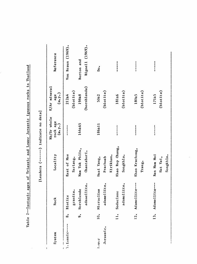
Table 2 Isotoptc ages of
Tr
tass
lc an
d Lower
Jurassic ig
neou
s ro
cks
In Thailand
[Leaders ( ) in
dica
te no da
ta]
System
Rock
1i las
sie
8.
Biot
ite
granite.
9.
Hornblende
adam
elli
te.
l.owiir
10.
Micr
ocli
ne
Jura
ssic
, ad
amel
lite
.
11.
Soda
clas
c
adamellite.
12.
Adam
elli
te
13.
Adamellite
Loca
lity
East of Mae
Sari
ang.
Nam
Tok
Phllu,
Chantaburi.
Huai
Ya
ng,
Prac
huab
Kiri
khan
.
Khao Ru
p Chang,
Song
khla
.
Khao Krachong,
Trang.
Ran
Nam
Noi
Hat
Yai,
Songkhla.
Rb/S
r whole
K/Ar mineral
rock
ag
e ag
e Reference
(m.y.)
(m.y.)
212±
4 Vo
n Braun
(196
9).
(blo
tite
)
144±
65
198±8
Burton and
(hornblende)
Bign
ell
(1969).
186±
11
50±2
Do
.
(blo
tite
)
181±6
(blo
tite
)
(bio
tite
)
(bio
tite
)
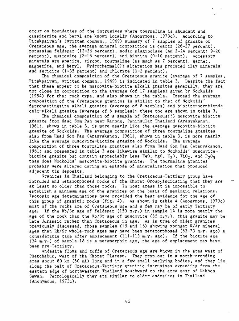
occur on boundaries of the intrusives where tourmaline is abundant and cassiterite and beryl are known locally (Anonymous, 1973c). According to Pitakpaivan's (written comraun., 1969) summary of 7 samples of granite of Cretaceous age, the average mineral composition is quartz (26-37 percent), potassium feldspar (12-26 percent), sodic plagioclase (An 2-24 percent: 9-20 percent), muscovite (2-16 percent), and biotite (0-10 percent). Accessory minerals are apatite, zircon, tourmaline (as much as 7 percent), garnet, magnetite, and beryl. HydrothermaK?) alteration has produced clay minerals and sericite (1-35 percent) and chlorite (0-2 percent).
The chemical composition of the Cretaceous granite (average of 7 samples, Pitakpaivan, written coramun., 1969) is indicated in table 3. Despite the fact that these appear to be muscovite-biotite alkali granites generally, they are not close in composition to the average (of 17 samples) given by Nockolds (1954) for that rock type, and also shown in the table. Instead the average composition of the Cretaceous granites is similar to that of Nockolds' ferrohastingsite alkali granite (average of 8 samples) and biotite-hornblende calc-alkali granite (average of 6 samples); these too are shown in table 3.
The chemical composition of a sample of Cretaceous(?) muscovite-biotite granite from Haad Som Pan near Ranong, Peninsular Thailand (Aranyakanon, 1961), shown in table 3, is more nearly like the average muscovite-biotite granite of Nockolds. The average composition of three tourmaline granites also from Haad Som Pan (Aranyakanon, 1961), shown in table 3, is more nearly like the average muscovite-biotite granite of Nockolds. The average composition of three tourmaline granites also from Haad Som Pan (Aranyakanon, 1961) and presented in table 3 are likewise similar to Nockolds' muscovite- biotite granite but contain appreciably less FeO, MgO, K20, Ti02 , and P205 than does Nockolds' muscovite-biotite granite. The tourmaline granites probably were altered during an episode of mineralization that produced adjacent tin deposits.
Granites in Thailand belonging to the Cretaceous-Tertiary group have intruded and metamorphosed rocks of the Khorat Groupjindicating that they are at least no older than those rocks. In most areas it is impossible to establish a minimum age of the granites on the basis of geologic relations. Isotopic age determinations have provided the best evidence for the age of this group of granitic rocks (fig. 4). As shown in table 4 (Anonymous, 1973c) most of the rocks are of Cretaceous age and a few may be of early Tertiary age. If the Rb/Sr age of feldspar (150 m.y.) in sample 14 is more nearly the age of the rock than the Rb/Sr age of muscovite (85 m.y.), this granite may be Late Jurassic rather than Cretaceous in age. As is true of older granites previously discussed, those samples (15 and 16) showing younger K/Ar mineral ages than Rb/Sr whole-rock ages may have been metamorphosed (63-73 m.y. ago) a considerable time after emplacement (111-113 m.y. ago). If the biotite age (34 m.y.) of sample 18 is a metamorphic age, the age of emplacement may have been pre-Tertiary.
Andesite flows and tuffs of Cretaceous age are known in the area west of Phetchabun, west of the Khorat Plateau. They crop out in a north-trending area about 80 km (50 mi) long and in a few small outlying bodies, and they lie along the belt of Cretaceous-Tertiary granitic intrusives extending from the eastern edge of northwestern Thailand southward to the area east of Nakhon Sawan. Petrologically they are similar to older andesites in Thailand (Anonymous, 1973c).
45
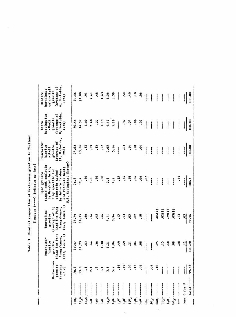
Ta It
1e 3 Chemical composition
of Cretaceous grant tea
in Thailand
(Leaders ( ) Indicate no
da
ta]
Musc
ovit
e-
blot
lte
Cretaceous
granite
gran
ite
(lla
ad Som
Pan;
(average
Aran
yaka
non,
of
7)
19
61,
table
B)
AI2°»
Fe2ev
Vet)
M80-
PoH-
»_ __
Na2<
»-
K,\
II20
T102
iyV -
MnO
n\
-_ _
Cf\
. __
. __ _
II
ik-
____
n f\ _
__
11 2°
)
wo3-
-
F' »
I.eHft 0
for
F
Total -
70.7
13.9
1.1
2.4 .8
1.4
3.1
5.2 .14
.49
.30
.13
.06
.04
.10
___
- 99
.86
72.5
7
14.2
3
.63
.64
.36
1.38
3.21
4.84
.40
.49
.21
.04
.08
.25
.15
.48
.08
.28
.12
100.20
Ipoo
gr
anit
e Muscovite-
Tourmaline
(rapid rock analysis
biot
ite
gran
ite
by llezeklah
Smith;
alka
li
(average of 3;
F by
specific io
n gr
anit
e llaad
Som
Pqn;
electrode
method
(ave
rage
of
Ar
anya
kanon,
by Jo
lmni
e Ga
rdne
r 17;
Nockolds,
1961
, ta
ble
B)
and
Patricia We
st;
1954)
U.S.
Geological Su
rvey
)
74.74
14.3
5
.88
.14
.05
.46
4.11
3.94
.13
.53
.05
.02
.10
.04(7)
.02(
7)
.29(
7)
.03(
7)
.13
.05
99.96
76.4
12.4
.50
1.0 .40
.80
2.8
4.9 .25
.34
.18
.06
.06
.07
.15
100.
3
74.63
13.8
6
.52
.89
.33
.57
3.05
5.16 .63
.14
.18
.04
100.00
Ferro-
hastlngaite
alkali
gran
ite
(ave
rage
of
8; Nn
ckol
ds,
1954
)
70.4
6
14.3
7
1.09
2.48
.22
1.19
4.19
5.18 .37
.34
.06
.05
100.
00
Blot
ltc-
ho
rnbl
ende
ca
lc-a
lkal
i gr
anit
e (average of
6; Nockolds,
1954
)
70.56
14.0
0
.91
2.41
.48
1.63
3.56
5.39 .50
.40
.10
.06
100.00
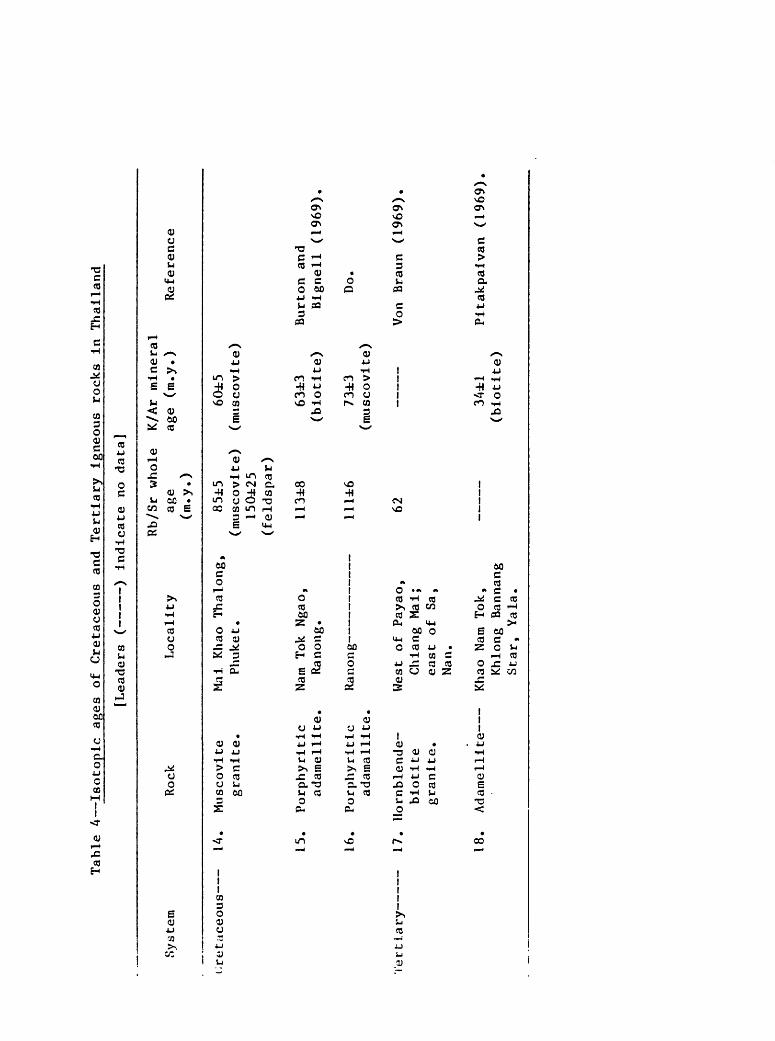
Table 4 Isotopic ages of
Cretaceous an
d Te
rtia
ry ig
neou
s ro
cks
in Th
aila
nd
[Lea
ders
( ) indicate no
da
ta]
System
Rock
Locality
Rb/Sr
whole
K/Ar mi
neral
age
age
(m.y.)
Reference
(m.y.)
cretaceous
Tert Lar
y-
14.
Muscovite
gran
ite,
15.
Porp
hyrl
tic
adamellite,
16.
Porphyrttlc
adam
alli
te,
17.
Horn
blen
de-
biot
tte
gran
ite.
18.
Adamellite
Mai
Khao Th
alon
g,
Phuke t.
Nam
Tok
Ngao
, Ra
nong
.
85i5
60±5
(mus
covi
te)
(muscovite)
150±25
(fel
dspa
r)
113±8
63±3
Burton and
(biotite)
Bign
ell
(196
9).
Ranong-
West
of
Payao,
Chiang Ma
i;
east
of Sa
, Nan.
Khao
Nam
Tok,
Khlong Bannang
Star
, Ya
la.
11U6
62
73±3
(muscovite)
Do.
Von
Braun
(196
9).
34±1
Pitakpaivan
(196
9).
(biotite)
Probably numerous small intrusive bodies throughout Thailand are Cretaceous-Tertiary in age (Iwai and others, 1966, p. 192; Javanaphet, 1969) but no good evidence is available to establish this with certainty.
Igneous rock materials are present in some of the Cretaceous-Tertiary sedimentary beds in Thailand. For example, Paleocene beds in the Fang basin contain pebbles, cobbles, and boulders of diabase, Pliocene beds in the Mae Sot basin contain porphyry pebbles near the base, and tuffaceous lake beds are interbedded with the Mae Sot oil shale layers.
Quaternary
Basalt of Quaternary age is widespread in Thailand, occurring as plugs and flows in numerous localities near the western and southern edges of the Khorat Plateau in northeastern Thailand, in a belt extending from Chiang Rai in northwestern Thailand southward through Lampang and west of Sukhothai almost to Kanchanaburi, and throughout the eastern part of southeastern Thailand (fig. 4). The flows commonly have fresh surfaces suggesting young age (Brown and others, 1951, p. 46-47), although some are overgrown with vegetation,
A flow near Mae Moh in northwestern Thailand consists of a layer at least 7 m (23 ft) thick of basalt ellipsoids with basaltic glass shards, pellets, and granules, overlain by a layer 3 m (10 ft) thick of platy vesicular basalt. The basalt ellipsoids (pillows) are arranged as "foreset" beds suggesting flow into a shallow body of water (Brown and others, 1951, p. 47).
The basalts are dark-gray to black, commonly vesicular or amygdaloidal, and aphanitic to vitrophyric. They weather deep brown, dark gray, and gray. Major minerals are plagioclase (mostly labradorite) and pyroxene; minor minerals are olivine and opaque minerals; phenocrysts are embedded characteristically in glassy matrix. Most basalts have both phenocrysts and xenocrysts of glassy green olivine. (Anonymous, 1973c). Basalt north of Kanchanaburi in western Thailand and in the vicinity of Chantaburi in southeastern Thailand is corundum (ruby and sapphire) bearing.
Although basalt in Thailand has been considered as old as Tertiary (Thai Department of Mineral Resources, written commun., 1969; Javanaphet, 1969; Hogbom, 1914; Brown and others, 1951), well dated flows are Quaternary, as for example flows overlying Pleistocene gravels in the Lampang basin of northwestern Thailand (Thai Department of Mineral Resources, written commun., 1969). The most recent summary of igneous rocks of Thailand (Sodsee, Nutalaya, and Campbell, written commun., 1973) classified all Cenozoic basalts as Quaternary in age. Haile and Tarling (1973) reported that basalts in northwestern Thailand have reversed magnetism, indicating an age of at least 700,000 years.
Metamorphic rocks
Precambrian metamorphic rocks have already been discussed for the purpose of elucidating the character of sedimentary and igneous rocks of Precambrian age. In addition to the high-grade metaraorphic terranes of probable Precambrian age (fig. 2), large areas of younger dominantly sedimentary rocks have been metamorphosed, but at lower intensity than the Precambrian terranes. I will now describe some metamorphic aspects of the Precambrian and younger rocks in Thailand for the purpose of clarifying the geologic history of the country.

High-grade sillimanitic metamorphic rocks are present in most of the Precambrian terranes exposed in Thailand. According to Campbell (1973a,b), several of the high-grade metamorphic complexes shown on figure 2 contain igneous rocks that were intruded during the Carboniferous and probably later times and that imparted metamorphic effects to their wall rocks. For example, Baura and others (1970) reported that Precambrian sedimentary rocks in the Chiang Mai-Tak gneiss belt were subjected to high-grade metamorphism including anatexis and granitization at deep levels during Precambrian time. Following uplift and erosion the rocks were covered by Cambrian and Ordovician sedimentary formations that in turn were metamorphosed at the time of intrusion of Carboniferous granitic rocks.
Biotite-sillimanite schist near Wiang Pa Pao is medium to coarse grained, dark gray, well foliated, and contains porphyroblasts of silliraanite averaging more than 5 cm (2 in) long. Quartz, plagioclase, biotite, and muscovite are also present (Campbell, 1973a,b).
Near the Bhumipol Dam site west of Sam Ngao, well foliated and lineated gray to gray-brown schist is made up of quartz, plagioclase, biotite, muscovite, and locally minor garnet, sillimanite, cordierite, pinite, and chlorite (Piyasin, 1972a,b). The underlying white to light-gray-green massive coarse-grained granoblastic to foliated marble schists are composed of calcite and subordinate quartz, plagioclase, biotite, epidote, zoisite, and locally hornblende, tremolite, diopside, garnet, rauscovite, and tourmaline. In the same area, massive gray well-lineated gneiss consists of microcline and biotite with subordinate muscovite, plagioclase, and quartz, and in places minor sillimanite, epidote, chlorite, apatite, zircon, and tourmaline.
Evidence of an early episode of metamorphism of the Bhumipol Dam rocks (Nutalaya, 1973a) is bedding-plane schistosity and isoclinal folding and development of almandine-amphibolite facies. Later biotite-zone metamorphism superimposed slip cleavages and recumbent folds on the metasedimentary rocks. Thermal metamorphism characterized by development of andalusite and cordierite accompanied emplacement of muscovite-biotite granite in Carboniferous(?) time. Retrograde sericite-chlorite metamorphism was later superimposed on the rocks.
Heim and Hirschi (1939) reported small dikes and veins of pegmatite, locally with tourmaline and apatite, cutting the metaraorphic rocks.
Campbell (1973a) reported feldspar-porphyroblastic paragneisses in the Tak region that have been metamorphosed in Precarabrian time to the andesine- epidote-anphibolite subfacies of the amphibolite facies. Superimposed on the amphibolite facies metamorphism were a penetrative deformation and partial recrystallization in the greenschist facies, considered by Campbell (1973a) to be post-lower Paleozoic in age. Light-gray coarse-grained to porphyroblastic granite gneiss (Precambrian?) intruded feldspar-porphyroblastic paragneiss layers concordantly and was accompanied by formation of sillimanite. Subsequently gray medium-grained granodiorite (Triassic?) intruded the orthogneiss and paragneiss both concordantly and discordantly. The granodiorite displays weak foliation parallel to that of the host gneisses.
In the Chonburi massif of southeastern Thailand (Brown and others, 1951) porphyroblastic micaceous granite orthogneisses are injected along foliation by lenses and stringers of pegmatite containing muscovite and beryl. Thin veins of black tourmaline and massive veins of quartz are common.
Lee (1923c,d) first recognized that Paleozic sedimentary rocks in Peninsular Thailand have been metamorphosed to slates and schists in the
49

vicinity of granitic intrusive bodies. Brown and others (1951) reported that lower Paleozoic metasedimentary rocks are present in a large region along the central axis and west side of Peninsular Thailand, as well as in the vicinity of granitic intrusives in the Khao Luang mountains of. eastern Peninsular Thailand. The metamorphic rocks are steeply-dipping dark well-bedded schists, slates, quartzites, and argillites. Bauin and others (1970) described Cambrian clastic rocks and Ordovician limestones in northwestern Thailand that locally were metamorphosed to phyllites and schists probably at the time of widespread granitic intrusion in the early Carboniferous. In the vicinity of Uttaradit, Piyasin (1972b) reported Cambrian and Ordovician sandstones, Ordovician limestones, and Silurian-Devonian clastic strata (including tuff) and chert metamorphosed to quartzite, phyllite, chloritic phyllite, and schist, probably in early Carboniferous time. Sripitanawat (1972) described Cambrian schist, quartz-mica schist, muscovite schist, quartzite, and massive marble lenses, Ordovician limestone with interbeds of phyllite, and undifferentiated Silurian-Devonian quartzite, phyllite, slate, and phyllitic tuff in the region around Nakhon Sawan.
Campbell (1973a) reported that Cambrian sandstone, Ordovician limestone, and Silurian-Devonian(?) fine-grained clastic rocks southwest of Tak have been metamorphosed probably during the Carboniferous to quartzite and schists. Where overlain by Precambrian gneiss thrust over them from the northeast, the Paleozoic strata are biotite-grade metamorphic rocks and westward the metamorphic grade decreases through the chlorite zone to weakly phyllitic rocks. Koch (1973) described metamorphosed Cambrian sedimentary rocks in the region northwest of Kanchanaburi as sericitic slate, biotite-muscovite schist, biotite schist, and calc-silicate rocks. The rocks were metamorphosed in post-Jurassic time.
Structure
Few detailed studies have been made of geologic structure in Thailand, yet the broad character of structural elements in the country is apparent. Folds, faults, and layered structures in Phanerozoic rocks reflect those of the Precambrian basement where it is exposed, and the persistence of major structural elements throughout the known geologic record is evident. Variations in the time of development, the locale, and the style of structures are known in Thailand, however, and the importance of these in the geologic history of the country will be emphasized here.
Precambrian basement
The principal areas of exposed Precambrian metamorphic and igneous rocks, as already described (fig. 2), occupy a coherent rather narrow belt curving from the north tip of northwestern Thailand southwestward into southeastern Thailand. Within the belt, the long axes of elongate masses of Precambrian rocks are alined with the belt, and foliations and compositional layering in the masses also generally parallel the trend of the belt. Some of the younger tectonic activity in the region was controlled by this rib of gneisses and schists, yet other younger structural events appear unrelated to it.
A few small outcrops of supposed Precambrian gneisses on Peninsular Thailand indicate that granitic crust probably underlies much of that part of the country. There is no information available on the nature of the crust
50
underlying the Khorat Plateau of northeastern Thailand. Precambrian rocks similar to those in Thailand, but including a significant component of amphibolites, are known north and east of the Khorat Plateau in Laos, Cambodia, and North and South Vietnam (Workman, 1972).
Phanerozoic stratigraphic discontinuities, and qrogenic sediments
Stratigraphic discontinuities, particularly angular unconformities and significant hiatuses, and erogenic sediments (conglomeratic strata), in the Phanerozoic section of Thailand provide evidence of episodes of pronounced structural deformation (tectonism) during post-Precambrian time.
Cambrian strata in places in Thailand lie unconformably upon rocks of Precambrian age, indicating that older rocks were deformed, intruded, metamorphosed, and eroded extensively prior to Phanerozoic time. Locally, as in northwestern Thailand, strata near the base of the Cambrian section are conglomeratic and indicate that uplifted terranes were not far off.
An unconformity separates Ordovician and Silurian strata in parts of Thailand, but it is absent in many places, and no erogenic sediments are known immediately above the unconformity. In northern Thailand, a hiatus extending from upper Lower Silurian to Devonian strata indicates an episode of erosion (or nondeposition), but the absence of orogenic sediments of stratigraphic equivalence, or just younger than the hiatus, suggests that the structural disturbance accounting for the hiatus was mild.
Conglomerates are present in Middle and Upper Devonian strata of northwestern and west-central Thailand, indicating land close by, possibly a volcanic arc east of Thailand. Pebbly mudstones (dropstone sediments) of Devonian age probably of glaciomarine origin in western and Peninsular Thailand suggests proximity of an inferred landmass.
Locally in northwestern Thailand, folded Devonian and Silurian strata are overlain unconformably by the Carboniferous section, but in western Thailand the Carboniferous lies conformably on Upper Devonian strata.
Widepread conglomeratic strata at the top of the Devonian section and near the base of the Carboniferous section in northeastern, northwestern, and west-central Thailand indicate continuing, and perhaps accelerating, uplift of some nearby land areas at the end of the Devonian and beginning of the Carboniferous periods. A pronounced angular unconformity in the upper part of Lower Carboniferous strata in northwestern Thailand shows that strong deformation took place in this region near the end of the Early Carboniferous. In Peninsular Thailand, Carboniferous strata lie unconformably on the Phuket Series (Devonian-Lower Carboniferous). Orogenic sediments are abundant in strata of Middle and/or Late Carboniferous age in northeastern, northwestern, southeastern, and Peninsular Thailand, indicating widespread local uplift throughout Thailand at that time. Of particular interest is the occurrence of pebbles of Upper Carboniferous ophiolitic rocks in Upper Carboniferous conglomerates in northwestern Thailand; sources of the pebbles are exposed widely in northwestern Thailand and the northwestern part of northeastern Thailand.
An unconformity marks the boundary between the Carboniferous section and overlying Permian strata in parts of northeastern and northwestern Thailand. In western Thailand, the Upper Carboniferous is missing locally between strata of Early Carboniferous and Early Permian age. Conglomerates lie near the base of the Permian section in northwestern, southeastern, and Peninsular
51

Thailand. These relations indicate widespread deformation in the vicinity of Thailand at the beginning of the Permian period. Minor erogenic sediments in Middle Permian strata in southeastern Thailand and at the base of Upper Permian strata in northwestern Thailand suggest only sporadic tectonism in the vicinity of Thailand during the remainder of the Permian.
A pronounced unconformity lies at the top of Permian strata and beneath the Triassic section in northeastern Thailand, and there are local hiatuses in Lower Triassic rocks in northeastern and northwestern Thailand. Marine Triassic strata are absent above Permian strata in a north-trending belt in northwestern Thailand between Tak and Chiang Mai. A basal conglomerate of the Triassic lies unconforraably on Permian, Devonian, or Silurian strata in different parts of Thailand. Throughout Thailand, with the exception of the Peninsula, conglomerates are widespread near the base of the Triassic section. Taken together, these relations indicate that deformation throughout Thailand was again pronounced at the beginning of the Triassic period. Conglomerates were deposited abundantly in strata of Middle and early Late Triassic age in northeastern and northwestern Thailand showing that deformation continued in the proximity of these regions. A marked angular unconformity is known below continental strata of Late Triassic age lying on the marine Triassic in northwestern and southeastern Thailand, and erogenic sediments were deposited in the lower parts of strata of this age in northwestern and northeastern Thailand, indicating another significant deformational event in the vicinity of Thailand late in Triassic time.
An unconformity is present locally at the base of the Jurassic section in northwestern Thailand and conglomerates are abundant in strata of Early, Middle, and Late Jurassic age. Deformation appears to have been widespread in the vicinity of northern Thailand throughout the Jurassic period.
Cretaceous strata are unknown in Thailand outside of the Khorat Plateau except in small patches west of Surat Thani and west of Trang in Peninsular Thailand, so that evidence from Cretaceous strata for structural deformation in Cretaceous time is limited. Conglomerates are abundant in Lower Cretaceous strata of the Khorat Plateau in northeastern Thailand. Evidently uplifts formed locally in the vicinity of Thailand during Early Cretaceous time.
Unconformities and conglomeratic strata in the Cenozoic section are widespread but quite local throughout Thailand, but they are poorly documented and correlated. Conglomerates are present in local basins in northwestern
- Thailand in Eocene, Miocene, and Pliocene strata, and throughout Thailand in Pleistocene and Holocene strata. Apparently tectonism was widespread throughout Thailand during the Cenozoic, and perhaps increased during the late Cenozoic.
Folds in Phanerozoic strata
Axes of folds in sedimentary rocks form consistent patterns in broad regions throughout Thailand, reflecting the variation in deformation that has affected different parts of the country. The fold axes were in part compiled by Campbell and Nutalaya (written comraun., 1973), and I inferred others from the geologic map of Thailand by Javanaphet (1969); all are shown in figure 5.
In northwestern Thailand, fold axes trend dominantly northerly. However, north of Chiang Dao, a set of fold axes trends easterly, turning northerly at its east end and southerly at its west end, forming an S-shaped pattern. Farther east, another more open S-shaped set of folds extends from the
52
vicinity of Chiang Rei southward to the vicinity of Lampang and Phrae. Near its north end, the set trends north-northeasterly, in its middle reaches north-northwesterly, and in its southern extension again north- northeasterly. According to Baura 'and others (1970) belts of folds display opposing directions of overturning in northwestern Thailand. In the south part of northwestern Thailand, northwesterly folds are overturned to the southwest (Campbell and Nutalaya, written coramun., 1973).
In northeastern Thailand, fold axes are dorainantly northwesterly, although north of Chaiyaphum and west of Khon Kaen axes trend dominantly north-northeasterly. At the west margin of northeastern Thailand, fold axes are northerly, and at the southwest corner of northeastern Thailand, fold axes are easterly.
Throughout west-central and southeastern Thailand, fold axes are almost universally northwesterly. In west-central Thailand, folds have been overturned to the southwest (Campbell and Nutalaya, written coramun., 1973).
In the northern part of Peninsular Thailand, fold axes are north- northeasterly but in the remainder of the Peninsula farther south the trend is northerly.
Northerly folds were formed in strata that range in age from Cambrian through Triassic in the western part of northwestern Thailand and in strata that range in age from Carboniferous through Jurassic in the eastern part of northwestern Thailand. North-trending folds at the west edge of northeastern Thailand are also in Carboniferous-Jurassic strata, and in Peninsular Thailand they are in strata that range in age from Cambrian through Jurassic.
North-northeasterly folds are found in Carboniferous-Jurassic strata in northwestern Thailand, the western part of northeastern Thailand, and in the northern part of Peninsular Thailand.
Easterly folds were formed in strata of Devonian-Permian age north of Chiang Dao in northwestern Thailand and in strata of Triassic-Jurassic age at the southwest corner of northeastern Thailand.
Northwesterly folds occur in Devonian-Permian strata in west-central Thailand, in Devonian-Jurassic strata in southeastern Thailand, and in Triassic-Cretaceous strata in northeastern Thailand.
In northwestern Thailand and locally in Peninsular Thailand, strata as young as Early Carboniferous in age, folded along northerly axes, were eroded and overlain unconformably by upper Lower Carboniferous strata, indicating an Early Carboniferous age of the folding. However, in west-central Thailand, the Carboniferous lies conformably on Upper Devonian strata, suggesting that the Early Carboniferous folding was not significant there. Folding in the northwestern part of northeastern Thailand has been reported (Workman, 1972) as middle Carboniferous in age. Mitchell, Young, and Jantanaripa (1970) reported post-Lower Permian folding in the araa of Phuket in Peninsular Thailand.
In the northwestern part of northeastern Thailand, Lower(?) and Middle(?) Triassic rocks were deposited on folded and eroded strata as young as Early Triassic in age, suggesting an episode of Early Triassic folding.
Upper Cretaceous strata on the Khorat Plateau in northeastern Thailand have been folded, and thus folding at least as young as Late Cretaceous took place in that region.
53
Thrust faults
Thrust faults are not widely recognized in Thailand. A few recorded cases provide evidence of specific episodes of deformation and of the sense of that deformation. Geologic map relations also suggest that thrust faulting has occurred in some places where no thrust faults have yet been recognized in the field.
In the south part of northwestern Thailand west of Tak, sedimentary rocks of Cambrian, Ordovician, Silurian, and Devonian(?) age that are folded along northwesterly axes and overturned to the southwest, are overridden by Precambrian gneiss (Campbell, 1973b). Also in northwestern Thailand east of Hod, Triassic strata have been thrust over Ordovician rocks on a low-angle west-dipping fault and apparently intruded by Triassic granite (Teggin and Suensilpong, 1973). In the southwest corner of northeastern Thailand, Permian rocks have been folded along west-northwesterly axes and lowest Permian limestone thrust to the north and northeast over middle-Upper Permian limestone and siltstone; the deformed sedimentary rocks are overlain unconformably by volcanic rocks of Permian-Triassic age (Angkatavanich and others, 1973; Campbell and Nutalaya, 1973). North of Kanchanaburi in west- central Thailand, Precambrian(?) gneiss appears to have been thrust eastward over Paleozoic sedimentary rocks (Campbell and Nutalaya, written commun., 1973).
In northwestern Thailand, in northeastern Thailand east of Loei, in west- central Thailand, and in Peninsular Thailand north of Phuket, the thick Kaeng Krachan Formation (Devonian-Carboniferous), consisting of poorly bedded graywacke, mudstone, and siltstone, and minor limestone, shale, sandstone, and conglomerate, and strata overlying the Kaeng Krachan, appear to be structurally discordant with many of the adjacent rock units that are older, of the same age, and younger than the Kaeng Krachan. For example, in northwestern Thailand between Mae Hong Son and Chiang Dao, the Kaeng Krachan and overlying Ratburi Limestone (Permian) form a coherent strongly folded unit (the tight S-shaped set of folds previously described), probably folded in Mesozoic time (Baum and others, 1970). The folded unit is separated along an irregular contact from adjacent rocks that range in age from Cambrian to Devonian (and possibly younger) and that show complex internal structural relations that are discordant to the folded unit. The geologic relations could be accounted for by a thrust fault of regional magnitude. In Peninsular Thailand in the vicinity of Surat Thani and Trang, folded Carboniferous- Jurassic strata show a similar discordance to folded Cambrian-Devonian strata farther east, again suggesting a possible thrust fault of regional magnitude.
The inferred thrust faults just described, and those referenced in the literature, are shown on a map illustrating the distribution of faults in Thailand (fig. 6).
Some other geologic relations suggest the presence of thrust faults in Thailand, but these inferred faults are not shown on figure 6.
In northwestern Thailand and the northwestern part of northeastern Thailand, Upper Carboniferous ophiolites of probable ocean-basin origin are irregularly distributed and in contact with rocks typical of continental crust (figs. 3,4; Javanaphet, 1969). Possibly these oceanic rocks were thrust faulted (obducted) onto the continental plate during a major tectonic deformation.
In northwestern Thailand between Chiang Dao and Fang, strongly deformed Devonian strata are overlain on what appears to be a nearly flat contact: by
54

Permian Ratburi Limestone. The Ratburi itself is internally deformed but the formation nevertheless forms a flat-lying plate that covers an area of several square kilometers, suggesting that it was emplaced along a thrust fault. This relation seems to be common in other parts of Thailand; extensive thick plates of internally deformed Ratburi overlie deformed rocks along a nearly horizontal contact. Although structural transport of such plates may not have been large, the plates appear to have been decoupled, and both upper and lower plates internally deformed.
Strike-slip faults
Strike-slip faults are a prominent and well documented element of Thailand structure. A number of these have been named, such as the Three Pagoda-Ratburi fault zone and the Khlong Marui fault zone (Campbell and Nutalaya, written commun., 1973). Inasmuch as these zones consist of a number of parallel faults, some as much as several kilometers apart, I refer to them as zones of faults rather than fault zones, and I have modified their names somewhat for ease of reference. I follow the suggestion of Campbell and Nutalaya to refer to the Khlong Marui fault zone in Peninsular Thailand as the Phangnga zone; the Ranong fault zone farther north on the Peninsular is here called Ranong zone of faults; the Three Pagoda-Ratburi fault zone in west- central Thailand is here called the Kanchanaburi zone of faults; the Moei- Uthai Thani fault zone and the Ping fault zone in the south part of northwestern Thailand are referred to collectively as the Tak zone of faults; and the Thoen fault zone in the southeast part of northwestern Thailand is called the Phrae zone of faults (fig. 6).
The Phangnga zone of strike-slip faults consists of a number of parallel faults that strike north-northeast and extend from the vicinity of Phangnga on the west coast of Peninsular Thailand nearly 200 km (125 mi) to the Gulf of Thailand northwest of Surat Thani. The main strand of the zone appears to pass just east of Phuket Island. The Phangnga zone marks the southern limit of the Kaeng Krachan Formation (Devonian-Carboniferous) in Thailand. It also appears to offset the north-trending belt of Cretaceous granites in Peninsular Thailand in a left-lateral sense. Garson and Mitchell (1970) indicated at least 150 km (95 mi) of left-lateral displacement along the zone, but if the zone has offset the granite belt as it appears to have done the displacement is close to 300 km (185 mi).
The Ranong zone of faults also strikes north-northeast and extends from the vicinity of Ranong on the west coast nearly 300 km (185 mi) to the vicinity of Prachuap Khiri Khan on the Gulf of Thailand. If numerous subparallel faults southeast of the main Ranong strand are included in the zone, it is nearly 50 km (30 mi) wide at the latitude of Chumphon. The faults of the Ranong zone juxtapose slices of rocks of the Kaeng Krachan, Ratburi, and Triassic-Jurassic strata. According to Garson and Mitchell (1970) the main strand of the Ranong zone has had at least 20 km (12 mi) of left-lateral offset.
The Kanchanaburi zone of subparallel strike-slip faults is as much as 30 km (20 mi) wide, strikes northwest, and extends from the Gulf of Thailand in the vicinity of Samut Songkhram nearly 300 km (185 nii) to the Burmese frontier in the vicinity of Sang Khla Buri. It marks the northern limit of the Kaeng Krachan Formation in west-central Thailand, although part of the northward disappearance of the Kaeng Krachan there is attributed to thrust faults.
55
According to Campbell and Nutalaya (written commun., 1973) movement on the Kanchanaburi zone is post-Cretaceous in age and possibly left lateral. Orientation of en echelon faults in the zone indicates, however, a right- lateral sense of movement. Amount of offset has not been indicated. Possibly 3 Tertiary basins in the Kanchanaburi zone of strike-slip faults are bounded by apparent strike-slip faults, but evidently some vertical movement occurred on these faults (fig. 6).
The Tak zone of faults also strikes northwest and extends from the vicinity of Nakhon Sawan at the west edge of the Cnao Phraya plain almost 400 km (250 mi) to the Burmese frontier southwest of Mae Sariang. If northwesterly faults east of the Chao Phraya plain that are alined with the Tak zone and appear to extend nearly to the Cambodian border in the vicinity of Sao Kaeo are considered to be part of the Tak zone, the zone is more than 700 km (450 mi) long in Thailand. According to Campbell and Nutalaya (written commun., 1973) the Ping segment of the Tak zone has offset Jurassic(?) sedimentary rocks at least 5 km (3 mi) in a left-lateral sense. Campbell and Nutalaya (written commun., 1973) also indicated that the Tak zone had displaced the north-trending Precambrian Chiang Mai-Tak and Ban Rai gneiss complexes about 100 km (60 mi) in a left-lateral sense. Thrust faults alined in the Tak strike-slip zone are better documented (Campbell, 1973b; Campbell and Nutalaya, written commun., 1973) than are those inferred in the Kanchanaburi zone.
The Phrae zone of faults strikes northeast and extends from Thoen, north of Tak, about 250 km (150 mi) to the Laos border beyond Nan. The Phrae zone forms the south boundary of marine Triassic strata and the north boundary of Silurian-Devonian sedimentary rocks in the east part of northwestern Thailand. Campbell and Nutalaya (written coramun., 1973) indicated that vertical displacement has occurred in the zone in post-Triassic time. On the basis of geologic map relations, the zone offsets rocks as young as Tertiary. One strand of the zone bounds the Quaternary basin at Phrae, indicating probably some late vertical movement. Although the direction and sense of movement on the Phrae zone is not completely known, deflection of structures in the vicinity of the zone suggests possible significant right- lateral offset.
Probably a large number of faults of general northwesterly or northeasterly orientation throughout Thailand, in addition to the strike-slip zones of faults already described, have had some strike-slip movement, but there is virtually no documentation of such movement. Some faults of these orientations in west-central and in northwestern Thailand that have controlled fluorspar mineralization and have had rather young movement show prominent subhorizontal slickensides and grooves, indicating significant or perhaps major strike-slip movement.
Campbell and Nutalaya (written commun., 1973), without specifying whether they referred to strike-slip or to other high-angle faults, indicated that in Peninsular Thailand northeasterly structures offset northwesterly structures whereas in west-central Thailand northwesterly structures offset northeasterly structures.
Looked at broadly, the conjugate system of major strike-slip zones of faults in Thailand presents some anomalies. The system, summarized in figure 7, appears to be the result of a single broad stress field, yet deformation on the major northeasterly elements in the south part of Thailand (Phangnga and Ranong zones) is left lateral and on the major northeasterly
56

LAOS
Ana.
57
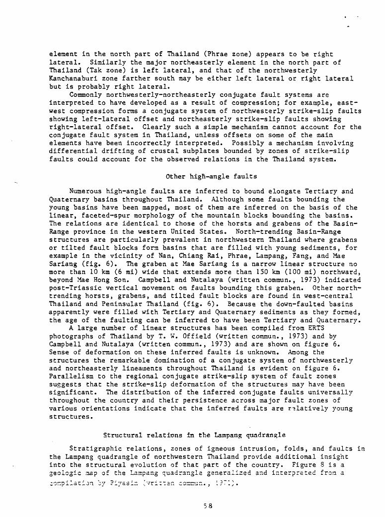
element in the north part of Thailand (Phrae zone) appears to be right lateral. Similarly the major northeasterly element in the north part of Thailand (Tak zone) is left lateral, and that of the northwesterly Kanchanaburi zone farther south may be either left lateral or right lateral but is probably right lateral.
Commonly northwesterly-northeasterly conjugate fault systems are interpreted to have developed as a result of compression; for example, east- west compression forms a conjugate system of northwesterly strike-slip faults showing left-lateral offset and northeasterly strike-slip faults showing right-lateral offset. Clearly such a simple mechanism cannot account for the conjugate fault system in Thailand, unless offsets on some of the main elements have been incorrectly interpreted. Possibly a mechanism involving differential drifting of crustal subplates bounded by zones of strike-slip faults could account for the observed relations in the Thailand system.
Other high-angle faults
Numerous high-angle faults are inferred to bound elongate Tertiary and Quaternary basins throughout Thailand. Although some faults bounding the young basins have been mapped, most of them are inferred on the basis of the linear, faceted-spur morphology of the mountain blocks bounding the basins. The relations are identical to those of the horsts and grabens of the Basin- Range province in the western United States. North-trending Basin-Range structures are particularly prevalent in northwestern Thailand where grabens or tilted fault blocks form basins that are filled with young sediments, for example in the vicinity of Nan, Chiang Rai, Phrae, Lampang, Fang, and Mae Sariang (fig. 6). The graben at Mae Sariang is a narrow linear structure no more than 10 km (6 mi) wide that extends more than 150 km (100 mi) northward, beyond Mae Hong Son. Campbell and Nutalaya (written comraun., 1973) indicated post-Triassic vertical movement on faults bounding this graben. Other north- trending horsts, grabens, and tilted fault blocks are found in west-central Thailand and Peninsular Thailand (fig. 6). Because the down-faulted basins apparently were filled with Tertiary and Quaternary sediments as they formed, the age of the faulting can be inferred to have been Tertiary and Quaternary.
A large number of linear structures has been compiled from ERTS photographs of Thailand by T. W. Offield (written commun., 1973) and by Campbell and Nutalaya (written comraun., 1973) and are shown on figure 6. Sense of deformation on these inferred faults is unknown. Among the structures the remarkable domination of a conjugate system of northwesterly and northeasterly lineaments throughout Thailand is evident on figure 6. Parallelism to the regional conjugate strike-slip system of fault zones suggests that the strike-slip deformation of the structures may have been significant. The distribution of the inferred conjugate faults universally throughout the country and their persistence across major fault zones of various orientations indicate that the inferred faults are relatively young structures.
Structural relations in the Lampang quadrangle
Stratigraphic relations, zones of igneous intrusion, folds, and faults in the Lampang quadrangle of northwestern Thailand provide additional insight into the structural evolution of that part of the country. Figure 8 is a geologic map of the Lampang quadrangle generalized and interpreted from acorn-pi lac ion by Piyasin 'vriitan comcun.. L?71}.
58
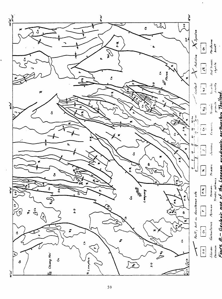
>j/
9v,p
if.uy \^
JJ*t-'">
\>
,90.9
1
,of.il

Distribution of stratigraphic units defines a north-northeast-trending synclinorium that passes through the central part of the Lampang quadrangle. Silurian, Devonian, and Carboniferous marine strata are extensively exposed in the west part of the quadrangle and also occur in the, southeast part of the quadrangle. On either edge of the synclinorium, these strata dip inward and presumably they extend entirely across the synclinoriura beneath younger rocks. Permian strata are widely exposed throughout the quadrangle although they are sparse in the western part. Permian rocks lie conformably on underlying Carboniferous strata.
Volcanic rocks of Late Permian-Early Triassic age occur dominantly within the synclinorium. Wherever exposed, they lie unconformably on underlying Permian sedimentary rocks, indicating a period of uplift and erosion of the Permian strata in the region of the synclinorium prior to deposition of the volcanics, and suggesting that the synclinoriura may have developed initially only after deposition of the Permian-Triassic volcanics.
Marine strata of Triassic age are widespread throughout the quadrangle but are absent in much of the west end of the quadrangle. These rocks lie unconformably upon the Perraian-Triassic volcanic unit and on Permian sedimentary strata within the synclinoriura, but westward they lap onto successively older strata, the Carboniferous and Silurian-Devonian units. This relation indicates that the area to the west was relatively high in the early part of the episode of Triassic marine sedimentation, and tended to become buried during the remainder of that episode. Chonglakraani (written commun., 1973, p. 7-14) pointed out the absence of the marine Triassic above Permian strata on the Chiang Mai geanticline which forms the uplifted area west of the synclimorium described here.
Jurassic rocks are limited to the northeast part of the Lampang quadrangle where they unconformably overlie Triassic and Permian sedimentary rocks and the Permian-Triassic volcanic unit. This relation suggests uplift and erosion of the synclinorium prior to deposition of Jurassic strata.
Cenozoic sedimentary rocks unconformably overlie or are faulted against all of the older rocks in the quadrangle, reflecting active tectonism in this region during the Cenozoic.
A prominent north-northeasterly belt of Triassic granite plutons in the western part of the quadrangle marks the uplift (Chiang Mai geanticline) adjacent to the Lampang synclinorium. These plutons were intruded at about the time of development of the synclinorium and hence must have been partly responsible for the uplift of the Chiang Mai geanticline. Small Triassic granite plutons lie near the axis of the synclinorium in the south-central part of the quadrangle.
Folds in Paleozoic and Mesozoic strata are numerous in the quadrangle and mostly are oriented north-northeasterly, parallel to the axis of the Lampang synclinorium. Numerous folds have been described in Silurian-Devonian and Carboniferous units, but none are shown on the map (fig. 8).
Permian and Triassic stratigraphic units were folded along northwesterly to northerly axes within the Lampang synclinorium prior to deposition of Jurassic strata, as the Jurassic rocks locally unconformably overlie folded and bevelled Permian and Triassic strata. Possibly the folding coincided with the maximum development of the synclinoriura shortly following explacement of the Triassic granites in the Chiang Mai geanticline.
Jurassic strata in the northeast part of the Lampang quadrangle have been folded along north-northwesterly to north-northeasterly axes. It is not
60
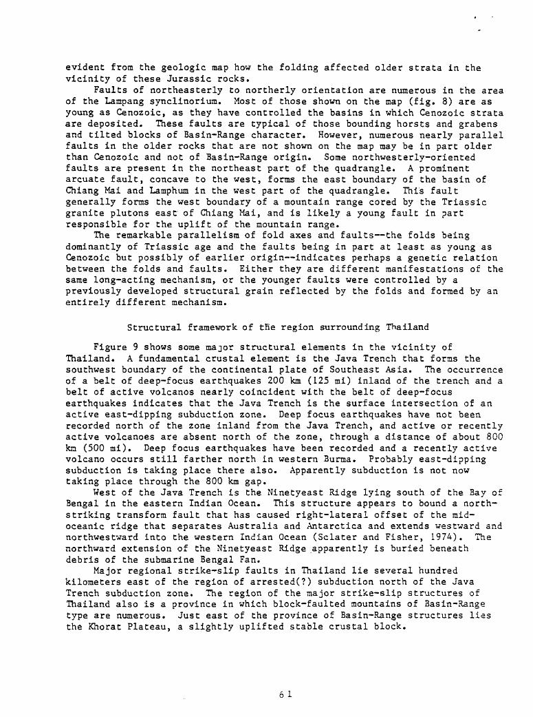
evident from the geologic map how the folding affected older strata in the vicinity of these Jurassic rocks.
Faults of northeasterly to northerly orientation are numerous in the area of the Lampang synclinorium. Most of those shown on the map (fig. 8) are as young as Cenozoic, as they have controlled the basins in which Cenozoic strata are deposited. These faults are typical of those bounding horsts and grabens and tilted blocks of Basin-Range character. However, numerous nearly parallel faults in the older rocks that are not shown on the map may be in part older than Cenozoic and not of Basin-Range origin. Some northwesterly-oriented faults are present in the northeast part of the quadrangle. A prominent arcuate fault, concave to the west, forms the east boundary of the basin of Chiang Mai and Lamphum in the west part of the quadrangle. This fault generally forms the west boundary of a mountain range cored by the Triassic granite plutons east of Chiang Mai, and is likely a young fault in part responsible for the uplift of the mountain range.
The remarkable parallelism of fold axes and faults the folds being dominantly of Triassic age and the faults being in part at least as young as Cenozoic but possibly of earlier origin indicates perhaps a genetic relation between the folds and faults. Either they are different manifestations of the same long-acting mechanism, or the younger faults were controlled by a previously developed structural grain reflected by the folds and formed by an entirely different mechanism.
Structural framework of tfie region surrounding Thailand
Figure 9 shows some major structural elements in the vicinity of Thailand. A fundamental crustal element is the Java Trench that forms the southwest boundary of the continental plate of Southeast Asia. The occurrence of a belt of deep-focus earthquakes 200 km (125 mi) inland of the trench and a belt of active volcanos nearly coincident with the belt of deep-focus earthquakes indicates that the Java Trench is the surface intersection of an active east-dipping subduction zone. Deep focus earthquakes have not been recorded north of the zone inland from the Java Trench, and active or recently active volcanoes are absent north of the zone, through a distance of about 800 km (500 mi). Deep focus earthquakes have been recorded and a recently active volcano occurs still farther north in western Burma. Probably east-dipping subduction is taking place there also. Apparently subduction is not now taking place through the 800 km gap.
West of the Java Trench is the Ninetyeast Ridge lying south of the Bay of Bengal in the eastern Indian Ocean. This structure appears to bound a north- striking transform fault that has caused right-lateral offset of the mid- oceanic ridge that separates Australia and Antarctica and extends westward and northwestward into the western Indian Ocean (Sclater and Fisher, 1974). The northward extension of the Ninetyeast Ridge apparently is buried beneath debris of the submarine Bengal Fan.
Major regional strike-slip faults in Thailand lie several hundred kilometers east of the region of arrested(?) subduction north of the Java Trench subduction zone. The region of the major strike-slip structures of Thailand also is a province in which block-faulted mountains of Basin-Range type are numerous. Just east of the province of Basin-Range structures lies the Khorat Plateau, a slightly uplifted stable crustal block.
6 1
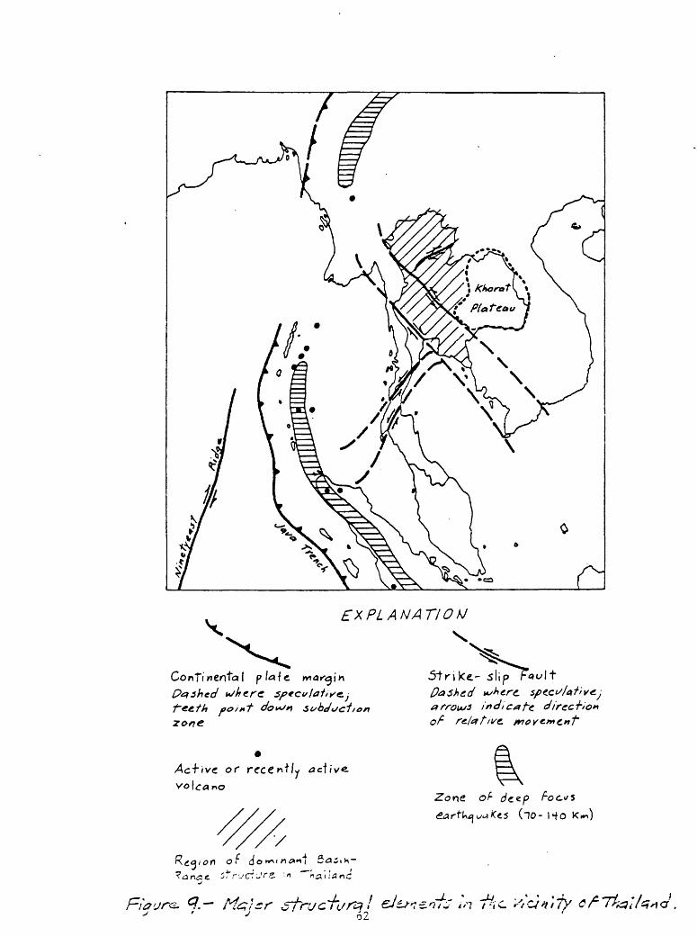
7
EXPLANATION
5trike- 5lip Da shed ^e.r
in di ca j~e. direc -hi
or rece*Hy
yof (jo
Zone of- dze.p
62
The similarity of this structural pattern to the present tectonic framework of a part of western North America is remarkable. In western North America, the Middle America Trench off the southwest coast of Mexico marks the southwest margin of the North American continental plate. Inland from the Trench 200-400 km (125-250 mi) in Mexico, lies a belt of active volcanos coinciding with a belt of deep-focus earthquakes, indicating active subduction. A gap where no subduction is presently occurring extends northward about 2,500 km (1,500 mi) from the Middle America Trench along the western margin of the continent. From northern California northward through Washington, subduction is again active, as evidenced by the active and recently active volcanos of the Cascade Range.
West of the Middle America Trench lies the north-trending East Pacific Rise which terminates northward where the rise intersects the margin of the continent.
Major strike-slip faults such as the San Andreas, the Garlock, and the Walker Lane, as well as others, are known along the gap in the subduction zone and inland for several hundred kilometers. The Basin-Range structural province of northern Mexico, southern California and Arizona, and the Great Basin region, lies just east of and overlaps into the zone of prominent strike-slip faults. And just east of the Basin-Range province lies the uplifted stable block of the Colorado Plateau.
The significance of the remarkable structural similarities between the region around Thailand and a part of western North America well be discussed in the next section which deals with the geologic history of Thailand.
Geologic history of Thailand
In Precambrian times the region of western Thailand was the site of deposition of much clastic sediment, probably mostly arkose and shales, and minor interbedded calcareous strata increasing in proportion northward. These strata later in the Precambrian were subjected to high-grade metamorphism, in part converted to granitic gneisses, and locally intruded by granitic magmas. East of Thailand the Precambrian saw a somewhat similar history except that appreciably more amphibolites were formed than in the western part of Thailand. The amphibolites are likely metamorphosed mafic igneous rocks, possibly doleritic sills or basaltic lava flows. As indicated in later pages, these two contrasting terranes may have formed on two separate continental plates that are now joined along a zone passing southeastward through the region of the Khorat Plateau.
By Cambrian time the region had been extensively eroded, leveled, and submerged beneath the sea. Shallow clastic deltaic marine sediments were deposited in the south and clastic shelf sediments in the north. On this meager pattern it might be inferred that land areas lay to the south (southwest and west on the basis of information from younger rocks) and that seas occupied the region to the north.
During the Ordovician Period marine strata were deposited throughout the region. In northern Thailand, a relatively thin section of shaly and carbonatic strata containing algal reefs suggests a marine shelf environment. In west-central Thailand, clastic carbonate sediments and other fine-grained elastics suggest proximity to land. In the south part of the country, a thick layer of eugeosynclinal organic pyrite-rich limestone and shale indicate possibly deeper water deposition. Paleogeographic patterns are
63
certainly not clear on the basis of these distributions of fades; possibly land lay west of the present position of Thailand, but its broad configuration must have been changed from that in Cambrian time.
Marine deposition was more or less continuous from Ordovician into Silurian time. In northwestern Thailand, the local absence of strata ranging from upper Lower Silurian into Devonian indicates at least mild uplift during that time, but elsewhere marine clastic sediments probably in part derived from the uplift to the northwest, and carbonates, were laid down during this interval. Where Silurian rocks are present in northwestern Thailand and elsewhere in the country, it appears that a thin western shelf facies of carbonaceous limestone and shale gives way eastward to a more clastic eugeosynclinal section that locally contains minor volcanic material. Possibly the elastics and volcanic materials were derived from a volcanic arc lying east of Thailand.
In Devonian time this pattern was continued. Relatively thin carbonaceous shale and limestone were deposited in a marine shelf environment in northwestern, west-central, and Peninsular Thailand. Farther east, rocks were of geosynclinal character, composed of graywacke, chert, limestone, tuff, agglomerate, and volcanic rocks, again probably derived from an inferred volcanic arc east of Thailand. A thick Devonian section of graywackes, turbidites, and glaciomarine sediments in Peninsular Thailand indicates proximity to a landmass.
The Devonian tilloids of southern Thailand have been correlated with those of Talchir, India, and diamonds weathered from the tilloids may have been derived ultimately from Andhra Pradesh, India, inasmuch as no other possible source is known in the vicinity of Thailand. These correlations thus indicate that Peninsular Thailand may have been joined with India during the Devonian Period. If so, the evidence for westerly sources of detritus, and deep ocean basin and volcanic island arc environments east of such land areas in the Devonian and earlier can be rationalized.
Near the close of the Devonian Period, strong deformation occurred locally in Thailand as indicated by folded Silurian and Devonian strata overlain unconformably by lower Carboniferous rocks.
Carboniferous sedimentary rocks show by their facies distributions the presence of a landmass to the west or southwest of Thailand, and a volcanic island arc lying several hundred kilometers east of the landmass. In the early Carboniferous, clastic sediments were shed from the landmass eastward into the region of Peninsular Thailand and, at the same time, elastics and associated tuff, chert, and limestone accumulated in an inter-arc basin extending from Peninsular Thailand northward through west-central Thailand and the western part of northwestern Thailand. Seaward of this belt a zone of mixed elastics and andesitic and rhyolitic volcanic rocks and agglomerates with local limestone and chert layers accumulated, shed largely from an active volcanic island arc. Despite an incomplete record in the sedimentary section, this pattern persisted through most of the Carboniferous, although volcanic activity seems to have been most extensive in the early Carboniferous. East of the volcanic belt, in the northwest part of northeastern Thailand, ocean- basin shales and limestones accumulated in the late Carboniferous. These rocks were deposited about 300 km (200 mi) east of the postulated volcanic island arc and thus may have been formed in a trench marking the surface intersection of a west-dipping subduction zone. The subduction zone formed the eastern boundary of a continental plate that consisted of the western and
64

Peninsular part of Thailand attached to the Indian continent at the latitude of the State of Andhra Pradesh.
The prominent north-trending belt of granitic batholiths of early-middle Carboniferous age in Thailand lies in a zone between .the sediments of the inter-arc basin and the mixed clastic and volcanic section shed from the inferred volcanic arc. Clearly the batholiths mark the position of the inferred volcanic arc, and It can be confidently deduced that the batholiths fed magmas upward to the volcanos of the island arc. These relations are evident on figure 3. The batholiths must have been of shallow character, because volcanic flows of the same age and composition lie not far from them at the present surface (fig. 4).
If the assemblage of Upper Carboniferous gabbro, pyroxenite, diabase, andesite, pyroclastic rocks, and chert in northern Thailand is indeed an ophiolite sequence comprising oceanic crust, it must have been eraplaced tectonically into its present continental environment. The presence of clasts of the ophiolite rocks, together with those of continental crustal rocks in conglomerates of Late Carboniferous age in northern Thailand, indicates that the ophiolites were uplifted and emplaced in Late Carboniferous time. The evidence that a continental mass lay Immediately east of Thailand from the Permian on suggests that continental rocks comprising western and Peninsular Thailand collided with another continental mass to the east, eliminating the oceanic basin previously occupying the intervening space, probably near the close of the Carboniferous. This collision accounted for the obduction of oceanic crust the ophiolites onto the western continental mass. Possibly the sliver of western continental rocks split from the Indian continent at that time so that a new oceanic basin developed to the west, inasmuch as the sedimentary rocks of Permian and younger age generally suggest a western oceanic basin. West-dipping subduction that characterized the Carboniferous of Thailand may have been modified or possibly destroyed by the collision of the continental plates.
The complexity and in places ambiguity of stratigraphic relations of Carboniferous rocks other than the ophiolites in Thailand indicate active tectonism, probably including thrust faulting, after deposition of the rocks. Some of this deformation may have occurred during the episode of tectonism related to the Inferred Late Carboniferous collision of continental plates. Strong deformation locally near the end of the Carboniferous in western and Peninsular Thailand Is suggested by unconformable relations of basal Permian rocks upon Lower and Middle Carboniferous strata.
During the Permian Period in western and Peninsular Thailand, a relatively thin shelf facies of limestone strata (underlain by elastics in northwestern Thailand) was deposited while farther east a relatively thick section of elastics, volcanic material, limestone, and chert, then dominantly limestone, and finally again elastics, volcanic material, and limestone was laid down. Plant fossils in the eastern facies indicate proximity to land.
Plutonism recurred during the Permian along the belt of Carboniferous batholiths and in addition took place at the southeast end of Peninsular Thailand in two episodes, one in the Early Permian and one near the end of the Permian. These episodes must have been related to the production of volcanic materials in the eastern section during Early and Late Permian times. Possibly the extensive Volcanic Formation (Upper Permian-Lower Triassic?) in north-central Thailand was related to the episode of Late Permian plutonisra, although generally it lies 100 km (60 mi) east of the belt of Carboniferous-
65

Permian batholiths. Instead, it may be related to an early phase of the Triassic plutonism that was widespread throughout Thailand.
The tectonic framework of the region of Thailand during the Permian is not clear. Although the plutonism and volcanism that, took place might have occurred because of a continuation of west-dipping subduction that marked the Carboniferous, the indication of an eastern continental mass does not accord wholly with such a picture.
By Triassic time, the evidence of an eastern continental mass seems firmly established on the basis of abundant continental sediments in northeastern Thailand as opposed to marine strata of equivalent age in western and Peninsular Thailand. The western margin of this continent, however, does not seem to have consisted of simply continental crust on the east overriding oceanic crust on the west so that a single east-dipping subduction zone developed. Triassic granites, although imperfectly dated, appear to be spread broadly and irregularly, with no pattern of age variation evident, throughout the country outside of Peninsular Thailand (where Triassic granite is not recognized except at the southeast tip of the Peninsula). This absence of linearity in distribution of the Triassic batholiths suggests other than a linear subduction zone; possibly magma generation was a result of something other than subduction.
Near the time of eruption of the Upper Permian-Lower Triassic(?) Volcanic Formation, or not long afterward, some deformation took place as evidenced by the unconformity of Lower Triassic strata above Upper Permian rocks, local absence of Lower Triassic strata, and local presence of erogenic sediments of Early Triassic age, throughout Thailand. Deformation, as evidenced by erogenic sediments, recurred during the remainder of Triassic time, and near the end of the Triassic, continental sediments lapped westward across older deformed marine Triassic rocks on a marked unconformity. Possibly these deformations were related to the emplacement of the granitic plutons throughout a large part of Thailand.
In northwestern Thailand in the vicinity of Lampang, a north- northeasterly synclinorium formed following deposition of the Volcanic Formation. This basin received marine sediments that lapped westward across a concurrently rising Chiang Mai geanticline. A second north-trending marine basin (synclinorium) formed west of the Chiang Mai geanticline at the same time. Triassic plutons invaded the geanticline also at this time and presumably uplift of the geanticline was related to emplacement of the plutons. Paleozoic and Triassic strata probably were folded within the Lampang synclinorium as it formed.
Although the development of a geanticline cored by plutonic rocks and flanked by marine sediments might suggest volcanic island-arc tectonics, the Triassic strata deposited in the marine basins flanking the arc do not contain abundant volcanic materials. Volcanic ash is locally abundant, however, and perhaps volcanic activity occurred in minor amounts along the arc.
Sufficient stratigraphic information to interpret geologic history during the Jurassic Period is available only for northern Thailand. In the eastern part, Jurassic clastic strata are dominantly of terrestrial origin and reflect a continental environment of origin. To the west, basal andesitic and rhyolitic lavas and tuffs give way upward to dominantly terrestrial clastic strata interlayered with some marine limestone.
Plutonic granitic rocks of Early Jurassic age are known only in Peninsular Thailand. Possibly rocks of this age are unrecognized in northern
66
Thailand, or lie buried in the region of Lower Jurassic volcanic rocks in northern Thailand. At any rate, a broad but linear belt of Jurassic magmatism extended from northern Thailand southward along the 100° E. meridian through the Malay Peninsula, and thence southeastward through, the Indonesian islands of Banka and Belitung (Katili, 1973). No doubt this belt of magmatic activity reflects Jurassic (dominantly Early Jurassic?) subduction that resulted from a continental mass overriding along an east-dipping zone oceanic crust to the west.
Some deformation occurred in different places in Thailand during most of the Jurassic.
Evidence of geologic history from Cretaceous sedimentary strata exists only in the northeastern part of Thailand. There, Lower Cretaceous, dominantly continental strata, give way upward to an Upper Cretaceous, dominantly marine section, containing extensive evaporite deposits.
Cretaceous magmatic activity occurred in a relatively narrow belt extending from west-central Thailand southward through Peninsular Thailand (where the belt, there consisting of granitic plutons, is offset on the Phangnga left-lateral strike-slip fault), and southeastward through Sumatra (Katili, 1973). North of west-central Thailand, the belt is offset and extends from the vicinity of Lop Buri northward to Laos as a zone of small granitic to intermediate plutons and andesitic flows and tuffs.
The Cretaceous tectonic framework of Thailand, reconstructed, thus appears to have consisted of a nearly linear north-trending belt of magmatism (volcanic island arc) in part nearly coincident with the earlier Jurassic belt but perhaps lying farther southwest in its southern part and farther east in its northern part. Most evidence of the volcanic-related sediments of an inter-arc basin east of the volcanic arc is now gone. A broad partly closed basin at the east edge of the inter-arc basin was the site of deposition of thick and extensive evaporites in late Cretaceous time.
The Cretaceous belt of magmatisra, as did the earlier linear magmatic belts, probably resulted from subduction caused by the continental plate overriding oceanic crust along a zone a few hundred kilometers west of the Cretaceous belt.
At the start of the Tertiary Period, magmatism still was taking place locally in the belt, and some early Tertiary plutons and volcanic deposits were formed.
Probably at least as early as the early Tertiary, strike-slip deformation commenced along major northwesterly and northeasterly fault zones in Penninsular, west-central, and northwestern Thailand. A number of large downwarps or basins formed because of differential up-and-down movements consequent to the strike-slip motions. The strike-slip deformation may have been caused by varying rates of movement of the blocks outlined by the strike- slip zones of faults due to uneven drifting of the Southeast Asian continental plate as it moved westward against the Indian Oceanic plate. These Cenozoic basins (outlined in fig. 7) in the region of the Gulf of Thailand, and possibly farther north in the region of the Chao Phraya plain, received marine sediments. The large Cenozoic basins in Thailand, set in the framework of major strike-slip structures, are closely analogous structurally to large Cenozoic basins in California that are related to the San Andreas-Garlock system of strike-slip faults.
Also, early in the Tertiary, smaller basins outlined by generally north- trending normal faults started forming in the region of the strike-slip
67
faults, particularly in northwestern Thailand, but also in west-central and Peninsular Thailand. These basins, lying between fault-block mountain ranges, accumulated a large variety of sediments during subsidence lasting into the Holocene. The present aseismicity of the region suggests that the basins are presently inactive. Depending on rates of subsidence, sediments that accumulated in the basins varied from coarse conglomerates to fine-grained detritus, including tuffaceous lakebeds and oil shales locally. Other organic-rich sediments such as lignites accumulated where environmental conditions were favorable.
The generally north-trending block-faulted basins and mountain ranges seem to have been controlled in places by an earlier structural grain that is evidenced by the orientation of fold axes. If preexisting structural grain was not an important control on the orientation of the younger block faulting, perhaps the faulting was the result of a continuation, modified in structural aspect, of earlier oblique forces (related to strike-slip deformation?) that formed the folds in Triassic and later times.
The stable region of the Khorat Plateau east of the region of strike-slip and normal faulting was slightly uplifted during the Tertiary.
Probably some small-scale igneous activity occurred in Thailand at different times throughout the Tertiary, but evidence of this in the form of well-dated igneous rocks is nil.
During the Quaternary, numerous small flows of basalt were extruded in widely scattered areas of Thailand. The disposition of these flows in more or less linear belts, an easterly belt lying between 14° and 15° N. and two northerly belts, one lying north of the easterly belt between 99° and 100° E. and one lying south of the easterly belt between 102° and 103° E., suggests a possible major fracture control extending as deep as the mantle.
The presence of abundant hot springs in northwestern, west-central, and part of Peninsular Thailand (fig. 10) indicates that this is presently a region of high heat flow in the crust.
MINERAL DEPOSITS
Mineral deposits in Thailand are numerous, widespread, and of great variety. Of the deposits known, only a few are large, but the potential seems great for additional substantial deposits.
Descriptions of deposits that follow are organized as to general geologic type rather than by commodity. The categories I distinguish for this purpose are stratiform deposits (potash and salt, phosphate, oil shale, lignite,, barite, gypsum, marl, some base-metal sulfide deposits, etc.), replacement deposits (zinc, fluorspar, etc.), stockwork and related deposits (tin, tungsten, copper, etc.), vein deposits (fluorspar, antimony, manganese, tin, etc.), other bedrock deposits (nickel, chromium, asbestos, etc.), residual deposits (iron, manganese, nickel, bauxite, etc.), placer deposits (tin, tungsten, gold, monazite, etc.), and oil and gas deposits. Certain mineral commodities are found closely associated in specific geologic environments in a number of physically different forms. Tin, for example, occurs as closely spaced veinlets (stockworks), disseminations in granite, pipelike bodies, greisens, closely spaced pegmatites and aplites, contact-metainorphic deposits, and hydrothermal lodes (veins). I have classified such deposits into three major types in this report: replacement deposits (contact-metamorphic), stockwork and related deposits (closely spaced veinlets, pegmatites, and
68

aplites; greisens; disseminations in granite), and veins (hydrothermal lodes, pipelike bodies including breccia pipes).
Some of the more important mineral deposits in Thailand are shown on figure 10; other deposits are shown by specific commodity on subsequent maps. A few deposits whose localities are not accurately known are not plotted on the maps but are listed in the text. Some of the deposits shown on the maps may not be accurately located, and the names of some localities shown on the maps are not known to me.
Stratiform deposits
Numerous mineral deposits in Thailand are classified as stratiform and are believed by me to be of sedimentary origin. Some, such as potash and salt, phosphate, oil shale, lignite, gypsum, and marl, are unquestionably of sedimentary genesis; understanding their character consists principally of recognizing their environment of sedimentation. Other deposits, such as barite, iron, manganese, and some base-metal sulfide deposits, have certain characteristics of sedimentary deposits, or are similar to deposits of barite, iron, manganese, and base-metal sulfides elsewhere in the world that are almost certainly of sedimentary origin. Barite, iron, manganese, and base- metal sulfides also are found in vein and other deposits, as indicated in later pages. Finally, I describe sandstone-type copper and uranium deposits in this section, although I consider them of epigenetic origin.
Some of the known stratiform deposits are very large, and the potential for additional large deposits of sedimentary genesis in Thailand seems good.
Potash and salt
According to Hite (1971, p. 1), "Thick beds of rock salt have been penetrated by numerous water wells in the Khorat Plateau of northeast Thailand and central Laos. These deposits of Cretaceous age are in the Maha Sarakam Formation of the Mesozoic Khorat Group. Beds of rock salt may also be present in the Sao Khua and Phu Kadung Formations in the Khorat Group and possibly in the Kanchanaburi Group of Paleozoic age.
"The salt-bearing Maha Sarakam Formation extends over 21,000 square kilometers in the Sakon Nakhon basin in the northern half of the Plateau. It extends over an additional 36,000 square kilometers to the south in the Khorat basin. The maximum thickness of the halite facies is unknown, but may exceed 1,000 meters. Some individual salt beds are at least 150 meters thick." Figure 11 shows the Khorat Plateau and localities referred to in the text.
Resources of rock salt in the evaporite section of the Maha Sarakam Formation are vast. Most of the salt presently produced in Thailand comes from evaporation of sea water along the coast of the Gulf of Thailand in the region around Bangkok.
On the basis of studies of distribution of bromine and potassium in halite from core holes at Chaiyaphum on the Khorat Plateau that were carried out by the U.S. Geological Survey and supported by the U.S. Department of State (USAID) and the Royal Thai Department of Mineral Resources, Hite (1971) suggested that at least one salt bed might contain potash. On Kite's encouragement, the Department of Mineral Resources undertook a drilling program in 1973 to test the evaporite section in the Sakon Nakhon basin for potash. According to R. J. Hite (written comraun., Jan. 1974), an initial hole
69
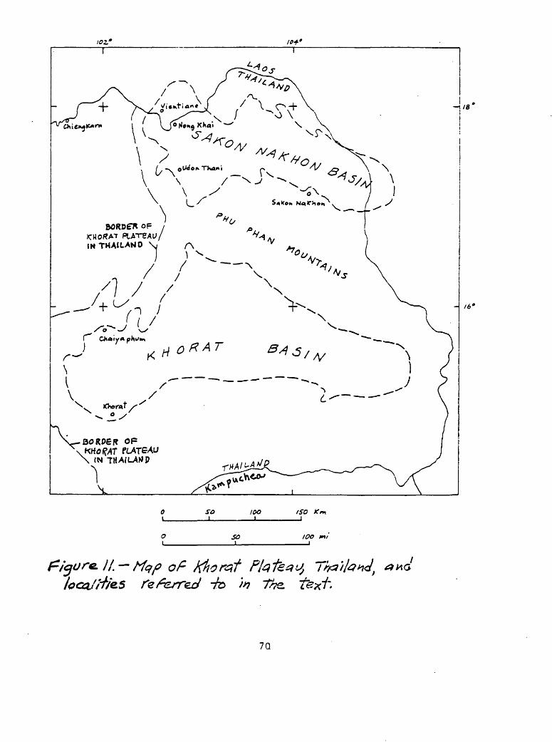
/<?.**
of Khoreff ffofezy
7Q
was drilled at Udon Thani. "This hole penetrated a thick bed of rock salt (819 ft) and made the first discovery of potash on the Khorat Plateau. The potash deposit occurs between the depths of 294 and 426 feet." The deposit consists mostly of the mineral carnallite (KMgCl3*6H2p), and contains a lesser amount of sylvite (KC1). Much of the mineralized interval is very pure carnallite, probably about 95-98 percent. "Sylvite occurs as thin layers in halite rock at the top of the deposit. It may also be disseminated through the upper part of the carnallite deposit. The gamma-ray log of the core hole shows radioactivity in the upper part of the carnallite zone to be much higher than that of the remainder of the carnallite zone suggesting the presence of sylvite."
A core hole being drilled at Nong Khai at the time of Kite's communi cation also had penetrated a potash deposit. According to Hite (written coramun., Jan. 1974), "Carnallite, very similar to that in the deposit found at Udon Thani, is present in the upper part of a very thick bed of rock salt. In addition to carnallite, this deposit also contains a large quantity of * * * tachyhydrite (CaMg2Cl6 '12H20)." Tachyhydrite is extremely soluble and hydroscopic and normally is only a rare secondary mineral in evaporite deposits. The only occurrence besides that on the Khorat Plateau where tachyhydrite is abundant is in Cretaceous evaporites of Cretaceous age in northeast Brazil.
Hite (written coramun., Jan. 1974) stated further that "The potash deposits at Udon Thani and Nong Khai have similar characteristics suggesting that they are stratigraphically equivalent." Probably the drill holes penetrate a single very extensive deposit that is continuous between the two locations (a distance of 50 km). "The thickness of high-grade carnallite found at Udon Thani exceeds that of any other known deposit in the world. Assuming this thickness remains constant in an area of at least 1 km around the drill hole, at least 60 million tons of high-grade carnallite is indicated. The depth of the potential ore is remarkably shallow and less than in any other potash mining district in the world."
Hite (written commun., Jan. 1974) pointed out that "The mineral carnallite contains about 17 percent K20 and is generally not considered a valuable ore of potash where sylvite deposits are available. Sylvite contains about 63 percent K20 and forms the ore in most of the world's potash mines. Because the Udon Thani deposit occurs at such shallow depth and, in addition, possesses other favorable mining attributes, it can probably be mined economically whether or not other deposits of sylvite are found.
"The tachyhydrite deposit at Nong Khai at this time cannot be considered of economic value. In fact its presence in carnallite would pose a mining hazard because it is such an unstable mineral. In the future, if cheap hydroelectric power became available in the area it might be feasible to use the magnesium chloride as a source of magnesium metal and hydrochloric acid."
Drilling done by the Laotian government, and supported by the United Nations, USAID, and the U.S. Geological Survey, on the Vietiane Plain 22.5 km north of Nong Khai, penetrated a high-grade potash deposit more than 8 m thick and averaging 28.5 percent K20. The potash beds are correlative with the potash-bearing intervals at Udon Thani and Nong Khai (R. J. Hite, written commun., May, 1975).
It is probable that substantial resources of potash will be developed in the Sakon Nakhon basin in the vicinity of Udon Thani and Nong Khai, and also in the so far untested Khorat basin. A high priority should be placed both on
71

additional drilling in the Sakon Nakhon basin and on start of drilling in the Khorat basin.
Phosphate
N. Angkatavanich (written coramun., Feb. 1974) has reported that a marine sedimentary phosphate deposit occurs at Kanom, Nakon Si Thammarat, intercalated with beds of black shale, sandstone, and quartzite in the upper part of limestone of the Permian Ratburi Group. In addition, phosphate deposits of some sort are known in or close to Permian limestone near Mae Tha (see fig. 24). These deposits may be of the marine sedimentary type, but could also have been concentrated in a near surface environment, as a result of leaching of sedimentary rocks of Permian or Triassic-Jurassic rocks which contain low concentrations of ?2^5*
An evaluation should be made of marine sedimentary rocks of favorable lithology (black shale, chert) of all ages throughout Thailand in order to assess the possibility that favorable geologic environments for economic deposits of phosphate rock are present. Samples should be analyzed for phosphate content to determine if phosphate is present in significant amounts, in order to establish trends that might indicate areas of potential deposits.
Oil shale
Oil shale beds of Tertiary age have been recognized in several places in Thailand. The only oil shale deposits that have received any study are at Mae Sot and at Li in northwestern Thailand (see fig. 12 for oil shale localities). The deposits at Mae Sot are the best known and apparently offer the most potential for significant resources of oil.
The Mae Sot Tertiary basin lies along the Moei River on the Burma- Thailand border west of Tak, and is about two thirds in Thailand and one third in Burma. Oil shale is interbedded in a sedimentary sequence of probably late Tertiary (Miocene to Pliocene or Pleistocene) age consisting of green shale, marl, sandy shale, micaceous or calcareous sandstone, fresh water limestone, gypsum, conglomerate, and tuffaceous lake beds. (Brown and others, 1951, p. 161-163).
The oil shale layers at Mae Sot have been folded and faulted but because of lack of geologic data there are uncertainties regarding the locations, attitudes, thickness, and number of oil shale beds in the basin. The oil shale is dense, tough, dark-brown rock of algal and laminated type, similar in appearance to oil shale of Devonian age in Alaska. Analyses reported by Brown and others (1951, p. 162) of selected samples of the shale indicated an oil content as much as 26 percent (about 70 gal/ton). In May 1972 a Canadian mining firm announced reserves in a 28 km concession in the Mae Sot basin at 100 million tons averaging 17 percent oil content (London Mining Journal, May 19, 1972, p. 412). This concession has not been mined. Two drill holes near the town of Mae Sot put down by the Department of Mineral Resources in the first part of 1974 to depths of 1,200 ft and 1,500 ft penetrated a Tertiary section consisting of 50-60 percent oil shale. Assays of drill hole cores by the U.S. Bureau of Mines indicated that these oil shale layers contain a low oil content. Only one interval of about 1.5 m assayed as high as 35 gal/ton, another interval of about 3 m contains about 25 gal/ton, and the remainder is lower.
72

Additional studies to determine the center of the original basin of deposition might lead to the discovery of sufficient high-grade oil shale to warrant development of an oil shale industry.
Pitrakul and Tantisukrit (1973, p. 46) reported .that oil shale is found in close association with lignite at Li in the Ban Pa Kha Tertiary basin in northwestern Thailand. The oil shale and lignite-bearing strata are Paleogene (early Tertiary) in age. Drilling and pitting have shown two horizons of oil shale overlying lignite seams. The upper oil shale bed is about 0.5-4.5 m thick and the lower oil shale bed averages 12 m thick. The oil shale contains 5-17 percent oil. Oil shale reserves at Li are estimated to be about 15 million tons, two : million tons of which can be mined by open pit methods.
Brown and others (1951, p. 163) reported oil shale of late Tertiary age near Krabi landing on the west coast of Peninsular Thailand that crops out for about 300 m along a tidal estuary. "The oil shale occurs in layers as much as 30 centimeters thick, intercalated with limestone, marl, hornstone, and anhydrite * * * in the upper part of the lignite-bearing formation of the Krabi series."
Lignite and coal
Lignite is found in the Tertiary basins in which oil shale occurs, and is known in other Tertiary basins in Thailand (Brown and others, 1951, p. 155- 159; Pitrakul and Tantisukrit, 1973, p. 43-45). According to Brown and others (1951, p. 155-156) at least 16 coal localities are known in continental or brackish-water marine sediments of Tertiary age in intermontane basins or bordering the present coast lines. The best known of these are shown on figure 12. Most of the coals in the north part of Thailand are brown, have woody texture, contain less than about 4,600 calories per kilogram, and are classed as lignite. Those in the south part of Thailand are more dense and black, contain more than 4,600 calories per kilogram, and are classed as subbituminous coal. Some contain more than about 6,100 calories per kilogram and are classed as bituminous coal.
The best known and probably largest deposit of lignite in Thailand is at Mae Moh (Gardner, 1967c), about 30 km east of Lampang and 6 km north of the Thai State Railway between Uttaradit and Lampang, and 530 km north of Bangkok. According to Gardner, the deposit is in a nonresistant claystone and siltstone sequence 1,000 m thick of the Mae Moh Formation of Pliocene age. The Pliocene strata occur in a north-trending fault-bounded graben about 5 x 13 km in size, flanked by uplifted blocks containing mostly folded and faulted marine Triassic rocks. The deposit consists of two main west-dipping lignite beds as much as 30 m thick separated by about 30 m of claystone. Lignite is known ' through a north-trending belt about 6 km long on the east side of the basin, but the deposit has been developed only in an open pit about 1 km long. Measured, indicated, and inferred reserves of lignite at the open pit and within the 6 km belt are more than 110,000,000 metric tons (m.t.) considered to be of lignite to subbituminous grade, and contain 33-39 percent moisture, 9-15 percent ash, 22-28 percent fixed carbon, 1.6-4.2 percent sulfur, and 26 percent volatiles.
In January 1974 at the time I visited the Mae Moh deposit, production was about 600 tons per day (Tpd), although production capacity was rated as about 1,200 Tpd. Most of the production is used in a chemical fertilizer plant located at Mae Moh. A Bangkok power plant could use about 1,000 Tpd lignite
73

but none was being shipped at the time of my visit. At the present rate of production it would take 5 centuries to exhaust the known deposit. Obviously production of the deposit could be enlarged substantially to provide a much larger percentage of Thailand's present energy needs.. Plans were underway at the time of my visit to do detailed drilling within the area that had been drilled previously.
According to Poothai and Ghana (1969a,b), lignite has been found recently in association with oil shale in the small basin of Ban Pa Kha, in the Li district, Lampoon province. The deposit is in a thin sequence of Paleogene (lower Tertiary) shale, clayey sandstone, and oil shale. The Tertiary strata lie in a basin 1 x 2.5 km in size surrounded by clastic sedimentary rocks of the Khorat Group. Two lignite seams each 7 ra thick are known and contain good quality coal. Reserves are estimated to be about 15 million tons, of which 8.7 million tons can be mined by open pit methods. The lignite is used only locally on a small scale in tobacco drying plants.
Pitrakul and Tantisukrit (1973, p. 45) and Poothai and Ghana (1969) described the Krabi lignite deposit in the Ban Pu Dum area in Peninsular Thailand. Lignite seams occur interbedded in upper Tertiary sands, clays, and marls, some of marine origin, known as the Krabi Series. The lignite seams are as much as 28 m thick and total reserves at Ban Pu Dum are more than 10 million tons. Total reserves in all the known lignite deposits of Krabi province may be as much as 100 million tons. Mining of the Ban Pu Dum lignite commenced in 1964 and the lignite was used as fuel in a thermoelectric power station. At the time of my visits in Peninsular Thailand in late 1973 and early 1974 a high-tension power line was under construction between Krabi and Bangkok for the purpose of supplementing the Bangkok power supply with Krabi- generated electricity.
Lignite is known in the Pliocene-Pleistocene basin of Chae Horn about 20 km northeast of Lampang in northwestern Thailand. Lignite beds about 1 m thick are intercalated with impure diatomite in "banded" clays in the lower part of the basin sediments (Pitrakul and Tantisukrit, 1973, p. 45).
Other lignite deposits are in the north part of the Mae Sot basin, Tak province (S. Lelawongs, oral commun., May 1974); at Ban Ngew Ngam and Ban Dua, Lampang province; Sahiab and Ban Mae Sai, Phrae province; Kiansa, Surat Thani province; and Lam Phura and Kantang, Trang province (Pitrakul and Tantisukrit, 1973, p. 45; Brown and others, 1951, p. 156-159).
Lignite resources of Thailand appear to be substantial, and their use could be expanded substantially to supply a much larger percentage of Thailand's energy needs than they now furnish. No doubt pollution problems would be considerably increased thereby, and careful study should go into disposition of mining and combustion wastes, and particularly those wastes that are discharged into the atmosphere during combustion.
Marl
A single important marl deposit in the Ban Mo district, Sara Buri province (fig. 10), furnishes a high-purity product used in the manufacture of cement at the Tha Luang plant, Ban Mo. According to Brown and others (1951, p. 140), "The marl is very soft and easily extracted at low cost. The marl deposits * * * are very extensive and lie at shallow depth. They were probably formed by redeposition of dissolved calcium carbonate at the bottom of a former (Tertiary) lake." An analysis of the Ban Mo marl shows 5.40 percent
74
S102, 1.35 percent ^20$, 0.73 percent AloC^, 0.04 percent MgO, 51.04 percent CaO, and 40.47 percent ignition loss (99.29 percent total).
Undoubtedly other large marl deposits occur in the Tertiary of Thailand. An evaluation of water well hole logs migh.t give indications of marl beds worth further study.
Diatomite
Diatomite beds of presumed Tertiary age and fresh-water origin are known in the Lampang basin in northwestern Thailand (see fig. 10). According to Brown and others (1951, p. 143) "About 18 kilometers south of Mae Tha railway station, a thick bed of diatomite crops out on the southern bank of the Mae Chang, a tributary of the Mae Wang. The exposure is reported to be 10 to 20 meters, and the bed dips westward toward the center of the basin." Chemical analysis showed 77.34 percent Si02, 2.85 percent E^O^, 6.33 percent A^O^, 5.14 percent CaO, 3.30 percent MgO, and 4.56 percent moisture (99.52 percent total).
Diatomite beds are also known at kilometer 4 on the Lampang-Fang highway, at Ban Phichai, and at Ko Kha (Pitrakul and Tantisukrit, 1973, p. 40). Five diatomite beds 1-10 m or more in thickness contain an estimated 10 million tons of reserves, based on drilling results.
Unrecognized diatomite beds also might be indicated by study of drill logs from holes in the Tertiary section of Thailand, and these too should be given additional evaluation.
Gypsum
Gypsum and associated anhydrite are abundant and widespread in Thailand. Layers of gypsum and anhydrite, some more than 100 m thick, are associated with halite in the Maha Sarakam Formation of Cretaceous age on the Khorat Plateau (Gardner, 1967b, p. 15-21; Hite, 1971). These resources throughout the plateau are of great magnitude but extraction of such a low- value commodity from the subsurface at this time would be too costly to be profitable.
In 1950 only a few small gypsum deposits were known in Thailand (Brown and others, 1951, p. 151-152). A number of small deposits were known near Lampang in northwestern Thailand. At Ban Song Hong, Nampard, Uttaradit province, gypsum as much as 80 cm thick occurs interbedded in red beds of the Mesozoic Khorat Group. Near Mae Moh, 50 km east of Lampang,, selenite occurs in cracks in a bed of white clay 10 m thick. At Mae Kua 45 km south of Lampang, satin spar gypsum is found in an occurrence similar to that near Mae Moh. Anhydrite occurs as thin beds in oil shale at Mae Sot and at Krabi.
Jacobson and others (1969, p. 68-70) reported gypsum and anhydrite at Wang Saphung and Loei in northeastern Thailand. The deposit at the south edge of the town of Loei is not well known. That at Wang Saphung 20 km south of Loei appears to be a sequence of beds of anhydrite and gypsum some as much as 50 m thick interlayered with shale, mudstone, and limestone of Permian- Carboniferous age. High-grade gypsum reserves at Wang Saphung were estimated to be about 500,000 nut.
Shekarchi (1971) reported three commercial deposits in Thailand, one in Surat Thani province in Peninsular Thailand, a second in Nakhon Sawan province about 250 kin north of Bangkok, and a third in Phichit province about 250 km
75
north of Bangkok. No details are known of the Surat Thani deposit. The Nakhon Sawan and Phichit deposits appear to be part of the same deposit, described as the Phichit deposit which is the principal source of gypsum in Thailand. Gardner (1967b) described the Phichit gyps.um deposit in detail. I visited the deposit in January 1974.
The Phichit gypsum deposit, discovered in 1955, lies along Khlong Saba which flows into the Nan River which, in turn, joins the Chao Phraya River about 40 km south of the deposit. The deposit is 16 km south of Ban Dong Khui. The location is shown on figure 10.
Country rocks in the area are shale, phyllite, siltstone, sandstone, and quartzite of probable Silurian and Devonian age, and limestone of the Ratburi Group of Permian age. Andesitic volcanic rocks possibly of Tertiary age are present locally. Some of the wall rocks of the deposit are cherty. Some shaly layers contain abundant clear euhedral gypsum crystals. Brown sand stone, conglomerate, and breccia crop out 1.5 km north of the deposit. These rocks resemble some of the basal Khorat Group of Mesozoic age 15-20 km southeast of the deposit.
Large blocks of greenish-gray igneous rocks are imbedded in the gypsum and anhydrite in places; some of these blocks are dikelike.
The gypsum deposit generally is covered with perhaps 1-2 m of clayey soil that lies upon a karstlike upper surface formed on gypsum rock.
The Phichit deposit is a thick north-trending layer about 300-550 m wide and at least 30 km long lying in apparent fault contact against its bounding wall rocks. It has been drilled to a depth of at least 415 m and apparently extends much deeper. Measured, indicated, and inferred reserves of gypsum at Phichit were estimated by Gardner (1967b, p. 33-38) to be about 36,800,000 m.t.
The gypsum rock is white to very light gray, granular, and medium to coarse grained. In places in the deposit where it is exposed in pits at the surface sedimentary laminae of dark-gray, probably organic, carbonaceous material are steeply dipping and otherwise contorted.
Drill hole information shows that the Phichit deposit consists of gypsum at the surface and to a depth of about 25 m, and anhydrite below 25 m.
The gypsum is high grade, containing generally more than 96 percent CaSO^^HoO. Analyses of gypsum and anhydrite from the deposit reported by Gardner tl967b, p. 12) are given in table 5 in percent.
The Phichit gypsum deposit is probably part of a sequence of evaporites in the Cretaceous Maha Sarakam Formation that has been faulted down as a slab into older rocks. Possibly it is part of a Permian-Carboniferous sequence similar to that known at Wang Saphang south of Loei.
Barite
Brown and others (1951, p. 137-138) reported lenses and beds of barite in sedimentary rocks that I classify as stratiform. Large stratiform deposits of barite interlayered with shale in northwestern Thailand, some of which have been discovered recently, are probably of sedimentary origin. Vein deposits of barite will be described in later pages. Locations of barite deposits are shown in figure 13.
According to Brown and others (1951, p. 137-138) pure barita lenses occur in sandstone of the Khorat Group about 20 km southeast of Nam Pat, Uttaradit province. "The barite is white and massive but good transparent crystals are not uncommon." One lens is about 1 a wide and 3 m Ion*. A bed of barite 10 m
76

Table 5 Chemical analyses of gypsum and anhydrite from the Phichit deposit
Sample SiC^ A^Og Fe2C>3 CaO MgO SOg #2® CaCC^ Gypsum Anhydrite no.
(calculated)
Gypsum
1 0.36 0.24 0.24 33.09 0.31 45.12 20.20 1.51 96.51 0.39
2 .36 .20 .24 32.75 .35 45.10 20.22 1.71 96.61 .29
3 .48 .32 .24 32.81 .61 45.00 20.17 1.30 96.37 .31
Anhydrite
4 .52 .40 .24 41.46 .57 55.60 .03 2.53 .14 94.42
5 .58 .26 .32 41.44 .33 55.90 .06 2.27 .29 94.90
77
thick dipping 50° W., and several thinner beds are found in sandy shale probably of Silurian-Devonian age 55 km west of Tak. A partial chemical analysis showed 92,7 percent BaSO^, 3.02 percent SiC^, and 0 percent Fe.
Jacobson and others (1969, p. 66) described a massive barite deposit at Ban Tin Pha 20 km south-southeast of Chiang Karn (see fig. 22) 5 m wide and 30 m long. Analysis of a grab sample showed 99.4 percent BaSO^, an unusually pure deposit. The deposit is in sandstone and shale of probable Devonian and early Carboniferous age. The deposit may be stratiform, although the geologic setting is too poorly known to allow a definite conclusion. About 5 km south of Ban Tin Pha a second barite deposit occurs at Baw Kin Khao (see fig. 22) in a sequence of limestone, shale, tuff, and dolomite beds of Devonian and early Carboniferous age. Jacobson and others (1969, p. 66-68) described the deposit as a bedded replacement of dolomite. Wall rocks are shale and mudstone. Mineralized rocks range from pure barite to dolomite containing minor barite. The deposit has a strike length of 1200 m. Massive barite ranges in width from 1 to 9 m and is exposed as layers through a vertical distance of 200 m. Two smaller deposits lie to the west. Proven and probable reserves in the main deposit were estimated at 2.5 million tons of barite that averages about 93 percent BaSO^. I believe this stratiform deposit may be of sedimentary origin.
Pitrakul and Tantisukrit (1973, p. 36-37) described a barite deposit at Ban Thimontha (Ti Mong Ta) in the northernmost part of Kanchanaburi province as veins in Upper Ordovician-Silurian shales and soft sandstones. The barite averages 97-98 percent BaSO^ and reserves have been estimated to be 110,GOO- 220,000 m.t. I believe the barite is at least in part stratiform and of sedimentary origin, although it probably has been displaced somewhat and possibly remobilized during strong regional deformation. In the same region a stratiform lead-barite deposit is known a few kilometers north of Song Toh, and just north of "old Song Toh," that I visited in February 1974. There, carbonate rock and shale of Ordovician age contain a layer of interlaminated galena and white barite as much as 2 m thick that has been drilled to a depth of 100 m. A nearby barite layer is not as large. The alternating barite and galena laminae are 1 mm to 1 cm thick; some layers are lenslike and locally are mildly contorted. Probably the deposit has undergone low-grade metaraorphism. I believe the galena-barite layers are of sedimentary origin, similar to massive sulfide deposits at Meggen and Rammelsberg, Germany, and to some others elsewhere in the world.
The Phu Mai Thong barite deposit, near Ban Mae Thoei about 20 km northwest of Li, Lamphun province, is perhaps the largest stratiform deposit of barite now known in Thailand. I visited the deposit in January 1974. A supposed sedimentary barite at Doi Tao, Chiang Mai province (Mahawat, written commun., 1972), is located near the position of the Phu Mai Thong deposit on the map of Thailand. I do not know if these are separate deposits.
Country rocks in the region according to the geologic map of Thailand (Javanaphet, 1969) are sedimentary rocks of Ordovician, Silurian, Devonian, and Tertiary ages, the older rocks having been intruded by Carboniferous and Triassic granites. However, the barite-bearing strata were described to me at the deposit by Department of Mineral Resources geologists as possibly Triassic in age inasmuch as the east-dipping strata overlie what appears to be limestone of Permian age west of the deposit. The barite occurs in thinly bedded and laminated buff, brown, and reddish-brown shale. Probably the shale is in part pyrite-bearing where it has not been weathered near the surface.
78

At the time of my visit the geology of the deposit was not well known. Three major barite layers 25-50 m thick lie conformably, about 50-100 m apart, in north-striking and moderately to steeply east-dipping shale beds. Exposures are poor and it is uncertain whether the barite beds are separate layers or faulted segments of the same layer. The three layers are en echelon, the easternmost (thickest) lying farthest south. The thickest barite layer is at least 500 m long. I estimated roughly about 7,000,000 m.t. of barite as probable reserves in the main layer. The average grade being shipped was about 90 percent BaSO^ (specific gravity about 4.2).
The barite is light gray to white, buff, and brown; it is massive to finely laminated, and laminations parallel bedding in the enclosing shale layers. Some of the light-gray to white unweathered barite contains thin layers as much as 2-3 mm thick of pyrite and possibly other sulfides, but sulfides are not abundant. Probably much of the color in the barite is due to iron oxides derived from oxidized pyrite. The contacts of barite and enclosing shale layers are conformable and gradational. Commonly, interlaminated shale and barite lie between massive barite and shale.
Because of the thin laminae in barite, and interlarainated shale and barite, all conformable with enclosing shale beds, I believe that the Phu Mai Thong stratiform barite deposit is of sedimentary origin. The interlayered sulfide layers are analogous to similar layers in sedimentary barite at Meggen and Rammelsberg, Germany.
If the Phu Mai Thong barite deposit is similar in origin to the deposits in Germany, it would be worthwhile to explore the shale beds laterally (on strike or down dip) away from the barite to search for beds of massive iron, lead, and zinc sulfides.
Iron
A group of small stratiform iron deposits in Paleozoic (possibly Precambrian) metamorphic rocks in southeastern Thailand may be of sedimentary origin. At Thap Khlong (Khao Tab Klang, fig. 16), which I visited in February 1974, magnetite, hematite, limonite, and quartz occur in foliated siliceous metasedimentary rocks in layers as much as 5 m thick. The iron-rich rock is thinly, in part irregularly, laminated; laminae are mostly 1-2 mm thick. Because of a positive magnetic response on the outcrop, the deposit at Thap Khlong had been surveyed by magnetometer, but it could not be traced far along strike.
Other deposits in a north-northwest-trending belt of metasedimentary rocks in southeastern Thailand include Cham Khlo, Klaeng, Ban Prok Fa, Lad Krating, Nong Ban, and Phanom Sarakhom (see fig. 16). Little is known of these iron deposits, but they also like the Thap Khlong deposit, may be of sedimentary origin. An aeromagnetic survey of this belt should be carried out to determine if any iron formation deposits of significant size are present. This belt seems to me to offer the best possibility of iron ore deposits of substantial size in Thailand.
A single additional iron deposit that may be of sedimentary origin is known as Kao Noi, Tung Long, Kanorn, Nakon Si Thammarat province, in Peninsular Thailand (not shown in fig. 16). The deposit consists of a layer of specular hematite in mica schist interlayered with gneiss of Paleozoic (possibly Precambrian) age.
79
Manganese
According to Brown and others (1951, p. 88-94) stratiform deposits of manganese minerals of possible sedimentary origin occur.in Kanchanaburi province west of Bangkok and in Pattani and Yala provinces in southernmost Peninsular Thailand. Gardner and others (1965) reported no occurrances of sedimentary manganese in northwestern Thailand where most of the manganese deposits in the country are known. Locations of manganese deposits are shown 4 in figure 27.
Brown and others (1951, p. 89) stated that in Kanchanaburi province near Ung Lu, 25 km north of Si Sawat on a tributary of the river Khwae Yai, hard black manganese oxides occur in sandstone; manganese content is as much as 46 percent. Near Luboh Jirai, Pattani province, manganese oxides occur as cementing material in conglomerate; manganese content is 19 percent. Manganiferous sandstones of the Khorat Group are reported at Hua Toh Phran, Bralor, Samohsukeh, and Tibu, Yala province, some containing as much as 39 percent Mn.
Jacobson and others (1969, p. 63) reported a manganese prospect in shale of Carboniferous-Permian age at Huai Pla Kang about 32 km east-southeast of Chiengkam (see fig. 22) that may be of sedimentary origin. There, irregularly shaped masses of manganese oxide as much as 0.5 m long occur in a shale bed 2 m thick. A 5 m channel sample along bedding averaged 15.2 percent Mn.
Reports of a large deposit of manganese oxide west of Kanchanaburi suggest the possibility of an extensive sedimentary deposit. The deposit has been described to be as much as 6 m thick, and recognized through a distance of about 10 km. Presumably the wall rocks are clastic sedimentary rocks of Devonian-Permian age. This occurrence warrants detailed study inasmuch as it could constitute a substantial manganese resource.
Most of the manganese deposits of all types throughout Thailand occur in clastic sedimentary rocks. Brown and others (1951, p. 88-89) indicated that the chief host rocks are sandstone, conglomerate, shale, and slate of the Mesozoic Khorat Group. Jacobson and others (1969, p. 58-63) indicated that in the Loei-Chiang Karn region most deposits occur in quartzite, phyllite, and shale of Devonian-Early Carboniferous age. Pitrakul and Tantisukrit (1973, p. 15) suggested that the principal hosts are Paleozoic sedimentary rocks and metasedimentary rocks. Piyasin (written commun., 1971) indicated that manganese deposits in the Lampang quadrangle in northwestern Thailand are in sedimentary rocks of Silurian-Jurassic age. Possibly the sedimentary rocks served as the source of manganese in hydrothermal deposits in Thailand, or may be favorable for the occurrence of sedimentary manganese deposits, but if so, no single sedimentary unit appears on this basis to have significantly more manganese than do others.
Base metals
No stratiform deposits of lead and zinc have been described in Thailand. Nevertheless the significant lead-zinc deposits at Nong Phai and Song Toh in Kanchanaburi province, identified as vein and replacement deposits by Brown and others (1951, p. 79-88) and by Pitrakul and Tantisukrit (1973, p. 19-20), have features that suggest that the deposits are of sedimentary origin. I visited the deposits in February 1974, and learned much about them
80

from Mr. Rung Songsiri of the Department of Mineral Resources, and Mr. Thani Klipbua, manager of the Song Toh mine who accompanied me on the visit. Mr. Poon is owner and operator of the Song Toh and Nong Phai mines.
At Song Toh about 25 km west-northwest of Si Sawat.and 110 km northwest of Kanchanaburi (location shown in fig. 14), a stratiform deposit of galena and minor sphalerite occurs in limestone of Ordovician age. Limestone of Early Ordovician age in the region consists of strata that are commonly lenticularly bedded, with lenses of dense gray limestone 3-10 mm thick and a few centimeters across separated by dark-gray clayey diasterns. Locally the limestone contains intraformational conglomerate. Above these rocks are Middle Ordovician strata that are thin-bedded to massive light-gray fine grained sugary limestone and some interbedded dark-gray shale layers. Upper Ordovician beds overlying these are similar to the Lower Ordovician strata. The ore deposits at'Song Toh and elsewhere in the region are in Middle Ordovician beds. No intrusive igneous rocks are known in the region, although a granitic batholith of Triassic age lies about 30 km north of Song Toh.
In places the limestone beds are fractured and brecciated, and cavities are lined with calcite rhombohedra as large as 1 cm across.
Bedding at the Song Toh deposit strikes nearly north and dips 30°-35° to the east. No large faults are known at the mine. In the region the Ordovician rocks have been strongly folded and faulted.
The galena ore body at Song Toh has a maximum thickness of about 10 m and it has been mined along strike about 100 m and down dip about 25 m. Mineralized rock similar in appearance is known about 500 m south of the mine, and has been encountered by drilling about 100 m down dip. Production to date has been minor as only primitive mining methods are being employed. The mined ore is very high grade, having the appearance of nearly pure galena, and is shipped by truck and boat to Kanchanaburi. A floatation plant is planned at the mine to allow production of 150 m«t. of ore per day. Reserves have not been calculated by the operator, but I estimated that perhaps 50,000-100,000 m.t. of high-grade ore can be inferred in the vicinity of the mine.
The galena ore is generally conformable to bedding of the enclosing sedimentary rocks. It appears to vary in grade along bedding, and pockets of high-grade galena ore as large as 5 m thick and 15 n across have been stoped out sporadically in the mineralized layer, leaving pillars and large areas of unmined lower-grade mineralized rock.
High-grade steel-gray galena ore that appears to have been undisturbed by fracturing or other deformation is dense, extremely fine grained, and thinly laminated parallel to the bedding layers in adjacent limestone and shale. The laminae are a fraction of a millimeter to about 2 mm thick. Locally, galena- rich laminae alternate with laminae of dark-gray shale.
In places the galena and other sulfides are coarse grained, showing crystals at least 2 mm in size. In such places the rock has been strongly deformed as though by flowage, and by brecciation. Some ore that appears to consist of irregular, patchy replacements of galena in limestone may be simply mashed and brecciated layered ore.
Most of the sulfide at Song Toh is galena. Light-grayish-brown sphalerite occurs with some of the galena ore and is particularly evident where the rock is coarse grained and limestone has been recrystallized to coarse-grained calcite aggregates. Pyrite is only locally abundant. I observed one pyrite-rich pod about 15 cm long with a hematite-stained core lying in a bedding layer of galena-calcita rock.
81
The silver content of the lead ore at Song Toh is not known, but it may be high. Ancient slag piles (dated at 400-700 years old by a C date on mine timber) in the vicinity of Song Toh that are now being worked for their lead content were left from raining and smelting operations apparently intended to recover the silver content of the ores. The slags run about 40 percent Pb but contain no silver; probably the ores were not worked initially for their lead content.
The Song Toh deposit is one of several lead deposits in a north- northwest-trending belt in Kanchanaburi province (see fig. 14) in Middle Orodovician rocks. A barite-galena stratiform deposit north of Song Toh has been described previously in this report. According to R. Songsiri (oral commun., February 1974) the lead deposits become progressively enriched in barite toward the north (compare locations of barite deposits in this region, fig. 13).
The occurrence of the lead ores of Kanchanaburi province entirely in Middle Ordovician limestone-shale strata, the absence of intrusive igneous rocks in the region, the systematically variable barite content of the ores that may reflect a sedimentary facies change, and the thin laminae in undeformed parts of the Song Toh deposit that are parallel to bedding of enclosing limestone and shale, all suggest that these ores are of sedimentary origin. The similarity of the galena-sphalerite-pyrite-barite assemblage at Song Toh and that of sedimentary origin at Meggen and Ramraelsberg, Germany, is noteworthy.
Probably extensive exploration is warranted in the region in search for additional, possibly much larger, stratiform sulfide and barite deposits. The fact that the rocks have been strongly deformed is an unfavorable aspect that will increase exploration difficulties.
Nong Phai, about 20 km west-northwest of Si Sawat (30 km by road) lies a few kilometers south of Song Toh. The lead-zinc deposit at Nong Phai was discovered about 1912 by German prospectors, but work on developing the deposit ceased during World War I. No activity took place until World War II, when small mining operations commenced. By the end of 1949 about 100 m.t. of lead-zinc ore per month was being shipped (Brown and others, 1951, p. 82- 85). Production continued at least until about 1960 (Smith, written commun., 1960) and probably into the 1960's but the property was idle when I visited it in February 1974.
The Nong Phai lead-zinc deposit is in limestone of Middle Ordovician age. Much of the limestone in the vicinity of the deposit has been recrystallized so that bedding has been obliterated. Silicification has been extensive in places around the periphery of the deposit.
The host rocks of the Nong Phai deposit have been strongly brecciated, faulted, and otherwise deformed, and the deposit itself has suffered extensive deformation. Three sets of moderately to steeply dipping faults cut the limestone; one set strikes northwest and dips northeast, a second strikes north and dips east, and a third strikes northeast and dips southeast. The sulfide ore locally has been sheared considerably.
The lead-zinc ore occurs mostly in so-called veins that lie along northwest- and north-striking faults of minor displacement. The main vein has been stoped for a length of about 100 m; it is in a zone about 20 m wide in which closely spaced parallel layers of sulfides constitute about 10 percent of the rock. Within this zone is a narrower zone 3 m wide in which layers of sulfides 10 cm to 1 m wide make up 20 percent of the rock. A smaller north-
82
trending zone consists of parallel layers of sulfides in limestone 1-7 m wide and contains 20-50 percent sulfides.
Up to 1960 about 33,000 short tons of ore grading 10 percent Pb, 10 percent Zn, and 1 oz per ton Ag had been produced (Smith, written commun., 1960, p. 1). Some hand sorted ore ran 25-55 percent Pb, 7-40 percent Zn, and 2-5 oz per ton Ag. Smith (1960, written commun., p. 1, 6) estimated 37,000 tons of indicated reserves and 100,000 tons of inferred reserves, grading 10 percent Pb, 4 percent Zn, and 1 02 per ton Ag. Upper levels of the ore deposit average higher zinc content than lower levels.
In places in the Nong Phai deposit sulfides occur in brecciated masses and as irregular veinlets in recrystallized limestone. Some of the brecciated ore consists of fragments of fine-grained galena and other sulfides cemented with coarse-grained calcite matrix, and some appears to be fragments of recrystallized limestone in a coarse-grained sulfide matrix. Calcite veinlets traverse the ore in places.
Some of the galena-rich ore at Nong Phai is dense, fine grained, and laminated, with laminae 1-3 mm or more thick. None however is as fine grained and thinly laminated as that seen at Song Toh. In places thin laminae of sulfides (mostly galena) less than 1 mm to about 1 cm thick are interlayered with gray shale laminae. Locally the interlayered galena and shale are strongly deformed in what appear to be tight folds, or are mashed and sheared as irregular stringers. The galena in places is obviously slickensided.
Galena is the principal sulfide and sphalerite is less abundant. Mostly these minerals are very fine grained but in places they are coarse grained; light-grayish-brown sphalerite occurs in crystals as much as 5 mm across in coarse-grained calcite. Pyrite is present in some of the ore. At and near the surface the ore has been oxidized and contains abundant anglesite, smithsonite, and hydrozincite. Some hemimorphite is present, and probably some other oxide minerals of zinc and lead occur in the near-surface ores. Probably the more highly oxidized near-surface ores that were mined early in the history of the mine contain a higher proportion of zinc minerals than do the unoxidized ores, accounting for the higher zinc grades of the early production. Iron oxide is abundant locally in the near-surface ores.
Calcite is the principal gangue mineral. White massive quartz, flinty silica, and silica boxworks are present. Much of the silica may be of supergene origin. I do not know if barite is present. The shale layers appear to contain abundant very fine-grained, very pale-greenish-gray sericite.
Analyses of samples of ore given by Brown and others (1951, p. 87) are shown in table 6 (in percent).
Additional analyses of channel samples from throughout the Nong Phai deposit also reported by Brown and others (1951, p. 88) are in table 7 (in percent except for Ag, given as oz per short ton).
The analyses do not show the amount of carbon, oxygen, calcium, etc., present, and the discrepancies between the total shown and 100 percent are probably due mainly to unanalyzed carbonate.
Despite the fact that the lead-zinc deposit at Nong Phai has been described as of vein and replacement type, I believe instead that it is a stratiform deposit of sedimentary origin that has been strongly modified by subsequent deformation and perhaps raetaraorphism. First, the deposit is in the same stratigraphic unit as, and only a few kilometers from, the Song Toh deposit which seems to me clearly to be of sedimentary origin. Second, the
83
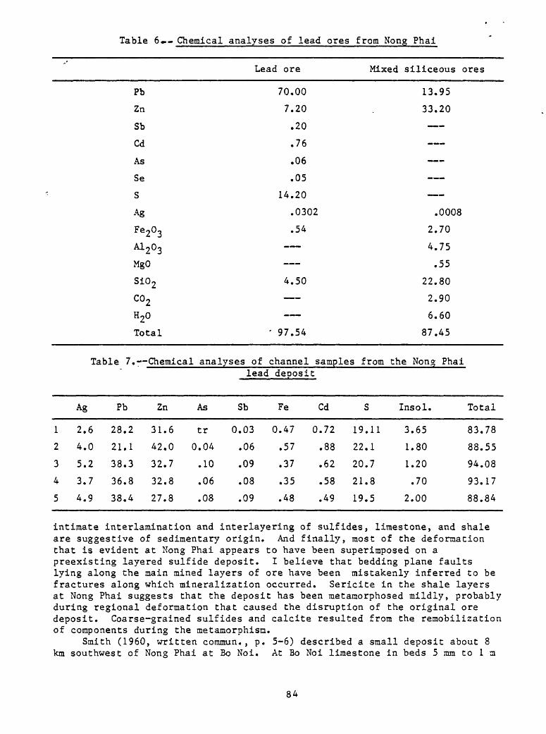
Table 6«-- Chemical analyses of lead ores from Nong Phal
Lead ore Mixed siliceous ores
Pb
Zn
Sb
Cd
As
Se
S
Ag
Fe203
A1 203
MgO
Si02
co2H20
Total
70.00
7.20
.20
.76
.06
.05
14.20
.0302
.54
4.50
' 97.54
13.95
33.20
.0008
2.70
4.75
.55
22.80
2.90
6.60
87.45
Table 7.- Chemical analyses of channel samples from the Nong Phailead deposit
Ag Pb Zn As Sb Fe Cd S Insol. Total
12
3
4
5
2.6
4.0
5.2
3.7
4.9
28.2
21.1
38.3
36.8
38.4
31.6
42.0
32.7
32.8
27.8
tr
0.04
.10
.06
.08
0.03
.06
.09
.08
.09
0.47
.57
.37
.35
.48
0.72
.88
.62
.58
.49
19.11
22.1
20.7
21.8
19.5
3.65
1.80
1.20
.70
2.00
83.78
88.55
94.08
93.17
88.84
intimate interlamination and interlayering of sulfides, limestone, and shale are suggestive of sedimentary origin. And finally, most of the deformation that is evident at Nong Phai appears to have been superimposed on a preexisting layered sulfide deposit. I believe that bedding plane faults lying along the main mined layers of ore have been mistakenly inferred to be fractures along which mineralization occurred. Sericite in the shale layers at Nong Phai suggests that the deposit has been metamorphosed mildly, probably during regional deformation that caused the disruption of the original ore deposit. Coarse-grained sulfides and calcite resulted from the remobilization of components during the metamorphisn.
Smith (1960, written commun., p. 5-6) described a small deposit about 8 km southwest of Nong Phai at Bo Noi. At Bo Noi limestone in beds 5 mm to 1m
84

thick contains galena in crystals as large as I mm across that form lenticular "veins" along bedding. A few quartz and quartz-calcite veins 2-5 cm wide containing small amounts of galena cut across the beds. I believe that this deposit also is of sedimentary origin and has been modified somewhat by subsequent metamorphism.
A stratiform copper deposit at Phanom Sarakham in southeastern Thailand (Brown and others, 1951, p. 62; Pitrakul and Tantisukrit, 1973, p. 22; location shown in fig. 21) may be of sedimentary origin. Native copper, cuprite, chalcopyrite, and malachite are found as rounded grains in mica schist in a wide area where no igneous rocks are known. Pyrite, ilmenite, and limonite also are present. Several beds of cupriferous schist 1-30 cm thick are interlayered with barren schist; copper content is as high as 3 percent. This area warrants detailed study to determine the extent of the deposit. If it is of sedimentary origin, it may be of substantial size.
Sandstone^type copper and uranium
Copper and uranium deposits in sandstone are described together here as a type because of their close affinity and distinctiveness compared to other stratiform deposits of metals in Thailand.
Brown and others (1951, p. 61) described several copper deposits in sandstone of the Khorat Group in northwestern Thailand (locations shown in fig. 21). At Ban Tan near Lampang, at Huai Hi 70 km north of Lampang, and at Huai Chan 75 km northeast of Lampang, copper-bearing sandstone layers 2-100 m long are known. At Ban Wang Sam Pan 90 km northeast of Uttaradit cupriferous sandstone is found in an area covering 25 m, a similar deposit is known 60 km southeast of Uttaradit. At Ban Huai Niara near Ban Huai Thad malachite occurs in a sandstane bed 1 m thick. Copper content is as high as 10 percent in parts of the sandstone. At Boh Pha Wiang near Ban Sieo a cupriferous sandstone bed 2 m thick crops out in a ravine. About 15 km northeast of Ban Pin at Tah Pah Mok copper mineralized rock is known in brecciated clastic strata. During World War II about 10 tons of ore containing as much as 8 percent Cu was mined.
Inthuputi (1971) and Shawe and others (1975) described a copper-uranium deposit at Phu Wiang (Wieng) at the west edge of the Khorat Plateau (fig. 17) in probable Lower Jurassic yellowish-gray and gray carbonaceous sandstone and conglomeratic sandstone. Radioactive minerals, malachite, and azurite are disseminated and coat fractures in podlike bodies as much as 1.5 m thick in a north-trending zone 1.5 km long and as much as 150 m wide. The most highly mineralized rock contains 0.03-0.08 percent U and 0.8-3.0 percent Cu.
Shawe and others (1975) suggested that the Khorat Plateau may have a large potential for sandstone-type uranium deposits.
Hite (1971) pointed out a large northwest-trending area in the west- central part of the Khorat Plateau (fig. 21) where copper is anomalously high in ground water in Cretaceous strata. The area is alined with the deposit at Phu Wiang and those in northwestern Thailand described by Brown and others (1951). I believe that this zone (outlined in fig. 21) warrants careful evaluation for sandstone-type copper deposits in Mesozoic clastic strata. The presence of large evaporite deposits in Cretaceous strata on the Khorat Plateau brings to mind the association of evaporites and the immense Zechstein copper deposits in clastic sedimentary strata of Permian age in East Germany and western Poland. Such deposits should be looked for on the Khorat Plateau.
Replacement deposits
Certain mineral deposits in Thailand, although occurring commonly in somewhat stratified forms in layers of sedimentary rocks, mainly carbonates, are believed to be of replacement origin (either hydrothfirmal or supergene) rather than of sedimentary genesis. These include the large zinc deposit at Pa Daeng, a number of fluorspar deposits throughout northwestern, west- central, and Peninsular Thailand, and widespread iron deposits.
Pa Daeng zinc deposit
The Pa Daeng zinc deposit is located about 12 kin east-southeast of Mae Sot n$ar the Burmese border in northwestern Thailand, about 500 km by road north-northwest of Bangkok (fig. 10), It is accessible by paved highway from Bangkok, by way of Tak, to Mae Sot, and thence on graded dirt road to the deposit. It was discovered in 1956 and explored from 1957 to 1961 by Sumitorao Metal Mining Co. Ltd., and explored by National Lead Co. in 1966-67. It is presently being operated by Thai Zinc Ltd., a subsidiary of New Jersey Zinc Co. Preliminary production had started by the first of January 1974, at which time plans called for mining about 200,000 m.t. of ore during the first year for processing at the New Jersey zinc plant in Palmerton, Pennsylvania. A mill to process the Pa Daeng ore is planned at Tak. I visited the deposit in January 1974.
The Pa Daeng deposit is remarkable for its high grade, which in fact is so high as to poison the soil overlying the deposit where it is exposed at the surface so that trees will not grow thereon. The boundaries of the deposit (and its satellitic bodies) are thus marked by the edge of the surrounding dense forest. The ore deposit at the surface has a brown to reddish-brown appearance and it is readily evident from the air. The soil on the deposit supports mainly a small succulant plant that bears red blossoms during the rainy season and is a zinc indicator plant. Pa Daeng in the Thai language means "red cliff."
The Pa Daeng zinc deposit is in the Kamawkala Limestone of Triassic age. In the region around Mae Sot the Kamawkala conformably overlies the Permian Rat Buri Limestone and unconformably underlies Pliocene beds consisting of fresh-water limestone, calcareous sandstone, siliceous sandstone, conglomerate, gypsum, and oil shale. The Kamawkala Limestone at ?a Daeng is thin- to medium-bedded impure limestone, in part oolitic, with interbedded dolomite, sandstone (commonly calcareous), and minor clay beds and lenses. In the vicinity of the deposit the Kamawkala strikes easterly and dips 30°-40° north (Veit, written commun., 1973, p.. 19).
I know of no studies that indicate the extent of altered wall rock in the vicinity of the Pa Daeng zinc deposit. The Kamawkala Limestone in the vicinity of the deposit appears to be somewhat bleached and iron stained. The deposit itself probably owes its high grade to supergene enrichment, and to what extent the limestone owes its altered appearance to near-surface leaching rather than to hydrothermal alteration is not known. Clay minerals such as kaolinite, montmorillonite, and illite(?) occur in and near ore (Veit, written commun., 1973, p. 22) and may have resulted in part from hydrothermal alteration and leaching of the impure limestone wall rocks.
No faults have been mapped in the vicinity of the Pa Daeng zinc deposit. Nevertheless the main ore body and five satellitic bodies known as
36
the Pagoda zinc deposit, and the New, Khang Phiban, Hua Lon, and Pa De zinc occurrences, form a northwest-trending linear zone almost 2500 m long and transverse to the strike of the sedimentary host rocks, suggesting a possible fracture control of the position of the ore bodies. Sandstone beds in the Kamawkala Limestone in the vicinity of the main Pa Daeng deposit are abruptly discontinuous. I do not know whether these beds are faulted off, or discontinuous because of original depositional irregularities,
The main Pa Daeng ore body is an irregular pod more than 500 m long, nearly 250 m wide, and locally more than 50 m thick that strikes northeast and dips northwest. It contains at least 3,000,000 ra.t. of ore averaging about 30 percent Zn, based on extensive drill and assay information. The core of the deposit generally exceeds 30 percent zinc and it is surrounded by a shell of lower-grade material. The ore body is roughly conformable with a northeasterly bend in the generally east-striking sedimentary beds, but locally it sharply crosscuts the limestone bedding. The main body consists of two superposed ore lenses separated by 10-20 m of nearly barren limestone. The Pagoda ore body is a smaller similarly oriented body about 150 m long lying 100 m west of the Pa Daeng body. The remaining ore bodies are smaller, about 50 m in diameter and roughly equidimensional. The New and Khang Phiban bodies are near the north end of the main Pa Daeng deposit and the Hua Lon and Pa De bodies are respectively about 1500 m and 2500 m northwest of the main deposit.
The Pa Daeng zinc ore is brown to grayish brown, and locally white near the surface. The ore is irregularly laminated, but many of the laminations are discontinuous. Parts appear fragmental, as though brecciated. High-grade rock (30 percent or more Zn) is hard whereas low-grade material (less than 20 percent Zn) is soft and earthy. Lenses of unreplaced limestone and dolomite, surrounded by low-grade rock, occur throughout the main ore body.
The principal ore minerals at the Pa Daeng deposit are hemimorphite (Zn^Si207 (OH)2.H20) and smithsonite (ZnCO^). The west half of the ore body, or upper layer generally, is dominantly hemimorphite, whereas the east half, of lower layer, is dominantly smithsonite. Minor amounts of secondary zinc carbonate minerals hydrozincite (2ZnC03.3Zn(OH) 2 ) and loseyite ((Zn,Mn)y(OH)^Q(C02) 2 ) are present, particularly near the surface and associated with smithsonite. In addition to clay minerals already described as present as part of the gangue are quartz, maghemite, goethite, chamosite, and rare nontronite, and in the east part of the deposit (lower or smithsonite layer) also calcite and dolomite (Veit, written commun., 1973, p. 22-24).
Galena, sphalerite, and cerrusite in small amounts are reported in the Pa De deposit (Veit, written commun., 1973, table 8).
In the main Pa Daeng deposit calcite and dolomite make up about 3 percent of the ore that contains more than 30 percent zinc, about 8 percent of the material that contains 20-30 percent zinc, and about 11 percent of the rock that contains 10-20 percent zinc. Iron (Fe^^) content of the deposit ranges from less than 5 percent to almost 20 percent, inversely proportional to the amount of zinc present. Alumina (A^O^) ranges from less than 5 percent to almost 15 percent, also varying inversely with zinc content. Cadmium averages about 0.2 percent throughout the deposit, ranging between about 0.01 percent and 1.0 percent, concentrated mainly in the smithsonite ore. Interestingly, lead and copper are virtually nil (Veit, written commun., 1973, p. 25).
There is no evidence of the age of the ore bodies other than that they formed after consolidation of the host rocks.
37
Undoubtedly the present zinc-silicate and carbonate ore bodies at Pa Daeng are supergene. The brecciated aspect of parts of the ore may have formed during supergene deposition. The linear disposition of the ore deposits in a trend transverse to the strike of sedimentary host beds suggests that the primary ore bodies had an epigenetic origin. The presence of galena and sphalerite at the Pa De ore body which is the lowest topographically of all the deposits suggests that the ore bodies formed as a result of virtually complete oxidation of primary sulfide deposits. Possibly relatively soluble zinc was leached by acid meteoric waters from a zinc-lead sulfide deposit and then deposited at a water table beneath. In the case of the Pa De deposit, the primary ore deposit was leached and reconstituted virtually in place at the water table. Hemimorphite formed abundantly in silica-rich rocks and smithsonite in carbonate rocks. Subsequent erosion removed the overlying host rocks in which the primary deposits formed, as well as the oxidized lead minerals that had remained following leaching of zinc.
If high-grade zinc deposits similar to the Pa Daeng hemimorphite- smithsonite ores are present at the surface elsewhere in the region, or throughout Thailand, they should be readily recognized because of the lack of trees and presence of indicator plants covering them. If high-grade zinc (or zinc-lead) sulfide deposits are present beneath the surface nearby, or elsewhere in Thailand, their possibly great metal content would make them prize exploration targets. The geologic setting of the Pa Daeng deposit should be further evaluated for the purpose of clarifying the genesis of the deposits, to aid exploration for similar deposits. Exploration for supergene zinc deposits might be warranted beneath deposits containing oxidized lead minerals elsewhere in Thailand.
Fluorspar
Vein, breccia pipe, and related deposits of fluorspar dominate over replacement or manto deposits of fluorspar in Thailand, although the replacement deposits are locally important. The replacement deposits will be described here even though some aspects of their geologic occurrence will be discussed in later pages where geologic setting, regional relations, and origin of fluorspar deposits in general are dealt with.
Locations of known replacement deposits are shown in figure 15. Large replacement deposits occur at Salak Phra northwest of Kanchanaburi, Muang Ngai north of Chiang Mai, and Mae Tha south of Chiang Mai. Smaller deposits are known at Huai Pong Kaeng northwest of Chiang Mai, Doi Chang (Om) northwest of Tak, Huai Pa Ti south of Kanchanaburi, and Khao Ong Khong near Si Sawat.
The Salak Phra district (also known as the Tha Kra Dan district and earlier as the Ban Sum Sui prospect), 86 km by road northwest of Kanchanaburi and about 2 km east of the Mae Nam Kwae Yai (River Kwai), contains at least nine replacement deposits of fluorspar. They appear to be randomly distributed in a north-trending area about 2 km wide and 3 km long. Numerous vein deposits and one large breccia pipe deposit of flurospar are also present in the Salak Phra district; these will be described in later pages, together with a brief history of discovery and operation of the district. I visited the district in February 1974. Part of the following description is based on Potisat (written commun., 1973).
The replacement deposits or mantos occur in carbonate host rocks of Ordovician age. Graptolitic black shale of Ordovician age, mudstone, slaty
33

shale, and quartzite of Paleozoic age, arkosic sandstone of unknown age, and crinoid-bearing limestone of Carboniferous(?) or Permian(?) age are also present in the district. Limestone in the vicinity of the replacement deposits is locally silicified. No igneous rocks are known in the district.
The deposits appear to be elongated in the direction of prominent faults in the district, mostly oriented north-northwesterly, north-northeasterly, and northerly, that commonly localized fissure veins of fluorspar. The replacement deposits may be partly fault controlled. They are somewhat analogous to the mantos in the Illinois-Kentucky district of the United States.
One of the larger replacement deposits known at Salak Phra, the Phu Wai deposit, is about 200 m long, 50 m wide, and 20 m thick; it contains an estimated 600,000 m.t. of fluorspar averaging about 40 percent Cap2» The known replacement deposits in the district are irregularly spaced roughly 1 km apart, although a few occur within about 100 m of other replacement deposits (fig. 25).
Fluorspar in the replacement deposits is characteristically very fined grained, dense, and finely laminated, reflecting the bedding character of the replaced limestone. Commonly bedding layers are marked by thin but laterally broad openings that may have formed as a result of contraction of the limestone upon replacement. The openings are lined with very fine grained botryoidal fluorite suggesting that open-space filling followed replacement of the limestone. The processes must have been continuous because the finely laminated replacement fluorspar merges imperceptibly with the botryoidal open- space filling fluorspar. Locally irregular cavities are lined with coarse grained (1-2 mm) fluorite cubes.
Color of the replacement fluorspar is gray, pink, buff, and light brown; the colors other than gray are due probably to oxidized iron sulfides.
Chalcedonic silica occurs with fluorite in the replacement deposits. Rare galena is present, coated with botryoidal fluorite that lines cavities.
The Muang Ngai deposit is 72 km north of Chiang Mai, 16 kai northwest of Chiang Dao, and 6 km northwest of the village of Muang Ngai. Only one replacement deposit of fluorspar has been recognized at this locality. Its description is based mostly on Charoensri (written commun., 1972).
The deposit is in limestone and an overlying shale in the Ratburi Group of Permian age. In the region around Muang Ngai the Ratburi overlies Carboniferous sandstone, graywacke, and shale, and is overlain unconformably by Tertiary conglomerate, sandstone, and shale. The closest known igneous rock is granite of Triassic age 10 km northwest of the deposit.
In the vicinity of the deposit shale has been silicified* dolomite has formed along the shale-limestone contact, and manganese oxide coats fractures in the limestone. Veinlets of fluorite occur in the host rocks surrounding the ore body.
Carboniferous strata in the region have been folded along northerly axes but the overlying Permian strata have been folded along easterly axes, probably during the Mesozoic. This structural discontinuity suggests that a thrust fault may separate the Permian and Carboniferous strata. Permian and older rocks are cut by a northwest-trending high-angle fault dipping northeast and the fluorspar replacement deposit lies in the hanging wall close to the fault. Also, the deposit is near the axis of an anticline in limestone of the Ratburi, at the top of the limestone just beneath capping shale.
39
The Muang Ngai deposit is about 130 m long, 30-40 m wide, and a maximum of perhaps 20 m thick. The deposit contains probably at least 100,000 m.t. of fluorspar. There is no record of the grade of the deposit.
The Mae Tha district lies 28 km southwest of Lamphun and 7 km east of the town of Mae Tha. A deposit being mined by the Universal Mining Co. Ltd., the central of three deposits in the district that are alined in an east-trending zone, contains some replacement bodies in addition to vein and irregular bodies of flurospar. The following description is based mostly on information from Mr. Abe (oral coramun., 1973) of Ishihari Sangu who, while employed by Universal in 1969-73, studied the fluorspar deposits in the Mae Tha district, and from Sektheera (1969).
Replacement bodies at the Universal mine are in limestone of the Ratburi Group. In the area, the Ratburi overlies Paleozoic quartzite, schist, phyllite, graywacke, and shale. The Ratburi in turn is overlain by conglomerate, sandstone, chert, and shale of Permian and Mesozoic age. The nearest granite (Triassic) lies 10 km southeast of the Mae Tha district. Trachytic basalt was reported by Abe (oral commun., 1973) in the vicinity of the Universal deposit but I did not observe any at the time of my visit in January 1974.
The Mae Tha district lies on the northwest flank of a major northeast- trending anticline (the Chiang Mai geanticline) and near the axis of a major north-northwesterly anticlinal fold on the flank of the major anticline.
Limestone and shale in the vicinity of the ore deposit have been silicified. The rocks are sheared and brecciated in and near ore bodies.
The deposit being mined by Universal is at least 800 m long and is known to a depth of 60 m on the basis of drilling. Estimates of reserves of all types of fluorspar in the deposit vary widely, from 300,000 ra.t. (Sektheera, S., written commun., 1969) to 4,000,000 m.t. (Abe, oral commun., 1973). Grade of concentrates produced in the past has ranged from 75-95 percent CaF£ and averaged 80 percent CaF2«
The fluorspar at the Universal deposit appeared to me in January 1974 to consist of a variety of types with no clear indication of the form of the ore bodies from which it was being rained. Some buff-colored fine-grained granular fluorspar called "sandstone" fluorspar appeared to be of replacement origin. Much of the fluorite is white to gray and massive, and some is botryoidal. Brecciated fluorite is also evident. Chalcedony is an abundant gangue mineral, and commonly occurs interlayered with massive fluorite.
Stibnite is abundant locally in the fluorspar of the Universal deposit. It occurs as radiating clusters in massive fluorspar as well as needlelike crystals growing in open spaces and characteristically coated with tiny (1 mm) clear colorless fluorite cubes. Some fluorspar, particularly fines in deeper parts of the mine, are dark gray from contained finely divided stibnite. In late 1974, some production of stibnite had commenced at the Universal deposit.
At Huai Pong Kaeng about 80 km northwest of Chiang Mai and 15 km northwest of Ban Paeng fluorite replaced limestone along southeast-trending joints to form a high-grade body about 60 m long and 1.5 m wide and along east-trending joints to form another body about 30 m long and 1 m wide. About 100 m west of the replacement bodies is a hot spring near the Pai river. If fluorite deposition was related to hot springs activity possibly these bodies are quite young.
At Dai Chang (Om) 80 km northwest of Tak, fluorite and silica have partly replaced Ordovician limestone in a zone about 200 m long and 100 m wide, and

Ordovician sandstone and quartzite in a zone about 18 m long (Charoensri, written commun., 1972).
At Huai Pa Ti about 50 km south of Kanchanaburi and 30 km west of Ratburi replacement deposits of fluorspar containing 15-80 percent Cal?2 occur in limestone interbedded with shale and sandstone, locally silicified. Fine- to coarse-grained biotite-muscovite granite containing aplite dikes and quartz veins occurs nearby.
A replacement deposit of fluorspar is reported (Potisat, written commun., 1973) near Khao Ong Khong near Si Sawat in well-bedded limestone and shale that are probably of Ordovician age.
Iron
Iron deposits, mostly of replacement origin and none of large size, are widespread in Thailand and are found throughout northwestern Thailand, in the Loei area in the northwest part of northeastern Thailand, in parts of west- central Thailand, in a group 100-200 km north of Bangkok, throughout southeastern Thailand, and in a group lying near Krabi and Nakhon Si Thammarat in Peninsular Thailand (fig. 16).
Most of the iron deposits are believed to be replacement bodies of contact-metamorphic origin. The few important replacement deposits are described in detail here and the remaining minor deposits are tabulated. Numerous mostly small lateritic deposits throughout Thailand, a few sedimentary iron formation deposits in southeastern Thailand, and an important veinlike deposit in Peninsular Thailand, are described elsewhere in this report.
The oldest productive iron mine in Thailand is at Khao Thab (Thap) Kwai, about 125 km north of Bangkok and 20 km north of Lop Buri (Brown and others, 1951, p. 76-78). Production started in September 1950. The wall rocks are limestone, sandstone, and shale probably of Permian or Carboniferous age, intruded by a quartz diorite stock of Tertiary age (Javanaphet, 1969). This stock is grouped with biotite-muscovite granite of Cretaceous and Tertiary age in figure 4.
In places near the contact of the quartz diorite stock limestone has recrystallized to marble and clastic sedimentary rocks have been converted to hornfels and quartzite. Green and reddish-brown garnets, wollastonite, green mica, clear quartz, pyrite, and chalcopyrite have formed locally. Apparently the stock contains numerous inclusions of garnetized hornfels and quartzite near its contact.
Intruded sedimentary strata appear to be flat lying, and the quartz- diorite-sedimentary rock contact probably is steep.
According to Brown and others (1951, fig. 9) the iron ore body is mostly in marble and extends for almost 500 m along the northeast-trending marble- quartz diorite contact.
Reserves estimated in 1941 were 720,000 m.t. of assured ore and 80,000 m.t. of probable ore grading about 48 percent Fe in a residual blanket northwest and downslope from the deposit. Primary ore reserves grading about 66 percent Fe appeared to be much smaller.
The primary ore consists of dense hematite, some of which is magnetic (Brown and others, 1951, p. 78).
Chemical analyses (reported by Brown and others, 1951, p. 78) indicated compositions (in percent) of primary and residual ore shown in table 8.
9 I
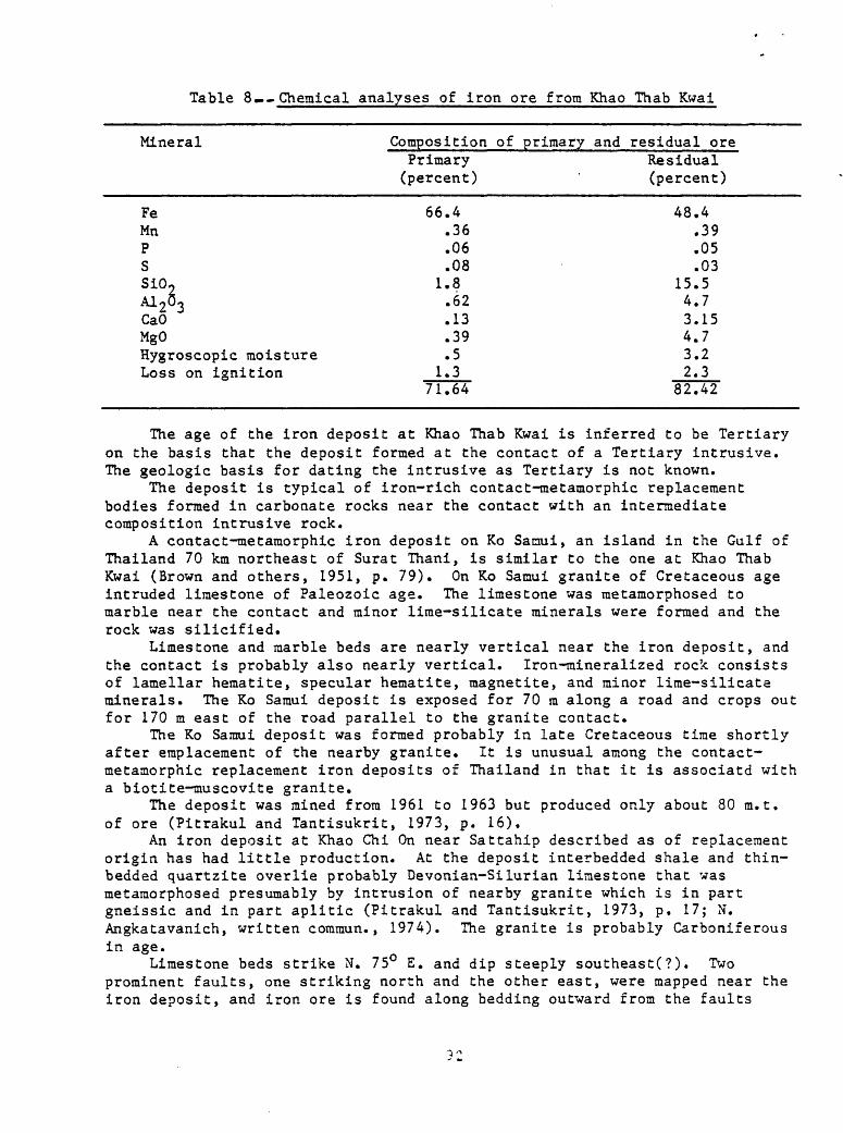
Table 8«... Chemical analyses of iron ore from Khao Thab Kwai
Mineral Composition of primary and residual orePrimary Residual(percent) (percent)
FeMnPSSiO-M263CaOMgOHygroscopic moistureLoss on ignition
66.4.36.06.08
1.8.62.13.39.5
1.371.64
48.4.39.05.03
15.54.73.154.73.22.3
82.42
The age of the iron deposit at Khao Thab Kwai is inferred to be Tertiary on the basis that the deposit formed at the contact of a Tertiary intrusive. The geologic basis for dating the intrusive as Tertiary is not known.
The deposit is typical of iron-rich contact-metamorphic replacement bodies formed in carbonate rocks near the contact with an intermediate composition intrusive rock.
A contact-metamorphic iron deposit on Ko Saciui, an island in the Gulf of Thailand 70 km northeast of Surat Thani, is similar to the one at Khao Thab Kwai (Brown and others, 1951, p. 79). On Ko Samui granite of Cretaceous age intruded limestone of Paleozoic age. The limestone was metamorphosed to marble near the contact and minor lime-silicate minerals were formed and the rock was silicified.
Limestone and marble beds are nearly vertical near the iron deposit, and the contact is probably also nearly vertical. Iron-mineralized rock consists of lamellar hematite, specular hematite, magnetite, and minor lime-silicate minerals. The Ko Samui deposit is exposed for 70 m along a road and crops out for 170 m east of the road parallel to the granite contact.
The Ko Samui deposit was formed probably in late Cretaceous time shortly after emplacement of the nearby granite. It is unusual among the contact- metamorphic replacement iron deposits of Thailand in that it is associatd with a biotite-inuscovite granite.
The deposit was mined from 1961 to 1963 but produced only about 80 m.t. of ore (Pitrakul and Tantisukrit, 1973, p. 16).
An iron deposit at Khao Chi On near Sattahip described as of replacement origin has had little production. At the deposit interbedded shale and thin- bedded quartzite overlie probably Devonian-Silurian limestone that was metamorphosed presumably by intrusion of nearby granite which is in part gneissic and in part aplitic (Pitrakul and Tantisukrit, 1973, p. 17; N. Angkatavanich, written commun., 1974). The granite is probably Carboniferous in age.
Limestone beds strike N. 75° E. and dip steeply southeast(?). Two prominent faults, one striking north and the other east, were mapped near the iron deposit, and iron ore is found along bedding outward from the faults

(Pitrakul and Tantisukrit, 1973, p. 17; N. Angkatavanich, written commun., 1974). Locally small quartz veins are found in the country rocks.
The deposit contains an estimated reserve of 56,000 m.t. of iron ore grading about 68 percent Fe, based on drilling by the Department of Mineral Resources (Pitrakul and Tantisukrit, 1973, p. 17).
Ore bodies are irregular, commonly massive, but in places granular and disseminated (Pitrakul and Tantisukrit, 1973, p. 17). The deposit as exposed in shallow pits when I visited in February 1974 consisted in part of a flat- dipping dense iron oxide layer 1-2 in thick overlain and underlain by laterite. Some of the iron oxide is botryoidal. Part of the layer is rather siliceous and has the aspect of jasperoid or gossan overlying an oxidized sulfide deposit. Pyrite occurs locally elsewhere in the deposit.
The deposit formed in part probably as a result of hydrothermal fluids moving outward from faults along bedding layers in limestone. It may have formed shortly following emplacement of the nearby Carboniferous granite, or it may be much younger and unrelated to the granite.
The Khao Chi On deposit has aspects of a very strongly weathered sulfide deposit, and may not have been rich in iron oxides initially as the previously described replacement iron deposits appear to have been.
At Kao Uem Kruem about 55 km north of Kanchanaburi the Department of Mineral Resources carried out an extensive drilling program starting in 1961 and lasting 5 years to explore a replacement deposit of iron ore. No mining has been done because of the low grade of the mineralized rock. The deposit is in Ordovician(?) limestone not far from a large body of granodiorite of Triassic age. It occurs as a replacement layer in limestone that is exposed at the surface for about 100 m along strike. An estimated 6,000,000 m.t. of ore grading 50-55 percent Fe was developed as a result of the drilling. The iron minerals are hematite and limonite. Some manganese oxide is present.
The iron deposit is considered to have formed by replacement outward from a fissure (A. Suwanasing, oral commun., 1974).
At Phu Lek, Chiang Khan, Loei Province, hematite-magnetite boulders in a residual deposit about 500 m long related to a replacement deposit at a limestone-Triassic granodiorite contact constitute a probable reserve of 400,000 m.t. (Pitrakul and Tantisukrit, 1973, p. 18).
Other replacement deposits of iron in Thailand, all small, are summarized in table 9.
A number of iron deposits have been recognized only from float. Some of these are boulders of magnetite and hematite near the contact between sedimentary rocks, mostly limestone, and intrusive rocks, mostly granodiorite of Triassic age. The primary deposits are probably of contact-raetamorphic replacement origin. They include Ban Mae Ho and Ban Mae La Noi at Mae Sarieng, Mae Hong Son; Phu Ang, Phu Khok, and Phu Khum Thong at Muang, Loei; Ban Rai, Uthai Thani; and Kao Ta Sao Wai Mia at Tha Mai, Chantaburi where pebbles and boulders 1 m thick cover an area of about 50 m .
To summarize the occurrence of contact-metamorphic replacement deposits of iron minerals, they are dominantly in limestone adjacent to dioritic and granodioritic intrusives. Most of the intrusives are Triassic in age, although one productive mine (at Khao Thab Kwai) is associated with a dioritic intrusive of supposed Tertiary age. The tendency for association with intrusives of Traissic age is indicated in figure 16, which shows in addition to the known iron deposits of the country also intrusive rocks of Triassic
93

Table 9 Sunmary of small replacement deposits oc Iron in Thailand
Name
Huai 3o Lak
?ran Kracai Xlong Slang
Phu Sang
Phu Ran, Ohu Sang.
Phu Lek Ban Tac.
Phu Kaew Yai
Phu Hin Lek Fai.
Phu Thong Oaeng.
Bo I-ltrd
Huai (Hua)Wai.
Kao (Xhao) tfong.
(Ban) Kao Thong.
Muang Thuad
Location
Mae Chaem, Chiang Mai.
Xampangpitch Chon Dan,
Pecchabun (not shown on fig. 12).
Chiang Khan, Loci.
. i ii rl r- - - - -
do
Muang, Loei (noC shown on fig. 12).
M~1rii* « »
Wang Saphung Loei.
Takhi, Nakon Sawan.
Lopburl
Krabi
Ma San, SuratThanie
Country rocks
Quarczite, schist, limestone, skarn (Paleozoic).
No data Liaestone, skarn
No data
Sandstone, shale
Ska rn
No data
Sandstone, siltstone.
do
Shale, siltstone, slaty shale, marble, quartzice.
Liaestone, shale, sandy shale (Persian, Carboniferous).
Liaestone, skarn (Peraian, Carboniferous? ) .
Limestone, lioe- silicate rock (Permian).
Associated intrusive rocks
Hornblende-biotite granodiorite (Triassic- Jurassic).
Porphyry (Tertiary? )~ Granite, diorite
Granodiori.ee (Triassic) , porphyry.
Granodiorite (Triassic)
No data
Granodiorite (Triassic), rhyolite.
Granodiorite (Triassic), porphyry.
Granodiorite (Triassic?)
Diorite porphyry (Tertiary?).
Diorite, granodiorice (Tertiary).
Granite (Cretaceous?)-
do
Minerals
Magnetite, magnetic hematite.
No data. Magnetite,
hematite, garnet.
No data.
Hematite, limonite.
Hematite, specular hematite oagnetite.
Magnetite, hematite.
Magnetite, pyrite, base- metal sulfides Do.
Magnetite, hematite, pyrite.
Hematite, magnetite.
Magnetite,hematite, pyrrhotite, capper, and lead sulfides garnet, malachite azurite.
Magnetite, lime- silicate minerals.
Liaonite.
9 '4

age. Magnetite and hematite are commonly abundant in the deposits and lime- silicate minerals, pyrite, and base metal sulfides are present in some deposits. Limonite is abundant in some deposits. Possibly sulfides are present or even abundant in the unweathered parts of some deposits where base- metal minerals as yet have not been recognized.
The likelihood that other small to medium tonnage replacement iron deposits will be discovered in Thailand seems good. Effective exploration will be greatly aided when Thailand acquires adequate aeroraagnetic coverage of the country. Most of the deposits will probably be located in the contact zones of granodioritic intrusives of Triassic age. Some may be found near intermediate composition intrusives of younger age.
The possibility for significant base-metal sulfide content of some of the replacement iron deposits should not be overlooked.
Base metals
Replacement or contact-metamorphic deposits of copper, lead, and zinc are not widely known in Thailand. Parts of the porphyry copper deposits near Loei appear to be the result of replacement, particularly where wall rocks are carbonate. Also near Loei some prospects reveal replacement deposits of lead and zinc.
According to Jacobson and others (1969, p. 16) the Phu Khum 1 prospect about 20 km southeast of Loei contains lead and zinc sulfide minerals along a brecciated contact between massive Carboniferous-Permian limestone and Triassic diorite porphyry. The roughly circular contact encloses an area nearly 1 km in diameter. Three meters of high-grade lead-zinc-silver ore were intersected in one drill hole drilled by the Department of Mineral Resources, and disseminated pyrite, with traces of lead and zinc, partially replacing limestone was found in three other drill holes.
The somewhat similar Phu Khum 2 prospect 2 km west of the Phum Khum 1 lies at a granodiorite-liraestone contact where lead and zinc minerals were seen in limestone at the surface, and a geochemical survey indicated lead-zinc mineralization for 800 m along the intrusive contact. One drill hole indicated only traces of base metals, however (Jacobson and others, 1969, p. 17).
According to Pitrakul and Tantisukrit (1973, p. 19) high-grade lead-zinc sulfide ore was mined in 1960-68 near Muang Kut, Mae Taeng, Chiangmai province from mineralized Permian limestone along a coarse-grained porphyritic granite contact. This deposit is probably of replacement origin.
Pitrakul and Tantisukrit (1973, p. 24) reported a contact-metainorphic copper deposit at the contact between rhyolite and andesite rocks and limestone in Lopburi province (Khok Kathiam(?) deposit).
Igneous intrusive contact zones in Thailand should be much more thoroughly evaluated for the occurrence of base-metal sulfide contact- raetamorphic deposits, as it seems likely that such deposits are more numerous than is presently recognized.
Tin
Aranyakanon and others (1970, p. 9-10) described contact metanorphic deposits of tin, calcium, and iron minerals that formed at intrusive contacts between granite and limestone, such as parts of the deposits at Pin Yoh
(Pinyok; Banchop mine) and Tarn Talu, in Yala Province, described elsewhere (localities shown in fig. 17). At the Banchop mine, Permian limestone altered to skarn, and contorted schistose argillite, were intruded by coarse-grained porphyritic granite that is fine-grained near the contact. At the contact the metamorphosed sedimentary rocks contain actinolite, hypersthene, hedenbergite, magnetite, garnet, and ferrous-iron pyroxene. Quartz, is rare and cassiterite is abundant enough locally to form ore deposits. In places the cassiterite- rich contact zone grades into a garnet zone farther from granite. The garnet zone contains green, brown, pale yellow, and buff garnet, quartz, tremolite, magnetite, and sparse cassiterite (in part acicular in radiating clusters, probably from cassiterite replacement of tremolite). In skarn near granite, zinc, lead, and copper minerals are also found.
A similar but smaller tin-bearing contact deposit occurs at the Trad mine, Na-San district, Surat Thani province.
Brown and others (1951, p. 122-123) described a contact-metamorphic deposit of tin at the Chenkit mines, Surat Thani, 13 km east-southeast of the Na San station on the railway. Biotite-muscovite granite of Cretaceous age intrudes massive impure limestone of Ordovician(?) age, and near the contact the limestone has been altered to tactite. The tactite contains abundant garnet, epidote, and arsenopyrite, and lesser amounts of pyrite, chalcopyrite, hematite, and cassiterite disseminated amongst the major minerals. Cassiterite also occurs in quartz-feldspar dikes or veins within the tactite, in association with mica, fluorite, tourmaline, pyrite, and chalcopyrite. In addition, cassiterite is found in quartz-tourmaline veins in granite and greisen, and in a narrow quartz vein along with wolframite.
Tungsten
The only significant contact-metamorphic (replacement) tungsten deposit known in Thailand is at Doi Mok, about 7.5 km northeast of Wiang Pa Pao, Chiangrai province, northwestern Thailand (fig. 28). I visited the deposit in January 1974. The mining concession at Doi Mok belongs to Mr. Inthong Suwanyeun, but at the time of my visit and during the previous 2 years or so since its discovery, the deposit was being mined by squatters without permits. Most of the mining appeared to be by gophering close to the surface, and by panning surficial material.
At Doi Mok biotite granite of Carboniferous(?) age has intruded limestone and shale of Silurian-Devonian(?) age. In the vicinity of the granite the limestone has been metamorphosed to marble and tactite and the shale has been metamorphosed to schist. On the north side of a hill on a main ridge of the Khuntan granite range east of Wiang Pa Pao where, most of the tungsten ore has been mined, granite is in contact with limestone. The limestone dips steeply north and conformably overlies schist layers that make up most of the hill. The schist on the south side of the hill about 500 m south of the granite- limestone contact is in contact with granite, suggesting that the metamorphosed sedimentary rocks constitute a roof pendant within, or a septum extending into, the granite intrusive.
The sporadic and piecemeal production of scheelite from the deposit that has resulted from the squatter mining operations has contributed to a poor understanding of the amount and grade of ore produced from Doi Mok. At the time of my visit about 20 m.t. per month of scheelite concentrates (grading about 70 percent W03) was being produced, whereas 6 months earlier about
96
50 m.t. per month had been produced. Apparently the rich scheelite ore in tactite at the contact, which constituted the initial discovery, has been exhausted. According to Pitrakul and Tantisukrit (1973, p. 4) the Doi Mok area produced about half of Thailand's scheelite output in 1972.
The rich scheelite ore of the contact zone lay in tactite against granite on the north side of the hill on the ridge at Doi Mok* Other scheelite mineralization occurred along schist layers (possibly carbonate-rich layers) underlying the hill; these mineralized layers are not known to be extensive. The tactite at Doi Mok contains in addition to quartz, calc-silicate minerals, and scheelite, minor cassiterite, molybdenite, galena, sphalerite, and arsenopyrite. Apparently only scheelite is recovered. Some contact rock at the Liang Ngiab mine south of the main Doi Mok workings contains abundant tourmaline and clay minerals in places; there, schistose argillite wall rock locally contains abundant graphite.
According to Pitrakul and Tantisukrit (1973, p. 4), scheelite also occurs with arsenopyrite and pyrite in quartz veins in the granite at Doi Mok, as small veinlets in joints in granite, and disseminated in granite. These parts of the Doi Mok deposit apparently are of stockwork type.
In seems surprising that additional substantial contact raetamorphic deposits are not known in carbonate rocks against intrusive contacts of the tungsten- and tin-rich granites of Thailand. Probably additional exploration of these environments would disclose such deposits. Inasmuch as the Doi Mok deposit is associated with a Carboniferous(?) granite intrusive, rocks of that age may be more favorable for prospecting than are the younger granitic rocks.
Phosphate
Most known deposits of phosphate in Thailand are of bird or bat guano type and are small. One deposit may be of replacement origin in young alluvium consisting mostly of Paleozoic limestone fragments, and despite its apparent small size offers larger potential than the guano type. Although the guano deposits and the bedded deposit are described as of replacement origin, some aspects of the bedded deposit are problematical and suggestive of marine sedimentary origin. Phosphate deposit localities are shown in figure 10.
The Tha Khum Nun bedded phosphate deposit lies about 2 km west of the fluorspar deposits at Mae Tha, Lamphun province. When I visited the deposit in January 1974 it had been mined for about 1 year although it had been known for 4-5 years.
The deposit is surrounded by alluvium, and its relations to other rocks are poorly known. The deposit is considered to overlie limestone; judged from a geologic map of the area (fig. 24) it probably is lying upon limestone of the Ratburi Group of Permian age. The deposit is also not far from outcrops of Triassic-Jurassic marine chert and shale (fig. 24) and therefore may be related to those rocks.
The Tha Khum Nun deposit contains about 30 percent P2^5 on the basis of the grade of rock that was being shipped to Bangkok at the time of my visit. Drilling at the deposit had indicated a thickness of about 23 m, but the lateral limits of the deposit had not been determined.
The phosphate rock is gray, buff, and brown, and is variously layered and mottled. Parts of the deposit are irregularly laminated, some layers are pebbly and contain concentrically zoned ovoid pellets, and parts contain limestone fragments that are incompletely or wholly replaced by phosphate,
9'7

lying in finer-grained matrix. The deposit appears to be a layer of Quaternary(?) alluvium containing a high proportion of limestone detritus that has been partly or completely replaced by phosphate. The source of the phosphate is unknown. Two possible sources in the vicinity are the Triassic- Jurassic marine chert and shale rocks, and marine cherty shale beds in the Permian limestone. If such were the origin of the phosphate, it was probably leached and then redeposited in the surficial materials as a result of tropical weathering.
A phosphate deposit 'reported (N. Angkatavanich, written coramun., 1974) at Ban Mae Moei (a village 2.5 km north-northwest of the Tha Khum Nun deposit) is the same as the Tha Khum Nun deposit. It is described as a "bird guano type" formed during Pleistocene(?) time in a limestone basin. Other guano deposits described by N. Angkatavanich (written coramun., 1974) and occurring mostly in caves in the Permian limestones are at Nong Ngui, Wangsapung, Loei Province; at Chorabueng, Potharam, Ratburi Province; at Klong Wan, Prachuap Kirikhan; and at Kao Rug Kiat, Songkhla. All probably formed as replacements by the reaction of bird and bat droppings with limestone.
Stockwork and related deposits
Tin
Tin deposits in a great variety of forms occur in granitic intrusive rocks or their closely adjacent wall rocks throughout all of western Thailand from northwestern Thailand southward through west-central Thailand and Peninsular Thailand, and in southeastern Thailand (fig. 17). Deposits classified as closely spaced veinlets, pegmatites, and aplites, as greisens, and as disseminations in granite are described here as stockwork and related deposits. Contact-metamorphic (replacement) deposits and hydrothermal lode (vein) and pipelike bodies of tin are described elsewhere in this report.
Tin has been produced in Thailand for centuries. According to Garson and others (1970) the total tin in concentrates mined during the period 1871-1968 is 596,129 long tons valued (1974's price) at nearly $5 billion. More than 90 percent of production has been from placer deposits (described elsewhere in this report). Some bedrock deposits have had important production, however, and large stockwork-type deposits may become significant producers in the future.
It has long been held that the tin deposits of Thailand are related to so-called "tin granites" of Late Cretaceous age (for example, Aranyakanon, 1961). Nevertheless it is evident from figure 17 that the tin deposits, although closely associated in space with "granitic" intrusives, in fact occur in or near virtually all types of intrusive rocks of Thailand including biotite-muscovite granite of Carboniferous and Permian ages, hornblende- biotite granodiorite of Triassic and Early Jurassic ages, and biotite- muscovite granite of Cretaceous and Tertiary ages. Figure 17 also reveals that tin deposits are abundant near many but not all of the Cretaceous and Tertiary granites; they are absent near the Cretaceous and Tertiary intrusives in central and northern Thailand, some of which are, however, of more mafic composition than granite. Tin deposits occur in the vicinity of all of the Lower Jurassic intrusives, which are hornblende-biotite granodiorites. Tin deposits are numerous near most of the hornblende-biotite granodiorites of Triassic age, although they are not found near Triassic intrusives in the

north part of southeastern Thailand, the east part of northwestern Thailand, and the northwest part of northeastern Thailand. Tin deposits are absent close to many of the Carboniferous biotite-muscovite granites, but are numerous near others, particularly in northwestern and in southeastern Thailand, Most of these granitoids are medium- to coarse-grained rocks of granular texture; some are porphyritic. Evidence discussed in later pages indicates that the tin deposits were formed by pneumatolysis long after emplacement and solidification of the granitoid intrusives, and possibly by processes not directly related to the raagmatisra of the intrusives.
The chemical character of the granitoid intrusive rocks in Thailand varies with age, as indicated in an earlier part of this report. For example, Carboniferous biotite-muscovite granites average 71.4 percent: Si02, 15.3 percent A^O^, 4.6 percent K20, 0.19 percent P2°5» and °« 007 percent SnCU. Triassic hornblende-biotite granodiorites average 68.7 percent SiCU, 15.7 percent A^O^, 3.6 percent ^0, 0.03 percent P2°5» anc* 0.007 percent Sn02« Cretaceous biotite-muscovite granites average /0.7 percent Si02 , 13.9 percent A^O^, 5.2 percent K20, 0.13 percent P2°5» and °* 01 Percent Sn02 . Muscovite- biotite granite of Cretaceous age from the Haad Som Pan tin district contains higher silica and notably more tin but tourmaline granite from the same locality, although it contains notably more silica also contains subtantially less tin (see table 3, p. 49).
The concept that tin deposits are characteristically associated with high-silica two-mica granites enriched in tin and termed "tin granites" does not appear to be wholly valid. Nevertheless, granites collected from the vicinities of tin deposits, whatever their ages, seem to be almost universally biotite-muscovite granites, some containing tourmaline, and enriched in tin (fig. 17). The tin contents of granites given in figure 17 include those listed by Aranyakanon (written coramun., 1970), and those of Pitakpaivan (1970) recalculated. The values reported by Pitakpaivan are almost certainly an order of magnitude high, inasmuch as they are much higher than other published values for tin-rich granites worldwide, and they are inconsistent with the values Aranyakanon gives for similar granites from the same areas. I suspect that because Pitakpaivan's data are consistently high, the analytical procedure used was not accurate although perhaps precise; possibly an error in the position of the decimal point in the reported results accounts for the discrepancy. Consequently I have applied an arbitrary correction factor of 0.1, and for purposes of more direct comparison, I have converted the Sn02 values of Pitakpaivan to the equivalent Sn values of Aranyakanon. Considering this adjustment, the average tin content of 61 analyses reported by Aranyakanon is 0.0067 percent (excluding one value of 2.025 percent) and the average tin content of 31 analyses reported by Pitakpaivan is 0.0086 percent (excluding one value of 0.091 percent). According to Sainsbury and Reed (1973, p. 641) silicic igneous rocks average 0.00035 percent tin, indicating that the Thailand granitoid rocks are indeed tin rich.
Based on Aranyakanon's (1970) data the average tin content of 23 granites in northwestern Thailand is 0.0066 percent, that of 10 granites in west- central and southeastern Thailand is 0.0064 percent, and that of 28 granites in southern Thailand is 0.0069 percent. The similarity in these figures shows that there are no significant regional variations in the tin content of Thailand tin-associated granitoids.
Using Pitakpaivan's (1970) data for the Sn02 content (corrected using a factor of 0.1) and the Si0 content of Thailand granites, I prepared a scatter
99

diagram for SnC^ versus SiC^ (fig. 18). The diagram shows that the maximum tin values tend to occur in granites that contain about 73 percent silica, and lesser values are found in granites with both higher and lower silica compositions. Interestingly, the same distribution of fluorine versus silica in igneous rocks is evident (Shawe, 1976, fig. 7), and a similar distribution of beryllium versus silica in volcanic rocks (peaking at 75 rather than at 73 percent SiC^, however) has been reported (Shawe and Bernold, 1966, pi. 1-C).
Aranyakanon (1970) provided data on the tungsten contents of the granites that he had analyzed for tin content. These data are plotted on a scatter diagram (fig. 19) comparing tungsten to tin. The diagram shows that although the tin content of the granites is little different in various parts of Thailand, the tungsten content varies significantly. Tungsten averages 0.0007 percent in 23 granites (excluding one value of 0.022 percent) from northwestern Thailand, 0.0010 percent in 35 granites (excluding one value of 0.9 percent) from southern Thailand, and 0.0026 percent in seven granites from west-central and southeastern Thailand. These data suggest regional variations in the chemistry of the Thailand granitoids even though the data for tin do not indicate such a variation. According to Hobbs and Elliott (1973, p. 669) the average tungsten content of granites is 0.00015 percent, showing that the Thailand granitoid rocks are enriched in tungsten as well as in tin.
The ages of the granitoid host rocks of the tin deposits as shown in figure 17 have been determined both by geologic evidence and by rubidium- strontium whole rocks ages (see p. 94-95; 101-103; 108-110). Although the specific ages of some individual granitoid intrusives are no doubt uncertain, there can be little doubt of the essential validity of the general ages of the major rock groups as discussed in earlier pages. Also, the petrology of some of the intrusives may not accord with that of the general group in which they are included. Correction of such misclassifications awaits further detailed work.
Potassium-argon data on mostly biotite and moscovite of the granitoid intrusives show that these minerals were recrystallized during metamorphic events, in some cases long after the emplacement of the intrusives. For example, a small pluton west of Rayong in southeastern Thailand was emplaced in the Permian (272 m.y. B.P.) and metamorphosed in the Late Cretaceous (72 m.y. B.P.). Two adjacent plutons near Ranong in Peninsular Thailand, one emplaced during the Carboniferous (307 m.y. B.P.) and the other emplaced in the Cretaceous (111-113 m.y. B.P.), were metamorphosed in the Late Cretaceous (63-73 m.y. B.P.). A Lower Jurassic pluton (186 m.y. B.P.) south of Prachuap Khiri Khan in Peninsular Thailand was metamorphosed in the early Tertiary (50 m.y. B.P.). On the basis of the potassium-argon ages on muscovite and biotite from the Thailand granitoid intrusives, two broad episodes of metamorphisra can be defined. One episode occurred 3^-73 m.y. B.P. affecting rocks dated by rubidium-strontium as 111-307 m.y. in age, and the other episode took place 171-229 m.y. B.P. affecting rocks dated by rubidium-strontium as 225-344 m.y. in age. Post-magmatic formation of the tin deposits within the biotite- muscovite granites was accompanied by formation of abundant muscovite, as discussed on later pages, which suggests that tin mineralization and metamorphism of the granitoids were correlative events, and that the tin mineralization occurred, in places, long after emplacement of the so-called tin granites.
100

Q.01 0.01 0.03 O.ff
. . '".
' //
7/
Olio)
/=*Ay
3*01 +o StO^. /n
10:

Z 01
rCl CS
r?!.s *v -J*- *. >ft v % ^. t» u- ? - * 5' ?. »' ^
* * * V t O
1
«v. *.
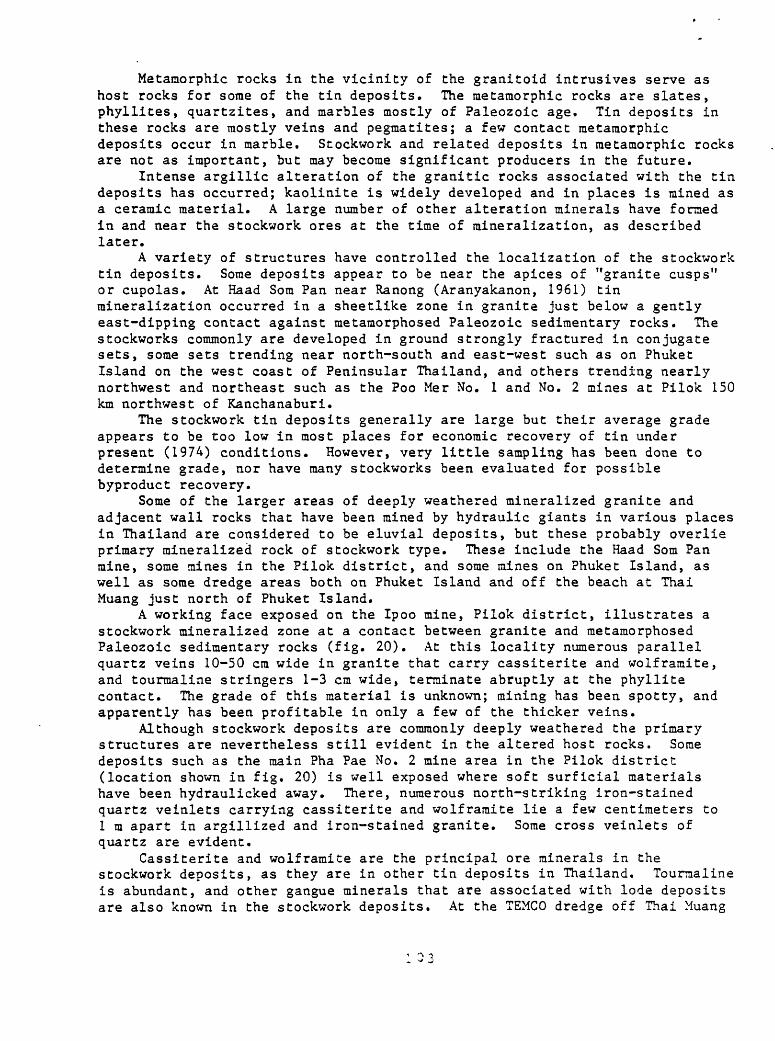
Metaniorphic rocks in the vicinity of the granitoid intrusives serve as host rocks for some of the tin deposits. The metamorphic rocks are slates, phyllites, quartzites, and marbles mostly of Paleozoic age. Tin deposits in these rocks are mostly veins and pegmatites; a few contact metamorphic deposits occur in marble. Stockwork and related deposits in metamorphic rocks are not as important, but may become significant producers in the future.
Intense argillic alteration of the granitic rocks associated with the tin deposits has occurred; kaolinite is widely developed and in places is mined as a ceramic material. A large number of other alteration minerals have formed in and near the stockwork ores at the time of mineralization, as described later.
A variety of structures have controlled the localization of the stockwork tin deposits. Some deposits appear to be near the apices of "granite cusps" or cupolas. At Haad Som Pan near Ranong (Aranyakanon, 1961) tin mineralization occurred in a sheetlike zone in granite just below a gently east-dipping contact against metamorphosed Paleozoic sedimentary rocks. The stockworks commonly are developed in ground strongly fractured in conjugate sets, some sets trending near north-south and east-west such as on Phuket Island on the west coast of Peninsular Thailand, and others trending nearly northwest and northeast such as the Poo Mer No. 1 and No. 2 mines at Pilok 150 km northwest of Kanchanaburi.
The stockwork tin deposits generally are large but their average grade appears to be too low in most places for economic recovery of tin under present (1974) conditions. However, very little sampling has been done to determine grade, nor have many stockworks been evaluated for possible byproduct recovery.
Some of the larger areas of deeply weathered mineralized granite and adjacent wall rocks that have been mined by hydraulic giants in various places in Thailand are considered to be eluvial deposits, but these probably overlie primary mineralized rock of stockwork type. These include the Haad Som Pan mine, some mines in the Pilok district, and some mines on Phuket Island, as well as some dredge areas both on Phuket Island and off the beach at Thai Muang just north of Phuket Island.
A working face exposed on the Ipoo mine, Pilok district, illustrates a stockwork mineralized zone at a contact between granite and metamorphosed Paleozoic sedimentary rocks (fig. 20). At this locality numerous parallel quartz veins 10-50 cm wide in granite that carry cassiterite and wolframite, and tourmaline stringers 1-3 cm wide, terminate abruptly at the phyllite contact. The grade of this material is unknown; mining has been spotty, and apparently has been profitable in only a few of the thicker veins.
Although stockwork deposits are commonly deeply weathered the primary structures are nevertheless still evident in the altered host rocks. Some deposits such as the main Pha Pae No. 2 mine area in the Pilok district (location shown in fig. 20) is well exposed where soft surficial materials have been hydraulicked away. There, numerous north-striking iron-stained quartz veinlets carrying cassiterite and wolframite lie a few centimeters to 1 m apart in argillized and iron-stained granite. Some cross veinlets of quartz are evident.
Cassiterite and wolframite are the principal ore minerals in the stockwork deposits, as they are in other tin deposits in Thailand. Tourmaline is abundant, and other gangue minerals that are associated with lode deposits are also known in the stockwork deposits. At the TEMCO dredge off Thai Muang
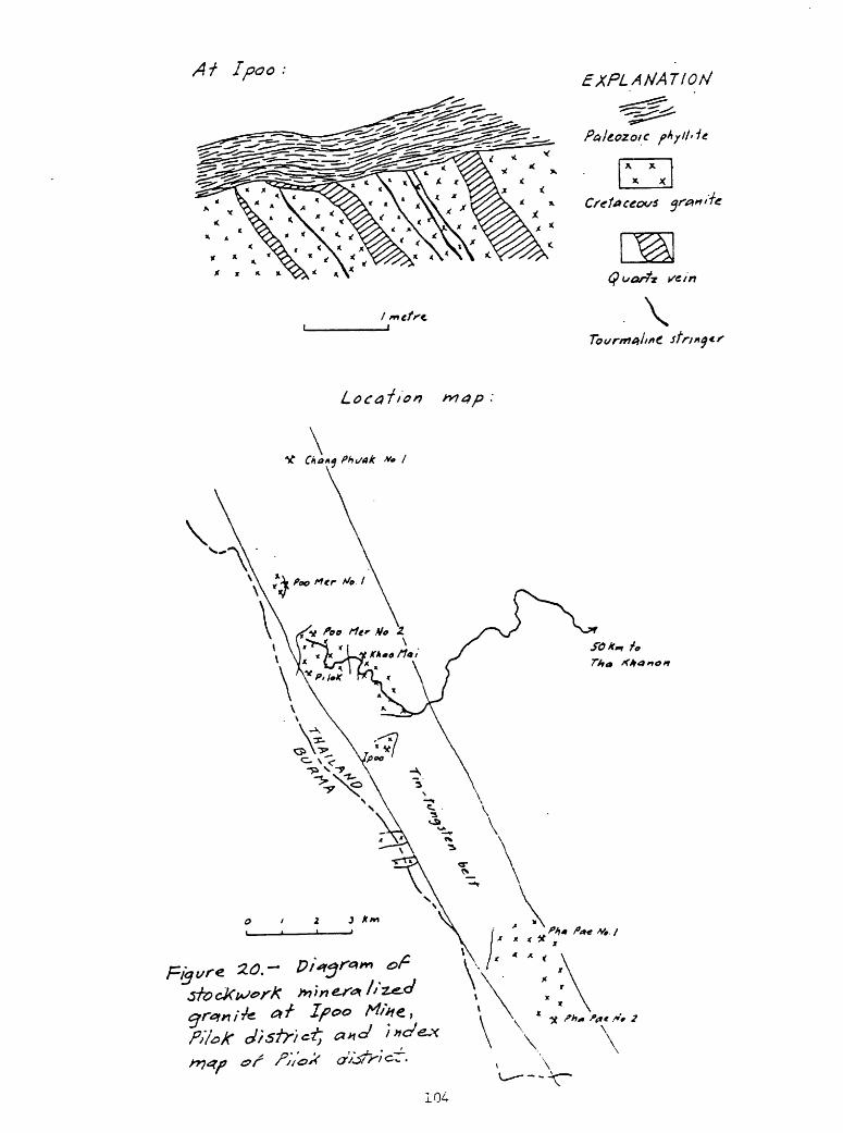
IpOO :
* * <X * *
EXPLANATION
104
beach north of Phuket Island an eluvial deposit that may be formed above a stockwork deposit at the contact between granite and argillite is being worked. Heavy minerals associated with cassiterite in this deposit are wolframite, scheelite, tantalite, ilmenite, monazite, zircon, xenotime, marcasite, and galena. In the vicinity of the Haad Som Pan stockwork and disseminated deposits (Aranyakanon, 1961; P. Aranyakanon, oral commun., 1974) in addition to cassiterite the metasomatic minerals recognized are tourmaline, muscovite, biotite, gilbertite, garnet (spessartite), albite, fluorite, topaz, monazite, huebnerite, anatase, pyrite, chalcopyrite, molybdenite, beryl, and quartz. According to Aranyakanon (1961) important secondary minerals formed in this order: tourmaline, albite, muscovite, fluorite, quartz. Where muscovite and topaz are abundant, the rocks are described as greisens. Aplite and pegmatite emplacement took place near the end of the episode of mineralization that started with albitization of granite and continued with addition of cassiterite (Aranyakanon, 1961, p. 5A-55).
The chemistry of most stockwork deposits is not well known. Tin and tungsten of course are important components, although their grade is poorly known. Other commodities such as tantalum, niobium, rare earths, and base metals have not been evaluated as possible byproducts.
Chemical analyses published by Aranyakanon (1961, table B) of rocks from the Haad Som Pan deposit, including granite in a zone transitional between mineralized and unmineralized granite, cassiterite ore from an "ore pocket," albite granite, and friable kaolinized granite are given in table 10.
Without considering some of the complexities of mineralization discussed by Aranyakanon (1961) I point out the corroboration provided by the chemical data for the mineral changes that occurred during tin mineralization.
Aranyakanon and others (written commun., 1969, p. 8-9) listed a number of deposits where cassiterite occurs disseminated in country rock adjacent to tin lodes or stringers. At the Hin Tak mine south of the Khun Thong Lang mine in the Na San district, Surat Thani province, disseminated cassiterite occurs in schist. The tin concentration is high but limited to a granite contact zone. In the Songkhla granite trend, similar deposits occur at the Koh Saba, Muang Mark, and Thai San mines in the Na Thawi district. At Thai San cassiterite ranges from very fine to very coarse grained (2 cm) and along with tourmaline impregnates sandstone. At the Veng Kai Tai mine, west of the Samnak Niam Si Chon district, Nakorn Sri Thamarat (Nakhon Si Thammarat) province, fine-grained cassiterite is disseminated in schist; the occurrence is similar to the Hin Tak mine, but more tin stringers are associated at Veng Kai Tai.
Greisens are commonly associated with quartz veins in areas of tin deposits. Aranyakanon and others (written commun., 1969, p. 14) described some greisens as veinlike bodies containing rauscovite, topaz, fluorite, apatite, and other minerals. Others are irregularly shaped or podlike. Associated quartz veins may have very little cassiterite bur. adjacent greisens contain considerable tin, such as at Klong Sra Kanchanadit district, Surat Thani, and at Wangpa, Haad (Hat) Yai district, Songkhla. In the south part of the Khao Luang batholith in the Ronphibul (Ronphibun) district, Nakorn Sri Thamarat province, tin in greisens occurs at the intersection of east- and north-trending quartz veins. Another locality with associated greisens and quartz veins in Khao Manora, Ban Rong-Lek, Tha Sala district, Nakorn Sri Thamarat.
Many greisens have no tin content. Most are pre-quartz veins and are themselves traversed by quartz veins.
105

Table 10 Chemical analyses of rocks from the Haad Som Pan tin
deposit
[N.D. (not determined)]
Transitionalzone
c-j n _____________O i. U n
Al 2 0 o
Fe2°3
1? nreu
Mg0 ________
CaQ
\T /"kNa 2 0
K n_ __________ ___
H20 -105°C
H r\ j.1 n^O/"« _____
Ti02
p n _ ___ _____P2°5M nnnu
Sn02
j^j_ _(j_____________
T* n _______ _ _B2°3WO
F _______ _ _____
Less 0 for F
74.59
14.99
.35
.29
.02
.46
4.09
3.99
nil
.73
.04
.02
.17
N.D.
N.D.
N.D.
N.D.
.20
99.94
.08
99.86
73.16
15.03
.68
.32
.15
.79
4.35
3.82
.28
.72
.07
.03
.15
.29
.06
.18
.03
.16
100.27
.06
100.21
Orepocket
52.97
20.94
4.11
.65
.23
.72
5.14
1.45
.18
.72
.17
.01
.26
10.88
trace
1.29
.06
.41
100.19
.17
100.02
Albitegranite
72.99
12.07
1.57
.20
.16
.98
5.25
.53
.36
.36
.09
.01
.05
4.96
nil
.47
.09
.12
100.28
.05
100.23
Kaolinized
74.04
15.71
.42
.41
.03
.15
2.75
4.28
nil
1.96
.04
nil
.19
N.D.
N.D.
N.D.
N.D.
.15
100.13
.06
100.07
106
Some tin-mineralized zones are especially rich in mica and lack the quartz common to greisens (Aranyakanon and others, 1970, p. 15). At Haad Som Pan, Ranong province, topaz is abundant in these. At the tin deposits at Khao Monora, Ban Rong Lek, mica veins occur in muscovite-tourmaline granite.
In addition to the disseminated tin in altered granite at Haad Som Pan, additional localities are given by Aranyakanon and others (1970, p. 15-17). These are Bang Non, 5-7 km south of Haad Som Pan; Kurod, south of Ranong in the Takuapa district; Klon Kokhook watershed, Kapong village, Takuapa district, where cassiterite, wolframite, and niobium-tantalum minerals are associated; Ban Song in Surat Thani province on the west side of the Khao Luang batholith and the upper Lampai stream, Huai Yot district, where very fine-grained cassiterite is disseminated in altered granite; the Namom mine of Yip In Troi Co. Ltd. and the Thung Kamin (Khamin) mine of Paksong Mining Co. Ltd., Thungpo village, Haad (Ha't) Yai district, where altered granite intrudes Mesozoic quartzite and shale; these deposits are similar to Haad Som Pan and contain cassiterite, wolframite, and torbernite in altered granite; Pa-Pane mine, Khao Lumphaya, Tala province, where close-spaced quartz veins in altered granite contain about 15 percent cassiterite and a small amount of wolframite; and the Cha-Son prospect in the Chao-Hom district, Lampang province in northern Thailand, where only minor tin is found in altered granite. There are many other metasomatized granite areas in Thailand, but most contain only a small amount of tin.
Copper
Copper deposits, of a variety of types, are widespread in the north part and virtually unknown in the south part of Thailand (fig. 21). Porphyry or stockwork type copper deposits are not numerous in Thailand but two deposits of moderate potential occur side by side in northeastern Thailand near Loei. The Phu Thong Daeng deposit is about 10 km south of Loei and the Phu Hin Lek Fai deposit is about 15 km east of Loei; they are called collectively the Loei deposits.
The deposits were first recognized during the period 1963-66 when the U.S. Geological Survey, the United Kingdom Overseas Geological Surveys, and the Royal Thai Department of Mineral Resources undertook studies in the region. The project was supported by the United Nations and consisted of geologic mapping, geochemical reconnaissance, ground and airborne magnetic surveys, other geophysical surveys, and drilling (Jacobson and others, 1969, p. 3). The Phu Thong Daeng and Phu Hin Lek Fai deposits were the most promising of a number of areas of mineral concentrations outlined by the project. Subsequent to the discoveries the Department of Mineral Resources carried on additional diamond drilling at these two properties and as a result a moderate resource of mineralized rock of satisfactory mining grade has been indicated.
In the late 1960's a number of U.S. mining companies evinced some interest in the properties but a variety of unfavorable factors militated against any company efforts to develop the properties. Since then (to 1974) communist activities have been prevalent in the region and security has deteriorated to the point that Thai government officials and foreigners are unable to visit the area safely.
Country rocks in the vicinity of the Loei porphyry copper deposits are predominantly Devonian to Permian sedimentary rocks intruded by probably Triassic granitoid rocks and andesite porphyries (fig. 22). The Paleozoic sedimentary rocks are dominantly shale (some tuffaceous), sandstone, siltstone, and limestone, metamorphosed during a regional metamorphism to slate, phyllite, argillite, and quartzite. Thermal raetamorphism near the contacts of igneous intrusives has produced slate, quartzite, hornfels, marble, and skarn. Triassic volcanic rocks and Triassic-Jurassic sedimentary rocks occur southwest of Loei and the sedimentary rocks are widespread southeast of Loei.
The Loei porphyry copper deposits as well as other base metal deposits and contact-raetaraorphic deposits in the area (fig. 22) are mostly in tuffaceous beds of Carboniferous and Permian age.
The Triassic granitoid intrusive rocks in the Loei area have been described by Bleackley and others (1965, p. 14) as granodiorite and microgranodiorite. Andesine is the dominant mineral, and subsidiary quartz, orthoclase, biotite, hornblende, and augite are present. Common accessory minerals are sphene, pyrite, and magnetite. The intrusives in the Loei area are grouped in figure 4 among the Triassic hornblende-biotite granodiorites. A single potassium-argon age determination on biotite(?), however, shows a latest Permian age of 230 m.y. (Jacobson and others, 1969, p. 10).
Andesite porphyry intrusives in the Loei area include those shown in figure 18 and smaller dike intrusives. The intrusives are petrographically indistinguishable from the andesite lavas of probably early Triassic age in the Loei area (Bleakley and others, 1965, p. 14). These authors stated that andesine and hornblende are the principal minerals, and both commonly occur as phenocrysts. The feldspar phenocrysts are complexly zoned. Augite is common in the groundmass and locally forms small phenocrysts. Quartz and biotite occur rarely as phenocrysts. Magnetite and other opaque grains constitute the accessory minerals.
The andesite porphyries have been propylitised; feldspars partly have been converted to sericite, calcite, and clinozoisite, and the ferromagnesian minerals partly have been replaced by chlorite and epidote.
The Triassic granodiorite intrusive bodies in the Loei area have a common aeroraagnetic characteristic (fig. 22). They all appear to be outlined by a prominent negative magnetic anomaly; a few show the negative anomaly somewhat offset from the surface outline of the intrusive, suggesting a possible subsurface displacement of the body of the intrusive. Associated with the negative magnetic anomalies are strong positive magnetic anomalies at or near the south margins of the intrusive bodies. The large Triassic intrusive north of Loei near Chiang Karn (Chieng Khan) is more complex, and shows numerous strong positive magnetic anomalies near its edges. The Triassic andesite porphyries are not marked by any common magnetic characteristic. Only the porphyry intrusive lying 6 km southeast of Phu Hin Lek Fai is closely associated with a magnetic high. Both the Phu Hin Lek Fai and Phu Thong Daeng porphyry copper deposits are centered near or on positive magnetic anomalies suggesting that they may be underlain by andesite porphyries similar in magnetic properties to the one southeast of Phu Hin Lek Fai, not a surprising relation. Indeed, at Phu Hin Lek Fai latite, quartz latite, and rhyodacite are associated with the mineralized rocks, and although possibly of Carboniferous-Permian age they are more likely intrusive and of Triassic
age. At Phu Thong Daeng porphyritic rhyodacite and quartz latite interlayered in tuff beds may also be intrusive.
A broad area surrounding the Phu Hin Lek Fai deposit has been hydrothermally altered as indicated by iron-stained rocks, gossan, and alteration minerals in the rocks (Jacobson and others, 1969, p. 23). Altered rock that may be tuff interbedded in the Carboniferous-Permian section consists mostly of kaolinite, halloysite, mica, chlorite, montmorillonite, feldspar, and quartz, and contains minor pyrite, epidote, garnet, and siderite. Magnetite is abundant in the surface gossan. At Phu Thong Daeng, also surrounded by hydrothermally altered rocks, altered tuff contains a high content of kaolinite, halloysite, and quartz and minor chlorite, montmorillonite, illite, pyrite, goethite, malachite, cuprite, delafosite (CuFeC^), and calcite (Jacobson and others, 1969, p. 29-30).
The Phu Hin Lek Fai deposit is near the axis of a north-northwest- striking and south-plunging anticline. The mineralized rocks are faulted but poor exposures generally prevent determining the relation, if any, of the faults to the mineral deposit. In an adit a north-striking fault appears to have localized brecciation and controlled sulfide mineralization (Jacobson and others, 1969, pi. 3F). The deposit at Phu Hin Lek Fai is elongated northerly as a result of its preferential development in the north-striking tuffaceous strata. The Phu Thong Daeng deposit is in steeply dipping, north-northeast- striking tuffaceous rocks and is also elongated northerly.
On the basis of drilling done to date, the Loei porphyry copper deposits together contain in the order of 50 million tons of mineralized rock that averages 0.65 percent Cu. About half this amount is in near-surface oxide zones and half is in deeper sulfide zones; the sulfide zones average slightly higher grade than_their overlying oxide equivalents.
At one place near the surface at Phu Hin Lek Fai brecciated and mineralized rock contains dominant iron oxides and assays 24 percent Fe, 0.55 percent Cu, and 2.65 percent Zn. At a second locality where a trench exposes mineralized tuff, disseminated pyrite and chalcocite are evident. This rock averages 0.48 percent Cu, 0.21 percent Pb, and 0.08 percent Zn. Drill holes show disseminated magnetite, pyrite, chalcopyrite, and chalcocite in weathered mineralized rock. Locally pyrite occurs in thin fractures. At Phu Hin Lek Fai, a typical gossan averages 56.8 percent Fe, 0.2 percent Cu, 0.2 percent Pb, and 2.0 percent Zn (Jacobson and others, 1969, p. 24). At Phu Thong Daeng drill holes indicate local massive sulfide minerals but most of the base metal sulfides are disseminated in tuff. In addition to the principal base metals present in drill cores, spectrographic analyses show traces of Ag, Ba, Co, Cr, Ga, Mo, Sn, and Zr. Gossan at Phu Thong Daeng contains about 52 percent Fe, 0.1-2.0 percent Cu, 0.01-2.4 percent Zn, and about 2.7 percent Mn. Spectrographic analyses revealed traces of Ba, Be, Co, Cr, Ga, Mo, Mb, Sn, Y, Yb, and Zr (Jacobson and others, 1969, p. 30).
The age of the Loei porphyry copper deposits is unknown, but presumably they are Early Triassic and related to the emplacement of the andesite porphyry intrusives.
The Loei copper deposits occur in two of several mineral zones or belts in the Loei region (fig. 22) that are characterized by numerous contact- metamorphic (replacement) and vein deposits of base metals, iron, and barite. Almost all of the geochemical and mineral anomalies known in the region also fall within the belts, as do all of the andesite porphyry intrusives known in the region. Furthermore, the belts of strong easterly
109
trend such as those containing the Phu. Thong Daeng and Phu Hin Lek Fai porphyry copper deposits and the deposits southeast of Chiangkarn are marked by prominent magnetic trends (fig. 22). Exploration for additional porphyry- type deposits along the mineral belts seems to be warranted. Also, particular attention should be focused on prominent magnetic highs outside but close to the mineral belts, such as those 5 km west of the Phu Thong Daeng deposit (where bedrock is mantled by alluvium), 15 km southwest of Loei, and the cluster of highs about 25 km southeast of Chiangkarn.
Another porphyry copper deposit is reported in northwestern Thailand at Wang Chao about 50 km west-northwest of Tak, where porphyry intrudes late Paleozoic slate, one has been reported in the vicinity of Phetchabun, and there may be others in other parts of the country, but little is known of these. The possibilities seem good for substantial metal resources in porphyry-type deposits in Thailand. The extensive terrains of volcanic rocks of Carboniferous, Lower Triassic, Lower Jurassic, Cretaceous, and Tertiary ages in the east half of northwestern Thailand, along the west edge of northeastern Thailand, in central Thailand north of Bangkok, and locally in southeastern Thailand (fig. 4) should be carefully examined, preferably mapped in detail, in a search for related porphyry intrusives that might have porphyry metal deposits associated with them. Aeromagnetic surveys would be of great value in establishing local targets for detailed studies.
Molybdenum
A disseminated molybdenum deposit is known at Nam Khun 35 km north- northwest of Chanthaburi in southeastern Thailand (Brown and others, 1951, p. 94-95; location shown in fig. 10). At Nam Khun biotite-muscovite granite (supposedly of Triassic age) has intruded Paleozoic raetamorphic rocks consisting of interbedded dark-gray slate and massive gray arkosic quartzite that strike northwest and dip moderately northeast. According to Brown and others (1951, p. 94) "molybdenite occurs in irregular scaly blebs ranging from a few millimeters to 20 millimeters in diameter. These are disseminated through the granite in the contact zone near rocks of the metamorphic series. Associated with the molybdenite is pyrite." According to Hughes and Bateson (1967) a hand specimen of highly weathered granite from the Nam Khun prospect contains 0.16 percent Mo and 0.02 percent W. Apparently no recent (to 1974) extensive evaluation of the property has been made.
Vein deposits
In Thailand a large variety of mineral commodities occur"in vein deposits that are fissure fillings. The veins are found in rocks of all ages and types; they may be associated with igneous rocks of great age range, and some appear not to be directly associated with igneous rocks. Closely related to vein deposits in some places are breccia pipe and other pipelike deposits of such commodities as fluorspar, tin, and tungsten, and they also are described in this section.
Fluorspar
Most of the deposits of fluorspar shown in figure 15 are vein deposits. The deposits occur in three broad clusters, one in the west half of
northwestern Thailand, the second in west-central Thailand, and the third near Surat Thani and Krabi in Peninsular Thailand. The most important fluorspar vein deposits and districts are described individually, and minor ones are then tabulated.
At Doi Chang 3-4 km northeast of Mae Sariang (Wanavanich, written commun., 1971) fluorspar veins occur in massive limestone probably of Ordovician age overlain by calcareous phyllitic shale and red shale. Coarse grained granite of Triassic age lies east of the deposits. North-striking faults bound a prominent graben that extends from Mae Sariang north to Mae Hong Son. Northwest- and east-striking fractures contain fissure veins of fluorspar. One vein is brecciated. Individual veins are as much as 4 m thick and 100 m long, and mineralized zones of closely spaced veins may be 15 m wide and 100 m long.
Small purple and brown fluorite crystals and botryoidal fluorite occur with quartz and chalcedony in veins, and massive fluorite, in part botryoidal, is found in the brecciated vein.
The Sahachart fluorite mine is situated about 2 km east of Mae Sariang (Teggin and Suensilpong, 1973). Country rocks are Lower Paleozoic slate and massive marble and Triassic calcareous shale and limestone. Triassic granite is intruded nearby. Triassic sedimentary rocks are thrust over the Paleozoic strata on a flat west-dipping fault. Fluorspar occurs in two parallel vertical ore zones in Paleozoic rocks beneath the thrust, along the thrust plane, and in overlying Triassic strata.
Fluorspar deposits at Doi Pha Dang (Daeng) (Wanavanich, written commun., 1971) are about 65 km airline south of Mae Hong Son. Country rocks are probably lower Paleozoic reddish and dark-gray shale (partly slate), bedded laminated limestone, and quartzite. Porphyritic biotite granite of Triassic age containing feldspar phenocrysts crops out in the area. A major north- striking fault lies west of the deposits. The veins occur along brecciated fissures at the contact between the granite and the shale and limestone. One vein is 6 m wide and 100 m long and a second is 2 m wide and 150 m long within a quartz vein as much as 10 m wide. Massive, compact white fluorite occurs with quartz that in part forms a boxwork.
A large number of fluorspar vein deposits occur in a cluster making up the Pai mining area about 30-60 km east of Mae Hong Son (Vichit, P., and others, written commun., 1971). Most of these deposits are not large and they are tabulated on later pages along with other small deposits. Some of the deposits are of moderate size and are described together here.
Rocks exposed in the Pai mining are are metamorphic, sedimentary, and igneous, and of considerable age range. Upper Cambrian sedimentary rocks are shale, sandy shale, and sandstone metamorphosed to quartzite. Ordovician light- to dark-gray, partly purplish and greenish, massive limestone, marbleized near granite contacts, and some intercalated shale and calcareous shale overlie Cambrian strata. Above these are slaty shale, shale, sandstone, and chert, and some intercalated limestone, of Silurian-Devonian age. The lower part of the Silurian-Devonian is laminated dense dark-gray shale and slaty shale with interlayered black and grayish-black bedded chert. Bedded limestone, calcareous schist, and sandstone are interlayered in the upper part. These rocks near granite contacts are metamorphosed to quartzite, quartz schist, mica schist, and phyllite. Above the Silurian-Devonian rocks are dark-gray and brown protoquartzite and graywacke and greenish-gray to dark-gray shale of Devonian-Carboniferous age. The upper part is shale and mudstone with some interbedded conglomerate and limestone. Permian limestone
111
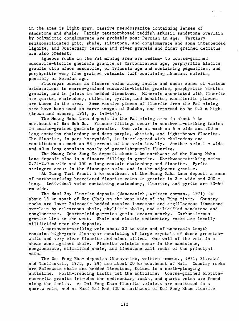
in the area is light-gray, massive pseudosparite containing lenses of sandstone and shale. Partly metamorphosed reddish arkosic sandstone overlain by polymictic conglomerate are probably post-Permian in age. Tertiary semiconsolidated grit, shale, siltstone, and conglomerate and some interbedded lignite, and Quaternary terrace and river gravels and finer grained detritus are also present.
Igneous rocks in the Pai mining area are medium- to coarse-grained muscovite-biotite gneissic granite of Carboniferous age, porphyritic biotite granite with minor muscovite, of Triassic age and containing pegmatites, and porphyritic very fine grained volcanic tuff containing abundant calcite, possibly of Permian age.
Fluorspar occurs as fissure veins along faults and shear zones of various orientations in coarse-grained rauscovite-biotite granite, porphyritic biotite granite, and in joints in bedded limestone. Minerals associated with fluorite are quartz, chalcedony, stibnite, pyrite, and hematite; cassiterite placers are known in the area. Some massive pieces of fluorite from the Pai mining area have been used to carve images of Buddha, one reported to be 0.3 m high (Brown and others, 1951, p. 143-144).
The Muang Maha Lana deposit in the Pai mining area is about 4 km northeast of Ban Sob Sa. Fissure fillings occur in southwest-striking faults in coarse-grained gneissic granite. One vein as much as 6 m wide and 700 m long contains chalcedony and deep purple, whitish, and light-brown fluorite. The fluorite, in part botryoidal, is interlayered with chalcedony and constitutes as much as 98 percent of the vein locally. Another vein 1 m wide and 40 m long consists mostly of greenish-purple fluorite.
The Muang Toho Sang Yo deposit about 1 km northwest of the Muang Maha Lana deposit also is a fissure filling in granite. Northwest-striking veins 0.75-2.0 m wide and 250 m long contain chalcedony and fluorite. Pyrite stringers occur in the fluorspar veins and in the adjacent granite.
At Muang Thai Prasit 2 km southeast of the Muang Maha Lana deposit a zone of north-striking brecciated fluorite veins in granite is 2 m wide and 200 m long. Individual veins containing chalcedony, fluorite, and pyrite are 30-60 cm wide.
The Huai Poy fluorite deposit (Wanavanich, written commun., 1971) is about 15 km south of Hot (Hod) on the west side of the Ping river. Country rocks are lower Paleozoic bedded massive limestone and argillaceous limestone overlain by calcareous shale, phyllitic shale, and silicified sandstone and conglomerate. Quartz-feldspar-mica gneiss occurs nearby. Carboniferous granite lies to the west. Shale and clastic sedimentary rocks are locally silificifed near the deposit.
A northwest-striking vein about 20 km wide and of uncertain length contains high-grade fluorspar consisting of large crystals of dense greenish- white and very clear fluorite and minor silica. One wall of the vein is a shear zone against shale. Fluorite veinlets occur in the sandstone, conglomerate, silicified shale, and limestone wall rocks of the principal vein.
The Doi Pong Kham deposits (Wanavanich, written commun., 1971; Pitrakul and Tantisukrit, 1973, p. 29) are about 20 km southeast of Hot. Country rocks are Paleozoic shale and bedded limestone, folded in a north-plunging anticline. North-trending faults cut the anticline. Coarse-grained biotite- muscovite granite intrudes the sedimentary rocks, and quartz veins are found along the faults. At Doi Pong Kham fluorite veinlets are scattered in a quartz vein, and at Huai Mai Had 100 m northwest of Doi Pong Kham fluorite
112
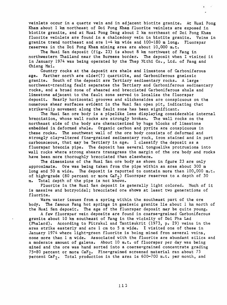
veinlets occur in a quartz vein and in adjacent biotite granite. At Huai Pong Kham about 1 km northeast of Doi Pong Kham fluorite veinlets are exposed in biotite granite, and at Huai Pong Dang about 2 km northeast of Doi Pong Kham fluorite veinlets are found in a chalcedony vein in biotite granite. Veins in granite trend northeast and are 1-4 km wide and 100-180 m long. Fluorspar reserves in the Doi Pong Kham mining area are about 10,000 m.t.
The Huai San deposit (fig. 23) is about 8 km northwest of Fang in northwestern Thailand near the Burmese border. The deposit when I visited it in January 1974 was being operated by the Thep Nithi Co., Ltd. of Fang and Chiang Mai.
Country rocks at the deposit are shale and limestone of Carboniferous age. Farther north are older(?) quartzite, and Carboniferous gneissic granite. South of the deposit are Tertiary sedimentary rocks. A large northwest-trending fault separates the Tertiary and Carboniferous sedimentary rocks, and a broad zone of sheared and brecciated Carboniferous shale and limestone adjacent to the fault zone served to localize the fluorspar deposit. Nearly horizontal grooves and slickensides are conspicuous on the numerous shear surfaces evident in the Huai San open pit, indicating that strike-slip movement along the fault zone has been significant.
The Huai San ore body is a pipelike lens displaying considerable internal brecciation, whose wall rocks are strongly broken. The wall rocks on the northeast side of the body are characterized by huge blocks of limestone embedded in deformed shale. Organic carbon and pyrite are conspicuous in these rocks. The southwest wall of the ore body consists of deformed and strongly clay-altered fine-grained sedimentary rock, iron stained and in part carbonaceous, that may be Tertiary in age. I classify the deposit as a fluorspar breccia pipe. The deposit has several tonguelike protrusions into wall rocks where strong shears transgress the margin of the ore body and rocks have been more thoroughly brecciated than elsewhere.
The dimensions of the Huai San ore body as shown in fgure 23 are only approximate. Ore was being taken from the pipe within an area about 300 m long and 50 m wide. The deposit is reported to contain more than 100,000 m.t. of high-grade (80 percent or more CaF2> fluorspar reserves to a depth of 30 m. Total depth of the pipe is not known.
Fluorite in the Huai San deposit is generally light colored. Much of it is massive and botryoidal; brecciated ore shows at least two generations of fluorite.
Warm water issues from a spring within the southeast part of the ore body. The famous Fang hot springs in gneissic granite lie about 1 km north of the Huai San deposit. The age of the fluorspar deposit may be quite young.
A few fluorspar vein deposits are found in coarse-grained Carboniferous granite about 10 km southeast of Fang in the vicinity of Doi Pha Lad (Phalard). According to Pitrakul and Tantisukrit (1973, p. 29) veins in the area strike easterly and are 1 cm to 5 m wide. I visited one of these in January 1974 where light-green fluorite is being mined from several veins, none more than 1 ra wide. Associated with the fluorite are abundant silica and a moderate amount of galena. About 10 ra.t. of fluorspar per day was being mined and the ore was hand sorted into a coarse-grained concentrate grading 75-80 percent or more CaF2« Fine-grained screened material ran about 75 percent CaF£. Total production in the area is 600-700 m.t. per month, and
113
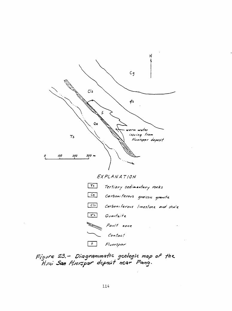
EXPLAN ATION
Contact
c>yre 23.- map of
114
fluorspar reserves are estimated at 40,000-50,000 m.t. (Pitrakul and Tantisukrit (1973, p. 29).
The Doi Chang (Om) fluorspar deposit (Charoensri, written commun., 1972) is about 80 km airline northwest of Tak near the Mae Tun River. Country rocks in the region consist of moderate dark-gray well-bedded pseudoraicritic limestone interbedded with arenaceous limestone and overlain by metamorphosed feldspathic sandstone and light-brown medium- to fine-grained quartzite, all of Ordovician age. Carboniferous granite and Cretaceous-Tertiary(?) muscovite granite are present in the region. Folds in the sedimentary rocks trend northwesterly, as does a major fault along the Mae Tun River. Fractures containing minor fissure veins of fluorite in Carboniferous(?) granite trend northeasterly.
Fluorspar occurs as two replacement deposits, already described in earlier pages. A third deposit is a vein about 30 m long and 8 m wide within a large ridge-topping quartz vein.
Coarsely to finely crystalline, vitreous colorless, light-brown, purple, and black fluorite occurs with cryptocrystalline and chalcedonic quartz in the fluorspar deposits. Ca?2 content is 50-80 percent.
Several fluorspar vein deposits are known in the Ban Pon Pu Fueng mining area about 15 km west of Mae Saruai (Suai) and 60 km southwest of Chiang Rai. Country rock is Devonian-Silurian dark-gray slaty shale and graphitic(?) phyllitic schist deformed into north-striking folds that locally digress to easterly trends. Brownish mica is present that resulted from low-grade regional metamorphism. Medium-grained porphyritic biotite-rauscovite granite of Carboniferous age jointed in northerly and easterly conjugate sets occurs nearby.
Quartz veins have been implaced discordantly and concordantly within the shale beds, and as east-trending fissure fillings in the granite. Country rocks near the veins have been silicified and pyritized; vugs lined with silica and goethite also occur in the shale.
The Huai Ngok-Ngak (Nok-Nak) vein in the Ban Pon Pu Fueng mining area lies about 1.5 km north of Ban San Pu Loei and was being mined by the C. B. Chieng Rai Mining Co. The vein trends northwest and dips steeply southwest, lying along a fissure discordant to the bedding in wall rocks. The vein pinches and swells, contains horses of phyllitic schist country rock, and is about 1-3 m wide. The hanging wall of the fluorspar vein locally is a quartz vein. The fluorite is generally massive to laminated, light-green to white. It is fractured and veined with white quartz; laminated fluorite may be offset along white quartz veinlets, and locally is brecciated. In places the quartz content is high. Galena (possibly argentiferous as suggested by the curved cubic cleavage surfaces) occurs locally in the fluorite, and iron minerals are found along the contacts of the vein. Ore reserves at Huai Ngok-Ngak have been estimated at about 13,000 m.t. (Inthuputi and others, written commun., 1972).
At Huai Muen (Mon) Thep about 1 km north of Huai Ngok-Ngak a second steep-walled northwest-trending fluorspar vein has been mined. The vein and its wall rocks are similar to Huai Ngok-Ngak. The Huai Muen Thep vein is about 4-8 m wide and about 170 m long, but it is pinched out for about 15 m in its central part. Both ends are terminated by faults and the faulted segments of the vein have not been located. The vein contains galena which diminishes in amount with depth. At the time of my visit in January 1974, about 5,000 m.t. had been produced from the Huai Muen Thep vein and operations had been recessed. According to Inthuputi and others (written coramun., 1972), the
115
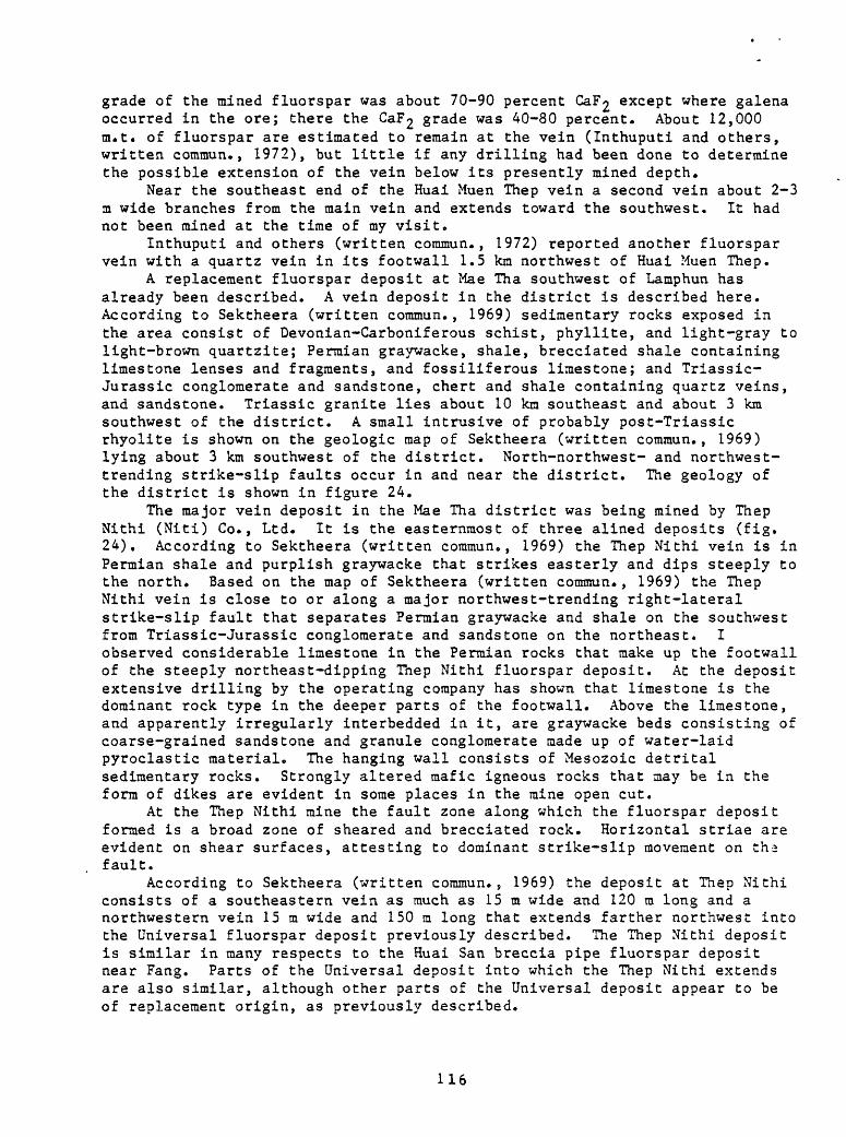
grade of the mined fluorspar was about 70-90 percent CaF£ except where galena occurred in the ore; there the CaF£ grade was 40-80 percent. About 12,000 m.t. of fluorspar are estimated to remain at the vein (Inthuputi and others, written commun., 1972), but little if any drilling had been done to determine the possible extension of the vein below its presently mined depth.
Near the southeast end of the Huai Muen Thep vein a second vein about 2-3 m wide branches from the main vein and extends toward the southwest. It had not been mined at the time of my visit.
Inthuputi and others (written coramun., 1972) reported another fluorspar vein with a quartz vein in its footwall 1.5 kin northwest of Huai Muen Thep.
A replacement fluorspar deposit at Mae Tha southwest of Lamphun has already been described. A vein deposit in the district is described here. According to Sektheera (written commun., 1969) sedimentary rocks exposed in the area consist of Devonian-Carboniferous schist, phyllite, and light-gray to light-brown quartzite; Permian graywacke, shale, brecciated shale containing limestone lenses and fragments, and fossiliferous limestone; and Triassic- Jurassic conglomerate and sandstone, chert and shale containing quartz veins, and sandstone. Triassic granite lies about 10 km southeast and about 3 km southwest of the district. A small intrusive of probably post-Triassic rhyolite is shown on the geologic map of Sektheera (written commun., 1969) lying about 3 km southwest of the district. North-northwest- and northwest- trending strike-slip faults occur in and near the district. The geology of the district is shown in figure 24.
The major vein deposit in the Mae Tha district was being mined by Thep Nithi (Niti) Co., Ltd. It is the easternmost of three alined deposits (fig. 24). According to Sektheera (written commun., 1969) the Thep Nithi vein is in Permian shale and purplish graywacke that strikes easterly and dips steeply to the north. Based on the map of Sektheera (written commun., 1969) the Thep Nithi vein is close to or along a major northwest-trending right-lateral strike-slip fault that separates Permian graywacke and shale on the southwest from Triassic-Jurassic conglomerate and sandstone on the northeast. I observed considerable limestone in the Permian rocks that make up the footwall of the steeply northeast-dipping Thep Nithi fluorspar deposit. At the deposit extensive drilling by the operating company has shown that limestone is the dominant rock type in the deeper parts of the footwall. Above the limestone, and apparently irregularly interbedded in it, are graywacke beds consisting of coarse-grained sandstone and granule conglomerate made up of water-laid pyroclastic material. The hanging wall consists of Mesozoic detrital sedimentary rocks. Strongly altered mafic igneous rocks that may be in the form of dikes are evident in some places in the mine open cut.
At the Thep Nithi mine the fault zone along which the fluorspar deposit formed is a broad zone of sheared and brecciated rock. Horizontal striae are evident on shear surfaces, attesting to dominant strike-slip movement on th.-2 fault.
According to Sektheera (written commun., 1969) the deposit at Thep Nithi consists of a southeastern vein as much as 15 m x*ide and 120 m long and a northwestern vein 15 m wide and 150 m long that extends farther northwest into the Universal fluorspar deposit previously described. The Thep Nithi deposit is similar in many respects to the Huai San breccia pipe fluorspar deposit near Fang. Parts of the Universal deposit into which the Thep Nithi extends are also similar, although other parts of the Universal deposit appear to be of replacement origin, as previously described.
116

.TAW,
EXPLAMAT/OfiJ
- Tr/033'C rkyoh'fcf?)
Tr t#ss> c
c - Jura S3' c
Tri *ss><:-
^ a xi J
regon
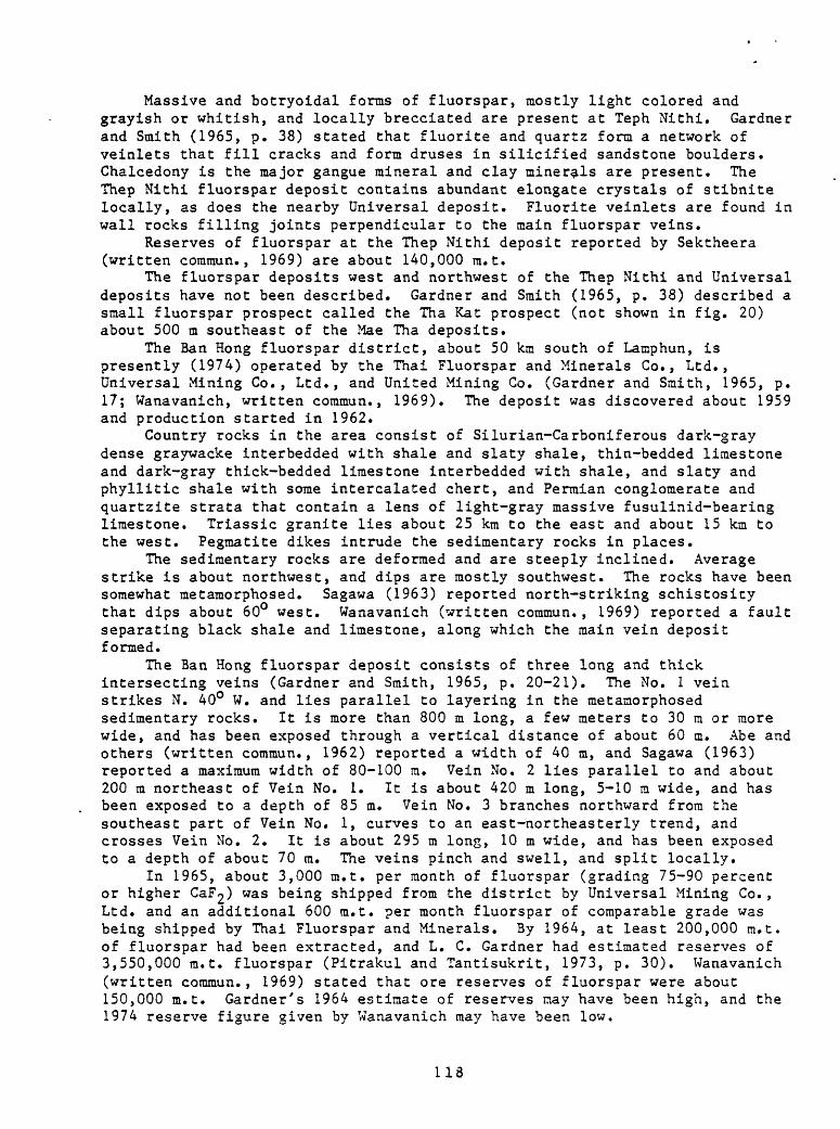
Massive and botryoidal forms of fluorspar, mostly light colored and grayish or whitish, and locally brecciated are present at Teph Nithi. Gardner and Smith (1965, p. 38) stated that fluorite and quartz form a network of veinlets that fill cracks and form druses in silicified sandstone boulders. Chalcedony is the major gangue mineral and clay minerals are present. The Thep Nithi fluorspar deposit contains abundant elongate crystals of stibnite locally, as does the nearby Universal deposit. Fluorite veinlets are found in wall rocks filling joints perpendicular to the main fluorspar veins.
Reserves of fluorspar at the Thep Nithi deposit reported by Sektheera (written commun., 1969) are about 140,000 m.t.
The fluorspar deposits west and northwest of the Thep Nithi and Universal deposits have not been described. Gardner and Smith (1965, p. 38) described a small fluorspar prospect called the Tha Kat prospect (not shown in fig. 20) about 500 m southeast of the Mae Tha deposits.
The Ban Hong fluorspar district, about 50 km south of Lamphun, is presently (1974) operated by the Thai Fluorspar and Minerals Co., Ltd., Universal Mining Co., Ltd., and United Mining Co. (Gardner and Smith, 1965, p. 17; Wanavanich, written commun., 1969). The deposit was discovered about 1959 and production started in 1962.
Country rocks in the area consist of Silurian-Carboniferous dark-gray dense graywacke interbedded with shale and slaty shale, thin-bedded limestone and dark-gray thick-bedded limestone interbedded with shale, and slaty and phyllitic shale with some intercalated chert, and Permian conglomerate and quartzite strata that contain a lens of light-gray massive fusulinid-bearing limestone. Triassic granite lies about 25 km to the east and about 15 km to the west. Pegmatite dikes intrude the sedimentary rocks in places.
The sedimentary rocks are deformed and are steeply inclined. Average strike is about northwest, and dips are mostly southwest. The rocks have been somewhat metamorphosed. Sagawa (1963) reported north-striking schistosicy that dips about 60° west. Wanavanich (written commun., 1969) reported a fault separating black shale and limestone, along which the main vein deposit formed.
The Ban Hong fluorspar deposit consists of three long and thick intersecting veins (Gardner and Smith, 1965, p. 20-21). The No. 1 vein strikes N. 40° W. and lies parallel to layering in the metamorphosed sedimentary rocks. It is more than 800 m long, a few meters to 30 m or more wide, and has been exposed through a vertical distance of about 60 m. Abe and others (written commun., 1962) reported a width of 40 m, and Sagawa (1963) reported a maximum width of 80-100 m. Vein No. 2 lies parallel to and about 200 m northeast of Vein No. 1. It is about 420 m long, 5-10 m wide, and has been exposed to a depth of 85 m. Vein No. 3 branches northward from the southeast part of Vein No. 1, curves to an east-northeasterly trend, and crosses Vein No. 2. It is about 295 m long, 10 m wide, and has been exposed to a depth of about 70 m. The veins pinch and swell, and split locally.
In 1965, about 3,000 m.t. per month of fluorspar (grading 75-90 percent or higher CaF£) was being shipped from the district by Universal Mining Co., Ltd. and an additional 600 m.t. per month fluorspar of comparable grade was being shipped by Thai Fluorspar and Minerals. By 1964, at least 200,000 m.t. of fluorspar had been extracted, and L. C. Gardner had estimated reserves of 3,550,000 ra.t. fluorspar (Pitrakul and Tantisukrit, 1973, p. 30). Wanavanich (written commun., 1969) stated that ore reserves of fluorspar were about 150,000 m.t. Gardner's 1964 estimate of reserves may have been high, and the 1974 reserve figure given by Wanavanich may have been low.
118
According to Gardner and Smith (1965, p.21): "Most of the fluorspar is coarsely crystalline and massive. The main impurity is silica, which ranges from a few percent to almost 100 percent of the vein material. Much of the raw ore, however, is high grade, a sample from an ore stockpile containing 85- 75 percent CaF2» 1.10 percent Si02» 0.70 percent S, and 0.78 percent E^O^ (Sagawa, 1963). The silica generally is segregated as veinlets, aggregates, and bands that can be separated by breaking the ore to gravel size and hand sorting." Wanavanich (written commun., 1969) reported that the fluorite at Ban Hong is green, black, and yellowish. Fluorite and chalcedony occur as cement in breccias of chalcedony, opal, and silicified shale. Kaolinite and red mud fill cavities locally in the fluorspar.
The Salak Phra (Tha Kra Dan) district northwest of Kanchanaburi was discovered in about 1968-69 and production started in about 1970-71. The principal holder of concessions and operator presently is United Fluorite Co., Ltd. In the district vein deposits are significant fluorspar producers and a large fluorspar breccia pipe is known; replacement ore bodies at Salak Phra have already been described. The vein deposits and the breccia pipe occur in the same Ordovician carbonate host rocks that the replacement bodies are in.
According to Potisat (written commun., 1973, p. 7-12) the veins are fissure fillings in Ordovician limestone that has generally steep dips ranging from 65° to vertical. Rocks as young as Devonian also are reported. At Khao Phu Ta To fluorspar fills fractures in shale and at Khao Turn Men veins are in arkosic sandstone (fig. 25). Where veins crop out in shale, silicification has been noted in both walls of the veins.
The discontinuity of units of arkosic sandstone, raudstone and shale, slate and quartzite, and calcareous shale within tightly folded and deformed Ordovician limestone (fig. 25) suggests the presence of unmapped faults.
The veins are sheetlike bodies that trend dominantly north-northwesterly, north-northeasterly, and northerly. Vein lengths vary from 10 m to more than 300 m. Average width of veins is 3-5 in, but crustified veins a fraction of a meter to 1 m wide are common. The longest veins are in the vicinity of Khao Ta No, and most of the veins in the district lie north of Khao Ta No. The longest vein is about 500 m long and 7.5 m wide at its maximum width. The veins are exposed through a vertical distance of about 350 m and there is no apparent vertical variation in character. Most veins contain at least 20 percent fluorite.
Prior to operations by United Fluorite Co., Ltd., about 100,000 m.t. of flurospar is reported to have been produced by illegal operations. During 18 months of operations from mid-1972 to February 1974, the company had processed more than 100,000 m.t. of flurospar concentrates through its washing plant, mostly from vein deposits.
The veins consist of layered (banded) and crustified fluorspar; locally brecciated, and locally massive. Some of the layered fluorspar is botryoidal in form and consists of mamillary masses whose internal structure displays concentric layers, and clusters of fibrous or needlelike fluorite crystals normal to the layers. The fibrous crystals form radiating masses which terminate at the mamillated surfaces. Some of the veins are sheeted as at Khao Phu Wai and Khao Ka Ta Noi where calcite and fluorite or calcite and cryptocrystalline quartz are interlayered in zones a fraction of a meter to 1.5m wide.
119
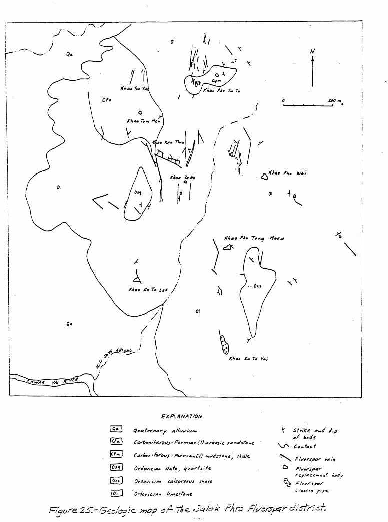
EXPLANATION
(Oij
I Oc/
H5T
of
Co-tact
/"/C

Fluorite in the Salak Phra vein deposits is variously green, blue, violet, brown, buff, and colorless. Gangue minerals associated with the fluorite are principally calcite and cryptocrystalline quartz. Kaolinite is present locally and galena occurs in very small amounts in some veins. The veins generally assay about O.OX percent Pb.
The age of the fluorspar veins is not known but like that of other fluorspar deposits in Thailand is presumed to be relatively young (Cenozoic).
A large fluorspar breccia pipe occurs in Ordovician limestone at Khao Ka Ta Yai at the south end of the Salak Phra district in Ordovician limestone. The mineralized area has been mined over an area 60 x 200 m. The average grade of the fluorspar in the pipe is 29 percent CaF£ an<^ there possibly is well over 1,000,000 m.t. of minable material in the deposit. The breccia consists of broken fragments of fluorspar mostly smaller than 20 cm in a matrix of cryptocrystalline quartz (chalcedony) and iron oxides. The iron oxides may have weathered from primary sulfides.
According to Potisat (written coramun., 1973, p. 11) "brecciation occurred during mineral deposition. Early chalcedony showing fine colored bands [was] deposited first, [and] then was brecciated. Fluorite [was deposited] next, and the rocks [were] fractured again. A porous, brown, silica rich jasperoidal material cements fragments both of chalcedony and of fluorite. Finally, narrow and steeply dipping fluorite veins cut across the breccia zone."
At Khao Ruag about 35 km southwest of Kanchanaburi fluorspar veins are found in medium-grained muscovite granite of Cretaceous age and in adjoining recrystallized limestone of Paleozoic age (Chapakaset and others, written commun., 1972; Potisat, written coramun., 1973). The marble in places near the fluorspar veins and adjacent to the granite contact has been metasomatized and contains feldspar,, quartz, tourmaline, and reddish-brown garnet.
The fluorspar veins are mainly north- to northeast-striking crudely lens- shaped bodies, the largest of which is about 100 m long and 5-16 ra wide. They are medium to high grade, but carry substantial amounts of cryptocrystalline quartz along their margins. Principal gangue minerals are cryptocrystalline quartz and clays.
The Huai Pa Ti fluorspar deposits are about 45 km west of Ratburi at Suan Pueng, Chom Bueng. Country rocks are interbedded shale and sandstone, and some limestone lenses, of probably late Paleozoic age, and a number of bodies of fine- to coarse-grained biotite-muscovite granite of Cretaceous age. Aplite dikes and quartz veins are present, and shale and sandstone have been silicified in places.
The granite bodies and folded sedimentary rocks trend generally northerly. Major faults strike north-northwesterly, and other faults trend northerly and northeasterly.
Most fluorspar veins are in granite near the contact with sedimentary rocks, and some are in the sedimentary rocks themselves. Fissure veins along fault zones contain 65-90 percent CaF2« Fluorite-quartz veins (genetically related to barren quartz veins in the area) are in granite, sandstone, and shale. CaF2 is 40-75 percent, and silica content is high.
Reserves of high-grade fluorspar (80 percent CaF£) are about 5,000 nut. and of low-grade fluorspar (40-75 percent CaF2) about 280,000 m.t. (Chancharoonpong, written commun., 1970).
The Khao Baitan fluorspar deposit at Ban Tha Salas, Bang Num Glad (Klud) Nua, near Khao Yoi (Yai), Phetchaburi (Phetburi; Petchburi), according to Pitrakul and Tantisukrit (1973, p. 28, 31) is in a terrane of sandstone,
121

shale, and limestone of Silurian-Devonian age intruded by Cretaceous granite. Fluorspar veins are oriented northeasterly, parallel to a large quartz vein. One fluorspar vein is described as 5 m wide, 1,000 m long, and exposed to a depth of 100 m. Fluorspar ore reserves have been estimated as about 1,300,000 m.t.
The Khao Kok fluorspar deposit lies about 30 km southwest of Phetchaburi. According to Veeraburus (written commun., 1970) country rocks are late Paleozoic shale, sandstone, and limestone intruded by Cretaceous muscovite-biotite granite. Quartz veins, pegmatites, and aplite dikes also cut the sedimentary rocks. The sedimentary rocks have been metamorphosed in part to phyllite, slate, and quartzite, and have been silicified locally.
Fluorspar veins have formed along an east-trending fault zone and along the contact of granite and metasedimentary rocks. High-grade fluorspar reserves classified as "probable" and "possible" have been estimated at about 250,000 m.t. (Veeraburus, written comraun., 1970).
The Khlong Thorn fissure vein of fluorspar is at Ban Chong Ki Rad about 40 km southeast of Krabi and about 5 km east-northeast of Ban Huai Sai Khao (Angkatavanich, written commun., 1974, p. 93-94). Country rocks are Mesozoic yellowish-, grayish-, and reddish-brown siltstone, sandstone, and quartzite, capped with light-gray limestone. No igneous rocks are known in the region. The fluorspar vein is in limestone and may be in part in sandstone. Wall rocks of the deposit locally are silicified.
The vein strikes east-northeast and was reported by Angkatavanich (written coraraun., 1974, p. 93) to be 0.5 m wide. At the time of my visit in February 1974 the mine had been in operation about 15 months and had been producing 1,000-1,500 m.t. per month of fluorspar grading about 75 percent CaF2 .
Massive light-gray to whitish fluorite constitutes much of the ore. Some massive fluorspar is veined and coated with thin layers and patches of azurite and malachite suggesting that the unweathered ore contains copper sulfides. White and light-purple cubes of fluorite 1-5 mm in size coat drusy cavities. Light-gray cryptocrystalline quartz is the principal gangue mineral. Light- gray barite is abundant in parts of the vein.
Small fluorspar vein deposits of poorly assessed potential in Thailand are shown in table 11.
In summarizing the character and distribution of vein deposits of fluorspar in Thailand we note that most are fissure fillings. Some occurrences have been described as cavity fillings. The color of fluorite and the type of associated minerals seem to be mostly independent of the host rocks. Silica in various forms, commonly chalcedonic, is the principal gangue, calcite may be abundant where wall rocks are limestone, and barite is present at Khlong Thorn in Peninsular Thailand where wall rocks are dominantly elastics of Mesozoic age. Stibnite occurs with fluorite in the western part of northwestern Thailand where fluorspar veins have wall rocks of shale and coarser elastics mostly of Paleozoic age. Galena is associated with fluorite locally in northwestern and in west-central Thailand where wall rocks are either granite, shale, or limestone. Cassiterite and wolframite occur with fluorite in granite on Ko Saraui Island. Copper minerals are found with fluorite in Mesozoic clastic sedimentary rocks at Khlong Thorn.
Many fluorspar vein deposits occur near granitoid intrusive rocks, but numerous intrusives, and wide areas in which intrusives are abundant, are devoid of fluorspar deposits (compare figs. 15 and 4). Moreover the fluorspar deposits, as indicated below, appear to be much younger than virtually all of
122
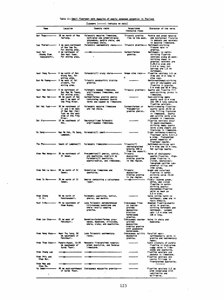
ezi
out »3,(.j»3fSf*s
|i
UIput
»U03«
»3lZ3Jinb put *uo3t-Mill u| fu|OA XB6nA
»|djnd jo siixu
A*Jt3UMIlP*S PUt »31U8J6 U| SUI»A /|J»Jf»«y3JOu
uo3spmiPUt »|t«S Ul fU|»A
6uoi m 001put OPI« « SM ul*A3f»6Jf| '3ft«yuOli
put 3MKII3JOU 6UHM3S
-op~
-op
U03SMMJO 3***M30OS M|
OC-01 '«
»3 IA03IIH
pUtlQUJOU,
jo 3MMU3not MI OS "6ui| tuj JM
»3|Z3J»np put '»3i|s ' UO3S3IIS OU03fP«l *
JO MM M| S2
PM1QUJOM
put »U03SpUtl
3|nijUl OJt OUOf !3SIOU.3JOU
03 uwou oii|J3S M|»A
ft ipnu st SUIOA » 3 \. jon i j - Xuopo i iya
-zutnb 6uuM3S -M3JOU ui 3M«nu
put
»PIH ID
OC-ST *^»A bui^|J3S-M3JOU ui »3UOn(jSt»|J°l0= P"»
P|xo uui put MU^t |ti3ut3*
-pns MVJJI3 «ptJ&^K)|! ttptOAj3oq
J«Xt| f $l»u<)
jo 3fMM3nos MI s*
JO M3JOU M| OS
3»««tS
31301CJ »3»zu»nb
pUt »U03M«HIS jo uuoc m or
*uo3fMii put ;
Afl Ult|JOAO »3(Z3Jtflb put
Xoj»»u c6u 6uc| m 01 P*w
3l*0<t»p OU3 "0-1J DOS
JO »fWM3JOU M|
JO U.3WS
JO S3|SO<t»9 |*AtjC
?M*S"0 fui»A Jtdtjoni;
»u03fMiM ui »jn33»j; put UIOMS 6uo|t UI»A
OU03SMI1I Ul 3U»S*jd OS|t Ml»A »jp|t3 putZ3Jtno '»uo3f»»n ui
i"3 05-Of SUIOA rutnbUt|Jjo tnoj»j|uo«jt3
JO 3*t»U3KOS M| 01
3MM OM3 UO <tn| (31H) ptH U»8 >C 3fOM M| f P«W HJO 3*W>U)JOU M| J
*uit3tK>3 6uO[ m 001 Pur »Pi« m 01 UIOA Z3J*nb
U| SSUlOf 6ui)(lJ3S-3St»UU »3M°nij put zumo
6uO| u 09 Put opin m $ »3tuu6 ui
put 6uinM
put
put unqt 6u|u|ufi fnoj»jiuoqj*0
Poppoq
JO )Mn M| 2 put30H JO U3»KW M| 09
JO 3SIOM3JOU M| g
*MJt 6u|U|W
I 6uot « Si put opt* 9-1
d jo 3fo« »»jt
UMJ9
mt SM *^t tBuiJdf sou !&uo[ M s-5'Z put OPI« u t-SJ'O
»Jt S3»(U|»Aui Jt»us
-3st» ut 6uo|t
03 -3MM43JON
Ul U|OA
utg jo MJJOU MI 9
t*Jt 6u|uun |ld 4POt]| ltl>H Utg
jo 3*l»M3JOu M| z t*jt 6u|uun ltd
tS 00$ vtg jo3fMM)JOU-3*»« M| f
s3*|uiOA put s)»ood ui put *o|nis o|djnd ' jiojni; |tpioXj3oq put -3ft» 043 03 «»n <u(-i|S|uoaj£ put AISSM uaajE put »|djn^ *3iuuE 9|tft|jj. 'OUOJM*
onuj
-utio uri otyj
MS "I 6uo«o otyx
- Hd
-^tnx 3IH ^OQ
-)IH oiu |tnn
-uno MK t»«H
-buoid OM utg
M*IS 6utn«)
dts
jo wuou MI K ""HI
JOP«3t tSOf «VAjjwnoo
[t3tp ou) uwptrj]
p*ff»sttS It

the intrusive rocks and are therefore associated with them only- CD incidentally.
Fluorspar deposits seem to be concentrated in clusters in strongly faulted regions of Thailand (fig. 15). In these regions, extensive strike- slip faulting has been documented, and some of the fluorspar deposits themselves show evidence that they were formed in zones of strike-slip deformation. Tensional (block) faulting has also been widespread in some areas of fluorspar deposits. All these faults probably have been active in the late Cenozoic, although some may have had earlier beginnings.
The principal regions of fluorspar deposits, the west part of northwestern Thailand, west-central Thailand, and Peninsular Thailand, also are regions characterized by modern hot springs (fig. 15). Indeed, two deposits, the Huai San near Fang and the Huai Pong Kaeng 80 km northwest of Chiang Mai, are closely associated with hot springs and nay have been deposited very recently from hot waters, or are still in the process of formation. The hot springs regions and fluorspar regions do not coincide exactly, and if the deposits are assumed to have been formed from hot springs actions, or in hot water systems close to the surface, the hot springs areas may have changed somewhat in position or size since the episode of fluorspar deposition.
The coincidence in distribution of fluorspar deposits and regions of high heat flow and tensional and strike-slip faulting in Thailand is analogous to a similar geologic relation observed in the Western United States (Shawe and others, 1976). A difference between the fluorine province in Thailand and that in the Western United States is the apparent lack of young fluorine-rich igneous rocks in Thailand and their abundance in the Western United States.
According to Angkatavanich (written coramun., 1974, table 1) total production of fluorspar in Thailand for the 11 year period 1962-72 was slightly more than 2,000,000 m.t. Details of production are given in table 12.
On the basis of the descriptions of individual fluorspar deposits given in preceding pages I estimate that total reserves of fluorspar ore in Thailand in 1974 grading more than about 50 percent CaF2 is at least 5,850,000 m.t., and grading more than about 30 percent Cap2 is about an additional 10,000,000 m.t. I believe that the fluorspar potential of Thailand has been barely touched. When the widespread favorable geologic environments for fluorspar deposits in Thailand have been extensively explored by modern methods, and modern mining and milling methods have been adopted, I believe that the total potential minable resources could well reach an order of magnitude larger than the presently estimated reserves.
Antimony
Antimony deposits in Thailand are all basically vein-type deposits. Local small bodies in some vein zones appear to be replacements along bedding layers in sedimentary rocks. All the known deposits are at the surface, and appear to extend only to shallow depths. As do fluorspar deposits, the antimony deposits occur in three broad clusters, one in central northwestern Thailand, the second generally in west-central Thailand but perhaps somewhat broader than this area, and the third south of Surat Thani in Peninsular Thailand (fig. 26). The larger deposits are described separately, and minor ones are then listed together in tabular form.
124
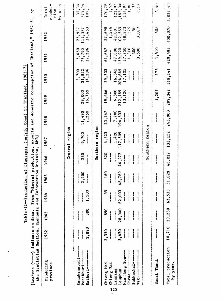
Table-12 Production of
fl
uors
par
(met
ric
tons)
In Th
aila
nd,
1962
-72
[Lea
ders
( )
Indicate no
data.
From "M
iner
al pr
oduc
tion
, ex
port
s an
d do
mestic
co
nsum
ptio
n of
Th
aila
nd,"
1962-7:',
hy
the
Statistics
Se
ctio
n, Ec
onom
ic and
Info
rmat
ion
Divi
sion
, DMR]
Prod
ucin
g pr
ovin
ce19
62
1963
19
64
1965
19
66
1967
19
6819
691970
1971
1972
To t a
1 produc
tion
by ar^;i
Cent
ral
regi
on
Kancha
nabu
rl
Petchburl
Rat bu
rl
_.._
_ _
__
____
o
onn
9^n
o 7nn
1 1 AQ
H2,
890
300
1,500
7,250
29,0
00
16,7
60
3,70
0 31
,852
14,286
5,65
0 77
,790
32
,296
25,9
97
112,
587
34,4
53
3r>,
V,7
?7rj,
r>V>
io(),
; r;-
Nort
hern
re
gion
Chle
ng M
al
Chleng Ral
Lamp
ang
Lamphun
Mae
Hong
Son
4 I
I L CiG
Sukh
otha
l
Tak
ICftflV
2,35
0 890
35
160
820
4,52
3 23,247
1^420
7,28
0 5,470
28,040
62,0
03
48,7
69
46,9
77
117,509
194,
633
'
19,6
66
6,800
212,
789
13,120
29,7
33
16,645
204,
645
17,105
61,6
67
47,8
00
159,920
37,7
50
1,31
0 30
0 3,500
27,6
98
1,57
6 42,091
102,585
48,8
73
575 50
3,07
7
170.
7K')
l,r>7
r,122, Oir,
1 ,183,140
116,M/.«
l,«8
r» 3S
O 6,577
Southern re
gion
Sura
t Than!
Total
production
by ye
ar.
:
10,7
10
29,2
30
63,5
38
51,8
29
48,027
133,152
243,900
1,20
7
299,
342
175
318,
141
1,51
0
429,
493
508
400,070
3,400
2, 02 7, 4'
J 2
The oldest and perhaps largest producer of antimony in Thailand is the Huai Nai Khao mine in the Ban Song mining district, Peninsular Thailand (Gardner, 1967a, p. 8-28). The deposit is close to the railroad 2 km southeast of Ban Song and 50 km south of Surat Thani. Antimony was discovered near Ban Song in about 1938. During World War II, the Japanese apparently made cursory attempts to prospect the deposit but no antimony was mined. During the Korean War, interest in the deposit was again revived, but still no antimony was produced. In about 1963, Siamerican Enterprise, Ltd., sank a 20 m inclined shaft that bottomed in high-grade massive ore. The shaft was abandoned because of caving walls, but the excavated ore had paid for the operations. Subsequently open pit operations were undertaken and continued at least into 1967. I do not know the present status of the mine.
Marine sedimentary rocks, in part weakly metamorphosed, that crop out in the vicinity of the Huai Nai Khao deposit are Ordovician limestone, Silurian- Devonian sandstone, siltstone, shale and some limestone, and Carboniferous limestone and shale. Triassic-Jurassic marine and nonmarine sandstone, siltstone, and shale are also present. The deposit is in north-striking steeply dipping light-gray to brown quartzitic sandstone and gray to black shale and siltstone of Paleozoic age. Limestone knobs lie nearby, and Cretaceous granite in a north-trending ridge of the Khao Luang Range is 1 km east.
Quartzitic sandstone forming the footwall of the deposit has been brecciated and silicified locally. Weak shale or mudstone forms the hanging wall of the deposit.
The antimony deposit at Huai Nai Khao lies along a brecciated east- trending fault zone that dips steeply southward. Stibnite was deposited mainly in brecciated sandstone of the footwall, in irregular lenslike bodies that are roughly parallel to the strike and dip of the fault zone. According to Gardner (1967a, p. 28) the ore body is made up "of many separate shoots, lodes, veins, and replacement masses that range from a few centimeters to 1.5 meters (5 feet) wide, a few centimeters to as much as 10 meters (33 feet) long, and as much as 20 meters (66 feet) thick." Gardner (1967a, p. 18) also stated that the deposit "has been traced for an east-west distance of about one kilometer, has been exposed continuously for about 250 meters, and has been opened for more than 100 meters. The mineralized zone ranges irregularly and abruptly in thickness from zero to 10 meters or more, but commercial ore seldom makes up the entire width." The deposit is known to a depth of at least 20 m. Gardner (1967a, p. 28) stated that the antimony content is "a few percent to almost 60 percent and probably averages about 10 percent." The ore was being blasted and hand sorted to obtain concentrates of at least 40 percent (ranging to nearly 60 percent and averaging 50 percent) Sb. Lower- grade material was either stockpiled or smelted in a nearby plant. 3y January 1964, about 1,300 m.t. of high-grade ore had been produced, and an estimated 4,000 m.t. of low-grade ore wasted. At that time reserves were estimated at about 15,000 m.t. of ore exceeding 45 percent Sb.
Stibnite is virtually the only ore mineral. Residual oxidized boulders in surficial overburden at the deposit contain valentinite (Sb20o), cervantite (Sb203 .Sb20 5 ), and stibiconite (Sb204 .H20) (Gardner, 1967a, p. 18). These boulders have not made ore, but have been stockpiled at the deposit, along with some low-grade Stibnite ore.
The Pa Had antimony mine, near the Mae Nam Yom River perhaps 10 km southeast of Wang Chin and 50 km south-southwest of Long in Phrae province, in
recent years has been Thailand's principal producer of antimony. When I visited the mine in January 1974, it was being operated by Electric Pahud Co., Ltd., of Bangkok. Significant production began in about 1969.
The deposit is in Carboniferous-Permian(?) carbonaceous shale or argillite. The sedimentary rocks are deformed and irregularly sheared; in some places the strata appear to have an average strike of N. 70° E., and to dip steeply northwest. No intrusive igneous rocks are reported in the region of the deposit.
The Pa Had antimony vein occurs irregularly along a complex zone of shearing and brecciation. The generally east-trending fault zone strikes nearly east near the west end of the vein, turns to about east-southeast near the middle of the vein where it is nearly vertical, turns abruptly to east- northeast farther east where the dip is steep to the southeast, and curves again to an east-southeast strike at the east end of the vein.
The vein appears to be perhaps 500-700 m long and is as much as 3 m wide. Minor veins occupy subsidiary shears along the main fault zone. Early mining was in the east part of the vein where high-grade ore was found. The west part of the vein appears to be more diffusely mineralized and is low grade. In January 1974, the west part was being developed by a shaft about 30 m north of the vein on the surface. Prior to commencement of the shaft, mining in the east part of the vein, all at the surface, had been at a rate of about 70 ra.t. per day. Best grade of ore mined was as high as 68 percent Sb (called A grade; pure stibnite is 71.7 percent Sb) and poorest ore was about 30 percent Sb (called D grade). Intermediate B and C grades were also distinguished. Total production from the vein during the previous 5 years was estimated at about 10,000 m.t. of ore.
The stibnite vein at Pa Had was strongly brecciated and sheared both before and after mineralization. Stibnite is found in broken quartz, and much of the stibnite in extensively sheared parts of the vein is finely granular. Such fine-grained milled stibnite is reported to be quite uncommon in other Thialand antimony deposits. In places in the vein, evidence of replacement of the sedimentary rocks by stibnite is seen in preserved sedimentary structures.
Quartz is the principal gangue mineral in the vein, and some pyrite is present locally.
I was unable to ascertain much of the regional geologic setting of the Pa Had antimony deposit. I saw no evidence to indicate the age of mineralization of the vein.
Deposits of antimony at Doi Pha Khan were described by Gardner (1967a, p. 30-32). The deposits are about 30 km north-northeast of the Pa Had mine. The district has been worked intermittently since about 1939, but may have been known long before that date.
Paleozoic sedimentary rocks in the area consist of a thick unit of massive brown to gray sandstone and some siltstone, overlain by limestone interbedded with shale and siltstone, in turn overlain by a thick sequence of light- to dark-gray shale and siltstone (phyllite in part) and some sandstone. Granite stocks as much as 10 km across are intruded in the area.
The sedimentary rocks have been folded into a large northwest-trending anticline whose axis lies east of the antimony deposits at Doi Pha Khan. One group of deposits about 1 km southeast of the Pha Khan railway station consists of veins, lodes, and replacement bodies in a north-northeast-trending zone of brecciated limestone (Gardner, 1967a, p. 31-32; Brown and others, 1951, p. 54-56; Sagawa, 1963).
Rich pockets and shoots are found over a distance of 500 ra along the breccia zone, and extend to a depth of 12 ra. Individual bodies that have been worked near the surface are 1-12 m long, 2-3 m wide, and 2-3 m deep. A main vein deposit at the north end of the mineralized zone is about 200 ra long and consists of small bodies in the breccia zone a few centimeters to 1.5 ra wide and as much as 3 m deep,
Stibnite is the primary ore mineral in the deposit, and quartz and calcite are gangue minerals. Light-yellow stibiconite occurs near the surface.
A breccia-pipe deposit of stibnite in the Khao Soon tungsten district is described elsewhere, with the description of tungsten deposits at Khao Soon.
Minor deposits of antimony in Thailand are described in table 13..The character and distribution of vein deposits of antimony in Thailand
can now be summarized. The veins are commonly formed along sheared and brecciated fault zones in silicified shale and sandstone. Some veins are found in limestone and granite. Stibnite is the only primary ore mineral recognized, and oxides and hydrated oxides of antimony have formed in the upper weathered parts of most veins. Stibnite commonly occurs in the veins as isolated masses, some of very high grade. Quartz and calcite are the principal gangue minerals (calcite is abundant where wall rocks are limestone). Minor pyrite and galena are found in some veins. Stibnite also occurs in a few fluorspar deposits.
The stibnite veins appear to be related to intrusive igneous rocks only incidentally; many are far from intrusives. The known deposits are all at the surface, and seem to extend only to shallow depths.
The three principal clusters of antimony deposits in Thailand are rather closely coincident with three regions of hot springs (fig. 26). This coincidence is even more close than the spatial association of fluorspar deposits and hot springs that has been cited previously.
The association of antimony deposits with hot springs and the apparent correlation of the deposits with the present ground surface leads to the conclusion that the deposits are quite young, probably late Cenozoic.
Shallow geophysical methods and geochemical methods, and stream panning in certain cases, applied in the regions of known antimony deposits, or more broadly in the regions of hot springs, should be effective in discovering new resources of antimony. Probably new deposits of the size and grade of the Huai Nai Khao and the Pa Had deposits will be found, and there is a good likelihood of important additional resources of antimony in Thailand.
Base metal deposits in the regions of stibnite veins in Thailand should be examined for their antimony concent. The stibnite veins should be tested for possible silver and gold content.
Manganese
Numerous small manganese deposits, most of them in northwestern Thailand, have been mined, some for almost 20 years, for battery-grade manganese oxide used in small factories in Bangkok, and for chemical- and metallurgical-grade manganese oxide exported largely to Japan. Most of the deposits are residual (to be described later), some are vein-type and related deposits (described here), and a few may be of sedimentary origin (already described). The locations of all are shown together in figure 27.
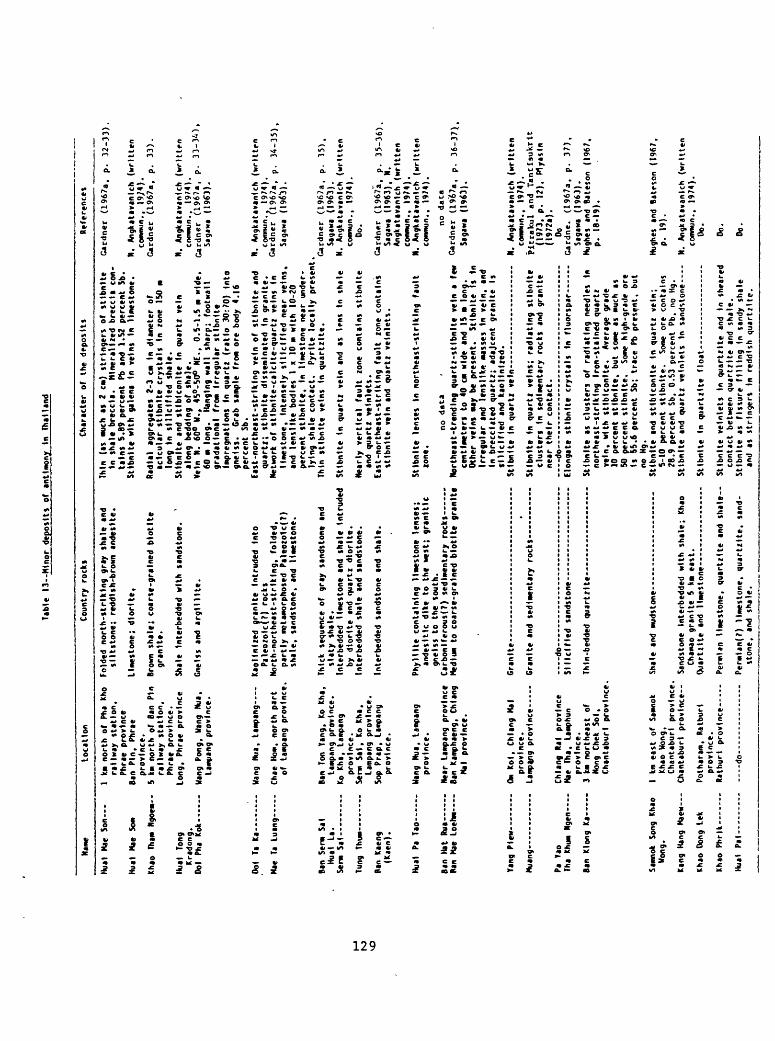
Tabl
e 13--Mlnor
depo
sits
of a
ntim
ony
In Thailand
Name
Loca
tion
Coun
try
rock
sCharacter
of the
deposits
References
Hual Mae Son
Hual
Mae
Som
Khao
Th
an N
goem
-
Hual long
Kradong.
Ool
Pha
Kok-
Ool
Ta Ka -
Mae
Ta Luang--
Ban
Sent Sal
Hual La.
Set* Sal
I km n
orth o
f Pha
Kho
rail
way
stat
ion,
Phrae
province
Ban
Pin, Ph
rae
province.
5 km no
rth
of B
an Pin
rail
way
stat
ion,
Ph
rae
prov
ince
.Lo
ng,
Phra
e pr
ovin
ce
Wang Pong,
Uang
Nu«.
Lamp
ang
province.
Uang Nu
a, Lampang-
Chae H
ow,
nort
h pa
rt
of Lampang
province.
Folded n
orth
-str
ikin
g gr
ay shale
and
sllt
ston
e; re
ddis
h-br
own
andeslte.
Limestone; dl
ortt
e,
Brow
n shale; co
arse
-gra
ined
blo
tlte
granite.
Shale
Interbedded
with sandstone.
Gneiss and
argllllte.
Kaol
in)r
ed gr
anit
e Intruded In
to
Pa1eo/olc(?) ro
cks
North-northeast-striking,
fold
ed,
part
ly m
etamorphosed Pa
leoz
olc(
T)
shal
e, sandstone, and
lime
ston
e.
Ban
Ton
Yang,
Ko K
ha,
Thick
sequ
ence
of
gray sandstone
and
Tung
Thum-
Ran
Kaeng
(Kaen).
Hual Pa Ta
o-
Ban
Hat Rua
Ban
Mae
Loehm-
Lamp
ang
province.
Ko K
ha,
Lamp
ang
province.
Serm Sa
l, Ko K
ha,
Lamp
ang
prov
ince.
Sop
Prap
, Lampang
province.
Wang Nu
a, Lampang
province.
Near L
ampang province
Ban
Kamp
haen
g, Chlang
Mal
province.
slat
y shale.
Interbedded
limestone
and
shal
e In
trud
edby
dt
orlt
e and
quar
tz d
torlte.
Interbedded
shal
e and
sandstone.
Interbedded
sand
ston
e and
shale.
Phyl
llte
containing
limestone
lens
es;
ande
sltl
c di
ke to t
he w
est;
gr
anit
icgneiss t
o the
south.
Carb
ontf
erou
s(7)
sedimentary rocks
Medium t
o coarse-grained b
lotlte granite
Yang
Plew-
Muang--
Om K
ol,
Chlang M
al
Granite -
prov
ince
. Lamp<ng province
Granite
and
sedi
ment
ary
rocks-
Pa Va
oTha
Khum
Ngen
Ban
Klon
g Ka -
Samn
ok So
ng Kh
ao
Wong
.
Kang
Han
g Maew
Khao D
ong
Lek
Khao P
hrlk ---
Hua<
Pal - --
Chlang R
al province
Mae
Tha, La
mphu
npr
ovin
ce.
3 km
northeast of
Nong Ch
ek Sol,
Chan
tabu
rl pr
ovin
ce.
-do-
St Hcl fle
d sandstone-
Thin (as
much a
s 2
cm)
stri
nger
s of st
lbnl
te
In sh
ale
breccia.
Minera
lize
d breccia
con
tain
s S.
B9 p
erce
nt Pb and
1.52 p
ercent Sb.
Stlb
nlte
with
gale
na In
veins
In limestone.
Radial aggregates 2-3
CM In
dia
mete
r of
aclc
ular
st
tbnl
te c
rystals
In zone ISO m
long
In slllclfled sh
ale.
Stlbnlte and
stlb
lcon
lte
In quartz ve
in
alon
g bedding
of shale.
Vein
N.
60
° M.,
45°-50°
HI.. 0.5-1.5 m
wide
. 60 m l
ong.
Hanging
wall sharp; footwall
gradattonal
from
Ir
regu
lar
stlb
ntte
Impregnations
In quartz (r
atio
30:70) In
to
gnei
ss.
Grab s
ample
from
ore b
ody
4.16
perc
ent
Sb.
East
-nor
thea
st-s
trik
ing
vein
of
stlb
nlte
and
quar
tz;
sttbntte d
isseminated
In granite.
Netw
ork
of st
lbnl
te-c
alcl
te-q
uart
z ve
ins
In
limestone. Intensely
slllclfled n
ear
vein
s,
and
I enj
like
bodies
I x
10 m w
ith
10-20
perc
ent
stlb
ntte
. In
limestone
near
under
lying
shal
e contact.
Pyrlte lo
call
y present
Thin
st
lbnl
te veins
In q
uart
/lie
.
Stlb
nlte
In q
uartz
vein
and
as lens In
sh
ale
Nearly vertical fault
zone
co
ntai
ns st
lbnl
teand
quar
tz ve
tnle
ts.
East
-nor
thea
st-s
trtk
tng
fault
zone
con
tain
sstlbnlte ve
in a
nd quartz velnlets.
Sttb
ntte
lenses In
nor
thea
st-s
trik
ing
faul
t zo
ne.
no data
Northeast-trending q
uartz-
stlb
nlte
ve
in a
few
centimeters
to 4
0 en w
ide
and
15
long.
Othe
r veins
«ay
be present.
Sttb
nlte
Is In
Irregular
and
lensltke m
asse
s In
vein,
and
In b
recclated
quar
tz;
adajcent gr
anit
e Is
rlllclfled and
kaollnlzed.
Stlbntte In
quartz ve
in .........
Stlb
nlte
In
quartz veins; ra
diat
ing
stlb
nlte
cl
uste
rs In
sedimentary
rocks
and
gran
ite
near
the
ir c
onta
ct.
do------ - -
Elon
gate
stlbnlte crystals In fluorspar ---
Thin-bedded
quartz!te-
1 km
east
of Sa
mnok
Sh
ale
and mudstone
Khao
Won
g,Ch
anta
burl
pr
ovin
ce.
Chantaburt provin
ce--
Sandstone
Inte
rbed
ded
with shale; Khao
Chamao g
rani
te 5
km e
ast.
Po
thar
am,
Bat b
ur)
Quart* He and
lime
ston
e---
----
----
---
prov
ince
. Ra
tbur
t pr
ovin
ce--
Pe
rmia
n limestone, qu
artz
tte
and
shal
e-
Stlb
nlte
as
clusters of radiating
need
les
In
northeast-striking Ir
on-s
tain
ed q
uartz
vein,
with st
lblc
onlt
e.
Average
grad
e 10 p
ercent sttbnlte,
but
some a
s mu
ch as
50 p
ercent stlbnlte.
Some
hi
gh-g
rade
ore
Is 55
.6 p
erce
nt Sb;
trace
Pb p
resent,
but
no K
g.St
lbnl
te and
Stlbtcontte
In q
uartz
vein;
5-10 p
erce
nt stlbntte.
Some
ore
contains
28.9 p
ercent Sb,
O.SJ
pe
rcen
t Pb.
no Hg.
Stlb
nlte
and q
uartz
velnlets In
sandstone -
Stlbnlte In
qua
rtzl
te float-
-do-
Permtan(?) limestone, quartztte, sa
nd
stone, and
shale.
Sttbntte vetnlets In
quartzlte and
In sheared
cont
act
between
quartzlte
and
shale.
Stlbntte as
fi
ssur
e fi
llin
g In
sandy
shal
e and
as stringers
In re
ddis
h quartzlte.
Gardner
(1967a
, p. 32-33),
N. An
gkat
avan
lch
(written
commun., 19
/4).
Ga
rdne
r (1967a,
p. 33
).
N. An
gkat
avan
tch
(wri
tten
common., 19
/4).
Ga
rdne
r (1967a,
p. 33-34),
Sagaxa (1961).
N. An
gkat
avan
tch
(written
comm
on..
1974).
Gard
ner
(1967a,
p. 34-35)
Sagawa (1963).
Gard
ner
(1967a,
p. 35),
Saga
wa (1963).
N. An
gkat
avan
lch
(written
common., 1974).
Do.
Gard
ner
(1967a,
p. 35-36)
Sagaxa (1963),
N.An
gkat
avan
lch
(wri
tten
commun., 1974).
N. An
gkat
avan
lch
(wri
tten
comm
un..
1974).
no data
Gar
dner
(1
967a
, p.
36
-37)
Sa
gaw
a (1
963)
.
N.
Ang
kata
vanl
ch
(wri
tte
nco
mm
un.,
1974
). P
ltra
kul
and
Tantl
sukrl
t(1
973,
p.
12
).
Ply
asln
(197
2a).
Do
Car
dn
e.
(196
7a.
p.
37
),Sa
gaw
a (1
963)
. Hu
ghes
an
d B
ates
on
(196
7,p
. IB
-19).
Hughes and
Bateson
(196
7,
p. 19
).
N. Angkatavanlch
(written
commun., 1974).
Do.
Do.
Do.
One of the largest vein deposits of manganese known in Thailand is at the Huai mine in the Wiang (Wang) Chin district, approximately 70 km southwest of Phrae and 50 km northwest of Uttaradit. At the time of my visit in January 1974 the mine and adjacent mill were being operated by Mr. Nam.
The wall rocks of the vein are mostly argillite probably of Carboniferous age, in an undifferentiated sequence of Carboniferous, Permian, and Traissic strata. The argillite walls of the vein are partly silicified. Apparently there are no intrusive igneous rocks in the area.
The vein is along a major fault zone, brecciated in places, that strikes about N. 55° E. and dips about 75° SE. The vein is about 135 m long and has a maximum width of 13 m. Its extension in depth is not known. The production at the mine at the time of my visit had been about :250 m.t. per month. Amount of reserves is not known.
The primary ore mineral is massive light-pinkish-brown rhodonite (MnSiO^). The rhodonite is laced with thin healed shears along which black manganese oxide has incipiently developed. Parts of the vein have been oxidized to hard massive manganese oxide that is almost black to iron gray in color. This manganese oxide is reported to have good "activity" for electrical properties, and is being rained as battery-grade ore.
The manganese oxide probably does not extend to any great depth in the vein, no more than a few tens of meters, being a surficial oxidation product of rhodonite. Massive rhodonite making up more or less the entire vein was exposed in one part of the open pit in which the vein was being mined, at a depth that appeared to be no more than 5 m beneath the original surface.
The Huai Muang (Mueng) mine lies about 20 km northeast of Chiang Karn in northeastern Thailand, about 2 km from the Mekong River along the Laos- Thailand border (Jacobson and others, 1969, p. 50-60).
Country rocks are folded and somewhat faulted Devonian and Carboniferous strata consisting of a sequence of interbedded quartzite, phyllite, slate, chert, conglomerate, sandstone, siltstone, and shale. The ore deposit is in a north-striking steeply dipping quartzite unit; strikes of quartzite and adjacent shale and sandstone strata in the mine area are mostly easterly however. Some dark fine-grained rock west of the mine may be igneous. The nearest granitic rocks lie 20 km south. The mineralized quartzite is fractured and locally brecciated.
According to Jacobson and others (1969, p. 59): "Most mining * * * had been completed * * * in mid-1963. Production from 1956-60 was 12,000 ra.t., from seven or more small pits and one main pit * * * The main pit was 27 m wide, 46 m long, and 5 m deep at the face." At a nearby adit 50 m of underground workings follow a westerly trend.
Pyrolusite and psilomelane occur mainly as pods in the clayey matrix of weathered brecciated quartzite and as fracture coatings in quartzite. Rhodochrosite (MnCO^) has been reported, apparently occurring in small veins. Jacobson and others (1969, p. 60) stated that "a selected chip sample of one of the pods showed a content of 39.2 percent Mn. However, a horizontal, 12-m chip-channel sample across the face of a previously mined open cut near the portal of the adit showed a content of only 3.9 percent Mn. Other constituents in the channel sample are 4.7 percent Fe and 54»9 percent Si02 ."
Numerous prospect pits in the vicinity of the mine show the presence of psilomelane and pyrolusite pods and lenses in soil. According to Jacobson and others (1969, p. 60) "The lenses ranged in thickness from a few cm to 1.8 ra;
in width, from 0.3 to 10 m; and in length, from 0.3 to 12 m. The run of the mine ore averaged about 50 percent Mn02»" These bodies are probably residual enrichments.
The Ban Pa Phai deposit in northwestern Thailand (Gardner and others, 1965, p. 42-43) about 90 km airline south of Lamphun and 40 km northwest of Thoen near Li, may be a vein deposit, although available data do not establish it definitely as such. The deposit in 1965 was owned by Thai Rocks and Minerals Company.
Country rocks are quartzite, slate, shale, and sandstone with some intercalated limestone, of Silurian-Devonian-Carboniferous(?) age (N. Angkatavanich, written coramun., 1974).
No details are known of the structural setting and physical characteristics of the ore deposit, except that it has an easterly trend. According to Gardner and others (1965, p. 42-43) a grab sample of choice ore assayed 77 percent Mn02» 1.0 percent Fe203, and 2.6 percent Si02« Production in 1965 was about 150 m.t. per month. In 1963 measured reserves of battery grade ore were 6,100 m.t., and indicated reserves were 5,800 m.t.
Small veins and related deposits of manganese in Thailand are tabulated in table 14.
Manganese oxide veins appear to be widely scattered throughout Thailand. Host rocks are mostly clastic rocks, but in places limestone or volcanic rocks are present. None of the veins are closely related to intrusive igneous rocks. Manganese oxides may be mostly weathering products of rhodonite and rhodochrosite. Possibly some are hypogene in origin and if so they might extend to greater depths than do the veins of manganese oxide formed by weathering of rhodonite and rhodochrosite. The presence of minor amounts of elements such as tungsten, lead, copper, molybdenum, thallium, arsenic, and beryllium, and the minerals barite, fluorite, and adularia, is indicative of hypogene origin, and should be looked for (see Hewett, 1964, p (1469). In addition, Hewett (1964, p. 1470) has suggested testing the deeper parts of hypogene veins of manganese oxide where they might grade downward into veins of manganese carbonate and silicate with barite, fluorite, and sulfide minerals that carry gold and silver in economically valuable amounts.
None of the Thailand vein deposits of manganese are large. Because of the known wide distribution and abundance of manganese deposits of all types in Thailand, the possibility for discovery of other small vein deposits appears good.
Tin
Hydrothermal lode (vein) and pipelike deposits of tin are widespread in Thailand as are stockwork and related deposits (already described). A few contact-metamorphic deposits and numerous placer deposits are described elsewhere in this report. Some aspects of the setting of the tin deposits have.already been described in the discussion of stockwork and related deposits. Specific features of some vein and pipelike deposits are presented here, and data on other veins and pipes are summarized.
According to Aranyakanon and others (1970, p. 6) hydrothermal lode deposits are the major source of cassiterite in placer deposits. The following descriptions of lode deposits are based largely on Aranyakanon and others (1970).

Table
14 Small ve
ins
and
related
deposits of manganese
In Th
aila
nd
[Lea
ders
( ) in
dica
te no da
ta]
Name
Location
Coun
try
rock
sCharac
ter
of th
e deposit
References
Phu
Lon; Huai
Khok
Kh
a; Huai
Kan.
18 km
northeast
of Chiang Ka
rn.
Huai
Ta
d-16 km
east-
nort
heas
t of
Chiang Ka
rn.
11 km
east-
nort
heas
t of
Chiang Ka
rn.
Loei
-Chi
ang
Karn
ar
ea.
20 km
southeast
of Chiang Ka
rn.
Hua
i N
ara
Kar
a;
36
-38
km
east-
H
uai
T
ab
Ch
ang.
south
east
of
Ch
ian
g
Kar
n.
Prak
it;
Ban
Dong
Mak
Fai.
Huai
P
ang
Phu
T
hara
Mu
p
Ban
San Saleek
Ta Kam
Ban
Rai-
Ben
Mai-
40 km
east-
sout
heas
t of
Chia
ng Ra
i(?)
,60 km
southwest
of Pe
tcha
bun.
60 km west-
sout
hwes
t of
Utha
i Thani.
50 km south
of
south
of
Song
khla
.
Devonian and
Carboniferous
sandstone, qu
artz
ite,
phyllitic
shale, slate,
and
lime
ston
e.
do*
do-
Dark-gray
quar
tzit
e-
Devo
nian
an
d Ca
rbon
ifer
ous
sand
ston
e, qu
artz
ite,
ph
ylli
tic
shale, slate,
and
lime
ston
e.Ca
rbon
ifer
ous
and
Permian
sand
ston
e, si
ltst
one,
shale, tu
ff,
and
limestone.
Tert
iary
(?)
ande
siti
c volcanic rocks.
Mass
ive
lime
ston
e,qu
artz
ite,
an
d slate.
Meso
zoic
(?)
fine
-gra
ined
re
d sa
ndst
one
inter-
bedded wi
th dark-gray
shale, si
ltst
one,
an
d conglomerate.
Veins
consisting of
ma
ngan
ese
oxid
es
(including pyrolusite)
and
rhodo-
chro
site
in quartzite
and
phyl
lite
ar
e as much as
1 m
wide
an
d 15 m
long
; average
grad
e is 27.3-38.6
percent
Mn;
SiO^
is less th
an 4
perc
ent,
Fe
is le
ss than 7
percent.
Manganese
oxides,
rhodochrosite, and
quartz in vein,
sample of which
showed 33
.8 percent
Mn and
20.2
pe
rcen
t Si
C^.
Manganese
oxides occur
as impregna
tions
and
frac
ture
co
atin
gs in
quar
tzit
e.
Average
Mn content
7.0-
12.5
pe
rcen
t.Py
rolu
site
oc
curs
as ve
inle
ts an
d sm
all
pock
ets
along
a fracture.
Irre
gula
r no
rth-
stri
king
zone 1-5
m wide of ma
nganese
oxide
pods
in
quar
tzit
e.
Cont
ains
5-30 percent
Mn02
.Th
in veins
in sa
ndst
one
and
silt
ston
e.
Manganese
oxide
as a
prim
ary
depo
sit;
re
sidu
al accumulations
nearby.
Pyrolusite and
rhodochrosite
in a
vein(?)
depo
sit.
Pyro
lusi
te in
vein in li
mest
one;
psilomelane
in fl
oat.
Pyro
lusi
te an
d psilomelane
in
frac
ture
s an
d along
bedd
ing
in
sand
ston
e.
Jaco
bson
an
d ot
hers
(1969,
p. 60
-62)
.
Jaco
bson
and
othe
rs (J
969,
p. 61
-63)
.
Jacobson and
others (1
969)
p. 62.
N. An
gkat
avan
ic.h
(wri
tten
comm
un.,
1974)
Jaco
bson
and
othe
rs (1
969,
p. 63),
Do.
N. Angkatavanich
(written
comm
un.,
19
74),
Do D
o,
Do,
In the vicinity of tin lodes the so-called "tin granites" have been pneumatolized so that biotite is reduced in amount, and tournaline and rauscovite increased. The rocks have been kaolinized and potassium feldspar has been recrystallized to microcline. Using the feldspar thermometer method of T.F.W. Barth, Aranyakanon and others (1970, p. 4) estimated that the granites were altered at temperatures somewhat below 600°C, and rich tin deposits formed at lower temperatures. In some places very low temperature tin lodes formed that contain chalcedonic quartz, but most of these have not been economic.
The highest-grade veins consisting of mostly cassiterite and a small amount of quartz are 0.5 to 15 cm wide. Lower-grade veins in which quartz dominates are as much as 3 m wide. The cassiterite-quartz lodes are known to depths as great as 300 m, but cassiterite appears to be concentrated in the upper parts of the lodes. Lode deposits of tin commonly have greisen deposits associated with them, and the lodes, where they are thin and closely spaced, grade into stockwork-type deposits.
Hydrothermal cassiterite veins occur in Mesozoic shale and sandstone at the Tungkamin, Koh Saba, and Muang Mark mines in the Songkhla granite range. There, disseminated cassiterite is found in the clastic country rocks adjacent to the lodes.
A small low-temperature hydrothermal tin lode is known at the Tuad mine, Nasan district, Surat Thani province, where cassiterite occurs with wolframite, rhodochrosite, and fluorite.
Some tin-bearing quartz lodes have the appearance of quartzite in which individual quartz grains may be as large-as 1 cm, such as in the Sa-Moeng district, Chiang Mai province, and at Tapsakae, Prachuab Kirikhan province.
Sulfides are abundant in some tin lodes, as in the Baho area in the granite range of Yala province where quartz veins with cassiterite and copper and iron sulfides strike easterly and dip 25° N. across the strike of phyllitic quartzite; at the Labu, Deda, and Tarn Talu mines at Tarn Talu-Batong, in the Lam Phaya granite range; in the Koh Saba area and the Thai San and Muang Mark mines, Na Thawi district, Songkhla province where cassiterite occurs with sulfides of lead, zinc, copper, silver, and in places bismuth in quartz lodes in schist and quartzite; and the Sora Manao mine area and at Kuan Taiu, Takuapa district, Phangnga province. At Som Manao, cassiterite occurs with cinnabar and iron sulfides. I saw abundant sulfides locally in cassiterite- and wolframite-bearing quartz veins in the Pilok district northwest of Kanchanaburi.
Veinlike cassiterite-bearing pegmatites are commonly associated with other forms of tin deposits, and generally are found in all of the so-called "tin granites." They contain most of the minerals common to cassiterite- bearing quartz veins, but in addition also contain feldspar crystals. Most pegmatites are somewhat older than the quartz veins. Following descriptions are based mostly on Aranyakanon and others (1970, p. 11-13).
One important pegmatite deposit is a vein 5 m wide in hornfels and schist at the Shone mine, in Surat Thani. province. Several pegmatite localities are in the Takuapa district. More than 95 percent of the tin produced in the Paksong and Pato areas, Pato district, Chumpon province, is from pegmatite veins. At Lak Lack Nai, Paksong area, a great many north-striking stringers of pegmatite occur in schist. They are known to depths as great as 30 m. At Pato and Paksong, and locally in the Tapsakae district, Prachuab Khirikhan province, some pegmatites in gneiss and schist have been metamorphosed, and
cassiterite is disseminated in the pegmatites. At the Namon mine, Thung-Pho village, Haad Yai district, Songkhla province, cassiterite and wolframite occur in a quartz-feldspar lode in medium-grained altered granite. The Chon mine in Phangnga province is described by Pitrakul and Tantisukrit (1973, p. 7) as an important pegmatitic cassiterite deposit.. The pegmatite is an irregular sill-like intrusion in quartzitic, calcareous schist on the east side of a large granitic stock. It consists of fine-grained albite, potassium feldspar, transparent and milky quartz, and cassiterite in crystals 5 mm to 5 cm in diameter, and minor black tourmaline, pink garnet, apatite, and pyrite.
Graphic tin-bearing pegmatites are known in many areas such as Kuramara and Ka-Too, Phuket province, Huai Yot-Lumpae in Trang province, and Tapsakae. In the Thungka area, Ranong province, and in the Tah Sala district, Nakorn Sri Thamarat province, kaolin has been rained from altered pegmatites and their granite wall rocks.
Minerals of niobium, tantalum, and rare earths are associated with cassiterite in pegmatites, such as in Phuket province. Some mines in Huai- Yot, Trang province, have produced columbite-tantalite as a byproduct of tin mining. Lepidolite is found in layers or zones in some pegmatite lodes, as in the Krasom area, Takuathung district, Phangnga province; and Chumbung district, Ratburi province. Massive lepidolite occurs at the Bangnow mine and at Nai-Pralat, Paksong village, Chumpon province. Beryl is commonly found in cassiterite-bearing pegmatites, but is generally not abundant. It is mostly green and not clear, and rarely blue and clear. Blue beryl is known in the east-striking pegmatites at Huai No, Mae-Cham district, Chiang Mai province, together with abundant mica and cassiterite crystals as large as 2 cm in diameter. Large beryl crystals are found in pegmatites in several areas of Ratburi province.
Most black cassiterite recovered from placer deposits originates in pegmatites.
Little mining has been done from pipelike cassiterite deposits in Thailand. The Muang Tuad mine, Nasan district, Surat Thani, appears to be in a pipe 3-4 m in diameter in limestone, argillite, and quartzite wall rocks.
According to Brown and others (1951, p. 98-99) in about 1950 quartz lode veins containing cassiterite and wolframite produced about 10 m.t. of cassiterite a month in the Pilok and Rat Buri districts in west-central Thailand, and only minor cassiterite in the Mae Sariang district, Mae Hong Son province in northwestern Thailand.
Vein networks, or stockwork, deposits of cassiterite in the Pilok district have already been described. In the district such as at the Poo Mer mines, Pilok mine, Khao Mai mine, I Poo (Pu) mine, Pha Pae mines, and Song Khwae mines, some of the larger veins in the stockworks have been mined individually. These veins contain, in addition to quartz, mica, tourmaline, cassiterite, and wolframite, also minor pyrite, chalcopyrite, molybdenite, scheelite, and beryl, and some contain significant feldspar and are classed as pegmatites. The Chang Phuak 1 mine at the north end of the district is on three north-striking closely spaced veins and a fourth parallel vein 500 m to the west, in phyllite (Brown and others, 1951, p. 105-113). According to Pitrakul and Tantisukrit (1973, p. 5) east-striking veins in the district are in granite and contain cassiterite and rarely gold; north-striking veins are commonly in phyllite and quartzite, are coarsely pegmatitic, and contain wolframite and scheelite. Near intersections of the east-striking and north- striking veins, the mineral content of the veins is mixed.

The Mae Sariang district lying about 50 km south of Mae Sariang is principally a tungsten producer, and it will be described in the section on tungsten veins.
Tin-bearing vein deposits that contain significant lead, copper, and zinc are known in the Pinyok-Labu area at the extreme southern tip of Thailand about 2-3 km from the Malaysia border (Brown and others, 1951, p. 130-133). These deposits may be similar in some respects to the tin lodes of Cornwall, England.
Rocks in the area consist of quartzite, phyllite, and shale of Paleozoic age overlain by Rat Buri Limestone of Permian age; these rocks are intruded locally by Cretaceous granite. The ore bodies occur in quartzite, phyllite, and cherty shale near or at contacts with granite. In the southeast part of the Pinyok-Labu area near Pinyok, quartz, calcite, andradite and hedenbergite are found in places in the wall rocks of the veins, suggesting that the wall rocks were altered by contact metamorphism due to granite emplacement.
The ore bodies consist of veins and stockworks. At granite contacts the deposits may be in part of replacement origin, details of which are described elsewhere. Somewhat irregular deposits occur in an area about 5 x 2 km in size at and north of Pinyok (Pinyok, New, and Guatoma or Tamtalu mines), and tabular veins are known at and south of Labu. The large deposit at the Pinyok mine lies along an east-southeast-striking contact and is about 500 m long and 200 in wide. The Tributor's vein at Labu is east striking and north dipping, 10-50 cm wide, and at least 150 m long; the Main Reef vein 1 km south of Labu strikes N. 55° W. and dips south; it is 15 m wide and of unknown length.
Canadian-Siam Resources has reported some of the results of drilling a tin-, silver-, and base metal-bearing deposit in Peninsular Thailand (London Mining Journal, April 13, 1973, p. 299; July 27, 1973, p. 73; October 12, 1973, p. 306) that may be a vein deposit. It is reported to occur in carbonate rocks in Yala province (S. Sampattavanija, oral commun., June 1975). The results are summarized in table 15.
Tungsten
Many aspects of vein deposits of tungsten are like those of tin already described. In fact as previously noted many vein deposits carry both tungsten and tin minerals. A few deposits that are notable for their tungsten content, or have had appreciable tungsten production, will be described here. Locations of most of the important tungsten deposits in Thailand are shown in figure 28.
The Khao Soon (Sun) tungsten district contains several vein and breccia- pipe deposits and is now Thailand's chief producer of tungsten. It lies at the top of Khao Soon hill near the town of Cha Wang, Nakhon Si Thamnarat province, on the railroad in Peninsular Thailand. The district was discovered in October 1970 by Mr. Udom Yenrudi, Managing Director, Siamerican Mining Enterprise Co., Ltd., who presently holds a concession on the district. Shortly after Mr. Udom's discovery of tungsten at Khao Soon, but before he was awarded a concession to mine by the Department of Mineral Resources, the district was swarming with squatter miners who commenced haphazard operations without a government permit. A town sprang up amidst the mining operations and soon reached a population of about 30,000. Although Mr. Udom was eventually awarded a concession, and is now operating a mine in the principal breccia pipe on the hill, about 5,000 people were still living on Khao Soon and were carrying out small-scale mining operations at the time I visited the
135
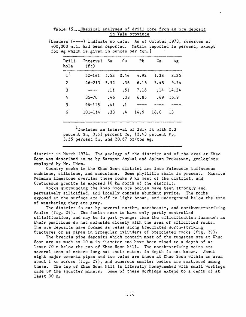
Table 15 ,_Chemical analyses of drill core from an ore depositin Yala province
[Leaders ( ) indicate no data. As of October 1973, reserves of 400,000 m.t. had been reported. Metals reported in percent, except for Ag which is given in ounces per ton.]
Drill hole
1*
2
3
4
5
6
Interval (ft)
52-161
46-213
35-70
96-115
101-114
Sn
1.53
5.52
.11
.46
.41
.38
Cu
0.46
.36
.51
.38
.1
.4
Pb
4.92
6.16
7.16
6.85
14.9
Zn
1.38
3.48
.14
.69
16.6
Ag
8.35
9.54
14.24
15.9
13
Includes an interval of 38.7 ft with 0.3 percent Sn, 0.61 percent Cu, 12.43 percent Pb, 3.55 percent Zn, and 20.67 oz/ton Ag.
district in March 1974. The geology of the district and of the ores at Khao Soon was described to me by Surapon Araykul and Apinun Pruksawan, geologists employed by Mr. Udom.
Country rocks in the Khao Soon district are late Paleozoic tuffaceous mudstone, siltstone, and sandstone. Some phyllitic shale is present. Massive Permian limestone overlies these rocks 9 km west of the district, and Cretaceous granite is exposed 10 km north of the district.
Rocks surrounding the Khao Soon ore bodies have been strongly and pervasively silicified, and locally contain abundant pyrite. The rocks exposed at the surface are buff to light brown, and underground below the zone of weathering they are gray.
The district is cut by several north-, northeast-, and northwest-striking faults (fig. 29). The faults seem to have only partly controlled silicification, and may be in part younger than the silicification inasmuch as their positions do not coincide closely with the area of silicified rocks. The ore deposits have formed as veins along brecciated north-striking fractures or as pipes in irregular cylinders of brecciated rocks (fig. 29).
The breccia pipe deposits which contain most of the tungsten ore at Khao Soon are as much as 10 m in diameter and have been mined to a depth of at least 70 m below the top of Khao Soon hill. The north-striking veins are several tens of meters long but their extent in depth is not known. About eight major breccia pipes and two veins are known at Khao Soon within an area about 1 km across (fig. 29), and numerous smaller bodies are scattered among these. The top of Khao Soon hill is literally honeycombed with small workings made by the squatter miners. Some of these workings extend to a depth of at least 30 m.

ACT.
',: *?^/*&? '^Mi:̂̂^^^^^^^f^^
. - ". :
> ..Jj' ' -.-; ;-- --: -. *--:
-.- - ?> -^ V - - --- -» v:':^ '. ?iS^<y '- - ̂ /^ i
The breccia pipe being mined by Mr. Udom is irregular, pinches and swells, and varies erratically in grade internally. I estimate that the higher grade parts contain about 20 percent ferberite (FeWO^) and therefore contain about 12 percent W. Only the highest grade ore (5-12? percent W) was being rained, both in the principal mine and in the numerous small squatter's mines, and a large amount of lower grade material has been left in the ground. The primitive concentrating methods being used at the mine also have left a large volume of low-grade material in the waste dumps.
At the time of my visit one pit (probably several individual operations) on Khao Soon hill was producing more than 1 m.t. of tungsten per day, and the principal mine operated by Mr. Udom was producing about 10 m.t. of concentrates (65 percent (W02) equivalent to about 5 ra.t. of tungsten per month.
The tungsten ore at Khao Soon is strongly brecciated, and breccia fragments range mostly from a few millimeters to 10 cm in size. The interstices of the breccia are partly filled with a matt of ferberite crystals, leaving numerous small cavities into which the crystals penetrate. The breccia has developed preferentially along fractured zones in silicified pyritic mudstone, and tends to terminate against phyllitic rocks. In the northeast-trending adit that extends into the principal breccia pipe being mined by Mr. Udom numerous northwest-striking fractures have been mineralized with ferberite.
The silicified host mudstone was initially fractured, veined with quartz, and brecciated, after which ferberite was deposited in open spaces. In places in the Khao Soon district, late stibnite was deposited in cavities on ferberite crystals.
Ferberite is the only ore mineral present in the parts of the district that are being mined for tungsten, although stibnite is sparsely present locally. In one place in Mr. Udora's mine pale yellowish-brown radiating clusters of hairlike crystals about 2 mm long that may be stibiconite altered from stibnite were seen in a breccia cavity perched on ferberite crystals. Hematite and limonite occur in places in the ferberite ore. At the Taiwan mine on the side of Khao Soon hill not far from the principal tungsten mine, stibnite is abundant and mining is principally for antimony. A greenish oxidation mineral is visible in some of the Taiwan ore. The deposit at the Taiwan mine also is in brecciated mudstone, but the ore is more massive than in the Khao Soon tungsten breccia ore, and generally lacks cavities. In the discovery area above the adit at the principal tungsten mine, marcasite occurs with ferberite and stibnite in silicified mudstone.
About 15 km north of the Khao Soon tungsten district, stibnite-wolframite ores have been mined near granitic intrusives. A scheelite-stibnite mine northwest of Khao Soon contains some fluorite and native sulfur.
The ferberite deposit at Khao Soon appears to be a unique type of tungsten occurrence. There are no known igneous rocks nearby. The open character of the breccia indicates a near-surface environment, probably relatively low temperature. The presence of stibnite also suggests a near- surface, low-temperature origin. The Khao Soon ferberite deposit occurs in the area of stibnite deposits in Peninsular Thailand that is characterized by the presence of several hot springs. Altogether these facts suggest a low- temperature, near-surface, possibly hot-springs, origin of the ferberite deposit. The type should be looked for in other parts of Thailand where hot springs, antimony deposits, and tungsten deposits are known to be associated.

The Mae Sariang tungsten district in Mae Hong Son province is about 50 km south of Mae Sariang on the Mae Nam Yuam River (Brown and others, 1951, p. 99- 105). Quartz veins containing wolframite were discovered in the late 1930's, some mining occurred during the Second World War, and major mining commenced in 1948, mostly at the Mae Lama mine which is on the largest vein in the district.
Country rocks in the area of the Mae Sariang district are Paleozoic limestone, shale, siltstone, and sandstone that have been folded along north- trending axes and have been metamorphosed to marble, phyllite, and quarzite. These rocks have been intruded by medium- to coarse-grained Triassic(?) muscovite-tourmaline granite, aplite, and pegmatite.
Most of the productive veins occur in steeply dipping fissures that strike N. 65° E., and are concentrated near anticlinal axes. They range in width from a few centimeters to 2 m, and the largest vein (Mae Lama) is 460 m long. The Mae Lama system is actually three closely spaced en echelon fissure veins. Mining had penetrated to a depth of about 30 m in 1950. In the early period of production (about mid-1948-50) about 450 m.t. of wolframite concentrates averaging 65 percent W02 was produced in 18 months. I do not know what the recent production has been.
Wolframite is the principal ore mineral in the Mae Sariang veins, but scheelite is significant in the eastern part of the district, and is present in other localities. According to Brown and others (1951, p. 104-105) "wolframite is found in grains, blades, and massive pockets scattered through white, subtranslucent quartz * * * Most of the larger crystals and crystal aggregates are concentrated along the walls of the massive quartz vein-filling * * * Scheelite occurs in two forms: as yellow-brown crystals replacing wolframite, and as a gray powder coating * * * wolframite crystals. The most common sulfide is arsenopyrite which is associated with wolframite and scheelite in several quartz veins." Pyrite, chalcopyrite, molybdenite, and rare brown translucent cassiterite also are present in places. The quartz vein margins commonly are lined with a selvage of coarsely crystallized muscovite, and locally with white clay. N. Angkatovanich (written commun., 1974) reported also the presence of pyrrhotite, goethite, and marraatite.
Quartz veins similar to those at Mae Sariang are present in the Pilok district northwest of Kanchanaburi in west-central Thailand, as previously described. Many of these veins have been mined for wolframite, although cassiterite is more abundant than in the Mae Sariang veins, and in places constitutes the principal ore mineral. Brown and others (1951, p. 108) stated that the Chang Phuak 1 mine is on four veins, the easternmost of which is pegmatitic and contains wolframite, molybdenite, chalcopyrite, and white mica. The other veins are massive white quartz containing vugs and scattered books of golden-brown mica. The veins are narrow and contain less than 1 percent wolframite. At the Poo Mer 1 mine in the Pilok district a flat quartz vein in tourmaline schist and granite contains wolframite in its lower part, and wolframite is also concentrated in the upper micaceous parts of nearly vertical quartz veins that intersect the lower part of the flat vein. An especially rich vein at the Khao Mai mine, Pilok district, yielded 700 kg of wolframite from 2m of vein material. At the I Pu (Poo) mine, Pilok district, wolframite constitutes 2-5 percent of some of the quartz veins, and the largest wolframite crystals are 1x3 cm. The wolframite to cassiterite ratio is 4 to 1. Some wolframite is partly replaced by scheelite. The Pha Pae mines at Pilok yielded a concentrate consisting of 70-80 percent
wolframite and 20-30 percent cassiterite. The Pilok mines are presently not very productive.
Wolframite is found in N. 10°-20° E.-trending quartz veins in biotite- muscovite granite at Klong Loy, Bang Saphan Yai, Prachuap Kirikhan province (N. Angkatavanich, written coramun., February 1974).
Brown and others (1951, p. 124-125) reported that the Rong Lek district in Nakhon Si Thammarat province produced wolframite and cassiterite from quartz fissure veins containing abundant arsenopyrite and pyrite. The veins strike generally northwest to west, are steep, 60 cm to 1.5m wide, and 50- 400 ra long, in alkali granite, phyllite, and slate. In about 1950 the Nai mine of Yip In Tsoi Co. produced 2.6 ra.t. of concentrates per month consisting of 70 percent wolframite and 30 percent cassiterite. Nearby mines produced lesser amounts of concentrate.
Wolframite-bearing quartz veins on Ko Saiaui Island in the Gulf of Thailand are a few centimeters to 0.6 m wide and as much as 400 m long in slate, sandstone, and limestone of Paleozoic age intruded by Cretaceous granite (Brown and others, 1951, p. 125-126). Wolframite crystals are clustered near the mica selvages of the veins, which contain also tourmaline and arsenopyrite and minor cassiterite, fluorite, pyrite, and chalcopyrite.
Brown and others (1951, p. 127) stated that at Laem Niat, on Phangan Island 100 km northeast of Bandon, Surat Thani, two north-northwest-striking quartz veins as much as 3 m wide in granite contain wolframite, galena, chalcopyrite, and cassiterite.
Wolframite, scheelite, cassiterite, galena, arsenopyrite, and pyrite occur in east-striking quartz veins in porphyritic biotite granite at Ban Kong Sok, Surat Thani province. The granite adjacent to the veins has been altered to medium-grained tourmaline granite (N. Angkatavanich, written commun., February 1974).
Probably most near-surface tungsten veins of significance in Thailand have been discovered inasmuch as prospecting of stream deposits by hand panning has been nearly universal throughout the country. It may be worthwhile, however, to evaluate the possibility of stockwork deposits of tungsten (with associated tin and other minerals) wherever vein-type deposits associated with granite are known. Such deposits likely would have to be worked on a large scale by mechanized methods to be profitable.
Ease metals
No important vein deposits of base metals have been mined in Thailand, although a few small deposits are known. Some of the veins contain dorainantly lead and zinc minerals and some-contain principally copper minerals. Localities of lead-bearing deposits are shown in figure 14.
Zinc-lead veins at Huai Tham, 1 km east of Ban Bo, Phrae, near the Ban Pin railway station have been known for many years (Brown and others, 1951, p. 80-82). Strongly folded dark-gray and greenish-gray slate and shale and yellowish-brown quartzitic sandstone of Paleozoic age have been intruded by small stocks of granite and a dike of monzonite porphyry near Huai Than. Three or four narrow quartz veins have been prospected. One steeply dipping vein striking north-northeast is about 30 cm wide and of unknown length. Irregular masses of finely crystalline reddish-brown sphalerite as much as 3 cm across occur in milky quartz together with some galena and pyrite. Locally the milky quartz has small vugs lined with quartz crystals.
140

Several vein deposits containing lead and zinc sulfides and minor copper in the Loei area of northeastern Thailand have been described by Jacobson and others (1969, p. 20-22, 29). Data are tabulated in table 16.
At Khanong Phra, Nakhon Ratchasima province, 15 km south of the Pak Chong railway station, copper-bearing lodes were prospected, shortly after 1900 (Brown and others, 1951, p. 58-60). Country rock is Triassic granite. One steeply dipping north-striking quartz vein averages about 40 cm wide and is several meters long. Where the vein has been brecciated, it contains malachite, azurite, and chalcocite; copper content is as high as 4 percent.
The Chan Thuk prospect at Nong Chan, Nakhon Ratchasima province, 6 km south of Chan Thuk railway station, was prospected as early as 1915 (Brown and others, 1951, p. 60t). Quartz veins in mica schist are as much as 50 cm wide and extend to a depth of at least 9 m. They contain malachite, azurite, and chalcopyrite, and as much as 3 percent Cu. Seventeen kilometers south of Chan Thuk station at Boh Hin Riang a north-striking quartz vein in mica schist is at least 200 m long. The vein contains secondary copper minerals and iron and manganese oxides.
Carrel (1964), quoted by Pitrakul and Tantisukrit (1973, p. 24), indicated that quartz veins associated with an intrusive body at Boh Hin Riang and Ban Sap Kha, Chan Thuk are of stockwork character.
Carrel (1964) also described copper-bearing quartz veins associated with porphyry sills in the Sa district, Nan province, as stockwork type.
At Huai Phi 9 km south of Petchabun chalcocite, malachite, azurite, and cuprite occur in a lenticular quartz vein 3-5 cm wide along the contact between Cretaceous andesite porphyry and interlayered sandstone and slate (Brown and others, 1951, p. 60). The vein was first prospected in 1934. At Pha Daeng 6 km east of Petchabun copper minerals occur in quartz lenses in Cretaceous andesite porphyry, and at nearby Boh Khok Na Kea malachite and azurite fill fracture in quartzite. Also at nearby Boh Noen Thong thin copper-bearing quartz veins are known, and at Boh Khao Thong, 2 km southwest of Pha Daeng malachite and azurite occur in a gouge zone (Brown and others, 1951, p. 61).
According to N. Angkatavanich (written coramun., January 1974) copper- bearing veins occur at Kao Nam Ko Yai about 50 km north of Petchabun. There, Mesozoic shale, sandstone, and siltstone overlie Permian limestone; the sedimentary rocks are folded and cut by north-striking faults. Granodiorite and diabase intrude the sedimentary rocks. Quartz veins no wider than 30 cm that contain chalcopyrite, chalcocite, and azurite, occur in fissures in limestone and along fractures in shale. A similar occurrence is known at Kho Thum Ruesi about 35 km north of Petchabun.
Near Nong Phai (Pai) 50 km south of Petchabun, chalcopyrite, malachite, and azurite form veinlets near a quartz vein in rhyolite(?) porphyry overlying limestone (N. Angkatavanich, written commun., January 1974).
Copper vein deposits are known at Khok Kathiam in Lop Buri Province about 160 km north of Bangkok (Brown and others, 1951, p. 62). They were first prospected in about 1920. In the area Tertiary(?) granite intrudes Permian limestone. Two subparallel north-striking and west-dipping breccia zones in granite each about 6 m wide are mineralized with malachite, azurite, and hematite. Tenor of the mineralized rock is low.
Carrel (1964), quoted by Pitrakul and Tantisukrit (1973, p. 24), stated that copper-bearing quartz veins are known at the Ban Pang Klua prospect, Nam Pat district, Uttaradit province, and that finely crystalline covellite in
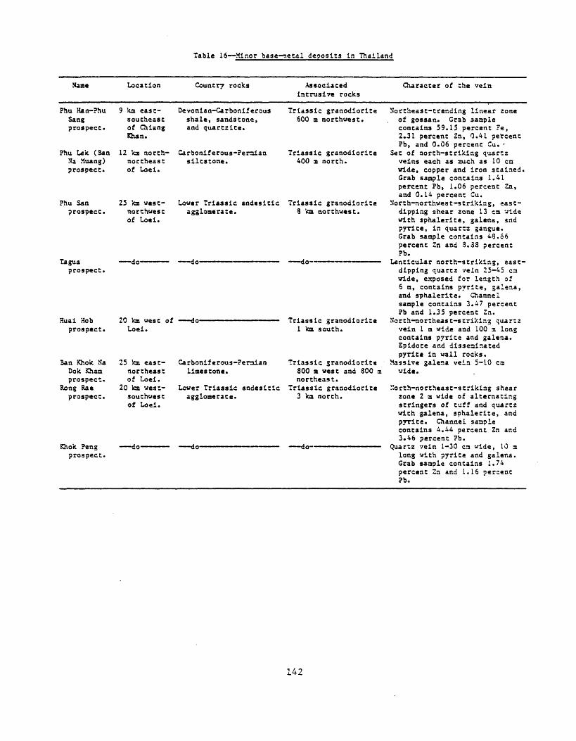
Table 16- Minor base aetal deoosits in Thailand
Name Location Country rocks Associated intrusive rocks
Character of the vein
Phu Han-?hu Sang prospect*
Phu Lek (San Ha Muang) prospect.
Phu San prospect.
Taguaprospecti
Huai Hob prospect.
Ban Khok Sa Dole Khan prospect.
Kong Rae prospect.
Khok Peng prospect.
9 km east- southeast of Chiang Khan.
12 km north- northeast of Loei.
25 ka west- northwest of Loei.
-do-
Devonian-Carboniferous shale, sandstone, and quartzite.
Carboniferous-Peraian siltstone.
Lower Triassic andesitic agglomerate.
Triassic granodiorite 600 a northwest.
Triassic granodiorite 400 a north.
Triassic granodiorite 3 ka northwest.
do-
20 ka west of do- Loei.
25 km east- northeast of Loei.
20 kn vest- southwest of Loei.
Carboniferous-Peraian limestone.
Lower Triassic andesitic agglomerate.
Triassic granodiorite 1 ka south.
Triassic granodiorite 800 m. west and 800 m northeast.
Triassic granodiorite 3 ka north.
Northeast-trending linear zone of gossan. Grab sample contains 59.15 percent Fe, 2.31 percent Zn, 0.41 percent Pb, and 0.06 percent Cu. -
Set of north-striking quartz veins each as much as 10 en vide, copper and iron stained. Grab sample contains 1.41 percent Pb, 1.06 percent Zn, and 0.14 percent Cu.
Morth-northwest-strikiag, east- dipping shear zone 13 cm vide with sphalerite, galena, and p7Tlte, in quartz gangue. Grab sample contains 48.66 percent Zn and 3.38 percent Pb.
Lenticular north-striking, east- dipping quartz vein 25-45 ca vide, exposed for length of 6 m, contains pyrite, galena, and sphalerite. Channel sample contains 3.47 percent Pb and 1.35 percent Zn.
North-northeast-strikir.g quarcz vein 1 m wide and 100 a long contains pyrice and galena. Epidote and disseminated pyrite in wall rocks.
Massive galena vein 5-10 cm vide.
"orth-northeast-striking shear zone 2 m wide of alternating stringers of tuff and quartz with galena, sphalerite, and pyrite. Channel saaple contains 4.44 percent Zn and 3.46 percent Pb.
Quartz vein 1-30 C3 wide, 10 m long vith pyrite and galena. Grab sample contains 1.74 percent Zn and 1.16 percent Pb.
142

quartz float suggests nearby veins at the Ban Pang Hat prospect, Chiang Khong district, Chiang Rai province.
The likelihood of large vein deposits of base metals in Thailand does not seem good. However, some of the copper-bearing veins may be parts of stockwork-type deposits and should be prospected further to evaluate this possibility.
The copper veins near Chan Thuk may be related to the episode of magmatism that saw emplacement of the Triassic granitoid rocks there. Deposits in the vicinity of Phetchabun and closely associated with Cretaceous andesite porphyry may be of stockwork (porphyry-copper) type.
Barite
Vein deposits of barite in Thailand are small. Brown and others (1951, p. 137-138) described veins 20-50 cm wide in the Ban Pin area, 30 km northwest of Uttaradit, that contain minor lead and copper minerals in barite, fluorite, and quartz gangue. The barite is milky white and massive; crystal faces are rare.
Mahawat (written commun., 1972) described barite vein deposits and "cavity fillings" along small structures in Chiang Rai, Mae Hong Son, Chiang Mai, Phrae, Uttaradit, Loei, Tak, and Petchabun provinces in northern Thailand, in Kaeng Krachan, Petburi, Ratburi, and Kanchanaburi provinces in central Thailand, and at Na San, Surat Thani province, and Tha Sala, Nakhon Si Thammarat province, Peninsular Thailand (most localities shown in fig. 13).
At Ban Ti Mon (Mong) Tha, Kanchanaburi province, barite occurs as veins in Upper Ordovician-Silurian shale and soft sandstone overlying sedimentary barite deposits in Middle Ordovician limestone. The veins are 97-98 percent BaSO^ and reserves are estimated to be 110,000-220,000 n.t. (Pitrakul and Tantisukrit, 1973, p. 36-37). These deposits already have been described as related to sedimentary barite deposits. Possibly the vein barite was remobilized from underlying sedimentary barite during a period of metamorphism and igneous intrusion in late Paleozoic or Mesozoic time.
I visited a small vein deposit of barite at Pawoh, Tak province, in January 1974. At Pawoh Paleozoic or Triassic black shale and tan siltstone and sandstone are strongly folded and faulted.. Shale and siltstone have been intensely iron-mineralized, particularly along numerous fractures. A barite vein 1-2 m wide exposed to a depth of perhaps 10 m and for a length of several tens of meters lies along a fault transverse to bedding in the sedimentary rocks. About 2,000 m.t. of barite had been mined and shipped, and a pile of mined barite about 5 X 10 m and 1-2 m high was stockpiled at the deposit which was inactive at the time of my visit. The barite is brecciated in places along the vein. The barite is white and coarsely crytalline; locally it contains small irregular seams 1-3 mm thick of pyrite and dark-brown siderite(?).
Iron
A productive vein deposit of iron at Khao Lek, Tha Sala, Nakorn (Nakhon) Si Thammarat province in Peninsular Thailand has been described by Pitrakul and Tantisukrit (1973, p. 17), Meekul (1964), Namart (1965), and Na Chiangmai (1966). The location (at Tha Sala) is shown in figure 16. The deposit is a
143
veinlike orebody within fractured sandy shale of Silurian-Devonian age. Granite of Cretaceous(?) age is intruded nearby.
The deposit is large compared to most known iron deposits elsewhere in Thailand. Between 1964 and 1971 slightly more than 3,000,000 nut. of iron ore was produced and shipped to Japan. Primary ore averaged 48.8 percent Fe; float ore rained at the surface in the vicinity of the vein ran 64.4 percent Fe. The ore is mainly specular hematite that contains a minor amount of magnetite.
The iron deposit at Khao Lek may be related genetically to nearby granitoid intrusive rocks. This deposit should be studied in detail to provide information from which the potential could be assessed for other similar deposits elsewhere in Thailand.
Gold
Most known deposits of gold in Thailand are placers; these are described in a later section. The placer deposits likely were derived from primary lode deposits, many of which have not been located. A few lode gold deposits are known, at Tha Tako in central Thailand, Krabin in southeastern Thailand, and Toh Moh in southern Peninsular Thailand. Locations of gold deposits are shown in figure 30. The deposits have been described by Brown and others (1951, p. 63-71) and Buravas and Buravas (1941).
The Tha Thako gold deposit lies about 75 km by road north of Khok Samrong, Lop Buri province. It was discovered shortly before about 1890, and it was prospected briefly in about 1910 and again in 1941. Limestone of the Ratburi Group was intruded by quartz monzonite porphyry of Cretaceous- Tertiary(?) age, and later by quartz diorite dikes. According to Brown and others (1951, p. 71) "The gold occurs in quartz-calcite veins, some of which also contain a green calcium garnet. Both white and green veins contain some pyrite. In general, the veins are irregular in size and shape and erratic in content of gold which is reported to range between 2 and 90 grams a ton. The largest vein observed is 6 meters wide and was traced for 200 meters along the strike."
The Krabin (Kabin Buri) gold deposit is at Ban Bo Thong, Prachin Buri province, which I visited in January 1974. It was mined first in about 1880 when rich ore was produced. A second attempt at mining in 1906-16 encountered lower grade ore.
Country rocks are metamorphosed east-striking Paleozoic (probably Silurian-Devonian) sedimentary rocks consisting of quartzite, limestone, and marble, intruded by hornblende diorite porphyry. Quartz, epidote, green garnet, and wollastonite occur in and adjacent in the gold lode. The gold lies mostly along quartzite-marble contacts in the garnet zone. The rock is badly crushed in places along the mineralized zone.
The deposit has been mined at or near the surface for about 100 m along the strike of the beds. Grade was about 5.5 grams per metric ton and decreased with depth. Probably the near-surface material had been secondarily enriched.
144
At the time of my visit the deposit was being drilled by the Department of Mineral Resources. Results were not promising, and further exploration of this deposit does not seem warranted.
The Ban Bo Nang Ching gold deposit lies about 20 km southeast of Sa Kaeo in Prachin Buri province. Alluvial and lode gold both are present. The deposit was reportedly mined about 60 years ago by the French from Indochina. I visited the deposit in January 1974.
The country rocks are Permian limestone and shale intruded by diorite porphyry of unknown age. The diorite porphyry in a waste dump at a prospect shaft about 20 m deep displays a variety of textures. Some angular fragments of coarse-grained porphyry are contained in fine-grained diorite that appears to be flow layered. Some of the igneous rock has the appearance of coarse grained pyroxenite. The diorite commonly is much sheared and altered, and contains abundant chlorite, irregular veinlets of white quartz and calcite, and locally abundant pyrite. A few quartz samples from the dump contain a bright-green (chromium?) mica, pyrite, and dark sulfide or iron oxides.
Several hundred meters east of the shaft a nearly vertical north-striking quartz vein about 2 m wide is exposed. The quartz is mostly massive white bull quartz; some crystal faces are evident in cavities in the bull quartz. Pyrite and chalcopyrite(?) are present in this vein. Gold is found attached to quartz in nearby alluvial deposits, and presumably most of the gold in bedrock is in quartz veins.
The Toh Moh (Waeng) gold deposit lies near the Malaysia border in Narathiwat province. The deposit has been known for a long time, and was mined using primitive methods by Chinese and Thais for many years. Systematic mining by a French company took place from 1936-40.
Country rocks are slate and schist, probably of Silurian-Devonian age as indicated by the geologic .map of Thailand (Javanaphet, 1969). These rocks are intruded at the deposit by a biotite granite stock probably of Cretaceous age. According to Brown and others (1951, p. 71) "Quartz veins are found in both granite and schist, but only a few of these are mineralized." The main quartz lode trends north and dips 20° east; the south part of the lode strikes southwest. A northwesterly fault terminated the lode at its north end. The vein ranges from a few centimeters to 2 m wide. Production of gold during the 5 years of operation was as follows (Brown and others, 1951, p. 63):
Fine ounces of gold
1936 10,3371937 13,7681938 13,6201939 12,7111940 12,303
Total 62,739
The mine was supposedly closed because high-grade ore had been exhausted, although it should be noted that gold mining leases were terminated by the Royal Department of Mines in 1941. We do not known what potential remains in the deposits; it should be further evaluated.
The lode deposits of gold in Thailand have some common features. They are quartz veins or quartz-mineralized rock found in probable Silurian- Devonian quartzite, limestone, slate, and schist, or in Permian limestone and

shale, and in diorite intruded into these rocks. In places granite or quartz diorite is present rather than diorite. Gold deposits in Thailand, including the lode deposits and the placer deposits which have been derived locally from undiscovered lode deposits, and excluding deposits in Peninsular Thailand, form three north-northeast-trending belts (fig. 30). .One belt is in northwestern Thailand, one lies west of the Khorat Plateau in northeastern Thailand, and one is in southeastern Thailand. Probably these belts offer the best promise for discovery of new lode deposits, but such deposits probably would be small, judged from the size of the presently known deposits. The Toh Moh deposit at the south end of Peninsular Thailand has been the only significant gold producer in the country. It is unique in that it is associated with a granitic intrusive. The Toh Moh deposit should be studied to provide a basis for estimating its remaining potential, and for assessing the possibility of similar deposits elsewhere in Thailand.
Qther bedrock deposits
Deposits of some commodities in Thailand are not conveniently grouped with the types of mineral deposits already considered, and they are described together here.
Chromite
A few chromite deposits have been reported in Thailand. They all appear to be of podiform type (Thayer, written commun., 1973) and likely are small. Three deposits have been described in Uttaradit province (N. Angkatavanich, written commun., February 1974). At Charin, Ta Pla (Tha Pa), upper Paleozoic shale and sandstone that have been metamorphosed to phyllite, schist, and quartzite have been intruded by Carboniferous pyroxenite and amphibolite in a north-trending layer. Diorite is also present in the area. Chroraite occurs as a vein in pyroxenite and amphibolite. At Huai Yang, Ta Pla, partly serpentinized perioditite has intruded phyllite, shale, and quartzite. Chromite is found as pockets, lenses, and veinlets in peridotite. At Kao Yiew Wua, Ben Lek, Ta Pla, serpentinite contains veins of quartz and pockets and veins of chromite. The Bukit Malo chromite deposit at Waeng in Narathiwat province, Peninsular Thailand (Suvanasingha, 1963; N. Angkatavanich, written commun., February 1974) is in serpentinized periodotite intruded into upper Paleozoic shaly sandstone. Gabbro is also present. Chromite occurs as pockets in peridotite. Chromium content of soil in the area is about 0.5 percent, and chromium in soil immediately over the deposit runs greater than 2 percent.
Asbestos
Known asbestos deposits in Thailand are in Uttaradit province, associated with mafic and ultraraafic intrusives that are similar to those in the same region that are chromite bearing. Localities are shown in figure 10.
At Mon Kai Chae about 33 km northeast of Uttaradit, 1.5 km north of Hat Ngiu on the Mae Nam Nan river, steeply dipping Silurian-Devonian slate and schist containing thin stringers and lenses of quartz are intruded by dikes, sills, and small plugs of Carboniferous diorite, gabbro, and pyroxenite (Brown and others, 1951, p. 133-135). "The asbestos occurs in irregular

discontinuous veinlets and stringers, 1 to 12 centimeters wide, through serpentinized zones in pyroxenite." In about 1950, the deposit had been only partly developed and I do not know its present status. Asbestos float, mostly of slip-fiber type, has been found throughout an area covering about 5,000 m . During World War II about 60 ra.t. of asbestos was mined and sold to buyers from Bangkok. A chemical analysis of the asbestos (Brown and others, 1951, p. 135) is given below (in percent).
Si02 57.0
Fe2°3"l"A1 2°3 8 * 5
MgO 20.1
CaO 14.0
Ignition loss
Total
The Bo Sam Kha asbestos deposit is about 45 km northeast of Uttaradit, 5 km northwest of Pha Luat on the Mae Nam Nan river (Brown and others, 1951, p. 135-137). In the Pha Luat area interbedded shale, sandstone, slate, quartzite, argillaceous schist, phyllite, and graywacke of Silurian-Devonian age that locally contain thin lenses and stringers of quartz have been intruded by Carboniferous diorite, gabbro, and pyroxenite. The sedimentary strata are folded and sheared. Asbestos occurs in an antigorite serpentine zone in pyroxene and gabbro. Most of the asbestos is cross-fiber type in irregular discontinuous veins a few millimeters to 25 cm wide. Some slip- fiber asbestos fibers along shears in serpentine are as much as 40 cm long. Asbestos-bearing serpentinite crops out in an east-northeast-trencling area about 100 m long and 40 m wide. Some asbestos produced during World War II was marketed in Bangkok.
These two deposits in Uttaradit province, and the ultramafic rocks throughout northwestern Thailand, should be evaluated further for asbestos resources.
Graphite
Brown and others (1951, p. 150-151) reported a deposit of graphite at Khao Phang, Chantaburi province in southeastern Thailand (fig. 10), and noted that other occurrences are known in the country. Khao Phang is about 15 km northwest of Chantaburi, in coarse-grained biotite-muscovite granite of Triassic age. Dark-gray columnar basalt flows of Quaternary age overlie the granite several hundred meters southwest of the graphite deposit. The deposit is in a landslide area in granite (Khao Phang means broken mountain). Graphite is irregularly disseminated through granite in blebs ranging from several millimeters to 20 cm in diameter; hexagonal cross sections of small crystals are visible through a hand lens. The area of graphite-bearing granite is small. In the central part, about 10 m across, granite contains as much as 1 percent graphite, but peripherally the graphite content is much less. Some minor production has occurred. In 1940, about 500 kg of graphite concentrates were marketed in Bangkok. The origin of the graphite at Khao Phang is not known. Possibly the graphite formed from conversion in a reducing environment of a carbon-rich sedimentary rock (coal?) incorporated in the granite during intrusion.
I observed graphite in shaly rocks in the contact of a granite intrusive at the Liang Ngiab scheelite mine near Doi Mok, Chiang Rai province, northwestern Thailand, but I do not known how extensive this deposit is. The graphite probably formed through contact netaraorphism of carbon-rich shale. Other occurrences have been reported (Japakaset, written cqramun., 1965) near Cha Wang in Nakhon Si Thammarat province and near Pranburi in Prachuap Khiri Khan province.
Quartz and feldspar
Silica sand, quartz, and feldspar are abundant in places in Thailand, and locally have been mined, or offer substantial resources for future development. Locations of deposits are shown in figure 31.
Brown and others (1951, p. 153) reported that "Small quantities of vein quartz, quartz sand, flint, and feldspar are used in the glass and ceramic industries in Thailand. Of some interest is the use of burned rice husks, containing 80-95 percent of silica, in the manufacture of ceramic glazes. The material is abundant and cheap and does not require grinding."
Analyses of silica materials of Thailand from Brown and others (1951, p. 153) are given in table 17 (in percent).
Orthoclase feldspar has been produced from porphyritic granite and pegmatite at two localities near Khao Phra Bat, Chon Buri province, and is known at Tha Di, Nakhon Si Thammarat province.
Pitrakul and Tantisukrit (1973, p. 39-40) reported a productive feldspar deposit in the Chom Bung district, Ratburi province, and other deposits are known at Ban Lat Ya, Muang, Kanchanaburi province. The Muang district, Tak province, is in porphyritic leucogranite. Other feldpar deposits have been reported in Prachuap Khiri Khan province.
According to Pitrakul and Tantisukrit (1973, p. 39-40) silica sand deposits near Khao Kao Seng in Songkhla province produce more than 50,000 tons per year for domestic glass factories. Large resources of high grade silica also are known along the beaches of Nakhon Si Thammarat and Pattani provinces, Ko Tarutao in Satun province, and in Trang and Prachuap Khiri Khan provinces. The best quality silica sand reported in Thailand is in the Laem Mae Pirn deposit, Klaeng, Rayong province, now being used in domestic glass factories. Hughes and Bateson (1967, p. 19) reported sharply angular, medium- to fine-grained sand containing very little feldspar and iron minerals in the vicinity of Chantaburi.
Clay
Among clay deposits in bedrock in Thailand are those composed of kaolinite that are probably the result of hydrothermal alteration of granite in or near tin deposits, the Changok dickite-kaolinite deposit in rhyolite volcanic rocks, and the Pang Ka kaolinite deposit in a rhyolite intrusive. The kaolinite deposits associated with tin deposits occur widely in granites of Carboniferous, Permian, Triassic, Jurassic, Cretaceous, and Tertiary ages throughout Thailand; not all of these are minable. These kaolinite deposits have been considered to be the product of weathering of granite (for example, Brown and others, 1951, p. 141-142) but I believe, as did Aranyakanon (1969), that they resulted from the hydrothermal alteration of granite that accompanied formation of the tin deposits. The kaolinite deposits are similar to those that are associated with the tin deposits of Cornwall, England, and that are mined as high quality china clay. A number of kaolinite deposits
148
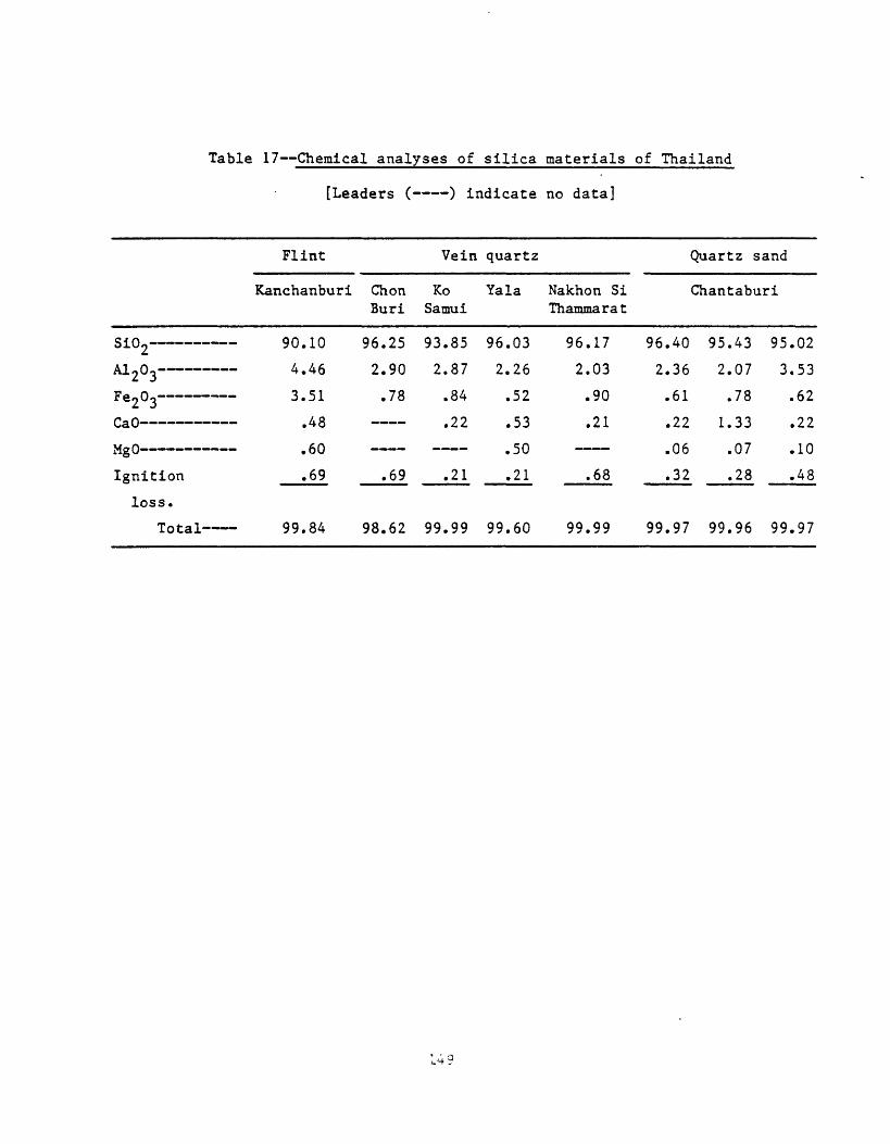
Table 17 Chemical analyses of silica materials of Thailand
[Leaders ( ) indicate no data]
Flint Vein quartz Quartz sand
Kanchanburi Chon Ko Yala Nakhon Si Chantaburi Buri Samui Thammarat
Si02
A i n _________AJ.rtUo
Fe203
CaO
v«. n___________rig U - - - --
Ignition
loss.Total
90.10
L AfiH HO
3.51
.48
.60
.69
99.84
96.259 onJ. 7U
.78
.69
98.62
93.85o 07L . o /
.84
.22
.21
99.99
96.03
2 O £ Zo
.52
.53
.50
.21
99.60
96.179 rns- U J
.90
.21
.68
99.99
96.40
2 T A JO
.61
.22
.06
.32
99.97
95.43? 07i- . \j i
.78
1.33
.07
.28
99.96
95.02^ s^j j j.62
.22
.10
.48
99.97

have been mined in the vicinity of tin deposit in Cretaceous granite in Peninsular Thailand. I saw kaolinite mines at Haad Som Pan near Ranong, and at Thung Kam south of Haad Som Pan in February 1974. At Thung Kam pulverulent strongly altered cassiterite-bearing granite was being hydraulicked and pumped by a gravel pump into sluices to recover the cassiterite. The water was then directed into settling tanks in which the kaolinite was collected.
The Changok dickite-kaolinite deposit is in Permian-Triassic rhyolitic rocks about 12 km north-northwest of Nakhon Nayok in Nakhon Nayok province (Hinthong, 1973). I visited the deposit in December 1973 and again in January 1974. The deposit is in layered volcanic rocks perhaps a few hundred meters thick that form cliffs west of the mine. The rhyolite although strongly altered locally shows residual flow layering and fragmental zones that nay be auto-brecciated flow rock. The deposit is irregular in shape but may be localized along a fault or fracture zone. I do not know the size of the Changok clay deposit but it appears to extend for a few hundred meters along the cliffs. Three grades (A, B, and C) are rained; grade C has a high silica content and has been used as a silica substitute. The better A and B grades have been used mostly for the manufacture of ceramics. Some high-grade dickite-kaolinite rock has been used in a manner similar to soapstone for carving bowls and other decorative pieces. Dickite is the principal clay mineral and kaolinite is present in lesser amounts. Pyrite and iron oxide stain probably from oxidized iron sulfide minerals are present locally. Some clay-rich rock shows molds of weathered-out, radiating, prismatic crystals, possibly stibnite. I believe the dickite-kaolinite deposit at Changok is of hydrothermal origin.
At the Pang Ka kaolinite deposit 27 km north of Lampang that I visited in January 1974, rhyolite of Tertiary(?) age which forms a body about 1.5 km long has intruded Triassic siltstone, sandstone, and shale (Piyasin, written comraun., 1971). In the vicinity of the intrusive the wall rocks in places are strongly iron mineralized and veined with small veinlets of quartz; kaolinite formed locally in the wall rocks. The deposit contains probably more than 1 million m.t. of kaolinite in large patches that are developed within the rhyolite intrusive. ^2°3 concent is about 17 percent, and with beneficiation is upgraded to 22-25 percent (P. Wasuvanich, oral commun., January 1974). The kaolinite is used for ceramics in Lampang and in Bangkok.
The Pang Ka kaolinite deposit like the Changok deposit is probably of hydrothermal origin; geochemical prospecting in the vicinity of both deposits might be worthwhile to test for anomalous metal concentrations.
Uranium
Thailand has some small uranium-bearing deposits, and some geologic environments favorable for uranium in which uranium minerals are not presently known to occur. The following descriptions are of a variety of known deposits and possibly favorable environments in which uranium deposits might be found. Uranium-copper deposits in Mesozoic sandstone on the Khorat Plateau have already been described.
Lignite deposits in Thailand should be examined for uranium content. Radioactivity of lignite ash at the electric powerplant in north Bangkok has already been recognized (Akanit Suwanasing, oral coramun., December 1973), Tertiary lignite deposits in the United States and others areas of the world contain significant amount of uranium, locally as much as about 0.01-0.03
percent but averaging lower; the ash of these lignites contains as much as 0.1-0.3 percent uranium (Denson and others, 1959; Pipiringos, 1961). Whereas the lignites in the United States are too low in grade for profitable extraction of uranium, extraction of uranium from the ash of lignite might be feasible if large amounts of lignite were used as fuel. Availability of better-grade coal precludes this for the time being in the United States. In Thailand, however, use of appreciable lignite as fuel provides a sizable amount of ash from which uranium might be profitably extracted if it is present in the ash in sufficient amount. For example, the Mae Moh lignite deposit in northwestern Thailand (Gardner, 1967c) contains more than 100 million tons of measured, indicated, and inferred reserves of lignite that consists of 9-15 percent ash.
Alkalic and granitic igneous rocks around the world, many with associated carbonatite complexes, commonly are the locales for deposits of uranium and thorium minerals as well as of rare-earth and niobium minerals. Most of these complexes have been intruded into Precarabrian continental crust (and in places into younger overlying rocks), and it is therefore likely that such alkalic igneous centers may be found in Thailand. Some granitic rocks such as the Conway Granite in the northeastern United States contain abundant disseminated uranium and thorium minerals, and veins containing uranium or thorium minerals are associated with certain granitic and alkalic rocks in the northwestern United States and in the Rocky Mountains of the United States. In northern Australia, uranium lodes in basalt interlayered in late Precambrian sedimentary rocks are associated with cassiterite-bearing granite (Newton and McGrath, 1958, p. 177-188). Such deposits may be present in Thailand. For example, torbernite with samarskite, pyrochlore, euxenite, and tungsten minerals disseminated and in vein deposits in granite near Tung Pho and Na Muang (Haad Yai, Yib In Soy tin mine), and Tung Kamin, Songkhla, Peninsular Thailand, has been reported (Payome Aranyakanon, oral and written communs., December 1973; Masao Sagawa, oral comraun., November 1973); and torbernite with samarskite, pyrochlore, and euxenite occurs disseminated with cassiterite in altered granite at Khun Thong Lang mine in Na Som district, Surat Thani province (Payome Aranyakanon, written coramun., December 1973). Also, an airborne radiometric survey carried out southeast of Prachin Buri in southeastern Thailand revealed anomalous radioactivity in the vicinity of Triassic granite; the nature of the deposit has not been fully evaluated (Akanit Suwanasing, written commun., December 1973). Monazite is found in granite gneiss at Hua Hin, Prachuab Khiri Khan (Payome Aranyakanon, written coramun., December 1973).
Studies by the Department of Mineral Resources reported by Kaewbaidhoon (1963) indicated that rock samples containing more than 500 parts per million uranium (maximum 2,540 ppm, which in some circumstances constitutes material of economic grade) were collected in the provinces of Yala, Uthai Thani, and Songkhla. Stream waters containing more than 1 ppb uranium were collected in the provinces of Nakhon Sawan, Chachoengsao, Songkhla, and Yala. These data suggest that the region surrounding the priorite occurrence at Bang Bung west of Uthai Thani and the torbernite occurrences near Songkhla are indeed uranium provinces and warrant further attention as regions containing possible uranium resources.
Uranium and thorium minerals are associated with cassiterite in primary deposits in granite in many parts of Thailand, as already indicated elsewhere in this report.

Although uranium is not known to occur in significant amounts with any of the fluorite deposits known in Thailand, it is associated with a few fluorite deposits elsewhere in the world. For example, at Spor Mountain, Utah, United States, small amount of uranium (not economically recoverable) occur in fluorspar pipes in Paleozoic carbonate rocks in the vicinity of Tertiary volcanic flows and small intrusions. Close by, a uranium deposit in Tertiary volcanic-sedimentary rocks has produced about 100,000 tons of ore grading about 0.2 percent U^Og. Similar deposits may be present in Thailand. Fluorite ores produced from mines in Thailand should be analyzed for uranium content. If anomalous amount of uranium are found, the geologic environs of the uranium-bearing mines should be examined for possible uranium deposits.
The extent of possible occurrence of uranium in black shale and sedimentary phosphate rocks in Thailand is unknown, but the presence of appreciable uranium in such rocks in certain places throughout the world makes a long-term search for these geological formations worthwhile. Uranium in black shale such as the late Paleozoic Chattanooga Shale in the Eastern United States is low in grade, but the lateral extent of the deposit is so large that the resources of uranium therein are of great magnitude. They are not economically extractable at present. Uranium occurs in low but significant amounts in sedimentary phosphate rock of late Paleozoic age in the phosphate field of Wyoming, Idaho, Montana, and Utah, Western United States, along with substantial amounts of other metals and fluorine. At present the rock is mined chiefly as fertilizer, but consideration has been given to extracting byproduct fluorine, uranium, and other metals during processing for commercial use. Airborne radiometric surveys would be valuable in locating deposits of uranium in black shale and phosphate rock in Thailand if they are present.
Residual deposits
A variety of mineral commodities in Thailand form deposits that are residual accumulations. Some of these may have had rather complex origins and in part at least have been transported into their present positions.
Nickel
Nickeliferous laterite at Ban Tha Kradan Nok, Srimahapo, Prachin Buri province, has been described by Suwanasing (written communs., 1971; 1972). Country rocks in the area are Silurian-Devonian recrystallized chert and quartz-sericite-magnetite rocks, and carbonaceous limestone. Granite bodies and ultramafic igneous dikes of Carboniferous(?) age have been intruded into the sedimentary rocks. Weathering of serpentinized ultramafic dikes has resulted in some concentration of nickel.
At Ban Tha Kradan Nok serpentinite containing an average of 0.06 NiO is overlain by weathered serpentinite 1-8 ra thick containing an average of 0.33 percent NiO. The weathered serpentinite is in turn overlain by about 5-8 in of lateritic soil that contains an average of 0.066 percent NiO.
Chemical analyses of serpentinite and weathered serpentinite given by Suwanasing (1972) are shown in table 18 (in percent).
Suwanasing (1972) did not give totals for these analyses; I do not know why the totals that are shown here are low. Nockold's (1954) average peridotite (23 samples) and average dunite (9 samples) are given in the last two columns of table 13 for comparison. These average compositions suggest
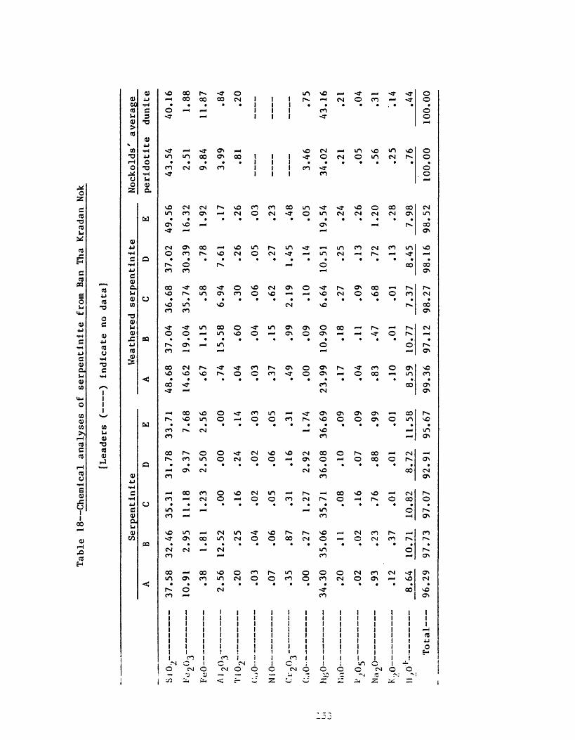
Table
18 Chemical analyses of
serpentinite fr
om Ba
n Tha
Krad
an No
k
[Lea
ders
( )
indicate no da
ta]
Serp
enti
nite
iix >
t\ _
AJ90
3
i' i
f\
_
/ A -
-i _ .
NiO
ct-2o
3
C.iO
-
MfcO
-
UnO-
l» n
2°
5
Ma20
V A
_<^-)\J
M(\l~
A
07 CQ
10.9
1
O Q
- -
.38
2C f
- -
90
£-\J
01
\j j
.07
- 15 j j
.00
*\ /
*\ f\
34.3
0
90
/.u
O9
- <n . y ~j 1 O
1
i.
8.64
B
32.4
6
2.95
1.81
12.5
2
.25
.04
.06
.87
.27
35.0
6
.11
.02
.23
.37
10.7
1
C
35.3
1
11.1
8
1.23
.00
.16
.02
.05
.31
1.27
35.7
1
.08
.16
.76
.01
10.8
2
D
31.78
9.37
2.50
.00
.24
.02
.06
.16
2.92
36.08
.10
.07
.88
.01
8.72
E
33.71
7.68
2.56
.00
.14
.03
.05
.31
1.74
36.69
.09
.09
.99
.01
11.58
Weat
here
d serpentinite
A
48.68
14.6
2
.67
.74
.04
.03
.37
.49
.00
23.99
.17
.04
.83
.10
8.59
B
37.04
19.04
1.15
15.5
8
.60
.04
.15
.99
.09
10.90
.18
.11
.47
.01
10.7
7
C
36.68
35.7
4
.58
6.94
.30
.06
.62
2.19
.10
6.64
.27
.09
.68
.01
7.37
D
37.0
2
30.39
.78
7.61
.26
.05
.27
1.45
.14
10.5
1
.25
.13
.72
.13
8.45
E
49.56
16.3
2
1.92
.17
.26
.03
.23
.48
.05
19.5
4
.24
.26
1.20
.28
7.98
Nockolds'
average
peri
doti
te
43.54
2.51
9.84
3.99
.81
3.46
34.0
2
.21
.05
.56
.25
.76
dunl
te
40.16
1.88
11.8
7
.84
.20
.75
43.16
.21
.04
.31
.14
.44
Total
96.2
9 97
.73
97.0
7 92
.91
95.6
7 99
.36
97.12
98.2
7 98
.16
98.52
100.
0010
0.00

that the serpentinite at Ban Tha Kradan Nok may have been derived from olivine-rich peridotite.
Pitrakul and Tantisukrit (1973, p. 26), quoting Pungrassami and Supalak (1970), described a nickeliferous soil over serpentinite at Ban Ragara, Pong Nam Pon, Chantaburi province. There, interbedded tuffaceous sandstone, siltstone, mudstone, and chert of Devonian-Carboniferous(?) age have been slightly metamorphosed (in part to calc-silicate hornfels) and intruded by Triassic granite and post-Traissic(?) serpentinite. The nickel-bearing serpentinite crops out in a narrow and flat area of about 45 m The serpentinite at and near the surface, as determined by a magnetic survey, is about 200 m wide and 400 m long and is elongated northeast. Grade of the deposit was not given by Pitrakul and Tantisukrit (1973). The serpentinite is probably derived from peridotite.
The ultramafic rocks and associated lateritic soils in the east part of northwestern Thailand should be investigated for nickel content.
Iron
Lateritic or residual iron deposits are widespread in Thailand but none has had more than small production. The laterites form a surficial blanket on many types of bedrock (Brown and others, 1951, p. 72-76). According to Brown and others (1951, p. 72) "Limonite occurs as small rounded pellets, generally less than 1 centimeter in diameter in the residual soil. In places the pellets are cemented into lateritic masses that have long been used as building stone. In the past, such deposits have furnished iron ore for reduction in primitive furnaces to supply iron for fashioning simple tools. Characteristically, the iron content of lateritic ores depends upon the admixture of clayey or sandy material. Generally these ores contain 0.2 percent or more phosphorous pentoxide. Some of the pellets are magnetic."
Brown and others (1951, p. 73) reported lateritic iron deposits at Muang, Uttaradit province; at Khao Phang, Sichol, Nakhon Si Thammarat province; at Ban Wang, Muang, Phatthalung province; at Koh Cham, Koh Lanta, Krabi province; and at Koh Libong, Kantang, Trang province. The Bo Dam lateritic iron deposit about 15 km west-southwest of Ban Pin station, Phrae province has produced a small amount of iron ore.
According to Brown and others (1951, p. 74) the Bo Dam area is underlain by strongly folded yellowish-green and gray shale and slaty shale and yellowish-brown sandstone, probably of Carboniferous or Permian age judged from the geologic map of Javanaphet (1969). The deposit occurs on a nearly horizontal bench that is probably a remnant erosional surface lying 45-55 m above the Mae Nam Yom River. The deposit is spongy textured, mottled yellowish brown to black, and contains numerous interconnected tubular openings lined with colloform yellowish- to dark-brown goethite. Between the tubular openings are thin bands of finely crystalline hematite and small pockets of yellowish-brown earthy limonite. Analyses of two grab samples from the deposit are given as follows:
154

Sample 1 Sample 2
Hygroscopic moisture
Loss of ignition
Si°2
A1 203
Fe2°3
MnO
?2o5Total
10.36
10.35
4.50
71.83
2.90
.28
100.22
1.13
9.07
13.63
4.96
71.23
.07
.20
100.29
Brown and others (1951, p. 76) reported 51,000 ra.t. of probable iron ore reserves at Bo Dam.
A large tonnage of residual iron ore at Khao Thab Kwai 20 kin north of Lop Buri has already been referred to under the description of the associated primary replacement deposit.
Jacobson and others (1969, p. 40-58) reported numerous residual deposits of iron in the Chiang Karn-Loei area of northeastern Thailand. Most of these consist of boulders of massive hematite, magnetite, and other iron minerals, and iron-oxide impregnated rocks, in lateritic soil. Some of these are associated with known primary iron deposits. The residual deposits are the Pone Bak Thek prospect, Phu Lek (Chiang Karn) deposit, Phu Yang deposit, Phu Hia deposit, Phu Lek (Ban That) prospect, Phu Noi prospect, Phu Luak prospect, Phu Ang deposit, Pa Pao prospect, Phu Tai Mai prospect, Phu Khok-Phu Khum Thong prospect, Phu Din Baw Eelert prospect, and Phu Phun prospect.
No doubt similar residual deposits of iron-mineral boulders in laterite occur at many of the primary iron ore deposits throughout Thailand.
'Manganese
Residual deposits of manganese similar to the residual deposit of iron are widespread in Thailand. Brown and others (1951, p. 89) stated that these resulted mostly from the leaching of older manganiferous sedimentary rocks and redeposition and concentration of manganese oxides near the surface, especially in the littoral zone of the Gulf of Thailand. Such littoral zone deposits occur at Kai Thi Point, Sadao Beach, Ta Eng Beach, and Phudsa Wan Bay on Ko Kram Island, Chon Buri province. Others are known on the coast near Patiu (Bang Son), Chumphon province, and on Ko Lan Island, Chon Buri province. Production has been small from all of these.
Damrongmanee (1963) reported a residual deposit of battery-grade manganese oxide at Ban Mae Jong, Li, Lamphun province. Gardner and others (1965) described the deposit in detail. Silurian shale and limestone have been converted at the surface to laterite that contains psiloraelane and pyrolusite in a blanket 1-18 m thick. The blanket covers an area 300 x 400 m. Gardner and others (1965, p. 25) reported reserves containing 50 percent Mn02 of 82,750 m.t., reserves containing 40 percent Mn02 of 166,750 m.t., and
O J
reserves containing 25 percent Mn02 of 290,400 m.t. The richest ore is in a large nearly vertical "crevice" as much as 20 m wide, of unknown depth. The ore in the crevice is porous, and water drains through it quickly, indicating an efficient subsurface drainage system.
Analyses of 11 samples of manganese ore from the Ban Mae Jong deposit (Gardner and others, 1965, p. 22) are given in table 19 (in percent).
An additional 11 samples of manganese ore from the deposit also have been analyzed (Gardner and others, 1965, p. 23) as indicated in table 20 (in percent).
Gardner and others (1965, p. 41) also noted the occurrence of a large residual deposit of manganese 20-30 km west of Mae Taeng (Tang) near Pa Pae Creek northwest of Chiang Mai. I visited the Mae Taeng deposit in January 1974. The deposit overlies shale, siltstone, and sandstone of Carboniferous age in a blanket that covers the flat top of a hill, probably the remnant of an old erosion surface. The blanket extends about 3 km east-west and more than 500 m north-south and has a maximum thickness of about 6 m. Manganese oxide occurs as fragments and boulders in a matrix of iron-rich soil. Manganese oxide also can be seen where it has replaced shale and siltstone layers in bedrock. The deposit is of low grade and is marginal. Production at the time of my visit was about 1,500 m.t. of concentrate per month for use as ferroraanganese. The compositions of 10 samples of ore range as follows, in percent: Mn0 2 , 46-76; Mn, 32-53; Si0 2 , 0.4-28; S, 0.1-4; Fe, 1.7-8.5; P, 0.1- 0.23; Cu, 0.01-0.03; Zn, 0.02-0.04; Co, 0.01-0.87; Ni, 0.01-0.03; and A1 203 , 1.2-7.5 (data from Thai Department of Mineral Resources).
Additional residual deposits of manganese oxide, in Lamphun province, northwestern Thailand, reported by Gardner and others (1965, p. 40-43) are at Mae Tha 1 km south of the junction of the Lamphun-Lampang highway and the State Railway; 3.5 km east of Ban Huai Khan; at Ban Wang Luang on the east side of the Li River Valley; at Ban Mae Thoei along the east base of Doi Tan Mountain; at Ben Huai Sala on the lower slope of Doi Tan Mountain 1 km west of the Li River; about 1 km west of Ban Huai Hae; and about 2 km west of Ban Pa Chi which is 3 km north of Li.
Fluorspar
Residual deposits of fluorspar are probably associated with most of the bedrock deposits of fluorspar in Thailand. Some are virtually in place whereas others have been more or less transported downslope from their bedrock origins. Most are not of minable grade.
Wanavanich (written coramun., 1970) reported float fluorspar ore in the vicinity of the Huai San fissure vein deposit in Chiang Mai province. At Salak Phra in Kanchanaburi province residual gravel-spar has been rained on the slopes below outcrops of lode fluorite. Fragments 1-5 cm in diameter are found embedded in reddish-brown clay soil (Potisat, written coramun., 1973). At Khao Mae Wong, Kanchanaburi province, boulders and other fragments of fluorspar and chalcedony lie along the tops of small hills, probably overlying veins in bedrock. Nearby at Khao Ong Khong, fluorite fragments occur at the surface along the contact of yellowish-brown shale and well-bedded limestone (Potisat, written commun., 1973). Float ores of fluorspar and barite are found at Khlong Thorn, Krabi province (Angkatavanich, written coraraun., 1974, p. 93).
According to Pitrakul and Tantisukrit (1973, p. 30) the Pa Sang deposit at Ban Ma Kok, Lamphun province, consists-of transported fragments of fiuorits
156

Table 19 Chemical analyses of samples of manganese ore from
the Ban Mae Jong deposit, in percent
[Leaders ( ) indicate no data; trace (Tr.)]
Sample
1
2
3
4
5
6
7
8
9
10
11
Fe
9.18
6.50
7.45
9.36
11.15
5.54
10.41
7.39
17.00
5.05
3.82
Mn02
56.55
60.81
47.60
27.61
44.22
63.31
53.88
31.61
22.19
63.67___
Mn Si02
35.89
39.52
31.00
19.58
29.37
44.96
34.81
21.03
17.04
42.06 2.26
22.48 1.58
S A1 9 0^ P Cu£ -J
0.018 2.11 0.071 Tr.
.019 2.14 .094 Tr.

Table
20 Additional ch
emic
al analyst
of samples
of manganese
ore
from
the
Ban
Mae
Jong
oo
depo
sit,
in
1 rc
ent,
an
d
[Tra
ce
Sample 1 2 3 A 5 6 7 8 9 10 11
Mn02
65.10
74.7
771
.51
81.9
469
.01
68.0
3
65.1
061
.62
65.2
167
.05
67.2
7
Mn 46.6
051
.56
49.1
754
.45
48.2
547
.03
45.6
443
.29
45.4
846
.86
47.4
0
S102
1.64
1.16
1.50
2.84
1.76
2.96
5.30
3.76
2.80
4.20
1.76
A120
3
3.38
2.11
2.43
1.83
2.61
2.57
3.34
3.00
2.94
2.81
3.05
I 2o
3
.26
.79
.11
.27
.32
.99
.06
1 .74
.10
.39
.19
CaO
0.34 .86
.69
.40
.63
.11
.29
.57
.57
.63
.57
descriptions of
sa
mple
s
(Tr.)]
MgO
0.62 .45
.49
.29
.47
.60
.23
.72
.66
.45
.57
1
BaO
2.32
1.56
1.97 .46
2.37
2.52
1.51
2.29
2.46
2.26
1.84
P
0.044
.053
.046
.059
.041
.059
.057
.080
.048
.054
.062
PbO
0.055
.045
.046
.055
.028
.037
.048
.027
.023
.031
.040
NiO
0.07 .10
.15
.23
.17
.10
.11
.08
1.10 .20
.10
S
Tr.
Tr.
Tr.
Tr.
Tr.
Tr.
Tr.
Tr.
Tr.
Tr.
Tr.
CuO
Tr.
Tr.
Tr.
Tr.
Tr.
Tr.
Tr.
Tr.
Tr.
Tr.
Tr.
CoO
Tr.
Tr.
Tr.
Tr.
Tr.
Tr.
Tr.
Tr.
Tr.
Tr.
Tr.
'Samples are
iden
tifi
ed as
fo
lio
s:
1.
Wash
ed un
sort
ed or
e (
-50
mm)
2.
Batt
ery-
grad
e ore, ha dpicked
(plu
s 1
cm)
3.
Batt
ery-
grad
e ore, sm
11
size (0
.5-1
cm
)4.
Ch
emic
al-g
rade
or
e (p
us
1 cm)
5.
Meta
llur
gica
l-grade
o e
(plu
s 1 cm)
6.
Metallurgical-grade
o u
(0.5-1 cm).
7.
Meta
llur
gica
l-gr
ade
o e
(min
us 0.5
cm)
8.
Meta
llur
gica
l-gr
ade
1 mp
or
e9.
Metallurgical-grade
1 mp
ore
10.
Meta
llur
gica
l-gr
ade
s all
size ore
11.
Meta
llur
gica
l-gr
ade
s ill
size
or
e
in various sizes, from pebble to boulder, scattered randomly over a plain near a small hill. The fluoritic gravels contain clasts of limestone and quartzite and are overlain by 5 m of lateritic soil. The Ban Mae Kaeng and Mae Theon mines at Theon, Lampang province are in deposits of transported fluorite. At Ban Kaeng country rocks in the vicinity are slate, phyllite, and granite. At Mae Theon transported fluorite fragments occur in holes in gray limestone on the top and slope of a hill. Calcite and fluorite veinlets are found in fractures in the limestone.
Bauxite
Bauxite deposits might be expected in Thailand in view of the intense tropical weathering of rocks that has occurred in the country. I know of no published reports that record any descriptions of such deposits however. According to Masao Sagawa (oral coramun., November 1973) bauxite is known just east of Prachinburi in southeastern Thailand. There bauxite appears to have formed from the weathering of volcanic rocks. This area and others in Thailand should be evaluated for possible economic deposits of bauxite.
Clay
Clay deposits of residual and transported origin are widespread in Thailand. According to Brown and others (1951, p. 141) "The principal clay products in Thailand are common bricks and household utensils of fired red and brown clays. Because these products are so common to everyday life, it is not generally realized that domestic clay is one of the principal mineral commodities of the country * * * Because of the wide distribution and generally small size of individual brick and pottery works, no statistics have been kept on either the quantity of clay that is rained each year or the value of manufactured clay products."
Brown and others (1951, p. 141) reported further that "Blackish, plastic transported clay is found throughout the great central plain of the Chao Phraya River. Much clay is mined and processed in Nonthaburi and brought 10 kilometers downstream to Bangkok by boat. The layer of topsoil, generally about 1 meter thick, is stripped to expose the clay. The top of the clay bed is usually of a quality suited for common brick. Finer clays, which lie deeper below the topoil,x52are used for crude products such as water jars, basins, stoves, and flower pots." Probably the transported clays have been additionally weathered in place and thus are in part of residual origin.
According to Pitrakul and Tantisukrit (1973, p. 37) the kaolin deposit at Sawankhalok, Sukhothai province, appears to be bedded clay. Kaolin beds are also reported from Chonburi and Chantaburi provinces, and a bed of white shale occurs in the Khorat Group at Thung Plong village opposit Ko Kram Island, Surat Thani(?) province.
In December 1973 and again in January 1974, I visited the Khok Mai Lai kaolinite deposits about 10 km southeast of Nakhon Nayok, Nakhon Nayok province. Three types of clays are found in this area. "Yellow clay" consisting of kaolinite and dickite and containing sand grains is used as fire clay. The clay is about 2 m thick overlying weathered schist and is faintly layered as though water laid. Probably it is a weathered transported deposit.
"Gray clay" in the area forms a layer about 30 cm thick at the surface in a flat area of rice fields. The clay is worked only from January to May when
159
rice is not being grown on the land. Organic material imparts the gray color and the clay turns white upon firing. The gray clay layer covers an area about 7 km long. It is underlain by an earth layer which in turn is underlain by a layer of "white clay" (kaolinite) resting on schist. The clays apparently have developed as a result of tropical weathering of material washed from the low hills to the north.
A deposit of the white clay that is being rained near Khok Mai Lai is as much as 10 m thick below a layer of surficial material a few meters thick. The white kaolinite clay forms an extensive layer of good quality that covers several square kilometers.
Puengrusami (written coramun., 1972) quoted by Pitrakul and Tantisukrit (1973, p. 39) described clay reserves in Thailand as follows:
Locality Reserves m.t.
Kaolin
Chae Horn, Lanpang province More than 100 millionMuang, Uttaradit province 73 millionMuang, Ranong province 500,000Na San, Surat Thani province 1 millionKlaeng, Rayong province 30,000
Ball Clay
Na San, Surat Thani province More than 200,000 Ban Song, Surat Thani province More than 40,000 Muang, Prachinburi province 40,000 (black clay)
More than 4 million (white clay)
Placer deposits
Tin and tungsten
Most of the tin production of Thailand has come from placer deposits. Cassiterite is virtually the only tin mineral present in the placers. Tungsten has been recovered from many of the tin placers, largely as wolframite and rarely as scheelite. Other heavy minerals are present but generally none of these has had any economic significance.
Brown and others (1951, p. 116-120) have given a history of tin placer operations in Thailand from earliest days of mining until about 1950. The following paragraphs are taken from that account.
Chinese probably were the first tin miners in Thailand, working placer deposits in Peninsular Thailand several centuries ago. The Portuguese negotiated trade treaties with Thailand as early as 1511, and tin was likely an item of trade. Tin mines were operating at Phuket on the Peninsula in the period 1583-92. In 1906, a continuous bucket dredge started recovering tin from the floor of Thung Kha harbor, Phuket.
When dredging started at Phuket, "most of the dredging companies were Australian and British, though a few dredges were built by other European
160

nationals and Chinese. In 1941, at the time of the Japanese invasion of Thailand, 39 dredges were operating; they produced 62.6 percent of the tin mined that year. During the war most of the dredges were stopped for lack of fuel or repair parts, and in 1946 the operating dredges produced only 6.0 percent of the tin mined. Since then many of the dredges have been repaired with funds provided by the Government of Thailand in payment for war damage and early in 1950, 32 dredges were in service" (Brown and others, 1951, p. 117).
Only one of the dredges that was operating in 1950 was working offshore deposits in Thung Kha harbor. The others were operating in well-defined stream channels and adjacent eluvium on land. At that time ground containing at least 0.25 Ib of cassiterite per cubic yard was profitable to dredge. When I visited the tin districts of Peninsular Thailand in late 1973 and early 1974, several offshore dredges were in operation in addition to those operating on the land.
"Placer deposits too small or too inaccessible for dredging are worked by gravel pumping. In 1941 there were 61 gravel pump mines being worked in Southern Thailand, and in 1949 there were 44 which yielded 22.13 percent of the tin mined that year" (Brown and others, 1951, p. 117-118).
"Many of the mines are working eluvial material which is generally broken by means of hydraulic giants, supplemented by ground sluicing during the rainy season, and washed to the gravel sump where it is elevated to palong washers, which employ an intermittent surging of water through the sluice to separate the tin" (Brown and others, 1951, p. 118).
"The relation of veins containing tin to the overlying eluvial material is best shown on the floor of the gravel pump mines. Rich streaks in the eluvium were found to overlie wide quartz veins containing cassiterite at two gravel mines on Phuket Island.
"Unit mining costs are higher in gravel pump mining than in dredging. Several operators estimated that to mine profitably in early 1950 they would have to recover 0.5 to 0.62 pound * * * of casserite per cubic yard of ground" (Brown and other, 1951, p. 118-120).
According to Brown and others (1951, p. 120) "Most of the hydraulic mines in south Thailand are working hillside eluvium at or near a contact with granite.* * * Hydraulic mining is possible where the working face is high enough on a hillside to permit proper slope in the sluices through which the material is removed, and adequate disposal of tailings * * * In 1949, hydraulic mines yielded 1.7 percent of the tin production of Thailand."
The following brief summary of placer tin deposits is taken from Pitrakul and Tantisukrit (1973, p. 3-10) and from Aranyakanon and others (written commun., 1969). In northwestern Thailand placer deposits are commonly found in small alluvial plain and basins within the granite ranges. The deposits are generally smaller than those in Peninsular Thailand, possibly because of steep mountainous terrain and less intense weathering conditions in northwestern Thailand. Cassiterite-bearing placers in northwestern Thailand are found at the Jae Son prospect, Jae Horn, Lampang province, and at the contact between Paleozoic metamorphic rocks and Triassic(?) granite of the Khuntan range, Hang Chat, Lampang province, where scheelite is also present.
Brown and others (1951) reported small tin placer deposits along a 16 km strip adjacent to the Burmese border in Chom Bung, Ratchaburi province, in west-central Thailand. Veeraburus (1967) noted that most of these deposits are at Suan Pung, along the Lam Pa Chi River and tributaries.
161
In southeastern Thailand tin placers are known at Ban Kai, Rayong province, and at Kahao Sabop, Khao Saodaotai, and Khao Chamao, Chantaburi province (Aranyakanon, 1968). Cassiterite is mostly fine-grained in stream and beach sands; large crystals are found only along tributaries of the Phlui waterfall. Hughes and Bateson (1967) also reported tin at Khao Klaet and Khao Chak Lao, and indicated that tungsten minerals are present in most of the southeastern Thailand occurrences.
I visited the cassiterite-bearing beach sands west of Rayong in February 1974, where the Rayong Tin Mining Co. has installed a pilot plant to test economic recovery of tin. A heavy black sand layer at the upper edge of a narrow beach contains about 1 percent cassiterite and appreciable ilmenite, inonazite, and zircon. Most of the cassiterite grains are less than 1 mm in size and the maximum size is 4 mm. The beach lies just below a low cliff of iron-cemented arkosic sandstone (Tertiary-Holocene?) that was derived from weathering of granite hills at Khao Khrok 7 kin north of the beach. Probably the wave action on the present beach is reconcentrating alluvial cassiterite from the arkosic sandstone.
Major production of tin comes from the provinces of Peninsular Thailand south of 11° N. (This is the so-called "open area" in which mining concessions were granted to either Thais or foreigners. All parts of Thailand north of 11° N. constituted a "closed area" in which mining rights were granted for a limited time and only to Thai companies. A new mining act established in 1968 allows mining concessions to be granted to Thais and foreigners alike throughout the country.) Most of the alluvial tin production is from dredging operation either inland or offshore, and by gravel pumping. In 1969, there were 4 offshore and 21 inland dredges in operation (Sinlapajan, 1969). Hosking (1970) remarked that offshore tin potential in Southeast Asia, including Thailand, now deserves greater attention than ever before. Offshore tin deposits have been worked only on the west side of the Peninsula. Offshore tin of uncertain potential occurs in the waters fringing the island of Ko Samui and Ko Phangan, Surat Thani province, and offshore in Pattani province.
Lowatanatrakul (1969) suggested that tin in offshore deposits originated mainly from offshore granites and occurs there as residual concentrations.
I visited the TEMCO dredge off the beach at Thai Muang north of Phuket Island in December 1973. Graham A. Nelson, manager of operations for TEMCO, provided me with considerable information on the occurrence of tin off Thai Muang. The cassiterite deposit off Thai Muang beach appears to be an eluvial or residual accumulation. Richest concentrations of tin are found near the contact between Cretaceous granite and argillite-schist of probable Devonian age. The deposit extends along these contacts through an area that reaches 3 km off the beach and 20 km along the beach, and occurs at an average depth of 40 ft below sea level. Average sediment thickness above the deposit on bedrock is about 15 ft, and the dredge can work to a maximum depth of 80 ft below sea level. Most cassiterite values lie a few inches to 2 ft aboveobedrock, and the average cassiterite content is 3/4 Ib per yd . Although tantalite, columbite, gold, and platinum are present in the deposit in minor amounts, no attempt is made to recover them in the dredging operations; some scheelite, wolframite, and tantalite are recovered when the concentrate is upgraded preparatory to smelting. Marcasite and galena are present in the dredge concentrates, supporting the conclusion that the deposit is a residual accumulation that is virtually in place.
162

Aranyakanon and others (written commun., 1969, p. 19-20) listed a number of eluvial deposits of cassiterite that occur throughout Thailand. Unlike placers, their values tend to be regular from the surface down, and their thickness is only 1-2 m, and never more than 3 m. Deposits are known at Mae Boh Kaew, Sa-Moneng district, Chiang Mai province, in the Pato and Pak Song areas, Pato, Chumphon (Chumporn) province, and at Kong Thaleck, Sichon district, Nakhon Si Thammarat province. At Haad Som Pan, Thungka, and Bang Pra areas in Ranong province, rich eluvial deposits are now largely mined out, Eluvial deposits occur at granite contacts against Mesozoic rocks at Koh Saba, at the Liwong-Khuangrod deposit, and at Muang Mak, Na Thawi, Songkhla province; on the left tributary at Klong Pom, Hat Yai district, Songkhla province; at the Thung Khamin deposit, Pak Song, Chumphon province; at the Yip In Taoi Co.'s Nawaong deposit at Na-Mom in the Thung Pho area; at the Kong Sa deposit, Kanchanadit district, Surat Thani province; and at Ronphibun, Nakhon Si Thammarat province.
Monazite and ilmenite sands and related deposits
Monazite occurs with other heavy minerals, chiefly ilmenite, garnet, tourmaline, zircon, xenotime, rutile, niobium and tantalum minerals, and ilmenorutile in the cassiterite accumulations of Thailand that are mined for tin (Poothai and others, 1969; Aranyakanon and Nilkhuha, 1955; Garson and others, 1970). Minor heavy minerals present are pyrite, marcasite, arsenopyrite, galena, molybdenite, samarskite, hematite, magnetite, leucoxene, hornblende, topaz, beryl, fluorite, apatite, gold, wolframite, and diamond (Aranyakanon and Nilkhuha, 1955; Israngura, written commun., 1972; Aranyakanon, 1955). The deposits are mainly stratified to nonstratified concentrations of heavy minerals together with quartz and minor other light minerals such as feldspars and micas occurring as alluvial, eluvial, and colluvial accumulations a few centimeters to about a meter thick on bedrock surfaces. The deposits are found both onshore and offshore. Alluvial concentration are related to ancient drainage courses both onshore and offshore; the offshore courses formed during the Pleistocene when sea level, worldwide, was much lower than at present (Hummel and Phawandon, 1967). Monazite also is found along with most of the minerals listed above, where heavy-mineral-rich placers occur as layers throughout beach sands in Peninsular Thailand (Poothai and others, 1969). Presence of monazite locally on the Khorat Plateau (Payome Aranyakanon, oral commun., 1973) suggests the possibility of monazite-bearing fossil beach placers in Mesozoic sedimentary rocks. Alluvium deposits along stream courses throughout Thailand where monazite-bearing igneous rocks are present likely also contain monazite.
Considerable studies already have been made of heavy-mineral content of monazite occurrences in Thailand, and data are available to make partial evaluations of monazite potential. Extensive sampling and analyses of heavy- mineral tailings from tin mining operations, and of beach sands, in the Phuket-Phangnga area of Peninsular Thailand indicate that substantial low- grade resources of thorium and uranium as well as rare-earth elements occur in monazite. If market conditions and mining technology improve so that coproduct commodities occurring with tnonazite in the heavy-mineral tailings and beach sands could be mined profitably, monazite would constitute a valuable component of such ores.
According to Israngura (written commun., 1972, table VII, VIII, IX, and X), existing heavy-mineral tailings dumps associated with 67 tin dines
153

(including dredging, hydraulic elevating, and gravel pumping operations) aggregate about 303,000 m.t., of which 6,130 m.t. consists of monazite (average 2.0 percent of total tailings). The range of composition of the monazite is not well known because mostly impure samples have been analyzed to data. One analysis of an impure monazite concentrate from Phangnga (Aranyakanon and Nilkhuha, 1955) suggests about 6.0 percent Th02, 64 percent rare-earth oxides, and 27 percent P2°5* p°°thai and others (1969) presented incomplete analyses of apparently impure materials with compositions ranging from 2.4 to 15.7 percent Th02, 0.7-4.1 percent U^Og, 24.2-58.1 percent rare- earth oxides, and averageing 25.9 percent P2°5*
No substantial amounts of known radioactive heavy minerals other than monazite occur in the tailings studied. Samarskite (multiple oxide of Nb, Ta, Ti, U, Th, etc.) is present in small amounts in some of the tin mining heavy mineral concentrates (Aranyakanon and Nilkhuha, 1955). It is not likely that substantial amounts will ever be recovered from tin mining operations, although studies of the origin of the samarskite may lead to recognition of economic occurrences of the mineral. Possibly a small amount of radioactive elements could be recovered from tin slags presently processed to recover tantalum and niobium. If the ilmenite present in the tailings is uraniferous, as some ilmenites are that are derived from geological environments similar to that from which this ilmenite comes, an additional substantial uranium resource may be present in the tailings. The titanium potential of ilmenite should be reckoned in evaluating economic potential of the deposits. Ilmenite makes up about 128,000 ra.t., about 42.2 percent of the total of the heavy- mineral tailings dumps.
Other minerals that contain tin, niobium, tantalum, zirconium, titanium, and rare earths enhance the economic potential of the tailings.
Additional existing heavy-mineral tailings from tin mining in the Phuket- Phangnga area remain to be evaluated.
The tin potential still remaining in the Phuket-Phangnga area is quite large, and additional large amounts of heavy-mineral tailings will results <. from future tin mining operations. These will constitute a significant addition to the monazite and other heavy-mineral resources just discussed.
The heavy-mineral content of beach sands in the Phuket-Phangnga area lias been studied by the Thai Department of Mineral Resources with the assistance of L. C. Noakes and E. H. McDonald of the Australian Bureau of Mineral Resources (Poothai and others, 1969). Results suggest that about 30,000,000 in3 of sand at Thai Muang beach and 20,000,000-35,000,000 m3 of sand at Takua Pa and Ko Kho Khao beaches combined are potentially minable. Values are mostly in the tin (cassiterite) and niobium-tantalum (columbite-tantalite) contents of the sands, although monazite content is "moderate to high" in 20 of the 112 holes drilled to test the sands. Heavy-mineral contents of samples collected ranged from 0.01 to 0.84 percent, and values based on tin and niobium-tantalum contents were estimated to range from nil to U.S. $1.29 per metric ton of raw sand (at 1969 prices). The monazite potential of these sands is not known certainly, but apparently monazite would be a valuable byproduct if the sands are mined for tin and niobium-tantalum. Detailed mineralogical studies of the Thai Muang beach sands by Pipop Israngura are presently in publication by the Committee for Coordination of Offshore Prospecting (CCOP); additional detailed studies of beach sand mineralogy by the Department of Mineral Resources are underway in the most favorable area at Thai Muang beach.
16 4
Monazite is known in alluvium near the waterfall at Mae Klang south of Chiang Mai; the alluvium is derived from gneiss (Payome Aranyakanon, oral commun., December 1973). Monazite also occurs with more abundant xenotitne at a waterfall near Cha Mao north of Chanthaburi (Payome Aranyakanon, oral commun., December 1973).
Priorite (multiple oxide of Y, Th, U, Nb, etc.) occurs with cassiterite in alluvium along a stream Chat passes Ban Bang in the Ban Rai district southwest of Uthai Thani (Payome Aranyakanon, oral commun., December 1973).
According to Brown and others (1951, p. 71-72), sands containing 40-50 percent ilmenite occur in various places on the beaches of southeastern and Peninsular Thailand. Two deposits are at Phet Buri and Prachuap Khiri Khan. The tailings dumps of the tin washing sheds in Peninsular Thailand commonly contain 60-90 percent ilmenite and 1-2 percent cassiterite. Thousands of tons of ilmenite are available in these dumps.
Gold
Gold placers have been worked for many years in Thailand but none is large. The most important placers are at Pa Ron in Prachuap Khiri Khan province. Bedrock in the district consists of gray, green, and blue-gray slate interbedded with gray and yellowish-gray quartzitic sandstone of Paleozoic age (Brown and others, 1951, p. 65).
The gold-bearing placers occur in eluvium which forms a thin blanket over bedrock on gently sloping benches 1-5 m above the adjacent stream channels of Khlong Yai and its tributary Huai Chang Han. The eluvium consists of clay, silt, sand, and weathered and angular rock chips from the underlying bedrock. At Nern Kai Khia 1 km north of Pa Ron the eluvial blanket is 2-5 m thick with most of the gold in a layer 5 cm thick just above bedrock. At Nern Mee 1 km farther north the eluvium is generally less than 2 m thick. "Coarse flake gold is reportedly obtained from a zone of weathered green slate about 25 to 35 centimeters thick, resting on unweathered slate bedrock" (Brown and others, 1951, p. 65). At Nern Sai just west of Nern Mee the eluvium is thin and discontinuous. A layer of weathered slate 20-30 cm thick at the base of the eluvium contains most of the gold. At Nern Paw 0.5 km northeast of Nern Mee eluvium is 1-3 m thick and the gold-bearing layer consisting of weathered slate, sandstone, and vein quartz is 25-35 cm thick on bedrock.
The gold recovered from the Pa Ron placers ranges from flour through coarse flake size to nuggets weighing as much as 50 gm. The gold is as high as 990 fine.
Gold placers occur at Huai Luang about 10 km southwest of Mae Chan, Chiang Rai province, at the junction of the streams Huai Ngu and Huai Luang. Rocks in the district are purplish-gray and brown slate and thin interbedded quartzite intruded by medium-grained diorite and traversed by quartz veins. Placers occur mainly along Huai Luang from about 100 m to 1 kin downstream from the diorite-sedimentary rock contact. Gold is irregularly distributed in the placers. According to Brown and others (1951, p. 68) a pit on the streambank exposed 3.5 m of barren alluvium underlain by a poor pay streak of gold- bearing clayey sand 0.3 cm thick. Below this lies barren clay 0.5 m thick overlying a second, richer, pay streak 0.2 m thick and composed of clayey sand with quartz pebbles, resting on x^eathered gray slate.
Most of the gold recovered is in flakes 1-2 ram in diameter, and about 950 fine.
16'5

Jacobson and others (1969, p. 63) reported placer gold at Ban Phia 13 km east-northeast of Loei in northeastern Thailand. The gold may have been derived from bedrock deposits related to a nearby Triassic granodioritic stock that intrudes Carboniferous and Permian sedimentary rocks.
According to Jacobson and others (1969, p. 64-65) the Ban Kham Duang gold placer prospect lies 65 km northwest of Udon Thani (Udorn) in northeastern Thailand. Bedrock is mostly red siltstone of the Khok Kruat Formation of Cretaceous age. Gold-bearing gravel forms a layer 0.3-3.35 m thick on bedrock, and is overlain by 1-9 m of silt, loam, and laterite. Visible gold has been detected in samples from 3 of 26 holes and from a pit in gravel. Gravel from the pit contains 1.4 gm of gold and 1.3 gm of platinum per m .
Placer deposits also are associated with the lode gold deposits at Krabin, Prachinburi province, Toh Moh, Narathiwat province, Tha Tako, Lop Buri province, and elsewhere in Thailand.
Gem minerals
Gems tones of wide variety including sapphire, ruby, topaz, zircon, and black spinel are found and have been worked for many years in eluvial and alluvial placers in several places in Thailand. All the significant deposits are associated with olivine basalt flows and plugs of Quaternary age. Nepheline has been reported in some of the basalt. In places the gems tones are recovered from residual soil that has developed on the basalt, and in other places from alluvium derived from nearby basalt. The gems tones are mined locally virtually on the surface by scraping soil from basalt bedrock. Where alluvium may be as much as 10 m thick, holes about 1 m in diameter are put down to the gem-bearing gravels which are mined at the bottom of the hole and a short distrace laterally therefrom. Excavation of these shallow shafts is by baskets slung on spring poles. Some hydraulicking is done in gravel banks along streams. Most of the gems are ultimately recovered by hand panning with water; some dry hand panning is employed.
The following descriptions of individual placers are based mostly on Brown and others (1951, p. 144-150). At Khao Phloi Waen 6.5 km west of Chantaburi in southeastern Thailand eluvial placers a few centimeters to 3 m thick on basaltic bedrock are worked for deep-blue sapphires and sapphires showing dark- and light-blue hexagonal zones, for some honey-yellow topazes and colorless zircons, and for rare rubies. Rough sapphires are mostly 3-5 mm and rarely 1 cm in size. At Ban Bang Kacha 7.5 km southwest of Chantaburi which I visited in January 1974 placer alluvium is about 3 m thick on bedrock. The basalt in this area has been hydrothermally altered and locally contains much pyrite. These placers yield mostly blue and some green sapphires, some honey-yellow topazes, some black spinels, a few gem zircons, and no rubies. In the Tom Phrora district, Chantaburi province, 21 km east of the city of Chantaburi> gems tones are mined at Ban Tok Phrom, Ban Si Siad, and Ban Ang Et. Blue sapphires are the principal gems tones recovered, along with some topazes and zircons, and rare rubies. At Bo Na Wong 13 km southeast of Tok Phrom in Trat province some rubies, minor topazes and zircons, and uncommon sapphires are mined. At the Bo Rai district 15 km north-northeast of Bo Na Wong in Trat province which I visited in January 1974, rubies are the most abundant gems tones, and gem zircons and topazes are recovered, but sapphires are absent. The Boh Phloi placers 25 km by road north of Kanchanaburi in west-central Thailand which I visited in February 1974 have produced mostly light-blue sapphires of generally larger size than elsewhere
166
in Thailand. A sapphire weighing 457 carats was reportedly found in the Boh Phloi placers. Black spinels have been produced, but only minor rubies of poor quality have been found.
Hughes and Bateson (1967) mentioned gems tone placers at Ban Bowein in southeastern Thailand in addition to those described-by Brown and others (1951). Pitrakul and Tantisukrit (1973, p. 41) quoted K. V. Campbell as reporting sapphires being mined from alluvium on basalt flows near Ban Bo Kees, Denchai, Prae province, in northwestern Thailand.
I am unaware of any reported differences in the basalts that yield mostly sapphires and those that yield chiefly rubies. I noted that basalts west of Chantaburi that yield chiefly sapphires have been hydrothermally altered in places. Possibly such alteration could affect color of the gems tones.
I believe that the gemstones of Thailand are a unique and valuable resource of the country. I believe that their value requires that they be more efficiently mined, and I suggest that efforts be made to mine the gems tone placers on a larger scale using heavy equipment to assure more complete recovery. This practice should of course entail proper land restoral procedures, to enable farming to make use of the land following mining.
Also, the marketing of Thailand gemstones should take more into account their distinctive value, so that this native product serves as a greater source of income to the country.
Oil and gas deposits
I visited the one operating oilfield in Thailand, at Fang in Chiang Mai province, northern Thailand in January 1974. The field is in a small Tertiary basin and is produced from sedimentary rocks at shallow depth at a rate of less than 1,000 bbls of crude oil per day. A structural trap along a fault zone localized the oil. Oil seeps and asphaltic sandstone are known at the surface in the vicinity.
The Thai military as well as some foreign oil companies have drilled elsehwere in Thailand in the search for oil and gas but so far none has been found. Offshore in the Gulf of Thailand, however, recent exploration by foreign oil companies has discovered a few oil and gas deposits, but their extent is not yet known. Localities of oil and gas discoveries in the Gulf of Thailand as of July 1973 are shown in figure 7.
The oil and gas discoveries in the Gulf are in or close to sedimentary basins of Tertiary age. Farther north, two large Tertiary basins occur in mainland Thailand. Near-surface sediments in these basins are unconsolidated Quaternary alluvium, and below these sediments it is likely that some marine sedimentary rocks of Tertiary age are present. The Tertiary basins in mainland Thailand, and those in the Gulf of Thailand, are similar to the oil- and gas-rich Tertiary basins of Southern California (Santa Maria, Ventura, Los Angeles, San Joaquin) in respect to their relation to a conjugate system of strike-slip faults. -The basins tend to be separated by the major strike-slip faults in both Thailand and Southern California, and evidently deformation along the faults was accompanied by downwarping between faults that allowed marine sedimentation. If the analogy between the Thailand and Southern California systems is valid, extensive oil and gas fields should be found in the peripheries of the Tertiary basins shown in figure 7. The discoveries to date suggest that this relationship may be so. The oil and gas deposits should be localized either by stratigraphic pinchouts or anticlinal folds
167
formed as a result of tangential deformation along the major strike-slip faults.
Geologic environments of mineral deposits
The preceding descriptions of mineral deposits in Thailand permit a summary of the stratigraphic, igneous, and tectonic settings of the mineral deposits. This summary will not be exhaustive, but will emphasize what I believe are the significant environments in which substantial mineral deposits are known or can be expected to be found. I will discuss these environments in the order in which I described the various geologic types of ore deposits. The different environments as discused do not form a consecutive sequence extending from older to younger in geologic time.
Stratiform mineral deposits formed in sedimentary basins of several types. Sedimentary iron deposits in southeastern Thailand occur in typical siliceous iron formation of uncertain age, either Precambrian or Paleozoic, that was deposited in a marine basin. Little beyond this is known of the environment. Paleozoic marine basins that formed at various times and places east of a postulated western continent received miogeosynclinal sediments, in part transitional into eugeosynclinal sediments, in which are interlayered barite, base-metal sulfide, and gypsum deposits. Although no marine phosphate deposits are known in Thailand, possibly phosphate deposits formed locally in these rocks. In Carboniferous time a well-defined volcanic arc formed as an island arc built up from the sea floor, passing diagonally from present northwestern to southeastern Thailand and east of the postulated western continent. Although no deposits in the region are recognized as such, massive-sulfide (copper-zinc) deposits characteristic of the eugeosynclinal assemblage of volcanic and sedimentary rocks are to be expected here, and should be looked for.
At the end of the Paleozoic the western continent disintegrated and a continent was emplaced east of the present central part of Thailand. In the late Mesozoic, marine basins along the west margin of this continent received extensive evaporite deposits consisting of halite, gypsum, and locally potash salts. Sandstone-type copper and uranium deposits formed, probably in late Mesozoic or early Tertiary time, in continental or near-shore marine strata of middle Mesozoic age. The possibility that Zechstein-type copper deposits related to the late Mesozoic evaporite strata formed at about this time should be evaluated.
By Tertiary time, continental accretion had built the continent westward to include most of present-day Thailand. The western part of the continent then became segmented as a result of a widespread system of conjugate northeasterly strike-slip structures and northerly block faults, and several small sedimentary basins formed. Some of these are shallow marine and some are continental. Among the sediments formed in the marine basins were marl deposits, and possibly source beds were laid down that were capable of generating oil and gas deposits. Some oil and gas deposits have been found in Tertiary marine basins in the Gulf of Thailand, and the likelihood is good that more will be discovered there. In the continental basins, and marginal to some marine basins, oil shale and (or) lignite deposits were formed.
Replacement mineral deposits formed in several distinctive environments throughout Thailand. The large replacement deposit of zinc in Triassic limestone at Pa Daeng in northwestern Thailand is enigmatic; the geologic
environment of its formation is not well understood. Iron and base-metal replacement (contact-metaraorphic) deposits formed widely, mostly adjacent to granitoid intrusives of Triassic age, although some formed near intrusives as young as Tertiary. Some tin and tungsten contact-metaraorphic deposits formed adjacent to intrusives possibly ranging in age from as old as Carboniferous to as young as Cretaceous. Tungsten deposits such as that at Doi Mok in northwestern Thailand should be more abundant than is now recognized near granitoid plutons where they intrude carbonate rocks. Fluorspar replacement deposits formed widely in carbonate rocks in regions of high heat flow (characterized by hot springs), probably mostly from middle Tertiary time to the present. Intrusive rocks of similar age are not recognized to be associated with the fluorspar deposits, but perhaps should be looked for carefully.
Stockwork deposits of tin formed in or adjacent to the so-called tin granites, but probably long after emplacement of the granites. Possibly these formed in Triassic-Jurassic time in or near plutons of Carboniferous-Triassic age, and again in Cretaceous-Tertiary time in or near plutons of Carboniferous-Cretaceous age. Stockwork deposits of copper (porphyry copper) formed in the Loei region of northeastern Thailand adjacent to Triassic porphyries and granitoid stocks probably shortly after the time of emplacement of the stocks. Deposits of this type may be more widespread than is presently evident and should be looked for where Triassic or younger mineralized stocks are known.
Vein deposits of base metals occur in the same geologic environment as replacement and Stockwork deposits but should be expected farther from associated stocks than the replacement and Stockwork deposits. Vein deposits of tin and tungsten are closely associated with, and grade into, the stockworks of tin and tungsten. Vein deposits of fluorspar and antimony are found in the same environment as are replacement deposits of fluorspar and are of the same age as these. The tungsten deposit at Khao Soon appears to have formed in this same low-temperature environment, related to the regions of hot springs, and a search for such deposits in these regions seems warranted. The geologic environments of lode deposits of gold in Thailand are not well understood. The deposits occur mostly in belts and adjacent to intermediate composition intrusives of Mesozoic-Tertiary age in clastic and carbonate rocks chiefly of Paleozoic age.
Carboniferous mafic and ultramafic rocks of so-called ophiolite affinity in northern Thailand locally contain abnormally high amounts of nickel and chromium minerals and asbestos. Conversion of the rocks to serpentinite, and tropical weathering, are processes that have formed these commodities into concentrations of economic interest, but to date no substantial resources are known of these minerals.
Weathering processes have developed a wide variety of residual deposits in the vicinity of certain primary (mostly lode and replacement) mineral deposits; none of these is of large magnitude.
The transporting and winnowing effects of water have concentrated a number of commodities into economic placer deposits. Tin, tungsten, gold, gemstones, monazite, ilraenite, and some other resistate minerals have moderate to large potential in this geologic environment.
The evaluation of geologic environments of ore deposits can be aided by consideration of the patterns of distribution of ore deposits of different kinds. Figure 32 shows the distribution of ore deposits in the Lampang
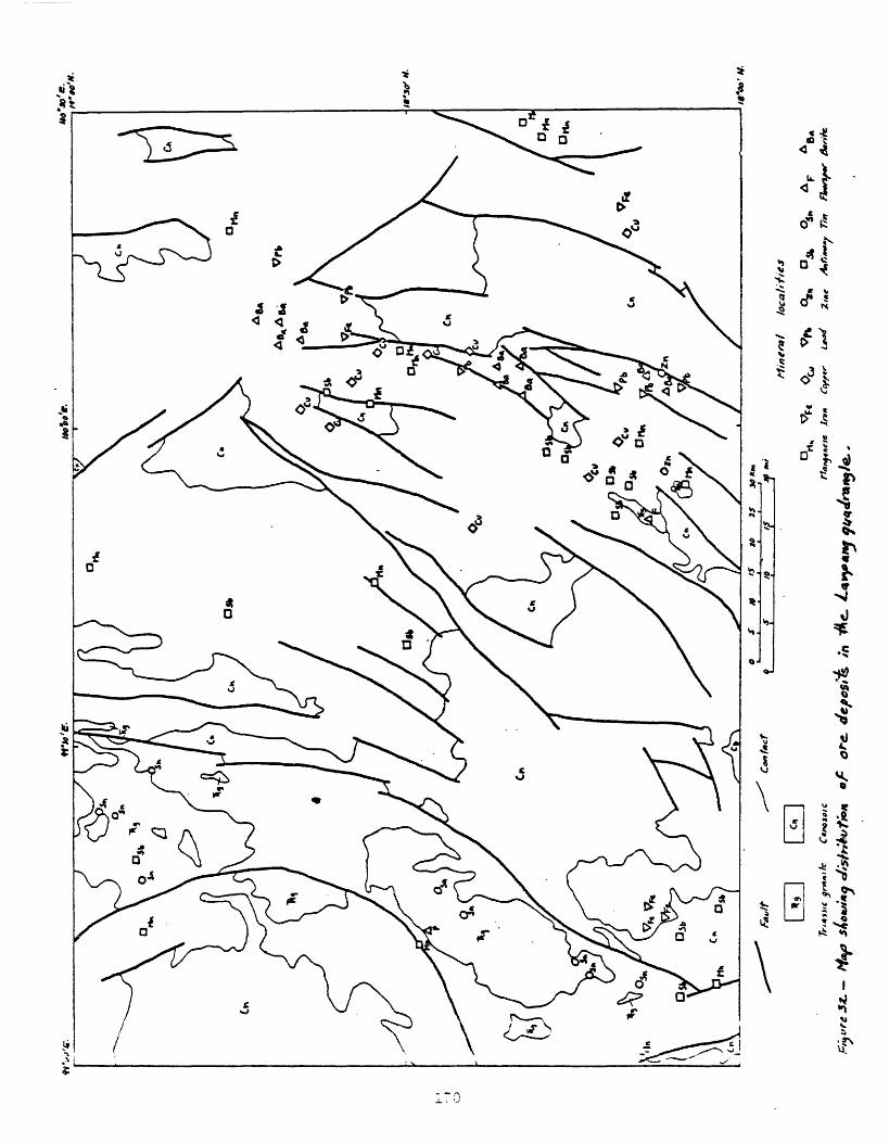
.09
.91
<k Jt
91 /
}
a,c
t.0fi
quadrangle (Piyasin, 1972a). The host rocks of the ore deposits shown in figure 32 can be determined by comparison of the map with figure 8 which shows more details of the geology of the quadrangle.
Manganese deposits in the Lampang quadrangle are scattered widely. They commonly occur on or close to faults, and otherwise are in sedimentary rocks that range in age from Silurian(?) to Jurassic. Iron deposits are in Permian and Triassic rocks, but are randomly distributed and not associated with known intrusives. Copper deposits are in Permian-Triassic rocks, some of which are volcanic, and form a cluster about 50 km in diameter northeast of small Triassic granite bodies in the east part of the quadrangle. The association with eugeosynclinal volcanic rocks suggests the possibility that some copper deposits are of massive-sulfide type, and the proximity to the granitic intrusives suggests the possibility that some are of hydrothermal origin. Possibly some hydrothermal modification of massive-sulfide deposits occurred.
Lead deposits are in rocks ranging in age from Silurian(?) to Jurassic, in a linear north-trending belt in the east part of the quadrangle. Two zinc deposits occur near the south end of the belt. Antimony deposits are widely and randomly scattered throughout the quadrangle between a belt of Traissic granites in the west part of the quadrangle, and the belt of lead deposits in the east part of the quadrangle.
Tin deposits in the Lampang quadrangle form a linear belt that coincides with the Triassic granite belt in the west part of the quadrangle. Two fluorspar deposits occur in separate Triassic granite bodies. Barite deposits occur in marine Triassic rocks in a linear belt nearly coinciding with the belt of lead deposits in the east part of the quadrangle.
The regionally zoned patterns of ore deposits observed in the Lampang quadrangle can be related to distribution of host rocks (for example, barite and copper), to linear zones of hydrothermal activity in a belt of older granitic rocks (for example, tin), and widespread hydrothermal activity where host rocks may have contributed components to the ore deposits (for example, antimony and manganese).
Mineral resource potential of Thailand
The separate evaluations of Thailand mineral commodities that I have made in this report indicate to me that Thailand possesses mineral resources of great monetary value, undoubtedly in the order of tnany billions of dollars. Potential for many of the commodities I have already suggested in the sections dealing with those commodities, and I have suggested potential in a general way in my discussion of the geologic environments of mineral deposits. I will summarize the suggested potentials here, in the order in which the commodities have been described, and in addition offer some suggestions for potential of mineral deposits of types not known in Thailand but to be expected there.
Admittedly all of my suggestions are speculative. Generally, I state them positively, according to my views, but the reader should recognize the uncertainty inherent in such statements.
Resources of salt (halite) in the Cretaceous Maha Sarakam Formation on the Khorat Plateau are virtually inexhaustible. The high cost of producing these deposits probably places their exploitation far into the future, if it is ever required. The possibility of substantial potash deposits of economic value on the Khorat Plateau is very good. Some sedimentary rocks of Paleozoic and Mesozoic age in the western and Peninsular parts of Thailand appear
favorable for the occurrence of phosphate deposits; to date no such deposits of economic significance have been recognized. The oil shale potential of the Mae Sot Tertiary basin in northwestern Thailand, and perhaps other Tertiary basins elsewhere in the country, is good. Much of the oil shale studied to date is low grade, although high-grade layers are known, and may be abundant in places. Lignite known in the Tertiary basins throughout Thailand has a large potential for future development. As a readily accessible energy resource it should be exploited much more intensively than it is at present (1974). Marl and diatomite deposits in Tertiary sedimentary sections probably are much more extensive in Thailand than presently recognized. Resources of gypsum in Mesozoic strata on and near the Khorat Plateau and in Paleozoic strata in western and Peninsular Thailand appear to be quite large. Bedded barite resources in Ordovician marine strata in Kanchanaburi province and in Triassic(?) marine strata in northwestern Thailand probably are extensive. Stratiform iron deposits of iron formation type are not known to be large in Thailand. I believe the best possibility for large iron deposits in Thailand lies in such deposits in southeastern Thailand. Sedimentary manganese deposits are not recognized in Thailand, but some evidence suggests that they may exist. Some large deposits may be present in clastic sedimentary rocks of Paleozoic or Mesozoic age in places in Thailand. Large base-metal sulfide deposits of sedimentary origin associated with bedded barite may. be present in Ordovician marine strata in Kanchanaburi province. Potential for sandstone- type copper and uranium deposits in Mesozoic strata on and near the Khorat Plateau seems good. Zechstein-type copper deposits should be looked for in association with the evaporite deposits of Cretaceous age on the Khorat Plateau.
The enigmatic Pa Daeng zinc replacement deposit deserves further detailed study to establish the geologic environment of its formation, so as to estimate the possibility that other such large and rich deposits occur elsewhere in Thailand. A large potential exists for replacement deposits of fluorspar in the regions of hot springs in northwestern, west-central, and Peninsular Thailand. Probably no replacement deposits of iron of very large size will be found in Thailand, although numerous small ones are likely present, mostly in the vicinities of Triassic granodiorites and younger mafic intrusives. Large replacement deposits of base metal and tin also are not likely to be found. Small deposits of base metals will be found mostly in the vicinities of the Triassic granodiorites and younger mafic intrusives. The possibility of additional replacement deposits of tungsten similar to Doi Mok in northwestern Thailand is good. Replacement deposits of phosphate that may be found probably all will be small.
Probably large stockwork deposits of tin and copper will be found in Thailand. Tin deposits occur in the so-called tin granites in western and Peninsular Thailand. Porphyry copper deposits are to be expected in the vicinity of granitoid stocks and prophyry intrusives of Triassic and younger age that are widely distributed throughout Thailand, outside of the Khorat Plateau and possibly the Peninsula. The potential for stockwork molybdenum deposits does not seem large.
The potential for vein deposits of fluorspar, like that of replacement deposits of fluorspar, appears very large in the regions of hot springs in northwestern, west-central, and Peninsular Thailand. Antimony vein deposits and tungsten deposits of the type known at Khao Soon, appear to have moderate to large potential in this same geologic environment. Potential discoveries
of vein deposits of manganese in Thailand will likely be small, but perhaps numerous. Deeper extensions of vein deposits of manganese should be explored for fluorite, barite, base metal, and precious metal veins. Veins of tin and tungsten in Thailand are undoubtedly numerous, but probably large potential resources do not exist in this type of deposit. Base metal, gold, and barite veins in Thailand offer no large potential resources. The Toh Moh gold deposit in Peninsular Thailand should be studied further to assess the potential for other deposits of this type. Vein deposits of iron ore probably contain only a small resource potential, although the vein at Khao Lek in Peninsular Thailand, being Thailand's largest iron producer, should be studied in detail to assess the possibility of similar veins elsewhere in the country.
Some small to moderate potential for chromium, nickel, and asbestos may occur in the Carboniferous ophiolites of northern Thailand. Graphite potential in Thailand is probably small. Quartz, feldspar, and clay potential appears to be substantial, and sources are widely distributed throughout Thailand.
Residual deposits of such commodities as iron, manganese, and fluorspar probably have only small resource potential. Bauxite deposits are almost totally unevaluated, but their potential may be large.
Placer deposits of tin, tungsten, monazite, ilmenite, and associated resistate minerals of tantalum and niobium, etc. , probably have a very large potential in Thailand, particularly in Peninsular Thailand and along much of the coastline of the country. Potential gold placer deposits are probably all small. Gemstone placers likely have a moderate potential; known placer grounds occur in southeastern and west-central Thailand, but other areas of Quaternary olivine basalts should be investigated for gemstone potential.
Oil and gas potential is probably very substantial in the large Tertiary sedimentary basins in the Gulf of Thailand and in mainland Thailand.
A few mineral resource possibilities not so far evident in Thailand should be considered. For example, silver has not been recognized in substantial amount in Thailand. It should be evaluated as a potential resource in porphyry copper deposits; in manganese oxide veins or the postulated down-dip extensions of manganese oxide veins that might contain fluorite, barite, base metals, and precious metals; and in base-metal veins such as those in Peninsular Thailand that are now being explored by Canadian Siam Resources Co. Wherever gold and base-metal mineralization (including also arsenic, antimony, and tungsten mineralization) has occurred in the vicinity of dioritic-granitic intrusive rocks, silty carbonaceous carbonate rocks that are abundant in the Paleozoic section and present in places in the Mesozoic section should be evaluated as.potential host rocks for Carlin, Nevada-type disseminated gold deposits. Eugeosynclinal sections of Paleozoic rocks consisting of shale, chert, and greenstone in the vicinities of the active or recently active Phangnga, Ranong, Kanchanaburi, Tak, and Phrae zones of strike-slip faults (fig. 6) should be examined for the possible occurrence of mercury deposits analogous to those found along major strands of the San Andreas strike-slip system in California, United States. The andesitic and rhyolitic volcanic rocks of Carboniferous age that are remnants of an ancient island arc that extended through present-day northwestern and southeastern Thailand should be examined for possible occurrences of copper-zinc massive sulfide ore deposits.

REFERENCES
Alekseev, M. N., and Takaya, Yoshikazu, 1967, An outline of the Upper Cenozoicdeposits in the Chao Phraya basin, central Thailand: Southeast AsianStudies, v. 5, no. 2.
Alexander, J. B., 1956, Malaisie Malaya, _in_ Dubertret, Louis, LexiqueStratigraphique International, v. 3, Asia, pt. 6b: InternationalGeological Congress, Paris, Comm. on Stratigraphy, Centre National Rech.Sci., 1956-1957.
American Commission on Stratigraphic Nomenclature, 1961, Code of stratigraphicnomenclature: American Association of Petroleum Geologists Bulletin,v. 45.
Angkatavanich, N., Busaracorae, S., and others, 1973, An outline of geology ofthe Thap Rwang area, Saraburi, Thailand: Geological Society of ThailandNewsletter, v. 6, no. 3.
Anonymous, 1973a, Field trip, Chiang Mai-Fang, in Conference on the geology ofThailand, Chiang Mai, Thailand, December 5-9, 1973: Report available fromChiang Mai University, Department of Geological Sciences, Thailand, 6 p.
_____1973b, Field trip, Chiang Mai-Phayao, in Conference on the geology ofThailand, Chiang Mai, Thailand, December 5-9, 1973: Available from ChiangMai University, Department of Geological Sciences, Thailand, 6 p.
_____1973c, Note and explanation on the igneous rocks of Thailand [map], inConference on the geology of Thailand, Chiang Mai, Thailand, December5-9, 1973: Available from Chiang Mai University, Department of GeologicalSciences, Thailand, 11 p.
Aranyakanon, Payome, 1955, Diamond discovery in Phangnga and Phuket, SouthThailand: Bangkok, Royal Thai Department of Mines Report ofInvestigations 1, p. 35-36.
_____1961, The cassiterite deposit of Haad Som Pan, Ranong Province,Thailand: Bangkok, Royal Thai Department of Mines Report ofInvestigations 4, 118 p.
_____1964, The Jae Son tin deposit, A. JaeHora, Lanpang,: Available fromBangkok, Royal Thai Department of Mineral Resources, Report on Mining Conference._1966, Potentials of tin ore in northern Thailand: Mineral Resources Gazette, Thailand, v. 11, no. 2, p. 20-24 [in Thai]._1968, Potentials of tin ore in Thailand: Mineral Resources Gazette, Thailand, v. 13, no. 4, p. 11-15 [in Thai]. 1969, Formation of kaolinite in the granite range by pneumatolytic
process: Mineral Resources Gazette, Thailand, v. 14, no. 2, p. 6-10 [inThai],
Aranyakanon, Pay<^ne, and Nilkhuha, C., 1955, Radioactive minerals from tin andtungsten mines in Thailand: Bangkok, Royal Thai Department of MinesReport of Investigations 1, p. 41-46.
Aranyakanon, Payone, and others, 1970, Tin deposits in Thailand [withdiscussion], _in_ Fox, W. , ed. , Technical Conference on Tin, 2d, Bangkok,1969: International Tin Council-Thailand, Department of MineralResources, London, v. 1, p. 81-104.
Army Map Service, 1944, Gazetteer to maps of Thailand: U.S. Department ofDefense, Washington, D.C.
174
Bataafse International Petroleum Maatschappij N.V., 1962, Photogeologicalreconnaissance Khorat Plateau (NE Thailand): Available, from Royal Thai Department of Mineral Resources, Photogeological Section, scale 1:500,000.
Baum, Fritz, von Braun, Eckart, Hahn, Lothar, Hess, Andreas, Koch, Klaus-Erich, Kruse, Gerhard, Quarch, Holger, and Siebenhuner, Michael, 1970, Onthe geology of northern Thailand: Beihefte zim Geologischen Jahrbuch,no. 102, 24 p.
Beall, J. V., 1970, Thailand: Mining Engineering, p. 100-105, July 1970. Berry, W. B. N., and Boucot, A. J., 1972a, Southeast Asian Silurian
correlation chart: University of California at Berkeley, 39 p. _____1972b, Correlation of the Southeast Asian and near eastern Silurian
rocks, with sections on Malaysia and Thailand, by C. R. Jones, a sectionon Afganistan, by Arnfrid Durkoop, and a section on Marmora region, byWinfried Haas: Geological Society of America Special Paper 137, 65 p.
Bhodisadya, S., 1972, Fluorite deposit, Khao Ruak, Kanchanaburi: GeologicalSociety of Thailand Newsletter, v. 5, nos. 5-6, p. 44-48 [In Thai].
Blank, E., Credner, W., and Olderhauser, E. V., 1935, Beitrage zur cheinischenVerwitterung und Bodenbildung im Siara: Chemie der Erde, v. 9, p. 419-452.
Bleackley, B., and others, 1964, Report on a geochemical reconnaissance surveyin the Loei-Chiang Kahn area of Thailand: Overseas Geological Surveys,London, 72 p.
_____1965, The regional geology of the Loei-Chiang Kahn area of Thailand anddetailed investigations of the Phu-Khum lead-zinc mineral prospects:Overseas Geological Surveys, London, 67 p.
Borax, E., and Stewart, R. D., 1965a, Geological reconnaissance of northeastThailand: Union Oil Company of California, v. 1, 95 p.; v. 2.
_____1965b, Note on the Khorat Series of northeastern Thailand: Symposium onthe Development of Petroleum Resources of Asia and the Far East, ECAFE,3d, Tokyo, November 10-20, 1965, 25 p.
_____1966, Notes on the Paleozoic stratigraphy of northeastern Thailand:Available from Working Party of Senior Geologists to ESCAPE, August 1977,17 p.
Bourret, Rene, 1925, Etudes geologiques dans la region de Pak-Lay (MoyenLaos): Indochina Service Geol. Bulletin, v. 15, pt. 2, 178 p.
Bowers, H. E., and Shawe, D. R., 1961, Heavy minerals as guides to uraniun-vanadiuzi ore deposits in the Slick Rock district, Colorado: U.S.Geological Survey Bulletin 1107-3, p. 169-213.
Brown, G. F., Buravas, Sanan, C. Javanaphet, Jurachet, Jalichandra, Nitipat,Johnston, W. D., Jr., Sethaput, Vija, and Taylor, G. C., Jr., 1951,Geologic reconnaissance of the mineral deposits of Thailand: U.S.Geological Survey Bulletin 984, 183 p.; reprinted by Royal ThaiDepartment of Mines, Geological Survey Memoir 1, 1953.
Brown, J. C., and Heron, A. M., 1923, The geology and ore deposits of theTavoy district: India Geological Survey Memoir, v. 44, pt. 2,p. 178-184.
Bunnag, C. V., and Dhararaks, K. V., 1947, Climates of Siam: Royal SiameseNavy Meterological Department, Scientific Articles 4.
Bunopas, Sangad, 1971, On the geology and stratigraphy of the Nam Phron Danand its vicinities: Geological Society of Thailand Newsletter, v. 4,nos. 1-3.
175

1972. Brief note on the geology of the sheet Phitsanulok: Geological Society of Thailand Newsletter, v. 5, nos. 5-r6.1973. On the tin deposit in Rayong Bay, eastern Gulf of Thailand: Available from .Geological Survey Division, Department of Mineral Resources, 9 p. 1973a, The Carboniferous volcanic sequences and red beds at Khao Luang,
in Conference on the geology of Thailand, Chiang Kai, Thailand, December 1973: Available form Chiang Mae University, Department of Geological
Sciences, 1 p. 1973b, The Permo-Triassic rocks on the Lansang fault zone, in Conference
on the geology of Thailand, Chiang Mai, Thailand, December 5-9, 1973: Available from Chiang Mai University, Department of Geological Sciences,3 p.
Bunopas, Sangad, Nakanart, Araya, and Boonyajitradulaya, Sakda, 1970,Stratigraphy and structure of the Khorat rocks along the Pitsanulok-LornSak Highway: Mineral Resources Gazette, Thailand, v. 15, no. 7, p. 9-20[in Thai],
Buravas, S., 1971, Kaolin: Mineral Resources Gazette, v. 16, no. 3, p. 18-35[in Thai].
Buravas, Saoak, and Buravas, Saman, 1941, Study of gold ores from Toh Mon,Krabin, and Tha Tago: Thai Science Bulletin, Bangkok, v. 3, no. 1,p. 1-10.
Buravas, Saman, 1941, Wolfram deposit of Khao To Sai. Amphoe Muang, Changwat Phuket: Available from Royal Thai Department of 'Mineral Resources, no. 41.
____1955, Notes on reconnaissance geology along Thailand-Malaya border: Available from Royal Thai Department of Mineral Resources. _1961, Stratigraphy of Thailand: Pacific Science Congress, 9th, Bangkok,
1957, Proceedings, v. 12, p. 301-305. Buravas, Smakr, 1973a, Age of the Mae Soon oil field of Fang Basin, Chiang Mai
Province: Available from Royal Thai Department of Mineral Resources. ____1973b, Succession of rocks in Fang and Chiang Mai areas with references
to Thai peninsular geology: Available from Royal Thai Department of Mineral
Resources(stratigraphic column). ____ 1973c, Coal under the Fang Basin: Available from Royal Thai Department of
Mineral Resources, 12 p. 1973d, Thail oil shale: Available from Royal Thai Department of Mineral
Resources, 9 p. Buravas, Saakr, and ines, W. R., no date, The coals of Fang Basin: Available from
Royal Thai Department of Mineral Resources. Buravas, Snakr, Gaines, W. R., Hashiaoto, W., and Kudo, S., 1968, On the
source rock of Mae Fang oil field, Chiang Mai, north Thailand: Geologyand Palaeontology of Southeast Asia, Tokyo, v. 5.
Burton, C. K., 1962, The older alluvium of Johore and Singapore: MalayaGeological Survey Professional Paper E-62.2-G.
_____1969, The geologic environment of tin mineralization in the Malay-Thaipeninsula: International Tin Council, Bangkok.
Burton, C. K. , and Bignell, J. D., 1969, Cretaceous-Tertiary events inSoutheast Asia: Geological Society of Anerica Bulletin, v. 80, p. 681-668.
Calloway, H. M., 1960, Antimony, _rn Mineral facts and problems, 1960 ed. :U.S. Bureau of Mines Bulletin 585, p. 61-69.
Cairpbsll, K. V. , i972a, Structural setting and metaiaorprac grade of theLar.sar.g gneiss: Ceolcgi^^l Society of Thcil-ind ^evsletrer,p. 32-44.
1973b, Metamorphic and deforaational events recorded in the Lansanggneiss, in Conference on the geology of Thailand, Chiang Mai, Thailand, December 5-9, 1973: Available from Chiang Mai University, Department of Science, 1 p.
Carrel, Pierre, 1960, Some information on copper [Thailand]: Thai MineOperators Convention, 1960, Proceedings, p. 40-49.
_____1963, A report on the geological survey of a manganese mine located in Lamphun Province, Li District, Village Paphai: Available from Royal Thai Department of Mineral Resources. 1964, Technical final summary report of a technical cooperation mission
in Thailand: Available from Bureau de Recherches Geologiques et Minieres, Paris Chakrabarti, A. R. , and Solomon, P. J. , 1972, A geochemical case history of
the Rajburi antimony prospect, Thailand: Geological Society of ThailandNewsletter, v. 5, nos. 1-4, p. 24-29.
Chandruang, Kumut, 1964a, Project: to mine and refine antimony in northernThailand: Available from Bangkok, Royal Thai Department of MineralResources.
____ _J.964b, Antimony mining and smelting in Thailand, in Symposium onmining Thai Mine Operators Convention, January 1964: Available fromBangkok, Royal Thai Department ef Mineral Resources.
Charal javanaphet (see also Javanaphet), Jumchet, 1969, Geology of Thailand andgeologic map of Thailand: Royal Thai Department of Mineral Resources,scale 1:1,000,000.
_____ 1969, The work and problems on tin of the Department of MineralResources: Available from Technical Conference on Tin of the InternationalTin Council, 2d, Bangkok, 12 p.
Chhibber, H. L. , 1934, The geology of Burma: London, Macmillan, 538 p. Chonglakinani , C., 1972, Stratigraphy of the Triassic Lanpang Group in northern
Thailand: Geological Society of Thailand Newsletter, v. 5, nos. 5-6,p. 33-36.
Chuamthaisong, C., 1972, Ground water resources of the Chiengraai Basin:Geological Society of Thailand Newsletter, v. 5, nos. 5-6, p. 37-41.
Cotter, G. de P., 1923, The oil shales of eastern Aniherst, Burma, with asketch of the geology of the neighborhood: India Geological Survey,v. 55, pt. 4, p. 275-286.
_____ 1924, The oil shales of eastern Anherst, Burma, with a sketch of the of the neighborhood: India Geological Survey Records, v. 55,
pt. 4, p. 274-313. Courtier, D. B., 1962, Note on terraces and other alluvial features in parts
of Province Wellesley, South Kedah, and North Perak: Malaya GeologicalSurvey Professional Paper E-62.1-T.
Credner, Wilhelm, 1929, Problems of geomorphology in Siam: Journal of SianSociety, Natural History Supplement, Bangkok, v. S, no. 1.
_____ 1935, Siam, das Land der Tai: Stuttgard, J. Engelhorr.s Nachr. , p. 9-63. Danirongnanee, T. , 1963, Manganese nine, Changwat Lanphun: Mining Gazettej v.
8, no. 7, p. 20-^2 [In Thai], DeHuff, G. L. , 1960, Manganese, _in Mineral facts and problems, 1960 ed. : U.S.
Bureau of Mines, p. 493-510. DeHuff, G. L. , and Fratta, Teresa, 1963, Manganese, in 1962 minerals yearbook,
V. 1: U.S. Bureau of Mines, ?. 8^7-872.
177

DeNeve, G, A., 1957, Correlation of fusulinid rocks from southern Sumatra,Bangka and Borneo, with similar rocks from Malaya, Thailand, and Burma: Pacific Science Congress, Bangkok, 1961, Proceedings, v. 12, 249 p.
Denson, N. M., Bachnian, G. 0., and Zeller, H. D., 1959, Uranium-bearing lignite in northwestern South Dakota and adjacent States: U.S. Geological Survey Bulletin 1055-B, p. 11-57.
Dheeradilok, Pisit, 1973, Precambrian rocks of Thailand in general, inConference on the geology of Thailand, Chiang Mai, Thailand, December 5-9, 1973: Available from Chiang 'Mai University, Department of Geological Sciences.
Endo, Seido, 1963, Some older Tertiary plants from northern Thailand: Japanese Journal of Geology and Geography, v. 34, p. 177-180.
_____1964, Some older Tertiary plants from northern Thailand: Geology and Palaeontology of Southeast Asia, Tokyo, v. 1, p. 113-115.
____1966, A supplementary note on the Paleogene Li flora in northernThailand: Geology and Palaeontology of Southeast Asia, Tokyo, v. 3, p.165-169.
Endo, Seido, and Fujiyama, lenori, 1965, Some late Mesozoic and late Tertiaryplants and a fossil insect from Thailand: Geology and Palaeontology ofSoutheast Asia, Tokyo, v. 2, p. 301-307.
Faure, C., and Fontaine, H., 1969, Geochronologie du Viet Nain, meridional:Arch. Geol. Viet Nam, v. 12, p. 213-222.
Fried. Krupp Rohstoffe Co., 1959, Raw materials survey, iron and steelindustry, Thailand, Main report expedition 1957-58: Available fromBangkok, Royal Thai Department of Mineral Resources.
Gardner, L. S., 1961, The possibilities of finding oil in Thailand:Convention on Mining Development in Phuket, Thailand, November 1960[preprint].
_____1967a, Antimony deposits of Thailand: Bangkok, Royal Thai Department ofMineral Resources Report of Investigations 13, 46 p.
_____1967b, Phichit gypsum deposit, central Thailand: Bangkok, Royal ThaiDepartment of Mineral Resources Report of Investigations 9, 41 p.
_____1967c, The Mae Mo lignite deposit in NW Thailand: Bangkok, Royal ThaiDepartment of Mineral Resources, Report of Investigations 12, 72 p.
Gardner, L. S., Danrongmanee, Tuan, and Smith, R. M., 1965, The Ban Mae Jongand other manganese deposits in northwestern Thailand: Bangkok, RoyalThai Department of Mineral Resources Report of Investigations 8, 51 p.
Gardner, L. S., and Smith, R. M., 1965, Fluorspar deposits of Thailand:Bangkok, Royal Thai Department of Mineral Resources Report ofInvestigations 10, 42 p.
Garson, M. S., and Mitchell, A. H. G., 1970, Transform faulting in the Thaipr.ninsula: Nature, v. 228, no. 5266, p. 45-47.
Garscn, M. S., Young, B., Mitchell, A. H. G. , Tait, B. A. R., Cogger, N., andPrewett, V. G., 1970, Economic geology and geochemistry, Pt. 2 ofGeology of the Phuket-Krabi-Takuapa area in peninsular Thailand: UnitedKingdon Institute of Geological Sciences, Overseas Division, London,136 p.
Geologic en Mijnbouw, 1960, Speciale Uitgave 100 jaar BillitonMaatschappij: Geologie en Mijnbouw, v. 39 (nieuwe serie, v. 22),p. 405-568.
Gerir.i, G. E., 1905, Historical retrospect of Junkceylon Island: SianSociety, v. 2, p. i4i.
178

German Geological Mission, Thailand, 1972, Final report: Available-fromthe Federal Republic of Germany Geological Survey,' Hanover, 94 p.
Gloe, C., 1955, Report of lignite investigations, Mae Mo basin, northernThailand: Available from Thai Lignite Thermal Power Organization,Bangkok.
Goddard, E. N., chm., and others, 1948, Rock-color chart: National ResearchCouncil; reprinted by Geological Society of America, 1951, 1963, 1970,6 p.
Gregory, J. W., 1930, Upper Triassic fossils from the Burmo-Siamese frontier the Thaungyin Trias and description of the corals: India GeologicalSurvey Records, v. 63, pt. 1, p. 155-167.
Guilcher, Andre, 1958, Coastal and submarine morphology: New York, John Wiley& Sons, 274 p.
Haile, N, S,, 1973, Note on Triassic fossil pollen from the Nam Pha Formation,Chulabhorn (Nam Phrom) Dam, Thailand: Geological Society of ThailandNewsletter, v. 6, no. 1, p. 15-16.
Raile, N. S., and Tarling, D. H., 1973, Note on reversed magnetism of youngCainozoic basalts near Lamphang, in Conference on the geology ofThailand, Chiang Mai, Thailand, December 5-9, 1973: Available from Chiang Mai University, Department of Geological Sciences, 5 p.
Hallet, Halt, 1890, A thousand miles on an elephant: London, Blackwood &Sons.
Hamada, Takashi, 1964, Two Carboniferous brachiopods from Loei, Thailand:Japanese Journal of Geology and Geography, v. 35, no. 1, p. 5-15.
Hashimoto, W., Kudo, S., and Inoma, A., 1966, On oil indications met withinTenkari coalfield, Horokanai, Hokkaido, with references to their sourceformations: Journal of Japanese Association of Petroleum Technologists,v. 31, no. 6, p. 250-256.
Hactori, Toraoo, 1969, Mineral composition of clay fractions in some Quaternarydeposits in the Cnao Phraya basin, central Thailand: Southeast AsianStudies, v, 6, no. 4, p. 241-246.
Haworth, H. F,, Charaljavanaphet (Javanaphet), Jurachet, Na Chiangmai, P., andPhioncharoen, C., 1964, Ground water resources development ofnortheastern Thailand: Royal Thai Department of Mineral Resources GroundWater Bulletin 2, 1252 p.
Haworth, H. F., Javanaphet, J. C. , and Na Chiangmai, P., 1959, Report onground water exploration and development of the Khorat Plateau region:Royal Thai Department of Mines Ground Water Bulletin 1.
Hayami, Itaru, 1968, Some non-marine bivalves from the Mesozoic Khorat Groupof Thailand: Geology and Paleontology of Southeast Asia, v, 4, p. 100-108.
Hayami, Itaru, Kobayashi, T., and Takai, F., 1962, On some Mesozoic fnssilsfrom the Khorat series and a note on the Khorat series: Available fromThailand Geological Survey, Department of Mineral Resources, Bangkok.
Hedberg, H. D., 1961, Stratigraphic classification and terminology:International Geological Congress, 21st, Norden, 1940, International Subcomnission on Stratigraphic Terminology, pt. 25, 38 p.
Heim, Arnold, and Hirschi, Hans, 1939, A section of the mountain ranges of northwestern Siara: Eclogae Geologicae Helvetiae, v. 32, no. 1.
179
Hewett, D. F., 1964, Veins of hypogene manganese oxide minerals in thesouthwestern United States: Economic Geology, v. 59, no, 8, p. 1429-1472.
Hilde, T. W. C., and Engel, C. G., 1967, Age, composition and tectonic settingof the Granite Island, Hon Trung Lon, off the coast of South Vietnam:Geological Society of America Bulletin, v. 78, p. 1239-1294.
Hinthong, Chaiyan, 1973, A note on the geology of Nakhon Nayok and Khao YaiNational Park: Geological Society of Thailand Geological Excursion, 1-2December 1973, 8 p. text, geological map, [in Thai and English],
Hirschi, Hans, and Heiin, Arnold, 1938, Zur geologic und petrographie von Nord-Siam: Schweizerische Mineralogische und Petrographische Mitteilungen, v.18, no. 2.
_____1939, A section of the mountain ranges of northwestern Siam: EcologaeGeologicae Helvetiae, v. 32, no. 1, p. 1-16,
Hite, R. J., 1971, Potential for potash and related mineral resources, KhoratPlateau, northeast Thailand and central Laos: U.S. Geological SurveyProject Report, Thailand Investigations (IR) TH-13, 64 p.
Hobbs, S. W., and Elliott, J. E., 1973, Tungsten: ^in_ United States mineralresources, U.S. Geological Survey Professional Paper 820, p. 667-678.
Hogbom, Bertil, 1914, Contributions to the geology and morphology of Siam:Sweden, Uppsala University Geological Institutions Bulletin, v. 12.
Holland, T. H., and others, 1955a, Birmanie-Burma, jLn_ Dubertret, Louis,Lexique Stratigraphique International, v. 3, Asie, pt. 6d: InternationalGeological Congress, Paris, Cotam. on Stratigraphy, Centre National Rech.Sci., 1956-1957.
_____1955b, India, Pakistan, Nepal, Bhutan, Jji Dubertret, Louis, LexiqueStratigraphique International, v. 3, Asie, pt. 8a: InternationalGeological Congress, Paris, Comn. on Stratigraphy, Centre National Rech.Sci., 1956-1957.
Hosking, K. F. G., 1970, Aspects of the geology of the tin fields of south east Asia [with discussion], _in_ Technical Conference on Tin, 2d, Bangkok,1969: International Tin Council-Thailand, Department of MineralResources, London, v. 1, p. 39-80.
Hughes, I. G., and Batescn, J. H., 1967, Reconnaissance geological and mineralsurvey of the Chantaburi area of south-east Thailand: Institute ofGeological Sciences, London, 29 p.
Humnel, C. L., and Phawandon, P., 1967, Geology and mineral deposits of thePhuket mining district, South Thailand: Thai Department of MineralResources Report of Investigations 5, 74 p.
Ingham, F. T., and Bradford, E. F., 1960, The geology and mineral resources cfKinta Valley, Perak: Malaya Geological Survey Memoir 9, 347 p.
Inghan, F. T., and others, 1943, Geological maps of Malaya: Malaya GeologicalSurvey, Department, Singapore, no. 35.
International Tin Council, 1962, Statistical yearbook, 1962: InternationalTin Council, London, 280 p.
Inthuputi, E., 19/1, Preliminary report on Phratu Teema copper-radioactivemineral deposits, Phu Wieng district, Khon Khaen province, northeasternThailand: Available from Royal^Thai Department of Mineral Resources,Economic geology Division, 16 p,
_____1972, Sedimentary copper deposits: Geological Society of ThailandNewsletter, v. 5, nos. 5-6, p. 56-57.
180

Isarangkoon (Israngura), Piphop, 1973, Distribution of heavy minerals in the Phuket and Phang-nga areas, southern Thailand: United Nations, Economic Commission for Asia and the Far East, Committee for Co-ordination of Joint Prospecting for Mineral Resources in Asian Offshore Areas, Technical Bulletin, v. 7, p. 11-21.
Iwai, Jun-ichi, Asaina, Kazuo, Veeraburus, Manas, and Hongnusonthi, A-ngoon, 1966, Stratigraphy of the so-called Khorat series and a note on the fossil plant-bearing Paleozoic strata in Thailand: Geology and Palaeontology of Southeast Asia, Tokyo, v. 2, p. 179-196.
Iwai, Jun-ichi, Sakagami, Sumio, Nakornsri, Nikorn, and Yuyen, Wathaki, 1968, Mesozoic stratigraphy of the northern part of the Khorat Plateau, Thailand: Geology and Palaeontology of Southeast Asia, Tokyo, v. 5, p. 151-165.
Jacobson, H. S., 1967, Economic geology of northeastern Thailand: submittedby the U.S. Delegation for ECAFE's Working Party of Senior Geologists and Subcommittee on Mineral Resources Development meetings, Bangkok, Thailand.
Jacobson, H. S., Pierson, C. T., Danvsawad, T., Japakasetr, T., Inthuputi, B., Siriratanamongkol, C., Prapassorukul, S., and Pholphan, N., 1969, Mineral investigation in northeastern Thailand: U.S. Geological Survey Professional Paper 618, 96 p.
Jalichan, N., and Bunnag, D., 1954a, A report on geologic reconnaissance of the mineral resources of northeastern Thailand: Available from Thailand Geological Survey, Department of Mineral Resources, Bangkok [in Thai with English translation in files]
_____l§54b, Underground water a possible solution to the water supplyproblem in northeastern Thailand: Available from. Thailand Geological Survey, Department of Mineral Resources,' Bangkok.
Jalichandra (Chalichandra), Nitipat, 1948, Asbestos: Industrial Magazine [Official Journal of the Thai Ministry of Industry], v. 2, no. 3, p. 33-39 [in Thai].
Javanaphet, J. C., 1964, Rock salt of the Khorat Plateau: Mineral Resources Gazette, v. 9, no. 6, p. 97-100.
_____1969, Geologic map of Thailand: Thailand Geological Survey, Department of Mineral Resources, scale 1:1,000,000, with 16 p. of text on the geology of Thailand.
Jones, W. R., 1925, Tin fields of the world: London, Mining Publications Ltd., 432 p. _
Kaewbaidhoon, S., 1963,_The preliminary hydro-geochenical study of uranium in Thailand Geochemical prospecting activities in Thailand, in Seminar on Geochemical Prospecting Methods and Techniques, Proceedings: United Nations, Mineral Resources Development Series 21, p. 30.
_____1964, Iron deposits, Loei Province, _in_ Report of mining conference: Available from Thailand Department of Mineral Resources, Bangkok.
_____1971, Fluorite deposit, Salak ?hra: Mineral Resources Gazette, v. 16, no. 12, p. 88-91 [in Thai].
Kaewphaithoon, S., and Viraburus, M., 1953, Reconnaissance geological survey trip from Kabinburi to Pakthongchai and froz: Kabinburi to Chanthaburi: Available from Thailand Geological Survey, Department of Mineral Resources,Bangkok.
181
Kanchanaga, Thuan, 1949, The commercial and economic progress in Thailand:Thailand Development Bureau, Bangkok.
Katili, J. A., 1973, Plate tectonics and the search for mineral deposits inwestern Indonesia: CCOP Newsletter, v. 1, no. 1, p'. 14-16.
Klompe, Th. H. F., 1962, Igneous and structural features of Thailand:Geologie en Mijnbouw, v. 41, no« 6, p. 290-302.
Kobayashi, T., 1958, Some Ordovician fossils from the Thailand-Malayanborderland: Japanese Journal of Geology and Geography, v. 29,p. 223-231.
_____1960, Notes on the geologic history of Thailand and adjacentterritories: Japanese Journal of Geology and Geography, v. 31,p. 129-148.
_____1964a, On the Cretaceous Ban Na Yo fauna of east Thailand, with a noteon the distribution of Nippononaia, Trigonioides, and Plicatounio:Geology and Palaeontology of Southeast Asia, Tokyo, v. 1, p. 31-41.
_____1964b, Geology of Thailand: Geology and palaeontology of SoutheastAsia, Tokyo, v. 2, p. 1-16.
_____1968, The Cretaceous non-marine pelecypods from the Nam Phung Dam sitein the northeastern part of the Khorat Plateau, Thailand, with a note onthe Trigonioididae: Geology and Palaeontology of Southeast Asia, Tokyo,v. 4, p. 109-138.
_____1973, The Early and Middle Palaeozoic history of the Burmese-Malayangeosyncline: Geology and Palaeontology of Southeast Asia, Tokyo, v. 11,p. 93-103.
Kobayashi, T., and Hamada, T., 1964, On the Middle Ordovician fossils fromSatun, the Malaysian frontier of Thailand: Japanese Journal of Geologyand Geography, v. 35, p. 205-211.
Kobayashi, T., Takai, F., and Hayami, I., 1964, On some Mesozoic fossils fromthe Khorat series of east Thailand and a note on the Khorat series:Geology and Palaeontology of Southeast Asia, Tokyo, v. 1, p. 119-133.
Kobayashi, T., and Igo, H., 1962, On the occurrence of graptolite shales innorthern Thailand: Japanese Journal of Geology and Geography, v. 36,nos. 2-4, p. 27-34.
_____1965, On the occurrence of graptolite shales in north Thailand:Japanese Journal of Geology and Geography, v. 36, p. 37-44.
Kobayashi, T., Igo, H., and others, 1964: Geology and Palaeontology ofSoutheast Asia, Tokyo, v. 1, p. 1-31.
Kobayashi, T., and others, 1964, Report on the stratigraphical andpaleontological reconnaissance in Thailand and Malaysia, 1963-1964:Overseas Technical Cooperation Agency, Tokyo, Reference no. 24, p. 1-72,10 figs., 1 map, August.
Koch, K. E., 1973, Geology of the region Sri Sawat-Thong Pha Phuia-Sangkhlaburi, Kanchanaburi Province, Thailand: Geological Society ofMalaysia Bulletin 6, p. 177-185.
Koenigswald, G. H. R. von, 1959, A mastodon and other fossil mammals fromThailand: Thailand Geological Survey, Department Mineral ResourcesReport of Investigations 2, p. 25-28.
Kon'no, Enzo, and Asama, Kazuo, 1973, Mesozoic plants from Khorat, Thailand:Geology and Palaeontology of Southeast Asia, Tokyo, v. 12, p. 149-172.
Krishnan, M. S., 1949, Geology of India and Burma: Madras Law Journal Office,Madras, India, 544 p,

Krol, G. L., 1960, Theories on the genesis of "Kaksa": Geologie en Mijnbouw,v. 39 (nieuwe serie, v. 22), no. 10, p. 437-443.
Kudo, S., and Asakawa, T., 1965, Geocheraical study of organic matter inpetroleum source beds in Niigata sedimentary basin: ECAFE, PetroleumSymposium, 3d, Agenda Item 6.
Kuenen, Ph. H., 1950, Marine geology: New York, John Wiley & Sons, 568 p. Kulasing, Pinit, 1973, Review of the Mesozoic Khorat Group, in Conference on
the geology of Thailand, Chiang Mai, Thailand, December 5-9, 1973: Available from Chiang Mai University, Department of GeologicalSciences, 15 p.
Kummel, Bernard, 1960, Triassic ammonoids from Thailand: Journal ofPaleontology, v. 34, p. 682-694. -
LaMoreaux, P. E., Charaljavanaphet, J., Jalichan, N., Na Chiangmai, P.,Bunnag, D., Thavisri, A., and Rakprathum, C., 1958, Reconnaissance of thegeology and ground water of the Khorat Plateau, Thailand: U.S.Geological Survey Water-Supply Paper 1429, 62 p.
Lee, W. M., 1923a, Reconnaissance geological report of the Khorat Region,Province of Nakorn Rajasima, Udon, Roi Et and Ubon, Siam: ThailandGeological Survey, Department of Mineral Resources, Bangkok [mimeographedcopy reproduction, 1954, and report in files].
____1923b, Outline of the geology of Siam with references to petroleum:American Association of Petroleum Geologists, v. 14, no. 4, p. 370-415.
_____1923c, Reconnaissance geological report of the province of Phuket SuratThani, Nakhon Si Thammarat and Pattani in Siamese Malaya: ThailandDepartment of State Railways, Bangkok.
____1923d, Reconnaissance geologic report of the Phuket, Surashtradhani,Nakon Sridhamaraj and Pattani in Siamese Malaya: Thailand Department of ,State Railways, B.E. 2466.
_____1923e, Reconnaissance geological report of the districts of Payap andMaharastra, northern Siam: Thailand Department of State Railways, StateRailway Printing Office, Bangkok, 16 p.
_____1923f, Reconnaissance geologic report of the district of Payap andMaharashtra, northern Siam: Thailand Department of State Railways, B.E.2466.
____1927, Outline of the geology of Siam with reference to petroleum:American Association of Petroleum Geologists Bulletin 11, no. 4, p. 411.
Leupold, W., 1939, ±r± Heim, Arnold, and Hirschi, Hans, A section of themountain ranges of northwestern Siara: Ecologae Geologicae Helvetiae, v.32, no. 1, p. 12.
Lignite Thermal Power Organization, 1959, Lignite in Thailand: Availablefrom Thermal Power Organization, Bangkok, 19 p.
Lord, C. S., 1968, The probable mineral potential of Thailand with specialreference to land capability classification and land-use planning: RoyalThai Department of Mineral Resources [prepared by External Aid Office,Ottawa, Canada], ^1 p., March.
Lowatanatrakul, K., 1969, Offshore tin deposits of Thailand: MineralResources Gazette, v. 14, no. 10, p. 42-45 [in Thai].
Mahavajana, J. , 1972, Minerals of Thailand: Mineral Resources Gazette, v. 17,no. 7, p. 75-34 [in Thai],
Mansuy, H., 1912, Etude geologique de Yun-nan oriental: Indochine ServiceGeology Meaoir, v. 1, pt. 2.
183
McCarthy, James, 1900, Surveying and exploration in Siara: London, 215 p.Meekul, A., 1964, Iron mine (Khao Lek): Mineral Resources Gazette, v. 9, no.
12, p. 42-52. [in Thai],Methekul, A., 1962, Report on the geological investigation of the Garnet
deposits of Khao Charaoon, Rayong and Chanthaburi Provinces: Available from Thailand Geological Survey, Department of Mineral Resources, File 285.
Mitchell, A. H. G., Young, B., and Jantaranipa, W., 1970, The Phuket Group',Peninsular Thailand; A Palaeozoic? geosynclinal deposit: GeologicalMagazine, v. 107, p. 411-427.
Moulds, D. E., 1964, Antimony, jln. U.S. Bureau of Mines, Minerals yearbook,1963: Washington, D.C., U.S. Government Printing Office, v. 1,p. 234-244.
____1965, Antimony, in U.S. Bureau of Mines, Minerals yearbook, 1964:Washington, B.C., U.S. Government Printing Office, v. 1, p. 211-222.
Na Chiangmai, P., 1966, Exploration and mining of iron ore in Nakorn SiThammarat Province: Mineral Resources Gazette, v. 11, no. 3, p. 70-90[in Thai].
Naniart, V., 1965, Iron deposits of Thailand: Mineral Resources Gazette, v.10, no. 9, p. 32-38 [in Thai].
National Geographic Service of Viet Nam, 1961, 1962, Geologic map of Laos,Cambodia, and North and South Vietnam: National Geographic Service ofViet Nam, scale 1:500,000 [published in quadrangles].
Newton, H. J., and McGrath, M. G., 1958, The occurrence of uranium in theMilestone Authority to Prospect, Wollogorang District, NorthernTerritory, in F. L. Stillwell Anniversary Volume: Australasian Instituteof Mining and Metallurgy, Melbourne, 302 p.
Newton, R. B., 1926, On Fusulina and other organisms in a partially calcareousquartzite from near the Malayan-Siamese frontier: Annals and Magazine ofNatural History, 9th ser., v. 17, p. 49-64.
Nissho Co., Ltd., 1963, [Report on Ban Pok manganese mine at ChangwatLamphun]: Nissho Co., Ltd., Tokyo, [privately printed; in Japanese].
Nockolds, S. R., 1954, Average chemical composition of some igneous rocks:Geological Society of America Bulletin, v. 65, p. 1007-1032.
Nutalaya, P., 1973a, Geology of the Bhumipol Dam area, Tak Province, Thailand,in Conference on the geology of Thailand, Chiang Mai. Thailand, December5-9, 1973: Available from Chiang Mai University, Department of GeologicalSciences.
_____1973b, Compilation of previous studies of the Cenozoic rocks ofThailand, in Conference on geology of Thailand, Chiang Mai, Thailand,December 5-9, 1973: Available from Chiang Mai University, Department ofGeological Sciences, 11 p.
Overseas Geological Surveys, London, and Thailand Department of MineralResources, 1966, A mineral survey in northeast Thailand: United Nations,Economic Commission for Asia and the Far East, Working Party of SeniorGeologists, 6th, Bangkok, Thailand, August 8-13, 1966, 20 p.
Pascoe, E e H., 1960, Manual of the geology of India and Burma, v. 2: 1210 p. Paton, J. R., 1962, The origin of the limestone hills of Malaya: Malaya
Geological Survey Professional Paper E-48, I-T. Pendleton, R. E., 1941a, Laterite and its structural use in Thailand and
Cambodia: Geographical Reviews, v. 31, p. 177-302. _____194Ib, Laterite or Sila Laeng, a peculiar soil formation: Thailand
Scientific Bulletin, v. 3. o. 61-"7.
134

____1949, Provisional map of the soils and surface rocks of the Kingdom of Thailand: Cadastral Survey Office, Bangkok, scale 1:2 1/2 million.
Pendleton, R. L., 1953, Report to accompany the provisional map of the soilsand surface rocks of the Kingdom of Siam: Available from ThailandGeological Survey, Department of Mineral Resources , Bangkok, 114 p.
Pendleton, R. L., and others, 1962, Thailand, aspects of landscape and life:American Geographical Society, 321 p.
Petroleum Handbook, Shell Co., 1959, p. 3-28. Phuthai, Charan, [undated], The coal and lignite deposits of Muang Li,
Lampoon: Available from Department of 'Mineral Resources: (pamphlet)
Phuvakul, S., 1972, Doi Mok scheelite deposit, A. Wiang Pa Pao: GeologicalSociety of Thailand Newsletter, v. 5, nos. 5-6, p. 32 [in Thai].
Pia, Julius, 1929, Upper Triassic fossils from the Burmo-Siamese frontier anew Dasycladacea, Holosporella siamensis nov. gen., nov. sp., with adescription of the allied genus Aciculella Pia: India Geological SurveyRecords, v. 63, pt. 1, p. 177-181.
Pipiringos, G. N., 1961, Uranium-bearing coal in the central part of the GreatDivide Basin, Sweetwater County, Wyoming: U.S. Geological SurveyBulletin 1099-A, 103 p.
Pitakpaivan, Kaset, 1955, Occurrences of Triassic formation at Mae Moh:Thailand Royal Department of Mines, Bangkok, Report of Investigations 1,11 p.
_____1965, Fusulines of the Rat Buri Limestone of Thailand: ThailandDepartment of Mineral Resources Memoir 2, 69 p.
_____1970, Tin-bearing granite and tin-barren granite in Thailand [withdiscussion], in Technical Conference on Tin, 2d, Bangkok, 1969, V. 1:International Tin Council-Thailand, Department of Mineral Resources,London, p. 283-298.
Pitakpaivan, K., and Nakhinbodee, 1973, The lower part of Khorat Group, inConference on the geology of Thailand, Chiang !Iai,, Thailand, December5-9, 1973: Available from Chiang 'Mai University, Department of Geological Sciences, 15 p.
Pitrakul, Suchit, and Tantisukrit, Charn, 1973, Review of economic mineraldeposits in Thailand, in Conference on the geology of Thailand, ChiangMai, Thailand, December 5-9, 1973; Available from Chiding Mai University, Department of Geological Sciences, 51 p.
Piyasin, Sangad, 1972a, Geology of Lanpang sheet N~E 47-7: Department ofMineral Resources, Report of Investigations 14, 98 p., scale 1:250,000[English abstract).
_____1972b, Geology of the Uttiradit sheet: Geological Society of ThailandNewsletter, v. 5, nos. 5-6, p. 7-10.
_____1973a, Stratigraphy and sediinentology of the Kaeng Krachan Group(Carboniferous), _in_ Conference on the geology of Thailand, Chiang Mai,Thailand, December 5-9, 1973: Available from Chiang Mai University,Department of Geological Sciences, 11 p.
_1973b, Review of the Ratburi Group, in Conference on the geology ofThailand, Chiang Mai, Thailand, December 5-9, 1973: Available from Chiang Mai University, Department of Geological Sciences, 49 p.
IS!
1973c, Review of the Lampang Group, in Conference on the geology ofThailand. Chiang Mai, Thailand, December 5-9. 1973: Available fromChiang Mai University, Department of Geological Sciences, 7 p.
Poothai, C., and Ghana, A., 1969a, Geology of mineral fuels in inailand:Mineral Resources Gazette, v. 14, no. 9, p. 73-83.
____1969b, Geology of mineral fuels in Thailand: Mineral Resources Gazette,v. 14, no. 11, p. 18-28.
Poothai, Charon, Kulvanich, Sermsakdi, and Ratanawong, Somboon, 1969 [1971],Heavy minerals associated with tin in alluvial and beach deposits inThailand [with discussion], jLii Fox, W., ed., Technical Conference on Tin,2d, Bangkok, 1969, V. 3: International Tin Council-Thailand, Departmentof Mineral Resources, London, p. 1059-1080.
Pungrassami, T., and Supalak, P., 1970, Preliminary geochemical study fornickel in soil over serpentinite at Ban Ragam, Chanthaburi Province,Thailand: Mineral Resources Gazette, v. 15, no. 9, p. 6-25.
Rama Rau, Sethu, 1929, The geology of the Mergui district: India GeologicalSurvey Memoir, v. 58, pt. 1, 8 p.
Reed, F. R. C., 1915, Supplementary memoir on new Ordovician and Silurianfossils from the northern Shan States: Palaeontologia Indica, new ser.,v. 6, mem. 1, p. 95, 98.
_____1920, Carboniferous fossils from Siam: Geological Magazine, v. 57,p. 113-120, 172-178.
______1936, The lower Palaeozoic faunas of the southern Shan States:Palaeontologia Indica, new ser., v. 21, mem. 3, p. 117-118.
Ridd, M. F., 1971, Southeast Asia as a part of Gondwanaland: Nature, v. 234,no. 5331, p. 531-533.
Riker, 0. P., 1954, Three years of exploration and development in Thailand:Available from Special Technical and Economic Mission to Thailand; U.S.Operations Mission, Agency for Industrial Development, Bangkok.
Robinson, W. E., and Dinneen, G. U., 1967, Constitutional aspects of oil shalekerogen: World Petroleum Congress, 7th, Mexico, Panel Discussion No. 14,Paper 2.
Royal Thai Navy Hydrographic Department, 1960, Phuket to Kantang HydrographicChart [2d ed.]: Royal Thai Navy Hydrographic Department, Bangkok.
Royal Thai Survey Department, Supreme Command Headquarters, 1972, ThailandNational Resources Atlas.
Sagawa, Masao, 1963, Report on investigation of ore deposits in Thailand in1963: Royal Thai Department of Mineral Resources, Bangkok [memorandumreport prepared by Overseas Technical Cooperation Agency, Japan].
Sainsbury, C. L., and Reed, B. L., 1973, Tin: _in_ United States mineralresources, U.S. Geological Survey Professional Paper 820, p. 637-651.
Sakagacii, S., 1966, Carboniferous? Bryozoa collected by Kaset Pitakapaivan atKhao Kok, Changwat Ratburi, Thailand: Geology and Palaeontology ofSoutheast Asia, Tokyo, v. 2, p. 297-300.
Sanathapand, X., 1959, The Fang oil field, Chiengmai, North Thailand:Symposium Development of Petroleum Resources of Asia and Far East,Mineral Resources Development Survey, Proceedings, p. 214-216.
Sanansieng, S., 1972, Geology of Sheet Ban Mi: Geological Society of ThailandNewsletter, v. 5, nos. 5-6, p. 20-23.
136
Saurin, E., 1956a, Lexique stratigraphique international: International Geological Congress, Commission of Stratigraphy, V. 3, Asia, pt. 6a, Indochine, 141 p. [translation from French by L. S. Gardner, U.S. Geological Survey].
_____1956b, Indochine, _ln Dubertret, Louis, Lexique StratigraphiqueInternational, V. 3, Asia, pt. 6a: Paris, International Geological Congress, Commission of Stratigraphy, Centre National Rech. Sci., 1956- 1957, 140 p.
_____1963, Notice sur la feuille de Vientiane Carte Geologique Viet Nam,Cambodia, Laos: Viet Nam, Service Geol. National, scale 1:500,000.
Sawata, H., 1973, Note on a young deposit near Lan Sang Village, Tak province,northwestern Thailand, in Conference on the geology of Thailand, ChiangMai, Thailand, December 5-9, 1973: Available from Chiang Mai University,Department of Geological Science, 4 p.
Scholia, P. F., [undated], Can Thailand attain a major position in theinternational antimony industry?, in Symposium on mining, Thai MineOperators Convention, Bangkok, January 1964: Royal Thai Department ofMineral Resources, Bangkok [report in files].
Sclater, J. G., and Fisher, R. L. , 1974, Evolution of the east-central IndianOcean, with emphasis on the tectonic setting of the Ninetyeast Ridge:Geological Society of America Bulletin, v. 85, p. 683-702.
Scrivenor, J. B., 1928, The geology of Malayan ore deposits: London,Macmillan and Co.
_____1931, Geology of Malaya: London, Macmillan and Co., 217 p. Sektheera, S., 1970, Phosphate: Mineral Resources Gazette, v. 15b, p. 25-37
[in Thai]. Senivong Na Ayuthya, P., 1967, Formation of gems in relation with basalt,
Chanthaburi Province: Mineral Resources Gazette, v. 12, no. 8, p. 53-58[in Thai].
Sethaput, V., 1956, Lexique stratigraphique international: InternationalGeological Congress, Commission of Stratigraphy, V. 3, Asia, pt. 6c,Thailand, p. 35-37.
Shawe, D. R., and Bernold, Stanley, 1966, Beryllium content of volcanicrocks: U.S. Geological Survey Bulletin 1214-C, p. C1-C11.
Shawe, D. R., Kite, R. J., and Inthuputi, Boonaai, 1975, Potential forsandstone-type uranium deposits in Jurassic rocks, Khorat Plateau,Thailand: Economic Geology, v. 70, no. 3, p. 538-541.
Shawe, D. R. (ed.), and others, 1976, Geology and resources of fluorine in theUnited States: U.S. Geological Survey Professional Paper 933, 99 p.
Shekarchi, E., 1971, The mineral industry in Thailand: U.S. Agency forInternational Development, U.S.O.M., Bangkok, 62 p.
Shouls, M. M., 1973, Seismicity and plate tectonics in the Thailand-Burna-Andaman Sea area: CCOP Newsletter, v. 1, no. 1, p. 17-19.
Sinlapajan, Pajon, 1969 [1971], Tin dredging in Thailand, in TechnicalConference on Tin, 2d, Bangkok, 1969, V. 2: International Tin Council- Thailand, Department of Mineral Resources, London, p. 671-638.
Siriphokakit, W., and Wongsawat, S., 1972, Lithological map of easternThailand: Available from Department of Mineral Resources, GroundwaterDivision, Bangkok.
Sithiprasasna, D., 1959, Occurrences of Mae Moh fossils: Department ofMineral Resources, Report of Investigations 2, 42 p.
13
Smith, R. M., 1961, Progress report manganese prospect, Changjwat Lamptjun:Available from Royal Department of'Mines,-, 4 p. (memorandum, J-uly 10J 1961).
Smith, R. M., and Penapoon, Gawee, 1960, Report of examination, Huai MuangMine (battery-grade manganese), Chiang Kahn Mining Company concession No.1, Changwat Loei, Thailand: Available from Royal Department of Mines,20 p.
Smith, R. M., and Tailanga, Sangad, 1960, Report of examination, Doi Tao mine(fluorite), Changwat Chiang Mai, Thailand: Available from U.S. OperationsMission to Thailand.
_____1961, Ban Mae Jong manganese prospect, Changwat Lamohun, Thailand:Available from Royal Department of Mines, 5 p. (memorandum, Feb. 3, 1961).
Smyth, H. W. , 1898, Five years in Siain [2 volumes]: New York, CharlesScribner's Sons.
Sripatanawat, V., 1972, The distribution of rock units of map 1:250,000Changwat Nakornsawan: Geological Society of Thailand Newsletter, v. 5,nos. 5-6.
Stokes, R. B., 1973, The pre-Ratburi Group Palaeozoic rocks of Thailand acompilation of previous work, in Conference on the geology of Thailand,Chiang Mai, Thailand, December 5-9, 1973: Available from Chiang MaiUniversity, Department of Geological Sciences, 42 p.
Sundharovat, S., 1964, Report on the geology of oil, oil shale, and coal inthe Tertiary basins of northern Thailand with a hypothesis on the originof the oil of probable nonraarine origin: Department of Mineral ResourcesReport of Investigations 7, 37 p.
_____1969, Comments on the origin of gypsum at Phichit: Mineral ResourcesGazette, v. 14, no. 12, p. 36-38 [in Thai].
Suvanasingha (Suwanasing), A., 1963, Geochemical study of chromium in soilover the chromite deposit of the Narathivas Province, southern Thailand,in Seminar on geocheraical prospecting methods and techniques,Proceedings: Mineral Resources Development Series, no. 21, ECAFE,Bangkok, p. 164-168.
_____1966, Iron deposits: Mineral Resources Gazette, v. 11, no. 3, p. 37-69[in Thai].
_____1972, Lateritic nickel deposit, A. Srimahapo, Prachinburi Province:Mineral Resources Gazette, v. 17, no. 6, p. 69-84 [in Thai].
Suwanasing, Akanit, 1973, Geology and mineral deposits in eastern Thailand:Available from Department of Mineral Resources, Economic GeologyDivision, 22 p.
Takai, F., 1961, A subfossil Cuon from Ang Thong, Thailand: Transactions andProceedings of the Palaeontological Society of Japan M.S. no. 41, p. 13-14.
Takaya, Yoshikazu, 1968, Quaternary outcrops in the Central Plain ofThailand: Kyoto University Reports on Research in Southeast Asia NaturalScience Series N-3, p. 7-68.
Takinoto, K., 1968, Fluorite deposits in the northern part of Thailand, inGeology and mineral resources in Thailand and Malaya: Kyoto UniversityReports on Research in Southeast Asia Natural Science Series N-3, p. 69-76.
Tattori, T., 1969, Mineral composition of clay fractions in some Quaternarydeposits in the Chao Phraya Basin, central Thailand: Southeast AsiStudies, v. 6, no. 4, p. 911-916.
133
J.SIU

Teggin, D. E., and Suensilpong, Sanarm, 1973, Some field observations on theMesozoic Mae Sariang granite: Geological Society of Thailand Newsletter,v. 6, no. 4, p. 94-102.
Thai Department of Mineral Resources, 1953, Development of solid mineral fuelsin Thailand, in_ United Nations Economic Commission on Asia and Far East,Development of mineral resources in Asia and the Far East: UnitedNations Economic Commission on Asia and Far East, Mineral ResourcesDevelopment Series 2.
Thai Department of Mineral Resources, 1969, Geology of Thailand: Text toaccompany Javanaphet, 1969, Geologic map of Thailand; 16 p.
Thai Department of Mineral Resources, [No date], Ore dressing and geology offluorite deposits^ Available from Bangkok, Royal Thai Department ofMineral Resources, 41 p.
Thailand Geological Survey, 1969, Geological map of Thailand: Royal ThaiDepartment of Mineral Resources, Bangkok, scale 1:1,000,000.
Thephasdin Na Ayuthya, B., 1964, Fluorite deposit, A. Ban Hong, LaniphunProvince: Mineral Resources Gazette, v. 9, no. 3, p. 113-116.
Toriyama, Ryuzo, 1944, On some fusulinids from northern Tai: Japanese Journalof Geology and Geography, v. 19, nos. 1-4, p. 243-248.
Trauth, F., 1929, Upper Triassic fossils from the Bunno-Siamese frontier onsome fossils from the Kamawkala limestone: India Geological SurveyRecords, v. 63, pt. 1, p. 174-176.
Umbgrove, J. H. F., 1947, The pulse of the earth: The Hague, MartinusNijhoff, 358 p.
UNEX, 1965, Tin deposits in eastern Gulf Coast region: Universal ExplorationCo., Ltd., Bangkok, Thailand.
United Nations, 1963, Atlas of physical, economic and social resources of thelower Mekong Basin, 257 p.
_____1970, Mining developments in Asia and the Far East, 1968, Thailand:Mineral Resources Development Series, no. 35, p. 90-91.
United Nations Economic Commission for Asia and the Far East (ECAFE), 1954,The Australian lignite (brown coal) industry in relation to thedevelopment of low grade coal deposits in Asia: United Nations EconomicCommission on Asia and Far East (Mineral Resources Development Series 3),175 p.
_____1956, Lignite resources of Asia and the Far East, their exploration,exploitation, and utilization: United Nations Economic Commission onAsia and Far East, Mineral Resources Development Ser. 7, 134 p.
U.S. Bureau Mines, 1973, Fluorspar, tin, Thailand: Mineral Trade Notes, v.70, no. 8, p. 5-6.
_____1974a, Fluorspar, Thailand: Mineral Trade Notes, v. 71, no. 12, pt. 5. _____1974b, Tin, tungsten, Thailand: Mineral Trade Notes, v. 71, no. 12, p.
20-21. U.S. Department of Commerce, 1954, Economic uses of industrial minerals:
Washington, D.C., U.S. Government Printing Office. Uyeno, Teruya, 1969, Miocene cyprinid fishes from Mae Sot basin, northwestern
Thailand: Geology and Palaeontology of Southeast Asia, Tokya, v. 7, p.93-96.
Veeraburus, Manas, 1967, Tin potentials in Ratburi Province: MineralResources Gazette, v. 12, no. 7, p. 4-10 [in Thai].
Veeraburus, Manas, and Japakasetr, T., 1969, Metallogenetic provinces ofThailand, in Technical Conference on Tin, I. T. C., Bangkok, 6 p.
1 QQ
Vichit, P., 1972, Tin deposits in Tung Kwian Teak Plantation area, A. HangChat, Larapang Province: Geological Society of Thailand Newsletter, v. 5,nos. 5-6, p. 49-54 [in Thai].
Viriyakataolporn, K., 1965, Antimony deposits in the northern part ofThailand: Mineral Resources Gazette, v. 10, no. 12, p. 50-53 [in Thai].
Von Eraun, E., 1969, On the age of the granites in Northern Thailand: SecondConference on Tin, Bangkok.
Von Koenigswald, G. H. R., 1959, A mastodon and other fossil mammals fromThailand: Bangkok, Department of Mines, Report of Investigations 2, p.25-28.
Ward, D. E., and Bunnag, D., 1961-63, Sedimentary rocks of northeasternThailand: Preliminary Report 1-5, Mining Development Project(USOM/Thailand, mineographed).
_____1964, Stratigraphy of the Mesozoic Khorat Group in northeasternThailand: Royal Thai Department of Mineral Resources Report ofInvestigations 6, 95 p.
Warren, C. G., 1960(7), Some geologic problems related to the Khorat Plateauof Thailand: Available from Thailand Geological Survey, Department ofMineral Resources, Ground T-Tater Section, Bangkok.
Waterhouse, J. B., and Piyasin, S., 1970, Mid-Permian brachiopods from KhaoPhrik, Thailand: Palaeontographic, v. 135, Abt. A.
Weir, John, 1929, Upper Triassic fossils from the Burmo-Siamese frontier brachiopoda and lamellibrachia from the Thaungyin River: IndiaGeological Survey Records, v. 63, pt. 1, p. 168-173.
Wong, W. A., 1927, Mineral wealth of China: Commercial Press, Ltd., Shanghai,China.
Wood, W. A. R., 1933. A history of Siam: Bangkok, Available from Royal ThaiDepartment of Mineral Res.qurces r-. 98 p.
Workman, D. R., 1972, Geology of Laos, Cambodia/ South Vietnam and the easternpart of Thailand a review: Institute of Geological Sciences Report 19,49 p.
190