Embed Size (px)
Citation preview

May 2012 Draft
SAM-2011-317-MBM
Page 1 of 47
Department of the Army
Mobile District Corps of Engineers
COMPENSATORY STREAM MITIGATION
STANDARD OPERATING PROCEDURES
AND GUIDELINES
TABLE OF CONTENTS
1.0 INTRODUCTION
2.0 REGULATORY AUTHORITIES AND GUIDELINES
3.0 ORGANIZATION OF STANDARD OPERATING PROCEDURE
4.0 ADVERSE (STREAM) IMPACTS
4.1 Stream Types
4.2 Priority Area
4.3 Existing Condition – Channel Condition Parameter
4.4 Impact Duration
4.5 Dominant Impact
4.6 Scaling Factor
5.0 IN-STREAM WORK – MITIGATION CREDITS
5.1 In-Stream Net Benefit
5.2 Streambank Stability
5.3 In-stream Habitat
5.4 Timing of Mitigation
6.0 RIPARIAN BUFFER WORK – MITIGATION CREDITS
6.1 Riparian Buffer Widths
6.2 Riparian Buffer Net Benefit
6.3 System Protection Credit
6.4 Mitigation Factor
7.0 STREAM RELOCATION
8.0 DEFINITIONS
Appendix A Stream Mitigation Worksheets:
1. Adverse Impact Worksheet
2. In-Stream Work Worksheet
3. Riparian Buffer Worksheet
Appendix B Guidelines for Stream Mitigation Design
Appendix C Guidelines for Development of Performance Standards
Appendix D Stream Mitigation Monitoring Requirements
Appendix E Example Credit Release Schedule for Mitigation Banks

May 2012 Draft
SAM-2011-317-MBM
Page 2 of 47
COMPENSATORY STREAM MITIGATION STANDARD OPERATING
PROCEDURES AND GUIDELINES
1.0 INTRODUCTION:
The purpose of this document is to provide natural resource agencies, parties involved in stream
compensatory mitigation, and the public with a set of standardized procedures and requirements
for addressing stream mitigation in the Mobile District. The manual is divided into two sections;
the first section is the main body comprised of the Standard Operating Procedure (SOP) for
rapidly assessing the compensatory mitigation required for permitted stream activities within the
Mobile District, as well as evaluating the number of “credits” obtainable through
implementation of various stream mitigation practices. The SOP describes a process to: 1)
determine and assess the stream impacts; 2) determine the compensation requirement; and, 3)
determine what types of and the amount of the various compensation practices that will satisfy
the compensation requirement. The second section of the manual includes, in the form of
supporting appendices, guidance for formulating stream mitigation plan requirements, stream
mitigation monitoring requirements, and stream mitigation success criteria applicable to all
forms of stream mitigation within the Mobile District, as well as a credit release schedule for
stream mitigation banks. This guidance may be used for all projects required to provide stream
mitigation by the Mobile District Regulatory Program.
The Mobile District encourages the use of natural stream channel design concepts for all in-
stream mitigation projects. This approach incorporates the use of stable, preferably non-
impacted reference quality stream reaches (see definition) for designing the appropriate
pattern, profile, and dimension for stream mitigation projects. The concept of using reference
sites is also encouraged when designing stream riparian buffer mitigation projects. Riparian
buffer preservation may account for no more than 30% of credits generated by the
mitigation plan and must meet the requirements of 33 CFR 332.2 (h) Compensatory
Mitigation For Losses of Aquatic Resources. Stream creation is prohibited except for
Priority 1 Restoration and stream relocation. Final stream restoration plans will be
completed and presented to the Corps for review. The final plans will incorporate appropriate
stream restoration techniques based on a reference stream and will be designed as required by
the natural channel design methods.
These standard operating procedures and guidelines are not intended to take the place of project
specific review and discussion between the resource agencies and the applicant, which may
result in adjustments to compensation requirements or credits obtained through application of
this process. These requirements neither negate nor diminish an applicant’s responsibility to
comply with all other laws and regulations. In accordance with 33 CFR 332.3(f), Compensatory
Mitigation For Losses of Aquatic Resources, the district engineer reserves the right to determine
appropriate compensatory mitigation required to offset unavoidable impacts to aquatic resources.
These Guidelines can be applied to stream compensation projects performed on-site, off-site, for
a stream mitigation bank, or for an in-lieu fee fund project, thereby, ensuring a standard
application for evaluating and crediting all stream compensation projects. These Guidelines are
intended to be used on ephemeral, intermittent, and perennial streams within the Mobile District.
Users of this guidance should refer to the requirements of 33 CFR 332, Compensatory Mitigation

May 2012 Draft
SAM-2011-317-MBM
Page 3 of 47
For Losses of Aquatic Resources, for mitigation requirements not specifically addressed in this
SOP. This is a living document and is expected to be reviewed and modified as needed to stay
current with changing regulations and most current stream mitigation concepts.
2.0 REGULATORY AUTHORITIES AND GUIDELINES
Section 10 of the Rivers and Harbors Act of 1899: In accordance with Section 10 of the Rivers and Harbors Act, the Corps of Engineers is responsible for regulating all work in navigable waters of the United States. Section 404 of the Clean Water Act: In accordance with Section 404 of the Clean Water Act (CWA) as amended in 1977, the Corps of Engineers is responsible for regulating the discharge of dredged or fill material in waters of the United States, including wetlands. The purpose of the CWA is to restore and maintain the physical, chemical, and biological integrity of the nation's waters. Section 404(b)(1) (“The Guidelines”) of the CWA provides the substantive environmental criteria by which all proposed discharges of dredged or fill material are evaluated (49 CFR 230.10). The Section 404 (b)(1) Guidelines requires application of a sequence of mitigation -- avoidance, minimization and compensation. Section 230.10 (d) of the 404(b)(1) Guidelines state that "... no discharge of dredged or fill material shall be permitted unless appropriate and practicable steps have been taken which will minimize potential adverse impacts of the discharge on the aquatic ecosystem." In other words, mitigation consists of the set of modifications necessary to avoid adverse impacts altogether, minimize the adverse impacts that are unavoidable and compensate for the unavoidable adverse impacts. Compensatory mitigation is required for unavoidable adverse impacts, which remain after all appropriate and practicable avoidance and minimization has been achieved. The 404(b)(1) Guidelines identify a number of "Special Aquatic Sites," including riffle pool complexes, which require a higher level of regulatory review and protection. This stream guidance document addresses only compensatory mitigation and should only be used after adequate avoidance and minimization of impacts associated with the proposed project has occurred. 2008 Mitigation Rule, 33 CFR 332 - Compensatory Mitigation for Impacts to Aquatic Resources. This regulation requires compensatory mitigation to replace aquatic resource functions unavoidably lost or adversely affected by authorized activities. The Mitigation Rule provides important guidance on compensatory mitigation including requiring increased use of functional assessment tools, improved performance standards, and a stronger emphasis on monitoring with the purpose of improving the success of compensatory mitigation projects. Regulatory Guidance Letter (RGL) 05-05 – Ordinary High Water Mark Identification. This document provided guidance for identifying ordinary high water mark. RGL 05-05 applies to jurisdictional determinations for non-tidal waters under Section 404 of the Clean Water Act and under Sections 9 and 10 of the Rivers and Harbors Act. Regulatory Guidance Letter (RGL) 08-03 – Minimum Monitoring Requirements for Compensatory Mitigation Projects Involving the Creation, Restoration, and/or Enhancement of Aquatic Resources. This document provides guidance on minimum monitoring requirements for compensatory mitigation projects, including the required content for monitoring reports.

May 2012 Draft
SAM-2011-317-MBM
Page 4 of 47
3.0 ORGANIZATION OF THE STANDARD OPERATING PROCEDURE (SOP)
The Stream SOP, used to calculate credits required from an impact site and credits generated
from a compensatory mitigation site, is divided into three evaluation sections, summarized
below. The sections represent the basic types of stream analyses that are performed, including
characterizing and assessing stream impacts, determining compensation requirements, and
determining compensation credits for in-stream and riparian buffer mitigation actions. The
worksheets, found in Appendix A, contain the factors discussed below for Adverse Impacts,
In-Stream Work and Riparian Buffer Restoration. These SOP worksheets are to be completed
when calculating the number of compensatory credits needed due to an impact and the number
generated by stream mitigation and riparian buffer mitigation.
Section 4.0 - The “Adverse (Stream) Impact” section describes a method to rapidly characterize
existing condition and proposed impacts to streams and calculates the compensation required. It
is accompanied by an Adverse Impact Worksheet in Appendix A which is to be completed for
projects that impact streams.
Sections 5.0 – The “In-stream Work” section describes a method for rapidly assessing and
characterizing in-stream restoration and enhancement actions and calculates the compensation
generated from these actions. It is accompanied by an In-Stream Work Worksheet in Appendix
A for projects that propose in-stream work.
Section 6.0 – The “Riparian Work” section describes a method for rapidly assessing and
characterizing riparian buffer mitigation actions and calculates the compensation generated from
these actions. It is accompanied by a Riparian Buffer Worksheet in Appendix A that must be
completed for each stream mitigation project.
4.0 ADVERSE (STREAM) IMPACT; Streams are complex ecosystems with morphological,
biological and chemical characteristics that are dependent on appropriate geomorphic dimension,
pattern, and profile as well as habitat and watershed integrity. The following factors will
determine the amount of mitigation credits required:
4.1 Stream Types: The Mobile District defines the various stream types using the following definitions and currently endorses the use of the North Carolina methodology (N.C. Division of Water Quality, 2010) for circumstances where differentiating ephemeral, intermittent, and perennial streams is difficult in the field. The North Carolina methodology recommends that streams should not be evaluated within 48 hours of a rainfall event that results in surface runoff, and the EPA guidance recommends sampling and verification of ephemeral streams during both dry and wet periods of the year (Fritz et.al 2006).
Perennial Stream - A perennial stream has bed and bank features with flowing water year-round
during a typical year (Federal Register 2012). The water table is located above the streambed for
most of the year. Groundwater is the primary source of water for stream flow. Runoff from
precipitation is a supplemental source of water for stream flow. Perennial streams support a diverse
aquatic community of organisms year round and are typically the streams that support major
fisheries.

May 2012 Draft
SAM-2011-317-MBM
Page 5 of 47
Intermittent Stream – An intermittent stream has bed and bank features with seasonal flowing
water, when ground water provides water for stream flow. During drier periods, an intermittent
stream may not have flowing water. Runoff from precipitation is a supplemental source of water
for stream flow. The biological community of an intermittent stream is composed of species that
are aquatic during a part of their life history or move to perennial water sources.
Ephemeral Stream – An ephemeral stream has bed and bank features with flowing stormwater only
during and for a short duration after precipitation events in a typical year. The streambed of an
ephemeral stream is located above the water table year-round and groundwater is not a source of
water for the stream. Precipitation runoff is the primary source of water for stream flow and it
typically has flowing water for a few hours to a few days after a storm event and typically has no
discernable floodplain.
4.2 Priority Area: Priority area is a factor used to determine the importance of the water body proposed to be impacted or used for mitigation. Priority areas are influenced by the quality of the aquatic habitat potentially subject to be impacted or used for mitigation. The priority area factor will influence the amount of stream credits generated. The priority areas are divided into three categories. Projects that fall into more than one category must use the higher priority designation. Primary: These areas are important to the biodiversity of stream ecosystems and/or larger watersheds and provide high levels of unique stream functions. Presence and performance of these functions is typically due to the absence of widespread (i.e., cumulative) stressors in and around the stream system. Impacts to these areas should be rigorously avoided or minimized. If, after thorough agency review, impacts are deemed unavoidable, compensation for impacts in these areas should emphasize replacement in the same immediate 8-digit watershed. Designated primary priority areas include:
Waters with Federal or State listed species,
National Estuarine Research Reserves,
River sections in approved greenway (natural undeveloped) corridors,
Wild and Scenic Rivers,
Outstanding National Resource Waters,
Outstanding State Waters,
Essential Fish Habitat Anadromous fish spawning habitat Waters with Federal Species of Management Concern or State listed rare or uncommon
species Designated shellfish grounds
Secondary: These areas are important to the biodiversity of stream ecosystems and/or larger watersheds and provide moderate levels of stream functions. Presence and performance of these functions has been hampered by the presence of cumulative stressors (i.e., agricultural, urban, suburban land uses) in and around the stream system. Secondary priority areas include stream reaches (i.e., a stream section containing a complete riffle and pool complex, or a suitable length of stream usually no less than 300 feet which is characteristic of the system) which are:

May 2012 Draft
SAM-2011-317-MBM
Page 6 of 47
Designated secondary trout streams (Put and Take Fishery),
Waters adjacent to Federal or State protected areas or Corps' approved mitigation banks, Within 0.5 mile upstream or downstream of waters on the 303(d) list, Designated State Heritage Trust Preserves, Within 0.5 mile upstream or downstream of primary priority reaches (as outlined
above), Within high growth areas that aren't ranked as primary priority systems, Within 0.5 miles of a drinking water withdrawal site
Tertiary: These areas include all other freshwater or tidally influenced lotic systems not ranked as primary or secondary priority.
4.3 Existing Condition - Channel Condition Parameter: Typically, stream channels
respond to disturbances or changes in flow regime and sediment loads by degrading to a lower
elevation and eventually re-stabilizing at that lower elevation. This sequential readjustment of
the channel to changing flows is the basic premise of the stream channel evolutionary process.
The differing stages of this evolutionary process can be directly correlated with the current state
of stream stability. The purpose of evaluating Channel Condition is to determine the current
condition of the channel cross-section, as it relates to this geomorphologic evolutionary process,
and to assess the current state of stream stability. These geomorphologic processes apply to the
majority of stream systems and assessment reaches due to the constant response of streams to
watershed changes in flow and sediment loads.
A channel’s physical condition can be determined by visually assessing certain
geomorphological indicators. These indicators include channel incision, access to original or
recently created floodplains, channel widening, channel depositional features, channel substrates,
rooting depth compared to streambed elevation, streambank vegetative protection, and
streambank erosion. Each of the Channel Condition categories describes a particular
combination of the state of these geomorphological indicators which generally correspond to a
stream channel stability condition at some stage in the evolution process.
Existing channel condition is an assessment of the stream cross-section along any given stream
reach. The existing/current channel condition of each reach is assessed using the following three
categories. However, in cases where the stream lies between category descriptions, the most
characteristic condition should be selected. The Evaluator needs to identify the prevailing
channel condition or problem (erosion, deposition, disconnection to the floodplain).
A. Geomorphologically Stable (Stable) These streams exhibit reference condition pattern, profile and
dimension. The channels show very little incision and little or no
evidence of active erosion or unprotected banks (usually outside stream
bends only), within the stream reach 80-100% of both banks are stable
and contain vegetative surface protection or natural rock stability along
the majority of the banks. Stable point bars and bankfull benches are
present (when appropriate for the stream type). These channels are
stable and have access to their original floodplain or fully developed
bankfull benches. Correct sediment size and type for the stream type. If
WSSI, Inc.

May 2012 Draft
SAM-2011-317-MBM
Page 7 of 47
sediment deposition is present, it covers less than 10% of the stream
bottom and is transient. Ephemeral streams have greater than 75%
canopy coverage or a high quality riparian zone habitat.
B. Partially Unstable These channels are typically incised and may not exhibit the reference
condition pattern, profile, or dimension. Vegetative surface protection
is present on 40-80% of both banks however there are visible signs of
bank erosion other than the outside curves of bends. The streambanks
may consist of some vertical or undercut banks. While portions of the
bankfull channel may still widen, other portions have begun to narrow
in an attempt to obtain stable dimensions. Additional sediment
deposition affecting 30-70 % of stream bottom but impacts to stream
profile features do not appear to be long-term. Depositional features
(point bars and bank full benches where appropriate), that contribute to
stability, are present or reforming in the appropriate stream types.
Ephemeral streams have 25-75% canopy coverage or a medium quality
riparian zone habitat.
C. Unstable These channels do not exhibit reference condition pattern, profile, or
dimension. These channels are typically overwidened and are incised.
The channel and streambanks are vertically and/or laterally unstable
and flow is usually contained within the banks during heavy rainfall
events (i.e. the stream does not have access to its floodplain). They are
likely to further widen and incise. The majority of both banks are near
vertical with shallow to moderate root depths. Erosional scars are likely
present on both banks. Vegetative surface protection is less than 40%
of both banks, and is insufficient to prevent significant erosion from
continuing. Stream profile and depositional features (point bars, mid-
channel bars, transverse bars, and bank full benches), which contribute
to stability are rare or absent. The natural stream bed substrates or
profile features are absent or covered by substantial sediment
deposition that is likely long-term. Ephemeral streams that have less
than 25% canopy coverage or a low quality riparian zone habitat.
4.4 Impact Duration: Duration is the amount of time adverse impacts are expected to
persist. Impacts which do not persist are assumed to have less effect on the aquatic ecosystem than those that persist for longer time periods. Temporary means impacts are short-term and stream will recover to pre-impact condition within 6 months of cessation of the impact. Recurrent means repeated impacts of short duration (such as within-channel 24-hour stormwater detention).

May 2012 Draft
SAM-2011-317-MBM
Page 8 of 47
Permanent means impacts are long-term and stream will not recover to pre-impact condition within 6 months of cessation of the impact or will have long-term effects such as impacts occurring during spawning or growth periods for Federal and/or State protected species.
4.5 Dominant Impact: This indicator considers direct impacts to the stream channel
from anthropogenic sources for which a Corps permit is required. The reach may or may not
have been altered throughout its entire length.
Examples of channel alterations evaluated by this indicator that disrupt the natural conditions of
the stream include, but are not limited to the following:
1. Straightening of channel or other channelization
2. Stream crossings (bridges and bottomless culverts)
3. Riprap along streambank or in streambed
4. Concrete, gabions, or concrete blocks along streambank
5. Manmade embankments on streambank, including spoil piles
6. Constrictions to stream channel or immediate flood prone area
7. Livestock impacted channels (i.e., hoof tread, livestock in stream)
The presence of a structure does not necessarily result in a reduced score. For instance, a bridge
that completely spans the floodplain would not be considered an alteration. Also, the Evaluator
is cautioned not to make assumptions about past alterations. Incision can be mistaken for
channelization.
Armor means to riprap, bulkhead, or use other rigid methods to contain stream channels. Below Grade (embedded) Culvert means to route a stream through pipes, box culverts, or other enclosed structures (<= 100 LF of stream to be impacted per crossing). The below grade culverts should be designed to pass bankfull flow, and greater than bankfull flow to be passed through other culverts within the floodplain. The culvert bottom including head-walls and toe-walls would be designed to be embedded to a depth of no less than 12 inches below ground line. If rock runs throughout the culvert area, a bottomless culvert should be used. Improperly designed culverts will be evaluated under Dominant Impact Factor for piping. Culverts should be designed to allow fish passage and allow other natural stream processes to occur unimpeded. Clearing means clearing of streambank vegetation or other activities that reduce or eliminate the quality and functions of vegetation within riparian habitat without disturbing the existing topography or soil. Mitigation for these impacts may be required if the impact occurs as a result of or in association with, an activity requiring a permit, and because degradation of riparian vegetation may affect the water quality and biota of the adjacent stream. Detention means to temporarily slow flows in a channel when bankfull is reached. Areas that are temporarily flooded due to detention structures must be designed to pass flows below bankfull stage. Fill means permanent fill of a stream channel due to construction of dams or weirs, relocation of a stream channel (even if a new stream channel is constructed), or other fill activities.

May 2012 Draft
SAM-2011-317-MBM
Page 9 of 47
Impound means to convert a stream to a lentic state with a dam or other detention/control structure that is not designed to pass normal flows below bankfull stage. Impacts to the stream channel where the structure is located is considered fill, as defined above. Morphologic change means to channelize, dredge, or otherwise alter the established or natural dimensions, depths, or limits of a stream corridor. Pipe means to route a stream for more than 100' through pipes, culverts, or other enclosed structures. Utility crossings mean pipeline/utility line installation methods that require disturbance of the streambed.
4.6 Scaling Factor: The Scaling factor assumes that the greater the linear distance affected by the impact, the greater the cumulative impact. Therefore, the scaling factor assesses the relative effects of the impacts based upon the length of a stream reach impacted by a project, as authorized under Section 404 of the Clean Water Act, and for which mitigation will be required. Each stream reach should be evaluated independently. The scaling factor score may not exceed a score of 2.0.
5.0 IN-STREAM WORK - MITIGATION CREDITS:
5.1. In-Stream Net Benefit: Net benefit is an evaluation of the proposed mitigation
action relative to the restoration, enhancement, and maintenance of the chemical, biological,
and physical integrity of the Nation's waters. Three stream mitigation categories are evaluated
for Net Benefit – stream channel restoration, and stream channel enhancement. Stream
creation is prohibited except for Priority 1 Restoration and stream relocation. Mitigation
credit cannot be generated for in-stream preservation. All in-stream work must be protected by
at least a minimum width buffer of native vegetation on both sides of the stream. Credit for
installation of structures described below will be based on 3X the length of the appropriate size
structure (e.g., 600' for a 200' tree revetment). Similarly, credit for removal of structures
described below will also be based on 3X the length of the structure. See Section 6.4
regarding the evaluation of the net benefit of mitigation projects proposed near man-made
impoundments.
5.1.1 Restoration: Restoration is the process of converting an unstable, altered, or
degraded stream corridor, including flood-prone areas, to a natural stable condition (neither
aggrading nor degrading) while considering recent and future watershed conditions. This process
is based on a reference condition/reach for the same stream valley type, use of regional curves, or
other commonly accepted methods, and includes restoring the appropriate geomorphic
dimension, pattern, and profile. This process supports reestablishing the streams physical,
biological, and chemical integrity, including transport of the water and sediment produced by its
watershed in order to achieve dynamic equilibrium.
An analysis of the existing geomorphological parameters of the compensation stream is
compared to those in a stable reference stream. Natural stream channel design methods and
calculations are then applied to develop a stable stream dimension, pattern, and profile that will

May 2012 Draft
SAM-2011-317-MBM
Page 10 of 47
maintain itself within the natural variability of the design parameters. Restoration activities
utilizing the natural stream channel design approach typically address the following:
1. Deficiencies in sinuosity, radius of curvature, belt width, meander length
2. Deficiencies in spacing, lengths, and depths for riffles, runs, pools, & glides
3. Restore appropriate critical shear stress
4. Deficiencies in slopes for channel, riffles, runs, pools, & glides
5. Deficiencies in width-depth ratio and cross-sectional area
Situations that readily lend themselves to inclusion in the Restoration Category include Priority
1, 2, or 3 relocations and restorations as described in A Geomorphological Approach to
Restoration of Incised Rivers, Rosgen 1997.
The following provides a summary of these
management activities:
Priority 1 Restoration Priority 1 Restoration is defined as stream channel restoration that involves the re-
establishment of a channel on the original floodplain, using a relic channel or constructing a
new channel. The new channel is designed and constructed with the proper dimension,
pattern, and profile characteristics for a stable stream. The existing, incised channel is either
backfilled or made into discontinuous oxbow lakes level with the new floodplain elevation.
Priority 2 Restoration
Priority 2 Restoration is defined as stream channel restoration that involves re-establishment
of a new floodplain at the existing level or higher but not at the original level. The new
channel is designed and constructed with the proper dimension, pattern, and profile
characteristics for a stable stream.
Priority 3 Restoration
Priority 3 Restoration is defined as stream channel restoration to a channel without an active
floodplain but with a flood prone area. However, the channel restoration must involve
establishing proper dimension, pattern, and profile.
Some sites may present difficulties in reestablishing a sinuous pattern when they are laterally
contained or have limitations in available belt width. This is often caused by utilities, infra-
structure, and other floodplain encroachments. Such physical constraints often favor the creation
of a step/pool bed morphology with less sinuosity (associated with Priority 3) over a riffle/pool
or riffle/run bed morphology with greater sinuosity (associated with Priorities 1 & 2). It is
necessary to consider the available belt width and the slope of the proposed stream when
designing the appropriate stream type that is suitable for that situation. Information should be
provided showing that the appropriate dimension, pattern, and profile are being restored for the
proposed stream type in that particular situation. The compensation plan narrative needs to
describe, and the plan design sheets need to clearly demarcate, the stream channel length (in
linear feet) and stream reaches to be restored, as defined above. Restoration mitigation credits
cannot be generated for stream channel or streambank restoration if the mitigation segment is
within 300 feet upstream of the full-pool elevation of an impoundment, or within the first 300

May 2012 Draft
SAM-2011-317-MBM
Page 11 of 47
feet downstream of a dam structure, weir, or a channelized/piped section (see definition under
dominant impacts).
Restoration Restrictions: 1. No enhancement activities can be coupled with restoration on the same linear
foot of stream channel.
2. The difference between projects that are credited as Restoration and projects
that are credited as Enhancement, is whether or not changes are necessary to
address the current channel’s dimension, pattern, and profile, as described for
each of the Priorities, to produce a stable channel. All three geomorphic
categories (i.e., pattern, profile, and dimension) are required to be addressed,
with noted pattern limitations for Priority 3, in order to receive Restoration
credit. Enhancement credit is given in all other situations when only two
geomorphic variables are addressed to produce a stable channel.
5.1.2 Enhancement: Enhancement Activities include physical alterations to the channel
that do not constitute Restoration but that directly augment channel stability, enhance
streambanks, streambed, and in-stream habitat, water quality, and stream ecology in accordance
with a reference condition, or analytical methodology. These activities may include physical in-
stream and/or streambank activities, but in total restore only one or two of the geomorphic
variables: dimension, pattern and profile. There are six activities included in the Enhancement
category: 1) In-stream Structures (cross vanes, j hooks, fish passage structures etc.), 2) Habitat
Structures, 3) Bankfull Bench Creation, 4) Laying Back Banks, 5) Bioremediation Techniques,
and 6) Streambank Planting. Removal of beaver dams for the purpose of returning hydrology to
the historic stable stream channel is considered stream enhancement.
In-stream Structures
This activity includes structures that are specifically designed and result in grade control and/or
bank stabilization. Accepted structures include, but are not limited to, cross-vanes, j-hook vanes,
native material revetments, rock weirs, rock vortex weirs, log-vanes, constructed riffles, and
step-pools. These structures may be created out of appropriate sized rock or logs, boulders or
cobbles based on the size of the stream and the flow regime. Structures not listed will be
considered on case-by-case basis. Normally, a pool is constructed in combination with these
structures, however, if one is not constructed this does not alter the credit provided.
The compensation plan needs to state, and clearly demarcate, the length (in linear feet) of stream
channel and reaches of stream channel expected to benefit from and be influenced by the
structures. An alternative strategy is that the benefit can be estimated to be 3X the length of the
structure.
Habitat Structures
This activity includes structures designed specifically for habitat creation. In-stream structures
constructed for channel stability will not receive credit for habitat structures. Accepted

May 2012 Draft
SAM-2011-317-MBM
Page 12 of 47
structures can be found in Section 5.3. Riffle and pool complexes and over hanging vegetation
do not qualify for credit in this activity. The compensation plan should state and the plan sheets
should clearly demarcate the length (in linear feet) of stream channel where habitat structures are
proposed.
Bankfull Bench Creation
This activity involves the creation of a bankfull bench along one or both of the streambanks.
This activity may result in less than the proper entrenchment ratio but does result in a stable
channel. The compensation plan should state, and the plan sheets should clearly demarcate, the
length (in linear feet) of stream channel where bankfull benches are proposed.
Lay Back Bank
This activity involves the manual manipulation of the bank slope but does not create a bankfull
bench or floodplain. The compensation plan should state, and the plan sheets should clearly
demarcate, the length (in linear feet) of stream channel where laying back the banks is proposed
to provide low bank erosion potential (see Section 5.2).
Bioremediation Techniques
This activity primarily relates to the use of coir logs or similar materials for bank stabilization.
Techniques and materials in this category include, but are not limited to, live fascines, branch
packing, brush mattresses, coir logs, and natural fiber rolls. More than one of these materials or
techniques may be warranted over the same stream length; however no additional credit will be
applied for that length. The compensation plan should include all bioremediation techniques
required over a particular length. Techniques and materials other than those listed will be
considered on a case-by-case basis for approval by the agencies. The compensation plan should
state, and the plan sheets should clearly demarcate, the length (in linear feet) of stream channel
where bioremediation techniques are proposed.
Streambank Planting
This activity includes the installation of plants other than seed along the immediate streambank
area. This is primarily done for streambank stabilization. This activity includes live stakes,
dormant post/stakes, branch layering, and the installation of plants. The compensation plan
should state, and the plan sheets should clearly demarcate, the length (in linear feet) of stream
channel where streambank plantings are proposed. Stream bank planting must create stable
stream banks (see Section 4.3).
Enhancement Restrictions: 1. Activities cannot be credited as both Restoration and Enhancement activities.
2. A structure cannot be credited as both an In-stream Structure and a Habitat
Structure.
3. Mechanical bank work cannot be credited as both Bankfull Bench and Laying
Back the Banks.
4. Bioremediation Techniques do not include Erosion Control matting.

May 2012 Draft
SAM-2011-317-MBM
Page 13 of 47
5.2 Streambank Stability: For the purposes of this stream SOP, the Bank Erosion Hazard Index is used to acknowledge the amount of work required to achieve a stable stream for stream enhancement projects only. The potential should be estimated using the figures from Table 1 and does not require the use of the formal BEHI methodology. The streambank stability/bank erosion potential addresses the existence of the potential for soil detachment from the upper and lower streambanks and its movement into the streams. Some bank erosion is normal in a healthy stream. Excessive bank erosion occurs where riparian zones are degraded; the stream is unstable due to changes in hydrology, sediment load, or loss of access to the floodplain, and when the streambanks are high and steep. Low Bank Erosion Potential: where the banks are low and at the appropriate elevation to allow the stream appropriate access to the floodplain, and the banks are protected by roots and vegetation that extend to the base-flow elevation. Greater than 33 percent of the surface areas of outside stream bends are protected by roots and/or vegetation. Moderately Bank Erosion Potential: where the banks are low and at the appropriate elevation to allow the stream appropriate access to the floodplain, and the banks are protected by roots and vegetation that extend to the base-flow elevation. Less than 33 percent of the surface areas of outside stream bends are protected by roots and/or vegetation. High Bank Erosion Potential: where the banks are high and steep, the stream no longer has
access to the floodplain, and the banks are no longer protected by roots and vegetation. There is
evidence of significant bank erosion with less than 5 percent of the surface areas of outside
stream bends are protected by roots and/or vegetation. Streambank stability can be assessed
using the Bank Erosion Hazard Index (BEHI) (Figure 1). Low, moderate and high bank erosion
potential can be correlated with the BEHI.
Figure 1. Illustrated examples of the five Bank Erosion Hazard Index (BEHI) criteria
(Rosgen 1996, 2001a)

May 2012 Draft
SAM-2011-317-MBM
Page 14 of 47
5.3 In-stream Habitat: The In-Stream Habitat assessment considers the habitat suitability
for effective colonization or use by fish, amphibians, and/or macroinvertebrates. This
assessment does not consider the abundance or diversity of organisms present, nor does it
consider the water chemistry and/or quality of the stream since other factors beyond those
measured (i.e. changing watershed conditions), which can affect the temporal diversity and
abundance of aquatic organisms. Therefore, this assessment seeks to evaluate the suitability of
physical elements within the stream reach which support aquatic organisms.
This habitat assessment includes the relative quantity and variety of natural structures in the
stream, such as cobble (riffles), large rocks, fallen trees, logs and branches, persistent leaf packs,
and undercut banks; available as refugia, feeding, or sites for spawning, and nursery functions of
aquatic macrofauna. A wide variety and/or abundance of in-stream habitat features provide
macroinvertebrates and fish with a large number of niches. As variety and abundance of cover
decreases, habitat structure becomes monotonous, diversity decreases, and the potential for
recovery following disturbance decreases. Riffles and runs are critical for maintaining a variety
and abundance of benthic organisms and serve as spawning and feeding refugia for certain fish.
The extent and quality of the riffle is an important factor in the support of a healthy biological
condition. Riffles and runs offer habitat diversity through a variety of particle sizes. Snags and
submerged logs are also productive habitat structures for macroinvertebrate colonization and fish
refugia.
The assessment does not establish a percent slope for distinguishing between high and low
gradient streams. Therefore, the Evaluator has to know whether a high or low gradient stream is
being assessed. Generally speaking, low gradient streams occur in the Coastal Plain, wetland /
marsh conditions, or wet meadows, and typically contains riffle and run complexes with finer
grain substrates. High gradient streams generally have greater than 4 percent slopes, alternating
riffles and pools, with gravel or cobble present in the riffles. Typically, most streams north of
the Fall Line are high gradient, with the exception of streams in the Coastal Plain and low
gradient streams flowing through wetlands or wet meadows throughout the state. Headwater
stream channels have ephemeral and intermittent hydrologic regimes and may not have the
diversity of habitat features or aquatic organisms found in higher order stream channels.
Hyporheic zone flow (subsurface region of streams where the mixture of surface water and
groundwater can be found) may comprise all of the flow in intermittent streams during dry times
of the year. A high gradient stream should not be scored lower because there is not submerged
aquatic vegetation. Likewise, a low gradient stream should not be scored lower because it does
not contain riffles.
High Gradient Streams Physical elements of high gradient stream systems that enhance a stream’s ability to support
aquatic organisms and are indicative of habitat diversity include the following:
1. Typically greater than 4 percent slopes with a varied mixture of larger substrate sizes
(i.e., sand, gravel, cobbles, and boulders).
2. Low amount of highly mobile substrate material – While most streambed substrate
mobilizes under a particular discharge, substrate that remains immobile during the more
May 2012 Draft
SAM-2011-317-MBM
Page 15 of 47
consistent and frequent discharges provides stable habitat that fish and
macroinvertebrates can utilize throughout differing stages of their lifecycles.
3. Low Embeddedness of substrate material – Embeddedness is the extent to which rocks
(gravel, cobble, and boulders) and snags are covered by silt, sand, or mud on the stream
bottom. As rocks and snags become embedded, there is less area available for
colonization for macroinvertebrates and less fish habitat. Generally, the less embedded
each particle is, the more surface area available to macroinvertebrates and fish.
Additionally, less embeddedness indicates less large-scale sediment movement and
deposition (observations of embeddedness are taken in the upstream and central portions
of riffles and cobble substrate areas).
4. A varied combination of water velocities and depths (riffles and pools) - More
combinations of velocity and depth patterns provide increased habitat diversity.
5. The presence of woody and leafy debris (fallen trees, logs, branches, leaf packs, etc.),
root mats, large rocks, and undercut banks (below bankfull).
6. The provision of shade protection by overhanging vegetation.
Low Gradient Streams Physical elements of low gradient stream systems that enhance a stream’s ability to support
aquatic organisms and are indicative of habitat diversity include the following:
1. A varied mixture of finer substrate materials (i.e., sand and gravel) in pools – varied
substrate materials support a higher diversity of organisms than mud or bedrock.
2. Submerged aquatic vegetation in pools – will also support a higher diversity of
organisms.
3. The presence of woody and leafy debris (fallen trees, logs, branches, leaf packs, etc.),
root mats, and undercut banks (below bankfull).
4. The provision of shade protection by overhanging vegetation.
This assessment measures the availability of physical habitat diversity within a stream. The
increased diversity and abundance of in-stream habitat features is used as an indirect measure of
the potential and/or presence of a diverse and abundant epifaunal and fish communities. Each
cover type must be present in appreciable amounts similar to reference sites and with high
likelihood of having a long-term presence to score. This should be assessed within a
representative subsection of the stream reach that is equivalent to 5X the active channel width.
1. Logs/large woody debris: Fallen trees or parts of trees that provide structure and
attachment for aquatic macroinvertebrates and hiding places for fish.
2. Deep Pools: Areas characterized by a smooth undisturbed surface, generally slow current,
and deep enough to provide protective cover for fish (75-100 percent deeper than prevailing
stream depth).
3. Overhanging vegetation: Trees, shrubs, vines, or perennial herbaceous vegetation that
hang immediately over the stream surface, providing shade and cover.
4. Boulders: Boulders more than 10 inches in diameter or large slabs more than 10 inches in
length.

May 2012 Draft
SAM-2011-317-MBM
Page 16 of 47
5. Undercut banks: Eroded areas extending horizontally beneath the surface of the bank
forming underwater pockets used by fish for hiding and protection.
6. Thick root mats: Dense mats of roots (generally from trees) at or beneath the water
surface forming structure for invertebrate attachment and fish cover.
7. Dense macrophyte beds: Beds of emergent or submerged aquatic vegetation thick enough
to provide invertebrate attachment and fish cover.
8. Riffles: Area characterized by broken water surface, rocky or firm substrate, moderately
swift current and relatively shallow depth (usually less than 18 inches).
5.3 In-Stream Habitat: The reach is assessed for the condition of In-Stream Habitat
using the following four Categories. A reference reach is needed to identify the appropriate
spacing and composition of habitat types. The Evaluator selects the category most representative
of the stream reach.
A. Optimal Greater than five types of habitat present. Physical Elements that enhance a stream’s ability to
support aquatic organisms are present in greater than 50% of the reach. Substrate is favorable
for colonization by a diverse and abundant epifaunal community, and there are many suitable
areas for epifaunal colonization and/or fish cover.
B. Suboptimal
Five types of habitat present. Physical Elements that enhance a stream’s ability to support
aquatic organisms are present in 30-50% of the reach. Conditions are mostly desirable, and are
generally suitable for full colonization by a moderately diverse and abundant epifaunal
community.
C. Marginal
Four types of habitat present. Physical Elements that enhance a stream’s ability to support
aquatic organisms are present in 10-30% of the reach. Conditions are generally suitable for
partial colonization by epifaunal and/or fish communities.
D. Poor Three or less types of habitat present. Physical Elements that enhance a stream’s ability to
support aquatic organisms are present in less than 10% of the reach. Conditions are generally
unsuitable for colonization by epifaunal and/or fish communities.
5.4 Timing of Mitigation: Mitigation must be initiated prior to or concurrent with the
start of the authorized project impacts to streams. Any required riparian buffer tree planting must occur within the first growing season of the project. No credits are generated for this factor if the mitigation action in a reach is primarily riparian buffer preservation. 1. Non-Banks:
Before: All mitigation is completed before the impacts occur. During: A majority of the mitigation is completed concurrent with the impacts
May 2012 Draft
SAM-2011-317-MBM
Page 17 of 47
After: A majority of the mitigation will be completed after the impacts occur.
2. Mitigation Banks: All mitigation must be completed before the impacts occur. Release of credits will require approval by IRT using the bank’s success criteria and credit release schedule.
6.0. RIPARIAN BUFFER WORK - MITIGATION CREDITS:
All stream mitigation projects require protective riparian buffers. Riparian buffer mitigation must result in high quality riparian wetland and upland habitats. No mitigation credit will be given for riparian buffers on impacted stream channels where no corrective stream channel work is proposed. Applicants proposing riparian wetland restoration or enhancement projects are encouraged to use the Mobile District performance criteria. Applicants may propose to amend these performance criteria, to account for regional variations, by providing field data from similar high quality wetlands within the same watershed. Performance criteria proposed for upland habitats must be based on field data collected from an in-kind high quality upland ecosystem within the same watershed. All proposed performance criteria will be evaluated for approval on a case-by-case basis.
6.1 Riparian Buffer Widths The minimum buffer width (MBW) for which mitigation credit will be earned is 50 feet on one side of the stream, measured from the top of the streambank, perpendicular to the channel. Narrower buffer widths may be allowed on a case-by-case basis for small urban streams due to physical space constraints often encountered in urban environments. Ephemeral streams may only claim credit for a maximum of a 1X the minimum buffer width. Intermittent streams may only claim credit for a maximum of a 2X the minimum buffer width. If topography within a proposed stream buffer has more than a 2% slope, 2 additional feet of buffer are required for every additional percent of slope (e.g., minimum buffer width with a +10% slope is 70 feet). Buffer slope will be determined in 50-foot increments beginning at the streambank. No additional buffer width will be required for negative slopes. For the reach being buffered, degree of slope will be determined at 100-foot intervals and averaged to obtain a mean degree of slope for calculating minimum buffer width. This mean degree of slope will be used to calculate the minimum buffer width for the entire segment of stream being buffered.
6.2. Riparian Buffer Net Benefit: Riparian Buffer Restoration means implementing rehabilitation practices within a stream riparian buffer zone to have a measurable effect on stream ecological function and water quality. Buffer restoration requires the restoration of both vegetation and hydrology to the system. Restoration programs should strive to mimic the hydrology, and vegetation species diversity, composition, and density of an in-kind reference system within the same watershed. Riparian Buffer Enhancement means implementing rehabilitation practices within a stream riparian buffer zone to have a measurable effect on stream water quality and/or ecological function. Buffer enhancement usually entails improving the existing upland and/or wetlands habitat by improving the vegetation to mimic that of a reference system within the same watershed. For upland buffers, enhancement programs should strive to mimic the target vegetation species diversity, composition, and density of an in-kind upland reference system.

May 2012 Draft
SAM-2011-317-MBM
Page 18 of 47
Riparian Buffer Preservation means the conservation, in its naturally occurring or present
condition, of a high quality riparian buffer to prevent its destruction, degradation, or alteration in
any manner not authorized by the governing authority. For the purposes of these guidelines, an
area will be considered as riparian buffer preservation if less than 10% of the area would require
planting of deep-rooted vegetation to restore streambank stability and improve wildlife habitat.
Riparian buffer preservation may account for no more than 30% of credits generated by
the mitigation plan. Preservation may be used when it has demonstrated that it meets all
the criteria specified under 33 CFR 332.2 (h). Baseline documentation is required for
demonstrating appropriate target species, diversity, and composition.
Fencing in Actively-Grazed Riparian Buffers: Cattle are not allowed to access riparian
buffers within compensatory mitigation sites. Land management actions typically include
restoring vegetation and fencing livestock from pastures, where livestock grazing activities are
impacting water quality and/or stream ecological function by causing streambank degradation,
sedimentation, and water quality problems. Livestock exclusion is normally accomplished by
fencing stream corridors and can include the construction of stream crossings with controlled
access and with stable and protected streambanks. No more than one livestock crossing is
allowed per 1,000 linear feet of stream mitigation. The width of the livestock crossing and any
length of affected stream below will be deducted from the total length of the stream mitigation
segment. After cattle have been removed, impacted riparian buffers must be restored or
enhanced and may not be used for preservation purposes only. Table 1 below provides appropriate Net Benefit values for the “Riparian Restoration, Enhancement, and Preservation” mitigation worksheet. Note that on the worksheet in Appendix A, buffers on each bank generate independent mitigation credit. Table 1. Riparian Buffer Restoration, Enhancement and Preservation Net Benefit
% Buffer that
Needs
Vegetation
Planted
Buffer Restoration
Buffer Enhancement - Buffer
Preservation -
Planting
(0 – 10%)
Planting
(51 - 100%)
Planting
(11% - 50%)
Buffer
Width (on
one side
of the
stream)
4X min. width 1.6 1.2 0.8 0.4
3X min. width 1.2 0.9 0.6 0.3
**2X min. width 0.8 0.6 0.4 0.2
*1X Minimum
width (50 ft)
0.4 0.3 0.2 0.1
No mitigation credit will be given for riparian buffers on impacted streams where no in-stream work is proposed. Smaller buffers width may be allowed on a case-by-case basis for small urban streams.
* Ephemeral Streams are limited to minimum 1X (50-foot) width buffers. ** Intermittent streams are limited to a maximum 2X minimum buffer width (maximum
100 feet on each side).
6.3 System Protection Credit; Bonus mitigation credit may be generated if proposed riparian mitigation activities include atleast minimum width buffers on both streambanks of the reach and legal protection of a fully buffered stream channel.

May 2012 Draft
SAM-2011-317-MBM
Page 19 of 47
6.4 Mitigation Factor; It is recommended that stream mitigation be conducted on free
flowing streams. However, if a proposed stream mitigation segment is located within 1 mile of
the upper end/full-pool elevation of an existing or proposed impoundment, and flows into the
impoundment, then mitigation credits for this segment of stream will be reduced by 50% and
you must use a mitigation factor of 0.5. Use mitigation factor of 1.0 for all other mitigation.
7.0 STREAM RELOCATION:
Stream relocation is moving a stream laterally to a new location within the same stream valley to allow a project, authorized under Section 404 of the Clean Water Act, to be constructed on the stream's former location. The relocation of a stream is considered fill when the relocation is conducted to allow development of the area where the stream was previously located (versus Priority 1 restoration). Impacts associated with stream relocation in these situations must be fully mitigated. The relocated stream can be used as compensatory mitigation if it is designed and constructed to replicate the appropriate pattern, profile, and dimension of a natural stable reference stream; restore the in-stream habitats, maintain the capacity to transport bedload sediment; and have appropriate riparian buffer on both sides of the stream. To ensure restoration of the hyporheic zone functions, streams with coarser substrates may be required to relocate the upper 12 inches of the former stream bottom substrates to the stream channel bottoms in the new constructed channel.
8.0 DEFINITIONS:
Bankfull Discharge (effective discharge) - the bankfull discharge stage is the incipient point at
which water begins to overflow the bed and bank channel and onto a floodplain. Bankfull may
not be at the top of the streambank in incised or entrenched streams. On average, bankfull
discharge events occur approximately once every 1.5 years. The bankfull discharge is the most
important stream process in defining channel form and is the flow that is most effective at
moving sediment, forming or removing bars, forming or changing bends and meanders, and
doing work that results in the average morphologic characteristics of channels.
Bankfull Width - is the width of the stream channel at bankfull discharge, as measured in a
riffle section.
Bank Height Ratio - is the maximum depth of the stream from top of the lowest bank to the
stream bed in thalweg divided by the maximum depth from bankfull to stream bed in thalweg. It
along with entrenchment ratio is a means to measure vertical stability of a stream.
Channel Dimension - is the stream's cross-sectional area (calculated as bankfull width
multiplied by mean depth at bankfull). Changes in bankfull channel dimensions correspond to
adverse changes in the magnitude and frequency of bankfull discharge that are associated with
water diversions, reservoir regulation, vegetation conversion, development, overgrazing, and
other watershed changes.
Channel Features - natural streams have sequences of riffles and pools or steps and pools that
maintain channel slope and stability and provide diverse aquatic habitat. A riffle is a bed feature
where the water depth is relatively shallow and the slope is steeper than the average slope of the

May 2012 Draft
SAM-2011-317-MBM
Page 20 of 47
channel. At low flows, water moves faster over riffles, which provides oxygen to the stream.
Riffles are found entering and exiting meanders and control the streambed elevation. Pools are
located on the outside bends of meanders between riffles. The pool has a flat slope and is much
deeper than the average channel depth. Step/pool sequences are found in high gradient streams.
Steps are vertical drops often formed by large boulders or downed trees. Deep pools are found at
the bottom of each step.
Channel Pattern - refers to the plan view of the channel as seen from above. Streams are rarely
straight; they tend to follow a sinuous path across a floodplain. Sinuosity of a stream is defined
as the ratio of channel length to valley length. In addition to slope, the degree of sinuosity is
related to channel dimensions, sediment load, stream flow, and the bed and bank materials.
Stream pattern is defined by measuring meander wavelength, radius of curvature, amplitude, and
belt width.
Channel Profile - of a stream refers to its longitudinal slope which typically decreases
downstream and is inversely related to slope. It is a reflection of irregular profile based upon bed
material, riffle/pool spacing, and other variables. At the watershed scale, channel slope generally
decreases in the downstream direction with commensurate increases in stream flow and
decreases in sediment size. Channel slope is inversely related to sinuosity, so steep streams have
low sinuosity and flat streams have high sinuosity.
Entrenchment Ratio - is an index value that describes the degree of vertical containment of a
river channel. It is calculated as the width of the flood-prone area (elevation at twice bankfull
max depth above thalweg) divided by width of bankfull channel.
Ephemeral Stream – a stream that has bed and bank feature with flowing stormwater only
during and for a short duration after precipitation events in a typical year. The streambed of an
ephemeral stream is located above the water table year-round and groundwater is not a source of
water for the stream. Precipitation runoff is the primary source of water for stream flow and it
typically has flowing water for a few hours to a few days after a storm event and typically has no
discernable floodplain.
Flood-prone Area - the width of the flood prone area is measured in the field at an elevation
twice-maximum depth at bankfull, measured in the thalweg. Maximum depth is the depth
measured at bankfull stage in the thalweg in a riffle section.
High Gradient Streams – streams with usually greater than 4 percent slopes within moderate-
high gradient landscapes; substrates primarily composed of coarse sediments [gravel (2mm) or
larger] or frequent coarse particulate aggregations. Riffle/run is a prevalent stream feature.
Intermittent Stream – a stream that has a bed and bank feature with seasonal flowing water,
when ground water provides water for stream flow. During drier periods, an intermittent stream
may not have flowing water. Runoff from precipitation is a supplemental source of water for
stream flow. The biological community of an intermittent stream is composed of species that are
aquatic during a part of their life history or move to perennial water sources.

May 2012 Draft
SAM-2011-317-MBM
Page 21 of 47
Low Gradient Streams - streams with low-moderate gradient landscapes; substrates of fine
sediment particles or infrequent aggregations of coarse sediment particles [gravel (2mm) or
larger]. Glide/pool is a prevalent.
Mean Depth at Bankfull - is the mean depth of the stream channel cross-section at bankfull
stage as measured in a riffle section.
Natural Stream Channel Design - is the concept of determining appropriate stream channel
design utilizing stable reference stream reaches that represent the best conditions attainable
within a particular stream class within a watershed.
Perennial Stream – a stream that has bed and bank feature with flowing water year-round
during a typical year. The water table is located above the streambed for most of the year.
Groundwater is the primary source of water for stream flow. Runoff from precipitation is a
supplemental source of water for stream flow. Perennial streams support a diverse aquatic
community of organisms year round and are typically the streams that support major fisheries
Priority 1 Restoration - is defined as stream channel restoration that involves the re-
establishment of a channel on the original floodplain, using either a relic channel or construction
of a new channel. The new channel is designed and constructed with the proper dimension,
pattern, and profile characteristics for a stable stream. The existing, incised channel is either
backfilled or made into discontinuous oxbow lakes level with the new floodplain elevation.
Priority 2 Restoration - is defined as stream channel restoration that involves re-establishment
of a new floodplain at the existing level or higher but not at the original level. The new channel
is designed and constructed with the proper dimension, pattern, and profile characteristics for a
stable stream.
Priority 3 Restoration - is defined as stream channel restoration to a channel without an active
floodplain but with a floodprone area. However, the restoration of the channel must involve
establishing proper dimension, pattern, and profile. Some sites may present difficulties in
reestablishing a sinuous pattern when they are laterally contained or have limitations in available
belt width. This is often caused by utilities, infrastructure, and other floodplain encroachments.
Such physical constraints often favor the creation of step/pool bed morphology with less
sinuosity (associated with Priority 3) over a riffle/pool bed morphology with greater sinuosity
(associated with Priorities 1 & 2).
Reference Reach/Condition - are unimpaired stream reaches that are located as close as
possible to the impacted reach, within the same watershed or stream whenever possible. These
relatively unimpaired stream systems provide reference metrics of physical (bed features,
channel forms, dimension, pattern, and profile), biological, and chemical parameters that have
demonstrated to be persistent even after periodic disturbances such as flooding events.
Riffle – a shallow stretch of stream where small rippled waves are formed above the stream
channel substrate.

May 2012 Draft
SAM-2011-317-MBM
Page 22 of 47
Riparian Buffer – a terrestrial area directly adjacent to the stream that is located landward from
the top of bank.
Sinuosity – is the ratio of channel length to valley length. In addition to slope, the degree of
sinuosity is related to channel dimensions, sediment load, stream flow, and the bed and bank
materials. In general, steep streams have low sinuosity and flat streams have high sinuosity.
Slope- slope of water surface averaged for 20-30 channel widths.
Stable Stream- a naturally stable stream channel is one that maintains its dimension, pattern,
and profile over time such that the stream does not cumulatively aggrade or degrade. Naturally
stable streams must be able to transport the water, organic matter, and sediment load supplied by
the watershed. Stable streams are not fixed and migrate across the landscape slowly over
geologic time while maintaining their form and function. In general, stream stability can be
assumed if the stream maintains a stable pattern, profile, and dimension after two bankfull events
which typically occur at a 1.5 year interval.
Stream Channel Creation – for the purposes of this SOP, the creation of new stream channel
reaches is only authorized for stream relocation and Priority 1 restoration projects. Projects must
occur within regions of a natural valley where it can be demonstrated similar stream types
currently of have historically occurred and any stream channel creation should be based on
measurements taken in a reference reach. Braided stream channels may not be created to replace
current or historic single-channel streams.
Stream Reach - stream reach is any length of a stream section with a continuous channel bed
having similar channel morphology, dimension, and gradient that contains at least one complete
riffle (or ripple) and pool (or run/glide) complex. Stream reach may vary depending on the
stream metric being measured; however the length should be consistent for performing stream
comparisons. If none noted, a suitable length is usually no less than 300 feet long. For
ephemeral streams, the U.S. Army Corps of Engineers guidebook (U.S. Army Corps of
Engineers 2010) utilizes 100 feet long stream assessment reaches.
Stream Re-establishment – is the manipulation of the physical, chemical, or biological
characteristics of a stream with the goal of creating natural/historic functions to former stream.
Re-establishment results in the rebuilding of a former stream.
Stream Restoration or Rehabilitation - is the manipulation of the physical, chemical, or
biological characteristics of a stream with the goal of restoring natural/historic functions of
degraded streams. Rehabilitation results in a gain in stream functions. This can be accomplished
by converting an unstable, altered, or degraded stream channel / stream corridor, including
adjacent riparian zone and flood-prone areas to its natural or referenced, stable conditions
considering recent and future watershed conditions. Stream channel restoration methods should
be based on measurements taken in a reference reach and may include restoration of the stream's
geomorphic dimension, pattern and profile and/or biological and chemical integrity, including
transport of water and sediment produced by the streams’ watershed to achieve dynamic
equilibrium. (Dimension includes a stream’s width, mean depth, width/depth ratio, maximum

May 2012 Draft
SAM-2011-317-MBM
Page 23 of 47
depth, flood prone area width, and entrenchment ratio. Pattern refers to a stream’s sinuosity,
meander wavelength, belt width, meander width ratio, and radius of curvature. Profile includes
the mean water surface slope, pool/pool spacing, pool slope, & riffle slope.)
Stream Stabilization – is the manipulation of the physical characteristics of stream to reduce the
erosion potential of the stream. Stabilization techniques which include “soft” methods or natural
materials (such as tree revetments, root wads, log crib structures, rock vanes, vegetated crib walls
and sloping of streambanks) may be considered part of a restoration design. However, stream
stabilization techniques that consist primarily of “hard” engineering, such as concrete lined
channels, rip rap, or gabions, while providing bank stabilization, will usually not be considered
restoration or enhancement in most cases.
Stream Enhancement – is the manipulation of the physical (pattern, profile, or dimension),
chemical, or biological characteristics of a (undisturbed but degraded) stream or stream buffer to
heighten, intensify, or improve specific function(s) or to change the growth stage or composition
of the vegetation present. Riparian buffer enhancement is undertaken for a purpose such as
water quality improvement and/or ecological functions (flood water retention or wildlife habitat).
These practices are typically conducted on the streambank or in the flood prone area. Biological
characteristics can be accomplished by implementing certain stream rehabilitation practices such
as the placement of in-stream habitat structures; however, they should only be attempted on a
stream reach that is not experiencing severe aggradation or degradation. Care must be taken to
ensure that the placement of in-stream structures will not affect the overall dimension, pattern, or
profile of a stable stream.
Stream Preservation – is the protection of ecologically important aquatic resources in
perpetuity through the implementation of appropriate legal and physical mechanisms.
Preservation will include protection of riparian areas adjacent to stream channels or other aquatic
resources as necessary to ensure protection and/or enhancement of the aquatic ecosystem. Stream Relocation - stream relocation is moving a stream laterally to a new location within the same stream valley to allow a project, authorized under Section 404 of the Clean Water Act, to be constructed on the stream's former location. (Note: relocation of a stream is considered fill under these guidelines when the relocation is conducted to allow development of the area where the stream previously was located; impacts associated with stream relocation in these situations must be fully mitigated). Relocated streams should reflect the dimension, pattern and profile of natural, referenced stable conditions; maintain the capacity to transport bedload sediment; and have at least a minimum width buffer of natural vegetation on both sides of the stream to receive mitigation credit. To ensure restoration of the hyporheic zone functions, it is highly recommended the upper 12 inches of stream bottom substrates from the abandoned stream be used to create the stream bottoms in the constructed stream channel.
Stream Restoration – is converting an unstable, altered, or degraded stream corridor, including
adjacent riparian zone (buffers) and flood-prone areas, to its natural stable condition considering
recent and future watershed conditions. This process should be based on a reference
condition/reach for the valley type and includes restoring the appropriate geomorphic dimension
(cross-section), pattern (sinuosity), and profile (channel slopes), as well as reestablishing the

May 2012 Draft
SAM-2011-317-MBM
Page 24 of 47
biological and chemical integrity, including transport of the water and sediment produced by the
stream’s watershed in order to achieve dynamic equilibrium.
Width/Depth Ratio- is an index value that indicates the shape of the channel cross-section. It is
the ratio of the bankfull width divided by the mean depth at bankfull.
May 2012 Draft
SAM-2011-317-MBM
Page 25 of 47
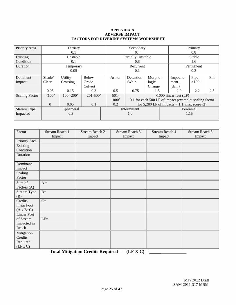
APPENDIX A
ADVERSE IMPACT
FACTORS FOR RIVERINE SYSTEMS WORKSHEET
Priority Area Tertiary
0.1
Secondary
0.4
Primary
0.8
Existing
Condition
Unstable
0.1
Partially Unstable
0.8
Stable
1.6
Duration Temporary
0.05
Recurrent
0.1
Permanent
0.3
Dominant
Impact
Shade/
Clear
0.05
Utility
Crossing
0.15
Below
Grade
Culvert
0.3
Armor
0.5
Detention
/Weir
0.75
Morpho-
logic
Change
1.5
Impound-
ment
(dam)
2.0
Pipe
>100’
2.2
Fill
2.5
Scaling Factor <100’
0
100’-200’
0.05
201-500’
0.1
501-
1000’
0.2
>1000 linear feet (LF)
0.1 for each 500 LF of impact (example: scaling factor
for 5,280 LF of impacts = 1.1, max score=2)
Stream Type
Impacted
Ephemeral
0.3
Intermittent
1.0
Perennial
1.15
Factor Stream Reach 1
Impact
Stream Reach 2
Impact
Stream Reach 3
Impact
Stream Reach 4
Impact
Stream Reach 5
Impact
Priority Area
Existing
Condition
Duration
Dominant
Impact
Scaling
Factor
Sum of
Factors (A)
A =
Stream Type
(B)
B=
Credits
linear Foot
(A x B=C)
C=
Linear Feet
of Stream
Impacted in
Reach
LF=
Mitigation
Credits
Required
(LF x C)
Total Mitigation Credits Required = (LF X C) = ________________
May 2012 Draft
SAM-2011-317-MBM
Page 26 of 47
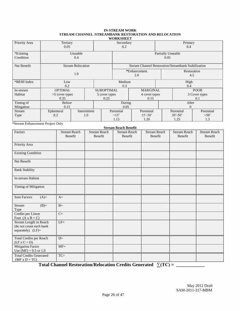
IN-STREAM WORK
STREAM CHANNEL /STREAMBANK RESTORATION AND RELOCATION
WORKSHEET
Priority Area
Tertiary
0.05
Secondary
0.2
Primary
0.4
*Existing
Condition
Unstable
0.4
Partially Unstable
0.05
Net Benefit
Stream Relocation
1.0
Stream Channel Restoration/Streambank Stabilization
*Enhancement
2.0
Restoration
4.5
*BEHI Index Low
0.2
Medium
0.3
High
0.4
In-stream
Habitat
OPTIMAL
>5 cover types
0.35
SUBOPTIMAL
5 cover types
0.25
MARGINAL
4 cover types
0.15
POOR
3 Cover types
0.1
Timing of
Mitigation
Before
0.15
During
0.05
After
0
Stream
Type
Ephemeral
0.2
Intermittent
1.0
Perennial
<15’
1.15
Perennial
15’-30’
1.20
Perennial
30’-50’
1.25
Perennial
>50’
1.3
*Stream Enhancement Project Only
Stream Reach Benefit
Factors Stream Reach
Benefit
Stream Reach
Benefit
Stream Reach
Benefit
Stream Reach
Benefit
Stream Reach
Benefit
Stream Reach
Benefit
Priority Area
Existing Condition
Net Benefit
Bank Stability
In-stream Habitat
Timing of Mitigation
Sum Factors (A)=
A=
Stream (B)=
Type
B=
Credits per Linear
Foot (A x B = C)
C=
Stream Length in Reach
(do not count each bank
separately) (LF)=
LF=
Total Credits per Reach
(LF x C = D)
D=
Mitigation Factor
Use (MF) = 0.5 or 1.0
MF=
Total Credits Generated
(MF x D = TC)
TC=
Total Channel Restoration/Relocation Credits Generated ∑(TC) = ____________

May 2012 Draft
SAM-2011-317-MBM
Page 27 of 47
RIPARIAN BUFFER WORKSHEET
Priority Area Tertiary
0.05
Secondary
0.2
Primary
0.4
Net Benefit (for each
side of stream
Riparian Restoration, Enhancement, and Preservation Factors
(select values from Table 1)
(MBW = Minimum Buffer Width = 50’ + 2’ / 1% slope)
System Protection
Credit
Condition : MBW restored or protected on both streambanks
To calculate:(Net Benefit Stream Side A + Net Benefit Stream Side B) / 2
Timing of Mitigation Before
0.15
During
0.05
After
0
Stream Type Ephemeral
0.9
Intermittent
1.0
Perennial
1.10
Stream Reach Benefit
Factors Stream
Reach 1
Stream
Reach 2
Stream
Reach 3
Stream
Reach 4
Stream
Reach 5
Stream
Reach 6
Priority Area
Net
Benefit
Stream Side A
Stream Side B
System Protection Credit
Condition Met (Buffer on both sides)
Timing of Mitigation
(None for primarily
riparian preservation)
Stream Side A
Stream Side B
Sum Factors (A) A =
Stream Type (B) B=
Credits per Linear Foot
(A x B = C)
C=
Linear Feet of Stream Buffer (LF)
(don’t count each bank separately )
LF=
Total Credits per Reach
(LF x C = D)
D=
Mitigation Factor
Use (MF) = 0.5 or 1.0
MF=
Total Credits Generated
D x MF = TC
TC=
Total Riparian Credits Generated ∑(TC) = ____________

May 2012 Draft
SAM-2011-317-MBM
Page 28 of 47
Appendix B: Guidelines for Stream Mitigation Design
Introduction
The following information is intended to give the stream designer an outline of the minimum
information requirements needed by the Corps of Engineers in reviewing any proposed stream
mitigation project. For instream channel restoration, there is no “one size fits all” simple
approach to address achievement of a successful project. River corridors, and the channels
which convey water and sediments through the corridors, are dynamic and influenced by an
array of physical and ecological processes related to regional climate, geology, hydrologic
regimes, hydraulics, geomorphic channel processes, connectivity to floodplain and riparian
zones, and anthropogenic stressors within the upstream watershed. For each project, it will be
important to take into consideration the effects of upstream land use changes on downstream
delivery of water flow and sediment, particularly when developing the final instream restoration
design to achieve a stable stream restoration project.
As a matter of policy, the Corps will determine, on a case-by-case basis, the net benefit of
mitigation actions that do not involve direct manipulation of the entire length of stream. Stream
creation other than for stream relocation or Priority 1 restoration is not authorized. Riparian
buffer preservation may account for no more than 30% of credits generated by the mitigation
plan. In-stream mitigation within 300 feet of a culvert, dam, or other man-made impact to waters
of the United States generally will generate only minimal enhancement credit.
All restoration and enhancement measures should be designed with the goal of improving the entire stream system within a target stream reach. Designs should be based upon using approved reference stream systems to properly determine stable stream pattern, profile, and dimension, stable stream bank design, and target habitats. The same reference reach strategy can be used to identify the target vegetative species composition, density, and diversity within the adjacent riparian buffer ecosystem. The level of detail required in a mitigation plan will be commensurate with the complexity of the mitigation project. All compensatory mitigation sites must be deed protected using either a conservation easement or restrictive covenant. The conservation easement or restrictive covenant must be approved by the Corps prior to being properly recorded with the appropriate local entity and it is highly recommended projects use the Mobile District’s template found on the Mobile District web page at http://www.sam.usace.army.mil/RD/reg/.
Natural Stream Channel Design
Due to the variation in regional physical and ecological processes acting upon and affecting
stream systems, natural stream channel design is the preferred approach endorsed by the Mobile
District. This approach incorporates regional data from similar stream and valley-type, using a
stable “reference reach”, or reaches, near the restoration site to be used as a template for
designing appropriate pattern, profile, dimension, and habitat characteristics for a stream
restoration project. Reference reaches are streams of the same type (and possibly order) and
position within the watershed that exhibit the least altered condition with stable stream pattern,
profile, dimension, and appropriate substrate and habitat.
May 2012 Draft
SAM-2011-317-MBM
Page 29 of 47
To provide a consistent and standardized framework for communicating stream information
when presenting an instream channel restoration project, applicants should discuss the existing
stream type and condition, preferably using the standardized Rosgen stream classification system
and the current stage using the Lane Stream Channel Evolution Model. This discussion should
center on the assessment of the upstream watershed issues that could influence stream hydrology
and sediment load, verification of bankfull indicators, and a geomorphic stability assessment of
the current stream dimension as well as pattern and profile. Vertical stability metrics include,
but are not limited to, width depth ratio, bank height ratio, and the stream entrenchment ratio.
Lateral stability metrics include, but not limited to, slope, riffle and pool bed features, sinuosity,
meander width ratio, and radius of curvature (see appendix B Summary Data Worksheet). There
may be instances, particularly when there is a significant level of degradation of the stream
channel, where applicants may be requested to discuss a hydraulic assessment to quantify flood
stage, stream velocity, sheer stress and stream power. The level of information collected will be
commensurate with the level of instream features proposed for restoration. The following
sections provide a helpful outline of the information needed for adequate review of stream
restoration projects. Generally, all of the following information is required; however if the
stream designer has cause and rationale for excluding some information they can submit a
request for consideration.
1. Watershed Assessment
The watershed assessment provides information regarding how activities (i.e., development and
agriculture) in the upstream watershed influence stream restoration goals and objectives. For
significantly degraded streams, the watershed assessment may require hydrologic calculations to
assess channel hydraulics and floodplain access. A comprehensive hydrologic evaluation may
not be necessary for projects which have gage station or regional curve data, an undeveloped
(i.e., forest) surrounding land-use cover, or have unaltered access to a floodplain. Information
for the watershed assessment, at a minimum, is as follows:
a) Identify project watershed drainage area
b) Identify past, current and planned land use(s) and land cover(s) in the upstream
watershed
c) Discuss surrounding land use and land cover trends for the project
d) Discuss soils and geology for the watershed and project site
e) Discuss the climate characteristics of the watershed
f) Discuss the topography of the watershed and project site (e.g., basin relief, basin
shape, Rosgen valley type, etc.)
g) Discuss the flow regime and drainage characteristics of the watershed above the
project site (e.g., drainage density, length of natural stream channel, length and
relative amount of impacted reaches.)
2. Existing Stream Assessment
A baseline assessment of the stream itself should be completed prior to beginning the design of a
stream restoration project. The stream assessment will evaluate the current vertical and lateral
stability of the stream and identify any causes of departure from target stable stream conditions.

May 2012 Draft
SAM-2011-317-MBM
Page 30 of 47
Stream assessment metrics must be science-based, but also practicable, repeatable and
appropriate for future comparative analysis (see appendix B Summary Data Worksheet).
a) Identify Rosgen stream type and Lane’s stream evolution stage.
b) Identify any impairment to stream pattern, profile, dimension, or stream
characteristics (e.g., vertical instability, lateral instability, stream habitat).
c) Identify the magnitude of stream impairment (e.g., localized or widespread).
d) Identify the cause(s) of the stream impairment.
e) Discuss bankfull indicator characteristics and bankfull discharge.
f) Discuss how bankfull determination results were identified and validated (the
accurate identification of bankfull is critical to assessing the appropriate stream
classification, its current condition, and its departure from a potential stable state.
The validation of bankfull is often a comparison to a regional bankfull and channel
characteristic curve, however a more intensive validation may be required for a
more complex site).
g) Discuss channel bed substrate and methods used to determine appropriate channel
bed materials.
h) Provide discussion of hydrologic analysis of critical flows including frequency of
bankfull events as well as extent and flows for the 2-year; 5-year; 10-year; 50-year;
and 100 year flood events. This discussion should include the method used to
determine this information.
i) Hydraulic analysis may be requested on significantly degraded stream channels
and will be requested on a project-by-project basis.
h) Provide a detailed basemap that shows the existing stream reach, existing channel
alignment, utilities, large trees, roads, wetlands, property boundaries, and any other
physical elements which might affect the design of the stream restoration project.
The basemap is also used to associate the documentation of the stability and
geomorphic assessment results (e.g., the location of eroding banks, head cuts, and
cross-section data points).
3. Stream Restoration Design Phase
a) Restoration objectives
Developers of stream restoration projects should utilize available information collected within
the watershed, existing stream, and reference reach streams for assessing the cause(s) and levels
of stream impairment and appropriate goals and objectives for the stream restoration project.
The objectives should be both well defined and have measurable performance standards to
evaluate their success. Both temporal and spatial objectives may be developed that are reflective
of the goals of the overall restoration process. In addition to identifying the objectives of the
project, the stream restorationist should also identify and discuss project limitations. There may
be physical limitations which may affect the design, such as historical structure preservation,
property access, or infrastructure conflicts. The design should address both objectives and
limitations of their stream restoration project. The following provides examples of stream
restoration objectives which should be identified early in the project development phase
(amended from Eng et.al. 2009):

May 2012 Draft
SAM-2011-317-MBM
Page 31 of 47
Stream Mitigation Project Objectives (select all appropriate objectives for a project)
Hydrologic Objectives 1. Restore flood flows above the bankfull stage to an abandoned floodplain. Convert
a terrace into an active floodplain by raising the channel bed and associated water
table.
2. Restore channel-forming flows to the appropriately sized channel.
3. Restore wetland and floodplain hydrology to meet the U.S. Army Corps of
Engineers definition of a wetland.
4. Dissipate flood energy by creating a meandering channel and new floodplain at the
existing bankfull elevation. Partially restore lost floodplain and wetland functions.
5. Dissipate flood energy by creating a step-pool channel and floodplain bench at the
existing bankfull elevation. Restore floodprone area functions.
6. For urban channels, restore bankfull discharge to pre-development levels by
providing grade control and/or recreating large floodplains.
7. Create a riparian buffer to reduce flood velocities on the floodplain and encourage
infiltration and sediment deposition.
Fluvial Geomorphologic Objectives
8. Create a stable channel (pattern, profile, and dimension) that neither aggrades nor
degrades over time.
9. Create streambanks that do not erode at rates above natural levels for reference
reach streams of the same stream type.
10. For alluvial systems, restore a riffle-pool bedform sequence such that the pool to
pool spacing and percent riffle-pool matches’ reference reach streams of the same
stream type.
11. For colluvial systems, restore a step-pool bedform sequence such that the pool to
pool spacing matches reference reach streams of the same stream type.
Biological Objectives
12. Create instream features and structures to increase aquatic habitats within a
stream reach.
16. Create a riparian buffer using native plants to improve channel shade, terrestrial
habitat, and improve water quality.
b) Use of reference reaches data for design criteria
The collection of reference reach data and the subsequent development of design criteria are
important to the natural channel design process because the criteria provide the template for
design of the restored channel dimensions, pattern and profile, as well as appropriate aquatic
habitat types.
At a minimum the discussion of the reference data should include:
a) Stream metric data presented at the same level of detail as reach data for the
impaired/proposed restoration reach (Appendix B Summary Data Worksheet).
b) Discuss the suitability of the reference reach as an appropriate design template.

May 2012 Draft
SAM-2011-317-MBM
Page 32 of 47
c) Identify any limitations to reference reach data and discuss how the restoration
design addresses these limitations.
d) Develop and document proposed design criteria of pattern, profile, and dimension.
Provide discussion of appropriate stream channel substrate and stream habitat.
c) Conceptual Stream Design
For a mitigation bank or in lieu fee project, the conceptual stream designs should be
submitted with the Prospectus. The conceptual designs must be submitted early in the permit
evaluation process for permittee responsible compensatory mitigation.
Conceptual designs should include:
a) A general location map showing the location and directions to the restoration
project.
b) Detailed scale map(s) of restoration project reach showing existing conditions,
utilities, delineated wetlands, existing 100-year FEMA floodplain boundary, any
additional waters of the U.S., and major topographic features such as roads and
buildings, etc.
c) Scale map(s) of the restoration reach showing existing and proposed stream
alignment (pattern).
d) Longitudinal profile of existing and proposed conditions showing channel
thalweg, and bankfull stage, proposed bankfull width and type and location of
instream structures
e) Typical before and after cross sectional designs (dimension)
f) Provide a conceptual level stream flow analysis to evaluate existing and proposed
stream flows at bankfull, and provide a discussion how they were incorporated
into proposed stream designs.
g) Provide a conceptual analysis of sediment transport issues by identifying the
status of the existing sediment supply and competency, and whether the stream is
aggrading or degrading. This section should also address the ability of the stream
restoration design to address any aggradation or degradation issues.
5) SIXTY PERCENT DESIGN PLAN
For a mitigation bank or in lieu fee project, the 60% stream designs should be submitted with
the Mitigation Banking Instrument or Project Management Plan. The design plans must be
submitted during the permit evaluation process for permittee responsible compensatory
mitigation. The sixty percent design and accompanying documentation are required for all
projects that propose stream channel modifications. The 60% design plans will build upon
the conceptual design plans and incorporate with the reference reach information by
including alignment geometry (pattern), proposed grading and sloping, revised longitudinal
profiles, detailed cross sectional (cut sheets) designs (dimensions), target benthic substrate,
target stream habitats, erosion and sediment control plans, and the riparian buffer
management plan. If requested, the 60% design plan will include the results of the
hydrologic and hydraulic analysis along with the results of the flood modeling and sediment
transport analysis.
May 2012 Draft
SAM-2011-317-MBM
Page 33 of 47
a) Sixty percent design plans include:
- A detailed revised scale map(s) of the stream restoration reach showing
existing conditions, utilities, delineated wetlands, existing 100-year FEMA
floodplain boundary, any additional waters of the U.S., and major
topographic features such as roads and buildings, etc.
- A detailed revise scale map(s) of the steam restoration reach showing
proposed conditions including the stream alignment, proposed bankfull
width, detailed grading, type and location of instream structures and
proposed FEMA 100-year floodplain boundaries
- A revised longitudinal profile of existing and proposed conditions showing
channel thalweg and bankfull stage, utilities and instream structure
locations, and the alignment geometry.
- Typical riffle and pool cross sections designs reflecting existing
topography and proposed grading
- Instream structure details and design
- A time sequence of construction and construction specifications
b) Erosion and sediment control plans
c) Maintenance Plans
d) Hydrologic and Hydraulic Analysis Report (certain components of the analysis
may be requested on a project-by-project basis depending on the condition of the
stream channel). The hydrologic and hydraulic analysis will evaluate flood
stages, (stream velocity, shear stress, and stream power if requested) and
compare existing with reference stream and proposed flood stage conditions.
The analysis will also evaluate and compare existing and proposed sediment
transport, both competency (i.e., size) and capacity (i.e., load). The method used
to evaluate the hydrology, hydraulics and sediment transport must be stated and
explained. The hydrologic and hydraulics analysis will include (at a minimum):
-Review existing FEMA floodplain studies and include a discussion of the
existing floodplain model and discharges used to develop existing
floodplain limits
- Document the development of a revised existing floodplain model based
on revised discharges, and the floodplain model used (if the existing
FEMA floodplain delineation is inaccurate)
- Prepare water surface profiles for the existing floodplain model, and the
revised or new proposed floodplain model
- Discuss any changes in floodplain limits. It must be demonstrated that
proposed profiles and data are consistent with floodplain management
requirements
- Discuss any changes in stream sediments and sediment transport capacity
If requested, the following comparative hydrologic and hydraulic analysis will also
be included in the 60% design plan:
- Prepare a tractive force analysis that evaluates boundary shear stress for
existing and proposed reference condition;
- Compare existing and proposed shear stress
- Compare existing and proposed stream power and stage or discharge

May 2012 Draft
SAM-2011-317-MBM
Page 34 of 47
- Determine the appropriate sediment transport capacity and competence
for the stream
- Document that the proposed design will provide the correct sediment
transport capacity and competence.
6) Proposed 60% Design Plan Requirements (Required in approved mitigation bank
MBI’s and In-Lieu Fee Project Management Plans)
Cover Sheet
Project name, owner contact, design firm contact
Table of contents
Introduction
Project summary
Scaled detailed vicinity map containing north arrow
Aerial plan view of site, project boundaries, GPS coordinates
Boundary Survey Plans
North arrow, drawing scale, graphic scale
Boundary description
Road names, stream names, area of tract
Reference survey notes and dates
Easements, utilities, restrictions, sensitive areas (cultural resources)
Topographic Survey
Location of streams and wetlands (including reference sites)
Detailed topographic map showing areas of in-stream restoration or enhancement
FEMA floodplain boundaries
Current and historic aerial or other data sources
General Description of Work
For each stream, a description of the linear feet of in-stream restoration or enhancement
and more specific priority type
For each stream, a description of the linear feet of stream requiring structure removal
For each stream, a description of the lengths and widths of riparian buffer restoration,
enhancement, or preservation
General sequence of construction and construction specifications
Stream Specific Restoration Detail Plans
Scaled site plan views showing locations of stream restoration, enhancement, or
preservation polygons along each stream reach
Site plans showing locations of reference reaches
Completed Appendix B Data Summary Worksheet for current, proposed, and reference
reach streams
Scaled site plans showing locations of existing and proposed stream alignment,
bankfull widths, channel thalweg, and type and location of instream structures
Scaled stream plans reflecting comparison of existing and proposed pattern, profile, and
dimension. At minimum, typical cross sectional dimensions for riffles and pools (or
ripple and pool in low gradient streams) that include bankfull dimensions
Design plans for proposed in-stream structures and their specifications

May 2012 Draft
SAM-2011-317-MBM
Page 35 of 47
Bank stabilization plans
Erosion control plans
Maintenance Plan
Riparian Buffer Detail Plans. All streams proposed as mitigation must be protected with riparian
buffers. Except for urban streams, the minimum riparian buffer that can be placed on a stream is
50 feet. Riparian buffer restoration and enhancement actions and target ecological performance
standards should be based upon success criteria developed for each wetland type by the Mobile
District and found on the Regional Internet Banking Information Tracking System (RIBITS) on
the Mobile District Regulatory Division website.
Scaled site plan views showing locations of riparian buffer restoration, enhancement, or
preservation polygons along each stream reach
Proposed Riparian buffer land management strategy and success criteria
Upland riparian buffer restoration and enhancement and target ecological performance
standards should be based upon target species composition, diversity, and structure
metrics similar to that required for forested wetlands, gathered from high quality
reference upland riparian buffers in the same watershed.
Summary Data Worksheet (next page). The following worksheet must be completed and
provided for any in-stream mitigation proposal. For mitigation banks and in-lieu fee projects, the
sheet must be provided for any request for a project success determination, and request
for a stream credit release associated with in-stream work by a mitigation bank.
A data sheet should be completed for each established cross section along the restored reach
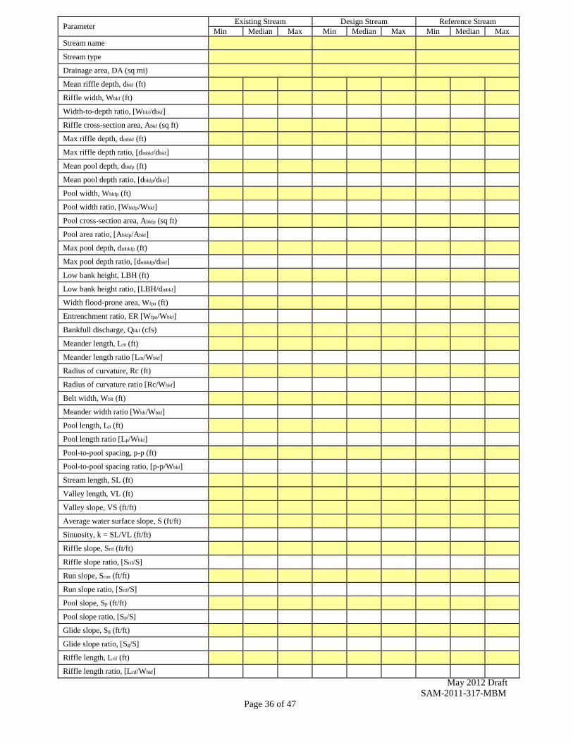
May 2012 Draft
SAM-2011-317-MBM
Page 36 of 47
Parameter Existing Stream Design Stream Reference Stream
Min Median Max Min Median Max Min Median Max
Stream name Stream type Drainage area, DA (sq mi) Mean riffle depth, dbkf (ft) Riffle width, Wbkf (ft) Width-to-depth ratio, [Wbkf/dbkf] Riffle cross-section area, Abkf (sq ft) Max riffle depth, dmbkf (ft) Max riffle depth ratio, [dmbkf/dbkf] Mean pool depth, dbkfp (ft) Mean pool depth ratio, [dbkfp/dbkf] Pool width, Wbkfp (ft) Pool width ratio, [Wbkfp/Wbkf] Pool cross-section area, Abkfp (sq ft) Pool area ratio, [Abkfp/Abkf] Max pool depth, dmbkfp (ft) Max pool depth ratio, [dmbkfp/dbkf] Low bank height, LBH (ft) Low bank height ratio, [LBH/dmbkf] Width flood-prone area, Wfpa (ft) Entrenchment ratio, ER [Wfpa/Wbkf] Bankfull discharge, Qbkf (cfs) Meander length, Lm (ft) Meander length ratio [Lm/Wbkf] Radius of curvature, Rc (ft) Radius of curvature ratio [Rc/Wbkf] Belt width, Wblt (ft) Meander width ratio [Wblt/Wbkf] Pool length, Lp (ft) Pool length ratio [Lp/Wbkf] Pool-to-pool spacing, p-p (ft) Pool-to-pool spacing ratio, [p-p/Wbkf] Stream length, SL (ft) Valley length, VL (ft) Valley slope, VS (ft/ft) Average water surface slope, S (ft/ft) Sinuosity, k = SL/VL (ft/ft) Riffle slope, Srif (ft/ft) Riffle slope ratio, [Srif/S] Run slope, Srun (ft/ft) Run slope ratio, [Srif/S] Pool slope, Sp (ft/ft) Pool slope ratio, [Sp/S] Glide slope, Sg (ft/ft) Glide slope ratio, [Sg/S] Riffle length, Lrif (ft) Riffle length ratio, [Lrif/Wbkf]

May 2012 Draft
SAM-2011-317-MBM
Page 37 of 47
Appendix C: Guidelines for the Development of Performance Standards
Performance standards are defined in the 2008 Mitigation Rule as: observable or measurable
physical, chemical, and/or biological attributes that are used to determine if a compensatory
mitigation project meets its objectives. The Rule goes on to say that performance standards must
be tied to the objectives (see Appendix B-Restoration Objectives) of the project, and must be
objective and verifiable and based on the best available science. All stream mitigation
methodologies, assessments, and performance standards must be practicable, repeatable, and
appropriate for implementation in the Regulatory Program and support other agency needs.
Protocols and methodologies for obtaining measurable attributes must be verified and approved
by the Corps.
The most notable stream system attributes associated with stream restoration projects are stream
geomorphology (pattern, profile, and dimension), hydrology (magnitude, duration, and
frequency), hydraulic (energy), and indirect surrogate metrics for chemistry (riparian buffer), and
biology (stream habitats). While some of these parameters lend themselves to efficient
measurement (e.g. geomorphology and habitat), others are more complicated. Measuring
changes in chemical and biological attributes of stream ecosystems is significantly more
complicated because of natural stochastic variability, regional variability, and quick
responsiveness to changing development influences outside the project area. In these cases, the
Mobile District supports the use of surrogate metrics within the control of the stream restoration
project that are practicable, repeatable, and appropriate for implementation in the Regulatory
Program. There are too many variables that must be addressed for a one-size fits all approach to
stream channel restoration. The Mobile District endorses the use of natural stream channel
design concepts where the development of project specific performance standards are based on
clearly defined objectives and the ability to correlate the appropriate stream restoration metrics
between the stream restoration project and approved reference reaches.
Reference reaches are streams of the same type (sometimes order), and position within the
watershed that exhibit stable stream pattern, profile, and dimension, appropriate benthic
substrates, and representative stream habitats. Reference reaches do not have to be pristine
“totally undisturbed” streams, but should represent the least altered stable stream available for a
watershed. While the reference reach can provide reference stream metrics for the stable stream
at a single point in time, it is important to monitor these systems during the life of the project
since upstream land use changes can also alter the condition of the reference system. Any
changes within the upstream watershed may require adaptive management when developing the
final stream restoration design.
Stream Mitigation Performance Standards
Establishment and acceptance of Reference Stream Reach for target stream pattern,
profile, and dimension using data required by Appendix B Summary Data Worksheet.
The Reference Reach Stream should be evaluated for appropriate benthic substrates and
aquatic habitats.

May 2012 Draft
SAM-2011-317-MBM
Page 38 of 47
Identification of stream attributes requiring stream restoration actions. Restore stream
channel to a stable pattern, profile, and dimension (as appropriate based on impacts),
appropriate benthic substrates, and appropriate aquatic habitats based upon reference
stream parameters.
Maintaining stable stream parameters, substrates, and habitats for at least two bankfull
events, preferably two larger events (i.e., 2-yr, 5-yr, 10-yr, 25yr, etc. events). Exact
calculation of the bankfull return and discharge will be addressed with the information
required in a completed Appendix B Summary Data Worksheet. Bankfull events
typically occur on a return interval of 1.5 or less. The second bankfull event should be no
sooner than 1.5 years after the first event to demonstrate long-term stability of the
restored stream channel. One flow must inundate the floodplain.
Riparian buffers: Except for urban streams, the minimum riparian buffer that can be
placed on a stream is 50 feet. Riparian buffer restoration and enhancement actions and
target ecological performance standards should be based upon success criteria developed
by Mobile District. The Mobile District wetland success criteria are listed on Regional
Internet Banking Information Tracking System (RIBITS) site on Mobile District
Regulatory Division web site (http://www.sam.usace.army.mil/RD/reg/).
Wetland riparian buffers: Site hydrology and vegetation mimics Corps approved wetland
reference site or wetlands performance standards/success criteria (and associated credit
release schedule if a mitigation bank) developed by Mobile District. Riparian
enhancement projects require vegetative improvements. Riparian restoration projects
require monitoring and demonstrating both vegetative and hydrologic improvements. For
hydrology, monitoring wells should be placed in both the project site and the target
reference site for measuring and demonstrating hydrologic improvements.
Upland riparian buffers: An upland reference site is required that is within the same
watershed. Riparian buffer restoration and enhancement ecological performance
standards will be based upon the same attributes (target species composition, density, and
diversity) as reflected in the Mobile District bottomland hardwood performance
standards. All reference sites and proposed performance standards must be approved.
Achievement of performance standards will be determined for each stream reaches through a
comparative analysis of the initial baseline data on physical parameters in the reference stream
and project stream before mitigation is implemented, and monitoring of these physical
parameters annually, for at least 5 years or the life of the mitigation project, and after
mitigation is completed (mitigation banks). Physical parameters that must be measured include
and documenting stream specific stability parameters for pattern, profile, and dimension,
benthic substrates, habitats, as well as deviations from stable stream conditions using, at
minimum, data required by Appendix B and the monitoring data requirements identified in
Appendix D. Although not required, water chemistry parameters such as water temperature,
DO, turbidity, and water pH may be provided above, below, and within the restored stream
reach to demonstrate no short-term adverse impacts resulting from the project. The presence of
various aquatic habitats must be measured which serves as a surrogate to measuring stream
biological productivity metrics such as fish and aquatic insect population metrics. While not
required, aquatic species diversity and abundance may be measured above, below, and within
the restored stream reach to demonstrate no short-term adverse impacts resulting from the
project.

May 2012 Draft
SAM-2011-317-MBM
Page 39 of 47
MITIGATION BANKS: Prior to requesting a credit release, mitigation banks are required to
provide stream measurement data sheets (appendix B worksheet) for each stream reach to
demonstrate achievement of required performance standards, including assessment of stable
stream conditions, appropriate substrates, and appropriate aquatic habitats. Selected cross-
sectional areas should be located at riffle and pool locations that are representative of typical
pattern, profile, and dimension for the entire stream reach. The appropriate number of
measurements will be determined on a project-by-project basis.
When monitoring stream restoration success criteria, information is required for evaluating
hydrologic, geomorphologic, and aquatic habitat attributes of the restored stream ecosystem.
Hydraulic data may be required on a case-by-case basis. The components listed in Appendices B
are important to assessing the baseline condition and restored condition of a restored reach. The
current performance standards for a stream restoration project are reflective of current lateral and
vertical stream channel stability (pattern, profile, and dimension), hydrology and bed form
diversity, channel substrate, aquatic habitat diversity, establishment of the riparian zone, and
floodplain connectivity. Table 1 refers to general performance criteria categories that will be
assessed:
Table 1. General performance criteria categories used to evaluate the success or failure of
activities at stream mitigation project.
Mitigation Component (Item) Success
(Required on action)
Failure
1. Floodplain Connectivity
Stream has access to
the floodplain or
floodprone area. No
signs of headcutting.
Loss of access to floodplain, stream
begins to incise (bed lowering) as
shown by headcuts, stream bank and
stream bed erosion and scour leading
to inappropriate stream profile and
dimension.
2. Stream Channel Stability
Vegetated stream
banks, limited erosion
that does not represent
a trend towards further
lateral instability,
stable stream channel
morphology that is
sustaining reference
stream attributes.
Streambank erosion and avulsion is
prevalent on both adjacent stream
banks and has the potential to cause
large (reach) scale adjustment and
destabilization of stream channel
pattern, profile, dimension, e.g.
down-valley meander bend
migration. Unnatural bank erosion is
predicted to worsen over time.
3. Bed Form Diversity Riffle/pool and depth
variation meets
reference conditions.
Appropriate stream
channel substrates.
Bed form frequency and variation
does not meet reference conditions,
and the loss of natural benthic
substrates

May 2012 Draft
SAM-2011-317-MBM
Page 40 of 47
4. Riparian Vegetation and
Hydrology
Riparian vegetation
and hydrology reflect
or are trending
towards achieving
target success criteria
(invasive species are
not present, hydrology
similar to reference
site, tree and plant
species density,
diversity, and
composition meet
target approved by
Mobile District).
Riparian vegetation and hydrology
not appropriate or indicate a trend
towards failure and not achieving the
target success criteria.
5. Biological Indicators
Aquatic Habitats
*Invertebrate populations
*Fish populations
*Not required as a success
criteria metric
Target aquatic habitat
reflects appropriate
composition, density,
and diversity present
and is demonstrating
sustainability. Though
not required,
supporting data that
reflects no short-term
project related impacts
to endemic aquatic
species populations.
Aquatic habitat composition and
diversity not present or not being
sustained. If collected, data that
reflects project causing negative
impacts to endemic aquatic species
populations.
Adaptive Management:
Contingency Plans/Remedial Actions: In the event the mitigation fails to achieve interim or final
success criteria as specified in the mitigation plan, sponsor shall develop necessary contingency
plans and implement appropriate remedial actions for that phase. In the event the sponsor fails to
implement necessary remedial actions or demonstrate meaningful progress towards achieving the
target success criteria within an appropriate amount of time determined by the Corps, the Corps
will notify sponsor and the appropriate authorizing agencies and require appropriate corrective
actions that may include providing alternative compensation by purchasing mitigation credits
from an approved mitigation bank. The Corps reserves the right to take enforcement actions on
all permit non-compliance issues.

May 2012 Draft
SAM-2011-317-MBM
Page 41 of 47
Appendix D: Stream Mitigation Monitoring Requirements
In general, the monitoring requirements of 33 CFR 332, Compensatory Mitigation For Losses of
Aquatic Resources, dictate monitoring of a compensatory mitigation site as being necessary to
determine if a compensatory mitigation site is meeting its performance standards and, if
necessary, adaptive management is required to ensure the site is meeting its objectives. This
relationship between project objectives (Appendix B), monitoring, and performance standards is
also clearly stated in Regulatory Guidance Letter 08-03, Mitigation Monitoring Requirements
which states, “monitoring reports are documents intended to provide the Corps with information
to determine if a compensatory mitigation project site is successfully meeting its performance
standards. Remediation and/or adaptive management used to correct deficiencies in
compensatory mitigation project outcomes should be based on information provided in the
monitoring reports and site inspections”. The objectives, performance standards, and
monitoring requirements for compensatory mitigation projects required to offset unavoidable
impacts to waters of the United States must be provided as special conditions of the DA permit
or specified in the approved final mitigation plan (see 33CFR 332.3(k)(2)). RGL-08-03 also
outlines the minimum information required submitted in a monitoring report.
Consistent with information requirements in Appendix B, the following list of parameters should
be considered a minimum in developing a monitoring strategy and information to be provided in
monitoring reports. If any of the factors listed below are NOT used to monitor any given project,
the reason for exclusion should be explained either in the mitigation banking instrument or
mitigation plan. The following parameters are required not only to ascertain success of the
project through the achievement of performance standards, but also to collect information to be
used for adaptive management if required. Also consistent with the stream design requirements
in Appendix B, reference stream(s) should also be a component of the monitoring strategy and
monitored for these same parameters to provide a consistency assurance check on the progress of
the project.
The collection of initial baseline data on physical parameters in streams and riparian buffers is
required before mitigation is implemented. Monitoring and collection of the data for
demonstrating progress and the achievement of interim target success criteria is required
annually, for at least 5 years, or until the final success criteria have been achieved. Additional
long-term monitoring may be required after mitigation is completed (mitigation banks).
Instream Monitoring
For projects proposing in-stream mitigation, the monitoring of the stream geomorphology is the
primary means of determining if the restoration is “stable”. Post construction monitoring serves
multiple purposes in that it allows the practitioner to both evaluate the physical character of the
restoration project, and also provides the opportunity to determine the degree of departure from
the original design and /or reference stream over time. Generally, monitoring of this nature
revolves around a suite of geomorphic parameters, and is focused on assuring that the restored
resource is not in a state of disequilibria (i.e. is not experiencing elevated processes of erosion
or aggradation). Relevant measurements (Appendix B Summary Data Worksheet) related to
stream pattern, profile, dimension and bed material are considered key indicators of stream

May 2012 Draft
SAM-2011-317-MBM
Page 42 of 47
stability and, are most commonly evaluated by taking repeated measurements of established
cross-sections and longitudinal profiles. Data from these measurements are useful in
determining the lateral and vertical stability of a restored or enhanced reach, as well as a
reference reach. Therefore, in cases where in-stream restoration activities are proposed,
monitoring will include measurements of geomorphic parameters including channel cross-
sections and longitudinal profiles within the restored stream reaches, as well as on any proposed
reference channels.
To detect potential changes in stream “stability”, permanent channel cross–sections will be
established and located by Global Positioning System in the restored stream reaches. Channel
cross sections will be erected perpendicular to the stream channel within both riffles and pools
where changes in patterns of erosion and sedimentation can be indentified through corresponding
changes in channel geometry (e.g., channel widening, incision, etc.). In order to help ensure
reproducibility during subsequent monitoring events, cross-sections will be monumented at both
ends. Cross-sections will be compared after each monitoring event to detect potential changes in
channel geometry that are both consistent and directional. If Identified and outside of the
designed range, these changes may serve as indicators of channel instability resulting from
disequilibria between erosional and depositional processes within the stream channel.
Stream monitoring will also include surveying longitudinal profiles along restored reaches. The
profiles will be located in such a manner as to provide adequate coverage along the length of the
restores stream reaches. Survey points will include channel thalweg, water surface, inner
berm(s), bankfull stage, and top of low bank. The profiles will be measured to monitor average
water surface slope, slope, depth, and spacing of various streambed features such as riffles, runs,
pools, and glides. The longitudinal profiles will extend parallel to the stream channel for a
distance equal to approximately 20 bank full channel widths. Longitudinal profiles will be
monumented at the upstream end to allow for reproducibility of the profiles during subsequent
monitoring events.
Although not required, water chemistry parameters may be measured with long-term monitoring
data of water temperature, DO, turbidity, and water pH to demonstrate no short-term adverse
impacts from the project. The presence of various aquatic habitats must be measured as a
surrogate to measuring stream biological productivity metrics such as fish and aquatic insect
population metrics. While not required, continuous monitoring of stream aquatic species
diversity and abundance may be measured for the purpose of demonstrating no short-term
adverse impacts from the proposed project and adequate biological recovery of the mitigation
site. Monitoring should occur above, within, and below the project stream reach.
Riparian buffer Monitoring: After initial collection of baseline information on vegetation,
document any changes in the preserved buffer annually for at least 5 years or the life of the
mitigation project. Minimal baseline information to be collected should include vegetation
present, species composition, density, and structure including average species height and average
species diameter at breast height. The site should be continually monitored for the presence of
exotic species and appropriate actions taken when necessary.
Riparian buffer restoration and enhancement: Collection of baseline information on
vegetation in the buffer before mitigation is implemented, and annually for atleast 5

May 2012 Draft
SAM-2011-317-MBM
Page 43 of 47
years or the life of the mitigation project until target success criteria are achieved.
Minimal information to be collected annually should include vegetation data required to
demonstrate achievement of success criteria metrics reflected in the Mobile District’s
habitat success criteria found on the RIBITS Site on the Mobile District web page at
http://www.sam.usace.army.mil/RD/reg/. Riparian restoration projects require
monitoring and demonstrating vegetative and hydrologic improvements. For
restoration projects, monitoring wells should be placed in both the project site and the
target reference site for measuring and demonstrating hydrologic improvements.
Upland riparian buffer restoration and enhancement and target ecological performance
standards should be based upon target species composition, diversity, and structure
metrics similar to that required for forested wetlands, gathered from high quality
reference upland riparian buffers in the same watershed.
Monitoring Reports
Parameters listed underneath the functional headings below will be required to be included in
monitoring reports. The following parameters are comprehensive and some may not be
appropriate depending on the type of stream mitigation being proposed. Reasons for not
including any of the following factors may be submit for IRT review.
A. For any in-stream restoration or enhancement project.
1) Stream pattern, profile, and dimension metrics using Appendix B Summary Data
Worksheet for project site and reference sites.
2) Geomorphology
a. Channel evolution stage
b. Bank migration, erosional patterns, and lateral stability
c. Bed form diversity
d. Bed material characterization
e. Sediment transport competency and capacity*
f. Large woody transport and storage 3) Hydrology: stream flow measurement should be accomplished using stream gaging
techniques.
a. Bankfull discharge: baseline (pre-construction); post construction (first year);
end of project.
b. Precipitation/runoff relationship: baseline versus end of project.*
c. Flood frequency and duration. Recommended this data be collected and
calculated throughout monitoring period.
4) Hydraulic:
a. Floodplain connectivity should be assessed using the following parameters:
Bank height ratio; entrenchment ratio
b. Flow dynamics: stream velocity*
B. For riparian zone restoration/enhancement project.
1) Current vegetative management actions
a. Target habitat and acreages of mitigation polygon.
b. Current land management actions achieved.

May 2012 Draft
SAM-2011-317-MBM
Page 44 of 47
c. Data supporting progress towards achieving the interim or final Mobile
District wetland habitat success criteria, or upland habitat success criteria
metrics based on an approved reference site.
2) Current hydrologic management actions (if proposed).
3) Current soil management actions (if proposed).
* As needed on a case-by-case basis

May 2012 Draft
SAM-2011-317-MBM
Page 45 of 47
Appendix E: Proposed Example of a Credit Release Schedule for
Mitigation Banks and In-Lieu Fee Programs
Independent credit release schedules must be developed for each stream reach. The first
credit release for each habitat type, regardless of the scientific based success criteria, will include
proof of subjugation of any liens or encumbrances on the property to the conservation easement.
After initial credit release, preservation credits will be authorized in direct proportion to
the percentage of funding of the long-term stewardship fund.
Stream Restoration (In-Stream and Riparian Restoration) – Credit Release Schedule (IRT
standards). Credit releases below apply/assume stream buffer restoration (bottomland hardwood
wetlands) and channel restoration as noted below.
Stream A
20% Initial release (buffer and instream credits) for approved MBI, conservation easement,
financial assurance and approval of final detailed stream channel restoration design plans.
For riparian restoration work, groundwater monitoring wells installed/arrayed in project
site and reference site to document the timing, duration and frequency of hydrology.
10% Upon completion of site preparation/earthwork and hydrology work related to stream
buffer and channel (see explanation below). To assess in-channel hydrology, stream
gages installed and correlated with bankfull indicators to show correct baseline and post
project stream geomorphology.
Upon completion of initial construction and submittal of post-construction monitoring
report (see Appendix D) submitted documenting physical, hydrological, and biological
improvements made pursuant to the stream channel restoration plan. Stream channel
work requires submittal of Appendix B Summary Data Worksheet. Improvements
include: new channel construction, grading, construction of bankfull benches, placement
and construction of in-stream structures, and bank stabilization measures.
For riparian buffer areas, groundwater monitoring well data should be provided that
demonstrates the appropriate magnitude, duration, and frequency of inundation and/or
saturation.
Riparian buffer target species managed to achieve initial planting/vegetation success
criteria metrics identified in the Mobile District habitat success criteria.
If the long-term management will be coordinated by a long-term management board, the
board members must be named by agency/profession and name. The long-term land
management board must be composed of private and conservation interests and approved
by the Interagency Review Team (IRT).
20% Following first successful bankfull event.
Success evaluated by stream stability of both in-stream pattern, profile, and dimension,
streambank stability, and appropriate benthic substrates as documented by re-survey of
the fixed cross-sections and monitoring points including photographic documentation,
narrative descriptions (including aquatic habitat), and completed Appendix B Summary
Data worksheet.

May 2012 Draft
SAM-2011-317-MBM
Page 46 of 47
Riparian Buffer: visual evidence of appropriate target species (and individual seedling)
placement in relation to appropriate topographic/hydrologic habitat.
Riparian Buffer: Positive trend in target species composition, diversity, and density
towards achieving Mobile District success criteria.
30% Following second successful bankfull event.
Success evaluated by stream stability of both in-stream pattern, profile, and dimension,
streambank stability, and appropriate benthic substrates as documented by re-survey of
the fixed cross-sections and monitoring points including photographic documentation,
narrative descriptions (including aquatic habitat), and completed Appendix B Summary
Data worksheet. Second bankfull event should have a return interval approximately 1.5
years from date of first bankfull event.
Riparian Buffer: visual evidence of species (and individual seedling) placement in
relation to appropriate topographic/hydrologic habitat.
Riparian Buffer: positive trend in target species composition, diversity, and density
towards achieving success criteria. Tree plantings show positive growth of root collar,
diameter, and/or height.
10% After fifth (5th
) year of successful bank stability and riparian monitoring.
Success evaluated by stream stability of both in-stream pattern, profile, and dimension,
streambank stability, and appropriate benthic substrates as documented by re-survey of
the fixed cross-sections and monitoring points including photographic documentation,
narrative descriptions (including aquatic habitat), and completed Appendix B Summary
Data worksheet.
Riparian Buffer: post-planting of shrubs and herbaceous layer.
Riparian Buffer: a minimum of three years positive growth of planted tree species is
required before shrubs and herbs are planted and/or naturally regenerate. Positive trend
in target species composition, diversity, and density towards achieving success criteria.
Tree plantings show positive growth of root collar, diameter, and/or height.
Riparian Buffer: visual evidence of appropriate shrubs and herbs planted sparingly or
naturally recruited, in small groupings across site.
Full funding of Long-Term Land Stewardship Fund (non-wasting escrow account).
10% Final credit release upon completion of monitoring (approximately year 10),
Success evaluated by stream stability of both in-stream pattern, profile, and dimension,
streambank stability, and appropriate benthic substrates as documented by re-survey of
the fixed cross-sections and monitoring points including photographic documentation,
narrative descriptions (including aquatic habitat), and completed Appendix B Summary
Data worksheet.
Riparian Buffer: A minimum of nine years positive growth of planted tree species.
Riparian Buffer has achieved all the target success criteria required in the Mobile District
habitat success criteria

May 2012 Draft
SAM-2011-317-MBM
Page 47 of 47
References
Eng, C.K., Shea, C.C., Starr, R.R., and Davis, S.L. 2009. Natural Channel Design Protocols for
Baltimore City, Maryland. U.S. Fish and Wildlife Service. CBFO-S09-03.
Fritz, K.M., Johnson, B.R., and Walters, D.M. 2006. Field Operations Manual for Assessing the
Hydrologic Permanence and Ecological Condition of Headwater Streams. EPA/600/R-06/126.
U.S. Environmental Protection Agency, Office of Research and Development, Washington DC.
Federal Register, Vol. 77, No. 34, Tuesday, February 21, 2012, Reissuance of nationwide permits.
Leopold, L.B. M.G. Wolman, and J.P. Miller, 1964. Fluvial Processes in Geomorphology. W.H.
Freeman & Co. San Francisco, CA, USA.
U.S. Army Corps of Engineers, Mobile District Regional Internet Banking and In-Lieu Fee
Tracking System (RIBITS) site on Mobile District Regulatory Division web site
(http://www.sam.usace.army.mil/RD/reg/).
NC Division of Water Quality. 2010. Methodology for Identification of Intermittent and
Perennial Streams and their Origins. 4.11. North Carolina Department of Environment and
Natural Resources, Division of Water Quality, Raleigh, NC.
Rosgen, D.L. 1994. A classification of natural rivers. Catena 22:169-199.
Rosgen, David. 1996. Applied River Morphology. Wildland Hydrology Books, 1481 Stevens
Lake Road, Pagosa Springs, CO. 81147, 385 pp.
Rosgen, D.L. 1997. A Geomorphological Approach to Restoration of Incised Rivers. Conference
on Management of Landscapes Disturbed by Channel Incision. ISBN 0-937099-05-8.
Rosgen, D.L. A Practical Method of Computing Streambank Erosion Rate. Proceedings of the
Seventh Federal Interagency Sedimentation Conference. Vol. 2, pp. II -9-15, March 25-29, 2001,
Reno, NV.
Simon, A. 1989. A model of channel response in disturbed alluvial channels. Earth Surface
Processes and Landforms 14(1):11-26.
U.S. Army Corps of Engineers. 2010. Operational Draft Regional Guidebook for the Functional
Assessment of High-gradient Ephemeral and Intermittent Headwater Streams in Western West
Virginia and Eastern Kentucky. Engineer and Research Development Center, ERDC/EL TR-10-
11.


![Army Corps Neg[1]](https://img.pdfslide.us/doc/110x75/577cde9a1a28ab9e78af7164/army-corps-neg1.jpg)