Embed Size (px)
Citation preview

DELIVERING OUR TRANSPORT FUTURE NOW
north-south corridor southern expressway duplication
Further informationCall: 1300 626 097
Email: [email protected]
Visit: dpti.sa.gov.au/southern_expressway_duplication

project overviewThe $407.5 million Southern Expressway Duplication project will transform the one-way reversible expressway into an 18.5 kilometre multi-lane, two-way expressway between Bedford Park and Old Noarlunga by mid 2014.
before after
This expressway is an important strategic route, linking the southern region with the wider metropolitan area and the CBD and is expected to take up to two years to complete.
The new carriageway will be constructed on the western side of the existing roadway and will give northbound traffic two lanes from Old Noarlunga to Reynella and four lanes from Reynella to Bedford Park. The existing carriageway will be used by southbound traffic
with three lanes from Bedford Park to Reynella and two lanes from Reynella to Old Noarlunga.
The design and construction works are being undertaken by a Joint Venture involving Baulderstone and Abigroup.
Monthly updates will be provided online, along with advance notice of construction activities for local residents, businesses, public transport commuters and road users throughout the project. In addition, the project team will be working with community groups and local businesses affected by construction.
Large D11 dozer used for rock breaking and other construction activities.
Artists impression of duplicated expressway near Seacombe Road (image for illustration purposes).
traffic restrictionsGenerally the number of lanes on the expressway will not be reduced during peak periods, however the expressway may be closed during weekends and weekday off-peak periods when required.
Traffic will be carefully managed to minimise disruption for motorists while ensuring the project can progress on schedule. Motorists are advised to allow more time for travel while construction is underway, take care on the road and adhere to speed restrictions, which are in place for everyone’s safety.
Due to roadside hazards, reduced lane widths and a changing road traffic environment during construction, reduced speed limits will be in place along the
expressway as required. Safety is a high priority during construction and these speed limit reductions will ensure a safe environment is provided for both workers and the travelling public.
Road users will be notified in advance of any major closures of the expressway or surrounding roads through the project website, traffic updates on local radio stations and local letterbox drops for bridge closures.
design worksDesign and construction of the new carriageway is being undertaken concurrently, with the design being continually refined as the project progresses. The expressway alignment and interchange designs have been completed. The design of the landscaping, noise attenuation treatments, pathways and urban design features will be progressively finalised throughout the project.
Directly affected residents will continue to be engaged throughout the design process on specific design issues.
The final design of the new road and interchanges is available on the website at dpti.sa.gov.au/southern_expressway_duplication
construction worksConstruction of the 18.5 kilometre roadway is complex with multiple work sites and various activities occurring simultaneously.Generally, construction will be undertaken in the following order:
> relocation of utility services
> earthworks and drainage activities
> construction of bridges and interchanges
> construction of the new road carriageway and ancillary work such as noise treatments, lighting, line marking and signage
> landscaping.
In addition, the rock in the escarpment between Seacombe Road and Majors Road will be cleared with a series of small controlled blasts to make way for the new city-bound carriageway.
The project corridor includes some 170 service utilities, which require relocation, protection or adjustment. Advance notice of any service interruptions will be provided to affected residents and businesses.
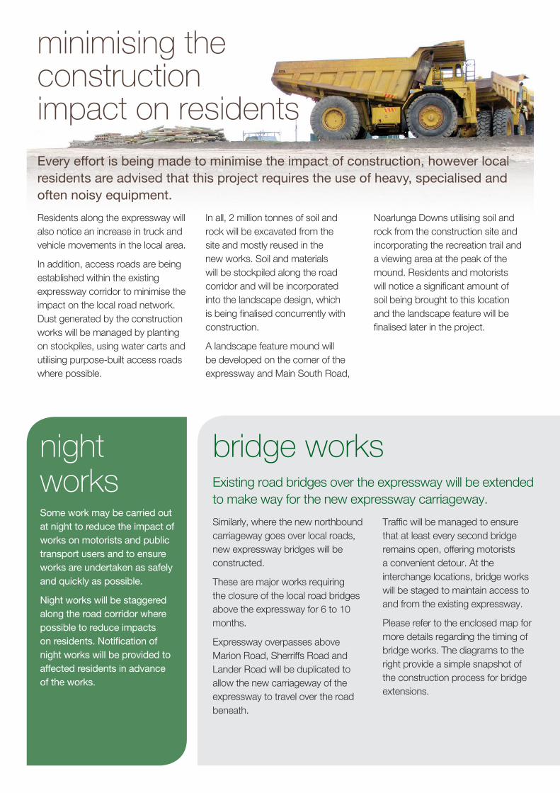
Road truck and excavator relocating soil and rock.
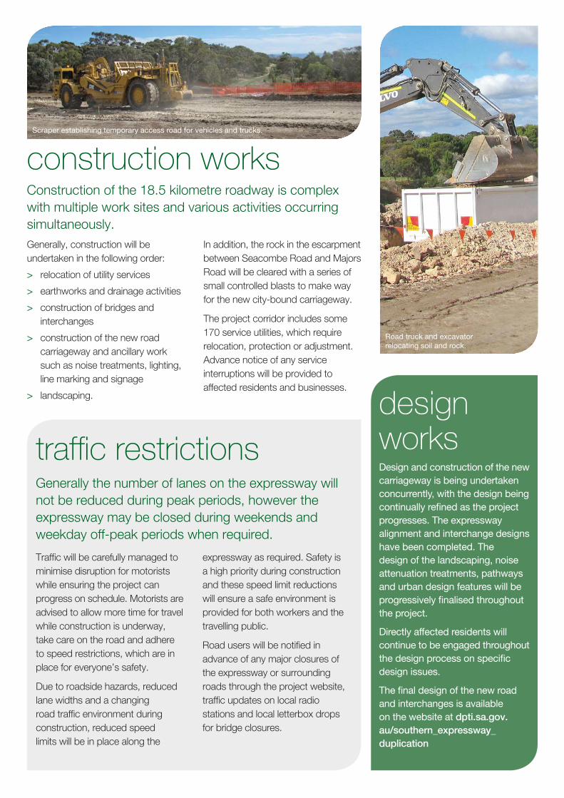
Scraper establishing temporary access road for vehicles and trucks.

BAINS RDBAINS RD
STAT
ES R
DST
ATES
RD
MAI
N SO
UTH
RDM
AIN
SOUT
H RD
BEACH RDBEACH RD
STURT RDSTURT RD
LONSD
ALE R
D
LONSD
ALE R
D
RIVER RDRIVER RD
BLACK RDBLACK RD
THE COVE RD
THE COVE RD
PANA
LATI
NGA
RDPA
NALA
TING
A RD
FLAXMILL RDFLAXMILL RD
ELIZABETH RDELIZABETH RD
YOUN
G ST
YOUN
G ST
SEACOMBE RDSEACOMBE RD
HAPPY VALLEY DR
HAPPY VALLEY DR
LANDER RDLANDER RD
BROD
IE R
DBR
ODIE
RD
MAJORS RDMAJORS RD
OCEAN BVDOCEAN BVD
COM
MER
CIAL
RD
COM
MER
CIAL
RD
BRIG
HTON
RD
BRIG
HTON
RD
SHERRIFFS RDSHERRIFFS RD
MOORE RDMOORE RD
MOR
PHET
T RD
MOR
PHET
T RD
HONEYPOT RDHONEYPOT RD
PERRY BARR RDPERRY BARR RD
CHANDLERS HILL RD
CHANDLERS HILL RD
KENIHANS RDKENIHANS RD
PIMPALA RDPIMPALA RD
FLAGSTAFF RD
FLAGSTAFF RD
GRANT RDGRANT RD
WHEATSHEAF RDWHEATSHEAF RD
O'SULLIVAN BEACH RDO'SULLIVAN BEACH RD
DIAGONAL RD
DIAGONAL RD
MANNING RD
MANNING RD
OLD SOUTH
RD
OLD SOUTH
RD
PATA
PIND
A RD
PATA
PIND
A RD
MAR
ION
RDM
ARIO
N RD SHEPHERDS HILL RD
SHEPHERDS HILL RD
GOLDSMITH DRGOLDSMITH DR
REYN
ELLA
BYP
ASS
RD
REYN
ELLA
BYP
ASS
RD
DOCTORS RDDOCTORS RD
WINDEBANKS RDWINDEBANKS RD
JETTY RDJETTY RD
MURRAY RDMURRAY RD
MIL
LER
STM
ILLE
R ST
PENNEYS HILL RDPENNEYS HILL RD
SHERRIFFS RD WESTSHERRIFFS RD WEST
MAIN SO
UTH RD
MAIN SO
UTH RD
DYSO
N RD
DYSO
N RD
DYSON RDDYSON RD
MAIN SOUTH RD
MAIN SOUTH RD
MAI
N SO
UTH
RDM
AIN
SOUT
H RD
CHAN
DLER
S HI
LL R
DCH
ANDL
ERS
HILL
RD
ONKAPARINGAHILLS
ONKAPARINGAHILLS
LONSDALELONSDALE
HAPPYVALLEYHAPPYVALLEY
MORPHETTVALE
MORPHETTVALE
HALLETTCOVE
HALLETTCOVE
MCLAREN VALEMCLAREN VALE
WOODCROFTWOODCROFT
HACKHAMHACKHAM
MARINOMARINO
FLAGSTAFFHILL
FLAGSTAFFHILL
O'HALLORANHILL
O'HALLORANHILL
REYNELLAREYNELLA
TROTTPARKTROTTPARK
SHEIDOWPARK
SHEIDOWPARK
NOARLUNGADOWNS
NOARLUNGADOWNS
CLARENDONCLARENDON
CHRISTIEDOWNS
CHRISTIEDOWNS
SEAFORDMEADOWSSEAFORDMEADOWS
BEDFORDPARK
BEDFORDPARK
CHRISTIESBEACH
CHRISTIESBEACH
STURTSTURT
SEACLIFFPARK
SEACLIFFPARK
OLDREYNELLA
OLDREYNELLA
EDENHILLSEDENHILLS
PORTNOARLUNGA
PORTNOARLUNGA
SEAVIEWDOWNSSEAVIEWDOWNS
BRIGHTONBRIGHTON
BELLEVUEHEIGHTS
BELLEVUEHEIGHTS
PORTNOARLUNGA
SOUTH
PORTNOARLUNGA
SOUTH
HACKHAMWEST
HACKHAMWEST
HUNTFIELDHEIGHTS
HUNTFIELDHEIGHTS
DARLINGTONDARLINGTON
ABERFOYLEPARK
ABERFOYLEPARK
O'SULLIVANBEACH
O'SULLIVANBEACH
SEACLIFFSEACLIFF
REYNELLAEAST
REYNELLAEAST
CHANDLERSHILL
CHANDLERSHILL
DOVERGARDENS
DOVERGARDENSSOUTH
BRIGHTONSOUTH
BRIGHTON
NOARLUNGACENTRE
NOARLUNGACENTRE
CRAIGBURNFARM
CRAIGBURNFARM
MARIONMARION
KINGSTONPARK
KINGSTONPARK
WARRADALEWARRADALEOAKLANDS PARKOAKLANDS PARK MITCHELL PARKMITCHELL PARK ST MARYSST MARYS
SEACOMBEGARDENS
SEACOMBEGARDENS
SEACOMBEHEIGHTS
SEACOMBEHEIGHTS
CLOVELLY PARKCLOVELLY PARK PASADENAPASADENAHOVEHOVE
Sugarbush pathSugarbush path
Glenhelen pathGlenhelen path
Poznan pathPoznan path
Peppermint pathPeppermint path
Perry pathPerry path
N
bridge closures legend
overpass restrictions
path closures
Seacombe Road bridge, Darlington Completed and open
2 Panalatinga Road, Reynella to Main South Road, Darlington
Northbound carriageway – 4 lanes
Southbound carriageway – 3 lanes (existing)
Main South Road, Old Noarlunga to Panalatinga Road, Reynella
Northbound carriageway – 2 lanes
Southbound carriageway – 2 lanes (existing)
Road Bridge (closure)
Road Bridge (road open with lane/speed restrictions)
Overpasses (restrictions)
Pedestrian bridges (closure)
1
2
3
4
5
67
8
9
10
11
12
13
14
15
16
17
Majors Road bridge, O’Halloran Hill Open November 2013
3
Young Street bridge, Reynella No closure required
5
6
O’Sullivan Beach Road bridge, Lonsdale Completed and open
9
Flaxmill Road bridge, Christie Downs From mid July 2013 until early 2014
11
Elizabeth Road bridge, Christie Downs Completed and open
12
Beach Road bridge, Christie Downs Traffic restrictions from May 2012 to early 2014 with a minimum of one lane in each direction during peak periods until November 2013
13
Honeypot Road bridge, Hackham West Closed late October 2013 to March 2014
15
Marion Road overpass, SturtTraffic restrictions from May 2013
1
Lander Road overpass, Trott Park Completed and open
4
Sherriffs Road overpass, Morphett ValeTraffic restrictions from April 2013
8
Sugarbush pathFrom Sept 2013 until Feb 2014
7
Glenhelen pathOpenShort-term closure required in November 2013 for installation of canopy
10
Poznan pathOpen November 2013
14
Peppermint pathOpenShort-term closure required in November 2013 for installation of canopy
16
Perry pathOpenShort-term closure required in November 2013 for installation of canopy
17
construction overview
Map for illustration purposes (not to scale).Updated October 2013.
Moore Road bridge, Reynella Completed and open
minimising the construction impact on residents
Every effort is being made to minimise the impact of construction, however local residents are advised that this project requires the use of heavy, specialised and often noisy equipment.
Residents along the expressway will also notice an increase in truck and vehicle movements in the local area.
In addition, access roads are being established within the existing expressway corridor to minimise the impact on the local road network. Dust generated by the construction works will be managed by planting on stockpiles, using water carts and utilising purpose-built access roads where possible.
In all, 2 million tonnes of soil and rock will be excavated from the site and mostly reused in the new works. Soil and materials will be stockpiled along the road corridor and will be incorporated into the landscape design, which is being finalised concurrently with construction.
A landscape feature mound will be developed on the corner of the expressway and Main South Road,
Noarlunga Downs utilising soil and rock from the construction site and incorporating the recreation trail and a viewing area at the peak of the mound. Residents and motorists will notice a significant amount of soil being brought to this location and the landscape feature will be finalised later in the project.
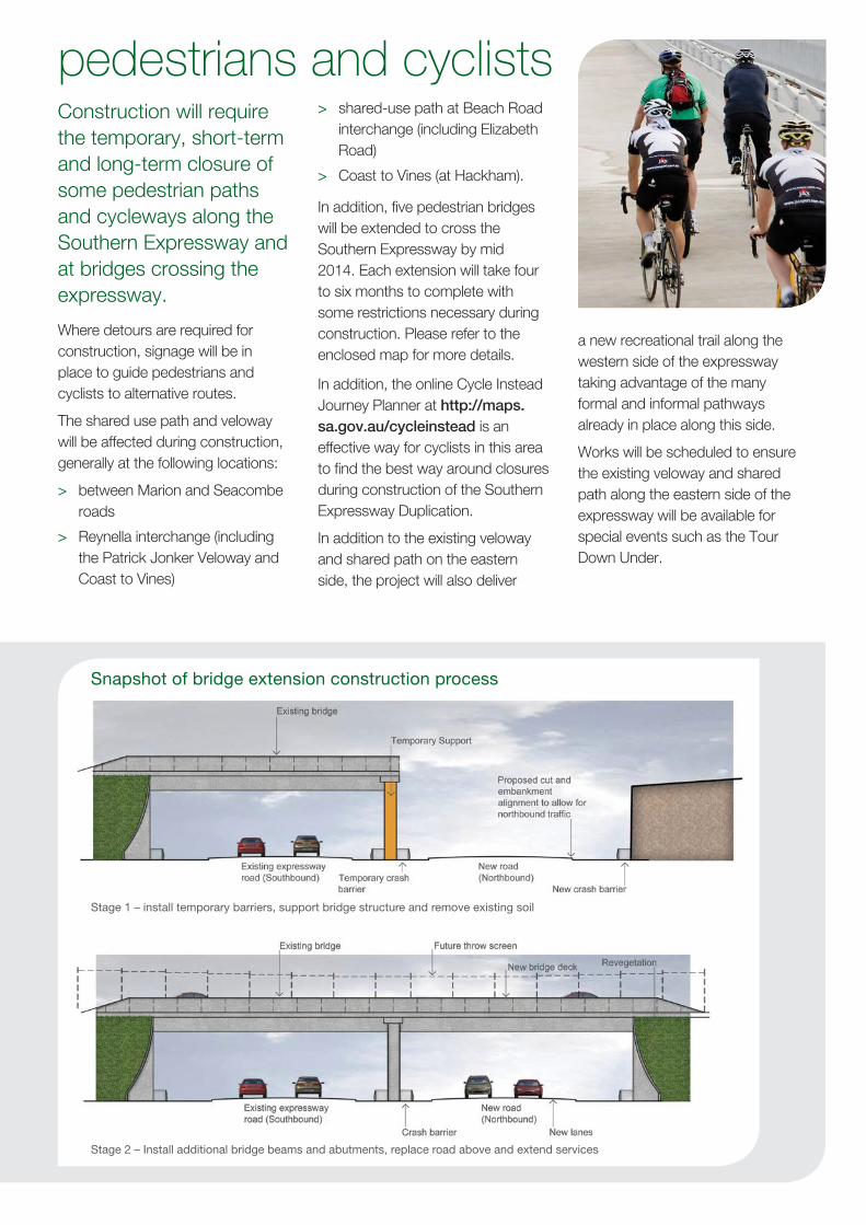
bridge worksExisting road bridges over the expressway will be extended to make way for the new expressway carriageway.
Similarly, where the new northbound carriageway goes over local roads, new expressway bridges will be constructed.
These are major works requiring the closure of the local road bridges above the expressway for 6 to 10 months.
Expressway overpasses above Marion Road, Sherriffs Road and Lander Road will be duplicated to allow the new carriageway of the expressway to travel over the road beneath.
Traffic will be managed to ensure that at least every second bridge remains open, offering motorists a convenient detour. At the interchange locations, bridge works will be staged to maintain access to and from the existing expressway.
Please refer to the enclosed map for more details regarding the timing of bridge works. The diagrams to the right provide a simple snapshot of the construction process for bridge extensions.
night worksSome work may be carried out at night to reduce the impact of works on motorists and public transport users and to ensure works are undertaken as safely and quickly as possible.
Night works will be staggered along the road corridor where possible to reduce impacts on residents. Notification of night works will be provided to affected residents in advance of the works.
pedestrians and cyclistsConstruction will require the temporary, short-term and long-term closure of some pedestrian paths and cycleways along the Southern Expressway and at bridges crossing the expressway.
Where detours are required for construction, signage will be in place to guide pedestrians and cyclists to alternative routes.
The shared use path and veloway will be affected during construction, generally at the following locations:
> between Marion and Seacombe roads
> Reynella interchange (including the Patrick Jonker Veloway and Coast to Vines)
> shared-use path at Beach Road interchange (including Elizabeth Road)
> Coast to Vines (at Hackham).
In addition, five pedestrian bridges will be extended to cross the Southern Expressway by mid 2014. Each extension will take four to six months to complete with some restrictions necessary during construction. Please refer to the enclosed map for more details.
In addition, the online Cycle Instead Journey Planner at http://maps.sa.gov.au/cycleinstead is an effective way for cyclists in this area to find the best way around closures during construction of the Southern Expressway Duplication.
In addition to the existing veloway and shared path on the eastern side, the project will also deliver
a new recreational trail along the western side of the expressway taking advantage of the many formal and informal pathways already in place along this side.
Works will be scheduled to ensure the existing veloway and shared path along the eastern side of the expressway will be available for special events such as the Tour Down Under.
Snapshot of bridge extension construction process
Stage 1 – install temporary barriers, support bridge structure and remove existing soil
Stage 2 – Install additional bridge beams and abutments, replace road above and extend services
An Environmental Management Plan has been developed to manage the impact on the environment, including the management of:
> water quality (and stormwater management during construction)
> vegetation removal
> Indigenous and European heritage
> noise modelling and attenuation measures, such as noise walls
> air quality, including dust management
> landscaping and urban design.
Landscaping will be undertaken to offset vegetation removals for the project and will include approximately:
> 75 000 amenity plantings (trees and shrubs)
> 1.7 hectares of native revegetation
> Over 200 semi-mature trees
For further information, environmental management fact sheets for the project can be downloaded online at dpti.sa.gov.au/southern_expressway_duplication
environmental management
interchanges
Existing interchanges will need to be modified to create new on and off ramps for the two-way expressway including:
> Main South Road, Darlington
> Marion Road, Sturt
> Panalatinga Road/Main South Road, Reynella
> Sherriffs Road, Reynella
> Beach Road, Noarlunga
> Main South Road, Old Noarlunga
During construction, these interchanges will remain open for access to the existing expressway in peak periods however lane and speed restrictions will be in place.
At the completion of the project, all existing access to and from the expressway will be maintained at each interchange.
More information regarding the design of these interchanges including arrangements for accessing the expressway once construction is complete can be found online at dpti.sa.gov.au/southern_expressway_duplication
river diversionsAs part of the expressway works a 300 metre section of the Field River and Trott Park Creek adjacent the Reynella interchange will be realigned to the west.
This will include an extension of the Field River culvert (pipe) under the new expressway carriageway.
In addition, a further 200 metre section of the Field River will be realigned just north of Young Street Bridge.
A key objective of these diversions is to rehabilitate the realigned river sections with native riparian plantings and develop the recreational trail through this area with viewing areas to create a place that the community can enjoy.
The current landscape concepts and further details of the river diversions are available online at dpti.sa.gov.au/southern_expressway_duplication
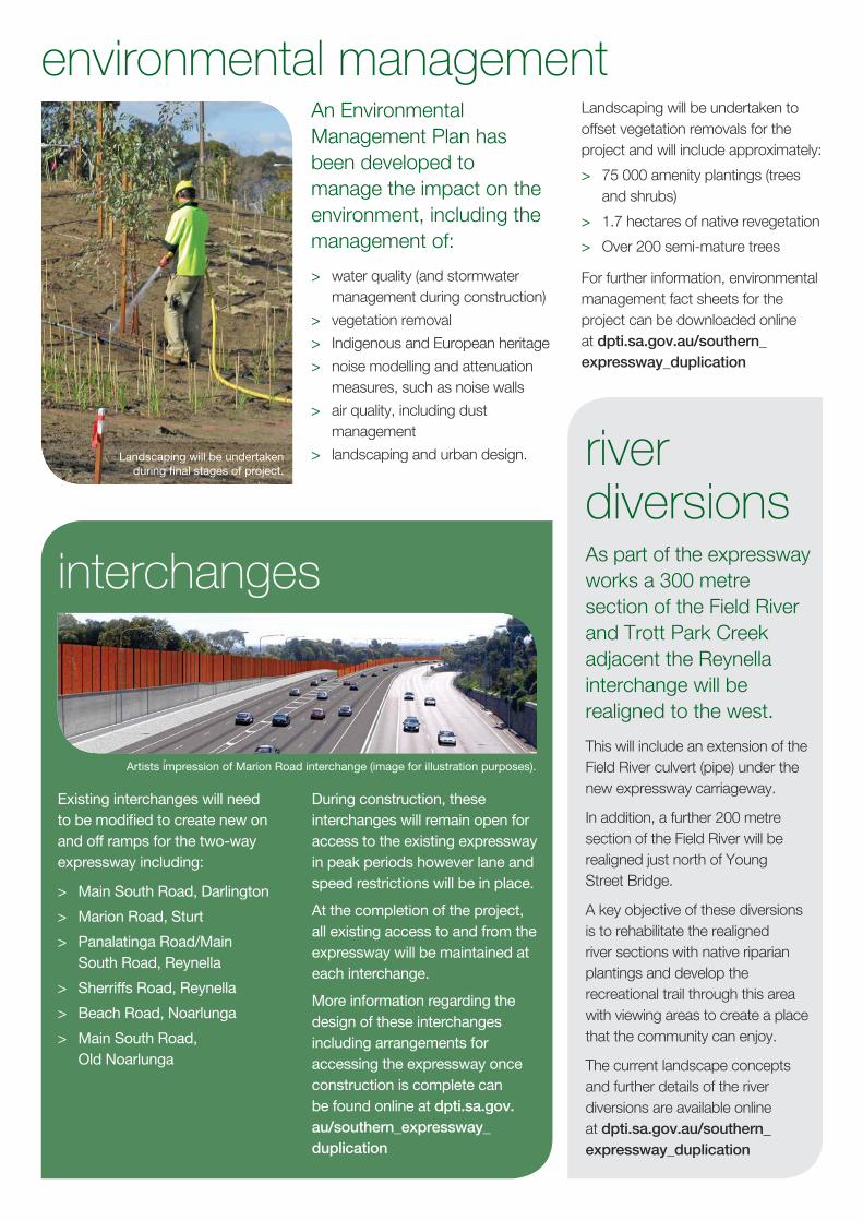
Artists impression of Marion Road interchange (image for illustration purposes).
Landscaping will be undertaken during final stages of project.

further information, feedback, subscribe for updates
> visit: dpti.sa.gov.au/southern_expressway_duplication
> call: 1300 626 097
> email: [email protected]
> site office: 3 Majors Road, O’Halloran Hill, SA 5158
> post: Southern Expressway Duplication, Department of Planning, Transport and Infrastructure, Reply Paid 1533, Adelaide SA 5001
social mediaTo receive the latest news feed from DPTI including project and traffic updates:
twitter.com/dpti_sa facebook.com/dptisa
www.dpti.sa.gov.au
public transport enquiriesFor further information about public transport changes:
> check: local bus stop for route and timetable changes
> call: Adelaide Metro InfoLine on 1300 311 108 (7am to 8pm daily). For customers with a hearing impairment please use TTY on 8303 0844.
> visit: adelaidemetro.com.au or an Adelaide Metro Info Centre on Currie Street, Adelaide or at Adelaide Railway Station or your nearest Adelaide Metro Info Bar.
public transport Construction works will affect some bus services that use the existing expressway, interchanges and surrounding roads. Bus users are advised to allow for extra travel time during these works.
Extensive planning is being undertaken to manage the disruption and provide public transport customers with as much notice as possible about service changes and route detours.
The following bus services are likely to experience extra travel time, particularly during peak periods, before 9.30am and after 3.30pm, Monday to Friday:
> T748, 750, 751, 751W - between the Beach Road interchange and the southern exit at Old Noarlunga
> 721X, T721, T721X, 722X, T722, 723X - between the Reynella interchange and Bedford Park junction with Main South Road.
Other bus services that use bridges and roads surrounding the Southern Expressway will also be affected by construction works. The closure of bridges or roads will be carefully staged to provide buses viable alternative routes and minimise inconvenience.