Embed Size (px)
Citation preview
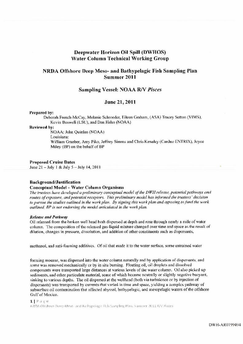
Deepwater Horizon Oil Spill (DWHOS)Water Column Technical Working Group
NRDA Offshore Deep Meso- and Bathypelagic Fish Sampling PlanSummer 2011
Sampling Vessel: NOAA R/V Pisces
June 21,2011
Prepared by:Deborah French-McCay, Melanie Schroeder, Eileen Graham, (ASA) Tracey Sutton (VIMS),
Kevin Bosv^elt (LSU), and Dan Hahn (NOAA)Reviewed by:
NOAA: John Quinlan (NOAA)Louisiana:William Graeber, Amy Piko, Jeffrey Simms and Chris Kenaley (Cardno ENTRIX), Joyce Miley (BP) on the behalf o f BP
Proposed Cruise DatesJune 21 - July I & July 5 -J u ly 14,2011
Background/JustificationConceptual Mode! - Water Column OrganismsThe trustees have developed a preliminary conceptual model o f the DWH release, potential pathways and routes o f exposure, and potential receptors. This preliminary model has informed the trustees' decision to pursue the studies outlined in the work plan. By signing this work plan and agreeing to fu n d the work outlined, BP is not endorsing the model articulated in the work plan.
Release and PathwayOil released from the broken well head both dispersed at depth and rose through nearly a mile o f water column. The composition o f the released gas-liquid mixture changed over time and space as the result of dilution, changes in pressure, dissolution, and addition o f other constituents such as dispersants,
methanol, and anti-foaming additives. O f oil that made it to the water surface, some entrained water
forming mousse, was dispersed into the water column naturally and by application of dispersants, and some was removed mechanically or by in situ burning. Floating oil, oil droplets and dissolved components were transported large distances at various levels of the water column. Oil also picked up sediments, and other particulate material, some o f which became neutrally or slightly negative buoyant, sinking to various depths. The oil dispersed at the wellhead (both via turbulence or by injection o f dispersants) was transported by currents that varied in time and space, yielding a complex pathway o f subsurface oil contamination that affected abyssal, bathypelagic, and mesopelagic waters o f the offshore G ulf of Mexico.1 I P ,1 g eN R D A O f f s l i o r e U G u p M o s o . s n d B.UliVF^'ulaf'tr (-i'Ji S d U ip l in R PI i n , S u n m i P t ’. O i l I t /V P o c c s
DWH-ARO199494
Routes o f ExposureFish and invertebrates in the water column are exposed to contaminants by swimming through contaminated water, spending time on/in contaminated sediments, taking up contaminants through body surfaces, passing contaminated water over respiratory structures, and ingesting water, oil droplets, contaminated biota, and particulates contaminated with oil as part o f feeding. Additionally, sensitive life stages of pelagic fish and invertebrates come in direct contact with floating oil that covers and is mixed into the neuston layer (upper ~0.5m) where many embryos and larvae develop. Other neustonic organisms exposed to surface oil include many small invertebrates important to the food web. In the water column, organisms are also exposed to suspended oil droplets, which can foul appendages or other body surfaces. Water column organisms have also been exposed to dispersants dissolved in water, on oil droplets and adsorbed to suspended particulate matter. Water column organisms were also exposed to dissolved and water-borne chemical additives such as methanol and anti-foaming agents.
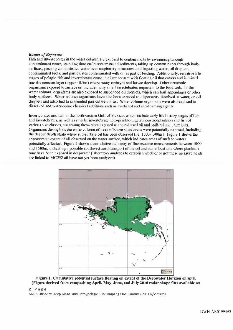
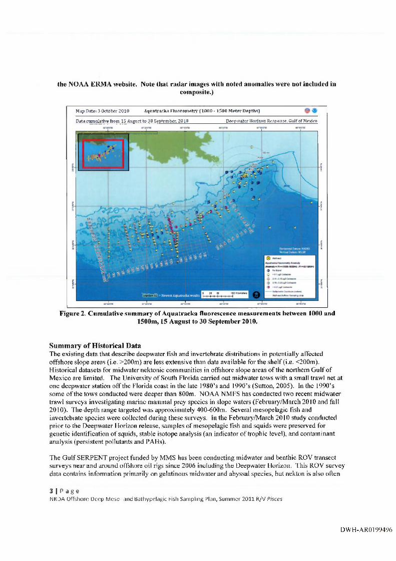
Invertebrates and fish in the north-eastern Gulf o f Mexico, which include early life history stages o f fish and invertebrates, as well as smaller invertebrate holo-piankton, gelatinous zooplankton and fish of various size classes, are among those biota exposed to the released oil and spill-related chemicals. Organisms throughout the water column o f deep offshore slope areas were potentially exposed, including the deeper depth strata where sub-surface oil has been observed (i.e. 1000-1300m). Figure 1 shows the approximate extent o f oil observed on the water surface, which indicates areas o f surface waters potentially affected. Figure 2 shows a cumulative summary o f fluorescence measurements between 1000 and 1500m, indicating a possible south westward transport o f the oil and some locations where plankton may have been exposed in deepwater (laboratory analyses to establish whether or not these measurements are linked to MC252 oil have not yet been analyzed).
Figure 1. Cumulative potential surface floating oil extent o f the Deepwater Horizon oil spill. (Figure derived from compositing April, May, June, and July 2010 radar shape files available on
2 I P a g eNRDA Offshore D eep Meso- and Bathypelagic Fish Sampling Plan, Summer 2011 R/V Pisces
DWH-ARO 199495
the NOAA ERMA website. Note that radar images with noted anomalies were not included incomposite.)
Map Date: 3 October 2010 A quatracka Fltiorotuetty (lOOO - 150D M eter Depths)
□atii m m otative from IS Augti^t to 30 Septem ber, 2010 D eepw ater Hortzon Respori^e, Gulf of Mexico
I - .......- „ i — = E ----------- -------i------------------ ^ ----------- 1 1 1
f
..
N't, r< ) \ ■..
ID
Figure 2. Cumulative summary of Aquatracka fluorescence measurements between 1000 and1500m, 15 August to 30 September 2010,
Summary of Historical DataThe existing data that describe deepwater fish and invertebrate distributions in potentially affected offshore slope areas (i.e. >200m) are less extensive than data available for the shelf (i.e. <200m). Historical datasets for midwater nektonic communities in offshore slope areas o f the northern G ulf of Mexico are limited. The University o f South Florida carried out midwater tows with a small trawl net at one deepwater station off the Florida coast in the late 1980’s and 1990’s (Sutton, 2005). In the 1990’s some o f the tows conducted were deeper than 800m. NOAA NMFS has conducted two recent midwater trawl surveys investigating marine mammal prey species in slope waters (February/March 2010 and fail 2010). The depth range targeted was approximately 400-600m. Several mesopelagic fish and invertebrate species were collected during these surveys. In the February/March 2010 study conducted prior to the Deepwater Horizon release, samples of mesopelagic fish and squids were preserved for genetic identification o f squids, stable isotope analysis (an indicator o f trophic level), and contaminant analysis (persistent pollutants and PAHs).
The G ulf SERPENT project funded by MMS has been conducting midwater and benthic ROV transect surveys near and around offshore oil rigs since 2006 including the Deepwater Horizon. This ROV survey data contains information primarily on gelatinous midwater and abyssal species, but nekton is also often
3 I P a g eNRDA Offshore Deep M eso- and Bathypelagic Fish Sampling Plan, Summer 2011 R/V Pisces
DWH-ARO 199496

recorded. This survey method yields information on species composition, depth stratification, and diversity and provides for an index as catch-per-unit-effort.
Finally there are deep (>800m) benthic travel datasets which contain information on bathypelagic species. These include MMS’s Northern G ulf o f Mexico continental slope habitats and benthic ecology study (Rowe and Kennicutt, 2009) having data from 1999-2001, and from the NOAA NMFS Fall Small Pelagics Survey (2002-2004, 2006-present) at some deeper stations along the shelf break.
The post-spill composition and density o f pelagic fish and invertebrate species in the vicinity o f areas potentially affected by the MC252 Deepwater Horizon incident have not been quantified in detail, especially in the deepwater areas surrounding the release site. Many o f the species and families that exist at such depths are known to vertically migrate (die! migration), for example the myctophids. However, vertically stratified sample data, investigating day/night shifts in abundance, for juvenile and adult fish and invertebrates in the water column is sparse. The R/V Pisces summer 2011 sampling plan is an effort to address these data needs.
The need for and design of potential sampling in other years to provide additional quantitative information and to document the deep meso- and bathypelagic community composition and abundance remains to be determined. Previous to this plan, the R/V Pisces conducted a cruise from December 1-20, 2010, and from March 22 — April 11, 2011. Anticipated cooperative cruises include R/V Pisces fall 2011 (September 7 - 27),
The primary objective is to collect fish and invertebrate samples using a midwater trawl net. The primary intended use o f the resulting data is to fill existing data gaps on community characteristics to better inform biological inputs to models (eg. COSIM and SIMAP) and other potential injury assessments. Sampling and analysis protocols have been developed for offshore stations in the 700m - 1400m depth range. In addition to trawling, the shipboard acoustics system will be running and collecting water column data for the entire cruise track. Also, if time permits (including during transits between stations and while transiting into and out of port), additional acoustic surveys near the wellhead area will be conducted (Attachment 7). In this way, the occurrence, abundance, biomass, and daily vertical migration of juvenile and adult deepwater meso- and bathypelagic species within the study area can be assessed.
Objectives and Approach: Deepwater Fish Sampling PlanHerein, the deepwater fish and invertebrate sitmmer sampling plan, to be performed on the R/V Pisces (Attachment 2), is described. This plan is being conducted along with other surveys to evaluate the composition, distribution, and densities o f juvenile and adult fish and larger invertebrates in the offshore G ulf o f Mexico waters potentially affected by the Deepwater Horizon Oil Spill (DWHOS) and in surrounding areas. In this plan, deepwater communities (deep mesopelagic and bathypelagic, i.e., between 700m and 1400m) are targeted. This plan is not intended to investigate deep water benthic communities. This plan has been developed by the DWHOS NRDA Water Column Technical Working Group in coordination with members o f the Fish Technical Working Group and the marine mammal TWG to ensure maximum comparability between sampling data sets collected by the different TWG efforts.
This plan will be implemented consistent with existing trustee regulations and policies. All applicable state and federal permits must be obtained prior to conducting work.
Attachments 13-15 provide SOPs for the protection and conservation of marine mammals and any species listed under the Endangered Species Act as appropriate for the vessel and sampling equipment operations
4 I 1' a g eN R D A O f f s h o r e D e t q i f ' / t p s o - a n d f i a t . h y p f ’ l a g l c r i s h s a m p l i i i g P l a n , S u m m e r ,;o 11 R / V Pieces
DWH-ARO 199497

to be conducted on this cruise. Marine mammal mitigation measures will be taken before and during deployments o f all gear types. Working in shifts, there will be two visual observers using big eye binoculars and two acoustic monitors using a towed acoustic array to monitor for the presence of marine mammals and listed species. Attachment 13 describes the specific mitigating procedures that will be taken and actions to be taken should species of concern be observed.
MethodologyCruise Plan and Sampling StationsThe R/V Pisces will depart Pascagoula, MS on June 21, 2011 to primarily conduct deep midwater trawl sampling at offshore stations. Other sampling activities are planned in conjunction with the midwater trawl including CTD vertical profiling (conductivity, temperature, salinity, depth), acoustic data from the shipboard EK60 system, and acoustic sensor array (including imaging sonar) vertical profiling (time permitting).
Due to the locations where oil exposure may have occurred (Figures 1 and 2 show some o f the areas where contaminants have been observed), there is a need to sample additional stations beyond the shelf region off the coast o f Louisiana, Mississippi, Alabama, and Florida, including sampling locations routinely sampled by the SEAMAP program (Attachment 9). The standard SEAMAP plankton sampling grid extends from the Texas shelf all the way to the Florida west coast shelf. The grid runs from the coast out to the 200 m bathymetric contour in the shelf waters o f the gulf. Grid cells are 30 x 30 NM, with sampling stations located at the mid-point o f each grid cell. For more detail on SEAMAP protocols, the annual SEAMAP environmental and biological atlas reports are found at; http://www.gsmfc.o rt>/default.php?p=sm_ov.htm#:content@12:links@ 13.
In biological sampling plans implemented in the fall o f 2010, winter 2011, and spring 2011 additional stations were added to the SEAMAP grid to help fill the data gap for sampling in the offshore areas near the spill (Figure 3, black dots), The extent of the offshore sampling grid is based on knowledge that currents and animal movements disperse water column biota widely in the northeastern Gulf o f Mexico.In this work plan, a subset o f the additional 46 deepwater stations added to the 2 0 10 fall SEAMAP survey are targeted for midwater trawl sampling. As many o f the deepwater stations as can be feasibly sampled in the ship-time available will be targeted. It is predicted that due to weather and travel time, the R/V Pisces will only be able to occupy 16 stations for the Summer Cruise (Figure 3, red dots). As such, this estimate is conservative; more stations in the grid can be picked up (B250, B185, B061, B065; weather and time dependent). In December 2010, inidwater trawls were conducted at 11 o f the deepwater stations aboard the Pisces (Figure 3, red squares; gear loss prevented completion of all the intended sampling stations), in March of 2011, midwater trawls were conducted at 10 of the deepwater stations aboard the Pisces (Figure 3, red triangles; gear loss prevented completion of all the intended sampling stations).
These efforts have contributed to a growing volume o f deepwater depth-discrete plankton and small nekton data in this region, which will better inform potential injury assessments. To characterize the juvenile and adult deep meso- and bathypelagic assemblage o f the region, the trawl net will be deployed at the same subset o f stations occupied by the previous midwater trawl cniise on the Pisces (December 2010 and March 2011) and will target the 700 - 1400m depth range (stations for summer 2011 are in Figure 3, red dots and Table 1), This array o f 16 stations was selected for its geographic expanse across the region of interest and potentially exposed to MC252 oil, overlap with NRDA plankton sampling effort, and its high degree o f overlap with the area sampled by the 2010 fall marine mammal survey (midwater trawls 400-600m)(Figure 3, maroon dots). The stations to be sampled for the Summer survey correspond to those targeted in March 2011. This station array differs from the December 2010 cruise on the Pisces, in that station B250 located at 28° OO'OO N, 88° 30'00 W was removed due to potential gear hazards. In addition, three stations (BO 16, B246, B247) targeted in December 2010 were shallower than
5 I P a g eNRDA Offshore D eep M eso- and Bathypelagic Fish Sampling Plan, Summer 2011 R/V P isces
DWH-AR0199498
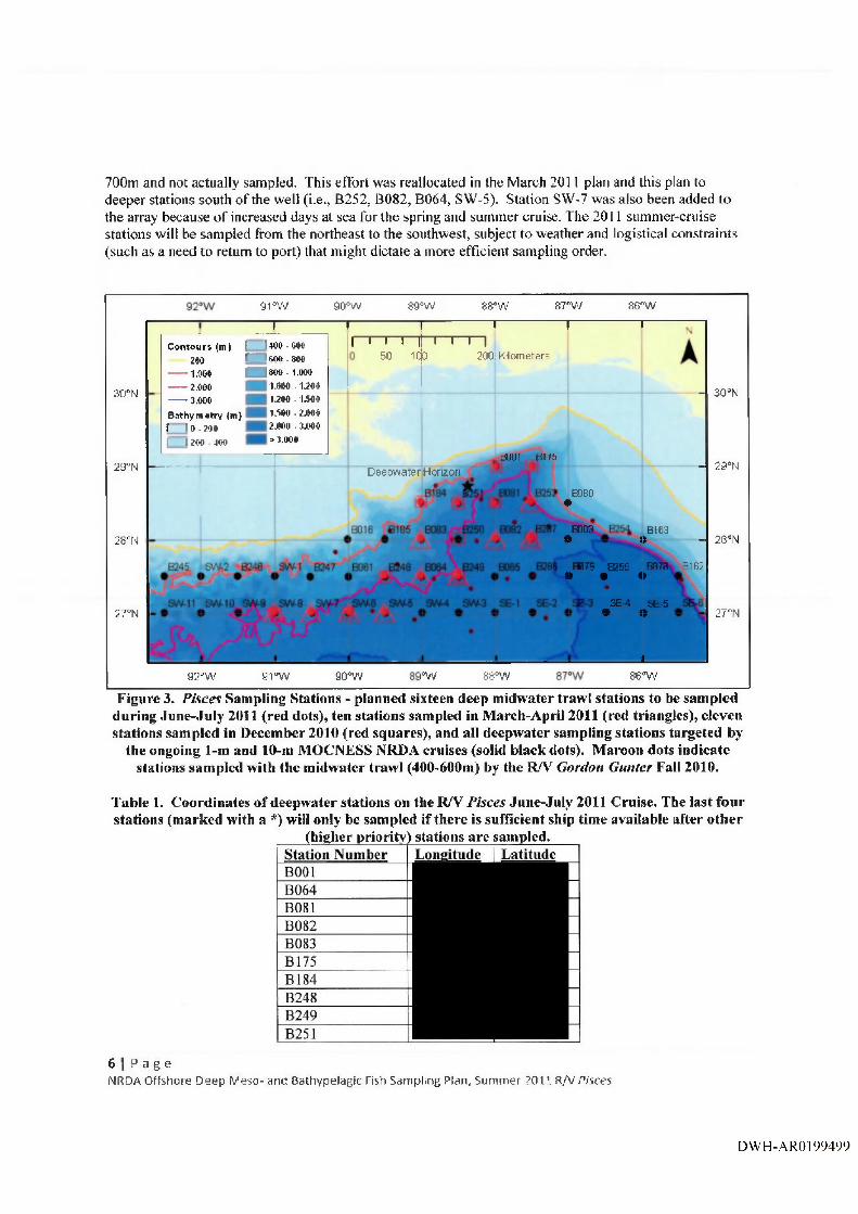
700m and not actually sampled. This effort was reallocated in the March 2011 plan and this plan to deeper stations south o f the well (i.e., B252, B082, B064, SW-5). Station SW-7 was also been added to the array because o f increased days at sea for the spring and summer cruise. The 2011 summer-cruise stations will be sampled from the northeast to the southwest, subject to weather and logistical constraints (such as a need to return to port) that might dictate a more efficient sampling order.
3 0 “N
29°N
2 8 °N
27-N
9 rw --- 1----
90°W
— I----Contourt (tn 1 1400 -000
ZOO — 000 . 000----1.000 ^■$00 . 1.000----2.000 1.000 .1.200----3.000 1.200 ■ 1.0008athym*try (m) 1.500 -Z.000f 1 0 - zoo 2.000 . 3.0001 1 zoo JOO > 3.000
r "
I I I I II5 0
8 9 ° W 8 8 ' W 8 7 - W
------------ 1-------------- P---T—I—r n
2 0 0 i K i lom etersiqo
86“W
1----
BOQI B176D eepw atefH onzon
, I
- 30°N
_ 29“N
8980•
B003e
B163a - 2S“N
HD7S•
B!S5•«
BO^»
BI62
3E-0»
SEiSnor 27“N
_1_9 2 ° W 91“W 9 0 “W i°W 8 S ° W 86-W
Figure 3. Pisces Sampling Stations - planned sixteen deep midwater trawl stations to be sampled during June-July 2011 (red dots), ten stations sampled in March-April 2011 (red triangles), eleven stations sampled in December 2010 (red squares), and all deepwater sampling stations targeted by
the ongoing 1-m and 10-m MOCNESS NRDA cruises (solid black dots). Maroon dots indicate stations sampled with the midwater trawl (400-600m) by the R/V Gordon Gunter Fall 2010.
Table 1. Coordinates o f deepwater stations on the R/V Pisces June-July 2011 Cruise. The last four stations (marked with a *) will only be sampled if there is sufficient ship time available after other
(higher priority) stations are sampled.Station Number Longitude Latitude
6 1 P a g eNRDA Offshore Deep Meso- and Bathypelagic Fish Sampling Plan, Summer 2011 R/V P isces
DWH-ARO 199499

B252B287SW-5SW-6SW-7SW-8B250*Bi85*806 MB065^
Sampling ProceduresM id w ater T raw l: The mid water trawl net that will be used is similar in design to the Irish Mid water Herring Trawl (IMHT) used by NOAA NMFS Northeast Fisheries Science Center (NEFSC). Modifications o f the original IMHT design include the use o f polytron twine to create knotless webbing at the front o f the net (to minimize drag) and a slight increase in taper throughout the body o f the net. This net is a 4-seam midwater trawl designed for high tow speeds with minimal drag (tow speed 4 knots). The mesh size at the mouth o f the net is 3.2m and gradually decreases down to 5cm at the last panel of webbing and codend. Net mensuration sensors and data-toggers will be used to actively monitor the fishing depth o f the net and record the layers fished for direct comparison with acoustic data collected during the trawls. Data from these sensors will also provide wing spread and mouth opening during the tow. This data will be used to calculate approximate net geometry. Net specifications and deployment procedures arc given in Attachment 3.
Sampling will take place 24-hours a day. At each station there will be two daytime tows and two nighttime tows, each timed (to the extent possible) to best characterize diel distribution patterns o f the organisms. Station sets will begin 1 hour after sunrise, and 1 hour after sunset, in order to approximately center the sampling on noon and midnight, respectively. For the first tow the net will be deployed to a depth o f 700m and slowly hauled up obliquely to the surface over the course of an hour (or possibly a shorter time period). The second tow will be deployed to a target depth of 1400m and slowly hauled up obliquely to 700m over a period o f 1 hour. Once 700m is reached, the vessel will commence net haul back at a faster winch speed. Net depth will be determined using trawl wire out/net depth relationships generated during the winter and spring Pisces cruises. Trawl wire out has been recorded from the wheelhouse during every tow, every ten minutes. These data are compared after each tow with net depth data determined during the tow using a time/depth recorder mounted on the trawl. Net depth vs. time has been plotted for every tow, and these plots are used by the Pisces crew to hit target depths as a function o f wire out and ship’s speed. Wire out versus time will continue to be recorded to assure target depth acquisition and fidelity. The average catch from the set o f shallower tows (700-0m) will be used as an indicator of biomass retained during set out and haul back o f the deeper tows. This average biomass will be effectively subtracted from the 1400-700m catches. This will account for contamination that may occur during set out and haul back while the net is still potentially “fishing”. After all four tows (2 daytime, 2 nighttime) are completed, the vessel will then transit to the next station getting there in time to repeat day-night sampling.
During net retrieval, the SeaBird TDR will be removed from the headrope. All available hands will be on the back deck, and will pick all organisms out o f the net mesh as the net is retrieved. Picked specimens will be kept in buckets o f cold water, as specimens from these depths are very fragile and degrade quickly. The cod-end catch will be deposited in a large plastic tote filled with cold water. Once in the
7 I P a oNRDA Otfsiioie Deep M eso and Bnthypelafdc Fish Sampihig l-’tctn, Siirnmet dO l l R/v Potrcs
DWH-AR0199500

Pisces wet lab, all buckets and totes will be sieved and combined into one large tray, with an adequate amount o f cold water. Before any sorting is done a targe label will be placed in the sample tray with the sample ID code in large print and a photo will be taken by a NRDA data manager. Once a photo is taken, the sample tray will be rough sorted into smaller, water-filled trays by major taxon (e.g., cephaiopods, gelatinous zooplankton, pyrosomes, fishes by order), Organisms with positive IDs will be counted, weighed en masse, and entered into the Fisheries Scientific Computer System (FSCS, Attachment 4).Less obvious organisms will be identified to species or lowest possible taxon. All taxonomic identifications entered into the FSCS, whether to species or lowest possible taxon, are considered preliminary data and will be confirmed following data analysis procedures that will be described in a separate work plan.
After identification, counting/weighing, data entry and labeling, each abundant and/or large taxon will be bagged in perforated bags and kept in cold storage (45“F) until fixation. Perforated bags will be stored in a 5-gal bucket, one or more per tow (sample size dependent). Samples from more than one tow will not be stored in any single container. Smaller lots o f identified taxa will be individually fixed in smaller jars. All specimens will be fixed in 10% (v/v) formalin/seawater solution (4% formaldehyde solution), buffered to neutral pH with sodium borate. The 5-gal buckets containing fixed samples will be kept in cold room until sample intake at dockside. All fish and invertebrates from each station wilt be kept and archived; nothing will be discarded. For more detail on shipboard specimen handling and preservation see Attachment 4.
All samples will be preserved immediately after recovering the nets per the description in Attachment 11. At the end of each leg, samples will be transported under NOAA NRDA Chain o f Custody to Dr. Tracey Sutton’s laboratory at Virginia Institute o f Marine Science (VIMS) College of William and Mary, VA where they will be stored in a secure facility. Later sample processing in lab will involve further sorting, taxonomic identification/verification, and species counts. Length/weight regressions will be generated for all major taxa, with correction for formalin effects (see Sutton and Hopkins, 1996). Detailed description o f analyses to be conducted on samples will be specified in a separate workplan (currently under development).
Figure 4. Schematic showing general midwater trawl deployment.
Acoustics: The SIMRAD EK60 scientific echosounder system will be used to collect data on acoustic backscatter in the water column. Much o f this backscatter will be due to zooplankton, small fish, squids and other biota. The R/V Pisces has a suite of transducers operating at 18 kHz, 38 kHZ, 120 kHz and 200 kHz frequencies. The EK60 will collect data continuously throughout the cruise with settings designed to quantify the relative biomass o f midwater fish in the target depths using the 18kHz and 38kHz frequencies. For more detail regarding use o f acoustics during the cruise see Attachment 7. If time and cruise logistics allow, a set o f transects will be run near the DWH well site operating the 18, 38,70, 120, and 200 kHz transducers (see Attachment 7).
8 I P a g eNROA Offshore Deep M eso- and Bathypelagic Fish Sampling Plan, Summer 2011 R/V Pisces
DWH-AR0199501

Raw acoustic data and sonar imaging data will be downloaded from the shipboard system or off o f the appropriate sensors and onto an official “NRDA hard drives and transported to the appropriate storage facility. The data will be controlled and managed by the trustees under project protocols, including Chain-of'Custody tracking o f the hard drives. The hard drives will be kept in a secure facility in trustee custody. Future processing and analysis will occur at Dr. Kevin Boswell’s laboratory at Florida International University (FlU), Processing, analysis, and reporting for all data types will be described and specified in separate work plans (currently under development).
Vertical Sonar Profiling: A DIDSON imaging sonar camera will be attached to the CTD rosette and deployed from the side o f the vessel down to full ocean depth or the deepest depth sampled by CTD (see below). This sensor will be used to identify scattering sources o f layers observed in fisheries echosounder data from survey vessel (Attachment 8). The DIDSON operates autonomously at 1.8 MHz and offers target size resolution between 2-5cm. The DIDSON has a 30° (horizontal) by 14° (vertical) field o f view with an effective range o f approximately 15m for nekton. This will provide additional data on size distribution and abundance, and has potential for identification purposes to general taxonomic groups for some fish species (i.e. family or genus). Data collected from the imaging sonar may then be used to better interpret the acoustic data from the shipboard scientific sonar system (e.g., Simrad EK 60s) and offer a quantitative estimate of in situ densities and length distributions for comparisons with direct capture in the midwater trawl net.
CTD: A Seabird CTD vertical profiling package will be deployed on station before each tow to collect dissolved oxygen, salinity, temperature, conductivity, chlorophyll, CDOM (if available), and depth information.
CTD casts will be performed at each station to the full water column depth for stations where the maximum net sampling depth is within 100 m o f the sea floor (i.e., at stations with water depths < 1600 m). At stations with depths between 1600 and 2000 m, CTD casts will be performed to at least 1500 m and beyond to the greatest depth that is operationally appropriate. At stations with depths greater than 2000 m, CTD casts will be performed to at least 1500 m. The total depth of CTD casts may be decreased if there are time constraints that would potentially limit IMHT deployment at scheduled times.
In general, CTD casts should be conducted while the vessel is drifting. Because the midwater trawls are performed over a tow path, as opposed to at a single location, the objective is to characterize the water properties over the general area of the tow. The start and finish locations shall be recorded for both the down- and the up-cast of the CTD. Local conditions in sea state and operational areas will dictate if maintaining position with dynamic positioning (DP) is necessary. It should be recorded whether a cast was completed while drifting or under DP.
Data Management and Trustee OversightAM profile, acoustic, and other electronic data (including photographs) will be saved to an on-board computer, and all data shall be migrated to a dedicated hard drive. The data will be controlled and managed by the trustees under project protocols, including Chain-of-Custody tracking o f the hard drive. Data is generally organized by station and all electronic data files will be filed into this structure by NOAA NRDA data manager with the assistance o f the operator/data logger. The iiard drive will be duplicated in full immediately following the cruise, and the duplicate hard drives will be provided to (1) the Louisiana Oil Spill Coordinator’s Office (LOSCO) on behalf o f the State o f Louisiana, and to (2) Cardno ENTRIX on behalf o f BP. The original hard drive shall be kept in a secure facility in trustee custody.
9 I P a g eNROA Offil iorG D e e p M e s o Builv /pclagic rish s, i i i ip ling RLvi. Sum nicr . -O i l R/V P o x e s
DWH-AR0199502
Under the direction o f the Chief Scientist, a NOAA Data Manager on board each vessel will summarize sampling activities and scientific observations throughout the day and email a daily report to a designated list of recipients and NOAA NRDA ([email protected]) by midnight each day o f the cruise.
LogisticsVesselOperations will be completed on the NOAA vessel RA/ Pisces (Attachment 2).
Personnel fo r RA^ Pisces (15 Science Berths Available):Dr. Tracey Sutton (Chief Scientist) — Deepwater Fish TaxonomyDr. Michael Vecchione (NOAA) - Deepwater Invertebrate TaxonomyDr. Kevin Boswell (LSU) - Fisheries AcousticsDr. Tamara Franks - Invertebrate TaxonomyApril Cook (VIMS) - Fish Taxonomy2 NRDA Data Managers1 NRDA Field SamplerCardo ENTRIX Lead ScientistCardno ENTRIX Representative4 Marine Mammals ObserversPaul Mercier - CSA Gear Specialist
NOAA Vessel Crew (commanding officer, mates, boatswain, engineer, deck hands)
NOAA Vessel Medical and Security Clearance RequirementsAll cruise participants must fill out and are personally responsible for submission o f the required NOAA medical and security clearance information included in Attachment 12. Instructions and appropriate parties to contact are indicated. Requirements for these clearances include a tuberculosis test, a FBI full background check, and fingerprinting. Medical and security forms must be submitted a m inim um of two weeks prior to the cruise departure date.
BudgetingThe Parties acknowledge that this budget is an estimate, and that actual costs may prove to be higher due to a number of potential factors. As soon as factors are identified that may increase the estimated cost,BP will be notified and a change order describing the nature and cause for the cost increase in addition to a revised budget will be provided for BP’s consideration and review. The field survey costs, miscellaneous costs, and contractor costs indicated in Budget Chart # 1 below shall be reimbursed by BP upon receipt o f written invoices submitted by the Trustees.
B udget C h art #1: Total Estimated Costs:NOAA OM AO Costs Days Day Rate Total
NOAA Pisces Ship Costs 25(21 DAS, 4 Staging/Destaging) $665,931
NOAA NRDA Costs Days Day RateNOAA C ontracto r L abor (days):Dr. Tracey Sutton and Graduate Student (VIMS) $50,000
Dr. Kevin Boswell $50,0002 NRDA Data Managers $69,000I NRDA Oceanographic Sampler $34,500
10 I a g eHP,DA Offsliore Deep iVloso atid Qathypel'igir ['cjii S,impling Pl.-in, Sumiiii'r 20 H R/V Pfite.s
DWH-AR0199503

2 Marine Mammal Observers $69,0002 Marine Mammal Acoustic Monitors H $69,000
NRDA M obilization Costs:Equipment Shipping $5,000Misc Costs, Sample Handling $13,000DIDSON Equipment rental/insurance 25 500 $12,500
2 BP Representatives (Cardno Entrix) Provided elsewhere
1 BP Representatives (CSA) Provided elsewhere
TOTA L $1,037,931
Budget Chart #2: Breakdown o f NOAA OMAO Costs.Item O perations = 21 Staging — 4Vessel Base Pay (17) $55,383 $10,549Wage Marine Overtime $75,726 $9,980Employer Surcharge - 31% $17,169 $3,270NOAA Corps Officer Salaries $18,292 $3,484NC Special Pay/Benefits $8,060 $1,535NOAA Overhead Rate (22.07%) $15,127 $2,881
NOAA Line Office Overhead Rate (8.60%) $5,894 $1,123
NOAA PMC Rate (0.0%) $- $-GSA Rent Reimbursable Rate (9.00%) $6,169 $1,175
Maintenance surcharge $103,950 $-Food/Supplies/Services $84,966 $574Fuel ($2.82/gal); 2400 gal/day $142,128 $-MOC Shoreside Support (112.3%) o f WM and NOAA Corps Labor costs
$82,737 $15,759
Total; $615,601 $50,331
G rand Total: $665,931
Budget Chart #3: Approximate replacement costs for NOAA gear.A pproxim ate NOAA gear replacem ent costs Cost2 DIDSON battery bottles $10,000
Safety PlansBP’s full operations and safety plans are attached as appendices. A HASP binder is provided to each vessel. In addition, the NOAA incident site safety plan (which all NOAA employees and contractors
11 I P a g 0NRDA Olf^hore Deep M eso and I3alhvp” l..igic I isii Sampling Plan, Sununei 3?0it R/V P/sces
DWH-AR0199504
must sign prior to the cruise) is attached (Attachment 1). Vessels will call into SIMOPS based on the current regulations (Attachment 5). Vessels will report in daily using the attached situation report (Attachment 6).
Distribution o f Laboratory ResultsEach laboratory shall simultaneously deliver raw data, including all necessary metadata, generated as part o f this work plan as a Laboratory Analytical Data Package (LADP) to the trustee Data Management Team (DMT), the Louisiana Oil Spill Coordinator's Office (LOSCO) on behalf o f the State o f Louisiana and to BP (or Cardno EMTRIX on behalf o f BP). The electronic data deliverable (EDD) spreadsheet with prevalidated analytical results, which is a component of the complete LADP, will also be delivered to the secure FTP drop box maintained by the trustees' Data Management Team (DMT). Any preliminary data distributed to the DMT shall also be distributed to LOSCO and to BP (or Cardno ENTRIX on behalf o f BP). Thereafter, the DMT will validate and perform quality assurance/quality control (QA/QC) procedures on the LADP consistent with the authorized Analytical Quality Assurance Plan, after which time the validated/QA/QC'd data shall be made available simultaneously to all trustees and BP (or Cardno ENTRIX on behalf o f BP). Any questions raised on the validated/QA/QC results shall be handled per the procedures in the Analytical Quality Assurance Plan and the issue and results shall be distributed to all parties. In the interest of maintaining one consistent data set for use by all parties, only the validatcd/QA/QC’d data set released by the DMT shall be considered the consensus data set. In order to assure reliability o f the consensus data and full review by the parties, no party shall publish consensus data until 7 days after such data has been made available to the parties. The LADP shall not be released by the DMT, LOSCO, BP or Cardno ENTRIX prior to validation/QA/QC absent a showing of critical operational need. Should any party show a critical operational need for data prior to validation/QA/QC, any released data will be clearly marked "‘preliminary/unvalidated” and will be made available equally to all trustees and to BP (or Cardno ENTRIX on behalf o f BP),
Sample RetentionAll materials associated with the collection or analysis o f samples under these protocols or pursuant to any approved work plan, except those consumed as a consequence o f the applicable sampling or analytical process, must be retained unless and until approval is given for their disposal in accordance with the retention requirements set forth in paragraph 14 o f Pretrial Order # 1 (issued August 10, 2010) and any other applicable Court Orders governing tangible items that are or may be issued in MDL No, 2179 IN RE: Oil Spill by the Oil Rig "DEEPWATER HORIZON" (B.D, LA 2010). Such approval to dispose must be given in writing and by a person authorized to direct such action on behalf o f the state or federal agency whose employees or contractors are in possession or control o f such materials.
ReferencesRowe, G.T. and M.C. Kennicutt II, eds. 2009. Northern Gulf o f Mexico continental slope habitats and benthic ecology study: Final report. U.S. Dept, of the Interior, Minerals Management. Service, Gulf o f Mexico OCS Region, New Orleans, LA. DCS Study MMS 2009-039. 456 pp.
Sutton, T.T. 2005. The bathypelagic fish assemblage o f the Gulf o f Mexico. The 85th Annual Meeting of the Amer. Soc. Ichthyologists and Herpetologists, Tampa.
12 I P ,1 g 0NRDA Offshote Depp Meso- and B.nthypfl^gic rish Sampling Plan, Sumiiv;'i' BOll R/V Pieces
DWH-AR0199505

Attachments:Attachment 1. NRDA_Ops_Safety_Plan_08DEC20l0Attachment 2 NOAA Research Vessel Pisces BrochureAttachment 3. Mid Water Trawl Net SpecificationsAttachment 4. Shipboard Meso- and Bathypelagic Specimen ProcessingAttachment 5, SIMOPS Procedures for the NRDA Scientific FleetAttachment 6. DWH Vessel Daily SitRep.pdfAttachment 1. Fisheries Acoustic Data CollectionAttachment 8. Vertical Sonar Image CollectionAttachment 9. NRDA_Field_Sampler_Data_Management_Protocol_l 0_23_2010Attachment 10. MC252 HSSE Incident Reporting Final 02 May 10 rev 1Attachment 1!. NOAA Cmise lnstructions NRDA Pisces Summer201 IAttachment 12a&b. NOAA Ship_Medical and Security Clearance Instructions and FormsAttachment 13. Mid-water trawl sampling mitigation measires_3ummer&fall cruisesAttachment 14. Protected Spp Interaction Prevention Proc_No-impact sampling gearAttachment 14. A to C. Protected Spp - 3 annexesAttachment 15. Vessel Strike Avoidance_Ship Strike Form Febriiary 2008Attachment 16. Deep tow protocols
13 I P a g eNRDA Offshore Deep Meso- .ind Bathypel'igic Fish Sampling Plan, Sifinnior 20.11 K/V ftsct’s
DWH-AR0199506

Deepwater Horizon Oil Spill (DWHOS)Water Column Technical Working Group
NRDA Offshore Deep Meso- and Bathypelagic Fish Sampling PlanSummer 2011
Sampling Vessel: NOAA RA Pisces
Cruise Dates: June 21 - July 1; July 5 - July 14,2011
Plan Date: June 21,2011
Approvals
Approval o f this work plan is for the purposes of obtaining data for the Natural Resource Damage Assessment. Each party reserves its rights to produce its own independent interpretation and analysis of any data collected pursuant to this work plan
BP Approval ■ V 7/; ‘Printed Name ^Signature Ddte ^
FederalTru.stee Aooroval i \5tXPrinted Name \>«ignature Date
\LC'^h'f^O
Louisiana ApprovalPrinted Name
14 I P a g eNHDA O ffshore D eep M eso and D alhypclagic Fish Sam pling Plan, S u n m c r 2 0 i l R/VP;sces
DWH-AR0199507