Embed Size (px)
Citation preview

3500 (OR-936.2) WAOR-61215
Dear Participant:
The Bureau of Land Management (BLM) has completed the comment analysis and rendered a final decision with regard to the Environmental Assessment (EA), OR-936-06-00, for the hardrock lease application submitted by General Moly, Inc. (GMI), formerly Idaho General Mines, Inc., on March 24, 2005. The application (assigned BLM Serial Number WAOR-61215) is for a fractional interest lease and a fringe acreage lease encompassing an area of approximately 899 acres referred to as the Margaret Deposit in the Mount St. Helens Mining District of western Washington.
Based on full consideration of GMI’s hardrock lease application, the alternatives addressed in the EA, and public comments received, we have determined that it would not be in the public’s interest to issue a fractional interest lease for the Federal 50 percent undivided mineral interests on the 217.3 acres nor a fringe acreage lease for 682.2 acres of land within the Gifford Pinchot National Forest encompassed by Mineral Survey-708 or the associated fringe acreage lease. The BLM’s decision is to select the No Action alternative and to consequently reject the lease application. This decision is based on the rationale and criteria considered in the enclosed Decision Record.
Sincerely,
Edward W. Shepard State Director, Oregon/Washington
Enclosure
936:DEWITT:lmd:04/08/2008:S:930/2008Correspondence/936/181
United States Department of the Interior Bureau of Land Management
Oregon State Office
April 18, 2008
Decision Document and Decision Rationale
Environmental Assessment OR-936-06-00 Margaret Deposit - Hardrock Mineral Leasing
Table of Contents
Introduction ………………………………………………………………………………...Page 1
Compliance with Land Use Planning ………………………………………………………Page 5
Alternatives Considered ……………………………………………………………………Page 5
Summary and Disposition of Public Comments on the EA………………………………...Page 5
Decision ……………………………………………………………………………………Page 5
Rationale and Criteria Considered …………………………………………………………Page 5
Public Involvement/Consultation/Coordination …………………………………………...Page 8
Conclusion …………………………………………………………………………………Page 8
Finding of No Significant Impact ………………………………………………………… Page 9
Decision ……………………………………………………………………………………Page 9
Right of Appeal ………………………………………………………………………….. Page 10
Appendix (Summary of Comments and Responses)……………………………………...Page 12
Comment Summary Table ………………………………………………………..Page 12
Response to Comments …………………………………………………………...Page 20
i

United States Department of the Interior Bureau of Land Management
Oregon State Office
April 18, 2008
Decision Document and Decision Rationale
Environmental Assessment OR-936-06-00 Margaret Deposit - Hardrock Mineral Leasing
Responsible Agency: USDI – Bureau of Land Management (BLM)
Responsible Official: Edward W. Shepard State Director, OR/WA 333 SW First Avenue Portland, OR 97204
503-808-6001
For further information, contact: Chris DeWitt Chief, Minerals Section 333 SW First Avenue Portland, OR 97204
503-808-6446
I. Introduction
Application
On March 24, 2005, General Moly, Inc. (GMI), (formerly Idaho General Mines Inc.) submitted a hardrock lease1 application (assigned Bureau of Land Management (BLM) Serial Number WAOR-61215) consistent with regulations at 43 Code of Federal Regulations (CFR), Part 3500: Leasing of Solid Minerals other than Coal and Oil Shale. The application area encompassed approximately 899 acres of matrix lands2 referred to as the Margaret Deposit3 in the Mount St. Helens Mining District of western Washington described as
1 Hardrock Minerals include base metals, precious metals, industrial minerals, and precious or semi-precious gemstones. 2 Matrix Lands mean Federal lands within the range of the northern spotted owl, but outside of the six categories of designated areas set forth by the Northwest Forest Plan, that are usually managed for multiple uses, including timber harvest and other silvicultural activities. 3 GM’s application asserted that “the Margaret Deposit holds future promise” as a substantial porphyry copper mineral deposit, with associated gold, molybdenum, and silver values: • 220 million tons at 0.77% copper • 2.1 million ounces gold • 46 million pounds molybdenum • 15 million ounces silver
1

Township 10 North, Range 6 East, of the Willamette Meridian, vicinity of Goat Mountain including parts of Sections 7, 8, 9, 16, 17, 18, 19, and 20 near the head of the Green River drainage, Skamania County, Washington.
GMI applied for both a fractional interest lease4 on lands within Mineral Survey5 (MS) – 708 (217.3 acres), and for a fringe acreage lease6 on adjoining lands included in MS-774, 1329, 1330, and, as amended on June 3, 2005, all of MS-779 (682.2 acres total fringe acreage).
Applicant
General Moly, Inc., is a U.S.-based molybdenum mineral development, exploration, and mining company incorporated under laws of the State of Delaware and listed on the American Stock Exchange (AMEX) under the symbol GMO7. GMI’s stated business objective is to acquire and develop advanced-stage gold, silver, base metal, and strategic mineral properties with a focus on previously drilled deposits of substance. The applicant owns an undivided 50 percent interest in the mineral estate within the 217.3 acres of MS-708. The Company is headquartered at 1726 Cole Blvd., Suite 115, Lakewood, Colorado 80401.
Affected Lands
The surface and mineral estate of all of the lands proposed for leasing are within the Gifford Pinchot National Forest (GPNF) in northern Skamania County, Washington. These lands are adjacent to and extend northeastward from the boundary of the Congressionally designated 110,300-acre Mount St. Helens National Volcanic Monument lying approximately 12 miles northeast of the volcanic crater on the fringe of the 1980 eruption blast zone.
The lands described in the lease application were previously patented under the Mining Law of 1872 to the Duval Corporation. After Duval Corporation was acquired by Pennzoil, it divested its hardrock mineral holdings (including the subject lands) in 1984. These lands were later re-acquired8 in fee into Federal ownership by the U.S. Forest Service (USFS) in June 1986 through donation and purchase under the Act of Oct. 10, 1978, mostly from The Trust for Public Lands (TPL), except for an undivided, privately held, 50 percent reserved mineral interest in MS-708.
4 Fractional Interest Lease is issued noncompetitively where the United States holds less than 100 percent of the mineral interest of the parcel and allows for the development of shared mineral interests. See generally 43 CFR Subpart 35095 Mineral Survey is made to mark the legal boundaries of mineral deposits or ore-bearing formations on the public domain where the boundaries are determined by lines other than the normal subdivision of the public lands. Such surveys are frequently conducted to stake out a claim of specified dimensions in protection of the claimant’s rights and/or in order to apply for and obtain a patent. 6 Fringe Acreage Lease is issued noncompetitively for known deposits of leasable minerals on Federal lands adjacent to existing deposits, when the Federal deposit(s) can be mined only as a part of an adjacent operation. See generally 43 CFR Subpart 35107 For further corporate information pertaining to General Moly, Inc., go to www.generalmoly.com 8 Acquired Lands means lands or interest in lands, including mineral estates, which the United States obtained through purchase, gift, or condemnations to which the mineral leasing laws have been extended. It includes all lands BLM administers for hardrock mineral leasing other than public domain lands. 43 CFR § 3501.5.
2

Because the lands were patented at the time the Mt. St. Helens National Volcanic Monument was designated, Congress left them out of the volcanic area.
Through a quit claim deed issued September 28, 2004, GMI obtained title to the privately held, 50 percent undivided mineral interests on the lands comprising MS-708. The United States owns the remaining 50 percent of the mineral estate and the entire surface in MS-708, as well as 100 percent of both the surface and mineral interests in full fee9 on the adjoining MS lands. The status of all the subject mineral estate is acquired.
The President’s Reorganization Plan No. 3 of 1946 transferred authority to lease acquired lands to the Department of the Interior with the written consent of the Department of Agriculture. The BLM discharges this responsibility in accordance with the Mineral Leasing Act for Acquired Lands of 1947 and, more specifically, with regulations at 43 CFR Subparts 3509 – Fractional and Future Interest Lease Applications and 3510 – Noncompetitive Leasing: Fringe Acreage Leases and Lease Modifications.
Environmental Assessment
On March 8, 2007, the BLM issued Environmental Assessment (EA) OR-936-06-0010 for public review and comment. The EA addressed three alternatives for disposition of GMI’s hardrock lease application: the Applicant's Proposed Action, the BLM’s preferred Administrative Alternative, and a No Action Alternative. Each alternative is briefly summarized below.
Applicant’s Proposed Action
On March 24, 2005, GMI applied for issuance of a fractional interest lease for the Federal hardrock minerals on lands within MS-708 and for a fringe acreage lease on adjoining lands included in MS-774, 1329, 1330, and 779. Together, the application encompassed approximately 900 acres:
• MS-708 217.3 acres • MS-774 267.7 acres • MS-779 247.9 acres • MS-1329 163.9 acres • MS-1330 2.7 acres
The fringe acreage lease would convey mineral rights to the applicant for those lands where the Federal government owns 100% of the mineral interest and where those lands can be mined only as part of an adjacent operation. 43 CFR §3510.15.
9 Full Fee implies a simple 100 per cent undivided ownership of both the surface and mineral estates in the specified parcel of land. 10 To view the EA, go to http://www.blm.gov/or/news/announce-archive.php and navigate to Hardrock Lease Application Environmental Assessment and click on “read more.”
3
Administrative Alternative
The Administrative Alternative proposed in the EA was to issue a fractional interest hardrock lease with a contingent right stipulation11 for the United States’ 50 percent interest in the undivided mineral estate encompassed by the approximately 217.3 acres in MS-708 and to not issue a concurrent fringe acreage lease for the remainder of the lands in the original application.
Consistent with authority at 43 CFR, Part 3500, BLM may issue a hardrock lease for acquired lands only with the written consent of the surface managing agency, in this case the USFS.12
The contingent right stipulation included in the USFS’ May 2, 2006, written consent states:
Notwithstanding any language to the contrary in Sections 2 and 1413 or any other provision of this lease, the lessee is not entitled to any exploration or development rights. Any plan to explore, develop, or in any other manner use the lands described herein, is subject to BLM’s approval following environmental analysis and public disclosure required by the National Environmental Policy Act, or any other analysis undertaken by the Department of the Interior or the Department of Agriculture for any reason. The BLM has absolute discretion to deny any exploration or development operations. No operations may commence until BLM has issued a specific permit subject to prior USFS consent covering those operations.14
By regulations, BLM may also issue noncompetitive fringe acreage leases for ". . .known deposits of leasable minerals on Federal lands adjacent to existing deposits, when the Federal deposits can be mined only as a part of an adjacent operation."15 This authority could be applicable to the adjoining, approximately 682 acres of MS lands. However, under the Administrative Alternative the BLM would address the fringe acreage portion of GMI’s application only when more substantive information becomes available with which to judge the criteria at 43 CFR §3510.15.
11 Contingent Right Stipulation reserves the right to subsequently disapprove of any exploration or development activity on a lease with no compensation to the lessee subject to premise that: “All operations on [a] lease are subject to Government approval with such site specific stipulations as may be necessary to assure reasonable protection of or mitigation of effects on other values. A plan of operation shall not be approved if it results in unacceptable impact on other resources, land uses, and/or the environment….” (U.S. Departments of the Interior and Agriculture, 47 Fed. Reg. 82 [April 28, 1982], and U.S. Forest Service regulations for implementation of the 1987 Reform Act [30 USC 226 (g) & (h)]). 12 The President’s Reorganization Plan No. 3 transferred authority to lease acquired lands to the Department of the Interior (1946) with the written consent of the Department of Agriculture (16 USC Sec. 480 et. seq., and 520 allow mineral development as Weeks law status lands; 16 USC Sec. 402 transferred this authority to the Secretary of the Interior with caveats). 13 OMB approved lease form (No. 1004-0121), Section 2 of Part I (land description), and Section 14 of Part II (special stipulations).14 Letter from Kimberly Evart Bown, Director, Recreation, Lands, and Mineral Resources, USFS, to Michael Mottice, Deputy State Director for Resource Planning, Oregon/Washington BLM, May 2, 2006. 15 43 CFR §3501.10(e)
4
No Action Alternative
For all aspects of both the Proposed Action and the preferred Administrative Alternative described in the EA, the third alternative considered is “No Action.” Under this alternative, the BLM would deny the lease application.
II. Compliance with Land Use Planning
Conformance with applicable USFS Land Use Plans and the primary purpose for which the USFS acquired the lands are discussed on pages 9 through 12 of the EA.
III. Alternatives Considered
For a summary of Alternatives Considered, see the discussion of the Environmental Assessment in Item I, above.
IV. Summary and Disposition of Public Comments on the EA
For a summary of Public Comments received on the EA and their Disposition, see the Appendix to this document.
V. Decision
Based on full consideration of GMI’s hardrock lease application, the alternatives addressed in the EA, and public comments received; the BLM has determined that it would not be in the public interest16 to issue a fractional interest lease for the Federal 50 percent undivided mineral interests on the approximately 217.3 acres of land within the Gifford Pinchot National Forest encompassed by Mineral Survey-708 or the associated fringe leases. The BLM's decision is to select the No Action alternative and to consequently reject the lease application. This decision is supported by the following rationale.
VI. Rationale and Criteria Considered
The decision to issue or deny a fractional lease is fully discretionary to the Government and is based on a determination of whether: • The applicant is the only person who has an interest in the non-Federal share of the same
minerals (43 CFR § 3509.45); • The applicant has an interest in the total non-Federal mineral estate of 50 percent or more
(43 CFR 3509.50 (b); and
16 Public Interest: Regulations do not provide a specific definition; however, relevant discussion is found in the preamble in the Federal Register notice issuing the Part 3500 regulations: “We intend for the phrase ‘in the public interest’ to imply a consideration of the potential environmental costs of mineral development. It is our duty to balance the potential benefits of mineral development against the potential environmental consequences of that development….” 64 Fed. Reg. 53512, 53533 (Oct1, 1999)
5
• Issuance would be in the public interest (43 CFR § 3509.50(c)).
Regarding fractional interest leasing, the BLM’s decision was based on the “public interest” criterion. As described in greater detail in the EA, a decision to issue a fractional interest lease with a contingent right stipulation would result in no authorization of on-the-ground activities, other than casual use17already allowable on public lands. A more conventional approach based on standard industry practice (SME Mining Engineering Handbook, Second Edition, Section 4, Mineral Prospecting and Exploration, ISBN 0-87335-100-2) would be to first conduct pre-development exploration in order to assist in the calculation of known and/or inferred ore resources/reserves, provide samples for ore beneficiation and other metallurgical tests, and determine overall economic viability. If the property proves viable for development, then a lease application could be submitted. Absent this information and data, lease issuance is premature.
The BLM acknowledges a fractional interest lease could be issued with the contingent right stipulation, but the legal effect of that lease would be relatively insignificant. With the contingent right stipulation, it is difficult to describe how the rights of the Applicant would differ from their rights without such a lease. An additional ground for the decision is that, given the limited effect that the proposed fractional interest lease would have, it is not in the public interest for the BLM and the USFS to assume the burden of lease administration. Rather, it would promote administrative efficiency to consider issuance of a lease only when the Applicant has the information necessary to put forth a more concrete proposal.
Notwithstanding the decision for the No Action Alternative, the BLM acknowledges GMI’s ownership of a 50 percent undivided mineral interest within the area of MS-708 to which the applicant may have certain specific rights beyond those of casual use, including the ability to apply for authorization from the USFS for access and for surface use, protection, and remediation subject to an appropriate level of NEPA review. The decision does not abridge GMI’s right to apply for a USFS-issued Exploration License for Hardrock Leasable or Solid Leasable Minerals other than Coal and Oil Shale (FSM 2862.4), or for a BLM-issued Exploration License (43 CFR Subpart 3506) or Prospecting Permit (43 CFR Subpart 3505).
The decision to issue or deny a fringe acreage lease is also fully discretionary to the Government and based on a determination of whether: • The lands are contiguous to the applicant’s existing Federal lease or to non-Federal lands
controlled by the applicant (43 CFR § 3510.15(a)); • The fringe acreage does not exceed the maximum size allowed in a lease (43 CFR §
3510.15(b)); • The acreage of the modified lease is not in excess of the maximum size allowed for a
lease (43 CFR § 3510.15(c)); • The mineral deposit is not in an area of competitive interest to holders of other active
mining units (43 CFR § 3510.15(d)); • The lands lack sufficient reserves of the mineral resource to warrant independent
development (43 CFR § 3510.15(e));
17 Casual Use means activities that ordinarily result in no or negligible disturbance of the public lands or resources.
6
• Leasing the lands will conserve natural resources and will provide for economical and efficient recovery as part of a mining unit (43 CFR § 3510.15(f); and
• The applicant meets the qualification requirements for holding a lease described in 43 CFR Subpart 3509 (43 CFR § 3510.15(g).
Regarding fringe acreage leasing, the BLM’s decision was based on the lack of sufficient information in the application or the associated record that would support a definitive determination on the aforementioned criteria or to support a determination of whether those lands can be mined only as part of an adjacent operation (43 CFR § 3510.15).
Mineral development on lands acquired under the Weeks Act of 1911 cannot be allowed unless the USFS determines that “such development will not interfere with the primary purposes for which the land was acquired,” Reorganization Plan No. 3 of 1946, Section 402, 5 U.S.C. App. 1. Because the decision here is to not issue a lease, there is no need for such a determination. The BLM notes, however, that the USFS written consent to lease, subject to a contingent right stipulation, indicated that the explicit purpose for the acquisition was to protect the Green River, and that leasing with a contingent right stipulation would not interfere with the primary purpose for which the land was acquired.
As described in the Administrative Alternative, a subsequent NEPA analysis would be needed to determine if any activities to be carried out subject to the terms and conditions of the lease would continue to result in a determination of compatibility with the Gifford-Pinchot National Forest (GPNF) Land and Resource Management Plan (LRMP), the Northwest Forest Plan (NFP), and the purpose for which the lands were acquired. If the activities were not compatible, the USFS would both not consent and request that BLM deny the permit to operate under the lease or would consider an amendment to their Forest Plan. Considering that the stated purpose of the acquisition was to protect the Green River, that only those future mineral development operations considered to be compatible with protection of the Green River would be allowed, that no information is available concerning future activities, and that the effects of subsequent lease activity is uncertain; it is not possible at this time to determine if leasing, even with a contingent right stipulation, would, over the long term, result in mineral development activities that would be compatible with the purpose of the acquisition.
Again, this decision does not diminish the applicant’s legitimate property rights nor does it preclude future consideration of proposed mining exploration and development in an environmentally sound manner that may benefit the Nation’s need for minerals. GMI’s vested legal ownership cannot be compromised because BLM cannot lease the remaining 50 percent undivided interest to another entity. In accordance with regulations at 43 CFR § 3509.45, “[o]nly persons who have an interest in the non-Federal share of the same minerals may apply for a fractional interest lease of the minerals.” As such, GMI’s exclusive rights or interests are maintained whether or not the lease, with the contingent rights stipulation, is issued.
7
VII. Public Involvement/Consultation/Coordination
Environmental Assessment Comment Period
On March 8, 2007, the BLM’s Oregon State Office announced the release of EA-OR-936-06-00 pertaining to GMI’s application for a hardrock minerals lease filed in March 2005 (see discussion of alternatives in Item I, above). Included with the EA was a draft Finding of No Significant Impact based on the Administrative Alternative as shaped by the contingent right stipulation included in the USFS’ May 2, 2006, written consent to lease.
Availability of the EA was posted on the BLM Oregon/Washington Web site at http://www.blm.gov/or/news/announce-archive.php with an initial 30-day comment period beginning on March 14, 2007. The comment period was extended for an additional 30 days closing on Monday May 14, 2007. Announcement of the EA availability was also provided through a media press release to radio, television, and newspapers throughout Oregon and Washington.
Comments
Some 33,900 comments were received by the close of the public comment period. Many commenters cited a variety of resource impacts. A summary of comments and the BLM’s responses are appended to this Decision Record. In general, commenters often speculated on impacts of development, which went beyond the scope of the alternatives being considered and would be more appropriately addressed if and when a detailed exploration plan is submitted by the applicant.
Comments fell into 20 broad categories ranging from land use to impacts on forest land, recreation, air and water quality, habitat, wildlife and fisheries, health and safety, and socioeconomics to constraints imposed by the Tumwater Inventoried Roadless Area (see Appendix below). As noted above, many comments went beyond the scope of the proposed actions described in the alternatives and sought to address environmental concerns related to actual mine development, but the single most reiterated comment was related to how lease issuance, in and of itself, was not compatible with the purpose for and method of acquisition (Land and Water Conservation Fund [LWCF]) of the subject lands.
Consultation/Coordination
Prior to its decision, the BLM sought USFS review of the draft Decision Record.
VIII. Conclusion
For the reasons cited in the Rationale and Criteria Considered (Item VI) above, the BLM has determined that issuance of neither the fractional lease with the contingent rights stipulation nor the associated fringe acreage leases are in the public interest and, therefore, is adopting the No Action alternative.
8
In the Public Interest
Regulations at 43 CFR § 3509.41 regarding fractional interest leases state that the BLM will “issue them [fractional interest leases] for lands where the United States owns less than 100 percent of the mineral interest and where we [BLM] have determined that it is in the public interest to grant the permit or lease.” As noted in the Federal Register preamble to 43 CFR § 3509.1:
“We intend for the phrase ‘in the public interest’ to imply a consideration of the potential environmental cost of mineral development.” 64 Fed. Reg. 53512, 53533 (Oct 1, 1999).
After consideration of the rationale and criteria described in Item VI of this Decision Record, the BLM has determined that selection of the No Action alternative is in the public interest.
Summary of Environmental Effects
Implementation of the No Action alternative would result in no direct or indirect change or impact to any on-the-ground resources because: • No physical on-the-ground and/or surface disturbing activity would be authorized and
therefore; • No mitigation would be required nor would any residual impacts be created; and • There would be no cumulative effects on the human environment.
IX. Finding of No Significant Impact
I have determined, based on review of the Environmental Analysis (EA-OR-936-06-001), dated March 8, 2007, including the explanation of the absence of any potentially significant environmental impacts, that the decision (selection of the No Action alternative) will have no significant impact in context or intensity, as defined in 40 CFR § 1508.27, on the human environment, and that preparation of an Environmental Impact Statement is not required.
Authorized Official:________________________________ Date:______________.
X. Decision
I have further determined that rejecting the subject lease application is "in the public interest" as defined above in Section VII. Thus, it is my decision to implement the No Action alternative and reject the lease application.
Authorized Official:________________________________ Date:______________.
9
XI. Right of Appeal
This decision may be appealed to the U.S. Department of the Interior, Office of Hearings and Appeals, Interior Board of Land Appeals (Board), by those who have a “legally cognizable interest” to which there is a substantial likelihood that the action authorized in this decision would cause injury and who have established themselves as a “party to the case.” (See 43 CFR § 4.410). If an appeal is taken, a written notice of appeal must be filed with the BLM officer who made the decision in this office by close of business (4:30 p.m.) not more than 30 days after publication of this decision. Only signed hard copies of a notice of appeal that are delivered to the BLM Oregon/Washington State Director at the address listed below, will be accepted. Faxed or e-mailed appeals will not be considered.
In addition to the applicant, anyone who has participated in the National Environmental Policy Act process for this project by providing public comments on the environmental assessment will qualify as party to the case. (See 43 CFR § 4.410(b)). However, in order to qualify as an appellant, a “party to the case,” you also have the burden of showing possession of a “legally cognizable interest” that has a substantial likelihood of injury from the decision. (See 43 CFR § 4.410(d)). Furthermore, you may raise on appeal only those issues you raised in comments on the environmental assessment or that have arisen after the opportunity for comments closed. (See 43 CFR § 4.410(c)).
The person signing the notice of appeal has the responsibility of proving eligibility to represent the appellant before the Board under its regulations at 43 CFR § 1.3. The appellant also has the burden of showing that the decision appealed from is in error. The appeal must clearly and concisely state which portion or element of the decision is being appealed and the reasons why the decision is believed to be in error. If your notice of appeal does not include a statement of reasons, such statement must be filed with this office and with the Board within 30 days after the notice of appeal was filed.
According to 43 CFR Part 4, you have the right to petition the Board to stay the implementation of the decision. Should you choose to file one, your stay request should accompany your notice of appeal. You must show standing and present reasons for requesting a stay of the decision. A petition for stay of a decision pending appeal shall show sufficient justification based on the following standards:
1. The relative harm to the parties if the stay is granted or denied, 2. The likelihood of the appellant’s success on the merits, 3. The likelihood of immediate and irreparable harm if the stay is not granted, and 4. Whether the public interest favors granting the stay.
A notice of appeal with petition for stay must be served upon the Regional Solicitor at the same time such documents are served on the deciding official at this office. Service must be accomplished within fifteen (15) days after filing in order to be in compliance with appeal regulations 43 CFR § 4.413(a). At the end of your notice of appeal you must sign a certification that service has been or will be made in accordance with the applicable rules (i.e., 43 CFR § § 4.410(c) and 4.413) and specify the date and manner of such service.
10
Addresses to Serve Documents
Oregon/Washington State Director USDI – Bureau of Land Management 333 SW First Avenue Portland, OR 97204
USDI – Office of Hearings and Appeals (IBLA) 801 N. Quincy Street, MS 300-QC Arlington, VA 22203
USDI – Regional Solicitor Pacific Northwest Region 500 NE Multnomah Street, Suite 607 Portland, OR 97232
11
APPENDIX
Summary of Public Comments and Responses to Comments Raised
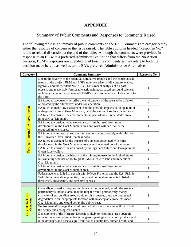
The following table is a summary of public comments on the EA. Comments are categorized by either the resource of concern or the issue raised. The table's column headed “Response No.” refers to related discussion at the end of the table. Although the comments were provided in response to an EA with a preferred Administrative Action that differs from the No Action decision, BLM’s responses are intended to address the comments as they relate to both the decision made herein, as well as to the EA’s preferred Administrative Alternative.
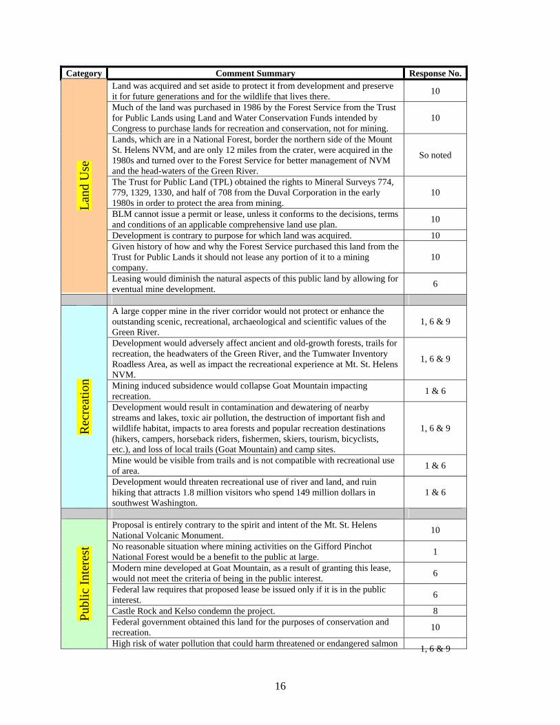
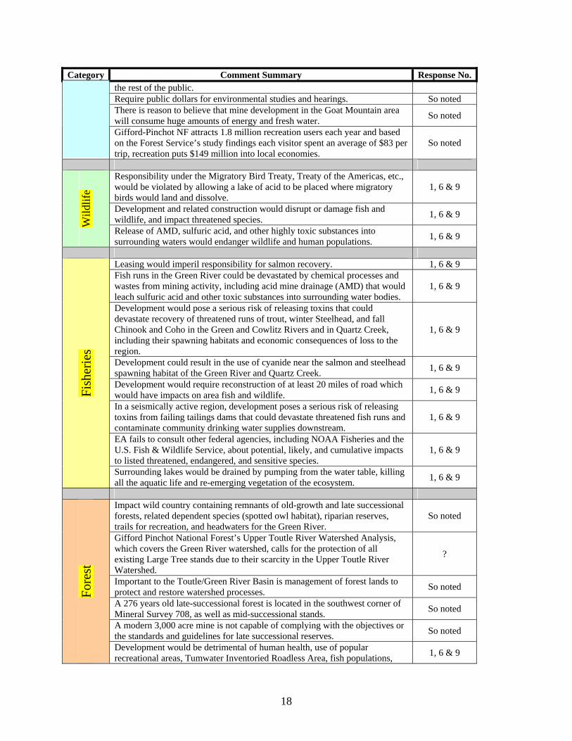
Category Comment Summary Response No.
Envi
ronm
enta
l Ass
essm
ent
Due to the severity of the potential cumulative impacts and the controversial nature of the project, BLM and USFS must complete a full, comprehensive, rigorous, and independent NEPA (i.e., EIS) impact analysis of all past, present, and reasonably foreseeable actions/impacts based on sound science, including the larger lease area and IGMI’s assess to unpatented lode claims to the north.
1
EA failed to adequately describe the environment of the areas to be affected or created by the alternatives under consideration. 2
EA failed to make any assessment as to the possible impacts of an open pit or underground mine at Goat Mountain, or of the nature of surface disturbance. 1
EA failed to consider the environmental impact of waste generated from a mine at Goat Mountain. 1
EA failed to consider what economic costs might result from mine development in the Goat Mountain area and what will occur after the proposed mine is closes.
1
EA failed to summarize how the future actions would comply with rules for the Tumwater Inventoried Roadless Area. 3
EA failed to account for the impacts of a smelter associated with mine development in the Goat Mountain area even if operated out of the region. 1
EA failed to consider the risk posed by tailings dam failure and leakage in the Green River valley. 1
EA failed to consider the history of the mining industry in the United States in evaluating whether or not to grant IGMI a lease to land and minerals at Goat Mountain.
1
EA failed to consider what economic costs might result from mine development in the Goat Mountain area. 1
Federal agencies failed to consult with NOAA Fisheries and the U.S. Fish & Wildlife Service about potential, likely, and cumulative impacts to listed threatened, endangered, and sensitive species.
1
Gen
eral
/ In
clus
ive
Com
men
ts
Generally opposed to proposal as plans are ill-conceived, would devastate a particularly vulnerable area, may be illegal, would permanently change character of surrounding area, would result in aesthetic and environmental degradation in an inappropriate location with unacceptable trade-offs near Goat Mountain, and would betray the public trust.
1
Environmental damage that would result in this sensitive area will harm both the beauty and ecological balance. 1
Development of the Margaret Deposit is likely to result in a large open pit mine or underground mine that is dangerous geologically, would produce acid mine drainage, and pose a significant risk to aquatic life, human health, and 1
12
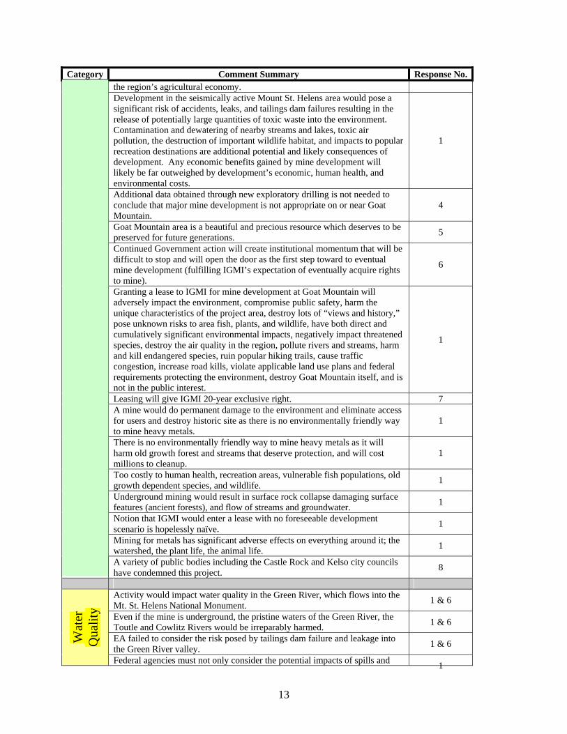
Category Comment Summary Response No. the region’s agricultural economy. Development in the seismically active Mount St. Helens area would pose a significant risk of accidents, leaks, and tailings dam failures resulting in the release of potentially large quantities of toxic waste into the environment. Contamination and dewatering of nearby streams and lakes, toxic air pollution, the destruction of important wildlife habitat, and impacts to popular recreation destinations are additional potential and likely consequences of development. Any economic benefits gained by mine development will likely be far outweighed by development’s economic, human health, and environmental costs.
1
Additional data obtained through new exploratory drilling is not needed to conclude that major mine development is not appropriate on or near Goat Mountain.
4
Goat Mountain area is a beautiful and precious resource which deserves to be preserved for future generations. 5
Continued Government action will create institutional momentum that will be difficult to stop and will open the door as the first step toward to eventual mine development (fulfilling IGMI’s expectation of eventually acquire rights to mine).
6
Granting a lease to IGMI for mine development at Goat Mountain will adversely impact the environment, compromise public safety, harm the unique characteristics of the project area, destroy lots of “views and history,” pose unknown risks to area fish, plants, and wildlife, have both direct and cumulatively significant environmental impacts, negatively impact threatened species, destroy the air quality in the region, pollute rivers and streams, harm and kill endangered species, ruin popular hiking trails, cause traffic congestion, increase road kills, violate applicable land use plans and federal requirements protecting the environment, destroy Goat Mountain itself, and is not in the public interest.
1
Leasing will give IGMI 20-year exclusive right. 7 A mine would do permanent damage to the environment and eliminate access for users and destroy historic site as there is no environmentally friendly way to mine heavy metals.
1
There is no environmentally friendly way to mine heavy metals as it will harm old growth forest and streams that deserve protection, and will cost millions to cleanup.
1
Too costly to human health, recreation areas, vulnerable fish populations, old growth dependent species, and wildlife. 1
Underground mining would result in surface rock collapse damaging surface features (ancient forests), and flow of streams and groundwater. 1
Notion that IGMI would enter a lease with no foreseeable development scenario is hopelessly naïve. 1
Mining for metals has significant adverse effects on everything around it; the watershed, the plant life, the animal life. 1
A variety of public bodies including the Castle Rock and Kelso city councils have condemned this project. 8
Wat
erQ
ualit
y
Activity would impact water quality in the Green River, which flows into the Mt. St. Helens National Monument. 1 & 6
Even if the mine is underground, the pristine waters of the Green River, the Toutle and Cowlitz Rivers would be irreparably harmed. 1 & 6
EA failed to consider the risk posed by tailings dam failure and leakage into the Green River valley. 1 & 6
Federal agencies must not only consider the potential impacts of spills and 1
13
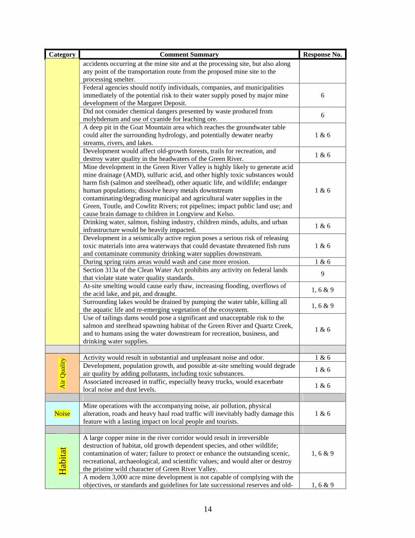
Category Comment Summary Response No. accidents occurring at the mine site and at the processing site, but also along any point of the transportation route from the proposed mine site to the processing smelter. Federal agencies should notify individuals, companies, and municipalities immediately of the potential risk to their water supply posed by major mine development of the Margaret Deposit.
6
Did not consider chemical dangers presented by waste produced from molybdenum and use of cyanide for leaching ore. 6
A deep pit in the Goat Mountain area which reaches the groundwater table could alter the surrounding hydrology, and potentially dewater nearby streams, rivers, and lakes.
1 & 6
Development would affect old-growth forests, trails for recreation, and destroy water quality in the headwaters of the Green River. 1 & 6
Mine development in the Green River Valley is highly likely to generate acid mine drainage (AMD), sulfuric acid, and other highly toxic substances would harm fish (salmon and steelhead), other aquatic life, and wildlife; endanger human populations; dissolve heavy metals downstream contaminating/degrading municipal and agricultural water supplies in the Green, Toutle, and Cowlitz Rivers; rot pipelines; impact public land use; and cause brain damage to children in Longview and Kelso.
1 & 6
Drinking water, salmon, fishing industry, children minds, adults, and urban infrastructure would be heavily impacted. 1 & 6
Development in a seismically active region poses a serious risk of releasing toxic materials into area waterways that could devastate threatened fish runs and contaminate community drinking water supplies downstream.
1 & 6
During spring rains areas would wash and case more erosion. 1 & 6 Section 313a of the Clean Water Act prohibits any activity on federal lands that violate state water quality standards. 9
At-site smelting would cause early thaw, increasing flooding, overflows of the acid lake, and pit, and draught. 1, 6 & 9
Surrounding lakes would be drained by pumping the water table, killing all the aquatic life and re-emerging vegetation of the ecosystem. 1, 6 & 9
Use of tailings dams would pose a significant and unacceptable risk to the salmon and steelhead spawning habitat of the Green River and Quartz Creek, and to humans using the water downstream for recreation, business, and drinking water supplies.
1 & 6
y Activity would result in substantial and unpleasant noise and odor. 1 & 6
Air
Qua
lit Development, population growth, and possible at-site smelting would degrade air quality by adding pollutants, including toxic substances. 1 & 6
Associated increased in traffic, especially heavy trucks, would exacerbate local noise and dust levels. 1 & 6
Noise Mine operations with the accompanying noise, air pollution, physical alteration, roads and heavy haul road traffic will inevitably badly damage this feature with a lasting impact on local people and tourists.
1 & 6
Hab
itat
A large copper mine in the river corridor would result in irreversible destruction of habitat, old growth dependent species, and other wildlife; contamination of water; failure to protect or enhance the outstanding scenic, recreational, archaeological, and scientific values; and would alter or destroy the pristine wild character of Green River Valley.
1, 6 & 9
A modern 3,000 acre mine development is not capable of complying with the objectives, or standards and guidelines for late successional reserves and old 1, 6 & 9
14
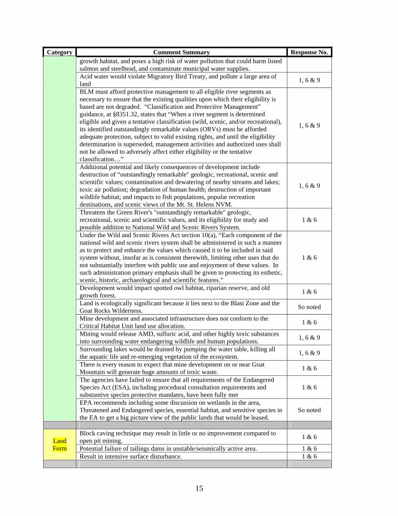
Category Comment Summary Response No. growth habitat, and poses a high risk of water pollution that could harm listed salmon and steelhead, and contaminate municipal water supplies. Acid water would violate Migratory Bird Treaty, and pollute a large area of land 1, 6 & 9
BLM must afford protective management to all eligible river segments as necessary to ensure that the existing qualities upon which their eligibility is based are not degraded. “Classification and Protective Management” guidance, at §8351.32, states that “When a river segment is determined eligible and given a tentative classification (wild, scenic, and/or recreational), its identified outstandingly remarkable values (ORVs) must be afforded adequate protection, subject to valid existing rights, and until the eligibility determination is superseded, management activities and authorized uses shall not be allowed to adversely affect either eligibility or the tentative classification…”
1, 6 & 9
Additional potential and likely consequences of development include destruction of “outstandingly remarkable" geologic, recreational, scenic and scientific values; contamination and dewatering of nearby streams and lakes; toxic air pollution; degradation of human health; destruction of important wildlife habitat; and impacts to fish populations, popular recreation destinations, and scenic views of the Mt. St. Helens NVM.
1, 6 & 9
Threatens the Green River's "outstandingly remarkable" geologic, recreational, scenic and scientific values, and its eligibility for study and possible addition to National Wild and Scenic Rivers System.
1 & 6
Under the Wild and Scenic Rivers Act section 10(a), “Each component of the national wild and scenic rivers system shall be administered in such a manner as to protect and enhance the values which caused it to be included in said system without, insofar as is consistent therewith, limiting other uses that do not substantially interfere with public use and enjoyment of these values. In such administration primary emphasis shall be given to protecting its esthetic, scenic, historic, archaeological and scientific features.”
1 & 6
Development would impact spotted owl habitat, riparian reserve, and old growth forest. 1 & 6
Land is ecologically significant because it lies next to the Blast Zone and the Goat Rocks Wilderness. So noted
Mine development and associated infrastructure does not conform to the Critical Habitat Unit land use allocation. 1 & 6
Mining would release AMD, sulfuric acid, and other highly toxic substances into surrounding water endangering wildlife and human populations. 1, 6 & 9
Surrounding lakes would be drained by pumping the water table, killing all the aquatic life and re-emerging vegetation of the ecosystem. 1, 6 & 9
There is every reason to expect that mine development on or near Goat Mountain will generate huge amounts of toxic waste. 1 & 6
The agencies have failed to ensure that all requirements of the Endangered Species Act (ESA), including procedural consultation requirements and substantive species protective mandates, have been fully met
1 & 6
EPA recommends including some discussion on wetlands in the area, Threatened and Endangered species, essential habitat, and sensitive species in the EA to get a big picture view of the public lands that would be leased.
So noted
Land Block caving technique may result in little or no improvement compared to open pit mining. 1 & 6
Form Potential failure of tailings dams in unstable/seismically active area. 1 & 6 Result in intensive surface disturbance. 1 & 6
15
Category Comment Summary Response No. La
nd U
se
Land was acquired and set aside to protect it from development and preserve it for future generations and for the wildlife that lives there. 10
Much of the land was purchased in 1986 by the Forest Service from the Trust for Public Lands using Land and Water Conservation Funds intended by Congress to purchase lands for recreation and conservation, not for mining.
10
Lands, which are in a National Forest, border the northern side of the Mount St. Helens NVM, and are only 12 miles from the crater, were acquired in the 1980s and turned over to the Forest Service for better management of NVM and the head-waters of the Green River.
So noted
The Trust for Public Land (TPL) obtained the rights to Mineral Surveys 774, 779, 1329, 1330, and half of 708 from the Duval Corporation in the early 1980s in order to protect the area from mining.
10
BLM cannot issue a permit or lease, unless it conforms to the decisions, terms and conditions of an applicable comprehensive land use plan. 10
Development is contrary to purpose for which land was acquired. 10 Given history of how and why the Forest Service purchased this land from the Trust for Public Lands it should not lease any portion of it to a mining company.
10
Leasing would diminish the natural aspects of this public land by allowing for eventual mine development. 6
Rec
reat
ion
A large copper mine in the river corridor would not protect or enhance the outstanding scenic, recreational, archaeological and scientific values of the Green River.
1, 6 & 9
Development would adversely affect ancient and old-growth forests, trails for recreation, the headwaters of the Green River, and the Tumwater Inventory Roadless Area, as well as impact the recreational experience at Mt. St. Helens NVM.
1, 6 & 9
Mining induced subsidence would collapse Goat Mountain impacting recreation. 1 & 6
Development would result in contamination and dewatering of nearby streams and lakes, toxic air pollution, the destruction of important fish and wildlife habitat, impacts to area forests and popular recreation destinations (hikers, campers, horseback riders, fishermen, skiers, tourism, bicyclists, etc.), and loss of local trails (Goat Mountain) and camp sites.
1, 6 & 9
Mine would be visible from trails and is not compatible with recreational use of area. 1 & 6
Development would threaten recreational use of river and land, and ruin hiking that attracts 1.8 million visitors who spend 149 million dollars in southwest Washington.
1 & 6
Publ
ic In
tere
st
Proposal is entirely contrary to the spirit and intent of the Mt. St. Helens National Volcanic Monument. 10
No reasonable situation where mining activities on the Gifford Pinchot National Forest would be a benefit to the public at large. 1
Modern mine developed at Goat Mountain, as a result of granting this lease, would not meet the criteria of being in the public interest. 6
Federal law requires that proposed lease be issued only if it is in the public interest. 6
Castle Rock and Kelso condemn the project. 8 Federal government obtained this land for the purposes of conservation and recreation. 10
High risk of water pollution that could harm threatened or endangered salmon 1, 6 & 9
16

Category Comment Summary Response No. and steelhead species and jeopardize water supplies for the cities of Kelso and Longview. Mt. St. Helens holds religious significance for Cowlitz and Klickitat people. So noted Development not best use for fragile, ecologically-rich land, and would not benefit the people or the environment in the long run. 1 & 6
Development would not represent wishes of majority – violate public trust. 1 & 6 Public's interest will not be served by turning over the unique Green River Valley area to mining. 1, 6 & 9
Health Beef and dairy cows down stream would drink the water and their meat and milk would become contaminated with mercury and lead that would brain damage everyone's children.
1, 6 & 9
Safe
ty
Development in the seismically active Mount St. Helens area would pose a serious risk of terrain sloughing, accidents, leaks, and tailings dam failure resulting in the release of potentially large quantities of toxic waste into the environment that could devastate threatened fish runs and contaminate community drinking water supplies downstream.
1, 6 & 9
Block caving technique may result in little or no improvement compared to open pit mining. So noted
Damage to human health, recreational use, fish populations, other wildlife, and area forests, including old growth dependent species. 1 & 6
Drinking water, salmon, fishing industry, children’s minds, adults, and urban infrastructure would be heavily impacted. 1, 6 & 9
Federal agencies must not only consider the potential impacts of spills and accidents occurring at the mine site and at the processing site, but also along any point of the transportation route from the proposed mine site to the processing smelter.
1, 6 & 9
Heavy metals in water would impact meat and milk from beef and dairy cattle downstream harming children. 1, 6 & 9
High toxicity of cyanide is a great concern given the possibility of accidental leaks into the environment. 1, 6 & 9
Mine development on or near Goat Mountain generating acid mine drainage could be devastating to area fish and wildlife, and to human health. 1, 6 & 9
Failure of tailings dams would pose a significant and unacceptable risk to the salmon and steelhead spawning habitat of the Green River and Quartz Creek, and to humans using the water downstream for recreation, business, and drinking water supplies.
1, 6 & 9
Unstable ground with high risk of surface erosion exists in the lease area. 1, 6 & 9
Soci
o-ec
onom
ics
Any economic benefits gained by mine development will likely be far outweighed by the development’s environmental costs. So noted
Area is economically more important to the US as a recreation and conservation land than as a mine. So noted
Environmental consequences of a mine would far outweigh the mining company's interest in pursuing this project. So noted
Impacts to agricultural along the Green, Toutle, and Cowlitz Rivers are a concern. 1, 6 & 9
Would bring jobs and money, but result in introduction of workers from outside the area with potential negative consequences to local social values. So noted
Leave taxpayers with massive environmental cleanup. So noted A mine would wipe out economic benefit of tourists and recreationists. So noted Profit gained by the owners of the mining corporation is no compensation to So noted
17
Category Comment Summary Response No. the rest of the public. Require public dollars for environmental studies and hearings. So noted There is reason to believe that mine development in the Goat Mountain area will consume huge amounts of energy and fresh water. So noted
Gifford-Pinchot NF attracts 1.8 million recreation users each year and based on the Forest Service’s study findings each visitor spent an average of $83 per trip, recreation puts $149 million into local economies.
So noted
Wild
life
Responsibility under the Migratory Bird Treaty, Treaty of the Americas, etc., would be violated by allowing a lake of acid to be placed where migratory birds would land and dissolve.
1, 6 & 9
Development and related construction would disrupt or damage fish and wildlife, and impact threatened species. 1, 6 & 9
Release of AMD, sulfuric acid, and other highly toxic substances into surrounding waters would endanger wildlife and human populations. 1, 6 & 9
Fish
erie
s
Leasing would imperil responsibility for salmon recovery. 1, 6 & 9 Fish runs in the Green River could be devastated by chemical processes and wastes from mining activity, including acid mine drainage (AMD) that would leach sulfuric acid and other toxic substances into surrounding water bodies.
1, 6 & 9
Development would pose a serious risk of releasing toxins that could devastate recovery of threatened runs of trout, winter Steelhead, and fall Chinook and Coho in the Green and Cowlitz Rivers and in Quartz Creek, including their spawning habitats and economic consequences of loss to the region.
1, 6 & 9
Development could result in the use of cyanide near the salmon and steelhead spawning habitat of the Green River and Quartz Creek. 1, 6 & 9
Development would require reconstruction of at least 20 miles of road which would have impacts on area fish and wildlife. 1, 6 & 9
In a seismically active region, development poses a serious risk of releasing toxins from failing tailings dams that could devastate threatened fish runs and contaminate community drinking water supplies downstream.
1, 6 & 9
EA fails to consult other federal agencies, including NOAA Fisheries and the U.S. Fish & Wildlife Service, about potential, likely, and cumulative impacts to listed threatened, endangered, and sensitive species.
1, 6 & 9
Surrounding lakes would be drained by pumping from the water table, killing all the aquatic life and re-emerging vegetation of the ecosystem. 1, 6 & 9
Fore
st
Impact wild country containing remnants of old-growth and late successional forests, related dependent species (spotted owl habitat), riparian reserves, trails for recreation, and headwaters for the Green River.
So noted
Gifford Pinchot National Forest’s Upper Toutle River Watershed Analysis, which covers the Green River watershed, calls for the protection of all existing Large Tree stands due to their scarcity in the Upper Toutle River Watershed.
?
Important to the Toutle/Green River Basin is management of forest lands to protect and restore watershed processes. So noted
A 276 years old late-successional forest is located in the southwest corner of Mineral Survey 708, as well as mid-successional stands. So noted
A modern 3,000 acre mine is not capable of complying with the objectives or the standards and guidelines for late successional reserves. So noted
Development would be detrimental of human health, use of popular recreational areas, Tumwater Inventoried Roadless Area, fish populations, 1, 6 & 9
18

Category Comment Summary Response No. other wildlife, forested area, native vegetation, and scenic beauty.
Roa
ds &
Roa
dles
s Are
a
Area under consideration cannot be leased because it enters the Tumwater Inventoried Roadless Area. 11
The northern portions of Mineral Surveys 708, 1330, and 774, as well as both the Margaret North and Red Bonanza lode claim areas, lie within the Tumwater Inventoried Roadless Area.
So noted
A modern 3,000-acre mine development is not capable of complying with the objectives or standards and guidelines of late successional reserves or unroaded recreation areas.
1, 6 & 11
Development would impact ancient forests, the Tumwater Inventoried Roadless Area, and popular recreation areas. 1, 6 & 11
Development would require the reconstruction of at least 20 miles of road, which would have impacts on area fish and wildlife; however, compliance with the Clinton Roadless Rule (i.e., Tumwater IRA) which would prohibit new temporary and permanent roads.
11
The 2001 Roadless Area Conservation Rule prohibits timber harvest, except when done for strictly ecological enhancement purposes. ?
Mine operations with the accompanying noise, air pollution, physical alteration, roads and heavy haul road traffic will inevitably badly damage this feature with a lasting impact on local people and tourists.
So noted
Traffic, construction, upgrading roads, and transporting products would impact on WQ and result in loss of historic and scenic areas. So noted
New roads in unstable soils would add sediment to area stream and rivers 1, 6 & 9
Vis
ual
Giving access to IGMI or any other mining type of industry will destroy the natural beauty to this area. So noted
A large copper mine in the river corridor would not protect or enhance the outstanding scenic, recreational, archaeological and scientific values of the Green River.
1 & 6
Mine would alter natural beauty of landscape, and affect the visual resources in the Mt. St. Helens NVM (only 12 miles from crater), as well as post-eruption recovery.
So noted
Backcountry would be degraded by destruction of old growth timber, vegetation, and natural scenic beauty, as well as visual and audible pollution. 1 & 6
Mine would be visible from local trails. So noted
Wastes There is every reason to expect that mine development on or near Goat Mountain will generate huge amounts of toxic waste. 1, 6 & 9
Supp
ortiv
e
Develop can be accomplished in a way that will protect the land and let them mine minerals. So noted
Development would be in the public interest by helping the economy. So noted It is reasonable to be confident that safe guards will be in place to protect water, wildlife, etc., from harm. So noted
EPA understands that it is unclear whether there would be an open pit or underground mine and we support the “contingent right stipulation” placed on the lease stating that no groundbreaking activity would occur before associated NEPA analyses are complete.
So noted
Opportunity to show country that mining can be conducted on sensitive lands to the benefit of everyone and provide good jobs. So noted
19
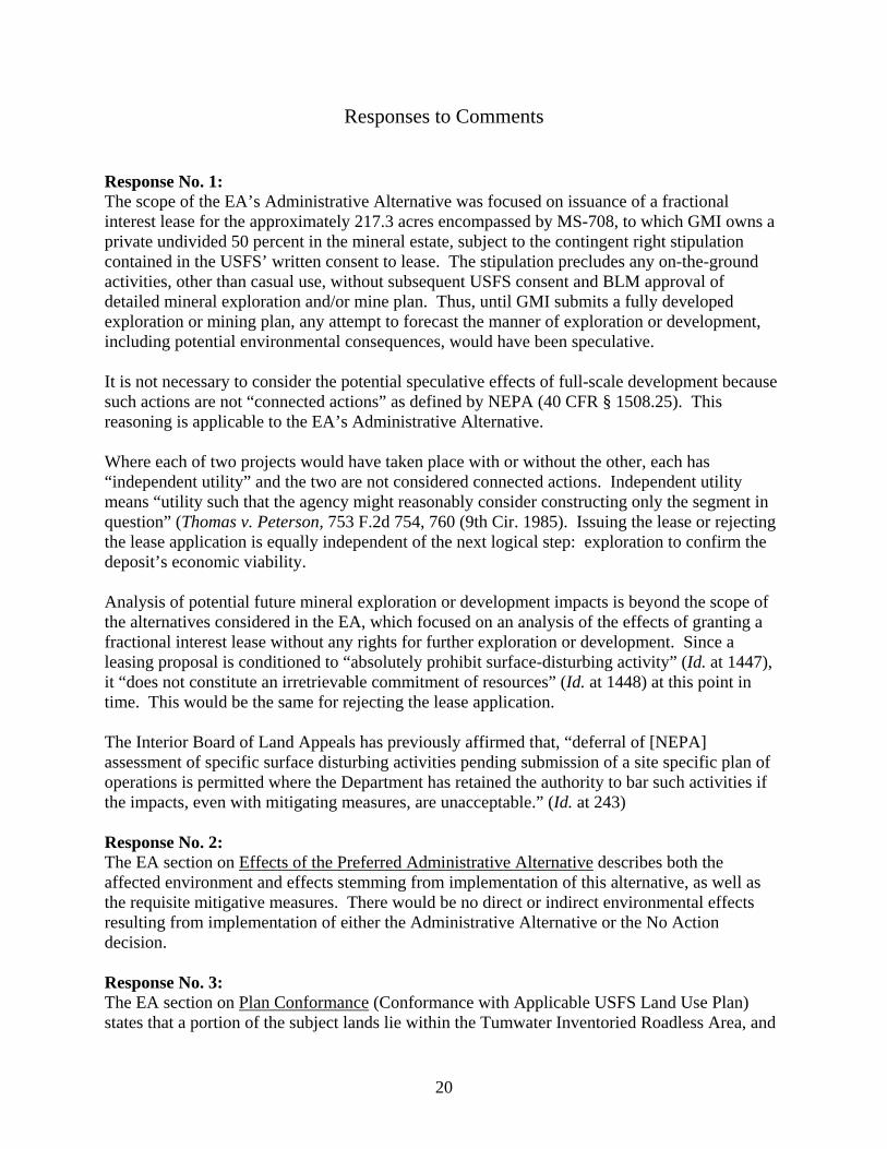
Responses to Comments
Response No. 1: The scope of the EA’s Administrative Alternative was focused on issuance of a fractional interest lease for the approximately 217.3 acres encompassed by MS-708, to which GMI owns a private undivided 50 percent in the mineral estate, subject to the contingent right stipulation contained in the USFS’ written consent to lease. The stipulation precludes any on-the-ground activities, other than casual use, without subsequent USFS consent and BLM approval of detailed mineral exploration and/or mine plan. Thus, until GMI submits a fully developed exploration or mining plan, any attempt to forecast the manner of exploration or development, including potential environmental consequences, would have been speculative.
It is not necessary to consider the potential speculative effects of full-scale development because such actions are not “connected actions” as defined by NEPA (40 CFR § 1508.25). This reasoning is applicable to the EA’s Administrative Alternative.
Where each of two projects would have taken place with or without the other, each has “independent utility” and the two are not considered connected actions. Independent utility means “utility such that the agency might reasonably consider constructing only the segment in question” (Thomas v. Peterson, 753 F.2d 754, 760 (9th Cir. 1985). Issuing the lease or rejecting the lease application is equally independent of the next logical step: exploration to confirm the deposit’s economic viability.
Analysis of potential future mineral exploration or development impacts is beyond the scope of the alternatives considered in the EA, which focused on an analysis of the effects of granting a fractional interest lease without any rights for further exploration or development. Since a leasing proposal is conditioned to “absolutely prohibit surface-disturbing activity” (Id. at 1447), it “does not constitute an irretrievable commitment of resources” (Id. at 1448) at this point in time. This would be the same for rejecting the lease application.
The Interior Board of Land Appeals has previously affirmed that, “deferral of [NEPA] assessment of specific surface disturbing activities pending submission of a site specific plan of operations is permitted where the Department has retained the authority to bar such activities if the impacts, even with mitigating measures, are unacceptable.” (Id. at 243)
Response No. 2: The EA section on Effects of the Preferred Administrative Alternative describes both the affected environment and effects stemming from implementation of this alternative, as well as the requisite mitigative measures. There would be no direct or indirect environmental effects resulting from implementation of either the Administrative Alternative or the No Action decision.
Response No. 3: The EA section on Plan Conformance (Conformance with Applicable USFS Land Use Plan) states that a portion of the subject lands lie within the Tumwater Inventoried Roadless Area, and
20

that road construction or reconstruction would generally not be allowed regardless of BLM’s decision.
Response No. 4: GMI already owns a 50 percent undivided mineral interest for lands within MS-708. As surface owner, the USFS has no regulatory authority over development of GMI’s mineral interest, and GMI could enjoy their mineral rights without regulatory oversight by the Federal Government if surface disturbance was not conducted. If the Federal Government does not issue a fractional interest lease, it may only be able to seek minimal mitigative measures if surface disturbing activities were conducted. If the U.S. issues a fractional interest lease with a contingent right stipulation, the Government will have lease regulatory responsibility, including the ability to require appropriate mitigative measures through approval of mineral exploration and/or development plans subsequently submitted by the applicant. Conversely, BLM could deny such operations if it is determined that the resultant environmental impacts are unacceptable. Submittal of future plans or permit applications are still an option for the applicant even with the No Action decision, and the U.S. will still retain some level of control over surface-disturbing activities through the NEPA process.
Response No. 5: Neither the Administrative Alternative nor the No Action decision would result in authorization of on-the-ground activities other than casual use, thus the existing environment would not be affected.
Response No. 6: Issuance of a fractional hardrock mineral lease is an action fully discretionary to the federal government and can only occur when it is determined to be in the public interest (43 CFR §3509.41). Under either the fractional interest lease with the contingent right stipulation required by the USFS’ written consent or the No Action decision, the Government would assess any plans that GMI subsequently submits for mineral exploration and/or development. At that later date, the Government would determine, consistent with the appropriate level of NEPA analysis, whether or not to consent to and approve the proposed action.
Response No. 7: A hardrock mineral lease is usually issued for an initial term not to exceed 20 years (43 CFR §3511.15). GMI will own their 50 percent undivided mineral interest for as long as they choose to hold it, whether or not a lease is issued. In addition, the Government can only issue a lease for its 50 percent undivided interest to the entity owning the other 50 percent (43 CFR § 3509.45).
Response No. 8: On March 26, 2006, the City of Kelso, Washington stated opposition to a proposed mine for land in the Green River valley below Goat Mountain. Similarly, on June 26, 2006, the City of Castle Rock, Washington, issued Resolution No. 2006-10 stating opposition to mine development at Goat Mountain. More recently, the City of Longview, Washington went on record opposing mine development, as did the Board of Commissioners of Cowlitz County, Washington. Since the direct link to mine development is speculative and beyond the scope of the EA, it was not analyzed for potential impacts.
21
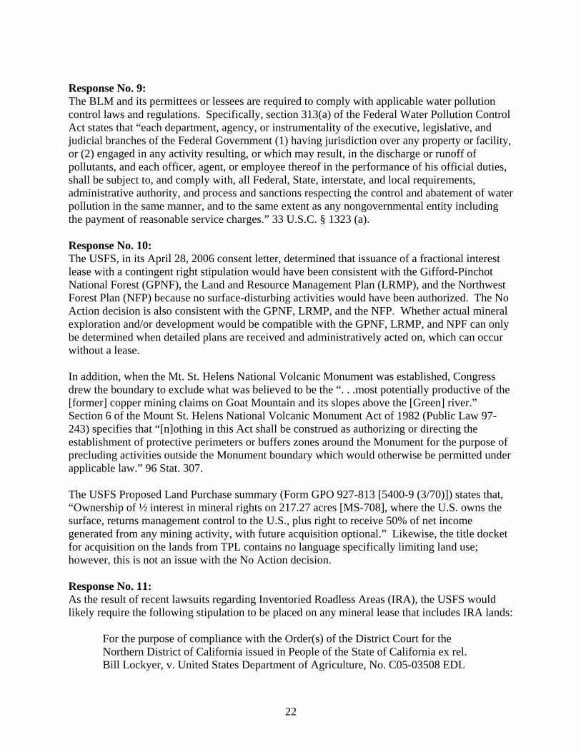
Response No. 9: The BLM and its permittees or lessees are required to comply with applicable water pollution control laws and regulations. Specifically, section 313(a) of the Federal Water Pollution Control Act states that “each department, agency, or instrumentality of the executive, legislative, and judicial branches of the Federal Government (1) having jurisdiction over any property or facility, or (2) engaged in any activity resulting, or which may result, in the discharge or runoff of pollutants, and each officer, agent, or employee thereof in the performance of his official duties, shall be subject to, and comply with, all Federal, State, interstate, and local requirements, administrative authority, and process and sanctions respecting the control and abatement of water pollution in the same manner, and to the same extent as any nongovernmental entity including the payment of reasonable service charges.” 33 U.S.C. § 1323 (a).
Response No. 10: The USFS, in its April 28, 2006 consent letter, determined that issuance of a fractional interest lease with a contingent right stipulation would have been consistent with the Gifford-Pinchot National Forest (GPNF), the Land and Resource Management Plan (LRMP), and the Northwest Forest Plan (NFP) because no surface-disturbing activities would have been authorized. The No Action decision is also consistent with the GPNF, LRMP, and the NFP. Whether actual mineral exploration and/or development would be compatible with the GPNF, LRMP, and NPF can only be determined when detailed plans are received and administratively acted on, which can occur without a lease.
In addition, when the Mt. St. Helens National Volcanic Monument was established, Congress drew the boundary to exclude what was believed to be the “. . .most potentially productive of the [former] copper mining claims on Goat Mountain and its slopes above the [Green] river.” Section 6 of the Mount St. Helens National Volcanic Monument Act of 1982 (Public Law 97243) specifies that “[n]othing in this Act shall be construed as authorizing or directing the establishment of protective perimeters or buffers zones around the Monument for the purpose of precluding activities outside the Monument boundary which would otherwise be permitted under applicable law.” 96 Stat. 307.
The USFS Proposed Land Purchase summary (Form GPO 927-813 [5400-9 (3/70)]) states that, “Ownership of ½ interest in mineral rights on 217.27 acres [MS-708], where the U.S. owns the surface, returns management control to the U.S., plus right to receive 50% of net income generated from any mining activity, with future acquisition optional.” Likewise, the title docket for acquisition on the lands from TPL contains no language specifically limiting land use; however, this is not an issue with the No Action decision.
Response No. 11: As the result of recent lawsuits regarding Inventoried Roadless Areas (IRA), the USFS would likely require the following stipulation to be placed on any mineral lease that includes IRA lands:
For the purpose of compliance with the Order(s) of the District Court for the Northern District of California issued in People of the State of California ex rel. Bill Lockyer, v. United States Department of Agriculture, No. C05-03508 EDL
22

consolidated with The Wilderness Society v. United States Forest Service, No. C05-04038 EDL (reinstating 36 CFR 294, Subpart B (2001) (Protection of Inventoried Roadless Areas) (hereinafter the “2001 Rule”)), surface occupancy or use is subject to the following special operating constraints:
No new temporary roads, permanent roads, road construction or reconstruction (as defined in 36 CFR 294.11) may occur within the lands described below:
. . .[Generally less than the northern one-third of MS-708.]
This stipulation may change in accordance with other applicable provisions. It would cease to apply in the event the District Court's Order reinstating the 2001 Rule is reversed, the 2001 Rule is set aside, or if the Forest Service determines that other events have caused the 2001 Rule to no longer be in effect or applicable to the lands within the leasehold. As a result, no new roads would be allowed in the portions of the mineral survey that lie within an IRA, regardless of any decision regarding issuance of the lease.
As the decision does not issue a fractional interest lease, this stipulation is unnecessary.
23
![Bureau of Customs and Border Protection · Bureau of Customs and Border Protection General Notices [CBP Decision 03–19] Customs Accreditation of BSI Inspectorate America Corporation](https://img.pdfslide.us/doc/110x75/5b5065d17f8b9a396e8e6216/bureau-of-customs-and-border-protection-bureau-of-customs-and-border-protection.jpg)