Embed Size (px)
Citation preview
1999~2000 WILDLIFE STUDIES JONAH FIELD II
NATURAL GAS DEVELOPMENT PROJECT
Prepared for
US Bureau of Land Management cmiddot Pinedale Field Office Pinedale Wyoming
and
Rock Springs Field Office Rock Springs Wyoming
By
TRC Mariah Associates Inc Laramie Wyoming MAl Project 22318
January 2001
1 Jonah II Wildlife Studies 1999-2000
(~ TABLE OF CONTENTS
10 INTRODUCTION 1
20 ME1HODS 3 21 RAPTORS bull 3 22 SAGE GROUSE 4
23 1HREATENED ENDANGERED PROPOSED CANDIDATE AND OlliER WYOMING SPECIES OF CONCERN 6 231 Black-footed Ferret 10 232 Bald Eagle Ferruginous Hawk Golden Eagle 10 233 Mountain Plover 10 234 Western Burrowing Owl 11 235 Other TEPCamp WSC Species 12
24 GENERAL WILDLIFE 12
30 RESULTS AND PROPOSED MONITORINGPROTECTION MEASURES 13 31 RAPTORS 13
311 Results 13 312 MonitoringProtection Measures 23
32 SAGE GROUSE 26 321 Results 26 322 Monitoring and Protection Measures 33
33 1HREATENED ENDANGERED PROPOSED CANDIDATE AND WYOMING SPECIES OF CONCERN 36 331 Results 36
3311 Black-footed Ferret 36 3312 Bald Eagle Ferruginous Hawk Golden Eagle 36 3313 Mountain Plover 36 3314 Western Burrowing Owl 38 3315 Other TEPCampWSC Species 38
332 Monitoring and Protection 38 3321 Black-footed Ferret 38 3322 Bald Eagle Ferruginous Hawk Golden Eagle 39 3323 Mountain Plover 40 3324 Western Burrowing Owl 42 3325 Other TEPCampWSC Species 42
333 General Wildlife 4~
3331 Results 43 3332 Monitoring and Protection 43
c 40 UTERATURE CITED 46
22318 TRC Mariah Associates Inc
11 Jonah II Wildlife Studies-1999-2000
TABLE OF CONTENTS (Continued)
APPENDIX A MAPS
APPENDIX B RAPTOR AND GENERAL WILDLIFE OBSERVATION DATA SHEETS
r
APPENDIX C RAPTOR NESTING RECORDS
APPENDIX D SAGE GROUSE LEK RECORDS
APPENDIXE MOUNTAIN PLOVER SURVEY FORMS
LIST OF-MAPS
Map 11 Wildlife Study Area Jonah II Project 2000 2
LIST OF TABLES
Table 21 Characteristics of Sagebrush Rangeland Needed for Productive High-quality Sage Grouse Habitat in Wyoming 7
Table 22 BLM Wyoming Animal Species of Concern (Draft) Documented or Potentially Occurring on or in the Vicinity of the Jonah II Natural Gas Project Area 2000 8
Table 31 Raptor Nest Locations and Activity Status 2000 Jonah II Wildlife Study Area ~ 14
Table 32 Summary of Active Raptor Nests Within 10 Mi of Existing or Proposed Disturbance Jonah II Wildlife Study Area ~ 20
Table 33 Nests and 1998-2000 Activity Status at Ferruginous Hawk Nesting ( Territories Jonah II Wildlife Study Area 22
22318 TRC Mariah Associates Inc
III Jonah II Wildlife Studies 1999middot2000
LIST OF TABLES (Continued)
Table 34 Raptor Nest Locations for Which Photos are Needed Jonah II Wildlife Study Area 2000 ~ 24
Table 35 Summary of Sage Grouse Lek Use Potential Impacts and Proposed Monitoring Jonah II Wildlife Study Area 20QO 27
Table 36 Sage Grouse Trends Jonah II Wildlife Study Area 1992-2000 29
Table 37 Summary of Noise Data Collection at the Bird Canyon and Lumen Compressor Stations Jonah II Wildlife Study Area 2000 30
Table 38 Results of Vegetation Studies MJ2P A 2000 31
Table 3~9 Whitetail Prairie Dog Towns Jonah II Wildlife St1ldy Area 2000 37
c
22318 TRC Mariah Associates Inc
c
Jonah II Wildlife Studies 1999-2000
( 10 INTRODUCTION
This report was prepared by TRC Mariah Associates Inc (TRC Mariah) for McMurry Oil
Company (McMurry) BP Amoco Production Company and other operators (collectively
referred to herein as the Operators) incompliance with the US Bureau of Land
Management (BLM) Record of Decision (ROD) for the Jonah Field II natural gas project
(BLM 1998a Appendix D) and the Decision Record (DR) for the Modified Jonah Field II
project (BLM 2000a) The goals of the ROD Wildlife MonitoringProtection Plan (WMPP)
and subsequent modifications made in the DR are to monitor wildlife population trends on
and adjacent to the Jonah Field II project area (J2PA) and Modified Jonah Field II project
area (MJ2P A) during the course of project development and operations and to avoid andor
minimize adverse impacts to wildlife present on project-affected areas Implementation of
the plan as presented in this report providesmiddot land managers and project personnel
opportunities to achieve and maintain wildlife productivity and populations on the project
area by minimizingmiddot andor avoiding potential adverse impacts to wildlife associated with
project development Wildlife monitoring was initiated in 1997and continuedthrough 2000
This report presents the methods and results of 1999 and 2000 wildlife studies on the
wildlife study area (WSA) which includes the MJ2P A J2PA and adjacent areaS (Map 11
and Appendix A) wildlife data collected in 1997 and 1998 are presented in BLM (1999)
Observational data were collected by BLM TRC Mariah Wyoming Game and Fish
Department (WGFD) and US Fish and Wildlife Service (USFWS) personnel and trends
across years are noted where possible Additionally potential wildlife disturbance sources
are identified and monitoring and protection measures proposed for 2001 are presented
Monitoring andprotection measures are consistent with those identified in the original ROD
(BLM 1998a) the environmental assessment (EA) for the Modified Jonah Field II project
(BLM 2000b) and include additional BLM~ andor Operator-requested measures
22318 TRC Mariah Associates Inc
2 Jonah II Wildlife Studies 1999-2000
Rl09W Rl07WR1 lOW
BIN
nON
T29N
o
middotmiddotmiddotmiddotmiddotmiddotmiddotmiddotmiddotmiddotmiddotmiddotmiddotmiddotmiddotmiddotmiddotmiddotmiddotmiddotmiddot=~~~~~~~~~~~~~35~1~~4--middotmiddotmiddotmiddotmiddotmiddotmiddotmiddotmiddotmiddot ~
J-----1
~kcbullbullbullbullbullbullbullbullbullbull lt bullbull bullbullbullbullbullbullbullbullbullbullbullbullbull
_-l - ---+----shy l
County Line -~oad
SUBLETTE CO-----------------------shy SWEETWATER CO
--shy 40-ACRE WELL LOCATION DENSITY AREA BOUNDARY (MJ2PA)
--shy JONAH FIELD II EIS PROJECT
5 AREA BOUNDARY (J2PA)
- -- shy WILDLIFE STUDY AREA MILES
22J18WlU)-PlJH-l
Map 11 Wildlife Study Area Jonah II Project 2000 (
TRC Mariah Associates Inc 22318
3 Jonah II Wildlife Studies 1999-2000
20 METHODS
Inventory and monitoring protocols are identified below for each wildlife speciescategory
The wildlife speciescategories for which specific inventory and monitoring procedures were
applied were developed based 011 management agency (Le BLM USFWS WGFD) and
individual concerns identified during the preparation of the Environmental Impact
Statement for the Jonah II project (BLM 1997 1998b) and the EA for Modified Jonah
Field II Project (BLM 2000b) Specific inventory and monitoring techniques generally
follow the methods presented in the WMPP for this project (BLM 1998a Appendix D) and
additional methods identified inmiddot BLM (2000b)
21 RAPTORS
c Aerial (helicopter)raptor nest surveys of the WSA were conducted in 1997 and 1998 to
determine the -location and activity status of raptor nests in the area (BLM 1999) In 1999
and 2000 raptor nest activity status surveys were conducted by TRC Mariah personnel on
the ground using four-wheel drive vehicles and pedestrian reconnaissance Activity status
surveys were conducted on May 30 and 31 and June 1 1999 and May 2242528 and 29
2000
In 1999 and 2000 raptor nest productivity surveys were conducted by TRC Mariah at all
active nest locations within 10 mi of eXisting or proposed development areas (see
Appendix A Wildlife Map) Productivity surveys were conducted on July 12 and August 8
1999 and June 12 and 13 and July 10 and 14 2000 using four-wheel drive vehicles and
pedestrian reconnaissance In the case of nest failure or abandonment attempts were made
to identify causative factors All data collected during raptor activity and productivity
surveys were recorded on maps Raptor Nesting Records and Raptor Observation Data
Sheets (see Appendix A [Wildlife Map] Appendix B [Raptor Observation Data Sheets] and
Appendix C [Raptor Nesting Records D
22318 TRC Mariah Associates Inc
4 Jonah II Wildlife Studies 1999-2000
( The boundary of each ferruginous hawk nesting territory was approximated based on the -shy location of known nests in the area No attempts were made to determine the general
foraging territories for nesting pairs
All raptor nestproductivity surveys were conducted using procedures that minimize
potential adverse effects to nesting raptors as identified in the ROD (BLM 1998a
Appendix D)
No artificial nest structures (ANSs) were erected in 1999 or 2000
22 SAGE GROUSE
Sage grouse lek surveys were conducted in 1999 and 2000 to determine the location and
extent of sage grouse breeding activities in the WSA (see Map 11 and Appendix A) No
investigations were conducted at sage grouse lek 16 Surveys were conducted primarily by
WGFD and BLM personnel and included aerial flights of the area to identify lek locations
and grOl~~d surveys to determine the extent of lek use Data on lek attendance lek location
and survey dates are provided in Appendix D (Sage Grouse Lek Records)
Specific surveys for sage grouse winter use of the J2PA and surrounding areas were not
implemented however general sage grouse winteruse data were collected by the BLM in
association with ongoing activities in the area This information may be reviewed at the
BLM Pinedale Field Office in Pinedale Wyoming
During 2000 TRC Mariah measured noise output windspeed and relative humidity at the
Bird Canyon and Lumen compressor stations and adjacent areas as requested by the BLM
Noise outputs were measured using a SPER scientific digital sound level meter (Model
840029) Readings were taken at both stations at approximately 04 mi away from the
Bird Canyon station to the north south east and west and at sage grouse leks 7 and 8
22318 TRC Mariah Associates Inc
c
l
5 Jonah II Wildlife Studies 1999-2000
(see Appendix A Wildlife Map for lek locations) Wind speeds were recorded using a Sims
anemometer (Model 95688) at locations where noise output was measured except directly
at the compressor stationsmiddot Relative humidity was measured using a Princo sling
psychrometer Readings at the Bird Canyon station and adjacent areas were taken between
600 am and 700 am on June 12000 and readings at the Lumen station and leks 7 and
8 were taken prior to 600 am on June 3 2000
On August 5-6 2000 mc Mariah biologists mapped habitat types within the MJ2P A to
facilitate an analysis of sage grouse nesting habitat quality and quantity Four habitat types
were identified based on an ocular interpretation of relative sagebrush cover and density
dense sagebrush moderately dense sagebrush basinsagebrush and scatteredno sagebrush
From August 7-10 2000 sampling was conducted in the dense moderate and basin
sagebrush types to determine the quality and quantity of sage grouse nesting and
brood-rearing habitat in the project area Sampling procedures generally were based on
studies currently being conducted on sage grouse nesting habitat in the area (personal
communication Matt Holloran University of Wyoming Cooperative Unit) Shrub cover
density and height and understory cover and height were measured along 15 60~m transects
in the dense and moderate density sagebrush types and along five transects in the basin
sagebrush type (see Appendix A Habitat Map) Sample points were randomly located using
a 60-m grid overlaid on a map of the area and randomly chosen x-y coordinates The points
were located in the field by pacing from recognizable landmarks At eachsample point a
60-m transect was laidout in a random compass direction The line-intercept method was
used to determine shrub cover along each transect The length of all live shrubs that
intercepted the transect were recorded to the nearest cm by species The average crown
height of each live shrub encountered along the transect was also measured To ensure
consistency within and among habitat types all cover transects middotwere sampled by themiddot same
biologist
22318 TRC Mariah Associates Inc
6 Jonah II Wildlife Studies 1999-2000
Vegetation and nonvegetation cover were also measured using Daubenmire quadrats
Twelve 01~m2 Daubenmire quadrats were placed along each 60-m transect (one every 5 m)
and an ocular ~stimation of cover was made for overs tory and understory at each quadrat
Understory cover values were further divided into grass forb subshrub lichen moss cactus
bare ground litter and rock Estimates were calculated based on relative cover such that
values totaled 100 for each quadrat Average height was also estimated for all vegetation
classes within each quadrat and when possible species were identified and recorded
Shrub density was estimated by counting the number of shrubs in a 60 x 1-m (60-m2) belt
transect Shrubswere identified to species with sagebrush identified to subspecies when
possible based on shrub height and topographic location
Data sheets were checked and verified for accuracy and completeness in the field Data
were analyzed using a Microsoftreg Excel spreadsheet and the results were compared with
high-quality sage grouse nesting and brood-rearing habitat characteristics as identified in
Table 21 (
23 THREATENED ENDANGERED PROPOSED CANDIDATE AND OTHER WYOMING SPECIES OF CONCERN
Inventory and monitoring of threatened endangered proposed candidate and other
Wyoming specfes of concern (TEPCamp WSC) were conducted in conjunction with surveys for
raptors and sage grouse A list of BLM Wyoming species of concern (draft) for the WSA
is provided in Table 22 Additional species-specific surveys were implemented by theBLM
in conjunction with on-site investigations conducted as components ofApplication for Permit
t~ Drill (APD) andor right-of-way (ROW) application processes as deemed necessary by
the BLM and in cOIppliance with the Biological Assessment for the project (BLM 1997
Appendix E) Data collection methods and resultsclearances for TEPCampWSC species
TRC Mariah Associates Inc 22318
n n ~ I Table 21 Characteristics of Sagebrush Rangeland Needed for Productive High-quality Sage Grouse Habitat in 00 Wyoming1
NestingEarly Latemiddot Brood-rearing Habitat Brood-rearing Habitat Winter Habitat
(April- June) (June - October) (November - February)
Height LeksBreeding Habitat Vegetation Height Canopy Height Canopy Above Snow Canopy (March - Early May) Parameter (inches) Cover()2 (inches) Cover()2 (inches) COVer()2
The lek is typically an open area surrounded by Sagebrush3 12-32 15-25 12-32 10-25 10-14 10-30 potential nesting habitat Leks commonly have less shrut) and herbaceous cover than surrounding areas Perennial gt74 gt 13S Variable gt13 NA NA Sagebrush surrounding the lek provides sage grouse GrassForb (4-inch (particularly hens) important hiding cover from minimum) predators The sagebrush cover immediately adjacent
Residual Perennial 4-5 gt36 NA NA NAmiddot NjAto the lek may or may not meet the definition of
Grass Cover high-quality nestingearly brood-rearing habitat
Area7 gt80 gt80 gt40 gt40 gt80 gt80
Adapted from personal communication with Tom Rinkes BLM Biologist Lander Wyoming November 2000 and based on Connelly et al in press Holloran unpublished data Lyon unpublished data and Heath unpublished data
2 Canopy coverage for sagebrush is defined as the percentage of ground covered by a vertical projection of the outermost perimeter of the natural spread of foliage of the plant Small openings within the canopy are included
3 Live plants I
4 Measured as droop height of leaves the highest naturally growing portion of the plant The height is measured immediately following hatching of chicks and near peak vegetation growth ~
()1 s Optimal cover comprised of approximately 60 perennial grasses and 40 forbs percent canopy cover should be substantially higher if sagebrush provides little lateral cover Herbaceous cover should exceed 15 for perennial grasses and 10 for forbs in mesic ~ sagebrush habitats
~ 6 Residual perennial grass canopy cover should equal or exceed 3 of the total vegetative cover ~I 7 Percent of seasonal habitat with indicated conditions needed for sage grouse population ~
0 ()
5 ~ ~ fl
~ ~ sect t ~ ~ shy~ i
~ f~ -gt ~ P N
8 ~
-J
8
Jonah II Wildlife Studies 1999-2000
( Table 22 BLM Wyoming Animal Species of Concern (Draft) Documented or Potentially Occurring on or in the Vicinity of middotthe Jonah II Natural Gas Project Area 20001
Other Designation and Ranking Wyoming Natural Heritage Program Specjes us Forest Service (FS) Regions 2 Documen~on
Common Scientific and 4 Wyoming Game and Fish or in Vicinity Habitat Name Name Department (NSS)2 of the J2PA3 Type(st
Long-eared Myoru evoru G5IS1B SIN NSS2 Yes Ff myotis
Whitetail Cynomys G4S2S3 NSS3 Yes5 UB prairie dog leucurus
Dwarf Sorexnanus G4S2S3 FSR2 NSS3 Yes5 PIR BS SB shrew
Northern Accipiter G51S23B S4N FSR2 FSR4 NSS4 Yes5 Ff goshawk genlilis
Peregrine Falco G4T3S1B S2N FSR2 NSS4 YesS Ff falcon peregrinus
_~ Ferruginous Buteo reg~lis G4S3B S3N FSR2 NSS3 YesS UB hawk
Burrowing Athene G4S3B SZN FSR2 NSS4 Yess BS SB CP owl cunicu14ria
C Sage grouse Centrocercus O5S3 Yess UB
Brewers Spizel14 _G5S3B SZN YesS UB sparrow breweri
Sage Amphispiza G5IS3B SZN YesS UB sparrow billineata
Sage Oreoscoptes G5IS3B SZN Yes5 UB thrasher rtwntanus
Loggerhead LAnius G5IS4B SZN FSR2 YesS UB shrike ludovicianus
Northern Rana pipiens G51S3 FSR2 NSS4 Yes PIR leopard frog
Boreal toad Bufo boreas G4T4S2 FSR2 FSR4 Yes PR boreas
Spotted frog Ranus pretiosa G4S2S3 FSR2 FSR4 NSS4 Yes PR
From Draft Wyoming BLM State Directors Sensitive Species List (Animals and Plants) September 2000 2 Rankings
Wyoming Natural Heritage Program Uses a standardized system developed by The Nature Conservancys Natural Heritage Network to assess the global and state wide conservation status of each plant and animal species subspecies and variety Each taxon is ranked on a scale of 1-5 from highest conservation concern to lowest Codes are as follows G Glob~ rank rank refers to the rangewide status of a species T Trinomial rank rank refers to the rangewide status of a subspecies or variety S State rank rank refers to the status of the taxon (species or subspecies) in Wyoming State rartks differ from
state to state
22318 TRC Mariah Associates Inc
I
9
2
JoMh II Wildlife Studies 1999-2000
Table 22 (Continued)
Critically imperiled because of extreme rarity (often known from five or fewer extant occurrences or very few remaining individuals) or because some factor of a species life history makesit vulnerable to extinction Imperiled because of rarity (often known from 6-20 occurrences) or because of factors demonstrably making a species vulnerable to extinction
3 Rare or local throughout its range or found locally in a restricted range (usually from 21-100 occurrences) 4 Apparently secure although the sPecies may be quite rare in parts of its range especially at the periphery 5 Demonstrably secure although the species may be rare in parts of its range especially at the periphery H Known only from historical records 1950 is the cutoff for plants 1970 is the cutoff date for animals X Believed to be extinct A Accidental or vagrant a taxon that is not known to regularly breed in the state or which appears very
infre-quently (typically refers to birds and bats) B Breeding rank a state-rank modifier indicating the status of a migratory species during the breeding season
(used mostly for migratory birds and bats) ~
N Nonbreedingrank a state-rank modifier indicating the status of a migratory species during the nonbreeding season (used mostly for migratory birds and bats) ZN or ZB Taxa that are not of significant concern in Wyoming during breeding (ZB) or non-breeding (ZN) seasons Such taxa often are not encountered in the same locations from year to year
V Possibly in peril but status uncertain more information is needed Q Questions exist regarding the taxonomic validity of a species subspecies or variety 7 Questions exist regarding the assigned G T or S rank of a taxon
US Forest Service Region 2 Rocky Mountain Region Region 4 = Intennountain ~egion
Wyoming Game and Fish Department The Wyoming Game and Fish Department has developed a matrix of habitat and population variables to detennine the conservation priority of all native breeding bird and mammal species in the state Six classes of native status species (NSS) are reoogirized of which classes 1 2 and 3 are considered to be high priorities for conservation attention These classes can be defined as follows NSSI Includes species with on-going significant loss of habitat and with populations that are greatly restricted or
declining (extirpation appears possible) - NSS2 Species in which (1) habitat is restricted or vulnerable (but no recent or significant loss has occurred) and
populations are greatly restricted or declining or (2) species with on-going significant loss of habitat and populations that are declining or restricted in numbers and distribution (but extirpation is not imminent)
NSS3 Species in which (1) habitat is not restricted but popUlations are greatly restricted or dec~g (extirpation appears possible) or (2) habitat is restricted or vulnerable (but no recent or significant loss has occurred) and populations ru-e declining or restricted in numbers or distribution (but extirpation is not imminent) or (3) significant habitat loss is on-going but the species is widely distributed and popUlation trends are thought to be stable
Indicates documentation of amphibian reptile or bird species in Sublette County (Baxter and Stone 1980 Fertig 1997 WGFD 1999) documentation of bird species within latitude 42deg longitude 109 0 (Dorn and Dorn 1990 WGFD 1992 WGFD 1996 WGFD 1999) andor documentation of mammal species within latitude 42deg longitude 109 0 (WGFD 1992 1996 1999) or within Sublette County (Fertig 1997) BS= big sagebrush CP = cushion plant FT = fly through PR = pondriparian SB saltbush VB = ubiquitous Species has been documented breeding within latitude 42 0
longitude 109 0 (Dorn and Dorn 1990 WGFD 1992 WGFD 1999)
22318 TRC Mariah Associates Inc
10 Jonah II Wildlife Studies 1999-2000
( 231 Black-footed Ferret
Portions of prairie dog town (PDT) 1 on the J2P A were surveyed for blac~-footed ferrets
during 1999 (see Appendix A Habitat Map for PDT 1 location) PDT locations burrow
densities and extent (Ie acres) were initially described in Anderson (1996) however
during the black-footed ferret survey and subsequent mapping conducted in 2000 all PDTs
on tlle MJ2P A were remapped to more accurately present the current size and location of
each town Additionally all open burrows within each town were censused to determine the
towns suitability as black-footed ferret habitat
The black-footed ferret survey was condu~ted using standard nocturnal survey procedures
in accordance with USFWS guidelines (USFWS 1989) Further detail on black-footed ferret
survey methods can be found in McMurry (1999) which is available for review at the BLM
Pinedale Field Office in Pinedale Wyoming
232 Bald Eagle Ferruginous Hawk Golden Eagle
Inventory and monitoring protocols for bald eagle ferruginous hawk and golden eagle were
implemented as described for raptors (see Section 21)
233 Mountain Plover
During 1999 suitable mountain plover breeding and nesting habitat (Ie areas with low (
growing vegetation less than 4 inches high andor active PDTs) within 025 mi of proposed
well locations or 300 ft of proposed roads were surveyedinvestigatedcleared by the BLM
prior to disturbance in association withAPD and-ROW application field reviews Data shy
from these surveysinvestigationsclearances are available for review ~t the BLM Pinedale
Field Office in Pinedale Wyoming
22318 TRC Mariah Associates Inc
11
c
Jonah II Wildlife Studies 1999-2000
( During 2000 all potential mountain plover breeding habitat on and within 05 mi of the
MJ2PA was mapped and mountain plover presenceabsence surveys were implemented on
suitable habitats pursuant to USFWS 1999) guidelines
Survey protocol was as follows
bull surveys were conducted during the period of May I-Jtme 15 (ie during early
courtship and territory establishment)
bull surveys were conducted from sunrise to 1000 am andor from 530 pm to
sunset
bull surveys were conducted from four-wheel-drive vehicles or all-terrain vehicles
(ATVs)
bull surveyors remained in or close to vehicles when scanning with binoculars
andor spotting scopes
bull potential habitats were surveyed three times during the survey window
(May I-June 15) 4lld each survey was separated by at least 14 days
bull surveys Were not conduct~d in inclement weather (eg poor visibility) and
bull surveys focused on locating displaying or calling males
234 Western Burrowing Owl
Prairie dog colonies and other suitable burrowing owl nesting habitats on the MJ2PA were
searched during late spring and summer 2000 by TRC Mariah personnel to determine the
extent of burrowing owl nesting (see Appendix C Raptor Nesting Records) Burrowing owl
nesting surveys were conducted in association with prairie dog colony mapping mountain
plover surveys raptor surveys and vegetation type mapping The number and location of
active nests in the area weremiddot identified and efforts were made to determine fledgling success
for active nests
22318 TRC Mariah Associates Inc
12 Jonah II Wildlife Studies 1999-2000
( 235 Other TEPCampWSC Species
Formal surveys for other TEPCamp WSC were not conducted during 1999 or 2000 However
site-specific investigations were implemented by the BLM in areas of potential habitat within shy
05 mi of proposed disturbance sites during on-site reviews conducted in conjunction with
APD and ROW application review processes This information is available for review at
the BLM Pinedale Field Office
24 GENERAL WILDLIFE
Observations of general wildlife were recorded during species~specific investigations and
data are presented in Appen~ix B Additional observations were made during on-site
investigations conducted during APD and ROW application review processes Data
obtained during these oil-site investigations may be reviewed at the BLM Pinedale Field
Office
No formal surveys for pronghorn antelope (Leantelope movementmigration studies) or
other specieswildlife categories (eg waterfowl predators) were conducted during 1999 or
2000
42318 TRC Mariah Associates Inc
13 Jonah II Wildlife Studies 1999-2000
30 RESULTS AND PROPOSED MONITORINGPROTECTION MEASURES
The following chapter presents the results of 1999 and 2000 wildlife investigations on the
WSAProposed monitoringprotection measures for 2001 are also identified and would be
implemented by the BLM WGFD andor Operators as identified below
The proposed wildlife protection measures were developed specifically for potentially
impacted wildlife resources on and adjacent to the MJ2P A and J2P A The principal
protection measure proposed for most wildlife species is avoidance of sensitivecrucial
habitats (eg raptornests sage grouse leks) where practical However numerous
species-specific measures have been ideptified
31 RAPTORS
311 Results
Table 31 provides information on the location and actIvity status of raptor nests on the
WSA Active nests are defined as those that have been used within the last 3 years
Information on productivity nearby project features and proposed protection measures at
active nest sites within affected areas are presented in Table 32 Twenty-five of 97 knoWn
~ raptor nest sites on and adjacent to the WSA were known to be active between 1998 and
2000 Fifty-seven of the nest sites on and adjacent to the WSA are ferruginous hawk nests
eight of which were known to be active duri~g the 1998-2000 period (Table 31) American
kestrel have 10 known nest sites on the WSA sixmiddotof which were active during the period
Other species with known nests on the WSA include burrowing owl (six nestsfour active)
golden eagle (five nests three active) and prairie falcon (seven nests three active)
~welve nests of unknown species were identified on the WSA during pre-1996 surveys
however only one of these nests was located (active) during subsequent raptor surveys and
it is likely based on mapped locations and the inability to relocate the nests that the other
11 riests are not present within the WSA
22318 TRC Mariah Associates Inc
C
I
0 lt~~()
~ I Table 31 Raptor Nest Locations and Activity Status 2000 Jonah II Wildlife Study Area l- ~
Activity by Yearl
Nest Activity Most Recent Numberz Status3 2000 1999 1998 Activity Legal Location
6 (j
~ ~
~
~ ~ cgt ()
Smiddot-~ ~ l
AK16
AK17
AK18
AK30
AK39
AK52
AK80
AK88
AK92
AK97
B019
B023
B075
B076
B077
B086
FHl (2 nests)
FH2
FH3
A
A
A
A
U
A
U
A
U
U
U
U
A
A
A
A
I
I
U
I
I
I
a
I
I
I
a
U
U
I
I
NC
I
A
A
I
I
NC
a
a
a
a
NC
I
I
NR
NR
NR
NC
NC
NC
NC
A
NR
I
I
I
a
A
A
NR
NR
NR
NR~
NC
NC
a
a
NR
NR
I
I
NC
1999
1999
1999
2000
19975
1998
U
2000
U
U
19975
19975
19985
19985
2000
2000
U
U
U
~ sect
~ 5 ~
~ ~
c
[ ~
io-o 0 0 0bull-I c c c
I- ~
n n ~ I Table 31 (Continued) 00
I Activity by yearl
Nest Activity Most Recent Number2 Status3 2000 1999 1998 Activity Legal Location
S ()
~ ~ ~ ~ nS ~
S p
FH4
FH5
FH6
FH7
FH8
FH9
FHlO
FHll
FHl2 (2 nests)
FH13
FH14
FH15
FH20
FH21
FH22
FH24middot
FH25
FH26 (3 nests)
A
I
I
I
I
I
I
I
1
1
Amiddot
I
I
I
1
A
1
A
A6 A I
I I
I I I
I I I
I I I
I I I
I I
I I J
1 I I
I 1 1
1 N I
18I I
I I
I I I
I I I
a I NC
I I I
a a I
2000
pre-1996
pre-1998
pre-1998
1996
pre-1998
pre-1998
pre-1996
pre-1997
pre-1998
1999
1999
pre-1997
pre-1997
pre-1998
2000
pre-1998
2000
~ ~
sect ~
~ ~
[ ~
~ ~ Q Q Q
I
N
~ ~
I c
c
00
I
~n n fj I Table 31 (Continued)
Nest Nurnber2
FH28
FH29
FH37 (2 nests)
FH38
FH42
FH43 (2 nestS)
FH53
FH54 (2 nests)
FH55
FH56
FH575 (2 nests)()
FH58 ~ FH59~ (3 nests)
~ FH60ltgt ()
Smiddot FH62 ~
FH64~ I
Activity Status3
U
U
A
A
I
I
A
I
I
I
I
U
I
I
I
U
Activity by Year
2000 1999 1998
I I NC
I NC
I A A
A NC I
I I
I I I
I I A
I I
I I I
I I I
I I I
NC I I
I I I
I I
I I I
I I NC
Most Recent Activity
1996s
pre-1996s
1999
2000
pre-1998
pre-1998
1998
pre-1998
pre-1998
pre-1997
pre-1997
pre-1998
pre-1997
pre-1997
pre-1997
pre-1997
Legal Location
~ ~ Il
~
~ $t ~ (1i
CrI E Il ~~ 0 0 0 I) ltgt ltgt ltgt
t-- 01
00
I
n (
~ I Table 31 (Continued)
Nest Number2
FH65
FH66 (2 nests)
FH67
FH68
FH69
FH70
FH71
FH73
FH78
FH82
FH83
FH84
~ FH85 ()
(2middot nests)
FH87~ sect
FH89 ~ tl middotF~90 n fi FH91 ~
FH93middot~ ~
Activity Status3
I
I
I
1
A
I
I
I
U
U
U
U
U
U
U
U
U
U
Activity by Year l
Most Recent Legal Location UTM Coordinates4
2000
I
I
I
I
a
I
I
I
NC
I
I
I
I
I
I
U
I
1999
I
I
I
I
I
I
I
I
I
I
I
I
NR
NR
NR
NR
NR
1998
I
I
I
I
I
I
I
I
NR
NR
NR
NR
NR
NR
NR
NR
NR
NR
Activity
pre-1997
pre-1997
pre-1998
pre-1997
2000
pre-1998
1997
pre-1996
U
Us
U
U
U
U
U
Umiddot
U
U
~ I Il ~
~
~ is S
[ ~
~
0 0 0
I
N ltgt ltgt ltgt
c
-l
n o ~I Table 31 (Continued) 00
I Nest Activity
Activity by Yearl
Most Recent Number2 Status3 2000 1999 1998 Activity Legal Location UTM Coordinates4
FH95 U I NR NR U (4 nests)
FH96 U I NR U
GE36 A A 1 I 2000
GE47 A A A 2000 (2 nests)
GE48 1 1 1 1 pre-1996
GE51 A A 1 1 2000
GE72 I 1 pre-1998
PF27 U 1 ~ 1 U 19975
A8PF41 A U U 19985
PF61 1 1 1 I 1997 nfa
PF63 1 1 1 pre-1998 nfa
PF79 A A NR 1999 nfa~ () PF81 A A a NR 2000 na
~ PF94 U 1 NR NR U nfag 19UN31 NC NC NC U na
~ ~ 19UN32 NC NC NC U nfac ()
19 ~ UN33 NC NC NC U nfa ~
19 UN34 NC NC NC U nla~ p
~ ~ sect ~
~
[ (Ii
~
~ Q
~ bullI) cc c
I- 00
II n ~ I Table 31 (Cont~nued) 00
I Nest Activity
Activity by Yearl
Most Recent Number2 Status 2000 1999 1998 Activity Legal Location trfM Coordinates
UN35 19 NC NC NC U nla
UN40 I~ NC NC NC U nla
UN44 19 NC NC NC U nla
UN45 19 NC NC NC U nla
UN46 19 NC NC NC U nla
UN49 19 NC NC NC U nla
UN50 A 1 alO 1 1999
UN74 U I 1 NC U nla
~ ti (j
sect ~
g ~ ~ g $5 ~
~ fl
I A = active a = likely active I = inactive NC = not checkednot located NR = nest had not yet been recorded U = unknown 2 FHI = ferruginous hawk nest 1 AK16 = American kestrel nest 16 B019 = burrowing owl nest 19 GE36 = golden eagle nest 36
PF27 = prairie falcon nest 27 UN31 =unknown species nest 31 Overall activity status is based on the BLM definition of an active nest as one which has been active in at least 1 of the past 3 years For
overall activity status nests for which activity was likely but not confirmed were considered active (A) Nests which were assigned an unknown acti~ity status (U) lack a ~onclusive activity determin~tion for at least 1 of the past 3 years andor w~re n~wly recorded and have not been momtored for 3 consecutive years Nests confirmed mactlve m all of the past 3 years are deemed mactlve (I)
E = easting N = northing nla = not available S Date is of last confirmed activity but a~tivity status was unknown in at least 1 of the past 3 years thus more recent activity may have
occurred 6 Used by prairie falcon 7 Used in 1999 by golden eagle 8 Used by common raven 9 Detailed searches for these nests in 1999 and 2000 found no raptor activity in the area of the mapped nest sites therefore nests were
assumed to be inactive 10 Possibly used by great horned owl or prairie falcon
~
~
~ ~
[ Ci
~ ~ P
sect
~ 0
n n Table 32 Summary of Active Raptor Nests Within 10 Mi of Existing or Proposed Disturbance Jonah II Wildlife Study ~
i-I Area1 00
Species Seasonal Nest Production -Nest Nest Buffer Nol Legal Location Condition Radius Eggs Nestlings Fledglings Nearby Project Features MitigationActions
AKI6 Unknown 05 mi 0 0 0 Numerous existing and proposed Continue activity status and project features within 05 mi productivity monitoring
AK17 Unknown 05 mi 0 0 0 Numerous existing and proposed Continue activity status and project features within 05 mi productivi~ monitoring
AKIS Unknown 05 mi 0 0 0 Numerous existing and proposed Continue activity status and project features within 10 mi produ~tivity monitoring
8075 Unknown 05 mi U U U Numerous existing and proposed Con tinue activity status and project features within 05 mi productivity monitoring
8077 UnknoWn 05 mi U U I 1999 Numerous existing and proposed Continue activity status and project features within 10 mi productivity monitoring
FH47 Unknown 10 mi 3 1999 2 1 (died) One proposed well pad within Continue activity status and (1 died) 1999 10 mi productivity monitoring if
1999 territolY 6 is inactive in 2001 shy potential development of ANS(s)
FH148 Good 10 mi 3 1997 U 2 1997 Numerous existing and proposed Colltinue activity status and 1 1999 - U U project features within to mi productivity monitoring if
egg failed limited alternative nest sites territolY 5 is inactive in 2001 available in territolY 5 potential development of ANS(s)shy
FH24 Destroyed 10 mi 0 0 0 Numerous proposed features within Continued monitoring the area for 10 mi limited alternative nest sites new and active nests
FH53 Good 10 mi 3 2 1998 21998 B1rma Road within 05 mi Continue activity status and (1 didnt productivity monitoring hatCh)~ 1998
~ ()
FH69 Good 10 mi 0 0 0 Road and pipeline occur within Continue activity status and 10 mi productivity monitoring
$l
t
Active nests defined by activity or likely activity in at least one of the past three nesting seasons See Appendix B Raptor Nesting Records for further detail See Appendix A Wildlife Map for nest locations FH = ferruginous hawk (see Table 33 for nesting territolY) AK = American kestrel BO burrowing owl
tl C
Presents number of items and year U unknown ~ See Appendix A Project Features Map
Seasonal and standard avoidance measures are not included since they would be applied as necessalY for all active nests ~ Used by prairie falcon in 2000
~ Used by golden eagle in 1999 0
~ s sect ~
~ ~ sflS
V
~ ~ shyQQ QI tv C)
g
N 0
21 Jonah II Wildlife Studies 1999-2000
( Since several active raptor nests on the area occur at distances greater than 1 mi from
existing and proposed oil and gas disturbance sites (and thus productivity monitoring is not
required) productivity data for some nests are limited (see Appendix C) Ferruginous hawk
nests in the WSA are known to have produced two fledglings in 1998 one in 1999 and none
in 2000 Ferruginous hawk nest 4 was active in 1999 and produced two young--both of
which died--one as a nestling and one as a fledgling A definitive cause for nest failure was
not identified but the dead fledgling was found decapitated In 2000 the nest was used by
prairie falcons and appeared to produce no fledglings
Nest productivity for other raptor species during 1999 and 2000 include three burrowing owl
fledglings (one in 1999 two in 2000 [nestsgt 10 mi from disturbance]) additional burrowing
owl young may have fledged from other known nests in the area Golden eagles fledged
three to four young in 2000 (nests gt10 mi from disturbance) American kestrels and prairie
falcon also had active nests in the area during the period and likely fledged young birds
c Themiddot approximate locations of ferruginousmiddot hawk nest territories present on and adjacent to
the WSA are shown on the Wildlife Map in Appendix A and briefly described in Table 33
An estimated 11 nesting territories are present on the WSA six of which have been
occupied at least once during the last 3 years (1998-2000) Project features proximal to th~
active nests in these territories are identified in Table 32 and Appendix A (Project Features
Map) Project featuresdevelopments on the J2PA exist and are further planned proximal
to nest territories 5 6 and 7~ Other activities (eg recreational activitiesoff-road vehicle
use livestock grazing wildlifepredator interactions climate) likely occur and will continue
to occur in these and other territories Ferruginous hawk nesting terrItory7 was not active
during the 3-year period and all known nest sites in the territory are at suboptimal locations
(Le on theground surface with easy access by predators) therefore nesting in territory 7
is unlikely to occur in all but the most active nesting years (Le when all other nearby
nesting territories are occupied) It is also possible that nest territories 5 6 and 7 and nest
site 24 will remain unused or will have limited success during the life of the Jonah II Field
22318 TRC Mariah Associates Inc
22 Jonah II Wildlife Studies 1999-2000
Table 33 Nests and 1998-2000 Activity Status at Ferruginous Hawk Nesting Territories Jonah II Wildlife Study Area)
Activity Status3
Nests Included in Territory Territory2 1998 1999 2000
1 68-71middot I Imiddot A (unknown luccess)
2 62 64-67 84-85 I I I 96
3 56-58 60 83 I I I
4 26 28-29 95 I I A (unknown success)
5 13-15 I I
C
A4 (failed)
6 2-12 78 I A AS (failed) (unknown success)
7 20-21 73 I I I
8 53-55 82 A I I (2 fledged)
9 42-43 I I I
10 37-38 A A AS (unknown success) (unknown success) (unknown success)
11 5990 I I I
See Appendix A Wildlife Map for locations No nesting territory is established for nests 1222425 and 91
3 Further detail is provided in Appendix C Raptor Nesting Record I = inactive A = active Used by golden eagle Used by prairie falcon
22318 TRC Mariah Associates Inc
23 Jonah II Wildlife Studies 1999-2000
( Mitigation measures as defined in Section 312 are recommended for territoriesS and 6
in 2001
Project facilities are proposed for development within 05 mi of three active American
kestrel nests and two active burrowing owl nes~s (see Table 32) Continued monitoring
efforts ~re proposed for these nest sites (see Section 312)
312 MonitoringProtection Measures
The primary mitigation measure for raptor species on the WSA is avoidance of active nest
locations during the breedingmiddot season Active nests are defined asraptor nests that have
been used within the last 3 years Unless excepted by the BLM during APD and ROW
application reviews all surface-disturbing activities will be restricted from February 1
through July 31 within a 05-mi radius of active rap tar nests except ferruginous hawk nests
for which the seasonal buffer will be 10 mi (see Table 32) In addition well locations
roads ancillary facilities and other surface structures requiring repeated human presence
will not be constructed within 825 ft of active raptor n~sts where practicaL Th~ seasonal
buffermiddot dist~nce and exclusion dates may vary depending on factors such as nest activity
status rapior species prey availability natural topographic barriers and line-of-sight
distances
Nest activity status and productivity monitoring will continue in 2001 as identified in the
ROD (BLM 1998a [Append~ E] BLM 2000b) Nest activity status will be monitored from
the ground Additionally uUknown nests 31-35 40 44-46 and 49 are recommended for
removal from maps arid further monitoring
In 2001 nestnest area photos will be taken of all raptar nest locations for which photos are
lacking (Table 34) (see Appendix C Raptor Nest Records)
22318 TRC Mariah Associates Inc
24 Jonah II Wildlife Studies 1999-2000
( Table 34 Raptor Nest Locations for WhichmiddotPhotos are Needed Jonah II Wildlife Study Area 2000
Species Nest Numbers
American kestrel
Burrowing owl
Ferruginous hawk
Golden eagle
Prairie falcon
Unknown
17 30 39 52 88 92 97
19 23 75 76 77 86 -
1 (2 nests) 2 3 5 6 7 11 22 28 29 37 38 42 70 78 82 89 91 93 95 (4 nests)
48
27 41 94
74
Well locations roads ancillary facilities and other surface structures requiring repeated
human presence will not be constructed within 825 ft (2000 ft for bald eagles) of active
raptor nests where practical Facility construction in these areas will require specific
approval from the BLM wildlife biologist and Authorized Officer
Operators will notify the BLM immediately if raptors are found nesting on project facilities
If nest manipulation or a situation requiring a taking of a raptor nest becomes necessary
a special permit will be obtained from the Denver USFWS Office Permit Section Permit
acquisition will be coordinated with the Wyoming State USFWS Office in Cheyenne and will
be initiated with sIJfficient lead time to allow for development of mitigation measures
Required corresponding permits will be obtained from theWGFD in Cheyenne
Consultation and coordination with the USFWS and WGFD will be conducted for all
mitigation activities relating to raptors
Because project development continues on and adjacent to active ferruginous hawk
territories 5 and 6 it is recommended that two artificial nesting structures (ANSs) be
established within or adjacent to these territories in 2001 if the territories remain inactive
22318 TRC Mariah Associates Inc
25 Jonah II Wildlife Studies 1999-2000
or unproductive during 2001 Operators ~l assist the BLM (in consultation with other land
users) as necessary in locating appropriate ANS sites and erecting ANSs It is recommended
that ANSs be established outside of existing and known future disturbance areas The lowshy
lying areas in Section 33 T29N R 107W appear to provide suitable areas for ANS locations
in territory 6 ANS construction arid maintenance activities will be completed between
August 1 and September 15 2001 Operators will be responsible for the annual
maintenance of ANSs throughout the life-of-project and all ANSs on public lands will
become the property of themiddotBLM upon completion of the project Additional mitigations
for nesting raptors would be designed on a site-specific basis as necessary in consultation
with the BLM USFWS and WGFD
In future years additional ANSs may be constructed (up to two ANSs for each impacted
nest) or existing degraded raptor nests may be upgradedreinforced to mitigate potential
)impacts The location of ANSs or nests proposed for upgrading will be identified in annual
reports ANSs will be located within or proximal to potentially affected nesting territories ( outside of the line-of-sight or nest buffer of actively nesting raptor pairs and at sites
sufficiently removed from development activities to minimize or avoid potential adverse
effects
In cases where existing project features (eg well locations) are located within the buffer
areas for active raptor nests no extensive maintenance activities (eg workovers ) will be
allowed during critical periods (Le approximately early March through midJune) The
exact dates of exclusion will be determined by the BLM and specified in Conditiolls of
Approval for APD and ROW applications and will likely vary among nests and from
year-to-year depending upon the raptorspecies and variations in weather nesting
chronology and other factors
c 22318 TRC Mariah Associates Inc
26 Jonah II Wildlife Studies 1999-2000
32 SAGE GROUSE
321 Results
Table 3S presents a summary of recent sage grouse lek use (1998-2000) nearby project
features and proposed monitoring and other actions for leks on the WSA (see Appendix D
Sage Grouse Lek R~cords for further detail) Table 36 presents historic information on
lek use since 1992 Lek middot16 was not surveyed during the period therefore no data on lek
use are presented
c
Of the 22 known leks on the WSA leks 1 2 3 7 9 10 17 18 19 21 and 22 have shown
considerable use during monitoring and no notable declines in use were identified
(Table 36 and Appendix D Sage Grouse Lek Records) Decreasing attendance has been
observed at lek 4 with maximum male attendance down from 16 in 1994 to one in 2000 and
due to the extent of n~arby project development this lek may continue to have low levels
or no use throughout the remainder of project development Nomales were observed at
leks S 6 8 11 1213 14 or1S in the last 3 t04 years (Table 36) and these leks also may
continue to be unused for the remainder of project develppment
Five new leks were located during 1999 (leks 17 and 18) and 2000 (leks 19 21 and 22)
Noise monitoring at leks 7 and 8 on the WSA and the lek near the Bird Canyon compressor
station are provided in Table 37
Habitat mapping of the MJ2P A during 2000 primarily conducted to assist in defining
optimal sage grouse nesting and brood-rearing areas found that dense sa~ebrush was the
most common habitat type occupying approxim4tely 89 (26S82 acres 41S rnF) of the
MJ2PA (see Appendix A Habitat Map) This habitat type generally occurs in flat to rolling
terrain and exhibits sagebrush cover of gt20 (Table 38) Wyoming and mountain big
22318 TRC Mariah Associates Inc
() (1 ~
~ ITable 35 Summary of Sage Grouse Lek Use Potential Impacts and Proposed Monitoring Jonah II Wildlife Study Area 20001
Lek Approximate No2 Location Status3 Use Nearby Project Features4 MonitoringOther Actionss
~ ()
~ ~
s
A tl n Et- ~
~ f
2
3
4
5
6
7
8
9
10
11
A
A
A
A
A
A
A
I
Relatively consistent
Relatively consistent
Relatively consistent
Decreasing maximum male attendance since 1996
No known use since pre-1997
No known use since pre-1997
Relatively consistent
No known use since pre-1997
Relatively consistent
Relatively consistent
No known use since pre-1994
One existing and numerous proposed wells and roads within 10 mij one proposed location within 025 mi
Existing pipeline within 025 mi numerous existing and proposed wells and roads within 10 mi
Proposed well and road within 025 mi one existing and another proposed well and road within 10 mi
One existingand two proposed wells and roads within 025 mi numerous proposed and existing wells pipelines and roads within 10 mi
Existing well pipelines and roads within 025 mi new wells proposed within 025 mi proposed and existing wells pipelines and roads within 10 mi
Existing road at let
Existing pipeline within 10 mi
Existing pipeline and road and one proposed well within 10 mi
Proposed well within 10 mi
Existing and proposed wells and roads within 10 mi
Proposed road within 025 mi proposed wells and roads within 10 mi
Monitor attendance three times in 2001 j move proposed well outside 025-mi buffer
Monitor attendance three times in 2001 ensure proposed wells and roads are outside 025-mi buffer
Monitor attendance three times in 2001 move proposed well and road to outside 025-mi buffer
Monitor attendance three times in 2001 move proposed wells and roads to outside 025-mi buffer
Discontinue monitoring
Discontinue monitoring
Monitor attendance three times in 2001 monitor noise levels in 2001 GPS lek perimeters in 2001
Discontinue monitoring
Monitor attendance three times in 2001 GPS lek perimeters in 2001
Monitor attendance three times in 2001 monitor noise levels in 2001
Discontinue monitoring in 2001 move prop~sed road to outside 025-mi buffer
~ l
sect ~
~ sectgni
~gt ~
0 0 0
I
tJ
~ C
N
c
-l
00
n n ~ ITable 35 (Continued)
Lek Approximate No2 Location Status3 Use Nearby Project Features4 MonitoringOther Actionss
12 Limited use since pre-1992 Existing well and roads within 10 mi
13 No known use since None pre--1996
14 No known use since Existing road within 10 mi pre-1992
15 No known use since Existing and proposed wells pipelines and pre-1997 roads within 025 mi
16 U Unknown None
17 A Relatively consistent since Proposed road within 10 mi 1999 (first located in 1999)
18 A Possible increased Existing road within 025 mi proposed well attendance since 1999 (first and road within 10 mi
located in 1999)
19 A First located in 2000 None
20 U Unknown Existing road within 025 mi
~ (j 21 A First located in 2000 Proposed well and road within 10 mi
~ sect
22
A Pirst located in 2000 Proposed ells and roads within 10 mi
~ tl g jl See Appendix A Wildlife Map and Appendix D Sage Grouse Lek Records for additional infonnation - 2 See Table 36 for alternate names $)
~ 3 A = active (at least once during last 3 years) I = inactive U = unknowntj See Appendix A Project Features Map
~ Seasonal and standard avoidance measures are not included since they would be applied as necessary for all leks ))
Monitor attendance three times in 2001 search for alternate nearby lek sites in 2001 if no use discontinue monitoring in 2002
Discontinue monitoring
Discontinue monitoring
Discontinue monitoring in 2001
Monitor attendance three times in 2001
Monitor attendance three times in 2001 GPS lek perimeters in 2001
Monitor attendance three times in 2001
Monitor attendancethree times in 2001 GPS lek perimeters in 2001
Monitor attendance three times in 2001 GPS lek perimeters in 2001
Monitor attendance three times in 2001 GPS lek perimeters in 2001
Monitor attendance three times in 2001 GPS lek perimeters in 2001
monitoring action not necessarily required
~ sect ~ ~ -
[ (IS
~
g P
sect N
~
29 Jonah II Wildlife Studies 1999-2000
Table 36 Sage Grouse Trends Jonah II Wildlife Study Area 1992-20001
History2 Lek
No Lek Name 1992 1993 1994 1995 1996 1997 1998 1999 2000
4-2 NS NS 9 NS 26 6 31 25 22
2 4-6 NS NS 2 NS 2 17 12 7 14
3 Sand Draw Reservoirmiddot NS NS NS NS 16 o 36 26 22
4 Clay H~ NS NS 16 NS 15 4 4 o 1
5 4-8 NS NS NS NS 1 o o o NS
6 4-9 NS NS NS NS 3 o o o o
7 4-7 NS NS 36 NS o 16 17 11 9
8 4-10 NS NS NS NS 2 o o o o
9 Alkali Draw NS NS NS NS NS 50 26 62 47
10 The Rocks NS NS NS NS NS 60 53 79 64
11 4-5 NS NS o NS o NS o o o
12 3-8 o o o 4 o 0+ o
13 3-6 NS NS NS NS o o o o o
14 3-7 o o 0 o o o o o o
15 Sand Draw NS NS NS NS o o o o
16 Long Draw UNK UNK UNK qNK UNK UNK UNK UNK UNK
17 Buckhorn Well 1 NS NS llS NS NS NS NS 5 3
18 Shelter Cabin NS NS NS NS NS NS NS 50+ 90 Reservoir
19 Prairie Dog Town 5 NS NS NS NS NS NS NS NS 9
20 Upper Alkali Creek NS NS o NS o NS NS NS NS
21 South Rocks NS NS NS NS NS NS NS NS 10
22 Antelope State NS NS NS NS NS NS NS NS 9
Further detail is provided in Appendix D Sage Grouse Lek Records 2 Numbers refer to maximum male attendance NS = not surveyed UNK = unknown + = unclassified birds
observed but not included
22318 TRC Mariah Associates Inc
30 Jonah II Wildlife Studies 1999-2000
( Table 37 Summary of Noise Data Collection at the Bird Canyon and Lumen Compressor Stations Jonah II Wildlife Study Area 2000
Noise Output l Relative Location Time (decibels) Windspeed Humidity
Bird Canyon June 1 2000 Compressor Station
04 mi to north 600 to 700 am 372 - 501 (4370) 5 mph from SW 26
04 mi to south 600 to 700 am 413 - 545 (4790) 3 mph from SW 26
04 mi to east 600 to 700 am 480 - 514 (4970) 2 mph from SW 26
04 mi to west 600 to 700 am 367 - 465 (4160) 4 mph from SW 26
Directly at Station 600 to 700 am 731 - 746 (7385)
Lumen Compressor Station June 32000
Lek 557 am 369 - 424 (3965) 3 mph from NW 15
Lek8 537 am 395 - 535 (4650) 5 mph from NW 15
Directly at Station 652 - 667 (6595)
I bull All noise output readings represent a decibel range between the minimum and maximum values recorded during a 2- to 3-minute interval at each particular sampling location Average outputs fall near the medians Numbers in parentheses are median values
sagebrush (Artemisia tridentata wyomingensis and A t vaseyana respectively) are the most
co~on shrub species with rabbitbrush (Chrysothamnus spp) also present Subshrubs in
this habitat type include granite prickly gilia (Leptodactylon pungens) broom snakeweed
(Gutierrezia sarothrae) and winterfat (Kraschenninikovia lanata) which is generally
uncommon Forbs include stemless goldenweed (Happlopappus acaulis) Hoods phlox
(Phlox hoodU)and miners candle (Cryptantha spp)and grass species include wheatgrasses
(Agropyron spp) Indian ricegnlss (Oryzopsis hymenoides) fescue
(Festuca ~p) and
needleandthread (Stipa comata)
The moderate density sagebrush type (9 of the MJ2PA 2605 acres 41 mi2) is most
middot commonly found in the southeastern portion of the project area where i~ typically occurs
-
22318 TRC Mariah Associates Inc
C
31 Jonah II Wildlife Studies 1999 2000
( Table 38 Results of Vegetation Studies MJ2P A 20001
Productive Sage Grouse MJ2PA Vegetation Type2 Habitat Characteristics
Moderate Dense Density Basin
Sagebrush Sagebrush Sagebrush NestinglEarly Late Parameter (n=15) (n=15) (n=5) Brood-rearing Brood-rearing
Sagebrush height (inches) 98 79 310 45 12-32 12-32
Percent sagebrush cover
Daubenmire 217 45 65 308 15-25 10-25
Line intercept 245 45 (99) 79 (89) 367 (79)
Percent total shrub cover
Daubenmire 220 68 314 -shyLine intercept 247 (99) 81 (92) 380 (80)
Grassforb height (inches) 56 65 65 gt70 Variable 4inch minimum
( Percent grass and forb 106 (89) 151 45(96) 201 45 gt 13 gt13 cover (65)
Residual grass height 63 61 65 4-5 (irtchesY
Percent residual grass 85 4 109 4 2014 gt3 cover
Sagebrush plants acre 7260 (99) 2636(92) 4494 (86)
Total shrubsacre 7665 (99) 2951 (96) 5088 (91 )
Data on file at TRC Mariah Laramie Wyoming measurements recorded in late summer 2 See Appendix A Habitat Map for locations Numbers in parentheses are the confidence level achieved with
80 precision using the z statistic derived from the following formula ~
s where
n = sample size d = 02 (for 80 precision) X = sample mean s = sample standard deviation
3 See Table 21 for references measurements recorded during late spritigearly summer Meets nestingearly brood-rearing characteristics
5 Meets late brood-rearing characteristics 6 Excludes pre-2000 litter in MJ2PA samples
22318 TRC Mariah Associates Inc
32 Jonah II Wildlife Studies 1999-2000
( on sideslopes It is characterized by an average of approximately 6-8 sagebrush cover
(Table 38) with spiny hopsage(Grayia spinosa) and scattered rabbitbrush also present
Subshrubs include snakeweed Gardners saltbush (A triplex gardneri) and winterfat Grass
and forb species composition is generally similar to that observed in the dense sagebrush
type
The basin sagebrush (Artemisia tridentata tridentata) type ( lt 1 of the MJ2P A 236 acres
04 mi2) is characterized by a narrow strip of tall dense basin sagebrush along the Sand
Draw drainage (see Appendix A Habitat Map) Understory is relatively sparse with some
scattered rabbitbrush and mixed grasses and forbs
(shy
Scatteredno sagebrush habitat (2 of the MJ2P A 575 acres 09 mi2) occurs in small
pockets within the project area (see Appendix A Habitat Map) These unsampled areas
are generally associated with playas rocky outcrops or steep slopes and they typically grade
into the moderate density sagebrush habitat type
Measured vegetation parameters within the three sampled vegetation types in the MJ2PA
were in no instance consistent with the qualitative and quantitative parameters for
productive sage grouse nesting or brood-rearing described in Table38 However the dense
sagebrush and basin sagebrush types in combination apparently provide adequate conditions
(with the exception of understory grassforb and residual grass heights) for sage grouse
nesting since sage grouse nesting and brood-rearing is known to occur in the area
Furthermore since year 2000 vegetation sampling in the MJ2P A occurred late in the
summer during a dry year and whereas sampling to determine productive nesting and
brood-rearing habitat parameters occurred immediately fo~lowing chick hatching (late
spring early summer) it is likely that some portion of the understory (grasses and forbs) was
lost to desiccation and wind andor grazing resulting in the potential for underestimation
of both cover anltlheight of grasses and forbs during the year 2000 vegetation sampling
22318 TRC Mariah Associates Inc
c
33 Jonah IIWildlife Studies 1999-2000
322 Monitoring and Protection Measures
Monitoring and identification of sage grouse leks on the WSA will continue in 2001 as
specified in the WMPP (BLM 1998a Appendix E) and the EA for the Modified Jonah Field
II Project (BLM 2000b)
It is recommended that the WGFD or BLM continue to implement aerial (fixed wing) sage
grouse lek inventories of the WSA in 2001 to provide further lek locational data and to
identify any new or previously undiscovered leks Additionally WGFD andlor BLM will
use GPS to determine lek perimeters in 2001 at leks 7 9 171920 21 and 22 Aerial
surveys will be implemented during Marchi April The absence ofldecreased use of leks 4
5 6 8 1112 13 14 and 15 may indicate that alternate lek siteS are being used therefore
it isreltommended that additional observations be made in 2001 in the vicinity of these leks
to locate any new unmapped leks
Due to the apparent lack of use over the last few years at leks 5 6 8 11 12 13 14 and 15
it is recommended that lek attendanc~ monitoring at these leks be discontinued in 2001
Attendance monitoring at these leks may be reinitiated once field development is complete
Attendance monitoring of other known sage grouse leks in the area by WGFD and Ior BLM
personnel will continue in 2001 as during past years and specified in the RoD (BLM 1998a
Appendix E) and deemed necessary by the BLM and WGFD
As requested by the BLM and WGFD noise monitoring will be implemented in 2001 at leks
7and 10 within the WSA and at the Bird Canyon lek located approximately 04 mi southeast
of the Bird Canyon Compressor Station southwest of the WSA Continuous noise
monitoring will be conducted from 5 am to 9 am on four separate occasions during the
period of March 15middotApril 30 at the three leks Noise monitoring equipment will include a
Bruel amp Kjaer Model 2260 precision integrating sound meter and octave bandmiddot analyzer
(noise frequency) with a data logger (meets ANSI 514-1983 Type 1 sound level meter
22318 TRC Mariah Associates Inc
34 Jonah II Wildlife Studies 1999-2000
( requirements) Noise meaSurements will be logged every 5minutes over the duration of the
5-hour sampling period and data will be downloa~ed daily for storage and analysis The
meter will be calibrated daily with a Bruel amp Kjaer Model 4231 sound level calibrator The
microphone will be fitted with a windscreen to reduce wind-generated noise and will be
mounted at the edge of each lek approximately 3 ft above the ground Contributing noise
sources will be identified and recorded as well as prevailing meteorological conditions i
(Le wind speed and direction temperature humidity and cloud cover)
As with raptors the principal protection for sage grouse is avoidance of leks during the
breeding season and the avoidance of probable nesting areas during the nesting season If
an active sage grouse nest is identified during the nesting season (April 1 - July 31) i
surface-disturbing activities will be delayed untilnestibg is completed
All surface-disturbingmiddot activities including pipeline construction will be avoided within
025 mi of active sage grouse leks and no permanent high profile structures such as
buildings and storage tanks which are suitable raptor perches will be constructed within
025 mi of any lek Therefore the proposed project features (ie well locations roads
pipelines) proximal to leks 1345 11 and 15 may require relocation to sites greater than
025 mi from the lek centers Well location and road and pipeline construction within
025 mi of leks 5 11 and 15 may be permitted in 2~OI (as authorized by BLM) since these
leks have exhibited little or no use during monitoring and are considered inactive
Operators will restrict construction activities between March 1 and June 30 within a
20-mi radius of active sage grouse leks to protect sage grouse nesting habitat and Will avoid
all drilling and construction activities from March 1 to May 15 on all areas within 10 mi of
active sage grouse leksmiddot to protect sage grouse breeding activities Operators will also
maintain a 05-mi disturbance-free buffer around middotleks 7 (and 8 south of the MJ2P A
(see Appendix A Wi~dlife Maps)
22318 TRCMariah Associates Inc
35 Jonah II Wildlife Studies 1999-2000
( While Operators have committed to avoiding optimal sage grouse nesting habitat during the
nesting period where practical (BLM 2000b) n optimal (productive) habitat has been
identified in the MJ2PA (see Table 38) However since sage grouse nesting and
brood-rearingmiddot is known to occur in the sagebrush-dominated habitats on the area it is
recommended that no disturbance (other than linear crossings) be authorized within the
basin sagebrush type (this type is currently protected by drainage buffers [see Appendix A
Habitat Map J) and that disturbance within the dense sagebrush type be avoided during the
nesting period
It is recommended that the BLM implement formal sage grouse winter use investigations
on the J2PA and a O5-mi buffer during late winter (JanuaryFebruary) 2001 to further
identify sage grouse wintering areas These surveys should be conducted on the ground and
all data collected should be provided on General Wildlife Observation Data Sheets or other
suitable forms (see Appendix B) Operators will cooperate in any further ongoing sage
grouse studies within the WSA and with the WGFD on any existing and new sage grouse
habitat improvement efforts (eg water developments) within Upland Game Bird
Management Area 7
Removal of water development structures proximal to lek 4 (Clay Hill) may occur in 2001
as directed by BLM Removal of these facilities may eliminate potential raptor perch sites
andor reduce the use of this area by livestock and humans
Operators will utilize directional drilling to access resources beneath the 025-mi active sage
grorise lek buffers (see Appendix A Wildlife Map) and beneath the 600-poundt wide (or tall
sagebrush-dominated) buffer associated with Sand Draw Granite Wash and Alkali Draw
protection areas if reserves beneath these locations are deemed economically feasible
c__ 22318 TRC Mariah Associates Inc
36 Jonah II Wildlife Studies 1999-2000
(
-33 THREATENED ENDANGERED PROPOSED CANDIDATE AND WYOMING
SPECIES OF CONCERN
I331 Results
3311 Black-footed Ferret
No black-footed ferrets or black-footed ferret sign was observed on the J2PA during the
black-footed ferret survey conducted on the area during 1999 Survey results are presented
in McMurry (1999) which is available for review at the BLM Pinedale Field Office
No PDTs with burrow densities suitable as black-footed ferret habitat (Le gt8 burrows
acre) were identified in the MJ2PA during year 2000 (Table 39) However portions of
PDTs 8 16 17 and 18 in the southeastern portion of the WSA have prairie dog burrow
densities suitable for black-footed ferret (see Appendix A Habitat Map) and black-footed
ferret surveys may be required if developments are proposed within these townS
3312 Bald Eagle Ferruginous Hawk Golden Eagle
No bald eagles were observed on the WSA during 1999 and 2000 wildlife investigations
Information on ferruginous hawks and golden eagles is provided in Section 311
3313 Mountain Plover
Mountain plover were observed for the first time adjacent to the J2PA during 1999 and a
single plover was observed within the J2PA during 2000 (see Appendix B) Adults with at
least two young were recorded on separate occasions outside the J2P A during 1999
indicating the presence of mountain plover breeding in the Alkali Creek drainage
22318 TRC Mariah Associates Inc
c
C
37 Jonah II Wildlife Studies 1999-2000
Table 39 Whitetail Prairie Dog Towns Jonah II Wildlife Study Area 2000
Prairie Dog Number of Burrow Density Town Acreage2 Open Burrows2 3 (burrowsacre)2 5
1 400 326 08
2 423 458 11
3 825 39 lt01
4 903 NS UNK
NS 5 106 UNK
6 358 724 20
7 800 NS UNK
8 1246 (131) 2084 (103) 45 (142)
9 280 NS UNK
10 39 NS UNK
11 203 NS UNK
12 79 NS UNK
13 86 NS UNK
14 105 NS UNK -
15 189 NS UNK
16 203 (52) (35)4 ~9 (138)
17 141 (30) 364 (26) 65 (156)
18 357 (55) 544 (43) 41 (166)
19 10 NS UNK
20 9 NS UNK
See Appendix A Habitat Map for location 2 Numbers in parentheses are for high density areas (Schlumberger Geco-Prackla 2000) 3 NS = not surveyed 4 Sample only 5 UNK = unknown
22318 TRC Mariah Associates Inc
38 Jonah II Wildlife Studies 1999-2000
( (Appendix B) No mountain plover were observed during species-specific investigations on
and within 05 mi of the MJ2PA during 2000 (see Appendix E)
3314 Western Burrowing Owl
Six western burrowing owl nestsnest sites were observed on the WSAfrom 1997 to 2000
(see Tables 31 and 32 and Appendix C Raptor Nesting Records) Of these nests only two
are known to have produced young however burrowing owl nests 75 and 76 were not
monitored for productivity during 1998 and 1999 and these nests may have successfully
produced young in these years
3315 Other TEPCamp WSC Species
The only other known TEPCamp WSC noted on the WSA during 1999 and 2000 surveys and
on-site investigations conducted during APD and ROW reviews was the loggerhead shrike
and it is possible that the species bred in the area during these years
I
332 Monitoring and ProtectiOn
USFWS andor WGFD consultation and coordination will be conducted for all necessary
mitigation activities relating to TEPCampWSC and their habitats implemented during 2001
3321 Black-footed Ferret
All whitetail PDTs within the J2P A have been mapped and those within the MJ2P A were
remapped and censused for op~n burrows in 2000 to determine whether they meet the
black-footep ferret habitat criteria established in the USFWS (1989) guidelines Proposed
disturbance in PDTs 1 2 3 and 6 will not adversely affect black-footed ferrets since these
towns are not suitable as black-footed ferret habitat
22318 TRC Mariah Associates Inc
I
39 Jonah Ii Wildlife Studies 1999-2000
~ During 2001 PDTs 12 3 and 6 will bereinvesiigated to locate and map the areas within
these towns that have the highest burrow densities GPS will be used to map these areas
Burrow densities will be censused within the areas of highest burrow density
If PDTsportions of PDTs of sufficient size and burr~w densitr for black-footed ferret
habitat are scheduled to be disturbed black-footed ferret surveys of these townstown
portions will be conducted Survey protocol will adhere to USFWS guidelines as established
in USFWS (1989) Surveys will be conducted by a USFWS-qualified biologist no more than
1 year prior to proposed disturbance and reports identifying survey methods and results will
be prepared and submitted to the USFWS and BLM in accordance with Section 7 of the
Endangered SpeCies Act of 1973 as amended and Interagency Cooperation Regulations
Surveys will be financed by the Operators
If black-footed ferrets are found within the J2PA but outside the MJ2P A the USFWS will
be notified immediately and formal consultations will be initiated to develop strategies that
ensure no adverse effects to the species If black-footed ferretsmiddot are found within the
MJ2PA the USFWS will be notified immediately and no further disturbance would occur
to the prairie dog complex in which the black-footed ferret was observed Before
ground-disturbing activities are initiated in black-footed ferret habitat authorizations to
proceed would be required from the BLM in consultation with the USFWS
3322 Bald Eagle Ferruginous Hawk Golden Eagle
Monitoring and protection protocol for bald eagle ferruginous hawk and golden eagle in
2001 will be as described for raptors (see Section 312) Additional measures will be
applied on a species- or site-specific basis as deemed necessary by the USFWS andor
BLM if potential impacts to these species are identified during 2001 APD and ROW
application reviews
22318 TRC Mariah Associates Inc
40 Jonah II Wildlife Studies 1999-2000
( 3323middot Mountain Plover
The following protocol has been modified from that presented in BLM (1998a Appendix E)
to accommodate USFWS changes to mountain plover survey and avoidance protocoL The
protocol remains consistent with that presented in BLM (2000b)
During the period of May I-June 15 2001 mountain plover surveys will be conducted by
an Operator-financedBLM-approved biologist in accordance with USFWS guidelines
(USFWS 1999) on suitable breeding areas throughout the MJ2PA and a 05-mi buffer (see
AppendiX A Habitat Map) Survey procedures will be as follows
bull surveys will be conducted during early courtship and territory establishment
bull surveys will be conducted from sunrise to 1000 am andor from 530 pm
to sunset
bull surveys will be conducte4 from four-wheel-drive vehicles or where access is
a problem andor no visual observations are made from vehicles ATVs will
be used
bull surveyors will remain in or close to yehicles when scanning with binoculars
bull after 2QOl surveys for mountain plover will be conductedmiddot in appropriate
habitat within 200 m (656 ft) of proposed disturbance sites
bull sites will be surveyed three times during the survey window (May I-June 15)
with each survey separated by at least 14 days
bull surveys will not be conducted in inclement weather (eg poor visibility)
surveys will focus on locating displaying or calling males
bull if breeding birds are observed additional surveys will be implemented
immediately prior to construction to search for active nest sites (applicable to
only post-2001 surveys)
bull if an active nest is located a 656-ft buffer zone will be established around the
nest to prevent direct and indirect nest disturbance and
bull gt surface-disturbing activities will occur as near to completion of surVeys as
possible
22318 TRC Mariah Associates Inc
41 Jonah II Wildlife Studfes 1999-2000
Mountain plover surveys will not be conducted for construction activities planned for the
period of July 11 through April 9 Survey results will be compared with the annual
development plans to determine if any proposed surface-disturbing activities will affect
occupied mountain plover nesting habitat Where practicable development plans will be
modified to avoid nesting habitat (eg through road realignment)
If an active nest is found in thesurveyarea planned activities will be delayed 37 days or
1 week post-hatching or if a brood of flightless chicks is observed activities will be delayed
at least 7 days
Where access roads andor well locations have been qmstructed prior to the mountain -
plover nesting season (April 10-July 10) and use of these areas has not been initiated for
development actions prior to April 10 a BLM-approved Qiologist will conduct site
investigations of these diSturbed areas prior to use to determine whether mountain plover
are present In the event plover nesting is occurring Operators will delay development
activities until nesting is complete
Nest success and productjvity of all mountain plover nests found within the MJ2PA will be
monitored and reported to the BLM and USFWS Wyoming Field Office annually
Prior to implementing surface disturbance within 200 m (656 ft) of known mountain plover
concentration areas (Le areas where broods andor adults have been ~bserved in the
current year or documented in at least 2 of the last 3 years) Operators will consult with the
BLM regarding initiation of informal conferencing with the USFWS
If removal of mountain plover nesting habitat is unavoidable loss will be minimized by
creating additional nesting habitat it is assumed that many of the existing and proposed
pipeline reclamation areas on the MJ2P A would provide suitable plover breeding habitats
Areas of pipeline reclamation that provide suitable plover beeding areas will be identified
annually If nesting habitat is disturbed the area will be reclaimed to approximate original
TRC Mariah Associates Inc 22318
c
42 Jonah II Wildlife Studies 1999-2000
( conditions (topography vegetation hydrology etc) aftercompletio~ of activities such that
disturbed potential mountain plover breeding habitat is reclaImed to conditions suitable for
mountain plover breeding
Operators will minimize road construction and maintenance activities (ie grading) In
suitable plover habitat from April 10- July 10 No surface-disturbing activities will be
conducted from April 1 - June 30 within 656 ft of identified mountain plover concentration
areas (ie areas where broods andor adults have been observed in the current year or
documented in at least 2 of the past 3 years)
3324 Western Burrowing Owl
Monitoring and avoidance of prairie dog colonies (see Section 3321) and avoidance of
active raptor nests during the nesting period (see Section 312) will continue in 2001
Additianally productivity monitoring will be implemented for all active burrowing owl nests
on the MJ2PA and a surrounding OS-mi area Additional measures may be applied in
future years if burrowing owl nesting andor productivity in the WSA is noted to be
declining These potential measures will be identified by the BLM
3325 Other TEPCampWSC Species
No formal surveys for other TEPCampWSC are proposed for 2001 however since loggerhead
shrike have been seen in the area special attention to this species is recommended for APD
and ROW application field reviews If during implementation of surveys for other species
or during APD and ROW application field reviews any TEPCampWSC is observed on areas
within OSmi of proposed disturbance sites nests or other crucial features for the observed
species if any will be avoided Consultation and coordination with the BLM USFWS and
WGFD will also be conducted as necessary Construction activities in these areas will be
curtailed untilthere is concurrence among Operators BLM USFWS and WGFD on what
22318 TRC Mariah Associates Inc
c
c
43 Jonah II Wildlife Studies 1999-2000
activities can be authorIzed Activities will in most cases be delayed until such time that
no adverse effects would occur (eg after fledging)
No additional protection measures will be applied for other sensitive species potentially
present on the WSA however it is assumed that the protection protocol specified below for
general wildlife will benefit TEPCampWSC as well (see Section 3332) In addition if
TEPCamp WSC are observed efforts will be made to determine the activities of the species
on the WSA (eg breeding nesting foraging hunting) If any management agency
(ie BLM WGFD USFWS) identifies a potential for impacts to any TEPCampWSC species
additional monitoring andor protection measures will be implemented as directed by the
BLM
333 General Wildlife
3331 Results
Data on other wildlife species observed on the WSA durin~ 1999 and 2000 surveys are
provided in Appendix R and in APD andROW application field review data available at
the BLM Pinedale Field Office
3332 Monitoring and Protection
No formal wildlife monitoring for other wildlife is recommended for 2001
Protection measures primarily designed to minimize impacts to other area resources
(eg vegetation and surface water resources Including wetlands steep slopes) are identified
in BLM (1998a 2000b) andthese measures provide additional impact mitigation forarea
wildlife Well locations access roads pipelines and ancillary facillties will be selected and bull bull I
designed to minimize disturbances to areas of high wildlife habitat value including wetlands
~ and riparian areas Areas with high erosion potential andor rugged topography (Le steep
(- slopes dunes floodplains unstable soils ) will be avoided where practical ~
22318 TRC Mariah Associates Inc
44 Jonah II Wildlife Studies 1999-2000
Removal or disturbance of vegetation will be minimized through construction site
management (eg by utilizing previously disturbed areas using existing ROWs designating
limited equipmentmaterials storage yards and staging areas scalping) and Operators will
adhere to all reclamation guidelines presented in the Reclamation Plan for this project
(see Appendix B in BLM 1997 1998a and 1998b)
To minimize wildlife mortality due to vehicle collisions Operators will continue to advise
project personnel regarding appropriate speed limits (Le35 mph) in the project area and
roads will be reclaimed as soon as possible after they are no longer required Some existing
roads in the area may be closed and reclaimed by Operators as authorized by the BLM
No roads are currently proposed for reclamation
To protect plant populations and wildlife habitat project-related travel will be restricted to
established project roads no off-road travel will be allowed except in emergencies
c No road or pipeline ROW fencing is proposed however if ROW fencing is required it will
be kept to amiddot minimum and the fences employed ~ll consist of four-strand barbed wire
which meets BLM and WGFD approval for facilitating wildlife movement Wildlife-proofI
fencing will be utilized only to enclose reclaimed areas where it is determined that wildlife
species are impeding successful vegetation establishment No improvements to existing
fences on the area are currently proposed
No new wildlifelivestock water sources are currently proposed for development
Potential increases in poaching will be minimized through continued employee and
contractor education regarding wildlife laws and Operators will notify all employees
( contract and company) that conviction of a major game violation could result in disciplinary
action Ifviolations are discovered Operators will immediately ntify theBLM and WGFD
and if the violation involves an employee or contractor said employee or contractor will bemiddot disciplined and may be dismissed by the Operator andor prosecuted by the WGFD
C
22318 TRC Mariah Associates Inc
45 Jonah II Wildlife Studies 1999-2000
Additional nonspecies-specitlc wildlife mitigations include the following
bull Reserve workover evaporation and flare pits potentially hazardous to
wildlife will be adequately protected by netting andor fencing as directed by
the BLM to prevent access bYmigratory birds and other wildlife
bull Siphons will be constructed at each reserve pit to collect as necessary any
undesirable materials that may enter the pits
bull Potential impacts to fisheries will be minimized by using proper erosion
control techniques (eg water bars jute netting rip-rap mUlch)
Construction within 500 ft of open water and 100 ft of intermittent or
ephemeral channels will be avoided where possible Channel crossings for
roads and pipelines will be constructed when flows are not expected (Le late
summer or fall) All necessary crossings will be constructed perpendicular to
flow No surface water or shallow groundwater in connection with surface
water will be utilized for the proposed project
bull Firearms and dogs will not be allowed on the J2P A during working hours by
BLM or Operator employees or their contractors Operators will enforce
existing drug alcohol and firearms policies
bull If injured wildlife are observed on the J2P A Operator personnel will contact
the BLM Pinedale Field Office and the WGFD Pinedale Office Under no
circumstances will injured wildlife be approac4ed or handled
bull Wildlife reporting as specified in the ROD (BLM 1998 Appendix E) will be
continued in 2001 (
22318 TRC Mariah Associates Inc
I
46 Jonah II Wildlife Studies 1999-2000
( 40 LITERATURE CITED
Anderson RM 1996 1996 Prairie Dog Raptor and Sage Grouse Inventory of McMurry Oil Companys Expanded Jonah Field Natural Gas Development Project Sublette County Wyoming Prepared for McMurry Oi~ Company Casper Wyoming by Anderson Environmental Consulting Casper Wyoming 13 pp
Baxter GT and MDmiddot Stone 1980 Amphibians and Reptiles of Wyoming Wyoming Game and Fish Department Bulletin No 16 137 pp
Bureau of Land M~nagement 1997 Draft Environmental Impact Btatement Jonah Field II Natural Gas Project US Department of the Interior Bureau of Land Management Rock Springs District Office Pinedale and Green River Resource Areas BLMWY PL-97 015 + 1310
__ 1998a ~ecord of Decision for Jonah Field II Natural Gas Development Project Environmental Impact Statement Sublette County Wyoming US Bureau of Land Management Rock Springs DistrictPinedale and Green River Resource Areas 43 pp + append
__ 1998b Final Environmental Impact Statement Jonah Field II Natural Gas Project US Department of the Interior Bureau of Land Management Pinedale and Green River Resource Areas BLMWY PL-98001 + 1310
__ 1999 1997 and 1998 Wildlife Studies Jonah Field II Natural Gas Development Project Prepared for US Bureau of Land Management Pinedale Field Office Pinedale Wyoming and Rock Springs Field Office Rock Springs Wyoming by TRC Mariah Associates Inc Laramie Wyoming 32 pp + append
__I _ bull 2000a Decision Record and Finding of No Significant Impact for the Modified Jonah Field II Natural Gas Project Sublette County Wyoming US Bureau of Land Management Pinedale and Rock Springs Field Offices BLMWY PL-001j 019+ 1310
__ middot2000b Environmental Assessment and Finding of No Significant Impact for the Modified Jonah Field II Natural Gas Project Sublette County Wyoming US Department of the Interior Bureau of Land Management Pinedale and Rock Springs Field Offices BLMWY jPL-00lj009+ 1310
Dorn JL and RD Dom 1990 Wyoming Birds Mountain West Publishing Cheyenne Wyoming 138 pp
22318 TRC Mariah Associates Inc
47 Jonah II Wildlife Studies 1999-2000
Fertig W 1997 Wyoming Plant and Animal Species of Special Concern Prepared for the Wyoming Natural Diversity Database 32pp
McMurry Oil Company 1999 Black-footed Ferret and Burrowing Owl Survey of a Prairie Dog Colony in Portions of Sections 29 30 31 and 32 T29N R108W Sections 25 and 36 T29NR109W Sublette County Wyoming Prepared for McMurry Oil Company Pinedale Wyoming by Monarch Wildlife Consultants Pinedale Wyoming 9 pp + append~
Schlumberger Geco-Prakla 2000 Final Black-footed Ferret and Burrowing Owl Surveys South Jonah Seismic Exploration Project Sublette County Wyoming Prepared for Schlumbergermiddot Geco-Prakla Midland Texas by TRC Mariah Associates Inc Laramie Wyoming 7 pp + append
US Fish and Wildlife Service 1989 Black-footed Ferret Survey Guidelines for Compliance with the Endangered Species Act US Fish and Wildlife Service Denver Colorado and Albuquerque New Mexico (April 1989) 10 p + append
__ 1999 Mountain Plover Survey Guidelines US Fish and Wildlife Service 1999 Photocopy 6 pp
Wyoming Game and Fish Department 1992 Wyoming Bird and Mammal Atlas 170 pp ___ 1996 Wyoming observation system records Biological Services Wyoming Game
and Fish Department Cheyenne Wyoming
___ 1999 Wyoming observation system records Biological Services Wyoming Game and Fish Department Cheyenne Wyoming
22318 TRC Mariah Associates Inc
c
Jonah II Wildlife Studies 1999-2000
( 10 INTRODUCTION
This report was prepared by TRC Mariah Associates Inc (TRC Mariah) for McMurry Oil
Company (McMurry) BP Amoco Production Company and other operators (collectively
referred to herein as the Operators) incompliance with the US Bureau of Land
Management (BLM) Record of Decision (ROD) for the Jonah Field II natural gas project
(BLM 1998a Appendix D) and the Decision Record (DR) for the Modified Jonah Field II
project (BLM 2000a) The goals of the ROD Wildlife MonitoringProtection Plan (WMPP)
and subsequent modifications made in the DR are to monitor wildlife population trends on
and adjacent to the Jonah Field II project area (J2PA) and Modified Jonah Field II project
area (MJ2P A) during the course of project development and operations and to avoid andor
minimize adverse impacts to wildlife present on project-affected areas Implementation of
the plan as presented in this report providesmiddot land managers and project personnel
opportunities to achieve and maintain wildlife productivity and populations on the project
area by minimizingmiddot andor avoiding potential adverse impacts to wildlife associated with
project development Wildlife monitoring was initiated in 1997and continuedthrough 2000
This report presents the methods and results of 1999 and 2000 wildlife studies on the
wildlife study area (WSA) which includes the MJ2P A J2PA and adjacent areaS (Map 11
and Appendix A) wildlife data collected in 1997 and 1998 are presented in BLM (1999)
Observational data were collected by BLM TRC Mariah Wyoming Game and Fish
Department (WGFD) and US Fish and Wildlife Service (USFWS) personnel and trends
across years are noted where possible Additionally potential wildlife disturbance sources
are identified and monitoring and protection measures proposed for 2001 are presented
Monitoring andprotection measures are consistent with those identified in the original ROD
(BLM 1998a) the environmental assessment (EA) for the Modified Jonah Field II project
(BLM 2000b) and include additional BLM~ andor Operator-requested measures
22318 TRC Mariah Associates Inc
2 Jonah II Wildlife Studies 1999-2000
Rl09W Rl07WR1 lOW
BIN
nON
T29N
o
middotmiddotmiddotmiddotmiddotmiddotmiddotmiddotmiddotmiddotmiddotmiddotmiddotmiddotmiddotmiddotmiddotmiddotmiddotmiddotmiddot=~~~~~~~~~~~~~35~1~~4--middotmiddotmiddotmiddotmiddotmiddotmiddotmiddotmiddotmiddot ~
J-----1
~kcbullbullbullbullbullbullbullbullbullbull lt bullbull bullbullbullbullbullbullbullbullbullbullbullbullbull
_-l - ---+----shy l
County Line -~oad
SUBLETTE CO-----------------------shy SWEETWATER CO
--shy 40-ACRE WELL LOCATION DENSITY AREA BOUNDARY (MJ2PA)
--shy JONAH FIELD II EIS PROJECT
5 AREA BOUNDARY (J2PA)
- -- shy WILDLIFE STUDY AREA MILES
22J18WlU)-PlJH-l
Map 11 Wildlife Study Area Jonah II Project 2000 (
TRC Mariah Associates Inc 22318
3 Jonah II Wildlife Studies 1999-2000
20 METHODS
Inventory and monitoring protocols are identified below for each wildlife speciescategory
The wildlife speciescategories for which specific inventory and monitoring procedures were
applied were developed based 011 management agency (Le BLM USFWS WGFD) and
individual concerns identified during the preparation of the Environmental Impact
Statement for the Jonah II project (BLM 1997 1998b) and the EA for Modified Jonah
Field II Project (BLM 2000b) Specific inventory and monitoring techniques generally
follow the methods presented in the WMPP for this project (BLM 1998a Appendix D) and
additional methods identified inmiddot BLM (2000b)
21 RAPTORS
c Aerial (helicopter)raptor nest surveys of the WSA were conducted in 1997 and 1998 to
determine the -location and activity status of raptor nests in the area (BLM 1999) In 1999
and 2000 raptor nest activity status surveys were conducted by TRC Mariah personnel on
the ground using four-wheel drive vehicles and pedestrian reconnaissance Activity status
surveys were conducted on May 30 and 31 and June 1 1999 and May 2242528 and 29
2000
In 1999 and 2000 raptor nest productivity surveys were conducted by TRC Mariah at all
active nest locations within 10 mi of eXisting or proposed development areas (see
Appendix A Wildlife Map) Productivity surveys were conducted on July 12 and August 8
1999 and June 12 and 13 and July 10 and 14 2000 using four-wheel drive vehicles and
pedestrian reconnaissance In the case of nest failure or abandonment attempts were made
to identify causative factors All data collected during raptor activity and productivity
surveys were recorded on maps Raptor Nesting Records and Raptor Observation Data
Sheets (see Appendix A [Wildlife Map] Appendix B [Raptor Observation Data Sheets] and
Appendix C [Raptor Nesting Records D
22318 TRC Mariah Associates Inc
4 Jonah II Wildlife Studies 1999-2000
( The boundary of each ferruginous hawk nesting territory was approximated based on the -shy location of known nests in the area No attempts were made to determine the general
foraging territories for nesting pairs
All raptor nestproductivity surveys were conducted using procedures that minimize
potential adverse effects to nesting raptors as identified in the ROD (BLM 1998a
Appendix D)
No artificial nest structures (ANSs) were erected in 1999 or 2000
22 SAGE GROUSE
Sage grouse lek surveys were conducted in 1999 and 2000 to determine the location and
extent of sage grouse breeding activities in the WSA (see Map 11 and Appendix A) No
investigations were conducted at sage grouse lek 16 Surveys were conducted primarily by
WGFD and BLM personnel and included aerial flights of the area to identify lek locations
and grOl~~d surveys to determine the extent of lek use Data on lek attendance lek location
and survey dates are provided in Appendix D (Sage Grouse Lek Records)
Specific surveys for sage grouse winter use of the J2PA and surrounding areas were not
implemented however general sage grouse winteruse data were collected by the BLM in
association with ongoing activities in the area This information may be reviewed at the
BLM Pinedale Field Office in Pinedale Wyoming
During 2000 TRC Mariah measured noise output windspeed and relative humidity at the
Bird Canyon and Lumen compressor stations and adjacent areas as requested by the BLM
Noise outputs were measured using a SPER scientific digital sound level meter (Model
840029) Readings were taken at both stations at approximately 04 mi away from the
Bird Canyon station to the north south east and west and at sage grouse leks 7 and 8
22318 TRC Mariah Associates Inc
c
l
5 Jonah II Wildlife Studies 1999-2000
(see Appendix A Wildlife Map for lek locations) Wind speeds were recorded using a Sims
anemometer (Model 95688) at locations where noise output was measured except directly
at the compressor stationsmiddot Relative humidity was measured using a Princo sling
psychrometer Readings at the Bird Canyon station and adjacent areas were taken between
600 am and 700 am on June 12000 and readings at the Lumen station and leks 7 and
8 were taken prior to 600 am on June 3 2000
On August 5-6 2000 mc Mariah biologists mapped habitat types within the MJ2P A to
facilitate an analysis of sage grouse nesting habitat quality and quantity Four habitat types
were identified based on an ocular interpretation of relative sagebrush cover and density
dense sagebrush moderately dense sagebrush basinsagebrush and scatteredno sagebrush
From August 7-10 2000 sampling was conducted in the dense moderate and basin
sagebrush types to determine the quality and quantity of sage grouse nesting and
brood-rearing habitat in the project area Sampling procedures generally were based on
studies currently being conducted on sage grouse nesting habitat in the area (personal
communication Matt Holloran University of Wyoming Cooperative Unit) Shrub cover
density and height and understory cover and height were measured along 15 60~m transects
in the dense and moderate density sagebrush types and along five transects in the basin
sagebrush type (see Appendix A Habitat Map) Sample points were randomly located using
a 60-m grid overlaid on a map of the area and randomly chosen x-y coordinates The points
were located in the field by pacing from recognizable landmarks At eachsample point a
60-m transect was laidout in a random compass direction The line-intercept method was
used to determine shrub cover along each transect The length of all live shrubs that
intercepted the transect were recorded to the nearest cm by species The average crown
height of each live shrub encountered along the transect was also measured To ensure
consistency within and among habitat types all cover transects middotwere sampled by themiddot same
biologist
22318 TRC Mariah Associates Inc
6 Jonah II Wildlife Studies 1999-2000
Vegetation and nonvegetation cover were also measured using Daubenmire quadrats
Twelve 01~m2 Daubenmire quadrats were placed along each 60-m transect (one every 5 m)
and an ocular ~stimation of cover was made for overs tory and understory at each quadrat
Understory cover values were further divided into grass forb subshrub lichen moss cactus
bare ground litter and rock Estimates were calculated based on relative cover such that
values totaled 100 for each quadrat Average height was also estimated for all vegetation
classes within each quadrat and when possible species were identified and recorded
Shrub density was estimated by counting the number of shrubs in a 60 x 1-m (60-m2) belt
transect Shrubswere identified to species with sagebrush identified to subspecies when
possible based on shrub height and topographic location
Data sheets were checked and verified for accuracy and completeness in the field Data
were analyzed using a Microsoftreg Excel spreadsheet and the results were compared with
high-quality sage grouse nesting and brood-rearing habitat characteristics as identified in
Table 21 (
23 THREATENED ENDANGERED PROPOSED CANDIDATE AND OTHER WYOMING SPECIES OF CONCERN
Inventory and monitoring of threatened endangered proposed candidate and other
Wyoming specfes of concern (TEPCamp WSC) were conducted in conjunction with surveys for
raptors and sage grouse A list of BLM Wyoming species of concern (draft) for the WSA
is provided in Table 22 Additional species-specific surveys were implemented by theBLM
in conjunction with on-site investigations conducted as components ofApplication for Permit
t~ Drill (APD) andor right-of-way (ROW) application processes as deemed necessary by
the BLM and in cOIppliance with the Biological Assessment for the project (BLM 1997
Appendix E) Data collection methods and resultsclearances for TEPCampWSC species
TRC Mariah Associates Inc 22318
n n ~ I Table 21 Characteristics of Sagebrush Rangeland Needed for Productive High-quality Sage Grouse Habitat in 00 Wyoming1
NestingEarly Latemiddot Brood-rearing Habitat Brood-rearing Habitat Winter Habitat
(April- June) (June - October) (November - February)
Height LeksBreeding Habitat Vegetation Height Canopy Height Canopy Above Snow Canopy (March - Early May) Parameter (inches) Cover()2 (inches) Cover()2 (inches) COVer()2
The lek is typically an open area surrounded by Sagebrush3 12-32 15-25 12-32 10-25 10-14 10-30 potential nesting habitat Leks commonly have less shrut) and herbaceous cover than surrounding areas Perennial gt74 gt 13S Variable gt13 NA NA Sagebrush surrounding the lek provides sage grouse GrassForb (4-inch (particularly hens) important hiding cover from minimum) predators The sagebrush cover immediately adjacent
Residual Perennial 4-5 gt36 NA NA NAmiddot NjAto the lek may or may not meet the definition of
Grass Cover high-quality nestingearly brood-rearing habitat
Area7 gt80 gt80 gt40 gt40 gt80 gt80
Adapted from personal communication with Tom Rinkes BLM Biologist Lander Wyoming November 2000 and based on Connelly et al in press Holloran unpublished data Lyon unpublished data and Heath unpublished data
2 Canopy coverage for sagebrush is defined as the percentage of ground covered by a vertical projection of the outermost perimeter of the natural spread of foliage of the plant Small openings within the canopy are included
3 Live plants I
4 Measured as droop height of leaves the highest naturally growing portion of the plant The height is measured immediately following hatching of chicks and near peak vegetation growth ~
()1 s Optimal cover comprised of approximately 60 perennial grasses and 40 forbs percent canopy cover should be substantially higher if sagebrush provides little lateral cover Herbaceous cover should exceed 15 for perennial grasses and 10 for forbs in mesic ~ sagebrush habitats
~ 6 Residual perennial grass canopy cover should equal or exceed 3 of the total vegetative cover ~I 7 Percent of seasonal habitat with indicated conditions needed for sage grouse population ~
0 ()
5 ~ ~ fl
~ ~ sect t ~ ~ shy~ i
~ f~ -gt ~ P N
8 ~
-J
8
Jonah II Wildlife Studies 1999-2000
( Table 22 BLM Wyoming Animal Species of Concern (Draft) Documented or Potentially Occurring on or in the Vicinity of middotthe Jonah II Natural Gas Project Area 20001
Other Designation and Ranking Wyoming Natural Heritage Program Specjes us Forest Service (FS) Regions 2 Documen~on
Common Scientific and 4 Wyoming Game and Fish or in Vicinity Habitat Name Name Department (NSS)2 of the J2PA3 Type(st
Long-eared Myoru evoru G5IS1B SIN NSS2 Yes Ff myotis
Whitetail Cynomys G4S2S3 NSS3 Yes5 UB prairie dog leucurus
Dwarf Sorexnanus G4S2S3 FSR2 NSS3 Yes5 PIR BS SB shrew
Northern Accipiter G51S23B S4N FSR2 FSR4 NSS4 Yes5 Ff goshawk genlilis
Peregrine Falco G4T3S1B S2N FSR2 NSS4 YesS Ff falcon peregrinus
_~ Ferruginous Buteo reg~lis G4S3B S3N FSR2 NSS3 YesS UB hawk
Burrowing Athene G4S3B SZN FSR2 NSS4 Yess BS SB CP owl cunicu14ria
C Sage grouse Centrocercus O5S3 Yess UB
Brewers Spizel14 _G5S3B SZN YesS UB sparrow breweri
Sage Amphispiza G5IS3B SZN YesS UB sparrow billineata
Sage Oreoscoptes G5IS3B SZN Yes5 UB thrasher rtwntanus
Loggerhead LAnius G5IS4B SZN FSR2 YesS UB shrike ludovicianus
Northern Rana pipiens G51S3 FSR2 NSS4 Yes PIR leopard frog
Boreal toad Bufo boreas G4T4S2 FSR2 FSR4 Yes PR boreas
Spotted frog Ranus pretiosa G4S2S3 FSR2 FSR4 NSS4 Yes PR
From Draft Wyoming BLM State Directors Sensitive Species List (Animals and Plants) September 2000 2 Rankings
Wyoming Natural Heritage Program Uses a standardized system developed by The Nature Conservancys Natural Heritage Network to assess the global and state wide conservation status of each plant and animal species subspecies and variety Each taxon is ranked on a scale of 1-5 from highest conservation concern to lowest Codes are as follows G Glob~ rank rank refers to the rangewide status of a species T Trinomial rank rank refers to the rangewide status of a subspecies or variety S State rank rank refers to the status of the taxon (species or subspecies) in Wyoming State rartks differ from
state to state
22318 TRC Mariah Associates Inc
I
9
2
JoMh II Wildlife Studies 1999-2000
Table 22 (Continued)
Critically imperiled because of extreme rarity (often known from five or fewer extant occurrences or very few remaining individuals) or because some factor of a species life history makesit vulnerable to extinction Imperiled because of rarity (often known from 6-20 occurrences) or because of factors demonstrably making a species vulnerable to extinction
3 Rare or local throughout its range or found locally in a restricted range (usually from 21-100 occurrences) 4 Apparently secure although the sPecies may be quite rare in parts of its range especially at the periphery 5 Demonstrably secure although the species may be rare in parts of its range especially at the periphery H Known only from historical records 1950 is the cutoff for plants 1970 is the cutoff date for animals X Believed to be extinct A Accidental or vagrant a taxon that is not known to regularly breed in the state or which appears very
infre-quently (typically refers to birds and bats) B Breeding rank a state-rank modifier indicating the status of a migratory species during the breeding season
(used mostly for migratory birds and bats) ~
N Nonbreedingrank a state-rank modifier indicating the status of a migratory species during the nonbreeding season (used mostly for migratory birds and bats) ZN or ZB Taxa that are not of significant concern in Wyoming during breeding (ZB) or non-breeding (ZN) seasons Such taxa often are not encountered in the same locations from year to year
V Possibly in peril but status uncertain more information is needed Q Questions exist regarding the taxonomic validity of a species subspecies or variety 7 Questions exist regarding the assigned G T or S rank of a taxon
US Forest Service Region 2 Rocky Mountain Region Region 4 = Intennountain ~egion
Wyoming Game and Fish Department The Wyoming Game and Fish Department has developed a matrix of habitat and population variables to detennine the conservation priority of all native breeding bird and mammal species in the state Six classes of native status species (NSS) are reoogirized of which classes 1 2 and 3 are considered to be high priorities for conservation attention These classes can be defined as follows NSSI Includes species with on-going significant loss of habitat and with populations that are greatly restricted or
declining (extirpation appears possible) - NSS2 Species in which (1) habitat is restricted or vulnerable (but no recent or significant loss has occurred) and
populations are greatly restricted or declining or (2) species with on-going significant loss of habitat and populations that are declining or restricted in numbers and distribution (but extirpation is not imminent)
NSS3 Species in which (1) habitat is not restricted but popUlations are greatly restricted or dec~g (extirpation appears possible) or (2) habitat is restricted or vulnerable (but no recent or significant loss has occurred) and populations ru-e declining or restricted in numbers or distribution (but extirpation is not imminent) or (3) significant habitat loss is on-going but the species is widely distributed and popUlation trends are thought to be stable
Indicates documentation of amphibian reptile or bird species in Sublette County (Baxter and Stone 1980 Fertig 1997 WGFD 1999) documentation of bird species within latitude 42deg longitude 109 0 (Dorn and Dorn 1990 WGFD 1992 WGFD 1996 WGFD 1999) andor documentation of mammal species within latitude 42deg longitude 109 0 (WGFD 1992 1996 1999) or within Sublette County (Fertig 1997) BS= big sagebrush CP = cushion plant FT = fly through PR = pondriparian SB saltbush VB = ubiquitous Species has been documented breeding within latitude 42 0
longitude 109 0 (Dorn and Dorn 1990 WGFD 1992 WGFD 1999)
22318 TRC Mariah Associates Inc
10 Jonah II Wildlife Studies 1999-2000
( 231 Black-footed Ferret
Portions of prairie dog town (PDT) 1 on the J2P A were surveyed for blac~-footed ferrets
during 1999 (see Appendix A Habitat Map for PDT 1 location) PDT locations burrow
densities and extent (Ie acres) were initially described in Anderson (1996) however
during the black-footed ferret survey and subsequent mapping conducted in 2000 all PDTs
on tlle MJ2P A were remapped to more accurately present the current size and location of
each town Additionally all open burrows within each town were censused to determine the
towns suitability as black-footed ferret habitat
The black-footed ferret survey was condu~ted using standard nocturnal survey procedures
in accordance with USFWS guidelines (USFWS 1989) Further detail on black-footed ferret
survey methods can be found in McMurry (1999) which is available for review at the BLM
Pinedale Field Office in Pinedale Wyoming
232 Bald Eagle Ferruginous Hawk Golden Eagle
Inventory and monitoring protocols for bald eagle ferruginous hawk and golden eagle were
implemented as described for raptors (see Section 21)
233 Mountain Plover
During 1999 suitable mountain plover breeding and nesting habitat (Ie areas with low (
growing vegetation less than 4 inches high andor active PDTs) within 025 mi of proposed
well locations or 300 ft of proposed roads were surveyedinvestigatedcleared by the BLM
prior to disturbance in association withAPD and-ROW application field reviews Data shy
from these surveysinvestigationsclearances are available for review ~t the BLM Pinedale
Field Office in Pinedale Wyoming
22318 TRC Mariah Associates Inc
11
c
Jonah II Wildlife Studies 1999-2000
( During 2000 all potential mountain plover breeding habitat on and within 05 mi of the
MJ2PA was mapped and mountain plover presenceabsence surveys were implemented on
suitable habitats pursuant to USFWS 1999) guidelines
Survey protocol was as follows
bull surveys were conducted during the period of May I-Jtme 15 (ie during early
courtship and territory establishment)
bull surveys were conducted from sunrise to 1000 am andor from 530 pm to
sunset
bull surveys were conducted from four-wheel-drive vehicles or all-terrain vehicles
(ATVs)
bull surveyors remained in or close to vehicles when scanning with binoculars
andor spotting scopes
bull potential habitats were surveyed three times during the survey window
(May I-June 15) 4lld each survey was separated by at least 14 days
bull surveys Were not conduct~d in inclement weather (eg poor visibility) and
bull surveys focused on locating displaying or calling males
234 Western Burrowing Owl
Prairie dog colonies and other suitable burrowing owl nesting habitats on the MJ2PA were
searched during late spring and summer 2000 by TRC Mariah personnel to determine the
extent of burrowing owl nesting (see Appendix C Raptor Nesting Records) Burrowing owl
nesting surveys were conducted in association with prairie dog colony mapping mountain
plover surveys raptor surveys and vegetation type mapping The number and location of
active nests in the area weremiddot identified and efforts were made to determine fledgling success
for active nests
22318 TRC Mariah Associates Inc
12 Jonah II Wildlife Studies 1999-2000
( 235 Other TEPCampWSC Species
Formal surveys for other TEPCamp WSC were not conducted during 1999 or 2000 However
site-specific investigations were implemented by the BLM in areas of potential habitat within shy
05 mi of proposed disturbance sites during on-site reviews conducted in conjunction with
APD and ROW application review processes This information is available for review at
the BLM Pinedale Field Office
24 GENERAL WILDLIFE
Observations of general wildlife were recorded during species~specific investigations and
data are presented in Appen~ix B Additional observations were made during on-site
investigations conducted during APD and ROW application review processes Data
obtained during these oil-site investigations may be reviewed at the BLM Pinedale Field
Office
No formal surveys for pronghorn antelope (Leantelope movementmigration studies) or
other specieswildlife categories (eg waterfowl predators) were conducted during 1999 or
2000
42318 TRC Mariah Associates Inc
13 Jonah II Wildlife Studies 1999-2000
30 RESULTS AND PROPOSED MONITORINGPROTECTION MEASURES
The following chapter presents the results of 1999 and 2000 wildlife investigations on the
WSAProposed monitoringprotection measures for 2001 are also identified and would be
implemented by the BLM WGFD andor Operators as identified below
The proposed wildlife protection measures were developed specifically for potentially
impacted wildlife resources on and adjacent to the MJ2P A and J2P A The principal
protection measure proposed for most wildlife species is avoidance of sensitivecrucial
habitats (eg raptornests sage grouse leks) where practical However numerous
species-specific measures have been ideptified
31 RAPTORS
311 Results
Table 31 provides information on the location and actIvity status of raptor nests on the
WSA Active nests are defined as those that have been used within the last 3 years
Information on productivity nearby project features and proposed protection measures at
active nest sites within affected areas are presented in Table 32 Twenty-five of 97 knoWn
~ raptor nest sites on and adjacent to the WSA were known to be active between 1998 and
2000 Fifty-seven of the nest sites on and adjacent to the WSA are ferruginous hawk nests
eight of which were known to be active duri~g the 1998-2000 period (Table 31) American
kestrel have 10 known nest sites on the WSA sixmiddotof which were active during the period
Other species with known nests on the WSA include burrowing owl (six nestsfour active)
golden eagle (five nests three active) and prairie falcon (seven nests three active)
~welve nests of unknown species were identified on the WSA during pre-1996 surveys
however only one of these nests was located (active) during subsequent raptor surveys and
it is likely based on mapped locations and the inability to relocate the nests that the other
11 riests are not present within the WSA
22318 TRC Mariah Associates Inc
C
I
0 lt~~()
~ I Table 31 Raptor Nest Locations and Activity Status 2000 Jonah II Wildlife Study Area l- ~
Activity by Yearl
Nest Activity Most Recent Numberz Status3 2000 1999 1998 Activity Legal Location
6 (j
~ ~
~
~ ~ cgt ()
Smiddot-~ ~ l
AK16
AK17
AK18
AK30
AK39
AK52
AK80
AK88
AK92
AK97
B019
B023
B075
B076
B077
B086
FHl (2 nests)
FH2
FH3
A
A
A
A
U
A
U
A
U
U
U
U
A
A
A
A
I
I
U
I
I
I
a
I
I
I
a
U
U
I
I
NC
I
A
A
I
I
NC
a
a
a
a
NC
I
I
NR
NR
NR
NC
NC
NC
NC
A
NR
I
I
I
a
A
A
NR
NR
NR
NR~
NC
NC
a
a
NR
NR
I
I
NC
1999
1999
1999
2000
19975
1998
U
2000
U
U
19975
19975
19985
19985
2000
2000
U
U
U
~ sect
~ 5 ~
~ ~
c
[ ~
io-o 0 0 0bull-I c c c
I- ~
n n ~ I Table 31 (Continued) 00
I Activity by yearl
Nest Activity Most Recent Number2 Status3 2000 1999 1998 Activity Legal Location
S ()
~ ~ ~ ~ nS ~
S p
FH4
FH5
FH6
FH7
FH8
FH9
FHlO
FHll
FHl2 (2 nests)
FH13
FH14
FH15
FH20
FH21
FH22
FH24middot
FH25
FH26 (3 nests)
A
I
I
I
I
I
I
I
1
1
Amiddot
I
I
I
1
A
1
A
A6 A I
I I
I I I
I I I
I I I
I I I
I I
I I J
1 I I
I 1 1
1 N I
18I I
I I
I I I
I I I
a I NC
I I I
a a I
2000
pre-1996
pre-1998
pre-1998
1996
pre-1998
pre-1998
pre-1996
pre-1997
pre-1998
1999
1999
pre-1997
pre-1997
pre-1998
2000
pre-1998
2000
~ ~
sect ~
~ ~
[ ~
~ ~ Q Q Q
I
N
~ ~
I c
c
00
I
~n n fj I Table 31 (Continued)
Nest Nurnber2
FH28
FH29
FH37 (2 nests)
FH38
FH42
FH43 (2 nestS)
FH53
FH54 (2 nests)
FH55
FH56
FH575 (2 nests)()
FH58 ~ FH59~ (3 nests)
~ FH60ltgt ()
Smiddot FH62 ~
FH64~ I
Activity Status3
U
U
A
A
I
I
A
I
I
I
I
U
I
I
I
U
Activity by Year
2000 1999 1998
I I NC
I NC
I A A
A NC I
I I
I I I
I I A
I I
I I I
I I I
I I I
NC I I
I I I
I I
I I I
I I NC
Most Recent Activity
1996s
pre-1996s
1999
2000
pre-1998
pre-1998
1998
pre-1998
pre-1998
pre-1997
pre-1997
pre-1998
pre-1997
pre-1997
pre-1997
pre-1997
Legal Location
~ ~ Il
~
~ $t ~ (1i
CrI E Il ~~ 0 0 0 I) ltgt ltgt ltgt
t-- 01
00
I
n (
~ I Table 31 (Continued)
Nest Number2
FH65
FH66 (2 nests)
FH67
FH68
FH69
FH70
FH71
FH73
FH78
FH82
FH83
FH84
~ FH85 ()
(2middot nests)
FH87~ sect
FH89 ~ tl middotF~90 n fi FH91 ~
FH93middot~ ~
Activity Status3
I
I
I
1
A
I
I
I
U
U
U
U
U
U
U
U
U
U
Activity by Year l
Most Recent Legal Location UTM Coordinates4
2000
I
I
I
I
a
I
I
I
NC
I
I
I
I
I
I
U
I
1999
I
I
I
I
I
I
I
I
I
I
I
I
NR
NR
NR
NR
NR
1998
I
I
I
I
I
I
I
I
NR
NR
NR
NR
NR
NR
NR
NR
NR
NR
Activity
pre-1997
pre-1997
pre-1998
pre-1997
2000
pre-1998
1997
pre-1996
U
Us
U
U
U
U
U
Umiddot
U
U
~ I Il ~
~
~ is S
[ ~
~
0 0 0
I
N ltgt ltgt ltgt
c
-l
n o ~I Table 31 (Continued) 00
I Nest Activity
Activity by Yearl
Most Recent Number2 Status3 2000 1999 1998 Activity Legal Location UTM Coordinates4
FH95 U I NR NR U (4 nests)
FH96 U I NR U
GE36 A A 1 I 2000
GE47 A A A 2000 (2 nests)
GE48 1 1 1 1 pre-1996
GE51 A A 1 1 2000
GE72 I 1 pre-1998
PF27 U 1 ~ 1 U 19975
A8PF41 A U U 19985
PF61 1 1 1 I 1997 nfa
PF63 1 1 1 pre-1998 nfa
PF79 A A NR 1999 nfa~ () PF81 A A a NR 2000 na
~ PF94 U 1 NR NR U nfag 19UN31 NC NC NC U na
~ ~ 19UN32 NC NC NC U nfac ()
19 ~ UN33 NC NC NC U nfa ~
19 UN34 NC NC NC U nla~ p
~ ~ sect ~
~
[ (Ii
~
~ Q
~ bullI) cc c
I- 00
II n ~ I Table 31 (Cont~nued) 00
I Nest Activity
Activity by Yearl
Most Recent Number2 Status 2000 1999 1998 Activity Legal Location trfM Coordinates
UN35 19 NC NC NC U nla
UN40 I~ NC NC NC U nla
UN44 19 NC NC NC U nla
UN45 19 NC NC NC U nla
UN46 19 NC NC NC U nla
UN49 19 NC NC NC U nla
UN50 A 1 alO 1 1999
UN74 U I 1 NC U nla
~ ti (j
sect ~
g ~ ~ g $5 ~
~ fl
I A = active a = likely active I = inactive NC = not checkednot located NR = nest had not yet been recorded U = unknown 2 FHI = ferruginous hawk nest 1 AK16 = American kestrel nest 16 B019 = burrowing owl nest 19 GE36 = golden eagle nest 36
PF27 = prairie falcon nest 27 UN31 =unknown species nest 31 Overall activity status is based on the BLM definition of an active nest as one which has been active in at least 1 of the past 3 years For
overall activity status nests for which activity was likely but not confirmed were considered active (A) Nests which were assigned an unknown acti~ity status (U) lack a ~onclusive activity determin~tion for at least 1 of the past 3 years andor w~re n~wly recorded and have not been momtored for 3 consecutive years Nests confirmed mactlve m all of the past 3 years are deemed mactlve (I)
E = easting N = northing nla = not available S Date is of last confirmed activity but a~tivity status was unknown in at least 1 of the past 3 years thus more recent activity may have
occurred 6 Used by prairie falcon 7 Used in 1999 by golden eagle 8 Used by common raven 9 Detailed searches for these nests in 1999 and 2000 found no raptor activity in the area of the mapped nest sites therefore nests were
assumed to be inactive 10 Possibly used by great horned owl or prairie falcon
~
~
~ ~
[ Ci
~ ~ P
sect
~ 0
n n Table 32 Summary of Active Raptor Nests Within 10 Mi of Existing or Proposed Disturbance Jonah II Wildlife Study ~
i-I Area1 00
Species Seasonal Nest Production -Nest Nest Buffer Nol Legal Location Condition Radius Eggs Nestlings Fledglings Nearby Project Features MitigationActions
AKI6 Unknown 05 mi 0 0 0 Numerous existing and proposed Continue activity status and project features within 05 mi productivity monitoring
AK17 Unknown 05 mi 0 0 0 Numerous existing and proposed Continue activity status and project features within 05 mi productivi~ monitoring
AKIS Unknown 05 mi 0 0 0 Numerous existing and proposed Continue activity status and project features within 10 mi produ~tivity monitoring
8075 Unknown 05 mi U U U Numerous existing and proposed Con tinue activity status and project features within 05 mi productivity monitoring
8077 UnknoWn 05 mi U U I 1999 Numerous existing and proposed Continue activity status and project features within 10 mi productivity monitoring
FH47 Unknown 10 mi 3 1999 2 1 (died) One proposed well pad within Continue activity status and (1 died) 1999 10 mi productivity monitoring if
1999 territolY 6 is inactive in 2001 shy potential development of ANS(s)
FH148 Good 10 mi 3 1997 U 2 1997 Numerous existing and proposed Colltinue activity status and 1 1999 - U U project features within to mi productivity monitoring if
egg failed limited alternative nest sites territolY 5 is inactive in 2001 available in territolY 5 potential development of ANS(s)shy
FH24 Destroyed 10 mi 0 0 0 Numerous proposed features within Continued monitoring the area for 10 mi limited alternative nest sites new and active nests
FH53 Good 10 mi 3 2 1998 21998 B1rma Road within 05 mi Continue activity status and (1 didnt productivity monitoring hatCh)~ 1998
~ ()
FH69 Good 10 mi 0 0 0 Road and pipeline occur within Continue activity status and 10 mi productivity monitoring
$l
t
Active nests defined by activity or likely activity in at least one of the past three nesting seasons See Appendix B Raptor Nesting Records for further detail See Appendix A Wildlife Map for nest locations FH = ferruginous hawk (see Table 33 for nesting territolY) AK = American kestrel BO burrowing owl
tl C
Presents number of items and year U unknown ~ See Appendix A Project Features Map
Seasonal and standard avoidance measures are not included since they would be applied as necessalY for all active nests ~ Used by prairie falcon in 2000
~ Used by golden eagle in 1999 0
~ s sect ~
~ ~ sflS
V
~ ~ shyQQ QI tv C)
g
N 0
21 Jonah II Wildlife Studies 1999-2000
( Since several active raptor nests on the area occur at distances greater than 1 mi from
existing and proposed oil and gas disturbance sites (and thus productivity monitoring is not
required) productivity data for some nests are limited (see Appendix C) Ferruginous hawk
nests in the WSA are known to have produced two fledglings in 1998 one in 1999 and none
in 2000 Ferruginous hawk nest 4 was active in 1999 and produced two young--both of
which died--one as a nestling and one as a fledgling A definitive cause for nest failure was
not identified but the dead fledgling was found decapitated In 2000 the nest was used by
prairie falcons and appeared to produce no fledglings
Nest productivity for other raptor species during 1999 and 2000 include three burrowing owl
fledglings (one in 1999 two in 2000 [nestsgt 10 mi from disturbance]) additional burrowing
owl young may have fledged from other known nests in the area Golden eagles fledged
three to four young in 2000 (nests gt10 mi from disturbance) American kestrels and prairie
falcon also had active nests in the area during the period and likely fledged young birds
c Themiddot approximate locations of ferruginousmiddot hawk nest territories present on and adjacent to
the WSA are shown on the Wildlife Map in Appendix A and briefly described in Table 33
An estimated 11 nesting territories are present on the WSA six of which have been
occupied at least once during the last 3 years (1998-2000) Project features proximal to th~
active nests in these territories are identified in Table 32 and Appendix A (Project Features
Map) Project featuresdevelopments on the J2PA exist and are further planned proximal
to nest territories 5 6 and 7~ Other activities (eg recreational activitiesoff-road vehicle
use livestock grazing wildlifepredator interactions climate) likely occur and will continue
to occur in these and other territories Ferruginous hawk nesting terrItory7 was not active
during the 3-year period and all known nest sites in the territory are at suboptimal locations
(Le on theground surface with easy access by predators) therefore nesting in territory 7
is unlikely to occur in all but the most active nesting years (Le when all other nearby
nesting territories are occupied) It is also possible that nest territories 5 6 and 7 and nest
site 24 will remain unused or will have limited success during the life of the Jonah II Field
22318 TRC Mariah Associates Inc
22 Jonah II Wildlife Studies 1999-2000
Table 33 Nests and 1998-2000 Activity Status at Ferruginous Hawk Nesting Territories Jonah II Wildlife Study Area)
Activity Status3
Nests Included in Territory Territory2 1998 1999 2000
1 68-71middot I Imiddot A (unknown luccess)
2 62 64-67 84-85 I I I 96
3 56-58 60 83 I I I
4 26 28-29 95 I I A (unknown success)
5 13-15 I I
C
A4 (failed)
6 2-12 78 I A AS (failed) (unknown success)
7 20-21 73 I I I
8 53-55 82 A I I (2 fledged)
9 42-43 I I I
10 37-38 A A AS (unknown success) (unknown success) (unknown success)
11 5990 I I I
See Appendix A Wildlife Map for locations No nesting territory is established for nests 1222425 and 91
3 Further detail is provided in Appendix C Raptor Nesting Record I = inactive A = active Used by golden eagle Used by prairie falcon
22318 TRC Mariah Associates Inc
23 Jonah II Wildlife Studies 1999-2000
( Mitigation measures as defined in Section 312 are recommended for territoriesS and 6
in 2001
Project facilities are proposed for development within 05 mi of three active American
kestrel nests and two active burrowing owl nes~s (see Table 32) Continued monitoring
efforts ~re proposed for these nest sites (see Section 312)
312 MonitoringProtection Measures
The primary mitigation measure for raptor species on the WSA is avoidance of active nest
locations during the breedingmiddot season Active nests are defined asraptor nests that have
been used within the last 3 years Unless excepted by the BLM during APD and ROW
application reviews all surface-disturbing activities will be restricted from February 1
through July 31 within a 05-mi radius of active rap tar nests except ferruginous hawk nests
for which the seasonal buffer will be 10 mi (see Table 32) In addition well locations
roads ancillary facilities and other surface structures requiring repeated human presence
will not be constructed within 825 ft of active raptor n~sts where practicaL Th~ seasonal
buffermiddot dist~nce and exclusion dates may vary depending on factors such as nest activity
status rapior species prey availability natural topographic barriers and line-of-sight
distances
Nest activity status and productivity monitoring will continue in 2001 as identified in the
ROD (BLM 1998a [Append~ E] BLM 2000b) Nest activity status will be monitored from
the ground Additionally uUknown nests 31-35 40 44-46 and 49 are recommended for
removal from maps arid further monitoring
In 2001 nestnest area photos will be taken of all raptar nest locations for which photos are
lacking (Table 34) (see Appendix C Raptor Nest Records)
22318 TRC Mariah Associates Inc
24 Jonah II Wildlife Studies 1999-2000
( Table 34 Raptor Nest Locations for WhichmiddotPhotos are Needed Jonah II Wildlife Study Area 2000
Species Nest Numbers
American kestrel
Burrowing owl
Ferruginous hawk
Golden eagle
Prairie falcon
Unknown
17 30 39 52 88 92 97
19 23 75 76 77 86 -
1 (2 nests) 2 3 5 6 7 11 22 28 29 37 38 42 70 78 82 89 91 93 95 (4 nests)
48
27 41 94
74
Well locations roads ancillary facilities and other surface structures requiring repeated
human presence will not be constructed within 825 ft (2000 ft for bald eagles) of active
raptor nests where practical Facility construction in these areas will require specific
approval from the BLM wildlife biologist and Authorized Officer
Operators will notify the BLM immediately if raptors are found nesting on project facilities
If nest manipulation or a situation requiring a taking of a raptor nest becomes necessary
a special permit will be obtained from the Denver USFWS Office Permit Section Permit
acquisition will be coordinated with the Wyoming State USFWS Office in Cheyenne and will
be initiated with sIJfficient lead time to allow for development of mitigation measures
Required corresponding permits will be obtained from theWGFD in Cheyenne
Consultation and coordination with the USFWS and WGFD will be conducted for all
mitigation activities relating to raptors
Because project development continues on and adjacent to active ferruginous hawk
territories 5 and 6 it is recommended that two artificial nesting structures (ANSs) be
established within or adjacent to these territories in 2001 if the territories remain inactive
22318 TRC Mariah Associates Inc
25 Jonah II Wildlife Studies 1999-2000
or unproductive during 2001 Operators ~l assist the BLM (in consultation with other land
users) as necessary in locating appropriate ANS sites and erecting ANSs It is recommended
that ANSs be established outside of existing and known future disturbance areas The lowshy
lying areas in Section 33 T29N R 107W appear to provide suitable areas for ANS locations
in territory 6 ANS construction arid maintenance activities will be completed between
August 1 and September 15 2001 Operators will be responsible for the annual
maintenance of ANSs throughout the life-of-project and all ANSs on public lands will
become the property of themiddotBLM upon completion of the project Additional mitigations
for nesting raptors would be designed on a site-specific basis as necessary in consultation
with the BLM USFWS and WGFD
In future years additional ANSs may be constructed (up to two ANSs for each impacted
nest) or existing degraded raptor nests may be upgradedreinforced to mitigate potential
)impacts The location of ANSs or nests proposed for upgrading will be identified in annual
reports ANSs will be located within or proximal to potentially affected nesting territories ( outside of the line-of-sight or nest buffer of actively nesting raptor pairs and at sites
sufficiently removed from development activities to minimize or avoid potential adverse
effects
In cases where existing project features (eg well locations) are located within the buffer
areas for active raptor nests no extensive maintenance activities (eg workovers ) will be
allowed during critical periods (Le approximately early March through midJune) The
exact dates of exclusion will be determined by the BLM and specified in Conditiolls of
Approval for APD and ROW applications and will likely vary among nests and from
year-to-year depending upon the raptorspecies and variations in weather nesting
chronology and other factors
c 22318 TRC Mariah Associates Inc
26 Jonah II Wildlife Studies 1999-2000
32 SAGE GROUSE
321 Results
Table 3S presents a summary of recent sage grouse lek use (1998-2000) nearby project
features and proposed monitoring and other actions for leks on the WSA (see Appendix D
Sage Grouse Lek R~cords for further detail) Table 36 presents historic information on
lek use since 1992 Lek middot16 was not surveyed during the period therefore no data on lek
use are presented
c
Of the 22 known leks on the WSA leks 1 2 3 7 9 10 17 18 19 21 and 22 have shown
considerable use during monitoring and no notable declines in use were identified
(Table 36 and Appendix D Sage Grouse Lek Records) Decreasing attendance has been
observed at lek 4 with maximum male attendance down from 16 in 1994 to one in 2000 and
due to the extent of n~arby project development this lek may continue to have low levels
or no use throughout the remainder of project development Nomales were observed at
leks S 6 8 11 1213 14 or1S in the last 3 t04 years (Table 36) and these leks also may
continue to be unused for the remainder of project develppment
Five new leks were located during 1999 (leks 17 and 18) and 2000 (leks 19 21 and 22)
Noise monitoring at leks 7 and 8 on the WSA and the lek near the Bird Canyon compressor
station are provided in Table 37
Habitat mapping of the MJ2P A during 2000 primarily conducted to assist in defining
optimal sage grouse nesting and brood-rearing areas found that dense sa~ebrush was the
most common habitat type occupying approxim4tely 89 (26S82 acres 41S rnF) of the
MJ2PA (see Appendix A Habitat Map) This habitat type generally occurs in flat to rolling
terrain and exhibits sagebrush cover of gt20 (Table 38) Wyoming and mountain big
22318 TRC Mariah Associates Inc
() (1 ~
~ ITable 35 Summary of Sage Grouse Lek Use Potential Impacts and Proposed Monitoring Jonah II Wildlife Study Area 20001
Lek Approximate No2 Location Status3 Use Nearby Project Features4 MonitoringOther Actionss
~ ()
~ ~
s
A tl n Et- ~
~ f
2
3
4
5
6
7
8
9
10
11
A
A
A
A
A
A
A
I
Relatively consistent
Relatively consistent
Relatively consistent
Decreasing maximum male attendance since 1996
No known use since pre-1997
No known use since pre-1997
Relatively consistent
No known use since pre-1997
Relatively consistent
Relatively consistent
No known use since pre-1994
One existing and numerous proposed wells and roads within 10 mij one proposed location within 025 mi
Existing pipeline within 025 mi numerous existing and proposed wells and roads within 10 mi
Proposed well and road within 025 mi one existing and another proposed well and road within 10 mi
One existingand two proposed wells and roads within 025 mi numerous proposed and existing wells pipelines and roads within 10 mi
Existing well pipelines and roads within 025 mi new wells proposed within 025 mi proposed and existing wells pipelines and roads within 10 mi
Existing road at let
Existing pipeline within 10 mi
Existing pipeline and road and one proposed well within 10 mi
Proposed well within 10 mi
Existing and proposed wells and roads within 10 mi
Proposed road within 025 mi proposed wells and roads within 10 mi
Monitor attendance three times in 2001 j move proposed well outside 025-mi buffer
Monitor attendance three times in 2001 ensure proposed wells and roads are outside 025-mi buffer
Monitor attendance three times in 2001 move proposed well and road to outside 025-mi buffer
Monitor attendance three times in 2001 move proposed wells and roads to outside 025-mi buffer
Discontinue monitoring
Discontinue monitoring
Monitor attendance three times in 2001 monitor noise levels in 2001 GPS lek perimeters in 2001
Discontinue monitoring
Monitor attendance three times in 2001 GPS lek perimeters in 2001
Monitor attendance three times in 2001 monitor noise levels in 2001
Discontinue monitoring in 2001 move prop~sed road to outside 025-mi buffer
~ l
sect ~
~ sectgni
~gt ~
0 0 0
I
tJ
~ C
N
c
-l
00
n n ~ ITable 35 (Continued)
Lek Approximate No2 Location Status3 Use Nearby Project Features4 MonitoringOther Actionss
12 Limited use since pre-1992 Existing well and roads within 10 mi
13 No known use since None pre--1996
14 No known use since Existing road within 10 mi pre-1992
15 No known use since Existing and proposed wells pipelines and pre-1997 roads within 025 mi
16 U Unknown None
17 A Relatively consistent since Proposed road within 10 mi 1999 (first located in 1999)
18 A Possible increased Existing road within 025 mi proposed well attendance since 1999 (first and road within 10 mi
located in 1999)
19 A First located in 2000 None
20 U Unknown Existing road within 025 mi
~ (j 21 A First located in 2000 Proposed well and road within 10 mi
~ sect
22
A Pirst located in 2000 Proposed ells and roads within 10 mi
~ tl g jl See Appendix A Wildlife Map and Appendix D Sage Grouse Lek Records for additional infonnation - 2 See Table 36 for alternate names $)
~ 3 A = active (at least once during last 3 years) I = inactive U = unknowntj See Appendix A Project Features Map
~ Seasonal and standard avoidance measures are not included since they would be applied as necessary for all leks ))
Monitor attendance three times in 2001 search for alternate nearby lek sites in 2001 if no use discontinue monitoring in 2002
Discontinue monitoring
Discontinue monitoring
Discontinue monitoring in 2001
Monitor attendance three times in 2001
Monitor attendance three times in 2001 GPS lek perimeters in 2001
Monitor attendance three times in 2001
Monitor attendancethree times in 2001 GPS lek perimeters in 2001
Monitor attendance three times in 2001 GPS lek perimeters in 2001
Monitor attendance three times in 2001 GPS lek perimeters in 2001
Monitor attendance three times in 2001 GPS lek perimeters in 2001
monitoring action not necessarily required
~ sect ~ ~ -
[ (IS
~
g P
sect N
~
29 Jonah II Wildlife Studies 1999-2000
Table 36 Sage Grouse Trends Jonah II Wildlife Study Area 1992-20001
History2 Lek
No Lek Name 1992 1993 1994 1995 1996 1997 1998 1999 2000
4-2 NS NS 9 NS 26 6 31 25 22
2 4-6 NS NS 2 NS 2 17 12 7 14
3 Sand Draw Reservoirmiddot NS NS NS NS 16 o 36 26 22
4 Clay H~ NS NS 16 NS 15 4 4 o 1
5 4-8 NS NS NS NS 1 o o o NS
6 4-9 NS NS NS NS 3 o o o o
7 4-7 NS NS 36 NS o 16 17 11 9
8 4-10 NS NS NS NS 2 o o o o
9 Alkali Draw NS NS NS NS NS 50 26 62 47
10 The Rocks NS NS NS NS NS 60 53 79 64
11 4-5 NS NS o NS o NS o o o
12 3-8 o o o 4 o 0+ o
13 3-6 NS NS NS NS o o o o o
14 3-7 o o 0 o o o o o o
15 Sand Draw NS NS NS NS o o o o
16 Long Draw UNK UNK UNK qNK UNK UNK UNK UNK UNK
17 Buckhorn Well 1 NS NS llS NS NS NS NS 5 3
18 Shelter Cabin NS NS NS NS NS NS NS 50+ 90 Reservoir
19 Prairie Dog Town 5 NS NS NS NS NS NS NS NS 9
20 Upper Alkali Creek NS NS o NS o NS NS NS NS
21 South Rocks NS NS NS NS NS NS NS NS 10
22 Antelope State NS NS NS NS NS NS NS NS 9
Further detail is provided in Appendix D Sage Grouse Lek Records 2 Numbers refer to maximum male attendance NS = not surveyed UNK = unknown + = unclassified birds
observed but not included
22318 TRC Mariah Associates Inc
30 Jonah II Wildlife Studies 1999-2000
( Table 37 Summary of Noise Data Collection at the Bird Canyon and Lumen Compressor Stations Jonah II Wildlife Study Area 2000
Noise Output l Relative Location Time (decibels) Windspeed Humidity
Bird Canyon June 1 2000 Compressor Station
04 mi to north 600 to 700 am 372 - 501 (4370) 5 mph from SW 26
04 mi to south 600 to 700 am 413 - 545 (4790) 3 mph from SW 26
04 mi to east 600 to 700 am 480 - 514 (4970) 2 mph from SW 26
04 mi to west 600 to 700 am 367 - 465 (4160) 4 mph from SW 26
Directly at Station 600 to 700 am 731 - 746 (7385)
Lumen Compressor Station June 32000
Lek 557 am 369 - 424 (3965) 3 mph from NW 15
Lek8 537 am 395 - 535 (4650) 5 mph from NW 15
Directly at Station 652 - 667 (6595)
I bull All noise output readings represent a decibel range between the minimum and maximum values recorded during a 2- to 3-minute interval at each particular sampling location Average outputs fall near the medians Numbers in parentheses are median values
sagebrush (Artemisia tridentata wyomingensis and A t vaseyana respectively) are the most
co~on shrub species with rabbitbrush (Chrysothamnus spp) also present Subshrubs in
this habitat type include granite prickly gilia (Leptodactylon pungens) broom snakeweed
(Gutierrezia sarothrae) and winterfat (Kraschenninikovia lanata) which is generally
uncommon Forbs include stemless goldenweed (Happlopappus acaulis) Hoods phlox
(Phlox hoodU)and miners candle (Cryptantha spp)and grass species include wheatgrasses
(Agropyron spp) Indian ricegnlss (Oryzopsis hymenoides) fescue
(Festuca ~p) and
needleandthread (Stipa comata)
The moderate density sagebrush type (9 of the MJ2PA 2605 acres 41 mi2) is most
middot commonly found in the southeastern portion of the project area where i~ typically occurs
-
22318 TRC Mariah Associates Inc
C
31 Jonah II Wildlife Studies 1999 2000
( Table 38 Results of Vegetation Studies MJ2P A 20001
Productive Sage Grouse MJ2PA Vegetation Type2 Habitat Characteristics
Moderate Dense Density Basin
Sagebrush Sagebrush Sagebrush NestinglEarly Late Parameter (n=15) (n=15) (n=5) Brood-rearing Brood-rearing
Sagebrush height (inches) 98 79 310 45 12-32 12-32
Percent sagebrush cover
Daubenmire 217 45 65 308 15-25 10-25
Line intercept 245 45 (99) 79 (89) 367 (79)
Percent total shrub cover
Daubenmire 220 68 314 -shyLine intercept 247 (99) 81 (92) 380 (80)
Grassforb height (inches) 56 65 65 gt70 Variable 4inch minimum
( Percent grass and forb 106 (89) 151 45(96) 201 45 gt 13 gt13 cover (65)
Residual grass height 63 61 65 4-5 (irtchesY
Percent residual grass 85 4 109 4 2014 gt3 cover
Sagebrush plants acre 7260 (99) 2636(92) 4494 (86)
Total shrubsacre 7665 (99) 2951 (96) 5088 (91 )
Data on file at TRC Mariah Laramie Wyoming measurements recorded in late summer 2 See Appendix A Habitat Map for locations Numbers in parentheses are the confidence level achieved with
80 precision using the z statistic derived from the following formula ~
s where
n = sample size d = 02 (for 80 precision) X = sample mean s = sample standard deviation
3 See Table 21 for references measurements recorded during late spritigearly summer Meets nestingearly brood-rearing characteristics
5 Meets late brood-rearing characteristics 6 Excludes pre-2000 litter in MJ2PA samples
22318 TRC Mariah Associates Inc
32 Jonah II Wildlife Studies 1999-2000
( on sideslopes It is characterized by an average of approximately 6-8 sagebrush cover
(Table 38) with spiny hopsage(Grayia spinosa) and scattered rabbitbrush also present
Subshrubs include snakeweed Gardners saltbush (A triplex gardneri) and winterfat Grass
and forb species composition is generally similar to that observed in the dense sagebrush
type
The basin sagebrush (Artemisia tridentata tridentata) type ( lt 1 of the MJ2P A 236 acres
04 mi2) is characterized by a narrow strip of tall dense basin sagebrush along the Sand
Draw drainage (see Appendix A Habitat Map) Understory is relatively sparse with some
scattered rabbitbrush and mixed grasses and forbs
(shy
Scatteredno sagebrush habitat (2 of the MJ2P A 575 acres 09 mi2) occurs in small
pockets within the project area (see Appendix A Habitat Map) These unsampled areas
are generally associated with playas rocky outcrops or steep slopes and they typically grade
into the moderate density sagebrush habitat type
Measured vegetation parameters within the three sampled vegetation types in the MJ2PA
were in no instance consistent with the qualitative and quantitative parameters for
productive sage grouse nesting or brood-rearing described in Table38 However the dense
sagebrush and basin sagebrush types in combination apparently provide adequate conditions
(with the exception of understory grassforb and residual grass heights) for sage grouse
nesting since sage grouse nesting and brood-rearing is known to occur in the area
Furthermore since year 2000 vegetation sampling in the MJ2P A occurred late in the
summer during a dry year and whereas sampling to determine productive nesting and
brood-rearing habitat parameters occurred immediately fo~lowing chick hatching (late
spring early summer) it is likely that some portion of the understory (grasses and forbs) was
lost to desiccation and wind andor grazing resulting in the potential for underestimation
of both cover anltlheight of grasses and forbs during the year 2000 vegetation sampling
22318 TRC Mariah Associates Inc
c
33 Jonah IIWildlife Studies 1999-2000
322 Monitoring and Protection Measures
Monitoring and identification of sage grouse leks on the WSA will continue in 2001 as
specified in the WMPP (BLM 1998a Appendix E) and the EA for the Modified Jonah Field
II Project (BLM 2000b)
It is recommended that the WGFD or BLM continue to implement aerial (fixed wing) sage
grouse lek inventories of the WSA in 2001 to provide further lek locational data and to
identify any new or previously undiscovered leks Additionally WGFD andlor BLM will
use GPS to determine lek perimeters in 2001 at leks 7 9 171920 21 and 22 Aerial
surveys will be implemented during Marchi April The absence ofldecreased use of leks 4
5 6 8 1112 13 14 and 15 may indicate that alternate lek siteS are being used therefore
it isreltommended that additional observations be made in 2001 in the vicinity of these leks
to locate any new unmapped leks
Due to the apparent lack of use over the last few years at leks 5 6 8 11 12 13 14 and 15
it is recommended that lek attendanc~ monitoring at these leks be discontinued in 2001
Attendance monitoring at these leks may be reinitiated once field development is complete
Attendance monitoring of other known sage grouse leks in the area by WGFD and Ior BLM
personnel will continue in 2001 as during past years and specified in the RoD (BLM 1998a
Appendix E) and deemed necessary by the BLM and WGFD
As requested by the BLM and WGFD noise monitoring will be implemented in 2001 at leks
7and 10 within the WSA and at the Bird Canyon lek located approximately 04 mi southeast
of the Bird Canyon Compressor Station southwest of the WSA Continuous noise
monitoring will be conducted from 5 am to 9 am on four separate occasions during the
period of March 15middotApril 30 at the three leks Noise monitoring equipment will include a
Bruel amp Kjaer Model 2260 precision integrating sound meter and octave bandmiddot analyzer
(noise frequency) with a data logger (meets ANSI 514-1983 Type 1 sound level meter
22318 TRC Mariah Associates Inc
34 Jonah II Wildlife Studies 1999-2000
( requirements) Noise meaSurements will be logged every 5minutes over the duration of the
5-hour sampling period and data will be downloa~ed daily for storage and analysis The
meter will be calibrated daily with a Bruel amp Kjaer Model 4231 sound level calibrator The
microphone will be fitted with a windscreen to reduce wind-generated noise and will be
mounted at the edge of each lek approximately 3 ft above the ground Contributing noise
sources will be identified and recorded as well as prevailing meteorological conditions i
(Le wind speed and direction temperature humidity and cloud cover)
As with raptors the principal protection for sage grouse is avoidance of leks during the
breeding season and the avoidance of probable nesting areas during the nesting season If
an active sage grouse nest is identified during the nesting season (April 1 - July 31) i
surface-disturbing activities will be delayed untilnestibg is completed
All surface-disturbingmiddot activities including pipeline construction will be avoided within
025 mi of active sage grouse leks and no permanent high profile structures such as
buildings and storage tanks which are suitable raptor perches will be constructed within
025 mi of any lek Therefore the proposed project features (ie well locations roads
pipelines) proximal to leks 1345 11 and 15 may require relocation to sites greater than
025 mi from the lek centers Well location and road and pipeline construction within
025 mi of leks 5 11 and 15 may be permitted in 2~OI (as authorized by BLM) since these
leks have exhibited little or no use during monitoring and are considered inactive
Operators will restrict construction activities between March 1 and June 30 within a
20-mi radius of active sage grouse leks to protect sage grouse nesting habitat and Will avoid
all drilling and construction activities from March 1 to May 15 on all areas within 10 mi of
active sage grouse leksmiddot to protect sage grouse breeding activities Operators will also
maintain a 05-mi disturbance-free buffer around middotleks 7 (and 8 south of the MJ2P A
(see Appendix A Wi~dlife Maps)
22318 TRCMariah Associates Inc
35 Jonah II Wildlife Studies 1999-2000
( While Operators have committed to avoiding optimal sage grouse nesting habitat during the
nesting period where practical (BLM 2000b) n optimal (productive) habitat has been
identified in the MJ2PA (see Table 38) However since sage grouse nesting and
brood-rearingmiddot is known to occur in the sagebrush-dominated habitats on the area it is
recommended that no disturbance (other than linear crossings) be authorized within the
basin sagebrush type (this type is currently protected by drainage buffers [see Appendix A
Habitat Map J) and that disturbance within the dense sagebrush type be avoided during the
nesting period
It is recommended that the BLM implement formal sage grouse winter use investigations
on the J2PA and a O5-mi buffer during late winter (JanuaryFebruary) 2001 to further
identify sage grouse wintering areas These surveys should be conducted on the ground and
all data collected should be provided on General Wildlife Observation Data Sheets or other
suitable forms (see Appendix B) Operators will cooperate in any further ongoing sage
grouse studies within the WSA and with the WGFD on any existing and new sage grouse
habitat improvement efforts (eg water developments) within Upland Game Bird
Management Area 7
Removal of water development structures proximal to lek 4 (Clay Hill) may occur in 2001
as directed by BLM Removal of these facilities may eliminate potential raptor perch sites
andor reduce the use of this area by livestock and humans
Operators will utilize directional drilling to access resources beneath the 025-mi active sage
grorise lek buffers (see Appendix A Wildlife Map) and beneath the 600-poundt wide (or tall
sagebrush-dominated) buffer associated with Sand Draw Granite Wash and Alkali Draw
protection areas if reserves beneath these locations are deemed economically feasible
c__ 22318 TRC Mariah Associates Inc
36 Jonah II Wildlife Studies 1999-2000
(
-33 THREATENED ENDANGERED PROPOSED CANDIDATE AND WYOMING
SPECIES OF CONCERN
I331 Results
3311 Black-footed Ferret
No black-footed ferrets or black-footed ferret sign was observed on the J2PA during the
black-footed ferret survey conducted on the area during 1999 Survey results are presented
in McMurry (1999) which is available for review at the BLM Pinedale Field Office
No PDTs with burrow densities suitable as black-footed ferret habitat (Le gt8 burrows
acre) were identified in the MJ2PA during year 2000 (Table 39) However portions of
PDTs 8 16 17 and 18 in the southeastern portion of the WSA have prairie dog burrow
densities suitable for black-footed ferret (see Appendix A Habitat Map) and black-footed
ferret surveys may be required if developments are proposed within these townS
3312 Bald Eagle Ferruginous Hawk Golden Eagle
No bald eagles were observed on the WSA during 1999 and 2000 wildlife investigations
Information on ferruginous hawks and golden eagles is provided in Section 311
3313 Mountain Plover
Mountain plover were observed for the first time adjacent to the J2PA during 1999 and a
single plover was observed within the J2PA during 2000 (see Appendix B) Adults with at
least two young were recorded on separate occasions outside the J2P A during 1999
indicating the presence of mountain plover breeding in the Alkali Creek drainage
22318 TRC Mariah Associates Inc
c
C
37 Jonah II Wildlife Studies 1999-2000
Table 39 Whitetail Prairie Dog Towns Jonah II Wildlife Study Area 2000
Prairie Dog Number of Burrow Density Town Acreage2 Open Burrows2 3 (burrowsacre)2 5
1 400 326 08
2 423 458 11
3 825 39 lt01
4 903 NS UNK
NS 5 106 UNK
6 358 724 20
7 800 NS UNK
8 1246 (131) 2084 (103) 45 (142)
9 280 NS UNK
10 39 NS UNK
11 203 NS UNK
12 79 NS UNK
13 86 NS UNK
14 105 NS UNK -
15 189 NS UNK
16 203 (52) (35)4 ~9 (138)
17 141 (30) 364 (26) 65 (156)
18 357 (55) 544 (43) 41 (166)
19 10 NS UNK
20 9 NS UNK
See Appendix A Habitat Map for location 2 Numbers in parentheses are for high density areas (Schlumberger Geco-Prackla 2000) 3 NS = not surveyed 4 Sample only 5 UNK = unknown
22318 TRC Mariah Associates Inc
38 Jonah II Wildlife Studies 1999-2000
( (Appendix B) No mountain plover were observed during species-specific investigations on
and within 05 mi of the MJ2PA during 2000 (see Appendix E)
3314 Western Burrowing Owl
Six western burrowing owl nestsnest sites were observed on the WSAfrom 1997 to 2000
(see Tables 31 and 32 and Appendix C Raptor Nesting Records) Of these nests only two
are known to have produced young however burrowing owl nests 75 and 76 were not
monitored for productivity during 1998 and 1999 and these nests may have successfully
produced young in these years
3315 Other TEPCamp WSC Species
The only other known TEPCamp WSC noted on the WSA during 1999 and 2000 surveys and
on-site investigations conducted during APD and ROW reviews was the loggerhead shrike
and it is possible that the species bred in the area during these years
I
332 Monitoring and ProtectiOn
USFWS andor WGFD consultation and coordination will be conducted for all necessary
mitigation activities relating to TEPCampWSC and their habitats implemented during 2001
3321 Black-footed Ferret
All whitetail PDTs within the J2P A have been mapped and those within the MJ2P A were
remapped and censused for op~n burrows in 2000 to determine whether they meet the
black-footep ferret habitat criteria established in the USFWS (1989) guidelines Proposed
disturbance in PDTs 1 2 3 and 6 will not adversely affect black-footed ferrets since these
towns are not suitable as black-footed ferret habitat
22318 TRC Mariah Associates Inc
I
39 Jonah Ii Wildlife Studies 1999-2000
~ During 2001 PDTs 12 3 and 6 will bereinvesiigated to locate and map the areas within
these towns that have the highest burrow densities GPS will be used to map these areas
Burrow densities will be censused within the areas of highest burrow density
If PDTsportions of PDTs of sufficient size and burr~w densitr for black-footed ferret
habitat are scheduled to be disturbed black-footed ferret surveys of these townstown
portions will be conducted Survey protocol will adhere to USFWS guidelines as established
in USFWS (1989) Surveys will be conducted by a USFWS-qualified biologist no more than
1 year prior to proposed disturbance and reports identifying survey methods and results will
be prepared and submitted to the USFWS and BLM in accordance with Section 7 of the
Endangered SpeCies Act of 1973 as amended and Interagency Cooperation Regulations
Surveys will be financed by the Operators
If black-footed ferrets are found within the J2PA but outside the MJ2P A the USFWS will
be notified immediately and formal consultations will be initiated to develop strategies that
ensure no adverse effects to the species If black-footed ferretsmiddot are found within the
MJ2PA the USFWS will be notified immediately and no further disturbance would occur
to the prairie dog complex in which the black-footed ferret was observed Before
ground-disturbing activities are initiated in black-footed ferret habitat authorizations to
proceed would be required from the BLM in consultation with the USFWS
3322 Bald Eagle Ferruginous Hawk Golden Eagle
Monitoring and protection protocol for bald eagle ferruginous hawk and golden eagle in
2001 will be as described for raptors (see Section 312) Additional measures will be
applied on a species- or site-specific basis as deemed necessary by the USFWS andor
BLM if potential impacts to these species are identified during 2001 APD and ROW
application reviews
22318 TRC Mariah Associates Inc
40 Jonah II Wildlife Studies 1999-2000
( 3323middot Mountain Plover
The following protocol has been modified from that presented in BLM (1998a Appendix E)
to accommodate USFWS changes to mountain plover survey and avoidance protocoL The
protocol remains consistent with that presented in BLM (2000b)
During the period of May I-June 15 2001 mountain plover surveys will be conducted by
an Operator-financedBLM-approved biologist in accordance with USFWS guidelines
(USFWS 1999) on suitable breeding areas throughout the MJ2PA and a 05-mi buffer (see
AppendiX A Habitat Map) Survey procedures will be as follows
bull surveys will be conducted during early courtship and territory establishment
bull surveys will be conducted from sunrise to 1000 am andor from 530 pm
to sunset
bull surveys will be conducte4 from four-wheel-drive vehicles or where access is
a problem andor no visual observations are made from vehicles ATVs will
be used
bull surveyors will remain in or close to yehicles when scanning with binoculars
bull after 2QOl surveys for mountain plover will be conductedmiddot in appropriate
habitat within 200 m (656 ft) of proposed disturbance sites
bull sites will be surveyed three times during the survey window (May I-June 15)
with each survey separated by at least 14 days
bull surveys will not be conducted in inclement weather (eg poor visibility)
surveys will focus on locating displaying or calling males
bull if breeding birds are observed additional surveys will be implemented
immediately prior to construction to search for active nest sites (applicable to
only post-2001 surveys)
bull if an active nest is located a 656-ft buffer zone will be established around the
nest to prevent direct and indirect nest disturbance and
bull gt surface-disturbing activities will occur as near to completion of surVeys as
possible
22318 TRC Mariah Associates Inc
41 Jonah II Wildlife Studfes 1999-2000
Mountain plover surveys will not be conducted for construction activities planned for the
period of July 11 through April 9 Survey results will be compared with the annual
development plans to determine if any proposed surface-disturbing activities will affect
occupied mountain plover nesting habitat Where practicable development plans will be
modified to avoid nesting habitat (eg through road realignment)
If an active nest is found in thesurveyarea planned activities will be delayed 37 days or
1 week post-hatching or if a brood of flightless chicks is observed activities will be delayed
at least 7 days
Where access roads andor well locations have been qmstructed prior to the mountain -
plover nesting season (April 10-July 10) and use of these areas has not been initiated for
development actions prior to April 10 a BLM-approved Qiologist will conduct site
investigations of these diSturbed areas prior to use to determine whether mountain plover
are present In the event plover nesting is occurring Operators will delay development
activities until nesting is complete
Nest success and productjvity of all mountain plover nests found within the MJ2PA will be
monitored and reported to the BLM and USFWS Wyoming Field Office annually
Prior to implementing surface disturbance within 200 m (656 ft) of known mountain plover
concentration areas (Le areas where broods andor adults have been ~bserved in the
current year or documented in at least 2 of the last 3 years) Operators will consult with the
BLM regarding initiation of informal conferencing with the USFWS
If removal of mountain plover nesting habitat is unavoidable loss will be minimized by
creating additional nesting habitat it is assumed that many of the existing and proposed
pipeline reclamation areas on the MJ2P A would provide suitable plover breeding habitats
Areas of pipeline reclamation that provide suitable plover beeding areas will be identified
annually If nesting habitat is disturbed the area will be reclaimed to approximate original
TRC Mariah Associates Inc 22318
c
42 Jonah II Wildlife Studies 1999-2000
( conditions (topography vegetation hydrology etc) aftercompletio~ of activities such that
disturbed potential mountain plover breeding habitat is reclaImed to conditions suitable for
mountain plover breeding
Operators will minimize road construction and maintenance activities (ie grading) In
suitable plover habitat from April 10- July 10 No surface-disturbing activities will be
conducted from April 1 - June 30 within 656 ft of identified mountain plover concentration
areas (ie areas where broods andor adults have been observed in the current year or
documented in at least 2 of the past 3 years)
3324 Western Burrowing Owl
Monitoring and avoidance of prairie dog colonies (see Section 3321) and avoidance of
active raptor nests during the nesting period (see Section 312) will continue in 2001
Additianally productivity monitoring will be implemented for all active burrowing owl nests
on the MJ2PA and a surrounding OS-mi area Additional measures may be applied in
future years if burrowing owl nesting andor productivity in the WSA is noted to be
declining These potential measures will be identified by the BLM
3325 Other TEPCampWSC Species
No formal surveys for other TEPCampWSC are proposed for 2001 however since loggerhead
shrike have been seen in the area special attention to this species is recommended for APD
and ROW application field reviews If during implementation of surveys for other species
or during APD and ROW application field reviews any TEPCampWSC is observed on areas
within OSmi of proposed disturbance sites nests or other crucial features for the observed
species if any will be avoided Consultation and coordination with the BLM USFWS and
WGFD will also be conducted as necessary Construction activities in these areas will be
curtailed untilthere is concurrence among Operators BLM USFWS and WGFD on what
22318 TRC Mariah Associates Inc
c
c
43 Jonah II Wildlife Studies 1999-2000
activities can be authorIzed Activities will in most cases be delayed until such time that
no adverse effects would occur (eg after fledging)
No additional protection measures will be applied for other sensitive species potentially
present on the WSA however it is assumed that the protection protocol specified below for
general wildlife will benefit TEPCampWSC as well (see Section 3332) In addition if
TEPCamp WSC are observed efforts will be made to determine the activities of the species
on the WSA (eg breeding nesting foraging hunting) If any management agency
(ie BLM WGFD USFWS) identifies a potential for impacts to any TEPCampWSC species
additional monitoring andor protection measures will be implemented as directed by the
BLM
333 General Wildlife
3331 Results
Data on other wildlife species observed on the WSA durin~ 1999 and 2000 surveys are
provided in Appendix R and in APD andROW application field review data available at
the BLM Pinedale Field Office
3332 Monitoring and Protection
No formal wildlife monitoring for other wildlife is recommended for 2001
Protection measures primarily designed to minimize impacts to other area resources
(eg vegetation and surface water resources Including wetlands steep slopes) are identified
in BLM (1998a 2000b) andthese measures provide additional impact mitigation forarea
wildlife Well locations access roads pipelines and ancillary facillties will be selected and bull bull I
designed to minimize disturbances to areas of high wildlife habitat value including wetlands
~ and riparian areas Areas with high erosion potential andor rugged topography (Le steep
(- slopes dunes floodplains unstable soils ) will be avoided where practical ~
22318 TRC Mariah Associates Inc
44 Jonah II Wildlife Studies 1999-2000
Removal or disturbance of vegetation will be minimized through construction site
management (eg by utilizing previously disturbed areas using existing ROWs designating
limited equipmentmaterials storage yards and staging areas scalping) and Operators will
adhere to all reclamation guidelines presented in the Reclamation Plan for this project
(see Appendix B in BLM 1997 1998a and 1998b)
To minimize wildlife mortality due to vehicle collisions Operators will continue to advise
project personnel regarding appropriate speed limits (Le35 mph) in the project area and
roads will be reclaimed as soon as possible after they are no longer required Some existing
roads in the area may be closed and reclaimed by Operators as authorized by the BLM
No roads are currently proposed for reclamation
To protect plant populations and wildlife habitat project-related travel will be restricted to
established project roads no off-road travel will be allowed except in emergencies
c No road or pipeline ROW fencing is proposed however if ROW fencing is required it will
be kept to amiddot minimum and the fences employed ~ll consist of four-strand barbed wire
which meets BLM and WGFD approval for facilitating wildlife movement Wildlife-proofI
fencing will be utilized only to enclose reclaimed areas where it is determined that wildlife
species are impeding successful vegetation establishment No improvements to existing
fences on the area are currently proposed
No new wildlifelivestock water sources are currently proposed for development
Potential increases in poaching will be minimized through continued employee and
contractor education regarding wildlife laws and Operators will notify all employees
( contract and company) that conviction of a major game violation could result in disciplinary
action Ifviolations are discovered Operators will immediately ntify theBLM and WGFD
and if the violation involves an employee or contractor said employee or contractor will bemiddot disciplined and may be dismissed by the Operator andor prosecuted by the WGFD
C
22318 TRC Mariah Associates Inc
45 Jonah II Wildlife Studies 1999-2000
Additional nonspecies-specitlc wildlife mitigations include the following
bull Reserve workover evaporation and flare pits potentially hazardous to
wildlife will be adequately protected by netting andor fencing as directed by
the BLM to prevent access bYmigratory birds and other wildlife
bull Siphons will be constructed at each reserve pit to collect as necessary any
undesirable materials that may enter the pits
bull Potential impacts to fisheries will be minimized by using proper erosion
control techniques (eg water bars jute netting rip-rap mUlch)
Construction within 500 ft of open water and 100 ft of intermittent or
ephemeral channels will be avoided where possible Channel crossings for
roads and pipelines will be constructed when flows are not expected (Le late
summer or fall) All necessary crossings will be constructed perpendicular to
flow No surface water or shallow groundwater in connection with surface
water will be utilized for the proposed project
bull Firearms and dogs will not be allowed on the J2P A during working hours by
BLM or Operator employees or their contractors Operators will enforce
existing drug alcohol and firearms policies
bull If injured wildlife are observed on the J2P A Operator personnel will contact
the BLM Pinedale Field Office and the WGFD Pinedale Office Under no
circumstances will injured wildlife be approac4ed or handled
bull Wildlife reporting as specified in the ROD (BLM 1998 Appendix E) will be
continued in 2001 (
22318 TRC Mariah Associates Inc
I
46 Jonah II Wildlife Studies 1999-2000
( 40 LITERATURE CITED
Anderson RM 1996 1996 Prairie Dog Raptor and Sage Grouse Inventory of McMurry Oil Companys Expanded Jonah Field Natural Gas Development Project Sublette County Wyoming Prepared for McMurry Oi~ Company Casper Wyoming by Anderson Environmental Consulting Casper Wyoming 13 pp
Baxter GT and MDmiddot Stone 1980 Amphibians and Reptiles of Wyoming Wyoming Game and Fish Department Bulletin No 16 137 pp
Bureau of Land M~nagement 1997 Draft Environmental Impact Btatement Jonah Field II Natural Gas Project US Department of the Interior Bureau of Land Management Rock Springs District Office Pinedale and Green River Resource Areas BLMWY PL-97 015 + 1310
__ 1998a ~ecord of Decision for Jonah Field II Natural Gas Development Project Environmental Impact Statement Sublette County Wyoming US Bureau of Land Management Rock Springs DistrictPinedale and Green River Resource Areas 43 pp + append
__ 1998b Final Environmental Impact Statement Jonah Field II Natural Gas Project US Department of the Interior Bureau of Land Management Pinedale and Green River Resource Areas BLMWY PL-98001 + 1310
__ 1999 1997 and 1998 Wildlife Studies Jonah Field II Natural Gas Development Project Prepared for US Bureau of Land Management Pinedale Field Office Pinedale Wyoming and Rock Springs Field Office Rock Springs Wyoming by TRC Mariah Associates Inc Laramie Wyoming 32 pp + append
__I _ bull 2000a Decision Record and Finding of No Significant Impact for the Modified Jonah Field II Natural Gas Project Sublette County Wyoming US Bureau of Land Management Pinedale and Rock Springs Field Offices BLMWY PL-001j 019+ 1310
__ middot2000b Environmental Assessment and Finding of No Significant Impact for the Modified Jonah Field II Natural Gas Project Sublette County Wyoming US Department of the Interior Bureau of Land Management Pinedale and Rock Springs Field Offices BLMWY jPL-00lj009+ 1310
Dorn JL and RD Dom 1990 Wyoming Birds Mountain West Publishing Cheyenne Wyoming 138 pp
22318 TRC Mariah Associates Inc
47 Jonah II Wildlife Studies 1999-2000
Fertig W 1997 Wyoming Plant and Animal Species of Special Concern Prepared for the Wyoming Natural Diversity Database 32pp
McMurry Oil Company 1999 Black-footed Ferret and Burrowing Owl Survey of a Prairie Dog Colony in Portions of Sections 29 30 31 and 32 T29N R108W Sections 25 and 36 T29NR109W Sublette County Wyoming Prepared for McMurry Oil Company Pinedale Wyoming by Monarch Wildlife Consultants Pinedale Wyoming 9 pp + append~
Schlumberger Geco-Prakla 2000 Final Black-footed Ferret and Burrowing Owl Surveys South Jonah Seismic Exploration Project Sublette County Wyoming Prepared for Schlumbergermiddot Geco-Prakla Midland Texas by TRC Mariah Associates Inc Laramie Wyoming 7 pp + append
US Fish and Wildlife Service 1989 Black-footed Ferret Survey Guidelines for Compliance with the Endangered Species Act US Fish and Wildlife Service Denver Colorado and Albuquerque New Mexico (April 1989) 10 p + append
__ 1999 Mountain Plover Survey Guidelines US Fish and Wildlife Service 1999 Photocopy 6 pp
Wyoming Game and Fish Department 1992 Wyoming Bird and Mammal Atlas 170 pp ___ 1996 Wyoming observation system records Biological Services Wyoming Game
and Fish Department Cheyenne Wyoming
___ 1999 Wyoming observation system records Biological Services Wyoming Game and Fish Department Cheyenne Wyoming
22318 TRC Mariah Associates Inc
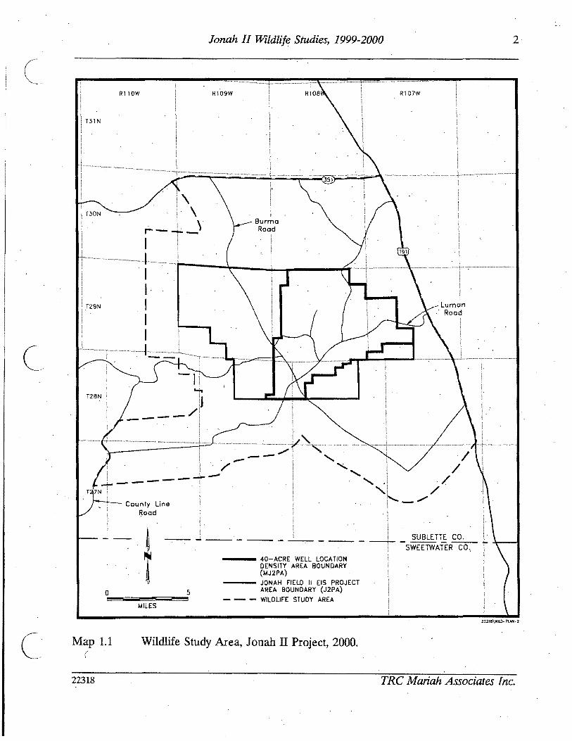
8
Jonah II Wildlife Studies 1999-2000
( Table 22 BLM Wyoming Animal Species of Concern (Draft) Documented or Potentially Occurring on or in the Vicinity of middotthe Jonah II Natural Gas Project Area 20001
Other Designation and Ranking Wyoming Natural Heritage Program Specjes us Forest Service (FS) Regions 2 Documen~on
Common Scientific and 4 Wyoming Game and Fish or in Vicinity Habitat Name Name Department (NSS)2 of the J2PA3 Type(st
Long-eared Myoru evoru G5IS1B SIN NSS2 Yes Ff myotis
Whitetail Cynomys G4S2S3 NSS3 Yes5 UB prairie dog leucurus
Dwarf Sorexnanus G4S2S3 FSR2 NSS3 Yes5 PIR BS SB shrew
Northern Accipiter G51S23B S4N FSR2 FSR4 NSS4 Yes5 Ff goshawk genlilis
Peregrine Falco G4T3S1B S2N FSR2 NSS4 YesS Ff falcon peregrinus
_~ Ferruginous Buteo reg~lis G4S3B S3N FSR2 NSS3 YesS UB hawk
Burrowing Athene G4S3B SZN FSR2 NSS4 Yess BS SB CP owl cunicu14ria
C Sage grouse Centrocercus O5S3 Yess UB
Brewers Spizel14 _G5S3B SZN YesS UB sparrow breweri
Sage Amphispiza G5IS3B SZN YesS UB sparrow billineata
Sage Oreoscoptes G5IS3B SZN Yes5 UB thrasher rtwntanus
Loggerhead LAnius G5IS4B SZN FSR2 YesS UB shrike ludovicianus
Northern Rana pipiens G51S3 FSR2 NSS4 Yes PIR leopard frog
Boreal toad Bufo boreas G4T4S2 FSR2 FSR4 Yes PR boreas
Spotted frog Ranus pretiosa G4S2S3 FSR2 FSR4 NSS4 Yes PR
From Draft Wyoming BLM State Directors Sensitive Species List (Animals and Plants) September 2000 2 Rankings
Wyoming Natural Heritage Program Uses a standardized system developed by The Nature Conservancys Natural Heritage Network to assess the global and state wide conservation status of each plant and animal species subspecies and variety Each taxon is ranked on a scale of 1-5 from highest conservation concern to lowest Codes are as follows G Glob~ rank rank refers to the rangewide status of a species T Trinomial rank rank refers to the rangewide status of a subspecies or variety S State rank rank refers to the status of the taxon (species or subspecies) in Wyoming State rartks differ from
state to state
22318 TRC Mariah Associates Inc
I
9
2
JoMh II Wildlife Studies 1999-2000
Table 22 (Continued)
Critically imperiled because of extreme rarity (often known from five or fewer extant occurrences or very few remaining individuals) or because some factor of a species life history makesit vulnerable to extinction Imperiled because of rarity (often known from 6-20 occurrences) or because of factors demonstrably making a species vulnerable to extinction
3 Rare or local throughout its range or found locally in a restricted range (usually from 21-100 occurrences) 4 Apparently secure although the sPecies may be quite rare in parts of its range especially at the periphery 5 Demonstrably secure although the species may be rare in parts of its range especially at the periphery H Known only from historical records 1950 is the cutoff for plants 1970 is the cutoff date for animals X Believed to be extinct A Accidental or vagrant a taxon that is not known to regularly breed in the state or which appears very
infre-quently (typically refers to birds and bats) B Breeding rank a state-rank modifier indicating the status of a migratory species during the breeding season
(used mostly for migratory birds and bats) ~
N Nonbreedingrank a state-rank modifier indicating the status of a migratory species during the nonbreeding season (used mostly for migratory birds and bats) ZN or ZB Taxa that are not of significant concern in Wyoming during breeding (ZB) or non-breeding (ZN) seasons Such taxa often are not encountered in the same locations from year to year
V Possibly in peril but status uncertain more information is needed Q Questions exist regarding the taxonomic validity of a species subspecies or variety 7 Questions exist regarding the assigned G T or S rank of a taxon
US Forest Service Region 2 Rocky Mountain Region Region 4 = Intennountain ~egion
Wyoming Game and Fish Department The Wyoming Game and Fish Department has developed a matrix of habitat and population variables to detennine the conservation priority of all native breeding bird and mammal species in the state Six classes of native status species (NSS) are reoogirized of which classes 1 2 and 3 are considered to be high priorities for conservation attention These classes can be defined as follows NSSI Includes species with on-going significant loss of habitat and with populations that are greatly restricted or
declining (extirpation appears possible) - NSS2 Species in which (1) habitat is restricted or vulnerable (but no recent or significant loss has occurred) and
populations are greatly restricted or declining or (2) species with on-going significant loss of habitat and populations that are declining or restricted in numbers and distribution (but extirpation is not imminent)
NSS3 Species in which (1) habitat is not restricted but popUlations are greatly restricted or dec~g (extirpation appears possible) or (2) habitat is restricted or vulnerable (but no recent or significant loss has occurred) and populations ru-e declining or restricted in numbers or distribution (but extirpation is not imminent) or (3) significant habitat loss is on-going but the species is widely distributed and popUlation trends are thought to be stable
Indicates documentation of amphibian reptile or bird species in Sublette County (Baxter and Stone 1980 Fertig 1997 WGFD 1999) documentation of bird species within latitude 42deg longitude 109 0 (Dorn and Dorn 1990 WGFD 1992 WGFD 1996 WGFD 1999) andor documentation of mammal species within latitude 42deg longitude 109 0 (WGFD 1992 1996 1999) or within Sublette County (Fertig 1997) BS= big sagebrush CP = cushion plant FT = fly through PR = pondriparian SB saltbush VB = ubiquitous Species has been documented breeding within latitude 42 0
longitude 109 0 (Dorn and Dorn 1990 WGFD 1992 WGFD 1999)
22318 TRC Mariah Associates Inc
10 Jonah II Wildlife Studies 1999-2000
( 231 Black-footed Ferret
Portions of prairie dog town (PDT) 1 on the J2P A were surveyed for blac~-footed ferrets
during 1999 (see Appendix A Habitat Map for PDT 1 location) PDT locations burrow
densities and extent (Ie acres) were initially described in Anderson (1996) however
during the black-footed ferret survey and subsequent mapping conducted in 2000 all PDTs
on tlle MJ2P A were remapped to more accurately present the current size and location of
each town Additionally all open burrows within each town were censused to determine the
towns suitability as black-footed ferret habitat
The black-footed ferret survey was condu~ted using standard nocturnal survey procedures
in accordance with USFWS guidelines (USFWS 1989) Further detail on black-footed ferret
survey methods can be found in McMurry (1999) which is available for review at the BLM
Pinedale Field Office in Pinedale Wyoming
232 Bald Eagle Ferruginous Hawk Golden Eagle
Inventory and monitoring protocols for bald eagle ferruginous hawk and golden eagle were
implemented as described for raptors (see Section 21)
233 Mountain Plover
During 1999 suitable mountain plover breeding and nesting habitat (Ie areas with low (
growing vegetation less than 4 inches high andor active PDTs) within 025 mi of proposed
well locations or 300 ft of proposed roads were surveyedinvestigatedcleared by the BLM
prior to disturbance in association withAPD and-ROW application field reviews Data shy
from these surveysinvestigationsclearances are available for review ~t the BLM Pinedale
Field Office in Pinedale Wyoming
22318 TRC Mariah Associates Inc
11
c
Jonah II Wildlife Studies 1999-2000
( During 2000 all potential mountain plover breeding habitat on and within 05 mi of the
MJ2PA was mapped and mountain plover presenceabsence surveys were implemented on
suitable habitats pursuant to USFWS 1999) guidelines
Survey protocol was as follows
bull surveys were conducted during the period of May I-Jtme 15 (ie during early
courtship and territory establishment)
bull surveys were conducted from sunrise to 1000 am andor from 530 pm to
sunset
bull surveys were conducted from four-wheel-drive vehicles or all-terrain vehicles
(ATVs)
bull surveyors remained in or close to vehicles when scanning with binoculars
andor spotting scopes
bull potential habitats were surveyed three times during the survey window
(May I-June 15) 4lld each survey was separated by at least 14 days
bull surveys Were not conduct~d in inclement weather (eg poor visibility) and
bull surveys focused on locating displaying or calling males
234 Western Burrowing Owl
Prairie dog colonies and other suitable burrowing owl nesting habitats on the MJ2PA were
searched during late spring and summer 2000 by TRC Mariah personnel to determine the
extent of burrowing owl nesting (see Appendix C Raptor Nesting Records) Burrowing owl
nesting surveys were conducted in association with prairie dog colony mapping mountain
plover surveys raptor surveys and vegetation type mapping The number and location of
active nests in the area weremiddot identified and efforts were made to determine fledgling success
for active nests
22318 TRC Mariah Associates Inc
12 Jonah II Wildlife Studies 1999-2000
( 235 Other TEPCampWSC Species
Formal surveys for other TEPCamp WSC were not conducted during 1999 or 2000 However
site-specific investigations were implemented by the BLM in areas of potential habitat within shy
05 mi of proposed disturbance sites during on-site reviews conducted in conjunction with
APD and ROW application review processes This information is available for review at
the BLM Pinedale Field Office
24 GENERAL WILDLIFE
Observations of general wildlife were recorded during species~specific investigations and
data are presented in Appen~ix B Additional observations were made during on-site
investigations conducted during APD and ROW application review processes Data
obtained during these oil-site investigations may be reviewed at the BLM Pinedale Field
Office
No formal surveys for pronghorn antelope (Leantelope movementmigration studies) or
other specieswildlife categories (eg waterfowl predators) were conducted during 1999 or
2000
42318 TRC Mariah Associates Inc
13 Jonah II Wildlife Studies 1999-2000
30 RESULTS AND PROPOSED MONITORINGPROTECTION MEASURES
The following chapter presents the results of 1999 and 2000 wildlife investigations on the
WSAProposed monitoringprotection measures for 2001 are also identified and would be
implemented by the BLM WGFD andor Operators as identified below
The proposed wildlife protection measures were developed specifically for potentially
impacted wildlife resources on and adjacent to the MJ2P A and J2P A The principal
protection measure proposed for most wildlife species is avoidance of sensitivecrucial
habitats (eg raptornests sage grouse leks) where practical However numerous
species-specific measures have been ideptified
31 RAPTORS
311 Results
Table 31 provides information on the location and actIvity status of raptor nests on the
WSA Active nests are defined as those that have been used within the last 3 years
Information on productivity nearby project features and proposed protection measures at
active nest sites within affected areas are presented in Table 32 Twenty-five of 97 knoWn
~ raptor nest sites on and adjacent to the WSA were known to be active between 1998 and
2000 Fifty-seven of the nest sites on and adjacent to the WSA are ferruginous hawk nests
eight of which were known to be active duri~g the 1998-2000 period (Table 31) American
kestrel have 10 known nest sites on the WSA sixmiddotof which were active during the period
Other species with known nests on the WSA include burrowing owl (six nestsfour active)
golden eagle (five nests three active) and prairie falcon (seven nests three active)
~welve nests of unknown species were identified on the WSA during pre-1996 surveys
however only one of these nests was located (active) during subsequent raptor surveys and
it is likely based on mapped locations and the inability to relocate the nests that the other
11 riests are not present within the WSA
22318 TRC Mariah Associates Inc
C
I
0 lt~~()
~ I Table 31 Raptor Nest Locations and Activity Status 2000 Jonah II Wildlife Study Area l- ~
Activity by Yearl
Nest Activity Most Recent Numberz Status3 2000 1999 1998 Activity Legal Location
6 (j
~ ~
~
~ ~ cgt ()
Smiddot-~ ~ l
AK16
AK17
AK18
AK30
AK39
AK52
AK80
AK88
AK92
AK97
B019
B023
B075
B076
B077
B086
FHl (2 nests)
FH2
FH3
A
A
A
A
U
A
U
A
U
U
U
U
A
A
A
A
I
I
U
I
I
I
a
I
I
I
a
U
U
I
I
NC
I
A
A
I
I
NC
a
a
a
a
NC
I
I
NR
NR
NR
NC
NC
NC
NC
A
NR
I
I
I
a
A
A
NR
NR
NR
NR~
NC
NC
a
a
NR
NR
I
I
NC
1999
1999
1999
2000
19975
1998
U
2000
U
U
19975
19975
19985
19985
2000
2000
U
U
U
~ sect
~ 5 ~
~ ~
c
[ ~
io-o 0 0 0bull-I c c c
I- ~
n n ~ I Table 31 (Continued) 00
I Activity by yearl
Nest Activity Most Recent Number2 Status3 2000 1999 1998 Activity Legal Location
S ()
~ ~ ~ ~ nS ~
S p
FH4
FH5
FH6
FH7
FH8
FH9
FHlO
FHll
FHl2 (2 nests)
FH13
FH14
FH15
FH20
FH21
FH22
FH24middot
FH25
FH26 (3 nests)
A
I
I
I
I
I
I
I
1
1
Amiddot
I
I
I
1
A
1
A
A6 A I
I I
I I I
I I I
I I I
I I I
I I
I I J
1 I I
I 1 1
1 N I
18I I
I I
I I I
I I I
a I NC
I I I
a a I
2000
pre-1996
pre-1998
pre-1998
1996
pre-1998
pre-1998
pre-1996
pre-1997
pre-1998
1999
1999
pre-1997
pre-1997
pre-1998
2000
pre-1998
2000
~ ~
sect ~
~ ~
[ ~
~ ~ Q Q Q
I
N
~ ~
I c
c
00
I
~n n fj I Table 31 (Continued)
Nest Nurnber2
FH28
FH29
FH37 (2 nests)
FH38
FH42
FH43 (2 nestS)
FH53
FH54 (2 nests)
FH55
FH56
FH575 (2 nests)()
FH58 ~ FH59~ (3 nests)
~ FH60ltgt ()
Smiddot FH62 ~
FH64~ I
Activity Status3
U
U
A
A
I
I
A
I
I
I
I
U
I
I
I
U
Activity by Year
2000 1999 1998
I I NC
I NC
I A A
A NC I
I I
I I I
I I A
I I
I I I
I I I
I I I
NC I I
I I I
I I
I I I
I I NC
Most Recent Activity
1996s
pre-1996s
1999
2000
pre-1998
pre-1998
1998
pre-1998
pre-1998
pre-1997
pre-1997
pre-1998
pre-1997
pre-1997
pre-1997
pre-1997
Legal Location
~ ~ Il
~
~ $t ~ (1i
CrI E Il ~~ 0 0 0 I) ltgt ltgt ltgt
t-- 01
00
I
n (
~ I Table 31 (Continued)
Nest Number2
FH65
FH66 (2 nests)
FH67
FH68
FH69
FH70
FH71
FH73
FH78
FH82
FH83
FH84
~ FH85 ()
(2middot nests)
FH87~ sect
FH89 ~ tl middotF~90 n fi FH91 ~
FH93middot~ ~
Activity Status3
I
I
I
1
A
I
I
I
U
U
U
U
U
U
U
U
U
U
Activity by Year l
Most Recent Legal Location UTM Coordinates4
2000
I
I
I
I
a
I
I
I
NC
I
I
I
I
I
I
U
I
1999
I
I
I
I
I
I
I
I
I
I
I
I
NR
NR
NR
NR
NR
1998
I
I
I
I
I
I
I
I
NR
NR
NR
NR
NR
NR
NR
NR
NR
NR
Activity
pre-1997
pre-1997
pre-1998
pre-1997
2000
pre-1998
1997
pre-1996
U
Us
U
U
U
U
U
Umiddot
U
U
~ I Il ~
~
~ is S
[ ~
~
0 0 0
I
N ltgt ltgt ltgt
c
-l
n o ~I Table 31 (Continued) 00
I Nest Activity
Activity by Yearl
Most Recent Number2 Status3 2000 1999 1998 Activity Legal Location UTM Coordinates4
FH95 U I NR NR U (4 nests)
FH96 U I NR U
GE36 A A 1 I 2000
GE47 A A A 2000 (2 nests)
GE48 1 1 1 1 pre-1996
GE51 A A 1 1 2000
GE72 I 1 pre-1998
PF27 U 1 ~ 1 U 19975
A8PF41 A U U 19985
PF61 1 1 1 I 1997 nfa
PF63 1 1 1 pre-1998 nfa
PF79 A A NR 1999 nfa~ () PF81 A A a NR 2000 na
~ PF94 U 1 NR NR U nfag 19UN31 NC NC NC U na
~ ~ 19UN32 NC NC NC U nfac ()
19 ~ UN33 NC NC NC U nfa ~
19 UN34 NC NC NC U nla~ p
~ ~ sect ~
~
[ (Ii
~
~ Q
~ bullI) cc c
I- 00
II n ~ I Table 31 (Cont~nued) 00
I Nest Activity
Activity by Yearl
Most Recent Number2 Status 2000 1999 1998 Activity Legal Location trfM Coordinates
UN35 19 NC NC NC U nla
UN40 I~ NC NC NC U nla
UN44 19 NC NC NC U nla
UN45 19 NC NC NC U nla
UN46 19 NC NC NC U nla
UN49 19 NC NC NC U nla
UN50 A 1 alO 1 1999
UN74 U I 1 NC U nla
~ ti (j
sect ~
g ~ ~ g $5 ~
~ fl
I A = active a = likely active I = inactive NC = not checkednot located NR = nest had not yet been recorded U = unknown 2 FHI = ferruginous hawk nest 1 AK16 = American kestrel nest 16 B019 = burrowing owl nest 19 GE36 = golden eagle nest 36
PF27 = prairie falcon nest 27 UN31 =unknown species nest 31 Overall activity status is based on the BLM definition of an active nest as one which has been active in at least 1 of the past 3 years For
overall activity status nests for which activity was likely but not confirmed were considered active (A) Nests which were assigned an unknown acti~ity status (U) lack a ~onclusive activity determin~tion for at least 1 of the past 3 years andor w~re n~wly recorded and have not been momtored for 3 consecutive years Nests confirmed mactlve m all of the past 3 years are deemed mactlve (I)
E = easting N = northing nla = not available S Date is of last confirmed activity but a~tivity status was unknown in at least 1 of the past 3 years thus more recent activity may have
occurred 6 Used by prairie falcon 7 Used in 1999 by golden eagle 8 Used by common raven 9 Detailed searches for these nests in 1999 and 2000 found no raptor activity in the area of the mapped nest sites therefore nests were
assumed to be inactive 10 Possibly used by great horned owl or prairie falcon
~
~
~ ~
[ Ci
~ ~ P
sect
~ 0
n n Table 32 Summary of Active Raptor Nests Within 10 Mi of Existing or Proposed Disturbance Jonah II Wildlife Study ~
i-I Area1 00
Species Seasonal Nest Production -Nest Nest Buffer Nol Legal Location Condition Radius Eggs Nestlings Fledglings Nearby Project Features MitigationActions
AKI6 Unknown 05 mi 0 0 0 Numerous existing and proposed Continue activity status and project features within 05 mi productivity monitoring
AK17 Unknown 05 mi 0 0 0 Numerous existing and proposed Continue activity status and project features within 05 mi productivi~ monitoring
AKIS Unknown 05 mi 0 0 0 Numerous existing and proposed Continue activity status and project features within 10 mi produ~tivity monitoring
8075 Unknown 05 mi U U U Numerous existing and proposed Con tinue activity status and project features within 05 mi productivity monitoring
8077 UnknoWn 05 mi U U I 1999 Numerous existing and proposed Continue activity status and project features within 10 mi productivity monitoring
FH47 Unknown 10 mi 3 1999 2 1 (died) One proposed well pad within Continue activity status and (1 died) 1999 10 mi productivity monitoring if
1999 territolY 6 is inactive in 2001 shy potential development of ANS(s)
FH148 Good 10 mi 3 1997 U 2 1997 Numerous existing and proposed Colltinue activity status and 1 1999 - U U project features within to mi productivity monitoring if
egg failed limited alternative nest sites territolY 5 is inactive in 2001 available in territolY 5 potential development of ANS(s)shy
FH24 Destroyed 10 mi 0 0 0 Numerous proposed features within Continued monitoring the area for 10 mi limited alternative nest sites new and active nests
FH53 Good 10 mi 3 2 1998 21998 B1rma Road within 05 mi Continue activity status and (1 didnt productivity monitoring hatCh)~ 1998
~ ()
FH69 Good 10 mi 0 0 0 Road and pipeline occur within Continue activity status and 10 mi productivity monitoring
$l
t
Active nests defined by activity or likely activity in at least one of the past three nesting seasons See Appendix B Raptor Nesting Records for further detail See Appendix A Wildlife Map for nest locations FH = ferruginous hawk (see Table 33 for nesting territolY) AK = American kestrel BO burrowing owl
tl C
Presents number of items and year U unknown ~ See Appendix A Project Features Map
Seasonal and standard avoidance measures are not included since they would be applied as necessalY for all active nests ~ Used by prairie falcon in 2000
~ Used by golden eagle in 1999 0
~ s sect ~
~ ~ sflS
V
~ ~ shyQQ QI tv C)
g
N 0
21 Jonah II Wildlife Studies 1999-2000
( Since several active raptor nests on the area occur at distances greater than 1 mi from
existing and proposed oil and gas disturbance sites (and thus productivity monitoring is not
required) productivity data for some nests are limited (see Appendix C) Ferruginous hawk
nests in the WSA are known to have produced two fledglings in 1998 one in 1999 and none
in 2000 Ferruginous hawk nest 4 was active in 1999 and produced two young--both of
which died--one as a nestling and one as a fledgling A definitive cause for nest failure was
not identified but the dead fledgling was found decapitated In 2000 the nest was used by
prairie falcons and appeared to produce no fledglings
Nest productivity for other raptor species during 1999 and 2000 include three burrowing owl
fledglings (one in 1999 two in 2000 [nestsgt 10 mi from disturbance]) additional burrowing
owl young may have fledged from other known nests in the area Golden eagles fledged
three to four young in 2000 (nests gt10 mi from disturbance) American kestrels and prairie
falcon also had active nests in the area during the period and likely fledged young birds
c Themiddot approximate locations of ferruginousmiddot hawk nest territories present on and adjacent to
the WSA are shown on the Wildlife Map in Appendix A and briefly described in Table 33
An estimated 11 nesting territories are present on the WSA six of which have been
occupied at least once during the last 3 years (1998-2000) Project features proximal to th~
active nests in these territories are identified in Table 32 and Appendix A (Project Features
Map) Project featuresdevelopments on the J2PA exist and are further planned proximal
to nest territories 5 6 and 7~ Other activities (eg recreational activitiesoff-road vehicle
use livestock grazing wildlifepredator interactions climate) likely occur and will continue
to occur in these and other territories Ferruginous hawk nesting terrItory7 was not active
during the 3-year period and all known nest sites in the territory are at suboptimal locations
(Le on theground surface with easy access by predators) therefore nesting in territory 7
is unlikely to occur in all but the most active nesting years (Le when all other nearby
nesting territories are occupied) It is also possible that nest territories 5 6 and 7 and nest
site 24 will remain unused or will have limited success during the life of the Jonah II Field
22318 TRC Mariah Associates Inc
22 Jonah II Wildlife Studies 1999-2000
Table 33 Nests and 1998-2000 Activity Status at Ferruginous Hawk Nesting Territories Jonah II Wildlife Study Area)
Activity Status3
Nests Included in Territory Territory2 1998 1999 2000
1 68-71middot I Imiddot A (unknown luccess)
2 62 64-67 84-85 I I I 96
3 56-58 60 83 I I I
4 26 28-29 95 I I A (unknown success)
5 13-15 I I
C
A4 (failed)
6 2-12 78 I A AS (failed) (unknown success)
7 20-21 73 I I I
8 53-55 82 A I I (2 fledged)
9 42-43 I I I
10 37-38 A A AS (unknown success) (unknown success) (unknown success)
11 5990 I I I
See Appendix A Wildlife Map for locations No nesting territory is established for nests 1222425 and 91
3 Further detail is provided in Appendix C Raptor Nesting Record I = inactive A = active Used by golden eagle Used by prairie falcon
22318 TRC Mariah Associates Inc
23 Jonah II Wildlife Studies 1999-2000
( Mitigation measures as defined in Section 312 are recommended for territoriesS and 6
in 2001
Project facilities are proposed for development within 05 mi of three active American
kestrel nests and two active burrowing owl nes~s (see Table 32) Continued monitoring
efforts ~re proposed for these nest sites (see Section 312)
312 MonitoringProtection Measures
The primary mitigation measure for raptor species on the WSA is avoidance of active nest
locations during the breedingmiddot season Active nests are defined asraptor nests that have
been used within the last 3 years Unless excepted by the BLM during APD and ROW
application reviews all surface-disturbing activities will be restricted from February 1
through July 31 within a 05-mi radius of active rap tar nests except ferruginous hawk nests
for which the seasonal buffer will be 10 mi (see Table 32) In addition well locations
roads ancillary facilities and other surface structures requiring repeated human presence
will not be constructed within 825 ft of active raptor n~sts where practicaL Th~ seasonal
buffermiddot dist~nce and exclusion dates may vary depending on factors such as nest activity
status rapior species prey availability natural topographic barriers and line-of-sight
distances
Nest activity status and productivity monitoring will continue in 2001 as identified in the
ROD (BLM 1998a [Append~ E] BLM 2000b) Nest activity status will be monitored from
the ground Additionally uUknown nests 31-35 40 44-46 and 49 are recommended for
removal from maps arid further monitoring
In 2001 nestnest area photos will be taken of all raptar nest locations for which photos are
lacking (Table 34) (see Appendix C Raptor Nest Records)
22318 TRC Mariah Associates Inc
24 Jonah II Wildlife Studies 1999-2000
( Table 34 Raptor Nest Locations for WhichmiddotPhotos are Needed Jonah II Wildlife Study Area 2000
Species Nest Numbers
American kestrel
Burrowing owl
Ferruginous hawk
Golden eagle
Prairie falcon
Unknown
17 30 39 52 88 92 97
19 23 75 76 77 86 -
1 (2 nests) 2 3 5 6 7 11 22 28 29 37 38 42 70 78 82 89 91 93 95 (4 nests)
48
27 41 94
74
Well locations roads ancillary facilities and other surface structures requiring repeated
human presence will not be constructed within 825 ft (2000 ft for bald eagles) of active
raptor nests where practical Facility construction in these areas will require specific
approval from the BLM wildlife biologist and Authorized Officer
Operators will notify the BLM immediately if raptors are found nesting on project facilities
If nest manipulation or a situation requiring a taking of a raptor nest becomes necessary
a special permit will be obtained from the Denver USFWS Office Permit Section Permit
acquisition will be coordinated with the Wyoming State USFWS Office in Cheyenne and will
be initiated with sIJfficient lead time to allow for development of mitigation measures
Required corresponding permits will be obtained from theWGFD in Cheyenne
Consultation and coordination with the USFWS and WGFD will be conducted for all
mitigation activities relating to raptors
Because project development continues on and adjacent to active ferruginous hawk
territories 5 and 6 it is recommended that two artificial nesting structures (ANSs) be
established within or adjacent to these territories in 2001 if the territories remain inactive
22318 TRC Mariah Associates Inc
25 Jonah II Wildlife Studies 1999-2000
or unproductive during 2001 Operators ~l assist the BLM (in consultation with other land
users) as necessary in locating appropriate ANS sites and erecting ANSs It is recommended
that ANSs be established outside of existing and known future disturbance areas The lowshy
lying areas in Section 33 T29N R 107W appear to provide suitable areas for ANS locations
in territory 6 ANS construction arid maintenance activities will be completed between
August 1 and September 15 2001 Operators will be responsible for the annual
maintenance of ANSs throughout the life-of-project and all ANSs on public lands will
become the property of themiddotBLM upon completion of the project Additional mitigations
for nesting raptors would be designed on a site-specific basis as necessary in consultation
with the BLM USFWS and WGFD
In future years additional ANSs may be constructed (up to two ANSs for each impacted
nest) or existing degraded raptor nests may be upgradedreinforced to mitigate potential
)impacts The location of ANSs or nests proposed for upgrading will be identified in annual
reports ANSs will be located within or proximal to potentially affected nesting territories ( outside of the line-of-sight or nest buffer of actively nesting raptor pairs and at sites
sufficiently removed from development activities to minimize or avoid potential adverse
effects
In cases where existing project features (eg well locations) are located within the buffer
areas for active raptor nests no extensive maintenance activities (eg workovers ) will be
allowed during critical periods (Le approximately early March through midJune) The
exact dates of exclusion will be determined by the BLM and specified in Conditiolls of
Approval for APD and ROW applications and will likely vary among nests and from
year-to-year depending upon the raptorspecies and variations in weather nesting
chronology and other factors
c 22318 TRC Mariah Associates Inc
26 Jonah II Wildlife Studies 1999-2000
32 SAGE GROUSE
321 Results
Table 3S presents a summary of recent sage grouse lek use (1998-2000) nearby project
features and proposed monitoring and other actions for leks on the WSA (see Appendix D
Sage Grouse Lek R~cords for further detail) Table 36 presents historic information on
lek use since 1992 Lek middot16 was not surveyed during the period therefore no data on lek
use are presented
c
Of the 22 known leks on the WSA leks 1 2 3 7 9 10 17 18 19 21 and 22 have shown
considerable use during monitoring and no notable declines in use were identified
(Table 36 and Appendix D Sage Grouse Lek Records) Decreasing attendance has been
observed at lek 4 with maximum male attendance down from 16 in 1994 to one in 2000 and
due to the extent of n~arby project development this lek may continue to have low levels
or no use throughout the remainder of project development Nomales were observed at
leks S 6 8 11 1213 14 or1S in the last 3 t04 years (Table 36) and these leks also may
continue to be unused for the remainder of project develppment
Five new leks were located during 1999 (leks 17 and 18) and 2000 (leks 19 21 and 22)
Noise monitoring at leks 7 and 8 on the WSA and the lek near the Bird Canyon compressor
station are provided in Table 37
Habitat mapping of the MJ2P A during 2000 primarily conducted to assist in defining
optimal sage grouse nesting and brood-rearing areas found that dense sa~ebrush was the
most common habitat type occupying approxim4tely 89 (26S82 acres 41S rnF) of the
MJ2PA (see Appendix A Habitat Map) This habitat type generally occurs in flat to rolling
terrain and exhibits sagebrush cover of gt20 (Table 38) Wyoming and mountain big
22318 TRC Mariah Associates Inc
() (1 ~
~ ITable 35 Summary of Sage Grouse Lek Use Potential Impacts and Proposed Monitoring Jonah II Wildlife Study Area 20001
Lek Approximate No2 Location Status3 Use Nearby Project Features4 MonitoringOther Actionss
~ ()
~ ~
s
A tl n Et- ~
~ f
2
3
4
5
6
7
8
9
10
11
A
A
A
A
A
A
A
I
Relatively consistent
Relatively consistent
Relatively consistent
Decreasing maximum male attendance since 1996
No known use since pre-1997
No known use since pre-1997
Relatively consistent
No known use since pre-1997
Relatively consistent
Relatively consistent
No known use since pre-1994
One existing and numerous proposed wells and roads within 10 mij one proposed location within 025 mi
Existing pipeline within 025 mi numerous existing and proposed wells and roads within 10 mi
Proposed well and road within 025 mi one existing and another proposed well and road within 10 mi
One existingand two proposed wells and roads within 025 mi numerous proposed and existing wells pipelines and roads within 10 mi
Existing well pipelines and roads within 025 mi new wells proposed within 025 mi proposed and existing wells pipelines and roads within 10 mi
Existing road at let
Existing pipeline within 10 mi
Existing pipeline and road and one proposed well within 10 mi
Proposed well within 10 mi
Existing and proposed wells and roads within 10 mi
Proposed road within 025 mi proposed wells and roads within 10 mi
Monitor attendance three times in 2001 j move proposed well outside 025-mi buffer
Monitor attendance three times in 2001 ensure proposed wells and roads are outside 025-mi buffer
Monitor attendance three times in 2001 move proposed well and road to outside 025-mi buffer
Monitor attendance three times in 2001 move proposed wells and roads to outside 025-mi buffer
Discontinue monitoring
Discontinue monitoring
Monitor attendance three times in 2001 monitor noise levels in 2001 GPS lek perimeters in 2001
Discontinue monitoring
Monitor attendance three times in 2001 GPS lek perimeters in 2001
Monitor attendance three times in 2001 monitor noise levels in 2001
Discontinue monitoring in 2001 move prop~sed road to outside 025-mi buffer
~ l
sect ~
~ sectgni
~gt ~
0 0 0
I
tJ
~ C
N
c
-l
00
n n ~ ITable 35 (Continued)
Lek Approximate No2 Location Status3 Use Nearby Project Features4 MonitoringOther Actionss
12 Limited use since pre-1992 Existing well and roads within 10 mi
13 No known use since None pre--1996
14 No known use since Existing road within 10 mi pre-1992
15 No known use since Existing and proposed wells pipelines and pre-1997 roads within 025 mi
16 U Unknown None
17 A Relatively consistent since Proposed road within 10 mi 1999 (first located in 1999)
18 A Possible increased Existing road within 025 mi proposed well attendance since 1999 (first and road within 10 mi
located in 1999)
19 A First located in 2000 None
20 U Unknown Existing road within 025 mi
~ (j 21 A First located in 2000 Proposed well and road within 10 mi
~ sect
22
A Pirst located in 2000 Proposed ells and roads within 10 mi
~ tl g jl See Appendix A Wildlife Map and Appendix D Sage Grouse Lek Records for additional infonnation - 2 See Table 36 for alternate names $)
~ 3 A = active (at least once during last 3 years) I = inactive U = unknowntj See Appendix A Project Features Map
~ Seasonal and standard avoidance measures are not included since they would be applied as necessary for all leks ))
Monitor attendance three times in 2001 search for alternate nearby lek sites in 2001 if no use discontinue monitoring in 2002
Discontinue monitoring
Discontinue monitoring
Discontinue monitoring in 2001
Monitor attendance three times in 2001
Monitor attendance three times in 2001 GPS lek perimeters in 2001
Monitor attendance three times in 2001
Monitor attendancethree times in 2001 GPS lek perimeters in 2001
Monitor attendance three times in 2001 GPS lek perimeters in 2001
Monitor attendance three times in 2001 GPS lek perimeters in 2001
Monitor attendance three times in 2001 GPS lek perimeters in 2001
monitoring action not necessarily required
~ sect ~ ~ -
[ (IS
~
g P
sect N
~
29 Jonah II Wildlife Studies 1999-2000
Table 36 Sage Grouse Trends Jonah II Wildlife Study Area 1992-20001
History2 Lek
No Lek Name 1992 1993 1994 1995 1996 1997 1998 1999 2000
4-2 NS NS 9 NS 26 6 31 25 22
2 4-6 NS NS 2 NS 2 17 12 7 14
3 Sand Draw Reservoirmiddot NS NS NS NS 16 o 36 26 22
4 Clay H~ NS NS 16 NS 15 4 4 o 1
5 4-8 NS NS NS NS 1 o o o NS
6 4-9 NS NS NS NS 3 o o o o
7 4-7 NS NS 36 NS o 16 17 11 9
8 4-10 NS NS NS NS 2 o o o o
9 Alkali Draw NS NS NS NS NS 50 26 62 47
10 The Rocks NS NS NS NS NS 60 53 79 64
11 4-5 NS NS o NS o NS o o o
12 3-8 o o o 4 o 0+ o
13 3-6 NS NS NS NS o o o o o
14 3-7 o o 0 o o o o o o
15 Sand Draw NS NS NS NS o o o o
16 Long Draw UNK UNK UNK qNK UNK UNK UNK UNK UNK
17 Buckhorn Well 1 NS NS llS NS NS NS NS 5 3
18 Shelter Cabin NS NS NS NS NS NS NS 50+ 90 Reservoir
19 Prairie Dog Town 5 NS NS NS NS NS NS NS NS 9
20 Upper Alkali Creek NS NS o NS o NS NS NS NS
21 South Rocks NS NS NS NS NS NS NS NS 10
22 Antelope State NS NS NS NS NS NS NS NS 9
Further detail is provided in Appendix D Sage Grouse Lek Records 2 Numbers refer to maximum male attendance NS = not surveyed UNK = unknown + = unclassified birds
observed but not included
22318 TRC Mariah Associates Inc
30 Jonah II Wildlife Studies 1999-2000
( Table 37 Summary of Noise Data Collection at the Bird Canyon and Lumen Compressor Stations Jonah II Wildlife Study Area 2000
Noise Output l Relative Location Time (decibels) Windspeed Humidity
Bird Canyon June 1 2000 Compressor Station
04 mi to north 600 to 700 am 372 - 501 (4370) 5 mph from SW 26
04 mi to south 600 to 700 am 413 - 545 (4790) 3 mph from SW 26
04 mi to east 600 to 700 am 480 - 514 (4970) 2 mph from SW 26
04 mi to west 600 to 700 am 367 - 465 (4160) 4 mph from SW 26
Directly at Station 600 to 700 am 731 - 746 (7385)
Lumen Compressor Station June 32000
Lek 557 am 369 - 424 (3965) 3 mph from NW 15
Lek8 537 am 395 - 535 (4650) 5 mph from NW 15
Directly at Station 652 - 667 (6595)
I bull All noise output readings represent a decibel range between the minimum and maximum values recorded during a 2- to 3-minute interval at each particular sampling location Average outputs fall near the medians Numbers in parentheses are median values
sagebrush (Artemisia tridentata wyomingensis and A t vaseyana respectively) are the most
co~on shrub species with rabbitbrush (Chrysothamnus spp) also present Subshrubs in
this habitat type include granite prickly gilia (Leptodactylon pungens) broom snakeweed
(Gutierrezia sarothrae) and winterfat (Kraschenninikovia lanata) which is generally
uncommon Forbs include stemless goldenweed (Happlopappus acaulis) Hoods phlox
(Phlox hoodU)and miners candle (Cryptantha spp)and grass species include wheatgrasses
(Agropyron spp) Indian ricegnlss (Oryzopsis hymenoides) fescue
(Festuca ~p) and
needleandthread (Stipa comata)
The moderate density sagebrush type (9 of the MJ2PA 2605 acres 41 mi2) is most
middot commonly found in the southeastern portion of the project area where i~ typically occurs
-
22318 TRC Mariah Associates Inc
C
31 Jonah II Wildlife Studies 1999 2000
( Table 38 Results of Vegetation Studies MJ2P A 20001
Productive Sage Grouse MJ2PA Vegetation Type2 Habitat Characteristics
Moderate Dense Density Basin
Sagebrush Sagebrush Sagebrush NestinglEarly Late Parameter (n=15) (n=15) (n=5) Brood-rearing Brood-rearing
Sagebrush height (inches) 98 79 310 45 12-32 12-32
Percent sagebrush cover
Daubenmire 217 45 65 308 15-25 10-25
Line intercept 245 45 (99) 79 (89) 367 (79)
Percent total shrub cover
Daubenmire 220 68 314 -shyLine intercept 247 (99) 81 (92) 380 (80)
Grassforb height (inches) 56 65 65 gt70 Variable 4inch minimum
( Percent grass and forb 106 (89) 151 45(96) 201 45 gt 13 gt13 cover (65)
Residual grass height 63 61 65 4-5 (irtchesY
Percent residual grass 85 4 109 4 2014 gt3 cover
Sagebrush plants acre 7260 (99) 2636(92) 4494 (86)
Total shrubsacre 7665 (99) 2951 (96) 5088 (91 )
Data on file at TRC Mariah Laramie Wyoming measurements recorded in late summer 2 See Appendix A Habitat Map for locations Numbers in parentheses are the confidence level achieved with
80 precision using the z statistic derived from the following formula ~
s where
n = sample size d = 02 (for 80 precision) X = sample mean s = sample standard deviation
3 See Table 21 for references measurements recorded during late spritigearly summer Meets nestingearly brood-rearing characteristics
5 Meets late brood-rearing characteristics 6 Excludes pre-2000 litter in MJ2PA samples
22318 TRC Mariah Associates Inc
32 Jonah II Wildlife Studies 1999-2000
( on sideslopes It is characterized by an average of approximately 6-8 sagebrush cover
(Table 38) with spiny hopsage(Grayia spinosa) and scattered rabbitbrush also present
Subshrubs include snakeweed Gardners saltbush (A triplex gardneri) and winterfat Grass
and forb species composition is generally similar to that observed in the dense sagebrush
type
The basin sagebrush (Artemisia tridentata tridentata) type ( lt 1 of the MJ2P A 236 acres
04 mi2) is characterized by a narrow strip of tall dense basin sagebrush along the Sand
Draw drainage (see Appendix A Habitat Map) Understory is relatively sparse with some
scattered rabbitbrush and mixed grasses and forbs
(shy
Scatteredno sagebrush habitat (2 of the MJ2P A 575 acres 09 mi2) occurs in small
pockets within the project area (see Appendix A Habitat Map) These unsampled areas
are generally associated with playas rocky outcrops or steep slopes and they typically grade
into the moderate density sagebrush habitat type
Measured vegetation parameters within the three sampled vegetation types in the MJ2PA
were in no instance consistent with the qualitative and quantitative parameters for
productive sage grouse nesting or brood-rearing described in Table38 However the dense
sagebrush and basin sagebrush types in combination apparently provide adequate conditions
(with the exception of understory grassforb and residual grass heights) for sage grouse
nesting since sage grouse nesting and brood-rearing is known to occur in the area
Furthermore since year 2000 vegetation sampling in the MJ2P A occurred late in the
summer during a dry year and whereas sampling to determine productive nesting and
brood-rearing habitat parameters occurred immediately fo~lowing chick hatching (late
spring early summer) it is likely that some portion of the understory (grasses and forbs) was
lost to desiccation and wind andor grazing resulting in the potential for underestimation
of both cover anltlheight of grasses and forbs during the year 2000 vegetation sampling
22318 TRC Mariah Associates Inc
c
33 Jonah IIWildlife Studies 1999-2000
322 Monitoring and Protection Measures
Monitoring and identification of sage grouse leks on the WSA will continue in 2001 as
specified in the WMPP (BLM 1998a Appendix E) and the EA for the Modified Jonah Field
II Project (BLM 2000b)
It is recommended that the WGFD or BLM continue to implement aerial (fixed wing) sage
grouse lek inventories of the WSA in 2001 to provide further lek locational data and to
identify any new or previously undiscovered leks Additionally WGFD andlor BLM will
use GPS to determine lek perimeters in 2001 at leks 7 9 171920 21 and 22 Aerial
surveys will be implemented during Marchi April The absence ofldecreased use of leks 4
5 6 8 1112 13 14 and 15 may indicate that alternate lek siteS are being used therefore
it isreltommended that additional observations be made in 2001 in the vicinity of these leks
to locate any new unmapped leks
Due to the apparent lack of use over the last few years at leks 5 6 8 11 12 13 14 and 15
it is recommended that lek attendanc~ monitoring at these leks be discontinued in 2001
Attendance monitoring at these leks may be reinitiated once field development is complete
Attendance monitoring of other known sage grouse leks in the area by WGFD and Ior BLM
personnel will continue in 2001 as during past years and specified in the RoD (BLM 1998a
Appendix E) and deemed necessary by the BLM and WGFD
As requested by the BLM and WGFD noise monitoring will be implemented in 2001 at leks
7and 10 within the WSA and at the Bird Canyon lek located approximately 04 mi southeast
of the Bird Canyon Compressor Station southwest of the WSA Continuous noise
monitoring will be conducted from 5 am to 9 am on four separate occasions during the
period of March 15middotApril 30 at the three leks Noise monitoring equipment will include a
Bruel amp Kjaer Model 2260 precision integrating sound meter and octave bandmiddot analyzer
(noise frequency) with a data logger (meets ANSI 514-1983 Type 1 sound level meter
22318 TRC Mariah Associates Inc
34 Jonah II Wildlife Studies 1999-2000
( requirements) Noise meaSurements will be logged every 5minutes over the duration of the
5-hour sampling period and data will be downloa~ed daily for storage and analysis The
meter will be calibrated daily with a Bruel amp Kjaer Model 4231 sound level calibrator The
microphone will be fitted with a windscreen to reduce wind-generated noise and will be
mounted at the edge of each lek approximately 3 ft above the ground Contributing noise
sources will be identified and recorded as well as prevailing meteorological conditions i
(Le wind speed and direction temperature humidity and cloud cover)
As with raptors the principal protection for sage grouse is avoidance of leks during the
breeding season and the avoidance of probable nesting areas during the nesting season If
an active sage grouse nest is identified during the nesting season (April 1 - July 31) i
surface-disturbing activities will be delayed untilnestibg is completed
All surface-disturbingmiddot activities including pipeline construction will be avoided within
025 mi of active sage grouse leks and no permanent high profile structures such as
buildings and storage tanks which are suitable raptor perches will be constructed within
025 mi of any lek Therefore the proposed project features (ie well locations roads
pipelines) proximal to leks 1345 11 and 15 may require relocation to sites greater than
025 mi from the lek centers Well location and road and pipeline construction within
025 mi of leks 5 11 and 15 may be permitted in 2~OI (as authorized by BLM) since these
leks have exhibited little or no use during monitoring and are considered inactive
Operators will restrict construction activities between March 1 and June 30 within a
20-mi radius of active sage grouse leks to protect sage grouse nesting habitat and Will avoid
all drilling and construction activities from March 1 to May 15 on all areas within 10 mi of
active sage grouse leksmiddot to protect sage grouse breeding activities Operators will also
maintain a 05-mi disturbance-free buffer around middotleks 7 (and 8 south of the MJ2P A
(see Appendix A Wi~dlife Maps)
22318 TRCMariah Associates Inc
35 Jonah II Wildlife Studies 1999-2000
( While Operators have committed to avoiding optimal sage grouse nesting habitat during the
nesting period where practical (BLM 2000b) n optimal (productive) habitat has been
identified in the MJ2PA (see Table 38) However since sage grouse nesting and
brood-rearingmiddot is known to occur in the sagebrush-dominated habitats on the area it is
recommended that no disturbance (other than linear crossings) be authorized within the
basin sagebrush type (this type is currently protected by drainage buffers [see Appendix A
Habitat Map J) and that disturbance within the dense sagebrush type be avoided during the
nesting period
It is recommended that the BLM implement formal sage grouse winter use investigations
on the J2PA and a O5-mi buffer during late winter (JanuaryFebruary) 2001 to further
identify sage grouse wintering areas These surveys should be conducted on the ground and
all data collected should be provided on General Wildlife Observation Data Sheets or other
suitable forms (see Appendix B) Operators will cooperate in any further ongoing sage
grouse studies within the WSA and with the WGFD on any existing and new sage grouse
habitat improvement efforts (eg water developments) within Upland Game Bird
Management Area 7
Removal of water development structures proximal to lek 4 (Clay Hill) may occur in 2001
as directed by BLM Removal of these facilities may eliminate potential raptor perch sites
andor reduce the use of this area by livestock and humans
Operators will utilize directional drilling to access resources beneath the 025-mi active sage
grorise lek buffers (see Appendix A Wildlife Map) and beneath the 600-poundt wide (or tall
sagebrush-dominated) buffer associated with Sand Draw Granite Wash and Alkali Draw
protection areas if reserves beneath these locations are deemed economically feasible
c__ 22318 TRC Mariah Associates Inc
36 Jonah II Wildlife Studies 1999-2000
(
-33 THREATENED ENDANGERED PROPOSED CANDIDATE AND WYOMING
SPECIES OF CONCERN
I331 Results
3311 Black-footed Ferret
No black-footed ferrets or black-footed ferret sign was observed on the J2PA during the
black-footed ferret survey conducted on the area during 1999 Survey results are presented
in McMurry (1999) which is available for review at the BLM Pinedale Field Office
No PDTs with burrow densities suitable as black-footed ferret habitat (Le gt8 burrows
acre) were identified in the MJ2PA during year 2000 (Table 39) However portions of
PDTs 8 16 17 and 18 in the southeastern portion of the WSA have prairie dog burrow
densities suitable for black-footed ferret (see Appendix A Habitat Map) and black-footed
ferret surveys may be required if developments are proposed within these townS
3312 Bald Eagle Ferruginous Hawk Golden Eagle
No bald eagles were observed on the WSA during 1999 and 2000 wildlife investigations
Information on ferruginous hawks and golden eagles is provided in Section 311
3313 Mountain Plover
Mountain plover were observed for the first time adjacent to the J2PA during 1999 and a
single plover was observed within the J2PA during 2000 (see Appendix B) Adults with at
least two young were recorded on separate occasions outside the J2P A during 1999
indicating the presence of mountain plover breeding in the Alkali Creek drainage
22318 TRC Mariah Associates Inc
c
C
37 Jonah II Wildlife Studies 1999-2000
Table 39 Whitetail Prairie Dog Towns Jonah II Wildlife Study Area 2000
Prairie Dog Number of Burrow Density Town Acreage2 Open Burrows2 3 (burrowsacre)2 5
1 400 326 08
2 423 458 11
3 825 39 lt01
4 903 NS UNK
NS 5 106 UNK
6 358 724 20
7 800 NS UNK
8 1246 (131) 2084 (103) 45 (142)
9 280 NS UNK
10 39 NS UNK
11 203 NS UNK
12 79 NS UNK
13 86 NS UNK
14 105 NS UNK -
15 189 NS UNK
16 203 (52) (35)4 ~9 (138)
17 141 (30) 364 (26) 65 (156)
18 357 (55) 544 (43) 41 (166)
19 10 NS UNK
20 9 NS UNK
See Appendix A Habitat Map for location 2 Numbers in parentheses are for high density areas (Schlumberger Geco-Prackla 2000) 3 NS = not surveyed 4 Sample only 5 UNK = unknown
22318 TRC Mariah Associates Inc
38 Jonah II Wildlife Studies 1999-2000
( (Appendix B) No mountain plover were observed during species-specific investigations on
and within 05 mi of the MJ2PA during 2000 (see Appendix E)
3314 Western Burrowing Owl
Six western burrowing owl nestsnest sites were observed on the WSAfrom 1997 to 2000
(see Tables 31 and 32 and Appendix C Raptor Nesting Records) Of these nests only two
are known to have produced young however burrowing owl nests 75 and 76 were not
monitored for productivity during 1998 and 1999 and these nests may have successfully
produced young in these years
3315 Other TEPCamp WSC Species
The only other known TEPCamp WSC noted on the WSA during 1999 and 2000 surveys and
on-site investigations conducted during APD and ROW reviews was the loggerhead shrike
and it is possible that the species bred in the area during these years
I
332 Monitoring and ProtectiOn
USFWS andor WGFD consultation and coordination will be conducted for all necessary
mitigation activities relating to TEPCampWSC and their habitats implemented during 2001
3321 Black-footed Ferret
All whitetail PDTs within the J2P A have been mapped and those within the MJ2P A were
remapped and censused for op~n burrows in 2000 to determine whether they meet the
black-footep ferret habitat criteria established in the USFWS (1989) guidelines Proposed
disturbance in PDTs 1 2 3 and 6 will not adversely affect black-footed ferrets since these
towns are not suitable as black-footed ferret habitat
22318 TRC Mariah Associates Inc
I
39 Jonah Ii Wildlife Studies 1999-2000
~ During 2001 PDTs 12 3 and 6 will bereinvesiigated to locate and map the areas within
these towns that have the highest burrow densities GPS will be used to map these areas
Burrow densities will be censused within the areas of highest burrow density
If PDTsportions of PDTs of sufficient size and burr~w densitr for black-footed ferret
habitat are scheduled to be disturbed black-footed ferret surveys of these townstown
portions will be conducted Survey protocol will adhere to USFWS guidelines as established
in USFWS (1989) Surveys will be conducted by a USFWS-qualified biologist no more than
1 year prior to proposed disturbance and reports identifying survey methods and results will
be prepared and submitted to the USFWS and BLM in accordance with Section 7 of the
Endangered SpeCies Act of 1973 as amended and Interagency Cooperation Regulations
Surveys will be financed by the Operators
If black-footed ferrets are found within the J2PA but outside the MJ2P A the USFWS will
be notified immediately and formal consultations will be initiated to develop strategies that
ensure no adverse effects to the species If black-footed ferretsmiddot are found within the
MJ2PA the USFWS will be notified immediately and no further disturbance would occur
to the prairie dog complex in which the black-footed ferret was observed Before
ground-disturbing activities are initiated in black-footed ferret habitat authorizations to
proceed would be required from the BLM in consultation with the USFWS
3322 Bald Eagle Ferruginous Hawk Golden Eagle
Monitoring and protection protocol for bald eagle ferruginous hawk and golden eagle in
2001 will be as described for raptors (see Section 312) Additional measures will be
applied on a species- or site-specific basis as deemed necessary by the USFWS andor
BLM if potential impacts to these species are identified during 2001 APD and ROW
application reviews
22318 TRC Mariah Associates Inc
40 Jonah II Wildlife Studies 1999-2000
( 3323middot Mountain Plover
The following protocol has been modified from that presented in BLM (1998a Appendix E)
to accommodate USFWS changes to mountain plover survey and avoidance protocoL The
protocol remains consistent with that presented in BLM (2000b)
During the period of May I-June 15 2001 mountain plover surveys will be conducted by
an Operator-financedBLM-approved biologist in accordance with USFWS guidelines
(USFWS 1999) on suitable breeding areas throughout the MJ2PA and a 05-mi buffer (see
AppendiX A Habitat Map) Survey procedures will be as follows
bull surveys will be conducted during early courtship and territory establishment
bull surveys will be conducted from sunrise to 1000 am andor from 530 pm
to sunset
bull surveys will be conducte4 from four-wheel-drive vehicles or where access is
a problem andor no visual observations are made from vehicles ATVs will
be used
bull surveyors will remain in or close to yehicles when scanning with binoculars
bull after 2QOl surveys for mountain plover will be conductedmiddot in appropriate
habitat within 200 m (656 ft) of proposed disturbance sites
bull sites will be surveyed three times during the survey window (May I-June 15)
with each survey separated by at least 14 days
bull surveys will not be conducted in inclement weather (eg poor visibility)
surveys will focus on locating displaying or calling males
bull if breeding birds are observed additional surveys will be implemented
immediately prior to construction to search for active nest sites (applicable to
only post-2001 surveys)
bull if an active nest is located a 656-ft buffer zone will be established around the
nest to prevent direct and indirect nest disturbance and
bull gt surface-disturbing activities will occur as near to completion of surVeys as
possible
22318 TRC Mariah Associates Inc
41 Jonah II Wildlife Studfes 1999-2000
Mountain plover surveys will not be conducted for construction activities planned for the
period of July 11 through April 9 Survey results will be compared with the annual
development plans to determine if any proposed surface-disturbing activities will affect
occupied mountain plover nesting habitat Where practicable development plans will be
modified to avoid nesting habitat (eg through road realignment)
If an active nest is found in thesurveyarea planned activities will be delayed 37 days or
1 week post-hatching or if a brood of flightless chicks is observed activities will be delayed
at least 7 days
Where access roads andor well locations have been qmstructed prior to the mountain -
plover nesting season (April 10-July 10) and use of these areas has not been initiated for
development actions prior to April 10 a BLM-approved Qiologist will conduct site
investigations of these diSturbed areas prior to use to determine whether mountain plover
are present In the event plover nesting is occurring Operators will delay development
activities until nesting is complete
Nest success and productjvity of all mountain plover nests found within the MJ2PA will be
monitored and reported to the BLM and USFWS Wyoming Field Office annually
Prior to implementing surface disturbance within 200 m (656 ft) of known mountain plover
concentration areas (Le areas where broods andor adults have been ~bserved in the
current year or documented in at least 2 of the last 3 years) Operators will consult with the
BLM regarding initiation of informal conferencing with the USFWS
If removal of mountain plover nesting habitat is unavoidable loss will be minimized by
creating additional nesting habitat it is assumed that many of the existing and proposed
pipeline reclamation areas on the MJ2P A would provide suitable plover breeding habitats
Areas of pipeline reclamation that provide suitable plover beeding areas will be identified
annually If nesting habitat is disturbed the area will be reclaimed to approximate original
TRC Mariah Associates Inc 22318
c
42 Jonah II Wildlife Studies 1999-2000
( conditions (topography vegetation hydrology etc) aftercompletio~ of activities such that
disturbed potential mountain plover breeding habitat is reclaImed to conditions suitable for
mountain plover breeding
Operators will minimize road construction and maintenance activities (ie grading) In
suitable plover habitat from April 10- July 10 No surface-disturbing activities will be
conducted from April 1 - June 30 within 656 ft of identified mountain plover concentration
areas (ie areas where broods andor adults have been observed in the current year or
documented in at least 2 of the past 3 years)
3324 Western Burrowing Owl
Monitoring and avoidance of prairie dog colonies (see Section 3321) and avoidance of
active raptor nests during the nesting period (see Section 312) will continue in 2001
Additianally productivity monitoring will be implemented for all active burrowing owl nests
on the MJ2PA and a surrounding OS-mi area Additional measures may be applied in
future years if burrowing owl nesting andor productivity in the WSA is noted to be
declining These potential measures will be identified by the BLM
3325 Other TEPCampWSC Species
No formal surveys for other TEPCampWSC are proposed for 2001 however since loggerhead
shrike have been seen in the area special attention to this species is recommended for APD
and ROW application field reviews If during implementation of surveys for other species
or during APD and ROW application field reviews any TEPCampWSC is observed on areas
within OSmi of proposed disturbance sites nests or other crucial features for the observed
species if any will be avoided Consultation and coordination with the BLM USFWS and
WGFD will also be conducted as necessary Construction activities in these areas will be
curtailed untilthere is concurrence among Operators BLM USFWS and WGFD on what
22318 TRC Mariah Associates Inc
c
c
43 Jonah II Wildlife Studies 1999-2000
activities can be authorIzed Activities will in most cases be delayed until such time that
no adverse effects would occur (eg after fledging)
No additional protection measures will be applied for other sensitive species potentially
present on the WSA however it is assumed that the protection protocol specified below for
general wildlife will benefit TEPCampWSC as well (see Section 3332) In addition if
TEPCamp WSC are observed efforts will be made to determine the activities of the species
on the WSA (eg breeding nesting foraging hunting) If any management agency
(ie BLM WGFD USFWS) identifies a potential for impacts to any TEPCampWSC species
additional monitoring andor protection measures will be implemented as directed by the
BLM
333 General Wildlife
3331 Results
Data on other wildlife species observed on the WSA durin~ 1999 and 2000 surveys are
provided in Appendix R and in APD andROW application field review data available at
the BLM Pinedale Field Office
3332 Monitoring and Protection
No formal wildlife monitoring for other wildlife is recommended for 2001
Protection measures primarily designed to minimize impacts to other area resources
(eg vegetation and surface water resources Including wetlands steep slopes) are identified
in BLM (1998a 2000b) andthese measures provide additional impact mitigation forarea
wildlife Well locations access roads pipelines and ancillary facillties will be selected and bull bull I
designed to minimize disturbances to areas of high wildlife habitat value including wetlands
~ and riparian areas Areas with high erosion potential andor rugged topography (Le steep
(- slopes dunes floodplains unstable soils ) will be avoided where practical ~
22318 TRC Mariah Associates Inc
44 Jonah II Wildlife Studies 1999-2000
Removal or disturbance of vegetation will be minimized through construction site
management (eg by utilizing previously disturbed areas using existing ROWs designating
limited equipmentmaterials storage yards and staging areas scalping) and Operators will
adhere to all reclamation guidelines presented in the Reclamation Plan for this project
(see Appendix B in BLM 1997 1998a and 1998b)
To minimize wildlife mortality due to vehicle collisions Operators will continue to advise
project personnel regarding appropriate speed limits (Le35 mph) in the project area and
roads will be reclaimed as soon as possible after they are no longer required Some existing
roads in the area may be closed and reclaimed by Operators as authorized by the BLM
No roads are currently proposed for reclamation
To protect plant populations and wildlife habitat project-related travel will be restricted to
established project roads no off-road travel will be allowed except in emergencies
c No road or pipeline ROW fencing is proposed however if ROW fencing is required it will
be kept to amiddot minimum and the fences employed ~ll consist of four-strand barbed wire
which meets BLM and WGFD approval for facilitating wildlife movement Wildlife-proofI
fencing will be utilized only to enclose reclaimed areas where it is determined that wildlife
species are impeding successful vegetation establishment No improvements to existing
fences on the area are currently proposed
No new wildlifelivestock water sources are currently proposed for development
Potential increases in poaching will be minimized through continued employee and
contractor education regarding wildlife laws and Operators will notify all employees
( contract and company) that conviction of a major game violation could result in disciplinary
action Ifviolations are discovered Operators will immediately ntify theBLM and WGFD
and if the violation involves an employee or contractor said employee or contractor will bemiddot disciplined and may be dismissed by the Operator andor prosecuted by the WGFD
C
22318 TRC Mariah Associates Inc
45 Jonah II Wildlife Studies 1999-2000
Additional nonspecies-specitlc wildlife mitigations include the following
bull Reserve workover evaporation and flare pits potentially hazardous to
wildlife will be adequately protected by netting andor fencing as directed by
the BLM to prevent access bYmigratory birds and other wildlife
bull Siphons will be constructed at each reserve pit to collect as necessary any
undesirable materials that may enter the pits
bull Potential impacts to fisheries will be minimized by using proper erosion
control techniques (eg water bars jute netting rip-rap mUlch)
Construction within 500 ft of open water and 100 ft of intermittent or
ephemeral channels will be avoided where possible Channel crossings for
roads and pipelines will be constructed when flows are not expected (Le late
summer or fall) All necessary crossings will be constructed perpendicular to
flow No surface water or shallow groundwater in connection with surface
water will be utilized for the proposed project
bull Firearms and dogs will not be allowed on the J2P A during working hours by
BLM or Operator employees or their contractors Operators will enforce
existing drug alcohol and firearms policies
bull If injured wildlife are observed on the J2P A Operator personnel will contact
the BLM Pinedale Field Office and the WGFD Pinedale Office Under no
circumstances will injured wildlife be approac4ed or handled
bull Wildlife reporting as specified in the ROD (BLM 1998 Appendix E) will be
continued in 2001 (
22318 TRC Mariah Associates Inc
I
46 Jonah II Wildlife Studies 1999-2000
( 40 LITERATURE CITED
Anderson RM 1996 1996 Prairie Dog Raptor and Sage Grouse Inventory of McMurry Oil Companys Expanded Jonah Field Natural Gas Development Project Sublette County Wyoming Prepared for McMurry Oi~ Company Casper Wyoming by Anderson Environmental Consulting Casper Wyoming 13 pp
Baxter GT and MDmiddot Stone 1980 Amphibians and Reptiles of Wyoming Wyoming Game and Fish Department Bulletin No 16 137 pp
Bureau of Land M~nagement 1997 Draft Environmental Impact Btatement Jonah Field II Natural Gas Project US Department of the Interior Bureau of Land Management Rock Springs District Office Pinedale and Green River Resource Areas BLMWY PL-97 015 + 1310
__ 1998a ~ecord of Decision for Jonah Field II Natural Gas Development Project Environmental Impact Statement Sublette County Wyoming US Bureau of Land Management Rock Springs DistrictPinedale and Green River Resource Areas 43 pp + append
__ 1998b Final Environmental Impact Statement Jonah Field II Natural Gas Project US Department of the Interior Bureau of Land Management Pinedale and Green River Resource Areas BLMWY PL-98001 + 1310
__ 1999 1997 and 1998 Wildlife Studies Jonah Field II Natural Gas Development Project Prepared for US Bureau of Land Management Pinedale Field Office Pinedale Wyoming and Rock Springs Field Office Rock Springs Wyoming by TRC Mariah Associates Inc Laramie Wyoming 32 pp + append
__I _ bull 2000a Decision Record and Finding of No Significant Impact for the Modified Jonah Field II Natural Gas Project Sublette County Wyoming US Bureau of Land Management Pinedale and Rock Springs Field Offices BLMWY PL-001j 019+ 1310
__ middot2000b Environmental Assessment and Finding of No Significant Impact for the Modified Jonah Field II Natural Gas Project Sublette County Wyoming US Department of the Interior Bureau of Land Management Pinedale and Rock Springs Field Offices BLMWY jPL-00lj009+ 1310
Dorn JL and RD Dom 1990 Wyoming Birds Mountain West Publishing Cheyenne Wyoming 138 pp
22318 TRC Mariah Associates Inc
47 Jonah II Wildlife Studies 1999-2000
Fertig W 1997 Wyoming Plant and Animal Species of Special Concern Prepared for the Wyoming Natural Diversity Database 32pp
McMurry Oil Company 1999 Black-footed Ferret and Burrowing Owl Survey of a Prairie Dog Colony in Portions of Sections 29 30 31 and 32 T29N R108W Sections 25 and 36 T29NR109W Sublette County Wyoming Prepared for McMurry Oil Company Pinedale Wyoming by Monarch Wildlife Consultants Pinedale Wyoming 9 pp + append~
Schlumberger Geco-Prakla 2000 Final Black-footed Ferret and Burrowing Owl Surveys South Jonah Seismic Exploration Project Sublette County Wyoming Prepared for Schlumbergermiddot Geco-Prakla Midland Texas by TRC Mariah Associates Inc Laramie Wyoming 7 pp + append
US Fish and Wildlife Service 1989 Black-footed Ferret Survey Guidelines for Compliance with the Endangered Species Act US Fish and Wildlife Service Denver Colorado and Albuquerque New Mexico (April 1989) 10 p + append
__ 1999 Mountain Plover Survey Guidelines US Fish and Wildlife Service 1999 Photocopy 6 pp
Wyoming Game and Fish Department 1992 Wyoming Bird and Mammal Atlas 170 pp ___ 1996 Wyoming observation system records Biological Services Wyoming Game
and Fish Department Cheyenne Wyoming
___ 1999 Wyoming observation system records Biological Services Wyoming Game and Fish Department Cheyenne Wyoming
22318 TRC Mariah Associates Inc
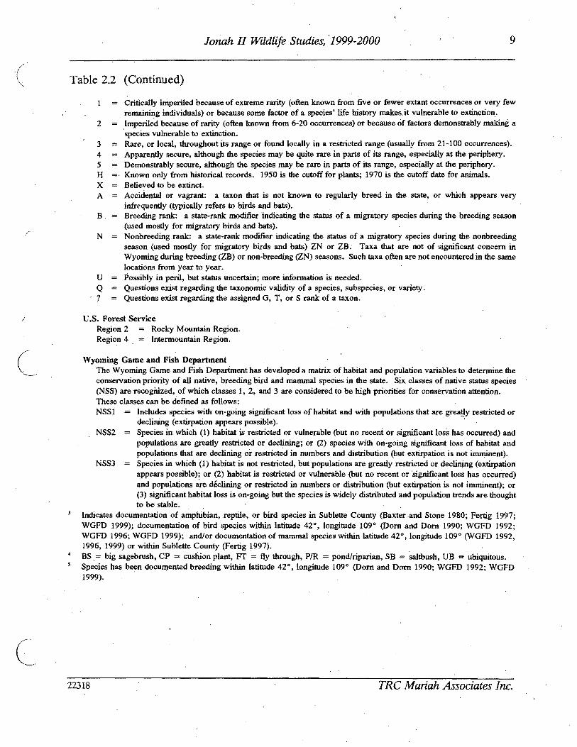
I
9
2
JoMh II Wildlife Studies 1999-2000
Table 22 (Continued)
Critically imperiled because of extreme rarity (often known from five or fewer extant occurrences or very few remaining individuals) or because some factor of a species life history makesit vulnerable to extinction Imperiled because of rarity (often known from 6-20 occurrences) or because of factors demonstrably making a species vulnerable to extinction
3 Rare or local throughout its range or found locally in a restricted range (usually from 21-100 occurrences) 4 Apparently secure although the sPecies may be quite rare in parts of its range especially at the periphery 5 Demonstrably secure although the species may be rare in parts of its range especially at the periphery H Known only from historical records 1950 is the cutoff for plants 1970 is the cutoff date for animals X Believed to be extinct A Accidental or vagrant a taxon that is not known to regularly breed in the state or which appears very
infre-quently (typically refers to birds and bats) B Breeding rank a state-rank modifier indicating the status of a migratory species during the breeding season
(used mostly for migratory birds and bats) ~
N Nonbreedingrank a state-rank modifier indicating the status of a migratory species during the nonbreeding season (used mostly for migratory birds and bats) ZN or ZB Taxa that are not of significant concern in Wyoming during breeding (ZB) or non-breeding (ZN) seasons Such taxa often are not encountered in the same locations from year to year
V Possibly in peril but status uncertain more information is needed Q Questions exist regarding the taxonomic validity of a species subspecies or variety 7 Questions exist regarding the assigned G T or S rank of a taxon
US Forest Service Region 2 Rocky Mountain Region Region 4 = Intennountain ~egion
Wyoming Game and Fish Department The Wyoming Game and Fish Department has developed a matrix of habitat and population variables to detennine the conservation priority of all native breeding bird and mammal species in the state Six classes of native status species (NSS) are reoogirized of which classes 1 2 and 3 are considered to be high priorities for conservation attention These classes can be defined as follows NSSI Includes species with on-going significant loss of habitat and with populations that are greatly restricted or
declining (extirpation appears possible) - NSS2 Species in which (1) habitat is restricted or vulnerable (but no recent or significant loss has occurred) and
populations are greatly restricted or declining or (2) species with on-going significant loss of habitat and populations that are declining or restricted in numbers and distribution (but extirpation is not imminent)
NSS3 Species in which (1) habitat is not restricted but popUlations are greatly restricted or dec~g (extirpation appears possible) or (2) habitat is restricted or vulnerable (but no recent or significant loss has occurred) and populations ru-e declining or restricted in numbers or distribution (but extirpation is not imminent) or (3) significant habitat loss is on-going but the species is widely distributed and popUlation trends are thought to be stable
Indicates documentation of amphibian reptile or bird species in Sublette County (Baxter and Stone 1980 Fertig 1997 WGFD 1999) documentation of bird species within latitude 42deg longitude 109 0 (Dorn and Dorn 1990 WGFD 1992 WGFD 1996 WGFD 1999) andor documentation of mammal species within latitude 42deg longitude 109 0 (WGFD 1992 1996 1999) or within Sublette County (Fertig 1997) BS= big sagebrush CP = cushion plant FT = fly through PR = pondriparian SB saltbush VB = ubiquitous Species has been documented breeding within latitude 42 0
longitude 109 0 (Dorn and Dorn 1990 WGFD 1992 WGFD 1999)
22318 TRC Mariah Associates Inc
10 Jonah II Wildlife Studies 1999-2000
( 231 Black-footed Ferret
Portions of prairie dog town (PDT) 1 on the J2P A were surveyed for blac~-footed ferrets
during 1999 (see Appendix A Habitat Map for PDT 1 location) PDT locations burrow
densities and extent (Ie acres) were initially described in Anderson (1996) however
during the black-footed ferret survey and subsequent mapping conducted in 2000 all PDTs
on tlle MJ2P A were remapped to more accurately present the current size and location of
each town Additionally all open burrows within each town were censused to determine the
towns suitability as black-footed ferret habitat
The black-footed ferret survey was condu~ted using standard nocturnal survey procedures
in accordance with USFWS guidelines (USFWS 1989) Further detail on black-footed ferret
survey methods can be found in McMurry (1999) which is available for review at the BLM
Pinedale Field Office in Pinedale Wyoming
232 Bald Eagle Ferruginous Hawk Golden Eagle
Inventory and monitoring protocols for bald eagle ferruginous hawk and golden eagle were
implemented as described for raptors (see Section 21)
233 Mountain Plover
During 1999 suitable mountain plover breeding and nesting habitat (Ie areas with low (
growing vegetation less than 4 inches high andor active PDTs) within 025 mi of proposed
well locations or 300 ft of proposed roads were surveyedinvestigatedcleared by the BLM
prior to disturbance in association withAPD and-ROW application field reviews Data shy
from these surveysinvestigationsclearances are available for review ~t the BLM Pinedale
Field Office in Pinedale Wyoming
22318 TRC Mariah Associates Inc
11
c
Jonah II Wildlife Studies 1999-2000
( During 2000 all potential mountain plover breeding habitat on and within 05 mi of the
MJ2PA was mapped and mountain plover presenceabsence surveys were implemented on
suitable habitats pursuant to USFWS 1999) guidelines
Survey protocol was as follows
bull surveys were conducted during the period of May I-Jtme 15 (ie during early
courtship and territory establishment)
bull surveys were conducted from sunrise to 1000 am andor from 530 pm to
sunset
bull surveys were conducted from four-wheel-drive vehicles or all-terrain vehicles
(ATVs)
bull surveyors remained in or close to vehicles when scanning with binoculars
andor spotting scopes
bull potential habitats were surveyed three times during the survey window
(May I-June 15) 4lld each survey was separated by at least 14 days
bull surveys Were not conduct~d in inclement weather (eg poor visibility) and
bull surveys focused on locating displaying or calling males
234 Western Burrowing Owl
Prairie dog colonies and other suitable burrowing owl nesting habitats on the MJ2PA were
searched during late spring and summer 2000 by TRC Mariah personnel to determine the
extent of burrowing owl nesting (see Appendix C Raptor Nesting Records) Burrowing owl
nesting surveys were conducted in association with prairie dog colony mapping mountain
plover surveys raptor surveys and vegetation type mapping The number and location of
active nests in the area weremiddot identified and efforts were made to determine fledgling success
for active nests
22318 TRC Mariah Associates Inc
12 Jonah II Wildlife Studies 1999-2000
( 235 Other TEPCampWSC Species
Formal surveys for other TEPCamp WSC were not conducted during 1999 or 2000 However
site-specific investigations were implemented by the BLM in areas of potential habitat within shy
05 mi of proposed disturbance sites during on-site reviews conducted in conjunction with
APD and ROW application review processes This information is available for review at
the BLM Pinedale Field Office
24 GENERAL WILDLIFE
Observations of general wildlife were recorded during species~specific investigations and
data are presented in Appen~ix B Additional observations were made during on-site
investigations conducted during APD and ROW application review processes Data
obtained during these oil-site investigations may be reviewed at the BLM Pinedale Field
Office
No formal surveys for pronghorn antelope (Leantelope movementmigration studies) or
other specieswildlife categories (eg waterfowl predators) were conducted during 1999 or
2000
42318 TRC Mariah Associates Inc
13 Jonah II Wildlife Studies 1999-2000
30 RESULTS AND PROPOSED MONITORINGPROTECTION MEASURES
The following chapter presents the results of 1999 and 2000 wildlife investigations on the
WSAProposed monitoringprotection measures for 2001 are also identified and would be
implemented by the BLM WGFD andor Operators as identified below
The proposed wildlife protection measures were developed specifically for potentially
impacted wildlife resources on and adjacent to the MJ2P A and J2P A The principal
protection measure proposed for most wildlife species is avoidance of sensitivecrucial
habitats (eg raptornests sage grouse leks) where practical However numerous
species-specific measures have been ideptified
31 RAPTORS
311 Results
Table 31 provides information on the location and actIvity status of raptor nests on the
WSA Active nests are defined as those that have been used within the last 3 years
Information on productivity nearby project features and proposed protection measures at
active nest sites within affected areas are presented in Table 32 Twenty-five of 97 knoWn
~ raptor nest sites on and adjacent to the WSA were known to be active between 1998 and
2000 Fifty-seven of the nest sites on and adjacent to the WSA are ferruginous hawk nests
eight of which were known to be active duri~g the 1998-2000 period (Table 31) American
kestrel have 10 known nest sites on the WSA sixmiddotof which were active during the period
Other species with known nests on the WSA include burrowing owl (six nestsfour active)
golden eagle (five nests three active) and prairie falcon (seven nests three active)
~welve nests of unknown species were identified on the WSA during pre-1996 surveys
however only one of these nests was located (active) during subsequent raptor surveys and
it is likely based on mapped locations and the inability to relocate the nests that the other
11 riests are not present within the WSA
22318 TRC Mariah Associates Inc
C
I
0 lt~~()
~ I Table 31 Raptor Nest Locations and Activity Status 2000 Jonah II Wildlife Study Area l- ~
Activity by Yearl
Nest Activity Most Recent Numberz Status3 2000 1999 1998 Activity Legal Location
6 (j
~ ~
~
~ ~ cgt ()
Smiddot-~ ~ l
AK16
AK17
AK18
AK30
AK39
AK52
AK80
AK88
AK92
AK97
B019
B023
B075
B076
B077
B086
FHl (2 nests)
FH2
FH3
A
A
A
A
U
A
U
A
U
U
U
U
A
A
A
A
I
I
U
I
I
I
a
I
I
I
a
U
U
I
I
NC
I
A
A
I
I
NC
a
a
a
a
NC
I
I
NR
NR
NR
NC
NC
NC
NC
A
NR
I
I
I
a
A
A
NR
NR
NR
NR~
NC
NC
a
a
NR
NR
I
I
NC
1999
1999
1999
2000
19975
1998
U
2000
U
U
19975
19975
19985
19985
2000
2000
U
U
U
~ sect
~ 5 ~
~ ~
c
[ ~
io-o 0 0 0bull-I c c c
I- ~
n n ~ I Table 31 (Continued) 00
I Activity by yearl
Nest Activity Most Recent Number2 Status3 2000 1999 1998 Activity Legal Location
S ()
~ ~ ~ ~ nS ~
S p
FH4
FH5
FH6
FH7
FH8
FH9
FHlO
FHll
FHl2 (2 nests)
FH13
FH14
FH15
FH20
FH21
FH22
FH24middot
FH25
FH26 (3 nests)
A
I
I
I
I
I
I
I
1
1
Amiddot
I
I
I
1
A
1
A
A6 A I
I I
I I I
I I I
I I I
I I I
I I
I I J
1 I I
I 1 1
1 N I
18I I
I I
I I I
I I I
a I NC
I I I
a a I
2000
pre-1996
pre-1998
pre-1998
1996
pre-1998
pre-1998
pre-1996
pre-1997
pre-1998
1999
1999
pre-1997
pre-1997
pre-1998
2000
pre-1998
2000
~ ~
sect ~
~ ~
[ ~
~ ~ Q Q Q
I
N
~ ~
I c
c
00
I
~n n fj I Table 31 (Continued)
Nest Nurnber2
FH28
FH29
FH37 (2 nests)
FH38
FH42
FH43 (2 nestS)
FH53
FH54 (2 nests)
FH55
FH56
FH575 (2 nests)()
FH58 ~ FH59~ (3 nests)
~ FH60ltgt ()
Smiddot FH62 ~
FH64~ I
Activity Status3
U
U
A
A
I
I
A
I
I
I
I
U
I
I
I
U
Activity by Year
2000 1999 1998
I I NC
I NC
I A A
A NC I
I I
I I I
I I A
I I
I I I
I I I
I I I
NC I I
I I I
I I
I I I
I I NC
Most Recent Activity
1996s
pre-1996s
1999
2000
pre-1998
pre-1998
1998
pre-1998
pre-1998
pre-1997
pre-1997
pre-1998
pre-1997
pre-1997
pre-1997
pre-1997
Legal Location
~ ~ Il
~
~ $t ~ (1i
CrI E Il ~~ 0 0 0 I) ltgt ltgt ltgt
t-- 01
00
I
n (
~ I Table 31 (Continued)
Nest Number2
FH65
FH66 (2 nests)
FH67
FH68
FH69
FH70
FH71
FH73
FH78
FH82
FH83
FH84
~ FH85 ()
(2middot nests)
FH87~ sect
FH89 ~ tl middotF~90 n fi FH91 ~
FH93middot~ ~
Activity Status3
I
I
I
1
A
I
I
I
U
U
U
U
U
U
U
U
U
U
Activity by Year l
Most Recent Legal Location UTM Coordinates4
2000
I
I
I
I
a
I
I
I
NC
I
I
I
I
I
I
U
I
1999
I
I
I
I
I
I
I
I
I
I
I
I
NR
NR
NR
NR
NR
1998
I
I
I
I
I
I
I
I
NR
NR
NR
NR
NR
NR
NR
NR
NR
NR
Activity
pre-1997
pre-1997
pre-1998
pre-1997
2000
pre-1998
1997
pre-1996
U
Us
U
U
U
U
U
Umiddot
U
U
~ I Il ~
~
~ is S
[ ~
~
0 0 0
I
N ltgt ltgt ltgt
c
-l
n o ~I Table 31 (Continued) 00
I Nest Activity
Activity by Yearl
Most Recent Number2 Status3 2000 1999 1998 Activity Legal Location UTM Coordinates4
FH95 U I NR NR U (4 nests)
FH96 U I NR U
GE36 A A 1 I 2000
GE47 A A A 2000 (2 nests)
GE48 1 1 1 1 pre-1996
GE51 A A 1 1 2000
GE72 I 1 pre-1998
PF27 U 1 ~ 1 U 19975
A8PF41 A U U 19985
PF61 1 1 1 I 1997 nfa
PF63 1 1 1 pre-1998 nfa
PF79 A A NR 1999 nfa~ () PF81 A A a NR 2000 na
~ PF94 U 1 NR NR U nfag 19UN31 NC NC NC U na
~ ~ 19UN32 NC NC NC U nfac ()
19 ~ UN33 NC NC NC U nfa ~
19 UN34 NC NC NC U nla~ p
~ ~ sect ~
~
[ (Ii
~
~ Q
~ bullI) cc c
I- 00
II n ~ I Table 31 (Cont~nued) 00
I Nest Activity
Activity by Yearl
Most Recent Number2 Status 2000 1999 1998 Activity Legal Location trfM Coordinates
UN35 19 NC NC NC U nla
UN40 I~ NC NC NC U nla
UN44 19 NC NC NC U nla
UN45 19 NC NC NC U nla
UN46 19 NC NC NC U nla
UN49 19 NC NC NC U nla
UN50 A 1 alO 1 1999
UN74 U I 1 NC U nla
~ ti (j
sect ~
g ~ ~ g $5 ~
~ fl
I A = active a = likely active I = inactive NC = not checkednot located NR = nest had not yet been recorded U = unknown 2 FHI = ferruginous hawk nest 1 AK16 = American kestrel nest 16 B019 = burrowing owl nest 19 GE36 = golden eagle nest 36
PF27 = prairie falcon nest 27 UN31 =unknown species nest 31 Overall activity status is based on the BLM definition of an active nest as one which has been active in at least 1 of the past 3 years For
overall activity status nests for which activity was likely but not confirmed were considered active (A) Nests which were assigned an unknown acti~ity status (U) lack a ~onclusive activity determin~tion for at least 1 of the past 3 years andor w~re n~wly recorded and have not been momtored for 3 consecutive years Nests confirmed mactlve m all of the past 3 years are deemed mactlve (I)
E = easting N = northing nla = not available S Date is of last confirmed activity but a~tivity status was unknown in at least 1 of the past 3 years thus more recent activity may have
occurred 6 Used by prairie falcon 7 Used in 1999 by golden eagle 8 Used by common raven 9 Detailed searches for these nests in 1999 and 2000 found no raptor activity in the area of the mapped nest sites therefore nests were
assumed to be inactive 10 Possibly used by great horned owl or prairie falcon
~
~
~ ~
[ Ci
~ ~ P
sect
~ 0
n n Table 32 Summary of Active Raptor Nests Within 10 Mi of Existing or Proposed Disturbance Jonah II Wildlife Study ~
i-I Area1 00
Species Seasonal Nest Production -Nest Nest Buffer Nol Legal Location Condition Radius Eggs Nestlings Fledglings Nearby Project Features MitigationActions
AKI6 Unknown 05 mi 0 0 0 Numerous existing and proposed Continue activity status and project features within 05 mi productivity monitoring
AK17 Unknown 05 mi 0 0 0 Numerous existing and proposed Continue activity status and project features within 05 mi productivi~ monitoring
AKIS Unknown 05 mi 0 0 0 Numerous existing and proposed Continue activity status and project features within 10 mi produ~tivity monitoring
8075 Unknown 05 mi U U U Numerous existing and proposed Con tinue activity status and project features within 05 mi productivity monitoring
8077 UnknoWn 05 mi U U I 1999 Numerous existing and proposed Continue activity status and project features within 10 mi productivity monitoring
FH47 Unknown 10 mi 3 1999 2 1 (died) One proposed well pad within Continue activity status and (1 died) 1999 10 mi productivity monitoring if
1999 territolY 6 is inactive in 2001 shy potential development of ANS(s)
FH148 Good 10 mi 3 1997 U 2 1997 Numerous existing and proposed Colltinue activity status and 1 1999 - U U project features within to mi productivity monitoring if
egg failed limited alternative nest sites territolY 5 is inactive in 2001 available in territolY 5 potential development of ANS(s)shy
FH24 Destroyed 10 mi 0 0 0 Numerous proposed features within Continued monitoring the area for 10 mi limited alternative nest sites new and active nests
FH53 Good 10 mi 3 2 1998 21998 B1rma Road within 05 mi Continue activity status and (1 didnt productivity monitoring hatCh)~ 1998
~ ()
FH69 Good 10 mi 0 0 0 Road and pipeline occur within Continue activity status and 10 mi productivity monitoring
$l
t
Active nests defined by activity or likely activity in at least one of the past three nesting seasons See Appendix B Raptor Nesting Records for further detail See Appendix A Wildlife Map for nest locations FH = ferruginous hawk (see Table 33 for nesting territolY) AK = American kestrel BO burrowing owl
tl C
Presents number of items and year U unknown ~ See Appendix A Project Features Map
Seasonal and standard avoidance measures are not included since they would be applied as necessalY for all active nests ~ Used by prairie falcon in 2000
~ Used by golden eagle in 1999 0
~ s sect ~
~ ~ sflS
V
~ ~ shyQQ QI tv C)
g
N 0
21 Jonah II Wildlife Studies 1999-2000
( Since several active raptor nests on the area occur at distances greater than 1 mi from
existing and proposed oil and gas disturbance sites (and thus productivity monitoring is not
required) productivity data for some nests are limited (see Appendix C) Ferruginous hawk
nests in the WSA are known to have produced two fledglings in 1998 one in 1999 and none
in 2000 Ferruginous hawk nest 4 was active in 1999 and produced two young--both of
which died--one as a nestling and one as a fledgling A definitive cause for nest failure was
not identified but the dead fledgling was found decapitated In 2000 the nest was used by
prairie falcons and appeared to produce no fledglings
Nest productivity for other raptor species during 1999 and 2000 include three burrowing owl
fledglings (one in 1999 two in 2000 [nestsgt 10 mi from disturbance]) additional burrowing
owl young may have fledged from other known nests in the area Golden eagles fledged
three to four young in 2000 (nests gt10 mi from disturbance) American kestrels and prairie
falcon also had active nests in the area during the period and likely fledged young birds
c Themiddot approximate locations of ferruginousmiddot hawk nest territories present on and adjacent to
the WSA are shown on the Wildlife Map in Appendix A and briefly described in Table 33
An estimated 11 nesting territories are present on the WSA six of which have been
occupied at least once during the last 3 years (1998-2000) Project features proximal to th~
active nests in these territories are identified in Table 32 and Appendix A (Project Features
Map) Project featuresdevelopments on the J2PA exist and are further planned proximal
to nest territories 5 6 and 7~ Other activities (eg recreational activitiesoff-road vehicle
use livestock grazing wildlifepredator interactions climate) likely occur and will continue
to occur in these and other territories Ferruginous hawk nesting terrItory7 was not active
during the 3-year period and all known nest sites in the territory are at suboptimal locations
(Le on theground surface with easy access by predators) therefore nesting in territory 7
is unlikely to occur in all but the most active nesting years (Le when all other nearby
nesting territories are occupied) It is also possible that nest territories 5 6 and 7 and nest
site 24 will remain unused or will have limited success during the life of the Jonah II Field
22318 TRC Mariah Associates Inc
22 Jonah II Wildlife Studies 1999-2000
Table 33 Nests and 1998-2000 Activity Status at Ferruginous Hawk Nesting Territories Jonah II Wildlife Study Area)
Activity Status3
Nests Included in Territory Territory2 1998 1999 2000
1 68-71middot I Imiddot A (unknown luccess)
2 62 64-67 84-85 I I I 96
3 56-58 60 83 I I I
4 26 28-29 95 I I A (unknown success)
5 13-15 I I
C
A4 (failed)
6 2-12 78 I A AS (failed) (unknown success)
7 20-21 73 I I I
8 53-55 82 A I I (2 fledged)
9 42-43 I I I
10 37-38 A A AS (unknown success) (unknown success) (unknown success)
11 5990 I I I
See Appendix A Wildlife Map for locations No nesting territory is established for nests 1222425 and 91
3 Further detail is provided in Appendix C Raptor Nesting Record I = inactive A = active Used by golden eagle Used by prairie falcon
22318 TRC Mariah Associates Inc
23 Jonah II Wildlife Studies 1999-2000
( Mitigation measures as defined in Section 312 are recommended for territoriesS and 6
in 2001
Project facilities are proposed for development within 05 mi of three active American
kestrel nests and two active burrowing owl nes~s (see Table 32) Continued monitoring
efforts ~re proposed for these nest sites (see Section 312)
312 MonitoringProtection Measures
The primary mitigation measure for raptor species on the WSA is avoidance of active nest
locations during the breedingmiddot season Active nests are defined asraptor nests that have
been used within the last 3 years Unless excepted by the BLM during APD and ROW
application reviews all surface-disturbing activities will be restricted from February 1
through July 31 within a 05-mi radius of active rap tar nests except ferruginous hawk nests
for which the seasonal buffer will be 10 mi (see Table 32) In addition well locations
roads ancillary facilities and other surface structures requiring repeated human presence
will not be constructed within 825 ft of active raptor n~sts where practicaL Th~ seasonal
buffermiddot dist~nce and exclusion dates may vary depending on factors such as nest activity
status rapior species prey availability natural topographic barriers and line-of-sight
distances
Nest activity status and productivity monitoring will continue in 2001 as identified in the
ROD (BLM 1998a [Append~ E] BLM 2000b) Nest activity status will be monitored from
the ground Additionally uUknown nests 31-35 40 44-46 and 49 are recommended for
removal from maps arid further monitoring
In 2001 nestnest area photos will be taken of all raptar nest locations for which photos are
lacking (Table 34) (see Appendix C Raptor Nest Records)
22318 TRC Mariah Associates Inc
24 Jonah II Wildlife Studies 1999-2000
( Table 34 Raptor Nest Locations for WhichmiddotPhotos are Needed Jonah II Wildlife Study Area 2000
Species Nest Numbers
American kestrel
Burrowing owl
Ferruginous hawk
Golden eagle
Prairie falcon
Unknown
17 30 39 52 88 92 97
19 23 75 76 77 86 -
1 (2 nests) 2 3 5 6 7 11 22 28 29 37 38 42 70 78 82 89 91 93 95 (4 nests)
48
27 41 94
74
Well locations roads ancillary facilities and other surface structures requiring repeated
human presence will not be constructed within 825 ft (2000 ft for bald eagles) of active
raptor nests where practical Facility construction in these areas will require specific
approval from the BLM wildlife biologist and Authorized Officer
Operators will notify the BLM immediately if raptors are found nesting on project facilities
If nest manipulation or a situation requiring a taking of a raptor nest becomes necessary
a special permit will be obtained from the Denver USFWS Office Permit Section Permit
acquisition will be coordinated with the Wyoming State USFWS Office in Cheyenne and will
be initiated with sIJfficient lead time to allow for development of mitigation measures
Required corresponding permits will be obtained from theWGFD in Cheyenne
Consultation and coordination with the USFWS and WGFD will be conducted for all
mitigation activities relating to raptors
Because project development continues on and adjacent to active ferruginous hawk
territories 5 and 6 it is recommended that two artificial nesting structures (ANSs) be
established within or adjacent to these territories in 2001 if the territories remain inactive
22318 TRC Mariah Associates Inc
25 Jonah II Wildlife Studies 1999-2000
or unproductive during 2001 Operators ~l assist the BLM (in consultation with other land
users) as necessary in locating appropriate ANS sites and erecting ANSs It is recommended
that ANSs be established outside of existing and known future disturbance areas The lowshy
lying areas in Section 33 T29N R 107W appear to provide suitable areas for ANS locations
in territory 6 ANS construction arid maintenance activities will be completed between
August 1 and September 15 2001 Operators will be responsible for the annual
maintenance of ANSs throughout the life-of-project and all ANSs on public lands will
become the property of themiddotBLM upon completion of the project Additional mitigations
for nesting raptors would be designed on a site-specific basis as necessary in consultation
with the BLM USFWS and WGFD
In future years additional ANSs may be constructed (up to two ANSs for each impacted
nest) or existing degraded raptor nests may be upgradedreinforced to mitigate potential
)impacts The location of ANSs or nests proposed for upgrading will be identified in annual
reports ANSs will be located within or proximal to potentially affected nesting territories ( outside of the line-of-sight or nest buffer of actively nesting raptor pairs and at sites
sufficiently removed from development activities to minimize or avoid potential adverse
effects
In cases where existing project features (eg well locations) are located within the buffer
areas for active raptor nests no extensive maintenance activities (eg workovers ) will be
allowed during critical periods (Le approximately early March through midJune) The
exact dates of exclusion will be determined by the BLM and specified in Conditiolls of
Approval for APD and ROW applications and will likely vary among nests and from
year-to-year depending upon the raptorspecies and variations in weather nesting
chronology and other factors
c 22318 TRC Mariah Associates Inc
26 Jonah II Wildlife Studies 1999-2000
32 SAGE GROUSE
321 Results
Table 3S presents a summary of recent sage grouse lek use (1998-2000) nearby project
features and proposed monitoring and other actions for leks on the WSA (see Appendix D
Sage Grouse Lek R~cords for further detail) Table 36 presents historic information on
lek use since 1992 Lek middot16 was not surveyed during the period therefore no data on lek
use are presented
c
Of the 22 known leks on the WSA leks 1 2 3 7 9 10 17 18 19 21 and 22 have shown
considerable use during monitoring and no notable declines in use were identified
(Table 36 and Appendix D Sage Grouse Lek Records) Decreasing attendance has been
observed at lek 4 with maximum male attendance down from 16 in 1994 to one in 2000 and
due to the extent of n~arby project development this lek may continue to have low levels
or no use throughout the remainder of project development Nomales were observed at
leks S 6 8 11 1213 14 or1S in the last 3 t04 years (Table 36) and these leks also may
continue to be unused for the remainder of project develppment
Five new leks were located during 1999 (leks 17 and 18) and 2000 (leks 19 21 and 22)
Noise monitoring at leks 7 and 8 on the WSA and the lek near the Bird Canyon compressor
station are provided in Table 37
Habitat mapping of the MJ2P A during 2000 primarily conducted to assist in defining
optimal sage grouse nesting and brood-rearing areas found that dense sa~ebrush was the
most common habitat type occupying approxim4tely 89 (26S82 acres 41S rnF) of the
MJ2PA (see Appendix A Habitat Map) This habitat type generally occurs in flat to rolling
terrain and exhibits sagebrush cover of gt20 (Table 38) Wyoming and mountain big
22318 TRC Mariah Associates Inc
() (1 ~
~ ITable 35 Summary of Sage Grouse Lek Use Potential Impacts and Proposed Monitoring Jonah II Wildlife Study Area 20001
Lek Approximate No2 Location Status3 Use Nearby Project Features4 MonitoringOther Actionss
~ ()
~ ~
s
A tl n Et- ~
~ f
2
3
4
5
6
7
8
9
10
11
A
A
A
A
A
A
A
I
Relatively consistent
Relatively consistent
Relatively consistent
Decreasing maximum male attendance since 1996
No known use since pre-1997
No known use since pre-1997
Relatively consistent
No known use since pre-1997
Relatively consistent
Relatively consistent
No known use since pre-1994
One existing and numerous proposed wells and roads within 10 mij one proposed location within 025 mi
Existing pipeline within 025 mi numerous existing and proposed wells and roads within 10 mi
Proposed well and road within 025 mi one existing and another proposed well and road within 10 mi
One existingand two proposed wells and roads within 025 mi numerous proposed and existing wells pipelines and roads within 10 mi
Existing well pipelines and roads within 025 mi new wells proposed within 025 mi proposed and existing wells pipelines and roads within 10 mi
Existing road at let
Existing pipeline within 10 mi
Existing pipeline and road and one proposed well within 10 mi
Proposed well within 10 mi
Existing and proposed wells and roads within 10 mi
Proposed road within 025 mi proposed wells and roads within 10 mi
Monitor attendance three times in 2001 j move proposed well outside 025-mi buffer
Monitor attendance three times in 2001 ensure proposed wells and roads are outside 025-mi buffer
Monitor attendance three times in 2001 move proposed well and road to outside 025-mi buffer
Monitor attendance three times in 2001 move proposed wells and roads to outside 025-mi buffer
Discontinue monitoring
Discontinue monitoring
Monitor attendance three times in 2001 monitor noise levels in 2001 GPS lek perimeters in 2001
Discontinue monitoring
Monitor attendance three times in 2001 GPS lek perimeters in 2001
Monitor attendance three times in 2001 monitor noise levels in 2001
Discontinue monitoring in 2001 move prop~sed road to outside 025-mi buffer
~ l
sect ~
~ sectgni
~gt ~
0 0 0
I
tJ
~ C
N
c
-l
00
n n ~ ITable 35 (Continued)
Lek Approximate No2 Location Status3 Use Nearby Project Features4 MonitoringOther Actionss
12 Limited use since pre-1992 Existing well and roads within 10 mi
13 No known use since None pre--1996
14 No known use since Existing road within 10 mi pre-1992
15 No known use since Existing and proposed wells pipelines and pre-1997 roads within 025 mi
16 U Unknown None
17 A Relatively consistent since Proposed road within 10 mi 1999 (first located in 1999)
18 A Possible increased Existing road within 025 mi proposed well attendance since 1999 (first and road within 10 mi
located in 1999)
19 A First located in 2000 None
20 U Unknown Existing road within 025 mi
~ (j 21 A First located in 2000 Proposed well and road within 10 mi
~ sect
22
A Pirst located in 2000 Proposed ells and roads within 10 mi
~ tl g jl See Appendix A Wildlife Map and Appendix D Sage Grouse Lek Records for additional infonnation - 2 See Table 36 for alternate names $)
~ 3 A = active (at least once during last 3 years) I = inactive U = unknowntj See Appendix A Project Features Map
~ Seasonal and standard avoidance measures are not included since they would be applied as necessary for all leks ))
Monitor attendance three times in 2001 search for alternate nearby lek sites in 2001 if no use discontinue monitoring in 2002
Discontinue monitoring
Discontinue monitoring
Discontinue monitoring in 2001
Monitor attendance three times in 2001
Monitor attendance three times in 2001 GPS lek perimeters in 2001
Monitor attendance three times in 2001
Monitor attendancethree times in 2001 GPS lek perimeters in 2001
Monitor attendance three times in 2001 GPS lek perimeters in 2001
Monitor attendance three times in 2001 GPS lek perimeters in 2001
Monitor attendance three times in 2001 GPS lek perimeters in 2001
monitoring action not necessarily required
~ sect ~ ~ -
[ (IS
~
g P
sect N
~
29 Jonah II Wildlife Studies 1999-2000
Table 36 Sage Grouse Trends Jonah II Wildlife Study Area 1992-20001
History2 Lek
No Lek Name 1992 1993 1994 1995 1996 1997 1998 1999 2000
4-2 NS NS 9 NS 26 6 31 25 22
2 4-6 NS NS 2 NS 2 17 12 7 14
3 Sand Draw Reservoirmiddot NS NS NS NS 16 o 36 26 22
4 Clay H~ NS NS 16 NS 15 4 4 o 1
5 4-8 NS NS NS NS 1 o o o NS
6 4-9 NS NS NS NS 3 o o o o
7 4-7 NS NS 36 NS o 16 17 11 9
8 4-10 NS NS NS NS 2 o o o o
9 Alkali Draw NS NS NS NS NS 50 26 62 47
10 The Rocks NS NS NS NS NS 60 53 79 64
11 4-5 NS NS o NS o NS o o o
12 3-8 o o o 4 o 0+ o
13 3-6 NS NS NS NS o o o o o
14 3-7 o o 0 o o o o o o
15 Sand Draw NS NS NS NS o o o o
16 Long Draw UNK UNK UNK qNK UNK UNK UNK UNK UNK
17 Buckhorn Well 1 NS NS llS NS NS NS NS 5 3
18 Shelter Cabin NS NS NS NS NS NS NS 50+ 90 Reservoir
19 Prairie Dog Town 5 NS NS NS NS NS NS NS NS 9
20 Upper Alkali Creek NS NS o NS o NS NS NS NS
21 South Rocks NS NS NS NS NS NS NS NS 10
22 Antelope State NS NS NS NS NS NS NS NS 9
Further detail is provided in Appendix D Sage Grouse Lek Records 2 Numbers refer to maximum male attendance NS = not surveyed UNK = unknown + = unclassified birds
observed but not included
22318 TRC Mariah Associates Inc
30 Jonah II Wildlife Studies 1999-2000
( Table 37 Summary of Noise Data Collection at the Bird Canyon and Lumen Compressor Stations Jonah II Wildlife Study Area 2000
Noise Output l Relative Location Time (decibels) Windspeed Humidity
Bird Canyon June 1 2000 Compressor Station
04 mi to north 600 to 700 am 372 - 501 (4370) 5 mph from SW 26
04 mi to south 600 to 700 am 413 - 545 (4790) 3 mph from SW 26
04 mi to east 600 to 700 am 480 - 514 (4970) 2 mph from SW 26
04 mi to west 600 to 700 am 367 - 465 (4160) 4 mph from SW 26
Directly at Station 600 to 700 am 731 - 746 (7385)
Lumen Compressor Station June 32000
Lek 557 am 369 - 424 (3965) 3 mph from NW 15
Lek8 537 am 395 - 535 (4650) 5 mph from NW 15
Directly at Station 652 - 667 (6595)
I bull All noise output readings represent a decibel range between the minimum and maximum values recorded during a 2- to 3-minute interval at each particular sampling location Average outputs fall near the medians Numbers in parentheses are median values
sagebrush (Artemisia tridentata wyomingensis and A t vaseyana respectively) are the most
co~on shrub species with rabbitbrush (Chrysothamnus spp) also present Subshrubs in
this habitat type include granite prickly gilia (Leptodactylon pungens) broom snakeweed
(Gutierrezia sarothrae) and winterfat (Kraschenninikovia lanata) which is generally
uncommon Forbs include stemless goldenweed (Happlopappus acaulis) Hoods phlox
(Phlox hoodU)and miners candle (Cryptantha spp)and grass species include wheatgrasses
(Agropyron spp) Indian ricegnlss (Oryzopsis hymenoides) fescue
(Festuca ~p) and
needleandthread (Stipa comata)
The moderate density sagebrush type (9 of the MJ2PA 2605 acres 41 mi2) is most
middot commonly found in the southeastern portion of the project area where i~ typically occurs
-
22318 TRC Mariah Associates Inc
C
31 Jonah II Wildlife Studies 1999 2000
( Table 38 Results of Vegetation Studies MJ2P A 20001
Productive Sage Grouse MJ2PA Vegetation Type2 Habitat Characteristics
Moderate Dense Density Basin
Sagebrush Sagebrush Sagebrush NestinglEarly Late Parameter (n=15) (n=15) (n=5) Brood-rearing Brood-rearing
Sagebrush height (inches) 98 79 310 45 12-32 12-32
Percent sagebrush cover
Daubenmire 217 45 65 308 15-25 10-25
Line intercept 245 45 (99) 79 (89) 367 (79)
Percent total shrub cover
Daubenmire 220 68 314 -shyLine intercept 247 (99) 81 (92) 380 (80)
Grassforb height (inches) 56 65 65 gt70 Variable 4inch minimum
( Percent grass and forb 106 (89) 151 45(96) 201 45 gt 13 gt13 cover (65)
Residual grass height 63 61 65 4-5 (irtchesY
Percent residual grass 85 4 109 4 2014 gt3 cover
Sagebrush plants acre 7260 (99) 2636(92) 4494 (86)
Total shrubsacre 7665 (99) 2951 (96) 5088 (91 )
Data on file at TRC Mariah Laramie Wyoming measurements recorded in late summer 2 See Appendix A Habitat Map for locations Numbers in parentheses are the confidence level achieved with
80 precision using the z statistic derived from the following formula ~
s where
n = sample size d = 02 (for 80 precision) X = sample mean s = sample standard deviation
3 See Table 21 for references measurements recorded during late spritigearly summer Meets nestingearly brood-rearing characteristics
5 Meets late brood-rearing characteristics 6 Excludes pre-2000 litter in MJ2PA samples
22318 TRC Mariah Associates Inc
32 Jonah II Wildlife Studies 1999-2000
( on sideslopes It is characterized by an average of approximately 6-8 sagebrush cover
(Table 38) with spiny hopsage(Grayia spinosa) and scattered rabbitbrush also present
Subshrubs include snakeweed Gardners saltbush (A triplex gardneri) and winterfat Grass
and forb species composition is generally similar to that observed in the dense sagebrush
type
The basin sagebrush (Artemisia tridentata tridentata) type ( lt 1 of the MJ2P A 236 acres
04 mi2) is characterized by a narrow strip of tall dense basin sagebrush along the Sand
Draw drainage (see Appendix A Habitat Map) Understory is relatively sparse with some
scattered rabbitbrush and mixed grasses and forbs
(shy
Scatteredno sagebrush habitat (2 of the MJ2P A 575 acres 09 mi2) occurs in small
pockets within the project area (see Appendix A Habitat Map) These unsampled areas
are generally associated with playas rocky outcrops or steep slopes and they typically grade
into the moderate density sagebrush habitat type
Measured vegetation parameters within the three sampled vegetation types in the MJ2PA
were in no instance consistent with the qualitative and quantitative parameters for
productive sage grouse nesting or brood-rearing described in Table38 However the dense
sagebrush and basin sagebrush types in combination apparently provide adequate conditions
(with the exception of understory grassforb and residual grass heights) for sage grouse
nesting since sage grouse nesting and brood-rearing is known to occur in the area
Furthermore since year 2000 vegetation sampling in the MJ2P A occurred late in the
summer during a dry year and whereas sampling to determine productive nesting and
brood-rearing habitat parameters occurred immediately fo~lowing chick hatching (late
spring early summer) it is likely that some portion of the understory (grasses and forbs) was
lost to desiccation and wind andor grazing resulting in the potential for underestimation
of both cover anltlheight of grasses and forbs during the year 2000 vegetation sampling
22318 TRC Mariah Associates Inc
c
33 Jonah IIWildlife Studies 1999-2000
322 Monitoring and Protection Measures
Monitoring and identification of sage grouse leks on the WSA will continue in 2001 as
specified in the WMPP (BLM 1998a Appendix E) and the EA for the Modified Jonah Field
II Project (BLM 2000b)
It is recommended that the WGFD or BLM continue to implement aerial (fixed wing) sage
grouse lek inventories of the WSA in 2001 to provide further lek locational data and to
identify any new or previously undiscovered leks Additionally WGFD andlor BLM will
use GPS to determine lek perimeters in 2001 at leks 7 9 171920 21 and 22 Aerial
surveys will be implemented during Marchi April The absence ofldecreased use of leks 4
5 6 8 1112 13 14 and 15 may indicate that alternate lek siteS are being used therefore
it isreltommended that additional observations be made in 2001 in the vicinity of these leks
to locate any new unmapped leks
Due to the apparent lack of use over the last few years at leks 5 6 8 11 12 13 14 and 15
it is recommended that lek attendanc~ monitoring at these leks be discontinued in 2001
Attendance monitoring at these leks may be reinitiated once field development is complete
Attendance monitoring of other known sage grouse leks in the area by WGFD and Ior BLM
personnel will continue in 2001 as during past years and specified in the RoD (BLM 1998a
Appendix E) and deemed necessary by the BLM and WGFD
As requested by the BLM and WGFD noise monitoring will be implemented in 2001 at leks
7and 10 within the WSA and at the Bird Canyon lek located approximately 04 mi southeast
of the Bird Canyon Compressor Station southwest of the WSA Continuous noise
monitoring will be conducted from 5 am to 9 am on four separate occasions during the
period of March 15middotApril 30 at the three leks Noise monitoring equipment will include a
Bruel amp Kjaer Model 2260 precision integrating sound meter and octave bandmiddot analyzer
(noise frequency) with a data logger (meets ANSI 514-1983 Type 1 sound level meter
22318 TRC Mariah Associates Inc
34 Jonah II Wildlife Studies 1999-2000
( requirements) Noise meaSurements will be logged every 5minutes over the duration of the
5-hour sampling period and data will be downloa~ed daily for storage and analysis The
meter will be calibrated daily with a Bruel amp Kjaer Model 4231 sound level calibrator The
microphone will be fitted with a windscreen to reduce wind-generated noise and will be
mounted at the edge of each lek approximately 3 ft above the ground Contributing noise
sources will be identified and recorded as well as prevailing meteorological conditions i
(Le wind speed and direction temperature humidity and cloud cover)
As with raptors the principal protection for sage grouse is avoidance of leks during the
breeding season and the avoidance of probable nesting areas during the nesting season If
an active sage grouse nest is identified during the nesting season (April 1 - July 31) i
surface-disturbing activities will be delayed untilnestibg is completed
All surface-disturbingmiddot activities including pipeline construction will be avoided within
025 mi of active sage grouse leks and no permanent high profile structures such as
buildings and storage tanks which are suitable raptor perches will be constructed within
025 mi of any lek Therefore the proposed project features (ie well locations roads
pipelines) proximal to leks 1345 11 and 15 may require relocation to sites greater than
025 mi from the lek centers Well location and road and pipeline construction within
025 mi of leks 5 11 and 15 may be permitted in 2~OI (as authorized by BLM) since these
leks have exhibited little or no use during monitoring and are considered inactive
Operators will restrict construction activities between March 1 and June 30 within a
20-mi radius of active sage grouse leks to protect sage grouse nesting habitat and Will avoid
all drilling and construction activities from March 1 to May 15 on all areas within 10 mi of
active sage grouse leksmiddot to protect sage grouse breeding activities Operators will also
maintain a 05-mi disturbance-free buffer around middotleks 7 (and 8 south of the MJ2P A
(see Appendix A Wi~dlife Maps)
22318 TRCMariah Associates Inc
35 Jonah II Wildlife Studies 1999-2000
( While Operators have committed to avoiding optimal sage grouse nesting habitat during the
nesting period where practical (BLM 2000b) n optimal (productive) habitat has been
identified in the MJ2PA (see Table 38) However since sage grouse nesting and
brood-rearingmiddot is known to occur in the sagebrush-dominated habitats on the area it is
recommended that no disturbance (other than linear crossings) be authorized within the
basin sagebrush type (this type is currently protected by drainage buffers [see Appendix A
Habitat Map J) and that disturbance within the dense sagebrush type be avoided during the
nesting period
It is recommended that the BLM implement formal sage grouse winter use investigations
on the J2PA and a O5-mi buffer during late winter (JanuaryFebruary) 2001 to further
identify sage grouse wintering areas These surveys should be conducted on the ground and
all data collected should be provided on General Wildlife Observation Data Sheets or other
suitable forms (see Appendix B) Operators will cooperate in any further ongoing sage
grouse studies within the WSA and with the WGFD on any existing and new sage grouse
habitat improvement efforts (eg water developments) within Upland Game Bird
Management Area 7
Removal of water development structures proximal to lek 4 (Clay Hill) may occur in 2001
as directed by BLM Removal of these facilities may eliminate potential raptor perch sites
andor reduce the use of this area by livestock and humans
Operators will utilize directional drilling to access resources beneath the 025-mi active sage
grorise lek buffers (see Appendix A Wildlife Map) and beneath the 600-poundt wide (or tall
sagebrush-dominated) buffer associated with Sand Draw Granite Wash and Alkali Draw
protection areas if reserves beneath these locations are deemed economically feasible
c__ 22318 TRC Mariah Associates Inc
36 Jonah II Wildlife Studies 1999-2000
(
-33 THREATENED ENDANGERED PROPOSED CANDIDATE AND WYOMING
SPECIES OF CONCERN
I331 Results
3311 Black-footed Ferret
No black-footed ferrets or black-footed ferret sign was observed on the J2PA during the
black-footed ferret survey conducted on the area during 1999 Survey results are presented
in McMurry (1999) which is available for review at the BLM Pinedale Field Office
No PDTs with burrow densities suitable as black-footed ferret habitat (Le gt8 burrows
acre) were identified in the MJ2PA during year 2000 (Table 39) However portions of
PDTs 8 16 17 and 18 in the southeastern portion of the WSA have prairie dog burrow
densities suitable for black-footed ferret (see Appendix A Habitat Map) and black-footed
ferret surveys may be required if developments are proposed within these townS
3312 Bald Eagle Ferruginous Hawk Golden Eagle
No bald eagles were observed on the WSA during 1999 and 2000 wildlife investigations
Information on ferruginous hawks and golden eagles is provided in Section 311
3313 Mountain Plover
Mountain plover were observed for the first time adjacent to the J2PA during 1999 and a
single plover was observed within the J2PA during 2000 (see Appendix B) Adults with at
least two young were recorded on separate occasions outside the J2P A during 1999
indicating the presence of mountain plover breeding in the Alkali Creek drainage
22318 TRC Mariah Associates Inc
c
C
37 Jonah II Wildlife Studies 1999-2000
Table 39 Whitetail Prairie Dog Towns Jonah II Wildlife Study Area 2000
Prairie Dog Number of Burrow Density Town Acreage2 Open Burrows2 3 (burrowsacre)2 5
1 400 326 08
2 423 458 11
3 825 39 lt01
4 903 NS UNK
NS 5 106 UNK
6 358 724 20
7 800 NS UNK
8 1246 (131) 2084 (103) 45 (142)
9 280 NS UNK
10 39 NS UNK
11 203 NS UNK
12 79 NS UNK
13 86 NS UNK
14 105 NS UNK -
15 189 NS UNK
16 203 (52) (35)4 ~9 (138)
17 141 (30) 364 (26) 65 (156)
18 357 (55) 544 (43) 41 (166)
19 10 NS UNK
20 9 NS UNK
See Appendix A Habitat Map for location 2 Numbers in parentheses are for high density areas (Schlumberger Geco-Prackla 2000) 3 NS = not surveyed 4 Sample only 5 UNK = unknown
22318 TRC Mariah Associates Inc
38 Jonah II Wildlife Studies 1999-2000
( (Appendix B) No mountain plover were observed during species-specific investigations on
and within 05 mi of the MJ2PA during 2000 (see Appendix E)
3314 Western Burrowing Owl
Six western burrowing owl nestsnest sites were observed on the WSAfrom 1997 to 2000
(see Tables 31 and 32 and Appendix C Raptor Nesting Records) Of these nests only two
are known to have produced young however burrowing owl nests 75 and 76 were not
monitored for productivity during 1998 and 1999 and these nests may have successfully
produced young in these years
3315 Other TEPCamp WSC Species
The only other known TEPCamp WSC noted on the WSA during 1999 and 2000 surveys and
on-site investigations conducted during APD and ROW reviews was the loggerhead shrike
and it is possible that the species bred in the area during these years
I
332 Monitoring and ProtectiOn
USFWS andor WGFD consultation and coordination will be conducted for all necessary
mitigation activities relating to TEPCampWSC and their habitats implemented during 2001
3321 Black-footed Ferret
All whitetail PDTs within the J2P A have been mapped and those within the MJ2P A were
remapped and censused for op~n burrows in 2000 to determine whether they meet the
black-footep ferret habitat criteria established in the USFWS (1989) guidelines Proposed
disturbance in PDTs 1 2 3 and 6 will not adversely affect black-footed ferrets since these
towns are not suitable as black-footed ferret habitat
22318 TRC Mariah Associates Inc
I
39 Jonah Ii Wildlife Studies 1999-2000
~ During 2001 PDTs 12 3 and 6 will bereinvesiigated to locate and map the areas within
these towns that have the highest burrow densities GPS will be used to map these areas
Burrow densities will be censused within the areas of highest burrow density
If PDTsportions of PDTs of sufficient size and burr~w densitr for black-footed ferret
habitat are scheduled to be disturbed black-footed ferret surveys of these townstown
portions will be conducted Survey protocol will adhere to USFWS guidelines as established
in USFWS (1989) Surveys will be conducted by a USFWS-qualified biologist no more than
1 year prior to proposed disturbance and reports identifying survey methods and results will
be prepared and submitted to the USFWS and BLM in accordance with Section 7 of the
Endangered SpeCies Act of 1973 as amended and Interagency Cooperation Regulations
Surveys will be financed by the Operators
If black-footed ferrets are found within the J2PA but outside the MJ2P A the USFWS will
be notified immediately and formal consultations will be initiated to develop strategies that
ensure no adverse effects to the species If black-footed ferretsmiddot are found within the
MJ2PA the USFWS will be notified immediately and no further disturbance would occur
to the prairie dog complex in which the black-footed ferret was observed Before
ground-disturbing activities are initiated in black-footed ferret habitat authorizations to
proceed would be required from the BLM in consultation with the USFWS
3322 Bald Eagle Ferruginous Hawk Golden Eagle
Monitoring and protection protocol for bald eagle ferruginous hawk and golden eagle in
2001 will be as described for raptors (see Section 312) Additional measures will be
applied on a species- or site-specific basis as deemed necessary by the USFWS andor
BLM if potential impacts to these species are identified during 2001 APD and ROW
application reviews
22318 TRC Mariah Associates Inc
40 Jonah II Wildlife Studies 1999-2000
( 3323middot Mountain Plover
The following protocol has been modified from that presented in BLM (1998a Appendix E)
to accommodate USFWS changes to mountain plover survey and avoidance protocoL The
protocol remains consistent with that presented in BLM (2000b)
During the period of May I-June 15 2001 mountain plover surveys will be conducted by
an Operator-financedBLM-approved biologist in accordance with USFWS guidelines
(USFWS 1999) on suitable breeding areas throughout the MJ2PA and a 05-mi buffer (see
AppendiX A Habitat Map) Survey procedures will be as follows
bull surveys will be conducted during early courtship and territory establishment
bull surveys will be conducted from sunrise to 1000 am andor from 530 pm
to sunset
bull surveys will be conducte4 from four-wheel-drive vehicles or where access is
a problem andor no visual observations are made from vehicles ATVs will
be used
bull surveyors will remain in or close to yehicles when scanning with binoculars
bull after 2QOl surveys for mountain plover will be conductedmiddot in appropriate
habitat within 200 m (656 ft) of proposed disturbance sites
bull sites will be surveyed three times during the survey window (May I-June 15)
with each survey separated by at least 14 days
bull surveys will not be conducted in inclement weather (eg poor visibility)
surveys will focus on locating displaying or calling males
bull if breeding birds are observed additional surveys will be implemented
immediately prior to construction to search for active nest sites (applicable to
only post-2001 surveys)
bull if an active nest is located a 656-ft buffer zone will be established around the
nest to prevent direct and indirect nest disturbance and
bull gt surface-disturbing activities will occur as near to completion of surVeys as
possible
22318 TRC Mariah Associates Inc
41 Jonah II Wildlife Studfes 1999-2000
Mountain plover surveys will not be conducted for construction activities planned for the
period of July 11 through April 9 Survey results will be compared with the annual
development plans to determine if any proposed surface-disturbing activities will affect
occupied mountain plover nesting habitat Where practicable development plans will be
modified to avoid nesting habitat (eg through road realignment)
If an active nest is found in thesurveyarea planned activities will be delayed 37 days or
1 week post-hatching or if a brood of flightless chicks is observed activities will be delayed
at least 7 days
Where access roads andor well locations have been qmstructed prior to the mountain -
plover nesting season (April 10-July 10) and use of these areas has not been initiated for
development actions prior to April 10 a BLM-approved Qiologist will conduct site
investigations of these diSturbed areas prior to use to determine whether mountain plover
are present In the event plover nesting is occurring Operators will delay development
activities until nesting is complete
Nest success and productjvity of all mountain plover nests found within the MJ2PA will be
monitored and reported to the BLM and USFWS Wyoming Field Office annually
Prior to implementing surface disturbance within 200 m (656 ft) of known mountain plover
concentration areas (Le areas where broods andor adults have been ~bserved in the
current year or documented in at least 2 of the last 3 years) Operators will consult with the
BLM regarding initiation of informal conferencing with the USFWS
If removal of mountain plover nesting habitat is unavoidable loss will be minimized by
creating additional nesting habitat it is assumed that many of the existing and proposed
pipeline reclamation areas on the MJ2P A would provide suitable plover breeding habitats
Areas of pipeline reclamation that provide suitable plover beeding areas will be identified
annually If nesting habitat is disturbed the area will be reclaimed to approximate original
TRC Mariah Associates Inc 22318
c
42 Jonah II Wildlife Studies 1999-2000
( conditions (topography vegetation hydrology etc) aftercompletio~ of activities such that
disturbed potential mountain plover breeding habitat is reclaImed to conditions suitable for
mountain plover breeding
Operators will minimize road construction and maintenance activities (ie grading) In
suitable plover habitat from April 10- July 10 No surface-disturbing activities will be
conducted from April 1 - June 30 within 656 ft of identified mountain plover concentration
areas (ie areas where broods andor adults have been observed in the current year or
documented in at least 2 of the past 3 years)
3324 Western Burrowing Owl
Monitoring and avoidance of prairie dog colonies (see Section 3321) and avoidance of
active raptor nests during the nesting period (see Section 312) will continue in 2001
Additianally productivity monitoring will be implemented for all active burrowing owl nests
on the MJ2PA and a surrounding OS-mi area Additional measures may be applied in
future years if burrowing owl nesting andor productivity in the WSA is noted to be
declining These potential measures will be identified by the BLM
3325 Other TEPCampWSC Species
No formal surveys for other TEPCampWSC are proposed for 2001 however since loggerhead
shrike have been seen in the area special attention to this species is recommended for APD
and ROW application field reviews If during implementation of surveys for other species
or during APD and ROW application field reviews any TEPCampWSC is observed on areas
within OSmi of proposed disturbance sites nests or other crucial features for the observed
species if any will be avoided Consultation and coordination with the BLM USFWS and
WGFD will also be conducted as necessary Construction activities in these areas will be
curtailed untilthere is concurrence among Operators BLM USFWS and WGFD on what
22318 TRC Mariah Associates Inc
c
c
43 Jonah II Wildlife Studies 1999-2000
activities can be authorIzed Activities will in most cases be delayed until such time that
no adverse effects would occur (eg after fledging)
No additional protection measures will be applied for other sensitive species potentially
present on the WSA however it is assumed that the protection protocol specified below for
general wildlife will benefit TEPCampWSC as well (see Section 3332) In addition if
TEPCamp WSC are observed efforts will be made to determine the activities of the species
on the WSA (eg breeding nesting foraging hunting) If any management agency
(ie BLM WGFD USFWS) identifies a potential for impacts to any TEPCampWSC species
additional monitoring andor protection measures will be implemented as directed by the
BLM
333 General Wildlife
3331 Results
Data on other wildlife species observed on the WSA durin~ 1999 and 2000 surveys are
provided in Appendix R and in APD andROW application field review data available at
the BLM Pinedale Field Office
3332 Monitoring and Protection
No formal wildlife monitoring for other wildlife is recommended for 2001
Protection measures primarily designed to minimize impacts to other area resources
(eg vegetation and surface water resources Including wetlands steep slopes) are identified
in BLM (1998a 2000b) andthese measures provide additional impact mitigation forarea
wildlife Well locations access roads pipelines and ancillary facillties will be selected and bull bull I
designed to minimize disturbances to areas of high wildlife habitat value including wetlands
~ and riparian areas Areas with high erosion potential andor rugged topography (Le steep
(- slopes dunes floodplains unstable soils ) will be avoided where practical ~
22318 TRC Mariah Associates Inc
44 Jonah II Wildlife Studies 1999-2000
Removal or disturbance of vegetation will be minimized through construction site
management (eg by utilizing previously disturbed areas using existing ROWs designating
limited equipmentmaterials storage yards and staging areas scalping) and Operators will
adhere to all reclamation guidelines presented in the Reclamation Plan for this project
(see Appendix B in BLM 1997 1998a and 1998b)
To minimize wildlife mortality due to vehicle collisions Operators will continue to advise
project personnel regarding appropriate speed limits (Le35 mph) in the project area and
roads will be reclaimed as soon as possible after they are no longer required Some existing
roads in the area may be closed and reclaimed by Operators as authorized by the BLM
No roads are currently proposed for reclamation
To protect plant populations and wildlife habitat project-related travel will be restricted to
established project roads no off-road travel will be allowed except in emergencies
c No road or pipeline ROW fencing is proposed however if ROW fencing is required it will
be kept to amiddot minimum and the fences employed ~ll consist of four-strand barbed wire
which meets BLM and WGFD approval for facilitating wildlife movement Wildlife-proofI
fencing will be utilized only to enclose reclaimed areas where it is determined that wildlife
species are impeding successful vegetation establishment No improvements to existing
fences on the area are currently proposed
No new wildlifelivestock water sources are currently proposed for development
Potential increases in poaching will be minimized through continued employee and
contractor education regarding wildlife laws and Operators will notify all employees
( contract and company) that conviction of a major game violation could result in disciplinary
action Ifviolations are discovered Operators will immediately ntify theBLM and WGFD
and if the violation involves an employee or contractor said employee or contractor will bemiddot disciplined and may be dismissed by the Operator andor prosecuted by the WGFD
C
22318 TRC Mariah Associates Inc
45 Jonah II Wildlife Studies 1999-2000
Additional nonspecies-specitlc wildlife mitigations include the following
bull Reserve workover evaporation and flare pits potentially hazardous to
wildlife will be adequately protected by netting andor fencing as directed by
the BLM to prevent access bYmigratory birds and other wildlife
bull Siphons will be constructed at each reserve pit to collect as necessary any
undesirable materials that may enter the pits
bull Potential impacts to fisheries will be minimized by using proper erosion
control techniques (eg water bars jute netting rip-rap mUlch)
Construction within 500 ft of open water and 100 ft of intermittent or
ephemeral channels will be avoided where possible Channel crossings for
roads and pipelines will be constructed when flows are not expected (Le late
summer or fall) All necessary crossings will be constructed perpendicular to
flow No surface water or shallow groundwater in connection with surface
water will be utilized for the proposed project
bull Firearms and dogs will not be allowed on the J2P A during working hours by
BLM or Operator employees or their contractors Operators will enforce
existing drug alcohol and firearms policies
bull If injured wildlife are observed on the J2P A Operator personnel will contact
the BLM Pinedale Field Office and the WGFD Pinedale Office Under no
circumstances will injured wildlife be approac4ed or handled
bull Wildlife reporting as specified in the ROD (BLM 1998 Appendix E) will be
continued in 2001 (
22318 TRC Mariah Associates Inc
I
46 Jonah II Wildlife Studies 1999-2000
( 40 LITERATURE CITED
Anderson RM 1996 1996 Prairie Dog Raptor and Sage Grouse Inventory of McMurry Oil Companys Expanded Jonah Field Natural Gas Development Project Sublette County Wyoming Prepared for McMurry Oi~ Company Casper Wyoming by Anderson Environmental Consulting Casper Wyoming 13 pp
Baxter GT and MDmiddot Stone 1980 Amphibians and Reptiles of Wyoming Wyoming Game and Fish Department Bulletin No 16 137 pp
Bureau of Land M~nagement 1997 Draft Environmental Impact Btatement Jonah Field II Natural Gas Project US Department of the Interior Bureau of Land Management Rock Springs District Office Pinedale and Green River Resource Areas BLMWY PL-97 015 + 1310
__ 1998a ~ecord of Decision for Jonah Field II Natural Gas Development Project Environmental Impact Statement Sublette County Wyoming US Bureau of Land Management Rock Springs DistrictPinedale and Green River Resource Areas 43 pp + append
__ 1998b Final Environmental Impact Statement Jonah Field II Natural Gas Project US Department of the Interior Bureau of Land Management Pinedale and Green River Resource Areas BLMWY PL-98001 + 1310
__ 1999 1997 and 1998 Wildlife Studies Jonah Field II Natural Gas Development Project Prepared for US Bureau of Land Management Pinedale Field Office Pinedale Wyoming and Rock Springs Field Office Rock Springs Wyoming by TRC Mariah Associates Inc Laramie Wyoming 32 pp + append
__I _ bull 2000a Decision Record and Finding of No Significant Impact for the Modified Jonah Field II Natural Gas Project Sublette County Wyoming US Bureau of Land Management Pinedale and Rock Springs Field Offices BLMWY PL-001j 019+ 1310
__ middot2000b Environmental Assessment and Finding of No Significant Impact for the Modified Jonah Field II Natural Gas Project Sublette County Wyoming US Department of the Interior Bureau of Land Management Pinedale and Rock Springs Field Offices BLMWY jPL-00lj009+ 1310
Dorn JL and RD Dom 1990 Wyoming Birds Mountain West Publishing Cheyenne Wyoming 138 pp
22318 TRC Mariah Associates Inc
47 Jonah II Wildlife Studies 1999-2000
Fertig W 1997 Wyoming Plant and Animal Species of Special Concern Prepared for the Wyoming Natural Diversity Database 32pp
McMurry Oil Company 1999 Black-footed Ferret and Burrowing Owl Survey of a Prairie Dog Colony in Portions of Sections 29 30 31 and 32 T29N R108W Sections 25 and 36 T29NR109W Sublette County Wyoming Prepared for McMurry Oil Company Pinedale Wyoming by Monarch Wildlife Consultants Pinedale Wyoming 9 pp + append~
Schlumberger Geco-Prakla 2000 Final Black-footed Ferret and Burrowing Owl Surveys South Jonah Seismic Exploration Project Sublette County Wyoming Prepared for Schlumbergermiddot Geco-Prakla Midland Texas by TRC Mariah Associates Inc Laramie Wyoming 7 pp + append
US Fish and Wildlife Service 1989 Black-footed Ferret Survey Guidelines for Compliance with the Endangered Species Act US Fish and Wildlife Service Denver Colorado and Albuquerque New Mexico (April 1989) 10 p + append
__ 1999 Mountain Plover Survey Guidelines US Fish and Wildlife Service 1999 Photocopy 6 pp
Wyoming Game and Fish Department 1992 Wyoming Bird and Mammal Atlas 170 pp ___ 1996 Wyoming observation system records Biological Services Wyoming Game
and Fish Department Cheyenne Wyoming
___ 1999 Wyoming observation system records Biological Services Wyoming Game and Fish Department Cheyenne Wyoming
22318 TRC Mariah Associates Inc
11
c
Jonah II Wildlife Studies 1999-2000
( During 2000 all potential mountain plover breeding habitat on and within 05 mi of the
MJ2PA was mapped and mountain plover presenceabsence surveys were implemented on
suitable habitats pursuant to USFWS 1999) guidelines
Survey protocol was as follows
bull surveys were conducted during the period of May I-Jtme 15 (ie during early
courtship and territory establishment)
bull surveys were conducted from sunrise to 1000 am andor from 530 pm to
sunset
bull surveys were conducted from four-wheel-drive vehicles or all-terrain vehicles
(ATVs)
bull surveyors remained in or close to vehicles when scanning with binoculars
andor spotting scopes
bull potential habitats were surveyed three times during the survey window
(May I-June 15) 4lld each survey was separated by at least 14 days
bull surveys Were not conduct~d in inclement weather (eg poor visibility) and
bull surveys focused on locating displaying or calling males
234 Western Burrowing Owl
Prairie dog colonies and other suitable burrowing owl nesting habitats on the MJ2PA were
searched during late spring and summer 2000 by TRC Mariah personnel to determine the
extent of burrowing owl nesting (see Appendix C Raptor Nesting Records) Burrowing owl
nesting surveys were conducted in association with prairie dog colony mapping mountain
plover surveys raptor surveys and vegetation type mapping The number and location of
active nests in the area weremiddot identified and efforts were made to determine fledgling success
for active nests
22318 TRC Mariah Associates Inc
12 Jonah II Wildlife Studies 1999-2000
( 235 Other TEPCampWSC Species
Formal surveys for other TEPCamp WSC were not conducted during 1999 or 2000 However
site-specific investigations were implemented by the BLM in areas of potential habitat within shy
05 mi of proposed disturbance sites during on-site reviews conducted in conjunction with
APD and ROW application review processes This information is available for review at
the BLM Pinedale Field Office
24 GENERAL WILDLIFE
Observations of general wildlife were recorded during species~specific investigations and
data are presented in Appen~ix B Additional observations were made during on-site
investigations conducted during APD and ROW application review processes Data
obtained during these oil-site investigations may be reviewed at the BLM Pinedale Field
Office
No formal surveys for pronghorn antelope (Leantelope movementmigration studies) or
other specieswildlife categories (eg waterfowl predators) were conducted during 1999 or
2000
42318 TRC Mariah Associates Inc
13 Jonah II Wildlife Studies 1999-2000
30 RESULTS AND PROPOSED MONITORINGPROTECTION MEASURES
The following chapter presents the results of 1999 and 2000 wildlife investigations on the
WSAProposed monitoringprotection measures for 2001 are also identified and would be
implemented by the BLM WGFD andor Operators as identified below
The proposed wildlife protection measures were developed specifically for potentially
impacted wildlife resources on and adjacent to the MJ2P A and J2P A The principal
protection measure proposed for most wildlife species is avoidance of sensitivecrucial
habitats (eg raptornests sage grouse leks) where practical However numerous
species-specific measures have been ideptified
31 RAPTORS
311 Results
Table 31 provides information on the location and actIvity status of raptor nests on the
WSA Active nests are defined as those that have been used within the last 3 years
Information on productivity nearby project features and proposed protection measures at
active nest sites within affected areas are presented in Table 32 Twenty-five of 97 knoWn
~ raptor nest sites on and adjacent to the WSA were known to be active between 1998 and
2000 Fifty-seven of the nest sites on and adjacent to the WSA are ferruginous hawk nests
eight of which were known to be active duri~g the 1998-2000 period (Table 31) American
kestrel have 10 known nest sites on the WSA sixmiddotof which were active during the period
Other species with known nests on the WSA include burrowing owl (six nestsfour active)
golden eagle (five nests three active) and prairie falcon (seven nests three active)
~welve nests of unknown species were identified on the WSA during pre-1996 surveys
however only one of these nests was located (active) during subsequent raptor surveys and
it is likely based on mapped locations and the inability to relocate the nests that the other
11 riests are not present within the WSA
22318 TRC Mariah Associates Inc
C
I
0 lt~~()
~ I Table 31 Raptor Nest Locations and Activity Status 2000 Jonah II Wildlife Study Area l- ~
Activity by Yearl
Nest Activity Most Recent Numberz Status3 2000 1999 1998 Activity Legal Location
6 (j
~ ~
~
~ ~ cgt ()
Smiddot-~ ~ l
AK16
AK17
AK18
AK30
AK39
AK52
AK80
AK88
AK92
AK97
B019
B023
B075
B076
B077
B086
FHl (2 nests)
FH2
FH3
A
A
A
A
U
A
U
A
U
U
U
U
A
A
A
A
I
I
U
I
I
I
a
I
I
I
a
U
U
I
I
NC
I
A
A
I
I
NC
a
a
a
a
NC
I
I
NR
NR
NR
NC
NC
NC
NC
A
NR
I
I
I
a
A
A
NR
NR
NR
NR~
NC
NC
a
a
NR
NR
I
I
NC
1999
1999
1999
2000
19975
1998
U
2000
U
U
19975
19975
19985
19985
2000
2000
U
U
U
~ sect
~ 5 ~
~ ~
c
[ ~
io-o 0 0 0bull-I c c c
I- ~
n n ~ I Table 31 (Continued) 00
I Activity by yearl
Nest Activity Most Recent Number2 Status3 2000 1999 1998 Activity Legal Location
S ()
~ ~ ~ ~ nS ~
S p
FH4
FH5
FH6
FH7
FH8
FH9
FHlO
FHll
FHl2 (2 nests)
FH13
FH14
FH15
FH20
FH21
FH22
FH24middot
FH25
FH26 (3 nests)
A
I
I
I
I
I
I
I
1
1
Amiddot
I
I
I
1
A
1
A
A6 A I
I I
I I I
I I I
I I I
I I I
I I
I I J
1 I I
I 1 1
1 N I
18I I
I I
I I I
I I I
a I NC
I I I
a a I
2000
pre-1996
pre-1998
pre-1998
1996
pre-1998
pre-1998
pre-1996
pre-1997
pre-1998
1999
1999
pre-1997
pre-1997
pre-1998
2000
pre-1998
2000
~ ~
sect ~
~ ~
[ ~
~ ~ Q Q Q
I
N
~ ~
I c
c
00
I
~n n fj I Table 31 (Continued)
Nest Nurnber2
FH28
FH29
FH37 (2 nests)
FH38
FH42
FH43 (2 nestS)
FH53
FH54 (2 nests)
FH55
FH56
FH575 (2 nests)()
FH58 ~ FH59~ (3 nests)
~ FH60ltgt ()
Smiddot FH62 ~
FH64~ I
Activity Status3
U
U
A
A
I
I
A
I
I
I
I
U
I
I
I
U
Activity by Year
2000 1999 1998
I I NC
I NC
I A A
A NC I
I I
I I I
I I A
I I
I I I
I I I
I I I
NC I I
I I I
I I
I I I
I I NC
Most Recent Activity
1996s
pre-1996s
1999
2000
pre-1998
pre-1998
1998
pre-1998
pre-1998
pre-1997
pre-1997
pre-1998
pre-1997
pre-1997
pre-1997
pre-1997
Legal Location
~ ~ Il
~
~ $t ~ (1i
CrI E Il ~~ 0 0 0 I) ltgt ltgt ltgt
t-- 01
00
I
n (
~ I Table 31 (Continued)
Nest Number2
FH65
FH66 (2 nests)
FH67
FH68
FH69
FH70
FH71
FH73
FH78
FH82
FH83
FH84
~ FH85 ()
(2middot nests)
FH87~ sect
FH89 ~ tl middotF~90 n fi FH91 ~
FH93middot~ ~
Activity Status3
I
I
I
1
A
I
I
I
U
U
U
U
U
U
U
U
U
U
Activity by Year l
Most Recent Legal Location UTM Coordinates4
2000
I
I
I
I
a
I
I
I
NC
I
I
I
I
I
I
U
I
1999
I
I
I
I
I
I
I
I
I
I
I
I
NR
NR
NR
NR
NR
1998
I
I
I
I
I
I
I
I
NR
NR
NR
NR
NR
NR
NR
NR
NR
NR
Activity
pre-1997
pre-1997
pre-1998
pre-1997
2000
pre-1998
1997
pre-1996
U
Us
U
U
U
U
U
Umiddot
U
U
~ I Il ~
~
~ is S
[ ~
~
0 0 0
I
N ltgt ltgt ltgt
c
-l
n o ~I Table 31 (Continued) 00
I Nest Activity
Activity by Yearl
Most Recent Number2 Status3 2000 1999 1998 Activity Legal Location UTM Coordinates4
FH95 U I NR NR U (4 nests)
FH96 U I NR U
GE36 A A 1 I 2000
GE47 A A A 2000 (2 nests)
GE48 1 1 1 1 pre-1996
GE51 A A 1 1 2000
GE72 I 1 pre-1998
PF27 U 1 ~ 1 U 19975
A8PF41 A U U 19985
PF61 1 1 1 I 1997 nfa
PF63 1 1 1 pre-1998 nfa
PF79 A A NR 1999 nfa~ () PF81 A A a NR 2000 na
~ PF94 U 1 NR NR U nfag 19UN31 NC NC NC U na
~ ~ 19UN32 NC NC NC U nfac ()
19 ~ UN33 NC NC NC U nfa ~
19 UN34 NC NC NC U nla~ p
~ ~ sect ~
~
[ (Ii
~
~ Q
~ bullI) cc c
I- 00
II n ~ I Table 31 (Cont~nued) 00
I Nest Activity
Activity by Yearl
Most Recent Number2 Status 2000 1999 1998 Activity Legal Location trfM Coordinates
UN35 19 NC NC NC U nla
UN40 I~ NC NC NC U nla
UN44 19 NC NC NC U nla
UN45 19 NC NC NC U nla
UN46 19 NC NC NC U nla
UN49 19 NC NC NC U nla
UN50 A 1 alO 1 1999
UN74 U I 1 NC U nla
~ ti (j
sect ~
g ~ ~ g $5 ~
~ fl
I A = active a = likely active I = inactive NC = not checkednot located NR = nest had not yet been recorded U = unknown 2 FHI = ferruginous hawk nest 1 AK16 = American kestrel nest 16 B019 = burrowing owl nest 19 GE36 = golden eagle nest 36
PF27 = prairie falcon nest 27 UN31 =unknown species nest 31 Overall activity status is based on the BLM definition of an active nest as one which has been active in at least 1 of the past 3 years For
overall activity status nests for which activity was likely but not confirmed were considered active (A) Nests which were assigned an unknown acti~ity status (U) lack a ~onclusive activity determin~tion for at least 1 of the past 3 years andor w~re n~wly recorded and have not been momtored for 3 consecutive years Nests confirmed mactlve m all of the past 3 years are deemed mactlve (I)
E = easting N = northing nla = not available S Date is of last confirmed activity but a~tivity status was unknown in at least 1 of the past 3 years thus more recent activity may have
occurred 6 Used by prairie falcon 7 Used in 1999 by golden eagle 8 Used by common raven 9 Detailed searches for these nests in 1999 and 2000 found no raptor activity in the area of the mapped nest sites therefore nests were
assumed to be inactive 10 Possibly used by great horned owl or prairie falcon
~
~
~ ~
[ Ci
~ ~ P
sect
~ 0
n n Table 32 Summary of Active Raptor Nests Within 10 Mi of Existing or Proposed Disturbance Jonah II Wildlife Study ~
i-I Area1 00
Species Seasonal Nest Production -Nest Nest Buffer Nol Legal Location Condition Radius Eggs Nestlings Fledglings Nearby Project Features MitigationActions
AKI6 Unknown 05 mi 0 0 0 Numerous existing and proposed Continue activity status and project features within 05 mi productivity monitoring
AK17 Unknown 05 mi 0 0 0 Numerous existing and proposed Continue activity status and project features within 05 mi productivi~ monitoring
AKIS Unknown 05 mi 0 0 0 Numerous existing and proposed Continue activity status and project features within 10 mi produ~tivity monitoring
8075 Unknown 05 mi U U U Numerous existing and proposed Con tinue activity status and project features within 05 mi productivity monitoring
8077 UnknoWn 05 mi U U I 1999 Numerous existing and proposed Continue activity status and project features within 10 mi productivity monitoring
FH47 Unknown 10 mi 3 1999 2 1 (died) One proposed well pad within Continue activity status and (1 died) 1999 10 mi productivity monitoring if
1999 territolY 6 is inactive in 2001 shy potential development of ANS(s)
FH148 Good 10 mi 3 1997 U 2 1997 Numerous existing and proposed Colltinue activity status and 1 1999 - U U project features within to mi productivity monitoring if
egg failed limited alternative nest sites territolY 5 is inactive in 2001 available in territolY 5 potential development of ANS(s)shy
FH24 Destroyed 10 mi 0 0 0 Numerous proposed features within Continued monitoring the area for 10 mi limited alternative nest sites new and active nests
FH53 Good 10 mi 3 2 1998 21998 B1rma Road within 05 mi Continue activity status and (1 didnt productivity monitoring hatCh)~ 1998
~ ()
FH69 Good 10 mi 0 0 0 Road and pipeline occur within Continue activity status and 10 mi productivity monitoring
$l
t
Active nests defined by activity or likely activity in at least one of the past three nesting seasons See Appendix B Raptor Nesting Records for further detail See Appendix A Wildlife Map for nest locations FH = ferruginous hawk (see Table 33 for nesting territolY) AK = American kestrel BO burrowing owl
tl C
Presents number of items and year U unknown ~ See Appendix A Project Features Map
Seasonal and standard avoidance measures are not included since they would be applied as necessalY for all active nests ~ Used by prairie falcon in 2000
~ Used by golden eagle in 1999 0
~ s sect ~
~ ~ sflS
V
~ ~ shyQQ QI tv C)
g
N 0
21 Jonah II Wildlife Studies 1999-2000
( Since several active raptor nests on the area occur at distances greater than 1 mi from
existing and proposed oil and gas disturbance sites (and thus productivity monitoring is not
required) productivity data for some nests are limited (see Appendix C) Ferruginous hawk
nests in the WSA are known to have produced two fledglings in 1998 one in 1999 and none
in 2000 Ferruginous hawk nest 4 was active in 1999 and produced two young--both of
which died--one as a nestling and one as a fledgling A definitive cause for nest failure was
not identified but the dead fledgling was found decapitated In 2000 the nest was used by
prairie falcons and appeared to produce no fledglings
Nest productivity for other raptor species during 1999 and 2000 include three burrowing owl
fledglings (one in 1999 two in 2000 [nestsgt 10 mi from disturbance]) additional burrowing
owl young may have fledged from other known nests in the area Golden eagles fledged
three to four young in 2000 (nests gt10 mi from disturbance) American kestrels and prairie
falcon also had active nests in the area during the period and likely fledged young birds
c Themiddot approximate locations of ferruginousmiddot hawk nest territories present on and adjacent to
the WSA are shown on the Wildlife Map in Appendix A and briefly described in Table 33
An estimated 11 nesting territories are present on the WSA six of which have been
occupied at least once during the last 3 years (1998-2000) Project features proximal to th~
active nests in these territories are identified in Table 32 and Appendix A (Project Features
Map) Project featuresdevelopments on the J2PA exist and are further planned proximal
to nest territories 5 6 and 7~ Other activities (eg recreational activitiesoff-road vehicle
use livestock grazing wildlifepredator interactions climate) likely occur and will continue
to occur in these and other territories Ferruginous hawk nesting terrItory7 was not active
during the 3-year period and all known nest sites in the territory are at suboptimal locations
(Le on theground surface with easy access by predators) therefore nesting in territory 7
is unlikely to occur in all but the most active nesting years (Le when all other nearby
nesting territories are occupied) It is also possible that nest territories 5 6 and 7 and nest
site 24 will remain unused or will have limited success during the life of the Jonah II Field
22318 TRC Mariah Associates Inc
22 Jonah II Wildlife Studies 1999-2000
Table 33 Nests and 1998-2000 Activity Status at Ferruginous Hawk Nesting Territories Jonah II Wildlife Study Area)
Activity Status3
Nests Included in Territory Territory2 1998 1999 2000
1 68-71middot I Imiddot A (unknown luccess)
2 62 64-67 84-85 I I I 96
3 56-58 60 83 I I I
4 26 28-29 95 I I A (unknown success)
5 13-15 I I
C
A4 (failed)
6 2-12 78 I A AS (failed) (unknown success)
7 20-21 73 I I I
8 53-55 82 A I I (2 fledged)
9 42-43 I I I
10 37-38 A A AS (unknown success) (unknown success) (unknown success)
11 5990 I I I
See Appendix A Wildlife Map for locations No nesting territory is established for nests 1222425 and 91
3 Further detail is provided in Appendix C Raptor Nesting Record I = inactive A = active Used by golden eagle Used by prairie falcon
22318 TRC Mariah Associates Inc
23 Jonah II Wildlife Studies 1999-2000
( Mitigation measures as defined in Section 312 are recommended for territoriesS and 6
in 2001
Project facilities are proposed for development within 05 mi of three active American
kestrel nests and two active burrowing owl nes~s (see Table 32) Continued monitoring
efforts ~re proposed for these nest sites (see Section 312)
312 MonitoringProtection Measures
The primary mitigation measure for raptor species on the WSA is avoidance of active nest
locations during the breedingmiddot season Active nests are defined asraptor nests that have
been used within the last 3 years Unless excepted by the BLM during APD and ROW
application reviews all surface-disturbing activities will be restricted from February 1
through July 31 within a 05-mi radius of active rap tar nests except ferruginous hawk nests
for which the seasonal buffer will be 10 mi (see Table 32) In addition well locations
roads ancillary facilities and other surface structures requiring repeated human presence
will not be constructed within 825 ft of active raptor n~sts where practicaL Th~ seasonal
buffermiddot dist~nce and exclusion dates may vary depending on factors such as nest activity
status rapior species prey availability natural topographic barriers and line-of-sight
distances
Nest activity status and productivity monitoring will continue in 2001 as identified in the
ROD (BLM 1998a [Append~ E] BLM 2000b) Nest activity status will be monitored from
the ground Additionally uUknown nests 31-35 40 44-46 and 49 are recommended for
removal from maps arid further monitoring
In 2001 nestnest area photos will be taken of all raptar nest locations for which photos are
lacking (Table 34) (see Appendix C Raptor Nest Records)
22318 TRC Mariah Associates Inc
24 Jonah II Wildlife Studies 1999-2000
( Table 34 Raptor Nest Locations for WhichmiddotPhotos are Needed Jonah II Wildlife Study Area 2000
Species Nest Numbers
American kestrel
Burrowing owl
Ferruginous hawk
Golden eagle
Prairie falcon
Unknown
17 30 39 52 88 92 97
19 23 75 76 77 86 -
1 (2 nests) 2 3 5 6 7 11 22 28 29 37 38 42 70 78 82 89 91 93 95 (4 nests)
48
27 41 94
74
Well locations roads ancillary facilities and other surface structures requiring repeated
human presence will not be constructed within 825 ft (2000 ft for bald eagles) of active
raptor nests where practical Facility construction in these areas will require specific
approval from the BLM wildlife biologist and Authorized Officer
Operators will notify the BLM immediately if raptors are found nesting on project facilities
If nest manipulation or a situation requiring a taking of a raptor nest becomes necessary
a special permit will be obtained from the Denver USFWS Office Permit Section Permit
acquisition will be coordinated with the Wyoming State USFWS Office in Cheyenne and will
be initiated with sIJfficient lead time to allow for development of mitigation measures
Required corresponding permits will be obtained from theWGFD in Cheyenne
Consultation and coordination with the USFWS and WGFD will be conducted for all
mitigation activities relating to raptors
Because project development continues on and adjacent to active ferruginous hawk
territories 5 and 6 it is recommended that two artificial nesting structures (ANSs) be
established within or adjacent to these territories in 2001 if the territories remain inactive
22318 TRC Mariah Associates Inc
25 Jonah II Wildlife Studies 1999-2000
or unproductive during 2001 Operators ~l assist the BLM (in consultation with other land
users) as necessary in locating appropriate ANS sites and erecting ANSs It is recommended
that ANSs be established outside of existing and known future disturbance areas The lowshy
lying areas in Section 33 T29N R 107W appear to provide suitable areas for ANS locations
in territory 6 ANS construction arid maintenance activities will be completed between
August 1 and September 15 2001 Operators will be responsible for the annual
maintenance of ANSs throughout the life-of-project and all ANSs on public lands will
become the property of themiddotBLM upon completion of the project Additional mitigations
for nesting raptors would be designed on a site-specific basis as necessary in consultation
with the BLM USFWS and WGFD
In future years additional ANSs may be constructed (up to two ANSs for each impacted
nest) or existing degraded raptor nests may be upgradedreinforced to mitigate potential
)impacts The location of ANSs or nests proposed for upgrading will be identified in annual
reports ANSs will be located within or proximal to potentially affected nesting territories ( outside of the line-of-sight or nest buffer of actively nesting raptor pairs and at sites
sufficiently removed from development activities to minimize or avoid potential adverse
effects
In cases where existing project features (eg well locations) are located within the buffer
areas for active raptor nests no extensive maintenance activities (eg workovers ) will be
allowed during critical periods (Le approximately early March through midJune) The
exact dates of exclusion will be determined by the BLM and specified in Conditiolls of
Approval for APD and ROW applications and will likely vary among nests and from
year-to-year depending upon the raptorspecies and variations in weather nesting
chronology and other factors
c 22318 TRC Mariah Associates Inc
26 Jonah II Wildlife Studies 1999-2000
32 SAGE GROUSE
321 Results
Table 3S presents a summary of recent sage grouse lek use (1998-2000) nearby project
features and proposed monitoring and other actions for leks on the WSA (see Appendix D
Sage Grouse Lek R~cords for further detail) Table 36 presents historic information on
lek use since 1992 Lek middot16 was not surveyed during the period therefore no data on lek
use are presented
c
Of the 22 known leks on the WSA leks 1 2 3 7 9 10 17 18 19 21 and 22 have shown
considerable use during monitoring and no notable declines in use were identified
(Table 36 and Appendix D Sage Grouse Lek Records) Decreasing attendance has been
observed at lek 4 with maximum male attendance down from 16 in 1994 to one in 2000 and
due to the extent of n~arby project development this lek may continue to have low levels
or no use throughout the remainder of project development Nomales were observed at
leks S 6 8 11 1213 14 or1S in the last 3 t04 years (Table 36) and these leks also may
continue to be unused for the remainder of project develppment
Five new leks were located during 1999 (leks 17 and 18) and 2000 (leks 19 21 and 22)
Noise monitoring at leks 7 and 8 on the WSA and the lek near the Bird Canyon compressor
station are provided in Table 37
Habitat mapping of the MJ2P A during 2000 primarily conducted to assist in defining
optimal sage grouse nesting and brood-rearing areas found that dense sa~ebrush was the
most common habitat type occupying approxim4tely 89 (26S82 acres 41S rnF) of the
MJ2PA (see Appendix A Habitat Map) This habitat type generally occurs in flat to rolling
terrain and exhibits sagebrush cover of gt20 (Table 38) Wyoming and mountain big
22318 TRC Mariah Associates Inc
() (1 ~
~ ITable 35 Summary of Sage Grouse Lek Use Potential Impacts and Proposed Monitoring Jonah II Wildlife Study Area 20001
Lek Approximate No2 Location Status3 Use Nearby Project Features4 MonitoringOther Actionss
~ ()
~ ~
s
A tl n Et- ~
~ f
2
3
4
5
6
7
8
9
10
11
A
A
A
A
A
A
A
I
Relatively consistent
Relatively consistent
Relatively consistent
Decreasing maximum male attendance since 1996
No known use since pre-1997
No known use since pre-1997
Relatively consistent
No known use since pre-1997
Relatively consistent
Relatively consistent
No known use since pre-1994
One existing and numerous proposed wells and roads within 10 mij one proposed location within 025 mi
Existing pipeline within 025 mi numerous existing and proposed wells and roads within 10 mi
Proposed well and road within 025 mi one existing and another proposed well and road within 10 mi
One existingand two proposed wells and roads within 025 mi numerous proposed and existing wells pipelines and roads within 10 mi
Existing well pipelines and roads within 025 mi new wells proposed within 025 mi proposed and existing wells pipelines and roads within 10 mi
Existing road at let
Existing pipeline within 10 mi
Existing pipeline and road and one proposed well within 10 mi
Proposed well within 10 mi
Existing and proposed wells and roads within 10 mi
Proposed road within 025 mi proposed wells and roads within 10 mi
Monitor attendance three times in 2001 j move proposed well outside 025-mi buffer
Monitor attendance three times in 2001 ensure proposed wells and roads are outside 025-mi buffer
Monitor attendance three times in 2001 move proposed well and road to outside 025-mi buffer
Monitor attendance three times in 2001 move proposed wells and roads to outside 025-mi buffer
Discontinue monitoring
Discontinue monitoring
Monitor attendance three times in 2001 monitor noise levels in 2001 GPS lek perimeters in 2001
Discontinue monitoring
Monitor attendance three times in 2001 GPS lek perimeters in 2001
Monitor attendance three times in 2001 monitor noise levels in 2001
Discontinue monitoring in 2001 move prop~sed road to outside 025-mi buffer
~ l
sect ~
~ sectgni
~gt ~
0 0 0
I
tJ
~ C
N
c
-l
00
n n ~ ITable 35 (Continued)
Lek Approximate No2 Location Status3 Use Nearby Project Features4 MonitoringOther Actionss
12 Limited use since pre-1992 Existing well and roads within 10 mi
13 No known use since None pre--1996
14 No known use since Existing road within 10 mi pre-1992
15 No known use since Existing and proposed wells pipelines and pre-1997 roads within 025 mi
16 U Unknown None
17 A Relatively consistent since Proposed road within 10 mi 1999 (first located in 1999)
18 A Possible increased Existing road within 025 mi proposed well attendance since 1999 (first and road within 10 mi
located in 1999)
19 A First located in 2000 None
20 U Unknown Existing road within 025 mi
~ (j 21 A First located in 2000 Proposed well and road within 10 mi
~ sect
22
A Pirst located in 2000 Proposed ells and roads within 10 mi
~ tl g jl See Appendix A Wildlife Map and Appendix D Sage Grouse Lek Records for additional infonnation - 2 See Table 36 for alternate names $)
~ 3 A = active (at least once during last 3 years) I = inactive U = unknowntj See Appendix A Project Features Map
~ Seasonal and standard avoidance measures are not included since they would be applied as necessary for all leks ))
Monitor attendance three times in 2001 search for alternate nearby lek sites in 2001 if no use discontinue monitoring in 2002
Discontinue monitoring
Discontinue monitoring
Discontinue monitoring in 2001
Monitor attendance three times in 2001
Monitor attendance three times in 2001 GPS lek perimeters in 2001
Monitor attendance three times in 2001
Monitor attendancethree times in 2001 GPS lek perimeters in 2001
Monitor attendance three times in 2001 GPS lek perimeters in 2001
Monitor attendance three times in 2001 GPS lek perimeters in 2001
Monitor attendance three times in 2001 GPS lek perimeters in 2001
monitoring action not necessarily required
~ sect ~ ~ -
[ (IS
~
g P
sect N
~
29 Jonah II Wildlife Studies 1999-2000
Table 36 Sage Grouse Trends Jonah II Wildlife Study Area 1992-20001
History2 Lek
No Lek Name 1992 1993 1994 1995 1996 1997 1998 1999 2000
4-2 NS NS 9 NS 26 6 31 25 22
2 4-6 NS NS 2 NS 2 17 12 7 14
3 Sand Draw Reservoirmiddot NS NS NS NS 16 o 36 26 22
4 Clay H~ NS NS 16 NS 15 4 4 o 1
5 4-8 NS NS NS NS 1 o o o NS
6 4-9 NS NS NS NS 3 o o o o
7 4-7 NS NS 36 NS o 16 17 11 9
8 4-10 NS NS NS NS 2 o o o o
9 Alkali Draw NS NS NS NS NS 50 26 62 47
10 The Rocks NS NS NS NS NS 60 53 79 64
11 4-5 NS NS o NS o NS o o o
12 3-8 o o o 4 o 0+ o
13 3-6 NS NS NS NS o o o o o
14 3-7 o o 0 o o o o o o
15 Sand Draw NS NS NS NS o o o o
16 Long Draw UNK UNK UNK qNK UNK UNK UNK UNK UNK
17 Buckhorn Well 1 NS NS llS NS NS NS NS 5 3
18 Shelter Cabin NS NS NS NS NS NS NS 50+ 90 Reservoir
19 Prairie Dog Town 5 NS NS NS NS NS NS NS NS 9
20 Upper Alkali Creek NS NS o NS o NS NS NS NS
21 South Rocks NS NS NS NS NS NS NS NS 10
22 Antelope State NS NS NS NS NS NS NS NS 9
Further detail is provided in Appendix D Sage Grouse Lek Records 2 Numbers refer to maximum male attendance NS = not surveyed UNK = unknown + = unclassified birds
observed but not included
22318 TRC Mariah Associates Inc
30 Jonah II Wildlife Studies 1999-2000
( Table 37 Summary of Noise Data Collection at the Bird Canyon and Lumen Compressor Stations Jonah II Wildlife Study Area 2000
Noise Output l Relative Location Time (decibels) Windspeed Humidity
Bird Canyon June 1 2000 Compressor Station
04 mi to north 600 to 700 am 372 - 501 (4370) 5 mph from SW 26
04 mi to south 600 to 700 am 413 - 545 (4790) 3 mph from SW 26
04 mi to east 600 to 700 am 480 - 514 (4970) 2 mph from SW 26
04 mi to west 600 to 700 am 367 - 465 (4160) 4 mph from SW 26
Directly at Station 600 to 700 am 731 - 746 (7385)
Lumen Compressor Station June 32000
Lek 557 am 369 - 424 (3965) 3 mph from NW 15
Lek8 537 am 395 - 535 (4650) 5 mph from NW 15
Directly at Station 652 - 667 (6595)
I bull All noise output readings represent a decibel range between the minimum and maximum values recorded during a 2- to 3-minute interval at each particular sampling location Average outputs fall near the medians Numbers in parentheses are median values
sagebrush (Artemisia tridentata wyomingensis and A t vaseyana respectively) are the most
co~on shrub species with rabbitbrush (Chrysothamnus spp) also present Subshrubs in
this habitat type include granite prickly gilia (Leptodactylon pungens) broom snakeweed
(Gutierrezia sarothrae) and winterfat (Kraschenninikovia lanata) which is generally
uncommon Forbs include stemless goldenweed (Happlopappus acaulis) Hoods phlox
(Phlox hoodU)and miners candle (Cryptantha spp)and grass species include wheatgrasses
(Agropyron spp) Indian ricegnlss (Oryzopsis hymenoides) fescue
(Festuca ~p) and
needleandthread (Stipa comata)
The moderate density sagebrush type (9 of the MJ2PA 2605 acres 41 mi2) is most
middot commonly found in the southeastern portion of the project area where i~ typically occurs
-
22318 TRC Mariah Associates Inc
C
31 Jonah II Wildlife Studies 1999 2000
( Table 38 Results of Vegetation Studies MJ2P A 20001
Productive Sage Grouse MJ2PA Vegetation Type2 Habitat Characteristics
Moderate Dense Density Basin
Sagebrush Sagebrush Sagebrush NestinglEarly Late Parameter (n=15) (n=15) (n=5) Brood-rearing Brood-rearing
Sagebrush height (inches) 98 79 310 45 12-32 12-32
Percent sagebrush cover
Daubenmire 217 45 65 308 15-25 10-25
Line intercept 245 45 (99) 79 (89) 367 (79)
Percent total shrub cover
Daubenmire 220 68 314 -shyLine intercept 247 (99) 81 (92) 380 (80)
Grassforb height (inches) 56 65 65 gt70 Variable 4inch minimum
( Percent grass and forb 106 (89) 151 45(96) 201 45 gt 13 gt13 cover (65)
Residual grass height 63 61 65 4-5 (irtchesY
Percent residual grass 85 4 109 4 2014 gt3 cover
Sagebrush plants acre 7260 (99) 2636(92) 4494 (86)
Total shrubsacre 7665 (99) 2951 (96) 5088 (91 )
Data on file at TRC Mariah Laramie Wyoming measurements recorded in late summer 2 See Appendix A Habitat Map for locations Numbers in parentheses are the confidence level achieved with
80 precision using the z statistic derived from the following formula ~
s where
n = sample size d = 02 (for 80 precision) X = sample mean s = sample standard deviation
3 See Table 21 for references measurements recorded during late spritigearly summer Meets nestingearly brood-rearing characteristics
5 Meets late brood-rearing characteristics 6 Excludes pre-2000 litter in MJ2PA samples
22318 TRC Mariah Associates Inc
32 Jonah II Wildlife Studies 1999-2000
( on sideslopes It is characterized by an average of approximately 6-8 sagebrush cover
(Table 38) with spiny hopsage(Grayia spinosa) and scattered rabbitbrush also present
Subshrubs include snakeweed Gardners saltbush (A triplex gardneri) and winterfat Grass
and forb species composition is generally similar to that observed in the dense sagebrush
type
The basin sagebrush (Artemisia tridentata tridentata) type ( lt 1 of the MJ2P A 236 acres
04 mi2) is characterized by a narrow strip of tall dense basin sagebrush along the Sand
Draw drainage (see Appendix A Habitat Map) Understory is relatively sparse with some
scattered rabbitbrush and mixed grasses and forbs
(shy
Scatteredno sagebrush habitat (2 of the MJ2P A 575 acres 09 mi2) occurs in small
pockets within the project area (see Appendix A Habitat Map) These unsampled areas
are generally associated with playas rocky outcrops or steep slopes and they typically grade
into the moderate density sagebrush habitat type
Measured vegetation parameters within the three sampled vegetation types in the MJ2PA
were in no instance consistent with the qualitative and quantitative parameters for
productive sage grouse nesting or brood-rearing described in Table38 However the dense
sagebrush and basin sagebrush types in combination apparently provide adequate conditions
(with the exception of understory grassforb and residual grass heights) for sage grouse
nesting since sage grouse nesting and brood-rearing is known to occur in the area
Furthermore since year 2000 vegetation sampling in the MJ2P A occurred late in the
summer during a dry year and whereas sampling to determine productive nesting and
brood-rearing habitat parameters occurred immediately fo~lowing chick hatching (late
spring early summer) it is likely that some portion of the understory (grasses and forbs) was
lost to desiccation and wind andor grazing resulting in the potential for underestimation
of both cover anltlheight of grasses and forbs during the year 2000 vegetation sampling
22318 TRC Mariah Associates Inc
c
33 Jonah IIWildlife Studies 1999-2000
322 Monitoring and Protection Measures
Monitoring and identification of sage grouse leks on the WSA will continue in 2001 as
specified in the WMPP (BLM 1998a Appendix E) and the EA for the Modified Jonah Field
II Project (BLM 2000b)
It is recommended that the WGFD or BLM continue to implement aerial (fixed wing) sage
grouse lek inventories of the WSA in 2001 to provide further lek locational data and to
identify any new or previously undiscovered leks Additionally WGFD andlor BLM will
use GPS to determine lek perimeters in 2001 at leks 7 9 171920 21 and 22 Aerial
surveys will be implemented during Marchi April The absence ofldecreased use of leks 4
5 6 8 1112 13 14 and 15 may indicate that alternate lek siteS are being used therefore
it isreltommended that additional observations be made in 2001 in the vicinity of these leks
to locate any new unmapped leks
Due to the apparent lack of use over the last few years at leks 5 6 8 11 12 13 14 and 15
it is recommended that lek attendanc~ monitoring at these leks be discontinued in 2001
Attendance monitoring at these leks may be reinitiated once field development is complete
Attendance monitoring of other known sage grouse leks in the area by WGFD and Ior BLM
personnel will continue in 2001 as during past years and specified in the RoD (BLM 1998a
Appendix E) and deemed necessary by the BLM and WGFD
As requested by the BLM and WGFD noise monitoring will be implemented in 2001 at leks
7and 10 within the WSA and at the Bird Canyon lek located approximately 04 mi southeast
of the Bird Canyon Compressor Station southwest of the WSA Continuous noise
monitoring will be conducted from 5 am to 9 am on four separate occasions during the
period of March 15middotApril 30 at the three leks Noise monitoring equipment will include a
Bruel amp Kjaer Model 2260 precision integrating sound meter and octave bandmiddot analyzer
(noise frequency) with a data logger (meets ANSI 514-1983 Type 1 sound level meter
22318 TRC Mariah Associates Inc
34 Jonah II Wildlife Studies 1999-2000
( requirements) Noise meaSurements will be logged every 5minutes over the duration of the
5-hour sampling period and data will be downloa~ed daily for storage and analysis The
meter will be calibrated daily with a Bruel amp Kjaer Model 4231 sound level calibrator The
microphone will be fitted with a windscreen to reduce wind-generated noise and will be
mounted at the edge of each lek approximately 3 ft above the ground Contributing noise
sources will be identified and recorded as well as prevailing meteorological conditions i
(Le wind speed and direction temperature humidity and cloud cover)
As with raptors the principal protection for sage grouse is avoidance of leks during the
breeding season and the avoidance of probable nesting areas during the nesting season If
an active sage grouse nest is identified during the nesting season (April 1 - July 31) i
surface-disturbing activities will be delayed untilnestibg is completed
All surface-disturbingmiddot activities including pipeline construction will be avoided within
025 mi of active sage grouse leks and no permanent high profile structures such as
buildings and storage tanks which are suitable raptor perches will be constructed within
025 mi of any lek Therefore the proposed project features (ie well locations roads
pipelines) proximal to leks 1345 11 and 15 may require relocation to sites greater than
025 mi from the lek centers Well location and road and pipeline construction within
025 mi of leks 5 11 and 15 may be permitted in 2~OI (as authorized by BLM) since these
leks have exhibited little or no use during monitoring and are considered inactive
Operators will restrict construction activities between March 1 and June 30 within a
20-mi radius of active sage grouse leks to protect sage grouse nesting habitat and Will avoid
all drilling and construction activities from March 1 to May 15 on all areas within 10 mi of
active sage grouse leksmiddot to protect sage grouse breeding activities Operators will also
maintain a 05-mi disturbance-free buffer around middotleks 7 (and 8 south of the MJ2P A
(see Appendix A Wi~dlife Maps)
22318 TRCMariah Associates Inc
35 Jonah II Wildlife Studies 1999-2000
( While Operators have committed to avoiding optimal sage grouse nesting habitat during the
nesting period where practical (BLM 2000b) n optimal (productive) habitat has been
identified in the MJ2PA (see Table 38) However since sage grouse nesting and
brood-rearingmiddot is known to occur in the sagebrush-dominated habitats on the area it is
recommended that no disturbance (other than linear crossings) be authorized within the
basin sagebrush type (this type is currently protected by drainage buffers [see Appendix A
Habitat Map J) and that disturbance within the dense sagebrush type be avoided during the
nesting period
It is recommended that the BLM implement formal sage grouse winter use investigations
on the J2PA and a O5-mi buffer during late winter (JanuaryFebruary) 2001 to further
identify sage grouse wintering areas These surveys should be conducted on the ground and
all data collected should be provided on General Wildlife Observation Data Sheets or other
suitable forms (see Appendix B) Operators will cooperate in any further ongoing sage
grouse studies within the WSA and with the WGFD on any existing and new sage grouse
habitat improvement efforts (eg water developments) within Upland Game Bird
Management Area 7
Removal of water development structures proximal to lek 4 (Clay Hill) may occur in 2001
as directed by BLM Removal of these facilities may eliminate potential raptor perch sites
andor reduce the use of this area by livestock and humans
Operators will utilize directional drilling to access resources beneath the 025-mi active sage
grorise lek buffers (see Appendix A Wildlife Map) and beneath the 600-poundt wide (or tall
sagebrush-dominated) buffer associated with Sand Draw Granite Wash and Alkali Draw
protection areas if reserves beneath these locations are deemed economically feasible
c__ 22318 TRC Mariah Associates Inc
36 Jonah II Wildlife Studies 1999-2000
(
-33 THREATENED ENDANGERED PROPOSED CANDIDATE AND WYOMING
SPECIES OF CONCERN
I331 Results
3311 Black-footed Ferret
No black-footed ferrets or black-footed ferret sign was observed on the J2PA during the
black-footed ferret survey conducted on the area during 1999 Survey results are presented
in McMurry (1999) which is available for review at the BLM Pinedale Field Office
No PDTs with burrow densities suitable as black-footed ferret habitat (Le gt8 burrows
acre) were identified in the MJ2PA during year 2000 (Table 39) However portions of
PDTs 8 16 17 and 18 in the southeastern portion of the WSA have prairie dog burrow
densities suitable for black-footed ferret (see Appendix A Habitat Map) and black-footed
ferret surveys may be required if developments are proposed within these townS
3312 Bald Eagle Ferruginous Hawk Golden Eagle
No bald eagles were observed on the WSA during 1999 and 2000 wildlife investigations
Information on ferruginous hawks and golden eagles is provided in Section 311
3313 Mountain Plover
Mountain plover were observed for the first time adjacent to the J2PA during 1999 and a
single plover was observed within the J2PA during 2000 (see Appendix B) Adults with at
least two young were recorded on separate occasions outside the J2P A during 1999
indicating the presence of mountain plover breeding in the Alkali Creek drainage
22318 TRC Mariah Associates Inc
c
C
37 Jonah II Wildlife Studies 1999-2000
Table 39 Whitetail Prairie Dog Towns Jonah II Wildlife Study Area 2000
Prairie Dog Number of Burrow Density Town Acreage2 Open Burrows2 3 (burrowsacre)2 5
1 400 326 08
2 423 458 11
3 825 39 lt01
4 903 NS UNK
NS 5 106 UNK
6 358 724 20
7 800 NS UNK
8 1246 (131) 2084 (103) 45 (142)
9 280 NS UNK
10 39 NS UNK
11 203 NS UNK
12 79 NS UNK
13 86 NS UNK
14 105 NS UNK -
15 189 NS UNK
16 203 (52) (35)4 ~9 (138)
17 141 (30) 364 (26) 65 (156)
18 357 (55) 544 (43) 41 (166)
19 10 NS UNK
20 9 NS UNK
See Appendix A Habitat Map for location 2 Numbers in parentheses are for high density areas (Schlumberger Geco-Prackla 2000) 3 NS = not surveyed 4 Sample only 5 UNK = unknown
22318 TRC Mariah Associates Inc
38 Jonah II Wildlife Studies 1999-2000
( (Appendix B) No mountain plover were observed during species-specific investigations on
and within 05 mi of the MJ2PA during 2000 (see Appendix E)
3314 Western Burrowing Owl
Six western burrowing owl nestsnest sites were observed on the WSAfrom 1997 to 2000
(see Tables 31 and 32 and Appendix C Raptor Nesting Records) Of these nests only two
are known to have produced young however burrowing owl nests 75 and 76 were not
monitored for productivity during 1998 and 1999 and these nests may have successfully
produced young in these years
3315 Other TEPCamp WSC Species
The only other known TEPCamp WSC noted on the WSA during 1999 and 2000 surveys and
on-site investigations conducted during APD and ROW reviews was the loggerhead shrike
and it is possible that the species bred in the area during these years
I
332 Monitoring and ProtectiOn
USFWS andor WGFD consultation and coordination will be conducted for all necessary
mitigation activities relating to TEPCampWSC and their habitats implemented during 2001
3321 Black-footed Ferret
All whitetail PDTs within the J2P A have been mapped and those within the MJ2P A were
remapped and censused for op~n burrows in 2000 to determine whether they meet the
black-footep ferret habitat criteria established in the USFWS (1989) guidelines Proposed
disturbance in PDTs 1 2 3 and 6 will not adversely affect black-footed ferrets since these
towns are not suitable as black-footed ferret habitat
22318 TRC Mariah Associates Inc
I
39 Jonah Ii Wildlife Studies 1999-2000
~ During 2001 PDTs 12 3 and 6 will bereinvesiigated to locate and map the areas within
these towns that have the highest burrow densities GPS will be used to map these areas
Burrow densities will be censused within the areas of highest burrow density
If PDTsportions of PDTs of sufficient size and burr~w densitr for black-footed ferret
habitat are scheduled to be disturbed black-footed ferret surveys of these townstown
portions will be conducted Survey protocol will adhere to USFWS guidelines as established
in USFWS (1989) Surveys will be conducted by a USFWS-qualified biologist no more than
1 year prior to proposed disturbance and reports identifying survey methods and results will
be prepared and submitted to the USFWS and BLM in accordance with Section 7 of the
Endangered SpeCies Act of 1973 as amended and Interagency Cooperation Regulations
Surveys will be financed by the Operators
If black-footed ferrets are found within the J2PA but outside the MJ2P A the USFWS will
be notified immediately and formal consultations will be initiated to develop strategies that
ensure no adverse effects to the species If black-footed ferretsmiddot are found within the
MJ2PA the USFWS will be notified immediately and no further disturbance would occur
to the prairie dog complex in which the black-footed ferret was observed Before
ground-disturbing activities are initiated in black-footed ferret habitat authorizations to
proceed would be required from the BLM in consultation with the USFWS
3322 Bald Eagle Ferruginous Hawk Golden Eagle
Monitoring and protection protocol for bald eagle ferruginous hawk and golden eagle in
2001 will be as described for raptors (see Section 312) Additional measures will be
applied on a species- or site-specific basis as deemed necessary by the USFWS andor
BLM if potential impacts to these species are identified during 2001 APD and ROW
application reviews
22318 TRC Mariah Associates Inc
40 Jonah II Wildlife Studies 1999-2000
( 3323middot Mountain Plover
The following protocol has been modified from that presented in BLM (1998a Appendix E)
to accommodate USFWS changes to mountain plover survey and avoidance protocoL The
protocol remains consistent with that presented in BLM (2000b)
During the period of May I-June 15 2001 mountain plover surveys will be conducted by
an Operator-financedBLM-approved biologist in accordance with USFWS guidelines
(USFWS 1999) on suitable breeding areas throughout the MJ2PA and a 05-mi buffer (see
AppendiX A Habitat Map) Survey procedures will be as follows
bull surveys will be conducted during early courtship and territory establishment
bull surveys will be conducted from sunrise to 1000 am andor from 530 pm
to sunset
bull surveys will be conducte4 from four-wheel-drive vehicles or where access is
a problem andor no visual observations are made from vehicles ATVs will
be used
bull surveyors will remain in or close to yehicles when scanning with binoculars
bull after 2QOl surveys for mountain plover will be conductedmiddot in appropriate
habitat within 200 m (656 ft) of proposed disturbance sites
bull sites will be surveyed three times during the survey window (May I-June 15)
with each survey separated by at least 14 days
bull surveys will not be conducted in inclement weather (eg poor visibility)
surveys will focus on locating displaying or calling males
bull if breeding birds are observed additional surveys will be implemented
immediately prior to construction to search for active nest sites (applicable to
only post-2001 surveys)
bull if an active nest is located a 656-ft buffer zone will be established around the
nest to prevent direct and indirect nest disturbance and
bull gt surface-disturbing activities will occur as near to completion of surVeys as
possible
22318 TRC Mariah Associates Inc
41 Jonah II Wildlife Studfes 1999-2000
Mountain plover surveys will not be conducted for construction activities planned for the
period of July 11 through April 9 Survey results will be compared with the annual
development plans to determine if any proposed surface-disturbing activities will affect
occupied mountain plover nesting habitat Where practicable development plans will be
modified to avoid nesting habitat (eg through road realignment)
If an active nest is found in thesurveyarea planned activities will be delayed 37 days or
1 week post-hatching or if a brood of flightless chicks is observed activities will be delayed
at least 7 days
Where access roads andor well locations have been qmstructed prior to the mountain -
plover nesting season (April 10-July 10) and use of these areas has not been initiated for
development actions prior to April 10 a BLM-approved Qiologist will conduct site
investigations of these diSturbed areas prior to use to determine whether mountain plover
are present In the event plover nesting is occurring Operators will delay development
activities until nesting is complete
Nest success and productjvity of all mountain plover nests found within the MJ2PA will be
monitored and reported to the BLM and USFWS Wyoming Field Office annually
Prior to implementing surface disturbance within 200 m (656 ft) of known mountain plover
concentration areas (Le areas where broods andor adults have been ~bserved in the
current year or documented in at least 2 of the last 3 years) Operators will consult with the
BLM regarding initiation of informal conferencing with the USFWS
If removal of mountain plover nesting habitat is unavoidable loss will be minimized by
creating additional nesting habitat it is assumed that many of the existing and proposed
pipeline reclamation areas on the MJ2P A would provide suitable plover breeding habitats
Areas of pipeline reclamation that provide suitable plover beeding areas will be identified
annually If nesting habitat is disturbed the area will be reclaimed to approximate original
TRC Mariah Associates Inc 22318
c
42 Jonah II Wildlife Studies 1999-2000
( conditions (topography vegetation hydrology etc) aftercompletio~ of activities such that
disturbed potential mountain plover breeding habitat is reclaImed to conditions suitable for
mountain plover breeding
Operators will minimize road construction and maintenance activities (ie grading) In
suitable plover habitat from April 10- July 10 No surface-disturbing activities will be
conducted from April 1 - June 30 within 656 ft of identified mountain plover concentration
areas (ie areas where broods andor adults have been observed in the current year or
documented in at least 2 of the past 3 years)
3324 Western Burrowing Owl
Monitoring and avoidance of prairie dog colonies (see Section 3321) and avoidance of
active raptor nests during the nesting period (see Section 312) will continue in 2001
Additianally productivity monitoring will be implemented for all active burrowing owl nests
on the MJ2PA and a surrounding OS-mi area Additional measures may be applied in
future years if burrowing owl nesting andor productivity in the WSA is noted to be
declining These potential measures will be identified by the BLM
3325 Other TEPCampWSC Species
No formal surveys for other TEPCampWSC are proposed for 2001 however since loggerhead
shrike have been seen in the area special attention to this species is recommended for APD
and ROW application field reviews If during implementation of surveys for other species
or during APD and ROW application field reviews any TEPCampWSC is observed on areas
within OSmi of proposed disturbance sites nests or other crucial features for the observed
species if any will be avoided Consultation and coordination with the BLM USFWS and
WGFD will also be conducted as necessary Construction activities in these areas will be
curtailed untilthere is concurrence among Operators BLM USFWS and WGFD on what
22318 TRC Mariah Associates Inc
c
c
43 Jonah II Wildlife Studies 1999-2000
activities can be authorIzed Activities will in most cases be delayed until such time that
no adverse effects would occur (eg after fledging)
No additional protection measures will be applied for other sensitive species potentially
present on the WSA however it is assumed that the protection protocol specified below for
general wildlife will benefit TEPCampWSC as well (see Section 3332) In addition if
TEPCamp WSC are observed efforts will be made to determine the activities of the species
on the WSA (eg breeding nesting foraging hunting) If any management agency
(ie BLM WGFD USFWS) identifies a potential for impacts to any TEPCampWSC species
additional monitoring andor protection measures will be implemented as directed by the
BLM
333 General Wildlife
3331 Results
Data on other wildlife species observed on the WSA durin~ 1999 and 2000 surveys are
provided in Appendix R and in APD andROW application field review data available at
the BLM Pinedale Field Office
3332 Monitoring and Protection
No formal wildlife monitoring for other wildlife is recommended for 2001
Protection measures primarily designed to minimize impacts to other area resources
(eg vegetation and surface water resources Including wetlands steep slopes) are identified
in BLM (1998a 2000b) andthese measures provide additional impact mitigation forarea
wildlife Well locations access roads pipelines and ancillary facillties will be selected and bull bull I
designed to minimize disturbances to areas of high wildlife habitat value including wetlands
~ and riparian areas Areas with high erosion potential andor rugged topography (Le steep
(- slopes dunes floodplains unstable soils ) will be avoided where practical ~
22318 TRC Mariah Associates Inc
44 Jonah II Wildlife Studies 1999-2000
Removal or disturbance of vegetation will be minimized through construction site
management (eg by utilizing previously disturbed areas using existing ROWs designating
limited equipmentmaterials storage yards and staging areas scalping) and Operators will
adhere to all reclamation guidelines presented in the Reclamation Plan for this project
(see Appendix B in BLM 1997 1998a and 1998b)
To minimize wildlife mortality due to vehicle collisions Operators will continue to advise
project personnel regarding appropriate speed limits (Le35 mph) in the project area and
roads will be reclaimed as soon as possible after they are no longer required Some existing
roads in the area may be closed and reclaimed by Operators as authorized by the BLM
No roads are currently proposed for reclamation
To protect plant populations and wildlife habitat project-related travel will be restricted to
established project roads no off-road travel will be allowed except in emergencies
c No road or pipeline ROW fencing is proposed however if ROW fencing is required it will
be kept to amiddot minimum and the fences employed ~ll consist of four-strand barbed wire
which meets BLM and WGFD approval for facilitating wildlife movement Wildlife-proofI
fencing will be utilized only to enclose reclaimed areas where it is determined that wildlife
species are impeding successful vegetation establishment No improvements to existing
fences on the area are currently proposed
No new wildlifelivestock water sources are currently proposed for development
Potential increases in poaching will be minimized through continued employee and
contractor education regarding wildlife laws and Operators will notify all employees
( contract and company) that conviction of a major game violation could result in disciplinary
action Ifviolations are discovered Operators will immediately ntify theBLM and WGFD
and if the violation involves an employee or contractor said employee or contractor will bemiddot disciplined and may be dismissed by the Operator andor prosecuted by the WGFD
C
22318 TRC Mariah Associates Inc
45 Jonah II Wildlife Studies 1999-2000
Additional nonspecies-specitlc wildlife mitigations include the following
bull Reserve workover evaporation and flare pits potentially hazardous to
wildlife will be adequately protected by netting andor fencing as directed by
the BLM to prevent access bYmigratory birds and other wildlife
bull Siphons will be constructed at each reserve pit to collect as necessary any
undesirable materials that may enter the pits
bull Potential impacts to fisheries will be minimized by using proper erosion
control techniques (eg water bars jute netting rip-rap mUlch)
Construction within 500 ft of open water and 100 ft of intermittent or
ephemeral channels will be avoided where possible Channel crossings for
roads and pipelines will be constructed when flows are not expected (Le late
summer or fall) All necessary crossings will be constructed perpendicular to
flow No surface water or shallow groundwater in connection with surface
water will be utilized for the proposed project
bull Firearms and dogs will not be allowed on the J2P A during working hours by
BLM or Operator employees or their contractors Operators will enforce
existing drug alcohol and firearms policies
bull If injured wildlife are observed on the J2P A Operator personnel will contact
the BLM Pinedale Field Office and the WGFD Pinedale Office Under no
circumstances will injured wildlife be approac4ed or handled
bull Wildlife reporting as specified in the ROD (BLM 1998 Appendix E) will be
continued in 2001 (
22318 TRC Mariah Associates Inc
I
46 Jonah II Wildlife Studies 1999-2000
( 40 LITERATURE CITED
Anderson RM 1996 1996 Prairie Dog Raptor and Sage Grouse Inventory of McMurry Oil Companys Expanded Jonah Field Natural Gas Development Project Sublette County Wyoming Prepared for McMurry Oi~ Company Casper Wyoming by Anderson Environmental Consulting Casper Wyoming 13 pp
Baxter GT and MDmiddot Stone 1980 Amphibians and Reptiles of Wyoming Wyoming Game and Fish Department Bulletin No 16 137 pp
Bureau of Land M~nagement 1997 Draft Environmental Impact Btatement Jonah Field II Natural Gas Project US Department of the Interior Bureau of Land Management Rock Springs District Office Pinedale and Green River Resource Areas BLMWY PL-97 015 + 1310
__ 1998a ~ecord of Decision for Jonah Field II Natural Gas Development Project Environmental Impact Statement Sublette County Wyoming US Bureau of Land Management Rock Springs DistrictPinedale and Green River Resource Areas 43 pp + append
__ 1998b Final Environmental Impact Statement Jonah Field II Natural Gas Project US Department of the Interior Bureau of Land Management Pinedale and Green River Resource Areas BLMWY PL-98001 + 1310
__ 1999 1997 and 1998 Wildlife Studies Jonah Field II Natural Gas Development Project Prepared for US Bureau of Land Management Pinedale Field Office Pinedale Wyoming and Rock Springs Field Office Rock Springs Wyoming by TRC Mariah Associates Inc Laramie Wyoming 32 pp + append
__I _ bull 2000a Decision Record and Finding of No Significant Impact for the Modified Jonah Field II Natural Gas Project Sublette County Wyoming US Bureau of Land Management Pinedale and Rock Springs Field Offices BLMWY PL-001j 019+ 1310
__ middot2000b Environmental Assessment and Finding of No Significant Impact for the Modified Jonah Field II Natural Gas Project Sublette County Wyoming US Department of the Interior Bureau of Land Management Pinedale and Rock Springs Field Offices BLMWY jPL-00lj009+ 1310
Dorn JL and RD Dom 1990 Wyoming Birds Mountain West Publishing Cheyenne Wyoming 138 pp
22318 TRC Mariah Associates Inc
47 Jonah II Wildlife Studies 1999-2000
Fertig W 1997 Wyoming Plant and Animal Species of Special Concern Prepared for the Wyoming Natural Diversity Database 32pp
McMurry Oil Company 1999 Black-footed Ferret and Burrowing Owl Survey of a Prairie Dog Colony in Portions of Sections 29 30 31 and 32 T29N R108W Sections 25 and 36 T29NR109W Sublette County Wyoming Prepared for McMurry Oil Company Pinedale Wyoming by Monarch Wildlife Consultants Pinedale Wyoming 9 pp + append~
Schlumberger Geco-Prakla 2000 Final Black-footed Ferret and Burrowing Owl Surveys South Jonah Seismic Exploration Project Sublette County Wyoming Prepared for Schlumbergermiddot Geco-Prakla Midland Texas by TRC Mariah Associates Inc Laramie Wyoming 7 pp + append
US Fish and Wildlife Service 1989 Black-footed Ferret Survey Guidelines for Compliance with the Endangered Species Act US Fish and Wildlife Service Denver Colorado and Albuquerque New Mexico (April 1989) 10 p + append
__ 1999 Mountain Plover Survey Guidelines US Fish and Wildlife Service 1999 Photocopy 6 pp
Wyoming Game and Fish Department 1992 Wyoming Bird and Mammal Atlas 170 pp ___ 1996 Wyoming observation system records Biological Services Wyoming Game
and Fish Department Cheyenne Wyoming
___ 1999 Wyoming observation system records Biological Services Wyoming Game and Fish Department Cheyenne Wyoming
22318 TRC Mariah Associates Inc
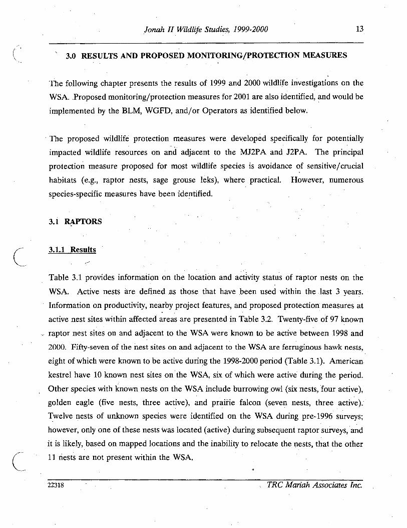
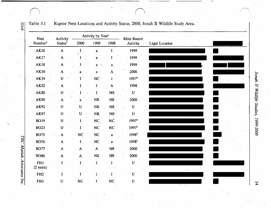
I
0 lt~~()
~ I Table 31 Raptor Nest Locations and Activity Status 2000 Jonah II Wildlife Study Area l- ~
Activity by Yearl
Nest Activity Most Recent Numberz Status3 2000 1999 1998 Activity Legal Location
6 (j
~ ~
~
~ ~ cgt ()
Smiddot-~ ~ l
AK16
AK17
AK18
AK30
AK39
AK52
AK80
AK88
AK92
AK97
B019
B023
B075
B076
B077
B086
FHl (2 nests)
FH2
FH3
A
A
A
A
U
A
U
A
U
U
U
U
A
A
A
A
I
I
U
I
I
I
a
I
I
I
a
U
U
I
I
NC
I
A
A
I
I
NC
a
a
a
a
NC
I
I
NR
NR
NR
NC
NC
NC
NC
A
NR
I
I
I
a
A
A
NR
NR
NR
NR~
NC
NC
a
a
NR
NR
I
I
NC
1999
1999
1999
2000
19975
1998
U
2000
U
U
19975
19975
19985
19985
2000
2000
U
U
U
~ sect
~ 5 ~
~ ~
c
[ ~
io-o 0 0 0bull-I c c c
I- ~
n n ~ I Table 31 (Continued) 00
I Activity by yearl
Nest Activity Most Recent Number2 Status3 2000 1999 1998 Activity Legal Location
S ()
~ ~ ~ ~ nS ~
S p
FH4
FH5
FH6
FH7
FH8
FH9
FHlO
FHll
FHl2 (2 nests)
FH13
FH14
FH15
FH20
FH21
FH22
FH24middot
FH25
FH26 (3 nests)
A
I
I
I
I
I
I
I
1
1
Amiddot
I
I
I
1
A
1
A
A6 A I
I I
I I I
I I I
I I I
I I I
I I
I I J
1 I I
I 1 1
1 N I
18I I
I I
I I I
I I I
a I NC
I I I
a a I
2000
pre-1996
pre-1998
pre-1998
1996
pre-1998
pre-1998
pre-1996
pre-1997
pre-1998
1999
1999
pre-1997
pre-1997
pre-1998
2000
pre-1998
2000
~ ~
sect ~
~ ~
[ ~
~ ~ Q Q Q
I
N
~ ~
I c
c
00
I
~n n fj I Table 31 (Continued)
Nest Nurnber2
FH28
FH29
FH37 (2 nests)
FH38
FH42
FH43 (2 nestS)
FH53
FH54 (2 nests)
FH55
FH56
FH575 (2 nests)()
FH58 ~ FH59~ (3 nests)
~ FH60ltgt ()
Smiddot FH62 ~
FH64~ I
Activity Status3
U
U
A
A
I
I
A
I
I
I
I
U
I
I
I
U
Activity by Year
2000 1999 1998
I I NC
I NC
I A A
A NC I
I I
I I I
I I A
I I
I I I
I I I
I I I
NC I I
I I I
I I
I I I
I I NC
Most Recent Activity
1996s
pre-1996s
1999
2000
pre-1998
pre-1998
1998
pre-1998
pre-1998
pre-1997
pre-1997
pre-1998
pre-1997
pre-1997
pre-1997
pre-1997
Legal Location
~ ~ Il
~
~ $t ~ (1i
CrI E Il ~~ 0 0 0 I) ltgt ltgt ltgt
t-- 01
00
I
n (
~ I Table 31 (Continued)
Nest Number2
FH65
FH66 (2 nests)
FH67
FH68
FH69
FH70
FH71
FH73
FH78
FH82
FH83
FH84
~ FH85 ()
(2middot nests)
FH87~ sect
FH89 ~ tl middotF~90 n fi FH91 ~
FH93middot~ ~
Activity Status3
I
I
I
1
A
I
I
I
U
U
U
U
U
U
U
U
U
U
Activity by Year l
Most Recent Legal Location UTM Coordinates4
2000
I
I
I
I
a
I
I
I
NC
I
I
I
I
I
I
U
I
1999
I
I
I
I
I
I
I
I
I
I
I
I
NR
NR
NR
NR
NR
1998
I
I
I
I
I
I
I
I
NR
NR
NR
NR
NR
NR
NR
NR
NR
NR
Activity
pre-1997
pre-1997
pre-1998
pre-1997
2000
pre-1998
1997
pre-1996
U
Us
U
U
U
U
U
Umiddot
U
U
~ I Il ~
~
~ is S
[ ~
~
0 0 0
I
N ltgt ltgt ltgt
c
-l
n o ~I Table 31 (Continued) 00
I Nest Activity
Activity by Yearl
Most Recent Number2 Status3 2000 1999 1998 Activity Legal Location UTM Coordinates4
FH95 U I NR NR U (4 nests)
FH96 U I NR U
GE36 A A 1 I 2000
GE47 A A A 2000 (2 nests)
GE48 1 1 1 1 pre-1996
GE51 A A 1 1 2000
GE72 I 1 pre-1998
PF27 U 1 ~ 1 U 19975
A8PF41 A U U 19985
PF61 1 1 1 I 1997 nfa
PF63 1 1 1 pre-1998 nfa
PF79 A A NR 1999 nfa~ () PF81 A A a NR 2000 na
~ PF94 U 1 NR NR U nfag 19UN31 NC NC NC U na
~ ~ 19UN32 NC NC NC U nfac ()
19 ~ UN33 NC NC NC U nfa ~
19 UN34 NC NC NC U nla~ p
~ ~ sect ~
~
[ (Ii
~
~ Q
~ bullI) cc c
I- 00
II n ~ I Table 31 (Cont~nued) 00
I Nest Activity
Activity by Yearl
Most Recent Number2 Status 2000 1999 1998 Activity Legal Location trfM Coordinates
UN35 19 NC NC NC U nla
UN40 I~ NC NC NC U nla
UN44 19 NC NC NC U nla
UN45 19 NC NC NC U nla
UN46 19 NC NC NC U nla
UN49 19 NC NC NC U nla
UN50 A 1 alO 1 1999
UN74 U I 1 NC U nla
~ ti (j
sect ~
g ~ ~ g $5 ~
~ fl
I A = active a = likely active I = inactive NC = not checkednot located NR = nest had not yet been recorded U = unknown 2 FHI = ferruginous hawk nest 1 AK16 = American kestrel nest 16 B019 = burrowing owl nest 19 GE36 = golden eagle nest 36
PF27 = prairie falcon nest 27 UN31 =unknown species nest 31 Overall activity status is based on the BLM definition of an active nest as one which has been active in at least 1 of the past 3 years For
overall activity status nests for which activity was likely but not confirmed were considered active (A) Nests which were assigned an unknown acti~ity status (U) lack a ~onclusive activity determin~tion for at least 1 of the past 3 years andor w~re n~wly recorded and have not been momtored for 3 consecutive years Nests confirmed mactlve m all of the past 3 years are deemed mactlve (I)
E = easting N = northing nla = not available S Date is of last confirmed activity but a~tivity status was unknown in at least 1 of the past 3 years thus more recent activity may have
occurred 6 Used by prairie falcon 7 Used in 1999 by golden eagle 8 Used by common raven 9 Detailed searches for these nests in 1999 and 2000 found no raptor activity in the area of the mapped nest sites therefore nests were
assumed to be inactive 10 Possibly used by great horned owl or prairie falcon
~
~
~ ~
[ Ci
~ ~ P
sect
~ 0
n n Table 32 Summary of Active Raptor Nests Within 10 Mi of Existing or Proposed Disturbance Jonah II Wildlife Study ~
i-I Area1 00
Species Seasonal Nest Production -Nest Nest Buffer Nol Legal Location Condition Radius Eggs Nestlings Fledglings Nearby Project Features MitigationActions
AKI6 Unknown 05 mi 0 0 0 Numerous existing and proposed Continue activity status and project features within 05 mi productivity monitoring
AK17 Unknown 05 mi 0 0 0 Numerous existing and proposed Continue activity status and project features within 05 mi productivi~ monitoring
AKIS Unknown 05 mi 0 0 0 Numerous existing and proposed Continue activity status and project features within 10 mi produ~tivity monitoring
8075 Unknown 05 mi U U U Numerous existing and proposed Con tinue activity status and project features within 05 mi productivity monitoring
8077 UnknoWn 05 mi U U I 1999 Numerous existing and proposed Continue activity status and project features within 10 mi productivity monitoring
FH47 Unknown 10 mi 3 1999 2 1 (died) One proposed well pad within Continue activity status and (1 died) 1999 10 mi productivity monitoring if
1999 territolY 6 is inactive in 2001 shy potential development of ANS(s)
FH148 Good 10 mi 3 1997 U 2 1997 Numerous existing and proposed Colltinue activity status and 1 1999 - U U project features within to mi productivity monitoring if
egg failed limited alternative nest sites territolY 5 is inactive in 2001 available in territolY 5 potential development of ANS(s)shy
FH24 Destroyed 10 mi 0 0 0 Numerous proposed features within Continued monitoring the area for 10 mi limited alternative nest sites new and active nests
FH53 Good 10 mi 3 2 1998 21998 B1rma Road within 05 mi Continue activity status and (1 didnt productivity monitoring hatCh)~ 1998
~ ()
FH69 Good 10 mi 0 0 0 Road and pipeline occur within Continue activity status and 10 mi productivity monitoring
$l
t
Active nests defined by activity or likely activity in at least one of the past three nesting seasons See Appendix B Raptor Nesting Records for further detail See Appendix A Wildlife Map for nest locations FH = ferruginous hawk (see Table 33 for nesting territolY) AK = American kestrel BO burrowing owl
tl C
Presents number of items and year U unknown ~ See Appendix A Project Features Map
Seasonal and standard avoidance measures are not included since they would be applied as necessalY for all active nests ~ Used by prairie falcon in 2000
~ Used by golden eagle in 1999 0
~ s sect ~
~ ~ sflS
V
~ ~ shyQQ QI tv C)
g
N 0
21 Jonah II Wildlife Studies 1999-2000
( Since several active raptor nests on the area occur at distances greater than 1 mi from
existing and proposed oil and gas disturbance sites (and thus productivity monitoring is not
required) productivity data for some nests are limited (see Appendix C) Ferruginous hawk
nests in the WSA are known to have produced two fledglings in 1998 one in 1999 and none
in 2000 Ferruginous hawk nest 4 was active in 1999 and produced two young--both of
which died--one as a nestling and one as a fledgling A definitive cause for nest failure was
not identified but the dead fledgling was found decapitated In 2000 the nest was used by
prairie falcons and appeared to produce no fledglings
Nest productivity for other raptor species during 1999 and 2000 include three burrowing owl
fledglings (one in 1999 two in 2000 [nestsgt 10 mi from disturbance]) additional burrowing
owl young may have fledged from other known nests in the area Golden eagles fledged
three to four young in 2000 (nests gt10 mi from disturbance) American kestrels and prairie
falcon also had active nests in the area during the period and likely fledged young birds
c Themiddot approximate locations of ferruginousmiddot hawk nest territories present on and adjacent to
the WSA are shown on the Wildlife Map in Appendix A and briefly described in Table 33
An estimated 11 nesting territories are present on the WSA six of which have been
occupied at least once during the last 3 years (1998-2000) Project features proximal to th~
active nests in these territories are identified in Table 32 and Appendix A (Project Features
Map) Project featuresdevelopments on the J2PA exist and are further planned proximal
to nest territories 5 6 and 7~ Other activities (eg recreational activitiesoff-road vehicle
use livestock grazing wildlifepredator interactions climate) likely occur and will continue
to occur in these and other territories Ferruginous hawk nesting terrItory7 was not active
during the 3-year period and all known nest sites in the territory are at suboptimal locations
(Le on theground surface with easy access by predators) therefore nesting in territory 7
is unlikely to occur in all but the most active nesting years (Le when all other nearby
nesting territories are occupied) It is also possible that nest territories 5 6 and 7 and nest
site 24 will remain unused or will have limited success during the life of the Jonah II Field
22318 TRC Mariah Associates Inc
22 Jonah II Wildlife Studies 1999-2000
Table 33 Nests and 1998-2000 Activity Status at Ferruginous Hawk Nesting Territories Jonah II Wildlife Study Area)
Activity Status3
Nests Included in Territory Territory2 1998 1999 2000
1 68-71middot I Imiddot A (unknown luccess)
2 62 64-67 84-85 I I I 96
3 56-58 60 83 I I I
4 26 28-29 95 I I A (unknown success)
5 13-15 I I
C
A4 (failed)
6 2-12 78 I A AS (failed) (unknown success)
7 20-21 73 I I I
8 53-55 82 A I I (2 fledged)
9 42-43 I I I
10 37-38 A A AS (unknown success) (unknown success) (unknown success)
11 5990 I I I
See Appendix A Wildlife Map for locations No nesting territory is established for nests 1222425 and 91
3 Further detail is provided in Appendix C Raptor Nesting Record I = inactive A = active Used by golden eagle Used by prairie falcon
22318 TRC Mariah Associates Inc
23 Jonah II Wildlife Studies 1999-2000
( Mitigation measures as defined in Section 312 are recommended for territoriesS and 6
in 2001
Project facilities are proposed for development within 05 mi of three active American
kestrel nests and two active burrowing owl nes~s (see Table 32) Continued monitoring
efforts ~re proposed for these nest sites (see Section 312)
312 MonitoringProtection Measures
The primary mitigation measure for raptor species on the WSA is avoidance of active nest
locations during the breedingmiddot season Active nests are defined asraptor nests that have
been used within the last 3 years Unless excepted by the BLM during APD and ROW
application reviews all surface-disturbing activities will be restricted from February 1
through July 31 within a 05-mi radius of active rap tar nests except ferruginous hawk nests
for which the seasonal buffer will be 10 mi (see Table 32) In addition well locations
roads ancillary facilities and other surface structures requiring repeated human presence
will not be constructed within 825 ft of active raptor n~sts where practicaL Th~ seasonal
buffermiddot dist~nce and exclusion dates may vary depending on factors such as nest activity
status rapior species prey availability natural topographic barriers and line-of-sight
distances
Nest activity status and productivity monitoring will continue in 2001 as identified in the
ROD (BLM 1998a [Append~ E] BLM 2000b) Nest activity status will be monitored from
the ground Additionally uUknown nests 31-35 40 44-46 and 49 are recommended for
removal from maps arid further monitoring
In 2001 nestnest area photos will be taken of all raptar nest locations for which photos are
lacking (Table 34) (see Appendix C Raptor Nest Records)
22318 TRC Mariah Associates Inc
24 Jonah II Wildlife Studies 1999-2000
( Table 34 Raptor Nest Locations for WhichmiddotPhotos are Needed Jonah II Wildlife Study Area 2000
Species Nest Numbers
American kestrel
Burrowing owl
Ferruginous hawk
Golden eagle
Prairie falcon
Unknown
17 30 39 52 88 92 97
19 23 75 76 77 86 -
1 (2 nests) 2 3 5 6 7 11 22 28 29 37 38 42 70 78 82 89 91 93 95 (4 nests)
48
27 41 94
74
Well locations roads ancillary facilities and other surface structures requiring repeated
human presence will not be constructed within 825 ft (2000 ft for bald eagles) of active
raptor nests where practical Facility construction in these areas will require specific
approval from the BLM wildlife biologist and Authorized Officer
Operators will notify the BLM immediately if raptors are found nesting on project facilities
If nest manipulation or a situation requiring a taking of a raptor nest becomes necessary
a special permit will be obtained from the Denver USFWS Office Permit Section Permit
acquisition will be coordinated with the Wyoming State USFWS Office in Cheyenne and will
be initiated with sIJfficient lead time to allow for development of mitigation measures
Required corresponding permits will be obtained from theWGFD in Cheyenne
Consultation and coordination with the USFWS and WGFD will be conducted for all
mitigation activities relating to raptors
Because project development continues on and adjacent to active ferruginous hawk
territories 5 and 6 it is recommended that two artificial nesting structures (ANSs) be
established within or adjacent to these territories in 2001 if the territories remain inactive
22318 TRC Mariah Associates Inc
25 Jonah II Wildlife Studies 1999-2000
or unproductive during 2001 Operators ~l assist the BLM (in consultation with other land
users) as necessary in locating appropriate ANS sites and erecting ANSs It is recommended
that ANSs be established outside of existing and known future disturbance areas The lowshy
lying areas in Section 33 T29N R 107W appear to provide suitable areas for ANS locations
in territory 6 ANS construction arid maintenance activities will be completed between
August 1 and September 15 2001 Operators will be responsible for the annual
maintenance of ANSs throughout the life-of-project and all ANSs on public lands will
become the property of themiddotBLM upon completion of the project Additional mitigations
for nesting raptors would be designed on a site-specific basis as necessary in consultation
with the BLM USFWS and WGFD
In future years additional ANSs may be constructed (up to two ANSs for each impacted
nest) or existing degraded raptor nests may be upgradedreinforced to mitigate potential
)impacts The location of ANSs or nests proposed for upgrading will be identified in annual
reports ANSs will be located within or proximal to potentially affected nesting territories ( outside of the line-of-sight or nest buffer of actively nesting raptor pairs and at sites
sufficiently removed from development activities to minimize or avoid potential adverse
effects
In cases where existing project features (eg well locations) are located within the buffer
areas for active raptor nests no extensive maintenance activities (eg workovers ) will be
allowed during critical periods (Le approximately early March through midJune) The
exact dates of exclusion will be determined by the BLM and specified in Conditiolls of
Approval for APD and ROW applications and will likely vary among nests and from
year-to-year depending upon the raptorspecies and variations in weather nesting
chronology and other factors
c 22318 TRC Mariah Associates Inc
26 Jonah II Wildlife Studies 1999-2000
32 SAGE GROUSE
321 Results
Table 3S presents a summary of recent sage grouse lek use (1998-2000) nearby project
features and proposed monitoring and other actions for leks on the WSA (see Appendix D
Sage Grouse Lek R~cords for further detail) Table 36 presents historic information on
lek use since 1992 Lek middot16 was not surveyed during the period therefore no data on lek
use are presented
c
Of the 22 known leks on the WSA leks 1 2 3 7 9 10 17 18 19 21 and 22 have shown
considerable use during monitoring and no notable declines in use were identified
(Table 36 and Appendix D Sage Grouse Lek Records) Decreasing attendance has been
observed at lek 4 with maximum male attendance down from 16 in 1994 to one in 2000 and
due to the extent of n~arby project development this lek may continue to have low levels
or no use throughout the remainder of project development Nomales were observed at
leks S 6 8 11 1213 14 or1S in the last 3 t04 years (Table 36) and these leks also may
continue to be unused for the remainder of project develppment
Five new leks were located during 1999 (leks 17 and 18) and 2000 (leks 19 21 and 22)
Noise monitoring at leks 7 and 8 on the WSA and the lek near the Bird Canyon compressor
station are provided in Table 37
Habitat mapping of the MJ2P A during 2000 primarily conducted to assist in defining
optimal sage grouse nesting and brood-rearing areas found that dense sa~ebrush was the
most common habitat type occupying approxim4tely 89 (26S82 acres 41S rnF) of the
MJ2PA (see Appendix A Habitat Map) This habitat type generally occurs in flat to rolling
terrain and exhibits sagebrush cover of gt20 (Table 38) Wyoming and mountain big
22318 TRC Mariah Associates Inc
() (1 ~
~ ITable 35 Summary of Sage Grouse Lek Use Potential Impacts and Proposed Monitoring Jonah II Wildlife Study Area 20001
Lek Approximate No2 Location Status3 Use Nearby Project Features4 MonitoringOther Actionss
~ ()
~ ~
s
A tl n Et- ~
~ f
2
3
4
5
6
7
8
9
10
11
A
A
A
A
A
A
A
I
Relatively consistent
Relatively consistent
Relatively consistent
Decreasing maximum male attendance since 1996
No known use since pre-1997
No known use since pre-1997
Relatively consistent
No known use since pre-1997
Relatively consistent
Relatively consistent
No known use since pre-1994
One existing and numerous proposed wells and roads within 10 mij one proposed location within 025 mi
Existing pipeline within 025 mi numerous existing and proposed wells and roads within 10 mi
Proposed well and road within 025 mi one existing and another proposed well and road within 10 mi
One existingand two proposed wells and roads within 025 mi numerous proposed and existing wells pipelines and roads within 10 mi
Existing well pipelines and roads within 025 mi new wells proposed within 025 mi proposed and existing wells pipelines and roads within 10 mi
Existing road at let
Existing pipeline within 10 mi
Existing pipeline and road and one proposed well within 10 mi
Proposed well within 10 mi
Existing and proposed wells and roads within 10 mi
Proposed road within 025 mi proposed wells and roads within 10 mi
Monitor attendance three times in 2001 j move proposed well outside 025-mi buffer
Monitor attendance three times in 2001 ensure proposed wells and roads are outside 025-mi buffer
Monitor attendance three times in 2001 move proposed well and road to outside 025-mi buffer
Monitor attendance three times in 2001 move proposed wells and roads to outside 025-mi buffer
Discontinue monitoring
Discontinue monitoring
Monitor attendance three times in 2001 monitor noise levels in 2001 GPS lek perimeters in 2001
Discontinue monitoring
Monitor attendance three times in 2001 GPS lek perimeters in 2001
Monitor attendance three times in 2001 monitor noise levels in 2001
Discontinue monitoring in 2001 move prop~sed road to outside 025-mi buffer
~ l
sect ~
~ sectgni
~gt ~
0 0 0
I
tJ
~ C
N
c
-l
00
n n ~ ITable 35 (Continued)
Lek Approximate No2 Location Status3 Use Nearby Project Features4 MonitoringOther Actionss
12 Limited use since pre-1992 Existing well and roads within 10 mi
13 No known use since None pre--1996
14 No known use since Existing road within 10 mi pre-1992
15 No known use since Existing and proposed wells pipelines and pre-1997 roads within 025 mi
16 U Unknown None
17 A Relatively consistent since Proposed road within 10 mi 1999 (first located in 1999)
18 A Possible increased Existing road within 025 mi proposed well attendance since 1999 (first and road within 10 mi
located in 1999)
19 A First located in 2000 None
20 U Unknown Existing road within 025 mi
~ (j 21 A First located in 2000 Proposed well and road within 10 mi
~ sect
22
A Pirst located in 2000 Proposed ells and roads within 10 mi
~ tl g jl See Appendix A Wildlife Map and Appendix D Sage Grouse Lek Records for additional infonnation - 2 See Table 36 for alternate names $)
~ 3 A = active (at least once during last 3 years) I = inactive U = unknowntj See Appendix A Project Features Map
~ Seasonal and standard avoidance measures are not included since they would be applied as necessary for all leks ))
Monitor attendance three times in 2001 search for alternate nearby lek sites in 2001 if no use discontinue monitoring in 2002
Discontinue monitoring
Discontinue monitoring
Discontinue monitoring in 2001
Monitor attendance three times in 2001
Monitor attendance three times in 2001 GPS lek perimeters in 2001
Monitor attendance three times in 2001
Monitor attendancethree times in 2001 GPS lek perimeters in 2001
Monitor attendance three times in 2001 GPS lek perimeters in 2001
Monitor attendance three times in 2001 GPS lek perimeters in 2001
Monitor attendance three times in 2001 GPS lek perimeters in 2001
monitoring action not necessarily required
~ sect ~ ~ -
[ (IS
~
g P
sect N
~
29 Jonah II Wildlife Studies 1999-2000
Table 36 Sage Grouse Trends Jonah II Wildlife Study Area 1992-20001
History2 Lek
No Lek Name 1992 1993 1994 1995 1996 1997 1998 1999 2000
4-2 NS NS 9 NS 26 6 31 25 22
2 4-6 NS NS 2 NS 2 17 12 7 14
3 Sand Draw Reservoirmiddot NS NS NS NS 16 o 36 26 22
4 Clay H~ NS NS 16 NS 15 4 4 o 1
5 4-8 NS NS NS NS 1 o o o NS
6 4-9 NS NS NS NS 3 o o o o
7 4-7 NS NS 36 NS o 16 17 11 9
8 4-10 NS NS NS NS 2 o o o o
9 Alkali Draw NS NS NS NS NS 50 26 62 47
10 The Rocks NS NS NS NS NS 60 53 79 64
11 4-5 NS NS o NS o NS o o o
12 3-8 o o o 4 o 0+ o
13 3-6 NS NS NS NS o o o o o
14 3-7 o o 0 o o o o o o
15 Sand Draw NS NS NS NS o o o o
16 Long Draw UNK UNK UNK qNK UNK UNK UNK UNK UNK
17 Buckhorn Well 1 NS NS llS NS NS NS NS 5 3
18 Shelter Cabin NS NS NS NS NS NS NS 50+ 90 Reservoir
19 Prairie Dog Town 5 NS NS NS NS NS NS NS NS 9
20 Upper Alkali Creek NS NS o NS o NS NS NS NS
21 South Rocks NS NS NS NS NS NS NS NS 10
22 Antelope State NS NS NS NS NS NS NS NS 9
Further detail is provided in Appendix D Sage Grouse Lek Records 2 Numbers refer to maximum male attendance NS = not surveyed UNK = unknown + = unclassified birds
observed but not included
22318 TRC Mariah Associates Inc
30 Jonah II Wildlife Studies 1999-2000
( Table 37 Summary of Noise Data Collection at the Bird Canyon and Lumen Compressor Stations Jonah II Wildlife Study Area 2000
Noise Output l Relative Location Time (decibels) Windspeed Humidity
Bird Canyon June 1 2000 Compressor Station
04 mi to north 600 to 700 am 372 - 501 (4370) 5 mph from SW 26
04 mi to south 600 to 700 am 413 - 545 (4790) 3 mph from SW 26
04 mi to east 600 to 700 am 480 - 514 (4970) 2 mph from SW 26
04 mi to west 600 to 700 am 367 - 465 (4160) 4 mph from SW 26
Directly at Station 600 to 700 am 731 - 746 (7385)
Lumen Compressor Station June 32000
Lek 557 am 369 - 424 (3965) 3 mph from NW 15
Lek8 537 am 395 - 535 (4650) 5 mph from NW 15
Directly at Station 652 - 667 (6595)
I bull All noise output readings represent a decibel range between the minimum and maximum values recorded during a 2- to 3-minute interval at each particular sampling location Average outputs fall near the medians Numbers in parentheses are median values
sagebrush (Artemisia tridentata wyomingensis and A t vaseyana respectively) are the most
co~on shrub species with rabbitbrush (Chrysothamnus spp) also present Subshrubs in
this habitat type include granite prickly gilia (Leptodactylon pungens) broom snakeweed
(Gutierrezia sarothrae) and winterfat (Kraschenninikovia lanata) which is generally
uncommon Forbs include stemless goldenweed (Happlopappus acaulis) Hoods phlox
(Phlox hoodU)and miners candle (Cryptantha spp)and grass species include wheatgrasses
(Agropyron spp) Indian ricegnlss (Oryzopsis hymenoides) fescue
(Festuca ~p) and
needleandthread (Stipa comata)
The moderate density sagebrush type (9 of the MJ2PA 2605 acres 41 mi2) is most
middot commonly found in the southeastern portion of the project area where i~ typically occurs
-
22318 TRC Mariah Associates Inc
C
31 Jonah II Wildlife Studies 1999 2000
( Table 38 Results of Vegetation Studies MJ2P A 20001
Productive Sage Grouse MJ2PA Vegetation Type2 Habitat Characteristics
Moderate Dense Density Basin
Sagebrush Sagebrush Sagebrush NestinglEarly Late Parameter (n=15) (n=15) (n=5) Brood-rearing Brood-rearing
Sagebrush height (inches) 98 79 310 45 12-32 12-32
Percent sagebrush cover
Daubenmire 217 45 65 308 15-25 10-25
Line intercept 245 45 (99) 79 (89) 367 (79)
Percent total shrub cover
Daubenmire 220 68 314 -shyLine intercept 247 (99) 81 (92) 380 (80)
Grassforb height (inches) 56 65 65 gt70 Variable 4inch minimum
( Percent grass and forb 106 (89) 151 45(96) 201 45 gt 13 gt13 cover (65)
Residual grass height 63 61 65 4-5 (irtchesY
Percent residual grass 85 4 109 4 2014 gt3 cover
Sagebrush plants acre 7260 (99) 2636(92) 4494 (86)
Total shrubsacre 7665 (99) 2951 (96) 5088 (91 )
Data on file at TRC Mariah Laramie Wyoming measurements recorded in late summer 2 See Appendix A Habitat Map for locations Numbers in parentheses are the confidence level achieved with
80 precision using the z statistic derived from the following formula ~
s where
n = sample size d = 02 (for 80 precision) X = sample mean s = sample standard deviation
3 See Table 21 for references measurements recorded during late spritigearly summer Meets nestingearly brood-rearing characteristics
5 Meets late brood-rearing characteristics 6 Excludes pre-2000 litter in MJ2PA samples
22318 TRC Mariah Associates Inc
32 Jonah II Wildlife Studies 1999-2000
( on sideslopes It is characterized by an average of approximately 6-8 sagebrush cover
(Table 38) with spiny hopsage(Grayia spinosa) and scattered rabbitbrush also present
Subshrubs include snakeweed Gardners saltbush (A triplex gardneri) and winterfat Grass
and forb species composition is generally similar to that observed in the dense sagebrush
type
The basin sagebrush (Artemisia tridentata tridentata) type ( lt 1 of the MJ2P A 236 acres
04 mi2) is characterized by a narrow strip of tall dense basin sagebrush along the Sand
Draw drainage (see Appendix A Habitat Map) Understory is relatively sparse with some
scattered rabbitbrush and mixed grasses and forbs
(shy
Scatteredno sagebrush habitat (2 of the MJ2P A 575 acres 09 mi2) occurs in small
pockets within the project area (see Appendix A Habitat Map) These unsampled areas
are generally associated with playas rocky outcrops or steep slopes and they typically grade
into the moderate density sagebrush habitat type
Measured vegetation parameters within the three sampled vegetation types in the MJ2PA
were in no instance consistent with the qualitative and quantitative parameters for
productive sage grouse nesting or brood-rearing described in Table38 However the dense
sagebrush and basin sagebrush types in combination apparently provide adequate conditions
(with the exception of understory grassforb and residual grass heights) for sage grouse
nesting since sage grouse nesting and brood-rearing is known to occur in the area
Furthermore since year 2000 vegetation sampling in the MJ2P A occurred late in the
summer during a dry year and whereas sampling to determine productive nesting and
brood-rearing habitat parameters occurred immediately fo~lowing chick hatching (late
spring early summer) it is likely that some portion of the understory (grasses and forbs) was
lost to desiccation and wind andor grazing resulting in the potential for underestimation
of both cover anltlheight of grasses and forbs during the year 2000 vegetation sampling
22318 TRC Mariah Associates Inc
c
33 Jonah IIWildlife Studies 1999-2000
322 Monitoring and Protection Measures
Monitoring and identification of sage grouse leks on the WSA will continue in 2001 as
specified in the WMPP (BLM 1998a Appendix E) and the EA for the Modified Jonah Field
II Project (BLM 2000b)
It is recommended that the WGFD or BLM continue to implement aerial (fixed wing) sage
grouse lek inventories of the WSA in 2001 to provide further lek locational data and to
identify any new or previously undiscovered leks Additionally WGFD andlor BLM will
use GPS to determine lek perimeters in 2001 at leks 7 9 171920 21 and 22 Aerial
surveys will be implemented during Marchi April The absence ofldecreased use of leks 4
5 6 8 1112 13 14 and 15 may indicate that alternate lek siteS are being used therefore
it isreltommended that additional observations be made in 2001 in the vicinity of these leks
to locate any new unmapped leks
Due to the apparent lack of use over the last few years at leks 5 6 8 11 12 13 14 and 15
it is recommended that lek attendanc~ monitoring at these leks be discontinued in 2001
Attendance monitoring at these leks may be reinitiated once field development is complete
Attendance monitoring of other known sage grouse leks in the area by WGFD and Ior BLM
personnel will continue in 2001 as during past years and specified in the RoD (BLM 1998a
Appendix E) and deemed necessary by the BLM and WGFD
As requested by the BLM and WGFD noise monitoring will be implemented in 2001 at leks
7and 10 within the WSA and at the Bird Canyon lek located approximately 04 mi southeast
of the Bird Canyon Compressor Station southwest of the WSA Continuous noise
monitoring will be conducted from 5 am to 9 am on four separate occasions during the
period of March 15middotApril 30 at the three leks Noise monitoring equipment will include a
Bruel amp Kjaer Model 2260 precision integrating sound meter and octave bandmiddot analyzer
(noise frequency) with a data logger (meets ANSI 514-1983 Type 1 sound level meter
22318 TRC Mariah Associates Inc
34 Jonah II Wildlife Studies 1999-2000
( requirements) Noise meaSurements will be logged every 5minutes over the duration of the
5-hour sampling period and data will be downloa~ed daily for storage and analysis The
meter will be calibrated daily with a Bruel amp Kjaer Model 4231 sound level calibrator The
microphone will be fitted with a windscreen to reduce wind-generated noise and will be
mounted at the edge of each lek approximately 3 ft above the ground Contributing noise
sources will be identified and recorded as well as prevailing meteorological conditions i
(Le wind speed and direction temperature humidity and cloud cover)
As with raptors the principal protection for sage grouse is avoidance of leks during the
breeding season and the avoidance of probable nesting areas during the nesting season If
an active sage grouse nest is identified during the nesting season (April 1 - July 31) i
surface-disturbing activities will be delayed untilnestibg is completed
All surface-disturbingmiddot activities including pipeline construction will be avoided within
025 mi of active sage grouse leks and no permanent high profile structures such as
buildings and storage tanks which are suitable raptor perches will be constructed within
025 mi of any lek Therefore the proposed project features (ie well locations roads
pipelines) proximal to leks 1345 11 and 15 may require relocation to sites greater than
025 mi from the lek centers Well location and road and pipeline construction within
025 mi of leks 5 11 and 15 may be permitted in 2~OI (as authorized by BLM) since these
leks have exhibited little or no use during monitoring and are considered inactive
Operators will restrict construction activities between March 1 and June 30 within a
20-mi radius of active sage grouse leks to protect sage grouse nesting habitat and Will avoid
all drilling and construction activities from March 1 to May 15 on all areas within 10 mi of
active sage grouse leksmiddot to protect sage grouse breeding activities Operators will also
maintain a 05-mi disturbance-free buffer around middotleks 7 (and 8 south of the MJ2P A
(see Appendix A Wi~dlife Maps)
22318 TRCMariah Associates Inc
35 Jonah II Wildlife Studies 1999-2000
( While Operators have committed to avoiding optimal sage grouse nesting habitat during the
nesting period where practical (BLM 2000b) n optimal (productive) habitat has been
identified in the MJ2PA (see Table 38) However since sage grouse nesting and
brood-rearingmiddot is known to occur in the sagebrush-dominated habitats on the area it is
recommended that no disturbance (other than linear crossings) be authorized within the
basin sagebrush type (this type is currently protected by drainage buffers [see Appendix A
Habitat Map J) and that disturbance within the dense sagebrush type be avoided during the
nesting period
It is recommended that the BLM implement formal sage grouse winter use investigations
on the J2PA and a O5-mi buffer during late winter (JanuaryFebruary) 2001 to further
identify sage grouse wintering areas These surveys should be conducted on the ground and
all data collected should be provided on General Wildlife Observation Data Sheets or other
suitable forms (see Appendix B) Operators will cooperate in any further ongoing sage
grouse studies within the WSA and with the WGFD on any existing and new sage grouse
habitat improvement efforts (eg water developments) within Upland Game Bird
Management Area 7
Removal of water development structures proximal to lek 4 (Clay Hill) may occur in 2001
as directed by BLM Removal of these facilities may eliminate potential raptor perch sites
andor reduce the use of this area by livestock and humans
Operators will utilize directional drilling to access resources beneath the 025-mi active sage
grorise lek buffers (see Appendix A Wildlife Map) and beneath the 600-poundt wide (or tall
sagebrush-dominated) buffer associated with Sand Draw Granite Wash and Alkali Draw
protection areas if reserves beneath these locations are deemed economically feasible
c__ 22318 TRC Mariah Associates Inc
36 Jonah II Wildlife Studies 1999-2000
(
-33 THREATENED ENDANGERED PROPOSED CANDIDATE AND WYOMING
SPECIES OF CONCERN
I331 Results
3311 Black-footed Ferret
No black-footed ferrets or black-footed ferret sign was observed on the J2PA during the
black-footed ferret survey conducted on the area during 1999 Survey results are presented
in McMurry (1999) which is available for review at the BLM Pinedale Field Office
No PDTs with burrow densities suitable as black-footed ferret habitat (Le gt8 burrows
acre) were identified in the MJ2PA during year 2000 (Table 39) However portions of
PDTs 8 16 17 and 18 in the southeastern portion of the WSA have prairie dog burrow
densities suitable for black-footed ferret (see Appendix A Habitat Map) and black-footed
ferret surveys may be required if developments are proposed within these townS
3312 Bald Eagle Ferruginous Hawk Golden Eagle
No bald eagles were observed on the WSA during 1999 and 2000 wildlife investigations
Information on ferruginous hawks and golden eagles is provided in Section 311
3313 Mountain Plover
Mountain plover were observed for the first time adjacent to the J2PA during 1999 and a
single plover was observed within the J2PA during 2000 (see Appendix B) Adults with at
least two young were recorded on separate occasions outside the J2P A during 1999
indicating the presence of mountain plover breeding in the Alkali Creek drainage
22318 TRC Mariah Associates Inc
c
C
37 Jonah II Wildlife Studies 1999-2000
Table 39 Whitetail Prairie Dog Towns Jonah II Wildlife Study Area 2000
Prairie Dog Number of Burrow Density Town Acreage2 Open Burrows2 3 (burrowsacre)2 5
1 400 326 08
2 423 458 11
3 825 39 lt01
4 903 NS UNK
NS 5 106 UNK
6 358 724 20
7 800 NS UNK
8 1246 (131) 2084 (103) 45 (142)
9 280 NS UNK
10 39 NS UNK
11 203 NS UNK
12 79 NS UNK
13 86 NS UNK
14 105 NS UNK -
15 189 NS UNK
16 203 (52) (35)4 ~9 (138)
17 141 (30) 364 (26) 65 (156)
18 357 (55) 544 (43) 41 (166)
19 10 NS UNK
20 9 NS UNK
See Appendix A Habitat Map for location 2 Numbers in parentheses are for high density areas (Schlumberger Geco-Prackla 2000) 3 NS = not surveyed 4 Sample only 5 UNK = unknown
22318 TRC Mariah Associates Inc
38 Jonah II Wildlife Studies 1999-2000
( (Appendix B) No mountain plover were observed during species-specific investigations on
and within 05 mi of the MJ2PA during 2000 (see Appendix E)
3314 Western Burrowing Owl
Six western burrowing owl nestsnest sites were observed on the WSAfrom 1997 to 2000
(see Tables 31 and 32 and Appendix C Raptor Nesting Records) Of these nests only two
are known to have produced young however burrowing owl nests 75 and 76 were not
monitored for productivity during 1998 and 1999 and these nests may have successfully
produced young in these years
3315 Other TEPCamp WSC Species
The only other known TEPCamp WSC noted on the WSA during 1999 and 2000 surveys and
on-site investigations conducted during APD and ROW reviews was the loggerhead shrike
and it is possible that the species bred in the area during these years
I
332 Monitoring and ProtectiOn
USFWS andor WGFD consultation and coordination will be conducted for all necessary
mitigation activities relating to TEPCampWSC and their habitats implemented during 2001
3321 Black-footed Ferret
All whitetail PDTs within the J2P A have been mapped and those within the MJ2P A were
remapped and censused for op~n burrows in 2000 to determine whether they meet the
black-footep ferret habitat criteria established in the USFWS (1989) guidelines Proposed
disturbance in PDTs 1 2 3 and 6 will not adversely affect black-footed ferrets since these
towns are not suitable as black-footed ferret habitat
22318 TRC Mariah Associates Inc
I
39 Jonah Ii Wildlife Studies 1999-2000
~ During 2001 PDTs 12 3 and 6 will bereinvesiigated to locate and map the areas within
these towns that have the highest burrow densities GPS will be used to map these areas
Burrow densities will be censused within the areas of highest burrow density
If PDTsportions of PDTs of sufficient size and burr~w densitr for black-footed ferret
habitat are scheduled to be disturbed black-footed ferret surveys of these townstown
portions will be conducted Survey protocol will adhere to USFWS guidelines as established
in USFWS (1989) Surveys will be conducted by a USFWS-qualified biologist no more than
1 year prior to proposed disturbance and reports identifying survey methods and results will
be prepared and submitted to the USFWS and BLM in accordance with Section 7 of the
Endangered SpeCies Act of 1973 as amended and Interagency Cooperation Regulations
Surveys will be financed by the Operators
If black-footed ferrets are found within the J2PA but outside the MJ2P A the USFWS will
be notified immediately and formal consultations will be initiated to develop strategies that
ensure no adverse effects to the species If black-footed ferretsmiddot are found within the
MJ2PA the USFWS will be notified immediately and no further disturbance would occur
to the prairie dog complex in which the black-footed ferret was observed Before
ground-disturbing activities are initiated in black-footed ferret habitat authorizations to
proceed would be required from the BLM in consultation with the USFWS
3322 Bald Eagle Ferruginous Hawk Golden Eagle
Monitoring and protection protocol for bald eagle ferruginous hawk and golden eagle in
2001 will be as described for raptors (see Section 312) Additional measures will be
applied on a species- or site-specific basis as deemed necessary by the USFWS andor
BLM if potential impacts to these species are identified during 2001 APD and ROW
application reviews
22318 TRC Mariah Associates Inc
40 Jonah II Wildlife Studies 1999-2000
( 3323middot Mountain Plover
The following protocol has been modified from that presented in BLM (1998a Appendix E)
to accommodate USFWS changes to mountain plover survey and avoidance protocoL The
protocol remains consistent with that presented in BLM (2000b)
During the period of May I-June 15 2001 mountain plover surveys will be conducted by
an Operator-financedBLM-approved biologist in accordance with USFWS guidelines
(USFWS 1999) on suitable breeding areas throughout the MJ2PA and a 05-mi buffer (see
AppendiX A Habitat Map) Survey procedures will be as follows
bull surveys will be conducted during early courtship and territory establishment
bull surveys will be conducted from sunrise to 1000 am andor from 530 pm
to sunset
bull surveys will be conducte4 from four-wheel-drive vehicles or where access is
a problem andor no visual observations are made from vehicles ATVs will
be used
bull surveyors will remain in or close to yehicles when scanning with binoculars
bull after 2QOl surveys for mountain plover will be conductedmiddot in appropriate
habitat within 200 m (656 ft) of proposed disturbance sites
bull sites will be surveyed three times during the survey window (May I-June 15)
with each survey separated by at least 14 days
bull surveys will not be conducted in inclement weather (eg poor visibility)
surveys will focus on locating displaying or calling males
bull if breeding birds are observed additional surveys will be implemented
immediately prior to construction to search for active nest sites (applicable to
only post-2001 surveys)
bull if an active nest is located a 656-ft buffer zone will be established around the
nest to prevent direct and indirect nest disturbance and
bull gt surface-disturbing activities will occur as near to completion of surVeys as
possible
22318 TRC Mariah Associates Inc
41 Jonah II Wildlife Studfes 1999-2000
Mountain plover surveys will not be conducted for construction activities planned for the
period of July 11 through April 9 Survey results will be compared with the annual
development plans to determine if any proposed surface-disturbing activities will affect
occupied mountain plover nesting habitat Where practicable development plans will be
modified to avoid nesting habitat (eg through road realignment)
If an active nest is found in thesurveyarea planned activities will be delayed 37 days or
1 week post-hatching or if a brood of flightless chicks is observed activities will be delayed
at least 7 days
Where access roads andor well locations have been qmstructed prior to the mountain -
plover nesting season (April 10-July 10) and use of these areas has not been initiated for
development actions prior to April 10 a BLM-approved Qiologist will conduct site
investigations of these diSturbed areas prior to use to determine whether mountain plover
are present In the event plover nesting is occurring Operators will delay development
activities until nesting is complete
Nest success and productjvity of all mountain plover nests found within the MJ2PA will be
monitored and reported to the BLM and USFWS Wyoming Field Office annually
Prior to implementing surface disturbance within 200 m (656 ft) of known mountain plover
concentration areas (Le areas where broods andor adults have been ~bserved in the
current year or documented in at least 2 of the last 3 years) Operators will consult with the
BLM regarding initiation of informal conferencing with the USFWS
If removal of mountain plover nesting habitat is unavoidable loss will be minimized by
creating additional nesting habitat it is assumed that many of the existing and proposed
pipeline reclamation areas on the MJ2P A would provide suitable plover breeding habitats
Areas of pipeline reclamation that provide suitable plover beeding areas will be identified
annually If nesting habitat is disturbed the area will be reclaimed to approximate original
TRC Mariah Associates Inc 22318
c
42 Jonah II Wildlife Studies 1999-2000
( conditions (topography vegetation hydrology etc) aftercompletio~ of activities such that
disturbed potential mountain plover breeding habitat is reclaImed to conditions suitable for
mountain plover breeding
Operators will minimize road construction and maintenance activities (ie grading) In
suitable plover habitat from April 10- July 10 No surface-disturbing activities will be
conducted from April 1 - June 30 within 656 ft of identified mountain plover concentration
areas (ie areas where broods andor adults have been observed in the current year or
documented in at least 2 of the past 3 years)
3324 Western Burrowing Owl
Monitoring and avoidance of prairie dog colonies (see Section 3321) and avoidance of
active raptor nests during the nesting period (see Section 312) will continue in 2001
Additianally productivity monitoring will be implemented for all active burrowing owl nests
on the MJ2PA and a surrounding OS-mi area Additional measures may be applied in
future years if burrowing owl nesting andor productivity in the WSA is noted to be
declining These potential measures will be identified by the BLM
3325 Other TEPCampWSC Species
No formal surveys for other TEPCampWSC are proposed for 2001 however since loggerhead
shrike have been seen in the area special attention to this species is recommended for APD
and ROW application field reviews If during implementation of surveys for other species
or during APD and ROW application field reviews any TEPCampWSC is observed on areas
within OSmi of proposed disturbance sites nests or other crucial features for the observed
species if any will be avoided Consultation and coordination with the BLM USFWS and
WGFD will also be conducted as necessary Construction activities in these areas will be
curtailed untilthere is concurrence among Operators BLM USFWS and WGFD on what
22318 TRC Mariah Associates Inc
c
c
43 Jonah II Wildlife Studies 1999-2000
activities can be authorIzed Activities will in most cases be delayed until such time that
no adverse effects would occur (eg after fledging)
No additional protection measures will be applied for other sensitive species potentially
present on the WSA however it is assumed that the protection protocol specified below for
general wildlife will benefit TEPCampWSC as well (see Section 3332) In addition if
TEPCamp WSC are observed efforts will be made to determine the activities of the species
on the WSA (eg breeding nesting foraging hunting) If any management agency
(ie BLM WGFD USFWS) identifies a potential for impacts to any TEPCampWSC species
additional monitoring andor protection measures will be implemented as directed by the
BLM
333 General Wildlife
3331 Results
Data on other wildlife species observed on the WSA durin~ 1999 and 2000 surveys are
provided in Appendix R and in APD andROW application field review data available at
the BLM Pinedale Field Office
3332 Monitoring and Protection
No formal wildlife monitoring for other wildlife is recommended for 2001
Protection measures primarily designed to minimize impacts to other area resources
(eg vegetation and surface water resources Including wetlands steep slopes) are identified
in BLM (1998a 2000b) andthese measures provide additional impact mitigation forarea
wildlife Well locations access roads pipelines and ancillary facillties will be selected and bull bull I
designed to minimize disturbances to areas of high wildlife habitat value including wetlands
~ and riparian areas Areas with high erosion potential andor rugged topography (Le steep
(- slopes dunes floodplains unstable soils ) will be avoided where practical ~
22318 TRC Mariah Associates Inc
44 Jonah II Wildlife Studies 1999-2000
Removal or disturbance of vegetation will be minimized through construction site
management (eg by utilizing previously disturbed areas using existing ROWs designating
limited equipmentmaterials storage yards and staging areas scalping) and Operators will
adhere to all reclamation guidelines presented in the Reclamation Plan for this project
(see Appendix B in BLM 1997 1998a and 1998b)
To minimize wildlife mortality due to vehicle collisions Operators will continue to advise
project personnel regarding appropriate speed limits (Le35 mph) in the project area and
roads will be reclaimed as soon as possible after they are no longer required Some existing
roads in the area may be closed and reclaimed by Operators as authorized by the BLM
No roads are currently proposed for reclamation
To protect plant populations and wildlife habitat project-related travel will be restricted to
established project roads no off-road travel will be allowed except in emergencies
c No road or pipeline ROW fencing is proposed however if ROW fencing is required it will
be kept to amiddot minimum and the fences employed ~ll consist of four-strand barbed wire
which meets BLM and WGFD approval for facilitating wildlife movement Wildlife-proofI
fencing will be utilized only to enclose reclaimed areas where it is determined that wildlife
species are impeding successful vegetation establishment No improvements to existing
fences on the area are currently proposed
No new wildlifelivestock water sources are currently proposed for development
Potential increases in poaching will be minimized through continued employee and
contractor education regarding wildlife laws and Operators will notify all employees
( contract and company) that conviction of a major game violation could result in disciplinary
action Ifviolations are discovered Operators will immediately ntify theBLM and WGFD
and if the violation involves an employee or contractor said employee or contractor will bemiddot disciplined and may be dismissed by the Operator andor prosecuted by the WGFD
C
22318 TRC Mariah Associates Inc
45 Jonah II Wildlife Studies 1999-2000
Additional nonspecies-specitlc wildlife mitigations include the following
bull Reserve workover evaporation and flare pits potentially hazardous to
wildlife will be adequately protected by netting andor fencing as directed by
the BLM to prevent access bYmigratory birds and other wildlife
bull Siphons will be constructed at each reserve pit to collect as necessary any
undesirable materials that may enter the pits
bull Potential impacts to fisheries will be minimized by using proper erosion
control techniques (eg water bars jute netting rip-rap mUlch)
Construction within 500 ft of open water and 100 ft of intermittent or
ephemeral channels will be avoided where possible Channel crossings for
roads and pipelines will be constructed when flows are not expected (Le late
summer or fall) All necessary crossings will be constructed perpendicular to
flow No surface water or shallow groundwater in connection with surface
water will be utilized for the proposed project
bull Firearms and dogs will not be allowed on the J2P A during working hours by
BLM or Operator employees or their contractors Operators will enforce
existing drug alcohol and firearms policies
bull If injured wildlife are observed on the J2P A Operator personnel will contact
the BLM Pinedale Field Office and the WGFD Pinedale Office Under no
circumstances will injured wildlife be approac4ed or handled
bull Wildlife reporting as specified in the ROD (BLM 1998 Appendix E) will be
continued in 2001 (
22318 TRC Mariah Associates Inc
I
46 Jonah II Wildlife Studies 1999-2000
( 40 LITERATURE CITED
Anderson RM 1996 1996 Prairie Dog Raptor and Sage Grouse Inventory of McMurry Oil Companys Expanded Jonah Field Natural Gas Development Project Sublette County Wyoming Prepared for McMurry Oi~ Company Casper Wyoming by Anderson Environmental Consulting Casper Wyoming 13 pp
Baxter GT and MDmiddot Stone 1980 Amphibians and Reptiles of Wyoming Wyoming Game and Fish Department Bulletin No 16 137 pp
Bureau of Land M~nagement 1997 Draft Environmental Impact Btatement Jonah Field II Natural Gas Project US Department of the Interior Bureau of Land Management Rock Springs District Office Pinedale and Green River Resource Areas BLMWY PL-97 015 + 1310
__ 1998a ~ecord of Decision for Jonah Field II Natural Gas Development Project Environmental Impact Statement Sublette County Wyoming US Bureau of Land Management Rock Springs DistrictPinedale and Green River Resource Areas 43 pp + append
__ 1998b Final Environmental Impact Statement Jonah Field II Natural Gas Project US Department of the Interior Bureau of Land Management Pinedale and Green River Resource Areas BLMWY PL-98001 + 1310
__ 1999 1997 and 1998 Wildlife Studies Jonah Field II Natural Gas Development Project Prepared for US Bureau of Land Management Pinedale Field Office Pinedale Wyoming and Rock Springs Field Office Rock Springs Wyoming by TRC Mariah Associates Inc Laramie Wyoming 32 pp + append
__I _ bull 2000a Decision Record and Finding of No Significant Impact for the Modified Jonah Field II Natural Gas Project Sublette County Wyoming US Bureau of Land Management Pinedale and Rock Springs Field Offices BLMWY PL-001j 019+ 1310
__ middot2000b Environmental Assessment and Finding of No Significant Impact for the Modified Jonah Field II Natural Gas Project Sublette County Wyoming US Department of the Interior Bureau of Land Management Pinedale and Rock Springs Field Offices BLMWY jPL-00lj009+ 1310
Dorn JL and RD Dom 1990 Wyoming Birds Mountain West Publishing Cheyenne Wyoming 138 pp
22318 TRC Mariah Associates Inc
47 Jonah II Wildlife Studies 1999-2000
Fertig W 1997 Wyoming Plant and Animal Species of Special Concern Prepared for the Wyoming Natural Diversity Database 32pp
McMurry Oil Company 1999 Black-footed Ferret and Burrowing Owl Survey of a Prairie Dog Colony in Portions of Sections 29 30 31 and 32 T29N R108W Sections 25 and 36 T29NR109W Sublette County Wyoming Prepared for McMurry Oil Company Pinedale Wyoming by Monarch Wildlife Consultants Pinedale Wyoming 9 pp + append~
Schlumberger Geco-Prakla 2000 Final Black-footed Ferret and Burrowing Owl Surveys South Jonah Seismic Exploration Project Sublette County Wyoming Prepared for Schlumbergermiddot Geco-Prakla Midland Texas by TRC Mariah Associates Inc Laramie Wyoming 7 pp + append
US Fish and Wildlife Service 1989 Black-footed Ferret Survey Guidelines for Compliance with the Endangered Species Act US Fish and Wildlife Service Denver Colorado and Albuquerque New Mexico (April 1989) 10 p + append
__ 1999 Mountain Plover Survey Guidelines US Fish and Wildlife Service 1999 Photocopy 6 pp
Wyoming Game and Fish Department 1992 Wyoming Bird and Mammal Atlas 170 pp ___ 1996 Wyoming observation system records Biological Services Wyoming Game
and Fish Department Cheyenne Wyoming
___ 1999 Wyoming observation system records Biological Services Wyoming Game and Fish Department Cheyenne Wyoming
22318 TRC Mariah Associates Inc
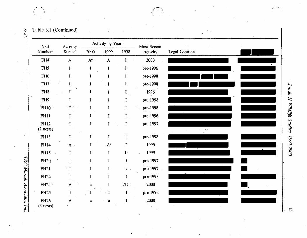
00
I
~n n fj I Table 31 (Continued)
Nest Nurnber2
FH28
FH29
FH37 (2 nests)
FH38
FH42
FH43 (2 nestS)
FH53
FH54 (2 nests)
FH55
FH56
FH575 (2 nests)()
FH58 ~ FH59~ (3 nests)
~ FH60ltgt ()
Smiddot FH62 ~
FH64~ I
Activity Status3
U
U
A
A
I
I
A
I
I
I
I
U
I
I
I
U
Activity by Year
2000 1999 1998
I I NC
I NC
I A A
A NC I
I I
I I I
I I A
I I
I I I
I I I
I I I
NC I I
I I I
I I
I I I
I I NC
Most Recent Activity
1996s
pre-1996s
1999
2000
pre-1998
pre-1998
1998
pre-1998
pre-1998
pre-1997
pre-1997
pre-1998
pre-1997
pre-1997
pre-1997
pre-1997
Legal Location
~ ~ Il
~
~ $t ~ (1i
CrI E Il ~~ 0 0 0 I) ltgt ltgt ltgt
t-- 01
00
I
n (
~ I Table 31 (Continued)
Nest Number2
FH65
FH66 (2 nests)
FH67
FH68
FH69
FH70
FH71
FH73
FH78
FH82
FH83
FH84
~ FH85 ()
(2middot nests)
FH87~ sect
FH89 ~ tl middotF~90 n fi FH91 ~
FH93middot~ ~
Activity Status3
I
I
I
1
A
I
I
I
U
U
U
U
U
U
U
U
U
U
Activity by Year l
Most Recent Legal Location UTM Coordinates4
2000
I
I
I
I
a
I
I
I
NC
I
I
I
I
I
I
U
I
1999
I
I
I
I
I
I
I
I
I
I
I
I
NR
NR
NR
NR
NR
1998
I
I
I
I
I
I
I
I
NR
NR
NR
NR
NR
NR
NR
NR
NR
NR
Activity
pre-1997
pre-1997
pre-1998
pre-1997
2000
pre-1998
1997
pre-1996
U
Us
U
U
U
U
U
Umiddot
U
U
~ I Il ~
~
~ is S
[ ~
~
0 0 0
I
N ltgt ltgt ltgt
c
-l
n o ~I Table 31 (Continued) 00
I Nest Activity
Activity by Yearl
Most Recent Number2 Status3 2000 1999 1998 Activity Legal Location UTM Coordinates4
FH95 U I NR NR U (4 nests)
FH96 U I NR U
GE36 A A 1 I 2000
GE47 A A A 2000 (2 nests)
GE48 1 1 1 1 pre-1996
GE51 A A 1 1 2000
GE72 I 1 pre-1998
PF27 U 1 ~ 1 U 19975
A8PF41 A U U 19985
PF61 1 1 1 I 1997 nfa
PF63 1 1 1 pre-1998 nfa
PF79 A A NR 1999 nfa~ () PF81 A A a NR 2000 na
~ PF94 U 1 NR NR U nfag 19UN31 NC NC NC U na
~ ~ 19UN32 NC NC NC U nfac ()
19 ~ UN33 NC NC NC U nfa ~
19 UN34 NC NC NC U nla~ p
~ ~ sect ~
~
[ (Ii
~
~ Q
~ bullI) cc c
I- 00
II n ~ I Table 31 (Cont~nued) 00
I Nest Activity
Activity by Yearl
Most Recent Number2 Status 2000 1999 1998 Activity Legal Location trfM Coordinates
UN35 19 NC NC NC U nla
UN40 I~ NC NC NC U nla
UN44 19 NC NC NC U nla
UN45 19 NC NC NC U nla
UN46 19 NC NC NC U nla
UN49 19 NC NC NC U nla
UN50 A 1 alO 1 1999
UN74 U I 1 NC U nla
~ ti (j
sect ~
g ~ ~ g $5 ~
~ fl
I A = active a = likely active I = inactive NC = not checkednot located NR = nest had not yet been recorded U = unknown 2 FHI = ferruginous hawk nest 1 AK16 = American kestrel nest 16 B019 = burrowing owl nest 19 GE36 = golden eagle nest 36
PF27 = prairie falcon nest 27 UN31 =unknown species nest 31 Overall activity status is based on the BLM definition of an active nest as one which has been active in at least 1 of the past 3 years For
overall activity status nests for which activity was likely but not confirmed were considered active (A) Nests which were assigned an unknown acti~ity status (U) lack a ~onclusive activity determin~tion for at least 1 of the past 3 years andor w~re n~wly recorded and have not been momtored for 3 consecutive years Nests confirmed mactlve m all of the past 3 years are deemed mactlve (I)
E = easting N = northing nla = not available S Date is of last confirmed activity but a~tivity status was unknown in at least 1 of the past 3 years thus more recent activity may have
occurred 6 Used by prairie falcon 7 Used in 1999 by golden eagle 8 Used by common raven 9 Detailed searches for these nests in 1999 and 2000 found no raptor activity in the area of the mapped nest sites therefore nests were
assumed to be inactive 10 Possibly used by great horned owl or prairie falcon
~
~
~ ~
[ Ci
~ ~ P
sect
~ 0
n n Table 32 Summary of Active Raptor Nests Within 10 Mi of Existing or Proposed Disturbance Jonah II Wildlife Study ~
i-I Area1 00
Species Seasonal Nest Production -Nest Nest Buffer Nol Legal Location Condition Radius Eggs Nestlings Fledglings Nearby Project Features MitigationActions
AKI6 Unknown 05 mi 0 0 0 Numerous existing and proposed Continue activity status and project features within 05 mi productivity monitoring
AK17 Unknown 05 mi 0 0 0 Numerous existing and proposed Continue activity status and project features within 05 mi productivi~ monitoring
AKIS Unknown 05 mi 0 0 0 Numerous existing and proposed Continue activity status and project features within 10 mi produ~tivity monitoring
8075 Unknown 05 mi U U U Numerous existing and proposed Con tinue activity status and project features within 05 mi productivity monitoring
8077 UnknoWn 05 mi U U I 1999 Numerous existing and proposed Continue activity status and project features within 10 mi productivity monitoring
FH47 Unknown 10 mi 3 1999 2 1 (died) One proposed well pad within Continue activity status and (1 died) 1999 10 mi productivity monitoring if
1999 territolY 6 is inactive in 2001 shy potential development of ANS(s)
FH148 Good 10 mi 3 1997 U 2 1997 Numerous existing and proposed Colltinue activity status and 1 1999 - U U project features within to mi productivity monitoring if
egg failed limited alternative nest sites territolY 5 is inactive in 2001 available in territolY 5 potential development of ANS(s)shy
FH24 Destroyed 10 mi 0 0 0 Numerous proposed features within Continued monitoring the area for 10 mi limited alternative nest sites new and active nests
FH53 Good 10 mi 3 2 1998 21998 B1rma Road within 05 mi Continue activity status and (1 didnt productivity monitoring hatCh)~ 1998
~ ()
FH69 Good 10 mi 0 0 0 Road and pipeline occur within Continue activity status and 10 mi productivity monitoring
$l
t
Active nests defined by activity or likely activity in at least one of the past three nesting seasons See Appendix B Raptor Nesting Records for further detail See Appendix A Wildlife Map for nest locations FH = ferruginous hawk (see Table 33 for nesting territolY) AK = American kestrel BO burrowing owl
tl C
Presents number of items and year U unknown ~ See Appendix A Project Features Map
Seasonal and standard avoidance measures are not included since they would be applied as necessalY for all active nests ~ Used by prairie falcon in 2000
~ Used by golden eagle in 1999 0
~ s sect ~
~ ~ sflS
V
~ ~ shyQQ QI tv C)
g
N 0
21 Jonah II Wildlife Studies 1999-2000
( Since several active raptor nests on the area occur at distances greater than 1 mi from
existing and proposed oil and gas disturbance sites (and thus productivity monitoring is not
required) productivity data for some nests are limited (see Appendix C) Ferruginous hawk
nests in the WSA are known to have produced two fledglings in 1998 one in 1999 and none
in 2000 Ferruginous hawk nest 4 was active in 1999 and produced two young--both of
which died--one as a nestling and one as a fledgling A definitive cause for nest failure was
not identified but the dead fledgling was found decapitated In 2000 the nest was used by
prairie falcons and appeared to produce no fledglings
Nest productivity for other raptor species during 1999 and 2000 include three burrowing owl
fledglings (one in 1999 two in 2000 [nestsgt 10 mi from disturbance]) additional burrowing
owl young may have fledged from other known nests in the area Golden eagles fledged
three to four young in 2000 (nests gt10 mi from disturbance) American kestrels and prairie
falcon also had active nests in the area during the period and likely fledged young birds
c Themiddot approximate locations of ferruginousmiddot hawk nest territories present on and adjacent to
the WSA are shown on the Wildlife Map in Appendix A and briefly described in Table 33
An estimated 11 nesting territories are present on the WSA six of which have been
occupied at least once during the last 3 years (1998-2000) Project features proximal to th~
active nests in these territories are identified in Table 32 and Appendix A (Project Features
Map) Project featuresdevelopments on the J2PA exist and are further planned proximal
to nest territories 5 6 and 7~ Other activities (eg recreational activitiesoff-road vehicle
use livestock grazing wildlifepredator interactions climate) likely occur and will continue
to occur in these and other territories Ferruginous hawk nesting terrItory7 was not active
during the 3-year period and all known nest sites in the territory are at suboptimal locations
(Le on theground surface with easy access by predators) therefore nesting in territory 7
is unlikely to occur in all but the most active nesting years (Le when all other nearby
nesting territories are occupied) It is also possible that nest territories 5 6 and 7 and nest
site 24 will remain unused or will have limited success during the life of the Jonah II Field
22318 TRC Mariah Associates Inc
22 Jonah II Wildlife Studies 1999-2000
Table 33 Nests and 1998-2000 Activity Status at Ferruginous Hawk Nesting Territories Jonah II Wildlife Study Area)
Activity Status3
Nests Included in Territory Territory2 1998 1999 2000
1 68-71middot I Imiddot A (unknown luccess)
2 62 64-67 84-85 I I I 96
3 56-58 60 83 I I I
4 26 28-29 95 I I A (unknown success)
5 13-15 I I
C
A4 (failed)
6 2-12 78 I A AS (failed) (unknown success)
7 20-21 73 I I I
8 53-55 82 A I I (2 fledged)
9 42-43 I I I
10 37-38 A A AS (unknown success) (unknown success) (unknown success)
11 5990 I I I
See Appendix A Wildlife Map for locations No nesting territory is established for nests 1222425 and 91
3 Further detail is provided in Appendix C Raptor Nesting Record I = inactive A = active Used by golden eagle Used by prairie falcon
22318 TRC Mariah Associates Inc
23 Jonah II Wildlife Studies 1999-2000
( Mitigation measures as defined in Section 312 are recommended for territoriesS and 6
in 2001
Project facilities are proposed for development within 05 mi of three active American
kestrel nests and two active burrowing owl nes~s (see Table 32) Continued monitoring
efforts ~re proposed for these nest sites (see Section 312)
312 MonitoringProtection Measures
The primary mitigation measure for raptor species on the WSA is avoidance of active nest
locations during the breedingmiddot season Active nests are defined asraptor nests that have
been used within the last 3 years Unless excepted by the BLM during APD and ROW
application reviews all surface-disturbing activities will be restricted from February 1
through July 31 within a 05-mi radius of active rap tar nests except ferruginous hawk nests
for which the seasonal buffer will be 10 mi (see Table 32) In addition well locations
roads ancillary facilities and other surface structures requiring repeated human presence
will not be constructed within 825 ft of active raptor n~sts where practicaL Th~ seasonal
buffermiddot dist~nce and exclusion dates may vary depending on factors such as nest activity
status rapior species prey availability natural topographic barriers and line-of-sight
distances
Nest activity status and productivity monitoring will continue in 2001 as identified in the
ROD (BLM 1998a [Append~ E] BLM 2000b) Nest activity status will be monitored from
the ground Additionally uUknown nests 31-35 40 44-46 and 49 are recommended for
removal from maps arid further monitoring
In 2001 nestnest area photos will be taken of all raptar nest locations for which photos are
lacking (Table 34) (see Appendix C Raptor Nest Records)
22318 TRC Mariah Associates Inc
24 Jonah II Wildlife Studies 1999-2000
( Table 34 Raptor Nest Locations for WhichmiddotPhotos are Needed Jonah II Wildlife Study Area 2000
Species Nest Numbers
American kestrel
Burrowing owl
Ferruginous hawk
Golden eagle
Prairie falcon
Unknown
17 30 39 52 88 92 97
19 23 75 76 77 86 -
1 (2 nests) 2 3 5 6 7 11 22 28 29 37 38 42 70 78 82 89 91 93 95 (4 nests)
48
27 41 94
74
Well locations roads ancillary facilities and other surface structures requiring repeated
human presence will not be constructed within 825 ft (2000 ft for bald eagles) of active
raptor nests where practical Facility construction in these areas will require specific
approval from the BLM wildlife biologist and Authorized Officer
Operators will notify the BLM immediately if raptors are found nesting on project facilities
If nest manipulation or a situation requiring a taking of a raptor nest becomes necessary
a special permit will be obtained from the Denver USFWS Office Permit Section Permit
acquisition will be coordinated with the Wyoming State USFWS Office in Cheyenne and will
be initiated with sIJfficient lead time to allow for development of mitigation measures
Required corresponding permits will be obtained from theWGFD in Cheyenne
Consultation and coordination with the USFWS and WGFD will be conducted for all
mitigation activities relating to raptors
Because project development continues on and adjacent to active ferruginous hawk
territories 5 and 6 it is recommended that two artificial nesting structures (ANSs) be
established within or adjacent to these territories in 2001 if the territories remain inactive
22318 TRC Mariah Associates Inc
25 Jonah II Wildlife Studies 1999-2000
or unproductive during 2001 Operators ~l assist the BLM (in consultation with other land
users) as necessary in locating appropriate ANS sites and erecting ANSs It is recommended
that ANSs be established outside of existing and known future disturbance areas The lowshy
lying areas in Section 33 T29N R 107W appear to provide suitable areas for ANS locations
in territory 6 ANS construction arid maintenance activities will be completed between
August 1 and September 15 2001 Operators will be responsible for the annual
maintenance of ANSs throughout the life-of-project and all ANSs on public lands will
become the property of themiddotBLM upon completion of the project Additional mitigations
for nesting raptors would be designed on a site-specific basis as necessary in consultation
with the BLM USFWS and WGFD
In future years additional ANSs may be constructed (up to two ANSs for each impacted
nest) or existing degraded raptor nests may be upgradedreinforced to mitigate potential
)impacts The location of ANSs or nests proposed for upgrading will be identified in annual
reports ANSs will be located within or proximal to potentially affected nesting territories ( outside of the line-of-sight or nest buffer of actively nesting raptor pairs and at sites
sufficiently removed from development activities to minimize or avoid potential adverse
effects
In cases where existing project features (eg well locations) are located within the buffer
areas for active raptor nests no extensive maintenance activities (eg workovers ) will be
allowed during critical periods (Le approximately early March through midJune) The
exact dates of exclusion will be determined by the BLM and specified in Conditiolls of
Approval for APD and ROW applications and will likely vary among nests and from
year-to-year depending upon the raptorspecies and variations in weather nesting
chronology and other factors
c 22318 TRC Mariah Associates Inc
26 Jonah II Wildlife Studies 1999-2000
32 SAGE GROUSE
321 Results
Table 3S presents a summary of recent sage grouse lek use (1998-2000) nearby project
features and proposed monitoring and other actions for leks on the WSA (see Appendix D
Sage Grouse Lek R~cords for further detail) Table 36 presents historic information on
lek use since 1992 Lek middot16 was not surveyed during the period therefore no data on lek
use are presented
c
Of the 22 known leks on the WSA leks 1 2 3 7 9 10 17 18 19 21 and 22 have shown
considerable use during monitoring and no notable declines in use were identified
(Table 36 and Appendix D Sage Grouse Lek Records) Decreasing attendance has been
observed at lek 4 with maximum male attendance down from 16 in 1994 to one in 2000 and
due to the extent of n~arby project development this lek may continue to have low levels
or no use throughout the remainder of project development Nomales were observed at
leks S 6 8 11 1213 14 or1S in the last 3 t04 years (Table 36) and these leks also may
continue to be unused for the remainder of project develppment
Five new leks were located during 1999 (leks 17 and 18) and 2000 (leks 19 21 and 22)
Noise monitoring at leks 7 and 8 on the WSA and the lek near the Bird Canyon compressor
station are provided in Table 37
Habitat mapping of the MJ2P A during 2000 primarily conducted to assist in defining
optimal sage grouse nesting and brood-rearing areas found that dense sa~ebrush was the
most common habitat type occupying approxim4tely 89 (26S82 acres 41S rnF) of the
MJ2PA (see Appendix A Habitat Map) This habitat type generally occurs in flat to rolling
terrain and exhibits sagebrush cover of gt20 (Table 38) Wyoming and mountain big
22318 TRC Mariah Associates Inc
() (1 ~
~ ITable 35 Summary of Sage Grouse Lek Use Potential Impacts and Proposed Monitoring Jonah II Wildlife Study Area 20001
Lek Approximate No2 Location Status3 Use Nearby Project Features4 MonitoringOther Actionss
~ ()
~ ~
s
A tl n Et- ~
~ f
2
3
4
5
6
7
8
9
10
11
A
A
A
A
A
A
A
I
Relatively consistent
Relatively consistent
Relatively consistent
Decreasing maximum male attendance since 1996
No known use since pre-1997
No known use since pre-1997
Relatively consistent
No known use since pre-1997
Relatively consistent
Relatively consistent
No known use since pre-1994
One existing and numerous proposed wells and roads within 10 mij one proposed location within 025 mi
Existing pipeline within 025 mi numerous existing and proposed wells and roads within 10 mi
Proposed well and road within 025 mi one existing and another proposed well and road within 10 mi
One existingand two proposed wells and roads within 025 mi numerous proposed and existing wells pipelines and roads within 10 mi
Existing well pipelines and roads within 025 mi new wells proposed within 025 mi proposed and existing wells pipelines and roads within 10 mi
Existing road at let
Existing pipeline within 10 mi
Existing pipeline and road and one proposed well within 10 mi
Proposed well within 10 mi
Existing and proposed wells and roads within 10 mi
Proposed road within 025 mi proposed wells and roads within 10 mi
Monitor attendance three times in 2001 j move proposed well outside 025-mi buffer
Monitor attendance three times in 2001 ensure proposed wells and roads are outside 025-mi buffer
Monitor attendance three times in 2001 move proposed well and road to outside 025-mi buffer
Monitor attendance three times in 2001 move proposed wells and roads to outside 025-mi buffer
Discontinue monitoring
Discontinue monitoring
Monitor attendance three times in 2001 monitor noise levels in 2001 GPS lek perimeters in 2001
Discontinue monitoring
Monitor attendance three times in 2001 GPS lek perimeters in 2001
Monitor attendance three times in 2001 monitor noise levels in 2001
Discontinue monitoring in 2001 move prop~sed road to outside 025-mi buffer
~ l
sect ~
~ sectgni
~gt ~
0 0 0
I
tJ
~ C
N
c
-l
00
n n ~ ITable 35 (Continued)
Lek Approximate No2 Location Status3 Use Nearby Project Features4 MonitoringOther Actionss
12 Limited use since pre-1992 Existing well and roads within 10 mi
13 No known use since None pre--1996
14 No known use since Existing road within 10 mi pre-1992
15 No known use since Existing and proposed wells pipelines and pre-1997 roads within 025 mi
16 U Unknown None
17 A Relatively consistent since Proposed road within 10 mi 1999 (first located in 1999)
18 A Possible increased Existing road within 025 mi proposed well attendance since 1999 (first and road within 10 mi
located in 1999)
19 A First located in 2000 None
20 U Unknown Existing road within 025 mi
~ (j 21 A First located in 2000 Proposed well and road within 10 mi
~ sect
22
A Pirst located in 2000 Proposed ells and roads within 10 mi
~ tl g jl See Appendix A Wildlife Map and Appendix D Sage Grouse Lek Records for additional infonnation - 2 See Table 36 for alternate names $)
~ 3 A = active (at least once during last 3 years) I = inactive U = unknowntj See Appendix A Project Features Map
~ Seasonal and standard avoidance measures are not included since they would be applied as necessary for all leks ))
Monitor attendance three times in 2001 search for alternate nearby lek sites in 2001 if no use discontinue monitoring in 2002
Discontinue monitoring
Discontinue monitoring
Discontinue monitoring in 2001
Monitor attendance three times in 2001
Monitor attendance three times in 2001 GPS lek perimeters in 2001
Monitor attendance three times in 2001
Monitor attendancethree times in 2001 GPS lek perimeters in 2001
Monitor attendance three times in 2001 GPS lek perimeters in 2001
Monitor attendance three times in 2001 GPS lek perimeters in 2001
Monitor attendance three times in 2001 GPS lek perimeters in 2001
monitoring action not necessarily required
~ sect ~ ~ -
[ (IS
~
g P
sect N
~
29 Jonah II Wildlife Studies 1999-2000
Table 36 Sage Grouse Trends Jonah II Wildlife Study Area 1992-20001
History2 Lek
No Lek Name 1992 1993 1994 1995 1996 1997 1998 1999 2000
4-2 NS NS 9 NS 26 6 31 25 22
2 4-6 NS NS 2 NS 2 17 12 7 14
3 Sand Draw Reservoirmiddot NS NS NS NS 16 o 36 26 22
4 Clay H~ NS NS 16 NS 15 4 4 o 1
5 4-8 NS NS NS NS 1 o o o NS
6 4-9 NS NS NS NS 3 o o o o
7 4-7 NS NS 36 NS o 16 17 11 9
8 4-10 NS NS NS NS 2 o o o o
9 Alkali Draw NS NS NS NS NS 50 26 62 47
10 The Rocks NS NS NS NS NS 60 53 79 64
11 4-5 NS NS o NS o NS o o o
12 3-8 o o o 4 o 0+ o
13 3-6 NS NS NS NS o o o o o
14 3-7 o o 0 o o o o o o
15 Sand Draw NS NS NS NS o o o o
16 Long Draw UNK UNK UNK qNK UNK UNK UNK UNK UNK
17 Buckhorn Well 1 NS NS llS NS NS NS NS 5 3
18 Shelter Cabin NS NS NS NS NS NS NS 50+ 90 Reservoir
19 Prairie Dog Town 5 NS NS NS NS NS NS NS NS 9
20 Upper Alkali Creek NS NS o NS o NS NS NS NS
21 South Rocks NS NS NS NS NS NS NS NS 10
22 Antelope State NS NS NS NS NS NS NS NS 9
Further detail is provided in Appendix D Sage Grouse Lek Records 2 Numbers refer to maximum male attendance NS = not surveyed UNK = unknown + = unclassified birds
observed but not included
22318 TRC Mariah Associates Inc
30 Jonah II Wildlife Studies 1999-2000
( Table 37 Summary of Noise Data Collection at the Bird Canyon and Lumen Compressor Stations Jonah II Wildlife Study Area 2000
Noise Output l Relative Location Time (decibels) Windspeed Humidity
Bird Canyon June 1 2000 Compressor Station
04 mi to north 600 to 700 am 372 - 501 (4370) 5 mph from SW 26
04 mi to south 600 to 700 am 413 - 545 (4790) 3 mph from SW 26
04 mi to east 600 to 700 am 480 - 514 (4970) 2 mph from SW 26
04 mi to west 600 to 700 am 367 - 465 (4160) 4 mph from SW 26
Directly at Station 600 to 700 am 731 - 746 (7385)
Lumen Compressor Station June 32000
Lek 557 am 369 - 424 (3965) 3 mph from NW 15
Lek8 537 am 395 - 535 (4650) 5 mph from NW 15
Directly at Station 652 - 667 (6595)
I bull All noise output readings represent a decibel range between the minimum and maximum values recorded during a 2- to 3-minute interval at each particular sampling location Average outputs fall near the medians Numbers in parentheses are median values
sagebrush (Artemisia tridentata wyomingensis and A t vaseyana respectively) are the most
co~on shrub species with rabbitbrush (Chrysothamnus spp) also present Subshrubs in
this habitat type include granite prickly gilia (Leptodactylon pungens) broom snakeweed
(Gutierrezia sarothrae) and winterfat (Kraschenninikovia lanata) which is generally
uncommon Forbs include stemless goldenweed (Happlopappus acaulis) Hoods phlox
(Phlox hoodU)and miners candle (Cryptantha spp)and grass species include wheatgrasses
(Agropyron spp) Indian ricegnlss (Oryzopsis hymenoides) fescue
(Festuca ~p) and
needleandthread (Stipa comata)
The moderate density sagebrush type (9 of the MJ2PA 2605 acres 41 mi2) is most
middot commonly found in the southeastern portion of the project area where i~ typically occurs
-
22318 TRC Mariah Associates Inc
C
31 Jonah II Wildlife Studies 1999 2000
( Table 38 Results of Vegetation Studies MJ2P A 20001
Productive Sage Grouse MJ2PA Vegetation Type2 Habitat Characteristics
Moderate Dense Density Basin
Sagebrush Sagebrush Sagebrush NestinglEarly Late Parameter (n=15) (n=15) (n=5) Brood-rearing Brood-rearing
Sagebrush height (inches) 98 79 310 45 12-32 12-32
Percent sagebrush cover
Daubenmire 217 45 65 308 15-25 10-25
Line intercept 245 45 (99) 79 (89) 367 (79)
Percent total shrub cover
Daubenmire 220 68 314 -shyLine intercept 247 (99) 81 (92) 380 (80)
Grassforb height (inches) 56 65 65 gt70 Variable 4inch minimum
( Percent grass and forb 106 (89) 151 45(96) 201 45 gt 13 gt13 cover (65)
Residual grass height 63 61 65 4-5 (irtchesY
Percent residual grass 85 4 109 4 2014 gt3 cover
Sagebrush plants acre 7260 (99) 2636(92) 4494 (86)
Total shrubsacre 7665 (99) 2951 (96) 5088 (91 )
Data on file at TRC Mariah Laramie Wyoming measurements recorded in late summer 2 See Appendix A Habitat Map for locations Numbers in parentheses are the confidence level achieved with
80 precision using the z statistic derived from the following formula ~
s where
n = sample size d = 02 (for 80 precision) X = sample mean s = sample standard deviation
3 See Table 21 for references measurements recorded during late spritigearly summer Meets nestingearly brood-rearing characteristics
5 Meets late brood-rearing characteristics 6 Excludes pre-2000 litter in MJ2PA samples
22318 TRC Mariah Associates Inc
32 Jonah II Wildlife Studies 1999-2000
( on sideslopes It is characterized by an average of approximately 6-8 sagebrush cover
(Table 38) with spiny hopsage(Grayia spinosa) and scattered rabbitbrush also present
Subshrubs include snakeweed Gardners saltbush (A triplex gardneri) and winterfat Grass
and forb species composition is generally similar to that observed in the dense sagebrush
type
The basin sagebrush (Artemisia tridentata tridentata) type ( lt 1 of the MJ2P A 236 acres
04 mi2) is characterized by a narrow strip of tall dense basin sagebrush along the Sand
Draw drainage (see Appendix A Habitat Map) Understory is relatively sparse with some
scattered rabbitbrush and mixed grasses and forbs
(shy
Scatteredno sagebrush habitat (2 of the MJ2P A 575 acres 09 mi2) occurs in small
pockets within the project area (see Appendix A Habitat Map) These unsampled areas
are generally associated with playas rocky outcrops or steep slopes and they typically grade
into the moderate density sagebrush habitat type
Measured vegetation parameters within the three sampled vegetation types in the MJ2PA
were in no instance consistent with the qualitative and quantitative parameters for
productive sage grouse nesting or brood-rearing described in Table38 However the dense
sagebrush and basin sagebrush types in combination apparently provide adequate conditions
(with the exception of understory grassforb and residual grass heights) for sage grouse
nesting since sage grouse nesting and brood-rearing is known to occur in the area
Furthermore since year 2000 vegetation sampling in the MJ2P A occurred late in the
summer during a dry year and whereas sampling to determine productive nesting and
brood-rearing habitat parameters occurred immediately fo~lowing chick hatching (late
spring early summer) it is likely that some portion of the understory (grasses and forbs) was
lost to desiccation and wind andor grazing resulting in the potential for underestimation
of both cover anltlheight of grasses and forbs during the year 2000 vegetation sampling
22318 TRC Mariah Associates Inc
c
33 Jonah IIWildlife Studies 1999-2000
322 Monitoring and Protection Measures
Monitoring and identification of sage grouse leks on the WSA will continue in 2001 as
specified in the WMPP (BLM 1998a Appendix E) and the EA for the Modified Jonah Field
II Project (BLM 2000b)
It is recommended that the WGFD or BLM continue to implement aerial (fixed wing) sage
grouse lek inventories of the WSA in 2001 to provide further lek locational data and to
identify any new or previously undiscovered leks Additionally WGFD andlor BLM will
use GPS to determine lek perimeters in 2001 at leks 7 9 171920 21 and 22 Aerial
surveys will be implemented during Marchi April The absence ofldecreased use of leks 4
5 6 8 1112 13 14 and 15 may indicate that alternate lek siteS are being used therefore
it isreltommended that additional observations be made in 2001 in the vicinity of these leks
to locate any new unmapped leks
Due to the apparent lack of use over the last few years at leks 5 6 8 11 12 13 14 and 15
it is recommended that lek attendanc~ monitoring at these leks be discontinued in 2001
Attendance monitoring at these leks may be reinitiated once field development is complete
Attendance monitoring of other known sage grouse leks in the area by WGFD and Ior BLM
personnel will continue in 2001 as during past years and specified in the RoD (BLM 1998a
Appendix E) and deemed necessary by the BLM and WGFD
As requested by the BLM and WGFD noise monitoring will be implemented in 2001 at leks
7and 10 within the WSA and at the Bird Canyon lek located approximately 04 mi southeast
of the Bird Canyon Compressor Station southwest of the WSA Continuous noise
monitoring will be conducted from 5 am to 9 am on four separate occasions during the
period of March 15middotApril 30 at the three leks Noise monitoring equipment will include a
Bruel amp Kjaer Model 2260 precision integrating sound meter and octave bandmiddot analyzer
(noise frequency) with a data logger (meets ANSI 514-1983 Type 1 sound level meter
22318 TRC Mariah Associates Inc
34 Jonah II Wildlife Studies 1999-2000
( requirements) Noise meaSurements will be logged every 5minutes over the duration of the
5-hour sampling period and data will be downloa~ed daily for storage and analysis The
meter will be calibrated daily with a Bruel amp Kjaer Model 4231 sound level calibrator The
microphone will be fitted with a windscreen to reduce wind-generated noise and will be
mounted at the edge of each lek approximately 3 ft above the ground Contributing noise
sources will be identified and recorded as well as prevailing meteorological conditions i
(Le wind speed and direction temperature humidity and cloud cover)
As with raptors the principal protection for sage grouse is avoidance of leks during the
breeding season and the avoidance of probable nesting areas during the nesting season If
an active sage grouse nest is identified during the nesting season (April 1 - July 31) i
surface-disturbing activities will be delayed untilnestibg is completed
All surface-disturbingmiddot activities including pipeline construction will be avoided within
025 mi of active sage grouse leks and no permanent high profile structures such as
buildings and storage tanks which are suitable raptor perches will be constructed within
025 mi of any lek Therefore the proposed project features (ie well locations roads
pipelines) proximal to leks 1345 11 and 15 may require relocation to sites greater than
025 mi from the lek centers Well location and road and pipeline construction within
025 mi of leks 5 11 and 15 may be permitted in 2~OI (as authorized by BLM) since these
leks have exhibited little or no use during monitoring and are considered inactive
Operators will restrict construction activities between March 1 and June 30 within a
20-mi radius of active sage grouse leks to protect sage grouse nesting habitat and Will avoid
all drilling and construction activities from March 1 to May 15 on all areas within 10 mi of
active sage grouse leksmiddot to protect sage grouse breeding activities Operators will also
maintain a 05-mi disturbance-free buffer around middotleks 7 (and 8 south of the MJ2P A
(see Appendix A Wi~dlife Maps)
22318 TRCMariah Associates Inc
35 Jonah II Wildlife Studies 1999-2000
( While Operators have committed to avoiding optimal sage grouse nesting habitat during the
nesting period where practical (BLM 2000b) n optimal (productive) habitat has been
identified in the MJ2PA (see Table 38) However since sage grouse nesting and
brood-rearingmiddot is known to occur in the sagebrush-dominated habitats on the area it is
recommended that no disturbance (other than linear crossings) be authorized within the
basin sagebrush type (this type is currently protected by drainage buffers [see Appendix A
Habitat Map J) and that disturbance within the dense sagebrush type be avoided during the
nesting period
It is recommended that the BLM implement formal sage grouse winter use investigations
on the J2PA and a O5-mi buffer during late winter (JanuaryFebruary) 2001 to further
identify sage grouse wintering areas These surveys should be conducted on the ground and
all data collected should be provided on General Wildlife Observation Data Sheets or other
suitable forms (see Appendix B) Operators will cooperate in any further ongoing sage
grouse studies within the WSA and with the WGFD on any existing and new sage grouse
habitat improvement efforts (eg water developments) within Upland Game Bird
Management Area 7
Removal of water development structures proximal to lek 4 (Clay Hill) may occur in 2001
as directed by BLM Removal of these facilities may eliminate potential raptor perch sites
andor reduce the use of this area by livestock and humans
Operators will utilize directional drilling to access resources beneath the 025-mi active sage
grorise lek buffers (see Appendix A Wildlife Map) and beneath the 600-poundt wide (or tall
sagebrush-dominated) buffer associated with Sand Draw Granite Wash and Alkali Draw
protection areas if reserves beneath these locations are deemed economically feasible
c__ 22318 TRC Mariah Associates Inc
36 Jonah II Wildlife Studies 1999-2000
(
-33 THREATENED ENDANGERED PROPOSED CANDIDATE AND WYOMING
SPECIES OF CONCERN
I331 Results
3311 Black-footed Ferret
No black-footed ferrets or black-footed ferret sign was observed on the J2PA during the
black-footed ferret survey conducted on the area during 1999 Survey results are presented
in McMurry (1999) which is available for review at the BLM Pinedale Field Office
No PDTs with burrow densities suitable as black-footed ferret habitat (Le gt8 burrows
acre) were identified in the MJ2PA during year 2000 (Table 39) However portions of
PDTs 8 16 17 and 18 in the southeastern portion of the WSA have prairie dog burrow
densities suitable for black-footed ferret (see Appendix A Habitat Map) and black-footed
ferret surveys may be required if developments are proposed within these townS
3312 Bald Eagle Ferruginous Hawk Golden Eagle
No bald eagles were observed on the WSA during 1999 and 2000 wildlife investigations
Information on ferruginous hawks and golden eagles is provided in Section 311
3313 Mountain Plover
Mountain plover were observed for the first time adjacent to the J2PA during 1999 and a
single plover was observed within the J2PA during 2000 (see Appendix B) Adults with at
least two young were recorded on separate occasions outside the J2P A during 1999
indicating the presence of mountain plover breeding in the Alkali Creek drainage
22318 TRC Mariah Associates Inc
c
C
37 Jonah II Wildlife Studies 1999-2000
Table 39 Whitetail Prairie Dog Towns Jonah II Wildlife Study Area 2000
Prairie Dog Number of Burrow Density Town Acreage2 Open Burrows2 3 (burrowsacre)2 5
1 400 326 08
2 423 458 11
3 825 39 lt01
4 903 NS UNK
NS 5 106 UNK
6 358 724 20
7 800 NS UNK
8 1246 (131) 2084 (103) 45 (142)
9 280 NS UNK
10 39 NS UNK
11 203 NS UNK
12 79 NS UNK
13 86 NS UNK
14 105 NS UNK -
15 189 NS UNK
16 203 (52) (35)4 ~9 (138)
17 141 (30) 364 (26) 65 (156)
18 357 (55) 544 (43) 41 (166)
19 10 NS UNK
20 9 NS UNK
See Appendix A Habitat Map for location 2 Numbers in parentheses are for high density areas (Schlumberger Geco-Prackla 2000) 3 NS = not surveyed 4 Sample only 5 UNK = unknown
22318 TRC Mariah Associates Inc
38 Jonah II Wildlife Studies 1999-2000
( (Appendix B) No mountain plover were observed during species-specific investigations on
and within 05 mi of the MJ2PA during 2000 (see Appendix E)
3314 Western Burrowing Owl
Six western burrowing owl nestsnest sites were observed on the WSAfrom 1997 to 2000
(see Tables 31 and 32 and Appendix C Raptor Nesting Records) Of these nests only two
are known to have produced young however burrowing owl nests 75 and 76 were not
monitored for productivity during 1998 and 1999 and these nests may have successfully
produced young in these years
3315 Other TEPCamp WSC Species
The only other known TEPCamp WSC noted on the WSA during 1999 and 2000 surveys and
on-site investigations conducted during APD and ROW reviews was the loggerhead shrike
and it is possible that the species bred in the area during these years
I
332 Monitoring and ProtectiOn
USFWS andor WGFD consultation and coordination will be conducted for all necessary
mitigation activities relating to TEPCampWSC and their habitats implemented during 2001
3321 Black-footed Ferret
All whitetail PDTs within the J2P A have been mapped and those within the MJ2P A were
remapped and censused for op~n burrows in 2000 to determine whether they meet the
black-footep ferret habitat criteria established in the USFWS (1989) guidelines Proposed
disturbance in PDTs 1 2 3 and 6 will not adversely affect black-footed ferrets since these
towns are not suitable as black-footed ferret habitat
22318 TRC Mariah Associates Inc
I
39 Jonah Ii Wildlife Studies 1999-2000
~ During 2001 PDTs 12 3 and 6 will bereinvesiigated to locate and map the areas within
these towns that have the highest burrow densities GPS will be used to map these areas
Burrow densities will be censused within the areas of highest burrow density
If PDTsportions of PDTs of sufficient size and burr~w densitr for black-footed ferret
habitat are scheduled to be disturbed black-footed ferret surveys of these townstown
portions will be conducted Survey protocol will adhere to USFWS guidelines as established
in USFWS (1989) Surveys will be conducted by a USFWS-qualified biologist no more than
1 year prior to proposed disturbance and reports identifying survey methods and results will
be prepared and submitted to the USFWS and BLM in accordance with Section 7 of the
Endangered SpeCies Act of 1973 as amended and Interagency Cooperation Regulations
Surveys will be financed by the Operators
If black-footed ferrets are found within the J2PA but outside the MJ2P A the USFWS will
be notified immediately and formal consultations will be initiated to develop strategies that
ensure no adverse effects to the species If black-footed ferretsmiddot are found within the
MJ2PA the USFWS will be notified immediately and no further disturbance would occur
to the prairie dog complex in which the black-footed ferret was observed Before
ground-disturbing activities are initiated in black-footed ferret habitat authorizations to
proceed would be required from the BLM in consultation with the USFWS
3322 Bald Eagle Ferruginous Hawk Golden Eagle
Monitoring and protection protocol for bald eagle ferruginous hawk and golden eagle in
2001 will be as described for raptors (see Section 312) Additional measures will be
applied on a species- or site-specific basis as deemed necessary by the USFWS andor
BLM if potential impacts to these species are identified during 2001 APD and ROW
application reviews
22318 TRC Mariah Associates Inc
40 Jonah II Wildlife Studies 1999-2000
( 3323middot Mountain Plover
The following protocol has been modified from that presented in BLM (1998a Appendix E)
to accommodate USFWS changes to mountain plover survey and avoidance protocoL The
protocol remains consistent with that presented in BLM (2000b)
During the period of May I-June 15 2001 mountain plover surveys will be conducted by
an Operator-financedBLM-approved biologist in accordance with USFWS guidelines
(USFWS 1999) on suitable breeding areas throughout the MJ2PA and a 05-mi buffer (see
AppendiX A Habitat Map) Survey procedures will be as follows
bull surveys will be conducted during early courtship and territory establishment
bull surveys will be conducted from sunrise to 1000 am andor from 530 pm
to sunset
bull surveys will be conducte4 from four-wheel-drive vehicles or where access is
a problem andor no visual observations are made from vehicles ATVs will
be used
bull surveyors will remain in or close to yehicles when scanning with binoculars
bull after 2QOl surveys for mountain plover will be conductedmiddot in appropriate
habitat within 200 m (656 ft) of proposed disturbance sites
bull sites will be surveyed three times during the survey window (May I-June 15)
with each survey separated by at least 14 days
bull surveys will not be conducted in inclement weather (eg poor visibility)
surveys will focus on locating displaying or calling males
bull if breeding birds are observed additional surveys will be implemented
immediately prior to construction to search for active nest sites (applicable to
only post-2001 surveys)
bull if an active nest is located a 656-ft buffer zone will be established around the
nest to prevent direct and indirect nest disturbance and
bull gt surface-disturbing activities will occur as near to completion of surVeys as
possible
22318 TRC Mariah Associates Inc
41 Jonah II Wildlife Studfes 1999-2000
Mountain plover surveys will not be conducted for construction activities planned for the
period of July 11 through April 9 Survey results will be compared with the annual
development plans to determine if any proposed surface-disturbing activities will affect
occupied mountain plover nesting habitat Where practicable development plans will be
modified to avoid nesting habitat (eg through road realignment)
If an active nest is found in thesurveyarea planned activities will be delayed 37 days or
1 week post-hatching or if a brood of flightless chicks is observed activities will be delayed
at least 7 days
Where access roads andor well locations have been qmstructed prior to the mountain -
plover nesting season (April 10-July 10) and use of these areas has not been initiated for
development actions prior to April 10 a BLM-approved Qiologist will conduct site
investigations of these diSturbed areas prior to use to determine whether mountain plover
are present In the event plover nesting is occurring Operators will delay development
activities until nesting is complete
Nest success and productjvity of all mountain plover nests found within the MJ2PA will be
monitored and reported to the BLM and USFWS Wyoming Field Office annually
Prior to implementing surface disturbance within 200 m (656 ft) of known mountain plover
concentration areas (Le areas where broods andor adults have been ~bserved in the
current year or documented in at least 2 of the last 3 years) Operators will consult with the
BLM regarding initiation of informal conferencing with the USFWS
If removal of mountain plover nesting habitat is unavoidable loss will be minimized by
creating additional nesting habitat it is assumed that many of the existing and proposed
pipeline reclamation areas on the MJ2P A would provide suitable plover breeding habitats
Areas of pipeline reclamation that provide suitable plover beeding areas will be identified
annually If nesting habitat is disturbed the area will be reclaimed to approximate original
TRC Mariah Associates Inc 22318
c
42 Jonah II Wildlife Studies 1999-2000
( conditions (topography vegetation hydrology etc) aftercompletio~ of activities such that
disturbed potential mountain plover breeding habitat is reclaImed to conditions suitable for
mountain plover breeding
Operators will minimize road construction and maintenance activities (ie grading) In
suitable plover habitat from April 10- July 10 No surface-disturbing activities will be
conducted from April 1 - June 30 within 656 ft of identified mountain plover concentration
areas (ie areas where broods andor adults have been observed in the current year or
documented in at least 2 of the past 3 years)
3324 Western Burrowing Owl
Monitoring and avoidance of prairie dog colonies (see Section 3321) and avoidance of
active raptor nests during the nesting period (see Section 312) will continue in 2001
Additianally productivity monitoring will be implemented for all active burrowing owl nests
on the MJ2PA and a surrounding OS-mi area Additional measures may be applied in
future years if burrowing owl nesting andor productivity in the WSA is noted to be
declining These potential measures will be identified by the BLM
3325 Other TEPCampWSC Species
No formal surveys for other TEPCampWSC are proposed for 2001 however since loggerhead
shrike have been seen in the area special attention to this species is recommended for APD
and ROW application field reviews If during implementation of surveys for other species
or during APD and ROW application field reviews any TEPCampWSC is observed on areas
within OSmi of proposed disturbance sites nests or other crucial features for the observed
species if any will be avoided Consultation and coordination with the BLM USFWS and
WGFD will also be conducted as necessary Construction activities in these areas will be
curtailed untilthere is concurrence among Operators BLM USFWS and WGFD on what
22318 TRC Mariah Associates Inc
c
c
43 Jonah II Wildlife Studies 1999-2000
activities can be authorIzed Activities will in most cases be delayed until such time that
no adverse effects would occur (eg after fledging)
No additional protection measures will be applied for other sensitive species potentially
present on the WSA however it is assumed that the protection protocol specified below for
general wildlife will benefit TEPCampWSC as well (see Section 3332) In addition if
TEPCamp WSC are observed efforts will be made to determine the activities of the species
on the WSA (eg breeding nesting foraging hunting) If any management agency
(ie BLM WGFD USFWS) identifies a potential for impacts to any TEPCampWSC species
additional monitoring andor protection measures will be implemented as directed by the
BLM
333 General Wildlife
3331 Results
Data on other wildlife species observed on the WSA durin~ 1999 and 2000 surveys are
provided in Appendix R and in APD andROW application field review data available at
the BLM Pinedale Field Office
3332 Monitoring and Protection
No formal wildlife monitoring for other wildlife is recommended for 2001
Protection measures primarily designed to minimize impacts to other area resources
(eg vegetation and surface water resources Including wetlands steep slopes) are identified
in BLM (1998a 2000b) andthese measures provide additional impact mitigation forarea
wildlife Well locations access roads pipelines and ancillary facillties will be selected and bull bull I
designed to minimize disturbances to areas of high wildlife habitat value including wetlands
~ and riparian areas Areas with high erosion potential andor rugged topography (Le steep
(- slopes dunes floodplains unstable soils ) will be avoided where practical ~
22318 TRC Mariah Associates Inc
44 Jonah II Wildlife Studies 1999-2000
Removal or disturbance of vegetation will be minimized through construction site
management (eg by utilizing previously disturbed areas using existing ROWs designating
limited equipmentmaterials storage yards and staging areas scalping) and Operators will
adhere to all reclamation guidelines presented in the Reclamation Plan for this project
(see Appendix B in BLM 1997 1998a and 1998b)
To minimize wildlife mortality due to vehicle collisions Operators will continue to advise
project personnel regarding appropriate speed limits (Le35 mph) in the project area and
roads will be reclaimed as soon as possible after they are no longer required Some existing
roads in the area may be closed and reclaimed by Operators as authorized by the BLM
No roads are currently proposed for reclamation
To protect plant populations and wildlife habitat project-related travel will be restricted to
established project roads no off-road travel will be allowed except in emergencies
c No road or pipeline ROW fencing is proposed however if ROW fencing is required it will
be kept to amiddot minimum and the fences employed ~ll consist of four-strand barbed wire
which meets BLM and WGFD approval for facilitating wildlife movement Wildlife-proofI
fencing will be utilized only to enclose reclaimed areas where it is determined that wildlife
species are impeding successful vegetation establishment No improvements to existing
fences on the area are currently proposed
No new wildlifelivestock water sources are currently proposed for development
Potential increases in poaching will be minimized through continued employee and
contractor education regarding wildlife laws and Operators will notify all employees
( contract and company) that conviction of a major game violation could result in disciplinary
action Ifviolations are discovered Operators will immediately ntify theBLM and WGFD
and if the violation involves an employee or contractor said employee or contractor will bemiddot disciplined and may be dismissed by the Operator andor prosecuted by the WGFD
C
22318 TRC Mariah Associates Inc
45 Jonah II Wildlife Studies 1999-2000
Additional nonspecies-specitlc wildlife mitigations include the following
bull Reserve workover evaporation and flare pits potentially hazardous to
wildlife will be adequately protected by netting andor fencing as directed by
the BLM to prevent access bYmigratory birds and other wildlife
bull Siphons will be constructed at each reserve pit to collect as necessary any
undesirable materials that may enter the pits
bull Potential impacts to fisheries will be minimized by using proper erosion
control techniques (eg water bars jute netting rip-rap mUlch)
Construction within 500 ft of open water and 100 ft of intermittent or
ephemeral channels will be avoided where possible Channel crossings for
roads and pipelines will be constructed when flows are not expected (Le late
summer or fall) All necessary crossings will be constructed perpendicular to
flow No surface water or shallow groundwater in connection with surface
water will be utilized for the proposed project
bull Firearms and dogs will not be allowed on the J2P A during working hours by
BLM or Operator employees or their contractors Operators will enforce
existing drug alcohol and firearms policies
bull If injured wildlife are observed on the J2P A Operator personnel will contact
the BLM Pinedale Field Office and the WGFD Pinedale Office Under no
circumstances will injured wildlife be approac4ed or handled
bull Wildlife reporting as specified in the ROD (BLM 1998 Appendix E) will be
continued in 2001 (
22318 TRC Mariah Associates Inc
I
46 Jonah II Wildlife Studies 1999-2000
( 40 LITERATURE CITED
Anderson RM 1996 1996 Prairie Dog Raptor and Sage Grouse Inventory of McMurry Oil Companys Expanded Jonah Field Natural Gas Development Project Sublette County Wyoming Prepared for McMurry Oi~ Company Casper Wyoming by Anderson Environmental Consulting Casper Wyoming 13 pp
Baxter GT and MDmiddot Stone 1980 Amphibians and Reptiles of Wyoming Wyoming Game and Fish Department Bulletin No 16 137 pp
Bureau of Land M~nagement 1997 Draft Environmental Impact Btatement Jonah Field II Natural Gas Project US Department of the Interior Bureau of Land Management Rock Springs District Office Pinedale and Green River Resource Areas BLMWY PL-97 015 + 1310
__ 1998a ~ecord of Decision for Jonah Field II Natural Gas Development Project Environmental Impact Statement Sublette County Wyoming US Bureau of Land Management Rock Springs DistrictPinedale and Green River Resource Areas 43 pp + append
__ 1998b Final Environmental Impact Statement Jonah Field II Natural Gas Project US Department of the Interior Bureau of Land Management Pinedale and Green River Resource Areas BLMWY PL-98001 + 1310
__ 1999 1997 and 1998 Wildlife Studies Jonah Field II Natural Gas Development Project Prepared for US Bureau of Land Management Pinedale Field Office Pinedale Wyoming and Rock Springs Field Office Rock Springs Wyoming by TRC Mariah Associates Inc Laramie Wyoming 32 pp + append
__I _ bull 2000a Decision Record and Finding of No Significant Impact for the Modified Jonah Field II Natural Gas Project Sublette County Wyoming US Bureau of Land Management Pinedale and Rock Springs Field Offices BLMWY PL-001j 019+ 1310
__ middot2000b Environmental Assessment and Finding of No Significant Impact for the Modified Jonah Field II Natural Gas Project Sublette County Wyoming US Department of the Interior Bureau of Land Management Pinedale and Rock Springs Field Offices BLMWY jPL-00lj009+ 1310
Dorn JL and RD Dom 1990 Wyoming Birds Mountain West Publishing Cheyenne Wyoming 138 pp
22318 TRC Mariah Associates Inc
47 Jonah II Wildlife Studies 1999-2000
Fertig W 1997 Wyoming Plant and Animal Species of Special Concern Prepared for the Wyoming Natural Diversity Database 32pp
McMurry Oil Company 1999 Black-footed Ferret and Burrowing Owl Survey of a Prairie Dog Colony in Portions of Sections 29 30 31 and 32 T29N R108W Sections 25 and 36 T29NR109W Sublette County Wyoming Prepared for McMurry Oil Company Pinedale Wyoming by Monarch Wildlife Consultants Pinedale Wyoming 9 pp + append~
Schlumberger Geco-Prakla 2000 Final Black-footed Ferret and Burrowing Owl Surveys South Jonah Seismic Exploration Project Sublette County Wyoming Prepared for Schlumbergermiddot Geco-Prakla Midland Texas by TRC Mariah Associates Inc Laramie Wyoming 7 pp + append
US Fish and Wildlife Service 1989 Black-footed Ferret Survey Guidelines for Compliance with the Endangered Species Act US Fish and Wildlife Service Denver Colorado and Albuquerque New Mexico (April 1989) 10 p + append
__ 1999 Mountain Plover Survey Guidelines US Fish and Wildlife Service 1999 Photocopy 6 pp
Wyoming Game and Fish Department 1992 Wyoming Bird and Mammal Atlas 170 pp ___ 1996 Wyoming observation system records Biological Services Wyoming Game
and Fish Department Cheyenne Wyoming
___ 1999 Wyoming observation system records Biological Services Wyoming Game and Fish Department Cheyenne Wyoming
22318 TRC Mariah Associates Inc
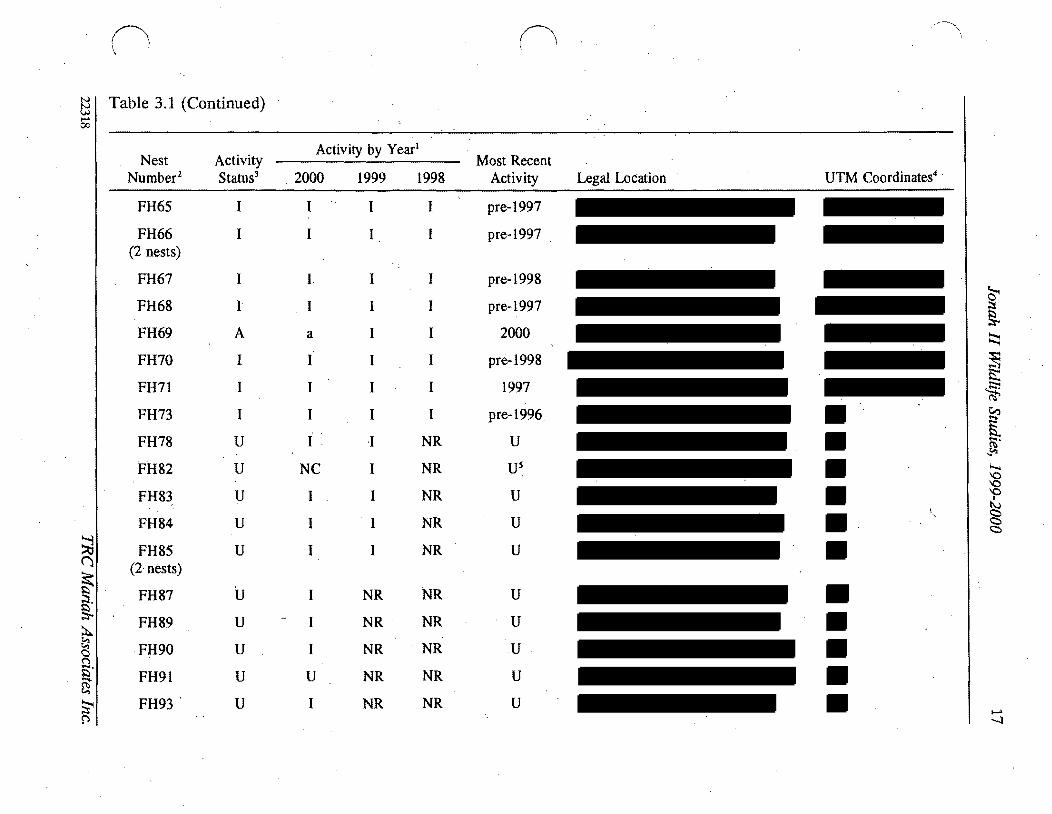
00
I
n (
~ I Table 31 (Continued)
Nest Number2
FH65
FH66 (2 nests)
FH67
FH68
FH69
FH70
FH71
FH73
FH78
FH82
FH83
FH84
~ FH85 ()
(2middot nests)
FH87~ sect
FH89 ~ tl middotF~90 n fi FH91 ~
FH93middot~ ~
Activity Status3
I
I
I
1
A
I
I
I
U
U
U
U
U
U
U
U
U
U
Activity by Year l
Most Recent Legal Location UTM Coordinates4
2000
I
I
I
I
a
I
I
I
NC
I
I
I
I
I
I
U
I
1999
I
I
I
I
I
I
I
I
I
I
I
I
NR
NR
NR
NR
NR
1998
I
I
I
I
I
I
I
I
NR
NR
NR
NR
NR
NR
NR
NR
NR
NR
Activity
pre-1997
pre-1997
pre-1998
pre-1997
2000
pre-1998
1997
pre-1996
U
Us
U
U
U
U
U
Umiddot
U
U
~ I Il ~
~
~ is S
[ ~
~
0 0 0
I
N ltgt ltgt ltgt
c
-l
n o ~I Table 31 (Continued) 00
I Nest Activity
Activity by Yearl
Most Recent Number2 Status3 2000 1999 1998 Activity Legal Location UTM Coordinates4
FH95 U I NR NR U (4 nests)
FH96 U I NR U
GE36 A A 1 I 2000
GE47 A A A 2000 (2 nests)
GE48 1 1 1 1 pre-1996
GE51 A A 1 1 2000
GE72 I 1 pre-1998
PF27 U 1 ~ 1 U 19975
A8PF41 A U U 19985
PF61 1 1 1 I 1997 nfa
PF63 1 1 1 pre-1998 nfa
PF79 A A NR 1999 nfa~ () PF81 A A a NR 2000 na
~ PF94 U 1 NR NR U nfag 19UN31 NC NC NC U na
~ ~ 19UN32 NC NC NC U nfac ()
19 ~ UN33 NC NC NC U nfa ~
19 UN34 NC NC NC U nla~ p
~ ~ sect ~
~
[ (Ii
~
~ Q
~ bullI) cc c
I- 00
II n ~ I Table 31 (Cont~nued) 00
I Nest Activity
Activity by Yearl
Most Recent Number2 Status 2000 1999 1998 Activity Legal Location trfM Coordinates
UN35 19 NC NC NC U nla
UN40 I~ NC NC NC U nla
UN44 19 NC NC NC U nla
UN45 19 NC NC NC U nla
UN46 19 NC NC NC U nla
UN49 19 NC NC NC U nla
UN50 A 1 alO 1 1999
UN74 U I 1 NC U nla
~ ti (j
sect ~
g ~ ~ g $5 ~
~ fl
I A = active a = likely active I = inactive NC = not checkednot located NR = nest had not yet been recorded U = unknown 2 FHI = ferruginous hawk nest 1 AK16 = American kestrel nest 16 B019 = burrowing owl nest 19 GE36 = golden eagle nest 36
PF27 = prairie falcon nest 27 UN31 =unknown species nest 31 Overall activity status is based on the BLM definition of an active nest as one which has been active in at least 1 of the past 3 years For
overall activity status nests for which activity was likely but not confirmed were considered active (A) Nests which were assigned an unknown acti~ity status (U) lack a ~onclusive activity determin~tion for at least 1 of the past 3 years andor w~re n~wly recorded and have not been momtored for 3 consecutive years Nests confirmed mactlve m all of the past 3 years are deemed mactlve (I)
E = easting N = northing nla = not available S Date is of last confirmed activity but a~tivity status was unknown in at least 1 of the past 3 years thus more recent activity may have
occurred 6 Used by prairie falcon 7 Used in 1999 by golden eagle 8 Used by common raven 9 Detailed searches for these nests in 1999 and 2000 found no raptor activity in the area of the mapped nest sites therefore nests were
assumed to be inactive 10 Possibly used by great horned owl or prairie falcon
~
~
~ ~
[ Ci
~ ~ P
sect
~ 0
n n Table 32 Summary of Active Raptor Nests Within 10 Mi of Existing or Proposed Disturbance Jonah II Wildlife Study ~
i-I Area1 00
Species Seasonal Nest Production -Nest Nest Buffer Nol Legal Location Condition Radius Eggs Nestlings Fledglings Nearby Project Features MitigationActions
AKI6 Unknown 05 mi 0 0 0 Numerous existing and proposed Continue activity status and project features within 05 mi productivity monitoring
AK17 Unknown 05 mi 0 0 0 Numerous existing and proposed Continue activity status and project features within 05 mi productivi~ monitoring
AKIS Unknown 05 mi 0 0 0 Numerous existing and proposed Continue activity status and project features within 10 mi produ~tivity monitoring
8075 Unknown 05 mi U U U Numerous existing and proposed Con tinue activity status and project features within 05 mi productivity monitoring
8077 UnknoWn 05 mi U U I 1999 Numerous existing and proposed Continue activity status and project features within 10 mi productivity monitoring
FH47 Unknown 10 mi 3 1999 2 1 (died) One proposed well pad within Continue activity status and (1 died) 1999 10 mi productivity monitoring if
1999 territolY 6 is inactive in 2001 shy potential development of ANS(s)
FH148 Good 10 mi 3 1997 U 2 1997 Numerous existing and proposed Colltinue activity status and 1 1999 - U U project features within to mi productivity monitoring if
egg failed limited alternative nest sites territolY 5 is inactive in 2001 available in territolY 5 potential development of ANS(s)shy
FH24 Destroyed 10 mi 0 0 0 Numerous proposed features within Continued monitoring the area for 10 mi limited alternative nest sites new and active nests
FH53 Good 10 mi 3 2 1998 21998 B1rma Road within 05 mi Continue activity status and (1 didnt productivity monitoring hatCh)~ 1998
~ ()
FH69 Good 10 mi 0 0 0 Road and pipeline occur within Continue activity status and 10 mi productivity monitoring
$l
t
Active nests defined by activity or likely activity in at least one of the past three nesting seasons See Appendix B Raptor Nesting Records for further detail See Appendix A Wildlife Map for nest locations FH = ferruginous hawk (see Table 33 for nesting territolY) AK = American kestrel BO burrowing owl
tl C
Presents number of items and year U unknown ~ See Appendix A Project Features Map
Seasonal and standard avoidance measures are not included since they would be applied as necessalY for all active nests ~ Used by prairie falcon in 2000
~ Used by golden eagle in 1999 0
~ s sect ~
~ ~ sflS
V
~ ~ shyQQ QI tv C)
g
N 0
21 Jonah II Wildlife Studies 1999-2000
( Since several active raptor nests on the area occur at distances greater than 1 mi from
existing and proposed oil and gas disturbance sites (and thus productivity monitoring is not
required) productivity data for some nests are limited (see Appendix C) Ferruginous hawk
nests in the WSA are known to have produced two fledglings in 1998 one in 1999 and none
in 2000 Ferruginous hawk nest 4 was active in 1999 and produced two young--both of
which died--one as a nestling and one as a fledgling A definitive cause for nest failure was
not identified but the dead fledgling was found decapitated In 2000 the nest was used by
prairie falcons and appeared to produce no fledglings
Nest productivity for other raptor species during 1999 and 2000 include three burrowing owl
fledglings (one in 1999 two in 2000 [nestsgt 10 mi from disturbance]) additional burrowing
owl young may have fledged from other known nests in the area Golden eagles fledged
three to four young in 2000 (nests gt10 mi from disturbance) American kestrels and prairie
falcon also had active nests in the area during the period and likely fledged young birds
c Themiddot approximate locations of ferruginousmiddot hawk nest territories present on and adjacent to
the WSA are shown on the Wildlife Map in Appendix A and briefly described in Table 33
An estimated 11 nesting territories are present on the WSA six of which have been
occupied at least once during the last 3 years (1998-2000) Project features proximal to th~
active nests in these territories are identified in Table 32 and Appendix A (Project Features
Map) Project featuresdevelopments on the J2PA exist and are further planned proximal
to nest territories 5 6 and 7~ Other activities (eg recreational activitiesoff-road vehicle
use livestock grazing wildlifepredator interactions climate) likely occur and will continue
to occur in these and other territories Ferruginous hawk nesting terrItory7 was not active
during the 3-year period and all known nest sites in the territory are at suboptimal locations
(Le on theground surface with easy access by predators) therefore nesting in territory 7
is unlikely to occur in all but the most active nesting years (Le when all other nearby
nesting territories are occupied) It is also possible that nest territories 5 6 and 7 and nest
site 24 will remain unused or will have limited success during the life of the Jonah II Field
22318 TRC Mariah Associates Inc
22 Jonah II Wildlife Studies 1999-2000
Table 33 Nests and 1998-2000 Activity Status at Ferruginous Hawk Nesting Territories Jonah II Wildlife Study Area)
Activity Status3
Nests Included in Territory Territory2 1998 1999 2000
1 68-71middot I Imiddot A (unknown luccess)
2 62 64-67 84-85 I I I 96
3 56-58 60 83 I I I
4 26 28-29 95 I I A (unknown success)
5 13-15 I I
C
A4 (failed)
6 2-12 78 I A AS (failed) (unknown success)
7 20-21 73 I I I
8 53-55 82 A I I (2 fledged)
9 42-43 I I I
10 37-38 A A AS (unknown success) (unknown success) (unknown success)
11 5990 I I I
See Appendix A Wildlife Map for locations No nesting territory is established for nests 1222425 and 91
3 Further detail is provided in Appendix C Raptor Nesting Record I = inactive A = active Used by golden eagle Used by prairie falcon
22318 TRC Mariah Associates Inc
23 Jonah II Wildlife Studies 1999-2000
( Mitigation measures as defined in Section 312 are recommended for territoriesS and 6
in 2001
Project facilities are proposed for development within 05 mi of three active American
kestrel nests and two active burrowing owl nes~s (see Table 32) Continued monitoring
efforts ~re proposed for these nest sites (see Section 312)
312 MonitoringProtection Measures
The primary mitigation measure for raptor species on the WSA is avoidance of active nest
locations during the breedingmiddot season Active nests are defined asraptor nests that have
been used within the last 3 years Unless excepted by the BLM during APD and ROW
application reviews all surface-disturbing activities will be restricted from February 1
through July 31 within a 05-mi radius of active rap tar nests except ferruginous hawk nests
for which the seasonal buffer will be 10 mi (see Table 32) In addition well locations
roads ancillary facilities and other surface structures requiring repeated human presence
will not be constructed within 825 ft of active raptor n~sts where practicaL Th~ seasonal
buffermiddot dist~nce and exclusion dates may vary depending on factors such as nest activity
status rapior species prey availability natural topographic barriers and line-of-sight
distances
Nest activity status and productivity monitoring will continue in 2001 as identified in the
ROD (BLM 1998a [Append~ E] BLM 2000b) Nest activity status will be monitored from
the ground Additionally uUknown nests 31-35 40 44-46 and 49 are recommended for
removal from maps arid further monitoring
In 2001 nestnest area photos will be taken of all raptar nest locations for which photos are
lacking (Table 34) (see Appendix C Raptor Nest Records)
22318 TRC Mariah Associates Inc
24 Jonah II Wildlife Studies 1999-2000
( Table 34 Raptor Nest Locations for WhichmiddotPhotos are Needed Jonah II Wildlife Study Area 2000
Species Nest Numbers
American kestrel
Burrowing owl
Ferruginous hawk
Golden eagle
Prairie falcon
Unknown
17 30 39 52 88 92 97
19 23 75 76 77 86 -
1 (2 nests) 2 3 5 6 7 11 22 28 29 37 38 42 70 78 82 89 91 93 95 (4 nests)
48
27 41 94
74
Well locations roads ancillary facilities and other surface structures requiring repeated
human presence will not be constructed within 825 ft (2000 ft for bald eagles) of active
raptor nests where practical Facility construction in these areas will require specific
approval from the BLM wildlife biologist and Authorized Officer
Operators will notify the BLM immediately if raptors are found nesting on project facilities
If nest manipulation or a situation requiring a taking of a raptor nest becomes necessary
a special permit will be obtained from the Denver USFWS Office Permit Section Permit
acquisition will be coordinated with the Wyoming State USFWS Office in Cheyenne and will
be initiated with sIJfficient lead time to allow for development of mitigation measures
Required corresponding permits will be obtained from theWGFD in Cheyenne
Consultation and coordination with the USFWS and WGFD will be conducted for all
mitigation activities relating to raptors
Because project development continues on and adjacent to active ferruginous hawk
territories 5 and 6 it is recommended that two artificial nesting structures (ANSs) be
established within or adjacent to these territories in 2001 if the territories remain inactive
22318 TRC Mariah Associates Inc
25 Jonah II Wildlife Studies 1999-2000
or unproductive during 2001 Operators ~l assist the BLM (in consultation with other land
users) as necessary in locating appropriate ANS sites and erecting ANSs It is recommended
that ANSs be established outside of existing and known future disturbance areas The lowshy
lying areas in Section 33 T29N R 107W appear to provide suitable areas for ANS locations
in territory 6 ANS construction arid maintenance activities will be completed between
August 1 and September 15 2001 Operators will be responsible for the annual
maintenance of ANSs throughout the life-of-project and all ANSs on public lands will
become the property of themiddotBLM upon completion of the project Additional mitigations
for nesting raptors would be designed on a site-specific basis as necessary in consultation
with the BLM USFWS and WGFD
In future years additional ANSs may be constructed (up to two ANSs for each impacted
nest) or existing degraded raptor nests may be upgradedreinforced to mitigate potential
)impacts The location of ANSs or nests proposed for upgrading will be identified in annual
reports ANSs will be located within or proximal to potentially affected nesting territories ( outside of the line-of-sight or nest buffer of actively nesting raptor pairs and at sites
sufficiently removed from development activities to minimize or avoid potential adverse
effects
In cases where existing project features (eg well locations) are located within the buffer
areas for active raptor nests no extensive maintenance activities (eg workovers ) will be
allowed during critical periods (Le approximately early March through midJune) The
exact dates of exclusion will be determined by the BLM and specified in Conditiolls of
Approval for APD and ROW applications and will likely vary among nests and from
year-to-year depending upon the raptorspecies and variations in weather nesting
chronology and other factors
c 22318 TRC Mariah Associates Inc
26 Jonah II Wildlife Studies 1999-2000
32 SAGE GROUSE
321 Results
Table 3S presents a summary of recent sage grouse lek use (1998-2000) nearby project
features and proposed monitoring and other actions for leks on the WSA (see Appendix D
Sage Grouse Lek R~cords for further detail) Table 36 presents historic information on
lek use since 1992 Lek middot16 was not surveyed during the period therefore no data on lek
use are presented
c
Of the 22 known leks on the WSA leks 1 2 3 7 9 10 17 18 19 21 and 22 have shown
considerable use during monitoring and no notable declines in use were identified
(Table 36 and Appendix D Sage Grouse Lek Records) Decreasing attendance has been
observed at lek 4 with maximum male attendance down from 16 in 1994 to one in 2000 and
due to the extent of n~arby project development this lek may continue to have low levels
or no use throughout the remainder of project development Nomales were observed at
leks S 6 8 11 1213 14 or1S in the last 3 t04 years (Table 36) and these leks also may
continue to be unused for the remainder of project develppment
Five new leks were located during 1999 (leks 17 and 18) and 2000 (leks 19 21 and 22)
Noise monitoring at leks 7 and 8 on the WSA and the lek near the Bird Canyon compressor
station are provided in Table 37
Habitat mapping of the MJ2P A during 2000 primarily conducted to assist in defining
optimal sage grouse nesting and brood-rearing areas found that dense sa~ebrush was the
most common habitat type occupying approxim4tely 89 (26S82 acres 41S rnF) of the
MJ2PA (see Appendix A Habitat Map) This habitat type generally occurs in flat to rolling
terrain and exhibits sagebrush cover of gt20 (Table 38) Wyoming and mountain big
22318 TRC Mariah Associates Inc
() (1 ~
~ ITable 35 Summary of Sage Grouse Lek Use Potential Impacts and Proposed Monitoring Jonah II Wildlife Study Area 20001
Lek Approximate No2 Location Status3 Use Nearby Project Features4 MonitoringOther Actionss
~ ()
~ ~
s
A tl n Et- ~
~ f
2
3
4
5
6
7
8
9
10
11
A
A
A
A
A
A
A
I
Relatively consistent
Relatively consistent
Relatively consistent
Decreasing maximum male attendance since 1996
No known use since pre-1997
No known use since pre-1997
Relatively consistent
No known use since pre-1997
Relatively consistent
Relatively consistent
No known use since pre-1994
One existing and numerous proposed wells and roads within 10 mij one proposed location within 025 mi
Existing pipeline within 025 mi numerous existing and proposed wells and roads within 10 mi
Proposed well and road within 025 mi one existing and another proposed well and road within 10 mi
One existingand two proposed wells and roads within 025 mi numerous proposed and existing wells pipelines and roads within 10 mi
Existing well pipelines and roads within 025 mi new wells proposed within 025 mi proposed and existing wells pipelines and roads within 10 mi
Existing road at let
Existing pipeline within 10 mi
Existing pipeline and road and one proposed well within 10 mi
Proposed well within 10 mi
Existing and proposed wells and roads within 10 mi
Proposed road within 025 mi proposed wells and roads within 10 mi
Monitor attendance three times in 2001 j move proposed well outside 025-mi buffer
Monitor attendance three times in 2001 ensure proposed wells and roads are outside 025-mi buffer
Monitor attendance three times in 2001 move proposed well and road to outside 025-mi buffer
Monitor attendance three times in 2001 move proposed wells and roads to outside 025-mi buffer
Discontinue monitoring
Discontinue monitoring
Monitor attendance three times in 2001 monitor noise levels in 2001 GPS lek perimeters in 2001
Discontinue monitoring
Monitor attendance three times in 2001 GPS lek perimeters in 2001
Monitor attendance three times in 2001 monitor noise levels in 2001
Discontinue monitoring in 2001 move prop~sed road to outside 025-mi buffer
~ l
sect ~
~ sectgni
~gt ~
0 0 0
I
tJ
~ C
N
c
-l
00
n n ~ ITable 35 (Continued)
Lek Approximate No2 Location Status3 Use Nearby Project Features4 MonitoringOther Actionss
12 Limited use since pre-1992 Existing well and roads within 10 mi
13 No known use since None pre--1996
14 No known use since Existing road within 10 mi pre-1992
15 No known use since Existing and proposed wells pipelines and pre-1997 roads within 025 mi
16 U Unknown None
17 A Relatively consistent since Proposed road within 10 mi 1999 (first located in 1999)
18 A Possible increased Existing road within 025 mi proposed well attendance since 1999 (first and road within 10 mi
located in 1999)
19 A First located in 2000 None
20 U Unknown Existing road within 025 mi
~ (j 21 A First located in 2000 Proposed well and road within 10 mi
~ sect
22
A Pirst located in 2000 Proposed ells and roads within 10 mi
~ tl g jl See Appendix A Wildlife Map and Appendix D Sage Grouse Lek Records for additional infonnation - 2 See Table 36 for alternate names $)
~ 3 A = active (at least once during last 3 years) I = inactive U = unknowntj See Appendix A Project Features Map
~ Seasonal and standard avoidance measures are not included since they would be applied as necessary for all leks ))
Monitor attendance three times in 2001 search for alternate nearby lek sites in 2001 if no use discontinue monitoring in 2002
Discontinue monitoring
Discontinue monitoring
Discontinue monitoring in 2001
Monitor attendance three times in 2001
Monitor attendance three times in 2001 GPS lek perimeters in 2001
Monitor attendance three times in 2001
Monitor attendancethree times in 2001 GPS lek perimeters in 2001
Monitor attendance three times in 2001 GPS lek perimeters in 2001
Monitor attendance three times in 2001 GPS lek perimeters in 2001
Monitor attendance three times in 2001 GPS lek perimeters in 2001
monitoring action not necessarily required
~ sect ~ ~ -
[ (IS
~
g P
sect N
~
29 Jonah II Wildlife Studies 1999-2000
Table 36 Sage Grouse Trends Jonah II Wildlife Study Area 1992-20001
History2 Lek
No Lek Name 1992 1993 1994 1995 1996 1997 1998 1999 2000
4-2 NS NS 9 NS 26 6 31 25 22
2 4-6 NS NS 2 NS 2 17 12 7 14
3 Sand Draw Reservoirmiddot NS NS NS NS 16 o 36 26 22
4 Clay H~ NS NS 16 NS 15 4 4 o 1
5 4-8 NS NS NS NS 1 o o o NS
6 4-9 NS NS NS NS 3 o o o o
7 4-7 NS NS 36 NS o 16 17 11 9
8 4-10 NS NS NS NS 2 o o o o
9 Alkali Draw NS NS NS NS NS 50 26 62 47
10 The Rocks NS NS NS NS NS 60 53 79 64
11 4-5 NS NS o NS o NS o o o
12 3-8 o o o 4 o 0+ o
13 3-6 NS NS NS NS o o o o o
14 3-7 o o 0 o o o o o o
15 Sand Draw NS NS NS NS o o o o
16 Long Draw UNK UNK UNK qNK UNK UNK UNK UNK UNK
17 Buckhorn Well 1 NS NS llS NS NS NS NS 5 3
18 Shelter Cabin NS NS NS NS NS NS NS 50+ 90 Reservoir
19 Prairie Dog Town 5 NS NS NS NS NS NS NS NS 9
20 Upper Alkali Creek NS NS o NS o NS NS NS NS
21 South Rocks NS NS NS NS NS NS NS NS 10
22 Antelope State NS NS NS NS NS NS NS NS 9
Further detail is provided in Appendix D Sage Grouse Lek Records 2 Numbers refer to maximum male attendance NS = not surveyed UNK = unknown + = unclassified birds
observed but not included
22318 TRC Mariah Associates Inc
30 Jonah II Wildlife Studies 1999-2000
( Table 37 Summary of Noise Data Collection at the Bird Canyon and Lumen Compressor Stations Jonah II Wildlife Study Area 2000
Noise Output l Relative Location Time (decibels) Windspeed Humidity
Bird Canyon June 1 2000 Compressor Station
04 mi to north 600 to 700 am 372 - 501 (4370) 5 mph from SW 26
04 mi to south 600 to 700 am 413 - 545 (4790) 3 mph from SW 26
04 mi to east 600 to 700 am 480 - 514 (4970) 2 mph from SW 26
04 mi to west 600 to 700 am 367 - 465 (4160) 4 mph from SW 26
Directly at Station 600 to 700 am 731 - 746 (7385)
Lumen Compressor Station June 32000
Lek 557 am 369 - 424 (3965) 3 mph from NW 15
Lek8 537 am 395 - 535 (4650) 5 mph from NW 15
Directly at Station 652 - 667 (6595)
I bull All noise output readings represent a decibel range between the minimum and maximum values recorded during a 2- to 3-minute interval at each particular sampling location Average outputs fall near the medians Numbers in parentheses are median values
sagebrush (Artemisia tridentata wyomingensis and A t vaseyana respectively) are the most
co~on shrub species with rabbitbrush (Chrysothamnus spp) also present Subshrubs in
this habitat type include granite prickly gilia (Leptodactylon pungens) broom snakeweed
(Gutierrezia sarothrae) and winterfat (Kraschenninikovia lanata) which is generally
uncommon Forbs include stemless goldenweed (Happlopappus acaulis) Hoods phlox
(Phlox hoodU)and miners candle (Cryptantha spp)and grass species include wheatgrasses
(Agropyron spp) Indian ricegnlss (Oryzopsis hymenoides) fescue
(Festuca ~p) and
needleandthread (Stipa comata)
The moderate density sagebrush type (9 of the MJ2PA 2605 acres 41 mi2) is most
middot commonly found in the southeastern portion of the project area where i~ typically occurs
-
22318 TRC Mariah Associates Inc
C
31 Jonah II Wildlife Studies 1999 2000
( Table 38 Results of Vegetation Studies MJ2P A 20001
Productive Sage Grouse MJ2PA Vegetation Type2 Habitat Characteristics
Moderate Dense Density Basin
Sagebrush Sagebrush Sagebrush NestinglEarly Late Parameter (n=15) (n=15) (n=5) Brood-rearing Brood-rearing
Sagebrush height (inches) 98 79 310 45 12-32 12-32
Percent sagebrush cover
Daubenmire 217 45 65 308 15-25 10-25
Line intercept 245 45 (99) 79 (89) 367 (79)
Percent total shrub cover
Daubenmire 220 68 314 -shyLine intercept 247 (99) 81 (92) 380 (80)
Grassforb height (inches) 56 65 65 gt70 Variable 4inch minimum
( Percent grass and forb 106 (89) 151 45(96) 201 45 gt 13 gt13 cover (65)
Residual grass height 63 61 65 4-5 (irtchesY
Percent residual grass 85 4 109 4 2014 gt3 cover
Sagebrush plants acre 7260 (99) 2636(92) 4494 (86)
Total shrubsacre 7665 (99) 2951 (96) 5088 (91 )
Data on file at TRC Mariah Laramie Wyoming measurements recorded in late summer 2 See Appendix A Habitat Map for locations Numbers in parentheses are the confidence level achieved with
80 precision using the z statistic derived from the following formula ~
s where
n = sample size d = 02 (for 80 precision) X = sample mean s = sample standard deviation
3 See Table 21 for references measurements recorded during late spritigearly summer Meets nestingearly brood-rearing characteristics
5 Meets late brood-rearing characteristics 6 Excludes pre-2000 litter in MJ2PA samples
22318 TRC Mariah Associates Inc
32 Jonah II Wildlife Studies 1999-2000
( on sideslopes It is characterized by an average of approximately 6-8 sagebrush cover
(Table 38) with spiny hopsage(Grayia spinosa) and scattered rabbitbrush also present
Subshrubs include snakeweed Gardners saltbush (A triplex gardneri) and winterfat Grass
and forb species composition is generally similar to that observed in the dense sagebrush
type
The basin sagebrush (Artemisia tridentata tridentata) type ( lt 1 of the MJ2P A 236 acres
04 mi2) is characterized by a narrow strip of tall dense basin sagebrush along the Sand
Draw drainage (see Appendix A Habitat Map) Understory is relatively sparse with some
scattered rabbitbrush and mixed grasses and forbs
(shy
Scatteredno sagebrush habitat (2 of the MJ2P A 575 acres 09 mi2) occurs in small
pockets within the project area (see Appendix A Habitat Map) These unsampled areas
are generally associated with playas rocky outcrops or steep slopes and they typically grade
into the moderate density sagebrush habitat type
Measured vegetation parameters within the three sampled vegetation types in the MJ2PA
were in no instance consistent with the qualitative and quantitative parameters for
productive sage grouse nesting or brood-rearing described in Table38 However the dense
sagebrush and basin sagebrush types in combination apparently provide adequate conditions
(with the exception of understory grassforb and residual grass heights) for sage grouse
nesting since sage grouse nesting and brood-rearing is known to occur in the area
Furthermore since year 2000 vegetation sampling in the MJ2P A occurred late in the
summer during a dry year and whereas sampling to determine productive nesting and
brood-rearing habitat parameters occurred immediately fo~lowing chick hatching (late
spring early summer) it is likely that some portion of the understory (grasses and forbs) was
lost to desiccation and wind andor grazing resulting in the potential for underestimation
of both cover anltlheight of grasses and forbs during the year 2000 vegetation sampling
22318 TRC Mariah Associates Inc
c
33 Jonah IIWildlife Studies 1999-2000
322 Monitoring and Protection Measures
Monitoring and identification of sage grouse leks on the WSA will continue in 2001 as
specified in the WMPP (BLM 1998a Appendix E) and the EA for the Modified Jonah Field
II Project (BLM 2000b)
It is recommended that the WGFD or BLM continue to implement aerial (fixed wing) sage
grouse lek inventories of the WSA in 2001 to provide further lek locational data and to
identify any new or previously undiscovered leks Additionally WGFD andlor BLM will
use GPS to determine lek perimeters in 2001 at leks 7 9 171920 21 and 22 Aerial
surveys will be implemented during Marchi April The absence ofldecreased use of leks 4
5 6 8 1112 13 14 and 15 may indicate that alternate lek siteS are being used therefore
it isreltommended that additional observations be made in 2001 in the vicinity of these leks
to locate any new unmapped leks
Due to the apparent lack of use over the last few years at leks 5 6 8 11 12 13 14 and 15
it is recommended that lek attendanc~ monitoring at these leks be discontinued in 2001
Attendance monitoring at these leks may be reinitiated once field development is complete
Attendance monitoring of other known sage grouse leks in the area by WGFD and Ior BLM
personnel will continue in 2001 as during past years and specified in the RoD (BLM 1998a
Appendix E) and deemed necessary by the BLM and WGFD
As requested by the BLM and WGFD noise monitoring will be implemented in 2001 at leks
7and 10 within the WSA and at the Bird Canyon lek located approximately 04 mi southeast
of the Bird Canyon Compressor Station southwest of the WSA Continuous noise
monitoring will be conducted from 5 am to 9 am on four separate occasions during the
period of March 15middotApril 30 at the three leks Noise monitoring equipment will include a
Bruel amp Kjaer Model 2260 precision integrating sound meter and octave bandmiddot analyzer
(noise frequency) with a data logger (meets ANSI 514-1983 Type 1 sound level meter
22318 TRC Mariah Associates Inc
34 Jonah II Wildlife Studies 1999-2000
( requirements) Noise meaSurements will be logged every 5minutes over the duration of the
5-hour sampling period and data will be downloa~ed daily for storage and analysis The
meter will be calibrated daily with a Bruel amp Kjaer Model 4231 sound level calibrator The
microphone will be fitted with a windscreen to reduce wind-generated noise and will be
mounted at the edge of each lek approximately 3 ft above the ground Contributing noise
sources will be identified and recorded as well as prevailing meteorological conditions i
(Le wind speed and direction temperature humidity and cloud cover)
As with raptors the principal protection for sage grouse is avoidance of leks during the
breeding season and the avoidance of probable nesting areas during the nesting season If
an active sage grouse nest is identified during the nesting season (April 1 - July 31) i
surface-disturbing activities will be delayed untilnestibg is completed
All surface-disturbingmiddot activities including pipeline construction will be avoided within
025 mi of active sage grouse leks and no permanent high profile structures such as
buildings and storage tanks which are suitable raptor perches will be constructed within
025 mi of any lek Therefore the proposed project features (ie well locations roads
pipelines) proximal to leks 1345 11 and 15 may require relocation to sites greater than
025 mi from the lek centers Well location and road and pipeline construction within
025 mi of leks 5 11 and 15 may be permitted in 2~OI (as authorized by BLM) since these
leks have exhibited little or no use during monitoring and are considered inactive
Operators will restrict construction activities between March 1 and June 30 within a
20-mi radius of active sage grouse leks to protect sage grouse nesting habitat and Will avoid
all drilling and construction activities from March 1 to May 15 on all areas within 10 mi of
active sage grouse leksmiddot to protect sage grouse breeding activities Operators will also
maintain a 05-mi disturbance-free buffer around middotleks 7 (and 8 south of the MJ2P A
(see Appendix A Wi~dlife Maps)
22318 TRCMariah Associates Inc
35 Jonah II Wildlife Studies 1999-2000
( While Operators have committed to avoiding optimal sage grouse nesting habitat during the
nesting period where practical (BLM 2000b) n optimal (productive) habitat has been
identified in the MJ2PA (see Table 38) However since sage grouse nesting and
brood-rearingmiddot is known to occur in the sagebrush-dominated habitats on the area it is
recommended that no disturbance (other than linear crossings) be authorized within the
basin sagebrush type (this type is currently protected by drainage buffers [see Appendix A
Habitat Map J) and that disturbance within the dense sagebrush type be avoided during the
nesting period
It is recommended that the BLM implement formal sage grouse winter use investigations
on the J2PA and a O5-mi buffer during late winter (JanuaryFebruary) 2001 to further
identify sage grouse wintering areas These surveys should be conducted on the ground and
all data collected should be provided on General Wildlife Observation Data Sheets or other
suitable forms (see Appendix B) Operators will cooperate in any further ongoing sage
grouse studies within the WSA and with the WGFD on any existing and new sage grouse
habitat improvement efforts (eg water developments) within Upland Game Bird
Management Area 7
Removal of water development structures proximal to lek 4 (Clay Hill) may occur in 2001
as directed by BLM Removal of these facilities may eliminate potential raptor perch sites
andor reduce the use of this area by livestock and humans
Operators will utilize directional drilling to access resources beneath the 025-mi active sage
grorise lek buffers (see Appendix A Wildlife Map) and beneath the 600-poundt wide (or tall
sagebrush-dominated) buffer associated with Sand Draw Granite Wash and Alkali Draw
protection areas if reserves beneath these locations are deemed economically feasible
c__ 22318 TRC Mariah Associates Inc
36 Jonah II Wildlife Studies 1999-2000
(
-33 THREATENED ENDANGERED PROPOSED CANDIDATE AND WYOMING
SPECIES OF CONCERN
I331 Results
3311 Black-footed Ferret
No black-footed ferrets or black-footed ferret sign was observed on the J2PA during the
black-footed ferret survey conducted on the area during 1999 Survey results are presented
in McMurry (1999) which is available for review at the BLM Pinedale Field Office
No PDTs with burrow densities suitable as black-footed ferret habitat (Le gt8 burrows
acre) were identified in the MJ2PA during year 2000 (Table 39) However portions of
PDTs 8 16 17 and 18 in the southeastern portion of the WSA have prairie dog burrow
densities suitable for black-footed ferret (see Appendix A Habitat Map) and black-footed
ferret surveys may be required if developments are proposed within these townS
3312 Bald Eagle Ferruginous Hawk Golden Eagle
No bald eagles were observed on the WSA during 1999 and 2000 wildlife investigations
Information on ferruginous hawks and golden eagles is provided in Section 311
3313 Mountain Plover
Mountain plover were observed for the first time adjacent to the J2PA during 1999 and a
single plover was observed within the J2PA during 2000 (see Appendix B) Adults with at
least two young were recorded on separate occasions outside the J2P A during 1999
indicating the presence of mountain plover breeding in the Alkali Creek drainage
22318 TRC Mariah Associates Inc
c
C
37 Jonah II Wildlife Studies 1999-2000
Table 39 Whitetail Prairie Dog Towns Jonah II Wildlife Study Area 2000
Prairie Dog Number of Burrow Density Town Acreage2 Open Burrows2 3 (burrowsacre)2 5
1 400 326 08
2 423 458 11
3 825 39 lt01
4 903 NS UNK
NS 5 106 UNK
6 358 724 20
7 800 NS UNK
8 1246 (131) 2084 (103) 45 (142)
9 280 NS UNK
10 39 NS UNK
11 203 NS UNK
12 79 NS UNK
13 86 NS UNK
14 105 NS UNK -
15 189 NS UNK
16 203 (52) (35)4 ~9 (138)
17 141 (30) 364 (26) 65 (156)
18 357 (55) 544 (43) 41 (166)
19 10 NS UNK
20 9 NS UNK
See Appendix A Habitat Map for location 2 Numbers in parentheses are for high density areas (Schlumberger Geco-Prackla 2000) 3 NS = not surveyed 4 Sample only 5 UNK = unknown
22318 TRC Mariah Associates Inc
38 Jonah II Wildlife Studies 1999-2000
( (Appendix B) No mountain plover were observed during species-specific investigations on
and within 05 mi of the MJ2PA during 2000 (see Appendix E)
3314 Western Burrowing Owl
Six western burrowing owl nestsnest sites were observed on the WSAfrom 1997 to 2000
(see Tables 31 and 32 and Appendix C Raptor Nesting Records) Of these nests only two
are known to have produced young however burrowing owl nests 75 and 76 were not
monitored for productivity during 1998 and 1999 and these nests may have successfully
produced young in these years
3315 Other TEPCamp WSC Species
The only other known TEPCamp WSC noted on the WSA during 1999 and 2000 surveys and
on-site investigations conducted during APD and ROW reviews was the loggerhead shrike
and it is possible that the species bred in the area during these years
I
332 Monitoring and ProtectiOn
USFWS andor WGFD consultation and coordination will be conducted for all necessary
mitigation activities relating to TEPCampWSC and their habitats implemented during 2001
3321 Black-footed Ferret
All whitetail PDTs within the J2P A have been mapped and those within the MJ2P A were
remapped and censused for op~n burrows in 2000 to determine whether they meet the
black-footep ferret habitat criteria established in the USFWS (1989) guidelines Proposed
disturbance in PDTs 1 2 3 and 6 will not adversely affect black-footed ferrets since these
towns are not suitable as black-footed ferret habitat
22318 TRC Mariah Associates Inc
I
39 Jonah Ii Wildlife Studies 1999-2000
~ During 2001 PDTs 12 3 and 6 will bereinvesiigated to locate and map the areas within
these towns that have the highest burrow densities GPS will be used to map these areas
Burrow densities will be censused within the areas of highest burrow density
If PDTsportions of PDTs of sufficient size and burr~w densitr for black-footed ferret
habitat are scheduled to be disturbed black-footed ferret surveys of these townstown
portions will be conducted Survey protocol will adhere to USFWS guidelines as established
in USFWS (1989) Surveys will be conducted by a USFWS-qualified biologist no more than
1 year prior to proposed disturbance and reports identifying survey methods and results will
be prepared and submitted to the USFWS and BLM in accordance with Section 7 of the
Endangered SpeCies Act of 1973 as amended and Interagency Cooperation Regulations
Surveys will be financed by the Operators
If black-footed ferrets are found within the J2PA but outside the MJ2P A the USFWS will
be notified immediately and formal consultations will be initiated to develop strategies that
ensure no adverse effects to the species If black-footed ferretsmiddot are found within the
MJ2PA the USFWS will be notified immediately and no further disturbance would occur
to the prairie dog complex in which the black-footed ferret was observed Before
ground-disturbing activities are initiated in black-footed ferret habitat authorizations to
proceed would be required from the BLM in consultation with the USFWS
3322 Bald Eagle Ferruginous Hawk Golden Eagle
Monitoring and protection protocol for bald eagle ferruginous hawk and golden eagle in
2001 will be as described for raptors (see Section 312) Additional measures will be
applied on a species- or site-specific basis as deemed necessary by the USFWS andor
BLM if potential impacts to these species are identified during 2001 APD and ROW
application reviews
22318 TRC Mariah Associates Inc
40 Jonah II Wildlife Studies 1999-2000
( 3323middot Mountain Plover
The following protocol has been modified from that presented in BLM (1998a Appendix E)
to accommodate USFWS changes to mountain plover survey and avoidance protocoL The
protocol remains consistent with that presented in BLM (2000b)
During the period of May I-June 15 2001 mountain plover surveys will be conducted by
an Operator-financedBLM-approved biologist in accordance with USFWS guidelines
(USFWS 1999) on suitable breeding areas throughout the MJ2PA and a 05-mi buffer (see
AppendiX A Habitat Map) Survey procedures will be as follows
bull surveys will be conducted during early courtship and territory establishment
bull surveys will be conducted from sunrise to 1000 am andor from 530 pm
to sunset
bull surveys will be conducte4 from four-wheel-drive vehicles or where access is
a problem andor no visual observations are made from vehicles ATVs will
be used
bull surveyors will remain in or close to yehicles when scanning with binoculars
bull after 2QOl surveys for mountain plover will be conductedmiddot in appropriate
habitat within 200 m (656 ft) of proposed disturbance sites
bull sites will be surveyed three times during the survey window (May I-June 15)
with each survey separated by at least 14 days
bull surveys will not be conducted in inclement weather (eg poor visibility)
surveys will focus on locating displaying or calling males
bull if breeding birds are observed additional surveys will be implemented
immediately prior to construction to search for active nest sites (applicable to
only post-2001 surveys)
bull if an active nest is located a 656-ft buffer zone will be established around the
nest to prevent direct and indirect nest disturbance and
bull gt surface-disturbing activities will occur as near to completion of surVeys as
possible
22318 TRC Mariah Associates Inc
41 Jonah II Wildlife Studfes 1999-2000
Mountain plover surveys will not be conducted for construction activities planned for the
period of July 11 through April 9 Survey results will be compared with the annual
development plans to determine if any proposed surface-disturbing activities will affect
occupied mountain plover nesting habitat Where practicable development plans will be
modified to avoid nesting habitat (eg through road realignment)
If an active nest is found in thesurveyarea planned activities will be delayed 37 days or
1 week post-hatching or if a brood of flightless chicks is observed activities will be delayed
at least 7 days
Where access roads andor well locations have been qmstructed prior to the mountain -
plover nesting season (April 10-July 10) and use of these areas has not been initiated for
development actions prior to April 10 a BLM-approved Qiologist will conduct site
investigations of these diSturbed areas prior to use to determine whether mountain plover
are present In the event plover nesting is occurring Operators will delay development
activities until nesting is complete
Nest success and productjvity of all mountain plover nests found within the MJ2PA will be
monitored and reported to the BLM and USFWS Wyoming Field Office annually
Prior to implementing surface disturbance within 200 m (656 ft) of known mountain plover
concentration areas (Le areas where broods andor adults have been ~bserved in the
current year or documented in at least 2 of the last 3 years) Operators will consult with the
BLM regarding initiation of informal conferencing with the USFWS
If removal of mountain plover nesting habitat is unavoidable loss will be minimized by
creating additional nesting habitat it is assumed that many of the existing and proposed
pipeline reclamation areas on the MJ2P A would provide suitable plover breeding habitats
Areas of pipeline reclamation that provide suitable plover beeding areas will be identified
annually If nesting habitat is disturbed the area will be reclaimed to approximate original
TRC Mariah Associates Inc 22318
c
42 Jonah II Wildlife Studies 1999-2000
( conditions (topography vegetation hydrology etc) aftercompletio~ of activities such that
disturbed potential mountain plover breeding habitat is reclaImed to conditions suitable for
mountain plover breeding
Operators will minimize road construction and maintenance activities (ie grading) In
suitable plover habitat from April 10- July 10 No surface-disturbing activities will be
conducted from April 1 - June 30 within 656 ft of identified mountain plover concentration
areas (ie areas where broods andor adults have been observed in the current year or
documented in at least 2 of the past 3 years)
3324 Western Burrowing Owl
Monitoring and avoidance of prairie dog colonies (see Section 3321) and avoidance of
active raptor nests during the nesting period (see Section 312) will continue in 2001
Additianally productivity monitoring will be implemented for all active burrowing owl nests
on the MJ2PA and a surrounding OS-mi area Additional measures may be applied in
future years if burrowing owl nesting andor productivity in the WSA is noted to be
declining These potential measures will be identified by the BLM
3325 Other TEPCampWSC Species
No formal surveys for other TEPCampWSC are proposed for 2001 however since loggerhead
shrike have been seen in the area special attention to this species is recommended for APD
and ROW application field reviews If during implementation of surveys for other species
or during APD and ROW application field reviews any TEPCampWSC is observed on areas
within OSmi of proposed disturbance sites nests or other crucial features for the observed
species if any will be avoided Consultation and coordination with the BLM USFWS and
WGFD will also be conducted as necessary Construction activities in these areas will be
curtailed untilthere is concurrence among Operators BLM USFWS and WGFD on what
22318 TRC Mariah Associates Inc
c
c
43 Jonah II Wildlife Studies 1999-2000
activities can be authorIzed Activities will in most cases be delayed until such time that
no adverse effects would occur (eg after fledging)
No additional protection measures will be applied for other sensitive species potentially
present on the WSA however it is assumed that the protection protocol specified below for
general wildlife will benefit TEPCampWSC as well (see Section 3332) In addition if
TEPCamp WSC are observed efforts will be made to determine the activities of the species
on the WSA (eg breeding nesting foraging hunting) If any management agency
(ie BLM WGFD USFWS) identifies a potential for impacts to any TEPCampWSC species
additional monitoring andor protection measures will be implemented as directed by the
BLM
333 General Wildlife
3331 Results
Data on other wildlife species observed on the WSA durin~ 1999 and 2000 surveys are
provided in Appendix R and in APD andROW application field review data available at
the BLM Pinedale Field Office
3332 Monitoring and Protection
No formal wildlife monitoring for other wildlife is recommended for 2001
Protection measures primarily designed to minimize impacts to other area resources
(eg vegetation and surface water resources Including wetlands steep slopes) are identified
in BLM (1998a 2000b) andthese measures provide additional impact mitigation forarea
wildlife Well locations access roads pipelines and ancillary facillties will be selected and bull bull I
designed to minimize disturbances to areas of high wildlife habitat value including wetlands
~ and riparian areas Areas with high erosion potential andor rugged topography (Le steep
(- slopes dunes floodplains unstable soils ) will be avoided where practical ~
22318 TRC Mariah Associates Inc
44 Jonah II Wildlife Studies 1999-2000
Removal or disturbance of vegetation will be minimized through construction site
management (eg by utilizing previously disturbed areas using existing ROWs designating
limited equipmentmaterials storage yards and staging areas scalping) and Operators will
adhere to all reclamation guidelines presented in the Reclamation Plan for this project
(see Appendix B in BLM 1997 1998a and 1998b)
To minimize wildlife mortality due to vehicle collisions Operators will continue to advise
project personnel regarding appropriate speed limits (Le35 mph) in the project area and
roads will be reclaimed as soon as possible after they are no longer required Some existing
roads in the area may be closed and reclaimed by Operators as authorized by the BLM
No roads are currently proposed for reclamation
To protect plant populations and wildlife habitat project-related travel will be restricted to
established project roads no off-road travel will be allowed except in emergencies
c No road or pipeline ROW fencing is proposed however if ROW fencing is required it will
be kept to amiddot minimum and the fences employed ~ll consist of four-strand barbed wire
which meets BLM and WGFD approval for facilitating wildlife movement Wildlife-proofI
fencing will be utilized only to enclose reclaimed areas where it is determined that wildlife
species are impeding successful vegetation establishment No improvements to existing
fences on the area are currently proposed
No new wildlifelivestock water sources are currently proposed for development
Potential increases in poaching will be minimized through continued employee and
contractor education regarding wildlife laws and Operators will notify all employees
( contract and company) that conviction of a major game violation could result in disciplinary
action Ifviolations are discovered Operators will immediately ntify theBLM and WGFD
and if the violation involves an employee or contractor said employee or contractor will bemiddot disciplined and may be dismissed by the Operator andor prosecuted by the WGFD
C
22318 TRC Mariah Associates Inc
45 Jonah II Wildlife Studies 1999-2000
Additional nonspecies-specitlc wildlife mitigations include the following
bull Reserve workover evaporation and flare pits potentially hazardous to
wildlife will be adequately protected by netting andor fencing as directed by
the BLM to prevent access bYmigratory birds and other wildlife
bull Siphons will be constructed at each reserve pit to collect as necessary any
undesirable materials that may enter the pits
bull Potential impacts to fisheries will be minimized by using proper erosion
control techniques (eg water bars jute netting rip-rap mUlch)
Construction within 500 ft of open water and 100 ft of intermittent or
ephemeral channels will be avoided where possible Channel crossings for
roads and pipelines will be constructed when flows are not expected (Le late
summer or fall) All necessary crossings will be constructed perpendicular to
flow No surface water or shallow groundwater in connection with surface
water will be utilized for the proposed project
bull Firearms and dogs will not be allowed on the J2P A during working hours by
BLM or Operator employees or their contractors Operators will enforce
existing drug alcohol and firearms policies
bull If injured wildlife are observed on the J2P A Operator personnel will contact
the BLM Pinedale Field Office and the WGFD Pinedale Office Under no
circumstances will injured wildlife be approac4ed or handled
bull Wildlife reporting as specified in the ROD (BLM 1998 Appendix E) will be
continued in 2001 (
22318 TRC Mariah Associates Inc
I
46 Jonah II Wildlife Studies 1999-2000
( 40 LITERATURE CITED
Anderson RM 1996 1996 Prairie Dog Raptor and Sage Grouse Inventory of McMurry Oil Companys Expanded Jonah Field Natural Gas Development Project Sublette County Wyoming Prepared for McMurry Oi~ Company Casper Wyoming by Anderson Environmental Consulting Casper Wyoming 13 pp
Baxter GT and MDmiddot Stone 1980 Amphibians and Reptiles of Wyoming Wyoming Game and Fish Department Bulletin No 16 137 pp
Bureau of Land M~nagement 1997 Draft Environmental Impact Btatement Jonah Field II Natural Gas Project US Department of the Interior Bureau of Land Management Rock Springs District Office Pinedale and Green River Resource Areas BLMWY PL-97 015 + 1310
__ 1998a ~ecord of Decision for Jonah Field II Natural Gas Development Project Environmental Impact Statement Sublette County Wyoming US Bureau of Land Management Rock Springs DistrictPinedale and Green River Resource Areas 43 pp + append
__ 1998b Final Environmental Impact Statement Jonah Field II Natural Gas Project US Department of the Interior Bureau of Land Management Pinedale and Green River Resource Areas BLMWY PL-98001 + 1310
__ 1999 1997 and 1998 Wildlife Studies Jonah Field II Natural Gas Development Project Prepared for US Bureau of Land Management Pinedale Field Office Pinedale Wyoming and Rock Springs Field Office Rock Springs Wyoming by TRC Mariah Associates Inc Laramie Wyoming 32 pp + append
__I _ bull 2000a Decision Record and Finding of No Significant Impact for the Modified Jonah Field II Natural Gas Project Sublette County Wyoming US Bureau of Land Management Pinedale and Rock Springs Field Offices BLMWY PL-001j 019+ 1310
__ middot2000b Environmental Assessment and Finding of No Significant Impact for the Modified Jonah Field II Natural Gas Project Sublette County Wyoming US Department of the Interior Bureau of Land Management Pinedale and Rock Springs Field Offices BLMWY jPL-00lj009+ 1310
Dorn JL and RD Dom 1990 Wyoming Birds Mountain West Publishing Cheyenne Wyoming 138 pp
22318 TRC Mariah Associates Inc
47 Jonah II Wildlife Studies 1999-2000
Fertig W 1997 Wyoming Plant and Animal Species of Special Concern Prepared for the Wyoming Natural Diversity Database 32pp
McMurry Oil Company 1999 Black-footed Ferret and Burrowing Owl Survey of a Prairie Dog Colony in Portions of Sections 29 30 31 and 32 T29N R108W Sections 25 and 36 T29NR109W Sublette County Wyoming Prepared for McMurry Oil Company Pinedale Wyoming by Monarch Wildlife Consultants Pinedale Wyoming 9 pp + append~
Schlumberger Geco-Prakla 2000 Final Black-footed Ferret and Burrowing Owl Surveys South Jonah Seismic Exploration Project Sublette County Wyoming Prepared for Schlumbergermiddot Geco-Prakla Midland Texas by TRC Mariah Associates Inc Laramie Wyoming 7 pp + append
US Fish and Wildlife Service 1989 Black-footed Ferret Survey Guidelines for Compliance with the Endangered Species Act US Fish and Wildlife Service Denver Colorado and Albuquerque New Mexico (April 1989) 10 p + append
__ 1999 Mountain Plover Survey Guidelines US Fish and Wildlife Service 1999 Photocopy 6 pp
Wyoming Game and Fish Department 1992 Wyoming Bird and Mammal Atlas 170 pp ___ 1996 Wyoming observation system records Biological Services Wyoming Game
and Fish Department Cheyenne Wyoming
___ 1999 Wyoming observation system records Biological Services Wyoming Game and Fish Department Cheyenne Wyoming
22318 TRC Mariah Associates Inc
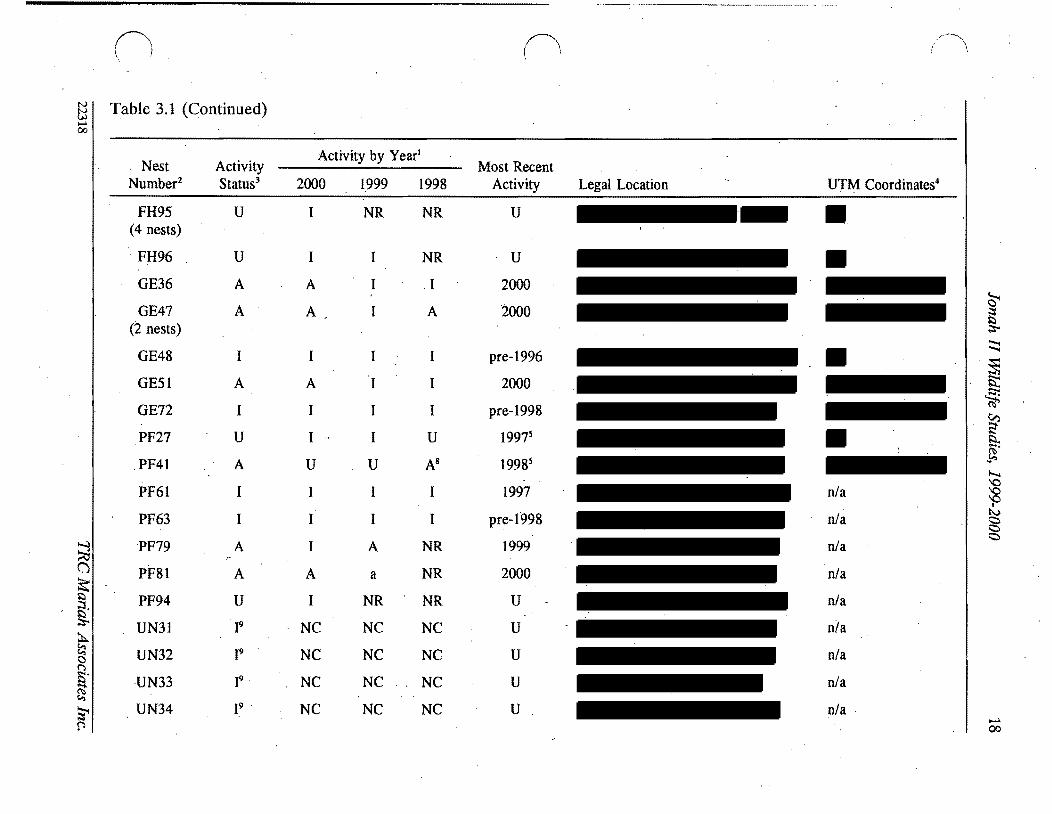
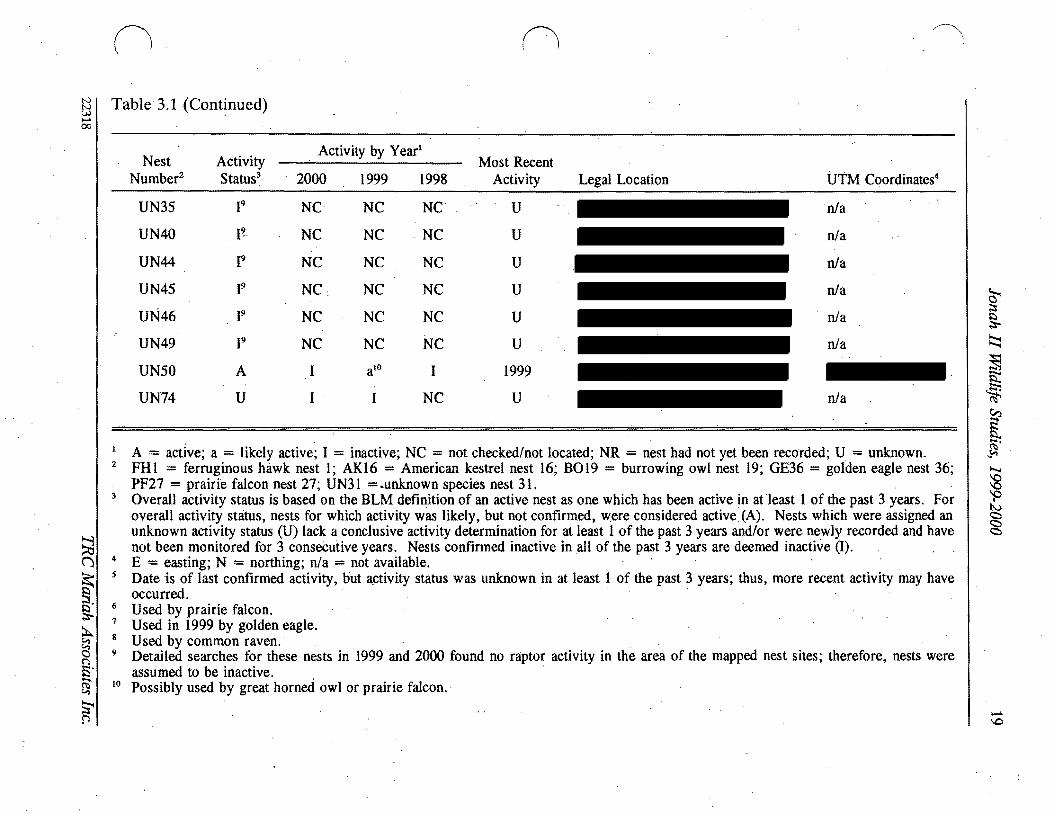
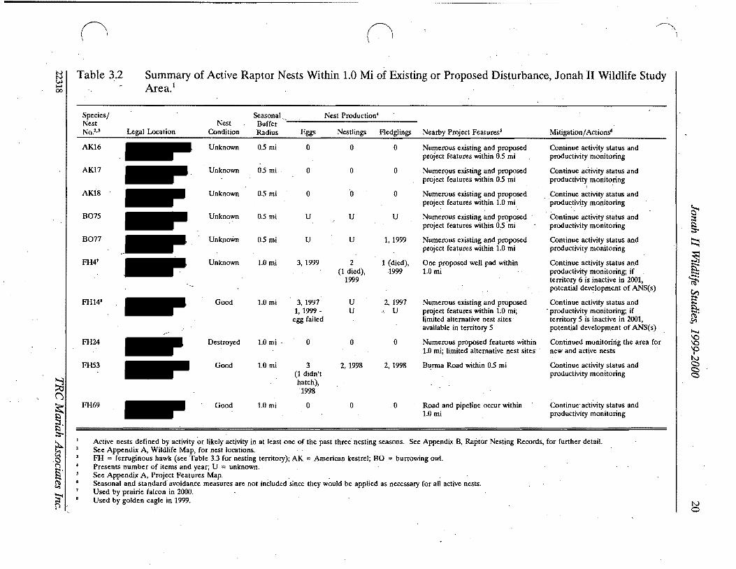
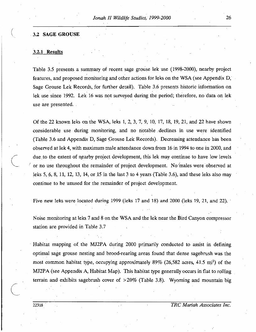
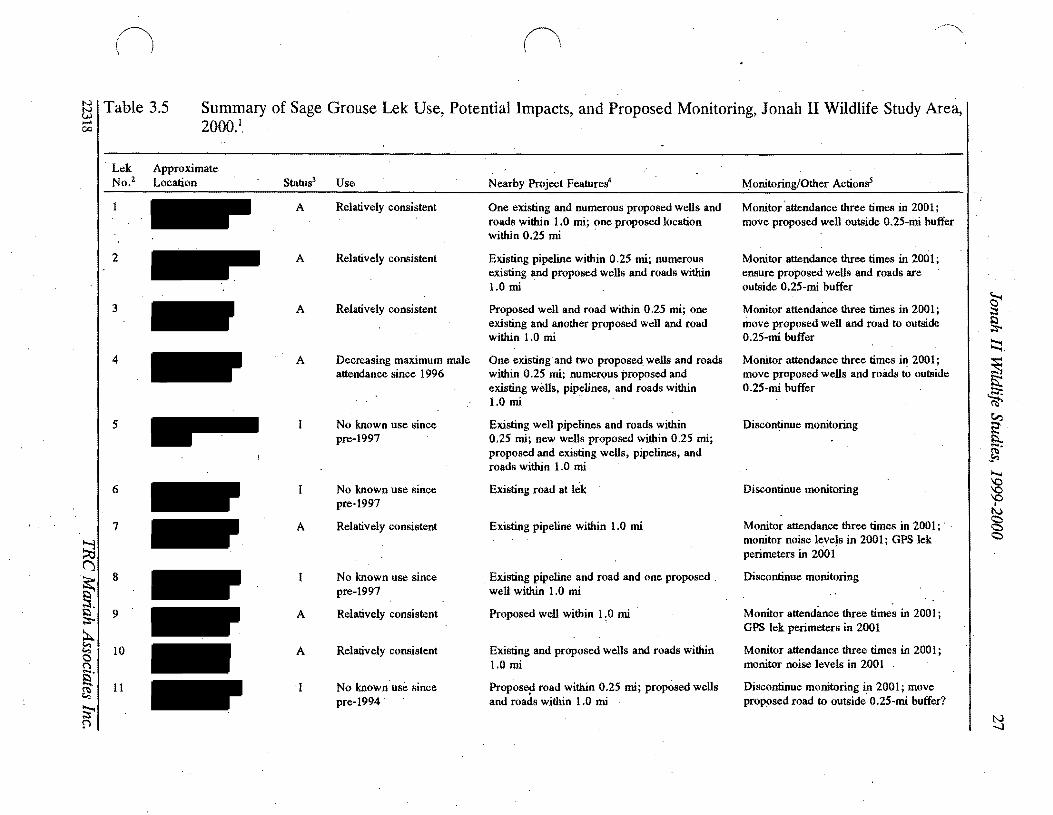
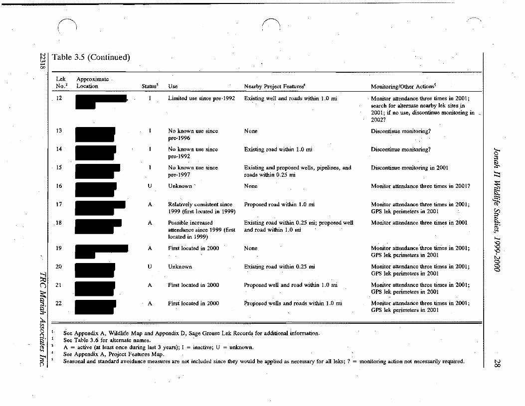
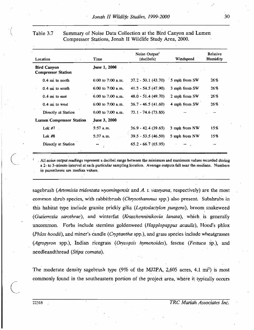
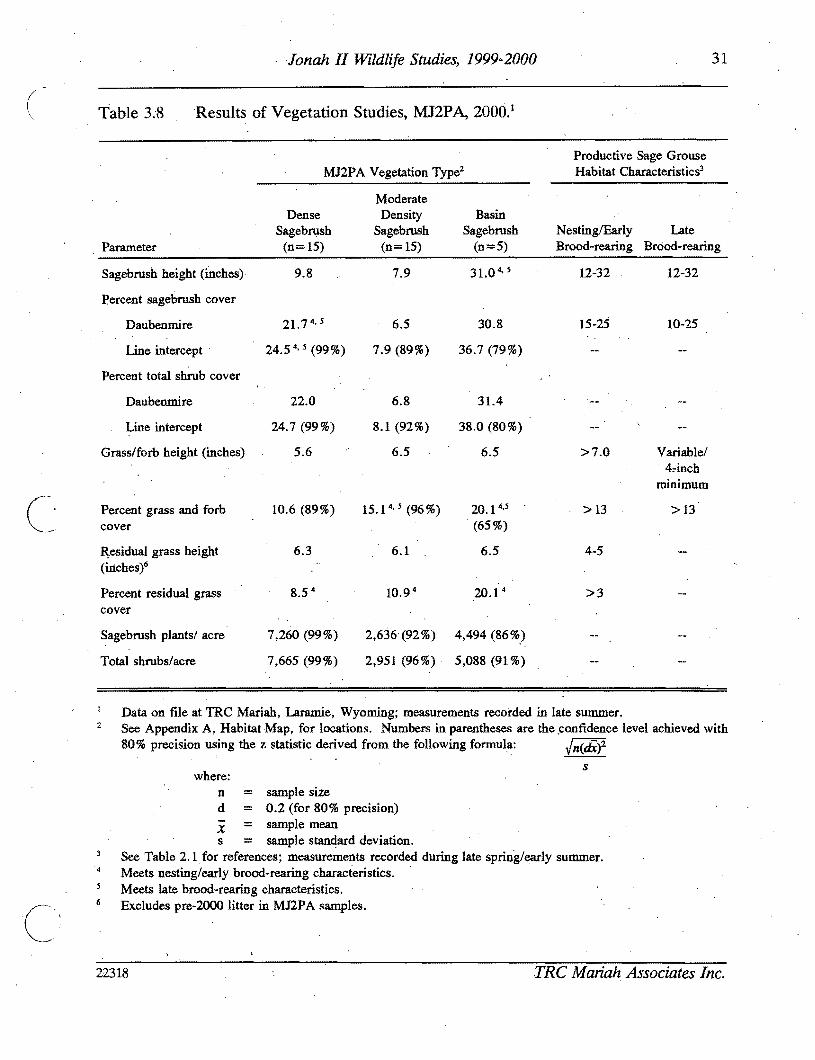
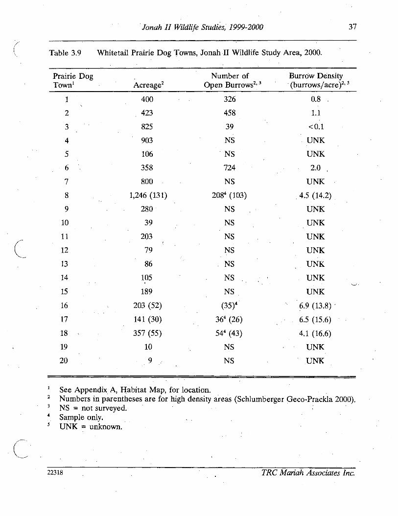
C
37 Jonah II Wildlife Studies 1999-2000
Table 39 Whitetail Prairie Dog Towns Jonah II Wildlife Study Area 2000
Prairie Dog Number of Burrow Density Town Acreage2 Open Burrows2 3 (burrowsacre)2 5
1 400 326 08
2 423 458 11
3 825 39 lt01
4 903 NS UNK
NS 5 106 UNK
6 358 724 20
7 800 NS UNK
8 1246 (131) 2084 (103) 45 (142)
9 280 NS UNK
10 39 NS UNK
11 203 NS UNK
12 79 NS UNK
13 86 NS UNK
14 105 NS UNK -
15 189 NS UNK
16 203 (52) (35)4 ~9 (138)
17 141 (30) 364 (26) 65 (156)
18 357 (55) 544 (43) 41 (166)
19 10 NS UNK
20 9 NS UNK
See Appendix A Habitat Map for location 2 Numbers in parentheses are for high density areas (Schlumberger Geco-Prackla 2000) 3 NS = not surveyed 4 Sample only 5 UNK = unknown
22318 TRC Mariah Associates Inc
38 Jonah II Wildlife Studies 1999-2000
( (Appendix B) No mountain plover were observed during species-specific investigations on
and within 05 mi of the MJ2PA during 2000 (see Appendix E)
3314 Western Burrowing Owl
Six western burrowing owl nestsnest sites were observed on the WSAfrom 1997 to 2000
(see Tables 31 and 32 and Appendix C Raptor Nesting Records) Of these nests only two
are known to have produced young however burrowing owl nests 75 and 76 were not
monitored for productivity during 1998 and 1999 and these nests may have successfully
produced young in these years
3315 Other TEPCamp WSC Species
The only other known TEPCamp WSC noted on the WSA during 1999 and 2000 surveys and
on-site investigations conducted during APD and ROW reviews was the loggerhead shrike
and it is possible that the species bred in the area during these years
I
332 Monitoring and ProtectiOn
USFWS andor WGFD consultation and coordination will be conducted for all necessary
mitigation activities relating to TEPCampWSC and their habitats implemented during 2001
3321 Black-footed Ferret
All whitetail PDTs within the J2P A have been mapped and those within the MJ2P A were
remapped and censused for op~n burrows in 2000 to determine whether they meet the
black-footep ferret habitat criteria established in the USFWS (1989) guidelines Proposed
disturbance in PDTs 1 2 3 and 6 will not adversely affect black-footed ferrets since these
towns are not suitable as black-footed ferret habitat
22318 TRC Mariah Associates Inc
I
39 Jonah Ii Wildlife Studies 1999-2000
~ During 2001 PDTs 12 3 and 6 will bereinvesiigated to locate and map the areas within
these towns that have the highest burrow densities GPS will be used to map these areas
Burrow densities will be censused within the areas of highest burrow density
If PDTsportions of PDTs of sufficient size and burr~w densitr for black-footed ferret
habitat are scheduled to be disturbed black-footed ferret surveys of these townstown
portions will be conducted Survey protocol will adhere to USFWS guidelines as established
in USFWS (1989) Surveys will be conducted by a USFWS-qualified biologist no more than
1 year prior to proposed disturbance and reports identifying survey methods and results will
be prepared and submitted to the USFWS and BLM in accordance with Section 7 of the
Endangered SpeCies Act of 1973 as amended and Interagency Cooperation Regulations
Surveys will be financed by the Operators
If black-footed ferrets are found within the J2PA but outside the MJ2P A the USFWS will
be notified immediately and formal consultations will be initiated to develop strategies that
ensure no adverse effects to the species If black-footed ferretsmiddot are found within the
MJ2PA the USFWS will be notified immediately and no further disturbance would occur
to the prairie dog complex in which the black-footed ferret was observed Before
ground-disturbing activities are initiated in black-footed ferret habitat authorizations to
proceed would be required from the BLM in consultation with the USFWS
3322 Bald Eagle Ferruginous Hawk Golden Eagle
Monitoring and protection protocol for bald eagle ferruginous hawk and golden eagle in
2001 will be as described for raptors (see Section 312) Additional measures will be
applied on a species- or site-specific basis as deemed necessary by the USFWS andor
BLM if potential impacts to these species are identified during 2001 APD and ROW
application reviews
22318 TRC Mariah Associates Inc
40 Jonah II Wildlife Studies 1999-2000
( 3323middot Mountain Plover
The following protocol has been modified from that presented in BLM (1998a Appendix E)
to accommodate USFWS changes to mountain plover survey and avoidance protocoL The
protocol remains consistent with that presented in BLM (2000b)
During the period of May I-June 15 2001 mountain plover surveys will be conducted by
an Operator-financedBLM-approved biologist in accordance with USFWS guidelines
(USFWS 1999) on suitable breeding areas throughout the MJ2PA and a 05-mi buffer (see
AppendiX A Habitat Map) Survey procedures will be as follows
bull surveys will be conducted during early courtship and territory establishment
bull surveys will be conducted from sunrise to 1000 am andor from 530 pm
to sunset
bull surveys will be conducte4 from four-wheel-drive vehicles or where access is
a problem andor no visual observations are made from vehicles ATVs will
be used
bull surveyors will remain in or close to yehicles when scanning with binoculars
bull after 2QOl surveys for mountain plover will be conductedmiddot in appropriate
habitat within 200 m (656 ft) of proposed disturbance sites
bull sites will be surveyed three times during the survey window (May I-June 15)
with each survey separated by at least 14 days
bull surveys will not be conducted in inclement weather (eg poor visibility)
surveys will focus on locating displaying or calling males
bull if breeding birds are observed additional surveys will be implemented
immediately prior to construction to search for active nest sites (applicable to
only post-2001 surveys)
bull if an active nest is located a 656-ft buffer zone will be established around the
nest to prevent direct and indirect nest disturbance and
bull gt surface-disturbing activities will occur as near to completion of surVeys as
possible
22318 TRC Mariah Associates Inc
41 Jonah II Wildlife Studfes 1999-2000
Mountain plover surveys will not be conducted for construction activities planned for the
period of July 11 through April 9 Survey results will be compared with the annual
development plans to determine if any proposed surface-disturbing activities will affect
occupied mountain plover nesting habitat Where practicable development plans will be
modified to avoid nesting habitat (eg through road realignment)
If an active nest is found in thesurveyarea planned activities will be delayed 37 days or
1 week post-hatching or if a brood of flightless chicks is observed activities will be delayed
at least 7 days
Where access roads andor well locations have been qmstructed prior to the mountain -
plover nesting season (April 10-July 10) and use of these areas has not been initiated for
development actions prior to April 10 a BLM-approved Qiologist will conduct site
investigations of these diSturbed areas prior to use to determine whether mountain plover
are present In the event plover nesting is occurring Operators will delay development
activities until nesting is complete
Nest success and productjvity of all mountain plover nests found within the MJ2PA will be
monitored and reported to the BLM and USFWS Wyoming Field Office annually
Prior to implementing surface disturbance within 200 m (656 ft) of known mountain plover
concentration areas (Le areas where broods andor adults have been ~bserved in the
current year or documented in at least 2 of the last 3 years) Operators will consult with the
BLM regarding initiation of informal conferencing with the USFWS
If removal of mountain plover nesting habitat is unavoidable loss will be minimized by
creating additional nesting habitat it is assumed that many of the existing and proposed
pipeline reclamation areas on the MJ2P A would provide suitable plover breeding habitats
Areas of pipeline reclamation that provide suitable plover beeding areas will be identified
annually If nesting habitat is disturbed the area will be reclaimed to approximate original
TRC Mariah Associates Inc 22318
c
42 Jonah II Wildlife Studies 1999-2000
( conditions (topography vegetation hydrology etc) aftercompletio~ of activities such that
disturbed potential mountain plover breeding habitat is reclaImed to conditions suitable for
mountain plover breeding
Operators will minimize road construction and maintenance activities (ie grading) In
suitable plover habitat from April 10- July 10 No surface-disturbing activities will be
conducted from April 1 - June 30 within 656 ft of identified mountain plover concentration
areas (ie areas where broods andor adults have been observed in the current year or
documented in at least 2 of the past 3 years)
3324 Western Burrowing Owl
Monitoring and avoidance of prairie dog colonies (see Section 3321) and avoidance of
active raptor nests during the nesting period (see Section 312) will continue in 2001
Additianally productivity monitoring will be implemented for all active burrowing owl nests
on the MJ2PA and a surrounding OS-mi area Additional measures may be applied in
future years if burrowing owl nesting andor productivity in the WSA is noted to be
declining These potential measures will be identified by the BLM
3325 Other TEPCampWSC Species
No formal surveys for other TEPCampWSC are proposed for 2001 however since loggerhead
shrike have been seen in the area special attention to this species is recommended for APD
and ROW application field reviews If during implementation of surveys for other species
or during APD and ROW application field reviews any TEPCampWSC is observed on areas
within OSmi of proposed disturbance sites nests or other crucial features for the observed
species if any will be avoided Consultation and coordination with the BLM USFWS and
WGFD will also be conducted as necessary Construction activities in these areas will be
curtailed untilthere is concurrence among Operators BLM USFWS and WGFD on what
22318 TRC Mariah Associates Inc
c
c
43 Jonah II Wildlife Studies 1999-2000
activities can be authorIzed Activities will in most cases be delayed until such time that
no adverse effects would occur (eg after fledging)
No additional protection measures will be applied for other sensitive species potentially
present on the WSA however it is assumed that the protection protocol specified below for
general wildlife will benefit TEPCampWSC as well (see Section 3332) In addition if
TEPCamp WSC are observed efforts will be made to determine the activities of the species
on the WSA (eg breeding nesting foraging hunting) If any management agency
(ie BLM WGFD USFWS) identifies a potential for impacts to any TEPCampWSC species
additional monitoring andor protection measures will be implemented as directed by the
BLM
333 General Wildlife
3331 Results
Data on other wildlife species observed on the WSA durin~ 1999 and 2000 surveys are
provided in Appendix R and in APD andROW application field review data available at
the BLM Pinedale Field Office
3332 Monitoring and Protection
No formal wildlife monitoring for other wildlife is recommended for 2001
Protection measures primarily designed to minimize impacts to other area resources
(eg vegetation and surface water resources Including wetlands steep slopes) are identified
in BLM (1998a 2000b) andthese measures provide additional impact mitigation forarea
wildlife Well locations access roads pipelines and ancillary facillties will be selected and bull bull I
designed to minimize disturbances to areas of high wildlife habitat value including wetlands
~ and riparian areas Areas with high erosion potential andor rugged topography (Le steep
(- slopes dunes floodplains unstable soils ) will be avoided where practical ~
22318 TRC Mariah Associates Inc
44 Jonah II Wildlife Studies 1999-2000
Removal or disturbance of vegetation will be minimized through construction site
management (eg by utilizing previously disturbed areas using existing ROWs designating
limited equipmentmaterials storage yards and staging areas scalping) and Operators will
adhere to all reclamation guidelines presented in the Reclamation Plan for this project
(see Appendix B in BLM 1997 1998a and 1998b)
To minimize wildlife mortality due to vehicle collisions Operators will continue to advise
project personnel regarding appropriate speed limits (Le35 mph) in the project area and
roads will be reclaimed as soon as possible after they are no longer required Some existing
roads in the area may be closed and reclaimed by Operators as authorized by the BLM
No roads are currently proposed for reclamation
To protect plant populations and wildlife habitat project-related travel will be restricted to
established project roads no off-road travel will be allowed except in emergencies
c No road or pipeline ROW fencing is proposed however if ROW fencing is required it will
be kept to amiddot minimum and the fences employed ~ll consist of four-strand barbed wire
which meets BLM and WGFD approval for facilitating wildlife movement Wildlife-proofI
fencing will be utilized only to enclose reclaimed areas where it is determined that wildlife
species are impeding successful vegetation establishment No improvements to existing
fences on the area are currently proposed
No new wildlifelivestock water sources are currently proposed for development
Potential increases in poaching will be minimized through continued employee and
contractor education regarding wildlife laws and Operators will notify all employees
( contract and company) that conviction of a major game violation could result in disciplinary
action Ifviolations are discovered Operators will immediately ntify theBLM and WGFD
and if the violation involves an employee or contractor said employee or contractor will bemiddot disciplined and may be dismissed by the Operator andor prosecuted by the WGFD
C
22318 TRC Mariah Associates Inc
45 Jonah II Wildlife Studies 1999-2000
Additional nonspecies-specitlc wildlife mitigations include the following
bull Reserve workover evaporation and flare pits potentially hazardous to
wildlife will be adequately protected by netting andor fencing as directed by
the BLM to prevent access bYmigratory birds and other wildlife
bull Siphons will be constructed at each reserve pit to collect as necessary any
undesirable materials that may enter the pits
bull Potential impacts to fisheries will be minimized by using proper erosion
control techniques (eg water bars jute netting rip-rap mUlch)
Construction within 500 ft of open water and 100 ft of intermittent or
ephemeral channels will be avoided where possible Channel crossings for
roads and pipelines will be constructed when flows are not expected (Le late
summer or fall) All necessary crossings will be constructed perpendicular to
flow No surface water or shallow groundwater in connection with surface
water will be utilized for the proposed project
bull Firearms and dogs will not be allowed on the J2P A during working hours by
BLM or Operator employees or their contractors Operators will enforce
existing drug alcohol and firearms policies
bull If injured wildlife are observed on the J2P A Operator personnel will contact
the BLM Pinedale Field Office and the WGFD Pinedale Office Under no
circumstances will injured wildlife be approac4ed or handled
bull Wildlife reporting as specified in the ROD (BLM 1998 Appendix E) will be
continued in 2001 (
22318 TRC Mariah Associates Inc
I
46 Jonah II Wildlife Studies 1999-2000
( 40 LITERATURE CITED
Anderson RM 1996 1996 Prairie Dog Raptor and Sage Grouse Inventory of McMurry Oil Companys Expanded Jonah Field Natural Gas Development Project Sublette County Wyoming Prepared for McMurry Oi~ Company Casper Wyoming by Anderson Environmental Consulting Casper Wyoming 13 pp
Baxter GT and MDmiddot Stone 1980 Amphibians and Reptiles of Wyoming Wyoming Game and Fish Department Bulletin No 16 137 pp
Bureau of Land M~nagement 1997 Draft Environmental Impact Btatement Jonah Field II Natural Gas Project US Department of the Interior Bureau of Land Management Rock Springs District Office Pinedale and Green River Resource Areas BLMWY PL-97 015 + 1310
__ 1998a ~ecord of Decision for Jonah Field II Natural Gas Development Project Environmental Impact Statement Sublette County Wyoming US Bureau of Land Management Rock Springs DistrictPinedale and Green River Resource Areas 43 pp + append
__ 1998b Final Environmental Impact Statement Jonah Field II Natural Gas Project US Department of the Interior Bureau of Land Management Pinedale and Green River Resource Areas BLMWY PL-98001 + 1310
__ 1999 1997 and 1998 Wildlife Studies Jonah Field II Natural Gas Development Project Prepared for US Bureau of Land Management Pinedale Field Office Pinedale Wyoming and Rock Springs Field Office Rock Springs Wyoming by TRC Mariah Associates Inc Laramie Wyoming 32 pp + append
__I _ bull 2000a Decision Record and Finding of No Significant Impact for the Modified Jonah Field II Natural Gas Project Sublette County Wyoming US Bureau of Land Management Pinedale and Rock Springs Field Offices BLMWY PL-001j 019+ 1310
__ middot2000b Environmental Assessment and Finding of No Significant Impact for the Modified Jonah Field II Natural Gas Project Sublette County Wyoming US Department of the Interior Bureau of Land Management Pinedale and Rock Springs Field Offices BLMWY jPL-00lj009+ 1310
Dorn JL and RD Dom 1990 Wyoming Birds Mountain West Publishing Cheyenne Wyoming 138 pp
22318 TRC Mariah Associates Inc
47 Jonah II Wildlife Studies 1999-2000
Fertig W 1997 Wyoming Plant and Animal Species of Special Concern Prepared for the Wyoming Natural Diversity Database 32pp
McMurry Oil Company 1999 Black-footed Ferret and Burrowing Owl Survey of a Prairie Dog Colony in Portions of Sections 29 30 31 and 32 T29N R108W Sections 25 and 36 T29NR109W Sublette County Wyoming Prepared for McMurry Oil Company Pinedale Wyoming by Monarch Wildlife Consultants Pinedale Wyoming 9 pp + append~
Schlumberger Geco-Prakla 2000 Final Black-footed Ferret and Burrowing Owl Surveys South Jonah Seismic Exploration Project Sublette County Wyoming Prepared for Schlumbergermiddot Geco-Prakla Midland Texas by TRC Mariah Associates Inc Laramie Wyoming 7 pp + append
US Fish and Wildlife Service 1989 Black-footed Ferret Survey Guidelines for Compliance with the Endangered Species Act US Fish and Wildlife Service Denver Colorado and Albuquerque New Mexico (April 1989) 10 p + append
__ 1999 Mountain Plover Survey Guidelines US Fish and Wildlife Service 1999 Photocopy 6 pp
Wyoming Game and Fish Department 1992 Wyoming Bird and Mammal Atlas 170 pp ___ 1996 Wyoming observation system records Biological Services Wyoming Game
and Fish Department Cheyenne Wyoming
___ 1999 Wyoming observation system records Biological Services Wyoming Game and Fish Department Cheyenne Wyoming
22318 TRC Mariah Associates Inc
I
39 Jonah Ii Wildlife Studies 1999-2000
~ During 2001 PDTs 12 3 and 6 will bereinvesiigated to locate and map the areas within
these towns that have the highest burrow densities GPS will be used to map these areas
Burrow densities will be censused within the areas of highest burrow density
If PDTsportions of PDTs of sufficient size and burr~w densitr for black-footed ferret
habitat are scheduled to be disturbed black-footed ferret surveys of these townstown
portions will be conducted Survey protocol will adhere to USFWS guidelines as established
in USFWS (1989) Surveys will be conducted by a USFWS-qualified biologist no more than
1 year prior to proposed disturbance and reports identifying survey methods and results will
be prepared and submitted to the USFWS and BLM in accordance with Section 7 of the
Endangered SpeCies Act of 1973 as amended and Interagency Cooperation Regulations
Surveys will be financed by the Operators
If black-footed ferrets are found within the J2PA but outside the MJ2P A the USFWS will
be notified immediately and formal consultations will be initiated to develop strategies that
ensure no adverse effects to the species If black-footed ferretsmiddot are found within the
MJ2PA the USFWS will be notified immediately and no further disturbance would occur
to the prairie dog complex in which the black-footed ferret was observed Before
ground-disturbing activities are initiated in black-footed ferret habitat authorizations to
proceed would be required from the BLM in consultation with the USFWS
3322 Bald Eagle Ferruginous Hawk Golden Eagle
Monitoring and protection protocol for bald eagle ferruginous hawk and golden eagle in
2001 will be as described for raptors (see Section 312) Additional measures will be
applied on a species- or site-specific basis as deemed necessary by the USFWS andor
BLM if potential impacts to these species are identified during 2001 APD and ROW
application reviews
22318 TRC Mariah Associates Inc
40 Jonah II Wildlife Studies 1999-2000
( 3323middot Mountain Plover
The following protocol has been modified from that presented in BLM (1998a Appendix E)
to accommodate USFWS changes to mountain plover survey and avoidance protocoL The
protocol remains consistent with that presented in BLM (2000b)
During the period of May I-June 15 2001 mountain plover surveys will be conducted by
an Operator-financedBLM-approved biologist in accordance with USFWS guidelines
(USFWS 1999) on suitable breeding areas throughout the MJ2PA and a 05-mi buffer (see
AppendiX A Habitat Map) Survey procedures will be as follows
bull surveys will be conducted during early courtship and territory establishment
bull surveys will be conducted from sunrise to 1000 am andor from 530 pm
to sunset
bull surveys will be conducte4 from four-wheel-drive vehicles or where access is
a problem andor no visual observations are made from vehicles ATVs will
be used
bull surveyors will remain in or close to yehicles when scanning with binoculars
bull after 2QOl surveys for mountain plover will be conductedmiddot in appropriate
habitat within 200 m (656 ft) of proposed disturbance sites
bull sites will be surveyed three times during the survey window (May I-June 15)
with each survey separated by at least 14 days
bull surveys will not be conducted in inclement weather (eg poor visibility)
surveys will focus on locating displaying or calling males
bull if breeding birds are observed additional surveys will be implemented
immediately prior to construction to search for active nest sites (applicable to
only post-2001 surveys)
bull if an active nest is located a 656-ft buffer zone will be established around the
nest to prevent direct and indirect nest disturbance and
bull gt surface-disturbing activities will occur as near to completion of surVeys as
possible
22318 TRC Mariah Associates Inc
41 Jonah II Wildlife Studfes 1999-2000
Mountain plover surveys will not be conducted for construction activities planned for the
period of July 11 through April 9 Survey results will be compared with the annual
development plans to determine if any proposed surface-disturbing activities will affect
occupied mountain plover nesting habitat Where practicable development plans will be
modified to avoid nesting habitat (eg through road realignment)
If an active nest is found in thesurveyarea planned activities will be delayed 37 days or
1 week post-hatching or if a brood of flightless chicks is observed activities will be delayed
at least 7 days
Where access roads andor well locations have been qmstructed prior to the mountain -
plover nesting season (April 10-July 10) and use of these areas has not been initiated for
development actions prior to April 10 a BLM-approved Qiologist will conduct site
investigations of these diSturbed areas prior to use to determine whether mountain plover
are present In the event plover nesting is occurring Operators will delay development
activities until nesting is complete
Nest success and productjvity of all mountain plover nests found within the MJ2PA will be
monitored and reported to the BLM and USFWS Wyoming Field Office annually
Prior to implementing surface disturbance within 200 m (656 ft) of known mountain plover
concentration areas (Le areas where broods andor adults have been ~bserved in the
current year or documented in at least 2 of the last 3 years) Operators will consult with the
BLM regarding initiation of informal conferencing with the USFWS
If removal of mountain plover nesting habitat is unavoidable loss will be minimized by
creating additional nesting habitat it is assumed that many of the existing and proposed
pipeline reclamation areas on the MJ2P A would provide suitable plover breeding habitats
Areas of pipeline reclamation that provide suitable plover beeding areas will be identified
annually If nesting habitat is disturbed the area will be reclaimed to approximate original
TRC Mariah Associates Inc 22318
c
42 Jonah II Wildlife Studies 1999-2000
( conditions (topography vegetation hydrology etc) aftercompletio~ of activities such that
disturbed potential mountain plover breeding habitat is reclaImed to conditions suitable for
mountain plover breeding
Operators will minimize road construction and maintenance activities (ie grading) In
suitable plover habitat from April 10- July 10 No surface-disturbing activities will be
conducted from April 1 - June 30 within 656 ft of identified mountain plover concentration
areas (ie areas where broods andor adults have been observed in the current year or
documented in at least 2 of the past 3 years)
3324 Western Burrowing Owl
Monitoring and avoidance of prairie dog colonies (see Section 3321) and avoidance of
active raptor nests during the nesting period (see Section 312) will continue in 2001
Additianally productivity monitoring will be implemented for all active burrowing owl nests
on the MJ2PA and a surrounding OS-mi area Additional measures may be applied in
future years if burrowing owl nesting andor productivity in the WSA is noted to be
declining These potential measures will be identified by the BLM
3325 Other TEPCampWSC Species
No formal surveys for other TEPCampWSC are proposed for 2001 however since loggerhead
shrike have been seen in the area special attention to this species is recommended for APD
and ROW application field reviews If during implementation of surveys for other species
or during APD and ROW application field reviews any TEPCampWSC is observed on areas
within OSmi of proposed disturbance sites nests or other crucial features for the observed
species if any will be avoided Consultation and coordination with the BLM USFWS and
WGFD will also be conducted as necessary Construction activities in these areas will be
curtailed untilthere is concurrence among Operators BLM USFWS and WGFD on what
22318 TRC Mariah Associates Inc
c
c
43 Jonah II Wildlife Studies 1999-2000
activities can be authorIzed Activities will in most cases be delayed until such time that
no adverse effects would occur (eg after fledging)
No additional protection measures will be applied for other sensitive species potentially
present on the WSA however it is assumed that the protection protocol specified below for
general wildlife will benefit TEPCampWSC as well (see Section 3332) In addition if
TEPCamp WSC are observed efforts will be made to determine the activities of the species
on the WSA (eg breeding nesting foraging hunting) If any management agency
(ie BLM WGFD USFWS) identifies a potential for impacts to any TEPCampWSC species
additional monitoring andor protection measures will be implemented as directed by the
BLM
333 General Wildlife
3331 Results
Data on other wildlife species observed on the WSA durin~ 1999 and 2000 surveys are
provided in Appendix R and in APD andROW application field review data available at
the BLM Pinedale Field Office
3332 Monitoring and Protection
No formal wildlife monitoring for other wildlife is recommended for 2001
Protection measures primarily designed to minimize impacts to other area resources
(eg vegetation and surface water resources Including wetlands steep slopes) are identified
in BLM (1998a 2000b) andthese measures provide additional impact mitigation forarea
wildlife Well locations access roads pipelines and ancillary facillties will be selected and bull bull I
designed to minimize disturbances to areas of high wildlife habitat value including wetlands
~ and riparian areas Areas with high erosion potential andor rugged topography (Le steep
(- slopes dunes floodplains unstable soils ) will be avoided where practical ~
22318 TRC Mariah Associates Inc
44 Jonah II Wildlife Studies 1999-2000
Removal or disturbance of vegetation will be minimized through construction site
management (eg by utilizing previously disturbed areas using existing ROWs designating
limited equipmentmaterials storage yards and staging areas scalping) and Operators will
adhere to all reclamation guidelines presented in the Reclamation Plan for this project
(see Appendix B in BLM 1997 1998a and 1998b)
To minimize wildlife mortality due to vehicle collisions Operators will continue to advise
project personnel regarding appropriate speed limits (Le35 mph) in the project area and
roads will be reclaimed as soon as possible after they are no longer required Some existing
roads in the area may be closed and reclaimed by Operators as authorized by the BLM
No roads are currently proposed for reclamation
To protect plant populations and wildlife habitat project-related travel will be restricted to
established project roads no off-road travel will be allowed except in emergencies
c No road or pipeline ROW fencing is proposed however if ROW fencing is required it will
be kept to amiddot minimum and the fences employed ~ll consist of four-strand barbed wire
which meets BLM and WGFD approval for facilitating wildlife movement Wildlife-proofI
fencing will be utilized only to enclose reclaimed areas where it is determined that wildlife
species are impeding successful vegetation establishment No improvements to existing
fences on the area are currently proposed
No new wildlifelivestock water sources are currently proposed for development
Potential increases in poaching will be minimized through continued employee and
contractor education regarding wildlife laws and Operators will notify all employees
( contract and company) that conviction of a major game violation could result in disciplinary
action Ifviolations are discovered Operators will immediately ntify theBLM and WGFD
and if the violation involves an employee or contractor said employee or contractor will bemiddot disciplined and may be dismissed by the Operator andor prosecuted by the WGFD
C
22318 TRC Mariah Associates Inc
45 Jonah II Wildlife Studies 1999-2000
Additional nonspecies-specitlc wildlife mitigations include the following
bull Reserve workover evaporation and flare pits potentially hazardous to
wildlife will be adequately protected by netting andor fencing as directed by
the BLM to prevent access bYmigratory birds and other wildlife
bull Siphons will be constructed at each reserve pit to collect as necessary any
undesirable materials that may enter the pits
bull Potential impacts to fisheries will be minimized by using proper erosion
control techniques (eg water bars jute netting rip-rap mUlch)
Construction within 500 ft of open water and 100 ft of intermittent or
ephemeral channels will be avoided where possible Channel crossings for
roads and pipelines will be constructed when flows are not expected (Le late
summer or fall) All necessary crossings will be constructed perpendicular to
flow No surface water or shallow groundwater in connection with surface
water will be utilized for the proposed project
bull Firearms and dogs will not be allowed on the J2P A during working hours by
BLM or Operator employees or their contractors Operators will enforce
existing drug alcohol and firearms policies
bull If injured wildlife are observed on the J2P A Operator personnel will contact
the BLM Pinedale Field Office and the WGFD Pinedale Office Under no
circumstances will injured wildlife be approac4ed or handled
bull Wildlife reporting as specified in the ROD (BLM 1998 Appendix E) will be
continued in 2001 (
22318 TRC Mariah Associates Inc
I
46 Jonah II Wildlife Studies 1999-2000
( 40 LITERATURE CITED
Anderson RM 1996 1996 Prairie Dog Raptor and Sage Grouse Inventory of McMurry Oil Companys Expanded Jonah Field Natural Gas Development Project Sublette County Wyoming Prepared for McMurry Oi~ Company Casper Wyoming by Anderson Environmental Consulting Casper Wyoming 13 pp
Baxter GT and MDmiddot Stone 1980 Amphibians and Reptiles of Wyoming Wyoming Game and Fish Department Bulletin No 16 137 pp
Bureau of Land M~nagement 1997 Draft Environmental Impact Btatement Jonah Field II Natural Gas Project US Department of the Interior Bureau of Land Management Rock Springs District Office Pinedale and Green River Resource Areas BLMWY PL-97 015 + 1310
__ 1998a ~ecord of Decision for Jonah Field II Natural Gas Development Project Environmental Impact Statement Sublette County Wyoming US Bureau of Land Management Rock Springs DistrictPinedale and Green River Resource Areas 43 pp + append
__ 1998b Final Environmental Impact Statement Jonah Field II Natural Gas Project US Department of the Interior Bureau of Land Management Pinedale and Green River Resource Areas BLMWY PL-98001 + 1310
__ 1999 1997 and 1998 Wildlife Studies Jonah Field II Natural Gas Development Project Prepared for US Bureau of Land Management Pinedale Field Office Pinedale Wyoming and Rock Springs Field Office Rock Springs Wyoming by TRC Mariah Associates Inc Laramie Wyoming 32 pp + append
__I _ bull 2000a Decision Record and Finding of No Significant Impact for the Modified Jonah Field II Natural Gas Project Sublette County Wyoming US Bureau of Land Management Pinedale and Rock Springs Field Offices BLMWY PL-001j 019+ 1310
__ middot2000b Environmental Assessment and Finding of No Significant Impact for the Modified Jonah Field II Natural Gas Project Sublette County Wyoming US Department of the Interior Bureau of Land Management Pinedale and Rock Springs Field Offices BLMWY jPL-00lj009+ 1310
Dorn JL and RD Dom 1990 Wyoming Birds Mountain West Publishing Cheyenne Wyoming 138 pp
22318 TRC Mariah Associates Inc
47 Jonah II Wildlife Studies 1999-2000
Fertig W 1997 Wyoming Plant and Animal Species of Special Concern Prepared for the Wyoming Natural Diversity Database 32pp
McMurry Oil Company 1999 Black-footed Ferret and Burrowing Owl Survey of a Prairie Dog Colony in Portions of Sections 29 30 31 and 32 T29N R108W Sections 25 and 36 T29NR109W Sublette County Wyoming Prepared for McMurry Oil Company Pinedale Wyoming by Monarch Wildlife Consultants Pinedale Wyoming 9 pp + append~
Schlumberger Geco-Prakla 2000 Final Black-footed Ferret and Burrowing Owl Surveys South Jonah Seismic Exploration Project Sublette County Wyoming Prepared for Schlumbergermiddot Geco-Prakla Midland Texas by TRC Mariah Associates Inc Laramie Wyoming 7 pp + append
US Fish and Wildlife Service 1989 Black-footed Ferret Survey Guidelines for Compliance with the Endangered Species Act US Fish and Wildlife Service Denver Colorado and Albuquerque New Mexico (April 1989) 10 p + append
__ 1999 Mountain Plover Survey Guidelines US Fish and Wildlife Service 1999 Photocopy 6 pp
Wyoming Game and Fish Department 1992 Wyoming Bird and Mammal Atlas 170 pp ___ 1996 Wyoming observation system records Biological Services Wyoming Game
and Fish Department Cheyenne Wyoming
___ 1999 Wyoming observation system records Biological Services Wyoming Game and Fish Department Cheyenne Wyoming
22318 TRC Mariah Associates Inc
c
43 Jonah II Wildlife Studies 1999-2000
activities can be authorIzed Activities will in most cases be delayed until such time that
no adverse effects would occur (eg after fledging)
No additional protection measures will be applied for other sensitive species potentially
present on the WSA however it is assumed that the protection protocol specified below for
general wildlife will benefit TEPCampWSC as well (see Section 3332) In addition if
TEPCamp WSC are observed efforts will be made to determine the activities of the species
on the WSA (eg breeding nesting foraging hunting) If any management agency
(ie BLM WGFD USFWS) identifies a potential for impacts to any TEPCampWSC species
additional monitoring andor protection measures will be implemented as directed by the
BLM
333 General Wildlife
3331 Results
Data on other wildlife species observed on the WSA durin~ 1999 and 2000 surveys are
provided in Appendix R and in APD andROW application field review data available at
the BLM Pinedale Field Office
3332 Monitoring and Protection
No formal wildlife monitoring for other wildlife is recommended for 2001
Protection measures primarily designed to minimize impacts to other area resources
(eg vegetation and surface water resources Including wetlands steep slopes) are identified
in BLM (1998a 2000b) andthese measures provide additional impact mitigation forarea
wildlife Well locations access roads pipelines and ancillary facillties will be selected and bull bull I
designed to minimize disturbances to areas of high wildlife habitat value including wetlands
~ and riparian areas Areas with high erosion potential andor rugged topography (Le steep
(- slopes dunes floodplains unstable soils ) will be avoided where practical ~
22318 TRC Mariah Associates Inc
44 Jonah II Wildlife Studies 1999-2000
Removal or disturbance of vegetation will be minimized through construction site
management (eg by utilizing previously disturbed areas using existing ROWs designating
limited equipmentmaterials storage yards and staging areas scalping) and Operators will
adhere to all reclamation guidelines presented in the Reclamation Plan for this project
(see Appendix B in BLM 1997 1998a and 1998b)
To minimize wildlife mortality due to vehicle collisions Operators will continue to advise
project personnel regarding appropriate speed limits (Le35 mph) in the project area and
roads will be reclaimed as soon as possible after they are no longer required Some existing
roads in the area may be closed and reclaimed by Operators as authorized by the BLM
No roads are currently proposed for reclamation
To protect plant populations and wildlife habitat project-related travel will be restricted to
established project roads no off-road travel will be allowed except in emergencies
c No road or pipeline ROW fencing is proposed however if ROW fencing is required it will
be kept to amiddot minimum and the fences employed ~ll consist of four-strand barbed wire
which meets BLM and WGFD approval for facilitating wildlife movement Wildlife-proofI
fencing will be utilized only to enclose reclaimed areas where it is determined that wildlife
species are impeding successful vegetation establishment No improvements to existing
fences on the area are currently proposed
No new wildlifelivestock water sources are currently proposed for development
Potential increases in poaching will be minimized through continued employee and
contractor education regarding wildlife laws and Operators will notify all employees
( contract and company) that conviction of a major game violation could result in disciplinary
action Ifviolations are discovered Operators will immediately ntify theBLM and WGFD
and if the violation involves an employee or contractor said employee or contractor will bemiddot disciplined and may be dismissed by the Operator andor prosecuted by the WGFD
C
22318 TRC Mariah Associates Inc
45 Jonah II Wildlife Studies 1999-2000
Additional nonspecies-specitlc wildlife mitigations include the following
bull Reserve workover evaporation and flare pits potentially hazardous to
wildlife will be adequately protected by netting andor fencing as directed by
the BLM to prevent access bYmigratory birds and other wildlife
bull Siphons will be constructed at each reserve pit to collect as necessary any
undesirable materials that may enter the pits
bull Potential impacts to fisheries will be minimized by using proper erosion
control techniques (eg water bars jute netting rip-rap mUlch)
Construction within 500 ft of open water and 100 ft of intermittent or
ephemeral channels will be avoided where possible Channel crossings for
roads and pipelines will be constructed when flows are not expected (Le late
summer or fall) All necessary crossings will be constructed perpendicular to
flow No surface water or shallow groundwater in connection with surface
water will be utilized for the proposed project
bull Firearms and dogs will not be allowed on the J2P A during working hours by
BLM or Operator employees or their contractors Operators will enforce
existing drug alcohol and firearms policies
bull If injured wildlife are observed on the J2P A Operator personnel will contact
the BLM Pinedale Field Office and the WGFD Pinedale Office Under no
circumstances will injured wildlife be approac4ed or handled
bull Wildlife reporting as specified in the ROD (BLM 1998 Appendix E) will be
continued in 2001 (
22318 TRC Mariah Associates Inc
I
46 Jonah II Wildlife Studies 1999-2000
( 40 LITERATURE CITED
Anderson RM 1996 1996 Prairie Dog Raptor and Sage Grouse Inventory of McMurry Oil Companys Expanded Jonah Field Natural Gas Development Project Sublette County Wyoming Prepared for McMurry Oi~ Company Casper Wyoming by Anderson Environmental Consulting Casper Wyoming 13 pp
Baxter GT and MDmiddot Stone 1980 Amphibians and Reptiles of Wyoming Wyoming Game and Fish Department Bulletin No 16 137 pp
Bureau of Land M~nagement 1997 Draft Environmental Impact Btatement Jonah Field II Natural Gas Project US Department of the Interior Bureau of Land Management Rock Springs District Office Pinedale and Green River Resource Areas BLMWY PL-97 015 + 1310
__ 1998a ~ecord of Decision for Jonah Field II Natural Gas Development Project Environmental Impact Statement Sublette County Wyoming US Bureau of Land Management Rock Springs DistrictPinedale and Green River Resource Areas 43 pp + append
__ 1998b Final Environmental Impact Statement Jonah Field II Natural Gas Project US Department of the Interior Bureau of Land Management Pinedale and Green River Resource Areas BLMWY PL-98001 + 1310
__ 1999 1997 and 1998 Wildlife Studies Jonah Field II Natural Gas Development Project Prepared for US Bureau of Land Management Pinedale Field Office Pinedale Wyoming and Rock Springs Field Office Rock Springs Wyoming by TRC Mariah Associates Inc Laramie Wyoming 32 pp + append
__I _ bull 2000a Decision Record and Finding of No Significant Impact for the Modified Jonah Field II Natural Gas Project Sublette County Wyoming US Bureau of Land Management Pinedale and Rock Springs Field Offices BLMWY PL-001j 019+ 1310
__ middot2000b Environmental Assessment and Finding of No Significant Impact for the Modified Jonah Field II Natural Gas Project Sublette County Wyoming US Department of the Interior Bureau of Land Management Pinedale and Rock Springs Field Offices BLMWY jPL-00lj009+ 1310
Dorn JL and RD Dom 1990 Wyoming Birds Mountain West Publishing Cheyenne Wyoming 138 pp
22318 TRC Mariah Associates Inc
47 Jonah II Wildlife Studies 1999-2000
Fertig W 1997 Wyoming Plant and Animal Species of Special Concern Prepared for the Wyoming Natural Diversity Database 32pp
McMurry Oil Company 1999 Black-footed Ferret and Burrowing Owl Survey of a Prairie Dog Colony in Portions of Sections 29 30 31 and 32 T29N R108W Sections 25 and 36 T29NR109W Sublette County Wyoming Prepared for McMurry Oil Company Pinedale Wyoming by Monarch Wildlife Consultants Pinedale Wyoming 9 pp + append~
Schlumberger Geco-Prakla 2000 Final Black-footed Ferret and Burrowing Owl Surveys South Jonah Seismic Exploration Project Sublette County Wyoming Prepared for Schlumbergermiddot Geco-Prakla Midland Texas by TRC Mariah Associates Inc Laramie Wyoming 7 pp + append
US Fish and Wildlife Service 1989 Black-footed Ferret Survey Guidelines for Compliance with the Endangered Species Act US Fish and Wildlife Service Denver Colorado and Albuquerque New Mexico (April 1989) 10 p + append
__ 1999 Mountain Plover Survey Guidelines US Fish and Wildlife Service 1999 Photocopy 6 pp
Wyoming Game and Fish Department 1992 Wyoming Bird and Mammal Atlas 170 pp ___ 1996 Wyoming observation system records Biological Services Wyoming Game
and Fish Department Cheyenne Wyoming
___ 1999 Wyoming observation system records Biological Services Wyoming Game and Fish Department Cheyenne Wyoming
22318 TRC Mariah Associates Inc