Embed Size (px)
Citation preview
G:\8393 Brookline, MA\Memos\D. Danesh 050820.docx 1
MEMORANDUM
TO: Mr. Daniel Danesh Danesh, LLC 500 Harvard Street Brookline, MA 02446
FROM: Scott W. Thornton, P.E., Associate and Derek Roach E.I.T, Transportation Engineer Vanasse & Associates, Inc. 35 New England Business Center Drive Suite 140 Andover, MA 01810 (978) 474-8800
DATE:
March 13, 2020 Updated May 8, 2020
RE:
8393
SUBJECT:
Traffic Assessment - 500 Harvard Street, Brookline, MA
INTRODUCTION Vanasse & Associates, Inc. (VAI) has prepared this Traffic Assessment to identify traffic impacts associated with the proposed 30-unit residential development with 1,740 square feet (sf) of ground floor retail to be located at 500 Harvard Street (the “Project”). Currently the site contains a restaurant with two driveways. This report identifies and analyzes existing and future traffic conditions both with and without the project and reviews access requirements, potential off-site improvements, and safety considerations. Included in this updated assessment is a site plan with a parking layout, traffic volume graphic exhibits, a sight distance exhibit, and a Technical Appendix with pertinent census and other technical information. SUMMARY No crashes were identified to have occurred within the study area from 2013-2017 and the sight distance available at the existing driveway onto Kenwood Street is adequate for vehicles and pedestrians. Using a conservative analysis approach including actual driveway counts of the current site traffic activity along with industry standard trip generation projections results in the Project producing a decrease in daily site generated traffic as compared to the previous site use. However, with only six parking spaces, it is expected that the Project will have far fewer trips than industry standards indicate and will represent a substantial decrease in traffic generation compared with the existing use. The Project will result in an increase of 4 trips during the weekday morning peak hour and a decrease of 1 trip in the weekday evening peak hour as compared to the restaurant use. No changes to critical movement LOS or delay occur as a result of the addition of the Project volumes under the 2027 Build condition. Closure of the existing 25-foot wide Harvard Street driveway will improve safety for pedestrians walking along the sidewalk on Harvard Street as well as bicyclists traveling on the roadway. In addition, loading is expected to occur during off-peak time periods and through existing loading areas on Harvard Street, without sending delivery vehicles onto Kenwood Street. Given the proposed constraints on the parking supply, along with measures such as charging for parking, provision of transit schedules on site, and promotion of bicycling resources and carsharing options, VAI has concluded that the Project can be safely accommodated on the area road network.
G:\8393 Brookline, MA\Memos\D. Danesh 050820.docx 2
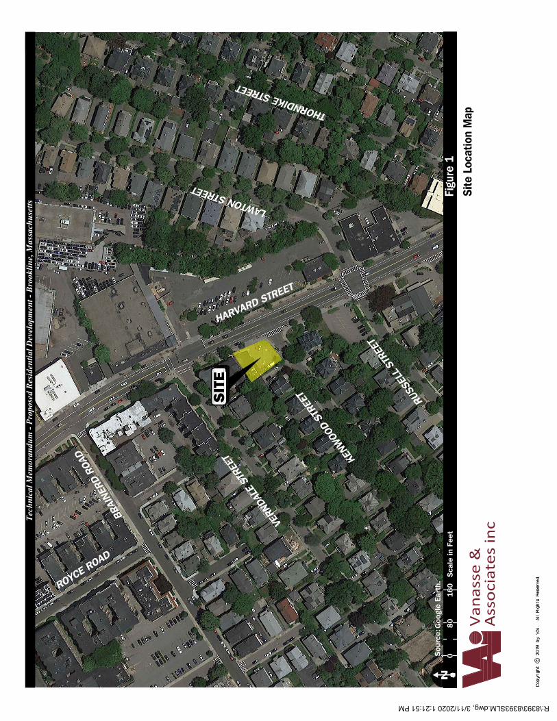
PROJECT DESCRIPTION Currently, 500 Harvard Street is occupied by the Shan-A-Punjab restaurant serving modern Indian cuisine. The site is situated on the northwest corner of the intersection of Harvard Street and Kenwood Street. The Project involves redeveloping the site into a residential development providing 30 apartment units and 1,740 sf of ground floor retail. A total of 6 parking spaces will be provided on-site (3 stacker spaces that accommodate 5 vehicles and 1 handicap space). Access to the site will be provided by way of the existing curb cut onto Kenwood Street. The existing curb cut onto Harvard Street will be closed. EXISTING CONDITIONS A comprehensive field inventory of existing conditions within the study area was conducted in February 2020. The field investigation consisted of an inventory of existing roadway geometrics; traffic volumes; and operating characteristics; as well as posted speed limits, and land use information within the study area. The study area for the project contains the major roadways which provide access to the project, as well as the intersections which are expected to accommodate the majority of project-related traffic. The study area is listed below and graphically depicted in Figure 1.
Harvard Street at Kenwood Street Harvard Street at Site Driveway Kenwood Street at Site Driveway
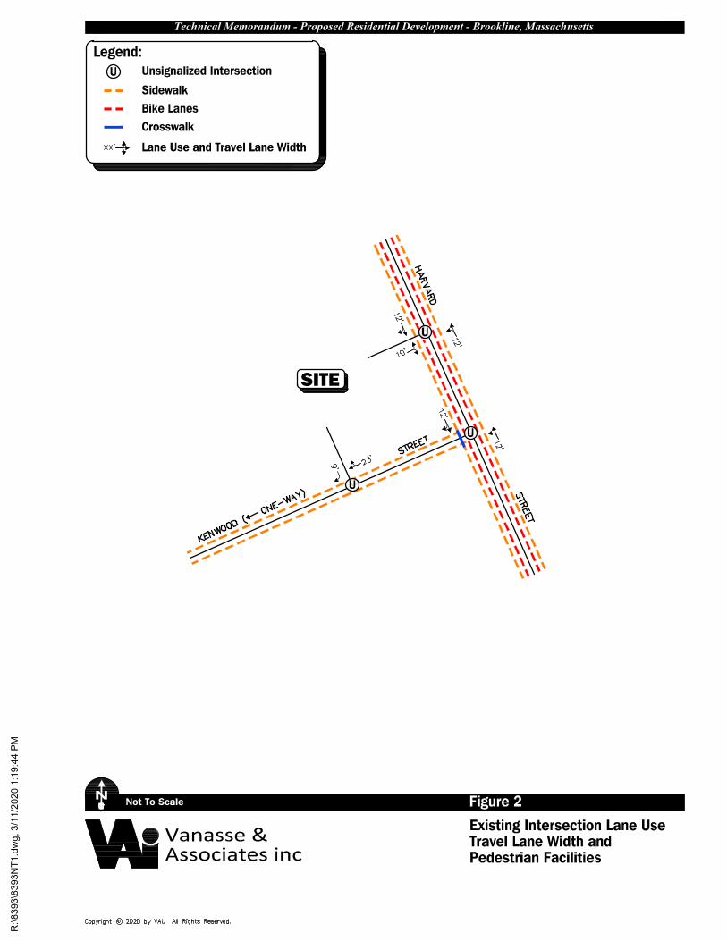
Existing Traffic Volumes In order to establish existing traffic-volume demands and flow patterns within the study area, manual turning movement counts (TMCs) were completed in February 2020. Manual TMCs were performed from 7:00 to 9:00 AM and 4:00 to 6:00 PM on an average weekday at the study area intersections. The following describes the study area roadways and intersections which are also shown in Figure 2 which summarizes existing lane use, travel lane widths, and sidewalk and crosswalk locations at the study area intersections. Geometry Harvard Street Harvard Street is classified as an urban principal arterial under the jurisdiction of the Town of Brookline. Harvard Street runs in a general north-south alignment throughout Brookline. Harvard Street allows two-way travel separated by a double yellow centerline. The land uses along Harvard Street generally consist of commercial and residential properties. Bike lanes are present on Harvard Street. Harvard Street at Kenwood Street Harvard Street is intersected by Kenwood Street from the east to form this three-way intersection. Direction of travel on Harvard Street is separated by a double yellow centerline. Kenwood Street allows one-way travel westbound. Illumination is provided via street lights mounted on metal poles. Land use in the vicinity of this intersection consists of a religious facility, a parking lot, and the Project site. This intersection is under the jurisdiction of the Town of Brookline.
SITE
KENW
OOD
STRE
ETVE
RNDA
LE S
TREE
T
BRAI
NERD
ROA
D
RUSS
ELL
STRE
ET
HARVARD STREET
LAWTON STREET
ROYCE ROAD
THORNDIKE STREET
Figu
re 1
Goo
gle
Eart
h.N
Van
asse
&A
ssoc
iate
s in
c
Sou
rce:
8016
00
Sca
le in
Fee
t
Site
Loc
atio
n M
ap
Tech
nica
l Mem
oran
dum
- Pr
opos
ed R
esid
entia
l Dev
elop
men
t - B
rook
line,
Mas
sach
uset
ts
R:\8393\8393SLM.dwg, 3/11/2020 1:21:51 PM
Not To Scale Figure 2Existing Intersection Lane Use
N
Travel Lane Width and
SITE
Technical Memorandum - Proposed Residential Development - Brookline, Massachusetts
Vanasse &Associates inc Pedestrian Facilities
Legend:Unsignalized IntersectionSidewalk
U
Bike Lanes
Lane Use and Travel Lane Width
U
U
U
Crosswalk
R:\8393\8393N
T1.dw
g, 3/11/2020 1:19:44 P
M
G:\8393 Brookline, MA\Memos\D. Danesh 050820.docx 3
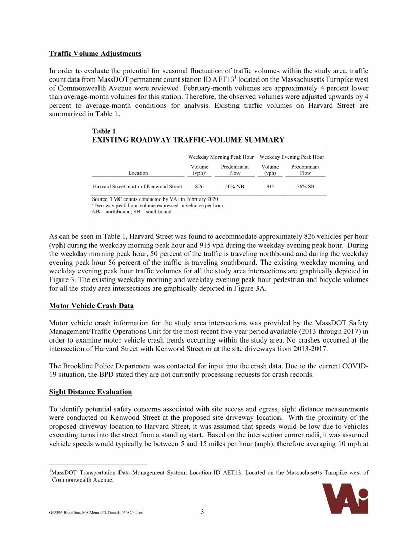
Traffic Volume Adjustments In order to evaluate the potential for seasonal fluctuation of traffic volumes within the study area, traffic count data from MassDOT permanent count station ID AET131 located on the Massachusetts Turnpike west of Commonwealth Avenue were reviewed. February-month volumes are approximately 4 percent lower than average-month volumes for this station. Therefore, the observed volumes were adjusted upwards by 4 percent to average-month conditions for analysis. Existing traffic volumes on Harvard Street are summarized in Table 1.
Table 1 EXISTING ROADWAY TRAFFIC-VOLUME SUMMARY
Weekday Morning Peak Hour Weekday Evening Peak Hour
Location Volume (vph)a
Predominant Flow
Volume (vph)
Predominant Flow
Harvard Street, north of Kenwood Street
826
50% NB
915
56% SB
Source: TMC counts conducted by VAI in February 2020. aTwo-way peak-hour volume expressed in vehicles per hour. NB = northbound; SB = southbound.
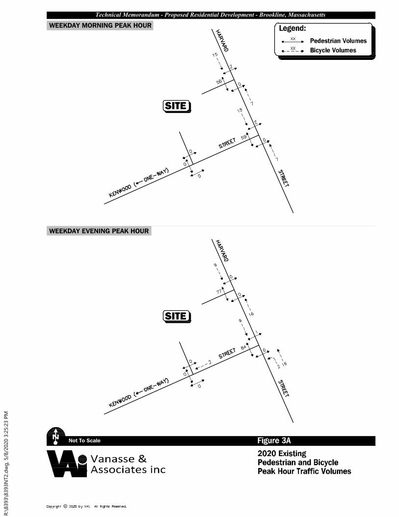
As can be seen in Table 1, Harvard Street was found to accommodate approximately 826 vehicles per hour (vph) during the weekday morning peak hour and 915 vph during the weekday evening peak hour. During the weekday morning peak hour, 50 percent of the traffic is traveling northbound and during the weekday evening peak hour 56 percent of the traffic is traveling southbound. The existing weekday morning and weekday evening peak hour traffic volumes for all the study area intersections are graphically depicted in Figure 3. The existing weekday morning and weekday evening peak hour pedestrian and bicycle volumes for all the study area intersections are graphically depicted in Figure 3A. Motor Vehicle Crash Data Motor vehicle crash information for the study area intersections was provided by the MassDOT Safety Management/Traffic Operations Unit for the most recent five-year period available (2013 through 2017) in order to examine motor vehicle crash trends occurring within the study area. No crashes occurred at the intersection of Harvard Street with Kenwood Street or at the site driveways from 2013-2017. The Brookline Police Department was contacted for input into the crash data. Due to the current COVID-19 situation, the BPD stated they are not currently processing requests for crash records. Sight Distance Evaluation To identify potential safety concerns associated with site access and egress, sight distance measurements were conducted on Kenwood Street at the proposed site driveway location. With the proximity of the proposed driveway location to Harvard Street, it was assumed that speeds would be low due to vehicles executing turns into the street from a standing start. Based on the intersection corner radii, it was assumed vehicle speeds would typically be between 5 and 15 miles per hour (mph), therefore averaging 10 mph at
1MassDOT Transportation Data Management System; Location ID AET13; Located on the Massachusetts Turnpike west of
Commonwealth Avenue.

Not To Scale Figure 32020 Existing
N
WEEKDAY MORNING PEAK HOUR
Peak Hour Traffic Volumes
WEEKDAY EVENING PEAK HOUR
SITE
Technical Memorandum - Proposed Residential Development - Brookline, Massachusetts
*lllegal movement.
Vanasse &Associates inc
SITE
R:\8393\8393N
T1.dw
g, 3/11/2020 1:20:11 P
M
Not To Scale Figure 3A2020 Existing
N
WEEKDAY MORNING PEAK HOUR
Pedestrian and Bicycle
WEEKDAY EVENING PEAK HOUR
SITE
Technical Memorandum - Proposed Residential Development - Brookline, Massachusetts
Vanasse &Associates inc
Pedestrian VolumesBicycle Volumes
Legend:
Peak Hour Traffic Volumes
SITE
R:\8393\8393N
T2.d
wg
, 5/8/2020 3:25:23 P
M
G:\8393 Brookline, MA\Memos\D. Danesh 050820.docx 4
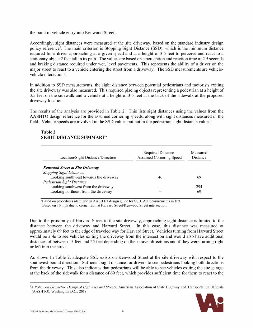
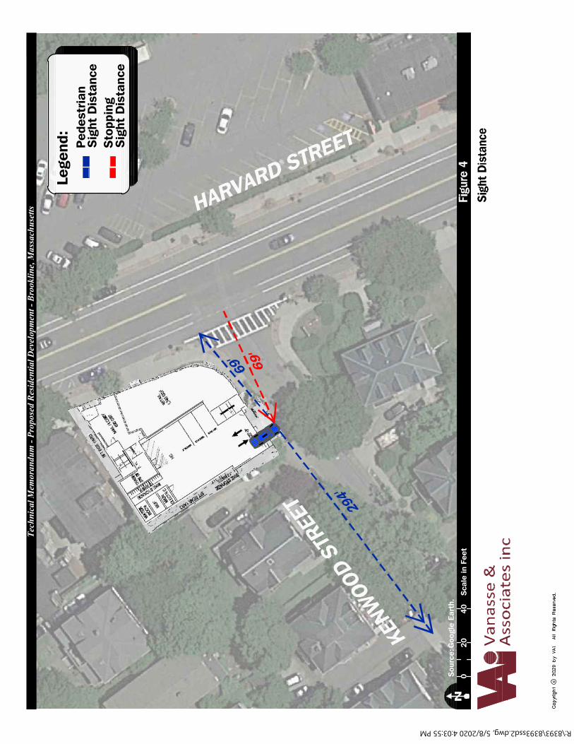
the point of vehicle entry into Kenwood Street. Accordingly, sight distances were measured at the site driveway, based on the standard industry design policy reference2. The main criterion is Stopping Sight Distance (SSD), which is the minimum distance required for a driver approaching at a given speed and at a height of 3.5 feet to perceive and react to a stationary object 2 feet tall in its path. The values are based on a perception and reaction time of 2.5 seconds and braking distance required under wet, level pavements. This represents the ability of a driver on the major street to react to a vehicle entering the street from a driveway. The SSD measurements are vehicle-vehicle interactions. In addition to SSD measurements, the sight distance between potential pedestrians and motorists exiting the site driveway was also measured. This required placing objects representing a pedestrian at a height of 3.5 feet on the sidewalk and a vehicle at a height of 3.5 feet at the back of the sidewalk at the proposed driveway location. The results of the analysis are provided in Table 2. This lists sight distances using the values from the AASHTO design reference for the assumed cornering speeds, along with sight distances measured in the field. Vehicle speeds are involved in the SSD values but not in the pedestrian sight distance values.
Table 2 SIGHT DISTANCE SUMMARYa
Location/Sight Distance/Direction
Required Distance –
Assumed Cornering Speedb
Measured Distance
Kenwood Street at Site Driveway Stopping Sight Distance:
Looking southwest towards the driveway Pedestrian Sight Distance
Looking southwest from the driveway Looking northeast from the driveway
46
-- --
69
294 69
aBased on procedures identified in AASHTO design guide for SSD. All measurements in feet. bBased on 10 mph due to corner radii at Harvard Street/Kenwood Street intersection.
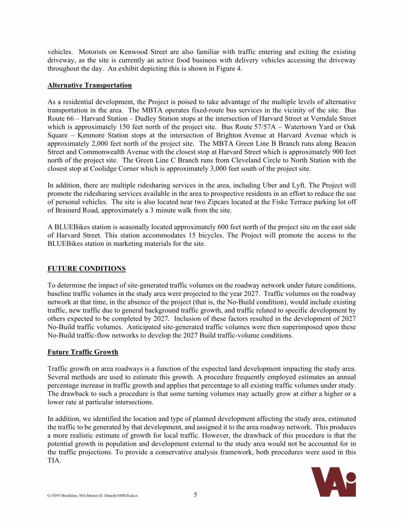
Due to the proximity of Harvard Street to the site driveway, approaching sight distance is limited to the distance between the driveway and Harvard Street. In this case, this distance was measured at approximately 69 feet to the edge of traveled way for Harvard Street. Vehicles turning from Harvard Street would be able to see vehicles exiting the driveway from the intersection and would also have additional distances of between 15 feet and 25 feet depending on their travel directions and if they were turning right or left into the street. As shown In Table 2, adequate SSD exists on Kenwood Street at the site driveway with respect to the southwest-bound direction. Sufficient sight distance for drivers to see pedestrians looking both directions from the driveway. This also indicates that pedestrians will be able to see vehicles exiting the site garage at the back of the sidewalk for a distance of 69 feet, which provides sufficient time for them to react to the
2A Policy on Geometric Design of Highways and Streets; American Association of State Highway and Transportation Officials
(AASHTO); Washington D.C., 2018.
G:\8393 Brookline, MA\Memos\D. Danesh 050820.docx 5
vehicles. Motorists on Kenwood Street are also familiar with traffic entering and exiting the existing driveway, as the site is currently an active food business with delivery vehicles accessing the driveway throughout the day. An exhibit depicting this is shown in Figure 4. Alternative Transportation
As a residential development, the Project is poised to take advantage of the multiple levels of alternative transportation in the area. The MBTA operates fixed-route bus services in the vicinity of the site. Bus Route 66 – Harvard Station – Dudley Station stops at the intersection of Harvard Street at Verndale Street which is approximately 150 feet north of the project site. Bus Route 57/57A – Watertown Yard or Oak Square – Kenmore Station stops at the intersection of Brighton Avenue at Harvard Avenue which is approximately 2,000 feet north of the project site. The MBTA Green Line B Branch runs along Beacon Street and Commonwealth Avenue with the closest stop at Harvard Street which is approximately 900 feet north of the project site. The Green Line C Branch runs from Cleveland Circle to North Station with the closest stop at Coolidge Corner which is approximately 3,000 feet south of the project site. In addition, there are multiple ridesharing services in the area, including Uber and Lyft. The Project will promote the ridesharing services available in the area to prospective residents in an effort to reduce the use of personal vehicles. The site is also located near two Zipcars located at the Fiske Terrace parking lot off of Brainerd Road, approximately a 3 minute walk from the site. A BLUEBikes station is seasonally located approximately 600 feet north of the project site on the east side of Harvard Street. This station accommodates 15 bicycles. The Project will promote the access to the BLUEBikes station in marketing materials for the site. FUTURE CONDITIONS To determine the impact of site-generated traffic volumes on the roadway network under future conditions, baseline traffic volumes in the study area were projected to the year 2027. Traffic volumes on the roadway network at that time, in the absence of the project (that is, the No-Build condition), would include existing traffic, new traffic due to general background traffic growth, and traffic related to specific development by others expected to be completed by 2027. Inclusion of these factors resulted in the development of 2027 No-Build traffic volumes. Anticipated site-generated traffic volumes were then superimposed upon these No-Build traffic-flow networks to develop the 2027 Build traffic-volume conditions. Future Traffic Growth Traffic growth on area roadways is a function of the expected land development impacting the study area. Several methods are used to estimate this growth. A procedure frequently employed estimates an annual percentage increase in traffic growth and applies that percentage to all existing traffic volumes under study. The drawback to such a procedure is that some turning volumes may actually grow at either a higher or a lower rate at particular intersections. In addition, we identified the location and type of planned development affecting the study area, estimated the traffic to be generated by that development, and assigned it to the area roadway network. This produces a more realistic estimate of growth for local traffic. However, the drawback of this procedure is that the potential growth in population and development external to the study area would not be accounted for in the traffic projections. To provide a conservative analysis framework, both procedures were used in this TIA.
KENW
OOD
STRE
ET
HARVARD STREET
294'
69'
69'
Figu
re 4
Goo
gle
Eart
h.N
Van
asse
&A
ssoc
iate
s in
c
Sou
rce:
2040
0S
cale
in F
eet
Sigh
t Dis
tanc
e
Tech
nica
l Mem
oran
dum
- Pr
opos
ed R
esid
entia
l Dev
elop
men
t - B
rook
line,
Mas
sach
uset
ts
Lege
nd:
Sig
ht D
ista
nce
Ped
estr
ian
Sig
ht D
ista
nce
Sto
ppin
g
R:\8393\8393ssd2.dwg, 5/8/2020 4:03:55 PM
G:\8393 Brookline, MA\Memos\D. Danesh 050820.docx 6
General Background Growth Traffic-volume data compiled by MassDOT from permanent count stations and historic traffic counts in the area were reviewed in order to determine general background traffic growth trends. Based on a review of this data and other area traffic studies, it was determine that the traffic volumes are decreasing in the area by approximately 0.1 percent per year on average. To be conservative, a 1.0 percent per year compounded annual background traffic growth rate was used to account for future traffic growth including presently unforeseen development within the study area. Specific Development by Others The Town of Brookline was contacted in order to determine if there are any planned or approved specific development projects within the area that would have an impact on future traffic volumes at the study intersections. Based on these discussions the following projects were identified for inclusion in this assessment. 40 Center Street – This redevelopment entails the construction of 40 residential units to be located at 40 Center Street in Brookline, Massachusetts. A total of 21 off-street vehicle parking spaces and 32 bicycle racks will be provided in the first-floor parking garage. Traffic volumes from the Traffic & Parking Assessment3 submitted by MDM in October 2016 indicate that this development will have a minor impact to the Project study area and where therefore assumed to be included in the general background growth rate. 384 Harvard Street – This development entails the construction of 62 senior housing units and 5,000 sf of ground floor retail to be located at 384 Harvard Street in Brookline, Massachusetts. Traffic volumes for this development were estimated using the Institute of Transportation Engineers (ITE) Land Use Code (LUC) 252 – Senior Adult Housing - Attached and added to the future condition networks. 420 Harvard Street – This development entails the construction of 36 residential units with 2,650 sf of office/retail space to be located at 420 Harvard Street in Brookline, Massachusetts. Parking will be provided on-site for 38 vehicles. Traffic volumes from the Transportation Impact Assessment4 submitted by VAI in August 2016 were added to the future condition networks. 445 Harvard Street – This development entails the construction of a five-story building with 25 residential units and 4,380 sf of ground floor retail to be located at 445 Harvard Street in Brookline, Massachusetts. Traffic volumes from the Traffic Memorandum5 submitted by VAI on July 23, 2018 were added to the future condition networks. 455 Harvard Street – This development entails the construction of 17 residential units with 1,735 sf of ground-floor retail to be locate at 455 Brookline, Massachusetts. Parking will be provided on-site for 12 vehicles. Traffic volumes from the Traffic Memorandum6 submitted by VAI on May 2, 2017 were added to the future condition networks.
3Traffic & Parking Assessment – Proposed Residential Development 40 Center Street – Brookline, MA; MDM Transportation
Consultants, Inc.; October 14, 2016. 4 Transportation Impact Assessment – Proposed Mixed-Use Development – Brookline, Massachusetts; VAI; August 2016 5 Traffic Memorandum – Proposed Mixed-Use Development – 445 Harvard Street – Brookline, Massachusetts; VAI; July 23, 2018. 6 Traffic Memorandum – Traffic Assessment – 455 Harvard Street – Brookline, MA; VAI; May 2, 2017.
G:\8393 Brookline, MA\Memos\D. Danesh 050820.docx 7
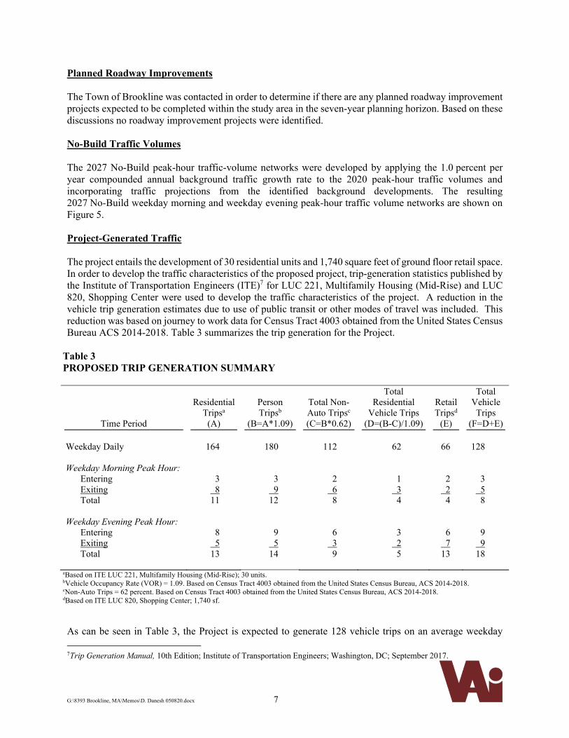
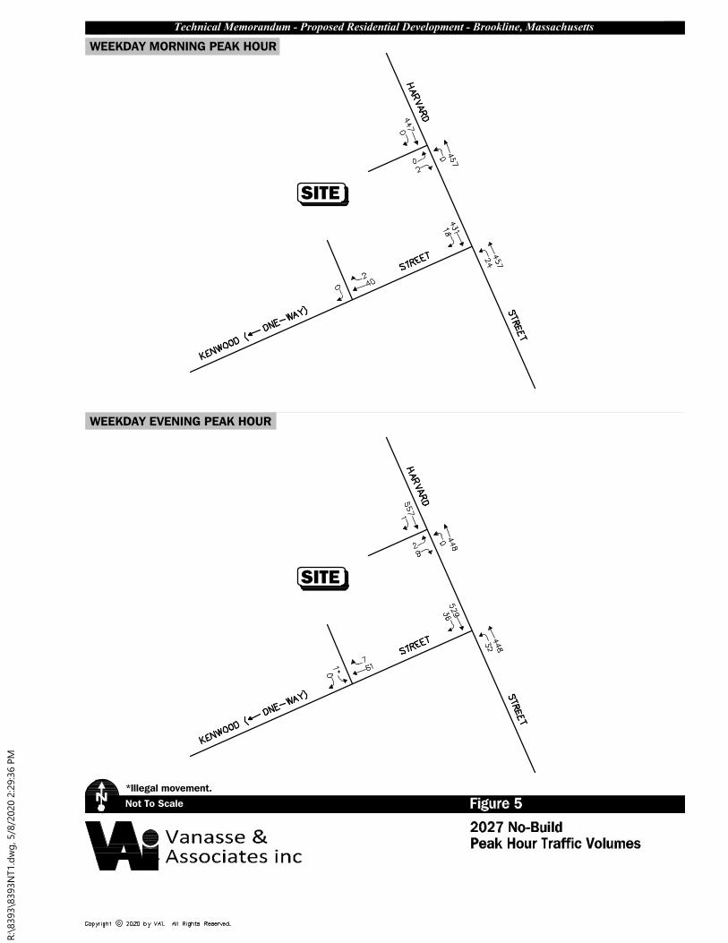
Planned Roadway Improvements The Town of Brookline was contacted in order to determine if there are any planned roadway improvement projects expected to be completed within the study area in the seven-year planning horizon. Based on these discussions no roadway improvement projects were identified. No-Build Traffic Volumes The 2027 No-Build peak-hour traffic-volume networks were developed by applying the 1.0 percent per year compounded annual background traffic growth rate to the 2020 peak-hour traffic volumes and incorporating traffic projections from the identified background developments. The resulting 2027 No-Build weekday morning and weekday evening peak-hour traffic volume networks are shown on Figure 5. Project-Generated Traffic The project entails the development of 30 residential units and 1,740 square feet of ground floor retail space. In order to develop the traffic characteristics of the proposed project, trip-generation statistics published by the Institute of Transportation Engineers (ITE)7 for LUC 221, Multifamily Housing (Mid-Rise) and LUC 820, Shopping Center were used to develop the traffic characteristics of the project. A reduction in the vehicle trip generation estimates due to use of public transit or other modes of travel was included. This reduction was based on journey to work data for Census Tract 4003 obtained from the United States Census Bureau ACS 2014-2018. Table 3 summarizes the trip generation for the Project.
Table 3
PROPOSED TRIP GENERATION SUMMARY
Time Period
Residential
Tripsa (A)
Person Tripsb
(B=A*1.09)
Total Non-Auto Tripsc
(C=B*0.62)
Total Residential
Vehicle Trips (D=(B-C)/1.09)
Retail Tripsd
(E)
Total Vehicle Trips
(F=D+E) Weekday Daily
164
180
112
62
66
128
Weekday Morning Peak Hour: Entering Exiting Total
3 8 11
3 9 12
2 6
8
1 3
4
2 2
4
3 5
8 Weekday Evening Peak Hour: Entering Exiting Total
8 5 13
9 5 14
6 3
9
3 2
5
6 7 13
9 9 18
aBased on ITE LUC 221, Multifamily Housing (Mid-Rise); 30 units. bVehicle Occupancy Rate (VOR) = 1.09. Based on Census Tract 4003 obtained from the United States Census Bureau, ACS 2014-2018. cNon-Auto Trips = 62 percent. Based on Census Tract 4003 obtained from the United States Census Bureau, ACS 2014-2018. dBased on ITE LUC 820, Shopping Center; 1,740 sf.
As can be seen in Table 3, the Project is expected to generate 128 vehicle trips on an average weekday
7Trip Generation Manual, 10th Edition; Institute of Transportation Engineers; Washington, DC; September 2017.
Not To Scale Figure 52027 No-Build
N
WEEKDAY MORNING PEAK HOUR
Peak Hour Traffic Volumes
WEEKDAY EVENING PEAK HOUR
SITE
Technical Memorandum - Proposed Residential Development - Brookline, Massachusetts
*lllegal movement.
Vanasse &Associates inc
SITE
R:\8393\8393N
T1.d
wg
, 5/8/2020 2:29:36 P
M
G:\8393 Brookline, MA\Memos\D. Danesh 050820.docx 8
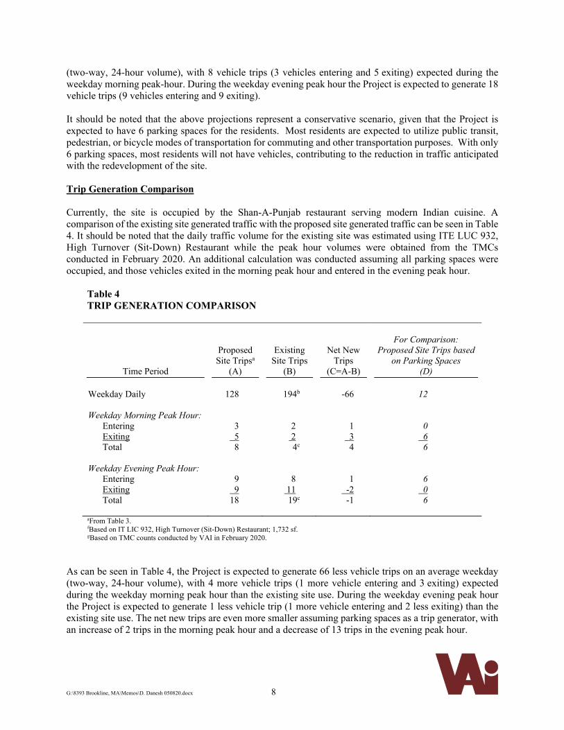
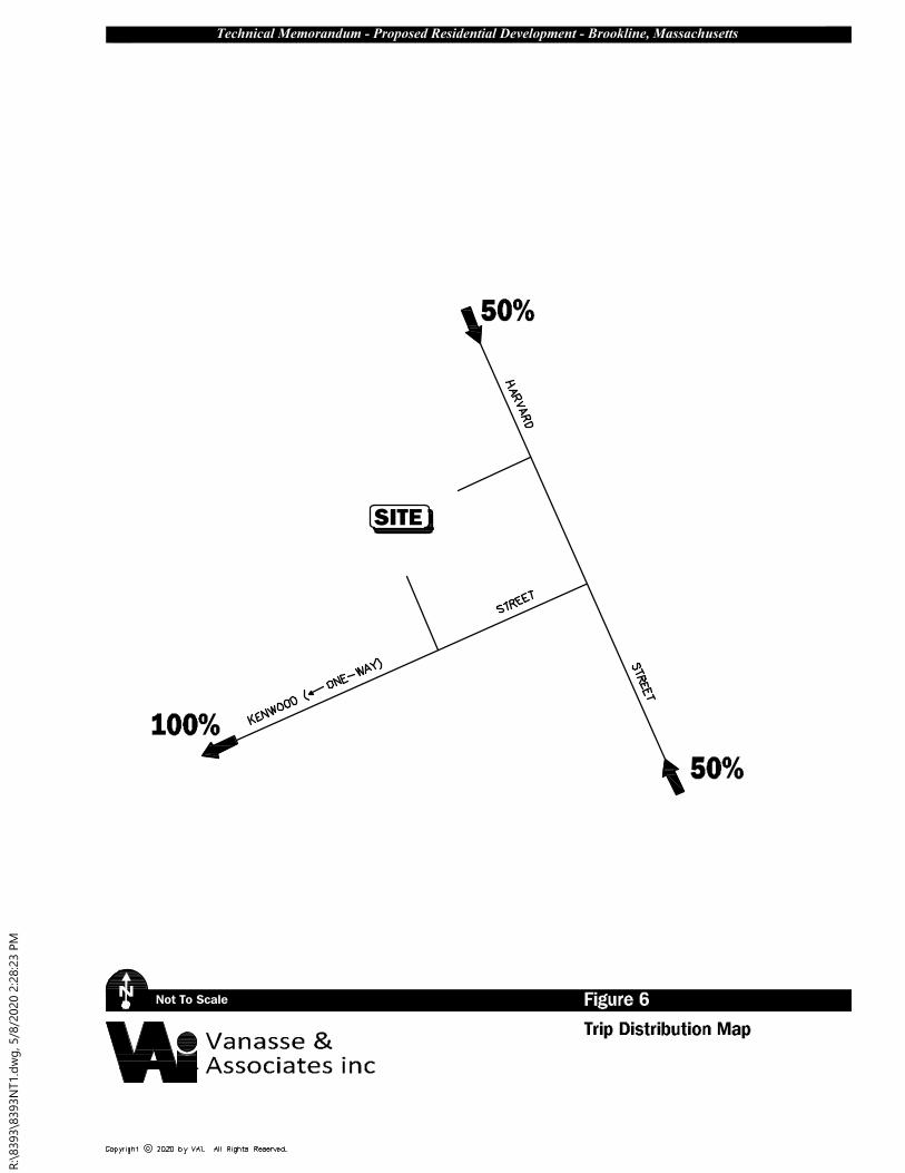
(two-way, 24-hour volume), with 8 vehicle trips (3 vehicles entering and 5 exiting) expected during the weekday morning peak-hour. During the weekday evening peak hour the Project is expected to generate 18 vehicle trips (9 vehicles entering and 9 exiting). It should be noted that the above projections represent a conservative scenario, given that the Project is expected to have 6 parking spaces for the residents. Most residents are expected to utilize public transit, pedestrian, or bicycle modes of transportation for commuting and other transportation purposes. With only 6 parking spaces, most residents will not have vehicles, contributing to the reduction in traffic anticipated with the redevelopment of the site. Trip Generation Comparison Currently, the site is occupied by the Shan-A-Punjab restaurant serving modern Indian cuisine. A comparison of the existing site generated traffic with the proposed site generated traffic can be seen in Table 4. It should be noted that the daily traffic volume for the existing site was estimated using ITE LUC 932, High Turnover (Sit-Down) Restaurant while the peak hour volumes were obtained from the TMCs conducted in February 2020. An additional calculation was conducted assuming all parking spaces were occupied, and those vehicles exited in the morning peak hour and entered in the evening peak hour.
Table 4
TRIP GENERATION COMPARISON
Time Period
Proposed Site Tripsa
(A)
Existing Site Trips
(B)
Net New Trips
(C=A-B)
For Comparison:
Proposed Site Trips based on Parking Spaces
(D) Weekday Daily
128
194b
-66
12
Weekday Morning Peak Hour: Entering Exiting Total
3 5
8
2 2 4c
1 3
4
0 6
6 Weekday Evening Peak Hour: Entering Exiting Total
9 9 18
8 11 19c
1 -2
-1
6 0
6
aFrom Table 3. fBased on IT LIC 932, High Turnover (Sit-Down) Restaurant; 1,732 sf. gBased on TMC counts conducted by VAI in February 2020.
As can be seen in Table 4, the Project is expected to generate 66 less vehicle trips on an average weekday (two-way, 24-hour volume), with 4 more vehicle trips (1 more vehicle entering and 3 exiting) expected during the weekday morning peak hour than the existing site use. During the weekday evening peak hour the Project is expected to generate 1 less vehicle trip (1 more vehicle entering and 2 less exiting) than the existing site use. The net new trips are even more smaller assuming parking spaces as a trip generator, with an increase of 2 trips in the morning peak hour and a decrease of 13 trips in the evening peak hour.
G:\8393 Brookline, MA\Memos\D. Danesh 050820.docx 9
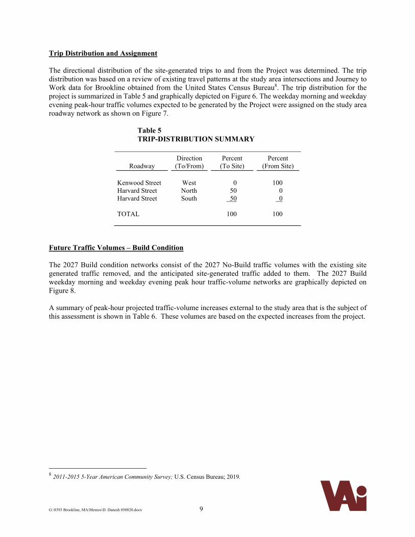
Trip Distribution and Assignment The directional distribution of the site-generated trips to and from the Project was determined. The trip distribution was based on a review of existing travel patterns at the study area intersections and Journey to Work data for Brookline obtained from the United States Census Bureau8. The trip distribution for the project is summarized in Table 5 and graphically depicted on Figure 6. The weekday morning and weekday evening peak-hour traffic volumes expected to be generated by the Project were assigned on the study area roadway network as shown on Figure 7.
Table 5 TRIP-DISTRIBUTION SUMMARY
Roadway Direction (To/From)
Percent (To Site)
Percent (From Site)
Kenwood Street Harvard Street Harvard Street TOTAL
West North South
0
50 50
100
100
0 0
100
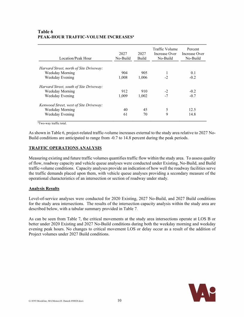
Future Traffic Volumes – Build Condition The 2027 Build condition networks consist of the 2027 No-Build traffic volumes with the existing site generated traffic removed, and the anticipated site-generated traffic added to them. The 2027 Build weekday morning and weekday evening peak hour traffic-volume networks are graphically depicted on Figure 8. A summary of peak-hour projected traffic-volume increases external to the study area that is the subject of this assessment is shown in Table 6. These volumes are based on the expected increases from the project.
8 2011-2015 5-Year American Community Survey; U.S. Census Bureau; 2019.
Not To Scale Figure 6Trip Distribution Map
N
SITE
Technical Memorandum - Proposed Residential Development - Brookline, Massachusetts
Vanasse &Associates inc
50%
50%
100%
R:\8393\8393N
T1.d
wg
, 5/8/2020 2:28:23 P
M
Not To Scale Figure 7Site Generated
N
WEEKDAY MORNING PEAK HOUR
Peak Hour Traffic Volumes
WEEKDAY EVENING PEAK HOUR
SITE
Technical Memorandum - Proposed Residential Development - Brookline, Massachusetts
Vanasse &Associates inc
SITE
R:\8393\8393N
T1.d
wg
, 5/8/2020 2:27:34 P
M
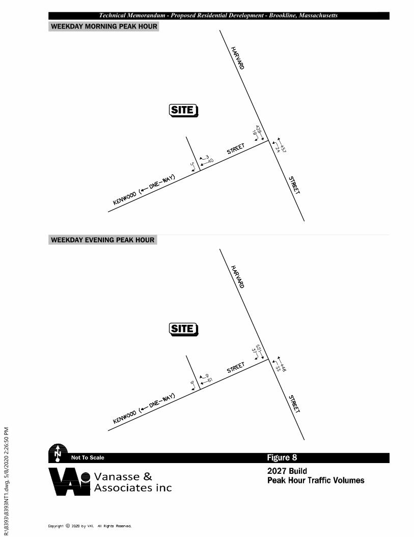
Not To Scale Figure 82027 Build
N
WEEKDAY MORNING PEAK HOUR
Peak Hour Traffic Volumes
WEEKDAY EVENING PEAK HOUR
SITE
Technical Memorandum - Proposed Residential Development - Brookline, Massachusetts
Vanasse &Associates inc
SITE
R:\8393\8393N
T1.d
wg
, 5/8/2020 2:26:50 P
M
G:\8393 Brookline, MA\Memos\D. Danesh 050820.docx 10
Table 6 PEAK-HOUR TRAFFIC-VOLUME INCREASESa
Location/Peak Hour 2027
No-Build 2027 Build
Traffic Volume Increase Over
No-Build
Percent Increase Over
No-Build Harvard Street, north of Site Driveway: Weekday Morning Weekday Evening
904 1,008
905 1,006
1 -2
0.1 -0.2
Harvard Street, south of Site Driveway: Weekday Morning Weekday Evening
912
1,009
910
1,002
-2 -7
-0.2 -0.7
Kenwood Street, west of Site Driveway: Weekday Morning Weekday Evening
40 61
45 70
5 9
12.5 14.8
aTwo-way traffic total.
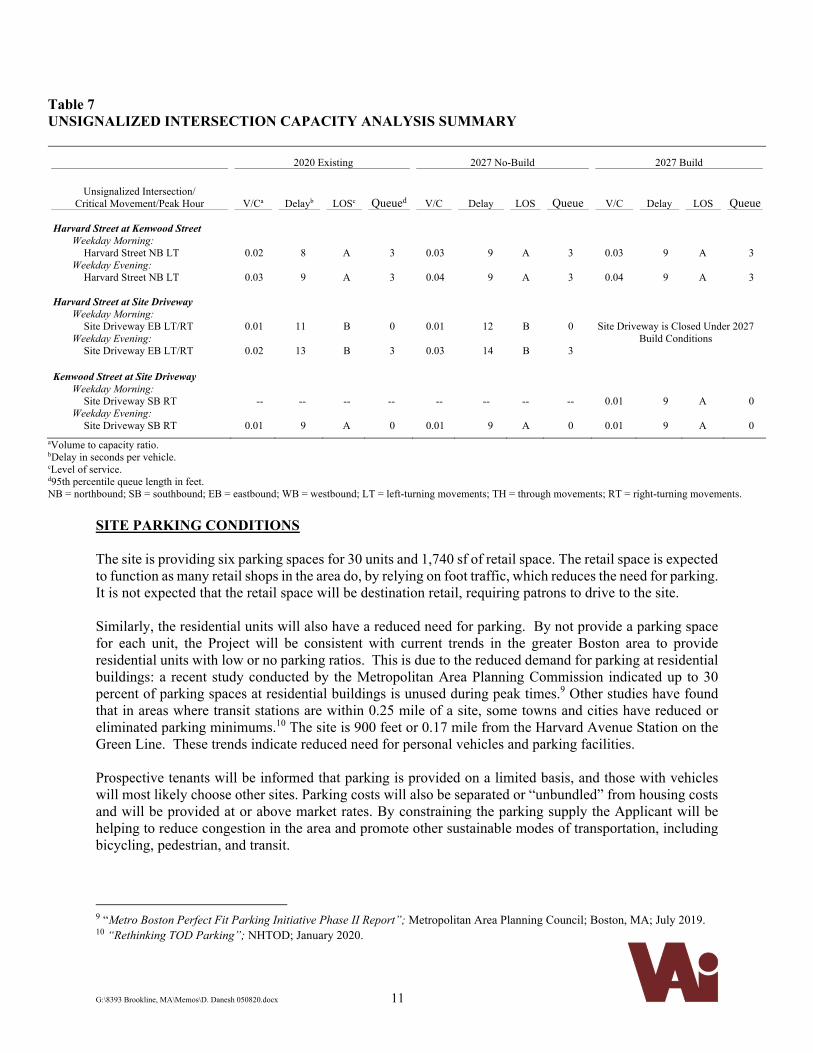
As shown in Table 6, project-related traffic-volume increases external to the study area relative to 2027 No-Build conditions are anticipated to range from -0.7 to 14.8 percent during the peak periods. TRAFFIC OPERATIONS ANALYSIS Measuring existing and future traffic volumes quantifies traffic flow within the study area. To assess quality of flow, roadway capacity and vehicle queue analyses were conducted under Existing, No-Build, and Build traffic-volume conditions. Capacity analyses provide an indication of how well the roadway facilities serve the traffic demands placed upon them, with vehicle queue analyses providing a secondary measure of the operational characteristics of an intersection or section of roadway under study. Analysis Results Level-of-service analyses were conducted for 2020 Existing, 2027 No-Build, and 2027 Build conditions for the study area intersections. The results of the intersection capacity analysis within the study area are described below, with a tabular summary provided in Table 7.
As can be seen from Table 7, the critical movements at the study area intersections operate at LOS B or better under 2020 Existing and 2027 No-Build conditions during both the weekday morning and weekday evening peak hours. No changes to critical movement LOS or delay occur as a result of the addition of Project volumes under 2027 Build conditions.
G:\8393 Brookline, MA\Memos\D. Danesh 050820.docx 11
Table 7 UNSIGNALIZED INTERSECTION CAPACITY ANALYSIS SUMMARY
2020 Existing 2027 No-Build 2027 Build
Unsignalized Intersection/ Critical Movement/Peak Hour
V/Ca
Delayb
LOSc Queued
V/C
Delay
LOS Queue
V/C
Delay
LOS Queue
Harvard Street at Kenwood Street Weekday Morning:
Harvard Street NB LT Weekday Evening:
Harvard Street NB LT
0.02
0.03
8
9
A
A
3
3
0.03
0.04
9
9
A
A
3
3
0.03
0.04
9
9
A
A
3
3
Harvard Street at Site Driveway Weekday Morning:
Site Driveway EB LT/RT Weekday Evening:
Site Driveway EB LT/RT
0.01
0.02
11
13
B
B
0
3
0.01
0.03
12
14
B
B
0
3
Site Driveway is Closed Under 2027 Build Conditions
Kenwood Street at Site Driveway Weekday Morning:
Site Driveway SB RT Weekday Evening:
Site Driveway SB RT
--
0.01
--
9
--
A
--
0
--
0.01
-- 9
--
A
--
0
0.01
0.01
9
9
A
A
0
0
aVolume to capacity ratio. bDelay in seconds per vehicle. cLevel of service. d95th percentile queue length in feet. NB = northbound; SB = southbound; EB = eastbound; WB = westbound; LT = left-turning movements; TH = through movements; RT = right-turning movements.
SITE PARKING CONDITIONS The site is providing six parking spaces for 30 units and 1,740 sf of retail space. The retail space is expected to function as many retail shops in the area do, by relying on foot traffic, which reduces the need for parking. It is not expected that the retail space will be destination retail, requiring patrons to drive to the site. Similarly, the residential units will also have a reduced need for parking. By not provide a parking space for each unit, the Project will be consistent with current trends in the greater Boston area to provide residential units with low or no parking ratios. This is due to the reduced demand for parking at residential buildings: a recent study conducted by the Metropolitan Area Planning Commission indicated up to 30 percent of parking spaces at residential buildings is unused during peak times.9 Other studies have found that in areas where transit stations are within 0.25 mile of a site, some towns and cities have reduced or eliminated parking minimums.10 The site is 900 feet or 0.17 mile from the Harvard Avenue Station on the Green Line. These trends indicate reduced need for personal vehicles and parking facilities. Prospective tenants will be informed that parking is provided on a limited basis, and those with vehicles will most likely choose other sites. Parking costs will also be separated or “unbundled” from housing costs and will be provided at or above market rates. By constraining the parking supply the Applicant will be helping to reduce congestion in the area and promote other sustainable modes of transportation, including bicycling, pedestrian, and transit.
9 “Metro Boston Perfect Fit Parking Initiative Phase II Report”; Metropolitan Area Planning Council; Boston, MA; July 2019. 10 “Rethinking TOD Parking”; NHTOD; January 2020.
G:\8393 Brookline, MA\Memos\D. Danesh 050820.docx 12
RECOMMENDATIONS AND CONCLUSIONS VAI has completed a transportation assessment of the potential impacts on the surrounding transportation infrastructure associated with the proposed 30-unit residential development with 1,740 sf of ground floor retail to be located at 500 Harvard Street in Brookline, Massachusetts. The following specific areas have been evaluated as they relate to the Project: i) access requirements; ii) potential off-site improvements; and iii) safety considerations; under existing and future conditions, both with and without the Project. No crashes were identified to have occurred within the study area from 2013-2017 and the sight distance available at the existing driveway onto Kenwood Street is adequate for vehicles and pedestrians. Using a conservative analysis approach including actual driveway counts of the current site traffic activity along with industry standard trip generation projections results in the Project producing a decrease in daily site generated traffic as compared to the previous site use. However, with only six parking spaces, it is expected that the Project will have far fewer trips than industry standards indicate and will represent a substantial decrease in traffic generation compared with the existing use. The following recommendations are also part of the Project:
Constrained parking supply of six parking spaces for 30 units. Parking space charges will be unbundled from rent, and market rates will be charged for spaces. Transit schedules will be posted at a central location on site. Alternative transportation including bicycling resources and carsharing options will be promoted
in literature for the site available for new residents. The Project will result in an increase of 4 trips during the weekday morning peak hour and a decrease of 1 trip in the weekday evening peak hour as compared to the restaurant use. No changes to critical movement LOS or delay occur as a result of the addition of the Project volumes under the 2027 Build condition. Closure of the existing 25-foot wide Harvard Street driveway will improve safety for pedestrians walking along the sidewalk on Harvard Street as well as bicyclists traveling on the roadway. In addition, loading is expected to occur during off-peak time periods and through existing loading areas on Harvard Street, without sending delivery vehicles onto Kenwood Street. Given the proposed measures designed to further reduce the use of personal vehicles associated with the site, VAI has concluded that the Project can be safely accommodated on the area road network. Cc: File