Embed Size (px)
Citation preview
GOVERNMENT OF INDIA
MINISTRY OF EARTH SCIENCES
EARTH SYSTEM SCIENCE ORGANIZATION
INDIA METEOROLOGICAL DEPARTMENT
A Preliminary Report on Depression over Bay of Bengal
(13 - 17 November, 2013)
CYCLONE WARNING DIVISION, NEW DELHI
DECEMBER, 2013
1
Depression over the Bay of Bengal (13 – 17 November 2013)
1. Introduction A depression formed over southwest and adjoining southeast Bay of Bengal on dated 13th
November 2013 near latitude 11.50N and longitude 86.50E, about 700 km east-southeast of Chennai,
770 km east-southeast of Nellore and 730 km east-northeast of Nagapattinam. The system crossed
Tamil Nadu coast near Nagapattinam on 0730 UTC of 16th November, 2013. It then moved westwards
and weakened gradually a well marked low pressure area over north interior Tamil Nadu at 0530 hrs
IST of 17th November, 2013. The salient features of this depression are given below:
(i). The depression initially moved westward and then it moved southwestwards and after that it moved west-northwestwards up to north interior Tamil Nadu.
(ii) Due to its slow movement over north Tamil Nadu, it caused very good rainfall activity over the region.
2 Monitoring and Prediction:
The depression was monitored with satellite, meteorological buoys, coastal, observations and
Doppler Weather Radar (DWR) Chennai. The half hourly INSAT/ Kalpana imageries & scattrometer
wind and every 10 minutes DWR imageries and products were used for monitoring of depression.
Various numerical weather prediction (NWP) models including IMD’s global and meso-scale models
were utilized to predict the track and intensity of the depression. The Tropical Cyclone Module in the
digitized forecasting system of IMD was utilized for analysis and comparison of various NWP models
and decision making process.
3. Genesis :
The remnant of the tropical depression (Wilma) over south China sea moved Malay peninsula
and emerged as a low pressure area emerged into Andaman Sea & neighbourhood with associated
upper air cyclonic circulation extending upto mid-tropospheric levels on 9th November, 2013. It lay
over southeast Bay of Bengal and adjoining Andaman & Nicobar Islands on 10th November. It lay as a
well marked low pressure area on 11th and persisted over the same region on 12th. It further
concentrated into a depression and laid centre at 0830 hours IST of 13th near lat. 11.5°N and long.
86.0°E, about 650 km east-southeast of Chennai.
The low level convergence and relative vorticity increased over the south Bay of Bengal. The
sea surface temperature over southwest Bay of Bengal was also warmer (28- 30°C). The ocean
thermal energy was about 80-100 kj / cm2over the region. The Madden Julian Oscillation (MJO) index
2
lay in phase 3 during these periods with amplitude less than 1. The vertical wind shear was moderate
to high (15-25 knots). Past studies indicate that phase 3 is favourable for genesis of depression as it
helps in enhancing the convection. Under these conditions the depression formed at 00 UTC of 13TH
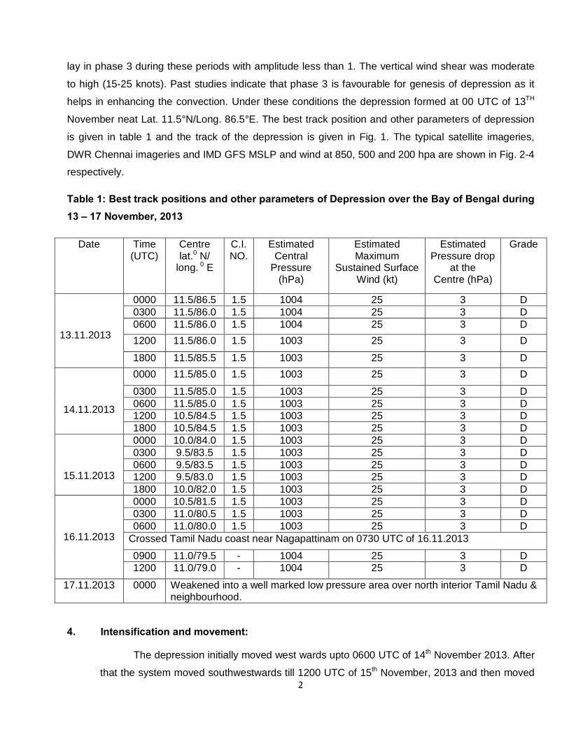
November neat Lat. 11.5°N/Long. 86.5°E. The best track position and other parameters of depression
is given in table 1 and the track of the depression is given in Fig. 1. The typical satellite imageries,
DWR Chennai imageries and IMD GFS MSLP and wind at 850, 500 and 200 hpa are shown in Fig. 2-4
respectively.
Table 1: Best track positions and other parameters of Depression over the Bay of Bengal during 13 – 17 November, 2013
Date
Time (UTC)
Centre lat.0 N/
long. 0 E
C.I. NO.
Estimated Central
Pressure (hPa)
Estimated Maximum
Sustained Surface Wind (kt)
Estimated Pressure drop
at the Centre (hPa)
Grade
13.11.2013
0000 11.5/86.5 1.5 1004 25 3 D 0300 11.5/86.0 1.5 1004 25 3 D 0600 11.5/86.0 1.5 1004 25 3 D 1200 11.5/86.0 1.5 1003 25 3 D
1800 11.5/85.5 1.5 1003 25 3 D
14.11.2013
0000 11.5/85.0 1.5 1003 25 3 D
0300 11.5/85.0 1.5 1003 25 3 D 0600 11.5/85.0 1.5 1003 25 3 D 1200 10.5/84.5 1.5 1003 25 3 D 1800 10.5/84.5 1.5 1003 25 3 D
15.11.2013
0000 10.0/84.0 1.5 1003 25 3 D 0300 9.5/83.5 1.5 1003 25 3 D 0600 9.5/83.5 1.5 1003 25 3 D 1200 9.5/83.0 1.5 1003 25 3 D 1800 10.0/82.0 1.5 1003 25 3 D
16.11.2013
0000 10.5/81.5 1.5 1003 25 3 D 0300 11.0/80.5 1.5 1003 25 3 D 0600 11.0/80.0 1.5 1003 25 3 D
Crossed Tamil Nadu coast near Nagapattinam on 0730 UTC of 16.11.2013
0900 11.0/79.5 - 1004 25 3 D 1200 11.0/79.0 - 1004 25 3 D
17.11.2013 0000 Weakened into a well marked low pressure area over north interior Tamil Nadu & neighbourhood.
4. Intensification and movement:
The depression initially moved west wards upto 0600 UTC of 14th November 2013. After
that the system moved southwestwards till 1200 UTC of 15th November, 2013 and then moved
3
west-northwest wards and crossed Tamil Nadu coast near Nagapattanam around 0730 UTC of
16th November, 2013. It weakened into a well-marked low pressure area over north interior
Tamil Nadu at 00 UTC of 17th November 2013.
Though most of the NWP models suggested slow intensification upto deep depression
stage, the system did not intensify into a deep depression due to increase in vertical wind shear
as the system moved towards the coast. The wind shear become high (20-30 knots) in the
evening of 14th November. Due to the high wind shear, the convection got sheared gradually.
Further the low amplitude of MJO was not supportive for intensification of the system. On these
day the NWP models also suggested no further intensification and rather weakening of the
system over the sea was suggested by same models. The Ocean thermal energy was also
less over southwest Bay of Bengal near to Srilanka and Tamil Nadu. As the system came closer
to Tamil Nadu coast, it did not weaken and maintained its intensity of depression due to
decreases in vertical wind shear. The wind shear was low to moderate (10-20 knots) at 1200
UTC of 15th Nov 2013. As a result the system crossed coast as a depression.
The upper tropospheric ridge ran along 13-14° N throughout the life period of the
system. Hence the depression lay to the south of the upper tropospheric ridge. The system
moved southwestwards on 14th and 15th November, 2013, under the influence of the mid-
tropospheric steering ridge. It then started moving west-northwestwards under the influence of
the anticyclone circulation lying to the northeast of the system centre. The convective clouds
system which was lying to the southwest of the system centre, shifted to the west and
northwest indicating west-northwest movement of the system.
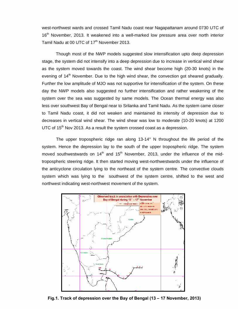
Fig.1. Track of depression over the Bay of Bengal (13 – 17 November, 2013)
4
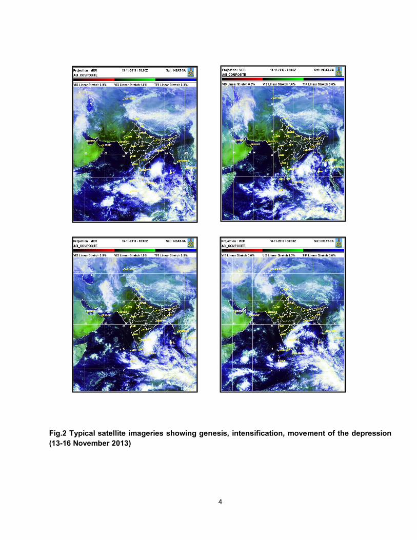
Fig.2 Typical satellite imageries showing genesis, intensification, movement of the depression (13-16 November 2013)
5
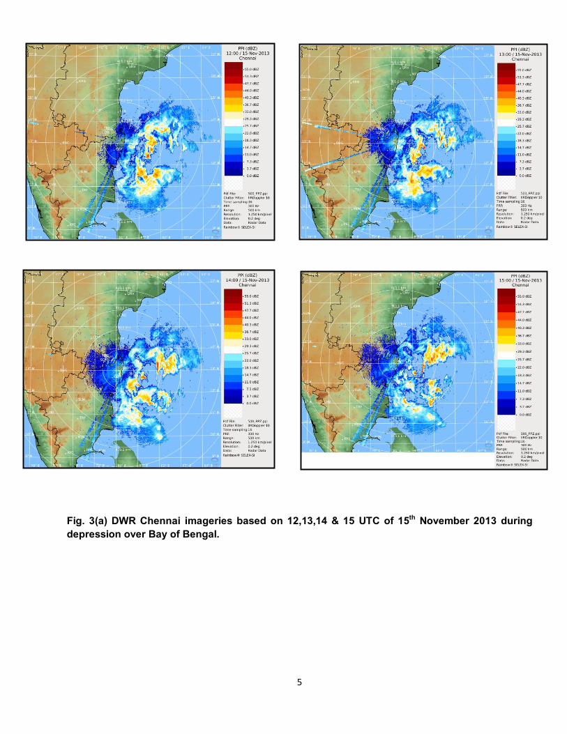
Fig. 3(a) DWR Chennai imageries based on 12,13,14 & 15 UTC of 15th November 2013 during depression over Bay of Bengal.
6
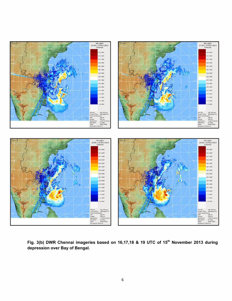
5. Warning services: Fig. 3(b) DWR Chennai imageries based on 16,17,18 & 19 UTC of 15th November 2013 during depression over Bay of Bengal.
7
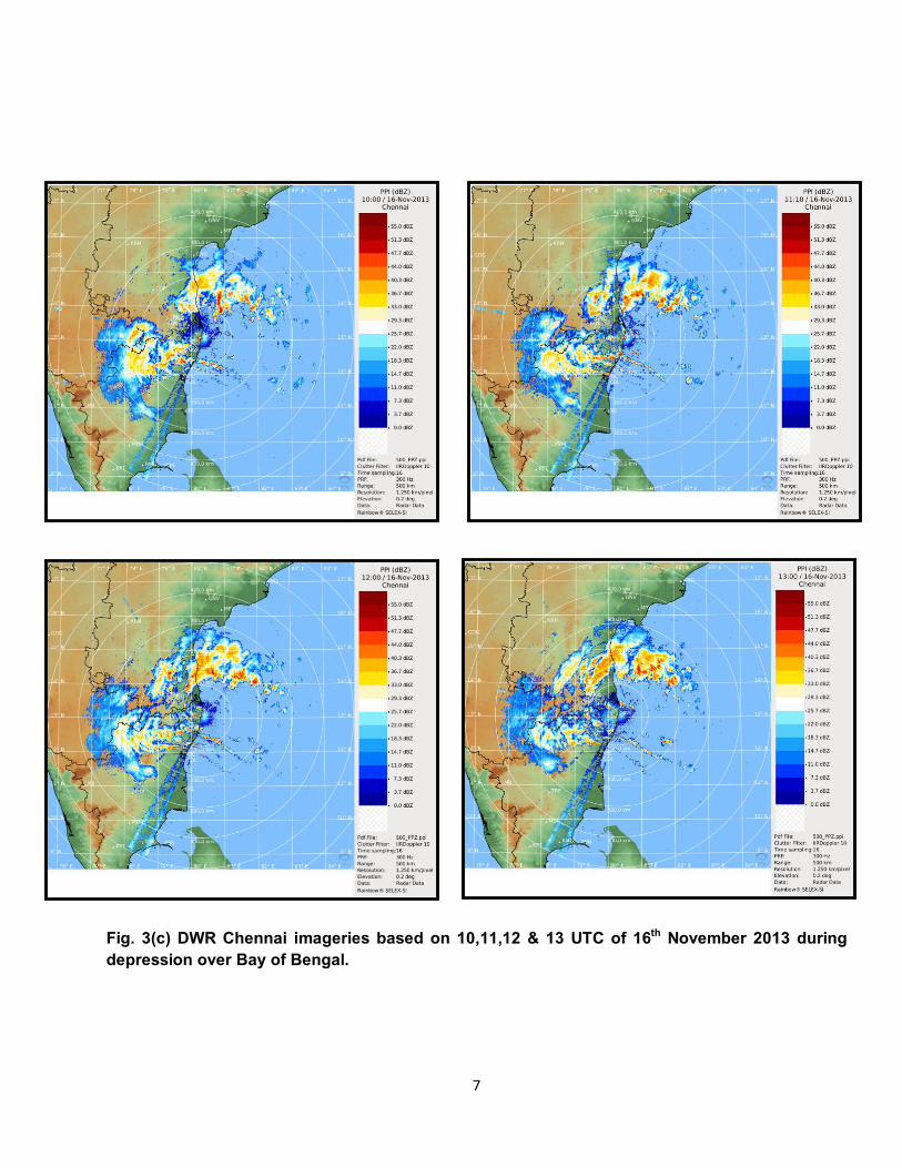
Fig. 3(c) DWR Chennai imageries based on 10,11,12 & 13 UTC of 16th November 2013 during depression over Bay of Bengal.
8
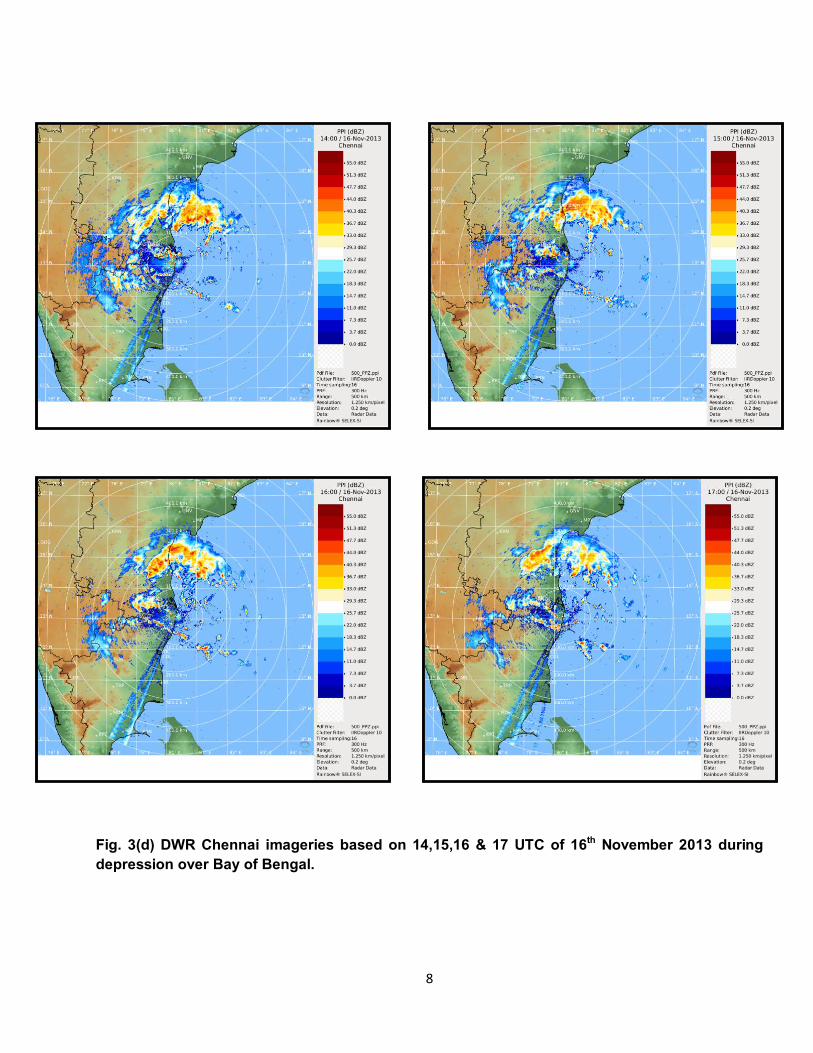
Fig. 3(d) DWR Chennai imageries based on 14,15,16 & 17 UTC of 16th November 2013 during depression over Bay of Bengal.

9
Fig.4 (a) IMD GFS MSLP and winds at 850, 500 & 200 hpa levels analysis and 10meter wind
based on 00 UTC of 13th November, 2013.
10
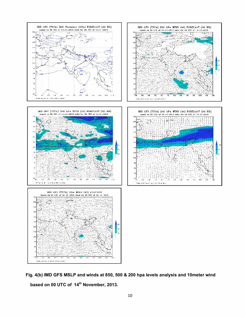
Fig. 4(b) IMD GFS MSLP and winds at 850, 500 & 200 hpa levels analysis and 10meter wind
based on 00 UTC of 14th November, 2013.
11
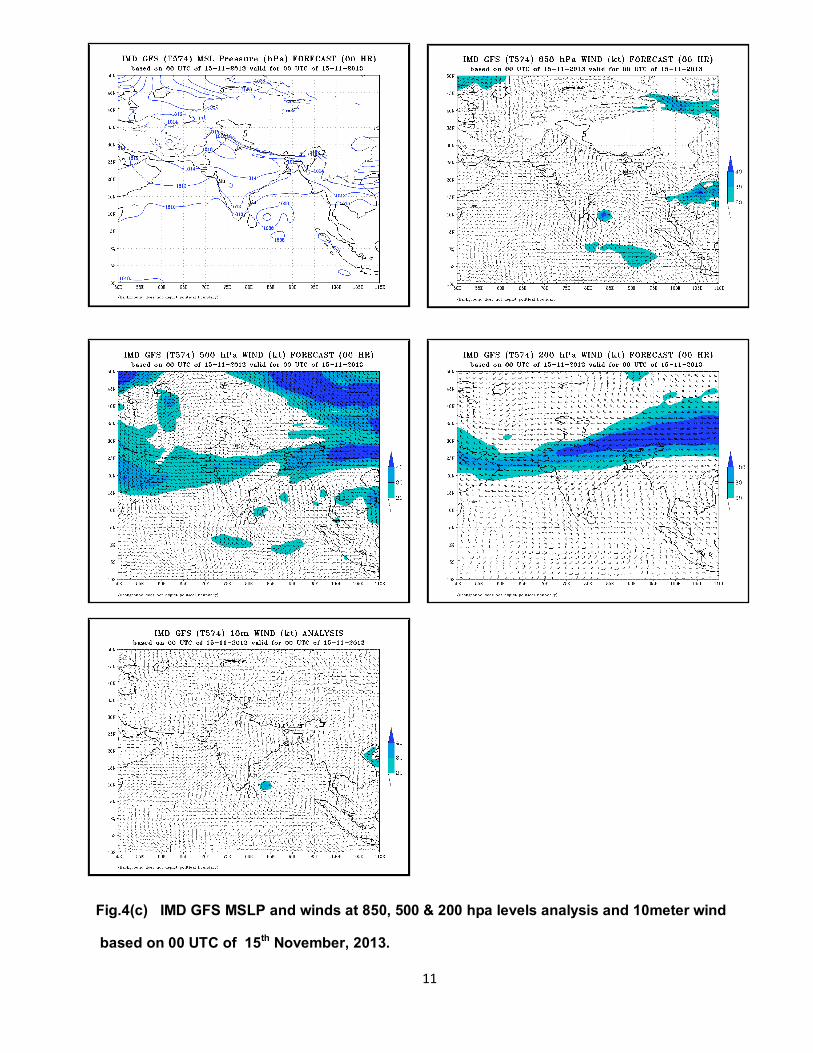
Fig.4(c) IMD GFS MSLP and winds at 850, 500 & 200 hpa levels analysis and 10meter wind
based on 00 UTC of 15th November, 2013.
12
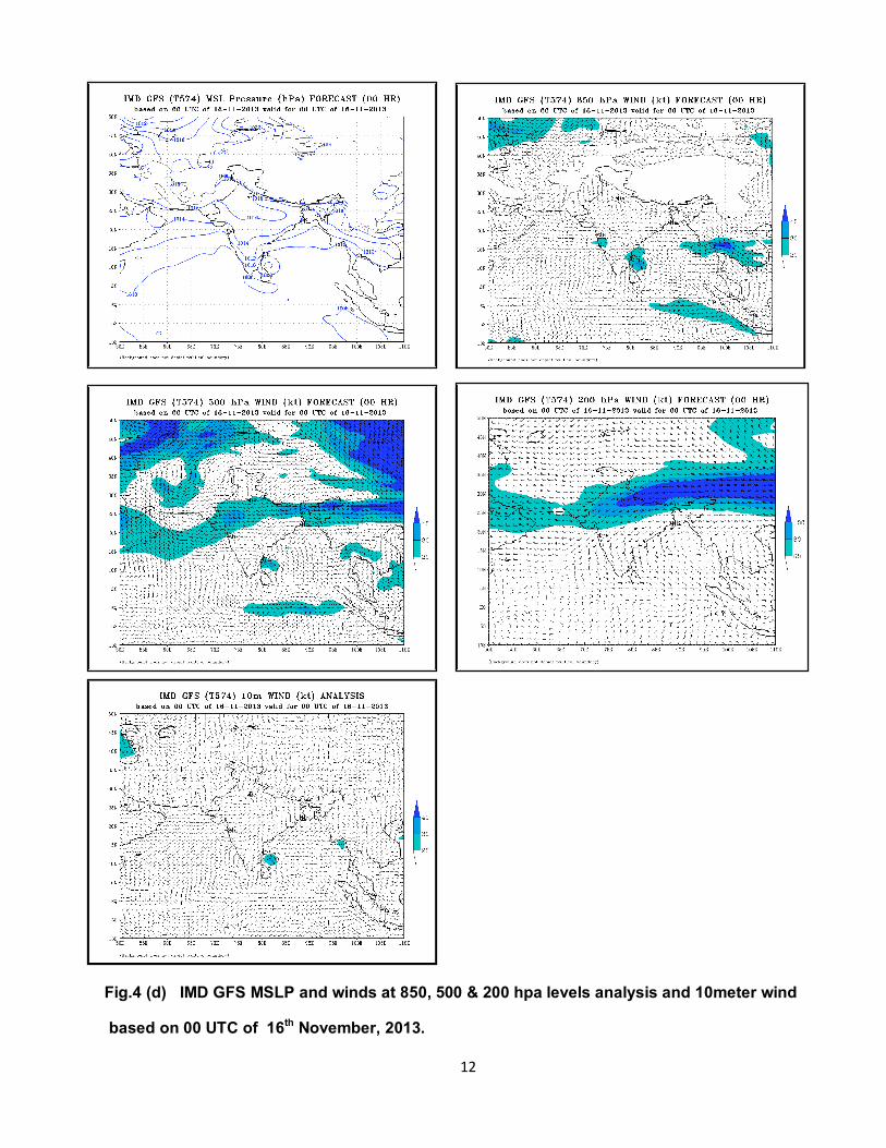
Fig.4 (d) IMD GFS MSLP and winds at 850, 500 & 200 hpa levels analysis and 10meter wind
based on 00 UTC of 16th November, 2013.
13
5. Realised Weather:
Chief amounts of 24 hrs. Rainfall (7 cm or more) ending at 0300 UTC from 14th November to 18th November, 2013 are given below:
14 November 2013 TAMILNADU & PUDUCHERRY: Srivaikuntam-7
16 November 2013 TAMILNADU & PUDUCHERRY: Chidambaram AWS-7. 17 November 2013 COASTAL ANDHRA PRADESH: Tada-9, Atmakur-7, Sriharikota-7, RAYALASEEMA: Tirumalla-9, TAMILNADU & PUDUCHERRY: Mayiladuthurai-22, Tirupattur AP-14, Sathanur Dam-13, Vandavasi-13, Chembarabakkam-13, Chennai AP-12, Tirupattur Town-12, Poonamallee-12, Tiruvallur-11, Maduranthagam-11, Musiri-11, Gingee-11, Harur-11, Tindivanam-10, Upper Anaicut-10, Pondicherry-10, Tiruttani-10, Pullambadi-10, Uthangarai-9, Poondi-9, Pochampalli-9, Mylam AWS-9, Dharmapuri PTO-9, Thiruvalangadu-9, Thogamalai-9, Lalgudi-9, Penucondapuram-9, Panchapatti-8, Chettikulam-8, Venbavur-8, Thuraiyur-8, Thuvakudi Imti-8, Vanur-8, Dharamapuri-8, Anaikaranchatram(Kollid-8, Chennai(N)-8, Samayapuram-8, Tozhudur-8, Barur-8, Tiruvannamalai-8, Anna University-7, Chengam-7, Mayanur-7, Perambalur-7, DGP Office-7, Jayamkondam-7, Thammampatty-7, Thathiengrpet-7, Padalur-7, Virudachalam-7, Tirukoilur-7, Coonoor PTO-7, Pallipattu-7, Grand Anaicut-7, Ulundurpet-7, Alangayam-7, Palacode-7, Sirkali-7, Chidambaram-7, Thiruvidaimaruthur-7, Trangambadi(Or)Tranqueb-7, Uthiramerur-7, SOUTH INTERIOR KARNATAKA: M M Hills-7. 18 November 2013 COASTAL ANDHRA PRADESH: Kavali-7, Nellore-7, KERALA: Vadakkancherry-7, Irinjalakuda-7, LAKSHADWEEP: Amini-7.
6. Warning services:
The Cyclone Warning Division/ Regional Specialised Meteorological Centre (RSMC)-Tropical
Cyclone, IMD, New Delhi mobilised all its resources for monitoring and prediction of depression. It
issued 3/6 hourly warning/advisory bulletins to national disaster management agencies including
National Disaster Management (NDM), Ministry of Home Affairs (MHA), concerned state Govts. and
other users at regular intervals. It also issued advisories to World Meteorological Organisation
(WMO)/Economic and Social Cooperation for Asia and the Pacific (ESCAP) Panel member countries
including Bangladesh, Myanmar, Thailand, Pakistan, Oman, Sri Lanka and Maldives during
depression period.
14
The number of bulletins issued by the Regional Specialised Meteorological Centre-Tropical Cyclone,
New Delhi and by Cyclone Warning Division, IMD, New Delhi are given below:
Bulletins for India : 21 Special Tropical Weather Outlook WMO/ESCAP Panel countries : 09
7. Forecast verification
Rainfall forecast
The heavy rainfall warning issued by IMD along with the actual heavy rainfall is given in Table 3.
Table 3: Heavy rainfall warning issued by IMD, New Delhi
Date & time
Warning issued 24 hr heavy rainfall realised at 0300UTC of date
13th November
2013
0300 UTC
Isolated extremely heavy rainfall - north coastal Tamil Nadu and south coastal Andhra Pradesh commencing from 15th November Heavy to very heavy rainfall-at a few places over north coastal Tamil Nadu and south coastal Andhra Pradesh commencing from 15th November 2013.
16th November, 2013 Isolated Heavy rainfall- Tamil Nadu & Puduchery. 17th November, 2013 Isolated heavy rainfall- Coastal Andhra Pradesh. Heavy to very heavy at a few places- Tamil Nadu & puduchery. 18th November, 2013 Isolated heavy-south coastal Andhra Pradesh & Kerala
14th November
2013
0300 UTC
Isolated extremely heavy rainfall – north coastal Tamil Nadu, Puducherry and south coastal Andhra Pradesh from 15th November 2013 night and over north Tamil Nadu on 16th & 17th November. Heavy to very heavy rainfall - at a few places north coastal Tamil Nadu, Puducherry and south coastal Andhra Pradesh from 15thNovember 2013 night and at a few places over north Tamil Nadu on 16th & 17th November. Isolated heavy to very heavy rainfall – over south coastal Andhra Pradesh, Rayalaseema and south Tamil Nadu on 16th and 17th ..
15th November
2013
0300 UTC
Isolated extremely heavy rainfall – north coastal Tamil Nadu, Puducherry and south coastal Andhra Pradesh from tonight and north Tamil Nadu on 16th
& 17th November. Heavy to very heavy rainfall at a few places – north coastal Tamil Nadu, Puducherry and south coasta l Andhra Pradesh from tonight and north Tamil Nadu on 16th & 17th November. Isolated heavy rainfall- over south coastal Tamil Nadu. Isolated heavy to very heavy rainfall- south coastal Andhra Pradesh, Rayalaseema and south Tamil Nadu on 16th and 17th
15
16th November
2013
0300 UTC
Isolated extremely heavy rainfall- north Tamil Nadu and Puducherry during next 48 hours. Heavy to very heavy rainfall at a few places- north Tamil Nadu and Puducherry during next 48 hours. Isolated heavy to very heavy rainfall- south coastal Andhra Pradesh and Rayalaseema during next 48 hours. Isolated heavy falls- over south Tamilnadu and south interior Karnataka during next 48 hrs.
---x---