Embed Size (px)
Citation preview
REVIEW OF THE PAGASA TROPICAL CYCLONE
WARNING SYSTEM
Contract OTR-0000-C-00-3438-00
Prepared for
Office of U.S. Foreign Disaster Assistance
Agency for International Development
Washington, DC 20523
Prepared by
Charles Holliday
Science Applications International Corporation
205 Montecito Avenue
Monterey, CA 93940

TABLE OF CONTENTS
Page
EXECUTIVE SUMMARY ................... . . . . 1
SECTION I Introduction... ........... . . . . 2
SECTION II Background and Current Practices. . . . 3
SECTION III Domestic Bulletin Review. . . . . . . . 12
SECTION IV Alternative Recommendations ......... 16
SECTION V Comments..... . . . . . . . . . . . 34
SECTION VI Summary .. . . . . . . . . 36
REFERENCES . ........... . . . . . . . . . . 39
APPENDIX.......... . . . . . . . . . .. . . . 41
i
EXECUTIVE SUMMARY
This report details the results of a review of the
system. In particular,Philippine tropical cyclone warning
warning message content and structure was analyzed with
respect to how well it causes appropriate public response.
This analysis considers the findings of other researchers
(most notably Mr. Amadore and colleagues of PAGASA) and the
body of knowledge about what motivates people to respond.
beingMr. Holliday was on-scene at PAGASA while warnings were
for one of the two major 1984 typhoon disastersissued
(Agnes, November 1984) and he also surveyed a portion of the
extent many of his impressions aredisaster area. To this
first hand.
Mr. Holliday has offered fifteen specific recommen
dations which, he argues persuasively, should improve public
PAGASA warnings. All of his recommendations areresponse to
within the capability of PAGASA to perform with little or no
to require legislaadditional assets. Few, if any, appear
None requiretive or ministerial level approval or changes.
measureadditional communications hardware although the full
of improvement cannot be realized without a reliable communi
cations system.
Probably the most important recommendations are
those which suggest technical changes in the public signal
system as well as procedural changes in establishing and
changing signals. Of slightly lesser importance is a rec
ommended re-phrasing of the signal messaes to emphasize the
important and to reduce clutter.
-1

Section I
INTRODUCTION
Typhoon' damage and casualty statistics in the
Philippines indicate a disturbing trend in the proportional
increase in loss of life compared to damage in recent decades
(Kintanar, et al., 1979). The recent disastrous typhoons
Nitang (Ike), and Undang (Agnes) during 1984 in which 1800
deaths occurred, unfortunately, proves further evidence of
this trend.
In the-case of typhoon Ike (1028 killed) track pre
diction offered relatively few problems, key warning informa
tion was released *in sufficient time for precautions to be
taken, and post disaster interviews revealed most residents
hdd heard the warnings in repeated radio broadcasts (Amadore
and Holliday, 1985). However, few heeded this advice.
The WMO's study of human response to tropical cy
clone warnings (WMO, 1982) states that a successful warning
system encompasses more than just the preparation and dissemi
nation of warning messages to the population at risk. It must
also take into account the human reaction element, and those
factors which will trigger an appropriate response to the
hazard threat. Thus, a vital function of any warning message
is to ensure it produces the desired effect on the audience
addressed. The content of the warning, and the wording used
is of great importance if it is to be persuasive.
Following recommendations by Sanders (1984), this
paper reviews aspects of the present PAGASA warning message content and structure, and offers an analysis of alternatives
for developing portions of the domestic bulletin.
-2

Section II
BACKGROUND - CURRENT PRACTICES
1. Area of Responsibility
PAGASA warnings are prepared when tropical cyclones
cross westward of 1350 east longitude (south of 250 north
latitude) and remain east of 115' east longitude in the South'
China Sea. If the tropical cyclone poses a threat to the
islands, Domestic Bulletins are prepared. Bulletins to shipp
ing are issued as long as the storm remains within the area of
responsibility.
2. Warning Terminology
The alerting system for domestic interests is 6,lin
eated into three successive threat levels utilizing a signal
numbering system (combining wind condition and time of
arrival). Definitions for these signals are given below (WMO,
1982).
a. Public Storm Signal One (PSS #1): Existence of a
tropical cyclone. Winds up to 50 KPH (32 kt) may be
expected in the display area within 36 hours.
b. Public Storm Signal Two (PSS #2): Tropical cyclone
is approaching or passing close to locality. Winds
of 60 KPH-100 KPH (32-55 kt) ma be expected in the
display area within 24 hours.
c. Public Storm Signal Three (PSS #3): The center of
the tropical cyclone is expected to pass close to or
over the display area. Winds in excess of 100 KPH
(55 kt) would be expected over these areas within
the next 12 hours.
-3
3. Domestic Bulletin
a. Issuance Times
This warning message is prepared for the general
public and disseminated to domestic interests every
6 hours (5 AM, 11AM, 5 PM, and 11 PM). Supplementary advisories may be issued if a severe typhoon threatens Manila, otherwise such advisories are in"
frequent.
b. Format and Content
The domestic bulletin is structured into a four-part
format following an order of specific details first
and warning information second. Its contents in
clude the following:
(1) location and characteristics
(2) 12-hr forecast position
(3) signal coverage, and storm effects (4) precautionary information.
All bulletins begin with a lead paragraph citing the tropical cyclone's location (expressed both as distance and direction relative to a geographic reference point, and as latitude and longitude of the cyclone center), maximum winds near the center (Kph), and the valid time/date of this information. In addiiton, a 12-hour movement forecast (direction
(16 points of the compass) and speed (Kph)] is provided including a well-known reference point (island, island group or
city).
The second section is short, stating the future location of the cyclone center (12 hours from valid time) in terminology of the preceding paragraph (distance and direction
relative to a geographic point, and latitude/longitude).
-4
Bulletins summarize all signal coverage in effect in
the third section. The detail of geographical assignment in signal display is dependent on the tropical cyclones relative distance to the archipelago. Storms not of immediate threat (usually PSS#-l) require only broader geographic reference such
as large islands (i.e., Samar, Leyte) or island groups (i.e., eastern Visayas). For storms of more immediate threat (PSS#2/3), coverage is expressed in specific province listing
including smaller offshore islands (i.e., Camarines Norte,
Camarines Sur, Albay, Sorsogan and Catanduanes).
Each signal level paragraph includes a brief sentence regarding the threat elements likely to affect a locality. The standard elements used are shown in Table 1, and include general weather, wind gust character, and coastal water conditions. The degree of severity is based upon the
signal level assigned.
Precautionary information is assigned to the final paragraph usually of one sentence length which also contains the time of next bulletin issuance. Precautionary advice is
given when PSS#2 or #3 are in effect (see Table 1). Under these conditions, the public is advised to "Take all precau
tions, and watch for the next bulletin".
-5

Table 1
Hazard Elements and Precautionary Information Contained in the
Domestic Bulleti-h
General
Weather
SIGNAL -
PSS #1 Occasional
Rains/Rains
PSS#2 Rains/
Stormy
PSS#3 Stormy
Wind
Conditions
Occasional
Gusty
(Less than
60 Kph)
Gusty/
Coastal
Water Conditions Precautions
Moderate to
Rough
Rough and Take all
Strong Gusty Dangerous Precautions
(60-100 to Small Watch for Kph) Seacraft next Bulletin
Strong/Gusty Very Rough and Take all
Very Strong Dangerous to all Precautions
Gusty Seacraft Watch for
(above 100 next Bulletin
Kph)
-6
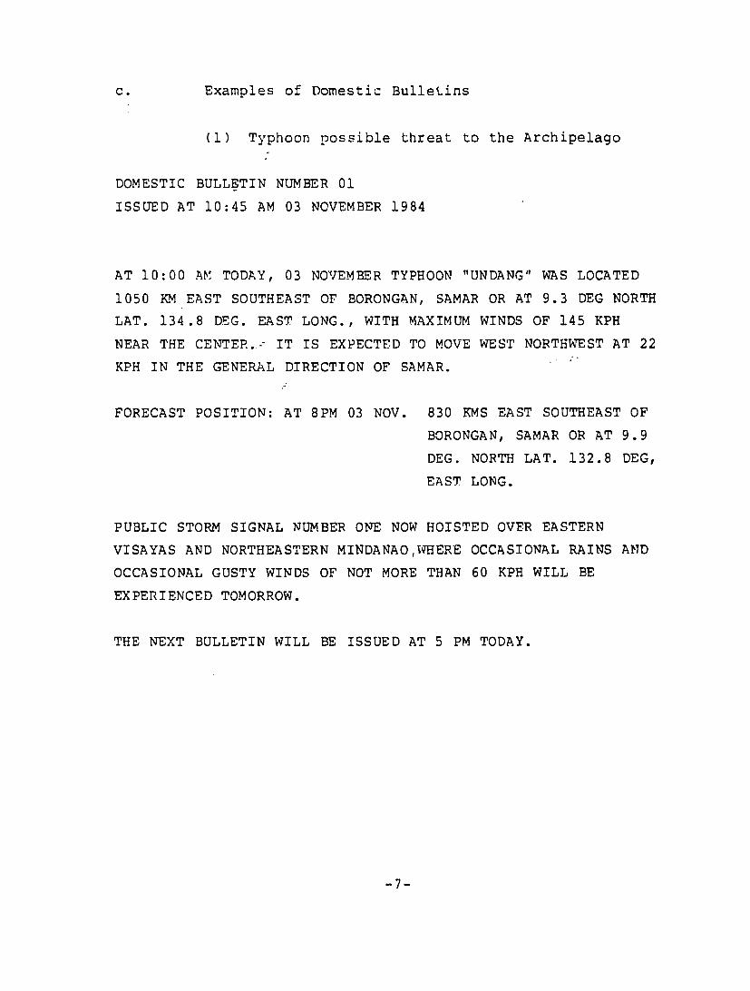
c. Examples of Domestic Bulletins
(1) Typhoon possible threat to the Archipelago
DOMESTIC BULLETIN NUMBER 01
ISSUED AT 10:45 AM 03 NOVEMBER 1984
AT 10:00 AV, TODAY, 03 NOVEMBER TYPHOON "UNDANG" WAS LOCATED
1050 KM EAST SOUTHEAST OF BORONGAN, SAMAR OR AT 9.3 DEG NORTH
LAT. 134.8 DEG. EAST LONG., WITH MAXIMUM WINDS OF 145 KPH
NEAR THE CENTER.-- IT IS EXPECTED TO MOVE WEST NORTHWEST AT 22
KPH IN THE GENERAL DIRECTION OF SAMAR.
FORECAST POSITION: AT 8PM 03 NOV. 830 KMS EAST SOUTHEAST OF
BORONGAN, SAMAR OR AT 9.9
DEG. NORTH LAT. 132.8 DEG,
EAST LONG.
PUBLIC STORM SIGNAL NUMBER ONE NOW HOISTED OVER EASTERN
VISAYAS AND NORTHEASTERN MINDANAOIHERE OCCASIONAL RAINS AND
OCCASIONAL GUSTY WINDS OF NOT MORE THAN 60 KPH WILL BE
EXPERIENCED TOMORROW.
THE NEXT BULLETIN WILL BE ISSUED AT 5 PM TODAY.
-7
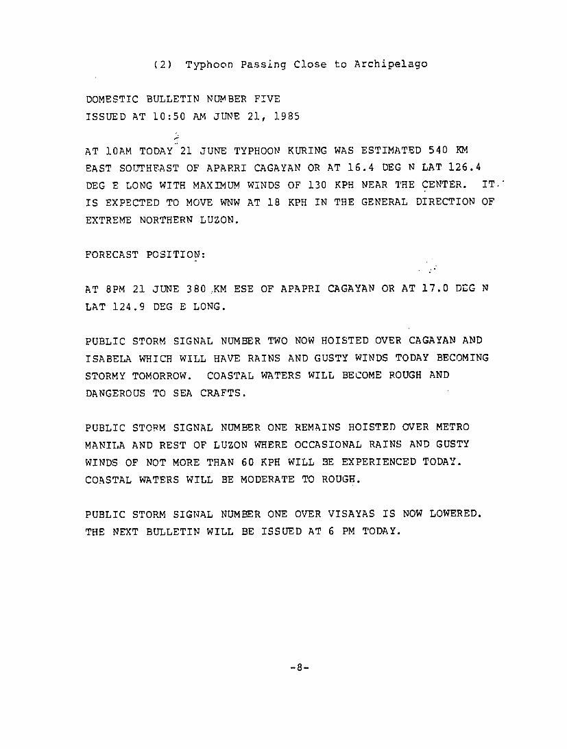
(2) Typhoon Passing Close to Archipelago
DOMESTIC BULLETIN NUMBER FIVE
ISSUED AT 10:50 AM JUNE 21, 1985
AT 10AM TODAY 21 JUNE TYPHOON KURING WAS ESTIMATED 540 KM
EAST SOUTHEAST OF APARRI CAGAYAN OR AT 16.4 DEG N LAT 126.4
DEG E LONG WITH MAXIMUM WINDS OF 130 KPH NEAR THE CENTER. IT.'
IS EXPECTED TO MOVE WNW AT 18 KPH IN THE GENERAL DIRECTION OF
EXTREME NORTHERN LUZON.
FORECAST POSITION:
AT 8PM 21 JUNE 380 .KM ESE OF APAPRI CAGAYAN OR AT 17.0 DEG N
LAT 124.9 DEG E LONG.
PUBLIC STORM SIGNAL NUMBER TWO NOW HOISTED OVER CAGAYAN AND
ISABELA WHICH WILL HAVE RAINS AND GUSTY WINDS TODAY BECOMING
STORMY TOMORROW. COASTAL WATERS WILL BECOME ROUGH AND
DANGEROUS TO SEA CRAFTS.
PUBLIC STORM SIGNAL NUMBER ONE REMAINS HOISTED OVER METRO
MANILA AND REST OF LUZON WHERE OCCASIONAL RAINS AND GUSTY
WINDS OF NOT MORE THAN 60 KPH WILL BE EXPERIENCED TODAY.
COASTAL WATERS WILL BE MODERATE TO ROUGH.
PUBLIC STORM SIGNAL NUMBER ONE OVER VISAYAS IS NOW LOWERED.
THE NEXT BULLETIN WILL BE ISSUED AT 6 PM TODAY.
-8
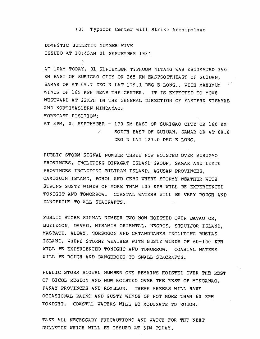
(3) Typhoon Center will Strike Archipelago
DOMESTIC BULLETIN NUMBER FIVE
ISSUED AT 10:45AM 01 SEPTEMBER 1984
AT 10AM TODAY, 01 SEPTEMBER TYPHOON NITANG WAS ESTIMATED 390
KM EAST OF SURIGAO CITY OR 265 KM EAS'SOUTHEAST OF GUIUAN,
SAMAR OR AT 09.7 DEG N LAT 129.1 DEG E LONG., WITH MAXIMUM
WINDS OF 185 KPH NEAR THE CENTER. IT IS EXPECTED TO MOVE
WESTWARD AT 22KPH IN THE GENERAL DIRECTION OF EASTERN VISAYAS
AND NORTHEASTERN MINDANAO.
FORE"AST POSITION:
AT 8PM, 01 SEPTEMBER - 170 KM EAST OF SURIGAO CITY OR 160 KM
SOUTH EAST OF GUIUAN, SAMAR OR AT 09.8
DEG N LAT 127.0 DEG E LONG.
PUBLIC STORM SIGNAL NUMBER THREE NOW HOISTED OVER SURIGAO
PROVINCES, INCLUDING DINAGAT ISLAND CROUP, SAMAR AND LEYTE
PROVINCES INCLUDING BILIRAN ISLAND, AGUSAN PROVINCES,
CAMIGUIN ISLAND, BOHOL AND CEBU WHERE STORMY WEATHER WITH
STRONG GUSTY WINDS OF MORE THAN 100 KPH WILL BE EXPERIENCED
TONIGHT AND TOMORROW. COASTAL WATERS WILL BE VERY ROUGH AND
DANGEROUS TO ALL SEACRAFTS.
PUBLIC STORM SIGNAL NUMBER TWO NOW HOISTED OVER DAVAO OR,
BUKIDNON, DAVAO, MISAMIS ORIENTAL, NEGROS, SIQUIJOR ISLAND,
MASBATE, ALBAY, -4ORSOGON AND CATANDUANES INCLUDING BUSIAS
ISLAND, WHERE STORMY WEATHER WITH GUSTY WINDS OF 60-100 KPH
WILL BE EXPERIENCED TONIGHT AND TOMORROW. COASTAL WATERS
WILL BE ROUGH AND DANGEROUS TO SMALL SEACRAFTS.
PUBLIC STORM SIGNAL NUMBER ONE REMAINS HOISTED OVER THE REST
OF BICOL REGION AND NOW HOISTED OVER THE REST OF MINDANAO,
PANAY PROVINCES AND ROMBLON. THESE AREEAS WILL HAVE
OCCASIONAL RAINE AND GUSTY WINDS OF NOT MORE THAN 60 KPH
TONIGHT. COASTAL WATERS WILL BE MODERATE TO ROUGH.
TAKE ALL NECESSARY PRECAUTIONS AND WATCH FOR THE NEXT
DULLETIN WHICH WILL BE ISSUED AT 5PM TODAY.

4. ShiDping Bulletin
a. Issuance Times
This Wqarning message is prepared for shipping in the
Philippine area of responsibility and disseminated to marine
interests as well as selected PAGASA field offices every 6
hours (5 AM, 11 AM, 5 PM, and 11 PM).
b. Format and Content
The shipping bulletin contains all pertinent storm
information in a concise paragraph. Included are the fol
lowing:
(1) location (latitude/longitude)
(2) surveillance method of center determination
(aircraft/satellite, etc.)
(3) radius (km) from center of rough to phenomenal
sea conditions
(4) maximum winds near center (m/s)
(5) radius (km) of typhoon force wind conditions [32
m/s (64 kt)]
(6) radius (an) of near gale force wind conditions
[13 m/s (26 kt))
(7) 12 hour forecast direction and speed
(8) 12 hour forecast position (latitude/longitude)
(9) 24-hour forecast position (latitude/longitude)
(10) request for three hourly ship reports
-10

c. Example of Shipping Bulletin
WTPH RPMM 010000Z
T T T TYPHOON WARNING 06
AT 0000 01 SEPTEMBER TYPHOON (8411) WAS ESTIMATED BASED ON
SURFACE AND AIRCRAFT REPORTS AT ZERO NINE POINT SEVEN NORTH
ONE TWO NINE POINT FIVE EAST ROUGH TO PHENOMENAL SEAS WITHIN'
FOUR ZERO ZERO KILOMETERS NORTHWEST SEMICIRCLE TWO ZERO ZERO
KILOMETERS ELSEWHERE MAXIMUM WINDS FIVE ZERO METERS PER SECOND
NEAR CENTER THREE TWO METERS PER SECOND WITHIN ONE ZERO ZERO
KILOMETERS ONE THREE METERS PER SECOND WITHIN FOUR ZERO ZERO
KILOMETERS NORTHWEST SEMICIRCLE TWO ZERO ZERO KILOMETERS
ELSEWHERE FORECAST TO MOVE WEST AT ZERO SIX METERS PER SECOND
FORECAST POSITIONS AT 011200Z ZERO NINE POINT EIGHT NORTH ONE
TWO SEVEN POINT ZERO EAST AND AT 020000Z ZERO NINE POINT NINE
NORTH ONE TWO FOUR POINT SEVEN EAST. ALL SHIPS WITHIN
TYPHOON AREA ARE REQUESTED TO SEND THREE HOURLY WEATHER
REPORTS TO WEATHER MANILA PD
WEATHER MANILA
d. Comment
Useful information exists in this bulletin for
disaster preparedness officials, and PAGASA field representa
tives concerning extended planring outlooks, and assessment of
storm dimensions.
-11
Section III
DOMESTIC BULLETIN REVIEW
1. Method
Familiarization with the development and range of
warning message content as well as its impact was obtained by
the author through the following methods:
a. Monitored warning message preparation sequence for typhoons Agnes and Bill (1984) at forecast office,
and engaged in frequent inquiry and discussion with
the principal players in shaping these advisories.
b. Reviewed domestic bulletins (issued since the late
1970's) on file selecting a variety of storm scenarios affecting the archipelago (Table 2). All
typhoons responsible for significant loss of life
were included.
c. Analyzed conventional surface and aircraft recon
naissance data for typhoons Ike and Agnes (1984) to
determine wind condition verification in signal dis
play areas.
d. Enga ed in frequent discussion with Typhoon Research
Division members regarding public response to warn
ings.
2. General Observations
a. The domestic bulletin format and the signal system
utilized have many advantages, a few principal ones are listed
below:
-12

Table 2 List of Tropical Cyclones - Domestic Bulletins Reviewed
TROPICAL CYCLONE DATE INTENSITY AREA AFFECTED
AGNES (Undang) Oct/Nov 84 Severe Ty Crossed Visayas
IKE (Nitang) Aug/Sep 84 Major Ty Crossed NE Mindanao and
Visayas
JUNE (Maring) Aug 84 Strong T.S. Crossed northern Luzon
VERA (Bebeng) Jul- 83 Minimal Ty Crossed Bico1 region and
southe-n Luzon
TIP (Auring) Jul 83 T.D. Crossed central Bicol region, northern Visayas
and southwest Luzon
NANCY (Weling) Oct 82 Major Ty Crossed northern Luzon
IRVING (Ruping) Sep 82 Strong T.S. Crossed Bicol region and
southern Luzon
NELSON (Bising) Mar 82 Major Ty Crossed Visayas
KIT (Kading) Dec 81 T.D. Approached eastern Visayas
and NE Mindanao
LEE (Dinang) Dec 81 Major Ty Crossed Bicol region Mindanao and southern Luzon
IRMA (Anding) Nov 81 Major Ty Crossed central Luzon
LYNN (Elang) Jul 81 T.S. Crossed Bicol region and
central Luzon
-13
(1) the standard format organization (fill in the blank) provides ease in message preparation.
(2) economy of wording provides essential basic in,-formation and provides message length suitable for constraints of communication system.
(3) warning signal levels combine magnitude of wind conditions with expected temporal onset, and are ideally suited to convey a threat situation with minimal wording.
b. Some warning procedures and message content aspects, however, are not emphasizing layman interpretation aspects nor threat perception. Some observations are listed below:
(1) With few exceptions, little differentiation is noted in bulletin content between a strong tropical storm threatening the Philippines and a major typhoon.
(2) Message frequency does not increase as distance to typhoon landfall decreases.
(3) Message content favors quantitative information with relatively less emphasis on narrative
description of threat.
(4) Supplementary messages are few and do not describe in detail the anticipated effects of a typhoon on a localized area followed with specific evacuation recommendations.
-14

(5) During landfall situations th,;! majority of bul
letin text is devoted to geographical assignment of signal display areas. Many areas
warned fail to verify wind conditions forecast,
adversely reflecting on credibility.
-15
SECTION IV
ALTERNATIVE RECOMMENDATIONS
In this section an attempt is made to address, and
offer alternatives to current warning practices and message
content procedures which may enhance community perception and
evaluation of threat advice issued. Findings by post-tropical
cyclone disaster surveys of public response in the U.S. and
Australia, as well as unstructured post-storm interviews in
the Philippines have been relied upon to form the basis for
many of the recommendations.
It is suggested that formal sociological surveys
regarding message content effectiveness be introduced and con
ducted frequently in the Philippines. Thereby essential in
formation can be gleaned to further develop effective message
structure and wording.
Alternative recommendations developed in this sec
tion are grouped into the following general categories:
severe threat awareness, areal overwarning, signal lead time,
supplementary remarks, storm location and size, message length
reduction, message organization, message frequency, local
interruption.
1. Severe Threat Awareness
l.a Higher Signal Requirement
Background:
The highest level of threat indicated in the current
PAGASA Public Storm Signal (PSS) system is for wind conditions
greater than 100 Kph (55 kt). PSS#3 is open ended, signifying
wind conditions which could range anywhere across the spectrum
from strong tropical storm to severe typhoon. The identifica
-16

tion of severity is dependent on inclusion of the maximum
winds, in the lead paragraph of the domestic bulletin. These
winds are expressed in kilometers-per-hour. Amadore (1983)
however, has noted that such technical terms concerning
strength have little or no meaning to the layman, and provide
little additional information for threat comprehension.
Climatological statistics show that the Philippine
archipelago is struck on the average, by four typhoons and two
tropical storms annually. Because of the mesoscale nature o:
the typhoon's most violent portion, the island's inhabitant's
common experien-ce is in the less intense fringe gale areas.
There are few individuals north of the 10th parallel who have
not experienced these fringe effects once or twice every few
years, and received warning coverage of Public Storm Signal
(PSS) #3 in their province.
The fact that PSS#3 is issued routinely for every
landfalling tropical cyclone of strong tropical storm force or
greater, the relatively high frequency, and inadvertent over
warning that occurs can set the stage for complacency. In
case of a rural subsistence population some communities cannot
afford to risk the loss of a day's work, such as in fishing,
and may prefer to "ride out" a storm unless they are persuaded
that an approaching threat is quite exceptional.
The critical problem here is to alert and convince
the population of a major threat. Special warning criteria
which emphasize the threat need to be devised for such situa
tions.
Recommendation:
Revise signal system to include one higher signal-
"Great Danger"--to signify the approach of a major typhoon
(winds over 180 Kph/95 Kt).
-17
Discussion:
The term "great" has been suggested by Southern
(1982) to denote in public warnings those storms of an intense
nature, and thereby aid in disaster preparedness.
Selection of the "Great Danger" signal criteria was
based on analysis of devastating Philippine typhoons (since
1970) inflicting casualty tolls of 200 or more (Table 3).
With few exceptions all typhoons wert. at levels of 180 Kph (95
kt) sustained wind or greater. This selection is consistent
with wind condition thresholds identified by Amadore (1982)
(see Appendix) which produced extensive damage to buildings of
light materials (a majority of housing types in the islands).
It is interesting to note that at these wind speeds, the pres
sure loading on a particular structure (related to the square of the velocity) is triple and double that exerted at PSS#3
(100 Kph/55 kt) and typhoon (130 Kph/64 kt) thresholds respec
tively.
4b. Storm Surge
Background:
Past disaster surveys conducted by Amadore and col
leagues (1985) following typhoons Nitang (Ike) and Undang
(Agnes) in 1984 indicated coastal residents had no comprehen
sion of the powerful interaction of wind.force with piling up water to inundate low lying areas. Their perception of the
threat was totally confined to the wind. This is an observa
tion found in many countries prone to tropical cyclones where
9 out of 10 deaths are attributed to coastal inundation.
-18
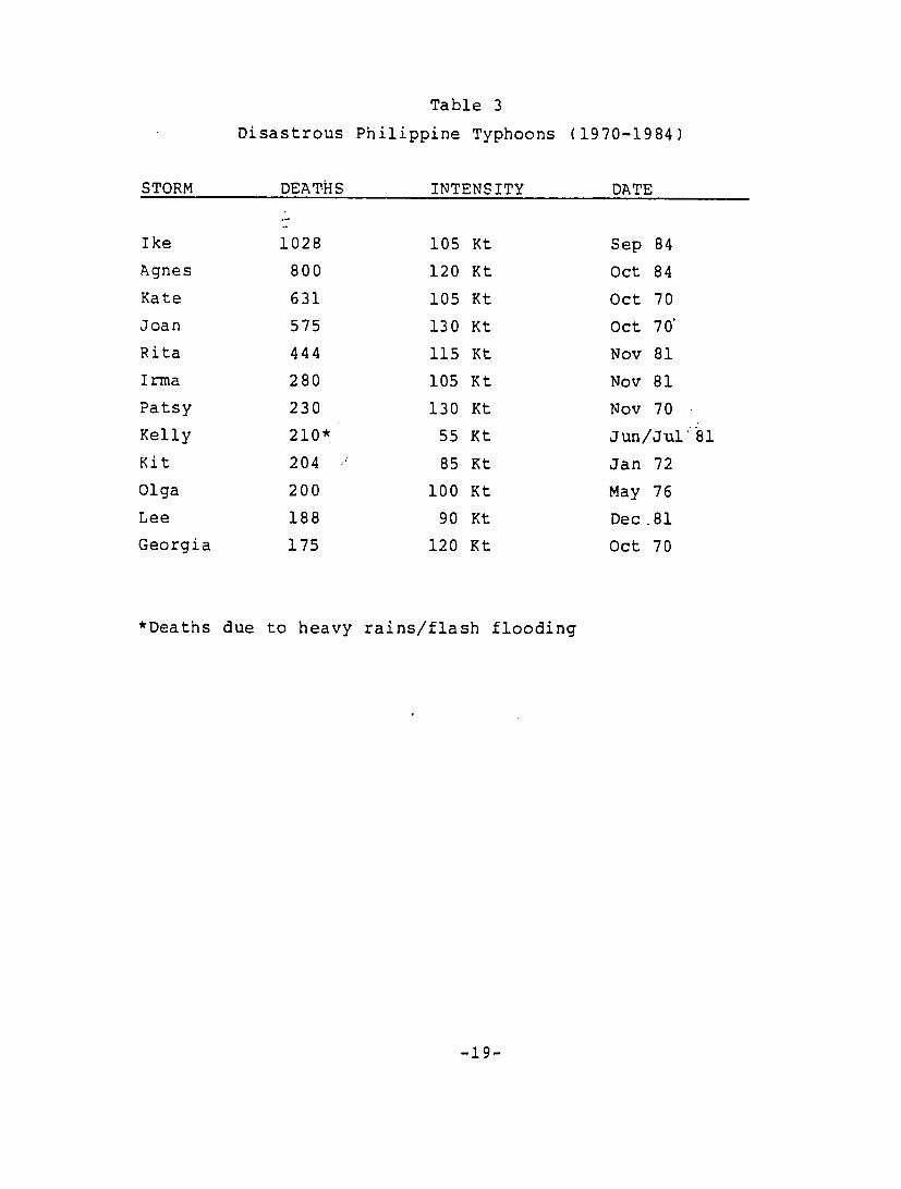
Table 3
Disastrous Philippine Typhoons (1970-1984)
STORM DEAT-HS INTENSITY DATE
Ike 1028 105 Kt Sep 84
Agnes 800 120 Kt Oct 84
Kate 631 105 Kt Oct 70
Joan 575 130 Kt Oct 70
Rita 444 115 Kt Nov 81
Irma 280 105 Kt Nov 81
Patsy 230 130 Kt Nov 70
Kelly 210* 55 Kt Jun/Jul*81
Kit 204 85 Kt Jan 72
Olga 200 100 Kt May 76
Lee 188 90 Kt Dec.81
Georgia 175 120 Kt Oct 70
*Deaths due to heavy rains/flash flooding
-19
4.c
Recommendation:
The Great Danger Signal text should include discus
sion of storm surge potential and general coastlines to be
affected.
Discussion:
Magnitude of storm surge potential is difficult to
assess (number of coastlines involved, variety of diurnal
tidal ranges, shore topography, rate and direction of center
approach). However, there is a general relationship with in
tensity, and the probability of inundation increases greatly
with an intense storm. Recognizable terminology such as "Big
Waves" or coastal flooding are preferable to the technical
term "storm surge" in the Philippines.
ExamDle:
"Dangerously high tides, and big waves generated by
this powerful typhoon will flood coastal sections, especially
in the Romblon islands and the northern coast of Panay."
Precautions (Protective Measures)
Background:
Issuance of a warning without explicit advice re
garding precautions is not productive. Social sciences
studies indicate people need to be told specifically what they
should do during a warning in order for it to be effective.
In case of potential coastal flooding, and violent winds,
evacuation from low lying areas, and housing of weak structure
is necessary to minimize casualties. Bulletins currently give
generalized recommendations to "seek higher grond for safety"
-20
and/or "take all necessary precautions". Advisories should
clearly state which areas should be evacuated and why.
Recommendation:
Great Danger Signal text should include evacuation
statements with specific recommendations.
Discussion:
Terms such as "low lying areas" are somewhat vague.
Knowledge of one's elevation in relation to the impending
storm tide usua~ly is not complete. Evacuation of-a specific
distance inland (1 km) would provide a better margin of
safety.
Example:
Situation--Center 12 hours before landfall:
"Emergency actions are needed immediately to evacuate within 1
km of the shoreline, and protect against extreme winds from this destructive typhoon by seeking shelter in secure build
ings."
4d. Reconnaissance Platform
Background
Social surveys have shown that on receipt of warn
ings, individuals seek confirmation evidence from other
sources as to the possible reality of the threat. In the
Philippines this confirming information often comes from
assessment of environment conditions. Indigenous signs of the
approaching danger are recognized in the commencement of
periphery gales and rains. Should the weather be fair, cred
ibility of the warning may be questioned.
-21
Recommenda tion:
Upon raising of PSS#3/Great Danger Signal, highlight the surveillance means of tracking and intensity determination of the typhoon (primarily aircraft reconnaissance or satellite when radar observation is not available).
Discussion:
Skepticism of the warning message may be alleviated when the layman is confronted with positive evidence gathered by a technological detection platform.
Example:
"Aircraft reports indicate typhoon Klaring is intensifying and continues to advance towards the Samar pro
vinces."
2. AREAL OVERWARNING
Background:
Excessive lengths of coastline are overwarned due to state-of-the-art skill limitation in accurately predicting the position of typhoon landfall 24 hours in advance. Amadore (1983) cites many of the complaints of community individuals who openly question the credibility of warnings which failed to materialize. "If warnings are to remain credible, the amount of overwarning must be restricted to an extent consistent with safety" (Simpson and Riehl, 1981). In this light, reducing the initial size of the critical wind envelope (PSS#3 criteria) may prove one incremental step toward diminishing unnecessary area extent of higher level in signal coverage.
-22
Recommendation:
Revise upward the minimum wind condition threshold
for PSS#3 to 130"Kph (70 kt).
Discussion:
The current PSS#3 threshold matches that of a strong
tropical storm (100 Kph/55 kt). International definition for
tropical cyclones of hurricane force is 120 Kph/64 kt. This
higher threshold has significance in its potential to serious
ly impact communities. A damage scale developed by Amadore
(1982) (see Appendix) indicates that significant damage to structures (light to medium building materials) does not begin
until the 130 Kph (70 kt) range is exceeded. A revision up
ward would drop sub-typhoon strength storms from considera
tion.
Further Recommendation:
Evaluation of effective signal coverage for all
threat levels be included in verification programs of the
accuracy of warnings.
3. SIGNAL LEAD TIME
- Direct upgrade from PSS#1 to PSS#3
Background:
In cases of rapidly advancing typhoons upgrading
sequentially from PSS#1 to PSS#2 before issuing PSS#3 6 hours
later is a costly exercise in terms of providing meaningful
lead times to target area communities. Stepwise progression,
in this case, is rapidly overtaken by events. To follow the
set sequence only delays critical warning time.
-23
Recommendation:
In situations of rapidly advancing typhoons, consider upgrading signal conditions directly from PSS#I to PSS#3 in target area.
4. SUPPLEMENTARY REMARKS
Backaround:
The primary purpose of PSS#1 is to announce an alert, increase public awareness of the approaching storm, and signal communities to watch for further developments.
PSS#1 supplemental text refers to zone weather forecasts only, and is void of precautionary information. Example: "These areas will have occasional rains, and gusty winds of not more than 60 Kph (32 kt). Coastal waters will be moderate to rough."
These weather conditions cited are not hazardous and not of major consequence. Text space should be utilized for precautionary recomendations.
Recommendation:
Revise PSS#1 accompanying remarks to focus on the alert nature of the signal, and emphasize precautionary information in lieu of zone weather forecasts.
-24
Fxamoles:
Situation--Typhoon in Philippine Sea, PSS#3 has not oeen issued: "Public storm signal Number One now in effect for the Bicol Region and Samar Island. Typhoon Konsing poses a possible threat to the region late Sunday. Residents shou.d keep in close touch with future bulletins if higher signals
are required. Fishermen should not venture far from port."
Situation--Typhoon near landfall
western provinces, message text lengthy
played): "Public Storm Signal Number One Mindoro and northern Palawan. Fishermen
PSS#1
(all
now
should in
displayed in
signals dis
effect for not venture
far from port."
5. STORM LOCATION AND SIZE
5.a. Relative Position Coordinates
Backaround:
Disaster survey interviews (Carter, 1977) reveal that the pub
lic often erroneously perceives reference coordinate points (towns, islands) relative to the tropical cyclone's position (cited in the warning message) as the point that the typhoon will actually strike. The island of Samar is commonly con
fused as a future impact point because of its outpost location to the Philippine Sea typhoons (Amadore, 1983). Current
practice in the Domestic Bulletin is to include one reference
point for storms still at sea east of the archipelago.
-25

Reconmmendation:
Include two geographic reference coordinate points
(towns, islands)- when citing storm's location (typhoons at
sea, east of the archipelago).
Discussion:
The first point would most likely be near the same
latitude, and closest to storm, while the second's position
may be further east/west downstream or more poleward/equator
ward to intersect the predicted track.
ExamDle:
Typhoon Asiang was "estimated 330 km east of Virac,
Catanduanes or 1020 km east of Manila."
5.b. Circulation Size
Background:
Amadore (1983) cites public misconception regarding
the immensity of a typhoon. Many view the storm as a point
which if not headed directly towards them is not seen as dang
erous. There is little understanding of the spatial relation
ship between the center and the dimensions outward of periph
eral gales. The domestic bulletin currently does not discuss
storm circulation size.
-26
Recommendation:
Introduce storm size dimensions (gale force area) following maximum-wind description statement. Focus should be on the sector most likely to affect the coast first.
Example:
"with maximum winds of 260 Kph near the center. Strong winds extend outward 250 km to the northwest."
6. MESSAGE LENGTH RED *'TION
6.a Deletion of Forecast Paragraph
Backcround
The current forecast position (10 hr) paragraph combined with the lead paragraph on current location focuses too much of the warning message introduction on detail, compli
cates comprehension, and promotes a mental image of the typhoon as a point. Furthermore, findings by Amadore (1983) indicate the layman has little understanding of latitude/longi
tude. Deletion of the domestic bulletin's forecast paragraph would help reduce message text length, and provide space for
precautionary information.
Recommendation
Delete forecast paragraph in Domestic Bulletin
Discussion:
The 10-hr forecast position, by itself, does not provide significant additional information to the field
-27
operational user. It is suggested that the shipping bulletin be disseminated widely to PAGASA field stations and disaster preparedness officials since it contains both tha 12- and 24-hr forecast positions.
6.b. Combining Great Danger and PSS#3 Display Coverage
Backaround:
The inclusion of both Great Danger signal and PSS#3 coverage in the Domestic Bulletin would serve marginal utility, and only increase message length. Due to the typical horizontal wind profile structure of a well developed typhoon (Simpson and Riehl-, 1981) the differentiation between 130 Kph (70 kt) and 10 Kph (95 kt) are too close to be of signif
icance.
Recommendation:
In case of major typhoons (180 Kph/95 kt) delete reference to PSS#3 coverage, and replace with Great Danger
signal areal coverage.
Comment:
It is understood that in cases of landfall on eastern islands that western provinces may only require PSS#3 warning. In such instances PSS#1 coverage would probably no longer be in existence providing some space for PSS#3 to be reintroduced.
-28
6.c. Combining PSS#l and PSS#2 Coverage Areas
Backaround:
In- cases of rapidly advancing typhoons in which landfall is imminent along the eastern zones of the archipel
ago, PSS#1 and PSS#2 coverage areas become increasingly compressed in the Western provinces (i.e., PSS#2 follows within 6
hours of PSS#l declaration). To adjust for this rapidly changing situation, and help reduce message text length, it is suggested deleting PSS#1 reference at a certain point in the
typhoon's advancement, and declaring PSS#2 for the remaining
provinces.
Recommendation:
In situations of rapidly advancing typhoons, with
PSS#1 and PSS#2 becoming increasingly compressed geographical
ly in the Western provinces consider combining PSS#l and PSS#2 coverage areas. Thus PSS#2 may be the initial condition set
in some areas.
7. Message Organization
7.a Hierarchy of Order
Background:
Message content should be organized with the most critical information highlighted first, followed by other information in order of decreasing importance (Norton, 1975).
-29
Recommendation:
The following information sequence should be employ
ed in the Domestic Bulletin:
Seauence Content
1) Critical Information - highest signal in effect
o hazard information
o precautionary information
2) Details - Tropical Cyclones Characteristics
(location, movement, size)
3) Other Important - Lesser Signal Notices
Information
7.b. Headliner
Backaround:
A brief summary statement at the lead of the warning
message would assist in comprehension. It would highlight the
message's key elements, and flag any major changes from the
last bulletin. As the journalist's article, it condenses the
story to be told in a few simple words easy to remember.
Headliners are currently employed by the U.S. Weather Service
in its tropical cyclone warning messages.
Recommendations:
Use headline statements to lead Domestic Bulletins.
-30
Example:
Konsing . . Extremely Dangerous . . . Bears down
on Northern Samar. . . Threatens Bicol Region,
8. Message Frequency
Background:
Southern (1982) has found that public response to initial warnings is indirect, and taken as a result of mutual consultation. However, he adds "information added progressively to successive warnings encourage personal decision
making".
Disaster surveys have found that persons at risk, desire frequent updates on the storm's progress as it nears landfall, with their belief related to ofthe number warnings received (Pifer, 1977). Current PAGASA practice is for message release every 6 hours. More frequent release is needed
during PSS#3 conditions.
Recommendation:
While PSS#3 is displayed, one or more intermediate advisories should be issued between the Domestic Bulletin
scheduled releases.
Discussion:
Information during this advanced warning period takes on a new urgency as communities are expected to make definite arrangements for their safety. Frequently, radar surveillance positions are available theas center nears, and crosses through the eastern barrier of islands. Fresh 3-hr
-31
updates of the typhoon's progress adds to the credibility of
the warnings.
Content:
It 2. suggested that content of the immediate advis
ory be narrative in format and focus on developments directly
affecting the highest signal area. Recommended subject cate-.
gories appear in decreasing order of importance.
1) Introductory summary statement.
2) Information on the danger faced.
3) Recommended precautions.
4) Latest center location (and means determined)
accompanied by areal extent of typhoon force
winds.
Discussion:
Changes in forward speed such as acceleration should
be noted. Statements relating the current storm to memorable
past typhoons in the region, or the fact that a rare landfall
(Mindanao) is threatened would be useful. Highlighting the
case of the intense small diameter storm is important due to
the misconception brought by the fair weather ahead of the
storm, and the abrupt and rapid rise of wind force that
follows.
Example: Intermediate Advisory
PAGASA Radar reports indicate Typhoon Konsing is now
bearing down on the Bicol region.
-32
Konsing with maximum winds of 215 Kph is concentrat
ed and extremely dangerous. It will be the strongest typhoon
to strike the region in 15 years.
The typhoon will generate coastal flooding and big
waves as well as destructive winds during i.ts approach and
passage. In areas of the Great Danger Signal, emergency
actions are needed immediately to evacuate 1 Km inland of the'
shoreline, and protect against extreme winds by seeking
shelter in secure buildings.
At 7 AM, the center of Konsing was located by PAGASA
radar near 13.0 North latitude and 125.0 East longitude or 110
Km southeast of Virac Catandaunes, and 165 Km east of Legaspi.
Strong winds (60 Kph) stretch outward from the center 200 Km
in all directions.
Konsing is expected to pass close to Legaspi later
this morning and cross over the Bicol region in the after
noon.
Keep tuned for later advisories.
Note:
Number of words in example above is 155 compared to
domestic bulletin text example on page 9 (Section 113c(3)]
which consists of 250 words.
-33

Section V
COMMENTS
Importance of Local Interpretation
Backaround:
The field PAGASA official is a key communicator in'
the warning system. His interpretation can enhance the warn
ing message--making the appeal more direct, translating terms
for layman understanding and conveying the threat to a person
al level. By contrast, a warning message delivered by radio
broadcast relay from Manila may be less effective. Because of
the source's remote, impersonal nature, residents may be less
likely to respond.
Recommendation:
Field PAGASA officials should interface with local
radio stations daring typhoon threat emergencies as much as
possible to broadcast the warning tailored to the local situa
tion.
Discussion:
As a case in point, Kintanar (1984) contrasts the
manner of warning message delivery in disastrous typhoon
Nitang (1984) between rural Surigao del Norte Province, and
the urban Cebu province. On receipt of the warning the meteo
rologist at Cebu was interviewed at length on radio while at
Surigao, the warning message was merely repeated by the radio
station's announcers. The resulting loss of life in typhoon
Nitang was far more severe in Surigao (490) than in Cebu (28).
Although many factors were not in Surigao's favor (first
strike on coast, eye passage at nighttime and at high tide,
and slightly lesser frequency of typhoon occurrence than
-34

Cebu province), the result of persuasive direct appeal by an
influential person (the local meteorologist) over the radio
may have had a sizeable impact on establishing credibility,
and diminishing both complacency and skepticism of the warning
held by the target population.
-35
I
Section VI
SUMMARY
A review of the current PAGASA warning message content and structure was conducted. This preliminary report identified and discussed alternative measures for developing portions of domesticthe bulletin. Implications of the suggested recommendations are that warning information must be tailored to create and strengthen public response to be effective. In summary, the recommended alternative measures included the following:
1. Revise Signal System to include one higher sighal--"Great Danger"--to signify the approach of a major typhoon (winds over 180 Kph/95 kt).
2. The Great Danger Signal text should include: o discussion of storm surge potential and general coast
lines to be affected. o evacuation statements with specific recommendations.
3. Surveillance platform (aircraft reconnaissance or satellite when radar observation is not available) should be highlighted in text as positive evidence of typhoon's existence during PSS#3 and Great Danger signal situations.
4. Minimum wind condition threshold of PSS#3 should be revised upward to 130 Kph (70 kt) to help reduce overwarning at the higher signal level.
5. Evaluation of effective signal coverage for all threat levels be included in verification programs for accuracy
of warnings.
-36
6. In situations of rapidly advancing typhoons, consider up
grading signal conditions directly from PSS#l to PSS#3 in
target area.
7. Revise PSS#1 accompanying remarks to focus on the alert
nature of. the signal, and emphasize precautionary informa
tion in lieu of zone weather forecasts.
8. Introduce two geographic reference coordinate points
(towns, islands) when citing storm's location in the
Philippine Sea.
9. Introduce storm size dimensions (gale force area) follow
ing the maximum wind description statement.
10. Reduce unnecessary information and message length with the
following measures:
o Delete forecast paragraph
o Delete PSS#3 coverage reference when Great Danger sig
nal in effect.
o Combine PSS#l and PSS#2 coverage under certain circum
stances.
11. Revise message content order to list highest signal in
effect first, followed by details and then lesser signal
notices.
12. Introduce headline statements to lead domestic bulletin.
13. Introduce intermediate advisories between the scheduled
bulletin releases when PSS#3 is displayed.
14. Content for intermediate advisory should be narrative in
format and focus on developments directly affecting the
highest signal area.
-37
15. (From Comments Section) Field PAGASA officials should
interface with local radio stations during typhoon
threat emergencies as much as possible to broadcast warning information tailored to the local situation.
With a look to the future, it is suggested that formal socio
logical surveys regarding message content effectiveness be introduced and conducted frequently in the Philippines.
Thereby essential information can be gleaned to further
develop effective message structure and working.
-38
REFERENCES
Amadore, L.A., 1982: Public Response to Tropical CycloneWarnings in the Philippines. In, Human Response to TroDical Cyclone Warninas and Their Content. WMO Tropical Cyclone Programme Project No. 12.
Amadore, L.A., et al, 1982: Damage Pattern of Typhoon Weling • (Nancy, 8222) and Ground Truth Verification of its Track. Presented at the Conference/Symposium on Tropical Cyclones of South China Sea at Quezon City, Philippines.
Amadore, L.A., 1983: Some misconceptions about the-domestic bulletin. Ang Tagamasid, 1, (3), 4-16.
Amadore, L.A. et al, 1985: Damage and Casualty Caused byTyphoon Ike, (8411) and Agnes, (8424). Presented at International Conference on Applied Meteorology and Climatology (PMS), Manila, Philippines.
kmadore, L.A., and C.R. Holliday, 1985: Typhoon Ike's Strike on the Southern Philippines. Presented at 16th Technical Conference on Hurricanes and Tropical Meteorology (AMS), Houston.
Carter, T.M., et al, 1977: Social factors affecting the dissemination of and response to warnings. Presented at the llth Technical Conference on Hurricanes and Tropical meteorology (AMS), Miami.
Kintanar, R.L., 1984: Typhoon Nitang (8411) and the TyphoonMitigation Program of the Philippines. Presented at the International Disaster Mitigation Conference (UNDRO/GOV. OF JAMAICA), Kingston, Jamaica.
-39

Kintanar, R.L., L.A. Amadore, and R.P. Lao, 1979: Tropical Cyclone Hazard in the Philippines. TMRDO Report No. 3, PAGASA, Quezon City, 44 p.
Pifer, B.E., 1977: User Assumptions in Tropical Cyclone Research.- Presented at the llth Technical Conference on Hurricanes and Tropical Meteorology (AMS), Miami.
Norton, J.L., 1975: Clear Weather Writina, NOAA, NWS, Ft. Worth, TX, 60 pp.
Sanders, J.F., 1984: Framework for a National Typhoon Mitigation Program in the Philippines., Science Applications Inc. Report to U.S. Foreign Disaster Assistance/AID, Monterey, 40 p.
Simpson, R.H. and Riehl, H., 1981: The Hurricane and Its Impact, Louisiana State University Press, Baton Rouge and London.
Southern, R.L., 1982: Developing strategies for more effective tropical cyclone warning terminology. In, Human Response to Tropical Cyclone Warninqs and Their Content. WMO Tropical Cyclone Programme Project No. 12.
WMO, 1982: Human Response to Tropical Cyclone Warnings and Their Content. WMO, Geneva, 133 p.
-40

APPENDIX
-41

TYPHOON DAMAGE SCALE [from: Amadore, L.A., Damage Pattern of Typhoon Weling(Nancy, 8221), and Ground Truth Verification of its Track. Presented at the Conference/Symposium on Tropical Cyclones of South China Sea at Quezon City, Philippines
Scale No. Description of Damage
(1) VERY LIGHT DAMAGE: Winds, 60 - 100 KPH
(32 - 55 Kt)
No damage to structures. Twigs and some branches of frail trees (ex. ipil-ipil, paper trees, kapok- etc. ) are broken. Some banana plants are tilted, a few are stooped or downed.
(2) LIGHT DAMAGE: Winds, 100 - 130 KPH
(55 - 70 Kt)
Unshielded, old schoolhouses and houses of light materials are partially damaged or unroofed. Some wooden electric posts are tilted or downed. Some banana plants, a few young mango trees, ipil-ipil and similar type of trees are downed or broken.
(3) LIGHT TO MODERATE DAMAGE Winds, 130 - 150 KPH
(70 - 80 Kt)
Houses of medium-build materials in open field, and some warehouses or bodega-type structures are unroofed. More damage to G.I. roofing of old, dilapidated residential structures and houses of light materials. Most banana plants are downed, some big trees (acacia, mango, etc.) are broken or uprooted, dwarf-type or hybrid coconut trees are tilted or downed.
-42

(4) MODERATE DAMAGE Winds, 150 - 180 KPH
(80 - 95 Kt)
Many houses of medium-built materials are
unroofed, some with collapsed walls.
Considerable damage to structures of light materials. Some houses of first class materials
are partially damaged (residential, business,
schoolhouses, hospitals). Almost total damage to banana plantations. Many tall trees are either broken, downed or defoliated.
(5) MODERATE TO HEAVY DAMAGE Winds, 180 - 200 KPH
(95 - 110 Kt)
Increasing damage to structures of 'first-class materials. Some G.I. roofing and walls are torn off from framed houses. Extensive damage to structures of medium-built materials, buildings of light materials are almost levelled off to the ground. More tall trees are broken, uprooted or defoliated, coconut trees are stooped, broken or
uprooted.
(6) HEAVY DAMAGE Winds, 200 - 230 KPH
(110 - 125 Kt)
Most medium-build structures are downed. Extensive damage to low-risk structures. Almost total damage to structures of light materials.
Most trees are broken or uprooted.
(7) WIDESPREAD DAMAGE Wind, > 230 KPH
(125 Kt)
Most houses of strong materials are damaged. Almost total damage to structures of medium and light materials. Few plants and trees survive.
-43