Embed Size (px)
Citation preview
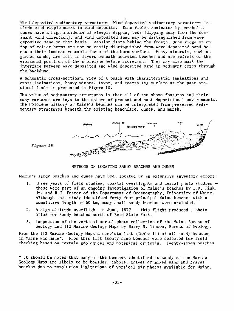
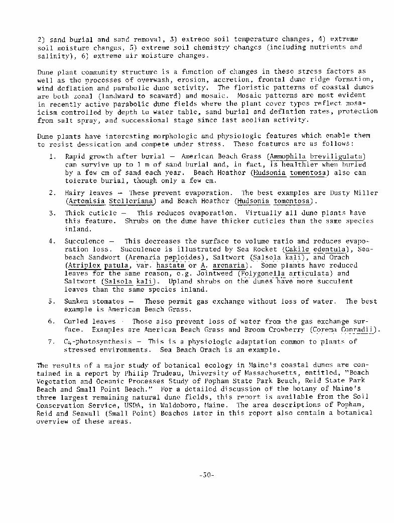
Wind de osited sedimentar structures Wind deposited sedimentary structures in-clude wind ripple marks in wind deposits. Dune fields dominated by parabolicdunes have a high incidence of steeply dipping beds dipping away from the dom-inant wind direction!, and wind deposited sand may be distinguished from wavedeposited sand on that basis. Aeolian flats behind the frontal dune ridge or ontop of relict berms are not so easily distinguished from wave deposited sand be-cause their laminae resemble those of the berm surface. Heavy minerals, such asgarnet sands, are left in layers beneath accreted beaches and are relicts of theerosional position of the shoreline before accretion. They may also mark theinterface between wave deposited and wind deposited sand in sediment cores throughthe backdune.
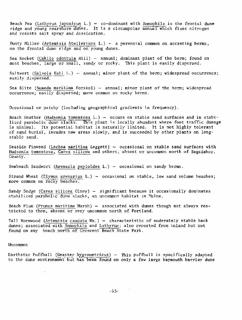
A schematic cross-sectioanl view of a beach with characteristic laminations and
cross laminations, heavy mineral layer, and coarse lag surface at the past ero-sional limit is presented in Figure 15.
The value of sedimentary structures is that all of the above features and theirmany variants are keys to the nature of present and past depositional environments.The Holocene history of Maine's beaches can be interpreted from preserved sedi-mentary structures beneath the existing beachface, dunes, and marsh.
Figure 15
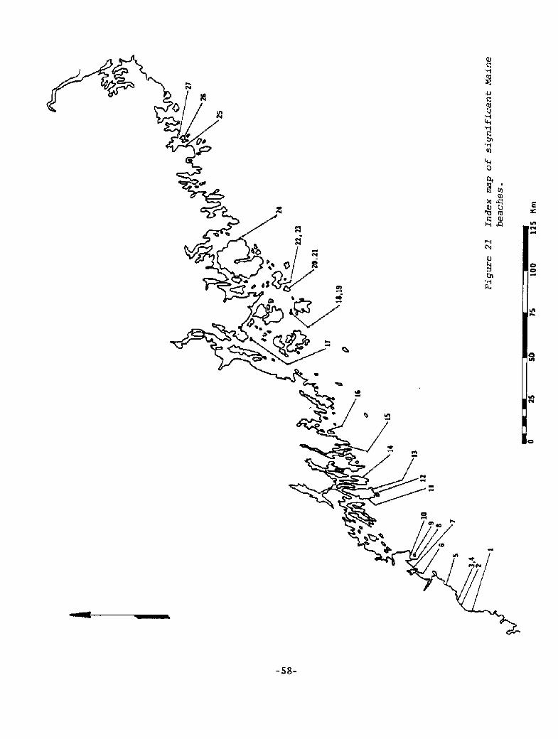
METHODS OF LOCATING SANDY BEACHES AND DUNES
Maine's sandy beaches and dunes have been located by an extensive inventory effort:
1. Three years of field studies, coastal overflights and aerial photo studiesthese were part of an ongoing investigation of Maine's beaches by L.K. Fink,Jr. and R.J. Foster of the Department of Oceanography, University of Maine.Although this study identified forty-four principal Maine beaches with acumulative length of 60 km, many small sandy beaches were excluded.
2. A high altitude overflight in June, 1977 � this flight produced a photoatlas for sandy beaches north of Reid State Park.
3. Inspection of the vertical aerial photo collection of the Maine Bureau ofGeology and 112 Marine Geology Maps by Barry S. Timson, Bureau of Geology.
From the 112 Marine Geology Maps a complete list Table II! of all sandy beachesin Maine was made". From this list twenty-nine beaches were selected for fieldchecking based on certain geological and botanical criteria, Twenty-seven beaches
It should be noted that many of the beaches identified as sandy on the MarineGeology Maps are likely to be boulder, cobble, gravel or mixed sand and gravelbeaches due to resolution limitations of vertical air photos available for Maine.
-32-
were visited in June, July and August of 1977 and a total of thirty-seven proposedcriticaI areas were delineated. The two beaches not visited are on coastal islands Andrews Beach, Long Island, Casco Bay and a north-facing pocket beach on SevenHundred Acre Island, Penobscot Bay!. These two areas are recommended for futurefield checking. The twenty-seven beaches visited represent approximately 20 kmof beach length. This compares with a total of 121 km of sandy beach based on theMarine Geology Maps and 60 kr8 based on the list by Fink and Foster.
Table II
SAND BEACHES OF MAINE in alphabetical order of topographic map name!
Beach Location or Name ~Len th To o a hic Ma Name* Town
Bailey Is1andBeach along northernmost tip ofBailey Island between N tip andcauseway entrance
204 m Harpswell
Bailey IslandWestward facing beach on north-ern peninsula of Bailey Island
192 m Harpswell
Bailey IslandNE beach directly opposite off-shore ledges
Bean island southern-side beach
96 m Harpswell
Bar Harbor NW 1/4
Bar Harbor NE 1/4
670 m
380 m
Sorrento
GouldsboroN facing beach on peninsulasandwiched between BankersBirch Hbrs. on Schoodic
Bar Harbor NE 1/4 Goul dsboro360 mBeach on arrowhead-shaped tipo f land between town o f Bir chHarbor and Prospect Pt.
Bar Harbor NE 1/4160 m GouldsboroBeach at head landward of SandCove
Beach facing SW onto Sand Cove
Beach facing SE onto Sand Cove
Beach surrounding SE tip ofHog Island
Bath NE 1/4 BrunswickThomas Bay beach
Fortunes Rocks Beach
290 m
2950 18 Bidde ford Pool NE 1/4 Bidde ford
* All names of topographic maps refer to the 7Q minute series. Where 7Qminute maps do not exist, quadrants of 15 minute maps are identified.
-33-
170 m
170 m
340 m
Bar Harbor NE 1/4
Bar Harbor NE 1/4
Bar Harbor NE 1/4
Gou1 dsboro
Gouldsboro
Gouldsboro
Table II Continued!
~Len th
Kennebunk-
port
Biddeford NW I/4
Biddeford
Ferry Beach 4500 m
410 m
Saco
Old Orchard
Beach
Bidde ford530 mHills Beach Old Orchard
Beach
HarringtonBoise Bubert120 m
HarringtonBoise Bubert160 m
Boise Bubert180 m Harrington
Georgetown
Georgetown
Southport
Boothbay Harbor
Boothbay Harbor
Boothbay Harbor
650 m
1160 m
260 m
SouthportBoothbay Harbor190 m
Bristol528 m
1370 m
Bristol
Bucksport SE 1/4 Stockton
Springs
Rockport
Rockport
220 m
530 m
240 m
Camden
Camden
Camden Camden
310 m Camden Camden
Beach Location or Name
Fortunes Rocks Beach
Horseshoe Cove Beach SW-facing
Horseshoe Cove Beach NE-facing
New Barn Cove Beach
Goose Rocks Beach
Beginning of Old OrchardBeach � Camp Ellis
Trafton Island Beaches facingNW, just south of northernmostpeninsula, eastern
Trafton Island Beaches facingNW, just south of northernmostpeninsula, western
NE side af Dyer Island, headof Watts Cove
Reid half mile beach
Reid mile beach
Beach midway down E side ofCapitol Island
Beach on northern tip ofSquirrel Island
Pemaquid Restoration Beach
Sandy Pt. beach, StocktonSprings
Beach on W side of Beauchamp Pt.
East side beach of Deadman Pt.
Northernmost beach at mouth of
Camden Harbor, slightly SW ofCurtin Island
Beach on SW side of Camden
Harbor
790 m
290 m
480 m
340 m
3600 m
To o ra hic Ma Name
Biddeford NW I/O
Biddeford NW I/4
Biddeford NW I/4
Biddeford NW I/4
Biddeford NW I/4
Town
Bidde ford
Biddeford
Biddeford
Bid.de ford
~Len th Town
Camden430 m Camden
Cape Elizabeth
Cape Elizabeth
190 m
790 m
Cape Elizabeth
Cape Elizabeth
Cape Elizabeth
Cape Elizabeth
Cape Elizabeth
Castine NE 1/4
Castine NE 1/4
Castine NE 1/4
310 m
790 m
Castine
Stockton
Springs
Castine NE 1/4 Stockton
Springs770 m
CutlerCross Island160 m
360 m Cross Island Cutler
Cross Island700 m Cutler
Cutler580 m Cross Island
170 m Cross Island Cutler
Cutler140 m Cross island
Table I I t'Continued!
Beach Location or Name
Beach at head of Camden Har-
bor, between Eaton Point andNorthwest Point
Broad Cove Beach
V-shaped beach, following apoint jutting into RichmondIsland Harbor
Crescent Beach
Marshall Cove Beach
John Cove Beach
Beach on NW part of WilsonPoint
Morse Cove Beach, western side
Beach on NW side of CapeJellison
Beach on NE side of CapeJellison
Philbrook Cove Beach
Beach on SW bend of Cape Rosier
Northwesternmost tip of PondIsland
Beach most westerly of the twobetween the Cross Island main-
land and Northwest Head
More eastern of the two beachesbetween upper Northwest Headand Cross Island's main body
Westernmost of the two beaches
separated by Grassy Pt. CrossIsland!
Easternmost of the two beachesseparated by Grassy Pt. CrossIsland!
Beach on the western side ofNortheast Harbor's ~outh CrossIsland!
Northernmost sandy beach ofIsland Peninsula containingCoast Guard station
1560 m
110 m
110 m
820 m
700 m
130 m
140 m
To o ra hic Ma Name
Castine NE 1/4
Castine SE 1/4
Castine SE 1/4
Cape Elizabeth
Cape Elizabeth
Cape Elizabeth
Castine
Islesboro
Brooksville
Deer Isle
-35-
TownLength
CutlerCross Island360 m
Cutler220 m Cutler
Deer Isle340 m
160 m isle Au Haut
Isle Au Haut130 m
Isle Au Haut530 m
340 m Isle Au Haut
Yarmouth310 m Freeport
FriendshipFriendship170 m
FriendshipFriendship140 m
FriendshipFriendship160 m
-36-
Table II Continued!
Beach Location or Name
NE-facing beach on Cross IslandCoast Guard peninsula
Westerly beach at head ofMachias Bay before Rte. 191crosses estuaries!
Machias Bay head, eastern beach
Largest sandy beach midway upsouthern side of Little River
Beach on southern tip of penin-sula framing northern side ofSoutheast Harbor
Beach north of Duck Harbor,Isle Au Haut
Beach on NW of Isle Au Haut,facing west to Flake Island
SE point of Merchant Island,V-shaped beach
Beach an southern half of Mer-
chant Island, facing NE
Miller Pt. beaches, South
Miller Pt. beaches, North
Circumferential beach on GreenIsland
SE-facing beach on easternpeninsula of Littlejohn Island
Peter Cove Beach
Stover Point Beach
Sizable beach on southwest qua-drant of Cranberry Island
Beach S of hook on western
side of Cranberry Island
Beach just N of southeast pointof' Friendship Island
Beach at head of Southern Cove
of Morse Island
620 m
120 m
310 m
170 m
460 m
240 m
360 m
620 m
To ogra hic Mam Name
Cutler
Cutler
Deer Isle NW 1/4
Deer Isle SW 1/4
Deer Isle SW 1/4
Deer Isle SW 1/4
Deer Isle SW 1/4
Devils Head
Devils Head
Drisko Island
Freeport
Freeport
Friendship
Cutler
Cutler
Calais
Calais
Addison
Harps we 1 1
Harpswell
Friendship
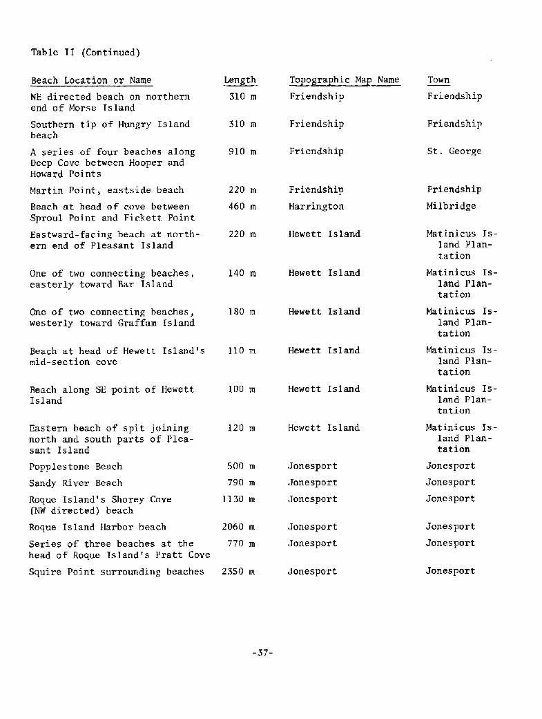
Table II Continued!
Length To o ra hic Ma Name
310 m Friendship
Friendship Friendship310 m
Friendship910 m St . George
220 m Hewett Island
140 m Hewett Island
Hewett Island180 m
Beach at head af Hewett Island's 110 m
mid-section cove
Hewett Island
Hewett Island100 m
120 m Hewett Island
Squire Point surrounding beaches 2350 81 JonesportJonesport
-37-
Beach Location or Name
NE directed beach on northernend of Morse Island
Southern tip of Hungry Islandbeach
A series of four beaches alongDeep Cove between Hooper andHoward Points
Martin Point, eastside beach
Beach at head of cave between
Sproul Point and Fickett Point
Eastward-facing beach at north-ern end of Pleasant Island
One of two connecting beaches.easterly toward Bar IsIand
One of two connecting beaches,westerly toward Graffam Island
Beach along SE point of HewettIsland
Eastern beach of spit joiningnorth and south parts of Plea-sant Island
Popplestone Beach
Sandy River Beach
Roque Island's Shorey Cove NW directed! beach
Roque Island Harbor beach
Series of. three beaches at the
head af Roque Island's Pratt Cove
220 m
460 m
500 m
790 m
1130 m
2060 81
770 m
Friendship
Harrington
Jonesport
Jonesport
Jonespart
Jonesport
Jonesport
Tawn
Friendship
Friendship
Milbridge
Matinicus Is-
land Plan-
tatian
Matinicus Is-
land Plan-
tation
Mat inicus Is-
land Plan-
tation
Matinicus Is-land Plan-
tation
Matinicus Is-land Plan-
tatian
Matinicus Is-land Plan-
tatlon
Jonesport
Jonesport
Jonesport.
Jonesport
Jonesport
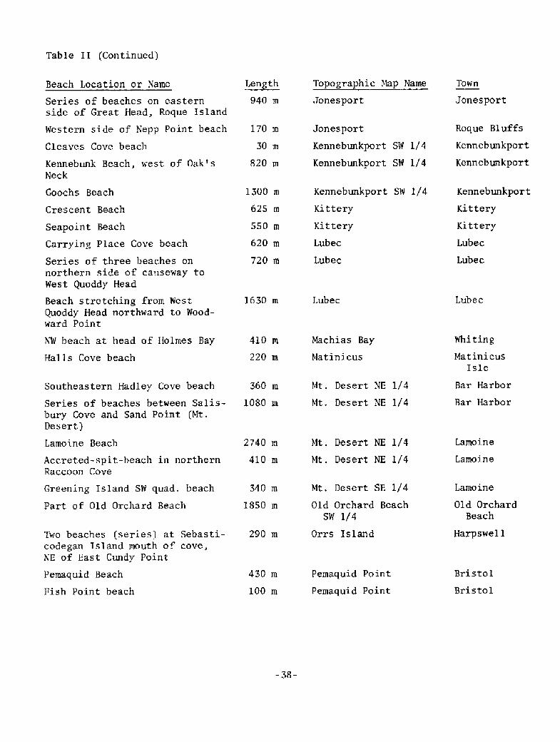
Table II Continued!
~Len th Topogra hic Map Name Town
Jonesport940 m Jonesport
170 m
30 m
820 m
Lube cLubec1630 m
Whi tingMachias Bay
Matinicus
410 m
220 m Mat ini cus
Isle
Mt. Desert NE 1/4
Mt, Desert NE 1/4
Bar Harbor
Bar Harbor
360 rn
1080 m
Mt. Desert NE 1/4
Mt. Desert NE 1/4
Lamoine
Lamoine
Lamoine Beach 2740 H1
410 rn
Mt, Desert SE 1/4 Lamoine340 m
1850 m Old Orchard
Beach
Old Orchard Beach
SW 1/4
Two beaches series! at Sebasti- 290 mcodegan Island mouth of cove,NE of East Cundy Point
Harpswe1 1Orrs Island
Pe1naquid Point
Pernaquid POint
Pemaquid Beach
Fish Point beach
430 m
100 m
Bristol
Bristol
-38-
Beach Location or Name
Series of beaches on eastern
side of Great Head, Roque Island
Western side of Nepp Point beach
Cleaves Cove beach
Kennebunk Beach, west o f Oak ' sNeck
Goochs Beach
Crescent Beach
Seapoint Beach
Carrying Place Cove beach
Series of three beaches onnorthern side of causeway toWest Quoddy Head
Beach stretching from WestQuoddy Head northward to Wood-ward Point
NW beach at head of Holmes Bay
Halls Cove beach
Southeastern Hadley Cove beach
Series of beaches between Salis-bury Cove and Sand Point Mt.Desert!
Accreted-spit-beach in northernRaccoon Cove
Greening Island SW quad. beach
Part of Old Orchard Beach
1300 m
625 1n
550 m
620 m
720 m
Jonesport
Kennebunkport SW 1/4
Kennebunkport SW 1/4
Kennebunkport SW 1/4
Kittery
Kittery
Lubec
Lubec
Roque Bluffs
Kennebunkport
Kennebunkport
Kennebunkport.
Kittery
Kittery
Lubec
Lubec
To ogra hic Ma Name TownLength
Phippsburg Phippsburg310 rn
Ph ippsbur gPhippsburg430 m
Phippsburg
Phippsburg
360 rn
100 m
Georgetown
Georgetown
Phippsburg240 m Georgetown
Phippsburg170 rn George town
Phippsburg Georgetown790 m
Phippsburg Georgetown
Cape Elizabeth
Cape Elizabeth
South Portland
Portland
Port. landPortland East580 m
1220 rn PortlandPortland East
Portland East
Portland East
Portland
Portland
620 rn
910 m
Andrews Beach
Cumberland
Cumberland
Portland East
Portland East
290 m
1990 m
CumberlandPortland East
Prouts Neck
430 m
4970 m
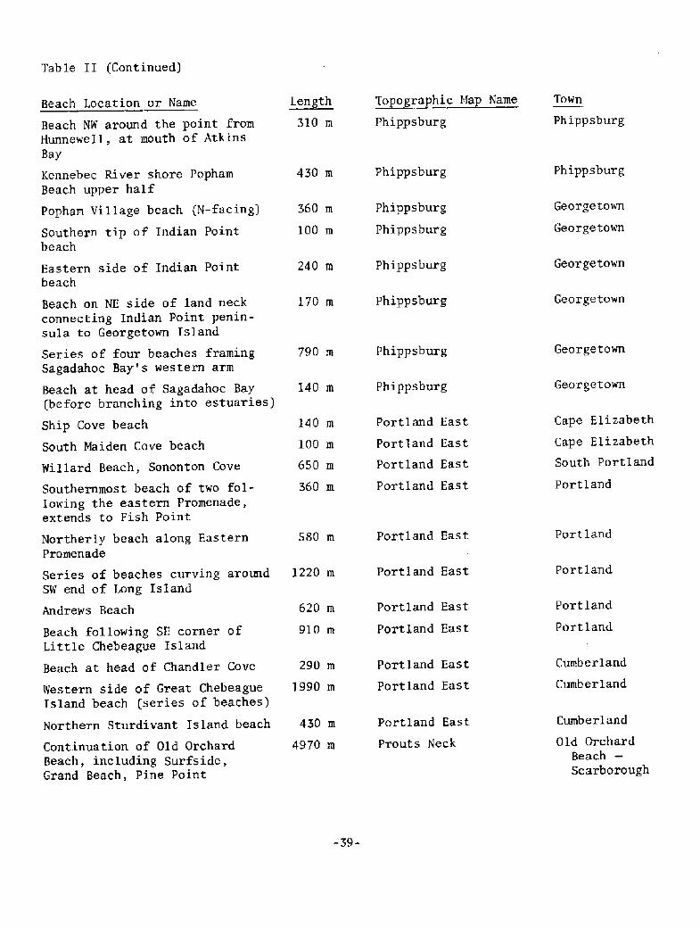
Table II Continued!
Beach Location or Name
Beach NW around the point fromHunnewell, at mouth of AtkinsBay
Kennebec River shore PophamBeach upper half
Popham Village beach N-facing!
Southern tip of Indian Pointbeach
Eastern side of Indian Pointbeach
Beach on NE side of land neckconnecting Indian Point penin-sula to Georgetown Island
Series of four beaches framingSagadahoc Bay's western arm
Beach at head o f Sagadahoc Bay before branching into estuaries!
Ship Cove beach
South Maiden Cove beach
Willard Beach, Sononton Cove
Southernmost beach of two fol-lowing the eastern Promenade,extends to Fish Point
Northerly beach along EasternPromenade
Series of beaches curving aroundSW end of Long Island
Beach following SE corner ofLittle Chebeague Island
Beach at head of Chandler Cove
Western side of Great ChebeagueIsland beach series of beaches!
Northern Sturdivant Island beach
Continuation of Old OrchardBeach, including Surfside,Grand Beach, Pine Point
140 m
100 rn
650 rn
360 m
Portland East
Portland East
Portland East
Portland East
Old Orchard
Beach
Scarborough
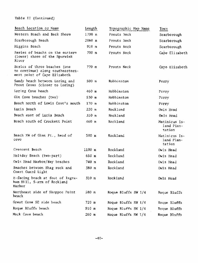
Table II Continued!
~tee th To o ra hic Ma Name
Cape ElizabethProuts Neck770 rn
Robbinston500 rn Perry
460 m
530 m
Beach north of Lewis Cove's mouth 170 m
220 m
310 m
460 m Matinicus Is-land Plan-
tation
Matinicus Is-
land Plan-
tation
Rockland500 m
Rockland310 m Owls Head
Roque Bluffs SW 1/4
Roque Bluffs SW 1/4
Roque B1u f fs580 m
Roque Bluffs
Roque Bluffs
Roque Bluf.fs
720 rn
910 m
260 m
Roque Bl uf f s beach
Mack Cove beach
Roque Bluffs SW 1/4
Roque Bluffs SW I/4
-40-
Beach Location or Name
Western Beach and Back Shore
Scarborough Beach
Higgins Beach
Series of beachs on the eastern
lower! shore of the SpurwinkRiver
Series of three beaches oneto continue! along southeastern-most point of Cape Elizabeth
Sandy beach between Loring andProst Coves closer to Loring!
Loring Cove beach
Gin Cove beaches two!
t.ucia Beach
Beach east of Lucia Beach
Beach south of Crockett Point
Beach NW of Ginn Pt., head ofcove
Crescent Beach
Holiday Beach two-part!
Owls Head Harbor/Bay beaches
Beaches between Shag rock andCoast Guard Light
E-facing beach at foot of Ingra-ham Hill, S-arm of RocklandHarbor
Northeast side of Shoppee Pointbeach
Great Cove SE side beach
1700 m
2060 m
910 m
700 m
1100 m
650 m
740 m
380 m
Prouts Neck
Prouts Neck
Prouts Neck
Prouts Neck
Robbinston
Robbinston
Robbinston
Rockland
Rockland
Rockland
Rockland
Rockland
Rockland
Rockland
Tow'n
Scarborough
Scarbo rough
Scarborough
Cape E1 i zabeth
Perry
Perry
Perry
Owls Head
Ow1s Head
Owls Head
Owls Head
Owls Head
Owls Head
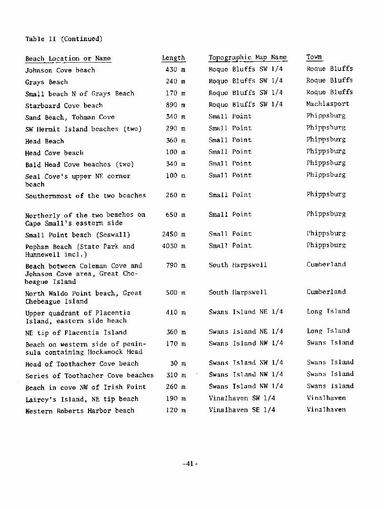
Table I I Continued!
To ogra hic Ma NameLength Towrl
Phippsbur g
Phippsburg
Phippsburg
Phippsburg260 m Small Point
Small Point Phippsburg650 rn
Phippsburg
Phippsburg
Small Point
Small Point
2450 m
4030 m
South Harpswell Cumber land790 m
CumberlandSouth Harpswell500 m
Swans Island NE 1/4 Long Island410 rn
Swans Island NE I/4
Swans Island NW 1/4
Long Island
Swans Island
360 m
170 rn
Swans Island NW I/4
Swans Island NW I/4
Swans Island NW I/4
Vinalhaven SW 1/4
Vinalhaven SE 1/4
30 m Swans Island
Swans Island
Swans Island
VinaIhaven
Vinalhaven
Series of Toothacher Cove beaches 310 rn
260 m
190 m
120 m
-41-
Beach Location or Name
Johnson Cove beach
Grays Beach
Small beach N of Grays Beach
Starboard Cove beach
Sand Bhach, Tohman Cove
SW Hermit Island beaches two!
Head Beach
Head Cove beach
Bald Head Cove beaches two!
Seal Cove's upper NE cornerbeach
Southernmost of the two beaches
Northerly of the two beaches onCape Small's eastern side
Small Point beach Seawal I!
Popham Beach State Park andHunnewell incl.!
Beach between Coleman Cove andJohnson Cove area, Great Che-beague Island
North Waldo Point beach, GreatChebeague island
Upper quadrant of PlacentiaIsland, eastern side beach
NE tip of Placentia Island
Beach on western side of penin-sula containing Hockamock Head
Head of Toothacher Cove beach
Beach in cove NW of Irish Point
Lairey's Island, NE tip beach
Western Roberts Harbor beach
430 m
240 m
170 m
890 rn
340 m
290 m
360 m
100 m
340 rn
100 m
Roque Bluffs SW I/4
Roque Bluffs SW I/4
Roque Bluffs SW 1/4
Roque Bluffs SW 1/4
Small Point.
Small Point
Small Point
SmaIl Point
Small Point
Sma11 Point
Roque Bluffs
Roque Bluffs
Roque Bluffs
Machiasport
Phippsburg
Phippsbur g
Phippsburg-
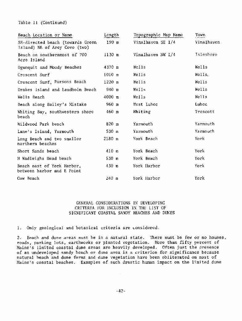
Table II Continued!
To o ra hic Ma NameBeach Location or Name I.eath190 m
Town
VinalhavenVinalhaven SE 1/4SE-directed beach towards GreenIsland! NE of Arey Cove two!
Vinalhaven NW I/4 IslesboroBeach on southernmost of 700Acre Island
1130 m
Whiting Bay, southwestern shorebeach
Yarroouth
Yarmo uth
Yarmouth
Yarrnouth
York Beach
Wildwood Park beach
Lane's Island, Yarroouth
820 m
530 rn
2180 m YorkLong Beach and two smallernorthern beaches
YorkYork Beach
York Beach
York Harbor
410 m
530 m
430 m
Short Sands beach
N Wadleighs Head beach York
YorkBeach east of York Harbor,between harbor and E Point
YorkYork HarborCow Beach 240 m
GENERAL CONSIDERATIONS 1N DEVELOPING
CRITERIA FOR INCLUSION IN THE LIST OF
SIGNIFICANT COASTAL SANDY BEACHES AND DUNES
1. Only geological and botanical criteria are considered.
2. Beach and dune areas must be in a natural state. There must be few or no houses,roads, parking lots, earthworks or planted vegetation. More than fifty percent ofMaine's limited coastal dune areas are heavily developed. Often just the presenceof an undeveloped sandy beach or dune area is a criterion for significance becausenatural beach and dune forms and dune vegetation have been obliterated on most ofMaine's coastal beaches. Examples of such drastic human impact on the limited dune
-42-
Ogunquit and Moody Beaches
Crescent Surf
Crescent Surf, Parsons Beach
Drakes Island and Laudholm Beach
Wells Beach
Beach along Bailey's Mistake
4370 m
1010 m
1220 m
940 m
4000 m
960 m
460 m
Wells
Wells
Wells
WelIs
Wells
West Lubec
Whiting
Wel ls
Wel ls,
Wel ls
Wel ls
Well s
Lubec
Trescott
and dune plant acreage of .'Raine are found at Long Sands, Ogunquit, Moody, Wells,Drakes Island, Kennebunk, Goose Rocks, Fortunes Rocks, Hills, Saco, Old Orchardand Higgins Beaches.
Beachfaces backed by extensive seawalls are not included as significant naturalareas. Such seawalls alter the shape of the beachface profile by preventing nor-mal responses to storm waves, constructional waves and wind.
3. The geographic distribution of Maine's beaches is a factor in consideringtheir significance. Beaches of different areas owe their existence to variousorigins. In areas where beaches are rare, the presence of even a small beachor dune area is significant.
4. Scientific and educational values are strong criteria for significance. Abeach or dune area may have excellent examples of certain geomorphic featuresor geological processes. The same is true for botanical features and processes.
GEOLOGICAL CRITERIA FOR SIGNIFICANCE
Two criteria were developed to determine the significance of a beach or dune area,One criterion was whether an area constituted a good example of the various geo-rnorphic types and features, The second criterion was to include those exampleswhich, either through their dune and beachface morphology or actual response behav-ior, manifest, the interaction between the physical elements of beach systems andvarious process agents. These criteria produced two lists, those geomorphic typesand features which occur in. Maine and those various process agents which leavetheir imprint on Maine beaches and dunes. These lists are as follows:
Beach and Dune Geomorphic Types and Features
A. Beach Types According to the Plan ViewI. Fringing Beaches
a. Fringing pocketb. Fringing deltac. Fringing strandplaind. Large fringing beaches
2. Barrier Beaches
a. Pocket barrier
b. Former marine lagoon or marshc. Cuspate barrier
3. Tombolos
a. Comet's tail
b. Normal to wave approach4, Cuspate Foreland5. Spits
a. Simpleb. Recurved � includes baymouth barrier-spit beachesc. Complexd. Double
-43-
Beach Features According to Profile Typesl. Erosional Profile Features
a. Frontal dune scarp FDS!b. Concave upward beachfacec. Low-tide terrace
d. Lag deposite. Heavy mineral fractionation
Graded beddingg. Ancient peat and tree stump exposuresh. Offshore subtidal bar
2. Accretionary Profile Featuresa. Broad berm
b. Berm crest may have cusps!c. Steep berm foresloped. Ridge and runnel systeme. Break-point barf. Graded beddingg. Characteristic sorting
C. Storm-Related Beach and Dune Features
1. Cobble or boulder storm ridge, berm, and cusps2. Overwash fans
3. Frontal dune ridge breaches4. Large-scale intertidal bar
D. Wind Related Beach and Dune Depositional Forms1. Frontal dune ridge FDR!2. Aeolian ramp3. Aeolian flats
4. Rear dune ridge5. Accretionar> ridge and swale topography6. Parabolic dunes and slacks
7. Onshore oriented blowouts
8. Precipitation dunes
E. Sedimentary Structural Featuresl. Swash marks
2. Ripple marks � many types3. Groundwater rill marks
4, Rhomboid marks
5. Current crescents and V-swash marks
6. Beach laminations
7. Wind formed cross-bedding
F. Ebb Tidal Delta and Flood Tidal Delta Features
II. Process Agents Which Leave an Imprint on Beach and Dune Morphology and WhichInfluence Beach and Dune Response Behavior.
A. Relative Sea Level Rise
1. Maine's beaches provide evidence of sea level rise rates, knowledgeof which is essential for coastal zone planning.
2. Transgressive facies barrier and salt marsh formation!, erosion andshoreline recession are results of sea level rise.
-44-
B. Prevailing and Dominant WindsI, Northeast storm winds � onshore directed
2. South to southwest winds � onshore directed3. Northwest winds � offshore directed
C. Waves
l. Storm waves
2. Constructional swell
D. Northeast Storms and Hurricanes
E. Currents
1. Tida1
2, River
3. Estuarine circulation4. Gulf of Maine gyre5. Longshore
Sand Supplyl. Influence of distribution of glacial outwash sediments on beach type
and occurrence
2. River sand sources
3. Onshore transport of submerged glacial deposits4. Wave erosion of upland glacial deposits5. Biogenic carbonate sources6. Wave erosion of local bedrock
BOTANICAL CRITERIA FOR SIGNIFICANCE
All undisturbed coastal sand dune and berm plant habitats in Maine are significantsimply because of their limited extent. Of the approximately 6,400 km of coastlinein Maine, the three beaches with large undisturbed dune fields Popham, Reid andSeawall Beaches! represent only 8.7 km of coastline length. Almost two-thirds ofMaine's original major dune fields are now heavily developed or altered by foottraffic erosion and dike construction. These beaches with major dune fields whichare now disturbed represent 18 km of coastline Ogunquit, Moody, Wells, and OldOrchard Beaches!. Smaller scale dune and berm plant habitats which remain undis-turbed are also significant because such habitats are rare in Maine. This is parti-cularly true north of Reid State Park where there are no large dune fields or broadaccretive berms. The attractiveness of beach and dune areas for potentially damagingrecreational and development uses, coupled with the fact that these usage pressuresare concentrated on only one or two percent of Maine's coastline, make identificationand description of Maine's natural dune and berm plant habitats urgent.
Additional criteria for the determination of significant coastal sandy dune and bermplant habitats are based on the following botanical features.
A. Landward to seaward zonation caused by salt spray effects, soil nutrientchanges, and sand burial or deflation rates.
B. Mosaic floristic patterns in stabilized parabolic dune fields. The distri-bution and abundance of plants in these habitats are functions of depth towater table, successional age, sand burial and deflation rates, and agesince last aeolian activity.
C. Dune field successional stages subsequent to accretion, fire, foot traffic,grazing, cutting or aeolian activity.
Vegetation development in overwashes and breaches.
Vegetation patterns on perennially accreting berms and spits.
Good stands of species with limited acreage in the state; e.g. AmericanBeach Grass, Beach Heather, Wormwood, Jointwood.
D.
G. Disjunct populations, especially stands of American Beach Grass north of ReidState Park. These are of value for scientific study of speciation as wellas geographic trends in environmentally and genetically controlled traits.
H. Geographic trends in abundance or ecotype which are of scientific value.To discern and study these trends it is necessary to maintain a continuumof natural habitats along the geographic axis in question.
The known and possibIe range limits of coastal sandy dune and berm plants in Maineare:
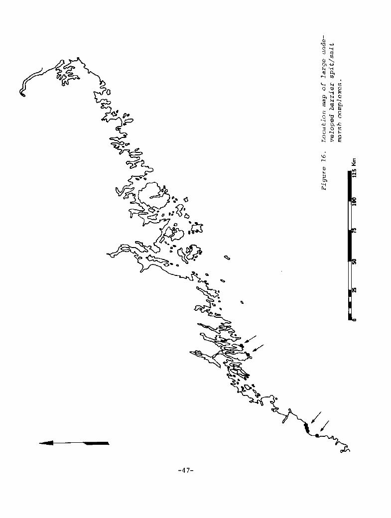
1. Wormwood � Artemisia caudata The northern coastal range limit for theAtlantic coast of North America is at Crescent Beach State Park Figure 17!.
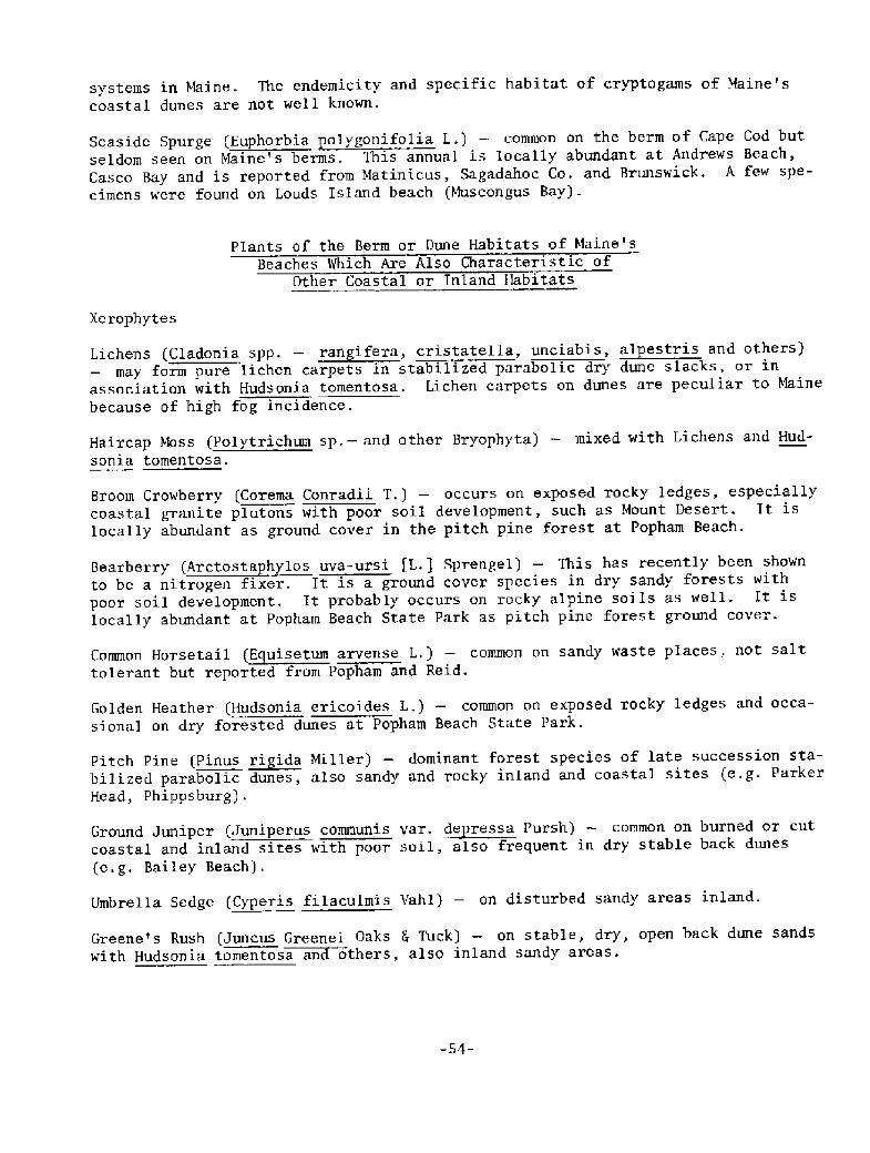
2. Beach Heather � Hudsonia tomentosa The northern coastal limit within Maineis Reid State Park. The plant reappears on Canadian beaches Figure 18!.
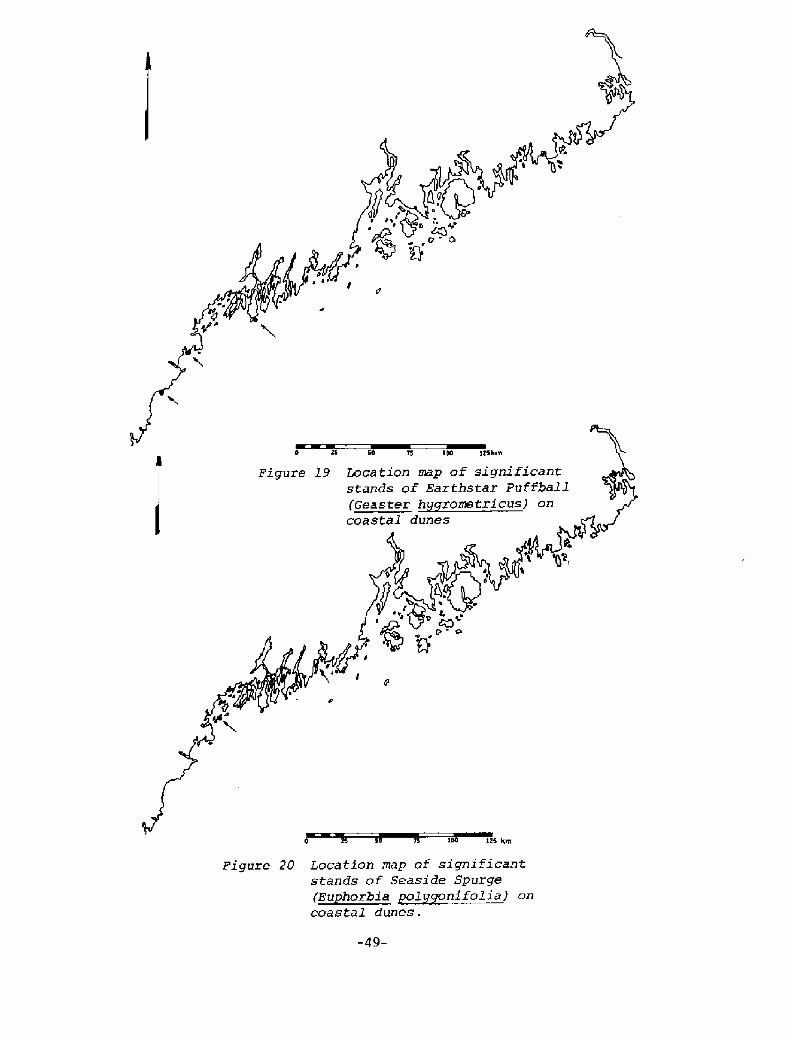
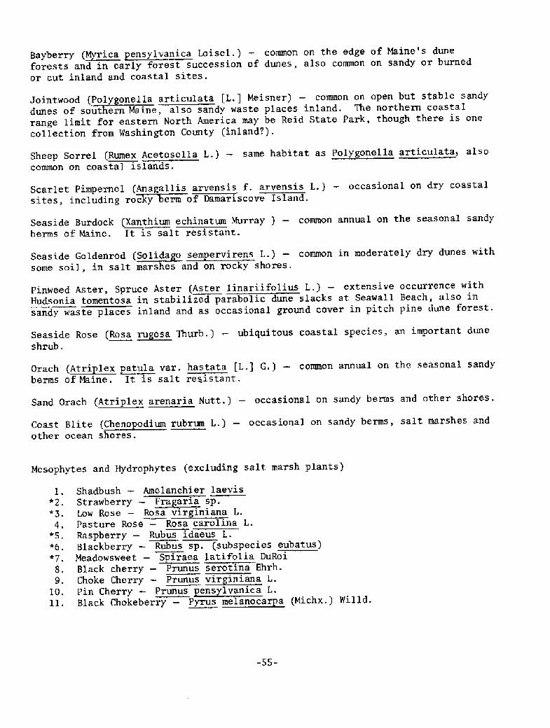
3. Earthstar Puffball � Geaster hygrometricus This dune mushroom reaches itsnorthern coastal range limit at either Seawall or Popham. It may be foundin sandy waste areas further north and in Canada Figure 19!.
Massachusetts beaches but has been found on only two sma11 Maine beaches.There was one collection in 1880 on Wells Beach. Maine specimens are muchsmaller than Massachusetts specimens. The plant. has also been collected innon-dune habitats in Maine Figure 20!.
GENERAL INFORMATION ON COASTAL SANDY
DUNE PLANT SPECIES AND ASSOCIATIONS
Coastal sandy dune plants of New England have peculiar physiologic, morphologic, andlife cycle features which enable them to survive and compete in a highly stressedenvironment. The major stresses which these plants endure are: I! salt spray,
-46-
The preserrce or abundance of many species have been found to decrease from south tonorth, but these trends are already difficult to study in detail because of excessivedevelopment on most of Maine's southern beaches Figure 16!.
pe
0+ 0>' ~
a
-4 7-
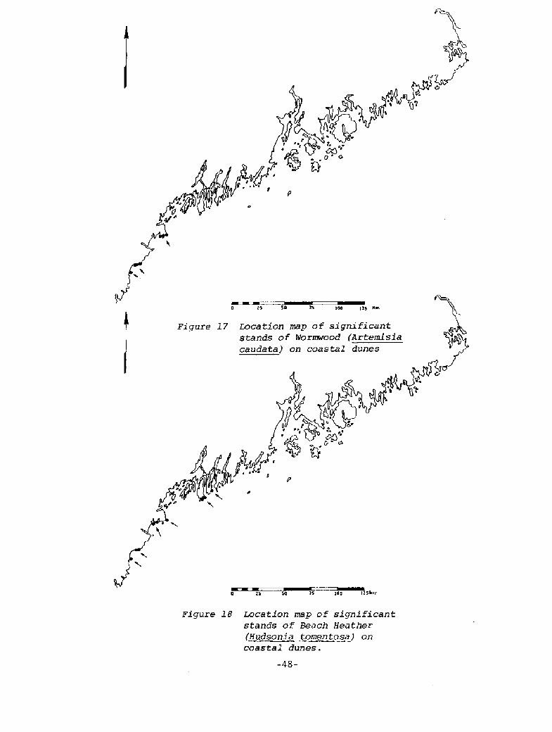
Figure l8 I+cation map of significantstands of Beach Heathez
Hudsoni a tomentose! on
coastal dunes.
-48-
75 1 125 km
Fi qure 20 Location map of significantstands oF Seaside Spurge
coastaI dunes.
2! sand burial and sand r emoval, 3! extreme soil temperature changes, 4! extremesoil moisture changes, 5! extreme soil chemistry changes including nutr ients andsalinity!, 6! extreme air moisture changes.
Dune plant community structure is a function of changes in these stress factors aswell as the processes of overwash, erosion, accretion, frontal dune ridge formation,wind deflation and parabolic dune activity. The floristic patterns of coastal dunesare both zonal landward to seaward! and mosaic. Mosaic patterns are most evidentin recently active parabolic dune fields where the plant cover types reflect mosa-icism controlled by depth to water table, sand burial and deflation rates, protectionfrom salt spray, and successional stage since last aeolian activity.
Dune plants have interesting morphologic and physiologic features which enable themto resist dessication and compete under stress. These features are as follows:
l. Rapid growth after burial � American Beach Grass ~Ammo hila breviligulatajcan survive up to I m of sand burial and, in fact, is healthier when buriedby a few cm of sand each year. Beach Heather Hudsonia tomentosa! also cantolerate burial, though only a few cm.
2. Hairy leaves � These prevent evaporation. The best examples are Dusty Miller Artemisia Stelleriana! and Beach Heather Hudsonia tomentosa!.
3. Thick cuticle � This reduces evaporation. Virtually all dune plants havethis feature. Shrubs on the dune have thicker cuticles than the same speciesinland.
4. Succulence � This decreases the surface to volume ratio and reduces evapo-ration loss. Succulence is illustrated by Sea Rocket Cakile edentula!, Sea-beach Sandwort Arenaria peeloidesj, Saltwort Salsola kali], and Grach Atriplex patula, var. hastata or A. arenaria! . Some plants have reducedleaves for the same reason, e.g. Jointweed Polygonella articulata! andSaltwort Salsola kali!. Upland shrubs on the dunes have more succulentleaves than the same species inland.
5, Sunken stomates � These permit gas exchange without loss of water, The bestexample is American Beach Grass.
6. Curled leaves � These also prevent loss of water from the gas exchange sur-face. Examples are American Beach Grass and Broom Crowberry Corema Conradii!.
7. Cl,-photosynthesis � This is a physiologic adaptation common to plants ofstressed environments. Sea Beach Orach is an example.
The results of a major study of botanical ecology in Maine's coastal dunes are con-tained in a report by Philip Trudeau, University of Massachusetts, entitled, "BeachVegetation and Oceanic Processes Study of Popham State Park Beach, Reid State ParkBeach and Small Point Beach." For a detailed discussion of the botany of Maine'sthree largest remaining natural dune fields, this report is available from the SoilConservation Service, USDA, in iYaldoboro, Maine. The area descriptions of Popham,Reid and Seawall Small Point! Beaches later in this report also contain a botanicaloverview of these areas.
-50-
Trudeau recognizes five basic plant communities which can be characterized bydominant species and sub-associations:
I, Foredune CommunityThis is the area seaward of the frontal dune ridge and has two zones:
A. Seasonal Berm � this zone is flooded by spring high tides or winterstorms. The plants are annuals which grow rapidly and produce manyseeds.
1. Sea Rocket � Cakile edentula
2. Saltwort � Salsola kali
B. Aeolian Ramp or Perennial Berm � these are recently accreted areaswith wind deposited sand now above the reach of spring tides andstorms.l. American Beach Grass � ~Ammo hila breviligulata2. Beach Pea � Lathyrus ~ja onicus3. Dusty Miller � Artemisia Stelleriana
II. Dune Grass CommunityThe dune grass community, dominated by American Beach Grass, runs from thefrontal dune ridge inland to a heath or shrub community. Species diver-sity is low, There is no soil, are few nutrients, and salt spray is heavy.Three sub-associations occur in addition to the monotypic beach grass.
Monotypic � pure American Beach GrassAmerican Beach Grass and Beach Pea Lathyrus ~ja onicus!American Beach Grass and Raspberry Rubus idaeus!American Beach Grass and Gooseberry Ribes sp.!
III. Dry Dune Slack CommunityThis community is found on dry inland dunes when salt spray and sand burialrates are lower than those for the dune grass community. The extreme varia-bility of the dry dune slack community is of interest to plant ecologists.Beach Heather Hudsonia tomentosa! is the community dominant and its occur-rence is significant sincCet cere are probably fewer than 40 hectares ofthis plant in Maine, and the bulk of this is found at Reid and Seawall.Associated plants are:
Pinweed � Lechea maritima
Pinweed Aster � Aster linariifolius
Lichens � Cladonia spp.Jointweed � Polygonella articulataGreene's Rush � Juncus Greenei
Sandy Sedge � Carex siliceaEarly Sedge � Carex 1
Some of the above plants will commonly be associated without Beach Heatherbeing present.
The presence of lichens in the back dune is peculiar to Maine and is aresult of the high incidence of coastal fog.
-51-
I V. Shrub Communi tyThis is a dense tangle of bushes .5 to 1.7 meters high. The dominants are:
2'="' '"'"'"
Meadowsweet � ~S iraea latifoliaRaspberry � Rubus z.daeus
Stands may be monotypic or in various mixtures. Poison Ivy Rhus toxico-dendron! and Gooseberry are common additions. Cherry Prunus spp. ! andServiceberry Ame1anchier spp.! are found at the edge of this community.
V. Dune Forest CommunityIn the deficient soil of inactive parabolic dunes and under the stress ofsalt spray, forests are dominated by Pitch Pine Pinus ~ri ida!. Threesuccessional stages toward the edaphic soil! climax Pitch Pine forestare commonly observed:
A. Semi-open with Beach Heather and Cladonia lichens between trees.
B. Widely spaced Pitch Pines with thick shrubs in between.
C. Mature Dune Forest with Pitch Pine, Red Maple Acer rubrum!, Red Oak
sp.!, Serviceberry Amelanchier sp.!. Dominant understory speciesinclude many grasses, Canada Mayflower Maianthemum canadense!, StarFlower Trientalis borealis!, Wild Sarsapari11a Aralia nudicaulis!,and Bunchberry Comus Canadensis!.
An additional forest type community occurs in low, moist back dune areas,where a low shrub-thicket forest is found. Dominants are Alder Ainussp.!, Winterberry Ilex verticillata!, Serviceberry, and Poplar.
A partial listing of Maine's berm and dune plants follows. The list was derivedfrom collections and field studies by Nelson and Trudeau,
PARTIAL LIST OF MAINE'S BERM AND DUNE PLANTS
Plants of the Berm or Dune Habitats of Maine'sBeaches Which Are Not Characteristic of
Other Coastal or Inland Habitats.
Common
American Beach Grass A~Ace hila breviligulata Host! � the dominant plant of activeand young dunes, especially the frontal dune ridge. It requires sand burial forvigor, resists dessication and salt spray damage and is responsible for entrapmentof sand in the frontal dune ridge.
Beach Pea Lathyrus ~aonicus L.! � co-dominant with Ammoohila in the frontal duneridge and young nearshore dunes. It is a circumpolar annual which fixes nitrogenand resists salt spray and dessication.
Dusty Miller Artemisia Stelleriana L.! � a perennial common on accreting berms,on the frontal dune ridge and on young dunes.
Sea Rocket Cakile edentula Hill! � annual; dominant plant of the berm; found onmost beaches, large or small, sandy or rocky. This plant is easily dispersed.
Saltwort Salsola Kali L.! � annual; minor plant of the berm; widespread occurrence;easily dispersed.
Sea Blite Suaeda maritima Forskel! � annual; minor plant of the berm; widespreadoccurrence, easily dispersed; more common on rocky berms.
Occasional or patchy including geographical gradients in frequency!,
Beach Heather Hudsonia tomentosa L.! � occurs on stable sand surfaces and in stabi-lized parabolic dune slacks. This plant is locally abundant where foot traffic damageis minimal. Its potential habitat is naturally limited. It is not highly tolerantof sand burial, invades new areas slowly, and is succeeded by other plants on long-stable sand.
Seaside Pinweed Lechea maritima Leggett! � occasional on stable sand surfaces withHudsonia tomentosa, Carex silicea and others; absent or uncommon north of Sagadahoc.County.
Seabeach Sandwort Arenaria ~e loides L.! � occasional on sandy harms.
Strand Wheat Elymus arenarius L.! � occasional on stable, low sand volume beaches;more common on rocky beaches,
Sandy Sedge Carex silicea Olney! � significant because it occasionally dominatesstabilized parabolic dune slacks, an uncommon habitat in 1'Line.
Beach Plum Prunus maritima Marsh! � associated with dunes though not always res-tricted to them, absent or very uncommon north of Portland.
Tall Wormwood Artemisia caudata Mx.! � characteristic of moderately stable backdunes; associated with ~Ammo hila and Lathyrus; also reported from inland but notfound on any beach north of Crescent Beach State Park.
Uncommon
Earthstar Puffball Geaster hygrometricus! � This puffball is specifically adaptedto the dune environment but has been found on only a few large baymouth barrier dune
systems in tb1aine. The endemicity and specific habitat of cryptogams of Maine'scoastal dunes are not well known.
Seaside Spurge Euphorbia polygonifolia L.! � common on the berm of Cape Cod butseldom seen on Maine's berms. This annual is locally abundant at Andrews Beach,Casco Bay and is reported from Matinicus, Sagadahoc Co. and Brunswick. A few spe-cimens were found on Louds Island beach Muscongus Bay!.
Plants of the Berm or Dune Habitats of Maine'sBeaches 1%thich Are Also Characteristic of
Other Coastal or Inland Habitats
Xerophytes
Lichens LCladonia spp, � rangtfera, criststella, unciabis, ~al estris and others!may form pure lichen carpets in stabilized parabolic dry dune slacks, or in
association with Hudsonia tomentosa. Lichen carpets on dunes are peculiar to Mainebecause of high fog incidence.
Haircap Moss Polytrichum sp.� and other Bryophyta! � mixed with Lichens and Hud-sonia tomentosa.
Broom Crowberry Corema Conradii T,! � occurs on exposed rocky ledges, especiallycoastal granite plutons with poor soil development, such as Mount Desert. It islocally abundant as ground cover in the pitch pine forest at Popham Beach.
to be a nitrogen fixer. It is a ground cover species in dry sandy forests withpoor soil development. It probably occurs on rocky alpine soils as well. It islocally abundant at Popham Beach State Park as pitch pine forest ground cover.
Common Horsetail Equisetum arvense L,! � co~mon on sandy waste places. not salttolerant but reported from Popham and Reid.
Golden Heather Hudsonia ericoides L,! � common on exposed rocky ledges and occa-sional on dry forested dunes at Popham Beach State Park,
Pitch Pine Pinus rigida Miller! � dominant forest species of late succession sta-bilized parabolic dunes, also sandy and rocky inland and coastal sites e.g. ParkerHead, Phippsburg!.
Ground Juniper Juniperus communis var. ~de ressa Pursh! � common on burned or cutcoastal and inland sites with poor soil, also frequent in dry stable back dunes e.g. Bailey Beach!.
Umbrella Sedge Cyperis filaculmis Vahl! � on disturbed sandy areas inland.
Greene's Rush Juncus Greenei Oaks 4 Tuck! � on stable, dry, open back dune sandswith Hudsonia tomentose anan others, also inland sandy areas.
-54-
pforests and in early forest succession of dunes, also common on sandy or burnedor cut inland and coastal sites.
dunes of southern Maine, also sandy waste places inland. The northern coastalrange limit for eastern North America may be Reid State Park, though there is onecollection from Washington County inland?!.
common on coastal islands.
Scarlet Pimpernel Anagallis arvensis f. arvensis L.! � occasional on dry coastalsites. including rocCky cern of Damariscove Island.
Seaside Burdock Xanthium echinatum Murray ! � common annual on the seasonal sandyberms of Maine. It is salt resistant.
some soil, in salt marshes and on rocky shores,
Pinweed Aster, Spruce Aster Aster linariifolius L.! � extensive occurrence withHudsonia tomentosa in stabilized parabolic dune slacks at Seawall Beach, also insandy waste places inland and as occasional ground cover in pitch pine dune forest.
Seaside Rose Rosa ~ru osa Thurb.] � ubiquitous coastal species, an important duneshrub.
Orach ~Atri les patula var, hastata [L.] G.I � common annual on the seasonal sandyberms of Maine. lt is salt resistant.
Sand Orach Atriplex arenaria Nutt.! � occasional on sandy berms and other shores.
other ocean shores.
Mesophytes and Hydrophytes excluding salt marsh plants!
1. Shadbush � Amelanchier laevis*2. Strawberry � ~Fra aria sp.
4. Pasture Rose � Rosa carolina L.*5, Raspberry � Rubus idaeus L.*6. Blackberry � Rubus sp. subspecies eubatus!7. Meadowsweet � Spiraea latifolia DuRoi8. Black cherry � Prunus serotina Ehrh.
-55-
12. Hardhack � Spiraea tomentosa L.*13. Cinquefoil � Potentilla sp.
14. Hawthorn � Crataegus sp.*15. Wrinkled Goldenrod � ~Solida o rugose Aiton*16. Goldenrod � ~Solids o spp.*17. Ragweed � Ambrosia artemisifolia L
H.
rter
F.
Des f.
! Hooker
18. Pearly Everlasting � ~Ana halus margaritacea L.j B.*19. Pineapple weed � Matricaria matricarioides Less. ! Po"20. Fall Rattlesnake Root � Prenanthes trifoliata Cass.!*21, Toothed Hawkweed � Hieracium canadense Mx.*22. Spiney-leaved Sow Thistle � Sonchus ashier L.! Hill«23. Field Sow Thistle � Sonchus arvensis L.*24. Flat-topped White Aster � Aster umbellatus Miller*2S. Common Yarrow � Achilles millefolrum L*26. Low Sweet Blueberry � Vaccinium angustifolium Aiton27, Black Huckleberry � Gaylussacia baccata Wang. ! K. Koc
*31. Gooseberry � Ribes sp.«32. Poison Ivy � Rhus toxicodendron L.33. Staghorn Sumac � Rhus ~thine L.34. Winterberry � Ilex verticillata L.! G.
*35. Common St. Johns-wort � Hyyericum perfoliatum L.*36. Tufted Vetch � Vicia cracca L.
*37. Yellow Clover � Trifolium agrarium L.38. Red Maple � Acer rubrum L.
� '" s � '"' ' '""
*41. Evening Primrose � Oenothera sp.
43. Wild Sarsaparilla � Aralia nudicaulis L.44. Bristly Sarsaparilla � Aralia ~his ida Vent.4S. Canada Mayflower � Maianthemum canadense Des f.46.. Starry False Solomon's Seal � Smilacina racemosa L.!
*48. Scotch Lovage � Ligusticum scothicum L.49. Star Flower � Trientalis borealis Raf.
*50. Deadly Nightshade � Solanum dulcamara L.51. Bush Honeysuckle � Diervilla Ionicera Miller52. Swamp-Ply-Honeysuckle � Lonicera oblor~ifolia GoldieS3. Wild Raisin � Viburnum cassinoides L.
*54, Morning Glory � Convolvulus seyium L.SS. Dodder � Cuscuta Gronovii Willd.
57. Bedstraw � Galium sp.58. Hemp-Nettle � ~Galen sis tetrahit L,59. Common Plantain � ~planta o major L.60. Common Milkwort � ~Poly ala ~san ines L.61. Bastard- Toadf lax � Comandra umbellata L. Nutt. !
-56-
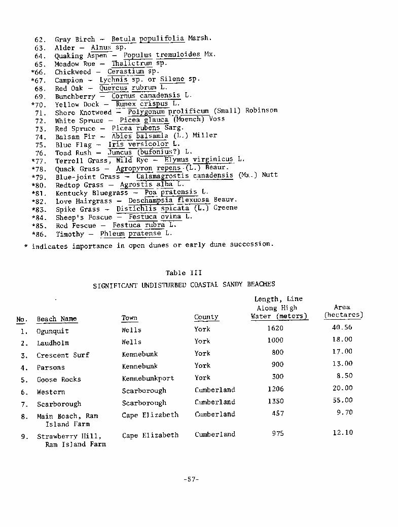
indic
Length, LineAlong High
Water meters!Area
hectares!Beach Name
Ogunquit
Laudholm
Town CountyNo.
l.
2.
40.561620YorkWells
Wells
Kennebunk
Kennebunk
Kennebunkport
Scarborough
Scarborough
Cape Elizabeth
18.001000York
17. 00800Crescent Surf York
13. 00900YorkParsons
8.50300YorkGoose Rocks20.00
55.00
1206Cumberland
Cumber 1 and
Cumberland
Western
1350Scarborough
Main Beach, RamIsland Farm
9. 70457
12.10Cape Elizabeth CumberlandStrawberry Hill,Ram Island Farm
975
-57-
62
63.
64.
65."66.
*67
68.69.
*70
71.
72,
73.
74.
75.
76.wl77
*78.
*79
+80
"81.
*82.
"83."84.
*85.
*86
Alder � Ainus sp.Quaking Aspen � ~Po ulus tremuloides ! x,Meadow Rue � Thalictrum sp.Chickweed � Cerastium sp.Campion � Lychnis sp. or Silene sp.Red Oak � Quercus rubrum L.Bunchberry � Comus canadensis L.Yellow Dock � Rumex ~eris us L.Shore Knotweed � Polycponum rolificum Small! RobinsonWhite Spruce � Picea glance ! conch! VossRed Spruce � Picea rubens Sarg.Balsam Fir � Abies balsamia L,! MillerBlue Flag � Iris versicolor L.Toad Rush � Juncus bufonius?! L.
Quack Grass � A~ro yron ~re ens . L.! Beaur.Blue-joint Grass � Calamagrostis canadensis Mx.! NuttRedtop Grass � Agrostis alba L.Kentucky Bluegrass � Poa pratensis L.
Spike Grass � Distichlis ~s icata L.! GreeneSheep's Fescue � Festuca ovina L.Red Fescue � Festuca rubra L.Timothy � Phleum pratense L.
ates importance in open dunes or early dune succession.
Table III
SIGNIFICANT UNDISTURBED COASTAL SANDY BEACHES
M
lV
Vi
O o
Ol
Vl
CV
CPl ~
-58-
4I
'4
'4 0 k 0! U
uleA


![Tessellation and Lyubich-Minsky laminations associated ...kawahira/works/lamination.pdf · Minsky [LM] introduced hyperbolic orbifold 3-laminations associated with rational maps](https://img.pdfslide.us/doc/110x75/605f52bea41bfa37736c1c34/tessellation-and-lyubich-minsky-laminations-associated-kawahiraworkslaminationpdf.jpg)