Embed Size (px)
Citation preview
55
Cretaceous and Tertiary Intrusive Rocks of South-Central Idaho
Kathleen M. Johnson1 Reed S. Lewis2 Earl H. Bennett? Thor H. Kiilsgaard4
INTRODUCTION
The Idaho batholith is one of the great &cum-Pacific batholiths. It extends over 300 miles in a north-south direction and is 80 miles wide. Armstrong (1975b) suggests that the batholith be divided into two parts, the Bitterroot lobe to the north and the larger Atlanta lobe to the south. Vast areas of south-central Idaho are underlain by Cretaceous and Tertiary intrusive rocks that are part of the Atlanta lobe. The older plutons were emplaced during Late Cretaceous time, were extensively faulted, and were intruded by Tertiary epizonal plutonic rocks and dike swarms. The Cretaceous batholith was exposed at the surface by early Eocene time and lower extrusive units of the Eocene Challis Volcanic Group were deposited directly on the batholith. The Eocene intrusive rocks are exposed in numerous small to large stocks within and to the east of the Atlanta lobe. They intruded to shallow levels between 42 and 50 Ma. Dike swarms and many stocks are concentrated along major regional northeast- trending faults related to Eocene extension.
x U. S. Geological Survey, Box 25046, MS 937, Denver CO 80225
2 Oregon State University, Department of Geology, Corvallis OR 97331
3 Idaho Geological Survey, University of Idaho, Moscow ID 83843
4 U.S. Geological Survey, West 920 Riverside Ave., Spokane WA 99201
Previous Work
Early geologic studies in the Atlanta lobe of the Idaho batholith were done by Ross (1928,1934) and Anderson (1947, 1952), who identified several types of Mesozoic and Tertiary rocks. Ross (1934) mapped and named the Tertiary Casto pluton and several Tertiary diorite bodies. More recently, Schmidt (1964) delineated four Late Cretaceous rock units near Cascade; Reid (1963) and Kiilsgaard and others (1970) mapped Cretaceous and Tertiary rocks in the Sawtooth Range, southwest of Stanley. Lewis and others (1987) provide a comprehen- sive list of geologic studies in the Cretaceous batholith. Bennett and Knowles (1985) provide a similar list of studies of the Tertiary intrusive rocks.
Geologic mapping and related laboratory studies for projects of the U. S. Geological Survey’s Conterminous United States Mineral Assessment Program (CUSMAP) in the Challis and Hailey 1 x 2 degree quadrangles have produced new information about the nature and extent of Cretaceous and Tertiary plutonic rocks of south-central Idaho. Published reports include the Challis quadrangle geologic map (Fisher and others, 1983 and in press), reports of work in progress (Kiilsgaard and Lewis, 1985; Bennett and Knowles, 1985), and the Challis quadrangle mineral resource assessment (Fisher and Johnson, 1987).
GEOLOGIC SETTING
Host rocks along the eastern margin of the Idaho
Johnson, K. M., Lewis, R. S., Bennett, E. H., and Kiilsgaard, T. H., 1988, Cretaceous and ‘JYertiq intrusive hocks of south-central Idaho, in Link, P. K., and Hackett, W. IX., editors, Guidebook to the Geolo~ of Central and Southern Idaho: Idaho Geologc+l Survey Bulletin 27, p. 55-86.
56 Guidebook to the Geology of Cent& and Southern Idaho
batholith are Paleozoic sediments that have been meta- morphosed to homfels and talc-homfels. Rocks of the Eocene Challis Volcanic Group obscure parts of the eastern margin of the batholith (Ross, 1937; McIntyre and others, 1982; Fisher and others, 1983).
The northern part of the Atlanta lobe intrudes a variety of Precambrian metasedimentary and metaigneous rocks, most of which are not well studied. Argillaceous quartzites of the Yellowjacket Formation (Ross, 1934; Ruppel, 1975; Lopez, 1982) are intruded by granitic rocks thought to have an approximate age of 1,370 Ma (Evans and Zartman, 1981; Armstrong, 1975a). High- grade gneiss and schist found west of Shoup (Cater and others, 1973) and paragneiss and orthogneiss found immediately north of the main Salmon River (Weis and others, 1972) may be Precambrian crust that is older than the Yellowjacket Formation.
Isolated roof pendants are found in a northwest- trending belt extending across the north-central part of the Atlanta lobe. These metasedimentary rocks are probably Paleozoic in age, but no correlations with known Paleozoic rocks have been made (Hobbs and Cookro, 1987, p. 18). The pendants are exposed on ridge tops and are thought to be at or near the top of the batholith.
The western margin of the Atlanta lobe is juxtaposed against oceanic island-arc rocks of Permian and Triassic age (Hamilton, 1963; Brooks and Vallier, 1978; Myers, 1982; Lund, 1984). Metavolcanic and metasedimentary rocks of the Wallowa-Seven Devils terrane, which have been intruded by Triassic and Jurassic plutons, and the structurally superimposed Riggins Group are now thought to have been accreted to the continent along a right-lateral transcurrent fault during the Cretaceous (Lund, 1984; Sutter and others, 1984; Criss and Fleck, 1987; Vallier and Brooks, 1987, p. 5).
The southwestern and southern margins of the Atlanta lobe are covered by younger volcanic and sedimentary rocks. Extensive flows of Miocene Columbia River Basalt Group mask intrusive relations at the southern end of the western margin. The southern margin is similarly obscured by Miocene and younger volcanic rocks of the Snake River Plain.
The western margin of the Idaho batholith is approximately coincident with the edge of the pre- Mesozoic continental margin. Armstrong and others (1977) recognize a distinct break in the initial 87Sr/86Sr ratios for igneous rocks of this area. East of a north- south line along the western edge of the batholith (Fig. l), initial Sr ratios are greater than 0.7055. West of the same line they are less than 0.7043. Fleck and Criss (1985) showed that in detail a continuum of *7Sr/t%r ratios exists across this line, but that the entire transition zone is typically no more than several hundred meters to a few kilometers wide.
Host rocks for Eocene intrusive rocks include all phases of the Cretaceous batholith, Paleozoic metasedi- mentary rocks east of the batholith, and older Eocene
Figure I. Generalized map showing the strontium isotope 0.70410.706 line, the trace of the Trans-Challis fault system, and the Bitterroot and Atlanta lobes of the Idaho batholith.
rocks of the Challis Volcanic Group (Fisher and others, in press). Ross (1934) recognized two groups of volcanic rocks in the Casto 30-minute quadrangle. Cater and others (1973) observed that Ross’ “Cast0 Volcanics” were probably altered Challis Volcanic Group and formally abandoned the name “Cast0 Volcanics.” McIntyre and others (1982) and Ekren (1985) have shown that the Challis Volcanic Group resulted from a series of relatively quiet eruptive events and large violent caldera- forming eruptions between 51 and 45 Ma. Thick sections of talc-alkaline intermediate lava and dacitic-rhyolitic tuff are exposed in the eastern half of the Challis and Hailey 1 x 2 degree quadrangles and the western half of the Idaho Falls 1 x 2 degree quadrangle (Moye and others, 1988, this volume).
Cretaceous Granitic Rocks
The Atlanta lobe of the Idaho batholith is 170 miles (275 km) long and 80 miles (130 km) wide and consists of six main rock types: tonalite, hornblende-biotite granodiorite, porphyritic granodiorite, biotite grano- diorite, muscovite-biotite granite, and leucocratic granite (Fig. 2). Most of these units are exposed over large
EXPLANATION . .
sediments E e
basalt
sediments
f
is y,:
Idavada Volconics
8 sediments c
Columbia River Bosolt r
g
Challis Volcanic Group
8
granite
qronodiorite ond diorite
qobbro
oplite/peqmotite complex
I I
muscovite-blltite
tonolite ond porphyritic qronodlorite
Idaho botholith undifferentiol
sedimentary rocks
metamorphic rocks
- contact - fault
U decollement
field trip
-- day I
-.v. day 2
-- day 3
0 I miler
Figure 2. Simplified geologic map of Cretaceous and Tertiary intrusive rocks in and near the Atlanta lobe of the Idaho batholith. Compiled from Fisher and others (in press), Bond (1978), and unpublished mapping by the authors.
58 Guidebook to the Geology of Central and Southern Idaho
areas. The Atlanta lobe lacks the numerous small, discrete granitic plutons that are characteristic of other large batholiths. Instead, the plutons are very large and contacts between them are gradational, even where exposures are good. Except for leucocratic granite, sharp contacts are rare.
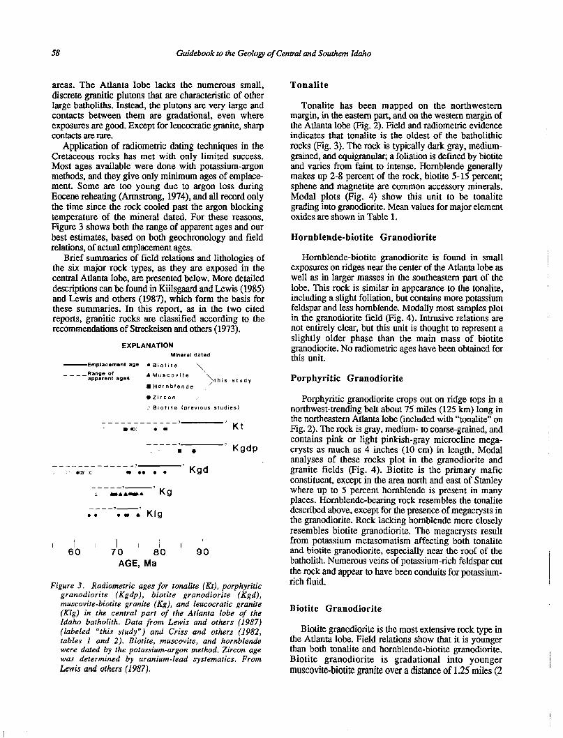
Application of radiometric dating techniques in the Cretaceous rocks has met with only limited success. Most ages available were done with potassium-argon methods, and they give only minimum ages of emplace- ment. Some are too young due to argon loss during Eocene reheating (Armstrong, 1974), and all record only the time since the rock cooled past the argon blocking temperature of the mineral dated. For these reasons, Figure 3 shows both the range of apparent ages and our best estimates, based on both geochronology and field relations, of actual emplacement ages.
Brief summaries of field relations and lithologies of the six major rock types, as they are exposed in the central Atlanta lobe, are presented below. More detailed descriptions can be found in Kiilsgaard and Lewis (1985) and Lewis and others (1987), which form the basis for these summaries. In this report, as in the two cited reports, granitic rocks are classified according to the recommendations of Streckeisen and others (1973).
EXPLANATION Mineral dated
-Emplacement age l Biotite “\ ---- Range of
apparent ages A Muscovite
l Hornblende ‘?,h~s study
@Zircon ,,’
2 Biotit e (previous studies)
--__ ------m-q DO l m ’ Kt
-----7 m a ’ Kgdp
-_----- --___ -7 em L m l e l l ’ Kgd
_--- c -?-’ Kg UAAYIA
---- 7-3 l * l m A Klg
I I I 710 I I I do I 60 80
AGE, Ma
Figure 3. Radiometric ages for tonalite (IO), porphyritic granodiorite (Kgdp). biotite granodiorite (Kgd), muscovite-biotite granite (Kg), and ieucocratic granite (Klg) in the central part of the Atlanta lobe of the Idaho batholith. Data from Lewis and others (1987) (labeled “this study”) and Criss and others (1982, tables I and 2). Biotite, muscovite, and hornblende were dated by the potassium-argon method, Zircon age was determined by uranium-lead systematics. From Lavis and others (1987).
Tonalite
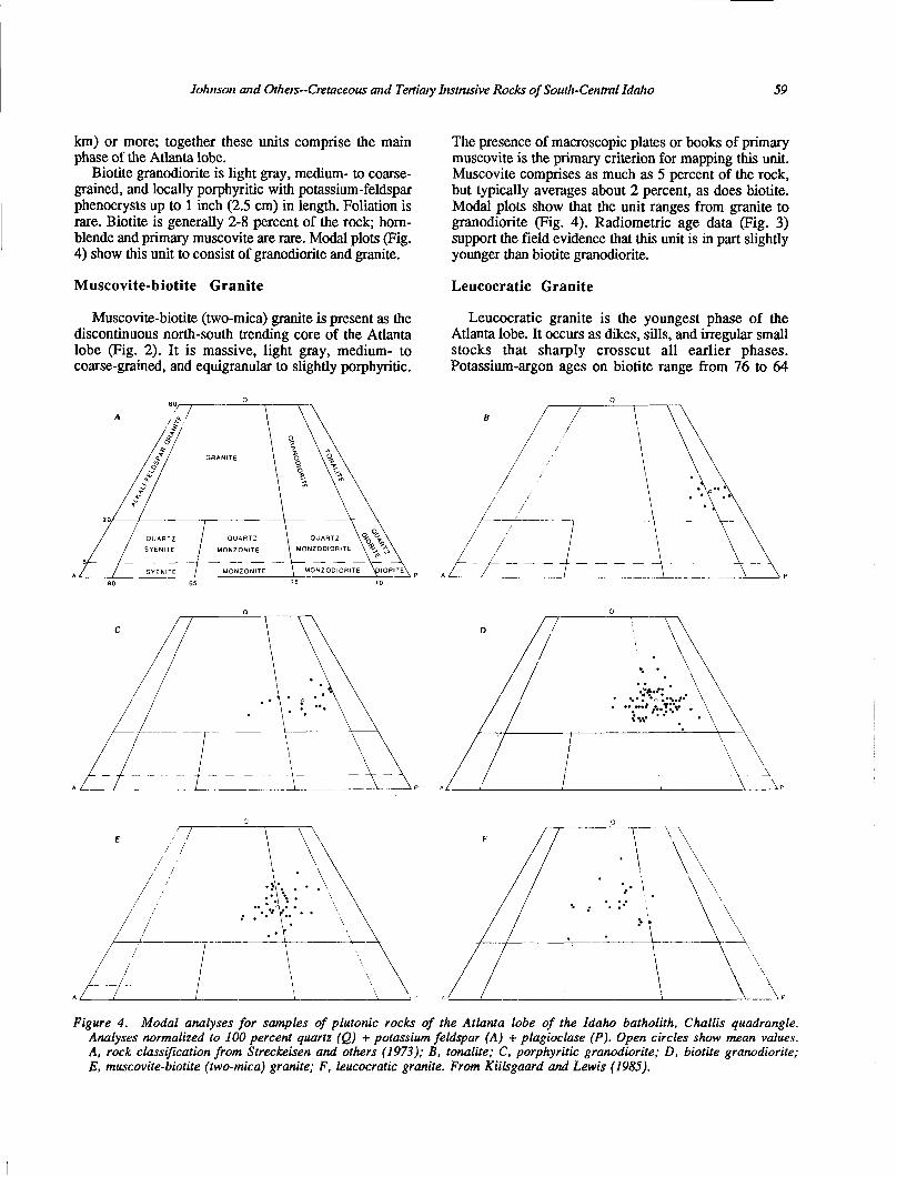
Tonalite has been mapped on the northwestern margin, in the eastern part, and on the western margin of the Atlanta lobe (Fig. 2). Field and radiometric evidence indicates that tonalite is the oldest of the batholithic rocks (Fig. 3). The rock is typically dark gray, medium- grained, and equigranular; a foliation is defined by biotite and varies from faint to intense. Hornblende generally makes up 2-8 percent of the rock, biotite 5-15 percent; sphene and magnetite are common accessory minerals. Modal plots (Fig. 4) show this unit to be tonalite grading into granodiorite. Mean values for major element oxides are shown in Table 1.
Hornblende-biotite Granodiorite
Hornblende-biotite granodiorite is found in small exposures on ridges near the center of the Atlanta lobe as well as in larger masses in the southeastern part of the lobe. This rock is similar in appearance to the tonalite, including a slight foliation, but contains more potassium feldspar and less hornblende. Modally most samples plot in the granodiorite field (Fig. 4). Intrusive relations are not entirely clear, but this unit is thought to represent a slightly older phase than the main mass of biotite granodiorite. No radiometric ages have been obtained for this unit.
Porphyritic Granodiorite
Porphyritic granodiorite crops out on ridge tops in a northwest-trending belt about 75 miles (125 km) long in the northeastern Atlanta lobe (included with “tonalite” on Fig. 2). The rock is gray, medium- to coarse-grained, and contains pink or light pinkish-gray microcline mega- trysts as much as 4 inches (10 cm) in length. Modal analyses of these rocks plot in the granodiorite and granite fields (Fig. 4). Biotite is the primary mafic constituent, except in the area north and east of Stanley where up to 5 percent hornblende is present in many places. Hornblende-bearing rock resembles the tonalite described above, except for the presence of megacrysts in the granodiorite. Rock lacking hornblende more closely resembles biotite granodiorite. The megacrysts result from potassium metasomatism affecting both tonalite and biotite granodiorite, especially near the roof of the batholith. Numerous veins of potassium-rich feldspar cut the rock and appear to have been conduits for potassium- rich fluid.
Biotite Granodiorite
Biotite granodiorite is the most extensive rock type in the Atlanta lobe. Field relations show that it is younger than both tonalite and hornblende-biotite granodiorite. Biotite granodiorite is gradational into younger muscovite-biotite granite over a distance of 1.25 miles (2
JoJnrson and Otlters--0etaceou.s and Tertiary Instrusive Rocks of Soutlt-Central Idaho 59
km) or more; together these units comprise the main phase of the Atlanta lobe.
Biotite granodiorite is light gray, medium- to coarse- grained, and locally porphyritic with potassium-feldspar phenocrysts up to 1 inch (2.5 cm) in length. Foliation is rare. Biotite is generally 2-8 percent of the rock; hom- blende and primary muscovite are rare. Modal plots (Fig. 4) show this unit to consist of granodiorite and granite.
Muscovite-biotite Granite Leucocratic Granite
Muscovite-biotite (two-mica) granite is present as the Leucocratic granite is the youngest phase of the discontinuous north-south trending core of the Atlanta Atlanta lobe. It occurs as dikes, sills, and irregular small lobe (Fig. 2). It is massive, light gray, medium- to stocks that sharply crosscut all earlier phases. coarse-grained, and equigranular to slightly porphyritic. Potassium-argon ages on biotite range from 76 to 64
90 65 35 10
The presence of macroscopic plates or books of primary muscovite is the primary criterion for mapping this unit. Muscovite comprises as much as 5 percent of the rock, but typically averages about 2 percent, as does biotite. Modal plots show that the unit ranges from granite to granodiorite (Fig. 4). Radiometric age data (Fig. 3) support the field evidence that this unit is in part slightly younger than biotite granodiorite.
/ /
/
Figure 4. Modal analyses for samples of plutonic rocks of the Atlanta lobe of the Idaho batholith, Challis quadrangle. Analyses normalized to 100 percent quartz (Q) + potassium feldspar (A) + plagioclase (P). Open circles show mean values. A, rock classification from Streckeisen and others (1973); B, tonalite; C, porphyritic granodiorite; D, biotite granodiorite; E, muscovite-biotite (two-mica) granite; F, leucocratic granite. From Kiilsgaard and Lewis (198.5).
60 Guidebook to the Geology of Central and Southern Idaho
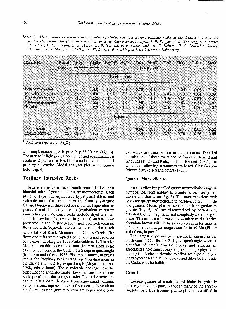
Table 1. Mean values of major-element oxides of Cretaceous and Eocene plutonic rocks in the Challis 1 x 2 degree quadrangle, Idaho. Analytical determination by X-ray fluorescence. Analysts: J. E. Taggart, J. S. Wahlberg, A. J. Bartel, J.D. Baker, L. L. Jackson, G. R. Mason, D. B. Hatfield, F. E. Lichte, and H. G. Neiman, U. S. Geological Survey; J.Amistoso, F. J. Moye, S. T. Luthy, and W. B. Strowd, Washington State University Laboratory.
* Total iron reported as Fe203.
Ma; emplacement age is probably 75-70 Ma (Fig. 3). The granite is light gray, fine-grained and equigranular; it
exposures are smaller but more numerous. Detailed
contains 2 percent or less biotite and trace amounts of descriptions of these rocks can be found in Bennett and
primary muscovite. Modal analyses plot in the granite Knowles (1985) and Kiilsgaard and Bennett (1987a), on
field (Fig. 4). which the following summaries are based. Classification follows Streckeisen and others (1973).
Tertiary Intrusive Rocks Quartz Monzodiorite
Eocene intrusive rocks of south-central Idaho are a bimodal suite of granite and quartz monzodiorite. Each plutonic type has equivalent hypabyssal dikes and volcanic units that are part of the Challis Volcanic Group. Hypabyssal dikes include rhyolites (equivalent to granites) and dacite-rhyodacites (equivalent to quartz monzodiorites). Volcanic rocks include rhyolite flows and ash flow tuffs (equivalent to granites) such as those preserved in the Custer graben, and dacite-rhyodacite flows and tuffs (equivalent to quartz monzodiorites) such as the tuffs of Black Mountain and Camas Creek. The flows and tuffs were erupted from calderas and cauldron complexes including the Twin Peaks caldera, the Thunder Mountain cauldron complex, and the Van Horn Peak cauldron complex in the Challis 1 x 2 degree quadrangle (McIntyre and others, 1982; Fisher and others, in press) and in the Porphyry Peak and Sheep Mountain areas in the Idaho Falls 1 x 2 degree quadrangle (Moye and others, 1988, this volume). These volcanic packages overlie older Eocene andesite-dacite flows that are much more widespread than the younger units. The older andesite- dacite units apparently came from many small volcanic vents. Plutonic representatives of each group have about equal areal extent; granite plutons are larger and diorite
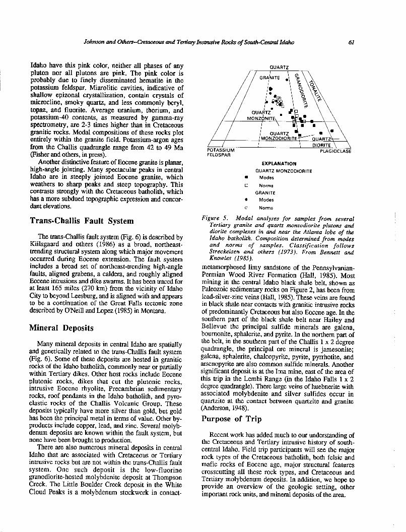
Rocks collectively called quartz monzodiorite range in composition from gabbro to granite (shown as grano- diorite and diorite on Fig. 2). The most prevalent rock types are quartz monzodiorite to porphyritic g-ranodiorite and granite. Modal plots show a range from gabbro to granite (Fig. 5). All are characterized by hornblende, euhedral biotite, magnetite, and complexly zoned plagio- clase. The more mafic varieties weather to distinctive chocolate brown soils. Potassium-argon ages for units in the Challis quadrangle range from 45 to 50 Ma (Fisher and others, in press).
The largest exposure of these rocks occurs in the north-central Challis 1 x 2 degree quadrangle where a complex of small dioritic stocks and swarms of associated fine-g-rained, gray to green, nonporphyritic to porphyritic dacite to rhyodacite dikes are exposed along the canyon of Rapid River. Stocks and dikes both intrude the Cretaceous batholith.
Granite
Eocene granite of south-central Idaho is typically coarse-grained and pink. Although many of the approx- imately forty-five Eocene granite plutons identified in
Johnson and Others-Ctztaceous and Tertiary Insausive Rocks of South-Cent& Idaho 61
Idaho have this pink color, neither all phases of any pluton nor all plutons are pink. The pink color is probably due to finely disseminated hematite in the potassium feldspar. Miarolitic cavities, indicative of shallow epizonal crystallization, contain crystals of microcline, smoky quartz, and less commonly beryl, topaz, and fluorite. Average uranium, thorium, and potassium-40 contents, as measured by gamma-ray spectrometry, are 2-3 times higher than in Cretaceous granitic rocks. Modal compositions of these rocks plot entirely within the granite field. Potassium-argon ages from the Challis quadrangle range from 42 to 49 Ma (Fisher and others, in press).
Another distinctive feature of Eocene granite is planar, high-angle jointing. Many spectacular peaks in central Idaho are in steeply jointed Eocene granite, which weathers to sharp peaks and steep topography. This contrasts strongly with the Cretaceous batholith, which has a more subdued topographic expression and concor- dant elevations.
Trans.Challis Fault System
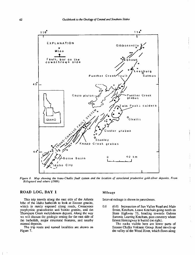
The trans-Challis fault system (Fig. 6) is described by Kiilsgaard and others (1986) as a broad, northeast- trending structural system along which major movement occurred during Eocene extension. The fault system includes a broad set of northeast-trending high-angle faults, aligned grabens, a caldera, and roughly aligned Eocene intrusions and dike swarms. It has been traced for at least 165 miles (270 km) from the vicinity of Idaho City to beyond Leesburg, and is aligned with and appears to be a continuation of the Great Falls tectonic zone described by O’Neill and Lopez (1985) in Montana.
Mineral Deposits
Many mineral deposits in central Idaho are spatially and genetically related to the trans-Challis fault system (Fig. 6). Some of these deposits are hosted in granitic rocks of the Idaho batholith, commonly near or partially within Tertiary dikes. Other host rocks include Eocene plutonic rocks, dikes that cut the plutonic rocks, intrusive Eocene rhyolite, Precambrian sedimentary rocks, roof pendants in the Idaho batholith, and pyro- elastic rocks of the Challis Volcanic Group. These deposits typically have more silver than gold, but gold has been the principal metal in terms of value. Other by- products include copper, lead, and zinc. Several molyb- denum deposits are known within the fault system, but none have been brought to production.
There are also numerous mineral deposits in central Idaho that are associated with Cretaceous or Tertiary intrusive rocks but are not within the trans-Challis fault system. One such deposit is the low-fluorine granodiorite-hosted molybdenite deposit at Thompson Creek. The Little Boulder Creek deposit in the White Cloud Peaks is a molybdenum stockwork in contact-
QUARTZ
FELDSPAR
EXPLANATION
QUARTZ MONZODIORITE
m Modes
0 Norms
GRANITE 0 Modes
0 Norms
Figure 5. Modal analyses for samples from several Tertiary granite and quartz monzodiorite plutons and diorite complexes in and near the Atlanta lobe of the Idaho batholith. Composition determined porn modes and norms of samples. Classification follows Streckeisen and others (1973). From Bennett and Knowles (1985).
metamorphosed limy sandstone of the Pennsylvanian- Permian Wood River Formation (Hall, 1985). Most mining in the central Idaho black shale belt, shown as Paleozoic sedimentary rocks on Figure 2, has been from lead-silver-zinc veins (Hall, 1985). These veins are found in black shale near contacts with granitic intrusive rocks of predominantly Cretaceous but also Eocene age. In the southern part of the black shale belt near Hailey and Bellevue the principal sulfide minerals are galena, bournonite, sphalerite, and pyrite. In the northern part of the belt, in the southern part of the Challis 1 x 2 degree quadrangle, the principal ore mineral is jamesonite; galena, sphalerite, chalcopyrite, pyrite, pyrrhotite, and arsenopyrite are also common sulfide minerals. Another significant deposit is at the Ima mine, east of the area of this trip in the Lemhi Range (in the Idaho Falls 1 x 2 degree quadrangle). There large veins of huebnerite with associated molybdenite and silver sulfides occur in quartzite at the contact between quartzite and granite (Anderson, 1948).
Purpose of Trip
Recent work has added much to our understanding of the Cretaceous and Tertiary intrusive history of south- central Idaho. Field trip participants will see the major rock types of the Cretaceous batholith, both felsic and mafic rocks of Eocene age, major structural features crosscutting all these rock types, and Cretaceous and Tertiary molybdenum deposits. In addition, we hope to provide an overview of the geologic setting, other important rock units, and mineral deposits of the area.
Guidebook to the Geology of Central and Southern Idaho
116’ 114O
EXPLANATION
u Mine
l
Fault, bar on the downthrown side
Panther Cree
r9
lmon
Boise Basin
Idaho City
0 40 km I I I I j
Creek
calde ra
Figure 6. Map showing the trans-Challis fault system and the location of associated productive gold-silver deposits. From Kiilsgaard and others (1986).
ROAD LOG, DAY 1 Mileage
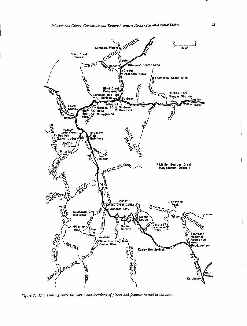
This trip travels along the east side of the Atlanta lobe of the Idaho batholith to look at Eocene granite, which is rarely exposed along roads, Cretaceous porphyritic granodiorite and biotite granite, and the Thompson Creek molybdenum deposit. Along the way we will discuss the geologic setting for the east side of the batholith, major structural features, and nearby mineral deposits.
The trip route and named localities are shown on Figure 7.
Interval mileage is shown in parentheses.
0.0 (0.0) Intersection of Sun Valley Road and Main Street, Ketchum. Leave Ketchum going north on State Highway 75, heading towards Galena Summit. Leaving Ketchum, pass cemetery where Ernest Hemingway is buried (on right).
The rocks visible here are lower parts of Eocene Challis Volcanic Group. Road travels up the valley of the Wood River, which flows along
Johrtson and Others-Xktaceous and Tettiaty blstrusive Rocks of South-Central Idaho 63
onerot Custer Mine
Thompson Creek Mine
*Little Boulder Creek Molybdenum Deposit
Figure 7. Map showing route for Day 1 and locations of places and features named in the text.
64 Guidebook to the Geology of Cent& and Southem Idaho
3.1
3.7
7.9
8.3
12.4
the west side of the Wood River graben. Graben faulting has preserved the volcanic flows and is related to Miocene basin and range extension. Peak ahead is Glassford Peak, elevation 11,602 feet (3,5 16 m j, exposing Challis Volcanic Group over Pennsylvanian-Permian Wood River Forma- tion and other upper Paleozoic rocks.
(3.1) Good exposures of lower Challis Volcanic Group on the right (east). Rocks are rhyodacite and dacite flows, as mapped by Hall and others (1978).
(0.6) More Challis Volcanic Group; dacitic and rhyodacitic flows.
(4.2) Headquarters of Sawtooth National Recreation Area (SNRA). Maps, information, and public restrooms. SNRA has tapes available for loan describing the drive between here and Stanley.
(0.4) Valley narrows here and then widens again to the north as a result of side-stepped en echelon graben faulting.
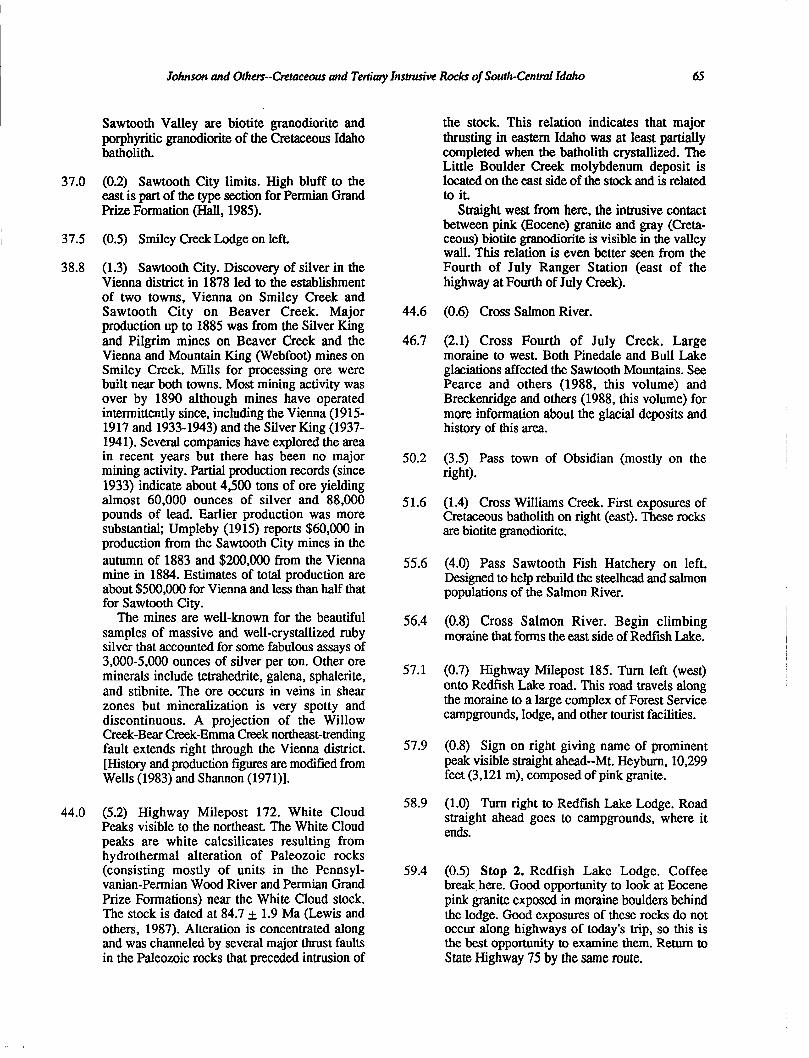
(4.1) Sign on right pointing out Boulder Mountains. This view of the Boulders shows Eocene pink granite (lower slopes) intruding andesites of the Challis Volcanic Group and Eocene dacite porphyry (Fig. 8).
Figure 8. Boulder Mountains seen from the southwest. Light-colored rocks just above the grassy slopes are Eocene pink granite; dark rocks on the skyline are andesite and dacite of the Eocene Challis Volcanic Group. Granite intrudes the volcanics and is itself intruded by porphyritic dikes.
14.8 (2.4) Exposures of Challis Volcanic Group.
14.9 (0.1) Cross Big Wood River.
16.6 (1.7) Small turnout to right, from which Figure 8 was taken. Fault across front (west side) of
Boulder Mountains is the same style of faulting as that responsible for the Wood River graben (basin and range).
20.3 (3.7) Cross Big Wood River. Challis Volcanic Group (dominantly rhyodacitic to andesitic flow rocks) in roadcuts from here to Stop 1.
30.0 (9.7) Galena Summit, 8,701 feet (2,652 m), and Milepost 158.
30.9 (0.9) Stop 1. Galena Summit overlook. The view from here is to the north into the Sawtooth Valley (Stanley Basin) and along the east side of the Sawtooth Mountains. The headwaters of the Salmon River are in the drainage immediately west of this overlook. The Sawtooth Valley, another basin and range structure, is a half-graben with the Sawtooth fault running along its west side. The southern end of the Sawtooth Moun- tains is Cretaceous biotite granodiorite and Eocene pink granite is exposed to the north. Rocks in the range have been mapped by Reid (1963) and Kiilsgaard and others (1970).
The Sawtooth batholith is the most prominent of the Eocene pink granites in south-central Idaho. The batholith is exposed in a horst bounded by the Sawtooth fault on the east. The Montezuma fault bounds the western side of the horst. These two northwest-trending faults are good examples of the expression of basin and range structures north of the Snake River Plain. Both faults terminate against major northeast- trending structures that are part of the trans- Challis fault system (Kiilsgaard and others, 1986). The trans-Challis fault system underwent major displacement during the Eocene and hosts many precious metal deposits.
Rocks exposed on Galena Summit are Challis Volcanic Group.
Restrooms available here.
3 1.0 (0.1) Highway Milepost 159.
32.9 (1.9) Turnout to left. The Sawtooth fault and other basin and range structures in Idaho cross-cut older northeast-trending structures south of the trans-Challis fault system. The northeast-trending faults had major movement during Eocene extension but may be older in places. The bleached zone on the north side (west from here) of Smiley Creek may be one of the northeast- trending structures that terminates surface expo- sures of the Sawtooth batholith. Aeromagnetic data indicate that the batholith is present at depth to the south of Smiley Creek.
36.8 (3.9) Hills ahead and to the right (east) of the
Johnson and Others--Cretaceous and Tetiiaty Instmsive Rocks of South-Centml Xdaho 65
Sawtooth Valley are biotite granodiorite and porphyritic granodiorite of the Cretaceous Idaho batholith.
37.0 (0.2) Sawtooth City limits. High bluff to the east is part of the type section for Permian Grand Prize Formation (Hall, 1985).
37.5 (0.5) Smiley Creek Lodge on left.
38.8 (1.3) Sawtooth City. Discovery of silver in the Vienna district in 1878 led to the establishment of two towns, Vienna on Smiley Creek and Sawtooth City on Beaver Creek. Major production up to 1885 was from the Silver King and Pilgrim mines on Beaver Creek and the Vienna and Mountain Ring (Webfoot) mines on Smiley Creek. Mills for processing ore were built near both towns. Most mining activity was over by 1890 although mines have operated intermittently since, including the Vienna (1915- 1917 and 1933-1943) and the Silver King (1937- 1941). Several companies have explored the area in recent years but there has been no major mining activity. Partial production records (since 1933) indicate about 4,500 tons of ore yielding almost 60,000 ounces of silver and 88,000 pounds of lead. Earlier production was more substantial; Umpleby (1915) reports $60,000 in production from the Sawtooth City mines in the autumn of 1883 and $200,000 from the Vienna mine in 1884. Estimates of total production are about $500,000 for Vienna and less than half that for Sawtooth City.
The mines are well-known for the beautiful samples of massive and well-crystallized ruby silver that accounted for some fabulous assays of 3,000-5,000 ounces of silver per ton. Other ore minerals include tetrahedrite, galena, sphalerite, and stibnite. The ore occurs in veins in shear zones but mineralization is very spotty and discontinuous. A projection of the Willow Creek-Bear Creek-Emma Creek northeast-trending fault extends right through the Vienna district. [History and production figures are modified from Wells (1983) and Shannon (1971)].
44.0 (5.2) Highway Milepost 172. White Cloud Peeks visible to the northeast. The White Cloud peaks are white calcsilicates resulting from hydrothermal alteration of Paleozoic rocks (consisting mostly of units in the Pennsyl- vanian-Permian Wood River and Permian Grand Prize Formations) near the White Cloud stock. The stock is dated at 84.7 + 1.9 Ma (Lewis and others, 1987). Alteration is concentrated along and was channeled by several major thrust faults in the Paleozoic rocks that preceded intrusion of
44.6
46.7
50.2
51.6
55.6
56.4
57.1
57.9
58.9
59.4
the stock. This relation indicates that major thrusting in eastern Idaho was at least partially completed when the batholith crystallized. The Little Boulder Creek molybdenum deposit is located on the east side of the stock and is related to it.
Straight west from here, the intrusive contact between pink (Eocene) granite and gray (Creta- ceous) biotite granodiorite is visible in the valley wall. This relation is even better seen from the Fourth of July Ranger Station (east of the highway at Fourth of July Creek).
(0.6) Cross Salmon River.
(2.1) Cross Fourth of July Creek. Large moraine to west. Both Pinedale and Bull Lake glaciations affected the Sawtooth Mountains. See Pearce and others (1988, this volume) and Breckenridge and others (1988, this volume) for more information about the glacial deposits and history of this area.
(3.5) Pass town of Obsidian (mostly on the right).
(1.4) Cross Williams Creek. First exposures of Cretaceous batholith on right (cast). These rocks are biotite granodiorite.
(4.0) Pass Sawtooth Fish Hatchery on left. Designed to help rebuild the steelhead and salmon populations of the Salmon River.
(0.8) Cross Salmon River. Begin climbing moraine that forms the east side of Redfish Lake.
(0.7) Highway Milepost 185. Turn left (west) onto Redfish Lake road. This road travels along the moraine to a large complex of Forest Service campgrounds, lodge, and other tourist facilities.
(0.8) Sign on right giving name of prominent peak visible straight ahead--Mt. Heyburn, 10,299 feet (3,121 m), composed of pink granite.
(1.0) Turn right to Redfish Lake Lodge. Road straight ahead goes to campgrounds, where it ends.
(0.5) Stop 2. Redfish Lake Lodge. Coffee break here. Good opportunity to look at Eocene pink granite exposed in moraine boulders behind the lodge. Good exposures of these rocks do not occur along highways of today’s trip, so this is the best opportunity to examine them. Return to State Highway 75 by the same route.
66 Guidebook to the Geology of Centml and Southern Idaho
61.7 (2.3) Turn left onto State Highway 75, immediately cross Redfish Lake Creek. Rocks exposed across the Salmon River are Cretaceous biotite granodiorite.
63.6
64.7
(1.9) Highway Milepost 187.
typical of fluorspar deposits in the area. These are vein deposits (quartz-fluorite or quartz-pyrite- fluorite-gold) that are believed to be related to rhyolite dikes and structurally related to the trans- Challis fault system.
(1.1) Peaks visible on the high skyline ahead are part of the Cabin Creek stock (Cabin Creek Peak). This is a small Tertiary granite stock that shows characteristics of both granite and rhyolite. East of and behind these peaks is the down- dropped block of the Custer graben (McIntyre and others, 1982; Fisher and others, in press).
72.8 (1.4) Mormon Bend Campground. Here we find the first large pink potassium feldspar megacrysts in biotite granodiorite.
66.0
66.6
(1.3) Intersection with State Highway 21 west. Continue on State Highway 75 toward Lower Stanley .
74.0 (1.2) Cross Basin Creek. During the uranium boom of the 195Os, uranium was discovered on Basin Creek. Deposits include pitchblende veins in granitic rocks of the Idaho batholith, and coffinite and uraninite in carbonaceous matter in the basal conglomerate of the Challis Volcanic Group that was deposited on the rocks of the batholith.
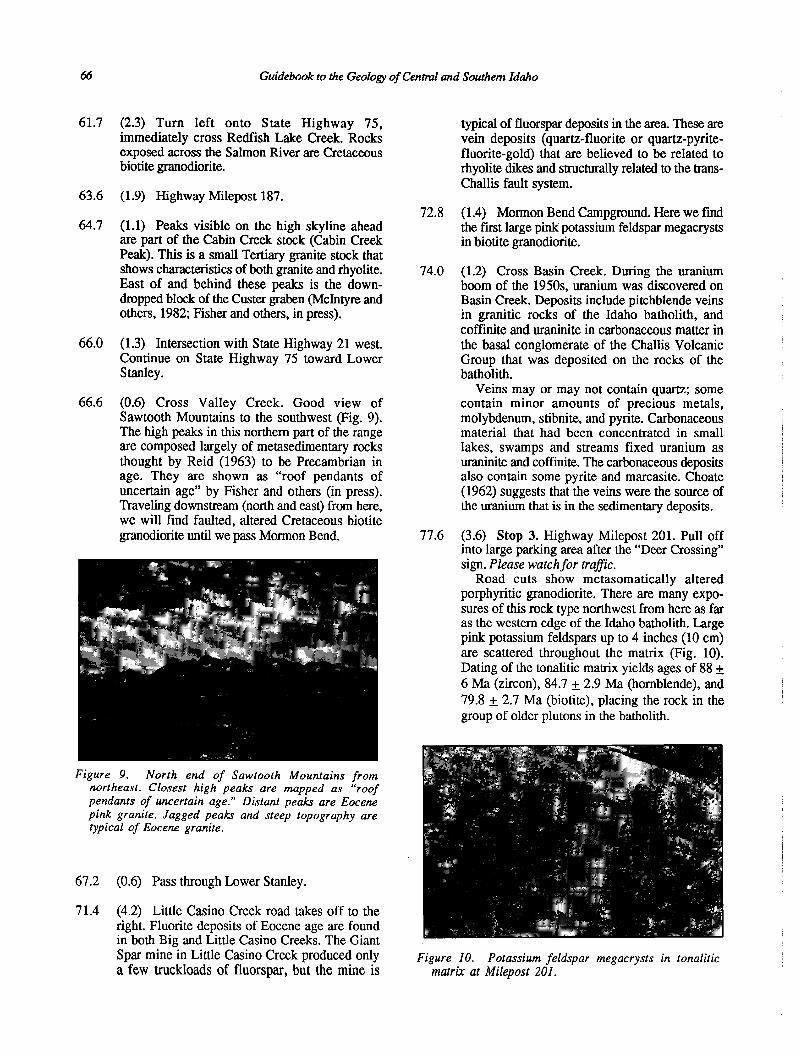
(0.6) Cross Valley Creek. Good view of Sawtooth Mountains to the southwest (Fig. 9). The high peaks in this northern part of the range are composed largely of metasedimentary rocks thought by Reid (1963) to be Precambrian in age. They are shown as “roof pendants of uncertain age” by Fisher and others (in press). Traveling downstream (north and east) from here, we will find faulted, altered Cretaceous biotite granodiorite until we pass Mormon Bend.
Veins may or may not contain quartz; some contain minor amounts of precious metals, molybdenum, stibnite, and pyrite. Carbonaceous material that had been concentrated in small lakes, swamps and streams fixed uranium as uraninite and coffin&e. The carbonaceous deposits also contain some pyrite and marcasite. Choate (1962) suggests that the veins were the source of the uranium that is in the sedimentary deposits.
Figure 9. North end of Sawtooth Mountains from northeast. Closest high peaks are mapped as “roof pendants of uncertain age.” Distant peaks are Eocene pink granite. Jagged peaks and steep topography are typical of Eocene granite.
67.2 (0.6) Pass through Lower Stanley.
7 1.4 (4.2) Little Casino Creek road takes off to the right. Fluorite deposits of Eocene age are found in both Big and Little Casino Creeks. The Giant Spar mine in Little Casino Creek produced only a few truckloads of fluorspar, but the mine is
77.6 (3.6) Stop 3. Highway Milepost 201. Pull off into large parking area after the “Deer Crossing” sign. Please watch for trafic.
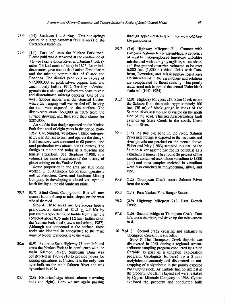
Road cuts show metasomatically altered porphyritic granodiorite. There are many expo- sures of this rock type northwest from here as far as the western edge of the Idaho batholith. Large pink potassium feldspars up to 4 inches (10 cm) are scattered throughout the matrix (Fig. 10). Dating of the tonalitic matrix yields ages of 88 + 6 Ma (zircon), 84.7 + 2.9 Ma (hornblende), and 79.8 + 2.7 Ma (biotite), placing the rock in the group of older plutons in the batholith.
Figure IO. Potassium feldspar megacrysts in tonalitic matrix at Milepost ZOI.
Johnson and Others--Ctrtaceous and Tertiaty Ittstmsive Rocks of South-Central Idaho 67
78.0 (0.4) Sunbeam Hot Springs. This hot springs occurs on a large east-west fault in rocks of the Cretaceous batholith.
79.0 (1.0) Turn left onto the Yankee Fork road. Placer gold was discovered at the confluence of Yankee Fork Salmon River and Jordan Creek (8 miles (13 km) north of here) in 1873. Later lode discoveries gave rise to the Yankee Fork district and the mining communities of Custer and Bonanza. The district produced in excess of $12,000,000. in gold, silver, copper, lead, and zinc, mostly before 1911. Tertiary andesites, pyroclastic rocks, and rhyolites are hosts to vein and disseminated mineral deposits. One of the most famous mines was the General Custer, where the hanging wall was eroded off, leaving the rich vein exposed on the surface. The discoverers made $60,000 in 1876 from the surface showing, and then sold their claims for $285,000.
An 8-cubit-foot dredge operated on the Yankee Fork for a total of eight years in the period 1940- 1952. J. R. Simplot, well-known Idaho entrepre- neur, was the last to own and operate the dredge. Gold recovery was estimated at 60 percent, and total production was almost 30,000 ounces. The dredge is maintained today as a museum and tourist attraction. See Stephens (1988, this volume) for more discussion of the history of placer mining on the Yankee Fork.
Some properties in the area are still being worked. U. S. Antimony Corporation operates a mill at Preachers Cove, and Sunbeam Mining Company is developing a closed vat, cyanide leach facility at the old Sunbeam mine.
79.7 (0.7) Blind Creek Campground. Bus will turn around here and stop at talus slopes on the west side of the road.
Stop 4. These rocks are Cretaceous biotite granodiorite, dated at 8 1.3 + 2.9 Ma by potassium-argon dating of biotite from a sample collected about 0.75 mile (1.2 km) farther in on the Yankee Fork road (Lewis and others, 1987). Although not connected-at the surface, these rocks are identical in appearance to the main mass of biotite granodiorite to the west.
80.6 (0.9) Return to State Highway 75, turn left, and cross the Yankee Fork at its confluence with the main Salmon River. Sunbeam Dam was constructed in 1909-1910 to provide power for mining operations at Custer. It is the only dam ever built on the main Salmon River and was dynamited in 1934.
83.4 (2.8) Historical sign about salmon spawning beds (on right). Here we are again passing
89.2
91.2
92.7
93.9
95.3
96.2
97.8
through approximately 8 l-million-year-old bio- tite granodiorite.
(7.6) Highway Milepost 211. Contact with Paleozoic Salmon River assemblage, a sequence of weakly metamorphosed limestone turbidites interbedded with dark gray argillite, siltite, shale, and fine-grained quartzite estimated to be over 6,000 feet (1,800 m) thick. Units with Cam- brian, Devonian, and Mississippian fossil ages are intercalated in the assemblage and relations are complicated by thrust faulting. This poorly understood unit is part of the central Idaho black shale belt (Hall, 1985).
(2.0) Highway Milepost 213. Slate Creek enters the Salmon from the south. Approximately 100 feet (30 m) of black gouge in rocks of the Salmon River assemblage is visible on the north side of the road. This northeast-trending fault extends up Slate Creek to the south. Cross Salmon River.
(1.5) At this big bend in the river, Salmon River assemblage is exposed in the road cuts and river gravels are perched on the terrace above. Fisher and May (1983) sampled this part of the Salmon River assemblage for its potential as a vanadium resource. They found 26 percent of the samples contained anomalous vanadium (> 1,000 ppm) and most samples enriched in vanadium were also enriched in molybdenum, silver, and zinc.
(1.2) Thompson Creek enters Salmon River from the north.
(1.4) Pass Yankee Fork Ranger Station.
(0.9) Highway Milepost 218. Pass French Creek.
(1.6) Second bridge to Thompson Creek. Turn left, cross the river, and drive up the mine access road.
101.9 (4.1) Second creek crossing and entrance to Thompson Creek mine (on left).
Stop 5. The Thompson Creek deposit was discovered in 1961 during a regional stream- sediment sampling program conducted by Union Carbide as part of a tungsten exploration program. Geologists followed up a 5 ppm molybdenum anomaly and discovered an out- cropping of molybdenite in the poorly exposed Pat Hughes stock. As Carbide had no interest in the property, the claims lapsed and were restaked by Cyprus Minerals Company in 1968. Cyprus explored the property and conducted bulk
68 Grddebook to the Geology of Central and Southern Idaho
sampling for molybdenum from an 8,000- foot(2,400-m)-long exploration drift. Cyprus merged with Standard Oil of Indiana in 1979 and announced plans for a 25,000 ton-per-day open pit mine that would be the largest mine in Idaho and would produce about 10 percent of the worlds molybdenum.
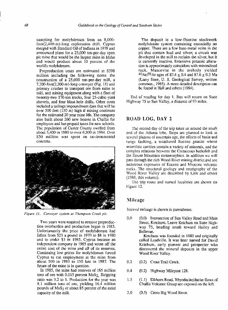
Preproduction costs are estimated at $398 million including the following items: the construction of a 25,000 ton-per-day mill, a 7,300-foot(2,200-m)-long conveyer (Fig. 11) and primary crusher to transport ore from mine to mill, and mining equipment along with a fleet of tweenty-two 170-ton trucks, four 25-cubic-yard shovels, and four blast-hole drills. Other costs included a tailings impoundment dam that will be over 500 feet (150 m) high if mining continues for the estimated 20 year mine life. The company also built about 260 new homes in Challis for employees and has prepaid taxes for new schools. The population of Custer County swelled from about 3,400 in 1980 to over 6,500 in 1984. Over $30 million was spent on environmental concerns.
Figure II. Conveyer system at Thompson Creek pit.
Two years were required to remove preproduc- tion overburden and production began in 1983. Unfortunately the price of molybdenum had fallen from $23 a pound in 1970 to $8 in 1980 and to under $3 in 1985. Cyprus became an independent company in 1985 and wrote off the entire cost of the mine and all of its reserves. Continuing low prices for molybdenum forced Cyprus to cut employment at the mine from about 500 in 1983 to 150 late in 1987. The future of the mine is in question.
In 1985, the mine had reserves of 185 million tons of ore with 0.115 percent MoS2. Stripping ratio was 3.2 to 1. Production for the year was 8.1 million tons of ore, yielding 16.4 million pounds of MoS2 or about 85 percent of the rated capacity of the mill.
The deposit is a low-fluorine stockwork molybdenite system containing essentially no copper. There are a few base-metal veins in the pit that contain lead and silver; a circuit was developed in the mill to reclaim the silver, but it is currently inactive. Extensive potassic altera- tion is approximately coincident with mineralized rock. Muscovite in the orebody yielded 4oArpgAr ages of 87.4 + 0.4 and 87.6 4 0.3 Ma (Larry Snee, U. S. Geological Survey, written commun., 1985). A more detailed description can be found in Hall and others (1984).
End of roadlog for day 1. Bus will return on State Highway 75 to Sun Valley, a distance of 93 miles.
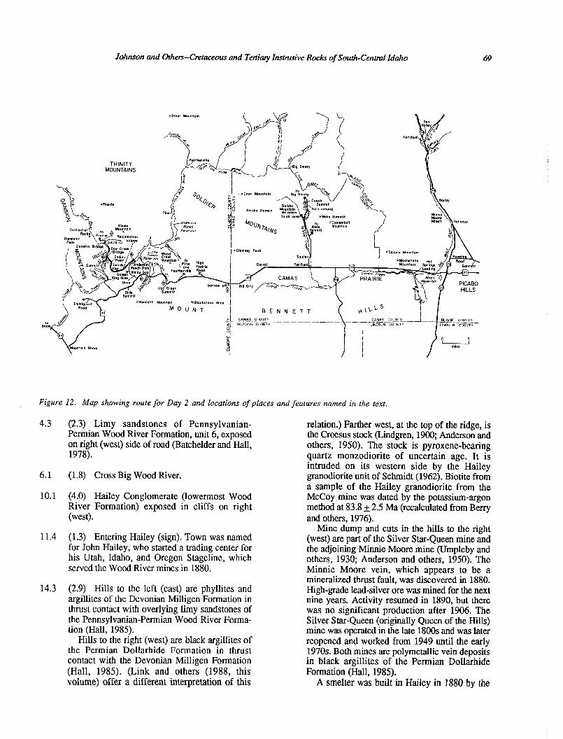
ROAD LOG, DAY 2
The second day of the trip takes us around the south end of the Atlanta lobe. Stops are planned to look at several plutons of uncertain age, the effects of basin and range faulting, a weathered Eocene granite whose miarolitic cavities contain a variety of minerals, and the complex relations between the Cretaceous batholith and the House Mountain metamorphics. In addition we will pass through the rich Wood River mining district and see numerous exposures of Eocene and Miocene volcanic rocks. The structural geology and stratigraphy of the Wood River Valley are described by Link and others (1988, this volume).
The trip route and named localities are shown on Figure 12.
Mileage
Interval mileage is shown in parentheses.
0.0 (0.0) Intersection of Sun Valley Road and Main Street, Ketchum. Leave Ketchum on State High- way 75, heading south toward Hailey and Bellevue.
Ketchum was founded in 1880 and originally called Leadville. It was later named for David Ketchum, early pioneer and prospector who discovered the mineral deposits in the upper Wood River Valley.
0.2
0.4
1.5
2.0
(0.2) Cross Trail Creek.
(0.2) Highway Milepost 128.
(1.1) Elkhom Road. Rhyodacite/dacite flows of Challis Volcanic Group are exposed on the left,
(0.5) Cross Big Wood River.
Johnson and Others--Cmtaceous and Tertiary Instrusive Rocks of South-Central Idaho 69
Figure 12. Map showing route for Day 2 and locations of places and features named in the text.
4.3
6.1
10.1
11.4
14.3
(2.3) Limy sandstones of Pennsylvanian- Permian Wood River Formation, unit 6, exposed on right (west) side of road (Batchelder and Hall, 1978).
(1.8) Cross Big Wood River.
(4.0) Hailey Conglomerate (lowermost Wood River Formation) exposed in cliffs on right (west).
(1.3) Entering Hailey (sign). Town was named for John Hailey, who started a trading center for his Utah, Idaho, and Oregon Stageline, which served the Wood River mines in 1880.
(2.9) Hills to the left (east) are phyllites and argillites of the Devonian Milligen Formation in thrust contact with overlying limy sandstones of the Pennsylvanian-Permian Wood River Forma- tion (Hall, 1985).
Hills to the right (west) are black argillites of the Permian Dollarhide Formation in thrust contact with the Devonian Milligen Formation (Hall, 1985). (Link and others (1988, this volume) offer a different interpretation of this
relation.) Farther west, at the top of the ridge, is the Croesus stock (Lindgren, 1900; Anderson and others, 1950). The stock is pyroxene-bearing quartz monzodiorite of uncertain age. It is intruded on its western side by the Hailey granodiorite unit of Schmidt (1962). Biotite from a sample of the Hailey granodiorite from the McCoy mine was dated by the potassium-argon method at 83.8 + 2.5 Ma (recalculated from Berry and others, 1976).
Mine dump and cuts in the hills to the right (west) are part of the Silver Star-Queen mine and the adjoining Minnie Moore mine (umpleby and others, 1930; Anderson and others, 1950). The Minnie Moore vein, which appears to be a mineralized thrust fault, was discovered in 1880. High-grade lead-silver ore was mined for the next nine years. Activity resumed in 1890, but there was no significant production after 1906. The Silver Star-Queen (originally Queen of the Hills) mine was operated in the late 1800s and was later reopened and worked from 1949 until the early 1970s. Both mines are polymetallic vein deposits in black argillites of the Permian Dollarhide Formation (Hall, 1985).
A smelter was built in Hailey in I880 by the
70 Guidebook to the Geology of Central and Southem Idaho
17.3
23.6
26.2
28.2
28.6
31.9
32.6
33.6
35.6
37.0
Wood River Smelting Company. It was dwarfed by the Philadelphia Smelter, built in Ketchum the next year, which installed the first electric light system in Idaho.
The Triumph mine northeast of Hailey was discovered in 1884, developed in 1927 and worked until the 1950s. Also a polymetallic lead- silver vein deposit, it produced more value in ore than all the other Wood River mines combined.
(3.0) Road to Gannett forks off to the left.
(6.3) Cross Baseline Road. This is the point of origin for the Idaho land survey system.
(2.6) Intersection of U. S. Highway 20 and State Highway 75. Turn right (west) onto U. S. 20. Rest area at this intersection.
(2.0) Final crossing of Big Wood River.
(0.4) Stop 1. Road cut is in rocks mapped by Schmidt (1962) as the Hailey granodiorite unit, a hornblende-biotite granodiorite of probable Creta- ceous age. Most of the rocks exposed in this area are Miocene volcanics, related to Snake River Plain volcanism.
(3.3) Road to Hot Springs Landing (on Magic Reservoir) takes off to left.
(0.7) Outcrop of Miocene rhyolitic volcanic rocks.
(1.0) Entrance to Moonstone Ranch on right. Moonstone Mountain to the northwest is a rhyolite dome of Miocene age that contains opalescent feldspars.
(2.0) Entering Camas Prairie, which is thought to be the surface expression of a graben related to downwarp of the Snake River Plain (Cluer and Cluer, 1986).
(1.4) The flat-topped mountain to the north is Square Mountain, mapped by Schmidt (1962) as Square Mountain Basalt. More recent work by Leeman (1982) shows the rocks to be ferrolatite. Xenocrysts of quartz and feldspar and xenoliths of granulitic and granitic gneiss are common in this unit.
West of Square Mountain, hornblende-bearing Hailey granodiorite is in contact with biotite granodiorite further to the west. Relative ages of the two units are unknown. The biotite grano- diorite is similar to the large masses of biotite granodiorite found elsewhere in the Cretaceous batholith.
39.2
46.4
48.2
52.3
54.1
54.4
58.5
59.9
60.3
60.5
62.2
63.3
63.7
64.4
(2.2) Camas County line. Old stage road to Hailey takes off to the northeast.
(7.2) Highway Milepost 158. Due north from here the highest tree-covered peak is Cannonball Mountain, underlain by Miocene rhyolite and basalt flows.
(1.8) Highway 46 intersection. Stay on U. S. 20. The low hills visible to the south are the Mount Bennett Hills, mostly Miocene tuffs and basalts of the Idavada Volcanics. Part of this area has been mapped by Smith (1966), and recon- naissance mapping of the region was done by Malde and others (1963).
(4.1) Turn right (north) at Fairfield.
(1.8) Old town of Soldier. Turn right (stay on pavement).
(0.3) Turn left. Prominent range to the north- west is the Soldier Mountains. The core is Eocene pink granite, and the margin is dominantly Eocene hornblende-biotite granodio- rite. Bare hills in foreground are deeply weathered, altered Cretaceous biotite and hornblende-biotite granodiorite cut by numerous Eocene dikes, which make the only outcrops. Dark outcrops on low hills to northeast are Miocene basalts resting on Eocene Challis Volcanic Group.
(4.1) Wells Summit turnoff. Go left, remaining on pavement.
(1.4) Sheared Cretaceous biotite granodiorite with lots of aplite and pegmatite.
(0.4) More sheared Cretaceous rock.
(0.2) Flat-topped hill to right (east) is Miocene ash-flow tuff.
(1.7) Pavement ends. Take the right fork, heading for Big Smoky Guard Station.
(1.1) Exposures of lower part of Challis Volcanic Group on left are breccias and dacite/andesite flows. Cross Owens Creek.
(0.4) Poorly exposed Cretaceous biotite grano- diorite on left.
(0.5) Big turn around. Bus will park here. Smaller vehicles can continue up the road to the stop.
Joltttsot~ ad OtJzem-Ctrtaceorrs atd Tetiiaty Ittsttzrsive Rocks of Soutll-Cetttml Idaho 71
64.4 (0.2) Andesites and dacites of Challis Volcanic Group exposed on right.
64.7 (0.3) Stop 2. Examine results of basin and range faulting. Large roadcut on right is faulted Cretaceous biotite granodiorite. Prominent expo- sure up the gulch is Eocene granodiorite. The northwest-trending fault drops Cretaceous grano- diorite and overlying Eocene Challis Volcanic Group against Eocene hornblende-biotite grano- diorite. 90.5
The fault zone is at least 300 feet (100 m) wide, but the main fracture comes through the small saddle north of where the road crosses the gulch (see Fig. 13). Sheared Eocene granodiorite is poorly exposed along the road just past the gulch. All the plutonic rocks are cut by rhyo- dacite and dacite dikes of Eocene age.
The Eocene granodiorite here has very pink potassium feldspar; the plagioclase is white. In general, the Eocene granodiorites have smaller quartz grains than the Cretaceous intrusive rocks. Hornblende in the Eocene rocks is small and acicular in contrast to the large stubby grains found locally in the Cretaceous granodiorites. In addition, the potassium feldspar in the Cretaceous rocks shows well-developed microcline twins, generally lacking in the Eocene granodiorites.
93.1
93.6
93.7
High peaks visible to the west from here are Eocene pink granite. Ridge in foreground is Eocene Challis Volcanic Group.
67.4 (2.7) Return to pavement and follow it to U. S. Highway 20.
77.3 (9.9) Intersection with U. S. 20; turn right (west).
93.8 (0.1) Return to U. S. 20 and turn left (west).
82.5 (5.2) Highway Milepost 147. 95.5
85.0 (2.5) Corral Store. Due north from here is the Iron Mountain fault, a major basin and range fault that passes over Steele Mountain and connects with the Deer Park fault, which terminates at the South Fork Payette River. The area west of the Soldier Mountains is down- dropped and contains hundreds of granophyre dikes and a few rhyolite and rhyodacite dikes, suggesting the presence of an Eocene plutonic complex at depth.
98.6
Northwest from here is Chimney Peak, capped by quartzite and other metamorphic rocks (age unknown), which are underlain by foliated aplite and pegmatite dikes and foliated hornblende granodiorite which make up the roof of the Cretaceous batholith. Mylonitic fabric and horn- blende lineations in the granodiorite suggest that the Chimney Peak block has moved south on a
101.9
small decollement. The foreground hills are aplite and pegmatite with exposures of onlapping Snake River Plain basalts at the base.
The next hill west from Chimney Peak has exposures of Tertiary granite half way up from the valley floor, and aplite and pegmatite at the top. Gabbroic rocks of probable Eocene age intruded along northeast-trending fractures. Meta- morphic rocks occur in the roof.
(5.5) Highway Milepost 139. Hill to northwest is Tertiary granite intruded by large Tertiary pink granophyre dikes. Most of the small hills rising above the prairie floor southwest of here are also pink granite.
(2.6) Elmore County line.
(0.5) Highway Milepost 136. Turn left onto dirt road.
(0.1) Stop 3. Park and walk south up a small hill to examine an inactive borrow pit in Eocene granite. Aplites cutting the very decomposed granite have miarolitic cavities containing smoky quartz, potassium feldspar, epidote (?), and axinite (?). The Eocene granites generally contain at least twice the background radiation (uranium and thorium) of the Cretaceous batholith and typically have smoky quartz, due to rearrange- ment of the crystal lattice by radiation. The lattice is restored by the sun’s ultraviolet rays, so these crystals turn clear when exposed to sun- light, for example on talus slopes.
(1.7) Highway Milepost 134. Exposed here are Snake River Plain basalts, whose overall age ranges from 10 Ma to Recent (Craters of the Moon). They are probably Holocene here on the Camas Prairie. See Cluer and Cluer (1986) for more information on the Camas Prairie.
(3.1) High Prairie Road takes off to right. On skyline ridge to south is the Blackstone mine. Pit is in Eocene granite; age of mineralization is unknown. The property was discovered in the late 1800s and was reopened in 1984. Exploration and development are continuing. Ores are complex sulfides with precious and base metals.
(3.3) Hills in the near distance to the north are Eocene granite; hill to the northwest (farther away and tree-covered) is on the other side of a big northeast-trending fault and exposes aplite and Perrmatite cuttinrr metamorbhic rocks.
72 Guidebook to the Geology of Central and Southern Idaho
114“48’30 * 114047’30’
EXPLANATION
Alluvium
Trd Flhyodac dike
Td Dacite / dike
1 1
Biotite granite
Horneblende- biotite granodiorite
Dacite lava8 and breccias
Biot ite granodionite
contact (dashed /A- where inferred)
F fault (dashed where inferred: dotted where con cealed: ball on downthrown side)
Pm Miles
Geology by Reed S. Lewis
Kgd
Tcv
/ I Tg I
rgd
a./‘”
I Td 1
IQJd I
I ‘.,
--- - Fault exposed /
in mnmt-4t.llt
4 Td
430
30’
130 !9 ’
Figure 13. Geologic map for STOP #2 (day 2), showing basin and range faulting in Cretaceous and Tertiary rocks south of Couch Summit.
Johnson and Others--Cretaceous and Tertiary Instmsive Rock of South-Central Idaho 73
102.5 (0.6) Pine-Featherville Road turnoff to the right (north). Note the granite pile which was used as a
marker describes Goodales Cutoff, a hoped-for shortcut to the mining district of Florence from
survey station when the road was built. the Oregon Trail (it was not).
105.2 (2.7) Stop 4. Cat Creek Summit, 5,527 feet (1,675 m). From the overlook, the skyline ridge to the north-northwest is House Mountain. The far side of House Mountain is made of House Mountain metamorphics, which we will see at Stops 7 and 8.
109.8 (0.5) Little Camas Reservoir is visible to the right (north).
112.3
Tree-covered hill to the north is Wood Creek Mountain. A northeast-trending fault separates Wood Creek Mountain (aplites, pegmatites, metamorphic rocks) from the granodiorite of Cat Creek Summit. This is the same fault described at 101.9 miles. There are several prospect pits located along this fault, which is typical of the northeast-trending structures in central Idaho.
(2.5) Stop 5. Windy Gap. Exposures of Miocene Idavada Volcanics occur on both sides of the road and extend to the top of the hill on the left (south). Voluminous eruptions of rhyolitic Idavada Volcanics occurred throughout southwest Idaho and southeast Oregon at approximately the same time as the onset of basin and range faulting in the northern part of the Great Basin and the onset of eruption of the Columbia River Basalt Group in Oregon, Idaho and Washington.
Here on the summit are exposures of granodiorite of Cat Creek Summit, whose age is probably Eocene but is not known with certainty. The porphyritic texture seen here is not present in all exposures and is not typical of known Cretaceous granites in this area. The steep, pinnacled weathering style (reflecting high- angle joints) and the crystal habit are also not typical of Cretaceous granites in this area. McDowell and Kulp (1969) obtained a date of 44 Ma from rock near here, but the exact location is not known.
The Danskin Mountains, the low hills visible to the left (south) of House Mountain, expose Idavada Volcanics on top of Cretaceous grano- diorite.
The skyline to the north is the Trinity Moun- tains, underlain by Eocene granodiorite and pink granite.
113.6
The distinctive topographic expression of this granodiorite can be seen following the road down the hill and around the comer.
(1.3) Turn right to Anderson Ranch Dam and town of Prairie. Pass through old townsite of Dixie. On the skyline, the flat-topped peak to right is Cretaceous granodiorite. Peaks to north on the skyline are the Trinity Mountains.
115.1 (1.5) Highly sheared aplite and pegmatite to the right.
Between Cat Creek Summit and Windy Gap, the next hill to the west on the highway, cross Lockman Gulch, just south of Little Camas Reservoir. Lockman Gulch is along another major northeast-trending fault, separating grano- diorite of Cat Creek Summit from the older aplite and pegmatite of the batholith and small exposures of Challis Volcanic Group that are present north of Windy Gap. This fault extends along the south side of Anderson Reservoir and exposes Challis Volcanic Group near Wood Creek.
116.5
109.3 (4.1) Last outcrop of granodiorite of Cat Creek Summit. The exposures on both sides of the road are believed to be Challis Volcanic Group at the base, overlain just a few meters up the hill on either side of the road by Idavada Volcanics. There are also exposures of granodiorite of Cat Creek Summit on the east side of these hills. Just over the hill on the north side of the highway are exposures of andesite/dacite that are tentatively identified as Challis Volcanic Group. These are the westernmost exposures of Challis rocks north of the Snake River Plain. Historical
(1.4) The mine dump to the west (left) is the King shaft of the Golden King mine. The shaft connects to a tunnel in the bottom of the South Fork Boise River canyon almost 900 feet (270 m) below the roacl. The mine was developed in the 1930s by the Daly Consolidated Mining Company. Metamorphic rocks are exposed in the shaft. The ridge just southwest of the shaft is capped by quartzite and is part of the House Mountain metamorphic suite. The hill in the foreground, just east of the quartzite-covered hill, is a rhyolite dike of uncertain but possible Eocene age. The low hills between the road and the rhyolite are aplite and pegmatite. Hills to the east of the road are sheared aplite and pegmatite at their base and aplite and pegmatite with metamorphic fragments higher up.
116.9 (0.4) End of pavement. Note canyon-filling basalts (age-equivalent to Snake River Plain basalts) across the gorge. Ridge above is called Granite Ridge for the expected reason.
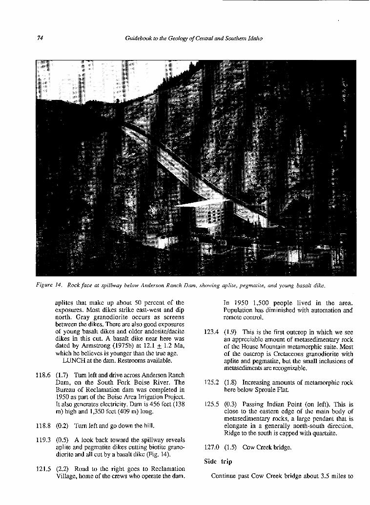
Stop 6. Exit bus halfway down the hill and walk to the dam. Note massive pegmatites and
74 Guidebook to the Geology of Central and Southem Idaho
aplites that make up about 50 percent of the exposures. Most dikes strike east-west and dip north. Gray granodiorite occurs as screens between the dikes. There are also good exposures of young basalt dikes and older andesite/dacite dikes in this cut. A basalt dike near here was dated by Armstrong (1975b) at 12.1 + 1.2 Ma, which he believes is younger than the true age.
LUNCH at the dam. Restrooms available.
118.6 (1.7) Turn left and drive across Anderson Ranch Dam, on the South Fork Boise River. The Bureau of Reclamation dam was completed in 1950 as part of the Boise Area Irrigation Project. It also generates electricity. Dam is 456 feet (138 m) high and 1,350 feet (409 m) long.
118.8 (0.2) Turn left and go down the hill.
119.3 (0.5) A look back toward the spillway reveals aplite and pegmatite dikes cutting biotite grano- diorite and all cut by a basalt dike (Fig. 14).
121.5 (2.2) Road to the right goes to Reclamation Village, home of the crews who operate the dam.
In 1950 1,500 people lived in the area. Population has diminished with automation and remote control.
123.4 (1.9) This is the first outcrop in which we see an appreciable amount of metasedimentary rock of the House Mountain metamorphic suite. Most of the outcrop is Cretaceous granodiorite with aplite and pegmatite, but the small inclusions of metasediments are recognizable.
125.2 (1.8) Increasing amounts of metamorphic rock here below Sproule Flat.
125.5 (0.3) Passing Indian Point (on left). This is close to the eastern edge of the main body of metasedimentary rocks, a large pendant that is elongate in a generally north-south direction. Ridge to the south is capped with quartzite.
127.0 (1.5) Cow Creek bridge.
Side trip
Continue past Cow Creek bridge about 3.5 miles to
Johnson and Others--Cretaceous and Tertiary Insttusive Rocks of South-Central Idalto
Figure 1.5. Mylonite in grarwdiorite intruded by aplite and pegmatite. Aplite and pegmatite intrude both parallel to and across the mylonite foliation.
where the South Fork road forks. The left fork crosses Danskin Bridge and continues down the river on private property. The right fork is the road to Prairie. Take the right fork and stop near the top of the ridge overlooking the South Fork, at the last outcrops before coming out onto the prairie.
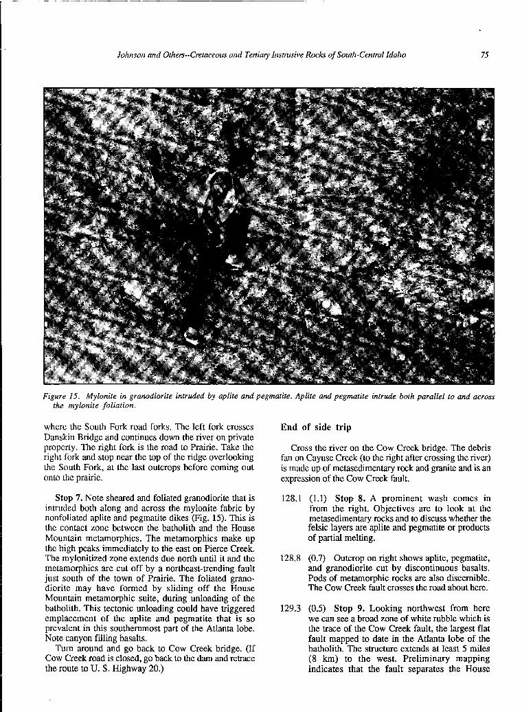
Stop 7. Note sheared and foliated granodiorite that is intruded both along and across the mylonite fabric by nonfoliated aplite and pegmatite dikes (Fig. 15). This is the contact zone between the batholith and the House Mountain metamorphics. The metamorphics make up the high peaks immediately to the east on Pierce Creek. The mylonitized zone extends due north until it and the metamorphics are cut off by a northeast-trending fault just south of the town of Prairie. The foliated grano- diorite may have formed by sliding off the House Mountain metamorphic suite, during unloading of the batholith. This tectonic unloading could have triggered emplacement of the aplite and pegmatite that is so prevalent in this southernmost part of the Atlanta lobe. Note canyon filling basalts.
Turn around and go back to Cow Creek bridge. (If Cow Creek road is closed, go back to the dam and retrace the route to U. S. Highway 20.)
End of side trip
Cross the river on the Cow Creek bridge. The debris fan on Cayuse Creek (to the right after crossing the river) is made up of metasedimentary rock and granite and is an expression of the Cow Creek fault.
128.1 (1.1) Stop 8. A prominent wash comes in from the right. Objectives are to look at the metasedimentary rocks and to discuss whether the felsic layers are aplite and pegmatite or products of partial melting.
128.8 (0.7) Outcrop on right shows aplite, pegmatite, and granodiorite cut by discontinuous basalts. Pods of metamorphic rocks are also discernible. The Cow Creek fault crosses the road about here.
129.3 (0.5) Stop 9. Looking northwest from here we can see a broad zone of white rubble which is the trace of the Cow Creek fault, the largest flat fault mapped to date in the Atlanta lobe of the batholith. The structure extends at least 5 miles (8 km) to the west. Preliminary mapping indicates that the fault separates the House
76 Guidebook to tJze Geology of Cent& and Southem Idalto
129.5 (0.2) Road levels out. Exposures to east (left) are quartzite and to the west are aplite and pegmatite on Long Tom Ridge.
129.9 (0.4) Hill on right is first exposure of Idavada Volcanics.
130.3 (0.4) More Idavada on right, marked by dark rubble.
130.5 (0.2) Summit. Valley ahead is along the trace of a fault, probably a northwest-trending, basin and range structure. Idavada Volcanics to right are on strike with valleys and dip to the south.
131.7
135.9
(1.2) Crossing fault in valley bottom.
(4.2) Cross cattle guard at the drainage divide at the top of Cow Creek. Bennett Mountain is straight ahead. The west end of Bennett Mountain seems to be down-faulted along a northeast fault that extends along U. S. Highway 20 through Dixie Summit. This indicates repeated movement on some Eocene structures.
137.4 (1.5) Turn right onto U. S. Highway 20. (When approaching this turn on the reverse trip, the dirt road has a sign for Prairie.) Idavada Volcanics exposed from here to end of today’s log.
141.2 (3.8) Highway Milepost 107. Tollgate Cafe on right.
141.7 (0.5) Immigrant Road enters from right.
Mountain metamorphic suite and crosscutting aplite and pegmatite of the younger, upper part of the batholith from older, deeper parts of the batholith (granodiorite and two-mica granite) that are exposed below and to the west of Danskin Peak starting at Cathedral Rocks. The older batholithic rocks form most of the bedrock north of the Snake River Plain from the Danskin Peak lookout to Boise.
The bold outcrops on the skyline ridge are metasediments, with aplite and pegmatite on either side.
End of road log for day 2. U. S. Highway 20 continues for 11 miles to Mountain Home and the intersection with Interstate 84, crossing first Idavada Volcanics and then Snake River Plain basal& Field trip will continue on I-84 (for 45 miles) to Boise.
9.1 (8.3) Boise County line.
12.7 (3.6) Highway Milepost 57. Top of hill, 4,242 feet (1,285 m). The big hill to the east with the antennae is Shafer Butte, part of the Bogus Basin ski area. The ridge north of Bogus Basin is the Boise Ridge. The ridge and basin are granodiorite of the Idaho batholith. Just south of the basin the batholith is covered by Idaho Group sediments.
The Boise Front fault, which is the south- westernmost major northwest-trending basin and range fault in the batholith, marks the change from Snake River Plain to Idaho batholith. Hot springs along this fault and related structures are used to heat a number of homes and public buildings in Boise.
ROAD LOG, DAY 3 14.8 (2.1) Scenic overlook especially positioned to
allow view of Bread Loaf Rock (on the right).
On the last day of the trip, we travel up the west side 15.4 (0.6) Turnout to right allows a view of the
of the Atlanta lobe, turn east into the core of the batholith, and return to Boise via Idaho City. We will examine Cretaceous tonalite, two-mica granite, and biotite granodiorite, as well as Eocene granite and granodiorite, and the Little Falls molybdenum deposit. Our route crosses major north- and northeast-trending faults, passes through the Boise Basin, the richest gold producing district in Idaho, and through thick sections of fossiliferous Miocene sediments.
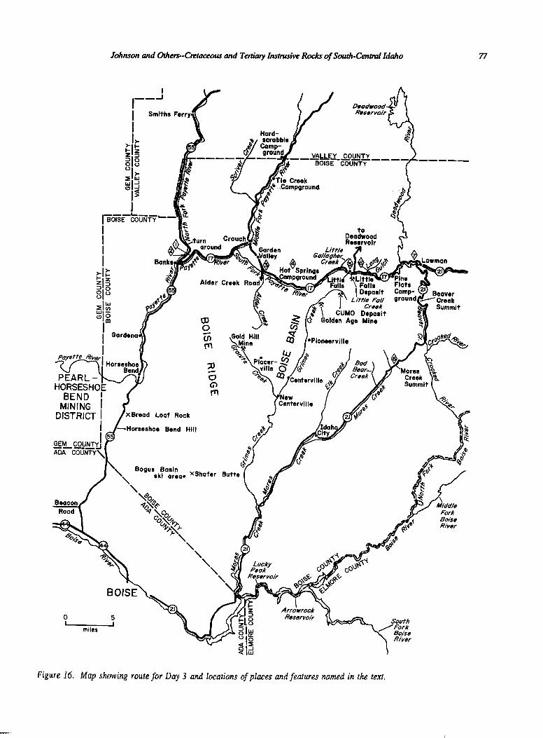
The trip route and named localities are shown on Figure 16.
Mileage
Interval mileage is shown in parentheses.
0.0 (0.0) Begin roadlog on the northwest side of Boise at the intersection of State Highways 55 (north) and 44 (west). Take State Highway 55 north, the Payette River Scenic Route.
0.8 (0.8) Gravel pits in this area are in lacustrine sediments. There are many patches of these sediments on top of Snake River Plain basalts. They are part of the Pliocene-Pleistocene Idaho Group and the Pleistocene Ten Mile Gravel. It has been proposed that these are primarily alluvial and lacustrine sediments that accumulated either in a series of lakes or in one big lake (Lake Idaho) (Jenks and Bonnichsen, 1987). Gravity- driven mass flows are also recognized. Silicifi- cation associated with hot springs has indurated some of the otherwise unconsolidated or loosely consolidated sediments. Stone quarried from these silicified sediments was used to construct many buildings in Boise including the State Capitol.
Johnson and Others-Cmtaceous and Tertiary Iiastrusive Rocks of South-Centml Idaho 77
MINING 1 DISTRICT ! xBread Loaf Rock
Bend Hill
Figure 16. Map showing route for Day 3 and locations of places and features named in the text.
Guidebook to the Geology of Cent& and Southern Idaho
landslides that are so prominent on the slopes of Horseshoe Bend Hill. Note patch of road marked “Sawdust fill.”
Horseshoe Bend Hill is composed of Idaho Group sediments and is crossed by a major northeast-trending fault. The fault has dropped the river valley down, resulting in the Horseshoe Bend in the Payette River. Just north of Horseshoe Bend granitic rocks of the Cretaceous batholith are exposed. The highway department has difficulty maintaining this road along the hill, and the unstable nature of the slopes is shown by the numerous landslides in this area. Sawdust is used as a base for the road in places to facilitate drainage. A new road is planned just east of the present route.
Southwest of here is the Pearl-Horseshoe Bend mining district, where gold was mined beginning in the late 1890s. The district contains numerous Eocene dikes which may mark the southwest extension of the trans-Challis fault system that cuts through Boise Basin.
18.6 (3.2) Highway Milepost 63.
18.9 (0.3) Enter Horseshoe Bend speed trap zone.
19.3 (0.4) Payette River at Horseshoe Bend.
20.0 (0.7) City park on the right (east). Restrooms available. Historical sign describes discovery of gold in Boise Basin (over the ridge to the northeast) in 1862. Traffic to and from Boise Basin passed through here in the early years after the discovery. We will visit Boise Basin later todaY-
The Boise Ridge, the high ridge east of Horseshoe Bend, is underlain by Cretaceous batholithic rocks and was first mapped by Lindgren (1898) as part of work done in Boise Basin.
21.7 (1.7) Cross Payette River (again). This river is part of the Boise Area Irrigation Project and is a great area for white water enthusiasts as it drops over 1,700 feet (515 m) in about 15 miles (24 km).
22.0 (0.3) Cretaceous tonalite is the dominant rock type from here north to Smiths Ferry, although large areas north and west of here have yet to be mapped and are shown as undifferentiated Creta- ceous batholithic rocks on Figure 2. The age of these tonalites is not well known, but they probably were emplaced between 85 and 95 Ma (Lewis and others, 1987).
24.8 (2.8) Entering Gardena.
25.4 (0.6) Hill to right shows dark brown soils characteristic of Columbia River basalts.
The Columbia River Basalt Group is a series of basalt flows totaling over 15,000 feet (4,500 m) thick and ranging in age from 17 Ma to about 7 Ma. The flows cover parts of Oregon, Idaho, and Washington and were fed from a series of dikes such as the Chief Joseph dike swarm located on the Idaho-Oregon border. The Miocene age of the flows is coincident with the onset of basin and range faulting in the northern part of the Great Basin and voluminous rhyolitic erup- tions of the Idavada Volcanics in southwest Idaho and southeast Oregon.
30.7 (5.3) Highway Milepost 75. The trace of the Sr 0.704-0.706 line described by Armstrong and others (1977) lies west of here but is not well constrained in this area. This line separates continental crust to the east from island arc rocks to the west. The western tonalites of the Cretaceous batholith were intruded to the east of this suture line. Cretaceous tonalitic rocks are also present west of the boundary; these rocks typically are deformed and many contain a few percent epidote (Taubeneck, 1971; Bonnichsen, 1987; Aliberti and Manduca, 1988, this volume). The tonalites east of the suture are I-type granitoids and are intruded by younger biotite granodiorite that is gradational to two-mica granite. The granodiorite and two-mica granite together form the bulk of the Atlanta lobe.
34.5 (3.8) Road to Crouch (State Highway 17) takes off to right along South Fork Payette River. We continue north along the North Fork Payette River.
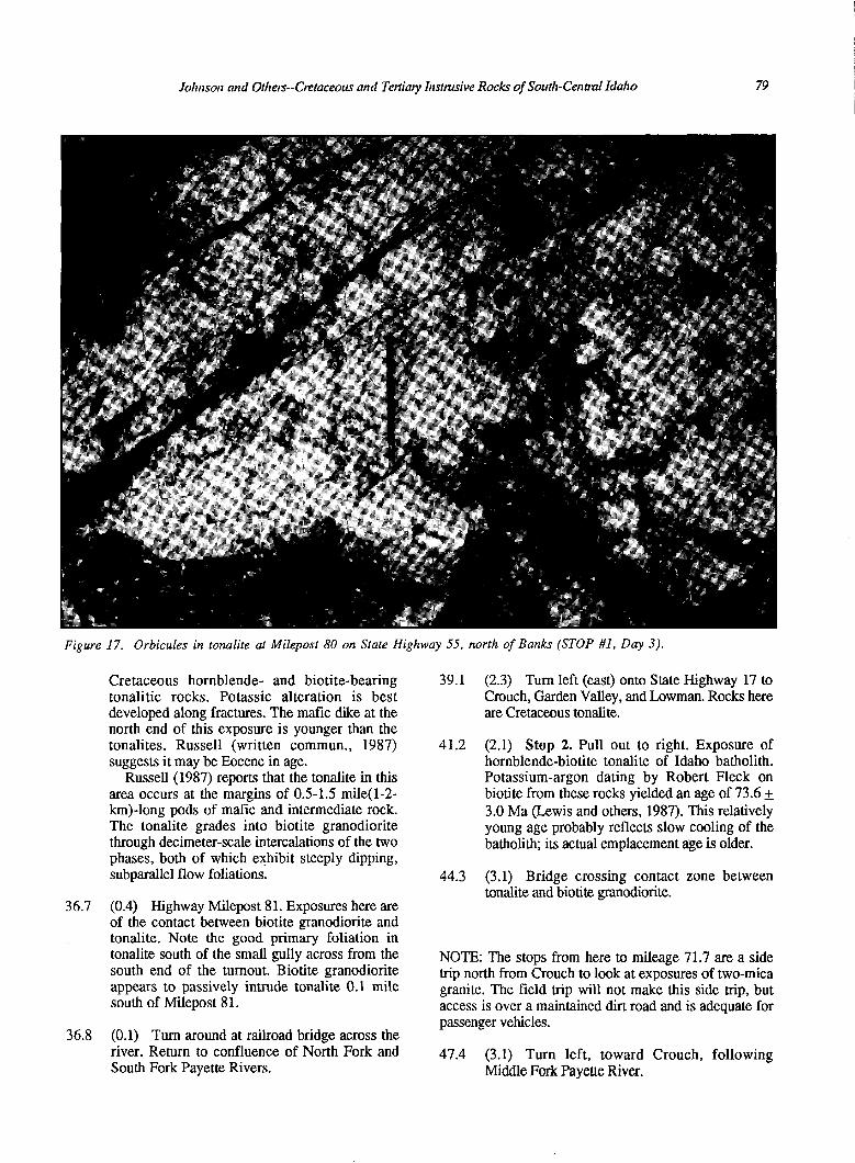
35.7 (1.2) Stop 1. Highway Milepost 80. Roadcut on right (east) shows superb examples of orbicular rock (Fig. 17). It is described by Charles W. Russell (Univ. of Washington, written commun., 1987) as “swirling masses of microgabbro (pargasitic hornblende and sodic labradorite with some larger plagioclase pheno- trysts getting up to An& in a matrix of andesine-rich, biotite-hornblende diorites.” The orbicules are most obvious in the microgabbro but are crudely formed in the diorite as well.
We urge you to be considerate in collecting the orbicules and other interesting textures displayed in these outcrops. There are only limited exposures of these oddities. If you must have large quantities, please try to collect from the riprap along the river or from debris at the base of the outcrop.
36.3 (0.6) Roadcut on right (east) shows a variety of
JoJrnsort and Otltem-Cretaceous and Terfiary Instrusive Rocks ojSoutJa-Central Idalto 79
Figure 17. Orbicules in tonalite at Milepost 80 on State Highway 55, north of Banks (STOP #I, Day 3).
Cretaceous hornblende- and biotite-bearing tonalitic rocks. Potassic alteration is best developed along fractures. The mafic dike at the north end of this exposure is younger than the tonalites. Russell (written commun., 1987) suggests it may be Eocene in age.
39.1 (2.3) Turn left (east) onto State Highway 17 to Crouch, Garden Valley, and Lowman. Rocks here are Cretaceous tonalite.
41.2 (2.1) Stop 2. Pull out to right. Exposure of hornblende-biotite tonalite of Idaho batholith. Potassium-argon dating by Robert Fleck on biotite from these rocks yielded an age of 73.6 + 3.0 Ma (Lewis and others, 1987). This relatively young age probably reflects slow cooling of the batholith; its actual emplacement age is older.
Russell (1987) reports that the tonalite in this area occurs at the margins of 0.5-l .5 mile( 1-2- km)-long pods of mafic and intermediate rock. The tonalite grades into biotite granodiorite through decimeter-scale intercalations of the two phases, both of which exhibit steeply dipping, subparallel flow foliations.
36.7 (0.4) Highway Milepost 81. Exposures here are of the contact between biotite granodiorite and tonalite. Note the good primary foliation in tonalite south of the small gully across from the south end of the turnout. Biotite granodiorite appears to passively intrude tonalite 0.1 mile south of Milepost 81.
36.8 (0.1) Turn around at railroad bridge across the river. Return to confluence of North Fork and South Fork Payette Rivers.
44.3 (3.1) Bridge crossing contact zone between tonalite and biotite granodiorite.
NOTE: The stops from here to mileage 71.7 are a side trip north from Crouch to look at exposures of two-mica granite. The field trip will not make this side trip, but access is over a maintained dirt road and is adequate for passenger vehicles.
47.4 (3.1) Turn left, toward Crouch, following Middle Fork Payette River.
80 Guidebook to the Geology of Cent& and Southern Idaho
48.3
51.0
53.8
55.0
56.3
57.5
58.3
58.6
(0.8) More two-mica granite.
(0.3) More two-mica granite, with better exposures across the creek.
58.8 (0.2) Better exposures of two-mica granite, although still crumbly.
59.5 (0.7) Hardscrabble Campground. Restrooms and turnaround here.
62.6 (3.1) Tie Creek Campground again.
(0.9) Intersection in city center of Crouch. Turn 7 1.7 (9.1) Return to main road, turn left and cross left. Middle Fork Payette River.
(2.7) Pavement ends. (End side trip)
(2.8) Payette Formation on left. The Payette Formation is a series of loosely consolidated sediments of Miocene age. Recent mapping has shown that this unit and similar lithologies are much more widespread in Idaho than previously known. Many of the sediments are lacustrine deposits, suggesting that Idaho may have had extensive lake coverage in Miocene time as basalts of the Columbia River Group dammed existing drainages. The Latah Formation in north Idaho and the Sucker Creek Formation in southwest Idaho are probably equivalents of the Payette Formation. There are about 5,550 feet (1,680 m) of these sediments in Garden Valley and extensive exposures in the Boise Basin; whether any of the section is repeated by faulting is not known. Early placer operators using hydraulic giants exposed thick sections of these sediments near Idaho City. There are a number of good plant fossil localities in the Payette Formation.
(1.2) Good exposures of Payette Formation with carbonaceous lenses.
(1.3) Tie Creek Campground. Restrooms here. Exposures of Payette Formation, including coal seams, in the river.
(1.2) Exposures of two-mica granite. Emplacement age of the two-mica granite is probably 72-78 Ma (Lewis and others, 1987). This rock type forms the core of the batholith and extends throughout the length of the Atlanta lobe. In the Challis 1 x 2 degree quadrangle the two-mica granite was intruded by fine-grained, leucogranite dikes and small stocks and plugs that represent the last gasp of the Cretaceous batholith and are dated at about 70-75 Ma.
73.8
74.8
75.0
76.5
77.3
78.8
80.4
82.0
84.7
(2.1) Enter Garden Valley. We have just crossed the inferred position of the Boise Ridge fault, a north-trending fault identified by Anderson (1947). This fault is one of the few for which offset can be estimated. Kiilsgaard and Lewis (1985, p. 38) show that basalt of the Columbia River Basalt Group east of the fault has been downdropped a minimum of 1,600 feet (490 m) with respect to the same basalt west of the fault.
(1 .O) Transition zone between two-mica granite and biotite granodiorite. This transition zone is generally mapped as biotite granodiorite.
(0.2) Stop 3. Alder Creek road. Bus will park here to allow a walk back down the road (west) to look at the transition zone.
(1.5) Another outcrop of transition zone between two-mica granite and biotite grano- diorite. Here we see even less muscovite than at the last outcrops, as we are closer to the main mass of biotite granodiorite.
Perched gravels across the river (south) were placered for gold at the turn of the century.
(0.8) Stop 4. Lunch at Hot Springs Campground. Good outcrops of biotite grano- diorite to the west.
(1.5) More placered gravels across the river. These gravels were probably worked near the turn of the century, although placer operations at the head of Alder Creek were active as late as the 1930s.
(1.6) Pavement ends. A sizeable dam and bridge are visible to the right. The Wharton power plant was built on this site and came on line in 1908. It produced 1400 horsepower and had trans- mission lines to Centerville, Idaho City, and Quartzburg. It was owned and operated by the Boston and Idaho Gold Dredging Company.
(1.6) A northeast-trending fault crossing behind the first set of knobs across the river has upthrown the Boise Basin dike swarm and Eocene plutons on its southeast side. This is the westernmost fault of the trans-Challis fault system mapped to date.
(2.7) The few dikes exposed here are the only dikes that have been recognized in this northwest
Johnson and Others-Cretaceous and Tertiary Instmsive Rocks of South-Central Idaho 81
85.1
85.8
86.2
86.4
86.5
86.8
block, contrasting markedly with the other side of the fault, the southeast block, which we will see 1.5 miles (2.4 km) down the road.
(0.4) Little Gallagher Creek. The fault described at mileage 82.0 crosses the river and heads up the creek to the northeast.
(0.7) Now we have crossed the fault and are going into the upthrown southeast block.
(0.4) Here we see the many dikes that are characteristic of this side of the fault. Compo- sitions include andesite, dacite, rhyolite, and lamprophyre.
(0.2) Little Falls, on the right. This is the location for which the upcoming Little Falls molybdenite deposit is named.
(0.1) Stop 5. Adit at Little Falls deposit. Molybdenite here occurs along fractures and veinlets in a swarm of northeast-trending Eocene dikes, mostly in porcelaneous rhyolite. Molyb- denite is exposed over an area 1,000 feet (330 m) wide and 3,000 feet (1,000 m) long. The deposit occurs in a pyritized and silicified zone; oxidation of the pyritized rock has colored the outcrop reddish brown and has created a strong molyb- denum anomaly over part of the deposit (Rostad, 1967). Fission-track dating of zircon from a pre- mineral rhyolite dike at the deposit gave an age of 29.3 + 1.7 Ma (Kiilsgaard and Bennett, 1987b). The property was discovered in 1960 and was prospected by Abella Resources from 1978 to 198 1. Abella’s assay data resulted in a weighted average grade of 0.05 percent MoS2 (Kiilsgaard and Bennett, 1987b). The rhyolite dikes cross the South Fork Payette River and make the falls in the river.
The swarm of rhyolitic dikes can be traced 2.5 miles (4 km) southwest to the Cumo molyb- denum deposit. Cumo was discovered by AMAX Exploration in 1963 and was evaluated until 1984. Chalcopyrite and molybdenite occur in quartz veins and as disseminations in gray quartz monzonite porphyry and other Eocene hypabyssal dikes. Both argillic alteration and silicification are present. Some rhyolitic dikes at Cumo postdate the mineralizing event. The deposit is estimated to contain one billion tons of material with an average grade of 0.10 percent MoS2 (Kiilsgaard and Bennett, 1987b).
(0.3) Road to Deadwood Reservoir. Large parking area. Looking up the road (north) you can see drill roads cut by Abella Resources during exploration of the Little Falls prospect.
87.9 (1.1) Eocene stock. Although this stock has a pink groundmass and is shown as granite by Fisher and others (1983, in press), it is not typical Eocene granite. It is at the extreme mafic end of granites and it chemically resembles the Eocene diorites and granodiorites. This exposure shows hornblende-biotite granodiorite. Dike has an excellent chilled margin.
88.4
88.5
88.7
(0.5) Cross creek.
(0.1) Tertiary diorite to quartz monzodiorite.
(0.2) Stop 6. Examine contact between Cretaceous biotite granodiorite on east and Eocene quartz monzodiorite on west. This is one of the few places where this contact relation is clearly shown. Similar Cretaceous rocks are exposed from here cast as far as Grandjean (about 26 miles (42 km), as the crow flies.)
91.8 (3.1) Pine Flats Campground.
92.8 (1.0) A river diversion project was undertaken here between 1910 and 1920. The road is still visible below. The idea was to divert the river through a tunnel in order to work placer deposits in the bend in the river. The project was never completed and the tunnel is now partially caved.
This is the western edge of the Deadwood fault zone, part of a set of north-trending faults that crosses the western part of the Atlanta lobe. The fault zone is mapped for about 50 miles (80 km) north from here along the Deadwood River and Johnson Creek. Foliated hornblende-biotite granodiorite east of the fault zone and near Deadwood mine, about 28 miles (45 km) north of here, is about 1,650 feet (500 m) lower than similar rock on the high ridge west of the fault, suggesting fault displacement of at least that much (Kiilsgaard and Lewis, 1985).
93.0
93.6
95.7
(0.2) Begin paved road.
(0.6) Bridge at Deadwood River.
(2.1) Stop 7. More biotite granodiorite exposed in a new roadcut. A basalt dike similar to the one exposed here was collected 4 miles (6.5 km) to the west and was dated by Armstrong (1975b) at 15.2 + 0.5 Ma. The biotite grano- diorite exposed here is the typical rock of the Atlanta lobe of the Idaho batholith: there are many, many square miles of this stuff.
97.0 (1.3) Intersection with State Highway 21. Turn right (south) toward Idaho City and Boise.

Guidebook to the GeoIogy of Cent& and Southern Idaho 82
97.2
106.7
115.2
117.3
121.6
126.3
(0.2) Cross South Fork Payette River.
(9.5) Beaver Creek summit, 6,064 feet (1,838 km).
(8.5) A major northeast-trending fault, part of the trans-Challis fault system, is exposed here.
(2.1) Stop 8. Mores Creek summit, 6,118 feet (1,854 km). Parking available on south side of the summit. Major northeast-trending fault is exposed in the gouge in the roadcut. This fault generally follows Mores Creek to the southwest. It is also exposed in the roadcuts on the northeast side of the summit.
(4.3) Bad Bear Creek.
(4.7) Extensive placer workings on right (northwest) side of the road, part of the Boise Basin district. Gold was discovered in Boise Basin in 1862, and a major gold rush was soon underway to the rich diggings. Both Pioneerville and Bannock (later renamed Idaho City) were established that year. The early work was in placers; modern dredges arrived in the early 1900s and operated until 1950. Lode deposits were discovered in 1863. The first lo-stamp mill was brought to the district in 1864. Major lode mines included the Golden Age, Comeback, Missouri, Belshazzar, Mountain Chief, and the Gold Hill mines. The Gold Hill mine was worked by the Talache Mining Company until 1938.
The mines are in epithermal precious-metal vein deposits of Tertiary age (Fisher and others, 1987). The orebodies are shallow; the richer portions are near the surface, and the values diminish with depth. They were mined chiefly for gold and silver but also contain variable amounts of copper, lead, and zinc. Deposits range from a few tens of tons to a few thousand tons, and have grades ranging from trace to 23 ounces of gold and trace to 2,500 ounces of silver per ton. Assay information on ore mined from twelve deposits in Boise Basin indicates an average grade of about 0.5 ounce of gold and 10 ounces of silver per ton. Electrum is the most significant ore mineral at most deposits.
Mines in the Boise Basin district produced more gold than any other district in Idaho, and the area is one of the major producing districts in the country. Boise County gold production from 1863 to 1980 is estimated at 2.8 million ounces, most of which came from the Boise Basin.
127.9 (1.6) Cretaceous biotite granodiorite.
128.7 (0.8) Highway Milepost 41. Placered ground on left (southeast) side of the road.
129.0 (0.3) Outcrops of Columbia River basalt.
130.8 (1.8) Road to right goes through Idaho City and back to Horseshoe Bend.
End roadlog. Field trip will return to Boise via State Highway 21 and Interstate 84, passing good exposures of Payette Formation at Idaho City, fresh biotite grano- diorite south of Idaho City, basalt lava flows of the Snake River Plain, and Lucky Peak Reservoir.
ACKNOWLEDGMENTS
Our research was supported by the CUSMAP program of the U. S. Geological Survey in the Challis and Hailey 2 degree sheets. The manuscript benefited from reviews by S. D. Luddington, F. J. Moye, C. M. White, and R.G. Worl. Photographs are by Earl H. Bennett.
REFERENCES
Aliberti, E. A., and Manduca, C. A., 1988, A transect across an island arc-continent boundary in west-central Idaho, in Link, PK., and Hackett, W. R., editors, Guidebook to the geology of central and southern Id- aho: Idaho Geological Survey Bulletin 27, p. 99-107.
Anderson, A. L., 1947, Geology and ore deposits of Boise Basin, Idaho: U. S. Geological Survey Bulletin 944-c, 319 p.
-9 1948, Tungsten mineralization at the Ima mine, Blue Wing District, Lemhi County, Idaho: Economic Geology, v. 43, no. 3, p. 18 l-206.
-- 9 1952, Multiple emplacement of the Idaho batholith: Journal of Geology, v. 60, no. 3, p. 255- 265.
Anderson, A. L., Kiilsgaard, T. H., and Fryklund, V. C., Jr., 1950, Detailed geology of certain areas in the Mineral Hill and Warm Springs mining districts, Blaine County, Idaho: Idaho Bureau of Mines and Geology Pamphlet 90, 73 p.
Armstrong, R. L., 1974, Geochronometry of the Eocene volcanic-plutonic episode in Idaho: Northwest Geology, v. 3, p. 1-15.
Armstrong, R. L., 1975a, Precambrian (1500 m.y. old) rocks of central Idaho--the Salmon River arch and its role in cordilleran sedimentation and tectonics: Ameri- can Journal of Science, v. 275-A, p. 437-467.
Johson and Others-Cretaceous and Tertiary Instrusive Rocks of South-Central Idaho 83
1975b, The geochronometry of Idaho: Isochron West, no. 14, 50 p.
Armstrong, R. L., Taubeneck, W. H., and Hales, P. O., 1977, Rb-Sr and K-Ar geochronology of Mesozoic granitic rocks and their Sr isotopic composition, Oregon, Washington, and Idaho: Geological Society of America Bulletin, v. 88, p. 397-411.
Batchelder, J. N., and Hall, W. E., 1978, Preliminary geologic map of the Hailey 7.5-minute quadrangle, Idaho: U. S. Geological Survey Open-File Report 78 546, 1 sheet, scale 1:24,000.
Bennett, E. H., and Knowles, C. R., 1985, Tertiary plutons and related rocks in central Idaho, in McIntyre, D. H., editor, Symposium on the geology and mineral deposits of the Challis 1 x 2 degree quad- rangle, Idaho: U. S. Geological Survey Bulletin 1658, p. 81-95.
Berry, A. L., Dalrymple, G. B., Lanphere, M. A., and Von Essen, J. C. (compilers), 1976, Summary of miscellaneous potassium-argon age measurements, U.S. Geological Survey, Menlo Park, California, for the years 1972-1974: U. S. Geological Survey Circular 727, 13 p.
Bond, J. G., 1978, Geologic map of Idaho: Idaho Bureau of Mines and Geology, scale 1:500,000.
Bonnichsen, Bill, 1987, Pre-Cenozoic geology of the West Mountain-Council Mountain-New Meadows area, west-central Idaho, in Vallier, T. L., and Brooks, H. C., editors, Geology of the Blue Moun- tains region of Oregon, Idaho, and Washington--the Idaho batholith and its border zone: U. S. Geological Survey Professional Paper 1436, p. 151-170.
Breckenridge, R. M., Stanford, L. R., Cotter, J. F. P., Bloomfield, J. M., and Evenson, E. B., 1988, Field guides to the Quatemary geology of central Idaho: Part B. Glacial geology of the Stanley Basin, in Link, P.K., and Hackett, W. R., editors, Guidebook to the geology of central and southern Idaho: Idaho Geological Survey Bulletin 27; p. 209-221.
Brooks, H. C., and Vallier, T. C., 1978, Mesozoic rocks and tectonic evolution of eastern Oregon and western Idaho, in Howell, D. G., and McDougall, K. A., editors, Mesozoic paleogeography of the western United States: Society of Economic Paleontologists and Mineralogists, Pacific Coast Paleogeography Symposium II, Pacific Section, p. 133-145.
Cater, F. W., Pinckney, D. M., Hamilton, W. B., Parker, R. L., Weldin, R. D., Close, T. J., and Zilka, N. T., 1973, Mineral resources of the Idaho Primitive
Area and vicinity, Idaho: U. S. Geological Survey Bulletin 1304,43 1 p.
Choate, Raoul, 1962, Geology and ore deposits of the Stanley area: Idaho Bureau of Mines and Geology Pamphlet 126, 120 p.
Cluer, J. K., and Cluer, B. L., 1986, The late Cenozoic Camas Prairie rift, south-central Idaho: University of Wyoming, Contributions to Geology, v. 24, no. l., p. 91-101.
Criss, R. E., and Fleck, R. J., 1987, Petrogenesis, geochronology, and hydrothermal systems of the northern Idaho batholith and adjacent areas based on l80/160, D/H, 87Sr/86Sr, K-Ar, and 4oAr/39Ar studies, in Vallier, T. L., and Brooks, H. C., editors, Geology of the Blue Mountains region of Oregon, Idaho, and Washington--the Idaho batholith and its border zone: U. S. Geological Survey Professional Paper 1436, p. 95-137.
Criss, R. E., Lanphere, M. A., and Taylor, H. P., Jr., 1982, Effects of regional uplift, deformation, and meteoric-hydrothermal metamorphism on K-Ar ages of biotites in the southern half of the Idaho batholith: Journal of Geophysical Research, v. 87, no. B8, p. 7029-7046.
Ekren, E. B., 1985, Eocene cauldron-related volcanic events in the Challis quadrangle, in McIntyre, D. H., editor, Symposium on the geology and mineral depo- sits of the Challis 1 x 2 degree quadrangle, Idaho: U.S. Geological Survey Bulletin 1658, p. 43-58.
Evans, K. V., and Zartman, R. E., 1981, U-Th-Pb zircon geochronology of Proterozoic Y granitic intrusions in the Salmon area, east-central Idaho: Geological Society of America Abstracts with Programs, v. 13, no. 4, p. 195.
Fisher, F. S., and Johnson, K. M., editors, 1987, Preliminary manuscript for “Mineral-resource assess- ment and geology of the Challis 1 x 2 degree quad- rangle, Idaho”: U. S. Geological Survey Open-File Report 87-480,251 p., 23 plates, scale 1:250,000.
Fisher, F. S., and May, G. D., 1983, Geochemical characteristics of the metalliferous Salmon River sequence, central Idaho: U. S. Geological Survey Open-File Report 83-670,28 p.
Fisher, F. S., Kiilsgaard, T. H., Johnson, K. M., and Bennett, E. H., 1987, Precious-metal veins, in Fisher, F. S., and Johnson, K. M., editors, Prelim- inary manuscript for “Mineral-resource assessment and geology of the Challis 1 x 2 degree quadrangle, Idaho”: U. S. Geological Survey Open-File Report 87-480, p. 117-126.
84 Guidebook to the Geology of Central and Southern Idaho
Fisher, F. S., McIntyre, D. H., and Johnson, K. M., 1983, Geologic map of the Challis 1 x 2 degree quadrangle, Idaho: U. S. Geological Survey Open-File Report 83-523,41 p., 2 sheets, scale 1:250,000.
-, in press, Geologic map of the Challis 1 x 2 degree quadrangle, Idaho: U. S. Geological Survey Miscellaneous Investigations Series Map I- 18 19, scale 1:250,000.
Fleck, R. J., and Criss, R. E., 1985, Strontium and oxygen isotopic variations in Mesozoic and Tertiary plutons of central Idaho: Contributions to Mineralogy and Petrology, v. 90, p. 291-308.
till, W. E., 1985, Stratigraphy of and mineral deposits in Paleozoic rocks of the black-shale mineral belt, central Idaho, in McIntyre, D. H., editor, Symposium on the geology and mineral deposits of the Challis 1x2 degree quadrangle, Idaho: U. S. Geological Survey Bulletin 1658, p. 117-131.
Hall, W. E., Batchelder, J. N., and Tschanz, C. M., 1978, Preliminary geologic map of the Sun Valley 7.5 minute quadrangle, Idaho: U. S. Geological Sur- vey Open-File Report 78-1058, 1 sheet, scale 1:24,000.
Hall, W. E., Schmidt, E. A., Howe, S. S., and Broth, M. J., 1984, The Thompson Creek, Idaho, porphyry molybdenum deposit--an example of a fluorine- deficient molybdenum granodiorite system: Proceed- ings of the Sixth Quadrennial IAGOD Symposium, E. Schweizerbart’sche Verlagsbuchhand-lung, Stutt- gart, Germany, p. 349-357.
Hamilton, Warren, 1963, Metamorphism in the Riggins area, western Idaho: U. S. Geological Survey Pro- fessional Paper 436,95 p.
Hobbs, S. W., and Cookro, T. M., 1987, Precambrian rock terrane, in Fisher, F. S., and Johnson, K. M., editors, Preliminary manuscript for “Mineral-resource assessment and geology of the Challis 1 x 2 degree quadrangle, Idaho”: U. S. Geological Survey Open- File Report 87-480, p. 9-20.
Jenks, M. D., and Bonnichsen, Bill, 1987, Lake Idaho: new perspectives through basalt stratigraphy [abs.]: American Association of Petroleum Geologists Bulletin, v. 71, p. 1008.
Kiilsgaard, T. H., and Bennett, E. H., 1987a, Eocene plutonic rock terrane, in Fisher, F. S., and Johnson, K. M., editors, Preliminary manuscript for “Mineral- resource assessment and geology of the Challis 1 x 2 degree quadrangle, Idaho”: U. S. Geological Survey Open-File Report 87-480, p. 54-60.
-9 1987b, Tertiary molybdenum stockworks, in Fisher, F. S., and Johnson, K. M., editors, Prelimi- nary manuscript for “Mineral-resource assessment and geology of the Challis 1 x 2 degree quadrangle, Idaho”: U. S. Geological Survey Open-File Report 87-480, p. 158-163.
Kiilsgaard, T. H., Fisher, F. S., and Bennett, E. H., 1986, The trans-Challis fault system and associated precious-metal deposits: Economic Geology, v. 81, p. 721-724.
Kiilsgaard, T. H., Freeman, V. L., and Coffman, J. S., 1970, Mineral resources of the Sawtooth Primitive Area, Idaho: U. S. Geological Survey Bulletin 1319- D, 174 p.
Kiilsgaard, T. H., and Lewis, R. S., 1985, Plutonic rocks of Cretaceous age and faults in the Atlanta lobe of the Idaho batholith, in McIntyre, D. H., editor, Symposium on the geology and mineral deposits of the Challis 1 x 2 degree quadrangle, Idaho: U. S. Geo- logical Survey Bulletin 1658, p. 29-42.
Leeman, W. P., 1982, Geology of the Magic Reservoir area, Snake River Plain, Idaho, in Bonnichsen, Bill, and Breckenridge, R. M., editors, Cenozoic geology of Idaho: Idaho Bureau of Mines and Geology Bulletin 26, p. 369-376.
Lewis, R. S., Kiilsgaard, T. H., Bennett, E. H., and Hall, W. E., 1987, Lithologic and chemical characteristics of the central and southeastern part of the southern lobe of the Idaho batholith, in Vallier, T.L., and Brooks, H. C., editors, Geology of the Blue Mountains region of Oregon, Idaho, and Washington-- the Idaho batholith and its border zone: U. S. Geological Survey Professional Paper 1436, p. 171- 196.
Lindgren, Waldemar, 1898, The mining districts of the Idaho basin and the Boise Ridge, Idaho: U. S. Geological Survey 18th Annual Report, part III, p. 617-719.
1900, The gold and silver veins of Silver City, -%&umtr, and other mining districts in Idaho: U. S.
Geological Survey 20th Annual Report, part III, p. 65-256.
Link, P. K., Skipp, B. A., Hait, M. H., Jr., Janecke, Susanne, and Burton, B. R., 1988, Structural and stratigraphic transect of south-central Idaho: a field guide to the Lost River, White Knob, Pioneer, Boulder, and Smoky Mountains, in Link, P. K., and Hackett, W.R., editors, Guidebook to the geology of central and southern Idaho: Idaho Geological Survey Bulletin 27, p. 5-42.
Johnson and Others--Crrtaceous and Tettimy Insttusive Rocks of South-Centml Idaho 85
Lopez, D. A., 1982, Constraints on the shape and position of the Yellowjacket (Proterozoic Y) deposi- tional basin: Geological Society of America Abstracts with Programs, v. 14, no. 6, p. 320.
in Idaho: Journal of Geology, v. 36, no. 8, p. 673- 693.
Lund, Karen, 1984, The continent-island arc juncture in west-central Idaho--a missing link in cordilleran tec- tonics: Geological Society of America Abstracts with Programs, v. 16, no. 6, p. 580.
1934, Geology and ore deposits of the Casto quadrangle, Idaho: U. S. Geological Survey Bulletin
877, 161 p.
-9 1937, Geology and ore deposits of the Bayhorse region, Custer County, Idaho: U. S. Geological Survey Bulletin 877, 161 p.
Malde, H. E., Powers, H. A., and Marshall, C. H., 1963, Reconnaissance geologic map of west-central Snake River Plain, Idaho: U. S. Geological Survey Miscellaneous Investigations Series Map I-373, scale 1: 125,000.
Rostad, 0. H., 1967, Geochemical case history at the Little Falls molybdenite prospect, Boise County, Idaho, in Symposium on Geochemical Prospecting: Canadian Geological Survey Paper 66-54, p. 249-252.
McDowell, F. W., and Kulp, J. L., 1969, Potassium- Ruppel, E. T., 1975, Precambrian and Lower Ordovician argon dating of the Idaho batholith: Geological Society of America Bulletin, v. 80, p. 2379-2382.
rocks in east-central Idaho: U. S. Geological Survey Professional Paper 889,34 p.
McIntyre, D. H., Ekren, E. B., and Hardyman, R. F., 1982, Stratigraphic and structural framework of the Challis Volcanics in the eastern half of the Challis 1x2 degree quadrangle, Idaho, in Bonnichsen, Bill, and Breckenridge, R. M., editors, Cenozoic geology of Idaho: Idaho Bureau of Mines and Geology Bulletin 26, p. 3-22.
Russell, C. W., 1987, Mafic complexes on the western margin of the Idaho batholith: Geological Society of America Abstracts with Programs, v. 19, no. 5, p. 330.
Moye, F. J., Hackett, W. R., Blakley, J. D., and Snider, L. G., 1988, Regional geologic setting and volcanic stratigraphy of the Challis volcanic field, central Idaho, in Link, PK., and Hackett, W. R., editors, Guidebook to the geology of central and southern Idaho: Idaho Geological Survey Bulletin 27, p. 87-97.
Schmidt, D. L., 1962, Quaternary geology of the Bellevue area in Blame and Camas Counties, Idaho: U. S. Geological Survey Open-File Report 62- 120, 92 p.
-, 1964, Reconnaissance petrographic cross section of the Idaho batholith in Adams and Valley Counties, Idaho: U.S. Geological Survey Bulletin 1181-G, 50 p.
Myers, P. E., 1982, Geology of the Harpster area, Idaho County, Idaho: Idaho Bureau of Mines and Geology Bulletin 25,46 p.
Shannon, S. S. Jr., 1971, Geology and geochemical exploration of the Vienna district, Blaine and Camas Counties, Idaho: Idaho Bureau of Mines and Geology Pamphlet 146,45 p.
O’Neill, J. M., and Lopez, D. A., 1985, Character and regional significance of Great Falls tectonic zone, east-central Idaho and west-central Montana: American Association of Petroleum Geologists Bulletin, v. 69, no. 3, p. 437-447.
Smith, C. L., 1966, Geology of eastern Mount Bennett Hills, Camas, Gooding, and Lincoln Counties, Idaho: Ph. D. dissertation, University of Idaho, Moscow, Idaho.
Pearce, Suzanne, Schlieder, Gunnar, and Evenson, E. B., 1988, Field guides to the Quaternary geology of central Idaho: Part A. Glacial deposits of the Big Wood River valley, in Link, P. K., and Hackett, W.R., editors, Guidebook to the geology of central and southern Idaho: Idaho Geological Survey Bulletin 27, p. 203-207.
Stephens, G. C., 1988, Field guides to the Quaternary geology of central Idaho: Part C. History of gold mining on the Yankee Fork River, Custer County, in Link, P. IS., and Hackett, W. R., editors, Guidebook to the geology of central and southern Idaho: Idaho Geological Survey Bulletin 27, p. 223-226.
Reid, R. R., 1963, Reconnaissance geology of the Sawtooth Range: Idaho Bureau of Mines and Geology Pamphlet 129, 37 p.
Ross, C. P., 1928, Mesozoic and Tertiary granitic rocks
Streckeisen, A. L., and others, 1973, Plutonic rocks-- classification and nomenclature recommended by the IUGS Subcommission on the systematics of igneous rocks: Geotimes, v. 18, no. 10, p. 26-30.
Sutter, J. F., Snee, L. W., and Lund, K. W., 1984, Metamorphic, plutonic, and uplift history of a continent-island arc suture zone, west-central Idaho:
86 Guidebook to the Geology of Centml and Southern Idaho
Geological Society of America Abstracts with Pro- grams, v. 16, no. 6, p. 670-671.
Taubeneck, W. H., 1971, Idaho batholith and its southern extension: Geological Society of America Bulletin, v. 82, p. 1899-1928.
Umpleby, J. B., 1915, Ore deposits in the Sawtooth quadrangle, Blame and Custer Counties, Idaho: U. S. Geological Survey Bulletin 580-K p. 221-249.
Umpleby, J. B ., Westgate, L. G., and Ross, C. P., 1930, Geology and ore deposits of the Wood River region, Idaho, with a description of the Minnie Moore and nearby mines, by D. F. Hewett: U. S. Geological Survey Bulletin 814,250 p.
Vallier, T. L., and Brooks, H. C., 1987, The Idaho batholith and its border zone--a regional perspective, in Vallier, T. L., and Brooks, H. C., editors, Geology of the Blue Mountains region of Oregon, Idaho, and Washington--the Idaho batholith and its border zone: U. S. Geological Survey Professional Paper 1436, p. l-7.
Weis, P. L., Schmitt, L. J., Tuchek, E. T., and Davis, W. E., 1972, Mineral resources of the Salmon River Breaks Primitive Area, Idaho: U. S. Geological Survey Bulletin 1353-C, 91 p.
Wells, Merle, 1983, Gold camps and silver cities, 2nd. edition: Idaho Bureau of Mines and Geology Bulletin 22, 165 p.