Embed Size (px)
Citation preview

C-466APD&E Feasibility Study
Prepared for:
Lake-Sumter MPOCity of WildwoodSumter County
Prepared by:
1000 North Ashley Drive, Suite 100Tampa, Florida 33602
(813) 224-8862
374004-00.07May 15, 2009

C-466APD&E Feasibility Study
Contents
1. SUMMARY.........................................................................................................................12. INTRODUCTION ...............................................................................................................2
2.1. Purpose........................................................................................................................22.2. Project Description ......................................................................................................2
3. NEED FOR IMPROVEMENT.............................................................................................53.1. Capacity ......................................................................................................................53.2. Safety ..........................................................................................................................53.3. Consistency with Transportation Plans.........................................................................63.4. Social/Economic Demands ..........................................................................................6
4. EXISTING CONDITIONS ..................................................................................................74.1. Existing Roadway Conditions ......................................................................................7
4.1.1. Functional Classification......................................................................................74.1.2. Typical Section ....................................................................................................74.1.3. Pedestrian and Bicycle Facilities ........................................................................104.1.4. Right of Way .....................................................................................................104.1.5. Horizontal Alignment.........................................................................................104.1.6. Vertical Alignment.............................................................................................104.1.7. Drainage ............................................................................................................114.1.8. Crash Data .........................................................................................................124.1.9. Intersections and Signalization ...........................................................................144.1.10. Access Management ..........................................................................................144.1.11. Lighting .............................................................................................................144.1.12. Utilities ..............................................................................................................144.1.13. Pavement Conditions .........................................................................................15
4.2. Environmental Characteristics ...................................................................................154.2.1. Land Use Data ...................................................................................................154.2.2. Cultural Features................................................................................................154.2.3. Natural and Biological Features .........................................................................15
5. DESIGN CRITERIA..........................................................................................................176. TRAFFIC...........................................................................................................................18
6.1. Existing Traffic Conditions........................................................................................186.2. Existing Roadway Segment Levels of Service ...........................................................186.3. Future Traffic Projections ..........................................................................................18
7. Corridor Analysis...............................................................................................................198. Alternative Alignment Analysis .........................................................................................19
8.1. Overview...................................................................................................................198.2. Typical Section..........................................................................................................21
8.2.1. Segment 1 ..........................................................................................................218.2.2. Segment 2 ..........................................................................................................288.2.3. Segment 3 ..........................................................................................................32
8.3. Evaluation Matrix ......................................................................................................368.4. Recommended Alternative.........................................................................................38

C-466APD&E Feasibility Study
TablesTable 4-1. Crash Data Summary ...................................................................................... 12
Table 8-1. Evaluation Matrix ........................................................................................... 37
FiguresFigure 2-1. C-466A Study Area. ...................................................................................... 3
Figure 2-2. Study Area Landmarks. ................................................................................. 4
Figure 4-1. C-466A Typical Section from US-301 to east of Pleasantdale Drive. ............. 8
Figure 4-2. C-466A Typical Section from east of Pleasantdale Drive to CR-139. ............ 9
Figure 4-3. Historical Crash Summary. ............................................................................ 13
Figure 8-1. Study Area Segments. ................................................................................... 20
Figure 8-2. C-466A Segment 1 Proposed Typical Section. .............................................. 22
Figure 8-3. C-466A Segment 1 Conceptual Layout. ........................................................ 23
Figure 8-4. C-466A Segment 1 Transition to Segment 2 “North”. ................................... 25
Figure 8-5 C-466A Segment 1 Transition to Segment 2 “South”. ................................... 26
Figure 8-6. C-466A Segment 1 Transition to Segment 2 “Center”. .................................. 27
Figure 8-7. C-466A Segment 2 Typical Section “North Widening”. ................................ 29
Figure 8-8. C-466A Segment 2 Typical Section “South Widening”. ................................ 30
Figure 8-9. C-466A Segment 2 Typical Section “Center Widening”. ............................... 31
Figure 8-10. C-466A Segment 3 Typical Section “North Widening”. .............................. 33
Figure 8-11. C-466A Segment 3 Typical Section “South Widening”. .............................. 34
Figure 8-12. C-466A Segment 3 Typical Section “Center Widening”. ............................. 35
Appendices
Appendix A. Technical Memorandum #1, Existing Conditions
Appendix B. Parcel and Right of Way Information
Appendix C. SWFWMD Wetland Documentation
Appendix D. FEMA Flood zone Documentation
Appendix E. Technical Memorandum #2, Traffic Analysis
Appendix F. LRE Project Cost Worksheets
Appendix G. Parcel and Building Impact Information

Tindale-Oliver and Associates, Inc. Page 1 C-466A374004-00.07 May 15, 2009 PD&E Feasibility Study
C-466APD&E Feasibility Study
1. SUMMARY
This study was prepared to address the feasibility of potential roadway widening of C-466A inthe City of Wildwood, Florida. The potential project would involve widening of C-466A fromtwo lanes to four lanes from US-301 to CR-139.
In conjunction with this study, two public meeting were held. The first meeting provided anintroduction to the purpose and intent of the study being done. At the second meeting the resultsof the analysis were presented and feedback was solicited from the public.
A third public meeting is to be held upon completion of the final report (currently anticipated forOctober 2008). This public meeting is to be a joint meeting of the representatives of theCommissions of the City of Wildwood, Sumter County, and representatives of the Lake-SumterMPO.
Based on the results of the engineering analysis, the discussions with the stake holders, andfeedback from the public, the recommended alternative for construction of C-466A is wideningthe roadway approximately symmetrical to the existing centerline of the roadway as thisisestimated to have the least impact to adjacent land and buildings.
Though not analyzed as part of this report, a “hybrid” widening could be investigated at thedesign phase which would further reduce the impacts to adjacent land owners. This alternativewould allow the design engineer to provide roadway curves in order to avoid impacts to adjacenthomes.

Tindale-Oliver and Associates, Inc. Page 2 C-466A374004-00.07 May 15, 2009 PD&E Feasibility Study
2. INTRODUCTION
2.1. Purpose
The purpose of this Feasibility Report is to document the findings of an engineeringevaluation for potential improvements to C-466A/Cleveland Avenue from US-301 to C-462/CR-139/Pony Farm Road (herein referred to as CR-139) in the City of Wildwood,Florida. This report presents the engineering data and analysis needed to provide a feasibility(preliminary level) overview of the potential project improvements. It documents theexisting physical features of the roadway and the existing environmental characteristics ofthe project corridor. The report also defines the need for improvements, including analysis ofexisting and projected traffic conditions that establish the requirements for the potentialproject improvements. The results of the analysis of the viable alternatives are documented,including the presentation of an alternatives evaluation matrix that provides the frameworkfor comparing the relative advantages and disadvantages of the individual alignmentalternatives developed for this study. From this evaluation matrix, an alternative was thenidentified for which a preliminary design analysis and conceptual plans were prepared, andthe social, economic and environmental impacts were evaluated.
As this report is preliminary in nature, the primary source of data was existing informationavailable through the City of Wildwood, Sumter County, and the Lake-Sumter MetropolitanPlanning Organization (MPO). Sources of data utilized in this study included, but were notlimited to:
Construction Plans for the Reconstruction of County Road 466-A, SpringsteadEngineering, March 1992 (Construction of closed drainage section for portions of C-466A
Construction Plans for County Road 466-A, Springstead Engineering, No Date(Construction of road and open swale along the eastern portion of the study area)
City of Wildwood Visioning Workshop Summary Report, July 2007 City of Wildwood DRAFT Long Range Transportation Plan, Kimley Horn 2014 Central Florida Regional Planning Model modified for the Villages Development 2000 and 2030 Central Florida Regional Planning Model base model files
2.2. Project Description
The proposed project involves the widening of C-466A from two lanes to four lanes in theCity of Wildwood. The study area begins at US-301 and extends eastward 1.15 miles to theintersection with CR-139. East of the study area, C-466A is to be widened to four lanes withfuture development.
The project study area is depicted on Figure 2-1 and 2-2.

Tindale-Oliver and Associates, Inc. Page 3 C-466A374004-00.07 May 15, 2009 PD&E Feasibility Study

Tindale-Oliver and Associates, Inc. Page 4 C-466A374004-00.07 May 15, 2009 PD&E Feasibility Study

Tindale-Oliver and Associates, Inc. Page 5 C-466A374004-00.07 May 15, 2009 PD&E Feasibility Study
3. NEED FOR IMPROVEMENT
The need for improvement to this roadway is based on several factors. The first of these factorsis to provide for additional capacity to meet the projected increase in traffic volumes in the area.The second factor is the need to enhance safety on C-466A. Third, improvements to C-466Awill help meet the social/economic demand of the area. Lastly, the proposed improvements areconsistent with the DRAFT Long Range Transportation Plan of the City of Wildwood. Thissection of the report presents the findings relative to each of these areas and a review of therecommendations presented by the local comprehensive planning efforts.
3.1. Capacity
A No-Project Alternative analysis was conducted for C-466A to document the need foradditional capacity and/or geometric improvements. The No-Project Alternative is definedas C-466A under the existing configuration with all other planned regional roadwayimprovements assumed complete.
The No-Project estimated near term (2015) Annual Average Daily Traffic (AADT) volumeson C-466A from US-301 to CR-139 are approximately 21,600 vehicles per day (vpd). In2015, the roadway segment is estimated to experience operation worse than minimumacceptable Level of Service (LOS) “D”.
The No-Project projected design year (2030) AADT volumes on C-466A from US-301 toCR-139 are 23,700 vpd. In 2030, the roadway segment is estimated to experience operationworse than the minimum acceptable LOS “D”.
C-466A will operate worse than LOS “D” even with the completion of anticipatedimprovements to the regional roadway network. These improvements included widening ofC-466A east of the study area, extension of CR-139 to SR-44, and the construction of aconnection from C-466A to SR-44 and ending at an interchange with the Florida Turnpike.
The existing and future traffic analysis is provided in Section 6.
3.2. Safety
One of the primary considerations when analyzing future roadway improvements is toprovide for the safe movement of vehicular traffic, as well as pedestrian and bicycle traffic.One of the key design elements of this study upgrades the corridor to provide for new, ormodifications to, pedestrian and bicycle facilities. This study also includes a historicalreview of the crash history along the corridor in determination the existence of potentialsafety concerns. The results of the crash history analysis are provided in Section 4.

Tindale-Oliver and Associates, Inc. Page 6 C-466A374004-00.07 May 15, 2009 PD&E Feasibility Study
3.3. Consistency with Transportation Plans
The widening of C-466A from two lanes to four lanes was compared against thetransportation plans of the City of Wildwood, Sumter County, and the Lake-SumterMetropolitan Planning Organization (LSMPO) as follows:
City of Wildwood DRAFT Long Range Transportation Plan as presented in the City ofWildwood Visioning Workshops Summary Report calls for C-466A as a four laneroadway.
The LSMPO Long Range Transportation Plan 2025 includes Lake County and a portionof the north east corner of Sumter County. The City of Wildwood and C-466A west ofthe Lake County line are not contained in the LSMPO LRTP.
The Sumter County’s most current Capital Improvement Program does not indicate aprogrammed improvement within the study area.
3.4. Social/Economic Demands
The City of Wildwood has spent considerable effort recent years developing a vision to guidedevelopment in the future. Part of this vision includes redevelopment of the C-466A corridorto include a “downtown” commercial district.
Additionally, large scale development to the east is currently under development review.The development of “The Villages of Sumter” is anticipated to be a mixed use developmentconsisting of, among other things, approximately 32,000 dwelling units, 4.5 million squarefeet of retail, and 0.5 million square feet of office.
C-466A would provide the primary interconnection between the City of Wildwood and theVillages development. Providing a roadway connection with acceptable operating conditionsbetween the City and the Villages would encourage interaction of the uses within these twoareas.

Tindale-Oliver and Associates, Inc. Page 7 C-466A374004-00.07 May 15, 2009 PD&E Feasibility Study
4. EXISTING CONDITIONS
4.1. Existing Roadway Conditions
C-466A begins at US-301 in the City of Wildwood and runs approximately 8.25 miles east toUS-27/441 (SR-25/500) in Lake County. This study area covers C-466A from US-301 eastapproximately 1.2 miles to CR-139. Existing conditions were also documented in TechnicalMemorandum #1 which is supplied in Appendix A.
4.1.1. Functional Classification
C-466A currently functions primarily as a local collector street providing access to smallside streets, residential, school, and church uses. However, C-466A also provides one offew east west connections between Sumter and Lake Counties in a continuous alignmentand in that way will function as a rural principal arterial east of the study area.
4.1.2. Typical Section
There are primarily two typical sections that exist along the C-466A in the study area.
The first section extending from US-301 eastward approximately 0.90 miles is a twolane, undivided, urban (closed drainage) section with 12’ lanes and concrete sidewalk onboth sides of the roadway. In this section, stormwater runoff is collected in curbsideinlets which feed an underground stormwater piping system that distributes thestormwater to one of the two Water Resource Areas (WRA).
The second section, which continues east to CR-139 and subsequently outside of thelimits of the study area, is a two lane, undivided, rural (open) section with 12’ lanes.Here, stormwater runoff is collected in roadside ditches and flows eastward out of thestudy area. A sidewalk is provided on the south side of the roadway, inside the southernright-of-way line.
The existing typical sections are presented in Figure 4-1 and Figure 4-2.

Tindale-Oliver and Associates, Inc. Page 8 C-466A374004-00.07 May 15, 2009 PD&E Feasibility Study

Tindale-Oliver and Associates, Inc. Page 9 C-466A374004-00.07 May 15, 2009 PD&E Feasibility Study
Tindale-Oliver and Associates, Inc. Page 10 C-466A374004-00.07 May 15, 2009 PD&E Feasibility Study
4.1.3. Pedestrian and Bicycle Facilities
As noted above, there are 5’ sidewalks along C-466A for the portion that has an urbansection and sidewalks on the south side only of the open or rural section. No bicyclefacilities exist within the study area.
4.1.4. Right of Way
Previous construction plans and information from the Sumter County PropertyAppraiser’s office were reviewed to identify the existing right-of-way along C-466A.There are several discrepancies between the two sources; in many instances the propertyboundaries of land adjacent to C-466A appear to encroach on the right-of-way asestimated from the construction documents. For purposes of this analysis, theconstruction plans were assumed as the most accurate source for right-of-wayinformation. The existing right-of-way in the study area is summarized as follows:
From US-301 to 1200’ east of Pleasantdale Drive (East of Church) - 60’ From East of Church to CR-139 – 100’
Given the discrepancy between property appraiser data and that of the most recentconstruction plans, prior to proceeding with preliminary and final construction plans, afull right-of-way survey will need to be conducted.
Appendix B provides a table and several exhibits which show discrepancies between theassumed/provided right-of-way and the information provided by the property appraiser.
4.1.5. Horizontal Alignment
In the study area, C-466A runs in a straight alignment east-west with no significanthorizontal curves.
4.1.6. Vertical Alignment
Over the study area limits, C-466A experiences approximately 20’-25’ in elevationchange between the low point and the high point. The roadway generally slopes upwardfrom west to east. The low point along the project area is east of Wildwood MiddleSchool at the existing Water Resource Area. The high point of the study area is on theeast end at, or around, the existing Wildwood Assembly of God Church. No elevationdata was available east of this location, but a field review indicated that after the peak atthe church, the roadway generally slopes downward from west to east toward CR-139.

Tindale-Oliver and Associates, Inc. Page 11 C-466A374004-00.07 May 15, 2009 PD&E Feasibility Study
4.1.7. Drainage
As discussed, approximately 0.9 miles of C-466A is currently served by an urban sectionwith curb and gutter and an under road pipe system which delivers storm water to one oftwo Water Resource Areas (WRA). WRA 1 is located just east of Wildwood MiddleSchool and holds 0.665 acre-feet from the control elevation to the top of bank. WRA 2 islocated north of C-466A in the vicinity of Milray Drive and Crestview Circle and holds2.781 acre-feet from the control elevation to the top of bank.
The storm water permit calculations done for the previous design of the closed roadwaysection were reviewed (STORMWATER DRAINAGE CALCULATION FOR COUNTYROAD 466-A IN CITY OF WILDWOOD, FLORIDA’ by Springstead Engineering, Inc.May, 1992). Based on those calculations, existing WRA 1, east of Wildwood MiddleSchool , does not have the estimated capacity necessary to accommodate the 25 year or100 year, 24 hour design storms. The current calculations estimate, that for the designstorm, the demand will result in ponding onto the road. Note that WRA1 is located at thelowest roadway elevation along the study area.
Using the previous calculations as a base, the additional stormwater pond capacitynecessary to mitigate the additional impacts of the proposed widening was calculated.Based on these calculations, it is estimated that an additional 1.8 acre-feet of pondcapacity will be needed to offset the impacts of the project, and a total of 6.0 acre-feet ofcapacity will be needed to fully accommodate the stormwater demands for the study areafor the design year storm.

Tindale-Oliver and Associates, Inc. Page 12 C-466A374004-00.07 May 15, 2009 PD&E Feasibility Study
4.1.8. Crash Data
Crash records for the study area were obtained from Sumter County Sherriff’sDepartment and the City of Wildwood Police Department from 2003/2004 to 2008.These data were reviewed to identify any safety issues along the corridor. The data issummarized in Table 4-1 and presented graphically in Figure 4-3.
Table 4-1 Crash Data Summary
As shown, the data provided indicates that over the past five years there have been a totalof 23 accidents. In these accidents there were no reported fatalities and two injuries. Therate of accidents, as reported, is approximately 4 per year. If it is assumed that theroadway averaged approximately 5,000-6,000 vehicles per day over this time, that wouldcalculate to approximately 4 crashes/ (365 days * 5000 vehicles/day) = 2 crashers/millionvehicles. The statewide average for 2 lane, undivided urban segments is 3.708 crashesper million vehicles. This level of crash activity would not be considered unusuallyhazardous.
Crash Data
Source On Street Cross Street Date
# of
Crashes
# of Vehicles
Involved
# of
Injuries
# of
Fatalaties Angle Rear End
Side
Swipe Other (Explain)Sumter County
Sheriff 466A 462 4/4/2005 1 1 N/A N/A N/A N/A N/ASumter County
Sheriff 466A 462 2/22/2006 1 2 N/A N/A N/A N/A N/ASumter County
Sheriff 466A 139 3/4/2006 1 1 N/A N/A N/A N/A N/ASumter County
Sheriff 466A 462W 6/3/2006 1 2 N/A N/A N/A N/A N/ASumter County
Sheriff 466A CR 462 9/29/2006 1 2 N/A N/A N/A N/A N/A
Wildwood P.D. Cleveland Avenue Pony Farm Road 10/4/2007 1 2 1 0 x
Wildwood P.D. Cleveland Avenue Pony Farm Road 12/6/2007 1 2 0 0 x
Wildwood P.D. Cleveland Avenue Pleasantdale Drive 3/13/2007 1 2 0 0 x
Wildwood P.D. Pleasantdale Drive Cleveland Avenue 7/5/2005 1 1 0 0 hit trash cans
Wildwood P.D. Cleveland Avenue Masters Drive 6/3/2004 1 2 0 0 x
Wildwood P.D. Cleveland Avenue Gray Avenue 9/21/2003 1 2 1 0 x
Wildwood P.D. Stanley Avenue Cleveland Avenue 2/7/2007 1 2 0 0 x car 1 backed into car 2
Wildwood P.D. Cleveland Avenue Stanley Avenue 9/4/2006 1 2 0 0 x
Wildwood P.D. Warfield Avenue Cleveland Avenue 5/27/2005 1 2 0 0 x
Wildwood P.D. Oldwire Road Cleveland Avenue 10/4/2007 1 2 0 0 x
Wildwood P.D. Cleveland Avenue Gamble Street 3/23/2005 1 2 0 0 x
Wildwood P.D. Cleveland Avenue Gamble Street 12/6/2003 1 2 0 0 x
Wildwood P.D. Cleveland Avenue Gamble Street 3/28/2003 1 2 0 0 x
Wildwood P.D. Cleveland Avenue Stanley Avenue 4/7/2003 1 1 0 0 hit speed limit sign
Wildwood P.D. US 301 Cleveland Avenue 3/7/2008 1 2 0 0 x
Wildwood P.D. Cleveland Avenue US 301 6/26/2006 1 1 0 0 x hit building and run
Wildwood P.D. Cleveland Avenue US 301 11/29/2004 1 2 0 0 x
Wildwood P.D. Cleveland Avenue US 301 4/14/2004 1 2 0 0 x x
Type of Crashes

Tindale-Oliver and Associates, Inc. Page 13 C-466A374004-00.07 May 15, 2009 PD&E Feasibility Study

Tindale-Oliver and Associates, Inc. Page 14 C-466A374004-00.07 May 15, 2009 PD&E Feasibility Study
4.1.9. Intersections and Signalization
At the west terminus of the study area, the intersection of C-466A and US-301 is asignalized T-intersection. US-301 runs north-south and westbound vehicles along C-466A can either make a left or a right turn. Directly west of C-466A is an existing railyard that would make it very costly to extend C-466A further west.
At the east terminus of the study area, the intersection of C-466A and CR-139 is a two-way stop controlled intersection with C-466A operating freely as the major street andCR-139 operating under stop control as the minor street. As development occurs at theintersection of C-466A and CR-139 it is anticipated that this intersection will becomesignalized. However, at the time of this report, signalization of this intersection is notprogrammed in the City or County’s planned improvements.
4.1.10. Access Management
Throughout the study area, there is frequent access provided to C-466A. Theseconnections include minor residential side streets, residential driveways, and access tochurches and a school. No turn lanes are provided at any of these side street connections.
For the future design, if a raised median is chosen, attention much be paid to the locationof median breaks to allow for connectivity for the existing roadway system. It isrecommended that FDOT and/or County guidelines provide a guide for the number andlocation of median openings through the corridor, while still allowing for access to theneighboring parcels as they are developed.
4.1.11. Lighting
Roadside lighting is mounted on the power poles within the study roadway. These polesare located on the north side of C-466A from US-301 to east of Wildwood MiddleSchool. Then the power poles, and subsequently the street lighting, shifts to the southside of C-466A. The street lighting ends just east of the Wildwood Assembly of GodChurch.
4.1.12. Utilities
Along the corridor several utilities exist both underground and overhead. The majority ofthe utilities are located within the right of way outside of the edge of pavement. For themost part, it appears that utilities were not located underneath the existing sidewalk. Theutilities in the corridor are as follows:
Water is located on the south side Buried telephone and TV are located on the north and south sides

Tindale-Oliver and Associates, Inc. Page 15 C-466A374004-00.07 May 15, 2009 PD&E Feasibility Study
Sanitary sewer picks up on the south side at Stanley Avenue Overhead utilities begin on the north side of C-466A, progressing west to east,
past Wildwood Elementary School, the overhead shifts to the south side of theroadway.
4.1.13. Pavement Conditions
Based on a “windshield” survey, the pavement along C-466A appears to be in goodcondition with minimal, if any, cracking. The existing pavement does not appear to needreplaced or resurfaced.
4.2. Environmental Characteristics
4.2.1. Land Use Data4.2.1.1.Existing Land Use
Existing land use data along the study area was based on review of recent aerialphotography as well as a field inspection and is summarized as follows:
The intersection of C-466A and US-301 has a restaurant (The Coffee House) anda commercial building (48 Hour Blinds Factory) on the northeast quadrant and achurch (Church of Christ) and law office on the south east quadrant. In thevicinity on the north side of C-466A is a gift shop (Cottage Garden Gifts).
Wildwood Middle School is located approximately 500’ east of US-301 The Wildwood Assembly of God church is located on the eastern end of the study
area, approximately 1600’ west of CR-139 The remainder of the study area is comprised of primarily single family
residential units on varying sized lots and some larger area agricultural.
It is anticipated that redevelopment will occur along the study area and the C-466Acorridor will transition from primarily residential to commercial in character.
4.2.2. Cultural Features
Discussions with the stake holders indicated that no archaeological, architectural orhistorically significant buildings or features were designated within the study area.
4.2.3. Natural and Biological Features
4.2.3.1.Wetlands
Information from the Southwest Florida Water Management District was reviewed toidentify potential impacts to wetlands in the study area. Based on this review thestudy area is in a designated upland area. There are several palustrine designated
Tindale-Oliver and Associates, Inc. Page 16 C-466A374004-00.07 May 15, 2009 PD&E Feasibility Study
areas (ponds) approximately 500’ north and south of C-466A. Supportingdocumentation is provided in Appendix C
4.2.3.2.Floodplain/Floodways
Information from the Federal Emergency Management Agency was reviewed todetermine if any of the C-466A study area is in a floodplain or a high flood area.According to FEMA, the majority of the City of Wildwood, including the C-466Astudy area is designated as Flood Zone “C” – Areas of Minimal Flooding. Supportingdocumentation is provided in Appendix D.
4.2.3.3.Vegetation
C-466A is “canopied” by various sizes and types of trees including oak trees. Thesetrees are located generally just outside of the existing right-of-way. The potentialproject would likely require removal or relocation of these trees.

Tindale-Oliver and Associates, Inc. Page 17 C-466A374004-00.07 May 15, 2009 PD&E Feasibility Study
5. DESIGN CRITERIA
As C-466A is a county roadway, design and construction criteria for the proposed improvementmust comply with Sumter County recommended standards and practices. The followingdocuments, or most recent revisions at the time of design, shall guide the design and constructionof the proposed improvements.
Manual of Uniform Minimum Standards for Design, Construction, and Maintenance forStreets and Highways (Florida Greenbook), FDOT, May 2007
Geometric Design of Streets and Highways, AASHTO, 2004 Plans Preparation Manual, FDOT, January 2008 State of Florida Department of Transportation Drainage Manual, FDOT, January 2008 Manual on Uniform Traffic Control Devices for Streets and Highways (MUTCD),
FHWA, 2003 Other generally accepted federal, state, and local guidelines.
It should be noted that if FDOT or other State funds are used for the construction of thisimprovement, that the design and construction may need to meet FDOT standards. This shouldbe verified prior to preparing preliminary and final engineering documents.

Tindale-Oliver and Associates, Inc. Page 18 C-466A374004-00.07 May 15, 2009 PD&E Feasibility Study
6. TRAFFIC
The information in this section is generally taken from Technical Memorandum #2: C-466ATraffic Analysis which is provided in Appendix E. This memorandum documented the existing(2008) traffic conditions, future volume estimates along the corridor, and future operatingconditions of the roadway progressively through 2030.
6.1. Existing Traffic Conditions
The existing (2008) AADT along C-466A in the study area is estimated to be 7,000 vehiclesper day.
6.2. Existing Roadway Segment Levels of Service
The existing (2008) Level of Service (LOS) along C-466A was estimated based on existingAADT and using FDOT’s Generalized LOS Capacity Table 4-1 (Urbanized Areas). As atwo-lane, undivided, non-State/County roadway, C-466A currently operates at LOS “C”.
6.3. Future Traffic Projections
The future traffic volumes were estimated for both a No-Project and Build condition. Basedon the future volume forecasting methodology, the No-Project and Build determination hadlittle, if any, impact on the future volume projections on C-466A. Therefore the Buildscenario volume estimate was used for future roadway operations analysis.
Using the previously discussed methodology for future volume estimation, the futuredemands on C-466A are estimated as follows:
2015 – 21,600 vpd 2030 – 23,700 vpd
It should be noted that the drastic increase in traffic along C-466A, particularly in the shortterm, is closely tied to the level of development of the Villages. The forecasts above arebased on an “aggressive” assumption that the Villages is to be built by 2014.
6.4. Future Roadway Segment Levels of Service
Based on the traffic volume projections, C-466A is estimated to begin to exceed LOS “D”capacity in 2012 at 16,700 vpd with the existing two-lane configuration.
With the widening of C-466A to four lanes, the roadway is expected to operate at LOS “C”through 2014 and isn’t expected to exceed LOS “D” within the study horizon.

Tindale-Oliver and Associates, Inc. Page 19 C-466A374004-00.07 May 15, 2009 PD&E Feasibility Study
7. Corridor Analysis
The area was reviewed to determine the feasibility of alternate corridors for this project. Noalternate corridors were identified which would be preferable to the existing alignment.
8. Alternative Alignment Analysis8.1. Overview
The objective of the Alternative Alignment Analysis process is to identify technically andenvironmentally sound alignment alternatives that meet the traffic needs of the project andthat are cost effective and acceptable to the community. This section documents the resultsof the identification and evaluation of the alternatives that were considered in this study. TheC-466A study area was broken into three distinct analysis segments based on a review ofexisting land use, geometric, and right-of-way considerations. The selection of the segmentsis discussed below:
Segment 1: C-466A from US-301 to the vicinity of Warfield Avenue
This segment was separated because of the location of Wildwood Middle Schoolapproximately 600’ east of US-301 and some of the buildings abut the existing right-of-way.For the purposes of this analysis the school and the WRA are considered fixed objects soregardless of the alignments chosen east of this segment, the roadway must be aligned toaccommodate the existing school as well as transitions westward to the intersection with US-301.
Segment 2: C-466A from Warfield Avenue to 1,200’ east of Pleasantdale Drive
This portion of C-466A was studied as a second segment based on the existing right-of-wayand roadway design information. This section of roadway has existing 60’ of right-of-wayand an based on the previously discussed construction plans. Also, this section of roadwayhas an urban (closed drainage) roadway section.
Segment 3: C-466A from 1,200’ east of Pleasantdale Drive to CR-139
The third segment of C-466A was defined based on the existing right-of-way and roadwaydesign information. This section of roadway has existing 100’ of right-of-way based on thepreviously discussed construction plans. Also, this section of roadway has a rural (opendrainage) roadway section.
The segment breakdown for the study area is presented in Figure 8-1.

Tindale-Oliver and Associates, Inc. Page 20 C-466A374004-00.07 May 15, 2009 PD&E Feasibility Study

Tindale-Oliver and Associates, Inc. Page 21 C-466A374004-00.07 May 15, 2009 PD&E Feasibility Study
8.2. Typical Section
The typical section alternatives to be developed for this project were discussed with theproject stake holders. Through much discussion, the ultimate section was determined inorder to provide the character of roadway desired by the City of Wildwood for one of itsgateway roadways and to provide efficient bicycle and pedestrian mobility.
Though the design of C-466A is effectively straight, because of the school constraint to thewest and depending on the other options chosen (to be discussed) the final design will needto incorporate horizontal curves. Attention to the design of the curves should be paid inorder provide for the appropriate roadway design speed.
8.2.1. Segment 1
Segment 1 is constrained by Wildwood Middle School and the existing WRA. Thissegment must connect to the chosen Segment 2 alignment at Warfield, continue westwardpast the school toward US-301, and eventually tie back into the intersection with US-301.Because of the physical constraints, particularly the sidewalk abutting the school, the“typical” section of this segment was modified. Within the right-of-way are two travellanes east and two travel lanes westbound, a 14’ median, two 4’ bike lanes, and a 5’sidewalk on the south side. On the north side of the road, outside of the right-of-way, a10’ easement area with a buffer and an 8’ sidewalk will be specified and constructed asredevelopment occurs. Though shown as a raised median in the typical section, the 14’could accommodate any number of configurations such as raised and landscaped, raisedand providing for turn lanes, or even accommodate a two-way left-turn lane.
All options of Segment 1 are identical up to the area of transition and would require,generally, an additional 44’ of right-of-way on the north side of C-466A and results inimpacts to two residential buildings and three buildings that operate commercially.Additionally there would be impacts to the existing school parking lot of approximately14 parking spaces and the driveway. Based on a review of the size of the parking lotparcel, these spaces could be relocated on site.
The typical section for C-466A in segment 1 (generally in front of the school) ispresented in Figure 8-2 and a conceptual layout of this area is shown in Figure 8-3.
The impacts of the transition of Segment 1 to Segment 2 are discussed below for thedifferent Segment 2 alignments.
For purposes of the segment analysis, if any part of an existing building is located withinthe proposed right-of-way, the building is considered impacted and noted as a relocation.

Tindale-Oliver and Associates, Inc. Page 22 C-466A374004-00.07 May 15, 2009 PD&E Feasibility Study

Tindale-Oliver and Associates, Inc. Page 23 C-466A374004-00.07 May 15, 2009 PD&E Feasibility Study

Tindale-Oliver and Associates, Inc. Page 24 C-466A374004-00.07 May 15, 2009 PD&E Feasibility Study
Segment 1 connecting to Segment 2 “North”:
For the transition of Segment 1 to tie into Segment 2 “North”, additional right-of-waywould be required on the north side of C-466A and the widening would result in tworesidential relocations.
Segment 1 connecting to Segment 2 “South”:
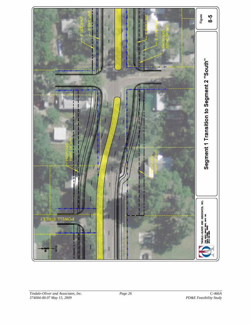
For the transition of Segment 1 to tie into Segment 2 “South”, additional right-of-waywould be required on both the north and south side of C-466A and the widening wouldresult in two residential relocations.
Segment 1 connecting to Segment 2 “Center”:
For the transition of Segment 1 to tie into Segment 2 “Center”, additional right-of-waywould be required on both the north and south side of C-466A and the widening wouldresult in two residential relocations.
All three alternatives above had the horizontal curvatures laid out, conceptually, at a designspeed of 30 mph. If a higher design speed is desired, the curves will need a higher design radiusand the “length” of the curves will be extended.
Figures 8-4, 8-5, and 8-6 show the conceptual transitions for each of the above options.

Tindale-Oliver and Associates, Inc. Page 25 C-466A374004-00.07 May 15, 2009 PD&E Feasibility Study
Tindale-Oliver and Associates, Inc. Page 26 C-466A374004-00.07 May 15, 2009 PD&E Feasibility Study

Tindale-Oliver and Associates, Inc. Page 27 C-466A374004-00.07 May 15, 2009 PD&E Feasibility Study

Tindale-Oliver and Associates, Inc. Page 28 C-466A374004-00.07 May 15, 2009 PD&E Feasibility Study
8.2.2. Segment 2
All options of segment 2 were analyzed with the following typical section. Within theright-of-way are two travel lanes eastbound and two travel lanes westbound, a 14’median, two 6’ bike paths, 2’ curb and gutter, and buffers. This section requires 86’ ofright-of way. On each side of the road, outside of the right-of-way, a 10’ easement areawith a buffer and an 8’ sidewalk will be specified and constructed by the property ownersas redevelopment occurs.
Segment 2: North Widening –
For this alternative, the exiting right-of-way on the south side of 466A is held. Thisalternative requires an additional 26’ of right-of-way and results in three relocations ofhomes (impacted by the proposed right-of way) on the north side of C-466A within theboundary of Segment 2.
The typical section for the north widening of Segment 2 is presented in Figure 8-7.
Segment 2: South Widening –
For this alternative, the existing right-of-way on the north side of 466A is held. Thisalternative requires an additional 26’ of right-of-way and results in four relocations ofhomes (impacted by the proposed right-of way) on the south side of C-466A within theboundary of Segment 2.
The typical section for the south widening of Segment 2 is presented in Figure 8-8.
Segment 2: Center Widening –
For this alternative, the road would be constructed symmetrically from the center of theexisting right-of-way. This alternative requires an additional 13’ of right-of-way on thenorth side and south side of C-466A and two relocations of homes (impacted by proposedright-of-way) within the boundary of Segment 2.
The typical section for the center widening of Segment 2 is presented in Figure 8-9.

Tindale-Oliver and Associates, Inc. Page 29 C-466A374004-00.07 May 15, 2009 PD&E Feasibility Study

Tindale-Oliver and Associates, Inc. Page 30 C-466A374004-00.07 May 15, 2009 PD&E Feasibility Study

Tindale-Oliver and Associates, Inc. Page 31 C-466A374004-00.07 May 15, 2009 PD&E Feasibility Study

Tindale-Oliver and Associates, Inc. Page 32 C-466A374004-00.07 May 15, 2009 PD&E Feasibility Study
8.2.3. Segment 3
All alternatives of segment 3 were analyzed to be constructed within the existing right-of-way and have the following configuration. Within the right-of-way are two travel laneseastbound and two travel lanes westbound, a 14’ median, two 6’ bike paths, 2’ curb andgutter, and buffers.
Segment 3: North Widening -
For this alternative the roadway would be constructed generally south of center of right-of-way such that, on the north side of the road there will be a 14’ buffer between the bikepath and the right-of-way. On each side of the road, outside of the right-of-way, a 10’easement area with a buffer and an 8’ sidewalk will be specified and constructed asredevelopment occurs. This alternative does not require acquisition of additional right-of-way.
The typical section for the north widening of Segment 3 is presented in Figure 8-10.
Segment 3: South Widening –
For this alternative the roadway would be constructed generally north of center of right ofway such that, on the south side of the road there will be a 14’ buffer between the bikepath and the right-of-way. On each side of the road, outside of the right-of-way, a 10’easement area with a buffer and an 8’ sidewalk will be specified and constructed asredevelopment occurs. This alternative does not require acquisition of additional right-of-way.
The typical section for the north widening of Segment 3 is presented in Figure 8-11.
Segment 3: Center Widening –
For this alternative the roadway would be constructed symmetrically about the center ofright of way such that on the north side and south side of the road there will be a 7’ bufferbetween the bike path and the right-of-way. On each side of the road, outside of theright-of-way, a 10’ easement area with a buffer and an 8’ sidewalk will be specified andconstructed as redevelopment occurs. This alternative does not require acquisition ofadditional right-of-way.
The typical section for the north widening of Segment 3 is presented in Figure 8-12.

Tindale-Oliver and Associates, Inc. Page 33 C-466A374004-00.07 May 15, 2009 PD&E Feasibility Study

Tindale-Oliver and Associates, Inc. Page 34 C-466A374004-00.07 May 15, 2009 PD&E Feasibility Study

Tindale-Oliver and Associates, Inc. Page 35 C-466A374004-00.07 May 15, 2009 PD&E Feasibility Study

Tindale-Oliver and Associates, Inc. Page 36 C-466A374004-00.07 May 15, 2009 PD&E Feasibility Study
8.3. Evaluation Matrix
The evaluation process for the alternatives considered involved the analysis of a variety offactors. Some of the representative evaluation factors that were considered include the landacquisition costs, impacts to adjacent property owners, impacts to wetlands and floodplains,and impacts to archaeological or historical sites.
For this preliminary level analysis, cost estimates for the alternatives for each segment werenot undertaken. Given the similarity in design for each of the alternatives, it is assumed thatthe construction costs for the alternatives would be comparable and therefore were not usedin the evaluation of the individual alternatives. A generalized, planning level, cost estimatewas undertaken using the FDOT Long Range Estimating (LRE) system and generalizedassumptions including:
Utilities relocation costs for water, sewer, and communication lines 5 foot sidewalks Maintenance of Traffic (10% of total construction costs) Mobilization (10% of total construction costs)
Using this methodology the cost estimate was approximately $10,024,460.92. It should benoted that the cost estimates generated by this program are typically used for planningpurposes and are tied strictly to typical quantities for a 4-lane urban design sectionrecommended in FDOT’s Design Handbook. This estimate should only serve as a guide tothe scale of costs although they are representative of current units prices based on FDOT biddata. Given the recent fluctuation in costs, this cost estimate remains a planning levelestimate represents only unit prices effective in today’s market. The LRE worksheets areprovided in Appendix F.
The Evaluation Matrices presented in Table 8-1 provides a comparative summary of theanalyzed roadway typical sections for each of the three analysis segments. This analysisserves to provide a basis to identify the recommended typical sections.
Detailed parcel and building information is provided in Appendix G.

Tindale-Oliver and Associates, Inc. Page 37 C-466A374004-00.07 May 15, 2009 PD&E Feasibility Study
Table 8-1 Evaluation Matrix
Segment 1
EVALUATION CRITERIA All North South Center North South Center North South Center
Land Costs 32,730$ 6,562$ 9,389$ 8,039$ 27,788$ 22,334$ 20,618$ -$ -$ -$
Building Costs 306,500$ 100,100$ 100,100$ 100,100$ 240,700$ 362,300$ 144,500$ -$ -$ -$
Total Cost 339,230$ 106,662$ 109,489$ 108,139$ 268,488$ 384,634$ 165,118$ -$ -$ -$Residential Relocations 2 2 2 2 5 4 3 0 0 0
Business Relocations 3 0 0 0 0 0 0 0 0 0
Church Relocations 0 0 0 0 0 0 0 0 0 0Wetland Impacts (acre) 0 0 0 0 0 0 0 0 0 0
Floodplain Impact (acre) 0 0 0 0 0 0 0 0 0 0
Archaeological Impacts 0 0 0 0 0 0 0 0 0 0Historic Land Impacts 0 0 0 0 0 0 0 0 0 0
Notes
Land and Building Costs based on Property Appraiser Land and Building Value data.
Land costs calculated based on amount of land needed to accommodate the propsed right-of-way. Buildings costs were determined if the proposed ROW impacts an existing building.
Segment 3 is assumed to be constructed entirely within the existing 100' ROW, therefore no impact to adjacent property owners
Segment 2 Segment 3Segment 1 "Transition" to Segment 2

Tindale-Oliver and Associates, Inc. Page 38 C-466A374004-00.07 – May 15, 2009 PD&E Feasibility Study
8.4. Recommended Alternative
Based on the results of the engineering analysis, the discussions with the stake holders, andfeedback from the public, the recommended alternative for construction of C-466A iswidening the roadway approximately symmetrical to the existing centerline of the roadwayas this is estimated to have the least impact to adjacent land and buildings. In conjunctionwith this alignment the design should incorporate a slight “meandering” where design allowsto further reduce impacts to buildings in Segment 2.
The symmetrical and “meandering” alignment was presented to, and approved by, the City ofWildwood Board of Commissioners on March 9, 2009 and by the Sumter County Board ofCommissioners on March 24, 2009.


![sumter crossing - Capital Pacific sumter crossing mid box center with in-place, assumable debt [ ] 1265 Broad Street, Sumter, SC • Trophy real estate - 100% occupied • 7.64% Cap](https://img.pdfslide.us/doc/110x75/5fd63ad03d5e6809b828820d/sumter-crossing-capital-pacific-sumter-crossing-mid-box-center-with-in-place.jpg)

![sumter crossing - Capital Pacific · 2020. 12. 30. · sumter crossing mid box center with in-place, assumable debt [ ] 1265 Broad Street, Sumter, SC • Trophy real estate - 100%](https://img.pdfslide.us/doc/110x75/610125039f97f65ef069c408/sumter-crossing-capital-pacific-2020-12-30-sumter-crossing-mid-box-center.jpg)