Embed Size (px)
Citation preview
F I N A L
Corridor Existing Conditions Report US 34 PEL
Prepared for
Colorado Department of Transportation
March 2018
CH2M HILL, Inc. 9191 South Jamaica Street Englewood, CO 80112


SL0323171132DEN III
Contents Section Page
Acronyms and Abbreviations .............................................................................................................. vii
1 Introduction and Corridor Overview ..................................................................................... 1-1 1.1 US 34 PEL Project Limits and Study Area ......................................................................... 1-1 1.2 Purpose and Need ............................................................................................................ 1-2 1.3 Corridor Stakeholders ...................................................................................................... 1-2
1.3.1 Key Agency Stakeholders .................................................................................... 1-2 1.3.2 Other Stakeholders ............................................................................................. 1-3
2 Previous Studies ................................................................................................................... 2-1 2.1 Summary of Previous Studies and Projects ..................................................................... 2-1
2.1.1 Corridor-level Studies ......................................................................................... 2-1 2.1.2 Regional-level and Local Agency Studies ............................................................ 2-4
3 Geometric Existing Conditions .............................................................................................. 3-1 3.1 Roadway Features............................................................................................................ 3-1
3.1.1 Roadway Characteristics ..................................................................................... 3-1 3.1.2 Designations........................................................................................................ 3-5 3.1.3 Design Speed and Speed Limits .......................................................................... 3-5 3.1.4 Areas Where Corridor Does Not Meet Standards .............................................. 3-6 3.1.5 Railroad Crossings ............................................................................................... 3-6 3.1.6 Right of Way ........................................................................................................ 3-7
3.2 Major Structures ............................................................................................................ 3-11 3.2.1 Bridges .............................................................................................................. 3-11 3.2.2 Frontage Roads ................................................................................................. 3-12
3.3 Drainage ......................................................................................................................... 3-15 3.3.1 Floodplain Crossings ......................................................................................... 3-15 3.3.2 Drainage Systems in Place ................................................................................ 3-15 3.3.3 Existing Water Quality Facilities ....................................................................... 3-15
3.4 Utilities ........................................................................................................................... 3-15 3.5 Pedestrian, Bicycle, and Transit Facilities ...................................................................... 3-17
3.5.1 Pedestrian Conditions ....................................................................................... 3-18 3.5.2 Bicycle Conditions ............................................................................................. 3-21 3.5.3 Transit Conditions ............................................................................................. 3-27
4 Traffic, Travel Forecasting, Safety, and ITS Existing Conditions .............................................. 4-1 4.1 Traffic Operations ............................................................................................................ 4-1
4.1.1 Safety .................................................................................................................. 4-1 4.1.2 Volumes .............................................................................................................. 4-4 4.1.3 Congestion .......................................................................................................... 4-7
4.2 ITS in the Corridor ............................................................................................................ 4-9
5 Access Control Plans ............................................................................................................. 5-1 5.1 Access Management Benefits .......................................................................................... 5-1 5.2 Guiding Principles ............................................................................................................ 5-2 5.3 Techniques ....................................................................................................................... 5-3 5.4 Access Categories ............................................................................................................ 5-6 5.5 Existing Access and Land Use Characteristics .................................................................. 5-7

CONTENTS
IV SL0323171132DEN
6 Environmental Scan .............................................................................................................. 6-1 6.1 Aquatic Resources ............................................................................................................ 6-1
6.1.1 Methodology ...................................................................................................... 6-1 6.1.2 Applicable Regulations ........................................................................................ 6-1 6.1.3 Existing Conditions .............................................................................................. 6-2 6.1.4 Next Steps ........................................................................................................... 6-2
6.2 Biological Resources ........................................................................................................ 6-3 6.2.1 Methodology ...................................................................................................... 6-3 6.2.2 Applicable Regulations ........................................................................................ 6-3 6.2.3 Existing Conditions .............................................................................................. 6-3 6.2.4 Next Steps ........................................................................................................... 6-8
6.3 Cultural Resources ........................................................................................................... 6-8 6.3.1 Methodology ...................................................................................................... 6-9 6.3.2 Applicable Regulations ........................................................................................ 6-9 6.3.3 Existing Conditions ............................................................................................ 6-10 6.3.4 Next Steps ......................................................................................................... 6-11
6.4 Floodplains ..................................................................................................................... 6-11 6.4.1 Methodology .................................................................................................... 6-12 6.4.2 Applicable Regulations ...................................................................................... 6-12 6.4.3 Existing Conditions ............................................................................................ 6-12 6.4.4 Next Steps ......................................................................................................... 6-13
6.5 Hazardous Materials ...................................................................................................... 6-13 6.5.1 Methodology .................................................................................................... 6-13 6.5.2 Applicable Regulations ...................................................................................... 6-14 6.5.3 Existing Conditions ............................................................................................ 6-14 6.5.4 Next Steps ......................................................................................................... 6-14
6.6 Land Use and Socioeconomics ....................................................................................... 6-15 6.6.1 Methodology .................................................................................................... 6-15 6.6.2 Existing Conditions ............................................................................................ 6-15 6.6.3 Next Steps ......................................................................................................... 6-28
6.7 Noise .............................................................................................................................. 6-29 6.7.1 Methodology .................................................................................................... 6-29 6.7.2 Applicable Regulations ...................................................................................... 6-29 6.7.3 Existing Conditions ............................................................................................ 6-30 6.7.4 Next Steps ......................................................................................................... 6-30
6.8 Recreational Resources .................................................................................................. 6-31 6.8.1 Methodology .................................................................................................... 6-31 6.8.2 Applicable Regulations ...................................................................................... 6-31 6.8.3 Existing Conditions ............................................................................................ 6-31 6.8.4 Next Steps ......................................................................................................... 6-32
6.9 Environmental Justice .................................................................................................... 6-32 6.9.1 Methodology .................................................................................................... 6-33 6.9.2 Applicable Regulations ...................................................................................... 6-33 6.9.3 Existing Conditions ............................................................................................ 6-33 6.9.4 Next Steps ......................................................................................................... 6-34
6.10 Visual Resources ............................................................................................................ 6-34 6.10.1 Methodology .................................................................................................... 6-34 6.10.2 Applicable Regulations ...................................................................................... 6-35 6.10.3 Existing Conditions ............................................................................................ 6-35 6.10.4 Next Steps ......................................................................................................... 6-35

CONTENTS
SL0323171132DEN V
6.11 Other Resources ............................................................................................................ 6-35 6.11.1 Air Quality ......................................................................................................... 6-36 6.11.2 Farmlands ......................................................................................................... 6-36 6.11.3 Paleontology ..................................................................................................... 6-36 6.11.4 Water Quality .................................................................................................... 6-36
7 Recommendations from the Existing Conditions Report ....................................................... 7-1 7.1 Changes to Project Limits and Study Area ....................................................................... 7-1
7.1.1 Segment: Foothills .............................................................................................. 7-1 7.1.2 Segment: Loveland Urban ................................................................................... 7-1 7.1.3 Segment: Loveland 6-lane .................................................................................. 7-2 7.1.4 Segment: Johnstown-Greeley ............................................................................. 7-2 7.1.5 Segment: Greeley Expressway ............................................................................ 7-2 7.1.6 Segment: East End .............................................................................................. 7-2
7.2 Consideration of Risk and Resiliency in the PEL .............................................................. 7-2
8 References ............................................................................................................................ 8-1
Appendixes
A CDOT DiSysEx Output B Environmental Resource Maps C GeoSearch Report
Tables
2-1 2040 Fiscally Constrained RTP Planned Projects within the US 34 PEL Study Area 3-1 Structures on the US 34 Corridor 3-2 Utilities Ownership 4-1 Historical Average Annual Daily Traffic Volumes (vpd) by Month and Yeara 4-2 Average Annual Growth in Traffic (approximate) 4-3 Existing ITS devices 5-1 US 34 Access Category Assignments 6-1 Federal- and State-listed Species with the Potential to Occur Within the Study Area 6-2 CDOT 2016 Noxious Weed Species Mapped Within the Study Area 6-3 Previously Recorded Cultural Resources in the Area of Review 6-4 Population and Households (2000-2015) 6-5 Median Household Income (2000-2015) 6-6 Larimer County Average Employment by Industry (2000-2015) 6-7 Weld County Average Employment by Industry (2000-2015) 6-8 Population, Household, and Employment Forecasts (2015-2040) 6-9 Relevant Plan Guidance 6-9 CDOT Noise Abatement Criteria 6-10 Recreational Resources in the US 34 PEL Study Area 6-11 Minority and Low-income Households in the US 34 PEL Study Area

CONTENTS
VI SL0323171132DEN
Figures
1-1 Project Location 2-1 Location of Previous Studies and Projects 3-1 Typical Sections and Speeds (West end of Project Area) 3-2 Typical Sections and Speeds (East end of Project Area) 3-3 At-Grade Railroad Crossings 3-4 ROW Widths 3-5 Major Structures 3-6 Frontage Roads 3-7 Existing and Proposed Local Pedestrian Facilities and RNMCs 3-8 Existing and Proposed Bicycle Facilities and RNMCs 3-9 Current COLT Service Map 3-10 GET routes, updated 2016 3-11 Local and Regional Existing and Proposed Transit Routes 3-12 Loveland Proposed Transit Plan 3-13 Greeley Transit Vision Plan Service Map 4-1 Summary of US 34 Crash Data 4-2 Crash Type at Major Intersections in the US 34 Corridor 4-3 Average Annual Daily Traffic Volume by MP (2016) 4-4 Average Hourly Traffic Volume by Day of Week (2016) 4-5 Traffic Growth on US 34 4-6 Quality of Traffic Flow During Peak Periods 4-7 TTI on US 34 4-8 Graphs of TTI on US 34 5-1 Functional Intersection Area 5-2 Consolidate Access 5-3 Connect Adjacent Properties 5-4 Define Driveways 5-5 Install Medians and Islands 5-6 Install Medians and Islands 5-7 Provide Cross-street Access 6-1 NFRMPO Subregions 7-1 Revised Project Area Map 7-2 Proposed Corridor Segments - West 7-3 Proposed Corridor Segments - East

SL0323171132DEN VII
Acronyms and Abbreviations APE area of potential effect
ATR Automated Traffic Recorder
BATS Berthoud Area Transportation Services
CAGR Compound Annual Growth Rate
CCTV Closed Circuit Television
CDOT Colorado Department of Transportation
CERCLA Comprehensive Environmental Response, Compensation, and Liability Act of 1980
CFR Code of Federal Regulations
CHPA Colorado Historical, Prehistorical and Archaeological Resources Act
CNHP Colorado Natural Heritage Program
CO carbon monoxide
COLT City of Loveland Transit
CPW Colorado Parks and Wildlife
CRA common resource area
CWA Clean Water Act
dBA A-weighted decibel
EA environmental assessment
EIS Environmental Impact Statement
EO Executive Order
FEMA Federal Emergency Management Agency
FHWA Federal Highway Administration
FIRM Flood Insurance Rate Map
FO Functionally Obsolete
FONSI Finding of No Significant Impact
GET Greeley Evans Transit
GIS geographic information system
GWRR Great Western Railroad
I Interstate
ID identification
IGA intergovernmental agreement
IPaC Information for Planning and Consultation
ITS intelligent transportation systems
LCMC Larimer County Mobility Committee

ACRONYMS AND ABBREVIATIONS
VIII SL0323171132DEN
LCR Larimer County Road
LWCF Land and Water Conservation Fund
MBTA Migratory Bird Treaty Act
MP mile post
mph mile(s) per hour
N/A not applicable
NAC Noise Abatement Criteria
NEPA National Environmental Policy Act
NDIS Natural Diversity Information System
NFR North Front Range
NFRMPO North Front Range Metropolitan Planning Organization
NHPA National Historic Preservation Act
NRCS Natural Resources Conservation Service
NRHP National Register of Historic Places
OAHP Office of Archaeology and Historic Preservation
OTIS Online Transportation Information System
PBA Programmatic Biological Assessment
PEL Planning and Environmental Linkages
PNR Park-n-Ride
PTZ Pan-Tilt-Zoom
RAFT Rural Alternative for Transportation
Region 4 CDOT's northeast Colorado region
RHA River and Harbors Act of 1899
RNMC regional non-motorized corridors
ROD Record of Decision
ROW right-of-way
RTC regional transit corridor
RTE Regional Transit Element
RTP Regional Transportation Plan
RV recreational vehicle
SAINT Senior Alternatives in Transportation
SD Structurally Deficient
SH State Highway
SPWRAP South Platte Water Related Activities Program
TTI Travel Time Index

ACRONYMS AND ABBREVIATIONS
SL0323171132DEN IX
UPRR Union Pacific Railroad
US U.S. Highway
USACE U.S. Army Corps of Engineers
USC United States Code
USFWS U.S. Fish and Wildlife Service
USGS U.S. Geological Survey
v/c volume-to-capacity
vpd Vehicles Per Day
WCMC Weld County Mobility Committee
WCR Weld County Road


SECTION 1
SL0323171132DEN 1-1
Introduction and Corridor Overview U.S. Highway (US) 34 is a critical east-west transportation corridor for northern Colorado's large and growing communities. Sustained and successful economic development along US 34 is increasing travel demand and necessitating the need to enhance safety, reduce congestion, and improve mobility.
The Colorado Department of Transportation (CDOT) is assessing various improvement opportunities on US 34 to address these needs. Identifying effective transportation improvements through the US 34 Planning and Environmental Linkages (PEL) Study is a top priority for CDOT's northeast Colorado region (Region 4) and its local government partners.
CDOT and the PEL partners continue to work collaboratively to develop a common vision for US 34 as well as discrete projects that improve safety and mobility along this important corridor. The PEL effort will incorporate, manage, and meet public and agency expectations for corridor improvements while building upon and validating past efforts.
The purpose of this Corridor Existing Conditions Report is to provide the background data needed to help define an ultimate vision for US 34. Environmental resources, existing roadway characteristics, multimodal facilities, traffic operations, safety statistics, travel volumes, level of service, and deficiencies have been documented. Previous plans and studies are also summarized for reference. This information will be used as a baseline for determining improvement needs during the alternative development process. Existing conditions presented in this report represent a snapshot in time current to September 15, 2017, and will be used to determine additional data collection needs for the PEL.
1.1 US 34 PEL Project Limits and Study Area The US 34 PEL project limits extended 34.3 miles (mile post [MP] 84.9 to MP 119.2) along US 34, west to east, from Glade Road west of Loveland to Weld County Road (WCR) 49 east of Greeley (Figure 1-1). The corridor is an important regional connection for the adjacent communities of Loveland, Johnstown, Windsor, Greeley, Garden City, Evans, and Kersey, as well as Front Range destinations, such as Rocky Mountain National Park. In addition to east-west travel, the corridor includes intersections with several important north-south regional roadways, including US 287, Interstate 25 (I-25), and US 85.
1.1.1 Western Project Limits The western project limit for potential physical improvements begins at Glade Road (MP 86.9), which is the first intersection west of the City of Loveland’s Growth Management Area boundary. It is also the eastern limit of the US 34 Canyon project that is currently under construction. Glade Road was identified as a logical western terminus for the US 34 PEL because this is the point where land use changes from urban to rural (both existing and future). This is also the location where the State Highway access category and speed limit change.
1.1.2 Eastern Project Limits The eastern project limit for potential physical improvements is at WCR 49 east of Greeley near the western edge of Kersey. WCR 49 is the last major regional arterial roadway located just east of the North Front Range Metropolitan Planning Organization (NFRMPO) boundaries and associated travel demand model limits. It provides a major traffic node for which there is existing and projected travel demand information for traffic entering/exiting the NFRMPO area and the Town of Kersey. WCR 49 is currently being improved to connect regional US 34 travelers to I-76, which would provide an alternative north-south regional travel route for Kersey, Greeley, Evans, and Garden City. As noted in the description of

SECTION 1 – INTRODUCTION AND CORRIDOR OVERVIEW
1-2 SL0323171132DEN
the Study Area, the PEL will also consider travel influences east of the project limits in the Study Area. However, analysis will be more qualitative in nature due to the lack of limited roadway network in this portion of the NFRMPO travel demand model, which is the primary source of quantitative travel forecast data for the PEL Study.
1.1.3 Study Area While the project limits are focused on US 34, understanding travel patterns and travel demands of parallel and intersection roadways is an important element of understanding the potential effects of improvements on US 34 and the surrounding roadways. Therefore, the Study Area (Figure 1-1) is larger than the project limits to encompass key parallel routes and better understand the interaction of increasing traffic on US 34. It is generally bounded by State Highway (SH) 402 and Freedom Parkway to the south, and O Street to the north. The western project limits and study limits are the same, however the eastern study limits extend beyond the eastern project limits to assess the east-west travel movements to the east through Kersey.
1.2 Purpose and Need The purpose of highway improvements is to preserve US 34 as a vital east-west regional transportation corridor. Improvements will link and move people, goods, and information reliably and adapt to future travel demands and funding opportunities.
Highway improvements are needed to:
• Enhance safety • Accommodate increased travel and tourism demands and maintain the economic vitality of the region • Increase reliability of east-west regional travel, while balancing local access, mobility, and freight needs
Successful alternatives will:
• Be compatible with the natural and human environment • Support community land use and aesthetics goals • Be fiscally responsible and implementable
1.3 Corridor Stakeholders Key agency stakeholders for the US 34 PEL include state and local jurisdictions within the Study Area, including those represented in the US 34 Coalition (see Section 1.3.1). Other stakeholders include law enforcement, emergency responders, and adjacent rail and ditch companies.
1.3.1 Key Agency Stakeholders The key agency stakeholders for the US 34 PEL include the following US 34 Coalition members:
• CDOT • City of Evans • City of Greeley • City of Loveland • Larimer County • NFRMPO • Town of Johnstown • Town of Kersey • Town of Windsor • Weld County

SECTION 1 – INTRODUCTION AND CORRIDOR OVERVIEW
SL0323171132DEN 1-3
1.3.2 Other Stakeholders The following have also been identified as stakeholders for the US 34 PEL:
• BNSF Railway Company • City of Loveland Transit (COLT) • Colorado Motor Carriers Association • Colorado State Patrol • Emergency Responders • Farmer’s Cooperative Ditch Company • Great Western Railroad (GWRR) • Greeley Evans Transit (GET) • Greeley-Loveland Irrigation Company • Larimer County Mobility Committee (LCMC) • Little Barnes Ditch Company • Northern Colorado Bicycle and Pedestrian Collaborative • Union Pacific Railroad (UPRR) • Weld County Mobility Committee (WCMC)


SECTION 1 – INTRODUCTION AND CORRIDOR OVERVIEW
SL0323171132DEN 1-5
Figure 1-1. Project Location Corridor Existing Conditions Report US 34 PEL


SECTION 2
SL0323171132DEN 2-1
Previous Studies 2.1 Summary of Previous Studies and Projects Within the project area, numerous corridor-level and local-level studies and/or projects have previously been completed that will inform the PEL process. This section summarizes previous studies and plans relevant to the Study Area and discusses their relevance to the project. Figure 2-1 illustrates the Study Area for each of the previous studies and projects in relation to the US 34 corridor.
Figure 2-1. Location of Previous Studies and Projects Corridor Existing Conditions Report US 34 PEL
2.1.1 Corridor-level Studies Over the past 20 years, entities such as CDOT and the Federal Highway Administration (FHWA) have completed several major studies, some of which have resulted in planned, recent, and ongoing improvements, within or adjacent to the corridor.

SECTION 2 – PREVIOUS STUDIES
2-2 SL0323171132DEN
2.1.1.1 US 34 Corridor Optimization Plan (2003) The US 34 Corridor Optimization Plan was conducted by CDOT in 2003 to identify the future transportation problems/issues along US 34, develop alternative improvements and measures to address the problems/issues, evaluate the effectiveness of each alternative, and assemble a business plan for improvements. The plan covered a 25-mile segment extending from I-25 east through Kersey and involved representatives from Larimer and Weld Counties and the municipalities of Loveland, Johnstown, Greeley, Evans, and Kersey. The plan identified a future cross section for US 34 to include six through lanes from I-25 to 17th Avenue that would accommodate an on-street bike lane via shoulder, a median wide enough to accommodate dual left turn lanes at intersections, auxiliary right-turn acceleration/deceleration
lanes, and shoulders. Signalization and the addition of dual left-turn lanes and a right-turn lane along all four approaches was recommended at several major intersections to eventually allow for the proposed interchanges from the US 34 Access Control Plan (CDOT, 2003b) (discussed in Section 2.1.1.6).
Additional recommended elements included the following (CDOT, 2003a):
• Widening Crossroads Boulevard to four lanes between I-25 and SH 257 • Establishing a new road from the east termination of Crossroads Boulevard to 59th Street/WCR 30 • Establishing an alternate connection to Fort Collins via Two Rivers Parkway and Harmony Road • Establishing a parallel collector street system on US 34 through Greeley • Establishing a new connection between SH 257 and US 34 Business Route • Widening LCR 18/WCR 54 to four lanes in the Study Area
2.1.1.2 US 85 PEL Study (2017) CDOT conducted the US 85 PEL Study for a 62-mile stretch of US 85 between I-76 in Commerce City and WCR 100 in the Town of Nunn, Colorado (CDOT, 2017a). The US 85 Access Control Plan (CDOT, 2003b) served as a foundation for the PEL Study. The PEL identified and prioritized short-term and long-term improvements through a collaborative process with stakeholders and the public to improve safety, reduce existing and future traffic congestion, provide efficient access for existing and future development, and improve mobility and connectivity for all transportation modes that match the context of the adjacent communities. The alternative development, refinement, and evaluation process resulted in a recommendation, or multiple recommendations, for each of the 93 intersections in the 62-mile corridor.
Within the US 34 PEL Study Area, the US 85 PEL Study recommended the following:
• Auxiliary lane additions at 31st Street and 37th Street • Undetermined improvements at the US 34 interchange with US 85 • Texas Turnarounds at 5th Street, 8th Street, 13th Street, 16th Street, 18th Street, and 22nd Street • Closure of the intersection with O Street and combining access with the construction of a traffic
signal at WCR 66.
2.1.1.3 Freedom Parkway Access Control Plan (Ongoing) The Freedom Parkway Access Control Plan, being prepared for the Freedom Parkway Coalition, will evaluate the corridor located to the south of the US 34 project that consists of WCR 54 from WCR 49 west, 37th Street in Evans and Greeley, LCR 18 from the county line to I-25, and a portion of SH 402 in Loveland. Internal stakeholder meetings for the plan began in 2017. An access inventory was conducted by May 2017 and recommendations will follow as plan preparation progresses.

SECTION 2 – PREVIOUS STUDIES
SL0323171132DEN 2-3
2.1.1.4 SH 402 Environmental Assessment and Finding of No Significant Impact (2008) The SH 402 Environmental Assessment (EA) (CDOT, 2007) identified alternatives to improve mobility and safety along the existing SH 402 from the US 287 intersection east to the I-25 interchange. SH 402 is located south of US 34 along the southern Study Area boundary. The EA and Finding of No Significant Impact (FONSI), approved in 2008, identified a preferred alternative that proposes intersection improvements, increasing highway capacity from two to four lanes, and shifting the alignment to accommodate turn lanes and auxiliary lanes and avoid right-of-way (ROW) and environmental impacts.
2.1.1.5 Truck Traffic in the Northeast Quadrant of the NFRMPO Region (2010) The Truck Traffic in the Northeast Quadrant of the NFRMPO Region Study (NFRMPO, 2010) was facilitated by the NFRMPO in response to increasing truck traffic volumes in the Town of Timnath and neighboring communities. The study area consisted of the northeastern portion of the NFRMPO: generally east of I-25, south of SH 14, west of US 85, and north of Crossroads Boulevard/WCR 64. The study recommended the establishment of truck route designations to supplement the state highway system within the sub-region, including Through Truck Routes and Local Truck Routes. The Through Truck Route adjacent to the US 34 PEL Study Area is the Crossroads Boulevard and O Street route. Designated local truck routes adjacent to the US 34 PEL Study Area included WCR 13, WCR 27, WCR 31, and WCR 37.
2.1.1.6 US 34 Access Control Plan (2003) The US 34 Access Control Plan (CDOT, 2003b) was conducted by CDOT in conjunction with the cities of Loveland, Greely, Evans, and Kersey and both Larimer and Weld Counties. The purpose of the study was to develop a detailed interim and ultimate plan for the US 34 corridor from the US 34/I-25 intersection on the west to the US 34/WCR 55 intersection east of Kersey.
The plan recommended interim traffic signals at LCR 5, LCR 3E, LCR 3, WCR 13, and WCR 17. New interim traffic signals were recommended at Promontory Parkway and Two Rivers Parkway (83rd Avenue). Existing traffic signals at 65th, 47th, 35th, 17th, 11th, and 8th Avenues would all remain in the interim condition. Eventually,
as traffic warrants and funding is available, interchanges would replace all interim traffic signals except for the traffic signals at 17th, 11th, and 8th Avenues which would remain in the ultimate condition.
In the ultimate access control plan, nine new interchanges were recommended, including a split diamond interchange at LCR 5 and LCR 3E; an interchange with ramps positioned in two quadrants at LCR 3; diamond interchanges at WCR 13, WCR 17, Promontory Parkway, 83rd Avenue/Two Rivers Parkway, 65th Avenue, and 47th Avenue; and a partial cloverleaf at 35th Avenue. Public road intersections recommended for ultimate signalization are the US 34 Business Route, WCR 49, WCR 51, SH 37/1st Street, and 9th Street. Other public road intersections, such as WCR 45, WCR 47, WCR 47.50, and WCR 49.50 were recommended to be three-quarter movement intersections. In addition, the ultimate plan recommended closing the existing WCR 56 intersection in Kersey and re-aligning WCR 56 to intersect US 34 at WCR 55.
An intergovernmental agreement (IGA), developed following the completion of the US 34 Access Control Plan, was signed by CDOT, the municipalities of Loveland, Greely, Evans, and Kersey and Larimer and Weld Counties. The IGA committed each signatory to regulating access in conformity with the US 34 Access Control Plan.

SECTION 2 – PREVIOUS STUDIES
2-4 SL0323171132DEN
2.1.1.7 North I-25 EIS and Record of Decision (2011) The North I-25 Environmental Impact Statement (EIS) (CDOT, 2011a) and Record of Decision (ROD) (CDOT, 2011b) evaluated improvements on I-25 from the Fort Collins/Wellington Area to Denver. The ROD selected Phase 1 of the Preferred Alternative, which included a proposed reconstruction of the I-25/US 34/Centerra Parkway interchange. As of May 2017, interchange final design is underway.
2.1.1.8 US 34 EA (2007) CDOT prepared an EA (CDOT, 2007) that evaluated alternatives along a 6-mile section of US 34 between US 287 (North Cleveland Avenue and North Lincoln Avenue one-way pair) and LCR 3 with a goal of improving current and future traffic mobility, improving transportation safety, and accommodating year 2030 travel demand. The US 34 FONSI approved a preferred alternative that would widen US 34 to six lanes and include a raised median, bike lanes, sidewalks, and curb and gutter. The EA/FONSI did not include improvements to the I-25/US 34 interchange.
2.1.1.9 US 34 Business Route EA (2008) In 2008, FHWA and CDOT conducted an evaluation of the US 34 Business Route (CDOT, 2008) to ensure future travel demand projection on the US 34 Business Route could be accommodated and to improve mobility, safety, and access. The study focused on the US 34 Business Route from 71st Avenue to SH 257. The EA yielded alternatives to widen US 34 Business Route from two lanes to four. The $25 million widening project was completed in fall 2009.
2.1.2 Regional-level and Local Agency Studies Over the past few decades, NFRMPO and local agencies adjacent to the US 34 Corridor have anticipated continued growth. The US 34 Corridor is rapidly becoming more congested. Local municipalities and planning agencies have addressed anticipated growth in numerous plans summarized in this section. Regional-level and local plans relating to bicycle and pedestrian users are discussed in Section 3.5.
2.1.2.1 NFRMPO 2040 Regional Transportation Plan (2015) The NFRMPO 2040 Regional Transportation Plan (RTP) (NFRMPO, 2015a) was adopted in 2015, amended in June 2017, and developed in coordination with the Technical Advisory Committee, CDOT, Regional Air Quality Council, Air Pollution Control Division, the 17-member Planning Council primarily composed of community elected officials, and other applicable community staff. The purpose of the plan was to address the economic vitality, safety, security, accessibility and mobility, environment, integration and connectivity, efficient system management and operation, and preservation of the North Front Range (transportation system per Moving Ahead for Progress in the 21st Century Act legislation. The NFR includes
portions of Larimer and Weld counties. The RTP recognized US 34 as a regionally significant corridor and identified the need to increase mobility, maintain system quality, and improve safety. The RTP identified various future travel modes to be planned for in the corridor that included passenger vehicles, bus service, bus rapid transit, truck freight, and bicycles and pedestrians. The RTP also identified fiscally constrained projects through 2040 within the NFRMPO planning region. Since adoption, the RTP has been amended twice to update the fiscally constrained project list. The fiscally constrained projects within the US 34 PEL Study Area are listed in Table 2-1.

SECTION 2 – PREVIOUS STUDIES
SL0323171132DEN 2-5
Table 2-1. 2040 Fiscally Constrained RTP Planned Projects within the US 34 PEL Study Area
Facility Name From To
Number of Lanes Year of
Improvement Cost
(thousands) Funding Source Before After
59th Avenue
20th Street
US 34 Bypass 2 2 (plus a center
turn lane)
2015 $1,500 Greeley – Capital Improvement Program
65th Avenue
US 34 Bypass
WCR 54 2 4 2015 $3,000 Greeley – Road Development Funds
SH 402 St. Louis Avenue
Boise Avenue 2 4 2015 $6,000 Loveland – Transportation Capital Improvement Plan Funds, CDOT
Weld County Parkway (WCR 49)
US 34 I-76 0-4 4 (plus a center
turn lane)
2017 $12,500 Weld County – General Fund
37th Street 35th Avenue
Two Rivers Parkway
2 4 2018 $1,500 Evans – Capital Projects Street Fund Future Development
59th Avenue
4th Street C Street 2 4 2020 $2,400 Greeley – Road Development Funds
Boyd Lake Avenue
LCR 20C US 34 2 4 2020 $1,988 Loveland – Transportation Capital Improvement Plan Funds
Boyd Lake Avenue
US 34 Canal 2 4 2020 $2,732 Loveland – Centerra Metro District
Crossroads Boulevard
Centerra Parkway
LCR 3 2 4 2020 $2,365 Loveland – Transportation Capital Improvement Plan Funds
I-25 SH 14 1.5 miles south of SH 402
4 6 2020 $250,700 CDOT, Local funding, Federal – TIGER
Taft Ave Arkins Branch
US 34 4 4 (plus a center
turn lane and bike
lanes)
2020 $10,509 Loveland – Transportation Capital Improvement Plan Funds
US 34 Denver Avenue
Boyd Lake Avenue
4 6 2020 $5,245 Loveland – Transportation Capital Improvement Plan Funds, CDOT
US 34 Rocky Mountain Avenue
I-25 4 6 2020 $2,066 Loveland – Centerra Metro District
US 34 I-25 Kendall Parkway (LCR 3E)
4 6 2020 $12,000 Loveland – Centerra Metro District, Transportation Capital Improvement Program Funds, CDOT

SECTION 2 – PREVIOUS STUDIES
2-6 SL0323171132DEN
Table 2-1. 2040 Fiscally Constrained RTP Planned Projects within the US 34 PEL Study Area
Facility Name From To
Number of Lanes Year of
Improvement Cost
(thousands) Funding Source Before After
83rd Avenue
US 34 Business Route
US 34 bypass 2 4 2025 $5,900 Greeley – Road Development Funds
Crossroads Boulevard
Great Western Drive
SH 257 0 2 (plus a center
turn lane)
2025 $5,000 Windsor – Road Impact Fee and Adjacent Development
LCR 3 US 34 Crossroads Boulevard
0 2 2025 $8,073 Loveland – Transportation Capital Improvement Plan Funds
LCR 18 I-25 Frontage Road
WCR 13 2 4 2030 $13,890 Johnstown; CDOT
US 34 Boyd Lake Avenue
Rocky Mountain Avenue
2 2 2030 $4,291 Loveland – General Fund, CDOT
59th Avenue
US 34 Bypass
20th Street 2 4 2035 $3,500 Greeley – Road Development Funds
83rd Avenue
WCR 54 WCR 64 2 3 2035 $7,000 Greeley – Road Development Funds
North Fairground Avenue (LCR 5)
Rodeo Road
71st Street (LCR 30)
2 4 2035 $3000 Loveland – Transportation Capital Improvement Plan Funds
O Street SH 85 83rd Avenue 2 2 (plus a center
turn lane)
2035 $4,700 Greeley – Road Development funds
SH 402 LCR 9 I-25 2 4 2035 $33,378 Loveland – Transportation Capital Improvement Plan Funds; CDOT
SH 402 US 287 St. Louis Avenue
2 4 2035 $3,000
Taft Avenue
US 34 22nd Street 4 4 (plus a center
turn lane and bike
lanes)
2035 $6,123 Loveland- Transportation Capital Improvement Plan Funds
WCR 54 35th Avenue
WCR 17 2 2 (plus a center
turn lane)
2035 $6,800 Greeley – road Development Funds
WCR 56 US 34 Bypass
WCR 17 0 2 2035 $21,000 Greeley – Road Development Funds
Total planned investment in the US 34 PEL Study Area through 2040 $439,460
Source: 2040 RTP (NFRMPO, 2015), amended June 2017
Rows highlighted in yellow indicate projects that are located on US 34.

SECTION 2 – PREVIOUS STUDIES
SL0323171132DEN 2-7
2.1.2.2 NFRMPO 2040 Regional Transit Element (2015) The 2040 Regional Transit Element (RTE) (NFRMPO, 2015b) created a long-range vision for regional transit services in the NFRMPO planning region. The RTE recommended further study of transit along the US 34 corridor as a community connection. Alternatives for future study relative to US 34 ranged from VanGOTM vanpooling transit service to 30-minute headways in peak hours and hourly headways for mid-day bus service. The RTE identified the need for additional development, connectivity to the Bustang service on I-25 at the US 34 Park-n-Ride (PNR), and improved marketing and scheduling to improve the usage of this route.
2.1.2.3 Greeley 2035 Comprehensive Transportation Plan (2011) Greeley’s 2035 Comprehensive Transportation Plan was developed to address the relationship between transportation and land use, identify future transportation needs of the area, estimate costs, and identify short-term and long-term improvements for roads, transit, bicycle, and pedestrian facilities. The plan identified medium to high growth in housing, employment, and congestion along US 34. Proposed US 34 plans included establishing a hazardous materials route, adding six new interchanges along US 34 to redistribute traffic to parallel roadways, and establishing bicycle routes between 47th Avenue and 71st Avenue along US 34. The plan corresponds to the city’s 2060 Comprehensive Plan.
2.1.2.4 O Street Arterial Corridor Study (2008) The O Street Arterial Corridor Study (Weld County, 2008) was a study/evaluation conducted by Weld County to establish a preferred alignment for an east-west arterial roadway between Greeley and Windsor. The roadway would extend the existing O Street to the west from the intersection of 83rd Avenue to SH 257 at Crossroads Boulevard, providing a regional connection to I-25. Upon completion of the evaluation process, the local agency committee settled on a preferred alternative that included maintaining a straight alignment (remaining south of WCR 64 ½) of O Street heading west of 83rd Avenue to Crossroads Boulevard.
2.1.2.5 Weld County 2035 Transportation Plan (2011) The purpose of the Weld County 2035 Transportation Plan (2011) was to provide technical information that could be used as a basis for formulating transportation-related policies. Furthermore, the plan was intended to ensure the sustainability of Weld County’s quality of life by preserving the rural character while providing strategies that sustain urban development. To address US 34, Weld County identified short-term projects and associated funding sources that include bridge replacements at I-25 and WCR 29 and intersection improvements at WCR 53.
2.1.2.6 City of Loveland 2035 Transportation Plan (2012) The purpose of the City of Loveland 2035 Transportation Plan (2012a) was to provide a document that guided transportation decision making toward a future desirable to the community. Furthermore, the plan addressed current and future growth through 2035. The plan identified several visions for the US 34 corridor, including transit between US 287/Cleveland Avenue and I-25, a transit center at the US 34/I-25 intersection, new bike lanes, and widening of US 34 from four lanes to six lanes between US 287/Cleveland Avenue and I-25.

SECTION 2 – PREVIOUS STUDIES
2-8 SL0323171132DEN
2.1.2.7 Kersey Comprehensive Plan (2016) The objective of the Kersey Comprehensive Plan (Town of Kersey, 2016) was to put forth the community’s vision for Kersey and to guide the town’s decision makers. The plan helped town officials ensure that development is consistent with the community’s vision, guiding principles, and goals. To address US 34, the city plans to work with CDOT to establish appropriate intersection control measures on the Kersey street system and improve the operational characteristics and safety of the US 34 corridor and recently expanded WCR 49.
2.1.2.8 Johnstown Transportation Master Plan (2008) The Johnstown Transportation Master Plan (Town of Johnstown, 2008) was prepared based on the vision and growth forecasts contained in the Area Comprehensive Plan (Town of Johnstown, 2006). It outlined the existing transportation system, traffic forecasts, and roadway network deficiencies and discusses a long-range plan for addressing transportation needs within the planning boundaries (which extend 1 mile north of US 34). The plan identified the following improvements within the US 34 PEL Study Area.
Short Range (2008 through 2013)
• Signalize intersections at US 34/LCR 3 and US 34/Larimer Parkway • Pave the following roadways to Johnstown street standard: LCR 3 from
LCR 18 to LCR 24; WCR 13 from US 34 to WCR 60
Medium Range (2014 through 2020)
• Signalize intersection at US 34/WCR 13 • Pave WCR 13 from WCR to US 34 to Johnstown street standard
Long Range (2021 through 2035)
• Improve WCR 15 from WCR 54 to US 34 to Johnstown street standard • Widen the following roadways to 4 lands with curb, gutter, and sidewalks: WCR 16 from WCR 56 to
US 34, LCR 3 from LCR 18 to LCR 24, and WCR 13 from WCR 54 to WCR 60

SECTION 3
SL0323171132DEN 3-1
Geometric Existing Conditions 3.1 Roadway Features This section documents the existing transportation system in the Study Area, including roadway characteristics, access categories, bridge structures, drainage facilities, major utilities, and multimodal facilities. Traffic operations including safety statistics, traffic volumes, level of service, deficiencies, and existing intelligent transportation systems (ITS) are addressed.
3.1.1 Roadway Characteristics The roadway characteristics vary widely west of I-25 through Loveland. East of I-25, there is almost no variation. The following discussion describes US 34 from west to east. Typical sections that show lane and shoulder widths, speed limits, presence of sidewalks, and medians are illustrated on Figures 3-1 and 3-2.
3.1.1.1 Typical Section 1 – Glade Road to Morning Drive At the west project limit, there is a 2-lane segment approximately 1.5 miles long within Loveland’s growth management area that retains rural, mountainous characteristics, with limited development and the Big Thompson River floodplain to the south. The posted speeds are 45 to 55 miles per hour (mph), increasing in the westbound direction leaving the urban area and decreasing in the eastbound direction. A typical Section 1 is shown on Figure 3-1.
3.1.1.2 Typical Section 2 – Morning Drive to 285 Feet West of Taft Avenue East of the rock formation of Devil’s Backbone, the floodplain no longer affects the highway and the roadway characteristics become more urban in nature. A typical Section 2, shown on Figure 3-1, has four lanes with a center turn lane to facilitate driveways and closely spaced intersections. The posted speed in the westbound direction increases from 35 to 45 mph. The posted speed in the eastbound direction is 35 mph.
3.1.1.3 Typical Section 3 – 285 Feet West of Taft Avenue to Monroe Avenue Around Lake Loveland, the roadway remains four lanes but the median is raised, as shown on Figure 3-1. The posted speed is 35 mph in both directions.
3.1.1.4 Typical Section 4 – Monroe Avenue to 500 Feet East of Denver Avenue East of Lake Loveland and the BNSF Railway Company grade separated crossing at Monroe Avenue, there are six lanes. This section, shown on Figure 3-1, is approximately 1.2 miles long and extends almost to Denver Avenue. The posted speed is 40 mph in both directions.
3.1.1.5 Typical Section 5 – 500 Feet East of Denver Avenue to 1,800 Feet West of I-25 A typical Section 5 runs from 500 feet east of Denver Avenue to 1,800 feet west of I-25, as shown on Figure 3-1. It is a 4-lane section with a narrow divided median. The City of Loveland has preserved ROW to increase the number of lanes from four to six in the future. Currently, the posted speed in both directions is 50 to 55 mph.
3.1.1.6 Typical Section 6 – Centerra Parkway to US 34 Business Route (18th Street) A typical Section 6 is shown on Figures 3-1 and 3-2. East of I-25 from Centerra Parkway to WCR 17, the communities of Loveland, Johnstown, and Windsor have annexed most of the north side of the roadway and approximately half of the south side. East of WCR 17, Greeley has annexed most of the ROW on

SECTION 3 – GEOMETRIC EXISTING CONDITIONS
3-2 SL0323171132DEN
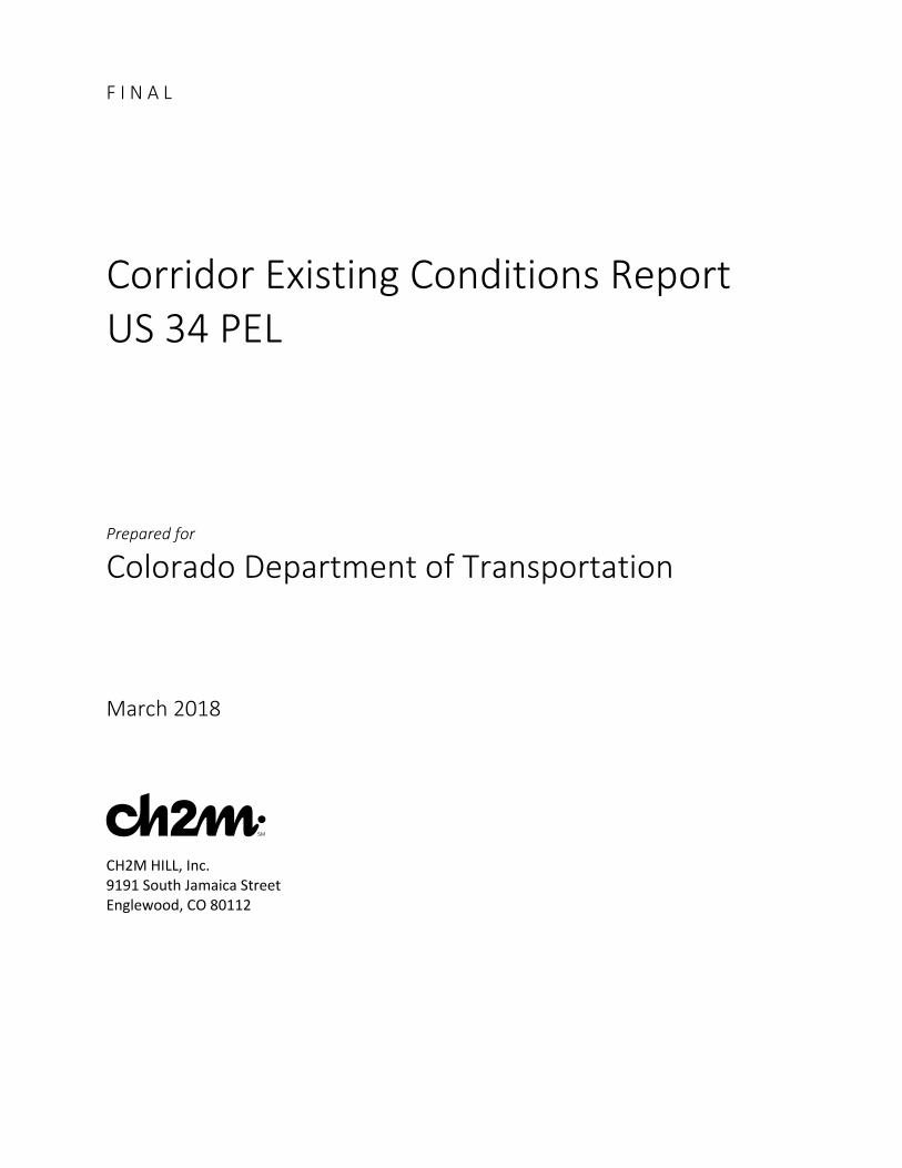
both sides. The roadway section is four lanes with a divided median and 4-foot inside shoulders and 10-foot outside shoulders. The posted speed in this portion of Typical Section 6 is 65 mph in both directions.
The portion of the Typical Section 6 roadway section from the US 34 Business Route interchange through Greeley is generally four lanes with a divided median of varying widths, as shown on Figure 3-2. The posted speeds vary between 45 to 65 mph. The interchange of US 34 and US 85 area has a 45-mph posted speed.
3.1.1.7 Typical Section 7 – US 34 Business Route (18th Street) to WCR 49 The easternmost 1.75 miles of the Study Area have four lanes, an undivided median, and 10-foot shoulders, as shown on Figure 3-2. The posted speed in both directions is 65 mph.

SECTION 3 – GEOMETRIC EXISTING CONDITIONS
SL0323171132DEN 3-3
Figure 3-1. Typical Sections and Speeds (West end of Project Area) Corridor Existing Conditions Report US 34 PEL
SECTION 3 – GEOMETRIC EXISTING CONDITIONS
3-4 SL0323171132DEN
Figure 3-2. Typical Sections and Speeds (East end of Project Area) Corridor Existing Conditions Report US 34 PEL

SECTION 3 – GEOMETRIC EXISTING CONDITIONS
SL0323171132DEN 3-5
3.1.2 Designations FHWA, CDOT, and local agencies maintain specific designations to describe the physical, mobility, and access characteristics of transportation corridors. FHWA designates the roadway as US 34, and it is part of the National Highway System. The following project-specific information was obtained from CDOT’s Online Transportation Information System (OTIS).
The western 0.75 mile of the Study Area is designated as rural. The remaining 29 miles have an urban designation. From the west project limits to west of Cascade Avenue is considered mountainous terrain. The terrain for the remainder of the Study Area is rolling.
US 34’s functional classification is Principal Arterial – Other from the west study limit to west of WCR 17. A Principal Arterial’s primary function is to carry through-traffic with medium to high speeds over medium to long distances in a safe and efficient manner. Direct access to the roadway is secondary to providing service to the through traffic, therefore the number of access points (signalized or other) should be limited. The classification changes to Principal Arterial – Freeway and Expressway through Greeley to east of the South Platte River crossing. Freeway and expressway roadways are intended to provide an even higher level of mobility than the Principal Arterial, so accesses are even more limited, with spacings of 1 mile being desirable. Near Kersey, the easternmost 0.8-mile designation changes back to Principal Arterial – Other.
The entire corridor is designated as a truck route.
3.1.3 Design Speed and Speed Limits Most of the highway was designed as a rural arterial, so the horizontal and vertical alignments were designed for high speeds. The available as-built and ROW plans were reviewed for the project and are summarized in the following paragraphs. The existing horizontal alignments can be determined except east of 23rd Avenue in Greeley to the US 34 Business Route interchange. The available vertical alignment information is less consistent.
The horizontal alignment is primarily on tangents with small points of intersection at section lines. These points of intersection do not have horizontal curves. The as-built plans do not typically specify any superelevation. Unless otherwise mentioned, 8 percent maximum superelevation tables are used.
There is a series of three curves between Glade Road and Morning Drive that are posted at 45 mph. These curves have adequate radiuses to meet a 55-mph design speed but do not have the spiral curves and have an unknown superelevation. At 45 mph, the spirals are not required.
From Morning Drive to Wilson Avenue, there are five curves with adequate radiuses to meet a 60-mph design. This area has a posted speed of 45 mph.
From Wilson Avenue to Grant Avenue, the highway characteristics are urban and the curves do not meet the 8-percent superelevation standards for highways without significant increase in the superelevation. The 4-percent maximum street standards are used to evaluate the alignment. The posted speed is 35 mph. The curve at Prospect Avenue meets a 35-mph design speed with normal crown and a 40-mph design speed with 2.2 percent superelevation. The series of curves around Lake Loveland require a 3.4-percent superelevation to meet a 40-mph design speed.
The remaining curves in Loveland to 23rd Avenue in Greeley and east of Greeley to WCR 49 have design speeds equal to or in excess of the posted speed using the 8-percent superelevation table.
For the corridor as a whole, there are no vertical design issues of concern that need to be corrected by the US 34 PEL project in order to meet modern standards. As alternatives and design revisions are considered at specific locations, more vertical design information will be collected and considered, especially if grade separations with railroads or crossroads are considered for alternatives.

SECTION 3 – GEOMETRIC EXISTING CONDITIONS
3-6 SL0323171132DEN
3.1.4 Areas Where Corridor Does Not Meet Standards Within Loveland, especially between Wilson Avenue and Monroe Avenue, US 34 has design characteristics that are more in line with an urban arterial context including narrow or no shoulders, narrow sidewalks, numerous private access driveways, and curves that require lower speed limits. No large-scale changes to US 34 are expected to occur in this area from ROW impacts or topographic restrictions such as Lake Loveland.
As the remainder of the corridor has evolved from its original rural context to the more urban context, necessary items such as traffic signals, multiple turn lanes defined by raised curbed medians, and other items have been introduced that conflict with the original design criteria.
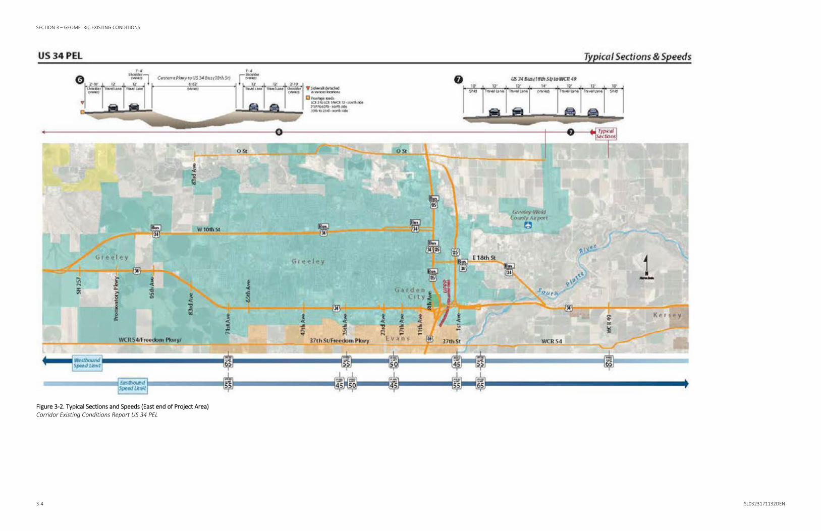
3.1.5 Railroad Crossings There are four railroad crossings in the corridor, two grade-separated and two at-grade.
BNSF Railway Company has a grade-separated railroad crossing west of North Cleveland Avenue (US 287 southbound) at MP 91.9. At this location, US 34 is a 4-lane divided highway with a raised median, 4- to 8-foot outside shoulders, and 4- to 8-foot sidewalks.
UPRR and GWRR at-grade crossings located east of I-25, illustrated on Figure 3-3, are 1.3 miles apart. UPRR crosses west of LCR 3 at MP 97.7. The GWRR crosses east of LCR 1/WCR 13, MP 99.0. In this location, US 34 is a 4-lane divided highway with a depressed median and a 65-mph speed limit. There are 4-foot inside shoulders and 10-foot outside shoulders through each crossing. UPRR has crossing arms. As of April 2017, there is a traffic signal at the WCR 13 intersection and an upgrade of the signal and installation of crossing arms at the GWRR crossing under construction. Upon completion, the traffic and railroad signals will be interconnected at this location.
At MP 113.0, there are two structures over the UPRR crossing in the US 85/US 34 interchange. Both structures carry two through lanes and a right auxiliary lane. There are 2-foot inside and outside shoulders and curbs.
SECTION 3 – GEOMETRIC EXISTING CONDITIONS
SL0323171132DEN 3-7
Figure 3-3. At-Grade Railroad Crossings Corridor Existing Conditions Report US 34 PEL
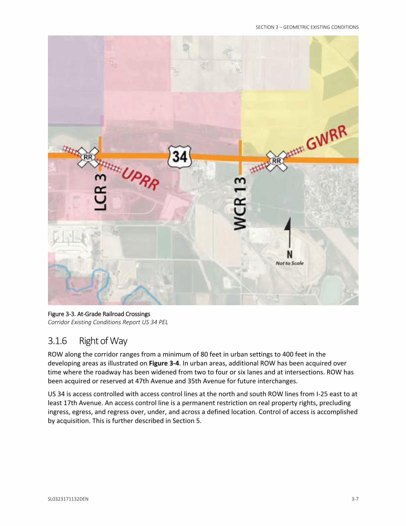
3.1.6 Right of Way ROW along the corridor ranges from a minimum of 80 feet in urban settings to 400 feet in the developing areas as illustrated on Figure 3-4. In urban areas, additional ROW has been acquired over time where the roadway has been widened from two to four or six lanes and at intersections. ROW has been acquired or reserved at 47th Avenue and 35th Avenue for future interchanges.
US 34 is access controlled with access control lines at the north and south ROW lines from I-25 east to at least 17th Avenue. An access control line is a permanent restriction on real property rights, precluding ingress, egress, and regress over, under, and across a defined location. Control of access is accomplished by acquisition. This is further described in Section 5.


SECTION 3 – GEOMETRIC EXISTING CONDITIONS
SL0323171132DEN 3-9
Figure 3-4. ROW Widths Corridor Existing Conditions Report US 34 PEL


SECTION 3 – GEOMETRIC EXISTING CONDITIONS
SL0323171132DEN 3-11
3.2 Major Structures 3.2.1 Bridges 3.2.1.1 Conditions, Rating, Lanes, Clearance Table Table 3-1 provides a summary of the structures throughout the corridor with information from CDOT’s as-built and inspection reports. The major structures on the US 34 corridor are illustrated on Figure 3-5.
Table 3-1. Structures on the US 34 Corridor Structure Number
Feature Intersected MP
Sufficiency Rating
Functional Status Clearance Roadway Section
C-16-AE Big Thompson River
86.931 98.6 --- -- 2-lane, variable shoulders
C-16-AR Draw 87.651 99.6 -- -- 2-lane, variable shoulders
C-16-DH Barnes Inlet Canal
90.976 99.3 -- -- 4-lane raised median, curb and gutter
C-16-W Barnes Inlet Canal
90.977 61.6 SD -- 4-lane raised median, curb and gutter
C-16-AQ BNSF Railway Company
91.839 98.8 -- -- 4-lane raised median, curb and gutter
C-16-T Loveland – Greeley Canal
93.245 78.5 FO -- 4-lane divided median, 10-foot outside and 4-foot inside shoulders
C-16-AX Loveland – Greeley Canal
93.246 78.5 FO -- 4-lane divided median, 10-foot outside and 4-foot inside shoulders
*C-17-EH I-25 Mainline 96.229 -- -- -- --
*C-17-EG I-25 Mainline 96.230 -- -- -- --
C-17-D Loveland – Greeley Canal
99.208 78.3 -- -- 4-lane divided median, 10-foot outside and 4-foot inside shoulders
C-17-FA US 34 Bus Loop
102.476 95.6 -- 17 feet, 6 inches
4-lane divided median, 10-foot outside and 4-foot inside shoulders
C-17-FO SH 257 102.804 99.8 -- 16 feet, 11 inches
4-lane divided median, 10-foot outside and 4-foot inside shoulders
C-17-FQ Sheep Draw 104.654 83.5 -- -- 4-lane divided median, 10-foot outside and 4-foot inside shoulders
+C-17-FR Sheep Draw 104.761 80.5 -- -- 2-lane, curb and gutter
C17-EY Loveland – Greeley Canal
107.923 95.5 -- -- 4-lane divided median, 10-foot outside and 4-foot inside shoulders
C-17-EX Loveland – Greeley Canal
108.803 98.5 -- -- 4-lane divided median, 10-foot outside and 4-foot inside shoulders
C-18-ER 23rd Avenue 111.209 90.1 -- -- 4-lane divided median, 10-foot outside and 4-foot inside shoulders
^C-18-AV Ramp to US 85 Southbound
112.570 -- -- -- --
^C-18-BB US 85 Bus 112.726 -- -- -- --
^C-18-AP US 85 Bus 112.727 -- -- -- --
^C-18-BH UPRR 112.926 -- -- -- --
^C-18-AO UPRR 112.927 -- -- -- --

SECTION 3 – GEOMETRIC EXISTING CONDITIONS
3-12 SL0323171132DEN
Table 3-1. Structures on the US 34 Corridor Structure Number
Feature Intersected MP
Sufficiency Rating
Functional Status Clearance Roadway Section
^C-18-EM US 85 Mainline Northbound
113.112 -- -- -- --
^C-18-EL US 85 Mainline Northbound
113.113 -- -- -- --
^C-18-EP 1st Avenue 113.238 -- -- -- --
^C-18-EO 1st Avenue -- -- -- -- --
C-18-EQ South Platte River
114.553 99.7 -- -- 4-lane divided median, 10-foot outside and 4-foot inside shoulders
C-18-ED South Platte River
114.554 99.7 -- -- 4-lane divided median, 10-foot outside and 4-foot inside shoulders
C-18-FE South Platte River
115.2 Will be inspected
in late 2017
-- -- 4-lane painted median, 10-foot outside shoulders, 2 auxiliary lanes
Notes:
*Structures to be replaced under the I-25 North Design Build project
+Structure on 95th Avenue
^Structures to be evaluated and likely replaced under the US 34/US 85 Interchange Reconstruction project
Sufficiency rating is a formula to evaluate a bridge’s sufficiency to remain in service on a scale of 0 to 100.
SD – Structurally deficient, which means there are elements of the bridge that need to be monitored and/or repaired. The fact that a bridge is structurally deficient does not imply that it is likely to collapse or that it is unsafe. It means the bridge must be monitored, inspected, and repaired/replaced at an appropriate time to maintain its structural integrity.
FO – Functionally obsolete, which is a bridge with a structure that was built to standards that are not used today. These bridges are not automatically rated as structurally deficient, nor are they inherently unsafe. Functionally obsolete bridges are those that do not have adequate lane widths, shoulder widths, or vertical clearances to serve current traffic demand or to meet the current geometric standards, or those that may be occasionally overtopped by flood waters.
3.2.2 Frontage Roads East of I-25, there are several short frontage roads that could affect future projects. Frontage roads improve traffic flow by maintaining corridor access control. The frontage roads are described below and mapped on Figure 3-6.
Near Kelim, between MP 97.8 to MP 98.8, there is a frontage road from LCR 3 to WCR 1 on the south side of US 34. The length is approximately 1 mile. There are several driveways and one public roadway access off the frontage road.
28th Street through Greeley is a frontage road. It is not continuous and is broken into the following segments:
• On the north side of US 34 from 71st Avenue to 58th Avenue • On the north side of US 34 from 35th Avenue to the 23rd Avenue Interchange ramps • On the north side of US 34 from 23rd Avenue to 17th Avenue • On the south side of US 34 at 1st Avenue, extending approximately 3,300 feet eastward
Additionally, 27th Street at 1st Avenue is a frontage road. It is approximately 3,200 feet long and extends eastward.

SECTION 3 – GEOMETRIC EXISTING CONDITIONS
SL0323171132DEN 3-13
Figure 3-5. Major Structures Corridor Existing Conditions Report US 34 PEL

SECTION 3 – GEOMETRIC EXISTING CONDITIONS
3-14 SL0323171132DEN
Figure 3-6. Frontage Roads Corridor Existing Conditions Report US 34 PEL

SECTION 3 – GEOMETRIC EXISTING CONDITIONS
SL0323171132DEN 3-15
3.3 Drainage 3.3.1 Floodplain Crossings Floodplains within the Project Limits are described in Section 6.4. Specific corridor locations where improvements may be impacted by the floodplain are described below.
The Big Thompson River intersects US 34 west of the Glade Road intersection. The river flows in a southeasterly direction through this section of the Study Area. The river is adjacent to the highway to the north for approximately 0.5 mile before the bridge, with the floodplain primarily north of the roadway. After the crossing, US 34 is within the floodplain for approximately 0.75 mile. The Flood Insurance Rate Map (FIRM) effective date for this floodplain is December 19, 2006.
The Lake Loveland regulated floodplain is limited to the banks of the lake and parallel to US 34 to the north. The FIRM map effective date for this floodplain is December 19, 2006.
In Weld County, Sheep Draw is regulated at the crossing with US 34 Business Route immediately west of the intersection with 95th Avenue/20th Street. The floodplain overtops the highway at this location. The FIRM for this floodplain is dated January 20, 2016.
Finally, US 34 crosses the South Platte River floodplain east of Greeley. The floodplain extends approximately 1.5 miles to the east and ends near the intersection of US 34 and the US 34 Business Route. There are two bridge crossing locations in the floodplain, two parallel structures on the west side of the floodplain, and a new structure constructed to address the new side channel created in the 2013 flood. The floodplain appears to overtop the roadway in two locations. The FIRM for this floodplain is dated January 20, 2016.
3.3.2 Drainage Systems in Place There are multiple irrigation facilities throughout the length of the corridor. These facilities are described in detail in Section 6.1.
3.3.3 Existing Water Quality Facilities A site visit was conducted to identify existing water quality facilities. No existing public water quality facilities along the US 34 corridor were identified during the site visit. There are several retention ponds created by developers in Greeley and Loveland that are adjacent to the ROW.
3.4 Utilities Full mapping of all the utilities in the corridor was not collected at this early stage of the project. As more specific alternatives are developed at specific locations, more detailed utility information will be collected to help determine if utility issues will drive alternative layouts, screening choices, or cost estimates.
Table 3-2 presents a listing ownership for utilities in the corridor based on available information from CDOT.

SECTION 3 – GEOMETRIC EXISTING CONDITIONS
3-16 SL0323171132DEN
Table 3-2. Utilities Ownership Owner Contact Name Email Phone Relocation Cost
Atmos Energy Jerry Adams [email protected] 970-304-2075 Atmos
CDOT Region 4 Lights and Signals
Rod Dudley (interim)
-- 970-381-4105 Include in Construction documents
CDOT Fiber Optic Backbone
Jill Scott [email protected] 303-512-5805 CDOT via Standard Utility Agreement
Comcast Fiber and Cable
Joe Lowe [email protected] 720-413-0072 Comcast
City of Evans Dawn Anderson [email protected] 970-475-1160 CDOT
City of Greeley Dan Moore [email protected] 970-350-9814 CDOT
DCP Midstream Lou Hagenlock [email protected] 970-378-6351 # CDOT
Level 3 Communications
Lance Larson [email protected] 303-556-5833 Level 3
Little Thompson Water District
Amber Kauffman [email protected] 970-532-2096 CDOT
Noble Energy (Anadarko)
Trevor Payne [email protected] 720-929-6448 # CDOT
Platte River Power Authority
Mark Curtis [email protected] 970-420-2999 CDOT
Poudre Valley Rural Electric Association
Matt Organ -- 970-282-6436 PVREA
Xcel Energy Gas/Electric Distribution
Pat Kreager [email protected] 970-225-7840 ^ Xcel
Xcel Energy HP Gas Sarah Robinson [email protected] 303-571-3926 Xcel
PDC Energy Barney Hammond
[email protected] 970-371-4190 PDC
CenturyLink Fiber and Telephone
Terry Speer [email protected] 970-490-7500 *Unknown
US Sprint Unavailable -- -- Sprint
Zayo Inc. Eric Boe [email protected] 303-481-6121 CDOT via Standard Utility Agreement
Greeley Ditch Number 3
-- -- 970-301-1448 Include approved design in Construction documents
Greeley & Loveland Irrigation Company
-- -- 970-352-0495 Include approved design in Construction documents
Saddle Butte Rockies Midstream
-- -- 701-690-0236 Owner
Sinclair Pipeline Company
-- -- 307-324-2636 Owner
AT&T Transmission -- -- 800-252-1133 AT &T

SECTION 3 – GEOMETRIC EXISTING CONDITIONS
SL0323171132DEN 3-17
Table 3-2. Utilities Ownership Owner Contact Name Email Phone Relocation Cost
KP Kauffman Co. -- -- 303-833-3251 KP Kauffman
Front Range Internet
-- -- 866-374-4662 Front Range Internet
TDS Telecom Bill Trujillo [email protected] -- TDS
Thompson Crossing Metro District 2 – Irrigation
-- -- 970-669-1463 Include approved design in Construction documents
Poudre Valley Hospital District
-- -- 970-495-7000 PV Hospital District
Town of Johnstown – Water and Sewer
Tom Hellen [email protected] 970-587-4664 CDOT
City of Loveland – Water, Sewer and Electric
Leah Browder [email protected] 970-962-2520 CDOT
Suncore Energy Pipeline
-- -- 303-857-2648 Suncore
TallGrass Interstate Gas Transmission
-- -- 970-332-4188 TallGrass
Synergy Resources Corporation
-- -- 970-978-6969 Synergy
West Ridge Irrigation Association
-- -- 970-330-5458 Include approved design in Construction documents
Notes: # = In Easement ^ = If in railroad ROW or in easements cost borne by CDOT * = Older installations are in easements, CDOT bears cost
3.5 Pedestrian, Bicycle, and Transit Facilities This section summarizes the existing and proposed pedestrian, bicycle, and transit facilities along US 34 within the Study Area. The analysis looked at regional and local geographic information system (GIS) data from NFRMPO and local municipalities, in addition to regional and local adopted plans and their proposed improvements to the pedestrian, bicycle, and transit networks along US 34 as summarized below.
• NFRMPO
− Regional Bicycle Plan (2013b) (adopted March 2013) − 2040 RTP (2015a) (adopted September 2015, amended February 2017) − 2040 Non-Motorized Plan (2017) (adopted February 2017) − Regional 2040 Transit Element (2015b) (adopted August 2015)
• City of Loveland
− Bicycle and Pedestrian Plan (2012a) (adopted May 2012) − 2035 Transportation Plan (2012b) (adopted December 2012)

SECTION 3 – GEOMETRIC EXISTING CONDITIONS
3-18 SL0323171132DEN
• City of Greeley
− Greeley 2035 Comprehensive Transportation Plan (2011) (adopted May 2011) − City of Greeley Bicycle Master Plan (2015) (adopted May 2015) − Greeley Parks, Trails and Open Lands Master Plan (2016a) (adopted May 2016) − 2016 GET 5- to 10-year Strategic Plan (GET, 2016) (adopted December 2016)
• Town of Windsor
− Comprehensive Plan (2016) (adopted March 2016)
• CDOT
− North I-25 EIS (2011a) (adopted August 2011)
The preferred alternative of the study highlights the intersection at I-25 and US 34 as an interchange reconstruction during the first phase. It also notes an express bus route that starts at the interchange of I-25 and US 34 and goes east along US 34 following US 34 Business Route. It also notes an express bus transit station and PNR at the intersection of US 34 and US 257.
− US 34 Business Route EA (2008):
FHWA, in conjunction with CDOT and local agencies, initiated an EA for improvements to US 34 between Garfield Avenue and just east of LCR 3. The EA addresses future mobility, safety, and access. The EA does not address interchange improvements at I-25 and US 34. Planned improvements include multi-modal transportation and widening the highway from four to six lanes. This EA and FONSI are complete.
3.5.1 Pedestrian Conditions Pedestrian infrastructure varies along the US 34 study corridor. The corridor pedestrian infrastructure contains examples of detached sidewalks, attached sidewalks, shared-use paths, and no sidewalks. The majority of the pedestrian infrastructure along the corridor is located within the Cities of Loveland and Greeley.
Pedestrian infrastructure at the regional level was evaluated by reviewing the NFRMPO Regional Bicycle Plan (2013b), the 2040 RTP (2015a), and the 2016 Non-Motorized Plan (2017). Pedestrian infrastructure at the local level was evaluated by reviewing the City of Loveland 2035 Transportation Plan (2012b) and the City of Loveland Bicycle and Pedestrian Plan (2012a). Figure 3-7 shows the locations of existing sidewalks based on GIS data from NFRMPO and proposed (planned, conceptual, and suggested) pedestrian improvements from adopted plans and their relationship to the existing and proposed regional non-motorized corridors (RNMC). Figure 3-7 shows the existing and proposed sidewalk, existing and proposed share use paths, and the proposed intersection, and trail intersection improvements from local municipalities. In addition, Figure 3-7 also shows the RNMC that will serve as regional pedestrian and bicycle facilities in the region.

SECTION 3 – GEOMETRIC EXISTING CONDITIONS
SL0323171132DEN 3-19
Figure 3-7. Existing and Proposed Local Pedestrian Facilities and RNMCs Corridor Existing Conditions Report US 34 PEL


SECTION 3 – GEOMETRIC EXISTING CONDITIONS
SL0323171132DEN 3-21
3.5.2 Bicycle Conditions The bicycle infrastructure along the corridor is mostly regional and local routes that intersect US 34 rather than facilities along the US 34 corridor. Existing and proposed local bicycle facilities are shown on Figure 3-8 and categorized as existing and proposed bike lanes, bike routes, and shared-use paths. The existing and proposed facilities shown are based on existing GIS data from local municipalities and NFRMPO and from the following local adopted plans: City of Loveland 2035 Transportation Plan (2012b), the City of Loveland Bicycle and Pedestrian Plan (2012a), The Greeley 2035 Comprehensive Transportation Plan (2011), the City of Greeley Bicycle Master Plan (2015), the Greeley Parks, Trails and Open Lands Master Plan (2016a), the City of Evans Open Space and Trails Master Plan (2004a) and the City of Evans Transportation Plan (2004b). Figure 3-8 also shows how the local facilities relate to the RNMC from the NFRMPO 2016 Non-Motorized Plan (2017) in which US 34 itself is proposed to be a RNMC.
Most of the existing facilities are concentrated within the city limits of Loveland and Greeley. There are few facilities in between the limits of the two municipalities or that cross I-25. The closest parallel facility that intersects I-25 runs north of US 34 crossing I-25 along Crossroads B
oulevard as a bike lane. It then continues along Crossroads Boulevard as a bike route crossing County Line Road all the way to Highway 257, ending close to the Poudre River Trail. To the south, LCR 20E is also highlighted by the Loveland Bicycle and Pedestrian Plan (2012a) as a proposed new shared-use path improvement that will cross I-25 as part of the Great Western/Johnstown/Loveland Non-Motorized Corridor.


SECTION 3 – GEOMETRIC EXISTING CONDITIONS
SL0323171132DEN 3-23
Figure 3-8. Existing and Proposed Bicycle Facilities and RNMCs Corridor Existing Conditions Report US 34 PEL


SECTION 3 – GEOMETRIC EXISTING CONDITIONS
SL0323171132DEN 3-25
In addition to US 34 itself being proposed as an RNMC, there are seven intersections along the US 34 corridor with RNMCs and another just south of US 34. Two of the intersections of US 34 with a RNMC have an existing underpass providing a north-south connection under US 34: the RNMC 5 and RNMC 7, both within Loveland. Additionally, another local underpass that provides a north-south connection under US 34 exists within Greeley at 15th Avenue Court and US 34. The intersections of US 34 with RNMC (two of them which include an underpass within Loveland) and an additional local underpass within Greeley are described as follows (from west to east):
• RNMC 11 – US 34 Non-Motorized: connects RNMC 7 – Front Range Trail (West) on the west to RNMC 1 – South Platte/American Discovery Trail on the east following US 34. This corridor is the only regional corridor running parallel to a state highway. The vision for this corridor is a shared-use trail, safely separated from the highway connecting Greeley and Promontory to Centerra, Johnstown, and Loveland. The only existing section of this corridor between 65th Avenue to 35th Avenue.
• Intersection US 34 with RNMC 5 - North Loveland/Windsor: An existing path intersects US 34 with an underpass east of Cascade Avenue.
• Intersection US 34 with RNMC 8 – BNSF Fort Collins/Berthoud: An existing section is located north within Fort Collins. Proposed path intersects US 34 east of North Garfield Avenue and runs parallel to the BNSF Railway Company lines (Rails-with-Trails). The corridor connects the downtowns of Fort Collins, Berthoud, and Loveland.

SECTION 3 – GEOMETRIC EXISTING CONDITIONS
3-26 SL0323171132DEN
• Intersection US 34 with RNMC 7 – Front Range Trail (West): An existing path intersects US 34 with an underpass east of North Boise Avenue. This RNMC is a 35-mile corridor that connects to RNMC 6 – Poudre River Trail and RNMC 3 – Big Thompson River.
• Intersection US 34 with RNMC 9 – Johnstown/Timnath: The proposed path will intersect US 34 close to County Line 13, which is the end of Larimer County and the start of Weld County. RNMC 9 is a 13-mile corridor in which the primary investment need recognized is increased mobility.
• Intersection US 34 with RNMC 4 – Great Western/Johnstown/Loveland: The proposed path will intersect US 34 east of County Road 13. RNMC 4 is a 25-mile corridor that follows the alignment of the Great Western Railroad.

SECTION 3 – GEOMETRIC EXISTING CONDITIONS
SL0323171132DEN 3-27
• Intersection US 34 with RNMC 10 – Greeley/LaSalle: An existing 8.5-mile shared-use path intersects US 34 at 35th Avenue. RNMC 10 is proposed to connect to RNMC 6 – Poudre River Trail on the north and US 85 on the south.
• Intersection US 34 with 15th Avenue Court underpass: The existing underpass provides a north-south connection under US 34. It connects residential neighborhoods on both sides of US 34. In addition, it helps connect a proposed bike route on the south of US 34 with existing bike lanes on 27th Street and 17th Avenue.
• Intersection US 34 with RNMC 1 – South Platte/American Discovery Trail: The proposed path is a
22-mile corridor that will connect Milliken, Weld County, Evans, LaSalle and Greeley. Currently, one segment exists in Evans. The corridor is proposed as a shared-use trail along the river corridor connecting to RNMC 6 – Poudre River Trail.
3.5.3 Transit Conditions 3.5.3.1 Existing Transit Services The Study Area contains three separate fixed-route transit agencies, operated by the region’s three large communities, and one demand-response service. CDOT currently operates the Bustang service, connecting Fort Collins and Loveland to Denver.
Transit is an important part of the growth anticipated to occur in Northern Colorado over the next 25 years. As a result, all transit agencies in the region are part of either the LCMC or the WCMC. Representatives from COLT (City of Loveland), GET (GET Transit Manager), and Transfort, the three largest transit agencies, are also active members of the NFRMPO Technical Advisory Committee as alternates for Loveland, Greeley, and Fort Collins.

SECTION 3 – GEOMETRIC EXISTING CONDITIONS
3-28 SL0323171132DEN
City of Loveland Transit
The COLT system is operated by the City of Loveland’s Public Works Department. COLT’s fixed-route service runs from 6:48 a.m. to 6:40 p.m., Monday through Friday and from 8:48 a.m. to 5:40 p.m. on Saturday, with 1-hour headways. Paratransit and senior door-to-door service is available during the same hours for eligible passengers. Three routes provide service from two main transfer centers: Loveland Food Bank and the South Transfer Center on 8th Street. The Loveland also provides funding for the FLEX service between Fort Collins, Longmont, and Boulder. Figure 3-9 shows the current COLT service map.
Figure 3-9. Current COLT Service Map Corridor Existing Conditions Report US 34 PEL
Greeley-Evans Transit
GET is operated by the City of Greeley and provides fixed-route, paratransit, and Call-N-Ride services to the public within Greeley, Garden City, and Evans. Service to Evans and Garden City is provided through an IGA. All University of Northern Colorado students can ride free with their student identification (ID).
The Ride Free with ID program was extended to any elementary, middle, or high school student in Greeley and Evans. Students can show their student IDs to bus drivers, obtain a free school year pass, or show their state-issued ID to the drivers. The service has allowed students to participate in a variety of after school activities they were not able to previously.
In 2016, GET updated its route system, which shifted the previous one-way loops with bi-directional linear routes shown on Figure 3-10.

SECTION 3 – GEOMETRIC EXISTING CONDITIONS
SL0323171132DEN 3-29
Figure 3-10. GET routes, updated 2016 Corridor Existing Conditions Report US 34 PEL

SECTION 3 – GEOMETRIC EXISTING CONDITIONS
3-30 SL0323171132DEN
Transfort
Transfort is the largest transit agency in the region, serving the City of Fort Collins. The service has seen record growth in the past 5 years, specifically after the opening of the MAX bus rapid transit line and partnering with Colorado State University to provide students with free service. In the Study Area, Transfort operates the FLEX services in partnership with Loveland, Berthoud, Longmont, and Boulder County. The local service provides service along US 287 between the South Transit Center in Fort Collins to the Longmont terminus at 8th and Coffman PNR, with stops in Fort Collins, Loveland, Berthoud, and Longmont. The express service stops at all MAX stations in Fort Collins, stops in Loveland, then runs express to Longmont and the City of Boulder. The express service is possible because of additional partnerships with the University of Colorado-Boulder and Colorado State University.
CDOT/Bustang
The Bustang service operates between the Downtown Transit Center and Harmony Road PNR in Fort Collins to US 34 PNR and Denver Union Station in Denver. Operating seven roundtrips per weekday, Bustang provides interregional service between Northern Colorado and the Denver Metro. At Denver Union Station, riders can connect to the RTD bus, light rail, and commuter rail system. At both stops in Fort Collins, riders can connect to the Transfort system, and in Loveland (Loveland-Greeley PNR stop), they can connect to the COLT system, which require the use of informal paths between stops. In the Study Area, Bustang operates along the I-25 Corridor.
3.5.3.2 Other Transportation Services Berthoud Area Transportation Services (BATS): BATS is operated by the Town of Berthoud. BATS provides shared-ride demand-response service for residents in an approximately 8-square-mile service area. The service area includes the developed portion of Berthoud and the immediate area surrounding the town. BATS transports riders to Longmont on Monday, with trips to Loveland provided Tuesday through Friday. Out-of-town (trips with destinations outside of Berthoud) rider pickups begin at 8:00 a.m. with a return trip to Berthoud at 11:30 a.m. In-town trips are provided from 8:00 a.m. to 4:00 p.m., Monday through Friday. There is no service on holidays, and all rides must be scheduled at least 24 hours in advance. BATS fares are $1.00 for in-town trips and $4.00 for out-of-town trips, each way. The system has a small source of consistent revenue through a one-cent municipal sales tax.
Senior Alternatives in Transportation (SAINT): SAINT is a 501(c)(3) non-profit providing rides to seniors 60 and older, and adults with disabilities in Fort Collins or Loveland. SAINT volunteers drive their own vehicles. SAINT staff recruits volunteers, schedules rides, and provides a mileage allowance and extra insurance to the volunteers. SAINT’s 500 clients are served by 160 volunteers and 4 staff members (1 full-time and 3 part-time). In 2016, volunteer drivers in Fort Collins and Loveland provided over 28,000 rides to seniors in need. SAINT operates from 8:15 a.m. to 4:00 p.m., Monday through Friday. Weekend and evening rides are available in Fort Collins by special request. Riders must call to make reservations at least three business days in advance, with reservations taken Monday through Friday from 8:00 a.m. to 12:00 p.m. No fare is required. However, donations of $1.00 are suggested, with the average donation being $1.15.
Berthoud Rural Alternative for Transportation (RAFT): RAFT began in January 2014 because of the reduction in the service area of BATS. RAFT is a non-profit volunteer transportation service that offers door-to-door, on-demand services to eligible seniors (65+) and adults (18+) with disabilities. RAFT operates under the Berthoud Area Community Center/Golden Links, Inc. The service relies on volunteer drivers. However, the service acquired an ADA van with funds from a NFRMPO New Freedom sub-grant. During its first year of service, volunteers drove approximately 22,000 miles, providing 960 trips for eligible individuals.
Windsor Senior Ride Program: Senior Ride provides transportation assistance to Windsor residents aged 55 and older who are unable to drive themselves. The service maintains one wheelchair-accessible,
SECTION 3 – GEOMETRIC EXISTING CONDITIONS
SL0323171132DEN 3-31
13-passenger Starcraft van. The van can hold up to two wheelchairs and 11 passengers. The service employs two drivers who split the driving duties. Rides are provided to and from medical appointments, as well as to and from Senior Nutrition Lunches at the Windsor Community Recreation Center on Wednesdays and Fridays.
VanGOTM – Vanpool Program: VanGOTM Vanpool Services is a provider that links an average of six people with similar daily commutes together to share a van. Vanpool members pay a monthly fee to cover the costs of the administration of the program, fuel, maintenance, and insurance. Driving responsibility is shared among the vanpool members. VanGoTM reports the vehicle and passenger miles traveled to Federal Transit Administration to fund the vehicles.
The VanGOTM fares are calculated using a zone system. There are a total of 13 20-square-mile service areas, with VanGOTM currently serving 10 of the areas. Fares are computed according to the number of zones in the vanpool’s route. For example, in 2012 a trip from Fort Collins to downtown Denver cost $227 per person, per month. The average price for a gallon of gasoline in 2012 was $3.60, making the VanGOTM vanpool option a cheaper alternative to driving to Denver alone on a daily basis.
3.5.3.3 Proposed Transit Services The NFRMPO 2040 RTE (2015) recommends nine regional transit corridors (RTCs) as priorities for transit investment over the next 25 years. These corridors enhance intra- and interregional connections, creating a network of east-west and north-south routes. Many of the routes would complement existing infrastructure, such as connecting cities to the Bustang service, while others would enhance the mobility of residents by connecting them to education, employment, medical, and social facilities. The RTCs discussed in this section are suggested corridors and not specific routes.
The RTC 5 runs along US 34 connecting Loveland with Greeley. RTCs 7 and 8 also run along US 34, but they provide a connection between Greeley and Loveland to the Bustang service. RTCs 2, 3, 4, and 9 do not run along US 34, but they intersect with it.
Figure 3-11 shows the existing local and regional transit services and the proposed local transit routes from the GET and the proposed RTCs.


SECTION 3 – GEOMETRIC EXISTING CONDITIONS
SL0323171132DEN 3-33
Figure 3-11. Local and Regional Existing and Proposed Transit Routes Corridor Existing Conditions Report US 34 PEL


SECTION 3 – GEOMETRIC EXISTING CONDITIONS
SL0323171132DEN 3-35
Regional Transit Corridor Descriptions
RTC 5: Greeley-to-Loveland: The vision for RTC 5 is to improve connectivity and mobility. Development has occurred along the US 34 corridor connecting Greeley and Loveland, providing new opportunities for shopping, medical facilities, and retail. A previous version of this route, the 34 Xpress, was canceled because of low ridership. Potential problems are discussed in the 2040 RTE (NFRMPO, 2015b). Additional development, connectivity to the Bustang service on I-25 at the US 34 PNR, and improved marketing and scheduling should improve the usage of this route. A demand exists for connecting communities west of I-25 with Greeley.
RTC 5 will provide a separate service from RTCs 7 and 8 by providing a complete, local route between Loveland and Greeley, in addition to connecting to the I-25 Bustang service. Whereas those two routes exist to provide links to the Bustang service, RTC 5 exists to provide connections within and between the two cities.
RTC 7: Greeley-to-Bustang (Express Route): The vision for RTC 7 is to provide express connections between downtown Greeley and the I-25 Bustang route (Centerra PNR). The corridor complements RTCs 5 and 8. The corridor intersects five additional corridors, creating a true regional connection. A regional demand exists to provide east-west connections, especially connecting Greeley to other transit corridors, I-25, and the development along the corridor.
RTC 8: Loveland-to-Bustang (Express Route): The vision for RTC 8 is to provide express connections between downtown Loveland and the I-25 Bustang route (Centerra PNR). The corridor complements RTCs 5 and 7. The corridor intersects five additional corridors, creating a true regional connection. A regional demand exists to provide east-west connections, especially connecting Loveland to other transit corridors, I-25, and the development along the corridor.

SECTION 3 – GEOMETRIC EXISTING CONDITIONS
3-36 SL0323171132DEN
City of Loveland Transit (COLT) Proposed Transit
The City of Loveland 2035 Transportation Plan (2012b) highlights the following proposed improvements illustrated on Figure 3-12.
• Proposed route 51 that travels along US 287 and intersects US 34 • Proposed route 56 that travels along US 34, starting at US 287 and going east • Proposed route 52 travels along I-25 • Proposed route 53 travels along I-25 • Proposed transit center along US 34 west of I-25
Figure 3-12. Loveland Proposed Transit Plan Corridor Existing Conditions Report US 34 PEL Source: City of Loveland, 2012b

SECTION 3 – GEOMETRIC EXISTING CONDITIONS
SL0323171132DEN 3-37
GET Transit Vision Plan
The map shown on Figure 3-13 is part of the Greeley 2035 Comprehensive Transportation Plan (City of Greeley, 2011). The plan mentions increased frequencies, moderate increases in the length of the service day, and increased coverage and regional service. The Transit Vision Plan Service Map on Figure 3-13 shows how the increase transit coverage could be extended to include the high-growth areas to the west, and some north and south coverage.
Figure 3-13. Greeley Transit Vision Plan Service Map Corridor Existing Conditions Report US 34 PEL Source: City of Greeley, 2011
3.5.3.4 Mobility Committees The Mobility Coordination Program reports to a mobility committee in each county (LCMC and WCMC). Each committee meets every other month, and all meetings are open to the public. The goal of the mobility committees is to provide a forum for transit providers, human service agencies, and members of the public to discuss needs, to network, and to find creative solutions to mobility issues.
Larimer County Mobility Committee: The LCMC meets the third Thursday every other month from 1:30 to 3:00 p.m. at the NFRMPO Offices, located at 419 Canyon Avenue, Suite 300, Fort Collins, Colorado 80521.
Weld County Mobility Committee: The WCMC meets the fourth Tuesday every other month from 1:30 to 3:00 p.m. at the Greeley Chamber of Commerce, 902 7th Avenue, Greeley, Colorado 80631.


SECTION 4
SL0323171132DEN 4-1
Traffic, Travel Forecasting, Safety, and ITS Existing Conditions 4.1 Traffic Operations 4.1.1 Safety Traffic crash data from 5 full years (2011 through 2015) was provided by CDOT for the Study Area. For the nearly 33-mile length of the Study Area, there were a total of 2,650 crashes over the 5-year period. For this report, the crash data is presented in a summary format, with additional breakout of crash types calculated at major intersections. Traffic data by intersection is not yet included, so crashes are presented as a total number and not as crash rates.
Severity of the 2,650 total crashes can be broken out by property damage only, crashes with injury, and crashes with fatalities.
• Property Damage Only = 1,777 • Crashes with Injury = 861; persons injured = 1,308 • Crashes with fatalities = 12; persons killed = 12
The number of vehicles involved in the 2,650 total crashes is broken out as follows:
• Single-vehicle crashes = 368 • Two-vehicle crashes = 1,898 • Three-vehicles or more = 384
The following observations were made from a review of CDOT’s summary of crash data provided by DiExSys (Appendix A):
• The most common times for crashes coincide with the peak a.m. and p.m. traffic times, especially the PM traffic hours from 4:00 p.m. to 6:00 p.m.
• 170 crashes, or over 6 percent, had a driver with some level of impairment (alcohol, drugs)
• Just over 12 percent of the crashes occurred during inclement weather
• About 60 percent of the total crashes occurred at intersections, driveways, or ramps
• Less than 8 percent of the total crashes involved drivers leaving the roadway
• About 70 percent of the crashes occurred in daylight, matching the percentage of traffic volume in daylight hours
Additional breakout data are shown in CDOT’s full DiExSys output in Appendix A.
The crash data were further evaluated by the project team to identify any substantial numbers or patterns that might guide the early stages of the PEL alternatives development process. The first breakout of data is shown on Figure 4-1, a summary graphic showing crashes broken out by the 0.1 mile along the whole corridor.
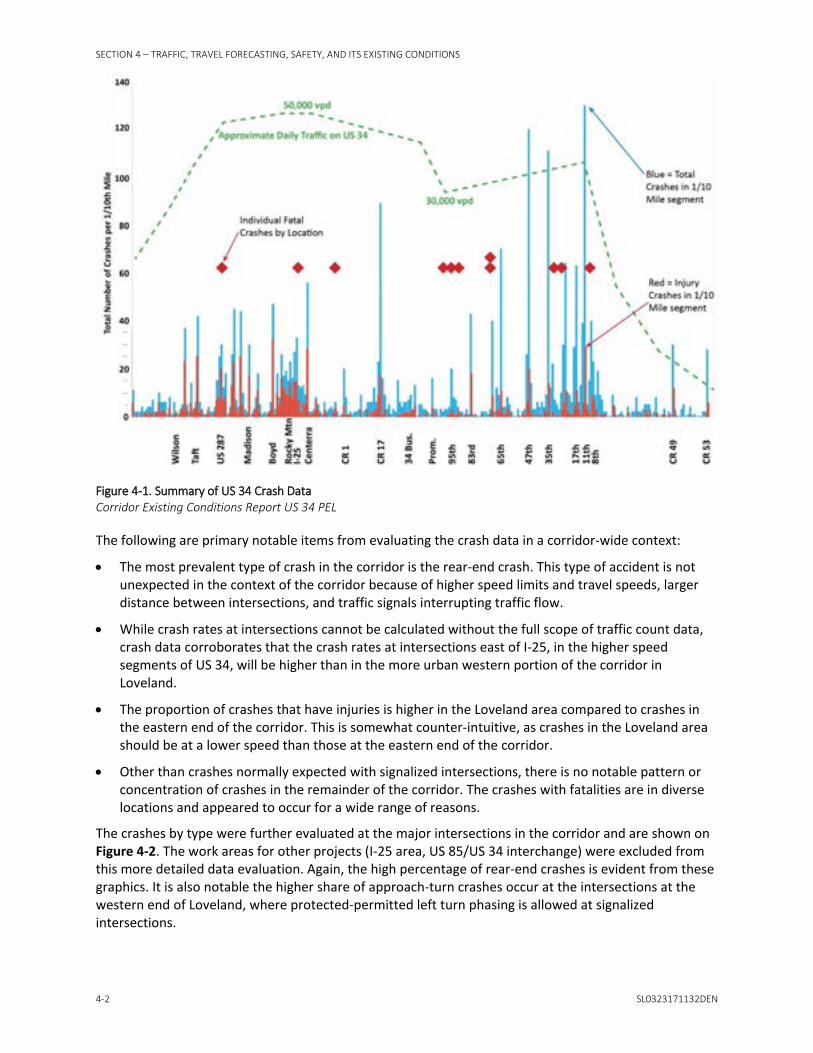
SECTION 4 – TRAFFIC, TRAVEL FORECASTING, SAFETY, AND ITS EXISTING CONDITIONS
4-2 SL0323171132DEN
Figure 4-1. Summary of US 34 Crash Data Corridor Existing Conditions Report US 34 PEL
The following are primary notable items from evaluating the crash data in a corridor-wide context:
• The most prevalent type of crash in the corridor is the rear-end crash. This type of accident is not unexpected in the context of the corridor because of higher speed limits and travel speeds, larger distance between intersections, and traffic signals interrupting traffic flow.
• While crash rates at intersections cannot be calculated without the full scope of traffic count data, crash data corroborates that the crash rates at intersections east of I-25, in the higher speed segments of US 34, will be higher than in the more urban western portion of the corridor in Loveland.
• The proportion of crashes that have injuries is higher in the Loveland area compared to crashes in the eastern end of the corridor. This is somewhat counter-intuitive, as crashes in the Loveland area should be at a lower speed than those at the eastern end of the corridor.
• Other than crashes normally expected with signalized intersections, there is no notable pattern or concentration of crashes in the remainder of the corridor. The crashes with fatalities are in diverse locations and appeared to occur for a wide range of reasons.
The crashes by type were further evaluated at the major intersections in the corridor and are shown on Figure 4-2. The work areas for other projects (I-25 area, US 85/US 34 interchange) were excluded from this more detailed data evaluation. Again, the high percentage of rear-end crashes is evident from these graphics. It is also notable the higher share of approach-turn crashes occur at the intersections at the western end of Loveland, where protected-permitted left turn phasing is allowed at signalized intersections.

SECTION 4 – TRAFFIC, TRAVEL FORECASTING, SAFETY, AND ITS EXISTING CONDITIONS
SL0323171132DEN 4-3
Figure 4-2. Crash Type at Major Intersections in the US 34 Corridor Corridor Existing Conditions Report US 34 PEL
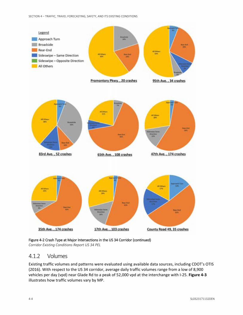
SECTION 4 – TRAFFIC, TRAVEL FORECASTING, SAFETY, AND ITS EXISTING CONDITIONS
4-4 SL0323171132DEN
Figure 4-2 Crash Type at Major Intersections in the US 34 Corridor (continued) Corridor Existing Conditions Report US 34 PEL
4.1.2 Volumes Existing traffic volumes and patterns were evaluated using available data sources, including CDOT’s OTIS (2016). With respect to the US 34 corridor, average daily traffic volumes range from a low of 8,900 vehicles per day (vpd) near Glade Rd to a peak of 52,000 vpd at the interchange with I-25. Figure 4-3 illustrates how traffic volumes vary by MP.

SECTION 4 – TRAFFIC, TRAVEL FORECASTING, SAFETY, AND ITS EXISTING CONDITIONS
SL0323171132DEN 4-5
Figure 4-3. Average Annual Daily Traffic Volume by MP (2016) Corridor Existing Conditions Report US 34 PEL
Typically, traffic volumes along US 34 during off-peak and weekends are less than during the typical weekday commuter periods. As shown on Figure 4-4, weekday traffic volumes along US 34 at the permanent count station located at the Larimer-Weld County Line (MP 98.94) experience a distinct morning and afternoon peak that coincides with commuter traffic. East of I-25, midday volumes during the week are comparable to the peak volumes experienced on a weekend.
Figure 4-4. Average Hourly Traffic Volume by Day of Week (2016) Corridor Existing Conditions Report US 34 PEL

SECTION 4 – TRAFFIC, TRAVEL FORECASTING, SAFETY, AND ITS EXISTING CONDITIONS
4-6 SL0323171132DEN
According to the NFRMPO travel demand model, the a.m. peak hour is from 7 to 8 a.m. while the p.m. peak hour is 4:30 to 5:30 p.m. Annual data from the permanent count station is provided in Table 4-1 and indicates that volumes have steadily increased over the past 15 years of record.
Table 4-1. Historical Average Annual Daily Traffic Volumes (vpd) by Month and Yeara Year Jan Feb Mar Apr May Jun Jul Aug Sep Oct Nov Dec
2017 43,285 46,464 N/A N/A N/A N/A N/A N/A N/A N/A N/A N/A
2016 41,425 43,841 44,715 45,735 46,782 48,405 47,164 48,117 46,670 47,377 44,448 44,327
2015 39,309 40,598 43,446 43,910 42,918 45,621 47,086 46,332 46,676 45,761 42,237 42,499
2014 35,950 37,857 41,214 42,264 42,228 43,411 43,125 43,982 43,537 43,628 39,668 40,897
2013 36,704 37,687 38,398 38,517 40,857 40,998 41,821 42,963 41,083 41,798 37,861 37,603
2012 35,201 36,581 38,570 37,521 38,685 40,102 38,711 39,795 38,582 38,990 37,924 36,867
2011 33,709 35,606 36,884 36,880 36,297 38,369 37,498 38,226 37,805 36,899 36,131 35,350
2010 33,019 34,679 35,322 36,921 36,757 38,427 37,244 37,162 36,877 36,833 35,540 35,100
2009 -- -- -- 33,865 34,658 35,796 35,399 35,538 35,931 33,576 33,790 33,221
2008 29,990 -- -- 33,858 36,495 -- -- -- -- -- -- --
2007 32,832 34,082 36,514 36,427 36,305 36,828 36,134 37,500 36,125 36,420 34,449 29,601
2006 31,997 32,921 33,456 35,318 35,034 36,202 35,116 35,788 35,734 35,162 34,113 34,551
2005 30,994 33,812 33,485 34,153 34,153 35,396 34,053 33,635 32,463 32,577 32,412 32,118
2004 30,871 32,264 33,701 34,310 33,486 -- 34,491 34,807 34,501 33,955 31,515 32,232
2003 30,664 31,062 28,303 33,520 33,817 34,660 34,639 34,391 33,974 33,867 30,859 31,633
2002 -- 31,173 29,273 34,213 -- 33,726 33,601 34,482 32,988 32,788 31,321 31,584
2001 26,027 27,624 28,847 29,945 29,382 31,059 31,256 32,362 31,205 31,732 26,611 28,373
2000 -- -- -- -- -- -- -- -- 28,642 28,052 26,563 26,448
a Includes weekends and holidays
Notes:
N/A = not applicable -- = data unavailable
The data in Table 4-1 indicate that traffic along US 34, near the automated traffic recorder (ATR) location east of County Line Road (between WCR 13 and WCR 15), has increased at a rate of approximately 3 percent per year over the past 15 years. To understand how the rate of traffic growth has changed over time, a traffic count at this same location taken in 1988 was also reviewed. Based upon that count, traffic along US 34 has experienced an annual growth rate of approximately 4.5 percent over the past 30 years. As shown in Table 4-2, traffic projections from the NFRMPO travel demand model reflect a 1.9 percent per year rate of growth from 2012 through 2040.
Table 4-2. Average Annual Growth in Traffic (approximate) 1988 - 2016 2001 - 2016 2012 - 2040
4.5 percent per year 3.0 percent per year 1.9 percent per yeara
a From the NFRMPO travel demand model
There is also a seasonal component to the traffic volumes, with volumes at the ATR station roughly 10 percent less in the winter (November to February) than in the summer. West of I-25, the seasonal

SECTION 4 – TRAFFIC, TRAVEL FORECASTING, SAFETY, AND ITS EXISTING CONDITIONS
SL0323171132DEN 4-7
influence is even greater (approximately 15 percent) and likely a result of summer recreational traffic to locations like Estes Park, Rocky Mountain National Park, and Grand Lake.
The rate in traffic volume growth has also varied based upon location along the corridor. Volumes within developed areas, such as Loveland and Greeley, have experienced a slower rate of volume growth than have less developed areas. As shown on Figure 4-5, the largest growth in volume along the corridor has occurred between US 287 and SH 257.
Figure 4-5. Traffic Growth on US 34 Corridor Existing Conditions Report US 34 PEL
4.1.3 Congestion The extent of corridor traffic congestion was determined based upon available data, including OTIS (CDOT, 2016) and INRIX.
OTIS reports volume-to-capacity (v/c) ratio, which can be used to approximate the quality of traffic flow. Based upon v/c ratio, approximately 35 percent of the corridor currently experiences unstable traffic conditions (0.8 > v/c ratio ≥ 0.9) or significant intersection delays (v/c ratio > 0.9). Corridor segments currently experiencing peak hour congestion are shown on Figure 4-6.
Figure 4-6. Quality of Traffic Flow During Peak Periods Corridor Existing Conditions Report US 34 PEL

SECTION 4 – TRAFFIC, TRAVEL FORECASTING, SAFETY, AND ITS EXISTING CONDITIONS
4-8 SL0323171132DEN
INRIX uses “big data” to provide travel time information along 5 million miles of highways throughout the country and around the world, including US 34 in Colorado. In this case, big data includes obtaining location data for tens of millions of vehicles and devices, in real time. This enables travel times and speeds (and by extension congestion) to be measured in real time.
Figure 4-7 is an example of an INRIX Travel Time Index (TTI) report for March 27 to March 31, 2017, between 4:00 and 6:00 p.m. TTI is the ratio of congested travel time to free-flow travel time. A TTI of 2.0, for example, means that it takes twice as long to travel from one point to another during that period of congestion than it takes when traffic volumes are light.
For the week represented in the INRIX graphic, congestion (shown as dark orange or red) occurred in the westbound direction at 23rd/35th Avenue, at WCR 17, between I-25 and Boyd Lake Road, and at US 287. Congestion in the eastbound direction was less widespread, and of shorter duration.
Figure 4-7. TTI on US 34 Corridor Existing Conditions Report US 34 PEL Source: INRIX
Figure 4-8 presents the same INRIX information in a graph format with TTI value along the vertical axis and US 34 Milepost along the horizontal axis. For the period analyzed, the graph clearly shows how TTI spikes at key locations throughout the corridor.

SECTION 4 – TRAFFIC, TRAVEL FORECASTING, SAFETY, AND ITS EXISTING CONDITIONS
SL0323171132DEN 4-9
Figure 4-8. Graphs of TTI on US 34 Corridor Existing Conditions Report US 34 PEL
4.2 ITS in the Corridor The ITS devices that are currently located in the US 34 corridor are presented in Table 4-3.
Table 4-3. Existing ITS devices MP Device
93.3 Variable Message Sign
96.02 (PNR Cam1) CCTV (PTZ)
96.02 (PNR Cam2) CCTV (PTZ)
96.1 (westbound) Remote Traffic Microwave Sensor
99.3 ATR
107.61 Adaptive Traffic Signal (65th Avenue)
109.11 Adaptive Traffic Signal (47th Avenue)
110.23 Adaptive Traffic Signal (35th Avenue)
111.23 Adaptive Traffic Signal (23rd Avenue)
111.74 Adaptive Traffic Signal (17th Avenue)
112.23 Adaptive Traffic Signal (11th Avenue)
CCTV (PTZ): Closed Circuit Television (Pan-Tilt-Zoom Camera)
CDOT does not currently have fiber optic communications along the US 34 corridor. However, connection of the CDOT R4 Headquarters in Greeley to the fiber optic backbone along I-25 is planned.


SECTION 5
SL0323171132DEN 5-1
Access Control Plans Access management is a tool that can be used to improve safety, increase the ability to accommodate travel demands, and provide effective access for local land uses. As a complementary process to the PEL, access control plans will be developed for the US 34 corridor. In conjunction with the recommendations from the PEL, the access control plans will provide a long-term vision for the corridors with respect to vehicular access and circulation, and will assist in understanding future operational needs and opportunities for partnership.
As defined by the Access Management Manual, TRB, Second Edition 2014 (AASHTO, 2014), “Access management is the coordinated planning, regulation, and design of access between roadways and land development. It involves the systematic control of the location, spacing, design, and operation of driveways, median openings, interchanges, and street connections to a roadway.” Access management along Colorado state highways is generally administered by CDOT on a case-by-case basis, as prescribed by the latest edition of the State of Colorado State Highway Access Code (2002). Per Section 2.12 of the State Highway Access Code, CDOT or a local authority may develop an access control plan for a segment of highway that defines access locations, level of access, and traffic control for future conditions. An access control plan is a long-range planning document that identifies access conditions that will be implemented as highway and land use characteristics change. Access control plans for state highways are binding agreements adopted by CDOT and the local authorities through an IGA. Developing an access control plan provides CDOT and the local authorities with the opportunity to develop a single transportation plan that considers multiple access points along a segment of highway as a network rather than as individual access points. Corridor-specific issues such as intersection spacing, traffic movements, circulation, land use, topography, alternative access opportunities, and other local planning documents may be considered in developing an access control plan. The plan does not define capacity improvements, off-network improvements, or funding sources for access improvements, although these elements will be incorporated in conjunction with the PEL process on US 34.
5.1 Access Management Benefits Access management provides the means to balance good mobility along the highway with local access needs of businesses and residents. Implementation of access management principles and techniques on state and local transportation networks can provide the following long-term benefits for highway users, communities, and businesses:
• Safety:
− Fewer decision points and less potential for conflicts for motorists, cyclists, and pedestrians result in a reduced number of crashes.
− Safe access to businesses and residences is provided.
• Increased ability to accommodate traffic demands:
− Limits full movement access within a corridor, which favors through movements and strategically identifies locations for vehicles to enter and exit the corridor.
− Reduces congestion, thereby reducing travel times and discouraging through traffic from seeking alternative local routes to avoid congestion.
− Improves operations on the highway to provide increased opportunities to reduce delay on the local street system.
− Reduces congestion, which results in less air pollution.

SECTION 5 – ACCESS CONTROL PLANS
5-2 SL0323171132DEN
• Preserves property values and the economic viability of abutting development:
− A more efficient roadway system captures a broader market area. − A more predictable and consistent development environment is created. − Well-defined driveways with suitable spacing make it easier for customers to enter and exit
businesses safely, thereby encouraging customers to patronize corridor businesses.
• Encourages use and development of local streets:
− Alternative local routes allow traffic to access local amenities conveniently without using the highway, thereby providing both convenient local access and circulation and reduced traffic volumes on the highway.
• Enhances corridor appearance:
− Businesses are easily located. − Well-defined access points with suitable spacing provide more opportunities for
streetscaping/landscaping.
5.2 Guiding Principles The access management principle centers around limiting and consolidating access along major roadways and focusing access for development on a supporting local street network and circulation system. The following guiding principles to access management will be applied in the development of the access control plan for US 34:
• Limit the number of direct access points to the major roadway • Locate signals, intersections, and interchanges to favor through movements • Minimize the number of locations where vehicles merge, split, or cross • Remove turning vehicles from through traffic lanes • Provide a supporting local street network and circulation system
In addition, a functional intersection area will be considered in evaluating the spacing between major intersections. The Policy on Geometric Design of Highways and Streets and the Access Management Manual, TRB, Second Edition 2014 (AASHTO, 2011; 2014) indicate that separation of access points should not be less than the functional area of the intersection. The functional intersection area extends upstream and downstream from the physical intersection, as shown on Figure 5-1.
Figure 5-1. Functional Intersection Area Corridor Existing Conditions Report US 34 PEL Source: FHWA, 2010

SECTION 5 – ACCESS CONTROL PLANS
SL0323171132DEN 5-3
The upstream distance is a combination of the storage length, deceleration and taper length, and the perception-reaction distance required for the speed of the segment. The downstream distance is measured as either acceleration length or decision sight distance. Providing acceleration length allows vehicles to accelerate to normal speed without conflict. Providing decision sight distance allows drivers to pass through an intersection before considering potential conflicts at the next intersection. The characteristics of the highway and adjacent land uses are used to determine the appropriate downstream distance for a corridor. The functional intersection area depends on the speed of the segment and the number of projected turning vehicles.
For segments where interchanges are considered, minimum interchange spacing will be based on the latest guidance from the National Cooperative Highway Research Program Report 687 Guidelines for Ramp and Interchange Spacing (2011). The guidelines are based on design, operations, safety, and signing considerations.
5.3 Techniques Several access management techniques, which are illustrated in the following figures, may be used to achieve the principles outlined in Section 5.2 and to realize the benefits of access management along US 34.
Principle: Limit the number of direct access points to the major roadway.
Technique: Consolidate Access
Figure 5-2. Consolidate Access Corridor Existing Conditions Report US 34 PEL
Consolidate access points by doing the following:
• Reduce the number of access points that serve a single property • Provide joint access for multiple properties at or near a property line

SECTION 5 – ACCESS CONTROL PLANS
5-4 SL0323171132DEN
Technique: Connect Adjacent Properties
Figure 5-3. Connect Adjacent Properties Corridor Existing Conditions Report US 34 PEL
Connect adjacent properties to provide circulation between properties and increase access opportunities for multiple properties.
Technique: Define Driveways
Figure 5-4. Define Driveways Corridor Existing Conditions Report US 34 PEL
Define driveways to provide clear identification of entrance and exit locations.

SECTION 5 – ACCESS CONTROL PLANS
SL0323171132DEN 5-5
Principle: Minimize the number of locations where vehicles merge, split, or cross.
Technique: Install Medians and Islands
Figure 5-5. Install Medians and Islands Corridor Existing Conditions Report US 34 PEL
Right-in/right-out with raised median eliminates left-turn movements between major intersections throughout a corridor.
Right-in/right-out with channelizing island eliminates left turn movements at specific locations.
Figure 5-6. Install Medians and Islands Corridor Existing Conditions Report US 34 PEL
Directional median opening or a three-quarter movement limits left-turn movements to one direction at strategic locations where increased access is beneficial for safety or operational reasons.

SECTION 5 – ACCESS CONTROL PLANS
5-6 SL0323171132DEN
Principle: Provide a supporting local street network and circulation system.
Technique: Provide Cross-street Access
Figure 5-7. Provide Cross-street Access Corridor Existing Conditions Report US 34 PEL
Relocate access to a side street to do the following:
• Reduce the number of direct access points to the major roadway. • Provide safe and easy access to a minor roadway intersection with the major roadway. • Provide opportunities to use an alternate local route, thereby avoiding use of the major roadway
completely.
5.4 Access Categories Section Three of the latest edition of the State of Colorado State Highway Access Code (2002) establishes a system of eight highway categories for defining the level of access for a highway segment based on the intended function of that segment. The Colorado Transportation Commission assigns a category to each state highway segment throughout Colorado. Guidance from the State Highway Access Code for these classifications will be considered in developing the access control plans. US 34 is categorized as described in Table 5-1.
Table 5-1. US 34 Access Category Assignments
US 34 Segment1 MP Description CDOT Access Category2
West 85.617-87.69 LCR 27 to Plaster Mill Rd (LCR 22B) R-A
West 87.69-96.25 Plaster Mill Rd (LCR 22B) to I-25 NR-A
East 96.25-97.797 I-25 to LCR 3 NR-A
East 97.797-117.251 LCR 3 to WCR 49 EX
1 Refer to Section 5.5 for US 34 Segment definition. 2 Characteristics of categories are defined in Sections 3.7, 3.8, and 3.10 of State Highway Access Code
(State of Colorado, 2002).

SECTION 5 – ACCESS CONTROL PLANS
SL0323171132DEN 5-7
According to Sections 3.8 and 3.10 of the State Highway Access Code (State of Colorado, 2002), the major access control characteristics of a highway segment under Categories R-A and NR-A are very similar. These major characteristics are as follows:
• Through traffic movements take precedence over direct access needs
• Capacity for medium to high speed and medium to high traffic volumes
• “One access shall be granted per parcel of land if reasonable access cannot be obtained from the local street or road system”
• 0.5-mile spacing for full movement intersections or minimum 35 percent efficiency for signal progression
According to Section 3.7 of the State Highway Access Code (State of Colorado, 2002), the major access control characteristics for a highway segment under Category E-X are as follows:
• Through traffic movements take precedence over direct access needs
• Capacity for high speeds and relatively high traffic volumes
• “Direct access service to abutting land is subordinate to providing service to through traffic movements”
• “No access to private property may be permitted unless reasonable access cannot be obtained from the general street system”
• 1-mile spacing for full movement intersections
5.5 Existing Access and Land Use Characteristics For the purposes of evaluating existing access, two separate segments within the US 34 PEL project limits were identified. Segment 1, the West Segment, is located in Larimer County west of I-25. It extends from LCR 27 (MP 85.617) to I-25 (MP 96.25) for a total length of 10.6 miles. The majority of the segment is within Loveland city limits, with small portions located within unincorporated Larimer County. The adjacent land uses are generally urban to suburban with arterial characteristics on US 34. Except for the first 2 miles of US 34 beginning at LCR 27, the West Segment is entirely located within the City of Loveland Growth Management Area. There are over 80 public road access points and roughly 320 private access points to either businesses, residences, or fields.
Segment 2, the East Segment, is located east of I-25 within Larimer County and Weld County. It extends from I-25 (MP 96.25) to WCR 49 (MP 117.251) for a total length of 21.0 miles. The adjacent land uses are generally rural to suburban with expressway characteristics on US 34. The segment travels through several municipalities and/or their urban growth boundaries, including Loveland, Johnstown, Windsor, Greeley, Evans, Garden City, and Kersey. There are over 60 public road access points and roughly 70 private access points to either businesses, residences, or fields. An existing access control plan was adopted in 2003 for the segment of US 34 between I-25 and WCR 55.
Given that an access control plan already exists for the East Segment, that the character of the land use and the access category differ between segments (see Section 5.4), and that I-25 creates a major separator between the segments, a new access control plan will be developed for US 34 west of I-25. The West Segment access control plan will be developed and will include CDOT, City of Loveland, and Larimer County as signatories for the IGA. Based on feedback from participating agencies, the existing access control plan is generally working well for the East Segment and will remain as is. The US 34 PEL process will not modify the existing access control plan for the East segment. The existing access control plan and associated IGA will continue to be a binding document between the participating agencies regardless of the outcomes of this study.


SECTION 6
SL0323171132DEN 6-1
Environmental Scan This environmental scan identifies environmental resources and environmentally sensitive areas within the Study Area. As defined in Chapter 1, the Study Area is generally bounded by SH 402 and Freedom Parkway to the south and O Street to the north. The purpose of the environmental scan is to identify resources early in the planning process as well as identify potential red flag resource areas for use in the evaluation of alternatives. Information provided in the analysis is primarily composed of readily available data and cursory field survey information. Detailed mapping for each environmental resource presented in this report can be found in Appendix B.
6.1 Aquatic Resources This section addresses existing conditions for water-related resources within the Study Area, including wetlands and other surface waters, such as streams, rivers, ponds, and lakes. These resources provide a variety of important functions, including agricultural irrigation, recreational opportunities, habitat for resident and migrating wildlife, sediment and pollutant filtration, and groundwater recharge.
6.1.1 Methodology Aquatic resources within the Study Area likely to be impacted by potential improvements were determined by placing the CDOT ROW over current aerial photographs and including a 50-foot buffer. Maps of aquatic resources are included on Figure B-1 in Appendix B.
Initial assessment research included a review of the following:
• U.S. Fish and Wildlife Service (USFWS) National Wetlands Inventory (2016) • Colorado Wetland Inventory (CNHP, 2017a) • U.S. Geological Survey (USGS) 7.5-minute topographic maps (1950, 1969, 1980a, 1980b, 1984a, and
1984b) • Google Earth aerial photography (Google Earth, 2016) • Natural Resources Conservation Service (NRCS) soil survey maps (2016a) • NRCS rapid watershed assessments (2009a, 2009b, 2010) • National Hydrography Dataset (USGS, 2014)
Aquatic resources identified during the initial assessment have been classified using the Cowardin classification system (Cowardin et al., 1979). Wetlands were classified into three groups: palustrine emergent, palustrine scrub-shrub, and palustrine forested. Surface water features were classified into three categories: lake, pond, and riverine. The lake identified in the Aquatic Resources Study Area was classified as lacustrine limnetic unconsolidated bottom with an intermittently exposed water regime (L1UBG). Ponds in the Aquatic Resources Study Area were classified as palustrine unconsolidated bottom. Riverine features were classified as riverine lower perennial (R2).
6.1.2 Applicable Regulations The River and Harbors Act of 1899 (RHA) (33 Code of Federal Regulations [CFR] Part 322) and the Clean Water Act (CWA) (33 CFR 323) are the two main federal regulations protecting aquatic resources. Project actions with the potential to discharge dredged or fill materials into jurisdictional wetlands and/or waters of the U.S., are regulated by Section 10 of the RHA and Section 404 of the CWA. The U.S. Army Corps of Engineers (USACE) is the agency responsible for administering RHA and CWA. Only the USACE can make an official determination if a wetland or surface water is jurisdictional and therefore a water of the U.S. For the PEL process, these are the only two regulations of concern.

SECTION 6 – ENVIRONMENTAL SCAN
6-2 SL0323171132DEN
6.1.3 Existing Conditions The Study Area is predominantly located within the common resource area (CRA) known as the Central Great Plains – Southern Part with the western edge of the project limits in the Southern Rocky Mountain Foothills CRA. The Southern Rocky Mountain Foothills CRA is the transition zone between the Great Plains and the Southern Rocky Mountains. The Central Great Plains – Southern Part CRA is broad undulating to rolling plains intersected by streams and rivers, with much of the area being used as cropland or rangeland.
Elevation in the Study Area ranges from approximately 4,600 to 5,100 feet above mean sea level. The Study Area is characterized as having a wide temperature range.
The Study Area supports five broad vegetative communities: industrial, landscape, farmland, wetland/riparian, and disturbed/barren. To support these diverse vegetation types, more than sixty different soil types are present crossing three watersheds: Big Thompson, Cache La Poudre, and Middle South Platte – Cherry Creek. The final receiving waters for the Study Area includes Big Thompson River, Cache la Poudre, South Platte River, and Platte River. Fifty-eight aquatic resources, consisting mainly of surface water features, have been identified in the Study Area. The aquatic resources breakdown is 9 wetlands, 1 lake, 7 ponds, and 42 individual linear surface water crossings. This does not account for field irrigation ditches. Each crossing of a linear surface water feature is counted individually even though the same stream may be crossed multiple times, for example, the South Platte River crosses the Study Area three times. In addition, 10 of the linear surface water features are named.
6.1.4 Next Steps During the development of alternatives for the US 34 PEL Study Area, a reconnaissance survey should be conducted to confirm the presence of the features discussed in Section 6.1.3, and identify any additional potential wetlands or other waters of the U.S. that were not identified during the initial research.
Section 404 of the CWA regulates impacts to waters of the U.S., including wetlands and surface water features. To ensure there is no net loss of functionality to the wetlands, impacts must be avoided, minimized, and mitigated. To the greatest extent practicable, future planning and design will incorporate avoidance and minimization of impacts to known wetland areas. Where avoidance and minimization would not be practicable, mitigation for impacts to wetlands could be achieved through the use of temporary and permanent best management practices.
A Section 404 permit would likely be required from the USACE to authorize placement of dredge and fill material in any water of the U.S., including wetlands. This would depend on both the size and scope of any project identified through the PEL process. Impacts under 0.5 acre often are permitted under existing nationwide permits, such as nationwide permit 14, which covers linear transportation projects. Impacts greater than 0.5 acre may require obtaining an individual permit. An individual permit includes a public notice and would trigger a National Environmental Policy Act (NEPA) clearance for the USACE. Generally, mitigation would be required under either permit type for impacts exceeding 0.1 acre of jurisdictional waters of the U.S., including wetlands. Before application for a permit, a wetland delineation survey would need to be conducted to document wetland boundaries and impact footprints.
CDOT compensates for wetland impacts regardless of CWA jurisdiction. A CDOT wetland finding will be required if permanent wetland impacts exceed 500 square feet or if temporary and permanent impacts combined exceed 1,000 square feet, regardless of CWA jurisdiction.

SECTION 6 – ENVIRONMENTAL SCAN
SL0323171132DEN 6-3
6.2 Biological Resources Biological resources are valued for their intrinsic, aesthetic, economic, and recreational qualities. For the purposes of this analysis, biological resources refer to all flora and fauna not covered in Section 6.1, with the focus being on federal and state threatened and endangered species.
6.2.1 Methodology A desktop review of readily available data for threatened and endangered species including existing habitat characteristics in the vicinity of the Study Area was completed. As part of this review, a list of federally and state-listed species with the potential to occur in the Study Area or be impacted by activities taking place in the Study Area was compiled. Habitat requirements for listed species were also completed by examining ecoregion descriptions, local area planning documents, and species data by reviewing the following:
• USFWS’s online Information for Planning and Consultation (IPaC system decision support system) (2017)
• Colorado Parks and Wildlife (CPW) Threatened and Endangered List (2017)
• Colorado Natural Heritage Program (CNHP) Tracking List (2017b)
Existing GIS data, CPW, and CNHP datasets were also reviewed to evaluate the Study Area for presence or absence of non-listed wildlife, including raptors and other migratory birds, big game, and wildlife reserves.
Noxious weed data were evaluated within the Study Area. The following desktop data sources were reviewed:
• Colorado Department of Agriculture Noxious Weed List (CDA, 2017) • Larimer County Weed District • Weld County Weed Management • Noxious weed 2016 occurrence data on the CDOT OTIS map viewer (2016)
6.2.2 Applicable Regulations Laws, Executive Orders (EOs), and other guidance related to biological resources include the following:
• Endangered Species Act of 1973 • Colorado’s Non-game and Endangered Species Conservation Act of 1973 • Senate Bill 40 – Protection of Fishing Streams • Migratory Bird Treaty Act (MBTA) of 1918 • Bald and Golden Eagle Protection Act of 1940 • EO 13186, Responsibilities of Federal Agencies to Protect Migratory Birds • EO 13112, Safeguarding the Nation from the Impacts of Invasive Species • Colorado Noxious Weed Act of 1990
6.2.3 Existing Conditions The desktop review identified 14 federal- and 22 state-listed species with the potential to occur within or downstream of the Study Area and are shown in Table 6-1. Federal-listed species were identified using USFWS IPaC system (2017), while state-listed species were identified using data from CPW and CNHP databases. The CPW maintains a list of species that Colorado has designated as state threatened, state endangered, and state special concern. Habitat preferences for state-listed species

SECTION 6 – ENVIRONMENTAL SCAN
6-4 SL0323171132DEN
were reviewed along with overall species range and documented occurrences using GIS data from CPW Natural Diversity Information Source (CPW, 2016a).
Eight species are listed at both the federal and state levels and are shown in Table 6-1. In addition to the federal- and state-listed species, suitable habitat for migratory birds is present throughout the Study Area. Maps illustrating federal-listed threatened and endangered species habitat in the Study Area are included on Figure B-2 of Appendix B.
Table 6-1. Federal- and State-listed Species with the Potential to Occur Within the Study Area Common Name Scientific Name Federal Listinga State Listingb
Amphibian
Northern leopard frog Lithobates pipiens Special Concern
Birds
Bald Eagle Haliaeetus leucocephalus Threatened
Burrowing owl Athene cuniculalria Threatened
Ferruginous Hawk Buteo regalis Special Concern
Least Tern Sterna antillarum Endangered Endangered
Long-billed Curlew Numenius americanus Special Concern
Piping Plover Charadrius melodus Threatened Threatened
Greater Sandhill Crane Grus canadensis tabida Special Concern
Mexican Spotted Owl Strix occidentalis lucida Threatened Threatened
Mountain Plover Charadrius montanus Special Concern
Whooping Crane Grus americana Endangered Endangered
Fish
Greenback cutthroat trout Oncorhynchus clarki stomias Threatened Threatened
Northern redbelly dace Phoxinus eos Endangered
Pallid sturgeon Scaphirhynchus albus Endangered
Insect
Arapahoe snowfly Arsapnia Arapahoe Candidate
Mammals
Black footed ferret Mustela nigripes Endangered
Black-tailed prairie dog Cynomys ludovicianus Special Concern
Canada lynx Lynx canadensis Threatened Endangered
North American wolverine Gulo gulo luscus Proposed Threatened Endangered
Preble’s meadow jumping mouse Zapus hudsonius preblei Threatened Threatened
Swift fox Vulpes velox Special Concern
Townsend's big-eared bat Corynorhinus townsendii pallescens Special Concern
Mollusks
Cylindrical papershell Anodontoides ferussacianus Special Concern
Reptile
Common garter snake Thamnophis sirtalis Special Concern

SECTION 6 – ENVIRONMENTAL SCAN
SL0323171132DEN 6-5
Table 6-1. Federal- and State-listed Species with the Potential to Occur Within the Study Area Common Name Scientific Name Federal Listinga State Listingb
Plants
Colorado butterfly plant Gaura neomexicana var. coloradensis Threatened
North Park phacelia Phacelia formosul Endangered
Ute ladies’-tresses orchid Spiranthes diluvialis) Threatened
Western prairie fringed orchid Platanthera praeclara Threatened
a USFWS, 2017 b CNHP, 2017b
No critical habitat for any federal-listed species occurs within the Study Area (USFWS, 2017).
6.2.3.1 South Platte Water Related Activities Program Five of the federal-listed species (Least Tern, Piping Plover, Whooping Crane, pallid sturgeon, and western prairie fringed orchid) are listed because they occur downstream of the Study Area and could be affected by projects that would result in water depletions to the Platte River system.
CDOT, as a state agency, participates in the South Platte Water Related Activities Program (SPWRAP). CDOT is cooperating with FHWA, which provides a federal nexus for the project. In response to the need for formal consultation for the water used from the South Platte River basin, FHWA has prepared a programmatic biological assessment (PBA) that will estimate total water usage from 2012 until 2019 (FHWA, 2012). On April 4, 2012, USFWS signed a Biological Opinion that concurs with this approach and requires a yearly reporting of water usage. The PBA addresses the five species noted previously. Therefore, they will not be addressed in the following paragraphs.
Federal-listed species not covered in the SPWRAP are discussed in more detail in the following subsections.
6.2.3.2 Mexican Spotted Owl Habitat for the Mexican Spotted Owl consists of old-growth or mature forests with complex structural components. There is no suitable habitat for the Mexican Spotted Owl located in or near the Study Area.
6.2.3.3 Greenback Cutthroat Trout Habitat for greenback cutthroat trout consists of mountains and foothills of the South Platte and Arkansas river drainage systems. The trout prefers cold water streams and cold water lakes with clear, cold, well-oxygenated water. Complex aquatic habitat types including low-velocity side channels, riffles, pools, boulders, and overhanging banks. Feeding and resting habitats are provided by overhanging branches, undercut banks, and eddies behind rubble.
6.2.3.4 Arapahoe Snowfly Arapahoe snowfly is an insect that typically inhabits cold, clean, well-oxygenated streams and rivers. They are sensitive to most types of pollution. They have only been found in two small tributaries of the Cache la Poudre River: Elkhorn Creek and Young Gulch. There is no suitable habitat for the Arapahoe snowfly located in or near the Study Area.
6.2.3.5 Canada Lynx Habitat for Canada lynx consist of uneven-aged stands with relatively open canopies and coniferous forests with well-developed understories. The lynx’s habitat is restricted to isolated areas of central

SECTION 6 – ENVIRONMENTAL SCAN
6-6 SL0323171132DEN
Colorado. The species occurs in subalpine forests with cold, snowy winters and a high density of snowshoe hare. No suitable habitat for the Canada lynx is located in or near the Study Area.
6.2.3.6 North American Wolverine North American wolverine can be found in a wide variety of alpine, boreal, and arctic habitats. Individual wolverines select areas that are cold and receive enough winter precipitation to reliably maintain deep persistent snow late into the warm season. No suitable habitat for the North American wolverine is located in or near the Study Area.
6.2.3.7 Preble’s Meadow Jumping Mouse Habitat for Preble’s meadow jumping mouse consists of riparian vegetation with adjacent, preferably undisturbed grassland and nearby water sources. The occupied range of the Preble’s meadow jumping mouse (area where species is known) does occur within the Study Area, as shown in Figures B-3 and B-3 in Appendix B (CPW, 2016b). Most of the Study Area is within either the overall range or occupied range for the Preble’s meadow jumping mouse.
6.2.3.8 Colorado Butterfly Plant Habitat for Colorado butterfly plant consists of sub-irrigated alluvial soils on level or slightly sloping floodplains and drainage bottoms at elevations ranging from 5,000 feet to 6,400 feet. Colonies often are found in low depressions or along bends in wide, active, meandering stream channels a short distance upslope from the actual channel. Potential habitat for Colorado butterfly plant could occur along channels within the Study Area.
6.2.3.9 North Park Phacelia North Park phacelia is only found in northern Colorado, in North Park, Jackson County. The species occurs in eroded soil outcrops composed of barren exposures of the Coalmont Formation, a coal-bearing substrate. It is found at an approximate elevation of 8,000 to 8,300 feet.
6.2.3.10 Ute Ladies’-tresses Orchid Ute ladies’-tresses orchid is dependent on wetland and riparian communities and occupies moist meadows associated with perennial stream terraces, floodplains, and oxbows at elevations ranging from 4,300 to 6,850 feet above sea level. Potential habitat for Ute ladies’-tresses orchid could occur along channels within the Study Area.
6.2.3.11 State-listed Species A review of CPW NDIS data found that the Study Area is located within the occupied range for Preble’s meadow jumping mouse, a state threatened species, and the overall range for Northern leopard frog (Lithobates pipiens), black-tailed prairie dog (Cynomys ludovicianus), and common garter snake (Thamnophis sirtalis), all state special-concern species. Maps illustrating state-listed species habitats in the Study Area are included in Figure B-3 of Appendix B. Prairie dog colonies were observed in Google Earth aerial images (2016) adjacent to the Study Area; however, colonies and species have not been field verified.
Potential habitat for Northern leopard frog (Lithobates pipiens; state special-concern species) and common garter snake (Thamnophis sirtalisc; state special-concern species) occur along riparian corridors.
Potential habitat also exists for Burrowing Owl (Athene cuniculalria; state-threatened species) near the active prairie dog colony.
SECTION 6 – ENVIRONMENTAL SCAN
SL0323171132DEN 6-7
6.2.3.12 MBTA Raptors and other migratory birds are protected by the federal MBTA enacted in 1918. GIS data from CPW NDIS (CPW, 2016a) were reviewed to identify potential mapped raptor nest locations in and near the Study Area. According to the available data, three Bald Eagle (Haliaeetus leucocephalus) and two Osprey (Pandion haliaetus) nests occur within 1 mile of the Study Area. The vegetation communities in the Study Area provide habitat to support a variety of nesting migratory birds.
6.2.3.13 Wildlife The Study Area occurs within the overall range for several game species that CPW tracks, including black bear (Ursus americanus), elk (Cervus canadensis), mountain lion (Puma concolor), mule deer (Odocoileus hemionus), white-tailed deer (O. virginianus), Canada Goose (Branta canadensis), and Wild Turkey (Meleagris gallopavo). Maps illustrating wildlife habitats in the Study Area are included in Figure B-4 of Appendix B.
Black bears prefer forested areas with dense ground vegetation and an abundance of food for forage. Black bear overall range and summer concentration areas can be found in the Study Area from the western edge to I-25.
Elk prefer to live in forested areas and often reside at higher elevations during the summer, migrating downslope for the winter. Elk resident population, summer range, production area, migration corridors, winter range, severe winter range, and overall range can be found from the western edge of the Study Area to I-25.
Mountain lions prefer areas with dense undergrowth and cover. They can be found on arid hillsides, scrub, and oak woodlands and will leave an area if they perceive a threat. Mountain lion peripheral range and overall range, along with the human conflict zone, can be found from the western edge of the Study Area to I-25.
Mule deer reside in a wide range of habitats—forests, mountains, brushlands, and deserts. Mountain populations migrate to higher elevations during summer months and maintain separate summer and winter ranges connected by a migratory pathway. Mule deer overall range, winter range, and concentration areas can be found dispersed throughout the Study Area. A resident population and mule deer summer range can be found in the Study Area from the western edge east to Wilson Ave.
White-tailed deer are a highly adaptable species and can be found in a variety of different environments. White-tailed deer are best suited for habitats that includes a combination of hardwoods, croplands, and brushlands. White-tailed deer overall range, winter range, and concentration areas can be found throughout the entire Study Area.
Canada Geese can be found in many different places, depending on the time of year. Geese prefer open, grassy habitats, including temperate, terrestrial, and freshwater niches, as well as wooded areas and agricultural land. Geese tend to migrate to warmer climates in the fall when water begins to freeze. Geese foraging area, production area, winter range, and winter concentration areas can be found throughout the entire Study Area.
Wild Turkeys occur in a variety of habitats from bottomland hardwood forests to upland woods and pine forests. These forests need to be interspersed with pastures, grasslands, or other agricultural land that provide openings for turkeys to feed. Wild Turkey overall range can be found briefly in the Study Area along the western edge, and reappearing with a greater concentration between US 85 and the eastern border of the Study Area.
No federal wildlife reserves are located in the Study Area. Browers State Wildlife Area is located approximately 0.5 mile south of US 34 near the US 34/US 85 interchange.

SECTION 6 – ENVIRONMENTAL SCAN
6-8 SL0323171132DEN
6.2.3.14 Noxious Weeds The Colorado listed and Weld and Larimer County noxious weeds are placed into one of the following three categories (CDA, 2017; Larimer County, 2017; Weld County, 2017b):
• List A: Species designated for eradication • List B: Species that must be managed to stop continued spread • List C: Species that are managed in jurisdictions that have chosen to require management of the
species
A review of CDOT 2016 noxious weed occurrence data (CDOT, 2016) found a total of eight species located within the Study Area, listed in Table 6-2.
Table 6-2. CDOT 2016 Noxious Weed Species Mapped Within the Study Area
Common Name/Scientific Name
Noxious Weed List
Coloradoa Larimer Countyb Weld Countyc
Bouncingbet (Saponaria officinalis) B No Yes
Canada thistle (Cirsium arvense) B Yes Yes
Common burdock (Arctium minus) C No Yes
Common mullein (Verbascum thapsus) C No Yes
Musk thistle (Carduus nutans) B Yes Yes
Puncturevine (Tribulus terrestris) C No Yes
Russian olive (Elaeagnus angustifolia) B No Yes
Scotch thistle (Onopordum acanthium) B Yes Yes
a CDA, 2017 b Larimer County, 2017 c Weld County, 2017b
6.2.4 Next Steps Threatened and endangered species (and their habitats) are ecologically important to the ecosystems in the Study Area. Impacts to this resource should be carefully considered when developing and evaluating alternatives for the PEL Study.
No additional steps are needed to further address SPWRAP requirements during the PEL. However, if an early action project would result in water depletions in the South Platte Basin, the amount of the depletion would be reported to the USFWS at the year’s end after the completion of the project. Effects to species not addressed in the PBA or affected by causes other than water depletions to the South Platte River, will require separate consultation with USFWS.
Coordination with CPW will continue as part of the PEL to develop a list of recommendations for the state threatened and endangered species, MBTA, and wildlife protection.
Noxious weeds identified in this analysis will be provided to the project team for consideration as alternatives are developed and evaluated for the PEL.
6.3 Cultural Resources Cultural resources, including historic and archaeological resources, within the Study Area are discussed in this section.

SECTION 6 – ENVIRONMENTAL SCAN
SL0323171132DEN 6-9
6.3.1 Methodology The area of review for this report extends for roughly 30 miles. The width of the area of review consists of the US 34 ROW, which is variable in width, with an additional buffer of 50 feet extending out to either side of the ROW boundary. This area was chosen to provide a representative overview of cultural resources that intersect or are directly adjacent to the highway and that may be encountered during future roadwork projects. Because no specific projects have been identified, this area is not considered to be an Area of Potential Effect (APE); as actionable projects are developed, individual APEs will need to be developed that are tailored to that project to fully envelop the direct and indirect impact areas for the undertaking. The APEs may be larger or smaller than this review corridor.
Data for this study were gathered from a variety of sources, including the Colorado Office of Archaeology and Historic Preservation (OAHP), General Land Office survey plat maps, historic USGS topographic quadrangle maps, and Larimer and Weld County Assessor records. OAHP data included both a request for a GIS clip of sites and surveys in the area and a search of the Compass database, which includes records of cultural resource investigations that have been conducted and cultural resources—archaeological sites as well as historic resources such as architectural properties and linear sites. The shapefiles were received in June 2017, and the additional Compass research was conducted in June and July 2017. Assessor’s records were used to identify the relative ages of architectural properties that may be considered historic in age as of this review. The maps were examined to inform the study regarding the potential for additional built environment resources such as trails, roads, railroads, and ditches that would need to be considered in potential future investigations. While the maps also show the locations of historic buildings present at the time they were produced, and there is archaeological potential in locations where buildings once stood but have since been razed, the potential for architectural properties for this review is largely confined to the Assessor records as they provide a more accurate indication whether a building still exists.
6.3.2 Applicable Regulations Legislation at the federal level requires that government agencies assess the impacts of projects on cultural resources before conducting work. This legislation provides a regulatory framework for the identification, evaluation, protection, and management of cultural resources. Cultural resources, including both archaeological and historic (buildings/structures/built environment) properties, are primarily protected through the National Historic Preservation Act (NHPA) of 1966 (16 United States Code [USC] §470f) and its implementing regulation (Protection of Historic Properties, 36 CFR Part 800). Section 106 is the primary portion of the NHPA relevant to cultural resource investigations. As defined in the NHPA (36 CFR 800.16.l) cultural resources are historic properties, which means any prehistoric- or historic-age site, building, structure, district, object, or property of traditional religious and cultural importance to a Native American tribe that is included in or eligible for inclusion in the National Register of Historic Places (NRHP). Historic properties are evaluated for NRHP eligibility based on criteria outlined in 36 CFR Part 60 and must retain sufficient integrity to convey that significance. Cultural resource investigations typically use an age threshold of 50 years or older when identifying resources. Large-scale construction and infrastructure projects such as highway investigations often use 45 years as the threshold to allow a 5-year build out period. Occasionally, properties that are less than 45 to 50 years old may be considered eligible if they are of exceptional importance.
The NHPA also required consultation with Native American tribes and encourages coordination with other relevant statues that are part of the larger environmental review process. These statues vary depending on the location and results of the project, but for highway projects typically include Section 4(f) of the U.S. Department of Transportation Act of 1966 (49 USC §303 and 23 USC §138) and the NEPA of 1970 (42 USC §4321; implementing regulations 40 CFR Parts 1500-1508). Section 4(f) of the Transportation Act mandates that the FHWA and state agencies, including CDOT, cannot approve the

SECTION 6 – ENVIRONMENTAL SCAN
6-10 SL0323171132DEN
use of historic/cultural sites unless there is no feasible and prudent alternative to the use of that location and the project has included all feasible planning to minimize adverse impacts to that culturally significant property resulting from that use. NEPA requires consideration of a broad range of factors related to the environment, including cultural and historic resources. Therefore, Section 106 compliance is one of the many required aspects of consideration in the NEPA process. In consideration of overlapping factors, the implementing regulations allow for a parallel, coordinated Section 106 and NEPA process.
On a state level, cultural resource investigations are governed by the Colorado Historical, Prehistorical and Archaeological Resources Act (CHPA) of 1973 (CRS 240-80-401 to 410 and CRS 24-4-101) and its implementing regulations (8 CCR 1504-7). CDOT must comply with this legislation, and therefore typically requests cultural resource investigations at various levels when state land or funding is involved. When both the CHPA and Section 106 of the NHPA are triggered, the Section 106 investigation typically ensures compliance with both federal and state regulations. Additionally, many communities including the City of Greeley, the City of Loveland, and the Town of Windsor have municipal preservation laws.
6.3.3 Existing Conditions The cultural resources existing conditions investigation conducted for the US 34 PEL demonstrates a high potential for historic and archaeological resources along the US 34 corridor. Although no cultural properties in the area are known to be listed on the national or state registers, OAHP data indicate that 25 historic resources, including both architectural properties and linear sites, have been evaluated as NRHP eligible or contributing and are therefore entitled to the same protections as listed resources under the NRHP. An additional 24 properties have been found eligible as part of a local survey conducted by the City of Loveland. It should be noted that data on file at the OAHP show that most of this corridor has either not been inventoried for cultural resources or the inventories were conducted over 10 years ago and therefore may be out of date. However, the 88 resources that have been previously evaluated for NRHP eligibility do provide a summary overview of the types of cultural properties along US 34. These resources are listed in Table 6-3 and mapped in Figure B-5 of Appendix B.
Table 6-3. Previously Recorded Cultural Resources in the Area of Review
Resource Type NRHP Total
Number Smithsonian Numbers
Archaeology – Historic Site Not Eligible 2 5LR.11187; 5LR.11426
Archaeology – Historic IF Not Eligible 2 5LR. 11186; 5WL.1537
Archaeology – Prehistoric IF Not Eligible 1 5WL.2255
Architectural Eligible 8 5LR.9881; 5LR.11182; 5LR.11188; 5LR.11209; 5LR.11210; 5LR.11210; 5LR.11288; 5LR.11297
Not Eligible 28 5LR.4961; 5LR.9880; 5LR.9882; 5LR.9883; 5LR.9884; 5LR.9885; 5LR.11175; 5LR.11176; 5LR.11178; 5LR.11181; 5LR.11183; 5LR.11184; 5LR.11185; 5LR.11189; 5LR.11190; 5LR.11191; 5LR.11192; 5LR.11289; 5LR.11290; 5LR.11291; 5LR.11294; 5LR.11295; 5LR.12563; 5LR.13609; 5WL.1538; 5WL.6890; 5WL.6891; 5WL.7706
Linear – Ditch Eligible 8 5LR.503.2; 5LR.503.3; 5LR.8928.1; 5LR.8928.3; 5LR.9631; 5WL.843; 5WL.843.13; 5WL.898
Needs Data 1 5LR.503
Not Eligible 14 5LR.8928.8; 5LR.11179.1; 5LR.11180.1; 5WL.898.5; 5WL.898.6; 5WL.898.7; 5WL.898.8; 5WL.899; 5WL.899.1; 5WL.2254.1; 5WL.2254.4; 5WL.2254.6; 5WL.298.14; 5WL.3150.1;

SECTION 6 – ENVIRONMENTAL SCAN
SL0323171132DEN 6-11
Table 6-3. Previously Recorded Cultural Resources in the Area of Review
Resource Type NRHP Total
Number Smithsonian Numbers
Linear – Railroad Eligible/Contributing
8 5LR.1731.1; 5LR.1731.8; 5LR.1815.2; 5LR.1815.3; 5LR.1815.12; 5WL.841; 5WL.841.5; 5WL.1969.85
Linear – Road/Bridge Eligible 1 5LR.13318.2
Not Eligible 8 5LR.9522; 5LR.9532; 5LR.9542; 5LR.11300.1; 5LR.13378.5; 5WL.2988; 5WL.2998; 5WL.6241
Other Structural Unknown 2 5LR.4661; 5WL.7549
Not Eligible 5 5LR.9384; 5LR.9384.1; 5LR.13381.4; 5WL.1012; 5WL.3166
The review of supplementary data sources including Larimer and Weld County Assessors’ records and historical maps of the area demonstrates that previously undocumented historic resources exist within the area of review. Architectural properties and linear resources such as ditches, roads, railroads, and utility lines are the most prevalent, but other portions of the built environment meet the age criterion for evaluation under Section 106 of the NHPA and would require documentation and review for eligibility. Archaeological resources have been documented in the area, and the history of use as well as the general topography suggest the potential for previously undocumented archaeological properties, both prehistoric and historic in age along US 34.
6.3.4 Next Steps Archaeological and historic resources are non-renewable, and, despite best efforts, cannot be completely restored or reconstructed once they are disturbed or destroyed. Because the data included in this study are the results of a literature review and prior investigations, they do not necessarily include all cultural resources present in the US 34 corridor. However, they are considered sufficient to provide insight and assistance in project development and the evaluation of action alternatives for the US 34 PEL. The following next steps are recommended:
• As individual projects are identified, a comprehensive Class III inventory should be conducted of the entire APE for that project to ensure the identification of NRHP-eligible resources.
• Once the Class III study is complete, a full effects evaluation for historic and archaeological resources should then be conducted on a project-specific basis.
• For all projects, if unanticipated materials are encountered during construction, all work in the area should stop immediately until the find can be evaluated by a qualified cultural resource specialist.
6.4 Floodplains A regulatory floodway means the channel of a river or other watercourse and the adjacent land area that must be reserved to discharge the base flood without cumulatively increasing the water surface elevation more than a designated height. Communities must regulate development in these floodways to ensure that there are no increases in upstream flood elevations. For streams and other watercourses where the Federal Emergency Management Agency (FEMA) has provided base flood elevations but no floodway has been designated, the community must review floodplain development on a case-by-case basis to ensure that increase in water surface elevations do not occur, or they must identify the need to adopt a floodway if adequate information is available (FEMA, 2017a).

SECTION 6 – ENVIRONMENTAL SCAN
6-12 SL0323171132DEN
6.4.1 Methodology FEMA’s digital GIS database was used to identify 100-year and 500-year floodplains and floodways in Larimer and Weld Counties. Maps of the floodplains in the Study Area are included as Figure B-6 in Appendix B.
6.4.2 Applicable Regulations The following regulatory requirements apply to floodplains:
• EO 11988, Floodplain Management (1977): Requires federal agencies to avoid, to the greatest extent possible, the long- and short-term adverse impacts associated with the occupancy and modification of floodplains and to avoid direct and indirect support of floodplain development wherever there is a practicable alternative (FEMA, 2015).
• CFR Title 23—Highways, Chapter I—FHWA, U.S. Department of Transportation, Part 650A—Bridges, Structures, and Hydraulics: Prescribes policies and procedures for the location and design of FHWA-administered highway projects that encroach on floodplains.
• CFR, Title 44—Emergency Management and Assistance, Chapter I—FEMA: Contains the policies and procedures for FEMA to regulate floodplain management and to analyze, identify, and map floodplains for the National Flood Insurance Program.
• The CDOT NEPA Manual (CDOT, 2014) divides floodplains into two areas: the floodway and the flood fringe. The flood fringe is the portion of the 100-year floodplain located outside of the designated floodway. A flood fringe typically has lower water velocities or standing water during flood events. FEMA allows development in these areas; however, the structures must be protected.
6.4.3 Existing Conditions Floodways and floodplains were identified using the National Flood Hazard Layer, which is a digital version of the FEMA Flood Map Service Center (FEMA, 2017b). The Study Area crosses three floodways: the Big Thompson River, Sheep Draw, and the South Platte River. The Study Area also parallels Lake Loveland, which is classified as a 100-year floodplain (Zone AE).
The Big Thompson River floodway and floodplain crosses the Study Area in a northwest to southeast direction at Glade Road. The floodway and floodplain are large, covering approximately 0.8 mile of US 34 from MP 86.9 to 87.7. Of that, approximately 0.5 mile of the floodway is located within the Study Area, from MP 87.2 to 87.7. The base flood elevation decreases across the Study Area from approximately 5,076 to 5,047 feet.
The Big Thompson floodplain fringe encroaches into 215 feet of the Study Area on the south side of US 34 between Langston Lane and Rossum Drive, approximate MP 88.2. The base flood elevation at the encroachment is approximately 5,036 feet. In the Study Area, the floodway is composed primarily of wooded riparian, landscape, and farmland. The Big Thompson River forms a confluence with the South Platte River.
US 34 is adjacent to the southern end of Lake Loveland from MP 90.7 to 91.5, approximately 0.7 mile. Lake Loveland’s 100-year floodplain is limited to the boundaries of the Lake and has a base flood elevation of approximately 5,015 feet. The lake does not have a designated 500-year floodplain.
Sheep Draw floodway and floodplain is the smallest of the floodways, approximately 0.4 mile wide, from MP 104.6 to 104.9, within the Study Area. The base flood elevation ranges from approximately 4,741 to 4,858. Sheep Draw crosses the Study Area in a southwest to northeast direction, forming a confluence with the Cache La Poudre River.
SECTION 6 – ENVIRONMENTAL SCAN
SL0323171132DEN 6-13
The South Platte River floodway and floodplain crosses the Study Area in a southwest to northeast direction east of the US 85/34 interchange at MP 114.2 and extends to MP 115.9. The floodway and floodplain are broad, covering approximately 1.7 linear miles of the US 34 Study Area. Part of the roadway is outside of the floodplain. However, the floodplain is still within the Study Area.
6.4.4 Next Steps Construction within a floodplain or floodway has the potential to change or impede the function of the floodplain, and result in new or increased flooding risk to facilities within and adjacent to the area. Floodplains and floodways identified in the Study Area will be provided to the project team for consideration during the development and evaluation of alternatives and to ensure compatibility with state, federal, and local floodplain regulations. CDOT should determine if hydraulic analysis of a particular floodplain or floodway will be necessary for projects identified during the PEL to ensure compliance with NEPA and 23 CFR 650A.
If development within a floodplain area is unavoidable, the alternative must be evaluated for its regulatory compliance and severity of impact on the surrounding floodway and floodplain. Under the requirements of EO 11988, “Floodplain Management,” all federal aid projects must make the following diligent efforts:
• Avoid adverse effects and incompatible floodplain development • Minimize the impact of highway actions that adversely affect the base floodplain • Restore and preserve the natural and beneficial floodplain service • Be consistent with the standards/criteria of FEMA’s National Flood Insurance Program
Other federal, state, and local requirements for floodplain impacts discussed in Chapter 4 of the Colorado Floodplain and Stormwater Criteria Manual (CWCB, 2006) would also need to be satisfied if recommendations that advance from this study involve development within the floodplain.
6.5 Hazardous Materials Hazardous materials include substances or materials determined by the U.S. Environmental Protection Agency to be capable of posing an unreasonable risk to health, safety, or property. Hazardous materials may exist within the Study Area at facilities that generate, store, or dispose of these substances, or at locations of past releases of these substances. Examples of hazardous materials include asbestos, lead-based paint, heavy metals, dry-cleaning solvents, and petroleum hydrocarbons (e.g., gasoline and diesel fuels), all of which could be harmful to human health and the environment.
6.5.1 Methodology An environmental records search, including federal and state environmental resources, was conducted using readily available data from the following databases:
• Federal: − Standard environmental records − Additional environmental records
• State of Colorado: − Standard environmental records − Additional environmental records
• Tribal Listings
The record search, included in Appendix C, identified facilities within 1 mile of the Study Area.

SECTION 6 – ENVIRONMENTAL SCAN
6-14 SL0323171132DEN
6.5.2 Applicable Regulations Hazardous materials are controlled by various state and federal regulations. NEPA, as amended (42 USC 4321 et seq., Public Law 91-190, 83 Stat. 852), mandates that decisions involving federal funds and approvals consider environmental effects from hazardous materials. Other applicable regulations include the Comprehensive Environmental Response, Compensation, and Liability Act of 1980 (CERCLA) (42 USC 9601 et seq.), which provides federal authority for the identification, investigation, and cleanup of sites throughout the U.S. that are contaminated with hazardous substances (as specifically designated in the CERCLA) and the Resource Conservation and Recovery Act of 1976 (42 USC 321 et seq.), which establishes a framework for the management of both solid and hazardous waste. The federal Hazardous and Solid Waste Amendments of 1984 established a new comprehensive regulatory program for underground storage tanks containing petroleum products and hazardous chemicals regulated under CERCLA.
6.5.3 Existing Conditions The Study Area is developed with a mix of commercial, residential, community, and agricultural development. The western portion of the Study Area, including the City of Loveland, consists primarily of residential and commercial development with a few areas of possible concern. The central portion of the Study Area, between I-25 and the City of Greeley, includes mainly agricultural land. The eastern portion of the Study Area is within the City of Greeley and consists of primarily residential and commercial developments with a couple of areas of possible concern. The majority of the potential hazardous locations are located in the western and eastern portions of the project area, particularly within the urban areas of Loveland and the Greeley. Potential hazardous material sites are shown in the map set included as Figure B-8 in Appendix B. Various routes within the Study Area are also used for the transport of hazardous materials. I-25 is a designated preferred highway route for controlled quantities of radioactive materials. Routes for non-radioactive hazardous materials within the Study Area include US 34 from I-25 east, I-25, and US 85 (FMCSA, 2017).
Reports of oil, gas, and water wells were also run and their locations are mapped in Figure B-7 (water wells) and Figure B-8 (oil and gas wells) in Appendix B. The reports indicated that within 500 feet of the US 34 centerline, there are 15 water wells and 114 oil/gas wells. There are four water wells close to the centerline of US 34 on the west side of I-25, and six water wells close to the centerline of US 34 on the east side of I-25. Additionally, there are numerous oil/gas wells within 500 feet of the US 34 centerline on the east side of I-25. Several of the oil/gas wells may be within the project boundary and may need to be investigated further.
6.5.4 Next Steps Encountering contaminated groundwater or soils may have significant implications for project cost, schedule, mitigation requirements, worker safety, and other important elements of a proposed alternative. Alternatives that are likely to affect contaminated soils or groundwater must be evaluated for their feasibility with an understanding of the constraints associated with encountering hazardous materials. Because of these risks, avoiding areas of known or suspected contamination is preferred. Project scope and design will need to be specifically reviewed within areas of potential concern to ensure that hazards will not be encountered.
Per Rule 603: Statewide Location Requirements for Oil and Gas Facilities, Drilling, And Well Servicing Operations (Colorado Oil and Gas Conservation Commission, 2016), new oil and gas wells would have to meet the required setback of 200 feet from existing infrastructure (e.g., buildings, roads, major aboveground utilities, and railroads) and should be located at least 150 feet from a property line. There are no setback requirements for water wells. Avoidance of oil, gas, and water wells is preferable; however, if it is not feasible, then additional coordination would occur with the owner of the well as the project progresses.

SECTION 6 – ENVIRONMENTAL SCAN
SL0323171132DEN 6-15
6.6 Land Use and Socioeconomics This section discusses land use and presents a socioeconomic community profile for the jurisdictions in the Study Area.
6.6.1 Methodology The Study Area is composed of portions of Larimer and Weld Counties and numerous cities and towns, which have thoughtfully articulated visions for their portions of the Study Area in their respective comprehensive plans. Jurisdictions within the Study Area include the following:
• City of Evans • City of Garden City • City of Greeley • Town of Johnstown • Town of Kersey • City of Loveland • Town of Milliken • Town of Windsor • Larimer County • Weld County
This section presents population, household, income, and employment trends and forecasts. Data sources include the US Census Bureau, the Colorado State Demography Office, the NFRMPO, and the Colorado Department of Labor and Employment.
The existing land use maps and summary were created using information and data from assessor parcel information, geographic information system data from individual jurisdictions and the NFRMPO, comprehensive plans, and interviews with several of the local jurisdictions. Future land use is discussed in Section 4.3.
6.6.2 Existing Conditions 6.6.2.1 Demographic Trends and Forecasts Population and Households
The population of Larimer and Weld Counties and almost all cities and towns in relative proximity to US 34 experienced a population increase in the past 15 years, as shown in Table 6-4. Larimer County grew by almost 67,000 and Weld County grew by about 90,000. Although the two counties and the larger cities of Greeley and Loveland experienced the largest increase in overall population, the smaller towns and cities experienced the highest compound annual growth rates in percentage terms. Compound average growth rate (CAGR) considers the effect of growth in intervening years to come up with an annual growth rate that is more accurate than a linear average. For example, the Town of Johnstown had a compound annual growth rate of 8.4 percent over the past 15 years. The City of Evans grew at 5.2 percent, and the Towns of Milliken and Windsor grew at 5 percent.
The number of households in each jurisdiction also increased from 2000 to 2015, with the largest compound annual growth rate occurring in smaller jurisdictions like Johnstown, Milliken, and Windsor. The number of households in Garden City increased slightly, despite a population decrease, from 2000 to 2015, indicating that household size has decreased during this time.
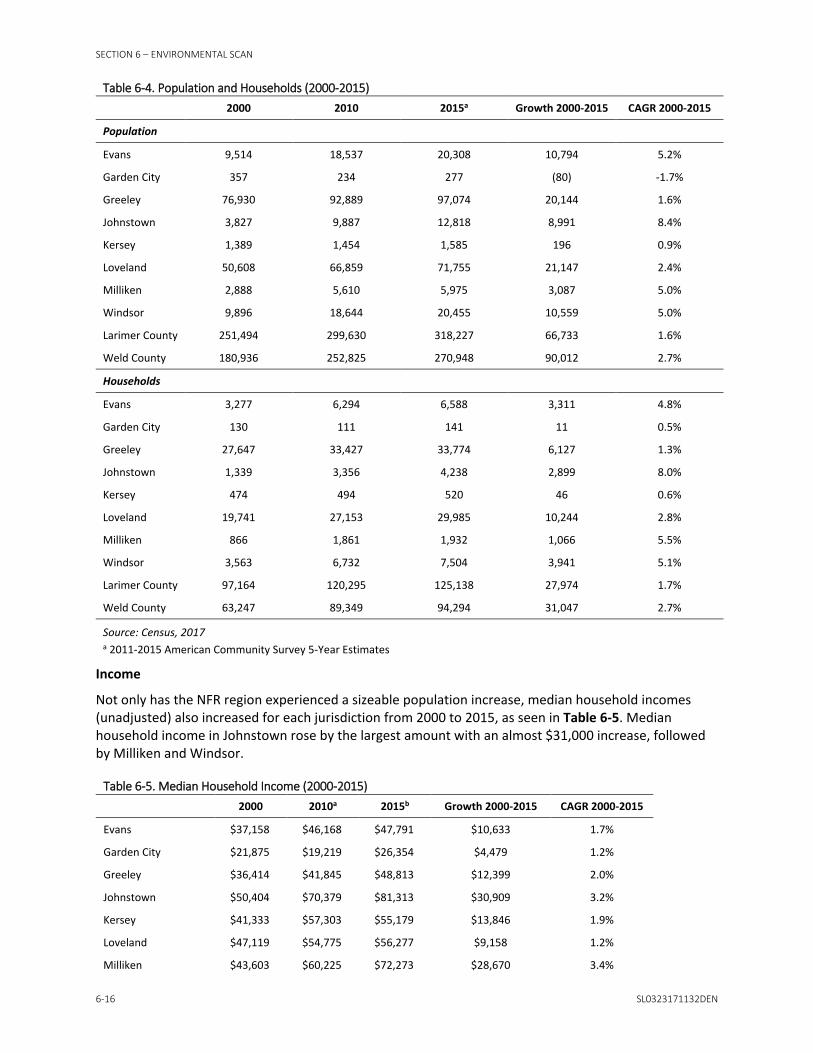
SECTION 6 – ENVIRONMENTAL SCAN
6-16 SL0323171132DEN
Table 6-4. Population and Households (2000-2015)
2000 2010 2015a Growth 2000-2015 CAGR 2000-2015
Population
Evans 9,514 18,537 20,308 10,794 5.2%
Garden City 357 234 277 (80) -1.7%
Greeley 76,930 92,889 97,074 20,144 1.6%
Johnstown 3,827 9,887 12,818 8,991 8.4%
Kersey 1,389 1,454 1,585 196 0.9%
Loveland 50,608 66,859 71,755 21,147 2.4%
Milliken 2,888 5,610 5,975 3,087 5.0%
Windsor 9,896 18,644 20,455 10,559 5.0%
Larimer County 251,494 299,630 318,227 66,733 1.6%
Weld County 180,936 252,825 270,948 90,012 2.7%
Households
Evans 3,277 6,294 6,588 3,311 4.8%
Garden City 130 111 141 11 0.5%
Greeley 27,647 33,427 33,774 6,127 1.3%
Johnstown 1,339 3,356 4,238 2,899 8.0%
Kersey 474 494 520 46 0.6%
Loveland 19,741 27,153 29,985 10,244 2.8%
Milliken 866 1,861 1,932 1,066 5.5%
Windsor 3,563 6,732 7,504 3,941 5.1%
Larimer County 97,164 120,295 125,138 27,974 1.7%
Weld County 63,247 89,349 94,294 31,047 2.7%
Source: Census, 2017 a 2011-2015 American Community Survey 5-Year Estimates
Income
Not only has the NFR region experienced a sizeable population increase, median household incomes (unadjusted) also increased for each jurisdiction from 2000 to 2015, as seen in Table 6-5. Median household income in Johnstown rose by the largest amount with an almost $31,000 increase, followed by Milliken and Windsor.
Table 6-5. Median Household Income (2000-2015)
2000 2010a 2015b Growth 2000-2015 CAGR 2000-2015
Evans $37,158 $46,168 $47,791 $10,633 1.7%
Garden City $21,875 $19,219 $26,354 $4,479 1.2%
Greeley $36,414 $41,845 $48,813 $12,399 2.0%
Johnstown $50,404 $70,379 $81,313 $30,909 3.2%
Kersey $41,333 $57,303 $55,179 $13,846 1.9%
Loveland $47,119 $54,775 $56,277 $9,158 1.2%
Milliken $43,603 $60,225 $72,273 $28,670 3.4%

SECTION 6 – ENVIRONMENTAL SCAN
SL0323171132DEN 6-17
Table 6-5. Median Household Income (2000-2015)
2000 2010a 2015b Growth 2000-2015 CAGR 2000-2015
Windsor $54,976 $75,970 $80,512 $25,536 2.6%
Larimer County $48,655 $56,447 $59,805 $11,150 1.4%
Weld County $42,321 $55,596 $60,572 $18,251 2.4%
Source: Census, 2017 a 2006-2010 American Community Survey 5-Year Estimates b 2011-2015 American Community Survey 5-Year Estimates
Employment
Larimer County gained more than 28,000 jobs between 2000 and 2015, as seen in Table 6-6. In 2015, there were an estimated 147,000 jobs in the county. The industries with the largest employment increase since 2000 were health care and social assistance and accommodation and food services.
Table 6-6. Larimer County Average Employment by Industry (2000-2015)
2000 2010 2015 Growth 2000-2015 CAGRa 2000-2015
Accommodation and Food Services 12,524 14,223 17,611 5,087 2.3%
Administrative and Waste Services 8,090 8,191 8,559 469 0.4%
Agriculture, Forestry, Fishing & Hunting 735 613 719 (16) -0.1%
Arts, Entertainment, and Recreation 1,873 2,489 2,808 935 2.7%
Construction 9,788 7,273 9,594 (194) -0.1%
Educational Services 13,214 15,409 16,956 3,742 1.7%
Finance and Insurance 2,797 3,178 3,544 747 1.6%
Health Care and Social Assistance 10,043 16,668 19,795 9,752 4.6%
Information 2,898 2,709 2,940 42 0.1%
Management of Companies and Enterprises 184 508 833 649 10.6%
Manufacturing 17,659 10,582 12,922 (4,737) -2.1%
Mining 286 308 543 257 4.4%
Other Services, Ex. Public Admin 2,850 3,452 4,076 1,226 2.4%
Professional and Technical Services 6,049 8,798 10,272 4,223 3.6%
Public Administration 6,434 7,445 7,607 1,173 1.1%
Real Estate and Rental and Leasing 2,000 2,228 2,727 727 2.1%
Retail Trade 15,440 16,528 18,035 2,595 1.0%
Transportation and Warehousing 2,792 2,416 2,925 133 0.3%
Unclassifiedb NA 33 21 (12) -8.6%
Utilities 620 716 726 106 1.1%
Wholesale Trade 2,881 2,890 4,235 1,354 2.6%
TOTAL, All Industries 119,157 126,657 147,448 28,291 1.4%
Source: Colorado Office of Labor Market Information, 2017 a Compound Annual Growth Rate b Growth and CAGR based on change from 2010 to 2015
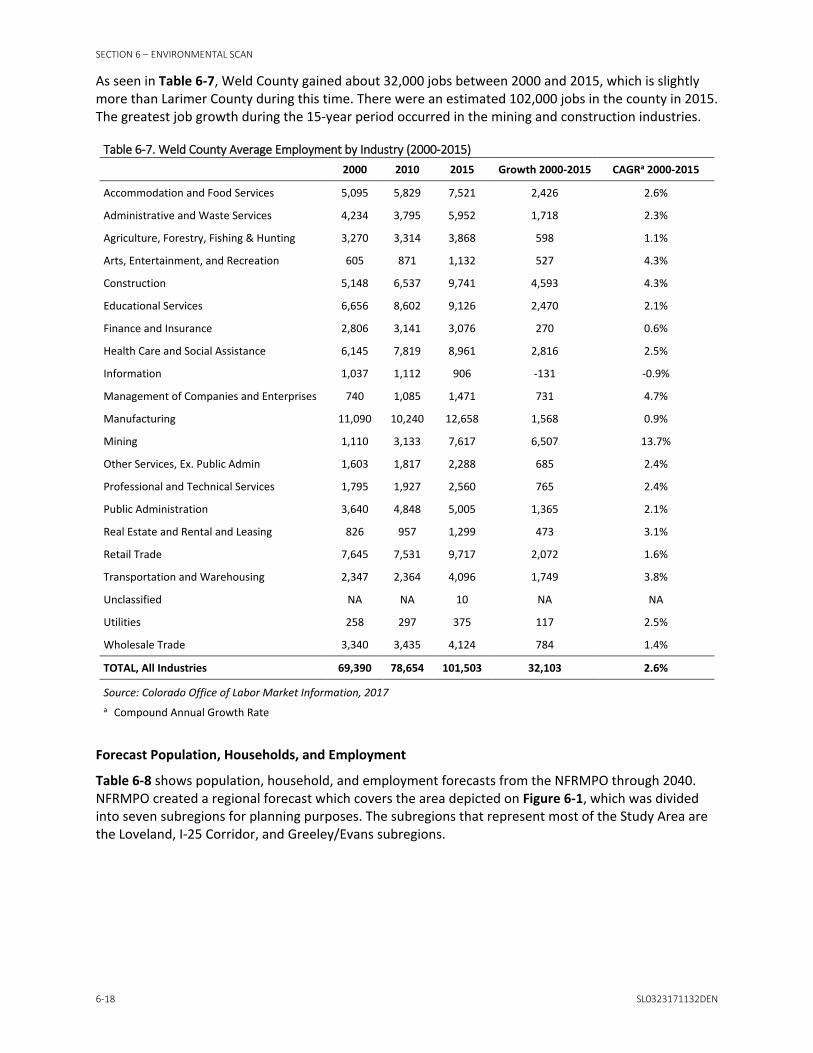
SECTION 6 – ENVIRONMENTAL SCAN
6-18 SL0323171132DEN
As seen in Table 6-7, Weld County gained about 32,000 jobs between 2000 and 2015, which is slightly more than Larimer County during this time. There were an estimated 102,000 jobs in the county in 2015. The greatest job growth during the 15-year period occurred in the mining and construction industries.
Table 6-7. Weld County Average Employment by Industry (2000-2015)
2000 2010 2015 Growth 2000-2015 CAGRa 2000-2015
Accommodation and Food Services 5,095 5,829 7,521 2,426 2.6%
Administrative and Waste Services 4,234 3,795 5,952 1,718 2.3%
Agriculture, Forestry, Fishing & Hunting 3,270 3,314 3,868 598 1.1%
Arts, Entertainment, and Recreation 605 871 1,132 527 4.3%
Construction 5,148 6,537 9,741 4,593 4.3%
Educational Services 6,656 8,602 9,126 2,470 2.1%
Finance and Insurance 2,806 3,141 3,076 270 0.6%
Health Care and Social Assistance 6,145 7,819 8,961 2,816 2.5%
Information 1,037 1,112 906 -131 -0.9%
Management of Companies and Enterprises 740 1,085 1,471 731 4.7%
Manufacturing 11,090 10,240 12,658 1,568 0.9%
Mining 1,110 3,133 7,617 6,507 13.7%
Other Services, Ex. Public Admin 1,603 1,817 2,288 685 2.4%
Professional and Technical Services 1,795 1,927 2,560 765 2.4%
Public Administration 3,640 4,848 5,005 1,365 2.1%
Real Estate and Rental and Leasing 826 957 1,299 473 3.1%
Retail Trade 7,645 7,531 9,717 2,072 1.6%
Transportation and Warehousing 2,347 2,364 4,096 1,749 3.8%
Unclassified NA NA 10 NA NA
Utilities 258 297 375 117 2.5%
Wholesale Trade 3,340 3,435 4,124 784 1.4%
TOTAL, All Industries 69,390 78,654 101,503 32,103 2.6%
Source: Colorado Office of Labor Market Information, 2017 a Compound Annual Growth Rate
Forecast Population, Households, and Employment
Table 6-8 shows population, household, and employment forecasts from the NFRMPO through 2040. NFRMPO created a regional forecast which covers the area depicted on Figure 6-1, which was divided into seven subregions for planning purposes. The subregions that represent most of the Study Area are the Loveland, I-25 Corridor, and Greeley/Evans subregions.

SECTION 6 – ENVIRONMENTAL SCAN
SL0323171132DEN 6-19
Figure 6-1. NFRMPO Subregions Corridor Existing Conditions Report US 34 PEL Source: NFRMPO, 2013a


SECTION 6 – ENVIRONMENTAL SCAN
SL0323171132DEN 6-21
The region is forecasted to grow by about 360,000 people by 2040 and nearly 145,000 households, with about 35 percent of that growth forecast to come from the portion of the region within the Study Area (Table 6-8). The jurisdictions within the Weld County portion of the Study Area are forecasted to grow at a 2.2 percent average annual growth rate, which is slightly higher than the region as a whole and the Larimer County portion of the Study Area.
The region also has a strong jobs outlook through 2040, with a growth forecast of almost 150,000 jobs. The communities in the Study Area are forecast for over 40 percent of future regional employment growth. Jobs in the Larimer County portion of the Study Area are forecasted to grow at a slightly higher rate than the region and the Weld County portion of the Study Area.
Table 6-8. Population, Household, and Employment Forecasts (2015-2040) 2015 2040 Growth 2015-2040 CAGR 2015-2040
Regional Population 537,273 896,191 358,918 2.1%
Larimer County Study Areaa 71,095 115,658 44,563 2.0%
Weld County Study Areab 120,920 206,290 85,370 2.2%
Total Study Area 192,015 321,948 129,933 2.1%
Study Area Percent of Region 36% 36% 36%
Regional Households 207,951 351,176 143,225 2.1%
Larimer County Study Area 29,091 46,890 17,799 1.9%
Weld County Study Area 45,315 78,245 32,930 2.2%
Total Study Area 74,406 125,135 50,729 2.1%
Study Area Percent of Region 36% 36% 35%
Regional Employment 280,207 428,599 148,392 1.7%
Larimer County Study Area 45,339 71,113 25,774 1.8%
Weld County Study Area 70,658 108,568 37,910 1.7%
Total Study Area 115,998 179,681 63,683 1.8%
Study Area Percent of Region 41% 42% 43%
Source: NFRMPO, 2013a a Portion of Study Area within Larimer County b Portion of Study Area within Weld County
6.6.2.2 Existing Land Use The summary of existing land uses is organized geographically from west to east by section. Given the corridor’s length, it was split into sections based on major intersections to organize content and increase readability. The summary of land uses primarily focuses on those parcels immediately adjacent to the US 34 ROW. Existing land uses are depicted in Figure B-9 of Appendix B.
Section A: Western edge to US 287
This section of land begins in unincorporated Larimer County and covers the western side of Loveland. The county portion is composed of open space and low-density residential in the western portion and a mix of auto-oriented, commercial, and residential uses.
North of US 34: Low density, auto-oriented commercial uses are present on the west end of the corridor. A little farther east is Devil’s Backbone Open Space and a mix of commercial and residential uses east of Rossum Drive. On the west and east side of Cascade Avenue are an office building and

SECTION 6 – ENVIRONMENTAL SCAN
6-22 SL0323171132DEN
hotel, respectively. Land uses between the hotel and Rist Benson Reservoir are predominantly residential in nature, including a vacant lot where 34 residential units are being planned.
The area between Rist Benson Reservoir and Lake Loveland is dominated by both small and large commercial operations. For example, Kmart and Safeway are on either side of Wilson Avenue. Another Safeway is situated on the northwest corner of US 34 and North Taft Avenue. Between these two grocery stores are smaller, auto-oriented commercial uses, including some retail, a bank, and multiple casual dining restaurants. There are also multi-family residential properties in this area. North of the commercial uses fronting US 34 are single-family residential neighborhoods with a few multiple-unit complexes interspersed.
Single-family houses are present immediately east of Loveland Lake. Commercial use dominates from where the train tracks cross US 34 to Sprouts Market, which is situated at the northeast corner of US 34 and US 287.
South of US 34: Very little development is present on the west end of the Study Area on the south side of US 34, although a winery is being developed in this area. There is a small residential development and some retail. The Mariana Butte Golf Course and larger single-family homes lie to the south. Between Rossum Drive and Rist Benson Reservoir is a mix of residential and commercial uses. There is an office and a mobile home park in this area also. Residential properties then dominate until the area just south of the Cascade Avenue and US 34 intersection where there is some commercial development. From this area to just east of Namaqua Road is a mix of residential and commercial uses. South of this entire area is a series of detention ponds that are just north of the Big Thompson River.
South of Rist Benson Reservoir is a mix of single-family and multi-family residential properties. To the south of this neighborhood are additional detention ponds. Commercial uses are present at the US 34 and Wilson Avenue intersection, but otherwise the area south of US 34 from Wilson Avenue to North Van Buren Avenue is predominantly residential in nature. Commercial uses are present all along US 34 from North Van Buren Avenue to North Taft Avenue. South of this commercial strip is a residential neighborhood and a Catholic school that has a large land footprint.
East of North Taft Avenue and south of Lake Loveland is a mix of single-family and multi-family residential uses. A few office buildings are present near Colorado Avenue, and then residential uses are present in and around Dwayne Webster Veteran’s Park. Residential properties dominate the few blocks east of the park. Commercial uses are interspersed closer to the US 34 and US 287 intersection. This major intersection is dominated by fast food/casual dining establishments.
Section B: US 287 to I-25
The dominant land uses between US 287 and I-25 are commercial uses, especially big box stores, and agricultural land.
North of US 34: North of US 34 from US 287 to Madison Avenue is a mix of sizes and types of commercial operations, as well as Monroe Elementary School. West of the school is smaller-scale commercial. East of the school is a variety of commercial uses, including auto-oriented retail.
The area from Madison Avenue to North Boise Avenue is dominated by larger commercial uses. There are hotels/motels, multiple professional buildings, and a commercial strip east of North Boise Avenue. Vacant property is present east of Denver Avenue, although a mix of commercial and light industrial uses are planned for this area, along with hundreds of apartment units. North of the commercial uses abutting US 34 between Lake Loveland and Boyd Lake are single-family residential neighborhoods. The McKee Medical Center is located just east of North Boise Avenue.
Multiple medical office and professional buildings abut US 34 west of North Boyd Lake Avenue. The area from North Boyd Lake Avenue to I-25 is dominated by regional commercial uses, although multi-family housing and a recreational vehicle (RV) park are present just west of Hahns Peak Drive. Regional big box

SECTION 6 – ENVIRONMENTAL SCAN
SL0323171132DEN 6-23
retail, such as Bed Bath & Beyond, Old Navy, and Target are present, as are a mix of casual dining establishments, and hotels. The Outlets of Loveland are situated at the northwest corner of the US 34 and I-25 interchange. There are over 40 outlet stores in this complex, including Ann Taylor, Under Armour, Nike, and J. Crew. The Centerra PNR lies just to the west of the southbound I-25 off-ramp.
South of US 34: Although a few commercial uses are present, the area east of US 287 is dominated by single-family housing up to Monroe Avenue. To its east are commercial uses including big box outlets like Jax, Home Depot, and Sam’s Club. Smaller-scale commercial uses abut US 34 east of Madison Avenue, and a mobile home park is situated just to the south. Land uses east of North Boise Avenue include commercial properties adjacent to US 34 with residential uses to the south. Just to the east is a Walmart Supercenter commercial parcel. East of Denver Avenue is a church, which fronts US 34. A variety of commercial enterprises lie to its south, and the Skyline Center for Health is situated to its east. East of the hospital is another large commercial node that includes Lowe’s and Kohl’s, which are set back away from US 34, with small-scale commercial use adjacent to US 34. A mix of single-family residential and a multi-family housing complex parcels lie to the south of these big box stores. A few restaurants and vacant properties run along US 34 east of Kohl’s, with Mountain View High School situated south of Mountain Lion Drive. Most of the area between North Boyd Lake Avenue and I-25 is undeveloped agricultural land. The only exception is a hotel located at the southwest corner of I-25 and US 34.
Section C: I-25 to SH 257
Commercial uses are the predominant land use type immediately east of I-25, including Centerra and the 2534 and Johnstown Plaza developments in Johnstown. East of this commercial node is primarily agricultural land interspersed with small pockets of commercial and residential development.
North of US 34: The Promenade Shops at Centerra lifestyle center (Centerra) is located east of I-25. This is a large regional retail draw that is home to shops, restaurants, and theaters. Despite the amount of square footage developed to date, many vacant parcels remain. Agricultural land begins to dominate the landscape east of Centerra. A few farm houses and agricultural-related buildings are present between Centerra and WCR 17. There is an auto-oriented commercial node at the northwest corner of the US 34 and WCR 17 intersection. To its north is Aims Community College, vacant land, and a landscape center. There is an auto-oriented retail business east of WCR 17, but otherwise the area is mostly agricultural land from WCR 17 to SH 257.
South of US 34: The area south of US 34 consists of the 2534 and Johnstown Plaza developments in Johnstown. 2534 is a 600-acre master-planned, mixed-use community. There is commercial development adjacent to US 34, including Ethan Allen and Bonefish Grill. In addition, there are offices and multi-family apartments in this area. Other recent developments include two hotels. East of this area is the Northern Colorado Rehabilitation Hospital, with medical and office buildings to its south. A great deal of construction is underway in this area, including Scheels, a 250,000-square-foot space that will be home to 85 specialty shops. Southeast of the hospital lies a large FedEx Ground facility. Despite recent and ongoing construction, many vacant properties remain.
The area adjacent to US 34 between the hospital and Kelim, an unincorporated community in Larimer County, consists of vacant or agricultural land. In addition to the residential properties in Kelim, there are also a few commercial properties. Agricultural land is the dominant land use between Kelim and SH 257, although a small residential subdivision is present west of WCR 15. The City of Greeley’s western boundary is WCR 17, so some of this agricultural land is within city limits. Just west of the US 34 and SH 257 intersection is where US 34 Business Route heads northeast before turning due east and traveling through Greeley north of US 34.

SECTION 6 – ENVIRONMENTAL SCAN
6-24 SL0323171132DEN
Section D: SH 257 to 65th Avenue
Land use on the west end of this section of land is dominated by agricultural land. However, most of this section is within the urbanized area of the City of Greeley. Commercial nodes are present within Greeley at major intersections and residential uses dominate areas between these nodes.
North of US 34: Between SH 257 and Promontory Parkway lies the Promontory-area commercial node, which is home to commercial uses including JBS USA, a leading meat processor and employer in the area. North of US 34 Business Route are office buildings including CDOT Region 4 Headquarters, and a Colorado State Patrol facility. Otherwise this area currently consists of agricultural land. East of Promontory Parkway is also generally agricultural land, although a single-family subdivision and self-storage operation are present just south of Business Route 34. Single-family residential use begins just east of 95th Avenue and continues to about 65th Avenue, with most development occurring on either side of 20th Street. Land immediately adjacent to US 34 remains vacant in this area, although construction is ongoing. Land uses adjacent to US 34 from 71st Avenue to 65th Avenue include a church and a mix of residential and small-scale commercial operations. The area just north of these parcels is undeveloped agricultural land.
South of US 34: The southeast corner of the US 34 and SH 257 interchange is the High Pointe Business Park. Although much of this area is vacant, multiple businesses are present, including Noble Energy, Pepsi Beverages Company, and Flatiron Steel. The area from this business park to 71st Avenue is almost entirely agricultural land, although a few residences are present along 28th Street. After US 34 turns to the southeast, agricultural land uses quickly transition to more urban-like use patterns consisting of residential and commercial developments. The area between 71st and 65th Avenues is mostly vacant; however, UCHealth is in the final design stage to develop a 25-acre medical campus in this location. South of what will become a new medical campus is a mix of single and multi-family residential units and St. Michael’s Town Square with a variety of commercial uses.
Section E: 65th Avenue to US 85
The area between 65th Avenue and US 85 includes most of the highly developed portion of the corridor within the City of Greeley. Since Greeley’s southern boundary is just a few blocks south of US 34, most of the city’s land area lies north of US 34.
North of US 34: Land between 65th Avenue to 47th Avenue primarily consists of single-family residential uses and Josephine Jones Park. Large, regional commercial retail is present on either side of 47th Avenue, including Weld County Buick GMC, Target, Kohl’s, and Best Buy. Lowe’s is situated north of Centerplace Drive, as are multiple casual dining establishments and a hotel. Vacant land is present immediately east of the hotel to 38th Avenue. The northwest corner of US 34 and 35th Avenue is home to multiple auto dealers and a large self-storage facility. Multiple apartment complexes and Greeley West High School are present to the north of this commercial node. Dense single-family development and multiple schools are present between 35th and 23rd Avenues north of 26th Street. A mix of multi-family housing and commercial development abuts US 34 in this same location. A church is also located in the area.
Single-family residential development dominates the area between 23rd and 11th Avenues from US 34 on the south to the University of Northern Colorado campus on the north. The University Square commercial shopping center is situated just east of 11th Avenue, and Garden City lies to its east. Garden City is composed of a mix of residential and commercial uses. The area between Garden City and US 85 is a mix of commercial and industrial uses, including JBS Carriers, Trimac Transportation, and National Tank Services.
South of US 34: Residential development is the dominant land use between 65th and 47th Avenues, yet commercial uses are present on either side of 47th Avenue, including a Sprouts Farmers Market and Honda of Greeley. Single-family residential use occurs mainly south of West 29th Street, although there

SECTION 6 – ENVIRONMENTAL SCAN
SL0323171132DEN 6-25
is a multi-family development south of the Bed Bath & Beyond. The area between this commercial node and the Gateway Lakes Natural Area, Homestead Park, and Home Depot consists almost exclusively of single-family residential uses.
Immediately east of 35th Avenue are a cemetery and a church/school. Dense commercial and industrial uses are present from this area to 17th Avenue. Restaurants and hotels front US 34 and big box stores, such as Walmart and Hobby Lobby lie south of West 29th Street. The Qwest Greeley Mall, Cinemark Greeley 12, Sears, and AutoZone are present east of 23rd Avenue. From 17th Avenue to 11th Avenue is a mix of residential properties and the Evans Cemetery near US 34, with Holiday Village, a large mobile home park, to the south.
The southwest corner of the US 34 and US 85 interchange is within the City of Evans and is composed of a few single-family properties and commercial operations adjacent to US 85. There is also a business center. To its south are multiple hotels, an RV retail business, and a few retail strips and industrial properties.
Section F: US 85 to Weld County Road 53
The more urban feel of Greeley quickly turns to a rural, pastoral landscape east of where the South Platte River crosses US 34 just east of the city boundary. Except for a few small developed areas, unincorporated Weld County between Greeley and Kersey consists almost entirely of agricultural land.
North of US 34: The northeast corner of the US 34 and US 85 interchange is composed of commercial and industrial uses between US 85 and 1st Avenue. Residential neighborhoods are present east of 1st Avenue, including single-family housing tracts and multi-family apartments. Immediately adjacent to US 34 is the Greeley-Evans Weld County School District building and bus depot and an RV Park. The South Platte River corridor meanders northeast, and agricultural land abuts the river. Other than Platte River Fort, an industrial-scale meat processing facility at WCR 47 ½, the north side of US 34 is composed of agricultural land all the way to Kersey.
South of US 34: Like the northeast corner of the US 34 and US 85 interchange, the southeast corner of the interchange is also primarily within the City of Greeley. The area west of 1st Avenue is a mix of commercial and industrial uses. There are commercial and industrial uses also just east of 1st Avenue, primarily on either side of East 30th Street. A single-family housing tract is present east of 1st Avenue and south of East 28th Street. Other than an RV park just outside the Greeley boundary, and a sliver of residential use on the west side of WCR 45 ½, agricultural land again dominates from the eastern edge of Greeley to WCR 47. The Rush Truck Center sits just east of WCR 47 and the Centennial Ag Supply Company is east of WCR 49, but otherwise agricultural land, interspersed with oil and gas activity, is present from WCR 47 to Kersey. Within Kersey, most land in the Study Area is vacant, although a few single-family residences are present west of Centennial Park.
6.6.2.3 Future Land Use Future land uses are depicted on Figure B-10 in Appendix B. The desired land use configuration for each community primarily comes from each jurisdiction’s comprehensive plan, and the planning horizon varies by jurisdiction. Table 6-9 summarizes future land uses outlined in plans for communities with land adjacent to US 34.

SECTION 6 – ENVIRONMENTAL SCAN
6-26 SL0323171132DEN
Table 6-9. Relevant Plan Guidance Relevant Plans Date US 34 Land Use Summary
City of Evans, 2010 Comprehensive Plan
Adopted February 16, 2010; Future Land Use Map, October 2014. Planning horizon: 2030.
Delineates a mix of future land uses south of US 34 near the US 85 interchange. Acknowledges the challenge local businesses face competing with large commercial centers along US 34.
City of Evans, US 85 Overlay District Master Plan
2014. Planning horizon: 2030.
Future land uses are delineated for the southwest and southeast corner of the US 85 and US 34 interchange, which include a mix of commercial, office, and automotive commercial uses.
City of Greeley, 2060 Comprehensive Plan
2009. City is planning an update shortly. Planning horizon: 2060.
Defines a 1-mile-wide corridor along U.S. Highway 34 from S.R. 257 to I-25 as a Strategic Employment Development Corridor within which industrial and employment land uses are intended for development. The land use guidance map in the plan highlights the US 34 employment corridor, US 34 industrial area, natural areas, and the US 85 industrial corridor.
City of Loveland, Comprehensive Plan
Adopted July 19, 2016. Planning horizon: 2026.
Includes a US 34 corridor area analysis, including strengths, weaknesses, and development opportunities. Encourages development of multi-use employment districts where campus-type settings are appropriate along transportation corridors, including US 34. Desired future land uses in proximity to the US 34 corridor are primarily commercial and employment in nature.
Larimer County Master Plan
November 1997. Currently being updated.
The master plan sets forth a growth management process designed to ensure that the county operates within its resources, and protects the environment and the lives of its residents. Future urban land uses are defined by intergovernmental agreements with cities and towns, which provide the framework for more urbanized land uses in the county. The county’s master plan focuses on its rural areas and Estes Valley.
Town of Johnstown, Johnstown Area Comprehensive Plan
2006. Planning horizon: 2035.
Includes a land use framework delineating a mix of commercial and employment uses along US 34. It highlights multiple commercial nodes as locations to encourage development of both regional and sub-regional retail and office uses, as well as a variety of residential uses.
Town of Kersey, Comprehensive Plan
2016 Much of the developed portion of Kersey is outside of the Study Area. However, the comprehensive Plan outlines potential development zones, including the area surrounding the US 34 and WCR 49 intersection and the Kersey Regional Business Center.
Town of Windsor, Comprehensive Plan
March 2016. Planning horizon: 2031-2036
Only a small portion of Windsor abuts US 34 to the west of the WCR 17 intersection. The desired future land uses in this area include light industrial and business park uses immediately adjacent to US 34, with commercial uses to the north.
Weld County Comprehensive Plan
June 2017 Weld County’s comprehensive plan is included within the County Charter and County Code in Article 22. Article 19 includes maps and the intergovernmental agreements with adjoining municipalities. Although land use policies are set forth in the comprehensive plan, the county does not have a future land use map.
Sources: City of Evans, 2010; City of Evans, 2014a; City of Evans, 2014b; City of Greeley, 2009; City of Loveland, 2016a; Larimer County, 1997; Town of Johnstown, 2006; Town of Kersey, 2016; Town of Windsor, 2016; Weld County, 2017a.
In general, the intensity of commercial activity along US 34 is likely to continue to increase given forecasts for population and employment growth in the Study Area, and the fact that future land uses envisioned for the corridor are primarily commercial and employment-based. Key areas of change from current conditions include those areas with large amounts of vacant land, such as Centerra and the area of Johnstown at the southeast corner of the I-25 and US 34 interchange.

SECTION 6 – ENVIRONMENTAL SCAN
SL0323171132DEN 6-27
The discussion of future land uses is organized by section only, and not further subdivided into areas north and south of US 34. It focuses on changes from current conditions.
Section A: Western Edge to US 287
Significant land use changes are unlikely on the western edge of the corridor. The Loveland Comprehensive Plan (2016a) mentions the potential for annexing this portion of the corridor into Loveland if landowners in the area are willing. Land uses west of North Wilson Avenue remain commercial in nature. Similarly, the area abutting US 34 between North Wilson Avenue and Lake Loveland remains commercial in nature, with areas of high density residential nearby. This area has an Enhanced Corridor overlay intended to encourage redevelopment patterns and densities sufficient to leverage new private re-investment in the area as part of transitioning existing land uses to be more transit supportive. Residential uses remain north and south of the US 34 commercial corridor in this area. The area south of the lake remains primarily residential in nature, and commercial uses continue to be envisioned on either side of Colorado Avenue.
Section B: US 287 to I-25
The area surrounding the US 287/US 34 intersection remains a mix of commercial and residential uses, with opportunities for more mixed-use housing. There is a Downtown Urban Renewal Area south of US 34, where catalytic projects and higher density residential uses are envisioned.
The area east of US 287 continues to be commercial in nature. The Enhanced Corridor overlay continues from US 287 to where Cheyenne Avenue intersects US 34 from the north. Employment uses are anticipated south of the commercial corridor in this area and residential uses to its north. The Sugar Factory Redevelopment near the US 34 and Madison Avenue intersection is a potential area of change. The Loveland Comprehensive Plan (2016a) mentions that it is well suited for mixed use development.
Land use changes in the area between Cheyenne Avenue and I-25 are likely to be the result of development of currently vacant properties along US 34. For example, the area north of US 34 between Denver Avenue and North Boyd Lake Avenue is in the employment center land use category, which encourages campus-style business parks with integrated housing. Vacant properties south of the commercial corridor are also within the employment center land use category.
The vacant agricultural land south of US 34 and east of North Boyd Lake Avenue is primarily intended to be commercial in nature, with opportunities for large format retail and multi-family housing. Vacant parcels north of the Medical Center of the Rockies are also in the employment center category.
Section C: I-25 to SH 257
The area immediately east of the US 34/I-25 interchange contains a large amount of vacant land, which is almost entirely planned for commercial uses with some residential mixed in. The area south of US 34 from I-25 to WCR 17 is within Johnstown. Johnstown has identified two gateway centers in this area, one at US 34 and I-25 and one at US 34 and LCR 3. Development is being encouraged in these areas and intended to provide regional-serving retail and office uses, as well as an assortment of medium- to high- density housing options. Additionally, a village center has been identified at US 34 and WCR 13, which is intended to provide sub-regional and community-serving retail and office uses, as well as an assortment of medium-density housing options. Beyond these nodes, general land uses south of US 34 primarily consist of a mix of commercial and employment uses along the highway and residential uses to the south. The exception to this is the existing residential development at the southwest corner of US 34 and WCR 15, which remains in a residential land use category.
The area north of US 34 between I-25 and LCR 3 is in the City of Loveland. Future land uses within this area are commercial and employment based with some areas planned for residential uses. A small area east of LCR 3 is within Johnstown. Future land uses in this area include commercial uses adjacent to US 34, and residential and public uses to the north. The area north of US 34 from WCR 13 to WCR 17 is

SECTION 6 – ENVIRONMENTAL SCAN
6-28 SL0323171132DEN
within Windsor. Land adjacent to the highway is in a light industrial/business park land use category, with commercial and agriculture immediately to the north and residential uses between WCR 60 and Crossroads Boulevard.
The area north and south of US 34 from WCR 17 to SH 257 is within Greeley and part of the US 34 Employment Corridor outlined in Greeley’s 2060 Comprehensive Plan (2009). Land south of US 34 and west of SH 257 is within the US 34 Industrial Area, which is currently vacant.
Section D: SH 257 to 65th Avenue and Section E: 65th Avenue to US 85
The Promontory area, which is north of US 34 and immediately east of SH 257, is within Greeley’s US 34 Employment Corridor, and the area south of US 34 is within the US 34 Industrial Area. Although some relatively large businesses are operating here, much of this area is currently vacant. Greeley has delineated the southwest corner of US 34 and 95th Avenue in and around the Boomerang Ditch for natural uses, such as parks or open space. Along US 34 from 95th Avenue to US 85, specific future land use guidance is limited and current zoning is a reasonable predictor of future land uses.
A portion of the corridor near the US 34 and 17th Avenue intersection is part of a redevelopment district and within the Greeley Urban Renewal Area. The district boundary south of US 34 is from 23rd Avenue to the City of Evans boundary. North of US 34, the redevelopment district is present from 17th Avenue to the Garden City boundary.
The area south of the US 34 and US 85 interchange is within the City of Evans and within the US 85 Urban Renewal Area (City of Evans, 2015). Desired future land uses include a mix of commercial, office, and automotive commercial uses. The north side of this interchange is within Garden City, which is almost entirely built out. A mix of land uses are present within the city.
Section F: US 85 to Weld County Road 53
The area east of Garden City has been identified by Greeley as the US 85 Industrial Corridor, which runs north to south along US 85. The area along the South Platte River has been identified as a natural area.
Land east of where US 34 and Business Route 34 intersect is within the Kersey Primary Urban Growth Area. Unincorporated Weld County land developed within the Primary Urban Growth Area is intended to be annexed into Kersey and developed as part of the town. From the intersection of US 34 and Business Route 34 to WCR 51 on both sides of US 34 is within the Kersey Regional Business Center. This area is intended to be an employment center, most of which is planned for light industrial uses.
Kersey’s Comprehensive Plan (Town of Kersey, 2016) outlines potential development zones, with the primarily development zones having relatively high potential for development. The first zone is about 42 acres at the intersection of US 34 and WCR 49. The second primary development zone is north and south of US 34 and 0.25 mile east and west of WCR 49. These development zones are in commercial and light industrial land use categories. East of WCR 51, the Kersey Comprehensive Plan calls for residential uses south of US 34 and a mix of commercial, light industrial, recreational and employment uses to the north.
6.6.3 Next Steps As the PEL process progresses, a traffic analysis will be completed. The traffic evaluation will take into consideration the existing and proposed land uses that will shape the US 34 corridor. Future analysis, such as the results of the traffic model, will help inform the alternatives analysis and provide content for analysis in the PEL document. The linkage among traffic, land use, and community barriers will also be considered in the alternatives and PEL document. Continued coordination with community leaders, stakeholder groups, and the public will remain important as the project progresses.

SECTION 6 – ENVIRONMENTAL SCAN
SL0323171132DEN 6-29
6.7 Noise The US 34 PEL will consider the noise effects of any improvement recommendations on sensitive receptors, such as residences, schools, parks, and businesses. A preliminary analysis of traffic noise within the Study Area was performed to investigate the current traffic noise conditions and to determine the potential for future traffic noise concerns for the interchange.
6.7.1 Methodology Noise-sensitive receptors within 500 feet of US 34 were identified within the Study Area, per CDOT guidelines (2015). For the US 34 corridor noise evaluation, online resources were used along with desktop utilities, such as Google Earth, to identify existing noise mitigation measures and noise-sensitive receptors along the study corridor.
6.7.2 Applicable Regulations FHWA procedures for noise abatement are outlined in Title 23 CFR Part 772. A noise-sensitive site is any property where frequent, exterior human use occurs and where a lowered noise level would be of benefit. CDOT has established a noise level at which a noise abatement must be considered. Known as Noise Abatement Criteria (NAC), these criteria vary according to a property’s land use category and are described in Table 6-9.
CDOT has determined that a traffic noise impact occurs when the projected traffic noise levels meet or exceed the NAC levels, or when projected noise levels substantially exceed existing noise conditions. CDOT defines substantially exceeding existing noise levels as an increase of a 10 A-weighted decibel (dBA), or more, over existing conditions (2015).
CDOT noise guidelines are approved by FHWA for use on federal aid and federal nexus projects in Colorado.
Table 6-9. CDOT Noise Abatement Criteria Activity
Category Activity Leq(h)a
Evaluation Location Activity Description
A 56 Exterior Lands on which serenity and quiet are extraordinary significant and serve an important public need and where the preservation of those qualities is essential if the area is to continue to serve its intended purpose
Bb 66 Exterior Residential
Cb 66 Exterior Active sport areas, amphitheaters, auditoriums, campgrounds, cemeteries, day care centers, hospitals, libraries, medical facilities, parks, picnic areas, places of worship, playgrounds, public meeting rooms, public or nonprofit institutional structures, radio studios, recording studios, recreational areas, Section 4(f) sites, schools, television studios, trails, and trail crossings
D 51 Interior Auditoriums, day care centers, hospitals, libraries, medical facilities, places of worship, public meeting rooms, public or nonprofit institutional structures, radio studios, recording studios, schools, and television studios
Eb 71 Exterior Hotels, motels, time-share resorts, vacation rental properties, offices, restaurants/bars, and other developed lands, properties or activities not included in A through D or F
F NA NA Agriculture, airports, bus yards, emergency services, industrial, logging, maintenance facilities, manufacturing, mining, rail yards, retail facilities, ship yards, utilities (water resources, water treatment, electrical), and warehousing

SECTION 6 – ENVIRONMENTAL SCAN
6-30 SL0323171132DEN
Table 6-9. CDOT Noise Abatement Criteria Activity
Category Activity Leq(h)a
Evaluation Location Activity Description
G NA NA Undeveloped lands that are not permitted for development.
Source: CDOT, 2015 a Hourly A-weighted sound level in dBA, reflecting a 1-dBA approach value below 23 CFR 772 values b Includes undeveloped lands permitted for this activity category
Notes:
Leq = The equivalent steady-state sound level that in a stated period of time contains the same acoustic energy as the time-varying sound level during the same time period.
Leq(h) = hourly value of Leq
6.7.3 Existing Conditions Existing land uses within the Study Area were observed and potential noise-sensitive land uses were documented. The locations with noise-sensitive activity categories B, C, and select E are shown on Figure B-11 in Appendix B. The following summarizes each activity category within the project limits.
• No activity category A land uses were observed within the Study Area.
• The activity category B land uses are shown on Figure B-11 in Appendix B. Because of the high level of this study, the location of activity category B land uses were identified, but not every receptor located within the neighborhood subdivision was identified.
• Numerous activity category C land uses exist within the Study Area, which are highlighted as one large shaded area of potential receptors on the maps in Appendix B. The following are examples of activity category C sites in the project limits that may be impacted by roadway traffic noise:
− Town parks and playgrounds − Schools − Churches − Trails − Pools
• Interior noise readings, activity category D, will not be considered as part of the PEL Study.
• Activity category E land uses, including restaurants, offices, hotels, and other commercial uses, have been identified within the Study Area and are shown on Figure B-11 in Appendix B. This activity category requires meeting a threshold of 71 dBA in order to consider mitigation.
• No activity category F land uses were observed within the Study Area. They are not considered noise-sensitive receptors.
• Undeveloped lands that do not have permitted development are activity category G and will be identified in the noise technical report in subsequent NEPA noise analyses.
6.7.4 Next Steps FHWA and CDOT rules do not require mitigation consideration for noise produced from roadways beyond project limits. Some of the noise problems identified in this analysis may be beyond the limits of specific recommended improvements from this study and will not require any actions. As alternatives are developed, additional detailed noise evaluations will be conducted and potentially affected neighborhoods and sensitive receptors will be identified.

SECTION 6 – ENVIRONMENTAL SCAN
SL0323171132DEN 6-31
Under 23 CFR 772, it is mandatory for all states to comply with the regulations for projects that are classified as Type I projects. Some projects may cause noise reductions. However, analyses are required to assess the exact nature of noise level changes resulting from a Type I project. The CDOT noise guidelines are applicable to all Type I projects. In general, Type I projects consist of capacity increases; alignment changes; or addition of weigh stations, rest stops, ride-share lots, and toll plazas.
Type I projects include additions of new interchanges or alterations of existing interchanges. In all cases in which a project is identified as Type I, a noise analysis study is required if noise-sensitive receptors are present within the study zone. Noise abatement still must be considered for Type I projects where impact level noise has been identified at noise-sensitive receptors, even though the project itself may not cause or contribute to an increase in traffic noise.
During construction of a recommended project, a common-sense approach to controlling the impact of noise from construction equipment and activities should be considered. Economical steps can be taken to minimize the effect of construction noise on local residents and sensitive receptors while not affecting construction schedules.
6.8 Recreational Resources Recreational resources are important community facilities that warrant consideration during transportation projects. These resources include publicly owned parks, recreation facilities, and wildlife and waterfowl refuges.
6.8.1 Methodology Several datasets were referenced to identify park and potential recreation resources within the Study Area, including the following:
• Larimer and Weld County Trail Maps (All Trails, 2017) • Google Earth online mapping (Google Earth, 2016) • Local media sources (Greeley Tribune, 2013) • Walk Ride Colorado Trail Maps (Walk-Ride USA, 2017) • CDOT OTIS (CDOT, 2017b)
6.8.2 Applicable Regulations Section 4(f) of the Department of Transportation Act of 1966 stipulates that FHWA and other Department of Transportation agencies cannot approve the use of land from publicly owned parks, recreational areas, wildlife and waterfowl refuges, or public and private historic sites unless there is no feasible and prudent alternative to the use of the land, and the action includes all possible planning to minimize harm to the property resulting from use (FHWA, 1966).
Some park and recreational resources are also regulated under the Land and Water Conservation Fund (LWCF) Act of 1965, which established a federal funding program to assist states in developing outdoor recreation sites. Section 6(f) of the act prohibits the conversion of property acquired or developed with these funds to a non-recreational purpose without the approval of the National Park Service (NPS, 2008).
6.8.3 Existing Conditions Nine recreational resources have been identified in the Study Area. Resources that are adjacent to the US 34 ROW include the Reservoir Trail, Josephine Jones Park, the Bypass Trail, the Gateway Lakes Natural Area/Homestead Park, Dwayne Webster Veteran’s Park, the South Shore Parkway/Lake Loveland, the Loveland Recreational Trail, Louden Ditch Trail, and the Loveland and Greeley Canal (All

SECTION 6 – ENVIRONMENTAL SCAN
6-32 SL0323171132DEN
Trails, 2017) Each resource is described in the Table 6-10. A map of the recreational resources in the Study Area is included on Figure B-12 in Appendix B.
Table 6-10. Recreational Resources in the US 34 PEL Study Area Resource Resources Type Description
Louden Ditch Trail (RNMC 5)
Trail Multi-use path intersecting US 34 at MP 89.
Reservoir Trail Trail Reservoir Trail runs along Reservoir Road connecting W 28th Street (at MP 110.6 along US 34) to the University of Northern Colorado Campus. The trail features a bike shoulder and 8-foot attached multi-use path.
Josephine Jones Park (Section 6(f))
Park Josephine Jones Park is approximately 49 acres located on US 34 at MP 108.3. The park encompasses a small playground, but most of its acreage is made up green space and trail. This is also a LWCF Section 6(f) property.
Bypass Trail Trail The Bypass Trail trailhead is located at 61st Avenue and US 34. It runs along US 34 past Josephine Jones Park to 35th Avenue.
Gateway Lakes Natural Area/ Homestead Park
Open Space The Gateway Lakes Natural Area, also known as Homestead Park, is a 32-acre span of open space with naturally themed amenities located along US 34 at MP 109.9. The land was deeded to Greeley in 2002 and features lakes, a naturally themed play area, an observation deck and granite trails, amphitheater, bridge, dock, and shelters (Greely Tribune, 2013).
Dwayne Webster Veteran’s Park (Section 6(f))
Park Dwayne Webster Veteran’s Park is approximately 5.5 acres and is located on US 34 at MP 91.4. The space encompasses shelters, basketball and tennis courts, Horseshoe pits, and a playground.
South Shore Parkway/Lake Loveland (Section 6(f))
Park The South Shore Parkway is situated along Lake Loveland and US 34. The space features fishing areas and a path/ trail along the lake at US 34 MP 91.3. This is also a LWCF Section 6(f) property.
Loveland Recreational Trail (RNMC 7)
Trail The Loveland Recreational Trail mostly follows the Big Thompson River, passing through Centennial Park, Fairgrounds Park, and Seven Lakes Park. The trail also provides access to Boyd Lake State Park and crosses US 34 at MP 93.7 and MP 89.
Loveland & Greeley Canal (RNMC 7)
Trail The Loveland and Greely Canal is a tributary trail of the Loveland Recreational Trail. It crosses US 34 at MP 93.7 and continues northeast towards Boyd lake until it splits east to cross Boyd Lake Boulevard.
Source: All Trails, 2017; Greeley Tribune, 2013; Google Earth, 2016; Walk-Ride USA, 2017
6.8.4 Next Steps During the PEL process, identified recreational resources will be made available to the project team so they can be avoided and impacts can be minimized as alternatives are identified. Potential Section 4(f) properties and Section 6(f) that could be impacted by proposed alternatives should be evaluated for Section 4(f)/Section 6(f) applicability. Potential avoidance and minimization measures considered during the alternatives evaluation should be documented as part of the PEL Study.
6.9 Environmental Justice Environmental justice is a public policy goal of promoting the fair treatment of people of all races, cultures, and incomes with respect to the development, adoption, implementation, and enforcement of environmental laws and policies. It is defined through the following principles that, when implemented,

SECTION 6 – ENVIRONMENTAL SCAN
SL0323171132DEN 6-33
help ensure the fair distribution of the benefits and burdens associated with any program or activity receiving federal financial assistance:
• To avoid, minimize, or mitigate disproportionately high and adverse human health and environmental effects, including social and economic effects, on minority populations and low-income populations
• To ensure the full and fair participation by all potentially affected communities in the transportation decision-making process
• To prevent the denial of, reduction in, or significant delay in the receipt of benefits by minority and low-income populations
Evaluating the population composition within the Study Area provides a basis for future outreach activities, assessing impacts to the local community, and evaluating potential alternatives with respect to environmental justice requirements.
6.9.1 Methodology Data from the U.S. Census Bureau’s American Community Survey were evaluated to determine whether minority or low-income populations are present within the Study Area. The analysis relied on the following sources:
• CDOT NEPA Manual, Chapter 9 (CDOT, 2014) • FHWA’s Guidance on Environmental Justice and NEPA (FHWA, 2011) • U.S. Census Bureau, 2011-2015 American Community Survey 5-Year Estimates (Census, 2017) • U.S. Census Bureau, 2016 Tiger/Line Shapefiles (Census, 2016) • U.S. Department of Housing and Urban Development, Fiscal Year 2016 Income Limits Summary
(Larimer and Weld Counties) (HUD, 2016)
The segment of US 34 under evaluation is located in Larimer and Weld Counties and travels through several Northern Colorado municipalities, including Loveland, Windsor, Greeley, and Evans. Minority populations are defined as census-defined races other than White, Non-Hispanic. Low-income households are calculated using Housing and Urban Development’s (HUD’s) low-income thresholds established for Larimer and Weld Counties.
6.9.2 Applicable Regulations EO 12898, “Federal Actions to Address Environmental Justice in Minority Populations and Low-Income Populations,” directs federal agencies to identify and address the disproportionately high and adverse human health or environmental effects of their actions on minority and low-income populations, to the greatest extent practicable and permitted by law. The analysis focuses on the requirements of EO 12898 and FHWA’s and CDOT’s most recent guidance related to the identification of environmental justice populations. This assessment does not address all protected populations that fall under the umbrella of CDOT’s Title VI program (e.g., advanced age, disability, or limited English proficiency) and field work and/or coordination with local jurisdictions was not undertaken.
6.9.3 Existing Conditions As shown on Figure B-13 in Appendix B, both minority and low-income populations are present within the Study Area. Sixty-eight of the 139 census block groups within the Study Area contain larger minority populations than the respective county average (17 percent in Larimer County and 33 percent in Weld County). Similarly, 67 census block groups contain larger low-income populations than the respective county average (15 percent in Larimer County and 14 percent in Weld County). U.S. Census block groups with minority and low-income populations are shown by locations on Figure B-13 in Appendix B.

SECTION 6 – ENVIRONMENTAL SCAN
6-34 SL0323171132DEN
Minority and low-income populations are concentrated within central Loveland, Greeley, and Evans, although there are a few outlying block groups within low-income populations (e.g. in Greeley’s western city limits and southeast Windsor).
Although environmental justice analyses rely on data at the census block or block group level to ensure area-specific population characteristics are identified, an overview of the statistics for the Study Area is provided in Table 6-11.
Table 6-11. Minority and Low-income Households in the US 34 PEL Study Area Location Total Population Total Households Percent Minority Percent Low-Income
US 34 PEL Study Area 235,250 87,091 30 15
Larimer County 318,227 125,138 17 15
Weld County 270,948 94,294 33 14%
In summary, both minority and low-income populations are present within the Study Area. These populations appear to be concentrated within central Loveland, Greeley, and Evans, although there are a few outlying block groups within low-income populations.
6.9.4 Next Steps Minority and low-income populations are present within the Study Area. It will be important to consider these populations throughout the PEL process and development of alternatives. The census data and mapping prepared for this assessment will be provided to the design team for consideration throughout the development of alternatives. If warranted, specialized outreach methods will be recommended. This should include an assessment of limited English proficiency.
6.10 Visual Resources Visual resources are the natural and cultural features of the landscape that define its aesthetic quality and form the overall impression, or visual character, of an area. Visual impacts can generally be defined in terms of the relationship between a project’s physical characteristics, the presence and location of viewers, and the character and quality of the environment in which a project is located. Because public concern over adverse visual impacts can generate controversy, the assessment of visual resources, evaluation of visual impacts, and consideration of mitigation and/or enhancement measures have become important components of the study, design, and implementation of most highway projects.
6.10.1 Methodology A visual assessment methodology typically includes a review of local land use planning documents and coordination with local planners to identify valued and/or protected visual resources, such as landmarks, natural features, protected lands, farmlands, views of the Rocky Mountains, and historical character within local communities that help to create community identity. Zoning overlays, ordinances, and/or land use controls related to visual resources are also identified.
Visual resources within the Study Area and sensitive viewers who might appreciate them are defined through site visits, photo inventory of the Study Area, and the examination of land use data, aerial photography, and GoogleEarth. This includes an assessment of the views that may be appreciated by motorists as well as views along the corridor that are seen by adjacent property owners.
Based on what is revealed through site visits and data collection, distinct landscape character units are defined. A landscape unit is a portion of a regional landscape that exhibits a distinct visual character. These areas often correspond to a place or district that can easily be identified by local viewers. These

SECTION 6 – ENVIRONMENTAL SCAN
SL0323171132DEN 6-35
efforts form a visual baseline against which potential changes to the visual environment can be compared.
6.10.2 Applicable Regulations FHWA’s Visual Impact Assessment for Highway Projects and Guidelines for the Visual Impact Assessment of Highway Projects (1988; 2015) provide guidance on how to conduct a visual assessment for federal or federal aid highway projects. The methodology outlined in FHWA’s guidance is widely recognized as a systematic and standardized approach to visual impact assessment.
6.10.3 Existing Conditions The Study Area is characterized by variable topography, generally flat in the more developed areas to the west and gently undulating to rolling in the more rural areas of the east. In the west portion of the Study Area, the landscape is more typical of suburban/urban development broken by parks, natural areas, or trail crossings. Apart from the more urbanized area through Greeley, the landscape in the eastern portion of the Study Area is more typical of northeastern Colorado’s rural and agricultural settings. Views to the west include the Rocky Mountains. US 34 travels through portions of the communities of Loveland, Johnstown, Windsor, Greeley, Garden City, Evans, and Kersey. Preliminary review indicates that the Study Area is composed of the following distinctive landscape character units containing comparable components:
• Residential (urban, suburban, rural) uses • Commercial, industrial, and municipal uses • Parks, recreational areas, and trails • Water and natural resources • Agricultural open space and undeveloped lands • Rocky Mountain backdrops
The location and dominance of the land uses contained within these landscape units are discussed in Section 6.6.2.2, Existing Land Use, and shown on Figure B-9 of Appendix B. Key visual features include Devil’s Backbone Open Space, Lake Loveland, Mariana Butte Golf Course, Big Thompson River, South Platte River, Dwayne Webster Veteran’s Park, protected agricultural lands, NRHP-eligible historic properties (with concentrations in the City of Loveland), and a variety of recreational trails that cross US 34. Sensitive viewers include residences, motorists, and recreational users.
6.10.4 Next Steps As alternatives are developed for the Study Area, a more detailed evaluation and characterization of the existing visual environment will be conducted. The methodology described in Section 6.10.1 will be followed to confirm existing conditions, identify visual features and sensitive viewers, and describe landscape units.
A qualitative assessment of how, and the degree to which, the alternatives would be consistent or inconsistent with the existing visual character of the landscape units will be provided. The potential for the alternatives to change the overall visual quality of the landscape units will also be discussed, as will potential opportunities to avoid or mitigate visual impacts or enhance the visual environment.
6.11 Other Resources The resource areas discussed in this section are unlikely to influence outcomes of the PEL process, thus they were not considered in detail in this report. However, these resources may require NEPA evaluation for future US 34 projects in compliance with applicable regulations.

SECTION 6 – ENVIRONMENTAL SCAN
6-36 SL0323171132DEN
6.11.1 Air Quality The Study Area is located in the attainment area for ground level ozone, and portions of the Study Area are within the Greeley carbon monoxide (CO) attainment/maintenance area (CDPHE, 2017a; 2017b). Projects emerging from the Study Area may require air quality analyses. Projects may have to meet regional conformity requirements through inclusion in the most current fiscally constrained NFRMPO plans that conform to the air quality improvement plans that cover portions of the Study Area. Projects located within the Greeley CO attainment/maintenance area may also require a project-level analysis for CO, as required by conformity rules—this requirement expires after 2019 when the second maintenance period concludes.
6.11.2 Farmlands The majority of the Study Area falls within an urbanized area. However, soils classified by NRCS as prime, unique, of statewide importance, and/or of local importance are present in the eastern portions of the Study Area. Recommendations that advance from this study may require the completion of a Farmland Conversion Impact Rating form and coordination with NRCS for projects that have the potential to convert farmlands to other uses.
6.11.3 Paleontology Before any construction project, a desktop literature review and museum record search is completed to identify geological formations within the Project Area that are likely to contain fossils. A record search and referencing of the Potential Fossil Yield Classification System was completed for this PEL. The majority of the Study Area has low to moderate potential to contain fossils, with the exception of the Morrison Formation, which has a high potential. There are no previously recorded fossil locations within the Study Area, although precise geographic coordinates were not available for all records. Surveying potential construction monitoring and CDOT clearance may be required before the construction of projects emerging from this study.
6.11.4 Water Quality The Study Area lies within the Big Thompson, Cache La Poudre, and Middle South Platte-Cherry Creek watersheds, and numerous drainages occur within the Study Area. Although there are numerous drainages in the project Study Area, surface water quality impacts are generally evaluated in the immediate vicinity of the streams and stream crossings, where surface water runoff from construction or the transportation system would collect and be discharged into the stream or waterbody. Future improvements should avoid and minimize impacts to water-related resources to the extent possible. If avoidance is not feasible, best management practices should be implemented to reduce direct and indirect impacts to these resources. The project should continue to coordinate with federal and local agencies to create and maintain water quality standards and facilities within the Study Area.
SECTION 7
SL0323171132DEN 7-1
Recommendations from the Existing Conditions Report 7.1 Changes to Project Limits and Study Area The project team analyzed the data collected for this report and recommended changes to the project limits and the Study Area. The Study Area has been extended to LCR 29 and the western limit of physical improvements (Project Limits) has been extended to LCR 27. These updates are shown on Figure 7-1. The extension was made to connect recommendations between the US 34 Canyon and US 34 PEL projects and to incorporate additional key corridor influences including the following:
• Traffic generated by Big Thompson Elementary School and school bus stop at US 34 and N County Road 23H (MP 87.2)
• Traffic generated by summer recreational traffic in the Big Thompson Canyon
• Residential/neighborhood zones just east of the Big Thompson Canyon
• Recent wildlife incidents/crashes occurring near the Big Thompson River and floodplain
Additionally, the team determined it was important to divide US 34 into corridor segments. Each segment has been given a unique name and will be used for organizing the alternatives as the PEL progresses. The following criteria were considered when the corridor was divided:
• Physical – ROW, number of lanes, existing cross section • Traffic – speed, access, traffic volumes • Range of potential solutions and expectations of stakeholders • Consideration of other projects
Figures 7-2 and 7-3 map the corridor segments. Two of the segments, I-25 and the US 34/US 85 interchange, are being completed as separate projects. Existing plans and recommendations from these projects will be incorporated into the US 34 project, but no new or additional improvements will be recommended within these limits.
7.1.1 Segment: Foothills The Foothills segment extends approximately 1.7 miles between MP 87 and MP 88.7 (LCR 27 to Morning Drive). This is a 2-lane segment within Loveland’s growth area that retains rural, mountainous characteristics with limited development and the Big Thompson River floodplain to the south. The posted speeds are 45 to 55 mph, increasing in the westbound direction leaving the urban area and decreasing in the eastbound direction.
7.1.2 Segment: Loveland Urban This Loveland Urban segment extends from Morning Drive to North Garfield Avenue (MP 88.7 to MP 91.7) approximately 3 miles. Moving east through the segment, land uses become more urban in nature with a mix of commercial and low-density housing. A typical section has four lanes, closely spaced intersections, and a center turn lane to facilitate driveway accesses. The posted speed in the westbound direction increases from 35 to 45 mph. The posted speed in the eastbound direction is 35 mph.

SECTION 7 – RECOMMENDATIONS FROM THE EXISTING CONDITIONS REPORT
7-2 SL0323171132DEN
7.1.3 Segment: Loveland 6-lane The Loveland 6-lane segment is approximately 4.1 miles beginning at North Garfield and ending just west of Rocky Mountain Avenue (MP 88.7 to MP 95.8). At Monroe Avenue—that is, east of Lake Loveland and the BNSF Railway Company grade-separated crossing—US 34 becomes six lanes. The 6-lane sections are approximately 1.2 miles long and extend almost to Denver Avenue. The posted speed is 40 mph in both directions. From Denver Avenue to Rocky Mountain Avenue, US 34 becomes a 4-lane section with a narrow-divided median. The City of Loveland has preserved ROW to increase the number of lanes from four to six in the future. Currently, the posted speed in both directions is 50 to 55 mph. Land use in this segment includes commercial uses, especially big box stores, and agricultural land.
7.1.4 Segment: Johnstown-Greeley The Johnstown-Greeley segment stretches approximately 6 miles from Thompson Parkway to just east of SH 257 (MP 97 to MP 103). The roadway section is four lanes, with a divided median and 4-foot inside shoulders and 10-foot outside shoulders. The posted speed in this segment is 65 mph in both directions. The land use in this section is primarily agricultural interspersed with pockets of commercial and residential development.
7.1.5 Segment: Greeley Expressway The Greeley Expressway segment is an approximately 9-mile section beginning just east of SH 257 and ending at 11th Avenue near the US 85 interchange (MP 103 to MP 112). Land use in this segment is mostly agricultural on the west end until entering the urban City of Greeley. Commercial nodes are present within Greeley at major intersections, and residential uses dominate areas between these nodes. The roadway section from the US 34 Business Route interchange through Greeley is generally four lanes with a divided median of varying widths. The posted speeds vary between 45 and 65 mph.
7.1.6 Segment: East End The East End segment extends 4 miles just east of 1st Avenue to the Study Area/project limits at WCR 49 (MP 113.3 to MP 117.3). From 1st Avenue to US 34 Business, this segment is four lanes with a divided median, 4-foot inside shoulders, and 10-foot outside shoulders. From US 34 Business (MP 115.5) to the WCR 49, this segment is a 4-lane, undivided roadway with 10-foot shoulders. The posted speed in both directions is 65 mph. Land use changes from the urban feel of Greeley to a rural, pastoral landscape to the east where the South Platte River crosses US 34 just east of the Greeley city boundary. Except for a few small developed areas, unincorporated Weld County between Greeley and Kersey consists almost entirely of agricultural land.
7.2 Consideration of Risk and Resiliency in the PEL In September 2013, a prolonged period of heavy rain and catastrophic flooding occurred in northern Colorado, which led to extensive infrastructure damage along drainageways. The heavy flooding affected communities along the Study Area.
Going forward, identifying risks and planning for potential extreme weather impacts is increasingly recognized as an important consideration to developing more resilient infrastructure. The Study Area crosses three floodways that could pose a natural risk to infrastructure: the Big Thompsons River, Sheep Draw, and the South Platte River. The Study Area also parallels Lake Loveland, which is classified as a 100-year floodplain (Zone AE). Across the country and internationally, transportation officials have begun to plan and design transportation infrastructure in consideration of extreme weather events and climate change. While transportation facilities are designed to handle a broad range of impacts based on historical climate conditions, preparing for climate change and extreme weather events is becoming

SECTION 7 – RECOMMENDATIONS FROM THE EXISTING CONDITIONS REPORT
SL0323171132DEN 7-3
recognized as critical for protecting the integrity of transportation systems and the necessary investment of funds.
In addition, human risks are a concern on US 34. There are four railroad crossings, two grade-separated and two at-grade. The at-grade crossings are a risk to human life, property, and commerce. While a grade-separated crossing reduces the risk to human life, incidents involving the railroad can affect commerce on the US 34.
The PEL Study will include an ongoing assessment of risks, in particular flood potential and railroad complications, along US 34 and will identify potential locations for opportunities to build a more resilient highway corridor. Additionally, the Purpose and Need has been updated following the preparation of this Existing Conditions Report to include the following project goal: Successful alternatives will reduce risk and increase reliability.


SECTION 7 – RECOMMENDATIONS FROM THE EXISTING CONDITIONS REPORT
SL0323171132DEN 7-5
Figure 7-1. Revised Project Area Map Corridor Existing Conditions Report US 34 PEL

SECTION 7 – RECOMMENDATIONS FROM THE EXISTING CONDITIONS REPORT
7-6 SL0323171132DEN
Figure 7-2. Proposed Corridor Segments - West Corridor Existing Conditions Report US 34 PEL

SECTION 7 – RECOMMENDATIONS FROM THE EXISTING CONDITIONS REPORT
SL0323171132DEN 7-7
Figure 7-3. Proposed Corridor Segments - East Corridor Existing Conditions Report US 34 PEL


SECTION 8
SL0323171132DEN 8-1
References All Trails. 2017. Larimer and Weld County Trails. http://www.alltrails.com/. Accessed March 28, 2017.
American Association of State Highway and Transportation Officials (AASHTO). 2011. A Policy on Geometric Design of Highways and Streets, Sixth Edition.
American Association of State Highway and Transportation Officials (AASHTO). 2014. Access Management Manual, TRB, Second Edition.
City of Evans. 2004a. City of Evans Open Space and Trails Master Plan. February 25, 2004. http://www.evanscolorado.gov/sites/default/files/fileattachments/parks/page/964/open_space_and_trails_plan_-_2004.pdf
City of Evans. 2004b. City of Evans Transportation Plan. March 2004. http://www.evanscolorado.gov/sites/default/files/fileattachments/public_works/page/509/2004transplan.pdf
City of Evans. 2010. 2010 Comprehensive Plan. Adopted February 16. http://www.evanscolorado.gov/planning-zoning/comprehensive-plan.
City of Evans. 2014a. Future Land Use Plan Map. October. http://www.evanscolorado.gov/sites/default/files/fileattachments/planning/zoning/page/918/map1.flup-2014.pdf.
City of Evans. 2014b. US Highway 85 Overlay District Master Plan.
City of Evans. 2015. Urban Renewal Areas Map. November. http://www.evanscolorado.gov/sites/default/files/fileattachments/maps/page/592/urban_renewal_areas.pdf.
City of Greeley. 2009. 2060 Comprehensive Plan. http://greeleygov.com/services/cd/lrp/2060-comprehensive-plan.
City of Greeley. 2011. Greeley 2035 Comprehensive Transportation Plan. May. http://greeleygov.com/docs/default-source/Public-Works/Transportation/greeley-2035-comprehensive-transportation-plan.pdf
City of Greeley. 2015. City of Greeley Bicycle Master Plan. May 5.
City of Greeley. 2016a. Greeley Parks, Trails and Open Lands Master Plan. May 10.
City of Greeley. 2016b. Official Zoning Map. http://greeleygov.com/services/cd. January 18.
City of Greeley. 2017a. Commercial/Industrial Projects List. Updated January 5, 2017. http://greeleygov.com/services/cd/planning-and-zoning. Accessed January 18, 2017.
City of Greeley. 2017b. Residential Projects List. Updated January 5, 2017. http://greeleygov.com/services/cd/planning-and-zoning. Accessed January 18, 2017.
City of Loveland. 2012a. Bicycle and Pedestrian Plan. May.
City of Loveland. 2012b. 2035 Transportation Plan. December. http://www.ci.loveland.co.us/home/showdocument?id=13500
City of Loveland. 2016a. Create Loveland Comprehensive Plan. Adopted July 19, 2016. http://www.cityofloveland.org/home/showdocument?id=30500.
City of Loveland. 2016b. Future Land Use Map. Updated February 5, 2016. http://www.cityofloveland.org/home/showdocument?id=11531.
City of Loveland. 2017c. Current Development Activities Interactive Map. Accessed March 2017. http://maps.cityofloveland.org/Apps/?viewer=cda.

SECTION 8 – REFERENCES
8-2 SL0323171132DEN
City of Loveland. 2017d. Loveland’s Historic Preservation Program. Accessed April 25, 2017. http://www.ci.loveland.co.us/departments/development-services/community-strategic-planning/historic-preservation.
Colorado Department of Agriculture (CDA). 2017. Noxious Weed Species. Accessed June 28, 2017. https://www.colorado.gov/pacific/agconservation/noxious-weed-species.
Colorado Department of Public Health and Environment (CDPHE). 2016. Regulation #93, Colorado’s Section 303(d) List of Impaired Waters and Monitoring and Evaluation List. Adopted March 17, 2004, and amended November 30, 2016.
CDPHE. 2017a. Revised Carbon Monoxide Maintenance Plan Greeley Attainment/Maintenance Area. Accessed April 25, 2017. https://www.colorado.gov/pacific/sites/default/files/AP_PO_Greeley-Carbon-Monoxide-Attainment-Maintenance-Plan-Revised-2009.pdf.
CDPHE. 2017b. State Implementation Plans. https://www.colorado.gov/pacific/cdphe/state-implementation-plans-sips
CDPHE. 2017c. Cleanwater; GIS Maps. Accessed March 16, 2017. https://www.colorado.gov/pacific/cdphe/clean-water-gis-maps.
Colorado Department of Transportation (CDOT). 2003a. US 34 Corridor Optimization Plan. March.
CDOT. 2003b. US 34 Access Control Plan. May.
CDOT. 2007. SH 402 Environmental Assessment.
CDOT. 2008. US 34 Business Route Environmental Assessment. October.
CDOT. 2011a. North I-25 Environmental Impact Statement. August.
CDOT. 2011b. North I-25 Record of Decision. December.
CDOT. 2014. National Environmental Policy Act Manual, Version 4 Update. October.
CDOT. 2015. Noise Analysis and Abatement Guidelines. https://www.codot.gov/programs/environmental/noise/guidelines-policies/copy_of_cdot-noise-guidance/view.
CDOT. 2016. CDOT Online Transportation Information System (OTIS) Map View. Accessed June 27, 2017. http://dtdapps.coloradodot.info/otis/Flex/MapView.
CDOT. 2017a. US 85 PEL Study.
CDOT. 2017b. CDOT Online Transportation Information System (OTIS). Accessed March 28, 2017.
Colorado Department of Labor and Employment. 2017. Colorado Department of Labor and Employment Office of Labor Market Information, LMI Gateway, QCEW for Multiple Industries in Multiple Areas in Multiple Time Periods. https://www.colmigateway.com/vosnet/analyzer/results.aspx?session=ind202.
Colorado Natural Heritage Program (CNHP). 2017a. Colorado Wetland Inventory Mapper. Accessed April 21, 2017. http://csurams.maps.arcgis.com/apps/webappviewer/index.html?id=a8e43760cb934a5084e89e46922580cc.
CNHP. 2017b. CNHP Conservation Status Handbook (Tracking Lists). Accessed April 21, 2017. http://www.cnhp.colostate.edu/download/list.asp. Last updated February.
Colorado Oil and Gas Conservation Commission. 2016. Rule 603: Statewide Location Requirements for Oil and Gas Facilities, Drilling, and Well Servicing Operations. http://cogcc.state.co.us/documents/reg/Rules/LATEST/CompleteRules%20as%20of%20March%2016,%202016.pdf. Updated Match 16, 2016. Accessed September 2017.

SECTION 8 – REFERENCES
SL0323171132DEN 8-3
Colorado Parks and Wildlife (CPW). 2016a. ArcGIS—Colorado Parks and Wildlife—Species Activity Data. Accessed May 9, 2017. http://www.arcgis.com/home/group.html?owner=rsacco&title=Colorado Parks and Wildlife - Species Activity Data.
Colorado Water Conservation Board (CWCB). 2006. Colorado Floodplain and Stormwater Criteria Manual. http://cwcb.state.co.us/technical-resources/floodplain-stormwater-criteria-manual/Documents /Chapter 4.pdf.
Cowardin, L.M., V. Carter, F. Golet, and E. LaRoe. 1979. Classification of Wetlands and Deepwater Habitats of the United States. U.S. Fish and Wildlife Service. FWS/OBS-79/31. 103 pp.
Colorado Park snad Wildlife (CPW). 2016b. Preble’s Meadow Jumping Mouse Overall Range Map. Accessed July 18, 2017. http://cpw.state.co.us/learn/Pages/KMZ-Maps.aspx. November.
CPW. 2017. Threatened and Endangered List. Accessed July 18, 2017. http://cpw.state.co.us/learn/Pages/SOC-ThreatenedEndangeredList.aspx.
Federal Emergency Management Agency (FEMA). 2015. Executive Order 11988: Floodplain Management. Accessed June 5, 2017. https://www.fema.gov/executive-order-11988-floodplain-management.
FEMA. 2017a. Floodway. Accessed June 5, 2017. https://www.fema.gov/floodway.
FEMA. 2017b. National Flood Hazard Layer. Accessed June 5, 2017. http://fema.maps.arcgis.com/apps/webappviewer/index.html?id=49069b91c14a411fa8defccf5c1f6266.
Federal Highway Administration (FHWA). 1966. Section 4(f) Tutorial. Accessed February 17, 2017. https://www.environment.fhwa.dot.gov/section4f/default.aspx.
FHWA. 1988. Visual Impact Assessment for Highway Projects. March.
FHWA. 2010. Access Management in the Vicinity of Intersections Technical Summary. February. https://safety.fhwa.dot.gov/intersection/other_topics/fhwasa10002/fhwasa10002.pdf.
FHWA. 2011. Guidance on Environmental Justice and NEPA. December 16.
FHWA. 2012. Programmatic Biological Assessment. February 2.
FHWA. 2015. Guidelines for the Visual Impact Assessment for Highway Projects (DOT FHWA-HI-88-054). January.
Federal Motor Carrier Safety Administration (FMCSA). 2017. National Hazardous Materials Route Registry. Accessed June 20, 2017. https://www.fmcsa.dot.gov/regulations/hazardous-materials/national-hazardous-materials-route-registry-state.
Google Earth. 2016. Source: US 34 PEL Corridor between Loveland, Colorado and Kersey, Colorado. Accessed April 21, 2017.
Greeley Evans Transit (GET). 2016. 2016 GET 5- to 10-year Strategic Plan. http://greeleyevanstransit.com/wp-content/uploads/2017/04/get-2016-strategic-plan.pdf
Greeley Tribune. 2013. Greeley to celebrate opening of new, naturally themed park on Saturday. Accessed March 31, 2017. http://www.greeleytribune.com/news/local/greeley-to-celebrate-opening-of-new-naturally-themed-park-on-saturday/#.
Larimer County. 1997. Larimer County Master Plan. November 19. http://www.larimer.org/planning/planning/master_plan/toc.htm.
Larimer County Department of Natural Resources. 2015. Open Lands Master Plan. January Adoption Draft.

SECTION 8 – REFERENCES
8-4 SL0323171132DEN
Larimer County. 2017. Larimer County Weed List. Accessed June 28, 2017. http://www.larimer.org/weeds/listb.htm.
National Cooperative Highway Research Program. 2011. Report 687 Guidelines for Ramp and Interchange Spacing.
National Park Service (NPS). 2008. State Land and Water Conservation Fund. Accessed March 27, 2017. https://www.nps.gov/ncrc /programs/lwcf/protect.html.
Natural Resources Conservation Service (NRCS). 1984. FPPA Rule, 7 CFR 658. Accessed April 25, 2017. https://www.nrcs.usda.gov/wps/portal/nrcs/main/national/landuse/fppa/.
NRCS. 2009a. Cachle la Poudre Watershed Hydrologic Unit Code 10190007 Rapid Assessment. October. Accessed April 19, 2017. https://www.nrcs.usda.gov/wps/portal/nrcs/detail/co/technical/dma/rwa/?cid=nrcseprd1321466.
NRCS. 2009b. Middle South Platte- Cherry Creek Watershed Hydrologic Unit Code 10190003 Rapid Assessment. October. Accessed April 19, 2017. https://www.nrcs.usda.gov/wps/portal/nrcs/detail/co/technical/dma/rwa/?cid=nrcseprd1321466.
NRCS. 2010. Big Thompson Watershed Hydrologic Unit Code 10190006 Rapid Assessment. February. Accessed April 19, 2017. https://www.nrcs.usda.gov/wps/portal/nrcs/detail/co/technical/dma/rwa/?cid=nrcseprd1321466.
NRCS. 2016a. Web Soil Survey for Portions of Larimer and Weld Counties, Colorado. Accessed April 21, 2017. http://websoilsurvey.nrcs.usda.gov/. Data last modified August 2016.
NRCS. 2016b. State Soil Data Access Hydric Soils List. Accessed April 21, 2017. http://websoilsurvey.nrcs.usda.gov/.
NRCS. 2017a. Web Soil Survey for Portions of Larimer and Weld Counties. Accessed April 25, 2017. http://websoilsurvey.nrcs.usda.gov/.
NRCS. 2017b. Prime and Important Farmlands. Accessed April 25, 2017. https://www.nrcs.usda.gov/wps/portal/nrcs/detail/ak/soils/surveys/?cid=nrcs142p2_035988.
North Front Range Metropolitan Planning Organization (NFRMPO). 2010. Truck Traffic in the Northeast Quadrant of the NFRMPO Region. April.
NFRMPO. 2013a. 2040 Economic and Demographic Forecast. 2012-2013. Adopted June 2013. http://nfrmpo.org/wp-content/uploads/2040-economic-demographic-forecast.pdf
NFRMPO. 2013b. Regional Bicycle Plan.
NFRMPO. 2015a. 2040 Regional Transportation Plan. September. Amended June 1, 2017.
NFRMPO. 2015b. 2040 Regional Transit Element.
NFRMPO. 2017. 2016 Non-Motorized Plan. February.
Office of Archaeology and Historic Preservation. 2017. Accessed April 25, 2017. http://www.historycolorado.org/oahp/listed-properties.
State of Colorado. 2002. State Highway Access Code. March.
Town of Johnstown. 2006. Johnstown Area Comprehensive Plan. http://www.townofjohnstown.com/DocumentCenter/Home/View/192.
Town of Johnstown. 2008. Transportation Master Plan. February. https://www.townofjohnstown.com/DocumentCenter/Home/View/405.

SECTION 8 – REFERENCES
SL0323171132DEN 8-5
Town of Kersey. 2016. Comprehensive Plan. http://www.kerseygov.com/ArchiveCenter/ViewFile/Item/51.
Town of Windsor. 2016. Comprehensive Plan. March. http://www.windsorgov.com/927/Community-Development-Plans-Studies.
U.S. Census Bureau (Census). 2016. Tiger/Line Shapefiles Released August 2016. Accessed March 2017. https://www.census.gov/geo/maps-data/data/tiger-line.html.
U.S. Census Bureau (Census). 2017. 2011-2015 American Community Survey 5-Year Estimates, Tables P053, B25010, B03002, and B19001. Accessed March 23, 2017.
United States Department of Housing and Urban Development (HUD). 2016. Fiscal Year 2016 Income Limits Summary for Larimer and Weld Counties. Accessed March 2017. https://www.huduser.gov/portal/datasets/il.html.
U.S. Environmental Protection Agency (EPA). 2017a. Reviewing National Ambient Air Quality Standards (NAAQS): Scientific and Technical Information. https://www.epa.gov/naaqs.
U.S. Environmental Protection Agency (EPA). 2017b. Mobile Source Pollution and Related Health Effects. https://www.epa.gov/mobile-source-pollution.
U.S. Fish and Wildlife Service (USFWS). 2016. National Wetlands Inventory. Accessed April 21, 2017. http://www.fws.gov/wetlands/Data/Mapper.html. Data last modified November 22, 2016.
USFWS. 2017. Information for Planning and Consultation (IPaC) Resource List. Accessed March 16, 2017. https://ecos.fws.gov/ipac/.
U.S. Geological Survey (USGS). 1950. Kersey, CO 7.5-minute topographic quadrangle map, 1950.
USGS. 1969. Windsor, CO 7.5-minute topographic quadrangle map, 1950. Photo revised 1969.
USGS. 1980a. Bracewell, CO 7.5-minute topographic quadrangle map 1950. Photo revised 1980.
USGS. 1980b. Greeley, CO 7.5-minute topographic quadrangle map 1950. Photo revised 1980
USGS. 1984a. Masonville, CO 7.5-minute topographic quadrangle map 1962. Photo revised 1984.
USGS. 1984b. Loveland, CO 7.5-minute topographic quadrangle map 1962. Photo revised 1984.
USGS. 2014. National Hydrography Dataset. Accessed April 21, 2017. http://nhd.usgs.gov.
USGS. 2016. National Hydrology Dataset. http://nhd.usgs.gov/.
Walk-Ride USA. 2017. Colorado. Accessed March 28, 2017. http://www.walkridecolorado.com/by-location/greeley-colorado.
Weld County. 2008. “O” Street Arterial Corridor Study. October.
Weld County. 2011. Weld County 2035 Transportation Plan.
Weld County. 2017a. Weld County Comprehensive Plan. Chapter 22 Comprehensive Plan. Charter and County Code. Weld County, Colorado. https://library.municode.com/co/weld_county/codes/charter_and_county_code?nodeId=CH22COPL. Accessed January 19, 2017.
Weld County. 2017b. Weed Management. Accessed June 28, 2017. https://www.weldgov.com/DEPARTMENTS/PUBLIC_WORKS/WEED_MANAGEMENT/


![Railroad Corridor & Barrow Pit/Wetland - nps.gov chapter3-8_BPW... · Railroad Corridor & Barrow Pit/Wetland [Existing conditions inventory maps and photographs follow this section]](https://img.pdfslide.us/doc/110x75/5c8b3f2709d3f2d5658d2b13/railroad-corridor-barrow-pitwetland-npsgov-chapter3-8bpw-railroad.jpg)