Embed Size (px)
Citation preview
RISCURI I CATASTROFE, NR. XIII, VOL. 14, NR. 1/2014
123
CONSIDERATIONS ON THE BLIZZARD OF THE PERIOD JANUARY 21-23, 2011
I. MARINIC 1, IULICA V DUVA2, ANDREEA FLORIANA MARINIC 3
Abstract: The paper analyzes the synoptic conditions that have caused blizzard in Romania in the period January 21-23, 2011. The analyzed situation shows that especially in the east and southeast the phenomenon of blizzard can occur also in conditions initially nonspecific that later can evolve to situations specific to blizzard. Therefore in the winter the emergence and development of a Mediterranean cyclone and its circulation across the Balkan Peninsula, in interaction with an anticyclonic field can be an important signal that the blizzard will take place in Romania. The blizzard phenomenon is particularly dangerous for the road traffic, because by blocking the roads and the vehicles in traffic it can cause human deaths, but also it is an important risk factor for the other economic activities. The paper is useful for climatologists, meteorologists, master students and students and to a wide range of specialists interested in Romania`s climatic conditions during winter. The analysis on the blizzard of the period january 21-23, 2011 in Romania is a continuation of the extended studies of the regional climate variability (Bogdan, Marinic , Andreea Floriana Marinic , 2010, Marinic 2006 ) Key words: blizzard, Mediterranean cyclones, blocking atmospheric circulation, climate cooling. 1. INTRODUCTION In the last 30 years the frequency of warm winters increased mainly in the
south-west of the country (Oltenia), but also throughout the country and Europe. The cold winters were increasingly rare as well as the normal ones. Note that the winter of 2009-2010 was a cold winter when there were some climate records (Bogdan, Marinic , 2010). In the winter of 2010-2011 the weather conditions returned closer to normal confirming the growth of the climate variability during winter. Following these developments, in some winters the severe winter phenomena were not recorded or were much reduced.
1 Ph.D., First Degree Weather Forecaster; SR II, Regional Meteorological Center Oltenia. 2Lecturer Ph.D, Faculty of Geography, Spiru Haret University, Bucharest, [email protected]. 3Bachelor of Sciences, Klimacampus, Hamburg Germany, [email protected].
I. MARINIC , IULICA V DUVA, ANDREEA FLORIANA MARINIC
124
In most of the country January 2011 was close to the normal temperature range.
After Hellmann criterion at the weather stations in Oltenia, January was from normal (N) to warm (W) and in most of the region warmish (WS). The average temperature for the entire region was -1.2°C, and its deviation from normal was 1.4°C, which means a warmish month (WS) for the whole region.
The monthly maximum temperatures ranged between 13.0°C, recorded in Caracal on January 16 and 16.0°C recorded in Apa Neagr and Tg. Logre ti on January 15.
The monthly minimum temperatures ranged between -10.3°C and -19.8°C (January 31, 2011). The monthly minimum temperatures at ground level ranged between -8.1°C, recorded in Caracal on January 31 and -24.6°C, recorded in Slatina on January 26.
There were recorded two periods of cold weather with negative average daily temperatures between January 1-8 and January 23-31 and a period of warm weather when the daily average temperatures were positive between January 9-17 and the daily average temperatures fluctuated slightly around 0°C between January 18-22, increasing the period of warm weather to 14 days.
We will further analyze the occurrence conditions of the blizzard in the period January 21-23, 2011.
2. DATA AND METHODS For this study the data were processed from the archives of Oltenia
Regional Meteorological Center (RMC), and the results obtained from mathematical models, synoptic maps and satellite images were analyzed.
3. THE BLIZZARD OF THE PERIOD JANUARY 21-23, 2011 3.1. The synoptic situation on January 21, 2011 At ground level On January 21, 2011 at 00 UTC the main baric centres of the atmosphere
over Europe were the following: - An anticyclone belt consisting of the Azores anticyclone and the
European anticyclone extended from the Atlantic Ocean over the UK and Scandinavia to the East Siberian Plain.
- In the north of this vast anticyclonic field there is positioned the low atmospheric pressure field consisting of a cyclone of north-Canadian origin and the Icelandic cyclone (fig. 1).

CONSIDERATIONS ON THE BLIZZARD OF THE PERIOD JANUARY 21-23, 2011
125
Figure 1. The synoptic situation at ground level and at 500 hPa height and the relative geopotential topography RT 500/100, on January 21, 2011 at 00 UTC (after www.wetter3.de).
Figure 2. The minimum temperatures field at 2m height, on January 21, 2011 at 00 UTC (after www.wetter3.de).
I. MARINIC , IULICA V DUVA, ANDREEA FLORIANA MARINIC
126
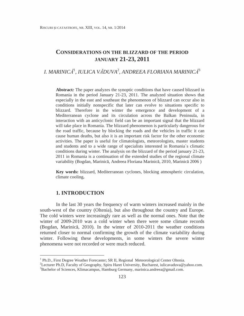
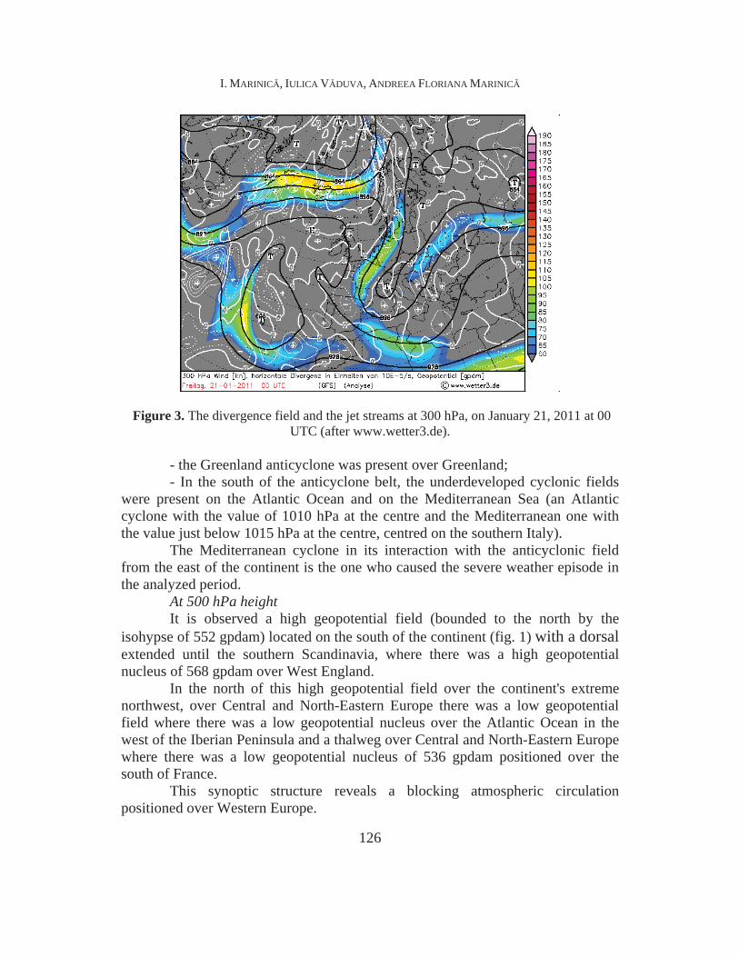
Figure 3. The divergence field and the jet streams at 300 hPa, on January 21, 2011 at 00 UTC (after www.wetter3.de).
- the Greenland anticyclone was present over Greenland; - In the south of the anticyclone belt, the underdeveloped cyclonic fields
were present on the Atlantic Ocean and on the Mediterranean Sea (an Atlantic cyclone with the value of 1010 hPa at the centre and the Mediterranean one with the value just below 1015 hPa at the centre, centred on the southern Italy).
The Mediterranean cyclone in its interaction with the anticyclonic field from the east of the continent is the one who caused the severe weather episode in the analyzed period.
At 500 hPa height It is observed a high geopotential field (bounded to the north by the
isohypse of 552 gpdam) located on the south of the continent (fig. 1) with a dorsal extended until the southern Scandinavia, where there was a high geopotential nucleus of 568 gpdam over West England.
In the north of this high geopotential field over the continent's extreme northwest, over Central and North-Eastern Europe there was a low geopotential field where there was a low geopotential nucleus over the Atlantic Ocean in the west of the Iberian Peninsula and a thalweg over Central and North-Eastern Europe where there was a low geopotential nucleus of 536 gpdam positioned over the south of France.
This synoptic structure reveals a blocking atmospheric circulation positioned over Western Europe.

CONSIDERATIONS ON THE BLIZZARD OF THE PERIOD JANUARY 21-23, 2011
127
On the western side of the blocking system the warm air advection occurs towards the northern latitudes and on the eastern side of the blocking system the cold air advection occurs from northeast to southwest across most of Central and Northern Europe (confirmed also by the jet streams position, Fig. 3).
For Romania, at 500 hPa height the air circulation was southwestern, in the lower troposphere it was of eastern type, and the air mass was continental polar (cP) specific to the winter season.
The subsequent evolution of this atmospheric structure, forecasted by the mathematical models, on January 21, 2011 at 10 am led to the following weather warning for the period January 21, 2011 at 18 PM – January 23, 2011 at 23 PM: In the referred period it will snow across the country, more abundant in the southern half of the country. In the beginning of this period on the coast, in the continental Dobrudja and B r gan, the rainfalls will be predominantly in the form of rain, quantitatively significant only in isolated areas. On the night of Saturday to Sunday and during Sunday, in the east and southeast the wind will have intensifications, blowing temporarily snow.
Note that in the period January 20, 2011 08.00 –January 21, 2011 08.00, the weather was generally bleak.Precipitations fell mostly as snow in the northwest and in the centre, there were mixed in the southwest and northeast, and in the rest of the territory it was fog, locally persistent and associated in isolated areas with drizzle and snow-flakes. Totally isolated in Cluj, Dolj, Teleorman, Dambovita and Galati County there was reported ice. The wind blew low to moderate. The maximum temperatures ranged between -1°C at Topli a, Joseni, Miercurea Ciuc, Târn veni, Turda, S rma u, Bato and Bâcle u and 9°C at Constan a, Medgidia and Cernavoda, and the minimum temperatures ranged between -3°C at Câmpina, Câmpulung Muscel and Dumbr vi a de Codru and 5°C at Sulina. At 08.00 there was local snow cover in the mountain (which measured up to 92 cm at Omu Peak) and in smaller areas in the western, north-western and central regions. (NMA, The weather bulletin, No. P 21 of January 21, 2011).
The severe weather events occurred within the period from the weather warning in the specified period and especially in the night of January 21/22, 2011, during the day of January 22, 2011 and in the night of January 22/23, 2011. Thus there were recorded the following in our country: There were two days of continuous snow and blizzards especially in the south, east and west of the country, and due to the snow cover 24 roads were closed: four national and 20 county roads were closed. The transport by train was affected. Thus CFR cancelled four trains: 8034 Fete ti - Bucharest Obor, 8033 -Bucharest Obor- Fete ti, 8021 Bucharest Obor – South C l ra i and 8022 South C l ra i - Bucharest Obor. Also, the Drobeta- Caransebes route is closed, because more trees fell on the rails. In the capital, about 250 machines have been used on the streets for snow removal. The major streets were cleaned with priority but the secondary roads have been
I. MARINIC , IULICA V DUVA, ANDREEA FLORIANA MARINIC
128
forgotten. For this reason, the doctors from the Bucharest Ambulance Service had difficulties in reaching the cases reported by emergency calls. There were affected mainly the eastern, Curvature and the southeast counties. (http://www.click.ro/actualitate/din_tara/Urgie-drumuri-inchise-suspendate-anulate_0_1108689229.html).
In the air at the height of 0-2 m above the ground level, the minimum temperatures in the morning of January 21, 2011 on the largest part of the continent, ranged between -10°C and 0°C, typical winter values, and only in the extreme south and west there were recorded positive temperatures (fig. 2).
In Scandinavia and in the continent's extreme east it is observed extremely low minimum temperatures (between -30° C and -20° C), characteristic to the cold arctic air mass, which was present there.
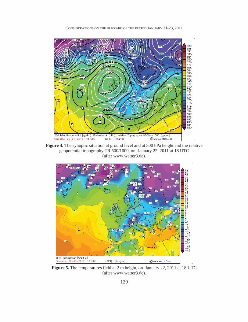
3.2. The synoptic situation on January 22, 2011. On January 22, 2011, the Mediterranean Cyclone increased the value of its
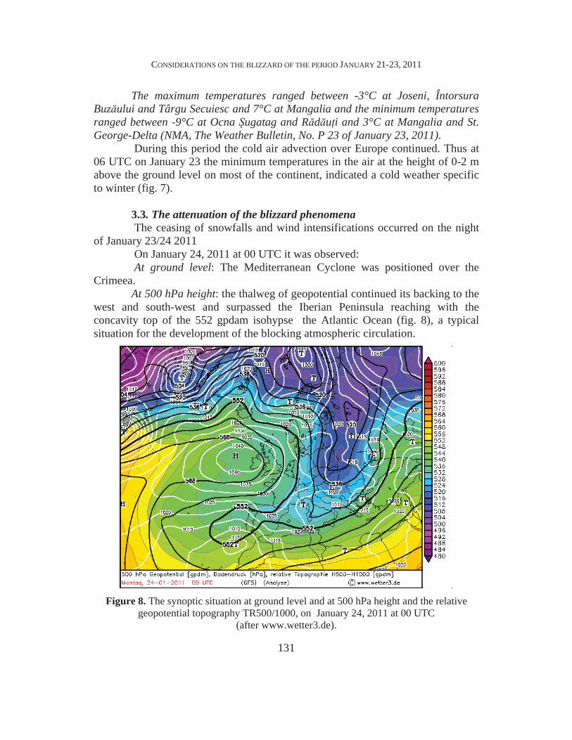
centre reaching 1005 hPa (Fig. 4), and its easy movement towards northeast intensified the cyclone-anticyclone interaction specific in such situations to the blizzard phenomenon. The geopotential thalweg became wider and the low geopotential nucleus was positioned at that time over southern Italy and its centre value of 544 gpdam indicated an ongoing occlusion process. The temperatures field on the continent, in the air at the height of 0-2 m, indicated an intensified cold air penetration on most part of the continent (fig. 5). The positioning of the jet streams indicated the main occurrence area of blizzards (fig. 6) on the southern continent.
Although Romania has been located to the 'periphery' of the blizzard area, the country's eastern part was affected by blizzard, and the blocking of the highways, railways and roads occurred in the period January 22-23, 2011. The diagnosis of the weather forecast between January 22, 2011 08.00 and January 2011, 23 08.00 shows that:
The weather was bleak, with rainfalls throughout the country. In most areas there have been predominantly snows and the snow cover measured up to 96 cm in the mountains, in the Bucegi Mountains, up to 30 cm in Transylvania, 28 cm in Banat, 21-24 cm in Cri ana, Maramure , Wallachia and Moldavia and less than 15 cm in the rest of the territory. In south-east and in small areas in the south there were also precipitations in the form of rain or sleet, and in Constan a, Ialomi a and C l ra i counties ice occurred isolated. The wind blew low and moderate, with local intensifications in southeast; it was isolated and transient in the other areas, blowing the snow.
CONSIDERATIONS ON THE BLIZZARD OF THE PERIOD JANUARY 21-23, 2011
129
Figure 4. The synoptic situation at ground level and at 500 hPa height and the relative
geopotential topography TR 500/1000, on January 22, 2011 at 18 UTC (after www.wetter3.de).
Figure 5. The temperatures field at 2 m height, on January 22, 2011 at 18 UTC
(after www.wetter3.de).

I. MARINIC , IULICA V DUVA, ANDREEA FLORIANA MARINIC
130
Figure 6. The divergence field and the jet streams at 300 hPa,
on January 22, 2011 at 18 UTC (after www.wetter3.de).
Figure 7. The minimum temperatures field at 2m height, on January 23, 2011 at 06 UTC (after www.wetter3.de).
CONSIDERATIONS ON THE BLIZZARD OF THE PERIOD JANUARY 21-23, 2011
131
The maximum temperatures ranged between -3°C at Joseni, Întorsura Buz ului and Târgu Secuiesc and 7°C at Mangalia and the minimum temperatures ranged between -9°C at Ocna ugatag and R d u i and 3°C at Mangalia and St. George-Delta (NMA, The Weather Bulletin, No. P 23 of January 23, 2011).
During this period the cold air advection over Europe continued. Thus at 06 UTC on January 23 the minimum temperatures in the air at the height of 0-2 m above the ground level on most of the continent, indicated a cold weather specific to winter (fig. 7).
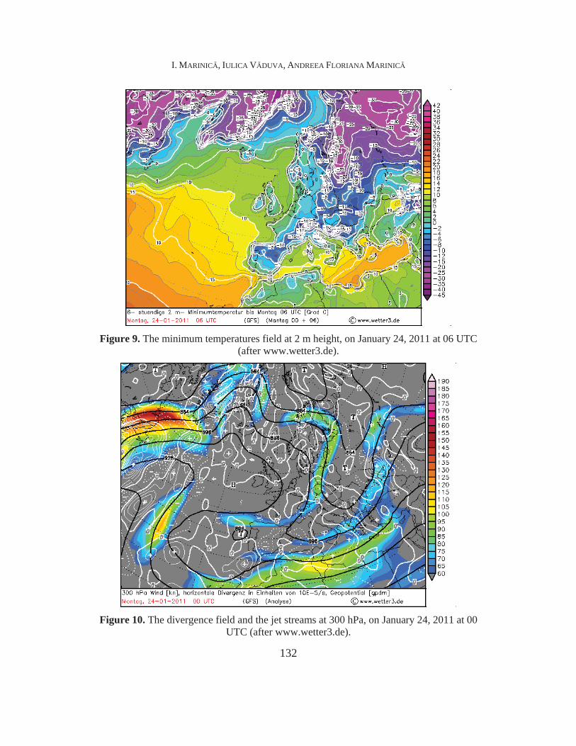
3.3. The attenuation of the blizzard phenomena The ceasing of snowfalls and wind intensifications occurred on the night
of January 23/24 2011 On January 24, 2011 at 00 UTC it was observed: At ground level: The Mediterranean Cyclone was positioned over the
Crimeea. At 500 hPa height: the thalweg of geopotential continued its backing to the
west and south-west and surpassed the Iberian Peninsula reaching with the concavity top of the 552 gpdam isohypse the Atlantic Ocean (fig. 8), a typical situation for the development of the blocking atmospheric circulation.
Figure 8. The synoptic situation at ground level and at 500 hPa height and the relative
geopotential topography TR500/1000, on January 24, 2011 at 00 UTC (after www.wetter3.de).
I. MARINIC , IULICA V DUVA, ANDREEA FLORIANA MARINIC
132
Figure 9. The minimum temperatures field at 2 m height, on January 24, 2011 at 06 UTC
(after www.wetter3.de).
Figure 10. The divergence field and the jet streams at 300 hPa, on January 24, 2011 at 00
UTC (after www.wetter3.de).
CONSIDERATIONS ON THE BLIZZARD OF THE PERIOD JANUARY 21-23, 2011
133
This continuous backing of the geopotential thalweg allowed the continuous cold air advection over most of the continent at all levels in the atmosphere.
For Romania at this time the air circulation was predominantly from the north.
The severe cooling of the weather, produced after this blizzard, continued until February 04, 2011, period during which there were recorded the monthly minimum temperatures of January (January 26-31, 2011) and of February (February 1-3, 2011).
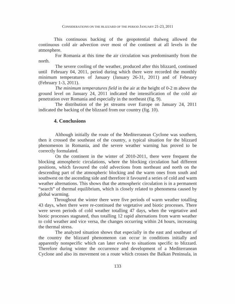
The minimum temperatures field in the air at the height of 0-2 m above the ground level on January 24, 2011 indicated the intensification of the cold air penetration over Romania and especially in the northeast (fig. 9).
The distribution of the jet streams over Europe on January 24, 2011 indicated the backing of the blizzard from our country (fig. 10).
4. Conclusions Although initially the route of the Mediterranean Cyclone was southern,
then it crossed the southeast of the country, a typical situation for the blizzard phenomenon in Romania, and the severe weather warning has proved to be correctly formulated.
On the continent in the winter of 2010-2011, there were frequent the blocking atmospheric circulations, where the blocking circulation had different positions, which favoured the cold advections from northeast and north on the descending part of the atmospheric blocking and the warm ones from south and southwest on the ascending side and therefore it favoured a series of cold and warm weather alternations. This shows that the atmospheric circulation is in a permanent “search” of thermal equilibrium, which is closely related to phenomena caused by global warming.
Throughout the winter there were five periods of warm weather totalling 43 days, when there were re-continued the vegetative and biotic processes. There were seven periods of cold weather totalling 47 days, when the vegetative and biotic processes stagnated, thus totalling 12 rapid alternations from warm weather to cold weather and vice versa, the changes occurring within 24 hours, increasing the thermal stress.
The analyzed situation shows that especially in the east and southeast of the country the blizzard phenomenon can occur in conditions initially and apparently nonspecific which can later evolve to situations specific to blizzard. Therefore during winter the occurrence and development of a Mediterranean Cyclone and also its movement on a route which crosses the Balkan Peninsula, in

I. MARINIC , IULICA V DUVA, ANDREEA FLORIANA MARINIC
134
interaction with an anticyclone field can be an important signal that the blizzard phenomenon will occur in Romania.
The blizzard phenomenon is particularly dangerous for the road traffic, because by blocking roads and vehicles in the traffic it can cause casualties, but it is also an important risk factor for the other economic activities.
REFERENCES
1. Octavia Bogdan, Ion Marinic , Andreea Floriana Marinic (2010), Frequency of warm
winters within Oltenia in 1999-2008 decade, în volumul Aerul i Apa Componente ale Mediului, dedicat Conferin ei tiin ifice cu acela i titlu 19-20.III.2010 Cluj Napoca, Universitatea Babe -Bolyai Facultatea de Geografie, Catedra de Geografie fizic i tehnic în colaborare cu Direc ia Apelor Some , Editori Gavril Pandi i Florin Moldovan, Editura Presa Universitar Clujan , pp 45-54, ISSN: 2067-743X.
2. Marinic , Ion (2006), Fenomene climatice de risc în Oltenia, Edit. MJM Craiova, 386 p.;
3. * * * Buletinele meteorologice ANM din 21-23 ianuarie 2011 4. * * * www.wetterzentrale.de