Embed Size (px)
Citation preview
M A Y 2 0 0 1
Draft Environmental Impact StatementDOE/EIS-0321
CONDON WIND PROJECT
Condon Wind Project Draft Environmental Impact Statement(DOE/EIS-0321)
Responsible Agency: U.S. Department of Energy (DOE), Bonneville Power Administration (BPA)Title of Proposed Action: Condon Wind ProjectStates Involved: Oregon
Abstract: BPA needs to acquire resources to meet its customers' load growth. In meeting that needfor power, BPA will consider the following purposes: protecting BPA and its customers against riskby diversifying its resource portfolio; assuring consistency with its responsibilities under the PacificNorthwest Electric Power Planning and Conservation Act to encourage the development of renewableresources; meeting customer demand for renewable resources; assuring consistency with its resourceacquisition strategy; and meeting the objectives of its Power Business Line's Strategic Plan. TheDraft Environmental Impact Statement (DEIS) evaluates the environmental impacts of the ProposedAction (to execute one or more power purchase and transmission services agreements to acquire andtransmit up to the full electric output of the proposed Condon Wind Project) and the No ActionAlternative. BPA's preferred alternative is the Proposed Action. BPA has also identified theProposed Action as the environmentally-preferred alternative.
The proposed wind project is located on private agricultural land in Gilliam County, Oregon. The38-acre project site is located within a 4,200-acre study area located on both sides of OregonHighway 206, approximately 5 miles northwest of the town of Condon. The project would usemodern, efficient 600-kilowatt (kW) wind turbines to convert energy in the winds to electricity thatwould be transmitted over the existing BPA transmission system. The project would consist of one ortwo phases: the first phase would use 41 wind turbines to yield a capacity of approximately 24.6megawatts (MW). A second phase (if built) would use 42 wind turbines to yield a capacity ofapproximately 25.2 MW. For purposes of this DEIS, the size of the project is assumed to be 49.8MW, built in two phases. Major components of the wind project include wind turbines andfoundations, small pad-mounted transformers, an operation and maintenance building, powercollection and communication cables, project access roads, meteorological towers on foundations,and a substation. During construction there would also be temporary equipment storage andconstruction staging areas. The first phase is proposed for construction in late 2001; the second phasecould be constructed during spring/summer 2002 or later.
To request additional copies of the DEIS, For additional information on the DEIS,please contact: please contact:Bonneville Power Administration Sarah T. BranumCommunications Office - KC-7 Environmental Specialist - KEC-4P.O. Box 3621 Bonneville Power AdministrationPortland, OR 97208 P.O. Box 3621Toll-free: 1-800-622-4520 Portland, OR 97208-3621
(503) 230-5115, or toll-free: [email protected]
You may access the DEIS, or find more information about BPA, on our web site at www.efw.bpa.gov .
For information on DOE National Environmental Policy Act (NEPA) activities, please contact:Carol M. Borgstrom, Director, Office of NEPA Policy and Compliance, EH-42, U.S. Department ofEnergy, 1000 Independence Avenue, SW, Washington DC 20585. Phone: 1-800-472-2756; or visitthe DOE NEPA Web at www.eh.doe.gov/nepa .
Condon Wind Project Table of ContentsDraft EIS Page i
Table of Contents
Summary
Chapter 1 Purpose of and Need for Action ...................................................1-11.1 Background ............................................................................................................ 1-11.2 Need for Action...................................................................................................... 1-11.3 Purpose of Action................................................................................................... 1-21.4 Decisions to be Supported by the EIS .................................................................... 1-21.5 Documents Incorporated by Reference .................................................................. 1-21.6 Scoping and Major Issues ...................................................................................... 1-3
Chapter 2 Proposed Action and Alternatives ...............................................2-12.1 Proposed Action ..................................................................................................... 2-1
2.1.1 Project Overview................................................................................... 2-12.1.2 Project Location and Project Site .......................................................... 2-12.1.3 Wind Resource ...................................................................................... 2-22.1.4 Project Components .............................................................................. 2-22.1.5 Construction .......................................................................................... 2-62.1.6 Operation and Maintenance ................................................................ 2-102.1.7 Workforce ........................................................................................... 2-102.1.8 Traffic.................................................................................................. 2-112.1.9 Hazardous Materials............................................................................ 2-112.1.10 Reclamation......................................................................................... 2-122.1.11 Decommissioning................................................................................ 2-12
2.2 No Action Alternative .......................................................................................... 2-132.3 Alternatives Considered but Eliminated from Detailed Study............................. 2-13
2.3.1 Alternative Energy Resources ............................................................. 2-132.3.2 Alternative Transmission Path ............................................................ 2-142.3.3 Alternative Turbine Locations ............................................................ 2-14
2.4 Summary of Environmental Impacts of the Alternatives ..................................... 2-142.5 Preferred Alternative ............................................................................................ 2-15
Chapter 3 Affected Environment, Environmental Consequences, andMitigation ................................................................................................3-13.1 Regional Setting ..................................................................................................... 3-13.2 Land Use and Recreation ....................................................................................... 3-1
3.2.1 Regulatory Framework.......................................................................... 3-23.2.2 Study Methodology ............................................................................... 3-23.2.3 Affected Environment ........................................................................... 3-23.2.4 Environmental Consequences—Proposed Action................................. 3-33.2.5 Environmental Consequences—No Action Alternative........................ 3-5
3.3 Geology, Soils, and Seismicity .............................................................................. 3-53.3.1 Regulatory Framework.......................................................................... 3-53.3.2 Study Methodology ............................................................................... 3-53.3.3 Affected Environment ........................................................................... 3-6
Table of Contents Condon Wind ProjectPage ii Draft EIS
3.3.4 Environmental Consequences – Proposed Action .................................3-73.3.5 Environmental Consequences—No Action Alternative ........................3-9
3.4 Fish .........................................................................................................................3-93.4.1 Regulatory Framework ..........................................................................3-93.4.2 Study Methodology..............................................................................3-103.4.3 Affected Environment..........................................................................3-103.4.4 Environmental Consequences—Proposed Action ...............................3-113.4.5 Environmental Consequences—No Action Alternative ......................3-12
3.5 Vegetation.............................................................................................................3-133.5.1 Regulatory Framework ........................................................................3-133.5.2 Study Methodology..............................................................................3-133.5.3 Affected Environment..........................................................................3-133.5.4 Environmental Consequences—Proposed Action ...............................3-143.5.5 Environmental Consequences—No Action Alternative ......................3-17
3.6 Wildlife .................................................................................................................3-183.6.1 Regulatory Framework ........................................................................3-183.6.2 Study Methodology..............................................................................3-183.6.3 Affected Environment..........................................................................3-193.6.4 Environmental Consequences—Proposed Action ...............................3-263.6.5 Environmental Consequences—No Action .........................................3-31
3.7 Water Resources and Wetlands ............................................................................3-323.7.1 Regulatory Framework ........................................................................3-323.7.2 Study Methodology..............................................................................3-323.7.3 Affected Environment..........................................................................3-323.7.4 Environmental Consequences—Proposed Action ...............................3-333.7.5 Environmental Consequences—No Action Alternative ......................3-34
3.8 Cultural Resources................................................................................................3-343.8.1 Regulatory Framework ........................................................................3-343.8.2 Study Methodology..............................................................................3-353.8.3 Affected Environment..........................................................................3-353.8.4 Environmental Consequences—Proposed Action ...............................3-393.8.5 Environmental Consequences—No Action Alternative ......................3-40
3.9 Visual Resources ..................................................................................................3-403.9.1 Regulatory Framework ........................................................................3-403.9.2 Study Methodology..............................................................................3-403.9.3 Affected Environment..........................................................................3-413.9.4 Environmental Consequences—Proposed Action ...............................3-423.9.5 Environmental Consequences—No Action Alternative ......................3-44
3.10 Socioeconomics, Public Services, and Utilities....................................................3-443.10.1 Regulatory Framework ........................................................................3-443.10.2 Study Methodology..............................................................................3-453.10.3 Affected Environment..........................................................................3-453.10.4 Environmental Consequences—Proposed Action ...............................3-483.10.5 Environmental Consequences—No Action Alternative ......................3-51
3.11 Transportation.......................................................................................................3-513.11.1 Regulatory Framework ........................................................................3-513.11.2 Study Methodology..............................................................................3-523.11.3 Affected Environment..........................................................................3-523.11.4 Environmental Consequences—Proposed Action ...............................3-533.11.5 Environmental Consequences—No Action Alternative ......................3-54
Condon Wind Project Table of ContentsDraft EIS Page iii
3.12 Air Quality ........................................................................................................... 3-553.12.1 Regulatory Framework........................................................................ 3-553.12.2 Study Methodology ............................................................................. 3-563.12.3 Affected Environment ......................................................................... 3-563.12.4 Environmental Consequences—Proposed Action............................... 3-563.12.5 Environmental Consequences—No Action Alternative...................... 3-57
3.13 Noise .................................................................................................................... 3-583.13.1 Regulatory Framework........................................................................ 3-583.13.2 Study Methodology ............................................................................. 3-593.13.3 Affected Environment ......................................................................... 3-593.13.4 Environmental Consequences—Proposed Action............................... 3-603.13.5 Environmental Consequences—No Action Alternative...................... 3-63
3.14 Public Health and Safety ...................................................................................... 3-633.14.1 Regulatory Framework........................................................................ 3-633.14.2 Study Methodology ............................................................................. 3-643.14.3 Affected Environment ......................................................................... 3-643.14.4 Environmental Consequences—Proposed Action............................... 3-643.14.5 Environmental Consequences—No Action Alternative...................... 3-66
3.15 Relationship Between Short-Term Uses of Man’s Environment vs. theMaintenance and Enhancement of Long-Term Productivity ............................... 3-66
3.16 Irreversible or Irretrievable Commitments of Resources ..................................... 3-663.17 Unavoidable Adverse Impacts ............................................................................. 3-67
Chapter 4 Cumulative Impacts ......................................................................4-1
Chapter 5 Consultation, Review, and Permit Requirements .......................5-15.1 National Environmental Policy Act ....................................................................... 5-15.2 Threatened and Endangered Species and Critical Habitat ..................................... 5-15.3 Fish and Wildlife Conservation.............................................................................. 5-25.4 Heritage Conservation............................................................................................ 5-35.5 State, Areawide, and Local Plan and Program Consistency .................................. 5-45.6 Coastal Zone Management Program Consistency.................................................. 5-45.7 Floodplains and Wetlands Protection..................................................................... 5-45.8 Farmlands............................................................................................................... 5-55.9 Recreation Resources ............................................................................................. 5-55.10 Global Warming..................................................................................................... 5-55.11 Permit for Structures in Navigable Waters............................................................. 5-55.12 Permit for Discharges into Waters of the United States......................................... 5-55.13 Permits for Right-of-Way on Public Lands............................................................ 5-55.14 Energy Conservation at Federal Facilities.............................................................. 5-65.15 Pollution Control at Federal Facilities ................................................................... 5-65.16 Hazardous Materials............................................................................................... 5-65.17 Environmental Justice ............................................................................................ 5-75.18 Notice to the Federal Aviation Administration ...................................................... 5-7
Chapter 6 References .....................................................................................6-16.1 Printed References ................................................................................................. 6-16.2 Personal Communications...................................................................................... 6-5
Table of Contents Condon Wind ProjectPage iv Draft EIS
Chapter 7 Agencies, Organizations, and Persons Receiving this EIS....... 7-17.1 Federal Agencies ....................................................................................................7-17.2 Tribal Government..................................................................................................7-17.3 Public Officials .......................................................................................................7-27.4 State Agencies ........................................................................................................7-27.5 Regional Government .............................................................................................7-27.6 Local Government ..................................................................................................7-37.7 Libraries and Educational Institutions ....................................................................7-37.8 Media ......................................................................................................................7-47.9 Utilities ...................................................................................................................7-47.10 Businesses...............................................................................................................7-47.11 Interest Groups........................................................................................................7-57.12 Individuals ..............................................................................................................7-5
Chapter 8 List of Preparers........................................................................... 8-1
Glossary and Acronyms
Index
Appendix A Public Involvement
Appendix B Agency Correspondence
Appendix C Technical Baseline Study – Executive Summary
Condon Wind Project Table of ContentsDraft EIS Page v
List of Tables and Figures
Tables
2.1-1 Project Wind Turbine Features...................................................................................2-3
2.1-2 Acreage of Agricultural and Non-Agricultural Land that Would Be Affectedby Phase 1 (41 Turbines), Phase 2 (42 Turbines), and Both Phases Combined(83 Turbines) ..............................................................................................................2-6
2.1-3 Construction Equipment Anticipated for the Proposed Project..................................2-7
2.4-1 Comparison of Alternatives......................................................................................2-14
3.6-1 Oregon Natural Heritage List of Sensitive Animal Species Known to Occur inGilliam County .........................................................................................................3-20
3.10-1 Race in Gilliam County and Oregon, 2000 ..............................................................3-47
3.10-2 Potential Annual Economic Benefits to Local and Regional EconomiesResulting from the Proposed Project ........................................................................3-50
3.12-1 National Primary Ambient Air Quality Standards....................................................3-55
3.13-1 Oregon State Allowable Hourly Noise Levels (dBA) ..............................................3-58
3.13-2 Examples of “A-Weighted” Sound Levels ...............................................................3-59
3.13-3 Summary of Background Sound Level Measurements ............................................3-60
3.13-4 Construction Equipment Noise.................................................................................3-61
3.13-5 Summary of Background Sound Levels and Predicted A-Weighted SoundLevels during Project Operation (dBA)....................................................................3-62
Figures
2.1-1 Project Site and Study Area Location............................................................ follows 2-2
2.1-2 Phase 1 and Phase 2 Turbine String Locations.............................................. follows 2-2
2.1-3 Turbine Features, 600-KW ............................................................................ follows 2-2
3.3-1 Soil Erosion Potential in Project Area ........................................................... follows 3-6
3.5-1 Vegetation and Wetlands in Project Area.................................................... follows 3-14
3.8-1 Historic Sites in Project Area ...................................................................... follows 3-36
3.9-1 Key Map of Photosimulation Locations ...................................................... follows 3-44
3.9-2 Photosimulation Site 1 – Looking West on ORE 206 ................................. follows 3-44
3.9-3 Photosimulation Site 2 – Looking North on ORE 206 ................................ follows 3-44
3.9-4 Photosimulation Site 3 – Looking Southwestfrom Ferry Canyon Road............................................................................. follows 3-44
Table of Contents Condon Wind ProjectPage vi Draft EIS
3.9-4a Photosimulation Site 3 – Looking Southwest from Ferry Canyon Road (BlackRotor Blades) .............................................................................................. follows 3-44
3.9-5 Photosimulation Site 4 – Looking South on ORE 206................................ follows 3-44
3.9-6 Photosimulation Site 5 – Looking Southeast on ORE 206 ......................... follows 3-44
3.13-1 Noise Measurement Locations.................................................................... follows 3-60
Condon Wind Project SummaryDraft EIS Page 1
Summary
Introduction
Bonneville Power Administration (BPA) is a federal agency responsible for purchasing,developing, and marketing electrical power to utility, industrial, and other customers in thePacific Northwest, pursuant to the Bonneville Project Act of 1937, the Pacific NorthwestElectric Power Planning and Conservation Act of 1980 (P.L. 96-501; the Northwest PowerAct), and other statutes. BPA wishes to encourage the development of renewable energyresources in the Pacific Northwest to meet customer demand for power, to diversify itsresource portfolio, and to meet its obligations under the Northwest Power Act.
Deregulation of the electric industry and subsequent energy supply issues, as well as thecurrent low-water year, have emphasized the need for new and diverse energy sources in theregion. Renewable resources like wind would not only help diversify BPA’s resourceportfolio, but are preferred by many consumers concerned about environmental effects ofother power sources. BPA has developed and marketed output from renewable powerprojects as “green power” as a way to satisfy demand from these consumers and to increasethe amount of new renewable energy resources in the region’s power supply. The NorthwestPower Planning Council’s Fourth Conservation and Electric Power Plan recommended thatNorthwest utilities offer green power purchase opportunities as a way to help the regionintegrate renewable resources into the power system in the future.
In October 1999, SeaWest Windpower, Inc. (SeaWest) submitted a proposal to BPA toidentify one or more sites in Oregon and Washington at which wind power facilities could bedeveloped. After considering preliminary information regarding several sites identified bySeaWest, BPA decided to examine a proposed wind project located near Condon, Oregon,and to consider purchasing power from a wind power facility that would be constructed bySeaWest at the site.
The National Environmental Policy Act (NEPA) (42 U.S.C. Sections 4321 et seq.) requiresfederal agencies to prepare and circulate an environmental impact statement (EIS) for majorfederal actions or decisions that could significantly affect the quality of the humanenvironment, including the natural and physical environment.
BPA’s decision whether or not to purchase power from the proposed wind project andtransmit it over BPA transmission lines will consider the information in this EIS, publiccomments, and other factors.
This Draft EIS provides environmental information to the public and federal, state, and localagencies, officials, and decision makers regarding the effects of the proposed action. TheFinal EIS will respond to public and agency comments on this Draft EIS, and it will providenecessary clarifications, elaborations, and minor revisions to this draft.
In the face of regional growth in electrical loads and increasing constraints on the existingenergy resource base, BPA needs to acquire resources that will contribute to diversificationof the long-term power supply in the region.
Summary Condon Wind ProjectPage 2 Draft EIS
The purposes of acquiring a diverse resource portfolio include:
! protecting BPA and its customers against risk;
! ensuring consistency with BPA’s responsibility under the Northwest Power Act toencourage the development of renewable energy resources;
! meeting customer demand for energy from renewable energy resources, thereby assuringconsistency with BPA’s Business Plan EIS (DOE/EIS-0183, June 1995) and BusinessPlan Record of Decision (ROD);
! ensuring consistency with the resource acquisition strategy of BPA’s Resource ProgramsEIS (DOE/EIS-0162, February 1993) and ROD; and
! meeting the objective in the January 2000 Strategic Plan of BPA’s Power Business Lineto acquire at least 150 average megawatts (MW) of new renewable resources by the endof fiscal year 2006 in order to meet customer demand for new renewable resources.
BPA’s preferred alternative is the proposed action to execute one or more power purchaseand transmission services agreements to acquire and transmit up to the full electrical outputof the proposed Condon Wind Project. The proposed action is the only alternative that meetsthe underlying need for action and best meets the purposes of action. The preferredalternative is also the environmentally preferred alternative.
Project Site and Wind Resource
The project site is located on both sides of Highway 206 (ORE206), approximately 5 milesnorthwest of the town of Condon in Gilliam County, Oregon. The 38-acre project site iswithin a 4,200-acre study area1 (see Figure S-1) consisting of gently sloping plateaus androlling, arid hills traversed by shallow canyons. In general, the elevation of the project siteand study area ranges from approximately 2,400 feet to 3,300 feet.
Within the project site, the wind project facilities would occupy a permanent footprint ofapproximately 21 acres for the 24.6-MW first phase and an additional 17 acres for the secondphase (38 acres total). The project has been designed to locate the turbines on the relativelyflat (and predominately cultivated) tops of plateaus to take advantage of the best windresources while minimizing potential environmental impacts.
The project site consists of private farmland that is used for non-irrigated agriculture(primarily winter wheat and barley), cattle grazing, or land that is in the ConservationReserve Program (CRP). The General Plan for Gilliam County, and the implementingzoning regulations, designate the project site as “Exclusive Farm Use.” Facilities forgenerating electricity from wind energy can be permitted in Exclusive Farm Use zonespursuant to a conditional land use permit. Such a permit would be issued by Gilliam County,in accordance with county procedures.
1 The study area is the 4,200-acre study area shown in Figure S-1. The project site is the location (covering38 acres) within the broader study area, of the proposed phase 1 and phase 2 wind turbine strings, project accessroads, O&M building, electrical substation, and electrical transmission line connecting to BPA’s Condon-DeMoss line.
Condon Wind Project SummaryDraft EIS Page 3
The project site is well exposed to the winds in all directions; however, the prevailing windsblow from the southwest and northwest across the project site toward the east. The winds areexpected to be strongest from late fall through spring.
Historical wind data collected near Wasco, Oregon; Goodnoe Hills, Washington; andKennewick, Washington, indicate that the Condon area has sufficient winds for wind projectdevelopment. Currently three temporary meteorological towers are measuring wind data atthe project site to confirm the wind resource potential.
Project Components and Construction Phases
The proposed project would consist of a wind project and its associated electrical system.The project would use modern, efficient 600-kilowatt (kW) wind turbines to convert energyin the winds near Condon, Oregon, to electricity that would be transmitted over the BPAtransmission system. The project would consist of one or two phases: the first phase woulduse 41 wind turbines to yield a capacity of approximately 24.6 MW. A second phase (ifbuilt) would use 42 wind turbines to yield a capacity of approximately 25.2 MW. The firstphase is proposed for construction in late 2001; the second phase could be constructed duringspring/summer of 2002 or later.
An estimated 60 to 70 delivery and construction workers and technicians would work onsiteover the duration of the construction period for each phase. However, not all personnelwould be onsite at the same time. Their presence onsite would be phased, depending on thepace of construction, over an estimated construction and equipment testing period of 4 to5 months for each phase, or possibly longer if seasonal weather delays occurred. Estimatedproject employment would not exceed 30 workers at any one time.
Major components of the wind project include the following.
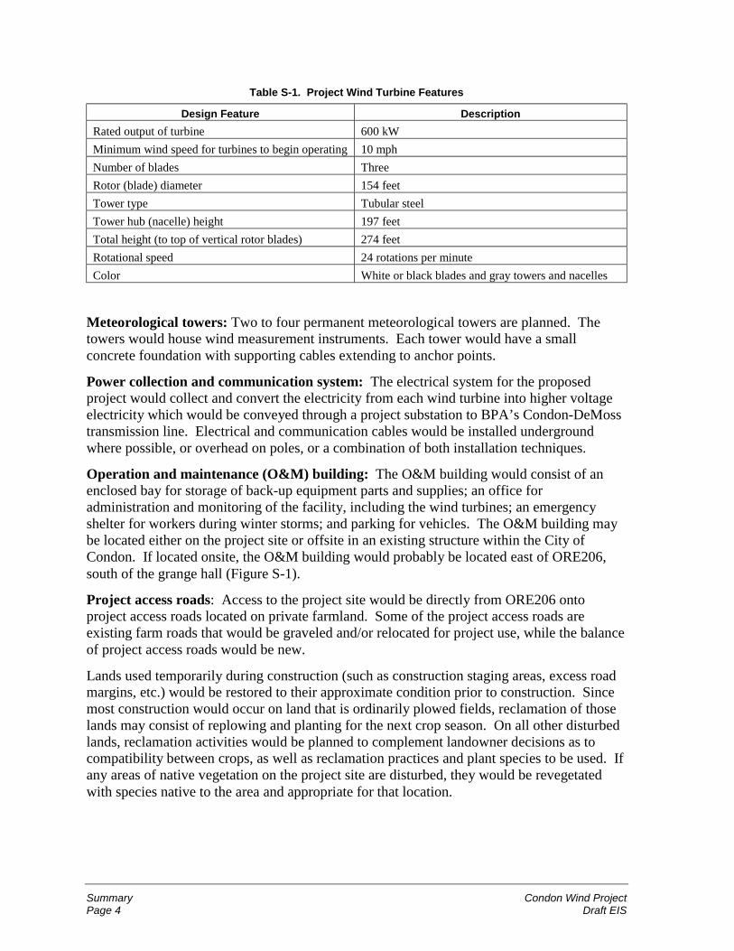
Wind turbines and foundations: The 600-kW wind turbines under consideration for theproject have the design features shown in Table S-1. The poured concrete foundations wouldbe approximately 12 feet in diameter. Foundation depth would depend on soil and localgeologic (bedrock) conditions. The tubular support towers would be constructed of heavyrolled steel that would be fabricated offsite, trucked to the project site in two or moresections, and assembled onsite. The towers would be smooth, with no avian perch locations,and finished in a light gray to blend into the landscape and sky. There would be three rotorblades on each turbine. Each blade would be constructed in one piece, typically of fiberglass,or a fiberglass composite, with a smooth, white or black outer surface (a black coating maybe applied to reduce blade icing). The wind turbines would be fitted with self-diagnosticcomputer monitoring and control systems located inside the turbine towers.
The Federal Aviation Administration may recommend that tower markings or aviation safetylighting be installed on a portion of the towers or nacelles. Otherwise, the completed projectwould normally have no lights at night.
Summary Condon Wind ProjectPage 4 Draft EIS
Table S-1. Project Wind Turbine Features
Design Feature Description
Rated output of turbine 600 kW
Minimum wind speed for turbines to begin operating 10 mph
Number of blades Three
Rotor (blade) diameter 154 feet
Tower type Tubular steel
Tower hub (nacelle) height 197 feet
Total height (to top of vertical rotor blades) 274 feet
Rotational speed 24 rotations per minute
Color White or black blades and gray towers and nacelles
Meteorological towers: Two to four permanent meteorological towers are planned. Thetowers would house wind measurement instruments. Each tower would have a smallconcrete foundation with supporting cables extending to anchor points.
Power collection and communication system: The electrical system for the proposedproject would collect and convert the electricity from each wind turbine into higher voltageelectricity which would be conveyed through a project substation to BPA’s Condon-DeMosstransmission line. Electrical and communication cables would be installed undergroundwhere possible, or overhead on poles, or a combination of both installation techniques.
Operation and maintenance (O&M) building: The O&M building would consist of anenclosed bay for storage of back-up equipment parts and supplies; an office foradministration and monitoring of the facility, including the wind turbines; an emergencyshelter for workers during winter storms; and parking for vehicles. The O&M building maybe located either on the project site or offsite in an existing structure within the City ofCondon. If located onsite, the O&M building would probably be located east of ORE206,south of the grange hall (Figure S-1).
Project access roads: Access to the project site would be directly from ORE206 ontoproject access roads located on private farmland. Some of the project access roads areexisting farm roads that would be graveled and/or relocated for project use, while the balanceof project access roads would be new.
Lands used temporarily during construction (such as construction staging areas, excess roadmargins, etc.) would be restored to their approximate condition prior to construction. Sincemost construction would occur on land that is ordinarily plowed fields, reclamation of thoselands may consist of replowing and planting for the next crop season. On all other disturbedlands, reclamation activities would be planned to complement landowner decisions as tocompatibility between crops, as well as reclamation practices and plant species to be used. Ifany areas of native vegetation on the project site are disturbed, they would be revegetatedwith species native to the area and appropriate for that location.
Condon Wind Project SummaryDraft EIS Page 5
Project Operation and Maintenance
Routine maintenance of the turbines would consist primarily of daily travel, generally bypickup trucks, of two to four operation/maintenance staff who would test and maintain thewind facilities (or six personnel after phase 2 is completed). Most servicing would beperformed “up-tower” (within the nacelle, without using a crane to remove the turbine fromthe tower). Occasionally the use of a crane and possibly equipment transport vehicles maybe necessary for cleaning, repair, adjustments, or replacement of the rotors or equipmentcontained in the nacelle. Additionally, all roads, pads, and trenched areas would be regularlyinspected and maintained to minimize erosion.
Monitoring the operations of the wind turbines would be conducted both from computerslocated in the base of each turbine tower and from the O&M facility usingtelecommunication linkages and computer-based monitoring.
Project Decommissioning
At the end of the project’s useful life, the owner would obtain any necessary authorizationfrom the appropriate regulatory agencies and from the landowners to decommission thefacilities. Decommissioning involves removing the turbines and support towers,transformers, and substation, and removing the upper portion of foundations so that they donot interfere with agricultural practices. Generally turbines, electrical components, andtowers would either resold or recycled for scrap. All unsalvageable materials would bedisposed of at authorized sites in accordance with laws and regulations.
No Action Alternative
An EIS must consider the alternative of not taking the proposed action. Under the No ActionAlternative, BPA would not execute one or more power purchase and transmission servicesagreements to acquire and transmit up to the full electrical output of SeaWest’s proposedCondon Wind Project. Because BPA’s transmission line is the only transmission line nearby,it is highly unlikely that the project would be implemented without a commitment from BPAto acquire the energy output or transmit it over BPA transmission lines to another purchaser.Without BPA’s commitment, the project would not be constructed or operated, and theresulting environmental impacts described in this EIS would not occur.
However, the region’s need for power is expected to continue to grow (as documented in theNorthwest Power Planning Council, Fourth Northwest Power Plan; Energy InformationAdministration, Annual Energy Outlook 2001). Under the No Action Alternative, a greaterproportion of other energy resources would be developed. The predominant resource is mostlikely to be combined-cycle combustion turbines (CTs) fueled by natural gas (NorthwestPower Planning Council, Northwest Power Supply Adequacy/Reliability Study Phase 1Report, Paper Number 2000-4, March 6, 2000). BPA’s Resource Programs EIS (RP EIS)and Business Plan EIS included an evaluation of the environmental impacts of energyresources including CTs.
Summary Condon Wind ProjectPage 6 Draft EIS
Affected Environment and Environmental Impacts
The affected environment, potential impacts, and mitigation for the resource disciplinesevaluated in this EIS are briefly described below. Table S-2, at the end of this Summary,summarizes the potential impacts from the proposed project and mitigation measures in amatrix format.
Land Use and Recreation
Affected Environment
The majority of Gilliam County is zoned Exclusive Farm Use (EFU), including the studyarea and adjacent lands. The proposed wind power project would require a Conditional UsePermit for construction in the EFU zone. The proposed project would also necessitate a GoalException to Oregon Statewide Planning Goal 3, which states that agricultural lands shall bepreserved and maintained for farm use.
The project site and study area are composed of privately owned land used primarily for non-irrigated agriculture (primarily crops, including barley and wheat). A small portion of theproject site and study area (13 percent and 8 percent, respectively) are currently held as CRPland.
Additional land uses within and adjacent to the study area include an active gravel quarry, agrange hall, an occupied house, a meteorological station, abandoned farming/ranchingequipment and implements, and low-density houses with barns and accompanyingoutbuildings. A PGT-PG&E natural gas pipeline traverses northeast to southwest across thesouthern part of the study area, and the 69-kV BPA Condon-DeMoss transmission line runsgenerally parallel to ORE206.
There are no formal recreational amenities within the study area. Hunting may be allowed bylandowner permission in some portions of the study area.
Potential Impacts
Potential land use impacts of the proposed project are summarized below. The level of eachimpact is included in parentheses following the impact description.
Construction
! Approximately 104 acres temporarily disturbed (58 acres in phase 1 and 46 acres inphase 2). Phase 1 temporary disturbance includes approximately 30 acres cultivatedcropland and 4 acres CRP land; phase 2 temporary disturbance includes approximately35 acres cropland and 10 acres CRP land. (Low)
! Temporary restriction on livestock grazing in areas outside agricultural cropland. (Low)
! Temporary interruption of upland bird hunting in the vicinity of the project site. (Minor)
! Potential minor increase in roadside sightseeing. (Minor)
Condon Wind Project SummaryDraft EIS Page 7
Operation and Maintenance
! Conversion of approximately 38 acres for permanent project facilities (21 acres forphase 1, 17 acres for phase 2). Total land converted includes approximately 25 acrescropland and 5 acres CRP land, which represents a very small to negligible portion of theagricultural acreage in the study area and Gilliam County. (Low)
Decommissioning
! Same as construction. (Low and Minor)
Mitigation Measures
Potential mitigation measures for land use impacts include:
! Construction activities will be coordinated with landowners to minimize disturbance offarm operations.
! Landowners will receive compensation for the use of their property through a leaseagreement with the proponent.
! Turbines would be spaced to allow for farming and crop dusting.
! Following project decommissioning, disturbed lands will be restored to their originalcondition through grading and planting. Acreage taken out of agricultural use will beavailable to return to agricultural use.
Geology, Soils, and Seismicity
Affected Environment
The project site and study area are located in the north-central portion of Oregon within theDeschutes-Columbia Plateau, with geology dominated by Columbia River Basalt. Theproject site and study area are located along ridges and uplands that are dissected by anetwork of streams. The ridges are blanketed by a relatively thin layer of soil (1 to 3 feetdeep) over basalt. The erosion potential of study area soils is generally slight to moderateand higher on steep slopes. None of the study area is irrigated farmland, so it does notqualify and has not been designated as prime, unique, or of statewide importance under theFarmland Protection Policy Act.
The type of earthquake events likely to occur in the project site and study area can beexpected to cause slight damage to property and structures.
Potential Impacts
Potential geology and soils impacts of the proposed project are summarized below. The levelof each impact is included in parentheses following the impact description.
Summary Condon Wind ProjectPage 8 Draft EIS
Construction
! Modification of topography and temporary soil disturbance from road improvements,road construction, staging area clearing, and underground trenching could potentiallyinduce erosion or unstable slopes. (Low)
! Removal of vegetation. (Low)
! Stormwater runoff. (Low)
! Potential for earthquake damage to facilities. (Low)
Operation and Maintenance
! Potential erosion at project facility. (Negligible)
Decommissioning
! Similar to construction. (Low)
Mitigation Measures
Mitigation measures for geology and soils impacts include:
! Avoid construction on steep slopes or areas designated as having high susceptibility toerosion.
! Properly design cut-and-fill slopes as required.
! Judiciously apply silt fencing, straw mulch, straw bale check dams, soil stabilizers, andreseed disturbed areas as required.
! Minimize construction during wet weather to reduce potential rutting and soil loss.
! Minimize vegetation removal during construction.
! Install roadway and impervious surface drainage (if needed) to control and disperserunoff.
! Ensure that access roads contain pervious, gravel surfaces.
! Project facilities will be constructed in accordance with applicable seismic design codes,including wind turbine foundations placed directly on competent bedrock.
! Following construction, regular inspections and maintenance would ensure erosion levelsare the same or less than pre-project conditions.
! When the project is decommissioned, perform site reclamation, potentially includingregrading, spot replacement of topsoil, revegetation of disturbed areas, and removal ofturbine foundations to 2-foot depth.
Condon Wind Project SummaryDraft EIS Page 9
Fish
Affected Environment
No fish-bearing streams are located in the project site or study area. Several fish-bearingstreams drain the general project vicinity, including Hay Creek, Dry Fork Hay Creek, andSixmile Canyon (perennial) and Tenmile Canyon, Ferry Canyon, and Sniption Canyon(seasonal). These streams eventually drain to the John Day River and thus to the ColumbiaRiver.
Summer steelhead, which are federally listed as threatened under the Endangered SpeciesAct, have been reported in portions of Hay Creek, Ferry Canyon, Dry Fork Hay Creek, andSixmile Canyon. Tenmile and Sniption Canyons could also support summer steelhead,although habitat maps do not indicate the presence of this species in these two streams.
The Pacific lamprey, listed by the state as vulnerable, may be present in some streams in theproject vicinity. Non-listed fish species in the general project vicinity may include redbandtrout, red sided shiner, largescale sucker, bridge lip sucker, long nose dace, speckled dace,torrent sculpin, and mottled sculpin.
Potential Impacts and Mitigation Measures
No fisheries impacts are expected, and no mitigation is required.
Vegetation
Affected Environment
Cultivated winter wheat (Triticum spp.) and spring barley (Hordeum spp.) compose thedominant vegetation cover in the project site and study area. Some of the more sloping areashave been converted to Conservation Reserve Program (CRP) status and planted with crestedwheatgrass and like perennials. The steepest lands (outside the project site and study area)support some high-quality native shrub-steppe communities (sagebrush and bunch grass),usually within the lower reaches of the drainage draws and away from cultivated areas.
The U.S. Fish and Wildlife Service has indicated that no federally-listed endangered,threatened, proposed, or candidate plant species are known to exist within the project site orstudy area. No state-listed plant species are present on the project site or in the study area.One state-listed plant (Laurence’s milk-vetch, Astragalus collinus var. laurentii) and twocandidate plants (disappearing monkeyflower, Mimulus evanescens, and hepaticmonkeyflower, Mimulus jungermannioides) have been found within a 10-mile radius of theproject site.
No special vegetation resources, such as high-quality native plant communities, are presenton the project site. There is one small patch (less than 1 acre) of high-quality native shrub-steppe in the northern portion of the study area near MP 28. This patch is outside the projectsite and would not be affected by the proposed project. A small wetland of 0.08 acres isassociated with the patch of shrub-steppe described above.
Summary Condon Wind ProjectPage 10 Draft EIS
Potential Impacts
Potential vegetation impacts of the proposed project are summarized below. The level ofeach impact is included in parentheses following the impact description.
Construction
! Total project (phase 1 and 2) would temporarily disturb approximately 64 acres ofcropland during construction, with about 25 acres of cropland remaining in the permanentfootprint for the 20-year project life. (Low)
! Approximately 14 acres of CRP land would be temporarily disturbed during construction,with approximately 5 acres permanently impacted (total for phase 1 and 2). PermanentCRP land impact represents approximately 36 percent of CRP land on the project site andapproximately 1 percent of CRP land in the study area. (Low)
! Total project (phase 1 and 2) would temporarily disturb approximately 2 acres of non-high-quality shrub-steppe vegetation, with about 1 acre remaining in the permanentfootprint for the 20-year project life. This represents less than 1 percent of the totalshrub-steppe in the study area. (Low)
! Establishment of noxious weeds. (Low)
! Vegetation loss due to fire. (Low)
Operation and Maintenance
! Vegetation loss due to fire. (Low)
! Weeds could become established around or downwind of project roads and facilities.(Low)
Decommissioning
! Similar to construction. (Low)
Mitigation Measures
Mitigation measures for vegetation impacts include:
! Landowners will receive compensation for the use of their property through a leaseagreement with the proponent.
! Construction corridors will be marked in shrub-steppe plant communities in the vicinityof construction areas.
! Exposed soils and areas temporarily disturbed by construction will be revegetated.
! Construction equipment will be limited to construction corridors and designated towerand building construction/staging footprint areas.
! If tree removal were unavoidable, each tree that is more than 4 inches diameter will bereplaced at a 5:1 ratio.
Condon Wind Project SummaryDraft EIS Page 11
! The proponent will prepare and implement a Weed Management Control and ResponsePlan, to be approved by the Gilliam County Weed Control Board. Weed managementwill include monitoring site facilities annually for infestation by noxious weeds. Weedswill be controlled in consultation with local landowners. Infestations will be addressedwithin 2 weeks and reported to appropriate staff at the Gilliam County Weed ControlBoard.
! All project vehicles will be equipped with basic fire-fighting equipment, includingextinguishers, shovels, and other equipment deemed appropriate (such as tools forfighting grass fires).
! Roads and turbine pads will be maintained free of vegetation during project operation.
! Herbicides will be used at landowner request to prevent weed infestation of cultivatedareas.
Wildlife
Special-Status Species
The USFWS identified the bald eagle as the only wildlife species listed as threatened orendangered that is known to occur in the vicinity of the proposed project. No occurrence hasbeen reported for the project site or study area, and no threatened species were observedduring the four-season avian surveys conducted for the proposed project. The study areacontains marginal habitat for bald eagles, and the project site contains no typical bald eaglehabitat. The most likely time for bald eagles to enter the study area or project site would befrom late fall to early spring. Bald eagles may occur rarely in the vicinity during winter.
Several state-listed species potentially occur in the project site and study area. Grasshoppersparrow, long-billed curlew, Swainson’s hawk, loggerhead shrike, sage sparrow, and silver-haired bat were observed during the project’s avian and bat surveys. Other state-listedspecies, such as olive-sided flycatchers and bank swallows, may fly through the project siteand study area during migratory periods.
Birds
In 2000 and 2001, a four-season avian study was conducted by URS, Inc. URS prepared astudy plan in consultation with USFWS and ODFW.
Horned lark, western meadowlark, vesper sparrow, and Brewer’s blackbird are by far themost common species of any avian group in the project site and study area. They occurthroughout the year and accounted for over three-quarters of all bird observations during theavian surveys.
Passerine migration through the study area is believed to be moderate. The area is locatedbetween known breeding areas to the north and known wintering areas to the south. Mostmigrants are expected to fly past the study area above turbine height rather than lingering tofeed or rest because the study area contains little cover or food that may attract migrants toland. Large flocks of migrating passerines were not observed during the avian survey.
Summary Condon Wind ProjectPage 12 Draft EIS
However, based on local birding reports, several types of passerines migrate through GilliamCounty.
Northern harriers were regularly observed during the avian survey. American kestrel was themost commonly observed raptor during the field studies. Red-tailed hawk was the secondmost commonly observed raptor in the project site/study area.
Swainson’s hawks, listed by the state as a sensitive/vulnerable species, were observedsoaring and flying at the project site during spring and summer. The nearest Swainson’shawk nest site observed is located more than 3 miles from the project site.
Golden eagles are known to forage within canyons in the general project vicinity. Thenearest nesting site found during the nest survey was more than 12 miles from the projectsite. All golden eagle observations were outside the areas where turbines would be placed.
Species observed in the avian surveys during the hawk migration season were Americankestrel, northern harrier, red-tailed hawk, rough-legged hawk, Cooper’s hawk, prairie falcon,and golden eagle. Other species not observed in the surveys, but reported to migrate throughthe general vicinity, include northern goshawk, sharp-shinned hawk, merlin, peregrinefalcon, and osprey.
Rough-legged hawks are common winter residents in the study area.
Based on habitat, short-eared and barn owls would be relatively common breeders andresidents in the general project vicinity, although the avian surveys resulted in only oneshort-eared owl observation and no barn owl observations. Great horned owls are alsopresent in the general project vicinity. A great horned owl nest was found 10 miles east ofthe project site during a spring helicopter survey. The study area also lies within the range ofwestern screech owls and burrowing owls, but none were sighted during the avian surveys.
Several species of owl may migrate through the project vicinity. Snowy owls are expected tobe occasional visitors in the general project vicinity; they were reported in November andDecember 1996 near Condon. Snowy owls were not detected during the avian field survey.
The long-billed curlew, classified by the state as a sensitive/vulnerable species, and killdeer,a common species, are the only shorebirds known to occur in the general project vicinity.Both migrant and resident populations occur. Long-billed curlews were observed during theavian surveys.
A few flocks of ducks and geese were noted in the avian surveys during the fall migrationperiod, but overall, the amount of activity appears relatively low. During fall 2000, one largeand one small flock of sandhill cranes, totaling 103 birds, were observed migrating over thestudy area. Canada geese were observed during summer and fall surveys in 2000.
Mourning doves are relatively common in the study area based on avian surveys.
Bats
Bat surveys conducted with the avian study in July and September 2000 confirmed thepresence of big brown bat and silver-haired bat, as well as bats in the genus Myotis (likely
Condon Wind Project SummaryDraft EIS Page 13
little brown myotis and California myotis). The state assigns the silver-haired bat’s status assensitive/undetermined.
The bat surveys indicate that most bat activity in the project vicinity occurs in canyons(outside the project site and study area) rather than on the ridgetops where the projectturbines would be installed. In general, important bat habitat such as roost sites (where batsrest) and foraging areas could be provided by the scattered trees and farm buildings in theproject vicinity, and in isolated rock outcrops in Ferry and Tenmile Canyons. The silver-haired bat was detected in the September survey, and is very likely a migrant.
Game Species
Mule deer are common throughout eastern Oregon, including the study area and vicinity.Pronghorn antelope are also present in the general project vicinity. Game bird species in thestudy area include chukar, gray partridge, California quail, and ring-necked pheasant.
Other Wildlife Species
Common wildlife species expected to occur in the project site, study area, and general projectvicinity include mule deer, pronghorn antelopes, cottontails, coyotes, foxes, badgers, bobcats,yellow-bellied marmots, gophers, skunks, ground squirrels, voles, deer mice, pocket mice,pocket gophers, and snakes. Cougars may also occasionally move through the generalproject vicinity to feed on deer, particularly in winter. Most wildlife activity would beexpected to occur on uncultivated lands throughout much of the year, although deer,pronghorn antelopes, voles, snakes, and mice may feed in wheat and barley fields.
Special Habitat Types
CRP lands in the project site and study area provide habitat for snakes and small mammals,raptors, common birds, mule deer, and other wildlife.
No trees are present on the project site, and trees are scarce in the study area, except for a fewscattered groves or individual trees usually associated with current or former farms (blacklocust is the most common tree species). Such upland trees provide habitat for nesting androosting birds and bats, and they are essential to Swainson’s hawks because suitable nesttrees are often the limiting factor to the species’ distribution and abundance. Trees may alsoprovide forage for browsing mule deer and antelope.
Riparian habitats with trees are not present on the project site and are very rare in the studyarea and project vicinity. Riparian vegetation other than trees occurs as narrow strips alongdrainage bottoms in the general project vicinity.
Shrub-steppe is an essential habitat for many native species, including species classified assensitive by the state such as sage sparrow and loggerhead shrike. The general projectvicinity supports three types of shrub-steppe: big sagebrush/bluebunch wheatgrass, stiffsagebrush/Sandberg’s bluegrass, and big sagebrush/gray rabbitbrush/annual grasses.
Streams and wetlands in the study area are discussed below, under “Water Resources andWetlands.”
Summary Condon Wind ProjectPage 14 Draft EIS
Scattered human structures in the study area (none on project site) also provide importantwildlife habitat. Existing utility poles and fences provide perches for raptors. Abandonedhomesteads and associated trees provide hiding and nesting cover for a variety of wildlife.
Potential Impacts
Potential wildlife impacts of the proposed project are summarized below. The level of eachimpact is included in parentheses following the impact description.
Construction
! Construction noise and activities would cause some wildlife to avoid areas of activeconstruction. (Low)
! Approximately 14 acres of CRP habitat disturbed (less than 1 percent of CRP land instudy area). (Low)
Operation and Maintenance
! Annual bird mortality due to collision with turbines is expected to be 50 to 100 (mostlypasserines with a few raptors). Annual bat mortality due to collision with turbines isexpected to be 60 to 160. Some birds may also collide with guy wires of the project’smeteorological towers. (Low to Moderate)
! Mortality of bald eagles or other birds due to electrocution by electrical transmissionlines. (Minor)
! General decline in wildlife use of the project site due to the presence of turbines andassociated operation and maintenance activities. (Minor)
Decommissioning
! Temporary increase in noise and visual disturbance potentially affecting wildlife. (Low)
! Elimination of bat and avian mortality caused by the project. Wildlife activity andhabitat at the project site could return to pre-project conditions. (None)
Mitigation Measures
Mitigation measures for wildlife impacts include:
! Construction will be primarily within areas that are private farmland that is onlymarginally productive as habitat.
! The project is sited in an area of low avian use. Project design includes tubular (notlattice) towers, slow-rotating turbine blades, and turbine location at the top or downwindside of ridges.
! The proponent will monitor avian and bat mortality for the first year of the project’s life,and submit a quarterly report during that year to BPA, ODFW, and USFWS. Themonitoring will follow standard protocols that have been established at other windresource projects.
Condon Wind Project SummaryDraft EIS Page 15
! The proponent will maintain a record of all wildlife injury and mortality that is observedat the project site.
! To prevent bald eagles from being attracted to the project site, project personnel andavian monitoring crews will remove any large carrion (dead deer or cattle) at the projectsite between November 15 and March 31 of any given year. Carrion will be relocatedwithin 24 hours to habitat more than 2 miles from the project.
! Overhead electrical power lines and other transmission facilities will be designed toprevent electrocution hazard to raptors and other birds by incorporating features such asperch guards, separation of wires, or line insulators.
Water Resources and Wetlands
No streams exist within the project site or study area, but several streams and drainages occurin the general project vicinity, including Hay Creek to the west, Tenmile Canyon (whichdrains to Hay Creek) to the north, Ferry Canyon to the east, and Sniption Canyon (whichdrains to Thirtymile Canyon) to the south. Streams in the general project vicinity typicallyexhibit poor water quality, including high temperatures, low oxygen levels, and pollutionsuch as sediments, bacteria, fecal coliform, nutrients, and toxic effluents. Smaller streamsgenerally dry up during summer, while larger streams flow year-round.
No wetlands are present on the project site. One 0.1-acre wetland is present in the northernportion of the study area near MP 28. Three seasonal wetlands totaling about 0.17 acre arelocated within draws just outside the study area. These sites were dry during field studies inJuly 2000. One pond located just outside the study area is believed to hold water throughoutthe year.
Potential Impacts
Potential impacts to water resources and wetlands are summarized below. The level of eachimpact is included in parentheses following the impact description.
Construction
! Soil erosion of exposed soils and potential for contaminant materials to be introducedinto surface waters in the general project vicinity. (Minor)
! Accidental spills of hazardous or toxic materials used or stored on the project site (fuels,lubricants, solvents). (Minor)
Operation and Maintenance
! Accidental spills of hazardous or toxic materials used or stored on the project site (fuels,lubricants, solvents). (Minor)
Decommissioning
! Same as construction. (Minor)
Summary Condon Wind ProjectPage 16 Draft EIS
Mitigation Measures
Mitigation measures for water resources and wetlands include:
! Use erosion control and soils management techniques during construction to prevent finesediments from being introduced into downstream drainages above existing levels.
! Contain and clean up contaminants on site during construction and operation.
Cultural Resources
The primary and traditional Native American groups to utilize the study area were theSahaptin-speaking Yakama, Warm Springs, and Tenino and the Numic-speaking NorthernPaiute. Cayuse, Umatilla, Nez Perce, and Walla Walla groups also are known to haveutilized this area. The ethnographic research shows that as many as 100 plant species wereregularly used in past times as food resources and many of these plants maintain theirimportance in modern times.
Tribal consultation was initiated by BPA, consistent with the agency’s 1996 Tribal Policy.Representatives from BPA and SeaWest met with the Cultural Resources Committees of theConfederated Tribes of Warm Springs Reservation and Confederated Tribes of the UmatillaReservation during the scoping period for the EIS. The purpose of the meetings was toinform the tribes about the proposed project and to hear any comments or concerns they mayhave regarding it. Both tribes mentioned the presence of native plant species within theproject vicinity that were and still are part of traditional root-gathering forays. Prior tocultural resource field surveys, the tribes declined an invitation to take part in walking overthe study area but requested an opportunity to comment on the Draft EIS.
Three previously identified hunter-fisher-gatherer sites are recorded adjacent to the studyarea. These consisted of stone flakes, projectile points, animal bones, shell fragments, andcharcoal. One of these sites is eligible for inclusion on the National Register of HistoricPlaces. During the 2000-2001 field surveys, three hunter-fisher-gatherer isolated artifactswere identified north of Richmond Road in the study area. No artifacts were found on theproject site.
Recorded historic sites in the study area mainly center on themes of homesteading, ranching,mining, and transportation. These sites date from the late 19th through early 20th centuries.The most common sites are wooden homesteads or cabins or their remains, along withassociated features such as wells, outhouses, windmills, trash dumps, and non-native trees.Corrals, fences, flumes, canals, and farm equipment also are present on some sites.
Potential Impacts
Potential impacts to cultural resources are summarized below. The level of each impact isincluded in parentheses following the impact description.
Construction
! Disturbance of undiscovered hunter-fisher-gatherer resources or unrecorded culturalresources. (Low)
Condon Wind Project SummaryDraft EIS Page 17
Operation and Maintenance
! None anticipated.
Decommissioning
! Same as construction. (Low)
Mitigation Measures
Mitigation measures for cultural resources include:
! If archaeological or historic materials are discovered during construction, further surface-disturbing activities at the site would cease, and BPA, State Historic Preservation Officer,and Tribal personnel would be notified to ensure proper handling of the discovery.
! Construction would avoid known hunter-fisher-gatherer artifacts and historic structuresand equipment.
Visual Resources
The visual setting of the study area includes plateaus of gently rolling hills incised byravines, undulating fields of grasses, low, dense native shrub-steppe, and a few humanelements such as transmission lines, windmills, and buildings. The visual quality of thestudy area is rural, with no urban or developed areas.
Primary viewer types associated with the proposed project include residents, local orbusiness travelers, occasional recreationists (primarily hunters), agricultural workers, andother types of workers in the area. The most visually sensitive viewers would be people inresidences located in or adjacent to the study area.
Potential Impacts
Potential visual impacts of the proposed project are summarized below. The level of eachimpact is included in parentheses following the impact description.
Construction
! Temporary alterations to viewscape from construction activities. (Low)
Operation and Maintenance
! Change in viewscape from presence of turbines and meteorological towers. Impactswould be greatest for residential viewers along ORE206 and between Condon and theproject site where views of the project are not obstructed. The impacts could be positiveor negative, depending on viewer perceptions of wind turbines. (Low to High)
Decommissioning
! Same as construction. (Low)
Summary Condon Wind ProjectPage 18 Draft EIS
Mitigation Measures
Mitigation measures for visual impacts include:
! Site all construction staging and storage areas away from locations that will be clearlyvisible from ORE206 to the extent practical.
! Provide clean-looking facility by storing equipment and supplies out of sight, if practical,by promptly removing any damaged or unusable equipment, and by promptly repairing ordecommissioning (and removing) turbines that are not functioning or not being used.
! Keep turbines and towers clean and touch up paint when needed.
! Coordinate with Oregon and federal recreational facilities and areas, and OregonDepartment of Transportation, to provide signs directing sightseers along ORE206 topublic viewing places that could provide safe viewing areas of the project site.
Socioeconomics, Public Services, and Utilities
Nearly 40 percent of the labor force in Gilliam County is employed in farming. Otheremployment sectors include transportation and public utilities (23 percent); government(18 percent); wholesale and retail trade (11 percent); services (6 percent); finance, insuranceand real estate (2 percent); and construction and mining (less than 1 percent).
The number of people below the poverty level (based on Census threshold definition) was12 percent in both Gilliam County and the State of Oregon in 1989. In 2000, the racialcomposition of Gilliam County was approximately 97 percent white and 2 percent Hispanicor Latino, with the rest of the population a mixture of other races. During the same period,the population of Oregon was approximately 87 percent white, 8 percent Hispanic or Latino,3 percent Asian, and the remainder composed of other races.
Fire service for the project would be provided by the South Gilliam County Rural FireProtection District. Police service would be provided by the Gilliam County Sheriff’s Office,located in downtown Condon.
Gilliam County Medical Center in Condon is staffed by two physician assistants withsupervision by a medical doctor from Hermiston. The nearest hospital is located in TheDalles, 70 miles northwest of Condon. The City of Condon is served by a volunteerEmergency Medical Technician crew with two fully equipped ambulances, and by LifeFlight helicopters, out of Bend (120 miles south), for major emergencies.
A substation southwest of the project site reduces the 69-kV power from the BPA Condon-DeMoss transmission line to 7.2 kV for distribution. Columbia Basin Electric Co-op, a full-requirements customer of BPA, serves the community.
There are no municipal or cooperative water or sewer systems serving the project site andstudy area. All farming is dryland.
Solid waste collection in the project vicinity is provided by Columbia Ridge Landfill andRecycling Center, and Sunrise Sanitation.
Condon Wind Project SummaryDraft EIS Page 19
Potential Impacts
Potential impacts related to socioeconomics, public services, and utilities are summarizedbelow. The level of each impact is included in parentheses following the impact description.
Construction
! Potential benefit to local and regional economies through employment opportunities andpurchase of goods and services. (Moderate)
! Increased demand on local emergency response resources such as fire, police, andmedical personnel and facilities. (Minor)
! Potential benefit if minority or low-income people become part of the constructionworkforce. (Low)
Operation and Maintenance
! Increased demand for emergency services, schools, housing, and utilities. (Minor)
! Local economic benefit from employment opportunities, increased tax revenues andpurchase of goods and services. (Low)
! Loss of agricultural revenues due to conversion of crop land to wind project facilities.(Minor)
Decommissioning
! Potential benefit to local and regional economies through employment opportunities andpurchase of goods and services. (Moderate)
! Increased demand on local emergency response resources such as fire, police, andmedical personnel and facilities. (Minor)
! Loss of up to six full-time jobs created as part of the project. (Low)
! Potential benefit to minority or low-income people if they become part of thedecommissioning workforce. (Low)
Mitigation Measures
Mitigation measures for socioeconomic impacts include:
! The proponent would make lease payments to property owners for use of theiragricultural land.
Transportation
Highway 19 (ORE19) is a major north-south arterial located approximately 5 miles east ofthe project site, where it intersects with ORE206 at the City of Condon (Figure S-1). Itextends from Interstate 84 along the Columbia River south to Wheeler County, Oregon.
Summary Condon Wind ProjectPage 20 Draft EIS
Highway 206 (ORE206) extends from Interstate 84 along the Columbia River southeastthrough Condon and into Morrow County, east of Gilliam County.
Approximately 100 miles of Gilliam County roads are paved, while over 300 miles are gravelroads. Three county roads provide access to the project site: Richmond Lane and FerryCanyon Road, located east of ORE206, and Old Cottonwood Road, located north of andparallel to ORE206 (Figure S-1).
The average daily two-way traffic (ADT) volume on ORE206 approximately 0.4 mile east ofCondon was 238 vehicles in 1999. The 1999 ADT volume on ORE19 (approximately4 miles south of Arlington) was 855 vehicles. Traffic volumes are not available for GilliamCounty roads. However, traffic volume is relatively low, and these roads are generally usedto access local residences.
Potential Impacts
Potential transportation impacts of the proposed project are summarized below. The level ofeach impact is included in parentheses following the impact description.
Construction
! Increase in average daily two-way traffic of 21 to 42 percent on ORE206 and 6 to 12percent on ORE19 (based on 1999 volumes). (Low)
! Potential for temporary delays in local traffic during delivery of equipment orcomponents. (Minor)
! Damage to state or county roads. (Low)
Operation and Maintenance
! Based on 1999 volumes, average daily trips would increase a maximum of 3 percent onORE206 and a maximum of 1 percent on ORE19. (Minor to Low)
Decommissioning
! Similar to construction. (Minor to Low)
Mitigation Measures
Mitigation measures for transportation impacts include:
! Coordinate routing of construction traffic with Gilliam County Public WorksDepartment.
! Employ traffic control flaggers and signs warning of construction activity and mergingtraffic as required.
! Repair any damages to state and/or county roads.
Condon Wind Project SummaryDraft EIS Page 21
Air Quality
The air quality attainment status of Gilliam County is not currently classified and air qualityin the county is not monitored. Because of the sparse population and rural nature of the area,Gilliam County is likely to be in attainment for all criteria pollutants. Existing sources of airpollution are likely to be minimal.
The climate in the area is very dry (16 inches of precipitation annually). Wind-blown dust isprevalent in non-irrigated agricultural areas such as the project site and study area becausesoils are often composed of fine-grain silt loams. Dust is generated in such environments byagricultural activities, vehicles traveling on dirt roads, construction, and other activities thatdisturb soil.
Potential Impacts
Potential air quality impacts of the proposed project are summarized below. The level ofeach impact is included in parentheses following the impact description.
Construction
! Combustion pollutants from equipment exhaust and “fugitive dust” particles fromdisturbed soils becoming airborne. (Low)
Operation and Maintenance
! Emissions and generated dust from maintenance vehicles and equipment. (Negligible)
Decommissioning
! Similar to construction. (Low)
Mitigation Measures
Mitigation measures for air quality impacts include:
! During construction, water exposed soil surfaces each day during dry weather, especiallywhen blowing dust is visible.
! Cover construction materials that could be a source of dust when stored.
! Limit vehicle speeds along non-graveled roads to 25 mph.
! Cover truck beds when transporting dirt/soil (if applicable).
! Shut down idling construction equipment.
Noise
The existing noise environment in the project site and study area is relatively quiet, withoccasional noise resulting from scattered farm machinery, vehicles on local roads, birds, andwind. Background noise levels at locations distant from traveled roadways are relativelylow.
Summary Condon Wind ProjectPage 22 Draft EIS
Potential Impacts
Potential noise impacts of the proposed project are summarized below. The level of eachimpact is included in parentheses following the impact description.
Construction
! Residents in the vicinity of the project site could experience construction noise(associated with grading and earthmoving activities, hauling of materials, building ofstructures, and construction of turbines) above Oregon noise standards. (Moderate toHigh)
Operation and Maintenance
! Two of 12 sound measurement locations in the study area would experience noise abovemeasured background levels but still below Oregon standards. (Low to Moderate)
Decommissioning
! Similar to construction. (Moderate to High)
Mitigation Measures
Mitigation measures for noise impacts include:
! All equipment will have sound-control devices no less effective than those provided onthe original equipment. No equipment will have an unmuffled exhaust.
! No noise-generating construction activity will be conducted within 1,000 feet of anoccupied residence between the hours of 10 p.m. and 7 a.m.
! In the event of adjacent landowner complaints, and as directed by the county, thecontractor will implement appropriate noise-reducing measures including, but not limitedto, changing the location of stationary construction equipment, shutting off idlingequipment, rescheduling construction activity, and notifying adjacent residents inadvance of construction work.
Public Health and Safety
The study area is a sparsely populated rural area of agricultural land, grassy canyons andridgetops. Potential hazards in the area include the fire hazard presented by dry crops andgrasses, especially in the summer months, and utility crossings. The BPA 69-kV Condon-DeMoss transmission line parallels and crosses the study area, and an undergroundPGT/PG&E gas pipeline crosses the project site/study area in a southwest-northeastdirection. The Condon airport is located approximately 4 miles east of the project site.
Potential Impacts
Potential public health and safety impacts of the proposed project are summarized below.The level of each impact is included in parentheses following the impact description.
Condon Wind Project SummaryDraft EIS Page 23
Construction
! Health and safety risks for workers and visitors. (Low)
Operation and Maintenance
! Potential health and safety risks to workers, farmers, aviators, and visitors. (Low)
Decommissioning
! Similar to construction. (Low)
Mitigation Measures
Mitigation measures for public health and safety impacts include:
! Each construction contractor and subcontractor will maintain a safety plan in compliancewith Oregon requirements. The proponent will maintain an overall site safety plan andconduct weekly safety meetings with contractors.
! Highway-authorized vehicles and construction equipment will be fueled, serviced, andcleaned offsite. Onsite fueling and servicing of non-highway-authorized equipment willbe in accordance with typical construction practices and in compliance with applicablelaws and regulations.
! Unauthorized visitors will be discouraged from entering the project site duringconstruction hours by the presence of construction workers, warning signs, placards, andgates.
! Coordinate project operation and maintenance activities with the needs of farmers andlandowners.
! Use warning signs, fences, and locked gates to discourage unauthorized access to theproject site during operation.
! An Operations Health and Safety Plan and Emergency Response Plan that informsemployees and others how to prevent emergencies and lower risks and how to respond toemergencies will be kept onsite. Specific training for employees will be provided.
! The Condon airport may have to account for the presence of wind turbines in its takeoffand landing patterns. The FAA will determine whether facility lighting or markings arerequired. Crop dusters would take precautions to minimize risk of collision with projectturbines.
! Fuels, oils, and solvents will be properly stored in approved above-ground containers.All materials will be used in compliance with applicable local, state, and federalenvironmental laws and regulations.
Table S-2, Page 1
Table S-2. Potential Impacts and Mitigation of the Proposed Condon Wind Project
Potential Impact Impact Level Mitigation
P = Design and/or construction measures proposed by the applicant to reduce potential impactsA = Additional mitigation measures being considered by BPA and the applicant to further reduce potential impacts
Land Use and Recreation
Construction
! Approximately 104 acres temporarily disturbed (58 acres inphase 1 and 46 acres in phase 2). Phase 1 temporarydisturbance includes approximately 30 acres cultivatedcropland and 4 acres CRP land; phase 2 temporarydisturbance includes approximately 35 acres cropland and10 acres CRP land.
Low
! Construction activities will be coordinated with landowners tominimize disturbance of farm operations. (P)
! Temporary restriction on livestock grazing in areas outsideagricultural cropland.
Low! Construction activities will be coordinated with landowners to
minimize disturbance of farm operations. (P)
! Temporary interruption of upland bird hunting in the vicinityof the project site.
Minor! None required.
! Potential minor increase in roadside sightseeing.Minor
! None required.
Operation and Maintenance
! Conversion of approximately 38 acres for permanent projectfacilities (21 acres for phase 1, 17 acres for phase 2). Totalland converted includes approximately 25 acres cropland and5 acres CRP land, which represents a very small to negligibleportion of the agricultural acreage in the study area andGilliam County.
Low
! Landowners will receive compensation for the use of theirproperty through a lease agreement with the proponent. (P)
! Turbines would be spaced to allow for farming and crop dusting.(P)
Decommissioning! Same as construction. Low and
Minor! Disturbed lands will be restored to their original condition through
grading and planting. (P)
! Acreage taken out of agricultural use will be available to return toagricultural use. (P)
Table S-2, Page 2
Table S-2. Potential Impacts and Mitigation of the Proposed Condon Wind Project
Potential Impact Impact Level Mitigation
P = Design and/or construction measures proposed by the applicant to reduce potential impactsA = Additional mitigation measures being considered by BPA and the applicant to further reduce potential impacts
Geology, Soils, and Seismicity
Construction
! Modification of topography and temporary soil disturbancefrom road improvements, road construction, staging areaclearing, and underground trenching could potentially induceerosion or unstable slopes.
Low ! Avoid construction on steep slopes or areas designated as havinghigh susceptibility to erosion. (P)
! Properly design cut-and-fill slopes as required. (P)
! Judiciously apply silt fencing, straw mulch, straw bale checkdams, soil stabilizers, and reseed disturbed areas as required. (P)
! Minimize construction during wet weather to reduce potentialrutting and soil loss. (P)
! Removal of vegetation. Low ! Minimize vegetation removal. (P)
! Stormwater runoff. Low ! Install roadway and impervious surface drainage (if needed) tocontrol and disperse runoff. (P)
! Ensure that access roads contain pervious, gravel surfaces. (P)
! Potential for earthquake damage to facilities. Low ! Project facilities will be constructed in accordance with applicableseismic design codes, including wind turbine foundations placeddirectly on competent bedrock. (P)
Operation and Maintenance
! Potential erosion at project facility. Negligible ! Regular inspections and maintenance to ensure erosion levels arethe same or less than pre-project conditions. (P)
Decommissioning
! Similar to construction. Low ! Perform site reclamation, potentially including regrading, spotreplacement of topsoil, revegetation of disturbed areas, andremoval of turbine foundations to 2-foot depth. (P)
Fish
Construction
! None anticipated. None ! None required.
Operation and Maintenance
! None anticipated. None ! None required.
Table S-2, Page 3
Table S-2. Potential Impacts and Mitigation of the Proposed Condon Wind Project
Potential Impact Impact Level Mitigation
P = Design and/or construction measures proposed by the applicant to reduce potential impactsA = Additional mitigation measures being considered by BPA and the applicant to further reduce potential impacts
Decommissioning
! None anticipated. None ! None required.
Vegetation
Construction
! Total project (phase 1 and 2) would temporarily disturbapproximately 64 acres of cropland during construction, withabout 25 acres of cropland remaining in the permanentfootprint for the 20-year project life.
Low ! Landowners will receive compensation for the use of theirproperty through a lease agreement with the proponent. (P)
! Approximately 14 acres of CRP land would be temporarilydisturbed during construction, with approximately 5 acrespermanently impacted (total for phase 1 and 2). PermanentCRP land impact represents approximately 36 percent of CRPland on the project site and approximately 1 percent of CRPland in the study area.
Low ! Landowners will receive compensation for the use of theirproperty through a lease agreement with the proponent. (P)
! Total project (phase 1 and 2) would temporarily disturbapproximately 2 acres of non-high-quality shrub-steppevegetation, with about 1 acre remaining in the permanentfootprint for the 20-year project life. This represents less than1 percent of the total shrub-steppe in the study area.
Low ! Construction corridors will be marked in shrub-steppe plantcommunities in the vicinity of construction areas. (A)
! Exposed soils and areas temporarily disturbed by construction willbe revegetated. (A)
! Construction equipment will be limited to construction corridorsand designated tower and building construction/staging footprintareas. (A)
! If tree removal were unavoidable, each tree that is more than4 inches diameter will be replaced at a 5:1 ratio. (A)
! Establishment of noxious weeds. Low ! The proponent will prepare and implement a Weed ManagementControl and Response Plan, to be approved by the Gilliam CountyWeed Control Board. Weed management will include monitoringsite facilities annually for infestation by noxious weeds. Weedswill be controlled in consultation with local landowners.Infestations will be addressed within 2 weeks and reported toappropriate staff at the Gilliam County Weed Control Board. (A)
Table S-2, Page 4
Table S-2. Potential Impacts and Mitigation of the Proposed Condon Wind Project
Potential Impact Impact Level Mitigation
P = Design and/or construction measures proposed by the applicant to reduce potential impactsA = Additional mitigation measures being considered by BPA and the applicant to further reduce potential impacts
! Vegetation loss due to fire. Low ! All project vehicles will be equipped with basic fire-fightingequipment, including extinguishers, shovels, and other equipmentdeemed appropriate (such as tools for fighting grass fires). (A)
Operation and Maintenance
! Vegetation loss due to fire. Low ! All project facility and maintenance vehicles will be equippedwith basic fire-fighting equipment, as described for construction.(A)
! Roads and turbine pads will be maintained free of vegetation. (P)
! Weeds could become established around or downwind ofproject roads and facilities.
Low ! Herbicides will be used at landowner request to prevent weedinfestation of cultivated areas. (P)
Decommissioning! Similar to construction. Low ! Same as construction.
Wildlife
Construction
! Construction noise and activities would cause some wildlifeto avoid areas of active construction.
Low ! Construction will be primarily within areas that are privatefarmland that is only marginally productive as habitat. (P)
! Approximately 14 acres of CRP habitat disturbed (less than 1percent of CRP land in study area).
Low ! None required, because loss represents a negligible reduction ofthis habitat type in the study area.
Operation and Maintenance! Annual bird mortality due to collision with turbines is
expected to be 50 to 100 (mostly passerines with a fewraptors). Annual bat mortality due to collision with turbines isexpected to be 60 to 160. Some birds may also collide withguy wires of the project’s meteorological towers.
Low toModerate
! The project is sited in an area of low avian use. Project designincludes tubular (not lattice) towers, slow-rotating turbine blades,and turbine location at the top or downwind side of ridges. (P)
! The proponent will monitor avian and bat mortality for the firstyear of the project’s life, and submit a quarterly report during thatyear to BPA, ODFW, and USFWS. The monitoring will followstandard protocols that have been established at other windresource projects. (A)
! The proponent will maintain a record of all wildlife injury andmortality that is observed at the project site. (A)
Table S-2, Page 5
Table S-2. Potential Impacts and Mitigation of the Proposed Condon Wind Project
Potential Impact Impact Level Mitigation
P = Design and/or construction measures proposed by the applicant to reduce potential impactsA = Additional mitigation measures being considered by BPA and the applicant to further reduce potential impacts
! To prevent bald eagles from being attracted to the project site,project personnel and avian monitoring crews will remove anylarge carrion (dead deer or cattle) at the project site betweenNovember 15 and March 31 of any given year. Carrion will berelocated within 24 hours to habitat more than 2 miles from theproject. (A)
! Mortality of bald eagles or other birds due to electrocution byelectrical transmission lines.
Minor ! Overhead electrical power lines and other transmission facilitieswill be designed to prevent electrocution hazard to raptors andother birds by incorporating features such as perch guards,separation of wires, or line insulators. (P)
! General decline in wildlife use of the project site due to thepresence of turbines and associated operation andmaintenance activities.
Minor ! None required.
Decommissioning
! Temporary increase in noise and visual disturbancepotentially affecting wildlife.
Low ! None required.
! Elimination of bat and avian mortality caused by the project.Wildlife activity and habitat at the project site could return topre-project conditions.
None ! None required.
Water Resources and Wetlands
Construction
! Soil erosion of exposed soils and potential for contaminantmaterials to be introduced into surface waters in the generalproject vicinity.
Minor ! Use erosion control and soils management techniques to preventfine sediments from being introduced into downstream drainagesabove existing levels. (P)
! Accidental spills of hazardous or toxic materials used orstored on the project site (fuels, lubricants, solvents).
Minor ! Contain and clean up contaminants on site. (P)
Operation and Maintenance
! Accidental spills of hazardous or toxic materials used orstored on the project site (fuels, lubricants, solvents).
Minor ! Contain and clean up contaminants on site. (P)
Decommissioning! Same as construction. Minor ! Same as construction.
Table S-2, Page 6
Table S-2. Potential Impacts and Mitigation of the Proposed Condon Wind Project
Potential Impact Impact Level Mitigation
P = Design and/or construction measures proposed by the applicant to reduce potential impactsA = Additional mitigation measures being considered by BPA and the applicant to further reduce potential impacts
Cultural Resources
Construction
! Disturbance of undiscovered hunter-fisher-gatherer resourcesor unrecorded cultural resources.
Low ! If archaeological or historic materials are discovered duringconstruction, further surface-disturbing activities at the site wouldcease, and BPA, State Historic Preservation Officer, and Tribalpersonnel would be notified to ensure proper handling of thediscovery. (P)
! Construction would avoid known hunter-fisher-gatherer artifactsand historic structures and equipment. (P)
Operation and Maintenance
! None anticipated. None ! None required.
Decommissioning! Same as construction. Low ! Same as construction.
Visual Resources
Construction
! Temporary alterations to viewscape from constructionactivities.
Low ! Site all construction staging and storage areas away from locationsthat will be clearly visible from ORE206 to the extent practical.(A)
Operation and Maintenance
! Change in viewscape from presence of turbines andmeteorological towers. Impacts would be greatest forresidential viewers along ORE206 and between Condon andthe project site where views of the project are not obstructed.The impacts could be positive or negative, depending onviewer perceptions of wind turbines.
Low to High ! Provide clean-looking facility by storing equipment and suppliesout of sight, if practical, by promptly removing any damaged orunusable equipment, and by promptly repairing ordecommissioning (and removing) turbines that are not functioningor not being used. (A)
! Keep turbines and towers clean and touch up paint when needed.(A)
! Coordinate with Oregon and federal recreational facilities andareas, and Oregon Department of Transportation, to provide signsdirecting sightseers along ORE206 to public viewing places thatcould provide safe viewing areas of the project site. (A)
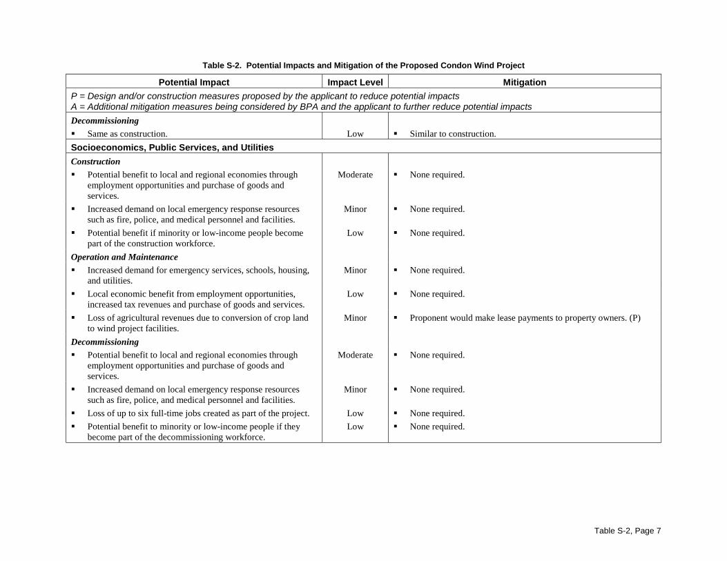
Table S-2, Page 7
Table S-2. Potential Impacts and Mitigation of the Proposed Condon Wind Project
Potential Impact Impact Level Mitigation
P = Design and/or construction measures proposed by the applicant to reduce potential impactsA = Additional mitigation measures being considered by BPA and the applicant to further reduce potential impacts
Decommissioning
! Same as construction. Low ! Similar to construction.
Socioeconomics, Public Services, and Utilities
Construction
! Potential benefit to local and regional economies throughemployment opportunities and purchase of goods andservices.
Moderate ! None required.
! Increased demand on local emergency response resourcessuch as fire, police, and medical personnel and facilities.
Minor ! None required.
! Potential benefit if minority or low-income people becomepart of the construction workforce.
Low ! None required.
Operation and Maintenance
! Increased demand for emergency services, schools, housing,and utilities.
Minor ! None required.
! Local economic benefit from employment opportunities,increased tax revenues and purchase of goods and services.
Low ! None required.
! Loss of agricultural revenues due to conversion of crop landto wind project facilities.
Minor ! Proponent would make lease payments to property owners. (P)
Decommissioning! Potential benefit to local and regional economies through
employment opportunities and purchase of goods andservices.
Moderate ! None required.
! Increased demand on local emergency response resourcessuch as fire, police, and medical personnel and facilities.
Minor ! None required.
! Loss of up to six full-time jobs created as part of the project. Low ! None required.
! Potential benefit to minority or low-income people if theybecome part of the decommissioning workforce.
Low ! None required.
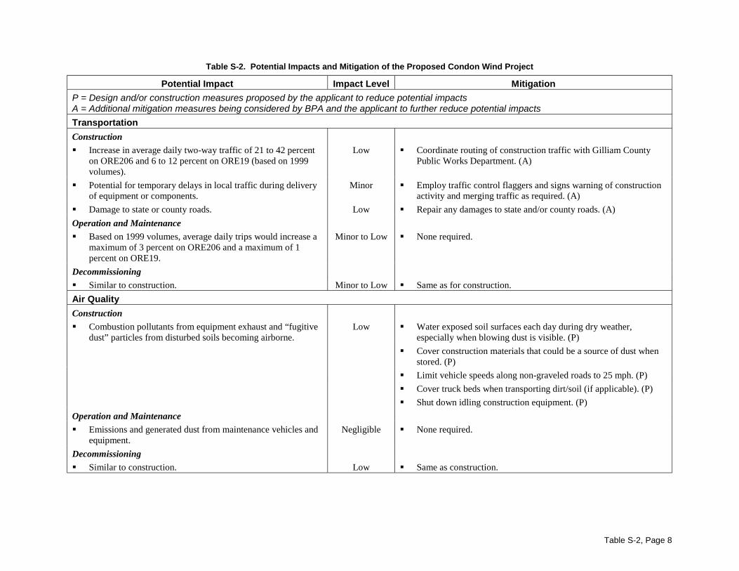
Table S-2, Page 8
Table S-2. Potential Impacts and Mitigation of the Proposed Condon Wind Project
Potential Impact Impact Level Mitigation
P = Design and/or construction measures proposed by the applicant to reduce potential impactsA = Additional mitigation measures being considered by BPA and the applicant to further reduce potential impacts
Transportation
Construction
! Increase in average daily two-way traffic of 21 to 42 percenton ORE206 and 6 to 12 percent on ORE19 (based on 1999volumes).
Low ! Coordinate routing of construction traffic with Gilliam CountyPublic Works Department. (A)
! Potential for temporary delays in local traffic during deliveryof equipment or components.
Minor ! Employ traffic control flaggers and signs warning of constructionactivity and merging traffic as required. (A)
! Damage to state or county roads. Low ! Repair any damages to state and/or county roads. (A)
Operation and Maintenance
! Based on 1999 volumes, average daily trips would increase amaximum of 3 percent on ORE206 and a maximum of 1percent on ORE19.
Minor to Low ! None required.
Decommissioning
! Similar to construction. Minor to Low ! Same as for construction.
Air Quality
Construction
! Combustion pollutants from equipment exhaust and “fugitivedust” particles from disturbed soils becoming airborne.
Low ! Water exposed soil surfaces each day during dry weather,especially when blowing dust is visible. (P)
! Cover construction materials that could be a source of dust whenstored. (P)
! Limit vehicle speeds along non-graveled roads to 25 mph. (P)
! Cover truck beds when transporting dirt/soil (if applicable). (P)
! Shut down idling construction equipment. (P)
Operation and Maintenance
! Emissions and generated dust from maintenance vehicles andequipment.
Negligible ! None required.
Decommissioning
! Similar to construction. Low ! Same as construction.
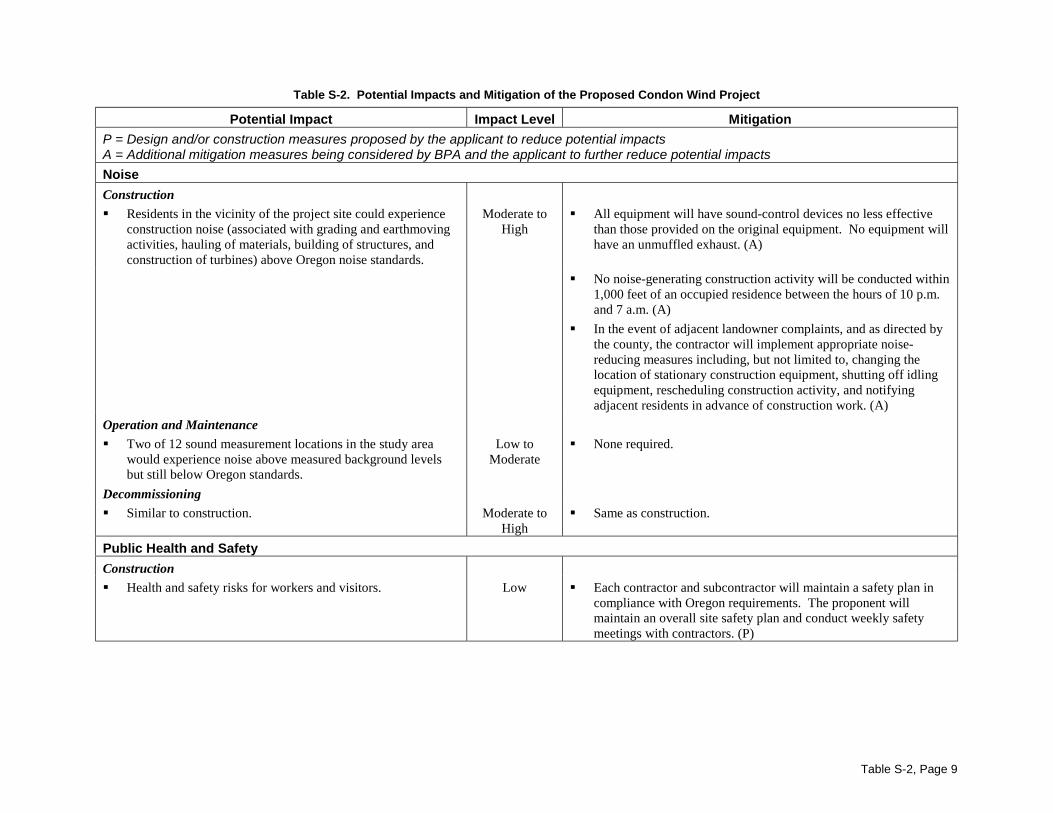
Table S-2, Page 9
Table S-2. Potential Impacts and Mitigation of the Proposed Condon Wind Project
Potential Impact Impact Level Mitigation
P = Design and/or construction measures proposed by the applicant to reduce potential impactsA = Additional mitigation measures being considered by BPA and the applicant to further reduce potential impacts
Noise
Construction
! Residents in the vicinity of the project site could experienceconstruction noise (associated with grading and earthmovingactivities, hauling of materials, building of structures, andconstruction of turbines) above Oregon noise standards.
Moderate toHigh
! All equipment will have sound-control devices no less effectivethan those provided on the original equipment. No equipment willhave an unmuffled exhaust. (A)
! No noise-generating construction activity will be conducted within1,000 feet of an occupied residence between the hours of 10 p.m.and 7 a.m. (A)
! In the event of adjacent landowner complaints, and as directed bythe county, the contractor will implement appropriate noise-reducing measures including, but not limited to, changing thelocation of stationary construction equipment, shutting off idlingequipment, rescheduling construction activity, and notifyingadjacent residents in advance of construction work. (A)
Operation and Maintenance
! Two of 12 sound measurement locations in the study areawould experience noise above measured background levelsbut still below Oregon standards.
Low toModerate
! None required.
Decommissioning
! Similar to construction. Moderate toHigh
! Same as construction.
Public Health and Safety
Construction
! Health and safety risks for workers and visitors. Low ! Each contractor and subcontractor will maintain a safety plan incompliance with Oregon requirements. The proponent willmaintain an overall site safety plan and conduct weekly safetymeetings with contractors. (P)
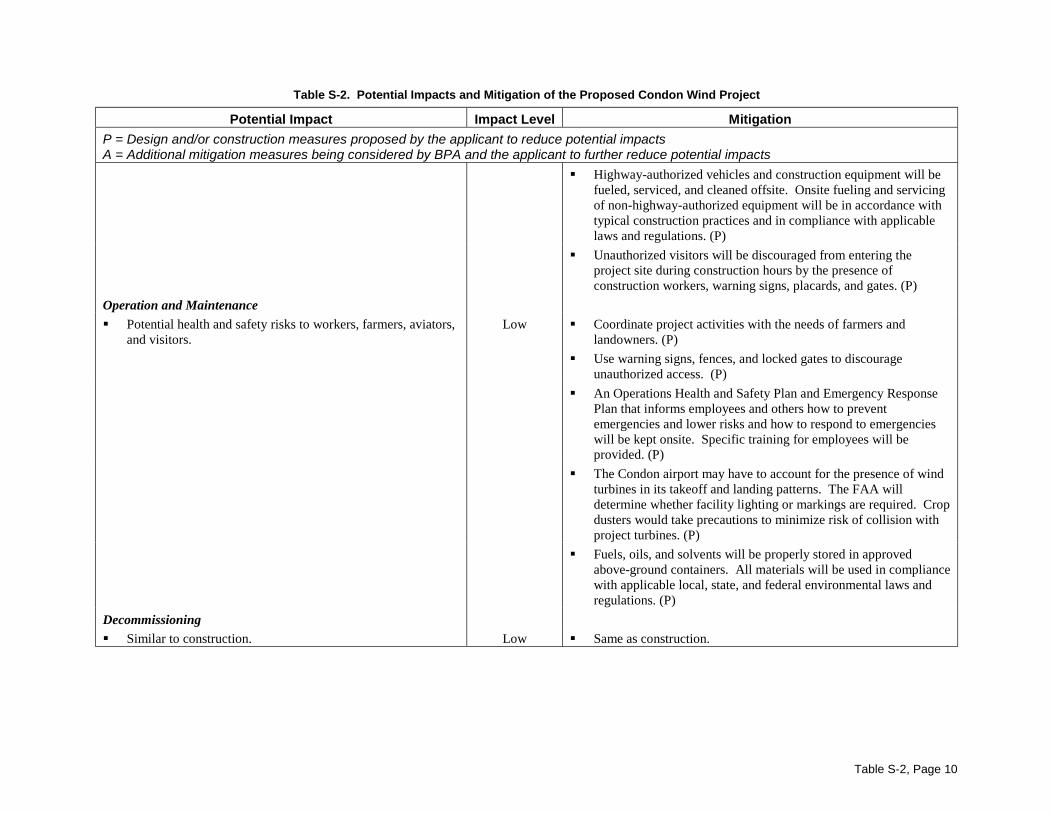
Table S-2, Page 10
Table S-2. Potential Impacts and Mitigation of the Proposed Condon Wind Project
Potential Impact Impact Level Mitigation
P = Design and/or construction measures proposed by the applicant to reduce potential impactsA = Additional mitigation measures being considered by BPA and the applicant to further reduce potential impacts
! Highway-authorized vehicles and construction equipment will befueled, serviced, and cleaned offsite. Onsite fueling and servicingof non-highway-authorized equipment will be in accordance withtypical construction practices and in compliance with applicablelaws and regulations. (P)
! Unauthorized visitors will be discouraged from entering theproject site during construction hours by the presence ofconstruction workers, warning signs, placards, and gates. (P)
Operation and Maintenance
! Potential health and safety risks to workers, farmers, aviators,and visitors.
Low ! Coordinate project activities with the needs of farmers andlandowners. (P)
! Use warning signs, fences, and locked gates to discourageunauthorized access. (P)
! An Operations Health and Safety Plan and Emergency ResponsePlan that informs employees and others how to preventemergencies and lower risks and how to respond to emergencieswill be kept onsite. Specific training for employees will beprovided. (P)
! The Condon airport may have to account for the presence of windturbines in its takeoff and landing patterns. The FAA willdetermine whether facility lighting or markings are required. Cropdusters would take precautions to minimize risk of collision withproject turbines. (P)
! Fuels, oils, and solvents will be properly stored in approvedabove-ground containers. All materials will be used in compliancewith applicable local, state, and federal environmental laws andregulations. (P)
Decommissioning! Similar to construction. Low ! Same as construction.
Condon Wind Project Purpose of and Need for ActionDraft EIS Page 1-1
Chapter 1 Purpose of and Need for Action
1.1 BackgroundBonneville Power Administration (BPA) is a federal agency responsible for purchasing, developing,and marketing electrical power to utility, industrial, and other customers in the Pacific Northwest,pursuant to the Bonneville Project Act of 1937, the Pacific Northwest Electric Power Planning andConservation Act of 1980 (P.L. 96-501; the Northwest Power Act), and other statutes. BPA wishes toencourage the development of renewable energy resources in the Pacific Northwest to meet customerdemand for power, to diversify its resource portfolio, and to meet its obligations under the NorthwestPower Act.
Deregulation of the electric industry and subsequent energy supply issues, as well as the current low-water year, have emphasized the need for new and diverse energy sources in the region. Renewableresources like wind would not only help diversify BPA’s resource portfolio, but are preferred bymany consumers concerned about environmental effects of other power sources. BPA has developedand marketed output from renewable power projects as “green power” as a way to satisfy demandfrom these consumers and to increase the amount of new renewable energy resources in the region’spower supply. The Northwest Power Planning Council’s Fourth Conservation and Electric PowerPlan recommended that Northwest utilities offer green power purchase opportunities as a way to helpthe region integrate renewable resources into the power system in the future.
In October 1999, SeaWest Windpower, Inc. (SeaWest) submitted a proposal to BPA to identify oneor more sites in Oregon and Washington at which wind power facilities could be developed. Afterconsidering preliminary information regarding several sites identified by SeaWest, BPA decided toexamine a proposed wind project located near Condon, Oregon, and to consider purchasing powerfrom a wind power facility that would be constructed by SeaWest at the site.
The National Environmental Policy Act (NEPA) (42 U.S.C. Sections 4321 et seq.) requires federalagencies to prepare and circulate an environmental impact statement (EIS) for major federal actionsor decisions that could significantly affect the quality of the human environment, including the naturaland physical environment.
BPA’s decision whether or not to purchase power from the proposed wind project and transmit it overBPA transmission lines will consider the information in this EIS, public comments, and other factors.
This Draft EIS provides environmental information to the public and federal, state, and localagencies, officials, and decision makers regarding the effects of the proposed action. The Final EISwill respond to public and agency comments on this Draft EIS, and it will provide necessaryclarifications, elaborations, and minor revisions to this draft.
1.2 Need for ActionIn the face of regional growth in electrical loads and increasing constraints on the existing energyresource base, BPA needs to acquire resources that will contribute to diversification of the long-termpower supply in the region.
Purpose of and Need for Action Condon Wind ProjectPage 1-2 Draft EIS
1.3 Purpose of ActionThe purposes of acquiring a diverse resource portfolio include:
� protecting BPA and its customers against risk;
� ensuring consistency with BPA’s responsibility under the Northwest Power Act to encourage thedevelopment of renewable energy resources;
� meeting customer demand for energy from renewable energy resources, thereby assuringconsistency with BPA’s Business Plan EIS (DOE/EIS-0183, June 1995) and Business PlanRecord of Decision (ROD);
� ensuring consistency with the resource acquisition strategy of BPA’s Resource Programs EIS(DOE/EIS-0162, February 1993) and ROD; and
� meeting the objective in the January 2000 Strategic Plan of BPA’s Power Business Line toacquire at least 150 average megawatts (MW) of new renewable resources by the end of fiscalyear 2006 in order to meet customer demand for new renewable resources.
1.4 Decisions to be Supported by the EISBPA will use this EIS to decide between two alternatives. The alternatives include the proposedaction (executing a power purchase agreement with SeaWest for up to 49.8 MW of electrical energyfrom the proposed Condon Wind Project and authorizing transmission over BPA power lines) and theNo Action Alternative. In addition, BPA may use this EIS for decisions regarding subsequent windprojects within the overall study area.
1.5 Documents Incorporated by ReferenceThe Northwest Power Act encourages the development of renewable resources within the PacificNorthwest and authorizes BPA to acquire resources that have potential for providing cost-effectiveservice to the region. In February 1993, BPA published the Resource Programs EIS (RP EIS), aprogrammatic document that evaluates the environmental tradeoffs among generic resource types andthe cumulative effects of adding these resources to the existing system. The analyses in the RP EISsupported BPA’s April 22, 1993, ROD which chose the Emphasize Conservation Alternative. Thisalternative emphasizes conservation and efficiency improvements, supplemented by renewable andthermal resources, as the most cost-effective and environmentally responsible option for BPA’s long-term conservation and generation resource acquisition objectives. As a renewable resource, theproposed project would implement one element of BPA’s Emphasize Conservation Alternative.
In June 1995, BPA published its Business Plan EIS (BP EIS). This policy-level EIS, which addressedBPA’s need for a business strategy to participate fully in the changing energy market, updated theanalyses in the RP EIS and confirmed the importance of renewable resources in the regional energyportfolio. BPA’s Business Plan ROD documented BPA’s decision to be market-driven in itsparticipation in the electric utility marketplace. Acquisition of renewable resources, such as theproposed wind project, is consistent with the decision to be market-driven.
All of these previous environmental documents are incorporated by reference into this Condon WindProject EIS. This EIS is tiered to the previous programmatic and policy level EISs and evaluates thepotential site-specific impacts from the proposed Condon Wind Project.
Condon Wind Project Purpose of and Need for ActionDraft EIS Page 1-3
1.6 Scoping and Major IssuesScoping refers to a time early in a project when the public has an opportunity to express opinions onwhich issues should be considered in an EIS. On July 5, 2000, BPA published a Notice of Intent toprepare an EIS and to conduct public scoping meetings for the proposed project. BPA developed amailing list of persons, agencies, and organizations that would likely be interested or affected by theproposed project. Currently, the mailing list contains about 200 persons, agencies, and organizations.
On July 10, 2000, a letter was mailed to everyone on the list, explaining the project, theenvironmental process, and how to participate (see Appendix A). A comment sheet was included soindividuals could mail their comments back to BPA. A news release was distributed on July 17 and ameeting notice, fact sheet, and comment form were inserted into the July 20 Condon Times-Journal.Project scoping meetings were held at the Arlington Municipal Building on July 19, 2000, and theGilliam County Courthouse in Condon on July 20, 2000. Written and verbal comments on the projectwere collected at the public meetings.
Many issues were raised during the scoping process. Most people raised questions about the projectdesign. They expressed support for wind power and the proposed project but wanted to know moreabout how it works. Other issues raised most often were the following:
� Socioeconomic impacts – how the project would affect local taxes, power rates and employment;
� Fish, wildlife, and vegetation – especially how the project would affect birds; and
� Land use/recreation – how the project would affect farming.
Comments received during the scoping period were used by environmental specialists in theirenvironmental impact analyses and are addressed throughout this document.
Everyone on the mailing list will receive notice when the Draft EIS is available and how to commenton it. Everyone will also receive notice when the Final EIS and ROD are available.
Purpose of and Need for Action Condon Wind ProjectPage 1-4 Draft EIS
Chapter 1 Purpose of and Need for Action................................................... 1-11.1 Background .............................................................................................................1-11.2 Need for Action.......................................................................................................1-11.3 Purpose of Action....................................................................................................1-21.4 Decisions to be Supported by the EIS.....................................................................1-21.5 Documents Incorporated by Reference...................................................................1-21.6 Scoping and Major Issues .......................................................................................1-3
Condon Wind Project Proposed Action and AlternativesDraft EIS Page 2-1
Chapter 2 Proposed Action and Alternatives
2.1 Proposed ActionBPA proposes to execute one or more power purchase and transmission services agreements toacquire and transmit up to the full electrical output of SeaWest’s proposed Condon Wind Project(49.8 megawatts [MW]). The proposed wind project is described in the following sections.
2.1.1 Project OverviewThe proposed project would consist of a wind project and its associated electrical system. The projectwould use modern, efficient 600-kilowatt (kW) wind turbines to convert energy in the winds nearCondon, Oregon, to electricity that would be transmitted over the BPA transmission system. Theproposed project would be sited entirely on private agricultural land northwest of the town of Condonin Gilliam County, Oregon. The project would consist of one or two phases: the first phase woulduse 41 wind turbines to yield a capacity of approximately 24.6 MW. A second phase (if built) woulduse 42 wind turbines to yield a capacity of approximately 25.2 MW. The first phase is proposed forconstruction in late 2001; the second phase could be constructed during spring/summer of 2002 orlater. For purposes of this EIS, the size of the project is assumed to be 49.8 MW, built in two phases,and the potential effects of a project of that size are evaluated.
Major components of the wind project include wind turbines and foundations, small pad-mountedtransformers, an operation and maintenance (O&M) building, power collection and communicationcables, project access roads, meteorological towers on foundations, and a substation. Duringconstruction there would also be temporary equipment storage and construction staging areas. Theproposed siting of wind turbines, roads, power lines, or other facility-related construction may beadjusted based on environmental, engineering, meteorological, or permit conditions.
2.1.2 Project Location and Project SiteThe project site is located on both sides of Highway 206 (ORE206), approximately 5 miles northwestof the town of Condon in Gilliam County, Oregon. The 38-acre project site lies within a 4,200-acrestudy area (see Figure 2.1-1) consisting of gently sloping plateaus and rolling, arid hills traversed byshallow canyons. In general, the elevation of the project site and study area ranges fromapproximately 2,400 feet to 3,300 feet.
Within the project site, the wind project facilities would occupy a permanent footprint ofapproximately 21 acres for the 24.6-MW first phase and an additional 17 acres for the second phase(38 acres total). The project has been designed to locate the turbines on the relatively flat (andpredominately cultivated) tops of plateaus to take advantage of the best wind resources whileminimizing potential environmental impacts.
The project site consists of private farmland that is used for non-irrigated agriculture (primarilywinter wheat and barley), cattle grazing, or land that is in the Conservation Reserve Program (CRP).The General Plan for Gilliam County, and the implementing zoning regulations, designates theproject site as “Exclusive Farm Use.” Facilities for generating electricity from wind energy can bepermitted in Exclusive Farm Use zones pursuant to a conditional land use permit. Such a permitwould be issued by Gilliam County, in accordance with county procedures.
Proposed Action and Alternatives Condon Wind ProjectPage 2-2 Draft EIS
2.1.3 Wind ResourceThe project site is well exposed to the winds in all directions; however, the prevailing winds blowfrom the southwest and northwest across the project site toward the east. The winds are expected tobe strongest from late fall through spring.
Historical wind data collected near Wasco, Oregon; Goodnoe Hills, Washington; and Kennewick,Washington, indicate that the Condon area has sufficient winds for wind project development.Currently, three temporary meteorological towers are measuring wind data at the project site toconfirm the wind resource potential.
2.1.4 Project Components
2.1.4.1 Turbines
The potential locations of turbines are shown in Figure 2.1-2. On wind energy projects such as theproposed project, sufficient spacing is maintained between the turbine towers to reduce the impact ofa given row of turbines (called a string) on the quality of the wind resource available to the row orrows downwind of it. For the proposed project, a spacing of approximately 460 feet would bemaintained between the turbine towers within each string. Downwind spacing between the stringswould be maintained at between 1,500 to 2,200 feet.
2.1.4.2 Project Access RoadsAccess to the project site would be directly from Highway 206 (ORE206) onto project access roadslocated on private farmland. Some of the project access roads are existing farm roads that would begraveled and/or relocated for project use, while the balance of project access roads would be new, asdescribed below. Project access roads would interconnect and would be available for use by bothproject staff and the landowner. No improvements to state or county roads or bridges are anticipated.
Project access roads would typically have a finished width of 12 to 14 feet, a compacted base ofnative soil and sub-base adapted to the needs of the site, and a gravel surface 4 to 6 inches deep.During construction, the temporary disturbance width of project access roads would be about 50 feet.After construction is complete, the project access roads would be finished for long-term use and thebalance of the construction disturbance area revegetated. Vehicle turnouts for construction andoperation/maintenance vehicles at turbine pads would typically be surfaced with gravel to a depth of4 inches, depending on soil conditions. Turnouts would be located surrounding each turbine along astring.
2.1.4.3 Wind Turbine FeaturesThe 600-kW wind turbines under consideration for the project have the design features shown inTable 2.1-1 and Figure 2.1-3. Nacelles (the rectangular structures at the top of the towers) withsmooth outer surfaces would enclose the generators, gears, and internal control systems and provide aprotected work area for windsmiths (turbine technicians) during inclement weather. Smooth, steeltubular support towers would provide access to the nacelle via a locked door and ladder system that isentirely contained within the tower. These design features will minimize perching opportunities forbirds as well as safety risks to workers accessing the turbines for maintenance. The followingparagraphs discuss the wind turbines in greater detail.
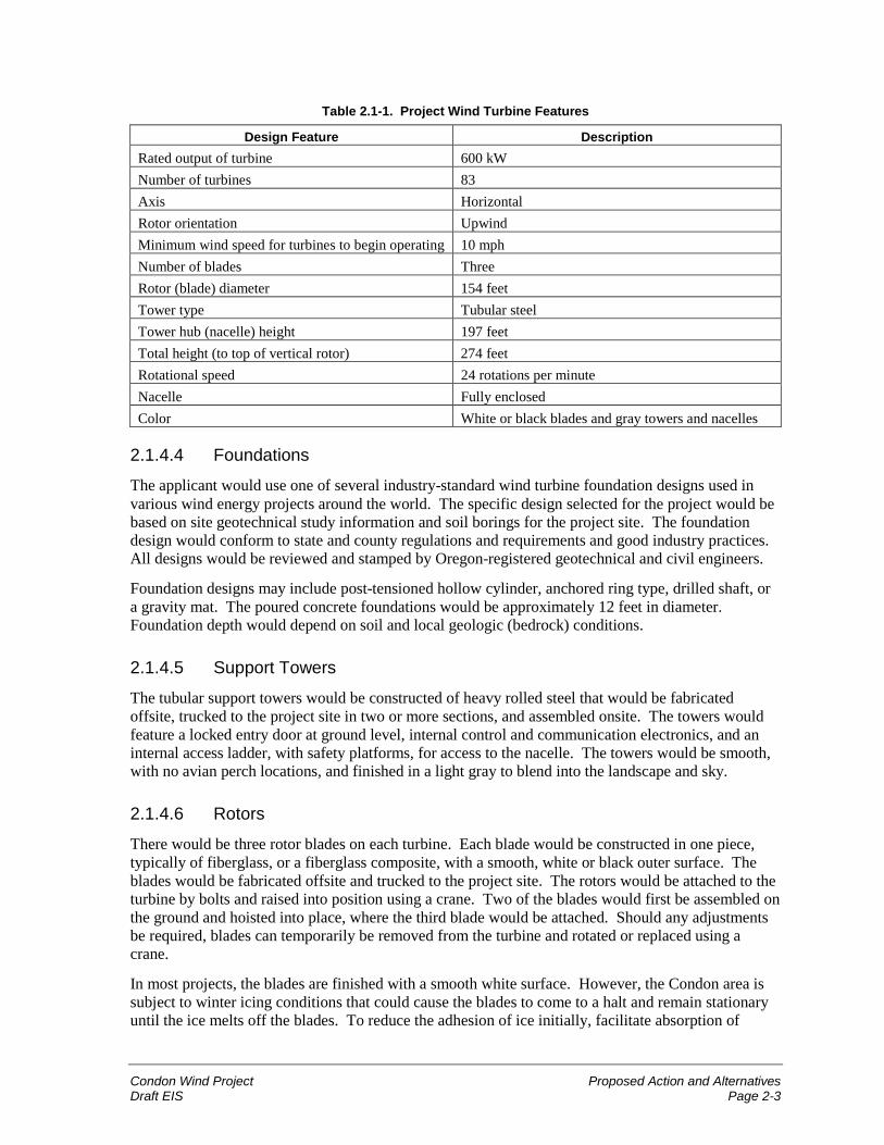
Condon Wind Project Proposed Action and AlternativesDraft EIS Page 2-3
Table 2.1-1. Project Wind Turbine Features
Design Feature DescriptionRated output of turbine 600 kWNumber of turbines 83Axis HorizontalRotor orientation UpwindMinimum wind speed for turbines to begin operating 10 mphNumber of blades ThreeRotor (blade) diameter 154 feetTower type Tubular steelTower hub (nacelle) height 197 feetTotal height (to top of vertical rotor) 274 feetRotational speed 24 rotations per minuteNacelle Fully enclosedColor White or black blades and gray towers and nacelles
2.1.4.4 Foundations
The applicant would use one of several industry-standard wind turbine foundation designs used invarious wind energy projects around the world. The specific design selected for the project would bebased on site geotechnical study information and soil borings for the project site. The foundationdesign would conform to state and county regulations and requirements and good industry practices.All designs would be reviewed and stamped by Oregon-registered geotechnical and civil engineers.
Foundation designs may include post-tensioned hollow cylinder, anchored ring type, drilled shaft, ora gravity mat. The poured concrete foundations would be approximately 12 feet in diameter.Foundation depth would depend on soil and local geologic (bedrock) conditions.
2.1.4.5 Support Towers
The tubular support towers would be constructed of heavy rolled steel that would be fabricatedoffsite, trucked to the project site in two or more sections, and assembled onsite. The towers wouldfeature a locked entry door at ground level, internal control and communication electronics, and aninternal access ladder, with safety platforms, for access to the nacelle. The towers would be smooth,with no avian perch locations, and finished in a light gray to blend into the landscape and sky.
2.1.4.6 Rotors
There would be three rotor blades on each turbine. Each blade would be constructed in one piece,typically of fiberglass, or a fiberglass composite, with a smooth, white or black outer surface. Theblades would be fabricated offsite and trucked to the project site. The rotors would be attached to theturbine by bolts and raised into position using a crane. Two of the blades would first be assembled onthe ground and hoisted into place, where the third blade would be attached. Should any adjustmentsbe required, blades can temporarily be removed from the turbine and rotated or replaced using acrane.
In most projects, the blades are finished with a smooth white surface. However, the Condon area issubject to winter icing conditions that could cause the blades to come to a halt and remain stationaryuntil the ice melts off the blades. To reduce the adhesion of ice initially, facilitate absorption of
Proposed Action and Alternatives Condon Wind ProjectPage 2-4 Draft EIS
radiant heat energy from the sky (that promotes melting of the ice), and help the ice slide off theblades, a black Teflon-like coating could be applied to the blades during the final manufacturingphase. One of the photosimulations in Chapter 3, Section 3.9 shows what black blades might looklike.
2.1.4.7 Nacelles and Generators
A turbine nacelle is the housing that covers the operating mechanism of the generators. The nacelleswould be mounted atop the tubular support towers using a crane. Each turbine would be equippedwith a yaw system that orients the nacelle and rotor blades toward the wind to maximize the captureof wind energy, and each would be controlled by on-board, automated computer monitoringequipment. The nacelles would be accessed internally through the towers. Most servicing of thegeneration equipment would be completed within the nacelle, which protects both equipment andworkers from the elements.
2.1.4.8 Meteorological Towers
A regular feature of large-scale wind power projects is one or more anemometer (wind measurement)towers installed in strategic locations around the project site, generally upwind of the turbines. Theanemometers are small devices that measure wind speeds at different heights on the meteorologicaltower. Each tower has a small concrete foundation, with supporting cables extending to smallconcrete and steel anchor points. Two to four permanent meteorological towers are planned for theproposed project.
2.1.4.9 Electrical SystemThe electrical system for the proposed project would collect and convert the electricity from eachwind turbine into higher voltage electricity which would be conveyed through a project substation toBPA’s Condon-DeMoss transmission line (Figure 2.1-1). The power collection system wouldconform to the National Electrical Code, National Electrical Safety Code, and prudent utility practice.The collection system is described in more detail below.
Low-voltage electricity would be generated by each wind turbine. Low-voltage cables installed inunderground conduits would carry the electricity from the base of the wind turbine tower to atransformer. These transformers would be installed on concrete foundations or pads. The pad-mounted transformers would raise the voltage from 600 volts to 34.5 kilovolts (kV).
Power cables would first connect individual or grouped pad-mounted transformers together, and thenconnect the pad-mounted transformers to the substation, which would be located near the interconnectpoint with the BPA Condon-DeMoss line. These cables may be placed underground (where feasible),carried by wooden poles above ground (where soil or rock conditions complicate construction, to linkproject units, or where a highway must be crossed), or a combination of both installation techniques.
The project substation would use one transformer, rated at 50 megavolt-amperes (MVA), to boost the34.5-kV level of the power collection system to the 69-kV level of the BPA Condon-DeMoss line.The substation would occupy a construction area of approximately 1 acre, with the finished substationoccupying a smaller area of approximately one-half acre. The completed substation would bedesigned per national standards and requirements of BPA, and it would be fenced for public safety.The substation would be unstaffed.
Condon Wind Project Proposed Action and AlternativesDraft EIS Page 2-5
2.1.4.10 Communication System
Turbine control and monitoring systems use communication lines, which are usually either copperlines similar to telephone lines, or fiber optic lines, both of which are thin and not highly visible.Usually, such lines run to each turbine, parallel with low- and medium-voltage power collection lineseither underground or overhead on poles.
2.1.4.11 Operation and Maintenance Building
The O&M building would consist of an enclosed bay for storage of back-up equipment parts andsupplies; an office for administration and monitoring of the facility, including the wind turbines; anemergency shelter for workers during winter storms; and parking for vehicles. The projectedpermanent footprint of the facility (including parking area) would be approximately 1 acre.
The O&M building may be located either on the project site or offsite in an existing structure withinthe City of Condon. If located onsite, the O&M building would probably be located east of ORE206,south of the grange hall, as shown in Figure 2.1-1. Both sites are being evaluated. However, becausethe alternate building in Condon is already constructed, this EIS analysis focuses on the potentialimpacts of the O&M building location on the project site itself.
2.1.4.12 Safety Features and Control Systems
The proposed wind turbines would be fitted with self-diagnostic computer monitoring and controlsystems located inside the turbine towers. Turbines would be monitored and directed from the O&Mfacility. In the event of a mechanical or electrical fault, the computer would automatically shut aturbine down. The turbines are designed to survive wind speeds in excess of 130 miles per hour, aspeed which exceeds recorded and projected maximum wind speeds at the project site. The electricalconnection between the turbines and the electrical grid can be disconnected manually orelectronically, either at the individual turbines or at several points along the power collection system,including the interconnection substation.
On the model of turbine being considered for this project, there is a redundant and fail-safe approachto slowing and stopping the rotor blades. The brake system is designed to engage automatically in theevent of a control system, grid, or hydraulic failure. Initial braking is accomplished by either a full-span blade feathering (turning the blades so they are parallel to the wind and hence generate no lift orturning power) and, secondarily, a separate hydraulic mechanical disc brake on the high-speed shaft.The two brake systems operate independently, so failure of one does not affect the performance of theother.
Each turbine would be protected from power surges and lightning strikes by surge arrestors andcircuit breakers, located at the turbine and along the power collection system. Furthermore, lightningprotection would be provided in the design of the blade, rotor, nacelle, tower, and grounding systemassociated with the foundation.
2.1.4.13 Lighting
Normally, the completed project would have no lights at night. However, the Federal AviationAdministration (FAA) would review the proposed project prior to construction and might recommendthat tower markings or aviation safety lighting be installed on a portion of the towers or nacelles.Until the FAA makes its determination, the need for any lighting or marking is uncertain. The FAAcould recommend that no lighting is required, due to low aviation use of the area. If recommended,
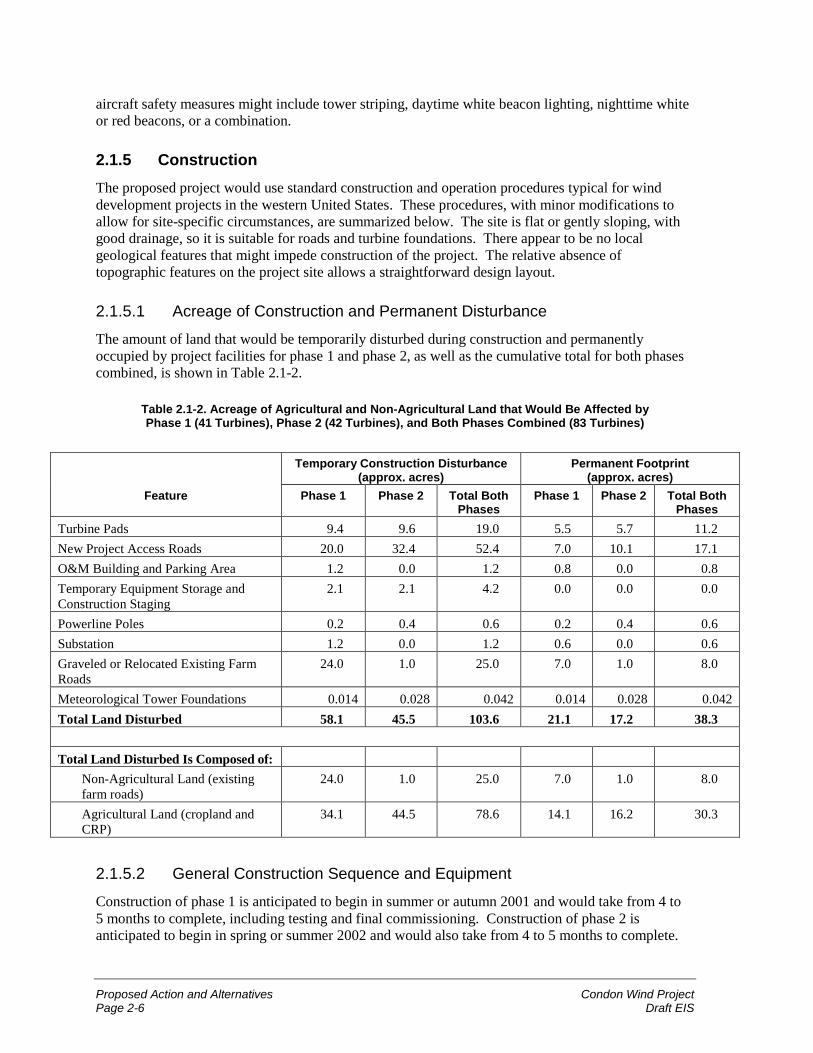
Proposed Action and Alternatives Condon Wind ProjectPage 2-6 Draft EIS
aircraft safety measures might include tower striping, daytime white beacon lighting, nighttime whiteor red beacons, or a combination.
2.1.5 ConstructionThe proposed project would use standard construction and operation procedures typical for winddevelopment projects in the western United States. These procedures, with minor modifications toallow for site-specific circumstances, are summarized below. The site is flat or gently sloping, withgood drainage, so it is suitable for roads and turbine foundations. There appear to be no localgeological features that might impede construction of the project. The relative absence oftopographic features on the project site allows a straightforward design layout.
2.1.5.1 Acreage of Construction and Permanent Disturbance
The amount of land that would be temporarily disturbed during construction and permanentlyoccupied by project facilities for phase 1 and phase 2, as well as the cumulative total for both phasescombined, is shown in Table 2.1-2.
Table 2.1-2. Acreage of Agricultural and Non-Agricultural Land that Would Be Affected byPhase 1 (41 Turbines), Phase 2 (42 Turbines), and Both Phases Combined (83 Turbines)
Temporary Construction Disturbance(approx. acres)
Permanent Footprint(approx. acres)
Feature Phase 1 Phase 2 Total BothPhases
Phase 1 Phase 2 Total BothPhases
Turbine Pads 9.4 9.6 19.0 5.5 5.7 11.2New Project Access Roads 20.0 32.4 52.4 7.0 10.1 17.1O&M Building and Parking Area 1.2 0.0 1.2 0.8 0.0 0.8Temporary Equipment Storage andConstruction Staging
2.1 2.1 4.2 0.0 0.0 0.0
Powerline Poles 0.2 0.4 0.6 0.2 0.4 0.6Substation 1.2 0.0 1.2 0.6 0.0 0.6Graveled or Relocated Existing FarmRoads
24.0 1.0 25.0 7.0 1.0 8.0
Meteorological Tower Foundations 0.014 0.028 0.042 0.014 0.028 0.042Total Land Disturbed 58.1 45.5 103.6 21.1 17.2 38.3
Total Land Disturbed Is Composed of:Non-Agricultural Land (existingfarm roads)
24.0 1.0 25.0 7.0 1.0 8.0
Agricultural Land (cropland andCRP)
34.1 44.5 78.6 14.1 16.2 30.3
2.1.5.2 General Construction Sequence and Equipment
Construction of phase 1 is anticipated to begin in summer or autumn 2001 and would take from 4 to5 months to complete, including testing and final commissioning. Construction of phase 2 isanticipated to begin in spring or summer 2002 and would also take from 4 to 5 months to complete.
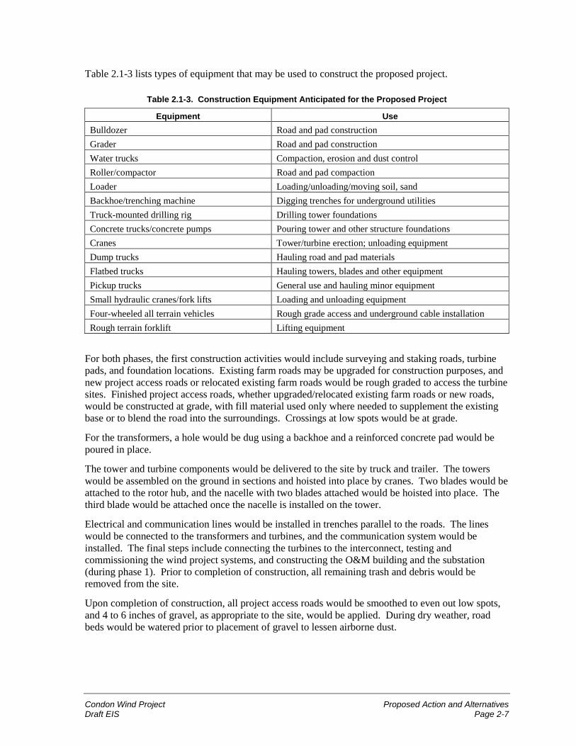
Condon Wind Project Proposed Action and AlternativesDraft EIS Page 2-7
Table 2.1-3 lists types of equipment that may be used to construct the proposed project.
Table 2.1-3. Construction Equipment Anticipated for the Proposed Project
Equipment UseBulldozer Road and pad constructionGrader Road and pad constructionWater trucks Compaction, erosion and dust controlRoller/compactor Road and pad compactionLoader Loading/unloading/moving soil, sandBackhoe/trenching machine Digging trenches for underground utilitiesTruck-mounted drilling rig Drilling tower foundationsConcrete trucks/concrete pumps Pouring tower and other structure foundationsCranes Tower/turbine erection; unloading equipmentDump trucks Hauling road and pad materialsFlatbed trucks Hauling towers, blades and other equipmentPickup trucks General use and hauling minor equipmentSmall hydraulic cranes/fork lifts Loading and unloading equipmentFour-wheeled all terrain vehicles Rough grade access and underground cable installationRough terrain forklift Lifting equipment
For both phases, the first construction activities would include surveying and staking roads, turbinepads, and foundation locations. Existing farm roads may be upgraded for construction purposes, andnew project access roads or relocated existing farm roads would be rough graded to access the turbinesites. Finished project access roads, whether upgraded/relocated existing farm roads or new roads,would be constructed at grade, with fill material used only where needed to supplement the existingbase or to blend the road into the surroundings. Crossings at low spots would be at grade.
For the transformers, a hole would be dug using a backhoe and a reinforced concrete pad would bepoured in place.
The tower and turbine components would be delivered to the site by truck and trailer. The towerswould be assembled on the ground in sections and hoisted into place by cranes. Two blades would beattached to the rotor hub, and the nacelle with two blades attached would be hoisted into place. Thethird blade would be attached once the nacelle is installed on the tower.
Electrical and communication lines would be installed in trenches parallel to the roads. The lineswould be connected to the transformers and turbines, and the communication system would beinstalled. The final steps include connecting the turbines to the interconnect, testing andcommissioning the wind project systems, and constructing the O&M building and the substation(during phase 1). Prior to completion of construction, all remaining trash and debris would beremoved from the site.
Upon completion of construction, all project access roads would be smoothed to even out low spots,and 4 to 6 inches of gravel, as appropriate to the site, would be applied. During dry weather, roadbeds would be watered prior to placement of gravel to lessen airborne dust.
Proposed Action and Alternatives Condon Wind ProjectPage 2-8 Draft EIS
2.1.5.3 Road and Pad Construction
Primary access to the project site would be from ORE206. Project access roads would beconstructed, or existing roads upgraded, in compliance with applicable building codes. Roads wouldbe located to minimize land disturbance, minimize interference with ongoing agricultural activities,and avoid sensitive resources and unsuitable topography, where feasible. Road locations may beamended during the permitting process for environmental or engineering reasons, to comply withpermit conditions, or to accommodate existing grazing and agriculture.
Roads would be built, surfaced (with gravel), and maintained to provide safe operating conditions.The minimum graveled project road width would be 12 to14 feet, with pullouts at selected locations,including turbine pads. Temporary construction disturbance areas along the roads would beapproximately 50 feet wide and may increase in uneven terrain if cuts and fills are necessary toconstruct and stabilize roads on slopes. Temporary construction around turbine pads may occupy anarea of approximately 100 feet by 100 feet. Project roads and turbine pads would have a gravel baseand surface as necessary for soil and weather conditions. No exposed cut-or-fill slopes greater than10 feet in height are proposed.
Topsoil removed during road and turbine pad construction would be stockpiled onsite next to theaccess roads. Topsoil would be respread in cut-and-fill slopes and these areas would be revegetatedas soon as possible after road construction. No offsite deposition of material would be necessary.
During construction, operation, and maintenance of the project, traffic would be restricted to existingfarm roads and new roads used for project access. Speed limits onsite would not exceed 25 mph tominimize dust and erosion, and to ensure safe and efficient traffic flow. Highway-authorized vehiclesand construction equipment would be fueled, serviced, and cleaned offsite. Good constructionpractices regarding weed-control inspection of hauling vehicles at the construction gravel sourcewould be observed.
Construction equipment that is transported to the project site on flatbed trucks (because suchequipment is not authorized for operation on the highway) would be fueled and serviced onsite duringthe construction phase. Examples of such equipment include bulldozers, graders, roller-compactors,backhoes, trenching equipment, and cranes. All fueling and servicing of such equipment would be inaccordance with typical construction practices and in compliance with applicable laws andregulations. Water for dust control and compaction would be secured by contract from the City ofCondon or the wells of local landowners.
2.1.5.4 Trenching and Placement of Electrical and Communication Cables
Where feasible, underground electrical and communication cables would be placed in 3- to 5-foot-wide trenches along the length of each turbine string corridor. In some cases, trenches would runfrom the end of one turbine string to the end of an adjacent string to link more turbines together viathe underground network. Due to the presence of shallow soil over bedrock on portions of the projectsite, some cables that would otherwise be placed underground may be raised above ground asoverhead lines supported by wooden poles.
Where soil depth permits, trenches would be mechanically excavated 2 to 4 feet deep and cables laidin place, with appropriate backfilling to separate power cables from communication cables. Trencheswould then be backfilled and the area revegetated concurrently with final revegetation or agriculturaluse of the construction site.
Condon Wind Project Proposed Action and AlternativesDraft EIS Page 2-9
Where necessary because of engineering or soil conditions, the power cables would run from thewind turbines to the substation through overhead conductors and insulators on a 35-kV-rated line onwooden poles. The substation would be a new 35/69-kV step-up substation located adjacent to theBPA 69-kV line that runs west of the project site.
2.1.5.5 Foundations and Installation of Support Towers
Wind Turbine Foundations
Foundations would be designed to accommodate local soil and geologic conditions. Constructionwould consist of excavating the foundation hole, constructing the reinforced concrete foundationbase, curing the concrete, and backfilling, as necessary, with soil to strengthen the foundation inplace. Prior to pouring the concrete, anchor bolts for the tubular steel tower would be placed so theywould be embedded in the concrete foundation. The poured concrete foundations would beapproximately 12 feet in diameter. Foundation depth would depend on soil and local geologic(bedrock) conditions.
After the concrete foundation has cured, tubular steel support tower assemblies would be anchor-bolted to the concrete foundation. The tower may consist of two or three sections that would beindividually raised into place by crane and secured, or raised in partially assembled form.
Foundation construction and turbine tower assembly and erection would occur within a 120-foot-widecorridor along turbine string locations. Additional temporary staging areas on the project site may beused to stage tower and turbine components prior to assembly and erection. Following construction,all temporary construction areas surrounding the final surfaced project roads and turbine pads, thetemporary staging and assembly areas, and all trenched areas would be reclaimed or prepared foragricultural use as appropriate.
Meteorological Tower Foundations
Two to four permanent meteorological towers would be erected, primarily upwind of the turbinestrings. Meteorological towers would be 197 feet tall, with a concrete foundation and wire cablestabilization. Foundation type and depth would depend on specific soil conditions at the towerlocations. Meteorological tower foundations would be excavated and then filled with concrete,depending on soil conditions. Some or all of the existing temporary meteorological towers would beremoved from the study area.
Other Foundations
Other facilities requiring foundations would include transformer pads, the substation, and O&M andcommunication facilities. The foundations would be constructed using standard cut-and-fillprocedures, then pouring concrete in a shallow slab or using a precast structure set on an appropriatedepth of structural fill.
2.1.5.6 Final Road Grading and Site Clean-UpUpon completion of construction, all remaining construction debris would be collected and removedfrom the site. Also, upon completion of construction and removal of all heavy constructionequipment, all project site roads would receive final grading and any additional gravel required.
Proposed Action and Alternatives Condon Wind ProjectPage 2-10 Draft EIS
2.1.5.7 Erosion Control
Erosion control would be standard practice both during and after construction and during therevegetation period. Erosion control would comply with state and county standards and wouldinclude, where necessary, sediment control basins and traps in drainages or other erosion controldevices (such as jute netting, soil stabilizers, or check dams). Surface water flows would be directedaway from cut-and-fill slopes and into ditches that drain into natural drainages, with silt traps asnecessary. Both during and after site revegetation, all remaining revegetation and erosion controldebris would be collected and removed from the site.
2.1.6 Operation and MaintenanceRoutine maintenance of the turbines would be necessary to maximize performance and detectpotential difficulties. Routine activities would consist primarily of daily travel, generally by pickuptrucks, of two to four operation/maintenance staff who would test and maintain the wind facilities (orsix personnel after phase 2 is completed). Most servicing would be performed “up-tower” (within thenacelle, without using a crane to remove the turbine from the tower). Occasionally the use of a craneand possibly equipment transport vehicles may be necessary for cleaning, repair, adjustments, orreplacement of the rotors or equipment contained in the nacelle. Additionally, all roads, pads, andtrenched areas would be regularly inspected and maintained to minimize erosion.
Monitoring the operations of the wind turbines would be conducted both from computers located inthe base of each turbine tower and from the O&M facility using telecommunication linkages andcomputer-based monitoring.
Over longer periods of time, repainting of towers and periodic exchanging of lubricants and hydraulicfluids in the operating mechanisms of the turbines and towers would occur. All lubricants andhydraulic fluids would be carefully stored, used, and disposed of in accordance with applicable lawsand regulations.
2.1.7 Workforce
2.1.7.1 Construction
An estimated 60 to 70 delivery and construction workers and technicians would work onsite over theduration of the construction period for each phase. However, not all personnel would be onsite at thesame time. Their presence onsite would be phased, depending on the pace of construction, over anestimated construction and equipment testing period of 4 to 5 months for each phase, or possiblylonger if seasonal weather delays occurred. Estimated project employment would not exceed30 workers at any one time.
2.1.7.2 Operation and Maintenance
Once the project becomes operational, there would be two to four operations and maintenancepersonnel onsite daily during weekly business hours (or six personnel after phase 2 is completed).For safety reasons, technicians working on turbines would typically work in pairs.
Condon Wind Project Proposed Action and AlternativesDraft EIS Page 2-11
2.1.8 Traffic
2.1.8.1 ConstructionConstruction of wind project roads, facilities, and electrical/communication lines would occur atabout the same time, using individual vehicles for multiple tasks. During the construction period foreach phase, there would be approximately 25 to 50 daily round trips (50 to 100 one-way trips) ofconstruction, delivery, and personnel vehicles. Over the entire construction period for each phase,this estimate includes the 112 to 231 round trips (224 to 462 one-way trips) of flatbed trucksdelivering the tower sections, nacelles, and blades, as well as all dump trucks, concrete trucks, cranes,other construction vehicles, trade vehicles, and personnel vehicles.
2.1.8.2 Operation and Maintenance
Assuming the presence of two to four operation/maintenance personnel (or six after phase 2 iscompleted), once commercial operations begin, there may be 2 to 6 daily round trips (4 to 12 one-waytrips daily) to and from the project site. Ordinary operation/maintenance traffic would consist ofpersonal vehicles and, typically, project pickup trucks. On infrequent occasions, larger equipment(such as flatbed trucks or a crane) may be required. During snow conditions, personnel may use snowremoval equipment on project site roads or specialized snow travel vehicles.
Should the O&M building be used to service other wind projects in the region, the number ofpersonnel could increase and this would increase the number of daily round trips to and from the site.Thus if there were a total of 10 personnel using the facility, there may be up to 10 daily round trips(20 one-way trips daily).
2.1.9 Hazardous MaterialsAll production, use, storage, transport, and disposal of hazardous materials associated with theproposed project would be in strict accordance with federal, state, and local government regulationsand guidelines. No extremely hazardous materials (as defined by 40 CFR; Section 335) areanticipated to be produced, used, stored, transported, or disposed of as a result of this project. Alllubricants, oils, greases, antifreeze, cleaners and degreasers, and hydraulic fluids used in the operationand maintenance of the wind project would be stored in the O&M building in approved containersabove ground. Similarly, all lubricants, oils, greases, antifreeze, cleaners and degreasers, or hydraulicfluids being held for delivery to a certified recycling transporter would be temporarily stored in theO&M building in approved containers above ground.
The project site would be utilized by a variety of construction and operation/maintenance vehiclesand equipment. Construction equipment and trucks used for operation/maintenance would beproperly maintained to minimize leaks of motor oils, hydraulic fluids, and fuels. Refueling andmaintenance of vehicles that are authorized for highway travel would be performed offsite at anappropriate facility during construction, operation, and maintenance. Construction vehicles that arenot highway-authorized would be serviced on the project site.
The wind turbines and transformers are anticipated to use the following lubricants, oils, greases,antifreeze, cleaners and degreasers, and hydraulic fluids (or comparable products from othermanufacturers):
� Simple Green (cleaner and degreaser);
� Oil-Flo (cleaner and degreaser);
Proposed Action and Alternatives Condon Wind ProjectPage 2-12 Draft EIS
� Mobil SHC 632 (gear oil);
� Mobilux EP 1 (grease);
� Mobil SHC 524 (hydraulic fluid);
� Shell DIALA (R) A oil (mineral oil used as transformer coolant); and
� ethylene glycol (standard commercial antifreeze used in radiators).
None of these products contain any compounds listed as extremely hazardous by the EnvironmentalProtection Agency. These products would be used in moderate quantities (less than 25 gallons per600-kW turbine) and would be contained entirely within the spill trap and nacelle, minimizing thepossibility for accidental leakage. Lubricants, hydraulic fluids, antifreeze, and oils would be checkedquarterly, filled as needed, and changed every 1 to 2 years, as recommended by the manufacturer.Fluid changes would be performed up-tower, where any accidental spill could be contained by thenacelle. Spent lubricants, hydraulic fluids, antifreeze, cleaners and degreasers, and oils would betransported and recycled offsite by a certified waste contractor.
Transformers would contain cooling oil that does not contain polychlorinated biphenyls (PCBs). Thefoundation for the transformers would be designed to contain 125 percent of the capacity of oil in thetransformer, in order to protect the site in case of a leak. Transformers would be regularly inspected.
Support towers and other project equipment would arrive onsite already painted and would rarelyneed repainting during the life of the equipment. Should any repainting be necessary, it would beperformed by licensed contractors in compliance with applicable laws and regulations.
Herbicides, if used at all, would be used at landowner request to minimize the potential forintroduction of weeds into adjacent cultivated areas. Herbicides would be applied in observance ofall regulations governing use and selection of herbicides, either by the landowner or, afterconsultation with the landowner, by a contract professional. Herbicides would not be stored onsite,and any excess herbicides would be disposed of offsite in accordance with regulations.
2.1.10 ReclamationReclamation refers to the restoration of lands used temporarily during construction (such asconstruction staging areas, excess road margins, etc.) to their approximate condition prior toconstruction. For the proposed project, nearly all of the project site is plowed fields that are currentlyunder cultivation or other agricultural use, and such uses would continue as the landownersdetermine. Since most construction would occur on land that is ordinarily plowed fields, reclamationof those lands may consist of replowing and planting for the next crop season. On all other disturbedlands, reclamation activities would be planned to complement landowner decisions as to compatibilitybetween crops, as well as reclamation practices and plant species to be used.
If any areas of native vegetation on the project site are disturbed, they would be revegetated withspecies native to the area and appropriate for that location. Since most of the project site is located oncultivated land, native vegetation is likely to be encountered, if at all, only in CRP lands or in thelayout of project roads bordering fields or project road crossings onto ORE206.
2.1.11 DecommissioningDecommissioning refers to the dismantling of the project elements and revegetation of the site uponcompletion of the operating life of the facility. Periodic replacement of equipment can extend theoperating life indefinitely, depending on future demand for electricity generated by the project.
Condon Wind Project Proposed Action and AlternativesDraft EIS Page 2-13
Therefore, the estimated life of the project depends primarily on the demand for power, which isexpected to continue growing.
At the end of the project’s useful life, the owner would obtain any necessary authorization from theappropriate regulatory agencies and from the landowners to decommission the facilities.Decommissioning involves removing the turbines and support towers, transformers, and substation,and removing the upper portion of foundations so that they do not interfere with agriculturalpractices. Generally turbines, electrical components, and towers are either resold or recycled forscrap. All unsalvageable materials would be disposed of at authorized sites in accordance with lawsand regulations.
Site reclamation would be based on site-specific requirements and techniques commonly employed atthe time the area is reclaimed. As necessary, this could include regrading, spot replacement oftopsoil, and revegetation of all project-disturbed areas that would not be used immediately for plow-based agriculture. Foundations would be removed to a depth of 2 feet, or less if bedrock isencountered. Project access roads would be reclaimed or left in place based on landowner preference.The land would then revert exclusively to landowner control.
2.2 No Action AlternativeAn EIS must consider the alternative of not taking the proposed action. Under the No ActionAlternative, BPA would not execute one or more power purchase and transmission servicesagreements to acquire and transmit up to the full electrical output of SeaWest’s proposed CondonWind Project. Because BPA’s transmission line is the only transmission line nearby, it is highlyunlikely that the project would be implemented without a commitment from BPA to acquire theenergy output or transmit it over BPA transmission lines to another purchaser. Without BPA’scommitment, the project would not be constructed or operated, and the resulting environmentalimpacts described in this EIS would not occur.
However, the region’s need for power is expected to continue to grow (as documented in theNorthwest Power Planning Council, Fourth Northwest Power Plan; Energy InformationAdministration, Annual Energy Outlook 2001). Under the No Action Alternative, a greaterproportion of other energy resources would be developed. The predominant resource is most likely tobe combined-cycle combustion turbines (CTs) fueled by natural gas (Northwest Power PlanningCouncil, Northwest Power Supply Adequacy/Reliability Study Phase 1 Report, Paper Number2000-4, March 6, 2000). BPA’s Resource Programs EIS (RP EIS) and Business Plan EIS included anevaluation of the environmental impacts of energy resources including CTs. These impacts arediscussed in brief throughout Chapter 3 in the No Action Alternative sections.
2.3 Alternatives Considered but Eliminated from Detailed Study
2.3.1 Alternative Energy ResourcesBPA’s RP EIS analyzed environmental trade-offs among all available energy resources includingconservation, renewable resources (solar, wind, geothermal, biomass, and hydro), system efficiencyimprovements, cogeneration, CTs, nuclear power, and coal. Acquisition of wind power is consistentwith BPA’s Resource Programs and Business Plan Records of Decision (see Section 1.5). Therefore,this EIS focuses on a site-specific analysis of the proposed project.
Proposed Action and Alternatives Condon Wind ProjectPage 2-14 Draft EIS
2.3.2 Alternative Transmission PathNo other transmission alternatives were studied. BPA’s Condon-DeMoss 69-kV transmission line isthe only transmission line near enough to the project to provide an economical point ofinterconnection between the project and the transmission grid. Connecting to a different point on thegrid would require constructing a lengthy new transmission line from the project. Such a line wouldhave far greater environmental impacts than the proposed plan of interconnection to the existingCondon-DeMoss line, and it would render the project economically unfeasible.
2.3.3 Alternative Turbine LocationsSeaWest considered placing turbine strings in different locations within the study area. The projectsite described in this EIS was chosen for reasons including wind quality, access, proximity to BPA’stransmission line, and environmental factors. Individual turbines within strings were also locatedaccording to these same factors.
2.4 Summary of Environmental Impacts of the AlternativesTable 2.4-1 compares the Proposed Action and the No Action Alternative based on the purposes ofthe project described in Section 1.3.
Table 2.4-1. Comparison of Alternatives
Purposes Proposed Action No ActionProtect BPA and itscustomers againstrisk.
Acquiring and transmitting the availablepower from the proposed wind projectwould allow BPA to increase theavailability of a reliable supply ofelectrical power to meet the need of it’scustomers in the Pacific Northwest. Byacquiring the electrical output from thisproject, this affords BPA the opportunityto add power to its system through thedevelopment of renewable resources -such as wind - that are environmentallyclean.
By not purchasing and transmitting thepower output from the proposedproject, BPA would have to look toother sources of electrical power tosupply its customers. The mostpredominant new energy sources arelikely to be combustion turbinesburning non-renewable fossil fuels,which are less environmentally cleanthan renewable resources such as windenergy.
Ensure consistencywith BPA’sresponsibility underthe Northwest PowerAct to encourage thedevelopment ofrenewable energyresources.
Purchasing the electrical power from theproposed wind project would ensureconsistency with the Northwest PowerAct, by promoting a project that utilizes arenewable energy resource (wind).
By not purchasing the electrical powerfrom the proposed project, BPA wouldhave one less opportunity to ensureconsistency with the Northwest PowerAct.
Meet customerdemand for energyfrom renewableenergy resources,thereby assuringconsistency withBPA’s Business PlanEIS (DOE/EIS-0183,June 1995) andBusiness Plan Recordof Decision (ROD).
Acquiring and transmitting the electricalpower from the proposed wind projectwould assure consistency with BPA’sBusiness Plan EIS and Business PlanROD by helping to meet customerdemand for electricity through thedevelopment of wind energy.
By not purchasing and transmitting theelectrical power from the proposedproject, BPA would decrease its abilityto meet customer demands for powerthrough the development of renewableenergy resources.
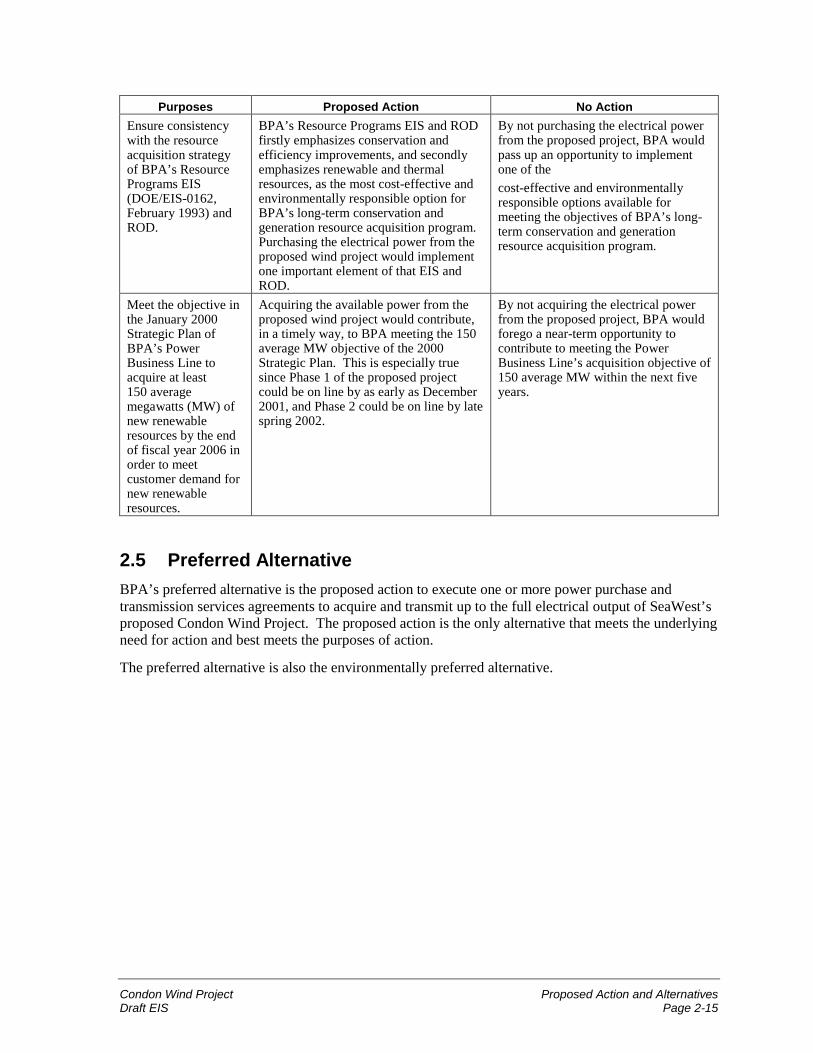
Condon Wind Project Proposed Action and AlternativesDraft EIS Page 2-15
Purposes Proposed Action No ActionEnsure consistencywith the resourceacquisition strategyof BPA’s ResourcePrograms EIS(DOE/EIS-0162,February 1993) andROD.
BPA’s Resource Programs EIS and RODfirstly emphasizes conservation andefficiency improvements, and secondlyemphasizes renewable and thermalresources, as the most cost-effective andenvironmentally responsible option forBPA’s long-term conservation andgeneration resource acquisition program.Purchasing the electrical power from theproposed wind project would implementone important element of that EIS andROD.
By not purchasing the electrical powerfrom the proposed project, BPA wouldpass up an opportunity to implementone of thecost-effective and environmentallyresponsible options available formeeting the objectives of BPA’s long-term conservation and generationresource acquisition program.
Meet the objective inthe January 2000Strategic Plan ofBPA’s PowerBusiness Line toacquire at least150 averagemegawatts (MW) ofnew renewableresources by the endof fiscal year 2006 inorder to meetcustomer demand fornew renewableresources.
Acquiring the available power from theproposed wind project would contribute,in a timely way, to BPA meeting the 150average MW objective of the 2000Strategic Plan. This is especially truesince Phase 1 of the proposed projectcould be on line by as early as December2001, and Phase 2 could be on line by latespring 2002.
By not acquiring the electrical powerfrom the proposed project, BPA wouldforego a near-term opportunity tocontribute to meeting the PowerBusiness Line’s acquisition objective of150 average MW within the next fiveyears.
2.5 Preferred AlternativeBPA’s preferred alternative is the proposed action to execute one or more power purchase andtransmission services agreements to acquire and transmit up to the full electrical output of SeaWest’sproposed Condon Wind Project. The proposed action is the only alternative that meets the underlyingneed for action and best meets the purposes of action.
The preferred alternative is also the environmentally preferred alternative.
Proposed Action and Alternatives Condon Wind ProjectPage 2-16 Draft EIS
Chapter 2 Proposed Action and Alternatives............................................... 2-12.1 Proposed Action......................................................................................................2-1
2.1.1 Project Overview....................................................................................2-12.1.2 Project Location and Project Site ...........................................................2-12.1.3 Wind Resource.......................................................................................2-22.1.4 Project Components ...............................................................................2-22.1.5 Construction ...........................................................................................2-62.1.6 Operation and Maintenance .................................................................2-102.1.7 Workforce ............................................................................................2-102.1.8 Traffic...................................................................................................2-112.1.9 Hazardous Materials.............................................................................2-112.1.10 Reclamation .........................................................................................2-122.1.11 Decommissioning.................................................................................2-12
2.2 No Action Alternative ...........................................................................................2-132.3 Alternatives Considered but Eliminated from Detailed Study..............................2-13
2.3.1 Alternative Energy Resources..............................................................2-132.3.2 Alternative Transmission Path .............................................................2-142.3.3 Alternative Turbine Locations .............................................................2-14
2.4 Summary of Environmental Impacts of the Alternatives......................................2-142.5 Preferred Alternative.............................................................................................2-15
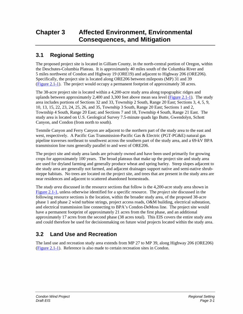
Condon Wind Project Regional SettingDraft EIS Page 3-1
Chapter 3 Affected Environment, EnvironmentalConsequences, and Mitigation
3.1 Regional SettingThe proposed project site is located in Gilliam County, in the north-central portion of Oregon, withinthe Deschutes-Columbia Plateau. It is approximately 40 miles south of the Columbia River and5 miles northwest of Condon and Highway 19 (ORE19) and adjacent to Highway 206 (ORE206).Specifically, the project site is located along ORE206 between mileposts (MP) 31 and 39(Figure 2.1-1). The project would occupy a permanent footprint of approximately 38 acres.
The 38-acre project site is located within a 4,200-acre study area along topographic ridges anduplands between approximately 2,400 and 3,300 feet above mean sea level (Figure 2.1-1). The studyarea includes portions of Sections 32 and 33, Township 2 South, Range 20 East; Sections 3, 4, 5, 9,10, 13, 15, 22, 23, 24, 25, 26, and 35, Township 3 South, Range 20 East; Sections 1 and 2,Township 4 South, Range 20 East; and Sections 7 and 18, Township 4 South, Range 21 East. Thestudy area is located on U.S. Geological Survey 7.5-minute quads Igo Butte, Gwendolyn, SchottCanyon, and Condon (from north to south).
Tenmile Canyon and Ferry Canyon are adjacent to the northern part of the study area to the east andwest, respectively. A Pacific Gas Transmission-Pacific Gas & Electric (PGT-PG&E) natural gaspipeline traverses northeast to southwest across the southern part of the study area, and a 69-kV BPAtransmission line runs generally parallel to and west of ORE206.
The project site and study area lands are privately owned and have been used primarily for growingcrops for approximately 100 years. The broad plateaus that make up the project site and study areaare used for dryland farming and generally produce wheat and spring barley. Steep slopes adjacent tothe study area are generally not farmed, and adjacent drainages support native and semi-native shrub-steppe habitats. No trees are located on the project site, and trees that are present in the study area arenear residences and adjacent to scattered abandoned homesteads.
The study area discussed in the resource sections that follow is the 4,200-acre study area shown inFigure 2.1-1, unless otherwise identified for a specific resource. The project site discussed in thefollowing resource sections is the location, within the broader study area, of the proposed 38-acrephase 1 and phase 2 wind turbine strings, project access roads, O&M building, electrical substation,and electrical transmission line connecting to BPA’s Condon-DeMoss line. The project site wouldhave a permanent footprint of approximately 21 acres from the first phase, and an additionalapproximately 17 acres from the second phase (38 acres total). This EIS covers the entire study areaand could therefore be used for decisionmaking on future wind projects located within the study area.
3.2 Land Use and RecreationThe land use and recreation study area extends from MP 27 to MP 39, along Highway 206 (ORE206)(Figure 2.1-1). Reference is also made to certain recreation sites in Condon.
Land Use and Recreation Condon Wind ProjectPage 3-2 Draft EIS
3.2.1 Regulatory FrameworkThe regulatory framework for this analysis includes the Gilliam County Comprehensive Land UsePlan and Zoning Ordinances, adopted in November 2000; Gilliam County Zoning Map; OregonStatewide Planning Goals 3 (Agricultural Lands) and 11 (Public Facilities); and OregonAdministrative Rules.
The majority of Gilliam County is zoned Exclusive Farm Use (EFU), including the study area andadjacent lands. There are no regional or special district plans that govern the study area. Uses thatare permitted outright in EFU zones generally include farms, single-family dwellings, harvesting,utility facility service lines, operation and maintenance of transportation facilities, fire servicefacilities, irrigation canals, and sites for takeoff and landing of model aircraft. Additional uses, suchas the proposed wind power project, are permitted with a Conditional Use Permit.
The proposed project would necessitate a Goal Exception to Oregon Statewide Planning Goal 3,which states that agricultural lands shall be preserved and maintained for farm use(OAR 660-015-0000[3]).
The Conservation Reserve Program (CRP) is a federal program administered by the NaturalResources Conservation Service (NRCS) under the authority of the Farm Bill. The CRP encouragesfarmers to convert highly erodible cropland or other environmentally sensitive acreage to vegetativecover, such as tame or native grasses, wildlife plantings, trees, filter strips, or riparian buffers.Farmers receive an annual rental payment for the term of the multiyear contract (typically 10 years).
3.2.2 Study MethodologyTo conduct the land use analysis for the proposed action, the Gilliam County Comprehensive LandUse Plan and Zoning Ordinances, the Zoning Map, the Oregon Administrative Rule 660.033.0130,and the Oregon Statewide Planning Goal 11 (Public Facilities) were reviewed for applicable policiesand existing land use designations. A site visit was conducted in October 2000 to further documentcurrent land uses. Interviews with the Gilliam County Planning Director provided informationregarding plans, policies, procedures, and ordinances relevant to the proposed project.
To conduct the recreational analysis, the Oregon Parks and Recreation Department; Bureau of LandManagement (BLM), Prineville District Office; Gilliam County Planning Department; and DeschutesState Park were contacted.
3.2.3 Affected Environment
3.2.3.1 Land Use
The project site and study area are composed of privately owned land used primarily for non-irrigatedagriculture (primarily crops, including barley and wheat). A small portion of the project site andstudy area (13 percent and 8 percent, respectively) are currently held as CRP land.
Additional land uses are varied throughout the study area. An active gravel quarry is located withinthe study area. A grange hall, an occupied house, and a meteorological station are located in thestudy area, and abandoned farming/ranching equipment and implements are scattered throughout thestudy area.
Residential land use within and adjacent to the study area is of low density and consists of houseswith barns and accompanying outbuildings. A PGT-PG&E natural gas pipeline traverses northeast to
Condon Wind Project Land Use and RecreationDraft EIS Page 3-3
southwest across the southern part of the study area, and the 69-kV BPA Condon-DeMosstransmission line runs generally parallel to ORE206 (Figure 2.1-1).
3.2.3.2 Recreation
There are no formal recreational amenities in the study area. The nearest recreational facilities are theCity of Condon Park, the Condon Golf Course, and the Gilliam County Fairgrounds, located inCondon approximately 5 miles from the project site. The only identified recreational activity ishunting, which may be allowed by landowner permission in some portions of the study area.
3.2.4 Environmental Consequences—Proposed Action
3.2.4.1 Definition of Impact Levels
� Land use and recreation impacts would be considered high if the proposed project wouldsubstantially preclude the primary existing or planned use of the land, result in a major change inoverall land use patterns, create considerable conflict with permitted land uses, substantially alterexisting recreational activities, or create extensive new recreational opportunities in the area.
� Land use and recreation impacts would be considered moderate if the proposed project wouldcreate a modest change in the primary existing or planned use of the land, overall land usepatterns, recreational opportunities, or slightly conflict with permitted land uses.
� Land use and recreation impacts would be considered low if the proposed project would notnoticeably change the primary existing or planned use of the land, would cause only, at most, aminor change in overall land use patterns or recreational opportunities, and would not conflictwith permitted land uses.
3.2.4.2 Impacts during Construction
Land Use
Land use impacts during construction of phases 1 and 2 of the proposed project would be low.Overall, the project would be consistent with the purpose and intent of the Gilliam County EFU zone,and in Gilliam County, public service facilities are allowed as a conditional use. Development of theproposed project would add a system of wind turbines and associated facilities to the existing landuses, which include crop growing, cattle grazing, and CRP land.
During construction of phases 1 and 2, approximately 58 acres and 46 acres, respectively would betemporarily disturbed. For phase 1, this area of temporary disturbance includes approximately 30acres of cultivated cropland and 4 acres of CRP land. For phase 2, the area of temporary disturbanceincludes approximately 35 acres of cropland and 10 acres of CRP land. During construction,livestock grazing in additional areas may have to be temporarily restricted to avoid conflicts betweenlivestock and construction equipment. The turbines would be spaced to allow for farming and cropdusting.
SeaWest would have to convert the lease of these parcels and withdraw some or all of the parcelsfrom the CRP, through contract revisions with the NRCS and the landowners.
Construction would take 4 to 5 months per phase. Phase 1 is proposed to begin in late 2001; thesecond phase could be constructed during spring/summer of 2002 or later. Construction activitieswould be coordinated with landowners to minimize disturbance of farm operations. All areas
Land Use and Recreation Condon Wind ProjectPage 3-4 Draft EIS
temporarily disturbed would be regraded and seeded as necessary to restore them to their originalcondition.
Recreation
Impacts on existing recreational facilities during construction of phases 1 and 2 of the proposedproject would be low to non-existent. There are no formal recreational facilities in the vicinity of theproject site. However, upland bird hunting could be interrupted temporarily in the vicinity of theproject site during construction. Construction of the project could encourage sightseeing by travelerson ORE206.
3.2.4.3 Impacts during Operation and Maintenance
Land Use
Operation and maintenance impacts on land use would be low. The permanent project facilitieswould occupy approximately 38 acres total (21 acres and 17 acres for phases 1 and 2, respectively).Phase 1 would impact approximately 12 acres of cropland and 2 acres of CRP land, while phase 2would impact an additional 13 acres of cropland and 3 acres of CRP lands.
Although the cropland (and CRP land) converted to use for the project would no longer be availablefor farm use, it represents a very small portion of the agricultural acreage in the study area and anegligible portion of the agricultural land in Gilliam County (more than 696,000 acres). Landownerswould receive compensation for the project use of their property through a lease agreement with theproponent.
The proposed project would not appreciably disrupt the current and planned agricultural uses of theland. Given the turbine spacing, the operation of agricultural equipment would not be impaired, butsome plowing patterns may have to be adjusted. The turbine spacing and orientation along a north-south axis would allow crop dusting. The project would not alter existing fencing around the projectsite except to add gates, which would be kept locked, to certain access roads. The landowner wouldhave keys to the gates.
Recreation
No operation and maintenance impacts on existing recreational activities are anticipated. The projectmay cause a minor increase in the number of sightseers on ORE206, but this impact would be low.
3.2.4.4 Impacts during Decommissioning
Low impacts to land use would be anticipated during decommissioning. During dismantling ofproject facilities, temporary land disturbance of the type and magnitude described earlier for projectconstruction would be anticipated. Temporarily disturbed lands would be restored to their originalcondition through grading and planting. Foundations would be removed to a depth of 2 feet, or untilbedrock was hit.
Once project facilities had been removed, cropland and CRP land taken out of agricultural use couldbe returned to agricultural use. An exception might be some of the access roads constructed for theproject, which could be considered desirable by the local landowners.
Potential recreational impacts from decommissioning would be minor, including possible minor andtemporary interruption of game bird hunting, and a minor increase in roadside sightseeing.
Condon Wind Project Land Use and RecreationDraft EIS Page 3-5
3.2.4.5 Mitigation
No mitigation measures are warranted for the low potential impacts to land use or recreation from theproposed project.
3.2.4.6 Unavoidable Impacts Remaining after Mitigation
Following construction, approximately 38 acres would be converted to wind project facilities duringthe life of the project. This includes a very small portion of the available agricultural land in thestudy area, and a negligible portion of the available agricultural land in Gilliam County. Afterdecommissioning, the project site would look as it did prior to construction, except for some accessroads that may remain at the landowners’ discretion.
3.2.5 Environmental Consequences—No Action AlternativeIf the No Action Alternative was implemented, existing recreation and agricultural land uses at theproject site would continue without influence of the proposed project. However, this does notpreclude other development within permitted uses in the study area. Other energy resources would bedeveloped in the region to meet the need for power. As the Resource Programs EIS (RP EIS)showed, these resources would have the same or greater impact to land use and recreation than thisproject.
3.3 Geology, Soils, and Seismicity
3.3.1 Regulatory FrameworkBased on communications with a representative of Gilliam County, the county does not have a criticalareas ordinance that would address potential geologic hazards in the project site and study area.There are no specific requirements or guidelines issued by the county with respect to geologicconditions. Current Oregon building codes are specified in Oregon Regulatory Statute (ORS)455.010 through 455.895. Geologic hazard regulations are overseen by the Oregon Department ofLand Conservation and Development, as defined in ORS 660.015. The project site and study area fallwithin Seismic Zone 2B of the 1997 Uniform Building Code.
The Farmland Protection Policy Act (7 U.S.C. 4201 et seq.) directs federal agencies to identify andquantify adverse impacts of their actions on farmland. The Act's purpose is to minimize conversionof agricultural land to non-agricultural uses.
3.3.2 Study MethodologyThe characterization of geologic and soil conditions in the project site and study area is based onexisting published information, including topographic maps (U.S. Geological Survey 1970a, 1970b,1970c, 1987), aerial photographs (URS 2000), geologic maps and documents (Swanson et al. 1981,Walker and MacLeod 1991, Orr et al. 1992, Goter 1994, Madin and Mabey 1996, ODLCD 2000), andthe county soil survey (SCS 1984). Federal, state, and local regulations were researched to define theregulatory framework with respect to geology, soils, and seismicity.
Geology, Soils, and Seismicity Condon Wind ProjectPage 3-6 Draft EIS
3.3.3 Affected Environment
3.3.3.1 GeologyThe project site and study area are located in the north-central portion of Oregon within theDeschutes-Columbia Plateau (Figure 2.1-1). The Deschutes-Columbia Plateau covers approximately63,000 square miles within Oregon, Idaho, and Washington. The geology of the plateau is dominatedby the Columbia River Basalt Group, a series of flood basalt flows that were deposited during theMiocene (6 to 17.5 million years ago). The Columbia River Basalt Group consists of four basaltformations: the Imnaha, Grande Ronde, Wanapum, and Saddle Mountains, from oldest to youngest.(Orr et al. 1992.) Two of these four basalt formations (Grande Ronde and Wanapum) underlie thestudy area.
Wanapum Basalt underlies most of the study area between MP 28 and MP 34, and Grande RondeBasalt underlies most of the study area between MP 34 and MP 38 (Swanson et al. 1981). TheWanapum Basalt (middle Miocene, 15 million years old) generally consists of gray to dark-gray,medium-grained basalt flows that exhibit blocky to platy jointing (Walker and MacLeod 1991). TheGrande Ronde Basalt (middle and lower Miocene, 15 to 17 million years old), underlying theremainder of the study area, generally consists of dark-gray to black aphyric basalt flows (Walker andMacLeod 1991). These basalt bedrock layers are expected to provide an adequate foundation for theproposed wind turbines.
The project site and study area are located along ridges and uplands that are dissected by a network ofstreams. The project site ground surface ranges between approximately 2,400 feet and 3,300 feetabove mean sea level. The ridges are blanketed by a relatively thin layer of soil (1 to 3 feet deep)over basalt. Based on field observations, basalt is commonly exposed within the streambeds adjacentto the study area. Rills and gullies extend upslope from the mainstems of the streams, sometimes tothe margins or interiors of the study area.
3.3.3.2 Soils
Based on the soil survey of Gilliam County (SCS 1984), soils in the project site and study areagenerally have the following qualities:
� Soils are typical of ridgetops and upland areas in the region and developed from a mixture ofloess (windblown silt) with small amounts of volcanic ash.
� Soil profiles are approximately 1 to 3 feet thick and underlain by basalt.
� Primary soil series include the Bakeoven-Condon complex; Condon, Mikkalo, Rhea and Valbysilt loams; Lickskillet very stony loam; and Wrentham-Rock outcrop complex.
� The erosion potential of these soil series is generally slight to moderate, except on steep slopes.
Based on a review of aerial photographs (URS 2000), no substantial areas of active erosion wereidentified at the project site. The erosion potential of the project site and vicinity is depicted inFigure 3.3-1.
The Condon and Valby silt loams would qualify as prime farmland if those areas were irrigated.However, none of the study area is irrigated farmland, so it does not qualify and has not beendesignated as prime, unique, or of statewide importance under the Farmland Protection Policy Act(Maley, Jordan, Dryland Systems Cropping Agent, Gilliam County Extension Service, Condon,Oregon, April 27, 2001–Telephone conversation).
Condon Wind Project Geology, Soils, and SeismicityDraft EIS Page 3-7
3.3.3.3 Seismicity
Based on an earthquake hazard map for Oregon, the type of earthquake events likely to occur in theproject site and study area can be expected to cause slight damage to property and structures (Madinand Mabey 1996).
Seismic hazards in the general project vicinity result from three types of earthquakes: subductionzone, intraplate, and crustal. Subduction zone and intraplate earthquakes are caused by thesubduction of the Juan de Fuca plate beneath the North American plate. Subduction zone earthquakesoccur at shallow depths beneath the ocean floor, at the boundary between the Juan de Fuca and NorthAmerican plates. These subduction zone earthquakes, generated off the coast of Oregon, can havemagnitudes of 8.0 to 9.0 or greater. Intraplate earthquakes can have magnitudes up to about 7.5 andoccur within the Juan de Fuca plate at depths of approximately 20 to 60 miles beneath the earth’ssurface. Crustal earthquakes are caused by the movement of relatively shallow faults within theNorth American plate. Most crustal fault earthquakes have a magnitude of less than 4.0 and generallycause little or no damage (ODLCD 2000).
Seismic hazards associated with crustal, subduction zone, and intraplate earthquakes are caused byground shaking, which can result in surface faulting (ground displacement), landslides, andliquefaction.
Published geologic maps of the study area and vicinity identify a west-northwest trending oblique slipfault that intersects the southern portion of the study area between MP 35 and MP 38 (Swanson et al.1981, Walker and MacLeod 1991). These geologic maps also identify a syncline (down-warped fold)and two anticlines (up-warped folds) trending west-southwest that intersect the southern portion ofthe study area between MP 36 and MP 38. These folds are interpreted to be associated with thesouth-southwest trending Blue Mountains anticline identified by Orr et al. (1992). A review of recentaerial photographs (URS 2000) between MP 34 and MP 39 did not identify any surface evidence ofthe fault or folds.
A published map of historic earthquakes in the general project area (Goter 1994) identifies theepicenter of a 3.4 to 5.4 magnitude crustal earthquake approximately 10 miles west of the project site.Approximately 25 smaller crustal earthquakes (magnitude 1.5 to 3.4) are identified between 5 and15 miles to the east and southeast of the project site, just east and southeast of Condon, Oregon. Theepicenters of historic intraplate earthquakes are located more than 100 miles west of the project site(Goter 1994).
3.3.4 Environmental Consequences – Proposed Action
3.3.4.1 Definition of Impact Levels� Impacts related to geology, soils, and seismicity would be considered high if the proposed project
resulted in increased mass wasting or permanent changes in the natural drainage pattern, ifconsiderable erosion was induced, or if substantial damage occurred to the project facilitiesbecause of seismic events (e.g., ground motion, surface faulting).
� Impacts related to geology, soils, and seismicity would be considered moderate if the proposedproject did not induce mass wasting, if standard soils management techniques would be effectivein controlling erosion to within acceptable levels, or if moderate damage occurred to the projectfacilities because of seismic events.
� Impacts related to geology, soils, and seismicity would be considered low if the proposed projectdid not induce mass wasting, if standard soils management techniques would hold erosion levels
Geology, Soils, and Seismicity Condon Wind ProjectPage 3-8 Draft EIS
to near existing levels, or if slight damage occurred to the project facilities because of seismicevents.
3.3.4.2 Impacts During Construction
Construction-related impacts regarding geology, soils, and seismicity would be low. Constructionactivities that could induce erosion or unstable slopes include road improvements, road construction,work/storage area clearing, and underground utility cable trenching. Removal of vegetation,modification of topography, and unmanaged stormwater runoff would contribute to potential impacts.Project construction would temporarily disturb approximately 58 acres of land during the first phase,and an additional 46 acres during the second phase (104 acres total). This temporary disturbance isexpected to last about 4 to 5 months for each phase of the project.
Standard approved construction practices and erosion management techniques would be employed toprevent mass wasting and control potential erosion to near existing levels. These practices andmanagement techniques include:
� minimizing vegetation removal;
� avoiding construction on steep slopes or areas designated as having a high susceptibility toerosion (Figure 3.3-1);
� properly designing cut-and-fill slopes (if any are required);
� installing roadway drainage (if needed) to control and disperse runoff;
� ensuring that access roads contain pervious, gravel surfaces;
� judiciously applying erosion control measures such as silt fencing, straw mulch, straw bale checkdams, and soil stabilizers, as well as reseeding disturbed areas as required; and
� minimizing construction and increasing gravel cover on roads during wet weather to reducepotential rutting and soil loss.
Earthquake-induced landslide areas are not apparent at the study area or vicinity, and the potential forfault movement along crustal faults in the project vicinity is considered low. The type of earthquakeslikely to occur in the project site and vicinity would be expected to cause only slight damage toproject facilities. The project would be constructed in accordance with applicable seismic designcodes, including foundations for the wind turbines placed directly on competent bedrock.
3.3.4.3 Impacts During Operation and MaintenanceOperation and maintenance-related impacts regarding geology, soils, and seismicity would benegligible. Project facilities would have a permanent footprint of 21 acres from the first phase, and anadditional 17 acres from the second phase (38 acres total). This post-construction footprint issubstantially less than the area that would be temporarily disturbed during construction (104 acres).
The soil management practices that would be used to minimize potential impacts from constructionactivities would also be applied to operation and maintenance activities, as necessary. All roads,wind turbine pads, and trenched areas would be regularly inspected and maintained to ensure erosionlevels are the same or less than present conditions.
Condon Wind Project Geology, Soils, and SeismicityDraft EIS Page 3-9
3.3.4.4 Impacts During Decommissioning
Potential impacts regarding geology, soils, and seismicity during decommissioning (dismantling) ofthe facilities would be similar to those during construction and would be low. Site reclamation wouldbe based on site-specific requirements and techniques commonly employed at the time the area isreclaimed. As necessary, this could include regrading, spot replacement of topsoil, and revegetationof all project-disturbed areas that would not be used immediately for plow-based agriculture. Projectaccess roads would be reclaimed or left in place based on landowner preference. Foundations wouldbe removed to a depth of 2 feet, or less if bedrock is encountered. The land would then revertexclusively to landowner control.
3.3.4.5 MitigationNo mitigation measures are required, if the practices and management methods listed inSection 3.3.4.2 are used.
3.3.4.6 Unavoidable Impacts Remaining after Mitigation
No adverse impacts are anticipated to remain after mitigation measures are implemented.
3.3.5 Environmental Consequences—No Action AlternativeUnder the No Action Alternative, the potential impacts to geology, soils, or from seismic activity atthe project site would remain the same as under present conditions, without the influence of theproposed project.
3.4 Fish
3.4.1 Regulatory Framework
3.4.1.1 Federal Endangered Species Act (16 U.S.C. §§ 1531-1544, December28, 1973, as amended 1976-1982, 1984 and 1988)
The Endangered Species Act (ESA) provides broad protection for species of fish, wildlife, and plantslisted as threatened or endangered in the United States or elsewhere. The ESA is administered by theU.S. Fish and Wildlife Service (USFWS) and, for salmon and other marine species, by the NationalMarine Fisheries Service (NMFS). The ESA defines procedures for listing species, designatingcritical habitat for listed species, and preparing recovery plans. The ESA also specifies prohibitedactions and exceptions.
Prohibited actions defined in Section 9 of ESA include “take” of a listed species. Take is defined asany action that would harass, harm, wound, or kill a listed species. Section 7 of the ESA enables theUSFWS or NMFS to issue a permit to a federal agency for incidental take (that is, unintentional takeof a listed species resulting from otherwise legal activities).
3.4.1.2 Oregon Endangered Species ActThe Oregon Endangered Species Act requires the Oregon Department of Fish and Wildlife (ODFW)to develop programs for the management and protection of state-listed species. However, the Actdoes not prohibit the take of state-listed species.
Fish Condon Wind ProjectPage 3-10 Draft EIS
3.4.1.3 Gilliam County Code (Section 4.090. SR. Significant Resource CombiningZone)
Gilliam County designates Significant Resource (SR) Zones to protect significant mineral resources,scenic areas, natural areas, and fish and wildlife habitat in the county.
3.4.2 Study MethodologyFish studies were conducted by Jones & Stokes fisheries biologists. The study area for fish includessurface waters located within the same watershed as the project site. Fish presence and streams in theproject vicinity were evaluated based on ODFW, StreamNet, NMFS, USFWS, and Bureau of LandManagement internet resources, U.S. Geological Survey maps, the John Day River Management Planand EIS (BLM 1999), and personal communications with ODFW (Unterwegner, Bailey pers.comms.) and BLM (Ralston pers. comm.). Stream conditions and drainages within the project sitewere then field checked by Jones & Stokes biologists on October 16, 17, and 18, 2000.
3.4.3 Affected Environment
3.4.3.1 Setting
Cropland dominates the project site and study area. Crops grow on broad hilltops (referred to as“table-tops” by local residents) following a north-to-south trending ridgeline. This ridgeline isbordered by an irregular pattern of slopes and drainages leading to deeply incised drainages andstreams (Figure 3.3-1).
These broad hilltops encompass about 60 percent of the landscape in the project vicinity. Such areasare utilized for dryland farming and generally produce wheat. Steep slopes are generally not farmedand support Conservation Reserve Program lands (planted in perennial grasses) as well as some semi-native shrub-steppe habitats. Drainages support native and semi-native shrub and grasslands. HayCreek, Tenmile Canyon, Ferry Canyon, and Sniption Canyon are the four major drainages in theproject vicinity (Figure 2.1-1). One wetland exists within the study area and three wetlands lieadjacent to but outside the study area. Trees are rare in the vicinity but present near residences andadjacent to scattered abandoned homesteads in the general project vicinity.
No fish-bearing streams are located in the study area. The following fish-bearing streams occur in theareas surrounding the project site, in the general vicinity (Figure 2.1-1):
� Hay Creek and Dry Fork Hay Creek to the east,
� Tenmile Canyon and Sixmile Canyon toward the north,
� Ferry Canyon to the west, and
� Sniption Canyon to the south.
These streams eventually drain to the John Day River, 10 miles west of the project site, which in turndrains to the Columbia River. Hay Creek, Dry Fork Hay Creek, and Sixmile Canyon are perennialstreams, while Tenmile Canyon, Ferry Canyon, and Sniption Canyon are seasonal.
Condon Wind Project FishDraft EIS Page 3-11
3.4.3.2 Federally-Listed Species
Summer Steelhead
Summer steelhead (Middle Columbia River Evolutionarily Significant Unit) are federally listed as athreatened species under the ESA. They have been reported in the following streams, which drain theproject vicinity:
� Hay Creek, from the mouth to river mile (RM) 17.0 (approximately 2 miles downstream from theproject site);
� Ferry Canyon, from the mouth to RM 9.0, the confluence with Lamberson Canyon(approximately 5 miles downstream from the project site);
� Dry Fork Hay Creek, from the confluence with Hay Creek to RM 7.0 (approximately 3 milesdownstream from the project site); and
� Sixmile Canyon, approximately 9.5 miles downstream of the project site.
Although habitat maps for the project vicinity do not indicate the presence of summer steelhead inTenmile and Sniption Canyons, these streams could support summer steelhead (Unterwegner pers.comm.).
Bull Trout
Bull trout are listed as a threatened species. Bull trout have not been recorded in the project vicinity(Unterwegner pers. comm.) and are believed absent.
3.4.3.3 State-Listed Species
Pacific Lamprey
The Pacific lamprey is a sensitive species classified by the state as vulnerable. Little is known of thedistribution of Pacific lamprey. They may be present in some of the streams in the project vicinity(Unterwegner pers. comm.).
3.4.3.4 Non-Listed Fish SpeciesSeveral other species are present, or may be present, in flowing portions of streams in the projectvicinity, including redband trout, red sided shiner, largescale sucker, bridge lip sucker, long nosedace, speckled dace, torrent sculpin, and mottled sculpin.
3.4.4 Environmental Consequences—Proposed Action
3.4.4.1 Definition of Impact Levels
� Impacts to fish from the proposed project would be considered high if they caused take or harmof a federally-listed or proposed threatened or endangered fish species, or had a long-termadverse effect on the populations, habitat, or viability of sensitive fish species.
� Impacts to fish from the proposed project would be considered moderate if they caused a short-term reduction in the quality and quantity of aquatic resources.
Fish Condon Wind ProjectPage 3-12 Draft EIS
� Impacts to fish from the proposed project would be considered low if they caused a minor andtemporary reduction in the quality and quantity of aquatic resources or habitats.
3.4.4.2 Impacts during Construction
No impacts on fish or other aquatic resources are expected during construction of either phase 1 orphase 2 of the proposed project. Because no fish-bearing streams are located on the project site,neither fish nor fish-bearing streams would be directly impacted during construction. The onlypotential impact would occur if creeks draining the project site experienced changes in water flowpatterns or water quantity/quality, thus indirectly affecting reaches of creeks downstream. However,as described in Section 3.7 for water resources, such impacts are not probable. In addition, the projectwould have no effect on downstream woody debris, seed deposition, nutrient cycling, or other keyfish habitat components. The proposed action includes several best management practices to protectwater quality and prevent erosion, which would in turn protect fish. Therefore fish are not likely tobe adversely affected by construction of either phase of the proposed project.
Neither phase 1 nor phase 2 construction is likely to adversely affect fish species listed under the ESAor otherwise result in violations of local, state, or federal regulations related to fish and fish habitat.
3.4.4.3 Impacts during Operation, Maintenance, and Decommissioning
Operation and maintenance would not adversely affect fish or other aquatic resources. Since fish-bearing streams are absent from where project activities would occur, only downstream impacts instreams receiving drainage from the project site are possible, and these are not likely to occur.
Therefore, project operation and maintenance is not likely to adversely affect fish species listed underthe ESA or otherwise result in violations of local, state, or federal regulations related to fish and fishhabitat.
Decommissioning impacts would be similar to those described earlier for construction; no impacts onfish are expected.
3.4.4.4 Mitigation
No mitigation measures are required because no adverse impacts on fish have been identified.
3.4.4.5 Unavoidable Impacts Remaining after Mitigation
No unavoidable impacts are anticipated.
3.4.5 Environmental Consequences—No Action AlternativeUnder the No Action Alternative, fish in the project vicinity would continue to exist without theinfluence of the proposed project. However, other energy resources (most likely CTs) would be builtin the region. These resources could be sited in areas with fish populations including threatened,endangered, or sensitive species.
Condon Wind Project VegetationDraft EIS Page 3-13
3.5 Vegetation
3.5.1 Regulatory FrameworkSee Section 3.4.1 for discussion of the federal and Oregon state Endangered Species Acts andrelevant portions of Gilliam County Code relating to vegetation.
3.5.2 Study MethodologyVegetation studies were conducted as part of the URS avian study (described in Section 3.6) andconfirmed in the field by Jones & Stokes botanists. The vegetation study area includes the ORE206corridor from approximately 2 miles west of Condon (starting at Sniption Canyon) to MP 27, with awestern extension to Ferry Canyon and an eastern extension to Tenmile Canyon at the northernportion of the area and the Hay Creek drainage in the central and southern portions of the study area.Vegetation was assessed based on field inspections and review of aerial photographs and the GilliamCounty Soil Survey (SCS 1984).
3.5.3 Affected Environment
3.5.3.1 General Setting
Major vegetation types in the project area are shown in Figure 3.5-1. Cultivated winter wheat(Triticum spp.) and spring barley (Hordeum spp.) compose the dominant vegetation cover in theproject site and study area. These croplands are dynamic in several ways. First, the fields are oftenfallow (not seeded) every other year, and this practice results in a changing mosaic of farmed andfallow fields. Second, planted fields change from a tilled and essentially barren soil in the fall to lushgreen fields of young wheat and barley in the spring and early summer, to tall fields of maturing grainin middle to late summer. At harvest, the fields are either mulched or left as stubble.
Where the broad hilltops begin to drop down into drainages, slopes quickly steepen. Some slopes thatmight still be arable in a technical sense have been converted to Conservation Reserve Program(CRP) status (described in Section 3.6.3.7) and planted with crested wheatgrass and like perennials.Other lands are too steep to farm with modern equipment, but were farmed in the early part of thecentury when horse-drawn plows could maneuver on the steep slopes. These areas support mixednative and non-native grass and shrub communities. Unimproved roads have been establishedthroughout the area, and many follow the drainage bottoms.
The steepest lands have been little disturbed and support some high-quality native shrub-steppecommunities (sagebrush and bunch grass), usually within the lower reaches of the drainage draws andaway from cultivated areas. Three general shrub-steppe communities are present: big sagebrush(Artemisia tridentata)/bluebunch wheatgrass (Agropyron spicatum), stiff sagebrush (Artemesiarigida)/Sandberg’s bluegrass (Poa sandbergii), and big sagebrush/gray rabbitbrush (Chrysothamnusnauseosus)/annual grasses. These areas support relatively uncommon native plant communities,include cryptogamic crust, and provide important wildlife habitat. These three communitiesintermingle, reflecting changes in aspect, substrate, and magnitude of disturbance. In areas subject tograzing and farming, species composition of the native shrub/bunchgrass communities has beenmodified through introduction of invasive non-native species. These modified, semi-native plantcommunities are the typical shrub-steppe and grassland communities found within both the study areaand the general vicinity. Much of the shrub-steppe, once dominant in Eastern Washington andOregon, has been eliminated by agriculture and grazing.
Vegetation Condon Wind ProjectPage 3-14 Draft EIS
3.5.3.2 Federally-Listed Species
In a letter dated September 22, 2000, the USFWS stated that no federally-listed endangered,threatened, proposed, or candidate plant species are known to exist within the project site or studyarea (Appendix B).
3.5.3.3 State-Listed SpeciesNo state-listed plant species are present on the project site or in the study area. These areas arefarmed or have otherwise been extensively altered. Some state-listed sensitive species may be presentin the canyons and other non-farmed areas in the general vicinity. One state-listed and two candidateplant species have been found within a 10-mile radius of the project site (ONHP 2000):
� Laurence’s milk-vetch (Astragalus collinus var. laurentii) is classified federally as a species ofconcern and by the state as a threatened species. This species occurs in basaltic grassland andsagebrush desert habitats (Meinke undated).
� Disappearing monkeyflower (Mimulus evanescens) is a candidate for state listing. It occurs ingravelly or rocky edges of reservoirs, lakes, or streambanks in the drying margins of recedingwaters.
� Hepatic monkeyflower (Mimulus jungermannioides) is listed as a federal species of concern and acandidate for state listing. It occurs in river canyons, on basaltic cliffs, or in small openings oncliffs, in areas that are kept moist by seeps.
None of these species has been reported in the study area.
3.5.3.4 Special Vegetation Resources
No special vegetation resources, such as high-quality native plant communities, are present on theproject site. There is one small patch of high-quality native shrub-steppe in the northern portion ofthe study area near MP 28. This patch is outside the project site and would not be affected by theproposed project. No other special vegetation resources are known to occur on the project site or inthe study area. Some wetland vegetation is present within four small seasonal wetlands locatedoutside of the project site. See Sections 3.6.3.7 and 3.7.3.2 for further discussion of wetlands andvegetation types.
3.5.4 Environmental Consequences—Proposed Action
3.5.4.1 Definition of Impact Levels
� Impacts to vegetation from the proposed project would be considered high if one or more high-quality native plant communities were permanently removed, the soil was compacted so that plantroot systems were destroyed, noxious weeds were spread, or a federally-listed plant species wastaken without effective mitigation.
� Impacts to vegetation from the proposed project would be considered moderate if one or morehigh-quality native plant communities were temporarily disturbed, the soil was compacted but thetopsoil and root system remained intact, or a federally-listed plant species was taken, but the losscould be mitigated through habitat enhancement, translocation, or other measures approved by theUSFWS.
Condon Wind Project VegetationDraft EIS Page 3-15
� Impacts to vegetation from the proposed project would be considered low if one or more high-quality native plant communities were temporarily disturbed without displacing the root systemor compacting soils.
3.5.4.2 Impacts during Construction
The project would result in low impacts on vegetation. Vegetation affected by the project wouldinclude agricultural cropland, CRP designated parcels, and shrub-steppe. No high-quality native plantcommunities would be disturbed.
Approximately 30 acres of agricultural cropland (primarily used for winter wheat and spring barley)would be temporarily disturbed during construction of phase 1. The permanent footprint of phase 1would occupy about 12 acres of this cropland. Similarly, construction of phase 2 would temporarilydisturb about 34 acres of agricultural cropland, with a permanent (project life) footprint of 13 acres ofcropland. Thus, the total project (phases 1 and 2) would temporarily disturb approximately 64 acresof cropland during construction, with about 25 acres of cropland remaining in the permanent footprintfor the 20-year project life.
Approximately 14 acres of CRP land (the total CRP land on the project site) would be temporarilydisturbed during construction of the project (4 acres in phase 1 and 10 acres in phase 2), withapproximately 5 acres permanently impacted (2 acres in phase 1 and 3 acres in phase 2). Thetemporarily disturbed CRP land could be returned to CRP following construction, if the landowner sodesired. The permanent (project life) disturbance to CRP land represents about 36 percent of the totalCRP land on the project site, and about 1 percent of the total CRP land in the study area.
Phase 1 construction would temporarily disturb approximately 0.7 acres of non-high-quality shrub-steppe, with about 0.3 acres remaining in the permanent (project life) footprint. Likewise,construction of phase 2 would temporarily disturb about 1.5 acres of non-high-quality shrub-steppe,with approximately 0.6 acres remaining in the permanent footprint. Thus, the total project (phases 1and 2) would temporarily disturb approximately 2.2 acres of non-high-quality shrub-steppevegetation, and permanently occupy about 0.9 acre of shrub-steppe for the 20-year project life. Thepermanent disturbance to non-high-quality shrub-steppe represents less than 1 percent of the totalshrub-steppe in the study area.
Potential impacts to vegetation include removal or trampling and soil compaction from crew activityand construction equipment. The project is not likely to adversely affect plant species listed under theESA (since none are present) or otherwise result in violations of local, state, or federal regulationsrelated to vegetation.
The proponent has committed to containing construction primarily within areas that are privatefarmland and that are used for non-irrigated agriculture (primarily spring barley and winter wheat),cattle grazing, or CRP land. Pole and electrical line installation equipment would be kept onORE206, poles would be sited to avoid common shrub-steppe vegetation along the south side ofORE206, and any exposed soil would be revegetated with a seed mix after pole placement. Projectfacilities, including wind turbines, the O&M building, substation, access roads, and power lines,would impact a new permanent footprint of approximately 21 acres for phase 1 and an additional17 acres for phase 2. Temporary disturbance would be approximately 58 acres for phase 1 and45 acres for phase 2. Temporarily disturbed areas would be revegetated after construction.
Some of the project access roads are existing farm roads that would be resurfaced and/or relocated forproject use, while the balance of project access roads would be new. During construction, thetemporary disturbance width of project access roads would be about 50 feet. The project access roadswould have a finished width of 12 to 14 feet and the balance of the construction disturbance area
Vegetation Condon Wind ProjectPage 3-16 Draft EIS
would be revegetated. Access roads would be located mostly within agricultural lands, and high-quality native habitats would not be affected.
Electrical power lines required for the project are not expected to cross any sensitive high-qualitynative habitats or treed areas (since specific transmission line locations have not yet been established,this impact is considered possible).
Construction would temporarily disturb soils, creating opportunities for colonization by noxiousweeds or other undesirable plants. Gilliam County’s Weed Control Program utilizes the State ofOregon’s Noxious Weed List for implementing weed management strategies. Yellow starthistle(Centaurea solstitialis) is the primary noxious weed in the county (Farrar pers. comm.).
3.5.4.3 Impacts during Operation and MaintenanceLittle or no impact on vegetation is expected during operation because activities would occur withinestablished roads and turnarounds. One potential impact to native vegetation would be the risk offire. However, since roads would be maintained free of vegetation, turbines would be located oncleared pads, and turbines are not an ignition source, the overall risk of fire is low. The primaryconcern for fire would be if vehicles regularly drove over grasslands (particularly cheatgrass) duringthe dry periods of summer. Standard precautions would serve to minimize this potential impact (seethe mitigation described later in this section).
Project facilities, including wind turbines, the O&M facility, the substation, access roads, and powerlines, would occupy a new permanent footprint of approximately 21 acres for the first phase and anadditional 17 acres for the second phase, for a project total of 38 acres. These acres would notsupport vegetation during the life of the project.
Areas along the edge of project roads, pads, and facilities would be vulnerable to weed infestationsbrought in on vehicle tires, and it is possible that weeds could spread into native communitiesdownwind if left uncontrolled. However, herbicides, if needed, would be used at landowner requestto minimize the potential for introduction of weeds into adjacent cultivated areas. Herbicides wouldbe applied in observance of all regulations governing use and selection of herbicides, either by thelandowner or, after consultation with the landowner, by a contract professional.
3.5.4.4 Impacts during Decommissioning
Low vegetation impacts would be expected during project decommissioning and would be similar tothose during construction. Site reclamation may include regrading, spot replacement of topsoil, andrevegetation of project-disturbed areas that would not be used immediately for plow-basedagriculture. Project access roads would be reclaimed or left in place based on landowner preference.The land would then revert exclusively to landowner control, and the cropland and CRP land could bereturned to agricultural use.
3.5.4.5 Mitigation
Should the project proceed, the following measures would help minimize potential vegetationimpacts:
� All project vehicles will be equipped with basic fire-fighting equipment, including extinguishers,shovels, and other equipment as deemed appropriate (such as tools for fighting grass fires).
Condon Wind Project VegetationDraft EIS Page 3-17
� Due to the rarity of trees in the area, no trees will be removed. In the unlikely event that treeremoval is unavoidable, new trees will be planted at a ratio of five trees for every tree lost that hasa diameter greater than 4 inches.
� Construction corridors will be marked within shrub-steppe plant communities in the vicinity ofconstruction areas to minimize disturbance of this vegetation type.
� Construction equipment will be limited to construction corridors and to designated tower andbuilding construction/staging footprints within cropland and CRP land.
� Electrical power poles will be placed to minimize impacts on shrub-steppe vegetation and anyexposed soil will be revegetated after poles are installed.
� Revegetation guidelines will be prepared and implemented for areas that would be disturbedduring construction, with guidelines as to whether native or non-native seed mixes would be used.
� To minimize establishment of noxious weeds, construction crews will limit transport of seeds toagricultural lands from roadside areas by complying with the Weed Management Control andResponse Plan.
� SeaWest or its successor will prepare and implement a Weed Management Control and ResponsePlan, to be approved by the Gilliam County Weed Control Board. Weed management willinclude monitoring site facilities annually for infestation by noxious weeds. Weeds will becontrolled in consultation with local landowners. Any infestation of noxious weeds will beaddressed within 2 weeks and reported to the appropriate staff at the Gilliam County WeedControl Board.
� To minimize opportunities for weed infestations, exposed soils will be reseeded with a seed mixapproved by the Natural Resources Conservation Service and/or reestablished as cropland afterconstruction is complete.
3.5.4.6 Unavoidable Impacts Remaining after MitigationSmall portions of common native plant communities could be disturbed during construction anddecommissioning of the proposed project. A small number of semi-native shrub-steppe communityplants (primarily Idaho fescue or bluebunch wheatgrass) would be permanently lost where poles areplaced for the electrical connection lines along ORE206 between MP 34 and MP 39. In addition, inlocations where access roads, towers, the O&M building and substation are sited within CRP land,development of grass and shrub plant communities within the footprints of these facilities would notoccur.
3.5.5 Environmental Consequences—No Action AlternativeWith the No Action Alternative, vegetation in the project site, study area, and vicinity would not beinfluenced by the proposed project. Other resources likely to be built in the region would have agreater impact on vegetation. For example, CTs use an average of 4.35 acres of land per MW for thegenerator, the development and extration of natural gas, and the construction of gas pipelines. Thesignificance of such impacts would depend on the location and design of the CT.
Wildlife Condon Wind ProjectPage 3-18 Draft EIS
3.6 Wildlife
3.6.1 Regulatory FrameworkSee Section 3.4 for discussion of the federal and Oregon state Endangered Species Acts and relevantportions of Gilliam County Code relating to wildlife. The following regulations also apply.
3.6.1.1 Migratory Bird Treaty Act (16 U.S.C. §§ 703-712, July 3, 1918, asamended 1936, 1960, 1968, 1969, 1974, 1978, 1986 and 1989)
The Migratory Bird Treaty Act (MBTA) implements various treaties and conventions between theUnited States and other countries, including Canada, Japan, Mexico, and the former Soviet Union, forthe protection of migratory birds. Under the MBTA, taking, killing, or possessing migratory birds ortheir eggs or nests is unlawful. Most species of birds are classified as migratory under the MBTA,except for non-native birds such as pheasant, chukar, gray partridge, house sparrow, Europeanstarling, and rock dove.
The MBTA allows few exemptions, such as waterfowl hunting. Many types of development result intake of migratory birds: collision with windows, for example, is a leading cause of death amongsongbirds. Take may be allowed under a scientific permit if research is deemed beneficial tomigratory birds.
3.6.1.2 Executive Order 13186, Responsibilities of Federal Agencies to ProtectMigratory Birds
This Executive Order directs each federal agency that is taking actions having or likely to have anegative impact on migratory bird populations to work with the USFWS to develop an agreement toconserve those birds. The protocols developed by this consultation are intended to guide futureagency regulatory actions and policy decisions; renewal of permits, contracts or other agreements;and the creation of or revisions to land management plans.
3.6.1.3 Bald Eagle Protection Act (16 U.S.C. §§ 668-668d, June 8, 1940, asamended 1959, 1962, 1972, and 1978)
The Bald Eagle Protection Act (BEPA) prohibits the taking or possession of and commerce in baldand golden eagles, with limited exceptions such as for scientific research or for Native Americanreligious purposes. Because a small number of bald eagles reside within foraging distance of theproposed project, some mortality of bald eagles could possibly result. However, because BEPAcovers only intentional acts, or acts in “wanton disregard” of the safety of golden or bald eagles, thisproject is not viewed as subject to its compliance.
3.6.2 Study MethodologyA four-season avian study was conducted by URS, Inc., using standardized point counts(Appendix C). URS prepared a study plan in consultation with USFWS and ODFW. Both agencieswere provided with copies of the plan prior to its initiation.
Condon Wind Project WildlifeDraft EIS Page 3-19
The avian study area included 16 observation stations established in the study area and vicinity.Biologists surveyed each station an average of 10 times per season. Information recorded includedthe names of species observed, their numbers and activities, the height of their flight and its direction,species habitat characteristics, and prevailing weather conditions.
Results of point counts were tallied to compile a list of species observed and to establish comparativeabundance among survey points, seasons, and other wind resource areas where similar studies havebeen conducted.
Searches for raptor nests were conducted within a 10-mile radius from point count stations.Helicopter sweeps and ground-based searches were used to identify nest site locations within suitablehabitats.
Bat surveys were conducted in July and September 2000, by Hayes and Waldien (2000) using netsthat catch flying bats, instruments that detect bat echo-location calls, and visual ground searches forpotential roosting and foraging habitat. The July surveys focused on resident bats and the Septembersurveys focused on migrating bats. In addition, September was a good indicator of the availability ofwater resources for bats throughout the summer. The results of those surveys are presented in theURS Ecological Baseline Study (URS 2001).
Other information sources include data from the Oregon Natural Heritage data system and interviewswith area wildlife biologists and local residents.
3.6.3 Affected EnvironmentThis section discusses federally-listed species, state-listed species, bat populations, avian groups,game species, and common wildlife species other than birds or bats. The section also includes adiscussion of special wildlife habitat types. The general setting of the study area is described inSection 3.4.
3.6.3.1 Federally-Listed Species
In a letter dated September 22, 2000, the USFWS identified the bald eagle as the only wildlife specieslisted as threatened or endangered that is known to occur in the vicinity of the proposed project(Appendix B). No occurrence has been reported for the study area, and no threatened species wereobserved during the avian study.
The study area contains marginal habitat for bald eagles, and the project site contains no typical baldeagle habitat. Bald eagles travel large distances in search of food and likely fly over the study areaand project site sporadically during their travels or during searches for cattle or deer carcasses andother carrion. When a large carcass is available, bald eagles may stay in an area for several days.The most likely time for bald eagles to enter the study area or project site would be from late fall toearly spring. During spring and summer, bald eagles tend to stay near nest sites, which are almostalways located near large bodies of water. No nest sites are near the study area, nor is habitat typicalof bald eagle nest sites; therefore, bald eagles are not expected to occur in the study area from mid-spring through summer.
Bald eagles regularly winter along the Columbia River (approximately 25 miles north of the studyarea), the John Day River (approximately 10 miles west), and Rock Creek (approximately 13 mileseast). Bald eagle winter use of the study area would be sparse and sporadic. No communal winterroost habitat (areas where bald eagles spend the night communally, used only in winter) is present.Bald eagles in the region would normally be expected to stay near these wintering areas located 10 to25 miles from the project site.
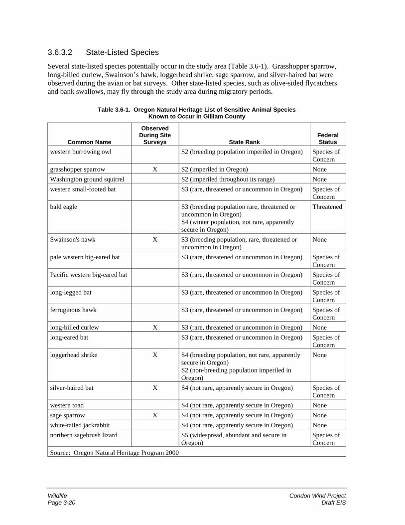
Wildlife Condon Wind ProjectPage 3-20 Draft EIS
3.6.3.2 State-Listed Species
Several state-listed species potentially occur in the study area (Table 3.6-1). Grasshopper sparrow,long-billed curlew, Swainson’s hawk, loggerhead shrike, sage sparrow, and silver-haired bat wereobserved during the avian or bat surveys. Other state-listed species, such as olive-sided flycatchersand bank swallows, may fly through the study area during migratory periods.
Table 3.6-1. Oregon Natural Heritage List of Sensitive Animal SpeciesKnown to Occur in Gilliam County
Common Name
ObservedDuring Site
Surveys State RankFederalStatus
western burrowing owl S2 (breeding population imperiled in Oregon) Species ofConcern
grasshopper sparrow X S2 (imperiled in Oregon) NoneWashington ground squirrel S2 (imperiled throughout its range) Nonewestern small-footed bat S3 (rare, threatened or uncommon in Oregon) Species of
Concernbald eagle S3 (breeding population rare, threatened or
uncommon in Oregon)S4 (winter population, not rare, apparentlysecure in Oregon)
Threatened
Swainson's hawk X S3 (breeding population, rare, threatened oruncommon in Oregon)
None
pale western big-eared bat S3 (rare, threatened or uncommon in Oregon) Species ofConcern
Pacific western big-eared bat S3 (rare, threatened or uncommon in Oregon) Species ofConcern
long-legged bat S3 (rare, threatened or uncommon in Oregon) Species ofConcern
ferruginous hawk S3 (rare, threatened or uncommon in Oregon) Species ofConcern
long-billed curlew X S3 (rare, threatened or uncommon in Oregon) Nonelong-eared bat S3 (rare, threatened or uncommon in Oregon) Species of
Concernloggerhead shrike X S4 (breeding population, not rare, apparently
secure in Oregon)S2 (non-breeding population imperiled inOregon)
None
silver-haired bat X S4 (not rare, apparently secure in Oregon) Species ofConcern
western toad S4 (not rare, apparently secure in Oregon) Nonesage sparrow X S4 (not rare, apparently secure in Oregon) Nonewhite-tailed jackrabbit S4 (not rare, apparently secure in Oregon) Nonenorthern sagebrush lizard S5 (widespread, abundant and secure in
Oregon)Species ofConcern
Source: Oregon Natural Heritage Program 2000
Condon Wind Project WildlifeDraft EIS Page 3-21
3.6.3.3 Bat Populations
Bat Breeding/Year-Round Resident Use
Bat surveys conducted with the avian study confirmed the presence of big brown bat and silver-hairedbat, as well as bats in the genus Myotis (likely little brown myotis and California myotis). The stateassigns the silver-haired bat’s status as sensitive/undetermined.
The bat surveys indicate that most bat activity in the project vicinity occurs in canyons rather than onthe ridgetops where turbines would be installed. Resident bats were found to concentrate foragingactivities within the Tenmile Canyon, Hay Creek, and Ferry Canyon drainages and at constructedponds scattered throughout the project vicinity. Wheat fields and side slopes appeared to receive littleuse.
In general, important bat habitat such as roost sites (where bats rest) and foraging areas could beprovided by the scattered trees and farm buildings in the project vicinity, and in isolated rock outcropsin Ferry and Tenmile Canyons.
Migrant Bat Use
Little published information is available regarding migrating bats. Several species of bats historicallymigrate through Oregon in the fall and spring. The project site lacks trees and other roosting habitatand has relatively dry conditions. This lack of habitat would likely result in most migrating batsflying through the site instead of stopping to roost or feed. The silver-haired bat was detected in theSeptember survey, and is very likely a migrant.
Wintering Bat Use
Bats are either in hibernation or absent from the project site and study area during winter (Barbourand Davis 1969).
3.6.3.4 Avian Groups
Passerines
Passerines include birds commonly referred to as perching birds or songbirds. Passerines aregenerally small birds, and the category includes flycatchers, larks, swallows, crows, magpies,warblers, shrikes, finches, sparrows, and others.
Passerine Breeding/Year-Round Resident Use
Horned lark, western meadowlark, vesper sparrow, and Brewer’s blackbird are by far the mostcommon species of any avian group in the study area. They occur throughout the year and accountedfor over three-quarters of all bird observations during the avian surveys. The horned lark, westernmeadowlark, vesper sparrow, and Brewer’s blackbird accounted for 71 percent, 53 percent, and 33percent of birds detected in summer, fall, and winter avian surveys, respectively. Most birds detectedin winter were unidentified passerines (47 percent). These species are well adapted to open croplandand adjacent habitats and occur in similar habitats throughout the Columbia Basin.
Migrant Passerine Use
Large flocks of migrating passerines were not observed during the avian survey completed for thisevaluation. However, based on local birding reports, several types of passerines migrate throughGilliam County (LaFaive 2000). Bluebirds and flocks of robins are known to fly through Gilliam
Wildlife Condon Wind ProjectPage 3-22 Draft EIS
County during spring and fall. Many other passerine species may migrate through the area becausemigration paths are spread over a wide area throughout Oregon.
Several species of passerines are reported to travel and stop in relatively large flocks (more than20 individuals) in Gilliam County, including sparrows (vesper, savannah, white-crowned, chipping),horned larks, American goldfinches, water pipits, and mountain bluebirds. Sparrows can occur invery large flocks throughout Gilliam County during migration. Even some forest-associated birds flythrough the area, including western tanager and several species of warblers (LaFaive 2000).
Most passerines undertake long-distance migration flights at night, typically flying at altitudes wellabove the highest reach of wind turbines (Bellrose in Alerstam 1990). However, flight altitudes dooccasionally fall within the height of wind turbines, and mortality of migrating passerines has beenreported at existing wind resource areas (Johnson, Wallace et al. 2000; Erickson et al. 2000), althoughno large mortality events like those reported for communication towers (Kerlinger 2000) have beenreported at wind projects.
Passerine migration through the study area is believed to be moderate. The area is located betweenknown breeding areas to the north and known wintering areas to the south. The Columbia Basin is amajor breeding area for waterfowl and raptors, and southeastern Oregon is a major wintering area.Many other types of birds from Washington, British Columbia, and Alaska fly through Oregon duringmigration.
Most migrants are expected to fly past the study area above turbine height rather than lingering tofeed or rest. This is because the study area contains little cover or food that may attract migrants toland. As a general rule, migrating passerines often land during the day to feed, drink water, and rest,and they may travel for periods at low altitudes. However, the study area does not contain forest,extensive wetlands, or other habitats that would be expected to attract large flocks of migratingpasserines to land.
Hawks and Eagles
Hawk and Eagle Breeding/Year-Round Resident Use
Northern harriers were regularly observed during the avian survey. These birds are well suited toagricultural lands. They hunt by flying low along the edges of fencerows and grassy areas, and suchhabitats are abundant in the study area.
American kestrel was the most commonly observed raptor during the field studies (URS and WEST2001). Red-tailed hawk was the second most commonly observed raptor in the study area.
Swainson’s hawks, listed by the state as a sensitive/vulnerable species, were observed soaring andflying at the project site during spring and summer. A total of seven observations were made duringthe spring surveys (with one pair siting) and two during summer surveys. Swainson’s hawks huntmostly from the air and are less reliant on perches than red-tailed hawks. However, the nearestSwainson’s hawk nest site observed is located more than 3 miles from the project site.
Golden eagles are known to forage within canyons in the general project vicinity. The nearest nestingsite found during the nest survey was over 12 miles from the project site. The avian studies resultedin 17 golden eagle observations in the study area during summer and fall; however, all observationswere outside the areas where turbines would be placed.
Condon Wind Project WildlifeDraft EIS Page 3-23
Migrant Hawk and Eagle Use
As with other bird species, migrating raptors are expected to travel through Oregon in a relativelybroad front rather than concentrating in any particular area. Surveys did not find major increases inraptor observations during spring or fall.
Species observed as part of the avian surveys during the hawk migration season were Americankestrel, northern harrier, red-tailed hawk, rough-legged hawk, Cooper’s hawk, prairie falcon, andgolden eagle. Other species not observed but reported to migrate through the general vicinity includenorthern goshawk, sharp-shinned hawk, merlin, peregrine falcon (formerly listed as endangered butsince delisted), and osprey.
Wintering Hawk and Eagle Use
Rough-legged hawks are common winter residents in the study area. These birds nest in the Arctictundra and winter in southern Canada and the northern United States. Like red-tailed hawks, rough-legged hawk activity was found to be highest along areas with perch structures, including alongORE206. As stated earlier under “Federally-Listed Species,” bald eagles may occur rarely in thevicinity during winter.
Owls
Breeding/Year-Round Resident Owl Use
Based on habitat, short-eared and barn owls would be relatively common breeders and residents in thegeneral project vicinity, although the avian surveys resulted in only one short-eared owl observationand no barn owl observations. Barn owls typically use human structures for nesting, whereas short-eared owls nest in dense shrub and grass habitat. Great horned owls are also present in the generalproject vicinity. A great horned owl nest was found 10 miles east of the project area during the springaerial surveys. These birds next in trees or rimrock areas. The study area also lies within the range ofwestern screech owls and burrowing owls, but none were sighted during the avian surveys.
Migrant Owl Use
Several species of owl may migrate through the project vicinity, including two species that also mayreside in the study area (e.g., saw-whet and short-eared owls). The only migratory owl detectedduring the avian surveys was the short-eared owl.
Wintering Owl Use
In addition to year-round resident owls, snowy owls are expected to be occasional visitors in thegeneral project vicinity, since it lies within the range of snowy owls (Johnsgard 1988). Snowy owlswere reported in November and December 1996 near Condon (Oregon Birders Online 2001). Snowyowls were not detected during the avian field survey.
Shorebirds
The long-billed curlew, classified by the state as a sensitive/vulnerable species, and killdeer, acommon species, are the only shorebirds known to occur in the general project vicinity. Both migrantand resident populations occur. Long-billed curlews form flocks in mid-summer after chicks havefledged, and such flocks are likely to travel through the general project vicinity. Seven individualobservations of long-billed curlews were made during the avian surveys.
Wildlife Condon Wind ProjectPage 3-24 Draft EIS
Waterfowl/Cranes
Waterfowl/Crane Breeding/Year-Round Residents
Few waterfowl breed in the study area and general project vicinity, although the canyons and otherdrainages in the vicinity probably provide nesting and foraging habitat. Canada geese were observedduring summer and fall avian surveys in 2000. Geese are grazers, feeding in wheat fields, pastures,and other areas containing grasses and forbs (non-woody plants).
Migrant Waterfowl/Crane Use
Waterfowl are expected to move through the general project vicinity in late fall. The project vicinityis too dry to attract many wetland birds, but migrating flocks of geese or wigeons (a type of duck)may stop in the study area croplands to feed. A few flocks of ducks and geese were noted in theavian surveys during the fall migration period, but overall, the amount of activity appears relativelylow. During fall 2000, one large and one small flock of sandhill cranes, totaling 103 birds, wereobserved migrating over the study area.
Winter Waterfowl/Crane Use
Canada geese and other types of waterfowl winter in the John Day River area and may travel touplands, such as those present in the study area, to feed. No water fowl were found wintering in thestudy area during the avian surveys.
Other Bird Groups
Mourning doves are relatively common in the study area based on avian surveys. Swifts andhummingbirds are rare because of a general lack of habitat.
3.6.3.5 Game SpeciesMule deer are common throughout eastern Oregon, including the study area and vicinity, typicallyfeeding along the edges of wheat fields during spring and fall when plants are green and succulent.During summer, they are not likely to be in the study area, as they most often appear near cover andnear irrigated alfalfa fields (not in the study area) or on steep, north-facing slopes where they findshade and cover. In winter, they tend to form groups and concentrate in areas with southernexposures, vegetation (non-wheat fields such as CRP, range, and remnant native vegetation), andsubstantial isolation from human activity.
Pronghorn antelope are also present in the general project vicinity, although they are more common inthe high-desert region of central Oregon.
In the general project vicinity, chukar are common along slopes, while gray partridge and Californiaquail are expected in shrubby habitats near wheat fields. Ring-necked pheasant would be expectedalong drainage bottoms that provide thick cover.
3.6.3.6 Common Animal Species (Other than Birds and Bats)
Common wildlife species expected to occur in the general project vicinity include mule deer,pronghorn antelopes, cottontails, coyotes, foxes, badgers, bobcats, yellow-bellied marmots, gophers,skunks, ground squirrels, voles, deer mice, pocket mice, pocket gophers, and snakes. Cougars mayalso occasionally move through the general project vicinity to feed on deer, particularly in winter.Most wildlife activity would be expected to occur on uncultivated lands throughout much of the year,although deer, pronghorn antelopes, voles, snakes, and mice may feed in wheat and barley fields.
Condon Wind Project WildlifeDraft EIS Page 3-25
3.6.3.7 Special Habitat Types
Conservation Reserve Program Lands
The CRP lands in the project site and study area are shown in Figure 3.5-1. The CRP is a federalprogram, administered by the Natural Resources Conservation Service (NRCS), to encourage farmersto convert highly erodible cropland or other environmentally sensitive acreage to vegetative cover,such as grasses, wildlife plantings, trees, filter strips, or riparian buffers. Farmers receive an annualrental payment for the term of the multi-year contract. Cost sharing helps to establish the vegetativecover practices. The program reduces soil erosion, reduces sedimentation in streams and lakes,improves water quality, and establishes wildlife habitat.
CRP lands in the project site and study area provide habitat for snakes and small mammals, which inturn attract raptors and other predators. Several species of common birds may also nest in theselands, and upland birds may use these areas throughout the year. The CRP lands can also provideimportant winter range for several types of wildlife, including mule deer.
Trees
No trees are present on the project site, and trees are scarce in the study area, except for a fewscattered groves or individual trees usually associated with current or former farms. Black locust(Robinia pseudo-acacia) is the most common species. Such upland trees provide habitat for nestingand roosting birds and bats, and they are essential to Swainson’s hawks because suitable nest trees areoften the limiting factor to the species’ distribution and abundance. Trees may also provide forage forbrowsing mule deer and antelope.
Riparian Habitats
Riparian habitats with trees are not present on the project site and are very rare in the study area andproject vicinity. Black cottonwoods (Populus angustifolia) may occasionally occur within ripariandrainages in the general project vicinity. Due to the scarcity of riparian habitats with trees, theseareas are important to wildlife, including birds, bats, and large mammals.
Riparian vegetation other than trees occurs as narrow strips along drainage bottoms in the projectvicinity. In drier drainages, plant species composition is often similar to the adjacent uplandcommunities, although the riparian plants grow taller and in greater density.
Shrub-Steppe Habitats
Shrub-steppe is an essential habitat for many native species, including species classified as sensitiveby the state such as sage sparrow and loggerhead shrike. Many other species rely on this habitat,particularly during winter when little other cover is available.
The general project vicinity supports three types of shrub-steppe: big sagebrush/bluebunchwheatgrass, stiff sagebrush/Sandberg’s bluegrass, and big sagebrush/gray rabbitbrush/annual grasses.Shrub-steppe communities were dominant prior to European settlement of the area. In areas subjectto grazing and farming, species composition of the native shrub/bunchgrass communities has beenmodified through introduction of invasive non-native species.
Water Bodies
The project site, study area, and general project vicinity are dry, receiving less than 16 inches ofprecipitation per year. Because of this dry condition, water is one of the major limiting factors to
Wildlife Condon Wind ProjectPage 3-26 Draft EIS
many types of wildlife. Surface water—even if available only in the spring—may be critical formaintaining populations of amphibians in the drainage bottoms, including great basin spadefoot (atoad), and western toad, a state sensitive species.
No wetlands are present on the project site. One 0.1-acre wetland is present in the northern portion ofthe study area near MP 28; a few ephemeral (seasonal) wetlands are scattered throughout the generalvicinity just outside the study area (Figure 3.5-1), and all of these sites were dry during field studiesconducted in July 2000. One pond located just outside the study area is believed to hold waterthroughout the year. Section 3.7 provides more information regarding the wetlands in the projectvicinity.
Other sources of water outside the project site and study area but in the general project vicinityinclude a small stream in Tenmile Canyon, which was flowing through September 2000, and smallpools in the upper reaches of Ferry Canyon off Alville Road that appear to persist throughout thesummer months. The lower reaches of Ferry Canyon were found to be dry during the September fieldvisit.
Human Structures
The human structures scattered over the study area provide important wildlife habitat. Existing utilitypoles provide perches for species such as golden eagle, red-tailed hawk, American kestrel, and rough-legged hawk. Raptors were observed during site surveys perched on BPA transmission line towersand local distribution line poles along ORE206. Wooden fence posts and similar fence structuresscattered throughout the study area also provide perching habitat for hawks and other types of birds.Abandoned homesteads and associated trees in the study area provide hiding and nesting cover for avariety of wildlife, including dusky woodrats, yellow-bellied marmots, skunks, snakes, and lizards.
3.6.4 Environmental Consequences—Proposed ActionPotential impacts to raptors and other birds using the study area include collision with wind turbines,loss of habitat, disturbance to foraging and breeding behavior, collision with overhead power lines,and electrocution. Project-related human activity could alter bird behavior during the constructionphases of the project, and the post-construction density of turbines in the developed portion of the sitemay alter avian use.
Several elements of the project design would help reduce the potential for impacts to birds, and reflectthe state-of-the-art knowledge about minimizing impacts to raptors and other bird species. First,avian use in the study area is very low. Siting the project in an area with low bird use is the mostfundamental way to reduce avian impacts. Beyond that, the project design incorporates a number offeatures that would reduce avian impacts. The use of tubular turbine towers rather than lattice towersminimizes bird perching or nesting opportunities. The slow moving rotation of the turbine blades(approximately one revolution every two seconds) increases the visibility of the blades compared tofaster-moving turbine models. Turbines are proposed to be set back from the upwind side of ridgesand would be located on the top or downwind sides. Turbines would not be located in low saddleareas between drainages. Research has indicated higher raptor use along the upwind side ofridgelines. Also, where feasible, transmission facilities would be located underground to reduce thenumber of locations near turbines where birds may be attracted to perch.
3.6.4.1 Definition of Impact Levels
� Wildlife impacts would be considered high if the project had an unavoidable adverse effect on afederally-listed threatened or endangered animal species, substantially reduced the quantity or
Condon Wind Project WildlifeDraft EIS Page 3-27
quality of a regionally or nationally significant wildlife population or habitat, substantiallyreduced the quantity or quality of habitat critical for the survival of local populations (such as big-game winter range), or adversely affected rare or declining species at the regional level.
� Wildlife impacts would be considered moderate if a federally-listed animal species were takenbut the loss was effectively mitigated through habitat enhancement, relocation, or other measuresapproved by the USFWS; if the project caused a local reduction in the quantity or quality ofwildlife habitat (as opposed to regional reductions); or if it marginally reduced the productivity ofadjacent wildlife habitats or resources (such as nest sites); or if individual animals were lost dueto the project, causing local population reductions but having negligible effects at the regionallevel.
� Wildlife impacts would be considered low if the project temporarily disturbed common wildlifespecies, reduced habitat that is common in the project vicinity, or adversely affected relativelycommon species at a local level.
3.6.4.2 Impacts during Construction
Project construction would result in low impacts on wildlife. Construction would be consistent withregulations pertaining to wildlife. No threatened or endangered species or migratory birds would beharmed or harassed, nor would critical or essential habitat for such species be altered. Avian and batmortality would not occur from construction activities.
Construction noise and activities would cause some animals to avoid areas of active construction. Ingeneral, such avoidance is a concern only under very specific situations, such as disturbance of a nestsite or other breeding areas where animals cannot readily relocate. This impact is unlikely becausethe nearest raptor nest site observed was more than 3 miles from the project site, and the proponenthas committed to containing construction primarily within areas that are private farmland that is onlymarginally productive as habitat.
Special Habitat Types
Approximately 14 acres of CRP land would be disturbed during construction of the project. This isconsidered a low level impact because this represents less than 1 percent of the CRP land in the studyarea, causing a very small reduction in the availability of this habitat type in the study area.
3.6.4.3 Impacts during Operation and Maintenance
Operation and maintenance of the proposed project would result in low to moderate impacts towildlife. Specifically, some bat and bird mortality would be unavoidable.
Birds
With current technology, avian mortality from collisions with the turbines and meteorological towerguy wires is an unavoidable consequence of wind resource development such as the proposed project.It follows that some avian mortality would occur at the project site over the life of this project. Theaverage number of birds killed per year for the proposed project from collisions with wind turbines isexpected to be in the range of 25 to 50 individuals for phase 1, and an additional 25 to 50 individualsfor phase 2 (0.57 to 0.88 birds/turbine/year). This average is based on average per-turbine impactsreported at two similar wind projects—the Vansycle (Umatilla County, Oregon) and Buffalo Ridge(Minnesota) wind resource areas—where a combined total of 5 years of mortality data have beensystematically gathered. These two projects are appropriate for comparison to the proposed projectsince (1) they use similar turbine designs (tubular steel towers, relatively large rotor diameter and
Wildlife Condon Wind ProjectPage 3-28 Draft EIS
height); (2) they are located in open agricultural areas; (3) they are located on ridges perpendicular tothe primary wind direction; and (4) raptors and other birds occur in similar abundance.
Turbines at the Vansycle site are approximately 165 feet tall at the turbine hub and approximately245 feet tall including the turbine blades. Studies at the Vansycle site found a mortality rateassociated with wind turbines of 0.63 birds/turbine/year. In the first year of monitoring, 12 avianfatalities were found, of which 7 (58 percent) were passerines. White-crowned sparrow, which alsooccurs at the proposed Condon site, was the most common species found. Based on the time period,it is likely that the white-crowned sparrows were migrating through the area, although residentpasserines were also found. Gray partridge (an upland game bird that also occurs at the Condonproject site) was also found to be vulnerable to collisions, which was somewhat surprising since thisspecies usually flies close to the ground, well below the height of wind turbine blades.
Two turbine types are in service at the Buffalo Ridge site. The Kenetech Model 33 M-VS turbine isinstalled on top of a 118-foot tubular tower and has a blade diameter of 108 feet. The rotor-sweptheight of the turbine is therefore approximately 64 to 172 feet above ground. The Zond Model Z-750turbine is installed on top of a 164-foot tubular tower. Two blade diameters are in use. With a 151-foot blade diameter, the rotor-swept height of the turbine is approximately 89 to 240 feet. With a157-foot blade diameter, the rotor-swept height of the turbine is approximately 86 to 243 feet.
At the Buffalo Ridge site, the mean number of avian fatalities was 2.83 birds/turbine/year (Johnson,Wallace et al. 2000). As with Vansycle, most avian fatalities (just over 75 percent) were passerines.Other fatalities detected were waterfowl, waterbirds, upland gamebirds, shorebirds, and one raptor.
In addition to collisions with the project wind turbines, birds may also collide with the guy wires ofthe project’s meteorological towers. Two to four permanent meteorological towers would beinstalled, primarily upwind of the turbine strings. The meteorological towers would be 197 feet high,with a concrete foundation and guy wire cable stabilization. Studies at a wind project at Foote CreekRim, Wyoming, resulted in annual estimates of up to 7.5 avian fatalities per meteorological towerbased on a 2-year study (Johnson et al. 2001).
While raptors were originally the major focus of concern for wind projects (Orloff and Flannery1992), more recent studies suggest that this initial concern was primarily due to siting turbines inareas with high raptor populations and high prey density (such as Altamont Pass), and possibly theuse of older technology (such as lattice towers that may attract perching by raptors). Also, earlierstudies focused on finding large birds largely overlooked passerine fatalities (which are much harderto find). Now, as intensive searches for all birds (large and small) have been undertaken at modernfacilities, the evidence suggests that hawks are relatively rare victims of collisions with wind energyfacilities. Because of their typically large abundance relative to raptors, passerines are the morecommonly observed fatality.
Due to the seasonal timing of reported fatalities, it appears likely that many of the fatalities aremigrants, and most passerines migrate at night. A total of nine raptor nests were found within a10-mile radius of the avian study area plots (1.4 nests/10,000 hectares). This density is extremely lowcompared to density found in similar surveys at other wind projects, including the Vansycle/Statelinewind site in Oregon (3.9-7.8 nests/10,000 hectares).
The study area does not contain key features typical of a major migration route. It is not at a meetingpoint of major flight barriers, such as seas and high mountain ranges, so birds are expected to movethrough the study area in a rather broad front, rather than in a concentrated flight path. The study areaalso does not contain forest, extensive wetlands, or other habitats that would attract large flocks ofmigrating passerines. Still, nocturnal migrants are likely to fly through this area during spring andfall migration (as any area in eastern Oregon) and a very small proportion of those flying through the
Condon Wind Project WildlifeDraft EIS Page 3-29
area might collide with proposed project turbines. The overall impact level on nocturnal migrantpopulations is expected to be minimal.
Species most likely to be impacted by the wind turbines and meteorological towers at the proposedproject site, based on mortality studies at other sites, include migrating sparrows (vesper, savannah,white-crowned, chipping) and warblers, together with resident or breeding swallows, Americankestrel, and chukar and/or gray partridge. Although individuals would be lost on a regular basis overthe life of the project, this loss would not significantly affect overall population levels or cause a trendtoward species becoming rare, threatened, or endangered. This is because the site is not likely amajor flyway, and most migrants fly well above the heights that would put them at risk (Alerstam1990). In addition, the data from the Buffalo Ridge site indicate that only a small fraction ofmigrating flocks are affected. Researchers at that site used radar studies to predict that over3.5 million nocturnal migrants annually flew over the general vicinity of the project, yet the greatestnumber of estimated annual fatalities was in the range of 1,000 per year, or less than 3 fatalities forevery 10,000 migrants. The Buffalo Ridge project has over 350 turbines. The amount of mortality atthe proposed Condon project site, with much fewer turbines, is expected to compose a much smallerfraction of the migrating birds.
No single event where large flocks of birds are killed has ever been reported at a wind energy project.The largest mortality reported at a wind energy development in one day was 14 warblers found at twoadjacent turbine structures at the Buffalo Ridge site.
Raptor mortality is likely to be low at the proposed site. The site supports similar or lower raptor usethan the Vansycle and Buffalo Ridge sites, and both of those sites reported little or no raptormortality. During some years, the Condon wind project may cause no mortality, while in other yearsmortality may be in the range of one to three individual hawks. American kestrel is the most likelyraptor species to collide with the proposed turbines, based on its observed use of the project site andknown risk factors. Golden eagles may be killed on rare occasions. Red-tailed hawks, rough-leggedhawks, northern harriers, and other less common or migrant species may also collide with projectturbines at some point over the life of the project, although the numbers are expected to be relativelylow (averaging less than one among these species per year, extrapolating from data from Vansycleand Buffalo Ridge). This impact is considered low to moderate, since it would affect individuals,including sensitive species that have experienced widespread population declines, but it would not belikely to result in long-term, regional population declines.
The Condon wind project would not jeopardize the continued existence of any species listed under theESA. Bald eagles, the only threatened wildlife species that occurs in the project site and study area,are not likely to be affected by the proposed project, since they rarely occur in the area and are notparticularly vulnerable to collisions with wind turbines. No bald eagles were seen at the project siteor study area during surveys, and onsite habitat conditions for bald eagles are poor. While bald eaglesuse a wide range of habitat types, open wheat fields are rarely used. Bald eagles are closelyassociated with large water bodies, and no such habitat is present within several miles from the site.To ensure ESA compliance, BPA would complete consultation with the USFWS under Section 7 ofthe ESA by submitting a biological assessment for listed species prior to committing to the project.
While bald eagles are not likely to be adversely affected by the project, it is possible that a goldeneagle could occasionally be killed. Golden eagles are protected under the Bald Eagle Protection Act.Because golden eagles have collided with wind turbines at other sites, and because golden eagleswere noted to occasionally fly within the project site, the possibility of mortality exists for thisspecies. It is assumed that golden eagle mortality at the project site could occur, but at low rates (onthe order of one fatality every several years). Turbines at the project site would be located away fromthe canyons where golden eagles would be expected to occur most frequently in the study area. The
Wildlife Condon Wind ProjectPage 3-30 Draft EIS
individual fatalities would probably not affect regional population levels. While any fatality iscertainly adverse, the overall effect on population levels would be negligible.
Mortality of bald eagles or other birds due to electrocution by electrical transmission facilities wouldbe minimal. Modern electrical power lines and other transmission facilities are designed to preventelectrocution hazard to raptors or other birds by incorporating features such as perch guards,separation of wires, or line insulators. Designs would be consistent with the recommendations of theAvian Powerline Interaction Committee (1994) or equivalent specifications approved by ODFW.
Mortality of birds listed under the Migratory Bird Treaty Act could be treated by the U.S. Fish andWildlife Service as a violation of this federal act, so appropriate mitigation measures would beemployed to reduce the risk of mortality to a minimum (see mitigation later in this section).However, because the associated bird mortality would be an unintended or incidental occurrence, it isunlikely that this would be considered a “take” under the Migratory Bird Treaty Act.
Bats
Based on per-turbine estimates found at the Vansycle and Buffalo Ridge sites, annual bat mortalityfor the proposed project could be in the range of 30 to 80 individual bats for the first phase and anadditional 30 to 80 individuals for the second phase. Individuals killed are most likely to be hoary,silver-haired, and little brown bats, based on the species found at the Vansycle site.
Bat fatalities at the Vansycle site were estimated to be 0.73 bats/turbine/year during the 1 year ofmonitoring completed there (Erickson et al. 2000). At Buffalo Ridge, estimated bat mortality isapproximately 2 bats per turbine (1.78 bats/turbine/year at one study area and 2.04 at another).Mortality at Buffalo Ridge may have been higher because several turbines were located nearwetlands, which are known to attract bats. At both the Vansycle and Buffalo Ridge sites, most batsthat were killed were believed to be migrants (primarily hoary bats).
The proposed Condon project site is expected to have a similar or lower mortality rate than thatreported at other wind resource areas because of low existing habitat values at the site and the lack ofevidence that the Condon study area receives high bat use during migration. Habitat conditions at thestudy area are such that few migrating bats are expected to land to roost or feed near where turbineswould be placed. The study area lacks the wetlands and roost sites that tend to attract bats.
Therefore, impacts to bats at the proposed Condon project site are expected to be low to moderate,since the species affected are not threatened or endangered and, while individuals would be taken,overall regional population levels are not likely to appreciably change.
General Wildlife
General wildlife impacts from the proposed project would be low. Use of the project site by birds andother wildlife may decline slightly due to the presence of turbines and associated operation andmaintenance activities. Most species affected would be common. Minor reductions in avian use havebeen reported at other wind resource areas (such as Vansycle), and most animals are known to avoidhuman activity.
Special Habitat Types
The operation and maintenance of the project would have no effect on special habitat types.
Condon Wind Project WildlifeDraft EIS Page 3-31
3.6.4.4 Impacts during Decommissioning
Decommissioning of the project would involve low impacts on wildlife. Decommissioning wouldcause a temporary increase in noise and visual disturbance that would, in turn, temporarily reducewildlife use of the project site and vicinity, although no threatened, endangered, or rare species wouldbe affected. Dismantling the project would eliminate the bat and avian mortality caused by thepresence of wind turbines. Subsequent to decommissioning, wildlife habitat at the project site wouldhave the potential to return to pre-project conditions, including CRP land.
3.6.4.5 Mitigation
The following measures would be employed to minimize potential project impacts on wildlife:
� To prevent bald eagles from being attracted to the project site, project personnel and avianmonitoring crews would look for large carrion (dead deer or cattle) on the project site betweenNovember 15 and March 31 of any given year. If found, large carrion would be relocated fromthe project site within 24 hours to similar habitats more than 2 miles from the closest turbine.Sites for such relocations would be identified by BPA.
� Due to inherent uncertainty in avian and bat mortality associated with the proposed project, andthe need to further scientific understanding of avian and bat mortality associated with windenergy generation, the following monitoring standards will be implemented:
1. SeaWest or its successor will monitor avian and bat mortality for the first year of the project’slife, and submit a quarterly report to BPA, ODFW, and USFWS. The monitoring will followstandard protocols that have been established at other wind resource projects.
2. SeaWest staff (or its successor) will maintain a record of all wildlife injury and mortality thatis observed on the project site. This record will include a photographic record of injury andmortality using a standard protocol approved by ODFW and the USFWS.
3. SeaWest or its successor will report, by telephone, injuries or mortalities of species listed inTable 3.6-1 (and any species listed in the future) to the designated BPA, ODFW, and/orUSFWS representatives within 24 hours following observation.
3.6.4.6 Unavoidable Impacts Remaining after Mitigation
Unavoidable adverse impacts after mitigation associated with the proposed project include (1) anannual bird mortality of between 50 and 100, mostly among the passerine species, but including a fewraptors; and (2) an annual bat mortality of between 60 and 160, most likely to be hoary, silver-haired,and myotis bat species.
3.6.5 Environmental Consequences—No ActionUnder No Action, the project would not be built, and the wildlife of the study area would continuewithout influence of the proposed project.
Water Resources and Wetlands Condon Wind ProjectPage 3-32 Draft EIS
3.7 Water Resources and Wetlands
3.7.1 Regulatory FrameworkThe Clean Water Act (CWA) regulates discharges into waters of the United States. In the state ofOregon, the Oregon Department of Environmental Quality (ODEQ) has responsibility forimplementing the CWA.
3.7.2 Study MethodologyThe study area evaluated includes the ORE206 corridor from approximately 2 miles west of Condon(starting at Sniption Canyon) to MP 27, with a western extension to Ferry Canyon and an easternextension to Tenmile Canyon and the Hay Creek drainage (Figure 2.1-1).
Various sources were consulted to identify and assess water resources in the project site, study area,and general project vicinity, including Internet sources from StreamNet, Oregon Department of Fishand Wildlife (ODFW), National Marine Fisheries Service (NMFS), U.S. Fish and Wildlife Service(USFWS), and Bureau of Land Management (BLM). U.S. Geological Survey maps, aerialphotographs, the Gilliam County Soil Survey (SCS 1984), and personnel from ODFW and BLM wereconsulted, and Jones & Stokes personnel conducted field inspections in September 2000.
3.7.3 Affected EnvironmentThe project site and study area are within one of the driest regions of the Pacific Northwest, generallyreceiving less than 16 inches of precipitation annually. Vegetation (mainly in drainages in the projectvicinity) is of the shrub-steppe variety, reflecting a dry climate and harsh temperature extremes(Federal Register Vol. 64, No. 57, March 25, 1999).
3.7.3.1 Streams
No streams exist within the project site or study area, but several streams and drainages occur in theproject vicinity, including Hay Creek to the west, Tenmile Canyon (which drains to Hay Creek) to thenorth, Ferry Canyon to the east, and Sniption Canyon (which drains to Thirtymile Canyon) to thesouth.
3.7.3.2 WetlandsOne very small (0.1 acre) seasonal wetland lies within the northern portion of the study area;however, this wetland is not within the area affected by construction. Three very small seasonalwetlands (totaling about 0.17 acres) are located within draws adjacent to the study area (Figure 3.5-1).All four of these wetlands are wet during late winter and spring and dry during summer.
3.7.3.3 Water Quality
Streams in the project vicinity typically exhibit poor water quality, including high temperatures, lowoxygen levels, and pollution such as sediments, bacteria, fecal coliform, nutrients, and toxic effluents(BLM 1999). Water quality data are routinely collected by ODEQ in the John Day River Basin. Inthe Lower John Day River Subbasin, ODEQ monitors three locations. The monitoring site at theORE206 bridge crossing (RM 39.5) is downstream of Thirtymile and Ferry Canyon but upstream of
Condon Wind Project Water Resources and WetlandsDraft EIS Page 3-33
Hay Creek. The monitoring site at McDonald Ferry is downstream of the study area (ODEQ website).
3.7.3.4 Climate and Hydrogeology
The climate in the area is very dry (16 inches of precipitation annually), with most precipitationfalling as snow. Winter months are cold with mean daily temperatures between 23 and 27oF.Freezing rain, snowstorms, ice fogs, and wind are common in winter, but extended periods of sun alsooccur. Late winter and early spring rainstorms can cause rapid snowmelt, resulting in high peakflows in drainages and streams and increased erosion. Summers are warm and dry with average dailyhighs ranging from 74 to 82oF, and drought periods are common. Occasional summer thunderstormscan bring isolated heavy rains.
Water that does not run off or evaporate, or water that is not taken up by plants, infiltrates into thesoil. Soils in the project site and study area drain such water readily but not rapidly (SCS 1984).Draining water eventually reaches bedrock, typically between 20 and 40 inches below the surface.This water is then directed downslope, where it eventually resurfaces at springs, wetlands, andstreams, or it may also enter aquifers.
Several of the smaller streams, such as the streams in Sniption and Ferry Canyons, generally dry upduring the drier summer months, while the larger streams, such as Hay Creek, flow year-round.These intermittent seasonal streams are generally fed by surface waters, while the perennial streamsare generally fed by groundwater from springs.
3.7.4 Environmental Consequences—Proposed Action
3.7.4.1 Definition of Impact Levels� Impacts related to water resources and wetlands would be considered high if the proposed project
caused a water body that supports sensitive fish, waterfowl, and animal habitat, or human usessuch as drinking water to become altered so as to affect its uses or integrity; or it caused waterquality in drainages downstream of the project site to degrade below state or local standards; or itcaused permanent changes in wetland hydrology, vegetation, or soils.
� Impacts related to water resources and wetlands would be considered moderate if the proposedproject did not affect a sensitive water body but caused water quality in downstream drainages tobe degraded below state or local standards, which could be partially mitigated; or it caused awetland to be partially filled or a wetland function to be partially degraded.
� Impacts related to water resources and wetlands would be considered low if the proposed projectdid not affect a sensitive water body but caused water quality in downstream drainages to beslightly degraded (not below state or local standards) and could be fully mitigated; or it caused ashort-term disruption of a wetland or a wetland function.
3.7.4.2 Impacts during Construction, Operation and Maintenance, orDecommissioning
No impacts on water resources and wetlands are anticipated from the proposed project for thefollowing reasons. First, no wetlands are located within 500 feet of proposed wind turbine locationsor access roads on the project site. Second, the erosion control and soils management techniques tobe employed during construction, operation and maintenance, and decommissioning are expected toprevent fine sediments—the main type of potential pollutant from the project—from being introduced
Water Resources and Wetlands Condon Wind ProjectPage 3-34 Draft EIS
into downstream drainages above existing levels (see Section 3.3 for further discussion of thesetechniques). Third, it is anticipated that any accidental spills of hazardous or toxic materials used orstored on the project site (fuels, lubricants, solvents) would be in quantities small enough to allow forcontainment and clean-up before the contaminants reached downstream drainages.
3.7.4.3 Mitigation
No mitigation for water resources would be required.
3.7.4.4 Unavoidable Impacts Remaining after Mitigation
No unavoidable impacts are anticipated.
3.7.5 Environmental Consequences—No Action AlternativeUnder the No Action Alternative, the project site would likely remain as farmland used for non-irrigated agriculture. Potential impacts to water resources and wetlands associated with the study areawould remain the same as under present conditions.
3.8 Cultural Resources
3.8.1 Regulatory FrameworkRegulations established for the management of cultural resources include the Antiquities Act of 1906;the Historic Sites Act of 1935; Section 106 of the National Historic Preservation Act (NHPA) of1966, as amended; the Archaeological Data Preservation Act (ADPA) of 1974; and theArchaeological Resources Protection Act (ARPA) of 1979, as amended. Specific laws also addressNative American religious freedom and graves protection as defined by the Native American GravesProtection and Repatriation Act (NAGPRA).
For this project, BPA has entered into a Section 106 (NHPA) consultation process with the OregonState Historic Preservation Officer, the Advisory Council on Historic Preservation, and the affectedNative American tribes. BPA’s 1996 Tribal Policy provides a framework for a government-to-government relationship with the 13 federally-recognized Columbia Basin Tribes.
The NHPA amendments specify that properties of traditional religious and cultural importance to aNative American tribe (also known as Traditional Cultural Properties [TCPs]) may be determined tobe eligible for inclusion on the National Register of Historic Places. In carrying out itsresponsibilities under Section 106, BPA is required to consult with any Native American tribe thatattaches religious and cultural significance to any properties.
NAGPRA requires consultation with appropriate Native American tribal authorities prior to theexcavation of human remains or cultural items (including funerary objects, sacred objects, andcultural patrimony) on federal lands or for projects that receive federal funds. NAGPRA recognizesNative American ownership interests in some human remains and cultural items found on federallands and makes illegal the sale or purchase of Native American human remains, whether or not theyderive from federal or Indian land. Repatriation, on request, to the culturally affiliated tribe isrequired for human remains.
Condon Wind Project Cultural ResourcesDraft EIS Page 3-35
3.8.2 Study MethodologyThe cultural resources evaluation is based on information gained from field surveys of the project siteand study area, archival research, and information provided by the proponent (SeaWest) about theproject’s construction, operation, and decommissioning phases. The study area for cultural resourcesis shown in Figure 2.1-1.
3.8.2.1 Archival Research
Background research and a records search identified previously documented or known historicproperties and previous archaeological surveys conducted in the project site and study area. Thedefinition of a historic property is any district, archaeological site, building, structure, or objectincluded in or eligible for listing in the National Register of Historic Places (U.S.C. 470w[5]). Therecords search was conducted at the Office of Archaeology and Historic Preservation (OAHP) inSalem, Oregon, by a qualified archaeologist. The University of Washington Library was accessed forbackground research on the region, and historic maps were consulted to identify regional land usepatterns established by the early pioneers. Aerial photographs were also consulted to track theregional land use pattern in more recent times.
Documents indicate that the project site and the majority of the study area have not been previouslysurveyed for archaeological sites or historic properties. Information available reveals three hunter-fisher-gatherer sites recorded approximately 0.25 mile outside the study area and one historic cisternand associated debris scatter recorded within the PGT-PG&E natural gas pipeline corridor thattraverses the study area (see Figure 3.8-1). No TCPs were identified within the project site or studyarea.
Based on this archival research and the fact the project site and study area have been subject tointensive farming and ranching over the last 100 years, a low probability exists for unknown andintact archaeological sites or historic properties to be found within these areas.
3.8.2.2 Field SurveyField surveys to assess cultural resources of the project site and study area were conducted onOctober 15 through 19, 2000 and March 27 through 30, 2001. The initial investigation involved anoverview and a sampling of the study area (approximately 15% of the study area) because turbinestring locations were not yet decided. A second survey was undertaken once turbine string locationswere identified to perform a systematic survey of the specific turbine string locations and associatedaccess roads, the proposed O&M building site, and the electrical power line right-of-way, as well asan inspection of an alternate site for the O&M building in Condon.
Two surveyors, spaced at 10- to 20-meter intervals, recorded notes on all cultural resourcesencountered. Aerial photographs were consulted, and digital images and color photographs weretaken of all significant resources during fieldwork. No shovel probes were excavated during thesurvey.
3.8.3 Affected Environment
3.8.3.1 Setting and Early History
Schalk’s (1980) cultural history sequence provides a framework in which to place the prehistoriccultural resources of the study area. Early human adaptations to the post-glacial Columbia Plateau
Cultural Resources Condon Wind ProjectPage 3-36 Draft EIS
from 12000 to 3500 B.P. (before present), covering the periods known as the Early and MiddleArchaic, appear to have been more dependent on terrestrial resources than the hunter-fisher-gathererswho followed. Typical artifacts of this period include large Cascade lanceolate points, edge-groundcobbles, and a wide variety of scraping tools. Toward the end of this very long period of humanhistory, plant-processing technology is apparent from pestles and food-grinding stones. Recordedsites suggest relatively small and mobile groups of hunter-fisher-gatherers inhabiting the region.
The next major human habitation period of the region (3500 B.P. to Anno Domini [A.D.] 1730),known as the Late Archaic through Contact Period, was marked by the appearance of structuralremains of houses and facilities for storage of food, cemeteries, and a wide variety of new projectilepoint types. The archaeological record of this period reflects considerable cultural change, with ageneral trend into larger villages, changes in house form, spatial organization, mortuary practices, andprojectile points, all within a subsistence framework.
The next major period (A.D. 1730 to 1850) is distinguished primarily by the introduction of the horseinto the region and attendant cultural changes. From an archaeological viewpoint, this period is theleast known of the entire archaeological record of the region.
Ethnographically, there appear to have been two or three main users of the study area and generalproject vicinity. The primary and traditional Native American groups to utilize the study area werethe Sahaptin-speaking Yakama, Warm Springs, and Tenino and the Numic-speaking Northern Paiute.The Cayuse, Umatilla, Nez Perce, and Walla Walla groups also are known to have utilized this area.Their hunter-fisher-gatherer economy was based on the harvest of anadromous fish and severalspecies of roots, supplemented by resident fish, plant products, and game (primarily mule deer).
The ethnographic research shows that as many as 100 plant species were regularly used in past timesas food resources and many of these plants maintain their importance in modern times. Native plantsstill utilized by the region’s Native American population include Gray’s lomatium (Lomatium grayi),bare-stem desert parsley or Indian consumption plant (Lomatium nudicaule), bitterroot (Lewisiarediviva), Canby’s lomatium (Lomatium canbyi), and camas (Camassia quamash). Bare-stemmedlomatium and big seed lomatium plants were identified during a field survey within the study area.
Tribes that have been contacted during initial consultation include the Confederated Tribes of theUmatilla Indian Reservation and Confederated Tribes of the Warm Springs Reservation.
3.8.3.2 Archaeological Research Results
Archaeological research in the study area and vicinity has been limited in scope and area. Most of theinvestigations have been conducted in conjunction with development projects requiring compliancewith federally-mandated cultural resource requirements. Early archaeological fieldwork associatedwith the installation of a natural gas pipeline between Alberta and California crossed the study area in1960. Background investigations in conjunction with this pipeline documented all cultural resourcesencountered (Mallory 1961). Only a handful of archaeological sites were recorded over 600 miles ofpipeline right-of-way. The nearest recorded site to the proposed wind project site found during thisearlier work, a rock shelter littered with ash, bone, chipped stone, and other organic material, wasSite 35SH22, approximately 18 miles south from the project site (Mallory 1961).
A cultural resource survey of the Ghost Camp Reservoir on Rock Creek in 1975 provided evidence ofhunter-fisher-gatherer occupation approximately 12 miles east of the project site.
Three previously identified hunter-fisher-gatherer sites are recorded adjacent to the study area:35GM118, 35GM119, and 35GM120. Based on this data, there is a high probability that
Condon Wind Project Cultural ResourcesDraft EIS Page 3-37
undiscovered hunter-fisher-gatherer deposits might also be present in the study area near thesepreviously recorded sites. These three sites are briefly described below.
Site 35GM118 is in the PGT-PG&E pipeline right-of-way in the bottom of Hay Creek canyon(Gleason et al. 1992). This site is a lithic scatter containing 75 to 100 CCS flakes, a number of basaltflakes, an obsidian flake, and several flaked tools. Based on the projectile points recovered at the site,it was determined that Site 35GM118 dates to the Early Archaic period (10,000 – 7,000 B.P.).
Site 35GM119 is a lithic scatter of flaked stone on the west side of the narrow north-south trendingHay Creek canyon. Site 35GM119 is approximately 800 meters south of 35GM118 in Hay Creek.Test excavations in 1993 uncovered almost 5,000 pieces of flaked stone, 151 tools, 850 grams ofanimal bones, freshwater shell fragments, and several samples of charcoal (Oetting 1993). Alsofound during excavation were 77 historic or recent artifacts on or near the ground surface along thenorthern and southern edges of the site. Excavations at 35GM119 identified a significant hunter-fisher-gatherer deposit that when radiocarbon dated was assigned to the Late Archaic period(2,500 B.P. to historic contact). Based on the substantial amount of cultural material recoveredduring the excavation and the excellent condition of the site, it was determined Site 35GM119 iseligible for inclusion on the National Register of Historic Places (Oetting 1993).
Site 35GM120 is a low-density lithic scatter located within the PGT-PG&E pipeline right-of-wayapproximately 5,000 feet north of the Linville town site along Richmond Road (Bailey 1993).Artifacts recorded include a basalt pestle and flaked stone chips. The age of the site is unknown, butbased on geomorphic context of the cultural deposit and lithic tool morphology, Site 35GM120appears to derive from a Middle to Late Archaic occupation (5,000 – 2,500 B.P.).
3.8.3.3 Recent History
The earliest evidence of substantial European historic use in the region dates to the 1840s with theopening of the Oregon Trail, which passed east to west through Gilliam County. European settlementof the region began in earnest in the 1860s and was related to mining, homesteading, andtransportation. Condon, known initially as Summit Springs, was established in the early 1880s andbecame a hub for the local agricultural industry. In 1890, Condon became the county seat of GilliamCounty and by 1905 the railroad was completed, connecting the area to the Columbia River.
Recorded historic sites in the study area mainly center on themes of homesteading, ranching, mining,and transportation. These sites date from the late 19th through early 20th centuries. The mostcommon sites are wooden homesteads or cabins or their remains, along with associated features suchas wells, outhouses, windmills, trash dumps, and non-native trees. Corrals, fences, flumes, canals,and farm equipment also are present on some sites.
3.8.3.4 Field Survey Results
During the field surveys, three hunter-fisher-gatherer isolated artifacts were identified north ofRichmond Road. These isolated artifacts were spaced across several hundred meters along the edgeof a ridge and included two CCS flakes and one basalt biface fragment. The two CCS flakes(JS-isolate #2 and JS-isolate #3), both less than 4 centimeters in length, were found 40 meters aparton the western boundary of one of the proposed turbine string locations. A basalt biface fragment(JS-isolate #1) was also identified along the same ridge approximately 50 meters south of the twoCCS flakes. The biface is approximately 3 centimeters in length and has fractures on both theproximal and distal ends. A small percentage (1 to 2 percent) of the ventral side has remnants of a redCCS cortex remaining on the biface fragment. These three isolated finds should not be impacted by
Cultural Resources Condon Wind ProjectPage 3-38 Draft EIS
the construction of the proposed turbine string, but a high probability exists for unknown hunter-fisher-gatherer deposits along this ridge.
Three historic structures, specifically one homestead with wooden corral, one wooden barn closelyassociated with a collapsed windmill, and another homestead with barn and four associatedoutbuildings, were identified within the study area (Figure 3.8-1). The first homestead is located nearMP 29.5. An old wooden hand-painted sign, stating “26IU271,” was found along ORE206 affixed toa barbed-wire fence, indicating the presence of this structure. This four-room wooden structure haswood shingles and square-head cut nails with overall dimensions of 11 feet by 20 feet. After 1890,machine-made round nails replaced early square-head cut nails. This structure has not been evaluatedfor listing in the National Register. A historic site inventory form for this structure will be submittedto the Oregon OAHP at Salem.
The wooden barn is located 1,000 feet west of ORE206 near MP 28.4. It is closely associated with astand of ornamental honey locusts (Robinia sp.), which are non-native trees. A collapsed windmill is25 feet below the barn and more than likely associated with the historic structure. The barn sits atop acement foundation, is held together with machine-made round nails, and measures 20 feet by 20 feet.The east side of the structure has collapsed. This structure has not been evaluated for listing in theNational Register. A historic site inventory form for this historic barn will be submitted to theOregon OAHP.
The second homestead is located along the proposed transmission line right-of-way adjacent toORE206 between MP 36 and 37. Located at the base of a ravine approximately 200 feet southwest ofthe transmission line right-of-way, the homestead, a barn, several outbuildings, and a large trashdump consisting of tin cans, bottles, auto parts, and other debris were found in an accelerated state ofdecay. The main building was constructed using square-head cut nails and showed evidence ofmodifications through time. The parcel of land was surrounded by ornamental honey locusts (Robinasp.), cottonwood trees (Populus balsamifera), and Lombardy poplar (Populus nigra). Thishomestead, accompanying outbuildings, and refuse deposits have not been evaluated for listing in theNational Register but they are probably not eligible due to the building’s serious state of decay. Ahistoric site inventory form for this homestead will be submitted to the Oregon OAHP.
Two historic refuse sites were identified during the field survey and have not been evaluated forlisting in the National Register. Debris from these sites suggests occupation between the 1920s and1940s. Nine abandoned pieces of historic farm equipment (horse/tractor-drawn disc plows andcultivators) were recorded as isolated artifacts. These historic implements and refuse sites areprobably not eligible for listing in the National Register.
A working Aermotor Windmill of unknown age is adjacent to the northern portion of the study areaalong ORE206 near MP 28. The open-geared steel windmill, originally manufactured by Aermotorfrom the 1890s through the 1920s, stands approximately 30 feet high and is supported by a four-poststeel tower. The width of the sails on this windmill cover 10 feet. Windmills played an importantrole in the lives of the early settlers of north-central Oregon from the late 19th century to the timewhen electricity reached remote communities. This functioning windmill has not been evaluated forlisting in the National Register; a historic site inventory form will be submitted to the Oregon OAHP.
The remains of two additional windmills of unknown age were identified. The first windmill tower isapproximately 250 feet west of ORE206 near MP 28.6 and consists of just the first tier of the four-post tower standing 12 feet high. The top portion of the tower, windmill sails, and vane were notpresent. The second windmill is approximately 1,500 feet west of ORE206 near MP 28.25, adjacentto the wooden barn mentioned earlier. The four cement post footings were still in place, but the towerwas missing. Only a section of the open-geared steel windmill sails was present. It appears to have
Condon Wind Project Cultural ResourcesDraft EIS Page 3-39
been an 8-foot-wide Aermotor windmill on a 15- to 20-foot-high, four-post tower structure. Neitherof these structures has been evaluated for listing in the National Register.
3.8.3.5 Consultation
Tribal consultation was initiated by BPA, consistent with the agency’s 1996 Tribal Policy.Representatives from BPA and SeaWest met with the Cultural Resources Committees of theConfederated Tribes of Warm Springs Reservation and Confederated Tribes of the UmatillaReservation during the scoping period for the EIS. The purpose of the meetings was to inform thetribes about the proposed project and to hear any comments or concerns they may have regarding it.Both tribes mentioned the presence of native plant species within the project vicinity that were andstill are part of traditional root-gathering forays. Prior to cultural resource field surveys, the tribesdeclined an invitation to take part in walking over the study area but requested an opportunity tocomment on the Draft EIS.
3.8.4 Environmental Consequences—Proposed Action
3.8.4.1 Definition of Impact Levels
Impact levels for cultural resources have not been developed for this EIS. The proposed projectwould be considered to have an adverse effect on cultural resources if it was to alter, directly orindirectly, the characteristic of an archaeological site or a historic property in a manner that woulddiminish the integrity of the property’s location, design, setting, materials, workmanship, feeling, orassociation.
3.8.4.2 Potential Construction, Operation, and Decommissioning Impacts
Project construction activities would not adversely affect any previously recorded archaeological siteor historic property. Preliminary research indicates a low probability for any unknown intactarchaeological sites within the project site. Potentially, undiscovered hunter-fisher-gatherer resourcesmay still exist, and construction excavation could encounter unrecorded cultural resources.
If archaeological or historic materials are discovered during construction, further surface-disturbingactivities at the site would cease, and appropriate BPA/SeaWest personnel would be notified by theirsubcontractors to ensure proper handling of the discovery by a qualified archaeologist.
Construction activities would avoid the three hunter-fisher-gatherer isolated artifacts, the threehistoric structures, two historic refuse sites, and nine abandoned pieces of historic farm equipmentpreviously described. Construction activities are not expected to disrupt plants and habitat (shrub-steppe) that contain plant species and varieties traditionally used by Native Americans. Access to theproject site property, which is privately owned, is not currently provided to Native Americans by thepresent property owners, and project development would not likely change the status of access.Therefore, the project is not expected to change the current availability of ethno-botanical resourcesto Native American tribes.
No potential adverse effects are anticipated from operation of the proposed project. Potential impactsduring decommissioning of the wind project could have the same potential effects as construction.
3.8.4.3 Mitigation
No mitigation measures are required for cultural resources, if the practices and procedures discussedearlier in Section 3.8.4.2 are followed.
Cultural Resources Condon Wind ProjectPage 3-40 Draft EIS
3.8.4.4 Unavoidable Impacts Remaining After Mitigation
No unavoidable impacts are anticipated.
3.8.5 Environmental Consequences—No Action AlternativeWith the No Action Alternative, the risk of adverse effect on cultural resources in the study areawould not change, as long as the land use in the area remained the same. If this project were notbuilt, it is likely another energy resource would be built. Depending on its location, and the grounddisturbing activities involved in construction, impacts on cultural resources could be greater.
3.9 Visual Resources
3.9.1 Regulatory FrameworkThere is no formal regulatory framework for visual resources.
3.9.2 Study MethodologyThe approach taken in evaluating potential visual impacts of the proposed project generally followsthe visual impact assessment methods developed by the U.S. Forest Service and the Bureau of LandManagement. The study area for the visual resources evaluation is generally the viewscapesassociated with the study area shown in Figure 2.1-1.
Topography, vegetation size and shape, and developed land uses were reviewed usingU.S. Geological Survey quadrangle maps, aerial photographs, surface photographs, and project maps.Field reconnaissance was conducted to determine the general visibility of the proposed wind turbinesfrom sensitive viewpoints (residences, travel routes, and public areas). Visual impacts resulting fromconstruction and operation/maintenance of the project facilities were evaluated by assessing the visualquality of the study area, viewer sensitivity, and the visibility of project facilities (primarily turbines)as seen from sensitive viewpoints.
3.9.2.1 Visual Quality
In this evaluation, visual quality is described as the visual patterns created by the combination of rurallandscapes and human-made development features. Visual quality in the study area was assessedusing the following descriptions:
� Urban/developed landscapes. These are common to urban areas and urban fringes. Humanelements in such landscapes are prevalent and certain landscape modifications may exist that donot blend with the natural surroundings.
� Rural landscapes. These landscapes exhibit reasonably attractive natural and human-madefeatures/patterns, although they are not visually distinctive or unusual within the region. Thelandscape provides positive visual experiences such as the presence of natural open spaceinterspersed with existing agricultural areas (farm fields, etc.).
� Scenic/distinctive landscapes. These exhibit distinctive and memorable visual features (such aslandforms, rock outcrops, streams/rivers, scenic vistas) and patterns (vegetation, open space) thatusually occur in an undisturbed rural setting but may also be found in an urban setting.
Condon Wind Project Visual ResourcesDraft EIS Page 3-41
3.9.2.2 Viewer Sensitivity
Viewer sensitivity, in this evaluation, is described as a combination of viewer type, viewer exposure(number of viewers and view frequency), view orientation, view duration, and viewerawareness/sensitivity to visual changes. Levels of viewer sensitivity in the study area were assessedusing the following general criteria:
� Industrial workers (mainly located in Condon) are considered to have low visual sensitivity.Compared with other viewer types, the number of viewers with low sensitivity would begenerally small and the duration of their view would be short. Activities of these viewers wouldtypically limit their awareness of the visual setting immediately outside the workplace. Inaddition, landscaping or adjacent buildings may screen their views.
� Highway and local travelers and agricultural workers are considered to have moderate visualsensitivity. The number of such viewers and frequency of their views would vary depending onthe location of the wind turbine strings. These viewers’ sensitivity is considered moderatebecause although travelers along ORE206 and those engaged in agricultural practices in theproject vicinity would frequently view the proposed project facilities, they would be focused onwork activities or driving.
� Residential and passive recreational viewers are considered to have comparatively high visualsensitivity. The visual setting may in part contribute to these viewers’ enjoyment of theexperience. Such viewers may potentially see the wind project facilities often and for longperiods.
3.9.3 Affected Environment
3.9.3.1 Visual Setting
The study area is located on the Columbia Plateau in north-central Oregon. The population in thisrural area is sparse and views extend for miles in some locations. The general terrain in the projectvicinity consists of plateaus of gently rolling hills incised by ravines, with no distinctive background.Tenmile Canyon and Ferry Canyon border the northern part of the study area to the east and west,respectively. The study area has relatively few human-made or natural vertical elements, and thosethat exist consist of transmission lines, a radio tower, windmills, isolated groups of deciduous trees,and a few buildings. The visual characteristics of the study area are described below from north tosouth, between MP 27 and MP 39 along Highway 206 (ORE206).
ORE206 forms the western boundary, from MP 27 to MP 30. The viewscape on the east side of thehighway between MP 27 and MP 30 is an expanse of rolling hills. The relatively flat foregroundblends into the background to meet the horizon. Hues of burnt sienna and dark green vary as thevegetation changes from bottlebrush squirreltail grass to gray rabbitbrush. Undulating fields ofgrasses are punctuated by low-lying, dense native shrub-steppe. Vertical elements in this portion ofthe study area include a windmill east of the highway at MP 28.5 and a fence that runs parallel to thehighway.
Between MP 30 and MP 35 slight depressions in the topography give way to canyons that interruptgently rolling plateaus of range grass and growing or fallow fields of wheat and barley, depending onthe time of year. Vertical elements include a residence surrounded by deciduous trees located atMP 32, west of ORE206 just west of the study area. A radio tower is located at MP 35.
Visual Resources Condon Wind ProjectPage 3-42 Draft EIS
The southern portion of the study area between MP 35 and MP 39 is again crossed by ORE206. Theviewscape here has more pronounced smooth-surfaced, rolling hills than the northern portions of thestudy area just described. The landscape west of the highway is covered with low-lying grayrabbitbrush and bluebunch grass. Vertical elements include 69-kV and 7.2-kV power lines, a radiotower, a residence surrounded by deciduous trees, and a grange hall all within the study area. Thesouthernmost portion of the study area has gently rolling hills incised by ravines.
3.9.3.2 Visual Quality
The visual quality of the study area is rural, with no urban/developed areas. The nearest town is theCity of Condon (population 830), located about 5 miles to the southeast. The study area landscapehas repeating patterns of wheat and barley cultivation with pockets of CRP land, resulting in arelatively uniform viewscape that does not contain unique or distinctive features. The natural andrural landscape features and patterns in the study area are reasonably attractive and interesting;however, the rural setting is lacking unique or distinctive features that would attract viewers.Landscape alterations such as roads, buildings, structures, and utilities are situated in a randompattern. Therefore, overall visual quality of the study area is considered low to moderate.
3.9.3.3 Viewer Sensitivity
Primary viewer types associated with the proposed project include residents, local or businesstravelers, occasional recreationists (primarily hunters), agricultural workers, and other types ofworkers in the area. The most visually sensitive viewers would be people in residences located in oradjacent to the study area (Figure 2.1-1). Visual sensitivity for these residential viewers would rangefrom moderate to high, depending on proximity to and visibility of the turbines.
Recreationists and local or business travelers would mainly be traveling along ORE206 or movingthrough the area, and their visual sensitivity would be considered low to moderate. Agriculturalworkers would likely be actively engaged in work-related activities but would be able to view theproposed project site for longer periods. Therefore, these viewers would be seeing the projectfacilities intermittently for short periods, and their visual sensitivity would be considered moderate,depending on their proximity to the project site.
3.9.4 Environmental Consequences—Proposed ActionPotential visual impacts include temporary visual changes introduced by construction, operation, andmaintenance of the wind turbines, and permanent visual changes caused by the presence of theturbines, the substation, and the O&M building. Visual quality and viewer sensitivity are combinedto determine visual impacts. Whether the visual impact is considered positive or negative depends onthe individual viewer’s perceptions.
3.9.4.1 Definition of Impact Levels� High visual impacts: The visual quality of the viewscape is moderate, viewer sensitivity is high,
and views of the project are of long duration or high frequency.
� Moderate visual impacts: The visual quality of the viewscape is moderate, viewer sensitivity ismoderate, views are long or short in duration, and viewers are likely engaged in focusedactivities.
� Low visual impacts: The visual quality of the viewscape is low, viewer sensitivity is low, theduration of views is relatively short, and the number of viewers is relatively small.
Condon Wind Project Visual ResourcesDraft EIS Page 3-43
3.9.4.2 Impacts during Construction
Construction activities would be of limited duration and would occur mostly between dawn and dusk.Residents in the project vicinity are considered to be the most visually sensitive viewers(Figure 2.1-1). Visual impacts for residents in the project vicinity would be moderate to high forthose residences along ORE206 and between Condon and the project site. The residences located inthe valleys would have obstructed views of the project site and therefore would experience low tomoderate visual impacts. Deciduous trees surrounding residences may partially obstruct the view ofthe construction activity and further reduce visual impacts. Those residences located west of Condonand those located east of the project site would have relatively unobstructed views and thus wouldexperience relatively high visual impacts. The other residents in the project vicinity would have lowimpacts because of obstructed views.
Local or business travelers and recreationists traveling along ORE206 would experience low tomoderate visual impacts. While the travelers and recreationists would be engaged in focusedactivities, the construction activity would be visible for some distance and the proximity of thehighway to the project site would allow for potential (albeit intermittent) views of long duration.
Agricultural workers would experience moderate visual impacts, depending on their proximity to theproject site. While they would be engaged in focused activities, there are a relatively small number ofvertical elements in the viewscape, making the construction activity easily visible for some distance.Also, their views would be of relatively long duration (albeit intermittent). Impacts would be higherfor those workers in closer proximity to the construction area.
Impacts to other workers in the surrounding area would be low due to the distance to the project site,the short duration of their views of the project site, and the fact that they would likely be focused onwork activities.
3.9.4.3 Impacts during Operation and Maintenance
The turbines on the project site would be located on top of relatively flat, sparsely vegetated plateausand would be visible for some distance. Photosimulations have been prepared depicting typical viewsof the project site from ORE206 before and after the wind turbines are constructed. Figure 3.9-1presents a key showing the location of photosimulations. The photosimulations are shown inFigures 3.9-2 through 3.9-6.
Visual impacts would be moderate for residents along ORE206 and between Condon and the projectsite, depending on their proximity to the turbines. The remaining residences are located in the valleysor are surrounded by deciduous trees and, therefore, the residents would have partially obstructedviews and would experience moderate visual impacts.
Visual impacts to local and business travelers and recreationists would be low to moderate. Theturbines would be visible for some distance, and while travelers and recreationists would be focusedon driving, there is the potential for views of long duration due to the orientation and proximity ofORE206 to the turbine strings.
Agricultural workers in proximity to the project site would experience moderate to high visualimpacts. Although these workers would be somewhat focused on their work activities, the turbineswould be a prominent part of their viewscape, and their views would likely be intermittent but of longduration. Impacts to other workers in the project vicinity would likely be low due to viewingdistance, short duration of views, and their focus on work activities.
If required, aircraft safety measures might include tower striping, daytime white beacon lighting, andnighttime white or red beacons for those towers associated with Condon Airport flight patterns. If
Visual Resources Condon Wind ProjectPage 3-44 Draft EIS
nighttime lights were required for some towers, these would be visible to residents and travelers in theproject vicinity.
Relative to other types of utility projects and facilities, or industrial facilities, the wind turbines wouldpresent clean, graceful lines that would not overpower the landscape or obstruct views. Because theturbines would be dispersed, and there would be space between individual turbines in the strings, theywould be much less of a focal point than many other large structures would be. The towers would bea neutral color that would blend easily with the neutral colors of the landscape.
3.9.4.4 Impacts during DecommissioningImpacts during decommissioning of the project would be similar to those of construction.
3.9.4.5 MitigationMitigation measures that would help minimize visual impacts include:
� siting all construction staging and storage areas away from locations that would be clearly visiblefrom ORE206 as much as practical;
� providing a clean-looking facility following construction by storing equipment and supplies outof sight, if practical; by promptly removing any damaged or unusable equipment; and bypromptly repairing or decommissioning (and removing) turbines that are not functioning or notbeing used;
� coordinating with Oregon and federal recreational facilities and areas, as well as the OregonDepartment of Transportation, to provide signs directing sightseers along ORE206 to publicviewing places that could provide safe viewing areas of the project site; and
� keeping turbines and towers clean and touching up paint when needed.
3.9.4.6 Unavoidable Impacts Remaining after MitigationThe project turbines would be a readily visible part of the viewscape in the project vicinity forresidents, agricultural workers, recreationists, and travelers along ORE206.
3.9.5 Environmental Consequences—No Action AlternativeUnder the No Action Alternative, the visual quality and sensitivity of viewers of the study area wouldnot be influenced by the proposed project. Energy resources built instead of the proposed projectcould have visual impacts. The intensity of impact would depend on the location of those energyresources.
3.10 Socioeconomics, Public Services, and Utilities
3.10.1 Regulatory FrameworkThere is no formal regulatory framework for socioeconomics except for environmental justice.Executive Order 12898, Federal Actions to Address Environmental Justice in Minority Populationsand Low-Income Populations, requires that impacts to minority and low-income populations bespecifically evaluated for all projects on federal lands, requiring federal permits, or obtaining federalfunding. Public services and utilities in the study area and project vicinity are regulated byordinances and policies set forth by Gilliam County.
Condon Wind Project Socioeconomics, Public Services, and UtilitiesDraft EIS Page 3-45
3.10.2 Study MethodologyInformation sources for this socioeconomic analysis include:
� Oregon Economic and Community Development Department website(http://www.econ.state.or.us);
� Center for Population Research and Census at Portland State University website(http://www.upa.pdx.edu/CPRC); http://quickfacts.census.gov/qfd/states/
� U.S. Census Bureau website (http://www.census.gov);
� State of Oregon Employment Department website (http://www.olmis.org);
� Betsy Pattee, Public Works/Planning Director, Gilliam County Public Works and PlanningDepartment;
� Bonnie Parker, City Administrator, City of Condon Fire Department;
� Chris Fitzsimmons, Office Deputy, Gilliam County Sheriff’s Department;
� Bill Gubser, Officer, City of Condon Police Department;
� Archie Ball, Operations Manager, Columbia Basin Electrical Co-op; and
� Jill Layton, Principal, Condon High School.
3.10.3 Affected EnvironmentThe study area for socioeconomic conditions includes the City of Condon and Gilliam County.
3.10.3.1 Population
From 1980 to 1990, Gilliam County’s population decreased from 2,057 to 1,717, an estimated16.5 percent. Condon experienced a similar reduction in population by approximately 19 percent.This population decrease, which continued from the 1970s to 1990, has been attributed to thedecommissioning of an Early Warning Radar Station in Condon, which had been a major employer inthe area.
Since 1990, the population of Gilliam County, which was 1,717, has increased by 11.5 percent. Thepopulation in the county began to increase when the Columbia Ridge Landfill and Recycling Centerconstructed a landfill, which employs a large segment of the Gilliam County working population(U.S. Census Bureau 1980, 1990; Pattee pers. comm.).
The 1990 Census reports indicate that the age group with the highest representation in Gilliam County(30 percent) was the 20 to 44 age bracket. This age bracket accounted for 25 percent in the City ofCondon and 39 percent in the state of Oregon. The median age in the City of Condon in 1990 was 44,higher than the county’s median age of 35.
Based on 2000 census data, the population of Gilliam County was 1,915. Approximately 830 people,or 40 percent of the county population, lived in the City of Condon in 1998 (Condon 2000 censusdata are not yet available).
Socioeconomics, Public Services, and Utilities Condon Wind ProjectPage 3-46 Draft EIS
3.10.3.2 Employment
Nearly 40 percent of the labor force in Gilliam County is employed in farming. Other employmentsectors include transportation and public utilities (23 percent); government (18 percent); wholesaleand retail trade (11 percent); services (6 percent); finance, insurance and real estate (2 percent); andconstruction and mining (less than 1 percent).
This indicates a reduction in the farming and government employment sectors from 1990, when thesesectors represented 43 percent and 21 percent of the employment at that time, respectively.Employment in transportation and public utilities increased from 1990 to 1998, from 11 percent to23 percent. Wholesale and retail trade remained constant at 11 to 12 percent from 1990 to 1998.
3.10.3.3 Housing and Lodging
The total number of housing units in Gilliam County in 1990 was 932, of which 356 were located inthe City of Condon (2000 census data are not yet available). Approximately three-quarters of thehousing units in Gilliam County were occupied, and one-quarter were vacant. About 84 percent weresingle-unit, detached dwellings. The second most abundant type of housing was mobile homes ortrailers, which constituted 11 percent of the total housing units. The next largest group was two-unitstructures, which made up 3 percent of the housing units in Gilliam County. Of the vacant housingunits, 82 percent were single units.
At present, temporary lodging in Condon includes the Condon Motel, the Condon Trailer and RVPark, and several vacant houses that are available for rent. The Condon Motel has 18 rooms.Approximately 26 houses that were constructed for the Early Warning Radar Station are vacant andavailable to rent (Pattee pers. comm.).
3.10.3.4 Fire and Medical Service
The City of Condon Fire Department has a volunteer chief and 20 volunteer firefighters. There aretwo stations in the City of Condon. One station, located in City Hall, has two trucks and is set up tofight structural fires. A second station in Condon, part of the South Gilliam County Rural FireProtection District, is set up to fight field and brush fires and is equipped with six vehicles. Fireservice for the project would be provided by the South Gilliam County Rural Fire Protection District.
No documentation was available on the number of calls for fire service; however, according to CityAdministrator Bonnie Parker, the city fire department usually responds to approximately two calls permonth.
Gilliam County Medical Center in Condon is staffed by two physician assistants with supervision bya medical doctor from Hermiston. The nearest hospital is located in The Dalles, 70 miles northwestof Condon. The City of Condon is served by a volunteer Emergency Medical Technician crew withtwo fully equipped ambulances, and by Life Flight helicopters, out of Bend (120 miles south), formajor emergencies.
3.10.3.5 Police Service
Police service for the project would be provided by the Gilliam County Sheriff’s Office, located indowntown Condon. The Sheriff’s Office has four vehicles and five full-time employees: a Sheriff, aChief Deputy, two Deputies, and an Office Deputy. The 911 Center that serves Gilliam County islocated in Morrow County.
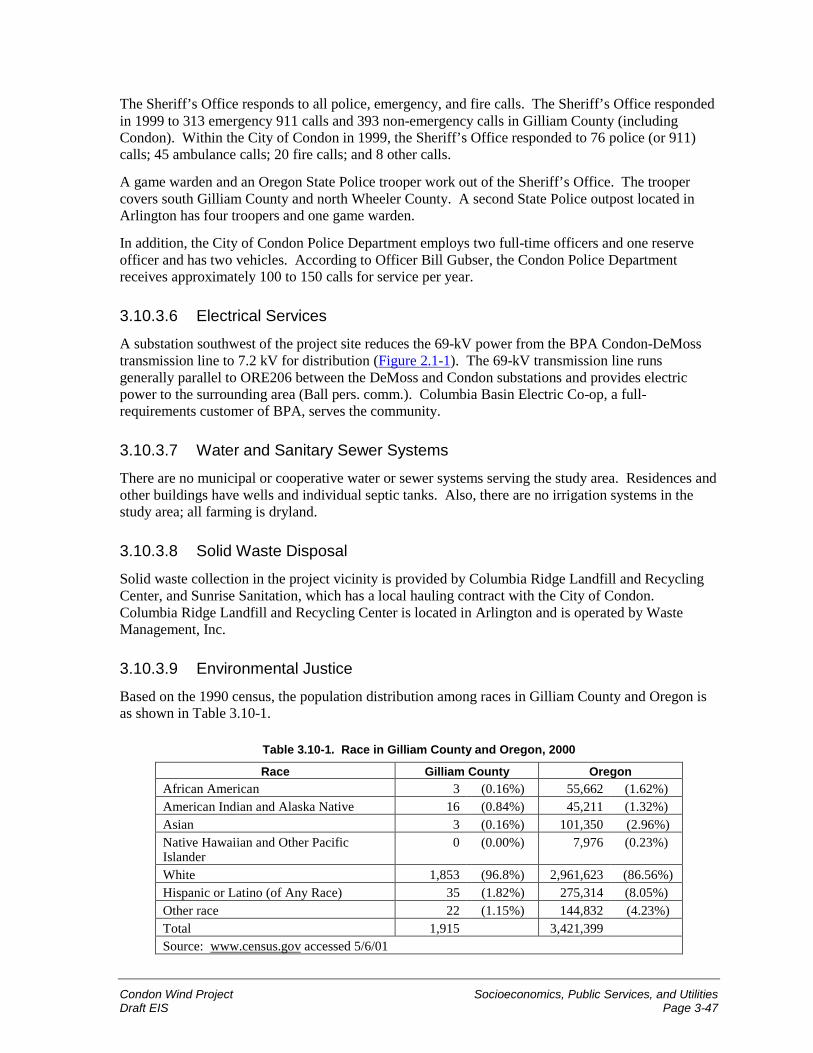
Condon Wind Project Socioeconomics, Public Services, and UtilitiesDraft EIS Page 3-47
The Sheriff’s Office responds to all police, emergency, and fire calls. The Sheriff’s Office respondedin 1999 to 313 emergency 911 calls and 393 non-emergency calls in Gilliam County (includingCondon). Within the City of Condon in 1999, the Sheriff’s Office responded to 76 police (or 911)calls; 45 ambulance calls; 20 fire calls; and 8 other calls.
A game warden and an Oregon State Police trooper work out of the Sheriff’s Office. The troopercovers south Gilliam County and north Wheeler County. A second State Police outpost located inArlington has four troopers and one game warden.
In addition, the City of Condon Police Department employs two full-time officers and one reserveofficer and has two vehicles. According to Officer Bill Gubser, the Condon Police Departmentreceives approximately 100 to 150 calls for service per year.
3.10.3.6 Electrical Services
A substation southwest of the project site reduces the 69-kV power from the BPA Condon-DeMosstransmission line to 7.2 kV for distribution (Figure 2.1-1). The 69-kV transmission line runsgenerally parallel to ORE206 between the DeMoss and Condon substations and provides electricpower to the surrounding area (Ball pers. comm.). Columbia Basin Electric Co-op, a full-requirements customer of BPA, serves the community.
3.10.3.7 Water and Sanitary Sewer Systems
There are no municipal or cooperative water or sewer systems serving the study area. Residences andother buildings have wells and individual septic tanks. Also, there are no irrigation systems in thestudy area; all farming is dryland.
3.10.3.8 Solid Waste Disposal
Solid waste collection in the project vicinity is provided by Columbia Ridge Landfill and RecyclingCenter, and Sunrise Sanitation, which has a local hauling contract with the City of Condon.Columbia Ridge Landfill and Recycling Center is located in Arlington and is operated by WasteManagement, Inc.
3.10.3.9 Environmental Justice
Based on the 1990 census, the population distribution among races in Gilliam County and Oregon isas shown in Table 3.10-1.
Table 3.10-1. Race in Gilliam County and Oregon, 2000
Race Gilliam County OregonAfrican American 3 (0.16%) 55,662 (1.62%)American Indian and Alaska Native 16 (0.84%) 45,211 (1.32%)Asian 3 (0.16%) 101,350 (2.96%)Native Hawaiian and Other PacificIslander
0 (0.00%) 7,976 (0.23%)
White 1,853 (96.8%) 2,961,623 (86.56%)Hispanic or Latino (of Any Race) 35 (1.82%) 275,314 (8.05%)Other race 22 (1.15%) 144,832 (4.23%)Total 1,915 3,421,399Source: www.census.gov accessed 5/6/01
Socioeconomics, Public Services, and Utilities Condon Wind ProjectPage 3-48 Draft EIS
The U.S. Census Bureau follows the Office of Management and Budget’s Statistical Policy Directive14 to determine poverty status based on income level. Poverty status can be used as a measure of lowincome for environmental justice analyses. The number of people below the poverty level was 12percent in both Gilliam County and the State of Oregon in 1989 (2000 census data not yet available)(www.census.gov accessed 1/3/01).
3.10.4 Environmental Consequences—Proposed Action
3.10.4.1 Definition of Impact LevelsFor this evaluation, socioeconomic impacts associated with the proposed project were assessed aseither beneficial, adverse, or no impact.
� A beneficial socioeconomic impact would provide employment, increase tax revenues, increaseproperty values, increase revenue from rents and home sales, or create other enhancing effects onthe social and economic vitality of affected communities.
� An adverse socioeconomic impact would reduce the tax base, reduce employment or propertyvalues, or create other similar deleterious effects on the social and economic vitality of the City ofCondon and/or Gilliam County.
3.10.4.2 Impacts of Construction
During construction, no housing impacts are expected because sufficient housing is available in theCity of Condon, and a minor temporary increase in population would occur. There is the potential fora beneficial impact on unemployment if some workers are hired locally. A minor beneficial impacton the local economy would occur from the purchase of goods and services and through rental ofhousing units. Minor increases in the need for emergency fire, medical, and police services mayoccur. No impact to schools or utilities are expected.
Approximately 60 to 70 workers would be hired over each 4- to 5-month construction period ofphases 1 and 2 of the proposed project, with such employment not exceeding 30 workers at any onetime. Phase 1 of construction is proposed to begin and be completed in late 2001, and phase 2 couldbe built as early as summer 2002. Phases 1 and 2 would not overlap. Assuming at least 33 percentlocal hiring (Gilmore et al. 1981), 10 of the 30 workers would be hired locally and 20 would in-migrate. If the in-migrants were to be temporarily housed in Gilliam County, this would represent a1 percent increase of the 2,100 individuals estimated to be living in the county (including Condon). Ifworkers were housed in Condon, which is likely given the proximity of the city to the project site andthe availability of housing, a 2.4 percent temporary increase in population would occur in the Cityduring each phase. Assuming 20 workers would in-migrate, the capacity of housing in GilliamCounty and Condon would be sufficient.
Gilliam County’s unemployment rate was estimated to be 4.9 percent in 1998 (according to State ofOregon Employment Division data). Neighboring Sherman and Wheeler County unemployment rateswere estimated to be 5.6 percent and 8.2 percent, respectively. This means that approximately170 people are unemployed in the three counties. This may be sufficient to provide the workforceneeded for the project, although some of the available workforce would likely not have the requiredtraining and skills to perform some of the construction tasks. Benefits to the local economy (City ofCondon and Gilliam County) and the regional economy (Sherman, Wheeler, Umatilla, and WascoCounties) include the potential for employment and the purchase of goods and services.
Condon Wind Project Socioeconomics, Public Services, and UtilitiesDraft EIS Page 3-49
Equipment (wind turbines and substation) would likely be purchased from outside the local andregional economic areas. However, the majority of goods and services would be purchased locallyand regionally (such as contractors; heavy equipment such as cranes and forklifts [rented]; vehicles[purchased]; lodging; fencing materials; uniforms; cleaning supplies; fuel; office supplies; tools;cement; and technicians and office staff). The estimated local expenditures for construction areestimated to be in the range of $445,000 to $570,000. The estimated regional expenditures forconstruction are estimated to be in the range of $3.7 million to $4.5 million.
During construction, the increased activity at the project site could increase the potential for fires andthe need for medical and police services at the project site. Should fire service be required, the Cityof Condon Fire Department and the South Gilliam County Rural Fire Department, located in Condon,have sufficient facilities to handle such emergencies. The Gilliam County Medical Center in Condonwould be available for minor injuries. The two ambulances in Condon could provide EmergencyMedical Technician crews and transportation to the nearest hospital located in The Dalles, Oregon,70 miles northwest of Condon. Life Flight helicopter service out of Bend, Oregon, 120 miles south ofCondon, could transport patients to Portland, The Dalles, or Bend for major medical emergencies.The existing Condon and Gilliam County police departments would provide sufficient services, ifrequired. An emergency response plan for the project would be prepared and kept onsite, andconstruction and operations personnel would be trained in the emergency procedures.
It is unlikely that families would temporarily locate in Condon or the surrounding area during theconstruction period for each phase. However, excess capacities in the Condon Elementary and HighSchools would accommodate additional students if needed.
No construction impacts to existing electrical systems, water and sanitary sewer systems, or solidwaste disposal are anticipated because the proponent would construct its own facilities or contract forconstruction. No new housing would be required.
The project would be located entirely on private property and not in the vicinity of low-income orminority populations. It would not displace or negatively affect minority or low-income people, whocould experience a beneficial impact from the project if they became part of the constructionworkforce.
3.10.4.3 Impacts of Operation and MaintenanceDuring operation of the project, no impacts are expected to housing, and only minor adverse impactscould occur to emergency services and schools. Beneficial impacts on the local economy wouldresult from increased tax revenues and the purchase of goods and services. In addition, acquisition ofthe output of the project by BPA would help reduce BPA’s energy resource deficit. The electricityproduced by the proposed project is relatively inexpensive and would help BPA reduce powerpurchases in today’s expensive electricity market. Thus, local utility prices are not expected to beaffected as a result of the project because the energy produced would be sold to BPA and added totheir supplies of energy.
During operation, two to six full-time staff (assuming both phases are built) would be employed bythe project. There would be no impacts to housing because there is an adequate housing supply inGilliam County and the City of Condon. The project would have a beneficial impact onunemployment if the full-time staff were hired locally.
Up to six families (assuming both phases are built) could permanently locate in Condon or thesurrounding area, if the required staff were not hired locally. Excess capacities in the elementary andhigh schools would accommodate potential students.
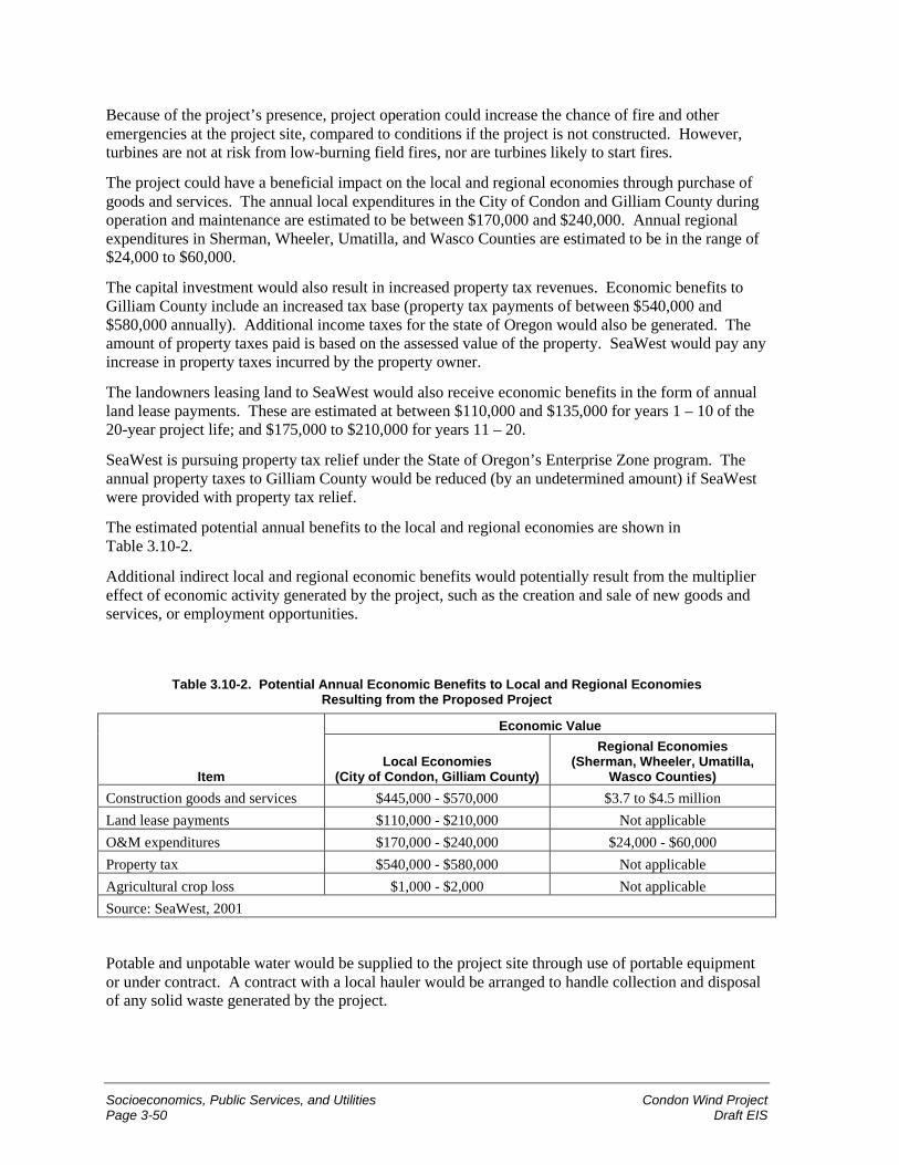
Socioeconomics, Public Services, and Utilities Condon Wind ProjectPage 3-50 Draft EIS
Because of the project’s presence, project operation could increase the chance of fire and otheremergencies at the project site, compared to conditions if the project is not constructed. However,turbines are not at risk from low-burning field fires, nor are turbines likely to start fires.
The project could have a beneficial impact on the local and regional economies through purchase ofgoods and services. The annual local expenditures in the City of Condon and Gilliam County duringoperation and maintenance are estimated to be between $170,000 and $240,000. Annual regionalexpenditures in Sherman, Wheeler, Umatilla, and Wasco Counties are estimated to be in the range of$24,000 to $60,000.
The capital investment would also result in increased property tax revenues. Economic benefits toGilliam County include an increased tax base (property tax payments of between $540,000 and$580,000 annually). Additional income taxes for the state of Oregon would also be generated. Theamount of property taxes paid is based on the assessed value of the property. SeaWest would pay anyincrease in property taxes incurred by the property owner.
The landowners leasing land to SeaWest would also receive economic benefits in the form of annualland lease payments. These are estimated at between $110,000 and $135,000 for years 1 – 10 of the20-year project life; and $175,000 to $210,000 for years 11 – 20.
SeaWest is pursuing property tax relief under the State of Oregon’s Enterprise Zone program. Theannual property taxes to Gilliam County would be reduced (by an undetermined amount) if SeaWestwere provided with property tax relief.
The estimated potential annual benefits to the local and regional economies are shown inTable 3.10-2.
Additional indirect local and regional economic benefits would potentially result from the multipliereffect of economic activity generated by the project, such as the creation and sale of new goods andservices, or employment opportunities.
Table 3.10-2. Potential Annual Economic Benefits to Local and Regional EconomiesResulting from the Proposed Project
Economic Value
ItemLocal Economies
(City of Condon, Gilliam County)
Regional Economies(Sherman, Wheeler, Umatilla,
Wasco Counties)Construction goods and services $445,000 - $570,000 $3.7 to $4.5 millionLand lease payments $110,000 - $210,000 Not applicableO&M expenditures $170,000 - $240,000 $24,000 - $60,000Property tax $540,000 - $580,000 Not applicableAgricultural crop loss $1,000 - $2,000 Not applicableSource: SeaWest, 2001
Potable and unpotable water would be supplied to the project site through use of portable equipmentor under contract. A contract with a local hauler would be arranged to handle collection and disposalof any solid waste generated by the project.
Condon Wind Project Socioeconomics, Public Services, and UtilitiesDraft EIS Page 3-51
Minority and low-income people would not be adversely affected by project operations due to thesmall size of the operational workforce. These individuals could experience a beneficial impact fromthe project if they became part of the operational workforce.
3.10.4.4 Impacts of Decommissioning
Anticipated impacts during decommissioning (dismantling) of the project facilities would be similarto construction, including the beneficial impact of hiring some local workers to dismantle the project.The up to six full-time jobs created as part of the project would be eliminated. This loss ofemployment would likely have a slight adverse impact on employment and the local economy.
Decommissioning of the project would not displace or negatively affect minority or low-incomepeople because it would take place entirely on private property and not within close proximity tominority or low-income populations. These people could experience a beneficial impact from theproject if they became part of the decommissioning workforce.
3.10.4.5 Mitigation
No mitigation measures are required.
3.10.4.6 Unavoidable Impacts Remaining after Mitigation
No unavoidable impacts are anticipated.
3.10.5 Environmental Consequences—No Action AlternativeUnder the No Action Alternative, the socioeconomic conditions in the project vicinity andsurrounding area would continue without influence from the proposed project. The county would notbenefit from the tax revenues and employment opportunities brought by the project.
3.11 TransportationThe study area for the transportation analysis includes local roads in the general project vicinity andthe road system serving Gilliam County between Condon and Interstate 84. The analysis focuses onroads that would be used by project personnel during construction of each phase of the project andfollowing construction for operation and maintenance (Figure 2.1-1).
3.11.1 Regulatory FrameworkGilliam County Public Works Department’s Roadmaster develops a Roadmaster Policy Workplan,which annually outlines scheduled maintenance and improvements to Gilliam County roads.
Gilliam County Public Works has no weight restrictions on county roads, except during inclementweather when a 10-ton limit is imposed. Large loads carried on the county roads are primarily hayand cattle. State highways in the vicinity of the project are subject to width and length restrictions, aswell as weight limitations. Annual permits are needed for large load transport on Highway 19(ORE19) (12-foot width and 75-foot length) and ORE206 (12-foot width and 65-foot length). Loadsthat exceed the permitted lengths require single-trip permits from the Oregon Department ofTransportation (ODOT).
Transportation Condon Wind ProjectPage 3-52 Draft EIS
3.11.2 Study MethodologyInformation used in this section includes traffic data obtained from the ODOT website(http://www.odot.state.or.us/ tdb/traffic_monitoring/ tvtable.asp). Additional information sourcesinclude a Gilliam County Roads Map and interviews with Gilliam County Public Works Departmentand ODOT’s Motor Carrier Transportation Division.
Information regarding length and weight restrictions, existing road conditions, and plannedimprovements/maintenance in the project vicinity was obtained from interviews with Betsy Pattee,Gilliam County Public Works; Dewey Kennedy, Roadmaster, Gilliam County Public Works; RickRodgers, Program Coordinator, ODOT Motor Carrier Transportation Division, Over-DimensionalPermit Unit; and Dan Kaplan, Mileage Control Specialist, ODOT Road Inventory and ClassificationServices. Site visits were conducted in October 2000 to examine road conditions and to verifyexisting access roads in the project vicinity.
3.11.3 Affected EnvironmentAccess to the study area is provided by highways described below and depicted in Figure 2.1-1.
Highway 19 (ORE19) is a major north-south arterial located approximately 5 miles from the projectsite, where it intersects with ORE206 at the City of Condon. It extends from Interstate 84 along theColumbia River south to Wheeler County, Oregon. ORE19 is classified as a two-lane PrincipalArterial. Near Condon, pavement conditions are good and shoulders are provided. The lane width ofORE19 in the vicinity of the project is 12 feet with 4-foot shoulders on either side of the highway.The speed limit outside Condon is 55 miles per hour.
Highway 206 (ORE206) extends from Interstate 84 along the Columbia River southeast throughCondon and into Morrow County, east of Gilliam County. ORE206 extends along the north-southaxis of the study area from MP 27 to MP 39 and is classified as a two-lane Principal Arterial(Figure 2.1-1). Near Condon, pavement conditions are good and shoulders are provided. The lanewidth of ORE206 is 12 feet. The speed limit outside Condon is 55 miles per hour.
Approximately 100 miles of Gilliam County roads are paved, while over 300 miles are gravel roads.The county roads currently have no planned improvements. General maintenance on gravel roadsincludes grading twice a year, in the spring and fall. The paved roads are patched as needed. Everyother year the paved roads are oiled and rock is applied. This activity was last completed in 2000 andis planned for 2002 (Pattee pers. comm.).
Three county roads provide access to the project site. These include Richmond Lane and FerryCanyon Road, located east of ORE206, and Old Cottonwood Road, located north of and parallel toORE206. Richmond Lane and Ferry Canyon Road are paved, two-lane roads with no shoulders andare in fair to good condition. Old Cottonwood Road is graveled. Several private gravel roads off ofORE206 provide access to the project site but are not open to the general public.
3.11.3.1 Traffic Volumes
Traffic data along ORE19 and ORE206 (both are truck routes) were collected by ODOT in 1999.The average daily two-way traffic (ADT) volume on ORE206 approximately 0.4 mile east of Condonwas 238 vehicles in 1999. Traffic volumes were highest in July and October, with ADT of 274vehicles in July and 286 vehicles in October. The lowest ADT volumes were recorded in Januarywith a count of 191 vehicles. Approximately 32 percent of the vehicles in 1999 on ORE206 near
Condon Wind Project TransportationDraft EIS Page 3-53
Condon were passenger vehicles; 46 percent were other two-axle, four-tire vehicles; and 12 percentwere single unit two-axle, six-tire vehicles.
The 1999 ADT volume on ORE19 (approximately 4 miles south of Arlington) was 855 vehicles.Traffic volumes were highest in July and August, with ADT volumes of 940 and 886 vehicles,respectively. The lowest ADT volumes were recorded in February, with a count of 794 vehicles.Approximately 33 percent of the vehicles in 1999 on ORE19 near Arlington were passenger vehicles;24 percent were other two-axle four-tire vehicles; and 28 percent were semi-trailer trucks with six-plus axles.
Traffic volumes are not available for Gilliam County roads. However, traffic volume is relativelylow, and these roads are generally used to access local residences (Pattee pers. comm.).
3.11.4 Environmental Consequences—Proposed Action
3.11.4.1 Definition of Impact Levels
� Transportation impacts associated with the project would be considered high if damage to statehighways or county roads occurred, or if normal use of the state and county roads in the projectvicinity were halted or impaired for considerable periods each day during project construction oroperation.
� Transportation impacts would be considered moderate if some minor damage to state highwaysor county roads occurred, or if normal use of the state and county roads in the project vicinitywere halted or impaired for relatively short periods during project construction or operation.
� Transportation impacts would be considered low if no damage to state highways or county roadsoccurred, or if normal use of the state and county roads in the project vicinity were temporarilyhalted or impaired for very brief periods during project construction or operation.
3.11.4.2 Impacts during Construction
Transportation impacts associated with the 4- to 5-month project construction period for each ofphases 1 and 2 are anticipated to be low. During project construction, heavy and light vehicles wouldaccess the site. Equipment and components would be transported to the project site via trucks, alongORE206 and/or ORE19, by a contract company or the manufacturer.
During the construction period for each phase, there would be approximately 25 to 50 daily roundtrips (50 to 100 one-way trips) of construction, delivery, and personnel vehicles. Over the entireconstruction period for each phase, this estimate includes the 112 to 231 round trips (224 to 462 one-way trips) of flatbed trucks delivering the tower sections, nacelles, and blades, as well as all dumptrucks, concrete trucks, cranes, other construction vehicles, trade vehicles, and personnel vehicles.Therefore, based on 1999 ADT volumes, during phases 1 and 2, ADT would increase between 21 and42 percent on ORE206 and between 6 and 12 percent on ORE19.
No convoys would be used to bring in construction equipment or components. At times, a fewvehicles delivering components or equipment may queue on ORE206, waiting to enter the projectsite, in a single day and within a relatively short amount of time. This could cause minor andtemporary delays in local traffic.
The contract companies and manufacturers would consult with ODOT and Gilliam County PublicWorks Department to ensure the most appropriate routes for site access. Necessary permits(primarily single-trip permits) would be secured as required.
Transportation Condon Wind ProjectPage 3-54 Draft EIS
Direct site access would likely be from ORE206 onto the project access roads on private farmland.Some of the project access roads are existing farm roads that would be resurfaced and/or relocated forproject use, while the balance of the project access roads would be new. No improvements to state orcounty roads are anticipated to be required.
3.11.4.3 Impacts during Operation and Maintenance
Transportation impacts during operation and maintenance are anticipated to be low. Assuming thepresence of up to six personnel, there may be 2 to 6 daily round trips (4 to 12 one-way trips daily) toand from the project site. Ordinary operation and maintenance traffic would consist of personalvehicles and project pickup trucks. On infrequent occasions, larger equipment, such as flatbed trucksor a crane, may be required to replace or repair parts. Based on 1999 volumes, ADT would increase amaximum of 3 percent on ORE206 and a maximum of 1 percent on ORE19 during operation andmaintenance. An indirect effect could result from increased traffic on ORE206 associated withsightseers curious about the wind project, but this cannot be predicted.
On occasion, parts of turbines or other components may need to be transported onto or offsite toeffect repairs, but the frequency of such events would be low, and impacts to transportation in theproject vicinity are not expected.
3.11.4.4 Impacts during Decommissioning
Decommissioning would involve some of the same types of impacts indicated for construction, andare anticipated to be low.
3.11.4.5 Mitigation
Mitigation measures that would help minimize transportation-related impacts include:
� coordinating routing of construction traffic with the Gilliam County Public Works Department;
� employing traffic control flaggers and signs warning of construction activity and merging traffic,as required; and
� repairing any damage to state and/or county roads caused by the project.
3.11.4.6 Unavoidable Impacts Remaining after Mitigation
Potential unavoidable transportation impacts could consist of minor delays and interruptions in localtraffic during construction and decommissioning.
3.11.5 Environmental Consequences—No Action AlternativeWith the No Action Alternative, transportation in the project vicinity would continue withoutinfluence of the proposed project. Roads that would have been improved for the project would be leftunimproved.
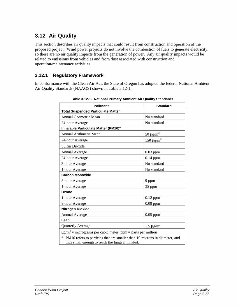
Condon Wind Project Air QualityDraft EIS Page 3-55
3.12 Air QualityThis section describes air quality impacts that could result from construction and operation of theproposed project. Wind power projects do not involve the combustion of fuels to generate electricity,so there are no air quality impacts from the generation of power. Any air quality impacts would berelated to emissions from vehicles and from dust associated with construction andoperation/maintenance activities.
3.12.1 Regulatory FrameworkIn conformance with the Clean Air Act, the State of Oregon has adopted the federal National AmbientAir Quality Standards (NAAQS) shown in Table 3.12-1.
Table 3.12-1. National Primary Ambient Air Quality Standards
Pollutant StandardTotal Suspended Particulate MatterAnnual Geometric Mean No standard24-hour Average No standardInhalable Particulate Matter (PM10)*Annual Arithmetic Mean 50 µg/m3
24-hour Average 150 µg/m3
Sulfur DioxideAnnual Average 0.03 ppm24-hour Average 0.14 ppm3-hour Average No standard1-hour Average No standardCarbon Monoxide8-hour Average 9 ppm1-hour Average 35 ppmOzone1-hour Average 0.12 ppm8-hour Average 0.08 ppmNitrogen DioxideAnnual Average 0.05 ppmLeadQuarterly Average 1.5 µg/m3
µg/m3 = micrograms per cubic meter; ppm = parts per million* PM10 refers to particles that are smaller than 10 microns in diameter, and
thus small enough to reach the lungs if inhaled.
Air Quality Condon Wind ProjectPage 3-56 Draft EIS
3.12.2 Study MethodologyAir quality impacts associated with phases 1 and 2 of the proposed project were evaluated usingfugitive dust emission factors contained in the Environmental Protection Agency’s Compilation ofAir Pollution Emission Factors (AP-42). The study area is shown in Figure 2.1-1 and includes thesurrounding airshed.
3.12.3 Affected EnvironmentThe air quality attainment status of Gilliam County is not currently classified and air quality in thecounty is not monitored. Because of the sparse population and rural nature of the area, GilliamCounty is likely to be in attainment for all criteria pollutants. Existing sources of air pollution arelikely to be minimal.
The climate in the area is very dry (16 inches of precipitation annually). Wind-blown dust isprevalent in non-irrigated agricultural areas such as the project site and study area because soils areoften composed of fine-grain silt loams. Dust is generated in such environments by agriculturalactivities, vehicles traveling on dirt roads, construction, and other activities that disturb soil.
3.12.4 Environmental Consequences—Proposed Action
3.12.4.1 Definition of Impact Levels
� Impacts related to air quality would be considered high if the proposed project created noticeableor measurable air emissions that exceeded NAAQS.
� Impacts related to air quality would be considered moderate if the proposed project creatednoticeable or measurable air emissions that did not exceed NAAQS, and which could be partiallymitigated with standard control practices.
� Impacts related to air quality would be considered low if the proposed project created smallamounts of noticeable or measurable air emissions that did not exceed NAAQS, which could besubstantially mitigated with standard control practices.
3.12.4.2 Impacts during Construction
Air quality impacts associated with construction of phases 1 and 2 of the proposed project would below. The primary type of air pollution during construction would be combustion pollutants fromequipment exhaust and fugitive dust particles from disturbed soils becoming airborne. Constructionactivities that could create dust include road improvements and construction, work area clearing, andunderground utility cable trenching. Project construction activities would temporarily disturbapproximately 58 acres for phase 1 and 46 acres for phase 2.
The amount of pollutants emitted from construction vehicles would be relatively small and similar tocurrent conditions with the operation of agricultural equipment in the project site and vicinity. Suchshort-term emissions from construction sites are exempt from air quality permitting requirements.Standard practices to control dust would be employed to substantially reduce emissions, including:
� watering exposed soil surfaces each day during dry weather, especially when blowing dust isvisible;
� covering construction materials that could be a source of dust when stored;
Condon Wind Project Air QualityDraft EIS Page 3-57
� limiting vehicle speeds along non-graveled roads to 25 miles per hour;
� covering truck beds when transporting dirt/soil (if applicable); and
� shutting down idling construction equipment, where feasible.
3.12.4.3 Impacts during Operation and Maintenance
Operation and maintenance impacts to air quality would be negligible for each phase of the project.Project facilities would have a permanent footprint of approximately 21 acres for phase 1 and17 acres additional for phase 2. This post-construction footprint is substantially less than the area thatwould be temporarily disturbed during construction (58 acres for phase 1 and 46 acres for phase 2).Operation and maintenance vehicles would mainly use access roads with paved or graveled surfaces,and the quantities of potential emissions would be very small, temporary, and localized.
3.12.4.4 Impacts during DecommissioningPotential project-related air quality impacts during decommissioning of the facilities would be similarto those during construction and would be low. The standard control practices employed to minimizepotential impacts from construction activities would also be applied to decommissioning activities, asnecessary.
3.12.4.5 Mitigation
No mitigation measures are required if the standard control practices listed above are employed.
3.12.4.6 Unavoidable Impacts Remaining after MitigationUnavoidable impacts from the project include very low levels of combustion pollutants and dust fromvehicles during project construction, operation and maintenance, and decommissioning.
3.12.5 Environmental Consequences—No Action AlternativeUnder the No Action Alternative, the study area would likely remain as farmland used for non-irrigated agriculture. Potential impacts to air quality associated with the project would not occur.The most likely alternative to wind generation would be electricity generated from the combustion offossil fuels. Fuel combustion from electric utilities generated 417,000 tons of carbon monoxide and6.1 million tons of nitrogen oxides in 1998. Total fossil fuel combustion produced 1,500 millionmetric tons carbon-equivalent of carbon dioxide in 1997 (EPA 2000). Nitrogen oxides contribute toozone generation in the lower atmosphere, and carbon dioxide is considered a greenhouse gas thatcontributes to global warming.
The most likely resources to be built in the region would be combined cycle combustion turbines(CTs). BPA’s Resource Programs Final EIS (RP EIS) included an analysis of environmental effectsof CTs on a per average megawatt (aMW) per year basis. Emission rates for CTs were estimated at5.81 tons of nitrogen oxides and 3,904.95 tons of carbon dioxide. Although improvements in airemission control technology and the increasing stringency of air quality permit requirements by stateagencies have led to lower emission rates, CTs still remain a significant source of air emissions. Inaddition to the emissions from the generation itself, there are also emissions of sulfur oxides, nitrogenoxides, and particulates associated with the extraction of natural gas and pipeline transportation.
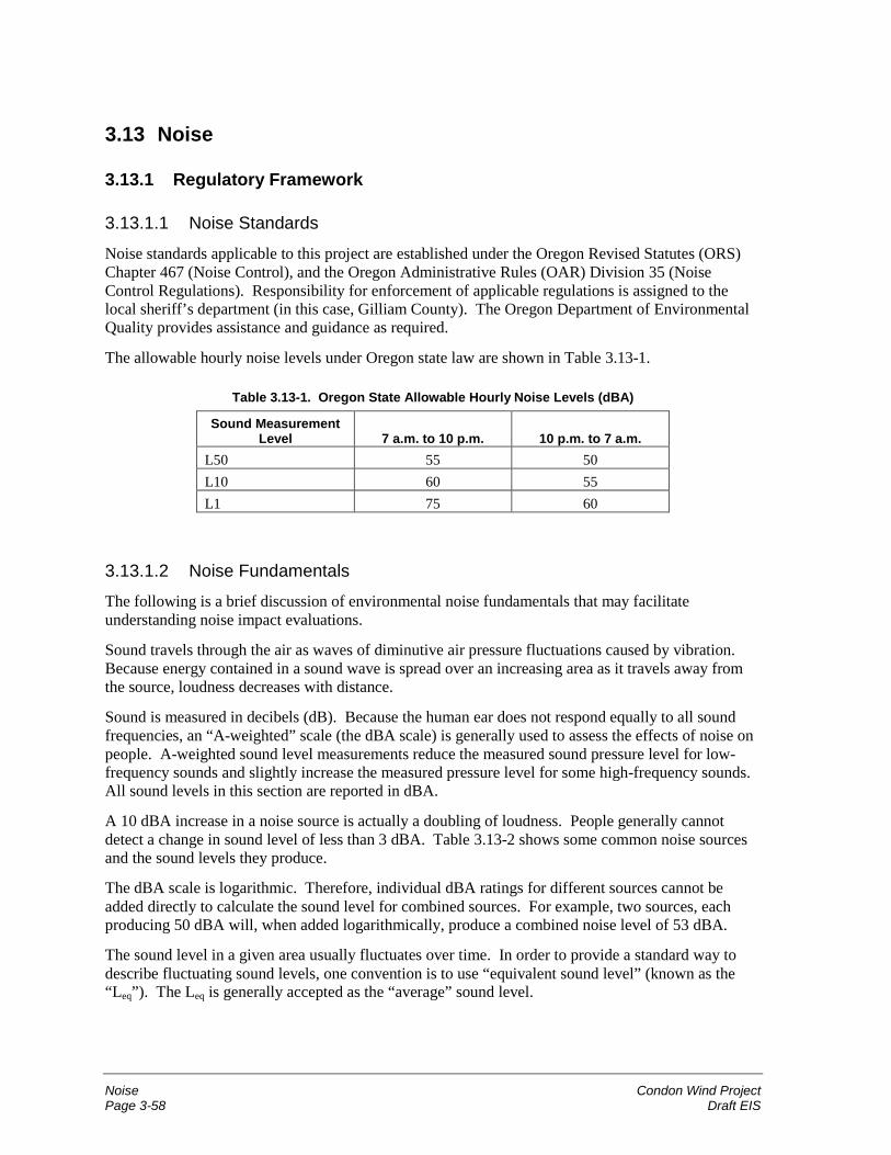
Noise Condon Wind ProjectPage 3-58 Draft EIS
3.13 Noise
3.13.1 Regulatory Framework
3.13.1.1 Noise Standards
Noise standards applicable to this project are established under the Oregon Revised Statutes (ORS)Chapter 467 (Noise Control), and the Oregon Administrative Rules (OAR) Division 35 (NoiseControl Regulations). Responsibility for enforcement of applicable regulations is assigned to thelocal sheriff’s department (in this case, Gilliam County). The Oregon Department of EnvironmentalQuality provides assistance and guidance as required.
The allowable hourly noise levels under Oregon state law are shown in Table 3.13-1.
Table 3.13-1. Oregon State Allowable Hourly Noise Levels (dBA)
Sound MeasurementLevel 7 a.m. to 10 p.m. 10 p.m. to 7 a.m.
L50 55 50L10 60 55L1 75 60
3.13.1.2 Noise FundamentalsThe following is a brief discussion of environmental noise fundamentals that may facilitateunderstanding noise impact evaluations.
Sound travels through the air as waves of diminutive air pressure fluctuations caused by vibration.Because energy contained in a sound wave is spread over an increasing area as it travels away fromthe source, loudness decreases with distance.
Sound is measured in decibels (dB). Because the human ear does not respond equally to all soundfrequencies, an “A-weighted” scale (the dBA scale) is generally used to assess the effects of noise onpeople. A-weighted sound level measurements reduce the measured sound pressure level for low-frequency sounds and slightly increase the measured pressure level for some high-frequency sounds.All sound levels in this section are reported in dBA.
A 10 dBA increase in a noise source is actually a doubling of loudness. People generally cannotdetect a change in sound level of less than 3 dBA. Table 3.13-2 shows some common noise sourcesand the sound levels they produce.
The dBA scale is logarithmic. Therefore, individual dBA ratings for different sources cannot beadded directly to calculate the sound level for combined sources. For example, two sources, eachproducing 50 dBA will, when added logarithmically, produce a combined noise level of 53 dBA.
The sound level in a given area usually fluctuates over time. In order to provide a standard way todescribe fluctuating sound levels, one convention is to use “equivalent sound level” (known as the“Leq”). The Leq is generally accepted as the “average” sound level.
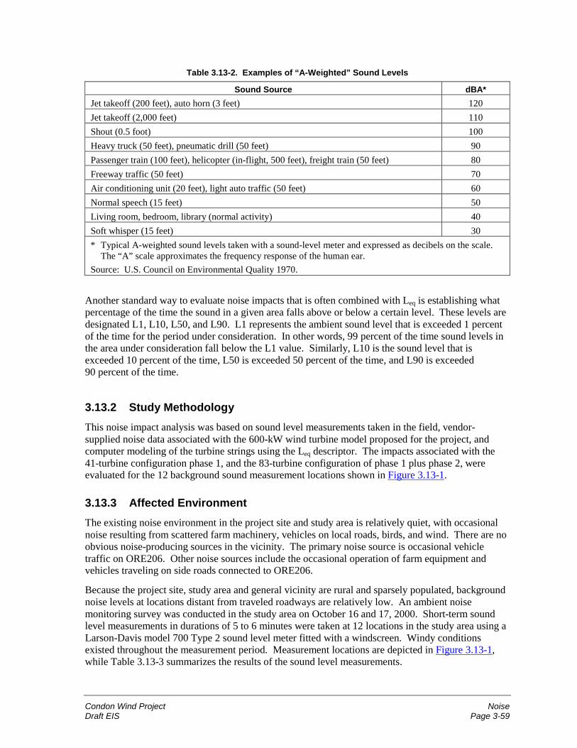
Condon Wind Project NoiseDraft EIS Page 3-59
Table 3.13-2. Examples of “A-Weighted” Sound Levels
Sound Source dBA*Jet takeoff (200 feet), auto horn (3 feet) 120Jet takeoff (2,000 feet) 110Shout (0.5 foot) 100Heavy truck (50 feet), pneumatic drill (50 feet) 90Passenger train (100 feet), helicopter (in-flight, 500 feet), freight train (50 feet) 80Freeway traffic (50 feet) 70Air conditioning unit (20 feet), light auto traffic (50 feet) 60Normal speech (15 feet) 50Living room, bedroom, library (normal activity) 40Soft whisper (15 feet) 30* Typical A-weighted sound levels taken with a sound-level meter and expressed as decibels on the scale.
The “A” scale approximates the frequency response of the human ear.Source: U.S. Council on Environmental Quality 1970.
Another standard way to evaluate noise impacts that is often combined with Leq is establishing whatpercentage of the time the sound in a given area falls above or below a certain level. These levels aredesignated L1, L10, L50, and L90. L1 represents the ambient sound level that is exceeded 1 percentof the time for the period under consideration. In other words, 99 percent of the time sound levels inthe area under consideration fall below the L1 value. Similarly, L10 is the sound level that isexceeded 10 percent of the time, L50 is exceeded 50 percent of the time, and L90 is exceeded90 percent of the time.
3.13.2 Study MethodologyThis noise impact analysis was based on sound level measurements taken in the field, vendor-supplied noise data associated with the 600-kW wind turbine model proposed for the project, andcomputer modeling of the turbine strings using the Leq descriptor. The impacts associated with the41-turbine configuration phase 1, and the 83-turbine configuration of phase 1 plus phase 2, wereevaluated for the 12 background sound measurement locations shown in Figure 3.13-1.
3.13.3 Affected EnvironmentThe existing noise environment in the project site and study area is relatively quiet, with occasionalnoise resulting from scattered farm machinery, vehicles on local roads, birds, and wind. There are noobvious noise-producing sources in the vicinity. The primary noise source is occasional vehicletraffic on ORE206. Other noise sources include the occasional operation of farm equipment andvehicles traveling on side roads connected to ORE206.
Because the project site, study area and general vicinity are rural and sparsely populated, backgroundnoise levels at locations distant from traveled roadways are relatively low. An ambient noisemonitoring survey was conducted in the study area on October 16 and 17, 2000. Short-term soundlevel measurements in durations of 5 to 6 minutes were taken at 12 locations in the study area using aLarson-Davis model 700 Type 2 sound level meter fitted with a windscreen. Windy conditionsexisted throughout the measurement period. Measurement locations are depicted in Figure 3.13-1,while Table 3.13-3 summarizes the results of the sound level measurements.
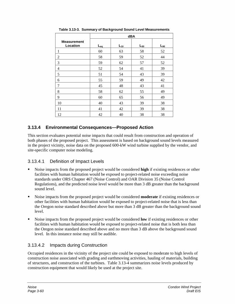
Noise Condon Wind ProjectPage 3-60 Draft EIS
Table 3.13-3. Summary of Background Sound Level Measurements
dBAMeasurement
Location Leq L10 L50 L90
1 60 63 58 522 58 59 52 443 59 62 57 524 52 54 41 395 51 54 43 396 55 59 49 427 45 48 43 418 58 62 55 499 60 65 56 4910 40 43 39 3811 41 42 39 3812 42 40 38 38
3.13.4 Environmental Consequences—Proposed ActionThis section evaluates potential noise impacts that could result from construction and operation ofboth phases of the proposed project. This assessment is based on background sound levels measuredin the project vicinity, noise data on the proposed 600-kW wind turbine supplied by the vendor, andsite-specific computer noise modeling.
3.13.4.1 Definition of Impact Levels
� Noise impacts from the proposed project would be considered high if existing residences or otherfacilities with human habitation would be exposed to project-related noise exceeding noisestandards under ORS Chapter 467 (Noise Control) and OAR Division 35 (Noise ControlRegulations), and the predicted noise level would be more than 3 dB greater than the backgroundsound level.
� Noise impacts from the proposed project would be considered moderate if existing residences orother facilities with human habitation would be exposed to project-related noise that is less thanthe Oregon noise standard described above but more than 3 dB greater than the background soundlevel.
� Noise impacts from the proposed project would be considered low if existing residences or otherfacilities with human habitation would be exposed to project-related noise that is both less thanthe Oregon noise standard described above and no more than 3 dB above the background soundlevel. In this instance noise may still be audible.
3.13.4.2 Impacts during Construction
Occupied residences in the vicinity of the project site could be exposed to moderate to high levels ofconstruction noise associated with grading and earthmoving activities, hauling of materials, buildingof structures, and construction of the turbines. Table 3.13-4 summarizes noise levels produced byconstruction equipment that would likely be used at the project site.
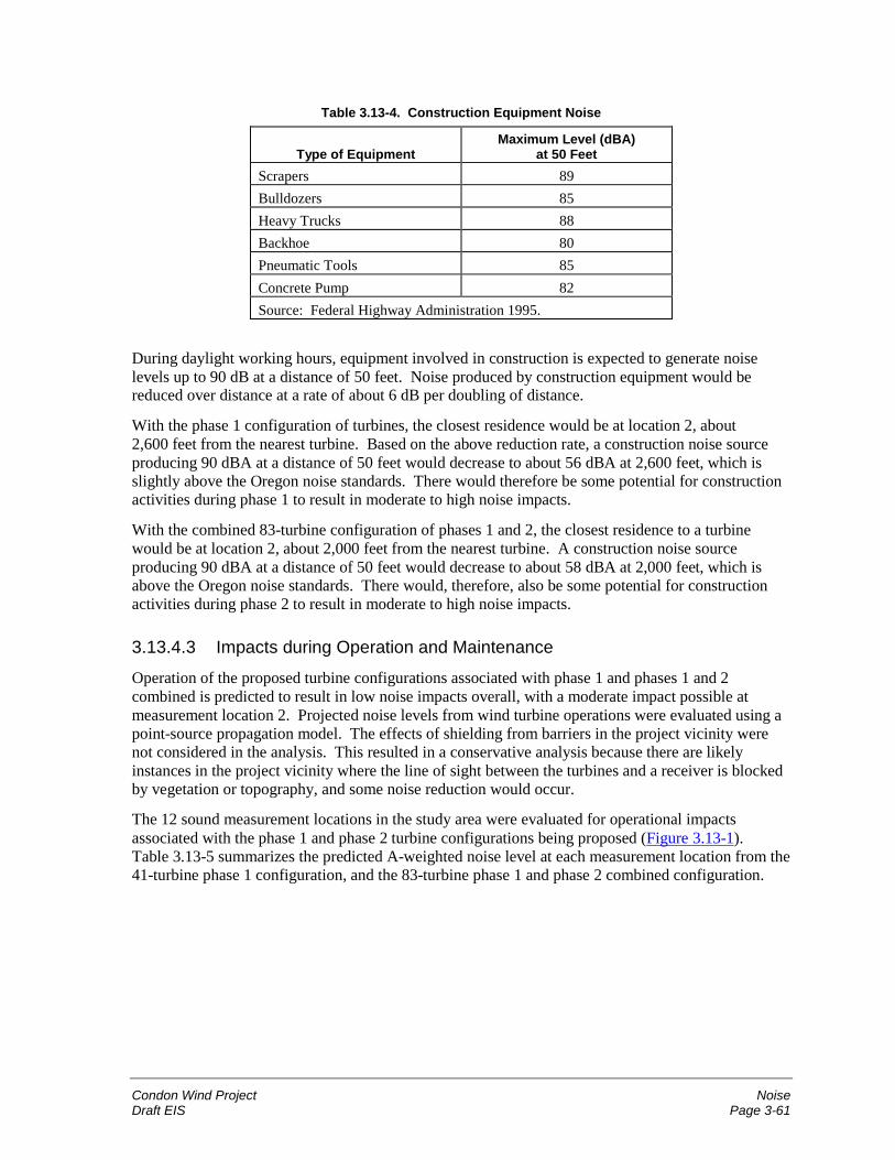
Condon Wind Project NoiseDraft EIS Page 3-61
Table 3.13-4. Construction Equipment Noise
Type of EquipmentMaximum Level (dBA)
at 50 FeetScrapers 89Bulldozers 85Heavy Trucks 88Backhoe 80Pneumatic Tools 85Concrete Pump 82Source: Federal Highway Administration 1995.
During daylight working hours, equipment involved in construction is expected to generate noiselevels up to 90 dB at a distance of 50 feet. Noise produced by construction equipment would bereduced over distance at a rate of about 6 dB per doubling of distance.
With the phase 1 configuration of turbines, the closest residence would be at location 2, about2,600 feet from the nearest turbine. Based on the above reduction rate, a construction noise sourceproducing 90 dBA at a distance of 50 feet would decrease to about 56 dBA at 2,600 feet, which isslightly above the Oregon noise standards. There would therefore be some potential for constructionactivities during phase 1 to result in moderate to high noise impacts.
With the combined 83-turbine configuration of phases 1 and 2, the closest residence to a turbinewould be at location 2, about 2,000 feet from the nearest turbine. A construction noise sourceproducing 90 dBA at a distance of 50 feet would decrease to about 58 dBA at 2,000 feet, which isabove the Oregon noise standards. There would, therefore, also be some potential for constructionactivities during phase 2 to result in moderate to high noise impacts.
3.13.4.3 Impacts during Operation and Maintenance
Operation of the proposed turbine configurations associated with phase 1 and phases 1 and 2combined is predicted to result in low noise impacts overall, with a moderate impact possible atmeasurement location 2. Projected noise levels from wind turbine operations were evaluated using apoint-source propagation model. The effects of shielding from barriers in the project vicinity werenot considered in the analysis. This resulted in a conservative analysis because there are likelyinstances in the project vicinity where the line of sight between the turbines and a receiver is blockedby vegetation or topography, and some noise reduction would occur.
The 12 sound measurement locations in the study area were evaluated for operational impactsassociated with the phase 1 and phase 2 turbine configurations being proposed (Figure 3.13-1).Table 3.13-5 summarizes the predicted A-weighted noise level at each measurement location from the41-turbine phase 1 configuration, and the 83-turbine phase 1 and phase 2 combined configuration.
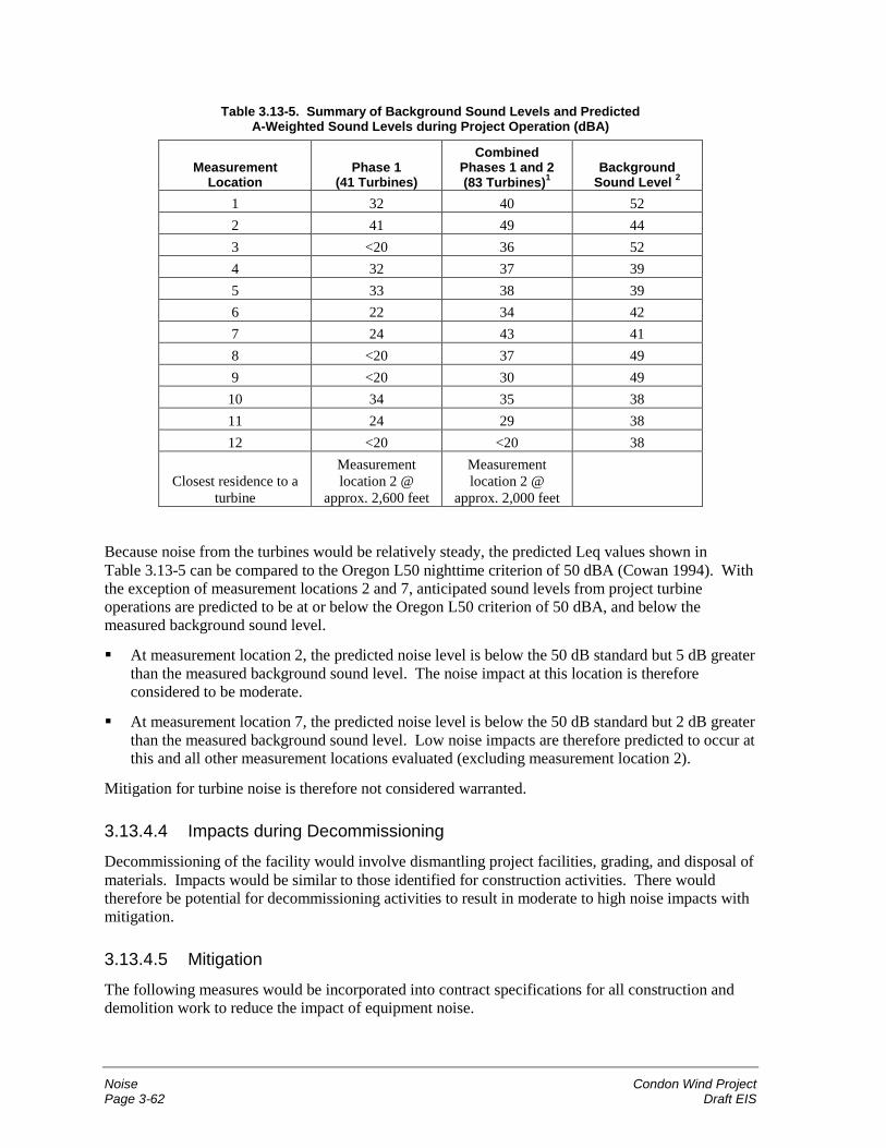
Noise Condon Wind ProjectPage 3-62 Draft EIS
Table 3.13-5. Summary of Background Sound Levels and PredictedA-Weighted Sound Levels during Project Operation (dBA)
MeasurementLocation
Phase 1(41 Turbines)
CombinedPhases 1 and 2(83 Turbines)1
BackgroundSound Level 2
1 32 40 522 41 49 443 <20 36 524 32 37 395 33 38 396 22 34 427 24 43 418 <20 37 499 <20 30 49
10 34 35 3811 24 29 3812 <20 <20 38
Closest residence to aturbine
Measurementlocation 2 @
approx. 2,600 feet
Measurementlocation 2 @
approx. 2,000 feet
Because noise from the turbines would be relatively steady, the predicted Leq values shown inTable 3.13-5 can be compared to the Oregon L50 nighttime criterion of 50 dBA (Cowan 1994). Withthe exception of measurement locations 2 and 7, anticipated sound levels from project turbineoperations are predicted to be at or below the Oregon L50 criterion of 50 dBA, and below themeasured background sound level.
� At measurement location 2, the predicted noise level is below the 50 dB standard but 5 dB greaterthan the measured background sound level. The noise impact at this location is thereforeconsidered to be moderate.
� At measurement location 7, the predicted noise level is below the 50 dB standard but 2 dB greaterthan the measured background sound level. Low noise impacts are therefore predicted to occur atthis and all other measurement locations evaluated (excluding measurement location 2).
Mitigation for turbine noise is therefore not considered warranted.
3.13.4.4 Impacts during Decommissioning
Decommissioning of the facility would involve dismantling project facilities, grading, and disposal ofmaterials. Impacts would be similar to those identified for construction activities. There wouldtherefore be potential for decommissioning activities to result in moderate to high noise impacts withmitigation.
3.13.4.5 Mitigation
The following measures would be incorporated into contract specifications for all construction anddemolition work to reduce the impact of equipment noise.
Condon Wind Project NoiseDraft EIS Page 3-63
� All equipment will have sound-control devices no less effective than those provided on theoriginal equipment. No equipment will have an unmuffled exhaust.
� No noise-generating construction activity will be conducted within 1,000 feet of a residentialstructure between the hours of 10 p.m. and 7 a.m.
� In the event of adjacent landowner complaints, and as directed by the county, the contractor willimplement appropriate additional noise-reducing measures including, but not limited to, changingthe location of stationary construction equipment, shutting off idling equipment, reschedulingconstruction activity, and notifying adjacent residents in advance of construction work.
3.13.4.6 Unavoidable Impacts Remaining after Mitigation
Potential unavoidable noise impacts include increased sound levels experienced by area residentsduring construction and decommissioning of the project.
3.13.5 Environmental Consequences—No Action AlternativeUnder the No Action Alternative, existing background noise levels in the project site, study area, andproject vicinity would continue without influence of the proposed project.
3.14 Public Health and Safety
3.14.1 Regulatory FrameworkA variety of federal and state safety regulations and guidelines apply to project design andconstruction. Federal safety regulations are issued under the authority of the Occupational Safety andHealth Act; state safety regulations are issued under the Oregon Industrial Safety and Health Act. Inaddition, the National Electrical Manufacturers Association and the Institute of Electrical andElectronics Engineers issue standards for the design of electrical equipment and controls. TheGilliam County Building Code (which is based on the Uniform Building Code) sets standards for fire,life, and structural safety aspects of buildings and related structures.
Several portions of the Code of Federal Regulations (CFR) governing the handling of hazardousmaterials would potentially apply to the proposed project, including:
� 40 CFR 112 (Spill Prevention Control and Countermeasures);
� 40 CFR 370 and 372 (Title III of the Superfund Amendments and Reauthorization Act); and
� 40 CFR 262-266 (Resource Conservation and Recovery Program).
Whether these regulations apply to the project would depend on the exact quantities and types ofhazardous materials stored onsite. Regulations would be enforced by the ODEQ and OregonDepartment of Health. In addition, development of a Hazardous Materials Management Plan inaccordance with the Uniform Fire Code may be required by the local fire district.
The Federal Aviation Administration (FAA) establishes requirements for towers and other tallstructures that could potentially interfere with aircraft safety. The FAA generally studies structures200 feet or taller and may require that they be lighted for aircraft safety.
Public Health and Safety Condon Wind ProjectPage 3-64 Draft EIS
3.14.2 Study MethodologyThe primary sources of information for this section were the Code of Federal Regulations, GilliamCounty Building Code, and other published documents and internet resources listed in Chapter 6.
3.14.3 Affected EnvironmentThe affected environment relevant to health and safety includes the study area and roads in thesurrounding area that would be used for access during construction and operation of the project(Figure 2.1-1). The affected environment is a sparsely populated rural area of agricultural land,grassy canyons and ridgetops. Potential hazards in the area include the fire hazard presented by drycrops and grasses, especially in the summer months, and utility crossings. The BPA 69-kV Condon-DeMoss transmission line parallels and crosses the study area, and an underground PGT/PG&E gaspipeline crosses the project site in a southwest-northeast direction. The Condon airport is locatedapproximately 4 miles east of the project site.
3.14.4 Environmental Consequences—Proposed ActionPotential health and safety risks include those that could be experienced by the general public as wellas construction, operation, and maintenance personnel at the facility and crop dusters that may enterthe study area. These are discussed below.
3.14.4.1 Definition of Impact Levels� Impacts on health and safety from the proposed project would be considered high if exposure to a
project-related hazard resulted in a substantial increased risk to human health and safety forproject personnel or the general public.
� Health and safety impacts would be considered moderate if exposure to a project-related hazardresulted in some risk to human health and safety for project personnel or the general public.
� Health and safety impacts would be considered low if exposure to a project-related hazardresulted in minor risk to human health and safety for project personnel or the general public.
3.14.4.2 Impacts during Construction
Public health and safety risks for construction workers and the general public associated withphases 1 and 2 of the proposed project would be low if appropriate health and safety procedures areemployed. Even with appropriate safety procedures during construction, minor health and safetyrisks exist for workers and visitors. Each contractor and subcontractor will maintain a safety plan incompliance with State of Oregon requirements. In addition, the applicant will maintain an overall sitesafety plan and will conduct weekly site safety meetings with contractors and subcontractors.
Highway-authorized vehicles and construction equipment would be fueled, serviced, and cleanedoffsite. Construction equipment that is transported to the project site on flatbed trucks (because suchequipment is not authorized for operation on the highway) would be fueled and serviced onsite duringthe construction phases. All fueling and servicing of such equipment would be in accordance withtypical construction practices and in compliance with applicable laws and regulations.
It is anticipated that unauthorized visitors would be discouraged from entering the project site duringconstruction hours by the presence of construction workers and warning signs, placards, and gates.Such access could be considered trespassing on private property.
Condon Wind Project Public Health and SafetyDraft EIS Page 3-65
3.14.4.3 Impacts during Operation and Maintenance
Health and safety risks for project personnel and the general public during operation and maintenancewould be low, if appropriate prevention and response procedures are used. Nevertheless, potentialhealth and safety risks during operation and maintenance of the project would exist.
Potential health and safety risks to those who farm or own property where the turbines would belocated would be minimized by coordinating project activities with the schedule and access needs offarmers/owners, and through the use of warning signs and locked access gates. Entrance to theproject site would be discouraged for unauthorized personnel. To prevent access to the turbines,turbine tower doors would be locked and there would be no ladders on the outside of the facility. Theelectric substation would be fenced.
Small amounts of fuels (diesel and/or gasoline), lubricating or other oils, and solvents would be storedin the O&M building in approved containers above ground. No extremely hazardous materials (asdefined by 40 CFR 335) are anticipated to be produced, used, stored, transported, or disposed of as aresult of this project. Potential risks associated with storage and use of these materials would beminimized through compliance with applicable local, state, and federal environmental laws andregulations.
An Operations Health and Safety Plan and Emergency Response Plan that inform employees andothers how to prevent emergencies and lower risks, as well as how to respond to emergencies, wouldbe kept onsite. Specific job-related training of employees, including cardiopulmonary resuscitation,first aid, tower climbing, rescue techniques, and safety equipment inspection, would also beemployed.
The Condon airport may have to take into account the presence of the wind turbines in its takeoff andlanding patterns. As part of project design, the proponent would comply with Federal AviationAdministration (FAA) procedures. Crop dusters planning to enter the project site area would takesuitable precautions to minimize potential for collision with the project turbines and meteorologicaltowers.
Because the project turbines and meteorological towers would not exceed 200 feet in height, it isunlikely that a Notice of Proposed Construction or Alteration (Form 7460-1) would need to be filedwith the FAA. Final locations of structures, structure types, and structure heights would be submittedto FAA for review. FAA may then conduct its own study of the project and make recommendationsto BPA and the proponent regarding possible airway marking, lighting, and other safety requirements.
Electric and Magnetic Fields
Electric and magnetic fields (EMF) are associated with electric transmission and distribution lines.The strength of EMF diminishes rapidly as the distance from the source increases. During projectoperation, the overhead power lines and substation would produce EMF in the immediate vicinity ofthese facilities. No residences are located in the vicinity of the proposed substation. The nearestresidence to the proposed overhead transmission line is about 2,000 feet away. Any fields generatedby the transmission line would diminish to background levels within a few hundred feet. Thus, thenearest residence is located beyond the reach of EMF effects. The power generated by the proposedproject would not raise background EMF to levels that would be substantially different from existinglevels. As a result, there would be no EMF exposure to residences and no significant increase inbackground levels of exposure to the general public caused by the proposed project.
Public Health and Safety Condon Wind ProjectPage 3-66 Draft EIS
3.14.4.4 Impacts of Decommissioning
If the project were decommissioned, potential health and safety risks would be similar to thosedescribed for project construction and would be low.
3.14.4.5 Mitigation
No mitigation measures are required for public health and safety.
3.14.4.6 Unavoidable Impacts Remaining after MitigationPotential unavoidable public health and safety risks include accidental fire that may occur duringconstruction or operation and maintenance, accidental release of hazardous materials, or accidentalinjury. These constitute normal risks associated with this type of project.
3.14.5 Environmental Consequences—No Action AlternativeUnder the No Action Alternative, existing health and safety risks associated with ongoing agriculturalactivities and with existing power lines on the project site would continue without influence of theproposed project.
3.15 Relationship Between Short-Term Uses of Man’s Environmentvs. the Maintenance and Enhancement of Long-TermProductivity
The proposed action under consideration does not pose short-term impacts that would significantlyalter the long-term productivity of the affected environment. The turbines and associated facilitieswould take less than 1 percent of the arable land in the 4,200-acre study area out of production, andthe remainder of the land could still be used for crops. After decommissioning of the project, all ofthe land could revert to previous uses. Little change in the long-term environmental productivity ofthe land would have been caused.
3.16 Irreversible or Irretrievable Commitments of Resources
The proposed action would include the use of steel, gravel, wood, and other non-renewable materialto construct the wind turbines, access roads, electrical power line, O&M building, and substation.Materials would come from outside sources or from local borrow pits. Petroleum-based fuels forvehicles and equipment would also be required. Development of the proposed action would result inthe irretrievable commitment of a small amount of cropland. These commitments are irretrievablerather than irreversible because the project could be decommissioned in the future and previous landuses restored. In addition, many materials used to construct and operate the project could be recycledupon decommissioning.

Condon Wind Project Unavoidable Adverse ImpactsDraft EIS Page 3-67
3.17 Unavoidable Adverse ImpactsUnavoidable adverse impacts are the environmental consequences of the proposed project that wouldoccur after mitigation measures have been implemented. For the proposed wind project, theunavoidable adverse impacts include:
Land Use: Approximately 38 acres would be permanently converted to wind project facilities,including approximately 25 acres of cropland and 5 acres of CRP land. This constitutes a very smallportion of the available agricultural land and CRP land in the study area and Gilliam County.
Vegetation: The project facilities would permanently occupy a small amount (less than an acre) ofnon-high-quality shrub-steppe vegetation, constituting less than 1 percent of the shrub-steppe in thestudy area. Approximately 5 acres of CRP land would also be occupied by permanent projectfacilities.
Wildlife: Birds and bats may collide with wind turbines or guy wires. Annual bird mortality isestimated at between 50 and 100 (mostly passerines with a few raptors). Annual bat mortality isestimated at between 60 and 160 (most likely hoary, silver-haired, and myotis).
Visual Resources: The wind turbines would be readily visible to residents, agricultural workers,recreationists, and highway travelers in the project vicinity. This could be considered an adverseimpact by some viewers.
Transportation: Minor delays and interruptions in local traffic could occur during construction anddecommissioning. Average daily trips would increase 1 to 3 percent on ORE19 and ORE206.
Air Quality: Low levels of combustion pollutants and dust could occur during construction,operation or decommissioning of the project.
Noise: Increased noise levels would be experienced by some area residents during construction,operation, and decommissioning.
Public Health and Safety: Accidental fire, release of hazardous materials, or injury could occurduring construction, operation, or decommissioning of the project.
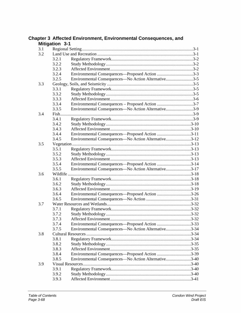
Table of Contents Condon Wind ProjectPage 3-68 Draft EIS
Chapter 3 Affected Environment, Environmental Consequences, andMitigation 3-13.1 Regional Setting......................................................................................................3-13.2 Land Use and Recreation ........................................................................................3-1
3.2.1 Regulatory Framework...........................................................................3-23.2.2 Study Methodology................................................................................3-23.2.3 Affected Environment............................................................................3-23.2.4 Environmental Consequences—Proposed Action .................................3-33.2.5 Environmental Consequences—No Action Alternative.........................3-5
3.3 Geology, Soils, and Seismicity ...............................................................................3-53.3.1 Regulatory Framework...........................................................................3-53.3.2 Study Methodology................................................................................3-53.3.3 Affected Environment............................................................................3-63.3.4 Environmental Consequences – Proposed Action .................................3-73.3.5 Environmental Consequences—No Action Alternative.........................3-9
3.4 Fish..........................................................................................................................3-93.4.1 Regulatory Framework...........................................................................3-93.4.2 Study Methodology..............................................................................3-103.4.3 Affected Environment..........................................................................3-103.4.4 Environmental Consequences—Proposed Action ...............................3-113.4.5 Environmental Consequences—No Action Alternative.......................3-12
3.5 Vegetation .............................................................................................................3-133.5.1 Regulatory Framework.........................................................................3-133.5.2 Study Methodology..............................................................................3-133.5.3 Affected Environment..........................................................................3-133.5.4 Environmental Consequences—Proposed Action ...............................3-143.5.5 Environmental Consequences—No Action Alternative.......................3-17
3.6 Wildlife .................................................................................................................3-183.6.1 Regulatory Framework.........................................................................3-183.6.2 Study Methodology..............................................................................3-183.6.3 Affected Environment..........................................................................3-193.6.4 Environmental Consequences—Proposed Action ...............................3-263.6.5 Environmental Consequences—No Action .........................................3-31
3.7 Water Resources and Wetlands.............................................................................3-323.7.1 Regulatory Framework.........................................................................3-323.7.2 Study Methodology..............................................................................3-323.7.3 Affected Environment..........................................................................3-323.7.4 Environmental Consequences—Proposed Action ...............................3-333.7.5 Environmental Consequences—No Action Alternative.......................3-34
3.8 Cultural Resources ................................................................................................3-343.8.1 Regulatory Framework.........................................................................3-343.8.2 Study Methodology..............................................................................3-353.8.3 Affected Environment..........................................................................3-353.8.4 Environmental Consequences—Proposed Action ...............................3-393.8.5 Environmental Consequences—No Action Alternative.......................3-40
3.9 Visual Resources...................................................................................................3-403.9.1 Regulatory Framework.........................................................................3-403.9.2 Study Methodology..............................................................................3-403.9.3 Affected Environment..........................................................................3-41

Condon Wind Project Table of ContentsDraft EIS Page 3-69
3.9.4 Environmental Consequences—Proposed Action ............................... 3-423.9.5 Environmental Consequences—No Action Alternative ...................... 3-44
3.10 Socioeconomics, Public Services, and Utilities.................................................... 3-443.10.1 Regulatory Framework ........................................................................ 3-443.10.2 Study Methodology ............................................................................. 3-453.10.3 Affected Environment ......................................................................... 3-453.10.4 Environmental Consequences—Proposed Action ............................... 3-483.10.5 Environmental Consequences—No Action Alternative ...................... 3-51
3.11 Transportation....................................................................................................... 3-513.11.1 Regulatory Framework ........................................................................ 3-513.11.2 Study Methodology ............................................................................. 3-523.11.3 Affected Environment ......................................................................... 3-523.11.4 Environmental Consequences—Proposed Action ............................... 3-533.11.5 Environmental Consequences—No Action Alternative ...................... 3-54
3.12 Air Quality............................................................................................................ 3-553.12.1 Regulatory Framework ........................................................................ 3-553.12.2 Study Methodology ............................................................................. 3-563.12.3 Affected Environment ......................................................................... 3-563.12.4 Environmental Consequences—Proposed Action ............................... 3-563.12.5 Environmental Consequences—No Action Alternative ...................... 3-57
3.13 Noise..................................................................................................................... 3-583.13.1 Regulatory Framework ........................................................................ 3-583.13.2 Study Methodology ............................................................................. 3-593.13.3 Affected Environment ......................................................................... 3-593.13.4 Environmental Consequences—Proposed Action ............................... 3-603.13.5 Environmental Consequences—No Action Alternative ...................... 3-63
3.14 Public Health and Safety ...................................................................................... 3-633.14.1 Regulatory Framework ........................................................................ 3-633.14.2 Study Methodology ............................................................................. 3-643.14.3 Affected Environment ......................................................................... 3-643.14.4 Environmental Consequences—Proposed Action ............................... 3-643.14.5 Environmental Consequences—No Action Alternative ...................... 3-66
3.15 Relationship Between Short-Term Uses of Man’s Environment vs. theMaintenance and Enhancement of Long-Term Productivity................................ 3-66
3.16 Irreversible or Irretrievable Commitments of Resources ..................................... 3-663.17 Unavoidable Adverse Impacts.............................................................................. 3-67
Condon Wind Project Cumulative ImpactsDraft EIS Page 4-1
Chapter 4 Cumulative Impacts
A “cumulative impact” is the impact on the environment that results from the incremental impact ofan action, such as this proposed action, when added to other past, present, and reasonably foreseeablefuture actions regardless of what agency (federal or non-federal) or person undertakes such otheractions. Cumulative impacts can also result from individually minor but collectively significantactions taking place over a period of time (40 CFR 1508.7).
Implementation of the proposed project (phases 1 and 2) may establish a precedent of wind energydevelopment in the Condon area that could facilitate the development of additional wind projects inthe study area and vicinity, or in the Condon area. However, at this time, no other wind projects areplanned in these areas. If future additional wind projects were to be developed in the study area,project vicinity, or Condon area, and the same siting criteria were applied as were used for theproposed project (such as avoiding wetlands and unstable slopes, and avoiding local avianflightways), then development of future projects would not be expected to cause significant adversecumulative impacts to the environment.
One of the most noticeable changes in the project area resulting from the proposed project would bethe change in the “visual landscape” with the placement of the project’s 83 wind turbines (phases 1and 2). However, the nature and importance of this change is subjective, since some people may findwind turbines an interesting feature (and welcomed as “green power”), while others may find them tobe a visual nuisance. If additional wind projects were to be developed in the project area in the future(although none are planned at this time), the cumulative impact of having the visual landscape furtheraltered by the placement of additional turbines would need further evaluation at that time.
In addition to the visual changes from the proposed project, a less noticeable but nonethelessimportant impact from the project would be bird or bat mortality from collisions with the turbineblades, the support towers, and the meteorological towers and associated guy wires. Although nofuture projects are planned at this time, if this does occur, avian and bat mortality would be an area ofpotential cumulative impacts that would need further evaluation at that time.
Condon Wind Project Consultation, Review, and Permit RequirementsDraft EIS Page 5-1
Chapter 5 Consultation, Review, and PermitRequirements
This chapter addresses Federal Statutes, Implementing Regulations, and Executive Orders potentiallyapplicable to the proposed project. This Draft EIS is being sent to tribes, federal agencies, and stateand local governments as part of the consultation process for this project.
5.1 National Environmental Policy Act
This EIS has been prepared by BPA pursuant to regulations implementing the NationalEnvironmental Policy Act (NEPA) (42 U.S.C. 4321 et seq.), which requires federal agencies toassess the impacts that their actions may have on the environment. BPA’s potential acquisition ofpower from the proposed project requires that BPA assess the potential environmental effects of theproposed project and describe them in an EIS.
This EIS was prepared in compliance with NEPA guidelines. As the federal lead agency, BPA heldpublic scoping meetings (July 19 and 20, 2000) and invited comments on the scope of the EIS.BPA’s public involvement activities for the project are discussed further in Chapter 1 andAppendix A. The EIS and the overall processes by which it was developed comply with NEPA’srequirement for documentation and public involvement.
5.2 Threatened and Endangered Species and Critical Habitat
The Federal Endangered Species Act (ESA) (16 U.S.C. 1531-1544, December 28, 1973, asamended 1976-1982, 1984 and 1988) requires federal agencies to ensure that their actions do notjeopardize endangered or threatened species or their critical habitats. The ESA provides broadprotection for species of fish, wildlife, and plants listed as threatened or endangered in the UnitedStates or elsewhere. The ESA is administered by the U.S. Fish and Wildlife Service (USFWS) and,for salmon and other marine species, by the National Marine Fisheries Service (NMFS). The ESAdefines procedures for listing species, designating critical habitat for listed species, and preparingrecovery plans. The ESA also specifies prohibited actions and exceptions.
Prohibited actions defined in Section 9 of the ESA include “take” of a listed species. Take is definedas any action that would harass, harm, wound, or kill a listed species. Section 7 of the ESA enablesthe USFWS or NMFS to issue a permit to a federal agency for incidental take (that is, unintentionaltake of a listed species resulting from otherwise legal activities).
BPA requested information on the occurrence of ESA-listed species in the study area; letters fromUSFWS and NMFS are included in Appendix B. Oregon Department of Fish and Wildlife (ODFW)staff were also interviewed for information on special-status species. Field studies included a four-season avian study conducted by URS, Inc., and field visits by Jones & Stokes biologists during 2000.The occurrence of special-status species in the study area, and potential impacts on these species, arediscussed in Sections 3.4, 3.5, and 3.6 in Chapter 3 of this EIS. A biological assessment will beprepared for the project and submitted to USFWS in compliance with Section 7 of the ESA.
The Oregon Endangered Species Act requires the ODFW to develop programs for the managementand protection of state-listed species. However, the Act does not prohibit the take of state-listedspecies. The Gilliam County Code (Section 4.090. SR. Significant Resource Combining Zone)
Consultation, Review, and Permit Requirements Condon Wind ProjectPage 5-2 Draft EIS
designates Significant Resource Zones to protect significant mineral resources, scenic areas, naturalareas, and fish and wildlife habitat in the county. Sections 3.4, 3.5, and 3.6 in Chapter 3 of this EISdiscuss these regulations as they relate to the proposed project.
5.3 Fish and Wildlife Conservation
The Fish and Wildlife Conservation Act of 1980 (16 USC 2901 et seq.) encourages federalagencies to conserve and promote conservation of non-game fish and wildlife species and theirhabitats. Sections 3.4 and 3.6 in Chapter 3 of this EIS document information obtained from ODFW,as well as potential fish and wildlife impacts and mitigation.
In addition, the Fish and Wildlife Coordination Act (16 USC 661 et seq.) requires federal agenciesundertaking projects affecting water resources to consult with the USFWS and the state agencyresponsible for fish and wildlife resources (ODFW). The proposed project would not affect waterresources.
The Pacific Northwest Electric Power Planning and Conservation Act or “Northwest PowerAct” (16 U.S.C. 839 et seq.) established the Pacific Northwest Electric Power and ConservationPlanning Council to develop a Regional Electric Power and Conservation Plan. The NorthwestPower Act encourages the development of renewable resources within the Pacific Northwest andauthorizes BPA to acquire renewable resources that have potential for providing cost-effective serviceto the region. In February 1993, BPA published the Resource Programs EIS (RP EIS), aprogrammatic document that evaluates the environmental tradeoffs among generic resource types andthe cumulative effects of adding these resources to the existing system. Based on the RP EIS, BPAadopted the Emphasize Conservation Alternative in the April 22, 1993, Resource Programs ROD.This alternative emphasizes conservation and efficiency improvements, supplemented by renewableand thermal resources, as the most cost-effective and environmentally responsible option for BPA’slong-term conservation and generation resource acquisition objectives. BPA’s Business Plan EISupdated the information and analyses in the RP EIS and confirmed the inclusion of renewableresources in the regional energy portfolio.
As a renewable resource, the proposed project would implement one element of BPA’s EmphasizeConservation Alternative. As described in the RP EIS and subsequent April 22, 1993, ROD, thisdocument is tiered to the RP EIS and evaluates the potential site-specific impacts from the proposedproject.
The Migratory Bird Treaty Act (16 U.S.C. 703-712) prohibits the taking, killing, possession,transportation, and importation of migratory birds, their eggs, parts, and nests, except whenspecifically authorized by the Department of the Interior. Most species of birds are classified asmigratory under the Act, except for nonnative birds such as pheasant, chukar, gray partridge, housesparrow, European starling, and rock dove.
The Bald Eagle Protection Act (BEPA), 16 U.S.C. 668-668d, June 8, 1940, as amended 1959,1962, 1972, and 1978, prohibits the taking or possession of and commerce in bald and golden eagles,with limited exceptions. Because a small number of bald eagles reside within foraging distance of theproposed project, some mortality of bald eagles could possibly result. However, because BEPAcovers only intentional acts, or acts in “wanton disregard” of the safety of golden or bald eagles, thisproject is not viewed as subject to its compliance. See Section 3.6 in Chapter 3 of this EIS for furtherdiscussion.
Executive Order 13186, Responsibilities of Federal Agencies to Protect Migratory Birds, directseach federal agency that is taking actions having or likely to have a negative impact on migratory birdpopulations to work with the USFWS to develop an agreement to conserve those birds. The protocols
Condon Wind Project Consultation, Review, and Permit RequirementsDraft EIS Page 5-3
developed by this consultation are intended to guide future agency regulatory actions and policydecisions; renewal of permits, contracts or other agreements; and the creation of or revisions to landmanagement plans.
5.4 Heritage Conservation
Regulations established for the management of cultural resources include:
! Antiquities Act of 1906 (16 U.S.C. 431-433);
! Historic Sites Act of 1935 (16 U.S.C. 461-467);
! Section 106 of the National Historic Preservation Act (NHPA) of 1966 (16 U.S.C. 470 etseq.), as amended;
! Archaeological Data Preservation Act (ADPA) of 1974 (16 U.S.C. 469 a-c);
! Archaeological Resources Protection Act (ARPA) of 1979 (16 U.S.C. 470 et seq.), asamended;
! Native American Graves Protection and Repatriation Act (NAGPRA) (25 U.S.C. 3001 etseq.); and
! Executive Order 13007 Indian Sacred Sites.
For this project, BPA has undertaken the Section 106 consultation process with the State HistoricPreservation Officer, the Advisory Council on Historic Preservation, and the affected NativeAmerican tribes. BPA’s 1996 government-to-government agreement with 13 federally-recognizedNative American tribes of the Columbia Basin identifies the roles and responsibilities of both partiesand provides guidance for the Section 106 consultation process with the tribes.
The NHPA amendments specify that properties of traditional religious and cultural importance to aNative American tribe (also known as Traditional Cultural Properties) may be determined to beeligible for inclusion on the National Register of Historic Places. In carrying out its responsibilitiesunder Section 106, BPA is required to consult with any Native American tribe that attaches religiousand cultural significance to any such properties.
NAGPRA requires consultation with appropriate Native American tribal authorities prior to theexcavation of human remains or cultural items (including funerary objects, sacred objects, andcultural patrimony) on federal lands or for projects that receive federal funding. NAGPRArecognizes Native American ownership interests in some human remains and cultural items found onfederal lands and makes illegal the sale or purchase of Native American human remains, whether ornot they derive from federal or Indian land. Repatriation, on request, to the culturally affiliated tribeis required for human remains.
Executive Order 13007 addresses “Indian sacred sites” on federal and Indian land. “Sacred site”means any specific, discrete, narrowly delineated location on federal land that is identified by anIndian tribe, or Indian individual determined to be an appropriately authoritative representative of anIndian religion, as sacred by virtue of its established religious significance to, or ceremonial use by,an Indian religion; provided that the tribe or appropriately authoritative representative of an Indianreligion has informed the agency of the existence of such a site. This order calls on agencies to dowhat they can to avoid physical damage to such sites, accommodate access to and ceremonial use ofIndian sacred sites, and facilitate consultation with appropriate Indian tribes and religious leaders andthe expeditious resolution of disputes relating to agency action on federal lands.
Consultation, Review, and Permit Requirements Condon Wind ProjectPage 5-4 Draft EIS
Section 3.8 in Chapter 3 of this EIS discusses cultural resources on the project site and in the studyarea, potential impacts, and mitigation measures to protect archaeological and historic resources.
5.5 State, Areawide, and Local Plan and Program ConsistencyThe Council on Environmental Quality regulations for implementing NEPA (CFR 1506.2) requireagencies to consider the consistency of a proposed action with approved state and local plans andlaws.
The state and local land use planning framework for the proposed project includes the GilliamCounty Comprehensive Land Use Plan and Zoning Ordinances, adopted in November 2000;Gilliam County Zoning Map; Oregon Statewide Planning Goal 11 (Public Facilities); andOregon Administrative Rules.
The majority of Gilliam County is zoned Exclusive Farm Use (EFU), including the study area andadjacent lands. There are no regional or special district plans that govern the study area. Uses thatare permitted outright in EFU zones generally include farms, single-family dwellings, harvesting,utility facility service lines, operation and maintenance of transportation facilities, fire servicefacilities, irrigation canals, and sites for takeoff and landing of model aircraft. Additional uses suchas the proposed project can be permitted with a Conditional Use Permit. Consistency of the projectwith state and local plans is further discussed in Section 3.2 in Chapter 3 of this EIS.
The county does not have a critical areas ordinance that would address potential geologic hazards inthe project site and study area. There are no specific requirements or guidelines issued by the countywith respect to geologic conditions. Current Oregon building codes are specified in OregonRegulatory Statute (ORS) 455.010 through 455.895. Geologic hazard regulations are overseen bythe Oregon Department of Land Conservation and Development, as defined in ORS 660.015. Thestudy area falls within Seismic Zone 2B of the 1997 Uniform Building Code. See Section 3.3 inChapter 3 of this EIS for further discussion of geology and soils.
In terms of policies related to transportation, the contract companies and wind turbine manufacturerswould consult with ODOT and Gilliam County Public Works Department to ensure the mostappropriate routes for site access during project construction. Necessary permits for transportation oflarge loads on the roadways would be secured as required. See Section 3.11 in Chapter 3 of this EISfor further discussion of transportation issues.
5.6 Coastal Zone Management Program Consistency
As an agency of the federal government, BPA is subject to the Coastal Zone Management Act(16 U.S.C. Sections 1451-1464). The proposed project is not in the coastal zone, nor would itdirectly affect the coastal zone.
5.7 Floodplains and Wetlands Protection
The Department of Energy mandates that impacts to floodplains and wetlands be assessed, andalternatives for protection of these resources be evaluated. Regulations are provided through10 CFR 1022.12, and Federal Executive Orders 11988 and 11990. No streams or associatedfloodplains exist within the project site. No wetlands are present where either construction oroperations activity would occur.
Condon Wind Project Consultation, Review, and Permit RequirementsDraft EIS Page 5-5
5.8 Farmlands
The Farmland Protection Policy Act (7 U.S.C. 4201 et seq.) directs federal agencies to identify andquantify adverse impacts of federal programs on farmlands. The Act’s purpose is to minimize thenumber of federal programs that contribute to the unnecessary and irreversible conversion ofagricultural land to non-agricultural uses.
Impacts on agricultural lands are discussed in Section 3.2 in Chapter 3 of this EIS. Followingconstruction, the permanent project facilities would occupy a land area of approximately 38 acres, ofwhich 30 acres is cropland (25 acres) and CRP land (5 acres). Although the 30 acres of agriculturalland converted to use for the project would no longer be available for farm use, it represents a verysmall portion (less than 1 percent) of the agricultural acreage in the study area and a negligibleamount of the agricultural land in Gilliam County (more than 696,000 acres). The proposed projectwould not appreciably disrupt the current and planned agricultural uses of the land. No designatedprime, unique, or other farmland of statewide importance would be affected by construction of theproject or converted to permanent project facilities.
5.9 Recreation ResourcesNone of the project components would be located near any formal existing recreation facilities.Upland bird hunting may be interrupted temporarily in the vicinity of the project site duringconstruction.
5.10 Global Warming
The proposed project would not generate emissions of gases (such as carbon dioxide) that contributeto global warming. To the extent wind energy reduces the amount of fossil fuel generation, globalwarming impacts can be avoided.
5.11 Permit for Structures in Navigable Waters
The proposed project does not include work or structures that are in or on any navigable waters of theUnited States as defined in the Rivers and Harbors Act of 1899 (33 U.S.C. 403).
5.12 Permit for Discharges into Waters of the United States
On December 8, 1999, the U.S. Environmental Protection agency (EPA) adopted rules pertaining tostormwater discharges into surface water bodies (40 CFR 122-124). The amended regulationsrequire that National Pollutant Discharge Elimination System (NPDES) permits be obtained forconstruction activities, including clearing, grading, and excavation, that disturb 1 to 5 acres of land.Under Section 402 of the Clean Water Act, federal facilities (or projects) are subject to thesepermitting requirements. Administration of this program has been delegated to the state; however, forfederal projects, EPA administers this program. The best management practices described inSection 3.3 in Chapter 3 of this EIS will be used to ensure that no sediments reach surface watersduring the construction of the proposed project, so a permit is not required.
5.13 Permits for Right-of-Way on Public Lands
The project site comprises privately owned land. No permits for rights-of-way on public lands wouldbe required.
Consultation, Review, and Permit Requirements Condon Wind ProjectPage 5-6 Draft EIS
5.14 Energy Conservation at Federal Facilities
This is not applicable to the proposed project.
5.15 Pollution Control at Federal Facilities
The Clean Air Act as revised in 1990 (PL 101-542, 42 U.S.C. 7401) requires the EPA and states tocarry out programs intended to ensure attainment of National Ambient Air Quality Standards. In theproject vicinity, authority for ensuring compliance with the Act is delegated to the OregonDepartment of Environmental Quality (ODEQ). The General Conformity Requirements of the Codeof Federal Regulations require that federal actions do not interfere with state programs to improve airquality in nonattainment areas.
The air quality attainment status of Gilliam County is not currently classified and air quality in thecounty is not monitored. Because of the sparse population and rural nature of the area, GilliamCounty is likely to be in attainment for all criteria pollutants. Air quality impacts of the proposedproject would be negligible, as discussed in Section 3.12 in Chapter 3 of this EIS.
The Clean Water Act (CWA) (33 U.S.C. 1251 et seq.) regulates discharges into waters of theUnited States. It sets national goals and policies to eliminate discharge of water pollutants intonavigable waters, to regulate discharge of toxic pollutants, and to prohibit discharge of pollutantsfrom point sources without permits. The primary instrument for implementing the CWA is theNPDES permit (discussed under Section 5.12 above). In the state of Oregon, the ODEQ hasresponsibility for implementing the CWA. As discussed in Section 3.7 in Chapter 3 of this EIS, withimplementation of proper erosion and soils management techniques during construction and operationof the project, no impacts on water resources or wetlands regulated under the CWA are anticipated.
Section 10 of the Rivers and Harbors Act (33 U.S.C. 403) regulates all work done in or structuresplaced below the ordinary high water mark of navigable waters of the United States. No workassociated with the proposed project would occur in such water bodies.
The Safe Drinking Water Act (42 U.S.C. Section 300f et seq.) protects the quality of publicdrinking water and its source. BPA would comply with state and local public drinking waterregulations. The proposed project would not affect any sole source aquifers or other critical aquifers,or adversely affect any surface water supplies.
The Noise Control Act of 1972 as amended (42 U.S.C. 4901 et seq.) sets forth a broad goal ofprotecting all people from noise that jeopardizes their health or welfare. It places principal authorityfor regulating noise control with states and local communities. Noise standards applicable to theproposed project are established under ORS Chapter 467 (Noise Control), and the OregonAdministrative Rules (OAR) Division 35 (Noise Control Regulations). Responsibility forenforcement of applicable regulations is assigned to the local sheriff’s department (in this case,Gilliam County). The ODEQ provides assistance and guidance as required. The allowable hourlynoise levels under Oregon state law, and potential noise impacts associated with the project, aredescribed in Section 3.13 in Chapter 3 of this EIS.
5.16 Hazardous Materials
The Spill Prevention Control and Countermeasures Act, Title III of the SuperfundAmendments and Reauthorization Act, and the Resource Conservation and Recovery Programpotentially apply to the proposed project, depending on the exact quantities and types of hazardousmaterials stored onsite. Regulations would be enforced by the ODEQ and Oregon Department of
Condon Wind Project Consultation, Review, and Permit RequirementsDraft EIS Page 5-7
Health. In addition, development of a Hazardous Materials Management Plan in accordance with theUniform Fire Code may be required by the local fire district.
The Toxic Substances Control Act (15 U.S.C. 2601-2671) regulates the use, storage, and disposal ofPCBs. Transformers on the wind turbines would contain cooling oil that does not contain PCBs.
The Federal Insecticide, Fungicide, and Rodenticide Act (7 U.S.C. 136 et seq.) registers andregulates pesticides. If herbicides are used at all for the proposed project, they would be used atlandowner request to minimize introduction of weeds into adjacent cultivated areas. Herbicideswould be applied either by the landowner or, after consultation with the landowner, by a contractprofessional charged with observance of all regulations governing use and selection of herbicides.Herbicides would not be stored onsite, nor would any excess herbicides be disposed of onsite.
5.17 Environmental Justice
In February 1994, Executive Order 12898, Federal Actions to Address Environmental Justice inMinority and Low-Income Populations, was released to federal agencies. This order directs federalagencies to incorporate environmental justice as part of their missions. As such, federal agencies arespecifically directed to identify and address, as appropriate, disproportionately high and adversehuman health or environmental effects of their programs, policies, and activities on minority and low-income populations.
The proposed project has been evaluated for potential disproportionately high environmental effectson minority and low-income populations (see Section 3.10 in Chapter 3 of this EIS). There would notbe a human health or environmental impact on minority and low-income populations from theproposed project.
5.18 Notice to the Federal Aviation Administration
As part of project design, the proponent would comply with Federal Aviation Administration (FAA)procedures. Because the project turbines and meteorological towers would not exceed 200 feet inheight, it is unlikely that a Notice of Proposed Construction or Alteration (Form 7460-1) would needto be filed with the FAA. Final locations of structures, structure types, and structure heights would besubmitted to FAA for review. FAA may then conduct its own study of the project and makerecommendations to BPA and the proponent regarding possible airway marking, lighting, and othersafety requirements.
Condon Wind Project ReferencesDraft EIS Page 6-1
Chapter 6 References
6.1 Printed References
Aikens, C. M. 1993. Archaeology of Oregon. U.S. Department of the Interior, Bureau of LandManagement, Oregon State Office. Portland, OR.
Alerstam, T. 1990. Bird migration. Press Syndicate of the University of Cambridge. Cambridge,England.
Avian Power Line Interaction Committee. 1994. Mitigating bird collisions with power lines: thestate of the art in 1994. Edison Electric Institute. Washington, DC.
Bailey, A. 1993. Site 35GM120. Archaeological site inventory form on file at the Office ofArchaeology and Historic Preservation, Salem, OR.
Barbour, R., and W. Davis. 1969. Bats of America. The University Press of Kentucky.Lexington, KY.
Bard, J.C. and R. McClintock. 1997. Draft—cultural resources assessment, Vansycle Wind Project,Umatilla County, Oregon. Prepared by CH2M HILL, Portland, Oregon, and Confederated Tribesof the Umatilla Indian Reservation, Pendleton, Oregon. Prepared for ESI Energy, Inc., NorthPalm Beach, Florida.
Bellrose, F. C. 1971. The distribution of nocturnal migrants in the air space. Auk 88: 397-424.
BLM (Bureau of Land Management). 1999. Draft John Day River management plan andenvironmental impact statement, Volume I. U.S. Department of the Interior, Bureau of LandManagement, Prineville District. Prineville, OR.
Center for Population Research and Census, Portland State University. 2000. Population projections.Available: http://www.upa.pdx.edu/CPRC/. Accessed: November 6, 2000.
Cheung, J., E. Gleason, and D. Martin. 1992. OR-GM-8. Historic property form on file at the Officeof Archaeology and Historic Preservation, Salem, OR.
Cole, D.L. 1975. Cultural resource survey of the Ghost Camp Reservoir and the Shutler FlatIrrigation Project. Memorandum agreement between U.S. Department of Agriculture SoilConservation Service, Portland, Oregon, and Museum of Natural History, University of Oregon,Eugene, OR.
Connolly, T.J. 1999. Newberry Crater: A ten-thousand-year record of human occupation andenvironmental change in the Basin-Plateau Borderlands. (University of Utah AnthropologicalPapers No. 121.) The University of Utah Press. Salt Lake City, UT.
Connolly, T.J., D.L. Jenkins, and J. Benjamin with contributions by R.L. Greenspan, R.E. Hughes,G.L. Tulsa, and N. Stenholm. 1993. Archaeology of Mitchell Cave (35WH122): A late periodhunting camp in the Ochoco Mountains, Wheeler County, Oregon. (University of OregonAnthropological Papers No. 46.) Eugene, OR.
Cowan, J.P. 1994. Handbook of environmental acoustics. Van Nostrand Reinhold. New York, NY.
Crawford, R.L. and W.W. Baker. 1981. Bats killed at a north Florida television tower: a 25-yearrecord. J. Mamm. 62:651-652.
References Condon Wind ProjectPage 6-2 Draft EIS
David Evans and Associates, Inc. Adopted April 1999. Gilliam County Transportation System Plan.Prepared for Gilliam County and the City of Lonerock, OR.
Dumond, D.E. and R. Minor. 1983. Archaeology in the John Day Reservoir: The Wildcat CanyonSite (35-GM-9). (University of Oregon Anthropological Papers 30.) Eugene, OR.
Erickson, W. P., G. D. Johnson, M. D. Strickland, and K. Kronner. 2000. Final report: avian and batmortality associated with the Vansycle wind project, Umatilla County, Oregon. 1999 study year.Western EcoSystems Technology, Inc., Cheyenne, Wyoming. Prepared for Umatilla CountyDepartment of Resource Services and Development, Pendleton, OR.
Gilliam County. Comprehensive land use plan and zoning ordinances. Condon, OR.
Gilmore, J. S., D. Hammond, K.D. Moore, J.F. Johson, and D.C. Coddington. 1981. Socioeconomicimpacts of power plants. Denver Research Institute. Denver, CO.
Gleason, E., J. Cheung, and D. Martin. Site 35GM118. Archaeological site inventory form on file atthe Office of Archaeology and Historic Preservation, Salem, OR.
Goter, S.K. 1994. Earthquakes in Washington and Oregon, 1872-1993. U.S. Geological Survey.(Open-File Report 94-226A.)
Hanes, R.C. 1988. Lithic assemblages of Dirty Shame Rockshelter: changing traditions in theNorthern Intermontane. (University of Oregon Anthropological Papers No. 40.) Eugene, OR.
Hersh Acoustical Engineering. 2000. Acoustic measurement report, noise emissions measurements,Mitsubishi Heavy Industries MWT-600 wind turbine at the Foote Creek IV wind plant. WestlakeVillage, CA.
Hoover, R.M., and R.H. Keith. 1996. Noise control for buildings, manufacturing plants, equipmentand products. Hoover & Keith, Inc. Houston, TX.
Hunn, E.S. 1999. Mobility as a factor limiting resource use on the Columbia Plateau. In NorthwestLands, Northwest Peoples: Readings In Environmental History edited by Dale D. Goble and PaulW. Hirt, pp.156-172. University of Washington Press, Seattle, WA.
Institute of Electrical and Electronics Engineers. 2000. Web page information available at:<http://www.ieee.org>.
Jenkins, D.L. and T.J. Connolly with contributions by R. S. Byram, L. S. Cummings, D.E. Freidel,R.E. Hughes, V.J. Singer, G.L. Tulsa, and N.A. Stenholm. 1994. Archaeological excavations atthe Paquet Gulch Bridge Site: a pithouse village in the Deschutes River Basin, SouthwesternColumbia Plateau, Oregon. (University of Oregon Anthropological Papers No. 49.) Eugene, OR.
Jenkins, D.L., and T.J. Connolly with contributions by L. S. Cummings, M.S. Droz, R.E. Hughes, V.Singer, and G.L. Tasa. 1996. Mid-Holocene occupations at the Heath Cliffs Site, Warm SpringsReservation, Oregon. (University of Oregon Anthropological Papers No. 53.) Eugene, OR.
Johnsgard, P.A. 1988. North American owls—biology and natural history. Smithsonian Institution.Washington, D.C.
Johnson, G.D., D.P. Young Jr., W.P. Erickson, C.E. Derby, M.D. Strickland, and R.E. Good. 2001.Avian and bat mortality associated with the initial phase of the Foote Creek Rim windpowerproject, Carbon County, Wyoming, November 3, 1998-October 31, 2001. Technical reportprepared by Western EcoSystems Technology, Inc. for SeaWest Energy Corporation and Bureauof Land Management.
Condon Wind Project ReferencesDraft EIS Page 6-3
Johnson, G. D, W. P. Erickson, M. D. Strickland, M. F. Shepherd, and D. Shepherd. 2000. Finalreport: avian monitoring studies at the Buffalo Ridge, Minnesota wind resource area: results of a4-year study. Western EcoSystems Technology, Inc., Cheyenne, WY. Prepared for NorthernStates Power Company, Minneapolis, MN.
Kerlinger, P. 2000. Avian mortality at communication towers: a review of recent literature,research, and methodology. Unpublished report prepared for U.S. Fish and Wildlife ServiceOffice of Migratory Bird Management.
Johnson, G.D., D. P. Young, Jr., W. P. Erickson, M. D. Strickland, R. E. Good, and P. Becker. 2000.Final report: avian and bat mortality associated with the initial phase of the Foote Creek RimWindpower project, Carbon County, Wyoming. Western EcoSystems Technology, Inc.,Cheyenne, WY. Prepared for SeaWest Energy Corporation, San Diego, CA and Bureau of LandManagement, Rawlins, WY.
LaFaive, M. (web site operator). 2000. Oregon birds on line. Updated September 25, 2000.Available: < http://osu.orst.edu/pubs/birds/obolnts/index.htm>. Accessed: December 12, 2000.
Madin, I.P. and M.A. Mabey. 1996 Earthquake Hazard Maps for Oregon. State of OregonDepartment of Geology and Mineral Industries, GMS-100.
Mallory, O.L. 1961. An archaeological survey of Pacific Gas Transmission Company’s Alberta toCalifornia Pipeline System: MP 108 to MP 722. (Washington State University Laboratory ofAnthropology Research Investigations No.12.) Pullman, WA.
MHA Environmental Consulting, Inc. 1998. Fourmile Hill Geothermal Development Project.Environmental impact statement/environmental impact report–Volume 1: Final EIS/EIR. (StateClearinghouse No. 96062042.) Prepared for U.S. Department of Interior, Bureau of LandManagement, and U.S. Department of Agriculture, Forest Service, Modoc National Forest.
Moratto, M.J., T.L. Jackson, R.M. Pettigrew and B.A. Price (editors). 1991. Archaeological testingand evaluation report, 1990-1991 field season. PGT-PG&E Pipeline Expansion Project, Idaho,Washington, Oregon, and California. Volume 1: Synopsis of testing and evaluation and historicproperties treatment plan. Prepared by INFOTEC Research, Inc. and BioSystems Analysis, Inc.Submitted to Pacific Gas Transmission Company, San Francisco, CA.
Musil, R.R. with contributions by R.L. Greenspan, B.E. Hemphill, P.F. McDowell and N.A.Stenholm. 1995. Adaptive transitions and environmental change in the Northern Great Basin: Aview from Diamond Swamp. (University of Oregon Anthropological Papers No. 51.) Eugene,OR.
National Electrical Manufacturers Association. 2000. Web page information. Available at:<http://www.nema.org>.
ODLCD (Oregon Department of Land Conservation & Development). 2000. Planning for naturalhazards. Seismic Technical Resource Guide, dated July 2000. Available at<http://www.lcd.state.or.us/hazapdfs/08_seismic.pdf>.
Oetting, A. C. 1992. Cultural resources survey of access roads for construction spread 2B of thePGT-PG&E Pipeline Expansion Project, Gilliam, Morrow, and Umatilla Counties, Oregon.(Heritage Research Associates Report No. 132.) Eugene, OR.
. 1993. Archaeological test excavations at Site 35GM119, Gilliam County, Oregon.(Heritage Research Associates Report No. 147.) Eugene, OR.
References Condon Wind ProjectPage 6-4 Draft EIS
ONHP (Oregon Natural Heritage Program). 2000. Response letter for rare, threatened andendangered plant species data request. The Nature Conservancy, Portland, OR.
Oregon Birders Online. 2001. Web page information. Available at:<http://www.orst.edu/pubs/birds/obolnts/gill9598.htm>.
Oregon Department of Transportation. 2000. Traffic volumes. Available:<http://www.odot.state.or.us/tdb/traffic_monitoring/tvtable.asp.> Accessed: November 10,2000.
Oregon Occupational Safety and Health Division. Department of Consumer and Business Services.2000. Web page information. Available at: <http://www.cbs.state.or.us/external/osha>.
Oregon Economic and Community Development Department. 2000. Community profiles.Available: <http://www.econ.state.or.us/.> Accessed: November 6, 2000.
Orloff, S., and A. Flannery. 1992. Wind turbine effects on avian activity, habitat use, and mortalityin Altamont Pass and Solano County Wind Resource Areas, 1989 – 1991. Final report toAlameda, Contra Costa and Solano Counties and the California Energy Commission byBiosystems Analysis, Inc., Tiburon, CA.
Orr, E.L., W.N. Orr and E.M. Baldwin. 1992. Geology of Oregon. Kendall/Hunt PublishingCompany.
Parfit, M. 1995. The floods that carved the West. Smithsonian Vol. 26, No. 1, pp.48-58.
Pojar, J. and A. Mackinnon 1994. Plants of the Pacific Northwest Coast, Washington, Oregon,British Columbia & Alaska. Lone Pine Publishing. Forest Service, British Columbia.
Reidel, S.P., N.P. Campbell, K.R. Fecht, and K.A. Lindssey. 1994. Late Cenozoic structure andstratigraphy of South-Central Washington. In Regional Geology of Washington State, edited byRaymond Lasmanis and Eric S. Cheney. Washington Division Geology and Earth ResourcesBulletin 80.
Schalk, R.F. 1980. Cultural resource investigations for the Second Powerhouse Project at McNaryDam, Near Umatilla, Oregon. Project Report No.1, Laboratory of Archaeology and History,Washington State University, Pullman, WA.
SCS (U.S. Soil Conservation Service). 1984. Soil survey of Gilliam County, Oregon. U.S.Department of Agriculture, Soil Conservation Service, in cooperation with Oregon AgriculturalExperiment Station.
Sorensen, P. B. 1999. Measurement of noise from a NEG Micon NM 900/52-49 wind turbine.Denmark.
Speulda, L.A. 1989. Oregon’s agricultural development: a historic context 1811-1940. Prepared forState Historic Preservation Office, Salem, OR.
State of Oregon Employment Department. 2000. Resident labor force, employment andunemployment. Available: <http://www.olmis.org/.> Accessed November 15, 2000.
Swanson, D.A., J.L. Anderson, V.E. Camp, P.R. Horton, W.H. Taubeneck and T.L. Wright. 1981.Reconnaissance geologic map of the Columbia River Basalt Group, Northern Oregon andWestern Idaho. (U.S. Geological Survey, Open-File Report 81-797.)
URS Corporation. 2000. Condon project aerial photographs (152.889) dated 6-20-00, scale 1” =2000’, photographs 1-1 through 1-7, 2-1 through 2-10, 3-1 through 3-10, and 4-1 through 4-8.
Condon Wind Project ReferencesDraft EIS Page 6-5
URS Corporation. 2001. Technical baseline report for the Condon wind project, Condon, OR.(URS Job No. 52-00070008.01). Portland, OR. With technical assistance from NorthwestWildlife Consultants, Western EcoSystems Technology, Loverna Wilson, John Hayes, and DavidWaldien. Prepared for Bonneville Power Administration. Portland, OR.
U.S. Census Bureau. 2000. 1990 census lookup. Available: <http://www.census.gov/.> AccessedNovember 3, 2000.
U.S. Department of Energy, Bonneville Power Administration. December 1996. Electrical andbiological effects of transmission lines: a review.
U.S. Geological Survey. 1970a. Gwendolen Quadrangle, Oregon – Gilliam Co. 7.5 minute series(topographic).
. 1970b. Igo Butte Quadrangle, Oregon – Gilliam Co. 7.5 minute series (topographic).
. 1970c. Schott Canyon Quadrangle, Oregon – Gilliam Co. 7.5 minute series (topographic).
. 1987. Condon Quadrangle, Oregon – Gilliam Co. 7.5 minute series (topographic).
Van Gelder, R.G. 1956. Echo-location failure in migratory bats. Trans. Kans. Acad. Sci. 59:220-222.
Walker, G.W. and N.S. MacLeod. 1991. Geologic map of Oregon. U.S. Geological Survey, scale1:500,000.
Weber, B. A. and R. E. Howell (editors). 1982. Coping with rapid growth in rural communities.Westview Press, Boulder, CO.
6.2 Personal CommunicationsBailey, Tim. Fish Biologist, Oregon Department of Fish and Wildlife. December 13, 2000–
telephone conversation.
Ball, Archie. Operations Manager, Columbia Basin Electrical Co-op. November 15, 2000–telephoneconversation.
Bartlemay, Laurie. Deputy Clerk, Arlington High School, Arlington, Oregon. November 15, 2000–telephone conversation.
Farrar, Donald. Weed Control Officer. Gilliam County Weed Control, Condon, OR.November 13, 2000—telephone conversation and facsimiles.
Fitzsimmons, Chris. Office Deputy, Gilliam County Sheriff’s Department, Condon, Oregon.November 7, 2000–telephone conversation.
Fitzwater, Darryl. Deschutes State Park, Oregon. November 9, 2000–telephone conversation.
Gubser, William. Officer, City of Condon Police Department, Condon, Oregon. November 7, 2000–telephone conversation.
Kaplan, Dan. Mileage Control Specialist, Oregon Department of Transportation, Salem, Oregon.November 16, 2000–telephone conversation.
Layton, Jill. Principal, Condon High School, Condon, Oregon. November 15, 2000–telephoneconversation.
References Condon Wind ProjectPage 6-6 Draft EIS
Maley, Jordan. Dryland Systems Cropping Agent, Gilliam County Extension Service, Condon,Oregon, April 27, 2001–telephone conversation
Mott, Heidi. Bureau of Land Management, Prineville District Office, Prineville, Oregon.November 13, 2000–telephone conversation.
Parker, Bonnie. City Administrator, City of Condon Fire Department, Condon, Oregon.November 7, 13, and 16, 2000–telephone conversations.
Pattee, Betsy. Public Works/Planning Director, Gilliam County, Condon, Oregon.November 6, 7, 9, 14, and 16, 2000–telephone conversations.
Ralston, Brent. Fish Biologist, Bureau of Land Management. November 14, 2000–telephoneconversation.
Rodgers, Rick. Program Coordinator, Oregon Department of Transportation Motor CarrierTransportation Division, Salem, Oregon. November 7, 2000–telephone conversation.
Sharp, Marge. City Recorder, City of Fossil, Oregon. November 20, 2000–telephone conversation.
Steinhour, Steven. SeaWest Windpower, Inc. December 7, 2000–transmittal to David Broadfoot withnoise emission data on the Vestas V66-1.65 MW wind turbine.
Unterwegner, Tim. Fish biologist, Oregon Department of Fish and Wildlife. November 13, 2000–telephone conversation.

Condon Wind Project Agencies, Organizations, & Persons Receiving this EISDraft EIS Page 7-1
Chapter 7 Agencies, Organizations, and PersonsReceiving this EIS
The project mailing list contains about 200 affected landowners, Tribes, local, state, and federalagencies, utility customers, public officials, interest groups, and the media. They have directlyreceived or been given instructions on how to receive all project information made available so farand will have an opportunity to review the Draft and Final EIS.
7.1 Federal Agencies
National Marine Fisheries ServicePortland, Oregon
Northwest Power Planning CouncilJeff KingPortland, Oregon
U.S. Dept. of the InteriorFish & Wildlife ServicePortland, Oregon
U.S. Bureau of Land ManagementPrineville District Office
U.S. Department of EnergyOffice of NEPA ComplianceWashington, DC
U.S. Environmental Protection AgencyRegion 10, Seattle, Washington
U.S. Environmental Protection AgencyWashington, DC
7.2 Tribal GovernmentConfederated Tribes of the Umatilla IndianReservationArmand Minthorn, Chairman & Board MemberCultural Resources CommissionPendleton, Oregon
Confederated Tribes of the Umatilla IndianReservationJeff Van Pelt, Program ManagerCultural Resource Protection ProgramPendleton, Oregon
Confederated Tribes of Warm SpringsReservationCharles Calica, Chief Operating OfficerWarm Springs, Oregon
Confederated Tribes of Warm SpringsReservationCharles V. Jackson, Tribal Council SecretaryBusiness & Economic DevelopmentWarm Springs, Oregon
Confederated Tribes of Warm SpringsReservationScott E. Stuemke, ManagerCultural Resources ProgramWarm Springs, Oregon
Confederated Tribes of Warm SpringsReservationRobert Brunoe, General ManagerDept. of Natural ResourcesWarm Springs, Oregon
Confederated Tribes of Warm SpringsReservationPatty O’Toole, Fisheries Program ManagerDept. of Natural ResourcesWarm Springs, Oregon
Confederated Tribes of Warm SpringsReservationLouis E. Pitt, Jr., Legislation DirectorGovernment AffairsWarm Springs, Oregon
Agencies, Organizations, & Persons Receiving this EIS Condon Wind ProjectPage 7-2 Draft EIS
7.3 Public Officials
State of Oregon Office of the GovernorHonorable John A. Kitzhaber, Governor
State of Oregon House of RepresentativesDistrict 59Honorable Lynn R. Lundquist, Representative
State of Oregon State Senate, District 28Honorable Ted Ferrioli, Senator
U.S. House of Representatives, House District 2Honorable Greg Walden, Representative
U.S. SenateHonorable Gordon H. Smith, Senator
U.S. SenateHonorable Ron Wyden, Senator
7.4 State Agencies
Port of ArlingtonPresident
State of Montana Office of the GovernorJudy Browning, Legal Counsel
State of Oregon Dept. of AgricultureDivision of Natural Resources
State of Oregon Dept. of Environmental QualityPendleton, Oregon
State of Oregon Dept. of Environmental QualityAir Quality DivisionBend, Oregon
State of Oregon Dept. of Environmental QualityHazardous WasteBend, Oregon
State of Oregon Dept. of Environmental QualityWater Quality ManagerBend, Oregon
State of Oregon Dept. of Fish & WildlifeHabitat Division
State of Oregon Dept. of Fish and WildlifeHeppner District Office
State of Oregon Dept. of ForestryResource Planning Director
State of Oregon Dept. of Geology & MineralResourcesState Geologist
State of Oregon Dept. of JusticeAssistant Attorney GeneralNatural Resources Section
State of Oregon Dept. of Land Conservation &Development
State of Oregon Dept. of Parks & Recreation
State of Oregon Dept. of Parks & RecreationState Historic Preservation Officer
State of Oregon Division of Building Codes
State of Oregon Division of State Lands,Eastern Region
State of Oregon Division of Water RightsSection Manager
State of Oregon Highway Commission
State of Oregon Office of Energy
State of Oregon Office of State Fire Marshal
State of Oregon Public Utilities Commission
State of Washington Dept. of EmploymentSecurity
7.5 Regional Government
Mid Columbia Council of GovernmentsThe Dalles, Oregon
Condon Wind Project Agencies, Organizations, & Persons Receiving this EISDraft EIS Page 7-3
7.6 Local Government
City of Condon
City of Condon Fire Dept.
City of Condon Police Dept.
City of FossilCity Recorder
City of LonerockMayor
Gilliam CountyAssessor
Gilliam CountyBoard of Commissioners
Gilliam CountyDept. of Planning
Gilliam CountyNatural Resource Watershed Council
Gilliam CountyPlanning Commission
Gilliam CountyPlanning DirectorCondon, Oregon
Gilliam CountyRoadmaster
Gilliam CountyWatermaster
Gilliam County Sheriff’s Dept.Condon, Oregon
Kittitas County Dept. of Public WorksEllensburg, Washington
Natural Resource Conservation Service
Soil & Water Conservation
Union County Extension ServiceLa Grande, Oregon
7.7 Libraries and Educational Institutions
Arlington High School
Blue Mountain Community College LibraryPendleton, Oregon
Central Oregon Community College LibraryBend, Oregon
City of Arlington, Public Library
City of Fossil, Public Library
Condon High School
Eastern Oregon University, Pierce LibraryLa Grande, Oregon
Gilliam County, Public LibraryCondon, Oregon
Northwestern University, Environmental PolicyProgramEvanston, Illinois
Oregon Institute of Technology LibraryKlamath Falls, Oregon
Oregon State University Extension ServiceCondon, Oregon
Portland State UniversityBranford Price Millar LibraryPortland, Oregon
Southern Oregon University LibraryAshland, Oregon
State of Oregon LibrarySalem, Oregon
Agencies, Organizations, & Persons Receiving this EIS Condon Wind ProjectPage 7-4 Draft EIS
7.8 Media
East OregonianHermiston, Oregon
Solar Voltaic Power LetterGrants Pass, Oregon
Times JournalCondon, Oregon
7.9 Utilities
Columbia Basin Electric Coop
Eugene Water & Electric Board
Seattle City Light
Southern California Edison CompanyPortland, Oregon
7.10 Businesses
Aeropower Services, Inc.Portland, Oregon
Bank of Eastern OregonCondon, Oregon
BBC Research & ConsultingDenver, Colorado
Cable Huston Benedict Haagensen & LloydLLPPortland, Oregon
CH2MHillPortland, Oregon
Geocon NorthwestBeaverton, Oregon
Grading & ExcavatingWasco, Oregon
Huckell Weinman AssociatesKirkland, Washington
Illinova Energy Partners Inc.Tigard, Oregon
Independent Power Inc.Woodinville, Washington
Klamath Energy Inc.
Mautz, Baum & O'Hanlon, LLPLa Grande, Oregon
Navigant ConsultingRancho Cordova, California
NEG Micon USA Inc.Rolling Meadows, Illinois
Newport Northwest, LLCMercer Island, Washington
Northwest Requirements UtilitiesExecutive DirectorPortland, Oregon
Oregon Utility Resource Coordination Assn.
Pioneer Community Development CorporationCondon, Oregon
Power Works Inc.Boise, Idaho
Shaffer Farm Inc.Condon, Oregon
Slater Communications & ElectronicsSalem, Oregon
Sorenson EngineeringIdaho Falls, Idaho
TDS TelecomCondon, Oregon
TRC Solutions, Inc.Laramie, Wyoming
Washington Trust Bank, Dept. of TrustSpokane, Washington
Condon Wind Project Agencies, Organizations, & Persons Receiving this EISDraft EIS Page 7-5
7.11 Interest Groups
Arlington Lions Club
Assante Riverwind League of WildernessDefendersBlue Mountains Biodiversity ProjectFossil, Oregon
Central Oregon Audubon SocietyBend, Oregon
Columbia River Gorge Audubon SocietyWhite Salmon, Washington
Condon Chamber of Commerce
Gilliam County Cattleman’s AssociationArlington, Oregon
Gilliam County Farm BureauCondon, Oregon
Gilliam County Farm Service AgencyCondon, Oregon
Gilliam County Senior Citizens & VeteransAffairsCondon, Oregon
Gilliam County Wheat LeagueArlington, Oregon
National Audubon SocietyOlympia, Washington
Northwest Energy CoalitionSeattle, Washington
Oregon Environmental CouncilPortland, Oregon
Renewable Northwest ProjectPortland, Oregon
7.12 Individuals
Arajuana Alexander
Edward Bates
Ray J. Beck
Litha Bell
Margaret Bennett
Julia Boyd
Bob Burniston
Brian Carpenter
Michelle Colby
Richard Daly
Edwin E. Derrick
Heather Devine
J. Paul Downs
Norman G. and Delene K. Durfey
Jasper Edwards
Donald G. Farrar
Norman and Marilyn Froman
Louis Gilliam
William Gregg
Kelsey Gregory
Janet Hix
James Huff
Robert Hutchison
Myra Irby
George Lantz
Lawrence Lear
Luren Maley
Robert and Norma Maley
Dave Messenger
June A. Mikkalo
Marilyn Miller
Vic Miller
Agencies, Organizations, & Persons Receiving this EIS Condon Wind ProjectPage 7-6 Draft EIS
William G. and Maureen Miller
Roberta Myers, Trustee
James E. and Rose M. Nelson
James J. and Michelle K. Nelson
Marie Norgren
Brian Orley
Shawn Payne
Mark R. Phillips
Gail PotterPotter & Sons Farms
Myrtle Potter
Tina Potter
Emmet Earl Pryor
Van and Rose Rietmann
Richard N. Rife
Les Ruark
Owen Schafer
Thomas Schott
Dolores Scott
Douglas Shull
Lloyd SmithM. Smith Ranch
Bob Szymanniski
Roberta Vandehey
Holly Weimar
Caroline R. Patching Trust
Kamerrer Farms
Norma Miller Trust
Condon Wind Project List of PreparersDraft EIS Page 8-1
Chapter 8 List of Preparers
The Condon Wind Project EIS is being prepared by BPA with the technical assistance ofenvironmental consultants. Individuals responsible for preparing the Draft EIS, along with theiraffiliation, experience, and education, are listed below.
Branum, Sarah—Environmental Project Lead, Bonneville Power Administration. Two years ofexperience in environmental analysis and NEPA documentation. Education: B.S. EnvironmentalStudies.
Broadfoot, David—Project Manager, Jones & Stokes. Twenty years of experience in land useplanning and environmental analysis for multidisciplinary projects. Education: B.A. Biology; M.S.Ecology.
Brush, Jeannie—Land Use Planner, Jones & Stokes. Nine years of experience in planning,permitting, cultural resources management, and historic preservation. Education: Master ofCommunity and Regional Planning (M.C.R.P.); M.S. Historic Preservation.
Buehler, David—Noise Analyst, Jones & Stokes. Twenty years of experience in environmentalacoustics and noise impact analysis. Education: B.S. Civil Engineering.
Canty, Bridget—Wildlife Biologist, URS Corporation. Seven years experience in EndangeredSpecies Act issues, NEPA documentation, wildlife habitat assessment and management planning.Education: B.S. Biology.
Cooper, Jason—Cultural Resource Specialist, Jones & Stokes. Nine years of experience inarchaeology and cultural resource inventory, with expertise in chipped stone technologies. Education:B.A. History; M.A. Anthropology/Archaeology.
Darr, George—Project Manager, Bonneville Power Administration. Nineteen years of experience intransmission line design, resource acquisition, and power project management. Education: B.S. CivilEngineering. Registered Professional Engineer in Oregon.
Erickson, Wallace—Biometrician, Western EcoSystems Technology, (WEST) Inc. Ten years ofexperience in statistical aspects of natural resource studies, including experimental design, conduct,and data analysis. Education: B.S. Statistics; M.S. Statistics; Ph.D. Statistics (anticipated May 2002).
Hall, Stephen—Wildlife Biologist, Jones & Stokes. Ten years of experience in NEPA, EndangeredSpecies Act, and wildlife/vegetation inventories. Education: B.S. Wildlife Management.
Hayes, John—Wildlife Ecologist, Oregon State University. Twenty years of experience in wildlifeecology. Education: B.S. Wildlife Science; M.S. Biology; Ph.D. Ecology and Evolutionary Biology.
Hillis, Judith—Wetland Biologist, Jones & Stokes. Two years of experience in wetland andvegetation assessments. Education: B.S. Botany; B.S. Ecology, Evolution, and ConservationBiology.
Kronner, Karen—Senior Wildlife Biologist for Ecological Baseline Study, Northwest WildlifeConsultants. Twenty-six years of experience in wildlife and terrestrial ecology, impact assessment,mitigation, regulatory compliance. Education: B.S. Outdoor Education/Wildlife Ecology.
Krugel, Linda—Planning Consultant, Krugel & Associates. Over 20 years of experience in policydevelopment and public involvement. Education: B.S. Related Arts; M. of City Planning; M. ofPublic Administration.
List of Preparers Condon Wind ProjectPage 8-2 Draft EIS
Matthies, Mark—Wetland Biologist, Jones & Stokes. Thirteen years of experience in wetlanddelineation and inventory, wetland impact assessment, wetland mitigation and habitat restoration, andvegetation classification and mapping. Education: M.S. Range and Wildland Sciences; B.S.Environmental Studies.
McInelly, Galan—Principal, GeoEngineers, Inc. Seventeen years of experience as a geologist onhydrogeologic, environmental and geotechnical projects. Education: B.S. Geology; M.S. Geology.
Miyahira, Robert—Project Geologist, GeoEngineers, Inc. Eleven years of experience as a geologiston hydrogeologic and environmental projects. Education: B.S. Geology and Geophysics; M.S.Geology and Geophysics.
Pierce, Kathy—NEPA Coordinator, Bonneville Power Administration. Twenty years of experiencein environmental analysis and NEPA documentation. Education: B.S. Forest and Wildlife Ecology;M.F. Forest Ecology.
Sharp, Lynn—Project Manager for Ecological Baseline Study, URS Corporation. Thirty years ofexperience in terrestrial and wetland ecology, impact assessment, mitigation, regulatory compliance.Education: B.A. Biology; M.S. Zoology.
Soncarty, Chris—Fisheries Biologist, Jones & Stokes. Four years of experience in fish habitatassessment. Education: B.S. Environmental Science, Salmonid Biology.
Waldien, David—Graduate Research Assistant, Oregon State University. Seven years of experiencein wildlife ecology. Education: B.S. Biology; M.S. Forest Science; Ph.D. Wildlife Science (inprogress).
Wilson, Loverna—Plant Ecologist, Loverna Wilson Environmental Consultant. Twenty-two yearsof experience in plant community classification, mapping, EIS baseline studies and reportpreparation, and endangered species surveys; and 16 years of experience in wetland and ripariandelineations, inventories, assessments, and mitigation design. Education: B.S. Business Education;M.S. Plant Ecology.
Condon Wind Project IndexDraft EIS Page 1
Index
Acreage of disturbance.................................................................. 2-6Air quality...................................................................................... 3-55, 3-67Alternatives considered but eliminated ......................................... 2-13Archaeological surveys ................................................................. 3-35Avian study.................................................................................... 3-18Bald Eagle Protection Act ............................................................. 3-18, 3-29, 5-2Bat mortality.................................................................................. 3-30, 4-1Bats................................................................................................ 3-21Bird mortality ................................................................................ 3-27, 4-1Cables (electrical and communication) ......................................... 2-8Climate .......................................................................................... 3-33Construction equipment ................................................................ 3-61Construction sequence................................................................... 2-6Conservation Reserve Program ..................................................... 3-15, 3-25, 5-5Cranes............................................................................................ 3-24Cultural resources.......................................................................... 3-34Cumulative impacts....................................................................... 4-1Decommissioning.......................................................................... 2-12Dust ............................................................................................... 3-56Eagles ............................................................................................ 3-22, 3-29Earthquakes ................................................................................... 3-7Economic benefits ......................................................................... 3-50Electric and magnetic fields .......................................................... 3-65Employment .................................................................................. 3-46, 3-48Environmental justice.................................................................... 3-47, 5-7Erosion .......................................................................................... 2-10, 3-6, 3-8Endangered Species Act (Oregon and federal) ............................. 3-9, 5-1Ethnobotanical resources............................................................... 3-39Federal Aviation Administration................................................... 3-65, 5-7Federally-listed species ................................................................. 3-11, 3-14, 3-19Fire and medical service................................................................ 3-46Fish ................................................................................................ 3-9Fish-bearing streams...................................................................... 3-10Foundations ................................................................................... 2-3, 2-9Game species................................................................................. 3-24Geology ......................................................................................... 3-5Hawks............................................................................................ 3-22, 3-29Hazardous materials ...................................................................... 2-11, 3-65, 5-6Historic structures.......................................................................... 3-38Housing ......................................................................................... 3-46, 3-48Irreversible or irretrievable commitments ..................................... 3-66
Index Condon Wind ProjectPage 2 Draft EIS
Land use.........................................................................................3-1, 3-67, 5-4Lighting..........................................................................................2-5Meteorological towers ...................................................................2-4Migratory birds ..............................................................................3-21, 3-23, 3-28Migratory Bird Treaty Act .............................................................3-18, 3-30, 5-2Mitigation.......................................................................................3-5, 3-9, 3-12, 3-16, 3-31, 3-34,
3-39, 3-44, 3-51, 3-54, 3-57, 3-62,3-66
Nacelles..........................................................................................2-4No Action Alternative....................................................................2-13, 3-5, 3-9, 3-12, 3-17, 3-31,
3-54, 3-57, 3-63Noise ..............................................................................................3-58, 3-67Operation and maintenance building .............................................2-5Owls ...............................................................................................3-23Passerines.......................................................................................3-21, 3-28Police .............................................................................................3-46Population ......................................................................................3-45Preferred alternative.......................................................................2-15Project description .........................................................................2-1Project location ..............................................................................2-1, 3-1Public health and safety .................................................................3-63, 3-67Purpose and need ...........................................................................1-1, 1-2Reclamation ...................................................................................2-12Recreation ......................................................................................3-3Roads .............................................................................................2-2, 2-8, 3-52Rotors.............................................................................................2-3Safety features................................................................................2-5Scoping ..........................................................................................1-3Seismicity.......................................................................................3-7Shorebirds ......................................................................................3-23Shrub-steppe ..................................................................................3-14, 3-25Socioeconomics .............................................................................3-44Soils ...............................................................................................3-6State-listed species .........................................................................3-14, 3-20Streams...........................................................................................3-32Traffic ............................................................................................2-11, 3-52Transportation................................................................................3-51, 3-67Trenching .......................................................................................2-8Tribal consultation .........................................................................3-34, 3-39, 5-3Turbines .........................................................................................2-2, 2-9Unavoidable impacts......................................................................3-5, 3-9, 3-12, 3-17, 3-31, 3-34,
3-39, 3-51, 3-57, 3-63, 3-66, 3-67Utilities...........................................................................................3-44Vegetation......................................................................................3-13, 3-67
Condon Wind Project IndexDraft EIS Page 3
Visual resources ............................................................................ 3-40, 3-67, 4-1Water quality ................................................................................. 3-32Waterfowl...................................................................................... 3-23Wetlands........................................................................................ 3-26, 3-32, 5-4Wildlife.......................................................................................... 3-18, 3-67Wind resource................................................................................ 2-2Workforce...................................................................................... 2-10, 3-48
Condon Wind Project Appendix A – Public InvolvementDraft EIS Page A-1
Appendix A Public Involvement
Comments received on the Draft EIS will be addressed in the Final EIS, expected in late July 2001.When the Final EIS is published, BPA will provide everyone on the mailing list an opportunity toreceive a copy.
Documents in this appendix include the following:
! Notice of Intent published in the Federal Register on July 5, 2000.
! July 10, 2000, letter mailed to the mailing list, explaining the proposed project, the environmentalprocess, and how to participate.
! Comment sheet included with letter so individuals could mail their comments back to BPA.
! BPA news release distributed July 17, 2000.
! Meeting notice, fact sheet, and comment form inserted into the July 20, 2000 Condon Times-Journal.
! November 15, 2000 letter mailed to the mailing list, describing some of the common commentsand explaining how they will be used in drafting the EIS.
! April 9, 2001, letter mailed to the mailing list, explaining changes to the proposed project.
41450 Federal Register / Vol. 65, No. 129 / Wednesday, July 5, 2000 / Notices
FERC’s Rules of Practice and Procedures(18 CFR 385.211, 385.214). Fifteencopies of each petition and protestshould be filed with the DOE on orbefore the date listed above.
Comments on the Morgan Stanleyrequest to export to Canada should beclearly marked with Docket EA–185–A.Additional copies are to be filed directlywith William H. Penniman, Esq., DanelE. Frank, Esq. Sutherland Asbill &Brennan LLP, 1275 PennsylvaniaAvenue, NW., Washington, DC 20004–2415 and William F. McCoy, Esq.,Principal and Counsel, Morgan Stanley& Co. Incorporated, 1221 Avenue of theAmericas, 27th Floor, New York, NY10020.
DOE notes that the circumstancesdescribed in this application arevirtually identical to those for whichexport authority had previously beengranted in FE Order EA–185.Consequently, DOE believes that it hasadequately satisfied its responsibilitiesunder the National EnvironmentalPolicy Act of 1969 through thedocumentation of a categoricalexclusion in the FE Docket EA–185proceeding.
Copies of this application will bemade available, upon request, for publicinspection and copying at the addressprovided above or by accessing theFossil Energy Home Page at http://www.fe.doe.gov. Upon reaching theFossil Energy Home page, select‘‘Regulatory Programs,’’ then‘‘Electricity Regulation,’’ and then‘‘Pending Proceedings’’ from the optionsmenus.
Issued in Washington, D.C., on June 28,2000.Anthony J. Como,Deputy Director, Electric Power Regulation,Office of Coal & Power Im/Ex, Office of Coal& Power Systems, Office of Fossil Energy.[FR Doc. 00–16930 Filed 7–3–00; 8:45 am]BILLING CODE 6450–01–P
DEPARTMENT OF ENERGY
Bonneville Power Administration
Condon Wind Project
AGENCY: Bonneville PowerAdministration (BPA), Department ofEnergy (DOE).ACTION: Notice of intent to prepare anEnvironmental Impact Statement (EIS)and notice of floodplain and wetlandsinvolvement.
SUMMARY: BPA intends to prepare an EISon a proposed Condon Wind Project,located northwest of the town ofCondon in Gilliam County, Oregon.
SeaWest WindPower, Inc. (SeaWest)proposes to construct and operate the24.3 to 24.75 megawatt (MW) windgeneration facility. BPA proposes topurchase the electrical output from theproject and to provide transmissionservices. The EIS will be site-specific asto the potential environmental impactsof the construction and operation of thewind project itself, as well as all relatedtransmission facilities. In addition, theEIS will take a broad programmatic lookat the balance of the project study area.This action may involve wetlandslocated in Gilliam County, Oregon. Inaccordance with DOE regulations forcompliance with wetlandsenvironmental review requirements,BPA will prepare a wetlands assessmentand will perform this proposed action ina manner so as to avoid or minimizepotential harm to or within the affectedwetlands. The assessment will beincluded in the EIS being prepared forthe proposed project in accordance withthe National Environmental Policy Act(NEPA).DATES: BPA has established a 30-dayscoping period during which affectedlandowners, concerned citizens, specialinterest groups, local governments, andany other interested parties are invitedto comment on the scope of theproposed EIS. Scoping will help BPAensure that a full range of issues relatedto this proposal is addressed in the EIS,and also will identify significant orpotentially significant impacts that mayresult from the proposed project.Written comments are due to theaddress below no later than August 7,2000. Comments may also be made atthe EIS scoping meetings to be held onJuly 19 and 20, 2000.ADDRESSES: BPA invites comments andsuggestions on the proposed scope ofthe Draft EIS. Send comment letters andrequests to be placed on the projectmailing list to Communications,Bonneville Power Administration—KC–7, P.O. Box 12999, Portland, Oregon,97212. The phone number of theCommunications office is 503–230–3478in Portland; toll-free 1–800–622–4519outside of Portland. Comments may alsobe sent to the BPA Internet address:[email protected].
The EIS scoping meetings will be heldat the City of Arlington MunicipalBuilding, Council Chambers, Locust andFirst Streets, Arlington, Oregon, on July19, 2000, from 4 p.m. to 8 p.m.; and atthe Gilliam County Courthouse, CircuitCourt Room, 221 S. Oregon Street,Condon, Oregon, on July 20, 2000, from4 p.m. to 8 p.m. At these informalmeetings, SeaWest will provideinformation, including maps, about the
wind project. Written information willbe available, and BPA staff will answerquestions and accept oral and writtencomments.
FOR FURTHER INFORMATION CONTACT:Tiffany B. B. Branum, KECP–4,Bonneville Power Administration, P.O.Box 3621, Portland, Oregon 97208–3621, phone number 503–230–5115, faxnumber 503–230–5699.SUPPLEMENTARY INFORMATION:
Background
Restructuring in the electric utilityindustry has resulted in increaseddemand for energy produced by newrenewable resources. Part of thisdemand is due to the increased abilityconsumers have to choose their powerprovider. Some of these consumers wantto encourage the development ofrenewable energy resources, and wanttheir power provider to give themoptions for doing this. Some Northweststates (such as Oregon) have passedlaws that require utilities to offer theircustomers a power rate that includessignificant new renewable energyresources. In other cases, individualutilities have chosen to dedicate aportion of their wholesale powerpurchases to new renewable resourcesand are relying on BPA to supply them.In addition, the Northwest PowerPlanning Council’s Fourth Conservationand Electric Power Plan recommendsthat Northwest utilities offer greenpower purchase opportunities as a wayto help the region integrate renewableresources into the power system in thefuture.
Purpose and Need
In the face of regional growth inelectrical loads and increasingconstraints on the existing energyresource base, BPA needs to acquireresources that will contribute todiversification of the long-term powersupply prospects in the region. Thepurposes of acquiring a diverse resourceportfolio include:
• Protecting BPA and its customersagainst risk;
• Assuring consistency with BPA’sresponsibility under the PacificNorthwest Electric Power Planning andConservation Act (Northwest PowerAct) to encourage the development ofrenewable energy resources;
• Meeting customer demand forenergy from renewable energyresources, thereby assuring consistencywith BPA’s Business Plan EIS (DOE/EIS–0183, June 1995) and Business PlanRecord of Decision (ROD);
• Assuring consistency with theresource acquisition strategy of BPA’s
VerDate 11<MAY>2000 19:23 Jul 03, 2000 Jkt 190000 PO 00000 Frm 00023 Fmt 4703 Sfmt 4703 E:\FR\FM\05JYN1.SGM pfrm01 PsN: 05JYN1
41451Federal Register / Vol. 65, No. 129 / Wednesday, July 5, 2000 / Notices
Resource Programs EIS (DOE/EIS–0162,February 1993) and ROD; and
• Meeting the objective in the January2000 Strategic Plan of BPA’s PowerBusiness Line to acquire at least 150average MW of new renewable resourcesby the end of fiscal year 2006 in orderto meet customer demand for newrenewable resources.
Proposed ActionBPA proposes to execute one or more
power purchase and transmissionservices agreements to acquire andtransmit up to the full electrical outputof SeaWest’s proposed Condon WindProject. SeaWest proposes to constructand operate this 24.3 to 24.75 MW windgeneration facility, located in southernGilliam County, Oregon, northwest ofthe town of Condon. The proposedproject site consists of relatively flatplateaus located in an area of rolling,arid hills bisected by canyons. Landuses within the project site consist ofnon-irrigated agriculture—winter wheatand cattle grazing. The project will belocated entirely on private farmland,and no project facilities will beconstructed upon lands owned by theState of Oregon or by the United States.
The approximately 26 to 41 turbineswill be arranged in several ‘‘strings,’’with generally between 250 to 425 feetbetween turbines in each string.SeaWest is considering using either 600-kilowatt (kW) turbines similar to thoseused at the existing Foote Creek RimWind Project in Wyoming, or larger, upto 950-kW turbines. If the 600-kWturbines are used, the turbines will beabout 165 to 197 feet tall at the turbinehub, and about 236 to 276 feet tallincluding the turbine blades. Thediameter of the ‘‘swept area’’ covered bythe rotors will be about 144 to 158 feet.Each turbine will be mounted on atubular steel tower installed on areinforced concrete foundation.Foundations will be either tubular orpad foundations, ranging fromapproximately 15 to 20 feet in widthand extending up to 25 to 30 feetunderground. If the 750-kW, 900-kW, or950-kW turbines are used, or analternative foundation design is utilized,these dimensions may be slightlygreater. Agricultural activities generallycan continue to take place directlyadjacent to the turbine pads.
Power from all turbines in the projectwill be collected by an underground andoverhead cable loop and then fedunderground to a proposed substation tobe located at the project site. The fencedsubstation site will occupyapproximately one to two acres. Fromthe substation site, power from theproject will be transmitted by
approximately two to five miles of newabove-ground lines (likely single-polewood structures) to interconnect withthe existing BPA De Moss-Condon 69–kilovolt (kV) transmission line. Otherfacilities required as part of the projectare access roads, an operation andmaintenance (O&M) building, andonsite storage. Most of the access roadswill consist of improved, graveled,existing farm roads, with someconstruction of new graveled roads inareas where usable farm roads do notexist. The O&M building will be on ornear the project site. SeaWest proposesto begin construction in mid to late2001. The Condon Wind Project isscheduled to begin commercialoperation late in 2001, and wouldoperate for at least 20 years.
Process to Date
Some environmental analyses havealready been conducted by SeaWest.Surveys for sensitive plant and wildlifespecies were initiated in the spring of2000. Scoping will help identify whatadditional studies will be required.
Alternatives Proposed forConsideration
The alternatives include the proposedaction (executing a power purchaseagreement with SeaWest for up to 24.75MW of electrical energy from theproposed Condon Wind Project andauthorizing transmission over BPApower lines) and the No Actionalternative. In addition, at least twotransmission alternatives will beexamined in the EIS.
Identification of Environmental Issues
For other wind projects, noise, visualimpact, influence on cultural resources,and effects on sensitive plant andanimal species have been identified aspotential environmental issues. Thescoping process will help identify therange of environmental issues thatshould be addressed in this EIS. Mapsand further information are availablefrom BPA at the address above. Whencompleted, the Draft EIS will becirculated for review and comment, andBPA will hold public commentmeetings for the Draft EIS. BPA willconsider and respond to commentsreceived on the Draft EIS in the FinalEIS, expected to be published in mid tolate 2001. BPA’s subsequent decisionwill be documented in a Record ofDecision. The EIS will satisfy therequirements of NEPA.
Issued in Portland, Oregon, on June 27,2000.
Judith A. Johansen,Administrator and Chief Executive Officer.[FR Doc. 00–16929 Filed 7–3–00; 8:45 am]
BILLING CODE 6450–01–P
DEPARTMENT OF ENERGY
Federal Energy RegulatoryCommission
[Docket No. EC00–98–001]
Commonwealth Edison Company;Notice of Filing
June 28, 2000.
Take notice that on June 20, 2000,Commonwealth Edison Company(ComEd) tendered for filing anamendment to the application it filed inthis proceeding on May 31, 2000.
ComEd states that it has, by mail,served a copy of the amendment on theIllinois Commerce Commission and onother identified entities.
Any person desiring to be heard or toprotest such filing should file a motionto intervene or protest with the FederalEnergy Regulatory Commission, 888First Street, NE., Washington, DC 20426,in accordance with Rules 211 and 214of the Commission’s Rules of Practiceand Procedure (18 CFR 385.211 and385.214). All such motions and protestsshould be filed on or before July 11,2000. Protests will be considered by theCommission to determine theappropriate action to be taken, but willnot serve to make protestants parties tothe proceedings. Any person wishing tobecome a party must file a motion tointervene. Copies of this filing are onfile with the Commission and areavailable for public inspection. Thisfiling may also be viewed on theInternet at http://www.ferc.fed.us/online/rims.htm (call 202–208–2222 forassistance).
Linwood A. Watson, Jr.,Acting Secretary.[FR Doc. 00–16840 Filed 7–3–00; 8:45 am]
BILLING CODE 6717–01–M
VerDate 11<MAY>2000 19:23 Jul 03, 2000 Jkt 190000 PO 00000 Frm 00024 Fmt 4703 Sfmt 4703 E:\FR\FM\05JYN1.SGM pfrm01 PsN: 05JYN1
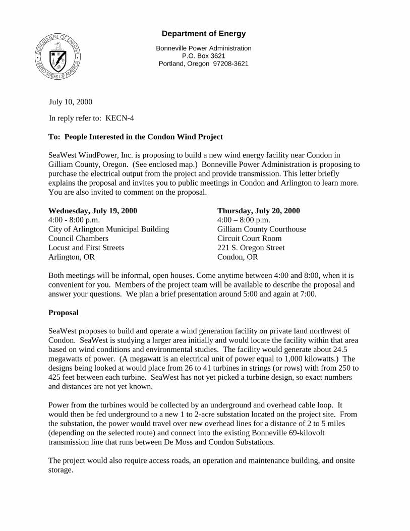
Department of Energy
Bonneville Power Administration P.O. Box 3621
Portland, Oregon 97208-3621
July 10, 2000 In reply refer to: KECN-4 To: People Interested in the Condon Wind Project SeaWest WindPower, Inc. is proposing to build a new wind energy facility near Condon in Gilliam County, Oregon. (See enclosed map.) Bonneville Power Administration is proposing to purchase the electrical output from the project and provide transmission. This letter briefly explains the proposal and invites you to public meetings in Condon and Arlington to learn more. You are also invited to comment on the proposal. Wednesday, July 19, 2000 Thursday, July 20, 2000 4:00 - 8:00 p.m. 4:00 – 8:00 p.m. City of Arlington Municipal Building Gilliam County Courthouse Council Chambers Circuit Court Room Locust and First Streets 221 S. Oregon Street Arlington, OR Condon, OR Both meetings will be informal, open houses. Come anytime between 4:00 and 8:00, when it is convenient for you. Members of the project team will be available to describe the proposal and answer your questions. We plan a brief presentation around 5:00 and again at 7:00. Proposal SeaWest proposes to build and operate a wind generation facility on private land northwest of Condon. SeaWest is studying a larger area initially and would locate the facility within that area based on wind conditions and environmental studies. The facility would generate about 24.5 megawatts of power. (A megawatt is an electrical unit of power equal to 1,000 kilowatts.) The designs being looked at would place from 26 to 41 turbines in strings (or rows) with from 250 to 425 feet between each turbine. SeaWest has not yet picked a turbine design, so exact numbers and distances are not yet known. Power from the turbines would be collected by an underground and overhead cable loop. It would then be fed underground to a new 1 to 2-acre substation located on the project site. From the substation, the power would travel over new overhead lines for a distance of 2 to 5 miles (depending on the selected route) and connect into the existing Bonneville 69-kilovolt transmission line that runs between De Moss and Condon Substations. The project would also require access roads, an operation and maintenance building, and onsite storage.
2
SeaWest would like to begin construction in mid to late 2001, with commercial operation starting in late 2001. The project would operate for at least 20 years. Environmental Analysis Bonneville, as a Federal agency, must study the environmental impacts, both adverse and beneficial, of a proposed project before it can take action. This policy is set out in the National Environmental Policy Act of 1969. The Act requires that significant environmental impacts of a proposed action be discussed in an Environmental Impact Statement. Because we are proposing to purchase power from the Condon Wind Project, we will prepare an Environmental Impact Statement on the entire proposal. The analysis will include at least two transmission alternatives. To Comment If you have comments on the proposed Condon Wind Project, you can give them to us at the public meetings, leave a message on our toll-free comment line at 1-800-622-4519, send an e-mail to [email protected], or mail them to: Bonneville Power Administration, P.O. Box 12999, Portland, OR 97212. If you comment by August 7, 2000, your ideas can affect the scope of our environmental studies. For More Information If you have any questions about the proposal, please call me toll-free at 1-800-282-3713, call my direct number (503) 230-4386, or send an e-mail to [email protected] . Thank you for your interest in our work. Sincerely, /s/ George D. Darr George D. Darr Project Manager Enclosure: Map
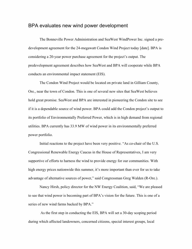
BPA evaluates new wind power development
The Bonneville Power Administration and SeaWest WindPower Inc. signed a pre-
development agreement for the 24-megawatt Condon Wind Project today [date]. BPA is
considering a 20-year power purchase agreement for the project’s output. The
predevelopment agreement describes how SeaWest and BPA will cooperate while BPA
conducts an environmental impact statement (EIS).
The Condon Wind Project would be located on private land in Gilliam County,
Ore., near the town of Condon. This is one of several new sites that SeaWest believes
hold great promise. SeaWest and BPA are interested in pioneering the Condon site to see
if it is a dependable source of wind power. BPA could add the Condon project’s output to
its portfolio of Environmentally Preferred Power, which is in high demand from regional
utilities. BPA currently has 33.9 MW of wind power in its environmentally preferred
power portfolio.
Initial reactions to the project have been very positive. “As co-chair of the U.S.
Congressional Renewable Energy Caucus in the House of Representatives, I am very
supportive of efforts to harness the wind to provide energy for our communities. With
high energy prices nationwide this summer, it’s more important than ever for us to take
advantage of alternative sources of power,” said Congressman Greg Walden (R-Ore.).
Nancy Hirsh, policy director for the NW Energy Coalition, said, “We are pleased
to see that wind power is becoming part of BPA’s vision for the future. This is one of a
series of new wind farms backed by BPA.”
As the first step in conducting the EIS, BPA will set a 30-day scoping period
during which affected landowners, concerned citizens, special interest groups, local
governments and other interested parties can comment on the scope of the EIS. SeaWest
will work closely with the local community regarding any concerns about the
environmental effects of the development.
If the project passes environmental muster, 600 or 950 kilowatt turbines would be
spaced across the relatively flat plateau currently used for winter wheat farming and
cattle grazing. The project would not interfere with either activity.
SeaWest is the largest independent developer of utility-scale wind power projects
in the world and has developed sites in Wyoming, California, the United Kingdom and
Spain. The Condon project is the first of what the company hopes will be between 300
and 500 MW of renewable projects in the Pacific Northwest.
CONTACT:George Darr, BPA (503) 230-4386; [email protected] Roberts, SeaWest (619) 908-3440; [email protected]
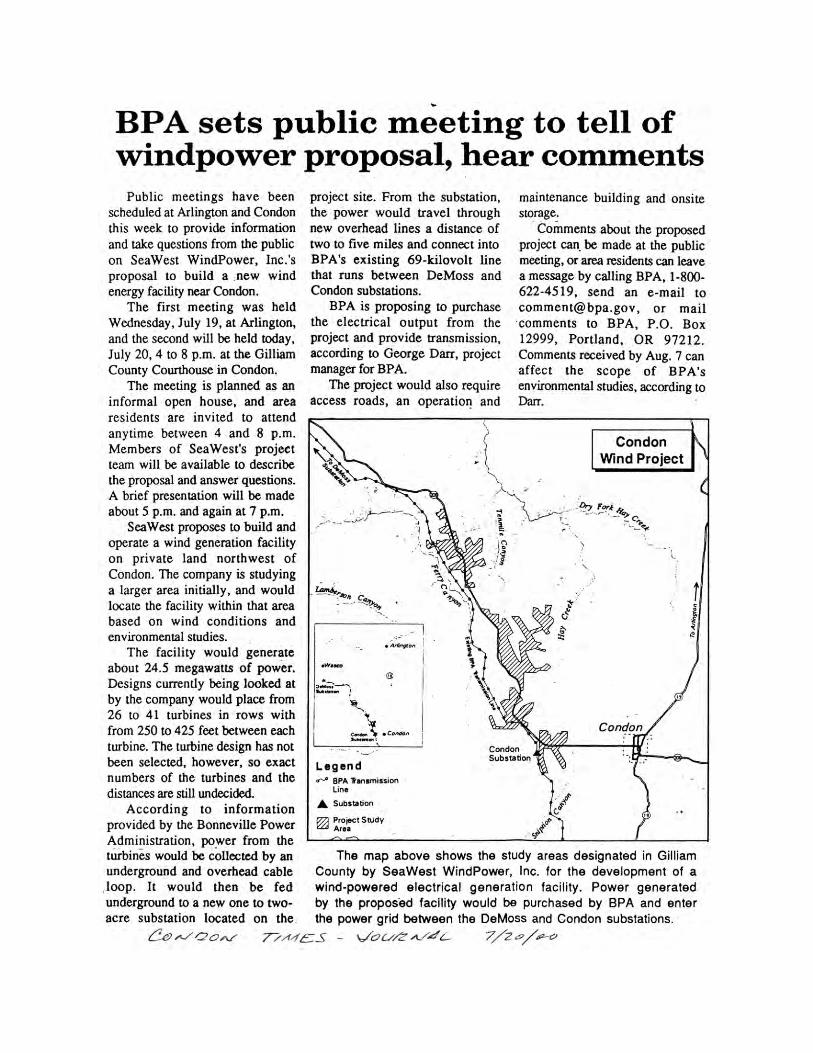
Department of Energy
Bonneville Power Administration P.O. Box 3621
Portland, Oregon 97208-3621
November 15, 2000 In reply refer to: PGC-6 To: People Interested in the Condon Wind Project SeaWest WindPower, Inc. is proposing to build a new wind energy facility near Condon in Gilliam County, Oregon. Bonneville Power Administration is proposing to purchase the electrical output from the project and provide transmission. This letter gives an update on the project and summarizes comments we received in July when the project was first announced and we held meetings in Condon and Arlington. Proposed Project SeaWest proposes to build and operate a wind generation facility on private land northwest of Condon (see attached map). SeaWest is studying a larger area initially and would locate the facility within that area based on wind conditions and environmental studies. The facility would generate about 24.5 megawatts (MW) of power (one average MW can provide electricity for 250 homes). There is a relationship between number, height, and spacing of turbines: as the size of turbines increases, the spacing between them increases, and the number needed decreases. SeaWest has not yet chosen the turbine models, so exact numbers, distances, and heights are not yet known. The range of turbine designs being considered would produce from 600 to 1650 kilowatts of power (1000 kilowatts is equal to one MW). With the largest turbines, 15 would be needed; with the smallest, 41. Turbines would be placed in strings (or rows) with from 250 to 690 feet between each turbine in a string. The total turbine height, including the rotor blades, would be from 236 to 378 feet Power from the turbines would be collected by an underground and overhead cable loop. It would then be transmitted 1-2 miles to a new ½-1 acre substation located near the BPA transmission line. The power would be transferred to the existing BPA 69-kilovolt transmission line that runs between De Moss and Condon Substations. The project would also require access roads, an operation and maintenance building, and onsite storage. SeaWest would like to begin construction in mid to late 2001, with commercial operation starting in late 2001. The project would operate for at least 20 years. Environmental Analysis As a Federal agency, BPA must study the environmental impacts, both adverse and beneficial, of this proposed project before it can take action. This policy is set out in the National Environmental Policy Act of 1969 that requires potential environmental impacts of a proposed action to be made public before decision-making. Environmental impacts will be discussed in an Environmental Impact Statement (EIS). Public Comments In July we asked for comments on the proposal to help us develop the environmental study. We mailed a comment form, held two public meetings, and asked people to phone, write, or e-mail any comments. We received 243 comments. The comments covered all aspects of the project and the EIS.
2
People clearly supported wind power, but wanted to know more about how it works. Sixty-seven comments sought information about the project design.
How many towers will there be? How tall will they be? How big are the blades? How much wind is needed?
Environmental topics attracted 109 comments. The category receiving most comments was Socioeconomic. Of particular interest was how the project would affect local taxes, power rates, and employment.
Who will pay the taxes on the land? Is there a royalty payment to the local government? Reducing rates would be a good outcome. How many jobs would be available to local residents?
Two other categories drew attention. The topic of Fish, Wildlife, and Vegetation received 15 comments; nearly all dealt with birds. Specifically named were: raptors, geese, merlin, owl, chukar, pheasant, bluebird, robin, and bald eagle. There were 12 comments on Land Use/Recreation. Most of those focused on how the project would affect farming. How We Use the Comments All the comments we received will help shape the analysis in the EIS. The comments have helped us to identify the key issues to be addressed in the EIS, as well as the impacts of most concern. Everyone who commented has been added to the project mail list. Project Schedule and Next Steps We are progressing according to schedule and plan to have a Draft EIS ready for public review next March. Please fill-in and return the enclosed postcard to let us know if you would like to receive the entire EIS (around 250 pages), the summary (around 25 pages), or a copy by electronic mail. Even if you don't return the postcard, we will let you know when the Draft EIS is available. If you have any questions about the proposal, please call me toll-free at 1-800-282-3713, call my direct number at (503) 230-4386, or send an e-mail to [email protected]. Thank you for your interest in our work. Sincerely, George D. Darr Project Manager Enclosures: Map Postcard
Department of Energy
Bonneville Power Administration P.O. Box 3621
Portland, Oregon 97208-3621
April 9, 2001 In reply refer to: PGC-6 To: People Interested in the Condon Wind Project Bonneville Power Administration (BPA) is proposing to purchase the electrical output and provide transmission for the Condon Wind Project, a new wind energy facility being proposed by SeaWest WindPower, Inc., near Condon in Gilliam County, Oregon. We are considering some changes to the proposal. This letter will bring you up-to-date. Proposal
SeaWest has proposed to build and operate a wind generation facility on private land northwest of Condon (see attached map). SeaWest originally proposed a facility that would generate about 24.6 megawatts (MW) of power. SeaWest leased more land than would be needed with plans to narrow the choice based on results of wind studies and other environmental factors. Wind Data The wind data collected so far depicts a less economic wind resource than anticipated. A larger project may be more economical. Over the last few weeks, SeaWest and BPA have looked for ways to restructure the project to reduce the cost of power. While SeaWest has filed a development application with Gilliam County for a 24.6 MW wind facility, we want you to know the project could expand to 49.8 MW. Turbine Design SeaWest has decided to use 600-kilowatt wind turbines (1000 kilowatts equal one MW). The 24.6 MW proposal would require 41 of these turbines; the 49.8 MW proposal, if requested, would require up to 83 turbines. The turbines would be approximately 274 feet tall including the rotor blades. The turbines would be placed in strings (or rows) with approximately 400 to 480 feet between each turbine in a string. Environmental Impact Statement As a Federal agency, BPA must study the environmental impacts of a proposed project. This policy is set out in the National Environmental Policy Act of 1969 which requires potential environmental impacts be considered and made public before a decision is made. Environmental impacts are discussed in an Environmental Impact Statement (EIS).
2
BPA is preparing an EIS on the Condon Wind Project. From the beginning, our analysis looked at impacts within the larger area. If SeaWest amends its application to request a larger project, the expansion would occur within the area already studied. To ensure that all of the environmental effects of an expanded project are fully evaluated, the Draft EIS will be based on the assumption that the expanded project could be built. Schedule The Draft EIS will be complete in about a month. We will let you know when it is available. If the project is approved by Gilliam County and BPA agrees to purchase the power output, SeaWest hopes to begin construction in late 2001, with commercial operation for the 24.6 MW facility starting in late 2001. If the project application is amended to request approval of a larger project, the balance of the expanded project (approximately 42 more turbines) would be constructed in 2002. The project would operate for at least 20 years. For More Information If you have any questions about the proposal, please call me toll-free at 1-800-282-3713, call my direct number at (503) 230-4386, or send an e-mail to [email protected]. Thank you for your interest in our work. Sincerely, George D. Darr Project Manager Enclosure: Map
Condon Wind Project Appendix B – Agency CorrespondenceDraft EIS Page B-1
Appendix B Agency Correspondence
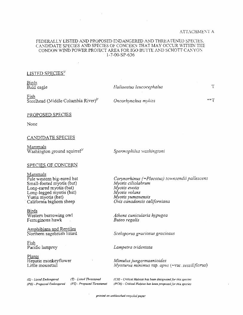
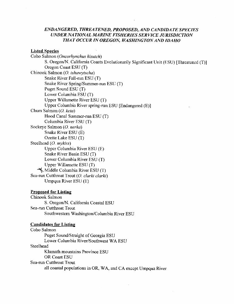
Condon Wind Project Appendix C – Technical Baseline StudyDraft EIS Page C-1
Appendix C Technical Baseline Study – ExecutiveSummary
(;(&87,9(�6800$5<
P:\SARAN\Condon May 14\Appdx C\URS Condon Exec Summary.doc ES-1
This report presents the results of an ecological baseline study for a proposed wind energy development project by SeaWest, Inc. near Condon, Oregon. The proposed project would provide up to 50 MW of electricity generated by 600-kW wind turbines. The first phase of the project would consist of 41 wind turbines and the second phase would consist of 42 turbines. URS Corporation and subcontractors Northwest Wildlife Consultants, Western EcoSystems Technology, Inc., Loverna Wilson, John Hayes, and David Waldien conducted the study. This study and report provides supporting documentation to the Environmental Impact Statement being prepared by the Bonneville Power Administration (BPA) and Jones & Stokes, Inc. Prior to initiation of the field study, a proposed protocol describing the methodology to be followed was discussed with representatives from BPA, the Oregon Department of Fish and Wildlife, and the U.S. Fish and Wildlife Service. The protocol was revised in response to those comments.
The general goal of the study was to gather information in sufficient detail to accurately characterize the quality and quantity of vegetation, wetlands, fish and wildlife (including any State or Federal Threatened, Endangered, and Sensitive species) present in the vicinity of the proposed project, and to provide a basis for identifying probable ecological impacts of a wind power project in the area. More specific goals are listed below in the form of a series of questions:
• What fish and wildlife species use the study area? Are there seasonal variations in species composition and use? What vegetation/habitat types are present in the study area?
• What is the status of threatened, endangered, and sensitive plant and animal species in the study area?
• Where in the study area do species occur and what habitats do they use? Do some fish or wildlife species or groups appear to make more use of some portions of the study area than others?
• Are there key habitat features, biotic and abiotic, that appear correlated with variations in plant distribution and fish and wildlife use of the area?
• Does an individual fish and wildlife species or species group exhibit distinctive behavior patterns over specific habitats and landforms? Does behavior exhibit diel or seasonal patterns?
• How do indices of use of the study area by birds compare to other windplant sites that have been studied in western North America, particularly in Oregon, Wyoming, Minnesota, and California?
The Condon study area (SA) consists of broad, flat, mostly cultivated ridgetops with some grazed native rangeland (shrub-steppe and grasslands) and Conservation Reserve Program (CRP) seeded fields, and grazed native rangeland on the adjacent canyon slopes. The SA is located along Highway 206 approximately 3 to 5 miles northwest of Condon, Oregon; 24 miles south of
(;(&87,9(�6800$5<
P:\SARAN\Condon May 14\Appdx C\URS Condon Exec Summary.doc ES-2
the Columbia River, and 9.5 miles east of the John Day River. The SA is within the Columbia Basin Physiographic Province (Franklin and Dyrness 1973) of which the original vegetation was grassland and shrub-steppe of the bluebunch wheatgrass-Idaho fescue zonal association. There are few trees and rocky outcrops in the SA.
Color aerial photography was specifically commissioned for this study and used in addition to USGS 7.5-minute quadrangle maps as the basis for vegetation mapping and field data sheets in the study. Vegetation was categorized and mapped on an aerial photo mosaic using the information gathered during ground surveys. Ground surveys by a botanist and wildlife biologist were conducted in the SA and by a fisheries biologist in areas downstream and outside of the SA, during the spring of 2000. These surveys were designed to search potentially suitable habitats for sensitive plants and animals, identify wetlands, and characterize vegetation communities. A helicopter aerial survey of tree- and cliff-nesting raptors was conducted within a 10-mile radius of the area where wind turbines could be developed. Avian use surveys were conducted weekly (twice weekly in the spring) at a series of 16 circular plots 1200 meters in diameter between April 13, 2000 and March 13, 2001. Plots were selected to cover as much of the SA as possible, within the limitations imposed by the terrain. The bat study methods included an assessment of suitability of habitat within and near the SA as well as surveys of bat activity using mist netting and echolocation monitoring at selected sites.
Ten vegetation/habitat types were identified within the SA: agricultural (cultivated) dry, upland trees, riparian trees, riparian (lacking trees), shrub-steppe, CRP and grassland, developed residential, surface water, emergent wetlands, and rocky outcrops. Four wetlands were found within the SA. One wetland within plot 15 was exceptional in that it consisted of several small vernal pools within an area of remarkably undisturbed bluebunch wheatgrass in which the cryptobiotic crusts are thick and unbroken.
No federal or state listed or sensitive plant species were observed in or near the SA during field surveys. Six sensitive animal species were observed during the field study in the SA: long-billed curlew (probably nesting locally, not necessarily within the SA), Swainson’s hawk (local summer resident, nesting outside the SA but within 10 miles), loggerhead shrike (may nest locally, not necessarily within the SA), sage sparrow (status unknown, possible migrant or local nester), grasshopper sparrow (summer resident, probably nests within SA), and silver-haired bat (fall migrant passing through the SA). Other “sensitive” species (state and federal) that could be affected by wind turbines and that may occasionally occur, but which were not observed during the field study, include bald eagle, a few species of bats, ferruginous hawk, and western burrowing owl.
In 2000, a total of 13 active raptor nests were identified during the aerial survey within the required 10-mile radius (consisting of 135,714 hectares) of the plots. This aerial survey documented an average of only 1.0 active large raptor nests (excluding common ravens) per 10,000 hectares within the 10-mile radius of the SA during the 2000 surveys. This density is low
(;(&87,9(�6800$5<
P:\SARAN\Condon May 14\Appdx C\URS Condon Exec Summary.doc ES-3
compared to densities estimated from similar surveys at the Vansycle/Stateline wind site in Oregon (3.9 to 7.8 nests per 10,000 hectares) and Foote Creek Rim in Wyoming (7 nests per 10,000 hectares). The raptor species observed during aerial surveys included red-tailed hawks (4 active nests), unknown raptors (4), Swainson’s hawks (3), and prairie falcons (2). Great horned owl and golden eagle nests were observed beyond the 10-mile radius. Common ravens were also recorded during the aerial survey and were the most abundant nesting species observed (6 nests).
During the avian use plot surveys a total of 50 bird species or best possible identification was recorded. Horned lark comprised 40 percent of the total birds counted, raptors 11 percent, western meadowlark 10 percent, waterbirds 3 percent, and upland game birds 1 percent. The other 35 percent of the total consisted of mostly other species of passerine birds such as sparrows, blackbirds, and common ravens, the only corvid observed. American kestrel was the most frequently observed raptor, followed by unidentified buteos, red-tailed hawk, northern harrier, rough-legged hawk, unidentified raptors, and golden eagle. Most of the “unidentified” birds were those recorded farther than 600 meters from the observer.
Overall, more species were observed in the SA during the spring and summer (26 and 28 respectively) than during the fall (15) and winter (14). However, the number of species/ unique groups identified per 15-minute plot survey was significantly higher in the spring than during the other seasons. There were no statistically significant differences between indices of use by any bird group or season between the plots within the proposed project area (the PA, where wind turbine development is proposed) and the plots outside the proposed project area (the OSPA). An analysis of seasonal differences within all of the plots combined (the Condon Analysis Area or CAA, consisting of the plots in the PA and OSPA) revealed that corvid use was significantly higher during the fall than other seasons. Raven use was highest of all large bird species and groups in the CAA in the summer, fall, and winter and was second-highest in the spring. Raven use in the fall was approximately ten times that of the next species (abundant in this case refers to an index of use, not true abundance). Raptor use was highest during spring but not quite significantly different from the other seasons. Use by the horned lark/meadowlark group was significantly lower during the summer than all the other seasons. Sparrows were only seen during the fall and winter, with the exception of grasshopper sparrow, which was observed in spring and summer. Combined use by all birds was significantly higher in summer than other seasons.
The ten large bird species, whose use in at least one season was in the top ten species, were the common raven, American kestrel, ring-necked pheasant, northern harrier, long-billed curlew, red-tailed hawk, gray partridge, golden eagle, rough-legged hawk, and turkey vulture. Small bird species in the “top ten” in at least one season were the horned lark, western meadowlark, vesper sparrow, and savannah sparrow.
(;(&87,9(�6800$5<
P:\SARAN\Condon May 14\Appdx C\URS Condon Exec Summary.doc ES-4
No apparent consistent patterns in use across seasons by plot for the groups that were analyzed (raptors, passerines, non-passerines, all birds) were evident.
The analysis of flight heights from the plot surveys included calculations of the percentages of flying birds that would pass through the rotor swept area (RSA) of three different size classes of wind turbine: small (600-750 kW), medium (900-1000 kW), and large (1500-1650 kW). Three turbine sizes were used for the analysis because the type of turbine to be used for this project had not been chosen. Of all observations of flying birds, 34 percent were recorded within the RSA for small and medium turbines, and 16 percent were within the RSA for large turbines. For groups with at least 20 flocks observed flying, blackbirds (84 percent), swallows (45 percent), and “others” (45 percent) were most often observed within the RSA of the small and medium sized turbines, while horned larks/meadowlarks (25 percent) and sparrows (none) were least often observed within the RSA and were mostly observed below the RSA. Swallows (40 percent), raptors (29 percent), corvids (28 percent), and “others” (22 percent) were most often observed within the RSA of the large turbines, with horned larks/meadowlarks (11 percent) and blackbirds (10 percent) least likely to occur. The blackbird estimates vary between the two turbine types due to the large number of blackbirds recorded at 25 meters above ground level (AGL).
A total of 83 percent of all birds observed were first recorded as flying. For groups with at least 20 flocks observed flying, sparrows (54 percent flying) had the lowest estimates and horned larks/meadowlarks (78 percent), raptors (86 percent), and swallows (96 percent) had the highest estimates.
Of the seven raptor species with greater than five observations of flight height, turkey vultures (10 percent), northern harriers (19 percent), golden eagles (19 percent) and Swainson’s hawks (22 percent) were least likely to fly within the RSA of the small/medium sized turbines. Rough-legged hawks (79 percent), American kestrels (38 percent), and red-tailed hawks (34 percent) were most likely to fly within the RSA of the small/medium-sized turbines. For the large sized turbines, the proportions of raptors likely to fly within the RSA were lower than the estimates for birds flying within the RSA for the small/medium-sized turbines. In some species, such as the golden eagle and Swainson’s hawk, the percentage of flights through the RSA of the large-sized turbines was half of that recorded for the small/medium-sized turbines.
Flight direction when first observed showed no evident pattern. Maps of flight paths varied by season, species, and location, and no obvious patterns of use were evident. Flight paths often followed elevation contours, especially near distinct canyon edges, such as the east edge of Ferry Canyon. This pattern is similar to that observed at Foote Creek Rim (Johnson et al. 2001).
Potentially suitable habitat for bats is generally scarce throughout the SA. Few trees, snags, and rocky areas are present. Farm buildings are scattered throughout the SA. Few water sites, particularly during the late summer and fall, are present in the SA. Bat activity was low at upland
(;(&87,9(�6800$5<
P:\SARAN\Condon May 14\Appdx C\URS Condon Exec Summary.doc ES-5
sites but myotis (which could not be identified to species), big brown, and State Sensitive silver-haired bats were detected. Considerable activity at stream and pond sites at and in the vicinity of the SA was detected, but only myotis species were identified. Myotis species were also recorded at various mobile sample points: the area with the most activity was a riparian area along Ferry Canyon. No bats were captured by mist netting at ponds. Although myotis calls could not be definitively identified to species, most of the calls recorded were typical of little brown bats and several were typical of California myotis.
Small birds most often observed in the zone of risk were horned larks, blackbirds (unidentified and Brewer’s blackbirds), western meadowlarks, swallows (cliff and unidentified), and American goldfinches. Horned larks and blackbirds were both estimated to be greater than seven times more likely to be found in the zone of risk than any other small birds. Note that of these species, only a horned lark was represented in the list of carcasses found during the one-year monitoring study at the Vansycle Wind plant in northeast Oregon, and it may have been killed by a car collision (Erickson et al. 2000). Horned lark was the most commonly observed passerine at the Foote Creek Rim Wind plant in Wyoming, had the highest risk index, and was the most abundant turbine-related collision observed.
Large birds most likely to be observed in the zone of risk are rough-legged hawks, American kestrels, common ravens, and northern harriers. The golden eagle is estimated to be 10 times less likely to be observed in the zone of risk than American kestrels and approximately 20 times less likely than common ravens.
Raptor relative use estimates for the Condon SA were compared to estimates from other wind plants where comparable data exists. Raptor use estimates were taken from three studies where data were collected from fixed-radius survey plots using protocols very similar to the protocol used on the Condon study. Monitoring studies included the Buffalo Ridge Wind Resource Area (WRA), Minnesota in 1996-1999 (Johnson et al. 2000a); the monitoring studies at the Foote Creek Rim WRA in 1995, 1997, 1998 and 1999 (Johnson et al. 2000b, 2001); and the Stateline monitoring study (CH2M Hill 2000). Due to differences in the time of surveys and possible differences in the quality of viewsheds out to 800 meters, some biases may exist.
Of the four sites, the estimated raptor use is highest during the spring, summer and fall at the Foote Creek Rim Wind Plant. During the winter, raptor use is highest at the Vansycle Wind Plant. Otherwise, similar use estimates exist for the CAA, the PA, the Vansycle WRA, and the Buffalo Ridge Project area, with none of these studies having consistently higher or lower raptor use estimates across all seasons. No turbine-related raptor fatalities were observed during a one-year monitoring effort at the Vansycle Wind Plant (Erickson et al. 2000) and only one red-tailed hawk fatality was found during a 5-year monitoring effort at the Buffalo Ridge WRA. Three turbine-related raptor fatalities (3 American kestrels, 1 northern harrier and 1 short-eared owl) were observed at the Foote Creek Rim Phase I Windplant (69 turbines) during two years of monitoring (Johnson et al. 2001). Comparisons of all bird use estimates was only appropriate for
(;(&87,9(�6800$5<
P:\SARAN\Condon May 14\Appdx C\URS Condon Exec Summary.doc ES-6
this study and the Vansycle baseline study, since the Buffalo Ridge and Foote Creek Rim surveys were conducted at points with 800-meter diameter viewsheds and only recorded large birds and species of concern. Estimates of all bird use were higher at the Vansycle WRA and the Vansycle Existing Project Area than at the CAA or PA in summer, fall, and winter and were comparable in the spring.
Fatality estimates from the Vansycle Wind plant (Erickson et al. 2000), the Buffalo Ridge Wind plant (Johnson et al. 2000a), and the Foote Creek Rim Wind plant (Johnson et al. 2001) for raptors and all birds were compared and used as a basis for estimating the range of fatalities that could be expected at the Condon project. Assuming 83 turbines at Condon and using the mean from these previous studies, it is estimated that an average of one raptor would be killed per year with an estimated range of 0–3 raptor fatalities per year. This average estimate and upper range is probably conservative (an overestimate) because raptor use at the Condon Site is similar to Buffalo Ridge and Vansycle, and the projection for raptor fatalities at Condon from these two wind plants is 0-0.2 raptors per year. Foote Creek Rim raptor use estimates and nesting densities are much higher than the corresponding estimates at the Condon Site, and the Foote Creek Rim raptor fatality estimate is the basis for the upper range of raptor mortality (3 raptor fatalities per year). Using the mean all bird fatality estimates from these three studies, we estimate 144 bird fatalities (in general) per year with a range of 52-235. The estimate from the Vansycle Windplant may be the most accurate (52) because bird use estimates for the Condon Site are similar to the Vansycle estimate.
Based on the 1-year monitoring study of the Vansycle Wind plant (Erickson et al. 2000), bat mortality averaged 0.74 bats/turbine/year. Assuming 83 turbines and approximately this mortality average, an estimated average of 61 bat fatalities could occur at the Condon project per year. Actual fatalities may vary from these projections. Using the confidence interval reported for Vansycle, we estimate a range of 22 to 125 bat fatalities per year.
Mitigation opportunities include:
• Select turbine sites carefully to reduce risk of collision. Some research has indicated higher raptor use along the upwind side of distinct ridgelines (Johnson et al. 2000b). Turbines at the Foote Creek Rim wind plant in Wyoming were set back from the upwind side of the distinct ridge edge because of this observed pattern. This may have contributed to the low raptor mortality (Johnson et al., 2000b). At the Condon Wind Project, turbines are proposed to be set back from the upwind (prevailing) side of distinct ridges and would be located on the top or the downwind side. Turbines should also not be located in low saddle areas that could be used frequently by raptors moving between drainages.
• Minimize any man-made perches and nesting structures associated with the wind development. The use of tubular towers with the cells of the turbines encased should minimize perching attempts on turbine structures by raptors.
(;(&87,9(�6800$5<
P:\SARAN\Condon May 14\Appdx C\URS Condon Exec Summary.doc ES-7
• Avoid aboveground transmission lines where feasible, and raptor-proof lines when they are above ground. Consider topography when siting aboveground lines.
• Delineate and clearly flag wetland boundaries within the construction corridor prior to project implementation and plan construction so as to avoid impacts to wetlands.
• Minimize road construction and restrict vehicle use to avoid and minimize impacts to sensitive habitats and ground-dwelling species.
• Educate construction personnel about maintaining reasonable driving speeds within the PA so as not to harass or accidentally strike wildlife. All construction personnel should be instructed to be particularly cautious and drive slower speeds from one hour before sunset to one hour after sunrise when some wildlife species are the most active. This should be a standard safety requirement throughout the construction and operational phase. Construction personnel should be given a briefing on sensitive wildlife in the area, and on required precautions to avoid harming wildlife.
• Revegetate any unfarmed disturbed areas using native plant seeds. Monitor revegetation to assure the success of the revegetation effort.
• Install and maintain best management practices for erosion control pursuant to an NPDES Stormwater General Permit 1200-C.
• Develop and implement measures to reduce the potential spread of noxious weeds in consultation with the appropriate weed control board of Gilliam County. Regularly monitor turbine strings, roads, and other disturbed areas to control the spread of noxious weeds.
• Form a technical advisory committee made up of experts from the cooperating agencies, SeaWest representatives, and other concerned groups to meet and discuss the results of the baseline study and to develop and oversee a monitoring plan to be implemented if the project is constructed.
• Avoid placing turbines where raptors have been consistently observed crossing over higher points on the landscape or where high foraging activity has been observed.
• Do not increase perch availability for raptors near turbine strings. Overhead T-line poles should be >1,000 feet away from the nearest turbine string.
• Assign a wildlife biologist to monitor the staking of turbine locations.
(;(&87,9(�6800$5<
P:\SARAN\Condon May 14\Appdx C\URS Condon Exec Summary.doc ES-8
References
CH2M Hill. 2000. SEPA Final EIS on FPL Energy’s Proposal for the Stateline Wind Project. Prepared for Florida Power and Light (FPL).
Erickson, W. P., G. D. Johnson, M. D. Strickland, and K. Kronner. 2000. Avian and bat mortality associated with the Vansycle Wind Project, Umatilla County, Oregon; 1999 study year. Western EcoSystems Technology, Inc., Cheyenne, Wyoming. 20pp.
Franklin, J. F., and C. T. Dyrness. 1973. Natural vegetation of Oregon and Washington. USDA Forest Service General Technical Report PNW-8.
Johnson, G. D., W. P. Erickson, M. D. Strickland, M. F. Shepherd, and D. A. Shepherd. 2000a. 1996 Avian Monitoring Studies at the Buffalo Ridge, MN Wind Resource Area: Results of a 4-Year Study. Technical Report prepared by Western EcoSystems Technology, Inc. for Northern States Power Company, Minneapolis, MN.
Johnson, G. D., D. P. Young Jr., W. P. Erickson, C. E. Derby, M. D. Strickland, and R. E. Good. 2000b. Wildlife Monitoring Studies, SeaWest Windpower Project, Carbon County, Wyoming. 1995–1999. Technical report prepared by Western EcoSystems Technology, Inc. for SeaWest Energy Corporation and Bureau of Land Management.
Johnson, G. D., D. P. Young Jr., W. P. Erickson, C. E. Derby, M. D. Strickland, and R. E. Good. 2001. Avian and Bat Mortality Associated with the Initial Phase of the Foote Creek Rim Windpower Project, Carbon County, Wyoming. November 3, 1998 – October 31, 2000. Technical report prepared by Western EcoSystems Technology, Inc. for SeaWest Energy Corporation and Bureau of Land Management.

Bonneville Power Administration
PO Box 3621 Portland, Oregon 97208-3621
DOE/BP-3376 MAY 2001 100