Embed Size (px)
Citation preview
Ice in the Environment: Proceedings of the 16th IAHR International Symposium on Ice Dunedin, New Zealand, 2nd–6th December 2002 International Association of Hydraulic Engineering and Research
CONCEPTION OF CHIYODA EXPERIMENTAL CHANNEL
Yukiyoshi Ito1, Mikio Kobayashi2 and Yasuharu Watanabe3
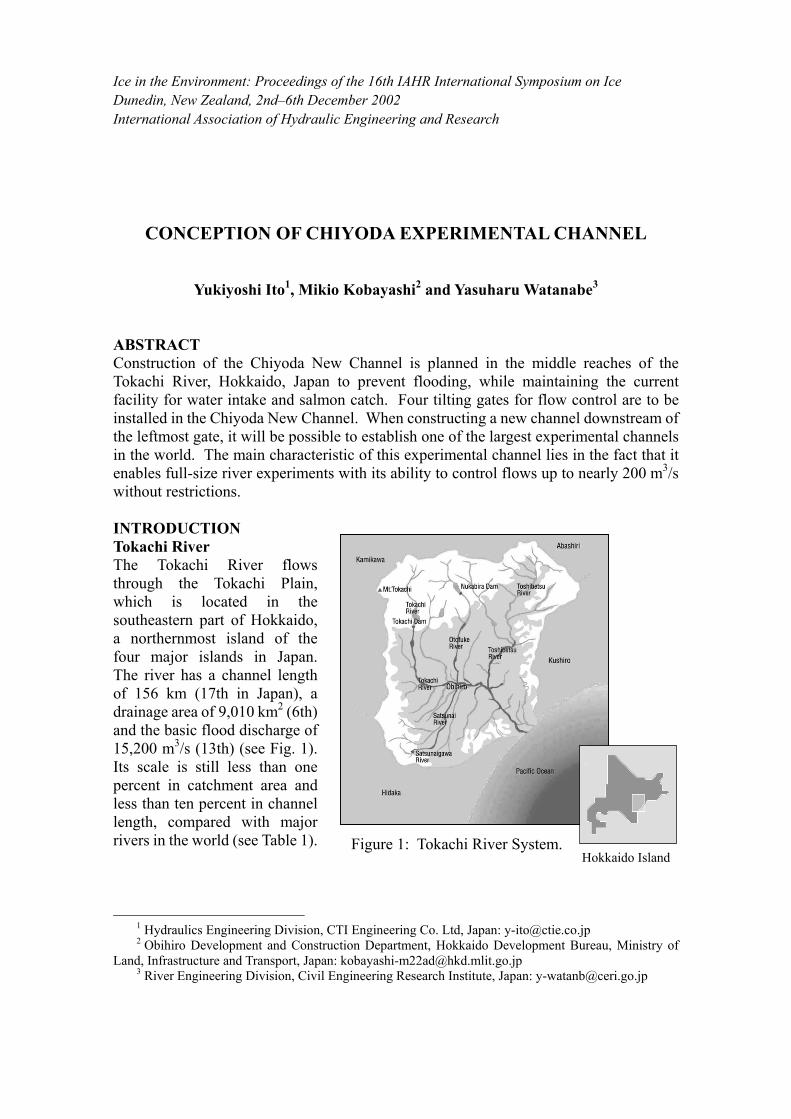
ABSTRACT Construction of the Chiyoda New Channel is planned in the middle reaches of the Tokachi River, Hokkaido, Japan to prevent flooding, while maintaining the current facility for water intake and salmon catch. Four tilting gates for flow control are to be installed in the Chiyoda New Channel. When constructing a new channel downstream of the leftmost gate, it will be possible to establish one of the largest experimental channels in the world. The main characteristic of this experimental channel lies in the fact that it enables full-size river experiments with its ability to control flows up to nearly 200 m3/s without restrictions. INTRODUCTION Tokachi River The Tokachi River flows through the Tokachi Plain, which is located in the southeastern part of Hokkaido, a northernmost island of the four major islands in Japan. The river has a channel length of 156 km (17th in Japan), a drainage area of 9,010 km2 (6th) and the basic flood discharge of 15,200 m3/s (13th) (see Fig. 1). Its scale is still less than one percent in catchment area and less than ten percent in channel length, compared with major rivers in the world (see Table 1).
1 Hydraulics Engineering Division, CTI Engineering Co. Ltd, Japan: [email protected] 2 Obihiro Development and Construction Department, Hokkaido Development Bureau, Ministry of
Land, Infrastructure and Transport, Japan: [email protected] 3 River Engineering Division, Civil Engineering Research Institute, Japan: [email protected]
Figure 1: Tokachi River System. Hokkaido Island
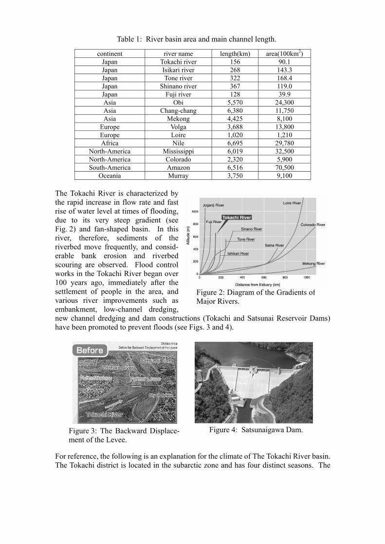
Figure 3: The Backward Displace-ment of the Levee.
Figure 4: Satsunaigawa Dam.
Table 1: River basin area and main channel length.
continent river name length(km) area(100km2) Japan Tokachi river 156 90.1 Japan Isikari river 268 143.3 Japan Tone river 322 168.4 Japan Shinano river 367 119.0 Japan Fuji river 128 39.9 Asia Obi 5,570 24,300 Asia Chang-chang 6,380 11,750 Asia Mekong 4,425 8,100
Europe Volga 3,688 13,800 Europe Loire 1,020 1,210 Africa Nile 6,695 29,780
North-America Mississippi 6,019 32,500 North-America Colorado 2,320 5,900 South-America Amazon 6,516 70,500
Oceania Murray 3,750 9,100 The Tokachi River is characterized by the rapid increase in flow rate and fast rise of water level at times of flooding, due to its very steep gradient (see Fig. 2) and fan-shaped basin. In this river, therefore, sediments of the riverbed move frequently, and consid-erable bank erosion and riverbed scouring are observed. Flood control works in the Tokachi River began over 100 years ago, immediately after the settlement of people in the area, and various river improvements such as embankment, low-channel dredging, new channel dredging and dam constructions (Tokachi and Satsunai Reservoir Dams) have been promoted to prevent floods (see Figs. 3 and 4).
For reference, the following is an explanation for the climate of The Tokachi River basin. The Tokachi district is located in the subarctic zone and has four distinct seasons. The
Figure 2: Diagram of the Gradients of Major Rivers.
annual precipitation is approximately 920 mm (see Fig. 5). Although the rainfall amount is large in summer, it is quite dry in winter seasons. The temperature rises to around 20 degree in summer, and the temperature usually falls to around –8 degree, and to –20 degrees in many cases (see Fig. 6). For this reason, The Tokachi River in winter (December–March) is covered by ice in many cases, and the ice maximum thickness amounts to 30cm - 70cm.
Average Value(1971- 2000)
020406080
100120140160
1 2 3 4 5 6 7 8 9 10 11 12(month)
(mm)Average Value(1971- 2000)
-20
-15
-10
-5
0
5
10
15
20
25
30
1 2 3 4 5 6 7 8 9 10 11 12(m onth)
(℃)
Max.Ave.Min.
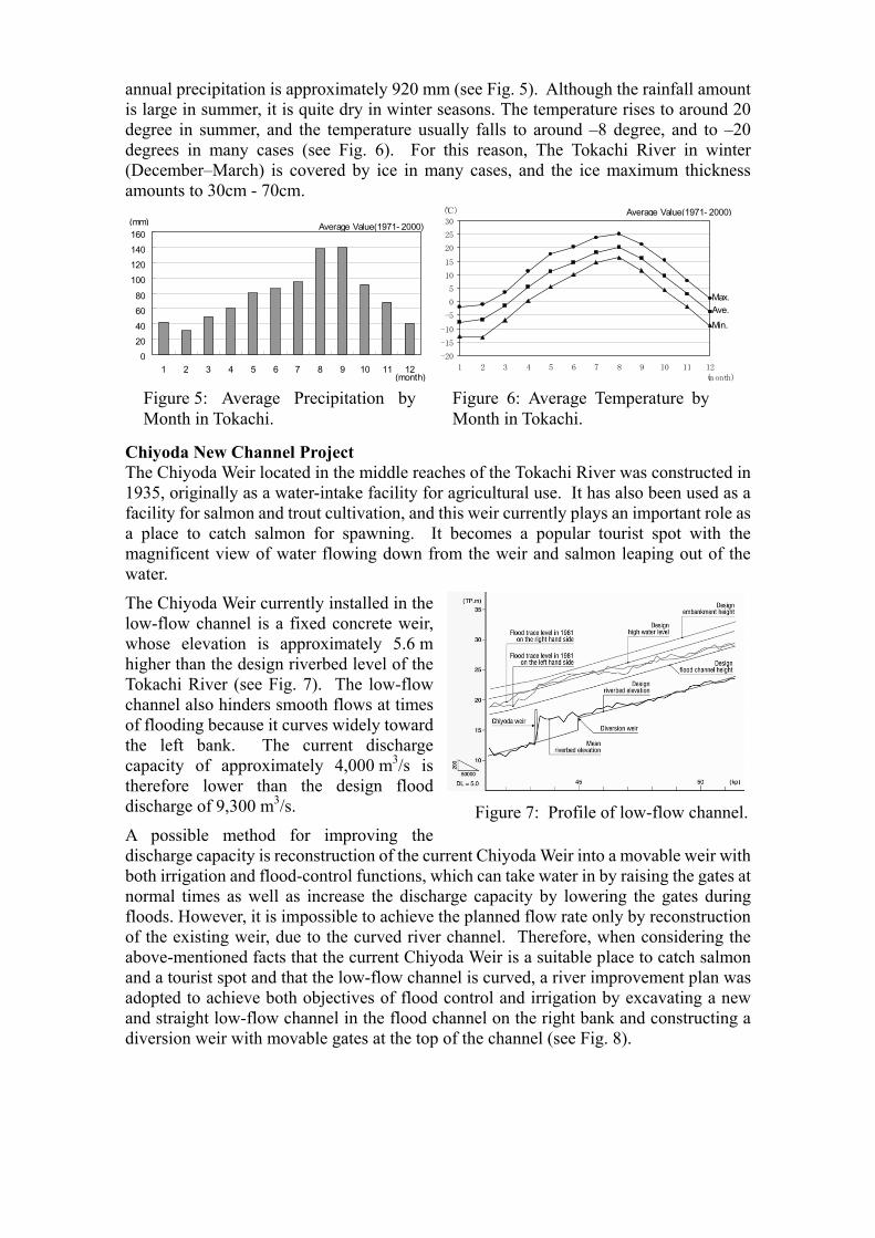
Chiyoda New Channel Project The Chiyoda Weir located in the middle reaches of the Tokachi River was constructed in 1935, originally as a water-intake facility for agricultural use. It has also been used as a facility for salmon and trout cultivation, and this weir currently plays an important role as a place to catch salmon for spawning. It becomes a popular tourist spot with the magnificent view of water flowing down from the weir and salmon leaping out of the water.
The Chiyoda Weir currently installed in the low-flow channel is a fixed concrete weir, whose elevation is approximately 5.6 m higher than the design riverbed level of the Tokachi River (see Fig. 7). The low-flow channel also hinders smooth flows at times of flooding because it curves widely toward the left bank. The current discharge capacity of approximately 4,000 m3/s is therefore lower than the design flood discharge of 9,300 m3/s.
A possible method for improving the discharge capacity is reconstruction of the current Chiyoda Weir into a movable weir with both irrigation and flood-control functions, which can take water in by raising the gates at normal times as well as increase the discharge capacity by lowering the gates during floods. However, it is impossible to achieve the planned flow rate only by reconstruction of the existing weir, due to the curved river channel. Therefore, when considering the above-mentioned facts that the current Chiyoda Weir is a suitable place to catch salmon and a tourist spot and that the low-flow channel is curved, a river improvement plan was adopted to achieve both objectives of flood control and irrigation by excavating a new and straight low-flow channel in the flood channel on the right bank and constructing a diversion weir with movable gates at the top of the channel (see Fig. 8).
Figure 6: Average Temperature byMonth in Tokachi.
Figure 5: Average Precipitation byMonth in Tokachi.
Figure 7: Profile of low-flow channel.
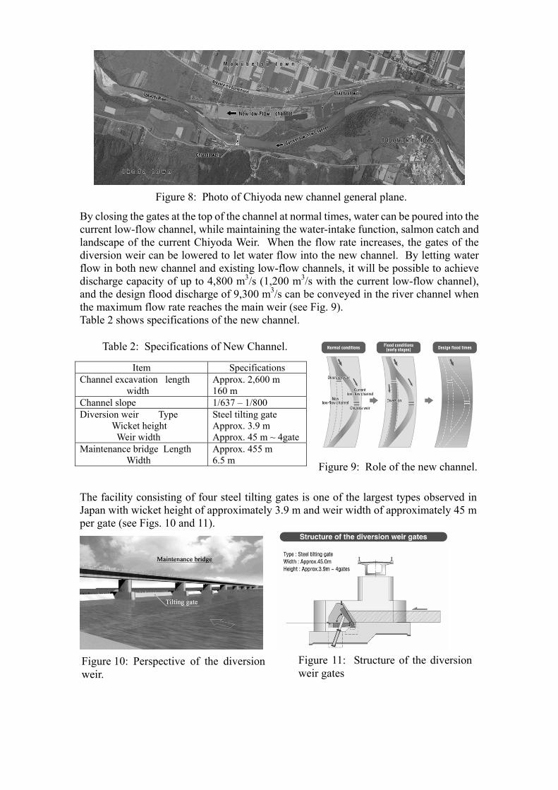
By closing the gates at the top of the channel at normal times, water can be poured into the current low-flow channel, while maintaining the water-intake function, salmon catch and landscape of the current Chiyoda Weir. When the flow rate increases, the gates of the diversion weir can be lowered to let water flow into the new channel. By letting water flow in both new channel and existing low-flow channels, it will be possible to achieve discharge capacity of up to 4,800 m3/s (1,200 m3/s with the current low-flow channel), and the design flood discharge of 9,300 m3/s can be conveyed in the river channel when the maximum flow rate reaches the main weir (see Fig. 9). Table 2 shows specifications of the new channel.
Table 2: Specifications of New Channel.
Item Specifications Channel excavation length width
Approx. 2,600 m 160 m
Channel slope 1/637 – 1/800 Diversion weir Type Wicket height Weir width
Steel tilting gate Approx. 3.9 m Approx. 45 m ~ 4gate
Maintenance bridge Length Width
Approx. 455 m 6.5 m
The facility consisting of four steel tilting gates is one of the largest types observed in Japan with wicket height of approximately 3.9 m and weir width of approximately 45 m per gate (see Figs. 10 and 11).
Figure 8: Photo of Chiyoda new channel general plane.
Figure 10: Perspective of the diversionweir.
Figure 11: Structure of the diversionweir gates
Figure 9: Role of the new channel.
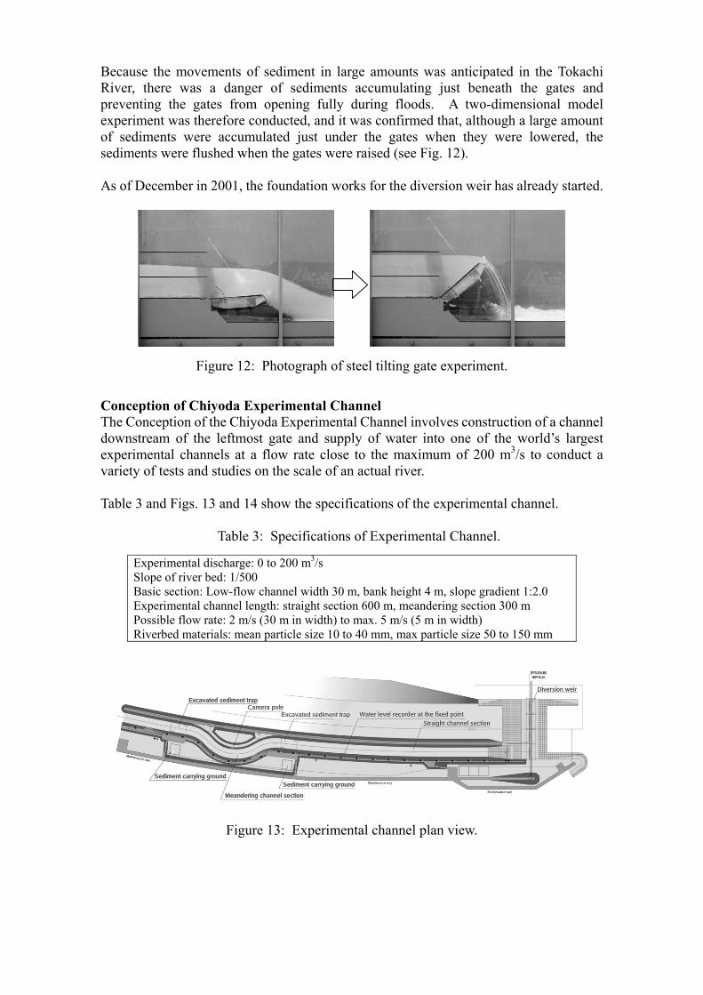
Because the movements of sediment in large amounts was anticipated in the Tokachi River, there was a danger of sediments accumulating just beneath the gates and preventing the gates from opening fully during floods. A two-dimensional model experiment was therefore conducted, and it was confirmed that, although a large amount of sediments were accumulated just under the gates when they were lowered, the sediments were flushed when the gates were raised (see Fig. 12). As of December in 2001, the foundation works for the diversion weir has already started.
Figure 12: Photograph of steel tilting gate experiment.
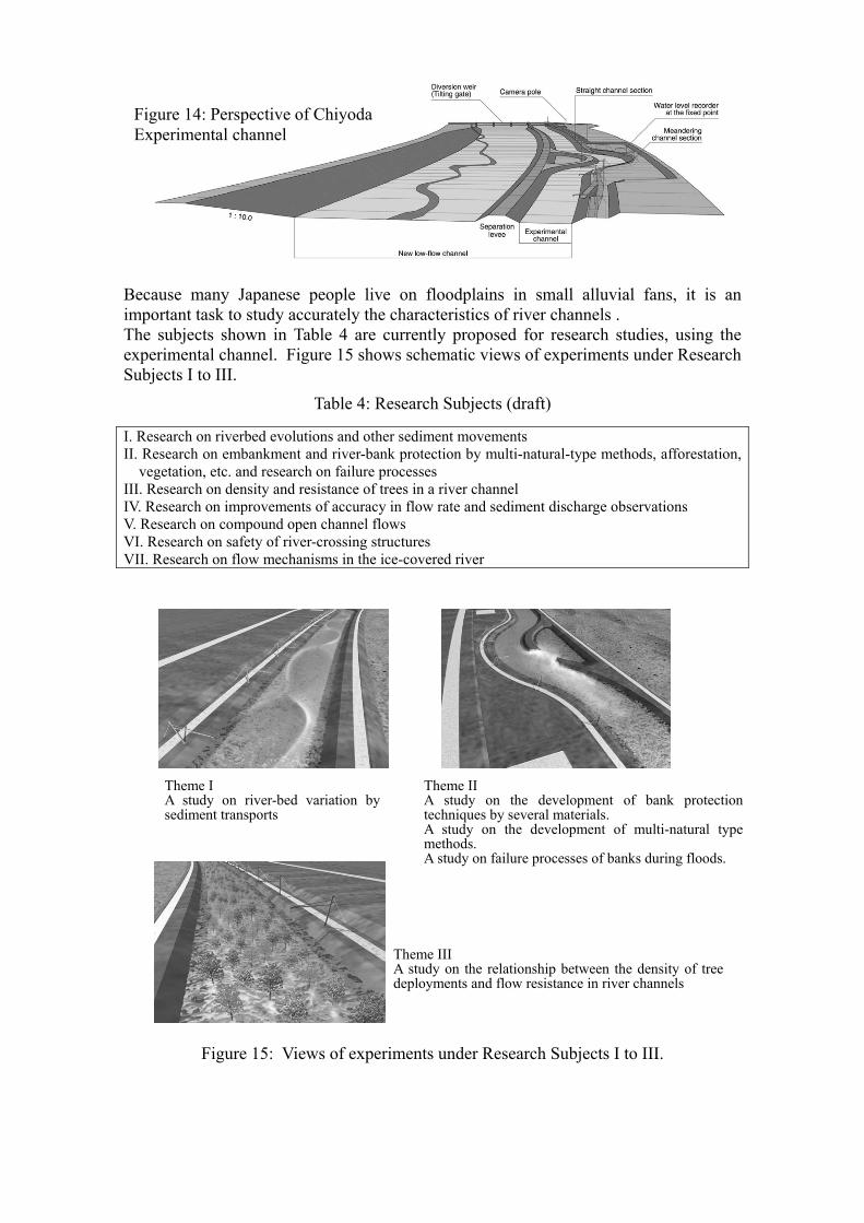
Conception of Chiyoda Experimental Channel The Conception of the Chiyoda Experimental Channel involves construction of a channel downstream of the leftmost gate and supply of water into one of the world’s largest experimental channels at a flow rate close to the maximum of 200 m3/s to conduct a variety of tests and studies on the scale of an actual river. Table 3 and Figs. 13 and 14 show the specifications of the experimental channel.
Table 3: Specifications of Experimental Channel.
Experimental discharge: 0 to 200 m3/s Slope of river bed: 1/500 Basic section: Low-flow channel width 30 m, bank height 4 m, slope gradient 1:2.0 Experimental channel length: straight section 600 m, meandering section 300 m Possible flow rate: 2 m/s (30 m in width) to max. 5 m/s (5 m in width) Riverbed materials: mean particle size 10 to 40 mm, max particle size 50 to 150 mm
Figure 13: Experimental channel plan view.
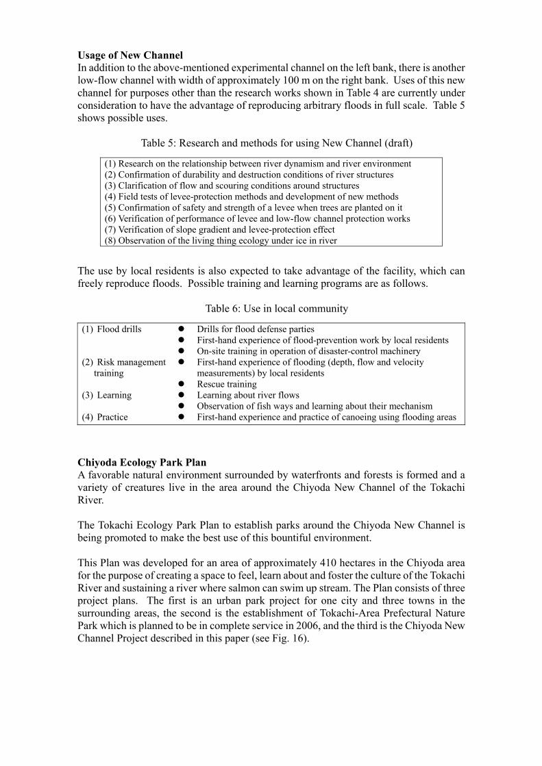
Because many Japanese people live on floodplains in small alluvial fans, it is an important task to study accurately the characteristics of river channels . The subjects shown in Table 4 are currently proposed for research studies, using the experimental channel. Figure 15 shows schematic views of experiments under Research Subjects I to III.
Table 4: Research Subjects (draft)
I. Research on riverbed evolutions and other sediment movements II. Research on embankment and river-bank protection by multi-natural-type methods, afforestation,
vegetation, etc. and research on failure processes III. Research on density and resistance of trees in a river channel IV. Research on improvements of accuracy in flow rate and sediment discharge observations V. Research on compound open channel flows VI. Research on safety of river-crossing structures VII. Research on flow mechanisms in the ice-covered river
Figure 15: Views of experiments under Research Subjects I to III.
Figure 14: Perspective of ChiyodaExperimental channel
Theme I A study on river-bed variation bysediment transports
Theme II A study on the development of bank protectiontechniques by several materials. A study on the development of multi-natural typemethods. A study on failure processes of banks during floods.
Theme III A study on the relationship between the density of treedeployments and flow resistance in river channels
Usage of New Channel In addition to the above-mentioned experimental channel on the left bank, there is another low-flow channel with width of approximately 100 m on the right bank. Uses of this new channel for purposes other than the research works shown in Table 4 are currently under consideration to have the advantage of reproducing arbitrary floods in full scale. Table 5 shows possible uses.
Table 5: Research and methods for using New Channel (draft)
(1) Research on the relationship between river dynamism and river environment (2) Confirmation of durability and destruction conditions of river structures (3) Clarification of flow and scouring conditions around structures (4) Field tests of levee-protection methods and development of new methods (5) Confirmation of safety and strength of a levee when trees are planted on it (6) Verification of performance of levee and low-flow channel protection works (7) Verification of slope gradient and levee-protection effect (8) Observation of the living thing ecology under ice in river
The use by local residents is also expected to take advantage of the facility, which can freely reproduce floods. Possible training and learning programs are as follows.
Table 6: Use in local community
(1) Flood drills (2) Risk management
training (3) Learning (4) Practice
Drills for flood defense parties First-hand experience of flood-prevention work by local residents On-site training in operation of disaster-control machinery First-hand experience of flooding (depth, flow and velocity
measurements) by local residents Rescue training Learning about river flows Observation of fish ways and learning about their mechanism First-hand experience and practice of canoeing using flooding areas
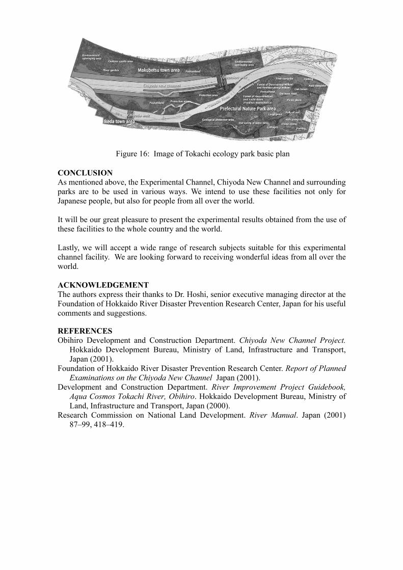
Chiyoda Ecology Park Plan A favorable natural environment surrounded by waterfronts and forests is formed and a variety of creatures live in the area around the Chiyoda New Channel of the Tokachi River. The Tokachi Ecology Park Plan to establish parks around the Chiyoda New Channel is being promoted to make the best use of this bountiful environment. This Plan was developed for an area of approximately 410 hectares in the Chiyoda area for the purpose of creating a space to feel, learn about and foster the culture of the Tokachi River and sustaining a river where salmon can swim up stream. The Plan consists of three project plans. The first is an urban park project for one city and three towns in the surrounding areas, the second is the establishment of Tokachi-Area Prefectural Nature Park which is planned to be in complete service in 2006, and the third is the Chiyoda New Channel Project described in this paper (see Fig. 16).
CONCLUSION As mentioned above, the Experimental Channel, Chiyoda New Channel and surrounding parks are to be used in various ways. We intend to use these facilities not only for Japanese people, but also for people from all over the world. It will be our great pleasure to present the experimental results obtained from the use of these facilities to the whole country and the world. Lastly, we will accept a wide range of research subjects suitable for this experimental channel facility. We are looking forward to receiving wonderful ideas from all over the world. ACKNOWLEDGEMENT The authors express their thanks to Dr. Hoshi, senior executive managing director at the Foundation of Hokkaido River Disaster Prevention Research Center, Japan for his useful comments and suggestions. REFERENCES Obihiro Development and Construction Department. Chiyoda New Channel Project.
Hokkaido Development Bureau, Ministry of Land, Infrastructure and Transport, Japan (2001).
Foundation of Hokkaido River Disaster Prevention Research Center. Report of Planned Examinations on the Chiyoda New Channel Japan (2001).
Development and Construction Department. River Improvement Project Guidebook, Aqua Cosmos Tokachi River, Obihiro. Hokkaido Development Bureau, Ministry of Land, Infrastructure and Transport, Japan (2000).
Research Commission on National Land Development. River Manual. Japan (2001) 87–99, 418–419.
Figure 16: Image of Tokachi ecology park basic plan