Embed Size (px)
Citation preview
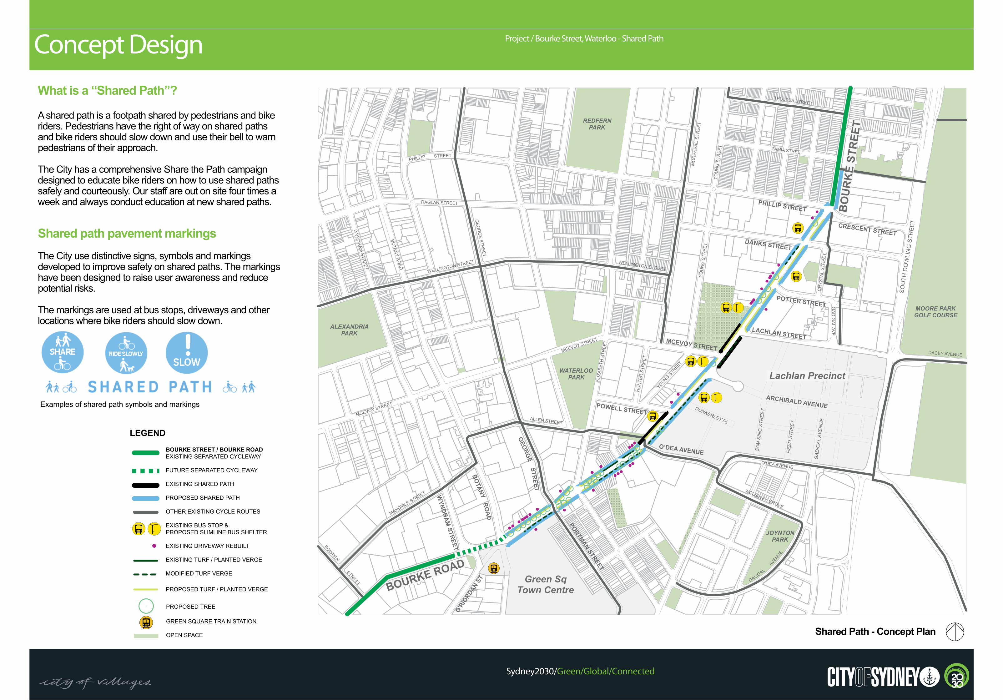
What is a “Shared Path”?
A shared path is a footpath shared by pedestrians and bike riders. Pedestrians have the right of way on shared paths and bike riders should slow down and use their bell to warn pedestrians of their approach.
The City has a comprehensive Share the Path campaign designed to educate bike riders on how to use shared paths safely and courteously. Our staff are out on site four times a week and always conduct education at new shared paths.
Shared path pavement markingsThe City use distinctive signs, symbols and markings developed to improve safety on shared paths. The markings have been designed to raise user awareness and reduce potential risks.
The markings are used at bus stops, driveways and other locations where bike riders should slow down.
Project / Bourke Street, Waterloo - Shared PathConcept Design
Sydney2030/Green/Global/Connected
Shared Path - Concept Plan
Examples of shared path symbols and markings
TELOPEA STREET
PHILLIP STREET
CRESCENT STREET
SOU
TH D
OW
LIN
G S
TREE
T
ZAMIA STREET
LACHLAN STREET
DACEY AVENUE
O'DEA AVENUE
MCEVOY STREET
ELIZ
ABET
H S
TREE
T
ARCHIBALD AVENUE
YOUNG STR
EET
HU
NTE
R S
TREE
T
MO
REH
EAD
STR
EET
WELLINGTON STREETWELLINGTON STREET
MANDIBLE STREET
ALLEN STREET
WOLSELEY GROVE
GALIGAL
AVENUE
REDFERNPARK
WATERLOOPARK
MOORE PARKGOLF COURSE
JOYNTONPARK
O'RIO
RDAN
ST
MCEVOY STREET
POWELL STREET
O’DEA AVENUE
GEO
RGE
BOTANY
RO
AD
WYNDHAM
STREET
DANKS STREET
POTTER STREET
ALEXANDRIAPARK
MCEVOY STREET
GEO
RG
E STREET
PHILLIP STREET
RAGLAN STREET
WYN
DH
AM STR
EET
BOTAN
Y RO
AD
BOWDEN
STREET
STREET
PORTMAN STREET
YOU
NG
STR
EET
YOU
NG
STR
EET
DUNKERLEY PL
SAM
SIN
G S
TREE
T
GAD
IGAL
AVE
NU
E
REE
D S
TREE
T
Green SqTown Centre
EVA
LA
GID
AG
CR
YSTA
L ST
REE
T
Lachlan Precinct
BO
UR
KE
STR
EET
BOURKE ROAD
BOURKE STREET / BOURKE ROAD
EXISTING SEPARATED CYCLEWAY
FUTURE SEPARATED CYCLEWAY
EXISTING SHARED PATH
PROPOSED SHARED PATH
OTHER EXISTING CYCLE ROUTES
EXISTING BUS STOP &
PROPOSED SLIMLINE BUS SHELTER
EXISTING DRIVEWAY REBUILT
EXISTING TURF / PLANTED VERGE
MODIFIED TURF VERGE
PROPOSED TURF OR PLANTED VERGE
GREEN SQUARE TRAIN STATION
OPEN SPACE
LEGEND
PROPOSED TREE
BOURKE STREET / BOURKE ROADEXISTING SEPARATED CYCLEWAY
FUTURE SEPARATED CYCLEWAY
EXISTING SHARED PATH
PROPOSED SHARED PATH
OTHER EXISTING CYCLE ROUTES
EXISTING BUS STOP & PROPOSED SLIMLINE BUS SHELTER
EXISTING DRIVEWAY REBUILT
EXISTING TURF / PLANTED VERGE
MODIFIED TURF VERGE
PROPOSED TURF / PLANTED VERGE
GREEN SQUARE TRAIN STATION
OPEN SPACE
LEGEND
PROPOSED TREE
Project / Bourke Street, Waterloo - Shared PathDesign Safety Features
Sydney2030/Green/Global/Connected
BOURKE STREET CYCLE NETWORK (WATERLOO) I STAGE 2 CONCEPT DESIGN 20REVISED CONCEPT NOVEMBER 2013
2.5
P A T H S H A R E DP A T H S H A R E D
Concept DesignBourke Street - Bus Stop
New bus stop layout provides greater access and visibility and provides a 2m wide path of travel behind the shelter.
SLO
WD
RIVE
WAY
SLOW
DRIVEW
AY
2.5
DRIVEW
AYD
RIVEWAY
DRIVEW
AY
P A T H S H A R E D
BOURKE STREET CYCLE NETWORK (WATERLOO) I STAGE 2 CONCEPT DESIGN 22
Concept DesignBourke Street - Driveway Treatment
REVISED CONCEPT NOVEMBER 2013
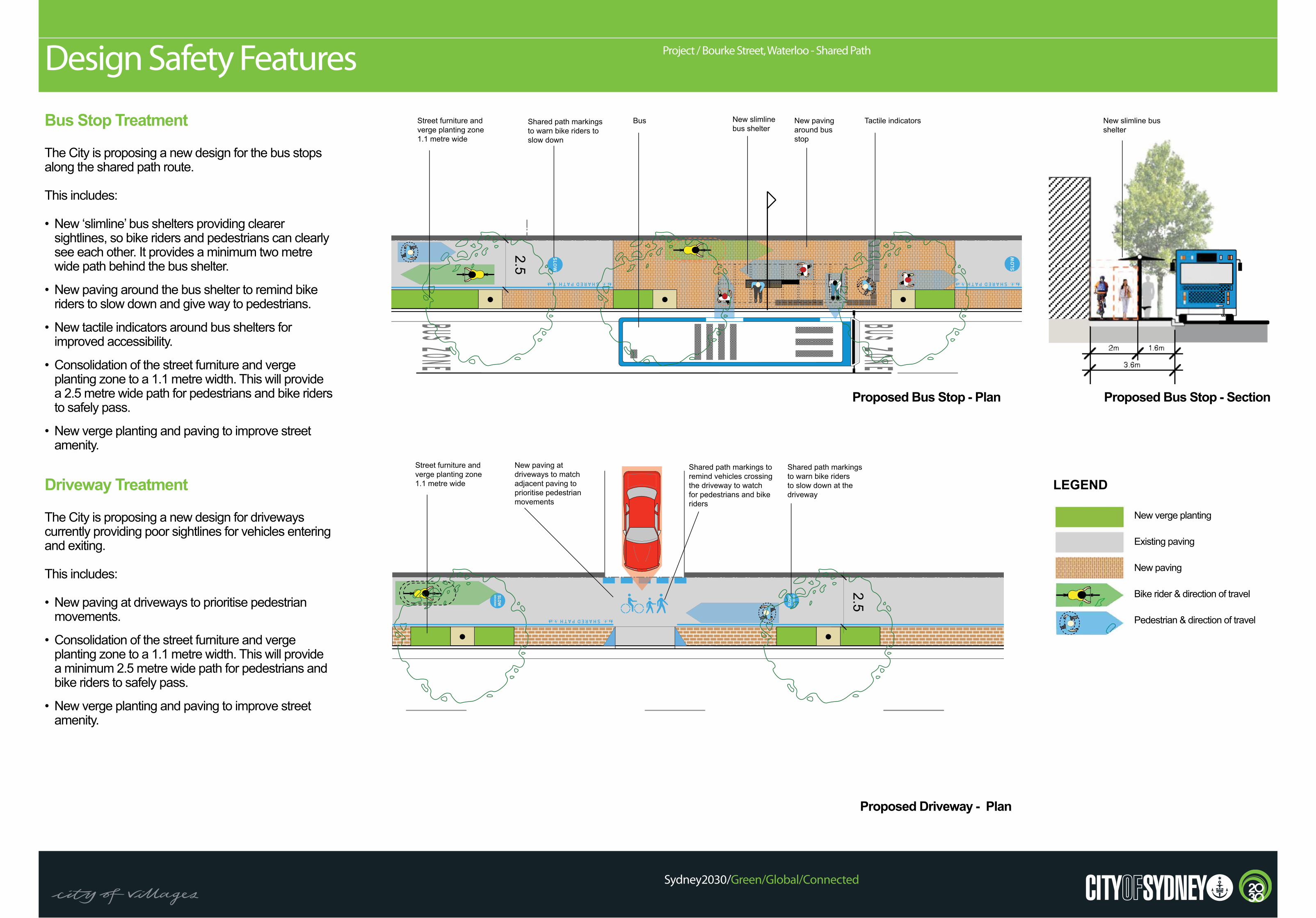
Bus Stop Treatment
The City is proposing a new design for the bus stops along the shared path route.
This includes:
• New ‘slimline’ bus shelters providing clearer sightlines, so bike riders and pedestrians can clearly see each other. It provides a minimum two metre wide path behind the bus shelter.
• New paving around the bus shelter to remind bike riders to slow down and give way to pedestrians.
• New tactile indicators around bus shelters for improved accessibility.
• Consolidation of the street furniture and verge planting zone to a 1.1 metre width. This will provide a 2.5 metre wide path for pedestrians and bike riders to safely pass.
• New verge planting and paving to improve street amenity.
Driveway Treatment
The City is proposing a new design for driveways currently providing poor sightlines for vehicles entering and exiting.
This includes:
• New paving at driveways to prioritise pedestrian movements.
• Consolidation of the street furniture and verge planting zone to a 1.1 metre width. This will provide a minimum 2.5 metre wide path for pedestrians and bike riders to safely pass.
• New verge planting and paving to improve street amenity.
Proposed Bus Stop - Plan
Proposed Driveway - Plan
Proposed Bus Stop - Section
Street furniture and verge planting zone 1.1 metre wide
New slimline bus shelter
New paving around bus stop
Tactile indicators New slimline bus shelter
Street furniture and verge planting zone 1.1 metre wide
BusShared path markings to warn bike riders to slow down
Shared path markings to warn bike riders to slow down at the driveway
Shared path markings to remind vehicles crossing the driveway to watch for pedestrians and bike riders
New paving at driveways to match adjacent paving to prioritise pedestrian movements
LEGEND
New verge planting
Existing paving
New paving
Bike rider & direction of travel
Pedestrian & direction of travel
Project / Bourke Street, Waterloo - Shared PathDesign Safety Features
Sydney2030/Green/Global/Connected
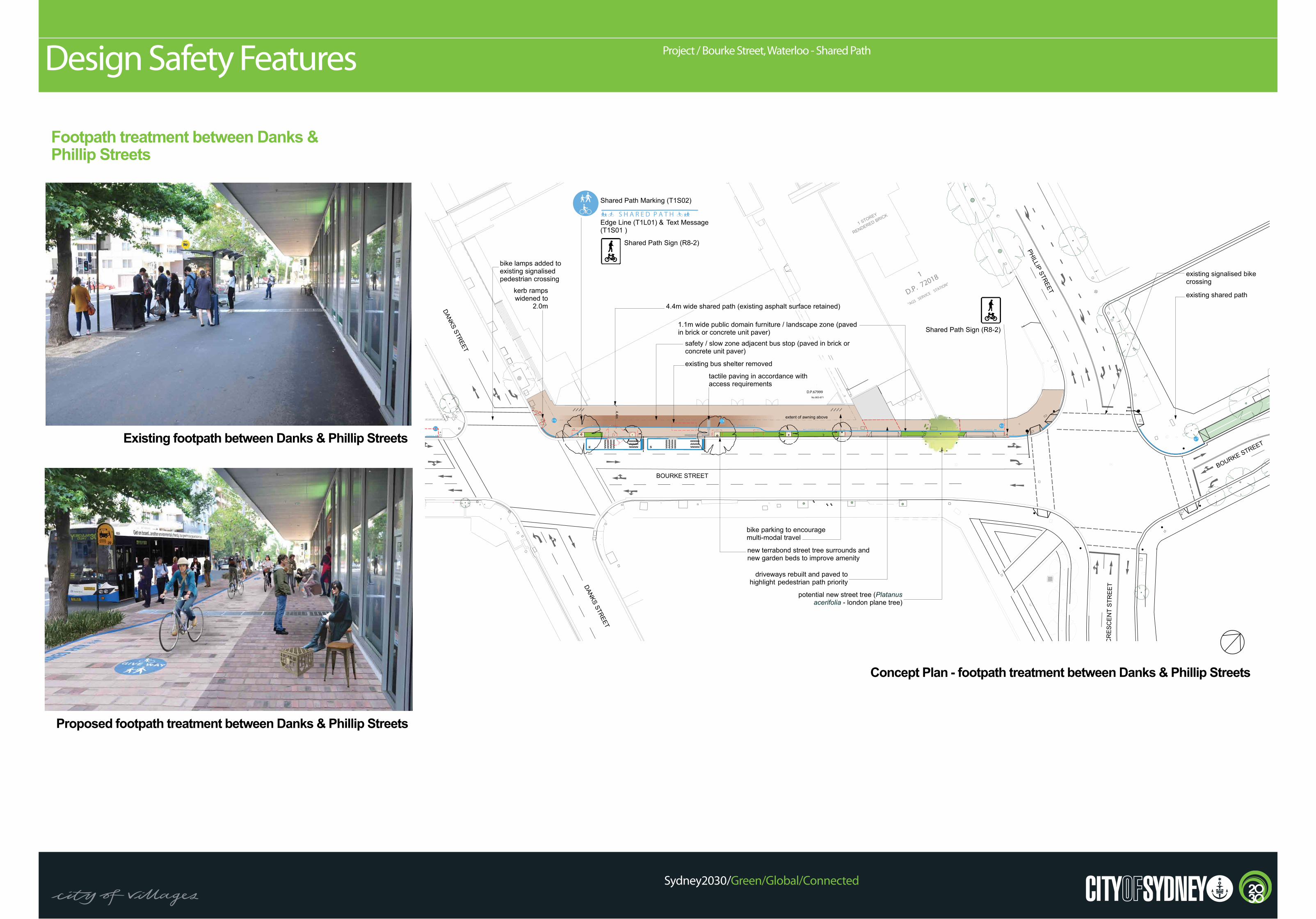
Footpath treatment between Danks & Phillip Streets
Existing footpath between Danks & Phillip Streets
Proposed footpath treatment between Danks & Phillip Streets
Concept Plan - footpath treatment between Danks & Phillip Streets
SHEETTCEJORPTNEILC DRAWING TITLESCALE
www.spackmanmossopmichaels.comREV AMENDMENT DESCRIPTION INITIAL DATE
1:250 @ A3
CONCEPT PLANDanks St to Phillip St
PTY LTD ABN 65 065 578 985
P.O. Box 880Darlinghurst NSW 13003 Oxford St Paddington NSW
LANDSCAPE ARCHITECTSN
SW
E
TRANSPORT PLANNERS & TRAFFIC ENGINEERS
GPO Box 5394Sydney NSW 2001
Tel: +61 2 9272 5100Fax: +61 2 9272 5101
www.pbworld.com
PARSONS BRINCKERHOFF
Tel: +61 2 8241 9900Fax: +61 2 9272 5101
ACCESS CONSULTANTS
1.06/56 Bowman StreetPyrmont NSW 2009
Tel: +612 9692 9322
www.mgac.com.au
MGAC
CIVIL ENGINEERS
GPO Box 5612West Chatswood NSW 2067www.woolacotts.com.au
WOOLACOTTS Bourke Street Cycle Network (Waterloo)Feasibility & Concept StudyA CONCEPT OPTION 5 - Draft for Comment MD 14.11.13
CP 004
P A T H S H A R E D
NGIS 352
DANKS STREET
DANKS STREET
1
D.P.67999
571
D.P.1093479
A HT
"ARAIT"887.oN
8 YEROTS ETERCNOC STNEMTRAPA
No.863-871
EKRUOB TEERTS O EKRU TEERTS
BOURKE STREET
PHILLIP STREET
TN
EC
SE
RC
T
EE
RTS
E
"AGS SERVICE STATION"
1 STOREY
RENDERED BRICK
1
D.P. 72018
2
D.P. 701617
4.4
m
P A T HS H A R E D
Shared Path Marking (T1S02)
Edge Line (T1L01) & Text Message(T1S01 )
Shared Path Sign (R8-2)
tactile paving in accordance withaccess requirements
4.4m wide shared path (existing asphalt surface retained)
existing bus shelter removed
safety / slow zone adjacent bus stop (paved in brick orconcrete unit paver)
1.1m wide public domain furniture / landscape zone (pavedin brick or concrete unit paver)
existing shared path
new terrabond street tree surrounds andnew garden beds to improve amenity
Shared Path Sign (R8-2)
bike lamps added toexisting signalisedpedestrian crossing
driveways rebuilt and paved tohighlight pedestrian path priority
bike parking to encouragemulti-modal travel
existing signalised bikecrossing
kerb rampswidened to
2.0m
extent of awning above
potential new street tree (Platanusacerifolia - london plane tree)
P A T H S H A R E D P A T H S H A R E D
P A S H A R E D HT P A T H S H A R E D