Embed Size (px)
Citation preview
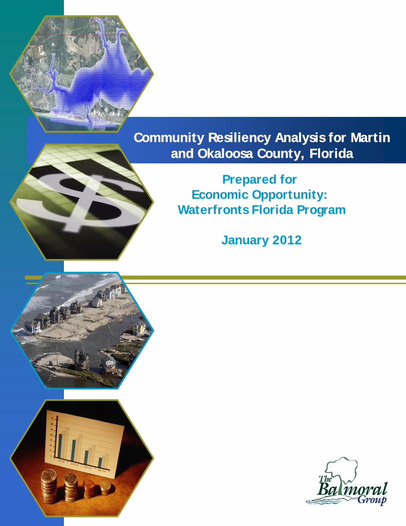
Community Resiliency Analysis for Martin and Okaloosa County, Florida
Community Resiliency Analysis for Martin and Okaloosa County, Florida
Prepared for Economic Opportunity:
Waterfronts Florida Program
January 2012
Community Resiliency Analysis
Martin and Okaloosa County
January 2012
Table of Contents
Summary of Cost Benefit Analysis ............................................................................................................ 3
Cost Benefit Analysis under future scenarios ......................................................................................... 11
Options for Planning Language .............................................................................................................. 15
Conclusions ........................................................................................................................................... 15
Appendix ............................................................................................................................................... 16
Template I ......................................................................................................................................... 16
Template II ......................................................................................................................................... 20
List of Tables
Table 1. Application of Values to Coastal Resiliency Strategy ................................................................... 4
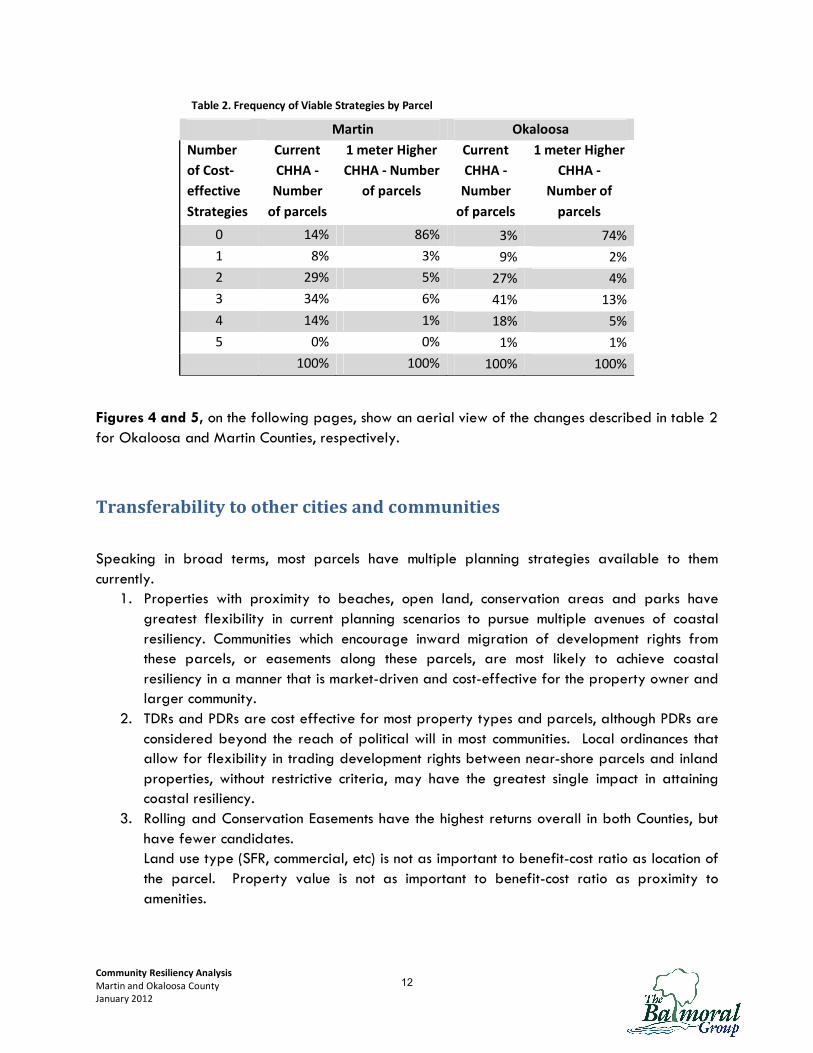
Table 2. Frequency of Viable Strategies by Parcel .................................................................................. 12
List of Figures
Figure 1. Damage from Hurricane Floyd, 09/1999 .................................................................................... 2
Figure 2. Cost Benefit Ratios of Okaloosa County Parcels for TDRs ........................................................... 6
Figure 3. Cost Benefit Ratios of Okaloosa County Parcels for Armoring .................................................... 6
Figure 4. Coastal Resiliency Strategy Effectiveness Rating - Okaloosa County ......................................... 13
Figure 5. Coastal Resiliency Strategy Effectiveness Rating - Martin County ............................................ 14
1

Community Resiliency Analysis
Martin and Okaloosa County
January 2012
Introduction
As Hurricane Irene demonstrated recently along the Eastern seaboard, even a relatively mild
storm can cause enormous damage to coastal communities. When coastal properties become
uninhabitable and roads impassable, the entire community sees the loss of economic output.
Beach front properties are highly coveted, but also vulnerable to erosion, inundation, storm
damage, and insurance risk. How does a coastal
community balance the value of coastal economic
development with the increasing costs of storm repairs as the
shoreline shifts and changes? How do public officials in
coastal communities encourage inland migration of coastal
development activity to minimize loss of property or lives?
In most Florida communities, waterfront property was
developed decades ago, and initial development of a parcel
is rarely the condition faced by local planning or permitting
authorities. Over the past fifteen years, stricter rules
governing beachfront construction that reflect
acknowledgment of a constantly changing shoreline have
been implemented throughout Florida. As a result, the
shoreline looks very different than it would have had
construction continued unabated.
Today, most coastal communities face few planning decisions
that would convert undeveloped land to new development.
Rather, likely scenarios are redevelopment of previously built
areas as part of economic revitalization efforts, or rebuilding
after a disaster, most likely a hurricane. Landowners face a
choice after storm damage: to rebuild a pre-storm structure,
or pursue other options. Coastal communities need to be
prepared with flexible options and desirable alternatives for
the landowner. By having the building blocks in place in
advance, a landowner can weigh the outcomes and determine
if building elsewhere may be in his or her best interest.
Communities with clear objectives to achieve coastal resiliency
have tools at their disposal. Coastal resiliency implies
reducing the risk of loss of life and property, and reducing
the municipal costs of servicing coastal properties and
infrastructure. In both cases, gradually reducing density along
Figure 1. Damage from Hurricane Floyd, 09/1999
2
Community Resiliency Analysis
Martin and Okaloosa County
January 2012
the coast while increasing density elsewhere provides a clear transition process for both the
property owner and community.
Which planning tools are likely to achieve the coastal resiliency objectives? Economic concerns or
potential legal ramifications often outweigh the most well-intentioned planning strategies, and
many planning exercises work beautifully on paper but drown in bureaucracy on the way to
implementation. With scarce resources, it is important that communities weigh both the social and
economic costs of different strategies, as well as the social and economic benefits. This study
evaluates the costs and benefits, at the County level, for seven planning strategies: transfers of
development rights, purchase of development rights, buy-outs, rolling easements, conservation
easements, land use designation changes, and armoring.
An underlying assumption to the analysis is that development rights have value, and the free
market recognizes this value. In communities where landowners can change the development
rights associated with their land readily and without committing to achieving community objectives,
development rights will not have economic value, and cannot be used effectively as incentives.
Likewise, there will be little opportunity to create incentives if a community has zoned properties
to achieve high density in areas where there is no demand. Current practices toward granting
development rights that are at odds with existing Comprehensive Plans or Zoning require careful
and realistic consideration. To achieve success with any incentive-based planning tool,
development rights must be treated as having economic value.
A series of Technical Memoranda precede this report. The Technical Memos set out the underlying
assumptions, literature citations, and legal precedent where appropriate, and rationale for the
measures used in each cost-benefit calculation. This report briefly summarizes the underpinnings of
the analysis, and shows how the results of the cost-benefit analysis may be generalized to other
cities and communities not included in the project scope.
Summary of Cost Benefit Analysis
The analysis process began with a series of decision rules designed to ensure transferability to
other coastal areas. The universe of parcels included was determined to be all parcels in the
Coastal High Hazard Area (CHHA). Analysis was first completed at the parcel level on every
single family residential (SFR) parcel, for each strategy. The parcel-level cost benefit analysis
estimates the measurable impacts a policy change has on all people (or communities) in each
county over a twenty year period. These impacts are monetized to quantify the impacts in dollar
terms. The dollar value of each impact is discounted into current (net present value) dollars for
comparison across policy alternatives.
Examination of the results found that benefit-cost ratios followed distinct spatial patterns, based
on their proximity to specific amenities, such as beach recreation areas, or conservation lands. For
land use types besides single family residential, the cost and benefits previously applied to all
residential properties are applied to a subset of multi-family residential and commercial
3
Community Resiliency Analysis
Martin and Okaloosa County
January 2012
properties for regions characterized as having a high, medium, or low number of viable
mitigation strategies. Thus all commercial properties within a prototypical area were assembled
for geographical areas with high, average, and low access to the amenities driving the benefit-
cost ratio. The purpose of this approach is to isolate the effects of commercial property
characteristics versus residential, in the same location.
A list of costs and benefits associated with each strategy was generated, including
1. Acquisition costs – to buy land, easements, or development rights
2. Construction costs – for armoring or demolition 3. Administrative costs – to oversee programs such as Transfers of Development Rights,
conservation easements, or land acquisition.
4. Avoided costs of municipal services – for properties that no longer need fire, water or
sewer services
5. Amenity values – values the public is willing to pay for open space, conservation land, recreational amenities, or ecological protection
6. Foregone revenues – such as future rents if a property is not rebuilt after a storm
Table 1 summarizes the specific cost-benefit measures applied to each strategy.
Table 1. Application of Values to Coastal Resiliency Strategy
Coastal Resiliency Strategy
Impact
Transfers of
development
rights
Purchase of
development
rights
Rolling
easements
Conservation
easements
Land use
designation
changes Buy-outs Armoring
Criteria
Construction Cost of
Armoring X N/A X
Acquisition Cost of Land or Easement X X X N/A X
Foregone Tax Revenue X X N/A X
Administrative Costs X
Avoided Costs of
Municipal Service X X X N/A X
Rental Income X N/A X
Costs of Accelerated
Development X N/A
Exchange of
Development Values X N/A
Value of Conservation
Land and Open space X X X X N/A X X
Wetland Values;
Amenity Values or
Migration X X X X N/A X X
Beach – Ecological
Value X X X
Beach - Recreation
Values X X X X N/A X X
4

Community Resiliency Analysis
Martin and Okaloosa County
January 2012
Research was completed to calculate measures for each cost and benefit at the parcel level, and
to determine which parcels are candidates for which strategies. Technical memoranda were
prepared supporting the measures chosen for each cost and benefit calculation, and calculations
were completed.
A strategy is considered viable if benefits exceed costs. Analysis was performed to identify
which strategies were viable for each parcel. Cost-effectiveness varied widely at the parcel
level, and followed distinct spatial patterns. Properties closest to most amenities have the most
strategies that are feasible. Generally speaking, properties with the highest property values
have the fewest strategies that are cost-effective.
Costs and benefits vary widely at the parcel level. An oceanfront home faces different options
for coastal resiliency than a parcel that is further distanced from the direct energy of waves, and
offers different ecological services, aesthetics, and engineering challenges. Cost-Benefit Analyses
described herein are conducted at the parcel level, using automated GIS techniques for thousands
of parcels in each County. Benefits vary by option and by parcel as described for each strategy
and may include social benefits such as continued access to public beaches and recreational
values, or environmental benefits such as habitat for sea turtle nesting or wetland migration, while
costs may include engineering costs as well as foregone revenue from taxes, or loss of wetland
migration paths.
The ratio of benefits to costs gives a measure of the return for costs expended; if the benefit: cost
ratio is 2:1, the implication is that, on average, for each dollar of cost, two dollars in benefits
were returned. The examples in Figures 2 and 3 show how benefit ratios vary for two different
strategies in the same county. The strategies illustrated here, Transfers of Development Rights
(TDRs) and Armoring, are discussed in detail in the following section, but are used here to show
how benefit ratios vary across parcels and strategies.1 TDRs have benefits greater than 1.0, or
benefits that exceed costs, for 2,490 residential parcels in the Okaloosa CHHA, while for 456
residential parcels, the ratio is less than 1.0, or costs exceed benefits. Over all Okaloosa CHHA
parcels, the average is 1.69; for every $100 in community costs, the community receives $169 in
benefits. The ratio varies widely across parcels, ranging from 0.24 to more than 5.0 (See Figure
2, where red columns indicate parcels that are not viable, and blue columns indicates the
number of parcels with positive ratios). In contrast, Figure 3 shows that Okaloosa County has
relatively large number of parcels that are not viable candidates for armoring, with an average
benefit ratio of 1.15, and maximum benefits under 3.
1 A prototypical Transfer of Development Rights (TDR) Program allows landowners to transfer the right to develop from one parcel of land to a different parcel of land, and helps shift development from sensitive areas to designated growth areas with access to services. Shoreline armoring means engineered structures built along the water’s edge intended to stop or slow erosion of the shoreline.
5
Community Resiliency Analysis
Martin and Okaloosa County
January 2012
Figure 2. Cost Benefit Ratios of Okaloosa County Parcels for TDRs
Figure 3. Cost Benefit Ratios of Okaloosa County Parcels for Armoring
Overall, the analysis found that multiple strategies were cost-effective for the vast majority of
single family residential parcels. In Okaloosa County, for example, out of 3,000 CHHA parcels,
all but 38 had more than one cost-effective strategy. For multi-family, commercial and industrial
land use types, spatial patterns generally mirrored SFR results. Some land use types showed
greater variation in benefit-cost ratios than SFR parcels; others showed more amplified benefits.
Average for all
parcels = 1.69
Average for all
parcels = 1.15
6
Community Resiliency Analysis
Martin and Okaloosa County
January 2012
In general, land use type (SFR, commercial, etc) is not as important to benefit-cost ratio as location
of the parcel. Property value is not as important to benefit-cost ratio as proximity to amenities.
The following sections identify key characteristics of each policy that drive the cost benefit results,
as well as specific features that may make that policy an effective strategy.
Incentive-Based Approaches
An underlying assumption to the analysis is that development rights have value, and the free
market recognizes this value. In communities where landowners can change the development
rights associated with their land readily and without committing to achieving community objectives,
development rights will not have economic value, and cannot be used effectively as incentives.
Likewise, there will be little opportunity to create incentives if a community has zoned properties
to achieve high density in areas where there is no demand. Current practices toward granting
development rights that are at odds with existing Comprehensive Plans or Zoning require careful
and realistic consideration. To achieve success with any incentive-based planning tool,
development rights must be treated as having economic value.
Incentive based approaches are cost effective for most property types and parcels. The average
benefit ratio for Transfers of Development Rights (TDRs) is 1.69 and 1.77 for Okaloosa and
Martin Counties, respectively. While Purchase of Development Rights (PDRs) has higher benefit
ratio averages of 3.61 and 3.21 for Okaloosa and Martin Counties, PDRs are considered beyond
the reach of political will in most communities. Local ordinances that allow for flexibility in trading
development rights between near-shore parcels and inland properties, without restrictive criteria,
may have the greatest single impact in attaining coastal resiliency
Transfers of Development Rights
Transfers of Development Rights or “TDRs” may be used to promote coastal resiliency by
providing landowners with alternatives to rebuilding in the CHHA after a storm. As set forth in the
Technical Memorandum, TDRs have failed to be used in most communities because of the
burdensome regulations and narrowly defined rules that have accompanied their introduction.
TDRs are most likely to be effective if the landowner sees opportunity for flexibility in exercising
his rights of property ownership. Research within Florida has found that many TDR transactions
have occurred outside a formal program, as an ad hoc situation to achieve the objectives of both
the landowner and local government.
Although TDRs have typically been envisioned as a tool to control residential density on
undeveloped land, it may be more useful to think of TDRs as a tool to migrate intense land uses
inward. Accordingly, land uses other than residential may be just as appropriate for TDR
transactions. If the current land use on a beachfront piece of property is commercial, the
community has just as much interest in transferring this land use landward as if it is residential. Thus
after a storm, the owner may rebuild on the property, transfer, or sell the development rights so
7
Community Resiliency Analysis
Martin and Okaloosa County
January 2012
that an inland piece of property may be developed or redeveloped at a substantially higher
density.
A useful example arose in Satellite Beach, Florida, when City officials negotiated with the owner
of a destroyed oceanfront hotel. Rather than rebuild, the owner donated the parcel as public
land, and rebuilt at higher density inland. The oceanfront site has reverted to natural land, and
the properties across the street will be the next oceanfront parcels as the natural site continues to
erode. Thus tax values will also migrate inland, as rebuilding events occur gradually over
decades.
All parcels within the CHHA were considered potential TDR candidates. Generally speaking, the
costs and benefits are driven by development values, administrative costs, and nonmarket costs to
the community of accelerated development in the receiving area for development.
Purchase of Development Rights
As set forth in the introduction of this section, development rights have value in communities that
utilize development rights as having value. In theory, development rights can be bought and sold:
a landowner who has accumulated development credits in excess of what he or she requires can
sell the credits to another landowner, or to the local government, to be used elsewhere. A
purchase of development rights by local government can be viewed as analogous to a
corporation buying back its stock; if the County wishes to limit development, reducing the total
quantity of development rights available increases the value of remaining development rights in
circulation.
All parcels within the CHHA were considered potential PDR candidates. The costs and benefits of
PDRs are driven by development values, administrative costs, and nonmarket costs to the
community of accelerated development in the receiving area for development.
Ownership-Based Approaches
Ownership approaches have the highest returns overall in both Counties, but have fewer
applicable candidates. Benefit ratios for conservation easements average over 50 for both
counties. Rolling easements average benefit ratios of 2.47 and 1.49 for Okaloosa and Martin
Counties respectively, but nearly every qualified parcel shows a benefit ratio greater than one.
Land acquisition benefit ratios average below one, indicating that only a few parcels are good
candidates for acquisition.
Conservation Easements
Conservation easements restrict the right to future development of defined parcels, or portions
thereof, in exchange for cash or tax benefits. Conservation easements negotiated with the
objective of coastal resiliency are likely to be motivated primarily by tax benefits combined with
a desire for the land to remain undeveloped.
8

Community Resiliency Analysis
Martin and Okaloosa County
January 2012
All parcels within the CHHA with proximity to wetlands, conservation lands, or the shoreline, were
considered potential conservation easement candidates. The cost of a conservation easement is
the market value of the future net income lost due to restrictions on future development; past
transactions were used to estimate approximate costs. The benefits of conservation easements are
estimated based on the value of ecosystem services that are generated by the specific easement.
Rolling Easements
Rolling Easements exchange foregone future revenues from development or continued use for a
current payment. A rolling easement can be applied to a property deed at the time of
development (which would lower the property value) or it can be purchased in a fashion
analogous to a conservation easement. In effect, a rolling easement allows a landowner a gentle
transition to a future moment in time when rebuilding will no longer be an option; until that
moment, the landowner may continue to rent, develop or otherwise use the property in permissible
uses as if the easement had not been granted. The easement prevents the owner from taking
steps to delay or prevent the encroachment of the coastline. A critically important component of a
rolling easement is that it provides advanced notice to property owners that their land must at
some point revert to public or natural use. It is in this capacity that rolling easements can be used
most beneficially with developed parcels.
All waterfront parcels within the CHHA below the elevation of the evacuation route were
considered potential rolling easement candidates. The costs associated with a rolling easement
scenario include monetary consideration given in exchange for the rolling easement payment, and
likely demolition costs of any structures on the property. For current conditions, the demo cost
would be zero, as rolling easements assume that only a future condition would create a need to
exercise the easement option. In subsequent reports that consider future conditions, demo costs will
be a factor.
Social benefits depend on location of the parcel and may include the value of preserved or
reclaimed environmentally sensitive lands and/or public access to open lands, as well as avoided
costs of municipal services to vulnerable shoreline properties.
Land Acquisition
Land has been acquired in both Martin and Okaloosa County to achieve community objectives
where repeated flooding events have occurred or environmentally sensitive lands have been
purchased to protect native habitats. Land acquisition programs require taxpayer funding:
environmental stewardship programs typically rely on a local millage dedicated to that purpose,
while flooding properties may be purchased by the City/County using federal grant money. In
the former case, a citizen panel often reviews potential parcels for purchase and prioritizes
based on established protocol and specific characteristics, within a predetermined budget
amount. Land that is acquired must also be maintained in perpetuity, and is removed from the
tax rolls permanently, so there are considerations beyond the immediate purchase transaction
that must be considered in an acquisition decision.
9
Community Resiliency Analysis
Martin and Okaloosa County
January 2012
In the case of Coastal Resiliency, prioritization of acquisition efforts is likely to focus on parcels
with repeated inundation or projected inundation at high frequency, in vulnerable evacuation
zones, or subject to critical erosion events (in many cases, these attributes overlap). Acquisition for
coastal resiliency implies that the parcel is restored to its natural state. The costs include the actual
purchase price, legal costs, and loss of tax revenue to the County. If demolition or restoration is
necessary, that is an additional cost.
All waterfront parcels within the CHHA below the elevation of the evacuation route were
considered potential acquisition candidates. The benefits may include avoided costs of damage
repair, environmental or recreational benefits to the public depending on the site location, and
avoided costs of continued municipal services. In many cases in other states, the acquiring body
rents the parcel for a few years to maintain revenue temporarily, which may offset demolition
costs.
Land Use Designation Changes
Land Use designation changes include changes to the zoning of a parcel or to the future land use
as designated in the county’s Comprehensive Plan. All of the planning strategies discussed in this
report incorporate some sort of land use assumption; that development rights associated with the
existing land use can be sold or transferred to a different locale, or that a portion of the existing
property rights can be sold or transferred under an easement. If used instead as a stand-alone
policy strategy, land use designation changes that would improve coastal resiliency are likely to
also diminish property rights. There are sufficient legal precedents defeating measures that
diminish property rights without compensation to negate the need for analysis of land use
designation changes as a separate strategy. Accordingly, land use designation changes outside
of those embedded as part of a larger strategy were not analyzed for full cost-benefit
calculations.
Physical Protection
Physical protection generally may be a viable strategy for a similar number of parcels as
ownership based approaches, but with lower average benefit ratios of 1.15 and 1.77 for
Okaloosa and Martin Counties respectively. Some negative impacts of physical measures, such as
increased erosion on adjacent properties were not quantified in this analysis.
Shoreline Armoring
For purposes of this report, shoreline armoring means engineered structures built along the water’s
edge intended to stop or slow erosion of the shoreline. Although armoring structures are mostly
effective at meeting this objective, there are numerous negative consequences associated with
their construction. Among these are accelerated erosion of adjacent properties, habitat
displacement, and limited beach access to the public. As a result, the use of coastal armoring is
typically considered the last or most extreme option in addressing a coastal erosion problem.
A primary motivator for armoring is the assumption that, without it, a property may be
uninhabitable within a short period of time. Costs and benefits of armoring are calculated using
10
Community Resiliency Analysis
Martin and Okaloosa County
January 2012
the topography of the parcel in question, all of which must border coastal waters to be
considered. The value associated with extending the period of time that a property may be useful
can be measured using rents; a benefit associated with the armoring is the market value of rents
a beachfront parcel could generate if protected.
Cost Benefit Analysis under future scenarios
To evaluate the effects of future scenarios, the CHHA line was migrated inland 1meter of
elevation. In some areas this equates a few feet inland, while in other areas this is a much
greater distance inland, depending on local slope. This analysis estimates the net present value
of the costs and benefits generated by policy alternatives applied after significant inundation has
occurred. When cost benefit calculations post inundation are compared to previous estimates,
substantial changes to viable strategies can be identified. Important trends across policies
include:
• The vast majority of parcels have less than two viable strategies. Under the current-day
scenario, the opposite was true – over 70% of parcels had two or more viable strategies.
• One reason is that many properties are lost to inundation, either because the parcel is
inundated or access to it is blocked by inundation.
• Another reason is that properties with proximity to more amenities under current CHHA
lost a greater proportion of viable strategies under the future CHHA.
• A notable consequence is that properties with proximity to fewest amenities may have no
cost-effective strategies as shorelines move inland.
• The change in viability for each strategy varied by county, and is directly linked to local
topography.
Table 2 shows the sharp increase in the number of parcels with no viable strategy. It also shows
the large percent reduction in the number of parcels with four and five viable strategies.
11
Community Resiliency Analysis
Martin and Okaloosa County
January 2012
Table 2. Frequency of Viable Strategies by Parcel
Martin Okaloosa
Number
of Cost-
effective
Strategies
Current
CHHA -
Number
of parcels
1 meter Higher
CHHA - Number
of parcels
Current
CHHA -
Number
of parcels
1 meter Higher
CHHA -
Number of
parcels
0 14% 86% 3% 74%
1 8% 3% 9% 2%
2 29% 5% 27% 4%
3 34% 6% 41% 13%
4 14% 1% 18% 5%
5 0% 0% 1% 1%
100% 100% 100% 100%
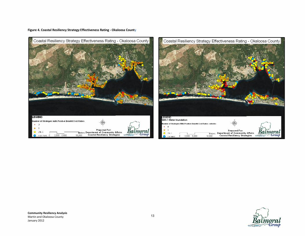
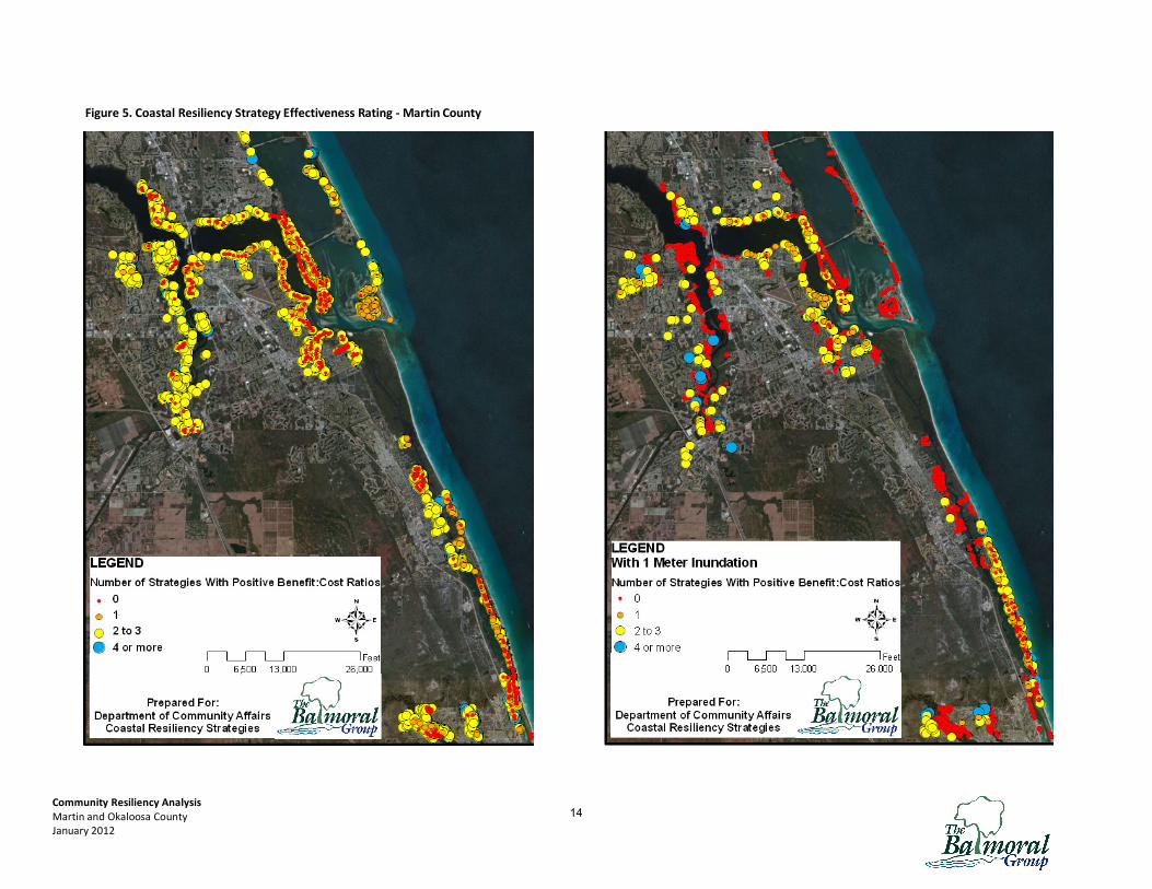
Figures 4 and 5, on the following pages, show an aerial view of the changes described in table 2
for Okaloosa and Martin Counties, respectively.
Transferability to other cities and communities
Speaking in broad terms, most parcels have multiple planning strategies available to them
currently.
1. Properties with proximity to beaches, open land, conservation areas and parks have
greatest flexibility in current planning scenarios to pursue multiple avenues of coastal
resiliency. Communities which encourage inward migration of development rights from
these parcels, or easements along these parcels, are most likely to achieve coastal
resiliency in a manner that is market-driven and cost-effective for the property owner and
larger community.
2. TDRs and PDRs are cost effective for most property types and parcels, although PDRs are
considered beyond the reach of political will in most communities. Local ordinances that
allow for flexibility in trading development rights between near-shore parcels and inland
properties, without restrictive criteria, may have the greatest single impact in attaining
coastal resiliency.
3. Rolling and Conservation Easements have the highest returns overall in both Counties, but
have fewer candidates.
Land use type (SFR, commercial, etc) is not as important to benefit-cost ratio as location of
the parcel. Property value is not as important to benefit-cost ratio as proximity to
amenities.
12
Community Resiliency Analysis
Martin and Okaloosa County
January 2012
Figure 4. Coastal Resiliency Strategy Effectiveness Rating - Okaloosa County
13
Community Resiliency Analysis
Martin and Okaloosa County
January 2012
Figure 5. Coastal Resiliency Strategy Effectiveness Rating - Martin County
14

Community Resiliency Analysis
Martin and Okaloosa County
January 2012
Options for Planning Language
Local and municipal governments can include in their Comprehensive Plans language that will
create resiliency to a changing coastline. The logical elements that could be modified to
incorporate suggested changes are the Coastal Management elements. Integrating “Adaptation
Action Area” language to reflect the State’s recent revisions will allow communities maximum
flexibility in adapting to coastal changes over time, regardless of when or if they occur. Damage
from storms can be mitigated by gradually encouraging migration of development rights away
from low-lying and oceanfront areas.
There are two conceptual approaches planners can use to adopting coastal resiliency techniques.
The first is using incentives to make parcels at higher elevation more valuable for development,
and the second is by slowly planning to migrate public services away from the most vulnerable
areas over time.
The former can be accomplished through a combination of the strategies evaluated in this study.
Using rolling easements and conservation easements can be used to secure parcels which in the
future are more appropriate as public open space, not requiring municipal services. At the same
time, structuring development rights bonuses to provide maximum return from inland development
can slowly reduce shoreline density. The second can be accomplished through long-term planning
that recognizes areas of greatest vulnerability and long-term maintenance costs.
A prior Technical Memorandum detailed alternative approaches to Comp Plan language that
have been designed for Florida Coastal Communities. The Appendix includes two templates for
consideration.
Conclusions
Long-term coastal resiliency has presented quandaries for local government officials who must
balance an oft-perceived conflict between coastal resiliency and public expenditures of scarce
resources. This study evaluated the costs and benefits of six planning strategies for each parcel in
two coastal counties, and found that viability of strategies is more prevalent than conflict.
Viability of different strategies is parcel-specific, but based primarily on location and proximity
to specific amenities. Planners can use this information to identify realistic spatial patterns to
apply various planning strategies in their own communities.
Template language that may be used to start the process is provided, which communities may
adopt to suit their local needs. The more options that are provided to landowners, the more likely
that market forces will drive development away from the areas most expensive to maintain, and
toward areas of desired development. Planners should focus on providing a combination of
options to landowners, and avoid limiting the strategies available to their community through
narrowly-defined ordinances or policies.
15
Community Resiliency Analysis
Martin and Okaloosa County
January 2012
Appendix
Template I
Goal 1 - Create a “Vulnerable Area” temporal and spatial planning overlay; i.e., develop the
temporal and spatial context for sea-level rise adaptation planning in the City/County.
� Objective 1.1: [Spatial Overlay] Identify the areas of the City that are vulnerable to sea
level rise (SLR) where the protection, accommodation, and retreat strategies should be
used.
o Vulnerable Area defined: The vulnerable area represents the area that
encompasses the cumulative geographic reach of all sea level rise impacts
projected for the planning horizon(s) as determined through data and analysis.
The vulnerable area can encompass areas not currently identified as flood hazard
areas (e.g. a future floodplain).
o Policy 1.1.1: The City/County shall use data and analysis to establish a SLR
adaptation overlay district encompassing all areas within the City that are
vulnerable to SLR consisting of three coastal zones:
A. SLR Adaptation Overlay Protection Zone
B. SLR Adaptation Overlay Accommodation Zone C. SLR Adaptation Overlay Managed Relocation Zone
o Policy 1.1.2: Require all sellers of real property within the SLR Overlay District to provide notice to purchasers that structures and properties are located within an area
that is vulnerable to sea level rise within the planning horizon.
• Objective 1.2: Expand planning horizons for sea-level rise adaptation to capture the
anticipated impacts of SLR based on current SLR models.
o Policy 1.2.1: Utilize a (___) year planning horizon2 when considering the adoption of
any protection, accommodation, and managed retreat strategy within the
City/County.
� Objective 1.3: Ensure consideration has been given to whether existing and planned public
and private infrastructure and land development within the vulnerable area is “sea-level
rise ready”.
o Policy 1.3.1: The City/County shall inventory all existing and planned infrastructure
and land development within the vulnerable area for its capacity to accommodate
projected sea-level rise over the life expectancy of the infrastructure and
development.
o Policy 1.3.2: No capital improvements within the vulnerable area shall be financed or
constructed without having first been reviewed to determine the extent to which the
2 Under Florida law local governments must develop planning horizons based on a 10 year interval for most planning purposes. Some transportation and infrastructure planning occurs on longer planning horizons. Current law does not preclude longer planning horizons should a local government choose to adopt them.
16
Community Resiliency Analysis
Martin and Okaloosa County
January 2012
proposed improvement is sea-level rise-ready, taking into account the sea-level rise
adaptation zone in which it is located, and whether it will contribute to additional
development within the vulnerable area.
Goal 2: To ensure adequate protection3 of the built environment through soft and hard shoreline
stabilization that seeks to maintain a static shoreline position within the City/County.
� Objective 2.1: Identify areas of the built environment vulnerable to sea level rise where
shoreline stabilization strategies will be appropriate.
o Policy 2.1.1: The City/County shall develop a comprehensive shoreline stabilization
strategy to address protection of the built environment where it has been
determined to be feasible and in the best interest of the City/County to protect
economic investment and public and private infrastructure.
o Policy 2.1.2: Based on projected rates of sea level rise within the SLR planning
horizon the City shall inventory all existing shoreline stabilization structures and
determine their capacity to maintain functionality throughout the SLR planning
horizon.
o Policy 2.1.3: The City/County shall inventory all public buildings and infrastructure
that are vulnerable to sea level rise within the SLR planning horizon and determine
whether such buildings and structures should be protected through shoreline
stabilization.
� Objective 2.2: Compensate for the loss of ecosystem services resulting from hard shoreline
stabilization in the City/County.
o Policy 2.2.1: The City/County shall require adequate mitigation for shoreline
stabilization through the construction of living shorelines in front of hard shoreline
stabilization structures where it is feasible do so.
Goal 3: To accommodate4 increasing sea levels and the additional flooding that will result by
adapting the built environment and enhancing the resiliency of the natural environment where it is
economically and ecologically practicable to do so.
• Objective 3.1: Assure that all aspects of the built environment within the accommodation
zone can withstand additional permanent or periodic inundation based on sea level rise
projections through structural and non-structural solutions.5
3 Protection means the use of any means of constructed physical barrier or other managed system to prevent the landward migration of tidally influenced water bodies 4 Accommodation contemplates a suite of policy tools that emphasize maintaining and adapting components of the built environment to periodic and permanent inundation over time. Accommodation policy also emphasizes retention and expansion of existing and potential floodways to manage flooding and to facilitate coastal ecosystem migration through and around the built environment. 5 To a significant extent existing floodplain regulations already contemplate, indeed encourage, accommodation within the built environment.
17
Community Resiliency Analysis
Martin and Okaloosa County
January 2012
o Policy 3.1.1: The City/County shall require all new construction within the
Accommodation Zone to adhere to performance standards designed to enable
development to withstand permanent and/or temporary inundation due to rising
sea levels.
� Objective 3.2: Reduce the density and intensity of development and redevelopment in the
accommodation zone landward of unprotected shorelines
o Policy 3.2.1 The City/County shall develop design guidelines that promote
compact development and redevelopment that maximizes the use of floodways
and flood storage within the zone of accommodation.
o Policy 3.2.2: The City/County shall limit the building footprint for all new
residential structures within the accommodation zone to ( ) square feet and
commercial structures to (____) square feet.
� Objective 3.3: Facilitate coastal ecosystem migration through the maintenance and
restoration of adequate open space within the zone of accommodation.
o Policy 3.3.1: The City/County shall establish riparian buffers that reflect projected
rates of sea level rise within the planning horizon for all tidally influenced water
bodies. Such buffers shall be designed to allow the conversion of adjacent
uplands to wetlands while retaining transitional ecotones where ecologically
feasible.
o Policy 3.3.2: The City/County shall develop priority areas for land acquisition
based on their strategic capacity to absorb floodwaters and support coastal
ecosystem migration.
Goal 4: To reduce vulnerability in the built environment and preserve coastal ecosystems through
changes in land use and the orderly abandonment and /or landward relocation of structures and
associated infrastructure.
� Objective 4.1: Reduce the density and intensity of future land use along unprotected
shorelines within the managed relocation zone.
o Policy 4.1.1: Within the managed relocation zone, the City/County shall eliminate new investment in public infrastructure likely to be subject to the impacts of sea
level rise within the planning horizon.6
o Policy 4.1.1: Within the managed relocation zone the City/County shall reduce
residential land use densities to no more than __ units per acre and commercial
structures to ____ square feet per acre.7
6 While uncertainty remains about the magnitude and timing of sea level rise, development decisions that are being made today are committing public and private capital to land use patterns and associated infrastructure and facilities with design lives that reach well into the period of time when the impacts of sea level rise will be felt.” (Deyle, et al., Adaptive Response Planning to Sea Level Rise in Florida and Implications for Comprehensive and Public-Facilities Planning, available at: http://www.gulfofmexicoalliance.org/working/coastal_resil/slr_comm_response.pdf)
18

Community Resiliency Analysis
Martin and Okaloosa County
January 2012
o Policy 4.1.3: The City/County shall create a transferable development rights
program within the managed relocation overlay that transfers densities and
intensities outside of the managed relocation zone.
� Objective 4.2: Preserve coastal ecosystems by ensuring that natural shoreline migration
processes may continue unimpeded.
o Policy 4.2.1: The City/County shall prohibit hard shoreline stabilization techniques
within Managed Relocation Zone.
o Policy 4.2.2: All permits for new development within the managed relocation zone
shall include, as a condition of development approval, a covenant or other real
property instrument that runs with the land, that requires the abandonment and
removal of structures and fixtures once they are inundated for at least __ months
per year, or are no longer habitable as determined by the building official,
whichever comes first.
• Objective 4.3: To develop programs to encourage abandonment of undeveloped properties
and relocation of existing structures within the “Managed Relocation Zone” consistent with
projected rates of shoreline recession over the SLR planning horizon.
o Policy 4.3.1: The City/County shall prioritize and seek to acquire properties or
interests in properties within the managed relocation zone based on their relative
vulnerability to SLR and the extent to which they may impede coastal ecosystem
migration.
o Policy 4.3.2: Identify and establish a land bank for the purposes of relocating
critically important infrastructure and municipal support facilities outside of the
vulnerable area.
o Policy 4.3.3: The City/County shall promote the acquisition of rolling conservation
easements within the managed relocation zone.8
7 This may require down-zoning or down-planning current densities and intensities with the proposed overlay zone. Down-zoning and down-planning can be controversial and give rise to legal claims, though courts have generally upheld them where they are supported by data and analysis and represent sound public policy, broadly applied. 8 A voluntary, parcel-specific rolling conservation easement obliges a property owner to forgo any rights to protect
upland structures such that the fee simple property shall “forever yield to the sea.” The easement may also require
removal of the structure. Such an easement may provide significant tax advantages to the property owner.
19
Community Resiliency Analysis
Martin and Okaloosa County
January 2012
Template II
Section 4 - The City/County adopts the following amendments to the Goals, Objectives and
Policies of the Coastal Management/Conservation Element:
• Objective 1.3: In order to direct development and population concentrations away from the
area seaward of the Coastal Construction Control Line and within the Coastal High Hazard
area, the City/County will continue to prevent use of public funds and discourage use of funds
by other levels of government as financial assistance for new, private development or
redevelopment that result in increased densities or intensities in these areas.
• Objective 1.4A : The City/County will strive to minimize the potential for future damage to
structures seaward of the Coastal Construction Control Line and within the Coastal High-
Hazard Area by having adopted a post-disaster reconstruction plan aimed at reducing or
eliminating the exposure of human life and rebuilt public and private property to subsequent
natural hazards.
o Policy 1.12.4 - The City/County, alone or with others, will acquire public land as
financially feasible to achieve the following:
• improve flexibility in addressing sea level rise
Section 5. The City/County adds the following Goal, Objectives, and Policies of the Coastal
Management/Conservation Element:
GOAL 2: Adaptive protection of private and public interests from adverse impacts due to long-term changes in sea level.
• Objective 2.1: The City/County will evaluate available data related to adverse impacts
from long-term changes in sea level. This process will be undertaken every five years or
earlier as deemed necessary by the CPAB.
o Policy 2.1.1 - The City/County will initiate efforts to address the issues of barrier
island sustainability.
o Policy 2.1.2 - The City/County will incorporate into the City/County’s planning
agenda for major public capital investments, changes in sea level within a 100-
year planning horizon.
• Objective 2.2: The City/County will initiate actions to actively address adverse impacts of
sea level rise as the impacts are identified.
o Policy 2.2.1 - The City/County will explore relocating critical infrastructure
outside erosion or flood prone areas based on projections of sea level rise.
o Policy 2.2.2 - The City/County will review its Land Development
Regulations to accommodate redevelopment in areas projected to become at risk
from impacts of sea level rise, using a continuous 100-year planning horizon.
20
Community Resiliency Analysis
Martin and Okaloosa County
January 2012
o Policy 2.2.3 - The City/County will encourage a community-wide dialogue
about what the City/County’s long-term response should be to sea level rise.
• Objective 2.3 : The City/County will investigate and implement, as opportunity and
resources allow, actions to reduce the City/County’s use of energy and increase use of
alternative energy sources.
o Policy 2.3.1 – The City/County will continue to implement energy-saving
strategies in its facilities throughout the City/County as opportunity and
resources allow.
o Policy 2.3.2 – The City/County will investigate the utility of alternative
energy sources and other emerging technologies.
o Policy 2.3.3 – The City/County will encourage residents and businesses to
implement cost-effective energy saving techniques.
Section 6 - The City/County/County adopts the following amendments to the Goals, Objectives
and Policies of the Capital Improvements Element:
o Policy 1.1.10 – To the degree opportunity and resources allow, the City/County will
design stormwater improvements and other capital improvements to function properly for
50 years or the design life of the improvement, whichever is greater, in the face of sea
level rise as best estimated at the time of the design.
o Policy 1.3.1 – The City/County will make improvements or assist others in making
improvements appropriate and necessary to protect and re-nourish dunes; beach areas,
and shorelines; maintain or replace public facilities, and provide improved recreational
opportunities east of the Coastal Construction Control Line (CCCL) and within the Coastal
High Hazard Area. These improvements shall specifically exclude improvements that
subsidize or otherwise encourage additional development in these areas.
21
Valerie Seidel [email protected]
Project Manager Phone: (407) 629‐2185
341 North Maitland Avenue, Suite 100 Fax: (407) 629‐2183
Maitland, FL 32751
Cost‐Benefit Analysis for
Coastal Resiliency Planning Strategies
DCA Agreement No. 11‐DR‐CH‐14‐00‐22‐001
Prepared for:
Florida Department of Community Affairs
Prepared by:
January 2012