Embed Size (px)
Citation preview

Initial Environmental Examination Report Project Number: 33209-01 June 2009
Nepal: Community -Managed Irrigated Agricultural Sector Project Kantawa Irrigation Subproject, Mahottari District Project Proponent: Department of Irrigation Prepared by Central Irrigation Development Division No. 1 (Mahottari) This Initial Environmental Examination is a document of the borrower. The views expressed herein do not necessarily represent those of ADB’s Board of Directors, Management, or staff, and may be preliminary in nature.

ABBREVIATIONS
ADB - Asian Development Bank CMIASP - Community-Managed Irrigated Agricultural Sector Project CPMO - Center Project Management Office DADO - District Agriculture Development Office DB - Design Branch DDC - District Development Committee DOI - Department of Irrigation EB - Environment Branch EMP - Environmental Monitoring Plan FMIS - Farmer-managed irrigation systems ha - Hectare IDD - Irrigation Development Division IDSD - Irrigation Development Sub-division IEE - Initial Environmental Examination IPM - Integrated Pest Management ISPM - Institutional Strengthening and Project Management km - Kilo Meter lps - Liter Per Second MEQCB - Monitoring, Evaluation, and Quality Control Branch MoEST - Ministry of Environment, Science and Technology NGO - Non Governmental Organization O&M - Operation and Maintenance PDMED - Planning, Design, Monitoring and Evaluation Division RCC - Reinforce Concrete Cement Rs. - Rupees SISP - Second Irrigation Sector Project SWD - Surface Water Division VDC - Village Development Committee VRB - Village Road Bridge WECS - Water Energy Commission Secretariat WUA - Water User’s Association ZoI - Zone of Influence
WEIGHTS AND MEASURES
ha - hectare km - kilometer l - liter m - meter mo - month s - second t - ton yr - year
CURRENCY EQUIVALENTS
(as of 31 March 2009)
Currency Unit - Nepalese Rupee (NR)
NR 1.00 = $0.01226 $1.00 = NRs 81.54
NOTE
In this report, “$” refers to US Dollars.

GLOSSARY
Terai The southernmost strip of land in Nep al, bordered to the north b y
Himalayan foothills and to the south by the Ganges River. The area was originally covered wit h tropical vegetation, but has been almost completely converted to agricultur al product ion. The Terai is now th e breadbasket of Nepal and is covered with farms.˜
Command Area It is the agriculture or cultivable area which receives assured irrigation through canals, waters, courses, and field channels up to farmers field.
TABLE OF CONTENTS I. INTRODUCTION 1 II. DESCRIPTION OF THE SUBPROJECT 2 III. DESCRIPTION OF THE ENVIRONMENT 6
Physical Environment 6 Ecological Resources 7 Socio-economic Environment 7
IV. SCREENING OF POTENTIAL ENVIRONMENTAL IMPACTS 9 V. POTENTIAL ENVIRONMENTAL IMPACT AND MITIGATION MEASURES 13
Environmental Problem Related to Project Design 13 Environmental Problems Related to Construction Stage: 14 Environmental Problems Resulting from Subproject Operations 16 Realization of Enhancement Potentials 17
VI. ANALYSIS OF ALTERNATIVES 17 VII. INSTITUTIONAL ARRANGEMENTS 18 VIII. ENVIRONMENTAL MANAGEMENT PLAN 20 IX. PUBLIC CONSULTATION AND DISCLOSURE 24 X. FINDINGS AND RECOMMENDATIONS 25 XI. CONCLUSION 26 Annex 1: Details of Proposed Intervention in the Subproject 27

- 1 -
I. INTRODUCTION
1. The Community-Manag ed Irrigated Agricultural Sector Pro ject is designed to improve the agricult ural product ivity and su stainability of farmer-managed irrigation systems (FMI Ss) while strengthening the policies, investment plans, and institutio ns f or irrigated agriculture , following the lessons learned during the Loa n 1437-NEP: Second Irrigation Sector Project (SISP). The Project will be located in the Easter n and Central regions o f Nepal and comprises two parts: (i) participa tory irrigated agricultur e development for FMIS; and (ii) institutional strengthening and proj ect management (ISPM). Under the first pa rt, 210 FMIS will be rehabilitated, resulti ng i n improvements in i rrigated agriculture over 34,000 he ctares (ha ) benefiting a bout 270,000 people. The second component comprises t he development an d implementation of improved institutional mechani sms for FMIS de velopment, further improved policies and regulations, strengthening of the key stakeholders agencies and their linkages.
2. An initial environmenta l examinati on (I EE) was undertaken for the core subproject s based on data collected during the Detailed Design Period. The overall objective of the IEE is to analyze the adverse environmental impacts arising from site selection, design, construction, and operation of the Project is su ch eff ect occur s and its mitigation to acceptable lev els through implementation of a se t of clearly defined and costed mitigation measures which have been included in the Project cost estimates. For each additional subpr oject, an I EE, and a n environmental impact assessment (EIA) if warranted, will be carried out in accorda nce with the Bank's guidelines and relevant government's environmental requirements during the preparation of subproject feasibility studies.
3. This Initial Environ mental Exa mination (IEE) Report for the Kantawa Irrigation Subproject has been pr epared to meet the Asia n Development Bank’s ( ADB) requirements for environmental assessment process and documentat ion prior to Subproject approval, followin g the procedu res in ADB’s Environmental Asse ssment Guidelines (2 003), and th e Project’s Environmental Assessment and Review Procedures and Arrangements.

- 2 -
II. DESCRIPTION OF THE SUBPROJECT
4. Project Location. The subproject is located in the Raghunathpur VDC, Son ma VDC and Khairbani VDC of Mahottari district in Jan akpur zone in the Central Develop ment Region. The subproject is located between the latitude and longitude of 260 52’ 02”N to 260 50’ 30”N and 850 43’ 53”E to 85 0 42 ’ 25”E respe ctively. Th e elevation of the area is about 96.00 m above MSL. Its location map is shown in Figure 1.
5. Accessibility. The subproject area is easily accessible through a gravel motorable road, 20 km southeast from Jalesore. T he headworks of the su bproject is about 1 km northeast of Kantawa village. Most of the main canal and the branch canals can be approached through the existing village road. The near est market is Gobar hiya, Gaushala Bazar Khairbani, Raghunathpur.
6. Existing Situation: The Kantawa subproject is an ex isting FMIS. This system is operated by the farmers since a lo ng time by c onstructing earthen bu nds in Kant awa Khola . Earlier this irrigation system was getting water fr eely, which caused uncontrolled inflow of water in the canal system during high discharges in the river with the associated erosion damage near the canal intake and the riverbanks in the vicinity of the di version point of the khola. The bund also often b reached and or outflan ked during f loods in the river. Though farmers are diverting water by making earth en bunds b ut frequent breaching o f the bund did not provide adequat e discharge to meet the water requirement of crops in time. To improve the water availability and the reliabilit y of the irrigation water supply th e farmers have reque sted assista nce for the implementation of the following improvements:
• Construction of permanent diversion structure at the same location as before.
• Permanent canal flow control and outlet structures as well as road crossings.
7. After the system improvemen t, the system will provide reliable, timely and suffici ent irrigation water supply to irrigate the land around Raghunathpur Village.
8. Command Area: The gross command area is 890 ha and t he net command area is 750 ha. Presently only mon soon paddy is irrigated in 30% of th e command area. A layout map is presented in Figure 2.
9. Project Components. The major i nfrastructure improvements include the construction of a permanent headworks con sisting of con crete weir, inta ke and river bank protection works, canal reshaping, branch canal offtakes (9), bridges/culverts (16), etc. The salient features of the subproject are presented in Table 1.

- 3 -
Figure 1: Location Map of the Subproject

- 4 -
Figure 2: A Layout Map of the Sub project

- 5 -
Table 1: Salient Features of the Kantwa Irrigation Subproject 1. Name of Subproject Kantawa Irrigation Subproject 2. Subproje ct Classification Rehabilitation 3. Location (VDC and Ward No) Raghunathpur, Khairbani and Sonma 1 to 9 4. Distri ct Mahottari 5. Distri ct Headquarter Jalesore 6. Zone Janakpur 7. Develo pment Region Central 8. Number of Households 1,025 9. General Elevation of the Subproject Area 100 msl 10. Slope and Topography of the Subproject Area flat or level (0 to 3% slope) 11. Population 8,075 12. Total Canal Length
a) Main Canal 2 numbers/ 8.56 km b) Branch Canal 8 numbers/ 12.75 km
13. Gross Command Area 891 ha 14. Net Command Area 750 ha 15. Cropping Intensity 125% (present) & 133% (future) 16. Name Of Water Source Kantawa River 17. Type Of Water Source Perennial 18. Catchment Area 10 km2 in Hydrological Region 7 19. Canal Type Earthen 20. Canal Discharge 1,069 liter per second 21. Side Slope 1:1 22. Bed Slope Shown in the L-Section in Detailed Design 23. Diversion Structure Concrete Weir 24. Proposed Subproject Interventions
Headworks 1 no. - Slab VRB/HP Culvert 15 nos. - Foot Bridge 1 nos. - Outlet 9 nos. 25. Number of people directly involved during construction (estimate)
Skilled: 5,381 man days Unskilled: 19,998 man days
26. Construction/Rehabilitation Period (months) 18 months Notes: VDC = V illage Development Committee ; msl = meters a bove sea level; km = kilometers; ha = hect ares; km2= square kilometers; RCC = reinforced concrete cement; VRB = Village Road Bridge
- 6 -
III. DESCRIPTION OF THE ENVIRONMENT
Physical Environment
10. Topography. The scheme is located in the Terai plains in an agricultural area with land that slopes gently from north to south at an elevation of just under 100 m abo ve msl. Th e Kantawa subproject lie s on the left bank of th e Kantawa River. The existing main canal is aligned fro m north to south crossing the command area while the branch canals are aligned generally from east to south-west. The canals are earthen canals in cut with negligible seepage loss and do not need lining.
11. Climate. The project area has three distinct seasons, spring, monsoon, and winter. The climate of the subproject area is mai nly sub-tropical and humid. It has hot and humid climat e during summer and moderately high rainfall du ring the mo nsoon. There is no me teorological station in t he project area itself, however, the nearest meteorological stat ion at Jalesore (Station No: - 01122) is used as refe rence, which is about 20 km from the subproject area. The recorded da ta of precipitation, maximum and minimum air temperature and relat ive humidity from Station No: 01122 whereas wind speed, e vaporation and sunsh ine hour of St ation No.: - 01114 at Hardinath is used for the analysis of crop water requirement. However, th e river does not dry up completely since its lon g stretch is fed by perennial sprin gs. Followin g are some important hydro-meteorological observations:
• Mean annual rainfall – varies from 8.1 mm minimum in No vember to 291.4 mm maximum in August;
• Mean monthly maximum temperature: varies from 22.1 °C in January to 35.0 °C in April and May
• Mean monthly minimum temperature: varies f rom 9.4 °C in January to 26. 2 °C in July
• Minimum evaporation: 2.0 mm in January • Maximum evaporation: 6.9 mm in April and May
12. Soils. The subproject a rea has medium textured soils. S oil texture slightly varies fro m clayey loam at head reach to silty clay in t he tail reach movi ng across the command area from north to the south. Th e fertility st atus of the soil i s foun d to be po or in major nutrients of Nitrogen, and poor to medium while considering contents of Phosphorous and Potash and poor in organic matter content (0.85 to 1.07%). The soil reaction is slight ly acidic wit h pH value ranging fro m 5.2 to 6. 9. The soil character istics (t exture, drainage, pH etc) in average are judged goo d for the existing and p roposed cro ps. To improve the soil fertility organic matter content and nitrogen need to be increased by using compo st about 50 0 to 600 kg per ha and planting crops in rotation with legu me crops fo r fixing the nitrogen in the soil from atmosphere respectively. In addition to this high yielding variety of crops and full dozes of fertilizers need to be used as recommended by agri-extension staff in the field and as recommended
13. Water Resources. Kantawa Rive r, the source of irrigation water, is a spring fed perennial source originating from Phulkawa village of Sundarpur VDC 1 0 to 15 km u/s from the

- 7 -
proposed headwork site. The catchments area at the pro posed headworks is about only 10.00 km2.
14. The watershed of the river is mostly covered with agricultura l land. Soil texture slightly varies from heavy to light silt moving across the command area from north to the south. Due to highly rechargeable zone lying to th e north of th e headworks, there are a lot of spring sources, which are adding discharge source of Kantawa River.
Ecological Resources
15. Vegetation and Forest. There is no national forest or communit y f orest within the project command area. There exists a few pole size Sisso trees within the inundation area o f the headworks, which are likely to be affected during the construction of the headworks. Apart from them, there are a number of trees of diffe rent species of timber, fodder, fuelwood and fruit within the p roject command area an d homestead but they a re not going to be af fected by the project activities.
16. Wildlife. As reported by the local people, jackals have been occasionally seen within the project command area.
17. Aquatic life. Fish spe cies like Maugura, Garai, Commo n carp and Bam ha ve been reported in t he Kantawa River. These species are mostly local habitat and found a ll along the river stretch. The fish population behind the earthen dam is reported to be quit e high. When the earthen dam is breached, the fish catch is reported to be quite high. It would be as high as 200 kg of different species.
Socio-economic Environment
18. The Kantawa ISP covers two settle ments or villages, namely Raghunathpur, Khairbani and Sonma VDCs 1 to 9 The to tal number of households with so me land holdings in the project area is 1025 with an averag e family size of 8.2 peo ple. The population is e stimated at 8075. However, there are an additional 10 land less households. Ethnically, the sett lement has a mixed type of social structure. The settlement of the villages in the command (throughout the system) has Yadav as t he ethnic majority follo wed by Teli and other low casts. The sample survey reflected that a majority of households (50%) live in the middle part of the system while 17% hh are located in the upper and 33% hh reside at the tail end.
19. The main o ccupation of people in the area is f arming. Th e sample h ousehold survey revealed that 48.75% households depend on agricultur e for their livelihood. Apart from agriculture, 0.25% ho useholds supplement their incom e from livestock and 0.75% fro m business activities. Most of the far mers rear goats, cows and buffaloes for gettin g meat an d milk, which is often also sold in n earby mark ets to buy t he article s of other primary needs. About 3.25% of households meet their needs by working as agriculture labour.
20. The labour force from ri ch families is more in volved in urba n based business and other medium, small and marginal farmers are involv ed both in country & foreign employment. The main source of agricult ural labour for the command area is the Ultra poor group. There is

- 8 -
sufficient labour force to meet the unskilled labour required for infrastructure construction. Only 16.5% of the sample hh were found fully employed for more than 300 days a year.
21. Landless work as the floating la bour force in addit ion to share cropping in larger landholders’ fields. Lab our from very Poor Grou p supplement their family income from casual work in cities as factory labour, tailoring, carpentry etc. However, none of such traditional caste based occupation was reported to provide full employment.
22. The education level of the communi ty is averag e. The literacy was found to correlate with the size of land ho lding of a fa mily, illiteracy being low among larg e land ho lders than in small farme rs and land less. Most of the people conside red literate in the area have not completed even the lower secondar y level. The number of f emale child attending local primary school was found almost equal (1 8.75%) to the number of boys (20.25%). School drop-out is common, e ven fro m th e primary s chool locate d within the village, to j oin the labour force for family support.
23. 36% of the households own Pucca house (cement mortared) while 55. 6% households have access to electricity. There is no community drinking water supply system. Tubewells with hand pumps are the only source of drinking water. None of the hh repo rted to have their own tubewells for drinking water. 32% population has access to primary health facilities.
24. A majority of farmers are poor and do not produce enou gh to meet their own food requirements. Only 38 .85% of sample hh re ported that they produce enough to meet their family food requirements for the year. Of thos e who reported insufficiency of food, face food scarcity for almost a half of the year. 3.25% hh r eported to work as local farm labour within the village to meet their foo d requirements while 0. 75% work outside the village. Landl ess people work on wa ges and so me of them take land on rent for farming on contractual basis. The wages to labourers working in the field is provided on the basis of two shifts. Normally the y are paid in kind. The a verage daily wa ge rate for male labour is 4-5 kg of rice (about US$ 0.6 t o 0.7). The wage rate for women i s about 20 % lower than for men (+- 5%). Malnutrition is common among children and elders.
- 9 -
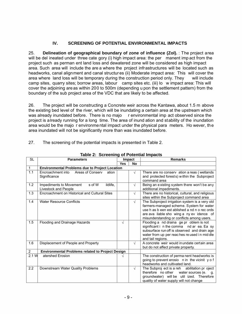
IV. SCREENING OF POTENTIAL ENVIRONMENTAL IMPACTS
25. Delineation of geographical boundary of zone of influence (ZoI). : The project area will be del ineated under three cate gory (i) high impact area: the per manent imp act from the project such as perman ent land loss and dewatered zone will be considered as high impact area. Such area will include the are a where the project infrastructures will be located such as headworks, canal alignment and canal structur es (ii) Moderate impact area: This will cover the area where land loss will be temporary during the construction period only. They will include camp sites, quarry sites; borrow areas, labour camp sites etc. (iii) lo w impact area: This will cover the adjoining are as within 200 to 500m (depending u pon the settlement pattern) from the boundary of the sub project area of the VDC that are likely to be affected.
26. The project will be constructing a Concrete weir across the Kantawa, about 1.5 m above the existing bed level of the river, which will be inundating a certain area at the upstream which was already inundated before. There is no majo r environmental imp act observed since the project is a lready running for a long time. The area of inund ation and stability of the inundation area would be the majo r environmental impact under the physical para meters. Ho wever, the area inundated will not be significantly more than was inundated before.
27. The screening of the potential impacts is presented in Table 2.
Table 2: Screening of Potential Impacts SL Parameters Impact Remarks
Yes No 1 Environmental Problems due to Project Location1.1 Encroachment into Areas of Conserv ation
Significance √ There are no conserv ation a reas ( wetlands
and protected forest s) w ithin the Subproject command area
1.2 Impediments to Movement s of W ildlife, Livestock and People
√ Being an e xisting system there won’t be any additional impediments.
1.3 Encroachment on Historical and Cultural Sites √ There are no historical, cultural, and religious sites within the Subproject command area
1.4 Water Resource Conflicts √ The Subproject irrigation system is a very old farmers-managed scheme. System for water use h as b een est ablished a nd n o rec ords are ava ilable sho wing a ny ev idence of misunderstanding or conflicts among users.
1.5 Flooding and Drainage Hazards √ Flooding a nd draina ge pr oblem is not significant i n the comma nd ar ea. Ea sy subsurface run off is observed and drain age water from up per reac hes re used i n mid dle and tail regions.
1.6 Displacement of People and Property √ A concrete weir would inundate certain area but do not affect private property.
2 Environmental Problems related to Project Design2.1 W atershed Erosion √ The construction of perma nent headworks is
going to prevent erosio n in the vicinit y o f headworks and cultivated land.
2.2 Downstream Water Quality Problems √ The Subproj ect is a reh abilitation pr oject therefore no other water sources (e. g. groundwater) will be util ized. Therefore quality of water supply will not change

- 10 -
SL Parameters Impact Remarks Yes No
2.3 Suitability of Natural Water for Irrigation √ The water sou rces have bee n used prior to rehabilitation w orks. There w ill be no changes in water use duri ng the Subproject implementation
2.4 Over pumping of Groundwater √ Groundwater w ill not be used in this Subproject.
2.5 Adequacy of Drainage Planning √ 2.6 Disruption of Existin g F armer Coop erative
Systems √ There are n o existing farmer s’ co operatives
within the command area. 2.7 Use of C hemicals in Agriculture a nd
Horticulture √ Use of chemic al fertilizers an d pesticid es is
likely to be in creased due to the improve d irrigated agriculture practice
2.8 Selection of Pesticides √ Selection and use of pestic ides m ay b e a problem
2.9 Land Use Conflicts √ The land us e within the command area has been established prior to the implem entation of the Su bproject. No recor ds are av ailable showing mis understanding or conflicts among different land uses.
2.10 Inadequacies in Water Distribution √ Necessary improvement work in the s ystem and improved efficiency of th e canal s ystem will increase the disc harge in the c anal. Inadequacy in w ater distribution will not occur.
2.11 C anal Management √ The operation and mainten ance (O&M) of the existi ng irri gation s ystem inclu ding mai n canal has bee n in pl ace prior t o implementation of the Subpr oject. W UA so far have or ganized a nd m anaged qu ite well for O & M of this system.
2.12 Passag eways √ The existin g passageways ar e not suf ficient for movement of peopl e and livestock. The Subproject will increas e the number of crossings and passageways.
2.13 Scouri ng Hazards √ The system has been in o peration for man y years. Scouri ng pro blems has n ot bee n reported. Canal beds are stable
3 Environmental Problems Related to Construction Stage3.1 • Ex cavation √ The excav ation will be re quired at the
structure sites. Being a n e xisting can al no new excavation will be required for canal.
3.2 • Constructi on material sites (Quarry Sites)
√ The construction work will r equire 890 m 3 sand 1, 693 m 3 of aggre gates and 1,9 05 m 3
block sto ne which c an b e f ulfilled from th e local market or local qu arry. Operation of quarry site for the sub proje ct may n ot be feasible.
3.3 • Work camp location and operation √ The contractor will h ave to establish work camp for the construction activities
3.4 • Lab our camp √ Total labour requirement will be about 19,998 unskilled an d 5,381 ski lled man d ays. Assuming ac tual construc tion working season of 14 months, the avera ge la bour requirement per da y would be 48 unski lled and 13 sk illed. The most o f the unsk illed and some of skilled manpower will be fulfilled from the local area. Hence labour camp will not be operated. Some of the out side labour will be reside within the work camp it self.

- 11 -
SL Parameters Impact Remarks Yes No
3.5 • S tockpiling of materials √ The construction materi al will be store d at the convenient locations for the constructi on activities.
3.6 • Operation of construction equipment and transport
√ No heav y c onstruction equi pments ar e needed. Onl y small d ewatering pumps, mixers, vibrato rs, etc will be used which d o not contrib ute major air po llution. Tractors, trucks and bullock cart s would b e use d for material transportation.
3.7 • Occupational health and safety √ Occupational hea lth and safet y of the workers will be addressed.
3.8 Temporary Closure of Irrigation System √ Construction a ctivities are li kely to d isturb the suppl y of irrigation water for a short period.
4 Environmental Problems Resulting from Project Operations4.1 Effect on downstream water use √ The propose d interve ntion will not b e
abstracting more water than existi ng quantity. Hence ef fect on dow nstream users has not been foreseen.
4.2 Adverse soil modifications √ The proposed subproject is t he rehabilitation of the existi ng irrigation system, adverse soi l modification will not occ ur due to th e proposed subproject implementation.
4.3 Changes in groundwater hydrology √ The Subproj ect will im prove the irri gation system which w ill like ly rechar ge the groundwater tables w ithin the command area.
4.4 Mo squito Breeding √ Water pond ing within the comman d are a may lead to incre ases i n inci dence of waterborne diseases and mosquito breeding
4.5 Hazards asso ciated with the us e of toxic chemicals
√ Use of pestic ides for the p est control cou ld be hazardous to the people and live stock
4.6 Hazards asso ciated with th e use of mineral fertilizer
√ Increased use of fertilizers likel y d ue to improved irrig ation s ystem, These ma y find its ways to gro und water an d surface water which could hazardous
5 Realization of Enhancement Potentials5.1 Employment to the local people √ Construction activities will re quire
construction labors. Loca l peo ple will g et opportunity i n emplo yment. In add ition farmers have to share the co nstruction cost which will be mostly usually in terms of labor force.
5.2 Community water supply in command area √ The command area has existin g water supply schemes (tubewells). Canal water ise not used for domestic purp ose and will no t be us ed as such dur ing Sub project implementation.
5.3 Aquaculture in command area √ Farmers do n ot practice aquaculture within the command area. It is unlikel y that this will practiced in future also.
5.4 Livelihood programs for landless households √ Construction a ctivities will re quire both skill and u nskilled laborers. The Subproject will also provi de li velihood trainings to enh ance economic conditions of landless households.
5.5 Feasib ility of cooperatives √ The Project w ill impl ement institutional development activities to strengthen capacity of water us ers associati ons which c ould function as a cooperativ e to support the
- 12 -
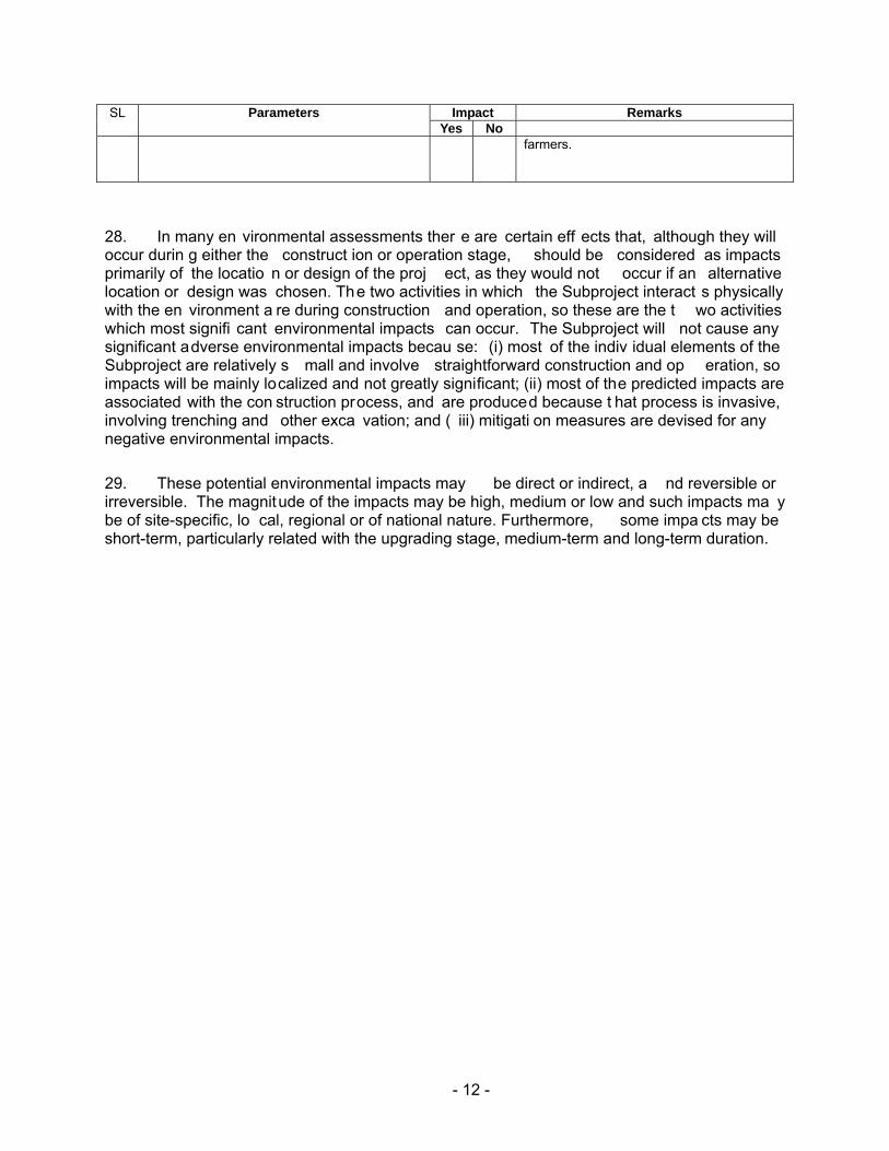
SL Parameters Impact Remarks Yes No
farmers.
28. In many en vironmental assessments ther e are certain eff ects that, although they will occur durin g either the construct ion or operation stage, should be considered as impacts primarily of the locatio n or design of the proj ect, as they would not occur if an alternative location or design was chosen. The two activities in which the Subproject interact s physically with the en vironment a re during construction and operation, so these are the t wo activities which most signifi cant environmental impacts can occur. The Subproject will not cause any significant adverse environmental impacts becau se: (i) most of the indiv idual elements of the Subproject are relatively s mall and involve straightforward construction and op eration, so impacts will be mainly localized and not greatly significant; (ii) most of the predicted impacts are associated with the con struction process, and are produced because t hat process is invasive, involving trenching and other exca vation; and ( iii) mitigati on measures are devised for any negative environmental impacts.
29. These potential environmental impacts may be direct or indirect, a nd reversible or irreversible. The magnitude of the impacts may be high, medium or low and such impacts ma y be of site-specific, lo cal, regional or of national nature. Furthermore, some impa cts may be short-term, particularly related with the upgrading stage, medium-term and long-term duration.

- 13 -
V. POTENTIAL ENVIRONMENTAL IMPACT AND MITIGATION MEASURES
Environmental Problem Related to Project Design
30. Watershed erosion: The construct ion of the p ermanent headworks is going to pr event the erosion in the vicinit y of the hea dworks and the erosion of the cultivated land. This is the positive impact of high magnitude, local extent and long term duration.
31. Use of Chemicals in Agriculture and Horticulture: Gobarhiya, Gaushala Bazar is the business centre for this area. The sub-project area is at a distance of 10 km from Gaushala. Therefore, the farmers of the area have relatively easy an d ready market for all their produce and the inputs they ne ed border town with In dia, the ava ilability of chemical fertilizers is ver y convenient. As reported, even the vendo rs bring them to farmers' door step at the comparatively lower price smuggled from India. The use o f chemical f ertilizers is l ikely to b e increased a s the project encourages irrigated agricultural p ractices. Excess use of chemical fertilizers in the field may percolate i nto the grou ndwater or run down int o surface w ater along with the runoff. But the excess use of fertilizers would be very rare in practice. Considering the rareness of the occurrence, this impact has been considered of low magnitude, local extent and long term duration.
32. The agricultural development plan has recommended the optimum dose of required chemical fertilizers for each of the proposed crops.
33. Selection of Pesticides: Majority of farmers of the project area are aware of the toxicity of the pest icides. As reported, they hav e n ot undertaken any kind of integr ated pest management (IPM) training. Hence, farme rs need some training on integrated pest management. With this backgroun d, it could be assumed that impact asso ciated with the pesticides will be low magnitude, local in extent and long term in duration.
34. Include IPM training under agriculture development program. The cost of this training will be covered from ADP.
35. Canal Management: The proposed project in tends to operate two main canals and eight branch canals. The main canal will be carrying the water for all the branch canals. Th e operation and maintenance of the system will be t he responsibil ity of the farmers themselves. Each of the canal system has their own canal management process, which has be en practiced for many years. But op eration and maintenance of the mai n canal will have to be worked out, which should not be a problem as they have been practicing such works for many years. Hence this impact has been considered of low magnitude, local extent and long term duration.
36. Water management plan will be developed for the operation of the system.
37. Passageway: There a re some passageways in the existing cana ls which is not adequate fo r move ment of the peo ple. Hence additional p assageways, 1 foot brid ge and 15 village road bridges have been proposed. This is a positive impact of high magnitude, local in extent and long term duration.

- 14 -
Environmental Problems Related to Construction Stage:
38. The Subproject will use labour-based, environment-friendly, and particip atory approach, the important features of which are:
• Use of local people as labour, hand tools and small equipment, rather than heavy machinery for construction.
• Balancing cut and fill a nd reuse of excavated materials as constru ction materials, and thus not generating excess spoils as far as possible.
• Use of bio -engineering techniques: integrated use of vegetation, simple civil engineering structures, and proper water management systems for slope protection.
39. Significant adverse negative environment al impacts are not expected during the construction stage mainly because: (i) rehabilita tion works can be const ructed without causing major disruption to irrig ation users; (ii) most construction w ill be condu cted by small teams of farmers working on sho rt lengths at a time so most impa cts will be l ocalized an d short in duration; and (iii) the overall construction program will be relatively short for a project of this nature, and is expected to be completed in 18 months.
40. During the construction phase most of the potential negative environmental impacts are associated with the activities of the construction contractor(s). By i ncluding en vironmental management clause s in the individ ual contract documents, the potential for adverse impacts can be significantly reduced.
41. Excavations. Exca vation will be a t the structures location s and few q uantities du e to reshaping of main and branch canals. But as these are small quantity, e xcavation would not cause serious adverse effects that cause silt ru noff, induced erosion a nd loss of cropland and vegetation. After construction, most of the excavated material would be reutilized in the ba ck filling work.
42. Mitigation measures include: (i) confine operations to the dry season; (ii) use of silt traps; and (iii) spoils of any in excess shall be disposed of in locations that will not promote instability and result in destruction of property, vegetation, irrigation and drinking water supply. Disposal near wetlands, protected areas, and other areas that will inconvenience or deprive local residents of their livelihood shall not be allowed. Acidic and saline spoils shall not be spread into agricultural land.
43. Work Camp Location and Operation. Potential environmental impacts inclu de (i) temporary air and noise pollution from machine operation; (ii) water pollution from s torage and use of fuel, oils, solvents, and lubricants; (iii) unhygienic conditions from laborers.
44. Mitigation measures include: (i) The Contractor shall consult with WUA and or VDC before locating project offices, sheds, and construction plants; (ii) camps shall not be located near settlements or near drinking water supply intakes; (iii) no trees shall be cut and removal of

- 15 -
vegetation shall be minimized; (iv) water and pit latrines facilities shall be provided for laborers; (v) used oil and lubricants shall be recovered and reused or removed from site by the Contractor; (vi) at conclusion of the Subproject, all wreckage, rubbish, or temporary works that are no longer required shall be removed or given to local residents; (vii) all temporary structures, including office buildings, shelters, and latrines shall be removed; (viii) sites shall be restored to near natural or stable conditions; (ix) exposed areas shall be planted with suitable vegetation; and (x) the Subproject proponent shall report in writing that the camp has been vacated and restored to pre-project conditions before acceptance of the works. Restoration of the work camp to its original condition will be covered from environmental management cost.
45. Stockpiling of Materials (Storage of topsoil, fill material, gravel, aggregates, and other construction materials). Potential environmental impacts include (i) silt ation and pollution o f surface water resulting from uncontrolled r unoff from storage pile s; and (ii) disturbance to private property.
46. Mitigation measures include: (i) stockpiling shall not be permitted during the rainy season unless covered by a suitable material; (ii) stripped material shall not be stored where natural drainage will be disrupted; (iii) protection of materials from erosion prior to rainy season; and (iv) storage on private property will be allowed only if written permission is obtained from the owner or authorized lessee.
47. Operation of construction equipment and transport: As no h eavy construction equipments are needed, the subproject activit ies will not contribute major air p ollution and excessive noise. However airborne dust p articles du e to const ruction materials durin g transportation and stockpiling may result in d eposition a nd possib le damage to vegetation, crops, and water resources.
48. Mitigation measures include: (i) stockpiled sand and soil shall be slightly wetted before loading particularly in windy conditions; (ii) vehicles transporting sand and soil shall be covered with a tarpaulin; and (iii) limit and control working practices through contract provisions such as: (a) avoid noise-generating activities at night; (b) consult with local community to inform them of the nature, duration, and likely effects of the construction work; (c) schedule work during dry season
49. Occupational health and safety: In the con struction sites, there will b e movement of local peoples. Despite precautions, possibility of accidents could not be ruled out completely as many types of equipment will be under operation. Hence, construct ion activitie s may pose safety concern to local peoples as well as workers. Although the health and safety will be major concern during the construction sta ge, magnitude of the i mpacts has been evalu ated as low since provision of health and safety measures are ma ndatory in any of the constructio n contracts and due to small scale of construction. The extent will be site specific and duration will be of short term.
50. Accidental insurance will be covered for all con struction workers and staff. An amount of Rs. 61,000.00 has bee n allocated for the buying the accident insura nce policy of the worker s. This cost sh all be covered from the environmental management cost. In order to minimize the unwanted accidents and possible effects of dust and gaseous emission to construction workers, the project will ensure adequate safety meas ures such a s provision of helmets, masks, ear

- 16 -
plugs, road signs, war ning signa ls etc. The p rovision of t he safety gears also w ill be borne environmental management cost.
51. Temporary closure of irrigation system. The construction activity in the canal system is likely to disturb the supply of the irrigation water for a relatively short period.
52. Mitigation Measures: The construction activities will be planned in consultation with the WUA members. The headworks construction will be carried out during the dry season and the alternative measures will be made to keep the canal in running conditions if the construction activities will be carried out during the canal operation time. Flexible hosing and/or diversion canals will be used to supply water to affected users. Cost of alternative arrangement for supplying the water will be part of the civil construction cost.
Environmental Problems Resulting from Subproject Operations
53. Changes in Groundwater Hydrology. The application of the irrigation water in the field is likely to r echarge the groundwater of the subproject area vicinity an d the groun dwater table will rise in general. But any substantial change i n groundwater hydrology is unlikely due to the proposed project becau se the subproject area is already re ceiving the irrigation water. The proposed subproject is rehabilitatio n only. Hence the imp act is consi dered of low magnitude, local in extent and long term in duration.
54. Mosquito Breeding. In an irrigation project, the water is flo oded in the field especially during the monsoon season, which could be the breeding ground for t he mosquito, a carrier of diseases. But the proposed subp roject is the rehabilitatio n of the exi sting irrigati on system, which is alr eady in operation. The proposed subproject is not going to have any additional effect on the environment. Hence the impact is considered of low magnitude, local in extent and long term in duration.
55. Hazards associated with the Use of Toxic Chemicals. Pesticides are the toxic chemicals t hat would b e used in t he agricultu ral crops w henever crops are infe sted by the insects. From the focused group discussion with the farmers, they seemed to be a ware of the toxicity of th e pesticides. Use of p esticides in the subproject area is m inimum. Farmers need some IPM (integrated pest management) training so as to train the farmers in pest management without the use of pesticides. With this background, it could be assumed that impact associated with the pesticides (toxic chemical s) will be of low magnitude, local in extent and l ong term in duration.
56. Hazards associated with the Use of Mineral Fertilizer. The farmers have been using chemical fertilizers in the crops. Bu t the quantity of usage i s less than the recommended dose for the crops. The subproject intends to carry out training in the crops cultivation to increase the crops yield. Hence the use of che mical fertilizers is going to be increased with the subproject implementation. But given the proper training programs, the applicatio n dose will be optimum for the crops and it would not create any hazard as such. Hence the impact is considered of low magnitude, local in extent and long term in duration.

- 17 -
Realization of Enhancement Potentials
57. Employment Opportunity to the Local People. The construction o f the subproject would require both skil led and unskil led labour. Semi skilled and unskil led labours are available in the subproject area as well as its vicinity. The sub project would provide employment opportunity to the local people. In addition, th e farmers will have to make their contribution, which could be in kind and ca sh. The farmers preferred to make co ntribution b y providin g labour.
58. Livelihood Programs for Landless Households. There are 50 ultra poor/landless households in the subproject area who work as tenants for other households who own the land. The proposed subproje ct intends t o enhance t he economic condit ion of these ho useholds by implementing different livelihood programs.
59. Feasibility of Cooperatives. The existing irr igation system is bein g operated and maintained by the water users asso ciation. They have defined rules and regulations, which are followed by all the members. The rules and regulations ar e socially binding. The proposed CMIASP intends to implement a nu mber of inst itutional development activities in str engthening capacities o f the WUAs in agricultu ral production, and poverty alleviation of the pr oject area. The WUA will have the key role to play in these activities. For the pro ject implementation, a coordination committee is planned to be formed. The WUA could also function as the cooperatives to support the farmers in terms of making timely availability of agricultural inputs, marketing of the agricultural production, facilitating the micro credits.
VI. ANALYSIS OF ALTERNATIVES
60. The proposed diversion structure for the intake is an overflow type of Concrete weir. On the consult ation with the WUA members, the headworks has been proposed at the same traditional diversion point. Since the irrigation system is the traditional system, canals already exist and there are no alternative alignments for them.

- 18 -
VII. INSTITUTIONAL ARRANGEMENTS
61. Institutional requirements. Nepal has an esta blished lega l and policy framework for environmental safeguarding in relation to projects . Environmental protection is overseen by th e Ministry of Environmen t, Science a nd Technology (MoEST). It holds overall responsibility for environmental policy. The principal legislatio n for enviro nmental safeguarding is the 1997 Environmental Protection Act (EPA) and its rules 1997, amended in 1999 and amendmen t 2008. Implementation of the EPA is the responsibility of the MoEST and the sectoral ministries. For those pr ojects having insignificant environmental impact s, the re sponsibility of u ndertaking and approving IEEs and implementing the subsequent environmental monitoring plan (EMP) are delegated t o the conce rned sector al ministries. The DOI is under the MOW R. Both DOI an d MOWR ha ve environmental sectio ns that liaise with each other. The Environ mental Section within DOI was established in 1988 and is located within the Surface Water Irrigation Division (SWID).
62. The revised Schedule 1 of Sect ion 2 of t he EPR stipulates the environme ntal assessment requirements for irrigation sche mes. It stipulates tha t an in itial e nvironmental examination (IEEs) is required for the rehabilitation of irr igation sch emes which has new headworks or change in the main canal alignment. Since the proposed sub project is a simple rehabilitation of the existing FMIS, a formal IEE in accord ance with EPR amend ment 2008 will not be required.
63. Institutional arrangements and responsibilities. At the DOI headq uarters level, a central project management office (CPMO) ha s been set up with class-I engineer as full time project director, and will be responsible for overall environmental management, under technical support and guidance from En vironmental Se ction in SWID. At the regional level, regiona l project sup port unit (RPSU) has been established with director of the Regional Irrigation Directorate as project manager of each re gion and will be responsible fo r day-to-day implementation of the Project. RPSU will have an assign ed staff to manage environmental activities with the assist ance of the consultant s. At the field level, subproject management unit (SMU) has been estab lished in each division headed by the chief of the irrigation development division/ subdivision (IDD/IDSD), which will u ndertake field operations including environmental planning and monitoring under supervision by RPSU. Specific institutional responsibilities during the subproject implementation cycle are stipulated as below.
Table 3: Institutional Responsibilities for Environmental Management Subproject Stage Responsible Organization Responsibilities
Overall ISPM Consultants Support capacity development of environmental planning, monitoring, and management
EB is SWID Guidance for environmental planning, monitoring, and mitigation
MEQCB in PDMED Management of monitoring and evaluation data Screening RPSU/SMU Screen the project results in light of
environmental and other criteris Planning RPSU/SMU/firms 1 Prepare IEE (included in SIP), minimize
avoidable losses, incorporate mitigation measures, and prepare EMP
CPMO-EB in SWD Endorse IEE and SIPSubproject Appraisal Subcommittee Approve IEE and SIP Ministry of Water Resources Approve IEE (which fall under schedule 1,

- 19 -
section 2 of EPR 1997, amendment, 2008) WUA formation RPSU/SMU/NGOs/COs Strengthen WUA including monitoring capacities Detailed Design RPSU/SMU/firms Assist in preparing RP, incorporate EMP into
engineering design and specifications Construction Contractor Implement required environmental measures
RPSU/SMU/firms Supervise contractor implementation of environmental measures
Agriculture and social support
RPSU/SMU/firms/NGOs Implement specific environmental mitigation measures incorporated in the agriculture and social development plan.
Operational DOI provide budget to undertake annual monitoring and audit
RPSU/SMU/NGOs (during Project) Carry-out annual performance audit of completed schemes. Support additional mitigation measures as necessary.
RID/IDD/IDSD/DDC/DADO (after Project)
Same as above
WUAs Monitor agriculture practice and impacts and report them to SMU.
Notes: DB=Design Branch; EB=Environmental Branch; MEQCB=Monitoring, Evaluation, and Quality Control Branch; PDMED=Planning, Design, Monitoring and Evaluation Division; SWD=Surface Water Division

- 20 -
VIII. ENVIRONMENTAL MANAGEMENT PLAN
64. The Enviro nmental Ma nagement Plan (EMP) is prepared to guide implementati on of mitigation measures and monitoring require ments. It includes institution and their roles, environmental management activities, environm ental management organizational stru cture and budget for mitigation measures.
65. Essentially, it will be put into operation through data collection at subproject level by SMU with the engage ment of private firms as nece ssary and/or WUA, moni tored and supervised by RPSU through regular management review and f ield confir mation, and processing and analysis by Monitoring and Evaluation Branch of DOI in coordination with DOA. Environmental data will be shared with En vironment Di vision. Monitoring costs have been incorporated into the de sign of the PPME system for the project. The findings of th e monitoring activities will be incorporated in t he regular PPME reports prepare d by CPMO with the assistance of the consultants engaged under institu tional stren gthening and project management, and submitted to ADB.
66. Framework for implementing environmental management plan is shown by Table 4.

- 21 -
Table 4: Environmental Management Plan
Sl
Impact Mitigation Measures Location Method Cost Responsible agencies for Implementation
Monitoring parameters
Responsible Agency for Monitoring
1 Environmental Problem due project location
2 Environmental Problem related to project design Watershed erosion Provide permanent headworks Design
Office Include i n det. design
No cost Design team
provision of permanent headworks
ISPMC
Canal management Prepare sub project s pecific water management plan and O & M Plan.
Design Office
included in det. design
No cost Design team
Prepare si te specific w ater management plan
ISPMC
Passageway P rovide passageway structures Design Office
Include i n det. design
No cost Design team
provide passage as agreed with the farmers
ISPMC
H azards associated with the use of toxic chemicals
Avoid u sing pesticide t o t he extent possible. Use I PM technique to control pest
Design Office
Include i n Agriculture Development Plan.
No cost Design team
Include I PM training package in A griculture Development Plan (ADP.)
ISPMC
3 Environmental Problem related to construction stage Excavation (i)confine ope rations in th e dry
season; (ii) u se of s ilt t raps; (iii) spoils sh all be di sposed of a t t he designated locations
Within t he sub-project
designate the spoil dis posal area
Part of civi l construction cost
Imp: Contractor Mon: SMU/WUA
spoil d isposal sites
SMU/WUA
Qua rry sites Work Camp Location and
Operation: (i) te mporary air and noise pollution from machine op eration; (ii ) water p ollution from storage and us e of fuel, oils, s olvents, an d lubricants; (ii i) unh ygienic conditions fro m l aborers; (iv) disturbance to wildlife
(i) work camp w ill be located away from the settlement ar ea. (i i) n o trees sh all be c ut a nd removal o f vegetation s hall b e minimized (iii) used oi l and l ubricants s hall be recovered and reus ed or rem oved from site. (iv) work camp will not be located in w ildlife habitats, restriction an d co ntrol of wildlife harassment, il legal hu nting and poaching
Within t he sub-project
Part of civi l construction cost
Contractor
Location of the work camp
SMU/WUA

- 22 -
Table 4: Environmental Management Plan
Sl
Impact Mitigation Measures Location Method Cost Responsible agencies for Implementation
Monitoring parameters
Responsible Agency for Monitoring
(v) will make own arrangements for water and sanitation
Work camp Included in environmental cost (Budget: Rs 50,000.00)
Imp: Contractor
disposal a nd sanitary facilities in t he work camp
SMU/WUA
(vi) Site will be p laced ba ck i n the original site c ondition and shall report in writing t hat site has been restored t o p re-project conditions before acceptance of the works.
Within t he sub-project
I ncluded in environmental cost (B udget : Rs, 50,000.00)
Imp: Contractor
Condition of t he work camp site before the issue of c ompletion certificate
SMU
Stockpiling of Materials : (i) s iltation and pollution of surface w ater resulting from unc ontrolled runoff from s torage pi les; and (ii ) disturbance to priv ate property.
(i) stockpiling wi ll not be permitted during t he rainy se ason unless covered b y a suitable material; (ii) stripped m aterial will not b e st ored where nat ural drai nage will be disrupted; (iii) p rotection o f materials from erosion prior to rainy season; and (iv ) s torage on private property will b e a llowed only with the w ritten permission from the owner.
Construction sites
ensure go od construction practice
Part of civi l construction cost
Imp: Contractor
Inspection of the construction material stocking site.
SMU/WUA
Operation of construction equipment and transport : em ission of air p ollutants, hi gh concentration of air borne dust res ulting and excessive n oise res ulting annoyance an d potential hazard t o human populations
(i) Stockpiled sand and soil shall be slightly wetted b efore loa ding particularly in wi ndy c onditions; ( ii) vehicles transporting s and a nd s oil shall b e c overed with a tarpaulin; and (iii) l imit and c ontrol working practices th rough contract provisions.
Construction site
ensure go od construction practice
Part of civi l construction cost
Imp: Contractor
SM U/WUA
Oc cupational health and safety
(i) Bu y accident in surance to al l workers. (i i) provide s afety g ears such hel mets, boo ts, ear plug, mouth m ask t o t he worker and labours
Construction site
Provide s afety gears
Included in environmental cost (Budget Rs. 61,000.00)
Imp: Contractor
insurance policy Mon: SMU/WUA

- 23 -
Table 4: Environmental Management Plan
Sl
Impact Mitigation Measures Location Method Cost Responsible agencies for Implementation
Monitoring parameters
Responsible Agency for Monitoring
T emporary closure of irrigation system
Plan t he he adworks construction during dry season
Headworks No cost Imp: Contractor
Construction plan
Mon: SMU/WUA
Make a lternative arr angement t o keep the canal running
Canals Part o f c ivil construction cost
Imp: Contractor
Enquiry o n canal closure
Mon: SMU/WUA
Environmental Problems Resulting from Project Operations H azards associated with
the use of toxic chemicals Avoid u sing pesticide t o t he extent possible. Use I PM technique to control pest
Command area
Pest co ntrol by IPM
No cost Imp: Farmers
Use o f pesticide in the crops
Mon: DADO
H azards associated with the use of mineral fertilizer
Use re commended dos e of inorganic fertilizers
Command area
Application o f fertilizers
No cost Imp: Farmers
Use of chemical fertilizer in the crops
Mon: DADO
Realization of Enhancement Potentials Employment t o t he l ocal
people Provide employment to local people in priority
Within S ub project area
Hire local labour to t he ex tent possible
No cost Imp: Contractor
Payroll of contractor
Mon: WUA
Livelihood pr ograms for landless households
Provide Live lihood enhancement Program (LEP) trai ning t o t he targeted people
Within s ub project area
Training I nclude in LEP cost
Imp: SMU
Training on LEP Mon: WUA
F easibility of cooperatives Provide institutional development training
Within s ub project area
Training I nclude in Institutional development plan cost.
Imp: SMU
Training o n Institutional development training
Mon: WUA

- 24 -
IX. PUBLIC CONSULTATION AND DISCLOSURE
67. This IEE report has be en prepared in close consultation with WUA me mbers and lead farmers who participate d in the walk through survey. The walk throug h survey was carried out from 7 th to 10th Februa ry 2009 an d the WUA endorsement meeting was conducted on 10 th February 20 09. The participants fro m WUA we re Mr. Mukesh Kumar Yadav (Chairman), Mr. Mohan Yadav (Vice Chairman), Mr. Ram Prasad Yadav (Treasurer) an d Mr. Ram Kewal Yadav (Member). The lead farmers were represent ed by Mr. Ra m Darshan Yadav and Mr. Mahesha Ray. The list of WUA members is presented below:
1. Mr. Mukesh Kumar Yadav, Chairman 2. Mr. Mohan Yadav, Vice Chairman 3. Mr. Ram Prasad Yadav, Treasurer 4. Mr. Shyam Kumar Yadav, Secretary 5. Mr. Laxman Yadav, Vice-Secretary 6. Mr. Ram Kewal Yadav, Member 7. Mr. Damodar Shah, Member 8. Mr . Jogindra Yadav, Member 9. Ms. Ram Pukari Devi Yadav, Member 10. Ms. Sharmila Devi Paswan, Member 11. Ms. Parmila Devi Yadav, Member
68. The impact and proposed mitigatio n measures were discussed and agreed with farmers during the SIP endorsement by WUA general body meeting.

- 25 -
X. FINDINGS AND RECOMMENDATIONS
69. The princip al findings are that the Subproj ect provides for inherently environme ntally friendly irrigation interventions and contributes to significantly improved living conditions through (i) communi ty e mphasis on subproject desig n and implementation, (ii) extensive technical support in e liciting sustainable practices in irri gated agriculture and (iii) a ddressing institutional needs for sustained and equitable O&M.
70. The identifi ed adverse environme ntal impacts will be addressed through pr oper planning, design, implementation, and O&M while incorpor ating identified mitigation measures. The screen ing process carried out in the IE E has not identified a ny significa nt negative environmental impacts like ly to be caused by the P roject. Environmental issues were considered throughout development of the Project and nece ssary changes were ma de to the designs to r educe or a void impacts. Potentia l negative impacts associated with constru ction activities can be mitigated by the application of standard health, saf ety, and environmental clauses in contract do cuments, close supervision, and close attention to transparency in tendering, and to quality control and supervision on site. Mitigation measures for oth er impacts are provided in detail in the IEE.
- 26 -
XI. CONCLUSION
71. The project is not expected to give ri se to any significant negative environmental impacts, and therefore does not require an ADB Environmental Impact Assessment.
72. The proposed subproject is rehabilitation of existing irrigation system, which is already in operation. Hence, the e nvironmental impact dur ing the oper ation phase will not be very much different than the existing situation. Rather the existing system lacks basic structures like intake, cross drains, the proposed intervention will be providing basic civil engineering structures for the operation of the canal. From the proposed intervention some adverse impacts of low magnitude have been identified during the construction stage but they are of short-term duration and could be easily mitigated. Th e proposed intervention will provide round ye ar irrigation to the entir e command a rea Taking into consider ation the adverse impac t of low magnitude and extensive positive impacts, this subproject is recomme nded for imp lementation on the en vironmental perspectives. Mitigatio n of minor adverse environmental impacts ca n be carrie d out as an integral part of the Subproject, during both the detailed d esign and implementati on stages. Appropriate measures will be included in the tender documents for the civil works.

- 27 -
ANNEX 1: DETAILS OF PROPOSED INTERVENTION IN THE SUBPROJECT
A. Main Canal 1
Item No
Chainage & WayPoints
Structure Condition Severity of the Problems on System Operation
Solution (Priority: H, M, or L)
Sketch
Fro m To 1 0+0 00
Hea dworks
2 0+0 26
VRB (5M) Road cross es the canal
Road Crossing VRB (H)
3 0+7 79
VRB (5M)
Road cross es the canal
Road Crossing VRB (H)
4 1+0 54
Start of Main canal 2
5 1+2 06
Existing Canal End
6 1+2 83
Bra nch Canal
Diversion for command area
Fulfill demand of Command area
Branch L/S
7 1+7 48
Branch Canal Diversion for command area
Fulfill demand of Command area
Branch L/S
9 2+5 48
Pipe Culvert (5m)
Road Cross es th e Canal
Road Crossing Pipe Culvert (5m)
10 2+9 98
Pipe Culvert ( Existing)
Road Cross es th e Canal
Road Crossing Pipe Culvert

- 28 -
Main Canal 2 (1+054 of Main Canal 1)
Item No
Chainage & WayPoints
Structure Condition Severity of the Problems on System Operation
Solution (Priority: H, M, or L)
Sketch
Fro m To 11 3 +016
Branch L4 Start
Diversion for command area
Fulfill demand of Command area
Branch L/S
12 3+3 78
Bra nch Canal
Diversion for command area
Fulfill demand of Command area
Branch L/S
13 4+1 97
Pipe Culvert, Branch Canal
Road Cr osses the canal
Road Crossing VRB Pip e C ulvert and Branch Canal
14 4+5 68
Pipe Culvert (7.5m), Hulaki road
Road Cr osses the canal
Road Crossing Pipe Culvert
15 4+8 86
End of Main canal 1
Item No
Chainage & WayPoints
Structure Condition Severity of the Problems on System Operation
Solution (Priority: H, M, or L)
Sketch
Fro m To 1 0+000 Start of Main canal 2
2 0+3 60
Branch canal start
Diversion for command area
Fulfill demand of Command area
Branch Canal
3 0+7 27
Pipe Culvert (5m), Branch canal start
Road Cr osses the canal
Road Crossing VRB Pipe Culvert (5m), Branch Canal
4 0+9 52
VRB (3m)
Road Cr osses the canal
Road Crossing Pipe Culvert (5m)
5 1+1 68
Branch Canal Srart
Diversion for command area
Fulfill demand of Command area
Branch Canal

- 29 -
Item No
Chainage & WayPoints
Structure Condition Severity of the Problems on System Operation
Solution (Priority: H, M, or L)
Sketch
Fro m To 6 1+2 58
VRB(5m )
Road Cr osses the canal
Road Crossing VRB (5m)
7 1+3 19
VRB (5m)
Road Cr osses the canal
Road Crossing VRB (5m)
8 1+4 26
VRB (5m)
Road Cr osses the canal
Road Crossing VRB (5m)
9 1+5 88
VRB (5m)
Road Cr osses the canal
Road Crossing VRB (5m)
10 1+8 04
VRB (5m)
Road Cr osses the canal
Road Crossing VRB (5m)
11 2 +017
Outlet, VRB (6m)
No S tructure, uncontrolled
No controlled outlet causing bank erosions
Outlet (H ) an d V RB (6m)
12 2+2 65
VRB (3m)
Road Cr osses the canal
Road Crossing VRB (5m)
13 3+2 89
Branch canal Start
Diversion for command area
Fulfill demand of Command area
Branch Canal
14 3+6 80
End of Main canal 2