Embed Size (px)
Citation preview
Communications Suite
Product Guide
Information in this document is subject to change without notice and does not represent a commitment on the part of the vendor or its representatives. No part of this document may be reproduced or transmitted in any form or by any means, electronic or mechanical, including photocopying, without the written permission of Pitney Bowes Inc., One Global View, Troy, New York 12180-8399.
© 2015 Pitney Bowes Inc. All rights reserved. AreaCodeInfo, CarrierInfo, ExchangeInfo Plus, LATAInfo, MediaPrints, MobileMarketInfo, PSAP Pro, and RateCenterInfo are trademarks of Pitney Bowes Inc. and/or its affiliates.
Use of the Telcordia™ LERG™ Routing Guide (LERG) data does not imply endorsement of any Pitney Bowes product by Telcordia. Products named herein may be trademarks of their respective manufacturers and are hereby recognized. Trademarked names are used editorially, to the benefit of the trademark owner, with no intent to infringe on the trademark.
Disclaimer
AreaCodeInfo, CarrierInfo, ExchangeInfo Plus, LATAInfo, PSAP Pro, MobileMarketInfo, RateCenterInfo, the Communications Suite Product Guide, and the supporting data furnished by Pitney Bowes, are accepted for use by the recipient with the understanding that Pitney Bowes makes no warranties, expressed or implied, concerning the accuracy, completeness, reliability, or suitability of this program or the supporting data. Pitney Bowes shall be under no liability whatsoever resulting from the use of this program. ExchangeInfo Plus should not be relied upon as the sole basis for solving a problem in situations where an incorrect decision may result in injury to persons or damage to property.
Further Information
Corporate Headquarters:Pitney Bowes Inc., One Global View, Troy, New York 12180-8399.
Phone: (518) 285-6000Fax: (518) 285-6070Sales: (800) 327-8627Government Sales: (800) 619-2333Technical Support: (518) 285-7283Technical Support Fax: (518) 285-6080
www.pb.com/software
September 2015
This document was published in July 2009 and is intended to reflect the products (table structures, coverage, etc.) as of this date. The actual data content (as opposed to the product content) is updated on a regular basis and does not require documentation updates.
Table of Contents
Chapter 1: Installing Communications Suite Products . . . . . . . . . . . . . . . . . . . . . 5
Communications Suite Overview . . . . . . . . . . . . . . . . . . . . . . . . . . . . . . . . . . . . . . . . . . .6
Communications Suite File Types. . . . . . . . . . . . . . . . . . . . . . . . . . . . . . . . . . . . . . . . . . .6
Installing a Product . . . . . . . . . . . . . . . . . . . . . . . . . . . . . . . . . . . . . . . . . . . . . . . . . . . . . . .7
Chapter 2: AreaCodeInfo . . . . . . . . . . . . . . . . . . . . . . . . . . . . . . . . . . . . . . . . . . . . . 8
AreaCodeInfo Overview . . . . . . . . . . . . . . . . . . . . . . . . . . . . . . . . . . . . . . . . . . . . . . . . . . .9
AreaCodeInfo Database . . . . . . . . . . . . . . . . . . . . . . . . . . . . . . . . . . . . . . . . . . . . . . . . . .10
Chapter 3: CarrierInfo . . . . . . . . . . . . . . . . . . . . . . . . . . . . . . . . . . . . . . . . . . . . . . . 12
CarrierInfo Overview. . . . . . . . . . . . . . . . . . . . . . . . . . . . . . . . . . . . . . . . . . . . . . . . . . . . .13
CarrierInfo Database. . . . . . . . . . . . . . . . . . . . . . . . . . . . . . . . . . . . . . . . . . . . . . . . . . . . .15
Table Structures . . . . . . . . . . . . . . . . . . . . . . . . . . . . . . . . . . . . . . . . . . . . . . . . . . . . . . . .15
Using CarrierInfo . . . . . . . . . . . . . . . . . . . . . . . . . . . . . . . . . . . . . . . . . . . . . . . . . . . . . . . .18
Chapter 4: ExchangeInfo Plus . . . . . . . . . . . . . . . . . . . . . . . . . . . . . . . . . . . . . . . . 34
ExchangeInfo Plus Overview . . . . . . . . . . . . . . . . . . . . . . . . . . . . . . . . . . . . . . . . . . . . . .35
ExchangeInfo Plus Database . . . . . . . . . . . . . . . . . . . . . . . . . . . . . . . . . . . . . . . . . . . . . .36
ExchangeInfo Plus Table Structures. . . . . . . . . . . . . . . . . . . . . . . . . . . . . . . . . . . . . . . .37
Using ExchangeInfo Plus . . . . . . . . . . . . . . . . . . . . . . . . . . . . . . . . . . . . . . . . . . . . . . . . .43
Chapter 5: LATAInfo . . . . . . . . . . . . . . . . . . . . . . . . . . . . . . . . . . . . . . . . . . . . . . . . 59
LATAInfo Overview . . . . . . . . . . . . . . . . . . . . . . . . . . . . . . . . . . . . . . . . . . . . . . . . . . . . . .60
LATAInfo Database . . . . . . . . . . . . . . . . . . . . . . . . . . . . . . . . . . . . . . . . . . . . . . . . . . . . . .61
Chapter 6: MediaPrints . . . . . . . . . . . . . . . . . . . . . . . . . . . . . . . . . . . . . . . . . . . . . . 63
MediaPrints Overview. . . . . . . . . . . . . . . . . . . . . . . . . . . . . . . . . . . . . . . . . . . . . . . . . . . .64
MediaPrints Database . . . . . . . . . . . . . . . . . . . . . . . . . . . . . . . . . . . . . . . . . . . . . . . . . . . .65
Chapter 7: MobileMarketInfo . . . . . . . . . . . . . . . . . . . . . . . . . . . . . . . . . . . . . . . . . 69
MobileMarketInfo Overview . . . . . . . . . . . . . . . . . . . . . . . . . . . . . . . . . . . . . . . . . . . . . . .70
Wireless Communications Overview . . . . . . . . . . . . . . . . . . . . . . . . . . . . . . . . . . . . . . .71
MobileMarketInfo Database . . . . . . . . . . . . . . . . . . . . . . . . . . . . . . . . . . . . . . . . . . . . . . .80
Product Guide 3
U700 Database Queries . . . . . . . . . . . . . . . . . . . . . . . . . . . . . . . . . . . . . . . . . . . . . . . . . .97
L700 Database Queries. . . . . . . . . . . . . . . . . . . . . . . . . . . . . . . . . . . . . . . . . . . . . . . . . . .98
MobileMarketAnalyzer . . . . . . . . . . . . . . . . . . . . . . . . . . . . . . . . . . . . . . . . . . . . . . . . . . .99
Using MobileMarketInfo . . . . . . . . . . . . . . . . . . . . . . . . . . . . . . . . . . . . . . . . . . . . . . . . .104
Chapter 8: PSAP Pro . . . . . . . . . . . . . . . . . . . . . . . . . . . . . . . . . . . . . . . . . . . . . . . 112
PSAP Pro Overview. . . . . . . . . . . . . . . . . . . . . . . . . . . . . . . . . . . . . . . . . . . . . . . . . . . . .113
PSAP Pro Database. . . . . . . . . . . . . . . . . . . . . . . . . . . . . . . . . . . . . . . . . . . . . . . . . . . . .114
Table Structures . . . . . . . . . . . . . . . . . . . . . . . . . . . . . . . . . . . . . . . . . . . . . . . . . . . . . . .115
Using PSAP Pro with Other Products . . . . . . . . . . . . . . . . . . . . . . . . . . . . . . . . . . . . . .117
Chapter 9: AHJ Pro . . . . . . . . . . . . . . . . . . . . . . . . . . . . . . . . . . . . . . . . . . . . . . . . 127
AHJ Pro Overview . . . . . . . . . . . . . . . . . . . . . . . . . . . . . . . . . . . . . . . . . . . . . . . . . . . . . .128
AHJ Pro Database . . . . . . . . . . . . . . . . . . . . . . . . . . . . . . . . . . . . . . . . . . . . . . . . . . . . . .128
Table Structures . . . . . . . . . . . . . . . . . . . . . . . . . . . . . . . . . . . . . . . . . . . . . . . . . . . . . . .129
Using AHJ Pro . . . . . . . . . . . . . . . . . . . . . . . . . . . . . . . . . . . . . . . . . . . . . . . . . . . . . . . . .132
Chapter 10: RateCenterInfo . . . . . . . . . . . . . . . . . . . . . . . . . . . . . . . . . . . . . . . . . 137
RateCenterInfo Overview . . . . . . . . . . . . . . . . . . . . . . . . . . . . . . . . . . . . . . . . . . . . . . . .138
RateCenterInfo Database . . . . . . . . . . . . . . . . . . . . . . . . . . . . . . . . . . . . . . . . . . . . . . . .138
Table Structures . . . . . . . . . . . . . . . . . . . . . . . . . . . . . . . . . . . . . . . . . . . . . . . . . . . . . . .139
Using RateCenterInfo . . . . . . . . . . . . . . . . . . . . . . . . . . . . . . . . . . . . . . . . . . . . . . . . . . .143
Appendix A: Glossary . . . . . . . . . . . . . . . . . . . . . . . . . . . . . . . . . . . . . . . . . . . . . . 145
Acronyms. . . . . . . . . . . . . . . . . . . . . . . . . . . . . . . . . . . . . . . . . . . . . . . . . . . . . . . . . . . . .146
Terms . . . . . . . . . . . . . . . . . . . . . . . . . . . . . . . . . . . . . . . . . . . . . . . . . . . . . . . . . . . . . . . .147
Product Guide 4
1
Chapter 1: Installing Communications Suite ProductsThis chapter provides an overview of the Communications Suite and instructions for installing most of the Pitney Bowes Communications Suite products.
In this chapter
Communications Suite Overview . . . . . . . . . . . . . . . . . . . . . . . . . . .6 Communications Suite File Types . . . . . . . . . . . . . . . . . . . . . . . . . .6 Installing a Product . . . . . . . . . . . . . . . . . . . . . . . . . . . . . . . . . . . . . .7
Communications Suite Overview
Communications Suite Overview
This book describes the Pitney Bowes Communications Suite, which provides comprehensive location-based coverage of telecommunications and wireless systems and is comprised of chapters of the following products:
• Chapter 2: AreaCodeInfo
• Chapter 3: CarrierInfo
• Chapter 4: ExchangeInfo Plus
• Chapter 5: LATAInfo
• Chapter 6: MediaPrints
• Chapter 7: MobileMarketInfo
• Chapter 8: PSAP Pro
• Chapter 9: AHJ Pro
• Chapter 10: RateCenterInfo
Each chapter in this guide describes a separately purchased product. For simplicity, all these products are described as a suite in a single book.
Some products in the Communications Suite also reference the Pitney Bowes product CallingAreaInfo. While CallingAreaInfo is technically considered part of the Communications Suite, this product includes an interface and a more complicated installation procedure, and therefore the content for this product resides in a distinct guide—CallingAreaInfo Product Guide. For information on how to install and use CallingAreaInfo, refer to this guide.
The multiple components of Communications Suite combine to give a detailed picture of telecommunications cabilities in a given region. This will help you make more informed decisions, reduce susceptibility, control costs, and enhance profitability.
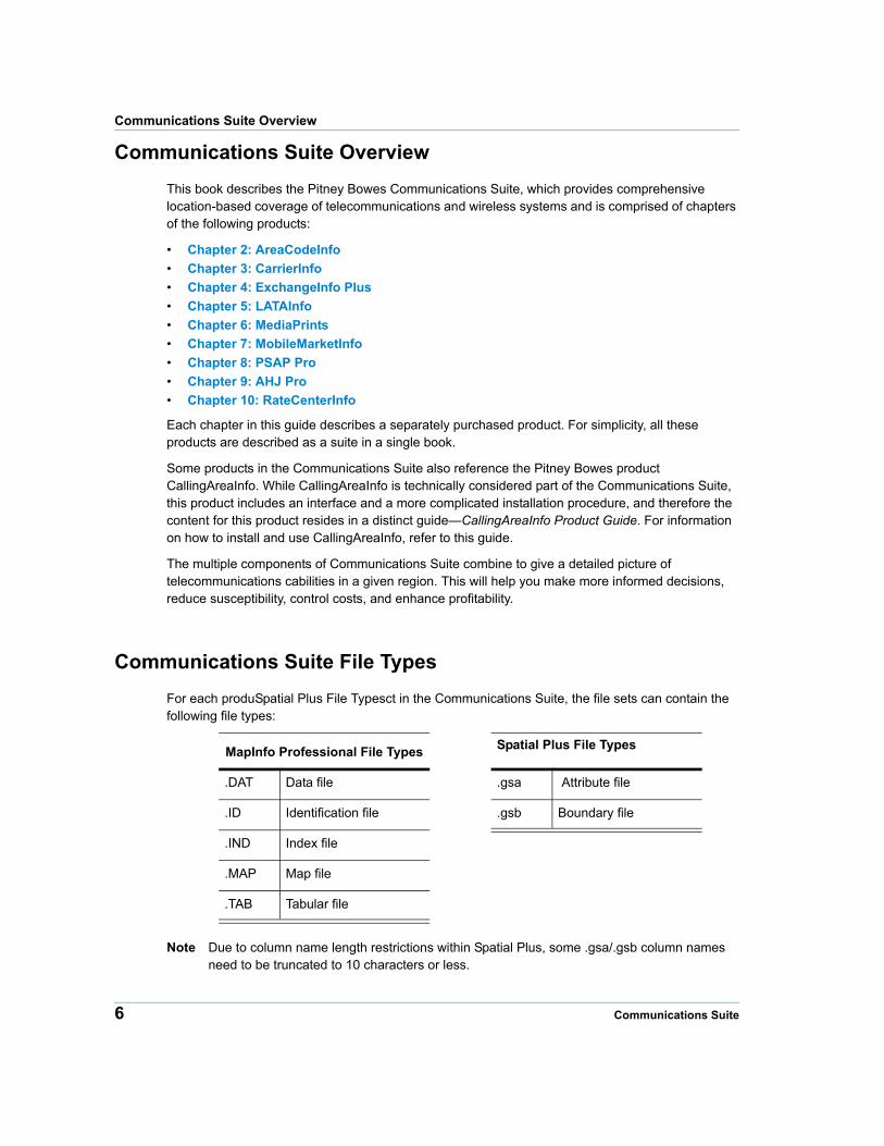
Communications Suite File Types
For each produSpatial Plus File Typesct in the Communications Suite, the file sets can contain the following file types:
MapInfo Professional File Types Spatial Plus File Types
.DAT Data file .gsa Attribute file
.ID Identification file .gsb Boundary file
.IND Index file
.MAP Map file
.TAB Tabular file
Note Due to column name length restrictions within Spatial Plus, some .gsa/.gsb column names need to be truncated to 10 characters or less.
6 Communications Suite
Chapter 1: Installing Communications Suite Products
In order to properly use file sets from any product in the Communications Suite, the following rules apply:
• You must have access to all of the files in the file set
• All files must be located in the same directory
Installing a Product
You can install any of the products in the Communications Suite as a standalone dataset. Products are described as a suite in the Communications Suite Product Guide for the sake of simplicity only. The Pitney Bowes Communications Suite recommends using MapInfo Professional v7 or higher.
To install any of the Communications Suite products:
1. Extract the contents of the zip file to a temporary folder location.
2. Copy the contents of the Data folder to the desired destination folder. If the destination folder already contains a previous vintage of the dataset, be sure to "Replace" all files of the same name with the files from the temporary folder location.
3. Copy the contents of the Docs folder (Product Guide and Release Notes) to the desired destination folder.
4. Delete the files in the temporary folder location to save disk space.
You are now ready to start using the Communications Suite.
Product Guide 7
2
Chapter 2: AreaCodeInfoAreaCodeInfo is Pitney Bowes’ map database of area code boundaries for the United States.
In this chapter
AreaCodeInfo Overview. . . . . . . . . . . . . . . . . . . . . . . . . . . . . . . . . . .9 AreaCodeInfo Database. . . . . . . . . . . . . . . . . . . . . . . . . . . . . . . . . .10
AreaCodeInfo Overview
AreaCodeInfo Overview
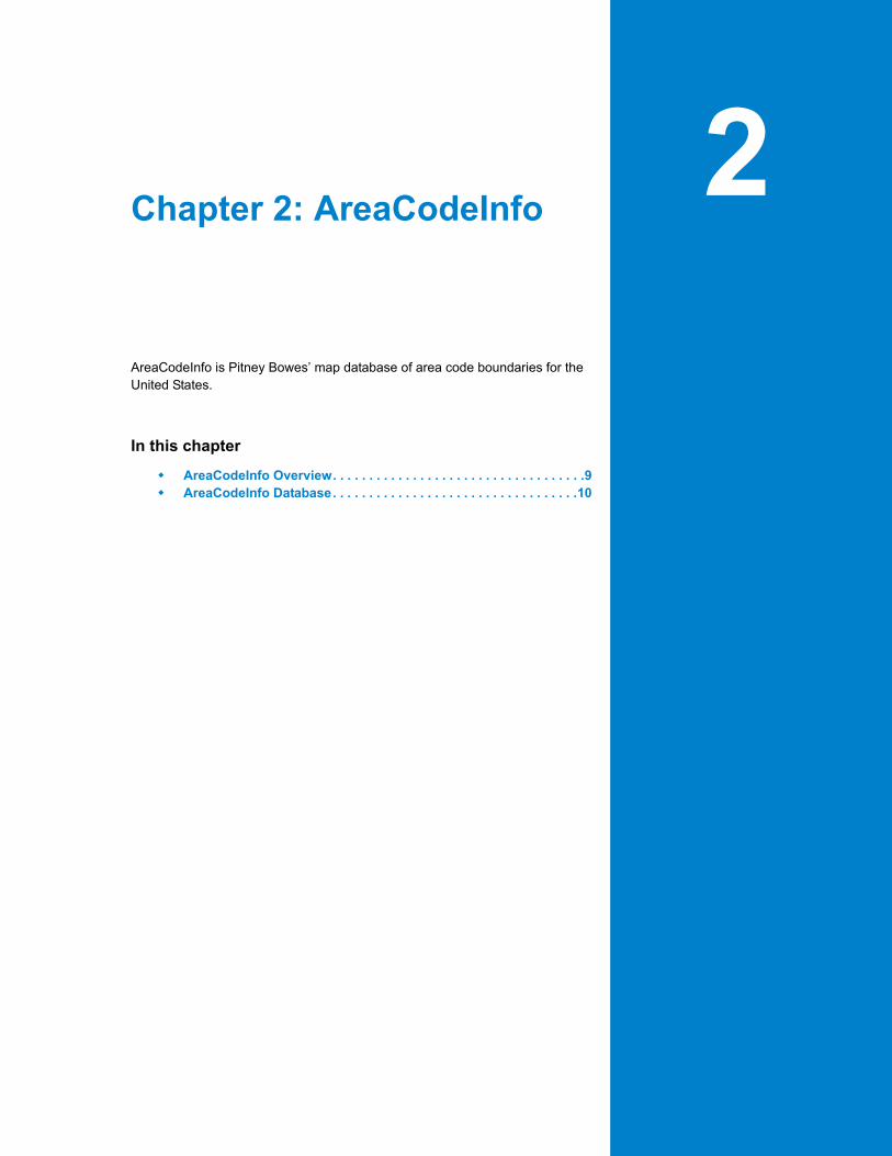
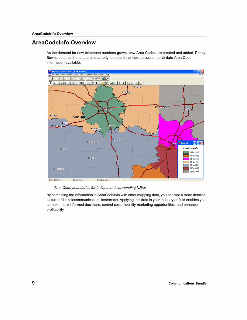
As the demand for new telephone numbers grows, new Area Codes are created and added. Pitney Bowes updates the database quarterly to ensure the most accurate, up-to-date Area Code information available.
Area Code boundaries for Indiana and surrounding NPAs
By combining the information in AreaCodeInfo with other mapping data, you can see a more detailed picture of the telecommunications landscape. Applying this data in your industry or field enables you to make more informed decisions, control costs, identify marketing opportunities, and enhance profitability.
9 Communications Bundle
Chapter 2: AreaCodeInfo
AreaCodeInfo Database
This section explains the AreaCodeInfo database structure and provides a description of its organization.
Database Structure
AreaCodeInfo contains one file set for the entire coverage area (Continental United States, Alaska, Hawaii, and Puerto Rico). The file sets are named according to the convention shown below:
AreaCodeInfo (US) AreaCodeRegions.*
The table below shows the file set for the United States:
AreaCodeInfo (US)AreaCodeInfo (US) -
Spatial Plus
US_AREA.DAT areacoderegions.gsa
US_AREA.ID areacoderegions.gsb
US_AREA.IND
US_AREA.MAP
US_AREA.TAB
To use AreaCodeInfo, you must have access to all of the files in the file set. All files must be located in the same directory.
Database Description
The AreaCodeInfo database is organized in the following manner:
Field Name Description Type Indexed
AREA_CODE Area Code Number (also known as NPA number)
Character (3) Yes
Source
Pitney Bowes’ suite of telecom infrastructure databases are built using state PUC data, state tariff data, the Telcordia™ LERG™ Routing Guide (LERG), StreetPro®, and other reference data.
Product Guide 10
AreaCodeInfo Database
Spatial Referencing
The AreaCodeInfo database has the following coverage, scale, coordinates, and projection
CoverageContinental United States, Alaska, Hawaii, and Puerto Rico.
Scale 1:24,000
Coordinates Latitude and Longitude
Projection NAD 83
11 Communications Bundle
3
Chapter 3: CarrierInfoCarrierInfo is Pitney Bowes’ database of local and wireless telephone service providers for the United States.
In this chapter
CarrierInfo Overview . . . . . . . . . . . . . . . . . . . . . . . . . . . . . . . . . . . .13 CarrierInfo Database . . . . . . . . . . . . . . . . . . . . . . . . . . . . . . . . . . . .15 Table Structures . . . . . . . . . . . . . . . . . . . . . . . . . . . . . . . . . . . . . . . .15 Using CarrierInfo . . . . . . . . . . . . . . . . . . . . . . . . . . . . . . . . . . . . . . .18
CarrierInfo Overview
CarrierInfo Overview
CarrierInfo is a macro view of the communications landscape, showing the serving area region of every telecommunications operating company. The product includes a high-level parent company view of a carrier's service area as well as a medium-level operating company number (OCN) view of the service area.
In particular, the product:
• Accurately shows the service area footprints, by rate center, of U.S. communications service providers.
• Allows users to determine coverage areas by service type (ILEC/CLEC/Wireless), parent company name, carrier name, or operating company number (OCN).
• Allows users to quickly determine and compare the overall competitive landscape of various carriers.
There are three major categories of landline telecommunications carriers:
• Regional Bell Operating Companies (RBOC)
• Independent Telephone Companies (ICO)
• Competitive Local Exchange Carriers (CLEC)
In addition to the landline telecommunications carriers, there are two major categories of wireless carriers:
• Personal Communication Services (PCS)
• Cellular Carriers
The divestiture of AT&T in 1984 created seven RBOCs. Several of the original RBOCs have merged and there are now four RBOCs. The local telephone companies that serve areas not served by RBOCs are considered Independent Telephone Companies (ICO). In a given area, there is one and only one RBOC or ICO offering service. The term “Incumbent Local Exchange Carrier” (ILEC) is used to identify the collection of RBOCs and ICOs.
The Telecommunications Act of 1996 deregulated the telecommunications landscape and for the first time allowed consumers to choose their local service provider. Competitive Local Exchange Carriers (CLECs) provide alternative service in areas served by ILECs. Unlike ILECs, CLECs are not required to provide service to all locations within their service territory, and can decline to offer service to particular regions or consumers. Consumers in a territory in which a CLEC operates have the option to receive local service from a CLEC rather than from the ILEC in the area. There can be multiple CLECs offering service in a given area.
The Power of CarrierInfo
CarrierInfo is used to analyze telecommunications carriers’ geographic presence at a high-level. Additionally, CarrierInfo may be used with other Pitney Bowes data products such as ExchangeInfo Plus and RateCenterInfo to associate parent company information with the lower-level detail provided by these products. To see examples of how CarrierInfo can be used in conjunction with other Pitney Bowes communications data products, see Using CarrierInfo on page 18.
13 Communications Suite
Chapter 3: CarrierInfo
For example, users can use the parent company layer to identify the footprint of Verizon Communications through a single selection. By then adding the OCN layer from CarrierInfo, users are then able identify all of the OCNs assigned to Verizon Communications. In this example, there are 41 OCNs assigned to Verizon Communications. The results of this query would identify all of the areas in which Verizon operates as an ILEC as well as a CLEC.
CarrierInfo may also be used to determine all of the CLECs that operate within a particular ILEC service territory. A selection of the ILEC’s parent company territory can be made from the Parent Company layer. That geographic area can then be overlaid with the CLEC layer and a selection can be made to determine all of the CLECs that have operating territories within the ILEC footprint.
CarrierInfo is useful for a variety of different users and applications, including:
• Mergers and Acquisitions
• Competitive Analysis
• Strategic expansion into new markets
The product can be used to answer questions such as:
• How much does one company overlap other companies’ coverage area?
• What are all the OCNs associated with Verizon or CenturyTel?
• What is the parent company of an area’s ILEC/CLEC?
• What are all the CLECs operating within a particular ILEC service area?
• What are all the NPA/NXXs for a specific company?
Note This last question requires that you have data from either RateCenterInfo or ExchangeInfo Plus to perform a complete analysis.
Features
CarrierInfo offers the following features:
• A single source for ILEC, CLEC, and Wireless carrier service areas by rate center.
CarrierInfo allows users to identify the service areas for any communications service provider in the United States.
• Useful layers that include Parent Companies, OCNs, incumbent and competitive carriers.
• The Parent company layer provides a researched parent company name so that affiliates can be viewed as part of a larger parent company view.
• The OCN layer provides a more detailed view of a parent company's serving area—in terms of the individual operating company numbers owned by the parent company
• Provides a critical link between Telcordia® LERG™ based company names and an industry recognized company name.
• Increase the usability of additional Pitney Bowes communications data products such as ExchangeInfo Plus and RateCenterInfo that rely on Telcordia LERG based company names.
Product Guide 14
CarrierInfo Database
CarrierInfo Database
This section explains the CarrierInfo database structure and provides a description of its organization.
Source
Pitney Bowes’ suite of telecom infrastructure databases are built using state PUC data, state tariff data, the Telcordia™ LERG™ Routing Guide (LERG), StreetPro®, and other reference data.
Spatial Referencing
The CarrierInfo database has the following coverage, scale, and coordinates:
CoverageContinental United States, Alaska, Hawaii, and Puerto Rico, Guam, US Virgin Islands, and US Northern Mariana Islands.
Scale 1:24,000
Coordinates Latitude and Longitude
Projection NAD83
Table Structures
The CarrierInfo database consists of the following tables:
• UsOcn.*
• UsOcnIlec.*
• UsOcnClec.*
• UsOcnWireless.*
• UsParent.*
• UsParentIlec.*
• UsParentClec.*
• UsParentWireless.*
15 Communications Suite
Chapter 3: CarrierInfo
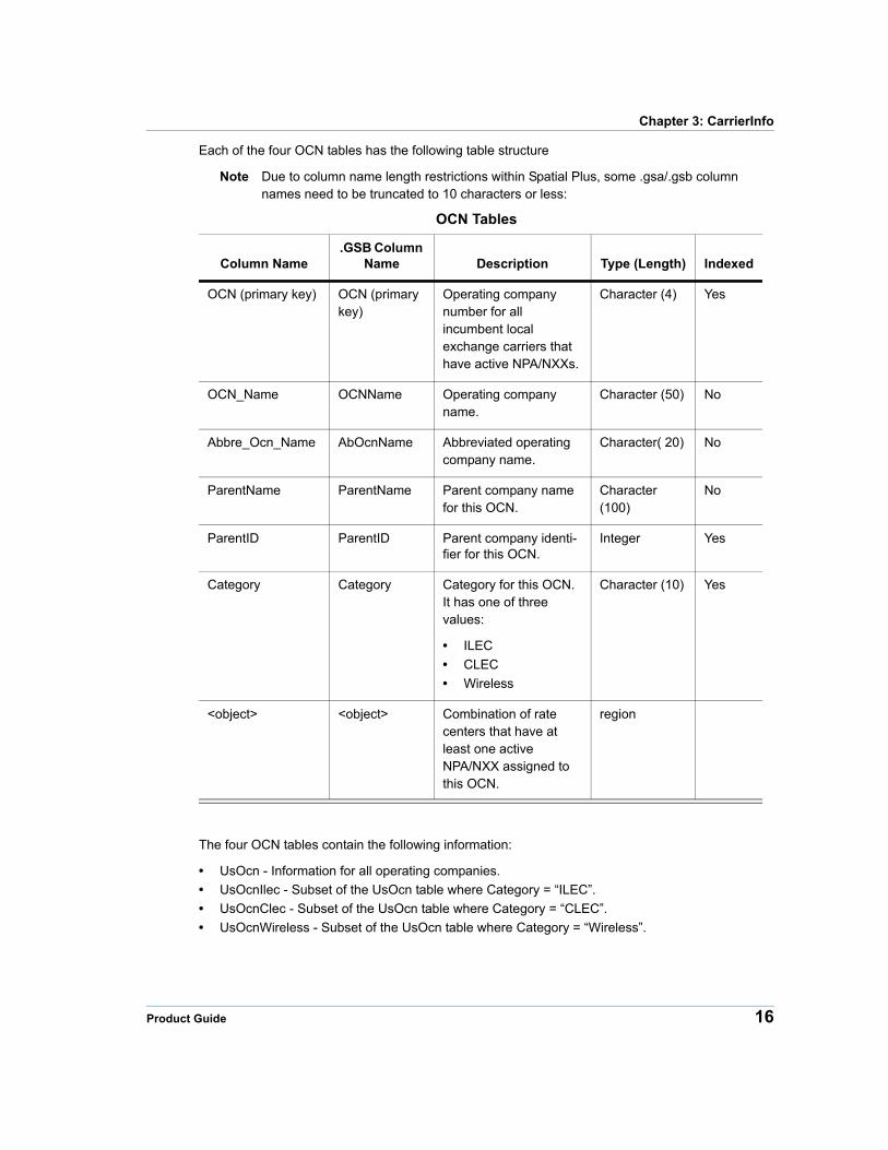
Each of the four OCN tables has the following table structure
Note Due to column name length restrictions within Spatial Plus, some .gsa/.gsb column names need to be truncated to 10 characters or less:
OCN Tables
Column Name.GSB Column
Name Description Type (Length) Indexed
OCN (primary key) OCN (primary key)
Operating company number for all incumbent local exchange carriers that have active NPA/NXXs.
Character (4) Yes
OCN_Name OCNName Operating company name.
Character (50) No
Abbre_Ocn_Name AbOcnName Abbreviated operating company name.
Character( 20) No
ParentName ParentName Parent company name for this OCN.
Character (100)
No
ParentID ParentID Parent company identi-fier for this OCN.
Integer Yes
Category Category Category for this OCN. It has one of three values:
• ILEC
• CLEC
• Wireless
Character (10) Yes
<object> <object> Combination of rate centers that have at least one active NPA/NXX assigned to this OCN.
region
The four OCN tables contain the following information:
• UsOcn - Information for all operating companies.
• UsOcnIlec - Subset of the UsOcn table where Category = “ILEC”.
• UsOcnClec - Subset of the UsOcn table where Category = “CLEC”.
• UsOcnWireless - Subset of the UsOcn table where Category = “Wireless”.
Product Guide 16
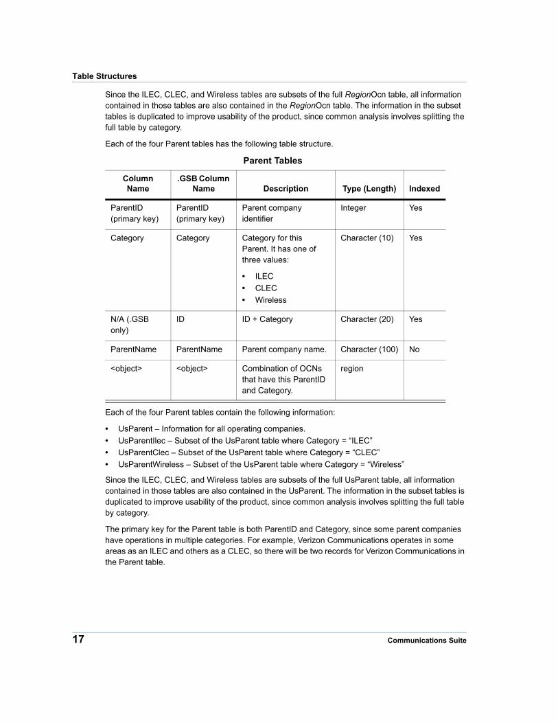
Table Structures
Since the ILEC, CLEC, and Wireless tables are subsets of the full RegionOcn table, all information contained in those tables are also contained in the RegionOcn table. The information in the subset tables is duplicated to improve usability of the product, since common analysis involves splitting the full table by category.
Each of the four Parent tables has the following table structure.
Parent Tables
Column Name
.GSB Column Name Description Type (Length) Indexed
ParentID (primary key)
ParentID (primary key)
Parent company identifier
Integer Yes
Category Category Category for this Parent. It has one of three values:
• ILEC
• CLEC
• Wireless
Character (10) Yes
N/A (.GSB only)
ID ID + Category Character (20) Yes
ParentName ParentName Parent company name. Character (100) No
<object> <object> Combination of OCNs that have this ParentID and Category.
region
Each of the four Parent tables contain the following information:
• UsParent – Information for all operating companies.
• UsParentIlec – Subset of the UsParent table where Category = “ILEC”
• UsParentClec – Subset of the UsParent table where Category = “CLEC”
• UsParentWireless – Subset of the UsParent table where Category = “Wireless”
Since the ILEC, CLEC, and Wireless tables are subsets of the full UsParent table, all information contained in those tables are also contained in the UsParent. The information in the subset tables is duplicated to improve usability of the product, since common analysis involves splitting the full table by category.
The primary key for the Parent table is both ParentID and Category, since some parent companies have operations in multiple categories. For example, Verizon Communications operates in some areas as an ILEC and others as a CLEC, so there will be two records for Verizon Communications in the Parent table.
17 Communications Suite
Chapter 3: CarrierInfo
About the ParentID Field• The ParentID is an arbitrary integer value that does not correspond to any industry-standard
code.
• The ParentID value for a particular ParentName will not change between updates.
• There is always a one-to-one relationship between ParentID and ParentName.
• The OCN table may be joined to the Parent table on ParentID and Category, or on ParentName and Category.
Using CarrierInfo
Compatibility with Other Communications Suite Products
The OCN Category values in CarrierInfo are not the same as those found in other Pitney Bowes data products such as CallingAreaInfo, ExchangeInfo Plus, and RateCenterInfo. The following table shows how the CarrierInfo Category corresponds to the OCN Category values in other Pitney Bowes data products.
CarrierInfo CategoryCategories in other Pitney Bowes Communications Data Products
ILEC • RBOC
• ICO
CLEC • CLEC
• ULEC
• L RESELLER
• IPES
• CAP
Wireless • WIRELESS
• W RESELLER
• PCS
• P RESELLER
Merger and Acquisition Scenarios
For users that want to look at various scenarios such as mergers and acquisitions, CarrierInfo allows users to view the service area at the parent company level and the OCN level. As an example let us take a look at the pending (as of November 1, 2005) MCI WorldCom and Verizon Communications merger and what impact it will have on the service areas of Verizon Communications. The following procedure shows how to do this.
Product Guide 18
Using CarrierInfo
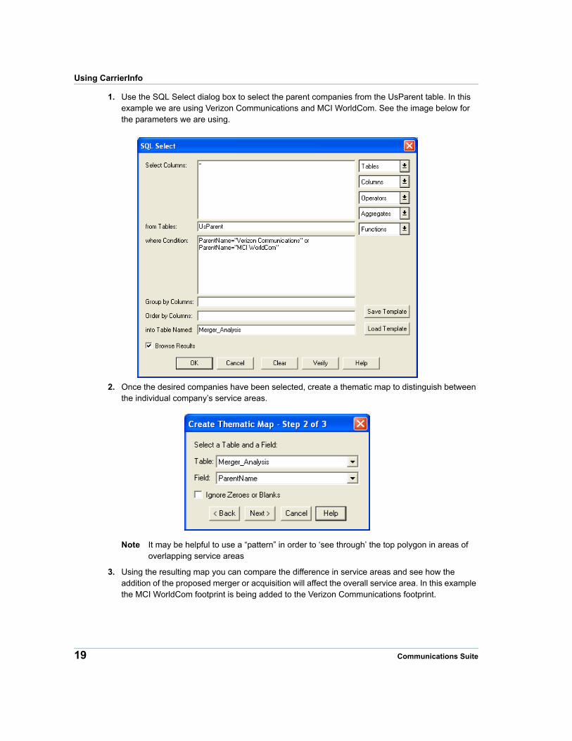
1. Use the SQL Select dialog box to select the parent companies from the UsParent table. In this example we are using Verizon Communications and MCI WorldCom. See the image below for the parameters we are using.
2. Once the desired companies have been selected, create a thematic map to distinguish between the individual company’s service areas.
Note It may be helpful to use a “pattern” in order to ‘see through’ the top polygon in areas of overlapping service areas
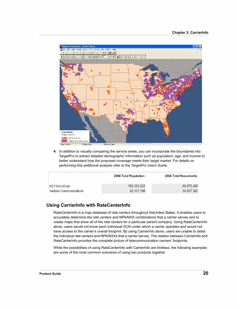
3. Using the resulting map you can compare the difference in service areas and see how the addition of the proposed merger or acquisition will affect the overall service area. In this example the MCI WorldCom footprint is being added to the Verizon Communications footprint.
19 Communications Suite
Chapter 3: CarrierInfo
4. In addition to visually comparing the service areas, you can incorporate the boundaries into TargetPro to extract detailed demographic information such as population, age, and income to better understand how the proposed coverage meets their target market. For details on performing this additional analysis refer to the TargetPro Users Guide.
Using CarrierInfo with RateCenterInfo
RateCenterInfo is a map database of rate centers throughout theUnited States. It enables users to accurately determine the rate centers and NPA/NXX combinations that a carrier serves and to create maps that show all of the rate centers for a particular parent company. Using RateCenterInfo alone, users would not know each individual OCN under which a carrier operates and would not have access to the carrier’s overall footprint. By using CarrierInfo alone, users are unable to detail the individual rate centers and NPA/NXXs that a carrier serves. The relation between CarrierInfo and RateCenterInfo provides the complete picture of telecommunication carriers’ footprints.
While the possibilities of using RateCenterInfo with CarrierInfo are limitless, the following examples are some of the most common scenarios of using two products together.
Product Guide 20
Using CarrierInfo
Selecting the Rate Centers for a Parent Company
This scenario walks through the process of selecting the rate centers served by a particular parent company. CarrierInfo provides the overall footprint, and RateCenterInfo provides the individual rate centers that can be further studied for a more detailed analysis.
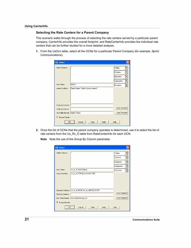
1. From the UsOcn table, select all the OCNs for a particular Parent Company (for example, Sprint Communications).
2. Once the list of OCNs that the parent company operates is determined, use it to select the list of rate centers from the Us_Rc_D table from RateCenterInfo for each OCN.
Note Note the use of the Group By Column parameter.
21 Communications Suite
Chapter 3: CarrierInfo
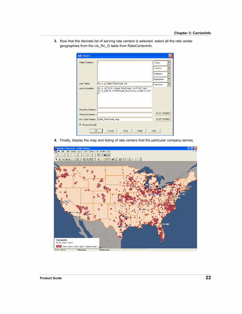
3. Now that the discrete list of serving rate centers is selected, select all the rate center geographies from the Us_Rc_G table from RateCenterInfo.
4. Finally, display the map and listing of rate centers that the particular company serves.
Product Guide 22
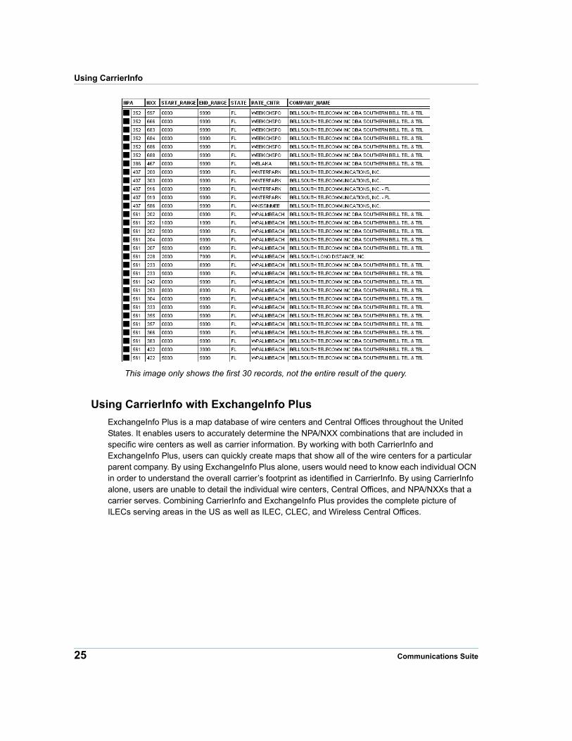
Using CarrierInfo
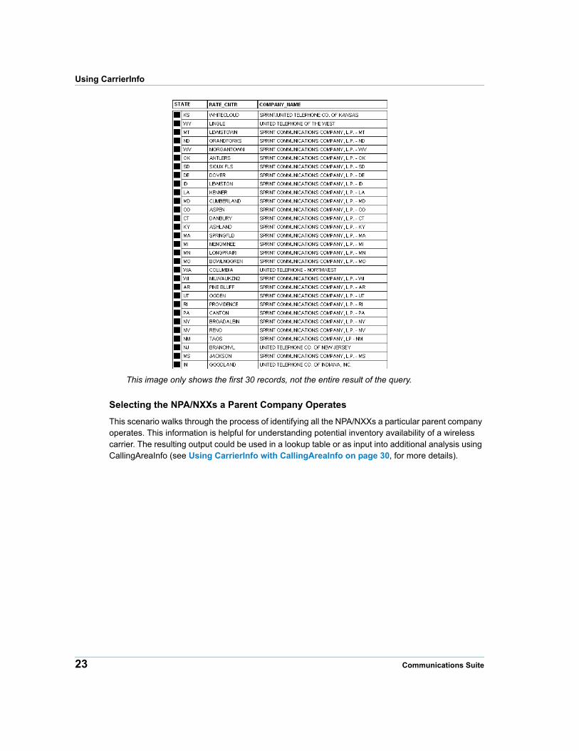
This image only shows the first 30 records, not the entire result of the query.
Selecting the NPA/NXXs a Parent Company Operates
This scenario walks through the process of identifying all the NPA/NXXs a particular parent company operates. This information is helpful for understanding potential inventory availability of a wireless carrier. The resulting output could be used in a lookup table or as input into additional analysis using CallingAreaInfo (see Using CarrierInfo with CallingAreaInfo on page 30, for more details).
23 Communications Suite
Chapter 3: CarrierInfo
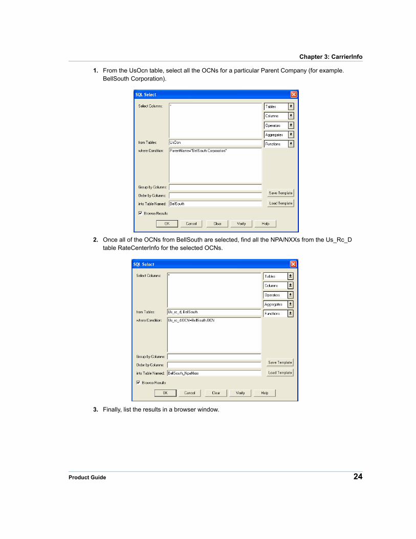
1. From the UsOcn table, select all the OCNs for a particular Parent Company (for example. BellSouth Corporation).
2. Once all of the OCNs from BellSouth are selected, find all the NPA/NXXs from the Us_Rc_D table RateCenterInfo for the selected OCNs.
3. Finally, list the results in a browser window.
Product Guide 24
Using CarrierInfo
This image only shows the first 30 records, not the entire result of the query.
Using CarrierInfo with ExchangeInfo Plus
ExchangeInfo Plus is a map database of wire centers and Central Offices throughout the United States. It enables users to accurately determine the NPA/NXX combinations that are included in specific wire centers as well as carrier information. By working with both CarrierInfo and ExchangeInfo Plus, users can quickly create maps that show all of the wire centers for a particular parent company. By using ExchangeInfo Plus alone, users would need to know each individual OCN in order to understand the overall carrier’s footprint as identified in CarrierInfo. By using CarrierInfo alone, users are unable to detail the individual wire centers, Central Offices, and NPA/NXXs that a carrier serves. Combining CarrierInfo and ExchangeInfo Plus provides the complete picture of ILECs serving areas in the US as well as ILEC, CLEC, and Wireless Central Offices.
25 Communications Suite
Chapter 3: CarrierInfo
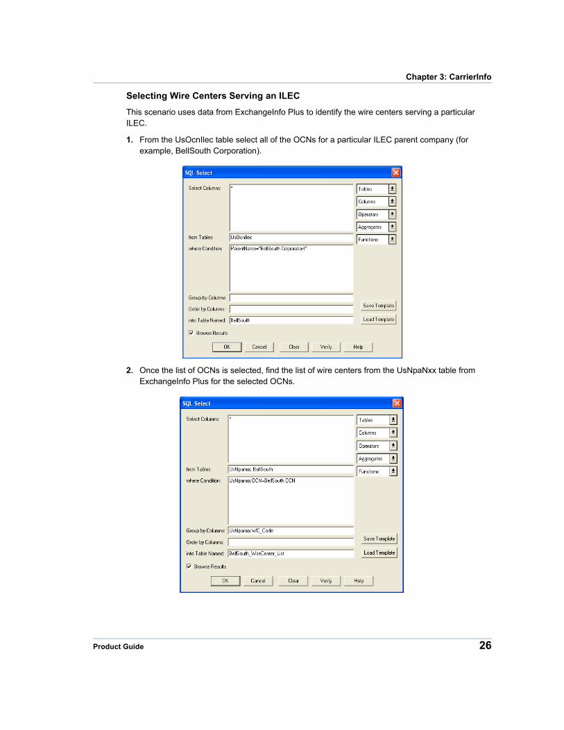
Selecting Wire Centers Serving an ILEC
This scenario uses data from ExchangeInfo Plus to identify the wire centers serving a particular ILEC.
1. From the UsOcnIlec table select all of the OCNs for a particular ILEC parent company (for example, BellSouth Corporation).
2. Once the list of OCNs is selected, find the list of wire centers from the UsNpaNxx table from ExchangeInfo Plus for the selected OCNs.
Product Guide 26
Using CarrierInfo
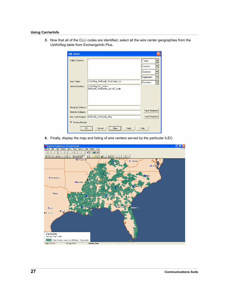
3. Now that all of the CLLI codes are identified, select all the wire center geographies from the UsWcReg table from ExchangeInfo Plus.
4. Finally, display the map and listing of wire centers served by the particular ILEC.
27 Communications Suite
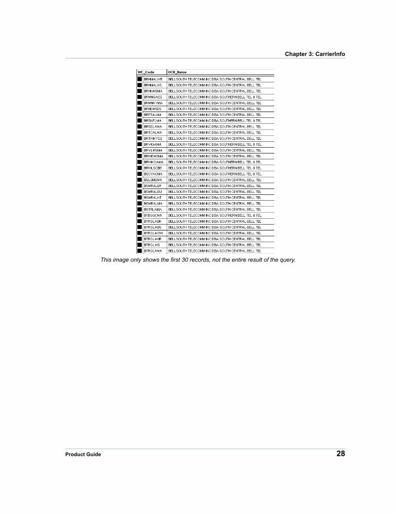
Chapter 3: CarrierInfo
This image only shows the first 30 records, not the entire result of the query.
Product Guide 28
Using CarrierInfo
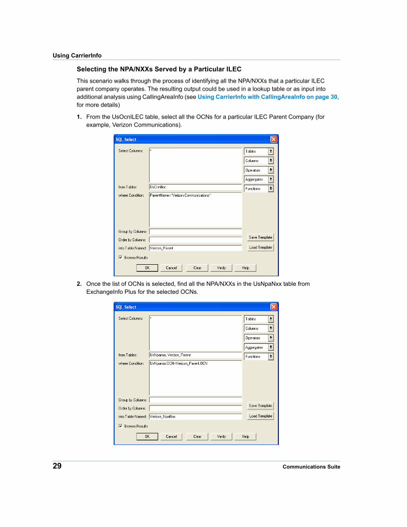
Selecting the NPA/NXXs Served by a Particular ILEC
This scenario walks through the process of identifying all the NPA/NXXs that a particular ILEC parent company operates. The resulting output could be used in a lookup table or as input into additional analysis using CallingAreaInfo (see Using CarrierInfo with CallingAreaInfo on page 30, for more details)
1. From the UsOcnILEC table, select all the OCNs for a particular ILEC Parent Company (for example, Verizon Communications).
2. Once the list of OCNs is selected, find all the NPA/NXXs in the UsNpaNxx table from ExchangeInfo Plus for the selected OCNs.
29 Communications Suite
Chapter 3: CarrierInfo
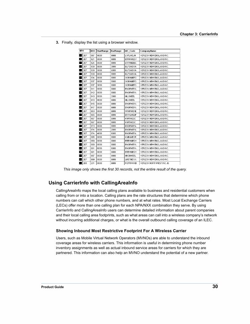
3. Finally, display the list using a browser window.
This image only shows the first 30 records, not the entire result of the query.
Using CarrierInfo with CallingAreaInfo
CallingAreaInfo maps the local calling plans available to business and residential customers when calling from or into a location. Calling plans are the rate structures that determine which phone numbers can call which other phone numbers, and at what rates. Most Local Exchange Carriers (LECs) offer more than one calling plan for each NPA/NXX combination they serve. By using CarrierInfo and CallingAreaInfo users can determine detailed information about parent companies and their local calling area footprints, such as what areas can call into a wireless company’s network without incurring additional charges, or what is the overall outbound calling coverage of an ILEC.
Showing Inbound Most Restrictive Footprint For A Wireless Carrier
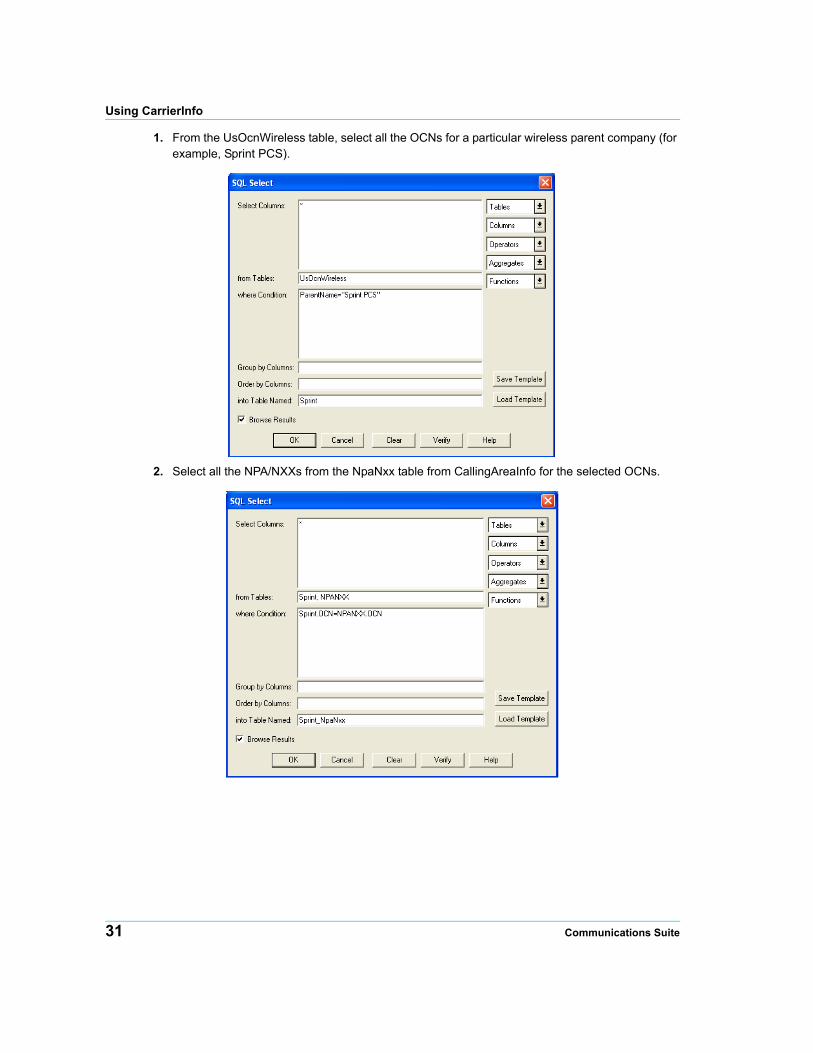
Users, such as Mobile Virtual Network Operators (MVNOs) are able to understand the inbound coverage areas for wireless carriers. This information is useful in determining phone number inventory assignments as well as actual inbound service areas for carriers for which they are partnered. This information can also help an MVNO understand the potential of a new partner.
Product Guide 30
Using CarrierInfo
1. From the UsOcnWireless table, select all the OCNs for a particular wireless parent company (for example, Sprint PCS).
2. Select all the NPA/NXXs from the NpaNxx table from CallingAreaInfo for the selected OCNs.
31 Communications Suite
Chapter 3: CarrierInfo
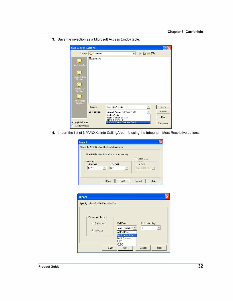
3. Save the selection as a Microsoft Access (.mdb) table.
4. Import the list of NPA/NXXs into CallingAreaInfo using the Inbound – Most Restrictive options.
Product Guide 32

Using CarrierInfo
5. From CallingAreaInfo create a database report and enable GENERATE MAPS.
6. Display the map for the resulting coverage area. In this scenario we see the rate centers that Sprint PCS has inventory, as well as areas that can access that inventory as a local call.
33 Communications Suite
4
Chapter 4: ExchangeInfo PlusExchangeInfo Plus is Pitney Bowes’ database of Wire Center serving areas and Central Offices across the United States and Canada.This chapter provides an introduction to ExchangeInfo Plus and its features.
In this chapter
ExchangeInfo Plus Overview . . . . . . . . . . . . . . . . . . . . . . . . . . . . .35 ExchangeInfo Plus Database . . . . . . . . . . . . . . . . . . . . . . . . . . . . .36 ExchangeInfo Plus Table Structures . . . . . . . . . . . . . . . . . . . . . . .37 Using ExchangeInfo Plus . . . . . . . . . . . . . . . . . . . . . . . . . . . . . . . .43
ExchangeInfo Plus Overview
ExchangeInfo Plus Overview
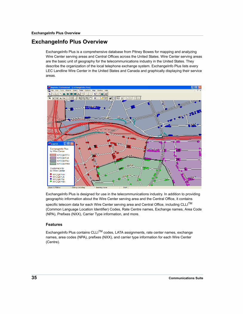
ExchangeInfo Plus is a comprehensive database from Pitney Bowes for mapping and analyzing Wire Center serving areas and Central Offices across the United States. Wire Center serving areas are the basic unit of geography for the telecommunications industry in the United States. They describe the organization of the local telephone exchange system. ExchangeInfo Plus lists every LEC Landline Wire Center in the United States and Canada and graphically displaying their service areas.
ExchangeInfo Plus is designed for use in the telecommunications industry. In addition to providing geographic information about the Wire Center serving area and the Central Office, it contains
specific telecom data for each Wire Center serving area and Central Office, including CLLITM (Common Language Location Identifier) Codes, Rate Centre names, Exchange names, Area Code (NPA), Prefixes (NXX), Carrier Type information, and more.
Features
ExchangeInfo Plus contains CLLITM codes, LATA assignments, rate center names, exchange names, area codes (NPA), prefixes (NXX), and carrier type information for each Wire Center (Centre).
35 Communications Suite
Chapter 4: ExchangeInfo Plus
ExchangeInfo Plus Database
File Structure
The ExchangeInfo Plus database is divided into three file sets for each state or province and two support data tables for each. The files are named in the following manner:
ExchangeInfo Plus state file sets
UsWcReg.*UsWcPt.*UsNPANXX.*
Support data tablesServiceTypeOCNCategory
Sample File Sets
In the case of ExchangeInfo Plus U.S., the file set for the state of Pennsylvania (abbreviated PA) contains the following files:
ExchangeInfo Plus MapInfo
PAWcReg.DATPAWcReg.IDPAWcReg.INDPAWcReg.MAPPAWcReg.TAB
PAWcPt.DATPAWcPt.IDPAWcPt.INDPAWcPt.MAPPAWcPt.TAB
PANPANXX.DATPANPANXX.INDPANPANXX.TAB
ServiceType.DATServiceType.TAB
OCNCategory.DATOCNCategory.TAB
ExchangeInfo Plus - Spatial Plus
uswcreg.gsauswcreg.gsb
uswcpt.gsa uwwcpt.gsb
Note For Spatial Plus, NPANXX, ServiceType, and OCNCategory are Access tables in exchangeinfoplus.mdb.
Product Guide 36
ExchangeInfo Plus Table Structures
ExchangeInfo Plus Canada (BC)
CnWcPt.dat CnWcPt.id CnWcPt.map CnWcPt.ind CnWcPt.tab
CnNPANXX.id CnNPANXX.ind CnNPANXX.map CnNPANXX.dat CnNPANXX.tab
OCNCategory.dat OCNCategory.tab OCNCategory.ind
CnWcReg.dat CnWcReg.id CnWcReg.map CnWcReg.tab
ServiceType.dat ServiceType.ind ServiceType.tab
In the case of ExchangeInfo Plus Canada, the file set contains the following files:
ExchangeInfo Plus Canada - Spatial Plus
cnwcreg.gsacnwcreg.gsb
cnwcpt.gsa cnwcpt.gsb
The ExchangeInfo Plus database is divided into five file sets:
• Central Office Points (XXWcPt.*)
• Wire Center Boundaries (XXWcReg.*)
• Area Code and Prefix Data Table (XXNPANXX.*)
• Service Type Data Table (ServiceType.*)
• OCN Category Data Table (OCNCategory.*)
Note For Spatial Plus, NPANXX, ServiceType, and OCNCategory are Access tables in exchangeinfoplus_canada.mdb.
The file sets can be opened and used individually. However, using the file sets together provides the most complete information about Wire Center (Centre) serving areas and Central Offices.
ExchangeInfo Plus Table Structures
Source
Pitney Bowes’ suite of telecom infrastructure databases are built using state PUC data, state tariff data, the Telcordia™ LERG™ Routing Guide (LERG), StreetPro®, and other reference data. Pitney Bowes’ Communications Data products now incorporate data with LERG effective dates (planned changes) thru the end of the release month. This change provides our customers with the most up-to-date content upon receipt of the products.
37 Communications Suite
Chapter 4: ExchangeInfo Plus
Spatial Referencing
The ExchangeInfo Plus database has the following coverage, scale, and coordinates:
CoverageContinental United States, Canada, Alaska, Hawaii, Guam, US Virgin Islands, US Northern Mariana Islands, and Puerto Rico.
Scale 1:24,000
Coordinates Latitude and Longitude
Projection NAD 83
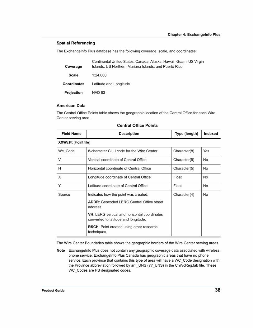
American Data
The Central Office Points table shows the geographic location of the Central Office for each Wire Center serving area.
Central Office Points
Field Name Description Type (length) Indexed
XXWcPt (Point file)
Wc_Code 8-character CLLI code for the Wire Center Character(8) Yes
V Vertical coordinate of Central Office Character(5) No
H Horizontal coordinate of Central Office Character(5) No
X Longitude coordinate of Central Office Float No
Y Latitude coordinate of Central Office Float No
Source Indicates how the point was created:
ADDR: Geocoded LERG Central Office street address
VH: LERG vertical and horizontal coordinates converted to latitude and longitude.
RSCH: Point created using other research techniques.
Character(4) No
The Wire Center Boundaries table shows the geographic borders of the Wire Center serving areas.
Note ExchangeInfo Plus does not contain any geographic coverage data associated with wireless phone service. ExchangeInfo Plus Canada has geographic areas that have no phone service. Each province that contains this type of area will have a WC_Code designation with the Province abbreviation followed by an _UNS (??_UNS) in the CnWcReg.tab file. These WC_Codes are PB designated codes.
Product Guide 38
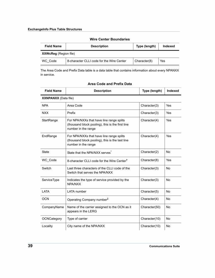
ExchangeInfo Plus Table Structures
Wire Center Boundaries
Field Name Description Type (length) Indexed
XXWcReg (Region file)
WC_Code 8-character CLLI code for the Wire Center Character(8) Yes
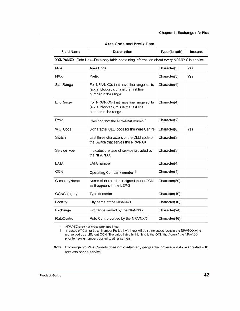
The Area Code and Prefix Data table is a data table that contains information about every NPANXX in service.
Area Code and Prefix Data
Field Name Description Type (length) Indexed
XXNPANXX (Data file)
NPA Area Code Character(3) Yes
NXX Prefix Character(3) Yes
StartRange For NPA/NXXs that have line range splits (thousand block pooling), this is the first line number in the range
Character(4) Yes
EndRange For NPA/NXXs that have line range splits (thousand block pooling), this is the last line number in the range
Character(4) Yes
State State that the NPA/NXX serves* Character(2) No
WC_Code 8-character CLLI code for the Wire Center† Character(8) Yes
Switch Last three characters of the CLLI code of the Switch that serves the NPA/NXX
Character(3) No
ServiceType Indicates the type of service provided by the NPA/NXX
Character(3) No
LATA LATA number Character(5) No
OCN Operating Company number‡ Character(4) No
CompanyName Name of the carrier assigned to the OCN as it appears in the LERG
Character(50) No
OCNCategory Type of carrier Character(10) No
Locality City name of the NPA/NXX Character(10) No
39 Communications Suite
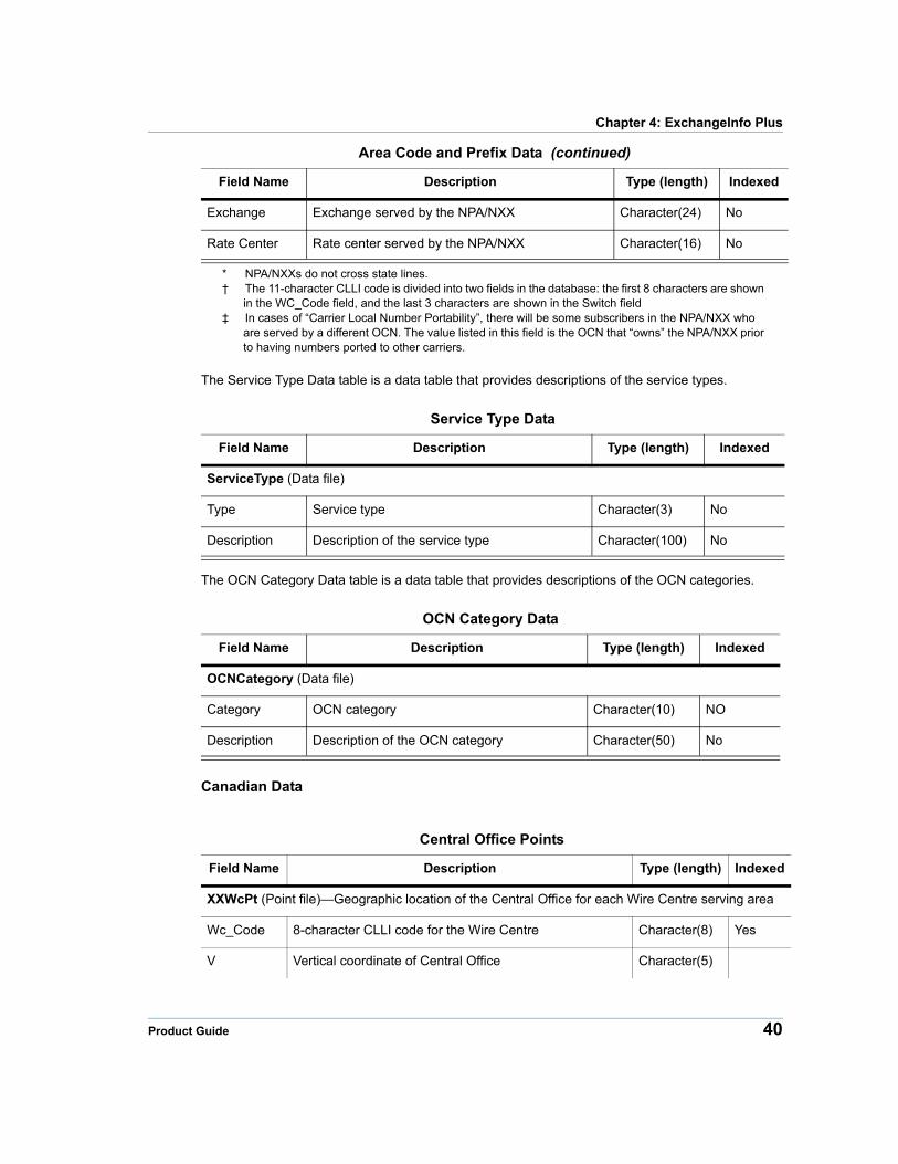
Chapter 4: ExchangeInfo Plus
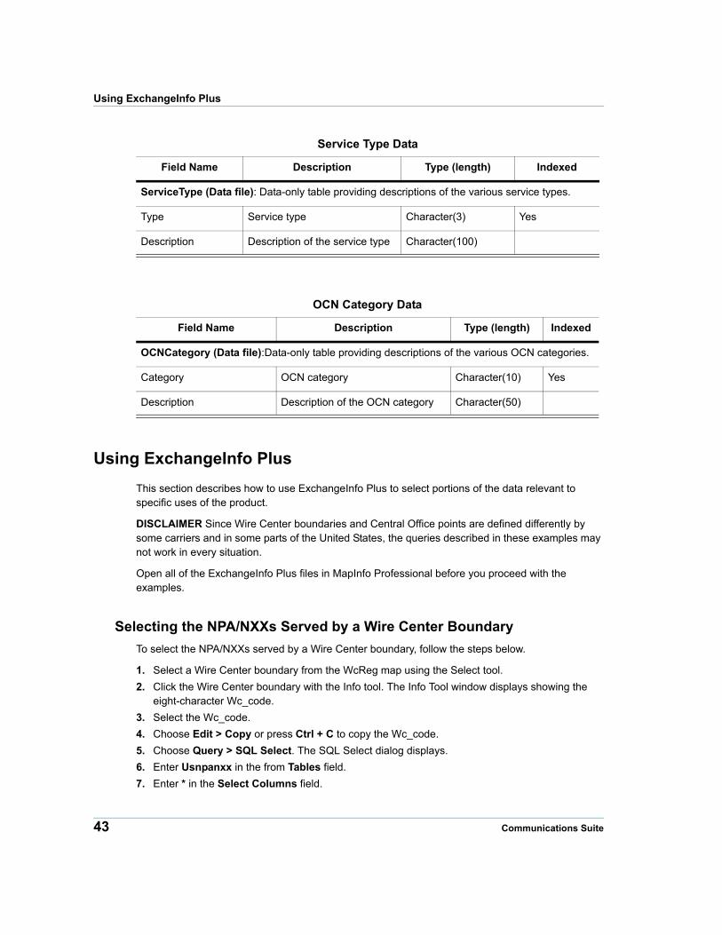
The Service Type Data table is a data table that provides descriptions of the service types.
Service Type Data
Field Name Description Type (length) Indexed
ServiceType (Data file)
Type Service type Character(3) No
Description Description of the service type Character(100) No
The OCN Category Data table is a data table that provides descriptions of the OCN categories.
OCN Category Data
Field Name Description Type (length) Indexed
OCNCategory (Data file)
Category OCN category Character(10) NO
Description Description of the OCN category Character(50) No
Canadian Data
Exchange Exchange served by the NPA/NXX Character(24) No
Rate Center Rate center served by the NPA/NXX Character(16) No
* NPA/NXXs do not cross state lines.† The 11-character CLLI code is divided into two fields in the database: the first 8 characters are shown
in the WC_Code field, and the last 3 characters are shown in the Switch field‡ In cases of “Carrier Local Number Portability”, there will be some subscribers in the NPA/NXX who
are served by a different OCN. The value listed in this field is the OCN that “owns” the NPA/NXX prior to having numbers ported to other carriers.
Area Code and Prefix Data (continued)
Field Name Description Type (length) Indexed
Central Office Points
Field Name Description Type (length) Indexed
XXWcPt (Point file)—Geographic location of the Central Office for each Wire Centre serving area
Wc_Code 8-character CLLI code for the Wire Centre Character(8) Yes
V Vertical coordinate of Central Office Character(5)
Product Guide 40
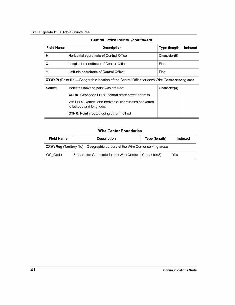
ExchangeInfo Plus Table Structures
H Horizontal coordinate of Central Office Character(5)
X Longitude coordinate of Central Office Float
Y Latitude coordinate of Central Office Float
XXWcPt (Point file)—Geographic location of the Central Office for each Wire Centre serving area
Source Indicates how the point was created:
ADDR: Geocoded LERG central office street address
VH: LERG vertical and horizontal coordinates converted to latitude and longitude.
OTHR: Point created using other method
Character(4)
Wire Center Boundaries
Field Name Description Type (length) Indexed
XXWcReg (Territory file)—Geographic borders of the Wire Center serving areas
WC_Code 8-character CLLI code for the Wire Centre Character(8) Yes
Central Office Points (continued)
Field Name Description Type (length) Indexed
41 Communications Suite
Chapter 4: ExchangeInfo Plus
Area Code and Prefix Data
Field Name Description Type (length) Indexed
XXNPANXX (Data file)—Data-only table containing information about every NPANXX in service
NPA Area Code Character(3) Yes
NXX Prefix Character(3) Yes
StartRange For NPA/NXXs that have line range splits (a.k.a. blocked), this is the first line number in the range
Character(4)
EndRange For NPA/NXXs that have line range splits (a.k.a. blocked), this is the last line number in the range
Character(4)
Prov Province that the NPA/NXX serves *
* NPA/NXXs do not cross province lines.
Character(2)
WC_Code 8-character CLLI code for the Wire Centre Character(8) Yes
Switch Last three characters of the CLLI code of the Switch that serves the NPA/NXX
Character(3)
ServiceType Indicates the type of service provided by the NPA/NXX
Character(3)
LATA LATA number Character(4)
OCN Operating Company number †
† In cases of “Carrier Local Number Portability”, there will be some subscribers in the NPA/NXX who are served by a different OCN. The value listed in this field is the OCN that “owns” the NPA/NXX prior to having numbers ported to other carriers.
Character(4)
CompanyName Name of the carrier assigned to the OCN as it appears in the LERG
Character(50)
OCNCategory Type of carrier Character(10)
Locality City name of the NPA/NXX Character(10)
Exchange Exchange served by the NPA/NXX Character(24)
RateCentre Rate Centre served by the NPA/NXX Character(16)
Note ExchangeInfo Plus Canada does not contain any geographic coverage data associated with wireless phone service.
Product Guide 42
Using ExchangeInfo Plus
Service Type Data
Field Name Description Type (length) Indexed
ServiceType (Data file): Data-only table providing descriptions of the various service types.
Type Service type Character(3) Yes
Description Description of the service type Character(100)
OCN Category Data
Field Name Description Type (length) Indexed
OCNCategory (Data file):Data-only table providing descriptions of the various OCN categories.
Category OCN category Character(10) Yes
Description Description of the OCN category Character(50)
Using ExchangeInfo Plus
This section describes how to use ExchangeInfo Plus to select portions of the data relevant to specific uses of the product.
DISCLAIMER Since Wire Center boundaries and Central Office points are defined differently by some carriers and in some parts of the United States, the queries described in these examples may not work in every situation.
Open all of the ExchangeInfo Plus files in MapInfo Professional before you proceed with the examples.
Selecting the NPA/NXXs Served by a Wire Center Boundary
To select the NPA/NXXs served by a Wire Center boundary, follow the steps below.
1. Select a Wire Center boundary from the WcReg map using the Select tool.
2. Click the Wire Center boundary with the Info tool. The Info Tool window displays showing the eight-character Wc_code.
3. Select the Wc_code.
4. Choose Edit > Copy or press Ctrl + C to copy the Wc_code.
5. Choose Query > SQL Select. The SQL Select dialog displays.
6. Enter Usnpanxx in the from Tables field.
7. Enter * in the Select Columns field.
43 Communications Suite
Chapter 4: ExchangeInfo Plus
8. Enter Wc_code = “XXXXXXXX” in the where Condition field, where XXXXXXXX is the eight-character Wc_code that you copied from the Info Tool window. Press Ctrl + V to paste it into the where Condition field.
9. Leave the Group by Columns and Order by Columns fields blank.
10. Enter Selection in the into Table Named field.
11. Click OK.
The results of the query display in a browser window.
Selecting Sub-Sets of Central Office Points
This section contains examples that show how to select sub-sets of Central Office points. The examples include the following:
• Selecting LEC Landline Central Office Points
• Selecting CLEC Central Office Points
• Selecting Central Office Points that Serve at Least One Wireless NPA/NXX
Selecting LEC Landline Central Office Points
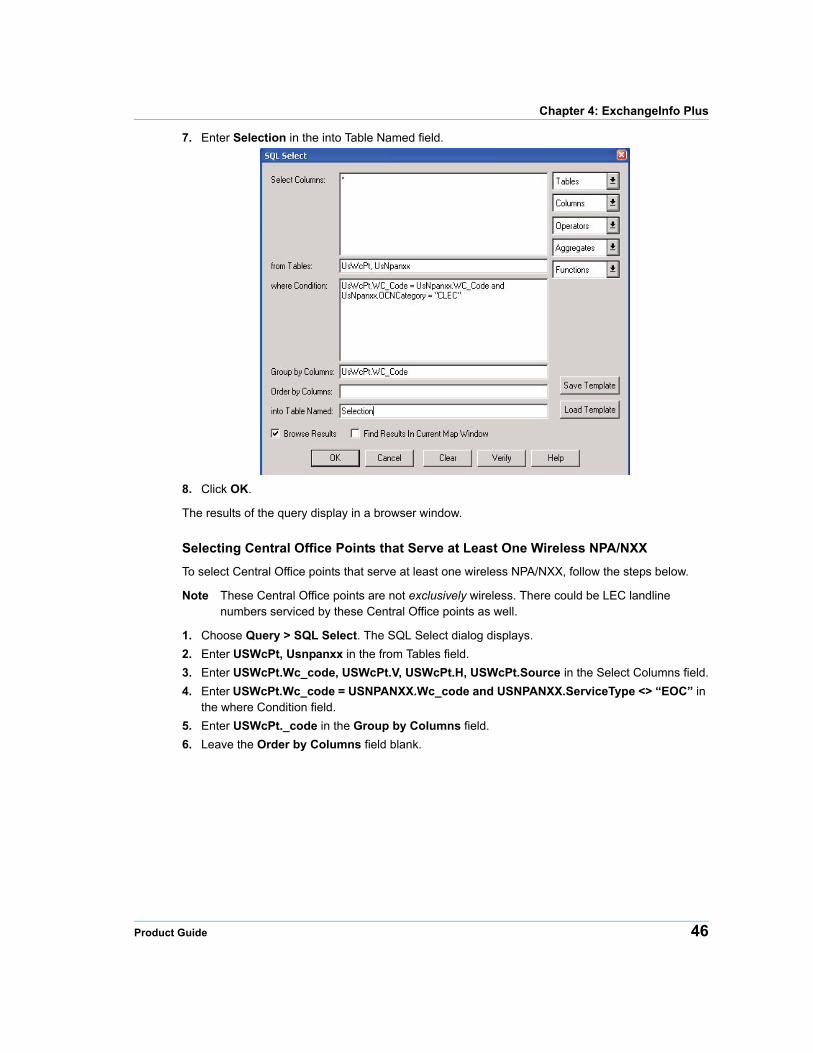
To select LEC landline Central Office points, follow the steps below.
1. Choose Query > SQL Select. The SQL Select dialog displays.
2. Enter USWcPt, Usnpanxx in the from Tables field.
3. Enter USWcPt.Wc_code, USWcPt.V, USWcPt.H, USWcPt.Source in the Select Columns field.
4. Enter USWcPt.Wc_code = USNPANXX.Wc_code and (USNPANXX.OCNCategory = “RBOC” or USNPANXX.OCNCategory = “ILEC”) and USNPANXX.ServiceType = “EOC” in the where Condition field.
Product Guide 44
Using ExchangeInfo Plus
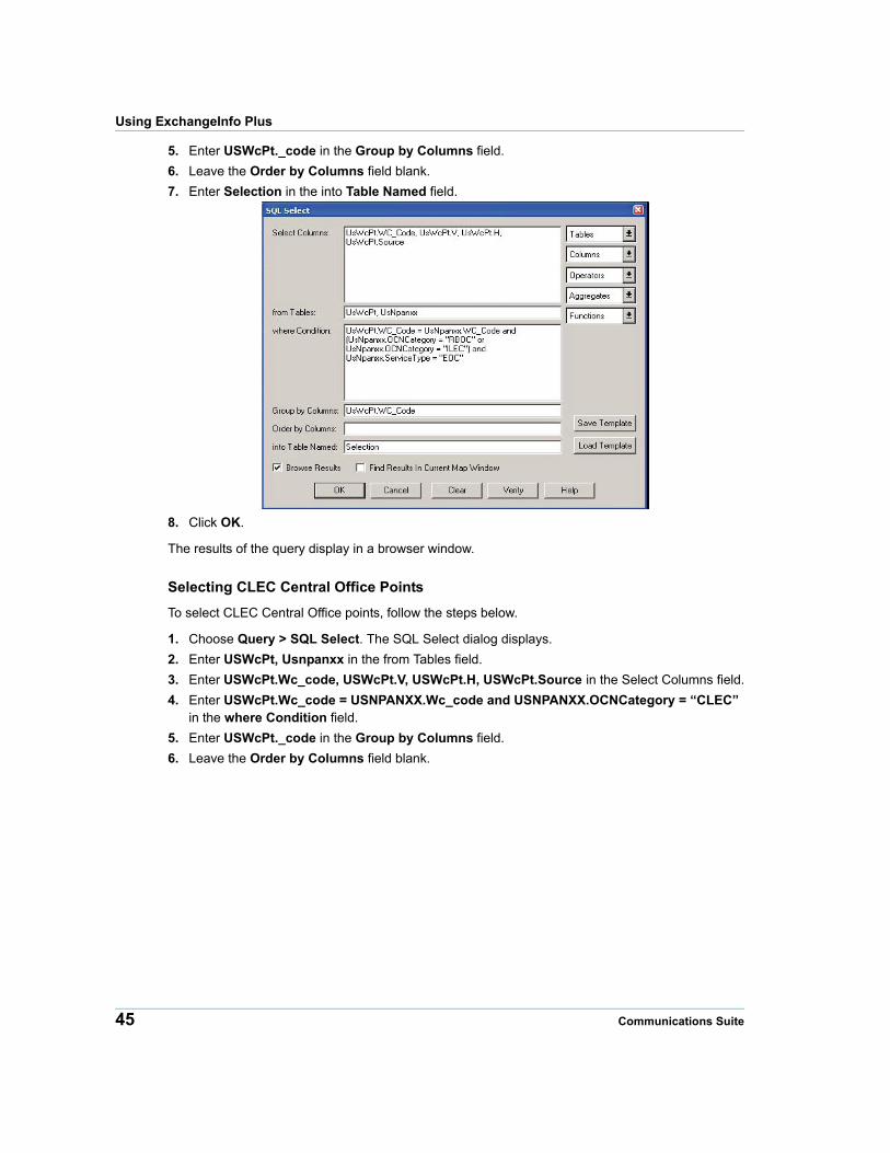
5. Enter USWcPt._code in the Group by Columns field.
6. Leave the Order by Columns field blank.
7. Enter Selection in the into Table Named field.
8. Click OK.
The results of the query display in a browser window.
Selecting CLEC Central Office Points
To select CLEC Central Office points, follow the steps below.
1. Choose Query > SQL Select. The SQL Select dialog displays.
2. Enter USWcPt, Usnpanxx in the from Tables field.
3. Enter USWcPt.Wc_code, USWcPt.V, USWcPt.H, USWcPt.Source in the Select Columns field.
4. Enter USWcPt.Wc_code = USNPANXX.Wc_code and USNPANXX.OCNCategory = “CLEC” in the where Condition field.
5. Enter USWcPt._code in the Group by Columns field.
6. Leave the Order by Columns field blank.
45 Communications Suite
Chapter 4: ExchangeInfo Plus
7. Enter Selection in the into Table Named field.
8. Click OK.
The results of the query display in a browser window.
Selecting Central Office Points that Serve at Least One Wireless NPA/NXX
To select Central Office points that serve at least one wireless NPA/NXX, follow the steps below.
Note These Central Office points are not exclusively wireless. There could be LEC landline numbers serviced by these Central Office points as well.
1. Choose Query > SQL Select. The SQL Select dialog displays.
2. Enter USWcPt, Usnpanxx in the from Tables field.
3. Enter USWcPt.Wc_code, USWcPt.V, USWcPt.H, USWcPt.Source in the Select Columns field.
4. Enter USWcPt.Wc_code = USNPANXX.Wc_code and USNPANXX.ServiceType <> “EOC” in the where Condition field.
5. Enter USWcPt._code in the Group by Columns field.
6. Leave the Order by Columns field blank.
Product Guide 46
Using ExchangeInfo Plus
7. Enter Selection in the into Table Named field.
8. Click OK.
The results of the query display in a browser window.
Selecting Sub-Sets of NPA/NXXs
This section contains examples that show how to select sub-sets of NPA/NXXs. The examples include the following:
• Selecting LEC Landline NPA/NXXs
• Selecting CLEC NPA/NXXs
• Selecting Wireless NPA/NXXs
Selecting LEC Landline NPA/NXXs
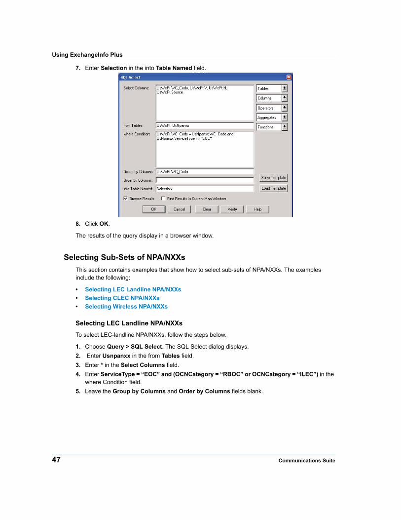
To select LEC-landline NPA/NXXs, follow the steps below.
1. Choose Query > SQL Select. The SQL Select dialog displays.
2. Enter Usnpanxx in the from Tables field.
3. Enter * in the Select Columns field.
4. Enter ServiceType = “EOC” and (OCNCategory = “RBOC” or OCNCategory = “ILEC”) in the where Condition field.
5. Leave the Group by Columns and Order by Columns fields blank.
47 Communications Suite
Chapter 4: ExchangeInfo Plus
6. Enter Selection in the into Table Named field.
7. Click OK.
The results of the query display in a browser window.
Selecting CLEC NPA/NXXs
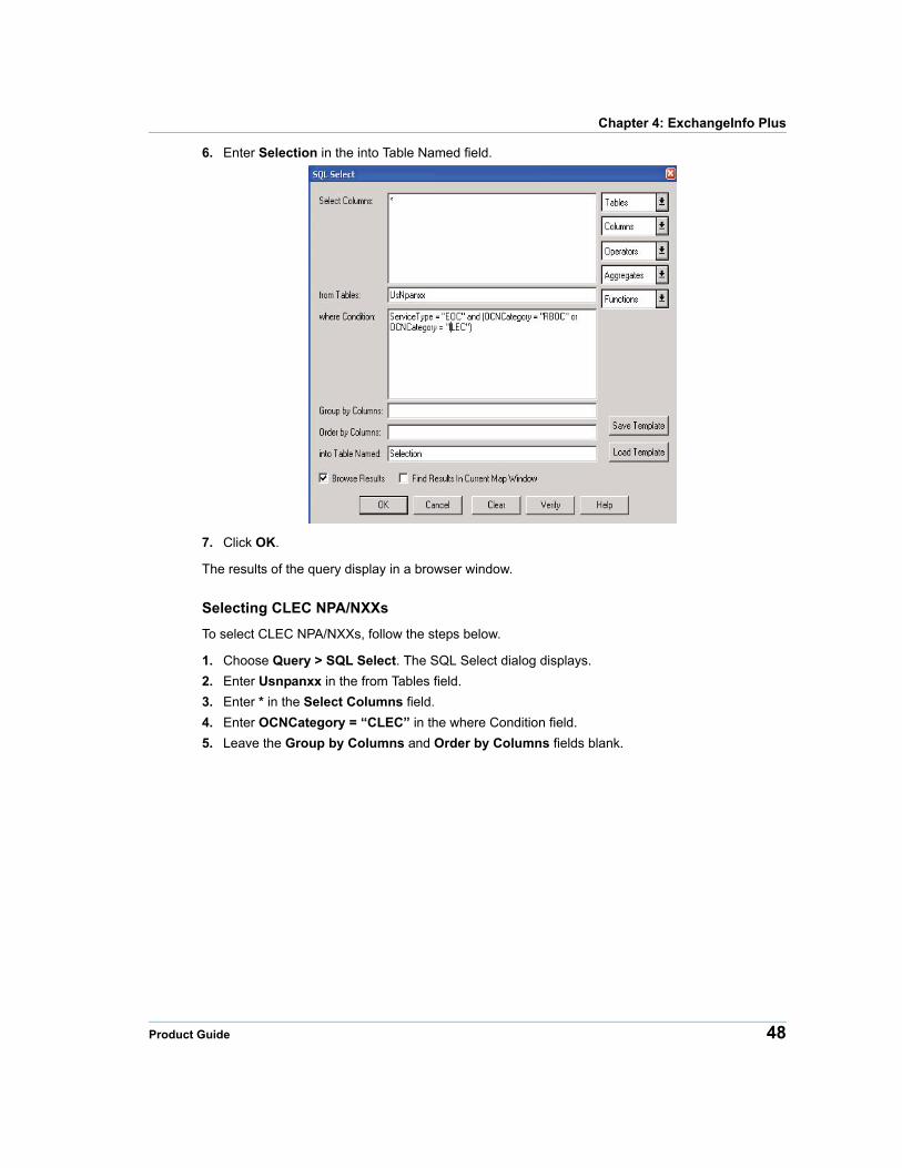
To select CLEC NPA/NXXs, follow the steps below.
1. Choose Query > SQL Select. The SQL Select dialog displays.
2. Enter Usnpanxx in the from Tables field.
3. Enter * in the Select Columns field.
4. Enter OCNCategory = “CLEC” in the where Condition field.
5. Leave the Group by Columns and Order by Columns fields blank.
Product Guide 48
Using ExchangeInfo Plus
6. Enter Selection in the into Table Named field.
7. Click OK.
The results of the query display in a browser window.
Selecting Wireless NPA/NXXs
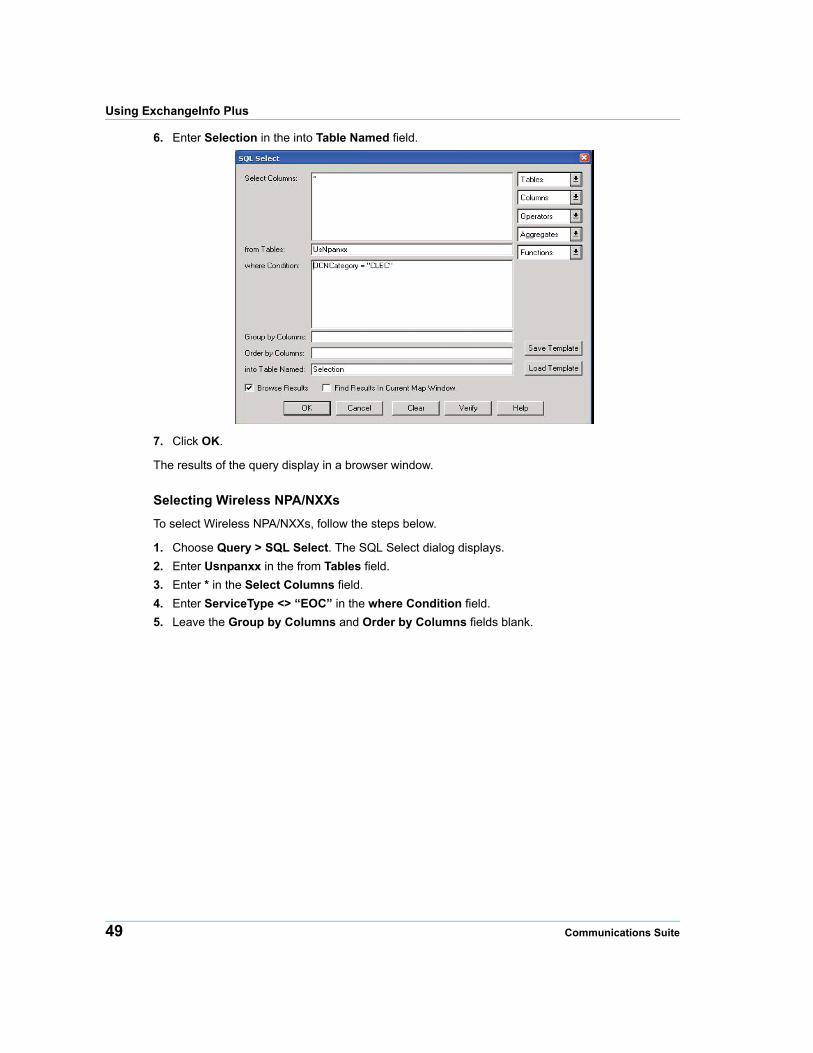
To select Wireless NPA/NXXs, follow the steps below.
1. Choose Query > SQL Select. The SQL Select dialog displays.
2. Enter Usnpanxx in the from Tables field.
3. Enter * in the Select Columns field.
4. Enter ServiceType <> “EOC” in the where Condition field.
5. Leave the Group by Columns and Order by Columns fields blank.
49 Communications Suite
Chapter 4: ExchangeInfo Plus
6. Enter Selection in the into Table Named field.
7. Click OK.
The results of the query display in a browser window.
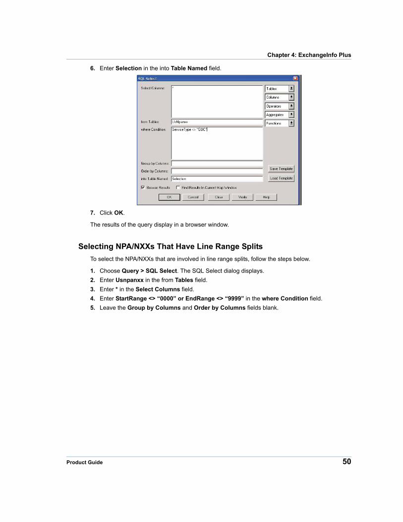
Selecting NPA/NXXs That Have Line Range Splits
To select the NPA/NXXs that are involved in line range splits, follow the steps below.
1. Choose Query > SQL Select. The SQL Select dialog displays.
2. Enter Usnpanxx in the from Tables field.
3. Enter * in the Select Columns field.
4. Enter StartRange <> “0000” or EndRange <> “9999” in the where Condition field.
5. Leave the Group by Columns and Order by Columns fields blank.
Product Guide 50
Using ExchangeInfo Plus
6. Enter Selection in the into Table Named field.
7. Click OK.
The results of the query display in a browser window.
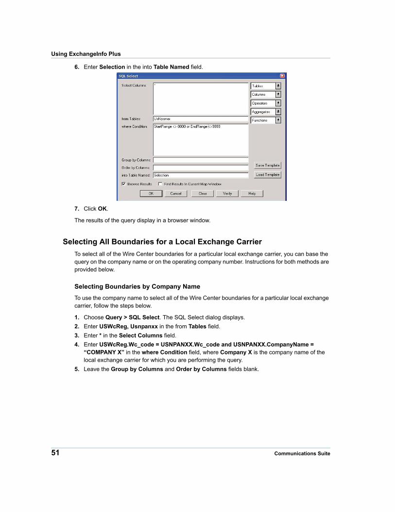
Selecting All Boundaries for a Local Exchange Carrier
To select all of the Wire Center boundaries for a particular local exchange carrier, you can base the query on the company name or on the operating company number. Instructions for both methods are provided below.
Selecting Boundaries by Company Name
To use the company name to select all of the Wire Center boundaries for a particular local exchange carrier, follow the steps below.
1. Choose Query > SQL Select. The SQL Select dialog displays.
2. Enter USWcReg, Usnpanxx in the from Tables field.
3. Enter * in the Select Columns field.
4. Enter USWcReg.Wc_code = USNPANXX.Wc_code and USNPANXX.CompanyName = “COMPANY X” in the where Condition field, where Company X is the company name of the local exchange carrier for which you are performing the query.
5. Leave the Group by Columns and Order by Columns fields blank.
51 Communications Suite

Chapter 4: ExchangeInfo Plus
6. Enter Selection in the into Table Named field.
7. Click OK.
The results of the query display in a browser window.
Selecting Boundaries by Operating Company Number
To use the operating company number to select all of the Wire Center boundaries for a particular local exchange carrier, follow the steps below.
1. Choose Query > SQL Select. The SQL Select dialog displays.
2. Enter USWcReg, Usnpanxx in the from Tables field.
3. Enter * in the Select Columns field.
4. Enter USWcReg.Wc_code = USNPANXX.Wc_code and USNPANXX.OCN = “####” in the where Condition field, where #### is the operating company number of the local exchange carrier for which you are performing the query.
5. Leave the Group by Columns and Order by Columns fields blank.
Product Guide 52
Using ExchangeInfo Plus
6. Enter Selection in the into Table Named field.
7. Click OK.
The results of the query display in a browser window.
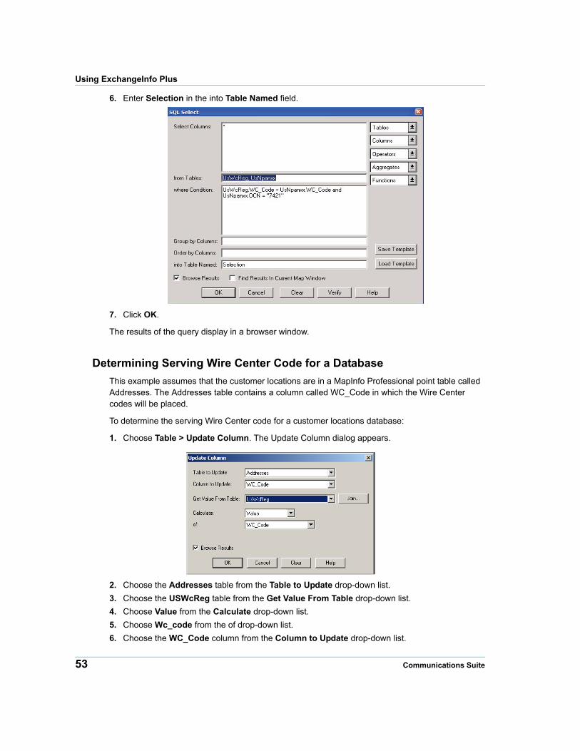
Determining Serving Wire Center Code for a Database
This example assumes that the customer locations are in a MapInfo Professional point table called Addresses. The Addresses table contains a column called WC_Code in which the Wire Center codes will be placed.
To determine the serving Wire Center code for a customer locations database:
1. Choose Table > Update Column. The Update Column dialog appears.
2. Choose the Addresses table from the Table to Update drop-down list.
3. Choose the USWcReg table from the Get Value From Table drop-down list.
4. Choose Value from the Calculate drop-down list.
5. Choose Wc_code from the of drop-down list.
6. Choose the WC_Code column from the Column to Update drop-down list.
53 Communications Suite
Chapter 4: ExchangeInfo Plus
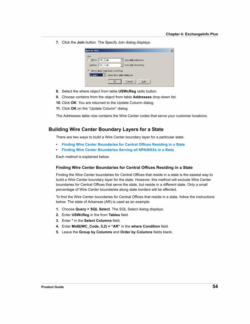
7. Click the Join button. The Specify Join dialog displays.
8. Select the where object from table USWcReg radio button.
9. Choose contains from the object from table Addresses drop-down list.
10. Click OK. You are returned to the Update Column dialog.
11. Click OK on the “Update Column” dialog.
The Addresses table now contains the Wire Center codes that serve your customer locations.
Building Wire Center Boundary Layers for a State
There are two ways to build a Wire Center boundary layer for a particular state:
• Finding Wire Center Boundaries for Central Offices Residing in a State
• Finding Wire Center Boundaries Serving all NPA/NXXs in a State
Each method is explained below.
Finding Wire Center Boundaries for Central Offices Residing in a State
Finding the Wire Center boundaries for Central Offices that reside in a state is the easiest way to build a Wire Center boundary layer for the state. However, this method will exclude Wire Center boundaries for Central Offices that serve the state, but reside in a different state. Only a small percentage of Wire Center boundaries along state borders will be affected.
To find the Wire Center boundaries for Central Offices that reside in a state, follow the instructions below. The state of Arkansas (AR) is used as an example.
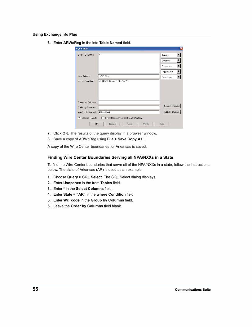
1. Choose Query > SQL Select. The SQL Select dialog displays.
2. Enter USWcReg in the from Tables field.
3. Enter * in the Select Columns field.
4. Enter Mid$(WC_Code, 5,2) = “AR” in the where Condition field.
5. Leave the Group by Columns and Order by Columns fields blank.
Product Guide 54
Using ExchangeInfo Plus
6. Enter ARWcReg in the into Table Named field.
7. Click OK. The results of the query display in a browser window.
8. Save a copy of ARWcReg using File > Save Copy As…
A copy of the Wire Center boundaries for Arkansas is saved.
Finding Wire Center Boundaries Serving all NPA/NXXs in a State
To find the Wire Center boundaries that serve all of the NPA/NXXs in a state, follow the instructions below. The state of Arkansas (AR) is used as an example.
1. Choose Query > SQL Select. The SQL Select dialog displays.
2. Enter Usnpanxx in the from Tables field.
3. Enter * in the Select Columns field.
4. Enter State = “AR” in the where Condition field.
5. Enter Wc_code in the Group by Columns field.
6. Leave the Order by Columns field blank.
55 Communications Suite
Chapter 4: ExchangeInfo Plus
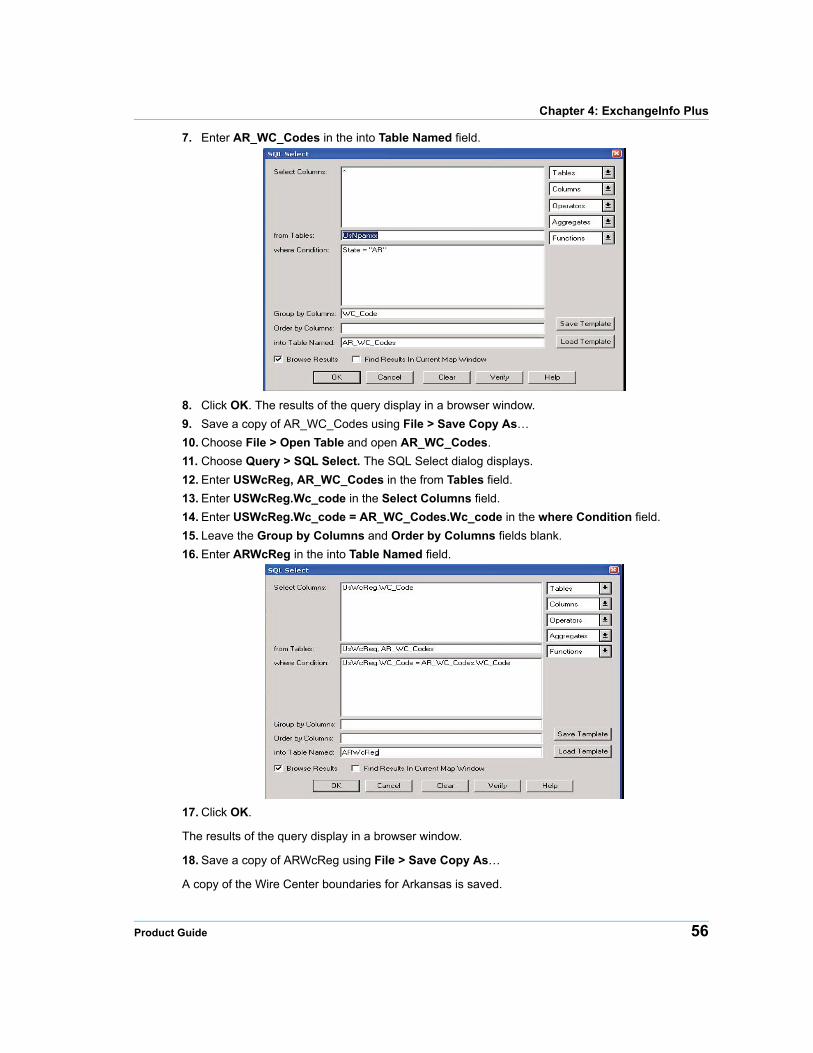
7. Enter AR_WC_Codes in the into Table Named field.
8. Click OK. The results of the query display in a browser window.
9. Save a copy of AR_WC_Codes using File > Save Copy As…
10. Choose File > Open Table and open AR_WC_Codes.
11. Choose Query > SQL Select. The SQL Select dialog displays.
12. Enter USWcReg, AR_WC_Codes in the from Tables field.
13. Enter USWcReg.Wc_code in the Select Columns field.
14. Enter USWcReg.Wc_code = AR_WC_Codes.Wc_code in the where Condition field.
15. Leave the Group by Columns and Order by Columns fields blank.
16. Enter ARWcReg in the into Table Named field.
17. Click OK.
The results of the query display in a browser window.
18. Save a copy of ARWcReg using File > Save Copy As…
A copy of the Wire Center boundaries for Arkansas is saved.
Product Guide 56
Using ExchangeInfo Plus
Geocoding a Database of Phone Numbers Using Central Office Points
The instructions below explain how to geocode records that contain a phone number field. You can produce a map of each record in the original table. The mapped locations are based on the locations of the Central Office points serving the NPA/NXX-X for the given phone number.
To geocode a database of phone numbers using central office points:
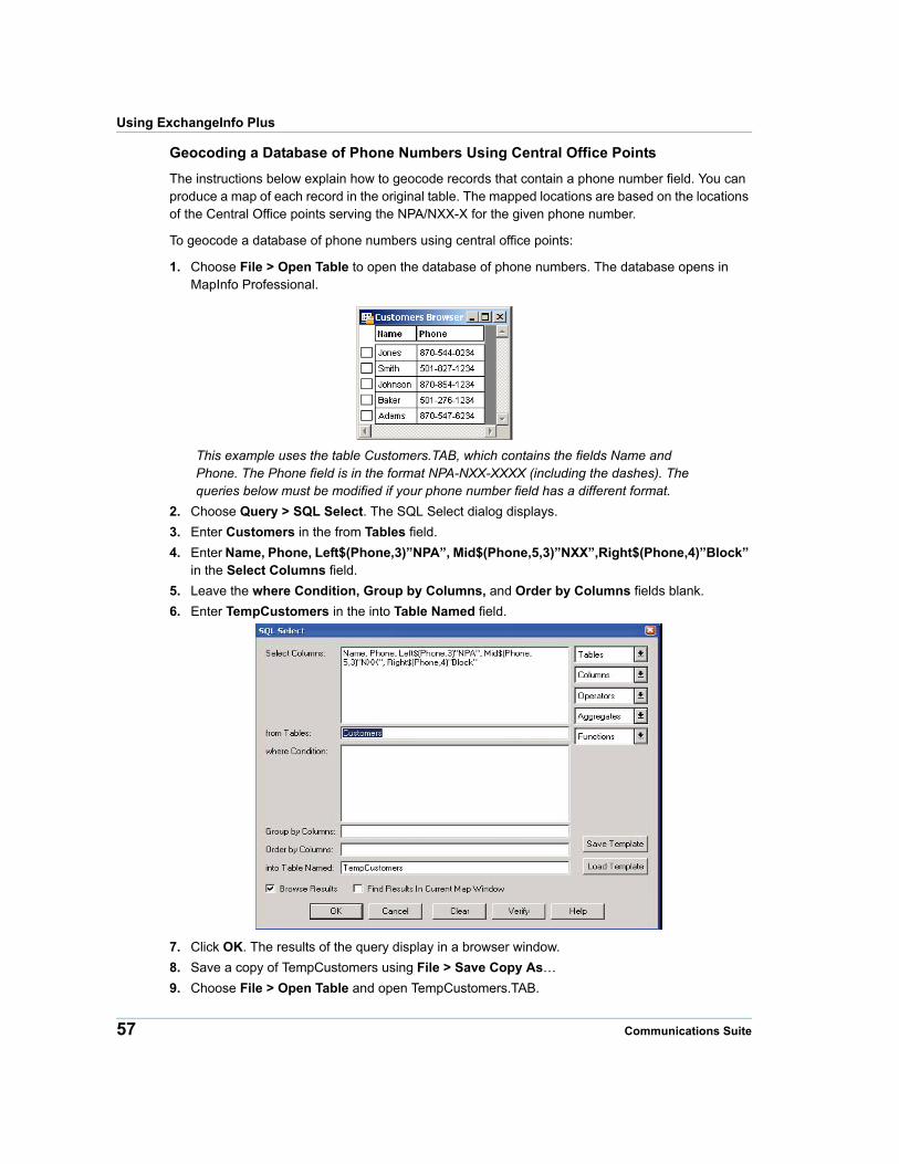
1. Choose File > Open Table to open the database of phone numbers. The database opens in MapInfo Professional.
This example uses the table Customers.TAB, which contains the fields Name and Phone. The Phone field is in the format NPA-NXX-XXXX (including the dashes). The queries below must be modified if your phone number field has a different format.
2. Choose Query > SQL Select. The SQL Select dialog displays.
3. Enter Customers in the from Tables field.
4. Enter Name, Phone, Left$(Phone,3)”NPA”, Mid$(Phone,5,3)”NXX”,Right$(Phone,4)”Block” in the Select Columns field.
5. Leave the where Condition, Group by Columns, and Order by Columns fields blank.
6. Enter TempCustomers in the into Table Named field.
7. Click OK. The results of the query display in a browser window.
8. Save a copy of TempCustomers using File > Save Copy As…
9. Choose File > Open Table and open TempCustomers.TAB.
57 Communications Suite
Chapter 4: ExchangeInfo Plus
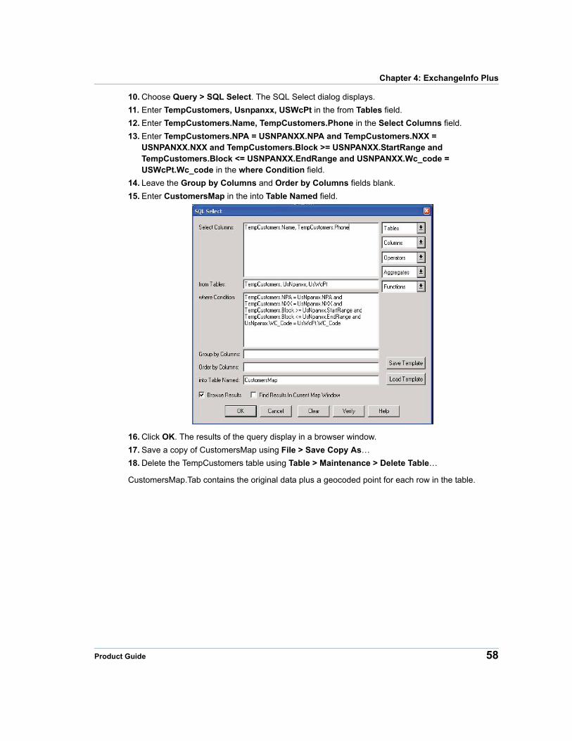
10. Choose Query > SQL Select. The SQL Select dialog displays.
11. Enter TempCustomers, Usnpanxx, USWcPt in the from Tables field.
12. Enter TempCustomers.Name, TempCustomers.Phone in the Select Columns field.
13. Enter TempCustomers.NPA = USNPANXX.NPA and TempCustomers.NXX = USNPANXX.NXX and TempCustomers.Block >= USNPANXX.StartRange and TempCustomers.Block <= USNPANXX.EndRange and USNPANXX.Wc_code = USWcPt.Wc_code in the where Condition field.
14. Leave the Group by Columns and Order by Columns fields blank.
15. Enter CustomersMap in the into Table Named field.
16. Click OK. The results of the query display in a browser window.
17. Save a copy of CustomersMap using File > Save Copy As…
18. Delete the TempCustomers table using Table > Maintenance > Delete Table…
CustomersMap.Tab contains the original data plus a geocoded point for each row in the table.
Product Guide 58
5
Chapter 5: LATAInfoLocal Access Transport Areas (LATAs) identify a telephone call’s carrier type. LATAInfo offers a map database of these LATAs, allowing you to easily differentiate calls carried by a Local Exchange Carrier (LEC) from those carried by a long-distance provider. This Pitney Bowes database covers continental United States, Alaska, Hawaii, and Puerto Rico.
In this chapter
LATAInfo Overview. . . . . . . . . . . . . . . . . . . . . . . . . . . . . . . . . . . . . .60 LATAInfo Database. . . . . . . . . . . . . . . . . . . . . . . . . . . . . . . . . . . . . .61
LATAInfo Overview
LATAInfo Overview
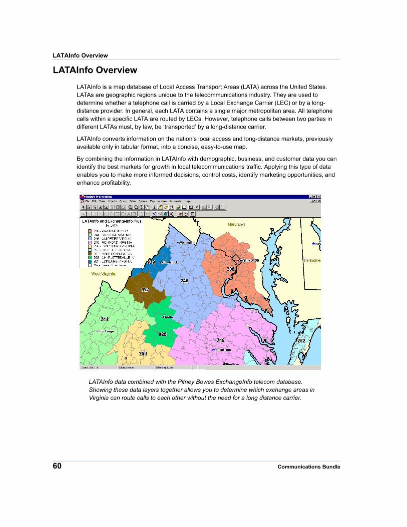
LATAInfo is a map database of Local Access Transport Areas (LATA) across the United States. LATAs are geographic regions unique to the telecommunications industry. They are used to determine whether a telephone call is carried by a Local Exchange Carrier (LEC) or by a long-distance provider. In general, each LATA contains a single major metropolitan area. All telephone calls within a specific LATA are routed by LECs. However, telephone calls between two parties in different LATAs must, by law, be ‘transported’ by a long-distance carrier.
LATAInfo converts information on the nation’s local access and long-distance markets, previously available only in tabular format, into a concise, easy-to-use map.
By combining the information in LATAInfo with demographic, business, and customer data you can identify the best markets for growth in local telecommunications traffic. Applying this type of data enables you to make more informed decisions, control costs, identify marketing opportunities, and enhance profitability.
LATAInfo data combined with the Pitney Bowes ExchangeInfo telecom database. Showing these data layers together allows you to determine which exchange areas in Virginia can route calls to each other without the need for a long distance carrier.
60 Communications Bundle
Chapter 5: LATAInfo
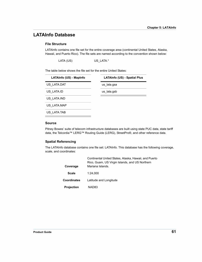
LATAInfo Database
File Structure
LATAInfo contains one file set for the entire coverage area (continental United States, Alaska, Hawaii, and Puerto Rico). The file sets are named according to the convention shown below:
LATA (US) US_LATA.*
The table below shows the file set for the entire United States:
LATAInfo (US) - MapInfo LATAInfo (US) - Spatial Plus
US_LATA.DAT us_lata.gsa
US_LATA.ID us_lata.gsb
US_LATA.IND
US_LATA.MAP
US_LATA.TAB
Source
Pitney Bowes’ suite of telecom infrastructure databases are built using state PUC data, state tariff data, the Telcordia™ LERG™ Routing Guide (LERG), StreetPro®, and other reference data.
Spatial Referencing
The LATAInfo database contains one file set: LATAInfo. This database has the following coverage, scale, and coordinates:
Coverage
Continental United States, Alaska, Hawaii, and Puerto Rico, Guam, US Virgin Islands, and US Northern Mariana Islands.
Scale 1:24,000
Coordinates Latitude and Longitude
Projection NAD83
Product Guide 61
LATAInfo Database
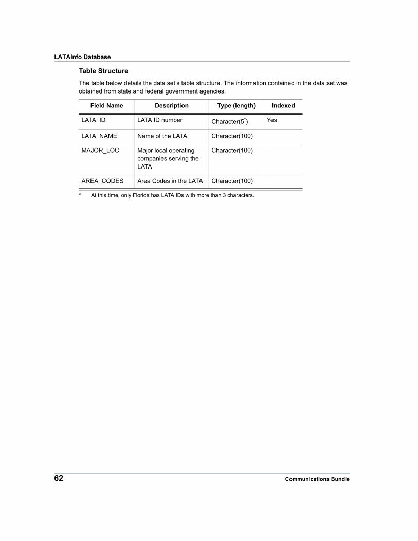
Table Structure
The table below details the data set’s table structure. The information contained in the data set was obtained from state and federal government agencies.
Field Name Description Type (length) Indexed
LATA_ID LATA ID number Character(5*
* At this time, only Florida has LATA IDs with more than 3 characters.
) Yes
LATA_NAME Name of the LATA Character(100)
MAJOR_LOC Major local operating companies serving the LATA
Character(100)
AREA_CODES Area Codes in the LATA Character(100)
62 Communications Bundle
6
Chapter 6: MediaPrintsMediaPrints is Pitney Bowes’ comprehensive, industry-standard cable data set, providing information covering continental United States, Alaska, and Hawaii.
In this chapter
MediaPrints Overview . . . . . . . . . . . . . . . . . . . . . . . . . . . . . . . . . . .64 MediaPrints Database . . . . . . . . . . . . . . . . . . . . . . . . . . . . . . . . . . .65
MediaPrints Overview
MediaPrints Overview
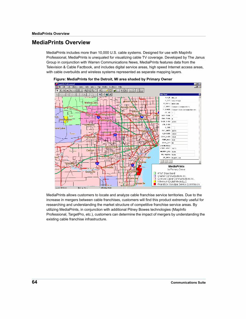
MediaPrints includes more than 10,000 U.S. cable systems. Designed for use with MapInfo Professional, MediaPrints is unequaled for visualizing cable TV coverage. Developed by The Janus Group in conjunction with Warren Communications News, MediaPrints features data from the Television & Cable Factbook, and includes digital service areas, high speed Internet access areas, with cable overbuilds and wireless systems represented as separate mapping layers.
Figure: MediaPrints for the Detroit, MI area shaded by Primary Owner
MediaPrints allows customers to locate and analyze cable franchise service territories. Due to the increase in mergers between cable franchises, customers will find this product extremely useful for researching and understanding the market structure of competitive franchise service areas. By utilizing MediaPrints, in conjunction with additional Pitney Bowes technologies (MapInfo Professional, TargetPro, etc.), customers can determine the impact of mergers by understanding the existing cable franchise infrastructure.
64 Communications Suite

Chapter 6: MediaPrints
Figure: MediaPrints Displaying Cable Internet Providers
MediaPrints Database
File Structure
MediaPrints (State)
us_cable.*
us_cable_overbuild.*
Source
The Janus Group, Inc. and Warren Communications News, Inc.
Product Guide 65
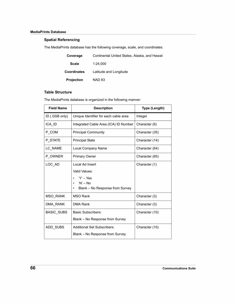
MediaPrints Database
Spatial Referencing
The MediaPrints database has the following coverage, scale, and coordinates:
Coverage Continental United States, Alaska, and Hawaii
Scale 1:24,000
Coordinates Latitude and Longitude
Projection NAD 83
Table Structure
The MediaPrints database is organized in the following manner:
Field Name Description Type (Length)
ID (.GSB only) Unique Identifier for each cable area Integer
ICA_ID Integrated Cable Area (ICA) ID Number Character (6)
P_COM Principal Community Character (35)
P_STATE Principal State Character (14)
LC_NAME Local Company Name Character (64)
P_OWNER Primary Owner Character (65)
LOC_AD Local Ad Insert
Valid Values:
• ‘Y’ – Yes
• ‘N’ – No
• Blank – No Response from Survey
Character (1)
MSO_RANK MSO Rank Character (3)
DMA_RANK DMA Rank Character (3)
BASIC_SUBS Basic Subscribers:
Blank – No Response from Survey
Character (10)
ADD_SUBS Additional Set Subscribers:
Blank – No Response from Survey
Character (10)
66 Communications Suite
Chapter 6: MediaPrints
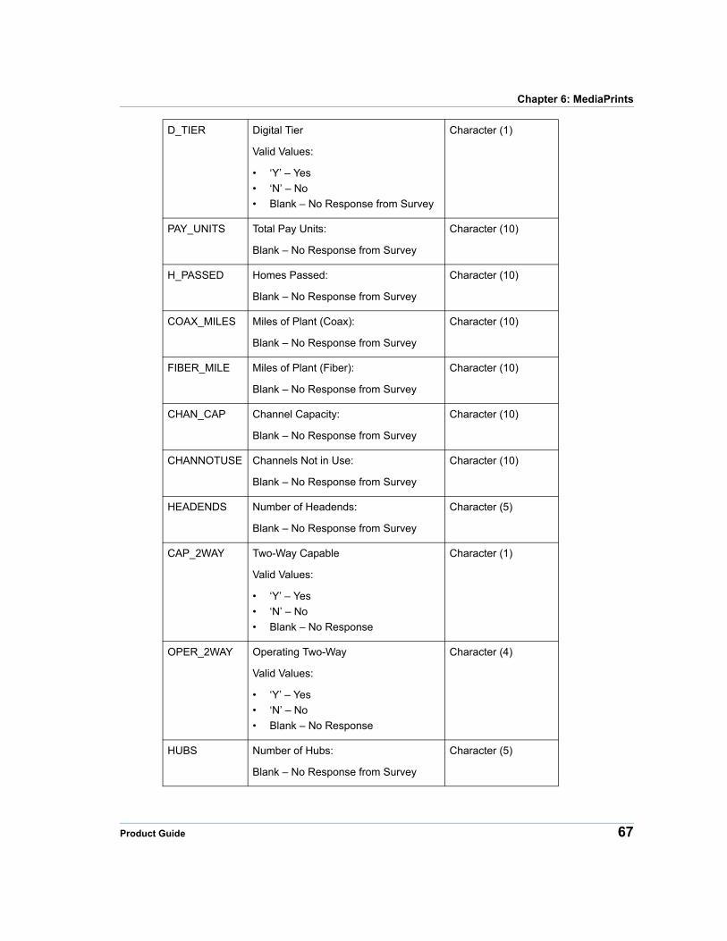
D_TIER Digital Tier
Valid Values:
• ‘Y’ – Yes
• ‘N’ – No
• Blank – No Response from Survey
Character (1)
PAY_UNITS Total Pay Units:
Blank – No Response from Survey
Character (10)
H_PASSED Homes Passed:
Blank – No Response from Survey
Character (10)
COAX_MILES Miles of Plant (Coax):
Blank – No Response from Survey
Character (10)
FIBER_MILE Miles of Plant (Fiber):
Blank – No Response from Survey
Character (10)
CHAN_CAP Channel Capacity:
Blank – No Response from Survey
Character (10)
CHANNOTUSE Channels Not in Use:
Blank – No Response from Survey
Character (10)
HEADENDS Number of Headends:
Blank – No Response from Survey
Character (5)
CAP_2WAY Two-Way Capable
Valid Values:
• ‘Y’ – Yes
• ‘N’ – No
• Blank – No Response
Character (1)
OPER_2WAY Operating Two-Way
Valid Values:
• ‘Y’ – Yes
• ‘N’ – No
• Blank – No Response
Character (4)
HUBS Number of Hubs:
Blank – No Response from Survey
Character (5)
Product Guide 67
MediaPrints Database
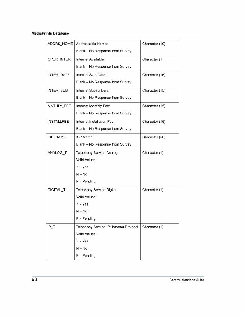
ADDRS_HOME Addressable Homes:
Blank – No Response from Survey
Character (10)
OPER_INTER Internet Available:
Blank – No Response from Survey
Character (1)
INTER_DATE Internet Start Date:
Blank – No Response from Survey
Character (16)
INTER_SUB Internet Subscribers:
Blank – No Response from Survey
Character (15)
MNTHLY_FEE Internet Monthly Fee:
Blank – No Response from Survey
Character (15)
INSTALLFEE Internet Installation Fee:
Blank – No Response from Survey
Character (15)
ISP_NAME ISP Name:
Blank – No Response from Survey
Character (50)
ANALOG_T Telephony Service Analog
Valid Values:
Y' - Yes
N' - No
P' - Pending
Character (1)
DIGITAL_T Telephony Service Digital
Valid Values:
Y' - Yes
N' - No
P' - Pending
Character (1)
IP_T Telephony Service IP: Internet Protocol
Valid Values:
Y' - Yes
N' - No
P' - Pending
Character (1)
68 Communications Suite
7
Chapter 7: MobileMarketInfoMobileMarketInfo is Pitney Bowes’ comprehensive database of cellular and FCC licensed wireless market areas across the United States.
This chapter provides an introduction to MobileMarketInfo and its features. It also explains how to install the database.
In this chapter
MobileMarketInfo Overview. . . . . . . . . . . . . . . . . . . . . . . . . . . . . . .70 Wireless Communications Overview . . . . . . . . . . . . . . . . . . . . . . .71 MobileMarketInfo Database. . . . . . . . . . . . . . . . . . . . . . . . . . . . . . .80 MobileMarketAnalyzer . . . . . . . . . . . . . . . . . . . . . . . . . . . . . . . . . . .99 Using MobileMarketInfo. . . . . . . . . . . . . . . . . . . . . . . . . . . . . . . . .104
MobileMarketInfo Overview
MobileMarketInfo Overview
MobileMarketInfo is a comprehensive database from Pitney Bowes that maps and analyzes the wireless license landscape. Complete with market partitioning and frequency disaggregation, MobileMarketInfo consists of Cellular Market Areas (CMA), Personal Communication Service Areas (PCS) and Advanced Wireless Services (AWS).
Together these service areas define the geographies in which wireless carriers are licensed to provide service throughout the U.S. By bringing together the complex FCC license data, coupled with dedicated research, MobileMarketInfo delivers a concise format for accurate analyses.
MobileMarketInfo Features
MobileMarketInfo includes the following features:
• Information about FCC wireless licenses
• Accurate 'Doing Business As' names
• Complete information on buildout dates and spectrum capacity
• Partitioning and disaggregation information for PCS licenses
• Relational database design that facilitates in-depth analysis
• Full integration with all other Pitney Bowes data products
• MobileMarketAnalyzer—a MapBasic Application that automates common analyses
Using MobileMarketInfo in Microsoft Access
You can open the MobileMarketInfo databases in Microsoft Access. Microsoft Access enables you to perform complex database manipulations with greater ease. However, the geographic features of MobileMarketInfo are only available in MapInfo Professional. Consult Microsoft Access documentation for information on using Microsoft Access.
Configuring MapInfo Professional to Support Microsoft Access
You do not need to install Microsoft Access to use MobileMarketInfo. However, if you have not installed Microsoft Access and you are using MapInfo Professional, you may need to configure your installation of MapInfo Professional to support Microsoft Access.
If you do not configure MapInfo Professional to support Microsoft Access, you will not be able to open any of the MobileMarketInfo TAB files.
To configure MapInfo Professional to support Microsoft Access:
1. Launch the MapInfo Professional Setup.exe file.
2. Click Install Products.
3. Select DBMS Support.
4. Select DBMS support (again).
5. Click Next.
6. Review and accept the license agreement.
7. Select MapInfo Professional Version 7 or later.
8. Locate your installation of MapInfo Professional.
70 Communications Suite
Chapter 7: MobileMarketInfo
9. Select the Pitney Bowes DAO (Microsoft Access) Support check box.
You do not need to check either of the following options:
• Pitney Bowes ODBC Connectivity Support
• Oracle 8i Spatial Object Support for Pitney Bowes
10. Click Next.
11. Allow the installation to complete.
12. Click Finish.
13. Restart your computer.
Note MobileMarketInfo is currently not available in Spatial Plus (.GSB) format.
Wireless Communications Overview
This section contains background information on the wireless communications industry. The information provided here is available on the Federal Communications Commission’s web site http://wireless.fcc.gov/services/, along with additional information about wireless communications in the United States.
Defining Cellular and Personal Communications Services
Two-way wireless communication in the United States most commonly employs either Cellular Services or Broadband Personal Communication Services technology. This section describes both technologies.
Cellular Services
The cellular radiotelephone service is a mobile radiotelephone service in which common carriers are authorized to offer and provide a mobile telecommunications service for hire to the general public using cellular systems. Cellular systems in the United States operate in the 824-894 mHz frequency bands and have 30 kHz channel spacing.
Personal Communications Services
Broadband Personal Communications Services (PCS) is used to provide a variety of services, such as digital mobile phones and wireless internet access. These services are also called mobile telephone services and mobile data services. PCS operates in the 1850-1990 mHz bands.
Advanced Wireless Services
Advanced Wireless Services (AWS) are used for a variety of wireless services, including Third Generation ("3G") mobile broadband and advanced wireless services. AWS operate in the 1710-1755 and 2110-2155 MHz bands.
Product Guide 71

Wireless Communications Overview
700 MHz
The 700 MHz spectrum consists of Upper 700 and Lower 700 bands, some paired and others not. The spectrum was previously owned by broadcasters for analog television use. Currently, Block C (746-757 and 776-787 MHz) of the Upper Band, and Blocks A (698-704 and 728-734 MHz), B (704-710 and 734-740 MHz) and C (710-716 and 740-746 MHz) of the Lower Band, are available for mobile phone use.
Cellular Services
This section describes cellular market areas, bandplan, licensing, how to obtain spectrum, and construction requirements.
Market Areas
The FCC divided the United States cellular communications market into Metropolitan Service Areas (MSAs) and Rural Service Areas (RSAs) in 1981. The FCC now calls MSAs and RSAs Cellular Market Areas (CMAs). CMAs are composed of one or more counties. The image below displays CMA394 and the counties of which it is composed.
Bandplan
Cellular Services are licensed to operate within a CMA at an A and a B frequency block. When the FCC first established cellular service rules, cellular spectrum was allocated into 40 mHz of spectrum: a 20 mHz block, 824 to 845 mHz, was designated for transmissions made by mobile units, and a separate 20 mHz block, from 870 to 890 mHz, was allocated for base station transmissions. The 40 mHz allocation accommodated 666 channel pairs (a channel pair consists of a mobile frequency and a corresponding base frequency).
72 Communications Suite
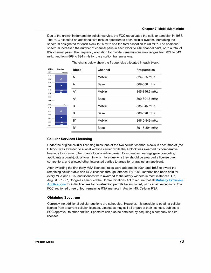
Chapter 7: MobileMarketInfo
Due to the growth in demand for cellular service, the FCC reevaluated the cellular bandplan in 1986. The FCC allocated an additional five mHz of spectrum to each cellular system, increasing the spectrum designated for each block to 25 mHz and the total allocation to 50 mHz. The additional spectrum increased the number of channel pairs in each block to 416 channel pairs, or to a total of 832 channel pairs. The frequency allocation for mobile transmissions now ranges from 824 to 849 mHz, and from 869 to 894 mHz for base station transmissions.
The charts below show the frequencies allocated in each block.
Block Channel Frequencies
A Mobile 824-835 mHz
A Base 869-880 mHz
A* Mobile 845-846.5 mHz
A* Base 890-891.5 mHz
B Mobile 835-845 mHz
B Base 880-890 mHz
B* Mobile 846.5-849 mHz
B* Base 891.5-894 mHz
Cellular Services Licensing
Under the original cellular licensing rules, one of the two cellular channel blocks in each market (the B block) was awarded to a local wireline carrier, while the A block was awarded by comparative hearings to a carrier other than a local wireline carrier. Comparative hearings gave competing applicants a quasi-judicial forum in which to argue why they should be awarded a license over competitors, and allowed other interested parties to argue for or against an applicant.
After awarding the first thirty MSA licenses, rules were adopted in 1984 and 1986 to award the remaining cellular MSA and RSA licenses through lotteries. By 1991, lotteries had been held for every MSA and RSA, and licenses were awarded to the lottery winners in most instances. On August 5, 1997, Congress amended the Communications Act to require that all Mutually Exclusive Applications for initial licenses for construction permits be auctioned, with certain exceptions. The FCC auctioned three of four remaining RSA markets in Auction 45: Cellular RSA.
Obtaining Spectrum
Currently, no additional cellular auctions are scheduled. However, it is possible to obtain a cellular license from a current cellular licensee. Licensees may sell all or part of their licenses, subject to FCC approval, to other entities. Spectrum can also be obtained by acquiring a company and its licenses.
Product Guide 73
Wireless Communications Overview
Construction Requirements
Initial cellular licensees are given a five-year period during which to expand their systems within the CMAs in which they are licensees. During the five-year buildout period, the licensee has the exclusive right to expand within its licensed CMA. At the end of the five-year buildout period, the actual service areas of all cells in a system is the licensee's Cellular Geographic Service Area
(CGSA)1. Any areas within the CMA that is not part of a licensee's CGSA at the end of the five-year period is considered unserved area.
Unserved Areas
The FCC’s application process has two phases for all cellular markets in which the five-year buildout period has expired:
Phase I:
A one-time process that provides an opportunity for eligible parties to file competing applications for authority to operate a new cellular system in, or to expand an existing cellular system into, unserved areas as soon as these areas become available. Entities may file Phase I applications only on the 31st day after the close of the initial licensee's five-year buildout period.
Phase II:
An ongoing process that allows eligible parties to apply for any unserved areas that may remain in a market after the Phase I process is complete. The timing of the Phase II licensing process is dependent on the Phase I process. If a Phase I application is granted, Phase II applications for any remaining unserved area within the market can be filed on or after the 121st day after the Phase I application was granted. If no Phase I applications were received, Phase II applications can be filed on or after the 32nd day after the close of the relevant five-year buildout period.
Mutually Exclusive Applications
Mutually exclusive applications occur whenever:
• Two or more acceptable applications are timely filed in the same market and channel block (for Phase I).
OR
• Two or more applications propose CGSAs that overlap one another (for Phase II).
In the past, the FCC conducted lotteries to resolve any mutually exclusive applications in Phase I or Phase II. In 1993, the FCC was given express authority to use auctions to choose from among two or more mutually exclusive initial applications. The Ninth Report and Order in the competitive bidding docket adopted final auction rules to enable the Commission to complete the licensing of Phase I and Phase II cellular unserved licenses. In Auction 12: Cellular Unserved, the FCC auctioned fourteen cellular unserved licenses.
1. MobileMarketInfo does not provide CGSAs. CMAs are the highest level of geographic precision avail-able in MobileMarketInfo.
74 Communications Suite
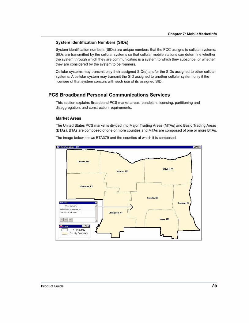
Chapter 7: MobileMarketInfo
System Identification Numbers (SIDs)
System identification numbers (SIDs) are unique numbers that the FCC assigns to cellular systems. SIDs are transmitted by the cellular systems so that cellular mobile stations can determine whether the system through which they are communicating is a system to which they subscribe, or whether they are considered by the system to be roamers.
Cellular systems may transmit only their assigned SID(s) and/or the SIDs assigned to other cellular systems. A cellular system may transmit the SID assigned to another cellular system only if the licensee of that system concurs with such use of its assigned SID.
PCS Broadband Personal Communications Services
This section explains Broadband PCS market areas, bandplan, licensing, partitioning and disaggregation, and construction requirements.
Market Areas
The United States PCS market is divided into Major Trading Areas (MTAs) and Basic Trading Areas (BTAs). BTAs are composed of one or more counties and MTAs are composed of one or more BTAs.
The image below shows BTA379 and the counties of which it is composed.
Product Guide 75
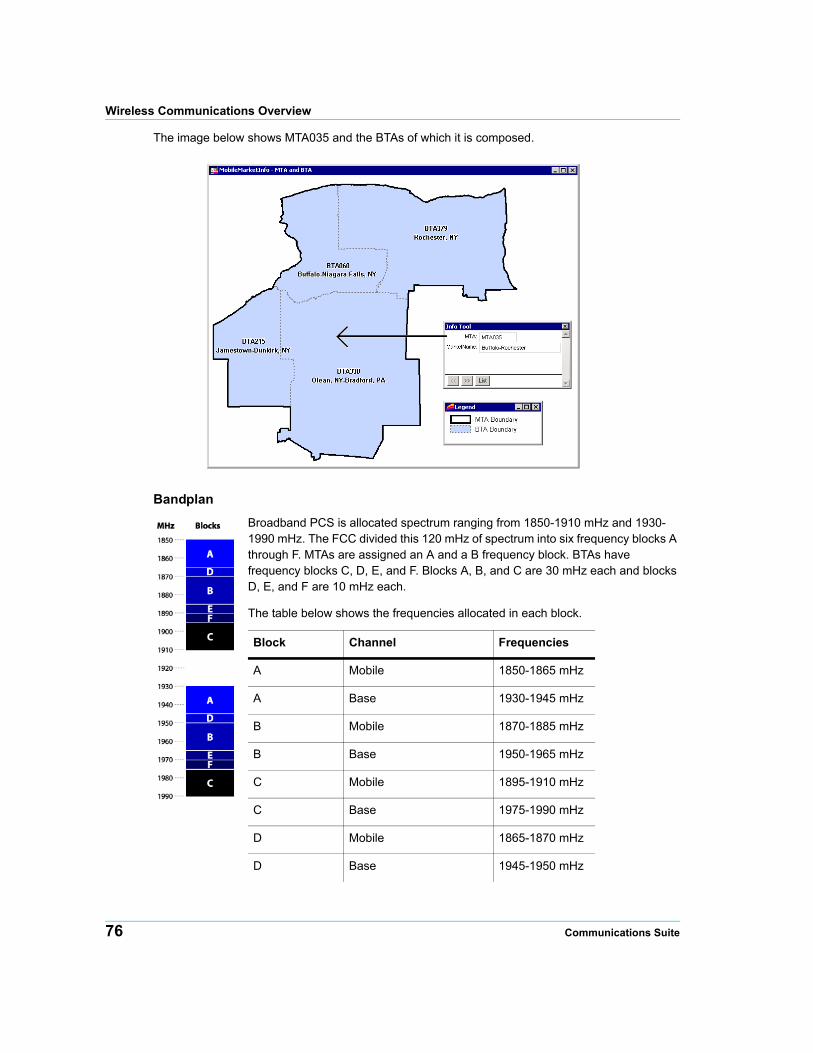
Wireless Communications Overview
The image below shows MTA035 and the BTAs of which it is composed.
Bandplan
Broadband PCS is allocated spectrum ranging from 1850-1910 mHz and 1930-1990 mHz. The FCC divided this 120 mHz of spectrum into six frequency blocks A through F. MTAs are assigned an A and a B frequency block. BTAs have frequency blocks C, D, E, and F. Blocks A, B, and C are 30 mHz each and blocks D, E, and F are 10 mHz each.
The table below shows the frequencies allocated in each block.
Block Channel Frequencies
A Mobile 1850-1865 mHz
A Base 1930-1945 mHz
B Mobile 1870-1885 mHz
B Base 1950-1965 mHz
C Mobile 1895-1910 mHz
C Base 1975-1990 mHz
D Mobile 1865-1870 mHz
D Base 1945-1950 mHz
76 Communications Suite
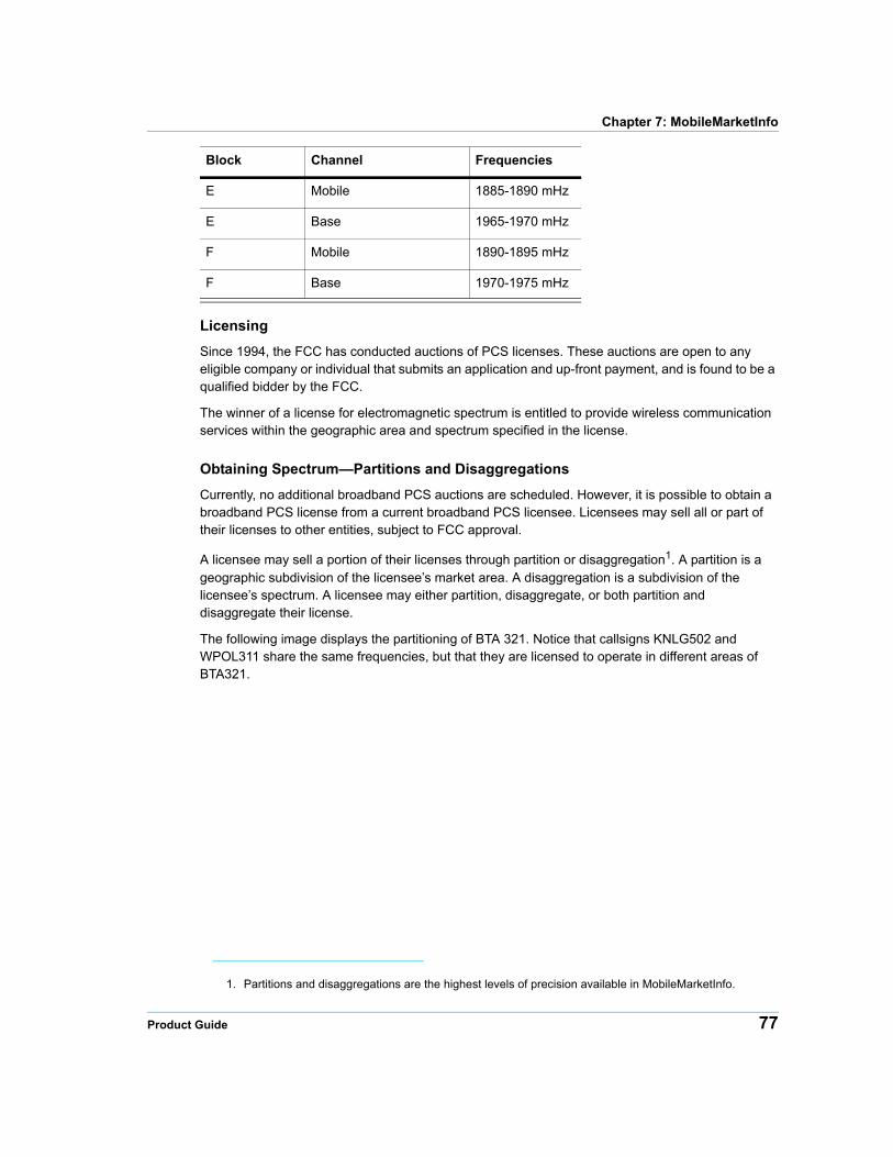
Chapter 7: MobileMarketInfo
Licensing
Since 1994, the FCC has conducted auctions of PCS licenses. These auctions are open to any eligible company or individual that submits an application and up-front payment, and is found to be a qualified bidder by the FCC.
The winner of a license for electromagnetic spectrum is entitled to provide wireless communication services within the geographic area and spectrum specified in the license.
Obtaining Spectrum—Partitions and Disaggregations
Currently, no additional broadband PCS auctions are scheduled. However, it is possible to obtain a broadband PCS license from a current broadband PCS licensee. Licensees may sell all or part of their licenses to other entities, subject to FCC approval.
A licensee may sell a portion of their licenses through partition or disaggregation1. A partition is a geographic subdivision of the licensee’s market area. A disaggregation is a subdivision of the licensee’s spectrum. A licensee may either partition, disaggregate, or both partition and disaggregate their license.
The following image displays the partitioning of BTA 321. Notice that callsigns KNLG502 and WPOL311 share the same frequencies, but that they are licensed to operate in different areas of BTA321.
E Mobile 1885-1890 mHz
E Base 1965-1970 mHz
F Mobile 1890-1895 mHz
F Base 1970-1975 mHz
1. Partitions and disaggregations are the highest levels of precision available in MobileMarketInfo.
Block Channel Frequencies
Product Guide 77

Wireless Communications Overview
This image displays disaggregation in MTA001. Notice that callsigns WPSL626 and KNLF202 operate in the same geographic area, but at different frequencies. WPSL625 operates from 1850-1855 mHz, and KNLF202 operates from 1855-1865 mHz.
78 Communications Suite
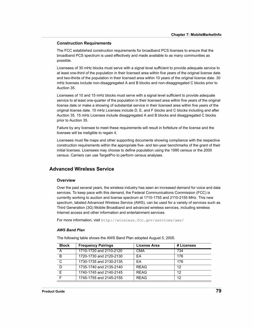
Chapter 7: MobileMarketInfo
Construction Requirements
The FCC established construction requirements for broadband PCS licenses to ensure that the broadband PCS spectrum is used effectively and made available to as many communities as possible.
Licensees of 30 mHz blocks must serve with a signal level sufficient to provide adequate service to at least one-third of the population in their licensed area within five years of the original license date and two-thirds of the population in their licensed area within 10 years of the original license date. 30 mHz licenses include non-disaggregated A and B blocks and non-disaggregated C blocks prior to Auction 35.
Licensees of 10 and 15 mHz blocks must serve with a signal level sufficient to provide adequate service to at least one-quarter of the population in their licensed area within five years of the original license date or make a showing of substantial service in their licensed area within five years of the original license date. 10 mHz Licenses include D, E, and F blocks and C blocks including and after Auction 35. 15 mHz Licenses include disaggregated A and B blocks and disaggregated C blocks prior to Auction 35.
Failure by any licensee to meet these requirements will result in forfeiture of the license and the licensee will be ineligible to regain it.
Licensees must file maps and other supporting documents showing compliance with the respective construction requirements within the appropriate five- and ten-year benchmarks of the grant of their initial licenses. Licensees may choose to define population using the 1990 census or the 2000 census. Carriers can use TargetPro to perform census analyses.
Advanced Wireless Service
Overview
Over the past several years, the wireless industry has seen an increased demand for voice and data services. To keep pace with this demand, the Federal Communications Commission (FCC) is currently working to auction and license spectrum at 1710-1755 and 2110-2155 MHz. This new spectrum, labeled Advanced Wireless Service (AWS), can be used for a variety of services such as Third Generation (3G) Mobile Broadband and advanced wireless services, including wireless Internet access and other information and entertainment services.
For more information, visit http://wireless.fcc.gov/services/aws/
AWS Band Plan
The following table shows the AWS Band Plan adopted August 5, 2005.
Block Frequency Pairings License Area # Licenses
A 1710-1720 and 2110-2120 CMA 734
B 1720-1730 and 2120-2130 EA 176
C 1730-1735 and 2130-2135 EA 176
D 1735-1740 and 2135-2140 REAG 12
E 1740-1745 and 2140-2145 REAG 12
F 1745-1755 and 2145-2155 REAG 12
Product Guide 79
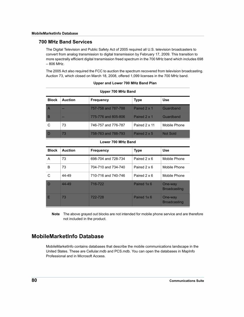
MobileMarketInfo Database
700 MHz Band Services
The Digital Television and Public Safety Act of 2005 required all U.S. television broadcasters to convert from analog transmission to digital transmission by February 17, 2009. This transition to more spectrally efficient digital transmission freed spectrum in the 700 MHz band which includes 698 – 806 MHz.
The 2005 Act also required the FCC to auction the spectrum recovered from television broadcasting. Auction 73, which closed on March 18, 2008, offered 1,099 licenses in the 700 MHz band.
Upper and Lower 700 MHz Band Plan
Upper 700 MHz Band
Block Auction Frequency Type Use
A -- 757-758 and 787-788 Paired 2 x 1 Guardband
B -- 775-776 and 805-806 Paired 2 x 1 Guardband
C 73 746-757 and 776-787 Paired 2 x 11 Mobile Phone
D 73 758-763 and 788-793 Paired 2 x 5 Not Sold
Lower 700 MHz Band
Block Auction Frequency Type Use
A 73 698-704 and 728-734 Paired 2 x 6 Mobile Phone
B 73 704-710 and 734-740 Paired 2 x 6 Mobile Phone
C 44-49 710-716 and 740-746 Paired 2 x 6 Mobile Phone
D 44-49 716-722 Paired 1x 6 One-way Broadcasting
E 73 722-728 Paired 1x 6 One-way Broadcasting
Note The above grayed out blocks are not intended for mobile phone service and are therefore not included in the product.
MobileMarketInfo Database
MobileMarketInfo contains databases that describe the mobile communications landscape in the United States. These are Cellular.mdb and PCS.mdb. You can open the databases in MapInfo Professional and in Microsoft Access.
80 Communications Suite
Chapter 7: MobileMarketInfo
Source
Pitney Bowes’ suite of telecom infrastructure databases are built using state PUC data, state tariff data, the Telcordia™ LERG™ Routing Guide (LERG), StreetPro®, and other reference data.
Use of the LERG data does not imply endorsement of any Pitney Bowes product by Telcordia.
Spatial Referencing
The MobileMarketInfo database has the following coverage, scale, coordinates, and projection:
Coverage Continental United States, Alaska, Hawaii, and Puerto Rico
Scale 1:24,000
Coordinates Latitude and Longitude
Projection NAD83
Cellular Database Structure
Cellular.mdb is located in the [InstallationDirectory]\MobileMarketInfo\Cellular\ folder, along with the following tables and queries:
Tables
• Cellular License
• Cellular Channel Block
• Cellular DBA
• CMA
Queries
• License Expired After
• License Expired Before
• License Expired Between
• License for DBA
• License Granted After
• License Granted Before
• License Granted Between
• License With Market Name
Note Effective June 2008, SID information has been removed from the Cellular database. This information has become increasingly difficult to maintain and Pitney Bowes is no longer able to provide accurate information.
PCS Database Structure
PCS.mdb is located in the [InstallationDirectory]\MobileMarketInfo\PCS\, along with the following MapInfo Professional tables and queries:
Tables
• PCS License
Product Guide 81
MobileMarketInfo Database
• PCS Frequency
• PCS DBA
• PCS Channel Block
• BTA
• MTA
Queries
• License 10 year Buildout Met Between
• License 10 year Buildout Date not Met and Deadline Between
• License 5 year Buildout Met Between
• License 5 year Buildout Date not Met and Deadline After
• License 5 year Buildout Date not Met and Deadline Before
• License 5 year Buildout Date not Met and Deadline Between
• License for DBA
• License for DBA with Frequency
• Market Code
• PCS Frequency Total Bandwidth with License Information
AWS Database Structure
MobileMarketInfo contains an AWS database that describes wireless communications. You can open the database in MapInfo Professional and in Microsoft Access. The AWS files are located in the [InstallationDirectory]\MobileMarketInfo\AWS folder.
Tables
• AWS License
• AWS Frequency
• AWS DBA
• AWS Channel Block
• AWS CMA
• AWS BEA
• AWS REA
Queries
• All Licenses within a BEA
• All Licenses within a BEA with Frequency Information
• All Licenses within an REA
• All Licenses within an REA with Frequency Information
• License for DBA
• License for DBA with Frequency
• Market Code
• AWS Frequency Total Bandwidth with License Information
700 MHz Band Services
MobileMarketInfo contains a database dedicated to 700 MHz Band Services.
82 Communications Suite
Chapter 7: MobileMarketInfo
Tables
• Auction73 REA
• Auction73 BEA
• U700 and L700 CMA
The table structures and queries for all of the above databases are described in the sections below.
Cellular Database Table Structure and Queries
Cellular Database Table Structures
This section contains information on the Cellular Database table structures.
Cellular License
The Cellular License table describes active Cellular licenses.
Field Name Description Type (length) Indexed
CELLULAR_LICENSE(No Objects)
CallSign Cellular license identifier (primary key) Character(10) Yes
USI Unique System Identifier. Alternate cellular license identifier.
Character(10) No
MarketCode Cellular Market Area (CMA) code Character(6) Yes
ChannelBlock Frequency block (A or B) Character(1) No
SubmarketCode One character submarket code Character(1) No
DBA Doing Business As name Character(50) No
Licensee Entity that owns the cellular license Character(50) No
LicenseContact Contact entity for the cellular license Character(50) No
LicenseOwner Owner of the license Character(50) No
LicenseeID Licensee identification Character(50) No
GrantDate Date on which the license was granted. Date No
ExpiredDate Date on which the license expires Date No
AuctionID Auction identification Character(10) No
CellularPhaseID Cellular phase identification Integer No
MAPINFO_ID MapInfo Professional Identifier, which is only visible in Microsoft Access
Long Integer Yes
Cellular Channel Block
The Cellular Channel Block table contains frequency information for cellular channel blocks.
Field Name Description Type (length) Indexed
CELLULAR_CHANNEL_BLOCK(No Objects)
Product Guide 83
MobileMarketInfo Database
Cellular DBA
The Cellular DBA table contains all Cellular Doing Business As names that are used in the Cellular database. Pitney Bowes created this table by aggregating CMA market data for each Cellular license.
Field Name Description Type (length) Indexed
CELLULAR_DBA(Region file)
DBA Doing Business as name (primary key) Character(50) Yes
MAPINFO_ID MapInfo Professional Identifier, which is only visible in Microsoft Access
Long Integer Yes
Region Object The geographic area of the DBA. Not available in Microsoft Access
<obj> No
CMA
The CMA table contains all Cellular Market Areas in the United States and Puerto Rico.
Block Frequency block (A or B) (primary key)
Character(1) Yes
MobileMin Minimum frequency for mobile phone to base tower transmission in MHz
Float No
MobileMax Maximum frequency for mobile phone to base tower transmission in MHz
Float No
BaseMin Minimum frequency for base tower to mobile phone transmission in MHz
Float No
BaseMax Maximum frequency for base tower to mobile phone transmission in MHz
Float No
AdditionalMobileMin Additional minimum frequency for mobile phone to base tower transmis-sion in MHz
Float No
AdditionalMobileMax Additional maximum frequency for mobile phone to base tower transmis-sion in MHz
Float No
AdditionalBaseMin Additional minimum frequency for base tower to mobile phone transmis-sion in MHz
Float No
AdditionalBaseMax Additional maximum frequency for base tower to mobile phone transmis-sion in MHz
Float No
MAPINFO_ID MapInfo Professional Identifier, which is only visible in Microsoft Access
Long Integer Yes
Field Name Description Type (length) Indexed
Field Name Description Type (length) Indexed
CMA(Polygon file)
MarketCode Cellular Market Area name (primary key) Character(6) Yes
84 Communications Suite
Chapter 7: MobileMarketInfo
Cellular Database Queries
This section contains descriptions of the queries included with the Cellular database.
License Expired After The LIC_Expired_after query finds the records in the Cellular License table where the ExpiredDate is after the date that you provide.
License Expired Before The LIC_Expired_before query finds the records in the Cellular License table where the ExpiredDate is before the date that you provide.
License Expired Between The LIC_Expired_between query finds the records in the Cellular License table where the ExpiredDate is between the dates that you provide.
License for DBA The LIC_For_DBA query finds the records in the Cellular License table where the DBA name is similar to the DBA name that you provide. You do not need to provide the entire DBA name exactly as it appears in the DBA column. Make sure that the query returns the results that you wanted, because all DBA names that are similar to the DBA name that you entered will be returned. For example, if you enter “cell,” the many licenses containing the word “cell” will be returned.
License Granted After The LIC_Granted_after query finds the records in the Cellular License table where the GrantDate is after the date that you provide.
License Granted Before The LIC_Granted_before query finds the records in the Cellular License table where the GrantDate is before the date that you provide.
License Granted Between The LIC_Granted_between query finds the records in the Cellular License table where the GrantDate is between the dates that you provide.
License With Market Name The LIC_with_MarketName query attaches the market names to the Cellular License table. The new table is created by joining the Cellular License table to the CMA table.
PCS Broadband Database Table Structure and Queries
PCS Broadband Database Table Structures
This section contains information on the PCS Broadband Database table structures.
PCS License
The PCS License table describes active broadband PCS licenses.
MarketName CMA market name Character(50) No
MAPINFO_ID MapInfo Professional Identifier, which is only visible in Microsoft Access
Long Integer Yes
Region Object The geographic area of the CMA. Not available in Microsoft Access
<obj> No
Field Name Description Type (length) Indexed
Field Name Description Type (length) Indexed
PCS_LICENSE(Polygon File)
Product Guide 85
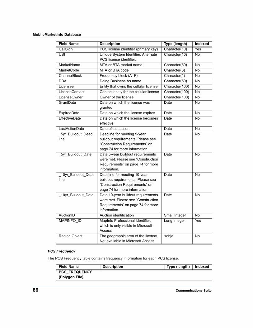
MobileMarketInfo Database
PCS Frequency
The PCS Frequency table contains frequency information for each PCS license.
CallSign PCS license identifier (primary key) Character(10) Yes
USI Unique System Identifier. Alternate PCS license identifier.
Character(10) No
MarketName MTA or BTA market name Character(50) No
MarketCode MTA or BTA code Character(6) No
ChannelBlock Frequency block (A -F) Character(1) No
DBA Doing Business As name Character(50) No
Licensee Entity that owns the cellular license Character(100) No
LicenseContact Contact entity for the cellular license Character(100) No
LicenseOwner Owner of the license Character(100) No
GrantDate Date on which the license was granted
Date No
ExpiredDate Date on which the license expires Date No
EffectiveDate Date on which the license becomes effective
Date No
LastActionDate Date of last action Date No
_5yr_Buildout_Deadline
Deadline for meeting 5-year buildout requirements. Please see “Construction Requirements” on page 74 for more information.
Date No
_5yr_Buildout_Date Date 5-year buildout requirements were met. Please see “Construction Requirements” on page 74 for more information.
Date No
_10yr_Buildout_Deadline
Deadline for meeting 10-year buildout requirements. Please see “Construction Requirements” on page 74 for more information.
Date No
_10yr_Buildout_Date Date 10-year buildout requirements were met. Please see “Construction Requirements” on page 74 for more information.
Date No
AuctionID Auction identification Small Integer No
MAPINFO_ID MapInfo Professional Identifier, which is only visible in Microsoft Access
Long Integer Yes
Region Object The geographic area of the license. Not available in Microsoft Access
<obj> No
Field Name Description Type (length) Indexed
Field Name Description Type (length) Indexed
PCS_FREQUENCY(Polygon File)
86 Communications Suite
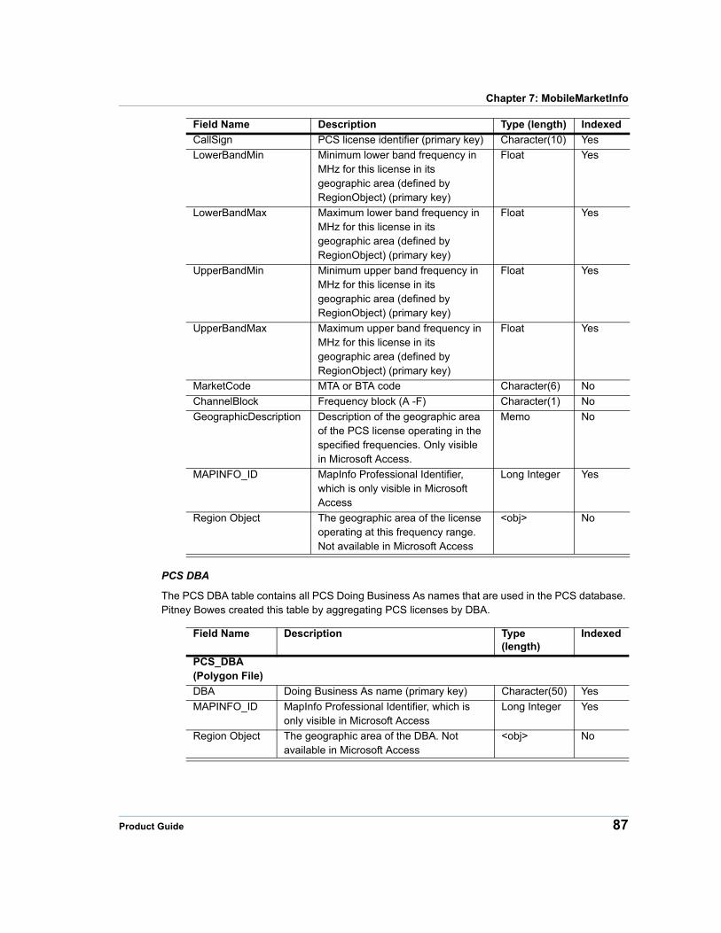
Chapter 7: MobileMarketInfo
PCS DBA
The PCS DBA table contains all PCS Doing Business As names that are used in the PCS database. Pitney Bowes created this table by aggregating PCS licenses by DBA.
Field Name Description Type (length)
Indexed
PCS_DBA(Polygon File)
DBA Doing Business As name (primary key) Character(50) Yes
MAPINFO_ID MapInfo Professional Identifier, which is only visible in Microsoft Access
Long Integer Yes
Region Object The geographic area of the DBA. Not available in Microsoft Access
<obj> No
CallSign PCS license identifier (primary key) Character(10) Yes
LowerBandMin Minimum lower band frequency in MHz for this license in its geographic area (defined by RegionObject) (primary key)
Float Yes
LowerBandMax Maximum lower band frequency in MHz for this license in its geographic area (defined by RegionObject) (primary key)
Float Yes
UpperBandMin Minimum upper band frequency in MHz for this license in its geographic area (defined by RegionObject) (primary key)
Float Yes
UpperBandMax Maximum upper band frequency in MHz for this license in its geographic area (defined by RegionObject) (primary key)
Float Yes
MarketCode MTA or BTA code Character(6) No
ChannelBlock Frequency block (A -F) Character(1) No
GeographicDescription Description of the geographic area of the PCS license operating in the specified frequencies. Only visible in Microsoft Access.
Memo No
MAPINFO_ID MapInfo Professional Identifier, which is only visible in Microsoft Access
Long Integer Yes
Region Object The geographic area of the license operating at this frequency range. Not available in Microsoft Access
<obj> No
Field Name Description Type (length) Indexed
Product Guide 87
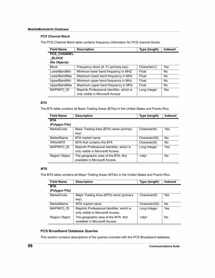
MobileMarketInfo Database
PCS Channel Block
The PCS Channel Block table contains frequency information for PCS channel blocks.
Field Name Description Type (length) Indexed
PCS_CHANNEL_BLOCK(No Objects)
Block Frequency block (A -F) (primary key) Character(1) Yes
LowerBandMin Minimum lower band frequency in MHZ Float No
LowerBandMax Maximum lower band frequency in MHz Float No
UpperBandMin Minimum upper band frequency in MHz Float No
UpperBandMax Maximum upper band frequency in MHz Float No
MAPINFO_ID MapInfo Professional Identifier, which is only visible in Microsoft Access
Long Integer Yes
BTA
The BTA table contains all Basic Trading Areas (BTAs) in the United States and Puerto Rico.
Field Name Description Type (length) Indexed
BTA(Polygon File)
MarketCode Basic Trading Area (BTA) name (primary key)
Character(6) Yes
MarketName BTA market name Character(50) No
WithinMTA MTA that contains the BTA Character(6) No
MAPINFO_ID MapInfo Professional Identifier, which is only visible in Microsoft Access
Long Integer Yes
Region Object The geographic area of the BTA. Not available in Microsoft Access
<obj> No
MTA
The MTA table contains all Major Trading Areas (MTAs) in the United States and Puerto Rico.
Field Name Description Type (length) Indexed
BTA(Polygon File)
MarketCode Major Trading Area (MTA) name (primary key)
Character(6) Yes
MarketName MTA market name Character(50) No
MAPINFO_ID MapInfo Professional Identifier, which is only visible in Microsoft Access
Long Integer Yes
Region Object The geographic area of the MTA. Not available in Microsoft Access
<obj> No
PCS Broadband Database Queries
This section contains descriptions of the queries included with the PCS Broadband database.
88 Communications Suite
Chapter 7: MobileMarketInfo
License 10 year Buildout Met Between The LIC_10yr_BO_met_between query finds the records in the PCS License table where _10yr_Buildout_Date is between the dates that you provide.
License 10 year Buildout Date not Met and Deadline Between The LIC_10yr_BO_NOT_met_and_Deadline_between query finds the records in the PCS License table that did not meet the 10 year buildout date and where _10yr_Buildout_Deadline is between the dates that you provide.
License 5 year Buildout Met Between The LIC_5yr_BO_met_between query finds the records in the PCS License table where _5yr_Buildout_Date is between the dates that you provide.
License 5 year Buildout Date not Met and Deadline After The LIC_5yr_BO_NOT_met_and_Deadline_between query finds the records in the PCS License table that did not meet the 5 year buildout date and where _5yr_Buildout_Deadline is after the date that you provide.
License 5 year Buildout Date not Met and Deadline Before The LIC_5yr_BO_NOT_met_and_Deadline_before query finds the records in the PCS License table that did not meet the 5 year buildout date and where _5yr_Buildout_Deadline is before the date that you provide.
License 5 year Buildout Date not Met and Deadline Between The LIC_5yr_BO_NOT_met_and_Deadline_between query finds the records in the PCS License table that did not meet the 5 year buildout date and where _5yr_Buildout_Deadline is between the dates that you provide.
License for DBA The LIC_For_DBA query finds the records in the PCS License table where the DBA name is similar to the DBA name that you provide. You do not need to provide the entire DBA name exactly as it appears in the DBA column. Make sure that the query returns the results that you wanted, because all DBA names that are similar to the DBA name that you entered will be returned.
License for DBA with Frequency The LIC_For_DBA_FR query finds the records in the PCS License table where the DBA name is similar to the DBA name that you provide and attaches frequency information from the PCS Frequency table. You do not need to provide the entire DBA name exactly as it appears in the DBA column. Make sure that the query returns the results that you wanted, because all DBA names that are similar to the DBA name that you entered will be returned.
Market Code The MarketCode query creates a list of all MTAs and BTAs with their associated Market Names from the PCS License table.
PCS Frequency Total Bandwidth with License Information The PCS_FREQUENCY_BandwidthTotal_with_LIC_info query joins the information in the PCS Frequency table to the PCS License table and calculates the total frequency for each record. The total frequency data is contained in the TotalBandwidth column. The total frequency is calculated using the following equation:
(LowerBandMax - LowerBandMin) + (UpperBandMax - UpperBandMin)=TotalBandwidth
Advanced Wireless Services Structure and Queries
This section covers the Advanced Wireless Services (AWS) database table structures in MobileMarketInfo.
Product Guide 89

MobileMarketInfo Database
AWS Database Table Structures
This section contains information for the AWS database table structures.
AWS License
The AWS License table describes active broadband AWS licenses:
90 Communications Suite
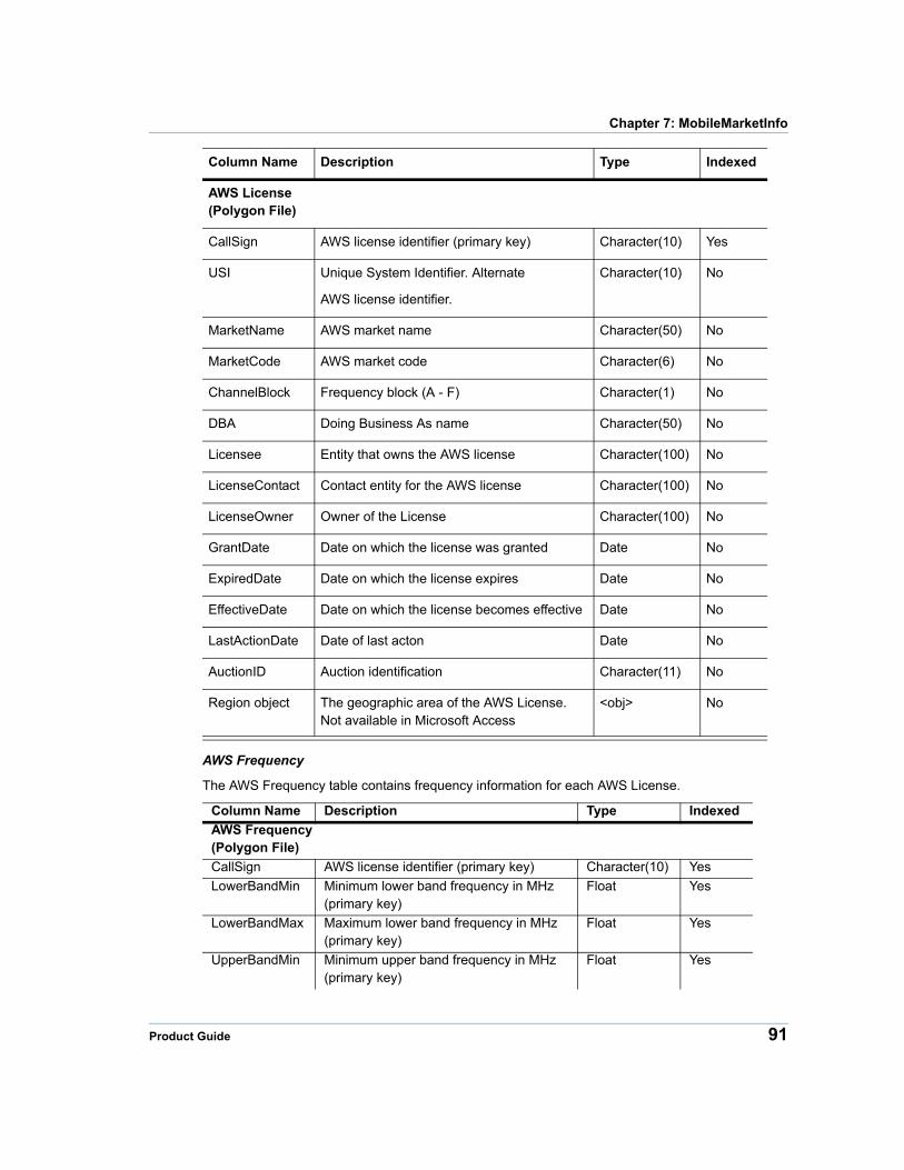
Chapter 7: MobileMarketInfo
Column Name Description Type Indexed
AWS License(Polygon File)
CallSign AWS license identifier (primary key) Character(10) Yes
USI Unique System Identifier. Alternate
AWS license identifier.
Character(10) No
MarketName AWS market name Character(50) No
MarketCode AWS market code Character(6) No
ChannelBlock Frequency block (A - F) Character(1) No
DBA Doing Business As name Character(50) No
Licensee Entity that owns the AWS license Character(100) No
LicenseContact Contact entity for the AWS license Character(100) No
LicenseOwner Owner of the License Character(100) No
GrantDate Date on which the license was granted Date No
ExpiredDate Date on which the license expires Date No
EffectiveDate Date on which the license becomes effective Date No
LastActionDate Date of last acton Date No
AuctionID Auction identification Character(11) No
Region object The geographic area of the AWS License. Not available in Microsoft Access
<obj> No
AWS Frequency
The AWS Frequency table contains frequency information for each AWS License.
Column Name Description Type Indexed
AWS Frequency(Polygon File)
CallSign AWS license identifier (primary key) Character(10) Yes
LowerBandMin Minimum lower band frequency in MHz (primary key)
Float Yes
LowerBandMax Maximum lower band frequency in MHz (primary key)
Float Yes
UpperBandMin Minimum upper band frequency in MHz (primary key)
Float Yes
Product Guide 91

MobileMarketInfo Database
AWS DBA
The AWS DBA table contains all AWS Doing Business As names that are used in the AWS
database. Pitney Bowes created this table by aggregating AWS licenses by DBA.
Column Name Description Type Indexed
AWS DBA(Polygon File)
DBA Doing Business As name Character(50) Yes
Region object The geographic area of the CMA. Each CMA is composed of a collection of counties
<obj> No
AWS Channel Block
The AWS Channel Block table contains frequency information AWS channel blocks.
Column Name Description Type Indexed
AWS ChannelBlock(No Objects)
ChannelBlock Frequency block (A - F) Character(1) Yes
LowerBandMin Minimum lower band frequency in MHz Float No
LowerBandMax Maximum lower band frequency in MHz Float No
UpperBandMin Minimum upper band frequency in MHz Float No
UpperBandMax Maximum upper band frequency in MHz Float No
UpperBandMax Maximum upper band frequency in MHz (primary key)
Float Yes
MarketCode BEA, CMA or REA identifier Character(6) Yes
ChannelBlock Frequency block (A - F) Character(1) No
Region object The geographic area of the AWS License operating at this frequency range. Not available in Microsoft Access
<obj> No
Column Name Description Type Indexed
92 Communications Suite
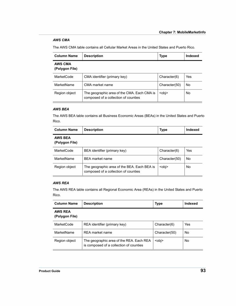
Chapter 7: MobileMarketInfo
AWS CMA
The AWS CMA table contains all Cellular Market Areas in the United States and Puerto Rico.
Column Name Description Type Indexed
AWS CMA(Polygon File)
MarketCode CMA identifier (primary key) Character(6) Yes
MarketName CMA market name Character(50) No
Region object The geographic area of the CMA. Each CMA is composed of a collection of counties
<obj> No
AWS BEA
The AWS BEA table contains all Business Economic Areas (BEAs) in the United States and Puerto
Rico.
Column Name Description Type Indexed
AWS BEA(Polygon File)
MarketCode BEA identifier (primary key) Character(6) Yes
MarketName BEA market name Character(50) No
Region object The geographic area of the BEA. Each BEA is composed of a collection of counties
<obj> No
AWS REA
The AWS REA table contains all Regional Economic Area (REAs) in the United States and Puerto
Rico.
Column Name Description Type Indexed
AWS REA(Polygon File)
MarketCode REA identifier (primary key) Character(6) Yes
MarketName REA market name Character(50) No
Region object The geographic area of the REA. Each REA is composed of a collection of counties
<obj> No
Product Guide 93
MobileMarketInfo Database
AWS Broadband Database Queries
This section contains descriptions of the queries included with the AWS database. You can use these queries in Microsoft Access and MapInfo Professional. For information about using the queries in MapInfo Professional, see Using MobileMarketInfo Queries in MapInfo Professional on page 104.
All Licenses within a BEA The All_LIC_within_BEA query finds the records in the AWS License table that operate within the BEA that you provide. The query includes all REA licenses (C frequency blocks) operating within the BEA as well as all BEA licenses (A, E frequency blocks).
All Licenses within a BEA with Frequency Information The All_LIC_within_BEA_FR query finds the records in the AWS License table that operate within the BEA that you provide and attaches frequency information from the AWS Frequency table. The query includes all REA licenses (C frequency blocks) operating within the BEA as well as all BEA licenses (A, E frequency blocks).
All Licenses within an REA The All_LIC_within_REA query finds the records in the AWS License table that operate within the REA that you provide.The query includes all BEA licenses (A, E frequency blocks) operating in the REA as well as all REA licenses (C frequency blocks).
All Licenses within an REA with Frequency Information The All_LIC_within_ REA_FR query finds the records in the AWS License table that operate within the REA that you provide and attaches frequency information from the AWS Frequency table. The query includes all BEA licenses (A, E frequency blocks) operating in the REA as well as all REA licenses (C frequency blocks).
License for DBA The LIC_For_DBA query finds the records in the AWS License table where the DBA name is similar to the DBA name that you provide. You do not need to provide the entire DBA name exactly as it appears in the DBA column. Make sure that the query returns the results that you wanted, because all DBA names that are similar to the DBA name that you entered will be returned.
License for DBA with Frequency The LIC_For_DBA_FR query finds the records in the AWS License table where the DBA name is similar to the DBA name that you provide and attaches frequency information from the AWS Frequency table. You do not need to provide the entire DBA name exactly as it appears in the DBA column. Make sure that the query returns the results that you wanted, because all DBA names that are similar to the DBA name that you entered will be returned.
Market Code The MarketCode query creates a list of all REA s and BEAs with their associated Market Names from the AWS License table.
AWS Frequency Total Bandwidth with License Information The AWS_FREQUENCY_BandwidthTotal_with_LIC_info query joins the information in the AWS Frequency table to the AWS License table and calculates the total frequency for each record. The total frequency data is contained in the TotalBandwidth column. The total frequency is calculated using the following equation:
(LowerBandMax - LowerBandMin)+(UpperBandMax - UpperBandMin)=TotalBandwidth
700 MHz Band Services
This section contains information for the Upper and Lower 700 MHz Band database table structures.
94 Communications Suite
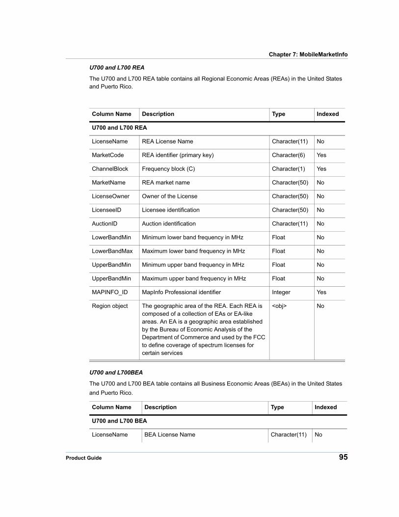
Chapter 7: MobileMarketInfo
U700 and L700 REA
The U700 and L700 REA table contains all Regional Economic Areas (REAs) in the United States and Puerto Rico.
Column Name Description Type Indexed
U700 and L700 REA
LicenseName REA License Name Character(11) No
MarketCode REA identifier (primary key) Character(6) Yes
ChannelBlock Frequency block (C) Character(1) Yes
MarketName REA market name Character(50) No
LicenseOwner Owner of the License Character(50) No
LicenseeID Licensee identification Character(50) No
AuctionID Auction identification Character(11) No
LowerBandMin Minimum lower band frequency in MHz Float No
LowerBandMax Maximum lower band frequency in MHz Float No
UpperBandMin Minimum upper band frequency in MHz Float No
UpperBandMin Maximum upper band frequency in MHz Float No
MAPINFO_ID MapInfo Professional identifier Integer Yes
Region object The geographic area of the REA. Each REA is composed of a collection of EAs or EA-like areas. An EA is a geographic area established by the Bureau of Economic Analysis of the Department of Commerce and used by the FCC to define coverage of spectrum licenses for certain services
<obj> No
U700 and L700BEA
The U700 and L700 BEA table contains all Business Economic Areas (BEAs) in the United States
and Puerto Rico.
Column Name Description Type Indexed
U700 and L700 BEA
LicenseName BEA License Name Character(11) No
Product Guide 95
MobileMarketInfo Database
U700 and L700 CMA
The U700 and L700 CMA table contains all Cellular Market Areas in the United States and Puerto Rico.
MarketCode BEA identifier (primary key) Character(6) Yes
ChannelBlock Frequency block (A,E) Character(1) Yes
MarketName BEA market name Character(50) No
LicenseOwner Owner of the License Character(50) No
LicenseeID Licensee identification Character(50) No
AuctionID Auction identification Character(11) No
LowerBandMin Minimum lower band frequency in MHz Float No
LowerBandMax Maximum lower band frequency in MHz Float No
UpperBandMin Minimum upper band frequency in MHz Float No
UpperBandMin Maximum upper band frequency in MHz Float No
MAPINFO_ID MapInfo Professional identifier Integer Yes
Region object The geographic area of the BEA. Each BEA is composed of a collection of EAs.
<obj> No
Column Name Description Type Indexed
U700 and L700 CMA
LicenseName CMA License Name Character(11) No
MarketCode CMA identifier (primary key) Character(6) Yes
ChannelBlock Frequency block (B) Character(1) Yes
MarketName CMA market name Character(50) No
LicenseOwner Owner of the License Character(50) No
LicenseeID Licensee identification Character(50) No
AuctionID Auction identification Character(11) No
LowerBandMin Minimum lower band frequency in MHz Float No
LowerBandMax Maximum lower band frequency in MHz Float No
Column Name Description Type Indexed
96 Communications Suite
Chapter 7: MobileMarketInfo
U700 Database Queries
U700 Database Queries
This section contains descriptions of the queries included with the U700 database. You can use these queries in Microsoft Access and MapInfo Professional. For information about using the queries in MapInfo Professional, see Using MobileMarketInfo Queries in MapInfo Professional on page 104.
All Licenses within an REA
The All_LIC_within_REA query finds the records in the U700 License table that operate within the REA that you provide.
All Licenses within an REA with Frequency Information
The All_LIC_within_ REA_FR query finds the records in the U700 License table that operate within the REA that you provide, and attaches frequency information from the U700 Frequency table.
License for DBA
The LIC_For_DBA query finds the records in the U700 License table where the DBA name is similar to the DBA name that you provide. You do not need to provide the entire DBA name exactly as it appears in the DBA column. Make sure that the query returns the results that you wanted, because all DBA names that are similar to the DBA name that you entered will be returned.
License for DBA with Frequency
The LIC_For_DBA_FR query finds the records in the U700 License table where the DBA name is similar to the DBA name that you provide, and attaches frequency information from the U700 Frequency table. You do not need to provide the entire DBA name exactly as it appears in the DBA column. Make sure that the query returns the results that you wanted, because all DBA names that are similar to the DBA name that you entered will be returned.
UpperBandMin Minimum upper band frequency in MHz Float No
UpperBandMin Maximum upper band frequency in MHz Float No
MAPINFO_ID MapInfo Professional identifier Integer Yes
Region object The geographic area of the CMA. Each CMA is composed of a collection of MSAs and RSAs.
<obj> No
Column Name Description Type Indexed
Product Guide 97
L700 Database Queries
Market Code
The MarketCode query creates a list of all REAs with their associated Market Names from the U700 License table.
U700 Frequency Total Bandwidth with License Information
The U700_FREQUENCY_BandwidthTotal_with_LIC_info query joins the information in the U700 Frequency table to the U700 License table, and calculates the total frequency for each record. The total frequency data is contained in the TotalBandwidth column. The total frequency is calculated using the following equation:
(LowerBandMax-LowerBandMin)+(UpperBandMax-UpperBandMin)= TotalBandwidth
L700 Database Queries
L700 Database Queries
This section contains descriptions of the queries included with the L700 database. You can use these queries in Microsoft Access and MapInfo Professional. For information about using the queries in MapInfo Professional, see Using MobileMarketInfo Queries in MapInfo Professional on page 104.
All Licenses within an BEA
The All_LIC_within_BEA query finds the records in the UL00 License table that operate within the REA that you provide. The query includes all CMA licenses operating within the BEA, as well as all BEA licenses.
All Licenses within an BEA with Frequency Information
The All_LIC_within_ BEA_FR query finds the records in the U700 License table that operate within the REA that you provide, and attaches frequency information from the U700 Frequency table. The query includes all CMA licenses operating within the BEA, as well as all BEA licenses.
All Licenses within a CMA
The All_LIC_within_CMA query finds the records in the L700 License table that operate within the CMA that you provide.The query includes all BEA licenses operating in the CMA, as well as all CMA licenses.
All Licenses within a CMA with Frequency Information
The All_LIC_within_ CMA_FR query finds the records in the L700 License table that operate within the CMA that you provide, and attaches frequency information from the L700 Frequency table. The query includes all BEA licenses operating in the CMA, as well as all CMA licenses.
98 Communications Suite
Chapter 7: MobileMarketInfo
License for DBA
The LIC_For_DBA query finds the records in the L700 License table where the DBA name is similar to the DBA name that you provide. You do not need to provide the entire DBA name exactly as it appears in the DBA column. Make sure that the query returns the results that you wanted, because all DBA names that are similar to the DBA name that you entered will be returned.
License for DBA with Frequency
The LIC_For_DBA_FR query finds the records in the L700 License table where the DBA name is similar to the DBA name that you provide, and attaches frequency information from the L700 Frequency table. You do not need to provide the entire DBA name exactly as it appears in the DBA column. Make sure that the query returns the results that you wanted, because all DBA names that are similar to the DBA name that you entered will be returned.
Market Code
The MarketCode query creates a list of all BEAs with their associated Market Names from the L700 License table.
L700 Frequency Total Bandwidth with License Information
The L700_FREQUENCY_BandwidthTotal_with_LIC_info query joins the information in the L700 Frequency table to the L700 License table, and calculates the total frequency for each record. The total frequency data is contained in the TotalBandwidth column. The total frequency is calculated using the following equation:
(LowerBandMax-LowerBandMin)+(UpperBandMax-UpperBandMin)= TotalBandwidth
MobileMarketAnalyzer
This section explains how to use the MapBasic tool MobileMarketAnalyzer that is included with MobileMarketInfo.
MobileMarketAnalyzer is an easy to use MapBasic application that allows you to select and view useful subsets of the MobileMarketInfo database. MobileMarketAnalyzer demonstrates the types of analysis that can be performed using MobileMarketInfo.
Starting MobileMarketAnalyzer
To launch the program MobileMarketAnalyzer in MapInfo Professional, follow the steps below.
1. Choose Tools>Run MapBasic Program.
The Run MapBasic Program window appears.
2. Browse to the location of MobileMarketAnalyzer.mbx.
Note MobileMarketAnalyzer.mbx must be located in the MobileMarketInfo installation directory for the program to operate properly.
3. Select MobileMarketAnalyzer.mbx, and click Open.
Product Guide 99
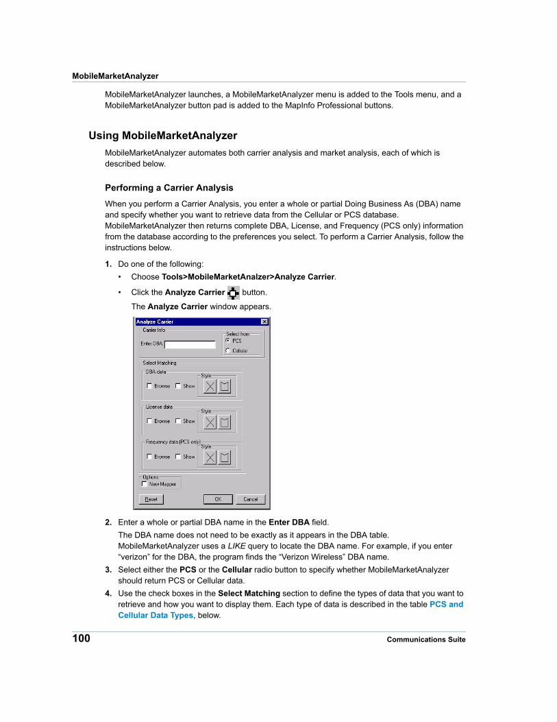
MobileMarketAnalyzer
MobileMarketAnalyzer launches, a MobileMarketAnalyzer menu is added to the Tools menu, and a MobileMarketAnalyzer button pad is added to the MapInfo Professional buttons.
Using MobileMarketAnalyzer
MobileMarketAnalyzer automates both carrier analysis and market analysis, each of which is described below.
Performing a Carrier Analysis
When you perform a Carrier Analysis, you enter a whole or partial Doing Business As (DBA) name and specify whether you want to retrieve data from the Cellular or PCS database. MobileMarketAnalyzer then returns complete DBA, License, and Frequency (PCS only) information from the database according to the preferences you select. To perform a Carrier Analysis, follow the instructions below.
1. Do one of the following:
• Choose Tools>MobileMarketAnalzer>Analyze Carrier.
• Click the Analyze Carrier button.
The Analyze Carrier window appears.
2. Enter a whole or partial DBA name in the Enter DBA field.
The DBA name does not need to be exactly as it appears in the DBA table. MobileMarketAnalyzer uses a LIKE query to locate the DBA name. For example, if you enter “verizon” for the DBA, the program finds the “Verizon Wireless” DBA name.
3. Select either the PCS or the Cellular radio button to specify whether MobileMarketAnalyzer should return PCS or Cellular data.
4. Use the check boxes in the Select Matching section to define the types of data that you want to retrieve and how you want to display them. Each type of data is described in the table PCS and Cellular Data Types, below.
100 Communications Suite
Chapter 7: MobileMarketInfo
5. Select either the Browse or the Show checkbox for each type of data that you want to retrieve.
• If you select the Browse checkbox, the data is shown in a new browser window.
• If you select the Show check box, the data is displayed in a map window. Use the Border Style button to set the style of the map region’s borders. Use the Fill Style button to set the style of the map region’s fill.
6. Check the New Mapper check box if you want to display the results in a new map window. If you do not check the New Mapper checkbox, the results are displayed in the most recently used map window.
7. Use the Reset button to clear the dialog.
8. Click OK.
The MobileMarketAnalyzer displays the data you requested in the format that you specified. Browser windows are displayed in the following order:
• DBA data
• License data
• Frequency data
The map layers are drawn in the following order:
• DBA data (bottom)
• License data (middle)
• Frequency data (top)
Note Because MobileMarketAnalyzer queries the MobileMarketInfo database, the resulting tables are not automatically saved. Additionally, if you close any of the tables that the queries are based upon, the query will also be closed.
PCS and Cellular Data Types
DBA data Retrieving PCS data selects all instances of the DBA name from the PCS_DBA table. The selection is named [DBA Name]_PCS_DBA, where [DBA Name] is the carrier that corresponds to the DBA name that you entered. For example, if you enter “Verizon” for the DBA name, the resulting table is named Verizon_Wireless_PCS_DBA.
Retrieving Cellular data selects all instances of the DBA name from the CELLULAR_DBA table. The selection is named [DBA Name]_CELL_DBA, where [DBA Name] is the carrier that corresponds to the DBA name.
License data Retrieving PCS data selects all licenses having the DBA name that you entered from the PCS_LICENSE table. The selection is named [DBA Name]_PCS_LIC, where [DBA Name] is the carrier that corresponds to the DBA name that you entered.
Product Guide 101
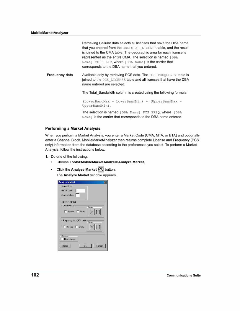
MobileMarketAnalyzer
Performing a Market Analysis
When you perform a Market Analysis, you enter a Market Code (CMA, MTA, or BTA) and optionally enter a Channel Block. MobileMarketAnalyzer then returns complete License and Frequency (PCS only) information from the database according to the preferences you select. To perform a Market Analysis, follow the instructions below.
1. Do one of the following:
• Choose Tools>MobileMarketAnalzer>Analyze Market.
• Click the Analyze Market button.
The Analyze Market window appears.
Retrieving Cellular data selects all licenses that have the DBA name that you entered from the CELLULAR_LICENSE table, and the result is joined to the CMA table. The geographic area for each license is represented as the entire CMA. The selection is named [DBA Name]_CELL_LIC, where [DBA Name] is the carrier that corresponds to the DBA name that you entered.
Frequency data Available only by retrieving PCS data. The PCS_FREQUENCY table is joined to the PCS_LICENSE table and all licenses that have the DBA name entered are selected.
The Total_Bandwidth column is created using the following formula:
(LowerBandMax – LowerBandMin) + (UpperBandMax – UpperBandMin).
The selection is named [DBA Name]_PCS_FREQ, where [DBA Name] is the carrier that corresponds to the DBA name entered.
102 Communications Suite
Chapter 7: MobileMarketInfo
2. Enter a complete CMA, MTA, or BTA market code in the Market Code field.
If the first three characters of the Market Code are “CMA”, then the data is selected from the Cellular database. If the first three characters of the Market Code are “MTA” or “BTA”, then the resulting data is selected from the PCS database.
3. Optionally enter a Channel Block in the Channel Block field.
If you do not enter a Channel Block, MobileMarketAnalyzer will return information for all Channel Blocks.
4. Use the checkboxes in the Select Matching section to define the types of data that you want to retrieve and how you want to display it. Each type of data is described in the table Market Code and Channel Block Data Types, below.
5. Select either the Browse or the Show checkbox for each type of data that you want to retrieve.
When you select the Browse checkbox, the data is shown in a new browser window.
When you select the Show check box, the data is displayed in a map window. Use the Border Style button to set the style of the map region’s borders. Use the Fill Style button to set the style of the map region’s fill.
6. Check the New Mapper check box if you want to display the results in a new map window. If you do not check the New Mapper check box, the results are displayed in the most recently used map window.
7. Use Reset to clear the dialog.
8. Click OK.
The MobileMarketAnalyzer displays the data you requested in the format that you specified. Browser windows are displayed in the following order:
• License data
• Frequency data
The map layers are drawn in the following order:
• License data (bottom)
• Frequency data (top)
Note Since MobileMarketAnalyzer queries the MobileMarketInfo database, the resulting tables are not automatically saved. Additionally, if you close any of the tables that the queries are based upon, the query will also be closed.
Market Code and Channel Block Data Types
License data If you entered an MTA or BTA Market Code, all licenses that have the Market Code and Channel Block that you entered are selected from the PCS_LICENSE table.
If you supplied a channel block, the selection is named [Market Code]_[Channel Block]_PCS_LIC, where [Market Code] is the MTA or BTA code and [Channel Block] is the Channel Block that you entered.
If you did not supply a Channel Block, the selection is named [Market Code]_PCS_LIC.
Product Guide 103
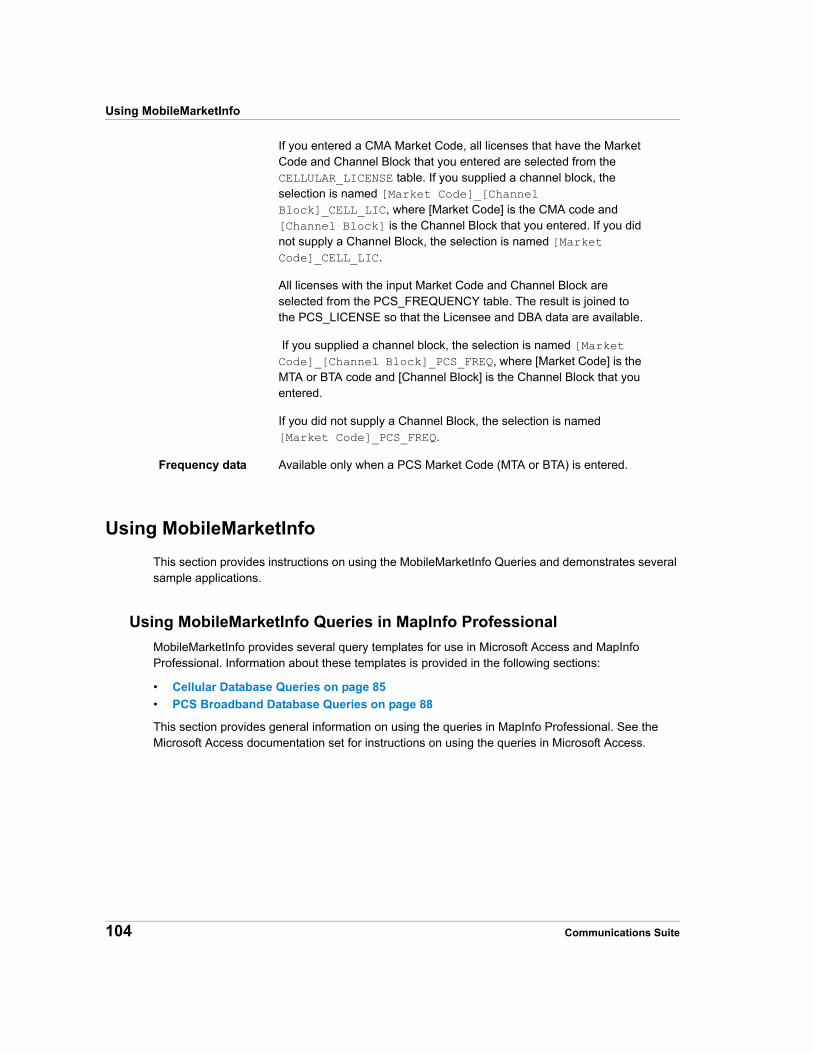
Using MobileMarketInfo
Using MobileMarketInfo
This section provides instructions on using the MobileMarketInfo Queries and demonstrates several sample applications.
Using MobileMarketInfo Queries in MapInfo Professional
MobileMarketInfo provides several query templates for use in Microsoft Access and MapInfo Professional. Information about these templates is provided in the following sections:
• Cellular Database Queries on page 85
• PCS Broadband Database Queries on page 88
This section provides general information on using the queries in MapInfo Professional. See the Microsoft Access documentation set for instructions on using the queries in Microsoft Access.
If you entered a CMA Market Code, all licenses that have the Market Code and Channel Block that you entered are selected from the CELLULAR_LICENSE table. If you supplied a channel block, the selection is named [Market Code]_[Channel Block]_CELL_LIC, where [Market Code] is the CMA code and [Channel Block] is the Channel Block that you entered. If you did not supply a Channel Block, the selection is named [Market Code]_CELL_LIC.
All licenses with the input Market Code and Channel Block are selected from the PCS_FREQUENCY table. The result is joined to the PCS_LICENSE so that the Licensee and DBA data are available.
If you supplied a channel block, the selection is named [Market Code]_[Channel Block]_PCS_FREQ, where [Market Code] is the MTA or BTA code and [Channel Block] is the Channel Block that you entered.
If you did not supply a Channel Block, the selection is named [Market Code]_PCS_FREQ.
Frequency data Available only when a PCS Market Code (MTA or BTA) is entered.
104 Communications Suite
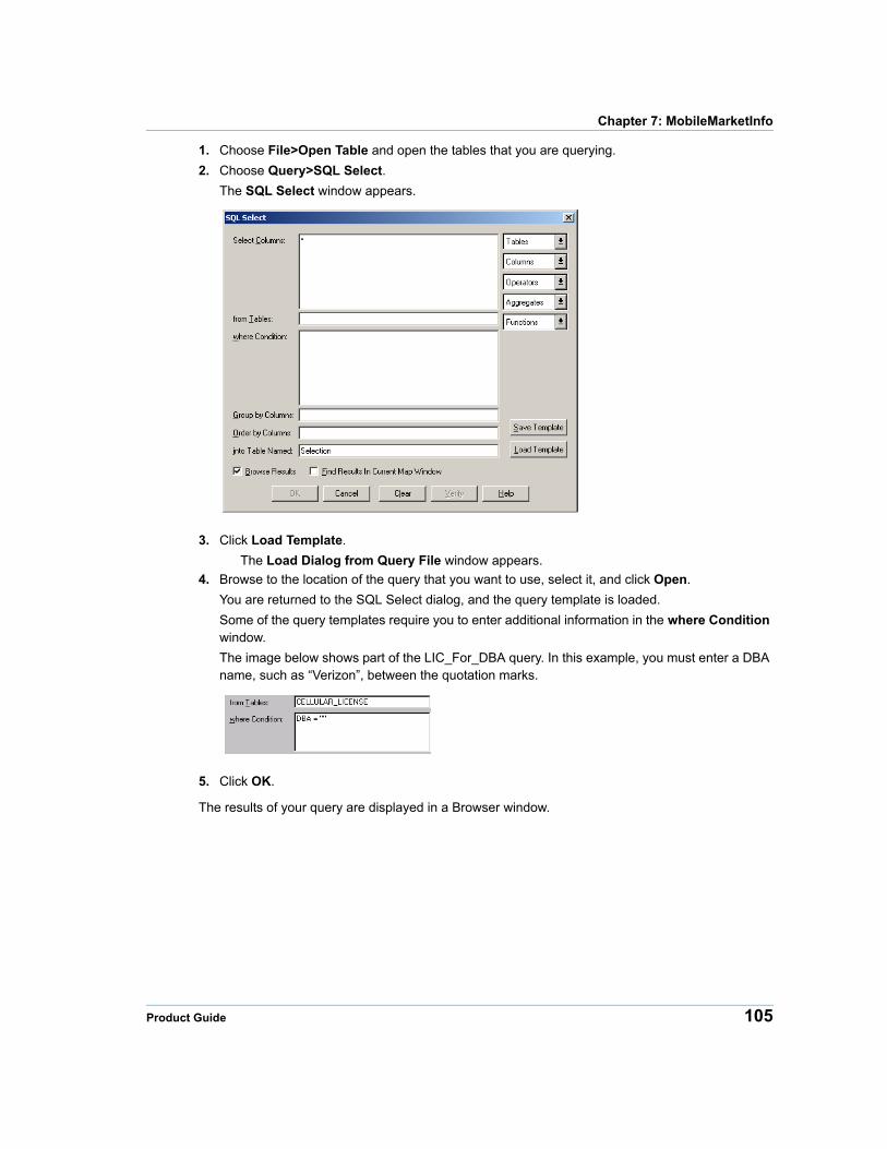
Chapter 7: MobileMarketInfo
1. Choose File>Open Table and open the tables that you are querying.
2. Choose Query>SQL Select.
The SQL Select window appears.
3. Click Load Template.
The Load Dialog from Query File window appears.
4. Browse to the location of the query that you want to use, select it, and click Open.
You are returned to the SQL Select dialog, and the query template is loaded.
Some of the query templates require you to enter additional information in the where Condition window.
The image below shows part of the LIC_For_DBA query. In this example, you must enter a DBA name, such as “Verizon”, between the quotation marks.
5. Click OK.
The results of your query are displayed in a Browser window.
Product Guide 105
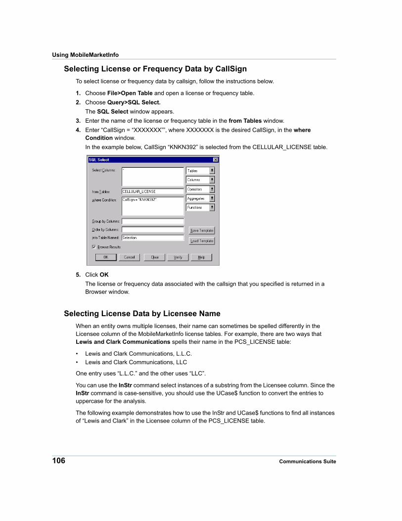
Using MobileMarketInfo
Selecting License or Frequency Data by CallSign
To select license or frequency data by callsign, follow the instructions below.
1. Choose File>Open Table and open a license or frequency table.
2. Choose Query>SQL Select.
The SQL Select window appears.
3. Enter the name of the license or frequency table in the from Tables window.
4. Enter “CallSign = “XXXXXXX””, where XXXXXXX is the desired CallSign, in the where Condition window.
In the example below, CallSign “KNKN392” is selected from the CELLULAR_LICENSE table.
5. Click OK
The license or frequency data associated with the callsign that you specified is returned in a Browser window.
Selecting License Data by Licensee Name
When an entity owns multiple licenses, their name can sometimes be spelled differently in the Licensee column of the MobileMarketInfo license tables. For example, there are two ways that Lewis and Clark Communications spells their name in the PCS_LICENSE table:
• Lewis and Clark Communications, L.L.C.
• Lewis and Clark Communications, LLC
One entry uses “L.L.C.” and the other uses “LLC”.
You can use the InStr command select instances of a substring from the Licensee column. Since the InStr command is case-sensitive, you should use the UCase$ function to convert the entries to uppercase for the analysis.
The following example demonstrates how to use the InStr and UCase$ functions to find all instances of “Lewis and Clark” in the Licensee column of the PCS_LICENSE table.
106 Communications Suite
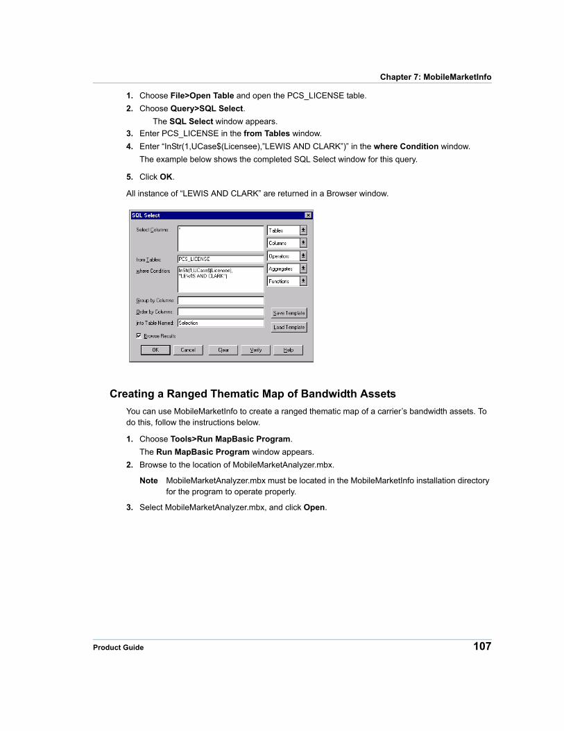
Chapter 7: MobileMarketInfo
1. Choose File>Open Table and open the PCS_LICENSE table.
2. Choose Query>SQL Select.
The SQL Select window appears.
3. Enter PCS_LICENSE in the from Tables window.
4. Enter “InStr(1,UCase$(Licensee),”LEWIS AND CLARK”)” in the where Condition window.
The example below shows the completed SQL Select window for this query.
5. Click OK.
All instance of “LEWIS AND CLARK” are returned in a Browser window.
Creating a Ranged Thematic Map of Bandwidth Assets
You can use MobileMarketInfo to create a ranged thematic map of a carrier’s bandwidth assets. To do this, follow the instructions below.
1. Choose Tools>Run MapBasic Program.
The Run MapBasic Program window appears.
2. Browse to the location of MobileMarketAnalyzer.mbx.
Note MobileMarketAnalyzer.mbx must be located in the MobileMarketInfo installation directory for the program to operate properly.
3. Select MobileMarketAnalyzer.mbx, and click Open.
Product Guide 107
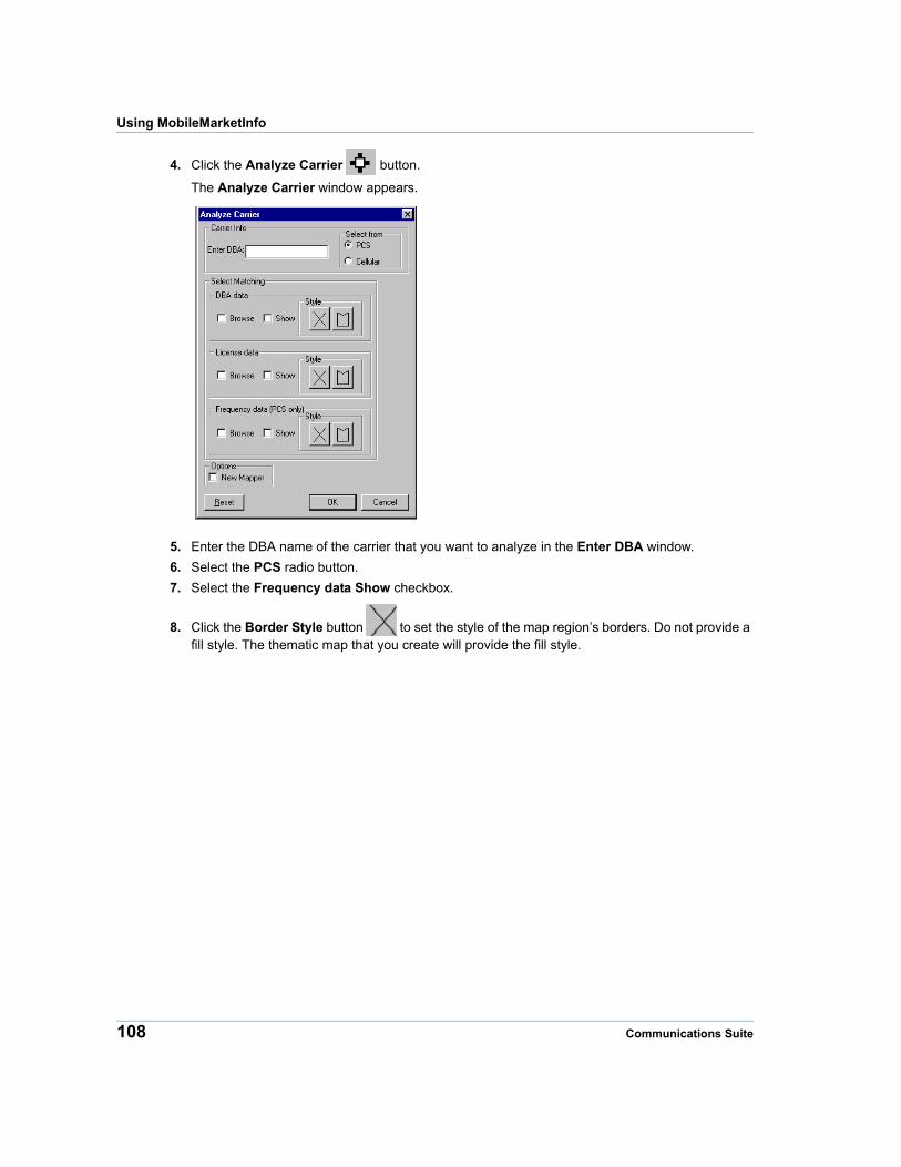
Using MobileMarketInfo
4. Click the Analyze Carrier button.
The Analyze Carrier window appears.
5. Enter the DBA name of the carrier that you want to analyze in the Enter DBA window.
6. Select the PCS radio button.
7. Select the Frequency data Show checkbox.
8. Click the Border Style button to set the style of the map region’s borders. Do not provide a fill style. The thematic map that you create will provide the fill style.
108 Communications Suite
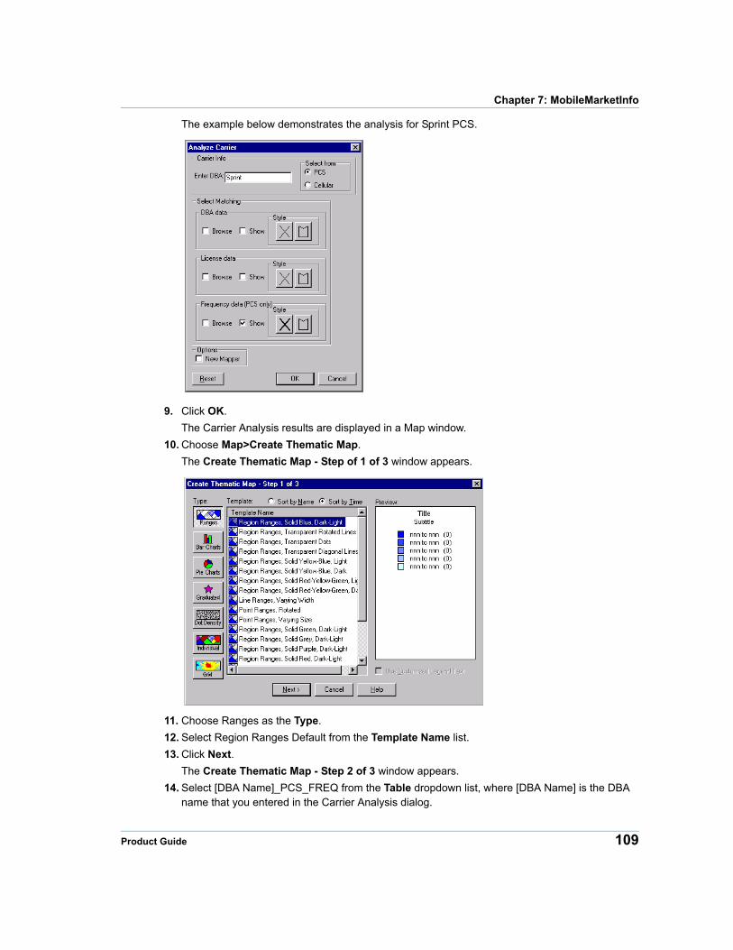
Chapter 7: MobileMarketInfo
The example below demonstrates the analysis for Sprint PCS.
9. Click OK.
The Carrier Analysis results are displayed in a Map window.
10. Choose Map>Create Thematic Map.
The Create Thematic Map - Step of 1 of 3 window appears.
11. Choose Ranges as the Type.
12. Select Region Ranges Default from the Template Name list.
13. Click Next.
The Create Thematic Map - Step 2 of 3 window appears.
14. Select [DBA Name]_PCS_FREQ from the Table dropdown list, where [DBA Name] is the DBA name that you entered in the Carrier Analysis dialog.
Product Guide 109
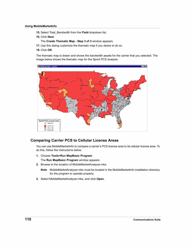
Using MobileMarketInfo
15. Select Total_Bandwidth from the Field dropdown list.
16. Click Next.
The Create Thematic Map - Step 3 of 3 window appears.
17. Use this dialog customize the thematic map if you desire to do so.
18. Click OK.
The thematic map is drawn and shows the bandwidth assets for the carrier that you selected. The image below shows the thematic map for the Sprint PCS analysis.
Comparing Carrier PCS to Cellular License Areas
You can use MobileMarketInfo to compare a carrier’s PCS license area to its cellular license area. To do this, follow the instructions below.
1. Choose Tools>Run MapBasic Program.
The Run MapBasic Program window appears.
2. Browse to the location of MobileMarketAnalyzer.mbx.
Note MobileMarketAnalyzer.mbx must be located in the MobileMarketInfo installation directory for the program to operate properly.
3. Select MobileMarketAnalyzer.mbx, and click Open.
110 Communications Suite
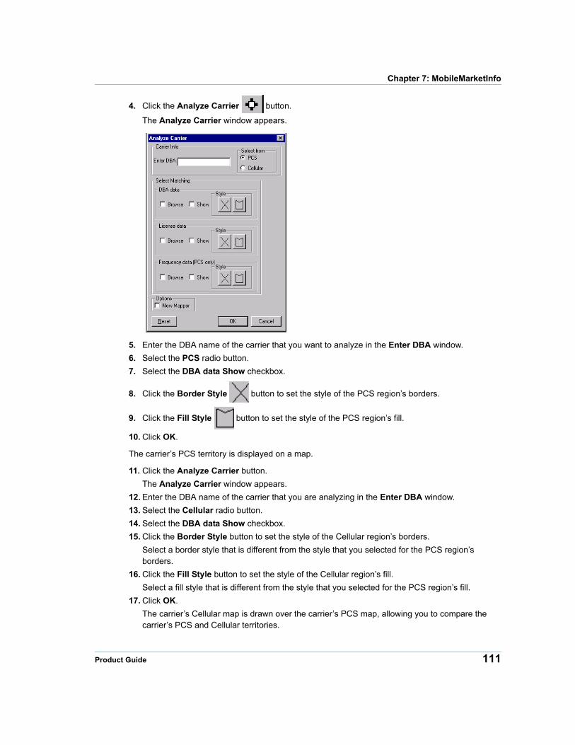
Chapter 7: MobileMarketInfo
4. Click the Analyze Carrier button.
The Analyze Carrier window appears.
5. Enter the DBA name of the carrier that you want to analyze in the Enter DBA window.
6. Select the PCS radio button.
7. Select the DBA data Show checkbox.
8. Click the Border Style button to set the style of the PCS region’s borders.
9. Click the Fill Style button to set the style of the PCS region’s fill.
10. Click OK.
The carrier’s PCS territory is displayed on a map.
11. Click the Analyze Carrier button.
The Analyze Carrier window appears.
12. Enter the DBA name of the carrier that you are analyzing in the Enter DBA window.
13. Select the Cellular radio button.
14. Select the DBA data Show checkbox.
15. Click the Border Style button to set the style of the Cellular region’s borders.
Select a border style that is different from the style that you selected for the PCS region’s borders.
16. Click the Fill Style button to set the style of the Cellular region’s fill.
Select a fill style that is different from the style that you selected for the PCS region’s fill.
17. Click OK.
The carrier’s Cellular map is drawn over the carrier’s PCS map, allowing you to compare the carrier’s PCS and Cellular territories.
Product Guide 111
8
Chapter 8: PSAP ProPSAP Pro is a comprehensive Public Safety Answering Point product. This Pitney Bowes database covers the United States and select Canadian provinces.
In this chapter
PSAP Pro Overview . . . . . . . . . . . . . . . . . . . . . . . . . . . . . . . . . . . .113 Table Structures . . . . . . . . . . . . . . . . . . . . . . . . . . . . . . . . . . . . . . .115 Using PSAP Pro with Other Products . . . . . . . . . . . . . . . . . . . . .117
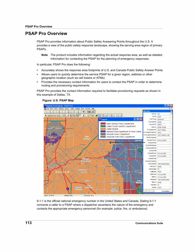
PSAP Pro Overview
PSAP Pro Overview
PSAP Pro provides information about Public Safety Answering Points throughout the U.S. It provides a view of the public safety response landscape, showing the serving area region of primary PSAPs.
Note The product includes information regarding the actual response area, as well as detailed information for contacting the PSAP for the planning of emergency responses.
In particular, PSAP Pro does the following:
• Accurately shows the response area footprints of U.S. and Canada Public Safety Answer Points
• Allows users to quickly determine the service PSAP for a given region, address or other geographic location (such as cell towers or ATMs)
• Provides the necessary contact information for users to contact the PSAP in order to determine routing and provisioning requirements.
PSAP Pro provides the contact information required to facilitate provisioning requests as shown in this example of Dallas, TX.
Figure: U.S. PSAP Map
9-1-1 is the official national emergency number in the United States and Canada. Dialing 9-1-1 connects a caller to a PSAP where a dispatcher ascertains the nature of the emergency and contacts the appropriate emergency personnel (for example: police, fire, or ambulance).
113 Communications Suite
Chapter 8: PSAP Pro
A PSAP is a physical location, which operates 24 hours, 7 days a week. A PSAP can have Basic or Enhanced capabilities.
• Basic 9-1-1 systems may include ANI/ALI information (Automatic Number Identification/Automatic Location Identification).
• Enhanced 9-1-1 systems have ANI/ALI plus selective routing capabilities. Selective routing provides greater accuracy in routing a 9-1-1 call to the appropriate PSAP responsible for a geographic jurisdiction. Selective routing also permits calls to be quickly transferred from the primary public safety answering point to emergency service providers or to backup or secondary PSAPs.
A Primary PSAP is one that receives the 9-1-1 call directly, through a 9-1-1 tandem or a selective router. A Secondary PSAP is one to which 9-1-1 calls are transferred from a Primary PSAP.
In the U.S., the Federal Communications Commission (FCC) regulates communications including 9-1-1.
PSAP Pro Database
File Names
The PSAP Pro database consists of the table UsPsapReg.*
The table below shows the file set for the United States.
United States PSAP Boundary File Set - MapInfo
United States PSAP Boundary File Set - Spatial Plus
UsPsapReg.dat uspsapreg.gsa
UsPsapReg.id uspsapreg.gsb
UsPsapReg.ind
UsPsapReg.map
UsPsapReg.tab
Note Due to column name length restrictions within Spatial Plus, some .gsa/.gsb column names need to be truncated to 10 characters or less.
Source
PSAP Data Resources, Inc. and Pitney Bowes.
Product Guide 114
Table Structures
Spatial Referencing
The PSAP Pro database has the following coverage, scale, and coordinates:
Coverage United States and Canada
Scale 1:24,000
Coordinates Latitude and Longitude
Projection NAD 83
Table Structures
PSAP Pro has the following table structure:
.TAB Column Name
.GSB Column Name Description Type (Length) Indexed
PSAPID PSAPID unique ID for the PSAP Integer Yes
FCCID FCCID FCC ID for the PSAP Integer No
PSAPType PSAPType Values: enhanced, basic, military, non-9-1-1
Character (20) No
CountyName CountyNme Name of the county where the PSAP is located
Character (40) No
CountyFIPS CountyFIPS FIPS of the county where the PSAP is located
Character (5) No
Agency Agency The name of the PSAP Character (120)
No
CoverageArea CvgArea Coverage area of the PSAP Character (254)
No
CoverageExceptions
CvgExcp Areas excluded from the CoverageArea
Character (254)
No
CoverageComments
CvgCmnt Additional comments about the PSAP's coverage
Character (254)
No
PSAPComments
PSAPCmnt General comments about the PSAP
Character (254)
No
OperatorPhone OprPhne Emergency number that is answered 24x7
Character (15) No
115 Communications Suite
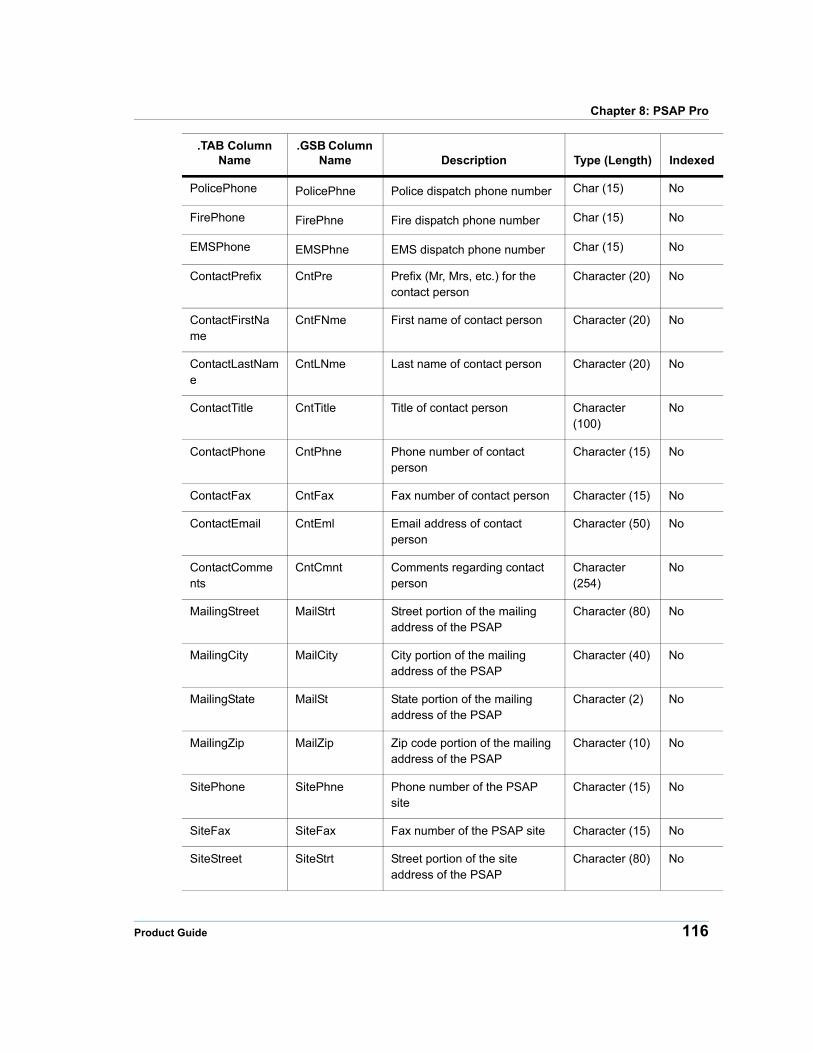
Chapter 8: PSAP Pro
PolicePhone PolicePhne Police dispatch phone number Char (15) No
FirePhone FirePhne Fire dispatch phone number Char (15) No
EMSPhone EMSPhne EMS dispatch phone number Char (15) No
ContactPrefix CntPre Prefix (Mr, Mrs, etc.) for the contact person
Character (20) No
ContactFirstName
CntFNme First name of contact person Character (20) No
ContactLastName
CntLNme Last name of contact person Character (20) No
ContactTitle CntTitle Title of contact person Character (100)
No
ContactPhone CntPhne Phone number of contact person
Character (15) No
ContactFax CntFax Fax number of contact person Character (15) No
ContactEmail CntEml Email address of contact person
Character (50) No
ContactComments
CntCmnt Comments regarding contact person
Character (254)
No
MailingStreet MailStrt Street portion of the mailing address of the PSAP
Character (80) No
MailingCity MailCity City portion of the mailing address of the PSAP
Character (40) No
MailingState MailSt State portion of the mailing address of the PSAP
Character (2) No
MailingZip MailZip Zip code portion of the mailing address of the PSAP
Character (10) No
SitePhone SitePhne Phone number of the PSAP site
Character (15) No
SiteFax SiteFax Fax number of the PSAP site Character (15) No
SiteStreet SiteStrt Street portion of the site address of the PSAP
Character (80) No
.TAB Column Name
.GSB Column Name Description Type (Length) Indexed
Product Guide 116
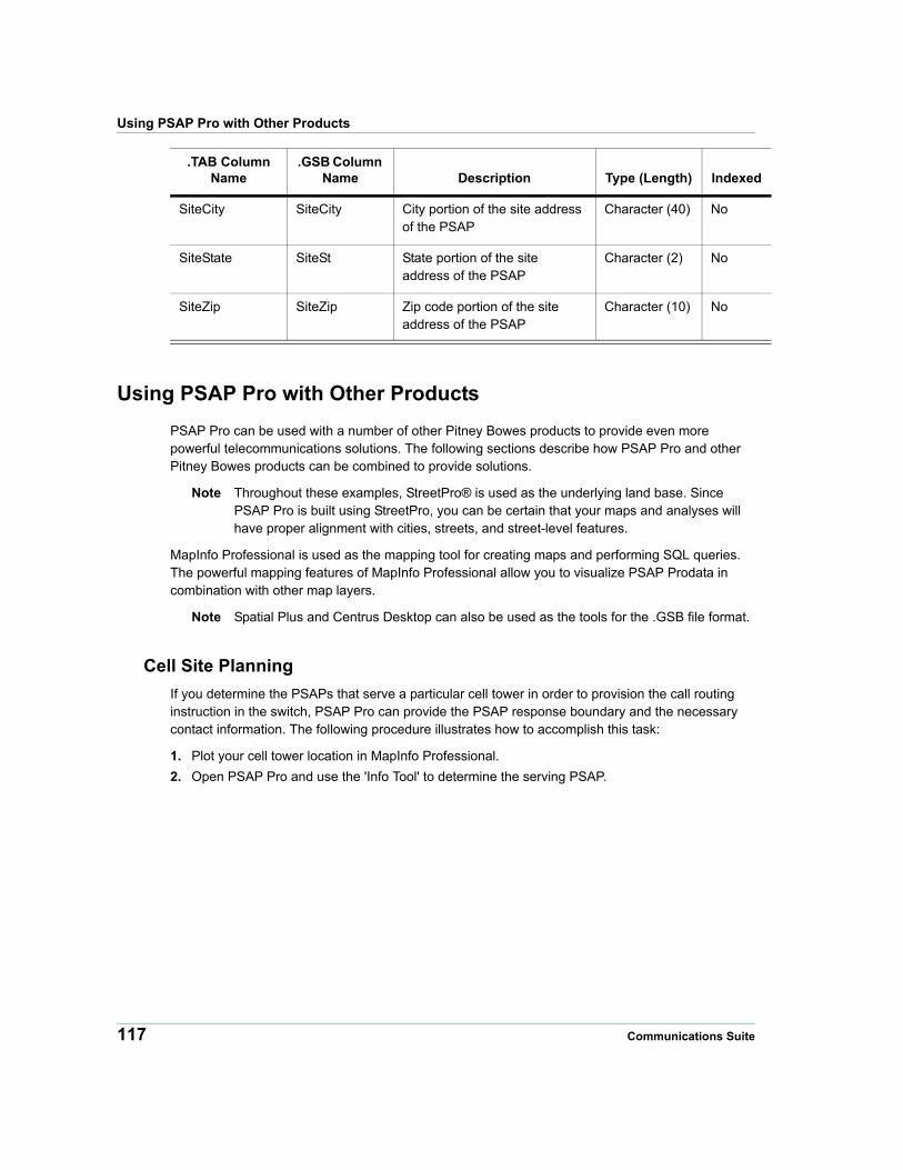
Using PSAP Pro with Other Products
Using PSAP Pro with Other Products
PSAP Pro can be used with a number of other Pitney Bowes products to provide even more powerful telecommunications solutions. The following sections describe how PSAP Pro and other Pitney Bowes products can be combined to provide solutions.
Note Throughout these examples, StreetPro® is used as the underlying land base. Since PSAP Pro is built using StreetPro, you can be certain that your maps and analyses will have proper alignment with cities, streets, and street-level features.
MapInfo Professional is used as the mapping tool for creating maps and performing SQL queries. The powerful mapping features of MapInfo Professional allow you to visualize PSAP Prodata in combination with other map layers.
Note Spatial Plus and Centrus Desktop can also be used as the tools for the .GSB file format.
Cell Site Planning
If you determine the PSAPs that serve a particular cell tower in order to provision the call routing instruction in the switch, PSAP Pro can provide the PSAP response boundary and the necessary contact information. The following procedure illustrates how to accomplish this task:
1. Plot your cell tower location in MapInfo Professional.
2. Open PSAP Pro and use the 'Info Tool' to determine the serving PSAP.
SiteCity SiteCity City portion of the site address of the PSAP
Character (40) No
SiteState SiteSt State portion of the site address of the PSAP
Character (2) No
SiteZip SiteZip Zip code portion of the site address of the PSAP
Character (10) No
.TAB Column Name
.GSB Column Name Description Type (Length) Indexed
117 Communications Suite
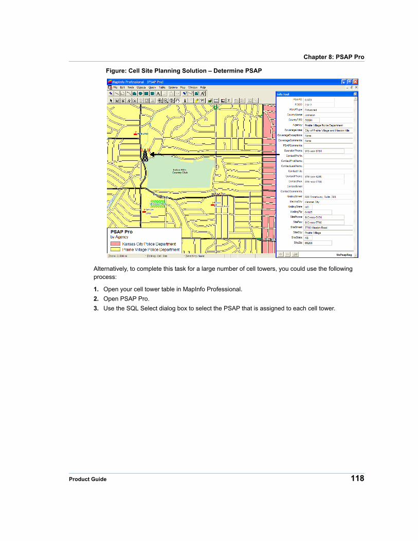
Chapter 8: PSAP Pro
Figure: Cell Site Planning Solution – Determine PSAP
Alternatively, to complete this task for a large number of cell towers, you could use the following process:
1. Open your cell tower table in MapInfo Professional.
2. Open PSAP Pro.
3. Use the SQL Select dialog box to select the PSAP that is assigned to each cell tower.
Product Guide 118
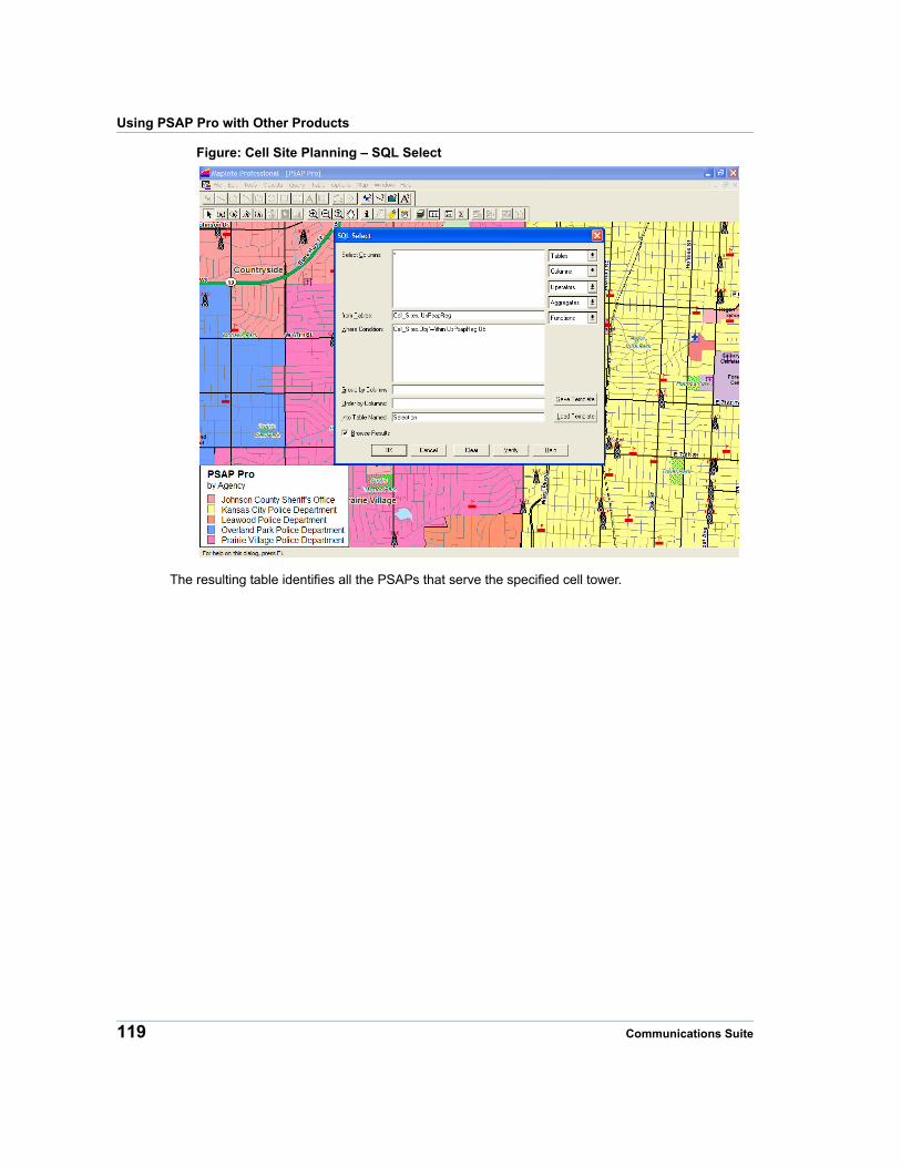
Using PSAP Pro with Other Products
Figure: Cell Site Planning – SQL Select
The resulting table identifies all the PSAPs that serve the specified cell tower.
119 Communications Suite
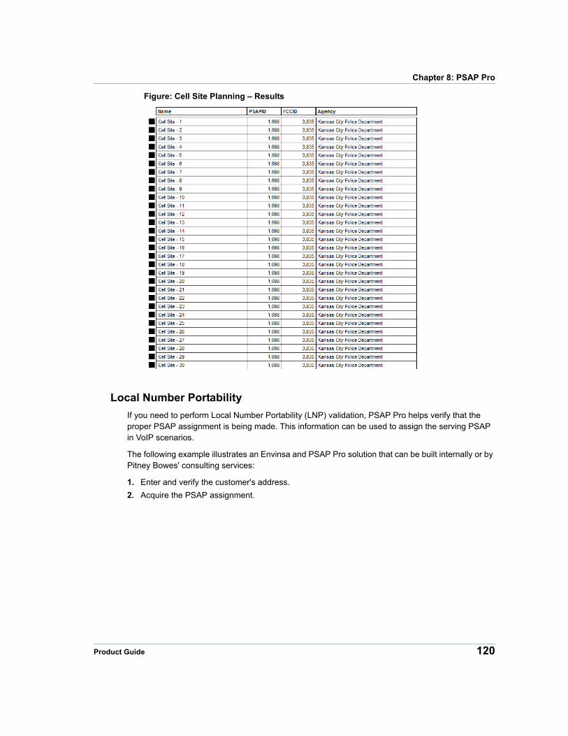
Chapter 8: PSAP Pro
Figure: Cell Site Planning – Results
Local Number Portability
If you need to perform Local Number Portability (LNP) validation, PSAP Pro helps verify that the proper PSAP assignment is being made. This information can be used to assign the serving PSAP in VoIP scenarios.
The following example illustrates an Envinsa and PSAP Pro solution that can be built internally or by Pitney Bowes' consulting services:
1. Enter and verify the customer's address.
2. Acquire the PSAP assignment.
Product Guide 120
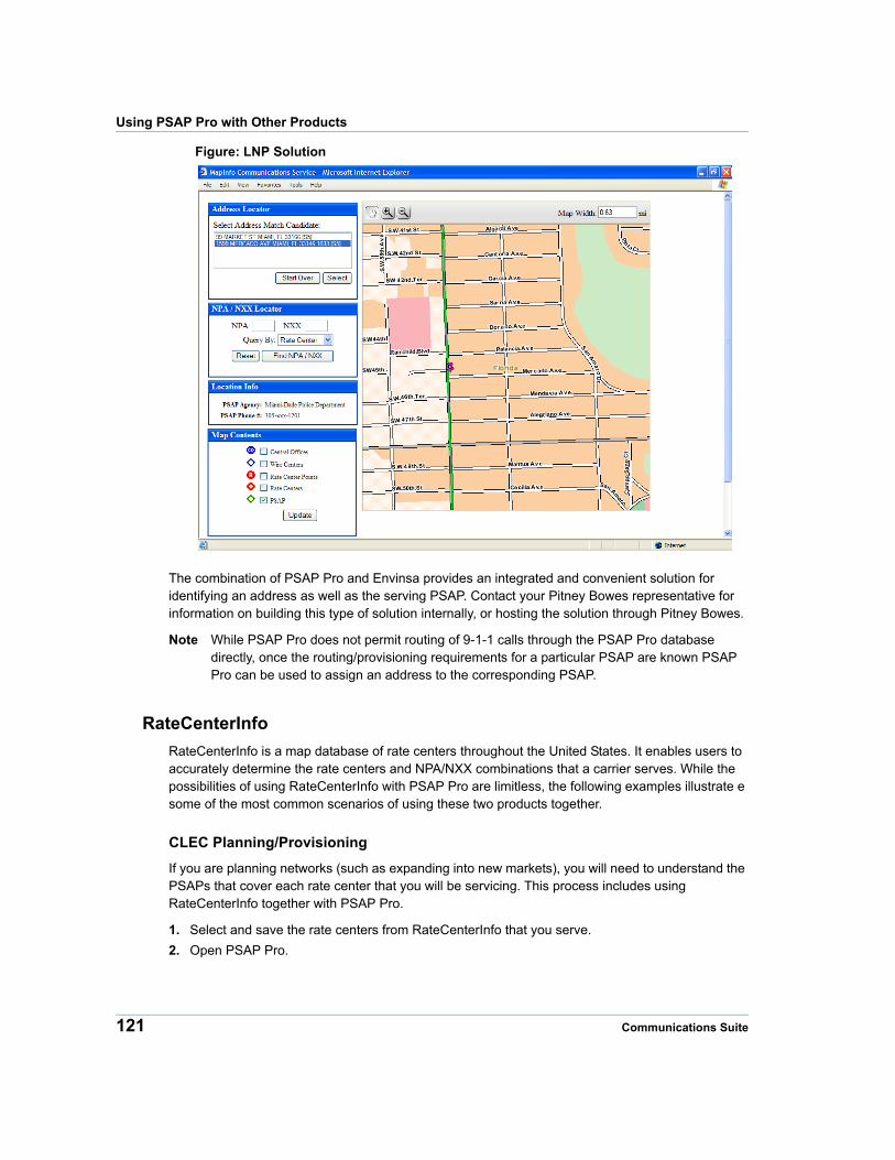
Using PSAP Pro with Other Products
Figure: LNP Solution
The combination of PSAP Pro and Envinsa provides an integrated and convenient solution for identifying an address as well as the serving PSAP. Contact your Pitney Bowes representative for information on building this type of solution internally, or hosting the solution through Pitney Bowes.
Note While PSAP Pro does not permit routing of 9-1-1 calls through the PSAP Pro database directly, once the routing/provisioning requirements for a particular PSAP are known PSAP Pro can be used to assign an address to the corresponding PSAP.
RateCenterInfo
RateCenterInfo is a map database of rate centers throughout the United States. It enables users to accurately determine the rate centers and NPA/NXX combinations that a carrier serves. While the possibilities of using RateCenterInfo with PSAP Pro are limitless, the following examples illustrate e some of the most common scenarios of using these two products together.
CLEC Planning/Provisioning
If you are planning networks (such as expanding into new markets), you will need to understand the PSAPs that cover each rate center that you will be servicing. This process includes using RateCenterInfo together with PSAP Pro.
1. Select and save the rate centers from RateCenterInfo that you serve.
2. Open PSAP Pro.
121 Communications Suite
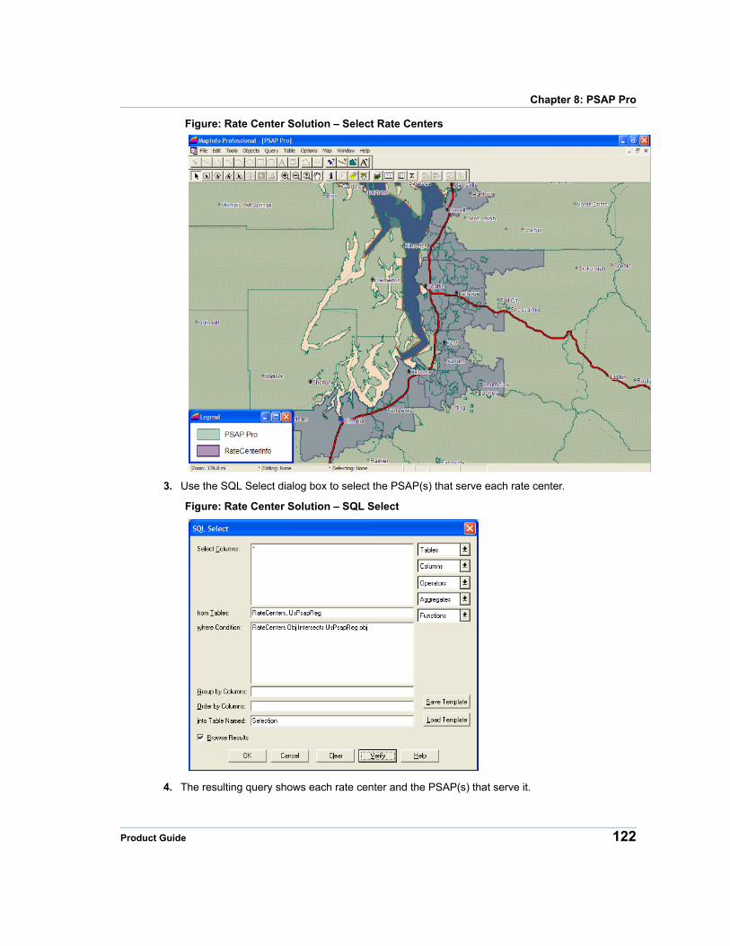
Chapter 8: PSAP Pro
Figure: Rate Center Solution – Select Rate Centers
3. Use the SQL Select dialog box to select the PSAP(s) that serve each rate center.
Figure: Rate Center Solution – SQL Select
4. The resulting query shows each rate center and the PSAP(s) that serve it.
Product Guide 122
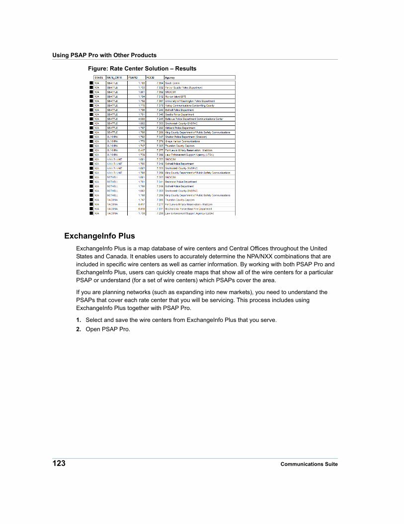
Using PSAP Pro with Other Products
Figure: Rate Center Solution – Results
ExchangeInfo Plus
ExchangeInfo Plus is a map database of wire centers and Central Offices throughout the United States and Canada. It enables users to accurately determine the NPA/NXX combinations that are included in specific wire centers as well as carrier information. By working with both PSAP Pro and ExchangeInfo Plus, users can quickly create maps that show all of the wire centers for a particular PSAP or understand (for a set of wire centers) which PSAPs cover the area.
If you are planning networks (such as expanding into new markets), you need to understand the PSAPs that cover each rate center that you will be servicing. This process includes using ExchangeInfo Plus together with PSAP Pro.
1. Select and save the wire centers from ExchangeInfo Plus that you serve.
2. Open PSAP Pro.
123 Communications Suite
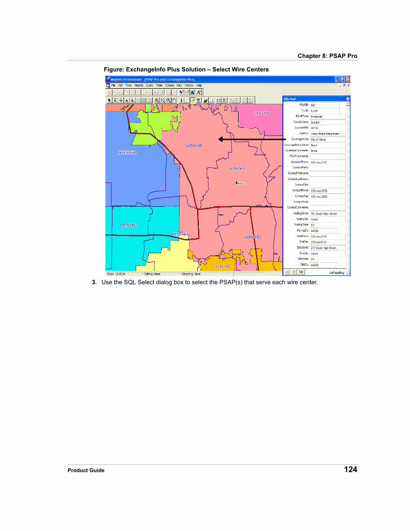
Chapter 8: PSAP Pro
Figure: ExchangeInfo Plus Solution – Select Wire Centers
3. Use the SQL Select dialog box to select the PSAP(s) that serve each wire center.
Product Guide 124
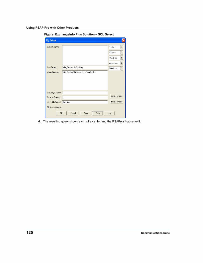
Using PSAP Pro with Other Products
Figure: ExchangeInfo Plus Solution – SQL Select
4. The resulting query shows each wire center and the PSAP(s) that serve it.
125 Communications Suite
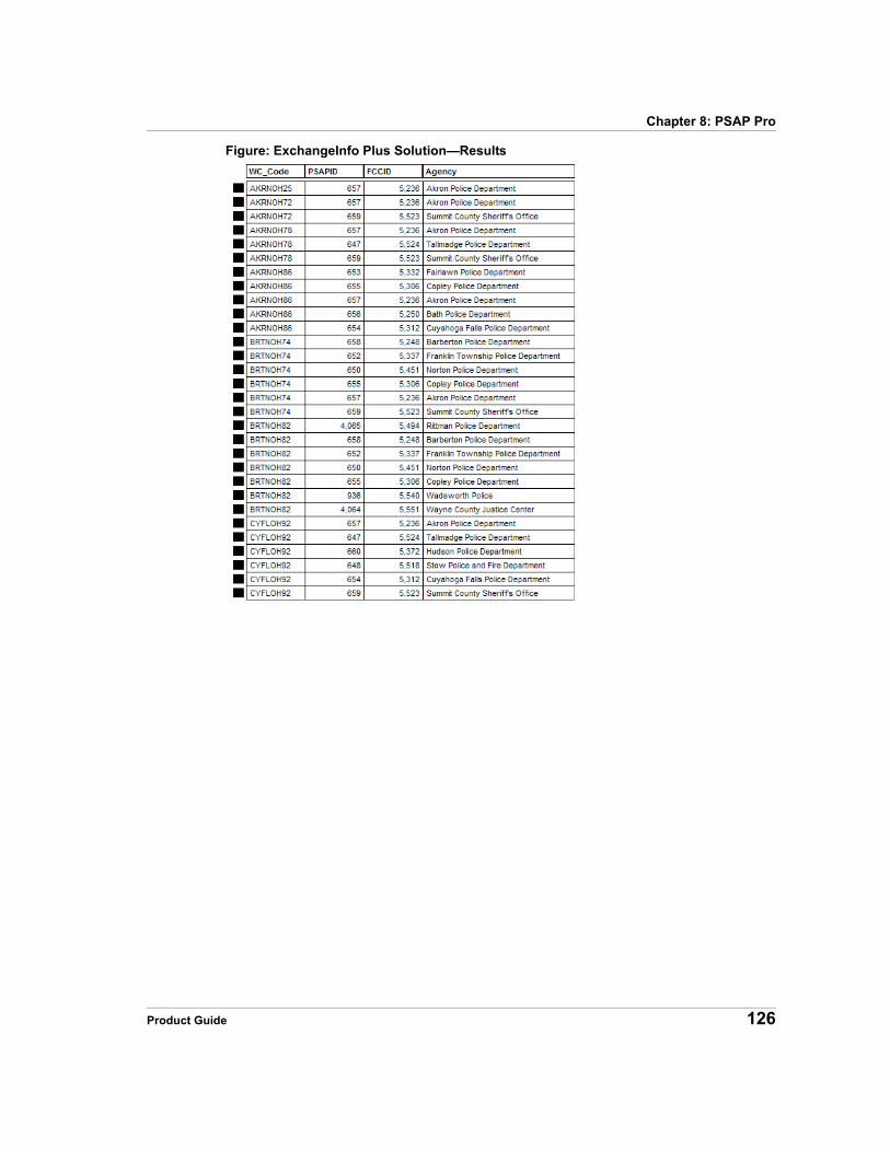
Chapter 8: PSAP Pro
Figure: ExchangeInfo Plus Solution—Results
Product Guide 126
9
Chapter 9: AHJ ProAHJ Pro is a database of Authority Having Jurisdiction (AHJ) entities throughout the United States, specifically focused on police, fire and emergency medical service (EMS) for alarm companies. The database is intended to be used with PASP Pro. In areas that AHJ Pro does not show an AHJ, alarm companies should contact the PSAP (from PSAP Pro) in that area.
In this chapter
AHJ Pro Overview . . . . . . . . . . . . . . . . . . . . . . . . . . . . . . . . . . . . .128 Table Structures . . . . . . . . . . . . . . . . . . . . . . . . . . . . . . . . . . . . . . .129 Using AHJ Pro . . . . . . . . . . . . . . . . . . . . . . . . . . . . . . . . . . . . . . . .132
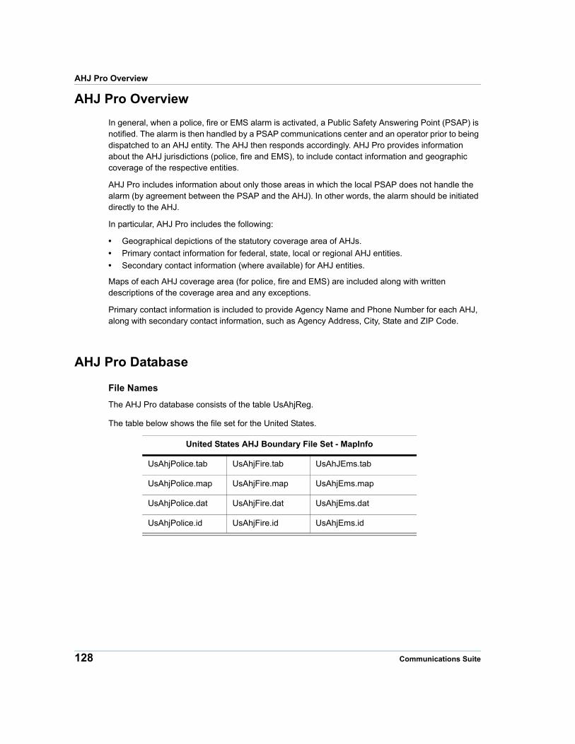
AHJ Pro Overview
AHJ Pro Overview
In general, when a police, fire or EMS alarm is activated, a Public Safety Answering Point (PSAP) is notified. The alarm is then handled by a PSAP communications center and an operator prior to being dispatched to an AHJ entity. The AHJ then responds accordingly. AHJ Pro provides information about the AHJ jurisdictions (police, fire and EMS), to include contact information and geographic coverage of the respective entities.
AHJ Pro includes information about only those areas in which the local PSAP does not handle the alarm (by agreement between the PSAP and the AHJ). In other words, the alarm should be initiated directly to the AHJ.
In particular, AHJ Pro includes the following:
• Geographical depictions of the statutory coverage area of AHJs.
• Primary contact information for federal, state, local or regional AHJ entities.
• Secondary contact information (where available) for AHJ entities.
Maps of each AHJ coverage area (for police, fire and EMS) are included along with written descriptions of the coverage area and any exceptions.
Primary contact information is included to provide Agency Name and Phone Number for each AHJ, along with secondary contact information, such as Agency Address, City, State and ZIP Code.
AHJ Pro Database
File Names
The AHJ Pro database consists of the table UsAhjReg.
The table below shows the file set for the United States.
United States AHJ Boundary File Set - MapInfo
UsAhjPolice.tab UsAhjFire.tab UsAhJEms.tab
UsAhjPolice.map UsAhjFire.map UsAhjEms.map
UsAhjPolice.dat UsAhjFire.dat UsAhjEms.dat
UsAhjPolice.id UsAhjFire.id UsAhjEms.id
128 Communications Suite
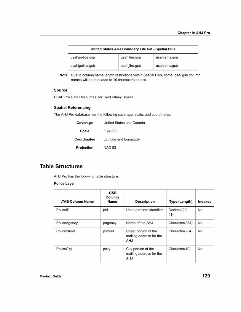
Chapter 9: AHJ Pro
United States AHJ Boundary File Set - Spatial Plus
usahjpolice.gsa usahjfire.gsa usahjems.gsa
usahjpolice.gsb usahjfire.gsb usahjems.gsb
Note Due to column name length restrictions within Spatial Plus, some .gsa/.gsb column names will be truncated to 10 characters or less.
Source
PSAP Pro Data Resources, Inc. and Pitney Bowes.
Spatial Referencing
The AHJ Pro database has the following coverage, scale, and coordinates:
Coverage United States and Canada
Scale 1:24,000
Coordinates Latitude and Longitude
Projection NAD 83
Table Structures
AHJ Pro has the following table structure:
Police Layer
.TAB Column Name
.GSB Column Name Description Type (Length) Indexed
PoliceID pid Unique record identifier Decimal(20, 11)
No
PoliceAgency pagency Name of the AHJ Character(254) No
PoliceStreet pstreet Street portion of the mailing address for the AHJ
Character(254) No
PoliceCity pcity City portion of the mailing address for the AHJ
Character(40) No
Product Guide 129
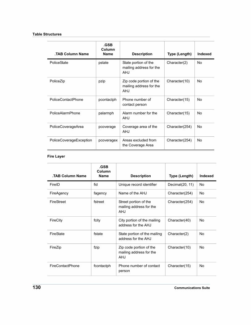
Table Structures
Fire Layer
PoliceState pstate State portion of the mailing address for the AHJ
Character(2) No
PoliceZip pzip Zip code portion of the mailing address for the AHJ
Character(10) No
PoliceContactPhone pcontactph Phone number of contact person
Character(15) No
PoliceAlarmPhone palarmph Alarm number for the AHJ
Character(15) No
PoliceCoverageArea pcoverage Coverage area of the AHJ
Character(254) No
PoliceCoverageException pcoveragex Areas excluded from the Coverage Area
Character(254) No
.TAB Column Name
.GSB Column Name Description Type (Length) Indexed
.TAB Column Name
.GSB Column Name Description Type (Length) Indexed
FireID fid Unique record identifier Decimal(20, 11) No
FireAgency fagency Name of the AHJ Character(254) No
FireStreet fstreet Street portion of the mailing address for the AHJ
Character(254) No
FireCity fcity City portion of the mailing address for the AHJ
Character(40) No
FireState fstate State portion of the mailing address for the AHJ
Character(2) No
FireZip fzip Zip code portion of the mailing address for the AHJ
Character(10) No
FireContactPhone fcontactph Phone number of contact person
Character(15) No
130 Communications Suite
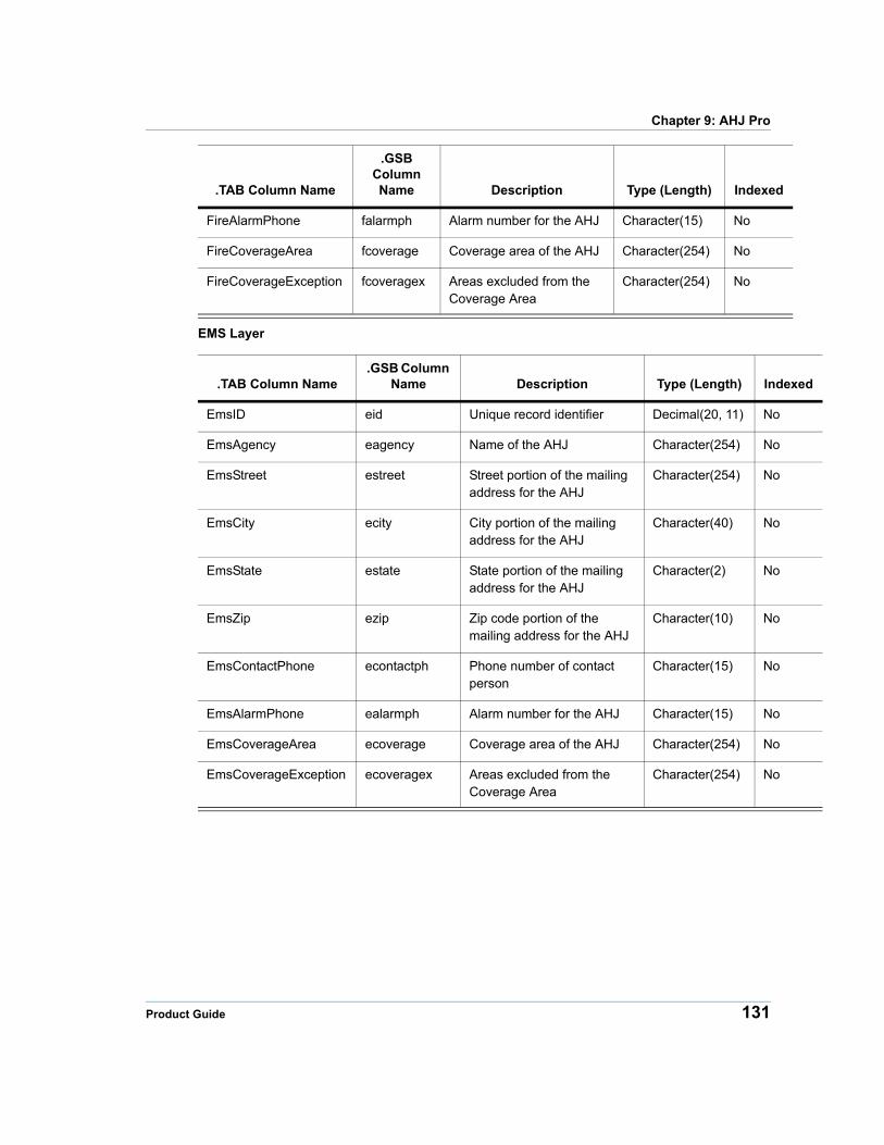
Chapter 9: AHJ Pro
xed
EMS Layer
.TAB Column Name.GSB Column
Name Description Type (Length) Inde
EmsID eid Unique record identifier Decimal(20, 11) No
EmsAgency eagency Name of the AHJ Character(254) No
EmsStreet estreet Street portion of the mailing address for the AHJ
Character(254) No
EmsCity ecity City portion of the mailing address for the AHJ
Character(40) No
EmsState estate State portion of the mailing address for the AHJ
Character(2) No
EmsZip ezip Zip code portion of the mailing address for the AHJ
Character(10) No
EmsContactPhone econtactph Phone number of contact person
Character(15) No
EmsAlarmPhone ealarmph Alarm number for the AHJ Character(15) No
EmsCoverageArea ecoverage Coverage area of the AHJ Character(254) No
EmsCoverageException ecoveragex Areas excluded from the Coverage Area
Character(254) No
FireAlarmPhone falarmph Alarm number for the AHJ Character(15) No
FireCoverageArea fcoverage Coverage area of the AHJ Character(254) No
FireCoverageException fcoveragex Areas excluded from the Coverage Area
Character(254) No
.TAB Column Name
.GSB Column Name Description Type (Length) Indexed
Product Guide 131
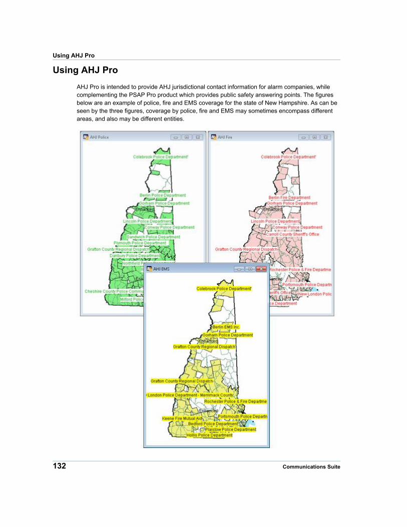
Using AHJ Pro
Using AHJ Pro
AHJ Pro is intended to provide AHJ jurisdictional contact information for alarm companies, while complementing the PSAP Pro product which provides public safety answering points. The figures below are an example of police, fire and EMS coverage for the state of New Hampshire. As can be seen by the three figures, coverage by police, fire and EMS may sometimes encompass different areas, and also may be different entities.
132 Communications Suite
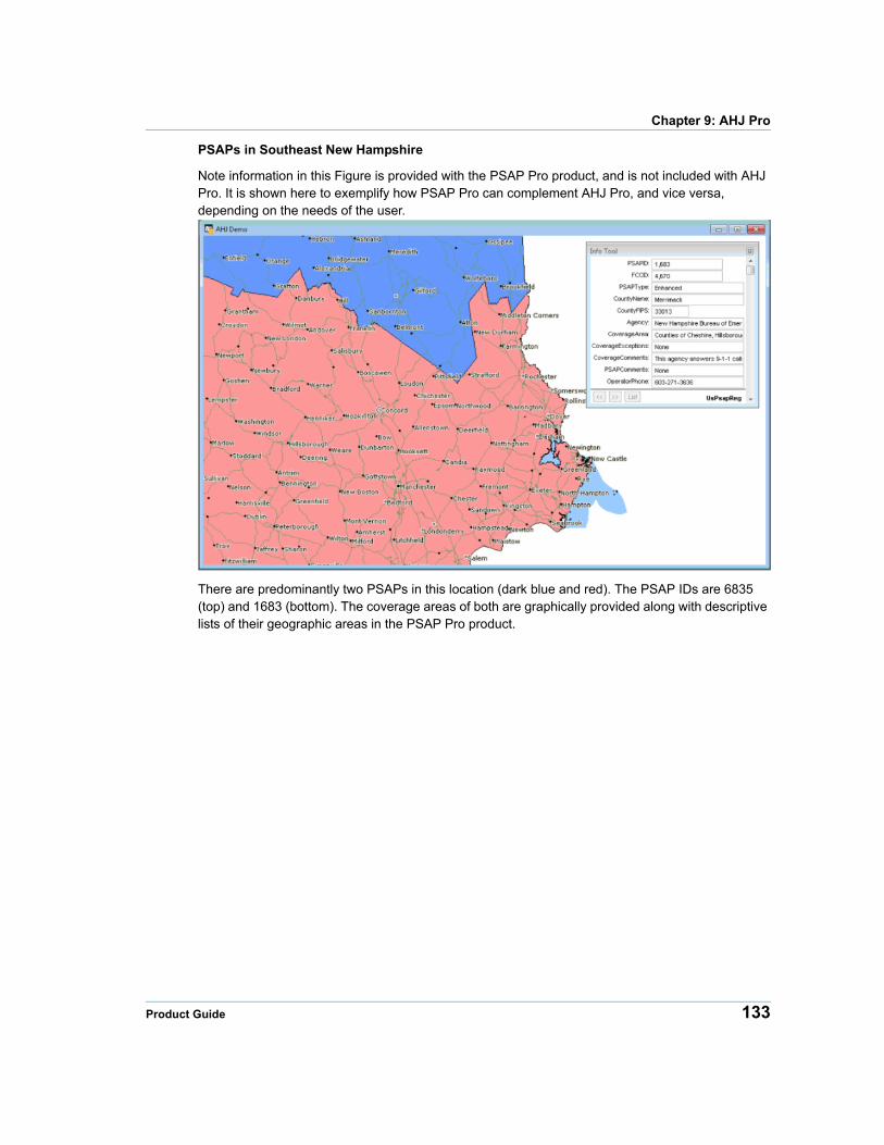
Chapter 9: AHJ Pro
PSAPs in Southeast New Hampshire
Note information in this Figure is provided with the PSAP Pro product, and is not included with AHJ Pro. It is shown here to exemplify how PSAP Pro can complement AHJ Pro, and vice versa, depending on the needs of the user.
There are predominantly two PSAPs in this location (dark blue and red). The PSAP IDs are 6835 (top) and 1683 (bottom). The coverage areas of both are graphically provided along with descriptive lists of their geographic areas in the PSAP Pro product.
Product Guide 133
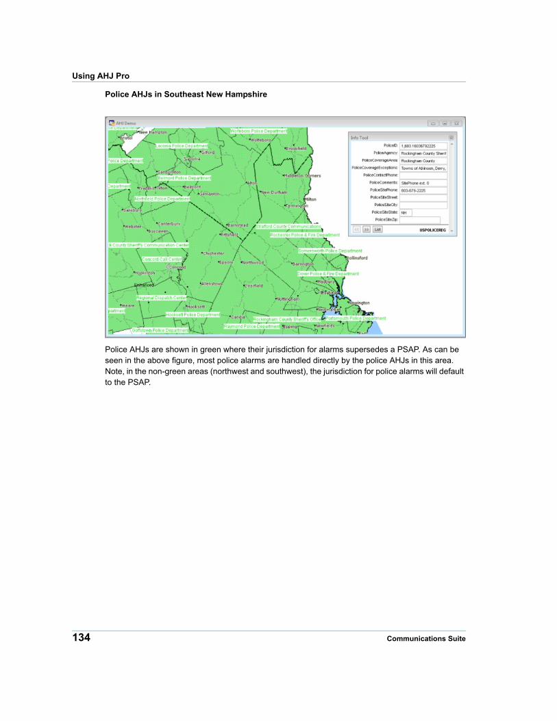
Using AHJ Pro
Police AHJs in Southeast New Hampshire
Police AHJs are shown in green where their jurisdiction for alarms supersedes a PSAP. As can be seen in the above figure, most police alarms are handled directly by the police AHJs in this area. Note, in the non-green areas (northwest and southwest), the jurisdiction for police alarms will default to the PSAP.
134 Communications Suite
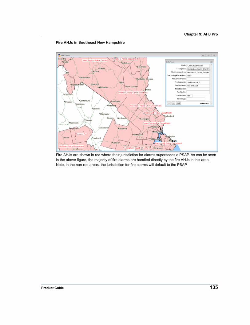
Chapter 9: AHJ Pro
Fire AHJs in Southeast New Hampshire
Fire AHJs are shown in red where their jurisdiction for alarms supersedes a PSAP. As can be seen in the above figure, the majority of fire alarms are handled directly by the fire AHJs in this area. Note, in the non-red areas, the jurisdiction for fire alarms will default to the PSAP.
Product Guide 135
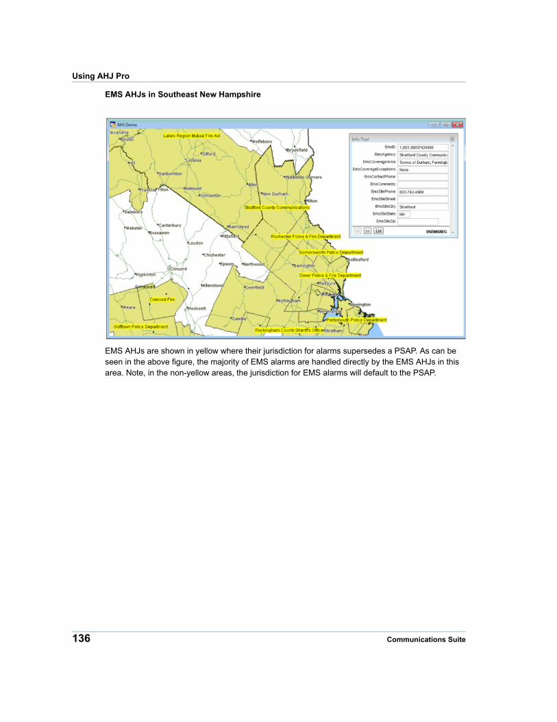
Using AHJ Pro
EMS AHJs in Southeast New Hampshire
EMS AHJs are shown in yellow where their jurisdiction for alarms supersedes a PSAP. As can be seen in the above figure, the majority of EMS alarms are handled directly by the EMS AHJs in this area. Note, in the non-yellow areas, the jurisdiction for EMS alarms will default to the PSAP.
136 Communications Suite
10
Chapter 10: RateCenterInfoRateCenterInfo is a map database of rate centers throughout the United States and Canada.
In this chapter
RateCenterInfo Overview. . . . . . . . . . . . . . . . . . . . . . . . . . . . . . . .138 RateCenterInfo Database. . . . . . . . . . . . . . . . . . . . . . . . . . . . . . . .138 Table Structures . . . . . . . . . . . . . . . . . . . . . . . . . . . . . . . . . . . . . . .139 Using RateCenterInfo. . . . . . . . . . . . . . . . . . . . . . . . . . . . . . . . . . .143
RateCenterInfo Overview
RateCenterInfo Overview
RateCenterInfo provides a comprehensive list of NPA/NXXs in each rate center. You can use RateCenterInfo to determine the Area Code/Exchange (NPA/NXX) combinations that are included in specific rate centers. RateCenterInfo also includes a map of the rate center points across the United States and Canada.
By combining the information in RateCenterInfo with geographic, business, and customer data, you can make more informed decisions, control costs, identify potential marketing opportunities, and enhance profitability.
RateCenterInfo Database
File Names
The RateCenterInfo database is divided into three file sets Each file set is divided into the entire United States or into individual states.The file sets are named as follows, where XX is the state abbreviation:
Area Code and Prefix Data Table XX_RC_D.*
Rate Center Boundaries XX_RC_G.*
Rate Center Points XX_RC_P.*
he table below shows the complete RateCenterInfo database for the United States.
Area Code and Prefix Data Table
Rate Center Boundaries
Rate Center Points
US_RC_D.DAT
US_RC_D.IND
US_RC_D.TAB
US_RC_G.DAT
US_RC_G.ID
US_RC_G.IND
US_RC_G.MAP
US_RC_G.TAB
US_RC_P.DAT
US_RC_P.ID
US_RC_P.IND
US_RC_P.MAP
US_RC_P.TAB
For Spatial Plus:• the AreaCode and Prefix Data Table (us_rc_d) is an Access Table in ratecenterinfo.mdb.
• the Rate Center Boundaries are us_rc_g.gsa and us_rc_g.gsb.
• the Rate Center Points are us_rc_p.gsa and us_rc_p.gsb.
138 Communications Suite
Chapter 10: RateCenterInfo
Rate Center Boundaries Rate Center Points
us_rc_g.gsa us_rc_p.gsa
us_rc_g.gsb us_rc_p.gsb
Source
Pitney Bowes’ suite of telecom infrastructure databases are built using state PUC data, state tariff data, the Telcordia™ LERG™ Routing Guide (LERG), StreetPro®, and other reference data.
Spatial Referencing
The RateCenterInfo database has the following coverage, scale, and coordinates:
CoverageContinental United States, Alaska, Hawaii, Guam, US Virgin Islands, US Northern Mariana Islands, Puerto Rico and Canada.
Scale 1:24,000
Coordinates Latitude and Longitude
Projection NAD 83
Table Structures
American Data
The tables below show the table structures the datasets included in RateCenterInfo for the U.S.
Area Code and Prefix Data
Field Name Description Type (Length) Indexed
xx_RC_D.* Tabular file that contains information on the NPA/NXX combinations served in each rate center.Pitney Bowes’ Communications Data products now incorporate NPA/NXXs with LERG effective dates (planned changes) thru the end of the release month. This change provides our customers with the most up-to-date content upon receipt of the products.
NPA Area Code Character (3) Yes
Product Guide 139
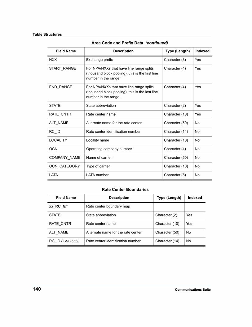
Table Structures
NXX Exchange prefix Character (3) Yes
START_RANGE For NPA/NXXs that have line range splits (thousand block pooling), this is the first line number in the range.
Character (4) Yes
END_RANGE For NPA/NXXs that have line range splits (thousand block pooling), this is the last line number in the range
Character (4) Yes
STATE State abbreviation Character (2) Yes
RATE_CNTR Rate center name Character (10) Yes
ALT_NAME Alternate name for the rate center Character (50) No
RC_ID Rate center identification number Character (14) No
LOCALITY Locality name Character (10) No
OCN Operating company number Character (4) No
COMPANY_NAME Name of carrier Character (50) No
OCN_CATEGORY Type of carrier Character (10) No
LATA LATA number Character (5) No
Rate Center Boundaries
Field Name Description Type (Length) Indexed
xx_RC_G.* Rate center boundary map
STATE State abbreviation Character (2) Yes
RATE_CNTR Rate center name Character (10) Yes
ALT_NAME Alternate name for the rate center Character (50) No
RC_ID (.GSB only) Rate center identification number Character (14) No
Area Code and Prefix Data (continued)
Field Name Description Type (Length) Indexed
140 Communications Suite
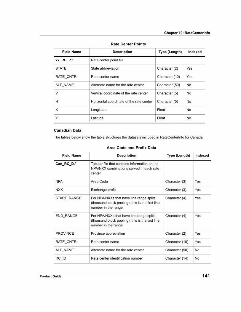
Chapter 10: RateCenterInfo
Rate Center Points
Field Name Description Type (Length) Indexed
xx_RC_P.* Rate center point file
STATE State abbreviation Character (2) Yes
RATE_CNTR Rate center name Character (10) Yes
ALT_NAME Alternate name for the rate center Character (50) No
V Vertical coordinate of the rate center Character (5) No
H Horizontal coordinate of the rate center Character (5) No
X Longitude Float No
Y Latitude Float No
Canadian Data
The tables below show the table structures the datasets included in RateCenterInfo for Canada.
Area Code and Prefix Data
Field Name Description Type (Length) Indexed
Can_RC_D.* Tabular file that contains information on the NPA/NXX combinations served in each rate center
NPA Area Code Character (3) Yes
NXX Exchange prefix Character (3) Yes
START_RANGE For NPA/NXXs that have line range splits (thousand block pooling), this is the first line number in the range.
Character (4) Yes
END_RANGE For NPA/NXXs that have line range splits (thousand block pooling), this is the last line number in the range
Character (4) Yes
PROVINCE Province abbreviation Character (2) Yes
RATE_CNTR Rate center name Character (10) Yes
ALT_NAME Alternate name for the rate center Character (50) No
RC_ID Rate center identification number Character (14) No
Product Guide 141

Table Structures
Rate Center Points
Field Name Description Type (Length) Indexed
Can_RC_P.* Rate center point file
PROVINCE Province abbreviation Character (2) Yes
RATE_CNTR Rate center name Character (10) Yes
ALT_NAME Alternate name for the rate center Character (50) No
V Vertical coordinate of the rate center Character (5) No
H Horizontal coordinate of the rate center Character (5) No
X Longitude Float No
Y Latitude Float No
LOCALITY Locality name Character (10) No
OCN Operating company number Character (4) No
COMPANY_NAME Name of carrier Character (50) No
OCN_CATEGORY Type of carrier Character (10) No
LATA LATA number Character (5) No
Rate Center Boundaries
Field Name Description Type (Length) Indexed
Can_RC_G.* Tabular file that contains rate center ID information
PROVINCE Province abbreviation Character (2) Yes
RATE_CNTR Rate center name Character (10) Yes
ALT_NAME Alternate name for the rate center Character (50) No
RC_ID Rate center identification number Character (14) No
Area Code and Prefix Data (continued)
Field Name Description Type (Length) Indexed
142 Communications Suite
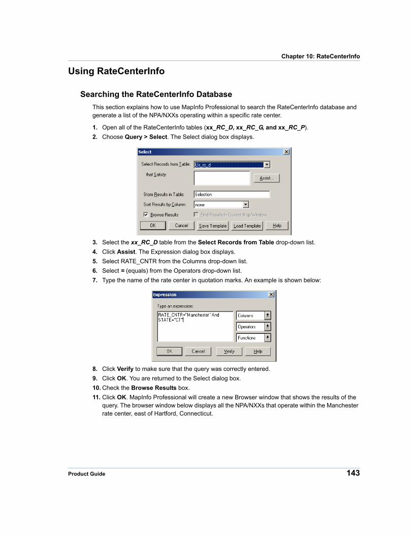
Chapter 10: RateCenterInfo
Using RateCenterInfo
Searching the RateCenterInfo Database
This section explains how to use MapInfo Professional to search the RateCenterInfo database and generate a list of the NPA/NXXs operating within a specific rate center.
1. Open all of the RateCenterInfo tables (xx_RC_D, xx_RC_G, and xx_RC_P).
2. Choose Query > Select. The Select dialog box displays.
3. Select the xx_RC_D table from the Select Records from Table drop-down list.
4. Click Assist. The Expression dialog box displays.
5. Select RATE_CNTR from the Columns drop-down list.
6. Select = (equals) from the Operators drop-down list.
7. Type the name of the rate center in quotation marks. An example is shown below:
8. Click Verify to make sure that the query was correctly entered.
9. Click OK. You are returned to the Select dialog box.
10. Check the Browse Results box.
11. Click OK. MapInfo Professional will create a new Browser window that shows the results of the query. The browser window below displays all the NPA/NXXs that operate within the Manchester rate center, east of Hartford, Connecticut.
Product Guide 143
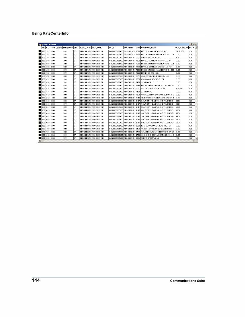
Using RateCenterInfo
144 Communications Suite
A
Appendix A: GlossaryThis appendix provides a glossary of acronyms and terms used in the Communications Suite products.
In this appendix:
Acronyms . . . . . . . . . . . . . . . . . . . . . . . . . . . . . . . . . . . . . . . . . . . .146 Terms. . . . . . . . . . . . . . . . . . . . . . . . . . . . . . . . . . . . . . . . . . . . . . . .147
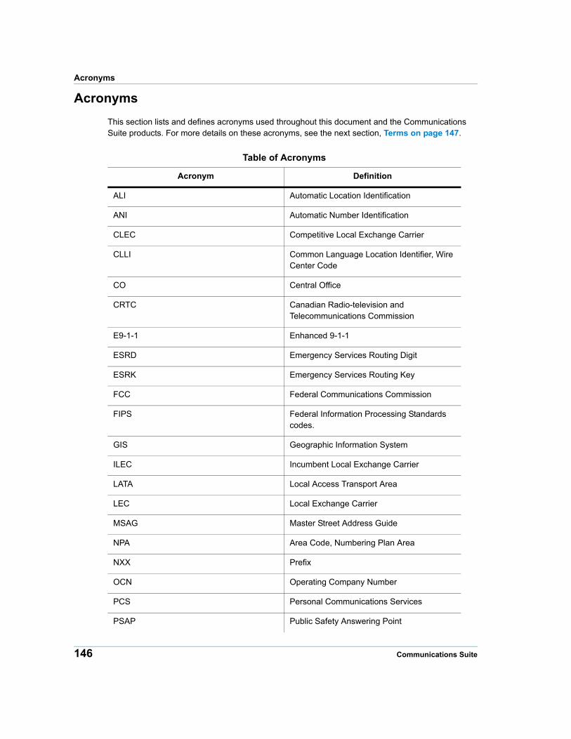
Acronyms
Acronyms
This section lists and defines acronyms used throughout this document and the Communications Suite products. For more details on these acronyms, see the next section, Terms on page 147.
Table of Acronyms
Acronym Definition
ALI Automatic Location Identification
ANI Automatic Number Identification
CLEC Competitive Local Exchange Carrier
CLLI Common Language Location Identifier, Wire Center Code
CO Central Office
CRTC Canadian Radio-television and Telecommunications Commission
E9-1-1 Enhanced 9-1-1
ESRD Emergency Services Routing Digit
ESRK Emergency Services Routing Key
FCC Federal Communications Commission
FIPS Federal Information Processing Standards codes.
GIS Geographic Information System
ILEC Incumbent Local Exchange Carrier
LATA Local Access Transport Area
LEC Local Exchange Carrier
MSAG Master Street Address Guide
NPA Area Code, Numbering Plan Area
NXX Prefix
OCN Operating Company Number
PCS Personal Communications Services
PSAP Public Safety Answering Point
146 Communications Suite
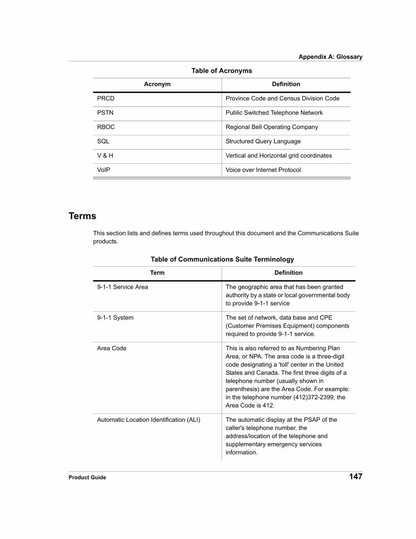
Appendix A: Glossary
Terms
This section lists and defines terms used throughout this document and the Communications Suite products.
PRCD Province Code and Census Division Code
PSTN Public Switched Telephone Network
RBOC Regional Bell Operating Company
SQL Structured Query Language
V & H Vertical and Horizontal grid coordinates
VoIP Voice over Internet Protocol
Table of Acronyms
Acronym Definition
Table of Communications Suite Terminology
Term Definition
9-1-1 Service Area The geographic area that has been granted authority by a state or local governmental body to provide 9-1-1 service
9-1-1 System The set of network, data base and CPE (Customer Premises Equipment) components required to provide 9-1-1 service.
Area Code This is also referred to as Numbering Plan Area, or NPA. The area code is a three-digit code designating a 'toll' center in the United States and Canada. The first three digits of a telephone number (usually shown in parenthesis) are the Area Code. For example: in the telephone number (412)372-2399, the Area Code is 412.
Automatic Location Identification (ALI) The automatic display at the PSAP of the caller's telephone number, the address/location of the telephone and supplementary emergency services information.
Product Guide 147
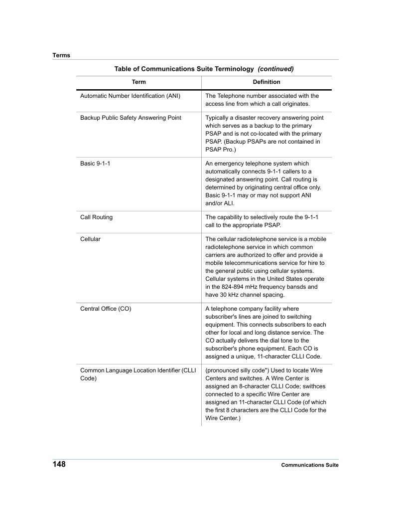
Terms
Automatic Number Identification (ANI) The Telephone number associated with the access line from which a call originates.
Backup Public Safety Answering Point Typically a disaster recovery answering point which serves as a backup to the primary PSAP and is not co-located with the primary PSAP. (Backup PSAPs are not contained in PSAP Pro.)
Basic 9-1-1 An emergency telephone system which automatically connects 9-1-1 callers to a designated answering point. Call routing is determined by originating central office only. Basic 9-1-1 may or may not support ANI and/or ALI.
Call Routing The capability to selectively route the 9-1-1 call to the appropriate PSAP.
Cellular The cellular radiotelephone service is a mobile radiotelephone service in which common carriers are authorized to offer and provide a mobile telecommunications service for hire to the general public using cellular systems. Cellular systems in the United States operate in the 824-894 mHz frequency bansds and have 30 kHz channel spacing.
Central Office (CO) A telephone company facility where subscriber's lines are joined to switching equipment. This connects subscribers to each other for local and long distance service. The CO actually delivers the dial tone to the subscriber's phone equipment. Each CO is assigned a unique, 11-character CLLI Code.
Common Language Location Identifier (CLLI Code)
(pronounced silly code") Used to locate Wire Centers and switches. A Wire Center is assigned an 8-character CLLI Code; swithces connected to a specific Wire Center are assigned an 11-character CLLI Code (of which the first 8 characters are the CLLI Code for the Wire Center.)
Table of Communications Suite Terminology (continued)
Term Definition
148 Communications Suite
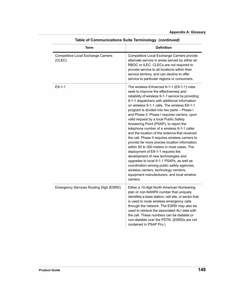
Appendix A: Glossary
Competitive Local Exchange Carriers (CLEC)
Competitive Local Exchange Carriers provide alternate service in areas served by either an RBOC or ILEC. CLECs are not required to provide service to all locations within their service territory, and can decline to offer service to particular regions or consumers.
E9-1-1 The wireless Enhanced 9-1-1 (E9-1-1) rules seek to improve the effectiveness and reliability of wireless 9-1-1 service by providing 9-1-1 dispatchers with additional information on wireless 9-1-1 calls. The wireless E9-1-1 program is divided into two parts – Phase I and Phase II. Phase I requires carriers, upon valid request by a local Public Safety Answering Point (PSAP), to report the telephone number of a wireless 9-1-1 caller and the location of the antenna that received the call. Phase II requires wireless carriers to provide far more precise location information, within 50 to 300 meters in most cases. The deployment of E9-1-1 requires the development of new technologies and upgrades to local 9-1-1 PSAPs, as well as coordination among public safety agencies, wireless carriers, technology vendors, equipment manufacturers, and local wireline carriers.
Emergency Services Routing Digit (ESRD) Either a 10-digit North American Numbering plan or non-NANPA number that uniquely identifies a base station, cell site, or sector that is used to route wireless emergency calls through the network. The ESRD may also be used to retrieve the associated ALI data with the call. These numbers can be dialable or non-dialable over the PSTN. (ESRDs are not contained in PSAP Pro.)
Table of Communications Suite Terminology (continued)
Term Definition
Product Guide 149
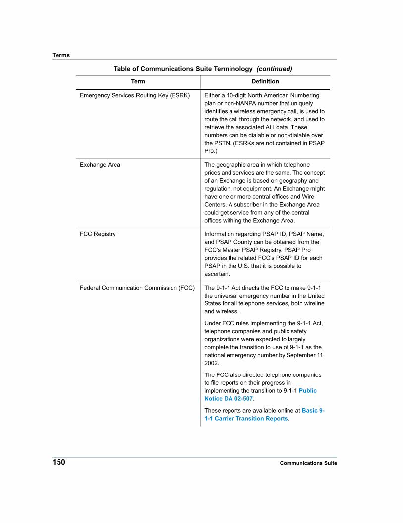
Terms
Emergency Services Routing Key (ESRK) Either a 10-digit North American Numbering plan or non-NANPA number that uniquely identifies a wireless emergency call, is used to route the call through the network, and used to retrieve the associated ALI data. These numbers can be dialable or non-dialable over the PSTN. (ESRKs are not contained in PSAP Pro.)
Exchange Area The geographic area in which telephone prices and services are the same. The concept of an Exchange is based on geography and regulation, not equipment. An Exchange might have one or more central offices and Wire Centers. A subscriber in the Exchange Area could get service from any of the central offices withing the Exchange Area.
FCC Registry Information regarding PSAP ID, PSAP Name, and PSAP County can be obtained from the FCC's Master PSAP Registry. PSAP Pro provides the related FCC's PSAP ID for each PSAP in the U.S. that it is possible to ascertain.
Federal Communication Commission (FCC) The 9-1-1 Act directs the FCC to make 9-1-1 the universal emergency number in the United States for all telephone services, both wireline and wireless.
Under FCC rules implementing the 9-1-1 Act, telephone companies and public safety organizations were expected to largely complete the transition to use of 9-1-1 as the national emergency number by September 11, 2002.
The FCC also directed telephone companies to file reports on their progress in implementing the transition to 9-1-1 Public Notice DA 02-507.
These reports are available online at Basic 9-1-1 Carrier Transition Reports.
Table of Communications Suite Terminology (continued)
Term Definition
150 Communications Suite
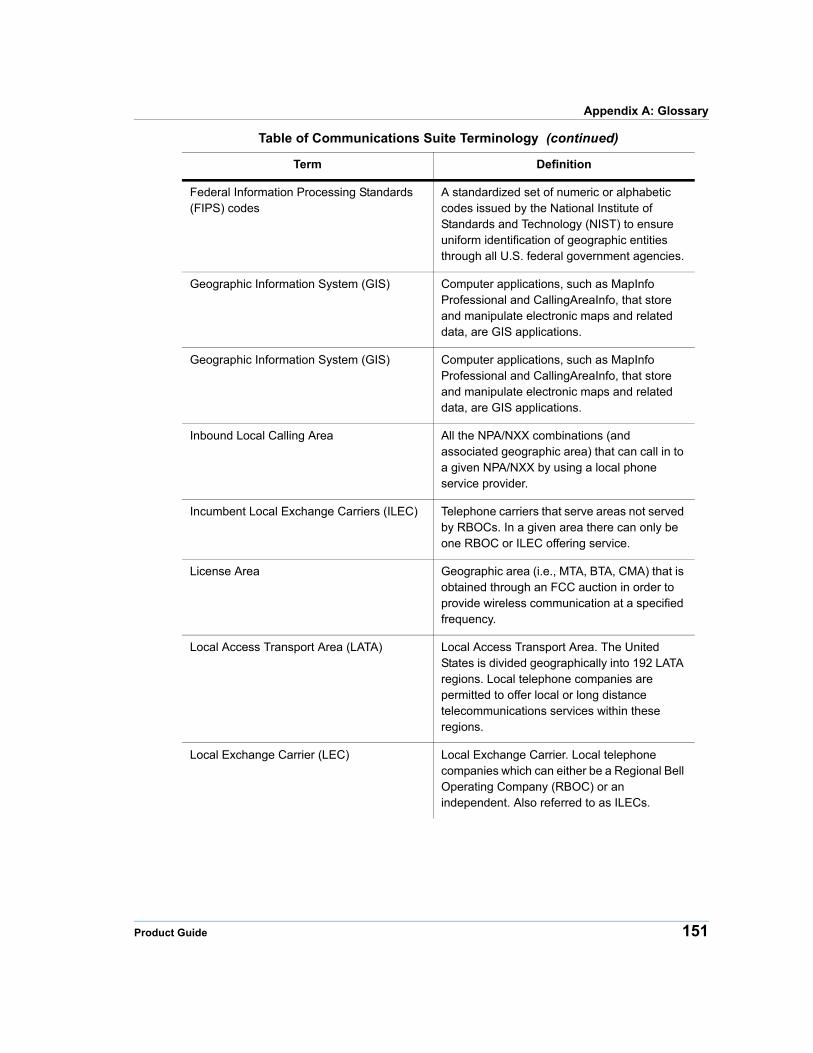
Appendix A: Glossary
Federal Information Processing Standards (FIPS) codes
A standardized set of numeric or alphabetic codes issued by the National Institute of Standards and Technology (NIST) to ensure uniform identification of geographic entities through all U.S. federal government agencies.
Geographic Information System (GIS) Computer applications, such as MapInfo Professional and CallingAreaInfo, that store and manipulate electronic maps and related data, are GIS applications.
Geographic Information System (GIS) Computer applications, such as MapInfo Professional and CallingAreaInfo, that store and manipulate electronic maps and related data, are GIS applications.
Inbound Local Calling Area All the NPA/NXX combinations (and associated geographic area) that can call in to a given NPA/NXX by using a local phone service provider.
Incumbent Local Exchange Carriers (ILEC) Telephone carriers that serve areas not served by RBOCs. In a given area there can only be one RBOC or ILEC offering service.
License Area Geographic area (i.e., MTA, BTA, CMA) that is obtained through an FCC auction in order to provide wireless communication at a specified frequency.
Local Access Transport Area (LATA) Local Access Transport Area. The United States is divided geographically into 192 LATA regions. Local telephone companies are permitted to offer local or long distance telecommunications services within these regions.
Local Exchange Carrier (LEC) Local Exchange Carrier. Local telephone companies which can either be a Regional Bell Operating Company (RBOC) or an independent. Also referred to as ILECs.
Table of Communications Suite Terminology (continued)
Term Definition
Product Guide 151
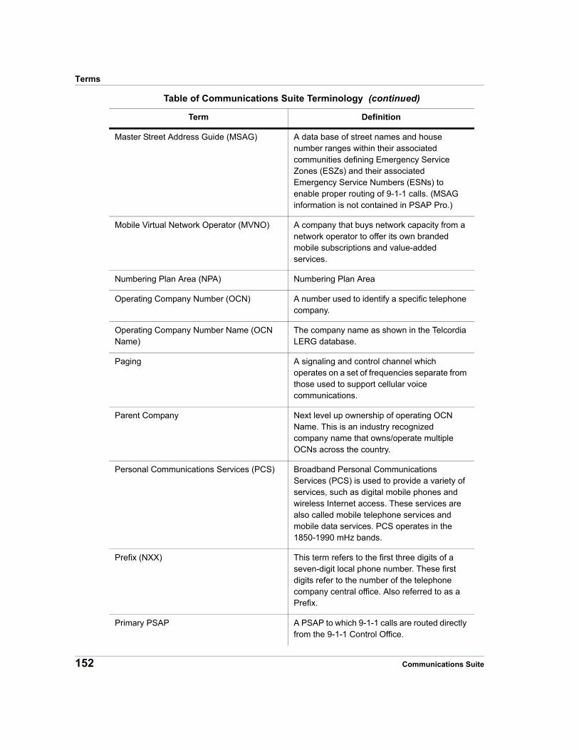
Terms
Master Street Address Guide (MSAG) A data base of street names and house number ranges within their associated communities defining Emergency Service Zones (ESZs) and their associated Emergency Service Numbers (ESNs) to enable proper routing of 9-1-1 calls. (MSAG information is not contained in PSAP Pro.)
Mobile Virtual Network Operator (MVNO) A company that buys network capacity from a network operator to offer its own branded mobile subscriptions and value-added services.
Numbering Plan Area (NPA) Numbering Plan Area
Operating Company Number (OCN) A number used to identify a specific telephone company.
Operating Company Number Name (OCN Name)
The company name as shown in the Telcordia LERG database.
Paging A signaling and control channel which operates on a set of frequencies separate from those used to support cellular voice communications.
Parent Company Next level up ownership of operating OCN Name. This is an industry recognized company name that owns/operate multiple OCNs across the country.
Personal Communications Services (PCS) Broadband Personal Communications Services (PCS) is used to provide a variety of services, such as digital mobile phones and wireless Internet access. These services are also called mobile telephone services and mobile data services. PCS operates in the 1850-1990 mHz bands.
Prefix (NXX) This term refers to the first three digits of a seven-digit local phone number. These first digits refer to the number of the telephone company central office. Also referred to as a Prefix.
Primary PSAP A PSAP to which 9-1-1 calls are routed directly from the 9-1-1 Control Office.
Table of Communications Suite Terminology (continued)
Term Definition
152 Communications Suite
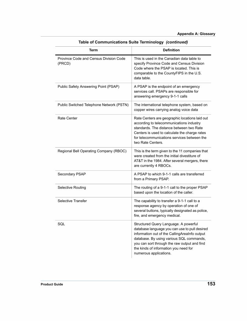
Appendix A: Glossary
Province Code and Census Division Code (PRCD)
This is used in the Canadian data table to specify Province Code and Census Division Code where the PSAP is located. This is comparable to the CountyFIPS in the U.S. data table.
Public Safety Answering Point (PSAP) A PSAP is the endpoint of an emergency services call. PSAPs are responsible for answering emergency 9-1-1 calls
Public Switched Telephone Network (PSTN) The international telephone system, based on copper wires carrying analog voice data
Rate Center Rate Centers are geographic locations laid out according to telecommunications industry standards. The distance between two Rate Centers is used to calculate the charge rates for telecommunications services between the two Rate Centers.
Regional Bell Operating Company (RBOC) This is the term given to the 11 companies that were created from the initial divestiture of AT&T in the 1984. After several mergers, there are currently 4 RBOCs.
Secondary PSAP A PSAP to which 9-1-1 calls are transferred from a Primary PSAP.
Selective Routing The routing of a 9-1-1 call to the proper PSAP based upon the location of the caller.
Selective Transfer The capability to transfer a 9-1-1 call to a response agency by operation of one of several buttons, typically designated as police, fire, and emergency medical.
SQL Structured Query Language. A powerful database language you can use to pull desired information out of the CallingAreaInfo output database. By using various SQL commands, you can sort through the raw output and find the kinds of information you need for numerous applications.
Table of Communications Suite Terminology (continued)
Term Definition
Product Guide 153
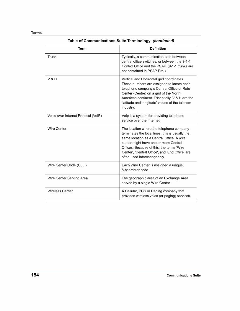
Terms
Trunk Typically, a communication path between central office switches, or between the 9-1-1 Control Office and the PSAP. (9-1-1 trunks are not contained in PSAP Pro.)
V & H Vertical and Horizontal grid coordinates. These numbers are assigned to locate each telephone company’s Central Office or Rate Center (Centre) on a grid of the North American continent. Essentially, V & H are the ‘latitude and longitude’ values of the telecom industry.
Voice over Internet Protocol (VoIP) VoIp is a system for providing telephone service over the Internet
Wire Center The location where the telephone company terminates the local lines; this is usually the same location as a Central Office. A wire center might have one or more Central Offices. Because of this, the terms 'Wire Center', 'Central Office', and 'End Office' are often used interchangeably.
Wire Center Code (CLLI) Each Wire Center is assigned a unique, 8-character code.
Wire Center Serving Area The geographic area of an Exchange Area served by a single Wire Center.
Wireless Carrier A Cellular, PCS or Paging company that provides wireless voice (or paging) services.
Table of Communications Suite Terminology (continued)
Term Definition
154 Communications Suite