Embed Size (px)
Citation preview
1
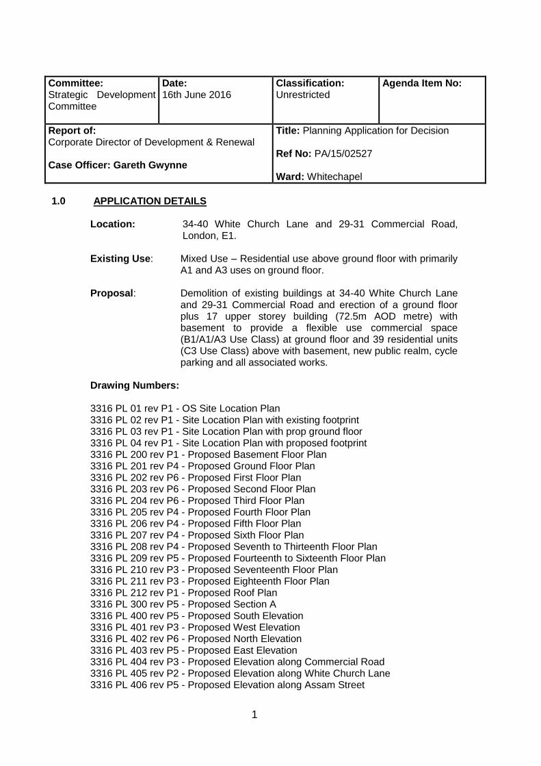
Committee: Strategic Development Committee
Date: 16th June 2016
Classification: Unrestricted
Agenda Item No:
Report of: Corporate Director of Development & Renewal Case Officer: Gareth Gwynne
Title: Planning Application for Decision Ref No: PA/15/02527 Ward: Whitechapel
1.0 APPLICATION DETAILS
Location: 34-40 White Church Lane and 29-31 Commercial Road,
London, E1.
Existing Use: Mixed Use – Residential use above ground floor with primarily A1 and A3 uses on ground floor.
Proposal: Demolition of existing buildings at 34-40 White Church Lane
and 29-31 Commercial Road and erection of a ground floor plus 17 upper storey building (72.5m AOD metre) with basement to provide a flexible use commercial space (B1/A1/A3 Use Class) at ground floor and 39 residential units (C3 Use Class) above with basement, new public realm, cycle parking and all associated works.
Drawing Numbers:
3316 PL 01 rev P1 - OS Site Location Plan 3316 PL 02 rev P1 - Site Location Plan with existing footprint 3316 PL 03 rev P1 - Site Location Plan with prop ground floor 3316 PL 04 rev P1 - Site Location Plan with proposed footprint 3316 PL 200 rev P1 - Proposed Basement Floor Plan 3316 PL 201 rev P4 - Proposed Ground Floor Plan 3316 PL 202 rev P6 - Proposed First Floor Plan 3316 PL 203 rev P6 - Proposed Second Floor Plan 3316 PL 204 rev P6 - Proposed Third Floor Plan 3316 PL 205 rev P4 - Proposed Fourth Floor Plan 3316 PL 206 rev P4 - Proposed Fifth Floor Plan 3316 PL 207 rev P4 - Proposed Sixth Floor Plan 3316 PL 208 rev P4 - Proposed Seventh to Thirteenth Floor Plan 3316 PL 209 rev P5 - Proposed Fourteenth to Sixteenth Floor Plan 3316 PL 210 rev P3 - Proposed Seventeenth Floor Plan 3316 PL 211 rev P3 - Proposed Eighteenth Floor Plan 3316 PL 212 rev P1 - Proposed Roof Plan 3316 PL 300 rev P5 - Proposed Section A 3316 PL 400 rev P5 - Proposed South Elevation 3316 PL 401 rev P3 - Proposed West Elevation 3316 PL 402 rev P6 - Proposed North Elevation 3316 PL 403 rev P5 - Proposed East Elevation 3316 PL 404 rev P3 - Proposed Elevation along Commercial Road 3316 PL 405 rev P2 - Proposed Elevation along White Church Lane 3316 PL 406 rev P5 - Proposed Elevation along Assam Street
2
3316 PL 407 rev P3 - Proposed Elevation along Commercial Road 3316 PL 410 rev P1 - Proposed Base Detail Elevation 3316 PL 411 rev P1 - Proposed Typical Detail Elevation 3316 PL 412 rev P1 - Proposed Top Detail Elevation 3316 PL 413 rev P1 - Proposed Brick Panel Detail Elevation 3316 PL 414 rev P1 - Proposed Metal Panel Detail Elevation 3316 PL 420 rev P2 - Existing Elevation along Commercial Road 3316 PL 421 rev P1 - Existing Elevation along White Church Lane 3316 PL 422 rev P1 - Existing Elevation along Assam Street 1426/003 Rev. B PL 500 rev P1 - Proposed 3 Bed 4 Person Layout Plan PL 501 rev P1 - Proposed 2 Bed 4 Person Layout Plan PL 502 rev P1 - Proposed 1 Bed 2 Person Layout Plan PL 503 rev P1 - Proposed Studio Layout Plan PL 504 rev P1 - Proposed 3 Bed 5 Person Duplex Lower Plan PL 505 rev P1 - Proposed 3 Bed 5 Person Duplex Upper Plan PL 506 rev P1 - Proposed 2 Bed 3 Person Wheelchair Plan PL 507 rev P1 - Proposed 2 Bed 3 Person Wheelchair Plan . Supporting Documents:
Design and Access Statement
Design and Access Statement Addendum
Landscape Strategy
Planning Statement
Daylight and Sunlight Assessment
Heritage, Townscape and Visual Impact Assessment
Statement of Community Involvement
Economic Statement
Energy Assessment and Sustainability Assessment
Air Quality Assessment
Wind/Microclimate Assessment
Acoustic Assessment
Transport Assessment
Financial Viability Assessment
Archaeological Desk Based Assessment
Soil Contamination Risk Assessment
Landscape Masterplan (1426/002 Rev. E)
Tall Building Analysis (CL14276/01) dated April 2016 . Applicant: David Abraham Partnership
2.0 Executive Summary 2.1 There have been a number of material changes made to this proposal following its
consideration at the Council‟s Strategic Development Committee on 10 March 2016. As such, this Officer Report considers the planning merits of this application as a revised proposal rather than as a deferred item reflecting the resolution to refuse made by the previous Committee.
2.2 Owner/occupiers of 845 neighbouring properties were consulted on the scheme on
two separate occasions with the second consultation undertaken after amendments being made to the proposals following the resolution by the Members in March. Three representations were received in total, objecting to the scheme raising concerns surrounding construction noise, loss of views, overlooking,
3
overshadowing and the cumulative impacts of the scale of development in the area on infrastructure.
2.3 Officers have considered the particular circumstances of this application against
the adopted policies in the London Plan 2015, Tower Hamlets Core Strategy 2010, the Council‟s Managing Development Document 2013, the National Planning Policy Framework (NPPF), and National Planning Practice Guidance (NPPG) and have found that:
2.4 The proposed height of the tall building is considered to be consistent with the
emerging built context for Aldgate providing a suitable transition in the hierarchy of tall buildings from the tallest building centred around Aldgate Place (to the west) - through a descending hierarchy of heights established in the consented scheme at No 27. Commercial Road and the built out schemes at No 35, No. 52-58 and No. 60 Commercial Road (set to the east of the application site).
2.5 In the context of a number of existing local consented tall building schemes, the
impact of the scheme on views and settings of nearby listed buildings, the Whitechapel High Street Conservation Area and the Altab Ali Park in particular, are considered to be broadly neutral and on balance acceptable.
2.6 The scheme‟s provides a small public realm space facing Commercial Road
helping to enhance the views and setting of the adjacent Grade II listed former St George‟s Brewery warehouse building.
2.7 The development would provide a range of residential unit sizes and tenures
including a maximum quantum of affordable housing (35.8 % by habitable room) given the viability constraints of the scheme, including the provision of 6x threebedroom affordable units at Borough framework rents (inclusive of service charges).
2.8 The housing would be of suitably high quality, with over 50% of the units benefiting
from triple aspect and the remainder of the units double aspect (with the exception 1 single aspect unit) which is indicative of a good standard of amenity for the future residents.
2.9 The scheme does present some significant challenges in respect of
daylight/sunlight. However these need to be considered with regard to the site context and, in particular, the degree of impact the consented scheme at No. 27 Commercial Road would impose on neighbouring developments. Subject to conditions, it is considered that the development would not have an unacceptable impact on the amenity of adjoining residents in terms of loss of daylight/sunlight, increased sense of enclosure, loss of privacy, increased overlooking, noise and construction impacts.
2.10 Transport matters including parking, access and servicing arrangement are
considered acceptable. 2.11 A suitable strategy for minimising carbon dioxide emissions from the development
has been proposed. Landscaping and biodiversity features are also proposed which seek to ensure the development is environmentally sustainable.

4
3.0 RECOMMENDATION Application for full planning permission 3.1 That the Committee resolve to GRANT planning permission subject to:
- Any direction by the London Mayor. - The prior completion of a legal agreement to secure the following planning
obligations: 3.2 Financial contributions:
a) £14,457 construction phase employment training b) £2,835 end-user phase employment training c) £27,615 carbon off-setting d) £85,000 for raised table works including kerbs adjustments and drainage provision e) Monitoring fee equivalent to £500 per each substantial Head of Terms
Total financial contribution: £129,907 plus monitoring contribution 3.3 Non-financial contributions:
a) On-site affordable housing consisting of 6 x three-bedroom units at Borough
Framework Levels inclusive of service charges, with 1 of these three-bedroom units delivered as a fully wheelchair accessible unit
b) 1 x one-bedroom and 2 x three-bedroom intermediate units c) Access to employment - 20% local procurement - 20% local labour in construction (d) 6 apprenticeships delivered during the construction phase (e) commuted sum to fund accessible bays 2 blue badge accessible car
parking bays on-street (f) Public access to public realm (g) Meet the Transport for London Cycle-Hire annual membership key fee for
each individual residential unit within the scheme for the first 3 years of occupation, as part of Travel Plan
(h) Car Free Agreement (to remove future occupants from having access to the
Borough‟s residents on street car parking permit scheme) (i) LBTH Code of Construction Practice and Considerate Constructors

5
3.3 Any other planning obligation(s) considered necessary by the Corporate Director Development & Renewal
3.4 That the Corporate Director Development & Renewal is delegated power to
negotiate the legal agreement indicated above acting within delegated authority. If within three months of the resolution the legal agreement has not been completed, the Corporate Director Development & Renewal is delegated power to refuse planning permission.
3.5 That the Corporate Director Development & Renewal is delegated power to
impose conditions and informatives on the planning permission to secure the following matters:
3.6 Conditions:
Compliance 1) Compliance with plans 2) 3 year time limit for implementation 3) Land contamination 4) Balconies retained as outdoor private amenity space for the life of the
development 5) Wind mitigation measures 6) Internal play space area maintained and actively managed for life of the
development 7) Fob access to lifts maintained for wheelchair accessible unit affordable rented
unit for the life of the development Pre commencement 8) Archaeology - written scheme of investigation Pre-commencement (other than demolition of the existing buildings) 9) Detailed drainage strategy 10) Details of cycle stand and storage areas 11) Impact on water supply infrastructure 12) Acoustic Mitigation Strategy 13) Piling method statement 14) Construction and Environmental Management Plan 15) Method statement demonstrating how the development will safeguard the
structural integrity of adjoining listed building 16) Use of construction cranes Pre- 3rd floor slab level 17) Detailed drawings and samples of all external materials 18) Landscaping and public realm including details of:
a. Soft landscaping b. Biodiversity improvement measures c. Details of roof top based solar panels and capacity for scheme to allow
future connection to a district heating network d. Hard landscaping e. Street furniture

6
f. Lighting to public realm including g. CCTV and security measures h. Visitor cycle parking i. Ground levels & thresholds – inclusive access
19) Wheelchair accessible units Prior to Occupation 20) Secured by Design accreditation 21) Delivery & Servicing Plan (including a Waste Management Strategy) 22) Travel Plan 23) Scheme to maximise active glazing frontages to ground floor commercial
use/s and a signage strategy 24) Detail of noise mitigation and odour control to any A3 unit/s 25) Details of opening hours for any A1/A3 unit/s 26) Interior design and management plan for internal play space 27) Details of external louvers to mitigate overlooking
3.7 Informatives a) Thames Water b) Environmental Health – Noise & Vibration c) National Grid apparatus
3.8 Any other condition(s) and/or informatives as considered necessary by the
Corporate Director for Development & Renewal. 4.0 BACKGROUND INFORMATION 4.1 Following a resolution to refuse this application at the Council‟s Strategic
Development Committee on the 10th March 2016, the applicant made a number of amendments to the proposals which were the subject of a further public consultation as the changes were considered to be material changes to the application.
4.2 The Strategic Development Committee resolved to refuse the previous iteration of
the application for the following reasons (as quoted from the Committee minutes):
Insufficient provision of affordable housing.
High residential density in excess of London Plan.
Height of the building.
The servicing arrangements.
The child play space and communal amenity space.
The design of the ground floor entrances.
Impact on infrastructure from the scheme
7
That the scheme would be out of keeping with the character of area and would change the character of the area.
In accordance with Development Procedural Rules, the application was
DEFERRED at the 10th March 2016 Committee to enable Officers to prepare a supplementary report to a future meeting of the Committee setting out proposed detailed reasons for refusal and the implications of the decision.
4.3 Officers prepared a supplementary deferral report, which was published for the subsequent 12th April 2016 Strategic Development Committee, which made the following recommendation to Members:
“The proposal has not been amended and has been considered in the context of the relevant Development Plan policies and the officer recommendation to GRANT planning permission remains unchanged. However if members are minded to REFUSE planning permission the following reasons are recommended:
Overdevelopment 1. The proposed development would deliver high density development in
excess of the density matrix ranges outlined by Policy 3.4 of the London Plan (incorporating alterations 2015), without demonstrating exceptional circumstances as required by the London Plan and London Housing Supplementary Planning Guidance . The proposals would show demonstrable symptoms of over development of the site, through the failure to provide any communal amenity space, failure to include an adequate amount and quality of child play space combined with problems of poor outlook and loss of privacy for future residents.
As such the scheme would fail to provide a sustainable form of
development in accordance with paragraphs 17, 56, 61 of the NPPF and would be contrary to the Development Plan, in particular policies 3.4, 3.5, 3.6, 7.1, 7.4, 7.6 and 7.7 of the London Plan (2015), policies SP02, SP06, SP10 and SP12 of the Tower Hamlets’ Core Strategy (2010) and policies, DM4, DM24, DM25, DM26 and DM27 of the Tower Hamlets’ Managing Development Document (2013).
Negative impacts on local townscape
2. The cumulative effect of the proposed development by reason of its height and scale combined with close proximity to the consented serviced apartments and hotel at 27 Commercial Road would result in an overbearing and incongruous form of development at the southern end of Whitechurch Lane, harming the visual amenities of the area and negatively impacting on local townscape. The development would be visible from the Whitechapel High Street Conservation Area, and the cumulative impact of two buildings of comparable height in close proximity to one another would affect views from within the conservation area causing harm on its setting and its significance as a designated heritage assets. The public benefits of the development would not outweigh the harm caused.

8
As such the scheme would fail to provide a sustainable form of development in accordance with paragraphs 17, 56, 61 of the NPPF and would be contrary to the Development Plan, in particular policies 7.4, 7.5, 7.6 and 7.7 and 7.8 of the London Plan (2015), policies SP02, SP06, SP10 and SP12 of the Tower Hamlets’ Core Strategy (2010) and policies, DM23, DM24, DM25, DM26 and DM27 of the Tower Hamlets’ Managing Development Document and the Borough’s vision for Aldgate, that taken as a whole, have an overarching objective of achieving place-making of the highest quality.
Ability to secure planning obligations 3. In the absence of a legal agreement to secure agreed and policy
compliant financial and non-financial contributions including affordable housing, skills, training and enterprise and transport matters the development fails to mitigate its impact on local services, amenities and infrastructure. The above would be contrary to the requirements of Policies SP02 and SP13 of the LBTH Core Strategy, Policies 8.2 of the London Plan and the draft consultation version LBTH Planning Obligations SPD (April 2015).”
4.5 Despite the publication of the Officer report, the deferred item was withdrawn from
the 12th April 2016 Strategic Development Committee agenda with the following
reason cited in the Committee minutes:
“The decision was taken after the applicant agreed to enter into further
negotiations with officers and is preparing amended drawings that seek to address
the reasons for refusal given by Members at March Strategic Development
Committee . These amendments will be re-consulted on with the application
targeted to return to the June SDC” 4.6 A further statutory public consultation was undertaken on the revised scheme . The
revised scheme is now the subject of this report and is presented to the 16 June 2016 Strategic Development Committee as a new, rather than deferred, agenda item due to the material amendments made to the proposal.
5.0 PROPOSAL, LOCATION DETAILS and DESIGNATIONS Site and Surroundings and Designations 5.1 The site is in Aldgate and occupies a street corner site, where the southern end of
Whitechurch Lane meets Commercial Road (and turns east). The back of the pavement to these two streets serves as the western and southern site boundaries. Assam Street marks the northern edge of the development site and the eastern edge abuts the grade II listed former St George‟s Brewery warehouse building.
5.2 The redline boundary (as shown in figure 1 below) measures approximately
829sqm (or 0.08 hectares) however the actual development plot occupies approximately 380sq.m when the public highway is excluded. Currently the site contains two buildings of three and four storeys in height respectively, with A1, B1 and A3 use at ground floor and with residential uses found across the upper floors.

9
Figure 1: Site location plan
5.3 White Church Lane is a relatively narrow street that links Commercial Road and
Whitechapel High Street and the buildings fronting it are between two and six storeys in height with commercial uses at ground floor with typically residential use above. Planning consent has been granted for a 21 storey service apartment hotel at No. 27 Commercial Road that occupies the opposite corner site of where White Church Lane meets Commercial Road (and turns west). Assam Street is a cul-de-sac and provides vehicular access to the basement car park serving the Naylor Building (a large residential development) and vehicular access service area serving the 19 storey high student housing development at No. 35 Commercial Road
5.4 The application site is located approximately 55 metres to the south of the
Whitechapel High Street Conservation Area. To the immediate east of the site is the grade II Listed John Walker & Sons Ltd Warehouse. The grade II Listed Gunmakers Company Hall & Proof House is located around 30 metres to the south of the site at No. 46-50 Commercial Road. The K2 Telephone Kiosk to the front of this building is also grade II listed. The grade II listed 32 and 34 Commercial Road are located around 60 metres to the south-west of the site. No. 17 White Church Lane is locally listed and is set approximately 55 metres to the north-west of the site.
10
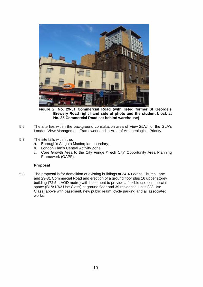
Figure 2: No. 29-31 Commercial Road (with listed former St George’s
Brewery Road right hand side of photo and the student block at No. 35 Commercial Road set behind warehouse)
5.6 The site lies within the background consultation area of View 25A.1 of the GLA‟s
London View Management Framework and in Area of Archaeological Priority. 5.7 The site falls within the:
a. Borough‟s Aldgate Masterplan boundary; b. London Plan‟s Central Activity Zone. c. Core Growth Area to the City Fringe /‟Tech City‟ Opportunity Area Planning
Framework (OAPF). Proposal 5.8 The proposal is for demolition of existing buildings at 34-40 White Church Lane
and 29-31 Commercial Road and erection of a ground floor plus 16 upper storey building (72.5m AOD metre) with basement to provide a flexible use commercial space (B1/A1/A3 Use Class) at ground floor and 39 residential units (C3 Use Class) above with basement, new public realm, cycle parking and all associated works.

11
Figure 3: CGI of proposal (showing south facade) including schemes under
construction and approved 5.9 The residential units would consist of 8x studio units, 16x one-bedroom units, 5x 2
bedroom units, 10x three-bedroom units. The ground floor would contain the flexible use commercial space, residential lobby space, a waste and recycling room serving the residential units.
5.10 There would be two entrances to the residential accommodation from Commercial
Street and Assam Street for all three residential tenures with a shared ground floor communal lobby space.
5.11 The scheme would create a small new public realm space at the junction of
Commercial Road and White Church Lane that would be finished (through a mix of hard and soft landscaping) to a high quality. The scheme would reveal (for the first time in over a hundred years) the attractive base of the flank wall of the listed brewery building at No. 28 Commercial Road.

12
Figure 4: proposed ground floor plan 5.11 The basement would contain a commercial waste store that is serviced by two lifts
in addition to providing a plant room and residential cycle store. 5.12 The affordable tenure rented accommodation would be provided on the 2nd 3rd and 4th upper floors and the intermediate units on 5th upper floor and 6th upper
floor with two market units also on the 6th floor and on all the floors above that. All the residential floors set are arranged in a mix of two and three units per floor with maisonette arrangement for the units on the top two floors. Each flat would benefit from an individual balcony (or a roof private terrace to one of the maisonette units). The on-site child play space provision for the scheme would be provided on the floor immediately above the ground floor.
5.13 The scheme would provide four wheelchair adaptable or accessible units (10%).
The scheme would provide no on-site car parking spaces 6.0 RELEVANT PLANNING HISTORY Site specific 6.1 None relevant to this application Surrounding Sites 27 Commercial Road 6.2 PA/14/02315 - planning permission granted 3/10/2014 for the demolition of existing
buildings and creation of a development, of a part 19 / part 21 storey hotel (81.420m AOD) comprising 211 apart-hotel suites with a service/drop off bay off White Church Lane.
6.3 PA/13/2338 - planning permission granted 15/8/14 for demolition of existing
buildings and creation of a development, of a part 19 / part 21 storey hotel, (comprising 269 bedrooms) with a service/drop off bay off White Church Lane.
6.4 Aldgate is an identified tall building cluster in the Borough‟s local plan and has been subject to major redevelopment in recent years with planning permission been granted for a number of tall buildings.
6.5 The following sites and the consents granted upon them are of relevance to this
application. All of the schemes (except Beagle House) is under construction or has been built out:
Aldgate Tower, B1 use office space rising to 17 storeys (93.6m AOD) – complete.
Aldgate Place: Major residential-led mixed use development including three towers of up to 26 storeys (95.98m AOD) – under construction.
No. 15-17 Leman Street and No. 1 Buckle Street: Serviced Apartment Hotel development of 23 storeys (86.2m AOD) – under construction.

13
Beagle House site: Office led scheme rising to 19 storeys (88.15m AOD) – consent granted.
No. 1 Commercial Street Mixed Use 86m - Mixed use (AOD) development rising to 23 storeys (86, AOD) – completed.
Nos 61-75 Alie Street (Altitude) – Residential scheme 27 storeys (91.10m AOD) – completed.
Goodman‟s Fields: Six towers of 19-23 storeys (73.18m-86.75m AOD) – under construction, part occupied.
No. 33-35 Commercial Road – student accommodation rising to 18 storeys (70m AOD) - completed.
No. 52-58 Commercial Road - residential led scheme rising to 13 and 17 storeys (55.6m and 67m AOD) – nearing completion.
No. 60 Commercial Road - student accommodation rising to 19 storeys (69m AOD) – completed.
7.0 POLICY FRAMEWORK 7.1 The Council in determining this application has the following main statutory duties
to perform: • To determine the application in accordance with the development plan unless
other material considerations indicate otherwise (Section 38(6) of the Planning and Compulsory Purchase Act 2004);
• To have regard to local finance considerations so far as material to the application, and to any other material considerations (Section 70 (2) Town &
Country Planning Act 1990); • In considering whether to grant planning permission for development which
affects the setting of a listed building, to have special regard to the desirability of preserving the setting (Section 66 (1) Planning (Listed Building and Conservation Areas) Act 1990);
• Pay special attention to the desirability of preserving or enhancing the character or appearance of the adjoining Whitechapel High Street
Conservation Area (Section 72 (1) Planning (Listed Buildings and Conservation Areas) Act 1990).
7.2 For details of the status of relevant policies see the front sheet for “Planning
Applications for Determination” agenda items. For a complex application such as this one, the list below is not an exhaustive list of policies, it contains some of the most relevant policies to the application:
7.3 Core Strategy Development Plan Document (CS)
Policies: SP02 Urban living for everyone SP03 Creating healthy and liveable neighbourhoods SP04 Creating a green and blue grid SP05 Dealing with waste SP06 Delivering successful employment hubs

14
SP07 Improving education and skills SP08 Making connected places SP09 Creating attractive and safe streets and spaces SP10 Creating distinct and durable places SP11 Working towards a zero-carbon borough SP12 Delivering Placemaking SP13 Planning Obligations 7.4 Managing Development Document (MDD)
Policies: DM0 Delivering Sustainable Development DM3 Delivering Homes DM4 Housing Standards and amenity space DM8 Community Infrastructure DM9 Improving Air Quality DM10 Delivering Open space DM11 Living Buildings and Biodiversity
DM12 Water spaces DM13 Sustainable Drainage DM14 Managing Waste DM15 Local Job Creation and Investment DM20 Supporting a Sustainable Transport Network DM21 Sustainable Transport of Freight DM22 Parking DM23 Streets and Public Realm DM24 Place Sensitive Design DM25 Amenity DM26 Building Heights DM27 Heritage and Historic Environment DM28 World Heritage Sites DM29 Zero-Carbon & Climate Change DM30 Contaminated Land
7.5 Supplementary Planning Guidance/Documents
Planning Obligations Supplementary Planning Document (2016).
Aldgate Masterplan Interim Guidance (2007)
7.6 London Plan (MALP 2016) Policies
1.1 Delivering Strategic vision and objectives London 2.1 London 2.5 Sub-regions 2.9 Inner London 2.10 Central Activity Zone 2.11 Central Activity Zone - strategic 2.12 Central Activities Zone - local 2.13 Opportunity Areas and Intensification Areas 2.14 Areas for Regeneration 2.15 Town Centres 2.18 Green infrastructure 3.1 Ensuring Equal Life Chances for All 3.2 Improving Health and Addressing Health Inequalities
15
3.3 Increasing Housing Supply 3.4 Optimising Housing Potential 3.5 Quality and Design of Housing Developments 3.6 Children and Young People‟s Play and Informal Recreation
Facilities 3.7 Large Residential Developments 3.8 Housing Choice 3.9 Mixed and Balanced Communities 3.10 Definition of Affordable Housing 3.11 Affordable Housing Targets 3.12 Negotiating Affordable Housing on Individual Private
Residential and Mixed Use Schemes 3.13 Affordable Housing Thresholds 3.16 Protection and Enhancement of Social Infrastructure 4.1 Developing London‟s Economy 4.2 Offices 4.3 Mixed-use developments and offices 4.5 London‟s visitor infrastructure 4.12 Improving Opportunities for All 5.1 Climate Change Mitigation 5.2 Minimising Carbon Dioxide Emissions 5.3 Sustainable Design and Construction 5.5 Decentralised Energy Networks 5.6 Decentralised Energy in Development Proposals 5.7 Renewable Energy 5.8 Innovative energy technologies 5.9 Overheating and Cooling 5.10 Urban Greening 5.11 Green Roofs and Development Site Environs 5.12 Flood Risk Management 5.13 Sustainable Drainage 5.14 Water Quality and Wastewater Infrastructure 5.15 Water Use and Supplies 5.21 Contaminated Land 6.1 Strategic Approach to Integrating Transport and Development 6.3 Assessing the Effects of Development on Transport Capacity 6.5 Funding Crossrail 6.9 Cycling 6.10 Walking 6.11 Congestion and traffic flow 6.12 Road Network Capacity 6.13 Parking 7.1 Building London‟s Neighbourhoods and Communities 7.2 An Inclusive Environment 7.3 Designing Out Crime 7.4 Local Character 7.5 Public Realm 7.6 Architecture 7.7 Location and Design of Tall and Large Buildings 7.8 Heritage Assets and archaeology 7.9 Access to Nature and Biodiversity 7.10 World Heritage Sites 7.11 London View Management Framework (LVMF) 7.12 Implementing the LVMF 7.13 Safety, security and resilience to emergency

16
7.14 Improving Air Quality 7.15 Reducing Noise and Enhancing Soundscapes 7.18 Open space 7.19 Biodiversity and Access to Nature 8.2 Planning obligations 8.3 Community Infrastructure Levy
7.8 London Plan Supplementary Planning Guidance/Documents
Housing Supplementary Planning Guidance (2016)
Shaping Neighbourhoods: Play and Informal Recreation SPG (2012)
London View Management Framework SPG (2012) • Sustainable Design & Construction SPG (2014) • Accessible London: Achieving an Inclusive Environment SPG (2014) • Control of Dust and Emissions During Construction and Demolition (2014)
Best Practice Guide • Shaping Neighbourhoods: Character and Context SPG (2014) • London World Heritage Sites SPG – Guidance on Settings (2012) • Sustainable Design and Construction SPG (2014) • City Fringe/Tech City Opportunity Area Planning Framework (adopted
December 2015) • Mayor‟s Climate Change Adaptation Strategy • Mayor‟s Climate Change Mitigation and Energy Strategy
7.9 Government Planning Policy Guidance/Statements
The National Planning Policy Framework 2012 (NPPF)
Technical Guide to NPPF
The National Planning Policy Guide (NPPG)
National Housing Standards (October 2015)
7.10 Other documents
Tower Hamlets Local Biodiversity Action Plan (2009)
Tower Hamlets Aldgate Connections study (May 2011)
English Heritage & Design Council draft Tall Buildings guidance (2014)
8.0 CONSULTATION RESPONSES 8.1 The views of the Directorate of Development and Renewal are expressed in the
MATERIAL PLANNING CONSIDERATIONS section below. 8.2 The following were consulted and made comments regarding the application,
summarised below: Internal Consultees
Waste Management Team 8.3 Waste and waste collection arrangements discussed extensively at pre-application
stage. No objection

17
Environmental Health 8.4 Contaminated Land Team: No objection, subject to the imposition of a relevant
planning condition should planning permission be granted. 8.5 Noise and Vibration Team: No objection, subject to further details of mitigation
measures and planning conditions on all plant including extract equipment serving the commercial unit and controls over of delivery hours for the commercial unit
8.6 Air Quality Team: No objection. The Air Quality Assessment shows that the
annual NO2 objective will be exceeded at all facades of the proposed development. The assessment recommends that whole house ventilation be installed to mitigate this with the air inlet on the roof as far as possible away from the flue for the CHP/Boilers, which is supported. The construction dust & emissions section of the assessment are accepted provided the mitigation measures listed are included in the Construction Environmental Management Plan. Transportation & Highways
8.7 The proposed development is car free and this is welcomed. A commuted sum to fund on-street accessible bays for registered blue badge holders for a period of three years, as and when they are required, is considered an acceptable compromise given site constraints. In summary the highways group has no objections subject to
A „Permit Free' agreement restricting all future residents of the development from applying for parking permits on street.
Detailed design of cycle storage provision
Cycle facilities being retained and maintained for life of the development.
Commuted sum to fund a minimum of 2 accessible bays on the public highway.
Travel Plan
Demolition / Construction logistics Plan
Service Management Plan
s278 Agreement being enter into
Legal agreement to secure raised table
Biodiversity Officer 8.8 The application site has no significant existing biodiversity value. Details of
biodiversity enhancements have been provided and the full details of these can be secured by condition including further details of the provision of a living roof
Energy Officer 8.9 The CO2 emission reductions proposed are supported and would result in a circa
24% reduction against the Building Regulations 2013. The current proposals are below the policy target of 45% reduction in CO2 and a carbon offsetting payment is therefore required.
8.10 The applicant should commit to integrating the 55sqm of PV‟s to maximise
emission reduction on site and provide a roof layout drawing to that effect. The applicant should also provide details of proposed operational costs of the CHP system to ensure the residents will enjoy energy tariff (heat) consistent with energy provided elsewhere in the borough. The use of a CHP on such a small scheme risks a high energy tariff that may prove particularly problematical for the RSL.
Employment & Enterprise Team
18
8.11 The developer should exercise reasonable endeavours to ensure that 20% of the construction phase workforce will be local residents of Tower Hamlets and 20% of goods/services procured during the construction phase should be through businesses in Tower Hamlets. The developer should also make a Planning Obligation SPD compliant offer in respect of skills and training along with apprenticeship places in the construction phase and end user phase.
Sustainable Urban Drainage (SUDs) Officer 8.12 The preliminary drainage strategy is accepted. No objection subject to planning
condition to agree detailed design of the drainage strategy and includes details of the living roof.
External Consultee
8.13 Historic Royal Palaces
No objections - requested additional information regarding the visibility of the proposed development from the Tower of London which was provided. Historic England
8.14 This application should be determined in accordance with national and local policy guidance, and on the basis of your specialist conservation advice.
Greater London Archaeology Advisory Service (GLAAS) 8.15 GLAAS considers that the archaeological interest of the site can be adequately
conserved by attaching a suitably worded planning condition. Metropolitan Police Crime Prevention Design Officer 8.16 No objections to the development proceeding as agreed by incorporating
measures to minimise the risk of crime and with any scheme completed to a manner that it can gain Secure by Design accreditation.
City Airport 8.17 The proposed development has been examined from an aerodrome safeguarding
aspect and from the information given LCY has no safeguarding objection. NATS 8.18 No objection London Borough of Southwark 8.19 No objection National Grid 8.20 Due to the presence of National Grid apparatus in proximity to the specified area,
the contractor should contact National Grid before any works are carried out to ensure our apparatus is not affected by any of the proposed works.
London Fire and Emergency Planning Authority (LFEPA) 8.21 The proposal should conform to the requirements of part B5 of Approved
Document B. Future details will be required of pump appliance access and water supplies;
London Underground (Infrastructure) 8.22 No objection

19
Thames Water (TW) 8.23 No objection subject to informative in respect of provision of Groundwater Risk
Management Permit from TW states that the existing water supply infrastructure has insufficient capacity to meet the additional demands for the proposed development. TW therefore recommends that a suitably worded condition be imposed to ensure that Impact studies of the existing water supply infrastructure have been submitted to, and approved in writing by, the local planning authority. TW also recommend that a condition be imposed to control the piling methods for the building. It also requests that a condition be imposed to allow a review of the development‟s drainage plan.
Environment Agency 8.24 No objection 8.25 City of London Corporation No comments to make.
Greater London Authority (including Transport for London): 8.26 Housing: The housing choice, density and residential quality are generally
supported in strategic planning terms. Children’s play space: Additional information regarding the type of playspace and
equipment to be provided on site. Affordable Housing: The findings of the independent viability assessment for the
provision of affordable housing should be shared with GLA officers prior to Stage 2 response being issued by the GLA.
Urban Design: The application is in broad compliance with London Plan Policy
7.1. The introduction of a shared entrance for all residents is welcomed Inclusive design: The application is in broad compliance with London Plan Policy
7.2 and 3.8. Transport: Scheme is car free which is welcomed. Four on-street disabled car
parking bays car is sought. Cycle parking provision is in compliance with policy, TfL would welcome further discussion with the Borough on how CIL funds might be used to provide an extension to the nearest cycle docking station that is nearly at capacity. Applicant should provide cycle hire membership for one year per residential unit. Delivery and Servicing Plan and Construction Logistic Plan should be secured by planning condition.
9.0 LOCAL REPRESENTATION 9.1 845 neighbouring properties were notified about the application and invited to
comment on both the revised proposal and the application as originally submitted. The application was also been publicised in East End Life and with a set of site notices on two separate occasions.
9.2 Across both consultations, a total of three objectors made written representations.
The nearby The Castle Public House (opposite in Commercial Road) objected on the grounds of the disruption it would cause to their business and the physical damage it would cause to the building. The other objections were made on the following grounds:

20
a. The building causing overlooking privacy issues to their residential block development.
b. In the context of the other tall buildings that have recently been erected, the
proposal would block the only clear sky and cast a constant shadow. c. The pressure on infrastructure from the cumulative level of development in
the area and resultant increase in population.
d. Noise and disruption from construction, particularly cumulatively with nearby construction sites.
e. Loss of views. 10.0 ASSESSMENT OF APPLICATIONS 10.1. The main consideration issues raised by the application that the Committee must
consider are:
(a) Land Use (b) Design & Heritage (c) Housing & Density (d) Neighbouring Amenity (e) Highways & Transportation
Land Use
10.2 At a national level, the National Planning Policy Framework (NPPF) promotes a
presumption in favour of sustainable development, through the effective use of land driven by a plan-led system, to ensure the delivery of sustainable economic, social and environmental benefits. The NPPF promotes the efficient use of land with high density, mixed-use development and encourages the use of previously developed, vacant and underutilised sites to maximise development potential, in particular for new housing. Local authorities are also expected boost significantly the supply of housing and applications should be considered in the context of the presumption in favour of sustainable development.
10.3 The London Plan identifies Opportunity Areas within London which are capable of
significant regeneration, accommodating new jobs and homes and recognises that the potential of these areas should be maximised. Aldgate is identified within the London Plan as part of the City Fringe Opportunity Area. The site falls within the London Plan Central Activity Zone. The eastern boundary of the CAZ is located approximately 200m to the east of the site along Commercial Road, at the junction with Greenfield Road. The proposed retail floorspace at ground floor, with the opportunity this provides for active street frontages with residential use above, is in land use terms consistent with the site designations identified within the London Plan.
10.4 The Core Strategy identifies Aldgate as an area of significant growth and
regeneration and places a focus on offices and educational uses around Aldgate East Station and mixed use in other areas, with residential uses forming part of mixed uses outside the Borough‟s Preferred Office Location. The site is located outside the Aldgate Preferred Office Location. However the site falls within the within the Borough Aldgate Master Plan area and the principle of a mixed use

21
development with commercial use at ground floor to maintain activity and residential use above is considered consistent with relevant policies in the London Plan and the vision statement, priorities and urban design principles for Aldgate as set out in the Borough‟s Core Strategy
Design & Heritage
10.5 The statutory tests for the assessment of planning applications affecting the setting
of listed buildings and conservation areas are set out at paragraph 7.1 above. The special attention to be paid to the desirability of preserving or enhancing the character or appearance of conservation areas also applies to development adjoining a conservation area, which is the case here.
NPPF: 10.6 The NPPF is the key policy document at national level relevant to the assessment
of individual planning applications. Chapters relevant to heritage, design and appearance are Chapter 7 „Requiring good design‟ and Chapter 12 „Conserving and Enhancing the Historic Environment.‟ Chapter 7 explains that the Government attaches great importance to the design of the built environment. It advises that it is important to plan for high quality and inclusive design. Planning decisions should not seek to impose architectural styles, stifle innovation or originality, but it is proper to promote or reinforce local distinctiveness.
10.7 Chapter 12 relates to the implications of development for the historic environment
and provides assessment principles. It also identifies the way in which any impacts should be considered, and how they should be balanced with the public benefits of a scheme.
10.8 The National Planning Practice Guidance (NPPG) sets out a list of criteria of “What
a well design place is? The guidance states:-
“Well designed places are successful and valued. They exhibit qualities that benefit users and the wider area. Well-designed new or changing places should:
be functional;
support mixed uses and tenures;
include successful public spaces;
be adaptable and resilient;
have a distinctive character;
be attractive; and
encourage ease of movement” London Plan
10.9 Chapter 7 of the London Plan places an emphasis on robust design in new development. Policy 7.4 specifically seeks high quality urban design having regard to the local character, pattern and grain of the existing spaces and streets. Policy 7.6 seeks highest architectural quality, enhanced public realm, materials that complement the local character, quality adaptable space and optimising the potential of the site. Policy 7.8 requires development affecting heritage assets and their settings to conserve their significance by being sympathetic to their form, scale, materials and architectural detail.
Local Plan

22
10.10 Core Strategy Policy SP10 and Policy DM23 and DM24 of the MDD seek to ensure
that buildings and neighbourhoods promote good design principles to create buildings, spaces and places that are high-quality, sustainable, accessible, attractive, durable and well-integrated with their surrounds.
Principle of a Tall Building 10.11 The Core Strategy identifies Aldgate as one of two locations in Tower Hamlets
where clusters of tall buildings will be supported. Policy DM26 supports the principle of tall buildings in the Aldgate area subject to high design quality.
10.12 Specific guidance is given in the London Plan and in the Borough‟s own Managing
Development Document in relation to tall buildings. The criteria set out by both documents can be summarised as follows:
• Be limited to areas in the CAZ, opportunity areas, intensification areas and
within access to good public transport; • Relate well to the form, proportion, composition, scale and character of
surrounding buildings, urban grain and public realm (including waterspaces) and improve the legibility of the areas;
• Should incorporate the highest standards of design and architectural quality,
making a positive contribution to the skyline when perceived from all angles during both the day and night. Developments should also assist in consolidating existing clusters;
• Should not adversely impact upon heritage assets or strategic and local views; • Present a human scale at street level and enhance permeability of the site
where possible; • Provide high quality private and communal amenity spaces for residents; • Provide public access to the upper floors where possible; and • Not adversely affect biodiversity or microclimates.
Aldgate – Place Making Vision
10.13 Policy DM26 of the Managing Development Document and SP10 of the Core
Strategy identify the Preferred Office Location centred around the former Aldgate gyratory system as a suitable location for tall buildings. The Local Plan identifies this tall building cluster as marking the “gateway” to Tower Hamlets, to also reflect the proximity to similar development in the City and to make the best use of the excellent public transport accessibility that can support high density development. The Aldgate Masterplan sets out that the “proposed cluster of buildings between Whitechapel High Street and Braham Street should represent the apex of building heights in Aldgate’.
10.14 Policy DM26 of the MDD envisages building heights in the remainder of the Aldgate
area to fall away in height away from this “central cluster” of buildings, to respect the town centre hierarchy.

23
10.15 The Borough‟s Aldgate Masterplan provides supplementary design guidance to the Local Plan in terms of place-making for Aldgate. It reiterates in guidance form what is set out in Policy DM26 of the Local Plan that tall buildings outside the Preferred Office Location are potentially acceptable in principle provided they do not “harm the character or appearance of the Whitechapel High Street Conservation Area or have an adverse or overbearing impact on Altab Ali Park and other open spaces, or harm the setting and appearance of Listed Buildings’. In line with Policy DM26 and the London Plan all tall buildings are required to demonstrate “exceptional design quality‟ and the use of high quality sustainable materials, given their high visibility.
10.16 Recent consented tall buildings schemes falling within and on the edges of the
Aldgate area are set out in paragraphs 6.2, 6.3 and 6.5of this report and should be taken into account when considering the height of this proposal at 18 storeys (72.5m AOD).
10.17 As set out in paragraphs 6.2, 6.3 and 6.5, the tallest tall buildings consented in
Aldgate are generally located within the preferred tall building cluster (centred around the former Aldgate gyratory), reaching a maximum height of 95.8 metres (AOD) with buildings heights generally falling below 90m outside this preferred cluster location.
10.18 Of particular note in respect of the application site is the permitted (but as yet un-
built) scheme at apart-hotel at No. 27 Commercial Road, located to the immediate west of the application. This would reach a maximum height of 81.5m (AOD) with it possessing a lower „shoulder height‟ element reaching 75.2 metres (AOD). In addition and set just to the east of the application site is the student accommodation at No. 33-35 Commercial Road built out at 69.8m (AOD) and set further to the east on the southern side of Commercial Road, at Nos. 52-58 and No. 50, three towers of 55m, 64m and 77m high. As such, the proposed building would fit within a sought pattern of tall buildings arcing away in a descending level of heights as the distance from the former gyratory increases. The scheme would be set approximately 9m lower than the immediate tall building consented to the west of the site and approximately 2.5m taller than the completed student block to the east of the site.
No 27 Commercial Road Proposal No 33-35 Commercial (consented scheme) (Student Block)

24
Figure 4: Scheme in relation to surrounding consented tall buildings at
No.27 and No. 33-35 Commercial Road
10.19 The scheme is consistent with the tall building hierarchy in the manner in which it appreciably step downs in height compared with the core area of Aldgate, although the proposed development would still benefit from a further reduction in height. A reduction of two storeys was suggested to create a greater distinction between the proposed development and the consented building at 27 Commercial Road, to help to soften the overall impact of built form. The proposed height of the building has been reduced by one floor. This has resulted in a slight improvement to the height transition, but it is apparent that a further reduction would create a more satisfactory outcome. However, on balance, Officers consider the proposed scale and massing is acceptable.
10.20 In addition to considering the actual heights of buildings in relation to each other, it
is also necessary to evaluate the way that they would be perceived in relation to each other, in order to fully understand the impacts on townscape. Given the very close proximity of the proposed development to the consented scheme at 27 Commercial Road, the two buildings (if constructed) would be seen together in most views. The Townscape and Visual Impact Assessment (TVIA), and the supporting CGI images in the Design and Access Statement (DAS), illustrate that the height of the proposed development would be perceived as similar to that of the permitted development at 27 Commercial Road. This is particularly evident in views to the east along Commercial Road, as illustrated by CGI View 02 (dated 6-4-2016). With respect to perceived heights of buildings, it is worth noting the tallest element at No 33-35 Commercial Road is actually set well back from the street front with lower historic buildings set before it that taken together reduces its perceived height.
10.21 In the interests of creating a varied townscape, in which building heights can be
seen to appreciably step down from the core area of Aldgate, Officers consider the current schemec benefit from a further reduction in height to help: (a) create a greater distinction between it and the consented building at No. 27 Commercial Road; and (b) to help soften the overall impact of built form.
10.22 However, on balance Officers consider the scheme as submitted is acceptable in
respect of the proposed scale and massing, albeit the very close proximity of the scheme to the consented hotel at No 27 Commercial Road and the narrow street that separates the two developments would accentuate the scheme‟s visual impact, most acutely from the south of the site and from views along Commercial Road.
10.23 In summary, London Plan, Core Strategy, MDD and Aldgate Masterplan policies
broadly supports the principle of tall buildings in this location. The proposed height of 18 storeys is condiered to sit comfortably within the emerging context and provide transition between the proposed tall buildings at Aldgate Place, the consented scheme at No 27 Commercial Road and the built out schemes at No 35, No. 52-58 and No. 60 Commercial Road.
Elevational treatment and materials 10.24 The scheme would utilise textured brickwork and bronze coloured aluminium
detailing. These would be combined to create elevations organised into a textured grid. Variation in the grid and use of materials shall help to delineate the base, middle and top sections of the tower.

25
10.25 The scheme involves well modelled elevations with a rational coherent architectural
language with welcome opportunities for sunlight shadowing. The organisation, texture and colour of the materials have the potential to complement the adjacent listed warehouse.
10.26 Taken overall, the proposed elevational treatment, the chosen use of materials and
the general architectural approach taken to the design of the tower is considered acceptable. Should planning permission be granted, the precise nature of the materials and detailing would be controlled by condition.
Analysis of impact on townscape and heritage assets and 10.27 The existing buildings on site have some limited townscape and heritage value.
However, they are not statutorily listed, locally listed nor located within a conservation area. On balance, the loss of the existing buildings can be considered acceptable, subject to the replacement development achieving a high standard of the design and the scheme as a whole delivering adequate public benefits.
10.28 The proposed building would be set only 10m away from the consented tall building
at No. 27 Commercial Road. As such, it is recognised these two developments, if built out, would provide an imposing entrance to White Church Lane. However any canyoning effects to this small street are considered acceptable given the proposed building contains only a 16m wide frontage to this street and from the building breaks of Assam Street immediately to the north of the site and the corner with Commercial Road is softened by the proposed new public realm space.
10.29 The proposed development would have a close relationship with the grade II listed
John Walker & Sons Ltd Warehouse, and would form part of its immediate setting. Whilst the scale of the proposed building would cause it to compete with the listed warehouse for prominence in the townscape, it would enhance its setting by revealing the more of its western façade including previously hidden detailing. The scheme is considered to have a neutral/minor adverse impact on the setting of this heritage asset. In considering this impact on the setting of the listed building, Officers have given it very special weight in accordance with the legal and planning policy framework referred to in paragraph 7.1 above. Taking into account other benefits of the scheme, such as the creation of small but attractive area of opens space in a prominent position on Commercial Road, this impact is, on balance, considered acceptable.
26
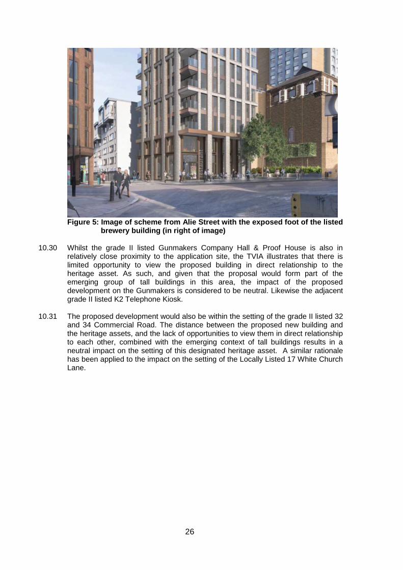
Figure 5: Image of scheme from Alie Street with the exposed foot of the listed
brewery building (in right of image) 10.30 Whilst the grade II listed Gunmakers Company Hall & Proof House is also in
relatively close proximity to the application site, the TVIA illustrates that there is limited opportunity to view the proposed building in direct relationship to the heritage asset. As such, and given that the proposal would form part of the emerging group of tall buildings in this area, the impact of the proposed development on the Gunmakers is considered to be neutral. Likewise the adjacent grade II listed K2 Telephone Kiosk.
10.31 The proposed development would also be within the setting of the grade II listed 32
and 34 Commercial Road. The distance between the proposed new building and the heritage assets, and the lack of opportunities to view them in direct relationship to each other, combined with the emerging context of tall buildings results in a neutral impact on the setting of this designated heritage asset. A similar rationale has been applied to the impact on the setting of the Locally Listed 17 White Church Lane.

27
Figure 6 CGI of Proposal taken from Altab Ali Park Tower (with No 33-35
Commercial Road to left of proposal and consented No 27 Commercial Road hotel to right)
10.32 The northern end of White Church Lane is located in the Whitechapel High Street
Conservation Area and it would form part of the backdrop of Altab Ali Park, an important area of open space in the Conservation Area. Again, special importance to the impacts on the setting of the Conservation Area has been applied in the balancing exercise. Aldgate is identified as a location for tall buildings. There are a number of existing consented schemes for tall buildings set to the south of Altab Ali Park and having particular regard to the verified views within the submitted Visual Impact Assessment, the impact on the views and settings of nearby listed buildings, conservation areas and the Altab Ali Park in particular are considered to be acceptable. Although we consider that overall the impact is neutral, Officer‟s have given special regard to what minor adverse impacts there are and consider them to be outweighed by the public benefits of the scheme in terms of delivery of new homes to high amenity and the public realm benefits including an improved setting to the at the base of the adjacent grade II listed warehouse.
28
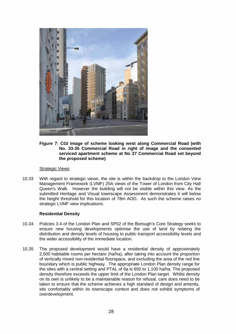
Figure 7: CGI image of scheme looking west along Commercial Road (with
No. 33-35 Commercial Road in right of image and the consented serviced apartment scheme at No 27 Commercial Road set beyond the proposed scheme)
Strategic Views 10.33 With regard to strategic views, the site is within the backdrop to the London View
Management Framework (LVMF) 25A views of the Tower of London from City Hall Queen's Walk. However the building will not be visible within this view. As the submitted Heritage and Visual townscape Assessment demonstrates it will below the height threshold for this location of 78m AOD. As such the scheme raises no strategic LVMF view implications.
Residential Density
10.34 Policies 3.4 of the London Plan and SP02 of the Borough‟s Core Strategy seeks to
ensure new housing developments optimise the use of land by relating the distribution and density levels of housing to public transport accessibility levels and the wider accessibility of the immediate location.
10.35 The proposed development would have a residential density of approximately
2,500 habitable rooms per hectare (ha/ha), after taking into account the proportion of vertically mixed non-residential floorspace, and excluding the area of the red line boundary which is public highway. The appropriate London Plan density range for the sites with a central setting and PTAL of 6a is 650 to 1,100 ha/ha. The proposed density therefore exceeds the upper limit of the London Plan target. Whilst density on its own is unlikely to be a maintainable reason for refusal, care does need to be taken to ensure that the scheme achieves a high standard of design and amenity, sits comfortably within its townscape context and does not exhibit symptoms of overdevelopment.

29
10.36 However as the London Plan makes clear, and as reiterated in the GLA Stage 1 response received to this scheme, these density ranges should not be applied mechanistically and a density above the stated range may be acceptable where the scheme is exemplary in all other respects, provides a high standard of residential amenity, provides a high quality of urban design, contributes positively to place-making, and does not exhibit any symptoms of overdevelopment in terms of adverse impacts on the amenity of future residential occupiers, neighbouring occupiers or neighbouring heritage assets. The scheme as set out in detail in the following sections is considered to meet all these criteria notwithstanding some challenges in respect of its height in the local townscape and the adequacy of the play-space provision.
Housing
10.37 The NPPF identifies as a core planning principle the need to encourage the
effective use of land through the reuse of suitably located previously developed land and buildings. Section 6 of the NPPF states that “housing applications should be considered in the context of the presumption in favour of sustainable development” and “Local planning authorities should seek to deliver a wide choice of high quality homes, widen opportunities for home ownership and create sustainable, inclusive and mixed communities.”
10.38 The application proposes 39 residential units as part of a mixed use scheme. The
principle of residential-led re-development of the site. The quantum of housing proposed will assist in increasing London‟s supply of housing and meeting the Council‟s housing target, as outlined in policy 3.3 of the London Plan and therefore make a positive contribution to meeting local, regional targets and national planning objectives.
Affordable Housing
10.39 The London Plan has a number of policies which seek to guide the provision of
affordable housing in London. Policy 3.9 seeks to encourage mixed and balanced communities with mixed tenures promoted across London. Policy 3.11 identifies that there is a strategic priority for affordable family housing and that boroughs should set their own overall targets for affordable housing provision over the plan period which can be expressed in absolute terms or as a percentage.
10.40 London Plan Policy 3.12 is considered to be of particular relevance as it provides
guidance on negotiating affordable housing provision on individual sites. The policy requires that the maximum reasonable amount should be secured on sites, having regard to: • Current and future requirements for affordable housing at local and regional
levels; • Affordable housing targets; • The need to encourage rather than restrain development; • The need to promote mixed and balanced communities; • The size and type of affordable housing needed in particular locations; and • The specific circumstances of the site.
10.41 The supporting text to the policy encourages developers to engage with an
affordable housing provider to progress a scheme. Boroughs should take a reasonable and flexible approach to affordable housing delivery as overall, residential development should be encouraged rather than restrained.

30
10.42 The Local Plan seeks 35%-50% affordable housing by habitable room to be provided, but subject to viability as set out in part 3a of the Core Strategy. The London Plan and NPPF also emphasise that development should not be constrained by planning obligations. Paragraph 173 of the NPPF states that: “the sites and scale of development identified in the plan should not be subject to such a scale of obligations and policy burdens that their ability to be developed viably is threatened.” Policy 3.12 of the London Plan is clear that viability is a consideration when negotiating affordable housing “negotiations on sites should take account of their individual circumstances including development viability” and the need to encourage rather than restrain development.
10.43 The scheme‟s affordable housing offer is 35.8% by habitable room, with on-site
provision. A viability appraisal has been submitted with the scheme and this has been independently reviewed by the Council‟s financial viability consultants. The review of the appraisal concluded that the proposed offer maximises the affordable housing that can viably be achieved. Indeed the revised affordable offer made by the applicant since March 2016 relies upon a future improvement in residential sales values relative to build costs for the scheme to deliver a predicated profit, or a reduced profit will be realised by the developer.
10.44 The affordable housing is being offered at a 71:29 split (by habitable rooms)
between affordable-rented units and shared ownership units. The London Plan seeks a ratio of 60:40, whilst Local Plan policy seeks a 70:30 split. The scheme is therefore in line with policy in terms of tenure mix.
10.45 The affordable rented units are offered at the Borough framework rent levels for this
postcode, which would mean £275 per week for the 3 bedroom flats, inclusive of service charges. Whilst these rent levels have had an effect on development viability, they ensure that rent levels are affordable to potential occupants in this location.
Housing Mix
10.46 Pursuant to Policy 3.8 of the London Plan, new residential development should
offer genuine housing choice, in particular a range of housing size and type. Policy SP02 of the Core Strategy also seeks to secure a mixture of small and large housing, requiring an overall target of 30% of all new housing to be of a size suitable for families (three-bed plus) including 45% of new affordable rented homes to be for families. Policy DM3 (part 7) of the MDD requires a balance of housing types including family homes. Specific guidance is provided on particular housing types and is based on the Councils most up to date Strategic Housing Market Assessment (2009).
10.47 The table below compares the proposed target mix against policy requirements:
Affordable Housing – Market housing split (below)
Number of units % of Units % of habitable rooms
Market 31 74.4 64.2%
Affordable 10 25.6 35.8%
TOTAL 39 100% 100%

31
Tenure Type Policy requirement (%) Proposed mix (%)
Private Studio 0 27
1 bed 50 50
2 bed 30 17
3 bed 20 7
4+ bed 0 0
Affordable Rented
1 bed 30 0
2 bed 25 0
3 bed 30 100
4+ bed 15 0
Intermediate Studio 0 0
1 bed 25 33
2 bed 50 0
3 bed 25 66
4+ bed 0 0
Dwelling numbers and mix by tenure (below)
Studio 1 bed 2 bed 3 bed
Market 8 15 5 2
Affordable Rent
0 0 0 6
Intermediate 0 1 0 2
TOTAL 8 16 5 10
Total as % 21 41 13 26
10.48 The scheme provides all the rented units as family sized units, whilst the policy
target is to provide 55% of the affordable rented units as 1 and 2 bedroom units. The proposed intermediate mix over provides 3 bedroom units - which is problematical given the challenges around affordability for 3-bed intermediate units in high value areas. However, on balance, the deviation from policy in respect of the affordable housing provision is considered acceptable given the provision of the 6x three-bedroom borough framework rented units and how it would help meet the greatest area of need within residents on the Borough‟s Housing Register, namely for larger sized affordable rented units.
10.49 The private mix is focussed towards studio units and 1 and 2 bed units.
Consequently, the private housing component of the development would not be policy compliant. However, it is worth noting the advice within London Mayor‟s Housing SPG in respect of the market housing. The SPG argues that it is inappropriate to crudely apply “housing mix requirements especially in relation to market housing, where, unlike for social housing and most intermediate provision, access to housing in terms of size of accommodation is in relation to ability to pay, rather than housing requirements”. The proposed mix in the market housing sector is, in the view of Officers, appropriate to the context and constraints of this site and the proposed high-density development.

32
10.50 The overall mix of unit sizes and tenures would make a positive contribution to a mixed and balanced community in this location as well as recognising the needs of the Borough as identified in the Council‟s Strategic Housing Market Assessment. It reflects the overarching principles of national, regional and local policies and guidance.
Quality of residential accommodation
10.51 Part 2 of the Housing SPG provides advice on the quality expected from new
housing developments with the aim of ensuring it is “fit for purpose in the long term, comfortable, safe, accessible, environmentally sustainable and spacious enough to accommodate the changing needs of occupants throughout their lifetime”. The document reflects the policies within the London Plan but provides more specific advice on a number of aspects including the design of open space, approaches to dwellings, circulation spaces, internal space standards and layouts, the need for sufficient privacy and dual aspect units.
10.52 All of the proposed flats meet or exceed the National Housing Standards and
London Plan minimum internal space standards. There are no single aspect north facing flats, over 50% of the unit are triple aspect with 18 other units double aspect. The two lift and stair cores and associated floor lobby/corridor spaces benefit from natural light. The proposed flats would not be unduly overlooked by neighbouring properties and subject to appropriate conditions regarding glazing specifications and ventilation would not be subject to undue noise, vibration or poor air quality.
Internal Daylight and Sunlight
10.53 DM25 of the MDD seeks to ensure adequate daylight and sunlight levels for the
future occupants of new developments. This policy must be read in the context of the Development Plan as a whole, including the Wood Wharf Site Allocation.
10.54 The Building Research Establishment (BRE) Handbook „Site Layout Planning for
Daylight and Sunlight 2011: A Guide to Good Practice‟ (hereinafter called the „BRE Handbook‟) provides guidance on the daylight and sunlight matters. It is important to note, however, that this document is a guide whose stated aim “is to help rather than constrain the designer”. The document provides advice, but also clearly states that it “is not mandatory and this document should not be seen as an instrument of planning policy.”
Daylight
10.55 The application is accompanied by a daylight and sunlight assessment report. The
results of the analysis for the original submission show that 55% of the windows serving the residential accommodation would experience Vertical Sky Component above the BRE guidance. Assessing the individual rooms, as opposed to individual windows, this submitted analysis recorded daylight distribution assessment would be met for all but a single figure number of living and bedroom and similarly in respect to achieving the BRE Average Daylight Factor guidance. The amended scheme is not considered to impact on these compliance figures in any significant manner. The scheme is considered would provide adequate daylight to its future occupants.

33
Sunlight 10.56 In relation to sunlight, the annual probable sunlight hours (APSH) considers the
amount of sun available in both the summer and winter for each given window which faces within 90° of due south. If the window reference point can receive more than one quarter (25%) of APSH, including at least 5% of APSH during the winter months, between 21st September and 21st March, then the room should still receive good sunlight.
10.57 The internal sunlight potential was tested for the original submitted scheme. 67%
of those rooms would experience BRE‟s annual sunlight levels and 75% would achieve the winter sunlight guidance. This level of compliance is considered reasonable in the context of a higher density urban environment such as Aldgate. The failings mainly relate to secondary windows serving dual aspect units. The sunlight analysis was not rerun for the amended scheme however it is not considered the changes would be of a magnitude to lend the scheme unacceptable on sunlight grounds
Amenity space
10.58 For all major developments there are four forms of amenity space: private amenity
space, communal amenity space, child amenity space and public open space. The „Children and Young People’s Play and Information Recreation SPG provides guidance on acceptable levels, accessibility and quality of children‟s play space and advises that where appropriate child play space can have a dual purpose and serve as another form of amenity space. This is particularly apt for very young children‟s play space as it is unlikely that they would be unaccompanied.
Private Amenity Space
10.59 Private amenity space requirements are a set figure which is determined by the
predicted number of occupants of a dwelling. Policy DM4 of the MDD sets out that a minimum of 5sq.m is required for 1-2 person dwellings with an extra 1sqm provided for each additional occupant. If in the form of balconies they should have a minimum width of 1500mm.
10.60 The proposal provides private amenity space to all of the units in compliance with
the above quantitative standard in the form of individual balconies and for one top floor unit a roof terrace.
Communal Amenity Space and Public Open Space 10.61 Communal open space is calculated by the number of dwellings within a proposed
development. 50sqm is required for the first 10 units with an additional 1sqm required for each additional unit. Therefore, the required amount of communal amenity space for the development would be 79sq.m. The proposal provides no dedicated communal amenity space for future occupants of the development. However it does provide new public realm space within the development plot of approximately 140sq.m that can be considered to some limited degree to serve the development and given the close proximity of Altab Ali Park and its inner London location can be considered acceptable for a residential scheme of this relative scale. Child play space

34
10.62 Play space for children is required for all major developments. The quantum of which is determined by the child yield of the development, with 10sqm of play space per child. The London Mayor‟s guidance on the subject requires, inter alia, that it will be provided across the development for the convenience of residents and for younger children in particular where there is natural surveillance for parents.
The scheme is predicted by the Borough to yield 12 children and approximately 14
children using the GLA child yield evidence base. Whilst the GLA child yield estimate is based upon all London data it is considered the more reliable estimate figure given it is currently derived from a more recent data set, than that used to produce the Borough based estimate. Accordingly the scheme is estimated to yield: o 5 children under age of 5, o 5 children between ages of 5-11 and o 4 children over the age of 12
The scheme is expected to provide a minimum 142sq.m of dedicated play space, assessed against the GLAchild yield calculator.
. 10.63 The scheme proposes to dedicate the entire first floor to an internal playspace
area, that would occupy an area of 137sq.m with a floor to ceiling height of approximately 2.5m. In terms of sum of area, the child playspace provision would meet all the child space provision for children under 12 and fall only marginally short against the total sum required for all age groups. The application documentation refers to this on-site play space being supplemented by existing or being built out open space facilities - principally from Altab Ali Park, Chaucer Gardens and the Aldgate Place development. Chaucer Gardens forms part of the Goodmans Fields site and is located less than 40metres (off Gowers Walk) to the south of Commercial Road that when built out will contain a play space area geared towards children aged 12-17 in years.
10.64 Officers consider the quantum of on-site communal play space is adequate, given
the expected child yield amongst younger children. The playspace would contain a small 7sq.m domestic scale balcony. The expanded size of the internal playspace, compared to when the scheme was originally submitted, is considered of benefit to the usability of the space (notwithstanding the scheme yields a greater number of children than previously) as the bigger area lends itself to some degree of subdivision between an early years play space zone and other sub divided spaces structured toward older children. However there remain concerns with the overall quality of the space as the floor to ceiling is minimal and in this aspect contrasts with amenity internal play space decks consented within much larger strategic development schemes located in the east of the Borough.
With regard to off-site provision Officers also have concerns on the reliance on the
cited off-site open spaces due to: (i) the cumulative pressure placed on these play spaces from the sheer scale of new residential developments coming forward in Aldgate; (ii) with the Aldgate Place play space due to the requirement of this space to primarily serve that scheme‟s own child yield, (ii) the lack of formal sports court spaces within these park spaces; and (iii) in the case of Chaucer Gardens the degree of physical severance from the proposed development site by Commercial Road. Given it is a very busy arterial that forms a part of the A12 truck road and again the expectation this space was designed in the first instance to serve the children of the Goodmans Field development.
10.65 Notwithstanding the above Officers concerns, given the child yield for the scheme
is small, and given the on-site provision in physical area terms meets the minimum

35
play space requirement for children under 12 Officers conclude it would not be reasonable to refuse the scheme on play-space provision grounds nor do officers consider they would be able to sustain that ground on appeal, should it be applied.
Overlooking/ Privacy 10.66 In general the scheme would not incur undue overlooking/privacy issues. However
there are a number of habitable rooms within the proposed development facing White Church Lane that would be set within approximately 10 metres of bedrooms within the yet to be built out apartment-hotel scheme at No. 27 Commercial Road.
To address the approximate 10m separation distance the applicant has agreed,
were the scheme to be consented, to install fixed louves to mitigate these privacy issues. In addition, it needs noting that overlooking relates to a relationship set across an established street (with existing habitable room windows with a comparable separation distance to the prospective hotel), and, as such, there is a degree of expectation that privacy would fall short of the level experienced and expected of new development where there is no street set between habitable rooms. Taking the existing relationship into account, the mitigation measures proposed and the fact the majority of the most effected rooms are bedrooms (as opposed to main living room spaces) the privacy issues are not considered such as to warrant a reason of refusal.
Neighbours Amenity 10.67 Core Strategy Policy SP10 „Creating Distinct and Durable Places’ & MDD Policy
DM25 „Amenity‟ require development to protect the amenity of adjoining properties. Indeed Policy DM25 of MDD seeks development to, where possible; improve the amenity of surrounding existing and future residents as well as the amenity of the surrounding public realm. The policy states that this should be by way of protecting privacy, avoiding an unacceptable increase in sense of enclosure, avoiding a loss of unacceptable outlook, not resulting in an unacceptable material deterioration of sunlighting and daylighting conditions or overshadowing to surrounding open space and not creating unacceptable levels of noise, vibration, light pollution or reductions in air quality during construction or operational phase of the development.
Effect on daylight and sunlight received by neighbouring properties 10.68 For calculating daylight to neighbouring properties, affected by a proposed
development, the primary assessment is the vertical sky component (VSC) together with daylight distribution assessment where internal room layouts are known or can reasonably be assumed. The 2011 BRE guide emphasises the VSC assessment as the primary method of assessment.
10.69 The VSC is a quantified measurement of the amount of skylight falling on a vertical
wall or window. The BRE handbook suggests a window should retain at 27% VSC or retain at least 80% of the pre-development VSC value. The significance of loss of daylight can be summarised as follows:
o 0-20 reduction – Negligible o 21-30% reduction – Minor significance o 31-40% reduction – Moderate significance o Above 40% reduction – Substantial significance

36
10.70 A second measurement is of the proportion of the room which receives direct sky light through the window i.e. it measures daylight distribution within a room. The BRE Handbook states that if an area of a room that receives direct daylight is reduced to less than 0.8 times its former value the effects will be noticeable to its occupants.
10.71 For calculating sunlight the BRE guidelines state that sunlight tests should be
applied to all main habitable rooms which have a window which faces within 90 degrees of due south.
10.72 The scheme in its original form was accompanied by a Daylight and Sunlight
Report, which provides an assessment of the impacts of the proposed development on the daylight and sunlight conditions of nearby residential properties and residential student accommodation. The assessment not only assesses the impacts of the development proceeding in isolation, but also the cumulative effects of the development were the scheme and the consented serviced apartment (hotel) development to be built out at No 27 Commercial Road. This assessment has not been revised following the reduction the height of the scheme by one storey , however given the proposed building enveloped has otherwise remained unchanged it is not considered the results would change in adverse manner in respect to daylight/sunlight impact to neighbours. In total the assessment considers the effects on the level of daylight received by 177 windows, serving 111 rooms.
10.73 Taken the impact of the scheme on its own, over 94% of the neighbouring windows
would achieve the BRE guidelines for VSC when the cumulative impacts are assessed this BRE target figure falls to 50%. Of the windows that fail to meet the BRE guidance 28% of those windows the cumulative impact is considered minor adverse (a VSC change of less than 0.6 or within 20% of guide level).
10.74 Taking the cumulative effects into account of the development at No. 27
Commercial Road were it also built out the properties adversely affected, assessed against the VSC test, by the proposed development are 32-34 Commercial Road, 35 Commercial Road, 42 Commercial Road Bar Locks Public House (21 White Church Lane), 7-8 Manningtree Street, 9 Manningtree Street, 63 Gowers Walk Goodmans Fields.
10.75 There are no adverse impacts, under either scenarios outside BRE guidance for
Vertical Sky Component or daylight distribution to the Naylor Building East. 10.76 The greatest cumulative effects are experienced by properties in Manningtree
Street and No 42 Commercial Road. 10.77 With respect to direct sunlight impacts 89% (50 out of the 56 windows assessed) of
the windows assessed would be above the BRE guidance for annual probable sunlight hours (APSH) and same figure for winter sunlight wen the scheme is considered independently of the cumulative impacts of No 27 Commercial Road. With the cumulative impacts 38 of the 56 windows (68%) would be above BRE APSH guidance and 57% winter sunlight guidance.
10.78 The greatest number of sunlight failings would be at No. 35 Commercial Road, The
Bars Locks Pub, and No 9 Manningtree. In addition 3 windows assessed would also fail BRE winter sunlight guidance at Naylor Building East, of which 2 of these failings would be classified of minor significance.

37
Assessment of impacts 35 Commercial Road 10.79 Taking the impact of the scheme on its own, 81.5% of the 27 windows assessed
will meet the BRE VSC guideline, 5 would fail but for of these 2 are marginal failures. Only 1 window would experience a moderate loss of greater than 30% VSC. Taken the cumulative effects, 9 windows or 33% of the windows will fail to meet the BRE guide. All these windows are understood to serve kitchens.
10.80 Assessed against BRE‟s daylight distribution 11 of the 13 rooms would meet the
BRE guidance with the two failings of minor significance. 32-34 Commercial Road 10.81 No VSC losses with the scheme taken in isolation. Taking the cumulative impacts,
50% windows affected 6 in total all minor adverse (i.e. of less than 30% VSC loss). 36 Commercial Road 10.82 No VSC losses with the scheme taken in isolation. 100% of the windows are
affected taking the cumulative effects. Of the total of 11 windows 6 windows will be a moderate impact (of greater than 30%.VSC loss), of which 4 serve bedrooms with the remaining 2 serving kitchens.
10.83 All 10 rooms comply with BRE guidance on daylight distribution. 42 Commercial Road 10.84 No VSC losses with the scheme taken in isolation. Taking the cumulative impacts,
all 4 windows tested would fail the VSC standards with two windows experiencing in excess of 50%. The windows serve 4 rooms, none of these windows fail the daylight distribution when the scheme is taken in isolation. All 4 windows would fail, were the hotel scheme implemented in isolation from this proposed scheme.
Bar Locke Public House (21 Whitechurch Lane) 10.85 The residential accommodation above the public house currently receives good
standards of daylight and sunlight. 10 windows assessed and taken the scheme in isolation all fall within BRE VSC guidance. Taking cumulative effects 8 windows (80%) would fall below BRE guidance with 6 of these windows receiving a major significance loss of greater than 40% VSC loss. 3 of these windows serve kitchens.
10.86 When account is taken account of daylight distribution and the levels of residual
sunlight within these rooms the overall impact to these rooms is considered fair. 7-8 Manning Street 10.87 All 24 windows assessed would meet BRE guidance taking the impacts of the
scheme alone. All windows would fail BRE guidance taking the cumulative impacts and experience 40%-50% reductions of major significance.
9 Manning Street

38
10.88 All 6 windows assessed would meet BRE guidance taking the impacts of the scheme alone. All 6 windows would fail BRE guidance taking the cumulative impacts and experience 40% to 50% VSC reductions. The impacts are therefore considered of major significance although it is worth noting all windows would maintain an absolute VSC above 10 and with tested daylight distribution impacts are limited to minor adverse for the rooms affected, against BRE guidance.
The Castle Pubic House 10.89 12 of the 16 windows assessed would meet BRE guidance taking the impacts of
the scheme alone. The 4 windows falling below BRE guidance would experience a minor adverse impact of 20% to 30% VSC loss.
11.90 Taking account the cumulative impact of the hotel at No 27 Commercial Road 50%
of the windows (8 in number) would be impacted, 7 windows would experience a reduction of more than 40% as such is of major adverse significance. However the residual absolute VSC figure would remain fair and with the daylight distribution to the 4 rooms tested meet recommended BRE guidance.
Goodmans Fields 10.91 15 windows assessed, of which 14 would meet BRE VSC guidance if the impact of
the scheme is assessed in isolation. Taking account of the cumulative impact, 12 (80%) of the windows would fail the VSC guidance. 4 of these windows would experience a VSC loss of greater than 40%, 5 windows, a VSC loss of between 30% to 40% and 3 windows a loss of 20%-30%. 9 of these windows serve kitchens, the remaining serving 4 bedrooms. Assessing the daylight distribution for these bedrooms, 3 of the 4 meet the BRE guidance for this measurement.
Context for daylight and sunlight losses
10.92 It is inevitable that in an urbanised borough such as Tower Hamlets and with such pressure being placed on the local planning authority to optimise the potential of development sites, daylight and sunlight infringement is a regular occurrence. In reaching final conclusions in relation to daylight and sunlight impacts weight needs to be given (a) to the nature of buildings and street patterns, (b) the current levels of daylight and sunlight enjoyed by existing residential occupiers that may fall below the absolute targets set out in the BRE Guidelines and (c) due weight and impact given to any existing consent that has yet to be implemented.
10.93 It is therefore fair and appropriate for the Council to apply a certain amount of
flexibility when applying the recommendations, as set out in the BRE Guidelines. This degree of flexibility is utilised on a regular basis. However, as Members will be aware, one needs to make judgements as to the acceptability of daylight and sunlight infringements on a case by case basis, when balanced against other material planning considerations. Conclusions
10.94 In this instance, the development is considered acceptable in terms of daylight/sunlight as the impacts of the scheme taken independently of other committed schemes is well within usual levels of failings given the urban context and with an acceptance any new development, however modest in additional storey height, might have significant impacts on a small number of neighbouring windows. The most significant number of adverse impacts in quantum and degree

39
of impact that would arise from this development occur when the impacts of this scheme are assessed alongside the cumulative impacts of the hotel development at No. 27 Commercial Road.
10.95 Although, it is acknowledged that there would be some daylight and sunlight
impacts on neighbouring properties and these would result in a detrimental impact on the amenities of those residential occupiers, on balance, the proposed development is considered to accord with Policy SP10(4) of the adopted Core Strategy (2010), and Policy DM25 of the Managing Development Document (2013).
Privacy, outlook and sense of enclosure 10.96 To the south of the application site there are no residential properties set within 23
metres of the site and similarly there are no habitable rooms windows within a close distance to the north or east of the site, as such there are no significant privacy, outlook or sense of enclosure issues to assess. With regard to existing development to the west, the impacts are centred on properties located on the west side of White Church Lane and the impacts upon these properties are considered limited (due to the nearest residential homes lying unoccupied awaiting work to commence on the serviced apartment hotel development at No. 27 Commercial Road and given the impacts are considered substantially less than those imposed independently by the consented development at No 27 Commercial road).
Microclimate 10.97 Tall buildings can have an impact upon the microclimate, particularly in relation to
wind. Where strong winds occur as a result of a tall building it can have detrimental impacts upon the comfort and safety of pedestrians and cyclists. It can also render landscaped areas unsuitable for their intended purpose.
10.98 A wind microclimate assessment report was prepared for the original application
proposal and uses the established Lawson Comfort Criteria and its results indicate there are no major adverse effects on local conditions and these conclusions are accepted by Officers to be relevant to the revised proposal. Mitigation measures are proposed in respect of balconies.
Secure by Design
10.99 Policy 7.3 of the London Plan seeks to ensure that developments are designed in such a way as to minimise opportunities for crime and anti-social behaviour. The built form should deter criminal opportunism and provide residents with an increased sense of security.
10.100 In general, the proposed layout and mix of uses provides some activity at street
level and natural surveillance. The Metropolitan Police Crime Prevention Design Advisor has no objections to the scheme and advises that were the application to be approved a condition should be imposed to ensure that the scheme meets Secured by Design accreditation.
Inclusive Design
10.101 Policy 7.2 of the London Plan Policy SP10 of the CS and Policy DM23 of the MDD
seek to ensure that developments are accessible, usable and permeable for all

40
users and that a development can be used easily by as many people as possible without undue effort, separation or special treatment.
10.102 A growing awareness of the importance of creating environments that are
accessible for all people has led the Council to emphasise the importance of „inclusive design‟. The development has been designed with the principles of inclusive design in mind.
10.103 The scheme will provide level thresholds to all the ground floor uses and entrances
and dual lift access will be provided to all the fully wheelchair accessible residential units.
Archaeology
10.104 The National Planning Policy Framework (Section 12) and the London Plan (Policy
7.8) emphasise that the conservation of archaeological interest is a material consideration in the planning process. Paragraph 128 of the NPPF says that applicants should be required to submit appropriate desk-based assessments, and where appropriate undertake field evaluation, to describe the significance of heritage assets and how they would be affected by the proposed development.
10.105 Greater London Archaeology Advisory Service advises that the submitted
documentation appropriately assesses the likely archaeological remains. Given the likely nature, depth and extent of the archaeology involved, they advise that further fieldwork prior to the determination of the application is not necessary and recommend a condition to agree and implement a Written Scheme of Investigation. Subject to this condition, the impact of the development on archaeology is acceptable.
Highways and Transportation
10.106 The NPPF and Policy 6.1 of the London Plan seek to promote sustainable modes of transport and accessibility, and reduce the need to travel by car and these objectives are also reflected in Core Strategy policies SP08 and SP09.
10.107 The site is located in an area with an excellent PTAL rating and sits within a
Controlled Parking Zone. The development site is fronted by Commercial Road, which is a Red Route for which TfL is the Highways Authority and White Church Lane for which LBTH is responsible.
10.108 The applicant has submitted a Transport Statement contains trip generation
analysis and details of servicing arrangements. The Transport Statement estimates the scheme would generate 18 additional car trip journeys. Deliveries to the ground floor commercial unit are expected to be predominantly by transit vans and not large goods vehicles. Residential refuse collection is anticipated would replicate the existing arrangement with collection from Assam Street. In respect to servicing, short term loading and unloading along White Church Lane is currently possible, with no loading restrictions in place. On Commercial Road there is an existing 20 minutes loading bay located less than 50m away from the site. It is anticipated that most service vehicles would load/ unload in Assam Street akin to the servicing arrangements for the neighbouring student housing development. Assam Street is a cul-de-sac and vehicles are able to turn-round and manoeuvre.
10.109 As set out in the comments received from both Transport for London and the Borough‟s Highway and Transportation Team, subject to appropriate conditions

41
and securing a commuted sums towards on street disabled parking bays, the scheme raises no highway or transportation issues.
10.110 An on-site disabled car parking bays is not practical on this small and tightly
constrained site. The car free arrangement is consistent with policy with the applicant‟s expressed willingness to fund provision for two disabled bays on-street in lieu of providing bays on site should it be demonstrated there is a need for such bays. Transport for London sought a commuted sum for four disabled bays, whilst the scheme as proposed would provide two, should the demand for the bays arise. The Borough Highway Officer considers 2 bays is the maximum capable, as there is no opportunity to provide more than two bays on the Borough‟s own adopted roads within a convenient distance of the development, and considers this provision on balance acceptable, although if an opportunity arose that a Transport for London managed road could provide two extra bays this would be welcomed.
10.111 The secure cycle bay provision is in line with London Plan standards. Noise and Dust 10.112 An acoustic assessment has been submitted with the planning application. The
assessment concludes that the demolition and construction will not result in adverse impacts to neighbours greater than those experienced from other major developments under construction or completed in the immediate vicinity.
10.113 The Council‟s Environmental Health Team have reviewed the documentation and
are satisfied the development‟s impact in terms of control of noise, dust and vibration to neighbours and future occupants during demolition, construction and occupation phases, subject to the imposition of relevant planning conditions and the powers available to the Council under other legislative frameworks, should planning permission be granted, including construction management plan.
Contaminated Land 10.114 In accordance with the requirements of the NPPF and policy DM30 of the MDD,
the application has been accompanied by a land contamination assessment which assesses the likely contamination of the site.
10.115 The Council‟s Environmental Health Officer has reviewed the submitted
assessment, and advises that subject to conditions to ensure that further site based assessments and appropriate mitigation measures are taken should contamination be found are there are no objections to the scheme on grounds of contaminated land issues, subject to the appliance of an appropriately worded planning condition.
Energy & Sustainability
10.116 At a national level, the National Planning Policy Framework sets out that planning
plays a key role in delivering reductions to greenhouse gas emissions, minimising vulnerability and providing resilience to climate change. The climate change policies as set out in Chapter 5 of the London Plan, policy SP11 of the Core Strategy and the Managing Development Document policy DM29 collectively require developments to make the fullest contribution to the mitigation and adaptation to climate change and to minimise carbon dioxide emissions.

42
10.117 The submitted proposals have followed the energy hierarchy of be lean, be clean & be green and seek to minimise CO2 emissions through the implementation of energy efficiency measures and use of a centralised energy system (CHP). The CO2 emission reductions are anticipated to be circa 24% against the Building Regulations 2013, short of the 45% policy target. In accordance with policy requirements, the applicant has agreed to the full financial contribution of £27,615 to the Council‟s carbon off-setting programme to achieve a total reduction of 45%. The figure is liable to fall when the inclusion of rooftop PV panels, although the proposed use of CHP may need to be reconsidered (that could affect the calculated CO2 reductions) when details (provided by condition) are supplied on the end user tariffs of such a technology on a scheme of this small size, particularly with respect to concerns on delivering a market competitive tariff for the residents of the affordable rented units.
10.118 To conclude, the overall approach to reducing carbon dioxide is accepted and in
accordance with relevant policies and could be secured by condition and within the s106 agreement.
Flood Risk and Water Resources
10.119 The NPPF, policy 5.12 of the London Plan, and policy DM13 of the MDD and SP04
of CS relate to the need to consider flood risk at all stages in the planning process. Policy 5.13 of the London Plan seeks the appropriate mitigation of surface water run-off.
10.120 The site is located in Flood Zone 1 and therefore the main risk is from surface
water run-off from the development. The site is already built upon and therefore subject to a planning condition to ensure the prepared draft drainage strategy the scheme is accordance with relevant policy and guidance
Biodiversity
10.121 Policy 7.19 of the London Plan, policy SP04 CS and policy DM11 of the MDD seek
to protect and enhance biodiversity value through the design of open space and buildings and by ensuring that development protects and enhances areas of biodiversity value in order to achieve a net gain in biodiversity. Policy DM11 of the MDD also requires elements of living buildings.
10.122 The application site has no significant existing biodiversity value. 10.123 Having regard to the possible conditions to secure the necessary mitigation and
enhancements, the proposal has an acceptable impact on biodiversity and is in accordance with relevant policies.
Planning Obligations
10.124 Core Strategy Policy SP13 seeks planning obligations to offset the impacts of the
development on local services and infrastructure in light of the Council‟s Infrastructure Delivery Plan (IDP). The Council‟s draft Planning Obligations SPD (2016) sets out in more detail how these impacts can be assessed and what the appropriate mitigation could be. The Council adopted a Borough-level Community Infrastructure Levy on April 1st 2015. Consequently, planning obligations are much more limited than they were prior to this date, with the CIL levy used to fund new education, healthcare and community facilities to meet the additional demand on infrastructure created by new residents.

43
10.125 The NPPF requires that planning obligations must be:
- Necessary to make the development acceptable in planning terms; - Directly related to the development; and, - Fairly and reasonably related in scale and kind to the development.
10.126 Regulation 122 of the CIL Regulations 2010 brings the above policy tests into law,
requiring that planning obligations can only constitute a reason for granting planning permission where they meet such tests. Furthermore, Regulation 123 stipulates that a planning obligation must not constitute a reason for the grant of planning permission if it provides for the funding or provision of any type of infrastructure which appears on the local planning authority‟s Regulation 123 infrastructure list.
10.127 The applicant has agreed to meet the following planning obligations. The financial
obligations secured include:
a) £14,457 construction phase employment training b) £2,835 end-user phase employment training c) £27,615 carbon off-setting d) £85,000 for raised table works including kerbs adjustments and drainage
provision e) Monitoring fee equivalent to £500 per each substantial Head of Terms Total financial contribution: £45,907 plus monitoring contribution.
10.128 The non-financial planning obligations include:
a) On-site affordable housing consisting of 6x three bedroom units at Borough Framework Levels inclusive of service charges, with 1 of these three bedroom units delivered as a fully wheelchair accessible unit
[to be delivered prior to occupation of 40% of market sale units] b) 1 x one bedroom intermediate units and 2x two bedroom units c) Access to employment - 20% local procurement - 20% local labour in construction (d) 6 apprenticeships delivered during the construction phase (e) a commuted sum to fund accessible bays 2 blue badge accessible bays on
street (f) Public access to public realm (g) Meet the Transport for London Cycle-Hire annual membership key fee for
each individual residential unit within the scheme for the first 3 years of occupation, as part of Travel Plan

44
10.129 All of the above obligations are considered to be in compliance with
aforementioned policies, the NPPF and Regulation 122 and 123 tests. Nonetheless, it needs to be emphasized that the applicant‟s commitment to utilise all reasonable endeavours to deliver the wider public realm vision does not and should not constitute a reason for the granting of planning permission.
10.130 With regard to affordable housing provision, the applicant has submitted a
Financial Viability Assessment which has been independently reviewed by consultants appointed by the Council. Officers are satisfied that the proposal would deliver the maximum amount of affordable housing that could be supported by the viability of the scheme without threatening the deliverability of the development.
Financial Considerations 10.131 Section 70(2) of the Town and Country Planning Act 1990 (as amended) requires
that the authority shall have regard to: - The provisions of the development plan, so far as material to the application; - Any local finance considerations, so far as material to the application; and, - Any other material consideration.
10.132 Section 70(4) defines “local finance consideration” as:
- A grant or other financial assistance that has been, or will or could be, provided to a relevant authority by a Minister of the Crown; or
- Sums that a relevant authority has received, or will or could receive, in payment of Community Infrastructure Levy.
10.133 In this case, the proposed development would be liable for Tower Hamlets and the
London Mayor‟s Community Infrastructure Levy. 10.134 Mayor of London CIL liability is estimated to be £98,781.06 (following estimated
social housing relief (£6,438.94). 10.135 Tower Hamlets CIL liability is estimated to be £405,559 (following estimated social
housing relief (£124,909) 10.136 Using the DCLG‟s New Homes Bonus Calculator, this development is likely to
generate approximately £50,301 of New Homes Bonus in the first year and a total payment of £301,807 over 6 years.
Health Considerations
10.137 Policy 3.2 of the London Plan seeks to improve health and address health
inequalities having regard to the health impacts of development proposals while the Council‟s policy SP03 of the Core Strategy seeks to deliver healthy and liveable neighbourhoods that promote active and healthy lifestyles, and enhance people‟s wider health and well-being.
10.138 The proposal raises no unique health implications, and would not prejudice the
opportunity of, residents, neighbours or members of the public to benefit from appropriate living conditions and lead healthy and active lifestyles. The play space and communal amenity space proposed would adequately meet the policy requirements. The gym and swimming pool available to the private and intermediate tenures would serve to promote active and healthy lifestyles. The

45
standard of the proposed residential accommodation would be high, commensurate with the high density of the scheme.
Human Rights Considerations 10.139 In determining this application the Council is required to have regard to the
provisions of the Human Rights Act 1998. In the determination of a planning application the following are particularly highlighted to Members:-
10.140 Section 6 of the Human Rights Act 1998 prohibits authorities (including the Council
as local planning authority) from acting in a way which is incompatible with the European Convention on Human Rights. "Convention" here means the European Convention on Human Rights, certain parts of which were incorporated into English law under the Human Rights Act 1998. Various Convention rights are likely to be relevant, including:-
• Entitlement to a fair and public hearing within a reasonable time by an
independent and impartial tribunal established by law in the determination of a person's civil and political rights (Convention Article 6). This includes property rights and can include opportunities to be heard in the consultation process;
• Rights to respect for private and family life and home. Such rights may be
restricted if the infringement is legitimate and fair and proportionate in the public interest (Convention Article 8); and,
• Peaceful enjoyment of possessions (including property). This does not impair
the right to enforce such laws as the State deems necessary to control the use of property in accordance with the general interest (First Protocol, Article 1). The European Court has recognised that "regard must be had to the fair balance that has to be struck between the competing interests of the individual and of the community as a whole".
10.141 This report has outlined the consultation that has been undertaken on the planning
application and the opportunities for people to make representations to the Council as local planning authority.
10.142 Were Members not to follow Officer‟s recommendation, they would need to satisfy
themselves that any potential interference with Article 8 rights will be legitimate and justified.
10.143 Both public and private interests are to be taken into account in the exercise of the
Council's planning authority's powers and duties. Any interference with a Convention right must be necessary and proportionate.
10.144 Members must, therefore, carefully consider the balance to be struck between
individual rights and the wider public interest. 10.145 As set out above, it is necessary, having regard to the Human Rights Act 1998, to
take into account any interference with private property rights protected by the European Convention on Human Rights and ensure that the interference is proportionate and in the public interest.
10.146 In this context, the balance to be struck between individual rights and the wider
public interest has been carefully considered.

46
Equalities Act Considerations 10.147 The Equality Act 2010 provides protection from discrimination in respect of certain
protected characteristics, namely: age, disability, gender reassignment, pregnancy and maternity, race, religion or beliefs and sex and sexual orientation. It places the Council under a legal duty to have due regard to the advancement of equality in the exercise of its powers including planning powers. Officers have taken this into account in the assessment of the application and the Committee must be mindful of this duty, inter alia, when determining all planning applications. In particular the Committee must pay due regard to the need to: - eliminate discrimination, harassment, victimisation and any other conduct that
is prohibited by or under the Act; - advance equality of opportunity between persons who share a relevant
protected characteristic and persons who do not share it; and, - foster good relations between persons who share a relevant protected
characteristic and persons who do not share it. 11.0 CONCLUSION 11.1 All other relevant policies and considerations have been taken into account.
Planning Permission should be approved for the reasons set out and the details of the decisions are set out in the RECOMMENDATIONS at the beginning of this report.
12 SITE MAP 12.1 Please refer to the next page of this report.

47