Embed Size (px)
Citation preview

Coastal Zone Management Consistency Statements (New York, Rhode Island, and Massachusetts)
Prepared for
January 2019
18 Tremont Street Suite 700 Boston, Massachusetts 02108

A-1
APPENDIX A
Coastal Zone Management Consistency Statements The federal Coastal Zone Management Act (CZMA) of 1972 requires that federal actions affecting any coastal use or resource (defined as land or water use, or natural resource of a state’s coastal zone), be conducted in a manner that is consistent with the enforceable policies of a state’s federally-approved Coastal Zone Management Program (CZMP) or Coastal Resource Management Program (CRMP). The CZMA and federal regulations at 15 Code of Federal Regulation (CFR) 930.00 authorize states with approved coastal zone management programs to conduct a coastal zone consistency review and concurrence determination of projects within or outside the state coastal zone boundary (if applicable) that require a federal license or permit, are federally funded, or are a direct activity of a federal agency to ensure that activities in or affecting the state’s coastal zone are consistent with the state enforceable program policies.
In accordance with the “federal consistency” requirement of the CZMA (16 USC 1456), as well as 307(c)(3)(A) and 15 CFR Part 930, the federal actions associated with the Project include approval of the COP by BOEM (15 CFR part 930, subpart E) and issuance of an Individual Permit by USACE, under Section 10 and 404 (15 CFR part 930, subpart D). Based on pre-application discussions, DWSF expects that New York, Rhode Island, and Massachusetts will review the Project for consistency with their state’s enforceable program policies. The construction, operations and maintenance, and decommissioning of the SFEC-NYS and SFEC-Onshore will also be reviewed and authorized under Article VII of the New York Public Service Law (PSL) by the New York State Department of Public Service Commission (NYSPSC). Their review will include review for consistency with the New York State CZMP.
This appendix provides summary tables listing each of the enforceable program policies and management principles for the New York State CZMP, the Rhode Island CRMP, and the Massachusetts CZMP. The summary tables present descriptions of how the South Fork Wind Farm (SFWF) and South Fork Export Cable (SFEC) will be consistent with each applicable policy or management principle and provide a cross reference to specific sections of the COP where the applicable policy or management principle is addressed. Key details for each state are described below.
New York State’s Coastal Zone Management Program The New York CZMP was established in 1982 and is administered by the New York Coastal Management Program within the New York State Department of State, which serves as the lead agency for the network of New York state agencies and local governments that administer the CZMP. The 44 enforceable policies of the New York State CZMP are implemented through a series of regulatory and management state authorities assigned to the New York State Department of State (NYSDOS), the Department of Environmental Conservation, the Department of Energy, the Public Service Commission, and the Office of Parks, Recreation, and Historic Preservation. The Waterfront Revitalization and Coastal Resources law (Executive Law, Article 42) establishes a balanced statewide approach for encouraging development in the coastal area while protecting natural coastal resources. The local waterfront revitalization program offers the town of East Hampton with the opportunity to participate in the State’s CZMP. DWSF has prepared a consistency statement that reviews the Project for consistency with the enforceable policies that make up the New York CZMP, including the Town of East Hampton Local Waterfront Revitalization Program (LWRP), see Appendix A-1. With respect to required federal licenses or permits under 15 CFR § 930.57(b), the proposed activity complies with the enforceable policies of the

APPENDIX A—CONSTRUCTION AND OPERATIONS PLAN FOR THE SOUTH FORK WIND FARM
A-2
New York State approved management program and will be conducted in a manner consistent with such program. Additionally, with respect to the COP, under 15 CFR § 930.76(c), the proposed activities described in detail in this plan comply with the New York approved management program and will be conducted in a manner consistent with such program.
Rhode Island Coastal Resources Management Program The Rhode Island CRMP was established in 1977 and is administered by Rhode Island Coastal Resources Management Council (CRMC), the lead agency for the network of Rhode Island state agencies and local governments that administer the CRMP and the Rhode Island Ocean Special Area Management Plan, or Ocean SAMP. The Ocean SAMP serves as a federally recognized coastal management and regulatory tool for outer continental shelf (OCS) exploration, development, and production activities needs to follow the requirements of CZMA section 307(c)(3)(b) (16 U.S.C. 1456(c)(3)(B)) and 15 CFR part 930, subpart E. Rhode Island has established a geographic location description (GLD) associated with the Ocean SAMP, which includes the federal portions of Block Island Sound and Rhode Island Sound as well as portions of the Atlantic Ocean. The SFWF and a large portion of the SFEC are located in the area defined by the GLD. DWSF is required to file a consistency certification because the Project is a listed activity on Rhode Island’s approved federal consistency list and is located within Rhode Island’s GLD. DWSF has prepared a consistency statement that reviews the Project for consistency with the enforceable policies set forth in Section 11.10 (formerly 1160) of the Ocean SAMP Renewable Energy and Other Offshore Development Policies and Standards, see Appendix A-2. The proposed activity complies with the enforceable policies of the Rhode Island approved management program and will be conducted in a manner consistent with such program.
Massachusetts Coastal Zone Management Program The Massachusetts CZMP was established in 1978 and is administered by the Massachusetts Office of Coastal Zone Management, which serves as the lead agency for the network of Massachusetts state agencies and local governments that administer the CZMP. DWSF has voluntarily prepared a consistency statement that reviews the Project for consistency with the enforceable policies of the Massachusetts CZMP, see Appendix A-3. The proposed activity complies with the enforceable policies of the Massachusetts approved management program and will be conducted in a manner consistent with such program.

Appendix A-1
Appendix A‐1. Coastal Zone Management Consistency Statements: New YorkDeepwater Wind South Fork, LLC
Policy # Policy/Requirement Response to Policy for SFWF Response to Policy for SFEC COP Section Reference
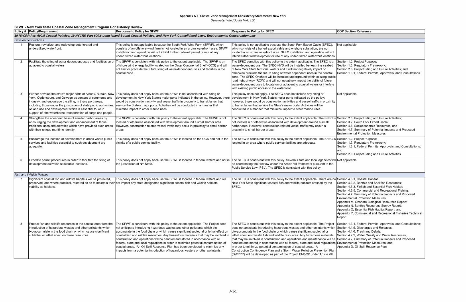
1 Restore, revitalize, and redevelop deteriorated and underutilized waterfront.
This policy is not applicable because the South Fork Wind Farm (SFWF), which consists of an offshore wind farm is not located in an urban waterfront area. SFWF installation and operation will not inhibit further redevelopment or use of any underutilized waterfront locations.
This policy is not applicable because the South Fork Export Cable (SFEC), which consists of a buried export cable and onshore substation, are not located in an urban waterfront area. SFEC installation and operation will not inhibit further redevelopment or use of any underutilized waterfront locations.
Not applicable
2 Facilitate the siting of water-dependent uses and facilities on or adjacent to coastal waters.
The SFWF is consistent with this policy to the extent applicable. The SFWF is an offshore wind energy facility located on the Outer Continental Shelf (OCS) and will not limit or preclude the future siting of water-dependent uses and facilities in the coastal zone.
The SFEC complies with this policy to the extent applicable. The SFEC is a water-dependent use. The SFEC-NYS will be installed beneath the seabed of New York State territorial waters and it will not negatively impact or otherwise preclude the future siting of water dependent uses in the coastal zone. The SFEC-Onshore will be installed underground within existing public road right-of-way (ROW) and will not negatively impact the ability of future water-dependent uses to locate on or adjacent to coastal waters or interfere with existing public access to the waterfront.
Section 1.2, Project Purpose;Section 1.3, Regulatory Framework;Section 2.0, Project Siting and Future Activities; and Section 1.3.1, Federal Permits, Approvals, and Consultations
3 Further develop the state's major ports of Albany, Buffalo, New York, Ogdensburg, and Oswego as centers of commerce and industry, and encourage the siting, in these port areas, including those under the jurisdiction of state public authorities, of land use and development which is essential to, or in support of, the waterborne transportation of cargo and people.
This policy does not apply because the SFWF is not associated with siting or development in New York State's major ports indicated in the policy. However, there would be construction activity and vessel traffic in proximity to transit lanes that service the State's major ports. Activities will be conducted in a manner that minimize impact to other marine uses.
This policy does not apply. The SFEC does not include any siting or development in New York State's major ports indicated by the policy; however, there would be construction activities and vessel traffic in proximity to transit lanes that service the State’s major ports. Activities will be conducted in a manner that minimize impact to other marine uses.
Not applicable
4 Strengthen the economic base of smaller harbor areas by encouraging the development and enhancement of those traditional uses and activities which have provided such areas with their unique maritime identity.
The SFWF is consistent with this policy to the extent applicable. The SFWF is not located or otherwise associated with development around a small harbor area. However, construction related vessel traffic may occur in proximity to small harbor areas
The SFEC is consistent with this policy to the extent applicable. The SFEC is not located in or otherwise associated with development around a small harbor area. However, construction related vessel traffic may occur in proximity to small harbor areas.
Section 2.0, Project Siting and Future Activities;Section 3.2, South Fork Export Cable;Section 4.6, Socioeconomic Resources; and Section 4.7, Summary of Potential Impacts and Proposed Environmental Protection Measures
5 Encourage the location of development in areas where public services and facilities essential to such development are adequate.
This policy does not apply because the SFWF is located on the OCS and not in the vicinity of a public service facility.
The SFEC is consistent with this policy to the extent applicable. The SFEC is located in an area where public service facilities are adequate.
Section 1.2, Project Purpose;Section 1.3, Regulatory Framework;Section 1.3.1, Federal Permits, Approvals, and Consultations; and Section 2.0, Project Siting and Future Activities
6 Expedite permit procedures in order to facilitate the siting of development activities at suitable locations.
This policy does not apply because the SFWF is located in federal waters and not in the jurisdiction of NY State.
The SFEC is consistent with this policy. Several State and local agencies will be coordinating their review under the Article VII framework pursuant to the Public Service Law (PSL). The SFEC is consistent with this policy.
Not applicable
7 Significant coastal fish and wildlife habitats will be protected, preserved, and where practical, restored so as to maintain their viability as habitats.
This policy does not apply because the SFWF is located in federal waters and will not impact any state-designated significant coastal fish and wildlife habitats.
The SFEC is consistent with this policy to the extent applicable. There are no New York State significant coastal fish and wildlife habitats crossed by the SFEC.
Section 4.3.1, Coastal Habitat;Section 4.3.2, Benthic and Shellfish Resources;Section 4.3.3, Finfish and Essential Fish Habitat;Section 4.6.5, Commercial and Recreational Fishing;Section 4.7, Summary of Potential Impacts and Proposed Environmental Protection Measures; Appendix M, Onshore Biological Resources Report;Appendix N, Benthic Resources Survey Report;Appendix O, Essential Fish Habitat Report; andAppendix Y, Commercial and Recreational Fisheries Technical Report
8 Protect fish and wildlife resources in the coastal area from the introduction of hazardous wastes and other pollutants which bio-accumulate in the food chain or which cause significant sublethal or lethal effect on those resources.
The SFWF is consistent with this policy to the extent applicable. The Project does not anticipate introducing hazardous wastes and other pollutants which bio-accumulate in the food chain or which cause significant sublethal or lethal effect on coastal fish and wildlife resources. Any hazardous materials that may be involved in construction and operations will be handled and stored in accordance with all federal, state and local regulations in order to minimize potential contamination of coastal areas. An Oil Spill Response Plan has been developed to minimize any impacts from a potential introduction of hazardous wasters or other pollutants.
The SFEC is consistent with this policy to the extent applicable. The Project does not anticipate introducing hazardous wastes and other pollutants which bio-accumulate in the food chain or which cause significant sublethal or lethal effect on coastal fish and wildlife resources. Any hazardous materials that may be involved in construction and operations and maintenance will be handled and stored in accordance with all federal, state and local regulations in order to minimize potential contamination of coastal areas. A Construction Contingency Plan and a Storm Water Pollution Prevention Plan (SWPPP) will be developed as part of the Project EM&CP under Article VII.
Section 1.3.1, Federal Permits, Approvals, and Consultations;Section 4.1.5, Discharges and Releases;Section 4.1.6, Trash and Debris;Section 4.2.2, Water Quality and Water Resources;Section 4.7, Summary of Potential Impacts and Proposed Environmental Protection Measures; andAppendix D, Oil Spill Response Plan
SFWF - New York State Coastal Zone Management Program Consistency Review
19 NYCRR Part 600.5 Coastal Policies; 19 NYCRR Part 600.6 Long Island Sound Coastal Policies; and New York Consolidated Laws, Environmental Conservation Law Development Policies
Fish and Wildlife Policies
A‐1‐1

Appendix A‐1. Coastal Zone Management Consistency Statements: New YorkDeepwater Wind South Fork, LLC
Policy # Policy/Requirement Response to Policy for SFWF Response to Policy for SFEC COP Section ReferenceSFWF - New York State Coastal Zone Management Program Consistency Review
19 NYCRR Part 600.5 Coastal Policies; 19 NYCRR Part 600.6 Long Island Sound Coastal Policies; and New York Consolidated Laws, Environmental Conservation Law 9 Expand recreational use of fish and wildlife resources in
coastal areas by increasing access to existing resources, supplementing existing stocks, and developing new resources.
This policy is not applicable because the SFWF is located on the OCS will not impact recreational use of fish and wildlife resources in the NY coastal area.
The SFEC is consistent with this policy to the extent practicable. The SFEC was sited to avoid impacts to recreational use of fish and wildlife resources, where possible. Where avoidance was not possible, measures were employed to minimize impacts to recreational use of fish and wildlife resources along the SFEC route. Any impact to recreational use of the resources offshore during the construction period will be temporary and localized. Operationally, there are no anticipated impacts to recreational use of resources, because the SFEC will be buried to a target depth of 4-6 feet. As a result, installation and operation will not impede further development and use of fish and wildlife resources in the coastal area.
Section 4.3.1, Coastal Habitat;Section 4.3.2, Benthic and Shellfish Resources;Section 4.3.3, Finfish and Essential Fish Habitat;Section 4.6.5, Commercial and Recreational Fishing;Section 4.7, Summary of Potential Impacts and Proposed Environmental Protection Measures;Appendix M, Onshore Biological Resources Report;Appendix N, Benthic Resources Survey Report;Appendix O, Essential Fish Habitat Report; andAppendix Y, Commercial and Recreational Fisheries Technical Report
10 Further develop commercial finfish, shellfish, and crustacean resources in the coastal area by encouraging the construction of new, or improvement of existing onshore commercial fishing facilities, increasing marketing of the state's seafood products, maintaining adequate stocks, and expanding aquaculture facilities.
This policy is not applicable because the SFWF will not impact commercial fishery resources in the NY coastal area.
The SFEC is consistent with this policy to the extent practicable. Various fisheries monitoring data sets suggest multiple fisheries are active near the SFEC–NYS. Installation of the SFEC may have temporary minimal affects to commercial fishery resources or activities. Operation of the SFEC will not affect commercial fishery resources or activities in the coastal area.
Section 4.3.1, Coastal Habitat;Section 4.3.2, Benthic and Shellfish Resources;Section 4.3.3, Finfish and Essential Fish Habitat;Section 4.6.5, Commercial and Recreational Fishing;Section 4.7, Summary of Potential Impacts and Proposed Environmental Protection Measures;Appendix M, Onshore Biological Resources Report;Appendix N, Benthic Resources Survey Report;Appendix O, Essential Fish Habitat Report; andAppendix Y, Commercial and Recreational Fisheries Technical Report
11 Buildings and other structures will be sited in the coastal area so as to minimize damage to property and the endangering of human lives caused by flooding and erosion.
This policy is not applicable because the SFWF does not include any buildings or structures within the New York State coastal area.
The SFEC is consistent with this policy to the extent applicable. Portions of the SFEC will occur within areas vulnerable to flooding and erosion. The SFEC is designed to use construction techniques and best management practices (BMPs) to avoid or minimize damange to property and lives caused by flooding and erosion. Construction activities will occur in accordance with a SWPPP, which will be included within the Project EM&CP.
Section 2.0, Project Siting and Future Activities;Section 3.0, Project Description;Section 4.6.3, Public Services;Section 4.6.7, Coastal Land Use and Infrastructure;Appendix E, Safety Management System; andAppendix M, Onshore Biological Resources Survey Report
12 Activities or development in the coastal area will be undertaken so as to minimize damage to natural resources and property from flooding and erosion by protecting natural protective features including beaches, dunes, barrier islands and bluffs.
This policy is not applicable because the SFWF is located on the OCS outside New York State coastal areas and flood hazard zones, and therefore will not result in damage to natural resources or property in New York State coastal areas.
The SFEC is consistent with this policy to the extent applicable. The Project EM&CP will include measures to minimize damage to natural resources and property from flooding and erosion (e.g. hay bale and/or silt fence barriers).During construction of the landing site and the SFEC, the Applicant will comply with all applicable regulations for Coastal Erosion Hazard Areas (CEHAs). In addition, horizontal direction drilling (HDD) will be utilized where necessary to avoid disturbing natural resources (e.g. the beach and associated dunes at the Beach Lane landing site) to the extent practicable.
Section 3.0, Project Description; Section 4.6.7, Coastal Land Use and Infrastructure;Section 4.7, Summary of Potential Impacts and Proposed Environmental Protection Measures; andAppendix M, Onshore Biological Resources Survey Report
13 The construction or reconstruction of erosion protection structures shall be undertaken only if they have a reasonable probability of controlling erosion for at least 30 years as demonstrated in design and construction standards and/or assured maintenance or replacement programs.
This policy is not applicable because the SFWF is located on the OCS and does not involve construction or reconstruction of erosion protection structures onshore in the New York State coastal area.
This policy is not applicable because the SFEC does not involve construction or reconstruction of erosion protection structures onshore in the New York State coastal area.
Not applicable
14 Activities and development, including the construction or reconstruction of erosion protection structures, shall be undertaken so that there will be no measurable increase in erosion or flooding at the site of such activities or development, or at other locations.
This policy is not applicable because the SFWF is located on the OCS and does not involve activities or development onshore (including construction and reconstruction of erosion protection structures) in the New York State coastal area.
This policy is not applicable because the SFEC does not involve activities or development onshore (including construction and reconstruction of erosion protection structures) in the New York State coastal area.
Not applicable
15 Mining, excavation, or dredging in coastal waters shall not significantly interfere with the natural coastal processes which supply beach materials to land adjacent to such waters and shall be undertaken in a manner which will not cause an increase in erosion of such land.
The SFWF is consistent with this policy to the extent applicable.The SFWF is located on the OCS, any dredging or disposal of dredged materials will not occur in NY State waters and therefoe will not cause an increase in erosion, and will not result in adverse impacts to water quality, physical processes, and marine productivity.
The SFEC is consistent with this policy to the extent applicable. The SFEC will be installed using a combination of hydraulic jet and mechanical plow. This process results in a minimum amount of sediment being suspended into the water column. Disturbed sediment will be allowed to naturally backfill the trench. HDD will be used at the sea-to-shore transition to avoid disturbance to shoreline structures or disturbance of nearshore coastal features. A temporary cofferdam will be installed at the sea-to-shore transition, which will aid in minimizing the spread of sediments suspended during the dredging process. After installation, all areas affected by the installation of the SFEC will be actively restored or allowed to return to their pre-installation condition.
Section 3.0, Project Description;Section 4.1.2, Sediment Suspension and Deposition;Section 4.2.2, Water Quality and Water ResourcesSection 4.2.3, Geological Resources;Appendix H, Geophysical and Geotechnical Survey Reports; andAppendix I, Sediment Survey and Sediment Transport Analysis Report
Flooding and Erosion Hazard Policies
A‐1‐2

Appendix A‐1. Coastal Zone Management Consistency Statements: New YorkDeepwater Wind South Fork, LLC
Policy # Policy/Requirement Response to Policy for SFWF Response to Policy for SFEC COP Section ReferenceSFWF - New York State Coastal Zone Management Program Consistency Review
19 NYCRR Part 600.5 Coastal Policies; 19 NYCRR Part 600.6 Long Island Sound Coastal Policies; and New York Consolidated Laws, Environmental Conservation Law 16 Public funds shall only be used for erosion protective
structures where necessary to protect human life, and new development which requires a location within or adjacent to an erosion hazard area to be able to function, or existing development; and only where the public benefits outweigh the long-term monetary and other costs including the potential for increasing erosion and adverse effects on natural protective features.
This policy is not applicable because the SFWF is located on the OCS and will not involve the use of public funds for erosion protective structures.
This policy is not applicable to the SFEC because it does not involve the use of public funds for erosion protective structures.
Not applicable
17 Non-structural measures to minimize damage to natural resources and property from flooding and erosion shall be used whenever possible.
This policy is not applicable because the SFWF is located on the OCS outside New York State coastal waters and coastal areas.
The SFEC is consistent with this policy to the extent applicable. The SFEC sea-to-shore transition will be installed via HDD to avoid impacts to the shoreline and existing natural resources. The SFEC-Onshore will be constructed along existing roads and railroad ROW without increasing the amount of impervious surfaces. The SFEC will not result in an increase in the potential for erosion or for flooding that would result in damage to natural resources or property.
Section 2.3, Review of Technologies and Installation Methods;Section 3.0, Project Description;Section 4.6.7, Coastal Land Use and Infrastructure;Appendix G, Project Engineering Plans and Construction Drawings; andAppendix M, Onshore Biological Resources Survey Report
18 To safeguard the vital economic, social and environmental interests of the state and its citizens, proposed major actions in the coastal area must give full consideration to those interests, and to the safeguards which the state has established to protect valuable coastal areas.
This policy is not applicable because the SFWF is located on the OCS and is not anticipated to impact any valuable New York State coastal waters or resources or affect economic, social, cultural, and environmental interests of the state and its citizens.
The SFEC is consistent with this policy to the extent applicable. The SFEC has been sited and designed in a manner that safeguards the economic, social, cultural, and environmental interests of the state and its citizens. The SFEC will be installed via HDD at the sea-to-shore transition and will have a minimal temporary impact during construction, and will not negatively impact the coastal environment or the ecological, historical, and scenic qualities it provides to the Town; and therefore will not have a significant negative impact on social, cultural, economic and environmental interests of the State.
Section 2.0, Project Siting and Future Activities;Section 3.0, Project Description; Section 3.2, South Fork Export Cable;Section 4.3.1, Coastal and Terrestrial Habitat;Section 4.3.2, Benthic and Shellfish Resources;Section 4.3.3, Finfish and Essential Fish Habitat; Section 4.4, Cultural Resources;Section 4.5, Visual Resources;Section 4.6, Socioeconomic Resources;Section 4.7, Summary of Potential Impacts and Proposed Environmental Protection Measures;Appendix M, Onshore Biological Resources Survey Report;Appendix N, Benthic Resources Survey Report;Appendix O, Essential Fish Habitat Report;Appendix R, Marine Archaeological Report (Not for Public Distribution); Appendix S, Archaeological Resources Report - Onshore (Not for Public Distribution);Appendix T, Historic Resources Report for Substation;Appendix U, Visual Resources Assessment Report for Substation;Appendix V, Visual Impact Assessment Report for SFWF; andAppendix Y, Commercial and Recreational Fisheries Technical Report
General Policy
A‐1‐3

Appendix A‐1. Coastal Zone Management Consistency Statements: New YorkDeepwater Wind South Fork, LLC
Policy # Policy/Requirement Response to Policy for SFWF Response to Policy for SFEC COP Section ReferenceSFWF - New York State Coastal Zone Management Program Consistency Review
19 NYCRR Part 600.5 Coastal Policies; 19 NYCRR Part 600.6 Long Island Sound Coastal Policies; and New York Consolidated Laws, Environmental Conservation Law
19 Protect, maintain, and increase the level and types of access to public water-related recreation resources and facilities.
This policy is not applicable because the SFWF is located on the OCS and will not limit the level or type of access to public water related recreation resources and facilities in the New York State coastal area.
The SFEC is consistent with this policy to the extent applicable. Construction of the SFEC may temporarily affect public access to the shoreline from the landing site. However, pedestrian and vehicle access will be maintained throughout construction. HDD methods will be utilized at the landfall to avoid permanent impacts to public access. The existing road ROW will remain in Town ownership. The area necessary to construct the transition vault will be minimal in area and its disturbance will be temporary. Therefore, there will be no permanent reduction to public access to public water-related recreation resources.
Section 4.6.4, Recreation and Tourism;Section 4.6.5, Commercial and Recreational Fishing;Section 4.7, Summary of Potential Impacts and Proposed Environmental Protection Measures; andAppendix Y, Commercial and Recreational Fisheries Technical Report
20 Access to the publicly owned foreshore and to lands immediately adjacent to the foreshore or the water's edge that are publicly owned shall be provided and it shall be provided in a manner compatible with adjoining uses.
This policy is not applicable because the SFWF is located on the OCS and will not impact publicly owned foreshore and areas immediately adjacent to the foreshore or the water's edge that is publicly owned.
The SFEC is consistent with this policy to the extent applicable. The SFEC is not anticipated to permanently impact any publicly-owned foreshore areas or lands that are immediately adjacent. Construction of the SFEC may temporarily affect public access to the shoreline at the landing site. However, pedestrian and vehicle access will be maintained throughout construction. HDD methods will be utilized at the landfall to avoid permanent impacts to public access from. The existing road ROW will remain in Town ownership.
Section 4.6.4, Recreation and Tourism; andSection 4.6.7, Coastal Land Use and Infrastructure
21 Water-dependent and water-enhanced recreation will be encouraged and facilitated, and will be given priority over non-water-related used along the coast.
The SFWF is consistent with this policy to the extent applicable. The SFWF is located on the OCS; however construction activity and vessel traffic during construction may temporarily impact water-dependent recreation. • A comprehensive communication plan will be implemented during offshore construction to inform all mariners, including commercial and recreational fishermen, and recreational boaters of construction activities and vessel movements. Communication will be facilitated through a Project website, public notices to mariners and vessel float plans, and a fisheries liaison. DWSF will submit information to the USCG to issue Local Notice to Mariners during offshore installation activities.• The communication plan will also include outreach to stakeholders in the offshorerecreational and tourism industry to minimize impacts to recreational events (e.g., sailboat races).
The SFEC is consistent with this policy to the extent applicable. The SFEC will not permanently impact existing or future water-dependent or water-enhanced recreational uses. Construction at the landing site and the SFEC may temporarily affect public access to the shoreline. However, pedestrian and vehicle access will be maintained throughout construction. Water dependent and water enhanced recreation will be fully restored upon completion of construction.
Section 4.6.4, Recreation and Tourism;Section 4.6.5, Commercial and Recreational Fishing;Section 4.7, Summary of Potential Impacts and Proposed Environmental Protection Measures; andAppendix Y, Commercial and Recreational Fisheries Technical Report
22 Development, when located adjacent to the shore, will provide for water-related recreation, whenever such use is compatible with reasonably anticipated demand for such activities, and is compatible with the primary purpose of the development.
The SFWF is consistent with this policy to the extent applicable. The SFWF is located on the OCS; however construction activity and vessel traffic during construction may temporarily impact access water-related recreation. • A comprehensive communication plan will be implemented during offshore construction to inform all mariners, including commercial and recreational fishermen, and recreational boaters of construction activities and vessel movements. Communication will be facilitated through a Project website, public notices to mariners and vessel float plans, and a fisheries liaison. DWSF will submit information to the USCG to issue Local Notice to Mariners during offshore installation activities.• The communication plan will also include outreach to stakeholders in the offshorerecreational and tourism industry to minimize impacts to recreational events (e.g., sailboat races).
The SFEC is consistent with this policy to the extent applicable. While the SFEC will involve minor and temporary construction activities within the Town road ROW for construction of the transition vault, there will be no permanent reduction in existing water-related recreation opportunities resulting from the SFEC.
Section 4.6.4, Recreation and Tourism;Section 4.6.5, Commercial and Recreational Fishing;Section 4.7, Summary of Potential Impacts and Proposed Environmental Protection Measures; andAppendix Y, Commercial and Recreational Fisheries Technical Report
23 Protect, enhance, and restore structures, districts, areas, or sites that are of significance in the history, architecture, archaeology or culture of the state, its communities, or the nation.
The SFWF is consistent with this policy to the extent practicable. No shipwrecks or significant archaeological sites are recorded within the SFWF area at the New York State Office of Parks, Recreation and Historic Preservation (NYSOPRHP). Data from NOAA’s Automated Wreck and Obstruction Information System (AWOIS) and Electronic Navigational Charts (ENC) databases, as well as the proprietary BOEM shipwreck database, indicated one shipwreck reported within the SFWF. DWSF will maintain a protective buffer extending 164 feet (50 m) from the maximum discernable extent of each wreck during Project construction, O&M, and decommissioning, to avoid impact.
The SFEC is consistent with this policy to the extent applicable. Construction and O&M will not require the demolition or physical alteration of any New York State and/or National Register of Historic Places (S/NHRP)-eligible or S/NRHP-listed buildings. No mitigation is anticipated to be necessary for negative impacts to historic resources associated with construction. In the event that unanticipated archaeological resources are encountered during construction, the actions outlined in the Unanticipated Discovery Protocol for the Project will be followed.
Section 4.4, Cultural Resources;Appendix R, Marine Archaeological Report (Not for Public Distribution);Appendix S, Archaeological Resources Report-Onshore (Not for Public Distribution); andAppendix T, Historic Resources Report for Substation
Public Access Policies
Recreation Policies
Historic and Scenic Resources Policies
A‐1‐4

Appendix A‐1. Coastal Zone Management Consistency Statements: New YorkDeepwater Wind South Fork, LLC
Policy # Policy/Requirement Response to Policy for SFWF Response to Policy for SFEC COP Section ReferenceSFWF - New York State Coastal Zone Management Program Consistency Review
19 NYCRR Part 600.5 Coastal Policies; 19 NYCRR Part 600.6 Long Island Sound Coastal Policies; and New York Consolidated Laws, Environmental Conservation Law 24 Prevent impairment of scenic resources of statewide
significance. The SFWF is consistent with this policy to the extent applicable. The SFWF will be located approximately 19 miles (30.6 km, 16.6 nm) southeast of Block Island, Rhode Island, and 35 miles (56.3 km, 30.4 nm) east of Montauk Point, New York. The SFWF is located far enough offshore such that only a relatively small portion of the project would be visible from the New York State coastline; therefore, the SFWF is not expected to impact scenic resources of statewide significance.
The SFEC is consistent with this policy to the extent applicable. The SFEC and sea-to-shore transition vault will be located underground within the existing paved Town road ROW with a manhole cover at the surface, thus avoiding direct impacts to existing scenic resources. Within the Coastal Boundary, the SFEC will not be visible as it will be installed underground and therefore will not impact scenic resources of Statewide Significance.
Section 4.1.9, Visible Structures;Section 4.4, Cultural Resources;Section 4.5, Visual Resources;Section 4.7, Summary of Potential Impacts and Proposed Environmental Protection Measures;Appendix U, Visual Resources Assessment Report for Substation; andAppendix V, Visual Impact Assessment Report for SFWF
25 Protect, restore, or enhance natural and man-made resources which are not identified as being of statewide significance, but which contribute to the overall scenic quality of the coastal area.
The SFWF is consistent with this policy to the extent applicable. The SFWF will be located approximately 19 miles (30.6 km, 16.6 nm) southeast of Block Island, Rhode Island, and 35 miles (56.3 km, 30.4 nm) east of Montauk Point, New York. The SFWF is located far enough offshore such that only a relatively small portion of the project would be visible from the New York State coastline; therefore, the SFWF is not expected to impact the overall scenic quality of the coastal area.
The SFEC is consistent with this policy to the extent applicable. As stated in response to State Policy 24, within the Coastal Boundary the SFEC will be installed underground, and therefore will not impact existing scenic resources.
Section 4.1.9, Visible Structures;Section 4.5, Visual Resources;Section 4.7, Summary of Potential Impacts and Proposed Environmental Protection Measures;Appendix U, Visual Resources Assessment Report for Substation; andAppendix V, Visual Impact Assessment Report for SFWF
26 Conserve and protect agricultural lands in the state's coastal area.
This policy is not applicable because the SFWF is located on the OCS and will not impact agricultural lands.
The SFEC is consistent with this policy to the extent applicable. Within the Coastal Boundary, the SFEC will be located within Town road ROW and proximate, but not within Suffolk County Agricultural District 5 (East Hampton, Southampton). The SFEC is not anticipated to impact this Agricultural District or any active farmland or agricultural soils, since the SFEC will be installed, within the existing pavement section, wherever practicable.
Section 2.0, Project Siting and Future Activities;Section 3.0, Project Description;Section 4.6.3, Public Services;Section 4.6.7, Coastal Land Use and Infrastructure;Section 4.7, Summary of Potential Impacts and Proposed Environmental Protection Measures; andAppendix G, Project Engineering Plans and Construction Drawings
27 Decisions on the siting and construction of major energy facilities in the coastal area will be based on public energy needs, compatibility of such facilities with the environment, and the facility's need for a shorefront location.
This policy is not applicable because the SFWF is located on the OCS outside of NY State coastal areas.
The SFEC is consistent with this policy to the extent applicable. The purpose of the Project is to generate electricity and transmit it to the existing East Hampton Substation. The Project addresses the need identified by the LIPA for new sources of power generation that can cost-effectively and reliably supply the South Fork of Suffolk County, Long Island, as an alternative to constructing new transmission facilities. The Project will also help LIPA achieve its renewable energy goals and will enable DWSF to fulfill its contractual commitments to LIPA pursuant to a Power Purchase Agreement (PPA) executed in 2017 resulting from LIPA’s technology-neutral competitive bidding process. The nature of offshore wind energy production necessitates transmission facilities within the coastal area in order to connect the electricity generated offshore by the wind turbine generators to distribution facilities located onshore. The Applicant’s filing of an application with the New York State Public Service Commission (NYSPSC) under Article VII of the PSL that fully evaluates the public energy needs, compatibility of the SFEC with the environment, and Project location, demonstrates compliance with this policy.
Section 1.2, Project Purpose; andSection 2.0, Project Siting and Future Activities
28 Ice management practices shall not interfere with the production of hydroelectric power, damage significant fish and wildlife and their habitats, or increase shoreline erosion or fl di
This policy is not applicable because the SFWF will not involve ice management measures and practices.
This policy is not applicable because the SFEC will not involve ice management measures and practices.
Not applicable
29 Encourage the development of energy resources on the outer continental shelf, in Lake Erie, and in other water bodies, and ensure the environmental safety of such activities.
The SFWF is consistent with this policy to the extent applicable. The SFWF is an offshore wind energy facility located on the OCS that has been designed to use construction techniques to avoid or minimize environmental impacts to the greatest extent practicable.
The SFEC is consistent with this policy to the extent applicable. The SFEC will support and facilitate the transmission of electricity generated by offshore wind energy facility to the local grid in the Town of East Hampton. The SFEC is designed to use construction techniques and BMPs to avoid or minimize impacts on water bodies and fisheries to the greatest extent practicable.
Section 1.2, Project Purpose; Section 2.0, Project Siting and Future Activities;Section 3.0, Project Description; andSection 4.0, Site Characterization and Assessment of Potential Impacts
Agricultural Lands Policy
Energy and Ice Management Policies
A‐1‐5

Appendix A‐1. Coastal Zone Management Consistency Statements: New YorkDeepwater Wind South Fork, LLC
Policy # Policy/Requirement Response to Policy for SFWF Response to Policy for SFEC COP Section ReferenceSFWF - New York State Coastal Zone Management Program Consistency Review
19 NYCRR Part 600.5 Coastal Policies; 19 NYCRR Part 600.6 Long Island Sound Coastal Policies; and New York Consolidated Laws, Environmental Conservation Law
30 Municipal, industrial, and commercial discharge of pollutants, including but not limited to, toxic and hazardous substances, into coastal waters will conform to state and national water quality standards.
The SFWF is consistent with this policy to the extent applicable. Routine or accidental (non-routine) fuel spills, wastewater discharges and solid waste releases associated with SFWF construction, O&M, and decommissioning activities are possible but considered unlikely. All vessel waste will be offloaded, stored, and disposed of in accordance with all applicable local, state and federal regulations, such as the U.S. Environmental Protection Agency (EPA) and USCG requirements for discharges and releases to surface waters. A project-specific Oil Spill Response Plan has also been developed to mitigate the potential for adversely impacting water quality.
The SFEC is consistent with this policy to the extent applicable. Routine or accidental (non-routine) fuel spills, wastewater discharges and solid waste releases associated with SFEC construction, O&M, and decommissioning activities are possible but considered unlikely. All vessel waste will be offloaded, stored, and disposed of in accordance with all applicable local, state and federal regulations, such as the United States Environmental Protection Agency (EPA) and United State Coast Guard (USCG) requirements for discharges and releases to surface waters. Activities associated with the construction of the SFEC are unlikely to result in the discharge of pollutants into coastal waters. There will be no process discharge associated with the operation of the SFEC. Unanticipated discharges will be handled and stored in accordance with all applicable federal, state, and local regulations in order to minimize potential contamination of coastal areas. A Construction Contingency Plan that addresses spill prevention, controls, and countermeasures, onshore and offshore, and a SWPPP will be developed as part of the Project EM&CP. The Applicant will implement the SWPPP during construction to preclude pollution of surface and ground waters in the vicinity of the SFEC route.
Section 1.3.1, Federal Permits, Approvals, and Consultations;Section 4.1.5, Discharges and Releases;Section 4.1.6, Trash and Debris;Section 4.2.2, Water Quality and Water Resources;Section 4.7, Summary of Potential Impacts and Proposed Environmental Protection Measures; andAppendix D, Oil Spill Response Plan
31 State coastal area policies and management objectives of approved local waterfront revitalization programs will be considered while reviewing coastal water classifications and while modifying water quality standards; however, those waters already overburdened with contaminants will be recognized as being a development constraint.
This policy is not applicable because the SFWF is located on the OCS and not in an area subject to a waterfront revitalization program.
The SFEC is subject to review under the East Hampton LWRP. See Appendix A-1-A
Appendix A
32 Encourage the use of alternative or innovative sanitary waste systems in small communities where the costs of conventional facilities are unreasonably high, given the size of the existing tax base of these communities.
This policy is not applicable because the SFWF is located on the OCS and does not include the installation of permanent sanitary waste systems.
This policy is not applicable because the SFEC does not involve the installation of permanent sanitary waste systems.
Not applicable
33 Best management practices will be used to ensure the control of storm water runoff and combined sewer overflows draining into coastal waters.
This policy is not applicable because the SFWF is located on the OCS and will not cause or result in storm water runoff or sewer overflows in NY State waters.
The SFEC is consistent with this policy to the extent applicable. The SFEC will not result in any direct discharge of untreated storm water into wetlands or waterbodies. Because the terrestrial portions of the SFEC will be located primarily underground within existing Town road ROW, the SFEC will not result in an increase in impervious surfaces or in a volume of storm water generated. The Applicant will prepare a SWPPP in accordance with the State Pollutant Discharge Elimination Systems (SPDES) rules and implement BMPs, to the extent necessary during construction, to avoid pollution of surface waters from storm water runoff. These may include, but are not limited to: •After completion of construction, there will be no significant increase in
impervious surfaces, as the SFEC is proposed to be installed beneath existing paved road ROWs and therefore, will not create an increase in storm water runoff. •HDD will be utilized in order to minimize areas of disturbance at the landing
site. •Disturbed roadway and shoulder surfaces will be restored upon the
completion of construction activities.
Section 4.2.2, Water Quality and Water Resources; andSection 4.7, Summary of Potential Impacts and Proposed Environmental Protection Measures
34 Discharge of waste materials into coastal waters from vessels subject to state jurisdiction will be limited so as to protect significant fish and wildlife habitats, recreational areas, and water supply areas.
The SFWF is consistent with this policy to the extent applicable. All vessel waste will be offloaded, stored, and disposed of in accordance with all applicable local, state and federal regulations, such as USCG requirements for discharges and releases to surface waters.
The SFEC is consistent with this policy to the extent applicable. Vessels participating in the construction and O&M of the SFEC will adhere to all applicable local, state and federal regulations, such as the EPA and USCG requirements for discharges and releases to surface waters.
Section 1.3.1, Federal Permits, Approvals, and Consultations;Section 4.1.5, Discharges and Releases;Section 4.1.6, Trash and Debris;Section 4.2.2, Water Quality and Water Resources; andSection 4.7, Summary of Potential Impacts and Proposed Environmental Protection Measures
SFWF - New York State Coastal Zone Management Program Consistency Review
A‐1‐6
Appendix A‐1. Coastal Zone Management Consistency Statements: New YorkDeepwater Wind South Fork, LLC
Policy # Policy/Requirement Response to Policy for SFWF Response to Policy for SFEC COP Section ReferenceSFWF - New York State Coastal Zone Management Program Consistency Review
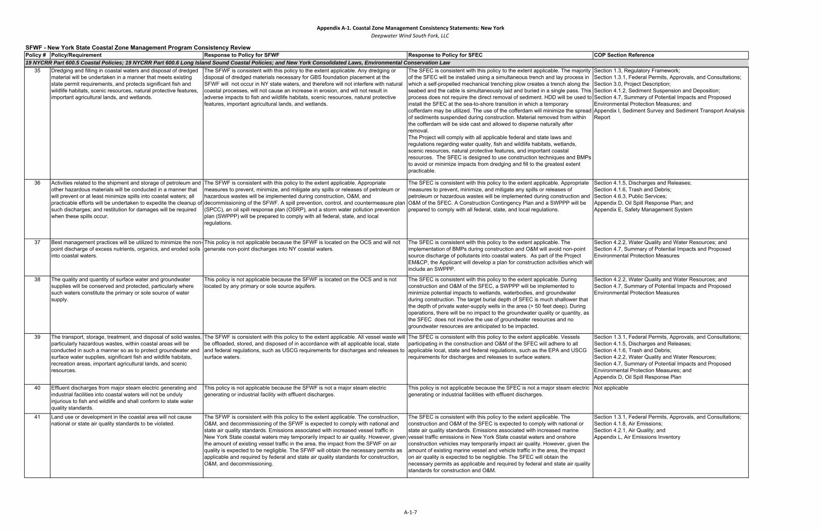
19 NYCRR Part 600.5 Coastal Policies; 19 NYCRR Part 600.6 Long Island Sound Coastal Policies; and New York Consolidated Laws, Environmental Conservation Law 35 Dredging and filling in coastal waters and disposal of dredged
material will be undertaken in a manner that meets existing state permit requirements, and protects significant fish and wildlife habitats, scenic resources, natural protective features, important agricultural lands, and wetlands.
The SFWF is consistent with this policy to the extent applicable. Any dredging or disposal of dredged materials necessary for GBS foundation placement at the SFWF will not occur in NY state waters, and therefore will not interfere with natural coastal processes, will not cause an increase in erosion, and will not result in adverse impacts to fish and wildlife habitats, scenic resources, natural protective features, important agricultural lands, and wetlands.
The SFEC is consistent with this policy to the extent applicable. The majority of the SFEC will be installed using a simultaneous trench and lay process in which a self-propelled mechanical trenching plow creates a trench along the seabed and the cable is simultaneously laid and buried in a single pass. This process does not require the direct removal of sediment. HDD will be used to install the SFEC at the sea-to-shore transition in which a temporary cofferdam may be utilized. The use of the cofferdam will minimize the spread of sediments suspended during construction. Material removed from within the cofferdam will be side cast and allowed to disperse naturally after removal. The Project will comply with all applicable federal and state laws and regulations regarding water quality, fish and wildlife habitats, wetlands, scenic resources, natural protective features, and important coastal resources. The SFEC is designed to use construction techniques and BMPs to avoid or minimize impacts from dredging and fill to the greatest extent practicable.
Section 1.3, Regulatory Framework;Section 1.3.1, Federal Permits, Approvals, and Consultations;Section 3.0, Project Description;Section 4.1.2, Sediment Suspension and Deposition;Section 4.7, Summary of Potential Impacts and Proposed Environmental Protection Measures; andAppendix I, Sediment Survey and Sediment Transport Analysis Report
36 Activities related to the shipment and storage of petroleum and other hazardous materials will be conducted in a manner that will prevent or at least minimize spills into coastal waters; all practicable efforts will be undertaken to expedite the cleanup of such discharges; and restitution for damages will be required when these spills occur.
The SFWF is consistent with this policy to the extent applicable. Appropriate measures to prevent, minimize, and mitigate any spills or releases of petroleum or hazardous wastes will be implemented during construction, O&M, and decommissioning of the SFWF. A spill prevention, control, and countermeasure plan (SPCC), an oil spill response plan (OSRP), and a storm water pollution prevention plan (SWPPP) will be prepared to comply with all federal, state, and local regulations.
The SFEC is consistent with this policy to the extent applicable. Appropriate measures to prevent, minimize, and mitigate any spills or releases of petroleum or hazardous wastes will be implemented during construction and O&M of the SFEC. A Construction Contingency Plan and a SWPPP will be prepared to comply with all federal, state, and local regulations.
Section 4.1.5, Discharges and Releases;Section 4.1.6, Trash and Debris;Section 4.6.3, Public Services;Appendix D, Oil Spill Response Plan; andAppendix E, Safety Management System
37 Best management practices will be utilized to minimize the non-point discharge of excess nutrients, organics, and eroded soils into coastal waters.
This policy is not applicable because the SFWF is located on the OCS and will not generate non-point discharges into NY coastal waters.
The SFEC is consistent with this policy to the extent applicable. The implementation of BMPs during construction and O&M will avoid non-point source discharge of pollutants into coastal waters. As part of the Project EM&CP, the Applicant will develop a plan for construction activities which will include an SWPPP.
Section 4.2.2, Water Quality and Water Resources; andSection 4.7, Summary of Potential Impacts and Proposed Environmental Protection Measures
38 The quality and quantity of surface water and groundwater supplies will be conserved and protected, particularly where such waters constitute the primary or sole source of water supply.
This policy is not applicable because the SFWF is located on the OCS and is not located by any primary or sole source aquifers.
The SFEC is consistent with this policy to the extent applicable. During construction and O&M of the SFEC, a SWPPP will be implemented to minimize potential impacts to wetlands, waterbodies, and groundwater during construction. The target burial depth of SFEC is much shallower that the depth of private water-supply wells in the area (> 50 feet deep). During operations, there will be no impact to the groundwater quality or quantity, as the SFEC does not involve the use of groundwater resources and no groundwater resources are anticipated to be impacted.
Section 4.2.2, Water Quality and Water Resources; andSection 4.7, Summary of Potential Impacts and Proposed Environmental Protection Measures
39 The transport, storage, treatment, and disposal of solid wastes, particularly hazardous wastes, within coastal areas will be conducted in such a manner so as to protect groundwater and surface water supplies, significant fish and wildlife habitats, recreation areas, important agricultural lands, and scenic resources.
The SFWF is consistent with this policy to the extent applicable. All vessel waste will be offloaded, stored, and disposed of in accordance with all applicable local, state and federal regulations, such as USCG requirements for discharges and releases to surface waters.
The SFEC is consistent with this policy to the extent applicable. Vessels participating in the construction and O&M of the SFEC will adhere to all applicable local, state and federal regulations, such as the EPA and USCG requirements for discharges and releases to surface waters.
Section 1.3.1, Federal Permits, Approvals, and Consultations;Section 4.1.5, Discharges and Releases;Section 4.1.6, Trash and Debris;Section 4.2.2, Water Quality and Water Resources;Section 4.7, Summary of Potential Impacts and Proposed Environmental Protection Measures; andAppendix D, Oil Spill Response Plan
40 Effluent discharges from major steam electric generating and industrial facilities into coastal waters will not be unduly injurious to fish and wildlife and shall conform to state water quality standards.
This policy is not applicable because the SFWF is not a major steam electric generating or industrial facility with effluent discharges.
This policy is not applicable because the SFEC is not a major steam electric generating or industrial facilities with effluent discharges.
Not applicable
41 Land use or development in the coastal area will not cause national or state air quality standards to be violated.
The SFWF is consistent with this policy to the extent applicable. The construction, O&M, and decommissioning of the SFWF is expected to comply with national and state air quality standards. Emissions associated with increased vessel traffic in New York State coastal waters may temporarily impact to air quality. However, given the amount of existing vessel traffic in the area, the impact from the SFWF on air quality is expected to be negligible. The SFWF will obtain the necessary permits as applicable and required by federal and state air quality standards for construction, O&M, and decommissioning.
The SFEC is consistent with this policy to the extent applicable. The construction and O&M of the SFEC is expected to comply with national or state air quality standards. Emissions associated with increased marine vessel traffic emissions in New York State coastal waters and onshore construction vehicles may temporarily impact air quality. However, given the amount of existing marine vessel and vehicle traffic in the area, the impact on air quality is expected to be negligible. The SFEC will obtain the necessary permits as applicable and required by federal and state air quality standards for construction and O&M.
Section 1.3.1, Federal Permits, Approvals, and Consultations;Section 4.1.8, Air Emissions;Section 4.2.1, Air Quality; andAppendix L, Air Emissions Inventory
A‐1‐7
Appendix A‐1. Coastal Zone Management Consistency Statements: New YorkDeepwater Wind South Fork, LLC
Policy # Policy/Requirement Response to Policy for SFWF Response to Policy for SFEC COP Section ReferenceSFWF - New York State Coastal Zone Management Program Consistency Review
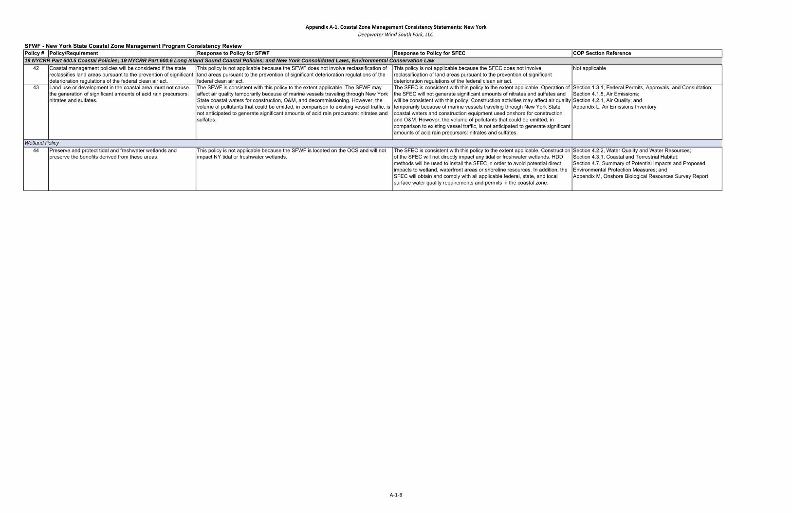
19 NYCRR Part 600.5 Coastal Policies; 19 NYCRR Part 600.6 Long Island Sound Coastal Policies; and New York Consolidated Laws, Environmental Conservation Law 42 Coastal management policies will be considered if the state
reclassifies land areas pursuant to the prevention of significant deterioration regulations of the federal clean air act.
This policy is not applicable because the SFWF does not involve reclassification of land areas pursuant to the prevention of significant deterioration regulations of the federal clean air act.
This policy is not applicable because the SFEC does not involve reclassification of land areas pursuant to the prevention of significant deterioration regulations of the federal clean air act.
Not applicable
43 Land use or development in the coastal area must not cause the generation of significant amounts of acid rain precursors: nitrates and sulfates.
The SFWF is consistent with this policy to the extent applicable. The SFWF may affect air quality temporarily because of marine vessels traveling through New York State coastal waters for construction, O&M, and decommissioning. However, the volume of pollutants that could be emitted, in comparison to existing vessel traffic, is not anticipated to generate significant amounts of acid rain precursors: nitrates and sulfates.
The SFEC is consistent with this policy to the extent applicable. Operation of the SFEC will not generate significant amounts of nitrates and sulfates and will be consistent with this policy. Construction activities may affect air quality temporarily because of marine vessels traveling through New York State coastal waters and construction equipment used onshore for construction and O&M. However, the volume of pollutants that could be emitted, in comparison to existing vessel traffic, is not anticipated to generate significant amounts of acid rain precursors: nitrates and sulfates.
Section 1.3.1, Federal Permits, Approvals, and Consultation;Section 4.1.8, Air Emissions;Section 4.2.1, Air Quality; andAppendix L, Air Emissions Inventory
44 Preserve and protect tidal and freshwater wetlands and preserve the benefits derived from these areas.
This policy is not applicable because the SFWF is located on the OCS and will not impact NY tidal or freshwater wetlands.
The SFEC is consistent with this policy to the extent applicable. Construction of the SFEC will not directly impact any tidal or freshwater wetlands. HDD methods will be used to install the SFEC in order to avoid potential direct impacts to wetland, waterfront areas or shoreline resources. In addition, the SFEC will obtain and comply with all applicable federal, state, and local surface water quality requirements and permits in the coastal zone.
Section 4.2.2, Water Quality and Water Resources; Section 4.3.1, Coastal and Terrestrial Habitat;Section 4.7, Summary of Potential Impacts and Proposed Environmental Protection Measures; andAppendix M, Onshore Biological Resources Survey Report
Wetland Policy
A‐1‐8

Appendix A‐1‐A. Coastal Zone Management Consistency Statements: Town of East Hampton, New York LWRPDeepwater Wind South Fork, LLC
Policy # Policy/Requirement Response to Policy COP Section Reference1 and 1A Restore, revitalize and redevelop deteriorated and underutilized waterfront areas for commercial and
industrial, cultural, recreational and other compatible uses. This statewide policy was adapted in the LWRP as Policy 1A (see below) to better address local concerns.
LWRP Policy 1A: Restore, revitalize, and redevelop the following underutilized sites for cultural, recreational, and other compatible uses. (1) Marina Lane dredge spoil site, Three Mile Harbor (2) Old Fish Factory Site, Napeague (3) Former Montauk Landfill (4) Montauk Harbor Area (5) Camp Hero, Montauk (6) Montauk Business Area
This policy is not applicable because the South Fork Export Cable (SFEC), which consists of a buried export cable and onshore substation, are not proposed to be located at any of the listed underutilized sites. SFEC installation and operation will not inhibit further redevelopment or use of any underutilized waterfront locations.
Not applicable
2 and 2A Facilitate the siting of water-dependent uses and facilities on or adjacent to coastal waters. This statewide policy was adapted in the LWRP as Policy 2A (see below) to better address local concerns.
LWRP Policy 2A: Water-dependent uses and facilities shall be sited on or adjacent to coastal waters, provided the proposed use is consistent with preservation and enhancement of other coastalresources, including cultural or natural resources.
The SFEC complies with this policy to the extent applicable. The SFEC is a water-dependent use. The SFEC-NYS will be installed beneath the seabed of New York State territorial waters and it will not negatively impact or otherwise preclude the future siting of water dependent uses in the coastal zone. The SFEC will be installed underground and will not negatively impact the ability of future water-dependent uses to locate on or adjacent to coastal waters. The underground installation of the SFEC within existing public road right-of-way (ROW) will ensure that the Project will not interfere with existing public access to the waterfront.
Section 2.0, Project Siting and Future Activities;Section 3.2, South Fork Export Cable;Section 4.6, Socioeconomic Resources;Section 4.6.4, Recreation and Tourism; andSection 4.7, Summary of Potential Impacts and Proposed Mitigation Measures
3 Further develop the State's major ports of Albany, Buffalo, New York, Ogdensburg, and Oswego as centers of commerce and industry, and encourage the siting, in the port areas, including those underthe jurisdiction of State public authorities, of land use and development, which is essential to or support of the waterborne transportation of cargo and people.
This policy does not apply. The SFEC does not include any siting or development in New York State's major ports indicated by the policy; however, there would be construction activities and vessel traffic in proximity to transit lanes that service the State’s major ports. Activities will be conducted in a manner that minimize impact to other marine uses.
Not applicable
4 Strengthen the economic base of small harbor areas by encouraging the development and enhancement of those traditional uses and activities which have provided such areas with their unique maritime identity.
The SFEC is consistent with this policy to the extent applicable. The SFEC is not proposed within Three Mile Harbor or Montauk Harbor, and, therefore will not have a negative impact upon the small harbors identified in the LWRP. However, construction vessels may utilize nearby small harbors and construction related vessel traffic may occur in proximity to small harbor areas. It is noted that, by bringing electricity generated by an alternative source of energy to the local transmission grid, the Project could have a beneficial economic impact on local businesses (some of which include traditional uses and activities), including those in the Three Mile Harbor and Montauk Harbor areas.
Section 2.0, Project Siting and Future Activities;Section 3.2, South Fork Export Cable;Section 4.6, Socioeconomic Resources; and Section 4.7, Summary of Potential Impacts and Proposed Environmental Protection Measures
5 Encourage the location of development in areas where public services and facilities essential to such development are adequate, except when such development has special functional requirements or other characteristics which necessitate its location in other coastal areas.
The SFEC is consistent with this policy to the extent applicable. The purpose of Policy 5 is to “strengthen commercial centers and minimize sprawl” (East Hampton Town, 1999, II-63). The SFEC will not extend public utility infrastructure to areas that are not already served; rather, it will increase the electricity supply and reliability of electric service available to the existing local transmission grid, and therefore, will not result in the increased potential for sprawling development. The SFEC does not encourage development or require public services offshore.
Section 1.2, Project Purpose;Section 1.3, Regulatory Framework;Section 1.3.1, Federal Permits, Approvals, and Consultations; and Section 2.0, Project Siting and Future Activities
6 Expedite permit procedures in order to facilitate the siting of development activities at suitable locations.
The purpose of this policy is for state agencies to coordinate permitting decisions. In the case of the SFEC, several state and local agencies will be coordinating their review under the Article VII framework pursuant to the PSL. Accordingly, the Project is consistent with this policy.
Not applicable
SFEC - Town of East Hampton Local Waterfront Revitalization Program (LWRP) Policies
A‐1‐A1
Appendix A‐1‐A. Coastal Zone Management Consistency Statements: Town of East Hampton, New York LWRPDeepwater Wind South Fork, LLC
Policy # Policy/Requirement Response to Policy COP Section ReferenceSFEC - Town of East Hampton Local Waterfront Revitalization Program (LWRP) Policies
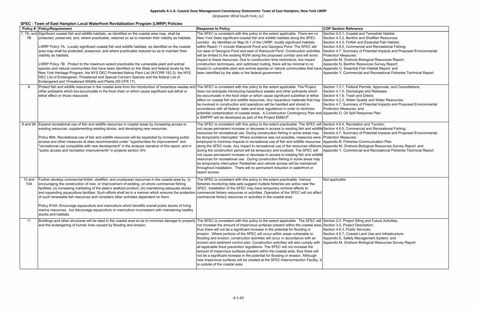
7, 7A, and 7B
Significant coastal fish and wildlife habitats, as identified on the coastal area map, shall be protected, preserved, and, where practicable, restored so as to maintain their viability as habitats.
LWRP Policy 7A: Locally significant coastal fish and wildlife habitats, as identified on the coastal area map shall be protected, preserved, and where practicable restored so as to maintain their viability as habitats.
LWRP Policy 7B: Protect to the maximum extent practicable the vulnerable plant and animal species and natural communities that have been identified on the State and federal levels by the New York Heritage Program, the NYS DEC Protected Native Plant List (NYCRR 193.3), the NYS DEC List of Endangered, Threatened and Special Concern Species and the federal List of Endangered and Threatened Wildlife and Plants (50 CFR 17).
The SFEC is consistent with this policy to the extent applicable. There are no New York State significant coastal fish and wildlife habitats along the SFEC corridor. As identified on Map III-1 of the LWRP, locally significant habitats within Reach 11 include Wainscott Pond and Georgica Pond. The SFEC will run west of Georgica Pond and east of Wainscott Pond. Construction activities will be limited to the existing ROW along the proposed corridor and will avoid impact to these resources. Due to construction time restrictions, low impact construction techniques, and optimized routing, there will be minimal to no impact to vulnerable plant and animal species or natural communities that have been identified by the state or the federal government.
Section 4.3.1, Coastal and Terrestrial Habitat;Section 4.3.2, Benthic and Shellfish Resources;Section 4.3.3, Finfish and Essential Fish Habitat;Section 4.6.5, Commercial and Recreational Fishing;Section 4.7, Summary of Potential Impacts and Proposed Environmental Protection Measures;Appendix M, Onshore Biological Resources Report;Appendix N, Benthic Resources Survey Report;Appendix O, Essential Fish Habitat Report; andAppendix Y, Commercial and Recreational Fisheries Technical Report
8 Protect fish and wildlife resources in the coastal area from the introduction of hazardous wastes and other pollutants which bio-accumulate in the food chain or which cause significant sub-lethal or lethal effect on those resources.
The SFEC is consistent with this policy to the extent applicable. The Project does not anticipate introducing hazardous wastes and other pollutants which bio-accumulate in the food chain or which cause significant sublethal or lethal effect on coastal fish and wildlife resources. Any hazardous materials that may be involved in construction and operations will be handled and stored in accordance with all federal, state and local regulations in order to minimize potential contamination of coastal areas. A Construction Contingency Plan and a SWPPP will be developed as part of the Project EM&CP.
Section 1.3.1, Federal Permits, Approvals, and Consultations;Section 4.1.5, Discharges and Releases;Section 4.1.6, Trash and Debris;Section 4.2.2, Water Quality and Water Resources;Section 4.7, Summary of Potential Impacts and Proposed Environmental Protection Measures; andAppendix D, Oil Spill Response Plan
9 and 9A Expand recreational use of fish and wildlife resources in coastal areas by increasing access to existing resources, supplementing existing stocks, and developing new resources.
Policy #9A: Recreational use of fish and wildlife resources will be expanded by increasing public access and other measures at sites recommended under "opportunities for improvement" and "recreational use compatible with new development" in the analysis narrative of this report, and in "public access and recreation improvements" in projects section XIV.
The SFEC is consistent with this policy to the extent practicable. The SFEC will not cause permanent increase or decrease in access to existing fish and wildliferesources for recreational use. During construction fishing in some areas may be temporarily interrupted. Where avoidance was not possible, measures were employed to minimize impacts to recreational use of fish and wildlife resources along the SFEC route. Any impact to recreational use of the resources offshore during the construction period will be temporary and localized. The SFEC will not cause permanent increase or decrease in access to existing fish and wildliferesources for recreational use. During construction fishing in some areas may be temporarily interrupted. Pedestrian and vehicle access will be maintained throughout installation. There will no permanent reduction in waterfront or beach access.
Section 4.6.4, Recreation and Tourism;Section 4.6.5, Commercial and Recreational Fishing; Section 4.7, Summary of Potential Impacts and Proposed Environmental Protection Measures;Appendix B, Fisheries Communication PlanAppendix M, Onshore Biological Resources Survey Report; andAppendix Y, Commercial and Recreational Fisheries Technical Report
10 and 10A
Further develop commercial finfish, shellfish, and crustacean resources in the coastal area by: (i) encouraging the construction of new, or improvement of existing, on-shore commercial fishing facilities; (ii) increasing marketing of the state's seafood product; (iii) maintaining adequate stocks and expanding aquaculture facilities. Such efforts shall be in a manner which ensures the protection of such renewable fish resources and considers other activities dependent on them.
Policy #10A: Encourage aquaculture and mariculture which benefits overall public stocks of living marine resources, but discourage aquaculture or mariculture inconsistent with maintaining healthy stocks and habitats.
The SFEC is consistent with this policy to the extent practicable. Various fisheries monitoring data sets suggest multiple fisheries are active near the SFEC. Installation of the SFEC may have temporary minimal affects to commercial fishery resources or activities. Operation of the SFEC will not affect commercial fishery resources or activities in the coastal area.
Not applicable
11 Buildings and other structures will be sited in the coastal area so as to minimize damage to property and the endangering of human lives caused by flooding and erosion.
The SFEC is consistent with this policy to the extent applicable. The SFEC will not increase the amount of impervious surfaces present within the coastal area, thus there will not be a significant increase in the potential for flooding or erosion. Where portions of the SFEC will occur within areas vulnerable to flooding and erosion, construction activities will occur in accordance with an erosion and sediment control plan. Construction activities will also comply with all applicable flood prevention regulations. The SFEC will not increase the amount of impervious surfaces present within the coastal area, thus there will not be a significant increase in the potential for flooding or erosion. Although new impervious surfaces will be created at the SFEC-Interconnection Facility, it is outside of the coastal area.
Section 2.0, Project Siting and Future Activities;Section 3.0, Project Description;Section 4.6.3, Public Services;Section 4.6.7, Coastal Land Use and Infrastructure;Appendix E, Safety Management System; andAppendix M, Onshore Biological Resources Survey Report
A‐1‐A2

Appendix A‐1‐A. Coastal Zone Management Consistency Statements: Town of East Hampton, New York LWRPDeepwater Wind South Fork, LLC
Policy # Policy/Requirement Response to Policy COP Section ReferenceSFEC - Town of East Hampton Local Waterfront Revitalization Program (LWRP) Policies
12 Activities or development in the coastal area will be undertaken so as to minimize damage to natural resources and property from flooding and erosion by protecting natural protective features including beaches, dunes, barrier islands, and bluffs. Primary dunes will be protected from all encroachments that could impair their natural protective capacity.
The SFEC is consistent with this policy to the extent applicable. During construction of the landing site and the SFEC, the Applicant will comply with all applicable regulations for CEHAs. The EM&CP for the Project will include measures to minimize damage to natural resources and property from flooding and erosion (e.g. hay bale and/or silt fence barriers). In addition, HDD will be utilized where necessary to avoid disturbing natural resources to the extent practicable
Section 2.0, Project Siting and Future Activities;Section 3.2, South Fork Export Cable;Section 4.3.1, Coastal and Terrestrial Habitats;Section 4.6.7, Coastal Land Use and Infrastructure;Section 4.7, Summary of Potential Impacts and Proposed Environmental Protection Measures; andAppendix M, Onshore Biological Resources Survey Report
13 and 13A
The construction or reconstruction of erosion protection structures shall be undertaken only if they have a reasonable probability of controlling erosion for at least 30 years as demonstrated in design and construction standards and/or assured maintenance or replacement programs.
Policy #13A: Erosion protection structures must be maintained both with regard to the structure and to adjoining natural protective features. Required maintenance may include beach nourishment and mitigation of erosion to nearby property and resources caused by construction or reconstruction of the erosion protection structure.
This policy is not applicable because the SFEC does not involve construction or reconstruction of erosion protection structures onshore in the New York State coastal area.
Not applicable
14 and 14A
Activities and development, including the construction or reconstruction of erosion protection structures, shall be undertaken so that there will be no measurable increase in erosion or flooding at the site of such activities or development, or at other locations.
Policy #14A: Minimize the construction of erosion protection structures and new development in hazardous areas in Reaches 1, 4, 5, 7, 8, 9, 10, 11, 12, and parts of Reaches 2, 3, and 6.
This policy is not applicable. The SFEC will be installed underground, and therefore will not increase the potential for flooding or erosion . In addition, the Applicant is not proposing to construct erosion protection structures
Not applicable
15 Mining, excavation or dredging in coastal waters shall not significantly interfere with the natural coastal processes which supply beach materials to land adjacent to such waters and shall be undertaken in a manner which will not cause an increase in erosion of such land.
The SFEC is consistent with this policy to the extent applicable. Dredging/excavation will be required within coastal waters for installation of the SFEC, and at the landing site. HDD will be utilized where possible to limit sediment disturbance to the extent practicable. In areas where excavation is required, the Applicant will use a combination of hydraulic jet and mechanical plow to install the SFEC in accordance with prevailing regulations (e.g. CEHA), which will not cause an increase in erosion or significantly interfere with natural coastal processes. All construction activities will comply with USACE requirements. An Individual Permit will be acquired from the USACE under Section 10 of the Rivers and Harbors Act (33 United States Code [USC] 403) and Section 404 of the Clean Water Act (CWA) (33 USC 1344). After installation, all areas affected by the installation of the SFEC will be actively restored or allowed to return to their pre-installation condition. It is anticipated that construction and O&M of the SFEC will not cause interference with natural coastal process, increased erosion, or result in adverse impacts to water quality, physical processes, and marine productivity in coastal areas.
Section 3.0, Project Description;Section 4.1.2, Sediment Suspension and Deposition;Section 4.2.2, Water Quality and Water Resources;Section 4.2.3, Geological Resources;Appendix H, Geophysical and Geotechnical Survey Reports; andAppendix I, Sediment Survey and Sediment Transport Analysis Reports
16 Public funds shall only be used for erosion protective structures where necessary to protect human life, and new development which requires a location within or adjacent to an erosion hazard area to be able to function, or existing development; and only where the public benefits outweigh the long-term monetary and other costs including the potential for increasing erosion and adverse effects on natural protective features.
This policy is not applicable because the SFEC does not involve the use of public funds for erosion protection structures.
Not applicable
17 and 17A
Whenever possible, use non-structural measures to minimize damage to natural resources and property from flooding and erosion, such measures shall include:
(I) The setback of buildings and structures;(II) The planting of vegetation and installation of sand fencing and draining;(III) The reshaping of bluffs; and(IV) The flood-proofing of buildings of their elevation above the base flood level.
Policy #17A: Along south shore ocean facing Reaches 8, 9, 10, and 11, only non-structural measures are permitted to minimize flooding and erosion.
The SFEC is consistent with this policy to the extent applicable. The Project does not include any shore line protection structures. The SFEC will be installed via HDD to avoid impacts to the shoreline and existing natural resources. The SFEC-Onshore will be constructed along existing roads and railroad ROW without increasing the amount of impervious surfaces. The Project will not result in an increase in the potential for erosion or for flooding that would result in damage to natural resources or property.
Section 2.3, Review of Technologies and Installation Methods;Section 3.0, Project Description;Section 4.6.7, Coastal Land Use and Infrastructure;Appendix G, Project Engineering Plans and Construction Drawings; andAppendix M, Onshore Biological Resources Survey Report
A‐1‐A3

Appendix A‐1‐A. Coastal Zone Management Consistency Statements: Town of East Hampton, New York LWRPDeepwater Wind South Fork, LLC
Policy # Policy/Requirement Response to Policy COP Section ReferenceSFEC - Town of East Hampton Local Waterfront Revitalization Program (LWRP) Policies
18 To safeguard the vital economic, social and environmental interests of the state and its citizens, proposed major actions in the coastal area must give full consideration to those interests, and to the safeguards which the state has established to protect valuable coastal areas.
The SFEC is consistent with this policy to the extent applicable. The SFEC will have a minimal temporary impact during construction only, and will not negatively impact the coastal environment or the ecological, historical, and scenic qualities it provides to the Town. The SFEC is not anticipated to impact any valuable New York State coastal waters or resources or impact economic, social, cultural, and environmental interests of the state and its citizens.
Section 2.0, Project Siting and Future Activities;Section 3.2, South Fork Export Cable;Section 4.3.1, Coastal and Terrestrial Habitat;Section 4.3.2, Benthic and Shellfish Resources;Section 4.3.3, Finfish and Essential Fish Habitat;Section 4.4, Cultural Resources;Section 4.5, Visual Resources;Section 4.6, Socioeconomic Resources;Section 4.7, Summary of Potential Impacts and Proposed Environmental Protection Measures;Appendix M, Onshore Biological Resources Survey Report;Appendix N, Benthic Resources Survey Report;Appendix O, Essential Fish Habitat Report;Appendix R, Marine Archaeological Report;Appendix S, Archaeological Resources Report - Onshore;Appendix T, Historic Resources Report for Substation;Appendix U, Visual Resources Assessment Report for Substation;Appendix V, Visual Impact Assessment Report for SFWF; andAppendix Y, Commercial and Recreational Fisheries Technical Report
19 Protect, maintain, and increase the level and types of access to public water-related recreation resources and facilities so that these resources and facilities may be fully utilized in accordance with reasonably anticipated recreation needs and protection of historic and natural resources. In providing such access, priority shall be given to public beaches, boating facilities, fishing areas waterfront parks.
The SFEC is consistent with this policy to the extent applicable. Construction of the SFEC landing site may temporarily affect public access to the shoreline. However, pedestrian and vehicle access will be maintained throughout installation Additionally, HDD methods will be utilized at the landing site in order to avoid permanent reduction to public access. Therefore, there will be no permanent negative impact to public access to public water-related recreation resources.
Section 4.6.4, Recreation and Tourism;Section 4.6.5, Commercial and Recreational Fishing;Section 4.7, Summary of Potential Impacts and Proposed Environmental Protection Measures; andAppendix Y, Commercial and Recreational Fisheries Technical Report
20 Access to the publicly-owned foreshore and to lands immediately adjacent to the foreshore or the water's edge that are publicly-owned shall be provided, and it shall be provided in a manner compatible with adjoining uses. Such lands shall be retained in public ownership.
The SFEC is consistent with this policy to the extent applicable. The SFEC is not anticipated to permanently impact any publicly-owned foreshore areas or lands that are immediately adjacent. There may be a temporary impact to access in certain areas during construction of the SFEC. Limited waterfront access will be maintained during the construction and maintenance and full access will be restored once these activities have been completed.
Section 2.0, Project Siting and Future Activities;Section 3.0, Project Description;Section 4.6.3, Public Services;Section 4.6.4, Recreation and Tourism; andSection 4.6.7, Coastal Land Use and Infrastructure
21 Water-dependent and water-enhanced recreation will be encouraged and facilitated, and will be given priority over non-water-related uses along the coast, provided it is consistent with the preservation and enhancement of other coastal resources and, takes into account demand for such facilities. In facilitating such activities, priority shall be given to areas where access to the recreation opportunities of the coast can be provided by new or existing public transportation services and to those areas where the use of the shore is severely restricted by existing development.
Policy #21A: Water-dependent and water-enhanced recreation will be encouraged and facilitated at sites recommended under "opportunities for improvement" and "recreational uses compatible with new development" in the analysis narrative of this report, and in "public access and recreation improvements" in projects XIV.
The SFEC is consistent with this policy to the extent applicable. The SFEC will not permanently impact existing or future water-dependent or water-enhanced recreational uses. Construction at the landing site and the SFEC may temporarily affect public access to the shoreline at the landing site. However, pedestrian and vehicle access will be maintained throughout construction. Water dependent and water enhanced recreation will be fully restored upon completion of construction. The SFEC will not encourage or facilitate water-dependent and water-enhanced recreation. However, it is noted that because all facilities within the State’s coastal area boundary will be located below grade there will be no reduction in water-dependent and water-enhanced recreation uses.
Not applicable
22 Development when located adjacent to the shore will provide for water-related recreation whenever such use is compatible with reasonably anticipated demand for such activities, and is compatible with the primary purpose of the development.
The SFEC is consistent with this policy to the extent applicable. Minor development adjacent to the shore will occur at the landing site for construction of the transition vault. The remainder of the SFEC within the coastal area will involve an underground electric transmission cable in already developed public road ROWs. However, it is noted that because all Project facilities within the State’s coastal area boundary will be located below grade and there will be no reduction in water-dependent and water-enhanced recreation uses.
Not applicable
A‐1‐A4

Appendix A‐1‐A. Coastal Zone Management Consistency Statements: Town of East Hampton, New York LWRPDeepwater Wind South Fork, LLC
Policy # Policy/Requirement Response to Policy COP Section ReferenceSFEC - Town of East Hampton Local Waterfront Revitalization Program (LWRP) Policies
23 Protect, enhance, and restore structures, districts, areas, or sites that are of significance in the history, architecture, archaeology or culture of the state, its communities, or the nation.
The SFEC is consistent with this policy to the extent applicable. Construction and O&M will not require the demolition or physical alteration of any S/NRHP-eligible or S/NRHP-listed buildings. No mitigation is anticipated to be necessary for negative impacts to historic resources associated with construction. In the event that unanticipated archaeological resources are encountered during construction, the actions outlined in the Unanticipated Discovery Protocol for the Project will be followed.
Not applicable
24 Prevent impairment of scenic resources of statewide significance, as identified on the coastal area map. Impairment shall include:
(i) The irreversible modification of geological forms, the destruction or removal of vegetation orstructures that are significant to the scenic quality of an identified resource;(ii) The addition of structures which because of siting or scale will reduce identified views or whichbecause of scale, form, or materials will diminish the scenic quality of an identified resource.
The SFEC is consistent with this policy to the extent applicable. Portions of the SFEC will pass through areas identified as SASS’s. However, the sea-to-shore transition vault will be located underground within the existing paved Town road. The SFEC will also not be visible, as it will be installed underground in existing public road ROWs within the coastal area. Visual impacts from construction at the landing site and along the SFEC will be temporary in nature. As such, the SFEC will not result in any permanent impairment of SASS’s.
Section 4.1.9, Visible Structures;Section 4.5, Visual Resources;Section 4.7, Summary of Potential Impacts and Proposed Environmental Protection Measures;Appendix U, Visual Resources Assessment Report for Substation; andAppendix V, Visual Impact Assessment Report for SFWF
25 Protect, restore, or enhance natural and man-made resources which are not identified as being of statewide significance, but which contribute to the overall scenic quality of the coastal area.
The SFEC is consistent with this policy to the extent applicable. As discussed above, the SFEC, including the sea-to-shore transition vault, will not impair scenic resources, as it will be installed underground and will not be visible from any natural and man-made resources.
Section 4.1.9, Visible Structures;Section 4.5, Visual Resources;Section 4.7, Summary of Potential Impacts and Proposed Environmental Protection Measures;Appendix U, Visual Resources Assessment Report for Substation; andAppendix V, Visual Impact Assessment Report for SFWF
26 (Important Agricultural Lands). To conserve and protect agricultural lands in State’s coastal area, an action shall not result in a loss, nor impair the productivity, of important agricultural lands if that loss or impairment would adversely affect the viability of agriculture in an agricultural district or if there is no agricultural district, in the area surrounding such lands.
LWRP Policy 26A: (Locally Important Agricultural Lands). To conserve and protect agricultural lands in East Hampton’s coastal area, an action shall not result in a loss, nor impair the productivity, of locally important agricultural lands if that loss or impairment would adversely affect the viability of agriculture in an agricultural district or if there is no agricultural district, in the area surrounding such lands.
The SFEC is consistent with this policy to the extent applicable. The SFEC will not result in a loss, nor will it impair the productivity, of locally important agricultural lands, because the SFEC will be installed within existing paved roadROWs and within existing LIRR ROW within the coastal area, and will not traverse the Suffolk County Agricultural District 5 or any active farmland or agricultural soils
Section 2.0, Project Siting and Future Activities;Section 3.0, Project Description;Section 4.6.3, Public Services;Section 4.6.7, Coastal Land Use and Infrastructure;Section 4.7, Summary of Potential Impacts and Proposed Environmental Protection Measures; andAppendix G, Project Engineering Plans and Construction Drawings
27 Decisions on the siting and construction of major energy facilities in the coastal area will be based on public energy needs, compatibility of such facilities with the environment, and the facility’s need for a shorefront location.
The SFEC is consistent with this policy to the extent applicable. The SFEC is directly compatible with this policy, as it will facilitate the transmission of electricity generated by offshore wind energy facilities to the local grid in the Town of East Hampton and satisfy the PPA entered into by the LIPA and the Applicant. The nature of offshore wind energy production necessitates transmission facilities within the coastal area in order to connect the electricity generated offshore by the wind turbine generators to distribution facilities located onshore. Therefore, the shorefront location is necessary for the sea-to-shore transition vault. The Applicant’s filing of an application with the NYSPSC under Article VII of the PSL that fully evaluates the public energy needs, compatibility of the Project with the environment, and Project location, demonstrates compliance with this policy.
Section 1.2, Project Purpose; andSection 2.0, Project Siting and Future Activities
28 Ice management practices shall not damage significant fish and wildlife and their habitats, increase shoreline erosion or flooding, or interfere with the production of hydroelectric power.
This policy does not apply because the Project does not include or anticipate the need for ice management measures and practices.
Not applicable
29 Encourage the development of energy resources on the outer continental shelf, in Lake Erie and in other water bodies, and ensure the environmental safety of such activities.
The SFEC is consistent with this policy to the extent applicable. As with LWRP Policy 27 above, the SFEC will be directly compatible with this policy, as it will facilitate the transmission of electricity generated by offshore wind energy facility to the local grid in the Town of East Hampton. HDD will be utilized as necessary to minimize impacts to coastal water bodies. The SFEC is designed to use construction techniques and BMPs to avoid or minimize environmental impacts to the greatest extent practicable.
Section 1.2, Project Purpose; andSection 2.0, Project Siting and Future Activities
A‐1‐A5

Appendix A‐1‐A. Coastal Zone Management Consistency Statements: Town of East Hampton, New York LWRPDeepwater Wind South Fork, LLC
Policy # Policy/Requirement Response to Policy COP Section ReferenceSFEC - Town of East Hampton Local Waterfront Revitalization Program (LWRP) Policies
30 Municipal, industrial, and commercial discharge of pollutants including but not limited to, toxic and hazardous substances, into coastal waters will conform to State and national water quality standards.
The SFEC is consistent with this policy to the extent applicable. Any hazardous materials that may be involved in construction and operations will be handled and stored in accordance with all federal, state and local regulations in order to minimize potential contamination of coastal areas. A Construction Contingency Plan and a SWPPP will be developed as part of the Project EM&CP. The Applicant will implement the SWPPP during construction to preclude pollution of surface and ground waters in the vicinity of the Project.
Section 1.3.1, Federal Permits, Approvals, and Consultations;Section 4.1.5, Discharges and Releases;Section 4.1.6, Trash and Debris;Section 4.2.2, Water Quality and Water Resources;Section 4.7, Summary of Potential Impacts and Proposed Environmental Protection Measures; andAppendix D, Oil Spill Response Plan
31 State coastal area policies and management objectives of approved local waterfront revitalization programs will be considered while reviewing coastal water classifications and while modifying water quality standards; however, those waters already overburdened with contaminants will be recognized as being a development constraint.
The SFEC is subject to review under the East Hampton LWRP. This Appendix provides an assessment of the Project’s consistency with the State coastal areapolicies and management objectives of East Hampton’s LWRP.
Not applicable
32 Encourage the use of alternative or innovative sanitary waste systems in small communities where the costs of conventional facilities are unreasonably high, given the size of the existing tax base of these communities.
This policy is not applicable because the SFEC will not be installing sanitary waste systems in small communities.
Not applicable
33 Best management practices will be used to ensure the control of storm water runoff and combined sewer overflows draining into coastal waters.
The SFEC is consistent with this policy to the extent applicable. The SFEC will not result in any direct discharge of untreated stormwater into wetlands or waterbodies. The Applicant will implement BMPs and follow the SWPPP within the Project EM&CP, to the extent necessary during construction, to avoid pollution of surface waters from stormwater runoff. These may include, but are
not limited to: •After completion of construction, there will be no significant increase in impervious surfaces, as the SFEC is proposed to be installed beneath existing paved road ROWs and therefore, will not create an increase in stormwater runoff. •HDD will be utilized in order to minimize areas of disturbance at the landing
site. •Disturbed roadway and shoulder surfaces will be restored upon the completion
of construction activities.
Section 4.2.2, Water Quality and Water Resources; andSection 4.7, Summary of Potential Impacts and Proposed Environmental Protection Measures
34 and 34A
Discharge of waste materials into coastal waters from vessels will be limited so as to protect significant fish and wildlife habitats, recreation areas and water supply areas.
Policy #34A: The following harbors and creeks of the town are designated state and federal EPA No-discharge Zones as of January 1999:
Reach 1: Northwest CreekReach 2: Three Mile Harbor, Hog CreekReach 3: Accabonac HarborReach 4: Napeague HarborReach 6: Lake Montauk
The SFEC is consistent with this policy to the extent applicable. In order to prevent waste materials from contaminating coastal waters the Applicant will follow the Construction Contingency Plan and the SWPPP, which will be developed as part of the Project EM&CP. All vessel waste will be offloaded, stored, and disposed of in accordance with all applicable local, state and federal regulations such as the EPA and USCG requirements for discharges and releases to surface waters. Additionally, the SFEC will not traverse any of the harbors and creeks identified in this local policy.
Section 1.3.1, Federal Permits, Approvals, and Consultations;Section 4.1.5, Discharges and Releases;Section 4.1.6, Trash and Debris;Section 4.2.2, Water Quality and Water Resources;Section 4.7, Summary of Potential Impacts and Proposed Environmental Protection Measures; andAppendix D, Oil Spill Response Plan
35 Dredging and dredge spoil disposal in coastal waters will be undertaken in a manner that meets existing State dredging permit requirements, and protects significant fish and wildlife habitats, scenicresources, natural protective features, important agricultural lands, and wetlands.
The SFEC is consistent with this policy to the extent applicable. The majority of the SFEC will be installed using a simultaneous trench and lay process in whicha self-propelled mechanical trenching plow creates a trench along the seabed and the cable is simultaneously laid and buried in a single pass. This process does not require the direct removal of sediment. HDD will be used to install the SFEC at the sea-to-shore transition in which a temporary cofferdam may be utilized. The use of the cofferdam will minimize the spread of sediments suspended during construction. Material removed from within the cofferdam will be side cast and allowed to disperse naturally after removal. Burial of the SFEC will meet all applicable permitting requirements and conditions, including an Individual Permit from the USACE under Section 10 of the Rivers and Harbors Act (33 USC 403) and Section 404 of the Clean Water Act (CWA) (33 USC 1344). In addition, the Applicant will obtain all relevant permits prior to commencing installation activities.
Section 1.3, Regulatory Framework;Section 1.3.1, Federal Permits, Approvals, and Consultations;Section 3.0, Project Description;Section 4.1.2, Sediment Suspension and Deposition;Section 4.7, Summary of Potential Impacts and Proposed Environmental Protection Measures; andAppendix I, Sediment Survey and Sediment Transport Analysis Reports
A‐1‐A6

Appendix A‐1‐A. Coastal Zone Management Consistency Statements: Town of East Hampton, New York LWRPDeepwater Wind South Fork, LLC
Policy # Policy/Requirement Response to Policy COP Section ReferenceSFEC - Town of East Hampton Local Waterfront Revitalization Program (LWRP) Policies
36 Activities related to the shipment and storage of petroleum and other hazardous materials will be conducted in a manner that will prevent or at least minimize spills into coastal waters; all practicable efforts will be undertaken to expedite the cleanup of such discharges; and restitution for damages will be required when these spills occur.
The SFEC is consistent with this policy to the extent applicable. Appropriate measures to prevent, minimize, and mitigate any spills or releases of petroleum or hazardous wastes will be implemented during construction and O&M of the SFEC. A Construction Contingency Plan and a SWPPP will be prepared to comply with all federal, state, and local regulations.
Not applicable
37 and 37A
Best Management Practices will be utilized to minimize the non-point discharge of excess nutrients, organics and eroded soils into coastal waters.
Policy #37A: Best management practices will be used to abate and eliminate storm water runoff draining into coastal waters.
The SFEC is consistent with this policy to the extent applicable. The SFEC will avoid nonpoint discharge of excess nutrients, organics, and eroded soils into coastal waters through the implementation of erosion control measures detailed in the SWPPP within the Project EM&CP. The SFEC and SFEC are consistent with this policy to the extent applicable. The SWPPP in the Project EM&CP will detail various BMPs, consistent with the intent of this policy.
Section 4.2.2, Water Quality and Water Resources; andSection 4.7, Summary of Potential Impacts and Proposed Environmental Protection Measures
38 The quality and quantity of surface water and groundwater supplies will be conserved and protected,particularly where such waters constitute the primary or sole source of water supply.
The SFEC is consistent with this policy to the extent applicable. During construction of the SFEC, any dewatering that is required in excavated and/or trenched areas will be properly managed by appropriate control measures, suchas with temporary mud pumps and slurry machines, which perform drilling activities in underground areas where significant amounts of groundwater may be present. A SWPPP will be prepared as part of the Project EM&CP, and the Applicant will ensure that the appropriate measures outlined by these documents will be implemented during construction of the SFEC. During operations, there will no impact to the groundwater quality or quantity, as the SFEC does not involve the use the groundwater resource. The target burial depth of SFEC is much shallower that the depth of private water-supply wells in the area (> 50 feet deep). Therefore, groundwater and surface waters will not be negatively impacted as a result of the SFEC.
Section 4.2.2, Water Quality and Water Resources; andSection 4.7, Summary of Potential Impacts and Proposed Environmental Protection Measures
39 The transport, storage, treatment and disposal of solid wastes, particularly hazardous wastes, within coastal areas will be conducted in such a manner so as to protect groundwater and surface water supplies, significant fish and wildlife habitats, recreation areas, important agricultural lands and scenic resources.
The SFEC is consistent with this policy to the extent applicable. During the construction of the SFEC it is expected that limited amounts of solid waste will be generated. The Applicant will dispose of construction debris in accordance with prevailing Town of East Hampton regulations, a manner that will be protective of groundwater and surface water supplies, significant fish and wildlife habitats, recreation areas, important agricultural lands, and scenic resources. Upon completion of construction, operation of the SFEC will not generate any significant quantities of solid waste outside of maintenance activities. The Applicant will likewise dispose of any solid waste generated during maintenance activities in accordance with prevailing Town of East Hampton regulations. Any hazardous materials that may be involved in construction and operations will be handled and stored in accordance with all applicable federal, state and local regulations, in order to minimize potential contamination of coastal areas. A Construction Contingency Plan and a SWPPP will be developed as part of the Project EM&CP.
Section 1.3.1, Federal Permit, Approvals, and Consultations;Section 4.1.5, Discharges and Releases;Section 4.1.6, Trash and Debris;Section 4.2.2, Water Quality and Water Resources;Section 4.7, Summary of Potential Impacts and Proposed Environmental Protection Measures; andAppendix D, Oil Spill Response Plan
40 Effluent discharges from major steam electric generating and industrial facilities into coastal waters will not be unduly injurious to fish and wildlife and shall conform to state water quality standards.
This policy is not applicable because the SFEC is not a major steam electric generating or industrial facility with effluent discharges.
Not applicable
41 Land use or development in the coastal area will not cause national or State air quality standards to be violated.
The SFEC is consistent with this policy to the extent applicable. The construction and O&M of the SFEC is expected to comply with national or state air quality standards. Emissions associated with increased marine vessel traffic emissions in New York State coastal waters and onshore construction vehicles may temporarily impact air quality. However, given the amount of existing marine vessel and vehicle traffic in the area, the impact on air quality is expected to be negligible.
Section 1.3.1, Federal Permits, Approvals, and Consultation;Section 4.1.8, Air Emissions;Section 4.2.1, Air Quality; andAppendix L, Air Emissions Inventory
42 Coastal management policies will be considered if the state reclassifies land areas pursuant to the prevention of significant deterioration regulations of the federal Clean Air Act.
This policy is not applicable because the SFEC does not involve reclassification of land areas pursuant to the prevention of significant deterioration regulations of the federal clean air act.
Not applicable
A‐1‐A7
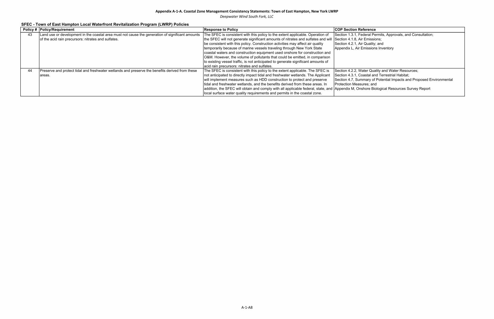
Appendix A‐1‐A. Coastal Zone Management Consistency Statements: Town of East Hampton, New York LWRPDeepwater Wind South Fork, LLC
Policy # Policy/Requirement Response to Policy COP Section ReferenceSFEC - Town of East Hampton Local Waterfront Revitalization Program (LWRP) Policies
43 Land use or development in the coastal area must not cause the generation of significant amounts of the acid rain precursors: nitrates and sulfates.
The SFEC is consistent with this policy to the extent applicable. Operation of the SFEC will not generate significant amounts of nitrates and sulfates and will be consistent with this policy. Construction activities may affect air quality temporarily because of marine vessels traveling through New York State coastal waters and construction equipment used onshore for construction and O&M. However, the volume of pollutants that could be emitted, in comparison to existing vessel traffic, is not anticipated to generate significant amounts of acid rain precursors: nitrates and sulfates.
Section 1.3.1, Federal Permits, Approvals, and Consultation;Section 4.1.8, Air Emissions;Section 4.2.1, Air Quality; andAppendix L, Air Emissions Inventory
44 Preserve and protect tidal and freshwater wetlands and preserve the benefits derived from these areas.
The SFEC is consistent with this policy to the extent applicable. The SFEC is not anticipated to directly impact tidal and freshwater wetlands. The Applicant will implement measures such as HDD construction to protect and preserve tidal and freshwater wetlands, and the benefits derived from these areas. In addition, the SFEC will obtain and comply with all applicable federal, state, and local surface water quality requirements and permits in the coastal zone.
Section 4.2.2, Water Quality and Water Resources; Section 4.3.1, Coastal and Terrestrial Habitat;Section 4.7, Summary of Potential Impacts and Proposed Environmental Protection Measures; andAppendix M, Onshore Biological Resources Survey Report
A‐1‐A8

Appendix A-2

Appendix A‐2. Coastal Zone Management Consistency Statements: Rhode IslandDeepwater Wind South Fork, LLC
SFWF ‐ Rhode Island Ocean Special Area Management Plan (Ocean SAMP) Consistency Review ‐ DRAFTOcean SAMP Section
Number 650‐RICR‐20‐05‐11
Policy/Requirement Old Policy # Response to Policy for SFWF Response to Policy for SFEC COP Section Reference
1160
11.10(B) B.The federal offshore renewable energy leasing process, and subsequent regulation of renewable energy projects located in federal waters, will remain under the jurisdiction of BOEMRE, in consultation and coordination with relevant federal agencies and affected state, local, and tribal officials, as per BOEMRE’s statutory authority at 43 USC 1337(p) and the regulations found at 30 CFR 285.
2 The SFWF is consistent with this policy. The SFWF is located in federal waters and therefore will remain in compliance with BOEMRE policies. The SFWF is also located within the RI Ocean SAMP study area and will comply with federally approved RICRMC enforceable policies.
The SFEC is consistent with this policy. The SFEC is located in federal waters and state waters, and will remain in compliance with BOEMRE policies as well as with New York State Coastal Zone Management policies. The SFEC is also located within the RI Ocean SAMP study area and will comply with federally approved RICRMC enforceable policies.
Section 1.2, Project Purpose; Section 1.3.1, Federal Permits, Approvals, and Consultations; Section 2.0, Project Siting and Route Selection; andSection 3.0, Project Description
1160.111.10.1(A) A. All Offshore Developments regardless of size, including energy projects, which are proposed for or located within
state waters of the Ocean SAMP area, are subject to the policies and standards outlined in Sections 11.9 and 11.10 of this part (except, as noted above, Section 11.9 policies shall not be used for CRMC concurrence or objection for CZMA Federal Consistency reviews). For the purposes of the Ocean SAMP, Offshore Developments are defined as:
1 The SFWF is consistent with this policy. The SFWF is not located within Rhode Island State waters but meets the definition of a large-scale offshore development and is subject to section 11.10 policies.
The SFEC is consistent with this policy. The SFEC is not located within Rhode Island State waters but meets the definition of a large-scale offshore development and is subject to section 11.10 policies.
Section 1.2, Project Purpose; Section 1.3.1, Federal Permits, Approvals, and Consultations; Section 2.0, Project Siting and Route Selection; andSection 3.0, Project Description
11.10.1(A)(1) 1. Large-scale projects, such as: i.
11.10.1(A)(1)(a) a. offshore wind facilities (5 or more turbines within 2 km of each other, or 18 MW power generation); a.
11.10.1(A)(1)(b) b. wave generation devices (2 or more devices, or 18 MW power generation); b.
11.10.1(A)(1)(c) c. instream tidal or ocean current devices (2 or more devices, or 18 MW power generation); and c.
11.10.1(A)(1)(d) d. offshore LNG platforms (1 or more); and d.
11.10.1(A)(1)(e) e. Artificial reefs (1/2 acre footprint and at least 4 feet high), except for projects of a public nature whose primary purpose is habitat enhancement.
e.
11.10.1(A)(1)(f) f. outer continental shelf (OCS) exploration, development, and production plans. N/A
11.10.1(A)(2) 2. Small-scale projects, defined as any projects that are smaller than the above thresholds; ii. This policy is not applicable because the SFWF is not a small-scale project. This policy is not applicable because the SFEC is not a small-scale project.
11.10.1(A)(3) 3. Underwater cables; iii. The SFWF is consistent with this policy. The SFWF includes an inter‐array underwater cable system that connects the WTGs to an offshore substation. Although the SFWF is located in Federal waters, it is also located within the RI Ocean SAMP study area.
The SFEC is consistent with this policy because it includes underwater cables that connects the SFWF to the mainland electric grid. The SFEC-Offshore will be located both in federal waters and New York State waters, as well as within the RI Ocean SAMP study area.
Section 1.2, Project Purpose; Section 1.3.1, Federal Permits, Approvals, and Consultations; Section 2.0, Project Siting and Route Selection; andSection 3.0, Project Description
11.10.1(A)(4) 4. Mining and extraction of minerals, including sand and gravel; iv. This policy is not applicable because the SFWF is an offshore wind farm facility, not a mining and extraction of minerals facility.
This policy is not applicable because the SFEC is a buried export cable, not a mining and extraction of minerals facility.
Not applicable
11.10.1(A)(5) 5. Aquaculture projects of any size, as defined and regulated in Section 00-1.3.1(K) of this chapter; v. This policy is not applicable because the SFWF is an offshore wind farm facility, not an aquaculture project.
This policy is not applicable because the SFEC is a buried export cable, not an aquaculture project. Not applicable
11.10.1(A)(6) 6. Dredging, as defined and regulated in Section 00-1.3.1(I) of this chapter; or vi. This policy is not applicable because the SFWF is an offshore wind farm facility, not a dredging project.
This policy is not applicable because the SFEC is a buried export cable, not a dredging project. Not applicable
11.10.1(A)(7) 7. Other development as defined in subchapter 00 part 1 of this chapter (RICRMP - Red Book) which is located from the mouth of Narragansett Bay seaward, in tidal waters from between 500 feet offshore and the 3-nautical mile, state water boundary.
vii. This policy is not applicable because the SFWF is an offshore wind farm facility, not a development located in Rhode Island coastal tidal waters.
This policy is not applicable because the SFEC is a buried export cable, not a development located in Rhode Island coastal tidal waters.
Not applicable
11.10.1(B) B. In assessing the natural resources and existing human uses present in state waters of the Ocean SAMP area, theCouncil finds that the most suitable area for offshore renewable energy development in the state waters of the Ocean SAMP area is the Renewable Energy Zone depicted in Figure 1 in Section 11.10.1(R) of this part, below. The Council designates this area as Type 4E waters. In the Rhode Island Coastal Resources Management Program these waters were previously designated as Type 4 (or multipurpose) but are hereby modified to show that this is thepreferred site for large scale renewable energy projects in state waters. The Council may approve offshore renewable energy development elsewhere in the Ocean SAMP area, within state waters, where it is determined to have no significant adverse impact on the natural resources or human uses of the Ocean SAMP area. Large-scale Offshore Developments shall avoid areas designated as Areas of Particular Concern consistent with Section 11.10.2of this part. No large-scale offshore renewable energy development shall be allowed in Areas Designated for Preservation consistent with Section 11.10.3 of this part.
2 The SFWF is consistent with this policy. The SFWF is located outside Rhode Island state waters and the Renewable Energy Zone designated by the Council. The SFWF has been sited to avoid areas designated for preservation and avoid, to the extent possible, areas of particular concern. When avoidance is not possible, protection measures will be employed to avoid or minimize impact to any areas of particular concern.
The SFEC is consistent with this policy. The SFEC is located outside Rhode Island state waters and the Renewable Energy Zone designated by the Council. The SFEC has been sited to avoid areas designated for preservation and avoid, to the extent possible, areas of particular concern. When avoidance is not possible, protection measures will be employed to avoid or minimize impact to any areas of particular concern.
Section 1.2, Project Purpose; Section 1.3.1, Federal Permits, Approvals, and Consultations; Section 2.0, Project Siting and Route Selection; andSection 3.0, Project Description
11.10.1( C ) C) Offshore Developments shall not have a significant adverse impact on the natural resources or existing human uses of the Rhode Island coastal zone, as described in the Ocean SAMP. Where the Council determines that impacts on the natural resources or human uses of the Rhode Island coastal zone through the pre-construction, construction, operation, or decommissioning phases of a project constitute significant adverse effects, the Council shall, through its permitting and enforcement authorities in state waters and through any subsequent CZMA federal consistency reviews, require that the applicant modify the proposal to avoid and/or mitigate the impacts or the Council shall deny the proposal.
3 The SFWF is consistent with this policy. The SFWF will not have significant adverse impact on the natural resources or human uses of the RI Ocean SAMP study area. It is expected that current activities will be able to continue post construction.
The SFEC is consistent with this policy. The SFEC will not have significant adverse impact on the natural resources or human uses of the RI Ocean SAMP study area. It is expected that current activities will be able to continue post construction.
Section 1.3.4, Coastal Zone Management Act Consistency;Section 4.3, Biological Resources;Section 4.6, Socioeconomic Resources;Section 4.7, Summary of Potential Impacts and Proposed Environmental Protection Measures; andAppendix A, Coastal Zone Management Federal Consistency Statements
The South Fork Export Cable (SFEC) is consistent with this policy. The SFEC is located in Federal and New York State waters. Portions of the SFEC will be located in Federal waters as well as in the Rhode Island Ocean Special Area Management Plan (Ocean SAMP) study area and meets the definition of an Offshore Development.
Section 1.2, Project Purpose;Section 1.3.1, Federal Permits, Approvals, and Consultations; Section 2.0, Project Siting and Route Selection; andSection 3.0, Project Description
11.10 Regulatory Standards
11.10.1 Overall Regulatory Standards
The SFWF is consistent with this policy because it is meets the definition of an offshore wind facility with 5 or more turbines.
This policy is not applicable because SFEC is a buried export cable, and does not include offshore wind facilities, wave generation devices, instream tidal or ocean current devices, offshore LNG platforms, artificial reefs, or OCS plans.
Section 1.2, Project Purpose; Section 1.3.1, Federal Permits, Approvals, and Consultations; Section 2.0, Project Siting and Route Selection; andSection 3.0, Project Description
11.10 (A) The South Fork Wind Farm (SFWF) is consistent with this policy. The SFWF is located in Federal waters, but also is within the Rhode Island Ocean Special Area Management Plan (Ocean SAMP) study area and meets the definition of an Offshore Development.
A. This section contains all the regulatory standards outlined by the Ocean SAMP. The regulatory standards have been organized according to the following stages: application; design, fabrication and installation; pre-construction; construction and decommissioning and; monitoring. Section 11.10.1 of this part, Overall Regulatory Standards, applies to all stages of development. The regulatory standards contained within all previous chapters of the Ocean SAMP document have been incorporated into this section based upon the applicable stage of development. The “Regulatory Standards” in Section 11.10 of this part are enforceable policies for purposes of the Federal CZMA Federal Consistency provision (16 U.S.C. § 1456 and 15 C.F.R. part 930). For CZMA Federal Consistency purposesthe Regulatory Standards, in addition to other applicable federally approved RICRMP enforceable policies shall be used as the basis for a CRMC CZMA Federal Consistency concurrence or objection.
1
A‐2‐1
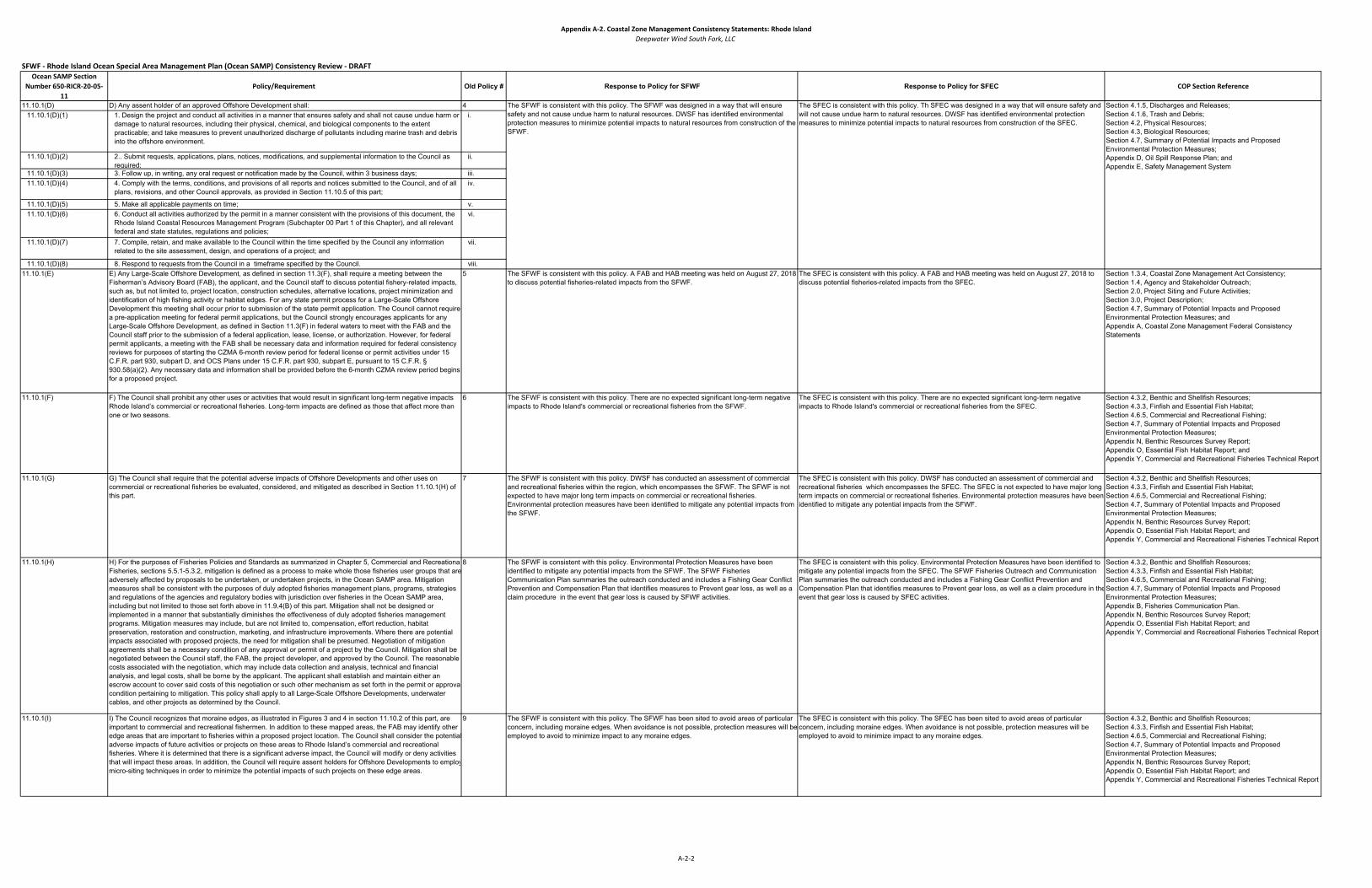
Appendix A‐2. Coastal Zone Management Consistency Statements: Rhode IslandDeepwater Wind South Fork, LLC
SFWF ‐ Rhode Island Ocean Special Area Management Plan (Ocean SAMP) Consistency Review ‐ DRAFTOcean SAMP Section
Number 650‐RICR‐20‐05‐11
Policy/Requirement Old Policy # Response to Policy for SFWF Response to Policy for SFEC COP Section Reference
11.10.1(D) D) Any assent holder of an approved Offshore Development shall: 411.10.1(D)(1) 1. Design the project and conduct all activities in a manner that ensures safety and shall not cause undue harm or
damage to natural resources, including their physical, chemical, and biological components to the extent practicable; and take measures to prevent unauthorized discharge of pollutants including marine trash and debris into the offshore environment.
i.
11.10.1(D)(2) 2.. Submit requests, applications, plans, notices, modifications, and supplemental information to the Council as required;
ii.
11.10.1(D)(3) 3. Follow up, in writing, any oral request or notification made by the Council, within 3 business days; iii.11.10.1(D)(4) 4. Comply with the terms, conditions, and provisions of all reports and notices submitted to the Council, and of all
plans, revisions, and other Council approvals, as provided in Section 11.10.5 of this part;iv.
11.10.1(D)(5) 5. Make all applicable payments on time; v.11.10.1(D)(6) 6. Conduct all activities authorized by the permit in a manner consistent with the provisions of this document, the
Rhode Island Coastal Resources Management Program (Subchapter 00 Part 1 of this Chapter), and all relevant federal and state statutes, regulations and policies;
vi.
11.10.1(D)(7) 7. Compile, retain, and make available to the Council within the time specified by the Council any information related to the site assessment, design, and operations of a project; and
vii.
11.10.1(D)(8) 8. Respond to requests from the Council in a timeframe specified by the Council. viii.11.10.1(E) E) Any Large-Scale Offshore Development, as defined in section 11.3(F), shall require a meeting between the
Fisherman’s Advisory Board (FAB), the applicant, and the Council staff to discuss potential fishery-related impacts, such as, but not limited to, project location, construction schedules, alternative locations, project minimization and identification of high fishing activity or habitat edges. For any state permit process for a Large-Scale Offshore Development this meeting shall occur prior to submission of the state permit application. The Council cannot require a pre-application meeting for federal permit applications, but the Council strongly encourages applicants for any Large-Scale Offshore Development, as defined in Section 11.3(F) in federal waters to meet with the FAB and the Council staff prior to the submission of a federal application, lease, license, or authorization. However, for federal permit applicants, a meeting with the FAB shall be necessary data and information required for federal consistency reviews for purposes of starting the CZMA 6-month review period for federal license or permit activities under 15 C.F.R. part 930, subpart D, and OCS Plans under 15 C.F.R. part 930, subpart E, pursuant to 15 C.F.R. § 930.58(a)(2). Any necessary data and information shall be provided before the 6-month CZMA review period begins for a proposed project.
5 The SFWF is consistent with this policy. A FAB and HAB meeting was held on August 27, 2018 to discuss potential fisheries-related impacts from the SFWF.
The SFEC is consistent with this policy. A FAB and HAB meeting was held on August 27, 2018 to discuss potential fisheries-related impacts from the SFEC.
Section 1.3.4, Coastal Zone Management Act Consistency;Section 1.4, Agency and Stakeholder Outreach;Section 2.0, Project Siting and Future Activities;Section 3.0, Project Description;Section 4.7, Summary of Potential Impacts and Proposed Environmental Protection Measures; andAppendix A, Coastal Zone Management Federal Consistency Statements
11.10.1(F) F) The Council shall prohibit any other uses or activities that would result in significant long-term negative impacts Rhode Island’s commercial or recreational fisheries. Long-term impacts are defined as those that affect more than one or two seasons.
6 The SFWF is consistent with this policy. There are no expected significant long-term negative impacts to Rhode Island's commercial or recreational fisheries from the SFWF.
The SFEC is consistent with this policy. There are no expected significant long-term negative impacts to Rhode Island's commercial or recreational fisheries from the SFEC.
Section 4.3.2, Benthic and Shellfish Resources;Section 4.3.3, Finfish and Essential Fish Habitat;Section 4.6.5, Commercial and Recreational Fishing;Section 4.7, Summary of Potential Impacts and Proposed Environmental Protection Measures;Appendix N, Benthic Resources Survey Report;Appendix O, Essential Fish Habitat Report; andAppendix Y, Commercial and Recreational Fisheries Technical Report
11.10.1(G) G) The Council shall require that the potential adverse impacts of Offshore Developments and other uses on commercial or recreational fisheries be evaluated, considered, and mitigated as described in Section 11.10.1(H) of this part.
7 The SFWF is consistent with this policy. DWSF has conducted an assessment of commercial and recreational fisheries within the region, which encompasses the SFWF. The SFWF is not expected to have major long term impacts on commercial or recreational fisheries. Environmental protection measures have been identified to mitigate any potential impacts from the SFWF.
The SFEC is consistent with this policy. DWSF has conducted an assessment of commercial and recreational fisheries which encompasses the SFEC. The SFEC is not expected to have major long term impacts on commercial or recreational fisheries. Environmental protection measures have been identified to mitigate any potential impacts from the SFWF.
Section 4.3.2, Benthic and Shellfish Resources;Section 4.3.3, Finfish and Essential Fish Habitat;Section 4.6.5, Commercial and Recreational Fishing;Section 4.7, Summary of Potential Impacts and Proposed Environmental Protection Measures;Appendix N, Benthic Resources Survey Report;Appendix O, Essential Fish Habitat Report; andAppendix Y, Commercial and Recreational Fisheries Technical Report
11.10.1(H) H) For the purposes of Fisheries Policies and Standards as summarized in Chapter 5, Commercial and RecreationalFisheries, sections 5.5.1-5.3.2, mitigation is defined as a process to make whole those fisheries user groups that are adversely affected by proposals to be undertaken, or undertaken projects, in the Ocean SAMP area. Mitigation measures shall be consistent with the purposes of duly adopted fisheries management plans, programs, strategies and regulations of the agencies and regulatory bodies with jurisdiction over fisheries in the Ocean SAMP area, including but not limited to those set forth above in 11.9.4(B) of this part. Mitigation shall not be designed or implemented in a manner that substantially diminishes the effectiveness of duly adopted fisheries management programs. Mitigation measures may include, but are not limited to, compensation, effort reduction, habitat preservation, restoration and construction, marketing, and infrastructure improvements. Where there are potential impacts associated with proposed projects, the need for mitigation shall be presumed. Negotiation of mitigation agreements shall be a necessary condition of any approval or permit of a project by the Council. Mitigation shall be negotiated between the Council staff, the FAB, the project developer, and approved by the Council. The reasonable costs associated with the negotiation, which may include data collection and analysis, technical and financial analysis, and legal costs, shall be borne by the applicant. The applicant shall establish and maintain either an escrow account to cover said costs of this negotiation or such other mechanism as set forth in the permit or approvalcondition pertaining to mitigation. This policy shall apply to all Large-Scale Offshore Developments, underwater cables, and other projects as determined by the Council.
8 The SFWF is consistent with this policy. Environmental Protection Measures have been identified to mitigate any potential impacts from the SFWF. The SFWF Fisheries Communication Plan summaries the outreach conducted and includes a Fishing Gear Conflict Prevention and Compensation Plan that identifies measures to Prevent gear loss, as well as a claim procedure in the event that gear loss is caused by SFWF activities.
The SFEC is consistent with this policy. Environmental Protection Measures have been identified to mitigate any potential impacts from the SFEC. The SFWF Fisheries Outreach and Communication Plan summaries the outreach conducted and includes a Fishing Gear Conflict Prevention and Compensation Plan that identifies measures to Prevent gear loss, as well as a claim procedure in theevent that gear loss is caused by SFEC activities.
Section 4.3.2, Benthic and Shellfish Resources;Section 4.3.3, Finfish and Essential Fish Habitat;Section 4.6.5, Commercial and Recreational Fishing;Section 4.7, Summary of Potential Impacts and Proposed Environmental Protection Measures;Appendix B, Fisheries Communication Plan.Appendix N, Benthic Resources Survey Report;Appendix O, Essential Fish Habitat Report; andAppendix Y, Commercial and Recreational Fisheries Technical Report
11.10.1(I) I) The Council recognizes that moraine edges, as illustrated in Figures 3 and 4 in section 11.10.2 of this part, are important to commercial and recreational fishermen. In addition to these mapped areas, the FAB may identify other edge areas that are important to fisheries within a proposed project location. The Council shall consider the potential adverse impacts of future activities or projects on these areas to Rhode Island’s commercial and recreational fisheries. Where it is determined that there is a significant adverse impact, the Council will modify or deny activities that will impact these areas. In addition, the Council will require assent holders for Offshore Developments to employmicro-siting techniques in order to minimize the potential impacts of such projects on these edge areas.
9 The SFWF is consistent with this policy. The SFWF has been sited to avoid areas of particular concern, including moraine edges. When avoidance is not possible, protection measures will beemployed to avoid to minimize impact to any moraine edges.
The SFEC is consistent with this policy. The SFEC has been sited to avoid areas of particular concern, including moraine edges. When avoidance is not possible, protection measures will be employed to avoid to minimize impact to any moraine edges.
Section 4.3.2, Benthic and Shellfish Resources;Section 4.3.3, Finfish and Essential Fish Habitat;Section 4.6.5, Commercial and Recreational Fishing;Section 4.7, Summary of Potential Impacts and Proposed Environmental Protection Measures;Appendix N, Benthic Resources Survey Report;Appendix O, Essential Fish Habitat Report; andAppendix Y, Commercial and Recreational Fisheries Technical Report
Section 4.1.5, Discharges and Releases;Section 4.1.6, Trash and Debris;Section 4.2, Physical Resources;Section 4.3, Biological Resources;Section 4.7, Summary of Potential Impacts and Proposed Environmental Protection Measures;Appendix D, Oil Spill Response Plan; andAppendix E, Safety Management System
The SFWF is consistent with this policy. The SFWF was designed in a way that will ensure safety and not cause undue harm to natural resources. DWSF has identified environmental protection measures to minimize potential impacts to natural resources from construction of the SFWF.
The SFEC is consistent with this policy. Th SFEC was designed in a way that will ensure safety and will not cause undue harm to natural resources. DWSF has identified environmental protection measures to minimize potential impacts to natural resources from construction of the SFEC.
A‐2‐2
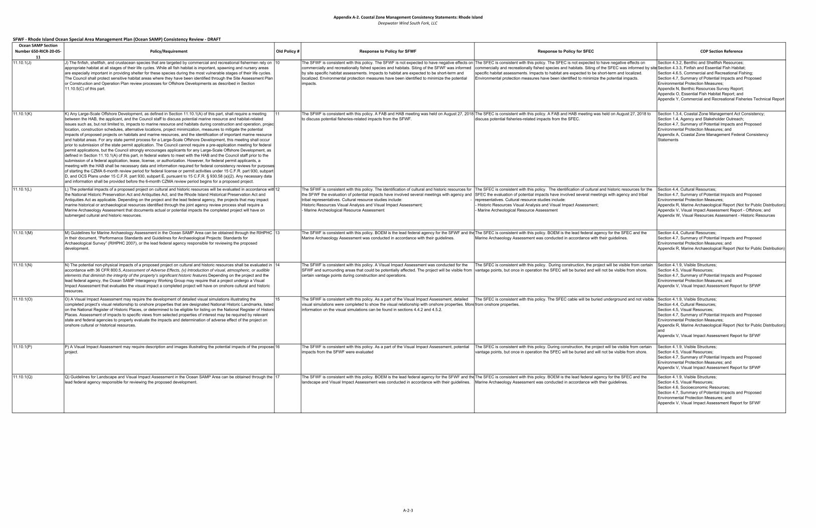
Appendix A‐2. Coastal Zone Management Consistency Statements: Rhode IslandDeepwater Wind South Fork, LLC
SFWF ‐ Rhode Island Ocean Special Area Management Plan (Ocean SAMP) Consistency Review ‐ DRAFTOcean SAMP Section
Number 650‐RICR‐20‐05‐11
Policy/Requirement Old Policy # Response to Policy for SFWF Response to Policy for SFEC COP Section Reference
11.10.1(J) J) The finfish, shellfish, and crustacean species that are targeted by commercial and recreational fishermen rely on appropriate habitat at all stages of their life cycles. While all fish habitat is important, spawning and nursery areas are especially important in providing shelter for these species during the most vulnerable stages of their life cycles. The Council shall protect sensitive habitat areas where they have been identified through the Site Assessment Plan or Construction and Operation Plan review processes for Offshore Developments as described in Section 11.10.5(C) of this part.
10 The SFWF is consistent with this policy. The SFWF is not expected to have negative effects on commercially and recreationally fished species and habitats. Siting of the SFWF was informed by site specific habitat assessments. Impacts to habitat are expected to be short-term and localized. Environmental protection measures have been identified to minimize the potential impacts.
The SFEC is consistent with this policy. The SFEC is not expected to have negative effects on commercially and recreationally fished species and habitats. Siting of the SFEC was informed by site specific habitat assessments. Impacts to habitat are expected to be short-term and localized. Environmental protection measures have been identified to minimize the potential impacts.
Section 4.3.2, Benthic and Shellfish Resources;Section 4.3.3, Finfish and Essential Fish Habitat;Section 4.6.5, Commercial and Recreational Fishing;Section 4.7, Summary of Potential Impacts and Proposed Environmental Protection Measures;Appendix N, Benthic Resources Survey Report;Appendix O, Essential Fish Habitat Report; andAppendix Y, Commercial and Recreational Fisheries Technical Report
11.10.1(K) K) Any Large-Scale Offshore Development, as defined in Section 11.10.1(A) of this part, shall require a meeting between the HAB, the applicant, and the Council staff to discuss potential marine resource and habitat-related issues such as, but not limited to, impacts to marine resource and habitats during construction and operation, projectlocation, construction schedules, alternative locations, project minimization, measures to mitigate the potential impacts of proposed projects on habitats and marine resources, and the identification of important marine resource and habitat areas. For any state permit process for a Large-Scale Offshore Development, this meeting shall occur prior to submission of the state permit application. The Council cannot require a pre-application meeting for federal permit applications, but the Council strongly encourages applicants for any Large-Scale Offshore Development, as defined in Section 11.10.1(A) of this part, in federal waters to meet with the HAB and the Council staff prior to the submission of a federal application, lease, license, or authorization. However, for federal permit applicants, a meeting with the HAB shall be necessary data and information required for federal consistency reviews for purposes of starting the CZMA 6-month review period for federal license or permit activities under 15 C.F.R. part 930, subpart D, and OCS Plans under 15 C.F.R. part 930, subpart E, pursuant to 15 C.F.R. § 930.58 (a)(2). Any necessary data and information shall be provided before the 6-month CZMA review period begins for a proposed project.
11 The SFWF is consistent with this policy. A FAB and HAB meeting was held on August 27, 2018 to discuss potential fisheries-related impacts from the SFWF.
The SFEC is consistent with this policy. A FAB and HAB meeting was held on August 27, 2018 to discuss potential fisheries-related impacts from the SFEC.
Section 1.3.4, Coastal Zone Management Act Consistency;Section 1.4, Agency and Stakeholder Outreach;Section 4.7, Summary of Potential Impacts and Proposed Environmental Protection Measures; andAppendix A, Coastal Zone Management Federal Consistency Statements
11.10.1(L) L) The potential impacts of a proposed project on cultural and historic resources will be evaluated in accordance withthe National Historic Preservation Act and Antiquities Act, and the Rhode Island Historical Preservation Act and Antiquities Act as applicable. Depending on the project and the lead federal agency, the projects that may impact marine historical or archaeological resources identified through the joint agency review process shall require a Marine Archaeology Assessment that documents actual or potential impacts the completed project will have on submerged cultural and historic resources.
12 The SFWF is consistent with this policy. The identification of cultural and historic resources for the SFWF the evaluation of potential impacts have involved several meetings with agency and tribal representatives. Cultural resource studies include: - Historic Resources Visual Analysis and Visual Impact Assessment; - Marine Archeological Resource Assessment
The SFEC is consistent with this policy. The identification of cultural and historic resources for the SFEC the evaluation of potential impacts have involved several meetings with agency and tribal representatives. Cultural resource studies include: - Historic Resources Visual Analysis and Visual Impact Assessment;- Marine Archeological Resource Assessment
Section 4.4, Cultural Resources; Section 4.7, Summary of Potential Impacts and Proposed Environmental Protection Measures;Appendix R, Marine Archaeological Report (Not for Public Distribution);Appendix V, Visual Impact Assessment Report - Offshore; and Appendix W, Visual Resources Assessment - Historic Resources
11.10.1(M) M) Guidelines for Marine Archaeology Assessment in the Ocean SAMP Area can be obtained through the RIHPHC in their document, “Performance Standards and Guidelines for Archaeological Projects: Standards for Archaeological Survey” (RIHPHC 2007), or the lead federal agency responsible for reviewing the proposed development.
13 The SFWF is consistent with this policy. BOEM is the lead federal agency for the SFWF and theMarine Archaeology Assessment was conducted in accordance with their guidelines.
The SFEC is consistent with this policy. BOEM is the lead federal agency for the SFEC and the Marine Archaeology Assessment was conducted in accordance with their guidelines.
Section 4.4, Cultural Resources;Section 4.7, Summary of Potential Impacts and Proposed Environmental Protection Measures; andAppendix R, Marine Archaeological Report (Not for Public Distribution)
11.10.1(N) N) The potential non-physical impacts of a proposed project on cultural and historic resources shall be evaluated inaccordance with 36 CFR 800.5, Assessment of Adverse Effects, (v) Introduction of visual, atmospheric, or audible elements that diminish the integrity of the property’s significant historic features. Depending on the project and the lead federal agency, the Ocean SAMP Interagency Working Group may require that a project undergo a Visual Impact Assessment that evaluates the visual impact a completed project will have on onshore cultural and historic resources.
14 The SFWF is consistent with this policy. A Visual Impact Assessment was conducted for the SFWF and surrounding areas that could be potentially affected. The project will be visible from certain vantage points during construction and operations.
The SFEC is consistent with this policy. During construction, the project will be visible from certain vantage points, but once in operation the SFEC will be buried and will not be visible from shore.
Section 4.1.9, Visible Structures;Section 4.5, Visual Resources;Section 4.7, Summary of Potential Impacts and Proposed Environmental Protection Measures; andAppendix V, Visual Impact Assessment Report for SFWF
11.10.1(O) O) A Visual Impact Assessment may require the development of detailed visual simulations illustrating the completed project’s visual relationship to onshore properties that are designated National Historic Landmarks, listed on the National Register of Historic Places, or determined to be eligible for listing on the National Register of Historic Places. Assessment of impacts to specific views from selected properties of interest may be required by relevant state and federal agencies to properly evaluate the impacts and determination of adverse effect of the project on onshore cultural or historical resources.
15 The SFWF is consistent with this policy. As a part of the Visual Impact Assessment, detailed visual simulations were completed to show the visual relationship with onshore properties. Moreinformation on the visual simulations can be found in sections 4.4.2 and 4.5.2.
The SFEC is consistent with this policy. The SFEC cable will be buried underground and not visible from onshore properties.
Section 4.1.9, Visible Structures;Section 4.4, Cultural Resources;Section 4.5, Visual Resources;Section 4.7, Summary of Potential Impacts and Proposed Environmental Protection Measures;Appendix R, Marine Archaeological Report (Not for Public Distribution);andAppendix V, Visual Impact Assessment Report for SFWF
11.10.1(P) P) A Visual Impact Assessment may require description and images illustrating the potential impacts of the proposedproject.
16 The SFWF is consistent with this policy. As a part of the Visual Impact Assessment, potential impacts from the SFWF were evaluated
The SFEC is consistent with this policy. During construction, the project will be visible from certain vantage points, but once in operation the SFEC will be buried and will not be visible from shore.
Section 4.1.9, Visible Structures;Section 4.5, Visual Resources;Section 4.7, Summary of Potential Impacts and Proposed Environmental Protection Measures; andAppendix V, Visual Impact Assessment Report for SFWF
11.10.1(Q) Q) Guidelines for Landscape and Visual Impact Assessment in the Ocean SAMP Area can be obtained through the lead federal agency responsible for reviewing the proposed development.
17 The SFWF is consistent with this policy. BOEM is the lead federal agency for the SFWF and thelandscape and Visual Impact Assessment was conducted in accordance with their guidelines.
The SFEC is consistent with this policy. BOEM is the lead federal agency for the SFEC and the Marine Archaeology Assessment was conducted in accordance with their guidelines.
Section 4.1.9, Visible Structures;Section 4.5, Visual Resources;Section 4.6, Socioeconomic Resources;Section 4.7, Summary of Potential Impacts and Proposed Environmental Protection Measures; andAppendix V, Visual Impact Assessment Report for SFWF
A‐2‐3

Appendix A‐2. Coastal Zone Management Consistency Statements: Rhode IslandDeepwater Wind South Fork, LLC
SFWF ‐ Rhode Island Ocean Special Area Management Plan (Ocean SAMP) Consistency Review ‐ DRAFTOcean SAMP Section
Number 650‐RICR‐20‐05‐11
Policy/Requirement Old Policy # Response to Policy for SFWF Response to Policy for SFEC COP Section Reference
1160.211.10.2(A) A) Areas of Particular Concern (APCs) have been designated in state waters through the Ocean SAMP process with
the goal of protecting areas that have high conservation value, cultural and historic value, or human use value from Large-Scale Offshore Development. These areas may be limited in their use by a particular regulatory agency (e.g. shipping lanes), or have inherent risk associated with them (e.g. unexploded ordnance locations), or have inherent natural value or value assigned by human interest (e.g. glacial moraines, historic shipwreck sites). Areas of Particular Concern have been designated by reviewing habitat data, cultural and historic features data, and human use data that has been developed and analyzed through the Ocean SAMP process. Currently designated Areas of Particular Concern are based on current knowledge and available datasets; additional Areas of Particular Concern may be identified by the Council in the future as new datasets are made available. Areas of Particular Concern may be elevated to Areas Designated for Preservation in the future if future studies show that Areas of Particular Concern cannot risk even low levels of Large-Scale Offshore Development within these areas. Areas of Particular Concern include:
1 The SFWF is consistent with this policy, as described below. The SFEC is consistent with this policy, as described below. Section 4.2.3, Geological Resources;Section 4.3, Biological Resources;Section 4.4, Cultural Resources;Section 4.5, Visual Resources;Section 4.7, Summary of Potential Impacts and Proposed Environmental Protection Measures;Appendix H, Geophysical and Geotechnical Survey ReportsAppendix N, Benthic Resources Survey Report;Appendix O, Essential Fish Habitat Report;Appendix R, Marine Archaeological Report (Not for Public Distribution);andAppendix V, Visual Impact Assessment Report for SFWF
11.10.2(A)(1) 1. Areas with unique or fragile physical features, or important natural habitats; i. The SFWF is consistent with this policy. Based on benthic and geophysical surveys, the SFWF was sited to avoid fragile physical features or important natural habitats.
The SFEC is consistent with this policy. Based on benthic and geophysical surveys, the SFEC was sited to avoid fragile physical features or important natural habitats.
Section 4.3.1, Coastal and Terrestrial Habitat;Section 4.6.5, Commercial and Recreational Fishing;Section 4.7, Summary of Potential Impacts and Proposed Environmental Protection Measures;Appendix N, Benthic Resources Survey Report;Appendix O, Essential Fish Habitat Report; and Appendix Y, Commercial and Recreational Fisheries Technical Report
11.10.2(A)(2) 2. Areas of high natural productivity; ii. The SFWF is consistent with this policy. Based on fisheries assessment, the SFWF was sited to avoid areas of high natural productivity.
The SFEC is consistent with this policy. Based on fisheries assessment, the SFWF was sited to avoid areas of high natural productivity.
Section 4.3, Biological Resources;Section 4.6.5, Commercial and Recreational Fishing;Section 4.7, Summary of Potential Impacts and Proposed Environmental Protection Measures;Appendix N, Benthic Resources Survey Report;Appendix O, Essential Fish Habitat Report; and Appendix Y, Commercial and Recreational Fisheries Technical Report
11.10.2(A)(3) 3. Areas with features of historical significance or cultural value; iii. The SFWF is consistent with this policy. Based on marine archaeological assessment, the SFWF was sited to avoid areas with features of historical significance or cultural value. Where avoidance is not possible, DWSF has identified environmental protection measures to minimize impacts on these resources, including an Unanticipated Discovery Plan.
The SFEC is consistent with this policy. Based on marine archaeological assessment, the SFEC wassited to avoid areas with features of historical significance or cultural value. Where avoidance is not possible, DWSF has identified environmental protection measures to minimize impacts on these resources, including an Unanticipated Discovery Plan.
Section 4.1.9, Visible Infrastructure;Section 4.4, Cultural Resources;Section 4.5, Visual Resources;Section 4.7, Summary of Potential Impacts and Proposed Environmental Protection Measures;Appendix R, Marine Archaeological Report (Not for Public Distribution);andAppendix V, Visual Impact Assessment Report for SFWF
11.10.2(A)(4) 4. Areas of substantial recreational value; iv. The SFWF is consistent with this policy. The SFWF is not located in an area that has substantial recreational value.
The SFEC is consistent with this policy. The SFEC is not located in an area that has substantial recreational value.
Section 4.6.4, Recreation and Tourism;Section 4.6.5, Commercial and Recreational Fishing;Section 4.6.7, Coastal Land Use and Infrastructure;Section 4.6.8, Other Marine Uses;Section 4.7, Summary of Potential Impacts and Proposed Environmental Management Measures; and Appendix Y, Commercial and Recreational Fisheries Technical Report
11.10.2(A)(5) 5. Areas important for navigation, transportation, military and other human uses; and v The SFWF is consistent with this policy. The SFWF was sited to avoid areas that are important to navigation, transportation, military and other uses.
The SFEC is consistent with this policy. The SFEC was sited to avoid areas that are important to navigation, transportation, military and other uses.
Section 4.6.6, Commercial Shipping;Section 4.6.7, Coastal Land Use and Infrastructure;Section 4.6.8, Other Marine Uses;Section 4.7, Summary of Potential Impacts and Proposed Environmental Protection Measures; andAppendix X, Navigational Safety Risk Assessment Report
11.10.2(A)(6) 6. Areas of high fishing activity. vi. The SFWF is consistent with this policy. Based on fisheries assessment, the SFWF is not sited in an area of high fishing activity.
The SFEC is consistent with this policy. Based on fisheries assessment, the SFEC is not sited in an area of high fishing activity.
Section 4.6.5, Commercial and Recreational Fishing;Section 4.7, Summary of Potential Impacts and Proposed Environmental Protection Measures; andAppendix Y, Commercial and Recreational Fisheries Technical Report;
11.10.2(B) B) The Council has designated the areas listed below in section 11.10.2(C) of this part in state waters as Areas of Particular Concern. All Large-scale, Small-scale, or other offshore development, or any portion of a proposed project, shall be presumptively excluded from APCs. This exclusion is rebuttable if the applicant can demonstrate by clear and convincing evidence that there are no practicable alternatives that are less damaging in areas outside of the APC, or that the proposed project will not result in a significant alteration to the values and resources of the APCWhen evaluating a project proposal, the Council shall not consider cost as a factor when determining whether practicable alternatives exist. Applicants which successfully demonstrate that the presumptive exclusion does not apply to a proposed project because there are no practicable alternatives that are less damaging in areas outside of the APC must also demonstrate that all feasible efforts have been made to avoid damage to APC resources and values and that there will be no significant alteration of the APC resources or values. Applicants successfully demonstrating that the presumptive exclusion does not apply because the proposed project will not result in a significant alteration to the values and resources of the APC must also demonstrate that all feasible efforts have been made to avoid damage to the APC resources and values. The Council may require a successful applicant to provide a mitigation plan that protects the ecosystem. The Council will permit underwater cables, only in certain categories of Areas of Particular Concern, as determined by the Council in coordination with the Joint Agency Working Group. The maps listed below in section 11.10.2( C) of this part. depicting Areas of Particular Concern may be superseded by more detailed, site-specific maps created with finer resolution data.
2 The SFWF is consistent with this policy. The SFWF is located in federal waters, but within the RI Ocean SAMP study area, and was sited to avoid Areas of Particular Concern. When avoidance is not possible, protection measures will be employed to avoid or minimize impacts to Areas of Particular Concern.
The SFEC is consistent with this policy. The SFEC is located in federal waters, but within the RI Ocean SAMP study area, and was sited to avoid Areas of Particular Concern. When avoidance is not possible, protection measures will be employed to avoid or minimize impacts to Areas of Particular Concern.
Section 1.2, Project Purpose;Section 1.3.1, Federal Permits, Approvals, and Consultations; Section 4.2.3, Geological Resources;Section 3.0, Project Description; and Appendix H, Geophysical and Geotechnical Survey Reports
11.10.2 Areas of Particular Concern
A‐2‐4

Appendix A‐2. Coastal Zone Management Consistency Statements: Rhode IslandDeepwater Wind South Fork, LLC
SFWF ‐ Rhode Island Ocean Special Area Management Plan (Ocean SAMP) Consistency Review ‐ DRAFTOcean SAMP Section
Number 650‐RICR‐20‐05‐11
Policy/Requirement Old Policy # Response to Policy for SFWF Response to Policy for SFEC COP Section Reference
11.10.2( C) C) Areas of particular concern that have been identified in the Ocean SAMP area in state waters are described as follows.
3 The SFWF is consistent with this policy. The SFEC is consistent with this policy. Section 1.2, Project Purpose; andSection 1.3.1, Federal Permits, Approvals, and Consultations
11.10.2( C)(1) 1. Historic shipwrecks, archaeological or historical sites and their buffers as described in Chapter 4, Cultural and Historic Resources, section 440.1.1 through 440.1.4, are Areas of Particular Concern. For the latest list of these sites and their locations please refer to the Rhode Island State Historic Preservation and Heritage Commission.
i. The SFWF is consistent with this policy. DWSF analyzed the shipwreck data provided by Rhode Island and there are none located within the SFWF area.
The SFEC is consistent with this policy. DWSF analyzed the shipwreck data provided by Rhode Island and there are none located along the SFEC route.
Section 4.4, Cultural Resources;Section 4.4.2, Marine Archaeological Resources;Section 4.7, Summary of Potential Impacts and Proposed Environmental Protection Measures; andAppendix R, Marine Archaeological Report (Not for Public Distribution)
11.10.2( C)(2) 2. Offshore dive sites within the Ocean SAMP area, as shown in Figure 2 in Section 11.10.2 of this part are designated Areas of Particular Concern. The Council recognizes that offshore dive sites, most of which are shipwrecks, are valuable recreational and cultural ocean assets and are important to sustaining Rhode Island’s recreation and tourism economy.
ii. The SFWF is consistent with this policy. There are no offshore dive sites of significance in the SFWF area.
The SFEC is consistent with this policy. There are no offshore dive sites of significance in the SFEC area.
Section 4.6.4, Recreation and Tourism;Section 4.6.8, Other Marine Uses;Section 4.7, Summary of Potential Impacts and Proposed Environmental Protection Measures; andAppendix X, Navigational Risk Assessment
11.10.2( C)(3) 3. Glacial moraines are important habitat areas for a diversity of fish and other marine plants and animals because of their relative structural permanence and structural complexity. Glacial moraines create a unique bottom topography that allows for habitat diversity and complexity, which allows for species diversity in these areas and creates environments that exhibit some of the highest biodiversity within the entire Ocean SAMP area. The Council also recognizes that because glacial moraines contain valuable habitats for fish and other marine life, they are also important to commercial and recreational fishermen. Accordingly, the Council shall designate glacial moraines as identified in Figure 3 and Figure 4 in section 11.10.2 of this part as Areas of Particular Concern.
iii. The SFWF is consistent with this policy. The SFWF has been sited to avoid areas of particular concern. When avoidance is not possible, protection measures will be employed to avoid to minimize impact to glacial moraines.
The SFEC is consistent with this policy. The SFEC has been sited to avoid areas of particular concern. When avoidance is not possible, protection measures will be employed to avoid to minimizeimpact to glacial moraines.
Section 4.2.3, Geological Resources;Section 4.2.4, Physical Oceanography and Meteorology; Section 4.7, Summary of Potential Impacts and Proposed Environmental Protection Measures; and Appendix H, Geophysical and Geotechnical Survey Reports
11.10.2( C)(4) 4. Navigation, Military, and Infrastructure areas including: designated shipping lanes, precautionary areas, recommended vessel routes, ferry routes, dredge disposal sites, military testing areas, unexploded ordnance, pilot boarding areas, anchorages, and a coastal buffer of 1 km as depicted in Figure 5 in section 11.10.2 of this part are designated as Areas of Particular Concern. The Council recognizes the importance of these areas to marine transportation, navigation and other activities in the Ocean SAMP area.
iv. The SFWF is consistent with this policy. DWSF analyzed navigation, military, and infrastructure areas, and there are no precautionary areas, ferry routes, dredge disposal sites, military testing areas, unexploded ordnance, pilot boarding areas, anchorages, or coastal buffers located in the SFWF area. There may be designated shipping lanes or recommended vessel routes in the future.
The SFEC is consistent with this policy. DWSF analyzed navigation, military, and infrastructure areas, and there are no precautionary areas, ferry routes, dredge disposal sites, military testing areas, unexploded ordnance, pilot boarding areas, anchorages, or coastal buffers located in the SFEC area. There may be designated shipping lanes or recommended vessel routes in the future.
Section 4.6.8, Other Marine Uses;Section 4.7, Summary of Potential Impacts and Proposed Environmental Protection Measures; andAppendix X, Navigational Safety Risk Assessment Report
11.10.2( C)(5) 5. Areas of high fishing activity as identified during the pre-application process by the Fishermen’s Advisory Board, as defined in section 11.3(E) of this part, may be designated by the Council as Areas of Particular Concern.
v. The SFWF is consistent with this policy. The SFWF has been sited to avoid Areas of high fishing activity. The SFWF is not expected to have major long-term impacts on fishing it is expected that fishing will continue after the SFWF construction.
The SFEC is consistent with this policy. The SFEC has been sited to avoid Areas of high fishing activity. The SFEC is not expected to have major long-term impacts on fishing it is expected that fishing will continue after the SFEC construction.
Section 4.6.5, Commercial and Recreational Fishing;Section 4.7, Summary of Potential Impacts and Proposed Environmental Protection Measures; and Appendix Y, Commercial and Recreational Fisheries Technical Report
11.10.2( C)(6) 6. Several heavily-used recreational boating and sailboat racing areas, as shown in Figure 6 in section 11.10.2 of this part, are designated as Areas of Particular Concern. The Council recognizes that organized recreational boating and sailboat racing activities are concentrated in these particular areas, which are therefore important to sustaining Rhode Island’s recreation and tourism economy.
vi. The SFWF is consistent with this policy. The SFWF is not located in a heavily-used recreational boating and sailboat racing areas as shown in Figure 6 of the RI SAMP.
The SFEC is consistent with this policy. The SFEC is not located in a heavily-used recreational boating and sailboat racing areas as shown in Figure 6 of the RI SAMP.
Section 4.6.4, Recreation and Tourism;Section 4.6.5, Commercial and Recreational Fishing;Section 4.7, Summary of Potential Impacts and Proposed Environmental Protection Measures; and Appendix Y, Commercial and Recreational Fisheries Technical Report
11.10.2( C)(7) 7. Naval Fleet Submarine Transit Lane, as described in Chapter 7, Marine Transportation, Navigation, and Infrastructure section 720.7, are designated as Areas of Particular Concern.
vii. The SFWF is consistent with this policy. The SFWF is not located in a Naval Fleet Submarine Transit Lane.
The SFEC is consistent with this policy. The SFEC is not located in a Naval Fleet Submarine Transit Lane.
Section 4.6.8, Other Marine Uses;Section 4.7, Summary of Potential Impacts and Proposed Environmental Protection Measures; andAppendix X, Navigational Safety Risk Assessment Report
11.10.2( C)(8) 8. Other Areas of Particular Concern may be identified during the pre-application review by state and federal agencies as areas of importance.
viii. The SFWF is consistent with this policy. DWSF recognizes that other Areas of Particular concern may be identified during the pre-application review.
The SFEC is consistent with this policy. DWSF recognizes that other Areas of Particular concern may be identified during the pre-application review.
Section 4.6.8, Other Marine Uses;Section 4.7, Summary of Potential Impacts and Proposed Environmental Protection Measures; andAppendix X, Navigational Safety Risk Assessment Report
11.10.2(D) D) Developers proposing projects for within the Renewable Energy Zone as described in section 11.10.1(B) of this part shall adhere to the requirements outlined in 11.10.2 of this part regarding Areas of Particular Concern in state waters, including any Areas of Particular Concern that overlap the Renewable Energy Zone (see Figure 7 in section 11.10.2 of this part).
4 This policy is not applicable because the SFWF is not located within Rhode Island State waters. This policy is not applicable because the SFEC is not located within Rhode Island State waters. Not applicable
1160.311.10.3(A) A) Areas Designated for Preservation are designated in the Ocean SAMP area in state waters for the purpose of
preserving them for their ecological value. Areas Designated for Preservation were identified by reviewing habitat and other ecological data and findings that have resulted from the Ocean SAMP process. Areas Designated for Preservation are afforded additional protection than Areas of Particular Concern (see section 11.10.2 of this part) because of scientific evidence indicating that Large-Scale Offshore Development in these areas may result in significant habitat loss. The areas listed in Section 11.10.3 are designated as Areas Designated for Preservation. The Council shall prohibit any Large-Scale Offshore Development, mining and extraction of minerals, or other development that has been found to be in conflict with the intent and purpose of an Area Designated for Preservation. Underwater cables are exempt from this prohibition. Areas designated for preservation include:
1 This policy is not applicable because the SFWF is located in federal waters, outside state waters, and is therefore not located in any Areas Designated for Preservation.
This policy is not applicable because the SFEC is located in federal waters, outside state waters, andis therefore not located in any Areas Designated for Preservation.
Not applicable
11.10.3(A)(1) 1. Ocean SAMP sea duck foraging habitat in water depths less than or equal to 20 meters [65.6 feet] (as shown in Figure 8 in section 11.10.2 of this part) is designated as an Area Designated for Preservation due to their ecological value and the significant role these foraging habitats play to avian species, and existing evidence suggesting the potential for permanent habitat loss as a result of offshore wind energy development. The current research regarding sea duck foraging areas indicates that this habitat is depth limited and generally contained within the 20 meter depth contour. It is likely there are discreet areas within this region that are prime feeding areas, however at present there is no long-term data set that will allow this determination. Thus, the entire area within the 20 meter contour is being protected as an Area Designated for Preservation until further research allows the Council and other agencies to make a more refined determination.
i. This policy is not applicable because the SFWF is not located in any Areas Designated for Preservation or Ocean SAMP sea duck foraging habitat.
This policy is not applicable because the SFEC is not located in any Areas Designated for Preservation or Ocean SAMP sea duck foraging habitat.
Not applicable
11.10.3(A)(2) 2. The mining and extraction of minerals, including sand and gravel, from tidal waters and salt ponds is prohibited. This prohibition does not apply to dredging for navigation purposes, channel maintenance, habitat restoration, or beach replenishment for public purposes.
2 This policy is not applicable because the SFWF is an offshore wind farm facility, not a mining and extraction of minerals facility.
This policy is not applicable because the SFEC is a buried export cable that will interconnect the SFWF with the SFEC - Onshore substation, not a mining and extraction of minerals facility.
Not applicable
11.10.3 Prohibitions and Areas Designated for Preservations
A‐2‐5

Appendix A‐2. Coastal Zone Management Consistency Statements: Rhode IslandDeepwater Wind South Fork, LLC
SFWF ‐ Rhode Island Ocean Special Area Management Plan (Ocean SAMP) Consistency Review ‐ DRAFTOcean SAMP Section
Number 650‐RICR‐20‐05‐11
Policy/Requirement Old Policy # Response to Policy for SFWF Response to Policy for SFEC COP Section Reference
11.10.3(A)(3) 3. The Council shall prohibit any Offshore Development in areas identified as Critical Habitat under the Endangered Species Act.
3 The SFWF is consistent with this policy. The SFWF is not located within any critical habitat areas.
The SFEC is consistent with this policy. The SFEC is not located within any critical habitat areas. Section 4.3, Biological Resources;Section 4.6.5, Commercial and Recreational Fishing;Section 4.7, Summary of Potential Impacts and Proposed Environmental Protection Measures;Appendix N, Benthic Resources Survey Report;Appendix O, Essential Fish Habitat Report; and Appendix Y, Commercial and Recreational Fisheries Technical Report
11.10.3(A)(4) 4. Dredged material disposal, as defined and regulated in Section 00-1.3.1(I) of this chapter, is further limited in theOcean SAMP area by the prohibition of dredged material disposal in the following Areas of Particular Concern as defined in section 11.10.2 of this part: historic shipwrecks, archaeological, or historic sites; offshore dive sites; navigation, military, and infrastructure areas; and moraines. Beneficial reuse may be allowed in Areas Designated for Preservation, whereas all other dredged material disposal is prohibited in those areas. All disposal of dredged material will be conducted in accordance with the U.S. EPA and U.S. Army Corps of Engineers’ manual, Evaluation of Dredged Material Proposed for Ocean Disposal.
4 This policy is not applicable because the SFWF is an offshore wind farm facility, not a dredging project.
This policy is not applicable because the SFEC is a buried export cable not a dredging project. Not applicable
1160.411.10.4(A) A) Large-scale projects or other development which is found to be a hazard to commercial navigation shall avoid
areas of high intensity commercial marine traffic in state waters. Avoidance shall be the primary goal of these areas. Areas of High Intensity Commercial Marine Traffic are defined as having 50 or more vessel counts within a 1 km by 1 km grid, as in Figure 9 in Section 11.10.2 of this part.
1 The SFWF is consistent with this policy. The SFWF is not located in the areas of high traffic as described in Figure 9 of the SAMP.
The SFEC is consistent with this policy. The SFEC will be buried and therefore not a hazard to commercial navigation.
Section 4.6.8, Other Marine Uses; andAppendix X, Navigational Safety Risk Assessment Report
1160.511.10.5(A) A) For the purposes of this document, the phrase “‘necessary data and information’” shall refer to the necessary
data and information required for federal consistency reviews for purposes of starting the Coastal Zone ManagementAct (CZMA) 6-month review period for federal license or permit activities under 15 C.F.R. part 930, subpart D, and OCS Plans under 15 C.F.R. part 930, subpart E, pursuant to 15 C.F.R. § 930.58(a)(2). Any necessary data and information shall be provided before the 6-month CZMA review period begins for a proposed project. It should be noted that other federal and state agencies may require other types of data or information as part of their review processes.
1 The SFWF is consistent with this policy. All necessary data and information will be provided to start the 6 month review period.
The SFEC is consistent with this policy. All necessary data and information will be provided to start the 6 month review period.
Section 1.3.4, Coastal Zone Management Act Consistency;Section 1.4, Agency and Stakeholder Outreach; andAppendix A, Coastal Zone Management Federal Consistency Statements
11.10.5(B) B) For the purposes of this document, the following terms shall be defined as: 211.10.5(B)(1) 1. A Site Assessment Plan (SAP) is defined as a pre-application plan that describes the activities and studies the
applicant plans to perform for the characterization of the project site.i. The SAP for lease OCS-A-0486 was developed and approved by BOEM in October 2017. The
CRMC issued concurrence for file # 2017-09-034 on September 8, 2017The SAP for lease OCS-A-0486 was approved by BOEM in October 2017. The CRMC issued concurrence for file # 2017-09-034 on September 8, 2017
Not Applicable
11.10.5(B)(2) 2. A Construction and Operations Plan (COP) is defined as a plan that describes the applicant’s construction, operations, and conceptual decommissioning plans for a proposed facility, including the applicant’s project easement area.
ii. The COP for the SFWF was submitted to BOEM in July 2018 and is under review. The COP for the SFEC was submitted to BOEM in July 2018 and is under review. Section 1.2, Project Purpose;Section 1.3.1, Federal Permits, Approvals, and Consultations; andSection 3.0, Project Description
11.10.5(B)(3) 3. A Certified Verification Agent (CVA) is defined as an independent third-party agent that shall use good engineering judgment and practices in conducting an independent assessment of the design, fabrication and installation of the facility. The CVA shall have licensed and qualified Professional Engineers on staff
iii. The CVA nomination was submitted with the COP and will be approved by BOEM. The CVA nomination was submitted with the COP and will be approved by BOEM. Section 1.5.3, Certified Verification Agency Nominations
11.10.5( C) C) Prior to construction, the following sections shall be considered necessary data and information and shall be required by the Council:
3
11.10.5( C)(1) 1. Site Assessment Plan – A SAP is a pre-application plan that describes the activities and studies (e.g. installation of meteorological towers, meteorological buoys) the applicant plans to perform for the characterization of the project site. Within the Renewable Energy Zone, if an applicant applies within 2 years of CRMC’s adoption of the Ocean Special Area Management Plan they may elect to combine the SAP and Construction and Operation Plan (COP) phase, but only within the renewable energy zone and only for 2 years after the adoption date. If an applicant elects to combine these two phases all requirements shall stilbe met. The SAP shall describe how the applicant shall conduct the resource assessment (e.g., meteorological and oceanographic data collection) or technology testing activities. The applicant shall receive the approval of the SAP by the Council. For projects within Type 4E waters (depicted in Figure 1 in section 11.10.1 of this part), pre-construction data requirements may incorporate data generated by the Ocean SAMP provided the data was collected within 2 years of the date of application, or where the Ocean SAMP data is determined to be current enough to meet the requirements of the Council in coordination with the Joint Agency Working Group. The applicant shall reference information and data discussed in the Ocean SAMP (including appendices and technical reports) in their SAP.
i. The SAP for lease OCS-A-0486 was developed and approved by BOEM in October 2017. The CRMC issued concurrence for file # 2017-09-034 on September 8, 2017
The SAP for lease OCS-A-0486 was approved by BOEM in October 2017. The CRMC issued concurrence for file # 2017-09-034 on September 8, 2017
See CRMC concurrence issued for file # 2017-09-034 on September 8, 2017.
11.10.5( C)(1)(a) a. The applicant’s SAP shall include data from: i.11.10.5( C)(1)(a)(1) 1. Physical characterization surveys (e.g., geological and geophysical surveys or hazards surveys); and 111.10.5( C)(1)(a)(2) 2. Baseline environmental surveys (e.g., biological or archaeological surveys). 2
11.10.5( C)(1)(b) b. The SAP shall demonstrate that the applicant has planned and is prepared to conduct the proposed site assessment activities in a manner that conforms to the applicant’s responsibilities listed above in section 11.10.1(E) of this part:
ii.
11.10.5( C)(1)(b)(1) 1. Conforms to all applicable laws, regulations; 111.10.5( C)(1)(b)(2) 2. Is safe; 211.10.5( C)(1)(b)(3) 3. Does not unreasonably interfere with other existing uses of the state waters, 311.10.5( C)(1)(b)(4) 4. Does not cause undue harm or damage to natural resources; life (including human and wildlife); the marine,
coastal, or human environment; or sites, structures, or direct harm to objects of historical or archaeological significance;
4
11.10.5( C)(1)(b)(5) 5. Uses best available and safest technology; 511.10.5( C)(1)(b)(6) 6. Uses best management practices; and 611.10.5( C)(1)(b)(7) 7. Uses properly trained personnel. 7
11.10.5( C)(1)( c) c. The applicant shall also demonstrate that the site assessment activities shall collect the necessary data and information required for the applicant’s COP, as described below in section 11.10.5( C)(2) of this part.
iii.
11.10.5( C)(1)(d) d. The applicant’s SAP shall include the information described in Table 1, as applicable. iv.
11.10.4 Other Areas
See CRMC concurrence issued for file # 2017-09-034 on September 8, 2017.
The SAP for lease OCS-A-0486 was developed and approved by BOEM in October 2017. The CRMC issued concurrence for file # 2017-09-034 on September 8, 2017
See CRMC concurrence issued for file # 2017-09-034 on September 8, 2017.
11.10.5 Application Requirements
The SAP for lease OCS-A-0486 was developed and approved by BOEM in October 2017. The CRMC issued concurrence for file # 2017-09-034 on September 8, 2017
The SAP for lease OCS-A-0486 was approved by BOEM in October 2017. The CRMC issued concurrence for file # 2017-09-034 on September 8, 2017
The SAP for lease OCS-A-0486 was approved by BOEM in October 2017. The CRMC issued concurrence for file # 2017-09-034 on September 8, 2017
A‐2‐6

Appendix A‐2. Coastal Zone Management Consistency Statements: Rhode IslandDeepwater Wind South Fork, LLC
SFWF ‐ Rhode Island Ocean Special Area Management Plan (Ocean SAMP) Consistency Review ‐ DRAFTOcean SAMP Section
Number 650‐RICR‐20‐05‐11
Policy/Requirement Old Policy # Response to Policy for SFWF Response to Policy for SFEC COP Section Reference
Table 1 Table 1: Contents of a site assessment plan Table 11.111.10.5( C)(1)(d)(1) (1) Contact Information. The name, address, e-mail address, and phone number of an authorized
representative.(1)
11.10.5( C)(1)(d)(2) (2) The site assessment or technology testing concept. A discussion of the objectives; description of the proposed activities, including the technology to be used; and proposed schedule from start to completion.
(2)
11.10.5( C)(1)(d)(4) (4) Stipulations and compliance. A description of the measures the applicant took, or shall take, to satisfy the conditions of any permit stipulations related to the applicant’s proposed activities.
(4)
11.10.5( C)(1)(d)(5) (5) A location. The surface location and water depth for all proposed and existing structures, facilities, and appurtenances located both offshore and onshore.
(5)
11.10.5( C)(1)(d)(6) (6) General structural and project design, fabrication, and installation. Information for each type of facility associated with the applicant’s project.
(6)
11.10.5( C)(1)(d)(7) (7) Deployment activities. A description of the safety, prevention, and environmental protection features or measures that the applicant will use.
(7)
11.10.5( C)(1)(d)(8) (8) The applicant's proposed measures for avoiding, minimizing, reducing, eliminating, and monitoring environmental impacts. A description of the measures the applicant shall take to avoid or minimize adverse effects and any potential incidental take, before the applicant conducts activities on the project site, and how the applicant shall mitigate environmental impacts from proposed activities, including a description of the measures to be used.
(8)
11.10.5( C)(1)(d)(9) (9) Reference information. Any document or published sources that the applicant information and data discussed in the Ocean SAMP (including appendices and technical reports), other plans referenced in the Ocean SAMP, and other plans previously submitted by the applicant or that are otherwise readily available to the Council.
(9)
11.10.5( C)(1)(d)(10) (10) Decommissioning and site clearance procedures. A discussion of methodologies. (10)
11.10.5( C)(1)(d)(11) (11) Air quality information. Information required for the Clean Air Act (42 U.S.C. 7409) and implementing regulations.
(11)
11.10.5( C)(1)(d)(12) (12) A listing of all Federal, State, and local authorizations or approvals required to conduct site assessment activities on the project site. A statement indicating whether such authorization or approval has been applied
(12)
11.10.5( C)(1)(d)(13) (13) A list of agencies or persons with whom the applicant has communicated, or will communicate, regardingpotential impacts associated with the proposed activities. Contact information and issues discussed.
(13)
11.10.5( C)(1)(d)(14) (14) Financial assurance information. Statements attesting that the activities and facilities proposed in the applicant’s SAP are or shall be covered by an appropriate performance bond or other Council approved
(14)
11.10.5( C)(1)(d)(15) (15) Other information. Additional information as requested by the Council in coordination with the JointAgency Working Group.
(15)
11.10.5( C)(1)(e) e. The applicant’s SAP shall provide the results of geophysical and geological surveys, hazards surveys, archaeological surveys (as required by the Council in coordination with the Joint Agency Working Group), and biological surveys outlined in Table 2 (with the supporting data) in the applicant’s SAP:
v.
Table 2 Table 2: Necessary data and information to be provided in the site assessment plan Table 11.211.10.5( C)(1)(e)(1) (1) Geotechnical. (1)11.10.5( C)(1)(e)(2) (2) Shallow hazards. (2)11.10.5( C)(1)(e)(3) (3) Archaeological resources. (3)11.10.5( C)(1)(e)(4) (4) Geological survey. (4)11.10.5( C)(1)(e)(5) (5) Biological survey. (5)11.10.5( C)(1)(e)(6) (6) Fish and Fisheries Survey (6)
11.10.5( C)(1)(f) f. The applicant shall submit a SAP that describes those resources, conditions, and activities listed in Table 3 that could be affected by the applicant’s proposed activities, or that could affect the activities proposed in the applicant’s SAP, including but not limited to:
vi.
Table 3 Table 3: Resource data and uses that shall be described in the site assessment plan Table 11.1311.10.5( C)(1)(f)(1) (1) Hazard information. (1)11.10.5( C)(1)(f)(2) (2) Water quality (2)11.10.5( C)(1)(f)(3) (3) Biological resources. (3)11.10.5( C)(1)(f)(4) (4) Threatened or endangered species. (4)11.10.5( C)(1)(f)(5) (5) Sensitive biological resources or habitats. (5)11.10.5( C)(1)(f)(6) (6) Archaeological and visual resources. (6)11.10.5( C)(1)(f)(7) (7) Social and economic resources. (7)11.10.5( C)(1)(f)(8) (8) Fisheries Resources and Uses (8)11.10.5( C)(1)(f)(9) (9) Coastal and marine uses. (9)
11.10.5( C)(1)(g) g. The Council shall review the applicant’s SAP in conjunction with the Joint Agency Working Group to determineif it contains the information necessary to conduct technical and environmental reviews and shall notify the applicant if the SAP lacks any necessary information.
vii. The SAP for lease OCS-A-0486 was developed and approved by BOEM in October 2017. The CRMC issued concurrence for file # 2017-09-034 on September 8, 2017
The SAP for lease OCS-A-0486 was approved by BOEM in October 2017. The CRMC issued concurrence for file # 2017-09-034 on September 8, 2017
See CRMC concurrence issued for file # 2017-09-034 on September 8, 2017.
11.10.5( C)(1)(h) h. As appropriate, the Council shall coordinate and consult with relevant Federal and State agencies, and affected Indian tribes.
viii. The SAP for lease OCS-A-0486 was developed and approved by BOEM in October 2017. The CRMC issued concurrence for file # 2017-09-034 on September 8, 2017
The SAP for lease OCS-A-0486 was approved by BOEM in October 2017. The CRMC issued concurrence for file # 2017-09-034 on September 8, 2017
See CRMC concurrence issued for file # 2017-09-034 on September 8, 2017.
11.10.5( C)(1)(i) i. Any Large-Scale Offshore Development, as defined above in section 11.10.1(A) of this part, shall require a pre-application meeting between the FAB, the applicant, and the Council staff to discuss potential fishery-related impacts, such as, but not limited to, project location, construction schedules, alternative locations, and project minimization. During the pre-application meeting for a Large-Scale Offshore Development, the FAB can also identify areas of high fishing activity or habitat edges to be considered during the review process
ix. The SAP for lease OCS-A-0486 was developed and approved by BOEM in October 2017. The CRMC issued concurrence for file # 2017-09-034 on September 8, 2017
The SAP for lease OCS-A-0486 was approved by BOEM in October 2017. The CRMC issued concurrence for file # 2017-09-034 on September 8, 2017
See CRMC concurrence issued for file # 2017-09-034 on September 8, 2017.
11.10.5( C)(1)(j) j. During the review process, the Council may request additional information if it is determined that the information provided is not sufficient to complete the review and approval process.
x. The SAP for lease OCS-A-0486 was developed and approved by BOEM in October 2017. The CRMC issued concurrence for file # 2017-09-034 on September 8, 2017
The SAP for lease OCS-A-0486 was approved by BOEM in October 2017. The CRMC issued concurrence for file # 2017-09-034 on September 8, 2017
See CRMC concurrence issued for file # 2017-09-034 on September 8, 2017.
11.10.5( C)(1)(k) k. Once the SAP is approved by the Council the applicant may begin conducting the activities approved in theSAP.
xi. The SAP for lease OCS-A-0486 was developed and approved by BOEM in October 2017. The CRMC issued concurrence for file # 2017-09-034 on September 8, 2017
The SAP for lease OCS-A-0486 was approved by BOEM in October 2017. The CRMC issued concurrence for file # 2017-09-034 on September 8, 2017
See CRMC concurrence issued for file # 2017-09-034 on September 8, 2017.
See CRMC concurrence issued for file # 2017-09-034 on September 8, 2017.
See CRMC concurrence issued for file # 2017-09-034 on September 8, 2017.
See CRMC concurrence issued for file # 2017-09-034 on September 8, 2017.
The SAP for lease OCS-A-0486 was developed and approved by BOEM in October 2017. The CRMC issued concurrence for file # 2017-09-034 on September 8, 2017
The SAP for lease OCS-A-0486 was approved by BOEM in October 2017. The CRMC issued concurrence for file # 2017-09-034 on September 8, 2017
The SAP for lease OCS-A-0486 was developed and approved by BOEM in October 2017. The CRMC issued concurrence for file # 2017-09-034 on September 8, 2017
The SAP for lease OCS-A-0486 was approved by BOEM in October 2017. The CRMC issued concurrence for file # 2017-09-034 on September 8, 2017
The SAP for lease OCS-A-0486 was developed and approved by BOEM in October 2017. The CRMC issued concurrence for file # 2017-09-034 on September 8, 2017
The SAP for lease OCS-A-0486 was approved by BOEM in October 2017. The CRMC issued concurrence for file # 2017-09-034 on September 8, 2017
A‐2‐7

Appendix A‐2. Coastal Zone Management Consistency Statements: Rhode IslandDeepwater Wind South Fork, LLC
SFWF ‐ Rhode Island Ocean Special Area Management Plan (Ocean SAMP) Consistency Review ‐ DRAFTOcean SAMP Section
Number 650‐RICR‐20‐05‐11
Policy/Requirement Old Policy # Response to Policy for SFWF Response to Policy for SFEC COP Section Reference
11.10.5( C)(1)(l) l. Reporting requirements of the applicant under an approved SAP: xii.
11.10.5( C)(1)(l)(1) 1. Following the approval of a SAP, the applicant shall notify the Council in writing within 30 days of completing installation activities of any temporary measuring devices approved by the Council.
1
11.10.5( C)(1)(l)(2) 2. The applicant shall prepare and submit to the Council a report semi-annually. The first report shall be due 6 months after work on the SAP begins; subsequent reports shall be submitted every 6 month thereafter until the SAP period is complete. The report shall summarize the applicant’s site assessment activities and the results of those activities.
2
11.10.5( C)(1)(l)(3) 3. The Council reserves the right to require additional environmental and technical studies, if it is found there is a critical area lacking or missing information.
3
11.10.5( C)(1)(m) m. The applicant shall seek the Council’s approval before conducting any activities not described in the approvedSAP, describing in detail the type of activities the applicant proposes to conduct and the rationale for these activities. The Council shall determine whether the activities proposed are authorized by the applicant’s existing SAP or require a revision to the applicant’s SAP. The Council may request additional information from the applicant, if necessary, to make this determination.
xiii. The SAP for lease OCS-A-0486 was developed and approved by BOEM in October 2017. The CRMC issued concurrence for file # 2017-09-034 on September 8, 2017
The SAP for lease OCS-A-0486 was approved by BOEM in October 2017. The CRMC issued concurrence for file # 2017-09-034 on September 8, 2017
See CRMC concurrence issued for file # 2017-09-034 on September 8, 2017.
11.10.5( C)(1)(n) n. The Council shall periodically review the activities conducted under an approved SAP. The frequency and extent of the review shall be based on the significance of any changes in available information and on onshore oroffshore conditions affecting, or affected by, the activities conducted under the applicant’s SAP. If the review indicates that the SAP should be revised to meet the requirements of this part, the Council shall require the applicant to submit the needed revisions.
xiv. The SAP for lease OCS-A-0486 was developed and approved by BOEM in October 2017. The CRMC issued concurrence for file # 2017-09-034 on September 8, 2017
The SAP for lease OCS-A-0486 was approved by BOEM in October 2017. The CRMC issued concurrence for file # 2017-09-034 on September 8, 2017
See CRMC concurrence issued for file # 2017-09-034 on September 8, 2017.
11.10.5( C)(1)(o) o. The applicant may keep approved facilities (such as meteorological towers) installed during the SAP period in place during the time that the Council reviews the applicant’s COP for approval. Note: Structures in state waters shall require separate authorizations outside the SAP process.
xv. The SAP for lease OCS-A-0486 was developed and approved by BOEM in October 2017. The CRMC issued concurrence for file # 2017-09-034 on September 8, 2017
The SAP for lease OCS-A-0486 was approved by BOEM in October 2017. The CRMC issued concurrence for file # 2017-09-034 on September 8, 2017
See CRMC concurrence issued for file # 2017-09-034 on September 8, 2017.
11.10.5( C)(1)(p) p. The applicant is not required to initiate the decommissioning process for facilities that are authorized to remain in place under the applicant’s approved COP. If, following the technical and environmental review of the applicant’s submitted COP, the Council determines that such facilities may not remain in place the applicant shalinitiate the decommissioning process.
xvi. The SAP for lease OCS-A-0486 was developed and approved by BOEM in October 2017. The CRMC issued concurrence for file # 2017-09-034 on September 8, 2017
The SAP for lease OCS-A-0486 was approved by BOEM in October 2017. The CRMC issued concurrence for file # 2017-09-034 on September 8, 2017
See CRMC concurrence issued for file # 2017-09-034 on September 8, 2017.
11.10.5( C)(1)(q) q. The Executive Director on behalf of the Council will be responsible for reviewing and approving study designs conducted as part of the necessary data and information contained in the SAP. The Executive Director shall seekthe advice of the FAB and HAB in setting out the study designs to be completed in the SAP. The Executive Director shall also brief the Ocean SAMP Subcommittee on each study design as it is being considered. Any applicant that initiated, conducted and/or completed site assessment studies or surveying activities prior to the adoption of the policies set forth in the SAMP, shall demonstrate that the studies were done in accordance with the federal protocols for such studies or in the alternative, to the council's satisfaction that the completed studies were conducted with approval from the Executive Director and in accordance with Sections 11.10.5(A), 11.10.5 (C)(2), 11.10.5 (C)(3), and 11.10.5 (C)(4) of this Part.
N/A The SAP for lease OCS-A-0486 was developed and approved by BOEM in October 2017. The CRMC issued concurrence for file # 2017-09-034 on September 8, 2017
The SAP for lease OCS-A-0486 was approved by BOEM in October 2017. The CRMC issued concurrence for file # 2017-09-034 on September 8, 2017
See CRMC concurrence issued for file # 2017-09-034 on September 8, 2017.
11.10.5( C)(2) 2. Construction and Operations Plan (COP) - The COP describes the applicant’s construction, operations, and conceptual decommissioning plans for the proposed facility, including the applicant’s project easement area.
ii. The COP for the SFWF was submitted to BOEM in July 2018 and is under review. The COP for the SFEC was submitted to BOEM in July 2018 and is under review. Section 3.0, Project Description
11.10.5( C)(2)(a) a. The applicant’s COP shall describe all planned facilities that the applicant shall construct and use for the applicant’s project, including onshore and support facilities and all anticipated project easements.
a. The COP for the SFWF was submitted to BOEM in July 2018 and is under review. The COP for the SFEC was submitted to BOEM in July 2018 and is under review. Section 3.0, Project Description
11.10.5( C)(2)(b) b. The applicant’s COP shall describe all proposed activities including the applicant’s proposed constructionactivities, commercial operations, and conceptual decommissioning plans for all planned facilities, including onshore and support facilities.
b. The COP for the SFWF was submitted to BOEM in July 2018 and is under review. The COP for the SFEC was submitted to BOEM in July 2018 and is under review. Section 3.0, Project Description
11.10.5( C)(2)( c) c. The applicant shall receive the Council’s approval of the COP before the applicant can begin any of the approved activities on the applicant’s project site, lease or easement.
c. The COP for the SFWF was submitted to BOEM in July 2018 and is under review. The COP for the SFEC was submitted to BOEM in July 2018 and is under review. Section 1.2, Project Purpose;Section 1.3.1, Federal Permits, Approvals, and Consultations;Section 2.0, Project Siting and Route Selection;Section 3.0, Project Description; andSection 4.0, Site Characterization and Assessment of Potential Impacts
11.10.5( C)(2)(d) d. The COP shall demonstrate that the applicant has planned and is prepared to conduct the proposed activities in a manner that:
d.
11.10.5( C)(2)(d)(1) 1. Conforms to all applicable laws, implementing regulations. 1
11.10.5( C)(2)(d)(2) 2. Is safe; 2
11.10.5( C)(2)(d)(3) 3. Does not unreasonably interfere with other uses of state waters; 3
11.10.5( C)(2)(d)(4) 4. Does not cause undue harm or damage to natural resources; life(including human and wildlife); the marine, coastal, or human environment; or direct impact to sites, structures, or objects of historical or archaeological
4
11.10.5( C)(2)(d)(5) 5. Uses best available and safest technology; 5
11.10.5( C)(2)(d)(6) 6. Uses best management practices; and 6
11.10.5( C)(2)(d)(7) 7. Uses properly trained personnel. 7
11.10.5( C)(2)(e) e. The applicant’s COP shall include the following project-specific information, as applicable. e. Table 4 Table 4: Contents of the construction and Operations Plan Table 11.4
11.10.5( C)(2)(e)(1) (1) Contact Information (1)11.10.5( C)(2)(e)(2) (2) Designation of operator, if applicable. (2) Executive Summary; and
Section 1.6.1, Authorized Representative and Operator
11.10.5( C)(2)(e)(3) (3) The construction and operation concept (3) Section 1.2, Project Purpose;Section 2.0, Project Siting and Route Selection; andSection 3.0, Project Description
11.10.5( C)(2)(e)(4) (4) A location. (5) Section 1.2, Project Purpose;Section 2.0, Project Siting and Route Selection; andSection 3.0, Project Description
11.10.5( C)(2)(e)(5) (5) General structural and project design, fabrication, and installation. (6) Section 3.0, Project Description
11.10.5( C)(2)(e)(6) (6) All cables and pipelines, including cables on project easements. (7) Section 3.0, Project Description
The COP for the SFWF was submitted to BOEM in July 2018 and is under review. The COP demonstrates that DWSF has planned and prepared to conduct activities as described.
The COP for the SFWF was submitted to BOEM in July 2018 and is under review. All of this information is listed in the COP and can be found in the designated sections within the COP.
The COP for the SFEC was submitted to BOEM in July 2018 and is under review. All of this information is listed in the COP and can be found in the designated sections within the COP.
Section 4.0, Site Characterization and Assessment of Potential Impacts; andAppendix R, Marine Archaeological Report (Not for Public Distribution)
Executive Summary; andSection 1.1, Project Overview
The COP for the SFEC was submitted to BOEM in July 2018 and is under review. The COP demonstrates DWSF has planned and prepared to conduct activities as described.
The SAP for lease OCS-A-0486 was approved by BOEM in October 2017. The CRMC issued concurrence for file # 2017-09-034 on September 8, 2017
See CRMC concurrence issued for file # 2017-09-034 on September 8, 2017.
The SAP for lease OCS-A-0486 was developed and approved by BOEM in October 2017. The CRMC issued concurrence for file # 2017-09-034 on September 8, 2017
A‐2‐8

Appendix A‐2. Coastal Zone Management Consistency Statements: Rhode IslandDeepwater Wind South Fork, LLC
SFWF ‐ Rhode Island Ocean Special Area Management Plan (Ocean SAMP) Consistency Review ‐ DRAFTOcean SAMP Section
Number 650‐RICR‐20‐05‐11
Policy/Requirement Old Policy # Response to Policy for SFWF Response to Policy for SFEC COP Section Reference
11.10.5( C)(2)(e)(7) (7) A description of the deployment activities. (8) Section 3.0, Project Description
11.10.5( C)(2)(e)(8) (8) A list of solid and liquid wastes generated. (9) Section 3.0, Project Description;Section 4.1.5, Discharges and Releases;Section 4.1.6, Trash and Debris; andSection 4.7, Summary of Potential Impacts and Proposed Environmental Protection Measures.
11.10.5( C)(2)(e)(9) (9) A list of chemical products used (if stored volume exceeds Environmental Protection (EPA) Reportable Quantities).
(10) Section 3.0, Project Description
11.10.5( C)(2)(e)(10) (10) Decommissioning and site clearance procedures. (12) Section 3.0, Project Description
11.10.5( C)(2)(e)(11) (11) A list of all Federal, State, and local authorizations, approvals, or permits that are required to conduct the proposed activities, including commercial operations.
(13) Section 1.3.1, Federal Permits, Approvals, and Consultations
11.10.5( C)(2)(e)(12) (12) The applicant's proposed measures for avoiding, minimizing, reducing, eliminating, and monitoring environmental impacts.
(14) Section 4.7, Summary of Potential Impacts and Proposed Environmental Protection Measures
11.10.5( C)(2)(e)(13) (13) Information the applicant incorporates by reference. (15) Section 5.0, References
11.10.5( C)(2)(e)(14) (14) A list of agencies or persons with whom the applicant has communicated, or will communicate, regardingpotential impacts associated with the proposed activities.
(16) Section 1.4, Agency and Stakeholder Outreach
11.10.5( C)(2)(e)(15) (15) Reference. (17) Section 5.0, References
11.10.5( C)(2)(e)(16) (16) Financial assurance. (18) Section 1.6.2, Financial Assurance
11.10.5( C)(2)(e)(17) (17) CVA nominations (19) Section 1.6.3, Certified Verification Agency Nominations
11.10.5( C)(2)(e)(18) (18) Construction schedule. (20) Section 1.5, Tentative Schedule
11.10.5( C)(2)(e)(19) (19) Air quality information. (21) Section 4.1.8, Air Emissions;Section 4.2.1, Air Quality, andAppendix L, Air Emissions Inventory
11.10.5( C)(2)(e)(20) (20) Other information. (22) Not Applicable
11.10.5( C)(2)(f) f. The applicant’s COP shall include the following information and surveys for the proposed site(s) of the applicant’s facility or facilities:
f.
Table 5 Table 5: Necessary data and information to be provided in the Construction and Operations Plan Table 11.5
11.10.5( C)(2)(f)(1) (1) Shallow hazards. (1)
11.10.5( C)(2)(f)(2) (2) Geological survey relevant to the siting and design of the facility. (2) Section 4.2.3, Geological Resources; andAppendix H, Geophysical and Geotechnical Survey Reports
11.10.5( C)(2)(f)(3) (3) Biological Survey (3) Section 4.3, Biological Resources;Section 4.7, Summary of Potential Impacts and Proposed Environmental Protection Measures; Appendix N, Benthic Resources Survey Report; andAppendix O, Essential Fish Habitat Report
11.10.5( C)(2)(f)(4) (4) Fish and Fisheries Survey (4) Section 4.3.2, Benthic and Shellfish Resources;Section 4.3.3, Finfish and Essential Fish Habitat;Section 4.6.5, Commercial and Recreational Fishing;Section 4.7, Summary of Potential Impacts and Proposed Environmental Protection Measures;Appendix N, Benthic Resources Survey Report;Appendix O, Essential Fish Habitat Report; andAppendix Y Commercial and Recreational Fisheries Technical Report
11.10.5( C)(2)(f)(5) (5) Geotechnical survey. (5) Section 4.2.3, Geological Resources; andAppendix H, Geophysical and Geotechnical Survey Reports
11.10.5( C)(2)(f)(6) (6) Archaeological and Visual resources if required. (6) Section 4.4, Cultural Resources;Section 4.5, Visual Resources;Appendix R, Marine Archaeological Report (Not for Public Distribution);andAppendix V, Visual Impact Assessment Report for SFWF
11.10.5( C)(2)(f)(7) (7) Overall site investigation. (7) Section 4.2.3, Geological Resources; andAppendix H, Geophysical and Geotechnical Survey Reports
11.10.5( C)(2)(g) g. The applicant’s COP shall describe those resources, conditions, and activities listed in Table 6 that could be affected by the applicant’s proposed activities, or that could affect the activities proposed in the applicant’s COP, including:
g.
Table 6 Table 6: Resources, conditions, and activities that shall be described in the Construction and Operations Plan
Table 11.6
11.10.5( C)(2)(g)(1) (1) Hazard information and sea level rise. (1)
11.10.5( C)(2)(g)(2) (2) Water quality and circulation (2) Section 4.2.2, Water Quality and Water Resources; andAppendix I, Sediment Survey and Sediment Transport Analysis Reports
The COP for the SFWF was submitted to BOEM in July 2018 and is under review. The necessary data and information can be found in the designated sections within the COP.
The COP for the SFWF was submitted to BOEM in July 2018 and is under review. The COP describes the resources, conditions and activities that could be affected by the SFWF.
Section 4.2.3, Geological Resources; andAppendix H, Geophysical and Geotechnical Survey Reports
Section 4.2.3, Geological Resources;Section 4.2.4, Physical Oceanography and Meteorology; andAppendix H, Geophysical and Geotechnical Survey Reports
The COP for the SFEC was submitted to BOEM in July 2018 and is under review. The necessary data and information can be found in the designated sections within the COP.
The COP for the SFEC was submitted to BOEM in July 2018 and is under review. The COP describes the resources, conditions and activities that could be affected by the SFEC.
A‐2‐9
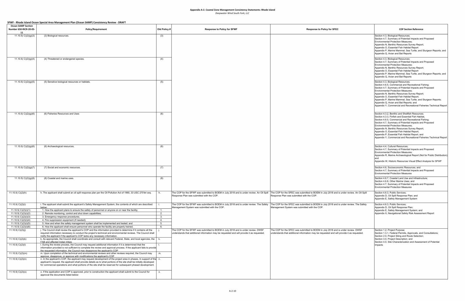
Appendix A‐2. Coastal Zone Management Consistency Statements: Rhode IslandDeepwater Wind South Fork, LLC
SFWF ‐ Rhode Island Ocean Special Area Management Plan (Ocean SAMP) Consistency Review ‐ DRAFTOcean SAMP Section
Number 650‐RICR‐20‐05‐11
Policy/Requirement Old Policy # Response to Policy for SFWF Response to Policy for SFEC COP Section Reference
11.10.5( C)(2)(g)(3) (3) Biological resources. (3) Section 4.3, Biological Resources;Section 4.7, Summary of Potential Impacts and Proposed Environmental Protection Measures;Appendix N, Benthic Resources Survey Report;Appendix O, Essential Fish Habitat ReportAppendix P, Marine Mammal, Sea Turtle, and Sturgeon Reports; andAppendix Q, Avian and Bat Reports
11.10.5( C)(2)(g)(4) (4) Threatened or endangered species. (4) Section 4.3, Biological Resources;Section 4.7, Summary of Potential Impacts and Proposed Environmental Protection Measures;Appendix N, Benthic Resources Survey Report;Appendix O, Essential Fish Habitat ReportAppendix P, Marine Mammal, Sea Turtle, and Sturgeon Reports; andAppendix Q, Avian and Bat Reports
11.10.5( C)(2)(g)(5) (5) Sensitive biological resources or habitats. (5) Section 4.3, Biological Resources;Section 4.6.5, Commercial and Recreational Fishing; Section 4.7, Summary of Potential Impacts and Proposed Environmental Protection Measures; Appendix N, Benthic Resources Survey Report;Appendix O, Essential Fish Habitat Report;Appendix P, Marine Mammal, Sea Turtle, and Sturgeon Reports; Appendix Q, Avian and Bat Reports; andAppendix Y, Commercial and Recreational Fisheries Technical Report
11.10.5( C)(2)(g)(6) (6) Fisheries Resources and Uses (6) Section 4.3.2, Benthic and Shellfish Resources;Section 4.3.3, Finfish and Essential Fish Habitat,Section 4.6.5, Commercial and Recreational Fishing; Section 4.7, Summary of Potential Impacts and Proposed Environmental Protection Measures; Appendix N, Benthic Resources Survey Report;Appendix O, Essential Fish Habitat Report;Appendix P, Essential Fish Habitat Report; andAppendix Y, Commercial and Recreational Fisheries Technical Report
11.10.5( C)(2)(g)(6) (6) Archaeological resources. (6) Section 4.4, Cultural Resources;Section 4.7, Summary of Potential Impacts and Proposed Environmental Protection Measures; Appendix R, Marine Archaeological Report (Not for Public Distribution);andAppendix W, Historic Resources Visual Effect Analysis for SFWF
11.10.5( C)(2)(g)(7) (7) Social and economic resources. (7) Section 4.6, Socioeconomic Resources; andSection 4.7, Summary of Potential Impacts and Proposed Environmental Protection Measures
11.10.5( C)(2)(g)(8) (8) Coastal and marine uses. (8) Section 4.6.7, Coastal Land Use and Infrastructure; Section 4.6.8, Other Marine Uses; andSection 4.7, Summary of Potential Impacts and Proposed Environmental Protection Measures
11.10.5( C)(2)(h) h. The applicant shall submit an oil spill response plan per the Oil Pollution Act of 1990, 33 USC 2701 et seq. h. The COP for the SFWF was submitted to BOEM in July 2018 and is under review. An Oil Spill Response Plan was submitted with the COP.
The COP for the SFEC was submitted to BOEM in July 2018 and is under review. An Oil Spill Response Plan was submitted with the COP.
Section 4.6.3, Public Services;Appendix D, Oil Spill Response Plan; andAppendix E, Safety Management System
11.10.5( C)(2)(i) i. The applicant shall submit the applicant’s Safety Management System, the contents of which are described below:
i.
11.10.5( C)(2)(i)(1) 1. How the applicant plans to ensure the safety of personnel or anyone on or near the facility; 1.11.10.5( C)(2)(i)(2) 2. Remote monitoring, control and shut down capabilities; 2.11.10.5( C)(2)(i)(3) 3. Emergency response procedures; 3.11.10.5( C)(2)(i)(4) 4. Fire suppression equipment (if needed); 4.11.10.5( C)(2)(i)(5) 5. How and when the safety management system shall be implemented and tested; and 5.11.10.5( C)(2)(i)(6) 6. How the applicant shall ensure personnel who operate the facility are properly trained. 6.
11.10.5( C)(2)(j) j. The Council shall review the applicant’s COP and the information provided to determine if it contains all the required information necessary to conduct the project’s technical and environmental reviews. The Council shall notify the applicant if the applicant’s COP lacks any necessary information.
j.
11.10.5( C)(2)(k) k. As appropriate, the Council shall coordinate and consult with relevant Federal, State, and local agencies, the FAB and affected Indian tribes.
k.
11.10.5( C)(2)(l) l. During the review process, the Council may request additional information if it is determined that the information provided is not sufficient to complete the review and approval process. If the applicant fails to providethe requested information, the Council may disapprove the applicant’s COP
l.
11.10.5( C)(2)(m) m. Upon completion of the technical and environmental reviews and other reviews required, the Council may approve, disapprove, or approve with modifications the applicant’s COP.
m.
11.10.5( C)(2)(n) n. In the applicant’s COP, the applicant may request development of the project area in phases. In support of the applicant’s request, the applicant shall provide details as to what portions of the site shall be initially developed for commercial operations and what portions of the site shall be reserved for subsequent phased development.
n.
11.10.5( C)(2)(o) o. If the application and COP is approved, prior to construction the applicant shall submit to the Council for approval the documents listed below:
o.
Section 4.6.3, Public Services;Appendix D, Oil Spill Response Plan;Appendix E, Safety Management System; andAppendix X, Navigational Safety Risk Assessment Report
Section 1.2, Project Purpose;Section 1.3.1, Federal Permits, Approvals, and Consultations;Section 2.0, Project Siting and Route Selection;Section 3.0, Project Description; andSection 4.0, Site Characterization and Assessment of Potential Impacts
The COP for the SFWF was submitted to BOEM in July 2018 and is under review. The Safety Management System was submitted with the COP.
The COP for the SFEC was submitted to BOEM in July 2018 and is under review. The Safety Management System was submitted with the COP.
The COP for the SFWF was submitted to BOEM in July 2018 and is under review. DWSF understands that additional information may be requested and will provide it as requested.
The COP for the SFEC was submitted to BOEM in July 2018 and is under review. DWSF understands that additional information may be requested and will provide it as requested.
A‐2‐10
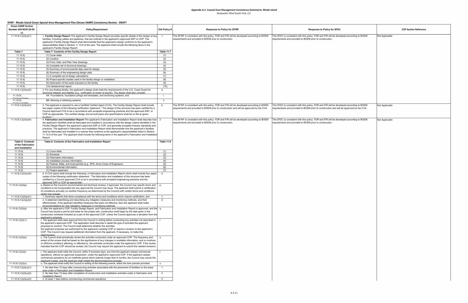
Appendix A‐2. Coastal Zone Management Consistency Statements: Rhode IslandDeepwater Wind South Fork, LLC
SFWF ‐ Rhode Island Ocean Special Area Management Plan (Ocean SAMP) Consistency Review ‐ DRAFTOcean SAMP Section
Number 650‐RICR‐20‐05‐11
Policy/Requirement Old Policy # Response to Policy for SFWF Response to Policy for SFEC COP Section Reference
11.10.5( C)(2)(o)(1) 1. Facility Design Report- The applicant’s Facility Design Report provides specific details of the design of any facilities, including cables and pipelines, that are outlined in the applicant’s approved SAP or COP. The applicant’s Facility Design Report shall demonstrate that the applicant’s design conforms to the applicant’s responsibilities listed in Section 11.10.6 of this part. The applicant shall include the following items in the applicant’s Facility Design Report:
1.
Table 7 Table 7: Contents of the Facility Design Report Table 11.7 11.10.5( (1) Cover letter. (1)11.10.5( (2) Location. (2)11.10.5( (3) Front, Side, and Plan View drawings. (3)11.10.5( (4) Complete set of structural drawings. (4)11.10.5( (5) Summary of environmental data used for design. (5)11.10.5( (6) Summary of the engineering design data. (6)11.10.5( (7) A complete set of design calculations. (7)11.10.5( (8) Project-specific studies used in the facility design or installation. (8)11.10.5( (9) Description of the loads imposed on the facility. (9)11.10.5( (10) Geotechnical report. (10)
11.10.5( C)(2)(o)(2) 2. For any floating facility, the applicant’s design shall meet the requirements of the U.S. Coast Guard for structural integrity and stability (e.g., verification of center of gravity). The design shall also consider
a.
11.10.5( C)(2)(o)(2)(AA)
AA. Foundations, foundation pilings and templates, and anchoring systems; and i
11.10.5( C)(2)(o)(2)(BB)
BB. Mooring or tethering systems. ii.
11.10.5( C)(2)(o)(3) 3. The applicant is required to use a Certified Verified Agent (CVA). The Facility Design Report shall include two paper copies of the following certification statement: ‘‘The design of this structure has been certified by a Council approved CVA to be in accordance with accepted engineering practices and the approved SAP, or COP as appropriate. The certified design and as-built plans and specifications shall be on file at (given location).’’
b. The SFWF is consistent with this policy. FDR and FIR will be developed according to BOEM requirements and provided to BOEM prior to construction and will be approved by the CVA.
The SFEC is consistent with this policy. FDR and FIR will be developed according to BOEM requirements and provided to BOEM prior to construction and will be approved by the CVA.
Not Applicable
11.10.5( C)(2)(o)(4) 4. Fabrication and Installation Report- The applicant’s Fabrication and Installation Report shall describe how the applicant’s facilities shall be fabricated and installed in accordance with the design criteria identified in the Facility Design Report; the applicant’s approved SAP or COP; and generally accepted industry standards and practices. The applicant’s Fabrication and Installation Report shall demonstrate how the applicant’s facilities shall be fabricated and installed in a manner that conforms to the applicant’s responsibilities listed in Section 11.10.6 of this part. The applicant shall include the following items in the applicant’s Fabrication and Installation Report:
2
Table 8: Contents of the Fabrication and Installation
Table 8: Contents of the Fabrication and Installation Report Table 11.8
11.10.5( (1) Cover letter. (1)11.10.5( (2) Schedule. (2)11.10.5( (3) Fabrication information. (3)11.10.5( (4) Installation process information. (4)11.10.5( (5) Federal, State, and local permits (e.g., EPA, Army Corps of Engineers). (5)11.10.5( (6) Environmental information. (6)11.10.5( (7) Project easement. (7)
11.10.5( C)(2)(o)(5) 5. A CVA report shall include the following: a Fabrication and Installation Report which shall include four paper copies of the following certification statement: ‘‘The fabrication and installation of this structure has been certified by a Council approved CVA to be in accordance with accepted engineering practices and the approved SAP or COP as appropriate.”
a.
11.10.5( C)(2)(p) p. Based on the Council’s environmental and technical reviews, if approved, the Council may specify terms andconditions to be incorporated into any approval the Council may issue. The applicant shall submit a certification of compliance annually (or another frequency as determined by the Council) with certain terms and conditions which may include:
p.
11.10.5( C)(2)(p)(1) 1. Summary reports that show compliance with the terms and conditions which require certification; and 1.11.10.5( C)(2)(p)(2) 2. A statement identifying and describing any mitigation measures and monitoring methods, and their
effectiveness. If the applicant identified measures that were not effective, then the applicant shall make recommendations for new mitigation measures or monitoring methods.
2.
11.10.5( C)(2)(q) q. After the applicant’s COP, Facility Design Report, and Fabrication and Installation Report is approved, and the Council has issued a permit and lease for the project site, construction shall begin by the date given in the construction schedule included as a part of the approved COP, unless the Council approves a deviation from the applicant’s schedule.
q.
11.10.5( C)(2)( r) r. The applicant shall seek approval from the Council in writing before conducting any activities not described in the applicant’s approved COP. The application shall describe in detail the type of activities the applicant proposes to conduct. The Council shall determine whether the activitiesthe applicant proposes are authorized by the applicant’s existing COP or require a revision to the applicant’s COP. The Council may request additional information from the applicant, if necessary, to make this determination.
r.
11.10.5( C)(2)(s) s. The Council shall periodically review the activities conducted under an approved COP. The frequency and extent of the review shall be based on the significance of any changes in available information, and on onshore or offshore conditions affecting, or affected by, the activities conducted under the applicant’s COP. If the review indicates that the COP should be revised, the Council may require the applicant to submit the needed revisions.
s.
11.10.5( C)(2)(t) t. The applicant shall notify the Council, within 5 business days, any time the applicant ceases commercial operations, without an approved suspension, under the applicant’s approved COP. If the applicant ceases commercial operations for an indefinite period which extends longer than 6 months, the Council may cancel the applicant’s lease, and the applicant shall initiate the decommissioning process
t.
11.10.5( C)(2)(u) u. The applicant shall notify the Council in writing of the following events, within the time periods provided: u.
11.10.5( C)(2)(u)(1) 1. No later than 10 days after commencing activities associated with the placement of facilities on the lease area under a Fabrication and Installation Report
1.
11.10.5( C)(2)(u)(2) 2. No later than 10 days after completion of construction and installation activities under a Fabrication and Installation Report.
2.
11.10.5( C)(2)(u)(3) 3. At least 7 days before commencing commercial operations. 3
Not Applicable
The SFEC is consistent with this policy. FDR and FIR will be developed according to BOEM requirements and provided to BOEM prior to construction.
Not Applicable
The SFWF is consistent with this policy. FDR and FIR will be developed according to BOEM requirements and provided to BOEM prior to construction.
The SFEC is consistent with this policy. FDR and FIR will be developed according to BOEM requirements and provided to BOEM prior to construction.
The SFWF is consistent with this policy. FDR and FIR will be developed according to BOEM requirements and provided to BOEM prior to construction.
A‐2‐11

Appendix A‐2. Coastal Zone Management Consistency Statements: Rhode IslandDeepwater Wind South Fork, LLC
SFWF ‐ Rhode Island Ocean Special Area Management Plan (Ocean SAMP) Consistency Review ‐ DRAFTOcean SAMP Section
Number 650‐RICR‐20‐05‐11
Policy/Requirement Old Policy # Response to Policy for SFWF Response to Policy for SFEC COP Section Reference
11.10.5( C)(2)(v) v. The applicant may commence commercial operations within 30 days after the CVA has submitted to the Council the final Fabrication and Installation Report.
v.
11.10.5( C)(2)(w) w. The applicant shall submit a Project Modification and Repair Report to the Council, demonstrating that allmajor repairs and modifications to a project conform to accepted engineering practices.
w.
11.10.5( C)(2)(w)(1) 1. A major repair is a corrective action involving structural members affecting the structural integrity of a portion of or all the facility.
1
11.10.5( C)(2)(w)(2) 2. A major modification is an alteration involving structural members affecting the structural integrity of a portionof or all the facility.
2
11.10.5( C)(2)(w)(3) 3. The report must also identify the location of all records pertaining to the major repairs or major modifications. 3
11.10.5( C)(2)(w)(4) 4. The Council may require the applicant to use a CVA for project modifications and repairs. 4
1160.6
11.10.6(A)(1) 1. The Applicant Shall use a CVA to review and certify the facility design report, the fabrication and installation report, and the project modifications and repairs report. The applicant shall use a CVA to
i.
11.10.6(A)(1)(a) a. Ensure the applicant's facilities are designed, fabricated and installed in conformance with accepted engineering practices and the facility design report and fabrication and installation report
a.
11.10.6(A)(1)(b) b. ensure that repairs and major modifications are completed in conformance with accepted engineering practices; and
b.
11.10.6(A)(1)( c) c. Provide the Council immediate reports of all incidents that affect the design, fabrication, and installation of the project and its components.
c.
11.10.6(A)(2) 2. Nominating a CVA for Council approval - the applicant shall nominate a CVA for the Council Approval. The Applicant shall specify whether the nomination is for the facility design report fabrication and installation report, modification and repair report, or for any combination of these.
ii.
11.10.6(A)(2)(a) a. For each CVA that the applicant nominates, the applicant shall submit to the council a list of documents they shall forward to the CVA and a qualification statement that includes the following
a.
11.10.6(A)(2)(a)(1) 1. Previous experience in third-party verification or experience in the design, fabrication, installation, or major modification of offshore energy facilities;
1
11.10.6(A)(2)(a)(2) 2. Technical Capabilities of the individual or the primary staff for the specific project; 2
11.10.6(A)(2)(a)(3) 3. Size and type of organization or corporation; 3
11.10.6(A)(2)(a)(4) 4. In house availability of, or access to, appropriate technology (including computer programs, hardware, and testing materials and equipment);
4
11.10.6(A)(2)(a)(5) 5.Ability to perform the CVA functions for the specific project considering current commitments 5
11.10.6(A)(2)(a)(6) 6. Previous experience with the Council requirements and procedures, if any; and 6
11.10.6(A)(2)(a)(7) 7. The level of work to be performed by the CVA 7
11.10.6(A)(3) 3. Individuals or organizations acting as CVAs shall not function in any capacity that shall create a conflict ofinterest, or the appearance of a conflict of interest
iii.
11.10.6(A)(4) 4. The verification shall be conducted by or under the direct supervision of registered professional engineers iv.11.10.6(A)(5) 5. The Council shall approve or disapprove the applicant's CVA prior to construction v.11.10.6(A)(6) 6. The applicant shall nominate a new CVA for the Council approval if the previously approved CVA: vi.
11.10.6(A)(6)(a) a. Is no longer able to serve in a CVA capacity for the project; or a.11.10.6(A)(6)(b) b. No longer meets the requirements for a CVA set forth in this subpart. b.
11.10.6(A)(7) 7. The CVA shall conduct an independent assessment of all proposed: vii.11.10.6(A)(7)(a) a. Planning criteria; a.11.10.6(A)(7)(b) b. Operational requirements; b.11.10.6(A)(7)(c) c. Environmental loading data c.11.10.6(A)(7)(d) d. Load determinations; d11.10.6(A)(7)(e) e. Stress analyses; e11.10.6(A)(7)(f) f. Material designations; f11.10.6(A)(7)(g) g. Soil and foundation conditions; g11.10.6(A)(7)(h) h. Safety factors; and h11.10.6(A)(7)(i) i. Other pertinent parameters of the proposed design. i
11.10.6(A)(8) 8. For any floating facility, the CVA shall ensure that any requirements of the U.S. Coast Guard for structural integrity and stability (eg., verification of center of gravity), have been met. The CVA shall also consider
viii.
11.10.6(A)(8)(a) a. Foundations; a.11.10.6(A)(8)(b) b. Foundation pilings and templates, and anchoring systems b.
11.10.6(A)(9) 9. The CVA shall do all of the following: ix.11.10.6(A)(9)(a) a. Use good engineering judgment and proactive in conducting an independent assessment of the fabrication
and installation activities;a.
11.10.6(A)(9)(b) b. Monitor the fabrication and installation of the facility; b.11.10.6(A)(9)(c) c. Make periodic onsite inspections while fabrication is in progress and verify the items required by Section
11.10.6 (A)(11) of this Part;c.
11.10.6(A)(9)(d) d. Make periodic onsite inspections while installation is in progress and satisfy the requirements by Section 11.10.6 (A)(12) of this Part; and
d
111.10.6(A) Section 1.6.3, Certified Verification Agency NominationsAppendix C, Certified Verification Agency Nominations
A) Certified Verification Agent- The Certified Verification Agent (CVA) shall use good engineering judgment and practices in conducting an independent assessment of the design, fabrication and installation of the facility. The CVAshall certify in the Facility Design Report to the Council that the facility is designed to withstand the environmental and functional load conditions appropriate for the intended service life at the proposed location. The CVA is paid for by the applicant, but is approved and reports to the Council.
The Project is consistent with this policy. The CVA nomination was submitted with the COP and will be approved by BOEM.
The SFEC is consistent with this policy. The CVA nomination as submitted with the COP and will be approved by BOEM.
11.10.6 Design, Fabrication and Installation Standards
A‐2‐12

Appendix A‐2. Coastal Zone Management Consistency Statements: Rhode IslandDeepwater Wind South Fork, LLC
SFWF ‐ Rhode Island Ocean Special Area Management Plan (Ocean SAMP) Consistency Review ‐ DRAFTOcean SAMP Section
Number 650‐RICR‐20‐05‐11
Policy/Requirement Old Policy # Response to Policy for SFWF Response to Policy for SFEC COP Section Reference
11.10.6(A)(9)(e) e. Certify in a report that project components are fabricated and installed in accordance with accepted engineering practices; the applicant's approved COP or SAP; and the fabrication and installation report
e
11.10.6(A)(9)(e)(1) (1) The report shall also identify the location of all records pertaining to fabrication and installation. 111.10.6(A)(9)(e)(2) (2) The applicant may commence commercial operations or other approved activities 30 days after the council
receives that certification report, unless the council notifies the applicant within that time period of its objections to the certification report
2
11.10.6(A)(10) 10. The CVA shall monitor the fabrication and installation of the facility to ensure that it has been built and installed according to the facility design report and fabrication and installation report.
x.
11.10.6(A)(10)(a) a. If the CVA finds that fabrication and installation procedures have been changed or design specifications have been modified, the CVA shall inform the applicant and the Council
a.
11.10.6(A)(11) 11. The CVA shall make periodic onsite inspections while fabrication is in progress and shall certify the following items, as appropriate:
xi.
11.10.6(A)(11)(a) a. Quality control by lessee (or grant holder) and builder; a.11.10.6(A)(11)(b) b. Fabrication site facilities; b.11.10.6(A)(11)(c) c. Material quality and identification methods; c.11.10.6(A)(11)(d) d. Fabrication procedures specified in the fabrication and installation report, and adherence to such procedures; d11.10.6(A)(11)(e) e. Welder and welding procedure qualification and identification; e.11.10.6(A)(11)(f) f. Adherence to structural tolerances specified; f.11.10.6(A)(11)(g) g. nondestructive examination requirements and evaluation results of the specified examinations; g.11.10.6(A)(11)(h) h. destructive testing requirements and results; h.11.10.6(A)(11)(i) i. repair procedures; i.11.10.6(A)(11)(j) j. installation of corrosion protection systems and splash zone protection; j.11.10.6(A)(11)(k) k. Erection procedures to ensure that overstressing of structural members does not occur; k.11.10.6(A)(11)(l) l. alignment procedures; l.11.10.6(A)(11)(m) m. dimensional check of the overall structure, including any turrets, turret and hull interfaces, any mooring line
and chain and riser tensioning line segments; andm.
11.10.6(A)(11)(n) n. status of quality control records at various stages of fabrication. n.11.10.6(A)(12) 12. The CVA shall make periodic onsite inspections while installation is in progress and shall, as appropriate,
verify, witness, survey, or check, the installation items required by this section. The CVA shall verify, as appropriate, all of the following:
xii.
11.10.6(A)(12)(a) a. Load out and initial flotation procedures; a.11.10.6(A)(12)(b) b. Towing operation procedures to the specified location, and review the towing records; b.11.10.6(A)(12)(c) c. Launching and uprighting activities; c.11.10.6(A)(12)(d) d. Submergence activities; d.11.10.6(A)(12)(e) e. Pile or anchor installations; e.11.10.6(A)(12)(f) f. Installation of mooring and tethering systems; f11.10.6(A)(12)(g) g. Transition pieces, support structures, and component installations; and g.11.10.6(A)(12)(h) h. Installation at the approved location according to the facility design report and the fabrication and installation
report. h.
11.10.6(A)(13) 13. For a fixed for floating facility, the CVA shall verify that proper procedures were used during the following: xiii.11.10.6(A)(13)(a) a. The loadoutof the transition pieces and support structures, piles, or structures, from each fabrication site;
and a.
11.10.6(A)(13)(b) b. The actual installation of the facility or major modification and the related installation activities. b.11.10.6(A)(14) 14. For a floating facility, the CVA shall verify that proper procedures were used during the following: xiv.
11.10.6(A)(14)(a) a. The loadout of the facility a.11.10.6(A)(14)(b) b. The installation of foundation pilitings templates, and anchoring systems. b.
11.10.6(A)(15) 15. The CVA shall conduct an onsite survey of the facility after transportation to the approved location. xv.11.10.6(A)(16) 16. The CVA shall spot check the equipment, procedures, and recordkeeping as necessary to determine
compliance with the applicable documents incorporated by reference and the regulation sunder this part.xvi.
11.10.6(A)(17) 17. The CVA shall prepare and submit to the applicant and the Council all reports required by this subpart. The CVA shall also submit interim repots to the applicant and the council, as requested by the council. The CVA shall submit one electronic copy and four paper copies of each final report to the council. In each report, the CVA shall:
xvii.
11.10.6(A)(17)(a) a. Give details of how, by whom, and when the CVA activities were conducted; a.11.10.6(A)(17)(b) b. Describe the CVA's activities during the verification process; b.11.10.6(A)(17)(c) c. Summarize the CVA's findings; and c.11.10.6(A)(17)(d) d. Provide any additional comments that the CVA deems necessary. d.
11.10.6(A)(18) 18. Until the council releases the applicants financial assurance under Section 11.10.7(B) of this part, the applicant shall compile, retain, and make available to the council representatives all of the following
xviii.
11.10.6(A)(18)(a) a. The as-built drawings; a.11.10.6(A)(18)(b) b. The design assumptions and analyses; b.11.10.6(A)(18)(c) c. A summary of the fabrication and installation examination records; c.11.10.6(A)(18)(d) d. Results from the required inspections and assessments; d.11.10.6(A)(18)(e) e. Records of repairs not covered in the inspection report submitted. e.
11.10.6(A)(19) 19. The applicant shall record and retain the original material test results of all primary structural materials during all stages of construction until the council releases the applicant's financial assurance under Section 11.10.7(B) of this part. Primary material is material that, should it fail, would lead to a significant reduction in facility safety, structural reliability, or operating capabilities. Items such as steel brackets, deck stiffener and secondary braces or beams would not generally be considered primary structural members (or materials).
xix.
11.10.6(A)(20) 20. The Applicant shall provide the Council with the location of these records in the certification statement. xx.11.10.6(A)(21) 21. The council may hire its own CVA agent to review the work of the applicants CVA. The applicant shall be
responsible for the cost of the council's CVA. The council's CVA shall perform those duties as assigned by the council.
xxi.
A‐2‐13
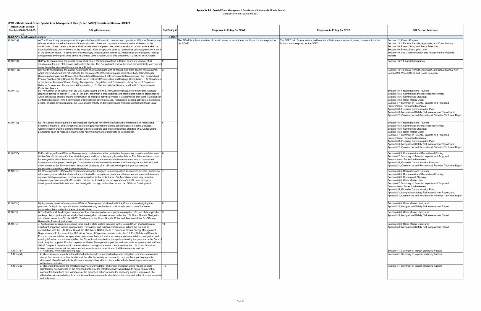
Appendix A‐2. Coastal Zone Management Consistency Statements: Rhode IslandDeepwater Wind South Fork, LLC
SFWF ‐ Rhode Island Ocean Special Area Management Plan (Ocean SAMP) Consistency Review ‐ DRAFTOcean SAMP Section
Number 650‐RICR‐20‐05‐11
Policy/Requirement Old Policy # Response to Policy for SFWF Response to Policy for SFEC COP Section Reference
1160.711.10.7(A) A) The Council may issue a permit for a period of up to 50 years to construct and operate an Offshore Development.
A lease shall be issued at the start of the construction phase and payment shall commence at the end of the construction phase. Lease payments shall be due when the project becomes operational. Lease renewal shall be submitted 5 years before the end of the lease term. Council approval shall be required for any assignment or transfeof the permit or lease. This provision shall not apply to aquaculture permitting. Aquaculture permitting and leasing are governed by the provisions of the RI General Laws Chapter 20-10 and Section 00-1.3.1(K) of this Chapter.
1 Section 1.2, Project Purpose;Section 1.3.1, Federal Permits, Approvals, and Consultations;Section 2.0, Project Siting and Route Selection;Section 3.0, Project Description; andSection 4.0, Site Characterization and Assessment of Potential Impacts
11.10.7(B) B) Prior to construction, the assent holder shall post a Performance Bond sufficient to ensure removal of all structures at the end of the lease and restore the site. The Council shall review the bond amount initially and every 3 years thereafter to ensure the amount is sufficient.
2 Section 1.6.2, Financial Assurance
11.10.7( C) C) Prior to construction, the assent holder shall show compliance with all federal and state agency requirements, which may include but are not limited to the requirements of the following agencies: the Rhode Island Coastal Resources Management Council, the Rhode Island Department of Environmental Management, the Rhode Island Energy Facilities Siting Board, the Rhode Island Historical Preservation and Heritage Commission, U.S. Department of the Interior Bureau of Ocean Energy Management, Regulation and Enforcement, Army Corps of Engineers, National Oceanic and Atmospheric Administration, U.S. Fish and Wildlife Service, and the U.S. Environmental Protection Agency.
3 Section 1.3.1, Federal Permits, Approvals, and Consultations; and Section 2.0, Project Siting and Route Selection
11.10.7(D) D) The Council shall consult with the U.S. Coast Guard, the U.S. Navy, marine pilots, the Fishermen’s Advisory Board as defined in section 11.3 (E) of this part, fishermen’s organizations, and recreational boating organizations when scheduling offshore marine construction or dredging activities. Where it is determined that there is a significantconflict with season-limited commercial or recreational fishing activities, recreational boating activities or scheduled events, or other navigation uses, the Council shall modify or deny activities to minimize conflict with these uses.
4 Section 4.6.4, Recreation and Tourism;Section 4.6.5, Commercial and Recreational Fishing;Section 4.6.6, Commercial Shipping;Section 4.6.8, Other Marine Uses;Section 4.7, Summary of Potential Impacts and Proposed Environmental Protection Measures;Appendix B, Fisheries Communication Plan; Appendix X, Navigational Safety Risk Assessment Report; andAppendix Y, Commercial and Recreational Fisheries Technical Report
11.10.7(E) E) The Council shall require the assent holder to provide for communication with commercial and recreational fishermen, mariners, and recreational boaters regarding offshore marine construction or dredging activities. Communication shall be facilitated through a project website and shall complement standard U.S. Coast Guard procedures such as Notices to Mariners for notifying mariners of obstructions to navigation.
5 Section 4.6.4, Recreation and Tourism;Section 4.6.5, Commercial and Recreational Fishing; Section 4.6.6, Commercial Shipping;Section 4.6.8, Other Marine Uses;Section 4.7, Summary of Potential Impacts and Proposed Environmental Protection Measures;Appendix B, Fisheries Communication Plan;Appendix X, Navigational Safety Risk Assessment Report; andAppendix Y, Commercial and Recreational Fisheries Technical Report
11.10.7(F) F) For all Large-Scale Offshore Developments, underwater cables, and other development projects as determined by the Council, the assent holder shall designate and fund a third-party fisheries liaison. The fisheries liaison must beknowledgeable about fisheries and shall facilitate direct communication between commercial and recreational fishermen and the project developer. Commercial and recreational fishermen shall have regular contact with and direct access to the fisheries liaison throughout all stages of an offshore development (pre-construction; construction; operation; and decommissioning).
6 Section 4.6.5, Commercial and Recreational Fishing; Section 4.7, Summary of Potential Impacts and Proposed Environmental Protection Measures;Appendix B, Fisheries Communication Plan; andAppendix Y, Commercial and Recreational Fisheries Technical Report
11.10.7(G) G) Where possible, Offshore Developments should be designed in a configuration to minimize adverse impacts on other user groups, which include but are not limited to: recreational boaters and fishermen, commercial fishermen, commercial ship operators, or other vessel operators in the project area. Configurations which may minimize adverse impacts on vessel traffic include, but are not limited to, the incorporation of a traffic lane through a development to facilitate safe and direct navigation through, rather than around, an Offshore Development.
7 Section 4.6.4, Recreation and Tourism;Section 4.6.5, Commercial and Recreational Fishing;Section 4.6.6, Commercial Shipping;Section 4.6.8, Other Marine Uses;Section 4.7, Summary of Potential Impacts and Proposed Environmental Protection Measures;Appendix B, Fisheries Communication Plan;Appendix X, Navigational Safety Risk Assessment Report; andAppendix Y, Commercial and Recreational Fisheries Technical Report
11.10.7(H) H) Any assent holder of an approved Offshore Development shall work with the Council when designing the proposed facility to incorporate where possible mooring mechanisms to allow safe public use of the areas surrounding the installed turbine or other structure
8 Section 4.6.8, Other Marine Uses; andAppendix X, Navigational Safety Risk Assessment Report
11.10.7(I) I) The facility shall be designed in a manner that minimizes adverse impacts to navigation. As part of its application package, the project applicant shall submit a navigation risk assessment under the U.S. Coast Guard’s Navigation and Vessel Inspection Circular 02-07, “Guidance on the Coast Guard’s Roles and Responsibilities for Offshore Renewable Energy Installations.”
9 Section 4.6.8, Other Marine Uses; andAppendix X, Navigational Safety Risk Assessment Report
11.10.7(J) J) Applications for projects proposed to be sited in state waters pursuant to the Ocean SAMP shall not have a significant impact on marine transportation, navigation, and existing infrastructure. Where the Council, in consultation with the U.S. Coast Guard, the U.S. Navy, NOAA, the U.S. Bureau of Ocean Energy Management, Regulation and Enforcement, the U.S. Army Corps of Engineers, marine pilots, the R.I. Port Safety and Security Forums, or other entities, as applicable, determines that such an impact on marine transportation, navigation, and existing infrastructure is unacceptable, the Council shall require that the applicant modify the proposal or the Council shall deny the proposal. For the purposes of Marine Transportation policies and standards as summarized in Ocean SAMP Chapter 7 impacts would be evaluated according to the same criteria used by the U.S. Coast Guard, as follows; these criteria shall not be construed to apply to any other Ocean SAMP chapters or policies
10 Section 4.6.8, Other Marine Uses; andAppendix X, Navigational Safety Risk Assessment Report
11.10.7(J)(1) 1. Negligible: No measurable impacts. i. Section 4.1, Summary of Impact-producing Factors11.10.7(J)(2) 2. Minor: Adverse impacts to the affected activity could be avoided with proper mitigation; or impacts would not
disrupt the normal or routine functions of the affected activity or community; or once the impacting agent is eliminated, the affected activity will return to a condition with no measurable effects from the proposed action without any mitigation.
ii. Section 4.1, Summary of Impact-producing Factors
11.10.7(J)(3) 3. Moderate: Impacts to the affected activity are unavoidable; and proper mitigation would reduce impacts substantially during the life of the proposed action; or the affected activity would have to adjust somewhat to account for disruptions due to impacts of the proposed action; or once the impacting agent is eliminated, the affected activity would return to a condition with no measurable effects from the proposed action if proper remedial action is taken.
iii. Section 4.1, Summary of Impact-producing Factors
11.10.7 Pre‐Construction StandardsThe SFEC is in federal waters and New York State waters. A permit, lease, or assent from the Council is not required for the SFEC.
The SFWF is in federal waters. A permit, lease, or assent from the Council is not required for the SFWF.
A‐2‐14

Appendix A‐2. Coastal Zone Management Consistency Statements: Rhode IslandDeepwater Wind South Fork, LLC
SFWF ‐ Rhode Island Ocean Special Area Management Plan (Ocean SAMP) Consistency Review ‐ DRAFTOcean SAMP Section
Number 650‐RICR‐20‐05‐11
Policy/Requirement Old Policy # Response to Policy for SFWF Response to Policy for SFEC COP Section Reference
11.10.7(J)(4) 4. Major: Impacts to the affected activity are unavoidable; proper mitigation would reduce impacts somewhat during the life of the proposed action; the affected activity would experience unavoidable disruptions to a degree beyond what is normally acceptable; and once the impacting agent is eliminated, the affected activity may retain measurable effects of the proposed action indefinitely, even if remedial action is taken
iv. Section 4.1, Summary of Impact-producing Factors
11.10.7(K) K) Prior to construction, the Applicant shall provide a letter from the U.S. Coast Guard showing it meets all applicable U.S. Coast Guard standards.
11 Section 1.3.1, Federal Permits, Approvals, and Consultations; and Section 1.4, Agency and Stakeholder Outreach
1160.811.10.8(A) A) The Assent Holder shall use the best available technology and techniques to minimize impacts to the natural
resources and existing human uses in the project area.1 Section 2.0, Project Siting and Route Selection;
Section 3.0, Project Description;Section 3.2, South Fork Export Cable; andSection 4.7, Summary of Potential Impact and Proposed Environmental Protection Measures
11.10.8(B) B) The Council shall require the use of an environmental inspector to monitor construction activities. The environmental inspector shall be a private, third-party entity that is hired by the Assent Holder, but is approved and reports to the Council. The environmental inspector shall possess all appropriate qualifications as determined by the Council. This inspector service may be part of the CVA requirements.
2 Section 2.0, Project Siting and Route Selection;Section 3.0, Project Description;Section 3.2, South Fork Export Cable; andSection 4.7, Summary of Potential Impacts and Proposed Environmental Protection Measures
11.10.8( C) C) Installation techniques for all construction activities should be chosen to minimize sediment disturbance. Jet plowing and horizontal directional drilling in nearshore areas shall be required in the installation of underwater transmission cables. Other technologies may be used provided the applicant can demonstrate they are as effective, or more effective, than these techniques in minimizing sediment disturbance.
3 Section 3.0, Project Description; Section 4.7, Summary of Potential Impacts and Proposed Environmental Protection Measures;Appendix I, Sediment Survey and Sediment Transport Analysis Reports; andAppendix J, Sediment Transport Analyses
11.10.8(D) D) All construction activities shall comply with the policies and standards outlined in the Rhode Island Coastal Resources Management Program (RICRMP), as well as the regulations of other relevant state and federal agencies.
4 Section 1.3, Regulatory Framework;Section 3.0, Project Description; andSection 4.7, Summary of Potential Impacts and Proposed Environmental Protection Measures
11.10.8(E) E) The applicant shall conduct all activities on the applicant’s permit under this part in a manner that conforms with the applicant’s responsibilities in section 11.10.1(E), and using
5
11.10.8(E)(1) 1. Trained personnel; and i.11.10.8(E)(2) 2. Technologies, precautions, and techniques that shall not cause undue harm or damage to natural resources,
including their physical, atmospheric, chemical and biological componentsii.
11.10.8(F) F) The Assent Holder shall be required to use the best available technology and techniques to mitigate any associated adverse impacts of offshore renewable energy development.
6
11.10.8(F)(1) 1. As required, the applicant shall submit to the Council: i.11.10.8(F)(1)(a) a. Measures designed to avoid or minimize adverse effects and any potential incidental take of endangered or
threatened species as well as all marine mammals;1
11.10.8(F)(1)(b) b. Measures designed to avoid likely adverse modification or destruction of designated critical habitat of such endangered or threatened species; and
2
11.10.8(F)(1)(c) c. The applicant’s agreement to monitor for the incidental take of the species and adverse effects on the critical habitat, and provide the results of the monitoring to the Council as required; and
3
11.10.8(G) G) If the Assent Holder, the Assent Holder’s subcontractors, or any agent acting on the Assent Holder’s behalf discovers a potential archaeological resource while conducting construction activities, or any other activity related to the Assent Holder’s project, the applicant shall:
7
11.10.8(G)(1) 1. Immediately halt all seafloor disturbing activities within the area of the discovery; i.11.10.8(G)(2) 2. Notify the Council of the discovery within 24 hours; and ii.11.10.8(G)(3) 3. Keep the location of the discovery confidential and not take any action that may adversely affect the
archaeological resource until the Council has made an evaluation and instructed the applicant on how to proceediii
11.10.8(G)(3)(a) a. The Council may require the Assent Holder to conduct additional investigations to determine if the resource is eligible for listing in the National Register of Historic Places under 36 CFR 60.4. The Council shall do this if
1
11.10.8(G)(3)(a)(1) 1. The site has been impacted by the Assent Holder’s project activities; or a.11.10.8(G)(3)(a)(2) 2. Impacts to the site or to the area of potential effect cannot be avoided. b.
11.10.8(G)(3)(b) b. If the Council incurs costs in protecting the resource, under section 110(g) of the NHPA, the Council may charge the applicant reasonable costs for carrying out preservation responsibilities
2
11.10.8(H) H) Post construction, the Assent Holder shall provide a side scan sonar survey of the entire construction site to verify that there is no post construction debris left at the project site. These side-scan sonar survey results shall be filed with the Council within 90 days of the end of the construction period. The results of this side-scan survey shall be verified by a third-party reviewer, who shall be hired by the Assent Holder but who is pre-approved by and reportsto the Council.
8 Section 3.0, Project Description
11.10.8(I) I) All pile-driving or drilling activities shall comply with any mandatory best management practices established by the Council in coordination with the Joint Agency Working Group and which are incorporated into the RICRMP.
9 Section 3.0, Project Description
11.10.8(J) J) The Council may require the Assent Holder to hire a CVA to perform periodic inspections of the structure(s) duringthe life of those structure(s). The CVA shall work for and be responsible to the council
10 Section 1.6.3, Certified Verification Agency Nominations
1160.911.10.9(A) A) The Council in coordination with the Joint Agency Working Group, as described in section 11.9.7(J) shall
determine requirements for monitoring prior to, during, and post construction. Specific monitoring requirements shall be determined on a project by- project basis and may include but are not limited to the monitoring of
1 Section 4.7, Summary of Potential Impacts and Proposed Environmental Protection Measures
11.10.9(A)(1) 1. Coastal processes and physical oceanography i. Section 4.2.4, Physical Oceanography and Meteorology;Section 4.7, Summary of Potential Impacts and Proposed Environmental Protection Measures;Appendix H, Geophysical and Geotechnical Survey Reports; andAppendix I, Sediment Survey and Sediment Transport Analysis Report
11.10.9(A)(2) 2. Underwater noise ii. Section 4.1.3, Noise;Section 4.7, Summary of Potential Impacts and Proposed Environmental Protection Measures; andAppendix J, Acoustic Assessment Reports
Section 4.4, Cultural Resources;Section 4.7, Summary of Potential Impacts and Proposed Environmental Protection Measures; andAppendix R, Marine Archaeological Report (Not for Public Distribution)
11.10.8 Standards for Construction ActivitiesThe SFWF is in federal waters. An assent from the Council is not required for the SFWF.
Section 4.7, Summary of Potential Impacts and Proposed Environmental Protection Measures
Section 4.7, Summary of Potential Impacts and Proposed Environmental Protection Measures
The SFWF is consistent with this policy. DWSF is committed to conducting monitoring prior to, during, and post construction as required by the Council. DWSF will coordinate with the Council and other key stakeholders in the development of specific monitoring plans.
The SFEC is consistent with this policy. DWSF is committed to conducting monitoring prior to, during, and post construction as required by the Council. DWSF will coordinate with the Council and other key stakeholders in the development of specific monitoring plans.
The SFEC is in federal waters and New York State waters. An assent from the Council is not required for the SFEC.
11.10.9 Monitoring Requirements
A‐2‐15

Appendix A‐2. Coastal Zone Management Consistency Statements: Rhode IslandDeepwater Wind South Fork, LLC
SFWF ‐ Rhode Island Ocean Special Area Management Plan (Ocean SAMP) Consistency Review ‐ DRAFTOcean SAMP Section
Number 650‐RICR‐20‐05‐11
Policy/Requirement Old Policy # Response to Policy for SFWF Response to Policy for SFEC COP Section Reference
11.10.9(A)(3) 3. Benthic ecology iii. Section 4.3.2, Benthic and Shellfish Resources;Section 4.7, Summary of Potential Impacts and Proposed Environmental Protection Measures; Appendix N, Benthic Resources Survey Report; andAppendix O, Essential Fish Habitat Report
11.10.9(A)(4) 4. Avian species iv. Section 4.3.6, Avian Species;Section 4.3.7, Bat SpeciesSection 4.7, Summary of Potential Impacts and Proposed Environmental Protection Measures; andAppendix Q, Avian and Bat Reports
11.10.9(A)(5) 5. Marine mammals v.Section 4.3.4, Marine Mammals; andSection 4.7, Summary of Potential Impacts and Proposed Environmental Protection Measures; andAppendix P, Marine Mammal, Sea Turtle, and Sturgeon Reports
11.10.9(A)(6) 6. Sea turtles vi. Section 4.3.5, Sea Turtles;Section 4.7, Summary of Potential Impacts and Proposed Environmental Protection Measures; andAppendix P, Marine Mammal, Sea Turtle, and Sturgeon Reports
11.10.9(A)(7) 7. Fish and fish habitat vii.Section 4.3.2, Benthic and Shellfish Resources;Section 4.3.3, Finfish and Essential Fish Habitat;Section 4.7, Summary of Potential Impacts and Proposed Environmental Protection Measures;Appendix N, Benthic Resources Survey Report; and. Appendix O, Essential Fish Habitat Report
11.10.9(A)(8) 8. Commercial and recreational fishing viii. Section 4.6.5, Commercial and Recreational Fishing;Section 4.7, Summary of Potential Impacts and Proposed Environmental Protection Measures;Appendix B, Fisheries Communication Plan; andAppendix Y, Commercial and Recreational Fisheries Technical Report
11.10.9(A)(9) 9. Recreation and tourism ix. Section 4.6.4, Recreation and Tourism;Section 4.6.5, Commercial and Recreational Fishing; Section 4.7, Summary of Potential Impacts and Proposed Environmental Protection Measures; andAppendix Y, Commercial and Recreational Fisheries Technical Report
11.10.9(A)(10) 10. Marine transportation, navigation and existing infrastructure x. Section 4.6.7, Coastal Land Use and Infrastructure;Section 4.6.8, Other Marine Uses;Section 4.7, Summary of Potential Impacts and Proposed Environmental Protection Measures;Appendix B, Fisheries Communication Plan; andAppendix Y, Commercial and Recreational Fisheries Technical Report
11.10.9(A)(11) 11. Cultural and historic resources xi. Section 4.4, Cultural Resources;Section 4.7, Summary of Potential Impacts and Proposed Environmental Protection Measures; andAppendix R, Marine Archaeological Report (Not for Public Distribution)
11.10.9(B) B) The Council shall require where appropriate that project developers perform systematic observations of recreational boating intensity at the project area at least three times: pre-construction; during construction; and post-construction. Observations may be made while conducting other field work or aerial surveys and may include either visual surveys or analysis of aerial photography or video photography. The Council shall require where appropriate that observations capture both weekdays and weekends and reflect high-activity periods including the July 4th holiday weekend and the week in June when Block Island Race Week takes place. The quantitative results of such observations, including raw boat counts and average number of vessels per day, will be provided to the Council.
2 The SFWF is consistent with this policy. If appropriate, DWSF will develop plans for observations of boat intensity. Based on coordination with the Council, monitoring will occur prior to, during, and post construction.
The SFEC is consistent with this policy. If appropriate, DWSF will develop plans for observations of boat intensity. Based on coordination with the Council, monitoring will occur prior to, during, and postconstruction.
Section 4.6.4, Recreation and Tourism;Section 4.6.5, Commercial and Recreational Fishing;Section 4.6.8, Other Marine Uses;Section 4.7, Summary of Potential Impacts and Proposed Environmental Protection Measures;Appendix B, Fisheries Communication Plan; andAppendix Y, Commercial and Recreational Fisheries Technical Report
11.10.9( C) C) The items listed below shall be required for all Offshore Developments: 311.10.9( C)(1) 1. A biological assessment of commercially and recreationally targeted species shall be required within the project
area for all Offshore Developments. This assessment shall assess the relative abundance, distribution, and different life stages of these species at all four seasons of the year. This assessment shall comprise a series of surveys, employing survey equipment and methods that are appropriate for sampling finfish, shellfish, and crustacean species at the project’s proposed location. Such an assessment shall be performed at least four times: pre-construction (to assess baseline conditions); during construction; and at two different intervals during operation(i.e. 1 year after construction and then postconstruction). At each time this assessment must capture all four seasons of the year. This assessment may include evaluation of survey data collected through an existing survey program, if data are available for the proposed site. The Council will not require this assessment for proposed projects within the Renewable Energy Zone that are proposed within 2 years of the adoption of the Ocean SAMP.
i.The SFWF is consistent with this policy. DWSF has developed a draft plan to assess commercial and recreational targeted species during all four seasons of the year pre- construction, during construction and during operation. See supplemental submission dated November 13, 2018.
The SFEC is consistent with this policy. DWSF conducted a desktop assessment of commercially and recreationally targeted species. DWSF is currently developing a plan to further assess targeted species pre-construction and during construction and operations.
Section 4.3, Biological Resources;Section 4.3.2, Benthic and Shellfish Resources;Section 4.3.3, Finfish and Essential Fish Habitat;Section 4.6.4, Recreation and Tourism;Section 4.6.5, Commercial and Recreational Fishing; Section 4.7, Summary of Potential Impacts and Proposed Environmental Protection Measures;Appendix N, Benthic Resources Survey Report;Appendix O, Essential Fish Habitat Report;Appendix P, Marine Mammal, Sea Turtle, and Sturgeon Reports; andAppendix Y, Commercial and Recreational Fisheries Technical Report
A‐2‐16

Appendix A‐2. Coastal Zone Management Consistency Statements: Rhode IslandDeepwater Wind South Fork, LLC
SFWF ‐ Rhode Island Ocean Special Area Management Plan (Ocean SAMP) Consistency Review ‐ DRAFTOcean SAMP Section
Number 650‐RICR‐20‐05‐11
Policy/Requirement Old Policy # Response to Policy for SFWF Response to Policy for SFEC COP Section Reference
11.10.9( C)(2) 2. An assessment of commercial and recreational fisheries effort, landings, and landings value shall be required forall proposed Offshore Developments. Assessment shall focus on the proposed project area and alternatives. This assessment shall evaluate commercial and recreational fishing effort, landings, and landings value at three different stages: preconstruction (to assess baseline conditions); during construction; and during operation. At each stage, all four seasons of the year must be evaluated. Assessment may use existing fisheries monitoring data but shall be supplemented by interviews with commercial and recreational fishermen. Assessment shall address whether fishing effort, landings, and landings value has changed in comparison to baseline conditions. The Council will not require this assessment for proposed projects within the Renewable Energy Zone that are proposed within 2 years of the adoption of the Ocean SAMP.
ii. The SFWF is consistent with this policy. DWSF conducted a pre-construction assessment of commercial and recreational fisheries activity for the SFWF area. DWSF will develop a plan to continue to assess commercial and recreational fishing activity.
The SFEC is consistent with this policy. DWSF conducted a pre-construction assessment of commercial and recreational fisheries activity for the SFWF area. DWSF will develop a plan to continue to assess commercial and recreational fishing activity.
Section 4.3.3, Finfish and Essential Fish Habitat;Section 4.6.4, Recreation and Tourism; Section 4.6.5, Commercial and Recreational Fishing; Section 4.7, Summary of Potential Impacts and Proposed Environmental Protection Measures;Appendix N, Benthic Resources Survey Report;Appendix O, Essential Fish Habitat Report;Appendix P, Marine Mammal, Sea Turtle, and Sturgeon Reports; and Appendix Y, Commercial and Recreational Fisheries Technical Report
11.10.9(D) D) The Council in coordination with the Joint Agency Working Group may also require facility and infrastructure monitoring requirements, that may include but are not limited to:
4
11.10.9(D)(1) 1. Post construction monitoring including regular visual inspection of inner array cables and the primary export cable to ensure proper burial, foundation and substructure inspection
i.
Section 3.0, Project Description; Section 3.1.5, Operations and Maintenance; Section 3.2.5, Operations and Maintenance
The SFEC is consistent with this policy. A CVA has been nominated to verify design and installation of the SFEC via the Facility Design Report and Fabrication and Installation Report.
The SFWF is consistent with this policy. A CVA has been nominated to verify design and installation of the SFWF via the Facility Design Report and Fabrication and Installation Report.
A‐2‐17

Appendix A-3
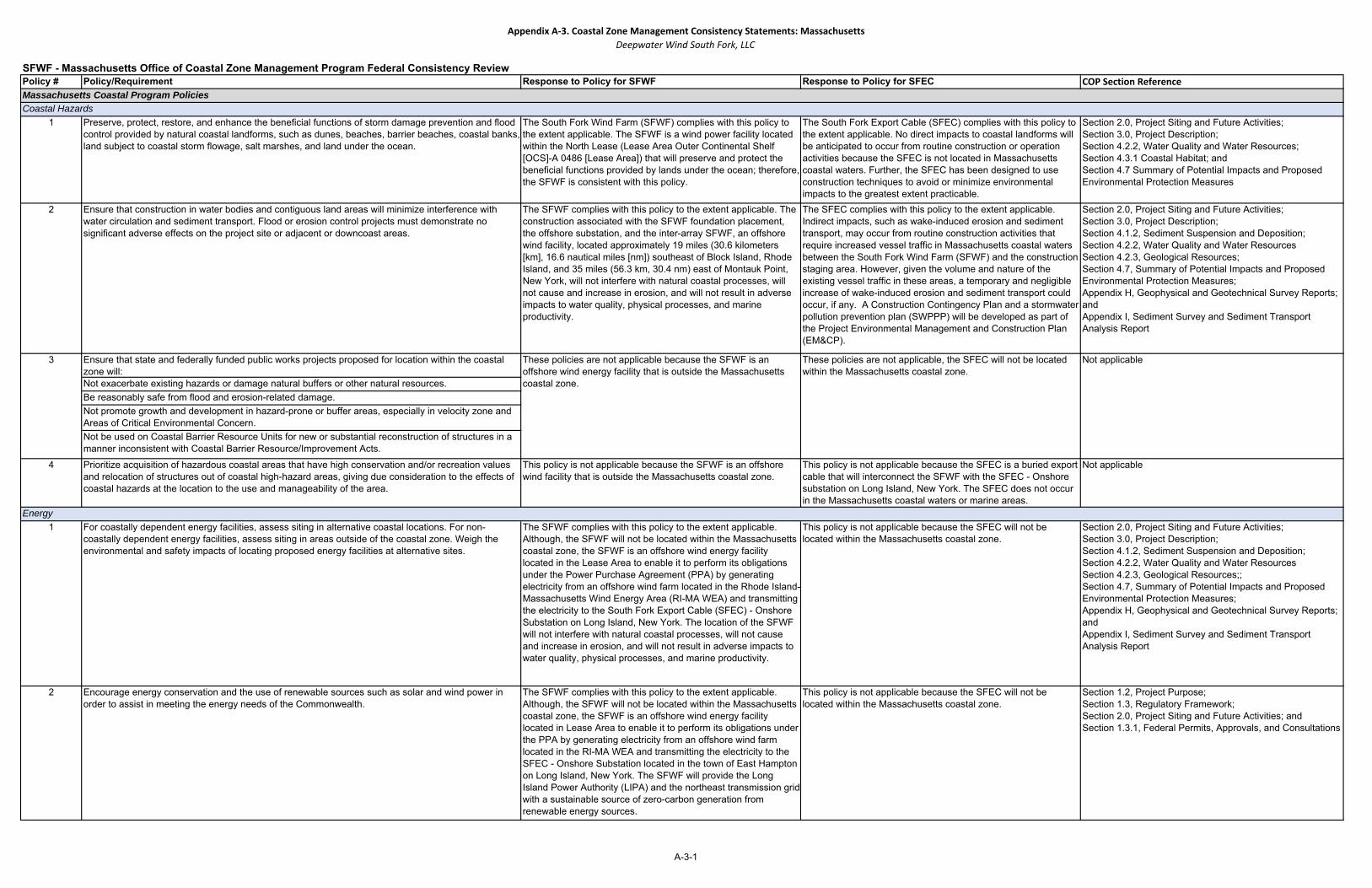
Appendix A‐3. Coastal Zone Management Consistency Statements: MassachusettsDeepwater Wind South Fork, LLC
Policy # Policy/Requirement Response to Policy for SFWF Response to Policy for SFEC COP Section Reference
1 Preserve, protect, restore, and enhance the beneficial functions of storm damage prevention and flood control provided by natural coastal landforms, such as dunes, beaches, barrier beaches, coastal banks, land subject to coastal storm flowage, salt marshes, and land under the ocean.
The South Fork Wind Farm (SFWF) complies with this policy to the extent applicable. The SFWF is a wind power facility located within the North Lease (Lease Area Outer Continental Shelf [OCS]-A 0486 [Lease Area]) that will preserve and protect the beneficial functions provided by lands under the ocean; therefore, the SFWF is consistent with this policy.
The South Fork Export Cable (SFEC) complies with this policy to the extent applicable. No direct impacts to coastal landforms will be anticipated to occur from routine construction or operation activities because the SFEC is not located in Massachusetts coastal waters. Further, the SFEC has been designed to use construction techniques to avoid or minimize environmental impacts to the greatest extent practicable.
Section 2.0, Project Siting and Future Activities;Section 3.0, Project Description; Section 4.2.2, Water Quality and Water Resources; Section 4.3.1 Coastal Habitat; and Section 4.7 Summary of Potential Impacts and Proposed Environmental Protection Measures
2 Ensure that construction in water bodies and contiguous land areas will minimize interference with water circulation and sediment transport. Flood or erosion control projects must demonstrate no significant adverse effects on the project site or adjacent or downcoast areas.
The SFWF complies with this policy to the extent applicable. The construction associated with the SFWF foundation placement, the offshore substation, and the inter-array SFWF, an offshore wind facility, located approximately 19 miles (30.6 kilometers [km], 16.6 nautical miles [nm]) southeast of Block Island, Rhode Island, and 35 miles (56.3 km, 30.4 nm) east of Montauk Point, New York, will not interfere with natural coastal processes, will not cause and increase in erosion, and will not result in adverse impacts to water quality, physical processes, and marine productivity.
The SFEC complies with this policy to the extent applicable. Indirect impacts, such as wake-induced erosion and sediment transport, may occur from routine construction activities that require increased vessel traffic in Massachusetts coastal waters between the South Fork Wind Farm (SFWF) and the construction staging area. However, given the volume and nature of the existing vessel traffic in these areas, a temporary and negligible increase of wake-induced erosion and sediment transport could occur, if any. A Construction Contingency Plan and a stormwater pollution prevention plan (SWPPP) will be developed as part of the Project Environmental Management and Construction Plan (EM&CP).
Section 2.0, Project Siting and Future Activities;Section 3.0, Project Description;Section 4.1.2, Sediment Suspension and Deposition;Section 4.2.2, Water Quality and Water ResourcesSection 4.2.3, Geological Resources;Section 4.7, Summary of Potential Impacts and Proposed Environmental Protection Measures;Appendix H, Geophysical and Geotechnical Survey Reports; andAppendix I, Sediment Survey and Sediment Transport Analysis Report
Ensure that state and federally funded public works projects proposed for location within the coastal zone will: Not exacerbate existing hazards or damage natural buffers or other natural resources. Be reasonably safe from flood and erosion-related damage. Not promote growth and development in hazard-prone or buffer areas, especially in velocity zone and Areas of Critical Environmental Concern. Not be used on Coastal Barrier Resource Units for new or substantial reconstruction of structures in a manner inconsistent with Coastal Barrier Resource/Improvement Acts.
4 Prioritize acquisition of hazardous coastal areas that have high conservation and/or recreation values and relocation of structures out of coastal high-hazard areas, giving due consideration to the effects of coastal hazards at the location to the use and manageability of the area.
This policy is not applicable because the SFWF is an offshore wind facility that is outside the Massachusetts coastal zone.
This policy is not applicable because the SFEC is a buried export cable that will interconnect the SFWF with the SFEC - Onshore substation on Long Island, New York. The SFEC does not occur in the Massachusetts coastal waters or marine areas.
Not applicable
1 For coastally dependent energy facilities, assess siting in alternative coastal locations. For non-coastally dependent energy facilities, assess siting in areas outside of the coastal zone. Weigh the environmental and safety impacts of locating proposed energy facilities at alternative sites.
The SFWF complies with this policy to the extent applicable. Although, the SFWF will not be located within the Massachusetts coastal zone, the SFWF is an offshore wind energy facility located in the Lease Area to enable it to perform its obligations under the Power Purchase Agreement (PPA) by generating electricity from an offshore wind farm located in the Rhode Island-Massachusetts Wind Energy Area (RI-MA WEA) and transmitting the electricity to the South Fork Export Cable (SFEC) - Onshore Substation on Long Island, New York. The location of the SFWF will not interfere with natural coastal processes, will not cause and increase in erosion, and will not result in adverse impacts to water quality, physical processes, and marine productivity.
This policy is not applicable because the SFEC will not be located within the Massachusetts coastal zone.
Section 2.0, Project Siting and Future Activities;Section 3.0, Project Description;Section 4.1.2, Sediment Suspension and Deposition;Section 4.2.2, Water Quality and Water ResourcesSection 4.2.3, Geological Resources;;Section 4.7, Summary of Potential Impacts and Proposed Environmental Protection Measures;Appendix H, Geophysical and Geotechnical Survey Reports; andAppendix I, Sediment Survey and Sediment Transport Analysis Report
2 Encourage energy conservation and the use of renewable sources such as solar and wind power in order to assist in meeting the energy needs of the Commonwealth.
The SFWF complies with this policy to the extent applicable. Although, the SFWF will not be located within the Massachusetts coastal zone, the SFWF is an offshore wind energy facility located in Lease Area to enable it to perform its obligations under the PPA by generating electricity from an offshore wind farm located in the RI-MA WEA and transmitting the electricity to the SFEC - Onshore Substation located in the town of East Hampton on Long Island, New York. The SFWF will provide the Long Island Power Authority (LIPA) and the northeast transmission grid with a sustainable source of zero-carbon generation from renewable energy sources.
This policy is not applicable because the SFEC will not be located within the Massachusetts coastal zone.
Section 1.2, Project Purpose;Section 1.3, Regulatory Framework;Section 2.0, Project Siting and Future Activities; and Section 1.3.1, Federal Permits, Approvals, and Consultations
These policies are not applicable, the SFEC will not be located within the Massachusetts coastal zone.
Energy
SFWF - Massachusetts Office of Coastal Zone Management Program Federal Consistency Review
Massachusetts Coastal Program PoliciesCoastal Hazards
3 These policies are not applicable because the SFWF is an offshore wind energy facility that is outside the Massachusetts coastal zone.
Not applicable
A-3-1

Appendix A‐3. Coastal Zone Management Consistency Statements: MassachusettsDeepwater Wind South Fork, LLC
Policy # Policy/Requirement Response to Policy for SFWF Response to Policy for SFEC COP Section ReferenceSFWF - Massachusetts Office of Coastal Zone Management Program Federal Consistency Review
1 Encourage sustainable development that is consistent with state, regional, and local plans and support the quality and character of the community.
This policy is not applicable because the SFWF does not propose to encourage sustainable development that is consistent with state, regional, and local plans.
The SFEC complies with this policy to the extent applicable. The SFEC is part of the SFWF offshore wind facility that could be characterized as sustainable development that is consistent with state, regional, and local plans.
Section 1.2, Project Purpose; and Section 2.0, Project Siting and Future Activities
2 Ensure that state and federally funded infrastructure projects in the coastal zone primarily serve existing developed areas, assigning highest priority to projects that meet the needs of urban and community development centers.
This policy is not applicable because the SFWF is an offshore wind facility and is not a state- or federally funded infrastructure project in the coastal zone.
This policy is not applicable because the SFEC is not a state or federally funded infrastructure SFEC in the Massachusetts coastal zone.
Not applicable
3 Encourage the revitalization and enhancement of existing development centers in the coastal zone through technical assistance and financial support for residential, commercial, and industrial development.
This policy is not applicable because the SFWF is an offshore wind facility.
This policy is not applicable because the SFEC does not occur in the Massachusetts coastal zone; therefore, this policy does not apply.
Not applicable
1 Protect coastal, estuarine, and marine habitats - including salt marshes, shellfish beds, submerged aquatic vegetation, dunes, beaches, barrier beaches, banks, salt ponds, eelgrass beds, tidal flats, rocky shore, bays, sounds, and other ocean habitats - and coastal freshwater streams, ponds, and wetlands to preserved critical wildlife habitat and other important functions and services including nutrient and sediment attenuation, wave and storm damage protection, and landform movement and processes.
The SFWF complies with this policy to the extent applicable because it has been designed to use construction techniques to avoid or minimize environmental impacts to the greatest extent practicable. A Construction Contingency Plan and a stormwater pollution prevention plan (SWPPP) will be developed as part of the Project Environmental Management and Construction Plan (EM&CP).
The SFEC complies with this policy to the extent applicable because the SFEC has been designed to use construction techniques to avoid or minimize environmental impacts to the greatest extent practicable.
Section 4.2.2, Water Quality and Water Resources;Section 4.3.1, Biological Resources; Section 4.3.1, Coastal and Terrestrial Habitat; Section 3.4.2, Benthic and Shellfish Resources; Section 4.3.3, Finfish and Essential Fish Habitat Section 4.7, Summary of Potential Impacts and Proposed Environmental Protection Measures;Appendix N, Benthic Resources Survey Report;Appendix O, Essential Fish Habitat Report;Appendix P, Marine Mammal, Sea Turtle, and Sturgeon Reports; andAppendix Q, Avian and Bat Reports
2 Advance the restoration of degraded or former habitats in coastal and marine areas. This policy is not applicable because the SFWF does not occur in or plan to advance the restoration of degraded or former habitats in the Massachusetts coastal or marine areas; if the port of New Bedford is selected for the SFWF staging area, the staging area is anticipated to be located within an existing port/facility.
This policy is not applicable because the SFEC is a buried export cable that will interconnect the SFWF with the SFEC - Onshore substation on Long Island, New York. The SFEC does not occur in the Massachusetts coastal waters or marine areas.
Not applicable
1 Support the development of sustainable aquaculture, both for commercial and enhancement (public shellfish stocking) purposes. Ensure that the review process regulating aquaculture facility sites (and access routes to those areas) protects significant ecological resources (salt marshes, dunes, beaches, barrier beaches, and salt ponds) and minimizes adverse effects on the coastal and marine environment and other water-dependent uses.
This policy is not applicable because the SFWF is an offshore wind facility which does not involve aquaculture.
This policy is not applicable because the SFEC is a buried export cable that does not involve aquaculture.
Not applicable
2 Except where such activity is prohibited by the Ocean Sanctuaries Act, the Massachusetts Ocean Management Plan, or other applicable provision of law, the extraction of oil, natural gas, or marine minerals (other than sand and gravel) in or affecting the coastal zone must protect marine resources, marine water quality, fisheries, and navigational, recreational and other uses.
Tthis policy is not applicable because the SFWF does not propose the extraction of oil, natural gas, or marine minerals.
This policy is not applicable the SFEC is a buried export cable that does not propose the extraction of oil, natural gas, or marine minerals.
Not applicable
3 Accommodate offshore sand and gravel extraction needs in areas and in ways that will not adversely affect marine resources, navigation, or shoreline areas because of alteration of wave direction and dynamics. Extraction of sand and gravel, when and where permitted, will be primarily for the purpose of beach nourishment or shoreline stabilization.
This policy is not applicable because the SFWF does not propose the extraction of sand and gravel.
This policy is not applicable because the SFEC is a buried export cable and does not propose the extraction of sand and gravel.
Not applicable
1 Ensure that dredging and disposal of dredged material minimize adverse effects on water quality, physical processes, marine productivity, and public health and take full advantage of opportunities for beneficial re-use.
This policy is not applicable because the SFWF does not propose dredging or disposal of dredged material in the Massachusetts coastal zone.
This policy is not applicable because the SFEC is a buried export cable that will interconnect the SFWF with the SFEC - Onshore substation on Long Island, New York, and will not require dredging or dredged material disposal within Massachusetts coastal waters.
Not applicable
2 Obtain the widest possible public benefit from channel dredging and ensure that Designated Port Areas and developed harbors are given highest priority in the allocation of resources.
This policy is not applicable because the SFWF does not propose channel dredging in the Massachusetts coastal zone.
This policy is not applicable because the SFEC is a buried export cable that will interconnect the SFWF located within the Lease Area Outer Continental Shelf (OCS)-A 0486 (the North Lease) with the SFEC - Onshore substation on Long Island, New York. The SFEC does not involve channel dredging in Massachusetts coastal waters or in a Designated Port Area (DPA).
Not applicable
Growth Management
Habitat
Ocean Resources
Ports and Harbors
A-3-2
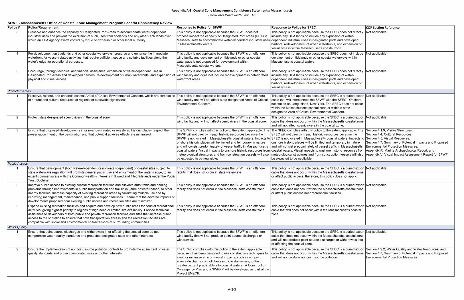
Appendix A‐3. Coastal Zone Management Consistency Statements: MassachusettsDeepwater Wind South Fork, LLC
Policy # Policy/Requirement Response to Policy for SFWF Response to Policy for SFEC COP Section ReferenceSFWF - Massachusetts Office of Coastal Zone Management Program Federal Consistency Review
3 Preserve and enhance the capacity of Designated Port Areas to accommodate water-dependent industrial uses and prevent the exclusion of such uses from tidelands and any other DPA lands over which an EEA agency exerts control by virtue of ownership or other legal authority.
This policy is not applicable because the SFWF does not propose impact the capacity of Designated Port Areas (DPA) in Massachusetts to accommodate water-dependent industrial uses in Massachusetts waters.
This policy is not applicable because the SFEC does not directly include any DPA lands or include any expansion of water-dependent industrial uses in designated ports and developed harbors, redevelopment of urban waterfronts, and expansion of visual access within Massachusetts coastal zone.
Not applicable
4 For development on tidelands and other coastal waterways, preserve and enhance the immediate waterfront for vessel-related activities that require sufficient space and suitable facilities along the water's edge for operational purposes.
This policy is not applicable because the SFWF is an offshore wind facility and development on tidelands or other coastal waterways is not proposed for development within Massachusetts coastal waters.
This policy is not applicable because the SFEC does not include development on tidelands or other coastal waterways within Massachusetts coastal waters.
Not applicable
5 Encourage, through technical and financial assistance, expansion of water-dependent uses in Designated Port Areas and developed harbors, re-development of urban waterfronts, and expansion of physical and visual access.
This policy is not applicable because the SFWF is an offshore wind facility and does not include redevelopment in deteriorated waterfront areas.
This policy is not applicable because the SFEC does not directly include any DPA lands or include any expansion of water-dependent industrial uses in designated ports and developed harbors, redevelopment of urban waterfronts, and expansion of visual access.
Not applicable
1 Preserve, restore, and enhance coastal Areas of Critical Environmental Concern, which are complexes of natural and cultural resources of regional or statewide significance.
This policy is not applicable because the SFWF is an offshore wind facility and will not affect state-designated Areas of Critical Environmental Concern.
This policy is not applicable because the SFEC is a buried export cable that will interconnect the SFWF with the SFEC - Onshore substation on Long Island, New York. The SFEC does not occur within the Massachusetts coastal zone or within a state-designated Area of Critical Environmental Concern.
Not applicable
2 Protect state designated scenic rivers in the coastal zone. This policy is not applicable because the SFWF is an offshore wind facility and will not affect scenic rivers in the coastal zone.
This policy is not applicable because the SFEC is a buried export cable that does not occur within the Massachusetts coastal zone and will not affect scenic rivers in the coastal zone.
Not applicable
3 Ensure that proposed developments in or near designated or registered historic places respect the preservation intent of the designation and that potential adverse effects are minimized.
The SFWF complies with this policy to the extent applicable. The SFWF will not directly impact historic resources because the SFWF is not located in Massachusetts coastal waters. Impacts to onshore historic places will be limited and temporary in nature and will consist predominately of vessel traffic in Massachusetts coastal waters. Visual impacts to onshore historic resources from meteorological structures and from construction vessels will also be expected to be negligible.
The SFEC complies with this policy to the extent applicable. The SFEC will not directly impact historic resources because the SFEC is not located in Massachusetts coastal waters. Impacts to onshore historic places will be limited and temporary in nature and will consist predominately of vessel traffic in Massachusetts coastal waters. Visual impacts to onshore historic resources from meteorological structures and from construction vessels will also be expected to be negligible.
Section 4.1.9, Visible Structures;Section 4.4, Cultural Resources;Section 4.5, Visual Resources;Section 4.7, Summary of Potential Impacts and Proposed Environmental Protection Measures;Appendix R, Marine Archaeological Report; andAppendix V, Visual Impact Assessment Report for SFWF
1 Ensure that development (both water-dependent or nonwater-dependent) of coastal sites subject to state waterways regulation will promote general public use and enjoyment of the water's edge, to an extent commensurate with the Commonwealth's interests in flowed and filled tidelands under the Public Trust Doctrine.
This policy is not applicable because the SFWF is an offshore facility that does not occur in state waterways.
This policy is not applicable because the SFEC is a buried export cable that does not occur within the Massachusetts coastal zone or affect public access; therefore, this policy does not apply.
Not applicable
2 Improve public access to existing coastal recreation facilities and alleviate auto traffic and parking problems through improvements in public transportation and trail links (land- or water-based) to other nearby facilities. Increase capacity of existing recreation areas by facilitating multiple use and by improving management, maintenance, and public support facilities. Ensure that the adverse impacts of developments proposed near existing public access and recreation sites are minimized.
This policy is not applicable because the SFWF is an offshore facility and does not occur in the Massachusetts coastal zone.
This policy is not applicable because the SFEC is a buried export cable that does not occur within the Massachusetts coastal zone or affect public access near recreational facilities.
Not applicable
3 Expand existing recreation facilities and acquire and develop new public areas for coastal recreational activities, giving highest priority to regions of high need or limited site availability. Provide technical assistance to developers of both public and private recreation facilities and sites that increase public access to the shoreline to ensure that both transportation access and the recreation facilities are compatible with social and environmental characteristics of surrounding communities.
This policy is not applicable because the SFWF is an offshore facility and does not occur in the Massachusetts coastal zone.
This policy is not applicable because the SFEC is a buried export cable that will does not occur within the Massachusetts coastal zone.
Not applicable
1 Ensure that point-source discharges and withdrawals in or affecting the coastal zone do not compromise water quality standards and protected designated uses and other interests.
This policy is not applicable because the SFWF is an offshore wind facility that will not produce point-source discharges or withdrawals.
This policy is not applicable because the SFEC is a buried export cable that does not occur within the Massachusetts coastal zone and will not produce point-source discharges or withdrawals into or affecting the coastal zone.
Not applicable
2 Ensure the implementation of nonpoint source pollution controls to promote the attainment of water quality standards and protect designated uses and other interests.
The SFWF complies with this policy to the extent applicable because it has been designed to use construction techniques to avoid or minimize environmental impacts, such as nonpoint source discharges of pollutants into coastal waters, to the greatest extent practicable into coastal waters. A Construction Contingency Plan and a SWPPP will be developed as part of the Project EM&CP.
This policy is not applicable because the SFEC is a buried export cable that does not occur within the Massachusetts coastal zone and will not produce nonpoint source pollution.
Section 4.2.2, Water Quality and Water Resources; andSection 4.7, Summary of Potential Impacts and Proposed Environmental Protection Measures
Public Access
Water Quality
Protected Areas
A-3-3
Appendix A‐3. Coastal Zone Management Consistency Statements: MassachusettsDeepwater Wind South Fork, LLC
Policy # Policy/Requirement Response to Policy for SFWF Response to Policy for SFEC COP Section ReferenceSFWF - Massachusetts Office of Coastal Zone Management Program Federal Consistency Review
3 Ensure that subsurface waste discharges conform to applicable standards, including the siting, construction, and maintenance requirements for on-site wastewater disposal systems, water quality standards, established Total Maximum Daily Load limits, and prohibitions on facilities in high-hazard areas.
This policy is not applicable because the SFWF is an offshore facility that will not produce subsurface waste discharges that will require an onsite wastewater disposal system.
This policy is not applicable because the SFEC is a buried export cable that does not occur within the Massachusetts coastal zone and will not produce subsurface waste discharges that will require an onsite wastewater disposal system.
Not applicable
A-3-4