Embed Size (px)
Citation preview
1
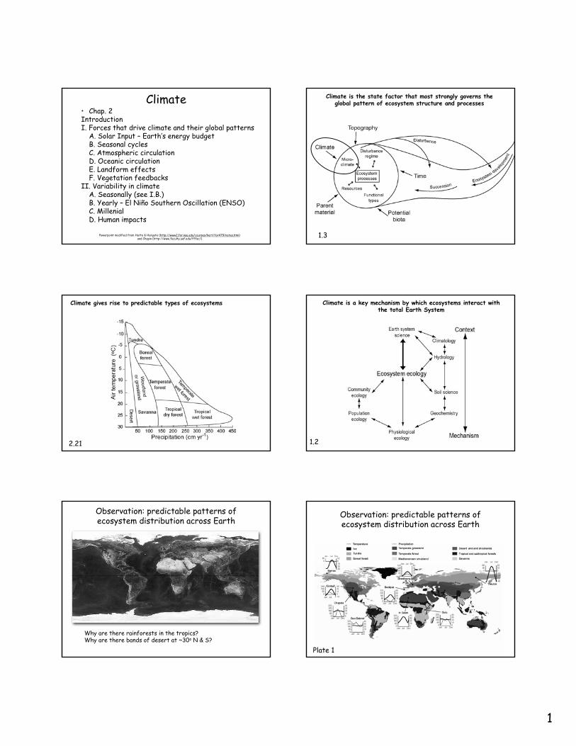
Climate• Chap. 2IntroductionI. Forces that drive climate and their global patterns
A. Solar Input – Earth’s energy budgetB. Seasonal cyclesC. Atmospheric circulationD. Oceanic circulationE. Landform effectsF. Vegetation feedbacks
II. Variability in climateA. Seasonally (see I.B.)B. Yearly – El Niño Southern Oscillation (ENSO)C. MillenialD. Human impacts
Powerpoint modified from Harte & Hungate (http://www2.for.nau.edu/courses/hart/for479/notes.htm) and Chapin (http://www.faculty.uaf.edu/fffsc/)
Climate is the state factor that most strongly governs the global pattern of ecosystem structure and processes
1.3
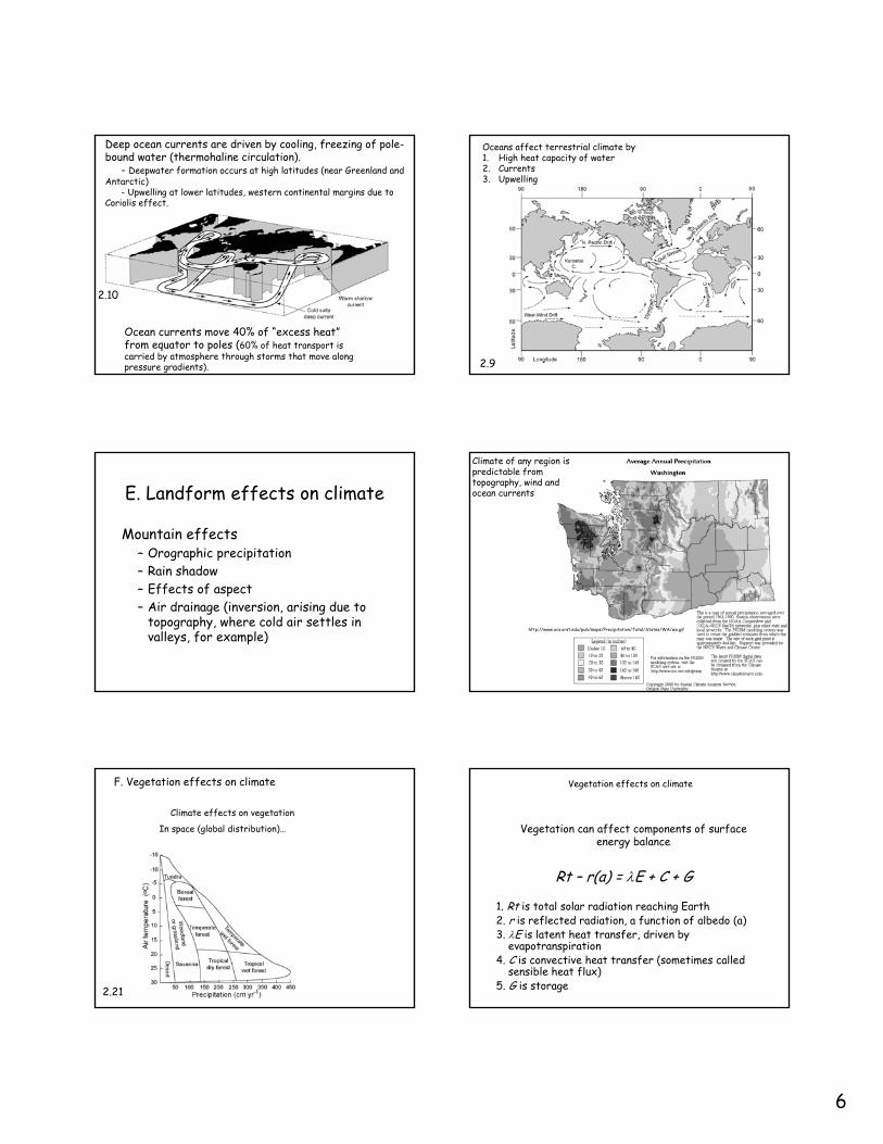
Climate gives rise to predictable types of ecosystems
2.21
Climate is a key mechanism by which ecosystems interact with the total Earth System
1.2
Observation: predictable patterns of ecosystem distribution across Earth
Why are there rainforests in the tropics?Why are there bands of desert at ~30o N & S?
Observation: predictable patterns of ecosystem distribution across Earth
Plate 1
2
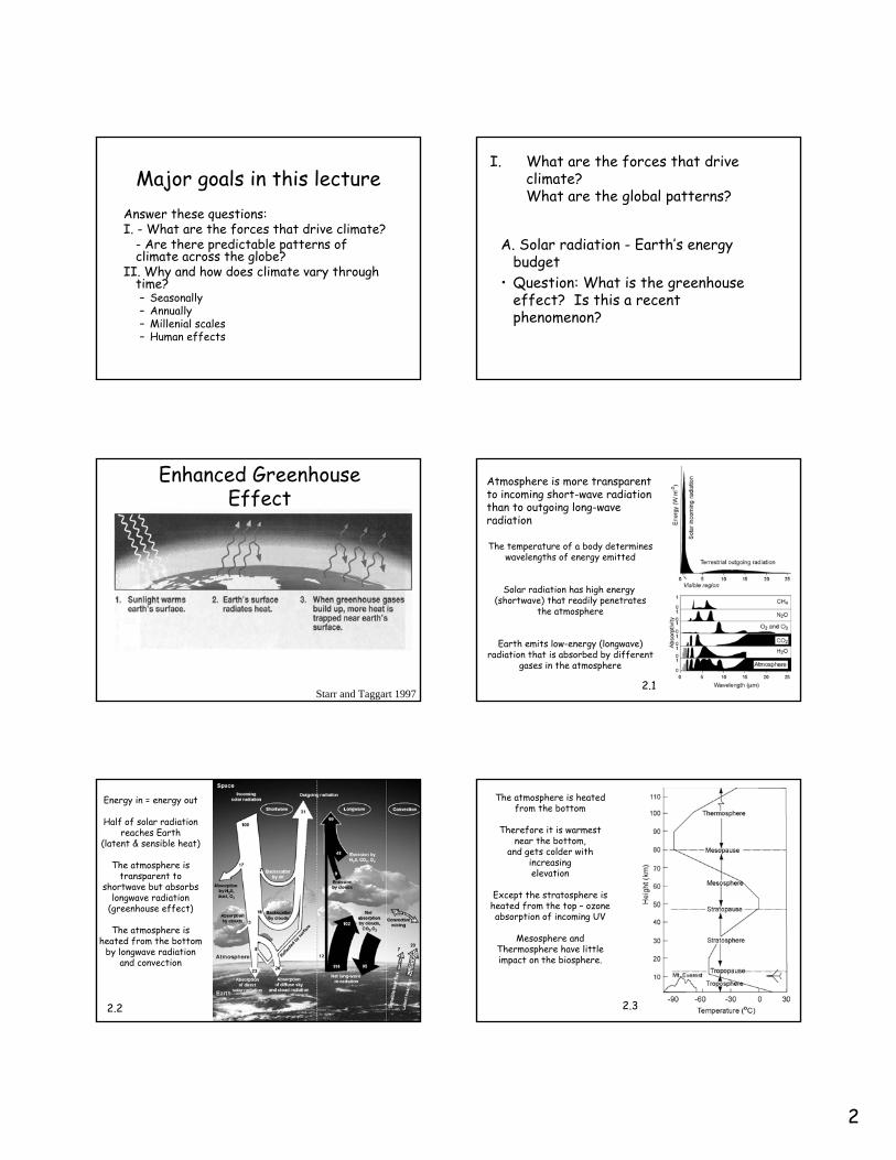
Major goals in this lectureAnswer these questions:I. - What are the forces that drive climate?
- Are there predictable patterns of climate across the globe?
II. Why and how does climate vary through time?– Seasonally– Annually– Millenial scales– Human effects
I. What are the forces that drive climate? What are the global patterns?
A. Solar radiation - Earth’s energy budget
• Question: What is the greenhouse effect? Is this a recent phenomenon?
Enhanced Greenhouse Effect
Starr and Taggart 1997
The temperature of a body determineswavelengths of energy emitted
Solar radiation has high energy (shortwave) that readily penetrates
the atmosphere
Earth emits low-energy (longwave)radiation that is absorbed by different
gases in the atmosphere
2.1
Atmosphere is more transparent to incoming short-wave radiation than to outgoing long-wave radiation
Energy in = energy out
Half of solar radiationreaches Earth
(latent & sensible heat)
The atmosphere is transparent to
shortwave but absorbs longwave radiation
(greenhouse effect)
The atmosphere is heated from the bottom
by longwave radiation and convection
2.2
The atmosphere is heated from the bottom
Therefore it is warmest near the bottom,
and gets colder with increasingelevation
Except the stratosphere is heated from the top – ozone absorption of incoming UV
Mesosphere and Thermosphere have little impact on the biosphere.
2.3
3
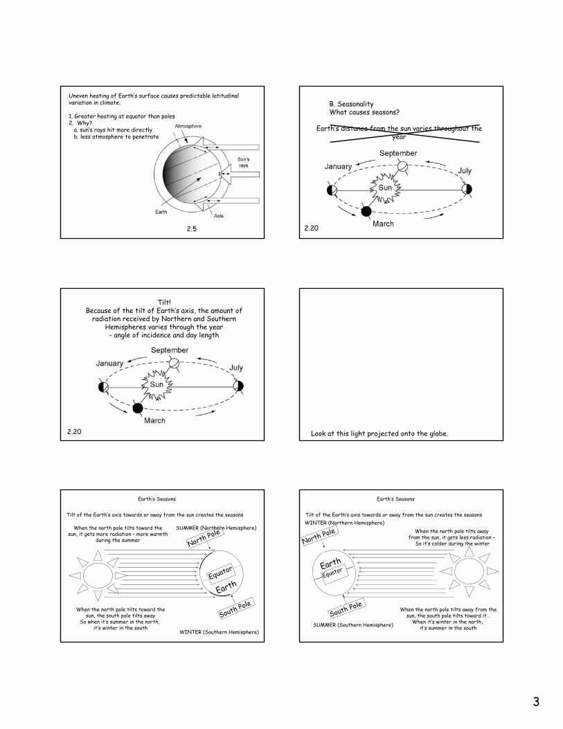
Uneven heating of Earth’s surface causes predictable latitudinal variation in climate.
1. Greater heating at equator than poles2. Why?
a. sun’s rays hit more directlyb. less atmosphere to penetrate
2.5
B. SeasonalityWhat causes seasons?
Earth’s distance from the sun varies throughout the year
2.20
Tilt!Because of the tilt of Earth’s axis, the amount of
radiation received by Northern and Southern Hemispheres varies through the year
- angle of incidence and day length
2.20 Look at this light projected onto the globe.
Tilt of the Earth’s axis towards or away from the sun creates the seasons
Earth’s Seasons
North Pole
Earth
When the north pole tilts toward thesun, it gets more radiation – more warmth
during the summer
SUMMER (Northern Hemisphere)
South Pole
WINTER (Southern Hemisphere)
When the north pole tilts toward thesun, the south pole tilts away
So when it’s summer in the north, it’s winter in the south
Equator
Tilt of the Earth’s axis towards or away from the sun creates the seasons
Earth’s Seasons
When the north pole tilts away from the sun, it gets less radiation –
So it’s colder during the winter
Earth
WINTER (Northern Hemisphere)
SUMMER (Southern Hemisphere)
When the north pole tilts away from thesun, the south pole tilts toward it…
When it’s winter in the north, it’s summer in the south
North Pole
South Pole
Equator
4
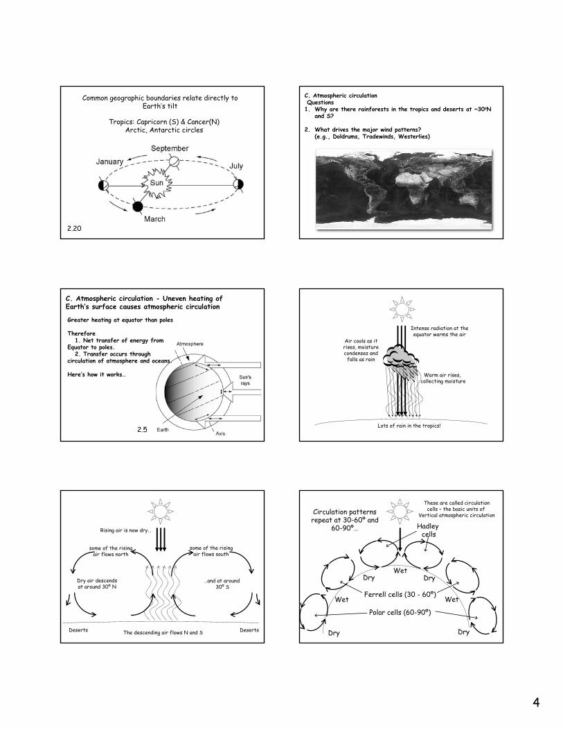
Tropics: Capricorn (S) & Cancer(N) Arctic, Antarctic circles
2.20
Common geographic boundaries relate directly to Earth’s tilt
C. Atmospheric circulationQuestions
1. Why are there rainforests in the tropics and deserts at ~30oN and S?
2. What drives the major wind patterns?(e.g., Doldrums, Tradewinds, Westerlies)
Greater heating at equator than poles
Therefore1. Net transfer of energy from
Equator to poles.2. Transfer occurs through
circulation of atmosphere and oceans.
Here’s how it works…
C. Atmospheric circulation - Uneven heating of Earth’s surface causes atmospheric circulation
2.5
Intense radiation at theequator warms the air
Warm air rises, collecting moisture
Air cools as itrises, moisturecondenses and
falls as rain
Lots of rain in the tropics!
some of the risingair flows south
some of the risingair flows north
Rising air is now dry…
Dry air descendsat around 30º N
…and at around 30º S
Deserts DesertsThe descending air flows N and S
These are called circulationcells – the basic units of
Vertical atmospheric circulation
Hadley cells
Ferrell cells (30 - 60º)
Polar cells (60-90º)
Circulation patternsrepeat at 30-60º and
60-90º…
Dry
Dry
Wet
WetDry
Wet
Dry
5
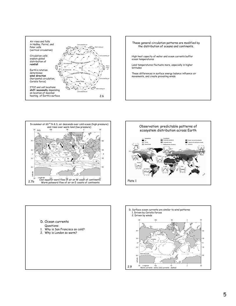
Air rises and falls in Hadley, Ferrel, and Polar cells(vertical circulation)
Circulation cells explain global distribution of rainfall
Earth’s rotation determineswind direction(horizontal circulation,Coriolis force)
ITCZ and cell locations shift seasonally depending on location of maximal heating of Earth’s surface 2.6
High heat capacity of water and ocean currents buffer ocean temperatures
Land temperatures fluctuate more, especially in higher latitudes
These differences in surface energy balance influence air movements, and create prevailing winds
These general circulation patterns are modified by the distribution of oceans and continents.
In summer at 60 º N & S, air descends over cold ocean (high pressure) and rises over warm land (low pressure)
Cool equator-ward flow of air on W coast of continentsWarm poleward flow of air on E coasts of continents2.7b
Observation: predictable patterns of ecosystem distribution across Earth
Plate 1
D. Ocean currents Questions:
1. Why is San Francisco so cold?2. Why is London so warm?
D. Surface ocean currents are similar to wind patterns:1. Driven by Coriolis forces2. Driven by winds
2.9 Warm currents – solid, Cold currents - dashed
6
Deep ocean currents are driven by cooling, freezing of pole-bound water (thermohaline circulation).
- Deepwater formation occurs at high latitudes (near Greenland andAntarctic)
- Upwelling at lower latitudes, western continental margins due to Coriolis effect.
Ocean currents move 40% of “excess heat”from equator to poles (60% of heat transport is carried by atmosphere through storms that move along pressure gradients).
2.10
Oceans affect terrestrial climate by1. High heat capacity of water2. Currents3. Upwelling
2.9
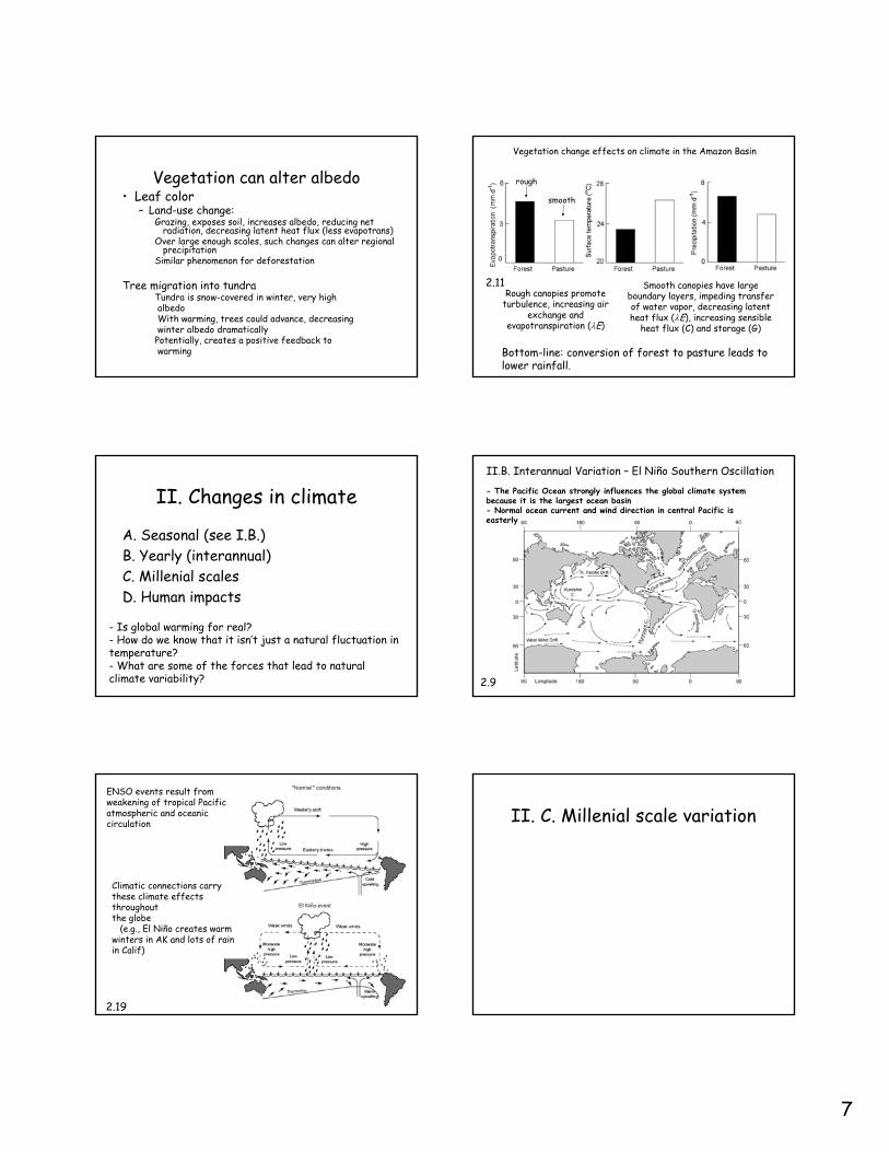
E. Landform effects on climate
Mountain effects– Orographic precipitation– Rain shadow– Effects of aspect– Air drainage (inversion, arising due to
topography, where cold air settles in valleys, for example)
Climate of any region is predictable from topography, wind and ocean currents
http://www.ocs.orst.edu/pub/maps/Precipitation/Total/States/WA/wa.gif
F. Vegetation effects on climate
Climate effects on vegetation
In space (global distribution)…
2.21
Rt – r(a) = λE + C + G
1. Rt is total solar radiation reaching Earth2. r is reflected radiation, a function of albedo (a)3. λE is latent heat transfer, driven by
evapotranspiration4. C is convective heat transfer (sometimes called
sensible heat flux)5. G is storage
Vegetation effects on climate
Vegetation can affect components of surfaceenergy balance
7
Vegetation can alter albedo• Leaf color
– Land-use change:Grazing, exposes soil, increases albedo, reducing net
radiation, decreasing latent heat flux (less evapotrans)Over large enough scales, such changes can alter regional
precipitationSimilar phenomenon for deforestation
Tree migration into tundraTundra is snow-covered in winter, very highalbedoWith warming, trees could advance, decreasingwinter albedo dramatically
Potentially, creates a positive feedback towarming
Vegetation change effects on climate in the Amazon Basin
Rough canopies promote turbulence, increasing air
exchange and evapotranspiration (λE)
Smooth canopies have large boundary layers, impeding transfer of water vapor, decreasing latent heat flux (λE), increasing sensible
heat flux (C) and storage (G)
rough
smooth
Bottom-line: conversion of forest to pasture leads to lower rainfall.
2.11
II. Changes in climate
A. Seasonal (see I.B.)B. Yearly (interannual)C. Millenial scalesD. Human impacts
- Is global warming for real? - How do we know that it isn’t just a natural fluctuation in temperature? - What are some of the forces that lead to natural climate variability?
- The Pacific Ocean strongly influences the global climate systembecause it is the largest ocean basin- Normal ocean current and wind direction in central Pacific is easterly
II.B. Interannual Variation – El Niño Southern Oscillation
2.9
ENSO events result from weakening of tropical Pacific atmospheric and oceanic circulation
Climatic connections carry these climate effects throughoutthe globe
(e.g., El Niño creates warm winters in AK and lots of rain in Calif)
2.19
II. C. Millenial scale variation
8
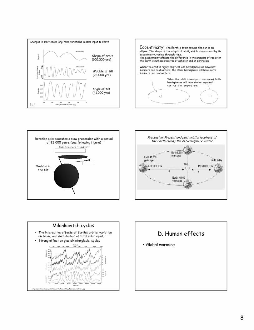
Changes in orbit cause long-term variations in solar input to Earth
Angle of tilt(41,000 yrs)
Wobble of tilt(23,000 yrs)
Shape of orbit(100,000 yrs)
2.14
Eccentricity: The Earth's orbit around the sun is an ellipse. The shape of the elliptical orbit, which is measured by its eccentricity, varies through time.The eccentricity affects the difference in the amounts of radiation the Earth's surface receives at aphelion and at perihelion.
When the orbit is highly elliptical, one hemisphere will have hot summers and cold winters; the other hemisphere will have warm summers and cool winters.
When the orbit is nearly circular (now), both hemispheres will have similar seasonal contrasts in temperature.
Rotation axis executes a slow precession with a period of 23,000 years (see following figure)
Pole Stars are Transient
Wobble inthe tilt
Precession: Present and past orbital locations of the Earth during the N Hemisphere winter
Milankovitch cycles• The interactive effects of Earth’s orbital variation
on timing and distribution of total solar input.• Strong effect on glacial/interglacial cycles
http://en.wikipedia.org/wiki/Image:Vostok_420ky_4curves_insolation.jpg
D. Human effects
• Global warming

9
Earth’s climate is now warmer than at any time in the last 1000 years
2.16
How can the atmosphere warm?
1. Increased solar input
2. Less reflected shortwave, less sulfate aerosols, darker surface of Earth (land-cover
change)
3. More absorbed longwavemore “greenhouse gases”
2.2
Most major greenhouse gases are increasing in atmospheric concentrations
15.3
Earth’s climate is now warmer than at any time in the last 1000 years1. increased solar input (small warming effect)2. Increased sulfate aerosols reflects radiation (small cooling effect)3. Increased greenhouse gas concentrations (large warming effect)4. Land-cover change creates a darker surface (large warming effect)
2.16
Climate is warming most rapidly at high latitudes
This warming is most pronounced in Siberia and western North America
Summary: Functioning of ecosystems varies predictably with climate

10
END
Combination of temperature and precipitation