Embed Size (px)
Citation preview
Vol. 66 · No. 3 · 221–2372012
DOI: 10.3112/erdkunde.2012.03.03 http://www.erdkunde.uni-bonn.deISSN 0014-0015
SOIL FUNCTIONS – TODAY’S SITUATION AND FURTHER DEVELOPMENT UNDER CLIMATE CHANGE
Kirsten Madena, Helge BorMann and luise giani
With 3 figures and 4 tablesReceived 01. March 2012 · Accepted 16. July 2012
Summary: Climate change will have effects on many ecosystems, including the top layer of the earth: the soils. Climate-induced changes in soil properties can lead to changes in soil functions and their importance for soil protection. These possible changes have been evaluated within the German part of the EU Interreg IVb project “Climate Proof Areas” in two pilot regions in the Wesermarsch (Germany). The evaluation of eight different soil sub-functions was carried out using the evaluation method TUSEC-B based on soil information gained from soil maps for present (Status Quo) and climate-adapted soil properties. Four different climate scenarios for 2050 were considered. The evaluation results of the individual soil functions have been summarized to an overall evaluation result using the maximum principle. The evaluation results for the Status Quo show that large areas of the pilot regions are important for soil protection regarding both the individual soil function evaluation and the summarized evaluation. The adaptation of climate-influenced evaluation parameters results in an increase of the importance of protection of the soils for some sub-regions and in a decrease for others, depending on the scenario. The differences in the extent and direction of changing evaluation results mainly depend on changes in soil organic matter content and groundwater level. They are different for the individual soil functions and regarding the overall evalua-tion result, but show the influence of climate change on soil functions. On the basis of these results, it is recommended to consider climate-induced changes in soil functions within spatial planning processes such as area-wide coastal protection or water management measures (e.g., dike or reservoir construction), to avoid the loss of soils with valuable functions that are worth protecting.
Zusammenfassung: Der �limawandel wird sich auf viele �kosysteme, einschlie�lich des �kosystems �Boden“, auswir-Der �limawandel wird sich auf viele �kosysteme, einschlie�lich des �kosystems �Boden“, auswir-ken. Diese klimabedingten Änderungen der Bodeneigenschaften können zu Veränderungen in den Funktionen des Bodens führen und dessen Bedeutung für den Bodenschutz verändern. Im Rahmen des EU-Interreg IVb-Projektes �Climate Proof Areas“ wurden daher in zwei Pilotregionen in der Wesermarsch (Deutschland) diese möglichen Veränderungen analysiert und bewertet. Die Bewertung von acht verschiedenen Bodenteilfunktionen erfolgte mittels der Bewertungsmethode TU-SEC-B für heutige und klimaangepasste Bodeneigenschaften unter der Berücksichtigung vier verschiedener �limaszenarien (2050). Die auf �arteninformationen basierenden Bewertungen der Teilfunktionen wurden abschlie�end in einer Gesamt-bewertung, basierend auf dem Maximumprinzip, zusammengefasst. Die Ergebnisse der Bewertung für den Status Quo zeigen, dass weite Bereiche der Pilotregionen sowohl hinsichtlich der Einzelfunktionen als auch in Bezug auf die Gesamt-bewertung für den Bodenschutz wichtig sind. Die Anpassung der klimabeeinflussten Parameter an die projizierten �limabe-dingungen in 2050 resultiert, je nach Szenario, sowohl in einer Erhöhung als auch in einer Abnahme der Schutzwürdigkeit der Böden. Diese Unterschiede in Ausma� und Richtung der Veränderungen sind insbesondere auf die Änderung des Gehaltes an organischer Substanz und des Grundwasserstandes zurückzuführen. Sie variieren für die Bewertungsergebnisse der Einzelfunktionen und der Gesamtbewertung, zeigen jedoch den Einfluss des �limawandels auf die Funktionen eines Bodens auf. Basierend auf diesen Ergebnissen ist eine Berücksichtigung klimatisch bedingter Veränderungen der Boden-funktionen innerhalb von Raumplanungsvorhaben (z.B. flächendeckender �üstenschutz, wasserwirtschaftliche Ma�nahmen (u.a. Deich- oder Polderbau)) zu empfehlen. Nur so ist ein zukünftiger Verlust von wertvollen Bodenfunktionen und damit von Böden mit einer hohen Schutzwürdigkeit zu vermeiden.
Keywords: Climatic change, coastal area, soil function evaluation, TUSEC-B, Northern Germany
1 Introduction
As the active layer between atmosphere and lithosphere soils regulate many biological and hy-drological processes. Thus, soils fulfill various eco-logical and social functions, differentiated into nat-
ural, utilization, and archive functions. The most obvious function is the production function (e.g., production of crops or raw material). Additionally, soils are the basis of life for animals, plants, and humans providing for essential needs such as water, nutrients and the surface to live on. They regulate
222 Vol. 66 · No. 3
many processes within the water and nutrient cy-cle, including the transformation of contaminants. Preserving the natural and cultural history by keep-ing information on natural impacts like sediment transport by flooding or sand storms and anthropo-genic changes, respectively, soils are also important historical archives.
“The capacity (of soil) to function” is the sim-plest definition for soil quality, as stated by the Soil Science Society of America (SSSA 1995). Improving soil quality and reversing soil degradation are major topics in the context of soil protection and solu-tion approaches have been changing continuously (Carter et al. 1997; WarKentin 1995). Until 1976, when the Food and Agricultural Organization of the United Nations published the “Framework for Land Evaluation” (FAO 1976), soil evalua-tion focused on agricultural productivity. With the Framework, which was revised in 2007 (FAO 2007), the evaluation process has been widened to include alternative land uses such as forestry and nature conservation to enhance the protection of the environment. On the legal basis, Germany en-acted the German Federal Soil Protection Act in 1998 as a basic legal principle for soil function pro-as a basic legal principle for soil function pro-tection and restoration (BBodSchG 1998). With this introduction into national law, increasing attention was paid to the multi-functionality of soils on na-tional and international level (leHMann and staHr 2010). Different international institutions started to consider the wide range of functions the soil un-dertakes within the ecosystems (EC 2002, 2006; Karlen et al. 1997). Additionally, the evaluation of soil functions as a basis for soil protection measures within spatial planning processes became more im-portant and should be implemented in the land use negotiating process in future (BouMa 2001).
During the past years, with a thorough dis-dis-cussion about climate change and its impact on ecosystems, the general interest in assessing the vulnerability of soil development and soil func-tioning has further increased. Changes in climatic conditions, especially in temperature and precipita-tion, can change soil properties and finally the soil functions (e.g., EEA 2008; IfB 2008; rounsevell et al. 1999). For example, higher temperatures, as projected for the future, can lead to increasing soil organic matter decomposition, and hence changes in soil hydraulic and physical properties (Kardol et al. 2010). As a result, the water storage capacity and the productivity of soils might decrease, and the vulnerability and importance of individual soil functions might change. Due to the complexity and
interaction of climate-induced changes in the water and heat balance of soils, however, contrary chang-es in soil functions can occur which are mostly combined with related changes in land use and in the soil microorganism population. Investigations performed in North Germany by springoB et al. (2001) showed that the mean content of organic carbon of different Ap horizons strongly increased with precipitation. verzandvoort and KuiKMan (2009), who discussed the influence of climate change on soils in their report, also described the positive and negative effects on soils and the im-portant role of soils within climate adaptation strat-egies. To evaluate shifts in soil functions of a site, it is therefore necessary to understand which and how soil properties can change and how these changes can be incorporated into the evaluation process.
Since the start of the discussion on imple-menting soil protection issues in spatial planning concepts, different evaluation methods for differ-ent scales and different focal points have been de-veloped. More than 80 evaluation methods, based on different data bases, planning scales, and se-lections of evaluated functions, exist in Germany (e.g., PLANUNGSGRUPPE ��OLOGIE UND UMWELT GMBH 2003). For spatial planning pur-poses, an evaluation approach needs to be clearly structured, applicable to different planning levels, and comprehensive regarding the soil functions which can be evaluated. Additionally, an aggrega-tion of evaluation results for individual soil func-tions is often required to rate their ecological value. In most cases the size of the area as well as the available soil data and information are the factors limiting the choice of methods.
Thus, the aim of the present work is to inves-tigate whether and in which direction a projected climate change can induce changes in soil functions and whether this can be identified by using an ap-propriate evaluation method. We used the TUSEC (Technique for Soil Evaluation and Categorization for Natural and Anthropogenic Soils) approach (leHMann et al. 2008) to evaluate the soil functions on the effect of climate change in two water board areas in the administrative district Wesermarsch (Northern Germany). This recently developed evaluation method considers most of the soil func-tions defined by the BBodSchG (1998) and has a clear evaluation procedure. It was tested for natural and anthropogenic soils at different sites in South Germany, Austria, Italy, Slovenia, and Switzerland ( Jenny et al. 2006). TUSEC has been developed for soil evaluation of natural and anthropogenic soils
223K. Madena, H. Bormann and L. Giani: Soil functions – today's situation and further development under climate change2012
in the temperate zone and comprises two evalua-tion levels which differ in the required evaluation parameters and the possible evaluation scale (see 3.1). Due to the parameters taken as a basis for the evaluation process it is possible to consider climate-induced changes in soil properties. Based on four different scenarios of climate-induced changes, we changed five evaluation parameters to evaluate the future worthiness of soils in the project area and compared the results with the evaluation re-sults of the present climate situation. We think this procedure will be useful to avoid losing valuable and protectable soils in future and can be used in spatial planning processes, for example, following the discussion and development process within the German part of the EU Interreg IVb project “Climate Proof Areas” (CLIMATE PROOF AREAS 2011), which this study is part of.
2 Study area
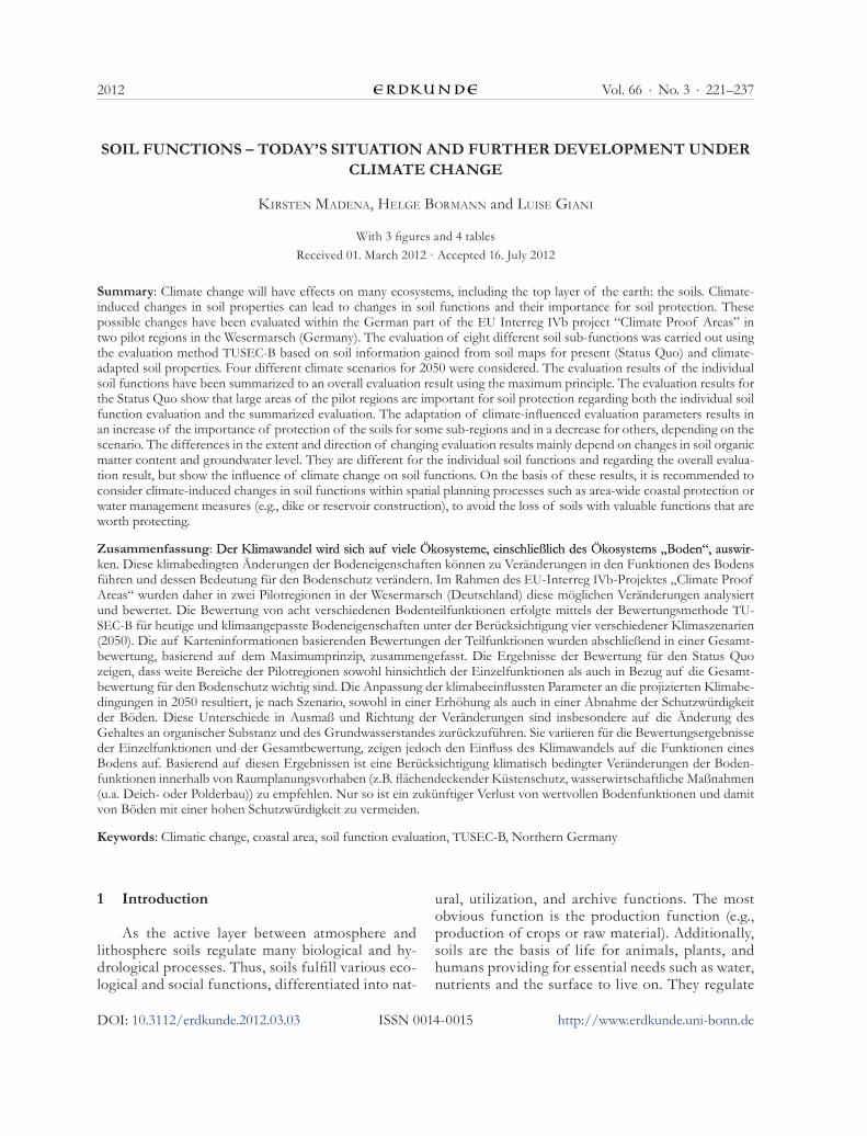
The study area is located in the northern part of Germany and comprises the water board ar-eas Butjadingen (north, ~216 km²) and Stadland (south, ~ 113 km²), which belong to the admin-istrative district Wesermarsch (Lower Saxony) (Fig. 1). Dominated by the North Sea, the climate is humid with moderate temperatures (~8 °C, mean annual temperature) and precipitation (~710 mm, mean annual precipitation) (MüHr 2007). The soils of the entire Wesermarsch region are mainly marsh (nearly 75%) and peat (nearly 15%) soils (severin 2008). Only 0.5% of the district area are sandy soils (LAND�REIS WESERMARSCH 2003). The devel-opment of these marsh and peat soils is closely re-lated to the Holocene sea transgression and regres-sion phases. Transgressions led to sedimentation of fine material in shallower and still water areas as well as sedimentation of coarser material close to the shore. Peat growth and the development of fens set in during regressions with concurrent high groundwater levels. Nowadays, the region is cut off from the sea by dikes. The groundwater influence is still present, but regulated by drainage mainly in winter time and by watering during summer. With increasing human activities and improved melio-ration techniques anthropogenic soils have been developed.
Different hydrological conditions, land man-agement as well as the specific pedogenetic factors and processes led to a wide range of marsh and peat soils in our study area. It is dominated by marsh
soils with mainly Gleyic Fluvisols (calcaric) (45.7%), Gleysols (clayic) (25.1%), and Haplic Gleysols (15.8%). About 8.5% of the area is covered with peat soils like Sapric Histosols or Histosols with clayic, organic, or anthropogenic layers (Fig. 1).
Land use in the Wesermarsch region is charac-terized by agriculture (80% of the area). Especially due to the soil conditions, 90% of the agricultural land is under grassland farming.
Coastal protection and drainage of the main land is vital for this area because of the flat relief with some parts of it being below mean sea level and its location close to the sea. For hundreds of years, the Wesermarsch and many other regions in the German coastal areas have been drained by ditches and pumping stations in the winter time. Due to water scarcity in the summer months the ditches have also been used for watering the arable fields and cattle with surface water from the Weser River. Nowadays, the water management system is negatively influenced by the increasing salt concen-tration in the irrigation water caused by the deep-ening of the Weser River (gFl/BioConsult/KüFog 2006). Projected higher storm tides and sea level rise may also increase the amount of salt water flowing upstream the river to the tid-al gates used for watering (Beckum, Strohausen) (graBeMann et al. 2005). Additionally, changes in climatic conditions such as less precipitation in summer and therefore a higher watering demand, may aggravate the salt water problem and cause follow-up problems which have to be solved by coastal protection and water management.
3 Materials and methods
3.1 TUSEC and the overall evaluation approach
To evaluate the soil functions in our proj-ect area, we chose TUSEC (Technique for Soil Evaluation and Categorization for Natural and Anthropogenic Soils), a method which has been developed to evaluate soil functions for soils un-der temperate climate, comprising TUSEC-A and TUSEC-B (beta-version) (leHMann et al. 2008). Compared to the A-procedure which is based on detailed pedological characteristics of the area, the B-procedure can be used for an orienting evaluation in larger areas. It is based on second-ary data (e.g., pedological, topographical, or his-torical map information) and can be applied for scales of 1:25,000 and smaller. Because of the ori-
224 Vol. 66 · No. 3
ACH
F
L
B
NL
DK
PL
CZ
B u t j a d i n g e n
S t a d l a n d
Soil map Wesermarsch (BÜK 50)
Sapric Histosol (bog)
Histosol (bog) with anthropogenic or clay cover layer (Anthrosol)
Histosol (fen) with clay or oganic cover layer (Anthrosol)
Haplic Gleysol
Haplic Gleysol/Histosol (bog)
Haplic Gleysol/Histosol (fen)
Gleysol clayic
Gleyic Anthrosol
Gleysols and Gleysol variations
Stagnosols andStagnosol variations
Podzols andPodzol variations
Salic Fluvisol
Histic Gleysol thionic
Gleyic Fluvisol calcaric
Sapric Histosol (fen)
water board border
Germany
Soil
0 1 2 3 4 5 km
Fig. 1: Location and soils (WRB classification) of the study area (north: Butjadingen; south: Stadland)Source: based on data of Nds. Bodeninformationssystem NIBIS with permission of LBEG, Hannover; NIBIS® �artenserver (2010) and T� 25 (© LGN)
225K. Madena, H. Bormann and L. Giani: Soil functions – today's situation and further development under climate change2012
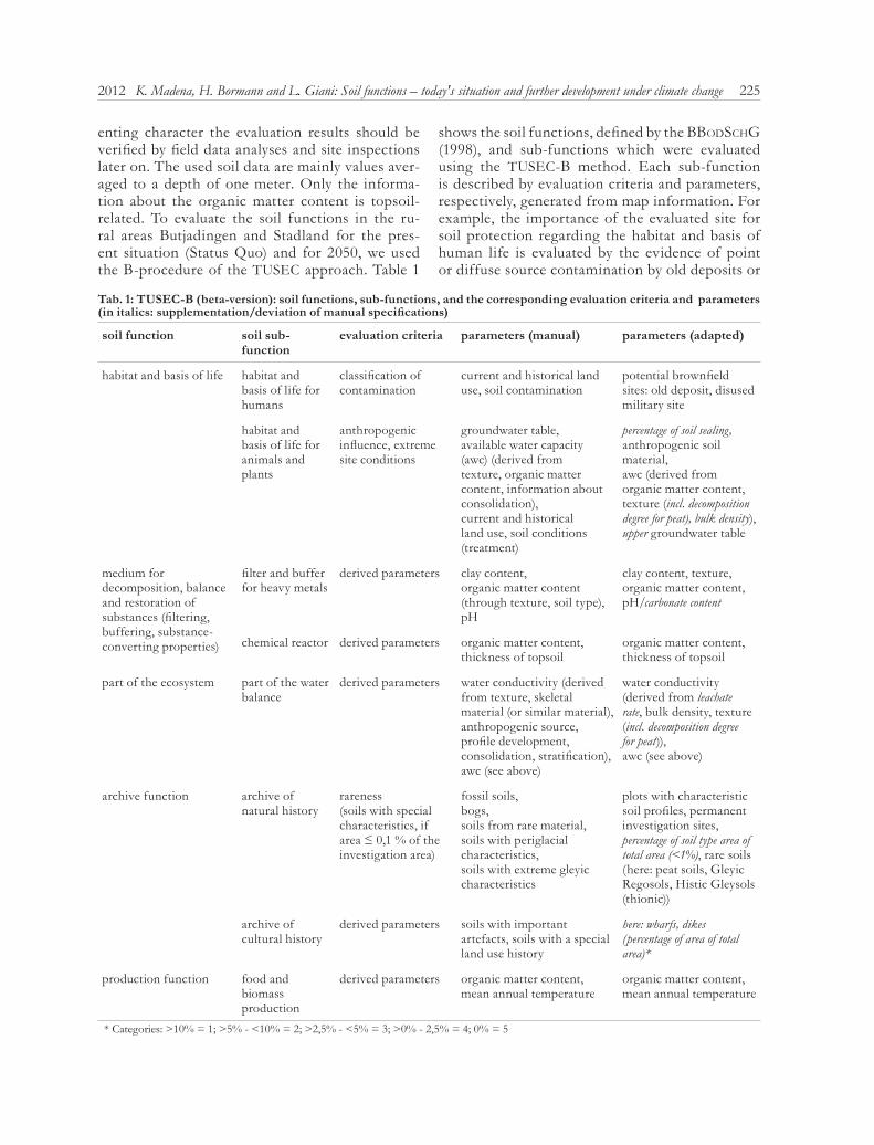
enting character the evaluation results should be verified by field data analyses and site inspections later on. The used soil data are mainly values aver-aged to a depth of one meter. Only the informa-tion about the organic matter content is topsoil-related. To evaluate the soil functions in the ru-ral areas Butjadingen and Stadland for the pres-ent situation (Status Quo) and for 2050, we used the B-procedure of the TUSEC approach. Table 1
shows the soil functions, defined by the BBodsCHg (1998), and sub-functions which were evaluated using the TUSEC-B method. Each sub-function is described by evaluation criteria and parameters, respectively, generated from map information. For example, the importance of the evaluated site for soil protection regarding the habitat and basis of human life is evaluated by the evidence of point or diffuse source contamination by old deposits or
Tab. 1: TUSEC-B (beta-version): soil functions, sub-functions, and the corresponding evaluation criteria and parameters (in italics: supplementation/deviation of manual specifications)
soil function soil sub-function
evaluation criteria parameters (manual) parameters (adapted)
habitat and basis of life habitat and basis of life for humans
classification of contamination
current and historical land use, soil contamination
potential brownfield sites: old deposit, disused military site
habitat and basis of life for animals and plants
anthropogenic influence, extreme site conditions
groundwater table,available water capacity (awc) (derived from texture, organic matter content, information about consolidation), current and historical land use, soil conditions (treatment)
percentage of soil sealing, anthropogenic soil material, awc (derived from organic matter content, texture (incl. decomposition degree for peat), bulk density), upper groundwater table
medium for decomposition, balance and restoration of substances (filtering, buffering, substance-converting properties)
filter and buffer for heavy metals
derived parameters clay content,organic matter content (through texture, soil type), pH
clay content, texture, organic matter content, pH/carbonate content
chemical reactor derived parameters organic matter content, thickness of topsoil
organic matter content, thickness of topsoil
part of the ecosystem part of the water balance
derived parameters water conductivity (derived from texture, skeletal material (or similar material), anthropogenic source, profile development, consolidation, stratification), awc (see above)
water conductivity (derived from leachate rate, bulk density, texture (incl. decomposition degree for peat)), awc (see above)
archive function archive of natural history
rareness (soils with special characteristics, if area ≤ 0,1 % of the investigation area)
fossil soils, bogs,soils from rare material,soils with periglacial characteristics,soils with extreme gleyic characteristics
plots with characteristic soil profiles, permanent investigation sites, percentage of soil type area of total area (<1%), rare soils (here: peat soils, Gleyic Regosols, Histic Gleysols (thionic))
archive of cultural history
derived parameters soils with important artefacts, soils with a special land use history
here: wharfs, dikes (percentage of area of total area)*
production function food and biomass production
derived parameters organic matter content,mean annual temperature
organic matter content,mean annual temperature
* Categories: >10% = 1; >5% - <10% = 2; >2,5% - <5% = 3; >0% - 2,5% = 4; 0% = 5
226 Vol. 66 · No. 3
military sites. And-, if-, or- etc. “decision trees” are used to evaluate the sub-function at five evaluation levels, with level 1 representing a very high impor-tance for soil protection and level 5 representing a very low importance for soil protection. Hence, a point-source contaminated site will be classified as “very low important for soil protection” regard-ing the function as habitat and basis of human life (structure: “if site is not contaminated = 1; if site is contaminated with point-source pollution (restora-tion not necessary) = 4; if site is contaminated with point-source pollution (restoration necessary) = 5). Notwithstanding the specifications in the manual we adapted some parameters due to the available data base (see 3.2), e.g., adding the leaching rate as one parameter to characterize the water balance function (Tab. 1). More information on the evalua-tion method and a precise description are given in the manual (leHMann et al. 2008).
To keep the evaluation structure of the TUSEC approach, also the soil sub-functions without cli-mate-sensitive evaluation parameters were evaluat-ed and integrated into the overall evaluation result.
TUSEC does not provide a guideline for sum-marizing the individual evaluation results of eve-ry soil function into an overall evaluation result, which is often required by spatial planners. To obtain such an overall evaluation result, the maxi-mum principle was applied in this study, meaning that functions which were evaluated with a very high importance for soil protection, dominate the overall result of the evaluated plot. As opposed to an average determination, lower important func-tions are not considered and therefore, a very high worthiness of protection of the individual evalua-tion is retained.
To summarize the individual evaluation results (eight soil sub-functions) the following classifica-tion was used:
individual evaluation result: overall evaluation result:≥ 2 x 1 or 4 x 2 1≥ 2 x 2 21 x 2 or ≥ 2 x 3 3≥ 2 x 4 4otherwise 5
with 1 = very high importance for soil protection 2 = high importance for soil protection 3 = medium importance for soil protection
4 = low importance for soil protection 5 = very low importance for soil protection.
3.2 Data “Status Quo”
For the soil function evaluation with TUSEC-B we used available information about soil type, land cover, potential brownfield sites, plots with char-acteristic, regional soil profiles, and permanent investigation sites gained from special maps (soil information system) provided by the State office for Mining, Energy, and Geology (LBEG) of Lower Saxony (Germany).We used the soil type units of the B� 50 (soil overview map 1:50,000) as evalua-tion units and the data stored in the digital B�50 data base. The B� 50 is a soil overview map gen-erated from secondary information (geology, to-pography, land use etc.) and is based on information from representative soil profiles for each map unit. In addition to information on pedology, geology, hydrogeology, and land cover, the soil information system provides derivative maps based on the B� 50. Therefore, additional information on leaching rates was available (Tab. 1: adapted parameters).
Information about historical coastal protection constructions, such as dikes and wharfs, was ob-tained from the Lower Saxony State office for pres-ervation of historical monuments (NLfD). These data are assumed to represent the present situation of soil and site properties, named “Status Quo”.
3.3 Climate change scenarios for 2050
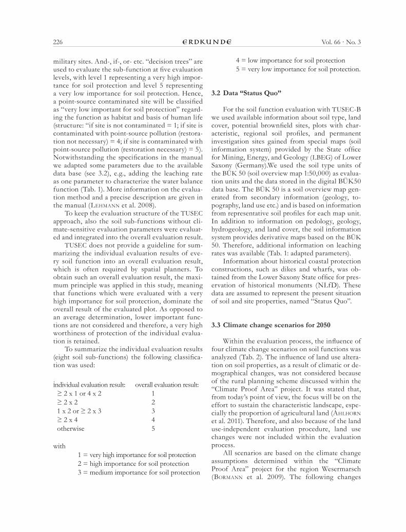
Within the evaluation process, the influence of four climate change scenarios on soil functions was analyzed (Tab. 2). The influence of land use altera-tion on soil properties, as a result of climatic or de-mographical changes, was not considered because of the rural planning scheme discussed within the “Climate Proof Area” project. It was stated that, from today’s point of view, the focus will be on the effort to sustain the characteristic landscape, espe-cially the proportion of agricultural land (aHlHorn et al. 2011). Therefore, and also because of the land use-independent evaluation procedure, land use changes were not included within the evaluation process.
All scenarios are based on the climate change assumptions determined within the “Climate Proof Area” project for the region Wesermarsch (BorMann et al. 2009). The following changes
227K. Madena, H. Bormann and L. Giani: Soil functions – today's situation and further development under climate change2012
in climate elements were projected based on the emission scenario A1B (ipCC 2000, 2007) and on WETTREG data (speKat et al. 2007):
temperature: + 1 – 1.5 °Cprecipitation (winter): app. + 25%precipitation (summer): app. - 15% evapotranspiration (annual): app. + 5-7%.
All scenarios assume the same increase in tem-perature, but partially differ regarding changes in leachate rate, groundwater level, organic matter content, and level of organic matter decomposi-tion (Tab. 2). Scenarios I and II, and scenarios III and IV, respectively, are equal regarding leach-ate rate and groundwater level. Their main differ-ence is an increase or decrease in organic matter content or decomposition level of organic matter. The organic matter content and the decomposition level are described by short symbols according to the Bodenkundliche �artieranleitung (AD-HOC-AG BODEN 2005). The organic matter content is divided into eight categories (h0 to h7) and each category refers to a range of mass percentage of or-ganic matter (e.g., h2 is equivalent to 1 – <2 mass-%). The classification of the decomposition level of organic matter is based on the visible plant struc-ture within the turf and comprises five categories from z1 (very low) to z5 (very high) (AD-HOC-AG BODEN 2005).
It is well known that microbial activity increas-es with increasing temperature, resulting concur-rently in decreasing organic matter contents (e.g., HörMann 1993; IFB 2008; Kardol et al. 2010; poWlsen 2005). To quantify the loss of organic mat-ter we used the information on temperature depend-ence of soil organic matter decomposition given by KirsCHBauM (1995). From the laboratory-based data he deduced a decrease of Corg of ~10% at a mean
annual temperature of 5 °C and of ~3% at a mean annual temperature of 30 °C upon a temperature increasing by 1 °C. By applying these calculations to our investigation area with a mean annual tem-perature of approximately 8 °C, the Corg content will decrease by approx. 9%, which means a decrease of 15% of the initial soil organic matter (SOM) content. To consider the influence of soil moisture, we ad-ditionally assumed an increase in SOM in scenario II due to reduced soil microbial activity caused by higher soil moisture (springoB et al. 2001). Within the evaluation procedure, an increase or decrease in organic matter content and organic matter decom-position by one level each is equivalent to a change by one category (according to the Bodenkundliche �artieranleitung (AD-HOC-AG BODEN 2005)), which approximately corresponds to a change by 15% of the initial SOM content.
The hypothesized higher leachate rate in 2050 compared to today is based on findings of osterKaMp et al. (2001) who assumed an increase in precipitation by 10% in the coastal Weser region and therefore higher groundwater recharge in this flat area. Simulating the groundwater and soil wa-ter balance HoFFMann et al. (2005) calculated an in-crease in groundwater recharge in this region. Thus, we assumed an increase in leachate rate of 4% (pre-cipitation (+10%) minus evapotranspiration (6%), see above).
The assumption of an increase in groundwater levels is based on projected increasing precipitation and leachate rates. BraMMer and BrinKMann (1990) predicted higher groundwater levels in coastal soils due to sea level rise. sCHirMer (2006) also assumed a rising groundwater level in the Lower Weser region. Furthermore, HoFFMann et al. (2005) simulated the changes in the groundwater surface distance for two coastal investigation areas in the Lower Weser re-gion which are near or within our study area. They
Tab. 2: Assumed changes of climate-affected parameters considered within the evaluation process
scenario 2050 temperature [°C] leachate rate
[%]groundwater level
[cm]
organic matter content
[level, %]
decomposition [level]
I + 1,5 + 4 + 5 -1 level (15) +1 level
II + 1,5 + 4 + 5 +1 level (15) –
III + 1,5 – – +1 level (15) –
IV + 1,5 – – -1 level (15) +1 level
228 Vol. 66 · No. 3
identified a decrease in the groundwater surface dis-tance of 5 cm and 22 cm due to sea level rise and higher groundwater recharge. For the total inves-tigation area (comprising large parts of the region Wesermarsch), they predicted a rising groundwater level. Based on these simulation results and on the as-sumption that less water might be pumped out of the area, e.g., due to higher pumping costs, we assumed a maximum groundwater level increase of 5 cm until 2050 for scenarios I and II. In scenarios III and IV, we hypothesized that the water management will not change and that the drainage capacity will be still sufficient to maintain the present groundwater level.
4 Results
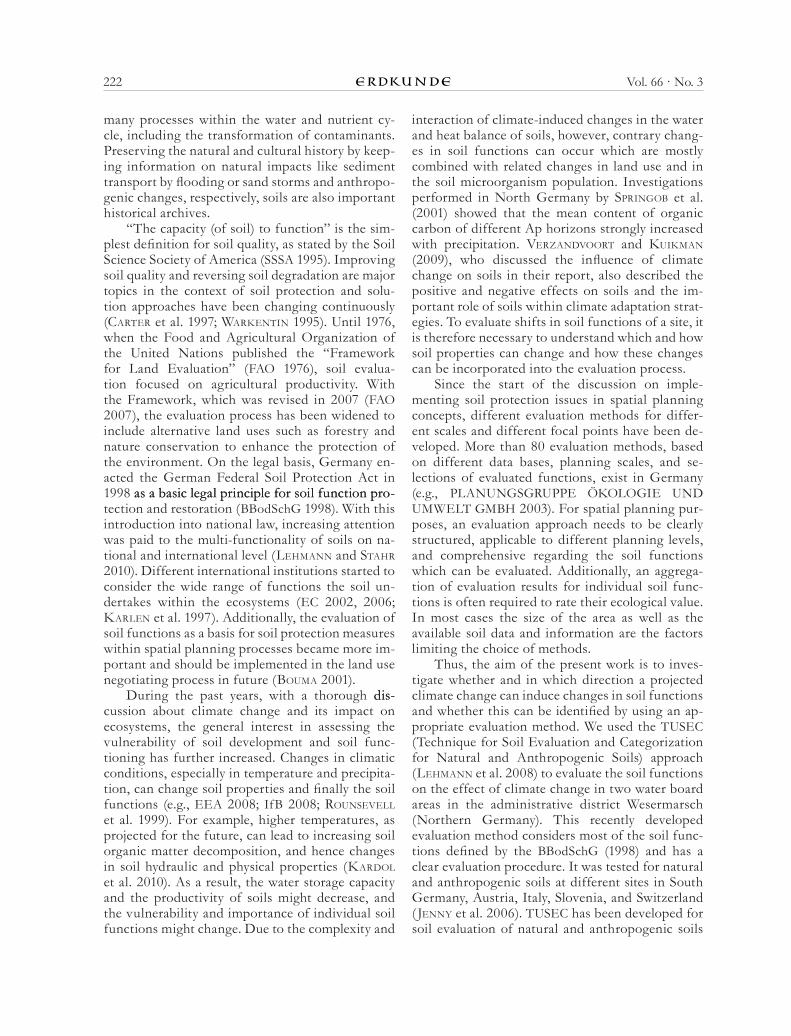
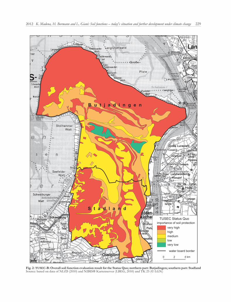
4.1 Soil function evaluation “Status Quo”
On the basis of today’s soil properties most parts of the study area are of very high (50.7%) and high importance (21.2%) for soil protection (Fig. 2). These areas are dominated by Histosols and Gleyic Fluvisols (calcaric) which are widely spread in the region. The lowest importance for soil protection, comprising 1.5% of the area, is represented by two Gleysol (clayic) plots, while the rest of the region (26.6%) is of medium importance.
The overall evaluation result is mainly influ-enced by the evaluation results of the individual hab-itat functions (not shown). Nearly the entire region is worth protecting (highly and very highly protect-able) regarding its functioning as the basis of human life (96.5%) and as the habitat and basis of life for animals and plants (99.9%). The Gleyic Fluvisols (calcaric) and Salic Fluvisols are very good filter and buffer for heavy metals and therefore highly protect-able. Furthermore, the Gleyic Fluvisols (calcaric) are of high importance for soil protection as part of the water balance, because they have a comparatively higher available water capacity and are of high impor-tance for food and biomass production. Especially, the Histosols in the study area are of very high/high importance regarding their function as chemical re-actor, but are barely worth protecting regarding their filter and buffer capacity for heavy metals, which also applies to the Haplic Gleysols, Gleysols (clayic), and the Gleyic Anthrosols in the area.
Plots representing Salic Fluvisols, Histic Gleysols (thionic), Histosol (fen), and Gleyic Regosols are ar-chives of natural history and therefore of very high importance for soil protection. Because of the set-tlement history in the study area, i.e. wharf and dike
constructions, and the differently weighted area per-centages of these constructions within the evaluation units, the soils are mainly of medium importance for cultural history.
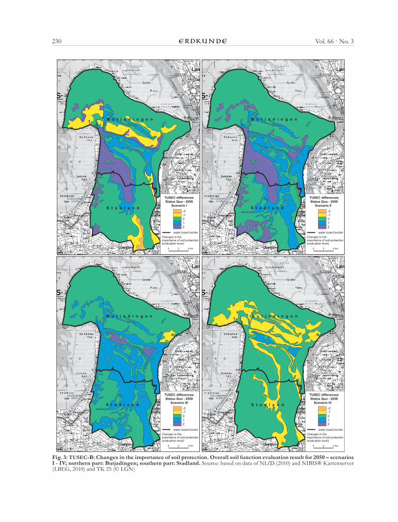
4.2 Soil function evaluation “Status Quo – 2050”
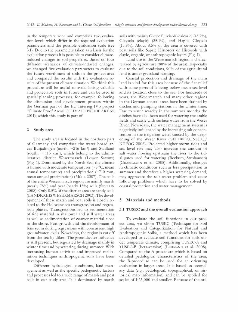
Adapting the evaluation parameters to the as-sumed climate-induced changes in 2050, the worthi-ness of protection regarding the overall evaluation result changed differently depending on the applied scenario (Fig. 3, Tab. 3). The smallest changes are ascertained by scenario IV with 77.1% of the area without any differences between the Status Quo and 2050. The remaining scenarios are very similar regarding the proportion of “no changes” (62.6–63.7%). The biggest differences in the importance for soil protection (overall result) are based on scenario II which leads to an enhancement of the soil worthi-ness in 2050 by two evaluation levels. In general, the changes in the overall evaluation result are mostly in the positive direction. This is true for scenarios II and III showing an increase of the importance of soil protection of 37% and 36.6%, respectively. The evaluation of scenario I results in a more posi-tive development of the soil functions (23.5%), but shows also negative changes (12.7%). Scenario IV is the only scenario which leads primarily to a negative development of the overall evaluation result (21.3%).
The analysis of the individual soil function evaluation results shows a higher increase of the im-portance for some soil functions as compared to the overall evaluation result (max. plus four evaluation levels).
Most changes in the importance of soil protec-tion are due to changes in soil organic matter. This is shown in scenarios II and III in which the com-paratively high proportion of a positive development of the “chemical reactor function” is caused by SOM changes. The same is true for the production func-tion of the evaluated soils. An increase in organic matter content results in a positive change while a decrease leads to a negative development of the soil functioning. The importance of soils as a habitat and basis of life for animals and plants is only slightly influenced by the assumed climatic changes, but is mainly positive for scenarios I and II. This can be explained by the definition of this soil function, which is targeted on the importance of extremely dry and wet locations. Because of the assumed higher groundwater levels, the soil moisture increases and therewith the rareness of the location for plants and
229K. Madena, H. Bormann and L. Giani: Soil functions – today's situation and further development under climate change2012
very highhighmediumlowvery low
water board border
TUSEC Status Quoimportance of soil protection
0 2 4 km
B u t j a d i n g e n
S t a d l a n d
Fig. 2: TUSEC-B: Overall soil function evaluation result for the Status Quo; northern part: Butjadingen; southern part: StadlandSource: based on data of NLfD (2010) and NIBIS® �artenserver (LBEG, 2010) and T� 25 (© LGN)
230 Vol. 66 · No. 3
B u t j a d i n g e n
S t a d l a n d
B u t j a d i n g e n
S t a d l a n d
-2-1012
water board border
TUSEC differencesStatus Quo - 2050
Scenario IV
Changes in the importance of soil protection(evaluation level)
0 2 4 km
-2-1012
water board border
TUSEC differencesStatus Quo - 2050
Scenario III
Changes in the importance of soil protection(evaluation level)
0 2 4 km
-2-1012
water board border
TUSEC differencesStatus Quo - 2050
Scenario II
Changes in the importance of soil protection(evaluation level)
0 2 4 km
-2-1012
water board border
TUSEC differencesStatus Quo - 2050
Scenario I
Changes in the importance of soil protection(evaluation level)
0 2 4 km
B u t j a d i n g e n
S t a d l a n d
B u t j a d i n g e n
S t a d l a n d
Fig. 3: TUSEC-B: Changes in the importance of soil protection. Overall soil function evaluation result for 2050 – scenarios I - IV; northern part: Butjadingen; southern part: Stadland. Source: based on data of NLfD (2010) and NIBIS® �artenserver (LBEG, 2010) and T� 25 (© LGN)
231K. Madena, H. Bormann and L. Giani: Soil functions – today's situation and further development under climate change2012
animals. Small, more or less positive changes (plus 1 evaluation level) were identified for the water bal-ance function and the filter and buffer function for heavy metals in 2050.
Due to the evaluation criteria regarding the habi-tat and basis of human life and both archive func-tions, which do not comprise climate-induced pa-rameters, there are no changes when comparing the present and the 2050 situations.
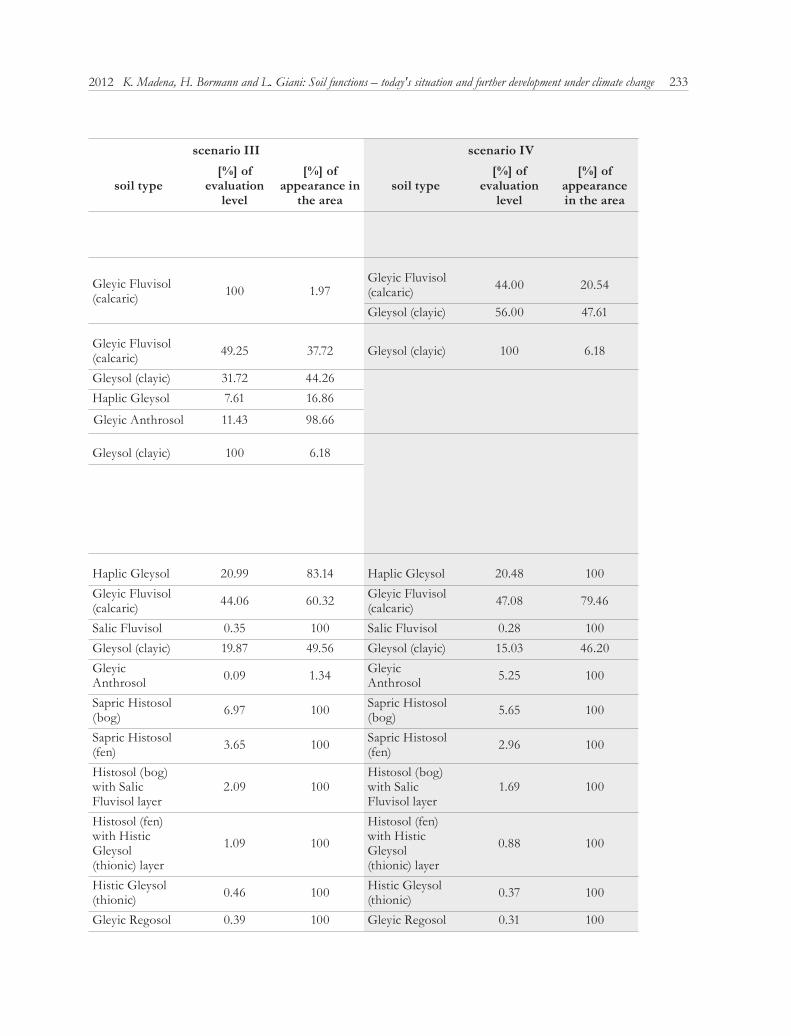
To identify soil type-related patterns in the fu-ture change of soil quality, we determined the area percentage of the soil types in relation to the differ-ences in the evaluation level (present – 2050). Table 4 summarizes the results for each scenario and gives the area percentage of the soil types regarding the proportion of the evaluation level and the appear-ance in the area, respectively. For example, only Gleyic Fluvisols (calcaric) show a two-level down-grading in the worthiness of protection. Therefore, this soil type comprises 100% of the evaluation level which represents only 5.18% of the total appearance in the study area.
Considering the soil type-related changes no clear pattern is observable. It is worth mentioning that the worthiness of protection of nearly 99% of the Gleyic Anthrosols areas increases with increas-
ing organic matter content (scenarios II and III). The soil protection value of the Calcic Gleysols in the south-western part of Butjadingen (see Fig. 1 and 3) probably increases with rising groundwater levels (scenarios I and II).
5 Discussion and conclusions
This study on the impact of climate change on soil functions shows that the worthiness of protec-tion of soil functions will be influenced by climate-induced changes in soil properties.
Depending on the assumed future climatic de-velopment and the chosen scenario these changes can be positive or negative and vary regarding the extent of change. Although our study is based only on an orientating evaluation method, it enabled us to identify parameters which, alone or in combination, change the future importance of soils for protection.
The most important parameter causing soil function changes appears to be the organic mat-ter content. This is in line with the conclusions of verzandvoort and KuiKMan (2009), who high-lighted the key role of organic matter regarding soil properties influenced by climatic changes. Organic
Tab. 3: TUSEC-B: Differences between the results of the individual soil function evaluation for the Status Quo and 2050 presented for each scenario (area percentage of evaluation level). No differences between Status Quo and 2050 for LIFE1, ARC1, and ARC2 (not shown)
Notes: LIFE1: habitat and basis of life for humans; LIFE2: habitat and basis of life for animals and plants; STOFIT1: water balance function; STOFIT3: filter & buffer for heavy metals; STOFIT4: chemical reactor; PROD1: production function; ARC1: archive for natural history; ARC2: archive for cultural history
I II scenario III IV
differences LIFE2
differences STOFIT1
differences STOFIT3
differences STOFIT4
differences PROD1
differences overall result
proportion -1 0.1 0.1 0.5 0.5 6.6 0.7 0.2 0 36.6 0.6 11.9 0
[%] 0.5 0.5 0.1 0.1 0 0 0 0.2 0.6 36.6 0.9 21.3
proportion -2 0 0 0 0 0 0 0 0 0 0 0.8 0
[%] 0 0 0 0 0 0 0 0 0 0 0 0
proportion 1 52.5 52.5 4.2 0.9 9.8 36.5 0 0.1 0 26.9 10.4 20.0
[%] 0 0 0.9 4.2 34.0 18.3 0.1 0 26.9 0 35.0 1.6
proportion 2 0 0 0 0 0 0.3 0 0 0 0 13.1 17.0
[%] 0 0 0 0.5 8.8 0 0 0 0 0 1.6 0
proportion 3 0 0 0 0 0 0 0 33.5 0 0 0 0
[%] 0 0 0 0 0 0 33.5 0 0 0 0 0
proportion 4 0 0 0 0 0 0 2.0 2.0 0 0 0 0
[%] 0 0 0 0 0 0 2.0 2.0 0 0 0 0
proportion 0 47.4 47.4 95.3 98.6 83.5 62.5 97.8 64.4 63.4 72.6 63.7 63.1
[%] 99.5 99.5 99.1 95.2 57.3 81.7 64.4 97.8 72.6 63.4 62.6 77.1
232 Vol. 66 · No. 3
scenario I scenario II scenario III scenario IV
differences [level] soil type
[%] of evaluation
level
[%] of appearance in the area
soil type[%] of
evaluation level
[%] of appearance in
the areasoil type
[%] of evaluation
level
[%] of appearance in
the areasoil type
[%] of evaluation
level
[%] of appearance in the area
-2 Gleyic Fluvisol (calcaric) 100 5.18
-1 Gleysol (clayic) 100 47.61 Gleyic Fluvisol (calcaric) 100 1.97
Gleyic Fluvisol (calcaric) 44.00 20.54
Gleysol (clayic) 56.00 47.61
1
Gleyic Fluvisol (calcaric) 81.49 18.57 Gleyic Fluvisol
(calcaric) 42.51 18.57 Gleyic Fluvisol (calcaric) 49.25 37.72 Gleysol (clayic) 100 6.18
Gleysol (clayic) 14.90 6.18 Gleysol (clayic) 55.61 44.26 Gleysol (clayic) 31.72 44.26Haplic Gleysol 3.61 2.38 Haplic Gleysol 1.88 2.38 Haplic Gleysol 7.61 16.86
Gleyic Anthrosol 11.43 98.66
2
Haplic Gleysol 20.36 16.86 Haplic Gleysol 15.70 16.86 Gleysol (clayic) 100 6.18Gleyic Fluvisol (calcaric) 66.89 19.14 Gleyic Fluvisol
(calcaric) 51.58 19.14
Gleyic Anthrosol 12.75 41.15
Gleyic Anthrosol 23.57 98.66
Gleysol (clayic) 9.15 6.18
0
Haplic Gleysol 18.72 75.58 Haplic Gleysol 20.22 80.76 Haplic Gleysol 20.99 83.14 Haplic Gleysol 20.48 100Gleyic Fluvisol (calcaric) 44.65 62.28 Gleyic Fluvisol
(calcaric) 45.12 62.28 Gleyic Fluvisol (calcaric) 44.06 60.32 Gleyic Fluvisol
(calcaric) 47.08 79.46
Salic Fluvisol 0.34 100 Salic Fluvisol 0.34 100 Salic Fluvisol 0.35 100 Salic Fluvisol 0.28 100Gleysol (clayic) 18.18 46.20 Gleysol (clayic) 19.71 49.56 Gleysol (clayic) 19.87 49.56 Gleysol (clayic) 15.03 46.20Gleyic Anthrosol 3.74 58.85 Gleyic
Anthrosol 0.09 1.34 Gleyic Anthrosol 0.09 1.34 Gleyic
Anthrosol 5.25 100
Sapric Histosol (bog) 6.84 100 Sapric Histosol
(bog) 6.91 100 Sapric Histosol (bog) 6.97 100 Sapric Histosol
(bog) 5.65 100
Sapric Histosol (fen) 3.58 100 Sapric Histosol
(fen) 3.62 100 Sapric Histosol (fen) 3.65 100 Sapric Histosol
(fen) 2.96 100
Histosol (bog) with Salic Fluvisol layer
2.05 100Histosol (bog) with Salic Fluvisol layer
2.07 100Histosol (bog) with Salic Fluvisol layer
2.09 100Histosol (bog) with Salic Fluvisol layer
1.69 100
Histosol (fen) with Histic Gleysol (thionic) layer
1.07 100
Histosol (fen) with Histic Gleysol (thionic) layer
1.08 100
Histosol (fen) with Histic Gleysol (thionic) layer
1.09 100
Histosol (fen) with Histic Gleysol (thionic) layer
0.88 100
Histic Gleysol (thionic) 0.45 100 Histic Gleysol
(thionic) 0.46 100 Histic Gleysol (thionic) 0.46 100 Histic Gleysol
(thionic) 0.37 100
Gleyic Regosol 0.38 100 Gleyic Regosol 0.38 100 Gleyic Regosol 0.39 100 Gleyic Regosol 0.31 100
Tab. 4: TUSEC-B: Differences between the overall evaluation results for the Status Quo and 2050 presented for each sce-nario (area percentage of soil types)
233K. Madena, H. Bormann and L. Giani: Soil functions – today's situation and further development under climate change2012
scenario I scenario II scenario III scenario IV
differences [level] soil type
[%] of evaluation
level
[%] of appearance in the area
soil type[%] of
evaluation level
[%] of appearance in
the areasoil type
[%] of evaluation
level
[%] of appearance in
the areasoil type
[%] of evaluation
level
[%] of appearance in the area
-2 Gleyic Fluvisol (calcaric) 100 5.18
-1 Gleysol (clayic) 100 47.61 Gleyic Fluvisol (calcaric) 100 1.97
Gleyic Fluvisol (calcaric) 44.00 20.54
Gleysol (clayic) 56.00 47.61
1
Gleyic Fluvisol (calcaric) 81.49 18.57 Gleyic Fluvisol
(calcaric) 42.51 18.57 Gleyic Fluvisol (calcaric) 49.25 37.72 Gleysol (clayic) 100 6.18
Gleysol (clayic) 14.90 6.18 Gleysol (clayic) 55.61 44.26 Gleysol (clayic) 31.72 44.26Haplic Gleysol 3.61 2.38 Haplic Gleysol 1.88 2.38 Haplic Gleysol 7.61 16.86
Gleyic Anthrosol 11.43 98.66
2
Haplic Gleysol 20.36 16.86 Haplic Gleysol 15.70 16.86 Gleysol (clayic) 100 6.18Gleyic Fluvisol (calcaric) 66.89 19.14 Gleyic Fluvisol
(calcaric) 51.58 19.14
Gleyic Anthrosol 12.75 41.15
Gleyic Anthrosol 23.57 98.66
Gleysol (clayic) 9.15 6.18
0
Haplic Gleysol 18.72 75.58 Haplic Gleysol 20.22 80.76 Haplic Gleysol 20.99 83.14 Haplic Gleysol 20.48 100Gleyic Fluvisol (calcaric) 44.65 62.28 Gleyic Fluvisol
(calcaric) 45.12 62.28 Gleyic Fluvisol (calcaric) 44.06 60.32 Gleyic Fluvisol
(calcaric) 47.08 79.46
Salic Fluvisol 0.34 100 Salic Fluvisol 0.34 100 Salic Fluvisol 0.35 100 Salic Fluvisol 0.28 100Gleysol (clayic) 18.18 46.20 Gleysol (clayic) 19.71 49.56 Gleysol (clayic) 19.87 49.56 Gleysol (clayic) 15.03 46.20Gleyic Anthrosol 3.74 58.85 Gleyic
Anthrosol 0.09 1.34 Gleyic Anthrosol 0.09 1.34 Gleyic
Anthrosol 5.25 100
Sapric Histosol (bog) 6.84 100 Sapric Histosol
(bog) 6.91 100 Sapric Histosol (bog) 6.97 100 Sapric Histosol
(bog) 5.65 100
Sapric Histosol (fen) 3.58 100 Sapric Histosol
(fen) 3.62 100 Sapric Histosol (fen) 3.65 100 Sapric Histosol
(fen) 2.96 100
Histosol (bog) with Salic Fluvisol layer
2.05 100Histosol (bog) with Salic Fluvisol layer
2.07 100Histosol (bog) with Salic Fluvisol layer
2.09 100Histosol (bog) with Salic Fluvisol layer
1.69 100
Histosol (fen) with Histic Gleysol (thionic) layer
1.07 100
Histosol (fen) with Histic Gleysol (thionic) layer
1.08 100
Histosol (fen) with Histic Gleysol (thionic) layer
1.09 100
Histosol (fen) with Histic Gleysol (thionic) layer
0.88 100
Histic Gleysol (thionic) 0.45 100 Histic Gleysol
(thionic) 0.46 100 Histic Gleysol (thionic) 0.46 100 Histic Gleysol
(thionic) 0.37 100
Gleyic Regosol 0.38 100 Gleyic Regosol 0.38 100 Gleyic Regosol 0.39 100 Gleyic Regosol 0.31 100
234 Vol. 66 · No. 3
matter is a major factor influencing, for instance, the water storage capacity, the nutrient balance (chemi-cal reactor), and the bonding capacity for harmful substances. The biological, chemical and physical properties of soils are especially influenced by the amount of organic matter (BaldoCK and sKJeMstad 1999). Therefore, also the intensity of changes in the evaluation results depends on the initial amount of organic matter. The climatic impact is smaller on soils with lower organic matter contents. Possible reasons could be (i) an organic matter threshold from which changes are not relevant anymore or (ii) the quality of the information about organic matter content which is only given by classification level and not by exact data. For instance, soils with soil organ-ic matter content reaching the upper limit can stay within the classification level, although the organic matter content decreases by 15%. Another cause can be (iii) the fact that organic soils are not explicitly considered within the TUSEC method, because soil components are generally considered with respect to the mineral part. There is no doubt, however, that climate change will influence the organic matter content of soils (e.g., IFB 2008; KaMp et al. 2008) and possibly the related soil functions, as shown by the result of this study. This knowledge leads to the question of whether soil organic matter will increase or decrease and will result in an improvement or impairment of the soil functions. In our view, this question cannot be answered definitively because of the complex interaction of parameters influenc-ing the soil organic matter content, like temperature, water content, and microbial composition. For ex-ample, microbial activity increases with temperature rise, but can also decrease with an increase in soil wa-ter content. Therefore, it is necessary to consider the site-specific conditions when estimating the future amount of soil organic matter and the development of soil functions (KolBe 2008). Additionally, further research on the interaction of influencing parame-ters is required, which is also claimed by engel and Müller (2009) in their report on the influence of cli-mate change on soils in Lower Saxony. This impor-tant information enables climate-induced changes in organic matter content to be specified on regional and local scales and soil function evaluation results to be concretized.
The second important parameter causing soil function changes seems to be the groundwater level which directly influences the soil moisture and indi-rectly influences the accumulation or decomposition of organic matter. An increasing groundwater level but constant soil temperature will result in a decreas-
ing microbial activity. This leads to a higher organic matter content and increases, for example, the pro-ductivity and water storage capacity of soils to some extent. However, high groundwater levels can also result in decreasing soil productivity due to water log-ging. Depending on whether the water management or the natural water regimes will change in future in the evaluated area or part of the area, the importance of protection can change. Especially water manage-ment changes, whose impact can be more or less pre-dicted, have to be taken into account when discuss-ing climate-induced changes in soil properties and functions. If there are no changes in groundwater regulation and the present groundwater level is kept, water-related changes in soil properties can also be neglected as well as soil movement processes (water erosion) in the flat study area.
In general, our research shows that it is possible to incorporate climate change into the evaluation process of soil functions. The used evaluation meth-od TUSEC-B allows us to evaluate soil functions of larger areas and to see the results in a wider spatial context. It was possible to evaluate the soil func-tions in our project region which comprises an area of ~329 km². TUSEC-B provides an overview of the general worthiness of protection of the soils in the region and can be used in planning processes. The orienting character of the approach enabled specific areas suitable for planning purposes to be identified, but they need to be verified by field investigations. Also the currentness of data used for the Status Quo evaluation should be revised. We assumed that the basic data reflect the present properties of the soils, but the data have not been updated recently and might not be representative of the Status Quo.
Summarizing the individual evaluation results to an overall result, we applied the maximum prin-ciple and defined five classification levels. Using dif-ferent categories with different weightings would lead to different evaluation results depending on the data base, the spatial planning level as well as on the question of whether individual evaluation criteria are relevant to the problem.
Nevertheless, the implementation of spatial planning measures, which are mostly long-term and area- consuming projects, should take into account that soils which are less worth protecting today can be of higher worthiness in future. For example, the localization of future spatial water management measures, as discussed within the German “Climate Proof Area” project, could be combined with the results of this soil function evaluation by planning water storage constructions or other adapted water
235K. Madena, H. Bormann and L. Giani: Soil functions – today's situation and further development under climate change2012
management measurements in future less vulner-able and important areas for soil protection. After choosing specific places based on the soil function evaluation, systematic soil type identification is necessary to verify the input data of the evaluation process.
Furthermore, soil function evaluation methods need to be parameterized in more detail to simplify their implementation in spatial planning and to en-hance their applicability, which was also mentioned by leHMann and staHr (2010). They stated that the concept of soil functions need further adaptation to spatial planning and land use aspects. Additionally, more studies are needed to investigate the future de-velopment of soil functions based on different evalu-ation methods.
Acknowledgements
The work presented here has been devel-oped within the German part of the Interreg IVb (NSRP) project “Climate Proof Areas” funded by the European Union. The Lower Saxony State office for Mining, Energy, and Geology (LBEG) and the Lower Saxony State office for preservation of histori-cal monuments (NLfD) have provided soil data and data about historical coast protection constructions.
References
AD-HOC-AG BODEN (ed.) (2005): Bodenkundliche �ar-tieranleitung. Hannover.
aHlHorn, F.; BorMann, H.; giani, l.; Klaassen, K.; Klen-Ke, t.; Malsy, M. and resteMeyer, B. (2011): �limasi-chere Region Wesermarsch – Die Zukunft der Wasser-wirtschaft. Erste Schritte auf dem Weg zu einer �li-maanpassungsstrategie für den Landkreis Wesermarsch. Abschlussdokument des Regionalforums Wesermarsch. http://www.climateproofareas.eu (28.02.2012).
BaldoCK, J. a. and sKJeMstad, J. O. (1999): Soil organic car-bon/soil organic matter. In: peverill, K. i.; sparroW, l. a. and reuter, D. J. (eds.): Soil analysis: an interpreta-tion manual. Collingwood, 159–170.
BBodSchG (1998): Gesetz zum Schutz vor schädlichen Bodenveränderungen und zur Sanierung von Altlasten (Bundes-Bodenschutzgesetz – BBodSchG). �Bundes-Bodenschutzgesetz vom 17. März 1998 (BGBl. I S. 502), das zuletzt durch Artikel 3 des Gesetzes vom 9. Dezem-ber 2004 (BGBl. I S. 3214) geändert worden ist“.
BorMann, H.; aHlHorn, F.; giani, l. and KlenKe, T. (2009): Climate Proof Areas – �onzeption von an den
�limawandel angepassten Wassermanagementstrategi-en im norddeutschen �üstenraum. In: �orrespondenz Wasserwirtschaft 2 (7), 363–369.
BouMa, J. (2001): The role of soil science in the land use negotiation process. In: Soil Use and Management 17, 1–6. DOI: 10.1111/j.1475-2743.2001.tb00001.x
BraMMer, H. and BrinKMann, R. (1990): Changes in soil resources in response to a gradually rising sea-level. In: sCHarpenseel, H. W.; sCHoMaKer, M. and ayouB, A. (eds.): Soils on a warmer earth. Proceedings of an In-ternational Workshop. Developments in Soil Science 20. München, 145–156.
Carter, M. r.; gregoriCH, e. g.; anderson, d. W.; doran, J. W.; Janzen, H. H. and pierCe, F. J. (1997): Concepts of soil quality and their significance. In: gregoriCH, E. G. and Carter, M. R. (eds.): Soil quality for crop produc-tion and ecosystem health. Amsterdam, 1–19.
CLIMATE PROOF AREAS (2011): Project homepage - project period: 2008–2011. http://www.climateproofar-eas.com (28.02.2012).
EC (EUROPEAN COMMISSION) (2002): Communication from the Commission to the Council, the European Par-liament, the Economic and Social Committee and the Committee of the Regions: “Towards a thematic strat-egy for soil protection”. Council Conclusions on Inte-grated Soil Protection. Brussels.
– (2006): Proposal for a directive of the European Parlia-ment and of the Council establishing a framework for the protection of soil and amending Directive 2004/35/EC. Geneva.
EEA (EUROPEAN ENVIRONMENT AGENCY) (ed.) (2008): Impacts of Europe’s changing climate – 2008 in-dicator-based assessment. Joint EEA-JRC-WHO report. Copenhagen. http://www.eea.europa.eu/publications/eea_report_2008_4 (11.06.2012).
engel, n and Müller, U. (2009): Auswirkungen des �li-mawandels auf Böden in Niedersachsen. Bericht �lima-wandel. http://www.lbeg.niedersachsen.de (11.06.2012).
FAO (FOOD AND AGRICULTURAL ORGANIZATION OF THE UNITED NATIONS) (1976): A framework for land evaluation. Soil Bulletin 32. Rome.
– (2007): Land evaluation – towards a revised framework. Rome.
GFL/BIOCONSULT/�ÜFOG (2006): Fahrrinnenanpassung der Au�enweser an die Entwicklungen im Schiffsverkehr mit Tiefenanpassung der hafenbezogenen Wendestelle: Auswirkungen auf die Landwirtschaft, Gutachten im Auf-trag der Wasser- und Schifffahrtsverwaltung des Bundes vertreten durch die Wasser- und Schifffahrtsämter Bre-men und Bremerhaven, Bremen & Loxsted. 2006. http://www.weseranpassung.de/downloads/dateien/Planfest-stellungsunterlagen/Aussenweser_Unterweser/I.9_Gut-achten_Landwirtschaft.pdf (01.07.2011).
236 Vol. 66 · No. 3
graBeMann, H.-J.; graBeMann, i. and Müller, A. (2005): Die Auswirkungen des �limawandels auf Hydrographie und Gewässergüte. In: B. sCHuCHardt and M. sCHirMer (eds.): �limawandel und �üste – Die Zukunft der Un-terweserregion, Berlin, Heidelberg, 59–77.
HörMann, G. (1993): �limaänderung und terrestrische �kosysteme. In: sCHellnHuBer, H. J. and sterr, H. (eds.): �limaänderung und �üste – Einblicke ins Treib-haus. Berlin, 260–275.
HoFFMann, B.; MeCKelBurg, M. and MeinKen, M. (2005): Folgen einer �limaänderung für den Grund- und Bodenwasserhaushalt der Unterwesermarsch. In: sCHuCHardt, B. and sCHirMer, M. (eds.): �limawandel und �üste – Die Zukunft der Unterweserregion. Berlin, 103–137.
IFB (Institut für Biodiversität) (ed.) (2008): Anpassungs-strategien bei Bodennutzungssystemen an den �lima-wandel. F & E-Vorhaben im Auftrag des Umweltbun-desamtes, F�Z: 206 71 202. Regensburg.
IPCC (INTERGOVERNMENTAL PANEL ON CLIMATE CHANGE) (ed.) (2000): Special report on emissions scenarios. http://www.grida.no/publications/other/ipcc_sr/?src=/climate/ipcc/emission (08.03.2011).
– (2007): Climate Change 2007 – the physical science basis. Contribution of Working Group I to the Fourth As-sessment Report of the IPCC. Cambridge.
Jenny, r.; geitner, C.; gruBan, W. and tusCH, M. (2006): Bodenbewertung in der räumlichen Planung – Ein Bei-trag zur nachhaltigen Raumentwicklung. Results of the EU-Interreg IIIB alpine region project TUSEC-IP.
KaMp, t.; CHoudHury, K.; ruser, r.; Hera, u. and rötzer, T. (2008): Auswirkungen von �limaänderungen auf Bö-den – Beeinträchtigungen der natürlichen Bodenfunk-tionen. In: Umweltbundesamt (ed.): Böden im �lima-wandel – Was tun? UBA-Texte 25/08, Dessau, 17–26.
Kardol, p.; Cregger, M. a.; CaMpany, C. e. and Classen, A. T. (2010): Soil ecosystem functioning under climate change: plant species and community effects. In: Ecol-ogy 91 (3), 767–781. DOI: 10.1890/09-0135.1
Karlen, d. l.; MausBaCH, M. J.; doran, J. W.; Cline, r. g.; Harris, r. F. and sCHuMan, G. E. (1997): Soil quality: a concept, definition, and framework for evaluation (a guest editorial). In: Soil Science Soci-ety American Journal 61 (1), 4–10. DOI: 10.2136/sssaj1997.03615995006100010001x
KirsCHBauM, M. U. F. (1995): The temperature dependence of soil organic matter decomposition, and the effect of global warming on soil organic storage. In: Soil Biology & Biochemistry 27 (6), 753–760. DOI: 10.1016/0038-0717(94)00242-S
KolBe, H. (2008). Schutz der organischen Substanz in Deutschland: Erhalt standorttypischer Humusgehal-te versus Humusbilanzierung als verbreitete Metho-
de in der Landwirtschaft. In: Hüttl, r.; preCHtl, a. and Bens, O. (eds.): Humusversorgung von Böden in Deutschland, Forschungsvorhaben im Auftrag des Um-weltbundesamtes, F�Z: 360 13 008. Cottbus, Potsdam, 133–143.
LAND�REIS WESERMARSCH (ed.) (2003): Regionales Raumordnungsprogramm Landkreis Wesermarsch 2003. II. Begründung und Raumordnungsbericht. Brake.
leHMann, A. and staHr, � (2010): The potential of soil func-tions and planner-orientated soil evaluation to achieve sustainable land use. In: Journal of Soils Sediments 10, 1092–1102. DOI: 10.1007/s11368-010-0207-5
leHMann, a.; david, s. and staHr, �. (2008): TUSEC – Bilingual-Edition: Eine Methode zur Bewertung natür-licher und anthropogener Böden (Deutsche Fassung) / Technique for Soil Evaluation and Categorization for Natural and Anthropogenic Soils (English version). Ho-Ho-henheimer Bodenkundliche Hefte 86. Stuttgart, Hohen-heim.
MüHr, B. (2007): �limadiagramm von Bremerhaven. http://www.klimadiagramme.de/Deutschland/bremerhaven2.html (07.03.2011).
osterKaMp, s.; KraFt, d. and sCHirMer, M. (2001): Climate change and the ecology of the Weser estuary region: as-sessing the impact of an abrupt change in climate. In: Climate Research 18, 97–104. DOI: 10.3354/cr018097
PLANUNGSGRUPPE ��OLOGIE UND UMWELT GMBH (ed.) (2003): Empfehlungen zur �lassifikation von Böden für räumliche Planungen. Zusammenfassung und Strukturierung von relevanten Methoden und Ver-fahren zur �lassifikation und Bewertung von Boden-funktionen für Planungs- und Zulassungsverfahren mit dem Ziel der Vergleichbarkeit. Endbericht im Auftrag der Bund/Länder-Arbeitsgemeinschaft Bodenschutz. http://www.laenderfinanzierungsprogramm.de/cms/WaBoAb_prod/WaBoAb/Vorhaben/LABO/B_12.02/index.jsp (28.02.2012).
poWlson, D. (2005): Will soil amplify climate change? In: Nature 433, 204–205. DOI: 10.1038/433204a
rounsevell, M. d. a.; evans, s. p. and BulloCK, P. (1999): Climate change and agricultural soils: impacts and adaptation. In: Climate Change 43, 683–709. DOI: 10.1023/A:1005597216804
sCHirMer, M. (2006): Wie hart trifft der �limawandel die Unterweserregion? In: Bremer Beiträge für Naturkunde und Naturschutz 6, 13–20.
severin, �. (2008): Die Landwirtschaft im Landkreis Wesermarsch. In: giani, l.; geHrt, e. and sponagel, H. (eds.): Exkursionsführer – Böden der niedersächsi-schen Marsch. Excursion guide presented at the confe-rence (September 3–5, 2008) �Die Böden der �üste und deren Genese im Spannungsfeld von Landnutzung und �limawandel“. Oldenburg, 16–18.
237K. Madena, H. Bormann and L. Giani: Soil functions – today's situation and further development under climate change2012
speKat, a.; enKe, W. and KreienKaMp, F. (2007): Neuent-wicklung von regional hoch aufgelösten Wetterlagen für Deutschland und Bereitstellung regionaler �limas-zenarios auf der Basis von globalen �limasimulationen mit dem Regionalisierungsmodell WETTREG auf der Basis von globalen �limasimulationen mit ECHAM5/MPI-OM T63L31 2010 bis 2100 für die SRES Szena-rios B1, A1B und A2. Forschungsprojekt im Auftrag des Umweltbundesamtes FuE-Vorhaben, F�Z 204 41 138. Potsdam.
springoB, g.; BrinKMann, s.; engel, n.; KirCHMann, H. and BöttCHer, J. (2001): Organic C levels of Ap hori-zons in North German Pleistocene sands as influenced by climate, texture, and history of land-use. In: Jour-nal of Plant Nutrition and Soil Science 164, 681–690. DOI: 10.1002/1522-2624(200112)164:6<681::AID-JPLN681>3.0.CO;2-V
SSSA (SOIL SCIENCE SOCIETY OF AMERICA) (1995): Statement on soil quality. In: Agronomy News, June 1995.
UMWELTMINISTERIUM BADEN-WÜRTTEMBERG (ed.) (1995): Bewertung von Böden nach ihrer Leistungsfähig-keit – Leitfaden für Planung und Gestattungsverfahren. In: Reihe Luft, Boden, Abfall 31. Baden-Württemberg.
verzandvoort, S. and KuiKMan, P. (2009): �limaatverand-ering, klimaatadaptatie en bodem: maakbaarheid, plan-vorming en realiteitsdenken. Altera, Wageningen UR, Report.
WarKentin, B. P. (1995): The changing concept of soil qual-ity. In: Journal of Soil and Water Conservation 50 (3), 226–228.
Authors
Dr. �irsten MadenaWG Soil Science, Institute of Biology
and Environmental SciencesUniversity of Oldenburg
26111 OldenburgGermany
Prof. Dr. Helge BormannChair of Water Management and
Engineering HydrologyDepartment of Civil Engineering
University of Siegen57068 Siegen
Prof. Dr. Luise GianiWG Soil Science, Institute of Biology
and Environmental SciencesUniversity of Oldenburg
26111 OldenburgGermany


![ManuskriptzurFunktionalanalysis - uni-bonn.de · 2017. 5. 22. · [11] D.Werner: Funktionalanalysis.Springer 1995. [12] K.Yosida: Functional Analysis.Springer 1980. Danken m¨ochte](https://img.pdfslide.us/doc/110x75/60b93ca3c2c93b3c360e1753/manuskriptzurfunktionalanalysis-uni-bonnde-2017-5-22-11-dwerner-1995.jpg)