Embed Size (px)
Citation preview
Planning Commission Agenda Report April 20, 2021 RPD-195, Lennar Homes of California, Inc. Page 1 of 9
Date: April 20, 2021
To: Planning Commission
From: Joseph R. Vacca, AICP Director of Community Development
Submitted By: Paul McClaren, Associate Planner Subject: RPD-195, Lennar Homes of California, Inc.
PROJECT INFORMATION SUMMARY
Request: The applicant requests approval of a Residential Planned Development Permit (RPD-195) to allow for the construction of 158 for sale, single-family residences at a density of 7.8 units per acre. Additionally, the applicant is proposing the relocation of the historic Scholle House to a new location within the development which will be rehabilitated and sold as a single-family residence.
Applicant: Ben O’Neal of Lennar Homes of California, Inc., 515 Marin Street, Suite 322, Thousand Oaks, CA 91360.
Property Owner: Lennar Homes of California, Inc., 515 Marin Street, Suite 322, Thousand Oaks, CA 91360.
General Plan Land Use Designations: Low-Medium Density Residential (5.1-10 dwelling units per acre).
Springville Specific Plan Designations: Low-Medium Density Residential (up to 10 dwelling units per acre).
Zoning Designations: Residential Planned Development, eight units per acre (RPD-8U).
Decision-Making Authority: Pursuant to Camarillo Municipal Code (CMC) Section 19.16.310, the Planning Commission is the decision-maker for the requested RPD.
Project Site Size, Location, and Parcel Numbers: The homes will be built on a 20.36-acre portion of the 43.3-acre subdivision of TT-5671-2M(3) at the northwest corner of Springville Drive and U.S. 101/Ventura Freeway (Assessor Parcel Nos. 157-0-020-185 and -220).
City of Camarillo Planning Commission
AGENDA REPORT
PC Item 8 I Page 1 of 84
Planning Commission Agenda Report April 20, 2021 RPD-195, Lennar Homes of California, Inc. Page 2 of 9
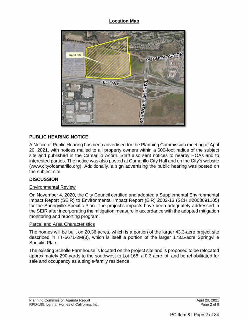
Location Map
PUBLIC HEARING NOTICE
A Notice of Public Hearing has been advertised for the Planning Commission meeting of April 20, 2021, with notices mailed to all property owners within a 600-foot radius of the subject site and published in the Camarillo Acorn. Staff also sent notices to nearby HOAs and to interested parties. The notice was also posted at Camarillo City Hall and on the City’s website (www.cityofcamarillo.org). Additionally, a sign advertising the public hearing was posted on the subject site.
DISCUSSION
Environmental Review
On November 4, 2020, the City Council certified and adopted a Supplemental Environmental Impact Report (SEIR) to Environmental Impact Report (EIR) 2002-13 (SCH #2003091105) for the Springville Specific Plan. The project’s impacts have been adequately addressed in the SEIR after incorporating the mitigation measure in accordance with the adopted mitigation monitoring and reporting program.
Parcel and Area Characteristics
The homes will be built on 20.36 acres, which is a portion of the larger 43.3-acre project site described in TT-5671-2M(3), which is itself a portion of the larger 173.5-acre Springville Specific Plan.
The existing Scholle Farmhouse is located on the project site and is proposed to be relocated approximately 290 yards to the southwest to Lot 168, a 0.3-acre lot, and be rehabilitated for sale and occupancy as a single-family residence.
PC Item 8 I Page 2 of 84
Planning Commission Agenda Report April 20, 2021 RPD-195, Lennar Homes of California, Inc. Page 3 of 9
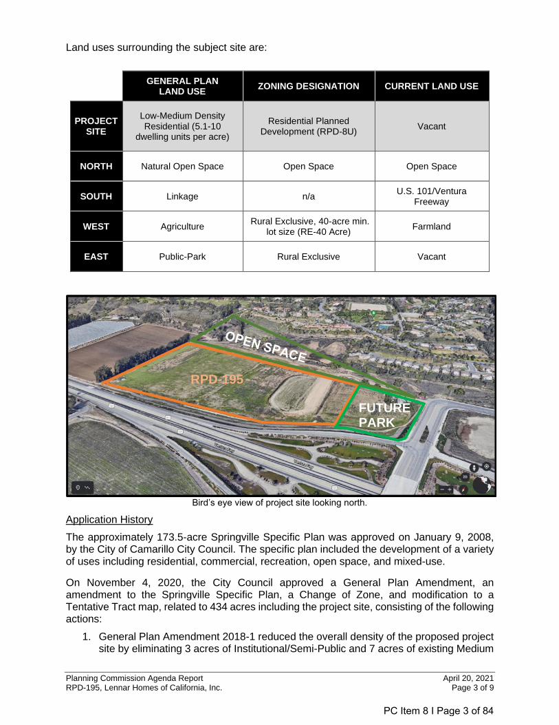
Land uses surrounding the subject site are:
GENERAL PLAN
LAND USE ZONING DESIGNATION CURRENT LAND USE
PROJECT SITE
Low-Medium Density Residential (5.1-10
dwelling units per acre)
Residential Planned Development (RPD-8U)
Vacant
NORTH Natural Open Space Open Space Open Space
SOUTH Linkage n/a U.S. 101/Ventura
Freeway
WEST Agriculture Rural Exclusive, 40-acre min.
lot size (RE-40 Acre) Farmland
EAST Public-Park Rural Exclusive Vacant
Bird’s eye view of project site looking north.
Application History
The approximately 173.5-acre Springville Specific Plan was approved on January 9, 2008, by the City of Camarillo City Council. The specific plan included the development of a variety of uses including residential, commercial, recreation, open space, and mixed-use.
On November 4, 2020, the City Council approved a General Plan Amendment, an amendment to the Springville Specific Plan, a Change of Zone, and modification to a Tentative Tract map, related to 434 acres including the project site, consisting of the following actions:
1. General Plan Amendment 2018-1 reduced the overall density of the proposed project site by eliminating 3 acres of Institutional/Semi-Public and 7 acres of existing Medium
RPD-195
FUTURE PARK
PC Item 8 I Page 3 of 84
Planning Commission Agenda Report April 20, 2021 RPD-195, Lennar Homes of California, Inc. Page 4 of 9
Density Residential (10.1-18 dwelling units per acre) land use designations, relocated the 5-acre future park site designated Public-Neighborhood Park, expanded the Low-Medium Density Residential (5.1-10 dwelling units per acre) designation from 14.5 acres to 20.36 acres, and expanded the Natural Open Space area by 4.14 acres to include an agricultural buffer and landscaped berm.
2. Springville Specific Plan Amendment reduced the maximum number of units in the project area of the Specific Plan from 200 dwelling units to a maximum of 159 dwelling units while increasing the total maximum number of units in the Specific Plan from 1,350 dwelling units to 1,365 dwelling units.
3. Change of Zone 328 eliminated the Professional Office (PO) Zone; relocated the 5-acre future park site zoned Rural Exclusive (RE); and expanded the Open Space (OS) Zone to include 4.14 acres for the berm and agricultural buffer. The remaining 20.36 acres (current project site) was rezoned RPD-8U.
4. TT-5671-2M(3) modified the previously approved tentative tract map for the Phase II area to subdivide the 43.3-acre project site into 168 lots, including 159 for-sale single-family detached residential parcels, a 5.1-acre future park site to be dedicated to PVRPD, a 0.3-acre private recreation lot for the residents of the subdivision, and 8.2 acres of open space, which will include a future landscaped berm along the freeway.
Project Description
TT-5671-2M(3), approved by the City Council on November 4, 2020, provides for the backbone infrastructure, street circulation, and subdivision of the project site. The proposed application for RPD-195 is a request for the approval of the site plan and architecture for the development of 158 for-sale, single-family detached residential units along with the relocation of the Scholle Farmhouse on lot 168 within the proposed development. The project provides a density of 7.8 dwelling units per acre, which is consistent with the Low-Medium Density Residential (5.1-10 dwelling units per acre) land use designation and RPD-8U Zone.
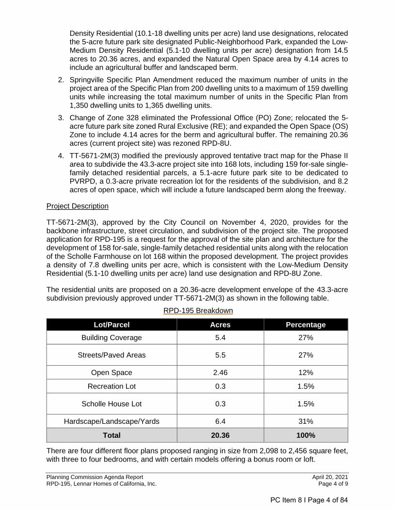
The residential units are proposed on a 20.36-acre development envelope of the 43.3-acre subdivision previously approved under TT-5671-2M(3) as shown in the following table.
RPD-195 Breakdown
Lot/Parcel Acres Percentage
Building Coverage 5.4 27%
Streets/Paved Areas 5.5 27%
Open Space 2.46 12%
Recreation Lot 0.3 1.5%
Scholle House Lot 0.3 1.5%
Hardscape/Landscape/Yards 6.4 31%
Total 20.36 100%
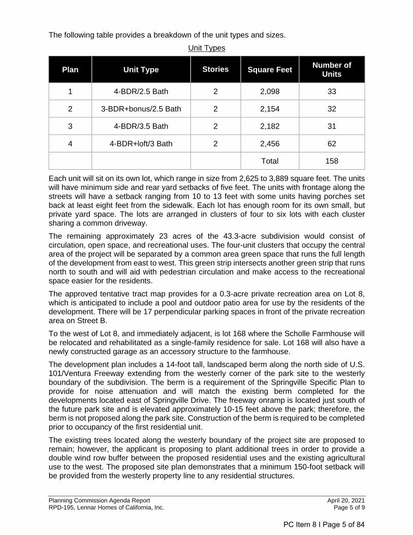
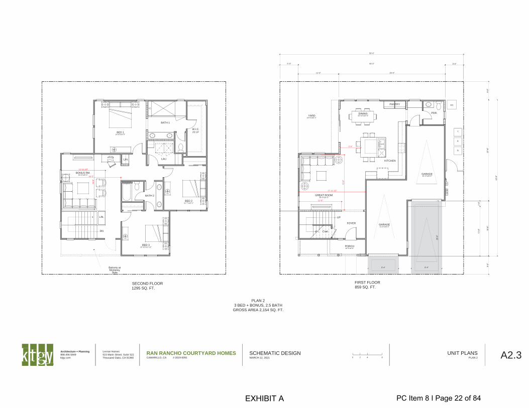
There are four different floor plans proposed ranging in size from 2,098 to 2,456 square feet, with three to four bedrooms, and with certain models offering a bonus room or loft.
PC Item 8 I Page 4 of 84
Planning Commission Agenda Report April 20, 2021 RPD-195, Lennar Homes of California, Inc. Page 5 of 9
The following table provides a breakdown of the unit types and sizes.
Unit Types
Each unit will sit on its own lot, which range in size from 2,625 to 3,889 square feet. The units will have minimum side and rear yard setbacks of five feet. The units with frontage along the streets will have a setback ranging from 10 to 13 feet with some units having porches set back at least eight feet from the sidewalk. Each lot has enough room for its own small, but private yard space. The lots are arranged in clusters of four to six lots with each cluster sharing a common driveway.
The remaining approximately 23 acres of the 43.3-acre subdivision would consist of circulation, open space, and recreational uses. The four-unit clusters that occupy the central area of the project will be separated by a common area green space that runs the full length of the development from east to west. This green strip intersects another green strip that runs north to south and will aid with pedestrian circulation and make access to the recreational space easier for the residents.
The approved tentative tract map provides for a 0.3-acre private recreation area on Lot 8, which is anticipated to include a pool and outdoor patio area for use by the residents of the development. There will be 17 perpendicular parking spaces in front of the private recreation area on Street B.
To the west of Lot 8, and immediately adjacent, is lot 168 where the Scholle Farmhouse will be relocated and rehabilitated as a single-family residence for sale. Lot 168 will also have a newly constructed garage as an accessory structure to the farmhouse.
The development plan includes a 14-foot tall, landscaped berm along the north side of U.S. 101/Ventura Freeway extending from the westerly corner of the park site to the westerly boundary of the subdivision. The berm is a requirement of the Springville Specific Plan to provide for noise attenuation and will match the existing berm completed for the developments located east of Springville Drive. The freeway onramp is located just south of the future park site and is elevated approximately 10-15 feet above the park; therefore, the berm is not proposed along the park site. Construction of the berm is required to be completed prior to occupancy of the first residential unit.
The existing trees located along the westerly boundary of the project site are proposed to remain; however, the applicant is proposing to plant additional trees in order to provide a double wind row buffer between the proposed residential uses and the existing agricultural use to the west. The proposed site plan demonstrates that a minimum 150-foot setback will be provided from the westerly property line to any residential structures.
Plan Unit Type Stories Square Feet Number of
Units
1 4-BDR/2.5 Bath 2 2,098 33
2 3-BDR+bonus/2.5 Bath 2 2,154 32
3 4-BDR/3.5 Bath 2 2,182 31
4 4-BDR+loft/3 Bath 2 2,456 62
Total 158
PC Item 8 I Page 5 of 84
Planning Commission Agenda Report April 20, 2021 RPD-195, Lennar Homes of California, Inc. Page 6 of 9
The project applicant is required to construct the 5-acre park site located at the northwest corner of Springville Drive and U.S. 101/Ventura Freeway, which will be dedicated to the Pleasant Valley Recreation and Park District. The park will include a turf playfield, children’s play equipment, pickleball and basketball courts, shade structures, cornhole play area, bocce ball court, and restrooms. There will be 23 perpendicular parking spaces on Street E, in front of the park site. The park site is required to begin construction prior to the 51st residential occupancy and be completed prior to the final occupancy of the 100th dwelling unit.
Circulation and Access
Access to the subdivision will be from Ponderosa Drive, which the developer is required to extend west of Springville Drive; no access will be provided from Springville Drive. The developer is also required to pave the existing Daily Drive frontage road along the existing agricultural property west of the project site to Central Avenue. Although the intent is to provide a secondary emergency exit, vehicles would be able to exit the site at any time by activating a sensor pad in the pavement. This eliminates the requirement for residents to use a key fob or have an access code. However, access into the subdivision from the frontage road would only be permitted by Fire Department personnel by way of a Knox Box entry system.
The project includes five private streets, two east-west, two north-south that are at the east and west ends of the project, and a third north-south in between to break up the block. The two north-south streets at either end will exit onto the new extension of Ponderosa Drive. The easterly north-south street will also serve as access to the new park.
The developer is required to post securities for its fair share of the cost of the design and installation of a traffic signal, located at the intersection of Ponderosa Drive and Springville Drive. The conditions of approval for TT-5671-2M(3) require the traffic signal to be constructed prior to the issuance of a Zone Clearance for the first building permit (including models). The traffic signal must be operational prior to the first certificate of occupancy or the opening of model homes to the public, whichever occurs first.
A 0.86-mile Class I bike path (separated from the street) will be constructed between the berm and the freeway. The bike path will continue along the easterly edge of the park site where it will connect to the existing Class II bike path (on-street) on Ponderosa Drive. The Bikeway Network in the General Plan Circulation Element shows the future extension of the Class I bike path along the Daily Drive frontage road to Central Avenue.
Parking
The proposed development complies with the Specific Plan requirement to provide two parking spaces per unit as each of the residential units provides a 2-car enclosed garage attached to each unit. The 2-car garages are accessed from a shared driveway. The entrances to the shared driveways will include 20 feet of decorative paving with the remainder of the driveway to have integrated, colored concrete.
In addition to garage parking spaces, Plans 1, 3, and 4 provide a 20-foot long driveway for the parking of two vehicles in front of the garages. Plan 2 will provide a 20-foot long driveway for the parking of one vehicle in front of the garage. Parking is also permitted on the local streets within the development to allow for additional guest parking.
Building Height and Architecture
The Springville Specific Plan provides for a maximum building height of 25 feet, however, exceptions to this height limit are allowed where the architectural style would benefit from an increased height.
PC Item 8 I Page 6 of 84
Planning Commission Agenda Report April 20, 2021 RPD-195, Lennar Homes of California, Inc. Page 7 of 9
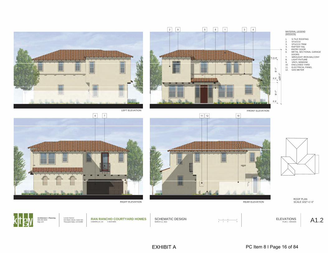
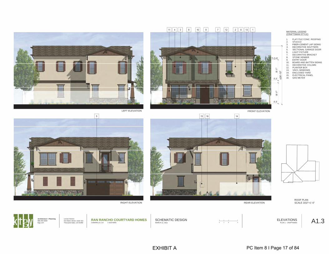
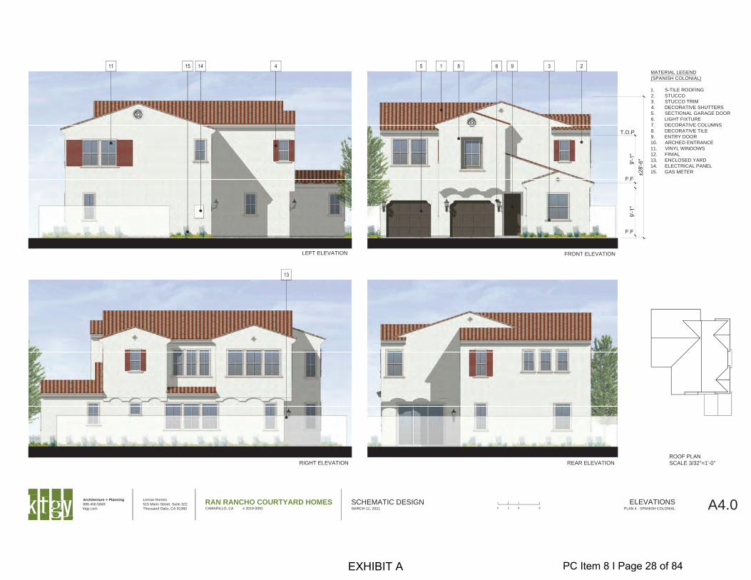
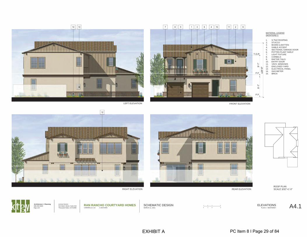
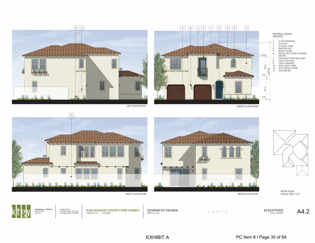
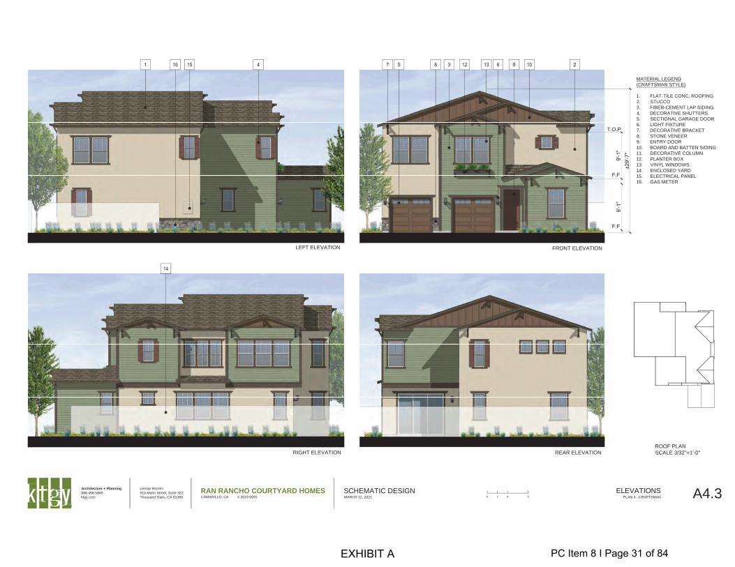
The proposed project consists of two-story, single family dwelling units varying in height from 25-feet, 1-inch to 29-feet, 7-inches. The units have marketable 9-foot ceilings and some of the architectural styles benefit from the increased heights by providing appropriately sloped roofs and architectural features. Additionally, the variation in height will break up the roof lines when the property is viewed from a distance. The proposed building heights of the single-family dwellings are consistent with the single-family dwellings already constructed within the Springville Specific Plan area, which were approved up to 28 feet in height.
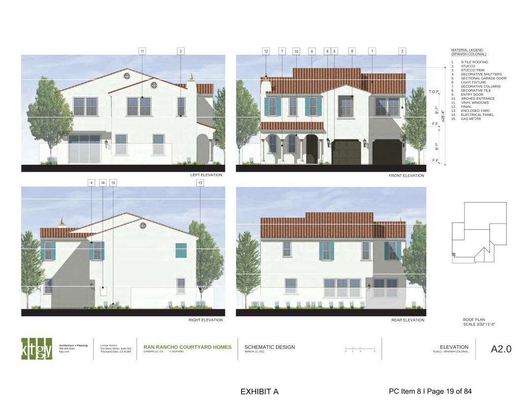
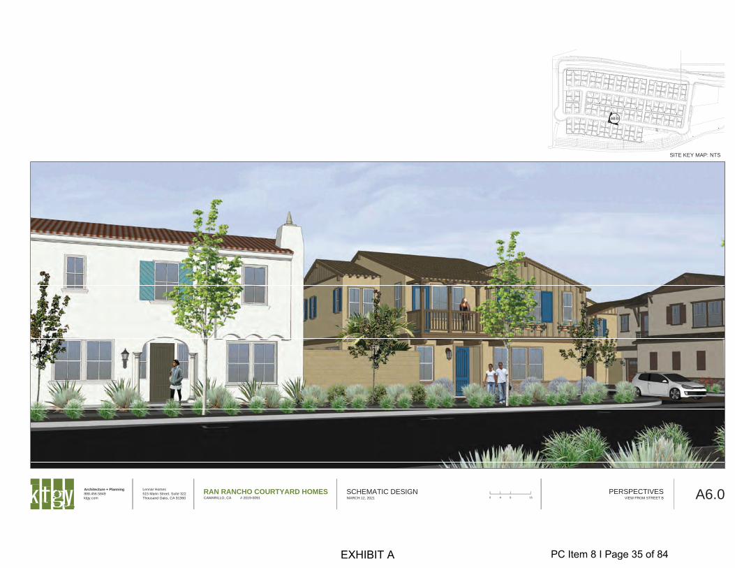
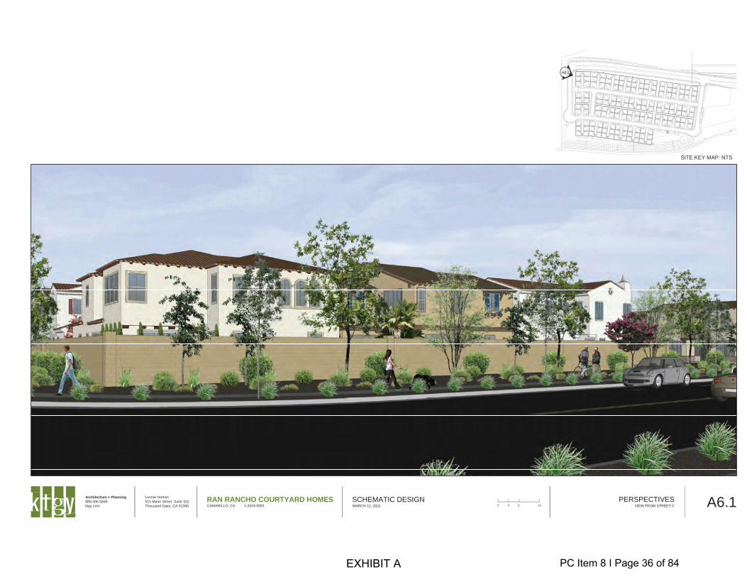
The City’s General Plan Community Design Element identifies the project site to be within the Heritage Zone, which requires buildings to have an architectural style that reflects the character of early California. Consistent with the Heritage Zone requirements, the development proposes the use of the following architectural styles: Spanish Colonial, Revival Mission, Monterey, and Craftsman. The design variations provide for a variety of materials, including stone, brick, iron work, decorative ceramic tile, stucco, exposed rafter tails, wood shutters and concrete roof tiles. The housing units have hipped and gabled roof lines that provide a variation in the elevations and overall massing. All the building elevations are enhanced with windows and openings of varying sizes and shapes, shutters, planters, and decorative metal work. The front of the housing units provide recessed, covered entrances that incorporate a variety of columns and arches. The color palette proposed for the development includes extensive use of varying shades of brown, beige and green as well as pops of jeweled tone accent colors.
Development Allotment Review
Due to the lack of housing supply throughout the state, Governor Newsom signed Senate Bill 330 (“SB 330) into law on October 9, 2019. Effective January 1, 2020 through January 1, 2025, SB 330 prohibits cities and counties from implementing limits on the annual number of residential permits issued. This means that during the five-year period, residential developers with project entitlements may proceed with the construction of their approved residential projects without first receiving development allotments from City in accordance with Title 20.
STAFF REVIEW AND RECOMMENDATION
The proposed project has been evaluated and found to be consistent with the recent approvals of GPA 2018-1, the amended Springville Specific Plan and CZ-328.
The project is consistent with the General Plan and Springville Specific Plan land use designations for Low-Medium Density (5.1-10 dwelling units per acre) residential development, as the project provides a density of 7.8 dwelling units per acre. Due to the proximity to the airport located south of the U.S. 101/Ventura Freeway, the project is within the Traffic Pattern Zone according to the Airport Comprehensive Land Use Plan. Within the Traffic Pattern Zone, residential uses are limited to a 25% structural coverage of the entire site including streets. The lot coverage for the project is calculated to be 12% based on the overall size of the 43.3-acre subdivision.
The Springville Specific Plan was envisioned to be a compact pedestrian-oriented neighborhood incorporating minimal front yard setbacks, front porches, increased housing density, smaller lot sizes, quality architecture, centrally located gathering areas, recreational areas, and tree-lined streets. The proposed development is consistent with the Specific Plan as it proposes a cluster-unit design with shared driveways to avoid garages from dominating the street. The design also minimizes curb cuts and allows for additional on-street parking.
The project site is within the RPD-8U Zone, which allows for flexibility in terms of lot sizes and dimensions in order to take advantage of modern site planning techniques. The lot sizes have already been established under T-5671-2M(3), which provides for single-family lots arranged
PC Item 8 I Page 7 of 84
Planning Commission Agenda Report April 20, 2021 RPD-195, Lennar Homes of California, Inc. Page 8 of 9
in clusters, ranging in size from 2,625 to 3,889 square feet. Although the lot sizes are smaller than a traditional single-family neighborhood, the placement of the buildings will provide for adequate separation between units and each lot will have its own private back yard area separated by 6-foot high walls. The compact design of the project also allows for the offering of a single-family detached product within the permitted low-medium density range of 5.1-10 dwelling units per acre.
General Plan Consistency
The development of the proposed 158 single-family units and preservation of the Scholle Farmhouse would enhance consistency with the General Plan Goals by:
➢ Supporting the development of a well-designed residential development with opportunities for recreation, open space, and connectivity through the expansion of sidewalks throughout the development, a Class I bike path, and proposed footpath and scenic lookout on the existing easement in the open space area, consistent with General Plan Community Design Element Goal RA-1 to preserve and enhance neighborhood identity and character for Camarillo’s residential neighborhoods.
➢ Providing a balance in housing types within the Springville Specific Plan area as well as city-wide, as the project would support 159 additional for-sale single-family detached residential units, consistent with General Plan Housing Element Goal 2 to encourage the availability of a variety of housing designs, tenures and prices to meet the needs of present and future City residents. Aside from custom build estate lots, there are very few potential sites remaining within the City that can provide for conventional for-sale single-family detached housing.
➢ Providing a safe, well-designed, continuous walkway system, allowing for connectivity within the community, as the project includes sidewalks on all streets, connecting residential uses to the future park site and the existing sidewalk network on Ponderosa Drive. The project includes a Class I bike path that will connect to the existing Class II bike path on Ponderosa Drive, consistent with General Plan Circulation Element Goal 5 to provide a citywide system of safe, efficient, and attractive bicycle and pedestrian routes for commuter, school, and recreational use.
➢ Relocating the historic Scholle Farmhouse within lot 168 of the proposed development and rehabilitating it for sale and occupancy as a single-family residence, is consistent with General Plan Community Design Element Goal PQPF-2 to identify and preserve cultural and historic resources.
➢ Promoting the General Plan Land Use Element objective of continually improving the areas as places for living by ensuring that those portions of the City which are best suited for residential use will be developed and preserved as healthful, safe, pleasant, attractive neighborhoods where all citizens are served by a full range of appropriate community facilities. The project will develop 159 single-family detached residential units, providing a density of 7.8 dwelling units per acre, consistent with the General Plan land use designation of Low-Medium Density Residential (5.1 - 10 dwelling units per acre) and create new amenities and a new 5-acre park.
➢ Providing high quality architectural design using Spanish Colonial, Revival Mission, Monterey, and Craftsman styles consistent with the Heritage Zone requirements of the Community Design Element.
➢ Constructing a 14-foot tall landscape berm along U.S. 101/Ventura Freeway to provide sound attenuation consistent with the Noise Element.
PC Item 8 I Page 8 of 84
Planning Commission Agenda Report April 20, 2021 RPD-195, Lennar Homes of California, Inc. Page 9 of 9
Springville Specific Plan Consistency
The proposed project has been reviewed and found to be consistent with the following Springville Specific Plan Objectives:
➢ To establish a collection of linked pedestrian-friendly neighborhoods featuring high architectural design character and quality of construction, consistent with the Early California Design Themes identified in the Heritage Zone policy, as well as providing extensive landscape/tree planting and a strong sense of place.
➢ To provide a series of parks, open spaces, and landscaped pedestrian and bike trails within the Springville Specific Plan Area and connecting to the City’s existing circulation system.
➢ To meet a variety of the future housing needs of the City of Camarillo in a location that is an infill property within the existing City limits and within the City CURB limits.
Findings
Staff has reviewed the proposed project for consistency with the applicable goals and policies of the City’s General Plan and the Springville Specific Plan, as well as the development standards set forth in the Zoning Ordinance. Staff therefore recommends approval of RPD-195, subject to the attached recommended conditions. If the Planning Commission concurs with staff’s recommendation to approve RPD-195, a resolution containing findings for approval of the request, is attached to this report.
SUGGESTED ACTIONS
Adopt a resolution approving RPD-195, subject to the recommended conditions of approval. The action of the Planning Commission is final unless an appeal is filed within ten (10) days of the date of their action.
ATTACHMENTS Resolution
Public Hearing Notice Location Map
PC Item 8 I Page 9 of 84
Resolution 2021- Page 1 of 2
RESOLUTION NO. PC 2021-
A RESOLUTION OF THE PLANNING COMMISSION OF THE CITY OF CAMARILLO APPROVING A REQUEST BY LENNAR HOMES OF CALIFORNIA, INC., FOR A RESIDENTIAL PLANNED DEVELOPMENT PERMIT TO CONSTRUCT 158 FOR SALE, SINGLE-FAMILY DETACHED RESIDENTIAL UNITS IN THE RPD-8U ZONE, WITHIN THE SPRINGVILLE SPECIFIC PLAN AREA, FURTHER DESCRIBED AND SET FORTH AS RPD-195
The Planning Commission of the City of Camarillo resolves as follows: SECTION 1. General Findings. The Planning Commission finds as follows:
A. An application for a Residential Planned Development permit to construct 158 for sale, single-family detached residential units and relocate/rehabilitate the historic Scholle House on approximately 20.36 acres located north of U.S. 101/Ventura Freeway and west of Springville Drive in the Springville Specific Plan area, located in the RPD-8U (Residential Planned Development, 8 dwelling units per acre maximum) Zone, has been submitted to the Planning Commission in accordance with the procedure set forth under Camarillo Municipal Code (CMC) Chapter 19.16.
B. CMC Chapter 19.16 specifies the procedure for processing this application and assigns certain authority to the Planning Commission to review the application for RPD-195.
SECTION 2. Environmental Review. The Planning Commission has reviewed the project for compliance with the California Environmental Quality Act (CEQA) and finds that project impacts have been adequately addressed in a Supplemental Environmental Impact Report (SEIR) to Environmental Impact Report (EIR) 2002-13 (SCH #2003091105) (“SSP EIR”) for the Springville Specific Plan which was certified by the City Council on November 4, 2020. Therefore, no further review is necessary.
SECTION 3. Project Findings. The Planning Commission, after reviewing the application and receiving evidence and testimony at the public hearing, finds that RPD-195 may be approved based on the following findings:
A. The project will not be injurious or detrimental to the public health, safety, and welfare because the proposed project is consistent with the General Plan land use designation and the Springville Specific Plan for Low-Medium Density Residential (5.1 - 10 dwelling units per acre maximum) land uses, as the project proposes 158 for-sale, detached, single-family residential units with a density of 7.8 dwelling units per acre.
B. The project has been designed to be compatible with the various uses and zones within the area because the proposed homes are consistent with the General Plan Community Design Element, including Heritage Zone requirements and the Springville Specific Plan, because the buildings are designed in the Spanish Colonial, Mission Revival, Monterey, and Craftsman architectural styles.
C. The developer has demonstrated that the project includes various amenities to meet the general intent of the ordinance by taking advantage of modern site planning techniques because the project includes a community recreation area with a pool, walking path, bicycle path, paved footpath on lot 6, and convenient, on-site, vehicular, and pedestrian circulation. Additionally, the placement of the buildings provide for adequate separation between units and
PC Item 8 I Page 10 of 84
Resolution 2021- Page 2 of 2
each lot will have its own private back yard area separated by 6-foot high walls. The compact design of the project allows for the offering of a single-family detached product within the permitted density range of 5.1-10 dwelling units per acre and the cluster-unit design with shared driveways minimizes curb cuts and allows for additional on-street parking.
D. The project is necessary to make reasonable use of the property because the proposed 158 for sale, detached, single-family homes on the 20.36-acre project site is permitted and within the maximum density allowed in the RPD-8U Zone and Springville Specific Plan and is consistent with the General Plan land use designation for Low-Medium Density (5.1-10 dwelling units per acre) Residential land use as it provides for a density of 7.8 dwelling units per acre.
E. The permit includes conditions which in the opinion of the Planning Commission are imposed to insure compatibility and/or to mitigate any adverse conditions involved with the use or intensity of development, both public and private, because the project provides adequate conditions of approval pertaining to landscaping, maintenance, parkland, open space, lighting, and noise to ensure the use is compatible with adjacent uses. Additionally, the adopted MMRP includes mitigation to reduce the environmental impacts of the project to a less than significant level.
F. The project will provide an environment of stable, desirable character with adequate open space, light, air, pedestrian, and vehicular circulations, because the project complies with the minimum separation requirements between buildings in the RPD Zone, provides adequate vehicular circulation and access to garages within the development; and includes pedestrian/bike paths linking neighborhoods and other recreational amenities.
SECTION 4. Approval of RPD-195. Based on the above findings, the Planning Commission approves RPD-195, including the plans labeled, Exhibit A, and subject to the following conditions labeled, Exhibit B, which are attached and made a part of this resolution, as well as all general Camarillo Municipal Code requirements and development standards.
SECTION 5. Office of Record. The record of proceedings upon which this decision is based is located in the Department of Community Development, which is the office of record for the same.
APPROVED AND ADOPTED on April 20, 2021, by members of the Planning Commission voting as follows:
AYES: NOES: ABSENT:
Chairman ATTEST: Secretary
Copy: General Services Department (Information Systems Division) Ben O’Neal, Lennar Homes of California, Inc.
PC Item 8 I Page 11 of 84
Architecture + Planning
888.456.5849
ktgy.com
Lennar Homes
515 Marin Street, Suite 322
Thousand Oaks, CA 91360
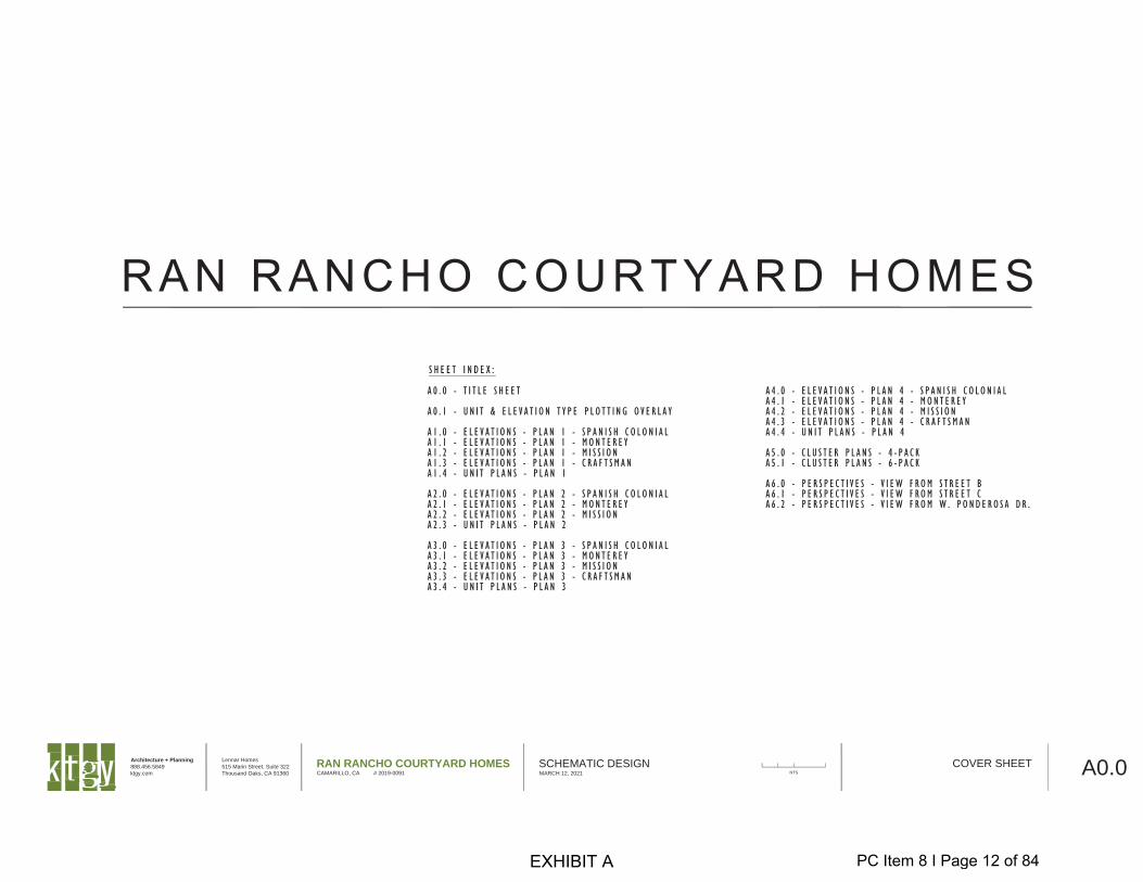
RAN RANCHO COURTYARD HOMESCAMARILLO, CA # 2019-0091
SCHEMATIC DESIGNMARCH 12, 2021 A0.0COVER SHEET
NTS
EXHIBIT A PC Item 8 I Page 12 of 84
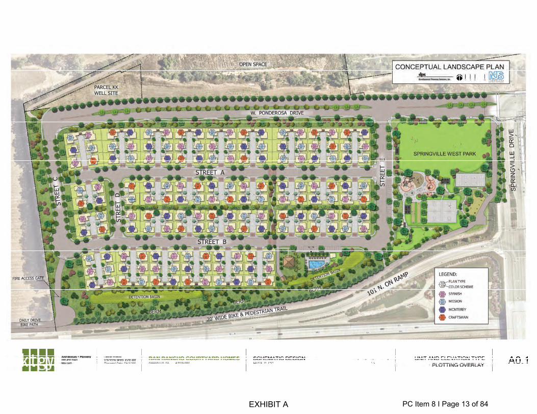
EXHIBIT A PC Item 8 I Page 13 of 84
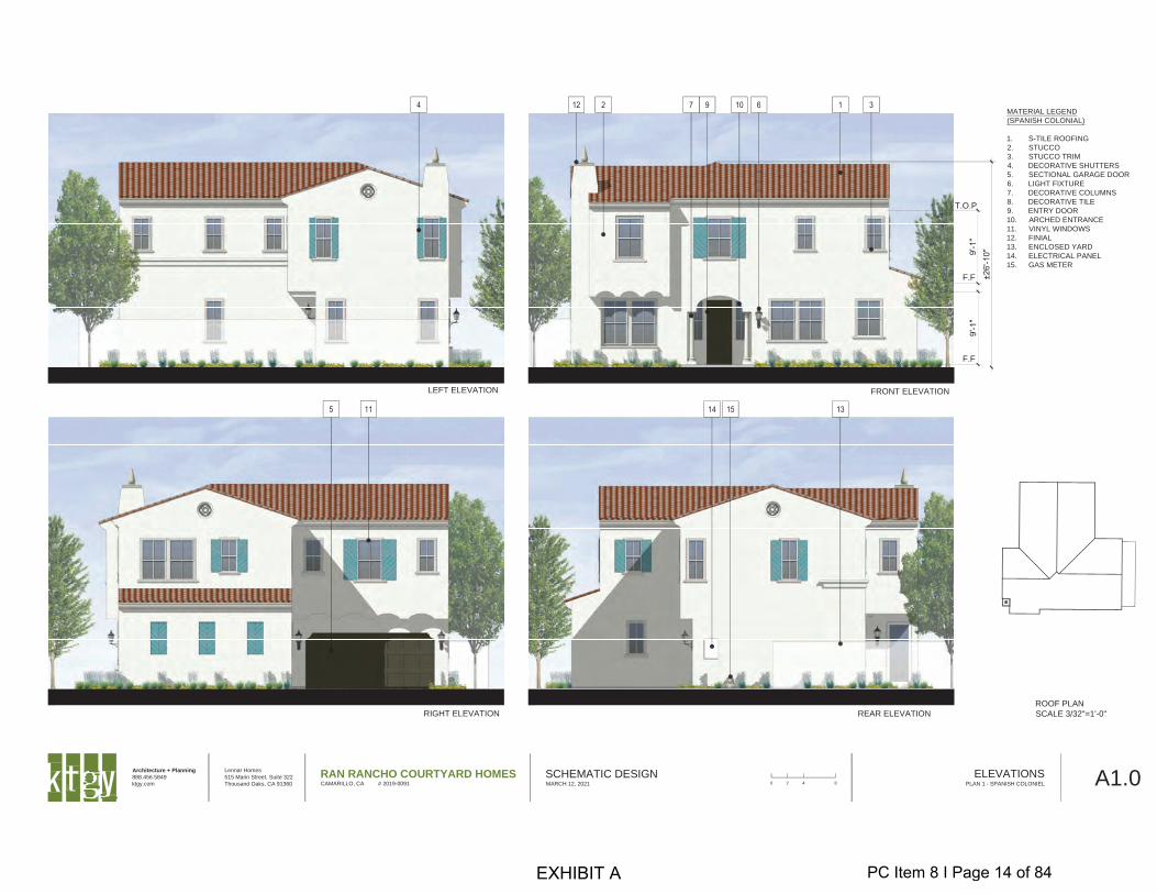
FRONT ELEVATION
REAR ELEVATION
LEFT ELEVATION
RIGHT ELEVATION
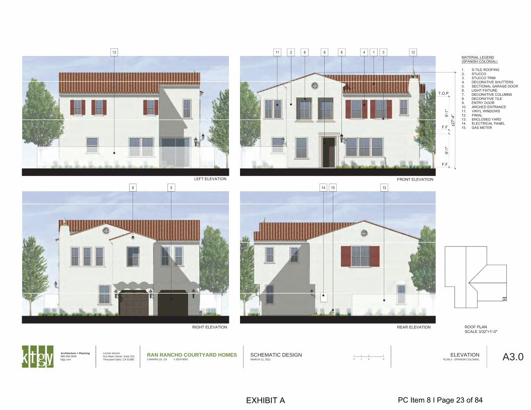
MATERIAL LEGEND
(SPANISH COLONIAL)
1. S-TILE ROOFING
2. STUCCO
3. STUCCO TRIM
4. DECORATIVE SHUTTERS
5. SECTIONAL GARAGE DOOR
6. LIGHT FIXTURE
7. DECORATIVE COLUMNS
8. DECORATIVE TILE
9. ENTRY DOOR
10. ARCHED ENTRANCE
11. VINYL WINDOWS
12. FINIAL
13. ENCLOSED YARD
14. ELECTRICAL PANEL
15. GAS METER
ROOF PLAN
SCALE 3/32"=1'-0"
F.F
F.F
T.O.P
Architecture + Planning
888.456.5849
ktgy.com
Lennar Homes
515 Marin Street, Suite 322
Thousand Oaks, CA 91360
RAN RANCHO COURTYARD HOMESCAMARILLO, CA # 2019-0091
SCHEMATIC DESIGNMARCH 12, 2021 A1.0ELEVATIONS
PLAN 1 - SPANISH COLONIEL0 2 4 8
EXHIBIT A PC Item 8 I Page 14 of 84
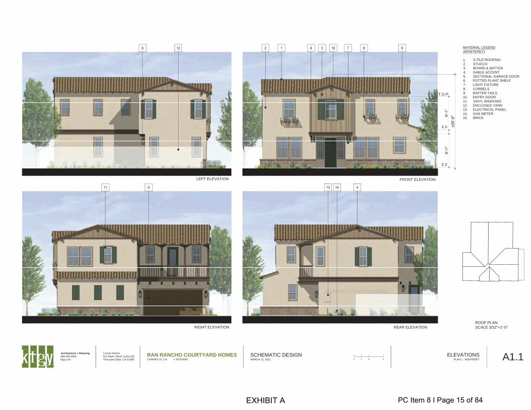
FRONT ELEVATION
REAR ELEVATION
LEFT ELEVATION
RIGHT ELEVATION
ROOF PLAN
SCALE 3/32"=1'-0"
F.F
F.F
T.O.P
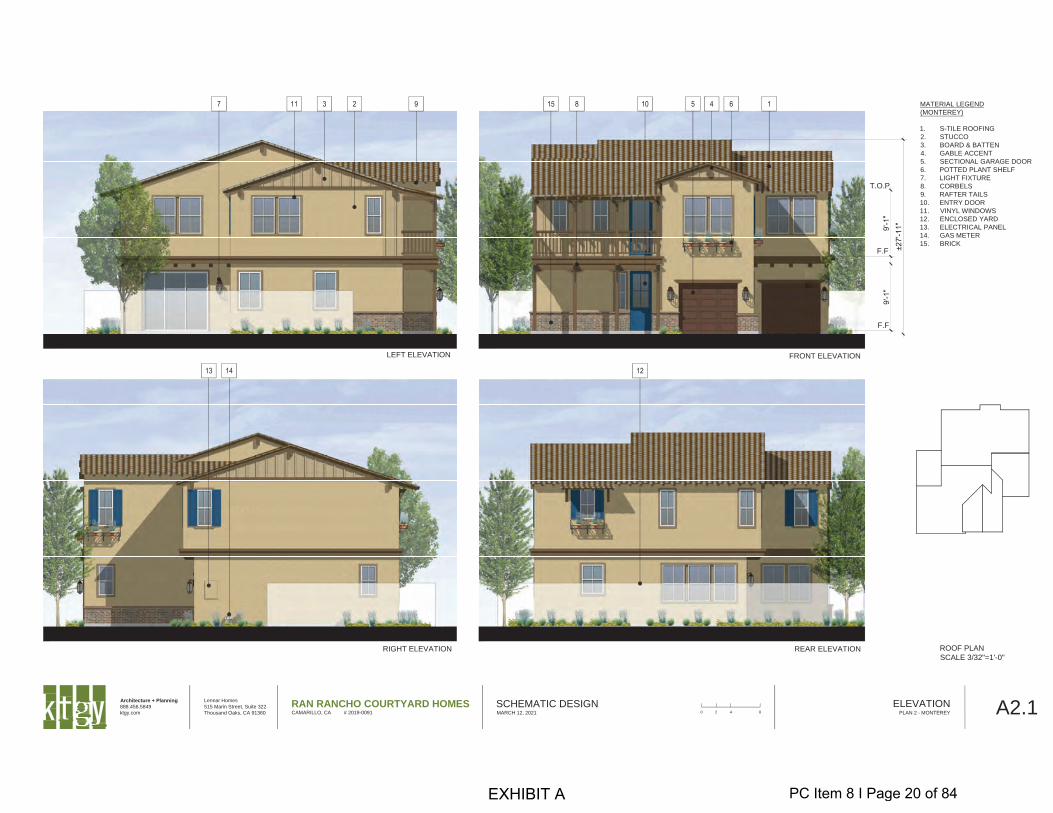
MATERIAL LEGEND
(MONTEREY)
1. S-TILE ROOFING
2. STUCCO
3. BOARD & BATTEN
4. GABLE ACCENT
5. SECTIONAL GARAGE DOOR
6. POTTED PLANT SHELF
7. LIGHT FIXTURE
8. CORBELS
9. RAFTER TAILS
10. ENTRY DOOR
11. VINYL WINDOWS
12. ENCLOSED YARD
13. ELECTRICAL PANEL
14. GAS METER
15. BRICK
Architecture + Planning
888.456.5849
ktgy.com
Lennar Homes
515 Marin Street, Suite 322
Thousand Oaks, CA 91360
RAN RANCHO COURTYARD HOMESCAMARILLO, CA # 2019-0091
SCHEMATIC DESIGNMARCH 12, 2021 A1.1ELEVATIONS
PLAN 1 - MONTEREY0 2 4 8
EXHIBIT A PC Item 8 I Page 15 of 84
FRONT ELEVATION
REAR ELEVATION
LEFT ELEVATION
RIGHT ELEVATION
ROOF PLAN
SCALE 3/32"=1'-0"
F.F
F.F
T.O.P
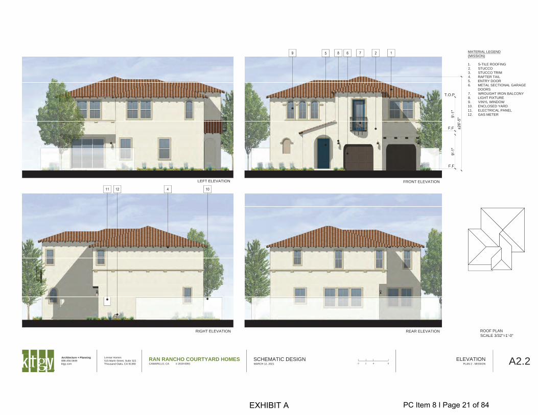
MATERIAL LEGEND
(MISSION)
1. S-TILE ROOFING
2. STUCCO
3. STUCCO TRIM
4. RAFTER TAIL
5. ENTRY DOOR
6. METAL SECTIONAL GARAGE
DOORS
7. WROUGHT IRON BALCONY
8. LIGHT FIXTURE
9. VINYL WINDOW
10. ENCLOSED YARD
11. ELECTRICAL PANEL
12. GAS METER
Architecture + Planning
888.456.5849
ktgy.com
Lennar Homes
515 Marin Street, Suite 322
Thousand Oaks, CA 91360
RAN RANCHO COURTYARD HOMESCAMARILLO, CA # 2019-0091
SCHEMATIC DESIGNMARCH 12, 2021 A1.2ELEVATIONS
PLAN 1 - MISSION0 2 4 8
EXHIBIT A PC Item 8 I Page 16 of 84
FRONT ELEVATION
REAR ELEVATION
LEFT ELEVATION
RIGHT ELEVATION
ROOF PLAN
SCALE 3/32"=1'-0"
F.F
F.F
T.O.P
MATERIAL LEGEND
(CRAFTSMAN STYLE)
1. FLAT-TILE CONC. ROOFING
2. STUCCO
3. FIBER-CEMENT LAP SIDING
4. DECORATIVE SHUTTERS
5. SECTIONAL GARAGE DOOR
6. LIGHT FIXTURE
7. DECORATIVE BRACKET
8. STONE VENEER
9. ENTRY DOOR
10. BOARD AND BATTEN SIDING
11. DECORATIVE COLUMN
12. PLANTER BOX
13. VINYL WINDOWS
14. ENCLOSED YARD
15. ELECTRICAL PANEL
16. GAS METER
Architecture + Planning
888.456.5849
ktgy.com
Lennar Homes
515 Marin Street, Suite 322
Thousand Oaks, CA 91360
RAN RANCHO COURTYARD HOMESCAMARILLO, CA # 2019-0091
SCHEMATIC DESIGNMARCH 12, 2021 A1.3ELEVATIONS
PLAN 1 - CRAFTSMAN0 2 4 8
EXHIBIT A PC Item 8 I Page 17 of 84
T.
R.
G.
A/C
PLAN 1
4 BED, 2.5 BATH
GROSS AREA 2,098 SQ. FT.
SECOND FLOOR
1293 SQ. FT.
FIRST FLOOR
805 SQ. FT.
DN.
BED 211'-3"x11'-7"
BED 118'-11"x14'-7"
BED 311'-3"x11'-3"
BATH 1
LAU.
W.I.C.
BATH 2LIN
ROOF BELOW
BED 411'-3"x10'-10"
W.I.C.W.I.C.
UP
GARAGE20'-7"x20'-11"
GREAT ROOM15'-9"x13'-4"
KITCHEN
FOYER
PDR.
PAN.
PORCH8'-0"x7'-0"
YARD29'-5"x11'-0"
STOR.
41'-0"
16'-4" 24'-8"
5'-0"10'-0"
56'-0"
LIN
Balcony atMonterey
StyleElevation
Columns atCraftsman
Style
DINING ROOM15'-9"x10'-11"
19 LF
W.I.C.
Pop-outAbove at
CraftsmanStyle
Pop-outAbove atSpanish
Colonial Style
Pop-outAbove atMonterey
Style
15'-6"
Columns atSpanish
Colonial Style
Pop-outAbove at
CraftsmanStyle
Pop-outAbove atSpanish
Colonial Style
Pop-outAbove atMonterey
Style
BalconyAbove atMonterey
StyleElevation
7'-0"
7'-0"
8'-6"
16'-3"
Architecture + Planning
888.456.5849
ktgy.com
Lennar Homes
515 Marin Street, Suite 322
Thousand Oaks, CA 91360
RAN RANCHO COURTYARD HOMESCAMARILLO, CA # 2019-0091
SCHEMATIC DESIGNMARCH 12, 2021 A1.4UNIT PLANS
PLAN 10 2 4 8
EXHIBIT A PC Item 8 I Page 18 of 84
FRONT ELEVATION
REAR ELEVATION
LEFT ELEVATION
RIGHT ELEVATION ROOF PLAN
SCALE 3/32"=1'-0"
F.F
T.O.P
F.F
MATERIAL LEGEND
(SPANISH COLONIAL)
1. S-TILE ROOFING
2. STUCCO
3. STUCCO TRIM
4. DECORATIVE SHUTTERS
5. SECTIONAL GARAGE DOOR
6. LIGHT FIXTURE
7. DECORATIVE COLUMNS
8. DECORATIVE TILE
9. ENTRY DOOR
10. ARCHED ENTRANCE
11. VINYL WINDOWS
12. FINIAL
13. ENCLOSED YARD
14. ELECTRICAL PANEL
15. GAS METER
Architecture + Planning
888.456.5849
ktgy.com
Lennar Homes
515 Marin Street, Suite 322
Thousand Oaks, CA 91360
RAN RANCHO COURTYARD HOMESCAMARILLO, CA # 2019-0091
SCHEMATIC DESIGNMARCH 12, 2021 A2.0ELEVATION
PLAN 2 - SPANISH COLONIAL0 2 4 8
EXHIBIT A PC Item 8 I Page 19 of 84
FRONT ELEVATION
REAR ELEVATION
LEFT ELEVATION
RIGHT ELEVATION
MATERIAL LEGEND
(MONTEREY)
1. S-TILE ROOFING
2. STUCCO
3. BOARD & BATTEN
4. GABLE ACCENT
5. SECTIONAL GARAGE DOOR
6. POTTED PLANT SHELF
7. LIGHT FIXTURE
8. CORBELS
9. RAFTER TAILS
10. ENTRY DOOR
11. VINYL WINDOWS
12. ENCLOSED YARD
13. ELECTRICAL PANEL
14. GAS METER
15. BRICK
ROOF PLAN
SCALE 3/32"=1'-0"
F.F
T.O.P
F.F
Architecture + Planning
888.456.5849
ktgy.com
Lennar Homes
515 Marin Street, Suite 322
Thousand Oaks, CA 91360
RAN RANCHO COURTYARD HOMESCAMARILLO, CA # 2019-0091
SCHEMATIC DESIGNMARCH 12, 2021 A2.1ELEVATION
PLAN 2 - MONTEREY0 2 4 8
EXHIBIT A PC Item 8 I Page 20 of 84
FRONT ELEVATION
REAR ELEVATION
LEFT ELEVATION
RIGHT ELEVATION ROOF PLAN
SCALE 3/32"=1'-0"
F.F
T.O.P
F.F
MATERIAL LEGEND
(MISSION)
1. S-TILE ROOFING
2. STUCCO
3. STUCCO TRIM
4. RAFTER TAIL
5. ENTRY DOOR
6. METAL SECTIONAL GARAGE
DOORS
7. WROUGHT IRON BALCONY
8. LIGHT FIXTURE
9. VINYL WINDOW
10. ENCLOSED YARD
11. ELECTRICAL PANEL
12. GAS METER
Architecture + Planning
888.456.5849
ktgy.com
Lennar Homes
515 Marin Street, Suite 322
Thousand Oaks, CA 91360
RAN RANCHO COURTYARD HOMESCAMARILLO, CA # 2019-0091
SCHEMATIC DESIGNMARCH 12, 2021 A2.2ELEVATION
PLAN 2 - MISSION0 2 4 8
EXHIBIT A PC Item 8 I Page 21 of 84
T.
R.
G.
A/C
BED 312'-10"x11'-11"
BED 211'-7"x12'-1"
LAU.LIN.
W.I.C.
BATH 2
BATH 1
PLAN 2
3 BED + BONUS, 2.5 BATH
GROSS AREA 2,154 SQ. FT.
SECOND FLOOR
1295 SQ. FT.
FIRST FLOOR
859 SQ. FT.
UP
Coat
GREAT ROOM18'-0"x15'-2"
PDR.
PANTRY
PORCH16'-5"x4'-6"
GARAGE11'-0"x20'-2"
FOYER
KITCHEN
DINING15'-10"x10'-0"YARD
15'-9"x35'-2"
GARAGE10'-2"x20'-0"
DN
50'-0"
40'-0" 5'-0"5'-0"
29'-0"11'-0"
BONUS RM.16'-2"x15'-4"
BED 114'-0"x14'-3"
Balcony atMonterey
Style
21 LF
LIN.
5'-6"
17'-11 1/2"
11'-6"
11'-11 1/2"
16'-2"
8'-4" 8'-4"
Architecture + Planning
888.456.5849
ktgy.com
Lennar Homes
515 Marin Street, Suite 322
Thousand Oaks, CA 91360
RAN RANCHO COURTYARD HOMESCAMARILLO, CA # 2019-0091
SCHEMATIC DESIGNMARCH 12, 2021 A2.3UNIT PLANS
PLAN 20 2 4 8
EXHIBIT A PC Item 8 I Page 22 of 84
Architecture + Planning
888.456.5849
ktgy.com
Lennar Homes
515 Marin Street, Suite 322
Thousand Oaks, CA 91360
RAN RANCHO COURTYARD HOMESCAMARILLO, CA # 2019-0091
SCHEMATIC DESIGNMARCH 12, 2021 A3.0ELEVATION
PLAN 3 - SPANISH COLONIAL0 2 4 8
EXHIBIT A PC Item 8 I Page 23 of 84
Architecture + Planning
888.456.5849
ktgy.com
Lennar Homes
515 Marin Street, Suite 322
Thousand Oaks, CA 91360
RAN RANCHO COURTYARD HOMESCAMARILLO, CA # 2019-0091
SCHEMATIC DESIGNMARCH 12, 2021 A3.1ELEVATION
PLAN 3 - MONTEREY0 2 4 8
EXHIBIT A PC Item 8 I Page 24 of 84
Architecture + Planning
888.456.5849
ktgy.com
Lennar Homes
515 Marin Street, Suite 322
Thousand Oaks, CA 91360
RAN RANCHO COURTYARD HOMESCAMARILLO, CA # 2019-0091
SCHEMATIC DESIGNMARCH 12, 2021 A3.2ELEVATION
PLAN 3 - MISSION0 2 4 8
EXHIBIT A PC Item 8 I Page 25 of 84
Architecture + Planning
888.456.5849
ktgy.com
Lennar Homes
515 Marin Street, Suite 322
Thousand Oaks, CA 91360
RAN RANCHO COURTYARD HOMESCAMARILLO, CA # 2019-0091
SCHEMATIC DESIGNMARCH 12, 2021 A3.3ELEVATION
PLAN 3 - CRAFTSMAN0 2 4 8
EXHIBIT A PC Item 8 I Page 26 of 84
A/C
T.
R.
G.
PLAN 3
4 BED, 3.5 BATH
GROSS AREA 2,182 SQ.FT.
SECOND FLOOR
1291 SQ. FT.
FIRST FLOOR
891 SQ. FT.
38'-0"
11'-0" 5'-0"4'-0" 27'-0"
56'-0"
BED 210'-6"x11'-0"
BED 114'-2"x13'-11"
BED 410'-4"x11'-0"
BATH 1
LAU.
BATH 2
Lin.
BED 310'-2"x10'-11"
W.I.C.
DN.
UPGARAGE10'-2"x20'-4"
GARAGE11'-0"x20'-0"
GREAT ROOM14'-6"x16'-8"
KITCHEN
FOYER
PDR.
PATIO14'-8"x 11'-6"
13'-0"
9'-0"
16'-0"
Coat
Columns atCraftsman
StyleElevation
Balcony atMonterey
StyleElevation
DINING ROOM16'-10"x11'-2"
26 LF
BATH 3
Lin.
PANTRY
Pop-out atSpanish
Colonial StyleElevation
Pop-out atSpanish
Colonial StyleElevation
BalconyAbove atMonterey
StyleElevation
14'-3 1/2"
Pop-out Aboveat SpanishColonialElevation
3'-10"
9'-8"
Architecture + Planning
888.456.5849
ktgy.com
Lennar Homes
515 Marin Street, Suite 322
Thousand Oaks, CA 91360
RAN RANCHO COURTYARD HOMESCAMARILLO, CA # 2019-0091
SCHEMATIC DESIGNMARCH 12, 2021 A3.4UNIT PLANS
PLAN 30 2 4 8
EXHIBIT A PC Item 8 I Page 27 of 84
FRONT ELEVATION
REAR ELEVATION
LEFT ELEVATION
RIGHT ELEVATION
ROOF PLAN
SCALE 3/32"=1'-0"
F.F
F.F
T.O.P
MATERIAL LEGEND
(SPANISH COLONIAL)
1. S-TILE ROOFING
2. STUCCO
3. STUCCO TRIM
4. DECORATIVE SHUTTERS
5. SECTIONAL GARAGE DOOR
6. LIGHT FIXTURE
7. DECORATIVE COLUMNS
8. DECORATIVE TILE
9. ENTRY DOOR
10. ARCHED ENTRANCE
11. VINYL WINDOWS
12. FINIAL
13. ENCLOSED YARD
14. ELECTRICAL PANEL
15. GAS METER
Architecture + Planning
888.456.5849
ktgy.com
Lennar Homes
515 Marin Street, Suite 322
Thousand Oaks, CA 91360
RAN RANCHO COURTYARD HOMESCAMARILLO, CA # 2019-0091
SCHEMATIC DESIGNMARCH 12, 2021 A4.0ELEVATIONS
PLAN 4 - SPANISH COLONIAL0 2 4 8
EXHIBIT A PC Item 8 I Page 28 of 84
FRONT ELEVATION
REAR ELEVATION
LEFT ELEVATION
RIGHT ELEVATION
ROOF PLAN
SCALE 3/32"=1'-0"
F.F
F.F
T.O.P
MATERIAL LEGEND
(MONTEREY)
1. S-TILE ROOFING
2. STUCCO
3. BOARD & BATTEN
4. GABLE ACCENT
5. SECTIONAL GARAGE DOOR
6. POTTED PLANT SHELF
7. LIGHT FIXTURE
8. CORBELS
9. RAFTER TAILS
10. ENTRY DOOR
11. VINYL WINDOWS
12. ENCLOSED YARD
13. ELECTRICAL PANEL
14. GAS METER
15. BRICK
Architecture + Planning
888.456.5849
ktgy.com
Lennar Homes
515 Marin Street, Suite 322
Thousand Oaks, CA 91360
RAN RANCHO COURTYARD HOMESCAMARILLO, CA # 2019-0091
SCHEMATIC DESIGNMARCH 12, 2021 A4.1ELEVATIONS
PLAN 4 - MONTEREY0 2 4 8
EXHIBIT A PC Item 8 I Page 29 of 84
FRONT ELEVATION
REAR ELEVATION
LEFT ELEVATION
RIGHT ELEVATION
ROOF PLAN
SCALE 3/32"=1'-0"
MATERIAL LEGEND
(MISSION)
1. S-TILE ROOFING
2. STUCCO
3. STUCCO TRIM
4. RAFTER TAIL
5. ENTRY DOOR
6. METAL SECTIONAL GARAGE
DOORS
7. WROUGHT IRON BALCONY
8. LIGHT FIXTURE
9. VINYL WINDOW
10. ENCLOSED YARD
11. ELECTRICAL PANEL
12. GAS METER
±27'-5"9'-1"
9'-1"
F.F
F.F
T.O.P
Architecture + Planning
888.456.5849
ktgy.com
Lennar Homes
515 Marin Street, Suite 322
Thousand Oaks, CA 91360
RAN RANCHO COURTYARD HOMESCAMARILLO, CA # 2019-0091
SCHEMATIC DESIGNMARCH 12, 2021 A4.2ELEVATIONS
PLAN 4 - MISSION0 2 4 8
EXHIBIT A PC Item 8 I Page 30 of 84
FRONT ELEVATION
REAR ELEVATION
LEFT ELEVATION
RIGHT ELEVATION
ROOF PLAN
SCALE 3/32"=1'-0"
F.F
F.F
T.O.P
MATERIAL LEGEND
(CRAFTSMAN STYLE)
1. FLAT-TILE CONC. ROOFING
2. STUCCO
3. FIBER-CEMENT LAP SIDING
4. DECORATIVE SHUTTERS
5. SECTIONAL GARAGE DOOR
6. LIGHT FIXTURE
7. DECORATIVE BRACKET
8. STONE VENEER
9. ENTRY DOOR
10. BOARD AND BATTEN SIDING
11. DECORATIVE COLUMN
12. PLANTER BOX
13. VINYL WINDOWS
14. ENCLOSED YARD
15. ELECTRICAL PANEL
16. GAS METER
Architecture + Planning
888.456.5849
ktgy.com
Lennar Homes
515 Marin Street, Suite 322
Thousand Oaks, CA 91360
RAN RANCHO COURTYARD HOMESCAMARILLO, CA # 2019-0091
SCHEMATIC DESIGNMARCH 12, 2021 A4.3ELEVATIONS
PLAN 4 - CRAFTSMAN0 2 4 8
EXHIBIT A PC Item 8 I Page 31 of 84
A/C
T.
R.
G.
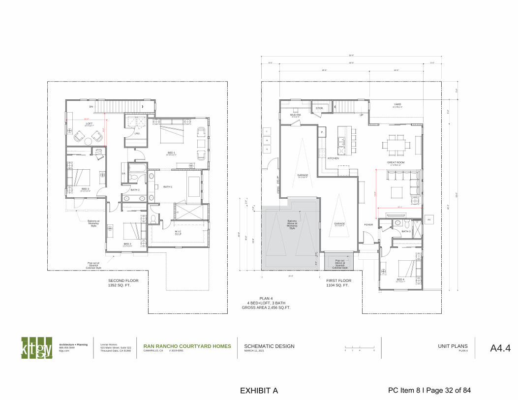
PLAN 4
4 BED+LOFT, 3 BATH
GROSS AREA 2,456 SQ.FT.
SECOND FLOOR
1352 SQ. FT.
FIRST FLOOR
1104 SQ. FT.
40'-0"
25'-0" 15'-0"
5'-0"5'-0"
50'-0"
UP
GARAGE10'-2"x20'-0"
GREAT ROOM17'-8"x25'-10"
BED 411'-7"x11'-7"
BATH 3
YARD20'-0"x11'-9"
BED 211'-2"x13'-6"
BED 116'-10"x14'-0"
LOFT16'-0"x12'-7"
LAU.
W.I.C
BATH 1
BATH 2
Lin.
GARAGE10'-2"x20'-4" FOYER
KITCHEN
DN
Balcony atMonterey
Style
31 LF
BED 310'-11"x14'-0"
STOR.
MUD RM.8'-5"x6'-8"
P.
Pop-out atSpanish
Colonial Style
BalconyAbove atMonterey
Style
Pop-outAbove atSpanish
Colonial Style
12'-1"
11'-2"
16'-0"
Architecture + Planning
888.456.5849
ktgy.com
Lennar Homes
515 Marin Street, Suite 322
Thousand Oaks, CA 91360
RAN RANCHO COURTYARD HOMESCAMARILLO, CA # 2019-0091
SCHEMATIC DESIGNMARCH 12, 2021 A4.4UNIT PLANS
PLAN 40 2 4 8
EXHIBIT A PC Item 8 I Page 32 of 84
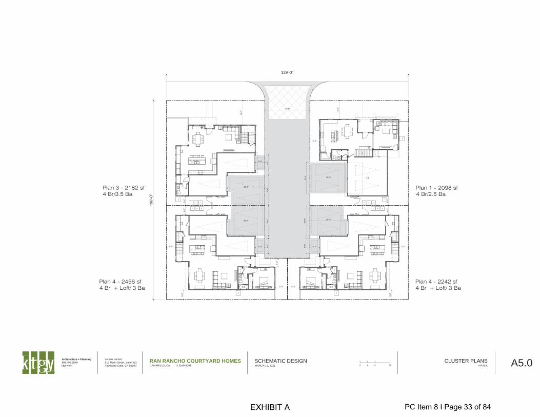
129'-0"
5'-0"
20'-0"
24'-0"
20'-0"
5'-0"
5'-0" 5'-0"
20'-0"
5'-0" 5'-0"
6'-6" 6'-6"
20'-0"
Architecture + Planning
888.456.5849
ktgy.com
Lennar Homes
515 Marin Street, Suite 322
Thousand Oaks, CA 91360
RAN RANCHO COURTYARD HOMESCAMARILLO, CA # 2019-0091
SCHEMATIC DESIGNMARCH 12, 2021 A5.0CLUSTER PLANS
4-PACK0 4 8 16
EXHIBIT A PC Item 8 I Page 33 of 84

129'-0"
20'-0"
5'-0"
5'-0"
5'-0"
5'-0"
5'-0"
20'-0"
20'-0"
5'-0"
5'-0"
5'-0"
5'-0"
5'-0"
5'-0"
6'-6" 6'-6"
20'-0"
20'-0"
24'-0"
20'-0"
5'-0"
Architecture + Planning
888.456.5849
ktgy.com
Lennar Homes
515 Marin Street, Suite 322
Thousand Oaks, CA 91360
RAN RANCHO COURTYARD HOMESCAMARILLO, CA # 2019-0091
SCHEMATIC DESIGNMARCH 12, 2021 A5.1CLUSTER PLANS
6-PACK0 4 8 16
EXHIBIT A PC Item 8 I Page 34 of 84
Architecture + Planning
888.456.5849
ktgy.com
Lennar Homes
515 Marin Street, Suite 322
Thousand Oaks, CA 91360
RAN RANCHO COURTYARD HOMESCAMARILLO, CA # 2019-0091
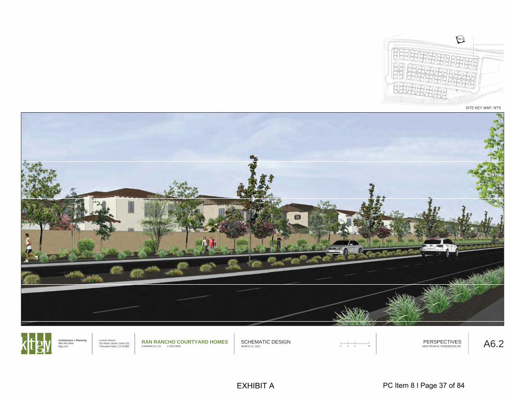
SCHEMATIC DESIGNMARCH 12, 2021 A6.0PERSPECTIVES
VIEW FROM STREET B0 4 8 16
SITE KEY MAP: NTS
A6.0
EXHIBIT A PC Item 8 I Page 35 of 84
Architecture + Planning
888.456.5849
ktgy.com
Lennar Homes
515 Marin Street, Suite 322
Thousand Oaks, CA 91360
RAN RANCHO COURTYARD HOMESCAMARILLO, CA # 2019-0091
SCHEMATIC DESIGNMARCH 12, 2021 A6.1PERSPECTIVES
VIEW FROM STREET C0 4 8 16
SITE KEY MAP: NTS
A6.1
EXHIBIT A PC Item 8 I Page 36 of 84
Architecture + Planning
888.456.5849
ktgy.com
Lennar Homes
515 Marin Street, Suite 322
Thousand Oaks, CA 91360
RAN RANCHO COURTYARD HOMESCAMARILLO, CA # 2019-0091
SCHEMATIC DESIGNMARCH 12, 2021 A6.2PERSPECTIVES
VIEW FROM W. PONDEROSA DR.0 4 8 16
SITE KEY MAP: NTS
A6.3
EXHIBIT A PC Item 8 I Page 37 of 84
* - Project Condition Modified CS - City Security Required ** - New Condition SS - Sanitary Security Required MC - Mitigation Condition GS - Grading Security Required MS - Maintenance Security Required RPD-195, Ran Rancho – 04/20/2021 Page 1
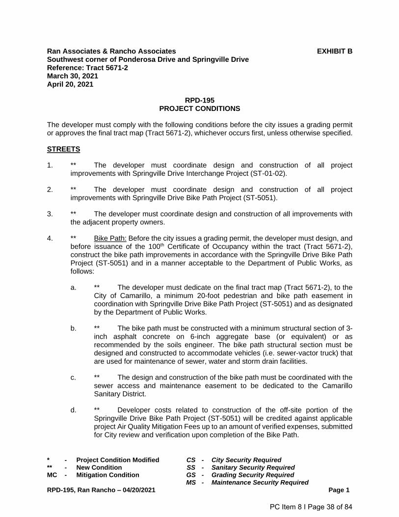
Ran Associates & Rancho Associates EXHIBIT B Southwest corner of Ponderosa Drive and Springville Drive Reference: Tract 5671-2 March 30, 2021 April 20, 2021
RPD-195 PROJECT CONDITIONS
The developer must comply with the following conditions before the city issues a grading permit or approves the final tract map (Tract 5671-2), whichever occurs first, unless otherwise specified.
STREETS
1. ** The developer must coordinate design and construction of all project improvements with Springville Drive Interchange Project (ST-01-02).
2. ** The developer must coordinate design and construction of all project improvements with Springville Drive Bike Path Project (ST-5051).
3. ** The developer must coordinate design and construction of all improvements with the adjacent property owners.
4. ** Bike Path: Before the city issues a grading permit, the developer must design, and before issuance of the 100th Certificate of Occupancy within the tract (Tract 5671-2), construct the bike path improvements in accordance with the Springville Drive Bike Path Project (ST-5051) and in a manner acceptable to the Department of Public Works, as follows:
a. ** The developer must dedicate on the final tract map (Tract 5671-2), to the City of Camarillo, a minimum 20-foot pedestrian and bike path easement in coordination with Springville Drive Bike Path Project (ST-5051) and as designated by the Department of Public Works.
b. ** The bike path must be constructed with a minimum structural section of 3-inch asphalt concrete on 6-inch aggregate base (or equivalent) or as recommended by the soils engineer. The bike path structural section must be designed and constructed to accommodate vehicles (i.e. sewer-vactor truck) that are used for maintenance of sewer, water and storm drain facilities.
c. ** The design and construction of the bike path must be coordinated with the sewer access and maintenance easement to be dedicated to the Camarillo Sanitary District.
d. ** Developer costs related to construction of the off-site portion of the Springville Drive Bike Path Project (ST-5051) will be credited against applicable project Air Quality Mitigation Fees up to an amount of verified expenses, submitted for City review and verification upon completion of the Bike Path.
PC Item 8 I Page 38 of 84
* - Project Condition Modified CS - City Security Required ** - New Condition SS - Sanitary Security Required MC - Mitigation Condition GS - Grading Security Required MS - Maintenance Security Required RPD-195, Ran Rancho – 04/20/2021 Page 2
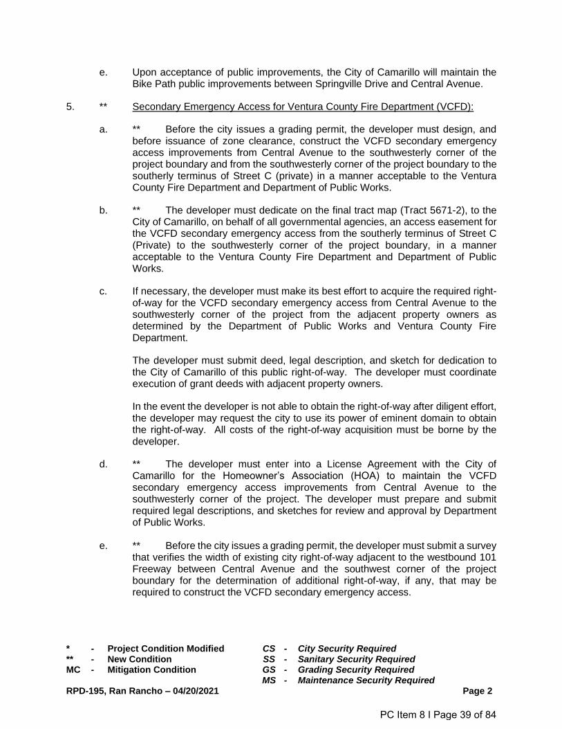
e. Upon acceptance of public improvements, the City of Camarillo will maintain the Bike Path public improvements between Springville Drive and Central Avenue.
5. ** Secondary Emergency Access for Ventura County Fire Department (VCFD):
a. ** Before the city issues a grading permit, the developer must design, and before issuance of zone clearance, construct the VCFD secondary emergency access improvements from Central Avenue to the southwesterly corner of the project boundary and from the southwesterly corner of the project boundary to the southerly terminus of Street C (private) in a manner acceptable to the Ventura County Fire Department and Department of Public Works.
b. ** The developer must dedicate on the final tract map (Tract 5671-2), to the City of Camarillo, on behalf of all governmental agencies, an access easement for the VCFD secondary emergency access from the southerly terminus of Street C (Private) to the southwesterly corner of the project boundary, in a manner acceptable to the Ventura County Fire Department and Department of Public Works.
c. If necessary, the developer must make its best effort to acquire the required right-of-way for the VCFD secondary emergency access from Central Avenue to the southwesterly corner of the project from the adjacent property owners as determined by the Department of Public Works and Ventura County Fire Department.
The developer must submit deed, legal description, and sketch for dedication to the City of Camarillo of this public right-of-way. The developer must coordinate execution of grant deeds with adjacent property owners.
In the event the developer is not able to obtain the right-of-way after diligent effort, the developer may request the city to use its power of eminent domain to obtain the right-of-way. All costs of the right-of-way acquisition must be borne by the developer.
d. ** The developer must enter into a License Agreement with the City of Camarillo for the Homeowner’s Association (HOA) to maintain the VCFD secondary emergency access improvements from Central Avenue to the southwesterly corner of the project. The developer must prepare and submit required legal descriptions, and sketches for review and approval by Department of Public Works.
e. ** Before the city issues a grading permit, the developer must submit a survey
that verifies the width of existing city right-of-way adjacent to the westbound 101 Freeway between Central Avenue and the southwest corner of the project boundary for the determination of additional right-of-way, if any, that may be required to construct the VCFD secondary emergency access.
PC Item 8 I Page 39 of 84
* - Project Condition Modified CS - City Security Required ** - New Condition SS - Sanitary Security Required MC - Mitigation Condition GS - Grading Security Required MS - Maintenance Security Required RPD-195, Ran Rancho – 04/20/2021 Page 3
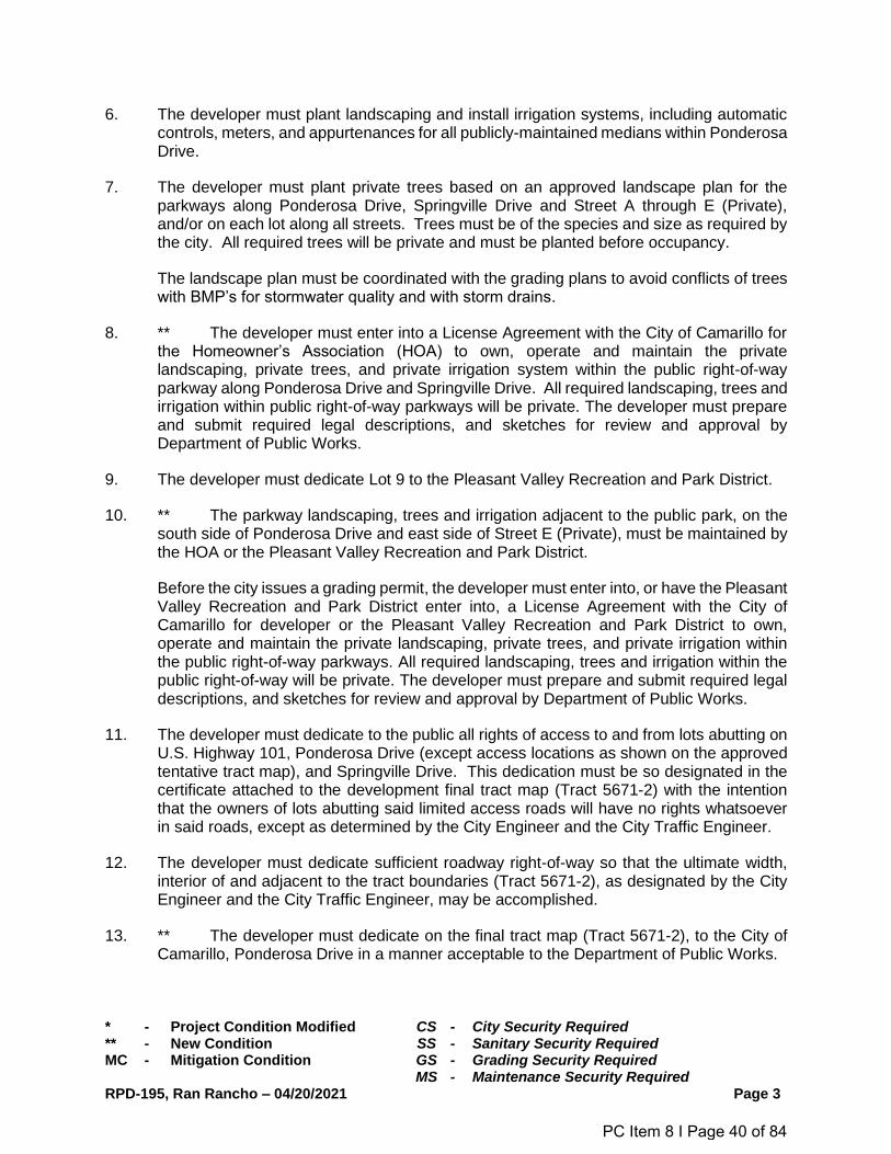
6. The developer must plant landscaping and install irrigation systems, including automatic controls, meters, and appurtenances for all publicly-maintained medians within Ponderosa Drive.
7. The developer must plant private trees based on an approved landscape plan for the parkways along Ponderosa Drive, Springville Drive and Street A through E (Private), and/or on each lot along all streets. Trees must be of the species and size as required by the city. All required trees will be private and must be planted before occupancy.
The landscape plan must be coordinated with the grading plans to avoid conflicts of trees with BMP’s for stormwater quality and with storm drains.
8. ** The developer must enter into a License Agreement with the City of Camarillo for the Homeowner’s Association (HOA) to own, operate and maintain the private landscaping, private trees, and private irrigation system within the public right-of-way parkway along Ponderosa Drive and Springville Drive. All required landscaping, trees and irrigation within public right-of-way parkways will be private. The developer must prepare and submit required legal descriptions, and sketches for review and approval by Department of Public Works.
9. The developer must dedicate Lot 9 to the Pleasant Valley Recreation and Park District.
10. ** The parkway landscaping, trees and irrigation adjacent to the public park, on the south side of Ponderosa Drive and east side of Street E (Private), must be maintained by the HOA or the Pleasant Valley Recreation and Park District.
Before the city issues a grading permit, the developer must enter into, or have the Pleasant Valley Recreation and Park District enter into, a License Agreement with the City of Camarillo for developer or the Pleasant Valley Recreation and Park District to own, operate and maintain the private landscaping, private trees, and private irrigation within the public right-of-way parkways. All required landscaping, trees and irrigation within the public right-of-way will be private. The developer must prepare and submit required legal descriptions, and sketches for review and approval by Department of Public Works.
11. The developer must dedicate to the public all rights of access to and from lots abutting on U.S. Highway 101, Ponderosa Drive (except access locations as shown on the approved tentative tract map), and Springville Drive. This dedication must be so designated in the certificate attached to the development final tract map (Tract 5671-2) with the intention that the owners of lots abutting said limited access roads will have no rights whatsoever in said roads, except as determined by the City Engineer and the City Traffic Engineer.
12. The developer must dedicate sufficient roadway right-of-way so that the ultimate width, interior of and adjacent to the tract boundaries (Tract 5671-2), as designated by the City Engineer and the City Traffic Engineer, may be accomplished.
13. ** The developer must dedicate on the final tract map (Tract 5671-2), to the City of Camarillo, Ponderosa Drive in a manner acceptable to the Department of Public Works.
PC Item 8 I Page 40 of 84
* - Project Condition Modified CS - City Security Required ** - New Condition SS - Sanitary Security Required MC - Mitigation Condition GS - Grading Security Required MS - Maintenance Security Required RPD-195, Ran Rancho – 04/20/2021 Page 4
14. ** If applicable, the developer must dedicate on the final tract map (Tract 5671-2), to the City of Camarillo, an easement for sidewalk and pedestrian purposes, for those portions of the sidewalk meandering outside of the public right-of-way along Ponderosa Drive, in a manner acceptable to the Department of Public Works.
15. Before the city issues a grading permit, traffic circulation and control on adjacent streets, including all curb openings, control signs for regulation, warning, and guidance of traffic, must be designed as required by the City Traffic Engineer. These must include, without limitation, stop signs, speed signs, turn prohibition signs, one-way signs, parking signs, together with required pavement striping, raised pavement markers, and road symbols. Traffic circulation and control onsite must meet the approval of the Director of Community Development and the City Traffic Engineer. (CS)
16. ** Signing and Striping: The developer must submit a signing and striping plan for review and approval by the City Traffic Engineer and the Department of Public Works. The signing and striping plans must show, but not limited to, the following:
a. Stop sign control for eastbound Street A at Street E, northbound Street E at Ponderosa Drive and southbound Street D at Street B.
b. Caltrans Detail 1 “Skip Centerline”, installed on Streets C, B and E.
c. Both sides of Ponderosa Drive must be posted No Parking Anytime.
d. Install W3-3, "Signal Ahead," on the south side of Ponderosa Drive approximately 150 feet west from the centerline of Street E and facing west towards eastbound traffic.
e. Show striping plan for Ponderosa Drive. Eastbound lanes must be striped with a 12-foot-wide vehicular lane next to the landscaped median (number 1 lane), an 11-foot-wide number 2 lane, and a 7-foot wide bicycle lane. Striping must transition to include a right turn only lane at Springville Drive.
f. Ponderosa Drive westbound lanes must be striped to show the same striping as eastbound lanes between Springville Drive and Street E and include the left turn pocket. Between Street E and Street C show lane number 2 merging into lane number 1. Lane number 1 must shift into the left turn pocket. Within the diverter island created, install 12-inch-wide solid white diagonals between the bicycle lane and the vehicular lane. Diagonals must be at 100 foot spacing.
g. Traffic signs in pedestrian areas must be installed with a vertical clearance of seven feet (7-feet) above the pedestrian travel way.
17. ** The developer must install “No Parking Any Time” sign at the westerly terminus of Street A. Enforcement will be the responsibility of the Homeowner’s Association.
18. * Before the city issues a certificate of occupancy for the last building of each phase of development, all signs must be installed, and before final acceptance of each phase,
PC Item 8 I Page 41 of 84
* - Project Condition Modified CS - City Security Required ** - New Condition SS - Sanitary Security Required MC - Mitigation Condition GS - Grading Security Required MS - Maintenance Security Required RPD-195, Ran Rancho – 04/20/2021 Page 5
the city may require the developer to add traffic control devices, such as signing and striping, the need for which are not apparent at time of plan approval but which are warranted due to actual field conditions. The developer must install the traffic control devices before final acceptance of each phase.
19. Ramps and other accessible path of travel elements (sidewalk, walk, appurtenances) must be constructed in locations specified by the City Engineer and the Director of Community Development. Accessible facilities must be constructed, and existing facilities reconstructed, within the project limits as necessary to comply with California Title 24 accessibility requirements of the California Building Codes and Americans with Disabilities Act (ADA). (CS)
20. All underground irrigation, water, and other pipes or openings which are encountered during construction of street and site improvements must be removed or sealed in a manner satisfactory to the Department of Public Works.
21. Before the city issues a grading permit, the developer must design horizontal and vertical curves at all intersections in a manner acceptable to the City Traffic Engineer.
22. Before the city issues a grading permit, the developer must design and, before first occupancy of any building, provide intersection visibility as set forth in CMC § 19.38.050 and in a manner acceptable to the City Traffic Engineer.
23. Before the city issues a grading permit, the developer must design frontage landscaping that will not obstruct a motorist’s line of sight above three feet nor below seven feet within the corner cutoff area of an uncontrolled intersection, or within the sight triangle of an uncontrolled intersection.
The developer must plant trees based on an approved landscape plan or planted parallel to the street centerline along the sidewalks and medians. All trees within the corner cutoff area of an uncontrolled intersection or within the sight triangle of an uncontrolled intersection must be spaced no closer than 40 feet apart to avoid creating a “fence post condition.”
24. The road construction (pave-out) policy of the city will apply: (CS)
a. The developer must remove and reconstruct any existing public improvements adjacent to the limits of the project found to be damaged before or during the construction of this project.
b. ** Ponderosa Drive: Before the city issues a grading permit, the developer must design and, before zone clearance for the first building permit (excluding models), construct Ponderosa Drive improvements from Springville Drive to, and including, the westerly terminus of the project, to be a public street, in a manner satisfactory to the Department of Public Works, as follows:
i. The dedicated right-of-way must be 94 feet wide. Within this right-of-way, the developer must provide a roadway that is 74 feet wide with a 14-foot
PC Item 8 I Page 42 of 84
* - Project Condition Modified CS - City Security Required ** - New Condition SS - Sanitary Security Required MC - Mitigation Condition GS - Grading Security Required MS - Maintenance Security Required RPD-195, Ran Rancho – 04/20/2021 Page 6
wide raised and landscaped center median. The pavement must be designed for a traffic index (T.I.) equal to 9.0. Also, within the right-of-way, and to the south side of the roadway, the developer must provide a 10-foot wide parkway with 5-foot wide meandering sidewalk. The sidewalk must be 8 feet wide when adjacent to the curb and 10 feet wide when adjacent to curb returns. Within the right-of-way and to the north side of the roadway, the developer must provide a 10-foot wide parkway with a 6-foot wide sidewalk to extend into and transition through the intersection to join the existing sidewalk.
ii. Design and construct median street name signs (reference Drawing Number TR-9) within the Ponderosa Drive medians adjacent to the project boundaries at locations approved by the City Traffic Engineer.
iii. Turn lanes:
1. Left-turn lanes must be 200 feet long with 90-foot bay tapers, except at the following location:
a. The Ponderosa Drive westbound left-turn lane median openings located at the intersections of Ponderosa Drive with Street C (Private) and Street E (Private) must be designed to be located in a manner acceptable to the City Traffic Engineer. The left-turn lane must be constructed to be 150 long with a 90-foot bay taper. The median opening must be designed to allow westbound Ponderosa Drive left-turn movements inbound to Street C (Private) and Street E (Private) and left-turn movements outbound from Street E (Private). Subsequent to construction, the city reserves the future right, upon recommendation of the City Traffic Engineer, to reconfigure the Ponderosa Drive median openings to prohibit left-turn movements outbound from Street E (Private).
2. Right-turn lanes must be 150 feet long with 90-foot bay taper.
iv. Before the city issues a grading permit, the developer must design and, before zone clearance for the first building permit (excluding models), construct the following improvements along Ponderosa Drive to transition through its intersection with Springville Drive to approximately 400 feet east of Springville Drive, in a manner satisfactory to the Department of Public Works: 1. Remove existing striping and resurface approximately 400 feet of
existing westbound Ponderosa Drive at Springville Drive, including its intersection with Springville Drive, prior to placing new pavement markings.
PC Item 8 I Page 43 of 84
* - Project Condition Modified CS - City Security Required ** - New Condition SS - Sanitary Security Required MC - Mitigation Condition GS - Grading Security Required MS - Maintenance Security Required RPD-195, Ran Rancho – 04/20/2021 Page 7
2. Re-stripe approximately 400 feet of existing westbound Ponderosa Drive at Springville Drive, including its intersection with Springville Drive.
c. ** Springville Drive: Before the city issues a grading permit, the developer must design and, before zone clearance for the first building permit (excluding models), construct the following improvements along existing Springville Drive, in a manner satisfactory to the Department of Public Works:
i. A 10-wide sidewalk along Springville Drive, adjacent to the project boundary to join the existing sidewalk to the south of the project.
ii. Resurface and re-stripe the existing southbound lanes, adjacent to the project boundary, including its intersection with Ponderosa Drive, prior to placing new pavement markings.
iii. Resurface approximately 300 feet of the existing northbound Springville Drive at Ponderosa Drive, prior to placing new pavement markings.
iv. The developer must re-stripe approximately 300 feet of the existing northbound Springville Drive at Ponderosa Drive.
v. Design and construct a median street name sign (reference Drawing Number TR-9) within the Springville Drive median adjacent to the project boundaries at a location approved by the City Traffic Engineer.
d. All final paving must be placed as required by project improvement plans before final inspection.
25. ** If, before zone clearance for the first building permit, the developer places all final paving on public streets and private streets, then, before final inspection, the developer must re-apply a final pavement treatment to all private streets and drive aisles, in a manner acceptable to the Department of Public Works.
26. ** Private Streets:
a. Before the city issues a grading permit, the developer must design and, before zone clearance for the first building permit (excluding models), construct Street A, B, and D to be private streets 56 feet wide with a 36-foot roadway, 10-foot wide parkways, with landscape adjacent to the curbs and 5-foot wide sidewalks. Said streets must be completed in a manner acceptable to the Department of Public Works. The pavement must be designed for a traffic index of TI = 7.5.
b. Before the city issues a grading permit, the developer must design and, before zone clearance for the first building permit (excluding models), construct Street C and E to be private streets 60 feet wide with a 40-foot roadway, 10-foot wide parkways, with landscape adjacent to the curbs and 5-foot wide sidewalks. Said
PC Item 8 I Page 44 of 84
* - Project Condition Modified CS - City Security Required ** - New Condition SS - Sanitary Security Required MC - Mitigation Condition GS - Grading Security Required MS - Maintenance Security Required RPD-195, Ran Rancho – 04/20/2021 Page 8
streets must be completed in a manner acceptable to the Department of Public Works. The pavement must be designed for a traffic index of TI = 7.5.
c. 4-pack and 6-pack drive aisles (Private) without parking must be 24 feet wide with a minimum of 4 feet between the edge of the aisle and a garage door. A 24-inch wide 4-inch high rolled curb and gutter must be on one side and a zero-inch curb only on the other side. Parking will be prohibited on both sides of the drive aisles.
d. The developer must install features that indicate to motorists that the project streets are private.
27. ** Traffic Signal – Springville Drive and Ponderosa Drive:
a. ** Before the city issues a grading permit, the developer must post securities for its fair share of the cost of the design and installation of traffic signal, including interconnect conduits and cables, at the intersection of Ponderosa Drive and Springville Drive as determined by the City Traffic Engineer and the Department of Public Works. (CS)
b. ** Before the city issues a grading permit the developer must design and, before the city issues a zone clearance for the first building permit (including models), construct the traffic signal at the intersection of Ponderosa Drive and Springville Drive in a manner acceptable to the City Traffic Engineer.
c. ** Before the city issues the first certificate of occupancy or the opening of the model homes to the general public, whichever occurs first, the traffic signal must be operational, as approved by the City Traffic Engineer.
d. Applicable traffic signal securities posted and/or cash-outs by other developers of the Springville Specific Plan may be available after the traffic signal has been accepted by City Council.
e. If the developer sells this project, or any portion of it, before construction in whole or in part, the developer shall inform the subsequent owner of any remaining financial responsibility to design and install the required traffic signals, and shall inform the city of any contractual arrangement that transfers the responsibility to a party other than the original developer.
28. Before the city issues a zone clearance, the developer must furnish to the Department of Public Works a street lighting plan. The plan must include all street lumens proposed or existing within the project boundaries. For each of the project streets that connect to an existing street, the plan must identify the location of the first existing street light on the existing street. For street lights located on local streets, the lights must be located a maximum of 220 feet apart and have 5.8 KHPS. For street lights located on collector streets, the lights must be located a maximum of 200 feet apart and have 9.5 KHPS. For street lights located on primary and secondary arterial streets, the lights must be located a maximum of 200 feet apart and have 22 KHPS. Before occupancy, the developer must construct street lights in accordance with the approved street lighting plan. This includes
PC Item 8 I Page 45 of 84
* - Project Condition Modified CS - City Security Required ** - New Condition SS - Sanitary Security Required MC - Mitigation Condition GS - Grading Security Required MS - Maintenance Security Required RPD-195, Ran Rancho – 04/20/2021 Page 9
decorative marbelite electroliers of the lumen rating called for on the plan, trenching, and installing underground electrical power to the lighting fixtures. Differential costs of the marbelite electroliers and the cost of trenching must be paid by the developer. Developer must contract with Southern California Edison for installation of street lights and must prepay all fees. (CS)
29. Ventura County Benchmark No. 96-1 AUX 1 may be used as datum in conjunction with this project.
30. The developer must submit evidence to the city of existing corner lot monumentation before project approval and at the completion of the project to ensure that existing corner monumentation and witness markings are not disturbed by construction activities or were reset.
31. Bridge Policy Fee:
The Bridge Policy (CMC §§ 18.70.020 and 18.75.050) will be complied with and before the city issues a grading permit, bridge construction fees must be paid.
Fees imposed pursuant to this condition are for the purpose of funding nine bridges listed in Resolution No. 2000-43. The amount of fees which the developer must pay pursuant to this condition is the developer’s proportionate share of the acreage of the developer’s property in relation to the estimated construction costs of the bridges as more fully set forth in Resolution No. 2000-43.
32. Traffic Mitigation Fee:
Before the city issues zone clearance for any building permits, the developer must pay the Traffic Mitigation Fee as established by CMC § 11.68. If the developer sells this project before construction, in whole or part, the developer must inform the subsequent owner that not all fees have been paid.
33. ** Camarillo Community Facilities District Number 1:
The developer is responsible for the project’s apportioned share of the applicable sewer, drainage and bridge improvements that constitute the “facilities” of the West Camarillo Community Facilities District (CFD) No. 1 and for the applicable sewer facilities buy-in payment established by resolution. The developer must pay the sewer facilities buy-in payment at the time and in the manner required by the applicable buy-in payment resolution (City Resolution 2012-48). The developer may satisfy its obligation with respect to bridge and drainage facilities by (1) payment of a one-time in-lieu payment, or (ii) annexing the subject property into CFD No. 1. If the developer elects to annex into CFD No.1, the developer must submit to the City an application and the applicable fees to process the annexation and apportionment of the subject property's special taxes.
34. ** Springville Interchange Benefit Area (SIBA) Fee:
PC Item 8 I Page 46 of 84
* - Project Condition Modified CS - City Security Required ** - New Condition SS - Sanitary Security Required MC - Mitigation Condition GS - Grading Security Required MS - Maintenance Security Required RPD-195, Ran Rancho – 04/20/2021 Page 10
Before the city issues zone clearance for any building permits, the developer must pay the Springville Interchange Benefit Area (SIBA) Fee as established and adopted by Resolution No. 2009-173. If the developer sells this project before construction, in whole or part, the developer must inform the subsequent owner that not all fees have been paid.
STREET SWEEPING
35. The developer is required, pursuant to these conditions of approval, to maintain the surface of all streets in a safe, clean, and swept condition from the date of first unit occupancy until final acceptance when all construction activities have been completed by the developer to the satisfaction of the City Engineer.
If the City Engineer finds that the improvements are not being maintained in a reasonably acceptable manner before the same being accepted by the city, the City Engineer may give written notice to the developer to perform such maintenance work as is required to comply with this condition; if, within the time set forth in the notice to perform, the developer fails to provide the necessary maintenance service, the city may provide such maintenance service and must be empowered to directly invoice the developer for the cost thereof, including all direct and indirect costs, as well as overhead and administrative costs.
GRADING AND DRAINAGE
36. ** Grading:
a. All grading must conform to CMC Chapter 16.04. (GS)
b. All grades and elevations shown on the approved tentative tract map are preliminary and will be verified during detailed design review by the Department of Public Works.
c. The entire development must be graded in total, or phased as approved by the City of Camarillo, in order to mitigate the noise, dust, air quality, and construction traffic impacts. Erosion control plans, slope planting plans, open space landscape plans, and irrigation plans must be approved and implemented immediately upon completion of grading.
d. Phasing:
i. The developer may request construction phases by submitting a preliminary phasing plan to the Department of Community Development for review and approval by the Department of Community Development and Department of Public Works.
ii. Before the city issues zone clearance for first building permit of any phase, if phasing is approved, of the onsite improvements associated with the zone clearance, the developer must complete all curb, gutters and street paving. All utilities must be installed before paving is placed.
PC Item 8 I Page 47 of 84
* - Project Condition Modified CS - City Security Required ** - New Condition SS - Sanitary Security Required MC - Mitigation Condition GS - Grading Security Required MS - Maintenance Security Required RPD-195, Ran Rancho – 04/20/2021 Page 11
e. Design and grade the tops of slopes and toes of slopes to be a minimum 2-feet at 2% minimum from back of curb, back of sidewalk, or right-of-way, whichever is further from the curb face.
f. Maximum graded slopes must be 2-foot horizontal and 1-foot vertical, including slopes on the berm.
g. Structural setback areas, deformation zones, and other special foundation zones must be shown on the grading plans with deed restrictions to be recorded on all lots determined to be in a restricted use zone.
37. * Soils:
a. The developer must prepare and submit to the City Engineer a soils and geologic study as required by CMC Chapter 16.38 and in accordance with the requirements of Resolution No. 88-57 (and all subsequent amendments). The study must include, without limitation, fault trenching, liquefaction, hydroconsolidation and seismically-induced settlement testing and analysis (contact the Public Works Department for guidelines). The developer must comply with the recommendations of the soils and geologic study as determined by the city. Any restricted use zones must be shown on the grading plan.
The soils report must also address the imported soils placed as uncertified fill in the previous borrow-site area, stock-pile area and fault investigation trenches.
b. The developer’s consultant must submit soils recommendations for those lots with buildings located over a cut/fill line on the project grading plans for review and approval by the Department of Public Works and Department of Community Development.
c. The developer’s consultant must submit soils recommendations for retaining walls located over cut/fill lines, at the top of slopes and at the bottom of slopes for review and approval by the Department of Public Works and Department of Community Development.
d. All proposed lots must be individually certified as geotechnically suitable for their intended use. Any lot not so certified must be indicated on the grading plan and must have recorded by separate instrument a deed restriction prohibiting building construction. The form of the document must be approved by the City Attorney.
38. ** Before the city issues a grading permit, the developer must design and, before final acceptance, reconstruct (upgrade) the existing private desilting basin located on Lot 6, in a manner acceptable to the City Engineer.
39. * The developer must prepare and submit a hydrology and hydraulics study for the project to the City Engineer. The study must include, without limitation, the hydraulic analysis for the sizing of the required storm drain system. Appropriate facilities for proper
PC Item 8 I Page 48 of 84
* - Project Condition Modified CS - City Security Required ** - New Condition SS - Sanitary Security Required MC - Mitigation Condition GS - Grading Security Required MS - Maintenance Security Required RPD-195, Ran Rancho – 04/20/2021 Page 12
drainage within the development must be provided and constructed as directed and approved by the City Engineer.
a. All areas must be graded in such a manner that there will be no undrained depressions.
b. All storm drain facilities must be designed to convey the Q50 storm runoff.
c. Pads must be protected from the Q100 storm including showing the overflow path on the hydrology map.
d. Discuss the path of overflow through the project for the 100-year flood. The berm may act as a dam with ponding within the property.
e. All proposed structures within the project area must be elevated well above and be protected from the 100-year flood from any source, in-tract drainage or from areas outside the tract (Tract 5671-2) boundaries. Include an engineering analysis of the 100-yr flood in the hydraulic analysis.
f. Provide Water Surface Pressure Gradient (WSPG) calculations using WSPG Program for all pipes 18-inches or larger.
g. Include with the detailed WSPG analysis, the existing freeway crossings and the downstream reaches. The detailed WSPG analysis must also include additional flows, junctions, transitions, inlets, outlets, etc. required through the project, Highway 101 right-of-way and the downstream reaches to Camarillo Hills Drain. If Highway 101 (southbound and northbound freeway lanes) are supposed to be draining to any downstream reaches, the hydraulic capacity calculations for these facilities should include the additional flows.
h. All hydraulic calculations need to reflect field and design conditions and elevations, as well as appropriate roughness factors.
40. ** Before the city issues a grading permit, the developer must design and, before final acceptance, construct the project’s drainage to transition to the intersection of Ponderosa Drive and Springville Drive, in a manner acceptable to the Department of Public Works. This may require transition areas that fall within the existing intersection to be reconstructed, such that there are no undrained depressions.
41. ** Before the city issues the grading permit, the developer must design and, before zone clearance, construct concrete swales behind retaining walls and at slopes in a manner acceptable to the City Engineer.
42. * Cross gutters may be permitted on minor streets only at those points where the traffic would normally be expected to stop.
43. The development must be protected from offsite drainage, and any water concentration and/or increase as a result of the construction of the development must be conveyed by
PC Item 8 I Page 49 of 84
* - Project Condition Modified CS - City Security Required ** - New Condition SS - Sanitary Security Required MC - Mitigation Condition GS - Grading Security Required MS - Maintenance Security Required RPD-195, Ran Rancho – 04/20/2021 Page 13
means of adequate facilities to the existing storm drain system designed to convey the development’s runoff.
44. * The developer must design and construct the slopes throughout the development in the following manner:
a. The developer must design and construct the concrete gutters with a minimum flowline slope of 0.5 percent and in a manner acceptable to the City Engineer.
b. The developer must design and construct asphalt access road, with a minimum of 1 percent cross fall slope, in a manner acceptable to the City Engineer.
c. Landscaping must be designed and installed with a minimum flowline slope of 1 percent and a minimum cross fall slope of 2 percent, and in a manner acceptable to the City Engineer.
d. The site must be raised, as needed, to provide standard slopes and standard clear cover for sewer, water and storm drains, in a manner acceptable to the City Engineer.
45. * Each lot must drain to an approved drainage facility. Cross lot drainage must be minimized. No direct outlets to Ponderosa Drive will be permitted.
46. ** Storm Water Acceptance:
a. The developer must provide storm water acceptance deeds on any and all lots subject to runoff water from adjacent lots or properties. In addition, the developer must construct permanent concrete swales at appropriate locations intercepting such runoff waters and transporting them off each lot in a manner approved by the City Engineer.
b. The developer must provide a storm water acceptance deed to the City of Camarillo for the storm water from Ponderosa Drive (public) which flows to the private storm drains in Ponderosa Drive, project private streets, project private storm drains and other project private property.
47. ** Private Strom Drain Lines:
a. All storm drain lines within the tract (Tract 5671-2) boundaries, including those located within private streets, drive aisles and Ponderosa Drive will be private.
b. All storm drain lines within the public right-of-way, such as but not limited to the crossings on Ponderosa Drive, from Lot 6 to the junction at the intersection of Ponderosa Drive and Street E, as determined by the Department of Public Works.
c. The storm drain mainline in Ponderosa Drive, west of the Springville Drive intersection, as shown on the approved tentative tract map, must be revised and
PC Item 8 I Page 50 of 84
* - Project Condition Modified CS - City Security Required ** - New Condition SS - Sanitary Security Required MC - Mitigation Condition GS - Grading Security Required MS - Maintenance Security Required RPD-195, Ran Rancho – 04/20/2021 Page 14
realigned to be parallel to Ponderosa Drive. Diagonal alignments within the streets must be realigned.
d. The storm drain lines along the southerly boundaries of Lots 7 and 9 between the berm and the Springville Interchange/101 Freeway and along the easterly boundary of Lot 9 adjacent to Springville Drive. These storm drain lines must be converted from open channels to boxes or pipes in the final design as determined by the Department of Public Works.
e. Before the city issues a grading permit, the developer must design and, before final acceptance, construct the storm drain system to connect to the existing triple 48”x24” RCB and double 48”x24” RCB by designing and constructing Junction Equalization Structures.
f. Before the city issues the grading permit, the developer must design and, before zone clearance, construct the radii and deflections of the storm drain system in a manner acceptable to the Department of Public Works.
g. The developer must enter into a License Agreement with the City of Camarillo for the Homeowner’s Association (HOA) to own, operate and maintain the private storm drain system (all storm drains) within the Ponderosa Drive public right-of-way. The developer must prepare and submit required legal descriptions, and sketches for review and approval by Department of Public Works.
48. ** Access Roads to Storm Drain Facilities:
a. The developer must design and construct access roads with turnarounds at locations designated by and in a manner acceptable to the Department of Public Works.
b. The developer must dedicate on the final tract map (Tract 5671-2), to the City of Camarillo, storm drain and access easements, for those storm drain facilities designated to be public in a manner acceptable to the Department of Public Works.
STORMWATER QUALITY
49. Development must be undertaken in accordance with conditions and requirements of the Ventura Countywide Stormwater Quality Management Program, National Pollutant Discharge Elimination System (NPDES) permit. (Order 2010-0108).
50. ** Since this project area was part of a Tentative Tract 5671 (Lots 5, 6, 7, 8, 9 & 10) which was deemed complete or approved prior to October 11, 2011, the effective date of the July 13, 2011 Ventura County Stormwater Quality Technical Guidance Manual, it must incorporate appropriate Ventura Countywide Stormwater Quality Urban Impact Management Plan (SQUIMP) requirements into the project plans for the following projects covered by SQUIMP requirements:
PC Item 8 I Page 51 of 84
* - Project Condition Modified CS - City Security Required ** - New Condition SS - Sanitary Security Required MC - Mitigation Condition GS - Grading Security Required MS - Maintenance Security Required RPD-195, Ran Rancho – 04/20/2021 Page 15
a. parking lots of 5,000 square feet or more or with 25 or more parking spaces and potentially exposed to stormwater runoff
b. Home subdivisions with 10 or more housing units
The project must apply recommendations outlined in the Stormwater Quality Report for Ran Rancho Properties TT-5671 dated November 22, 2010. The project must be designed to include the control measures applicable to a development project with an application deemed complete for processing or approved tract map prior to October 11, 2011, the effective date of the July 13, 2011 Ventura County Stormwater Quality Technical Guidance Manual, as specified in the 2002 Technical Guidance Manual for Stormwater Quality Control Measures under Board Order 00-108 (2002 Technical Manual). Those control measures include site design control, site-specific source control, and require treatment control measures (refer to Table 2-3 of the Technical Manual). Per the Technical Manual, project must minimize impervious surfaces through methods such as reducing footprint of building and parking lots; clustering buildings and paved areas to maximize pervious area; use minimum allowable roadway and sidewalk cross sections and parking stall widths, include landscape islands in cul-de-sacs (where approved), use pervious materials where appropriate, such as modular paving blocks, turf blocks porous concrete and asphalt, brick and gravel or cobbles, and use grass-lined channels or surface swales to convey runoff instead of paved gutters. For treatment, emphasis should be on the use of infiltration/land-based treatment controls, such as bioretention gardens, pervious concrete/pavement, and grassy bioswales. Alternative or proprietary treatment controls not described in the Technical Manual may be considered on a case-by-case basis provided the project proponent can demonstrate that treatment equivalent to approved methods is achievable. Copies of SQUIMP and the 2002 Technical Guidance Manual can be obtained from the Ventura Countywide Stormwater Program at www.vcstormwater.org or 805-654-2010.
Pretreatment of parking lot and roof drainage will be required before discharge to storm drain system.
Stormwater treatment device(s) location and detail must be shown on the plans.
The owner is responsible for providing a SQUIMP worksheet on the form provided by the city. The SQUIMP worksheet will be subject to the review and approval of the City Engineer and/or the City Stormwater Program Manager. Before final acceptance of project improvements, the owner or his/her designated representative must certify that the treatment device was constructed and installed in accordance with the approved SQUIMP.
51. State General Construction Permit requirement for projects that disturb 1 acre or more of soil or are part of a larger common plan of development. Before the city issues a grading permit, the developer must submit a copy of the project receipt of the Notice of Intent (NOI) and Waste Discharge Identification (WDID) from the California State Water Resources Control Board (SWRCB), Storm Water Permit Unit, for coverage under the General Construction NPDES Permit (GCP) (Permit No. CAS000002/ Order No. 2009-009-DWQ as amended). The developer must comply with all requirements of the General Permit.
PC Item 8 I Page 52 of 84
* - Project Condition Modified CS - City Security Required ** - New Condition SS - Sanitary Security Required MC - Mitigation Condition GS - Grading Security Required MS - Maintenance Security Required RPD-195, Ran Rancho – 04/20/2021 Page 16
52. All development subject to the State GCP, must prepare a local Stormwater Pollution Prevention Plan (SWPPP) based on the template available in the California Construction BMP Handbook Portal available at www.casqa.org. The SWPPP must be submitted to the city for review and approval, and once approved; the developer must submit the SWPPP in electronic format to the city.
53. If a change of ownership takes place for the entire development or portions of the common plan of development where construction activities are still on-going, development must provide city with Proof of a Change of Information form (COI) with the State GCP.
54. The project construction plans must incorporate Best Management Practices (BMPs) applicable to the development for the review and approval of the City Engineer. Suggested construction BMPs are listed in the California Stormwater BMP Handbook for Construction, which can be downloaded at www.cabmphandbooks.com.
55. All onsite storm drain inlets, whether newly constructed or existing, must be labeled “Don’t Dump – Drains to Creek” before occupancy in accordance with city requirements. The labels are to be provided by the city to the developer at cost; this does not include installation of the labels. There will be additional labor charges for installation by the city.
56. No architectural copper should be used that is exposed to stormwater runoff. This area drains to a watershed that has been listed by the State Water Resources Control Board as being impaired for copper per Los Angeles Regional Water Quality Control Board Resolution No. 2006-012.
57. All exterior metal building surfaces, including roofs, must be with rust-inhibitive paint to prevent corrosion and release of metal contaminants into the storm drain system prior to occupancy.
58. Certified full capture trash devices must be installed to address the trash total maximum daily load (TMDL) requirements imposed under Los Angeles Regional Water Quality Control Board Resolution No. 2007-007 or the Statewide Trash Amendments adopted April 7, 2015. Contact the City’s Stormwater Program Manager for a list of certified devices and more information. If there are existing storm drain inlets within this project, they will be required to be retrofitted to address the above trash policies.
59. If applicable, trash enclosures in the recreational area must include a lattice structure to cover the enclosure with a solid roof design below to direct stormwater away from entering the enclosure. All litter/waste material must be kept in leak-proof containers. Area(s) must be paved with impermeable material. No other area may drain onto these areas. The trash enclosure may not drain to the storm drain system or the sanitary sewer and all cleanups must be performed using dry cleanup methods. There must be no slope on the interior floor of the enclosure and the waste handling area must be bermed to prevent run-on of stormwater. Post sign on trash enclosure informing users that hazardous materials are not to be disposed of therein.
PC Item 8 I Page 53 of 84
* - Project Condition Modified CS - City Security Required ** - New Condition SS - Sanitary Security Required MC - Mitigation Condition GS - Grading Security Required MS - Maintenance Security Required RPD-195, Ran Rancho – 04/20/2021 Page 17
60. Landscape areas must be designed and maintained with efficient irrigation to reduce runoff and promote surface filtration and minimize the use of fertilizers and pesticides which can contribute to urban runoff pollution.
61. Parking areas with five or more spaces must be designed to minimize degradation of stormwater quality. BMPs, such as bioretention, bioswales, oil/water separators, sand filter basins or approved equals, must be installed to intercept and effectively prohibit pollutants from discharging to the storm drain system. The design must be submitted to the City Engineer for review and approval before the city issues a grading permit.
62. If applicable, decorative fountains and ponds must be designed with no connection to the storm drain system. The discharge of non-stormwater from fountains and ponds must not be allowed to drain to the storm drain system.
63. Air-conditioning condensate flows must be segregated to prevent introduction of pollutants and must be directed to pervious areas for percolation where possible.
64. All property areas must be maintained free of litter/debris.
65. All onsite storm drains must be cleaned at least twice a year; once immediately before October 1 (the beginning of the rainy season), and once in January. Additional cleaning may be required by the City Engineer.
66. Private roads and parking lots must be maintained free of litter/debris. Sidewalks, parking lots, and private roads must be swept at least on a monthly basis, with a minimum of two (2) sweepings occurring during the month of October, prior to the beginning of the rainy season. Such sweepings must be a minimum two (2) weeks apart. When swept or washed, debris must be trapped and collected to prevent entry to the storm drain system. The applicant must provide a program for the compliance with this requirement prior to issuance of zoning clearance.
67. If applicable, trash enclosures must be dry swept/cleaned at least on a monthly basis, with a minimum of two (2) sweepings occurring during the month of October, prior to the beginning of the rainy season. Such sweepings must be a minimum two (2) weeks apart. When swept, debris must be trapped and collected to prevent entry to the storm drain system. The facility must have a spill prevention, control and cleanup plan.
68. If a generator is installed for the recreation center, then the enclosure must be paved with impermeable material. No other area must drain onto these areas. The enclosure area must not drain to the storm drain system or the sanitary sewer and all cleanups must be performed using dry cleanup methods. There must be no slope on the interior floor of the enclosure and the area must be bermed to prevent run-on of stormwater. The generator or tank must have adequate secondary containment to contain 110 percent of fuel or liquid in tank in event of a spill.
69. There must be no pressure washing of parking areas, sidewalks, or private roads, unless the City approves a collection system to keep water from entering the storm drain.
PC Item 8 I Page 54 of 84
* - Project Condition Modified CS - City Security Required ** - New Condition SS - Sanitary Security Required MC - Mitigation Condition GS - Grading Security Required MS - Maintenance Security Required RPD-195, Ran Rancho – 04/20/2021 Page 18
70. If applicable waters from salt-chemistry pools or spas, filter waste and acid-wash or other cleaning waste water are prohibited and illegal to discharge to either the storm drain system or to the sewer system. Water from fresh-water swimming pools may be discharged to the storm drain system as long as the discharge meets the city’s Municipal Stormwater Permit requirements. There must not be any swimming pool drains directly connected to the storm drain system.
71. The owner is responsible for maintaining and operating all on-site private improvements. The owner is responsible for submitting a stormwater quality mitigation device Maintenance Plan and is responsible for providing a Stormwater Treatment Device Access and Maintenance Agreement on the form provided by the city for all post-construction stormwater treatment devices, as required by the Ventura County Municipal Stormwater Permit Order 2010-0108. The agreement will be subject to the review and approval of the City Engineer and City Attorney. Before final acceptance of project improvements, the owner or his/her designated representative must certify that the treatment device was constructed and installed in accordance with the approved plans.
WATER AND FIRE PROTECTION
72. The project must comply with CMC Chapter 14.12, the City of Camarillo Water Conservation Ordinance No. 1126.
73. In order to provide for reasonable fire protection during the construction period, the developer must maintain passable vehicular access to all buildings. Adequate fire hydrants with required fire flow must be installed before structural framing as recommended by the Fire Department and Camarillo Water Division.
74. Any water well(s) located on such property must be indicated on improvement plans. Developer must submit pumping performance and well history to the city. Such water well(s) must be offered to the city. If the water quality or location of the well(s) is such that the city deems the well(s) unusable, the well(s) must be destroyed according to CMC Chapter 14.08 or, at the city’s discretion, security of an amount equal to the charges of such destruction must be placed with the city to insure proper destruction of the well(s) at a future date. (CS)
75. ** The developer must dedicate on the final tract map (Tract 5671-2), to the City of Camarillo, Parcel KK for the future city well site, of a size and at a location as designated by the Department of Public Works.
76. ** Before project approval in the City Water Division service area, the developer must comply with all requirements as set forth in the city ordinances and standards.
a. The developer must design and construct the water system to meet or exceed the City of Camarillo’s Water Standards. All water system facilities and/or appurtenances will be approved by the City Engineer. (CS)
PC Item 8 I Page 55 of 84
* - Project Condition Modified CS - City Security Required ** - New Condition SS - Sanitary Security Required MC - Mitigation Condition GS - Grading Security Required MS - Maintenance Security Required RPD-195, Ran Rancho – 04/20/2021 Page 19
b. The developer must design and construct the separation between water and other utilities (i.e. storm drain, sewer, etc.) in accordance with the City of Camarillo’s Water Standards.
c. The developer must furnish a water network analysis/written report on the source and amount of water available.
77. ** The developer must dedicate on the final tract map (Tract 5671-2), to the City of Camarillo, easement for water pipeline, access and maintenance purposes, over the entire width of Streets “A”, “B”, “C”, “D”, Parcels A through GG and a minimum 20-foot wide easement along the southerly boundary of the project on Lots 7 and through the park on Lot 9 and areas outside the public right-of-way, in a manner acceptable to the Department of Public Works.
78. *** Access Road to City Water Facilities:
a. The developer must design and, before final acceptance, construct a minimum 20-foot wide access road with turnarounds along the southerly boundary of the project between the berm and the 101 Freeway and along Springville Drive, in a manner acceptable to the Department of Public Works.
b. The access road must have a minimum 3-inch asphalt concrete on 6-inch aggregate base (or equivalent) or as recommended by the soils engineer.
c. The access road must extend to the west and transition with the VCFD secondary emergency access road and bike path, in a manner acceptable to the Department of Public Works.
d. The developer must construct access roads at locations designated by, and in a manner acceptable to, the Department of Public Works.
79. ** Water Main Replacement:
a. Before the city issues a grading permit, the developer must design and, before zone clearance, remove the existing 16-inch water main located adjacent and through Street E, in a manner acceptable to the Department of Public Works.
b. Before the city issues a grading permit, the developer must design and, before zone clearance, construct a new water main to replace the 16-inch main in a manner acceptable to the Department of Public Works.
c. The developer must abandon, on the final tract map (Tract 5671-2), those portions of the existing waterline easement, which are partially located adjacent and through Street E, as designated by the Department of Public Works.
80. * The developer must design the landscape irrigation system separate from the domestic system in Ponderosa Drive. This separate landscape irrigation system must include mains and meters capable of being disconnected from the domestic mains and
PC Item 8 I Page 56 of 84
* - Project Condition Modified CS - City Security Required ** - New Condition SS - Sanitary Security Required MC - Mitigation Condition GS - Grading Security Required MS - Maintenance Security Required RPD-195, Ran Rancho – 04/20/2021 Page 20
connected to future reclaimed water mains to be located adjacent to the freeway rights-of-way. Reclaimed water service will be used once reclaimed water supply is available to the area. The Homeowners’ Association or Owners’ Association must be responsible for the maintenance of these lines. (CS)
81. No pre-grading or grading permits, building permits or map recordation shall take place until a water will-serve letter conforming to Administrative Policy and Procedure No. 8.4 is issued by the City of Camarillo Water Division indicating that adequate water supply is available to service the proposed application.
82. ** City of Oxnard Existing Waterline:
a. The developer must obtain a Letter of Non-interference from the City of Oxnard for any work on or adjacent to the City of Oxnard water facilities located along the westerly project boundary, crossing Ponderosa right-of-way, and along the northerly boundary of Lot 6.
b. The developer must coordinate design and construction of improvements along the westerly project boundary adjacent to Street C, Ponderosa right-of-way and the northerly project boundary adjacent to Lot 6 with respect to the City of Oxnard’s existing waterline and facilities.
83. The developer must dedicate on the final tract map (Tract 5671-2), to the city of Camarillo, any water rights associated with this project.
84. Before the city issues a grading permit, the developer must furnish to the city a completed Groundwater Allocation Transfer Authorization form as issued by the city in accordance with the Fox Canyon Groundwater Management Agency (GMA) Ordinance 8, Chapter 5.0, Section 5.3.
The historical groundwater allocation that was extracted and applied to such property for the purpose of agricultural irrigation will be transferred from the agricultural facility(s) supplying that property to the City of Camarillo.
If an extraction facility(s) supplied the historical allocation to a greater acreage than the amount of property to be developed, the allocation to be transferred will be prorated proportionately.
SANITARY
85. The developer must provide the necessary backflow prevention control devices as required by the Ventura County Department of Environmental Health.
86. * Private Sewer System: The method of sewage and waste disposal must be by means of a private community disposal system.
a. All sewer mains and laterals within the development will be private and maintained by the Homeowner’s Association unless designated to be public by the District.
PC Item 8 I Page 57 of 84
* - Project Condition Modified CS - City Security Required ** - New Condition SS - Sanitary Security Required MC - Mitigation Condition GS - Grading Security Required MS - Maintenance Security Required RPD-195, Ran Rancho – 04/20/2021 Page 21
b. Sewerage system design, including connections to the Camarillo Sanitary District (District) system, must be submitted to the District for approval.
c. The sewer main crossing under the berm, as shown on the approved tentative tract map must be revised and realigned to be perpendicular to the berm to minimize diagonal alignments.
87. * The developer must post appropriate bonds in amounts determined by the District to guarantee construction of that portion of the disposal system to be maintained by the District. This includes any modifications to the existing sewers and any new manholes. This security shall be filed with the District before project approval. (SS)
88. ** Access Road to Sewer Facilities:
a. The developer must dedicate on the final tract map (Tract 5671-2), to the Camarillo Sanitary District a minimum 20-foot wide access and maintenance easements in a manner acceptable to the Camarillo Sanitary District.
b. The developer must design and construct a minimum 20-foot wide access road with turnarounds for public sewer facilities along the southerly and easterly project boundaries in a manner acceptable to the Camarillo Sanitary District.
c. The access road must have a minimum structural section of 3-inch asphalt concrete on 6-inch aggregate base (or equivalent) or as recommended by the soils engineer.
89. ** The developer must design and construct the separation between sewer and other utilities (i.e. water, storm drain, etc.) in accordance with the Camarillo Sanitary District Standard.
90. The developer must provide the city with an unconditional sanitary will-serve letter from the Camarillo Sanitary District indicating that adequate sewer conveyance and treatment capacity is available to service this project.
UTILITIES
91. All utility lines and stub connections to property lines of each lot must be installed underground before any paving is placed.
92. The developer must underground new utilities in the following manner:
a. The developer must contact the Southern California Edison Company, Verizon Communications (telephone), and Time Warner Cable to make a determination of the requirement for the aboveground structures necessary to serve and to be constructed for this project.
b. The developer must provide easements for these structures outside of the public right-of-way and must provide screening for these structures. The location and
PC Item 8 I Page 58 of 84
* - Project Condition Modified CS - City Security Required ** - New Condition SS - Sanitary Security Required MC - Mitigation Condition GS - Grading Security Required MS - Maintenance Security Required RPD-195, Ran Rancho – 04/20/2021 Page 22
screening must be subject to the approval by the City Engineer and the Director of Community Development.
93. * Encroachment Permits: Developer must obtain all necessary encroachment permits before project approval. This will include, without limitation, City of Camarillo, City of Oxnard, Southern California Edison Company, Southern California Gas Company, Verizon Communications (telephone), Time Warner Cable, Calleguas Municipal Water District, and Caltrans.
94. The developer must provide trenching for conduit and miscellaneous substructures necessary for the installation of cable television and electronic gear.
95. ** Existing Utilities: Before the city approves the final tract map (Tract 5671-2), the developer must verify that the location of existing city utilities (sewer, water and storm drain) are within the existing recorded easements.
a. If any utility is found to be outside, or near the edge, of an existing easement the developer must dedicate additional appropriate easements on the final tract map (Tract 5671-2) as designated by the Department of Public Works.
b. The developer must relocate all conflicting utilities to accommodate the development.
MISCELLANEOUS
96. The development is subject to the subdivision requirements of CMC Title 18.
97. * The developer must form a Homeowners’ Association (HOA) with CC&Rs, or other program approved by the city and City Attorney, to be recorded to provide maintenance of the private improvements, such as, but not limited to, open space lots, recreation lot, private streets, private traffic signs, lettered lots for 4-pack and 6-pack drive aisles, VCFD secondary emergency access road (on-site & off-site), lettered lots for common areas, retaining walls, private parkways, including but not limited to private landscaping, private trees and private irrigation within the public right-of-way, private storm drain lines, private sewer lines, private water pipelines, private basins and BMP’s.
98. No permanent building construction may be commenced until the Public Works Department approves final grading and improvement plans, the Community Development Department issues a zone clearance, and Building and Safety issues a building permit.
99. All persons doing business in the city in connection with the project must have a current Business License Tax Certificate before commencing construction.
100. Before the city issues a grading permit or approves the final tract map (Tract 5671-2), whichever occurs first, the developer must submit to the city improvement plans, grading plans, and erosion control plans for the development. These plans must include street and site improvements, drainage facilities and structures as required by the city, sewer system, water supply system, and plans showing the layout of all underground utilities
PC Item 8 I Page 59 of 84
* - Project Condition Modified CS - City Security Required ** - New Condition SS - Sanitary Security Required MC - Mitigation Condition GS - Grading Security Required MS - Maintenance Security Required RPD-195, Ran Rancho – 04/20/2021 Page 23
proposed to be installed. The project agreements, securities, and documents may not be approved by the City Council unless said improvement plans, grading plans, and erosion control plans are ready to be approved by the City Engineer.
101. All improvement and grading plans must be on 24” x 36” drawing size. Originals must be inked on 4 mil Mylar or linen. No “cut and paste,” “sticky-backs,” “zip-a-tone,” “kroy lettering,” or other tape will be permitted on final originals.
102. There will be no burning or burying of materials at any time during the development or agricultural burning before development.
103. The conditions of approval of this project supersede all conflicting notations, specifications, dimensions, typical sections, and the like, which may be shown on tentative project plans.
104. All ordinances, policy resolutions and standards of the city in effect at the time of approval of this project must be complied with as a condition of this approval. This condition will not apply to the amount of fees to be paid.
105. The amount of fees to be paid will be those in effect at the actual time of payment of such fees. All fees must be paid before the city issues a grading permit, or approves the final tract map (Tract 5671-2), whichever occurs first, unless otherwise specified or required by law. Administrative Policy and Procedure No. 8.02 will apply to capital facility fees.
106. Any deposit or security required by any ordinance, resolution, policy or condition must be delivered to the city in a form acceptable to the city.
107. * The developer must make an appointment with the Public Works Administrator to review agreements, securities, and documents of the project to determine eligibility to be placed on the City Council agenda. This meeting must take place a minimum of ten (15) working days before the City Council meeting.
The project final tract map (Tract 5671-2) and improvement plans must be presented to City Council for authorization for approval and for signatures by the Mayor and City Engineer.
108. * Before final inspection and acceptance of public improvements, the developer must submit “As-built” improvement plans to the Department of Public Works for review and approval.
109. Responsibility:
a. Before commencing work, the developer must designate in writing an authorized representative with complete authority to represent and act for the developer. Said representative must be present at the site of the work at all times while work is actually in progress. During periods when work is suspended, arrangements acceptable to the City Engineer must be made for any emergency work which may be required.
PC Item 8 I Page 60 of 84
* - Project Condition Modified CS - City Security Required ** - New Condition SS - Sanitary Security Required MC - Mitigation Condition GS - Grading Security Required MS - Maintenance Security Required RPD-195, Ran Rancho – 04/20/2021 Page 24
b. In the absence of the developer and the developer’s authorized representative from the project site, required decisions will be made by the City Engineer. If warranted, the City Engineer will order completion of work to protect the general public. If said orders are not acted upon immediately, the city may complete the work or have said work completed at the developer’s expense.
c. The developer must be responsible for all actions of his contractors and subcontractors until the improvements have been approved and accepted by the City Council.
110. There will be no ingresses or egresses to the property except for those shown on the approved tentative map labeled Exhibit A, and as approved by this development permit, to wit: RPD-195. Any entrance must be surfaced and improved as to include necessary paveout to join existing pavement as required and in accordance with City Standards.
111. Developer must submit design and calculations and obtain permit and inspection for retaining walls from Building and Safety.
112. Before commencing work, the developer must schedule a pre-job meeting with the city public works inspector, storm water inspector, water inspector, sewer inspector and landscape supervisor.
PC Item 8 I Page 61 of 84
RPD-195, Lennar Homes of California, Inc. Page 25
4/20/2021
EXHIBIT B
DEPARTMENT OF COMMUNITY DEVELOPMENT
CONDITIONS OF APPROVAL
RPD-195, LENNAR HOMES OF CALIFORNIA, INC.
FIRE PROTECTION
113. Access Road Width, Private Roads/Driveways - Private roads must comply with Public Road Standards.
114. Construction Access - Prior to combustible construction, a paved all-weather access road / driveway suitable for use by a 20 ton Fire District vehicle must be installed at locations approved by the Fire District.
115. Construction Access Utilities - Prior to combustible construction, all utilities located within the access road and the first lift of the access road pavement must be installed. A minimum 20 foot clear width must remain free of obstruction during any construction activities within the development once combustible construction starts.
116. Turning Radius - The access road must be of sufficient width to allow for a 40 foot centerline turning radius at all turns in the road.
117. Vertical Clearance - All access roads / driveways must have a minimum vertical clearance of 13 feet 6 inches (13' 6"). Clear of building to sky.
118. Site Access - Two (2) means of ingress/egress must be provided to the development in accordance with Fire District access standards.
119. Access Road Gates - Any gates to control vehicle access are to be located to allow a vehicle waiting for entrance to be completely off the intersecting roadway. A minimum clear open width of 15 feet in each direction must be provided for separate entry / exit gates and a minimum 20 for combined entry / exit gates. If gates are to be locked, a Knox system must be installed. The method of gate control, including operation during power failure (battery back-up), must be subject to review by the Fire Prevention Division. Gate plan details must be submitted to the Fire District for approval prior to installation. A final acceptance inspection by the Fire District is required prior to placing any gate into service.
120. Fire Lanes - Prior to construction the applicant must submit two (2) site plans to the Fire District for approval of the location of fire lanes. Prior to occupancy, all fire lanes must be posted “NO PARKING-FIRE LANE-TOW AWAY” in accordance with California Vehicle Code, the International Fire Code and current VCFPD Fire Lane Standards. All signs and or Fire Lane markings must be within recorded access easements.
121. Road / Street Name Required - Public and private roads must be named if serving more than four (4) parcels or as required by the Fire department.
PC Item 8 I Page 62 of 84
RPD-195, Lennar Homes of California, Inc. Page 26
4/20/2021
122. Street Names - Prior to recordation of street names, proposed names must be submitted to the Fire District's Fire Prevention Bureau for review and approval.
123. Street Name Signs - Street name signs must be installed in conjunction with the road improvements.
124. Address Numbers (Single Family Homes) - Address numbers, a minimum of 4 inches (4") high, must be installed prior to occupancy, must be of contrasting color to the background, and must be readily visible at night. Brass or gold plated numbers must not be used. Where structures are set back more than 150 feet (150') from the street, larger numbers will be required so that they are distinguishable from the street. In the event the structure(s) is not visible from the street, the address number(s) must be posted adjacent to the driveway entrance on an elevated post.
125. Address Number Plan - A plan must be submitted to the Fire District for review indicating the method in which buildings are to be identified by address numbers
126. Fire Hydrant Plan - Prior to construction, the applicant must submit plans to the Fire District for placement of fire hydrants. On plans, show existing hydrants within 500 feet of the development. Indicate the type of hydrant, number and size of outlets.
127. Fire Hydrant(s) Required - Fire hydrant(s) must be provided in accordance with current adopted edition of the International Fire Code, Appendix C and adopted amendments. On-site fire hydrants may be required as determined by the Fire District.
128. Fire Hydrant Design (Single Family Homes) - Fire hydrants must be installed and in service prior to combustible construction and must conform to the minimum standards of the Camarillo Water Works Manual and the following.
a. Each hydrant must be a 6 inch wet barrel design and must have one (1) 4 inch and one (1) 2 ½ inch outlet.
b. The required fire flow of 1000 gpm must be achieved at no less than 20-psi residual pressure.
c. Fire hydrants must be spaced 500 feet on center, and so located that no structure will be farther than 250 feet from any one hydrant.
d. Fire hydrants must be set back from the curb face 24 inches on center.
e. No obstructions, including walls, trees, light and signposts, meter, must be placed within three (3) feet of any hydrant.
f. A concrete pad must be installed extending 18 inches out from the fire hydrant.
g. Ground clearance to the lowest operating nut must be between 18 to 24 inches. 129. Fire Hydrant Installation - Prior to combustible construction on any parcel, a fire
hydrant capable of providing the required fire flow and duration must be installed and in service along the access road / driveway at a location approved by the Fire District, but no further than 250 feet from the building site. The owner of the combustible construction is responsible for the cost of this installation.
130. Hydrant Location Markers - Prior to occupancy of any structure, blue reflective hydrant location markers must be placed on the access roads in accordance with Fire District standards. If the final asphalt cap is not in place at time of occupancy, hydrant
PC Item 8 I Page 63 of 84
RPD-195, Lennar Homes of California, Inc. Page 27
4/20/2021
location markers must still be installed and must be replaced when the final asphalt cap in completed.
131. Fire Flow Verification - Prior to map recordation, the applicant must provide to the Fire District, verification from the water purveyor that the purveyor can provide the required fire flow of 1000 gallons per minute at 20 psi for a minimum 2 hour duration.
132. Water System Plans - Plans for water systems supplying fire hydrants and / or fire sprinkler systems and not located within a water purveyor’s easement, must be submitted to the Fire District for review and approval prior to issuance of grading and/or building permits or signing of Mylar plans, whichever is first. Plans must reflect only dedicated private fire service lines and associated appurtenances. Plan must be design and submitted with the appropriate fees in accordance with VCFPD Standard 14.7.2.
133. Fire Sprinklers - All structures must be provided with an automatic fire sprinkler system in accordance with current VCFPD Ordinance at time of building permit application.
134. Fire Department Clearance - Applicant must obtain VCFD Form #126 "Requirements for Construction" prior to obtaining a building permit for any new structures or additions to existing structures.
POLICE
135. Construction equipment, tools, etc. must be properly secured during non-working hours.
136. A six-foot-high (6’) chain link fence with vinyl mesh must be erected around the site during the construction phase.
137. That lighted address numbers on each unit be provided for easy identification.
AIR QUALITY
138. The development must meet all regulations of the Ventura County Air Pollution Control District and must be in compliance with the Air Quality Management Plan (AQMP).
139. The development must conform with the transportation demand management measures as set forth under Camarillo Municipal Code § 19.44.195.
140. Prior to building permit, the applicant must contribute funds to local transit to reduce ROC and NOx emissions in the amount of $894.26 per residential unit going to local transit.
141. Prior to building permit for the park, the applicant must contribute funds to local transit to reduce ROC and NOx emissions in the amount of $881.05 going to local transit.
LANDSCAPING
142. That a detailed landscaping, irrigation plan and specifications prepared by a registered architect or by a registered landscape architect must be submitted for all green areas or public or semi-public areas including required street trees. Said landscaping must
PC Item 8 I Page 64 of 84
RPD-195, Lennar Homes of California, Inc. Page 28
4/20/2021
include an automatic irrigation system with moisture sensors and automatic rain shut-off devices and consist of a combination of trees, shrubs and groundcover utilizing drought-resistant materials with careful consideration given to eventual, size, spread, susceptibility to disease and pests, and durability and adaptability to existing soil and climatic conditions. Plans must also include a program for maintenance. The landscaping of the development must be completed and maintained in accordance with the landscape plans submitted and approved by the city landscape architect and the Director of Community Development.
143. Landscaping and irrigation must be incompliance with the City’s Landscape and Irrigation Guidelines, Springville Specific Plan, and Chapter 14.14 – Water Efficient Landscapes of the Camarillo Municipal Code.
144. The developer must submit a landscape irrigation audit report to the Department of Community Development in compliance with the State Model Water Efficient Landscape Ordinance prior to occupancy of the final residential unit.
145. The landscaping of the development must be completed and maintained in accordance with the landscape plans submitted and approved by the City landscape architect consultant and the Director of Community Development.
146. Both sides of Ponderosa Drive must provide a sidewalk. Improvements on the south side of Ponderosa Drive must include a meandering sidewalk.
147. That the homeowner’s association must provide for maintenance of all landscape and open space lots in a manner free of overgrown weeds and dead landscaping.
148. That a minimum of 15 feet of landscaping and irrigation, including street trees be provided on the north side of Ponderosa Drive, providing a transition to the natural open space area.
149. The developer must submit a separate landscape and irrigation plan for parkway landscaping and street trees for review and approval by the City landscape architect consultant and the Director of Community Development prior to issuance of a grading permit. Street trees must be planted in accordance with the Springville Specific Plan.
150. The developer must submit a separate landscape and irrigation plan for the 5-acre park site for review and approval by the City landscape architect consultant and the Director of Community Development prior to issuance of a grading permit. The developer is responsible for submitting landscape and irrigation plans to PVRPD for review and approval. The developer must provide evidence of approval by PVRPD prior to the City’s approval of the landscape and irrigation plans.
151. The median on Ponderosa Drive must be landscaped. The developer must submit a separate landscape and irrigation plan for the median for review and approval by the City landscape architect consultant, Director of Community Development, and Director of Public Works prior to issuance of a grading permit.
152. The developer must submit a separate landscape and irrigation plan for front yard and common area landscaping for review and approval by the City landscape architect consultant and the Director of Community Development prior to issuance of a grading permit.
PC Item 8 I Page 65 of 84
RPD-195, Lennar Homes of California, Inc. Page 29
4/20/2021
153. The developer must install landscaping and irrigation in all common areas, front yards of single-family lots, landscape parcels, open space, recreation areas, and parkways, including street trees in accordance with the approved landscape plans prior to occupancy.
154. That Lot 6 provide for a paved footpath along the northerly property line with bench and shade structure, for review and approval by the Director of Community Development prior to issuance of a grading permit.
155. All slopes required to be planted must be maintained by the developer until the planting has achieved ninety percent (90%) coverage. Prior to final inspection, if the landscaping has not resulted in the required coverage, a maintenance program and guarantee must be submitted for review and approval by the Director of Community Development. Said guarantee must be accompanied with a right-of-entry and hold harmless agreement.
156. All planting areas must be filled to within two inches (2”) of the top of curbs. Planting areas must be cleared of debris, rocks, concrete, and other foreign material preparatory to planting. The Department of Community Development must approve curb design adjacent to planters and no asphalt or concrete must extend into planters.
157. Landscape plans must be at a minimum scale of 1” = 20’; except that slope planting plans may be at 1” = 30’ minimum scale.
158. That any tree within five feet (5’) of any public sidewalk or other public improvement must be provided with a root barrier as approved by the Deputy Director Public Works/City Engineer and Director of Community Development.
159. That the developer or his representative must contact the Department of Public Works for an inspection for final approval of any landscaping within the parkway of city right-of-way by contacting the city landscape inspector at (805.388.5338) 48 hours prior to the inspection.
160. That prior to final inspection, the developer must submit written certification from the landscape architect that the landscaping has been completed in accordance with the approved plans and specifications.
161. All landscape plan check and inspection fees must be paid at the time of submittal of landscape plan.
162. Irrigation must be provided to street trees.
163. Driveways and parking areas must be separated from landscape areas by means of concrete curbing a minimum of six inches (6”) above the parking area.
164. All trees are to be double staked per City Standard S-2 or appropriately supported as approved by the Director of Community Development.
165. The developer must form a Homeowners’ Association (HOA) to provide maintenance of common areas including parkway landscaping, open space areas, and berm. The CC&R’s establishing the HOA must be submitted for review and approval by the City Attorney and Director of Community Development prior to recordation of the tract map.
PC Item 8 I Page 66 of 84
RPD-195, Lennar Homes of California, Inc. Page 30
4/20/2021
166. Open space lots 6 and 7 must be continuously maintained by the Homeowner’s Association for the project and kept free of debris and weeds.
167. The final design of the rough grading of open space areas must be subject to the review and approval of the Director of Community Development and Director of Public Works.
168. Slopes within the open space area along the north side of Ponderosa Drive must provide a natural contour at the base of the slope.
PARKING/ACCESS
169. All private drives less than thirty-two feet (32’) in width must be posted “No Parking” with the location of the signs approved by the Deputy Director Public Works/City Engineer and the Director of Community Development.
170. Private streets must be maintained by the Homeowners’ Association and must meet city standards for construction, which include a seal coat.
171. That garages must be available for parking of vehicles. No construction must obstruct the ability to use the garages for vehicles. The Homeowners Association must enforce this requirement.
PARKS/SCHOOLS
172. The developer must dedicate on the final map to the Pleasant Valley Recreation and Park District a five-acre (net) park site on lot 9. The subdivider must improve the park in accordance with Title 18 of the Camarillo Municipal Code, including grading, utility stub-ins, curb and gutter. The final design of the rough grading of the park is subject to review by the manager of the Pleasant Valley Recreation and Park District, the Director of Community Development and Director of Public Works. The developer must design and construct all park improvements, including improvement of the public right-of-way, parkways, landscaping, sports courts, playground equipment, shade structures, drainage facilities, restrooms, and any other structures. The park must begin construction prior to the 51st residential occupancy and be completed prior to the final occupancy of the 100th dwelling unit within RPD-195.
173. The sales office must prominently display a park site plan in the sales office and provide a written notice and conceptual park plans for the future park site as disclosure during the sale of homes within RPD-195.
174. The developer must provide all prospective purchasers with a written notice that the schools in the area are currently impacted and that students may not be able to attend the local schools in the area, as determined by the Pleasant Valley Elementary School District.
175. The developer must pay school facilities fees as determined by the school districts and the city prior to building permit issuance in accordance with city and/or state regulations.
PC Item 8 I Page 67 of 84
RPD-195, Lennar Homes of California, Inc. Page 31
4/20/2021
RECYCLING/REFUSE
176. All single-family residential developments must have, as part of the fence design, a gate with a minimum width of thirty-six inches (36”) to accommodate trash, recycling, and organic waste containers, as well as a 36-inch wide concrete walk to provide access to the driveway.
177. During construction, the developer must divert 65 percent of all non-hazardous construction materials from landfill (CalGreen Building Code Part II of Title 24 California Code of Regulations. Recycling bins must be made available during construction and labeled “Recycling Only,” or bins containing mixed material must be sent to a State-approved recycling center or transfer station where the material is to be sorted for proper recycling.
178. Prior to issuance of a building permit, the developer must submit a Construction and Demolition Materials Management Plan Estimate to the Building and Safety Division for recycling of waste materials consistent with the aforementioned requirement. The Construction and Demolition Materials Management Plan Estimate must include estimated quantities for each type of material to be diverted or landfilled.
179. Prior to final inspection, the developer must submit a Final Report Construction and Demolition Waste Letter of Documentation to the Building and Safety Division, demonstrating compliance with the Construction and Demolition Materials Management Plan Estimate and indicate the total amount of construction and demolition waste diverted.
180. Development must include post-consumer recycled materials in the construction of the project with a minimum of five percent (5%) of the total estimated project cost--excluding land costs and grading costs and government fees to be used as the guide. Prior to zone clearance, the Developer must submit a list of material to be used and an indication of the total percentage of the construction cost. Prior to final inspection, the Developer must submit written certification describing compliance with this condition.
181. That the developer must submit a signing and striping plan, which will include posting of signs indicating, “No Parking on Trash Collection Days” for review and approval by the City Traffic Engineer and Director of Community Development. On trash pick-up days, all bins must be placed on the main private streets and not in driveways.
NOISE
182. Site preparation and construction activities must be limited to between the hours of 7 a.m. and 7 p.m. and not on Sundays or holidays in accordance with the city’s Noise Ordinance.
183. The developer must comply with the recommendations of the noise study and provide any necessary noise attenuation to comply with the City of Camarillo Municipal Code and General Plan Noise Element requirements.
PC Item 8 I Page 68 of 84
RPD-195, Lennar Homes of California, Inc. Page 32
4/20/2021
WATER AND ENERGY CONSERVATION
184. Developer must comply with any water conservation requirements established by ordinance or otherwise that are in effect at the time of application for building permit.
185. Water conservation devices must be installed in the project, including without limitation ultra-low consumption toilets and flow restrictors, in accordance with Camarillo Municipal Code, Chapter 14.12.
GENERAL
186. That all conditions for Tract 5671-2M(3) are applicable to this project.
187. That air conditioning units are permitted in the side and rear yard as shown on the approved site plan. Any changes are subject to the review and approval by the Director of Community Development prior to issuance of a Zone Clearance. Air conditioning units must be screened from view from the public right-of-way.
188. Each residential unit must maintain the minimum setbacks as shown on the approved site plan, as follows:
• Side yard = 5 feet
• Rear yard = 5 feet
• Front yard = 5 feet
• Fronting onto Street A, Street B, and Street D = as shown on the approved site plan. No additions or expansions are permitted beyond the established setback.
189. That a 20-foot-long driveway for the parking of two vehicles must be provided for all units, except that Plan 2 may provide a 20-foot long driveway for the parking of one vehicle. The 20-foot long driveways must not encroach into any shared driveways.
190. Provide enhanced pavement design at all shared driveways for review and approval by the Director of Community Development prior to issuance of a grading permit. Decorative pavers for the first 20 feet with the remainder of the shared driveway provided with integrated colored concrete and border will be acceptable.
191. That the applicant must obtain appropriate permits and a zone clearance must be obtained from the City Departments of Community Development, Public Works/Land Development Division, and Building and Safety. Additional information and fees may be required from these departments, such as: school fees, traffic fees, police facility fees, soils reports, geologic studies, grading plans, utility fees, encroachment permit fees, and building code requirements. The building plans will also be coordinated with other governmental agencies (i.e. fire, water, environmental health, etc.). It is the applicant’s responsibility to ensure that all City of Camarillo and interested parties’ requirements have been met.
192. That the permit is granted for the land as described in the application and any attachment thereto and as shown on the site plan submitted labeled Exhibit “A”.
PC Item 8 I Page 69 of 84
RPD-195, Lennar Homes of California, Inc. Page 33
4/20/2021
193. That the location of all buildings, fences, roadways, parking areas, landscape and other facilities or features must be substantially as shown on the plan labeled, Exhibit “A,” and in conformance with the conditions labeled, Exhibit “B”.
194. That unless the use is inaugurated, or the construction of the structure is commenced and diligently pursued not later than twelve (12) months from the date this permit is granted, this permit will automatically expire on that date. However, if there have been no changes in the proposed plot plan or adjacent area, the Director of Community Development may grant additional time extensions for use inauguration.
195. The applicant must sign and return an Applicant’s Statement within 10 days of approval that he/she is aware and understands and agrees to abide and adhere to all conditions of approval attached to the project.
196. The development common areas and park must be provided with bicycle racks in a location and of a suitable design, as approved by the Director of Community Development.
197. That, if archaeological or historical artifacts are uncovered during land modification activities, the site must be preserved until a qualified Archaeologist is consulted for proper disposition of site and a concurrence received from the Department of Public Works/Engineering and the Department of Community Development.
198. That the final colors, textures, and materials be submitted for approval by the Director of Community Development prior to issuance of the zone clearance.
199. That the final building elevations shall be subject to the review and approval by the Director of Community Development prior to issuance of the zone clearance.
200. That building elevations provide for additional enhancements where it sides or backs onto private and public streets. The final architecture for these units is subject to review and approval by the Director of Community Development prior to issuance of a building permit.
201. All exterior light fixtures and location be approved by the Director of Community Development. On-site lighting must be shielded and directed from adjoining properties, so as to produce no annoyance or nuisance or traffic hazard.
202. That a wall and fence plan be submitted for review and approval by the Director of Community Development prior to issuance of a grading permit. Development must provide decorative perimeter walls consistent with the approved design theme established for the Springville Specific Plan, which includes a decorative cap and pilasters. Any wall that is visible from public view must be of a decorative masonry concrete block. Each single-family residential lot must provide a pedestrian gate on at least one side of the residence, for access to the side and rear yard.
203. That typical patio cover designs and locations must be submitted and approved by the Director of Community Development prior to issuance of the first building permit.
204. Additions, changes, exterior modifications, mechanical equipment, storage, or equipment enclosures may be built only after receiving Department of Community Development approval and appropriate permits.
PC Item 8 I Page 70 of 84
RPD-195, Lennar Homes of California, Inc. Page 34
4/20/2021
205. That a plotting mix be submitted for review and approval by the Director of Community Development prior to issuance of a grading permit. The plotting mix is to indicate the floor plan, architectural style, and color palette for each unit. No two same units may be provided next to or across from each other.
206. That a construction phasing plan be submitted for review and approval by the Director of Community Development prior to issuance of a Zone Clearance.
207. That the developer submits a Zone Clearance for review and approval by the Departments of Community Development and Public Works for any temporary construction trailer, sales office, and temporary power poles.
208. All temporary and permanent signage must be submitted under a sign permit for review and approval by the Department of Community Development prior to issuance of a building permit. All signage must comply with the requirements of the Camarillo Municipal Code.
209. That decorative garages be provided as shown in the approved elevations labeled Exhibit A. A garage door plan must be submitted for review and approval by the Director of Community Development prior to issuance of a zone clearance.
210. That transformer and cable television locations are shown on the plot plan prior to the issuance of the zone clearance with appropriate landscape or wall screening.
211. There must be no outdoor storage, sales, or displays in accordance with the RPD Zone.
212. The project must comply with the requirements of the RPD Zone and Springville Specific Plan.
213. All garages must be provided with automatic garage door openers.
214. That all buildings must have a concrete or clay barrel tile roof material. Composition shingles are not permitted.
215. That Spanish Colonial Style units must have full barrel roof tiles on the gable ends.
216. The final design of structures on the recreation area (Lot 8) must complement the exterior design of the buildings in the project through the use of similar materials and design features. Landscape and irrigation plans for Lot 8 must be submitted for review and approval by the Director of Community Development prior to issuance of a grading permit. The recreation area must be completed prior to occupancy of the 79th unit. The final design must include the following:
a. recreation building with men’s and women’s restrooms
b. pool with a minimum surface area of 1,000 square feet or 1,300 square feet if providing a diving board.
c. spa with minimum dimensions of seven feet by seven feet (7’ x 7’)
d. listing of patio furniture to be provided for pool area, including chairs, tables, and lounge chairs
e. a minimum of five cabanas and/or patio trellis/cover
PC Item 8 I Page 71 of 84
RPD-195, Lennar Homes of California, Inc. Page 35
4/20/2021
f. handicapped accessible requirements (including handicapped parking space) in accordance with local, state, and federal requirements
g. bike racks
h. fencing surrounding the pool deck area, in accordance with Building and Safety Department requirements for minimum height and maximum opening.
217. The Director of Community Development may approve minor changes, but any substantial change must require the filing of a modification application to be considered by the Planning Commission.
218. Applicant agrees, as a condition of issuing this permit, to pay all legal and expert fees and expenses of the city in defending any legal action brought against the city, other than one by the applicant, challenging the issuance of the permit, or any action or failure to act by the city relating to the environmental review process pursuant to the California Environmental Quality Act. In the event such a legal action is filed against the city, city must estimate its expenses for the litigation and applicant must deposit said amount with the city or enter into an agreement with the city to pay such expenses as they become due.
219. Developer/Applicant must reimburse the city for all attorneys’ fees expended by the city which are directly related to the processing of this development/project. No Certificate of Occupancy or other final occupancy approval must be given until attorneys’ fees billed to date have been paid.
220. That transformer and cable television location is shown on the plot plan prior to the issuance of the zone clearance with appropriate landscape or wall screening.
SECURITY REQUIREMENTS
221. All persons doing business in the City of Camarillo in connection with the project must have a current Business Tax Certificate prior to commencing construction.
222. Any deposit or security required by any ordinance, resolution, policy, or condition must be delivered to the City of Camarillo in a form acceptable to the city.
223. Any fee, deposit, or security required by any City of Camarillo regulations governing conditions for construction projects and for the purpose of guaranteeing the performance of any act or agreement by a developer must be delivered to the city in the form of a time certificate of deposit or passbook account with principal only payable to the City of Camarillo. An assignment agreement must be executed and delivered to the city setting forth the conditions of the time certificate of deposit or passbook account.
SPECIAL
224. The applicant must pay reimbursement fees to the City of Camarillo for their fair share of the costs incurred in the preparation of the Springville Specific Plan and Environmental Impact Report.
PC Item 8 I Page 72 of 84
RPD-195, Lennar Homes of California, Inc. Page 36
4/20/2021
225. The developer must construct the sidewalk and landscape improvements along Ponderosa Drive with the first phase of development of Tract 5671-2 and must be completed prior to occupancy of any unit.
226. To reduce noise from overhead flights from the Camarillo Airport and freeway, the roofs on all residential structures must be insulated and dual-pane windows installed.
227. That the developer submit a patio cover exhibit for the purposes of establishing a uniform setback and design standard for review and approved by the Director of Community Development.
228. That balconies are not permitted within the side or rear yard.
229. Walls must not occur directly adjacent to a sidewalk. A minimum 5-foot landscape area is required between a sidewalk and a wall.
230. No recreational vehicle parking is permitted on residential lots or streets.
231. The developer must sign all necessary documents for conditions that are required to be recorded and run with the land.
232. The developer must form a Homeowners’ Association (HOA) to provide maintenance of the common area including parkway landscaping.
233. That CC&R’s must be submitted for review and approval by the City Attorney and the Director of Community Development prior to recordation of TT-5671-2M(3). The applicant must pay for the costs necessary to review the draft CC&R’s. All revisions to the CC&R’s must be highlighted or otherwise marked on subsequent submittals.
234. That each initial owner must be provided with a copy of the CC&Rs.
235. That the developer provides a written notice to all prospective purchasers of all existing and proposed future land uses within proximity of the development. The sales office must provide a map depicting surrounding land uses, both existing and proposed.
236. Per Senate Bill 330 the City’s Development Allotment ordinance (Chapter 1, Title 20 of the Camarillo Municipal Code) is suspended until January 1, 2025 or such other time as determined by future actions of the California legislature. Building permits that are not issued prior to the sunset period of SB 330, or extensions by the legislature, must comply with the CMC Title 20 - Development Control.
237. Developer, by acceptance of the approval of RPD-195, agrees to indemnify, defend and hold the city harmless from and against any and all liabilities, claims, actions, causes of action, proceedings, suits, damages, judgments, liens, levies, costs and expenses of whatever nature, including reasonable attorneys’ fees and disbursements (collectively, “Claims”), which the city may suffer or incur or to which the city may become subject by reason of or arising out of the city’s approval of this project or the activities undertaken by the developer under this permit and any related project approvals. If any Claim is brought against the city by legal action or otherwise, developer agrees to defend the city at the city’s request and with counsel satisfactory to city. For the purposes of this section, “city” includes the City of Camarillo’s officials, officers, employees and agents.
PC Item 8 I Page 73 of 84
RPD-195, Lennar Homes of California, Inc. Page 37
4/20/2021
238. The owner of the property must regularly and promptly remove any and all graffiti from the project, must maintain exteriors in a clean and attractive condition, and must maintain all landscaping required for the project in a healthy, orderly and aesthetically pleasing condition. In instances where the Department of Community Development determines that a violation of this condition exists, the owner must act promptly to correct the condition in accordance with the direction of the Director of Community Development.
239. That a covenant be included in the CC&R’s advising the future property owners of the right to farm for the adjoining and nearby agricultural operations, including the use of normal agricultural practices, which includes creating dust, use of wind machines, bird bombs, pesticides, fertilizers, and equipment. The covenant must also include a statement advising the future property owners of the use of the streets in the subdivision for transporting agricultural products via trucks and trailers, and necessary support equipment to service agricultural operations. Additionally, the developer must notify prospective purchasers of the same by a separate written document. The final wording for the CC&R’s must be reviewed and approved by the City Attorney prior to recordation.
240. A 14-foot tall berm must be constructed along U.S. Highway 101 designed in accordance with the Springville Specific Plan prior to occupancy of the first unit within RPD-195.
241. That the top of the berm must continue easterly at least to the property line adjacent to the park site to provide for sound attenuation from the freeway onramp.
242. The project must provide for a decorative feature at the intersection of Ponderosa Drive and Springville Drive, in accordance with the Springville Specific Plan and maintained by the HOA for the project. The final design is subject to the review and approval by the City Council prior to issuance of a grading permit.
243. That a vegetative screen be provided and continuously maintained along the westerly boundary of the map in compliance with the requirements of the County of Ventura Agricultural Commissioner.
244. Prior to issuance of a Zone Clearance, the applicant must record a covenant that runs with the land that open space areas (Lots 6 and 7) must be preserved as open space and must not be utilized for development for residential or commercial purposes, subject to the review and approval by the City Attorney and Director of Community Development.
245. Development must provide for decorative street furniture, mailboxes, and street lights consistent in design of the architectural character of the development. The final design must be subject to the review and approval by the Director of Community Development.
246. If during development activities, any oil or gas wells are encountered, the developer is to immediately notify the California Department of Conservation Geologic Energy Management Division’s construction site well review engineer in the Coastal district office and submit any required documents.
PC Item 8 I Page 74 of 84
RPD-195, Lennar Homes of California, Inc. Page 38
4/20/2021
AIRPORT
247. Development must not exceed a maximum lot coverage of 25% in accordance with the Airport Comprehensive Land Use Plan.
248. The developer must be required to execute a fair disclosure agreement relating to aviation and to post maps in the sales office notifying potential property purchasers of the location of the airport, the traffic patterns of the airport, and the potential impact of single event noise.
249. That the applicant sign a statement that he is aware of the existence of the airport and will not oppose or object to normal airport operation noise now and in the future. This statement must be recorded and must run with the land.
250. That a covenant be included in the CC&R’s advising future property owners that any electromagnetic disturbance that causes interference with radio transmission, aircraft, instruments, navigational aids, or other electromagnetic receptors, must be modified or abated upon the written request of the Camarillo Airport Authority.
251. Prior to issuance of a zone clearance, the property owner must grant an avigation easement to the County of Ventura that would include the elements of the Federal Aviation Administration’s Model Avigation Easement. This easement must be recorded with the title of the property and run with the land.
252. Development of the site, including project landscaping, must be in compliance with Federal Aviation Administration Part 77 Surfaces and the Airport Comprehensive Land Use Plan.
ENVIRONMENTAL
253. MC Prior to construction, to ensure that no sensitive plants would be affected by the project, the Applicant must conduct blooming season plant surveys for Plummer's mariposa lily, southern tarplant, Blochman's Dudley, and rayless ragwort in accordance with applicable protocols developed by the CDFW. Surveys for sensitive plants should be conducted by a botanist familiar with the species and its flowering status. (Mitigation Measure 3.3-1 for EIR 02-13.)
254. MC A monitoring program must be developed by the Applicant and approved by the CDFW to ensure the continued viability of sensitive habitat and/or individual or populations of special-status (CNPS List 1B or greater) plant species that would be relocated or replaced to other areas within the project area. The plan will focus on establishing baseline conditions of the current population(s), creating management and/or enhancement goals, developing a monitoring timeframe, establishing acceptable viability criteria, identifying appropriate remedial actions to be taken if the viability criteria is not met, and a funding mechanism for long-term monitoring, which could include establishment of a fund via development fees. (Mitigation Measure 3.3-2 for EIR 02-13.)
255. MC The project applicant, in consultation with the USFWS, must conduct a pre-construction survey within the phases of the project site that are scheduled for construction activities. The survey must be conducted by a qualified biologist to
PC Item 8 I Page 75 of 84

RPD-195, Lennar Homes of California, Inc. Page 39
4/20/2021
determine if burrowing owls are occupying the project site. The survey must be conducted no more than three weeks prior to grading of the project site. (Mitigation Measure 3.3-3 for EIR 02-13.)
256. MC To ensure that avian species of concern, protected migratory species (e.g., MBTA), or raptors species are not injured or disturbed by construction in the vicinity of nesting habitat, the project applicant must implement the following measures (Mitigation Measure 3.3-4 for EIR 02-13.):
a. When feasible, all tree removal must occur between August 30 and February 15 to avoid the breeding season of any raptor species that could be using the area, and to discourage hawks from nesting in the vicinity of an upcoming construction area. This period may be modified with the authorization of the DFW; or if it is not feasible to remove trees outside this window then, prior to the beginning of mass grading, including grading for major infrastructure improvements, during the period between February 15 and August 30, all trees and potential burrowing owl habitat within 350 feet of any grading or earthmoving activity must be surveyed for active raptor nests or burrows by a qualified biologist no more than 30 days prior to disturbance. If active raptor nests or burrows are found, and the site is within 350 feet of potential construction activity, a fence must be erected around the tree or burrow(s) at a distance of up to 350 feet, depending on the species, from the edge of the canopy to prevent construction disturbance and intrusions on the nest area. The appropriate buffer must be determined by the City in consultation with CDFW.
b. No construction vehicles must be permitted within restricted areas (i.e., raptor protection zones), unless directly related to the management or protection of the legally protected species.
c. In the event that a nest is abandoned, despite efforts to minimize disturbance, and if the nestlings are still alive, the developer must contact CDFW and, subject to CDFG approval, fund the recovery and hacking (controlled release of captive reared young) of the nestling(s).
d. If a legally protected species nest is located in a tree designated for removal, the removal must be deferred until after August 30th, or until the adults and young of the year are no longer dependent on the nest site as determined by a qualified biologist.
257. MC The large trees identified as windrows that occur along northwestern portion of the site must be retained to the extent feasible. If removal is required, these trees must be replaced within the Specific Plan area at a 2:1 ratio by native trees that would be similar in height at maturity. (Mitigation Measure 3.3-5 for EIR 02-13.)
258. MC Impacted coastal sage scrub vegetation that cannot be avoided, including that which is impacted due to brush clearing requirements, must be replaced or restored at a minimum 2:1 ratio under a mitigation plan approved by the CDFW. If replacement within the area is not feasible, then an approved mitigation bank must be used. For either case, on site or offsite revegetation, a mitigation monitoring plan must be
PC Item 8 I Page 76 of 84
RPD-195, Lennar Homes of California, Inc. Page 40
4/20/2021
prepared and approved by the CDFW prior to the issuance of a grading permit. The revegetation plan must include the following:
a. The details and procedures required to prepare the restoration site for planting (i.e. grading, soil preparations, soil stocking, etc.).
b. The methods and procedures for the installation of the plant materials. Plant protection measures identified by this document, the project biologist, and/or agency personnel must be incorporated into the planting design and layout.
c. Guidelines for the maintenance of the mitigation site during the establishment phase of the plantings. The maintenance program must contain guidelines for the control of nonnative plant species, the maintenance of any irrigation system, and the replacement of plant species.
d. The revegetation plan must provide for monitoring to evaluate the growth of the developing habitat and/or vegetation. Specific goals for the restored habitat must be defined by quantitative and qualitative characteristics of similar habitats and plants (e.g., density, cover, species composition, structural development). Monitoring reports of the mitigation site must be reviewed by the CDFW as require.
e. Contingency plans and appropriate remedial measures must also be outlined in the revegetation plan should the plantings fail to meet designated success criteria and planting goals. (Mitigation Measure 3.3-7 for EIR 02-13.)
259. MC Within one month of project approval, the project proponents must inspect the roof of the Scholle Farm House building for any signs of decay/damage that could allow water to infiltrate the building. Damaged areas can be temporarily covered with blue tarps or other roof materials until the roof is permanently reroofed when the building is rehabilitated. (Mitigation Measure 3.4-1a for Supplemental EIR 02-13.)
260. MC 3.4-1b Prior to the issuance of grading permits, the project proponents must retain the services of a historic architect who meets the Secretary of the Interior’s Standards for Professionals, and has at least 10 years’ experience with using the Secretary of the Interior’s Standards for the Treatment of Historic Properties with Guidelines for Preserving, Rehabilitating, Restoring, & Reconstructing Historic Buildings (Kay D. Weeks and Anne E. Grimmer, revised 2017) (SOIS) to develop the plan for moving and rehabilitating the Scholle Farm House. Using a historic architect who has experience working with the SOIS will insure the move and rehabilitation plans meet the requirements of CEQA. (Mitigation Measure 3.4-1b for Supplemental EIR 02-13.)
261. MC Prior to the relocation of the Scholle Farm House, a Historic Structures Report (HSR) must be prepared to document current conditions. (See National Park Service, Preservation Brief #43) A HSR serves to be a working guide for the project applicant and rehabilitation team. The HSR can provide a range of rehabilitation concepts (and their costs) that meets SOIS, Historic Building Code, and other life and safety issues based on the building’s current conditions. (Mitigation Measure 3.4-1c for Supplemental EIR 02-13.)
PC Item 8 I Page 77 of 84
RPD-195, Lennar Homes of California, Inc. Page 41
4/20/2021
262. MC Prior to the relocation of the Scholle Farm House, the project proponents must, with the aid of the project historic architect, refer to John Obed Curtis’ treatise “Moving Historic Buildings”, written for the U.S. Department of the Interior’s Heritage Conservation department in 1979. Even with the advent of computer-controlled hydraulic lifting equipment, this document still remains a valuable tool when planning for the issues that will arise when moving a historic structure. The building may only be moved with a specialized rigging company. (Mitigation Measure 3.4-1d for Supplemental EIR 02-13.)
263. MC Prior to the relocation of the Scholle Farm House and the demolition of the other existing structures at the site, the project proponents must retain the services of a professional photographer to capture select views of the Scholle Farm House property. Large-format, archivally stable photographs of the interior and exterior of the entire property to create a record the built-environment resources situated on the property. Views will be taken of the buildings and structures of the farmstead; of the current setting/location/feeling of from where the farm house building is being removed, and to where the building will be re-located.
a. Photographs shall be 5” by 7”, and printed in black and white;
b. A shot-sheet of the location of where the individual photographs were captured must be prepared;
c. A minimum of two sets of hardcopy prints, and one set of negatives must be made of a total of approximately 40 interior and exterior views of the property;
d. Two or more, archivally-stable cds of all digital photographs, made available by consultants associated with this project, must be prepared;
e. The photographs must be labeled in accordance with instructions used for submissions to the Historic American Building Survey program; placed in archivally stable sleeves; and placed in a binder along with a cd of the digital photographs and shot sheet;
f. Two copies of the photographic record must be created, with one copy comprised of a set of prints and the negatives. The copy with the negatives must be contributed to the Pleasant Valley Historical Society, and the other copy to the City of Camarillo Library – Local History Room. (Mitigation Measure 3.4-1e for Supplemental EIR 02-13.)
264. MC Prior to the relocation of the Scholle Farm House, digital copies of the Historic Structure Report and all working drawings and plans must be recorded on cds, and contributed to the historic repositories named in mitigation measure 3.4-1e above. (Mitigation Measure 3.4-1f for Supplemental EIR 02-13.)
265. MC Prior to the issuance of occupancy permits for the rehabilitated Scholle Farm House, interpretive signage must be created to commemorate the history of the Scholle Family, the Scholle Farm House, and this region of Pleasant Valley. The text and graphic design of the interpretive sign must be held by a 24” by 36”, National Park Service quality, outdoor interpretive sign and frame, with text and photographs created by an architectural historian. The large sign must be placed in a location where it can be viewed by the public. A smaller (National Register style) brass or aluminum plaque,
PC Item 8 I Page 78 of 84
RPD-195, Lennar Homes of California, Inc. Page 42
4/20/2021
noting the historic building and a short history, may be situated in a safe and secure location on the Scholle Farm House building. (Mitigation Measure 3.4-2a for Supplemental EIR 02-13.)
266. MC Prior to the issuance of occupancy permits for the rehabilitated Scholle Farm House, the project proponents must submit an application for listing the Scholle Farm House as a Historic Landmark in the City of Camarillo. (Mitigation Measure 3.4-2b for Supplemental EIR 02-13.)
267. MC Prior to issuance of a grading permit, the developer must retain a qualified (ROPA-listed) archaeologist to monitor ground-disturbing construction activities. The archaeologist must have the authority to halt construction activities within 100 feet of a potential discovery, and all construction personnel must be instructed to stop work in the vicinity of a potential discovery until the archaeologist assesses the significance of the find and implements appropriate measures to protect or scientifically remove the find. Construction personnel must also be informed that unauthorized collection of archaeological resources is prohibited. (Mitigation Measure 3.4-3 for EIR 02-13.)
268. MC A qualified archaeologist must first determine whether an archaeological resource uncovered during construction is a “unique archaeological resource” under Public Resources Code Section 21083.2(g). If the archaeological resource is determined to be a “unique archaeological resource,” the archaeologist must formulate a mitigation plan, in consultation with the City, that satisfies the requirements of Public Resources Code Section 21083.2. (Mitigation Measure 3.3-4 for EIR 02-13.)
269. MC Design for Springville must ensure that project design minimizes the use of reflective mirrored glass for windows. Project design must maximize the use of nonreflective, textured materials to minimize glare impacts. (Mitigation Measure 3.5-1 for EIR 02-13.)
270. MC All outdoor lighting must be directed to the specific location intended for illumination (e.g., parking lots) to limit stray light spillover onto adjacent areas. In addition, all lighting must be shielded to minimize the production of light spill onto adjacent uses. (Mitigation Measure 3.5-2 for EIR 02-13.)
271. MC The developer must implement all appropriate dust control measures, including but not limited to (Mitigation Measure 3.8-1 for EIR 02-13.):
a. The area disturbed by clearing, grading, earth moving, or excavation operations must be minimized to prevent excessive amounts of dust.
b. Pre-grading/excavation activities must include watering the area to be graded or excavated before commencement of grading or excavation operations. Application of water (preferably reclaimed, if available) should penetrate sufficiently to minimize fugitive dust during grading activities.
c. Fugitive dust produced during grading, excavation, and construction activities must be controlled by the following activities:
i. All trucks must be required to cover their loads as required by California Vehicle Code §23114.
PC Item 8 I Page 79 of 84
RPD-195, Lennar Homes of California, Inc. Page 43
4/20/2021
ii. All graded and excavated material, exposed soil areas, and active portions of the construction site, including unpaved on-site roadways, must be treated to prevent fugitive dust. Treatment must include, but not necessarily be limited to, periodic watering, application of environmentally-safe soil stabilization materials, and/or roll-compaction as appropriate. Watering must be done as often as necessary and reclaimed water must be used whenever possible.
d. Graded and/or excavated inactive areas of the construction site must be monitored by the developer at least weekly for dust stabilization. Soil stabilization methods, such as water and roll compaction, and environmentally-safe dust control materials, must be periodically applied to portions of the construction site that are inactive for over four days. If no further grading or excavation operations are planned for the area, the area should be seeded and watered until grass growth is evident, or periodically treated with environmentally-safe dust suppressants, to prevent excessive fugitive dust.
e. Signs must be posted on-site limiting traffic to 15 miles per hour or less.
f. During periods of high winds (i.e., wind speed sufficient to cause fugitive dust to impact adjacent properties), all clearing, grading, earth moving, and excavation operations must be curtailed to the degree necessary to prevent fugitive dust created by on-site activities and operations from being a nuisance or hazard, either off-site or on-site. The site superintendent/supervisor must use his/her discretion in conjunction with the APCD in determining when winds are excessive.
g. Adjacent streets and roads must be swept at least once per day, preferably at the end of the day, if visible soil material is carried over to adjacent streets and roads.
h. Personnel involved in grading operations, including contractors and subcontractors, should be advised to wear respiratory protection in accordance with California Division of Occupational Safety and Health regulations.
272. MC If the project site poses a risk for Valley Fever, the VCAPCD recommends that the lead agency include appropriate Valley Fever mitigation measures, including but not limited to (Mitigation Measure 3.8-2 for EIR 02-13.):
a. Restrict employment to persons with positive coccidioidin skin tests (since those with positive tests can be considered immune to reinfection).
b. Hire crews from local populations where possible, since it is more likely that they have been previously exposed to the fungus and are therefore immune.
c. Require crews to use respirators during project clearing, grading, and excavation operations in accordance with California Division of Occupational Safety and Health regulations.
d. Require that the cabs of grading and construction equipment be air-conditioned.
e. Require crews to work upwind from excavation sites.
PC Item 8 I Page 80 of 84
RPD-195, Lennar Homes of California, Inc. Page 44
4/20/2021
f. Pave construction roads.
g. Where acceptable to the fire department, control weed growth by mowing instead of discing, thereby leaving the ground undisturbed and with a mulch covering.
h. During rough grading and construction, the access way into the project site from adjoining paved roadways should be paved or treated with environmentally-safe dust control agents.
273. MC The developer must implement the following measures to mitigate ozone precursor emissions from construction motor vehicles (Mitigation Measure 3.8-3 for EIR 02-13.):
a. Minimize equipment idling time.
b. Maintain equipment engines in good condition and in proper tune as per manufacturers’ specifications.
c. Lengthen the construction period during smog season (May through October), to minimize the number of vehicles and equipment operating at the same time.
d. Use alternatively fueled construction equipment, such as compressed natural gas (CNG), liquefied natural gas (LNG), or electric, if feasible.
274. MC The project applicant must contribute funds to an off-site Transportation Demand Management ( TDM) plan. The contributions must be calculated based on the amount of emissions that must be reduced to bring the project below the thresholds established by the VCAPCD, and will be based on the year of completion of the development. (Mitigation Measure 3.8-3 for EIR 02-13.)
275. MC The City must conduct meetings, as needed, with off-site constituents that are affected by project construction to provide advance notice of construction activities and ensure that the mutual needs of the proposed project and of those impacted by construction noise are met, to the extent feasible. (Mitigation Measure 3.9-1 for EIR 02-13.)
276. MC The applicant must prepare a Phase I Environmental Site Assessment (ESA) for the proposed site. The Phase I ESA must be prepared in accordance with ASTM E-1527-00 “Standard Practice for Environmental Site Assessments: Phase I Environmental Site Assessment Process.”
If recommended in the Phase I ESA, the project sponsor must undertake (or require the responsible party to undertake) a Phase II ESA soil sampling plan; or if any environmental contamination is identified by the Phase I ESA, the project sponsor must implement (or require the responsible party to implement) the recommendations of the report to further investigate and to remove any pesticide/herbicide soil contamination.
If the Phase II ESA sampling results show evidence of soil contamination at levels that may require corrective action or the implementation of engineering controls (“Controls”), the project sponsor must prepare (or must require the responsible party to prepare) a work plan for corrective action and/or Controls (“Work Plan”) and a risk
PC Item 8 I Page 81 of 84
RPD-195, Lennar Homes of California, Inc. Page 45
4/20/2021
assessment to identify acceptable cleanup goals for the intended use of the site. The project sponsor or the responsible party must submit the Work Plan and risk assessment to the Ventura County Environmental Health Department or any other environmental regulatory agency with jurisdiction (“the Oversight Agency”) for review and approval. The project sponsor must undertake (or must require the responsible party to undertake) any corrective measures and/or implement any Controls deemed necessary by the Oversight Agency, and any additional corrective measures or controls deemed necessary by the project sponsor, to reduce any risk identified as unacceptable based upon that analysis and review. (Mitigation Measure 3.11-1 for EIR 02-13.)
277. MC Site-specific hydrological reports must be prepared for future development under the Springville Specific Plan in order to ensure that pre- and post-peak runoff flows remain the same, as required by the LARWQCB. (Mitigation Measure 3.12-1 for EIR 02-13.)
278. MC New development, including commercial retail/office, and residential uses, under the Specific Plan must be equipped with fire sprinkler systems. (Mitigation Measure 3.13-1 for EIR 02-13.)
279. MC Consistent with the recommendations in the City’s water reliability plans to expand the City’s recycled water program; development under the proposed project must include the use of reclaimed water for landscape watering throughout the Specific Plan area. (Mitigation Measure 3.14-1 for EIR 02-13.)
PC Item 8 I Page 82 of 84
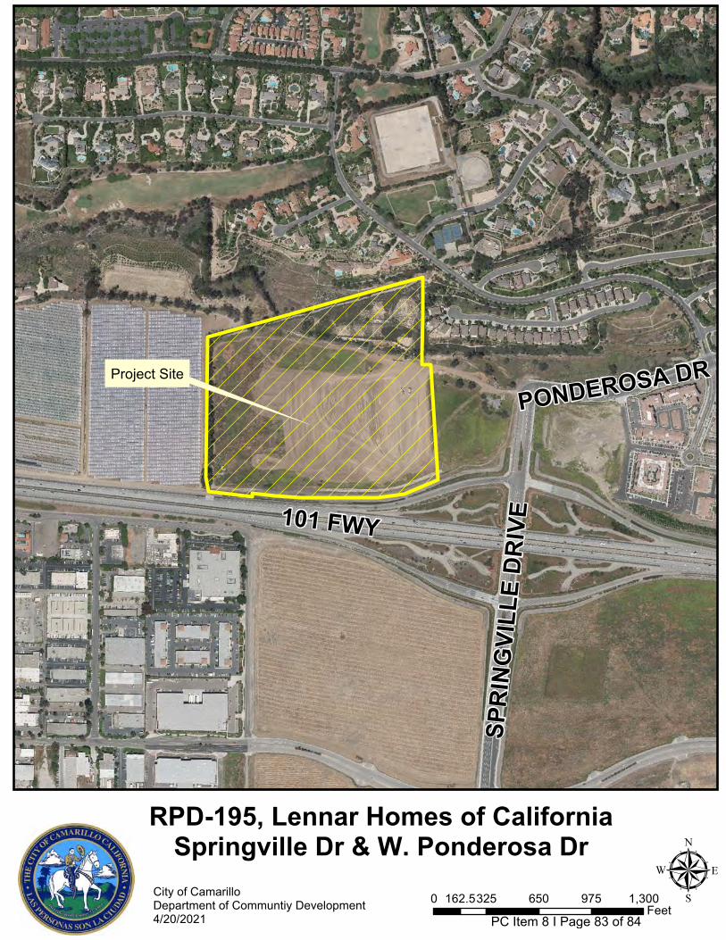
RPD-195, Lennar Homes of CaliforniaSpringville Dr & W. Ponderosa Dr
City of CamarilloDepartment of Communtiy Development4/20/2021
μ0 325 650 975 1,300162.5Feet
SP
RIN
GV
ILL
E D
RIV
E101 FWY
PONDEROSA DRProject Site
PC Item 8 I Page 83 of 84
601 Carmen Drive | Camarillo | CA | 93010
City of Camarillo Department of Community Development
805.388.5360 805.388.5388 fax
The City of Camarillo Planning Commission will conduct a public hearing on Tuesday, April 20, 2021 at 6:30 p.m., virtually via Zoom, on the following agenda item:
RPD-195, Lennar Homes of California, Inc.
An application has been received from Ben O’Neal of Lennar Homes of California, Inc., seeking approval of a Residential Planned Development Permit, RPD-195. The application proposes the construction of 158 for-sale, single family detached units on 20.36-acres and the relocation, rehabilitation, and sale of the Scholle Farmhouse on lot 168 of Tract 5671-2. The development will also include the construction of Ponderosa Drive as a complete street extending west of Springville Drive, private streets for internal circulation, public pedestrian/bike path and all necessary utilities as approved in Tract 5671-2. The proposed project is located north of U.S. 101 Freeway and west of Springville Drive in the Springville Specific Plan in the Residential Planned Development, 8 units per acre (RPD-8U) Zone.
The project was reviewed in accordance with the California Environmental Quality Act (CEQA) and the State CEQA guidelines, as well as the City’s environmental guidelines. The project’s impacts have been adequately addressed in Supplemental Environmental Impact Report (S-EIR) No. 2002-13 (SCH #2003091105) after incorporating the mitigation measures in accordance with the adopted mitigation monitoring and reporting program.
The Planning Commission may make recommendations or other adjustments deemed to be appropriate or propose conditions to the application. Any person interested in this matter is invited to attend and present testimony either for or against the proposed application. If you challenge the proposed action in court, you may be limited to raising only those issues you or someone else raised at the public hearing described in this notice or in written correspondence delivered to the Planning Commission at or prior to the public hearing.
If the public hearing is held while the Ventura County Public Health Officer’s Stay Well at Home Order is still in place, the chambers will be closed to the public. Please check the Agenda on the City’s website for instructions on how you can participate in the hearing held via Zoom or contact the Department of Community Development at 805.388.5360, or by email at [email protected].
For further information regarding this application, you may contact the City of Camarillo, Department of Community Development and speak with Paul McClaren, Associate Planner at 805.388.5365, or via email at [email protected]. You may also review copies of the application materials on the City’s website at www.cityofcamarillo.org/planningcommission prior to the Planning Commission meeting.
In compliance with the Americans with Disabilities Act, if you need special assistance to participate in this meeting, please contact the City Clerk at 805.388.5316. Notification 48 hours prior to the meeting will enable the City to make reasonable arrangements to ensure participation in this meeting. (28 CFR 35.102-35.104 ADA Title II.)
Para asistencia en español, por favor de contactar el Departamento de Desarrollo Comunitario y comunicarse con Monique Martinez al 805.388.5360.
Joseph R. Vacca, Planning Commission Secretary
PC Item 8 I Page 84 of 84