Embed Size (px)
Citation preview

DRAFT FINAL Biological Assessment in Support of the U.S. Environmental Protection Agency’s Decision to Issue a Greenhouse Gas Permit in Connection with the Proposed Expansion of the Chevron Phillips Cedar Bayou Plant near the City of Baytown, Harris County, Texas
Prepared for
Chevron Phillips Chemical Company LP
Prepared by
SWCA Environmental Consultants
November 2012


DRAFT FINAL BIOLOGICAL ASSESSMENT IN SUPPORT OF THE U.S.
ENVIRONMENTAL PROTECTION AGENCY’S DECISION TO ISSUE A GREENHOUSE GAS PERMIT IN CONNECTION WITH THE PROPOSED EXPANSION OF THE CHEVRON PHILLIPS
CEDAR BAYOU PLANT NEAR THE CITY OF BAYTOWN, HARRIS COUNTY, TEXAS
Prepared for
Chevron Phillips Chemical Company LP 10001 Six Pines Drive
The Woodlands, Texas 77380 Attn: Cynthia Gleason
(713) 280-0869
Prepared by
SWCA Environmental Consultants Austin Office
4407 Monterey Oaks Boulevard, Building 1, Suite 110 Austin, Texas 78749
(512) 476-0891 www.swca.com
SWCA Project No. 21457
November 6, 2012

DRAFT FINAL Biological Assessment for the Proposed Expansion of the Chevron Phillips Cedar Bayou Plant near the City of Baytown, Harris County, Texas
iii
CONTENTS
Executive Summary .................................................................................................................. vii 1. Introduction ............................................................................................................................ 1 2. Agency Regulations ............................................................................................................... 3
2.1. Environmental Protection Agency Regulations and Standards ....................................................... 3 2.2. Endangered Species Act .................................................................................................................. 3 2.3. State of Texas Endangered Species Regulations ............................................................................. 3
3. Methodology ........................................................................................................................... 4 4. Project Description ................................................................................................................ 8
4.1. Project Purpose and Process ........................................................................................................... 8 4.2. Construction Information ............................................................................................................... 12
4.2.1. Construction Activities and Schedule .................................................................................... 12 4.2.2. Construction Equipment Required ......................................................................................... 12 4.2.3. Emissions Controls ................................................................................................................ 13
4.3. Operation and Maintenance Information ....................................................................................... 14 4.3.1. Operation ............................................................................................................................... 14 4.3.2. Water Use .............................................................................................................................. 14 4.3.3. Noise Levels .......................................................................................................................... 14
4.4. National Pollutant Discharge Elimination System Information..................................................... 15 4.5. Regional/Area Ecological Information .......................................................................................... 16
4.5.1. General Region Information .................................................................................................. 16 4.5.2. Land Use ................................................................................................................................ 16 4.5.3. Climate ................................................................................................................................... 17 4.5.4. Topography ............................................................................................................................ 17 4.5.5. Geology.................................................................................................................................. 17 4.5.6. Soils ....................................................................................................................................... 17 4.5.7. Water Resources .................................................................................................................... 18 4.5.8. Vegetation .............................................................................................................................. 22 4.5.9. Wildlife .................................................................................................................................. 22
4.6. Listed Species ................................................................................................................................ 23 4.6.1. Summary of Listed Species ................................................................................................... 23 4.6.2. Critical Habitat Designation .................................................................................................. 25 4.6.3. Descriptions of Listed Species ............................................................................................... 25 4.6.4. Descriptions of Recently Delisted Species with Monitoring Requirements .......................... 34 4.6.5. Texas Natural Diversity Database Results ............................................................................. 35
5. LIsted Species Habitat Evaluation ...................................................................................... 36 5.1. Vegetation Communities Observed ............................................................................................... 36 5.2. Listed Species Habitat Analysis ..................................................................................................... 36
6. Air Quality Analysis Results ............................................................................................... 38 6.1. Estimated Total Annual Emissions Overview ............................................................................... 38 6.2. Area of Impact Dispersion Modeling Results ................................................................................ 40
6.2.1. Dispersion Modeling Methods............................................................................................... 40 6.2.2. Dispersion Modeling Results ................................................................................................. 41
DRAFT FINAL Biological Assessment for the Proposed Expansion of the Chevron Phillips Cedar Bayou Plant near the City of Baytown, Harris County, Texas
iv
7. Effects of the Federal Action .............................................................................................. 41 7.1. Air Quality ..................................................................................................................................... 41
7.1.1. Air Pollution Effects Background Review ............................................................................ 41 7.1.2. Air Quality Effects ................................................................................................................. 43 7.1.3. Impacts of Air Pollution Sources on Flora and Fauna ........................................................... 44
7.2. Water Quality ................................................................................................................................. 45 7.2.1. Wastewater Effects ................................................................................................................ 45 7.2.2. Surface Water Effects ............................................................................................................ 46
7.3. Noise .............................................................................................................................................. 46 7.3.1. Noise Effects Background Review ........................................................................................ 46 7.3.2. Noise-Related Effects ............................................................................................................ 47
7.4. Infrastructure-Related Effects ........................................................................................................ 47 7.5. Human Activity Effects ................................................................................................................. 47
8. Conclusions .......................................................................................................................... 48 8.1. Determination of Effect ................................................................................................................. 48 8.2. Cumulative Effects......................................................................................................................... 50 8.3. Interdependent and Interrelated Actions ........................................................................................ 50
9. Literature Cited ..................................................................................................................... 51
DRAFT FINAL Biological Assessment for the Proposed Expansion of the Chevron Phillips Cedar Bayou Plant near the City of Baytown, Harris County, Texas
v
APPENDICES Appendix A. Photographic Log Appendix B. U.S. Fish and Wildlife Service and Texas Parks and Wildlife Department Protected
Species Lists
FIGURES Figure 1. Site location. ............................................................................................................................ 2 Figure 2. Project area and the 3-mile action area. ................................................................................... 6 Figure 3. Proposed site plan for the Cedar Bayou Plant. ...................................................................... 10 Figure 4. Wetland and waterway features in the project area. .............................................................. 20 Figure 5. Known or possible habitat locations for listed species evaluated in the biological
assessment.............................................................................................................................. 26
TABLES Table ES-1. Summary of the Federally Listed Species in Harris and Chambers Counties, their
Potential for Occurrence in the Action Area, and Effects Determination ............................. vii Table 1. Distances Required to Achieve Significant Impact Level Based on Criteria Pollutant
Modeling Results for the Chevron Phillips Proposed Unit 1594 ............................................. 4 Table 2. Expected Wastewater Concentrations and Loading for the Proposed Project at Outfall
001 ......................................................................................................................................... 16 Table 3. Soil Map Units in the Action Area ........................................................................................ 18 Table 4. Potentially Jurisdictional Water Features Identified in the Project Area ............................... 19 Table 5. Federally Listed Species Designated by both USFWS and TPWD as Potentially
Occurring in Harris and Chambers Counties, Texas ............................................................. 24 Table 6. Summary of Estimated Emissions for the Proposed Project ................................................. 39 Table 7. Summary of Estimated Emissions for Speciated VOCs for the Proposed Project ................ 39 Table 8. Comparison of Estimated Emissions of Criteria Pollutants for the Proposed Project ........... 41 Table 9. Comparison of Background Concentrations, this Project’s Proposed Emission Levels,
and Emission Concentration Exposures and the Levels of Effects to Vegetation ................. 44 Table 10. Summary of the Federally Listed Species in Harris and Chambers Counties, their
Potential for Occurrence in the Action Area, and Effects Determination ............................. 48
DRAFT FINAL Biological Assessment for the Proposed Expansion of the Chevron Phillips Cedar Bayou Plant near the City of Baytown, Harris County, Texas
vi
This page intentionally blank
DRAFT FINAL Biological Assessment for the Proposed Expansion of the Chevron Phillips Cedar Bayou Plant near the City of Baytown, Harris County, Texas
vii
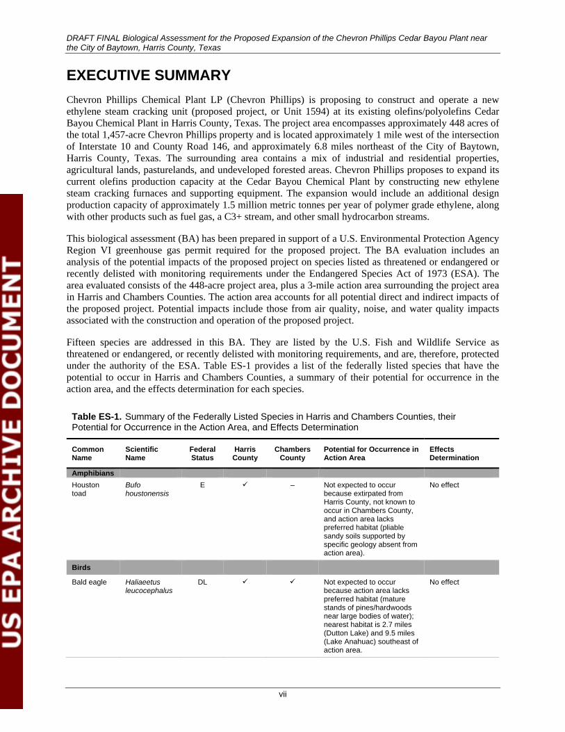
EXECUTIVE SUMMARY Chevron Phillips Chemical Plant LP (Chevron Phillips) is proposing to construct and operate a new ethylene steam cracking unit (proposed project, or Unit 1594) at its existing olefins/polyolefins Cedar Bayou Chemical Plant in Harris County, Texas. The project area encompasses approximately 448 acres of the total 1,457-acre Chevron Phillips property and is located approximately 1 mile west of the intersection of Interstate 10 and County Road 146, and approximately 6.8 miles northeast of the City of Baytown, Harris County, Texas. The surrounding area contains a mix of industrial and residential properties, agricultural lands, pasturelands, and undeveloped forested areas. Chevron Phillips proposes to expand its current olefins production capacity at the Cedar Bayou Chemical Plant by constructing new ethylene steam cracking furnaces and supporting equipment. The expansion would include an additional design production capacity of approximately 1.5 million metric tonnes per year of polymer grade ethylene, along with other products such as fuel gas, a C3+ stream, and other small hydrocarbon streams.
This biological assessment (BA) has been prepared in support of a U.S. Environmental Protection Agency Region VI greenhouse gas permit required for the proposed project. The BA evaluation includes an analysis of the potential impacts of the proposed project on species listed as threatened or endangered or recently delisted with monitoring requirements under the Endangered Species Act of 1973 (ESA). The area evaluated consists of the 448-acre project area, plus a 3-mile action area surrounding the project area in Harris and Chambers Counties. The action area accounts for all potential direct and indirect impacts of the proposed project. Potential impacts include those from air quality, noise, and water quality impacts associated with the construction and operation of the proposed project.
Fifteen species are addressed in this BA. They are listed by the U.S. Fish and Wildlife Service as threatened or endangered, or recently delisted with monitoring requirements, and are, therefore, protected under the authority of the ESA. Table ES-1 provides a list of the federally listed species that have the potential to occur in Harris and Chambers Counties, a summary of their potential for occurrence in the action area, and the effects determination for each species.
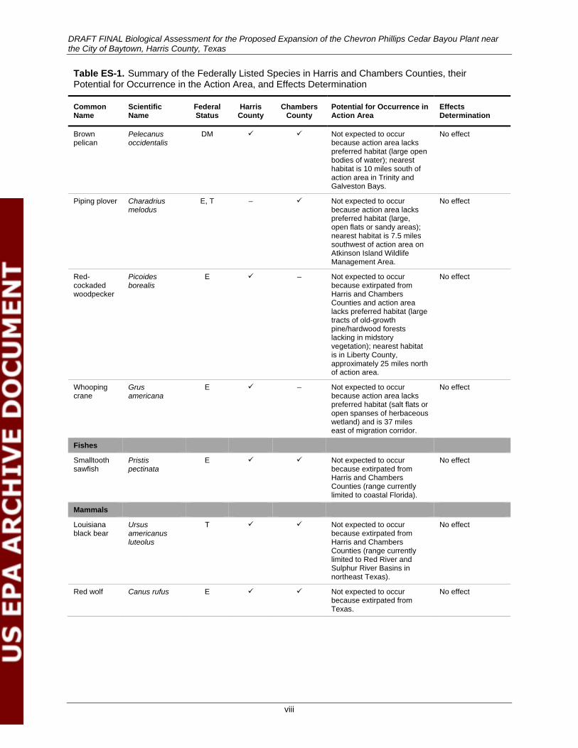
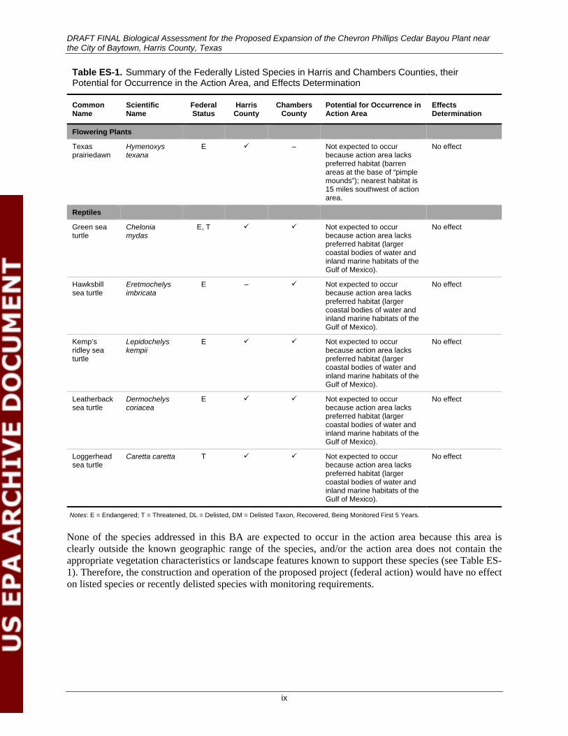
Table ES-1. Summary of the Federally Listed Species in Harris and Chambers Counties, their Potential for Occurrence in the Action Area, and Effects Determination
Common Name
Scientific Name
Federal Status
Harris County
Chambers County
Potential for Occurrence in Action Area
Effects Determination
Amphibians Houston toad
Bufo houstonensis
E – Not expected to occur because extirpated from Harris County, not known to occur in Chambers County, and action area lacks preferred habitat (pliable sandy soils supported by specific geology absent from action area).
No effect
Birds
Bald eagle Haliaeetus leucocephalus
DL Not expected to occur because action area lacks preferred habitat (mature stands of pines/hardwoods near large bodies of water); nearest habitat is 2.7 miles (Dutton Lake) and 9.5 miles (Lake Anahuac) southeast of action area.
No effect
DRAFT FINAL Biological Assessment for the Proposed Expansion of the Chevron Phillips Cedar Bayou Plant near the City of Baytown, Harris County, Texas
viii
Table ES-1. Summary of the Federally Listed Species in Harris and Chambers Counties, their Potential for Occurrence in the Action Area, and Effects Determination
Common Name
Scientific Name
Federal Status
Harris County
Chambers County
Potential for Occurrence in Action Area
Effects Determination
Brown pelican
Pelecanus occidentalis
DM Not expected to occur because action area lacks preferred habitat (large open bodies of water); nearest habitat is 10 miles south of action area in Trinity and Galveston Bays.
No effect
Piping plover Charadrius melodus
E, T – Not expected to occur because action area lacks preferred habitat (large, open flats or sandy areas); nearest habitat is 7.5 miles southwest of action area on Atkinson Island Wildlife Management Area.
No effect
Red-cockaded woodpecker
Picoides borealis
E – Not expected to occur because extirpated from Harris and Chambers Counties and action area lacks preferred habitat (large tracts of old-growth pine/hardwood forests lacking in midstory vegetation); nearest habitat is in Liberty County, approximately 25 miles north of action area.
No effect
Whooping crane
Grus americana
E – Not expected to occur because action area lacks preferred habitat (salt flats or open spanses of herbaceous wetland) and is 37 miles east of migration corridor.
No effect
Fishes
Smalltooth sawfish
Pristis pectinata
E Not expected to occur because extirpated from Harris and Chambers Counties (range currently limited to coastal Florida).
No effect
Mammals
Louisiana black bear
Ursus americanus luteolus
T Not expected to occur because extirpated from Harris and Chambers Counties (range currently limited to Red River and Sulphur River Basins in northeast Texas).
No effect
Red wolf Canus rufus E Not expected to occur because extirpated from Texas.
No effect
DRAFT FINAL Biological Assessment for the Proposed Expansion of the Chevron Phillips Cedar Bayou Plant near the City of Baytown, Harris County, Texas
ix
Table ES-1. Summary of the Federally Listed Species in Harris and Chambers Counties, their Potential for Occurrence in the Action Area, and Effects Determination
Common Name
Scientific Name
Federal Status
Harris County
Chambers County
Potential for Occurrence in Action Area
Effects Determination
Flowering Plants
Texas prairiedawn
Hymenoxys texana
E – Not expected to occur because action area lacks preferred habitat (barren areas at the base of “pimple mounds”); nearest habitat is 15 miles southwest of action area.
No effect
Reptiles
Green sea turtle
Chelonia mydas
E, T Not expected to occur because action area lacks preferred habitat (larger coastal bodies of water and inland marine habitats of the Gulf of Mexico).
No effect
Hawksbill sea turtle
Eretmochelys imbricata
E – Not expected to occur because action area lacks preferred habitat (larger coastal bodies of water and inland marine habitats of the Gulf of Mexico).
No effect
Kemp’s ridley sea turtle
Lepidochelys kempii
E Not expected to occur because action area lacks preferred habitat (larger coastal bodies of water and inland marine habitats of the Gulf of Mexico).
No effect
Leatherback sea turtle
Dermochelys coriacea
E Not expected to occur because action area lacks preferred habitat (larger coastal bodies of water and inland marine habitats of the Gulf of Mexico).
No effect
Loggerhead sea turtle
Caretta caretta T Not expected to occur because action area lacks preferred habitat (larger coastal bodies of water and inland marine habitats of the Gulf of Mexico).
No effect
Notes: E = Endangered; T = Threatened, DL = Delisted, DM = Delisted Taxon, Recovered, Being Monitored First 5 Years.
None of the species addressed in this BA are expected to occur in the action area because this area is clearly outside the known geographic range of the species, and/or the action area does not contain the appropriate vegetation characteristics or landscape features known to support these species (see Table ES-1). Therefore, the construction and operation of the proposed project (federal action) would have no effect on listed species or recently delisted species with monitoring requirements.
DRAFT FINAL Biological Assessment for the Proposed Expansion of the Chevron Phillips Cedar Bayou Plant near the City of Baytown, Harris County, Texas
1
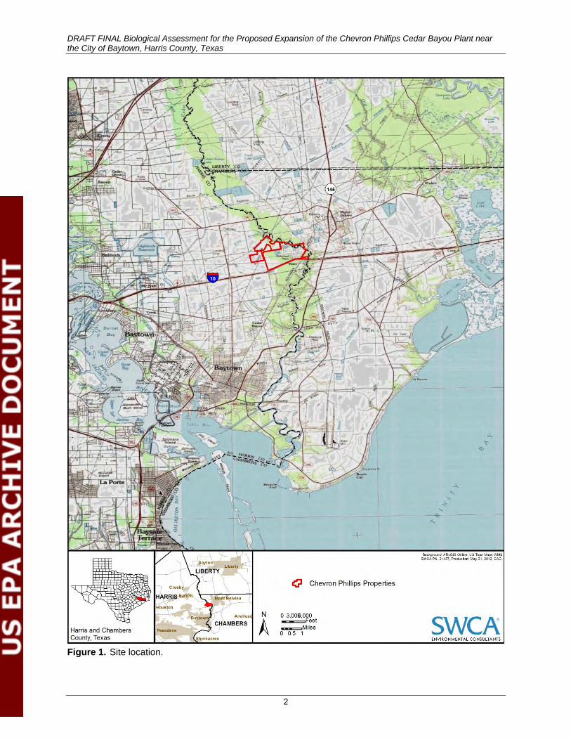
1. INTRODUCTION SWCA Environmental Consultants (SWCA) was contracted by Chevron Phillips Chemical Plant LP (Chevron Phillips) to complete a biological assessment (BA) in support of the U.S. Environmental Protection Agency’s (EPA) decision to issue a greenhouse gas (GHG) permit in connection with the proposed construction and operation of a new ethylene steam cracking unit (proposed project, Unit 1594, or federal action) at its existing olefins/polyolefins Cedar Bayou Chemical Plant in Harris County, Texas. The project area encompasses approximately 448 acres of the total 1,457-acre Chevron Phillips property and is located approximately 1 mile west of the intersection of Interstate (I-10) and County Road (CR) 146, approximately 6.8 miles northeast of the City of Baytown, Harris County, Texas (Figure 1). The surrounding area contains a mix of industrial and residential properties, agricultural lands, pasturelands, and undeveloped forested areas. Chevron Phillips proposes to expand its current olefins production capacity at the Cedar Bayou Plant by constructing new ethylene steam cracking furnaces and supporting equipment. The modification would include an additional design production capacity of approximately 1.5 million metric tonnes per year of polymer grade ethylene, along with other products such as fuel gas, a C3+ stream, and other small hydrocarbon streams.
This BA is prepared pursuant to Section 7 under the Endangered Species Act (ESA) of 1973, as amended, to determine whether the EPA’s issuance of a GHG permit for the proposed project may affect listed species, proposed species, or designated critical habitat. The outcome of this BA determines whether formal consultation or a conference with USFWS is necessary (50 Code of Federal Regulations [CFR] 402.02; 50 CFR 402.12).
DRAFT FINAL Biological Assessment for the Proposed Expansion of the Chevron Phillips Cedar Bayou Plant near the City of Baytown, Harris County, Texas
2
Figure 1. Site location.
DRAFT FINAL Biological Assessment for the Proposed Expansion of the Chevron Phillips Cedar Bayou Plant near the City of Baytown, Harris County, Texas
3
2. AGENCY REGULATIONS
2.1. Environmental Protection Agency Regulations and Standards
Chevron Phillips is seeking a permit under the EPA’s Prevention of Significant Deterioration (PSD) program for GHGs, pursuant to 40 CFR 52.21. This federal air quality permit would authorize GHG emmissions associated with the construction and operation of the proposed project. The involvement of federal permitting through the issuance of a PSD permit establishes a federal nexus that could require consultation with the USFWS and/or the National Marine Fisheries Service (NMFS). SWCA has drafted this BA, which addresses EPA’s decision to issue a GHG permit in support of the proposed project, in compliance with Section 7 of the ESA. Section 7 of the ESA requires that, through consultation with the USFWS, federal actions not jeopardize the continued existence of any threatened, endangered, or proposed species or result in the destruction or adverse modification of critical habitat. The BA has been prepared in accordance with EPA rules and regulations implementing the ESA and other federal and state regulations (EPA 2012c).
This project would require nonattainment New Source Review (NNSR) air permitting for nitrogen oxides (NOx) and volatile organic compounds (VOCs) as precursors to ground-level ozone (O3) formation, and PSD permitting for nitrogen dioxide (NO2), carbon monoxide (CO), and particulate matter less than 2.5 microns (PM2.5). The EPA has delegated authority to the Texas Commission on Environmental Quality (TCEQ) to issue consolidated NNSR/PSD air permits for these air pollutants; thus, the proposed project would require a PSD permit from TCEQ. The project would also require a PSD permit for GHGs from the EPA because the TCEQ has declined to implement the GHG PSD permitting program. Therefore, a separate GHG PSD permit must be approved and issued by the EPA.
2.2. Endangered Species Act The ESA prohibits unauthorized take, possession, sale, and transport of endangered or threatened species and provides protection for species and their habitats that are listed as threatened/endangered in the United States or elsewhere. The ESA seeks to conserve listed species by including provisions for listing species, developing recovery plans, and designating critical habitat. Section 7 of the ESA contains the procedures for authorizing, funding, or carrying out federal actions that may affect listed species. Furthermore, the ESA provides a mechanism by which non-federal persons and entities may receive authorization to take actions that could result in incidental take of a listed species.
Section 9 of the ESA prohibits the take of any federally listed endangered species (16 United States Code [USC] 1538(a)), and USFWS has extended that prohibition to threatened species by regulation. The ESA defines take as “to harass, harm, pursue, hunt, shoot, wound, kill, trap, capture, or collect, or to attempt to engage in any such conduct” (16 USC 1532(19)). Section 10(a)(1)(B) of the ESA (16 USC 1539(a)(1)(B)) authorizes the USFWS to issue a permit allowing take that is “incidental to, and not the purpose of, the carrying out of an otherwise lawful activity.”
2.3. State of Texas Endangered Species Regulations Under Texas Threatened and Endangered Species Regulations (31 Texas Administrative Code [TAC] 65.171–65.176 [2010]), the State of Texas prohibits the take, possession, transportation, or sale of state-listed species without the issuance of a permit from the Texas Parks and Wildlife Department (TPWD).
DRAFT FINAL Biological Assessment for the Proposed Expansion of the Chevron Phillips Cedar Bayou Plant near the City of Baytown, Harris County, Texas
4
Although the USFWS authorizes the take of migratory bird species under a USFWS Migratory Bird Depredation Permit, TPWD authorizes take of protected game birds and mammals under a depredation permit if these species cause economic hardship or pose a threat to public safety (TPWD 2012g). A permit is not required to kill nuisance fur-bearing animals, such as common raccoons (Procyon lotor). Under the TPWD Depredation Permit, any game animal or game bird killed must be immediately field dressed, maintained in edible condition, and donated to a charitable institution, a hospital, a needy person, or any other appropriate recipient.
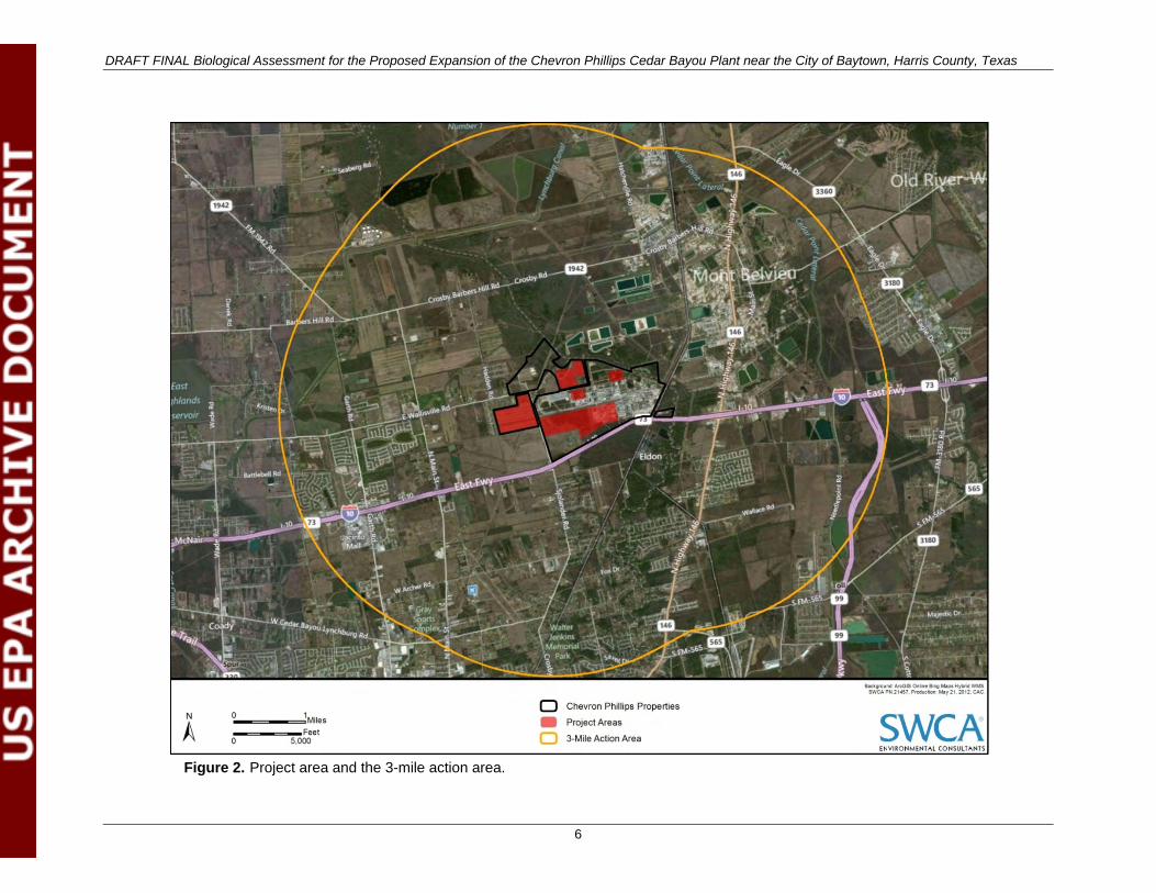
3. METHODOLOGY For the purposes of this BA, the project area is defined as the 448-acre site where the proposed project would be constructed and operated. The action area for this BA includes the project area plus an area extending 3 miles in all directions beyond the project area perimeter. As required by regulations at 50 CFR 402.02, the action area includes all areas in which listed species could be affected directly or indirectly by the federal action. To delineate the action area boundary, SWCA identified the areas where project-related impacts to air quality, water quality, vegetation, and noise levels could have a direct or indirect effect on the species addressed in this BA. Potential impacts to air quality, specifically the modeled 1-hour significant impact level (SIL) for NO2, were found to extend the farthest distance from the proposed project. Based on preliminary modeling, SWCA used a rounded 3-mile radius from the project area fenceline to define the action area boundary. The final modeled SIL for NO2 is 1.7 miles (Table 1), which confirms that the 3-mile radius is still valid and exceeds the requirements. The action area encompasses approximately 32,613 acres and is located in southeast Harris County and along the western extent of Chambers County (Figure 2); therefore, species occurring in either Harris and Chambers Counties are considered in this assessment.
Table 1. Distances Required to Achieve Significant Impact Level Based on Criteria Pollutant Modeling Results for the Chevron Phillips Proposed Unit 1594
Pollutant Regulation Averaging Period
SIL Maximum Ground Level Concentration
(GLCmax)
Below SIL? (yes or no)
Distance Required to Achieve SIL
(mile)
NO2 NAAQS 1-hour 7.5 19.0 No 1.7
Annual 1 0.30 Yes –
CO NAAQS 1-hour 2,000 497.10 Yes –
8-hour 500 343.50 Yes –
PM10 State NAAQS 24-hour 5 9.44 No 1.2
Annual 1 0.46 Yes –
PM2.5 NAAQS 24-hour 1.2 3.20 No 1.3
Annual 0.3 0.20 Yes –
SO2 State NAAQS 30-min 14.3 5.49 Yes –
1-hour 7.8 5.10 Yes –
3-hour 25 5.09 Yes –
24-hour 5 2.90 Yes –
Annual 1 0.47 Yes –
Source: RPS n.d. [2012]
Notes: NAAQS = National Ambient Air Quality Standards; SO2 = sulfate
DRAFT FINAL Biological Assessment for the Proposed Expansion of the Chevron Phillips Cedar Bayou Plant near the City of Baytown, Harris County, Texas
5
SWCA biologists conducted a detailed desktop review of the action area using the following available data: 2010 National Agriculture Imagery Program aerial imagery; U.S. Geological Survey 7.5-minute topographic maps; National Wetlands Inventory digital data; National Hydrography Dataset digital data; Natural Resources Conservation Service (NRCS) Soil Data Mart; Bureau of Economic Geology Geologic Atlas of Texas digital data; TPWD Natural Diversity Database (NDD) searches; peer reviewed literature; and publicly available data from TPWD, USFWS, and other regulatory agencies.
DRAFT FINAL Biological Assessment for the Proposed Expansion of the Chevron Phillips Cedar Bayou Plant near the City of Baytown, Harris County, Texas
6
Figure 2. Project area and the 3-mile action area.

DRAFT FINAL Biological Assessment for the Proposed Expansion of the Chevron Phillips Cedar Bayou Plant near the City of Baytown, Harris County, Texas
7
An SWCA biologist also conducted a field reconnaissance of the action area on March 13, 2012. A U.S. Geological Survey 7.5-minute topographic map (Mont Belvieu, Texas), recent aerial imagery, and maps provided by Chevron Phillips were used for general orientation in the action area. The field reconnaissance consisted of a detailed pedestrian survey of the 448-acre project area and a windshield survey of the remainder of the action area to evaluate vegetation and landscape features considered important to the potential occurrence of species addressed in this BA. The field reconnaissance of the action area beyond the project area limits was conducted from pubic roadways and other publicly accessible areas because no access to privately owned land was obtained. Data were collected to describe the vegetation communities in the action area and to assess the potential for occurrence of federally listed species. Photographs of the project area and surrounding areas are included in Appendix A. Results of both the field survey data and details obtained through desktop review were used to prepare this BA.
Evaluation of species with the potential for occurrence in the action area was based on 1) documented records, 2) existing information on distribution, and 3) qualitative comparisons of the habitat requirements of each species with vegetation communities or landscape features in the action area.1
Possible impacts to these species were evaluated based on reasonably foreseeable project-related activities. The potential for occurrence of each species is summarized according to the categories listed below. Because not all species are accommodated precisely by a given category (i.e., category definitions may be too restrictive), an expanded rationale for each category assignment is provided. Potential for occurrence categories are as follows:
• Known to occur: The species has been documented in the action area by a reliable observer.
• May occur: The action area is in the species’ currently known range, and vegetation communities, soils, etc., resemble those known to be used by the species.
• Unlikely to occur: The action area is in the species’ currently known range, but vegetation communities, soils, etc., do not resemble those known to be used by the species, or the action area is clearly outside the species’ currently known range.
The primary purpose of this BA is to determine the potential effects, if any, on any species present in the action area. As noted in the USFWS Consultation Handbook, “no effect” determinations are appropriate where the federal action would not affect a listed species or designated critical habitat (USFWS and NMFS 1998). Where species are not present in the action area and no effects to the species are reasonably certain to occur, “no effect” is the appropriate determination. The Consultation Handbook clarifies that a “may affect, not likely to adversely affect” determination is appropriate where effects on listed species are “expected to be discountable, insignificant, or completely beneficial.” The Consultation Handbook further explains that “insignificant effects relate to the size of the impact and should never reach the scale where take occurs.” Conversely, where an effect is not discountable, insignificant, or completely beneficial or anticipated take is likely to occur as a result of the federal action, the appropriate determination is “may affect, likely to adversely affect” (USFWS and NMFS 1998).
The effects analysis must address the direct, indirect, interrelated, interdependent, and cumulative effects of an action. A direct effect is the direct or immediate effect of the project on a species or its habitat, whether beneficial or adverse (50 CFR 402.02). Direct effects result from the action and include the direct effects of interrelated actions and interdependent actions. Direct effects occur at or very close to the time 1 We agree with Hall et al. (1997) that habitat is organism-specific and thus not synonymous with vegetation community. However, we have refined their definition to read as follows: habitat is an area in which some members of a species regularly occur continuously or seasonally. In the field, habitat is operationally defined by the presence or absence of a species. Areas that appear suitable for a species but that have not been surveyed are considered possible habitat. We avoid using the term ‘potential’ with respect to habitat because potential is defined as ‘capable of becoming but not yet in existence’; ‘possible,’ on the other hand, is defined as ‘of uncertain likelihood’. We also avoid using the terms ‘unoccupied habitat’ or ‘suitable, but unoccupied habitat,’ which represent a contradiction in terms.
DRAFT FINAL Biological Assessment for the Proposed Expansion of the Chevron Phillips Cedar Bayou Plant near the City of Baytown, Harris County, Texas
8
of the action itself. Interrelated projects include other projects or activities that are part of a larger project and depend on the larger project for their justification (i.e., the federal action would not occur without the larger project). Interdependent projects have no independent utility apart from the federal action (i.e., other projects would not occur without the federal action). Indirect effects are caused by the action and occur later in time after the action is completed (50 CFR 402.02). Cumulative effects include the effects of future tribal, state, local, or private actions that are reasonably certain to occur in the area of the federal action subject to consultation (50 CFR 402.02). Cumulative effects are considered together with the effect of the federal action under consultation by USFWS to determine whether the effects of the federal action are likely to jeopardize the continued existence of a listed species. Other future federal actions that may affect a listed species would be subject to consultation requirements established in Section 7 of the ESA and, therefore, are not considered cumulative effects of the federal action.
Those species listed by the USFWS were assigned to one of three categories of possible effect, following USFWS recommendations. The effects determinations are generally categorized as follows:
• May affect, is likely to adversely affect: The proposed project is likely to adversely affect a species 1) if the species occurs or may occur in the action area, and 2) if any adverse effect on listed species may occur as a direct or indirect result of the federal action or its interrelated or interdependent actions, and the effect is not discountable, insignificant, or beneficial. In the event that the overall effect of the federal action is beneficial to the listed species but also is likely to cause some adverse effects, then the federal action “is likely to adversely affect” the listed species.
• May affect, is not likely to adversely affect: The project is not likely to adversely affect a species if 1) the species may occur but its presence has not been documented and/or surveys following approved protocol have been conducted with negative results, and/or 2) project activity effects on a listed species are expected to be discountable, insignificant, or completely beneficial.
o Beneficial effects are contemporaneous positive effects without any adverse effects on the species.
o Insignificant effects relate to the size of the impact and should never reach the scale where take occurs.
o Discountable effects are those extremely unlikely to occur. Based on best judgment, a person would not 1) be able to meaningfully measure, detect, or evaluate insignificant effects; or 2) expect discountable effects to occur.
• No effect: The project would have no effect on a species if 1) it has no likelihood of effect on a listed species or its designated critical habitat (including effects that may be beneficial, insignificant, or discountable), or 2) the species’ habitat does not occur in the action area.
4. PROJECT DESCRIPTION
4.1. Project Purpose and Process Chevron Phillips proposes to expand its olefins (ethylene and propylene) production capacity at the Cedar Bayou Plant by constructing and operating a new ethylene unit (Unit 1594) and supporting equipment, including a cooling tower, generators, storage tanks, a wastewater collection and treatment system, and other minor utilities. Chevron Phillips currently operates an ethylene cracking unit, polyethylene units, and normal- and polyalphaolefins manufacturing units. The purpose of this modification is to increase production capacity of polymer grade ethylene product by approximately 1.5 million metric tonnes per year, along with other products such as fuel gas, C3+ product, and various other small hydrocarbon streams.
DRAFT FINAL Biological Assessment for the Proposed Expansion of the Chevron Phillips Cedar Bayou Plant near the City of Baytown, Harris County, Texas
9
Unit 1594 would consist of a fresh ethane feed preparation unit, eight steam cracking furnaces, a quench water system, cracked gas compression system, caustic wash system, cracked gas dehydrator system, high pressure deethanizer and low pressure C2 (ethylene) stripper, acetylene hydrogenation system, demethanization system, and heat pump system. Fresh ethane feedstock, which would be used in Unit 1594 production, is currently transported to the Cedar Bayou Plant through a pipeline and used on-site for existing production. The ethylene product would be sent to customers through a pipeline and/or consumed on-site.
A very high pressure (VHP) boiler is used during startup and normal operations and is equipped with ultra-low NOX burners, selective catalytic reduction, and a continuous emissions monitoring system to measure NOX, CO, and oxygen gas (O2). Low pressure vent streams (such as those from waste storage tanks) are collected and routed to the VHP boiler for destruction. The low profile flare system is designed for the safe control of gases vented from the ethylene cracker and support units. Three emergency generators driven by diesel engines would have a 4-megawatt total capacity to ensure continuous operation of critical equipment in an emergency. Storage tanks consist and 10 nitrogen-blanketed tanks for various types of material.
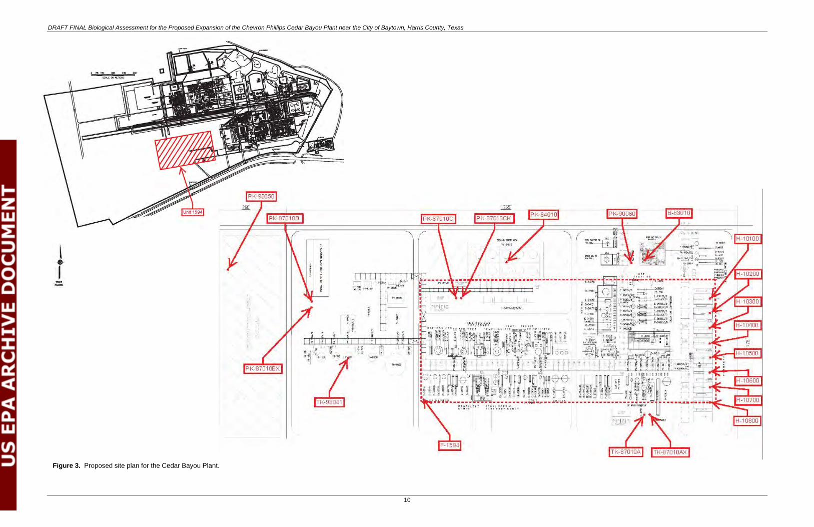
Unit 1594 would use approximately 5 million gallons of water a day in a cooling tower, boiler, and the process. Six oily wastewater and chemical wastewater sumps would also be constructed. These sumps would be covered, sealed, and nitrogen-blanketed with sump vents that are collected and sent to the boiler for control of emissions. Water that could contain benzene would be treated in a steam stripper. The first 1 inch of stormwater from process areas would be collected on-site and sent to a stormwater equalization tank, with overflow discharging to clean stormwater sewers and ditches. All process wastewater and potentially contaminated stormwater would be treated in an enhanced biological system prior to discharge. Other utilities that would not require air permit approval include a raw water treatment system, demineralized water system, and plant air/instrument air systems. The plot plan identifying the location of each utility for the proposed project is located in Figure 3.
DRAFT FINAL Biological Assessment for the Proposed Expansion of the Chevron Phillips Cedar Bayou Plant near the City of Baytown, Harris County, Texas
10
Figure 3. Proposed site plan for the Cedar Bayou Plant.

DRAFT FINAL Biological Assessment for the Proposed Expansion of the Chevron Phillips Cedar Bayou Plant near the City of Baytown, Harris County, Texas
11
This page intentionally blank

DRAFT FINAL Biological Assessment for the Proposed Expansion of the Chevron Phillips Cedar Bayou Plant near the City of Baytown, Harris County, Texas
12
Unit 1594 would be constructed in the central portion of the project area within the footprint of and immediately adjacent to existing facilities (see Figure 3). A new control room would be constructed adjacent to Unit 1594 along with an addition to the current administration building and temporary buildings, laydown areas, and contractor areas (e.g., parking lot; rest/meeting areas), which would be located in the western portion of the project area (see Figure 3). Existing access to the Cedar Bayou Plant is along the west-bound frontage of I-10 or from Sjolander Drive. No improvements to these public roadways are anticipated by the proposed project; however, Harris County or the City of Baytown may have plans to upgrade Sjolander Drive. New internal roads would be built in the project area in partial connection with the proposed project (see Figure 3). During review of the existing Cedar Bayou Plant, it was determined that several buildings would need to be relocated to comply with internal building siting standards. Therefore, a new laboratory, warehouse, maintenance shop, security gate, and associated roads are planned for construction west of the existing administrative building. Aside from the use of the same roads, the relocation of buildings to comply with internal building siting standards is not connected to nor dependent on the proposed project because it would proceed regardless of the proposed project.
4.2. Construction Information
4.2.1. Construction Activities and Schedule
Chevron Phillips proposes to initiate site preparation (e.g., removing old foundations, leveling) from November 2013 through June 2014. Construction of Unit 1594 would occur from July 2014 through October 2016, with pre-commissioning occurring March 2016 through November 2016 and commissioning from November 2016 through March 2017. The construction phase of the proposed project, from site preparation and grading to commercial operation, is scheduled to last approximately 40 months. During that time, many activities would take place, including construction of foundations, installation of piping and equipment, and erection of major structures. During these activities, a varying type and number of construction equipment and personnel would be in the area of the proposed project. In addition, best management practices (BMPs) for dust abatement and stormwater protection would be adhered to in order to avoid any potential impacts.
4.2.2. Construction Equipment Required
The proposed project would use conventional construction techniques and equipment. Equipment used during construction would include cranes, compactors, excavators, bulldozers, graders, rollers, frontend loaders, backhoes, dump trucks, pickup trucks, and flatbed trucks for construction activities; water trucks, concrete pump trucks, cranes, and concrete mixer trucks for materials handling; and stationary equipment, such as jackhammers, pneumatic tools, generators, pumps, air compressor, and welder’s torches. The noise levels resulting from this construction equipment would vary greatly, depending on the type of equipment used (make and model), the operations being performed, and the power level and quantity of equipment. The following measures would be implemented to reduce noise and annoyance at receptors during construction of the facility: 1) all construction equipment would be operated and maintained to minimize noise generation, 2) equipment and vehicles would be kept in good repair and fitted with “manufacturer recommended” mufflers, and 3) regular equipment maintenance and lubrication would be constructed.
DRAFT FINAL Biological Assessment for the Proposed Expansion of the Chevron Phillips Cedar Bayou Plant near the City of Baytown, Harris County, Texas
13
4.2.3. Emissions Controls
Air quality analyses for the proposed project were performed by RPS as part of the EPA and TCEQ permitting requirements. This analysis also included a best available control technology (BACT) analysis for each component. The proposed project would include the following emission sources that propose significant net GHG emissions increases: eight steam cracking furnaces, VHP boiler, vapor destruction unit, low profile flare, routine emergency generator testing, and fugitive emissions from piping components in GHG service (RPS 2012; SEE Solutions, LLC 2012). The following emission controls would be implemented for the proposed project:
• The proposed emission limits for each emission source is based on a 12-month rolling average and includes carbon dioxide (CO2), methane (CH4), and nitrous oxide (N2O), with CO2 emissions accounting for more than 99% of the total projected emissions. The BACT limits include the following:
o Each of the steam cracking furnaces would have a proposed CO2 equivalent (CO2e) BACT limit of 206,000 tons per year (tpy).
o The VHP boiler would have a proposed CO2e BACT limit of 127,000 tpy. o The furnace/boiler combustion cap would have a proposed CO2e BACT limit of 1,572,000 tpy. o The vapor destruction unit would have a proposed CO2e BACT limit of 1,100 tpy. o The low profile flare would have a proposed CO2e BACT limit of 27,000 tpy. o The emergency generators A, B, and C would have a proposed CO2e BACT limit of 275 tpy. o Fugitive emissions from piping components in GHG service would have a proposed CO2e
BACT limit of 6,800 tpy.
• GHG emissions by the steam cracking furnaces would be minimized by implementing the following BACT: Incorporate low-carbon fuels, energy efficiency, and good combustion practices. To reduce GHG emissions during decoking of the furnaces, the following BACT would be implemented: Incorporate a combination of design and recommended operation to limit coke formation in the tubes to the extent practicable considering ethane as a raw material.
• GHG emissions by the VHP boiler and its corresponding steam supply/demand as integrated with the process unit’s equipment downstream of the boiler would be minimized by implementing the following BACT: Incorporate low-carbon fuels, energy efficiency, and good combustion practices.
• GHG emissions by both the vapor destruction unit and low profile flare would be minimized by implementing the following BACT: Incorporate low-carbon fuel and good combustion practices.
• GHG emissions by each of the emergency generators and fire water pump engine would be minimized by implementing the following BACT: Incorporate good combustion practices. Furthermore, these new engines would be subject to the federal New Source Performance Standard for Stationary Reciprocating Internal Combustion Engines, which requires that specific emission standards for various pollutants must be met during normal operation; therefore, the engines would meet or exceed BACT.
• Fugitive emissions from the piping components would be minimized by implementing audio/visual/olfactory leak detection methods to identify and repair system and equipment leaks.
DRAFT FINAL Biological Assessment for the Proposed Expansion of the Chevron Phillips Cedar Bayou Plant near the City of Baytown, Harris County, Texas
14
4.3. Operation and Maintenance Information
4.3.1. Operation
The annual hours of operation would be 8,760 hours per year, including start-up and shutdown events. Normal operations would include service and repair, as needed, to the equipment. The following equipment would be required for the operation of the proposed project: eight proprietary Ultra Selective Conversion induced draft furnaces; VHP boiler; vapor destruction unit; low profile flare; one multi-cell, induced draft, counter-flow type cooling tower; 10 nitrogen-blanketed tanks including the spent caustic tank, two benzene stripper tanks, the oily wastewater equalization tank, two slop oil tanks, the sludge holding tank, and dimethyl disulfide tank; three emergency generators; three diesel storage tanks; raw water treatment system; demineralized water system; and plant air/instrument air systems.
4.3.2. Water Use
The proposed Unit 1594 would use existing infrastructure for raw water use; no additional infrastructure would be required for the construction and operation of Unit 1594. Chevron Phillips currently receives its raw water for operational use from the San Jacinto River Authority, Highland Division via the Coastal Water Authority Canal. The Highland Division provides an extensive 35-mile canal system and a 1,400-acre reservoir for water delivery to industrial, municipal, and agricultural customers under long-term water supply contracts (San Jacinto River Authority 2012). The proposed Unit 1594 would receive approximately 5 million gallons per day (MMgal/d) from the Highland Division’s existing Coastal Water Authority Canal, which would be purified in the raw water treatment system. The treated water would be used in the process primarily as cooling water and steam. Steam is primarily used in the process to drive the large compressors and pumps in the unit to maximize overall energy efficiency and reliability. The water use rate for Unit 1594 would be 5 MMgal/d and the facility would operate for 8,760 hours per year. Thus, the new Unit 1594 would use a total of 1.8 billion gallons of water per year.
All wastewater would be monitored for water quality in accordance with local and state regulations. Water would also be used in BMPs to control dust during construction and operation.
4.3.3. Noise Levels
Local conditions, such as traffic, topography, and winds characteristic of the region, can alter background noise conditions. In general, the day-night sound levels at outdoor quiet urban night-time noise levels range from 40 to 50 A-weighted decibels (dBA) (EPA 1974). However, the action area contains a mixture of residential, commercial, and industrial zoned properties. Therefore, the existing, average, ambient noise levels at the proposed project area are estimated to be 35–65 dBA for day and night conditions. Currently, the Cedar Bayou Plant has noise standards for equipment operation at levels at or below 85 dBA at 3 feet from each source. This ensures that fence line noise levels are below levels that would impact the surrounding community (Gleason 2012a). The major sound sources from the proposed project would be the compressors and motors such as the propylene compressor and the ethylene refrigeration, as well as cooling tower pumps (P8401A/B/C/D/E), all identified in Figure 3 above. Chevron Phillips would continue to meet the internal noise standards.
The following noise mitigation measures may be implemented for the proposed project to reduce noise and annoyance at receptors during construction of the facility, if necessary:
• All construction equipment should be operated and maintained to minimize noise generation. Equipment and vehicles should be kept in good repair and fitted with “manufacturer recommended” mufflers. Regular equipment maintenance and lubrication would be required.
DRAFT FINAL Biological Assessment for the Proposed Expansion of the Chevron Phillips Cedar Bayou Plant near the City of Baytown, Harris County, Texas
15
• Portable noise screens or enclosures to provide shielding for high noise activities or equipment should be used as necessary. The effectiveness of a barrier depends on factors such as the relative height of the barrier relative to the line-of-sight from the source to the receiver, the distance from the barrier to the source and to the receiver, and the reflections of sound. To be effective, a barrier must block the line-of-sight from the source to the receiver. A properly designed noise barrier can reduce noise by as much as 20 dBA.
• The noisiest operations should be combined to occur at the same time. The total noise produced would not be significantly greater than the level produced if the operations were performed separately.
• As the design of the proposed project progresses and construction scheduling becomes finalized, additional measures may also be implemented, if required, to minimize the effects of construction noise.
4.4. National Pollutant Discharge Elimination System Information
The State of Texas, through the TCEQ Texas Pollutant Discharge Elimination System (TPDES), has the federal authority to regulate the National Pollutant Discharge Elimination System program regarding discharge of pollutants to Texas surface water. Chevron Phillips has an existing wastewater permit (TPDES Permit No. WQ0001006000) to discharge into waters of the U.S. Authorization includes discharge of treated process wastewater, treated domestic wastewater, cooling tower blowdown, demineralizer regenerate, sour water, and stormwater into Cedar Bayou via Outfall 001. Daily average flow is limited to 4.0 MMgal/d with a daily maximum limited to 6.0 MMgal/d. The average daily discharge during dry weather from Outfall 001 ranges from 2.3 to 2.6 MMgal/d, based on annual discharge rates from 2009 to 2011 (Gleason 2012b). Unit 1594 is designed to discharge 1.1 MMgal/d without stormwater. Although the new effluent discharge from Unit 1594 would fall under the flow limits of the existing wastewater permit, an increase in flow is likely to be requested. Although the wastewater permit limits are expected to increase in daily and maximum flow, no increase in concentration limits in the process wastewater are anticipated from the proposed project.
Stormwater is currently authorized for discharge into Cedar Bayou from Outfall 002. For Outfall 003, Chevron Phillips is authorized to discharge stormwater, rinse water from rail cars, and cooling tower blowdown into Lake Blackwood prior to entering Cedar Bayou. As volume is intermittent and flow is variable for Outfalls 002 and 003, no volume limits were identified. There are thirteen existing ponds on-site ranging from less than 1 million gallons to 15 million gallons in capacity. Each is lined with clay, and there are groundwater monitoring wells throughout the plant.
For the proposed Unit 1594, six oily wastewater and chemical wastewater sumps would be constructed. These sumps would be covered, sealed, and nitrogen-blanketed with sump vents that are collected and sent to a boiler for control of emissions. Water that could contain benzene would be treated in a steam stripper. The first 1 inch of stormwater would be collected on-site and sent to a stormwater equalization tank, with overflow discharging to clean stormwater sewers and ditches. During times of extended heavy rain, Unit 1594 would treat and discharge the first flush of stormwater in a stormwater equalization tank, with overflow discharging to clean stormwater sewers and ditches. All process wastewater and potentially contaminated stormwater would be treated in an enhanced biological system. Combined with the process wastewater, this influx in stormwater would likely exceed the current 4- and 6-MMgal/d limits.
The existing wastewater permit contains sampling and monitoring of Outfall 001 discharge for flow, pH, organic compounds, total organic carbon, biochemical oxygen demand, dissolved oxygen, selected metals, ammonia (NH3), and effluent toxicity testing. The amended permit that would include Unit 1594
DRAFT FINAL Biological Assessment for the Proposed Expansion of the Chevron Phillips Cedar Bayou Plant near the City of Baytown, Harris County, Texas
16
discharge is expected to contain similar sampling and monitoring requirements. An internal outfall for Unit 1594 wastewater may be constructed for water quality sampling. This additional sampling point would ensure that discharge from Unit 1594 (both internally and ultimately at Outfall 001) would meet the new limits that are protective of the receiving water. Unit 1594 is not expected to use new chemicals or materials that are not already present in the existing Cedar Bayou Plant. A list of effluent characteristics, their concentration limitations, and expected loading associated with the proposed Unit 1594 as compared to the maximum loading allowed in the current permit is provided in Table 2.
Table 2. Expected Wastewater Concentrations and Loading for the Proposed Project at Outfall 001
Effluent Characteristics*
Expected Concentration Grab Sample
(mg/L)†
Expected Loading (lb/day)‡
Current Permit Loading Maximum
(lb/day)
NH3 (as nitrogen) 30 4.6 500
Biochemical oxygen demand (5-day) 55 46 940
Chloroform 0.1 0.2 1.1
Dissolved oxygen (mg/L) 4.0 (min)
7.1 4.0 (min)
Phenols, total 0.3 0.1 0.31
Total organic carbon 110 229 1,750
Total suspended solids 65 138 1,150
Notes: mg/L = milligrams per liter; lb/day = pounds per day; min = minimum requirement. * All other effluent characteristics Chevron Phillips typically samples for are expected to be non-detect based on results from the
existing plant. † Proposed Unit 1594 limits are expected to be similar to the existing permitted Outfall 001. ‡ Proposed Unit 1594 actual sample results are expected to be similar to the existing permitted Outfall 001.
4.5. Regional/Area Ecological Information This section provides applicable environmental characteristics for the general region, including the action area, in which the proposed project is located.
4.5.1. General Region Information
The action area is located in the Western Gulf Coastal Plain Level III ecoregion and more specifically within the Northern Humid Gulf Coastal Prairies Level IV ecoregion (Griffith et al. 2004). The Western Gulf Coastal Plain has a mild and humid climate, with hot summers and mild winters. This ecoregion includes flat coastal plains, barrier islands, dunes, beaches, bays, estuaries, and tidal marshes.
4.5.2. Land Use
The land use in the action area primarily supports grasslands (16,888 acres [52%]), followed by woody lands (4,903 acres [15%]), high intensity development (3,703 acres [11%]), cultivated lands (2,212 acres [7%]), woody wetlands (2,104 acres [6%]), and low intensity development (1,293 acres [4%]). The remaining 5% of land use in the action area comprises reservoirs, herbaceous wetlands, and bare or transitional areas (Griffith et al. 2004). The City of Mont Belvieu and surrounding oil and gas well fields are located approximately 2.25 miles northeast of the project area; small residential neighborhoods are located approximately 2.5 miles west and 1.75 miles southeast; and a small mobile home park is located approximately 1.5 miles southeast. Cultivated fields, pasturelands, and mixed forested areas are located
DRAFT FINAL Biological Assessment for the Proposed Expansion of the Chevron Phillips Cedar Bayou Plant near the City of Baytown, Harris County, Texas
17
throughout the action area. Cultivation in Harris County may include rice (Oryza sativa), soybean (Glycine max), corn (Zea mays), and various species of grain, hay, and vegetable crops, whereas rangeland activities may include production of cattle, horses, hogs, and poultry (Handbook of Texas Online 2012).
Recreational venues in the action area include a racetrack and Gray Sports Complex, Don McCleod Recreation Center, two small parks, Stallworth Stadium, and the San Jacinto mall. Several reservoirs, the Coastal Water Authority Canal, the Lynchburg Canal, Cedar Point Lateral, Cedar Bayou and its tributaries including Ellis Branch, McGee Gully, Cary Bayou, and Horsepen Bayou as well as an impounded lake (Lake Blackwood) are also located in the action area. Outside of the action area, major features include Dutton Lake approximately 6.3 miles southeast, Lake Anahuac approximately 13 miles east, Trinity Bay approximately 8 miles southeast, the San Jacinto River approximately 8.5 miles southwest, and the City of Baytown approximately 6.8 miles southwest.
4.5.3. Climate
Temperatures in Harris and Chambers Counties are typical of humid coastal climates, ranging from the low 40s degrees Fahrenheit (°F) during the winter to the mid-90s during the summer (NRCS 2012c). The average temperature during the winter months is 54.4°F, and the average daily minimum temperature is 44.6°F. During the summer months, the average temperature is 83.1°F, and the average daily maximum temperature is 91.4°F. The prevailing winds are from the north from November to February, from the southeast from March to May, and from the south-southeast from June to October. The average wind speed is highest in March and April at up to 24 miles per hour. The average humidity during the day is approximately 55%, with high discomfort from heat and humidity during the summer months (June through August). The maximum ultraviolet index identifies extreme levels during the summer months with high to very high levels occurring 7 months out of the year. Precipitation in the region is moderate, with rainfall totaling approximately 50 inches per year on average (NRCS 2012c).
4.5.4. Topography
The topography in Harris and Chambers Counties is relatively level and close to sea level due to the proximity to the coastline. This is also true for the action area, where topography is relatively flat, ranging from just 10–85 feet above mean sea level (amsl); however, steep sloping to 0 feet amsl does occur along Cedar Bayou at the eastern edge of the project area. The topography in the action area gently slopes eastward toward Cedar Bayou.
4.5.5. Geology
Surface geology in the action area consists of the predominately clay (Qbc) and predominately sand (Qbs) geologic units of the Beaumont Formation (Qb). Areas of the Qbc geologic unit consist of clay or mud of low permeability, high water-holding capacity, poor drainage, and level to depressed relief. Areas of the Qbs geologic unit consist of dominantly clayey sand and silt of moderate permeability and drainage and level relief with local mounds and ridges (Bureau of Economic Geology 1982).
4.5.6. Soils
Twenty soil map units are identified as occurring in the action area (NRCS 2012a; 2012b) (Table 3). The Addicks loam (Ad), Anahuac silt loam (An), and Morey silt loam (Mo) comprise deep loamy soils on nearly level coastal plains. Both the Beaumont clay (Ba) and Beaumont-Urban land complex (Bc) comprise clayey fluviomarine deposits and are found on gilgai depressions of the flats of the coastal plains. Bernard clay loam (Bd) comprises loamy fluviomarine deposits on meander scrolls or pimple mounds on flats of the coastal plains. The Bernard-Edna complex (Be) supports deep and very deep, tight clayey or
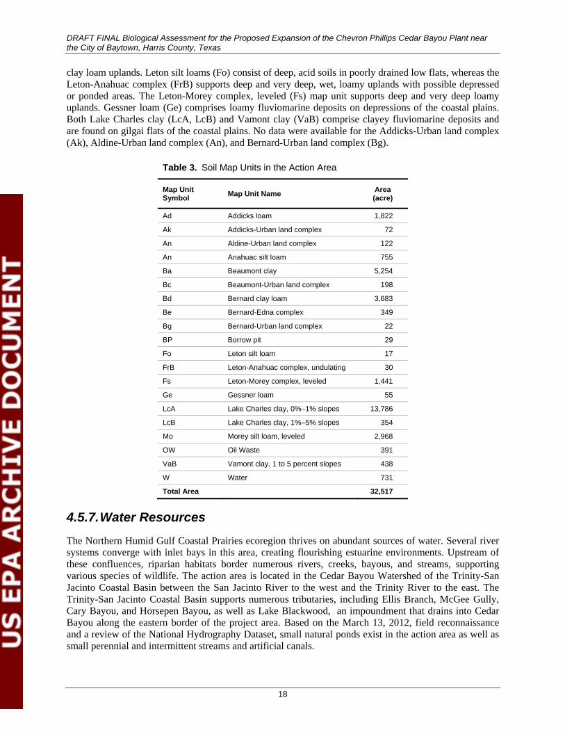
DRAFT FINAL Biological Assessment for the Proposed Expansion of the Chevron Phillips Cedar Bayou Plant near the City of Baytown, Harris County, Texas
18
clay loam uplands. Leton silt loams (Fo) consist of deep, acid soils in poorly drained low flats, whereas the Leton-Anahuac complex (FrB) supports deep and very deep, wet, loamy uplands with possible depressed or ponded areas. The Leton-Morey complex, leveled (Fs) map unit supports deep and very deep loamy uplands. Gessner loam (Ge) comprises loamy fluviomarine deposits on depressions of the coastal plains. Both Lake Charles clay (LcA, LcB) and Vamont clay (VaB) comprise clayey fluviomarine deposits and are found on gilgai flats of the coastal plains. No data were available for the Addicks-Urban land complex (Ak), Aldine-Urban land complex (An), and Bernard-Urban land complex (Bg).
Table 3. Soil Map Units in the Action Area
Map Unit Symbol Map Unit Name Area
(acre)
Ad Addicks loam 1,822
Ak Addicks-Urban land complex 72
An Aldine-Urban land complex 122
An Anahuac silt loam 755
Ba Beaumont clay 5,254
Bc Beaumont-Urban land complex 198
Bd Bernard clay loam 3,683
Be Bernard-Edna complex 349
Bg Bernard-Urban land complex 22
BP Borrow pit 29
Fo Leton silt loam 17
FrB Leton-Anahuac complex, undulating 30
Fs Leton-Morey complex, leveled 1,441
Ge Gessner loam 55
LcA Lake Charles clay, 0%–1% slopes 13,786
LcB Lake Charles clay, 1%–5% slopes 354
Mo Morey silt loam, leveled 2,968
OW Oil Waste 391
VaB Vamont clay, 1 to 5 percent slopes 438
W Water 731
Total Area 32,517
4.5.7. Water Resources
The Northern Humid Gulf Coastal Prairies ecoregion thrives on abundant sources of water. Several river systems converge with inlet bays in this area, creating flourishing estuarine environments. Upstream of these confluences, riparian habitats border numerous rivers, creeks, bayous, and streams, supporting various species of wildlife. The action area is located in the Cedar Bayou Watershed of the Trinity-San Jacinto Coastal Basin between the San Jacinto River to the west and the Trinity River to the east. The Trinity-San Jacinto Coastal Basin supports numerous tributaries, including Ellis Branch, McGee Gully, Cary Bayou, and Horsepen Bayou, as well as Lake Blackwood, an impoundment that drains into Cedar Bayou along the eastern border of the project area. Based on the March 13, 2012, field reconnaissance and a review of the National Hydrography Dataset, small natural ponds exist in the action area as well as small perennial and intermittent streams and artificial canals.
DRAFT FINAL Biological Assessment for the Proposed Expansion of the Chevron Phillips Cedar Bayou Plant near the City of Baytown, Harris County, Texas
19
Cedar Bayou is considered environmentally sensitive due to the undeveloped natural channel reaches upstream of Baytown and the saltwater marshlands in the lower reaches (Harris County Flood Control District [HCFCD] 2012). TPWD considers the area around the mouth of Cedar Bayou to be critical wildlife habitat (HCFCD 2012). This waterway is on the EPA Clean Water Act (CWA) 303(d) list of impaired waters. The impaired portion of Cedar Bayou includes the Cedar Bayou Tidal segment (Segment ID No. 0901), which occurs from the confluence with Galveston Bay 0.6 mile downstream of Tri-City Beach Road to a point 1.4 mile upstream of I-10. Cedar Bayou Tidal is listed as being impaired for certain water quality issues, including 1) presence of Enterococcus bacteria (found in human waste); 2) high chlorophyll a levels, which can cause algal blooms; and, 3) polychlorinated biphenyls (PCBs) and dioxins in edible fish tissue (TCEQ 2010). There is a total maximum daily load of dioxin for Cedar Bayou. HCFCD, along with other partners, is currently developing a watershed protection plan to address these water quality issues.
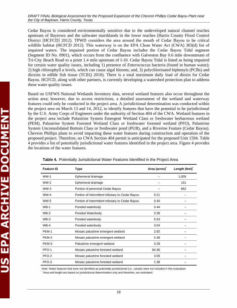
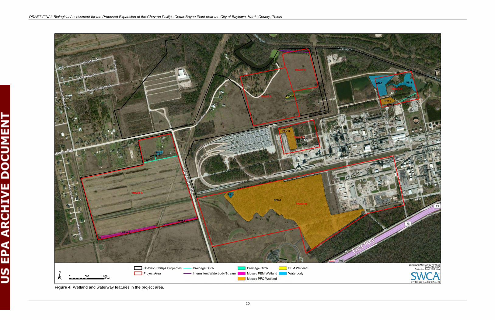
Based on USFWS National Wetlands Inventory data, several wetland features also occur throughout the action area; however, due to access restrictions, a detailed assessment of the wetland and waterway features could only be conducted in the project area. A jurisdictional determination was conducted within the project area on March 13 and 14, 2012, to identify features that have the potential to be jurisdictional by the U.S. Army Corps of Engineers under the authority of Section 404 of the CWA. Wetland features in the project area include Palustrine System Emergent Wetland Class or freshwater herbaceous wetland (PEM), Palustrine System Forested Wetland Class or freshwater forested wetland (PFO), Palustrine System Unconsolidated Bottom Class or freshwater pond (PUB), and a Riverine Feature (Cedar Bayou). Chevron Phillips plans to avoid impacting these water features during construction and operation of the proposed project. Therefore, no CWA Section 404 permit is anticipated for the proposed Unit 1594. Table 4 provides a list of potentially jurisdictional water features identified in the project area. Figure 4 provides the locations of the water features.
Table 4. Potentially Jurisdictional Water Features Identified in the Project Area
Feature ID Type Area (acres)* Length (feet)*
WW-1 Ephemeral drainage – 1,005
WW-2 Ephemeral drainage – 151
WW-3 Portion of perennial Cedar Bayou – 862
WW-4 Portion of intermittent tributary to Cedar Bayou 0.21 –
WW-5 Portion of intermittent tributary to Cedar Bayou 0.40 –
WB-1 Ponded waterbody 0.44 –
WB-2 Ponded Waterbody 0.38 –
WB-3 Ponded waterbody 5.53 –
WB-4 Ponded waterbody 3.04 –
PEM-1 Mosaic palustrine emergent wetland 2.82 –
PEM-2 Mosaic palustrine emergent wetland 0.38 –
PEM-3 Palustrine emergent wetland 0.28 –
PFO-1 Mosaic palustrine forested wetland 84.36 –
PFO-2 Mosaic palustrine forested wetland 3.59 –
PFO-3 Mosaic palustrine forested wetland 1.38 –
Note: Water features that were not identified as potentially jurisdictional (i.e., canals) were not included in this evaluation. * Area and length are based on jurisdictional determination only and therefore, are estimated.
DRAFT FINAL Biological Assessment for the Proposed Expansion of the Chevron Phillips Cedar Bayou Plant near the City of Baytown, Harris County, Texas
20
Figure 4. Wetland and waterway features in the project area.
DRAFT FINAL Biological Assessment for the Proposed Expansion of the Chevron Phillips Cedar Bayou Plant near the City of Baytown, Harris County, Texas
21
This page intentionally blank
DRAFT FINAL Biological Assessment for the Proposed Expansion of the Chevron Phillips Cedar Bayou Plant near the City of Baytown, Harris County, Texas
22
According to the Federal Emergency Management Agency (FEMA) flood insurance rate map, the eastern edge of the project area along Cedar Bayou and its tributaries is in the 100-year floodplain or Zone AE, with a 1% chance of annual flooding (FEMA 2012). The remainder of the project area is designated 500-year floodplain or as 0.2% Annual Change Flood Hazard Zone (FEMA 2012). Much of the remaining portions of the action area are outside the floodplain, with areas along tributaries and bayous surrounded by a 500-year floodplain and a 100-year floodplain occurring immediately adjacent to these waterbodies.
4.5.8. Vegetation
Most of the Northern Humid Gulf Coastal Prairies ecoregion has been altered from its native grassland habitat into urban land uses, cropland, or pastureland. Native habitat characteristics consist of grasslands with scattered clusters of oaks (Quercus spp.), known as oak mottes or maritime woodlands.
Little bluestem (Schizachyrium scoparium var. scoparium), yellow indiangrass (Sorghastrum nutans), brownseed paspalum (Paspalum plicatulum), gulf muhly (Muhlenbergia capillaris), and switchgrass (Panicum virgatum) were the dominant grassland species before alteration of the grassland occurred (Wiken et al. 2011).
Most of the action area falls in the pine hardwood vegetation community with the crops vegetation community dominating the remainder of the action area (McMahan et al. 1984). The pine hardwood vegetation community (subtype 4) exists in the project area and consists of loblolly pine (Pinus taeda), shortleaf pine (P. echinata), blackjack oak (Quercus marilandica), sand post oak (Q. stellata var. margaretta), southern red oak (Q. falcata), flowering dogwood (Cornus florida), sweetgum (Liquidambar styraciflua), sassafras (Sassafras albidum), American beautyberry (Callicarpa americana), wax myrtle (Morella cerifera), yaupon holly (Ilex vomitoria), hawthorn (Crataegus sp.), yellow jessamine (Gelsemium sempervirens), slender bluestem (Schizachyrium tenerum), broomsedge bluestem (Andropogon virginicus), and little bluestem.
The crops vegetation community exists immediately east and west of the project area and consists of cultivated cover crops or row crops providing food and/or fiber for either humans or domestic animals. This community may also portray grassland associated with crop rotations. Typical crops in Harris County include rice, soybean, alfalfa (Medicago sativa) and other hays, corn, and various grains and vegetable crops.
4.5.9. Wildlife
Several species of wildlife exist in the Western Gulf Coastal Plain ecoregion. Common terrestrial species in this area include, but are not limited to white-tailed deer (Odocoileus virginianus), coyote (Canis latrans), ringtail cat (Bassariscus astutus), nine-banded armadillo (Dasypus novemcinctus), javelina (Pecari tajacu), feral hog (Sus scrofa), swamp rabbit (Sylvilagus aquaticus), nutria (Myocastor coypus), and American alligator (Alligator mississipiensis) (CEC 2011). Based on the NDD, one waterbird rookery exists 52 miles east of the action area.
SWCA is not aware of any bird surveys that have been conducted specifically in the action area, but bird species expected to commonly occur either on a permanent or seasonal basis were identified through review of the results of Texas breeding bird surveys for the communities of Stowell and Winnie (Sauer et al. 2011), located east approximately 16 and 22 miles, respectively, of the action area. In addition, SWCA reviewed the Houston Christmas Bird Count (Audubon Society 2012), and the TOS Handbook of Texas Birds (Lockwood and Freeman 2004). Based on this review, birds expected to occur commonly year-round in the action area include laughing gull (Larus atricilla), ring-billed gull (Larus delawarensis),
DRAFT FINAL Biological Assessment for the Proposed Expansion of the Chevron Phillips Cedar Bayou Plant near the City of Baytown, Harris County, Texas
23
neotropic cormorant (Phalacrocorax brasilianus), killdeer (Charadrius vociferous), American coot (Fulica americana), red-winged blackbird (Agelaius phoeniceus), rock pigeon (Columba livia), eastern bluebird (Sialia sialis), northern cardinal (Cardinalis cardinalis), northern mockingbird (Mimus polyglottos), European starling (Sturnus vulgaris), common grackle (Quiscalus quiscula), and great-tailed grackle (Quiscalus mexicanus).
Migratory species expected to be common winter residents in the action area include American bittern (Botaurus lentiginosus), snow goose (Chen caerulescens), western sandpiper (Calidris mauri), black-bellied plover (Pluvialis squatarola), lesser scaup (Aythya affinis), ruddy duck (Oxyura jamaicensis), northern shoveler (Anas clypeata), canvasback (Aythya valisineria), spotted sandpiper (Actitis macularia), whimbrel (Numenius phaeopus), American white pelican (Pelecanus erythrorhynchos), double-crested cormorant (Phalacrocorax auritus), white-rumped sandpiper (Calidris fuscicollis), osprey (Pandion haliaetus), cedar waxwing (Bombycilla cedrorum), yellow-rumped warbler (Setophaga coronata), tree swallow (Tachycineta bicolor), and American goldfinch (Spinus tristis).
The action area is located along the eastern edge of the Central Flyway (USFWS 2012g). This position creates potential for a great number of migratory bird species that neither breed nor winter in the action area to occur in the area on a regular or irregular basis during the spring and fall migration periods. Regular migrants through the action area likely include buff-breasted sandpiper (Tryngites subruficollis) and broad-winged hawk (Buteo platypterus), among others.
4.6. Listed Species
4.6.1. Summary of Listed Species
The USFWS and TPWD maintain the lists of listed species and the critical habitats designated in each Texas county. These species are currently listed as endangered or threatened under the ESA (16 USC 1531 et seq.). TPWD frequently designates federally listed species in a county that is not necessarily on the USFWS list. Although preference is made to USFWS-identified species for each county, it is not to be used as the sole and final source for identifying species that may be impacted by a proposed project. Therefore, those federally listed species that TPWD designates as occurring in Harris or Chambers Counties are also addressed. The fifteen endangered and threatened species evaluated in this BA were based on the USFWS and TPWD lists for both Harris and Chambers Counties (USFWS 2012a, 2012b; TPWD 2012a, 2012b). The USFWS and TPWD ESA species lists are provided in Appendix B, and a summary of the listed species evaluated in this BA is presented in Table 5.
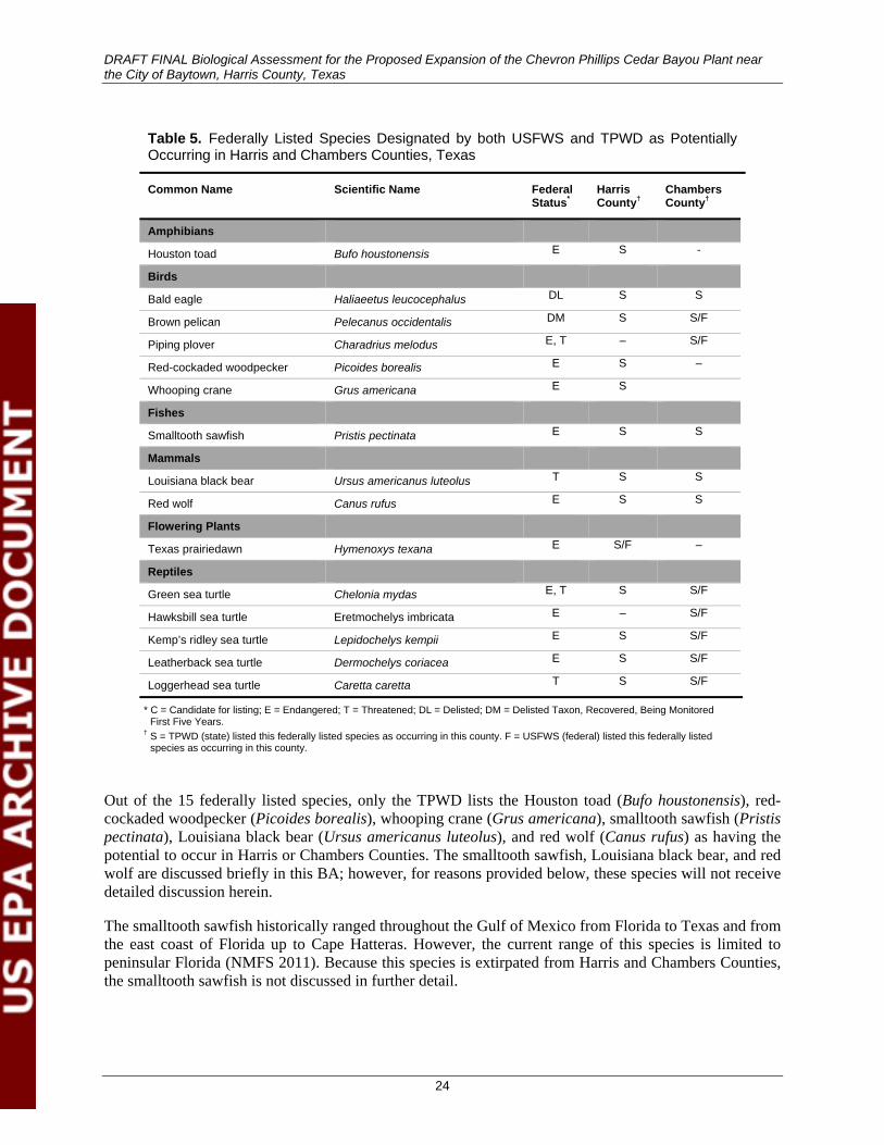
DRAFT FINAL Biological Assessment for the Proposed Expansion of the Chevron Phillips Cedar Bayou Plant near the City of Baytown, Harris County, Texas
24
Table 5. Federally Listed Species Designated by both USFWS and TPWD as Potentially Occurring in Harris and Chambers Counties, Texas
Common Name Scientific Name Federal Status*
Harris County†
Chambers County†
Amphibians
Houston toad Bufo houstonensis E S -
Birds
Bald eagle Haliaeetus leucocephalus DL S S
Brown pelican Pelecanus occidentalis DM S S/F
Piping plover Charadrius melodus E, T – S/F
Red-cockaded woodpecker Picoides borealis E S –
Whooping crane Grus americana E S
Fishes
Smalltooth sawfish Pristis pectinata E S S
Mammals
Louisiana black bear Ursus americanus luteolus T S S
Red wolf Canus rufus E S S
Flowering Plants
Texas prairiedawn Hymenoxys texana E S/F –
Reptiles
Green sea turtle Chelonia mydas E, T S S/F
Hawksbill sea turtle Eretmochelys imbricata E – S/F
Kemp’s ridley sea turtle Lepidochelys kempii E S S/F
Leatherback sea turtle Dermochelys coriacea E S S/F
Loggerhead sea turtle Caretta caretta T S S/F
* C = Candidate for listing; E = Endangered; T = Threatened; DL = Delisted; DM = Delisted Taxon, Recovered, Being Monitored First Five Years.
† S = TPWD (state) listed this federally listed species as occurring in this county. F = USFWS (federal) listed this federally listed species as occurring in this county.
Out of the 15 federally listed species, only the TPWD lists the Houston toad (Bufo houstonensis), red-cockaded woodpecker (Picoides borealis), whooping crane (Grus americana), smalltooth sawfish (Pristis pectinata), Louisiana black bear (Ursus americanus luteolus), and red wolf (Canus rufus) as having the potential to occur in Harris or Chambers Counties. The smalltooth sawfish, Louisiana black bear, and red wolf are discussed briefly in this BA; however, for reasons provided below, these species will not receive detailed discussion herein.
The smalltooth sawfish historically ranged throughout the Gulf of Mexico from Florida to Texas and from the east coast of Florida up to Cape Hatteras. However, the current range of this species is limited to peninsular Florida (NMFS 2011). Because this species is extirpated from Harris and Chambers Counties, the smalltooth sawfish is not discussed in further detail.
DRAFT FINAL Biological Assessment for the Proposed Expansion of the Chevron Phillips Cedar Bayou Plant near the City of Baytown, Harris County, Texas
25
The USFWS lists the Louisiana black bear, a subspecies, as threatened and considers the entire black bear species in the historical range of the Louisiana black bear as threatened, by similarity of appearance to a threatened taxon. Historically, black bears were distributed throughout the state, but recent verified occurrences have been limited to the Red River and Sulphur River Basins in northeast Texas (TPWD 2012e). Because this species is extirpated from Harris and Chambers Counties, the Louisiana black bear is not discussed in further detail.
The distribution of the red wolf formerly extended over the western two-thirds of Texas, but this species is now extirpated in Texas. The last record of red wolf occurring in Texas was 1970 (Schmidly 2012). All reintroduced populations are classified as experimental and nonessential, not endangered; however, no reintroduced populations occur in Harris or Chambers Counties. Because this species is extirpated from Harris and Chambers Counties, the red wolf is not discussed in further detail.
4.6.2. Critical Habitat Designation
The USFWS designates critical habitat for ESA-listed species to aid in the recovery of those species. The USFWS Critical Habitat Portal was accessed to determine whether any designated critical habitat for ESA-listed species occurs in the action area. The results revealed that no designated critical habitat is present in the action area. The closest area of designated critical habitat is for the piping plover (Charadrius melodus) and is more than 32 miles to the southeast of the action area in specific locations along Galveston Island, Galveston County, Texas (USFWS 2012d) (Figure 5).
4.6.3. Descriptions of Listed Species
A brief description, including listing status, life history, habitat requirements, population status, and current and historical range information, of the remaining nine federally listed species are described below. Known occurrences identified from the literature and TPWD NDD review as well as possible habitat locations are identified in Figure 5.
4.6.3.1. HOUSTON TOAD
The Houston toad was listed as endangered in 1970 due to threats primarily from loss and alteration of habitat as a result of urban development (USFWS 2011). The species is a small anuran, approximately 2.0–3.5 inches long, with mottled coloration from light brown to gray, sometimes with green patches (USFWS 2011). Houston toads are poor burrowers and thus require pliable, soft sandy soils for aestivation during the summer and hibernation throughout the winter. The species also requires specific vegetative cover such as pine (Pinus species)-oak (Quercus species) woodlands for shade surrounding its breeding ponds.
The Houston toad is not listed by USFWS or TPWD as occurring in Chambers County. This species historically occurred in Harris County, but has not been encountered in the county since 1976. The TPWD NDD review confirms this statement, identifying the last occurrence in 1976 approximately 18 miles southwest of the action area. Another occurrence in 1976 identified a location 8 miles northeast in Liberty County, which is not a county being evaluated in this BA. The species’ current range encompasses Austin, Bastrop, Colorado, Lavaca, Lee, Leon, Milam, and Roberston Counties (USFWS 2011). USFWS has determined that the Houston toad is currently extirpated from Harris County (USFWS 2011). Based on EPA’s inquiry, SWCA reviewed in detail existing aerial photography, NRCS soil data, GAT digital data, published vegetation types (McMahan et al. 1984), and descriptions of the vegetation communities within the action area collected during the March 13, 2012, field reconnaissance.
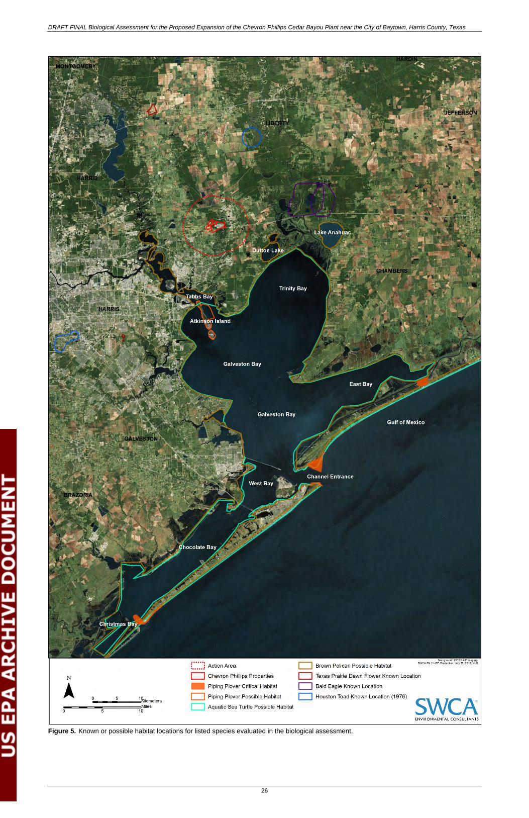
DRAFT FINAL Biological Assessment for the Proposed Expansion of the Chevron Phillips Cedar Bayou Plant near the City of Baytown, Harris County, Texas
26
Figure 5. Known or possible habitat locations for listed species evaluated in the biological assessment.

DRAFT FINAL Biological Assessment for the Proposed Expansion of the Chevron Phillips Cedar Bayou Plant near the City of Baytown, Harris County, Texas
27
This page intentionally blank
DRAFT FINAL Biological Assessment for the Proposed Expansion of the Chevron Phillips Cedar Bayou Plant near the City of Baytown, Harris County, Texas
28
The pine hardwood forests of the action area support similar vegetative characteristics (i.e., species composition, canopy structure) to habitat preferred by the Houston toad. However, the surface geology identified in the action area consists of the Beaumont Formation (see Section 4.5.5), which differs from the geologic formations solely associated with Houston toad habitat. Houston toad populations only occur on two separate bands of geologic formations on which the deepest sands in the region occur: 1) the band that runs through Bastrop County northeast to Freestone County, which includes the Carrizo, Queen City, Sparta, Reclaw, and Weches geologic formations; and 2) the Lavaca County band, which includes the Willis and Goliad geologic formations (IUCN/SSC Conservation Breeding Specialist Group 1994). In addition, soils in the action area consist of loams, silty loams, and clays (see Section 4.5.6), which are much more compact than the soft, pliable sandy soils required by the species. Houston toads require soft, pliable sandy soils to aestivate in the summer and hibernate in the winter because they are poor burrowers and are impeded when burrowing into hard soils (USFWS 2011). Therefore, due to the lack of required soils and geology, as well as the absence of the species in Harris County since 1976, the Houston toad is not expected to occur in the action area.
4.6.3.2. PIPING PLOVER
The piping plover was listed as both threatened and endangered by the USFWS in 1985 because of extensive habitat destruction and historical population declines from hunting. The Great Lakes breeding population is listed as endangered, whereas larger breeding populations of the Atlantic coast and northern Great Plains and all wintering populations are listed as threatened (USFWS 1985a). Little is known about the historical status and population of the piping plover prior to 1980. Protection afforded by the Migratory Bird Treaty Act of 1918 (MBTA) has eliminated hunting as a major threat to this species. However, reasons for the decline in populations of the species since that time are many and include loss or degradation of habitat, human recreational disturbances in habitat, dune stabilization projects, damming and channelization of rivers (which can eliminate sandbars, allow encroachment of vegetation, and alter water flows), and drainage of wetlands (Flemming et al. 1992; USFWS 2003; USFWS 1985a). Wintering habitats on the Texas Gulf Coast are threatened by industrial activities, urban development, human activity on beaches, and maintenance activities for commercial waterways, with the potential for pollution from spills of petrochemicals or other hazardous materials also being a concern (Campbell 1995).
The piping plover is an uncommon to locally common shorebird that can be found wintering along the Texas coast on sandy beaches, sand flats, mudflats, algal flats, washover passes, and spoil islands (Nicholls and Baldassarre 1990; Campbell 1995; Ferland and Haig 2002; USFWS 2003; Lockwood and Freeman 2004; Haig et al. 2005). They can also be found probing for invertebrates along shorelines of streams, ephemeral ponds, and lagoons. Small sand dunes, debris, and sparse vegetation in adjacent beaches provide shelter from wind and extreme temperatures (USFWS 2003).
Critical habitat for the wintering population of piping plovers was designated in 2001 and divided into 137 units across eight states (USFWS 2001). Nineteen of those units were located along the Texas coastline (USFWS 2001). In 2009, the units in Texas were reconfigured and reduced to 18 (USFWS 2009b). Critical wintering habitat for the plover was designated in many locations along the Texas coast, extending from Chambers County south to Cameron County (USFWS 2009b). Designated critical habitat for this species is located approximately 32 miles southeast of the action area in specific locations along Galveston Island (Figure 5).
SWCA reviewed the habitat in the action area for areas that could attract piping plovers. The waterbodies, waterways, and wetlands in the action area do not exhibit habitat characteristics (i.e., large open flats, sandy areas) preferred by piping plovers. The closest possible habitat identified near the action area is located on Atkinson Island Wildlife Management Area, approximately 7.5 miles southwest of the action area (see Figure 5).
DRAFT FINAL Biological Assessment for the Proposed Expansion of the Chevron Phillips Cedar Bayou Plant near the City of Baytown, Harris County, Texas
29
4.6.3.3. RED-COCKADED WOODPECKER
The red-cockaded woodpecker is a small black-and-white woodpecker with a longish bill that was listed as endangered by the USFWS in 1970 (USFWS 1970c). This woodpecker prefers large tracts of old-growth longleaf pine (Pinus palustris) or pine-hardwood forests lacking in midstory vegetation in the southeastern United States, spanning into eastern Texas (McFarlane 2012). The primary threat to the existence of this species is almost complete loss of habitat.
Historically, this species occurred throughout the eastern half of Texas, but due to extensive logging of its preferred habitat, the current red-cockaded woodpecker range extends into only 17 counties in Texas. Both Harris and Chambers Counties are listed in the historic range of this species (TPWD 2012f). USFWS databases currently do not list the species as occurring in Harris or Chambers Counties (USFWS 2012e). More specifically, TPWD and USFWS, along with Texas Partners in Flight, U.S. Forest Service, and Texas Forest Service, have determined that the red-cockaded woodpecker is currently extirpated from Harris and Chambers Counties due to lack of suitable habitat (Shackelford and Reid 2001). Based on inquiry from EPA, SWCA reviewed in detail existing aerial photography, published vegetation types (McMahan et al. 1984), and descriptions of the vegetation communities in the action area collected during the March 13, 2012, field reconnaissance. SWCA determined that the pine hardwood vegetation communities identified within the action area are dominated by overstory species such as loblolly pine, shortleaf pine, blackjack oak, sand post oak, southern red oak, water oak, pin oak, sweet gum, cedar elm, and/or flowering dogwood (see Sections 4.5.8 and 5.1). Midstory species are also present and typically include yaupon holly, deciduous holly, American beauty berry, and/or wax myrtle. Canopy height in these areas ranges from 25 to 40 feet and densities range from 50% to 100% (see Appendix A, Photograph A-7).
Preferred red-cockaded woodpecker habitat includes open, old-growth pine forests with little to no midstory cover (Shackelford and Reid 2011). Old-growth longleaf pines are defined as being in excess of 120 feet tall and 3 feet in diameter-at-breast height (The Longleaf Alliance 2002). Typically, these pine stands are historic, open, fire-maintained, and are often referred to as “park-like” (see Appendix A, Photograph A-7) (Shackelford and Reid 2011). SWCA determined that the vegetation characteristics in the action area do not support preferred habitat required by the species because midstory vegetation is not only present, but is relatively high in density (50%–100%), and pine trees are not considered old-growth because they are only 25–40 feet in canopy height. The closest county in which red-cockaded woodpecker habitat potentially occurs is Liberty County, approximately 25 miles north of the action area.
4.6.3.4. WHOOPING CRANE
The whooping crane, the tallest bird in North America, was listed by USFWS as endangered in 1967 (USFWS 1967). The greatest threats to the whooping crane are human-made and include power lines, illegal hunting, and habitat loss (TPWD 2012h). Whooping cranes prefer coastal salt marshes in their wintering range in Texas.
The whooping crane overwinters in the Aransas National Wildlife Refuge in Aransas County, Texas, with regular occurrences in Matagorda, Refugio, Calhoun, Aransas, Williamson, San Patricio, Maverick, and Caldwell Counties. The entire whooping crane migratory corridor encapsulates 95% of all sightings and spans approximately 106 counties across Texas (USFWS 2012f). Chambers County is not considered part of the whooping crane migration corridor and therefore, the whooping crane is not expected to occur in Chambers County. However, Harris County is included in the migration corridor. The western extent of Harris County is included in the portion of the migration corridor that encompasses the outermost 5% of whooping crane sightings. This area is approximately 37 miles west of the action area. The likelihood of observing a whooping crane outside of this corridor is extremely rare. However, in the event a whooping crane could occur outside this corridor in Harris County (e.g., significant storm that blows birds off-
DRAFT FINAL Biological Assessment for the Proposed Expansion of the Chevron Phillips Cedar Bayou Plant near the City of Baytown, Harris County, Texas
30
course), SWCA reviewed the action area and determined that the wetland and vegetation characteristics do not support preferred habitat required by the species because they lack salt flats or open expanses of herbaceous wetland.
4.6.3.5. TEXAS PRAIRIEDAWN
The Texas prairiedawn (Hymenoxys texana) is an annual flowering plant that was listed as endangered by the USFWS in 1985 (USFWS 1985b). The primary threat to the existence of this species is habitat destruction. Because the known range of this plant is in Harris County, rapid development from Houston and surrounding suburbs continues to modify or eliminate habitat (USFWS 1989). The flower is part of the Gulf Coast Prairies Safe Harbor Agreement established in 1995. This agreement is intended to protect three listed species (including the Texas prairiedawn) in 2,377,700 acres of rangeland spanning across 19 counties in the central Gulf region of Texas.
This plant is found in barren areas at the base of “pimple mounds,” with slightly saline soils such as Addicks loam and Bernard clay loam (TPWD 2012b). It can also grow in barren areas that may have been previously disturbed. Disturbed areas could include abandoned rice fields, vacant lots, and pastures where these pimple mounds may have been flattened (USFWS 1989). The Texas prairiedawn exists only in Harris County, with one exception in Fort Bend County. Only approximately 50 known sites occur for this species throughout its range, and many of these sites are in the Addicks and Barker Reservoirs in western Harris County (TPWD 2011). Based on TPWD NDD, the nearest known observation of this plant from the project area is 15 miles to the southwest of the action area (Figure 5). The Addicks and Barker Reservoir spillways are approximately 42 miles and 43 miles to the west, respectively. Although two soils that support this species (Addicks loam and Bernard clay loam soil types) do exist adjacent to the project area, desktop review and field verification identified no barren areas at the base of “pimple mounds” in or adjacent to the action area. A photographic comparison of preferred habitat versus habitat identified within the action area is located in Appendix A (Photographs A-4 and A-5).
4.6.3.6. GREEN SEA TURTLE
The green sea turtle (Chelonia mydas) was listed as threatened/endangered on July 28, 1978 (USFWS 1978); it is listed as threatened in all areas except for breeding populations in Florida and along the Pacific coast of Mexico, where it is listed as endangered. Critical habitat for the species was designated in Puerto Rico in 1998 (USFWS 1998). Historically, the primary threats to the green sea turtle have been over-harvesting of eggs and adults for human consumption (National Oceanic and Atmospheric Administration [NOAA] 2012a). Recent threats include loss of nesting beaches to coastal development projects, disorientation of hatchlings by beachfront lighting, excessive nest predation, degradation of foraging habitat, marine pollution, watercraft strikes, entanglement in fishing equipment, channel dredging, and commercial fishing operations (USFWS-North Florida Field Office [NFFO] 2012a).
Green sea turtles nest on sandy beaches, with hatchlings typically moving out to open water to seek refuge in floating vegetation such as Sargassum, where they initially feed on marine invertebrates then progress to seagrasses and seaweeds (TPWD 2012c). Older turtles spend most of their time in coastal, shallower waters, including bays, lagoons, shoals, inlets, and around reefs and jetties (USFWS-NFFO 2012a). Adults are herbivorous, feeding in shallow water areas with abundant seagrasses or algae; in fact, seagrass pastures are generally considered to be the primary habitat for adult green turtles (Lutz et al. 2003; Bjorndal and Bolten 2010).
Green sea turtles have a circumglobal distribution in tropical and subtropical waters in over 140 countries (NOAA 2012a), with nesting beaches known in the Atlantic, Indian, and Pacific Ocean Basins and the eastern Mediterranean Sea (NMFS and USFWS 2007a). In the United States, green sea turtles nest

DRAFT FINAL Biological Assessment for the Proposed Expansion of the Chevron Phillips Cedar Bayou Plant near the City of Baytown, Harris County, Texas
31
primarily in Florida, with minor nesting occurring northward to North Carolina; foraging turtles have been observed as far north as Massachusetts (NOAA 2012a; USFWS-NFFO 2012a). Green sea turtles are also found in the Gulf of Mexico and occasionally visit the Texas coast.
Green sea turtles are not known to permanently inhabit Galveston Bay waters, but use the bay and the Gulf of Mexico as a seasonal foraging area as they make their way along the coast to their Florida breeding grounds (Sage and Gallaway 2002). They prefer the seagrass-laden areas of the Laguna Madre, but are occasionally found in nearby nearshore waters (Sage and Gallaway 2002). Green sea turtles have the potential to occur in Galveston Bay in Chambers County, approximately 15 miles south of the action area (see Figure 5). Occurrences have been identified near the entrance of the Galveston Bay Entrance Channel and in Christmas Bay, approximately 30 miles south and 48 miles southwest of the action area, respectively (Caillouet et al. 1991).
Sea turtles are marine species, so the possibility of any sea turtles swimming up Cedar Bayou is not something SWCA originally considered in this BA. In response to EPA’s inquiry regarding the potential for sea turtles to occur in Cedar Bayou near the project area, SWCA researched the topic and found nothing in the scientific literature that discusses the occurrence of sea turtles in freshwater. This is a very strong indication that these animals do not even occasionally stray into freshwater. Although it outwardly seems plausible that a sea turtle could swim freely between marine and fresh waters, reasons exist for why they do not. The primary reason is that the body chemistry of the animals is adapted to life in saltwater. Osmotic pressure would remove salt from their bodies if they spent extended time in freshwater, and this would cause metabolic harm to the animals. Another reason is related to their diet. Sea turtles eat jellyfish, seagrass, coral, and other marine foods. The foods that sea turtles eat do not occur in freshwater environments and as such, the turtles have no reason to travel into them. Buoyancy may be a third reason. Saltwater provides greater buoyancy than does freshwater, and it is possible that the density of the animals would in the long-term prove detrimental to their energy budgets in a less buoyant, freshwater environment by forcing the animals to work harder to swim upward. Therefore, it is extremely unlikely that sea turtles are capable of occurring in freshwater systems like Cedar Bayou near the project area.
4.6.3.7. HAWKSBILL SEA TURTLE
The hawksbill sea turtle (Eretmochelys imbricata) was listed as endangered throughout its range on June 2, 1970 (USFWS 1970a). Terrestrial critical habitat was designated in Puerto Rico on June 24, 1982 (USFWS 1982), and was expanded to include some offshore waters in 1998 (USFWS 1998). The decline of this species is primarily due to commercial exploitation, primarily for its eggs and shell, followed by loss and degradation of habitat, including coral reef communities (NOAA 2012b). Coral reefs have been harmed by development activities and by global climate change and ocean pollution; also, threats result from direct harvesting, loss of habitat, entanglement in fishing equipment, and collisions with watercraft (NOAA 2012b). Populations in the Atlantic are generally thought to be doing better than those in the Indo-Pacific region, with populations in the Indian Ocean doing far better than those in the Pacific (NMFS and USFWS 2007b).
Hawksbills use different habitats at different stages of their life cycle. After hatching, juvenile hawksbills often take shelter in weedlines or Sargassum (NMFS and USFWS 2007b). Adult hawksbills typically occur in water less than 65 feet deep and can be found in a variety of habitats, including rocky areas, coral reefs, lagoons, mangrove bays, seagrass beds, and mudflats (USFWS-NFFO 2012b; NMFS and USFWS 2007b). Adult hawksbills are most closely associated with coral reef and other hard-bottom habitats, but seagrass pastures can support healthy populations and are considered peripheral habitats for this species (Bjorndal and Bolten 2010).
DRAFT FINAL Biological Assessment for the Proposed Expansion of the Chevron Phillips Cedar Bayou Plant near the City of Baytown, Harris County, Texas
32
The hawksbill occurs throughout the world in tropical and subtropical waters. It is believed to occur offshore of at least 108 countries and breed on beaches in 70 countries (NMFS and USFWS 2007b). In the United States, hawksbills occur most commonly in Puerto Rico and the U.S. Virgin Islands (NOAA 2012b). Hawksbill turtles occur in the Gulf of Mexico and are seen with some regularity along the Texas coast. Most sightings involve post-hatchlings and juveniles believed to originate from Mexican nesting beaches (NOAA 2012b). Hawksbill sea turtles may use seagrass habitats in the Galveston Bay area, approximately 8 miles southeast of the action area, although they are generally associated with coral reef and other hard-bottom habitats. Hawksbill sea turtles do not have the potential to occur in Cedar Bayou adjacent to the project area because their body chemistry is adapted to life solely in saltwater, food sources are limited to marine environments, and buoyancy differences in freshwater would prove detrimental to their energy budgets, all of which preclude them from using freshwater systems (see Section 4.6.3.6 for details).
4.6.3.8. KEMP’S RIDLEY SEA TURTLE
The Kemp’s ridley sea turtle (Lepidochelys kempii) was listed as endangered throughout its range on December 2, 1970 (USFWS 1970b). No critical habitat has been designated for this species. The Kemp’s ridley is the most seriously endangered of the sea turtles due to persistently high levels of harvesting of eggs and hunting of adult and juvenile turtles for human consumption, coupled with losses suffered from incidental capture in fishing and shrimping trawlers, and the disturbance to, or destruction of, benthic foraging habitats (USFWS and NMFS 1992). A minimum of 702 nests was recorded in 1985, down from tens of thousands of nests found annually in the middle of the twentieth century (USFWS-NFFO 2012c). Numbers of nesting turtles have increased slowly over the past two decades as a result of diligent protection of nesting beaches and use of turtle-excluding devices on trawlers (USFWS-NFFO 2012c).
Adult turtles of this species typically occur in coastal, nearshore, or inshore habitats, where they feed primarily on crabs in shallow seas (less than 120 feet deep) (USFWS and NMFS 1992; NMFS and USFWS 2007c). Both adults and juveniles may move out to deeper, warmer waters during winter months (NMFS and USFWS 2007c). Hatchling turtles swim out to sea and are believed to lead a pelagic existence amongst floating vegetation until they reach a carapace length of approximately 8 inches (NMFS and USFWS 2007c), where upon they shift to using benthic coastal habitats through maturity.
Unlike the other sea turtles considered in this BA, Kemp’s ridleys have a relatively restricted range. Adults occur primarily in the Gulf of Mexico, whereas post-hatchlings and juvenile benthic-stage turtles occur along the Atlantic coast of the United States (NMFS and USFWS 2007c). In Texas, Kemp’s ridley sea turtles occur along the length of the coast, with the south coast providing an important foraging area for adult turtles, and Sabine Pass and the northern coast providing an important foraging area for juveniles (NMFS and USFWS 2007c). The species also nests on Texas beaches, mostly on Padre Island National Seashore (National Park Service 2012a) assisted by a partnership with the Mexican government using eggs transferred from Rancho Nuevo.
Kemp’s ridley sea turtle is by far the dominant sea turtle species in the Galveston Bay area (Sage and Gallaway 2002). The Galveston Bay area has the third highest number of occurrences of this species, behind the Sabine Pass/High Island and Corpus Christi/North Padre Island regions (Manzella and Williams 1992). These estuaries are bordered by tidal marshes and mudflats and have more turbid waters that support commercial crab fisheries (Manzella and Williams 1992), the preferred source of food for the species. This species has been regularly identified throughout Galveston Bay as well as north of Trinity Bay in Tabbs Bay near its confluence with the San Jacinto River (Caillouet et al. 1995). These occurrences are approximately 8 miles southeast and 5 miles southwest of the action area, respectively. Kemp’s ridley sea turtles do not have the potential to occur in Cedar Bayou adjacent to the project area because their body chemistry is adapted to life solely in saltwater, food sources are
DRAFT FINAL Biological Assessment for the Proposed Expansion of the Chevron Phillips Cedar Bayou Plant near the City of Baytown, Harris County, Texas
33
limited to marine environments, and buoyancy differences in freshwater would prove detrimental to their energy budgets, all of which preclude them from using freshwater systems (see Section 4.6.3.6 for details).
4.6.3.9. LEATHERBACK SEA TURTLE
The leatherback sea turtle (Dermochelys coriacea) is currently listed as endangered. It was initially listed throughout its United States and foreign range on June 2, 1970 (USFWS 1970a). Critical habitat in the U.S. Virgin Islands was designated on September 26, 1978, and March 23, 1979 (USFWS 1978; 1979). It is considered an endangered species worldwide and is listed in Appendix 1 of the Convention on International Trade in Endangered Species (CITES), a list of the most highly endangered animals worldwide (CITES 2012). The species has suffered from disturbance and development of nesting beaches, harvesting of eggs and nesting females, loss through entanglement in fishing equipment and as incidental catch in commercial fisheries, boat strikes, and ingestion of plastics mistaken for jellyfish, a preferred food item (NMFS and USFWS 2007e).
The leatherback is the largest living turtle and is so distinctive that it is placed in its own unique family, Dermochelyidae (NMFS and USFWS 1992). The leatherback is the most pelagic of the sea turtles and when away from nesting beaches is typically encountered in deeper waters of continental shelf and pelagic habitats (NMFS and USFWS 1998b). Nesting occurs primarily on tropical and subtropical beaches, although adults primarily feed in temperate and sub-polar waters where preferred foods are jellyfish and tunicates (sea squirts). These turtles seldom travel in large groups, although small groups may move into coastal waters following concentrations of jellyfish. Leatherbacks inhabit primarily the upper reaches of the open ocean, but they also frequently descend into deep waters from 650 to 1,650 feet in depth (TPWD 2012c). Adult females require sandy nesting beaches backed with vegetation and sufficiently sloped so the distance to dry sand is not too far. These preferred beaches are relatively close to deep waters and generally rough seas.
The leatherback is a worldwide species, with nesting beaches known in the Atlantic, Pacific, and Indian Ocean basins. Estimates indicate the total leatherback population in the Atlantic likely ranges from 34,000 to 94,000 and could be stable, whereas the numbers of nesting leatherbacks on beaches in the Indian Ocean basin and along the Pacific coast have dropped substantially over the past two decades from thousands to the low hundreds (NMFS and USFWS 2007e). Nesting in the United States and immediate vicinity occurs only in the Atlantic basin, along the Florida, Puerto Rico, and the British and U.S. Virgin Islands coastlines (NMFS and USFWS 2007e). On the mainland Pacific side of the United States, leatherback turtles are recorded from California to Alaska, including along the Aleutian chain (NMFS and USFWS 1998b). Leatherback turtles are also regularly seen in Hawaiian waters.
The leatherback sea turtle is known to visit the Gulf of Mexico; however, they are considered a rare visitor to the Texas Gulf Coast (TPWD 2012c). Leatherbacks have been known to nest in Texas only on North Padre Island in Cameron County, with the most recent nesting records (with one exception in 2008) dating back to the 1920s and 1930s (National Park Service 2012b). Although leatherbacks are considered “rare” visitors to Texas waters, they do occur on the Texas coast on a regular, but probably seasonal, basis. In the Galveston Bay area, leatherbacks have not been reported in Galveston Bay itself, likely due to its shallow depth, but two occurrences of this species were recorded from 1988 to 1991 in the Galveston Bay Entrance Channel where waters are deeper (Caillouet et al. 1995). These occurrences are approximately 30 miles south of the action area. Leatherback sea turtles do not have the potential to occur in Cedar Bayou adjacent to the project area because their body chemistry is adapted to life solely in saltwater, food sources are limited to marine environments, and buoyancy differences in freshwater would prove detrimental to their energy budgets, all of which preclude them from using freshwater systems (see Section 4.6.3.6 for details).
DRAFT FINAL Biological Assessment for the Proposed Expansion of the Chevron Phillips Cedar Bayou Plant near the City of Baytown, Harris County, Texas
34
4.6.3.10. LOGGERHEAD SEA TURTLE
The loggerhead sea turtle (Caretta caretta) was listed as threatened throughout its range on July 28, 1978 (USFWS 1978). No critical habitat has been designated for this species. Loggerheads have historically been commercially harvested for their meat, eggs, leather, and fat. The meat and leather from loggerheads are not as valuable as those from the green sea turtle, and their shells are of less value than those from the hawksbill. Another large threat to the loggerhead both inside and outside the United States is disturbance and/or destruction of nesting beaches (NMFS and USFWS 1998a, 2007d). Disturbances result from various sources, including construction projects (e.g., roads, buildings, jetties, and seawalls), installation of lighting (which can disorient hatchlings), installation of beach armoring or other erosion controls (which can preclude access to beaches by turtles), vehicular and pedestrian traffic, pollution, and removal of vegetation (NMFS and USFWS 1998a, 2007d).
Loggerheads have a more varied diet than other sea turtles and, because of that, can be found in a wider variety of habitats. Adults are primarily found in tropical to temperate waters, often occurring coastally, where they can be found around coral reefs and rocky places, in bays, lagoons, salt marshes, creeks, ship channels, and even the mouths of large rivers (USFWS-NFFO 2012d). Most adult loggerheads feed on benthic invertebrates (crabs, snails, clams, echinoderms, etc.) in areas with a hard bottom, but will also feed on plants and animals occurring in the water column (NMFS and USFWS 1998a). Loggerheads nest on ocean beaches, and occasionally on estuarine shorelines with suitable sand, primarily in warm temperate and subtropical waters (NMFS and USFWS 1998a). Hatchling turtles move offshore and are believed to largely be carried by currents while taking refuge and feeding in floating vegetation, including Sargassum (NMFS and USFWS 1998a; USFWS-NFFO 2012d). After a decade or more, the turtles largely leave the open ocean to begin foraging in coastal habitats (USFWS-NFFO 2012d).
Loggerheads have a circumglobal distribution, inhabiting continental shelves and coastal waters in temperate, subtropical, and tropical waters of the Atlantic, Pacific, and Indian Oceans (NOAA 2012c; NMFS and USFWS 1998a). In the United States, nesting is not known to occur north of Virginia and is concentrated in Florida (USFWS-NFFO 2012d; NMFS and USFWS 1998a, 2007d). All United States coastal shelf waters on the Atlantic side, including the Gulf of Mexico, are considered occupied by loggerhead sea turtles, with many estuaries and bays providing important inshore habitat (NMFS and USFWS 2007d). The loggerhead appears to be a comparatively common and year-round resident of Texas Gulf Coast waters and would be expected to occur on a regular basis in the Galveston Bay area, approximately 11 miles south of the action area. They have been recorded adjacent to the Galveston Bay Entrance Channel and in Tabbs Bay near its confluence with the San Jacinto River, approximately 30 miles to the south and 6 miles to the southwest, respectively (Caillouet et al. 1995). Limited nesting by the loggerhead also occurs on the Texas coast (TPWD 2012d). Twenty nests of this species were recorded in Texas from 1979 through 2002 (USFWS 2003). Loggerhead sea turtles do not have the potential to occur in Cedar Bayou adjacent to the project area because their body chemistry is adapted to life solely in saltwater, food sources are limited to marine environments, and buoyancy differences in freshwater would prove detrimental to their energy budgets, all of which preclude them from using freshwater systems (see Section 4.6.3.6 for details).
4.6.4. Descriptions of Recently Delisted Species with Monitoring Requirements
4.6.4.1. BALD EAGLE
The bald eagle (Haliaeetus leucocephalus) was listed as endangered in all areas of the United States south of the 40th parallel on March 11, 1967 (USFWS 1967). It was subsequently removed from the federal list of endangered and threatened wildlife on August 8, 2007, throughout its range in all of the lower 48 states
DRAFT FINAL Biological Assessment for the Proposed Expansion of the Chevron Phillips Cedar Bayou Plant near the City of Baytown, Harris County, Texas
35
(USFWS 2007b), except for a small population in portions of Arizona that was later removed on September 30, 2010 (USFWS 2010). A post-delisting plan requires that each state in which breeding bald eagles are present must collect data on occupied nests every 5 years over a 20-year period. The bald eagle remains protected by the Bald and Golden Eagle Protection Act of 1940 and provisions of the MBTA (USFWS 2007a).
The bald eagle is a large raptor with a dark brown body and wings, white tail and head, and a yellow beak. Bald eagles can be found along large lakes, rivers, and sea coasts as winter residents or migrants in Texas. They prefer old-growth and mature stands of pine and/or hardwood trees for perching, roosting, and nesting. The bald eagle breeds primarily in the eastern third of Texas and will winter in other portions of the state where large bodies of water occur. This species has been observed in all counties surrounding the action area, and based on results of the TPWD NDD review, the closest known nesting territories are approximately 5.7 miles east of the action area (Figure 5). Larger expanses of more natural habitats such as Dutton Lake or Lake Anahuac approximately 2.7 and 9.5 miles southeast of the action area, respectively, would likely be preferable to bald eagles in the area.
4.6.4.2. BROWN PELICAN
The brown pelican (Pelicanus occidentalis) was listed as endangered throughout its United States range on October 13, 1970 (USFWS 1970c). It was removed from the federal list of endangered and threatened wildlife on November 17, 2009 (USFWS 2009a). The USFWS issued a draft post-delisting monitoring plan for 5 years on September 30, 2009 (USFWS 2009a). The brown pelican will remain protected under the provisions of the MBTA (USFWS 2009a).
The brown pelican is the smallest of the eight species of pelican, spanning approximately 4 feet in length. These waterbirds are typically found in open expanses of marine habitat, preferring shallow inshore waters such as estuaries and bays and never wandering inland more than 20 miles (Lockwood and Freeman 2004). The brown pelican is common throughout Harris and Chambers Counties in and adjacent to the large bodies of water like Trinity Bay and Galveston Bay, and even smaller lakes like Dutton Lake and Lake Anahuac, approximately 3 and 10 miles east of the action area, respectively (see Figure 5).
4.6.5. Texas Natural Diversity Database Results
The results of the Texas NDD records review for Chambers, Galveston, Harris, Jefferson, and Liberty Counties were received from the TPWD on September 13, 2011, and March 20, 2012. No elements of occurrence (EOs) are located in the action area for the proposed project. Two EOs of the Houston toad are located 7 miles northeast of the action area in Liberty County and 18 miles southwest of the action area in Harris County. The EO records for Houston toad indicate this species was last observed in 1976 (EO ID 3159; EO ID 3224). As discussed above, the Houston toad has been extirpated from Harris County since the mid-1970s and is not expected to occur in the project or action area.
Two EOs for bald eagle nesting territories are located 5 and 8 miles east of the action area (EO ID 1808; EO ID 2340). Reservoirs in the action area could provide limited foraging habitat; however, more natural habitats such as Lake Anahuac or Dutton Lake would likely be preferable to bald eagles in the area. Bald eagles could be expected to fly over these areas to nearby suitable habitat or forage in these limited areas. No other EOs for federally listed species were identified for Harris or Chambers Counties; however, the lack of data does not necessarily indicate the absence of occurrence for threatened or endangered species in the action area.
DRAFT FINAL Biological Assessment for the Proposed Expansion of the Chevron Phillips Cedar Bayou Plant near the City of Baytown, Harris County, Texas
36
One waterbird rookery EO was listed as occurring approximately 52 miles east of the action area in Jefferson County, Texas. This rookery supports numerous bird species that are protected through provisions of the MBTA.
5. LISTED SPECIES HABITAT EVALUATION Results of both the field survey data obtained on March 13, 2012, and information obtained through the detailed desktop review as described in Section 3 (Methodology) were used to prepare this evaluation. The following sections describe the vegetation communities observed throughout the action area and the analysis of the potential for species addressed in this BA to occur in the action area.
5.1. Vegetation Communities Observed McMahan et al. (1984) classify the action area primarily as a pine hardwood vegetation community and a crops vegetation community. In addition, this area is classified as Gulf Coastal grassland by Brown et al. (2007). The March 13, 2012, field reconnaissance verified these communities in more detail. It was observed that the forested wetland areas bordering croplands were dominated by black willow (Salix nigra), white oak (Quercus alba), Chinese tallow (Triadica sebifera), false willow (Baccharis neglecta), curly dock (Rumex crispus), spikerush (Eleocharis spp.), and canary grass (Phalaris canariensis). Unaltered forested mosaic wetland areas are also present in the project area and are dominated by loblolly pine, water oak (Quercus nigra), sweet gum, cedar elm (Ulmus crassifolia), and pin oak (Quercus palustris), with understory vegetation consisting of dwarf palmetto (Sabal minor), deciduous holly (Ilex decidua), greenbrier (Smilax spp.), poison ivy (Toxicodendron radicans), and dewberry (Rubus trivialis). Canopy height in these areas ranges from 25 to 40 feet and densities range from 50% to 100%.
It was also noted that areas lacking agricultural vegetation in the crops vegetation community are dominated by Bermuda grass (Cynodon dactylon), common ragweed (Ambrosia artemisiifolia), false garlic (Allium spp.), common yellow mustard (Brasicca compestriss), milk thistle (Silybum marianum), wandering vetch (Vicia peregrina), and buttercup (Ranunculus sceleratus).
5.2. Listed Species Habitat Analysis
5.2.1.1. HOUSTON TOAD
Houston toads historically occurred in Harris County, but USFWS has determined that the species is currently extirpated from Harris County (USFWS 2011). Nevertheless, SWCA reviewed the habitat within the action area upon EPA’s request and although the action area’s vegetative characteristics resemble that of preferred Houston toad habitat, the surface geology and soil characteristics within the action area lack the required soft sandy soils Houston toads need for burrowing. In addition, the species has not been known to occur in Harris County since 1976. Therefore, this species is not expected to occur in the action area.
5.2.1.2. BALD EAGLE
Bald eagles could occur year-round in Harris and Chambers Counties, preferring tall perches adjacent to large bodies of water. TPWD NDD review indicated nesting territories nearby, approximately 5.7 miles east of the action area. Human-made reservoirs in the action area could provide a small amount of lower quality foraging habitat; however, these areas stray from suitable habitat requirements (e.g., mature stands of pine and/or hardwood trees). Larger expanses of more natural habitats such as Lake Anahuac or Dutton
DRAFT FINAL Biological Assessment for the Proposed Expansion of the Chevron Phillips Cedar Bayou Plant near the City of Baytown, Harris County, Texas
37
Lake approximately 9.5 and 2.7 miles southeast of the action area, respectively, would likely be preferable to bald eagles in the area. Although bald eagles are not expected to occur in the action area because suitable habitat is absent, they could be expected to occasionally fly over the action area on an infrequent, year-round basis.
5.2.1.3. BROWN PELICAN
Brown pelicans could occur year-round in Harris and Chambers Counties, preferring large bodies of water such as the Trinity and Galveston Bays, approximately 10 miles south of the action area. Although brown pelicans travel inland, they typically do not travel inland for more than 20 miles. Although brown pelicans are not expected to occur in the action area because suitable habitat is absent, they could be expected to occasionally fly over on an infrequent, year-round basis.
5.2.1.4. PIPING PLOVER
Critical habitat is designated for the piping plover in specific locations along Galveston Island in Galveston, County, Texas, approximately 30 miles southeast of the action area. In addition to critical habitat, other possible habitat identified near the action area is located on Atkinson Island Wildlife Management Area, approximately 7.5 miles southwest of the action area. SWCA reviewed the action area and determined that it does not exhibit habitat characteristics (i.e., large open flats, sandy areas) required to support this species. The closest suitable habitat is over 7 miles away; thus, the piping plover is unlikely to occur in the action area.
5.2.1.5. RED-COCKADED WOODPECKER
Both Harris and Chambers Counties were listed in the historic range of this species (TPWD 2012f). However, TPWD and USFWS, along with Texas Partners in Flight, U.S. Forest Service, and Texas Forest Service, have determined that the red-cockaded woodpecker is currently extirpated from both Harris and Chambers Counties due to lack of suitable habitat, which includes large tracts of old-growth longleaf pine or pine-hardwood forests lacking in midstory vegetation (Shackelford and Reid 2001). SWCA reviewed the habitat in the action area upon EPA’s request and determined that the vegetation characteristics do not support preferred habitat required by the species because midstory vegetation is not only present, but is relatively high in density (50%–100%), and pine trees are not considered old-growth because they are only 25–40 feet in canopy height (see Appendix A, Photographs A-6 and A-7). The closest county in which red-cockaded woodpecker habitat potentially occurs is in Liberty County, approximately 25 miles north of the action area. Therefore, the red-cockaded woodpecker is not expected to occur in the action area.
5.2.1.6. WHOOPING CRANE
The western extent of Harris County, approximately 37 miles west of the action area, is included in the portion of the whooping crane migration corridor that encompasses the outermost 5% of sightings. The likelihood of observing a whooping crane outside of this corridor is extremely rare. However, in the event a whooping crane could occur outside this corridor in Harris County (e.g., significant storm that blows birds off-course), SWCA reviewed the action area and determined that its industrialized nature and its wetland and vegetation characteristics do not support preferred foraging habitat required by the species (i.e., salt flats or open expanses of herbaceous wetland). Therefore, the whooping crane is unlikely to occur in the action area.
DRAFT FINAL Biological Assessment for the Proposed Expansion of the Chevron Phillips Cedar Bayou Plant near the City of Baytown, Harris County, Texas
38
5.2.1.7. TEXAS PRAIRIEDAWN
Only approximately 50 known sites occur within the range for the Texas prairiedawn, and many of these sites are in the Addicks and Barker Reservoirs in western Harris County, approximately 44 miles west of the action area. Other known, local specimens on private lands are located in northwest Harris County, approximately 50–59 miles northwest of the action area. The nearest known observation of this species is 15 miles to the southwest of the action area. Although two soils that support this species (Addicks loam and Bernard clay loam soil types) do exist adjacent to the project area, desktop review and field verification identified no barren areas at the base of “pimple mounds” in or adjacent to the action area. A photographic comparison of preferred habitat versus habitat identified within the action area is located in Appendix A (Photographs A-4 and A-5). Therefore, the Texas prairiedawn is unlikely to occur in the action area.
5.2.1.8. SEA TURTLES
The five sea turtles assessed in this BA are the green sea turtle, hawksbill sea turtle, Kemp’s ridley sea turtle, leatherback sea turtle, and loggerhead sea turtle. These turtles are limited to the larger coastal bodies of water and inland marine habitats of the Gulf of Mexico. All of these species, except for the more pelagic leatherback, could occur in the Galveston Bay and Trinity Bay and even in the more northern reaches of these waterbodies in Tabbs Bay near its confluence with the San Jacinto River approximately 6 miles southwest of the action area. The action area itself does not contain similar habitat features required to support these species. The five sea turtles do not have the potential to occur in Cedar Bayou adjacent to the project area because their body chemistry is adapted to life solely in saltwater, food sources are limited to marine environments, and buoyancy differences in freshwater would prove detrimental to their energy budgets, all of which preclude them from using freshwater systems. The closest suitable habitat is approximately 6 miles southwest of the action area in Tabbs Bay; thus, the five sea turtle species are unlikely to occur in the action area.
5.2.1.9. SUMMARY
None of the federally listed species or recently delisted species with monitoring requirements identified by USFWS and TPWD as occurring or having the potential to occur in Harris or Chambers Counties are likely to occur in the action area. These species are not expected to occur because the action area is either clearly beyond the known geographic ranges of these species or the action area does not contain the appropriate vegetation characteristics or landscape features known to support these species.
6. AIR QUALITY ANALYSIS RESULTS
6.1. Estimated Total Annual Emissions Overview RPS completed an analysis of estimated air pollutant emissions by the proposed project (RPS n.d. [2012]). The analysis includes estimated emissions from the following sources: eight steam cracking furnaces, VHP boiler, vapor destruction unit, low profile flare, routine emergency generator testing, and fugitive emissions from piping components (RPS n.d. [2012]). Table 6 presents the results of this air pollutant emissions analysis, and Table 7 represents the speciated VOC emissions limits.
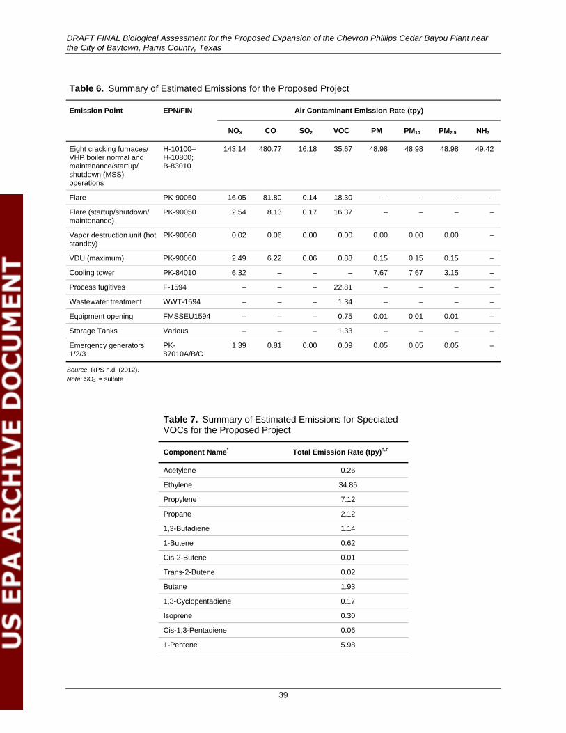
DRAFT FINAL Biological Assessment for the Proposed Expansion of the Chevron Phillips Cedar Bayou Plant near the City of Baytown, Harris County, Texas
39
Table 6. Summary of Estimated Emissions for the Proposed Project
Emission Point EPN/FIN Air Contaminant Emission Rate (tpy)
NOX CO SO2 VOC PM PM10 PM2.5 NH3
Eight cracking furnaces/ VHP boiler normal and maintenance/startup/ shutdown (MSS) operations
H-10100– H-10800; B-83010
143.14 480.77 16.18 35.67 48.98 48.98 48.98 49.42
Flare PK-90050 16.05 81.80 0.14 18.30 – – – –
Flare (startup/shutdown/ maintenance)
PK-90050 2.54 8.13 0.17 16.37 – – – –
Vapor destruction unit (hot standby)
PK-90060 0.02 0.06 0.00 0.00 0.00 0.00 0.00 –
VDU (maximum) PK-90060 2.49 6.22 0.06 0.88 0.15 0.15 0.15 –
Cooling tower PK-84010 6.32 – – – 7.67 7.67 3.15 –
Process fugitives F-1594 – – – 22.81 – – – –
Wastewater treatment WWT-1594 – – – 1.34 – – – –
Equipment opening FMSSEU1594 – – – 0.75 0.01 0.01 0.01 –
Storage Tanks Various – – – 1.33 – – – –
Emergency generators 1/2/3
PK-87010A/B/C
1.39 0.81 0.00 0.09 0.05 0.05 0.05 –
Source: RPS n.d. (2012). Note: SO2 = sulfate
Table 7. Summary of Estimated Emissions for Speciated VOCs for the Proposed Project
Component Name* Total Emission Rate (tpy)†,‡
Acetylene 0.26
Ethylene 34.85
Propylene 7.12
Propane 2.12
1,3-Butadiene 1.14
1-Butene 0.62
Cis-2-Butene 0.01
Trans-2-Butene 0.02
Butane 1.93
1,3-Cyclopentadiene 0.17
Isoprene 0.30
Cis-1,3-Pentadiene 0.06
1-Pentene 5.98
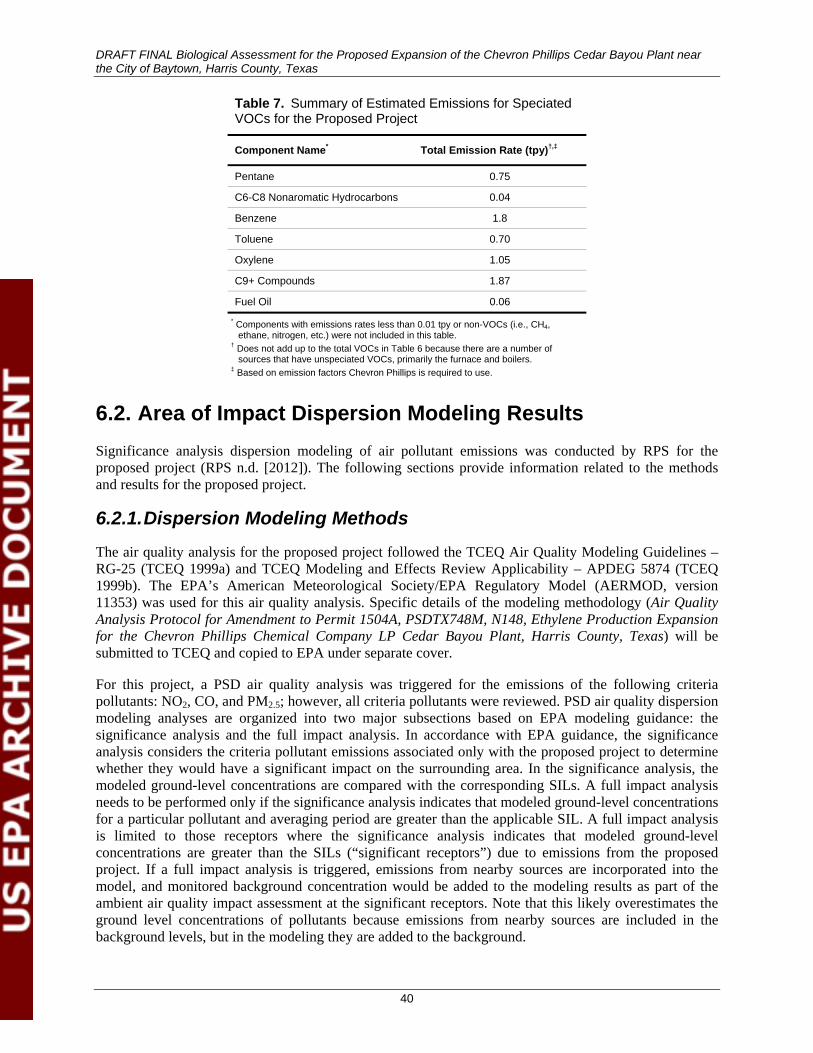
DRAFT FINAL Biological Assessment for the Proposed Expansion of the Chevron Phillips Cedar Bayou Plant near the City of Baytown, Harris County, Texas
40
Table 7. Summary of Estimated Emissions for Speciated VOCs for the Proposed Project
Component Name* Total Emission Rate (tpy)†,‡
Pentane 0.75
C6-C8 Nonaromatic Hydrocarbons 0.04
Benzene 1.8
Toluene 0.70
Oxylene 1.05
C9+ Compounds 1.87
Fuel Oil 0.06 * Components with emissions rates less than 0.01 tpy or non-VOCs (i.e., CH4,
ethane, nitrogen, etc.) were not included in this table. † Does not add up to the total VOCs in Table 6 because there are a number of
sources that have unspeciated VOCs, primarily the furnace and boilers. ‡ Based on emission factors Chevron Phillips is required to use.
6.2. Area of Impact Dispersion Modeling Results Significance analysis dispersion modeling of air pollutant emissions was conducted by RPS for the proposed project (RPS n.d. [2012]). The following sections provide information related to the methods and results for the proposed project.
6.2.1. Dispersion Modeling Methods
The air quality analysis for the proposed project followed the TCEQ Air Quality Modeling Guidelines –RG-25 (TCEQ 1999a) and TCEQ Modeling and Effects Review Applicability – APDEG 5874 (TCEQ 1999b). The EPA’s American Meteorological Society/EPA Regulatory Model (AERMOD, version 11353) was used for this air quality analysis. Specific details of the modeling methodology (Air Quality Analysis Protocol for Amendment to Permit 1504A, PSDTX748M, N148, Ethylene Production Expansion for the Chevron Phillips Chemical Company LP Cedar Bayou Plant, Harris County, Texas) will be submitted to TCEQ and copied to EPA under separate cover.
For this project, a PSD air quality analysis was triggered for the emissions of the following criteria pollutants: NO2, CO, and PM2.5; however, all criteria pollutants were reviewed. PSD air quality dispersion modeling analyses are organized into two major subsections based on EPA modeling guidance: the significance analysis and the full impact analysis. In accordance with EPA guidance, the significance analysis considers the criteria pollutant emissions associated only with the proposed project to determine whether they would have a significant impact on the surrounding area. In the significance analysis, the modeled ground-level concentrations are compared with the corresponding SILs. A full impact analysis needs to be performed only if the significance analysis indicates that modeled ground-level concentrations for a particular pollutant and averaging period are greater than the applicable SIL. A full impact analysis is limited to those receptors where the significance analysis indicates that modeled ground-level concentrations are greater than the SILs (“significant receptors”) due to emissions from the proposed project. If a full impact analysis is triggered, emissions from nearby sources are incorporated into the model, and monitored background concentration would be added to the modeling results as part of the ambient air quality impact assessment at the significant receptors. Note that this likely overestimates the ground level concentrations of pollutants because emissions from nearby sources are included in the background levels, but in the modeling they are added to the background.
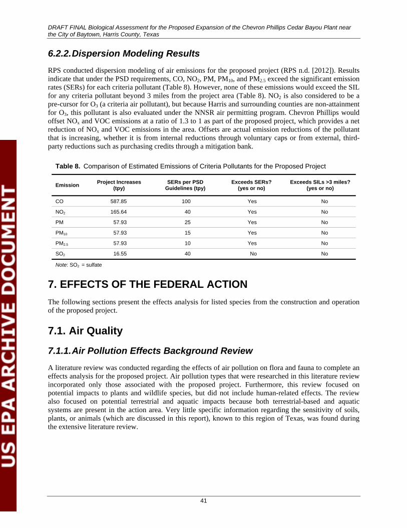
DRAFT FINAL Biological Assessment for the Proposed Expansion of the Chevron Phillips Cedar Bayou Plant near the City of Baytown, Harris County, Texas
41
6.2.2. Dispersion Modeling Results
RPS conducted dispersion modeling of air emissions for the proposed project (RPS n.d. [2012]). Results indicate that under the PSD requirements, CO, NO2, PM, PM10, and PM2.5 exceed the significant emission rates (SERs) for each criteria pollutant (Table 8). However, none of these emissions would exceed the SIL for any criteria pollutant beyond 3 miles from the project area (Table 8). NO2 is also considered to be a pre-cursor for O3 (a criteria air pollutant), but because Harris and surrounding counties are non-attainment for O3, this pollutant is also evaluated under the NNSR air permitting program. Chevron Phillips would offset NOx and VOC emissions at a ratio of 1.3 to 1 as part of the proposed project, which provides a net reduction of NOx and VOC emissions in the area. Offsets are actual emission reductions of the pollutant that is increasing, whether it is from internal reductions through voluntary caps or from external, third-party reductions such as purchasing credits through a mitigation bank.
Table 8. Comparison of Estimated Emissions of Criteria Pollutants for the Proposed Project
Emission Project Increases (tpy)
SERs per PSD Guidelines (tpy)
Exceeds SERs? (yes or no)
Exceeds SILs >3 miles? (yes or no)
CO 587.85 100 Yes No
NO2 165.64 40 Yes No
PM 57.93 25 Yes No
PM10 57.93 15 Yes No
PM2.5 57.93 10 Yes No
SO2 16.55 40 No No
Note: SO2 = sulfate
7. EFFECTS OF THE FEDERAL ACTION The following sections present the effects analysis for listed species from the construction and operation of the proposed project.
7.1. Air Quality
7.1.1. Air Pollution Effects Background Review
A literature review was conducted regarding the effects of air pollution on flora and fauna to complete an effects analysis for the proposed project. Air pollution types that were researched in this literature review incorporated only those associated with the proposed project. Furthermore, this review focused on potential impacts to plants and wildlife species, but did not include human-related effects. The review also focused on potential terrestrial and aquatic impacts because both terrestrial-based and aquatic systems are present in the action area. Very little specific information regarding the sensitivity of soils, plants, or animals (which are discussed in this report), known to this region of Texas, was found during the extensive literature review.
DRAFT FINAL Biological Assessment for the Proposed Expansion of the Chevron Phillips Cedar Bayou Plant near the City of Baytown, Harris County, Texas
42
Generalized conclusions regarding the effects of air pollution on biodiversity of ecosystems include the following: 1) lower life forms are usually more affected than higher life forms; 2) plants are normally more affected then terrestrial wildlife; and 3) typically, populations of species that are affected decline, but this is not always the case (Dudley and Stolton 1996). Effects to higher life forms, such as mammals and birds, are usually indirect effects to food chain changes or food availability reduction or effects to reproductive success (Dudley and Stolton 1996). Many species of animals have at least some level of tolerance to air pollution, and for those that are affected, the level of effect can vary from one individual to another (Dudley and Stolton 1996).
Impacts to flora and fauna from air pollutants can be categorized as acute or chronic. Where acute effects represent short-term (e.g., 3-hour averaging) exposures to relatively high levels, chronic effects represent longer term (e.g., months and years) exposures to lower levels of pollutants (Smith and Levenson 1980). Pathways in which air pollutants can have direct and indirect effects on plants and animals include 1) direct exposure to animals; 2) direct exposure to plants; 3) indirect exposure by animal ingestion of plants with toxin on their surfaces; and 4) indirect exposure through plant uptake of toxins that have been deposited on soil, and animal ingestion of plants that have undergone uptake of toxins (Smith and Levenson 1980). In addition, these effects to species of plants and wildlife from exposures to air pollutants can have varying degrees of effects to different species and also vary between individuals of one species (Smith and Levenson 1980).
Air pollution components, including photochemical oxidants (or smog) such as NOx and VOCs, which are precursors to O3, have been shown to affect animals, primarily as eye irritation and eye or respiratory injury (Peterson 1982). Research has revealed that low-level chronic exposures can be reversible and also that localized tolerance can occur (Peterson 1982). Plants, however, have more deleterious effects from oxidant stress. CO contributes to the formation of CO2 and O3, which is a part of the photochemical oxidant complex. O3 uptake through plant stomata of leaves is found to accelerate the aging process in plants, causing injury to foliage, flowers, and fruit (Peterson 1982). Conifers are particularly vulnerable to chronic oxidant stress because they preserve their photosynthetic tissue for longer periods of time than deciduous trees (Peterson 1982).
Air pollutants in acid form or that have acid-forming properties, such as sulfate (SO2) and NOx, can be deposited in wet (i.e., acid rain) or dry forms (EPA 2012a). As SO2 and NOx gases are emitted into the atmosphere, they react to form SO2, nitrous oxides (NOx), sulfuric acid (H2SO4) and nitric acid (HNO3), which are then deposited back to the Earth’s surface as pollutants (Lovett and Tear 2008). Effects of NOx include contribution to soil and water acidification and nutrient enrichment, which can lead to losses in biodiversity (EPA 2012a). Detrimental effects of sulfur oxide (SOx) pollutants consist of the following: soil and water acidification, direct injury to plants through direct exposure by the gaseous pollutant, contribution to particle formation with associated effects, contribution to mercury methylation in wetland areas, and cooling of the atmosphere (EPA 2012a; Smith and Levenson 1980).
Acidifying air pollutants can have significant effects on the reproduction and physiology of amphibians and aquatic organisms such as fish and macroinvertebrates, but effects to terrestrial wildlife are poorly understood. Short-term effects to animals typically involve mild respiratory irritation; however, long-term direct effects to terrestrial fauna have not been extensively studied. Acid precipitation causes fish kills, species population and biodiversity reduction, and food chain imbalances in aquatic systems (EPA 2008). Deposition of acid particles, wet and dry, can also have direct visible effects to plant surfaces from short-term, high-level exposure and also have adverse metabolic effects from long-term, low-level exposure (Peterson 1982). Effects to terrestrial plants include altered foliar growth or injury, accelerated erosion of protective cuticles and leaching of foliar nutrients, altered relations with symbiotic species and pathogens, and reduced seed germination in conifers (Peterson 1982).

DRAFT FINAL Biological Assessment for the Proposed Expansion of the Chevron Phillips Cedar Bayou Plant near the City of Baytown, Harris County, Texas
43
NH3 effects include the following: eutrophication (i.e., the process by which a waterbody becomes enriched with dissolved nutrients that promote the growth of aquatic plants, and as a result, a depletion of dissolved oxygen in surface water can occur); groundwater nitrogen contamination; and the formation of nitrate and sulfate particles that have adverse environmental effects (EPA 2012a). Nitrogen saturation of an ecosystem is the long-term removal of nitrogen limitations on biotic activity, along with a decrease in the ability of nitrogen retention (Fenn et al. 2003). This excess in nitrogen availability can in turn affect groundwater quality, eutrophication of waterbodies, toxic effects to freshwater flora and fauna, biodiversity changes, nutrient cycling disruptions, and increased soil emissions of nitrogen (Fenn et al. 2003).
Adverse effects of PM pollution include the following: impaired visibility in wildlife, alteration of ecosystem processes, soil structure modifications, and the alteration of timing and location of traditional precipitation patterns (EPA 2012a). Mineral dusts and soil-related dusts associated with road and railroad use are usually relatively inert, are not particularly acidic or alkaline, are commonly composed of course particles (i.e., larger than 2.5 microns in diameter), and usually only have effects close to the source; any potential effects are usually associated with high dust loads (Chaston and Doley 2006; Doley and Rossato 2010). The deposition of dust on plants has been shown to impact plants in the following ways: reduced light penetration on the leaf surface, increased leaf temperature, decreased photosynthesis, increased transpiration, and inhibition of growth (Chaston and Doley 2006; Doley and Rossato 2010; Sharifi et al. 1997). Adverse effects of PM pollution on aquatic systems include increased turbidity, which can inhibit the spawning of fish and disrupt aquatic ecosystem balance, and increased sedimentation leading to physical disruption of hydraulic characteristics of flowing waterbodies and increased flooding potential (Food and Agriculture Organization of the United Nations 1996).
7.1.2. Air Quality Effects
7.1.2.1. CRITERIA POLLUTANT EMISSIONS
As identified in Table 8 above, the proposed project would have emissions that are above the SERs. However, when modeled, these emissions would not exceed the SILs outside the action area; as such, impacts from emissions are limited to the action area. Impacts of increased CO, PM, PM10, PM2.5, and NH3 could have direct and indirect effects on wildlife species present in the action area. These effects could include increased nitrogen levels, which could have direct, short-term effects by damaging plant surfaces and also have long-term effects by changing the vegetation community composition, disrupting nutrient cycling, and increasing GHG soil emissions. NOx and VOCs are not expected to have a direct or indirect effect on wildlife species present in the action area because the project would offset the increase in these emissions at a ratio of 1.3 to 1. Offsets are actual emission reductions of the pollutant that is increasing, whether it is from internal reductions through voluntary caps or from external, third-party reductions such as purchasing credits through a mitigation bank.
7.1.2.2. FUGITIVE DUST
Construction of the proposed project would temporarily increase dust presence in the area, but dust is not likely to result during operation of the project because BMPs to control dust during construction and operation would be implemented. Thus, the short-term increase during the initial construction would likely be negligible in terms of impacts to wildlife species.
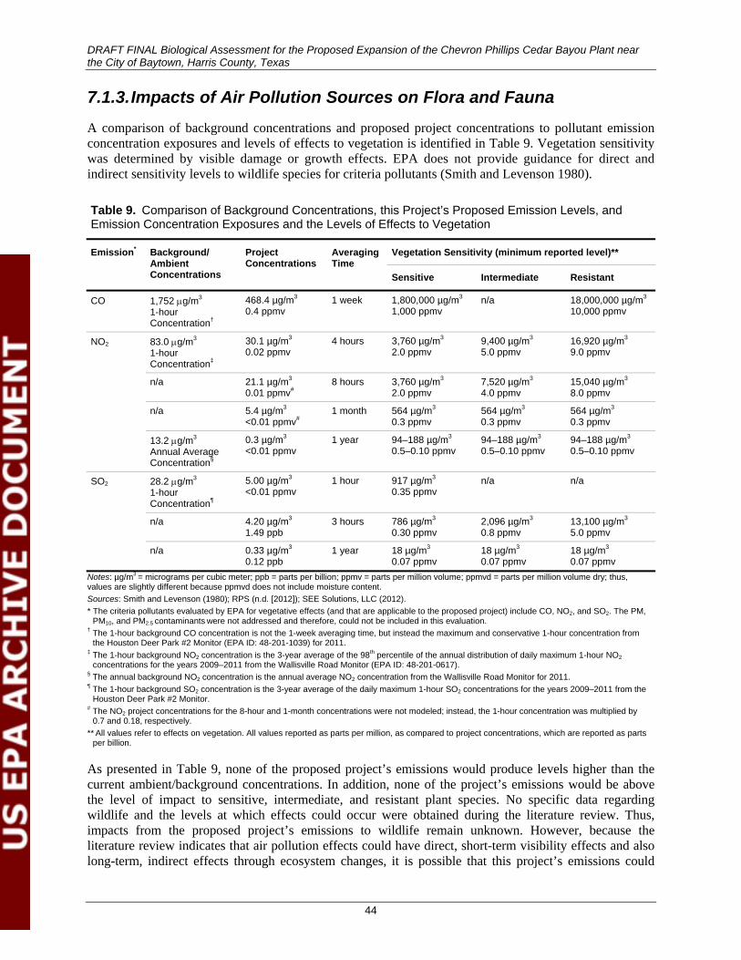
DRAFT FINAL Biological Assessment for the Proposed Expansion of the Chevron Phillips Cedar Bayou Plant near the City of Baytown, Harris County, Texas
44
7.1.3. Impacts of Air Pollution Sources on Flora and Fauna
A comparison of background concentrations and proposed project concentrations to pollutant emission concentration exposures and levels of effects to vegetation is identified in Table 9. Vegetation sensitivity was determined by visible damage or growth effects. EPA does not provide guidance for direct and indirect sensitivity levels to wildlife species for criteria pollutants (Smith and Levenson 1980).
Table 9. Comparison of Background Concentrations, this Project’s Proposed Emission Levels, and Emission Concentration Exposures and the Levels of Effects to Vegetation
Emission* Background/ Ambient Concentrations
Project Concentrations
Averaging Time
Vegetation Sensitivity (minimum reported level)**
Sensitive Intermediate Resistant
CO 1,752 μg/m3
1-hour Concentration†
468.4 µg/m3
0.4 ppmv 1 week 1,800,000 µg/m3
1,000 ppmv n/a 18,000,000 µg/m3
10,000 ppmv
NO2 83.0 μg/m3
1-hour Concentration‡
30.1 µg/m3
0.02 ppmv 4 hours 3,760 µg/m3
2.0 ppmv 9,400 µg/m3
5.0 ppmv 16,920 µg/m3
9.0 ppmv
n/a 21.1 µg/m3
0.01 ppmv# 8 hours 3,760 µg/m3
2.0 ppmv 7,520 µg/m3
4.0 ppmv 15,040 µg/m3
8.0 ppmv
n/a 5.4 µg/m3
<0.01 ppmv# 1 month 564 µg/m3
0.3 ppmv 564 µg/m3
0.3 ppmv 564 µg/m3
0.3 ppmv
13.2 μg/m3
Annual Average Concentration§
0.3 µg/m3
<0.01 ppmv 1 year 94–188 µg/m3
0.5–0.10 ppmv 94–188 µg/m3
0.5–0.10 ppmv 94–188 µg/m3
0.5–0.10 ppmv
SO2 28.2 μg/m3 1-hour Concentration¶
5.00 µg/m3
<0.01 ppmv 1 hour 917 µg/m3
0.35 ppmv n/a n/a
n/a 4.20 µg/m3
1.49 ppb 3 hours 786 µg/m3
0.30 ppmv 2,096 µg/m3
0.8 ppmv 13,100 µg/m3
5.0 ppmv
n/a 0.33 µg/m3
0.12 ppb 1 year 18 µg/m3
0.07 ppmv 18 µg/m3
0.07 ppmv 18 µg/m3
0.07 ppmv Notes: µg/m3 = micrograms per cubic meter; ppb = parts per billion; ppmv = parts per million volume; ppmvd = parts per million volume dry; thus, values are slightly different because ppmvd does not include moisture content. Sources: Smith and Levenson (1980); RPS (n.d. [2012]); SEE Solutions, LLC (2012). * The criteria pollutants evaluated by EPA for vegetative effects (and that are applicable to the proposed project) include CO, NO2, and SO2. The PM,
PM10, and PM2.5 contaminants were not addressed and therefore, could not be included in this evaluation. † The 1-hour background CO concentration is not the 1-week averaging time, but instead the maximum and conservative 1-hour concentration from
the Houston Deer Park #2 Monitor (EPA ID: 48-201-1039) for 2011. ‡ The 1-hour background NO2 concentration is the 3-year average of the 98th percentile of the annual distribution of daily maximum 1-hour NO2
concentrations for the years 2009–2011 from the Wallisville Road Monitor (EPA ID: 48-201-0617). § The annual background NO2 concentration is the annual average NO2 concentration from the Wallisville Road Monitor for 2011. ¶ The 1-hour background SO2 concentration is the 3-year average of the daily maximum 1-hour SO2 concentrations for the years 2009–2011 from the
Houston Deer Park #2 Monitor. # The NO2 project concentrations for the 8-hour and 1-month concentrations were not modeled; instead, the 1-hour concentration was multiplied by
0.7 and 0.18, respectively. ** All values refer to effects on vegetation. All values reported as parts per million, as compared to project concentrations, which are reported as parts
per billion.
As presented in Table 9, none of the proposed project’s emissions would produce levels higher than the current ambient/background concentrations. In addition, none of the project’s emissions would be above the level of impact to sensitive, intermediate, and resistant plant species. No specific data regarding wildlife and the levels at which effects could occur were obtained during the literature review. Thus, impacts from the proposed project’s emissions to wildlife remain unknown. However, because the literature review indicates that air pollution effects could have direct, short-term visibility effects and also long-term, indirect effects through ecosystem changes, it is possible that this project’s emissions could
DRAFT FINAL Biological Assessment for the Proposed Expansion of the Chevron Phillips Cedar Bayou Plant near the City of Baytown, Harris County, Texas
45
have short- and long-term effects to wildlife. Any potential effects from the proposed project are not likely to result in a significant impact to or decline in wildlife species or their populations because the contribution of air emissions contributions is minor for all pollutants except for NOx and VOCs, which will have a net reduction through offsetting at a ratio of 1.3 to 1. Because none of the 15 species addressed in this BA are expected to occur in the action area, the listed species and recently delisted species with monitoring requirements would not be affected by impacts from project-related air pollution sources.
7.2. Water Quality
7.2.1. Wastewater Effects The wastewater that is currently generated on-site is treated prior to being discharged into surface waters under TPDES Permit No. WQ0001006000. Chevron Phillips adheres to strict monitoring protocols through its wastewater permit, including regular monitoring reports and submittals of toxicity in mysid shrimp (Mysidopsis bahia) and inland silverside fish (Menidia beryllina) to ensure that effluent discharge meets the limits that are protective of the receiving water. Daily average flow for process wastewater is limited to 4.0 MMgal/d with a daily maximum limited to 6.0 MMgal/d. Currently, average daily discharge during dry weather from Outfall 001 ranges from 2.3 to 2.6 MMgal/d. An additional 1.1 MMgal/d of process wastewater is expected to be discharged from Outfall 001 into the receiving water from the operation of Unit 1594. This addition is not expected to exceed the existing permitted daily average and daily maximum limits; however, an increase in the permit limits would nevertheless be requested.
Impacts from the increase in discharge from Unit 1594 would likely include an increased distance of downstream surface water flow during typical and flood conditions. The TCEQ considers the mixing zone to extend 30 feet downstream of Outfall 001 in the existing wastewater permit for the daily average of 4 MMgal/d and daily maximum of 6 MMgal/d. This downstream extent is where the samples for toxicity testing must be taken and is the distance considered to encompass any potential instream effects. The additional 1.1 MMgal/d of process wastewater from the proposed Unit 1594 would extend this distance between 8 and 12 feet downstream. The increased flow volume contribution from Unit 1594 would be very small (1.8%) as compared to the existing Cedar Bayou flow volume (60 MMgal/day [USGS 2012])2, and is not anticipated to have a noticeable effect on wildlife species. Because none of the 15 species addressed in this BA are expected to occur in the action area, the listed species and recently delisted species with monitoring requirements would not be affected by impacts from project-related increases in wastewater volume and the potentially affected downstream distance. As identified in Table 2, the proposed increase in effluent discharge from Unit 1594 is not expected to have a higher concentration of pollutants than the current discharge and therefore, would not have an additional impact on the receiving water, nor the wildlife associated with it.
Cedar Bayou is considered environmentally sensitive and is listed as impaired for bacteria, chlorophyll a, and PCB/dioxin contamination in fish tissue. Bacteria, dioxin, and PCBs were noted to come from the following sources along the Cedar Bayou Tidal segment in 2009: wastewater treatment plant point source discharges, collection system failures, septic system failures in the upper portion of the watershed, urban runoff, and stormwater (Houston-Galveston Area Council 2009). The Cedar Bayou Plant burns natural gas and plant gas (CH4 and hydrogen), which does not have the dioxin formation potential in its combustion gas-like waste incinerators and coal-fired power plants (EPA 2012b). In addition, stormwater runoff from on-site surfaces would be collected on-site and treated in a stormwater equalization tank, with overflow discharging to clean stormwater sewers and ditches. Therefore, construction and operation of Unit 1594 are not expected to contribute to the causes of impairment in the Cedar Bayou Watershed.
2 Daily flow volume was calculated by determining the annual average of collected data from 2002 through 2011 after removal of the high and low volumes, which came out to 92.5 feet/second or 60 MMgal/d.
DRAFT FINAL Biological Assessment for the Proposed Expansion of the Chevron Phillips Cedar Bayou Plant near the City of Baytown, Harris County, Texas
46
7.2.2. Surface Water Effects
There are several surface water features in the action area. Two ponds in the project area are isolated, whereas an additional two ponds are hydrologically connected to the Cedar Bayou Watershed system. Several waterways are also associated with the proposed project. Chevron Phillips plans to avoid impacting these water features during construction and operation of the proposed project. Wildlife species have the potential to use these ponded environments in the project area as well as other such aquatic habitats including ponds, reservoirs, canals, natural drainages, and Cedar Bayou and its tributaries in the action area. However, because none of the 15 species addressed in this BA are expected to occur in the action area, none of the listed species and recently delisted species with monitoring requirements would use these water features in the action area.
There is potential for NO2 to directly alter the pH of surface waters in the action area. However, this potential is low due to the infrequency of the predicted exposure of a concentration greater than the SIL to surface waters and the low concentration of airborne pollutants over large volumes of surface waters. Therefore, emissions resulting from the proposed project would not likely directly affect surface water pH. Any possible impact would be considered an isolated, temporary event. Direct impacts to wildlife species by way of air pollution to surface waters are not expected to occur from the proposed project. Indirect, long-term effects from NO2 emissions such as acidification, eutrophication, or nitrogen saturation could occur; however, these effects are typically the result of direct acid deposition that would be an unlikely, rare event. Indirect impacts to wildlife species by way of air pollution to surface waters are not expected to occur from the proposed project. Because none of the 15 species addressed in this BA are expected to occur in the action area, the listed species and recently delisted species with monitoring requirements would not be affected by impacts from project-related increases in air pollution affecting surface waters.
7.3. Noise
7.3.1. Noise Effects Background Review
A literature review was conducted regarding the effects from an acoustical stimulus (i.e., noise) on terrestrial wildlife in order to complete an effects analysis for the proposed project. The nature of anthropogenic noise is multifaceted and even more complex in terms of how it affects wildlife species. The effects can range from habitat use changes, activity pattern changes, increased stress responses, decreased immune responses, decrease foraging efficiency and success, reduced reproductive success, increased predation risk, intraspecific diminished communication, and hearing damage (Noise Quest 2012; Pater et al. 2006; USFWS 2012c). These responses can vary, depending on the nature of the sound, including sound level, rate of onset, duration, number of events, spectral distribution of sound energy, and level of background noise (Pater et al. 2006). Noise is typically presented in terms of decibels (dB), and for most noise assessments, it is quantified in terms of dBA, which is an A-weighted sound-level scale that more closely describes how a person perceives sound. Thus, the sound level when defined as dBA does not always transfer to wildlife, because species groups (i.e., owls, bats, birds, and ungulates) have different hearing sensitivities and ranges (Pater et al. 2006). Other considerations for noise effects on wildlife include the ambient or background noise level and how that compares with the project’s noise level. Also, the sound from a noise expands outward with roughly a 6-dB decrease in each distance-doubling increment (Pater et al. 2006). Furthermore, the perceived sound level from a noise source can be affected by other factors besides distance from the source, such as source noise strength, direction of the source, atmospheric conditions, and topography (Pater et al. 2006).
DRAFT FINAL Biological Assessment for the Proposed Expansion of the Chevron Phillips Cedar Bayou Plant near the City of Baytown, Harris County, Texas
47
The following information provides some of the wildlife-specific data obtained in the literature research in order to better understand how noise levels have the potential to affect wildlife species:
• Bat species can hear well at high frequencies; thus, low frequency noises would not likely affect these species (Pater et al. 2006).
• Animals have been shown to habituate to noise sources once they learn that the noise does not pose a threat (Pater et al. 2006).
• Woodland and grassland bird population declines have been shown to occur between 35 and 48 dB (Kaseloo 2006; USFWS 2012c).
• For the average bird, noise levels 24–30 dB above background noise are detectable (USFWS 2012c).
• Bird communication can be affected at levels above 20 dB (USFWS 2012c).
7.3.2. Noise-Related Effects
As previously discussed, the project area, and likely most of the action area, has an existing noise level of 35–65 dBA. Standards for maximum construction and operational noise levels would be no greater than 85 dBA at a distance of 3 feet. However, these noise levels are at the source, and because noise attenuates, the noise levels in the action area would be much less. At a distance of 6,500 feet (1.23 miles) from the project area, the operational noise would attenuate to 0 dBA. Although most of the action area is supported by grasslands, cultivated lands, and woody lands (80%), high-intensity development including industrial plants, oil and gas wells fields, and urban areas are scattered throughout the action area. Much of the wildlife present in the action area is habituated to the typical noises associated with common industry practices in the area. No impacts to wildlife species from construction or operational noise are expected because the levels would be minimal and similar to existing conditions. Because none of the 15 species addressed in this BA are expected to occur in the action area, the listed species and recently delisted species with monitoring requirements would not be affected by impacts from project-related increases in noise.
7.4. Infrastructure-Related Effects To construct the proposed project, portions of the 448-acre project area would be cleared of the existing vegetation; consequently, removing the existing plants and potentially displacing wildlife. Because none of the 15 species addressed in this BA are expected to occur in the action area, the listed species and recently delisted species with monitoring requirements would not be affected by impacts from infrastructure-related clearing activities.
7.5. Human Activity Effects Construction of the proposed project would temporarily increase human-related presence in the area, and operation would increase human-related presence in the long term, both of which could disturb and affect wildlife species. However, the additional increase would not be much greater than what currently occurs in the area (e.g., residential traffic, commercial traffic, and industrial operations). Thus, the human-related activity effects from the construction and operation of the proposed project would likely be negligible. Because none of the 15 species addressed in this BA are expected to occur in the action area, the listed species and recently delisted species with monitoring requirements would not be affected by impacts from project-related increases in human activities.
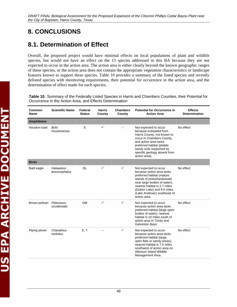
DRAFT FINAL Biological Assessment for the Proposed Expansion of the Chevron Phillips Cedar Bayou Plant near the City of Baytown, Harris County, Texas
48
8. CONCLUSIONS
8.1. Determination of Effect Overall, the proposed project would have minimal effects on local populations of plant and wildlife species, but would not have an effect on the 15 species addressed in this BA because they are not expected to occur in the action area. The action area is either clearly beyond the known geographic ranges of these species, or the action area does not contain the appropriate vegetation characteristics or landscape features known to support these species. Table 10 provides a summary of the listed species and recently delisted species with monitoring requirements, their potential for occurrence in the action area, and the determination of effect made for each species.
Table 10. Summary of the Federally Listed Species in Harris and Chambers Counties, their Potential for Occurrence in the Action Area, and Effects Determination
Common Name
Scientific Name Federal Status
Harris County
Chambers County
Potential for Occurrence in Action Area
Effects Determination
Amphibians
Houston toad Bufo houstonensis
E – Not expected to occur because extirpated from Harris County, not known to occur in Chambers County, and action area lacks preferred habitat (pliable sandy soils supported by specific geology absent from action area).
No effect
Birds
Bald eagle Haliaeetus leucocephalus
DL Not expected to occur because action area lacks preferred habitat (mature stands of pines/hardwoods near large bodies of water); nearest habitat is 2.7 miles (Dutton Lake) and 9.5 miles (Lake Anahuac) southeast of action area.
No effect
Brown pelican Pelecanus occidentalis
DM Not expected to occur because action area lacks preferred habitat (large open bodies of water); nearest habitat is 10 miles south of action area in Trinity and Galveston Bays.
No effect
Piping plover Charadrius melodus
E, T – Not expected to occur because action area lacks preferred habitat (large, open flats or sandy areas); nearest habitat is 7.5 miles southwest of action area on Atkinson Island Wildlife Management Area.
No effect
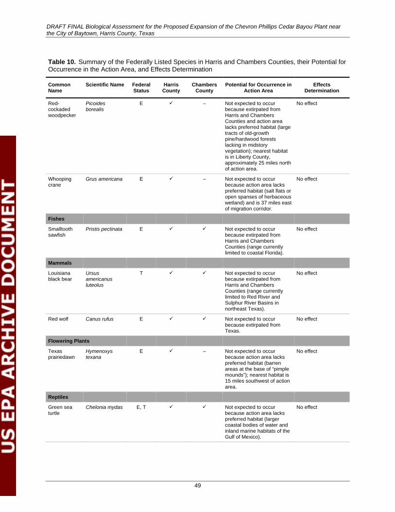
DRAFT FINAL Biological Assessment for the Proposed Expansion of the Chevron Phillips Cedar Bayou Plant near the City of Baytown, Harris County, Texas
49
Table 10. Summary of the Federally Listed Species in Harris and Chambers Counties, their Potential for Occurrence in the Action Area, and Effects Determination
Common Name
Scientific Name Federal Status
Harris County
Chambers County
Potential for Occurrence in Action Area
Effects Determination
Red-cockaded woodpecker
Picoides borealis
E – Not expected to occur because extirpated from Harris and Chambers Counties and action area lacks preferred habitat (large tracts of old-growth pine/hardwood forests lacking in midstory vegetation); nearest habitat is in Liberty County, approximately 25 miles north of action area.
No effect
Whooping crane
Grus americana E – Not expected to occur because action area lacks preferred habitat (salt flats or open spanses of herbaceous wetland) and is 37 miles east of migration corridor.
No effect
Fishes
Smalltooth sawfish
Pristis pectinata E Not expected to occur because extirpated from Harris and Chambers Counties (range currently limited to coastal Florida).
No effect
Mammals
Louisiana black bear
Ursus americanus luteolus
T Not expected to occur because extirpated from Harris and Chambers Counties (range currently limited to Red River and Sulphur River Basins in northeast Texas).
No effect
Red wolf Canus rufus E Not expected to occur because extirpated from Texas.
No effect
Flowering Plants
Texas prairiedawn
Hymenoxys texana
E – Not expected to occur because action area lacks preferred habitat (barren areas at the base of “pimple mounds”); nearest habitat is 15 miles southwest of action area.
No effect
Reptiles
Green sea turtle
Chelonia mydas E, T Not expected to occur because action area lacks preferred habitat (larger coastal bodies of water and inland marine habitats of the Gulf of Mexico).
No effect
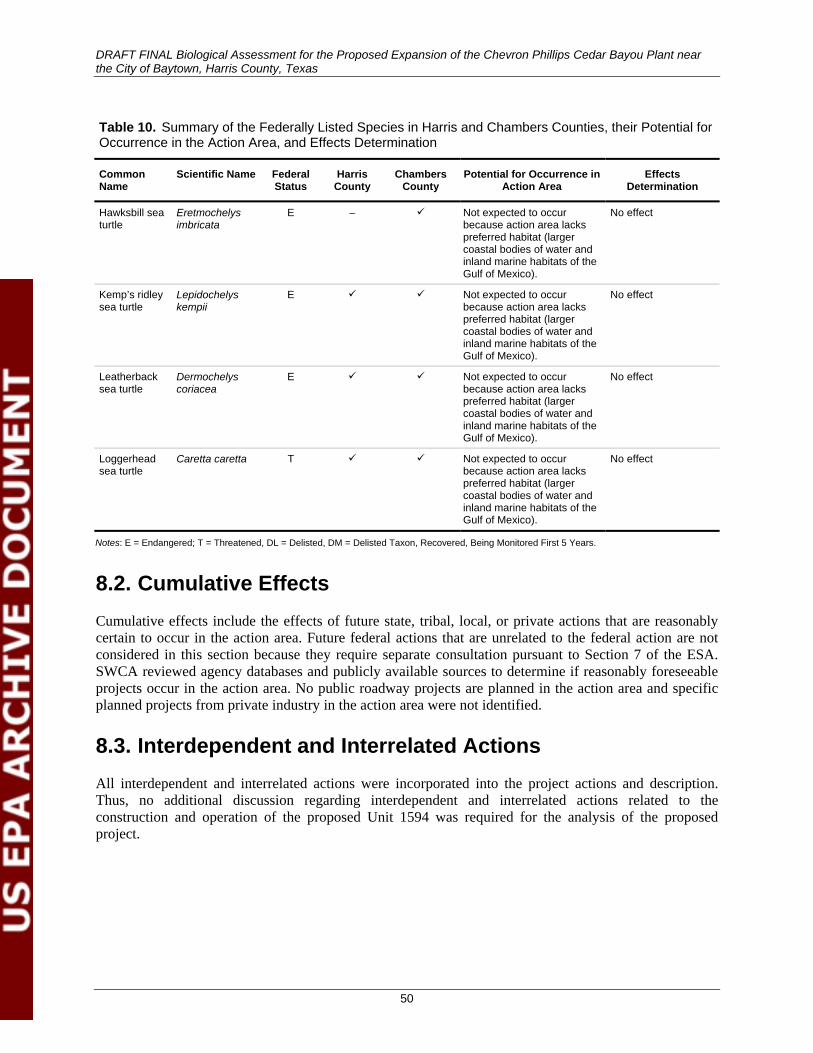
DRAFT FINAL Biological Assessment for the Proposed Expansion of the Chevron Phillips Cedar Bayou Plant near the City of Baytown, Harris County, Texas
50
Table 10. Summary of the Federally Listed Species in Harris and Chambers Counties, their Potential for Occurrence in the Action Area, and Effects Determination
Common Name
Scientific Name Federal Status
Harris County
Chambers County
Potential for Occurrence in Action Area
Effects Determination
Hawksbill sea turtle
Eretmochelys imbricata
E – Not expected to occur because action area lacks preferred habitat (larger coastal bodies of water and inland marine habitats of the Gulf of Mexico).
No effect
Kemp’s ridley sea turtle
Lepidochelys kempii
E Not expected to occur because action area lacks preferred habitat (larger coastal bodies of water and inland marine habitats of the Gulf of Mexico).
No effect
Leatherback sea turtle
Dermochelys coriacea
E Not expected to occur because action area lacks preferred habitat (larger coastal bodies of water and inland marine habitats of the Gulf of Mexico).
No effect
Loggerhead sea turtle
Caretta caretta T Not expected to occur because action area lacks preferred habitat (larger coastal bodies of water and inland marine habitats of the Gulf of Mexico).
No effect
Notes: E = Endangered; T = Threatened, DL = Delisted, DM = Delisted Taxon, Recovered, Being Monitored First 5 Years.
8.2. Cumulative Effects Cumulative effects include the effects of future state, tribal, local, or private actions that are reasonably certain to occur in the action area. Future federal actions that are unrelated to the federal action are not considered in this section because they require separate consultation pursuant to Section 7 of the ESA. SWCA reviewed agency databases and publicly available sources to determine if reasonably foreseeable projects occur in the action area. No public roadway projects are planned in the action area and specific planned projects from private industry in the action area were not identified.
8.3. Interdependent and Interrelated Actions All interdependent and interrelated actions were incorporated into the project actions and description. Thus, no additional discussion regarding interdependent and interrelated actions related to the construction and operation of the proposed Unit 1594 was required for the analysis of the proposed project.
DRAFT FINAL Biological Assessment for the Proposed Expansion of the Chevron Phillips Cedar Bayou Plant near the City of Baytown, Harris County, Texas
51
9. LITERATURE CITED Audubon Society. 2012. Black Rail (Laterallus jamaicensis). Available at:
http://birds.audubon.org/species/blarai. Accessed May 25, 2012.
Bjorndal, K.A., and A.B. Bolten. 2010. Hawksbill sea turtles in seagrass pastures: success in a peripheral habitat. Marine Biology 157:135–145.
Brown, D.E., P.J. Unmack, and T.C. Brennan. 2007. Digitized map of biotic communities for plotting and comparing distributions of North American animals. Southwestern Naturalist 52(4):610–617. Available at: http://www.old.wildsonora.com/ws/sites/default/files/Brown-Unmack-Brennan07.pdf. Accessed May 27, 2012.
Bureau of Economic Geology. 1982. Geologic atlas of Texas: Houston sheet. Scale 1:250,000. Austin, Texas: University of Texas at Austin.
Caillouet, C.W., Jr., C.T. Fontaine, S.A. Manzella-Tirpak, and D.J. Shaver. 1991. Sea turtle head starting and ecology research. Proceedings of the : Galveston Bay Characterization Workshop, February 21–23, 1991. Austin, Texas: Galveston Bay National Estuary Program. Available at: http://gbic.tamug.edu/gbeppubs/6/gdnep6_153-159.pdf. Accessed May 26, 2012.
Campbell, L. 1995. Endangered and Threatened Animals of Texas, Their Life History and Management. Austin, Texas: Texas Parks and Wildlife Department, Resource Protection Division, Endangered Resources Branch.
Chaston, K., and D. Doley. 2006. Mineral particulates and vegetation: effects of coal dust, overburden and flyash on light interception and leaf temperature. Clean Air and Environmental Quality 40(1):40–44.
Convention on International Trade in Endangered Species (CITES). 2012. Appendices I, II, and III. Available at: http://www.cites.org/eng/app/appendices.php. Accessed June 13, 2012.
Doley, D., and L. Rossato. 2010. Mineral particulates and vegetation: modeled effects of dust on photosynthesis in plant canopies. Air Quality and Climate Change 44(2):22–27.
Dudley, N., and S. Stolton. 1996. Air Pollution and Biodiversity: A Review. World Wildlife Fund International, Switzerland. Available at: http://www.equilibriumresearch.com/upload/document/airpollutionandbiodi4f9.pdf. Accessed May 28, 2012.
Federal Emergency Management Agency (FEMA). 2012. FIRM map. Available at: https://msc.fema.gov/webapp/wcs/stores/servlet/FemaWelcomeView?storeId=10001&catalogId=10001&langId=-1&userType=G. Accessed March 19, 2012.
Fenn, M.E., J.S. Baron, E.B. Allen, H.M. Rueth, K.R. Nydick, L. Geiser, W.D. Bowman, J.O. Sickman, T. Meixner, D.W. Johnson, and P. Neitlich. 2003. Ecological effects of nitrogen deposition in the western United States. Bioscience 53(4):404–420. Available at: http://www.fs.fed.us/psw/publications/fenn/psw_2003_fenn012.pdf. Accessed November 5, 2012.
DRAFT FINAL Biological Assessment for the Proposed Expansion of the Chevron Phillips Cedar Bayou Plant near the City of Baytown, Harris County, Texas
52
Ferland, C.L., and S.M. Haig. 2002. 2001 international piping plover census. Corvallis, Oregon: U.S. Geological Survey, Forest and Rangeland Ecosystem Science Center.
Flemming, S.P., R.D. Chiasson, and P.J. Austin-Smith. 1992. Piping plover nest site selection in New Brunswick and Nova Scotia. Journal of Wildlife Management 56(3):578–583.
Food and Agriculture Organization of the United Nations. 1996. Pollution by sediments. Chapter 2 in: Control of Water Pollution from Agriculture. FAO Irrigation and Drainage Papers. Available at: http://www.fao.org/docrep/W2598E/w2598e05.htm#sediment%20as%20a%20physical%20pollutant. Accessed June 1, 2012.
Gleason, C. 2012a. Current and proposed noise levels at the Cedar Bayou Facility. Personal communication by email with K. Greuter, SWCA Environmental Consultants. April 3, 2012.
______. 2012b. Wastewater collection and treatment system description. Personal communication by email with K. Greuter, SWCA Environmental Consultants. May 29, 2012.
Griffith, G.E., S.A. Bryce, J.M. Omernik, J.A. Comstock, A.C. Rogers, B. Harrison, S.L. Hatch, and D. Bezanson. 2004. Ecoregions of Texas (color poster with map, descriptive text, and photographs). Scale 1:2,500,000. Reston, Virginia: U.S. Geological Survey.
Haig, S.M., C.L. Ferland, F.J. Cuthbert, J. Dingledine, J.P. Goossen, A. Hecht, and N. McPhillips. 2005. A complete species census and evidence for regional declines in piping plovers. Journal of Wildlife Management 69(1):160–173.
Hall, L.S., P.R. Krausman, and M.L. Morrison. 1997. The habitat concept and a plea for standard terminology. Wilson Society Bulletin 25:173–182.
Handbook of Texas Online. 2012. Harris County. Available at: http://www.tshaonline.org/handbook/online/articles/hch07. Accessed May 28, 2012.
Harris County Flood Control District (HCFCD). 2012. Cedar Bayou watershed. Available at: http://www.hcfcd.org/L_cedarbayou.html. Accessed May 28, 2012.
Houston-Galveston Area Council (H-GAC). 2009. 2009 BHR sources and causes of pollution 05-05-09. Available at: http://www.h-gac.com/community/water/rivers/documents/summary_of_water_quality_impairments_and_concerns.pdf. Accessed May 28, 2012.
IUCN/SSC Conservation Breeding Specialist Group. 1994. Houston Toad Population & Habitat Viability Assessment Report. Apple Valley, Minnesota: IUCN/SSC Conservation Breeding Specialist Group. Available at: http://www.cbsg.org/cbsg/workshopreports/23/houston_toad_phva_(1994).pdf. Accessed October 30, 2012.
Kaseloo, P.A. 2006. Synthesis of noise effects on wildlife populations. In Proceedings of the 2005 International Conference on Ecology and Transportation, edited by C.L. Irwin, P. Garrett, and K.P. McDermott, pp. 33–35. Raleigh, North Carolina: Center for Transportation and the Environment, North Carolina State University.
Lockwood, M.W., and B. Freeman. 2004. The Texas Ornithological Society Handbook of Texas Birds. College Station, Texas: Texas A&M University Press.
DRAFT FINAL Biological Assessment for the Proposed Expansion of the Chevron Phillips Cedar Bayou Plant near the City of Baytown, Harris County, Texas
53
The Longleaf Alliance. 2002. The life of a longleaf. Available at: http://www.auburn.edu/academic/forestry_wildlife/longleafalliance/ecosystem/longleaftree/longleaftree5.htm. Accessed October 30, 2012.
Lovett, G.M., and T.H. Tear. 2008. Threats from Above: Air Pollution Effects on Ecosystems and Biological Diversity in the Eastern United States. The Nature Conservancy and the Cary Institute of Ecosystem Studies. Available at: http://www.caryinstitute.org/sites/default/files/public/reprints/Effects_of_atmospheric_deposition_on_biodiversity.pdf. Accessed May 28, 2012.
Lutz, P.L., J.A. Musick, and J. Wyneken (eds.). 2003. The Biology of Sea Turtles, Vol. I. Boca Raton, Florida: CRC Press.
McFarlane, R. 2012. Woodpeckers. Houston, Texas: Houston Audubon Society. Available at: http://www.houstonaudubon.org/screenprint.aspx?newsletterid=1048&AspxAutoDetectCookieSupport=1. Accessed May 25, 2012.
McMahan, C.A., R.G. Frye, and K.L. Brown. 1984. The Vegetation Types of Texas, Including Cropland. PWD Bulletin 7000-120. Austin, Texas: Texas Parks and Wildlife Department.
Manzella, S. A. and J. A. Williams. 1992. The Distribution of Kemp’s Ridley Sea Turtles (Lepidochelys kempi) along the Texas Coast: An Atlas. U.S. Department of Commerce NOAA Technical Report NMFS 110. Available at: http://www.caryinstitute.org/sites/default/files/public/reprints/Effects_of_atmospheric_deposition_on_biodiversity.pdf. Accessed May 26, 2012.
National Marine Fisheries Service (NMFS). 2011. Smalltooth sawfish (Pristis pectinata). Available at: http://www.nmfs.noaa.gov/pr/species/fish/smalltoothsawfish.htm. Accessed May 25, 2012.
National Marine Fisheries Service and U.S. Fish and Wildlife Service (NMFS and USFWS). 1992. Recovery Plan for Leatherback Turtles in the U.S., Caribbean, Atlantic and Gulf of Mexico. Washington, D.C.: National Marine Fisheries Service.
______. 1998a. Recovery Plan for U.S. Pacific Populations of the Loggerhead Turtle (Caretta caretta). Silver Spring, Maryland: National Marine Fisheries Service.
______. 1998b. Recovery Plan for U.S. Pacific Populations of the Leatherback Turtle (Dermochelys coriacea). Silver Spring, Maryland: National Marine Fisheries Service.
______. 2007a. Green Sea Turtle (Chelonia mydas) 5-Year Review: Summary and Evaluation. Silver Spring, Maryland: National Marine Fisheries Service Office of Protected Resources; Jacksonville, Florida: U.S. Fish and Wildlife Service Jacksonville Ecological Services Office.
______. 2007b. Hawksbill Sea Turtle (Eretmochelys imbricata) 5-Year Review: Summary and Evaluation. Silver Spring, Maryland: National Marine Fisheries Service Office of Protected Resources; Jacksonville, Florida: U.S. Fish and Wildlife Service Jacksonville Ecological Services Office.
______. 2007c. Kemp’s Ridley Sea Turtle (Lepidochelys kempii) 5-Year Review: Summary and Evaluation. Silver Spring, Maryland: National Marine Fisheries Service Office of Protected Resources; Jacksonville, Florida: U.S. Fish and Wildlife Service Jacksonville Ecological Services Office.
DRAFT FINAL Biological Assessment for the Proposed Expansion of the Chevron Phillips Cedar Bayou Plant near the City of Baytown, Harris County, Texas
54
______. 2007d. Loggerhead Sea Turtle (Caretta caretta) 5-Year Review: Summary and Evaluation. Silver Spring, Maryland: National Marine Fisheries Service Office of Protected Resources; Jacksonville, Florida: U.S. Fish and Wildlife Service Jacksonville Ecological Services Office.
______. 2007e. Leatherback Sea Turtle (Dermochelys coriacea) 5-Year Review: Summary and Evaluation. Silver Spring, Maryland: National Marine Fisheries Service Office of Protected Resources; Jacksonville, Florida: U.S. Fish and Wildlife Service Jacksonville Ecological Services Office.
National Oceanic and Atmospheric Administration (NOAA). 2012a. Green sea turtle (Chelonia mydas) fact sheet. Available at: http://www.nmfs.noaa.gov/pr/species/turtles/green.htm. Accessed May 25, 2012.
______. 2012b. Hawksbill sea turtle (Eretmochelys imbricata) fact sheet. Available at: http://www.nmfs.noaa.gov/pr/species/turtles/hawksbill.htm. Accessed May 25, 2012.
______. 2012c. Loggerhead sea turtle (Caretta caretta) fact sheet. Available at: http://www.nmfs.noaa.gov/pr/species/turtles/loggerhead.html. Accessed May 25, 2012.
National Park Service. 2012a. The Kemp’s ridley sea turtle. Available at: http://www.nps.gov/pais/naturescience/kridley.htm. Accessed May 26, 2012.
______. 2012b. Padre Island National Seashore reptiles. Available at: http://www.nps.gov/pais/naturescience/reptiles.htm. Accessed May 26, 2012.
Natural Resources Conservation Service (NRCS). 2012a. Soil data mart map unit descriptions for Chambers County, Texas. Available at: http://soildatamart.nrcs.usda.gov/Report.aspx?Survey=TX071&UseState=TX. Accessed May 25, 2012.
_____. 2012b. Soil data mart map unit descriptions for Harris County, Texas. Available at: http://soildatamart.nrcs.usda.gov/Report.aspx?Survey=TX201&UseState=TX. Accessed May 25, 2012.
_____.2012c. TAPS report for Baytown, TX586 station. Available at: http://www.wcc.nrcs.usda.gov/ftpref/support/climate/taps/tx/48201.txt. Accessed May 24, 2012.
Nicholls, J.L., and G.A. Baldassarre. 1990. Habitat associations of piping plovers wintering in the United States. Wilson Bulletin 102(4):581–590.
NoiseQuest. 2012. What does noise affect? Available at: http://www.noisequest.psu.edu/pmwiki.php?n=NoiseAffect.Wildlife. Accessed April 28, 2012.
Pater, L.L, T.G. Grubb, and D.K. Delaney. 2006. Recommendations for improved assessment of noise impacts on wildlife. Journal of Wildlife Management 73(5):788–795.
DRAFT FINAL Biological Assessment for the Proposed Expansion of the Chevron Phillips Cedar Bayou Plant near the City of Baytown, Harris County, Texas
55
Peterson, M.A. 1982. The effects of air pollution and acid rain on fish, wildlife, and their habitats—urban ecosystems. U.S. Fish and Wildlife Service, Biological Services Program, Eastern Energy and Land Use Team, FWS/OBS-80/40.10. Available at: http://nepis.epa.gov/Exe/ZyNET.exe/9100UMGS.PDF?ZyActionP=PDF&Client=EPA&Index=1981%20Thru%201985&File=D%3A\ZYFILES\INDEX%20DATA\81THRU85\TXT\00000019\9100UMGS.txt&Query=&SearchMethod=1&FuzzyDegree=0&User=ANONYMOUS&Password=anonymous&QField=&UseQField=&IntQFieldOp=0&ExtQFieldOp=0&Docs=. Accessed May 28, 2012.
RPS. n.d. [2012]. Air Dispersion Modeling Analysis Report for the Chevron Phillips Ethylene Production Expansion. Austin, Texas: RPS.
_____. 2012. Application to Amend Air Permit No. 1504A, Ethylene Production Expansion, Chevron Phillips Chemical Company LP, Cedar Bayou Plant, Harris County, Texas, RN103919817/CN600303614. Submitted to the Texas Commission on Environmental Quality December 2011. Austin, Texas: RPS.
Sage, T., and A. Gallaway. 2002. The Bay’s Living Resources. Chapter 8 in: The State of the Bay: A Characterization of the Galveston Bay Ecosystem. 2nd ed. Webster, Texas: Galveston Bay Estuary Program. Available at: www.gbic.tamug.edu/sobdoc/sob2/cha.8-9.pdf. Accessed May 26, 2012.
San Jacinto River Authority. 2012. Highlands Division homepage. Available at: http://www.sanjacintoriverauthority.com/about/highlands.html. Accessed May 24, 2012.
Sauer, J.R., J.E. Hines, J.E. Fallon, K.L. Pardieck, D.J. Ziolkowski, Jr., and W.A. Link. 2011. The North American Breeding Bird Survey, Results and Analysis 1966 - 2010. Version 12.07.2011. Laurel, Maryland: U.S. Geological Survey Patuxent Wildlife Research Center. Available at: http://www.mbr-pwrc.usgs.gov/bbs/. Accessed November 5, 2012.
Schmidly, D.J. 2012. The Mammals of Texas. Austin: University of Texas Press. Available at: http://www.nsrl.ttu.edu/tmot1/. Accessed April 15, 2012.
SEE Solutions, LLC. 2012. Greenhouse Gas PSD Permit Application for Chevron Phillips Chemical Company LP, Cedar Bayou Plant, New Ethylene Unit 1594. December 2011. Pearland, Texas: SEE Solutions, LLC.
Shackelford, C., and J. Reid. 2001. The Endangered Red-cockaded Woodpecker and Modern Forestry in Texas: Living in Harmony. 2nd ed. PWD BK W7000-361 (11/01). Texas Partners in Flight, Texas Parks and Wildlife, U.S. Fish and Wildlife Service, U.S. Forest Service, and the Texas Forest Service. Available at: http://www.tpwd.state.tx.us/publications/pwdpubs/media/pwd_bk_w7000_0361.pdf. Accessed October 30, 2012.
Sharifi, M.R., A.C. Gibson, and P.W. Rundel. 1997. Surface dust impacts on gas exchange in Mojave Desert shrubs. Journal of Applied Ecology 34(4):837–846.
Smith, A.E., and J.B. Levenson. 1980. A screening procedure for the impacts of air pollution sources on plants, soils, and animals. Report No. EPA 450/2-81-078. Prepared for U.S. Environmental Protection Agency Office of Air Quality Planning and Standards, Triangle Research Park, North Carolina. Argonne, Illinois: Argonne National Laboratory.
DRAFT FINAL Biological Assessment for the Proposed Expansion of the Chevron Phillips Cedar Bayou Plant near the City of Baytown, Harris County, Texas
56
Texas Commission on Environmental Quality (TCEQ). 1999a. Air dispersion modeling guidelines, RG-25 (revised), February 1999. Available at: http://www.tceq.texas.gov/permitting/air/guidance/newsourcereview/nsr_mod_guidance.html. Accessed May 28, 2012.
______. 1999b. Air Permit Reviewer Reference Guide, APDG 5874, Modeling and Effects Review Applicability: How to Determine the Scope of Modeling and Effects Review for Air Permits. Available at: http://www.tceq.state.tx.us/assets/public/permitting/air/Guidance/NewSourceReview/mera.pdf. Accessed May 28, 2012.
———. 2010. 2010 Texas Water Quality Inventory: Assessment Results for Basin 9 – Trinity-San Jacinto Coastal Basin. Available at: http://www.tceq.texas.gov/assets/public/compliance/monops/water/10twqi/2010_basin9.pdf. Accessed May 27, 2012.
Texas Parks and Wildlife Department (TPWD). 2012a. Annotated county list of rare species for Chambers County. Available at: http://gis2.tpwd.state.tx.us/ReportServer$GIS_EPASDE_SQL/Pages/ReportViewer.aspx?%2fReport+Project2%2fReport5&rs%3aCommand=Render&county=Chambers. Accessed May 26, 2012.
———. 2012b. Annotated county list of rare species for Harris County. Available at: http://gis2.tpwd.state.tx.us/ReportServer$GIS_EPASDE_SQL/Pages/ReportViewer.aspx?%2fReport+Project2%2fReport5&rs%3aCommand=Render&county=Harris. Accessed May 26, 2012.
______. 2012c. Leatherback sea turtle (Dermochelys coriacea) fact sheet. Available at: http://www.tpwd.state.tx.us/huntwild/wild/species/lethback/. Accessed May 26, 2012.
______. 2012d. Loggerhead sea turtle (Caretta caretta) fact sheet. Available at: http://www.tpwd.state.tx.us/huntwild/wild/species/logghead/. Accessed May 26, 2012.
______. 2012e. Louisiana Black Bear – Ursus americanus luteolus. Leaflet. Austin, Texas: Texas Parks and Wildlife Department. Available at: http://www.tpwd.state.tx.us/publications/pwdpubs/media/pwd_bk_w7000_0013_louisiana_black_bear.pdf. Accessed May 25, 2012.
______. 2012f. Red-cockaded woodpecker: historic range of red-cockaded woodpeckers in Texas. Available at: http://www.tpwd.state.tx.us/huntwild/wild/birding/red_cockaded_woodpecker/range_rcw/. Accessed May 25, 2012.
_____. 2012g. Texas Parks and Wildlife Department depredation permit. Available at: _https://apps.tpwd.state.tx.us/privatelands/permitDepredationHelp.seam;jsessionid=A52E8908DDA9933C36B2200E93BA87F9?cid=2210. Accessed April 11, 2012.
______. 2012h. Whooping crane (Grus americana). Available at: http://www.tpwd.state.tx.us/huntwild/wild/species/whooper/. Accessed September 17, 2012.
U.S. Environmental Protection Agency (EPA). 1974. Information on levels of environmental noise requisite to protect public health and welfare with an adequate margin of safety. Available at: http://www.nonoise.org/library/levels/levels.htm#levelsof. Accessed January 18, 2012.
DRAFT FINAL Biological Assessment for the Proposed Expansion of the Chevron Phillips Cedar Bayou Plant near the City of Baytown, Harris County, Texas
57
______. 2008. Effects of acid rain on surface waters and aquatic animals. Available at: http://www.epa.gov/acidrain/effects/surface_water.html#a2. Accessed May 28, 2012.
______. 2012a. Air pollution, our nation’s air. Available at: http://www.epa.gov/airtrends/2010/report/airpollution.pdf. Accessed April 15, 2012.
______. 2012b. Dioxins and furans. Available at: http://www.epa.gov/pbt/pubs/dioxins.htm. Accessed July 30, 2012.
______. 2012c. U.S. Environmental Protection Agency Endangered Species Protection Program. Available at: http://www.epa.gov/espp/. Accessed July 12, 2012.
U.S. Fish and Wildlife Service (USFWS). 1967. Endangered species list – 1967. Federal Register 32(48):4001.
______. 1970a. Part 17 - Conservation of endangered species and other fish or wildlife (first list of endangered foreign fish and wildlife as Appendix A). Federal Register 3(106):8491–8498.
______. 1970b. List of endangered foreign fish and wildlife. Federal Register 35(233):18319–18322.
______. 1970c. United States list of endangered native fish and wildlife. Federal Register 35(199):16047–16048.
______. 1978. Listing and protecting loggerhead sea turtles as "threatened species" and populations of green and olive ridley sea turtles as threatened species or “endangered species.” Federal Register 43(146):32800–32811.
______. 1979. Determination of critical habitat for the leatherback sea turtle. Federal Register 44(58):17710–17712.
______. 1982. Endangered and threatened wildlife and plants; determination of critical habitat for hawksbill sea turtle in Puerto Rico. Federal Register 47(122):27295–27298.
______. 1985a. Determination of endangered and threatened status for piping plover. Federal Register 50:50726–50734.
______. 1985b. Proposal to determine Hymenoxys texana to be an endangered species. Federal Register 50(44): 9095–9097.
______. 1989. Hymenoxys texana Recovery Plan. Albuquerque: U.S. Fish and Wildlife Service. Available at: http://ecos.fws.gov/docs/recovery_plan/900413a.pdf. Accessed November 5, 2012.
______. 1998. Designated critical habitat; green and hawksbill sea turtles. Federal Register 63(170):46693–46701.
______. 2001. Final determination of critical habitat for wintering piping plovers. Federal Register 66(132):36037–36086.
______. 2003. Recovery Plan for the Great Lakes Piping Plover (Charadrius melodus). Fort Snelling, Minnesota.
______. 2007a. Authorizations under the Bald and Golden Eagle Protection Act for take of eagles. Federal Register 72(107):31141–31155.
DRAFT FINAL Biological Assessment for the Proposed Expansion of the Chevron Phillips Cedar Bayou Plant near the City of Baytown, Harris County, Texas
58
______. 2007b. Removing the bald eagle in the lower 48 states from the list of endangered and threatened wildlife. Federal Register 72(130):37346–37372.
______. 2009a. Draft post-delisting monitoring plan for the brown pelican (Pelecanus occidentalis). Federal Register 74(188):50236–50237.
______. 2009b. Revised designation of critical habitat for the wintering population of the piping plover (Charadrius melodus) in Texas. Federal Register 74(95):23475–23600.
______. 2010. Post-delisting monitoring plan for bald eagle (Haliaeetus leucocephalus). Federal Register 75(107):31811–31812.
______. 2011. Houston Toad (Bufo houstonensis) 5-Year Review: Summary and Evaluation. Austin, Texas: Ecological Services Field Office. Available at: http://www.fws.gov/southwest/es/Documents/R2ES/HoustonToad_5-yr_Review_Nov2011.pdf. Accessed May 24, 2012.
______. 2012a. List of threatened, endangered, or candidate species for Chambers County, Texas. Ecological Services Office. Last updated May 14, 2012. Accessed May 26, 2012.
______. 2012b. List of threatened, endangered, or candidate species for Harris County, Texas. Ecological Services Office. Last updated May 14, 2012. Accessed May 26, 2012.
———. 2012c. The Effect of Noise on Wildlife. Available at: http://www.fws.gov/windenergy/docs/Noise.pdf. Accessed April 28, 2012.
______. 2012d. Critical habitat portal. Available at: http://criticalhabitat.fws.gov/crithab/. Accessed April 15, 2012.
______. 2012e. Species profile: red-cockaded woodpecker (Picoides borealis). Available at: http://ecos.fws.gov/speciesProfile/profile/speciesProfile.action?spcode=B04F. Accessed September 17, 2012.
______. 2012f. Species profile: whooping crane (Grus americana). Available at: http://ecos.fws.gov/speciesProfile/profile/speciesProfile.action?spcode=B003. Accessed May 25, 2012.
______. 2012g. Migratory bird flyways. Available at: http://www.fws.gov/migratorybirds/Flyways.html. Accessed May 28, 2012.
U.S. Fish and Wildlife Service–North Florida Field Office (USFWS-NFFO). 2012a. Green sea turtle (Chelonia mydas) fact sheet. Available at: http://www.fws.gov/northflorida/SeaTurtles/Turtle%20Factsheets/green-sea-turtle.htm. Accessed May 25, 2012.
______. 2012b. Hawksbill sea turtle (Eretmochelys imbricate) fact sheet. Available at: http://www.fws.gov/northflorida/SeaTurtles/Turtle%20Factsheets/hawksbill-sea-turtle.htm. Accessed May 25, 2012.
______. 2012c. Kemp’s ridley sea turtle (Lepidochelys kempii) fact sheet. Available at: http://www.fws.gov/northflorida/SeaTurtles/Turtle%20Factsheets/kemps-ridley-sea-turtle.htm. Accessed June 1, 2012.
DRAFT FINAL Biological Assessment for the Proposed Expansion of the Chevron Phillips Cedar Bayou Plant near the City of Baytown, Harris County, Texas
59
______. 2012d. Loggerhead Sea Turtle (Caretta caretta) fact sheet. Available at: http://www.fws.gov/northflorida/SeaTurtles/Turtle%20Factsheets/loggerhead-sea-turtle.htm. Accessed June 1, 2012.
U.S. Fish and Wildlife Service and National Marine Fisheries Service (USFWS and NMFS). 1992. Recovery Plan for the Kemp’s Ridley Sea Turtle (Lepidochelys kempii). St. Petersburg, Florida: National Marine Fisheries Service.
______. 1998. Consultation Handbook Procedures for Conducting Consultation and Conference Activities Under Section 7 of the Endangered Species Act.
U.S. Geological Survey (USGS). 2012. USGS surface water annual statistics for Texas: USGS 08067500 Cedar Bayou nr Crosby, TX. Available at: http://waterdata.usgs.gov/tx/nwis/annual/?referred_module=sw&site_no=08067500&por_08067500_1=699,00060,1,1972,2012&year_type=W&format=html_table&date_format=YYYY-MM-DD&rdb_compression=file&submitted_form=parameter_selection_list. Accessed October 31, 2012.
Wiken, E., F. Jiménez Nava, and G. Griffith. 2011. North American Terrestrial Ecoregions—Level III. Montreal, Canada: Commission for Environmental Cooperation. Available at: http://www.cec.org/Storage/133/15860_QA07.30-32_NP_NA_Terrestrial_Ecoregions_Level_3_Final-2june11.pdf. Accessed April 15, 2012.
APPENDIX A
Photographic Log

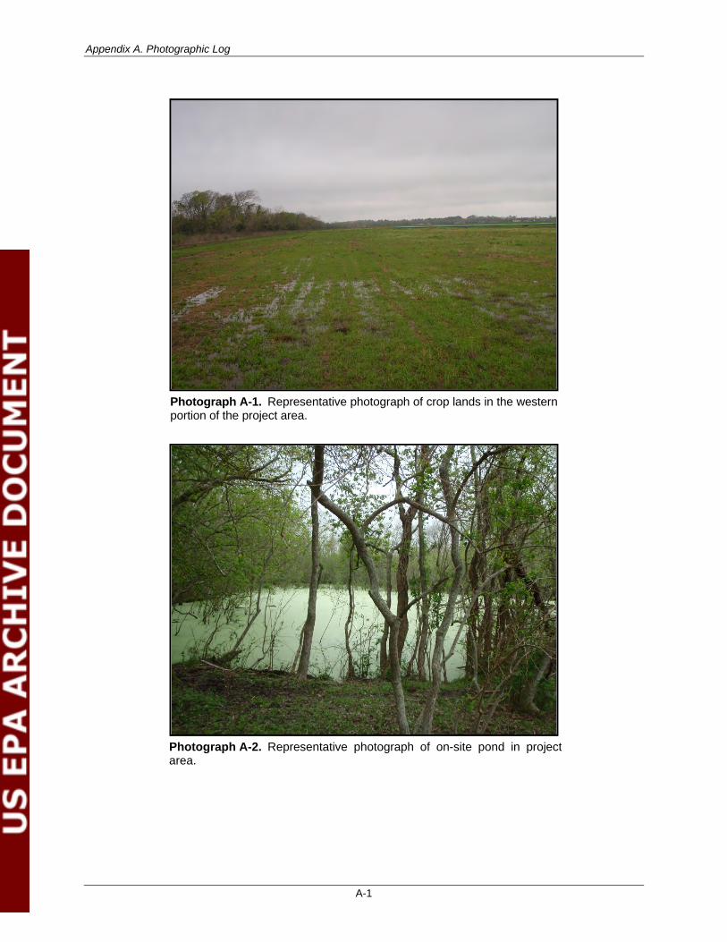
Appendix A. Photographic Log
A-1
Photograph A-1. Representative photograph of crop lands in the western portion of the project area.
Photograph A-2. Representative photograph of on-site pond in project area.
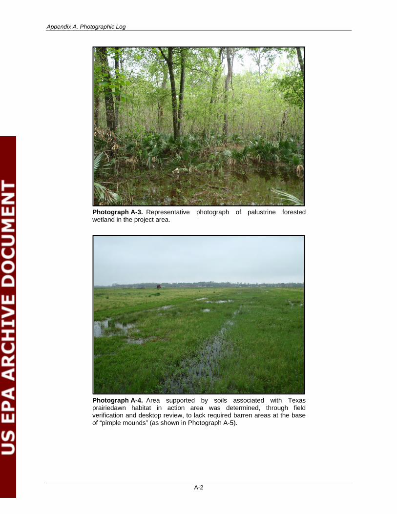
Appendix A. Photographic Log
A-2
Photograph A-3. Representative photograph of palustrine forested wetland in the project area.
Photograph A-4. Area supported by soils associated with Texas prairiedawn habitat in action area was determined, through field verification and desktop review, to lack required barren areas at the base of “pimple mounds” (as shown in Photograph A-5).
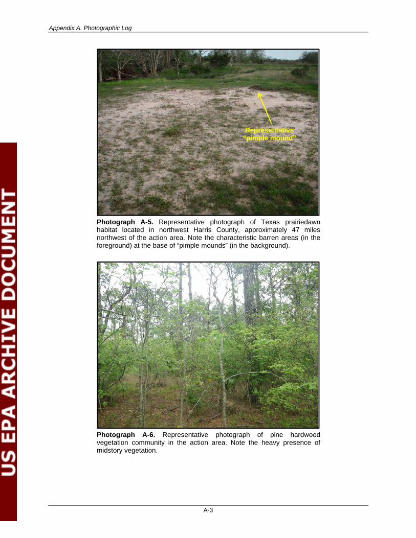
Appendix A. Photographic Log
A-3
Photograph A-5. Representative photograph of Texas prairiedawn habitat located in northwest Harris County, approximately 47 miles northwest of the action area. Note the characteristic barren areas (in the foreground) at the base of “pimple mounds” (in the background).
Photograph A-6. Representative photograph of pine hardwood vegetation community in the action area. Note the heavy presence of midstory vegetation.
Representative “pimple mound”
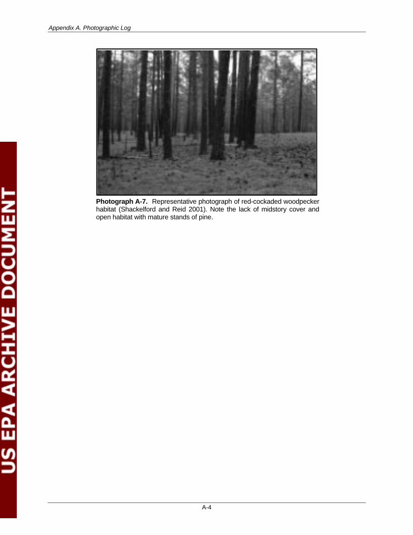
Appendix A. Photographic Log
A-4
Photograph A-7. Representative photograph of red-cockaded woodpecker habitat (Shackelford and Reid 2001). Note the lack of midstory cover and open habitat with mature stands of pine.
APPENDIX B
U.S. Fish and Wildlife Service and Texas Parks and Wildlife Department Protected Species Lists

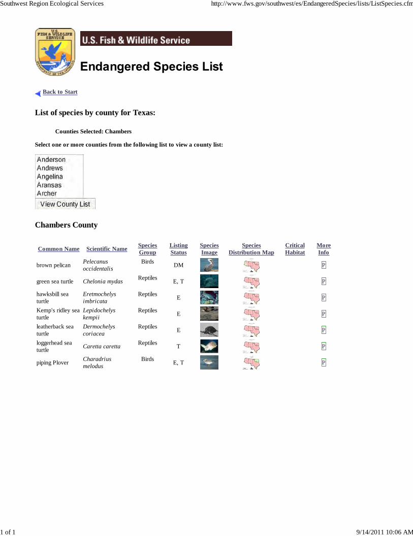
Back to Start
List of species by county for Texas:
Counties Selected: Chambers
Select one or more counties from the following list to view a county list:
Chambers County
Common Name Scientific Name SpeciesGroup
ListingStatus
SpeciesImage
SpeciesDistribution Map
CriticalHabitat
MoreInfo
brown pelican Pelecanusoccidentalis
Birds DM P
green sea turtle Chelonia mydas Reptiles E, T P
hawksbill seaturtle
Eretmochelysimbricata
Reptiles E P
Kemp's ridley seaturtle
Lepidochelyskempii
Reptiles E P
leatherback seaturtle
Dermochelyscoriacea
Reptiles E P
loggerhead seaturtle Caretta caretta Reptiles T P
piping Plover Charadriusmelodus
Birds E, T P
Southwest Region Ecological Services http://www.fws.gov/southwest/es/EndangeredSpecies/lists/ListSpecies.cfm
1 of 1 9/14/2011 10:06 AM
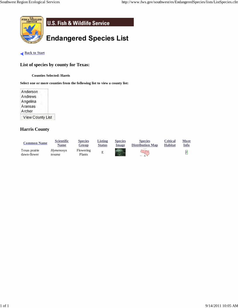
Back to Start
List of species by county for Texas:
Counties Selected: Harris
Select one or more counties from the following list to view a county list:
Harris County
Common Name ScientificName
SpeciesGroup
ListingStatus
SpeciesImage
SpeciesDistribution Map
CriticalHabitat
MoreInfo
Texas prairiedawn-flower
Hymenoxystexana
FloweringPlants E P
Southwest Region Ecological Services http://www.fws.gov/southwest/es/EndangeredSpecies/lists/ListSpecies.cfm
1 of 1 9/14/2011 10:05 AM
Texas Parks & Wildlife Dept. Page 1 of 4
Annotated County Lists of Rare SpeciesLast Revision: 2/28/2011 4:14:00 PM
formerly an uncommon breeder in the Panhandle; potential migrant; winter along coast
Black Rail Laterallus jamaicensis
found primarily near rivers and large lakes; nests in tall trees or on cliffs near water; communally roosts, especially in winter; hunts live prey, scavenges, and pirates food from other birds
Brown Pelican Pelecanus occidentalis DL E
salt, brackish, and freshwater marshes, pond borders, wet meadows, and grassy swamps; nests in or along edge of marsh, sometimes on damp ground, but usually on mat of previous year's dead grasses; nest usually hidden in marsh grass or at base of Salicornia
Bald Eagle Haliaeetus leucocephalus DL T
year-round resident and local breeder in west Texas, nests in tall cliff eyries; also, migrant across state from more northern breeding areas in US and Canada, winters along coast and farther south; occupies wide range of habitats during migration, including urban, concentrations along coast and barrier islands; low-altitude migrant, stopovers at leading landscape edges such as lake shores, coastlines, and barrier islands.
American Peregrine Falcon Falco peregrinus anatum DL T
migrant throughout state from subspecies’ far northern breeding range, winters along coast and farther south; occupies wide range of habitats during migration, including urban, concentrations along coast and barrier islands; low-altitude migrant, stopovers at leading landscape edges such as lake shores, coastlines, and barrier islands.
Arctic Peregrine Falcon Falco peregrinus tundrius DL
largely coastal and near shore areas, where it roosts and nests on islands and spoil banks
wintering migrant along the Texas Gulf Coast; beaches and bayside mud or salt flats
Piping Plover Charadrius melodus LT T
Reddish Egret Egretta rufescens T
Snowy Plover Charadrius alexandrinus
resident of the Texas Gulf Coast; brackish marshes and shallow salt ponds and tidal flats; nests on ground or in trees or bushes, on dry coastal islands in brushy thickets of yucca and prickly pear
wintering individuals (not flocks) found in weedy fields or cut-over areas where lots of bunch grasses occur along with vines and brambles; a key component is bare ground for running/walking
Henslow's Sparrow Ammodramus henslowii
Peregrine Falcon Falco peregrinus DL T
both subspecies migrate across the state from more northern breeding areas in US and Canada to winter along coast and farther south; subspecies (F. p. anatum) is also a resident breeder in west Texas; the two subspecies’ listing statuses differ, F.p. tundrius is no longer listed in Texas; but because the subspecies are not easily distinguishable at a distance, reference is generally made only to the species level; see subspecies for habitat.
BIRDS Federal Status State Status
CHAMBERS COUNTY
Texas Parks & Wildlife Dept. Page 2 of 4
Annotated County Lists of Rare Species
possible as transient; bottomland hardwoods and large tracts of inaccessible forested areas
Louisiana black bear Ursus americanus luteolus LT T
MAMMALS Federal Status State Status
American eel Anguilla rostrata
coastal waterways below reservoirs to gulf; spawns January to February in ocean, larva move to coastal waters, metamorphose, then females move into freshwater; most aquatic habitats with access to ocean, muddy bottoms, still waters, large streams, lakes; can travel overland in wet areas; males in brackish estuaries; diet varies widely, geographically, and seasonally
Smalltooth sawfish Pristis pectinata LE E
different life history stages have different patterns of habitat use; young found very close to shore in muddy and sandy bottoms, seldom descending to depths greater than 32 ft (10 m); in sheltered bays, on shallow banks, and in estuaries or river mouths; adult sawfish are encountered in various habitat types (mangrove, reef, seagrass, and coral), in varying salinity regimes and temperatures, and at various water depths, feed on a variety of fish species and crustaceans
FISHES Federal Status State Status
forages in prairie ponds, flooded pastures or fields, ditches, and other shallow standing water, including salt-water; usually roosts communally in tall snags, sometimes in association with other wading birds (i.e. active heronries); breeds in Mexico and birds move into Gulf States in search of mud flats and other wetlands, even those associated with forested areas; formerly nested in Texas, but no breeding records since 1960
Swallow-tailed Kite Elanoides forficatus T
Southeastern Snowy Plover Charadrius alexandrinus tenuirostris
only in Texas during migration and winter, mid September to early April; short to medium distance, diurnal migrant; strongly tied to native upland prairie, can be locally common in coastal grasslands, uncommon to rare further west; sensitive to patch size and avoids edges.
wintering migrant along the Texas Gulf Coast beaches and bayside mud or salt flats
Sprague's Pipit Anthus spragueii C
Western Snowy Plover Charadrius alexandrinus nivosus
Wood Stork Mycteria americana T
lowland forested regions, especially swampy areas, ranging into open woodland; marshes, along rivers, lakes, and ponds; nests high in tall tree in clearing or on forest woodland edge, usually in pine, cypress, or various deciduous trees
prefers freshwater marshes, sloughs, and irrigated rice fields, but will attend brackish and saltwater habitats; nests in marshes, in low trees, on the ground in bulrushes or reeds, or on floating mats
uncommon breeder in the Panhandle; potential migrant; winter along coast
White-faced Ibis Plegadis chihi T
BIRDS Federal Status State Status
CHAMBERS COUNTY
Texas Parks & Wildlife Dept. Page 3 of 4
Annotated County Lists of Rare Species
Kemp's Ridley sea turtle Lepidochelys kempii LE E
Leatherback sea turtle Dermochelys coriacea LE E
Gulf and bay system, adults stay within the shallow waters of the Gulf of Mexico; feed primarily on crabs, but also snails, clams, other crustaceans and plants, juveniles feed on sargassum and its associated fauna; nests April through August
saline flats, coastal bays, and brackish river mouthss
Atlantic hawksbill sea turtle Eretmochelys imbricata LE E
perennial water bodies; deep water of rivers, canals, lakes, and oxbows; also swamps, bayous, and ponds near deep running water; sometimes enters brackish coastal waters; usually in water with mud bottom and abundant aquatic vegetation; may migrate several miles along rivers; active March-October; breeds April-October
Alligator snapping turtle Macrochelys temminckii T
Gulf and bay system, warm shallow waters especially in rocky marine environments, such as coral reefs and jetties, juveniles found in floating mats of sea plants; feed on sponges, jellyfish, sea urchins, molluscs, and crustaceans, nests April through November
Gulf Saltmarsh snake Nerodia clarkii
Gulf and bay system; shallow water seagrass beds, open water between feeding and nesting areas, barrier island beaches; adults are herbivorous feeding on sea grass and seaweed; juveniles are omnivorous feeding initially on marine invertebrates, then increasingly on sea grasses and seaweeds; nesting behavior extends from March to October, with peak activity in May and June
Green sea turtle Chelonia mydas LT T
REPTILES Federal Status State Status
Louisiana pigtoe Pleurobema riddellii T
streams and moderate-size rivers, usually flowing water on substrates of mud, sand, and gravel; not generally known from impoundments; Sabine, Neches, and Trinity (historic) River basins
MOLLUSKS Federal Status State Status
Red wolf Canis rufus LE E
Plains spotted skunk Spilogale putorius interrupta
catholic; open fields, prairies, croplands, fence rows, farmyards, forest edges, and woodlands; prefers wooded, brushy areas and tallgrass prairie
roosts in cavity trees of bottomland hardwoods, concrete culverts, and abandoned man-made structures
Southeastern myotis bat Myotis austroriparius
extirpated; formerly known throughout eastern half of Texas in brushy and forested areas, as well as coastal prairies
MAMMALS Federal Status State Status
CHAMBERS COUNTY
Texas Parks & Wildlife Dept. Page 4 of 4
Annotated County Lists of Rare Species
Texas windmill-grass Chloris texensis
Texas endemic; sandy to sandy loam soils in relatively bare areas in coastal prairie grassland remnants, often on roadsides where regular mowing may mimic natural prairie fire regimes; flowering in fall
PLANTS Federal Status State Status
Texas horned lizard Phrynosoma cornutum T
swamps, floodplains, upland pine and deciduous woodlands, riparian zones, abandoned farmland; limestone bluffs, sandy soil or black clay; prefers dense ground cover, i.e. grapevines or palmetto
open, arid and semi-arid regions with sparse vegetation, including grass, cactus, scattered brush or scrubby trees; soil may vary in texture from sandy to rocky; burrows into soil, enters rodent burrows, or hides under rock when inactive; breeds March-September
coastal marshes, tidal flats, coves, estuaries, and lagoons behind barrier beaches; brackish and salt water; burrows into mud when inactive; may venture into lowlands at high tide
Timber/Canebrake rattlesnake
Crotalus horridus T
Texas diamondback terrapin Malaclemys terrapin littoralis
Gulf and bay system primarily for juveniles, adults are most pelagic of the sea turtles; omnivorous, shows a preference for mollusks, crustaceans, and coral; nests from April through November
Loggerhead sea turtle Caretta caretta LT T
Gulf and bay systems, and widest ranging open water reptile; omnivorous, shows a preference for jellyfish; in the US portion of their western Atlantic nesting territories, nesting season ranges from March to August
Northern scarlet snake Cemophora coccinea copei T
Smooth green snake Liochlorophis vernalis T
Gulf Coastal Plain; mesic coastal shortgrass prairie vegetation; prefers dense vegetation
mixed hardwood scrub on sandy soils; feeds on reptile eggs; semi-fossorial; active April-September
REPTILES Federal Status State Status
CHAMBERS COUNTY
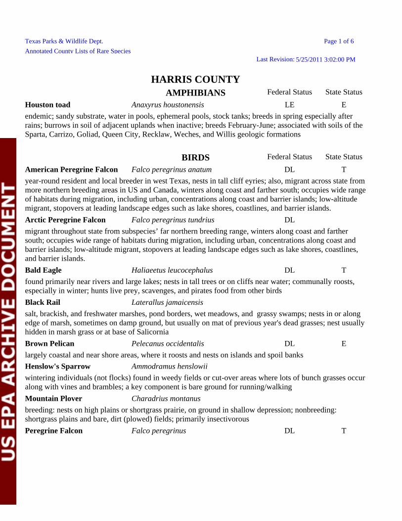
Texas Parks & Wildlife Dept. Page 1 of 6
Annotated County Lists of Rare SpeciesLast Revision: 5/25/2011 3:02:00 PM
Peregrine Falcon Falco peregrinus DL T
Bald Eagle Haliaeetus leucocephalus DL T
found primarily near rivers and large lakes; nests in tall trees or on cliffs near water; communally roosts, especially in winter; hunts live prey, scavenges, and pirates food from other birds
Black Rail Laterallus jamaicensis
migrant throughout state from subspecies’ far northern breeding range, winters along coast and farther south; occupies wide range of habitats during migration, including urban, concentrations along coast and barrier islands; low-altitude migrant, stopovers at leading landscape edges such as lake shores, coastlines, and barrier islands.
American Peregrine Falcon Falco peregrinus anatum DL T
year-round resident and local breeder in west Texas, nests in tall cliff eyries; also, migrant across state from more northern breeding areas in US and Canada, winters along coast and farther south; occupies wide range of habitats during migration, including urban, concentrations along coast and barrier islands; low-altitude migrant, stopovers at leading landscape edges such as lake shores, coastlines, and barrier islands.
Arctic Peregrine Falcon Falco peregrinus tundrius DL
wintering individuals (not flocks) found in weedy fields or cut-over areas where lots of bunch grasses occur along with vines and brambles; a key component is bare ground for running/walking
Mountain Plover Charadrius montanus
breeding: nests on high plains or shortgrass prairie, on ground in shallow depression; nonbreeding: shortgrass plains and bare, dirt (plowed) fields; primarily insectivorous
Henslow's Sparrow Ammodramus henslowii
salt, brackish, and freshwater marshes, pond borders, wet meadows, and grassy swamps; nests in or along edge of marsh, sometimes on damp ground, but usually on mat of previous year's dead grasses; nest usually hidden in marsh grass or at base of Salicornia
Brown Pelican Pelecanus occidentalis DL E
largely coastal and near shore areas, where it roosts and nests on islands and spoil banks
BIRDS Federal Status State Status
Houston toad Anaxyrus houstonensis LE E
endemic; sandy substrate, water in pools, ephemeral pools, stock tanks; breeds in spring especially after rains; burrows in soil of adjacent uplands when inactive; breeds February-June; associated with soils of the Sparta, Carrizo, Goliad, Queen City, Recklaw, Weches, and Willis geologic formations
AMPHIBIANS Federal Status State Status
HARRIS COUNTY
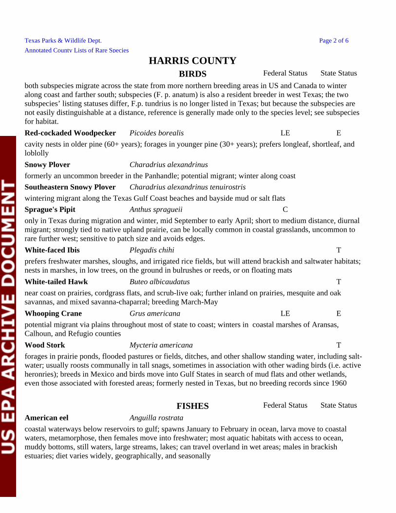
Texas Parks & Wildlife Dept. Page 2 of 6
Annotated County Lists of Rare Species
coastal waterways below reservoirs to gulf; spawns January to February in ocean, larva move to coastal waters, metamorphose, then females move into freshwater; most aquatic habitats with access to ocean, muddy bottoms, still waters, large streams, lakes; can travel overland in wet areas; males in brackish estuaries; diet varies widely, geographically, and seasonally
American eel Anguilla rostrata
FISHES Federal Status State Status
Whooping Crane Grus americana LE E
near coast on prairies, cordgrass flats, and scrub-live oak; further inland on prairies, mesquite and oak savannas, and mixed savanna-chaparral; breeding March-May
potential migrant via plains throughout most of state to coast; winters in coastal marshes of Aransas, Calhoun, and Refugio counties
forages in prairie ponds, flooded pastures or fields, ditches, and other shallow standing water, including salt-water; usually roosts communally in tall snags, sometimes in association with other wading birds (i.e. active heronries); breeds in Mexico and birds move into Gulf States in search of mud flats and other wetlands, even those associated with forested areas; formerly nested in Texas, but no breeding records since 1960
Wood Stork Mycteria americana T
White-tailed Hawk Buteo albicaudatus T
Snowy Plover Charadrius alexandrinus
formerly an uncommon breeder in the Panhandle; potential migrant; winter along coast
Southeastern Snowy Plover Charadrius alexandrinus tenuirostris
both subspecies migrate across the state from more northern breeding areas in US and Canada to winter along coast and farther south; subspecies (F. p. anatum) is also a resident breeder in west Texas; the two subspecies’ listing statuses differ, F.p. tundrius is no longer listed in Texas; but because the subspecies are not easily distinguishable at a distance, reference is generally made only to the species level; see subspecies for habitat.
Red-cockaded Woodpecker Picoides borealis LE E
cavity nests in older pine (60+ years); forages in younger pine (30+ years); prefers longleaf, shortleaf, and loblolly
prefers freshwater marshes, sloughs, and irrigated rice fields, but will attend brackish and saltwater habitats; nests in marshes, in low trees, on the ground in bulrushes or reeds, or on floating mats
White-faced Ibis Plegadis chihi T
Sprague's Pipit Anthus spragueii C
only in Texas during migration and winter, mid September to early April; short to medium distance, diurnal migrant; strongly tied to native upland prairie, can be locally common in coastal grasslands, uncommon to rare further west; sensitive to patch size and avoids edges.
wintering migrant along the Texas Gulf Coast beaches and bayside mud or salt flats
BIRDS Federal Status State Status
HARRIS COUNTY
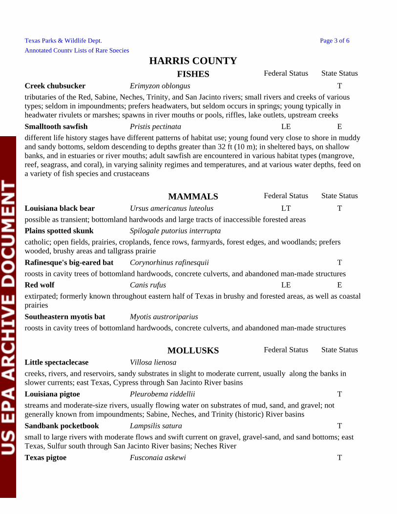
Texas Parks & Wildlife Dept. Page 3 of 6
Annotated County Lists of Rare Species
creeks, rivers, and reservoirs, sandy substrates in slight to moderate current, usually along the banks in slower currents; east Texas, Cypress through San Jacinto River basins
Louisiana pigtoe Pleurobema riddellii T
Little spectaclecase Villosa lienosa
streams and moderate-size rivers, usually flowing water on substrates of mud, sand, and gravel; not generally known from impoundments; Sabine, Neches, and Trinity (historic) River basins
Texas pigtoe Fusconaia askewi T
Sandbank pocketbook Lampsilis satura T
small to large rivers with moderate flows and swift current on gravel, gravel-sand, and sand bottoms; east Texas, Sulfur south through San Jacinto River basins; Neches River
MOLLUSKS Federal Status State Status
Plains spotted skunk Spilogale putorius interrupta
possible as transient; bottomland hardwoods and large tracts of inaccessible forested areas
Louisiana black bear Ursus americanus luteolus LT T
Red wolf Canis rufus LE E
catholic; open fields, prairies, croplands, fence rows, farmyards, forest edges, and woodlands; prefers wooded, brushy areas and tallgrass prairie
roosts in cavity trees of bottomland hardwoods, concrete culverts, and abandoned man-made structures
Southeastern myotis bat Myotis austroriparius
extirpated; formerly known throughout eastern half of Texas in brushy and forested areas, as well as coastal prairies
Rafinesque's big-eared bat Corynorhinus rafinesquii T
roosts in cavity trees of bottomland hardwoods, concrete culverts, and abandoned man-made structures
MAMMALS Federal Status State Status
tributaries of the Red, Sabine, Neches, Trinity, and San Jacinto rivers; small rivers and creeks of various types; seldom in impoundments; prefers headwaters, but seldom occurs in springs; young typically in headwater rivulets or marshes; spawns in river mouths or pools, riffles, lake outlets, upstream creeks
Creek chubsucker Erimyzon oblongus T
Smalltooth sawfish Pristis pectinata LE E
different life history stages have different patterns of habitat use; young found very close to shore in muddy and sandy bottoms, seldom descending to depths greater than 32 ft (10 m); in sheltered bays, on shallow banks, and in estuaries or river mouths; adult sawfish are encountered in various habitat types (mangrove, reef, seagrass, and coral), in varying salinity regimes and temperatures, and at various water depths, feed on a variety of fish species and crustaceans
FISHES Federal Status State Status
HARRIS COUNTY
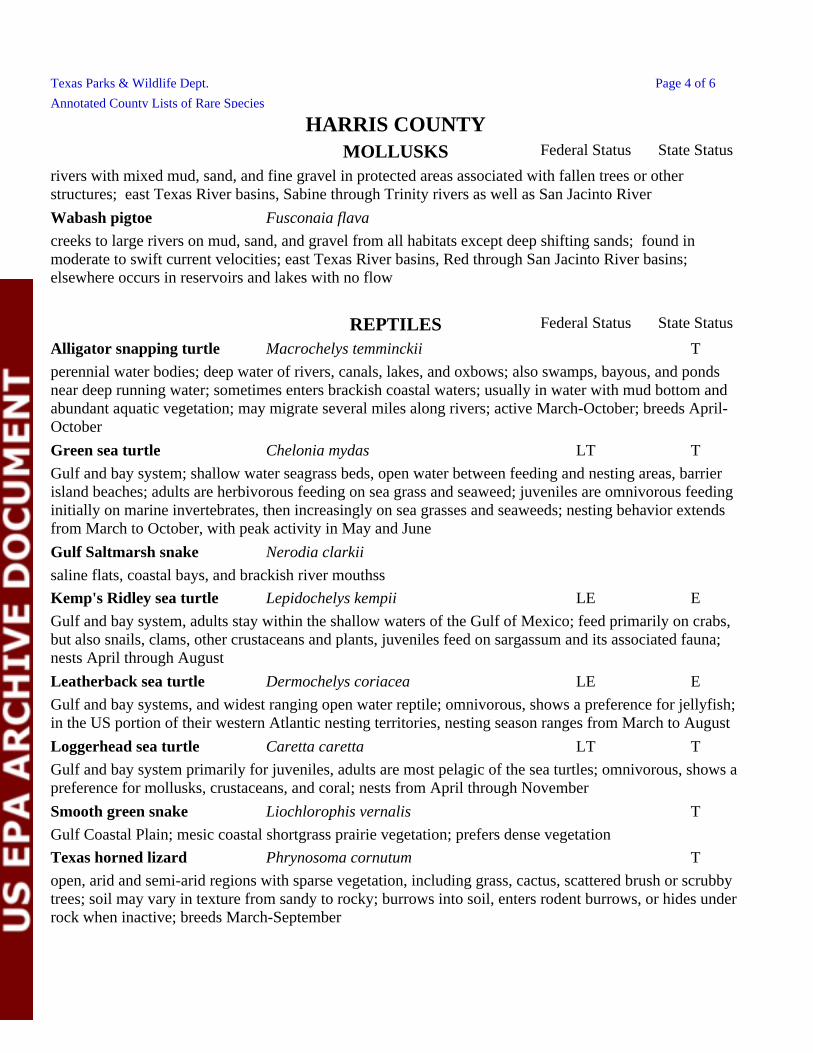
Texas Parks & Wildlife Dept. Page 4 of 6
Annotated County Lists of Rare Species
Smooth green snake Liochlorophis vernalis T
Gulf Coastal Plain; mesic coastal shortgrass prairie vegetation; prefers dense vegetation
Loggerhead sea turtle Caretta caretta LT T
Gulf and bay system primarily for juveniles, adults are most pelagic of the sea turtles; omnivorous, shows a preference for mollusks, crustaceans, and coral; nests from April through November
Texas horned lizard Phrynosoma cornutum T
open, arid and semi-arid regions with sparse vegetation, including grass, cactus, scattered brush or scrubby trees; soil may vary in texture from sandy to rocky; burrows into soil, enters rodent burrows, or hides under rock when inactive; breeds March-September
Gulf and bay system; shallow water seagrass beds, open water between feeding and nesting areas, barrier island beaches; adults are herbivorous feeding on sea grass and seaweed; juveniles are omnivorous feeding initially on marine invertebrates, then increasingly on sea grasses and seaweeds; nesting behavior extends from March to October, with peak activity in May and June
Gulf Saltmarsh snake Nerodia clarkii
Green sea turtle Chelonia mydas LT T
perennial water bodies; deep water of rivers, canals, lakes, and oxbows; also swamps, bayous, and ponds near deep running water; sometimes enters brackish coastal waters; usually in water with mud bottom and abundant aquatic vegetation; may migrate several miles along rivers; active March-October; breeds April-October
Alligator snapping turtle Macrochelys temminckii T
Leatherback sea turtle Dermochelys coriacea LE E
Gulf and bay systems, and widest ranging open water reptile; omnivorous, shows a preference for jellyfish; in the US portion of their western Atlantic nesting territories, nesting season ranges from March to August
Gulf and bay system, adults stay within the shallow waters of the Gulf of Mexico; feed primarily on crabs, but also snails, clams, other crustaceans and plants, juveniles feed on sargassum and its associated fauna; nests April through August
saline flats, coastal bays, and brackish river mouthss
Kemp's Ridley sea turtle Lepidochelys kempii LE E
REPTILES Federal Status State Status
Wabash pigtoe Fusconaia flava
rivers with mixed mud, sand, and fine gravel in protected areas associated with fallen trees or other structures; east Texas River basins, Sabine through Trinity rivers as well as San Jacinto River
creeks to large rivers on mud, sand, and gravel from all habitats except deep shifting sands; found in moderate to swift current velocities; east Texas River basins, Red through San Jacinto River basins; elsewhere occurs in reservoirs and lakes with no flow
MOLLUSKS Federal Status State Status
HARRIS COUNTY
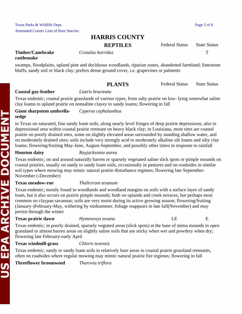
Texas Parks & Wildlife Dept. Page 5 of 6
Annotated County Lists of Rare Species
Texas endemic; mostly found in woodlands and woodland margins on soils with a surface layer of sandy loam, but it also occurs on prairie pimple mounds; both on uplands and creek terraces, but perhaps most common on claypan savannas; soils are very moist during its active growing season; flowering/fruiting (January-)February-May, withering by midsummer, foliage reappears in late fall(November) and may persist through the winter
Texas prairie dawn Hymenoxys texana LE E
Texas endemic; on and around naturally barren or sparsely vegetated saline slick spots or pimple mounds on coastal prairies, usually on sandy to sandy loam soils, occasionally in pastures and on roadsides in similar soil types where mowing may mimic natural prairie disturbance regimes; flowering late September-November (-December)
Texas meadow-rue Thalictrum texanum
Texas endemic; in poorly drained, sparsely vegtated areas (slick spots) at the base of mima mounds in open grassland or almost barren areas on slightly saline soils that are sticky when wet and powdery when dry; flowering late February-early April
Threeflower broomweed Thurovia triflora
Texas windmill-grass Chloris texensis
Texas endemic; sandy to sandy loam soils in relatively bare areas in coastal prairie grassland remnants, often on roadsides where regular mowing may mimic natural prairie fire regimes; flowering in fall
in Texas on saturated, fine sandy loam soils, along nearly level fringes of deep prairie depressions; also in depressional area within coastal prairie remnant on heavy black clay; in Louisiana, most sites are coastal prairie on poorly drained sites, some on slightly elevated areas surrounded by standing shallow water, and on moderately drained sites; soils include very strongly acid to moderately alkaline silt loams and silty clay loams; flowering/fruiting May-June, August-September, and possibly other times in response to rainfall
Texas endemic; coastal prairie grasslands of various types, from salty prairie on low- lying somewhat saline clay loams to upland prairie on nonsaline clayey to sandy loams; flowering in fall
Coastal gay-feather Liatris bracteata
Houston daisy Rayjacksonia aurea
Giant sharpstem umbrella-sedge
Cyperus cephalanthus
PLANTS Federal Status State Status
Timber/Canebrake rattlesnake
Crotalus horridus T
swamps, floodplains, upland pine and deciduous woodlands, riparian zones, abandoned farmland; limestone bluffs, sandy soil or black clay; prefers dense ground cover, i.e. grapevines or palmetto
REPTILES Federal Status State Status
HARRIS COUNTY
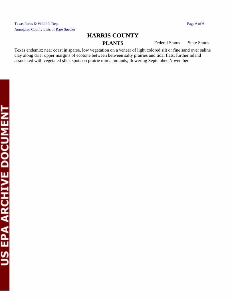
Texas Parks & Wildlife Dept. Page 6 of 6
Annotated County Lists of Rare Species
Texas endemic; near coast in sparse, low vegetation on a veneer of light colored silt or fine sand over saline clay along drier upper margins of ecotone between between salty prairies and tidal flats; further inland associated with vegetated slick spots on prairie mima mounds; flowering September-November
PLANTS Federal Status State Status
HARRIS COUNTY