Embed Size (px)
Citation preview
CHESHIRE HISTORIC TOWNS SURVEY
Nantwich
Archaeological Assessment
2003
CHESHIRE HISTORIC TOWNS SURVEY
Nantwich
Archaeological Assessment
2003
Environmental Planning Cheshire County Council
Backford Hall Backford Chester
CH1 6PZ These reports are the copyright of Cheshire County Council and English Heritage. We would like to acknowledge the assistance of Dr Chris Lewis, University of Liverpool, in the preparation of these reports. The archive is held by the Cheshire County Sites and Monuments Record.
The Ordnance Survey mapping within this document is provided by Cheshire County Council under licence from the Ordnance Survey, in order to fulfil its public function to make available Council held public domain information. The mapping is intended to illustrate the spatial changes that have occurred during the historical development of Cheshire towns. Persons viewing this mapping should contact Ordnance Survey copyright for advice where they wish to licence Ordnance Survey mapping/map data for their own use. The OS web site can be found at www.ordsvy.gov.uk
NANTWICH
ARCHAEOLOGICAL ASSESSMENT
Mike Shaw & Jo Clark
1. SUMMARY Nantwich was, after Chester, the most important of Cheshire’s medieval towns. Its importance was based upon the presence of brine springs from which salt has been extracted since at least the Roman period. Today it remains a local market centre and retains many fine timber-framed buildings of the 16th and 17th centuries as reminders of its past importance. 1.1 Topography and Geology Nantwich lies c 40m AOD, mainly on the east bank of the River Weaver but with some settlement on the west bank, principally along Welsh Row. It is located at the southern end of the county within the dairy farming country of the Cheshire plain, 39km south east of Chester. The underlying solid geology is Keuper Marl within which are the salt beds from which the brine was derived (Hains and Horton 1969, 69-72). Above this are drift deposits, comprising river gravel on the west side of the town, with alluvium in the immediate area of the river, and boulder clay on the east side (British Geological Survey, 1967). The soils developed upon these deposits are largely stagnogleys, which are the most common soil type of the Cheshire Plain (Furness 1979, 108-32). They are ideal grassland soils and ‘a major factor in the development of the Cheshire dairy farming industry’ (ibid, 123). They are graded classes 3 - 4, the chief limiting factors being their fine texture and surface wetness. Nantwich is located at a nodal point in the road network. The former main road from London to Chester (A51), runs southeast - northwest through the town, while other roads lead to Market Drayton to the south (A529), Whitchurch to the south-west (A525), Wrexham to the west (A534), Middlewich to the north-east (A530) and Newcastle-under-Lyme (A52) to the east. 1.2 Administrative Unit Nantwich lay in Warmundestrou Hundred at the time of Domesday Survey (1086) but this became known as Nantwich Hundred from the 12th century. Nantwich was a parochial chapelry in the parish of Acton up until 1677 when it became an independent parish (Dunn, 1987, 30). Today, Nantwich is a Civil Parish and lies within the Borough of Crewe and Nantwich. 1.3 Place Name
Cheshire Historic Towns Survey 1 © Cheshire County Council and English Heritage 2002
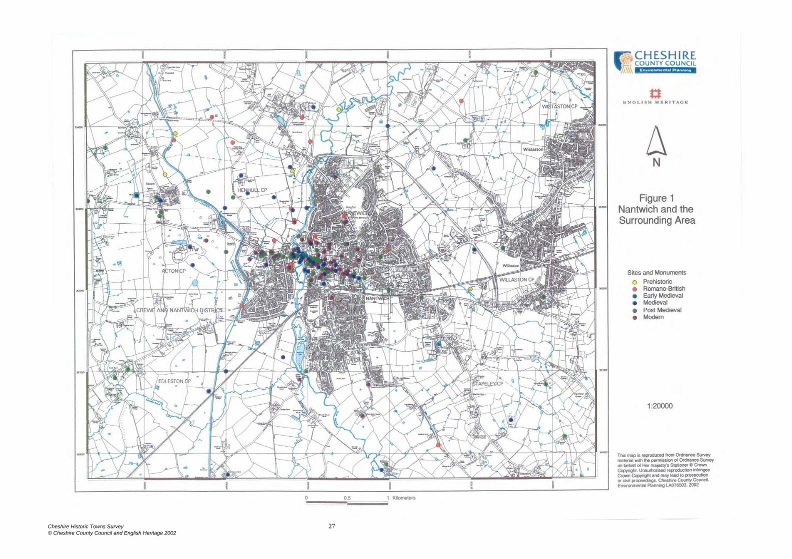
The town was often referred to as simply Wich, from ‘wic’ an industrial or trading settlement - in this case a salt manufacturing centre. It was also called Wich Malbank, which refers to its Norman overlords the Malbank dynasty. The ‘Nant’ element comes from ‘named’, meaning well known or renowned. The importance of Nantwich salt to Wales is demonstrated by its possession of a Welsh name, Heledd Wen - the white salt pit. (Dodgson 1971, 30-1). 2. SOURCES 2.1 Historical The chief sources for the history of Nantwich are Ormerod’s History of Cheshire (1882) and James Hall’s History of the Town and Parish of Nantwich (1883). There are a number of more recent histories of varying quality, and the most useful of these are those by Lake (1981 & 1983). A number of detailed primary records are located at the County Record Office (CRO) that would no doubt provide valuable information but unfortunately this is beyond the remit of the present survey. 2.2. Cartographic Nantwich is depicted on Saxton’s 1577 map of Cheshire and Speed’s county map of 1610. The first available map to show the road network at Nantwich is Burdett’s map of 1777. However, Burdett has omitted settlement on the west bank of the Weaver. The earliest detailed town plan is Fenna’s Map of 1794, published at a scale of 20 inches to 1 mile (1:3168). There is a tithe map of 1846 which shows the surrounding area but does not cover the settled area in detail. Useful plans of the town include the Ordnance Survey 10 feet: 1 mile plan of 1851, the First Edition 25”: 1 mile map of 1876 and the First Edition 6”: 1 mile plan of 1876. 2.3 Archaeological There are approximately 147 records for the urban area of Nantwich included in the Cheshire Sites and Monuments Record (CSMR), which are depicted on Figure 1. Where sites and finds have been identified from the CSMR, the relevant reference is provided throughout this document. The current project has identified over 40 new sites, which have been included in the CSMR. Twenty nine archaeological interventions are recorded on the County Sites and Monuments Record (Appendix 1) a number of which were small scale. Unfortunately, there are scant records remaining for the earlier interventions but despite this, Nantwich is still one of the most intensively investigated of Cheshire’s towns. The most significant work carried out in the town has been the discovery and excavation of two saltworking houses at Wood Street in 1979-80 (CSMR 180/2, McNeil 1983), which established the archaeological potential of the town. More recent work in the same area by Earthworks, has provided further evidence of medieval and post medieval saltworking (Earthworks 2001 & 2002). The only other work carried out on any scale have been the excavations in the area of Nantwich castle (CSMR 179/2), principally by McNeil in 1978 (McNeil, undated) but also by Hill
Cheshire Historic Towns Survey 2 © Cheshire County Council and English Heritage 2002
and Parkhouse in 1974-6 (Williams, 1975) and Gifford and Partners in 1994-5 (Gifford and Partners, 1995). Small scale work has established Roman activity to the west of the river at St Anne’s Lane (CSMR 178/0/2) and a 2nd-century ditch has been located at Riverside (CSMR 177/0/12). 3. HISTORICAL AND ARCHAEOLOGICAL SUMMARY 3.1 Prehistoric Evidence of prehistoric activity in the Nantwich area is limited to ceramic salt containers found at Beeston Castle and other late prehistoric sites in the Welsh Marches and North Wales, which are thought to have been made in the Nantwich/Middlewich area (Morris, 1985). One of the few notable prehistoric finds from the area is a Bronze Age palstave that was discovered in Henhull parish 1km north-west of Nantwich. However, there is no archaeological evidence to suggest that there was activity in Nantwich itself during this period. 3.2 Roman In contrast to the prehistoric period, there is an abundance of material available from the Roman period which identifies Nantwich as an important part of the wider Roman landscape. For example, the Roman Road from Middlewich to Whitchurch has been traced from the west of Reaseheath Old Hall to the Shropshire Union Canal and passes north-west of Nantwich (CSMR 1189/1/7). A further section of this road has been identified south-west of Nantwich in Baddiley parish (CSMR 1189/1/9). Although most of the evidence for Roman activity comes from individual finds, the few excavations that have been carried out indicate that there was settlement and industry at Nantwich during the Roman period. For example, an archaeological excavation at Davelyn House, St Anne’s Lane, uncovered a plank tank, which was probably used for salt making, along with possible fragments of salt containers (briquetage). This has led to the suggestion that there was brine working on the west bank of the River Weaver, perhaps connected to a settlement area on the east bank, by a river crossing to the south of the present bridge (McNeil, 1985; CSMR 178/0/2). Two lead brine pans discovered c 500m north of the town bridge (CSMR 180/0/1) on the west bank of the river may indicate brine working in this area also. An assemblage of Roman pottery sherds was also recovered from Davelyn House along with a cremation which was set into a Severn Valley ware jar of 2nd to 3rd century date (CSMR 177/1). It is likely, however, that the main settlement area was on the east bank of the river, away from any industrial and cemetery areas. Around 200 sherds of Roman pottery of 2nd to 4th century date were found during excavations at the Crown car park, and although no features of this date were discovered, this appears to indicate the close proximity of the settlement (CSMR 177/0/8). One of the most substantial Roman features discovered at Nantwich was a 1m deep ditch found during an excavation at Riverside just south of Davelyn House (CSMR 180/0/1). 3.3 Early Medieval
Cheshire Historic Towns Survey 3 © Cheshire County Council and English Heritage 2002
The archaeological record for early medieval Nantwich is very limited. The only definite find of this period is a bronze mount of 8th to early 9th century date found ‘in fields near Nantwich’ (CSMR 181). So, despite a detailed entry in the Domesday Survey the location and extent of the early medieval settlement and saltworkings of Nantwich are unknown. The Domesday Survey records that:
(316) T.R.E there was in Warmundestrou Hundred a Wich (Nantwich) in which there was a brinepit for making salt , and there were 8 salthouses so divided between the king and Earl Edwin that of all the issues and renders the king had two [third] parts and the earl the third...
In the same Wich many men of the country had [blank] salthouses...
All these salthouses, both common and demesne were surrounded on one side by a certain stream and on the other by a certain ditch...
T.R.E this Wich rendered £21 in farm, including all the pleas of the same hundred. When (Earl) Hugh received it, it was waste excepting only one salthouse. William Malbank now holds the same Wich of the earl with all the customs belonging to it...and the Wich is at farm for £10 (Harris and Thacker, 1987, 350) Domesday provides a valuable insight into what had become one of Cheshire’s most successful salt producing centres by the mid-11th century. In 1066 Nantwich was valued at £21 as opposed to £8 for both Middlewich and Northwich, the other salt producing centres in the county. Domesday also shows the importance of salt-working at this time, revealing the close control exercised over it by the crown and the earl through an elaborate system of tolls and regulations. Importantly, Domesday also records that the saltworks were sited by the river and demarcated by a boundary ditch. The town doubtless grew up around, and because of, the brine workings, although it is unclear whether settlement lay within the boundary ditch or whether the ditch surrounded the brine working area alone. Many of the route ways leading out from the town are likely to have originated as salt ways by which salt was traded over long distances. Nantwich, in common with the rest of Cheshire, clearly suffered devastation after the anti-Norman rebellion of 1069-70. It was said to be waste when it was granted to Hugh Lupus, the Earl of Chester, in 1071 and it had only partially recovered by 1086 when it was let out to farm at a reduced rate of £10. In the medieval period Nantwich lay in Acton parish. Higham has suggested that this link dates back to an earlier period and that the saltworkings were originally administered from a royal estate centred on Acton. He also postulates that the royal estate may have been created to oversee the saltworkings (Higham 1993, 143-5). 3.4 Medieval
Cheshire Historic Towns Survey 4 © Cheshire County Council and English Heritage 2002
3.4.1 The Manor Earl Hugh granted Nantwich, as well as much of the lands of the hundred within which it lay, to William Malbank and it is the Malbank dynasty who probably did much to create the town. William Malbank is traditionally said to have founded Nantwich castle (CSMR 179/2), as well as the Church of St Mary (CSMR 179/1) and the hospital of St Nicholas (CSMR 179/5). A further hospital, the leper hospital of St Lawrence (CSMR 179/6), at the west end of Welsh Row, may also have been founded by the Malbank dynasty (Harris, 1980, 186). The second baron, Hugh Malbank, founded Combermere Abbey at the southern end of the county and granted it a quarter of the town, and these lands became known as the Abbot’s fee (Hall, 1883, 18-21). The Malbank dynasty held the town until c1160-70 and it was often referred to as Wich Malbank even as late as the 16th century. After 1160-70 the Malbank lands were divided up between the three daughters of the third and last baron, to form three separate holdings or fees (Hall, 1883, 23). 3.4.2 Settlement The castle at Nantwich (CSMR 179/2) was certainly in existence by 1160-70 when it was bequeathed by William Malbank to one of his daughters (Hall 1883, 22). Its site has completely disappeared but a plausible case has been made for its location by the river on a slight crest to the west of High Street and to the south of the town bridge, with the curving line of High Street following or overlying the course of the outer ditch. Excavations have revealed features of the castle (Williams 1975; McNeil 1978; Gifford and Partners 1995). It is not known when the castle fell into disuse. McNeil has suggested from archaeological evidence that although the outer ditch was silting up from the 13th century and was finally abandoned in the late 14th to early 15th centuries, the castle itself may have survived longer (McNeil 1980/1, 30). There is a tradition that stone from the castle was re-used in Nantwich church in Henry VII’s reign: ‘early in this monarch’s reign, the ruins were removed to enlarge and beautify the southern aisle of the church’ (Platt 1818, 73). The town was granted a charter in 1567 confirming its ancient privilege that ‘The Burgesses of Wich Malbank were entitled not to be put upon any assizes, juries, recognizances or inquests whatever concerning lands and tenements lying out of the vill of Wich Malbank or its liberty...’ (Hall 1883, 79). This privilege was said to have been proved by an inquisition in 1319-20 and to have ‘had then that privilege time out of mind’ (Beresford, 1973,75). The Black Death and other pestilences of the 14th - 15th centuries, and a fire in 1438 (Hall 1883, 94) no doubt provided setbacks but by the 15th century Nantwich can be shown to be the most important town in Cheshire apart from Chester itself. The commercial core of the town was centred around the market areas and the High Street and included Pepper Street, Beam Street, Hospital Street and Pillory Street. Buildings here tend to be densely packed with the gable end fronting onto the street. Away from the commercial core buildings have wider frontages and tend to face onto the street.
Cheshire Historic Towns Survey 5 © Cheshire County Council and English Heritage 2002
Few buildings survive from the medieval period, most of the central core having been destroyed in the ‘Great Fire’ of 1583. Archaeological evidence of medieval settlement does however appear to survive in abundance. For example, an excavation carried out to the rear of 31 Hospital Street revealed organic soils and clay layers to a depth of 2m and in the lower waterlogged levels medieval finds, and three timber beams dating from the 13th/15th centuries were uncovered (CSMR 179/0/19). Also, trial trenches dug adjacent to the late medieval town house of the Wilbrahams of Woodhey (Sweet Briar Hall, 65-71 Hospital Street) which escaped the fire of 1583, have revealed a pottery sequence that dates from the 12th century (CSMR 179/0/21). 3.4.3 Economy 3.4.3.1 Taxation Data for Cheshire towns is rare because in the medieval period the shire was exempt from national taxation, having its own taxation system, the Mize. In the Cheshire Mize of 1405, however, Nantwich paid a total of £7 3s, by far the largest sum (Chester was not included), the next largest sum being that paid by Congleton at £4 53s 4d (Booth 1985). 3.4.3.2 Agriculture The town was surrounded by its arable fields, pastures and meadows. In the medieval period the fields were probably farmed using an open field system (Lake 1983, 11). Certainly ridge and furrow can be seen in fields to the north on aerial photographs taken in 1947 (RAF CPE/UK/1935/4358 and 4462). To the north east is Beam Heath, which was a large area of Common Land. 3.4.3.3 Saltworking There were at least eight salt houses in the town in 1066, and these were probably located on the bank of the river at Snow Hill where the medieval brine pit ‘the Old Biot’ was located. Archaeological evidence demonstrates that by the late 12th century the industry had expanded to Wood Street on the west bank of the river. Brine was carried across the river to these salt houses in wooden pipes. The salt houses were well preserved, complete with troughs for holding brine and hearths over which the brine was boiled in lead pans. One of the wich houses was short lived, the other survived until the 16th century, after which date the saltworking industry in this area probably declined (CSMR 180/2). Just 75m south-west of this site, a massive wooden structure was excavated under what is now the Cheshire Cat car park. It has been suggested that this was a large brine cistern that may date back to the 12th century (CSMR 180/0/2). Evaluation on the north side of Welsh Row, on land adjacent to the Cheshire Cat, was carried out by Earthworks in 2001 and revealed further evidence of possible salt working together with domestic structures. A dark organic layer, up to 2.5m deep in places, contained medieval pottery, probably of 13th and 14th century date, charcoal fragments and plant remains, suggesting build up from medieval rubbish dumping, in a boggy environment. A series of post holes and stakes suggests the presence of a
Cheshire Historic Towns Survey 6 © Cheshire County Council and English Heritage 2002
timber structure, while the discovery of industrial waste from iron working may suggest that there was a smithy on the site. Associated with these deposits was a possible wooden salt rake, while further salt rakes and a wooden paddle or spade for stirring brine were recovered during a subsequent watching brief (Earthworks 2001 and 2002). Salt-working was a major industry in the town until the 17th century although the industry was hit by the import of cheap sea salt from France in the mid-14th century. The number of salt houses rose to around 400 in 1530 but was reduced to 216 in 1538 (Twigg undated). 3.4.3.4 Trade A survey of 1276 records that there were butchers’ shops, a grain shop and a chandler’s shop located in Nantwich (Lake 1983, 3). Other trades are represented by street names (Dodgson 1971, 32-5). For example, Barker Street - the tanning quarter (1421), Barber’s Lane (1440), Flessherowe - butcher’s row (1394); and le Tayntre Yard - yard with a fuller’s stretching frame (1447) There is some indirect archaeological evidence for tanning from both the National Westminster Bank site, High Street (Williams 1975, 52) and the Crown Car Park excavations (McNeil undated, 7). 3.4.3.5 Markets and Fairs In 1283 Robert Burnell, the Bishop of Bath and Wells, who had been granted part of the town, obtained a charter for a three day fair (Hall, 1883, 42). The fair was held on the vigil, feast and morrow of the feast of Bartholomew the Apostle (23-25 August) (Letters 2002). There was a weekly cattle market held at the west end of Beam Street by the 14th century but it is likely that markets were held at Nantwich from a much earlier date. In 1577 the market cross (CSMR 179/1/2), which was the focus for the Saturday market was described as the ‘greate stonne crosse...standing and beinge in the Churcheyarde of Wiche Malbanke’ (Lake 1983, 3). 3.4.3.6 Guilds and Fraternities The existence of some form of guild in the town is demonstrated by the town regulations of 1538 which include ordinances for the governance of guild priests. There was a guild hall in the churchyard which was probably suppressed at the Reformation as the guild hall was purchased from the Crown to endow a Grammar School, later demolished c1860 (Hall 1883, 30-1). An excavation was carried out in 1976 in St Mary’s Churchyard in an attempt to locate the guildhall. Unfortunately, no evidence was discovered as the ground had been badly disturbed by road building and grave digging (CSMR 179/0/3). 3.4.3.7 Water Mills There is a reference to a mill at Nantwich that dates to c1228 (Hall 1883, 6) but the location of this is uncertain. Two mills are known in medieval times, Frog Mill (CSMR 179/11), which was mentioned in 1302 and was perhaps situated on Welsh Row (formerly Frog Row), and Nantwich Mill (CSMR 179/12) on the river Weaver
Cheshire Historic Towns Survey 7 © Cheshire County Council and English Heritage 2002
which is assumed to have been in existence by 1363 when there is a reference to molendina de Wico Malbank (the mills of Nantwich) (Dodgson 1971, 39). The latter mill potentially stood on the site of the post medieval mill, which was located west of Water Lode Road and south of the town bridge, and Lake suggests that the cutting of the mill leat and the creation of an island upon which this later mill stood can be ascribed to the 16th century (Lake, 1983, 11-12). The mill was converted to a cotton mill in 1789, which was closed in 1874. It then had a variety of uses, for example, on the OS First Edition it is identified as a Corn Mill. It was demolished in the 1970s after a fire (Bott, 1983, 62). 3.4.3.8 The Town Bridge The date of construction of the first bridge over the river on or about the line of the present bridge (CSMR 179/45) is crucial in assessing the date of the phases of growth of Nantwich but unfortunately there is very little dating evidence available. A bridge is first mentioned in 1398-9 (Hall 1883, 86) but it is not known when it was constructed. At this time there is mention of a chapel dedicated to St Anne, by or upon the bridge and a rental of 1438-9 refers to ‘four shops....upon the bridge with the chapel etc’. In 1622 the bridge was described as being ‘a strong timber bridge’. The timber bridge was replaced by a stone structure in 1664. This bridge was succeeded by the present one, which was built in 1803 (Hall 1883, 125). 3.4.4 Religion St Mary’s church (CSMR 179/1/1) at Nantwich was a chapel of ease to Acton church for much of its life. Nevertheless it is a large, ornate building often referred to as the ‘Cathedral of South Cheshire’. The earliest reference to the chapel is in 1130 when the church of Acton and the chapel of Wich Malbank were granted to Combermere Abbey. The present church is cruciform in plan with a central, octagonal tower. It dates principally from c1340 - 1400 but with restoration by Sir George Gilbert Scott in 1854-61. Of particular interest are the late 14th century misericords under the seats in the choir stalls (Richards, 1947,248-250). During works in 2000, associated with the improvement of the heating system, probable traces of the medieval church were revealed. A foundation wall of probable medieval date was revealed beneath the existing chancel doorway, while two articulated burials, one possibly of medieval date, were recorded in a trench immediately outside the north wall of the chancel. In addition fragments of medieval floor tile and one piece of medieval pottery were recovered (Earthworks 2000). A document of 1577 locates a market cross in the churchyard and apparently the churchyard was used for marketing at this time, despite prohibitions of the practice at the end of the 13th century (Hall 1983, 3). The burial ground may have been more extensive as the discovery of human remains under the District Bank on the north side of Churchyardside is recorded (Hall 1883, 328) and in 1983 three lead coffins were discovered under Churchyardside. The churchyard ceased to be used for burials after a severe cholera epidemic in 1848 (CSMR 179/1/3). There were two medieval hospitals in Nantwich. The first, the hospital of St Nicholas (CSMR 179/5), which was dissolved in 1548 is generally thought to have been founded at the end of the 11th century and would have marked the eastern limits of
Cheshire Historic Towns Survey 8 © Cheshire County Council and English Heritage 2002
the town at this time. Its location is not certain but it is traditionally said to have stood on the site of 140 Hospital Street. The second is the probable site of the hospital and chapel of St Leonard (CSMR 179/6), which is recorded from 1260 and was dissolved in 1548. As a leper hospital it would have stood outside the settled area of Nantwich. By the mid-14th century its function had changed to providing beds for the infirm poor. Wilbraham’s Almshouses were built on or near the site of the hospital in 1613, and then later replaced by the present Tollemache Almshouses in 1870 (Harris, 1980, 186-7). 3.4.5 The Surrounding Area Most notable of the surrounding medieval landscape are the large number of moated sites. For example, 2km to the north is Reaseheath moated site (SAM 13493), 2km to the west is Monks Lane moated site at Acton (SAM 13437), and 1.5km to the south is Edleston moated site and fishpond (SAM 13518). 3.5 Post Medieval 3.5.1 The Manor By 1597 most of the Barony of Nantwich had been acquired by Sir Hugh Cholmondley. However, the town was dominated by gentry families such as the Maistersons, the Wilbrahams, the Wettenhalls, the Mainwarings, the Crewes, the Churches and the Wrights. Some had been important families since the 13th century, others were more recent additions to the gentry, but all were in a good position to take advantage of the dissolution of the monasteries, especially the suppression of Combermere Abbey in 1538. 3.5.2 The Civil War During the Civil War the town was garrisoned by the Parliamentarians. Defences were erected and the town withstood a siege before being relieved at the Battle of Nantwich in 1644. The defences comprised earth banks and a ditch with sconces (fortifications) at the ends of the routes into the town (Dore 1966, 34). Partridge (1774, 74) claims that remains of these fortifications could still be seen in his day. However, Hall (1883, 147) casts doubt on this. Certainly no sign of them can be discerned at the present day or on any of the earlier maps. The Nantwich battlefield is listed in English Heritage’s Battlefield Register (1995). 3.5.3 Settlement The greater part of the town was destroyed by ‘the Great Fire’ of 1583. It was soon rebuilt, however, and many of the fine mansion houses of the gentry date from this time. Elegant Georgian houses, such as the Dysart Buildings on Monks Lane which are Listed Grade II* (CSMR 179/0/2), suggest that there was continued prosperity into the 18th century. 3.5.3.1 Almshouses
Cheshire Historic Towns Survey 9 © Cheshire County Council and English Heritage 2002
There were a number of Almshouses built in the post-medieval town. The first were built at the west end of Welsh Row by Roger Wilbraham in 1613 (CSMR 179/47). Wright’s Almshouses (CSMR 179/0/1) at the east end of Hospital Street were founded in 1638 by Sir Edmund Wright and the Widows’ Almshouses (CSMR 179/0/35) at the east end of Welsh Row were endowed by a later Roger Wilbraham in 1676. The Crewe almshouses at the east end of Beam Street were endowed by John Crewe in 1767 (179/0/45). Wilbraham’s almshouses of 1613 were replaced by the Tollemache almshouses in 1870, and Wright’s almshouses were moved to a site behind the Crewe almshouses in 1975-6. In 1974 an excavation took place on the site of Wright’s Almshouses which failed to produce archaeological deposits dating before the 17th century, which suggests that this area lay outside the area of the medieval settlement (CSMR 179/0/1). 3.5.3.2 Mansion Houses Another feature of the late medieval and post-medieval town were the mansion houses of the gentry situated on the edges of the town. Good examples of these include: Sweet Briar Hall which still stands on Hospital Street, Maisterson’s House which stood on Pillory Street, Beam Street End mansion, which stood on Beam Street, Crewe’s mansion on London Road and White Hall and Townsend House which once stood on Welsh Row. 3.5.3.4 The Spa Town The late 19th century saw an attempt to make Nantwich a spa town, perhaps inspired by the example of Droitwich in Worcestershire. The Brine and Medicinal Baths were opened on the site of the former saltworks at Snow Hill in 1883 (CSMR 179/52). A decade later the former Shrewbridge Hall, around 1km to the south of the town, was re-modeled to form the Brine Baths Hotel (CSMR 2758/1). It was demolished in 1958. 3.5.3.5 Schools A grammar school was founded around 1572 and was located in the former guild hall on the northern side of the churchyard (CSMR 179/14). It was enlarged c 1611 and closed c1860. A charity school, the Blue Cap School, was in existence by the early 18th century (CSMR 179/54). Both schools were replaced by the Free School opened on Welsh Row in 1860 (CSMR 179/17). Schools are marked at Second Wood Street (CSMR 179/18) and Market Street (CSMR 179/20) on the OS 1st Edition map surveyed in 1876. 3.5.4 Economy By the late 16th century the town fields had been gradually acquired by the gentry and converted to pasture (Lake 1983, 11). The common land at Beam Heath was gradually enclosed from the early 19th century onwards and in the less populous areas of town, properties were separated from each other by low hedges and unoccupied areas were filled with gardens and crofts (Lake 1983, 11). The town continued to be an important market centre for the surrounding area. A market was held every Saturday and the ‘weekly great markets of cattle’ held at the
Cheshire Historic Towns Survey 10 © Cheshire County Council and English Heritage 2002
end of Beam Street are recorded in 1621 (Lake 1983, 35). Hall records four fair days in the town (1883, 503). The 18th century saw a number of attempts to control and extend the town’s markets. A market hall and sessions house were built in 1720, a covered market for the cloth fair was opened in 1780 and there was an unsuccessful attempt to persuade the butchers to move into a new shambles, built in 1792 (Hall 1883, 229, 232). The butchers continued to ply their trade from stalls in the streets until a large, new market hall (CSMR 179/53) was built in 1868 to the north of Churchyardside (Hall, 1883, 249). 3.5.4.1 Saltworking Salt production declined in the 17th century, as increasingly salt was imported from abroad. Indeed, by 1650 there were just 55 salthouses in the town. The discovery of rock salt at Marbury near Northwich in 1670 and brine springs at Winsford in 1700 further affected Nantwich. Evaluation on the north side of Welsh Row, on land adjacent to the Cheshire Cat, was carried out by Earthworks in 2001 and revealed evidence of post medieval saltworking. A series of timber-lined channels, dating to the 18th century, may have served to channel brine to the saltworks. One channel contained at least three wooden barrels packed in clay, which probably served to store brine before evaporation. Evidence of a large timber building was revealed nearer the street frontage. The building appears to have been constructed of timber and wattle-framed panels filled with daub containing horse hair. It may have served an industrial function, possibly associated with the salt industry, but there was no evidence to support this suggestion (Earthworks 2001). The opening of the Weaver Navigation in 1735 sounded a death knell for the industry, since it gave Northwich and Winsford ready access to the Mersey but did not extend as far as Nantwich. By 1792 there were only three salt houses left in the town, and the last one closed in 1856 (Bilsborough, 1991, 43). 3.5.4.2 Trades and Services A list of those affected by the Great Fire of 1583 (Lake 1983, 153-6) gives some idea of the trades present in the town at this time. The largest group were the mercers (dealers in cloth) who were concentrated in High Street. Also prominent were the shoemakers and butchers, with smaller numbers of glovers and tailors. Cheese making was an increasingly important industry. In the 17th century William Webb described Nantwich cheese as the best in Europe (King 1656, 68) and the herbalist John Gerard wrote that the best cheese in Cheshire was made around Nantwich (Hall 1883, 483). Towards the end of the 18th century Joseph Partridge (1774, 57) regarded shoemaking, and to a lesser extent glovemaking, as the town’s chief trades, although the bone lace and knit stocking industries had also been important. The cotton spinning mill was opened in 1789 on the site of the corn mill but was closed in 1874 and a clothing factory was opened on the Barony at the north-eastern edge of the town in 1874 by Messrs Harlock (CSMR 179/32). Tanneries, which were
Cheshire Historic Towns Survey 11 © Cheshire County Council and English Heritage 2002
presumably important in supplying the local shoemaking and gloving industries are shown on the OS First Edition map surveyed in 1876, at the western and eastern edges of the town (CSMR 179/16; 179/43). Another to the north of the town, is shown on the OS map of 1851 but it appears to have gone out of business by the time of the 1876 OS map (CSMR 179/51). There were two tanneries recorded in the town in 1789 (Cowdroy 1789). The town was also important as a stopover in the coaching era and this would have provided both direct and ancillary employment. Hence in 1792 there were 34 inns and public houses, twelve malt kilns and malt houses, 127 stables and five smithies in the town (Lake 1983, 132). 3.5.5 Religion St Mary’s continued to be an important centre for worship in the post medieval period (see 3.4.4). However, Nonconformity flourished in Nantwich and there were at various times meeting houses of the Presbyterians, the Baptists, the Society of Friends (Quakers), the Congregationalists and various sects of the Methodists (Hall 1883, 383-403). Identified from the OS First Edition map surveyed in 1876 are the following: the Primitive Methodist Chapel on Welsh Row, St Ann’s Roman Catholic Chapel south of Welsh Row, the Chapel of the United Free Methodists on Castle Street, the Baptist Chapel on Market Street, the Methodist Chapel on Hospital Street, the Unitarian Chapel on Hospital Street, and the Friends Meeting House on Pillory Street. 3.5.6 Population Nantwich’s population in 1664 has been estimated at 2,900 and it would appear at this time to have retained its position as the county’s second town (MacGregor 1992). In the 19th century census returns, which are published in the Victoria County History, however, Nantwich shows only a slow growth, while other more heavily industrialised centres grew rapidly (Harris 1979, 203-219). For 1981 and 1991 census data has been reproduced under Class Licence Number C01W0000125 with the permission of the Controller of the HMSO.
1801 3463 1901 7722 1811 3999 1911 7815 1821 4661 1921 7296 1831 4886 1931 7133 1841 5489 1951 8843 1851 5579 1961 10438 1861 6225 1971 11683 1871 6673 1981 11867 1881 7495 1991 11695 1891 7412
3.5.7 Transport and Communications The first section of the Shropshire Union Canal was built between Nantwich and Chester, and was opened in 1779. A later section of the canal was built connecting
Cheshire Historic Towns Survey 12 © Cheshire County Council and English Heritage 2002
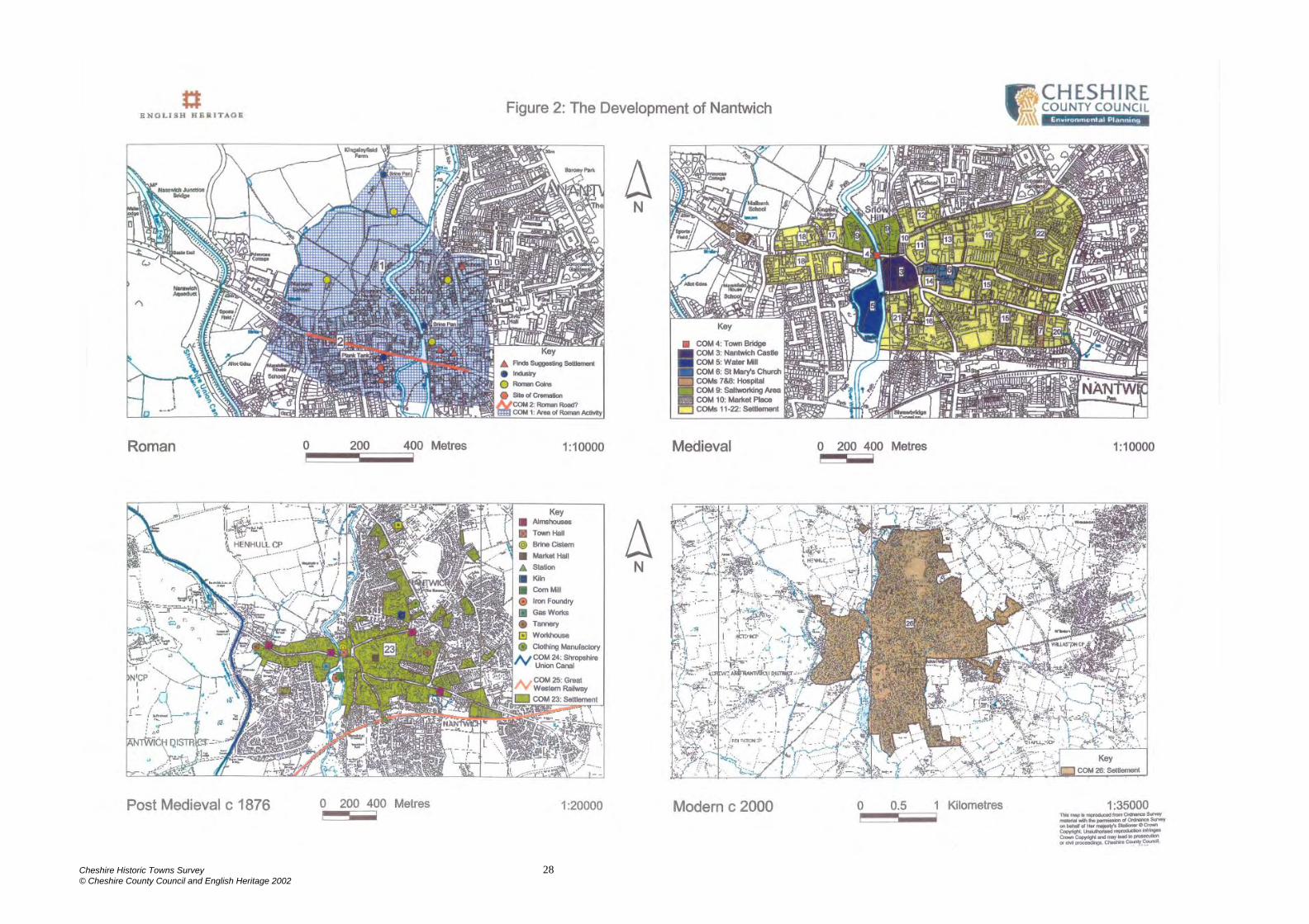
Nantwich with Wolverhampton, which was opened in 1853 (Owen, 1982, 17). The iron aqueduct of the Shropshire Union Canal was designed by Thomas Telford and was completed in 1835 (Ashmore, 1982, 50). Nantwich was also located on a major road until the re-routing of the London to Holyhead road in the 1830s. It was also bypassed by the Grand Junction Railway in 1837 which led to the growth of Crewe, only 8 miles distant and this had an inevitable effect upon Nantwich. The railway finally arrived in Nantwich in 1858, with the opening of the Crewe to Shrewsbury line, followed by the Great Western, Nantwich to Market Drayton line in 1863 (Greville, 1954, 137-139). 3.5.8 The Surrounding Area There are a number of surviving 17th century buildings in the surrounding area, for example the Star Inn on Chester Road, Acton which is 2km west of Nantwich (CSMR 268/0/1); and Red Hall Farmhouse at Wistaston, 2.5km north-east of Nantwich (CSMR 230/1). One kilometre to the west of Nantwich is Dorfold Hall (Listed Grade I), which was built in the 17th century and has a registered Park and Garden of 18th century date (CSMR 268/3). 4. PLAN COMPONENTS (Figure 2) The town has been divided into 26 plan components (prefixed by COM). These have been tentatively sub-divided by period, although there is a need for a great deal of further work to define the date of these plan components more closely. Many would have spanned more than one period but are discussed under their earliest likely date of occurrence. In some cases tightly defined plan components can be identified. In others only a general area can be delineated and a tighter definition can be achieved by further fieldwork. The origins, nature, form and development of the town are all still incompletely understood. A broad outline of its development can, however, be attempted, which can be tested and refined as further work is carried out. Although there was an early medieval salt producing settlement at Nantwich, the location and extent of this is unknown and it has therefore not been possible to produce a plan of the town during this period. As such, its identification should be treated as a research priority. ROMAN c 43BC- c 450AD (Figure 2) COM 1 - Area of Roman Activity COM 2 - Roman Road? MEDIEVAL c 1066 –1540 (Figure 2) COM 3 - Nantwich Castle COM 4 - Town Bridge COM 5 - Water Mill COM 6 - St Mary’s Church COM 7 - Hospital of St Nicholas
Cheshire Historic Towns Survey 13 © Cheshire County Council and English Heritage 2002
COM 8 - Hospital of St Leonard COM 9 - Saltworking Area COM 10 - Market Place COM 11 - Settlement, east of High Street, south of Beam Street COM 12 - Settlement, north of Beam Street COM 13 - Settlement, south of Beam Street COM 14 - Settlement, east of High Street and south of St Mary’s church COM 15 - Settlement, Hospital Street COM 16 - Settlement, west of Pillory Street COM 17 - Settlement, east of Welsh Row COM 18 - Settlement, Welsh Row COM 19 - Settlement, south and east of Beam Street COM 20 - Later medieval settlement, east of Hospital Street COM 21 - Tanning area, later a settlement area, Barker Street COM 22 - Crofts and Gardens POST MEDIEVAL c 1876 (Figure 2) COM 23 - Settlement COM 24 - Shropshire Union Canal COM 25 - Great Western Railway MODERN c 2000 (Figure 2) COM 26 - Settlement 4.1 Roman (Figure 2) The scale and nature of settlement at Nantwich is uncertain, therefore COM 1 is intended to indicate a broad zone of activity, within which it is likely that Roman settlement and industry were located. The available evidence indicates that there was settlement dating to between the 2nd and 4th centuries AD. Presumably, as in Middlewich and Northwich, this settlement was engaged in the exploitation of brine. However, there is no evidence to suggest that there was military activity at Nantwich as there is for the other two salt producing centres. It has been suggested that Roman brine workings were perhaps confined to the west bank, with settlement on the east bank. There may even have been a road (COM 2) that connected the two. This is potentially indicated by the straight line that appears to connect the ends of Hospital Street and Welsh Row, crossing the river to the south of the present bridge. This also suggests the possible location of a Roman crossing over the river Weaver. Of course this may also date to the medieval period but the close proximity of the route to the major areas of Roman finds at Davelyn House and the Crown Car Park suggest that it may have Roman origins. 4.2 Medieval (Figure 2) The nature and extent of Nantwich Castle (COM 3) is unknown and the outlined area is therefore provisional since it is based upon limited excavation data and topographical evidence. However, the size defined at around 1.4ha compares well with motte and bailey castles elsewhere in the county (eg Aldford 1.5ha, Dodleston 1.3ha). Topographically it would have been a prime location, overlooking either a
Cheshire Historic Towns Survey 14 © Cheshire County Council and English Heritage 2002
ford across the river to the south or a bridge crossing to the north. It was also well sited for the overseeing and controlling of brine working to the north in the Snow Hill area. It is not known when the castle fell out use but by the 16th century the High Street frontage was given over to wealthy merchants’ houses and inns, notably the Crown Inn, which was rebuilt after the fire of 1583. Whether this development commenced after the abandonment of the castle or began earlier by gradual encroachment onto the castle site is uncertain. Plots vary in size but by the time of the earliest maps buildings are generally at right angles to the street with widths of c 8m and lengths of up to 70m. Archaeological excavations suggest that the back area of these tenements was given over to industrial functions, especially saltworking and tanning (Williams 1975; McNeil 1978). A bridge at Nantwich COM 4 is first mentioned in 1398-9 but when this was constructed and whether it had a predecessor is unknown. The present stone structure was built in 1803. Meanwhile, the earliest reference to a mill (CSMR 179/12) is dated around 1228 (Hall 1883, 6) but its date of construction and its precise location is uncertain. However, it is likely that the medieval mill will be on or near the site of the post medieval corn mill (COM 5). Lake suggests that the cutting of a mill leat and the creation of an island upon which the mill stood can be ascribed to the 16th century (1983, 11-12) The fabric of St Mary’s Church (COM 6) dates largely to the 14th century, with 19th century restoration. However, a chapel of ease is known to have stood on this site by the mid-12th century. The full extent of the medieval and post medieval churchyard is uncertain but the discovery of human remains north of Churchyardside indicates that the extent of the graveyard has been reduced. It is not known when this occurred. A guildhall was located on the north side of the churchyard, the remains of which excavation in 1976 failed to discover. There were two medieval hospitals in Nantwich. The first, the hospital of St Nicholas (COM 7;CSMR 179/5) is thought to have been founded at the end of the 11th century at 140 Hospital Street, and this would have marked the eastern limits of the town at this time. The second is the probable site of the hospital and chapel of St Leonard on Welsh Row (COM 8; CSMR 179/6). As a leper hospital it would have stood outside the settled area. While the location of the early medieval saltworking is unknown, the area of medieval saltworking (COM 9) is better understood. Located at Snow Hill, one of the main saltworking areas, was the medieval brine pit ‘the Old Biot’, which may also have been the site of the early medieval brine workings. A survey of 1624 demonstrates that Snow Hill and Wood Street were the location of many of the wich houses or saltworks (CRO DCH/Y/10). The Wood Street excavations in 1979-80 located two well-preserved salt houses that dated from the late 12th century and apparently represent a later expansion of the industry from Snow Hill on the opposite bank of the river. Work adjacent to the Cheshire Cat, at the southern end of Second Wood Street, in 2001-2 also provided evidence of saltworking. Wyche House Bank was also an area largely given over to saltworking as its name would imply. It is uncertain when the industry expanded to this area but it was in existence by the time
Cheshire Historic Towns Survey 15 © Cheshire County Council and English Heritage 2002
of the 1624 survey. A small saltworking area is located north-west of the castle, which may have covered a larger area as evidence of saltworking was found on the south side of the castle site. This was also the site of the last saltworks in the town which closed in 1856. There are three market areas defined by COM 10. The first is an area that lies just off the High Street, to the west of St Mary’s Church, which together with the High Street and the churchyard to the east, is likely to have been used as a market from early times, perhaps during the life of the castle when its position between the castle and church would have made it a prime location. A market hall and sessions house was built on this site in 1720 (CSMR 179/15). This building fell down twice but was rebuilt in 1760 as a single storey market hall and this continued to be used until it was replaced by the present market hall in 1868. The second market place is a triangular market area between the High Street and Beam Street. Its date is uncertain but is probably medieval, although the street names of Swine Market and Oat Market are not recorded until 1794, by which date the area between the streets had been built over. The third market is the Beam Street cattle market. The west end of Beam Street characteristically widens out, suggesting that this was the location of one of the medieval markets. COM 11 is a densely settled area at the centre of town, surrounded by Pepper Street to the east, High Street and Oat Market to the west and Beam Street to the north. The shape of this plan component suggests that it may at one time have formed an open market area beside the castle. The High Street/ Oat Market properties appear to have been the first to be laid out with widths of c10m and lengths of up to 70m. Pepper Street plots are markedly smaller with widths of c5m and lengths of c20m, suggesting that they may have been inserted into the back of properties that front onto the High Street. There are a number of medieval settlement components – COMs 12-21. COM 12 is an area of Medieval settlement to the north of Beam Street. Here burgage plots are 10-14m wide and 60-70m in length. In COM 13 burgage plots are present on Pepper Street and Beam Street; those on Pepper Street are the larger (often 7-8m by 45m) suggesting that it was the dominant frontage. In the 19th century there were only properties along the north side of Churchyardside; the remainder of Churchyardside, Crowsfoot Lane and the area between being gardens. COM 14 is a densely settled town centre area. High Street is the dominant frontage with plots around 10m in width and 40m in length. By 1851 the back areas of properties are built up with access via a passageway. Church Lane plots are smaller, c 5m by 20m. The most notable property is the Lamb Hotel at the corner of Hospital Street and Church Lane which was used as the Parliamentarian headquarters in the Civil War, although the present building dates from 1861. For COM 15, Hospital Street is the dominant frontage with burgage plots c 5-10m wide and 40-50m long. A major building is Sweetbriar Hall, a late medieval town house of the Wilbrahams of Woodhey which survived the Great Fire of 1583, although now much altered. To the north of Hospital Road the settlement area is bisected by a back lane - The Gullett. Its date of inception is uncertain but it is shown on Fenna’s map of 1794. The north-eastern quarter of the area was largely
Cheshire Historic Towns Survey 16 © Cheshire County Council and English Heritage 2002
crofts and gardens until quite recently. Pillory Street is also heavily built up with a number of inns located at the northern end, close to the town centre. Pillory Street remains the dominant frontage in COM 16 with plots c 5m wide and 30m long. Small properties also front onto Love Street and Mill Street. The southern portion of this component was formerly occupied by the mansion house of one of the gentry families, Maisterson’s Hall or Pillory Street End Mansion (CSMR 179/4), described as ‘a very ancient house’ in 1622 (Hall 1883, 125). It was taken down in 1797 and replaced by Elm House which has in turn been recently demolished. COM 17 is an area of settlement to the west of the Wood Street saltworking area. Building plots extend backwards for around 100m towards the town fields. They are of a very different form to COM 18, which lies immediately to the west and has the appearance of planned medieval settlement with very long, narrow burgage plots and back lanes that lead to the town fields behind. The excavation evidence from the salt houses at Wood Street would suggest that industrial activity had spread to the west bank by the late 12th century, and settlement probably spread along Welsh Row around the same time. Certainly the foundation of the leper hospital at the west end of Welsh Row is unlikely to be later than the 12th to 13th centuries and this would suggest settlement on the west bank, although this would not have stretched as far as the hospital itself while it continued to house lepers. In 1580 Townsend House, a substantial brick mansion, was built by Richard Wilbraham at the western end of Welsh Row. By 1810 it was dilapidated and was converted into a brewery in 1824 and in 1855 into a clothing factory (CSMR 179/7). It has now been demolished. There are burgage-style tenements along Beam Street COM 19, c 8-10m wide and 80m long. Behind them is a back lane, named the Rope Walk on the 1851 Ordnance Survey map, which until recently separates the Beam Street tenements from an area which was predominantly gardens and orchards. Two rope makers were recorded in the town in 1822 (Pigot & Co 1822). COM 20 lies to the east of St Nicholas’ hospital and was probably not settled until late in the medieval period. The eastern portion of the area is occupied by Churche’s mansion, a commodious gentry house of 1577, which is one of the finest surviving houses in the town. The street name of Barker Street, recorded from 1421, would suggest that this area (COM 21) was the site of the tanning quarter in the medieval period. It would have been an eminently suitable site for the industry as it had a ready access to water for the washing and soaking of hides. Its position upstream of the main settlement area would not, however, have improved the purity of the water. This consideration and the generally noxious nature of the industry would have encouraged a move further to the edge of the town once the settlement had expanded. Plots on Barker Street are of burgage type with a narrow frontage c 10-15m in width, but extending back towards the river for a distance of around 70-80m. By the 18th to 19th centuries the area was given over to a mixture of wealthy houses with pleasure grounds leading down to the river and industrial premises, chiefly malthouses.
Cheshire Historic Towns Survey 17 © Cheshire County Council and English Heritage 2002
The area of COM 22 belonged to Combermere Abbey and was used in the medieval period as crofts and gardens. It was still largely unsettled until the 19th century. Nevertheless it lies outside the field system and must have been defined at an early date in order to influence the alignment of Millstone Lane. It may have had an earlier significance as a boundary of some form. 4.3 Post Medieval (Figure 2) Post medieval Nantwich COM 23 had grown only slightly since the medieval period, which is very much reflected by the small scale growth depicted upon the OS 6”:1 mile 1st Edition map surveyed 1876. The chief reason for the small scale expansion seems to have been a desire to build gentry mansions and almshouses on the edge of town, though whether this indicates that the central area was fully developed or whether it was simply easier or more fashionable to build on the edges of the town is uncertain. The lack of development on ‘The Crofts’, an obvious area for expansion, suggests that there was not any great pressure for land. The Beam Street End mansion house (no longer standing) was in existence by 1590 when it was bequeathed by Roger Mainwaring to his wife (Hall 1883, 449). It probably represents the first encroachment onto ‘The Crofts’. The mansion was converted into a House of Correction in 1677 and pulled down in 1767 when Crewe’s Almshouses (179/0/45) were built on the site. Wright’s Almshouses were built in 1638 on land which had formerly belonged to St Nicholas’ Hospital, then in 1676 Roger Wilbraham founded the Widows’ Almshouses on Welsh Row, adapting three existing houses for the purpose. Sited at the western end of Welsh Row are the Tollemache Almshouses which are built on the site of the former Wilbraham’s Almshouses built in 1613, which were reputedly on the site of St Leonard’s Leper Hospital (COM 8). This western end of Welsh Row is unlikely to have been occupied while St Leonard’s served as a leper hospital and may have remained unoccupied until the post-medieval period. However, buildings were located here by 1794 and the Free Grammar School (CSMR 179/17) was built here in 1860. Properties to the north of Beam Street are small, with little resemblance to the typical ‘burgage plot’. This and the location of the area away from the centre of the town suggest that it was settled later, perhaps as encroachment onto town fields or heathland. This settlement is suggested as taking place in the post-medieval period, although a date later in the medieval period is equally possible. Nantwich is not renowned for being an industrial town. Saltworking continued in the Snow Hill and Wood Street areas, but declined from the 17th century onwards. In addition, there are a number of small scale industrial features in the town. For example, the town mill was converted to cotton production in 1789. This ceased in 1874, from when the mill had a variety of uses before being demolished in 1970. Gas works were constructed in the town on St Anne’s Lane in 1832 and a clothing manufactory was located just off Barony Road owned by Messrs Harlock and Co. in 1874 (Morris and Co. 1874, 91). Local transportation included the Shropshire Union Canal which runs west of Nantwich COM 24, the second section of which was opened in 1835, and the railway to the south of Nantwich COM 25, which had limited impact upon the town, unlike the small rural settlement of Crewe to the east which expanded beyond all recognition.
Cheshire Historic Towns Survey 18 © Cheshire County Council and English Heritage 2002
4.4 Modern (Figure 2) Since the mid-1950s there has been a growth on the west bank of the river, northwards for schooling and southwards for housing (Millfields etc). On the east bank of the river there has been a growth of housing to the north and south and of mixed housing and manufacturing to the east. Part of Broom Heath is now The Barony Park. ‘The Crofts’ were gradually given over to housing and industrial developments, while the enclosure of Beam Heath saw new building to the north east in the late 19th to early 20th centuries. 5. ARCHAEOLOGICAL POTENTIAL 5.1 Above-Ground Remains Although few buildings survive from the medieval period, since most of the town was destroyed in the ‘Great Fire’ of 1583, there are substantial historic remains surviving above ground in Nantwich. The historic core, which retains its medieval street pattern (with possibly earlier origins) is a designated Conservation Area and there are three Grade I Listed buildings, four Grade II* and 112 Grade II Listed Buildings within the settlement area. These include a large number of 16th and 17th-century timber framed buildings, particularly along the High Street and Hospital Street e.g. Churche’s Mansion on Hospital Street, which is dated 1577 and Listed Grade I. Also, immediately north-west of the town is the site of the 17th century battlefield of the Battle of Nantwich which is registered in the English Heritage list of battlefields. 5.2 Below-Ground Remains A number of problems are encountered in assessing the archaeological potential of the town. Whilst there has been a significant amount of archaeological work carried out there has been a general failure in the earlier work to record data regarding the exact location of trenches, depth of archaeological deposits and the likely survival of deposits following development. Nevertheless, the work that has been carried out has been enough to demonstrate the high archaeological potential of the town. Where records survive archaeological levels have been shown to survive deeply buried below the modern ground surface and there are extensive areas of well preserved waterlogged deposits, especially close to the river. For example, at Wood Street on the west bank of the river archaeological levels were located below 1m of overburden and a wide range of organic material was preserved. These included complete timber brine troughs or ‘ships’ and leather artefacts, especially shoes. Again, at the Cheshire Cat, at the southern end of Second Wood Street, medieval layers were encountered at a depth of 1m, whilst Post Medieval deposits survived between 500mm and 700mm below ground level. The site was rich in the survival of both timber artefacts and structural remains with high potential for the recovery of palaeoenvironmental remains. On the east bank of the river the excavations at Crown car park and Bowers Row car park demonstrated the presence of around 3m of archaeological deposits, again sealed below approximately 1m of overburden. At both sites the environmental potential was classified as high.
Cheshire Historic Towns Survey 19 © Cheshire County Council and English Heritage 2002
Waterlogged deposits have also been retrieved from the rear plots of 31 and 35 Hospital Street. Finds have included medieval leather shoes and wooden beams dating between the 13th and 15th centuries (CSMR 179/0/19 and 179/0/20). Away from the River, for example at Davelyn House, Roman material was recovered from around 1m below the ground surface, while at Cocoa Yard and 1 Welsh Row, archaeological levels were buried below c 0.5m of overburden. Although the details of the excavation are unclear, a trial trench dug in 1975 to the rear of 47 High Street revealed 2.85m deep makeup over natural sand (CSMR 179/0/18). Archaeological work undertaken so far on the medieval settlement has established that further work is likely to be rewarding, and the occurrence of at least two widespread and dateable fires may help in giving a terminus antequem for deposits below fire levels. 6 PRIORITIES FOR ARCHAEOLOGICAL WORK 6.1 General The study of Nantwich forms part of a national research priority to examine the origins and development of medieval small towns and rural markets (Priority H5; English Heritage 1997, 49). In addition it would make a contribution to the study of industrial archaeology (Priority T6; English Heritage 1997, 53) and to the understanding of patterns of craftmanship and industry (T7). Work at Nantwich would fit into a number of national priorities, in particular the following processes of change:
• PC4 Briton into Roman – For example, is there exploitation of salt in the Iron Age and continuity into the Roman period?
• PC5 Empire to Kingdom – For example, is there any continuity of
exploitation of salt between the late Roman and early medieval periods? • PC6 Late Saxon to medieval – For example, the nature of the urban form,
is there any evidence for major reorganisation of the town after the Norman conquest?
6.2 Roman • Establish the area and status of the settlement during this period. • Examine the origins of the exploitation of brine at Nantwich. Can this be dated
back to the Iron Age or did salt production begin in the Roman period? What was the nature and scale of salt production at Nantwich?
6.3 Early Medieval • Establish the nature and extent of settlement during the early medieval period. • Examine the relationship between Nantwich and Acton in the early medieval
period (
Cheshire Historic Towns Survey 20 © Cheshire County Council and English Heritage 2002
• Establish whether there were dwellings at Nantwich or were the salt workers housed at Acton, or elsewhere? Were there administrative buildings at Nantwich or were these at Acton?
• Establish the nature and extent of brine exploitation during the early medieval period. Was there continuity from the Roman period? Is there any evidence for the ditch mentioned at Domesday?
6.4 Medieval • Establish precise location of settlement areas and date their phases of expansion
and contraction. • Establish the nature of buildings on settlement plots. • Establish the foundation date of the church. Date phases of expansion. • Establish the foundation date of the castle, establish the layout and extent of this
and any phases of expansion and contraction. Establish when it was in use and when it was abandoned.
• Establish the extent of the saltworking industry, examine phases of expansion and contraction.
• Examine evidence of industries other than salt, identify whether well defined activity zones can be identified.
• Examine when a bridge across the Weaver was first constructed, allowing the settlement to spread on both sides of the river.
• Establish the location of the towns medieval water mills. • Establish the location of the medieval market places. 6.5 Post Medieval • Establish precise location of settlement areas and date their phases of expansion
and contraction. • Establish the location of the Civil War defences. • Examine the decline of the brine industry. • Examine trade and industry and the effect of the railway and canal upon this. 7 SOURCES 7.1 Bibliography Archives and Local Studies, 1996 Nantwich, Township Pack 60 Cheshire County Council Bilsborough, N, 1991 The Treasures of Cheshire, Bolton Booth, P H W 1985 Cheshire Mize Book 1405 unpublished transcript Cowdroy, W 1789 The Directory and Guide for the City and County of Chester, Chester Crosby, A, 1996 A History of Cheshire, Phillimore
Cheshire Historic Towns Survey 21 © Cheshire County Council and English Heritage 2002
CSMR, County Sites and Monuments Record, Environmental Planning, Cheshire County Council Dodgson, J McN, 1971 The Place Names of Cheshire: Part III. The Place Names of Nantwich Hundred and Eddisbury Hundred, Cambridge University Press Dore, R N, 1966 The Civil Wars in Cheshire, Cheshire Community Council Dunn, F I, 1987 The Ancient Parishes, Townships and Chapelries of Cheshire Earthworks Archaeological Services, 1996 An Archaeological Watching Brief at 10-16 High Street, Nantwich, Cheshire, unpublished report for Densems (Holdings) Ltd and Bower Edleston Architects Earthworks Archaeological Services, 1997a An Archaeological Evaluation on Land Adjacent to Riverside, Nantwich, Cheshire, unpublished report for Bett Homes (Northern) Ltd Earthworks Archaeological Services, 1997b An Archaeological Watching Brief at The Cocoa Yard, off Pall Mall, Pillory Street, Nantwich, Cheshire, unpublished report for Bower Edleston Architects Earthworks Archaeological Services, 1997c Note on An Archaeological Watching Brief at No. 1 Welsh Row, Nantwich Earthworks Archaeological Services, 1998 An Archaeological Watching Brief During Redevelopment on Land Adjacent to Riverside, Nantwich, Cheshire, unpublished report for Bett Homes (Northern) Ltd Earthworks Archaeological Services, 2000 Improvements to the heating System at St Mary’s Church, Nantwich, Cheshire. An Archaeological Watching, unpublished report for TACP Earthworks Archaeological Services, 2001 Proposed Redevelopment at Second Wood Street & Rear of the Former ‘Cheshire Cat’, Welsh Row, Nantwich, Cheshire. A Programme of Archaeological Evaluation, unpublished report for Bower Edleston Architects Earthworks Archaeological Services, 2002 A Note on Observations During Groundworks. Rear of ‘The Cheshire Cat’, Welsh Row, Nantwich, Cheshire. unpublished report for Schofield Brothers English Heritage, 1995 Battlefields Register English Heritage, 1997 English Heritage Research Agenda, Draft 8 April 1997 Furness, R R, 1978 Soils of Cheshire Soil Survey Bulletin No.6 Garton, E, 1972 Nantwich Saxon to Puritan Johnson
Cheshire Historic Towns Survey 22 © Cheshire County Council and English Heritage 2002
Gifford and Partners, 1995 Report on an Archaeological Evaluation and Excavation at Bowers Row Car Park, Nantwich, unpublished report for the Borough of Crewe and Nantwich Gifford and Partners, 1997 Report on an Archaeological Watching Brief at Welsh Row, Nantwich, unpublished report for Linden Homes North West Ltd Hains, B A and Horton A, 1969 British Regional Geology: Central England, 3rd edition Hall, J, 1883 A history of the Town and Parish of Nantwich, Manchester Harris, B E and Thacker A T, (eds), 1987 The Victoria History of the County of Chester: Vol I Oxford University Press Harris, B E (ed), 1979 The Victoria History of the County of Chester: Vol II Oxford University Press Harris, B E (ed), 1980 The Victoria History of the County of Chester: Vol III Oxford University Press Higham, N J, 1993 The Origins of Cheshire Manchester University Press King, D, 1656 The Vale Royal of England Lake, J, 1981 A History and Guide to Nantwich Lake, J, 1983 The Great Fire of Nantwich, Shiva Publishing MacGregor, A J, (ed), 1992 The Alehouses and Alehouse-Keepers of Cheshire, 1629-1828 McNeil, R, 1980/1 Nantwich, three years of excavations and observations, Cheshire Archaeological Bulletin 7, 30-33 McNeil, R, 1982 The Bowling Green 1981, Cheshire Archaeological Bulletin 8, 53 McNeil, R, 1983 Two Twelfth Century Wich Houses in Nantwich, Cheshire, Medieval Archaeology 27, 40-88 McNeil, R, undated Archaeology in Nantwich. Crown Car Park Excavations. Interim Report. McNeil, R, and Roberts, A F, 1987 A plank tank from Nantwich, Britannia 18, 287-95 Morris & Company, 1874 Commercial Directory and Gazetteer of Cheshire Morris, E, 1985 Prehistoric Salt Distributions: two Case Studies from Western Britain, Bulletin of Board of Celtic Studies 32, 336-79
Cheshire Historic Towns Survey 23 © Cheshire County Council and English Heritage 2002
Ormerod, G, 1882 The History of the County Palatine and City of Chester, 3 vols, 2nd edition, edited by Thomas Helsby Partridge, J, 1774 An Historical Account of the Town and Parish of Nantwich, Shrewsbury Pigot and Co, 1822 Commercial Directory for the County of Cheshire Platt, J W, 1818 The history and antiquities of Nantwich, London Roberts, A F, 1991 Roman Remains from St Anne’s Lane, Nantwich, unpublished report in CSMR Sylvester, D, and Nulty, G (eds) 1958 The Historical Atlas of Cheshire, The Cheshire Community Council Tait, J, (ed) 1916 The Domesday Survey of Cheshire, Chetham Society, New Series 75 Twigg, G, undated Salt-making in Domesday Cheshire, Cheshire Libraries and Museums West, D, undated The Cheshire Salt Industry in Tudor and Stuart Times (1485-1714), Cheshire Libraries and Museums Williams, S R, 1975 Nantwich SJ 651523: National Westminster Bank, Cheshire Archaeological Bulletin 3, 52. 7.2 Maps (CRO – Cheshire Record Office) British Geological Survey, 1967 1 inch map: Nantwich sheet 122 Burdett, P P, 1777, A Survey of the County Palatine of Chester (The Historic Society of Lancashire and Cheshire Occasional Series Volume 1 1974) Fenna’s map of Nantwich 1794 (CRO DDX 330) Ordnance Survey 10 feet: 1 mile map 1851 Ordnance Survey 25”: 1 mile map 1876 Ordnance Survey First Edition 6”: 1mile sheet 56 surveyed 1876 Saxton, C , 1577 Cestriae Comitatus CRO PM12/10 Speed, J, 1662 The County Palatine of Chester with the Most Ancient Citie Described (reprint of the 1610 original) CRO PM1/11
Cheshire Historic Towns Survey 24 © Cheshire County Council and English Heritage 2002
Tithe Award 1846 (map: CRO EDT 285/2; apportionment EDT 285/1) 8 ILLUSTRATIONS Figure 1: Nantwich and the Surrounding Area Figure 2: The Development of Nantwich
Cheshire Historic Towns Survey 25 © Cheshire County Council and English Heritage 2002
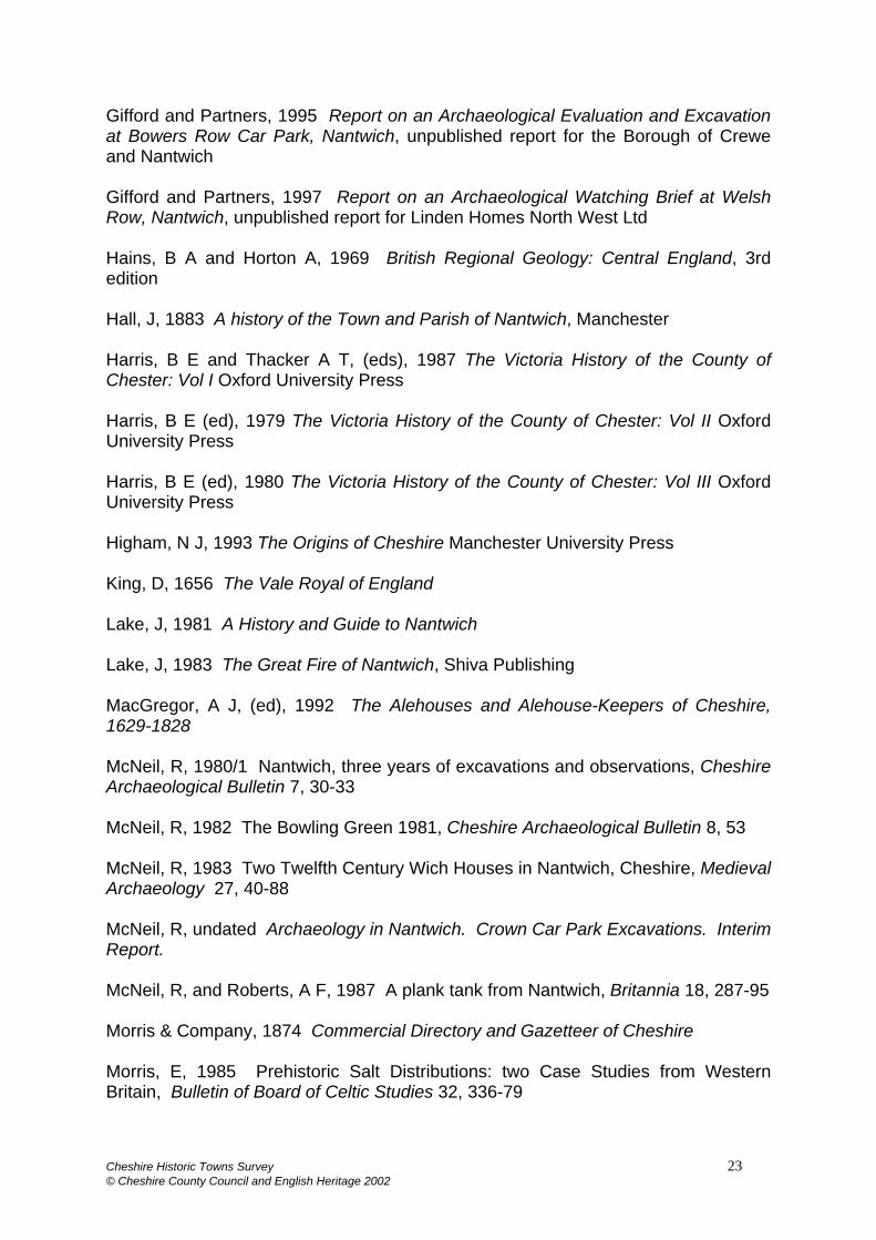
APPENDIX 1 Archaeological Work Carried Out In Nantwich Site CSMR number Excavator Year Reference
Wright’s Almshouses
179/0/1 Frances Celoria
1974 Note in CSMR
47 High Street 179/0/18 John Dent/ Barri Jones
1974 Note in CSMR
Sweet Briar Hall 179/0/21 John Dent/ Barri Jones
1974 Note in CSMR
31 Hospital Street 179/0/19 John Ray 1974-5 Note in CSMR 13-15 Mill Street 179/0/49 John Ray 1974-5 Note in CSMR National Westminster Bank
177/0/6 180/3
David Hill/ Jonathon Parkhouse
1974-6 Note in CSMR
Mill Street 179/0/48 Frances Celoria
1975 Note in CSMR
St Mary’s Churchyard
179/0/3 David Wilson 1976 Note in CSMR
35 Hospital Street 179/0/20 John Ray 1976 Note in CSMR Churche’s Mansion 179/3 David Wilson 1976 Note in CSMR Pepper Street 179/0/52 John Ray pre-1978 Note in CSMR 12A Welsh Row 180/0/4 John Ray pre-1978 Note in CSMR E bank of Weaver 180/0/5 John Ray pre-1978 Note in CSMR W bank of Weaver 180/0/9 John Ray pre-1978 Note in CSMR Crown Car Park 177/0/8 Robina McNeil 1978 McNeil undated Wood Street 180/2 Robina McNeil 1979-80 McNeil 1983 Bowling Green 179/0/55 Robina McNeil 1981 McNeil 1982 St Anne’s Lane 178/0/2 Robina McNeil 1985 McNeil and Roberts
1987; Roberts 1991 Cheshire Cat, Welsh Row
180/0/2 Blacklay pre-1986 Note in CSMR
37 Welsh Row 180/0/3 Rick Turner 1986-7 Note in CSMR Cocoa Yard 179/0/53 Earthworks 1994 Earthworks 1997b 1 Welsh Row 179/0/54 Earthworks 1994 Earthworks 1997c Bowers Row Car Park
179/0/47 Gifford 1995 Gifford 1995
10-16 High Street 179/0/50 Earthworks 1996 Earthworks 1996 Grocott’s Garage, Welsh Row
179/0/51 Gifford 1996-7 Gifford 1997
Riverside 177/0/12 Earthworks 1997-8 Earthworks 1998 St Mary’s Church 179/1/1 Earthworks 2000 Earthworks 2000 Cheshire Cat, Welsh Row
180/4 Earthworks 2001 Earthworks 2001
Cheshire Cat, Welsh Row
180/4 Earthworks 2002 Earthworks 2002
Cheshire Historic Towns Survey 26 © Cheshire County Council and English Heritage 2002
Cheshire Historic Towns Survey 27 © Cheshire County Council and English Heritage 2002
Cheshire Historic Towns Survey 28 © Cheshire County Council and English Heritage 2002