Embed Size (px)
Citation preview

1
PLEASE DO NOT REMOVE THIS COVER SHEET
Checklist for submitting a Region of Durham
Application for Consent
Incomplete applications and/or surveys will not be accepted and will be returned
Have you completed a pre-consultation review with the local municipality and the Region of Durham Planning Department? If not, please contact the applicable local municipality to arrange for same. Then contact Land Division staff at 905-668-7711 to arrange a Regional pre-consultation meeting.
Have you answered all questions in the application form?
Have you completed and attached the Site Screening Questionnaire? See attachment 1.
Is Minimum Distance Separation (MDS) applicable to the subject property? See attachment 2.
Has the Declaration page been signed by the applicant and commissioned by a Commissioner of Oaths? If not, please contact Land Division staff.
Have you completed and included the applicable Location Map?
If you are acting as agent, have you enclosed 2 original copies of the Authorization from Owner? See attachment 3.
Have you included the requisite copies of the draft 40R-Plan? See instructions on page 2.
Have you included all of the requisite fees? If you are unsure as to the fees payable please contact Land Division staff.
Have you included 2 original copies of the Application form?
Have you attached all applicable supporting documents (reports/studies)?
Last updated: January 2018
Office Use Only Submission Date:
File Number: LD Deemed Complete Date:
Municipality: Meeting Date:

2
The Regional Municipality of Durham Application for Consent
AS PER THE PLANNING ACT, AS AMENDED, THE MUNICIPAL ACT 2001, AS AMENDED AND IN ACCORDANCE WITH THE PROVINCIAL REGULATIONS
Instructions to applicant, please read carefully before completing the application.
A. It is the policy of the Region of Durham Land Division Committee that a separate application with applicable fees be submitted for each consent transaction.
To make an application, complete and file two (2) signed original application forms together with all supporting documents, applicable draft 40R-Plan (together with detailed sketch where required) and applicable fees. Submit two (2) copies of the draft 40R-Plan (“8 ½" x 11" or 8 ½" x 14") in size or twenty (20) copies if 11” x 17” or larger.
Note to applicant: All questions in the application must be completed in full otherwise the application will be deemed incomplete and returned to you.
B. In accordance with By-law 24-2016, the following application processing fees apply at submission:
$1000.00 certified funds, unless drawn on a solicitor’s cheque, for each application submitted ;
$300.00 certified funds, unless drawn on a solicitor’s cheque for the Regional Planning Review fee for each application submitted; and
Prior to submitting your application you must contact the Land Division office for othercurrent agency user fees applicable to your consent application(s) at (905) 668-7711 or tollfree 1-800-372-1102.
In accordance with Bylaw 24-2016, the following application fees may also apply after submission:
$150.00 certified funds, unless drawn on a solicitor’s cheque for tabling the application to anothermeeting, if applicable.
$750.00 certified funds, unless drawn on a solicitor’s cheque for stamping a deed and finalization ofdocuments for the application (paid at end of the Land Division process to the Region of Durham).
$250.00 certified funds, unless drawn on a solicitor’s cheque for re-stamping of a deed should thedeed be returned by the Land Registry Office or if deed is revised by the solicitor after stamping.
C. The undersigned hereby applies to the Region of Durham Land Division Committee under the Planning Act, as amended, for consent to the transaction as described, and to the extent set forth in this application.
D. All completed applications, communications, clearances/fulfilment of conditions and requests for Certificates etc. related to applications for consent (severance), (as well as change of conditions, validation of title and approval of foreclosure or power of sale) under the Planning Act must be filed directly with the Durham Region Land Division Office.
E. Please note the application together with any and all documents related thereto are a public record and as such are available for viewing or duplication by the general public upon request.

3
1. Applicant Information
An owner of land or the owner's agent, duly authorized in writing, may apply for consent. Complete the information below (please print legibly using black ink): Owner #1 Owner #2
Name:
Address:
Phone/Fax:
Email: ________ _________
Authorized Agent: Name: Mailing Address: Phone/Fax: _____________________ Email: _______________
2. Type of Transaction: Indicate transaction for which application for consent is being made:
Conveyance: Please select only one (1) of the following:
a) creation of new lot; OR
b) addition to a lot – moving/adjusting lot line
(indicate direction to which the severed parcel will be added):
North South East West
Note: For Lot Line Adjustments only, please also complete the section below:
Name, address and phone number of person(s) to whom the land is intended to be transferred. Name: _ Mailing Address: Phone/Fax: _____________________________
Assessment Roll Number of adjacent property: 18- _______ (15 digits total)
Other – see page #4

4
Other transaction type (please select if applicable):
c) Easement/Right-of-Way
d) Lease
e) Correction of Title
f) Mortgage or Charge
g) Partial Discharge of Mortgage
h) Other e.g. Validation of Title, Approval for Power of Sale/Foreclosure of Mortgage
3. Property Information of subject lands:
Legal Description including Lot & Concession (Mandatory) _____________
Part numbers on draft or registered 40R-Plan ____________
Municipal address, if available ___________
Assessment Roll Number (Mandatory): 18- ___________________________________(15 digits total)
4. Existing easements/right-of-ways or covenants:
YES NO
If YES, please describe below in detail:
Type of Easement Severed Lands Retained Lands
5. Dimensions of Lands in Metric Units (must accurately match dimensions noted on draft 40-RPlan)
Severed Lands Retained Lands
Frontage
Average Width
Average Depth
Total Area

5
6. Use of Land
Severed Lands Retained Lands
Existing Proposed Existing Proposed
Urban Residential
Seasonal Residential
Mobile Home Park
Commercial
Tourist Recreational
Agricultural
Industrial
Institutional
Parkland
Utility
Hamlet/Cluster
Non-Farm Related Rural Residential
Farm-related Rural Residential
Other:
List the number and type of existing and proposed buildings and structures on the lands
7. Agricultural Information
Agricultural Code of Practise – Minimum Distance Separation (MDS)
Is there a livestock barn or manure storage facility located within 1000 metres of the Severed Land?
YES NO
If YES, please complete the attached DATA Sheet – MDS – Attachment 2
Is the purpose of the severance to dispose of a surplus dwelling YES NO
Date of purchase of total holdings:
Details of farm operation: ______
Site Screening Questionnaire – In accordance with the Region’s Council adopted Site Contamination
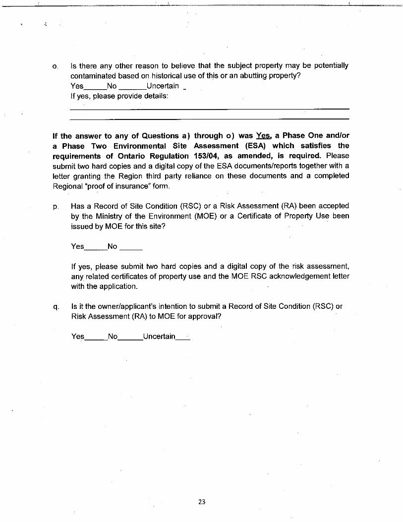
Protocol all Land Division Committee applications must be accompanied by either a completed Site Screening Questionnaire (SSQ), or a Phase One Environmental Site Assessment Report, prepared in accordance with Ontario Regulation 153/04, as amended. The Region’s SSQ can be found in Attachment 1 to this application. For new lots, the SSQ must be signed by a Qualified Person.

6
8. Has there ever been an application for consent by the current or previous owners on this parcel of land?
YES NO
LD File Number(s):
For what use?
Date of transfer, name of transferee and land use:
9. Has the parcel to be severed or retained ever been or is it part of an application for plan of subdivision?
YES NO
If YES, specify date and File No.:
Status of File:
10. Has the subject or retained land ever been the subject of a variance, zoning amendment,
Minister's zoning order amendment or official plan amendment application?
YES NO
If YES, specify date and File No.:
Status of File:
11. Durham Regional Official Plan Designation (Please contact Regional Planning and Economic Development Department staff for this information)
Severed Land:
Retained Land:
12. Is the application consistent with the Provincial Policy Statement?
YES NO

7
13. Is the subject land within an area of land designated under the Oak Ridges Moraine
Conservation Plan? (Please contact the Regional Planning and Economic Development
Department staff for this information)
YES NO
If YES, please specify whether the application conforms to or does not conflict with the Oak Ridges Moraine Conservation Plan: _________________________________________________________________________________
_________________________________________________________________________________
14. Is the subject land within the Greenbelt Area? (Please contact the Regional Planning and
Economic Development Department staff for this information)
YES NO
If YES, please specify whether the application conforms to or does not conflict with the Greenbelt Plan:
_________________________________________________________________________________
_________________________________________________________________________________
15. Please specify whether the application conforms to or does not conflict with the Growth Plan
for the Greater Golden Horseshoe:
_________________________________________________________________________________
_________________________________________________________________________________
16. Is the subject land within an area of land designated under the Lake Simcoe Protection Plan?
(Please contact the Regional Planning and Economic Development Department staff for this
information)
_________________________________________________________________________________
_________________________________________________________________________________
17. Local zoning information (Please contact the area municipality for this information)
Severed Land Retained Land
Municipal Official Plan Designation:
Zoning Regulations:
a) By-law Number
b) Zoning Category
c) Minimum Frontage
d) Minimum Area

8
18. Services existing and proposed:
Severed Land Retained Land
Existing Proposed Existing Proposed
a) Public Water and Sewers
b) Public Water and Private Sewage System
c) Public Sewer and Well
d) Well and Private Sewage System
e) Other: Communal, Lake Water, etc.
If proposed, specify when above will be available:
If a private sewage system exists on the proposed severed or retained lands, please provide the following details:
Severed lands: Installation date: Health Dept. File Number:
Retained lands: Installation date: Health Dept. File Number:
If applicable, please provide a separate site servicing plan with the application.
19. Property Frontage/Access to: Severed Land Retained Land
a) Open Municipal Road
b) Regional Road
c) Provincial Highway
d) Unopened Road Allowance
e) ROW
f) Other:
Name of Road(s)
Is access by water?
YES NO If YES, what boat docking and parking facilities are available? Distance of docking and parking facilities from nearest public road and from subject property:

9
20. 40R-Plan Requirements:
The applicant shall submit 2 copies of the draft 40R-Plan together with detailed sketch, where required, on 8 ½" x 11" or 8 ½" x 14" or provide 20 copies if 11” x 17” or larger. The draft 40R-Plan and/or sketch, where applicable, must show the following information:
a) abutting lands owned by the owner showing the boundaries and dimensions;
b) the distance between the owner's land and the nearest township lot line or appropriate landmark (i.e. bridge, railway crossing, etc.);
c) the boundaries and dimensions of the severed and the retained parcels and the location of all land previously severed;
d) the boundaries and dimensions of easements, right-of-ways, leases, mortgages, etc., existing and being applied for on the subject land and the boundaries and dimensions of any easements, right-of-ways, leases, mortgages, etc., existing or being applied for on the retained land;
e) the approximate location of all natural and artificial features on the subject land (i.e. buildings, railways, roads, watercourses, drainage ditches, rivers or stream banks, slopes, wetlands, wooded areas, wells and septic tanks) and on adjacent lands which may affect the application;
f) the use of adjacent lands (i.e. residential, agricultural, cottage, commercial, etc.);
g) the location, width and names of all road allowances, streets, right-of-ways, highways within or abutting the property, indicating whether they are public travelled roads, private roads or right- of-ways or unopened road allowances;
h) the location and nature of any right-of-way or easement affecting the subject land; and
i) if access to the subject land is by water only, the location of the parking and boat docking facilities.
Finalization Of Consent:
Once all of the conditions contained in the Committee’s Decision are fully satisfied, the applicant’s solicitor must prepare and forward the legal document(s) with the applicable fee to the Region of Durham Land Division Committee office, to the attention of the Assistant Secretary-Treasurer.
For most applications (lot line adjustments and/or new lots) the legal documents, as prepared by a Solicitor, shall include the following documents in triplicate:
1. Draft of the complete Transfer/Deed of Land (including the Land Transfer Tax Affidavit); 2. Acknowledgement and Direction document signed by all owners; and 3. Schedule “A” Certificate for stamping (the full legal description of the “severed” lands).
The legal document(s) is/are to contain a registrable description satisfactory to the Registrar in keeping with the current requirements of the Registry Act. 5 working days are required for the review and stamping of the legal document(s) indicating the Committee's consent.
The document(s) will be returned to the solicitor for registration purposes.

10
REGIONAL MUNICIPALITY OF DURHAM
DECLARATION
This declaration must be completed by the Applicant and signed in the presence of a Commissioner for Taking Affidavits
I/We of the (name of applicant) (name of City, Town, Township, etc.)
in the Region/County/District of solemnly declare that all of the statements
contained in the application for consent and all supporting documents are true and complete, and I make this
solemn declaration conscientiously believing it to be true, and knowing that it is of the same force and effect as
if made under oath, and by virtue of the "Canada Evidence Act."
Declared before me at:
in the Region/County/District of
this day of
, in the year .
Owner/Agent
Commissioner of Oaths
THIS APPLICATION MUST BE SUBMITTED TO:
Durham Region Land Division Committee Telephone: 605 Rossland Rd. E., 4th Floor (905) 668-7711 Whitby, ON L1N 6A3 1-800-372-1102 (Toll Free Line) Facsimile: (905) 666-6208
SELECT AND ATTACH APPLICABLE LOCATION MAP IDENTIFYING LOCATION OF SUBJECT LAND

DIX
IE R
D
SQ
UIR
ES
B
EA
CH
RD
NO
TION
R
D
CH
UR
CH
ST
SID
ELIN
E 24
SH
OA
L PO
INT R
D
AU
DLE
Y RD
KIN
SA
LE R
D
SID
ELIN
E 4
GR
EE
NW
OO
D R
D
PAD
DO
CK
RD
CO
RO
NATIO
N R
D
CO
UN
TRY LA
MCQUA
YBV
PIC
KE
RIN
G
BE
AC
H R
D
RAVE
NS
CR
OFT
RD
SID
ELIN
E 20
SID
ELIN
E 16
SID
ELIN
E 14
HA
LLS R
D
LYNDEBROOK RD
HA
LLS R
D
SA
ND
Y BE
AC
H R
DVA
LLEY
FAR
MRD
RIV
ER
SIDE
R
D
WHITEVALE RD
SID
ELIN
E 22
HA
RW
OO
D AV
SA
LEM
RD
AU
DLE
Y RD
GA
RD
EN
ST
FIFTH CONCESSION RD
ROSSLAND RDROSSLAND RDS
ALE
M R
D
FINCH AV
BR
OC
K R
D
HAR
WO
OD
AV
HE
NR
Y ST
TAUNTON RD
DUNDAS STKINGSTON RDW
ES
TNE
Y RD
VICTORIA ST
LAK
E R
IDG
E R
D
BR
OC
K S
T
BAYLY ST
TAUNTON RD
St.L.&H.
St.L.&H.
C.N.R.C.N.R.
St.L.&H.
BROUGHAM GREENWOOD
ALMONDVILLAGE
MACEDONIANVILLAGE
PORTWHITBY
AJAX
TOWN OF
KINSALE
PICKERING BEACH
PICKERING VILLAGE
AUDLEY
MoorePoint
Richardson Point
WhitbyHarbour
LyndeC
ree k
Lynde Creek
Carruthers
Creek
EastDuffinC
re
ek
East
Duffin
C reek
Gana tsekiago
nCree
kU
r fe' Cree k
Sprin gC
reek
BroughamC
reek
Carruth
ersC
reek
CranberryMarsh
401
401
7
4
43
2
23
4431242
22
37
29
45
31
12
7
Prepared by The Regional Municipality of Durham Planning Department January 2001
l:/projects/Roads_Map_2001/Roads_Map_Illustrator/Ajax_Roads
LegendProvincial Highways
Regional Highways
Regional Roads
Municipal Roads
Freeway Interchanges
401
2
44
0 2 4 6
Scale in Kilometres
2
The Regional Municipalityof Durham

PORTBOLSTER
MAPLE BEACH
SCUGOG LINE 14
FOWLERS RD
CONCESSION 2
CONCESSION 4
SID
ER
OA
D 17A
CONCESSION 7
CONCESSION 8
CONCESSION 9
BR
OC
K R
D
CONCESSION 10
CONCESSION 11
CONCESSION 14
CONCESSION 13
SID
ER
OA
D 17
CONCESSION 3
CONCESSION 2
CONCESSION 4
CONCESSION 9
CONCESSION 10
THO
RA
H S
IDE
RO
AD
SID
ER
OA
D 18
SID
ER
OA
D 18A
CONCESSION 14
RIDG
E RD
SID
ER
OA
D 18
CONCESSION 10
CONCESSION 11
CONCESSION 9
SID
ER
OA
D 17
CONCESSION 6
CONCESSION 2
CONCESSION 4
CONCESSION 5
SID
ER
OA
D 18
BROCK RD
CONCESSION 6
CONCESSION 7
CONCESSION 8
SID
ER
OA
D 17
SID
ER
OA
D 17
LAK
E R
IDG
E R
D
SIMCOE ST
MARA RD
OSBORNEST
HW
Y NO
. 12
CRESSWELL
WOODVILLE
LORNEVILLE
ARGYLE
HW
Y NO
. 46HWY NO 48
HWY NO. 7
COUNTY
C.N.
R.
SAINTFIELD
LEASKDALE
UDORA
SONYA
LAYTON
PINDALE
BLACKWATER
SUNDERLAND
VALLENTYNE
VROOMANTON
CEDARHURST
MOORELANDS
BEAVERTON
MANILLA
VICTORIACORNERS
THORAHBEACH
BROCK
OF
TOWNSHIP
WICK
CANNINGTONWILFRID
GAMEBRIDGE
DERRYVILLE
SEAGRAVE
BeavertonHarbour
ThorahIsland
CentrePoint
SouthPoint
NorthPoint
MaraPoint
EaglePoint
Woodman Point
Wagner Lake
Beav
erRi
ver
Vro
oman
Cre
ek
Beaver River
White's
C reek
Talbot River
Trent Canal
Uxb
ridg
eB
rook
12/48
48
7
7/12
12
13
23 2
13
10
23
23
15
23
47
50
2
6
12
48
LLOY
DS
IDE
RO
AD
WE
THE
RA
LS
IDE
RO
AD
SH
IER
RD
LAK
E R
IDG
E R
D
CA
ME
RO
NS
IDE
RO
AD
SID
ER
OA
D 18A
SID
ER
OA
D 18
LegendProvincial Highways
Regional Highways
Regional Roads
Municipal Roads
2
12
2
Trans-Canada Highway
Prepared by The Regional Municipality of Durham Planning Department January 2001
l:/projects/Roads_Map_2001/Roads_Map_Illustrator/Brock_Roads
0 2 4 6 8
Scale in Kilometres
2
The Regional Municipalityof Durham
TOO
LEY R
DFIC
ES
RD
NASH RD
SO
LINA R
D
HO
LT RD
SOUTH SERVICEM
AP
LE G
RO
VE
RD
LAN
GM
AID
RD
LEA
SK
RD
BA
KE
R S
CH
OO
L R
D
OLD
SC
UG
OG
RD
EN
FIELD
RD
CONCESSION RD 10
WA
SH
ING
TON
RD
AVE
RY
RD
MID
DLE
RD
LETTN
ER
RD
GIB
BS
RD
AK
ED
RD
BR
OW
N R
DN
IXO
N R
D
CLE
ME
NS
RD
LIBE
RTY S
T N
LIBE
RTY S
T N
MO
SP
OR
T RD
LON
G S
AU
LT RD
MU
RP
HY R
D
CONCESSION RD 10
SKELDING RD
DAW
SO
N R
D
WH
ITE R
D
THE
DE
LL RD
SH
ILOH
RD
GILM
OR
E R
D
CONCESSION RD 6
HE
NR
Y RD
RE
ID R
D
MAY
NA
RD
RD
JEW
EL R
D
WA
LSH
RD
LAWR
EN
CE
RD
PO
LLAR
D R
D
GIB
SO
N R
D
BR
OW
NS
VILLE
RD
STA
PLE
TON
RD
RE
ID R
D
ELLIO
TT RD
CONCESSION RD 3
RIC
KA
RD
R
D
BE
NN
ETT
RD
PR
OV
IDE
NC
E R
D
TRU
LLS R
DTR
ULLS
RD
CONCESSION RD 6
GR
ASSHOPPER
PARK
RD
CA
RS
CAD
DE
NR
D
GREEN
RD
PRES
TON
VALERD
OLD
SCU
GO
GR
D
HA
NC
OC
K R
D
BLOOR ST
BASELINE RD
RD
LAM
BS
RD
BR
AG
G R
D
SQ
UA
IR R
DLO
CK
HA
RT R
D
AR
THU
R S
T
STE
PH
EN
SO
N
RD
CONCESSION RD 1
BE
LLAM
Y RD
LAKESH ORE RD
STE
WA
RT R
D
CONCESSION RD 5
SO
PE
R R
D
LAN
GS
TAFF R
D
ME
RC
ER
RD
THO
MP
SO
N R
D
OA
K S
CH
OO
L R
D
CO
ON
EY R
D
THERTELL RD
ALLIN
RD
BE
ST R
DCONCESSION RD 7
LES
KA
RD
RD
OC
HO
NS
KI R
D
VIC
KE
RS
RD
GA
MS
BY R
D
CONCESSION RD 4GO
LF CO
UR
SE
RD
MO
RG
AN
S R
D
PATTER
SO
N R
D
AN
DR
EW
S
RD
AC
RE
S R
D
BE
THE
SD
A RD
CE
DA
R PA
RK
R
D
CONCESSION RD 4
MID
DLE
RD
HO
LT RD
WO
OD
LEY R
D
UN
ION
SC
HO
OL
RD
WO
TTEN
RD
CONCESSION RD 7
WE
RR
Y RD
VAN
NE
ST
RD
FOW
LER
SLIN
E
CONCESSION RD 9
GR
AN
DV
IEW
ST
RU
ND
LE R
D
MEARNS AV
MO
FFAT RD
NIC
HO
LS R
D
NE
WTO
NV
ILLE R
D
RILE
Y RD
ME
AR
NS
AV
BE
LL-W
OO
D D
R
EN
FIELD
RD
KING ST
ADELAID E AV
MA
RTIN
RD
NE
WTO
NV
ILLE R
D
GANARASKA RD
TAUNTON RD
OLIVE AV
TOW
NLIN
E R
D
MILL ST
HA
RM
ON
Y RD
LIBE
RTY S
T
ELIZABETHVILLE
PONTYPOOL
HWY NO. 115
St.L.&H.St.L.&H.
St.L.&H.
St.L.&H.
St.L.&H..
St.L.&H.
C.N.R.
C.N.R.
C.N.R.
MITCHELLCORNERS
SOLINA
TYRONE
ENNISKILLENHAYDON
BURKETON
ENFIELD
BOWMANVILLE
NEWCASTLE
MAPLEGROVE
HAMPTON
ORONO
LESKARD
KENDAL
NEWTONVILLE
PORTDARLINGTON
PORTGRANBY
MUNICIPALITY OF CLARINGTON
GUADCORNERS
DARLINGTON
NEWTONVILLE STATION
BROWNSVILLE
TAUNTON
KIRBY
STARKVILLE
CROOKEDCREEK
McLaughlin Bay
Raby Head
Bond Head
Bouchette Point
Har
mony Creek
Darl ington
Creek
Bowm
anvil leC
reek
Mackie
Cr eek
Wilm
otCreek
Stal
ke
r Creek
Hun
ter Cre
ek
Oro
noC
reek
Wilm
otC
reek
Ganar aska
River
Bow
manville
Cre
ek
Graham Cre ek
Gra ham
Creek
Mullig
anC
reek
F arewell Creek
PortGranbyC
reek
Tool
eyC
re
ek
Sope
rC
reek
401
401
35/115
35/115
35 11520
4
14
57
2 17
2
18
9
17
42
55
2
22
34
34
Lake Ontario
BOUNDARY RD
WILMOT CREEK
BONDHEAD
CO
UR
TICE
RD
COURTICE
PEBBLESTONE RD
LegendProvincial Highways
Regional Highways
Regional Roads
Municipal Roads
Freeway Interchanges
2
12
2
0 2 4 6
Scale in Kilometres
2
Prepared by The Regional Municipality of Durham Planning Department January 2001
l:/projects/Roads_Map_2001/Roads_Map_Illustrator/Clarington_Roads
The RegionalMunicipalityof Durham

RITS
ON
RD
THO
RN
TON
RD
GA
RR
AR
D R
DG
AR
RA
RD
RD
TOO
LEY R
DFIC
ES
RD
NASH RD
LAN
GM
AID
RD
LEA
SK
RD
CONCESSION RD10
TRU
LLS R
DTR
ULLS
RD
PRES
TON
VALERD
CONCESSION RD 7S
TEV
EN
SO
N R
D
CONLIN RD
HA
RM
ON
Y RD
WILS
ON
RD
N
RAGLAN RD
CONCESSION RD 9
GR
AN
DV
IEW
ST
COLUMBUS RD
HOWDEN RD
HA
RM
ON
Y RD
N
STE
VE
NS
ON
RD
DU
FFS R
D
PEBBLESTONE RD
AN
DE
RS
ON
STDRYDEN BV
COATES RD
BOUNDARY RD
PHILLIPMURRAY DR
STEVENSO
N R
D
SIM
CO
E S
T
WILS
ON
RD
KING ST
EN
FIELD
RD
PARK
RD ADELAID E AV
SIMCOE ST
GIBB ST
DUNDAS ST
THO
RN
TON
RD
ROSSLAND RD
THIC
KS
ON
RD
BOND ST
OLIVE AV
RITS
ON
RD
TAUNTON RD
TOW
NLIN
E R
D
HO
PK
INS
ST
HA
RM
ON
Y RD
BLOOR ST
WINCHESTER RD
CONSUMERS DR
MANNI NG RD
FAR
EW
ELL S
T
Oshawa
Airport
St.L.&H.
St.L.&H.
C.N.R.
MITCHELLCORNERS
MOUNTCARMEL
RAGLAN
MYRTLESTATION
BROOKLIN
COLUMBUS
ENFIELD
SHIRLEY
OSHAWA
OF
CITY
MYRTLE
TAUNTON
COURTICE
Thicksons Point Gold
Point
OshawaHarbour
Pringle
Creek
Goodm
anC
reek
East
Osh
awa Cre
ek
WestO
shawa
Creek
Oshawa
Creek
Har
mony Creek
Corbett
Creek
7/12
2
26
36
26 52 53 54
22
52
52
54
60
33
59
2
16 35
55
2
22
34
4
3
60WENTWORTH ST
25
5858
62
56
253
26
59
2A
Bonnie BraePoint
Prepared by The Regional Municipality of Durham Planning Department January 2001
l:/projects/Roads_Map_2001/Roads_Map_Illustrator/Oshawa_Roads
LegendProvincial Highways
Regional Highways
Regional Roads
Municipal Roads
Freeway Interchanges
26
2
401
0 2 4 6
Scale in Kilometres
2
The Regional Municipalityof Durham

DIX
IE R
D
SQ
UIR
ES
B
EA
CH
RD
NO
TION
R
D
CH
UR
CH
ST
SID
ELIN
E 26
SID
ELIN
E 24
SH
OA
L PO
INT R
D
AU
DLE
Y RD
KIN
SA
LE R
D
SID
ELIN
E 4
GR
EE
NW
OO
D R
D
PAD
DO
CK
RD
SID
ELIN
E 26
SID
ELIN
E 24
SID
ELIN
E 32
SID
ELIN
E 16
SID
ELIN
E 2
CO
UN
TRY LA
LIVE
RP
OO
L RD
PIC
KE
RIN
G
BE
AC
H R
D
RAVE
NS
CR
OFT
RD
UXBRIDGE-PICKERING TOWNLINE
WE
STN
EY R
D
SID
ELIN
E 26
SID
ELIN
E 28
SID
ELIN
E 30
SID
ELIN
E 32
NO
RTH
RD
SID
ELIN
E 28
SID
ELIN
E 20
SID
ELIN
E 16
SID
ELIN
E 14
SID
ELIN
E 6
SID
ELIN
E 4
HA
LLS R
D
CO
UN
TRY LA
COLUMBUS RD
HA
LLS R
D
SA
ND
Y BE
AC
H R
DVA
LLEY
FAR
MRD
RIV
ER
SIDE
RD
BRAWLEY RD
SEVENTH CONCESSION RD
WHITEVALE RDS
IDE
LINE
22
SHEPPARD AV
RO
SE
BA
NK
RD
FAIR
PO
RT R
D
HA
RW
OO
D AV
SA
LEM
RD
AU
DLE
Y RD
DA
GM
AR
RD
SID
ELIN
E 12
SID
ELIN
E 14
SID
ELIN
E 20
EIGHTH CONCESSION RD
FIFTH CONCESSION RD
ROSSLAND RDTHIRD CONCESSION RD
SA
LEM
RD
TOR
ON
TO-P
ICK
ER
ING
TOW
NLIN
E R
D
ALTO
NA R
D
TAUNTON RD
FINCH AV
BR
OC
K R
D
HAR
WO
OD
AV
TAUNTON RD
DUNDAS STKINGSTON RD
KINGSTON RD
WE
STN
EY R
D
VICTORIA ST
WH
ITES
RD
BAYLY ST
BAYLY ST
TAUNTON RD
LAK
E R
IDG
E R
D
MA
RK
HA
M-P
ICK
ER
ING
TOW
NLIN
E R
D
MACDONALD-CARTIER FREEWAY
STOUFFVILLE
HWY NO. 401
HWY NO. 7
St.L.&H.
St.L.&
H.
St.L.&H.
St.L.&H.
C.N.R.C.N.R.
C.N.
R.
St.L.&H.
DAGMARBALSAM
CLAREMONT
BROUGHAMGREEN RIVER GREENWOOD
CHERRYWOOD
WHITEVALE
ALMONDVILLAGE
GLEN MAJOR
PORTWHITBY
WHITBY
OF PICKERINGCITY
KINSALE
PICKERING BEACH
PICKERING VILLAGE
Frenchman Bay
MoorePoint
Richardson Point
Whitevale Pond
ChalkLake
Rees
orC
reek
Lynde C
reek
Carruthers
Creek
Ea stDuffin
Cre
ek
East
Duffin
Creek
Mitch ell Creek
Wix
on
Creek
Gana tsekiago
nCree
kU
rfe' Cree
k
Spring
Creek
BroughamC
reek
RougeRiv er
Petti coat
Cre ek
West Duf fin Creek
West
Duff in
Creek
CranberryMarsh
401
401
7 7
5
4
2
23
4431
24
2
22
37
2938
27
4
27
30
5
23
31
31
1
ALTONA
Prepared by The Regional Municipality of Durham Planning Department January 2001
l:/projects/Roads_Map_2001/Roads_Map_Illustrator/Pickering_Roads
LegendProvincial Highways
Regional Highways
Regional Roads
Municipal Roads
Freeway Interchanges
0 2 4 6
Scale in Kilometres
2
401
2
22
The Regional Municipalityof Durham

SID
ELIN
E 2
RITS
ON
RD
N
THO
RN
TON
RD
NCONCESSION RD 10
AVE
RY
RD
EDGERTON RD
JOBB RD
WILS
ON
AV
FALLIS RD
JOH
NS
RD
MALCOLM RD
NE
SB
ITT LINE
MCKEE RD
BYERS RD
BEACOCK RDHEAD RD
DEMARA RD
CHANDLER DR
POGUE RD
HOOD DR CROZIER LA
DIA
MO
ND
SID
ER
OA
D
SCUGOG LINE 2
PINE GATE RD
MIDDLE MARCH RD
MEDD RD
WHITFIELD RD
HARPER RD
CLEMENTS RD
SCUGOG LINE 14
OLD
SIM
CO
E R
D
ALLBRIGHT RD
WAGG RD
CO
NC
ES
SIO
N 6
CO
NC
ES
SIO
N 7
BALL RD
CO
NC
ES
SIO
N 6
CONCESSION 2
ASHB
UR
NRD
MAST
RD
MA BROWN'S
RD
MIS
SIS
SA
UG
AS
TL
CAR
NEG
IEBE
ACH
RD
TILL S
IDE
RO
AD
LEASKDALE RD
OLD
SCU
GO
GR
D
OLD
SIM
CO
ER
D
WO
OD
LEY R
D
RAGLAN RD E
RU
SS
ELL R
DG
RA
HA
M R
D
SA
ND
Y RD
CA
RTW
RIG
HT W
ES
T QU
AR
TER
LINE
PROUTT RD
CE
DA
RD
ALE
RD
DEVITTS RD
CA
RTW
RIG
HT E
AS
T QU
AR
TER
LINE
MOUNTJOY RDFOW
LER
SLIN
EM
CLA
UG
HLIN
RD
CONCESSION RD 9
CHALK LAKE RD
SCUGOG LINE 4
GR
AY SID
ER
OA
D
SCUGOG LINE 6
SCUGOG LINE 10
CONCESSION 2
CE
NTR
E R
D
BROOKDALERD
UXBRIDGE-PICKERING TOWNLINE
WE
STN
EY R
D
SID
ELIN
E 6
SID
ELIN
E 4
BR
YAN
T S
IDE
RO
AD
HIGH POINT
RD
HOWDEN RDBRAWLEY RD W
BLUE MOUNTAIN RD
SCUGOG LINE 12
CRAGG RD
SPA
DIN
A S
IDE
RO
AD
MA
HO
OD
'S
RD
SCUGOG LINE 3
SCUGOG LINE 8
MA
RS
H H
ILL RD
SCUGOG LINE 9
AS
HB
UR
N R
D
HE
RO
N R
D
DA
GM
AR
RD
SID
ELIN
E 12
REACH ST
GOODWOOD RD
ISLA
ND RDSI
MC
OE
ST
REACH ST
TORONTO
ST
MYRTLE RD W
MA
IN S
T
LOTUS
BURTON
St.L.&H.St.L.&H.
St.L.&H.
BURKETON MOUNTCARMELRAGLANASHBURN
DAGMARBALSAM
ENFIELD
BLACKSTOCK
NESTLETON STATION
NESTLETON
ST. CHRISTOPHER
VIEWLAKE
CAESAREA
PORT PERRY
PRINCEALBERT
MANCHESTER
PROSPECT
SHIRLEY
PURPLE HILL
CADMUS
UTICA
EPSOM
GREENBANK
SAINTFIELD
LAKESIDE BEACH
SCUGOGCENTRE
Scugog
Island
GLEN MAJOR
UXBRIDGE
SANDYHOOK
POINT VIEW BEACH
SONYA
LAYTON
VICTORIACORNERS
TOWNSHIP
OF
SCUGOG
WICK
SEAGRAVE
MARSH HILL
MYRTLE
Osler Marsh
Lake Scugog
Pine Point
Williams Point
ScugogPoint
BallPoint
Starr Bay
PlattenIsland
Kings Bay
Wagner Lake
ChalkLake
Fallis Pond
Non
quon
Riv
er
East
cros
sC
reek
Beav
erRiver
Uxb
ridg
eB
rook
L ynde Cr eek
7/12
7/12
7A7A
7A
7A
57
57
57
19
20
192
5
23
8
47
1
13
13
6
2
7
7
23
21
8
47
SUMMIT DRPINE POINT RD
SM
ITTS
IDE
RO
AD
BOUNDARY RD
DARWARD RD
LegendProvincial Highways
Regional Highways
Regional Roads
Municipal Roads
2
12
2
0 2 4 6 8
Scale in Kilometres
2
Prepared by The Regional Municipality of Durham Planning Department January 2001l:/projects/Roads_Map_2001/Roads_Map_Illustrator/Scugog_Roads
The Regional Municipalityof Durham

SID
ELIN
E 24
SID
ELIN
E 32
SID
ELIN
E 16
SID
ELIN
E 2
PINE GATE RD
MIDDLE MARCH RD
MEDD RD
WEBB RD
SECORD RD
PROUSE RD
ALLBRIGHT RD
WAGG RD
CO
NC
ES
SIO
N 6
CO
NC
ES
SIO
N 7
O'BEIRN RD
CO
NC
ES
SIO
N 4
CO
NC
ES
SIO
N 2
WAGG RD
CO
NC
ES
SIO
N 3
FEASBY RD
DAVIS DR
BALL RD
ASHWORTH RD
MEYERS RD
HOLLINGERS RD
ZEPHYR RD
LEITCH RD BREWSTER RD
CO
NC
ES
SIO
N 6
CO
NC
ES
SIO
N 4
CO
NC
ES
SIO
N 3
CO
NC
ES
SIO
N 2
FOWLERS RD
CONCESSION 2
CONCESSION 4
OLD STOUFF VILLE
RD
MAST
RD
LEASKDALE RD
CHALK LAKE RD
CE
NTR
E R
D
BROOKDALERD
UXBRIDGE-PICKERING TOWNLINE
WE
STN
EY R
D
SID
ELIN
E 26
SID
ELIN
E 28
SID
ELIN
E 30
SID
ELIN
E 6
SID
ELIN
E 4
CO
NC
ES
SIO
N 5
DA
GM
AR
RD
SID
ELIN
E 12
SID
ELIN
E 14
SID
ELIN
E 20
REACH ST
BR
OC
K R
D
LAK
E R
IDG
E R
D
ZEPHYR RD
SANDFORD RD
TORONTO
ST
MYRTLE RD W
MA
IN S
T
STOUFFVILLE
HW
Y NO
. 48
HW
Y NO
. 47
C.N.R.
C.N.R
.
C.N.R.
St.L.&H.
DAGMARBALSAM
CLAREMONT
GLEN MAJOR
ALTONA
GLASGOW
GOODWOODCOPPINSCORNERS
UXBRIDGE
SANDYHOOK
ROSEVILLESILOAM
SANDFORD
LEASKDALE
UDORA
ZEPHYR
VALLENTNE
VROOMANTON
VICTORIACORNERS
UXBRIDGE
TOWNSHIP OF
Musselman Lake
MudLake
Wagner Lake
ChalkLake
Beav
erRiver
Peffer
l aw
Broo
k
Uxb
ridg
eB
rook
Peffer
lawB
rook
Wix
onCre
ek
5
30
5
47
30
21
1
47
8
23
8
47
1
13
23
1
32
39
13
39
11
23
LegendProvincial Highways
Regional Highways
Regional Roads
Municipal Roads
2
12
2
Prepared by The Regional Municipality of Durham Planning Department January 2001
l:/projects/Roads_Map_2001/Roads_Map_Illustrator/Uxbridge_Roads
0 2 4 6 8
Scale in Kilometres
2
The Regional Municipalityof Durham

AU
DLE
Y RD
KIN
SA
LE R
D
SID
ELIN
E 4
SID
ELIN
E 2
CO
RO
NATIO
N R
D
CO
UN
TRY LA
CO
CH
RA
NE
ST
THO
RN
TON
RD
GA
RR
AR
D R
DG
AR
RA
RD
RD
DIA
MO
ND
SID
ER
OA
D
MCQUA
YB V
GA
RD
EN
ST
STE
VE
NS
ON
RD
CONLIN RD
RAGLAN RD
COLUMBUS RD
SID
ELIN
E 4
BR
YAN
T S
IDE
RO
AD
HA
LLS R
D
LYNDEBROOK RD
CO
UN
TRY LA
COLUMBUS RD
HA
LLS R
D
HOWDEN RDBRAWLEY RDS
OU
TH B
LAIR
ST
AU
DLE
Y RD
GA
RD
EN
ST
MU
D LA
KE
RD
DU
FFS R
D
AS
HB
UR
N R
D
HE
RO
N R
D
DA
GM
AR
RD
AN
DE
RS
ON
STDRYDEN BV
ROSSLAND RD
TOWNLINE RD
CO
CH
RA
NE
ST HE
NR
Y ST
STEVENSO
N R
D
SIM
CO
E S
T
PARK
RD
SIMCOE ST
GIBB ST
DUNDAS ST
THO
RN
TON
RD
ROSSLAND RD
THIC
KS
ON
RD
MYRTLE RD
TAUNTON RD
KINGSTON RD
VICTORIA ST
LAK
E R
IDG
E R
D
BR
OC
K S
T
HO
PK
INS
ST
WINCHESTER RD
CONSUMERS DR
MANNI NG RD
LAK
E R
IDG
E R
D
2
3
Oshawa
Airport
St.L.&H.
St.L.&H.
C.N.R.
C.N.R.
St.L.&H.
RAGLAN
MYRTLESTATION
ASHBURNDAGMAR
ALMONDVILLAGE
MACEDONIANVILLAGE
BROOKLIN
COLUMBUS
GLEN MAJOR
PORTWHITBY
OF
WHITBY
TOWN
KINSALE
MYRTLE
PICKERING BEACH
AUDLEY
Richardson Point
WhitbyHarbour
Thicksons Point
GoldPoint
Lynde C
reek
LyndeC
ree k
Lynde Creek
Pringle
Creek
Goodm
anC
reek
East
Osh
awa Cre
ek
WestO
shawa
Creek
Oshawa
Creek
Carruth
ersC
reek
Corbett
Creek
CranberryMarsh
401
7
7/12
26
4
43 36 26
2
52 53 54
22
52
52
54
60
2
4
23
23
45
60
46
25
58
53
26
59
2A
12
DUNDAS ST
28
3
5
Prepared by The Regional Municipality of Durham Planning Department January 2001
l:/projects/Roads_Map_2001/Roads_Map_Illustrator/Whitby_Roads
LegendProvincial Highways
Regional Highways
Regional Roads
Municipal Roads
Freeway Interchanges
26
2
401
0 2 4 6
Scale in Kilometres
2
The Regional Municipalityof Durham


Attachment #3
AUTHORIZATION OF AGENT
This must be completed if an agent is to be authorized to submit the application and to represent the Owner. This form must be signed by the Owner.
Address of Subject Property: Name of Registered Owner(s): Application for Consent (list transaction type): As of the date of this application, I am the Registered Owner of the lands described in this application, and I have examined the contents of this application and hereby certify that the information submitted with the application is correct insofar as I have knowledge of these facts, and I authorize the submission of this application on my behalf. Name of Authorized Agent Signature of Owner Date Signature of Owner