Embed Size (px)
Citation preview
CHARRETTE REPORT Kent State University’s
Cleveland Urban Design Collaborative
DRAFT
2014
OHIO
PREPARED BY:
Kent State University’s Cleveland Urban Design Collaborative (CUDC)1309 Euclid Ave., Suite 200Cleveland, OH 44115(216) 357-3434www.cudc.kent.edu
STAFF:
Terry Schwarz, David Jurca, Jeff Kruth, Kristen Zeiber, Elizabeth Conway, Matt Provolt
STUDENTS: Said Abiakl, Turki Alosimi, Brittany Ballish, Matt Dureiko, Carolyn Emmer, Colin Fishbaugh, Andrew Foster, Mykie Hrusovski, Jeff Jasinski, James Lennon, Alena Miller, Jonathan Nagy, Matthew Nykamp, Max Wagner
ALUMNI:
Stephen Manka, Antonia Marinucci, Julie Whyte
SUPPORTED BY:
Conneaut Port Authority
P.O. Box 218Conneaut, OH 44030(440) 593-1300www.conneautportauthority.com
Special thanks to Wally Dunne, Joe Raisian, Denver Spieldenner, Lighthouse Retreats, and the Conneaut Arts Center for lodging, accommodations, and wonderful hospitality during the charrette.
Charrette Report Conneaut, Ohio
TABLE OF CONTENTS
I. EXECUTIVE SUMMARY 1
II. BACKGROUND 2
CHARRETTE PROCESS 8
III. CONNECTIONS 10
IV. ROUTE 7 CORRIDOR 18
V. DOWNTOWN 28
VI. LAKEFRONT 38
1Charrette Report Conneaut, Ohio
I. EXECUTIVE SUMMARY
From October 4-6th, 2014, students, staff, and alumni from Kent State University’s Cleveland Urban Design Collaborative (CUDC) worked closely with community members in Conneaut, Ohio to generate a shared vision for the city’s future. Primarily focused on issues related to Conneaut’s valuable lakefront location, charrette participants worked quickly to generate a shared vision over the course of three days.
Community members articulated the main goals for the project, gathered during the charrette’s first public feedback session: 1. Focus on lakefront assets. 2. Increase tourism. Connect Conneaut to regional
destinations and attractions.3. Connect existing assets within Conneaut. Link
sites of interest from the lake to the highway. 4. Promote year-round outdoor activity. 5. Enhance scenic routes for cycling. 6. Encourage multiple modes of transportation.
Identify opportunities for bikes, snowmobiles, and golf carts.
7. Diversify and expand housing options. Attract tourists to become residents.
8. Reveal Conneaut’s history and identity. Develop wayfinding and public art strategies.
9. Revitalize key nodes. Reinforce important places that embody Conneaut’s heritage.
In order to respond to these priorities, the design team divided into four groups, each focused on a different geographic focus area:
The Connections group identified opportunities for improved street and off-road trail connections within Conneaut and extending beyond to surrounding communities in Ashtabula County. Proposed enhancements could encourage residents and tourists to visit nearby wineries, covered bridges, recreational destinations, and other cultural assets.
Focused on the overall experience of Conneaut’s main north-south arterial, the Route 7 Corridor team first categorized the corridor into four distinct segments, then generated design interventions tailored to each zone.
The Downtown group’s proposals focus on reestablishing the historic core of the city, through strategic phasing of large and small scale projects, including a new Fisherman’s Village.
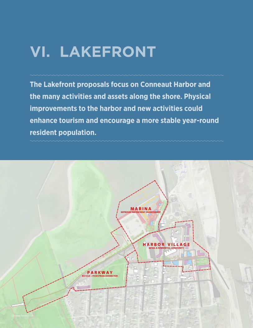
The Lakefront proposals focus on Conneaut Harbor and the many activities and assets along the shore. Physical improvements to the harbor and new activities are proposed to enhance tourism and encourage a more stable year-round population.
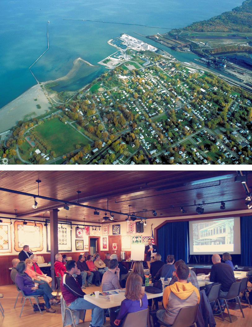
Facing page top: Aerial photograph of Conneaut located along the Ohio’s eastern Lake Erie shore.
Facing page bottom: CUDC’s David Jurca introduces the charrette’s first community meeting.
2
II. BACKGROUND
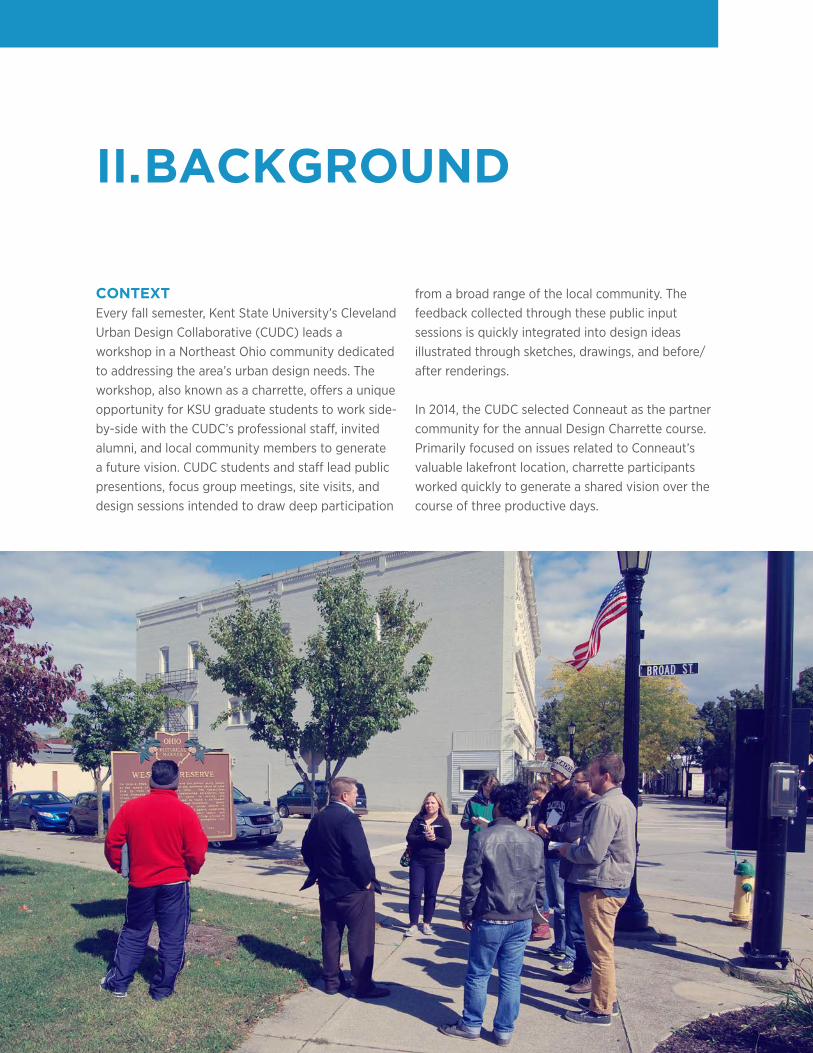
CONTEXTEvery fall semester, Kent State University’s Cleveland Urban Design Collaborative (CUDC) leads a workshop in a Northeast Ohio community dedicated to addressing the area’s urban design needs. The workshop, also known as a charrette, offers a unique opportunity for KSU graduate students to work side-by-side with the CUDC’s professional staff, invited alumni, and local community members to generate a future vision. CUDC students and staff lead public presentions, focus group meetings, site visits, and design sessions intended to draw deep participation
from a broad range of the local community. The feedback collected through these public input sessions is quickly integrated into design ideas illustrated through sketches, drawings, and before/after renderings. In 2014, the CUDC selected Conneaut as the partner community for the annual Design Charrette course. Primarily focused on issues related to Conneaut’s valuable lakefront location, charrette participants worked quickly to generate a shared vision over the course of three productive days.
3Charrette Report Conneaut, Ohio
The charrette’s primary objective was to envision a revitalized waterfront with better connections to adjacent neighborhoods, the historic downtown, and surrounding regional destinations via attractive street corridors. CUDC graduate students, staff, and alumni worked together in teams to generate design responses to this objective with community input.
The engagement process was fast-paced, but incorporated valuable input from many organizational representatives, business owners, and local residents. Before arriving in Conneaut,
students conducted research on the history, climate, tourism economy, and demographics of the area. The background data was combined with first-hand observations and stakeholder feedback from the charrette weekend to inspire the design recommendations shown in this report.
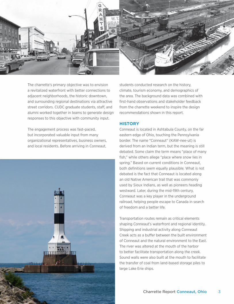
HISTORYConneaut is located in Ashtabula County, on the far eastern edge of Ohio, touching the Pennsylvania border. The name “Conneaut” (KAW-nee-ut) is derived from an Indian term, but the meaning is still debated. Some claim the term means “place of many fish,” while others allege “place where snow lies in spring.” Based on current conditions in Conneaut, both definitions seem equally plausible. What is not debated is the fact that Conneaut is located along an old Native American trail that was commonly used by Sioux Indians, as well as pioneers heading westward. Later, during the mid-19th century, Conneaut was a key player in the underground railroad, helping people escape to Canada in search of freedom and a better life.
Transportation routes remain as critical elements shaping Conneaut’s waterfront and regional identity. Shipping and industrial activity along Conneaut Creek acts as a buffer between the built environment of Conneaut and the natural environment to the East. The river was altered at the mouth of the harbor to better facilitate transportation along the creek. Sound walls were also built at the mouth to facilitate the transfer of coal from land-based storage piles to large Lake Erie ships.
4
TOURISMConneaut’s Lake Erie oriented location offers opportunities for connecting ecotourism, diverse residential options, small town identity, and outdoor recreation amenities into an appealing overall experience. Sometimes referred to as “Ohio’s sharpest corner,” this small town has an outsized share of tourist attractions, including wineries, covered bridges, outdoor recreation, historic landmarks, and cultural events.
Conneaut is part of a statewide network of wineries connected by an organized “trail” system. The Ohio trails include: the Lake Erie Shores & Islands Wine Trail; Vines & Wines Trail; Capital City Wine Trail; Canal Country Wine Trail; Appalacian Wine Trail; and Oio River Valley Wine Trail. Ashtabula County contains 20 wineries, with two vineyards and one winery located within Conneaut’s borders.
Ashtabula County is also known for its covered bridges. Conneaut boasts four covered bridges, including three located on the river and two conveniently located near wineries.
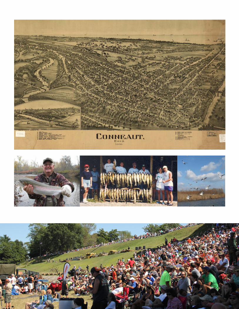
The lakefront and riverfront access in Conneaut attracts a range of outdoor enthusiasts. Conneaut Creek is an international hotspot for Steelhead fishing. Even during winter months, ice fishing continues along Lake Erie’s frozen shoreline. A growing number of tourists also enjoy Conneaut’s outdoor environments through birdwatching.
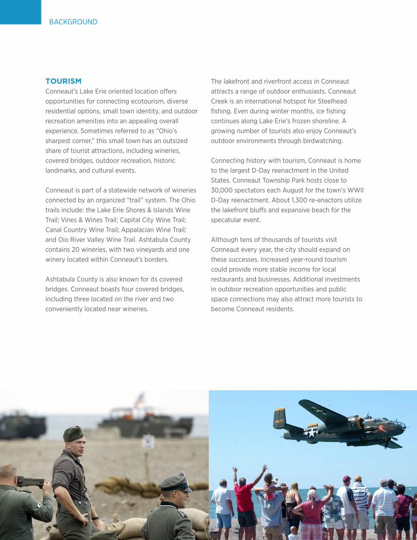
Connecting history with tourism, Conneaut is home to the largest D-Day reenactment in the United States. Conneaut Township Park hosts close to 30,000 spectators each August for the town’s WWII D-Day reenactment. About 1,300 re-enactors utilize the lakefront bluffs and expansive beach for the specatular event.
Although tens of thousands of tourists visit Conneaut every year, the city should expand on these successes. Increased year-round tourism could provide more stable income for local restaurants and businesses. Additional investments in outdoor recreation opportunities and public space connections may also attract more tourists to become Conneaut residents.
BACKGROUND
5Charrette Report Conneaut, Ohio
6
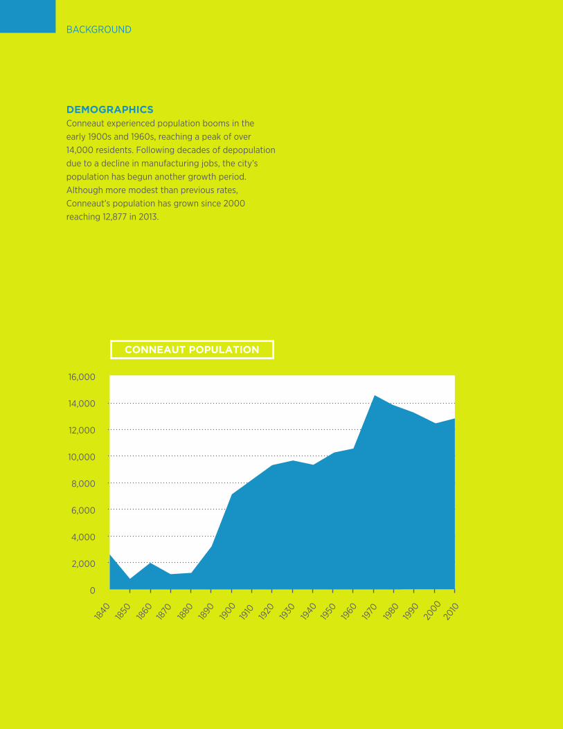
DEMOGRAPHICSConneaut experienced population booms in the early 1900s and 1960s, reaching a peak of over 14,000 residents. Following decades of depopulation due to a decline in manufacturing jobs, the city’s population has begun another growth period. Although more modest than previous rates, Conneaut’s population has grown since 2000 reaching 12,877 in 2013.
BACKGROUND
16,000
14,000
12,000
10,000
8,000
6,000
4,000
2,000
0
1840
1880
1920
1960
1850
1890
1930
1970
1860
1900
1940
1980
2000
1870
1910
1950
1990
2010
CONNEAUT POPULATION
7Charrette Report Conneaut, Ohio
53.3%12.2%
10% 3.1%1.8% 1.7%2.8% 2.1%33.4% 81.1%
7.5%1.8%
0.4%1.8% 88.5%
WhiteAfrican AmericanHispanic/LatinoAsianMixed
WhiteAfrican AmericanHispanic/LatinoAsianMixed
WhiteAfrican AmericanHispanic/LatinoAsianMixed
CLEVELAND OHIO
CONNEAUT
8
CHARRETTE PROCESS
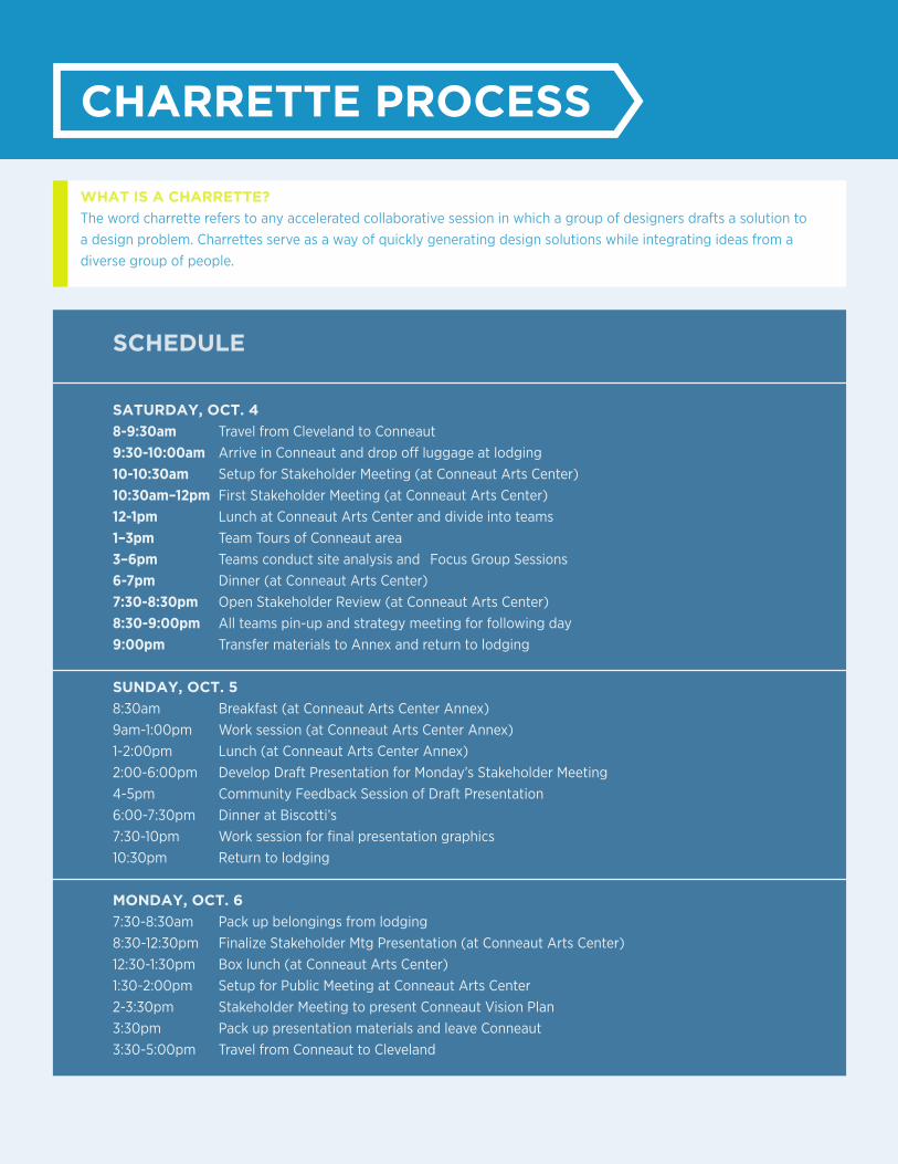
WHAT IS A CHARRETTE?
The word charrette refers to any accelerated collaborative session in which a group of designers drafts a solution to a design problem. Charrettes serve as a way of quickly generating design solutions while integrating ideas from a diverse group of people.
SCHEDULE
SATURDAY, OCT. 4
8-9:30am Travel from Cleveland to Conneaut9:30-10:00am Arrive in Conneaut and drop off luggage at lodging10-10:30am Setup for Stakeholder Meeting (at Conneaut Arts Center)10:30am–12pm First Stakeholder Meeting (at Conneaut Arts Center) 12-1pm Lunch at Conneaut Arts Center and divide into teams1–3pm Team Tours of Conneaut area3–6pm Teams conduct site analysis and Focus Group Sessions 6-7pm Dinner (at Conneaut Arts Center) 7:30-8:30pm Open Stakeholder Review (at Conneaut Arts Center)8:30-9:00pm All teams pin-up and strategy meeting for following day9:00pm Transfer materials to Annex and return to lodging
SUNDAY, OCT. 5
8:30am Breakfast (at Conneaut Arts Center Annex) 9am-1:00pm Work session (at Conneaut Arts Center Annex)1-2:00pm Lunch (at Conneaut Arts Center Annex) 2:00-6:00pm Develop Draft Presentation for Monday’s Stakeholder Meeting4-5pm Community Feedback Session of Draft Presentation6:00-7:30pm Dinner at Biscotti’s7:30-10pm Work session for final presentation graphics10:30pm Return to lodging MONDAY, OCT. 6
7:30-8:30am Pack up belongings from lodging8:30-12:30pm Finalize Stakeholder Mtg Presentation (at Conneaut Arts Center)12:30-1:30pm Box lunch (at Conneaut Arts Center) 1:30-2:00pm Setup for Public Meeting at Conneaut Arts Center2-3:30pm Stakeholder Meeting to present Conneaut Vision Plan3:30pm Pack up presentation materials and leave Conneaut3:30-5:00pm Travel from Conneaut to Cleveland
9Charrette Report Conneaut, Ohio
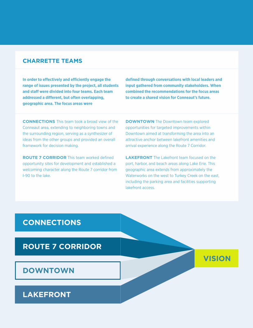
CONNECTIONS This team took a broad view of the Conneaut area, extending to neighboring towns and the surrounding region, serving as a synthesizer of ideas from the other groups and provided an overall framework for decision making.
ROUTE 7 CORRIDOR This team worked defined opportunity sites for development and established a welcoming character along the Route 7 corridor from I-90 to the lake.
DOWNTOWN The Downtown team explored opportunities for targeted improvements within Downtown aimed at transforming the area into an attractive anchor between lakefront amenities and arrival experience along the Route 7 Corridor.
LAKEFRONT The Lakefront team focused on the port, harbor, and beach areas along Lake Erie. This geographic area extends from approximately the Waterworks on the west to Turkey Creek on the east, including the parking area and facilities supporting lakefront access.
CHARRETTE TEAMS
In order to effectively and efficiently engage the range of issues presented by the project, all students and staff were divided into four teams. Each team addressed a different, but often overlapping, geographic area. The focus areas were
defined through conversations with local leaders and input gathered from community stakeholders. When combined the recommendations for the focus areas to create a shared vision for Conneaut’s future.
CONNECTIONS
ROUTE 7 CORRIDOR
DOWNTOWN
LAKEFRONT
VISION
10
ConnectionsRoute 7DowntownWaterfront
III. CONNECTIONS
The Connections proposals expand beyond the City of
Conneaut to engage the surrounding region. A wide range
of proposals suggest ways to better link existing activities
and assets, as well as integrate future developments.
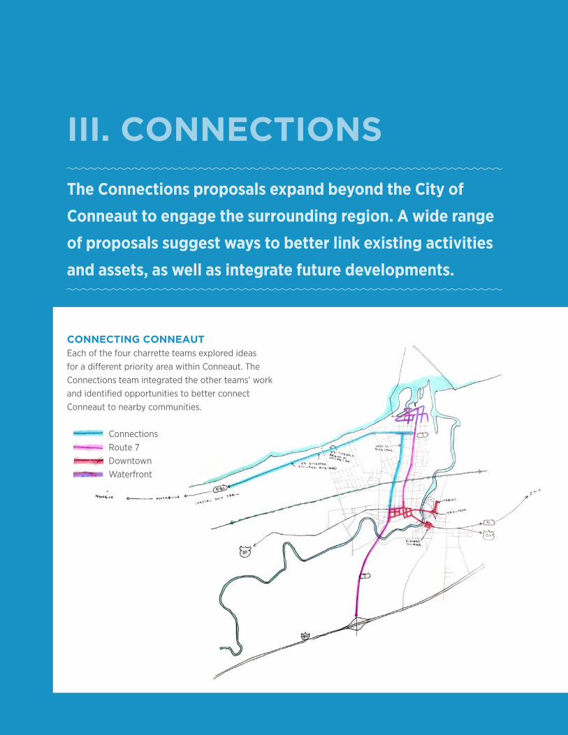
CONNECTING CONNEAUTEach of the four charrette teams explored ideas for a different priority area within Conneaut. The Connections team integrated the other teams’ work and identified opportunities to better connect Conneaut to nearby communities.
11Charrette Report Conneaut, Ohio
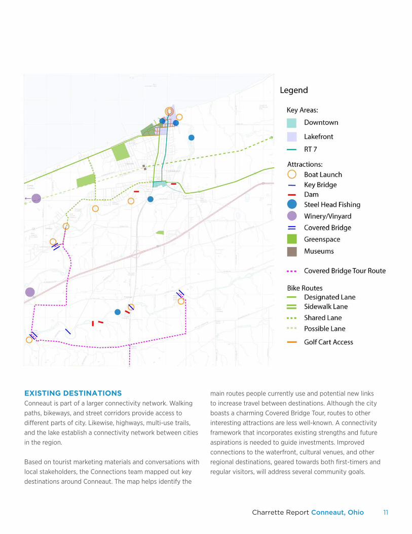
EXISTING DESTINATIONSConneaut is part of a larger connectivity network. Walking paths, bikeways, and street corridors provide access to different parts of city. Likewise, highways, multi-use trails, and the lake establish a connectivity network between cities in the region.
Based on tourist marketing materials and conversations with local stakeholders, the Connections team mapped out key destinations around Conneaut. The map helps identify the
main routes people currently use and potential new links to increase travel between destinations. Although the city boasts a charming Covered Bridge Tour, routes to other interesting attractions are less well-known. A connectivity framework that incorporates existing strengths and future aspirations is needed to guide investments. Improved connections to the waterfront, cultural venues, and other regional destinations, geared towards both first-timers and regular visitors, will address several community goals.
12
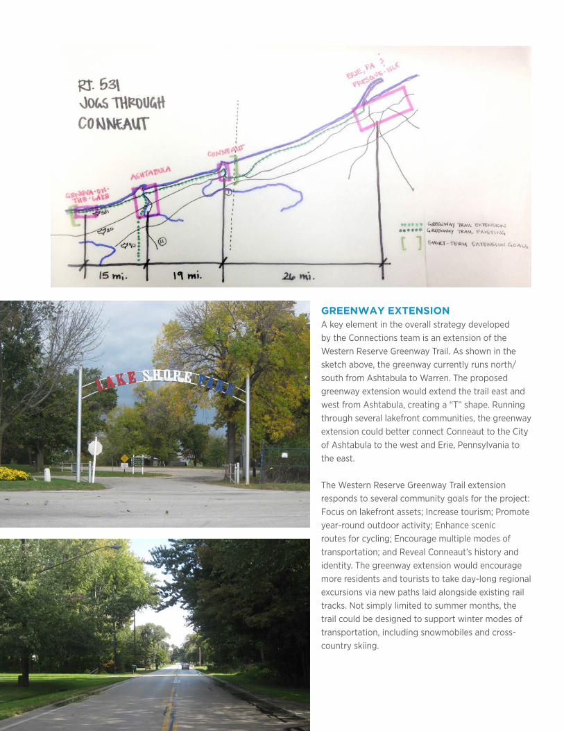
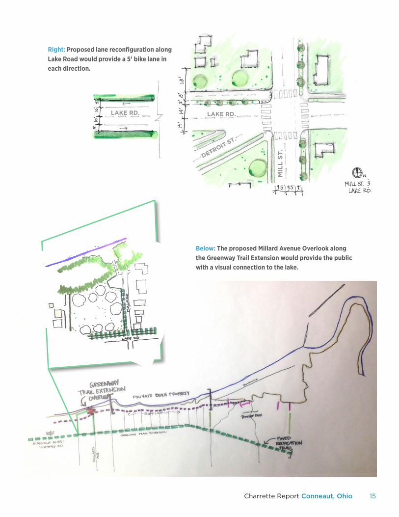
GREENWAY EXTENSIONA key element in the overall strategy developed by the Connections team is an extension of the Western Reserve Greenway Trail. As shown in the sketch above, the greenway currently runs north/south from Ashtabula to Warren. The proposed greenway extension would extend the trail east and west from Ashtabula, creating a “T” shape. Running through several lakefront communities, the greenway extension could better connect Conneaut to the City of Ashtabula to the west and Erie, Pennsylvania to the east.
The Western Reserve Greenway Trail extension responds to several community goals for the project: Focus on lakefront assets; Increase tourism; Promote year-round outdoor activity; Enhance scenic routes for cycling; Encourage multiple modes of transportation; and Reveal Conneaut’s history and identity. The greenway extension would encourage more residents and tourists to take day-long regional excursions via new paths laid alongside existing rail tracks. Not simply limited to summer months, the trail could be designed to support winter modes of transportation, including snowmobiles and cross-country skiing.
13Charrette Report Conneaut, Ohio
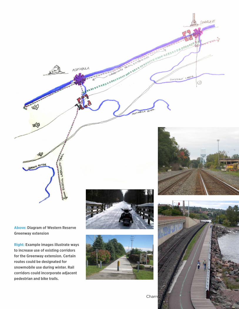
Above: Diagram of Western Reserve Greenway extension
Right: Example images illustrate ways to increase use of existing corridors for the Greenway extension. Certain routes could be designated for snowmobile use during winter. Rail corridors could incorporate adjacent pedestrian and bike trails.
14
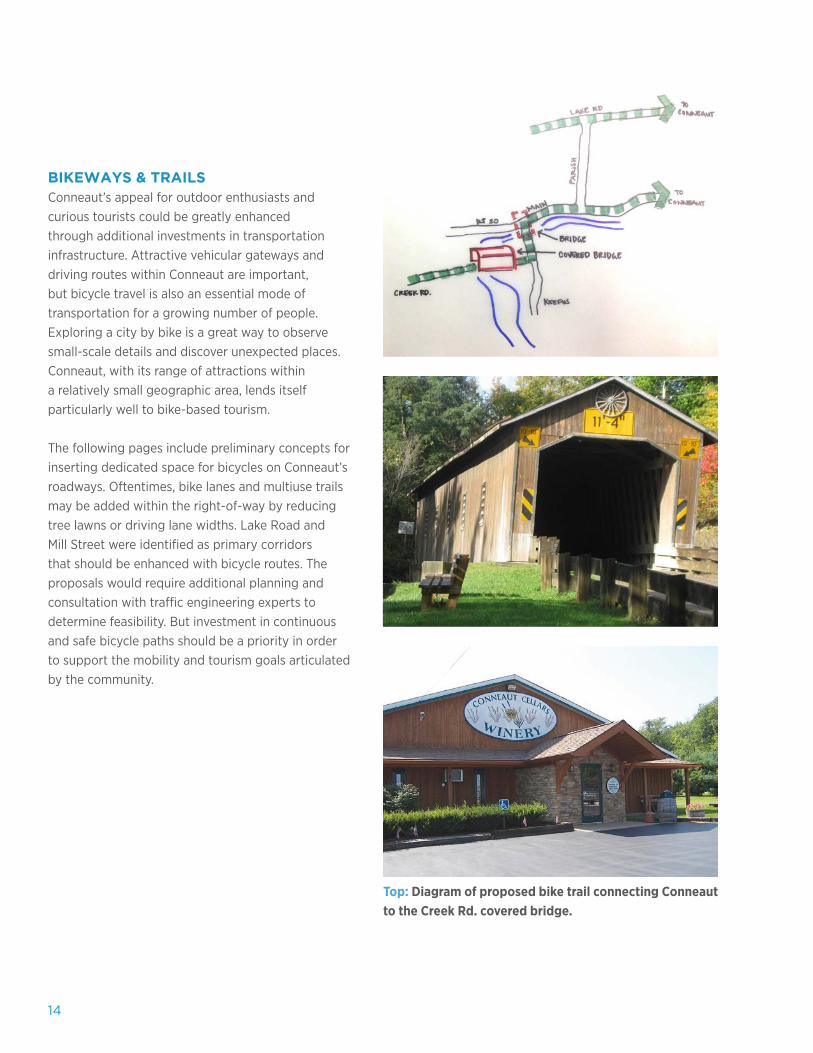
Top: Diagram of proposed bike trail connecting Conneaut to the Creek Rd. covered bridge.
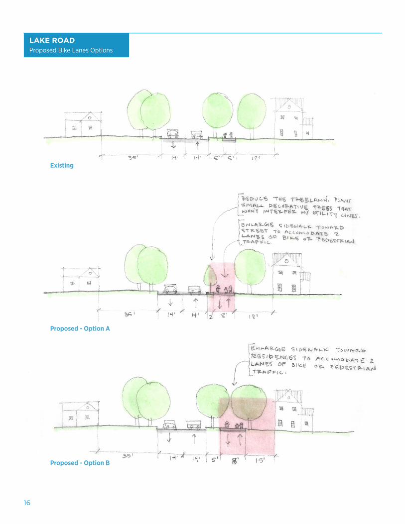
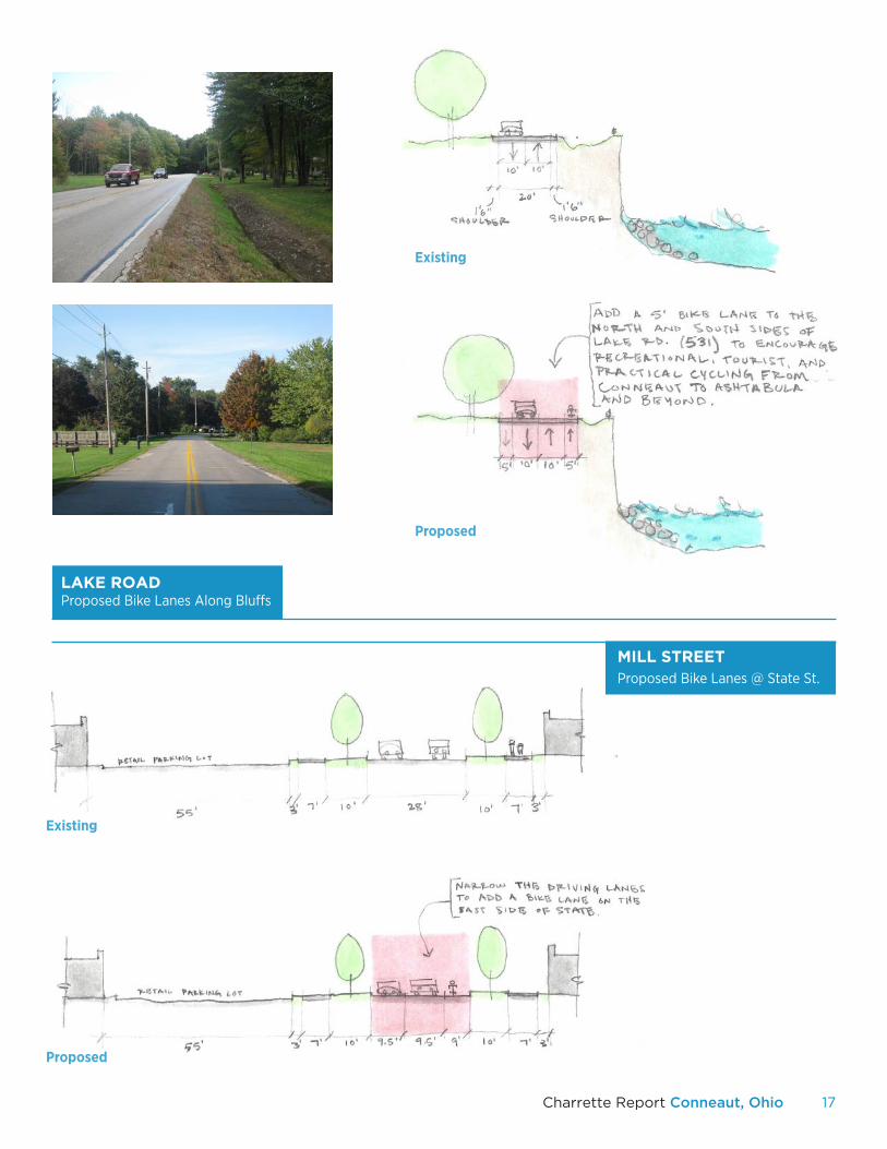
BIKEWAYS & TRAILSConneaut’s appeal for outdoor enthusiasts and curious tourists could be greatly enhanced through additional investments in transportation infrastructure. Attractive vehicular gateways and driving routes within Conneaut are important, but bicycle travel is also an essential mode of transportation for a growing number of people. Exploring a city by bike is a great way to observe small-scale details and discover unexpected places. Conneaut, with its range of attractions within a relatively small geographic area, lends itself particularly well to bike-based tourism.
The following pages include preliminary concepts for inserting dedicated space for bicycles on Conneaut’s roadways. Oftentimes, bike lanes and multiuse trails may be added within the right-of-way by reducing tree lawns or driving lane widths. Lake Road and Mill Street were identified as primary corridors that should be enhanced with bicycle routes. The proposals would require additional planning and consultation with traffic engineering experts to determine feasibility. But investment in continuous and safe bicycle paths should be a priority in order to support the mobility and tourism goals articulated by the community.
15Charrette Report Conneaut, Ohio
LAKE RD.
Below: The proposed Millard Avenue Overlook along the Greenway Trail Extension would provide the public with a visual connection to the lake.
LAKE RD.
MIL
L S
T.
DETROIT ST.
Right: Proposed lane reconfiguration along Lake Road would provide a 5’ bike lane in each direction.
16
Proposed - Option A
Existing
Proposed - Option B
LAKE ROADProposed Bike Lanes Options
17Charrette Report Conneaut, Ohio
Existing
Proposed
Proposed
MILL STREETProposed Bike Lanes @ State St.
LAKE ROADProposed Bike Lanes Along Bluffs
Existing
18
The
IV. ROUTE 7 CORRIDOR
The Route 7 Corridor proposals focus on the main axial
circulation of Conneaut travelling North and South.
Ideas for enhancing the corridor include intersection
improvements, wayfinding signage, and branding.
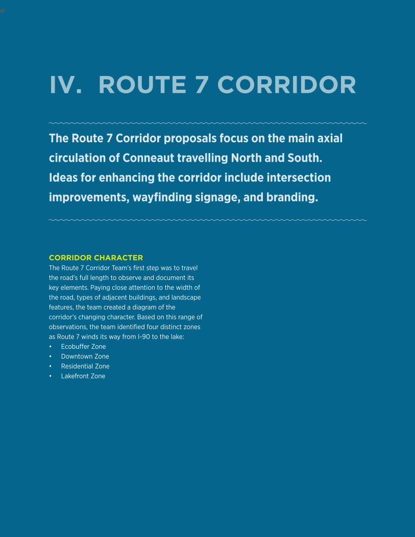
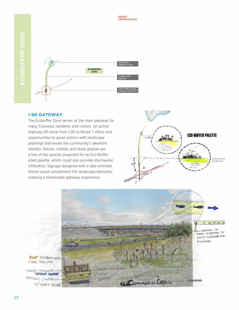
CORRIDOR CHARACTERThe Route 7 Corridor Team’s first step was to travel the road’s full length to observe and document its key elements. Paying close attention to the width of the road, types of adjacent buildings, and landscape features, the team created a diagram of the corridor’s changing character. Based on this range of observations, the team identified four distinct zones as Route 7 winds its way from I-90 to the lake: • Ecobuffer Zone• Downtown Zone• Residential Zone• Lakefront Zone
19Charrette Report Conneaut, Ohio
20
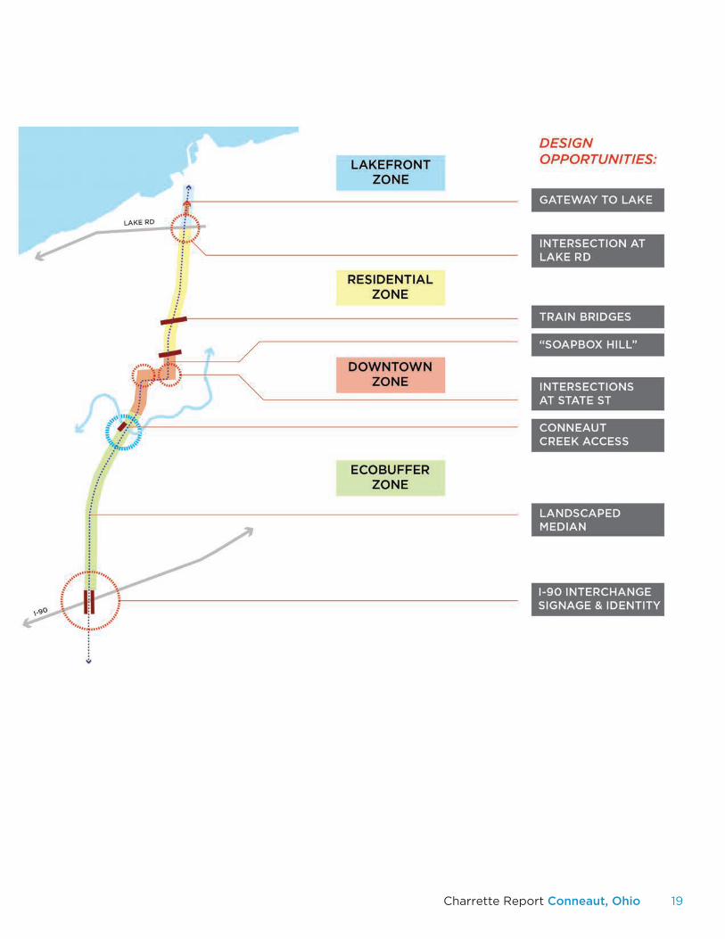
EXPERIENCE DIAGRAMA first step in the process of creating the final Character Map was to identify the various experiences along the Route 7 Corridor. Potential experiences might include key decision-making points, unexpected features, or important landmarks that create strong emotions or memories. The Route 7 Corridor team identified several distinguishing moments along the route, including gateway intersections, framed sightlines created by bridges, memorable signage, historic buildings, and lake views.
21Charrette Report Conneaut, Ohio
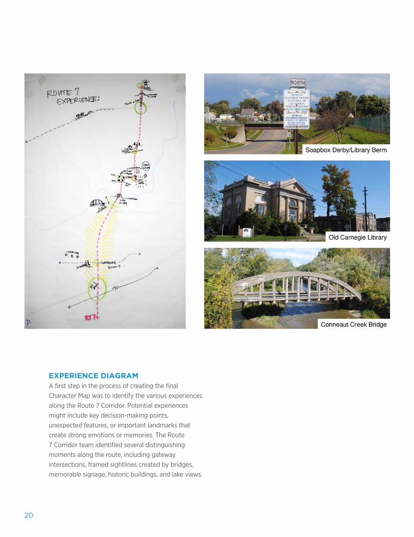
STREET EDGE DIAGRAMThe experience diagram provided a useful tool for quickly analyzing the Route 7 Corridor. Similarly, the team’s street edge diagram clearly communicates where the distance between buildings changes. Three primary open spaces were identified through this diagramming process, including a park, hillside lot, and vacant parcels. By combining the experience diagram with the street edge diagram, the Route 7 team identified opportunities for large and small-scale interventions to improve the corridor in a context-sensitive manner.
22
EC
OB
UF
FE
R Z
ON
E
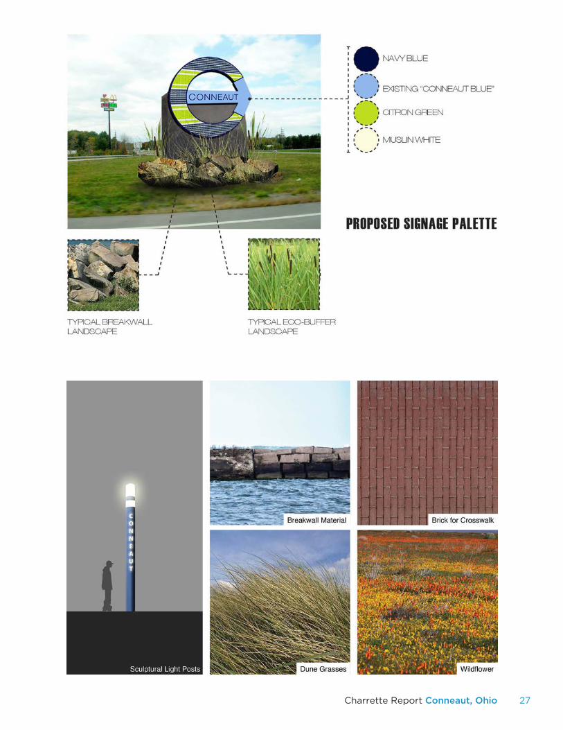
I-90 GATEWAYThe Ecobuffer Zone serves as the main gateway for many Conneaut residents and visitors. An active highway off-ramp from I-90 to Route 7 offers vast opportunities to greet visitors with landscape plantings that evoke the community’s lakefront identity. Daisies, cattails, and dune grasses are a few of the species proposed for an Eco-Buffer plant palette, which could also provide stormwater infiltration. Signage designed with a lake-oriented theme could complement the landscape elements, creating a memorable gateway experience.
23Charrette Report Conneaut, Ohio
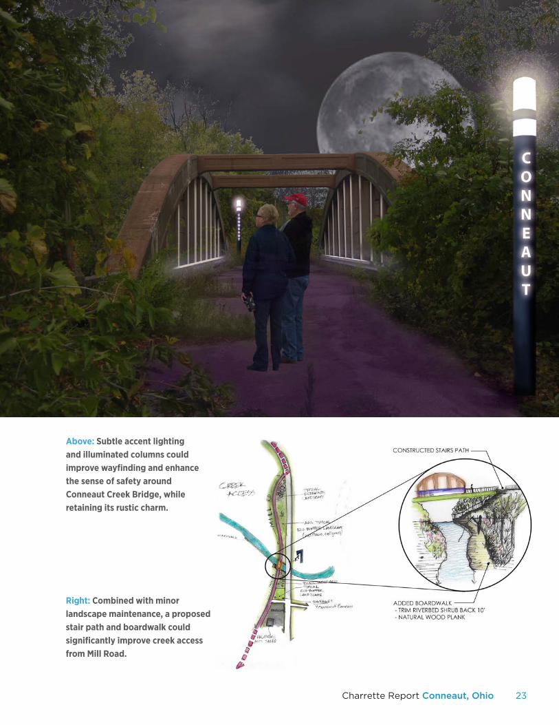
Right: Combined with minor landscape maintenance, a proposed stair path and boardwalk could significantly improve creek access from Mill Road.
Above: Subtle accent lighting and illuminated columns could improve wayfinding and enhance the sense of safety around Conneaut Creek Bridge, while retaining its rustic charm.
24
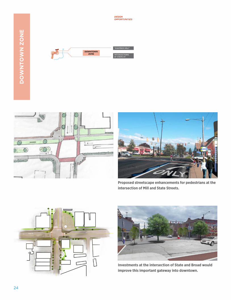
Proposed streetscape enhancements for pedestrians at the intersection of Mill and State Streets.
Investments at the intersection of State and Broad would improve this important gateway into downtown.
DO
WN
TO
WN
ZO
NE
25Charrette Report Conneaut, Ohio
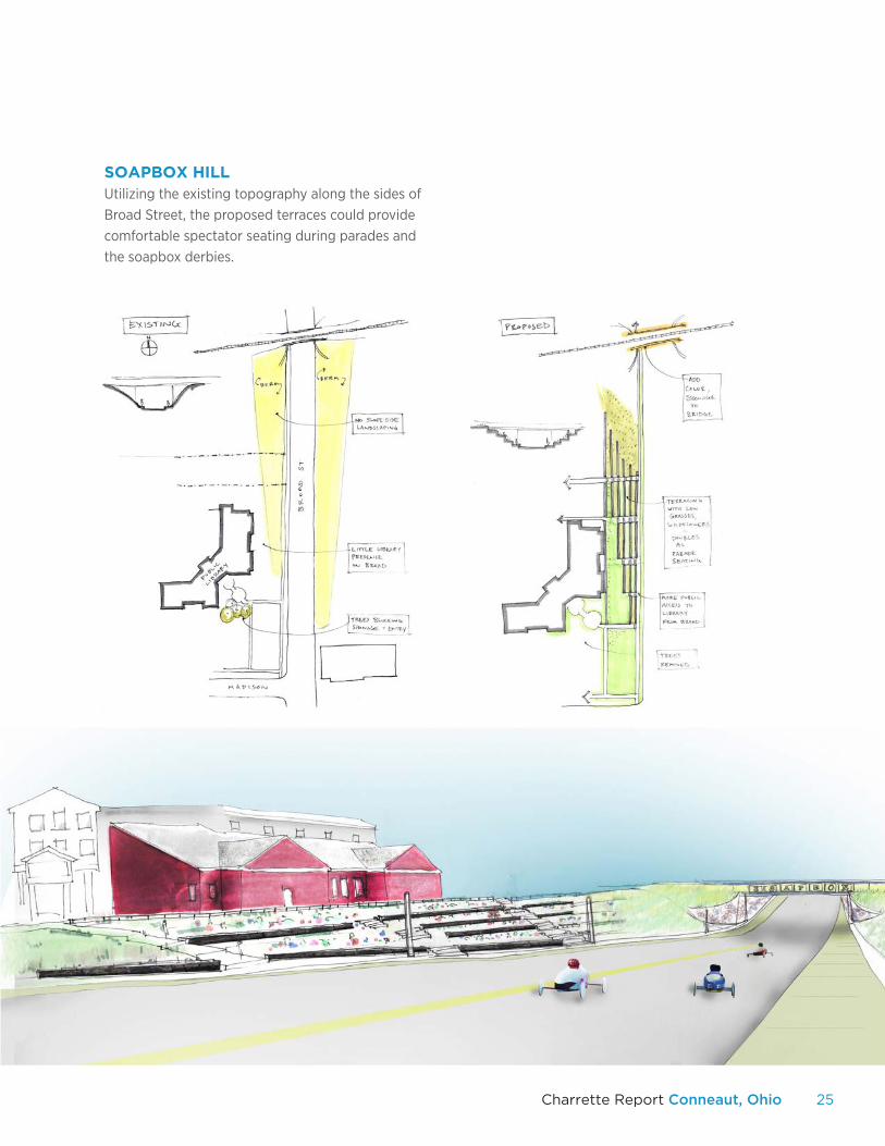
SOAPBOX HILLUtilizing the existing topography along the sides of Broad Street, the proposed terraces could provide comfortable spectator seating during parades and the soapbox derbies.
26
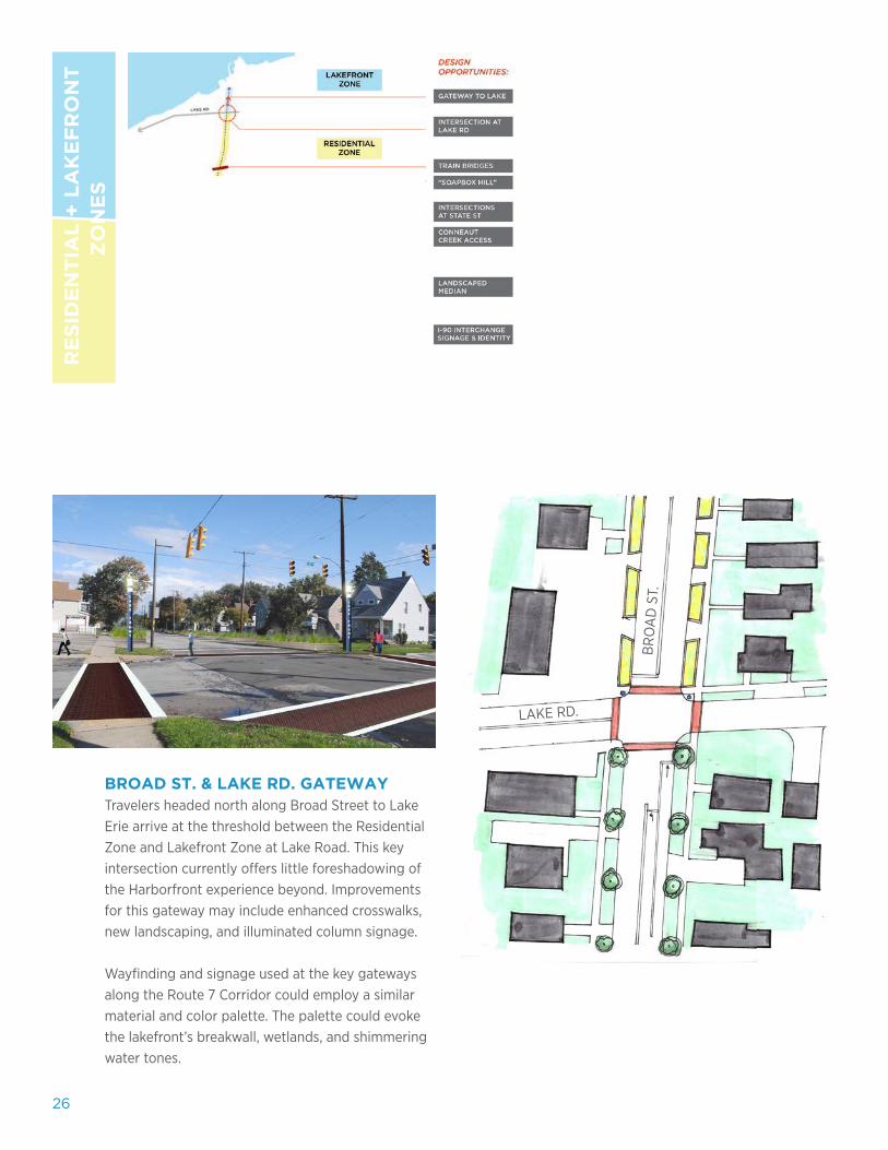
BROAD ST. & LAKE RD. GATEWAYTravelers headed north along Broad Street to Lake Erie arrive at the threshold between the Residential Zone and Lakefront Zone at Lake Road. This key intersection currently offers little foreshadowing of the Harborfront experience beyond. Improvements for this gateway may include enhanced crosswalks, new landscaping, and illuminated column signage.
Wayfinding and signage used at the key gateways along the Route 7 Corridor could employ a similar material and color palette. The palette could evoke the lakefront’s breakwall, wetlands, and shimmering water tones.
RE
SID
EN
TIA
L +
LA
KE
FR
ON
T
ZO
NE
S
LAKE RD.
BR
OA
D S
T.
27Charrette Report Conneaut, Ohio
28
V. DOWNTOWN
The proposals for Downtown focus on reestablishing the
historic core of the city. Revitalization will have to occur
through strategic phasing of the large and small scale
projects, including a new Fisherman’s Village.
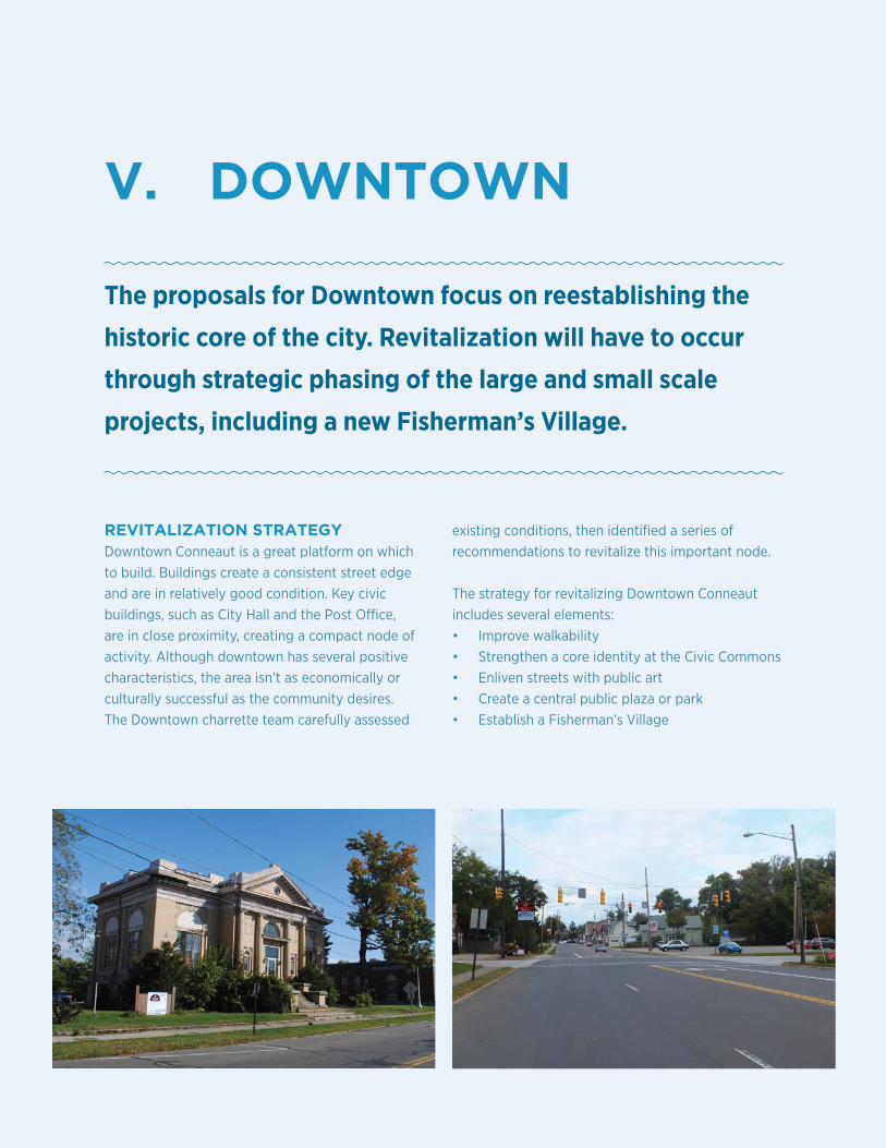
REVITALIZATION STRATEGYDowntown Conneaut is a great platform on which to build. Buildings create a consistent street edge and are in relatively good condition. Key civic buildings, such as City Hall and the Post Office, are in close proximity, creating a compact node of activity. Although downtown has several positive characteristics, the area isn’t as economically or culturally successful as the community desires. The Downtown charrette team carefully assessed
existing conditions, then identified a series of recommendations to revitalize this important node.
The strategy for revitalizing Downtown Conneaut includes several elements:• Improve walkability• Strengthen a core identity at the Civic Commons • Enliven streets with public art• Create a central public plaza or park• Establish a Fisherman’s Village
29Charrette Report Conneaut, Ohio
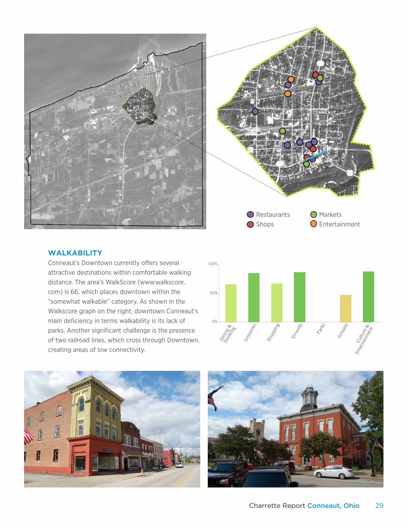
WALKABILITYConneaut’s Downtown currently offers several attractive destinations within comfortable walking distance. The area’s WalkScore (www.walkscore.com) is 66, which places downtown within the “somewhat walkable” category. As shown in the Walkscore graph on the right, downtown Conneaut’s main deficiency in terms walkability is its lack of parks. Another significant challenge is the presence of two railroad lines, which cross through Downtown, creating areas of low connectivity.
RestaurantsShops
MarketsEntertainment
30
1.
2.3.
4.
5.
6.
31Charrette Report Conneaut, Ohio
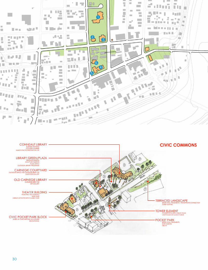
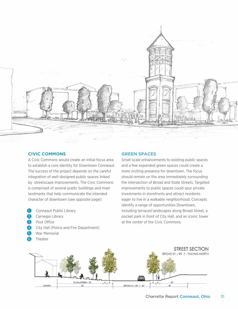
CIVIC COMMONSA Civic Commons would create an initial focus area to establish a core identity for Downtown Conneaut. The success of the project depends on the careful integration of well-designed public spaces linked by streetscape improvements. The Civic Commons is comprised of several public buildings and main landmarks that help communicate the intended character of downtown (see opposite page):
1. .Conneaut Public Library2. .Carnegie Library3. .Post Office4. .City Hall (Police and Fire Department)5. .War Memorial6. .Theater
GREEN SPACESSmall-scale enhancements to existing public spaces and a few expanded green spaces could create a more inviting presence for downtown. The focus should remain on the area immediately surrounding the intersection of Broad and State Streets. Targeted improvements to public spaces could spur private investments in storefronts and attract residents eager to live in a walkable neighborhood. Concepts identify a range of opportunities Downtown, including terraced landscapes along Broad Street, a pocket park in front of City Hall, and an iconic tower at the center of the Civic Commons.
32
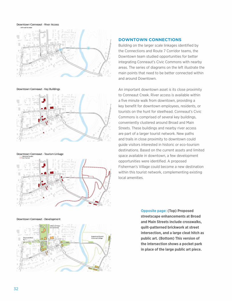
DOWNTOWN CONNECTIONSBuilding on the larger scale linkages identified by the Connections and Route 7 Corridor teams, the Downtown team studied opportunities for better integrating Conneaut’s Civic Commons with nearby areas. The series of diagrams on the left illustrate the main points that need to be better connected within and around Downtown.
An important downtown asset is its close proximity to Conneaut Creek. River access is available within a five minute walk from downtown, providing a key benefit for downtown employees, residents, or tourists on the hunt for steelhead. Conneaut’s Civic Commons is comprised of several key buildings, conveniently clustered around Broad and Main Streets. These buildings and nearby river access are part of a larger tourist network. New paths and trails in close proximity to downtown could guide visitors interested in historic or eco-tourism destinations. Based on the current assets and limited space available in downtown, a few development opportunities were identified. A proposed Fisherman’s Village could become a new destination within this tourist network, complementing existing local amenities.
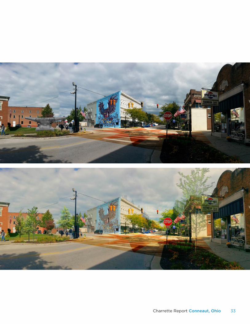
Opposite page: (Top) Proposed streetscape enhancements at Broad and Main Streets include crosswalks, quilt-patterned brickwork at street intersection, and a large cleat hitch as public art. (Bottom) This version of the intersection shows a pocket park in place of the large public art piece.
33Charrette Report Conneaut, Ohio
34
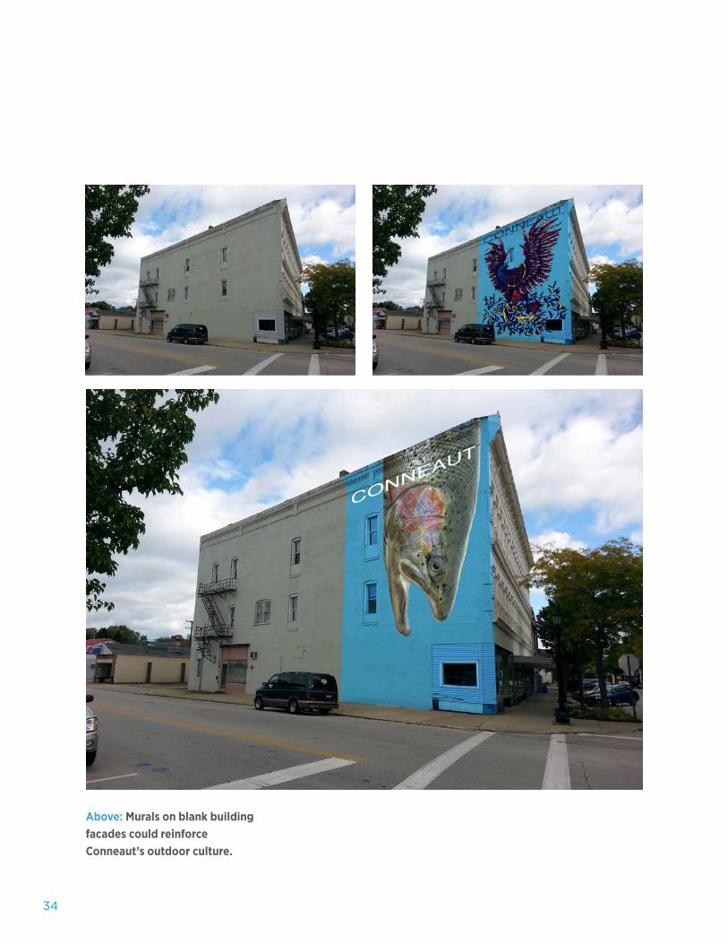
Above: Murals on blank building facades could reinforce Conneaut’s outdoor culture.
35Charrette Report Conneaut, Ohio
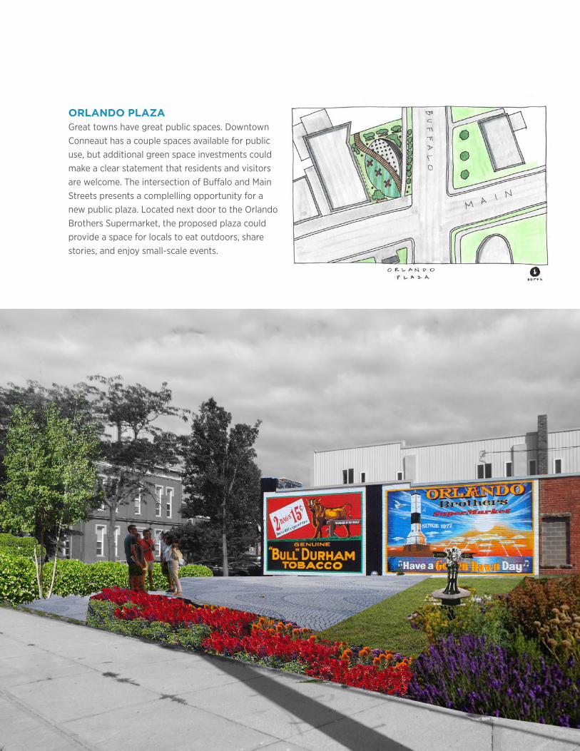
ORLANDO PLAZAGreat towns have great public spaces. Downtown Conneaut has a couple spaces available for public use, but additional green space investments could make a clear statement that residents and visitors are welcome. The intersection of Buffalo and Main Streets presents a complelling opportunity for a new public plaza. Located next door to the Orlando Brothers Supermarket, the proposed plaza could provide a space for locals to eat outdoors, share stories, and enjoy small-scale events.
36
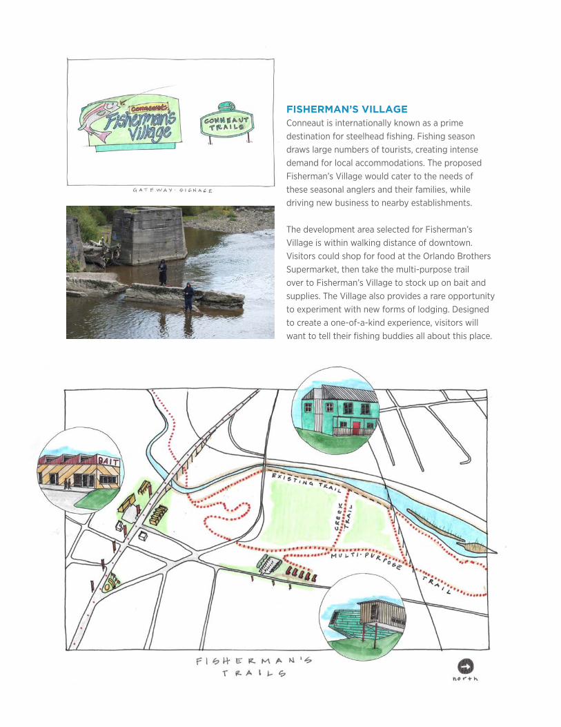
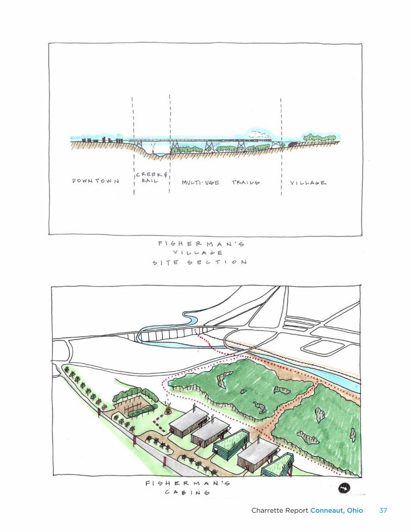
FISHERMAN’S VILLAGEConneaut is internationally known as a prime destination for steelhead fishing. Fishing season draws large numbers of tourists, creating intense demand for local accommodations. The proposed Fisherman’s Village would cater to the needs of these seasonal anglers and their families, while driving new business to nearby establishments.
The development area selected for Fisherman’s Village is within walking distance of downtown. Visitors could shop for food at the Orlando Brothers Supermarket, then take the multi-purpose trail over to Fisherman’s Village to stock up on bait and supplies. The Village also provides a rare opportunity to experiment with new forms of lodging. Designed to create a one-of-a-kind experience, visitors will want to tell their fishing buddies all about this place.
37Charrette Report Conneaut, Ohio
38
VI. LAKEFRONT
The Lakefront proposals focus on Conneaut Harbor and
the many activities and assets along the shore. Physical
improvements to the harbor and new activities could
enhance tourism and encourage a more stable year-round
resident population.
39Charrette Report Conneaut, Ohio
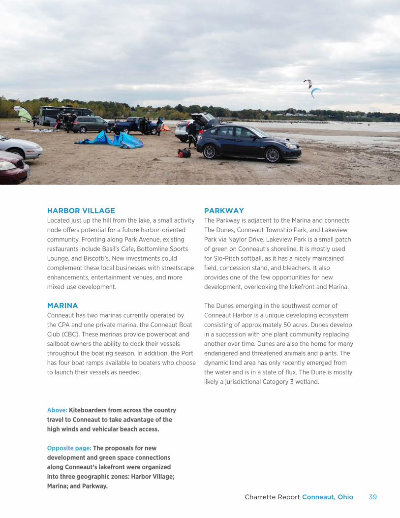
Above: Kiteboarders from across the country travel to Conneaut to take advantage of the high winds and vehicular beach access. Opposite page: The proposals for new development and green space connections along Conneaut’s lakefront were organized into three geographic zones: Harbor Village; Marina; and Parkway.
HARBOR VILLAGELocated just up the hill from the lake, a small activity node offers potential for a future harbor-oriented community. Fronting along Park Avenue, existing restaurants include Basil’s Cafe, Bottomline Sports Lounge, and Biscotti’s. New investments could complement these local businesses with streetscape enhancements, entertainment venues, and more mixed-use development.
MARINAConneaut has two marinas currently operated by the CPA and one private marina, the Conneaut Boat Club (CBC). These marinas provide powerboat and sailboat owners the ability to dock their vessels throughout the boating season. In addition, the Port has four boat ramps available to boaters who choose to launch their vessels as needed.
PARKWAYThe Parkway is adjacent to the Marina and connects The Dunes, Conneaut Township Park, and Lakeview Park via Naylor Drive. Lakeview Park is a small patch of green on Conneaut’s shoreline. It is mostly used for Slo-Pitch softball, as it has a nicely maintained field, concession stand, and bleachers. It also provides one of the few opportunities for new development, overlooking the lakefront and Marina.
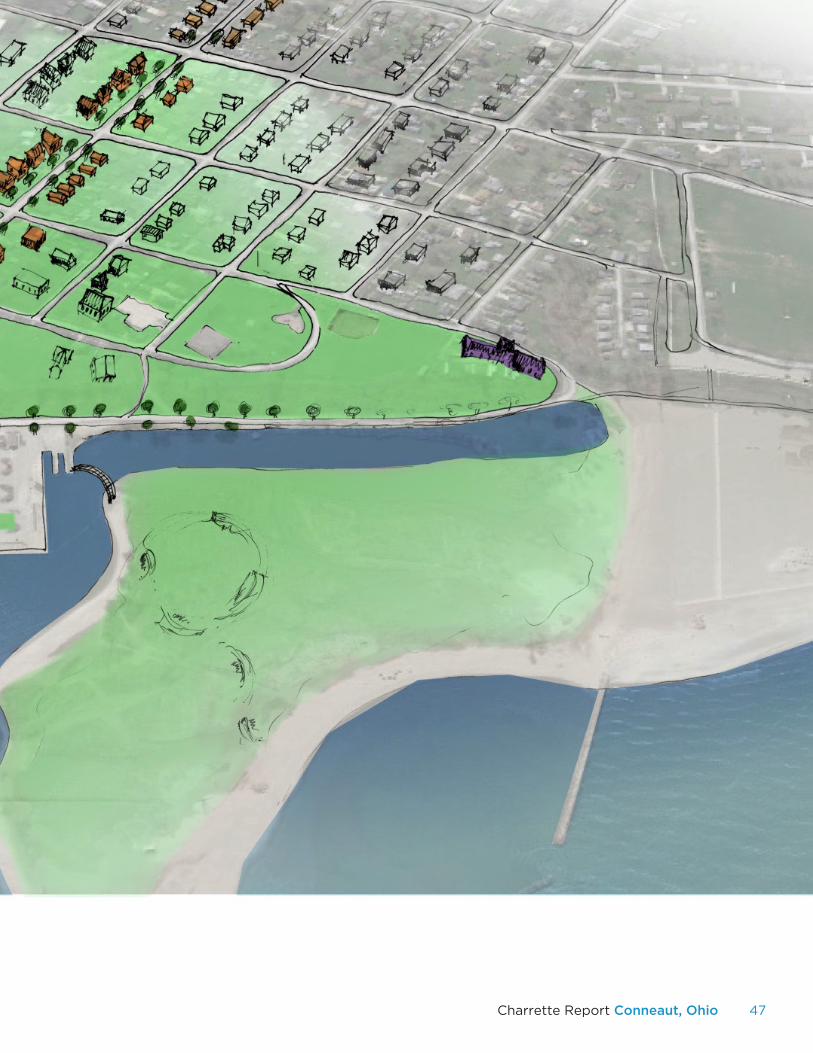
The Dunes emerging in the southwest corner of Conneaut Harbor is a unique developing ecosystem consisting of approximately 50 acres. Dunes develop in a succession with one plant community replacing another over time. Dunes are also the home for many endangered and threatened animals and plants. The dynamic land area has only recently emerged from the water and is in a state of flux. The Dune is mostly likely a jurisdictional Category 3 wetland.
40
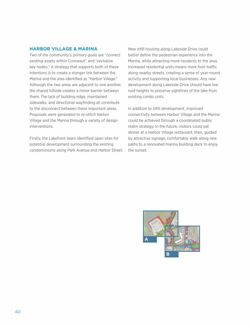
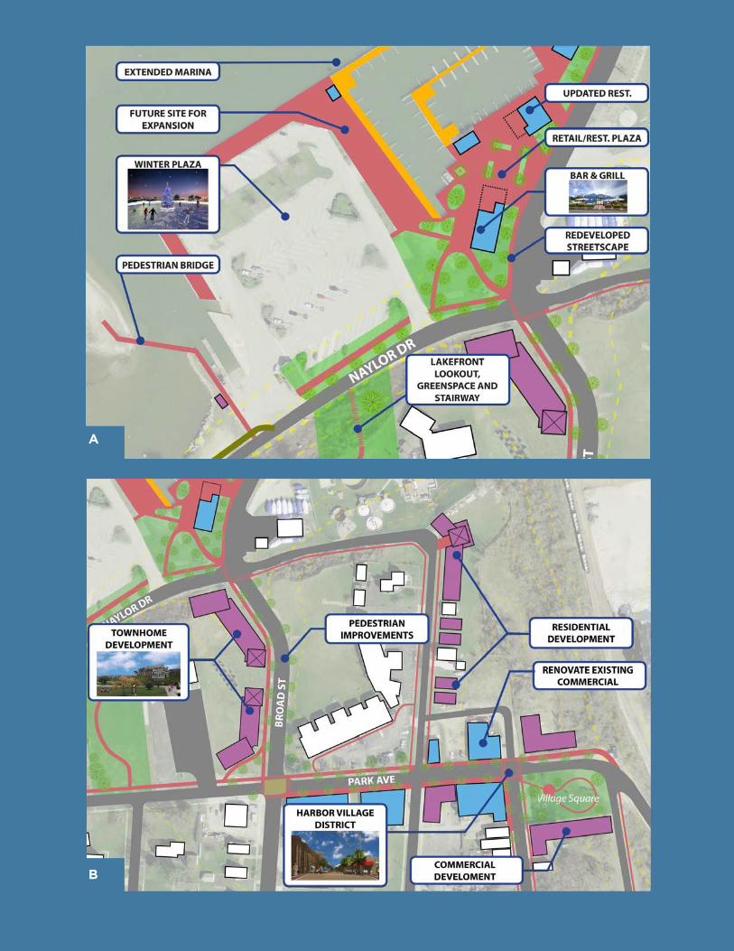
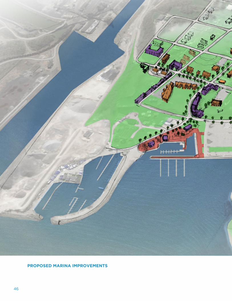
HARBOR VILLAGE & MARINATwo of the community’s primary goals are “connect existing assets within Conneaut” and “revitalize key nodes.” A strategy that supports both of these intentions is to create a stonger link between the Marina and the area identified as “Harbor Village.” Although the two areas are adjacent to one another, the shared hillside creates a minor barrier between them. The lack of building edge, maintained sidewalks, and directional wayfinding all contribute to the disconnect between these important areas. Proposals were generated to re-stitch Harbor Village and the Marina through a variety of design interventions.
Firstly, the Lakefront team identified open sites for potential development surrounding the existing condominiums along Park Avenue and Harbor Street.
New infill housing along Lakeside Drive could better define the pedestrian experience into the Marina, while attracting more residents to the area. Increased residential units means more foot-traffic along nearby streets, creating a sense of year-round activity and supporting local businesses. Any new development along Lakeside Drive should have low roof heights to preserve sightlines of the lake from existing condo units.
In addition to infill development, improved connectivity between Harbor Village and the Marina could be achieved through a coordinated public realm strategy. In the future, visitors could eat dinner at a Harbor Village restaurant, then, guided by attractive signage, comfortably walk along new paths to a renovated marina building deck to enjoy the sunset.
A
B
41Charrette Report Conneaut, Ohio
A
B
42
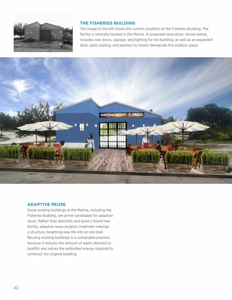
THE FISHERIES BUILDINGThe image to the left shows the current condition of the Fisheries Building. The facility is centrally located in the Marina. A proposed renovation, shown below, includes new doors, signage, and lighting for the building, as well as an expanded deck, patio seating, and planters to clearly demarcate the outdoor space.
ADAPTIVE REUSESome existing buildings at the Marina, including the Fisheries Building, are prime candidates for adaptive reuse. Rather than demolish and build a brand new facility, adaptive reuse projects creatively redesign a structure, breathing new life into an old shell. Reusing existing buildings is a sustainable practice, because it reduces the amount of waste directed to landfills and values the embodied energy required to construct the original building.
43Charrette Report Conneaut, Ohio
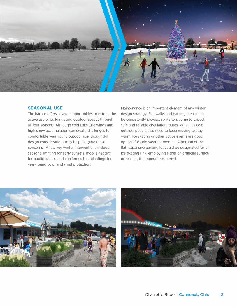
SEASONAL USEThe harbor offers several opportunities to extend the active use of buildings and outdoor spaces through all four seasons. Although cold Lake Erie winds and high snow accumulation can create challenges for comfortable year-round outdoor use, thoughtful design considerations may help mitigate these concerns. A few key winter interventions include seasonal lighting for early sunsets, mobile heaters for public events, and coniferous tree plantings for year-round color and wind protection.
Maintenance is an important element of any winter design strategy. Sidewalks and parking areas must be consistently plowed, so visitors come to expect safe and reliable circulation routes. When it’s cold outside, people also need to keep moving to stay warm. Ice skating or other active events are good options for cold weather months. A portion of the flat, expansive parking lot could be designated for an ice-skating rink, employing either an artificial surface or real ice, if temperatures permit.
44
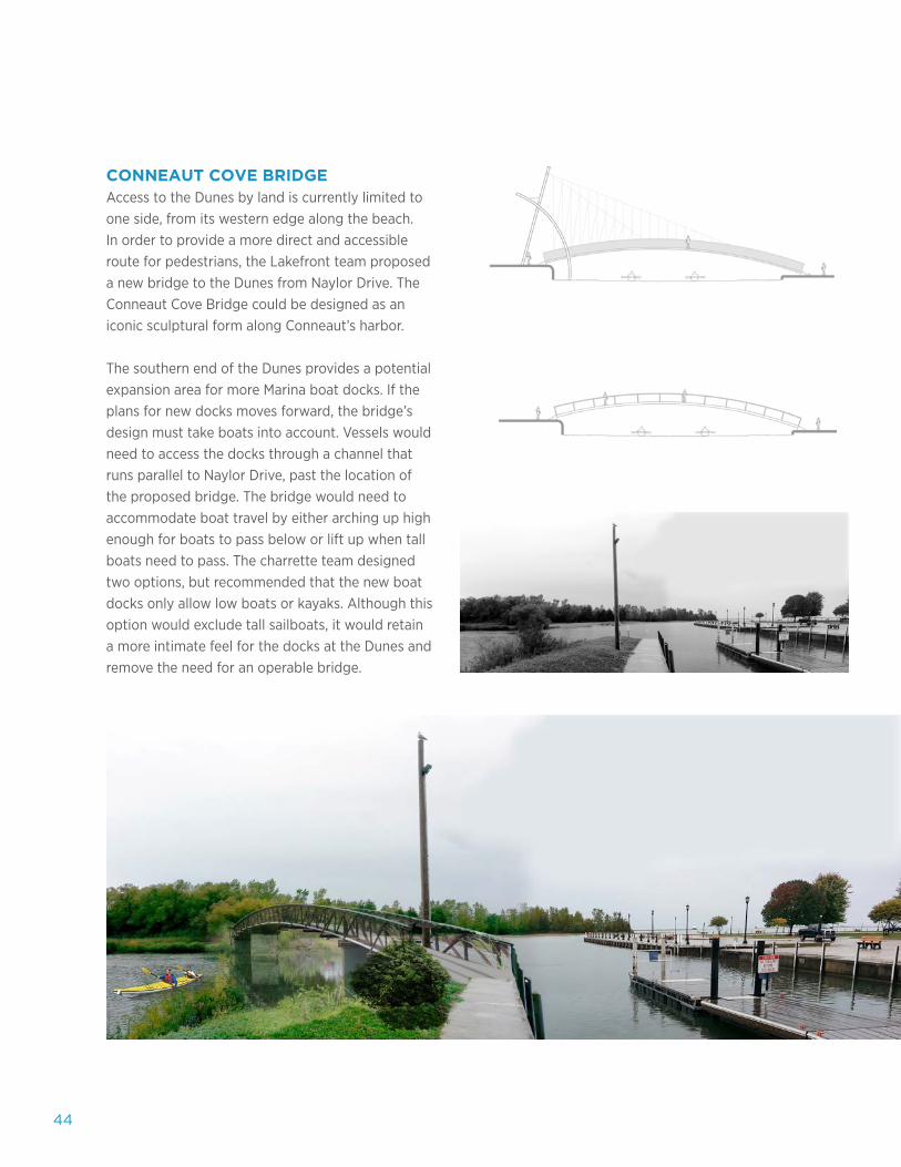
CONNEAUT COVE BRIDGEAccess to the Dunes by land is currently limited to one side, from its western edge along the beach. In order to provide a more direct and accessible route for pedestrians, the Lakefront team proposed a new bridge to the Dunes from Naylor Drive. The Conneaut Cove Bridge could be designed as an iconic sculptural form along Conneaut’s harbor.
The southern end of the Dunes provides a potential expansion area for more Marina boat docks. If the plans for new docks moves forward, the bridge’s design must take boats into account. Vessels would need to access the docks through a channel that runs parallel to Naylor Drive, past the location of the proposed bridge. The bridge would need to accommodate boat travel by either arching up high enough for boats to pass below or lift up when tall boats need to pass. The charrette team designed two options, but recommended that the new boat docks only allow low boats or kayaks. Although this option would exclude tall sailboats, it would retain a more intimate feel for the docks at the Dunes and remove the need for an operable bridge.
45Charrette Report Conneaut, Ohio
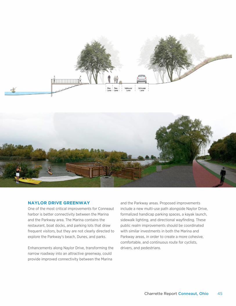
NAYLOR DRIVE GREENWAY One of the most critical improvements for Conneaut harbor is better connectivity between the Marina and the Parkway area. The Marina contains the restaurant, boat docks, and parking lots that draw frequent visitors, but they are not clearly directed to explore the Parkway’s beach, Dunes, and parks.
Enhancements along Naylor Drive, transforming the narrow roadway into an attractive greenway, could provide improved connectivity between the Marina
and the Parkway areas. Proposed improvements include a new multi-use path alongside Naylor Drive, formalized handicap parking spaces, a kayak launch, sidewalk lighting, and directional wayfinding. These public realm improvements should be coordinated with similar investments in both the Marina and Parkway areas, in order to create a more cohesive, comfortable, and continuous route for cyclists, drivers, and pedestrians.
46
PROPOSED MARINA IMPROVEMENTS
47Charrette Report Conneaut, Ohio
48
CONNEAUT CHARRETTE REPORT Kent State University’s
Cleveland Urban Design Collaborative
DRAFT