Embed Size (px)
Citation preview
Charrette Series Report

The quality of the places that we inhabit is a matter of vital importance to all our lives. By influencing our behaviour and our outlook, our places shape us as individuals and as a nation. In Scotland, we are fortunate to have a rich heritage of places of outstanding quality. What we must ensure, though, is that our new development is a match for this legacy and that the places which we now create are ambitious and inspiring. A consistent theme of the planning policy, guidance and advice issued by the Scottish Government is, thus, the need to focus on the creation of better places. We recognise, however, that there is a need to move beyond words and to put principle into practice.
Launched in 2008, the Scottish Sustainable Communities Initiative (SSCI) has been a turning point in Government’s work to transform the design, quality and environmental standards of new housing-led developments. The SSCI aims to raise standards and to develop skills in design, architecture and sustainable construction, and the initiative has identified exemplar projects that provide a basis for demonstration and learning.
In taking forward the SSCI, we provided support for three design charrettes to involve communities, civic leaders and stakeholders in development strategies. These charrettes took place in Lochgelly, Ladyfield in Dumfries and Grandhome on the edge of Aberdeen. For these projects, the highest international expertise has been brought to bear and I commend the foresight of the project teams in choosing to engage Duany Plater-Zyberk & Company (DPZ). The contribution of Andrés Duany and his team, in terms of insight, energy, commitment and quality of outputs has exceeded expectations and I believe that their achievements are outstanding in developing long term vision-based strategies for each of the three projects. The enthusiasm that we also encountered from communities during the charrettes was a very clear indicator of the will and the understanding that exists in Scotland for this dynamic approach.
The charrette process has proven itself to be an immensely powerful mechanism for harnessing information, interests, local views and aspirations, and for marrying these with specialist knowledge and design skills. I believe that a key challenge for the Scottish Government now, is to help to mainstream this approach to community involvement and placemaking in shaping the future of Scotland’s places. Andrés Duany has remarked that the Scottish Sustainable Communities Initiative is the most interesting planning initiative anywhere in the world. I am of course, delighted to share his view and, through this document, wish to share our experiences more widely. What this government wants for the people of Scotland is the creation of inspiring places to live, work and gather. Quite simply places where people wish to be. I have great faith that we can all work together to build a future Scotland of which we can be proud.
John Swinney MSP Cabinet Secretary for Finance and Sustainable Growth
ContentsThe Scottish Sustainable Communities Initiative 04
The SSCI Charrette Series 05
What is a Charrette? 06
Charrette Team 07
Participants 07
Policy and Guidance Context 08
The Three Sites 09
Summary 10
The Ladyfield Charrette 13
Key Issues 14
Planning Context 15
Land-Use Context 16
Transportation Context 17
The Public Design Process 18
The “Light Imprint” Plan 20
The “Peel” Plan 22
The “Quay Connection” Plan 24
The “Pinwheel Plaza” Plan 26
Post Charrette Development 30
Architectural Concepts 31
Special Studies 34
The Lochgelly Charrette 37
Key Issues 38
Regional Context 39
Local Context 40
Site Boundaries 41
Public Design Process 42
The Lochgelly Illustrative Plan 44
Diagrams 46
Proposed Phasing 48
Elements of the Lochgelly Masterplan: 50Southern Town Expansion 50Transit-Oriented Development 51
Town Centre Revitalisation Proposals: 52High Street Retail 52
Town Centre Masterplan 53Miners’ Square 54Lochgelly Centre 56Health Centre 57Market Square 58Farmers’ Market Hall 59Lochgelly West Primary School 60
Architectural Concepts 61Housing Estate Modification 62
The Grandhome Charrette 65
Key Issues 66
Planning Context 67
Regional Context 68
Local Context 69
Public Design Process 70
The Illustrative Masterplan 72
Analytical Diagrams 74
Elements of the Grandhome Masterplan 76The Town Centre 76The North-Western Neighbourhood Centre 77The Academy Neighbourhood Centre 77The Northern Neighbourhood Centre 78The Central Park Neighbourhood 78
Stone Wall Study 79
Phasing Strategy 80
Housing Diversity 81The Footdee District and the Seaton Towers Compared 81New Footdee District 82Neighbourhood Centre Kit 84
Building Guidelines & Codes 85Synoptic Survey 86
Appendix 93
Appendix I: A Design Process For greenfield Sites 94
Appendix II: Density Study 98
Appendix III: Local Terms of Urbanism 99
Appendix IV: Lochgelly Unit Count 102
Appendix V: Grandhome Unit Count 103
The Scottish Sustainable Communities Initiative (SSCI)
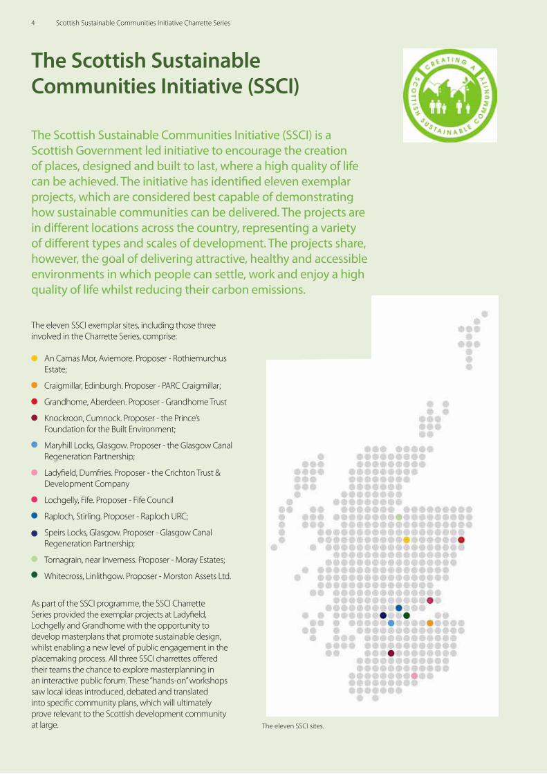
The eleven SSCI exemplar sites, including those three involved in the Charrette Series, comprise:
An Camas Mor, Aviemore. Proposer - Rothiemurchus Estate;
Craigmillar, Edinburgh. Proposer - PARC Craigmillar;
Grandhome, Aberdeen. Proposer - Grandhome Trust
Knockroon, Cumnock. Proposer - the Prince’s Foundation for the Built Environment;
Maryhill Locks, Glasgow. Proposer - the Glasgow Canal Regeneration Partnership;
Ladyfield, Dumfries. Proposer - the Crichton Trust & Development Company
Lochgelly, Fife. Proposer - Fife Council
Raploch, Stirling. Proposer - Raploch URC;
Speirs Locks, Glasgow. Proposer - Glasgow Canal Regeneration Partnership;
Tornagrain, near Inverness. Proposer - Moray Estates;
Whitecross, Linlithgow. Proposer - Morston Assets Ltd.
As part of the SSCI programme, the SSCI Charrette Series provided the exemplar projects at Ladyfield, Lochgelly and Grandhome with the opportunity to develop masterplans that promote sustainable design, whilst enabling a new level of public engagement in the placemaking process. All three SSCI charrettes offered their teams the chance to explore masterplanning in an interactive public forum. These “hands-on” workshops saw local ideas introduced, debated and translated into specific community plans, which will ultimately prove relevant to the Scottish development community at large.
The Scottish Sustainable Communities Initiative (SSCI) is a Scottish Government led initiative to encourage the creation of places, designed and built to last, where a high quality of life can be achieved. The initiative has identified eleven exemplar projects, which are considered best capable of demonstrating how sustainable communities can be delivered. The projects are in different locations across the country, representing a variety of different types and scales of development. The projects share, however, the goal of delivering attractive, healthy and accessible environments in which people can settle, work and enjoy a high quality of life whilst reducing their carbon emissions.
The eleven SSCI sites.
4 Scottish Sustainable Communities Initiative Charrette Series
The SSCI Charrette Series
A month-long series of interactive, public design workshops, the SSCI Charrette Series was a ground-breaking programme for the Scottish Government. The series involved three sites across Scotland, which had been selected for their potential as exemplar communities. Differing in size, location and socioeconomic circumstance, the three sites provided a range of challenges resulting in design approaches and solutions applicable to similar sites across Scotland. An exercise of this type has never before been executed at a national level.
The SSCI Charrettes were unique not only in their scope but also in their approach to community engagement and participation. In each charrette, an international design team, led by urban design practice Duany Plater-Zyberk & Company, engaged directly with each of the three site’s local communities to determine the optimal approach to the masterplanning assignments. Each charrette featured meetings with a wide variety of groups, including both the general public and specialised professionals, with community feedback incorporated directly into the masterplans. Between and even during the meetings, the design team prepared the necessary layouts, illustrations, architectural plans and diagrams. All were presented on-site within each 5-8 day charrette in the presence of the public. The materials within this report were generated on-site at the charrettes and presented to the public, often within minutes of completion.
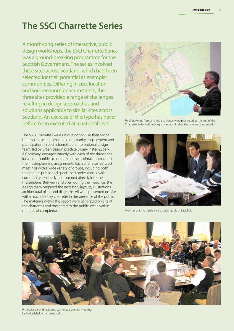
Final drawings from all three charrettes were presented at the end of the Charrette Series in Edinburgh, one month after the opening presentation.
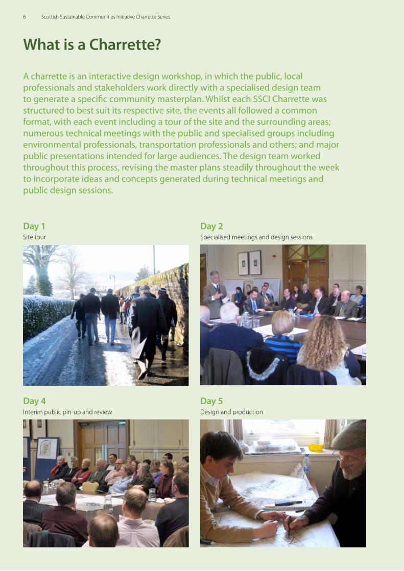
Members of the public visit a design table at Ladyfield.
Professionals and residents gather at a general meeting in the Ladyfield charrette studio.
5Introduction
What is a Charrette?
A charrette is an interactive design workshop, in which the public, local professionals and stakeholders work directly with a specialised design team to generate a specific community masterplan. Whilst each SSCI Charrette was structured to best suit its respective site, the events all followed a common format, with each event including a tour of the site and the surrounding areas; numerous technical meetings with the public and specialised groups including environmental professionals, transportation professionals and others; and major public presentations intended for large audiences. The design team worked throughout this process, revising the master plans steadily throughout the week to incorporate ideas and concepts generated during technical meetings and public design sessions.
Day 1Site tour
Day 2Specialised meetings and design sessions
Day 5Design and production
Day 4Interim public pin-up and review
6 Scottish Sustainable Communities Initiative Charrette Series
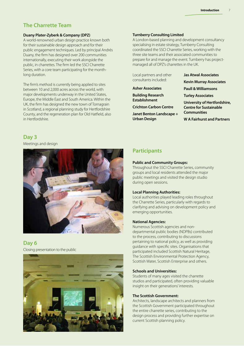
Day 3Meetings and design
Public and Community Groups: Throughout the SSCI Charrette Series, community groups and local residents attended the major public meetings and visited the design studio during open sessions.
Local Planning Authorities: Local authorities played leading roles throughout the Charrette Series, particularly with regards to clarifying and advising on development policy and emerging opportunities.
National Agencies: Numerous Scottish agencies and non-departmental public bodies (NDPBs) contributed to the process, contributing to discussions pertaining to national policy, as well as providing guidance with specific sites. Organisations that participated included Scottish Natural Heritage, The Scottish Environmental Protection Agency, Scottish Water, Scottish Enterprise and others.
Schools and Universities: Students of many ages visited the charrette studios and participated, often providing valuable insight on their generations’ interests.
The Scottish Government: Architects, landscape architects and planners from the Scottish Government participated throughout the entire charrette series, contributing to the design process and providing further expertise on current Scottish planning policy.
Participants
The Charrette Team
Duany Plater-Zyberk & Company (DPZ)A world-renowned urban design practice known both for their sustainable design approach and for their public engagement techniques. Led by principal Andrés Duany, the firm has designed over 200 communities internationally, executing their work alongside the public, in charrettes. The firm led the SSCI Charrette Series, with a core team participating for the month-long duration.
The firm’s method is currently being applied to sites between 10 and 2,000 acres across the world, with major developments underway in the United States, Europe, the Middle East and South America. Within the UK, the firm has designed the new town of Tornagrain in Scotland, a regional planning study for Hertfordshire County, and the regeneration plan for Old Hatfield, also in Hertfordshire.
Day 6Closing presentation to the public
Turnberry Consulting LimitedA London-based planning and development consultancy specialising in estate strategy, Turnberry Consulting coordinated the SSCI Charrette Series, working with the three site teams and their associated communities to prepare for and manage the event. Turnberry has project-managed all of DPZ’s charrettes in the UK.
Local partners and other consultants included:
Asher Associates
Building Research Establishment
Crichton Carbon Centre
Janet Benton Landscape + Urban Design
Jas Atwal Associates
Kevin Murray Associates
Paull & Williamsons
Turley Associates
University of Hertfordshire, Centre for Sustainable Communities
W A Fairhurst and Partners
7Introduction
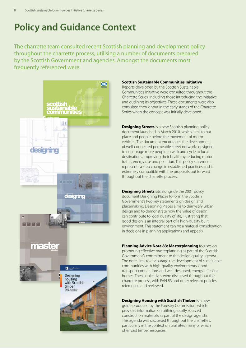
Scottish Sustainable Communities Initiative Reports developed by the Scottish Sustainable Communities Initiative were consulted throughout the Charrette Series, including those introducing the initiative and outlining its objectives. These documents were also consulted throughout in the early stages of the Charrette Series when the concept was initially developed.
Designing Streets is a new Scottish planning policy document launched in March 2010, which aims to put place and people before the movement of motor vehicles. The document encourages the development of well-connected permeable street networks designed to encourage more people to walk and cycle to local destinations, improving their health by reducing motor traffic, energy use and pollution. This policy statement represents a step change in established practices and is extremely compatible with the proposals put forward throughout the charrette process.
Designing Streets sits alongside the 2001 policy document Designing Places to form the Scottish Government’s two key statements on design and placemaking. Designing Places aims to demystify urban design and to demonstrate how the value of design can contribute to local quality of life, illustrating that good design is an integral part of a high-quality built environment. This statement can be a material consideration in decisions in planning applications and appeals.
Planning Advice Note 83: Masterplanning focuses on promoting effective masterplanning as part of the Scottish Government’s commitment to the design quality agenda. The note aims to encourage the development of sustainable communities with high-quality environments, good transport connections and well-designed, energy-efficient homes. These objectives were discussed throughout the charrette process, with PAN 83 and other relevant policies referenced and reviewed.
Designing Housing with Scottish Timber is a new guide produced by the Forestry Commission, which provides information on utilising locally sourced construction materials as part of the design agenda. This agenda was discussed throughout the charrettes, particularly in the context of rural sites, many of which offer vast timber resources.
Policy and Guidance Context
The charrette team consulted recent Scottish planning and development policy throughout the charrette process, utilising a number of documents prepared by the Scottish Government and agencies. Amongst the documents most frequently referenced were:
initiative - report❱❱
Summary
Creating successful and sustainab le p laces will
depend on a shift in attitudes , expectations and
practices about the design of cities , towns ,
villages and the countrys ide. We need :
Decision makers who understand the role of design
in delivering sustainable development (page 9).
Developers, landowners, investors and public bodies
who recognise the commercial and economic value
of good design (page 18).
Effective collaboration between disciplines, professionals,
local communities and others in the planning and urban
design process (page 27).
Development plans with effective design policies, and
urban design frameworks, development briefs and master
plans to provide planning and design guidance (page 34).
Developers submitting design statements with planning
applications that explain the design principles on which
the development proposal is based (page 41).
A high level of awareness and urban design skills in local
authorities, including planners and councillors who are
committed to raising design standards and understand
the impact of their decisions (page 47).
A stronger design element in built environment
professional education (page 48).
Better design education in continuous
professional development programmes (page 49).
Greater commitment to higher standards of
design among public bodies (page 49).
1
2
3
4
5
6
7
8
9
designing
city town
A Policy Statement for Scotland
urban design the collaborative process of shaping thesetting for life in cities, towns, villages and rural areas
village rural
Making it work together
places
masterplanning our ability to masterplan will have an
important role in achieving successful places and
a sustainable future for Scotland
planning
>
sustainable place design build
PAN
83
Planning Advice Note
8 Scottish Sustainable Communities Initiative Charrette Series
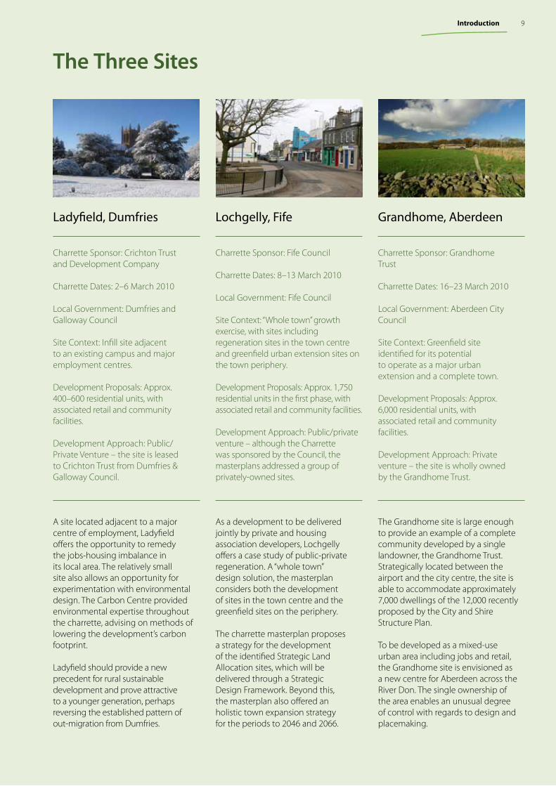
A site located adjacent to a major centre of employment, Ladyfield offers the opportunity to remedy the jobs-housing imbalance in its local area. The relatively small site also allows an opportunity for experimentation with environmental design. The Carbon Centre provided environmental expertise throughout the charrette, advising on methods of lowering the development’s carbon footprint.
Ladyfield should provide a new precedent for rural sustainable development and prove attractive to a younger generation, perhaps reversing the established pattern of out-migration from Dumfries.
Ladyfield, Dumfries Lochgelly, Fife Grandhome, Aberdeen
The Grandhome site is large enough to provide an example of a complete community developed by a single landowner, the Grandhome Trust. Strategically located between the airport and the city centre, the site is able to accommodate approximately 7,000 dwellings of the 12,000 recently proposed by the City and Shire Structure Plan.
To be developed as a mixed-use urban area including jobs and retail, the Grandhome site is envisioned as a new centre for Aberdeen across the River Don. The single ownership of the area enables an unusual degree of control with regards to design and placemaking.
As a development to be delivered jointly by private and housing association developers, Lochgelly offers a case study of public-private regeneration. A “whole town” design solution, the masterplan considers both the development of sites in the town centre and the greenfield sites on the periphery.
The charrette masterplan proposes a strategy for the development of the identified Strategic Land Allocation sites, which will be delivered through a Strategic Design Framework. Beyond this, the masterplan also offered an holistic town expansion strategy for the periods to 2046 and 2066.
The Three Sites
Charrette Sponsor: Crichton Trust and Development Company
Charrette Dates: 2–6 March 2010
Local Government: Dumfries and Galloway Council
Site Context: Infill site adjacent to an existing campus and major employment centres.
Development Proposals: Approx. 400–600 residential units, with associated retail and community facilities.
Development Approach: Public/Private Venture – the site is leased to Crichton Trust from Dumfries & Galloway Council.
Charrette Sponsor: Fife Council
Charrette Dates: 8–13 March 2010
Local Government: Fife Council
Site Context: “Whole town” growth exercise, with sites including regeneration sites in the town centre and greenfield urban extension sites on the town periphery.
Development Proposals: Approx. 1,750 residential units in the first phase, with associated retail and community facilities.
Development Approach: Public/private venture – although the Charrette was sponsored by the Council, the masterplans addressed a group of privately-owned sites.
Charrette Sponsor: Grandhome Trust
Charrette Dates: 16–23 March 2010
Local Government: Aberdeen City Council
Site Context: Greenfield site identified for its potential to operate as a major urban extension and a complete town.
Development Proposals: Approx. 6,000 residential units, with associated retail and community facilities.
Development Approach: Private venture – the site is wholly owned by the Grandhome Trust.
9Introduction
Summary
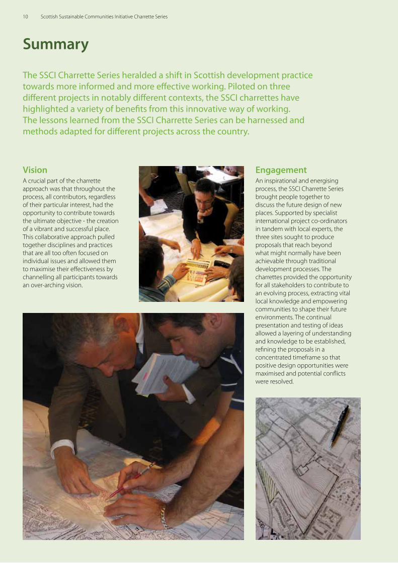
The SSCI Charrette Series heralded a shift in Scottish development practice towards more informed and more effective working. Piloted on three different projects in notably different contexts, the SSCI charrettes have highlighted a variety of benefits from this innovative way of working. The lessons learned from the SSCI Charrette Series can be harnessed and methods adapted for different projects across the country.
VisionA crucial part of the charrette approach was that throughout the process, all contributors, regardless of their particular interest, had the opportunity to contribute towards the ultimate objective - the creation of a vibrant and successful place. This collaborative approach pulled together disciplines and practices that are all too often focused on individual issues and allowed them to maximise their effectiveness by channelling all participants towards an over-arching vision.
EngagementAn inspirational and energising process, the SSCI Charrette Series brought people together to discuss the future design of new places. Supported by specialist international project co-ordinators in tandem with local experts, the three sites sought to produce proposals that reach beyond what might normally have been achievable through traditional development processes. The charrettes provided the opportunity for all stakeholders to contribute to an evolving process, extracting vital local knowledge and empowering communities to shape their future environments. The continual presentation and testing of ideas allowed a layering of understanding and knowledge to be established, refining the proposals in a concentrated timeframe so that positive design opportunities were maximised and potential conflicts were resolved.
10 Scottish Sustainable Communities Initiative Charrette Series
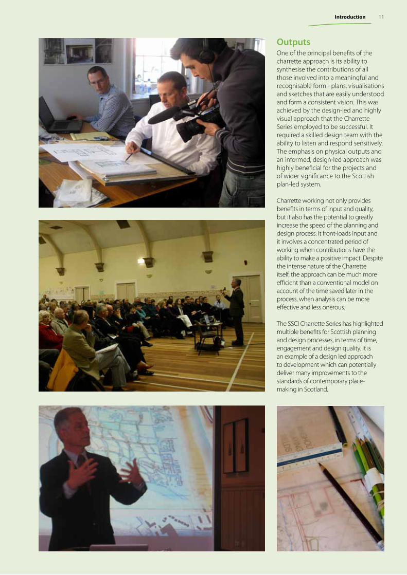
OutputsOne of the principal benefits of the charrette approach is its ability to synthesise the contributions of all those involved into a meaningful and recognisable form - plans, visualisations and sketches that are easily understood and form a consistent vision. This was achieved by the design-led and highly visual approach that the Charrette Series employed to be successful. It required a skilled design team with the ability to listen and respond sensitively. The emphasis on physical outputs and an informed, design-led approach was highly beneficial for the projects and of wider significance to the Scottish plan-led system.
Charrette working not only provides benefits in terms of input and quality, but it also has the potential to greatly increase the speed of the planning and design process. It front-loads input and it involves a concentrated period of working when contributions have the ability to make a positive impact. Despite the intense nature of the Charrette itself, the approach can be much more efficient than a conventional model on account of the time saved later in the process, when analysis can be more effective and less onerous.
The SSCI Charrette Series has highlighted multiple benefits for Scottish planning and design processes, in terms of time, engagement and design quality. It is an example of a design led approach to development which can potentially deliver many improvements to the standards of contemporary place-making in Scotland.
11Introduction
The TeamScottish Government
Architecture and Place Division
Duany Plater-Zyberk & Company
Senen Antonio Eusebio AzcueMonica Carney Andrés Duany, Project Principal Matt Lambert Tom Low, Project DirectorJohn NeasLew Oliver Guy PearlmanChristopher Ritter
Turnberry Consulting
Katharine BurgessJonathan CoulsonAino NärenevaPaul Roberts
Local Team & Additional Participants
Kate Denholm, Crichton Development CompanyJohn Edwards, Crichton Development CompanyHelen Lund, Crichton Development CompanyGordon Mann, Crichton TrustGraham U’ren, Crichton Trust
Tony Fitzpatrick, Dumfries & Galloway Council Steve Rogers, Dumfries & Galloway CouncilKenneth Ross, Dumfries & Galloway Council
Lena Hiltrop, Crichton Carbon CentreMark McKenna, Crichton Carbon CentreGary White, Crichton Carbon Centre
Daniel Jeffs, TurleysStephen Tucker, Turleys
Ken Asher, Asher Associates Matt Lamont, Asher Associates
Andrew Starr, Centre for Sustainable Communities, University of Hertfordshire
The first of the three, the Ladyfield charrette focussed on methods of sustainable community design. Solar design, sustainable urban drainage and many other methods were explored, with the design team focussing on masterplanning strategies which would encourage carbon reduction and maximise the contextual benefits of the site.
The team produced several masterplans for Ladyfield, all of which abided by a “natural green” urbanism, featuring a mixed-use village centre surrounded by a well-connected and walkable neighbourhood. Such a settlement would encourage pedestrian activity and reduced car usage, particularly on account of Ladyfield’s location adjacent to major employment centres.
To be managed and developed by the Crichton Trust and Development Company, Ladyfield will be designed as an energy-efficient, walkable neighbourhood enabling residents to make the transition to a low-carbon economy. The development team has shown a strong commitment to sustainability and will encourage sustainable design by both utilising local resources and reducing general energy consumption.
The Ladyfield Charrette2-6 MARCH 2010
Key Issues
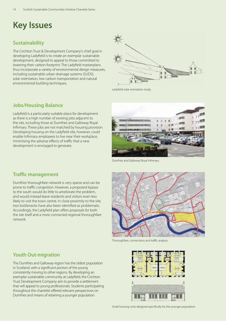
Sustainability The Crichton Trust & Development Company’s chief goal in developing Ladyfi eld is to create an exemplar sustainable development, designed to appeal to those committed to lowering their carbon footprint. The Ladyfi eld masterplans thus incorporate a variety of environmental design measures, including sustainable urban drainage systems (SUDS), solar orientation, low carbon transportation and natural environmental building techniques.
Ladyfi eld solar orientation study.
Dumfries and Galloway Royal Infi rmary.
Jobs/Housing BalanceLadyfi eld is a particularly suitable place for development as there is a high number of existing jobs adjacent to the site, including those at Dumfries and Galloway Royal Infi rmary. These jobs are not matched by housing provision. Developing housing on the Ladyfi eld site, however, could enable Infi rmary employees to live near their workplace, minimising the adverse eff ects of traffi c that a new development is envisaged to generate.
Thoroughfare, connections and traffi c analysis.
N
Traffi c managementDumfries’ thoroughfare network is very sparse and can be prone to traffi c congestion. However, a proposed bypass to the south would do little to ameliorate the problem, and would instead leave residents and visitors even less likely to visit the town centre. In close proximity to the site, two bottlenecks have also been identifi ed as problematic. Accordingly, the Ladyfi eld plan off ers proposals for both the site itself and a more connected regional thoroughfare network.
Small housing units designed specifi cally for the younger population.
Youth Out-migrationThe Dumfries and Galloway region has the oldest population in Scotland, with a signifi cant portion of the young consistently moving to other regions. By developing an exemplar sustainable community at Ladyfi eld, the Crichton Trust Development Company aim to provide a settlement that will appeal to young professionals. Students participating throughout the charrette off ered relevant perspectives on Dumfries and means of retaining a younger population.
14 Scottish Sustainable Communities Initiative Charrette Series
Planning Context
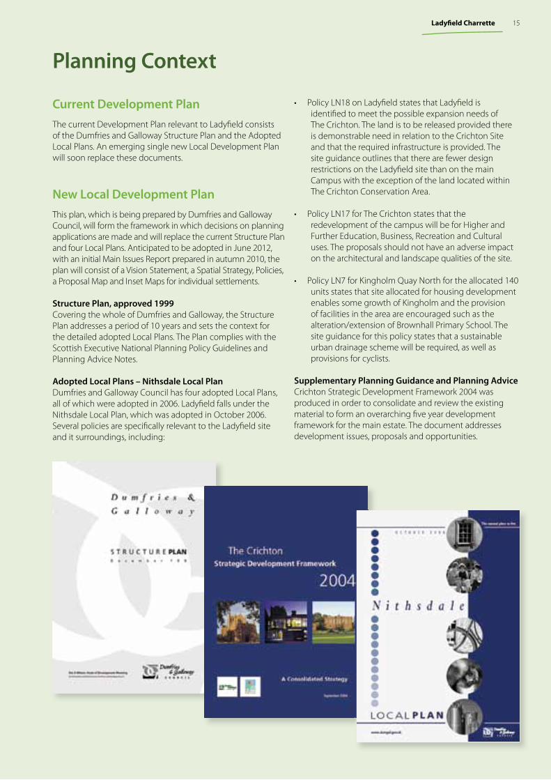
Current Development PlanThe current Development Plan relevant to Ladyfi eld consists of the Dumfries and Galloway Structure Plan and the Adopted Local Plans. An emerging single new Local Development Plan will soon replace these documents.
New Local Development PlanThis plan, which is being prepared by Dumfries and Galloway Council, will form the framework in which decisions on planning applications are made and will replace the current Structure Plan and four Local Plans. Anticipated to be adopted in June 2012, with an initial Main Issues Report prepared in autumn 2010, the plan will consist of a Vision Statement, a Spatial Strategy, Policies, a Proposal Map and Inset Maps for individual settlements.
Structure Plan, approved 1999Covering the whole of Dumfries and Galloway, the Structure Plan addresses a period of 10 years and sets the context for the detailed adopted Local Plans. The Plan complies with the Scottish Executive National Planning Policy Guidelines and Planning Advice Notes.
Adopted Local Plans – Nithsdale Local PlanDumfries and Galloway Council has four adopted Local Plans, all of which were adopted in 2006. Ladyfi eld falls under the Nithsdale Local Plan, which was adopted in October 2006. Several policies are specifi cally relevant to the Ladyfi eld site and it surroundings, including:
• Policy LN18 on Ladyfi eld states that Ladyfi eld is identifi ed to meet the possible expansion needs of The Crichton. The land is to be released provided there is demonstrable need in relation to the Crichton Site and that the required infrastructure is provided. The site guidance outlines that there are fewer design restrictions on the Ladyfi eld site than on the main Campus with the exception of the land located within The Crichton Conservation Area.
• Policy LN17 for The Crichton states that the redevelopment of the campus will be for Higher and Further Education, Business, Recreation and Cultural uses. The proposals should not have an adverse impact on the architectural and landscape qualities of the site.
• Policy LN7 for Kingholm Quay North for the allocated 140 units states that site allocated for housing development enables some growth of Kingholm and the provision of facilities in the area are encouraged such as the alteration/extension of Brownhall Primary School. The site guidance for this policy states that a sustainable urban drainage scheme will be required, as well as provisions for cyclists.
Supplementary Planning Guidance and Planning AdviceCrichton Strategic Development Framework 2004 was produced in order to consolidate and review the existing material to form an overarching fi ve year development framework for the main estate. The document addresses development issues, proposals and opportunities.
15Ladyfi eld Charrette
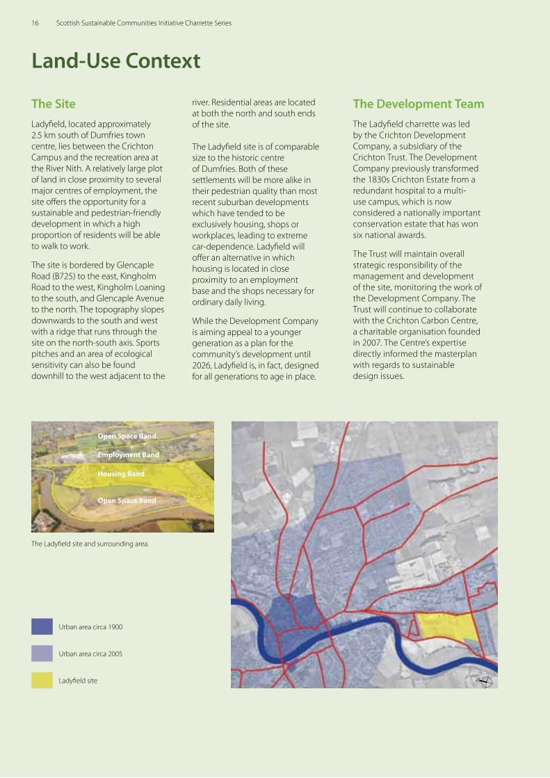
The SiteLadyfi eld, located approximately 2.5 km south of Dumfries town centre, lies between the Crichton Campus and the recreation area at the River Nith. A relatively large plot of land in close proximity to several major centres of employment, the site off ers the opportunity for a sustainable and pedestrian-friendly development in which a high proportion of residents will be able to walk to work.
The site is bordered by Glencaple Road (B725) to the east, Kingholm Road to the west, Kingholm Loaning to the south, and Glencaple Avenue to the north. The topography slopes downwards to the south and west with a ridge that runs through the site on the north-south axis. Sports pitches and an area of ecological sensitivity can also be found downhill to the west adjacent to the
Land-Use Context
river. Residential areas are located at both the north and south ends of the site.
The Ladyfi eld site is of comparable size to the historic centre of Dumfries. Both of these settlements will be more alike in their pedestrian quality than most recent suburban developments which have tended to be exclusively housing, shops or workplaces, leading to extreme car-dependence. Ladyfi eld will off er an alternative in which housing is located in close proximity to an employment base and the shops necessary for ordinary daily living.
While the Development Company is aiming appeal to a younger generation as a plan for the community’s development until 2026, Ladyfi eld is, in fact, designed for all generations to age in place.
The Ladyfi eld site and surrounding area.
Open Space Band
Employment Band
Housing Band
Open Space Band
Ladyfi eld site
Urban area circa 1900
Urban area circa 2005
N
The Development TeamThe Ladyfi eld charrette was led by the Crichton Development Company, a subsidiary of the Crichton Trust. The Development Company previously transformed the 1830s Crichton Estate from a redundant hospital to a multi-use campus, which is now considered a nationally important conservation estate that has won six national awards.
The Trust will maintain overall strategic responsibility of the management and development of the site, monitoring the work of the Development Company. The Trust will continue to collaborate with the Crichton Carbon Centre, a charitable organisation founded in 2007. The Centre’s expertise directly informed the masterplan with regards to sustainable design issues.
16 Scottish Sustainable Communities Initiative Charrette Series

Transportation Context
Much discussion at the charrette focussed on wider traffi c issues within the Dumfries and Galloway area, and the proposed bypass, which would encircle the southern portions of Dumfries. The design team concluded that such a scheme might do little to reduce peak-hour congestion at the two bottlenecks compared to adding two local road links. Peak-hour congestion would also be signifi cantly improved by developing housing for those working in immediate proximity to the site.
The team proposed two local road links, to disperse cars from Glencaple and Bankend Roads to Craigs Road, enabling commuters to avoid the bottleneck entirely. These links would improve traffi c performance without the enormous cost of the bypass thus releasing the dedicated funds for other initiatives, such as the improvement of the historic town centre. This proposition received spontaneous applause at the fi nal charrette presentation.
Current long bypass proposal
Existing roadways
The River Nith
Proposal for a new bypass
Bottleneck
Charrette short bypass proposal
Existing roadways
The River Nith
Charrette proposal for short bypasses
Bottleneck
NN
17Ladyfi eld Charrette
The Public Design Process
Tuesday 2 MarchArriving in Dumfries to fresh snowfall, the charrette team began with a site tour led by the Crichton Trust and consulting engineers, Asher Associates. The team traversed the site, as well as the Crichton Campus, and toured the Dumfries area, including both the town centre and more recent developments on the town’s edges. The evening concluded with an opening presentation, introducing the principles of the charrette and of sustainable, pedestrian-oriented planning.
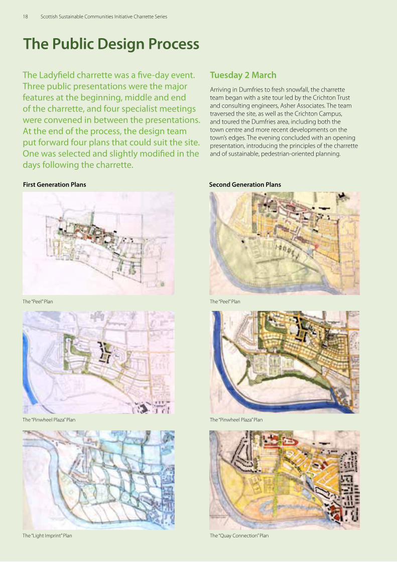
First Generation Plans Second Generation Plans
The “Peel” Plan The “Peel” Plan
The “Pinwheel Plaza” Plan The “Pinwheel Plaza” Plan
The “Light Imprint” Plan The “Quay Connection” Plan
The Ladyfield charrette was a five-day event. Three public presentations were the major features at the beginning, middle and end of the charrette, and four specialist meetings were convened in between the presentations. At the end of the process, the design team put forward four plans that could suit the site. One was selected and slightly modified in the days following the charrette.
18 Scottish Sustainable Communities Initiative Charrette Series
Thursday 4 MarchThe second full day of public engagement brought an additional 100 participants to the studio, many of whom had attended on the days before. Discussions focussed on the emerging masterplan, shown in sketches. Three options were presented and debated.
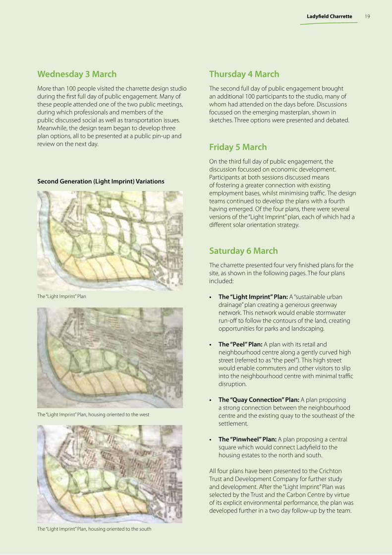
Friday 5 March On the third full day of public engagement, the discussion focussed on economic development. Participants at both sessions discussed means of fostering a greater connection with existing employment bases, whilst minimising traffic. The design teams continued to develop the plans with a fourth having emerged. Of the four plans, there were several versions of the “Light Imprint” plan, each of which had a different solar orientation strategy.
Saturday 6 March The charrette presented four very finished plans for the site, as shown in the following pages. The four plans included:
• The “Light Imprint” Plan: A “sustainable urban drainage” plan creating a generous greenway network. This network would enable stormwater run-off to follow the contours of the land, creating opportunities for parks and landscaping.
• The “Peel” Plan: A plan with its retail and neighbourhood centre along a gently curved high street (referred to as “the peel”). This high street would enable commuters and other visitors to slip into the neighbourhood centre with minimal traffic disruption.
• The “Quay Connection” Plan: A plan proposing a strong connection between the neighbourhood centre and the existing quay to the southeast of the settlement.
• The “Pinwheel” Plan: A plan proposing a central square which would connect Ladyfield to the housing estates to the north and south.
All four plans have been presented to the Crichton Trust and Development Company for further study and development. After the “Light Imprint” Plan was selected by the Trust and the Carbon Centre by virtue of its explicit environmental performance, the plan was developed further in a two day follow-up by the team.
Wednesday 3 March More than 100 people visited the charrette design studio during the first full day of public engagement. Many of these people attended one of the two public meetings, during which professionals and members of the public discussed social as well as transportation issues. Meanwhile, the design team began to develop three plan options, all to be presented at a public pin-up and review on the next day.
Second Generation (Light Imprint) Variations
The “Light Imprint” Plan, housing oriented to the west
The “Light Imprint” Plan
The “Light Imprint” Plan, housing oriented to the south
19Ladyfield Charrette
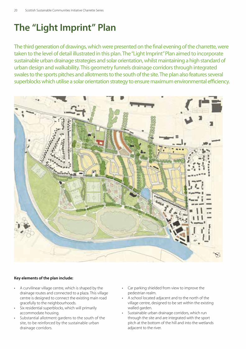
The third generation of drawings, which were presented on the final evening of the charrette, were taken to the level of detail illustrated in this plan. The “Light Imprint” Plan aimed to incorporate sustainable urban drainage strategies and solar orientation, whilst maintaining a high standard of urban design and walkability. This geometry funnels drainage corridors through integrated swales to the sports pitches and allotments to the south of the site. The plan also features several superblocks which utilise a solar orientation strategy to ensure maximum environmental efficiency.
Key elements of the plan include:
• A curvilinear village centre, which is shaped by the drainage routes and connected to a plaza. This village centre is designed to connect the existing main road gracefully to the neighbourhoods.
• Six residential superblocks, which will primarily accommodate housing.
• Substantial allotment gardens to the south of the site, to be reinforced by the sustainable urban drainage corridors.
• Car parking shielded from view to improve the pedestrian realm.
• A school located adjacent and to the north of the village centre, designed to be set within the existing walled garden.
• Sustainable urban drainage corridors, which run through the site and are integrated with the sport pitch at the bottom of the hill and into the wetlands adjacent to the river.
The “Light Imprint” Plan
N
20 Scottish Sustainable Communities Initiative Charrette Series
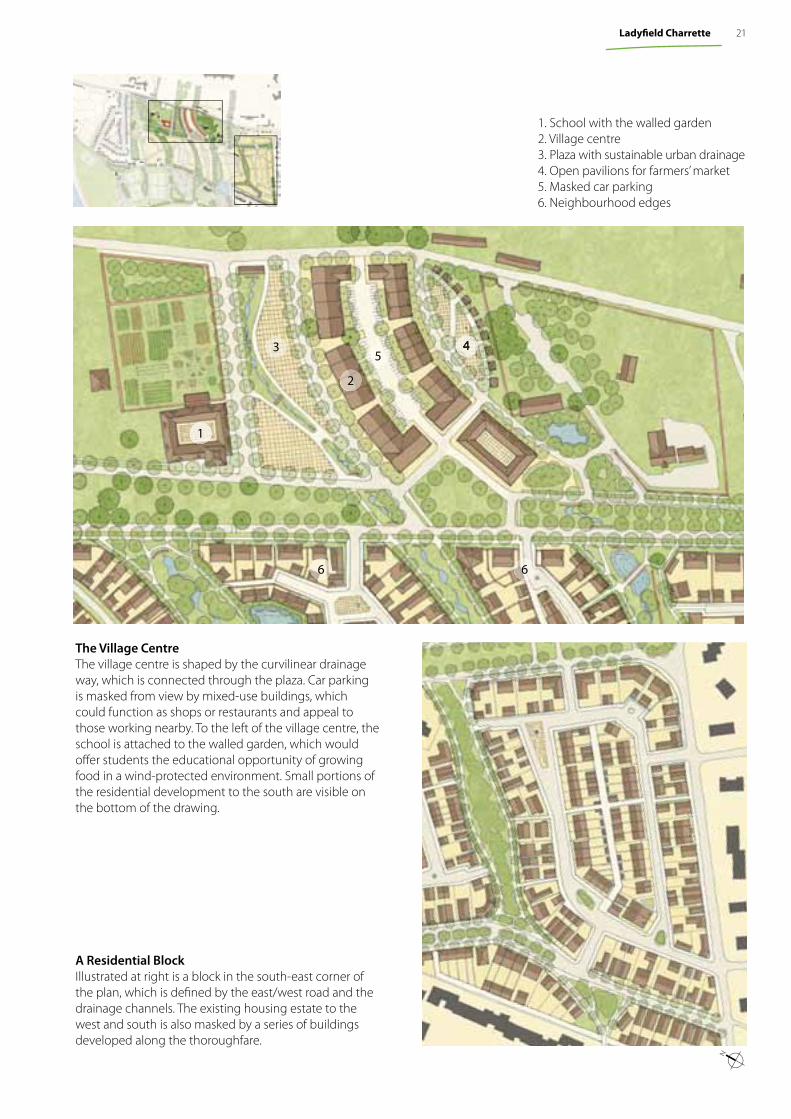
A Residential BlockIllustrated at right is a block in the south-east corner of the plan, which is defi ned by the east/west road and the drainage channels. The existing housing estate to the west and south is also masked by a series of buildings developed along the thoroughfare.
1. School with the walled garden 2. Village centre 3. Plaza with sustainable urban drainage4. Open pavilions for farmers’ market 5. Masked car parking6. Neighbourhood edges
The Village Centre The village centre is shaped by the curvilinear drainage way, which is connected through the plaza. Car parking is masked from view by mixed-use buildings, which could function as shops or restaurants and appeal to those working nearby. To the left of the village centre, the school is attached to the walled garden, which would off er students the educational opportunity of growing food in a wind-protected environment. Small portions of the residential development to the south are visible on the bottom of the drawing.
4
1
3
2
5
6 6
N
21Ladyfi eld Charrette
Key elements of the plan include:
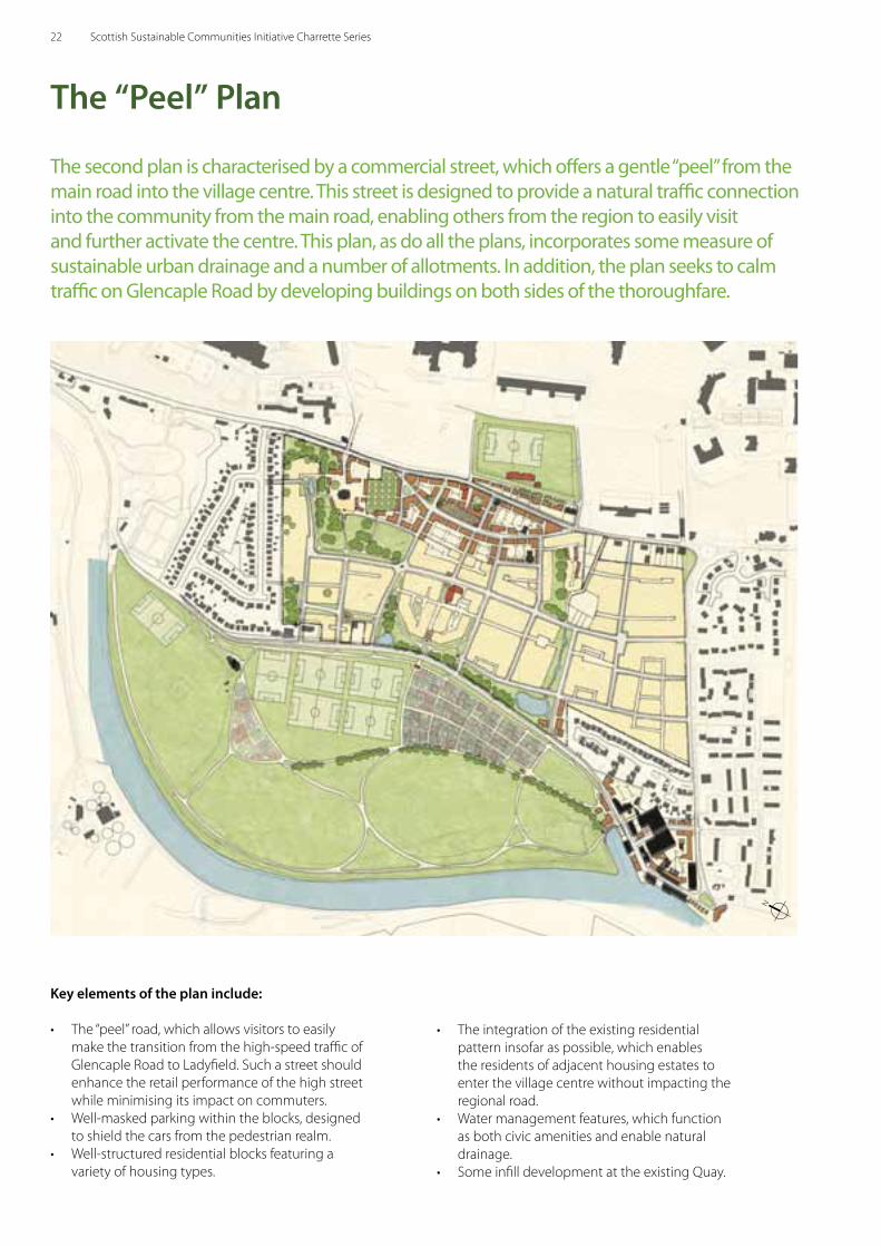
• The “peel” road, which allows visitors to easily make the transition from the high-speed traffic of Glencaple Road to Ladyfield. Such a street should enhance the retail performance of the high street while minimising its impact on commuters.
• Well-masked parking within the blocks, designed to shield the cars from the pedestrian realm.
• Well-structured residential blocks featuring a variety of housing types.
The second plan is characterised by a commercial street, which offers a gentle “peel” from the main road into the village centre. This street is designed to provide a natural traffic connection into the community from the main road, enabling others from the region to easily visit and further activate the centre. This plan, as do all the plans, incorporates some measure of sustainable urban drainage and a number of allotments. In addition, the plan seeks to calm traffic on Glencaple Road by developing buildings on both sides of the thoroughfare.
• The integration of the existing residential pattern insofar as possible, which enables the residents of adjacent housing estates to enter the village centre without impacting the regional road.
• Water management features, which function as both civic amenities and enable natural drainage.
• Some infill development at the existing Quay.
The “Peel” Plan
N
22 Scottish Sustainable Communities Initiative Charrette Series
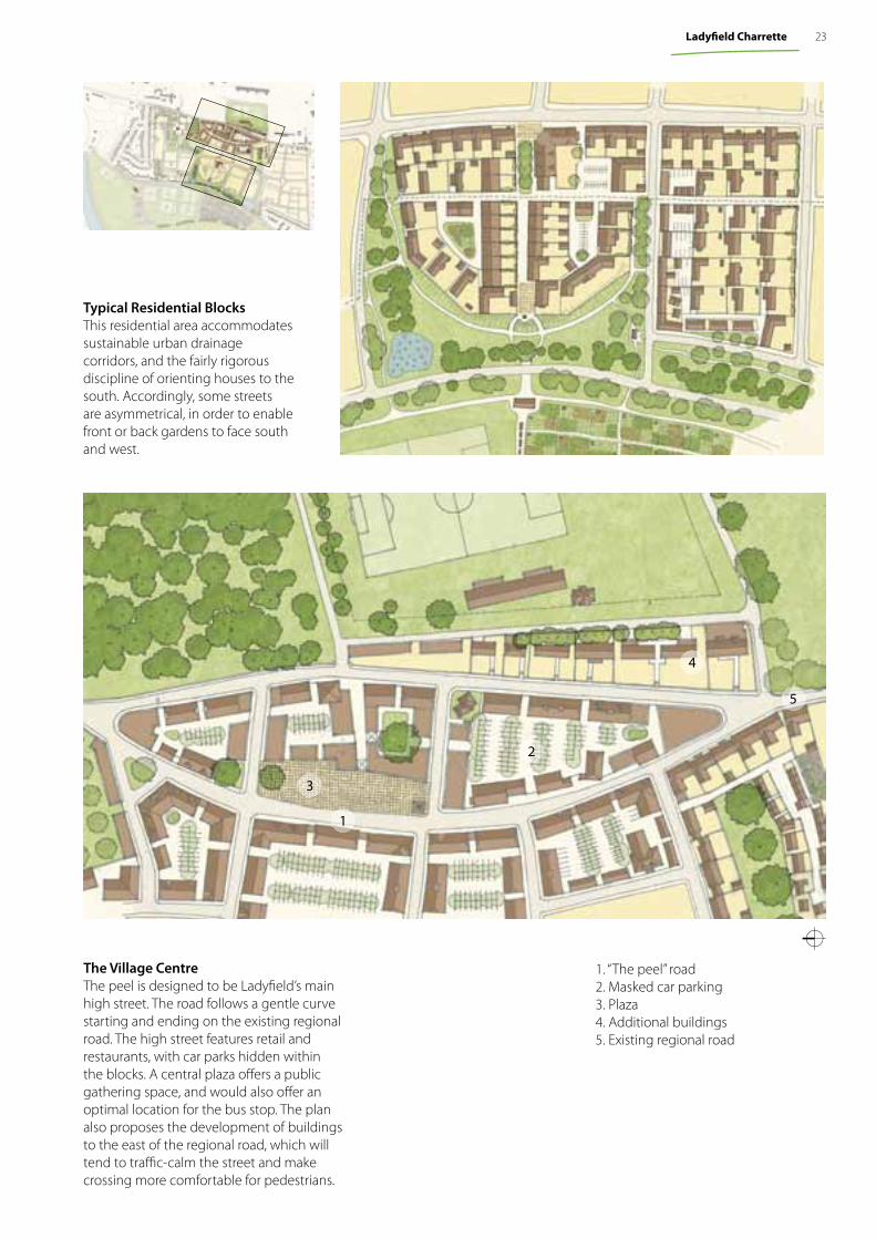
The Village CentreThe peel is designed to be Ladyfi eld’s main high street. The road follows a gentle curve starting and ending on the existing regional road. The high street features retail and restaurants, with car parks hidden within the blocks. A central plaza off ers a public gathering space, and would also off er an optimal location for the bus stop. The plan also proposes the development of buildings to the east of the regional road, which will tend to traffi c-calm the street and make crossing more comfortable for pedestrians.
Typical Residential BlocksThis residential area accommodates sustainable urban drainage corridors, and the fairly rigorous discipline of orienting houses to the south. Accordingly, some streets are asymmetrical, in order to enable front or back gardens to face south and west.
1. “The peel” road2. Masked car parking3. Plaza4. Additional buildings5. Existing regional road
2
3
4
5
1
23Ladyfi eld Charrette
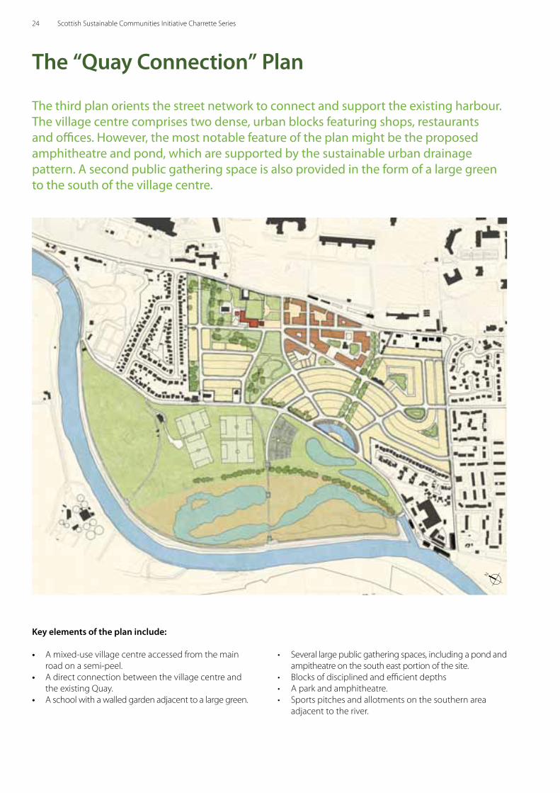
The third plan orients the street network to connect and support the existing harbour. The village centre comprises two dense, urban blocks featuring shops, restaurants and offices. However, the most notable feature of the plan might be the proposed amphitheatre and pond, which are supported by the sustainable urban drainage pattern. A second public gathering space is also provided in the form of a large green to the south of the village centre.
Key elements of the plan include:
• A mixed-use village centre accessed from the main road on a semi-peel.
• A direct connection between the village centre and the existing Quay.
• A school with a walled garden adjacent to a large green.
• Several large public gathering spaces, including a pond and ampitheatre on the south east portion of the site.
• Blocks of disciplined and efficient depths • A park and amphitheatre.• Sports pitches and allotments on the southern area
adjacent to the river.
The “Quay Connection” Plan
N
24 Scottish Sustainable Communities Initiative Charrette Series
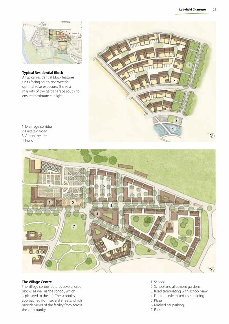
The Village CentreThe village centre features several urban blocks, as well as the school, which is pictured to the left. The school is approached from several streets, which provide views of the facility from across the community.
Typical Residential BlockA typical residential block features units facing south and west for optimal solar exposure. The vast majority of the gardens face south, to ensure maximum sunlight.
1. School2. School and allotment gardens3. Road terminating with school view4. Flatiron-style mixed-use building5. Plaza6. Masked car parking7. Park
4
1
2
5
7
6
3
4
3
2
1
1. Drainage corridor2. Private garden3. Amphitheatre4. Pond
NN
25Ladyfi eld Charrette
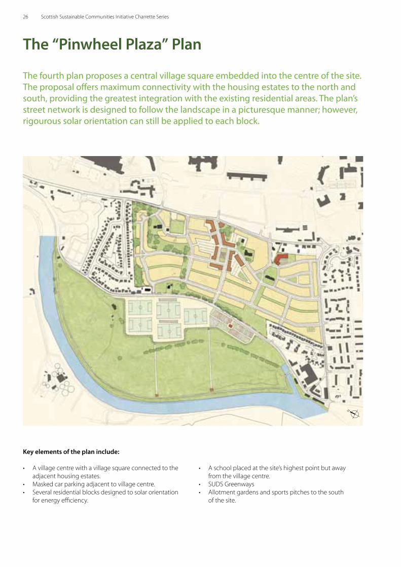
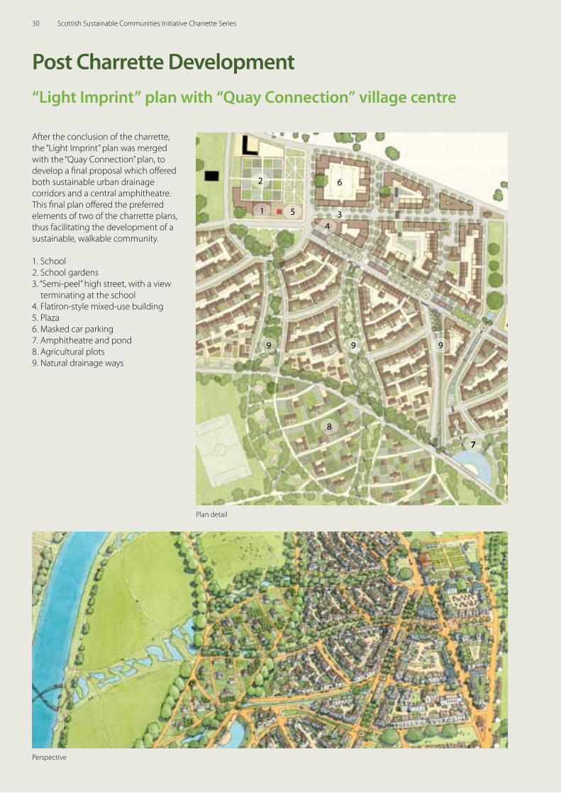
The fourth plan proposes a central village square embedded into the centre of the site. The proposal offers maximum connectivity with the housing estates to the north and south, providing the greatest integration with the existing residential areas. The plan’s street network is designed to follow the landscape in a picturesque manner; however, rigourous solar orientation can still be applied to each block.
Key elements of the plan include:
• A village centre with a village square connected to the adjacent housing estates.
• Masked car parking adjacent to village centre.• Several residential blocks designed to solar orientation
for energy efficiency.
• A school placed at the site’s highest point but away from the village centre.
• SUDS Greenways• Allotment gardens and sports pitches to the south
of the site.
The “Pinwheel Plaza” Plan
N
26 Scottish Sustainable Communities Initiative Charrette Series
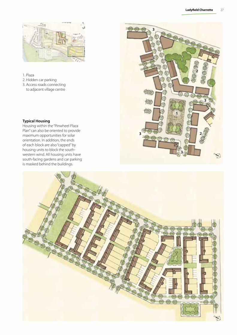
Typical HousingHousing within the “Pinwheel Plaza Plan” can also be oriented to provide maximum opportunities for solar orientation. In addition, the ends of each block are also “capped” by housing units to block the south-western wind. All housing units have south-facing gardens and car parking is masked behind the buildings.
1. Plaza2. Hidden car parking3. Access roads connecting
to adjacent village centre
3
3
3
1
2
2
NN
3
27Ladyfi eld Charrette
These analytical diagrams, one set for each of the alternatives, serve to clarify and assess the attributes of each plan.
1: The “Light Imprint” Plan
Private Plots (in yellow)
Civic Open Space (green) and School (red)
Thoroughfare Network (brown)
Regulating Plan (purple) and 5-minute walking distances (red circles)
2: The “Peel” Plan
Private Plots (in yellow)
Civic Open Space (green) and School (red)
Thoroughfare Network (brown)
Regulating Plan (purple) and 5-minute walking distances (red circles)
28 Scottish Sustainable Communities Initiative Charrette Series
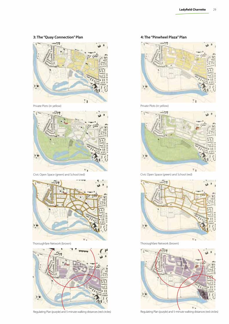
3: The “Quay Connection” Plan
Private Plots (in yellow)
Civic Open Space (green) and School (red)
Thoroughfare Network (brown)
Regulating Plan (purple) and 5-minute walking distances (red circles)
4: The “Pinwheel Plaza” Plan
Private Plots (in yellow)
Civic Open Space (green) and School (red)
Thoroughfare Network (brown)
Regulating Plan (purple) and 5-minute walking distances (red circles)
29Ladyfi eld Charrette
Plan detail
Perspective
1 3
6
7
8
9 9 9
4
5
2
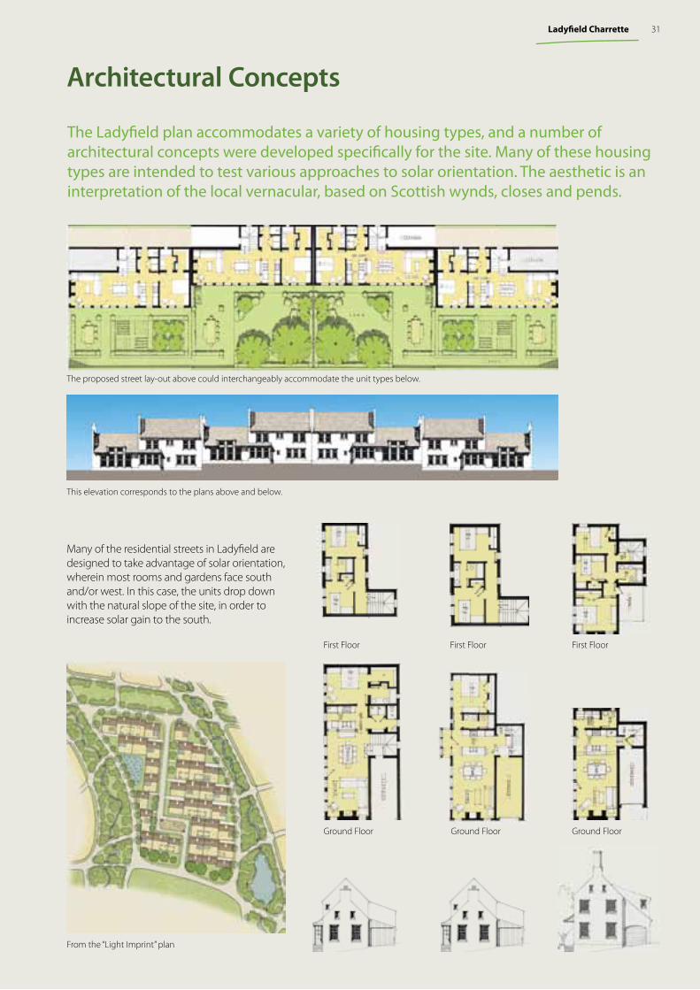
After the conclusion of the charrette, the “Light Imprint” plan was merged with the “Quay Connection” plan, to develop a fi nal proposal which off ered both sustainable urban drainage corridors and a central amphitheatre. This fi nal plan off ered the preferred elements of two of the charrette plans, thus facilitating the development of a sustainable, walkable community.
1. School2. School gardens3. “Semi-peel” high street, with a view
terminating at the school4. Flatiron-style mixed-use building5. Plaza6. Masked car parking7. Amphitheatre and pond8. Agricultural plots9. Natural drainage ways
Post Charrette Development“Light Imprint” plan with “Quay Connection” village centre
30 Scottish Sustainable Communities Initiative Charrette Series
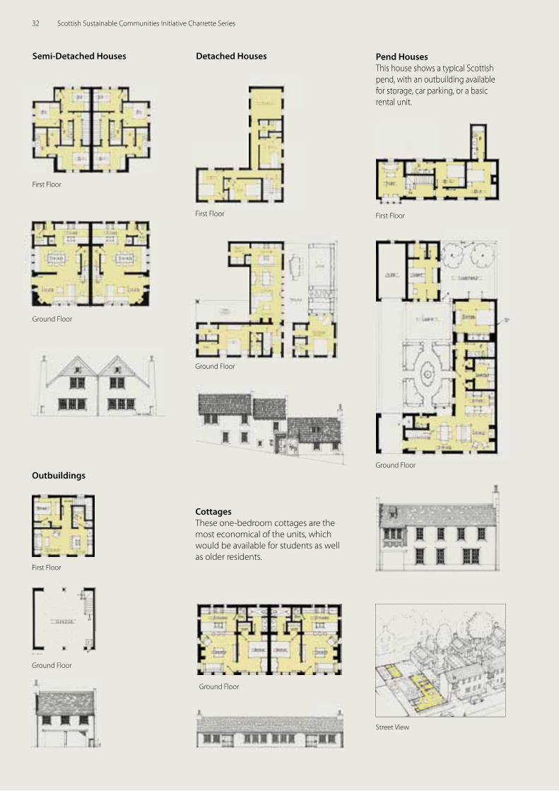
Architectural Concepts
The Ladyfi eld plan accommodates a variety of housing types, and a number of architectural concepts were developed specifi cally for the site. Many of these housing types are intended to test various approaches to solar orientation. The aesthetic is an interpretation of the local vernacular, based on Scottish wynds, closes and pends.
Many of the residential streets in Ladyfi eld are designed to take advantage of solar orientation, wherein most rooms and gardens face south and/or west. In this case, the units drop down with the natural slope of the site, in order to increase solar gain to the south.
This elevation corresponds to the plans above and below.
Ground Floor
First FloorFirst Floor
Ground Floor
First Floor
Ground Floor
The proposed street lay-out above could interchangeably accommodate the unit types below.
From the “Light Imprint” plan
31Ladyfi eld Charrette
Outbuildings
Semi-Detached Houses
Ground Floor
Ground Floor
First Floor
First Floor
Pend HousesThis house shows a typical Scottish pend, with an outbuilding available for storage, car parking, or a basic rental unit.
Street View
Ground Floor
First Floor
Detached Houses
Ground Floor
First Floor
CottagesThese one-bedroom cottages are the most economical of the units, which would be available for students as well as older residents.
Ground Floor
32 Scottish Sustainable Communities Initiative Charrette Series
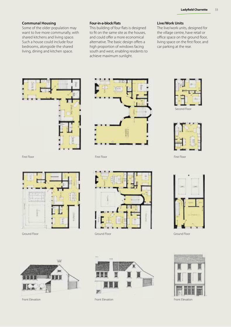
Live/Work UnitsThe live/work units, designed for the village centre, have retail or offi ce space on the ground fl oor, living space on the fi rst fl oor, and car parking at the rear.
Front Elevation
Ground Floor
First Floor
Second Floor
Four-in-a-block FlatsThis building of four fl ats is designed to fi t on the same site as the houses, and could off er a more economical alternative. The basic design off ers a high proportion of windows facing south and west, enabling residents to achieve maximum sunlight.
Front Elevation
Ground Floor
First Floor
Communal HousingSome of the older population may want to live more communally, with shared kitchens and living space. Such a house could include four bedrooms, alongside the shared living, dining and kitchen space.
Front Elevation
Ground Floor
First Floor
33Ladyfi eld Charrette
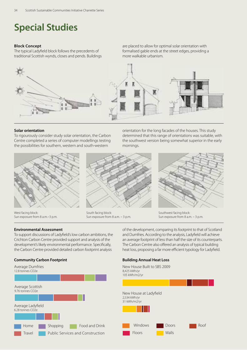
Solar orientationTo rigourously consider study solar orientation, the Carbon Centre completed a series of computer modellings testing the possibilities for southern, western and south-western
Environmental AssessmentTo support discussions of Ladyfi eld’s low carbon ambitions, the Crichton Carbon Centre provided support and analysis of the development’s likely environmental performance. Specifi cally, the Carbon Centre provided detailed carbon footprint analysis
West facing block:Sun exposure from 8 a.m.–3 p.m.
South facing block: Sun exposure from 8 a.m. – 3 p.m.
Southwest facing block: Sun exposure from 8 a.m. – 3 p.m.
Block Concept The typical Ladyfi eld block follows the precedents of traditional Scottish wynds, closes and pends. Buildings
Special Studies
orientation for the long facades of the houses. This study determined that this range of orientations was suitable, with the southwest version being somewhat superior in the early mornings.
of the development, comparing its footprint to that of Scotland and Dumfries. According to the analysis, Ladyfi eld will achieve an average footprint of less than half the size of its counterparts. The Carbon Centre also off ered an analysis of typical building heat loss, proposing a far more effi cient typology for Ladyfi eld.
Community Carbon Footprint Building Annual Heat Loss
Average Scottish 9.76 tonnes CO2e
Average Dumfries12.8 tonnes CO2e
Average Ladyfi eld 6.28 tonnes CO2e
Home Food and Drink
Travel Public Services and Construction
Shopping
are placed to allow for optimal solar orientation with formalised gable ends at the street edges, providing a more walkable urbanism.
New House at Ladyfi eld2,534 kWh/yr31 kWh/m2/yr
New House Built to SBS 20098,425 kWh/yr105 kWh/m2/yr
Windows Doors Roof
Floors Walls
34 Scottish Sustainable Communities Initiative Charrette Series
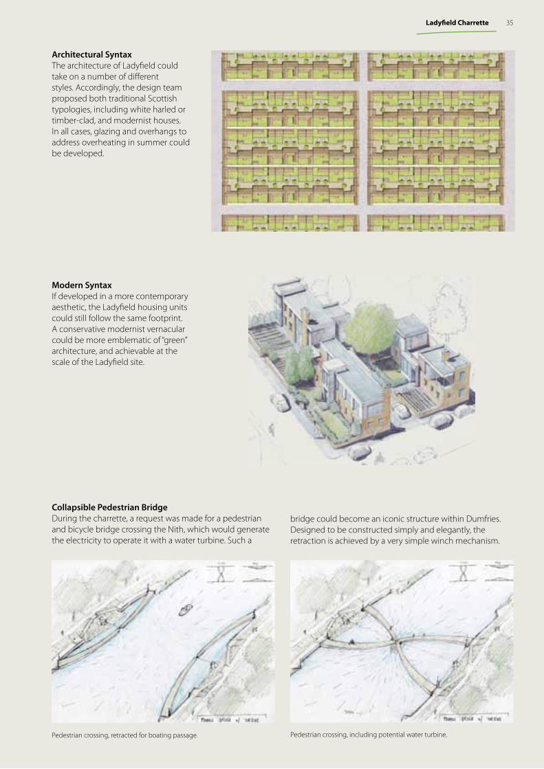
Modern SyntaxIf developed in a more contemporary aesthetic, the Ladyfi eld housing units could still follow the same footprint. A conservative modernist vernacular could be more emblematic of “green” architecture, and achievable at the scale of the Ladyfi eld site.
Architectural SyntaxThe architecture of Ladyfi eld could take on a number of diff erent styles. Accordingly, the design team proposed both traditional Scottish typologies, including white harled or timber-clad, and modernist houses. In all cases, glazing and overhangs to address overheating in summer could be developed.
35Ladyfi eld Charrette
Collapsible Pedestrian Bridge During the charrette, a request was made for a pedestrian and bicycle bridge crossing the Nith, which would generate the electricity to operate it with a water turbine. Such a
bridge could become an iconic structure within Dumfries. Designed to be constructed simply and elegantly, the retraction is achieved by a very simple winch mechanism.
Pedestrian crossing, retracted for boating passage. Pedestrian crossing, including potential water turbine.
The TeamScottish Government
Architecture and Place Division
Duany Plater-Zyberk & Company
Senen Antonio Eusebio Azcue Andrés Duany, Project Principal Xavier Iglesias, Project DirectorMatt Lambert Andrew Moneyheffer Paul MurrainJohn NeasLew Oliver Christopher RitterRuthzaly WeichMax Von Trott
Turnberry Consulting
Katharine BurgessJonathan CoulsonAino NärenevaPaul Roberts
Site Team & Additional Participants
Frances Chisholm, Fife CouncilKaren Christie, Fife Council Hazel Davidson, Fife CouncilVioleta Ilendo, Fife CouncilLynn Leitch, Fife CouncilDavid Thompson, Fife CouncilKeith Winter, Fife Council Alison Wood, Fife Council
Many more Council Officers contributed
Councillor John Beare, Fife CouncilCouncillor Ian Chisholm, Fife CouncilCouncillor Mark Hood, Fife CouncilCouncillor Frances Melville, Fife Council
Douglas McMillian, Adam Smith CollegeRay Graham, Adam Smith College
Located about 20 miles north of Edinburgh in Fife, Lochgelly is a town of about 6,500 which lost its principal industry, mining, years ago. Although the town has lost much of its economic vitality, the town’s location, in close proximity to Edinburgh, remains a great asset. The town has now received a major Strategic Land Allocation (SLA) from Fife Council, and will be expanding by approximately 1,750 new dwellings by 2026. These dwellings are to be positioned within long-life neighbourhoods, designed to be compact, with a mix of densities, housing types and tenures.
The SSCI Charrette Team initially focussed on designing the SLA sites, then mending the town’s centre and improving its disjointed thoroughfare network. The team ultimately moved beyond their original assignment, however, to envision Lochgelly in 2066 and then “pull back” to 2026. This resulted in significant differences in the thoroughfare networks, including a wholly new location for the rail station. These town expansion proposals, along with the town centre regeneration proposals, are introduced in the following pages.
The Lochgelly Charrette8-13 MARCH 2010
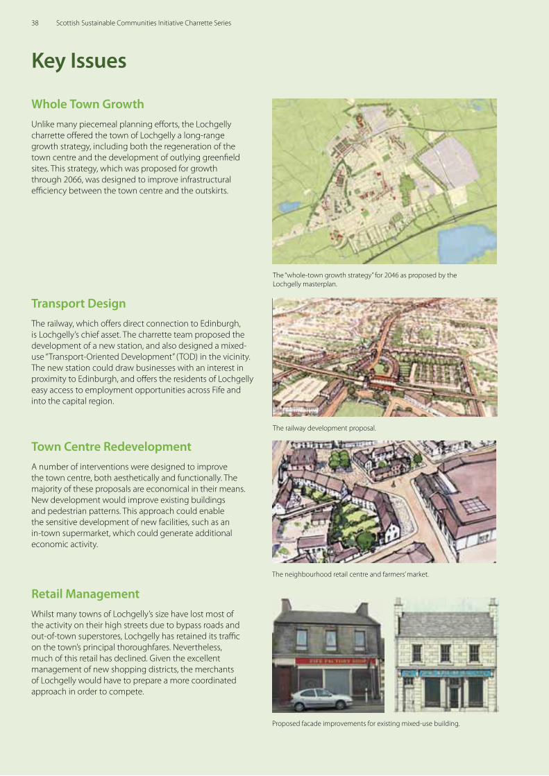
Whole Town GrowthUnlike many piecemeal planning eff orts, the Lochgelly charrette off ered the town of Lochgelly a long-range growth strategy, including both the regeneration of the town centre and the development of outlying greenfi eld sites. This strategy, which was proposed for growth through 2066, was designed to improve infrastructural effi ciency between the town centre and the outskirts.
Key Issues
The “whole-town growth strategy” for 2046 as proposed by the Lochgelly masterplan.
The railway development proposal.
The neighbourhood retail centre and farmers’ market.
Proposed facade improvements for existing mixed-use building.
Monday, March 22, 2010
Transport DesignThe railway, which off ers direct connection to Edinburgh, is Lochgelly’s chief asset. The charrette team proposed the development of a new station, and also designed a mixed-use “Transport-Oriented Development” (TOD) in the vicinity. The new station could draw businesses with an interest in proximity to Edinburgh, and off ers the residents of Lochgelly easy access to employment opportunities across Fife and into the capital region.
Town Centre RedevelopmentA number of interventions were designed to improve the town centre, both aesthetically and functionally. The majority of these proposals are economical in their means. New development would improve existing buildings and pedestrian patterns. This approach could enable the sensitive development of new facilities, such as an in-town supermarket, which could generate additional economic activity.
Retail Management Whilst many towns of Lochgelly’s size have lost most of the activity on their high streets due to bypass roads and out-of-town superstores, Lochgelly has retained its traffi c on the town’s principal thoroughfares. Nevertheless, much of this retail has declined. Given the excellent management of new shopping districts, the merchants of Lochgelly would have to prepare a more coordinated approach in order to compete.
38 Scottish Sustainable Communities Initiative Charrette Series
Current Development PlanThe current Development Plan for Fife consists of the Fife Structure Plan 2006 – 2026 and ten adopted Local Plans currently in the process of being replaced by three Area Local Plans; the Dunfermline &West Fife, the Mid Fife and the St Andrews & East Fife Local Plans.
Lochgelly Strategic Design FrameworkThe Lochgelly Strategic Design Framework has informed the identifi cation of sites within the draft Mid Fife Local Plan. The Framework sets out a vision for the expansion of Lochgelly over the next twenty years and provides urban design principles to guide the Masterplanning of these sites. It also looks at the development capacity of diff erent areas of Lochgelly and provides guidance on suitable densities and house types that respond to the existing built and natural environment in these areas and provides a range of house types and tenures.
Planning Context
Fife Structure Plan 2006 – 2026The Approved Fife Structure Plan sets out the strategic land use planning framework until 2026. The plan shapes the long term aim of the Council in relation to housing, transport and major employment opportunities.
The Structure Plan identifi es Lochgelly as a Strategic Land Allocation for a minimum of 1,400 new houses, 25 hectares of new employment land as well as provision of other community facilities and infrastructure improvements. The new development is envisaged to assist in the regeneration of Lochgelly, particularly on account of the creation of new employment opportunities.
Mid Fife Local Plan as modifi ed (Oct 2009)The Draft Local Plan Strategy:The strategy is guided by the Fife Structure Plan 2006–26.The Draft Local Plan deals with the following issues:
• promoting the redevelopment and re-use of sites that are vacant and/or derelict that take precedence over undeveloped land;
• placing regeneration as a priority. Development proposals will be assessed to identify how they help regeneration in the priority areas in Mid Fife;
• identifying Strategic Land Allocations to assist regeneration over the next 20 years;
• promoting the re-vitalisation of employment land to meet the needs of modern employers;
• supporting proposals that provide key public transport infrastructure and promote improved transport links to and within the Local Plan area;
• encouraging high standards of urban design in development proposals; and
• supporting further development of the leisure, recreational, and tourism potential.
Strategic Development Plan for the Edinburgh and South East Scotland areaStrategic Development Plans (SDPs) are being introduced for the four city regions in Scotland (Edinburgh, Dundee, Glasgow and Aberdeen) as part of The Planning etc (Scotland) Act 2006. The SDPs are produced by Strategic Development Planning Authorities and set a broad spatial planning strategy that can address issues such as the environment, housing, transport and infrastructure, economic development and retailing.
Lochgelly falls within the Edinburgh and South East Scotland Strategic Development Plan area, also known as SESPlan. The plan will cover a population of 1.2 million and 521,000 (2006) households; a population expected to grow by 14% in the period from 2004 – 2032, rising to 1.4 million or 700,000 households.
39Lochgelly Charrette
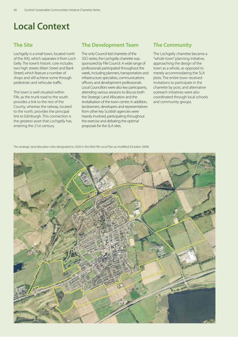
The SiteLochgelly is a small town, located north of the A92, which separates it from Loch Gelly. The town’s historic core includes two high streets (Main Street and Bank Street) which feature a number of shops and still achieve some through pedestrian and vehicular traffic.
The town is well-situated within Fife, as the trunk road to the south provides a link to the rest of the County, whereas the railway, located to the north, provides the principal link to Edinburgh. This connection is the greatest asset that Lochgelly has, entering the 21st century.
Local Context
The strategic land allocation sites designated to 2026 in the Mid Fife Local Plan as modified (October 2009).
The Development TeamThe only Council-led charrette of the SSCI series, the Lochgelly charrette was sponsored by Fife Council. A wide range of professionals participated throughout the week, including planners, transportation and infrastructure specialists, communications officers, and development professionals. Local Councillors were also key participants, attending various sessions to discuss both the Strategic Land Allocation and the revitalisation of the town centre. In addition, landowners, developers and representatives from other key Scottish agencies were heavily involved, participating throughout the exercise and debating the optimal proposals for the SLA sites.
The CommunityThe Lochgelly charrette became a “whole town” planning initiative, approaching the design of the town as a whole, as opposed to merely accommodating the SLA plots. The entire town received invitations to participate in the charrette by post, and alternative outreach initiatives were also coordinated through local schools and community groups.
40 Scottish Sustainable Communities Initiative Charrette Series
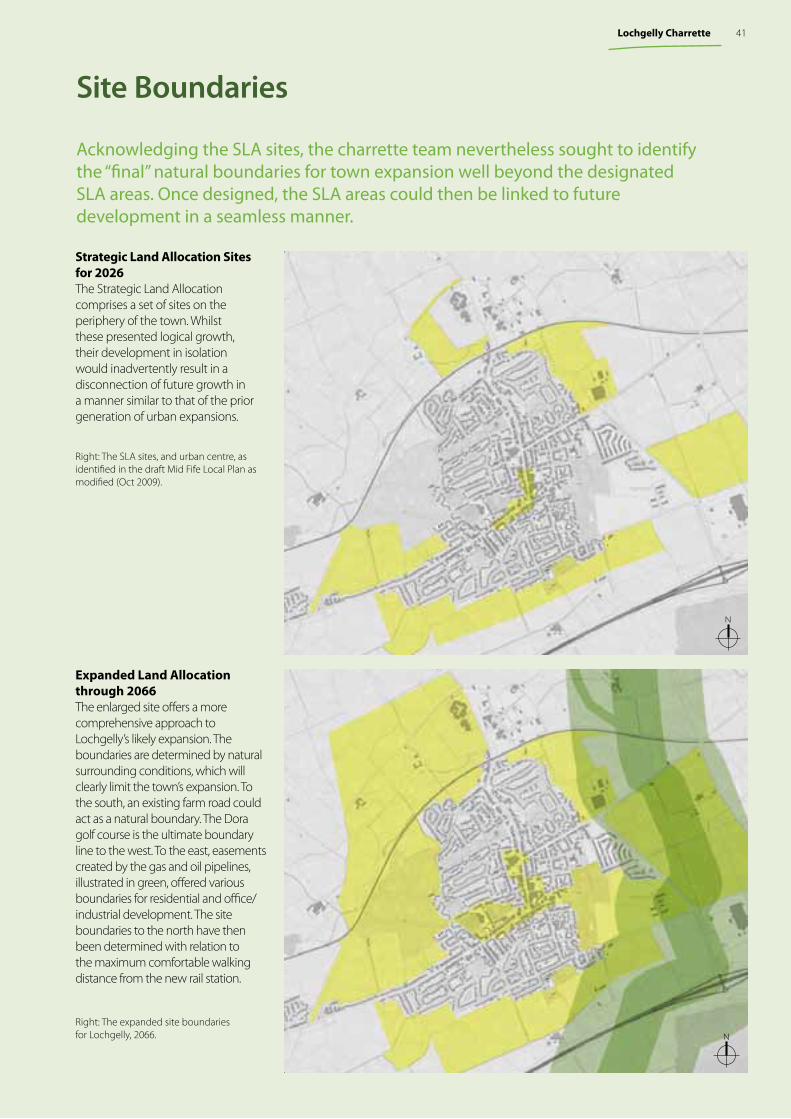
Acknowledging the SLA sites, the charrette team nevertheless sought to identify the “final” natural boundaries for town expansion well beyond the designated SLA areas. Once designed, the SLA areas could then be linked to future development in a seamless manner.
Strategic Land Allocation Sites for 2026 The Strategic Land Allocation comprises a set of sites on the periphery of the town. Whilst these presented logical growth, their development in isolation would inadvertently result in a disconnection of future growth in a manner similar to that of the prior generation of urban expansions.
Expanded Land Allocation through 2066The enlarged site offers a more comprehensive approach to Lochgelly’s likely expansion. The boundaries are determined by natural surrounding conditions, which will clearly limit the town’s expansion. To the south, an existing farm road could act as a natural boundary. The Dora golf course is the ultimate boundary line to the west. To the east, easements created by the gas and oil pipelines, illustrated in green, offered various boundaries for residential and office/industrial development. The site boundaries to the north have then been determined with relation to the maximum comfortable walking distance from the new rail station.
Right: The expanded site boundariesfor Lochgelly, 2066.
Site Boundaries
Monday, March 22, 2010
Monday, March 22, 2010
N
N
Right: The SLA sites, and urban centre, as identified in the draft Mid Fife Local Plan as modified (Oct 2009).
41Lochgelly Charrette
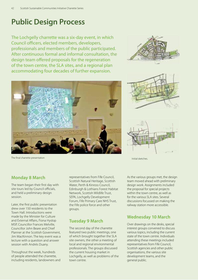
Public Design Process
The Lochgelly charrette was a six-day event, in which Council offi cers, elected members, developers, professionals and members of the public participated. After continuous formal and informal consultation, the design team off ered proposals for the regeneration of the town centre, the SLA sites, and a regional plan accommodating four decades of further expansion.
Monday 8 MarchThe team began their fi rst day with site tours led by Council offi cials, and held a preliminary design session.
Later, the fi rst public presentation drew over 150 residents to the Town Hall. Introductions were made by the Minister for Culture and External Aff airs, Fiona Hyslop MSP, Councillor Frances Melville, Councillor John Beare and Chief Planner at the Scottish Government, Jim MacKinnon. The key event was a lecture with a question and answer session with Andrés Duany.
Throughout the week, hundreds of people attended the charrette, including residents, landowners and
representatives from Fife Council, Scottish Natural Heritage, Scottish Water, Perth & Kinross Council, Edinburgh & Lothians Forest Habitat Network, Scottish Wildlife Trust, SEPA, Lochgelly Development Forum, Fife Primary Care NHS Trust, the Fife police force and other groups.
Tuesday 9 MarchThe second day of the charrette featured two public meetings, one of which brought together the SLA site owners, the other a meeting of local and regional environmental professionals. The groups discussed the current housing market in Lochgelly, as well as problems of the town centre.
The fi nal charrette presentation Initial sketches.
As the various groups met, the design team moved ahead with preliminary design work. Assignments included the proposal for special projects within the town centre, as well as for the various SLA sites. Several discussions focussed on making the railway station more accessible.
Wednesday 10 MarchOver drawings on the desks, special interest groups convened to discuss various topics, including the current state of the town centre. Individuals attending these meetings included representatives from Fife Council, Scottish agencies and other public organisations, the various site development teams, and the general public.
42 Scottish Sustainable Communities Initiative Charrette Series
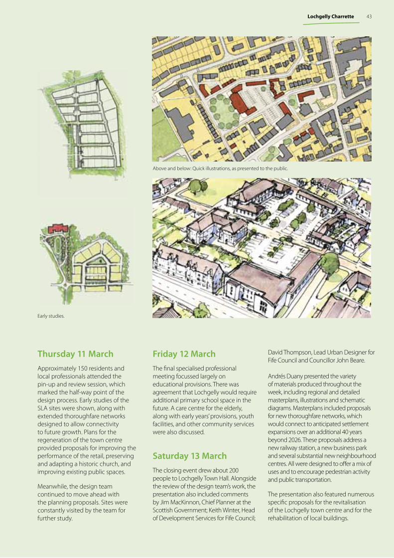
Thursday 11 MarchApproximately 150 residents and local professionals attended the pin-up and review session, which marked the half-way point of the design process. Early studies of the SLA sites were shown, along with extended thoroughfare networks designed to allow connectivity to future growth. Plans for the regeneration of the town centre provided proposals for improving the performance of the retail, preserving and adapting a historic church, and improving existing public spaces.
Meanwhile, the design team continued to move ahead with the planning proposals. Sites were constantly visited by the team for further study.
Friday 12 MarchThe fi nal specialised professional meeting focussed largely on educational provisions. There was agreement that Lochgelly would require additional primary school space in the future. A care centre for the elderly, along with early years’ provisions, youth facilities, and other community services were also discussed.
Saturday 13 MarchThe closing event drew about 200 people to Lochgelly Town Hall. Alongside the review of the design team’s work, the presentation also included comments by Jim MacKinnon, Chief Planner at the Scottish Government; Keith Winter, Head of Development Services for Fife Council;
Early studies.
Above and below: Quick illustrations, as presented to the public.
David Thompson, Lead Urban Designer for Fife Council and Councillor John Beare.
Andrés Duany presented the variety of materials produced throughout the week, including regional and detailed masterplans, illustrations and schematic diagrams. Masterplans included proposals for new thoroughfare networks, which would connect to anticipated settlement expansions over an additional 40 years beyond 2026. These proposals address a new railway station, a new business park and several substantial new neighbourhood centres. All were designed to off er a mix of uses and to encourage pedestrian activity and public transportation.
The presentation also featured numerous specifi c proposals for the revitalisation of the Lochgelly town centre and for the rehabilitation of local buildings.
43Lochgelly Charrette
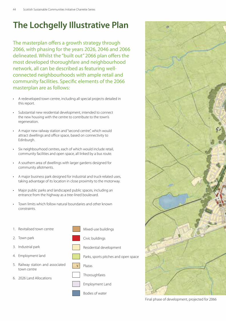
Final phase of development, projected for 2066
The masterplan offers a growth strategy through 2066, with phasing for the years 2026, 2046 and 2066 delineated. Whilst the “built out” 2066 plan offers the most developed thoroughfare and neighbourhood network, all can be described as featuring well-connected neighbourhoods with ample retail and community facilities. Specific elements of the 2066 masterplan are as follows:
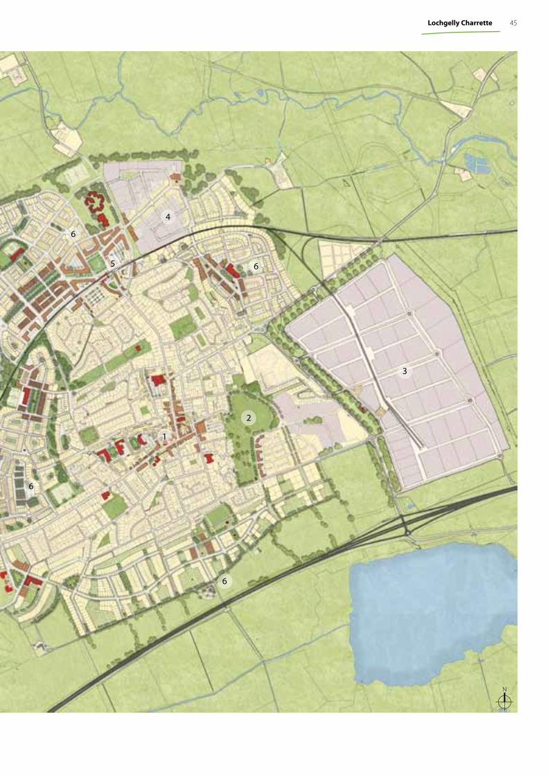
The Lochgelly Illustrative Plan
1. Revitalised town centre
2. Town park
3. Industrial park
4. Employment land
5. Railway station and associated town centre
6. 2026 Land Allocations
Mixed-use buildings
Civic buildings
Residential development
Parks, sports pitches and open space
Plazas
Thoroughfares
Employment Land
Bodies of water
• A redeveloped town centre, including all special projects detailed in this report.
• Substantial new residential development, intended to connect the new housing with the centre to contribute to the town’s regeneration.
• A major new railway station and “second centre”, which would attract dwellings and office space, based on connectivity to Edinburgh.
• Six neighbourhood centres, each of which would include retail, community facilities and open space, all linked by a bus route.
• A southern area of dwellings with larger gardens designed for community allotments.
• A major business park designed for industrial and truck-related uses, taking advantage of its location in close proximity to the motorway.
• Major public parks and landscaped public spaces, including an entrance from the highway as a tree-lined boulevard.
• Town limits which follow natural boundaries and other known constraints.
44 Scottish Sustainable Communities Initiative Charrette Series
1
2
3
5
6
6
6
4
6
N
45Lochgelly Charrette
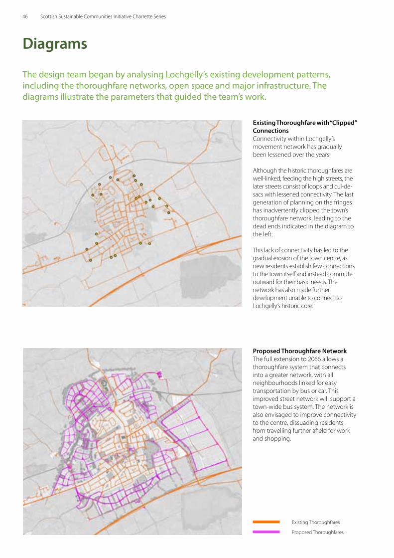
The design team began by analysing Lochgelly’s existing development patterns, including the thoroughfare networks, open space and major infrastructure. The diagrams illustrate the parameters that guided the team’s work.
Diagrams
Existing Thoroughfare with “Clipped” ConnectionsConnectivity within Lochgelly’s movement network has gradually been lessened over the years.
Although the historic thoroughfares are well-linked, feeding the high streets, the later streets consist of loops and cul-de-sacs with lessened connectivity. The last generation of planning on the fringes has inadvertently clipped the town’s thoroughfare network, leading to the dead ends indicated in the diagram to the left.
This lack of connectivity has led to the gradual erosion of the town centre, as new residents establish few connections to the town itself and instead commute outward for their basic needs. The network has also made further development unable to connect to Lochgelly’s historic core.
Proposed Thoroughfare NetworkThe full extension to 2066 allows a thoroughfare system that connects into a greater network, with all neighbourhoods linked for easy transportation by bus or car. This improved street network will support a town-wide bus system. The network is also envisaged to improve connectivity to the centre, dissuading residents from travelling further afield for work and shopping.
Existing Thoroughfares
Proposed Thoroughfares
46 Scottish Sustainable Communities Initiative Charrette Series
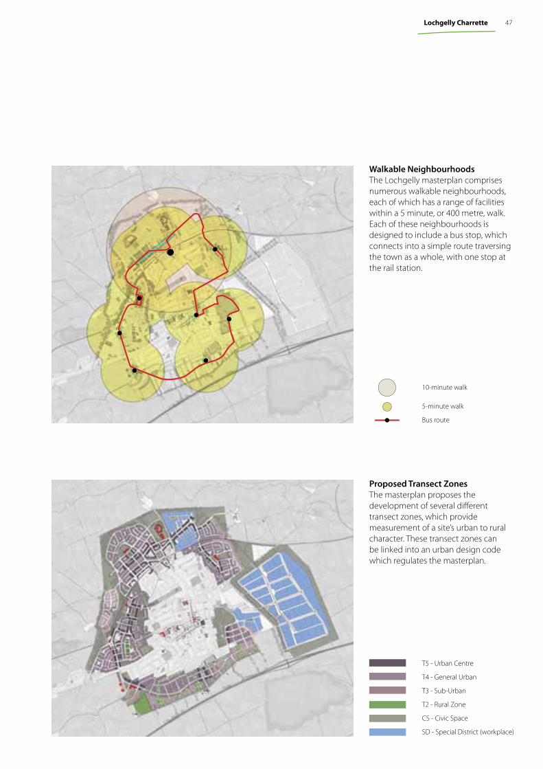
Walkable Neighbourhoods The Lochgelly masterplan comprises numerous walkable neighbourhoods, each of which has a range of facilities within a 5 minute, or 400 metre, walk. Each of these neighbourhoods is designed to include a bus stop, which connects into a simple route traversing the town as a whole, with one stop at the rail station.
Proposed Transect ZonesThe masterplan proposes the development of several diff erent transect zones, which provide measurement of a site’s urban to rural character. These transect zones can be linked into an urban design code which regulates the masterplan.
T5 - Urban Centre
T4 - General Urban
T3 - Sub-Urban
T2 - Rural Zone
CS - Civic Space
SD - Special District (workplace)
10-minute walk
5-minute walk
Bus route
47Lochgelly Charrette
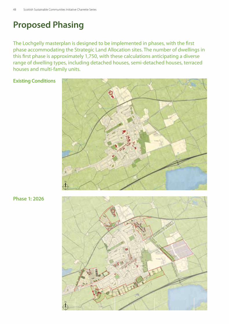
Proposed Phasing
The Lochgelly masterplan is designed to be implemented in phases, with the fi rst phase accommodating the Strategic Land Allocation sites. The number of dwellings in this fi rst phase is approximately 1,750, with these calculations anticipating a diverse range of dwelling types, including detached houses, semi-detached houses, terraced houses and multi-family units.
Phase 1: 2026
Existing Conditions
N
N
48 Scottish Sustainable Communities Initiative Charrette Series
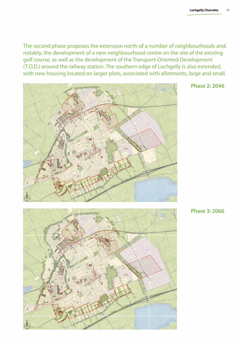
Phase 3: 2066
Phase 2: 2046
N
N
The second phase proposes the extension north of a number of neighbourhoods and, notably, the development of a new neighbourhood centre on the site of the existing golf course, as well as the development of the Transport-Oriented Development (T.O.D.) around the railway station. The southern edge of Lochgelly is also extended, with new housing located on larger plots, associated with allotments, large and small.
49Lochgelly Charrette
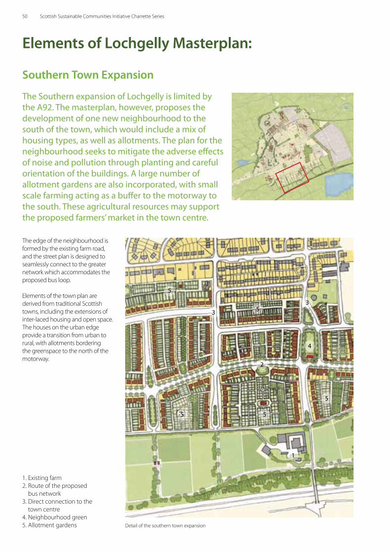
The Southern expansion of Lochgelly is limited by the A92. The masterplan, however, proposes the development of one new neighbourhood to the south of the town, which would include a mix of housing types, as well as allotments. The plan for the neighbourhood seeks to mitigate the adverse eff ects of noise and pollution through planting and careful orientation of the buildings. A large number of allotment gardens are also incorporated, with small scale farming acting as a buff er to the motorway to the south. These agricultural resources may support the proposed farmers’ market in the town centre.
The edge of the neighbourhood is formed by the existing farm road, and the street plan is designed to seamlessly connect to the greater network which accommodates the proposed bus loop.
Elements of the town plan are derived from traditional Scottish towns, including the extensions of inter-laced housing and open space. The houses on the urban edge provide a transition from urban to rural, with allotments bordering the greenspace to the north of the motorway.
1. Existing farm2. Route of the proposed
bus network3. Direct connection to the
town centre4. Neighbourhood green5. Allotment gardens
5
1
2
3
4
Elements of Lochgelly Masterplan:
3
5 5
5
5
Detail of the southern town expansion
Southern Town Expansion
50 Scottish Sustainable Communities Initiative Charrette Series
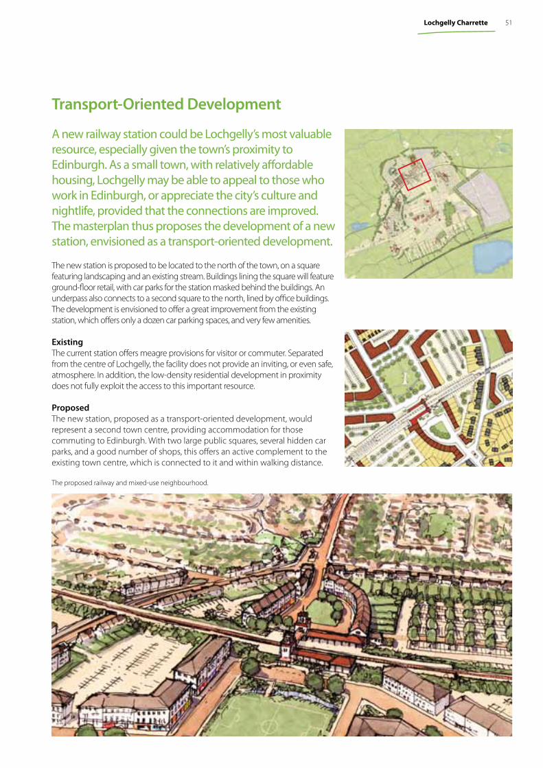
The new station is proposed to be located to the north of the town, on a square featuring landscaping and an existing stream. Buildings lining the square will feature ground-floor retail, with car parks for the station masked behind the buildings. An underpass also connects to a second square to the north, lined by office buildings. The development is envisioned to offer a great improvement from the existing station, which offers only a dozen car parking spaces, and very few amenities.
ExistingThe current station offers meagre provisions for visitor or commuter. Separated from the centre of Lochgelly, the facility does not provide an inviting, or even safe, atmosphere. In addition, the low-density residential development in proximity does not fully exploit the access to this important resource.
ProposedThe new station, proposed as a transport-oriented development, would represent a second town centre, providing accommodation for those commuting to Edinburgh. With two large public squares, several hidden car parks, and a good number of shops, this offers an active complement to the existing town centre, which is connected to it and within walking distance.
The proposed railway and mixed-use neighbourhood.
A new railway station could be Lochgelly’s most valuable resource, especially given the town’s proximity to Edinburgh. As a small town, with relatively affordable housing, Lochgelly may be able to appeal to those who work in Edinburgh, or appreciate the city’s culture and nightlife, provided that the connections are improved. The masterplan thus proposes the development of a new station, envisioned as a transport-oriented development.
Transport-Oriented Development
51Lochgelly Charrette
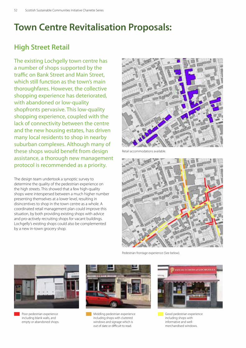
High Street Retail
The existing Lochgelly town centre has a number of shops supported by the traffic on Bank Street and Main Street, which still function as the town’s main thoroughfares. However, the collective shopping experience has deteriorated, with abandoned or low-quality shopfronts pervasive. This low-quality shopping experience, coupled with the lack of connectivity between the centre and the new housing estates, has driven many local residents to shop in nearby suburban complexes. Although many of these shops would benefit from design assistance, a thorough new management protocol is recommended as a priority.
The design team undertook a synoptic survey to determine the quality of the pedestrian experience on the high streets. This showed that a few high-quality shops were interspersed between a much higher number presenting themselves at a lower level, resulting in disincentives to shop in the town centre as a whole. A coordinated retail management plan could improve this situation, by both providing existing shops with advice and pro-actively recruiting shops for vacant buildings. Lochgelly’s existing shops could also be complemented by a new in-town grocery shop.
Town Centre Revitalisation Proposals:
Retail accommodations available.
Pedestrian frontage experience (See below).
Poor pedestrian experience including blank walls, and empty or abandoned shops.
Middling pedestrian experience including shops with cluttered windows and signage which is out of date or difficult to read.
Good pedestrian experience including shops with informative and well-merchandised windows.
52 Scottish Sustainable Communities Initiative Charrette Series
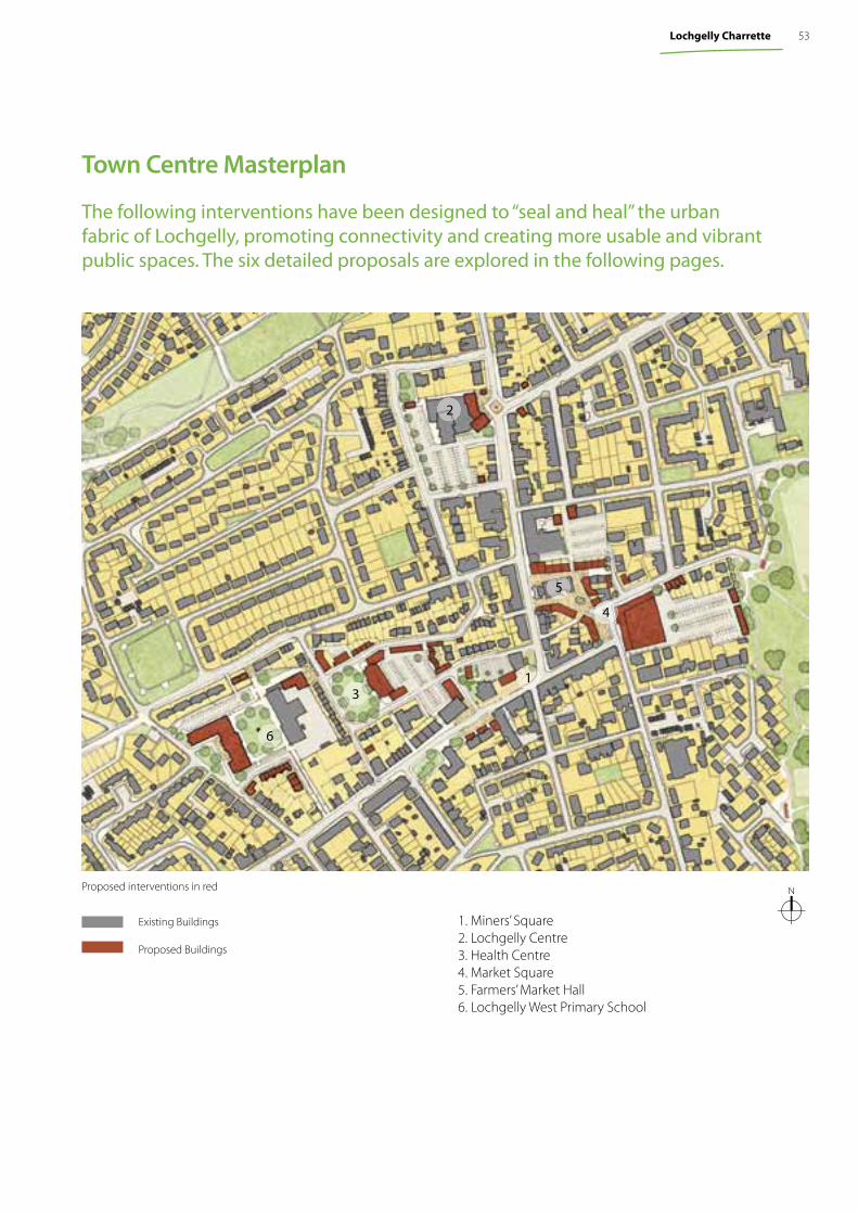
Proposed interventions in red
Existing Buildings
Proposed Buildings
1. Miners’ Square2. Lochgelly Centre3. Health Centre4. Market Square5. Farmers’ Market Hall6. Lochgelly West Primary School
1
2
3
4
5
6
The following interventions have been designed to “seal and heal” the urban fabric of Lochgelly, promoting connectivity and creating more usable and vibrant public spaces. The six detailed proposals are explored in the following pages.
N
Town Centre Masterplan
53Lochgelly Charrette
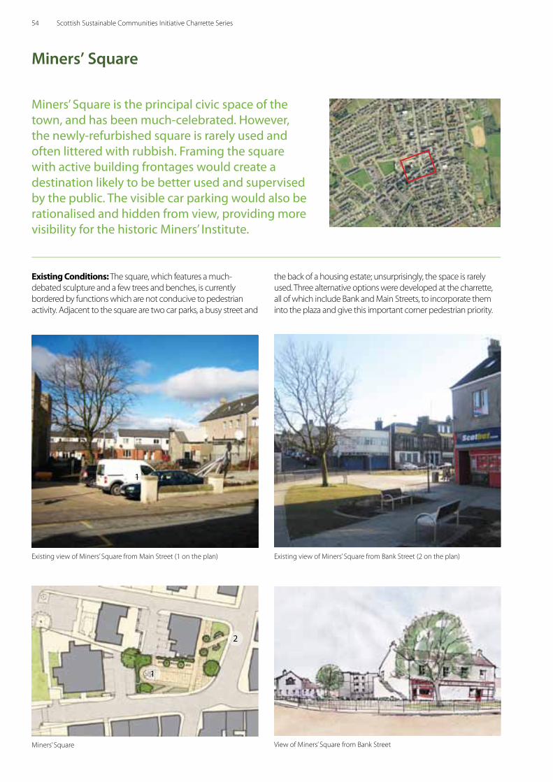
Miners’ Square is the principal civic space of the town, and has been much-celebrated. However, the newly-refurbished square is rarely used and often littered with rubbish. Framing the square with active building frontages would create a destination likely to be better used and supervised by the public. The visible car parking would also be rationalised and hidden from view, providing more visibility for the historic Miners’ Institute.
Miners’ Square
Existing Conditions: The square, which features a much-debated sculpture and a few trees and benches, is currently bordered by functions which are not conducive to pedestrian activity. Adjacent to the square are two car parks, a busy street and
the back of a housing estate; unsurprisingly, the space is rarely used. Three alternative options were developed at the charrette, all of which include Bank and Main Streets, to incorporate them into the plaza and give this important corner pedestrian priority.
Miners’ Square View of Miners’ Square from Bank Street
1
2
1
Existing view of Miners’ Square from Main Street (1 on the plan) Existing view of Miners’ Square from Bank Street (2 on the plan)
54 Scottish Sustainable Communities Initiative Charrette Series
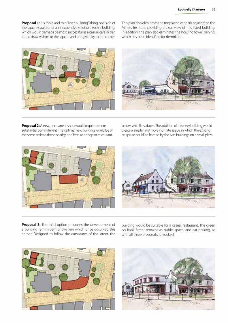
Proposal 2: A new, permanent shop would require a more substantial commitment. The optimal new building would be of the same scale to those nearby, and feature a shop or restaurant
Proposal 3: The third option proposes the development of a building reminiscent of the one which once occupied this corner. Designed to follow the curvatures of the street, the
Proposal 1: A simple and thin “liner building” along one side of the square could offer an inexpensive solution. Such a building, which would perhaps be most successful as a casual café or bar, could draw visitors to the square and bring vitality to the corner.
building would be suitable for a casual restaurant. The green on Bank Street remains as public space, and car parking, as with all three proposals, is masked.
This plan also eliminates the misplaced car park adjacent to the Miners’ Institute, providing a clear view of this listed building. In addition, the plan also eliminates the housing tower behind, which has been identified for demolition.
below, with flats above. The addition of this new building would create a smaller and more intimate space, in which the existing sculpture could be framed by the two buildings on a small plaza.
55Lochgelly Charrette
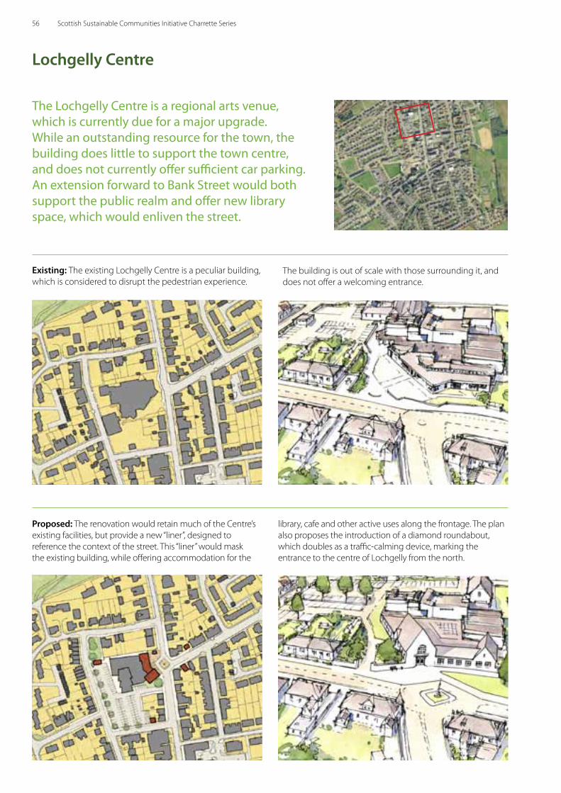
The Lochgelly Centre is a regional arts venue, which is currently due for a major upgrade. While an outstanding resource for the town, the building does little to support the town centre, and does not currently offer sufficient car parking. An extension forward to Bank Street would both support the public realm and offer new library space, which would enliven the street.
Proposed: The renovation would retain much of the Centre’s existing facilities, but provide a new “liner”, designed to reference the context of the street. This “liner” would mask the existing building, while offering accommodation for the
Existing: The existing Lochgelly Centre is a peculiar building, which is considered to disrupt the pedestrian experience.
Lochgelly Centre
library, cafe and other active uses along the frontage. The plan also proposes the introduction of a diamond roundabout, which doubles as a traffic-calming device, marking the entrance to the centre of Lochgelly from the north.
The building is out of scale with those surrounding it, and does not offer a welcoming entrance.
56 Scottish Sustainable Communities Initiative Charrette Series
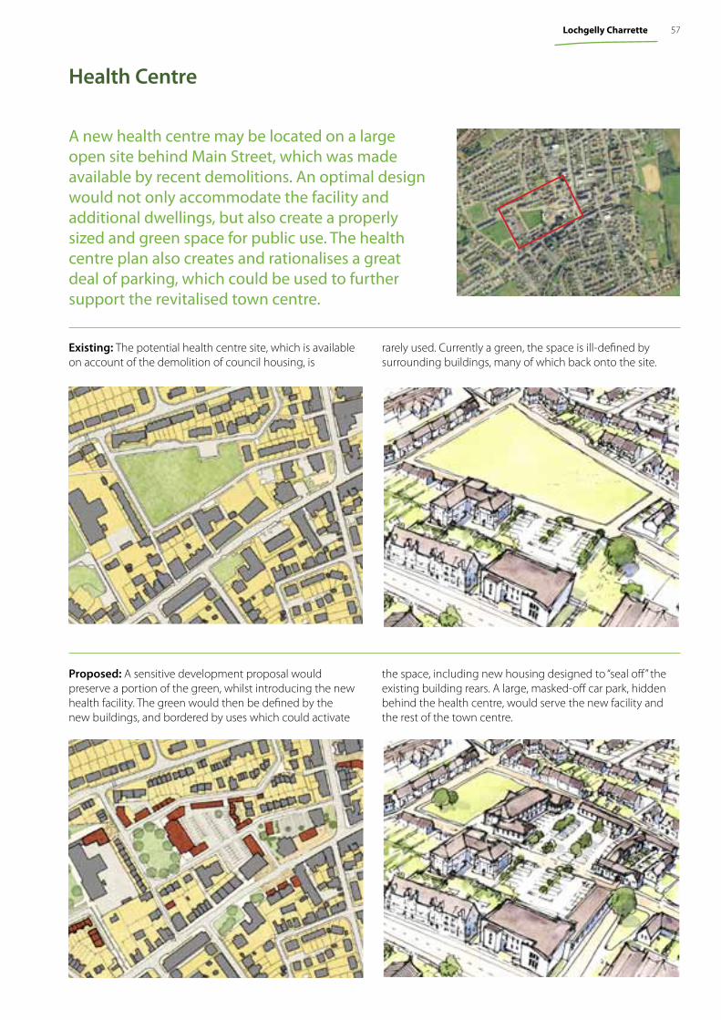
A new health centre may be located on a large open site behind Main Street, which was made available by recent demolitions. An optimal design would not only accommodate the facility and additional dwellings, but also create a properly sized and green space for public use. The health centre plan also creates and rationalises a great deal of parking, which could be used to further support the revitalised town centre.
Existing: The potential health centre site, which is available on account of the demolition of council housing, is
rarely used. Currently a green, the space is ill-defined by surrounding buildings, many of which back onto the site.
Proposed: A sensitive development proposal would preserve a portion of the green, whilst introducing the new health facility. The green would then be defined by the new buildings, and bordered by uses which could activate
the space, including new housing designed to “seal off” the existing building rears. A large, masked-off car park, hidden behind the health centre, would serve the new facility and the rest of the town centre.
Health Centre
57Lochgelly Charrette
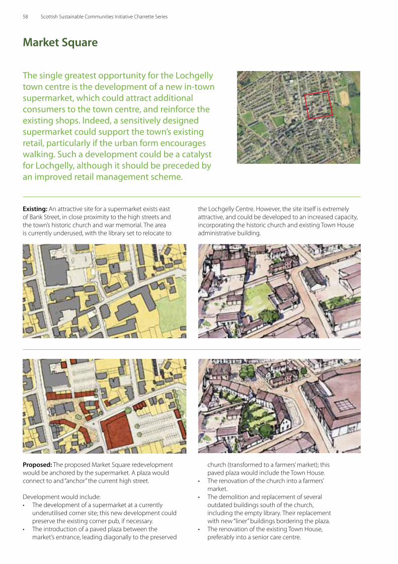
The single greatest opportunity for the Lochgelly town centre is the development of a new in-town supermarket, which could attract additional consumers to the town centre, and reinforce the existing shops. Indeed, a sensitively designed supermarket could support the town’s existing retail, particularly if the urban form encourages walking. Such a development could be a catalyst for Lochgelly, although it should be preceded by an improved retail management scheme.
Market Square
Existing: An attractive site for a supermarket exists east of Bank Street, in close proximity to the high streets and the town’s historic church and war memorial. The area is currently underused, with the library set to relocate to
Proposed: The proposed Market Square redevelopment would be anchored by the supermarket. A plaza would connect to and “anchor” the current high street.
Development would include:• The development of a supermarket at a currently
underutilised corner site; this new development could preserve the existing corner pub, if necessary.
• The introduction of a paved plaza between the market’s entrance, leading diagonally to the preserved
the Lochgelly Centre. However, the site itself is extremely attractive, and could be developed to an increased capacity, incorporating the historic church and existing Town House administrative building.
church (transformed to a farmers’ market); this paved plaza would include the Town House.
• The renovation of the church into a farmers’ market.
• The demolition and replacement of several outdated buildings south of the church, including the empty library. Their replacement with new “liner” buildings bordering the plaza.
• The renovation of the existing Town House, preferably into a senior care centre.
58 Scottish Sustainable Communities Initiative Charrette Series
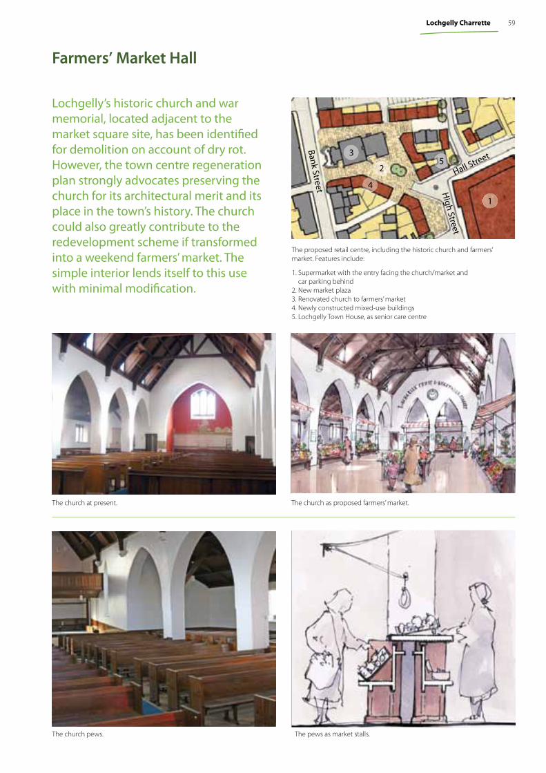
The church as proposed farmers’ market.The church at present.
The pews as market stalls.The church pews.
Monday, March 22, 2010
Monday, March 22, 2010
Monday, March 22, 2010
Farmers’ Market Hall
Lochgelly’s historic church and war memorial, located adjacent to the market square site, has been identifi ed for demolition on account of dry rot. However, the town centre regeneration plan strongly advocates preserving the church for its architectural merit and its place in the town’s history. The church could also greatly contribute to the redevelopment scheme if transformed into a weekend farmers’ market. The simple interior lends itself to this use with minimal modifi cation.
The proposed retail centre, including the historic church and farmers’ market. Features include:
1. Supermarket with the entry facing the church/market and car parking behind
2. New market plaza3. Renovated church to farmers’ market4. Newly constructed mixed-use buildings5. Lochgelly Town House, as senior care centre
Bank Street
Hall Street
High Street
5
1
4
3
2
59Lochgelly Charrette
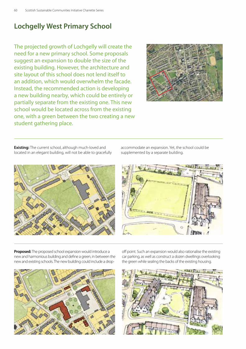
The projected growth of Lochgelly will create the need for a new primary school. Some proposals suggest an expansion to double the size of the existing building. However, the architecture and site layout of this school does not lend itself to an addition, which would overwhelm the facade. Instead, the recommended action is developing a new building nearby, which could be entirely or partially separate from the existing one. This new school would be located across from the existing one, with a green between the two creating a new student gathering place.
Lochgelly West Primary School
Existing: The current school, although much-loved and located in an elegant building, will not be able to gracefully
Proposed: The proposed school expansion would introduce a new and harmonious building and define a green, in between the new and existing schools. The new building could include a drop-
off point. Such an expansion would also rationalise the existing car parking, as well as construct a dozen dwellings overlooking the green while sealing the backs of the existing housing.
accommodate an expansion. Yet, the school could be supplemented by a separate building.
60 Scottish Sustainable Communities Initiative Charrette Series
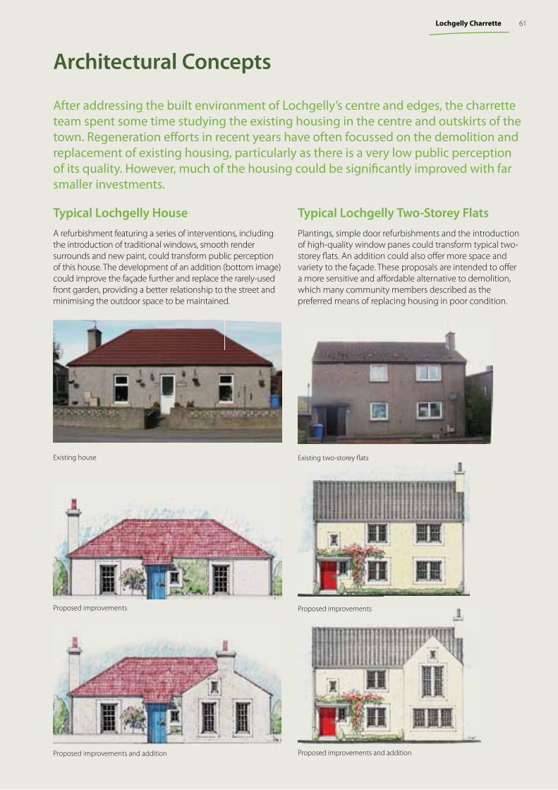
Architectural Concepts
After addressing the built environment of Lochgelly’s centre and edges, the charrette team spent some time studying the existing housing in the centre and outskirts of the town. Regeneration eff orts in recent years have often focussed on the demolition and replacement of existing housing, particularly as there is a very low public perception of its quality. However, much of the housing could be signifi cantly improved with far smaller investments.
Typical Lochgelly Two-Storey FlatsPlantings, simple door refurbishments and the introduction of high-quality window panes could transform typical two-storey fl ats. An addition could also off er more space and variety to the façade. These proposals are intended to off er a more sensitive and aff ordable alternative to demolition, which many community members described as the preferred means of replacing housing in poor condition.
Existing two-storey fl ats
Proposed improvements
Proposed improvements and additionProposed improvements and addition
Existing house
Proposed improvements
Typical Lochgelly HouseA refurbishment featuring a series of interventions, including the introduction of traditional windows, smooth render surrounds and new paint, could transform public perception of this house. The development of an addition (bottom image) could improve the façade further and replace the rarely-used front garden, providing a better relationship to the street and minimising the outdoor space to be maintained.
61Lochgelly Charrette
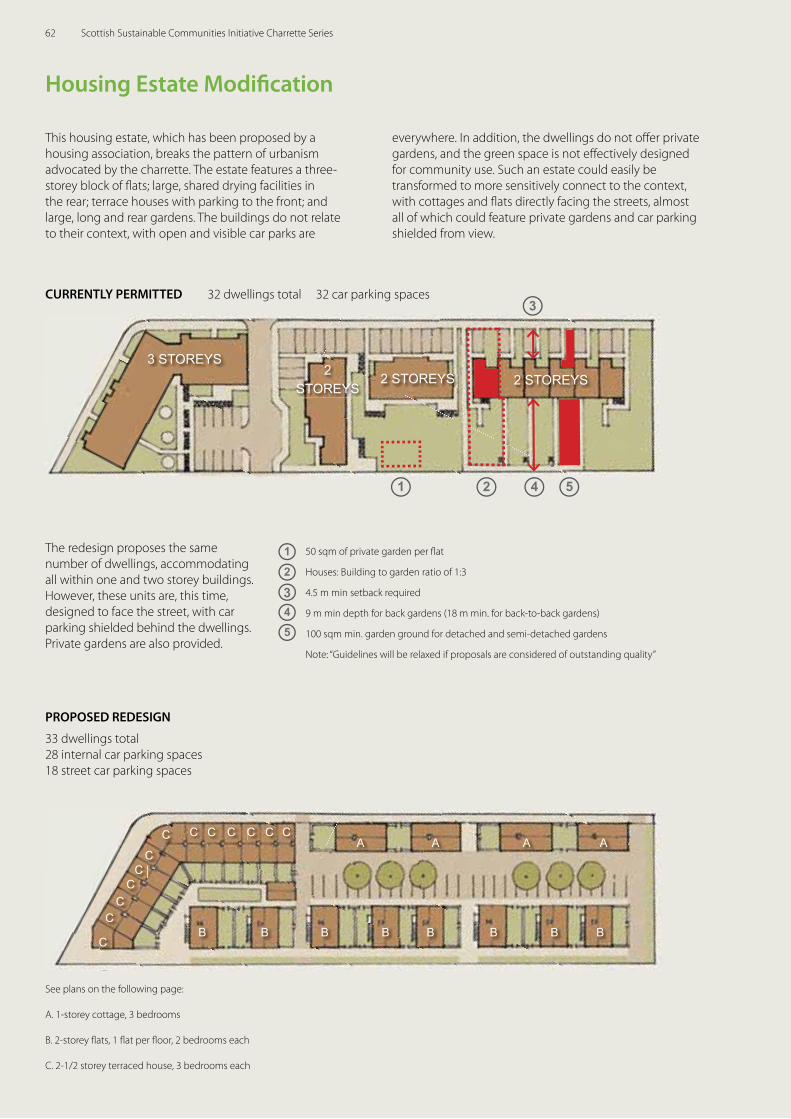
Housing Estate Modifi cation
This housing estate, which has been proposed by a housing association, breaks the pattern of urbanism advocated by the charrette. The estate features a three-storey block of fl ats; large, shared drying facilities in the rear; terrace houses with parking to the front; and large, long and rear gardens. The buildings do not relate to their context, with open and visible car parks are
everywhere. In addition, the dwellings do not off er private gardens, and the green space is not eff ectively designed for community use. Such an estate could easily be transformed to more sensitively connect to the context, with cottages and fl ats directly facing the streets, almost all of which could feature private gardens and car parking shielded from view.
32 dwellings total 32 car parking spacesCURRENTLY PERMITTED
2 STOREYS
2
2 STOREYS 2 STOREYS3 STOREYS
1 4
3
5
1
2
5
4
50 sqm of private garden per fl at
Houses: Building to garden ratio of 1:3
4.5 m min setback required
9 m min depth for back gardens (18 m min. for back-to-back gardens)
100 sqm min. garden ground for detached and semi-detached gardens
Note: “Guidelines will be relaxed if proposals are considered of outstanding quality”
The redesign proposes the same number of dwellings, accommodating all within one and two storey buildings. However, these units are, this time, designed to face the street, with car parking shielded behind the dwellings. Private gardens are also provided.
33 dwellings total 28 internal car parking spaces18 street car parking spaces
PROPOSED REDESIGN
C
CCCCCCC
CC
CC
CB B B B B B B B
A A A A
3
See plans on the following page:
A. 1-storey cottage, 3 bedrooms
B. 2-storey fl ats, 1 fl at per fl oor, 2 bedrooms each
C. 2-1/2 storey terraced house, 3 bedrooms each
62 Scottish Sustainable Communities Initiative Charrette Series
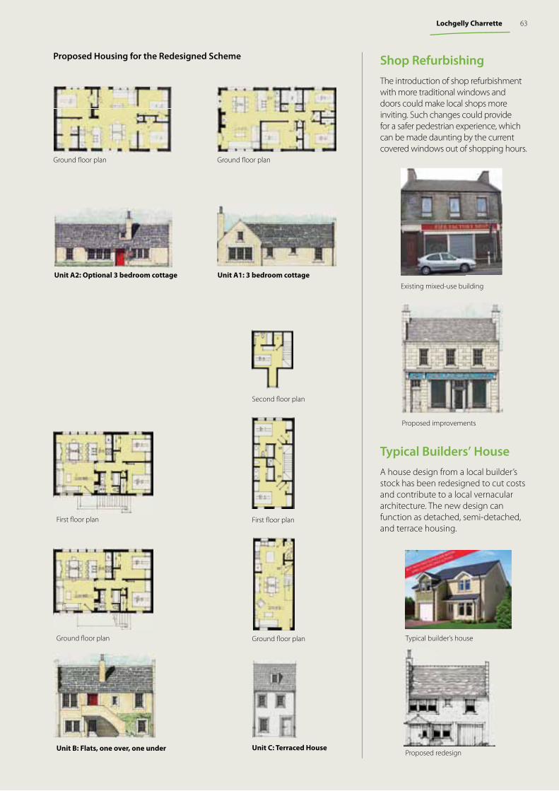
Shop Refurbishing The introduction of shop refurbishment with more traditional windows and doors could make local shops more inviting. Such changes could provide for a safer pedestrian experience, which can be made daunting by the current covered windows out of shopping hours.
Existing mixed-use building
Proposed improvements
Unit B: Flats, one over, one under
Ground fl oor plan
First fl oor plan
Ground fl oor plan
First fl oor plan
Second fl oor plan
Unit C: Terraced House
Typical Builders’ HouseA house design from a local builder’s stock has been redesigned to cut costs and contribute to a local vernacular architecture. The new design can function as detached, semi-detached, and terrace housing.
Typical builder’s house
Proposed redesign
Unit A1: 3 bedroom cottage
Ground fl oor planGround fl oor plan
Unit A2: Optional 3 bedroom cottage
Proposed Housing for the Redesigned Scheme
63Lochgelly Charrette
The TeamScottish Government
Architecture and Place Division
Duany Plater-Zyberk & Company
Senen Antonio Eusebio Azcue Judith BellAndrés Duany, Project Principal Matt Lambert Gavin MurrayJohn NeasLew Oliver Christopher RitterGalina Tachieva, Project DirectorMax Von Trott Max Zabala
Turnberry Consulting
Katharine BurgessJonathan CoulsonAino NärenevaPaul Roberts
Local Team & Additional ParticipantsDavid Paton, Grandhome Trust Juliette Paton, Grandhome Trust William Paton, Grandhome TrustMalcolm Forbes, Grandhome TrustDuncan MacLeod, Grandhome Trust
Jas Atwal, Jas Atwal AssociatesJanet Benton, Janet Benton Landscape + Urban DesignKenn Clark, W A Fairhurst & PartnersZoe Corsi, The Big PartnershipKevin Murray, Kevin Murray AssociatesStephen Murray, The Big PartnershipIan Ross, WA Fairhurst & PartnersBruce Smith, Paull & Williamsons
Sandy Beattie, Aberdeen City CouncilDr. Margaret Bochel, Aberdeen City CouncilRuth Morris, Aberdeen City CouncilRebecca Oakes, Aberdeen City CouncilLaura Robertson, Aberdeen City Council
Kara Connon, BREJames Fisher, BREDouglas Scott, BREAndrew Waddelove, BRE
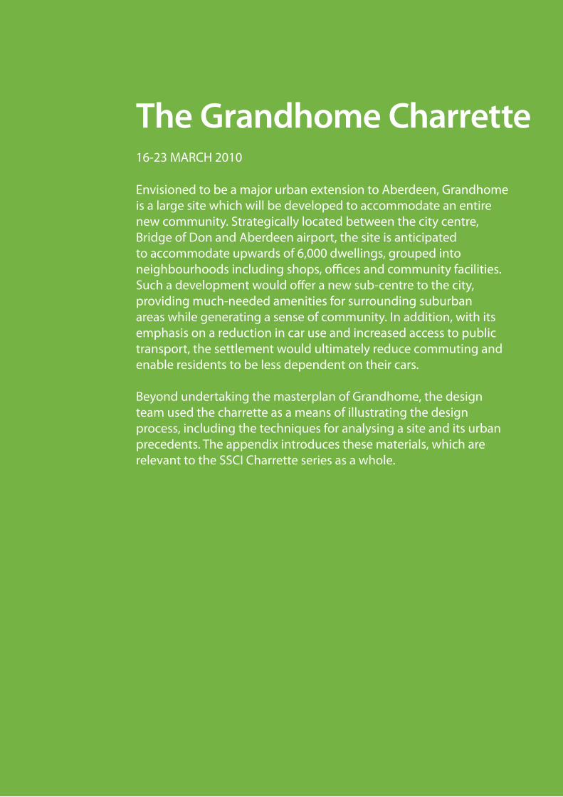
The Grandhome Charrette
Envisioned to be a major urban extension to Aberdeen, Grandhome is a large site which will be developed to accommodate an entire new community. Strategically located between the city centre, Bridge of Don and Aberdeen airport, the site is anticipated to accommodate upwards of 6,000 dwellings, grouped into neighbourhoods including shops, offices and community facilities. Such a development would offer a new sub-centre to the city, providing much-needed amenities for surrounding suburban areas while generating a sense of community. In addition, with its emphasis on a reduction in car use and increased access to public transport, the settlement would ultimately reduce commuting and enable residents to be less dependent on their cars.
Beyond undertaking the masterplan of Grandhome, the design team used the charrette as a means of illustrating the design process, including the techniques for analysing a site and its urban precedents. The appendix introduces these materials, which are relevant to the SSCI Charrette series as a whole.
16-23 MARCH 2010
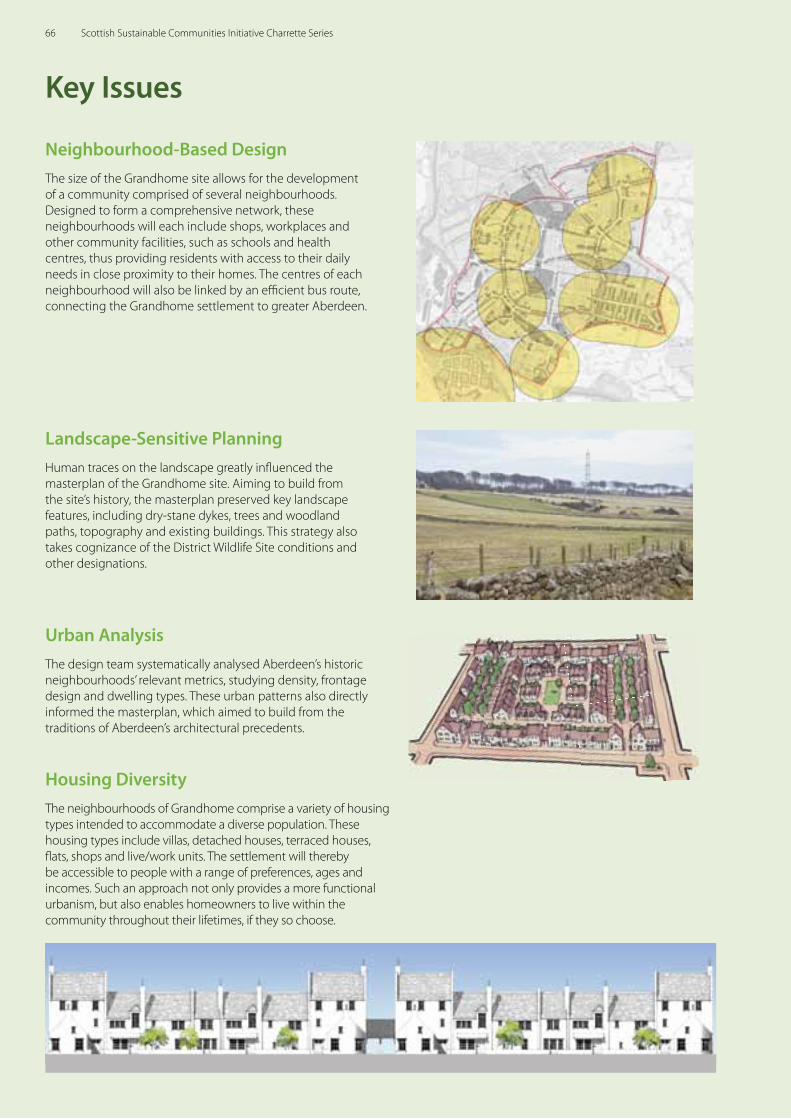
Neighbourhood-Based DesignThe size of the Grandhome site allows for the development of a community comprised of several neighbourhoods. Designed to form a comprehensive network, these neighbourhoods will each include shops, workplaces and other community facilities, such as schools and health centres, thus providing residents with access to their daily needs in close proximity to their homes. The centres of each neighbourhood will also be linked by an effi cient bus route, connecting the Grandhome settlement to greater Aberdeen.
Key Issues
Urban AnalysisThe design team systematically analysed Aberdeen’s historic neighbourhoods’ relevant metrics, studying density, frontage design and dwelling types. These urban patterns also directly informed the masterplan, which aimed to build from the traditions of Aberdeen’s architectural precedents.
Landscape-Sensitive PlanningHuman traces on the landscape greatly infl uenced the masterplan of the Grandhome site. Aiming to build from the site’s history, the masterplan preserved key landscape features, including dry-stane dykes, trees and woodland paths, topography and existing buildings. This strategy also takes cognizance of the District Wildlife Site conditions and other designations.
Housing DiversityThe neighbourhoods of Grandhome comprise a variety of housing types intended to accommodate a diverse population. These housing types include villas, detached houses, terraced houses, fl ats, shops and live/work units. The settlement will thereby be accessible to people with a range of preferences, ages and incomes. Such an approach not only provides a more functional urbanism, but also enables homeowners to live within the community throughout their lifetimes, if they so choose.
66 Scottish Sustainable Communities Initiative Charrette Series
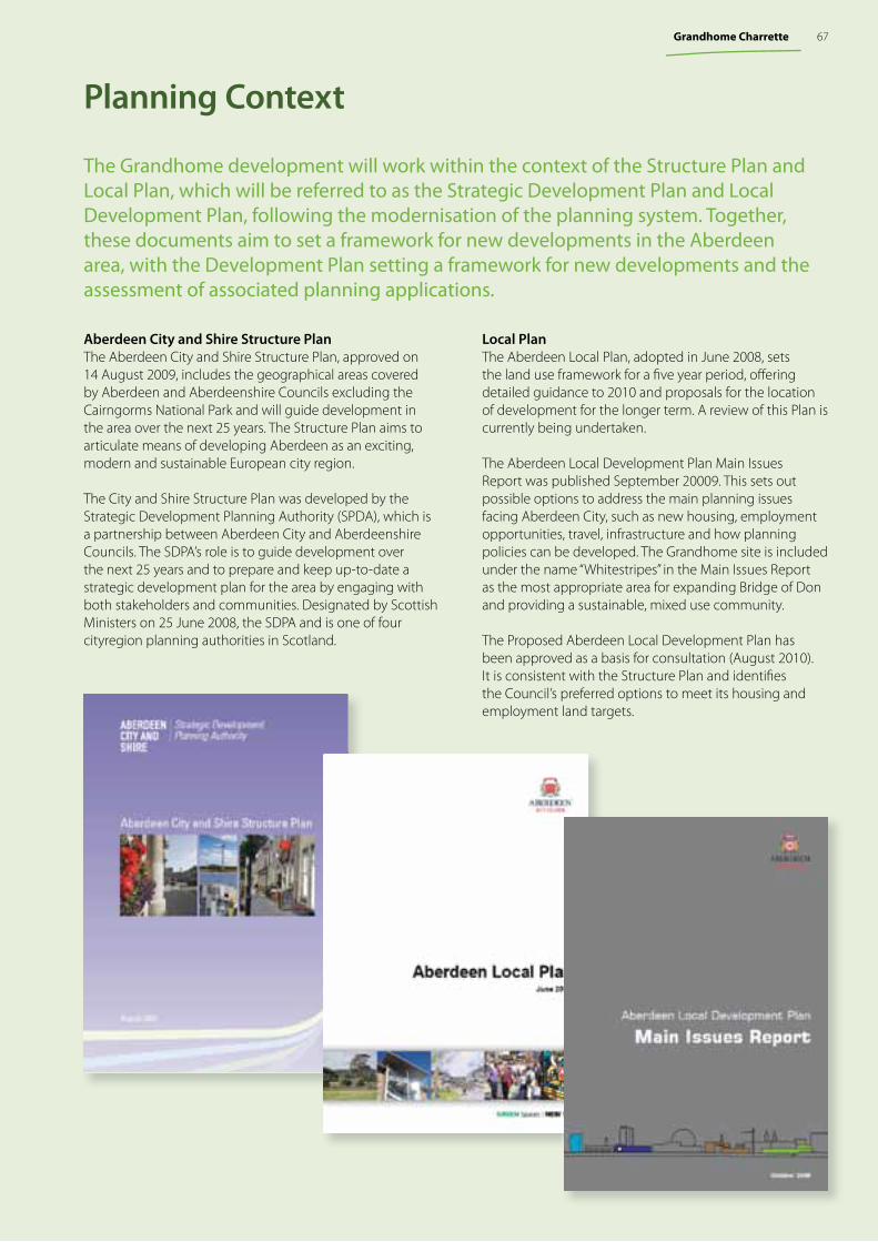
The Grandhome development will work within the context of the Structure Plan and Local Plan, which will be referred to as the Strategic Development Plan and Local Development Plan, following the modernisation of the planning system. Together, these documents aim to set a framework for new developments in the Aberdeen area, with the Development Plan setting a framework for new developments and the assessment of associated planning applications.
Aberdeen City and Shire Structure PlanThe Aberdeen City and Shire Structure Plan, approved on 14 August 2009, includes the geographical areas covered by Aberdeen and Aberdeenshire Councils excluding the Cairngorms National Park and will guide development in the area over the next 25 years. The Structure Plan aims to articulate means of developing Aberdeen as an exciting, modern and sustainable European city region.
The City and Shire Structure Plan was developed by the Strategic Development Planning Authority (SPDA), which is a partnership between Aberdeen City and Aberdeenshire Councils. The SDPA’s role is to guide development over the next 25 years and to prepare and keep up-to-date a strategic development plan for the area by engaging with both stakeholders and communities. Designated by Scottish Ministers on 25 June 2008, the SDPA and is one of four cityregion planning authorities in Scotland.
Planning Context
Local PlanThe Aberdeen Local Plan, adopted in June 2008, sets the land use framework for a fi ve year period, off ering detailed guidance to 2010 and proposals for the location of development for the longer term. A review of this Plan is currently being undertaken.
The Aberdeen Local Development Plan Main Issues Report was published September 20009. This sets out possible options to address the main planning issues facing Aberdeen City, such as new housing, employment opportunities, travel, infrastructure and how planning policies can be developed. The Grandhome site is included under the name “Whitestripes” in the Main Issues Report as the most appropriate area for expanding Bridge of Don and providing a sustainable, mixed use community.
The Proposed Aberdeen Local Development Plan has been approved as a basis for consultation (August 2010). It is consistent with the Structure Plan and identifi es the Council’s preferred options to meet its housing and employment land targets.
67Grandhome Charrette
Grandhome is one of several sites which have been identifi ed for potential development in order to meet the requirements of the Structure Plan for Aberdeen City and Shire. These sites will enable the strategic expansion of the city, and discourage sprawl across the wider area. Among the sites identifi ed for development, Grandhome is a strategic location, in close proximity to both the city centre, and Dyce airport. The size of the site also enables the development of a complete and walkable settlement, with suffi cient retail, offi ce space, schools, health facilities and other amenities. While respecting the context and precedents of Aberdeen, the charrette proposed a settlement, which could function independently and also contribute positively to the wider functioning of the city.
Regional Context
Grandhome site
Proposed Western Peripheral Route
Potential development
Existing development
Dyce Airport
Sub-centres
The regional context for the Grandhome site
Site photographs depicting the character of the landscape.
Existing Bus RoutesProposed Bus Routes
Bike and trail connections
N
68 Scottish Sustainable Communities Initiative Charrette Series
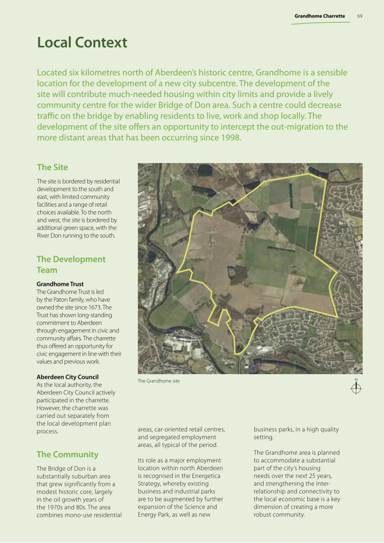
The Grandhome site
Located six kilometres north of Aberdeen’s historic centre, Grandhome is a sensible location for the development of a new city subcentre. The development of the site will contribute much-needed housing within city limits and provide a lively community centre for the wider Bridge of Don area. Such a centre could decrease traffi c on the bridge by enabling residents to live, work and shop locally. The development of the site off ers an opportunity to intercept the out-migration to the more distant areas that has been occurring since 1998.
Local Context
N
The Site The site is bordered by residential development to the south and east, with limited community facilities and a range of retail choices available. To the north and west, the site is bordered by additional green space, with the River Don running to the south.
The Development TeamGrandhome TrustThe Grandhome Trust is led by the Paton family, who have owned the site since 1673. The Trust has shown long-standing commitment to Aberdeen through engagement in civic and community aff airs. The charrette thus off ered an opportunity for civic engagement in line with their values and previous work.
Aberdeen City CouncilAs the local authority, the Aberdeen City Council actively participated in the charrette. However, the charrette was carried out separately from the local development plan process.
The CommunityThe Bridge of Don is a substantially suburban area that grew significantly from a modest historic core, largely in the oil growth years of the 1970s and 80s. The area combines mono-use residential
areas, car-oriented retail centres, and segregated employment areas, all typical of the period.
Its role as a major employment location within north Aberdeen is recognised in the Energetica Strategy, whereby existing business and industrial parks are to be augmented by further expansion of the Science and Energy Park, as well as new
business parks, in a high quality setting.
The Grandhome area is planned to accommodate a substantial part of the city’s housing needs over the next 25 years, and strengthening the inter-relationship and connectivity to the local economic base is a key dimension of creating a more robust community.
69Grandhome Charrette
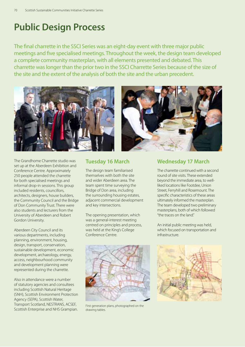
Public Design Process
The final charrette in the SSCI Series was an eight-day event with three major public meetings and five specialised meetings. Throughout the week, the design team developed a complete community masterplan, with all elements presented and debated. This charrette was longer than the prior two in the SSCI Charrette Series because of the size of the site and the extent of the analysis of both the site and the urban precedent.
The Grandhome Charrette studio was set up at the Aberdeen Exhibition and Conference Centre. Approximately 250 people attended the charrette for both specialised meetings and informal drop-in sessions. This group included residents, councillors, architects, designers, house builders, the Community Council and the Bridge of Don Community Trust. There were also students and lecturers from the University of Aberdeen and Robert Gordon University.
Aberdeen City Council and its various departments, including planning, environment, housing, design, transport, conservation, sustainable development, economic development, archaeology, energy, access, neighbourhood community and development planning were represented during the charrette.
Also in attendance were a number of statutory agencies and consultees including Scottish Natural Heritage (SNH), Scottish Environment Protection Agency (SEPA), Scottish Water, Transport Scotland, NESTRANS, ACSEF, Scottish Enterprise and NHS Grampian.
Wednesday 17 March The charrette continued with a second round of site visits. These extended beyond the immediate area, to well-liked locations like Footdee, Union Street, Ferryhill and Rosemount. The specific characteristics of these areas ultimately informed the masterplan. The team developed two preliminary masterplans, both of which followed “the traces on the land.’’
An initial public meeting was held, which focused on transportation and infrastructure.
Tuesday 16 MarchThe design team familiarised themselves with both the site and wider Aberdeen area. The team spent time surveying the Bridge of Don area, including the surrounding housing estates, adjacent commercial development and key intersections.
The opening presentation, which was a general-interest meeting centred on principles and process, was held at the King’s College Conference Centre.
First generation plans, photographed on the drawing tables.
70 Scottish Sustainable Communities Initiative Charrette Series
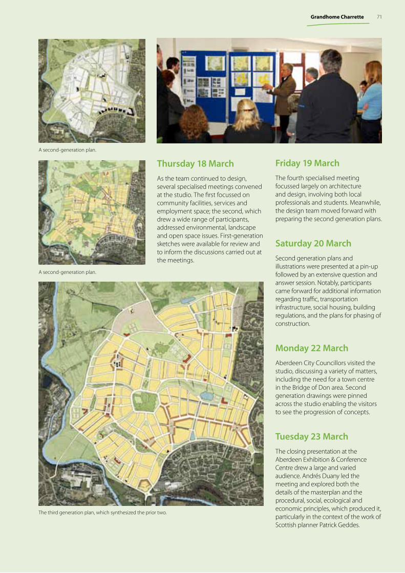
Thursday 18 MarchAs the team continued to design, several specialised meetings convened at the studio. The first focussed on community facilities, services and employment space; the second, which drew a wide range of participants, addressed environmental, landscape and open space issues. First-generation sketches were available for review and to inform the discussions carried out at the meetings.
The third generation plan, which synthesized the prior two.
A second-generation plan.
A second-generation plan.
Friday 19 March The fourth specialised meeting focussed largely on architecture and design, involving both local professionals and students. Meanwhile, the design team moved forward with preparing the second generation plans.
Saturday 20 March Second generation plans and illustrations were presented at a pin-up followed by an extensive question and answer session. Notably, participants came forward for additional information regarding traffic, transportation infrastructure, social housing, building regulations, and the plans for phasing of construction.
Monday 22 March Aberdeen City Councillors visited the studio, discussing a variety of matters, including the need for a town centre in the Bridge of Don area. Second generation drawings were pinned across the studio enabling the visitors to see the progression of concepts.
Tuesday 23 March The closing presentation at the Aberdeen Exhibition & Conference Centre drew a large and varied audience. Andrés Duany led the meeting and explored both the details of the masterplan and the procedural, social, ecological and economic principles, which produced it, particularly in the context of the work of Scottish planner Patrick Geddes.
71Grandhome Charrette
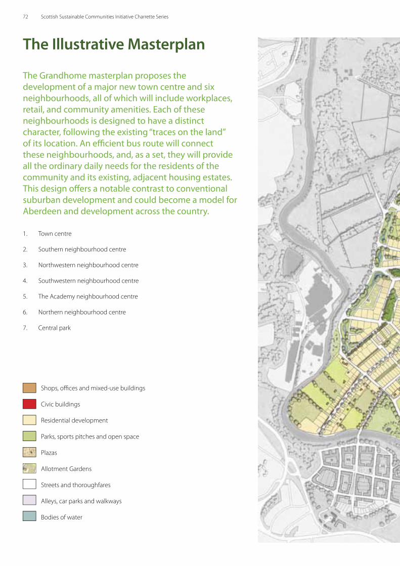
The Grandhome masterplan proposes the development of a major new town centre and six neighbourhoods, all of which will include workplaces, retail, and community amenities. Each of these neighbourhoods is designed to have a distinct character, following the existing “traces on the land” of its location. An effi cient bus route will connect these neighbourhoods, and, as a set, they will provide all the ordinary daily needs for the residents of the community and its existing, adjacent housing estates. This design off ers a notable contrast to conventional suburban development and could become a model for Aberdeen and development across the country.
The Illustrative Masterplan
1. Town centre
2. Southern neighbourhood centre
3. Northwestern neighbourhood centre
4. Southwestern neighbourhood centre
5. The Academy neighbourhood centre
6. Northern neighbourhood centre
7. Central park
8
9
Shops, offi ces and mixed-use buildings
Civic buildings
Residential development
Parks, sports pitches and open space
Plazas
Allotment Gardens
Streets and thoroughfares
Alleys, car parks and walkways
Bodies of water
72 Scottish Sustainable Communities Initiative Charrette Series
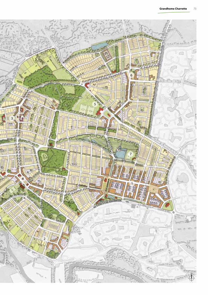
3
5
41
6
2
7
N
73Grandhome Charrette
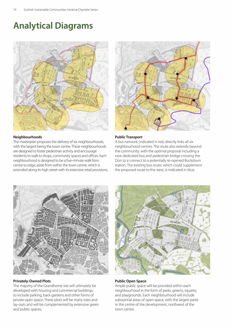
Analytical Diagrams
Neighbourhoods The masterplan proposes the delivery of six neighbourhoods, with the largest being the town centre. These neighbourhoods are designed to foster pedestrian activity and encourage residents to walk to shops, community spaces and offices. Each neighbourhood is designed to be a five-minute walk from centre to edge, aside from within the town centre, which is extended along its high street with its extensive retail provisions.
Privately-Owned PlotsThe majority of the Grandhome site will ultimately be developed with housing and commercial buildings, to include parking, back gardens and other forms of private open space. These plots will be many sizes and lay-outs and will be complemented by extensive green and public spaces.
Public TransportA bus network, indicated in red, directly links all six neighbourhood centres. The route also extends beyond the community, with the optimal proposal including a new dedicated bus and pedestrian bridge crossing the Don to a connect to a potentially re-opened Bucksburn station. The existing bus route, which could supplement the proposed route to the west, is indicated in blue.
Public Open SpaceAmple public space will be provided within each neighbourhood in the form of parks, greens, squares, and playgrounds. Each neighbourhood will include substantial areas of open space, with the largest parks in the centre of the development, northwest of the town centre.
74 Scottish Sustainable Communities Initiative Charrette Series
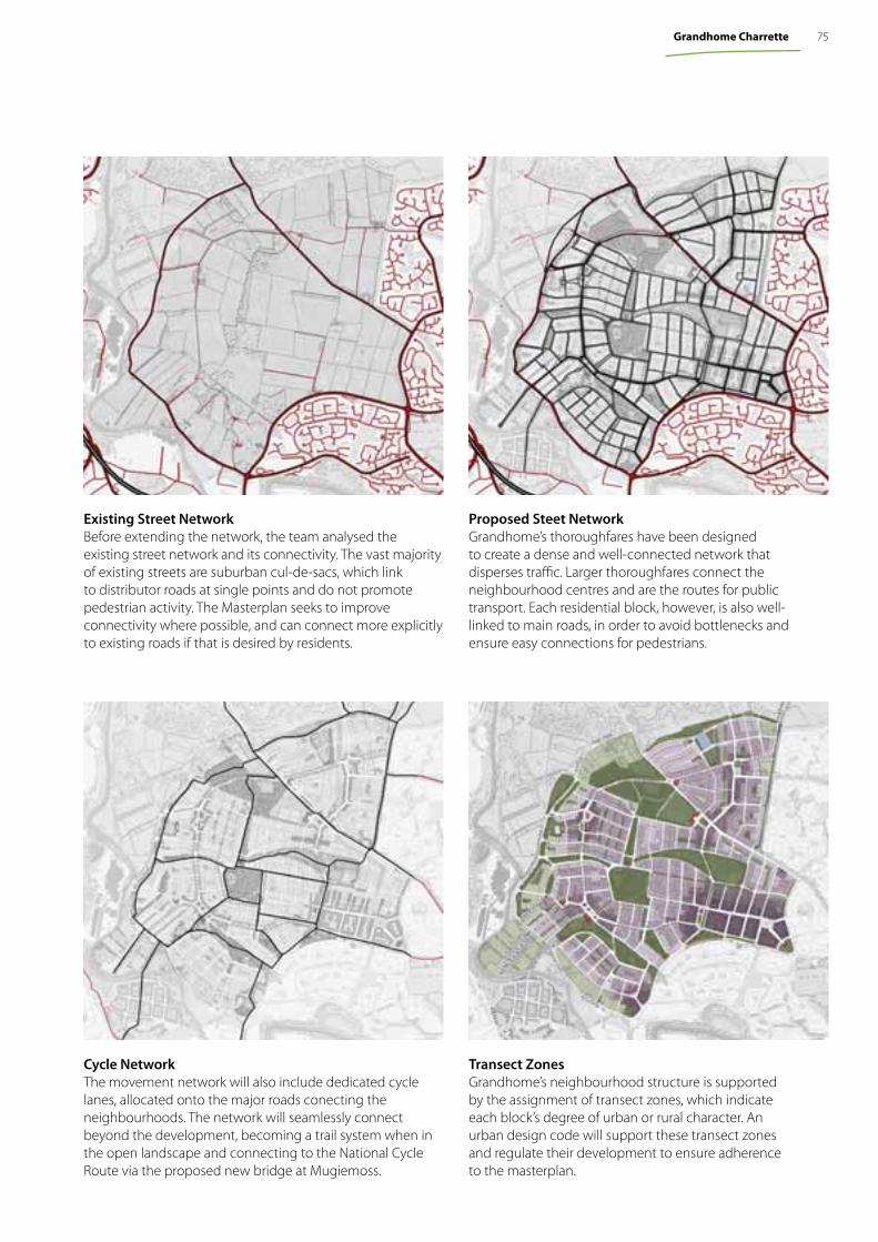
Existing Street NetworkBefore extending the network, the team analysed the existing street network and its connectivity. The vast majority of existing streets are suburban cul-de-sacs, which link to distributor roads at single points and do not promote pedestrian activity. The Masterplan seeks to improve connectivity where possible, and can connect more explicitly to existing roads if that is desired by residents.
Cycle NetworkThe movement network will also include dedicated cycle lanes, allocated onto the major roads conecting the neighbourhoods. The network will seamlessly connect beyond the development, becoming a trail system when in the open landscape and connecting to the National Cycle Route via the proposed new bridge at Mugiemoss.
Proposed Steet NetworkGrandhome’s thoroughfares have been designed to create a dense and well-connected network that disperses traffic. Larger thoroughfares connect the neighbourhood centres and are the routes for public transport. Each residential block, however, is also well-linked to main roads, in order to avoid bottlenecks and ensure easy connections for pedestrians.
Transect Zones Grandhome’s neighbourhood structure is supported by the assignment of transect zones, which indicate each block’s degree of urban or rural character. An urban design code will support these transect zones and regulate their development to ensure adherence to the masterplan.
75Grandhome Charrette

The Town Centre
N
The Grandhome town centre is the highest density portion of the settlement, including shops, offi ces and amenities likely to be used by the wider Bridge of Don community. An active high street acts as the principal thoroughfare, linking a central plaza to a small neighbourhood green. Along the street, taller, mixed-use buildings shield surface car parks within each block.
Within this area, a network of walkable streets and squares will provide a pleasant atmosphere for both Grandhome residents and those from further afi eld.
Elements of the Grandhome Masterplan
The Grandhome masterplan proposes the development of a number of neighbourhoods, each of which will have its own individual character. These neighbourhoods will then be comprised of buildings designed by a variety of architects, who will work within the context of the Grandhome regulating plan and an associated urban design code.
The following detailed plans and illustrations were developed during the charrette to enable participants to visualise the future settlement. Illustrative rather than regulatory, these plans are intended to be noncommittal about architectural detail. Rather, the drawings illustrate the proposals for public spaces, thoroughfares, building massing, and landscape design.
76 Scottish Sustainable Communities Initiative Charrette Series
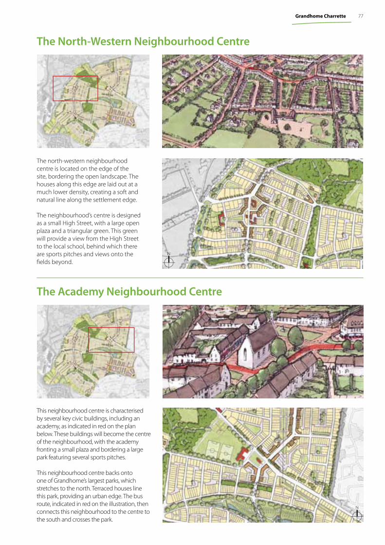
The Academy Neighbourhood Centre
N
This neighbourhood centre is characterised by several key civic buildings, including an academy, as indicated in red on the plan below. These buildings will become the centre of the neighbourhood, with the academy fronting a small plaza and bordering a large park featuring several sports pitches.
This neighbourhood centre backs onto one of Grandhome’s largest parks, which stretches to the north. Terraced houses line this park, providing an urban edge. The bus route, indicated in red on the illustration, then connects this neighbourhood to the centre to the south and crosses the park.
The north-western neighbourhood centre is located on the edge of the site, bordering the open landscape. The houses along this edge are laid out at a much lower density, creating a soft and natural line along the settlement edge.
The neighbourhood’s centre is designed as a small High Street, with a large open plaza and a triangular green. This green will provide a view from the High Street to the local school, behind which there are sports pitches and views onto the fi elds beyond.
The North-Western Neighbourhood Centre
N
77Grandhome Charrette
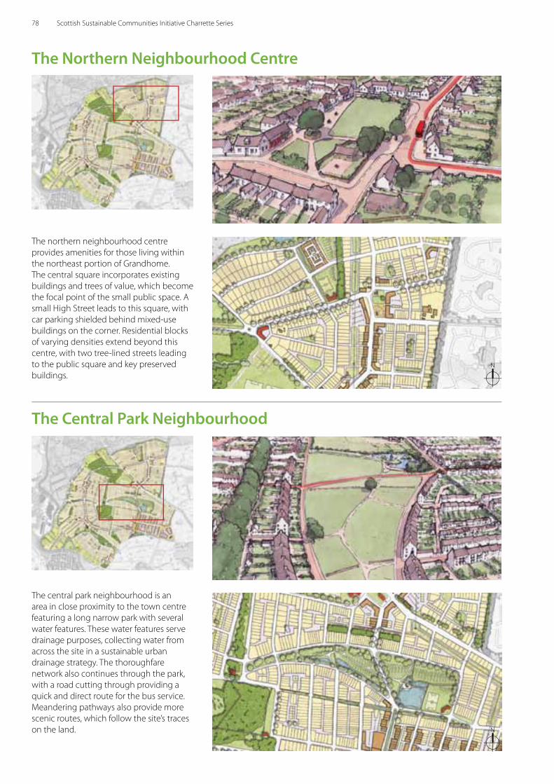
The northern neighbourhood centre provides amenities for those living within the northeast portion of Grandhome. The central square incorporates existing buildings and trees of value, which become the focal point of the small public space. A small High Street leads to this square, with car parking shielded behind mixed-use buildings on the corner. Residential blocks of varying densities extend beyond this centre, with two tree-lined streets leading to the public square and key preserved buildings.
The Northern Neighbourhood Centre
N
N
The Central Park Neighbourhood
The central park neighbourhood is an area in close proximity to the town centre featuring a long narrow park with several water features. These water features serve drainage purposes, collecting water from across the site in a sustainable urban drainage strategy. The thoroughfare network also continues through the park, with a road cutting through providing a quick and direct route for the bus service. Meandering pathways also provide more scenic routes, which follow the site’s traces on the land.
78 Scottish Sustainable Communities Initiative Charrette Series
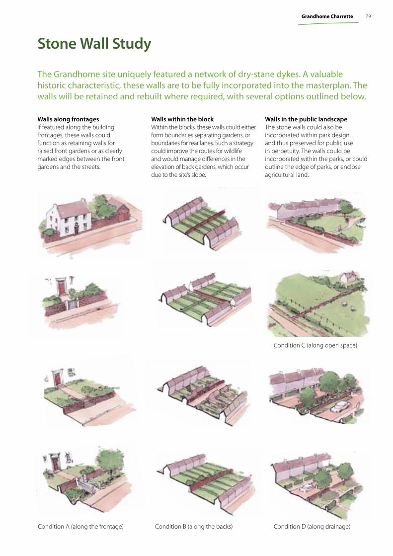
Stone Wall Study
The Grandhome site uniquely featured a network of dry-stane dykes. A valuable historic characteristic, these walls are to be fully incorporated into the masterplan. The walls will be retained and rebuilt where required, with several options outlined below.
Walls along frontages If featured along the building frontages, these walls could function as retaining walls for raised front gardens or as clearly marked edges between the front gardens and the streets.
Walls within the blockWithin the blocks, these walls could either form boundaries separating gardens, or boundaries for rear lanes. Such a strategy could improve the routes for wildlife and would manage diff erences in the elevation of back gardens, which occur due to the site’s slope.
Walls in the public landscapeThe stone walls could also be incorporated within park design, and thus preserved for public use in perpetuity. The walls could be incorporated within the parks, or could outline the edge of parks, or enclose agricultural land.
Condition C (along open space)
Condition A (along the frontage) Condition B (along the backs) Condition D (along drainage)
79Grandhome Charrette
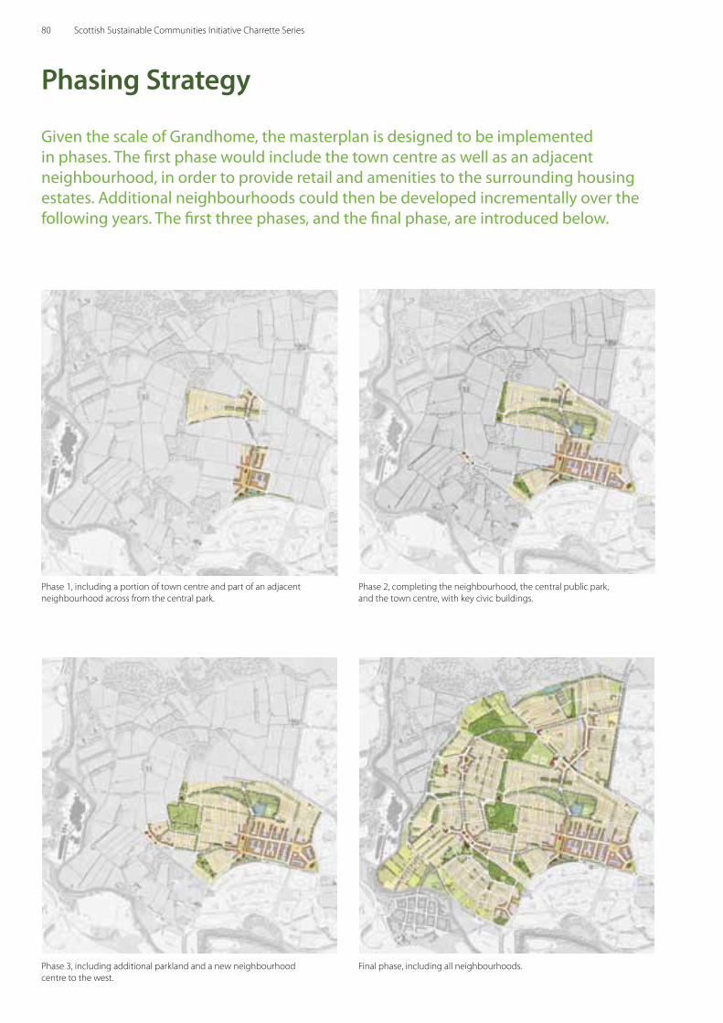
Given the scale of Grandhome, the masterplan is designed to be implemented in phases. The first phase would include the town centre as well as an adjacent neighbourhood, in order to provide retail and amenities to the surrounding housing estates. Additional neighbourhoods could then be developed incrementally over the following years. The first three phases, and the final phase, are introduced below.
Phasing Strategy
Phase 1, including a portion of town centre and part of an adjacent neighbourhood across from the central park.
Phase 2, completing the neighbourhood, the central public park, and the town centre, with key civic buildings.
Phase 3, including additional parkland and a new neighbourhood centre to the west.
Final phase, including all neighbourhoods.
80 Scottish Sustainable Communities Initiative Charrette Series
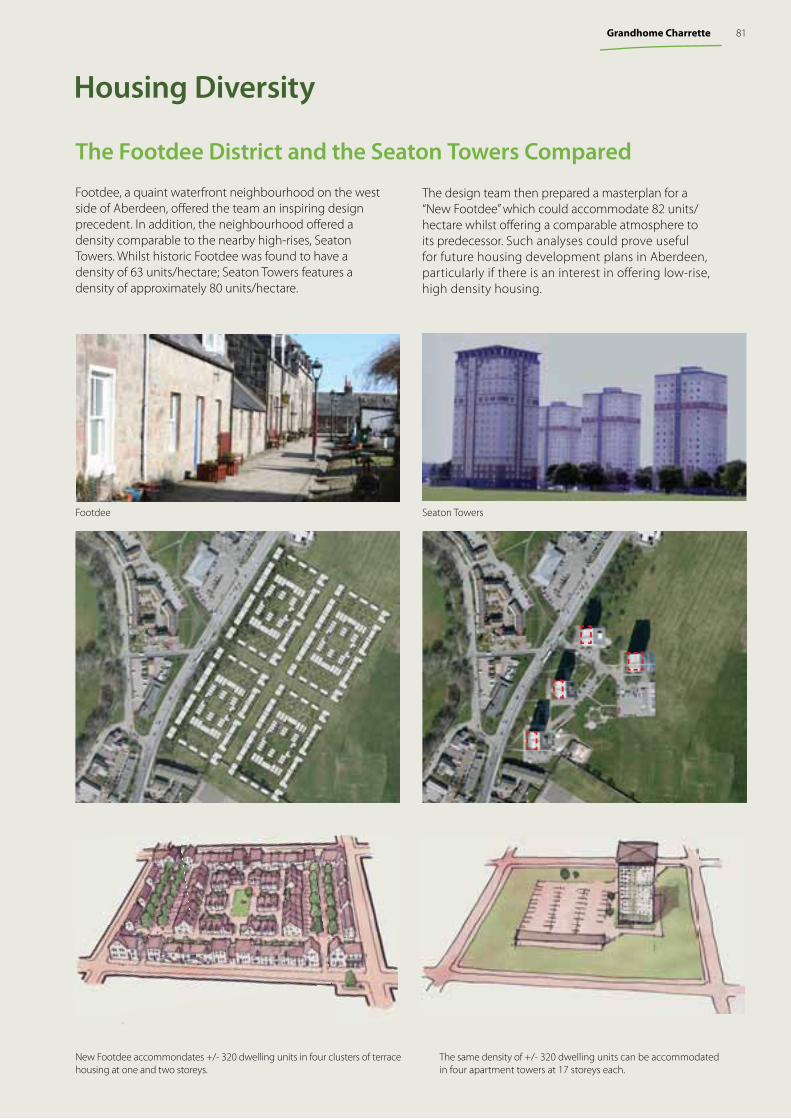
Footdee, a quaint waterfront neighbourhood on the west side of Aberdeen, off ered the team an inspiring design precedent. In addition, the neighbourhood off ered a density comparable to the nearby high-rises, Seaton Towers. Whilst historic Footdee was found to have a density of 63 units/hectare; Seaton Towers features a density of approximately 80 units/hectare.
Housing Diversity
The same density of +/- 320 dwelling units can be accommodated in four apartment towers at 17 storeys each.
New Footdee accommondates +/- 320 dwelling units in four clusters of terrace housing at one and two storeys.
The Footdee District and the Seaton Towers Compared
The design team then prepared a masterplan for a “New Footdee” which could accommodate 82 units/ hectare whilst off ering a comparable atmosphere to its predecessor. Such analyses could prove useful for future housing development plans in Aberdeen, particularly if there is an interest in offering low-rise, high density housing.
Footdee Seaton Towers
81Grandhome Charrette
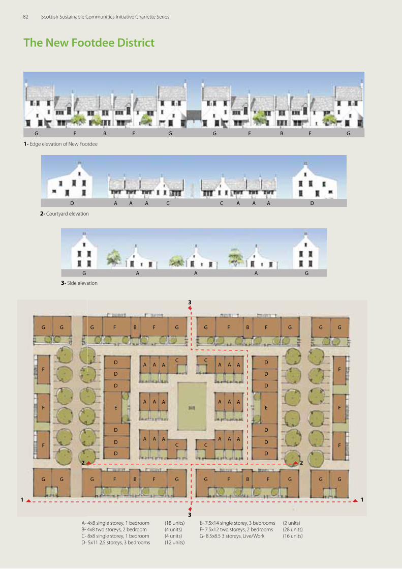
1- Edge elevation of New Footdee
3- Side elevation
2- Courtyard elevation
The New Footdee District
A- 4x8 single storey, 1 bedroom (18 units)B- 4x8 two storeys, 2 bedroom (4 units) C- 8x8 single storey, 1 bedroom (4 units)D- 5x11 2.5 storeys, 3 bedrooms (12 units)
E- 7.5x14 single storey, 3 bedrooms (2 units)F- 7.5x12 two storeys, 2 bedrooms (28 units)G- 8.5x8.5 3 storeys, Live/Work (16 units)
A A
A A
A A
A A
A A
A A
A A
A A
A AC
C
C
C
B BF FFGGG G G G G GF
G G G G GG F FB BF FGG
E E
F F
F F
F F
1 1
3
3
2 2D
D
D
D
D
D
D
D
D
D
D
D
G F F G G F B F GB
D DA A A A A AC C
G A A A G
82 Scottish Sustainable Communities Initiative Charrette Series
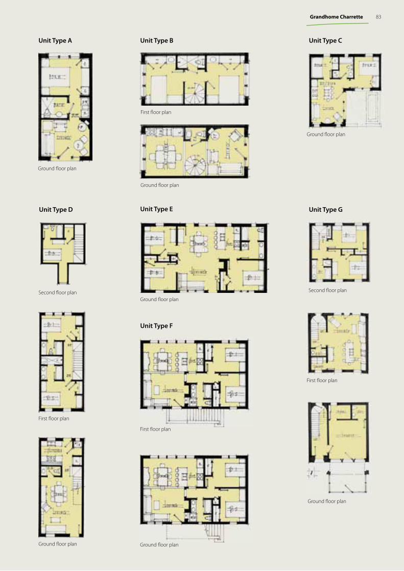
Unit Type D
Ground fl oor plan
Ground fl oor plan
First fl oor plan
Second fl oor plan
Unit Type A Unit Type C
Ground fl oor plan
Unit Type G
Ground fl oor plan
First fl oor plan
Second fl oor plan
Unit Type B
Ground fl oor plan
First fl oor plan
First fl oor planFirst fl oor plan
Unit Type F
Unit Type E
Ground fl oor plan
Ground fl oor plan
83Grandhome Charrette
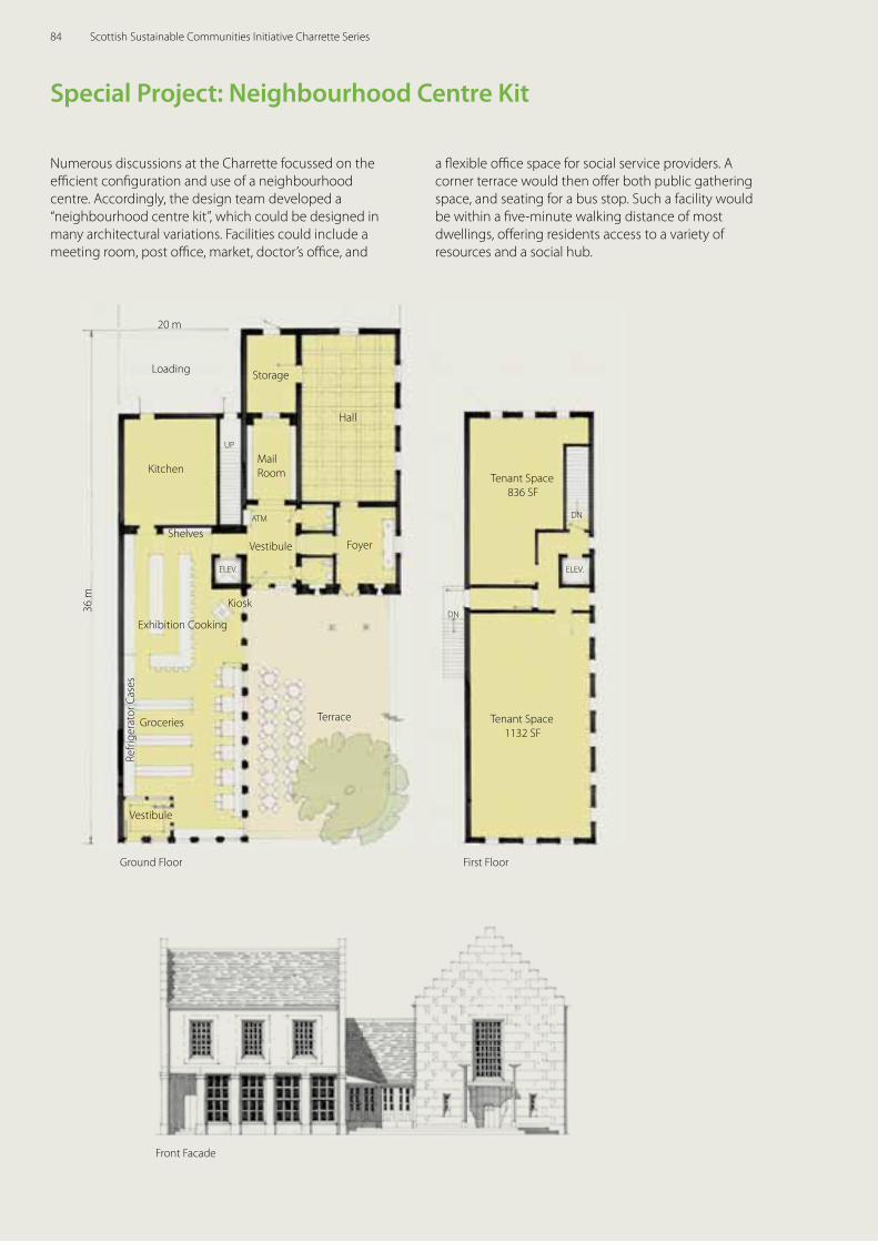
Numerous discussions at the Charrette focussed on the effi cient confi guration and use of a neighbourhood centre. Accordingly, the design team developed a “neighbourhood centre kit”, which could be designed in many architectural variations. Facilities could include a meeting room, post offi ce, market, doctor’s offi ce, and
a fl exible offi ce space for social service providers. A corner terrace would then off er both public gathering space, and seating for a bus stop. Such a facility would be within a fi ve-minute walking distance of most dwellings, off ering residents access to a variety of resources and a social hub.
Front Facade
Special Project: Neighbourhood Centre Kit
Ground Floor First Floor
Loading
Tenant Space836 SF
Kiosk
Groceries
Kitchen
Storage
Mail Room
Exhibition Cooking
Tenant Space1132 SF
Hall
Terrace
20 m
Vestibule
36 m
Vestibule
ATM
FoyerShelves
Refri
gera
tor C
ases
ELEV.
DN
DN
ELEV.
UP
84 Scottish Sustainable Communities Initiative Charrette Series
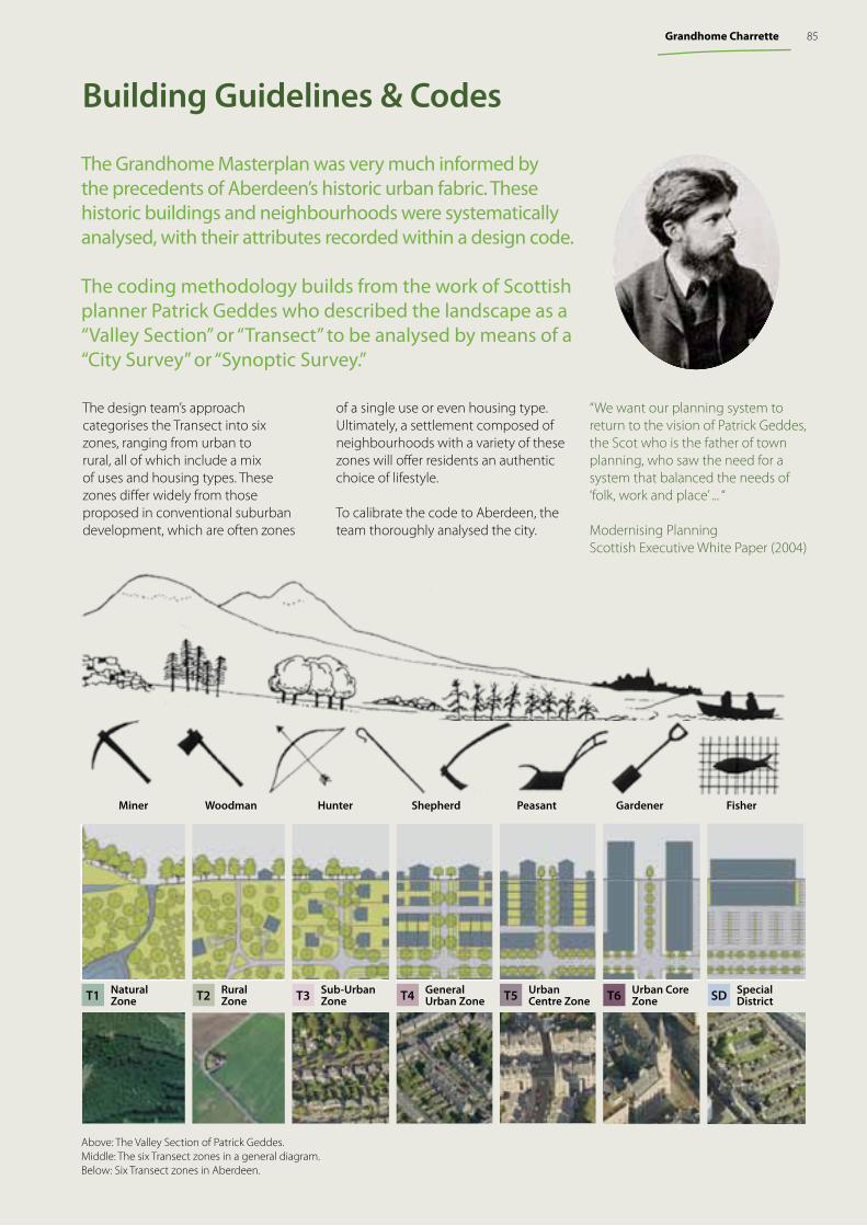
The design team’s approach categorises the Transect into six zones, ranging from urban to rural, all of which include a mix of uses and housing types. These zones diff er widely from those proposed in conventional suburban development, which are often zones
The Grandhome Masterplan was very much informed by the precedents of Aberdeen’s historic urban fabric. These historic buildings and neighbourhoods were systematically analysed, with their attributes recorded within a design code.
The coding methodology builds from the work of Scottish planner Patrick Geddes who described the landscape as a “Valley Section” or “Transect” to be analysed by means of a “City Survey” or “Synoptic Survey.”
“We want our planning system to return to the vision of Patrick Geddes, the Scot who is the father of town planning, who saw the need for a system that balanced the needs of ‘folk, work and place’ ... “
Modernising PlanningScottish Executive White Paper (2004)
Above: The Valley Section of Patrick Geddes. Middle: The six Transect zones in a general diagram. Below: Six Transect zones in Aberdeen.
Building Guidelines & Codes
T1 T2 T3 T4 T5 T6 SDNatural Zone
RuralZone
Sub-UrbanZone
General Urban Zone
Urban Centre Zone
Urban Core Zone
Special District
Miner Woodman Hunter Shepherd Peasant Gardener Fisher
of a single use or even housing type. Ultimately, a settlement composed of neighbourhoods with a variety of these zones will off er residents an authentic choice of lifestyle.
To calibrate the code to Aberdeen, the team thoroughly analysed the city.
85Grandhome Charrette
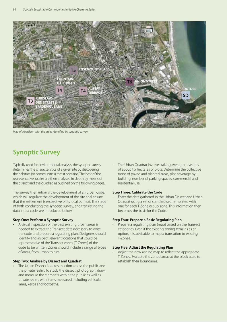
Typically used for environmental analysis, the synoptic survey determines the characteristics of a given site by discovering the habitats (or communities) that it contains. The best of the representative locales are then analysed in depth by means of the dissect and the quadrat, as outlined on the following pages.
The survey then informs the development of an urban code, which will regulate the development of the site and ensure that the settlement is respective of its local context. The steps of both conducting the synoptic survey, and translating the data into a code, are introduced below.
Step One: Perform a Synoptic Survey • A visual inspection of the best existing urban areas is
needed to extract the Transect data necessary to write the code and prepare a regulating plan. Designers should identify and inspect relevant locations that could be representative of the Transect zones (T-Zones) of the code to be written. Zones should include a range of types of areas, from urban to rural.
Step Two: Analyse by Dissect and Quadrat• The Urban Dissect is a cross section across the public and
the private realm. To study the dissect, photograph, draw, and measure the elements within the public as well as private realm, with items measured including vehicular lanes, kerbs and footpaths.
• The Urban Quadrat involves taking average measures of about 1.5 hectares of plots. Determine the collective ratios of paved and planted areas, plot coverage by building, number of parking spaces, commercial and residential use.
Step Three: Calibrate the Code• Enter the data gathered in the Urban Dissect and Urban
Quadrat using a set of standardised templates, with one for each T-Zone or sub-zone. This information then becomes the basis for the Code.
Step Four: Prepare a Basic Regulating Plan• Prepare a regulating plan (map) based on the Transect
categories. Even if the existing zoning remains as an option, it is advisable to map a translation to existing T-Zones.
Step Five: Adjust the Regulating Plan • Adjust the new zoning map to reflect the appropriate
T-Zones. Evaluate the zoned areas at the block scale to establish their boundaries.
Synoptic Survey
Map of Aberdeen with the areas identified by synoptic survey.
ROSEMOUNT PLACE
UNION STREET
FOOTDEE
RUBISLAW DEN STREET & SPADEMILL LANE
T3
T5
T6
SD
FOUNTAIN-HALL ROAD
T4 ALBERT TERRACET4
86 Scottish Sustainable Communities Initiative Charrette Series
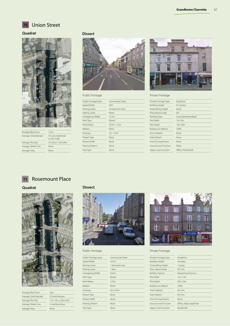
Private FrontagePublic Frontage
DissectQuadrat
Private Frontage Type Shopfront
Building Height 4-5 storeys
Outbuilding Height None
Floor above Grade 0m
Building Type Courtyard/Specialised
Plot Width 7m-25m
Plot Depth 13m-28m
Buildout at Setback 100%
Front Setback None
Side Setback None
Front Encroachment None
Ground Level Function Retail
Upper Level Function Offi ce/ Residential
Public Frontage Type Commercial Street
Spatial Width 20m
Moving Lanes 2 travel and 2 bus
Parking Lanes None
Carriageway Width 13.5m
Kerb Type Raised
Kerb Radius 3.25m - 5.5m
Median None
Footway 2m - 4.5m
Planter Type None
Planter Width None
Planting Pattern None
Tree Type None
Average Block Face 112m
Average Units/Hectare 76 units residential6 units retail
Average Plot Size 7m-25m x 13m-28m
Average Parked Cars None
Average Trees None
Union StreetT6
Rosemount PlaceDissectQuadrat
Private Frontage Type Shopfront
Building Height 4 storeys
Outbuilding Height 1 storey
Floor above Grade 0m min.
Building Typical Rearyard and terrace
Plot Width 11m-15m
Plot Depth 20m-24m
Buildout at Setback 100%
Front Setback 0m min.
Side Setback 0m min.
Front Encroachment None
Ground Level Function Offi ce, retail, residential
Upper Level Function Residential
Public Frontage Type Commercial Street
Spatial Width 14.5m
Moving Lanes 1 lane each way
Parking Lanes 1 lane
Carriageway Width 9.25m
Kerb Type Raised
Kerb Radius 3.25m
Median None
Footway 2m-3.25m
Planter Type None
Planter Width None
Planting Pattern None
Tree Type None
Average Block Face 52m
Average Units/Hectare 53 units/hectare
Average Plot Size 11m-15m x 20m-24m
Average Parked Cars 5 cars/block face
Average Trees None
T5
Public Frontage Private Frontage
87Grandhome Charrette
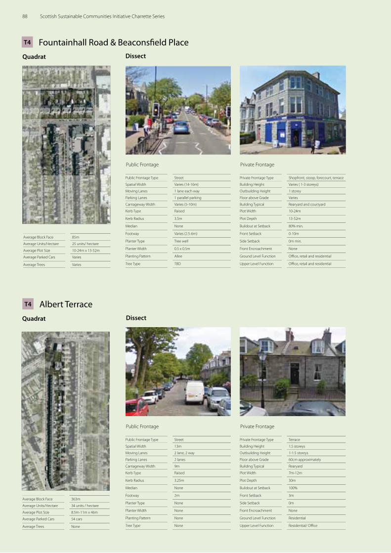
DissectQuadrat
Fountainhall Road & Beaconsfi eld Place
Private Frontage Type Shopfront, stoop, forecourt, terrace
Building Height Varies ( 1-3 storeys)
Outbuilding Height 1 storey
Floor above Grade Varies
Building Typical Rearyard and courtyard
Plot Width 10-24m
Plot Depth 13-52m
Buildout at Setback 80% min.
Front Setback 0-10m
Side Setback 0m min.
Front Encroachment None
Ground Level Function Offi ce, retail and residential
Upper Level Function Offi ce, retail and residential
Public Frontage Type Street
Spatial Width Varies (14-16m)
Moving Lanes 1 lane each way
Parking Lanes 1 parallel parking
Carriageway Width Varies (5-10m)
Kerb Type Raised
Kerb Radius 3.5m
Median None
Footway Varies (2.5-6m)
Planter Type Tree well
Planter Width 0.5 x 0.5m
Planting Pattern Allee
Tree Type TBD
Average Block Face 85m
Average Units/Hectare 25 units/ hectare
Average Plot Size 10-24m x 13-52m
Average Parked Cars Varies
Average Trees Varies
T4
Public Frontage Private Frontage
DissectQuadrat
Albert Terrace
Private Frontage Type Terrace
Building Height 1.5 storeys
Outbuilding Height 1-1.5 storeys
Floor above Grade 60cm approximately
Building Typical Rearyard
Plot Width 7m-12m
Plot Depth 30m
Buildout at Setback 100%
Front Setback 3m
Side Setback 0m
Front Encroachment None
Ground Level Function Residential
Upper Level Function Residential/ Offi ce
Public Frontage Type Street
Spatial Width 13m
Moving Lanes 2 lane, 2 way
Parking Lanes 2 lanes
Carriageway Width 9m
Kerb Type Raised
Kerb Radius 3.25m
Median None
Footway 2m
Planter Type None
Planter Width None
Planting Pattern None
Tree Type None
Average Block Face 363m
Average Units/Hectare 34 units / hectare
Average Plot Size 8.5m-11m x 46m
Average Parked Cars 54 cars
Average Trees None
T4
Public Frontage Private Frontage
88 Scottish Sustainable Communities Initiative Charrette Series
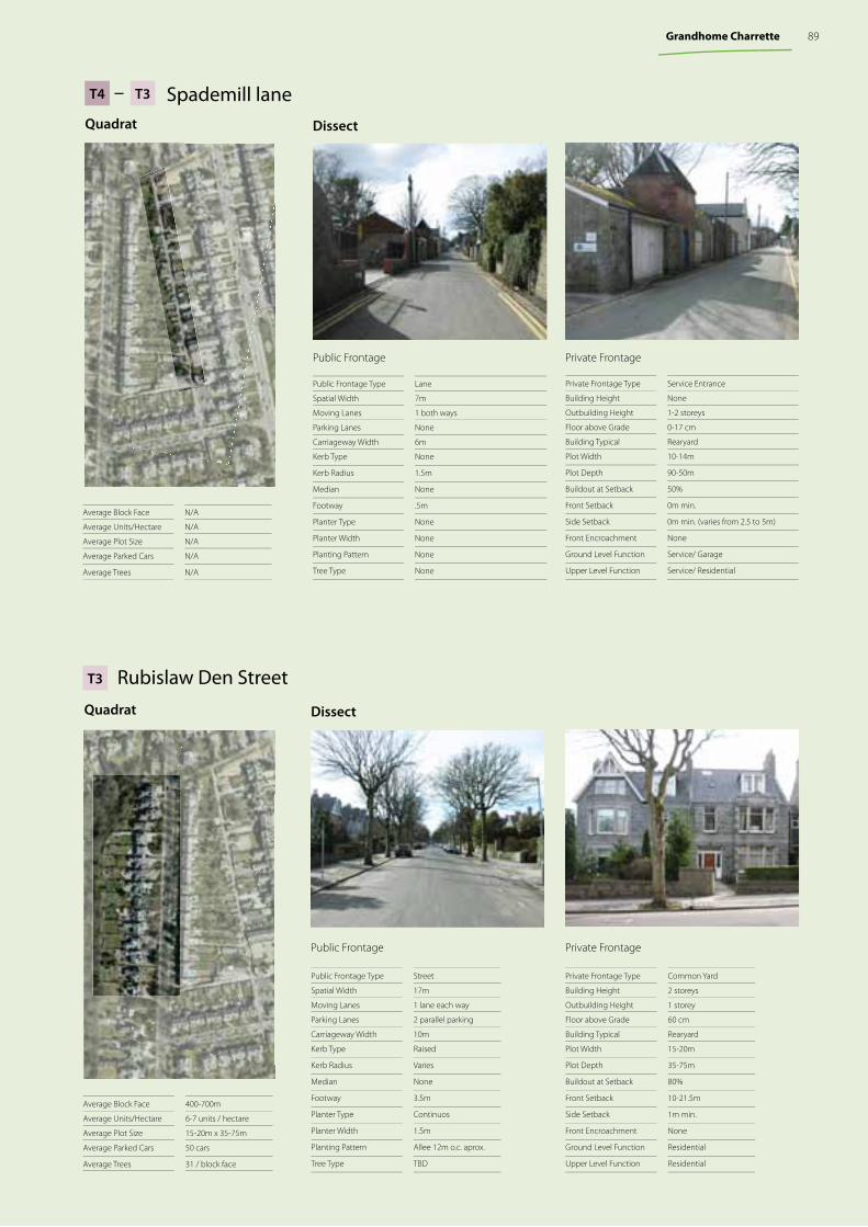
Private Frontage Type Service Entrance
Building Height None
Outbuilding Height 1-2 storeys
Floor above Grade 0-17 cm
Building Typical Rearyard
Plot Width 10-14m
Plot Depth 90-50m
Buildout at Setback 50%
Front Setback 0m min.
Side Setback 0m min. (varies from 2.5 to 5m)
Front Encroachment None
Ground Level Function Service/ Garage
Upper Level Function Service/ Residential
Public Frontage Type Lane
Spatial Width 7m
Moving Lanes 1 both ways
Parking Lanes None
Carriageway Width 6m
Kerb Type None
Kerb Radius 1.5m
Median None
Footway .5m
Planter Type None
Planter Width None
Planting Pattern None
Tree Type None
Average Block Face N/A
Average Units/Hectare N/A
Average Plot Size N/A
Average Parked Cars N/A
Average Trees N/A
Private FrontagePublic Frontage
DissectQuadrat
Spademill lane– T3T4
DissectQuadrat
Rubislaw Den Street
Private Frontage Type Common Yard
Building Height 2 storeys
Outbuilding Height 1 storey
Floor above Grade 60 cm
Building Typical Rearyard
Plot Width 15-20m
Plot Depth 35-75m
Buildout at Setback 80%
Front Setback 10-21.5m
Side Setback 1m min.
Front Encroachment None
Ground Level Function Residential
Upper Level Function Residential
Public Frontage Type Street
Spatial Width 17m
Moving Lanes 1 lane each way
Parking Lanes 2 parallel parking
Carriageway Width 10m
Kerb Type Raised
Kerb Radius Varies
Median None
Footway 3.5m
Planter Type Continuos
Planter Width 1.5m
Planting Pattern Allee 12m o.c. aprox.
Tree Type TBD
Average Block Face 400-700m
Average Units/Hectare 6-7 units / hectare
Average Plot Size 15-20m x 35-75m
Average Parked Cars 50 cars
Average Trees 31 / block face
T3
Private FrontagePublic Frontage
89Grandhome Charrette
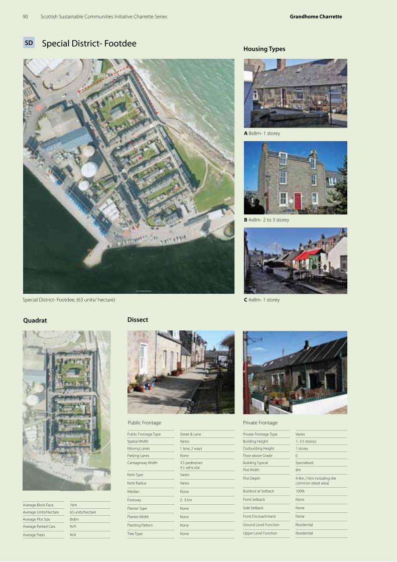
Special District- Footdee
70M
76M
c
B
A
27M
Housing Types
Special District- Footdee, (63 units/ hectare)
DissectQuadrat
Private Frontage Type Varies
Building Height 1- 3.5 storeys
Outbuilding Height 1 storey
Floor above Grade 0
Building Typical Specialised
Plot Width 8m
Plot Depth 4-8m, (16m including the common street area)
Buildout at Setback 100%
Front Setback None
Side Setback None
Front Encroachment None
Ground Level Function Residential
Upper Level Function Residential
Public Frontage Type Street & Lane
Spatial Width Varies
Moving Lanes 1 lane, 2 ways
Parking Lanes None
Carriageway Width 3.5 pedestrian4.5 vehicular
Kerb Type Varies
Kerb Radius Varies
Median None
Footway 2- 3.5m
Planter Type None
Planter Width None
Planting Pattern None
Tree Type None
Average Block Face 76m
Average Units/Hectare 63 units/hectare
Average Plot Size 8x8m
Average Parked Cars N/A
Average Trees N/A
SD
Public Frontage Private Frontage
C 4x8m- 1 storey
B 4x8m- 2 to 3 storey
A 8x8m- 1 storey
90 Scottish Sustainable Communities Initiative Charrette Series Grandhome Charrette
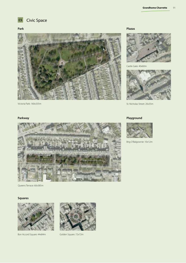
Civic SpaceCS
Parkway
Queens Terrace: 60x385m
Plazas
Squares
Playground
Brig O’Balgownie: 10x12m
Castle Gate: 40x60m
St. Nicholas Street: 20x35m
Bon Accord Square: 44x84m Golden Square: 72x72m
Park
Victoria Park: 160x335m
91Grandhome Charrette


Appendix
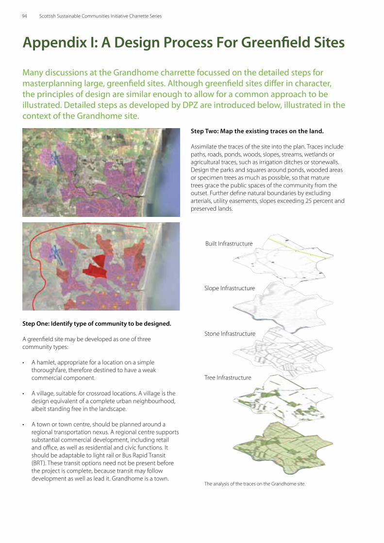
Appendix i: A Design Process For greenfi eld Sites
Many discussions at the Grandhome charrette focussed on the detailed steps for masterplanning large, greenfi eld sites. Although greenfi eld sites diff er in character, the principles of design are similar enough to allow for a common approach to be illustrated. Detailed steps as developed by DPZ are introduced below, illustrated in the context of the Grandhome site.
Step Two: Map the existing traces on the land.
Assimilate the traces of the site into the plan. Traces include paths, roads, ponds, woods, slopes, streams, wetlands or agricultural traces, such as irrigation ditches or stonewalls. Design the parks and squares around ponds, wooded areas or specimen trees as much as possible, so that mature trees grace the public spaces of the community from the outset. Further defi ne natural boundaries by excluding arterials, utility easements, slopes exceeding 25 percent and preserved lands.
Built Infrastructure
Slope Infrastructure
Stone Infrastructure
Tree Infrastructure
Step one: identify type of community to be designed.
A greenfi eld site may be developed as one of three community types:
• A hamlet, appropriate for a location on a simple thoroughfare, therefore destined to have a weak commercial component.
• A village, suitable for crossroad locations. A village is the design equivalent of a complete urban neighbourhood, albeit standing free in the landscape.
• A town or town centre, should be planned around a regional transportation nexus. A regional centre supports substantial commercial development, including retail and offi ce, as well as residential and civic functions. It should be adaptable to light rail or Bus Rapid Transit (BRT). These transit options need not be present before the project is complete, because transit may follow development as well as lead it. Grandhome is a town.
The analysis of the traces on the Grandhome site.
94 Scottish Sustainable Communities Initiative Charrette Series
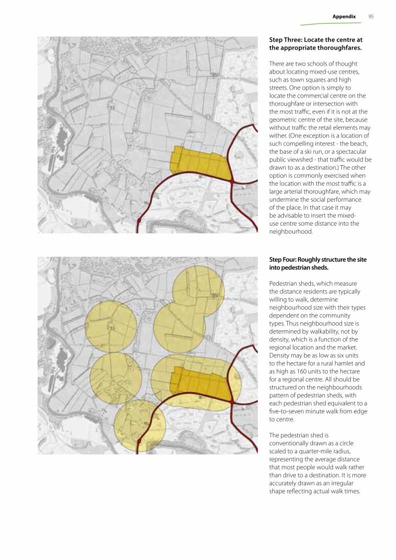
Step Three: Locate the centre at the appropriate thoroughfares.
There are two schools of thought about locating mixed-use centres, such as town squares and high streets. One option is simply to locate the commercial centre on the thoroughfare or intersection with the most traffic, even if it is not at the geometric centre of the site, because without traffic the retail elements may wither. (One exception is a location of such compelling interest - the beach, the base of a ski run, or a spectacular public viewshed - that traffic would be drawn to as a destination.) The other option is commonly exercised when the location with the most traffic is a large arterial thoroughfare, which may undermine the social performance of the place. In that case it may be advisable to insert the mixed-use centre some distance into the neighbourhood.
Step Four: Roughly structure the site into pedestrian sheds.
Pedestrian sheds, which measure the distance residents are typically willing to walk, determine neighbourhood size with their types dependent on the community types. Thus neighbourhood size is determined by walkability, not by density, which is a function of the regional location and the market. Density may be as low as six units to the hectare for a rural hamlet and as high as 160 units to the hectare for a regional centre. All should be structured on the neighbourhoods pattern of pedestrian sheds, with each pedestrian shed equivalent to a five-to-seven minute walk from edge to centre.
The pedestrian shed is conventionally drawn as a circle scaled to a quarter-mile radius, representing the average distance that most people would walk rather than drive to a destination. It is more accurately drawn as an irregular shape reflecting actual walk times.
95Appendix
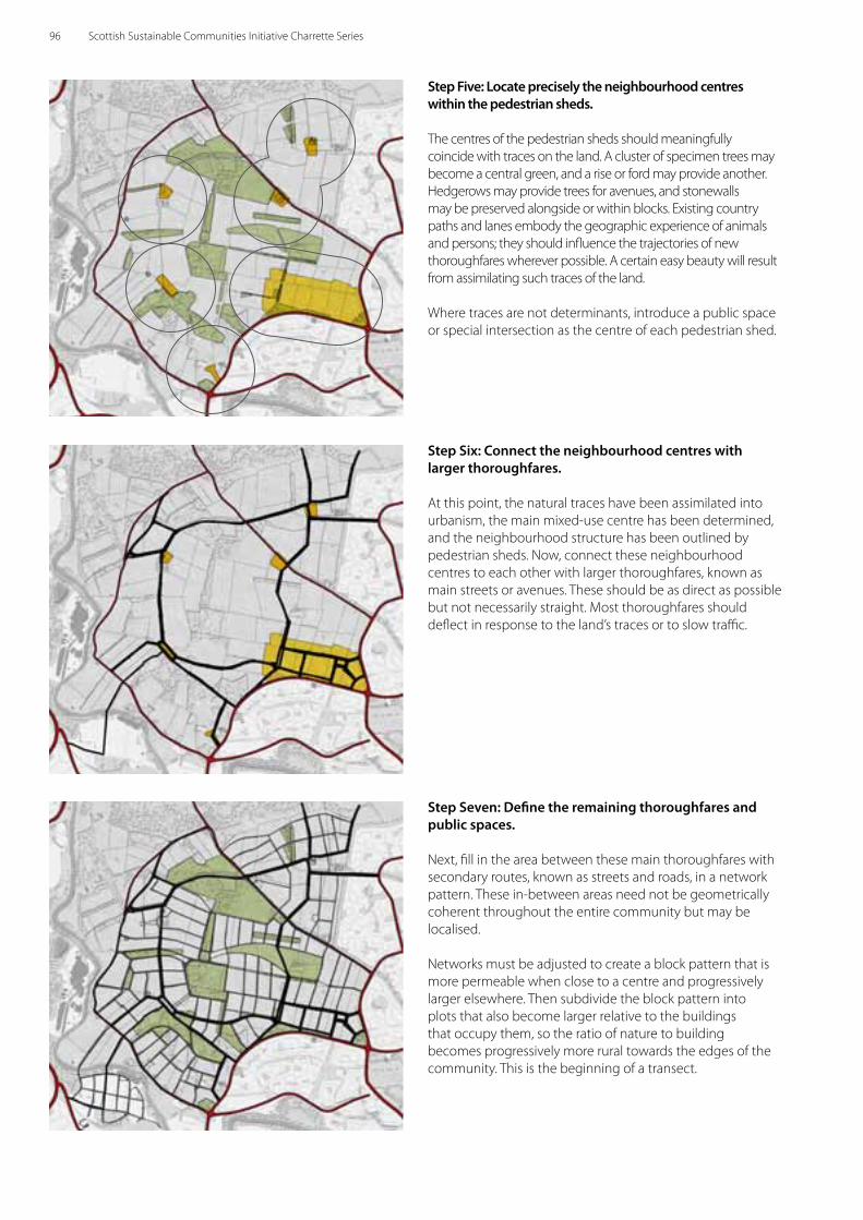
Step Six: Connect the neighbourhood centres with larger thoroughfares.
At this point, the natural traces have been assimilated into urbanism, the main mixed-use centre has been determined, and the neighbourhood structure has been outlined by pedestrian sheds. Now, connect these neighbourhood centres to each other with larger thoroughfares, known as main streets or avenues. These should be as direct as possible but not necessarily straight. Most thoroughfares should deflect in response to the land’s traces or to slow traffic.
Step Seven: Define the remaining thoroughfares and public spaces.
Next, fill in the area between these main thoroughfares with secondary routes, known as streets and roads, in a network pattern. These in-between areas need not be geometrically coherent throughout the entire community but may be localised.
Networks must be adjusted to create a block pattern that is more permeable when close to a centre and progressively larger elsewhere. Then subdivide the block pattern into plots that also become larger relative to the buildings that occupy them, so the ratio of nature to building becomes progressively more rural towards the edges of the community. This is the beginning of a transect.
Step Five: Locate precisely the neighbourhood centres within the pedestrian sheds.
The centres of the pedestrian sheds should meaningfully coincide with traces on the land. A cluster of specimen trees may become a central green, and a rise or ford may provide another. Hedgerows may provide trees for avenues, and stonewalls may be preserved alongside or within blocks. Existing country paths and lanes embody the geographic experience of animals and persons; they should influence the trajectories of new thoroughfares wherever possible. A certain easy beauty will result from assimilating such traces of the land.
Where traces are not determinants, introduce a public space or special intersection as the centre of each pedestrian shed.
96 Scottish Sustainable Communities Initiative Charrette Series
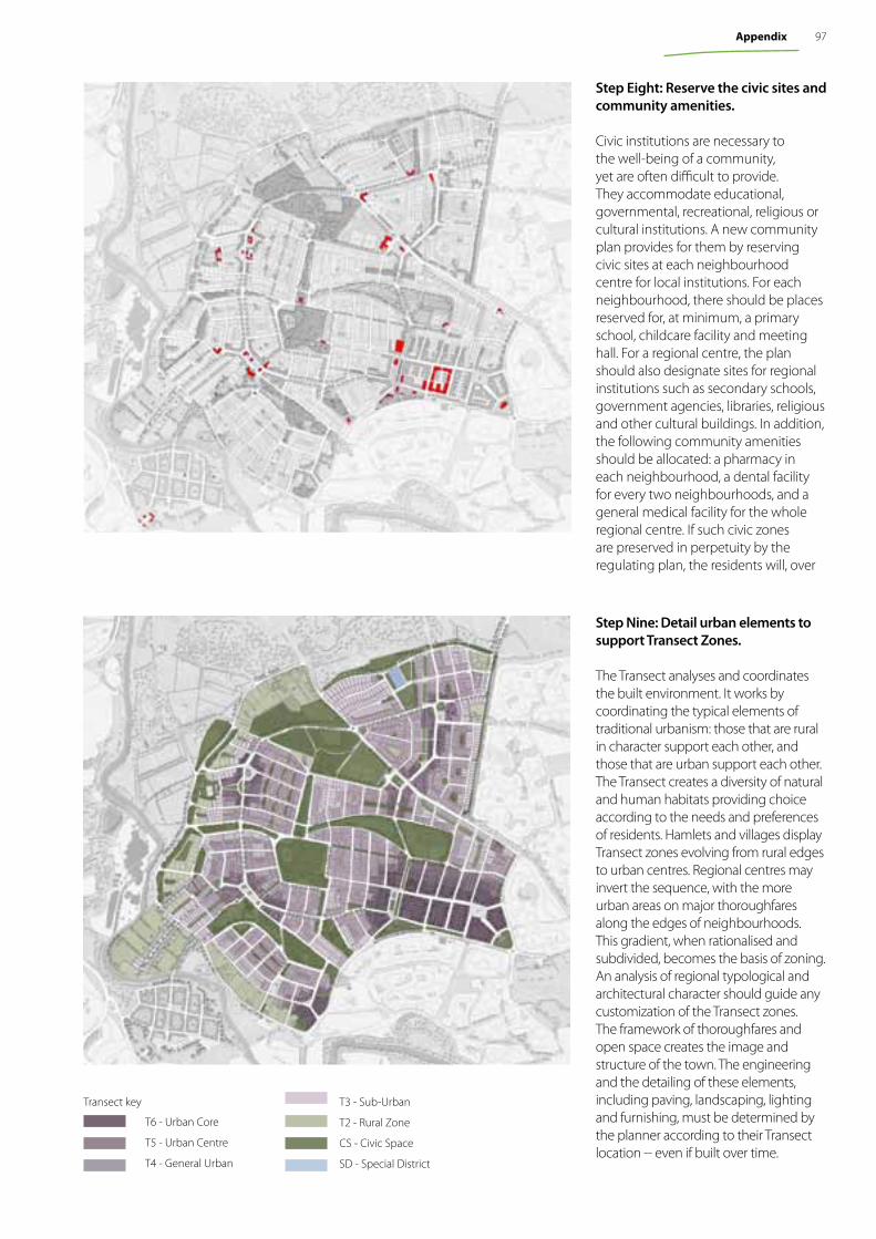
Step Eight: Reserve the civic sites and community amenities.
Civic institutions are necessary to the well-being of a community, yet are often difficult to provide. They accommodate educational, governmental, recreational, religious or cultural institutions. A new community plan provides for them by reserving civic sites at each neighbourhood centre for local institutions. For each neighbourhood, there should be places reserved for, at minimum, a primary school, childcare facility and meeting hall. For a regional centre, the plan should also designate sites for regional institutions such as secondary schools, government agencies, libraries, religious and other cultural buildings. In addition, the following community amenities should be allocated: a pharmacy in each neighbourhood, a dental facility for every two neighbourhoods, and a general medical facility for the whole regional centre. If such civic zones are preserved in perpetuity by the regulating plan, the residents will, over
Step Nine: Detail urban elements to support Transect Zones.
The Transect analyses and coordinates the built environment. It works by coordinating the typical elements of traditional urbanism: those that are rural in character support each other, and those that are urban support each other. The Transect creates a diversity of natural and human habitats providing choice according to the needs and preferences of residents. Hamlets and villages display Transect zones evolving from rural edges to urban centres. Regional centres may invert the sequence, with the more urban areas on major thoroughfares along the edges of neighbourhoods. This gradient, when rationalised and subdivided, becomes the basis of zoning. An analysis of regional typological and architectural character should guide any customization of the Transect zones. The framework of thoroughfares and open space creates the image and structure of the town. The engineering and the detailing of these elements, including paving, landscaping, lighting and furnishing, must be determined by the planner according to their Transect location -- even if built over time.
Transect key
T6 - Urban Core
T5 - Urban Centre
T4 - General Urban
T3 - Sub-Urban
T2 - Rural Zone
CS - Civic Space
SD - Special District
97Appendix
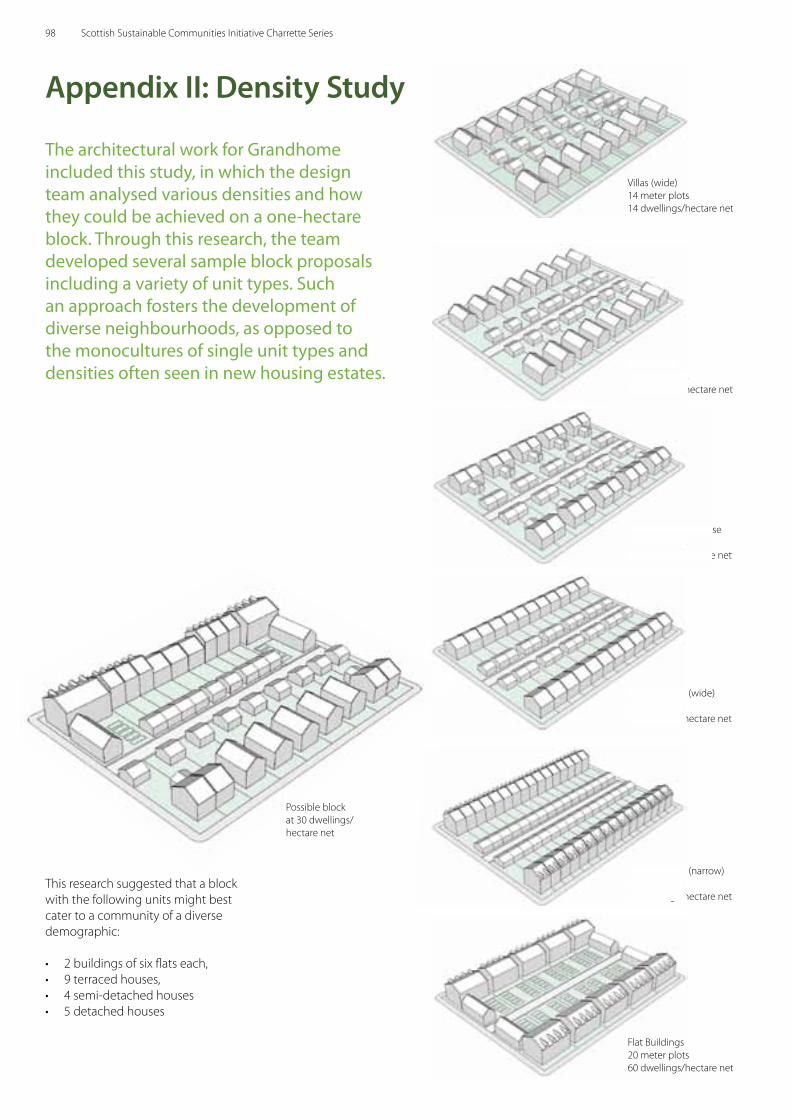
The architectural work for Grandhome included this study, in which the design team analysed various densities and how they could be achieved on a one-hectare block. Through this research, the team developed several sample block proposals including a variety of unit types. Such an approach fosters the development of diverse neighbourhoods, as opposed to the monocultures of single unit types and densities often seen in new housing estates.
This research suggested that a block with the following units might best cater to a community of a diverse demographic:
• 2 buildings of six fl ats each, • 9 terraced houses, • 4 semi-detached houses • 5 detached houses
Villas (wide)14 meter plots 14 dwellings/hectare net
Terrace House (wide)8 meter plots 24 dwellings/hectare net
Terrace House (wide)8 meter plots 24 dwellings/hectare net
Villas (small)14 meter plots 16 dwellings/hectare net
Villas (small)14 meter plots 16 dwellings/hectare net
Semi-Detached House10 meter plots 20 dwellings/hectare net
Semi-Detached House10 meter plots 20 dwellings/hectare net
Terrace House (narrow)6 meter plots 32 dwellings/hectare net
Terrace House (narrow)6 meter plots 32 dwellings/hectare net
Possible block at 30 dwellings/hectare net
Appendix ii: Density Study
Flat Buildings20 meter plots 60 dwellings/hectare net
98 Scottish Sustainable Communities Initiative Charrette Series
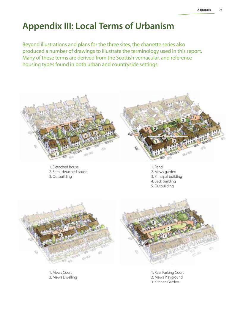
Appendix iii: Local Terms of Urbanism
Beyond illustrations and plans for the three sites, the charrette series also produced a number of drawings to illustrate the terminology used in this report. Many of these terms are derived from the Scottish vernacular, and reference housing types found in both urban and countryside settings.
1. Pend2. Mews garden3. Principal building 4. Back building5. Outbuilding
1. Detached house2. Semi-detached house3. Outbuilding
1
1 34
5
1
3
22
2
1. Mews Court2. Mews Dwelling
1. Rear Parking Court2. Mews Playground3. Kitchen Garden
2
1 2
1
3
99Appendix
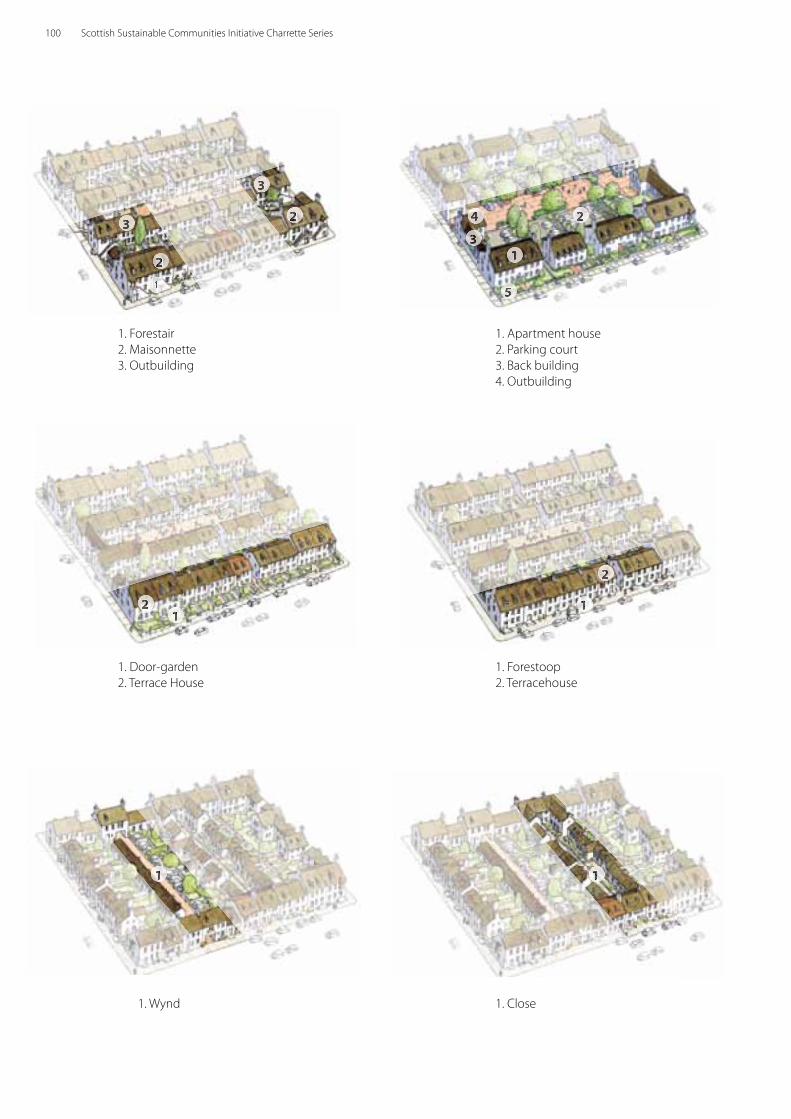
1. Wynd 1. Close
1. Door-garden2. Terrace House
1. Forestoop 2. Terracehouse
12
2
1
1 1
1. Apartment house2. Parking court3. Back building 4. Outbuilding
1. Forestair2. Maisonnette 3. Outbuilding
2
23
3
1
1
5
3
4 2
100 Scottish Sustainable Communities Initiative Charrette Series
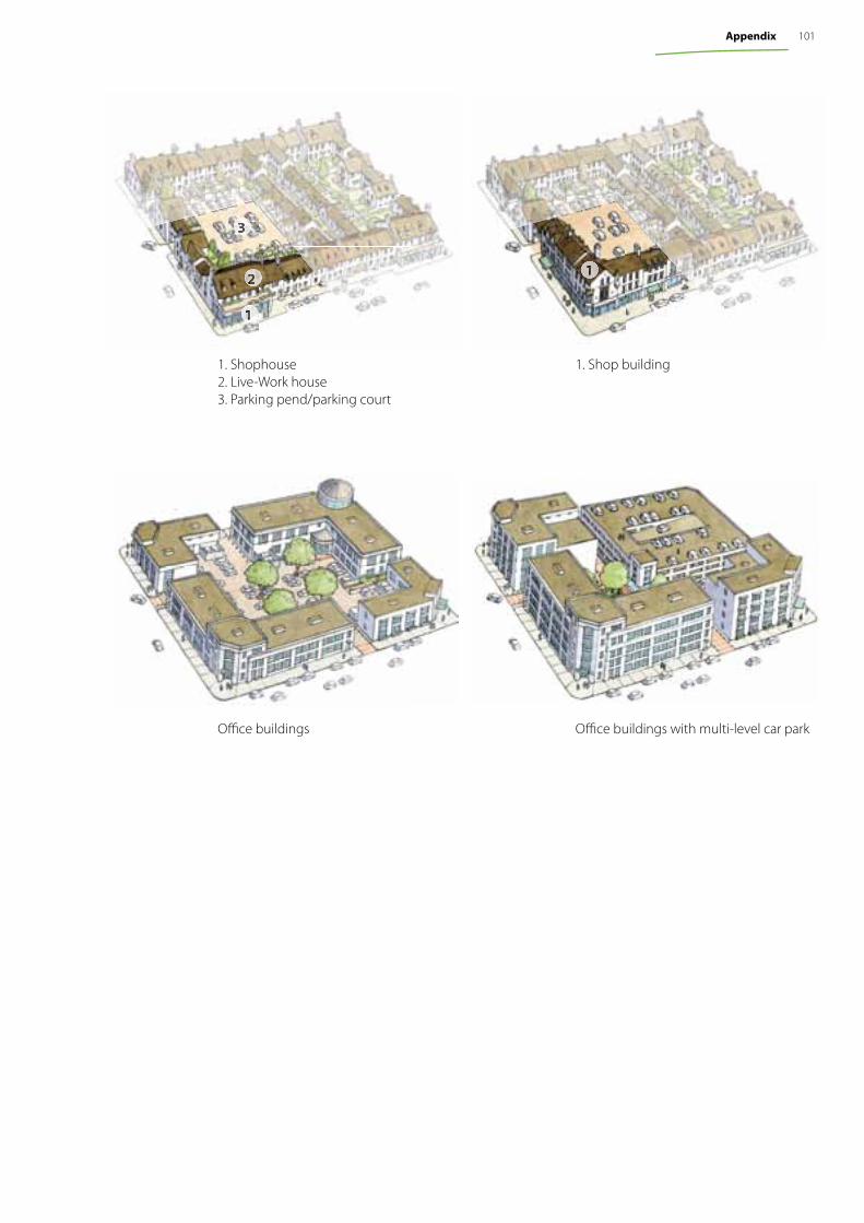
Offi ce buildings Offi ce buildings with multi-level car park
1. Shophouse2. Live-Work house3. Parking pend/parking court
1. Shop building
2
3
1
1
101Appendix
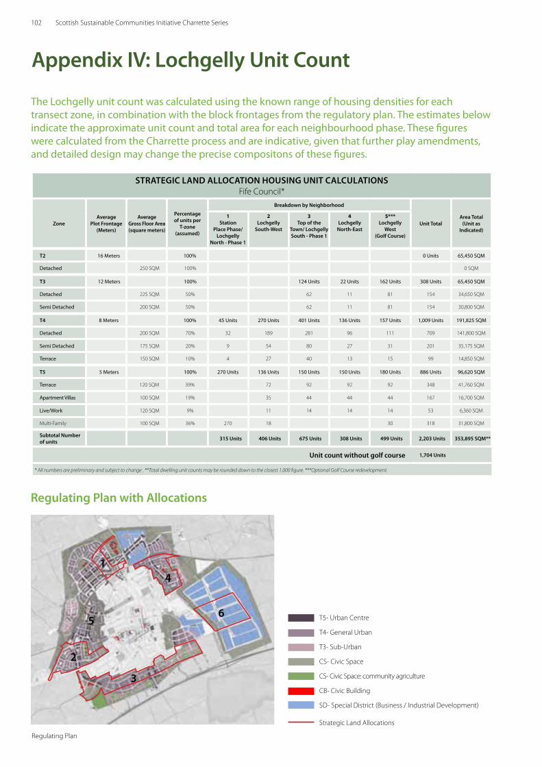
102 Scottish Sustainable Communities Initiative Charrette Series
STRATEgiC LAND ALLoCATioN HoUSiNg UNiT CALCULATioNSFife Council*
ZoneAverage
Plot Frontage(Meters)
Average gross Floor Area(square meters)
Percentageof units per
T-zone(assumed)
Breakdown by Neighborhood
Unit TotalArea Total
(Unit as indicated)
1Station
Place Phase/ Lochgelly
North - Phase 1
2Lochgelly
South-West
3Top of the
Town/ Lochgelly South - Phase 1
4Lochgelly
North-East
5***Lochgelly
West(golf Course)
T2 16 Meters 100% 0 Units 65,450 SQM
Detached 250 SQM 100% 0 SQM
T3 12 Meters 100% 124 Units 22 Units 162 Units 308 Units 65,450 SQM
Detached 225 SQM 50% 62 11 81 154 34,650 SQM
Semi Detached 200 SQM 50% 62 11 81 154 30,800 SQM
T4 8 Meters 100% 45 Units 270 Units 401 Units 136 Units 157 Units 1,009 Units 191,825 SQM
Detached 200 SQM 70% 32 189 281 96 111 709 141,800 SQM
Semi Detached 175 SQM 20% 9 54 80 27 31 201 35,175 SQM
Terrace 150 SQM 10% 4 27 40 13 15 99 14,850 SQM
T5 5 Meters 100% 270 Units 136 Units 150 Units 150 Units 180 Units 886 Units 96,620 SQM
Terrace 120 SQM 39% 72 92 92 92 348 41,760 SQM
Apartment Villas 100 SQM 19% 35 44 44 44 167 16,700 SQM
Live/Work 120 SQM 9% 11 14 14 14 53 6,360 SQM
Multi-Family 100 SQM 36% 270 18 30 318 31,800 SQM
Subtotal Number of units 315 Units 406 Units 675 Units 308 Units 499 Units 2,203 Units 353,895 SQM**
Unit count without golf course 1,704 Units
* All numbers are preliminary and subject to change . **Total dwelling unit counts may be rounded down to the closest 1,000 figure. ***Optional Golf Course redevelopment.
T5- Urban Centre
T4- General Urban
T3- Sub-Urban
CS- Civic Space
CS- Civic Space: community agriculture
CB- Civic Building
SD- Special District (Business / Industrial Development)
Strategic Land Allocations
Appendix iV: Lochgelly Unit Count
Regulating Plan with Allocations
Regulating Plan
3
4
6
1
2
5
The Lochgelly unit count was calculated using the known range of housing densities for each transect zone, in combination with the block frontages from the regulatory plan. The estimates below indicate the approximate unit count and total area for each neighbourhood phase. These figures were calculated from the Charrette process and are indicative, given that further play amendments, and detailed design may change the precise compositons of these figures.
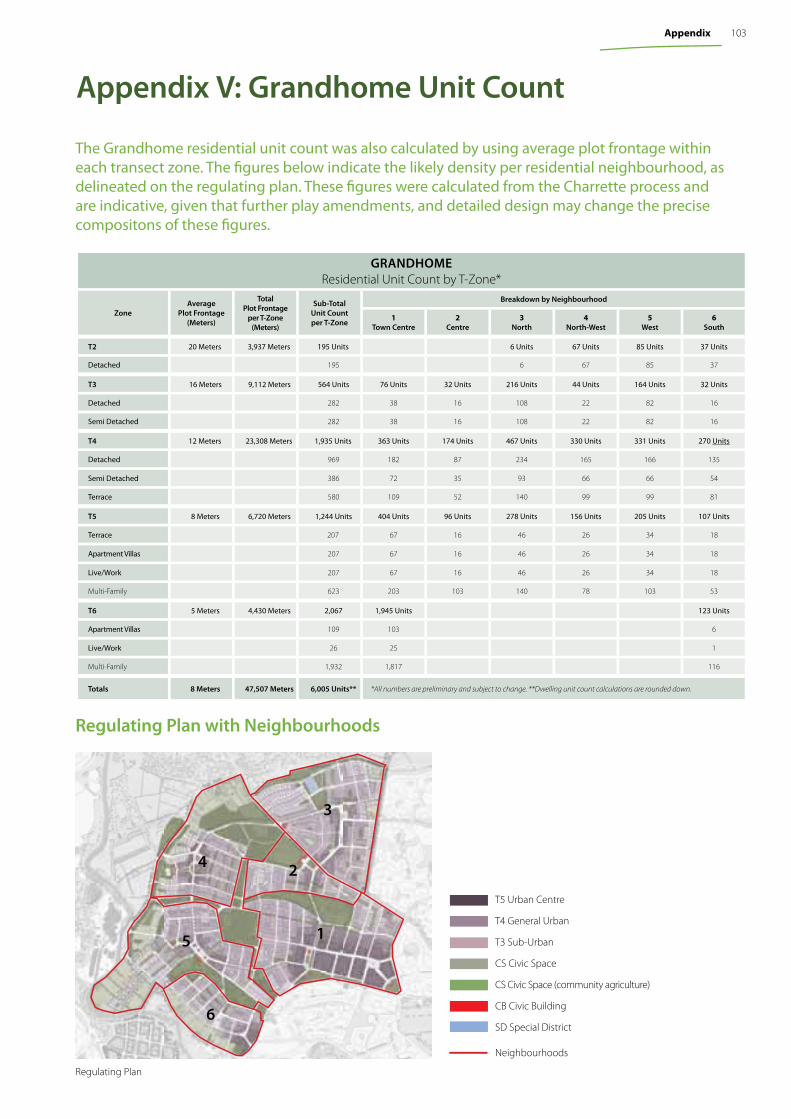
103Appendix
gRANDHoMEResidential Unit Count by T-Zone*
ZoneAverage
Plot Frontage(Meters)
Total Plot Frontage
per T-Zone(Meters)
Sub-TotalUnit Countper T-Zone
Breakdown by Neighbourhood
1Town Centre
2Centre
3North
4North-West
5West
6South
T2 20 Meters 3,937 Meters 195 Units 6 Units 67 Units 85 Units 37 Units
Detached 195 6 67 85 37
T3 16 Meters 9,112 Meters 564 Units 76 Units 32 Units 216 Units 44 Units 164 Units 32 Units
Detached 282 38 16 108 22 82 16
Semi Detached 282 38 16 108 22 82 16
T4 12 Meters 23,308 Meters 1,935 Units 363 Units 174 Units 467 Units 330 Units 331 Units 270 Units
Detached 969 182 87 234 165 166 135
Semi Detached 386 72 35 93 66 66 54
Terrace 580 109 52 140 99 99 81
T5 8 Meters 6,720 Meters 1,244 Units 404 Units 96 Units 278 Units 156 Units 205 Units 107 Units
Terrace 207 67 16 46 26 34 18
Apartment Villas 207 67 16 46 26 34 18
Live/Work 207 67 16 46 26 34 18
Multi-Family 623 203 103 140 78 103 53
T6 5 Meters 4,430 Meters 2,067 1,945 Units 123 Units
Apartment Villas 109 103 6
Live/Work 26 25 1
Multi-Family 1,932 1,817 116
Totals 8 Meters 47,507 Meters 6,005 Units** *All numbers are preliminary and subject to change. **Dwelling unit count calculations are rounded down.
Appendix V: grandhome Unit Count
T5 Urban Centre
T4 General Urban
T3 Sub-Urban
CS Civic Space
CS Civic Space (community agriculture)
CB Civic Building
SD Special District
Neighbourhoods
3
4
1
2
5
6
Regulating Plan
Regulating Plan with Neighbourhoods
The Grandhome residential unit count was also calculated by using average plot frontage within each transect zone. The fi gures below indicate the likely density per residential neighbourhood, as delineated on the regulating plan. These fi gures were calculated from the Charrette process and are indicative, given that further play amendments, and detailed design may change the precise compositons of these fi gures.