Embed Size (px)
Citation preview

8 SOLA, 2021, Vol. 17, 8−15, doi:10.2151/sola.2021-002
©The Author(s) 2021. This is an open access article published by the Meteorological Society of Japan under a Creative Commons Attribution 4.0 International (CC BY 4.0) license (http://creativecommons.org/license/by/4.0).
AbstractThis study investigated characteristics of atmospheric envi-
ronmental fields in the occurrence of quasi-stationary convective bands (QSCBs) in Kyushu, western Japan during the July 2020 heavy rainfall event. We performed case studies of extreme rainfall subevents in the Kumamoto and Kagoshima prefectures on 3−4 July (2020KK) and northern Kyushu on 6−7 July 2020 (2020NK), compared with two heavy rainfall events in northern Kyushu in 2017 and 2018.
Nine QSCBs were objectively extracted during the July 2020 heavy rainfall event, causing hourly precipitation amounts exceed-ing 100 mm twenty times. In 2020KK, the environmental field with extremely large precipitable water due to low-level and mid-dle-level humidity was affected by the upper-level cold airflow, which resulted in favorable condition for the deep convection development. Consequently, the lightning activity became high, and cloud tops were the highest in comparison to previous events. QSCBs in 2020KK and 2020NK were located along a low-level convergence line/zone associated with an inflow that had extreme-ly large water vapor flux on the south side of the mesoscale Baiu frontal depressions. In most of the QSCB cases in 2020, mesoscale depressions were observed and enhanced horizontal winds, which led to extremely large low-level water vapor flux to produce short-term heavy rainfall.
(Citation: Araki, K., T. Kato, Y. Hirockawa, and W. Mashiko, 2021: Characteristics of atmospheric environments of quasi- stationary convective bands in Kyushu, Japan during the July 2020 heavy rain fall event. SOLA, 17, 8−15, doi:10.2151/sola.2021-002.)
1. Introduction
In early July 2020, extreme rainfall occurred in Kyushu, western Japan, which named “the July 2020 heavy rainfall event”, causing extensive damages due to floods and landslides. It is well known that heavy rainfall occurs in Kyushu during the Baiu season, the rainy season from mid- to late spring through early to midsum-mer in Japan (e.g., Akiyama 1973; Ogura et al. 1985; Nagata and Ogura 1991; Moteki et al. 2004a, b), and quasi-stationary convec-tive bands (hereafter QSCBs) often cause localized heavy rainfall (Ogura 1991; Yoshizaki et al. 2000; Kato 1998, 2005, 2006). Statistical studies have indicated that precipitation systems corre-sponding to QSCBs occur frequently in Kyushu (Tsuguti and Kato 2014; Unuma and Takemi 2016a; Hirockawa et al. 2020a). QSCBs are often called “Senjo-kousuitai” in Japanese, and can cause extreme rainfall and extensive damages (Kato 2020).
In previous studies on the environmental occurrence conditions for heavy rainfall, environmental parameters including stability in-dices have been used to quantify the conditions (Kato et al. 2007; Kato 2011; Araki et al. 2017; Takemi and Unuma 2019). The difference between the environmental occurrence conditions for quasi-stationary convective clusters and the other precipitation systems during the warm seasons in Japan has been statistically
clarified using environmental parameters (Unuma and Takemi 2016a, b). Kato (2020) proposed environmental conditions, includ-ing dynamic and thermodynamic environmental parameters and low-level water vapor flux, for the diagnostic forecast of QSCBs by examining those in previous cases of localized heavy rainfall events. While such diagnostic approaches are useful for statistical-ly standardizing environmental occurrence conditions for QSCBs, it is arguable whether or not they could apply to extreme cases that have resulted in heavy rainfall disasters in recent years.
Some case studies have been conducted on extreme rainfall cases caused by QSCBs in recent years. In “the July 2017 north-ern Kyushu heavy rainfall event” occurred in northern Kyushu on 5−6 July 2017, cumulonimbus clouds developed higher than 15 km, which were caught by radar observations (Kato et al. 2018). Kawano and Kawamura (2020) showed that a low-level quasi- stationary convergence zone played a crucial role in forming and maintaining the QSCB. Extreme rainfall was also caused by QSCBs in northern Kyushu during “the July 2018 heavy rainfall event” (Shimpo et al. 2019; Tsuguti et al. 2019). It is noted that the environmental fields in this event were characterized by synoptic- scale ascents that were induced by an upper trough (Takemura et al. 2019; Sekizawa et al. 2019; Yokoyama et al. 2020), synoptic- scale or larger moisture flow (Yatagai et al. 2019), and extremely large amounts of precipitable water due to a very humid environ-ment in the middle-level atmosphere (Takemi and Unuma 2019). Tsuji et al. (2020) compared environmental fields in the 2017 and 2018 events, and noted that the middle-level atmosphere was moist in the latter due to synoptic-scale ascent dynamically forced by a deep trough. They also noted that upper-level cold air advec-tion due to a shallow trough enhanced atmospheric instability in the 2017 event.
On the other hand, it has been known that mesoscale Baiu frontal depressions (BFDs), which are the mesoscale depressions developing over the Baiu front, are important for the environmen-tal occurrence conditions for heavy rainfall in Kyushu (Akiyama 1984; Ninomiya et al. 1984; Ogura et al. 1985; Ninomiya 1978, 2000; Ninomiya and Yamazaki 1979). Ogura et al. (1985) per-formed a case study on “the Nagasaki heavy rainfall event” that occurred in northern Kyushu on 23 July 1982, and showed that the QSCB-like precipitation intensification appeared during the period when very moist low-level inflow reached peak near the mesoscale BFD. They also noted that localized heavy rainfall occurred over several other areas in association with mesoscale BFDs and the precipitation intensified over coast areas upwind of moist low-level jets.
Moreover, only a few studies have investigated extreme cases causing heavy rainfall disasters in recent years using the diagnos-tic approach with environmental parameters. Therefore, to charac-terize the atmospheric environments for the occurrence of extreme rainfall caused by QSCBs during the July 2020 heavy rainfall event, we performed case studies of extreme rainfall subevents in Kumamoto and Kagoshima prefectures on 3−4 July (2020KK) and northern Kyushu on 6−7 July 2020 (2020NK), comparing them with the extreme rainfall events on 6−7 July 2018 (2018NK) and on 5 July 2017 (2017NK) focusing on the importance of mesoscale BFDs using environmental parameters derived from analysis data.
Characteristics of Atmospheric Environments of Quasi-Stationary Convective Bands in Kyushu, Japan
during the July 2020 Heavy Rainfall Event
Kentaro Araki1, Teruyuki Kato2, Yasutaka Hirockawa1, and Wataru Mashiko1
1Meteorological Research Institute, Tsukuba, Japan2Meteorological College, Kashiwa, Japan
Corresponding author: Kentaro Araki, Meteorological Research Institute, 1-1 Nagamine, Tsukuba 305-0052, Japan. E-mail: [email protected].
9Araki et al., Atmospheric Environments during the July 2020 Heavy Rainfall Event
Temperature at 250 and 500 hPa (T250, T500), advection of tem-perature at 250 and 500 hPa (TADV250, TADV500), and vertical velocity at 700 hPa (W700) were averaged hourly for the domain. To evaluate synoptic-scale vertical velocity, W700 was averaged horizontally by 400 km (Kato 2020). Parameters as following were hourly calculated as the maximum value within the domain; precipitable water vapor (PWV), mixing ratio of water vapor at 950 hPa (WV950), horizontal velocity at 950 hPa (VEL950), water vapor flux amount at 950 hPa (FLWV950), convective available po-tential energy (CAPE) computed by adiabatically lifting a parcel at 950 hPa, and storm-relative environmental helicity (SREH) which was obtained from the maximum of two values estimated by the methods of Maddox (1976) and Bunkers et al. (2000). To eliminate the local influence of convective activities, SREH was averaged horizontally by 100 km. Level of neutral buoyancy (LNB), which was estimated by adiabatically lifting a parcel from 950 hPa, was chosen by the minimum values (hPa) in the domain.
It is noted that the differences of temperature, water vapor mixing ratio, and horizontal velocity between the LA data and radiosonde observations in Kyushu are sufficiently small (Fig. S2 in Supplement), which the LA data could well reproduce actual atmospheric conditions even during extreme rainfall events.
3. Results
3.1 Precipitation characteristics of QSCBsTo reveal the contribution of QSCB on precipitation amounts
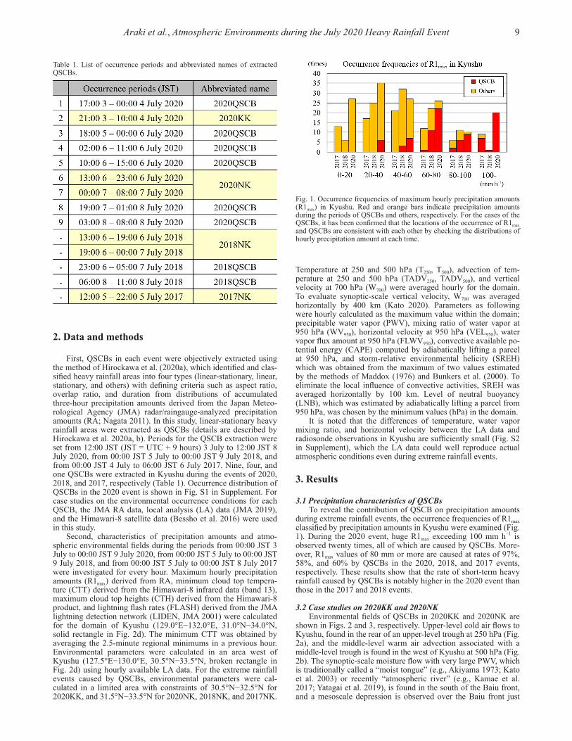
during extreme rainfall events, the occurrence frequencies of R1max classified by precipitation amounts in Kyushu were examined (Fig. 1). During the 2020 event, huge R1max exceeding 100 mm h−1 is observed twenty times, all of which are caused by QSCBs. More-over, R1max values of 80 mm or more are caused at rates of 97%, 58%, and 60% by QSCBs in the 2020, 2018, and 2017 events, respectively. These results show that the rate of short-term heavy rainfall caused by QSCBs is notably higher in the 2020 event than those in the 2017 and 2018 events.
3.2 Case studies on 2020KK and 2020NKEnvironmental fields of QSCBs in 2020KK and 2020NK are
shown in Figs. 2 and 3, respectively. Upper-level cold air flows to Kyushu, found in the rear of an upper-level trough at 250 hPa (Fig. 2a), and the middle-level warm air advection associated with a middle-level trough is found in the west of Kyushu at 500 hPa (Fig. 2b). The synoptic-scale moisture flow with very large PWV, which is traditionally called a “moist tongue” (e.g., Akiyama 1973; Kato et al. 2003) or recently “atmospheric river” (e.g., Kamae et al. 2017; Yatagai et al. 2019), is found in the south of the Baiu front, and a mesoscale depression is observed over the Baiu front just
2. Data and methods
First, QSCBs in each event were objectively extracted using the method of Hirockawa et al. (2020a), which identified and clas-sified heavy rainfall areas into four types (linear-stationary, linear, stationary, and others) with defining criteria such as aspect ratio, overlap ratio, and duration from distributions of accumulated three-hour precipitation amounts derived from the Japan Meteo-rological Agency (JMA) radar/raingauge-analyzed precipitation amounts (RA; Nagata 2011). In this study, linear-stationary heavy rainfall areas were extracted as QSCBs (details are described by Hirockawa et al. 2020a, b). Periods for the QSCB extraction were set from 12:00 JST (JST = UTC + 9 hours) 3 July to 12:00 JST 8 July 2020, from 00:00 JST 5 July to 00:00 JST 9 July 2018, and from 00:00 JST 4 July to 06:00 JST 6 July 2017. Nine, four, and one QSCBs were extracted in Kyushu during the events of 2020, 2018, and 2017, respectively (Table 1). Occurrence distribution of QSCBs in the 2020 event is shown in Fig. S1 in Supplement. For case studies on the environmental occurrence conditions for each QSCB, the JMA RA data, local analysis (LA) data (JMA 2019), and the Himawari-8 satellite data (Bessho et al. 2016) were used in this study.
Second, characteristics of precipitation amounts and atmo-spheric environmental fields during the periods from 00:00 JST 3 July to 00:00 JST 9 July 2020, from 00:00 JST 5 July to 00:00 JST 9 July 2018, and from 00:00 JST 5 July to 00:00 JST 8 July 2017 were investigated for every hour. Maximum hourly precipitation amounts (R1max) derived from RA, minimum cloud top tempera-ture (CTT) derived from the Himawari-8 infrared data (band 13), maximum cloud top heights (CTH) derived from the Himawari-8 product, and lightning flash rates (FLASH) derived from the JMA lightning detection network (LIDEN, JMA 2001) were calculated for the domain of Kyushu (129.0°E−132.0°E, 31.0°N−34.0°N, solid rectangle in Fig. 2d). The minimum CTT was obtained by averaging the 2.5-minute regional minimums in a previous hour. Environmental parameters were calculated in an area west of Kyushu (127.5°E−130.0°E, 30.5°N−33.5°N, broken rectangle in Fig. 2d) using hourly available LA data. For the extreme rainfall events caused by QSCBs, environmental parameters were cal-culated in a limited area with constraints of 30.5°N−32.5°N for 2020KK, and 31.5°N−33.5°N for 2020NK, 2018NK, and 2017NK.
Table 1. List of occurrence periods and abbreviated names of extracted QSCBs.
Fig. 1. Occurrence frequencies of maximum hourly precipitation amounts (R1max) in Kyushu. Red and orange bars indicate precipitation amounts during the periods of QSCBs and others, respectively. For the cases of the QSCBs, it has been confirmed that the locations of the occurrence of R1max and QSCBs are consistent with each other by checking the distributions of hourly precipitation amount at each time.

10 SOLA, 2021, Vol. 17, 8−15, doi:10.2151/sola.2021-002
below the middle-level trough (Fig. 2c). This depression forms in the front of the middle-level trough at 09:00 JST on 3 July, travelling eastward without intense precipitation around the center of the depression (Fig. S3 in Supplement). This feature is consistent with typical BFDs (Akiyama 1984; Ogura et al. 1985; Tochimoto and Kawano 2012, 2017). The QSCB is located along a convergence line between the circulation associated with the BFD and the flow along the edge of the Pacific high, associated with the inflow that has significantly large low-level water vapor flux in the south side of the BFD (Fig. 2d). The CTT of the QSCB locally drops less than −70°C and a typical formation pattern of the back-building type (Bluestein and Jain 1985) is also observed in the QSCB (Fig. S4a in Supplement).
In 2020NK, both upper-level and middle-level troughs exist over China, and Kyushu is located in the south of the subtropical jet stream (Figs. 3a and 3b). A very moist airflow from the west and a moist airflow along the edge of the Pacific high from the southwest merge in Kyushu in the south of the Baiu front (Fig. 3c). Two mesoscale BFDs are also found and a QSCB is located
in the convergence zone associated with the inflow that has sig-nificantly large low-level water vapor flux (Fig. 3d). Upper-level clouds almost cover Kyushu, and the CTT of the QSCB also locally drops −70°C (Fig. S4b in Supplement).
These results indicate that the environmental occurrence conditions for QSCBs in 2020KK and 2020NK are strongly associated with mesoscale BFDs. Environmental fields of QSCBs in 2018NK and 2017NK are also shown in Figs. S5 and S6 in Supplement, respectively. In 2018NK, a clear convergence line associated with large low-level water vapor flux is also found near the Baiu front, and a QSCB forms along the convergence line (Fig. S5). A QSCB forms in a low-level convergence zone in 2017NK, as shown by Kawano and Kawamura (2020), but the low-level water vapor flux is considerably smaller than that in the other cases because horizontal wind in the inflow along the edge of the Pacific high is weaker in addition to smaller water vapor amounts (Fig. S6). It should be noted that no apparent mesoscale BFD is found both in the 2018NK and 2017NK.
Fig. 2. Environmental conditions of the QSCB derived from local analysis (LA) at 03:00 JST on 4 July 2020. (a) Horizontal distribution of temperature (T250; color, °C), height (Z250; black contour, m), horizontal wind at 250 hPa (vector, m s−1), horizontal velocity at 200 hPa (VEL200; white contour, m s−1), (b) temperature (T500; color, °C), height (Z500; contour, m), horizontal wind at 500 hPa (vector, m s−1), (c) precipitable water vapor (PWV; color, mm), sea level pressure (SLP; contour, hPa), horizontal wind at 950 hPa (vector, m s−1), and (d) water vapor flux at 950 hPa (FLWV950; color, g m−2 s−1), SLP (black contour, hPa), horizontal convergence at 950 hPa (CONV950; blue contour, 2.0 × 10⁻³ s−1; blue hatch, 1.0 × 10⁻³ s−1), horizontal wind at 950 hPa, hourly pre-cipitation amount obtained from radar/raingauge-analyzed precipitation amount (RA; shade, mm h−1). The locations of the Baiu front and depression based on subjective analysis of the JMA weather chart and LA are shown in (c), and the locations of the front and depressions considering mesoscale disturbances are shown in (d).

11Araki et al., Atmospheric Environments during the July 2020 Heavy Rainfall Event
3.3 Characteristics of atmospheric environments of QSCBsTo quantitatively characterize the environmental occurrence
conditions for extreme rainfall events, environmental parameters for each period of 2020KK, 2020NK, 2018NK, and 2017NK are compared (Table 2). As for observational features, CTT and CTH in 2020KK are the lowest and the highest in comparison with the other events, respectively. FLASH in 2020KK temporally exceeds 1400 times h−1, which is higher than the period-averaged FLASH in 2017NK. These results show that the QSCB in 2020KK was composed of very tall and thunderous cumulonimbus clouds among the recent extreme rainfall cases.
Regarding the features of upper-level and middle-level tem-perature fields, T250 is lower in 2017NK and 2020KK, and signifi-cant cold air advection at 250 hPa is found in 2020KK. T500 is the highest in 2020KK and the lowest in 2017NK, and significant warm air advection is found at 500 hPa in 2020KK. Concerning the features of water vapor fields, PWV in 2020KK is more than 77 mm, which is comparable to that in 2018NK as noted as an extremely large value by Takemi and Unuma (2019). WV950 is almost the same values in each event, but VEL950 is larger in 2020KK and 2020NK, resulting in extremely large FLWV950 over 530 g m−2 s−1. In terms of thermodynamic stability, CAPE is 1678 J kg−1 in 2020KK, which indicates an extremely unstable atmospheric condition. LNB is also 100 hPa throughout the period only in 2020KK, indicating the thermodynamic environments
favorable for deep convection development. Regarding aspects of dynamic environments, SREH in each event is more than 100 m−2 s−2 and satisfy the conditions favorable for QSCB forma-tion (Kato 2020). W700 in 2020KK is larger than that in 2018NK where the environment was significantly affected by synoptic- scale ascent (e.g., Takemura et al. 2019).
To understand the relationship between environmental param-eters and precipitation amounts in case of QSCB, scatter diagrams of environmental parameters for R1max are also examined (Fig. S7 in Supplement). Parameters of FLWV950, PWV, CAPE and W700 tend to increase with R1max, except in the 2017 event (Figs. S7a, S7b, S7c, and S7d). CTT tends to become lower as R1max increas-es, and most of QSCB cases have CTT below −65°C, with the lowest CTT observed in 2020KK (Fig. S7e). A clear relationship with the precipitation amount is not found for FLASH (Fig. S7f), and the other environmental parameters in Table 2 (not shown). Focusing on the environmental parameters for QSCBs, FLWV950 is over 450 g m−2 s−1 during all the appearance periods of QSCBs in the 2020 event (Fig. S7a). These results indicate that all the QSCBs in the 2020 event were composed of very tall cumulonim-bus clouds and formed under the environmental conditions with extremely large low-level water vapor flux. It should be noted that these results were not significantly different when environmental parameters estimated from 1 or 2 hours prior to the time of R1max were used.
Fig. 3. Same as Fig. 2, but for 13:00 JST on 6 July 2020.

12 SOLA, 2021, Vol. 17, 8−15, doi:10.2151/sola.2021-002
Present analyses based on case studies and environmental parameters show that the environmental fields in 2020KK are characterized by upper-level cold air, middle-level warm air, synoptic-scale ascent, and extremely large PWV and low-level water vapor flux. To investigate the environmental occurrence conditions for QSCBs under the influence of mesoscale BFDs as described in Ogura et al. (1985), vertical profiles of T, WV, VEL, and FLWV for 2020KK, 2020NK, 2018NK, and 2017NK are shown in Fig. 4. The average is obtained from hourly LA data of 1−10 July in 2015−2020 in the domain of the broken rectangle in Fig. 2d.
In 2020KK, a negative anomaly of T is also found in the upper-level layer from 300 to 150 hPa, and T and WV are larger than the averaged values from the low-level to middle-level layers, with the largest anomalies at 500 and 700 hPa, respectively (Figs. 4a and 4b). Although a small positive anomaly (~0.6 g kg−1) is found in WV950 for each event, the difference of the middle-level WV would be responsible for that of PWV. From this result, it is noted that the upper-level cold airflow in the environmental condi-tions with extremely large PWV due to low-level and middle-level humidity enhances the atmospheric unstable condition favorable for the development of deep convection, which could result in higher lightning activity and the highest cloud top height among the present heavy rainfall events.
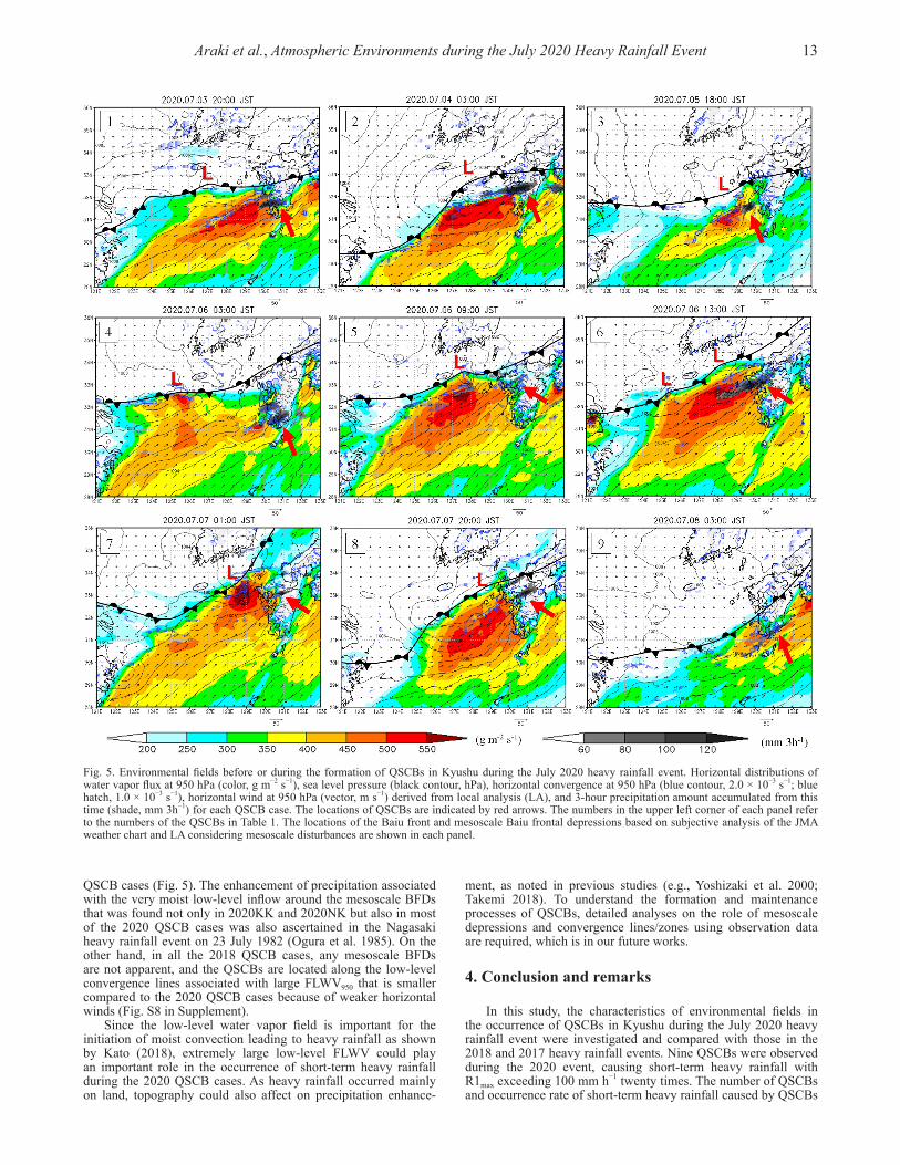
The environmental fields in 2020KK and 2020NK are also characterized by stronger winds at all levels than those in 2017NK and 2018NK (Fig. 4c), resulting in extremely large FLWV in a low-level atmosphere (Fig. 4d). Especially in 2020KK, the peak of horizontal velocity is found at approximately 900 hPa, which is a similar feature of moist low-level jets in the environmental oc-currence conditions for heavy rainfall associated with mesoscale BFDs (e.g., Ogura et al. 1985). The results of the case studies indi-cate that QSCBs formed along a convergence line/zone associated with BFDs, which played an important role in the intensification of very moist low-level inflows in 2020KK and 2020NK. All of the QSCBs in the 2020 event form when FLWV950 becomes extremely large (Fig. S7a), and the intensification of FLWV950 is caused by mesoscale BFDs, which have got apparent from a few hours to a day before the formation of QSCBs, in eight of nine
Fig. 4. Vertical profiles of difference of (a) temperature (T), (b) mixing ratio of water vapor (WV), (c) horizontal velocity (VEL), and (d) wa-ter vapor flux (FLWV) from average (AVE). The AVE is obtained from hourly local analysis data of 1−10 July in 2015−2020 in the domain of the broken rectangle in Fig. 2d. Profiles of 2020KK are calculated in the domain of 127.5°E−130.0°E and 30.5°N−32.5°N, and those of 2020NK, 2018NK, and 2017NK are obtained in the domain of 127.5°E−130.0°E and 31.5°N−33.5°N. Each profile is obtained from the data averaged for the periods of 2020KK, 2020NK, 2018NK, and 2017NK. Temperature in (a) and the others respectively indicate the averaged and maximum values for the domain.
Table 2. Environmental parameters averaged for each heavy rainfall period of 2020KK, 2020NK, 2018NK, and 2017NK. Total, Max, and Min in parentheses in a column of parameters and each event show the total, maximum, and minimum values for the period, respectively. Only the maximum hourly precipitation amount (R1max) shows the maximum value for the period. Parameters with Max, Min, and Ave in the “Value in domain” column represent the maximum, minimum, and averaged values for the domains of 127.5°E−130.0°E and 30.5°N−32.5°N for 2020KK, and 127.5°E−130.0°E and 31.5°N− 33.5°N for 2020NK, 2018NK, and 2017NK, respectively.
13Araki et al., Atmospheric Environments during the July 2020 Heavy Rainfall Event
QSCB cases (Fig. 5). The enhancement of precipitation associated with the very moist low-level inflow around the mesoscale BFDs that was found not only in 2020KK and 2020NK but also in most of the 2020 QSCB cases was also ascertained in the Nagasaki heavy rainfall event on 23 July 1982 (Ogura et al. 1985). On the other hand, in all the 2018 QSCB cases, any mesoscale BFDs are not apparent, and the QSCBs are located along the low-level convergence lines associated with large FLWV950 that is smaller compared to the 2020 QSCB cases because of weaker horizontal winds (Fig. S8 in Supplement).
Since the low-level water vapor field is important for the initiation of moist convection leading to heavy rainfall as shown by Kato (2018), extremely large low-level FLWV could play an important role in the occurrence of short-term heavy rainfall during the 2020 QSCB cases. As heavy rainfall occurred mainly on land, topography could also affect on precipitation enhance-
ment, as noted in previous studies (e.g., Yoshizaki et al. 2000; Takemi 2018). To understand the formation and maintenance processes of QSCBs, detailed analyses on the role of mesoscale depressions and convergence lines/zones using observation data are required, which is in our future works.
4. Conclusion and remarks
In this study, the characteristics of environmental fields in the occurrence of QSCBs in Kyushu during the July 2020 heavy rainfall event were investigated and compared with those in the 2018 and 2017 heavy rainfall events. Nine QSCBs were observed during the 2020 event, causing short-term heavy rainfall with R1max exceeding 100 mm h−1 twenty times. The number of QSCBs and occurrence rate of short-term heavy rainfall caused by QSCBs
Fig. 5. Environmental fields before or during the formation of QSCBs in Kyushu during the July 2020 heavy rainfall event. Horizontal distributions of water vapor flux at 950 hPa (color, g m−2 s−1), sea level pressure (black contour, hPa), horizontal convergence at 950 hPa (blue contour, 2.0 × 10⁻³ s−1; blue hatch, 1.0 × 10⁻³ s−1), horizontal wind at 950 hPa (vector, m s−1) derived from local analysis (LA), and 3-hour precipitation amount accumulated from this time (shade, mm 3h−1) for each QSCB case. The locations of QSCBs are indicated by red arrows. The numbers in the upper left corner of each panel refer to the numbers of the QSCBs in Table 1. The locations of the Baiu front and mesoscale Baiu frontal depressions based on subjective analysis of the JMA weather chart and LA considering mesoscale disturbances are shown in each panel.
14 SOLA, 2021, Vol. 17, 8−15, doi:10.2151/sola.2021-002
in the 2020 event were significantly higher than those in the 2017 and 2018 events.
In 2020KK, environmental fields were characterized by extremely large PWV due to low-level and middle-level humidity and upper-level cold airflow, which resulted in the enhancement of atmospheric unstable conditions favorable for the development of deep convection. It is noted that the environmental conditions in 2020KK had the hybrid characteristics of extremely large PWV and strong synoptic-scale ascent as in 2018NK and upper-level cold air as in 2017NK. Consequently, the lightning activity was high in 2020KK and cloud top heights of QSCBs were the highest compared to those in 2018NK and 2017NK.
QSCBs in 2020KK and 2020NK were located along a low- level convergence line/zone associated with inflows with extreme-ly large low-level water vapor flux on the south side of mesoscale BFDs. Although the QSCBs in 2018NK and 2017NK were also located along low-level convergence lines/zones, environmental fields in 2020KK and 2020NK were different from those in 2018NK and 2017NK in respect to the existence of mesoscale BFDs and extremely larger low-level water vapor flux amounts. Mesoscale BFDs were apparent and intensified horizontal winds in most of the QSCB cases in 2020, causing extremely large low- level water vapor flux, which resulted in short-term heavy rainfall. The features of environmental conditions with mesoscale BFDs and moist low-level inflows found in 2020KK and 2020NK were also ascertained in the Nagasaki heavy rainfall event on 23 July 1982.
Our results suggest that monitoring and predicting mesoscale BFDs, in addition to the low-level water vapor field, could potentially improve the forecast of QSCBs causing short-term heavy rainfall. Further accumulation of case studies and numerical studies with advanced data assimilation and physical processes are desired. These are our future issues.
Acknowledgements
We thank Mr. S. Hayashi and M. Hayashi of the JMA Mete-orological Research Institute for their useful advices. We are also grateful to the reviewers and the editor. LIDEN data used in this study was provided from the JMA. GSMaP data in this study was provided by the Japan Aerospace Exploration Agency (JAXA).
Edited by: Q. Moteki
Supplement
Supplement: Figures showing occurrence distribution, envi-ronmental occurrence conditions, cloud top temperature of QSCBs, and comparison between the LA and radiosonde data. Precipita-tion data is partially derived from the GSMaP (Kubota et al. 2020).
References
Akiyama, T., 1973: The large-scale aspects of the characteristic features of Baiu front. Papers in Meteor. and Geophys., 24, 157−188.
Akiyama, T., 1984: A medium-scale cloud cluster in a Baiu front. Part I: Evolution process and fine structure. J. Meteor. Soc. Japan, 62, 485−504.
Araki, K., M. Murakami, T. Kato, and T. Tajiri, 2017: Analysis of atmospheric environments for convective cloud develop-ment around the Central Mountains in Japan during warm seasons using ground-based microwave radiometer data. Tenki, 64, 19−36 (in Japanese with English abstract).
Bessho, K., K. Date, M. Hayashi, A. Ikeda, T. Imai, H. Inoue, Y. Kumagai, T. Miyakawa, H. Murata, T. Ohno, A. Okuyama, R. Oyama, Y. Sasaki, Y. Shimazu, K. Shimoji, Y. Sumida, M. Suzuki, H. Taniguchi, H. Tsuchiyama, D. Uesawa, H. Yokota, and R. Yoshida, 2016: An introduction to Himawari-8/9 –
Japan’s new-generation geostationary meteorological satel-lites. J. Meteor. Soc. Japan, 94, 151−183.
Bluestein, H. B., and M. H. Jain, 1985: The formation of meso-scale lines of precipitation: Severe squall lines in Oklahoma during the spring. J. Atmos. Sci., 42, 1711−1732.
Bunkers, M. J., B. A. Klimowski, J. W. Zeitler, R. L. Thompson, and M. L. Weisman, 2000: Predicting supercell motion using a new hodograph technique. Wea. Forecasting, 15, 61−79.
Hirockawa, Y., T. Kato, H. Tsuguti, and N. Seino, 2020a: Identi-fication and classification of heavy rainfall areas and their characteristic features in Japan. J. Meteor. Soc. Japan, 98, 835−857.
Hirockawa, Y., T. Kato, K. Araki, and W. Mashiko, 2020b: Characteristics of extreme rainfall event in Kyushu district, southwestern Japan in early July 2020. SOLA, 16, 265−270.
Japan Meteorological Agency, 2001: Introduction to the JMA lightning detection system LIDEN. Kishou, 45, 17426− 17429 (in Japanese).
Japan Meteorological Agency, 2019: Local analysis. Outline of the Operational numerical weather prediction at the Japan Meteorological Agency, 40−43 (Available online at: https:// www.jma.go.jp/jma/jma-eng/jma-center/nwp/outline2019- nwp/index.htm, accessed 14 November 2020).
Kamae, Y., W. Mei, and S.-P. Xie, 2017: Climatological relation-ship between warm season atmospheric rivers and heavy rainfall over East Asia. J. Meteor. Soc. Japan, 95, 411−431.
Kato, R., K. Shimose, and S. Shimizu, 2018: Predictability of precipitation caused by linear precipitation systems during the July 2017 Northern Kyushu Heavy Rainfall Event using a cloud-resolving numerical weather prediction model. J. Disas. Res., 13, 846−859.
Kato, T., 1998: Numerical simulation of the band-shaped torren-tial rain observed over southern Kyushu, Japan on 1 August 1993. J. Meteor. Soc. Japan, 76, 97−128.
Kato, T., 2005: Statistical study of band-shaped rainfall systems, the Koshikijima and Nagasaki lines, observed around Kyushu Island, Japan. J. Meteor. Soc. Japan, 83, 943−957.
Kato, T., 2006: Structure of the band-shaped precipitation system inducing the heavy rainfall observed over northern Kyushu, Japan on 29 June 1999. J. Meteor. Soc. Japan, 84, 129−153.
Kato, T., 2011: Heavy rainfall over the Baiu frontal zone around Japan, – Relation with cloud top heights of cumulonimbi –. The Global Monsoon System: Research and Forecast, Second Edition, World Scientific Press, 339−356.
Kato, T., 2018: Representative height of the low-level water vapor field for examining the initiation of moist convection lead-ing to heavy rainfall in East Asia. J. Meteor. Soc. Japan, 96, 69−83.
Kato, T., 2020: Quasi-stationary band-shaped precipitation sys-tems, named “Senjo-Kousuitai”, causing localized heavy rainfall in Japan. J. Meteor. Soc. Japan, 98, 485−509.
Kato, T., M. Yoshizaki, K. Bessho, T. Inoue, Y. Sato, and X-BAIU- 01 observation group, 2003: Reason for the failure of the simulation of heavy rainfall during X-BAIU-01- Importance of a vertical profile of water vapor for numerical simula-tions. J. Meteor. Soc. Japan, 81, 993−1013.
Kato, T., S. Hayashi, and M. Yoshizaki, 2007: Statistical study on cloud top heights of cumulonimbi thermodynamically esti-mated from objective analysis data during the Baiu season. J. Meteor. Soc. Japan, 85, 529−557.
Kawano, T., and R. Kawamura, 2020: Genesis and maintenance processes of a quasi-stationary convective band that pro-duced record-breaking precipitation in northern Kyushu, Japan on 5 July 2017. J. Meteor. Soc. Japan, 98, 673−690.
Kubota, T., K. Aonashi, T. Ushio, S. Shige, Y. N. Takayabu, M. Kachi, Y. Arai, T. Tashima, T. Masaki, N. Kawamoto, T. Mega, M. K. Yamamoto, A. Hamada, M. Yamaji, G. Liu, and R. Oki, 2020: Global Satellite Mapping of Precipitation (GSMaP) products in the GPM era. Satellite Precipitation Measurement, Springer, 355−373.
Maddox, R. A., 1976: An evaluation of tornado proximity wind and stability data. Mon. Wea. Rev., 104, 133−142.

15Araki et al., Atmospheric Environments during the July 2020 Heavy Rainfall Event
Moteki, Q., H. Uyeda, T. Maesaka, T. Shinoda, M. Yoshizaki, and T. Kato, 2004a: Structure and development of two merged rainbands observed over the East China Sea during X-BAIU- 99: Part I. Meso-β-scale structure and development process-es. J. Meteor. Soc. Japan, 82, 19−44.
Moteki, Q., H. Uyeda, T. Maesaka, T. Shinoda, M. Yoshizaki, and T. Kato, 2004b: Structure and development of two merged rainbands observed over the East China Sea during X-BAIU- 99: Part II. Meso-α-scale structure and build-up processes of convergence in the Baiu frontal region. J. Meteor. Soc. Japan, 82, 45−65.
Nagata, K., 2011: Quantitative precipitation estimation and quanti-tative precipitation forecasting by the Japan Meteorological Agency. Technical Review of RSMC Tokyo, 13 (Available online at: http://www.jma.go.jp/jma/jma-eng/jma-center/rsmc-hp-pub-eg/techrev/text13-2.pdf, accessed 14 Novem-ber 2020).
Nagata, M., and Y. Ogura, 1991: A modeling case study of inter-action between heavy precipitation and a low-level jet over Japan in the Baiu season. Mon. Wea. Rev., 119, 1309−1336.
Ninomiya, K., 1978: Heavy rainfalls associated with frontal depression in Asian subtropical humid region (I). J. Meteor. Soc. Japan, 56, 253−266.
Ninomiya, K., 2000: Large- and meso-α-scale characteristics of Meiyu/Baiu front associated with intense rainfalls in 1−10 July 1991. J. Meteor. Soc. Japan, 78, 141−157.
Ninomiya, K., H. Koga, Y. Yamagishi, and Y. Tatsumi, 1984: Prediction experiment of extremely intense rainstorm by a very-fine mesh primitive equation model. J. Meteor. Soc. Japan, 62, 273−295.
Ninomiya, K., and K. Yamazaki, 1979: Heavy rainfall associated with frontal depression in Asian subtropical humid region. Part II: Mesoscale features of precipitation, radar echoes and stratification. J. Meteor. Soc. Japan, 57, 399−413.
Ogura, Y., 1991: Analyses and mechanisms of intense precipita-tion. Tenki, 38, 276−288 (in Japanese).
Ogura, Y., T. Asai, and K. Dohi, 1985: A case study of a heavy precipitation event along the Baiu front in northern Kyushu, 23 July 1982: Nagasaki heavy rainfall. J. Meteor. Soc. Japan, 63, 883−900.
Sekizawa, S., T. Miyasaka, H. Nakamura, A. Shimpo, K. Take-mura, and S. Maeda, 2019: Anomalous moisture transport and oceanic evaporation during a torrential rainfall event over western Japan in early July 2018. SOLA, 15A, 25−30.
Shimpo, A., and co-authors, 2019: Primary factors behind the Heavy Rain Event of July 2018 and the subsequent heat wave in Japan. SOLA, 15A, 13−18.
Takemi, T., 2018: Importance of terrain representation in sim-
ulating a stationary convective system for the July 2017 Northern Kyushu Heavy Rainfall case. SOLA, 14, 153−158.
Takemi, T., and T. Unuma, 2019: Diagnosing environmental properties of the July 2018 Heavy Rainfall event in Japan. SOLA, 15A, 60−65.
Takemura, K., S. Wakamatsu, H. Togawa, A. Shimpo, C. Koba-yashi, S. Maeda, and H. Nakamura, 2019: Extreme moisture flux convergence of western Japan during the heavy rain event of July 2018. SOLA, 15A, 49−54.
Tochimoto, E., and T. Kawano, 2012: Development processes of Baiu frontal depressions. SOLA, 8, 9−12.
Tochimoto, E., and T. Kawano, 2017: Numerical investigation of development processes of Baiu frontal depressions. Part I: Case studies. J. Meteor. Soc. Japan, 95, 91−109.
Tsuguti, H., and T. Kato, 2014: Objective extraction of heavy rainfall events and statistical analysis on their characteristic features. Tenki, 61, 455−469 (in Japanese).
Tsuguti, H., N. Seino, H. Kawase, Y. Imada, T. Nakaegawa, and I. Takayabu, 2019: Meteorological overview and mesoscale characteristics of the Heavy Rain Event of July 2018 in Japan. Landslides, 16, 363−371.
Tsuji, H., C. Yokoyama, and Y. N. Takayabu, 2020: Contrasting features of the July 2018 heavy rainfall event and the 2017 Northern Kyushu rainfall event. J. Meteor. Soc. Japan, 98, 859−876.
Unuma, T., and T. Takemi, 2016a: Characteristics and environ-mental conditions of quasi-stationary convective clusters during the warm season in Japan. Quart. J. Roy. Meteor. Soc., 142, 1232−1249.
Unuma, T., and T. Takemi, 2016b: A role of environmental shear on the organization mode of quasi-stationary convective clusters during the warm season in Japan. SOLA, 12, 111− 115.
Yatagai, A., K. Minami, M. Masuda, and N. Sueto, 2019: Devel-opment of intensive APHRODITE hourly precipitation data for assessment of the moisture transport that caused heavy rainfall events. SOLA, 15A, 43−48.
Yokoyama, C., H. Tsuji, and Y. N. Takayabu, 2020: The effects of an upper-tropospheric trough on the heavy rainfall event in July 2018 over Japan. J. Meteor. Soc. Japan, 98, 235−255.
Yoshizaki, M., T. Kato, Y. Tanaka, H. Takayama, Y. Shoji, H. Seko, K. Arao, and K. Manabe, 2000: Analytical and numerical study of the 26 June 1998 orographic rainband observed in western Kyushu, Japan. J. Meteor. Soc. Japan, 78, 835−856.
Manuscript received 31 August 2020, accepted 16 November 2020SOLA: https://www. jstage. jst.go. jp/browse/sola/
![QUASI-BIGEBRES DE LIE ET ALGEBRES QUASI-BATALIN ...streaming.ictp.it/preprints/P/99/174.pdf3 Quasi-bigebres de Lie Les quasi-bigebres de Lie [6] (appelees quasi-bigebres jacobiennes](https://img.pdfslide.us/doc/110x75/60aa5fd4a787df4f051abfc1/quasi-bigebres-de-lie-et-algebres-quasi-batalin-3-quasi-bigebres-de-lie-les.jpg)


![Identify key features and characteristics of atmospheric, geological, hydrological, and biological systems as they relate to aquatic environments.[AQS.4A]](https://img.pdfslide.us/doc/110x75/56649e735503460f94b7228a/identify-key-features-and-characteristics-of-atmospheric-geological-hydrological.jpg)