Embed Size (px)
Citation preview
NOTE: This Chapter should not be read in isolation. You may need to consider other chapters of this DCP when preparing your application.
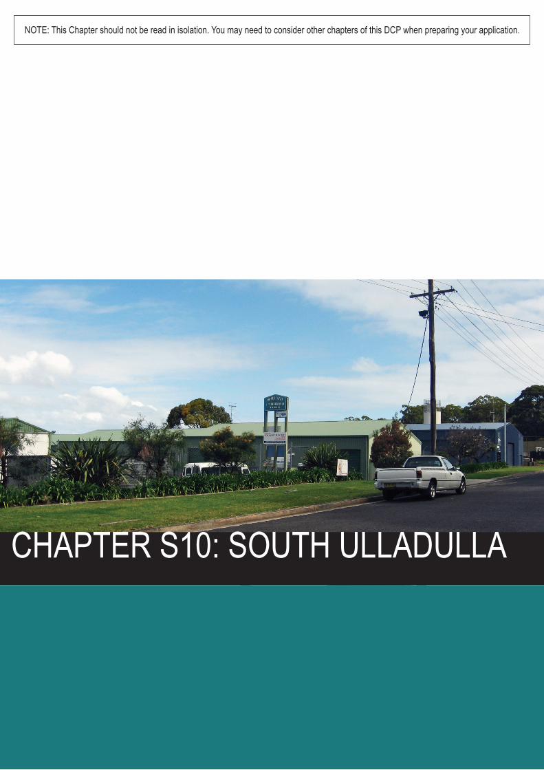
CHAPTER S10: SOUTH ULLADULLA
Shoalhaven Development Control Plan 2014
Chapter S10: South Ulladulla
Page | 1
Chapter S10: South Ulladulla
Contents
1 Purpose ........................................................................................................................ 3
2 Application .................................................................................................................... 3
3 Context ......................................................................................................................... 4
4 Objectives ..................................................................................................................... 4
5 Controls ........................................................................................................................ 4
5.1 Suitable Land Uses ................................................................................................. 4
5.1.1 Objectives ........................................................................................................ 5
5.1.2 Design Solutions .............................................................................................. 5
5.2 Building Form: Height and Setbacks ....................................................................... 5
5.2.1 Objectives ........................................................................................................ 6
5.2.2 Height of buildings ............................................................................................ 6
5.2.3 Setbacks .......................................................................................................... 6
5.3 Architectural Design ................................................................................................ 7
5.3.1 Objectives ........................................................................................................ 7
5.3.2 Design solutions ............................................................................................... 7
5.4 Vehicle Access, Servicing and Car Parking ............................................................ 8
5.4.1 Objectives ........................................................................................................ 9
5.4.2 Design solutions ............................................................................................... 9
5.5 Stormwater Management ..................................................................................... 10
5.5.1 Objectives ...................................................................................................... 10
5.5.2 Design solutions ............................................................................................. 10
5.6 Site Contamination ............................................................................................... 11
5.6.1 Objectives ...................................................................................................... 11
5.6.2 Design solutions ............................................................................................. 11
5.7 Utility Services ...................................................................................................... 12
5.8 Open Space and Landscaping ............................................................................. 12
5.8.1 Objectives ...................................................................................................... 12
5.8.2 Design solutions ............................................................................................. 12
6 Advisory Information ................................................................................................... 16
6.1 Other legislation or policies you may need to check ............................................. 16
Shoalhaven Development Control Plan 2014
Chapter S10: South Ulladulla
Page | 2
Figures
Figure 1: Subject Land Map ................................................................................................. 3 Figure 2: Bulky Goods Precinct ......................................................................................... 14 Figure 3: Fringe Commercial Industrial Precinct ................................................................ 15
Diagrams Diagram 1: Setbacks............................................................................................................ 7 Diagram 2: Vehicle Access Servicing and Parking ............................................................ 10
Amendment history
Version Number Date Adopted by Council Commencement Date Amendment Type
1 14 October 2014 22 October 2014 New
2 23 June 2015 1 July 2015 Amendment
Shoalhaven Development Control Plan 2014
Chapter S10: South Ulladulla
Page | 3
1 Purpose
The purpose of this chapter is to:
Ensure that development is designed to effectively use limited industrial land;
Enhance the southern entrance to the Ulladulla central business district; and
Ensure that development does not conflict with the Ulladulla retail centre
2 Application
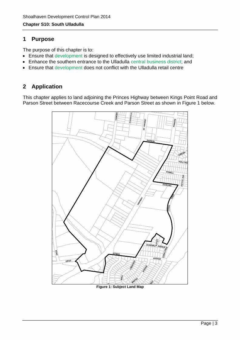
This chapter applies to land adjoining the Princes Highway between Kings Point Road and Parson Street between Racecourse Creek and Parson Street as shown in Figure 1 below.
Figure 1: Subject Land Map
Shoalhaven Development Control Plan 2014
Chapter S10: South Ulladulla
Page | 4
3 Context
The desired future character for this area is:
An attractive entrance to the Ulladulla Town Centre with well-designed developments located within an attractive landscaped setting.
A vibrant business centre which acknowledges its visual access to the highway but respects the need for traffic safety, the long term efficiency of the Princes Highway and the viability of the Ulladulla retail centre.
Development which takes into consideration the principles of ecologically sustainable development consistent with the land uses.
4 Objectives
The objectives are to encourage development which: i. Maintains the efficiency of the Princes Highway by reducing the number of
driveways having direct access to the highway. ii. Does not conflict with the predominance of the Ulladulla retail centre. iii. Provides for customer and employee cap parking on the site of that
development. iv. Allows traffic movements to and from the Princes Highway that are safe and
convenient for vehicles, cyclists and pedestrians. v. Provides landscaping at a height and density that softens the development from
the Princes Highway and which may include planting on the Princes Highway footpath reserve.
vi. Is environmentally sensitive, acknowledges the biodiversity of the area, contributes in a positive manner to the quality and character of the landscape and is appropriate for the land use.
vii. Ensures that storm water management is designed to have not net impact on any receiving waters.
viii. Minimises waste products and encourages recycling where possible.
5 Controls
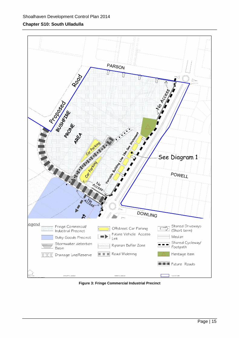
In addition to the controls mentioned in this section, you should also refer to the maps in Figures 2 and 3 at the end of this chapter for supplementary controls.
Note: In addition to the provisions outlined in this chapter, other environmental considerations must be addressed in your development application. Specifically a bushfire risk assessment in accordance with Planning for Bushfire Protection 2006 and consideration of other environmental factors as mapped in Shoalhaven LEP 2014.
5.1 Suitable Land Uses
Council intends to create a bulky goods precinct for the Milton Ulladulla area which supplements the Ulladulla retail centre and provides a range of goods which by their
Shoalhaven Development Control Plan 2014
Chapter S10: South Ulladulla
Page | 5
nature require good visual accessibility, large sites for display, manoeuvring for large service vehicles and customer collection. It is also intended to provide for other forms of commercial and light industrial activities that would normally be located on the fringe of the central business district. Land on the eastern side of the highway is identified for tourist and visitor accommodation and infrastructure.
5.1.1 Objectives
To ensure that Ulladulla’s town centre continues to act as the primary shopping destination for shopping trips.
To ensure that activities are compatible with the objectives of the B5 Business Development and IN2 Light Industrial zones.
5.1.2 Design Solutions
General To maintain the integrity of the zones, any extension or rebuilding of an existing dwelling should be limited. Complete or substantial demolition of dwellings for replacement with a new single dwelling will not be supported unless applied for under existing use rights. Fringe commercial and light industrial precinct Light industrial uses should be located to the rear of sites which front onto the Princes Highway. Lot consolidation You may be required to consolidate lots to facilitate orderly redevelopment and optimise all development opportunities identified in this chapter.
Note: In preparing your application, you should consider Clause 7.6 Riparian land and watercourses of the Shoalhaven LEP 2014 if your site is within 50m of the top of the bank of a watercourse. You should also consider the provisions of Planning for Bushfire Protection and the Building Code of Australia for bushfire and building requirements.
5.2 Building Form: Height and Setbacks
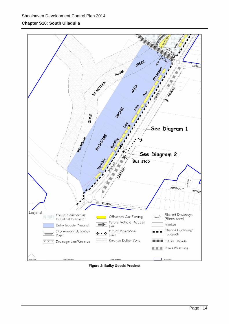
Most buildings in the South Ulladulla area are either single or two-storey construction. Building heights and setback controls are designed to ensure that this precinct maintains a compatible scale to the rest of the town and its natural surroundings (including natural watercourses and bushfire risk). In the bulky goods precinct, setbacks are designed to provide flexibility through a variable building line. These setbacks will also allow for the future connection of off-street car parks and improved visibility to showroom displays.
Shoalhaven Development Control Plan 2014
Chapter S10: South Ulladulla
Page | 6
5.2.1 Objectives
To retain an appropriate scale of development that is in keeping with the future character of the area.
To encourage development of a height and mass that creates a visually attractive streetscape, and minimises and recognises the impact on adjacent development and future land use potential.
To reinforce the role of the Princes Highway as the gateway to the Ulladulla Shopping Centre,
To establish building setbacks that: o Allow for the safe and efficient access to the site; and o Achieve car parking requirements that do not encroach on the public domain.
Minimise the risk to development from the risk of bushfire and flooding.
5.2.2 Height of buildings
Bulky Goods/Fringe Business/Light Industrial Area Maximum height of buildings are as shown on the Shoalhaven LEP (SLEP) 2014 Height of Buildings map, however, development is limited to two storeys behind the 18 metre building line, while development forward of the building line (Transitional zone) is limited to two storeys. Tourist Accommodation Area Maximum height of buildings are as shown on the SLEP 2014 Height of Buildings map.
Note: Architectural roof features may exceed the maximum height of buildings as per Clause 5.6 of the SLEP 2014.
5.2.3 Setbacks
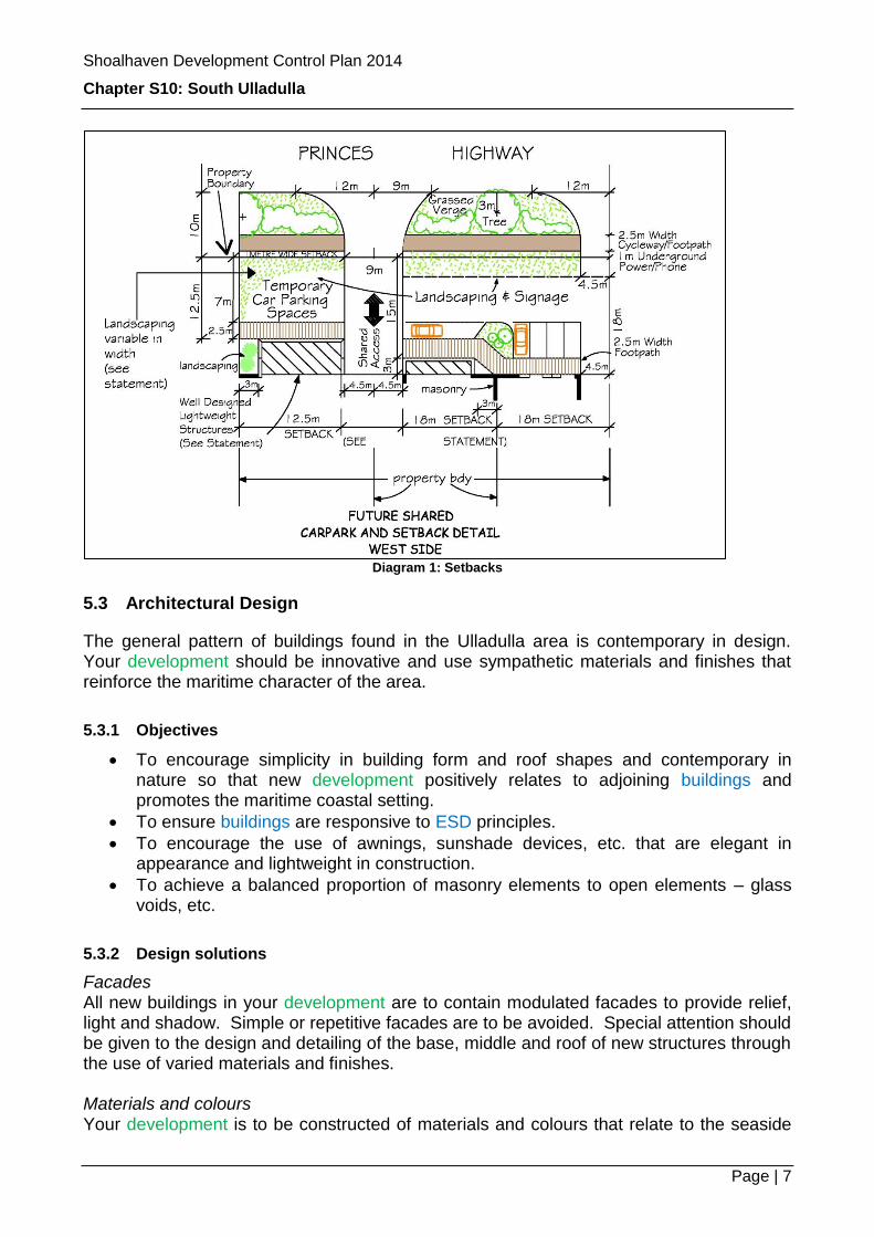
Setbacks determine how a building is placed on a site. In the bulky goods precinct setbacks are designed to provide flexibility through a variable building line. At the same time setbacks will allow for the future connection of off-street car parks and improved visibility to showroom displays. Furthermore development will need to protect the riparian zone associated within the natural watercourse and address bushfire risks. Bulky Goods/Fringe Business/Light Industrial Area Your development is to have a front setbacks of a minimum 18m as measured from the front boundary of the property adjacent to the Princes Highway (west side). You may be able to reduce the front setback to 12.5m where you can demonstrate that the building mass and bulk of the main structure will be reduced through the addition of a lightweight structure e.g. showroom or office. See Diagram 1 below. Tourist Accommodation Area (east of Highway) If your lot has frontage to the Princes Highway, your development is to be setback 10m (after road widening) from that frontage.
Shoalhaven Development Control Plan 2014
Chapter S10: South Ulladulla
Page | 7
Diagram 1: Setbacks
5.3 Architectural Design
The general pattern of buildings found in the Ulladulla area is contemporary in design. Your development should be innovative and use sympathetic materials and finishes that reinforce the maritime character of the area.
5.3.1 Objectives
To encourage simplicity in building form and roof shapes and contemporary in nature so that new development positively relates to adjoining buildings and promotes the maritime coastal setting.
To ensure buildings are responsive to ESD principles.
To encourage the use of awnings, sunshade devices, etc. that are elegant in appearance and lightweight in construction.
To achieve a balanced proportion of masonry elements to open elements – glass voids, etc.
5.3.2 Design solutions
Facades All new buildings in your development are to contain modulated facades to provide relief, light and shadow. Simple or repetitive facades are to be avoided. Special attention should be given to the design and detailing of the base, middle and roof of new structures through the use of varied materials and finishes. Materials and colours Your development is to be constructed of materials and colours that relate to the seaside
Shoalhaven Development Control Plan 2014
Chapter S10: South Ulladulla
Page | 8
environment and give a lightweight contemporary feel. Where your development has large expanses of walls, these should be a neutral or earth tone colour with brighter colours used for trim detail and decorative architectural elements. You will need to justify any variation to this approach. Wall Cladding Wall cladding should be a combination of rendered masonry and lightweight flat sheet products including timber Hardiplank®/plywood, metal or glass. Masonry surfaces should not dominate over other external surfaces. Roofs Roofs should be of pre-coloured materials and have a corrugated profile or similar. Shutters You are not permitted to use block out roller shutters on ground floor windows having frontage to a public road (75% permeability is required) as the blank frontage detracts from the quality and interest of the streetscape. Air conditioning You are to inconspicuously locate air conditioning units, fans, stacks and hoods etc. Concrete slabs Your development must not have concrete floor slabs visible on the external face of a building. Parapets The parapets of new buildings should relate to the building function and structure and not merely decorate the building. Enclosed structures Enclosed structures in front of the 18 metre building line in the Bulky Goods Precinct are to have variable roof pitches. The wall area located in front of the building line should be constructed as 40% brick and 60% of variable materials with an emphasis on glass, or to have open sides. Tourist accommodation The multi dwelling housing provisions contained in Chapter G14: Other Residential Accommodation of this DCP should be used as a guide.
5.4 Vehicle Access, Servicing and Car Parking
Bulky goods retailing and fringe commercial development will have adequate and visible car parking from any public street. Service vehicles will be able to enter the site safely from any major road and leave the sire in a forward direction. The ability to connect car parking spaces forward of the front building lines is an important provision for long term efficient access to the Princes Highway. This chapter also requires a central car parking facility and alternative access to the highway for commercial and light industry north of the proposed road connection to St Vincent Street.
Shoalhaven Development Control Plan 2014
Chapter S10: South Ulladulla
Page | 9
5.4.1 Objectives
To provide convenient, accessible and safe car and bicycle parking.
To ensure the provision of off street car parking is designed and located to satisfy the needs of occupants, customers and visitors, including people with disabilities.
To encourage the design of vehicle access and parking facilities to integrate with overall site planning and landscaping design to minimise their visual impact.
To ensure that adequate provision is made for loading and unloading facilities.
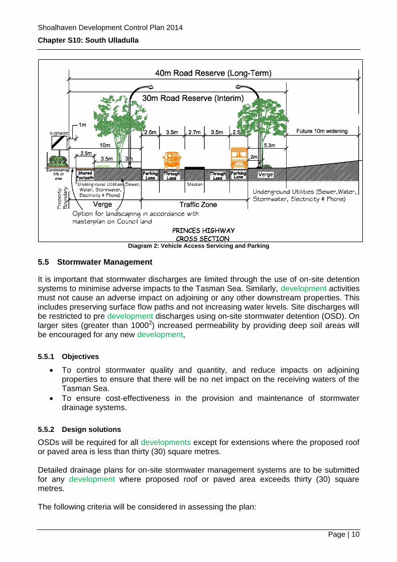
Note: Refer to Diagram 2 below.
5.4.2 Design solutions
Car parking All car parking is to comply with Chapter G21: Car Parking and Traffic, however, where there is a discrepancy between these provisions and that chapter, then these provisions will prevail. The surface and slope of driveways and parking areas should facilitate stormwater infiltration on site where possible and are to be suitably landscaped. Large areas of concrete surfaces, coloured or uncoloured, are to be avoided. Access If your lot fronts onto the Princes Highway and has a width of 25 metres or less, you are encouraged to share access with an adjoining lot. Limited access will be available to any development having frontage to the east side of the Princes Highway. Easements for access in favour of Council may be required for any development that required shared access by one or more adjoining parties to off-street car parking or where shared driveways are required to the Princes Highway. Corner lots If your property is a corner lot, you may be required to dedicate splay corners for road widening purposes to improve sight distances at intersections. Splays will generally be 3m x 3m.
Shoalhaven Development Control Plan 2014
Chapter S10: South Ulladulla
Page | 10
Diagram 2: Vehicle Access Servicing and Parking
5.5 Stormwater Management
It is important that stormwater discharges are limited through the use of on-site detention systems to minimise adverse impacts to the Tasman Sea. Similarly, development activities must not cause an adverse impact on adjoining or any other downstream properties. This includes preserving surface flow paths and not increasing water levels. Site discharges will be restricted to pre development discharges using on-site stormwater detention (OSD). On larger sites (greater than 10002) increased permeability by providing deep soil areas will be encouraged for any new development,
5.5.1 Objectives
To control stormwater quality and quantity, and reduce impacts on adjoining properties to ensure that there will be no net impact on the receiving waters of the Tasman Sea.
To ensure cost-effectiveness in the provision and maintenance of stormwater drainage systems.
5.5.2 Design solutions
OSDs will be required for all developments except for extensions where the proposed roof or paved area is less than thirty (30) square metres. Detailed drainage plans for on-site stormwater management systems are to be submitted for any development where proposed roof or paved area exceeds thirty (30) square metres. The following criteria will be considered in assessing the plan:
Shoalhaven Development Control Plan 2014
Chapter S10: South Ulladulla
Page | 11
The downstream capacity and need for stormwater detention and reuse.
The scope for on-site infiltration of water.
The minimisation of detrimental impacts on existing water balance and quality.
The sustainability and maintenance needs of the stormwater system.
The safety of pedestrians and vehicles.
Emergency spillways and/or overland flow paths. Surface flow paths are to be preserved, or alternatives provided, wherever they pass through or affect the development site. Site discharges are not to be concentrated to a degree greater than that which naturally occurs. Flow paths are to be retained within easements. All stormwater drainage connected to Council’s drainage system shall be by gravity means.
Note: Further controls for stormwater management can be found in Chapter G2: Sustainable Stormwater Management and Erosion/Sediment Control.
5.6 Site Contamination
Contaminated land means a building or place that is affected by a chemical or any other waste, and is:
Unsafe or unfit for occupation by persons or animals,
Has reduced capacity to support vegetation,
Otherwise environmentally degraded.
5.6.1 Objectives
To ensure that the redevelopment of contaminated or potentially contaminated land does not pose a risk to public health or the environment.
5.6.2 Design solutions
Development applications for sites that are contaminated or potentially contaminated must demonstrate:
The suitability of the site to accommodate the intended use(s) without posing a risk to public health or the environment; and
Any measures necessary to develop the site will not pose a risk to public health or the environment.
Note: Further controls for site contamination can be found in Council’s Contaminated Land Policy.
Shoalhaven Development Control Plan 2014
Chapter S10: South Ulladulla
Page | 12
5.7 Utility Services
As part of your development, you are to provide for the undergrounding of electricity and telephone services within the boundary of your site. Any extension of supply shall be placed underground at the applicant’s expense. You are to locate and design site and waste facilities to have an attractive visual appearance that complements the townscape character when viewed from a public street or place.
5.8 Open Space and Landscaping
Adequate landscaped open space is to be provided for any development to maintain the future desired character of the area. The provision of on-site landscaping plays an important part in integrating a development into the desired streetscape for the area. High quality landscaping is encouraged throughout the City.
5.8.1 Objectives
To enhance the appearance, amenity and energy efficiency of new development through landscape design and the provision of appropriate trees and shrubs.
To integrate onsite landscape works with landscaping within the public footpath domain.
Maximise solar access.
5.8.2 Design solutions
Open Space All landscaping is to minimise site disturbance and contribute to energy efficiency and amenity. You can achieve this by providing:
Summer shade and winter sun, especially to north facing elevations; and
Private open space; and
Car parking for both employees and the public. Any landscaping that is forward of the front building line is to be an average width of three metres, of which one metre of the public footpath area may be utilised in achieving total requirements.
Note: Any planting within the public footpath area is to be in accordance with the Council designed landscape master plan for this area.
The shared cycleway/footpath on the western side of the highway - as indicated in Figures 2 and 3 below - shall be constructed in coloured concrete (light grey) to a width of 2.5 metres and located 1 metre from the front property boundary. Landscaping should not obstruct the use of this facility.
Note: Should the cycleway be relocated to the eastern side of the highway, provision is to be made for a 1.5
Shoalhaven Development Control Plan 2014
Chapter S10: South Ulladulla
Page | 13
metre footpath, and the areas available for landscaping may be increased to 2 metres as measured from the front property boundary and the footpath.
Street Trees Any street tree planting should be in accordance with Council’s landscape master plan. Landscaping Works Landscaping is to be provided to 5% of the area between the building line and the front property boundary. Any landscaping provided within the road reserve is to be in accordance with Council’s landscape master plan.
Shoalhaven Development Control Plan 2014
Chapter S10: South Ulladulla
Page | 14
Figure 2: Bulky Goods Precinct
Shoalhaven Development Control Plan 2014
Chapter S10: South Ulladulla
Page | 15
Figure 3: Fringe Commercial Industrial Precinct
Shoalhaven Development Control Plan 2014
Chapter S10: South Ulladulla
Page | 16
6 Advisory Information
6.1 Other legislation or policies you may need to check
Note: This section is not exclusive and you may be required to consider other legislation, policies and other documents with your application.
Council Policies
& Guidelines
Shoalhaven City Council Contaminated Land Policy
Contribution Plan
External Policies
& Guidelines
Nil
Legislation Shoalhaven Local Environmental Plan 2014
State Environmental Planning Policy No. 71 – Coastal Protection