Embed Size (px)
Citation preview

The Study on Comprehensive Water Management of Musi River Basin in the Republic of Indonesia
Main ReportFinal Report
CHAPTER 7
COMPREHENSIVE WATER MANAGEMENT MASTER PLAN
7.1 Component 1: Water Use Management
7.1.1 Identification of Programs and Objective
Overview
PROPENAS 2000-2004 has formulated five development priorities. Of these, closely related to the present master plan is; accelerating economic recovery and strengthening the foundation of sustainable and fair development on the basis of the people’s economic system. PROPENAS stipulates that this aim can be realized only with the management of natural resources, which ensures the preservation of the supporting capacity of the environment and the conservation of natural resources.
In line with PROPENAS, Strategic Planning of Water Resources Development 2000-2004, Water Resources Service (Dinas PUP) of South Sumatra Province, describes the water resources should always be protected, conserved and maintained by realizing comprehensive management that ensures sustainable development. One of the goals of water resources development is to support stabilization of the rice self-reliance.
If water resources utilization proceeds out of control, it results in environmental damage and degradation of water resources, which ultimately reduces the supporting capacity of the environment and resources, thus endangering the implementation of sustainable development.
Identified Issues of Water Use Management
Many problems are raised in answers to the questionnaire survey, etc. According to diagnosis of these problems from the viewpoint of water use management, major issues to be solved are identified, as follows:
Water Supply to Wide Area
Each PDAM supplies potable water for domestic purpose, including small industrial purposes, etc. However, quantity and quality of supplied water are not sufficient. In addition, there still remain numbers of urban and rural inhabitants who cannot receive portable water supply services. This issue is to be solved mainly from the viewpoint of basic human needs.
Necessity of Sustainable Irrigation and Swamp Development
Irrigation and swamp development is necessary in order to achieve the stable self-reliance of rice and food security at provincial and national level, as well as to realize sustainable regional development. This issue is to be solved in a sustainable way,
JICA CTI Engineering International Co., Ltd. NIKKEN Consultants, Inc.
117
Main Report Final Report
The Study on Comprehensive Water Management ofMusi River Basin in the Republic of Indonesia
namely, be developed with the water resources management that ensures the preservation of the supporting capacity of the environment and the conservation of water resources.
Water Supply to Transmigration Farmers in Tidal Swamp Area
Living environment of the transmigration farmers in tidal swamp area is undesirable mainly because of difficulties of obtaining drinking and cooking water. This issue is to be solved from the viewpoint of basic human needs.
Conflict between Aquaculture and Irrigation Water Uses
Aquaculture in paddy fields experiences severe conflicts with irrigation. Irrigation water cannot reach to the downstream of irrigation system due to aquaculture. On the other hand from aquaculture side, quantity and quality of water is not stable due to irrigation. This issue should be solved in order to realize equitable and sustainable regional development.
Enhancing Water Utilization for Tourism
Dinas PUP, South Sumatra Province has an intension to utilize water resources to support the tourism development, like canal network improvement at Karang Anyar. However, utilization of river water is difficult because of flow regimes, etc. This issue should be solved in order to realize balanced and sustainable regional development.
Necessity of Water Management Model
It is difficult to manage water resources in a comprehensive way, because the system is highly complex. This issue should be solved in order to achieve sustainable development with conservation of environment in the whole Musi River Basin.
Objectives of Water Use Management
Considering the identified issues, provincial strategies and super goal, the following objectives of the water use management are identified as: (1) Promote water utilization for basic human needs; (2) Promotion of water utilization for sustainable development; and, (3) Development of water management system.
7.1.2 Evaluation of Major On-going and In-coming Irrigation Development Projects
Three on-going and in-coming irrigation projects, namely Komering, Lakitan and Temedak Irrigation Projects, have been evaluated from the viewpoint of water resources development as a basis of water management planning. Using projected 2020 water uses for sectors other than irrigation and swamp as discussed in Sub-Section 3.9.4, water balance analysis has been carried out in order to confirm their 80% dependability, which is the standard method for planning irrigation development in Indonesia. In the dependability confirmation, considerable water deficits (annual deficits more than 10%
118 JICA CTI Engineering International Co., Ltd. NIKKEN Consultants, Inc.

The Study on Comprehensive Water Management of Musi River Basin in the Republic of Indonesia
Main ReportFinal Report
of annual total irrigation demand) are counted, because water deficits can be controlled to some extent by adjusting cropping pattern.
Komering Irrigation Project
Stage I and Stage II (Phase 1 & 2)
New irrigation development of 63,058ha (Stage I 20,968ha and Stage II 42,090ha) has been evaluated. As a result, dependability of the development has been estimated at more than 80%, meaning this development is possible from the viewpoint of water resources, by the water supply from Lake Ranau (254 mcm):
Stage III
New irrigation development under Stage III is 57,600ha (13,100ha in South Sumatra Province and 44,500ha in Lampung Province). Water resources for this development are planned as: Komering I Dam (120 million m3), Komering II Dam (40 million m3) and Muaradua Dam (150 million m3). Stage III is expected for feasibility study. By this feasibility study, topological, geological and socio-economical data of those dam/reservoir sites are to be collected. Without these data, evaluation of this development is not possible.
Lakitan Irrigation Project
New irrigation development (13,950ha) of Lakitan Irrigation Project is evaluated, and its dependability has been estimated at more than 80%.
Temedak Irrigation Project
New irrigation development (5,000ha) of Temedak Irrigation Project has been evaluated under the presence of Musi Hepp with whose dependability at more than 80%.
7.1.3 Potential Irrigation and Swamp Area
Method of Potential Irrigation and Swamp Area Estimation
Potential land mentioned in Sub-Section 3.9.5 Potential Land Resources are allocated to each sub-basin based on the ratio of its basin area to that of regency/municipality. Three on-going and in-coming irrigation projects as discussed above were included in potential land.
Using these potential lands and projected 2020 water uses, water balance has been carried out to estimate the dependability of agricultural development. In the water balance, diversion at Randu from the Komering River to the Organ River was not considered because a weir is to be constructed at the diversion site. Determination procedure of potential irrigation and swamp area at each sub-basin is as follows:
(1) Give potential areas with double cropping.
JICA CTI Engineering International Co., Ltd. NIKKEN Consultants, Inc.
119

Main Report Final Report
The Study on Comprehensive Water Management ofMusi River Basin in the Republic of Indonesia
(2) If dependability is less than 80% (using considerable deficits), some double
cropping area is simply changed to single cropping by try and error.
(3) If dependability is still less than 80%, areas of swamp, communal and/or simple irrigation are reduced by try and error.
(4) If dependability is still less than 80%, semi-technical irrigation area is reduced by try and error
(5) Potential development areas are determined, if dependability becomes over 80%
Potential Irrigation and Swamp Area
Based on the study, the potential areas in the Basin are summarised, as shown in Table 7.1.1. Consequently, potential area of technical irrigation becomes 137,500ha, which is greater than the land potential for technical irrigation, 70,400ha. This increase comes from the developments of Komering, Lakitan and Temedak Irrigation Projects.
Table 7.1.1 Potential Irrigation and Swamp Area in the Basin Potential Irrigation and Swamp Area (ha) Irrigation Type Potential Land
(ha) Double Cropping Single Cropping Total Technical 70,400 137,500 0 137,500 Semi Technical 61,500 40,100 0 40,100 Simple 25,000 18,300 0 18,300 Communal 189,200 106,800 0 106,800 Non-tidal 321,700 167,900 62,300 230,200 Tidal 264,000 220,700 43,300 264,000 Total 931,800 691,300 105,600 796,900
Water Use of Potential Irrigation and Swamp Area
Water requirements for the potential irrigation area and potential swamp area have been estimated at 11,668.4 and 7,271.6, respectively in mcm/year with a total of 18,940.0. Based on this water balance, ratio of water use, under potential irrigation and swamp area and other projected 2020 consumptive water uses, is estimated, as follows:
(1) Potential Water Use (mcm/year): 21,760(2) Water Deficit: 866(3) Water Use: (1)–(2) 20,894(4) Potential Surface Water: 73,700(5) Water Use Ratio: (3)/(4) 28%
7.1.4 Potential Irrigation and Swamp Development and Rice Self-Reliance
Self-Reliance Circumstances of Rice
Indonesia achieved self-reliance of rice in 1984 by the introduction of high yield varieties and irrigation development. However, recent urbanization and industrialization around large cities have resulted in the decrease of productive paddy fields. On the other hand, the demand for rice has increased in accordance with the
120 JICA CTI Engineering International Co., Ltd. NIKKEN Consultants, Inc.
The Study on Comprehensive Water Management of Musi River Basin in the Republic of Indonesia
Main ReportFinal Report
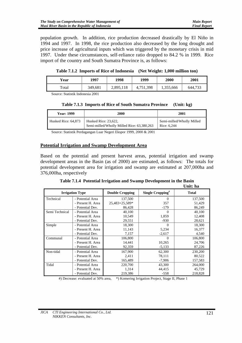
population growth. In addition, rice production decreased drastically by El Niño in 1994 and 1997. In 1998, the rice production also decreased by the long drought and price increase of agricultural inputs which was triggered by the monetary crisis in mid 1997. Under these circumstances, self-reliance ratio dropped to 84.2 % in 1999. Rice import of the country and South Sumatra Province is, as follows:
Table 7.1.2 Imports of Rice of Indonesia (Net Weight: 1,000 million ton)
Year 1997 1998 1999 2000 2001
Total 349,681 2,895,118 4,751,398 1,355,666 644,733 Source: Statistik Indonesia 2001
Table 7.1.3 Imports of Rice of South Sumatra Province (Unit: kg)
Year: 1999 2000 2001
Husked Rice: 64,873 Husked Rice: 23,622, Semi-milled/Wholly Milled Rice: 63,380,263
Semi-milled/Wholly Milled Rice: 6,244
Source: Statistik Perdagangan Luar Negeri Ekspor 1999, 2000 & 2001
Potential Irrigation and Swamp Development Area
Based on the potential and present harvest areas, potential irrigation and swamp development areas in the Basin (as of 2000) are estimated, as follows: The totals for potential development area for irrigation and swamp are estimated at 207,000ha and 376,000ha, respectively
Table 7.1.4 Potential Irrigation and Swamp Development in the Basin Unit: ha
Irrigation Type Double Cropping Single Cropping# Total
Technical - Potential Area - Present H. Area- Potential Dev.
137,500 25,483+25,589*
86,428
0 357
-179
137,500 51,429 86,249
Semi Technical - Potential Area - Present H. Area- Potential Dev.
40,100 10,549 29,551
0 1,859 -930
40,100 12,408 28,621
Simple - Potential Area - Present H. Area- Potential Dev.
18,300 11,143 7,157
0 5,234
-2,617
18,300 16,377 4,540
Communal - Potential Area - Present H. Area- Potential Dev.
106,800 14,441 92,359
0 10,265 -5,133
106,800 24,706 87,226
Non-tidal - Potential Area - Present H. Area- Potential Dev.
167,900 2,411
165,489
62,300 78,111 -7,906
230,200 80,522
157,583 Tidal - Potential Area
- Present H. Area- Potential Dev.
220,700 1,314
219,386
43,300 44,415
-558
264,000 45,729
218,828 #) Decrease: evaluated at 50% area, *) Komering Irrigation Project, Stage II, Phase 1
JICA CTI Engineering International Co., Ltd. NIKKEN Consultants, Inc.
121
Main Report Final Report
The Study on Comprehensive Water Management ofMusi River Basin in the Republic of Indonesia
Potential Development and Rice Self-Reliance
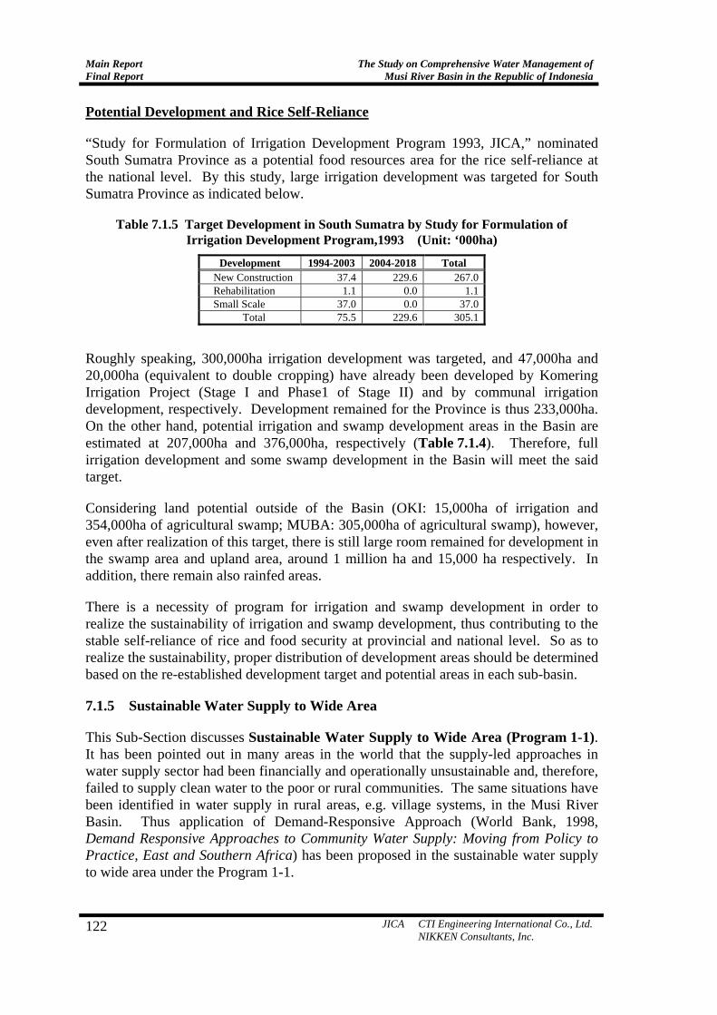
“Study for Formulation of Irrigation Development Program 1993, JICA,” nominated South Sumatra Province as a potential food resources area for the rice self-reliance at the national level. By this study, large irrigation development was targeted for South Sumatra Province as indicated below.
Table 7.1.5 Target Development in South Sumatra by Study for Formulation of Irrigation Development Program,1993 (Unit: ‘000ha)
Development 1994-2003 2004-2018 Total New Construction 37.4 229.6 267.0Rehabilitation 1.1 0.0 1.1Small Scale 37.0 0.0 37.0
Total 75.5 229.6 305.1
Roughly speaking, 300,000ha irrigation development was targeted, and 47,000ha and 20,000ha (equivalent to double cropping) have already been developed by Komering Irrigation Project (Stage I and Phase1 of Stage II) and by communal irrigation development, respectively. Development remained for the Province is thus 233,000ha. On the other hand, potential irrigation and swamp development areas in the Basin are estimated at 207,000ha and 376,000ha, respectively (Table 7.1.4). Therefore, full irrigation development and some swamp development in the Basin will meet the said target.
Considering land potential outside of the Basin (OKI: 15,000ha of irrigation and 354,000ha of agricultural swamp; MUBA: 305,000ha of agricultural swamp), however, even after realization of this target, there is still large room remained for development in the swamp area and upland area, around 1 million ha and 15,000 ha respectively. In addition, there remain also rainfed areas.
There is a necessity of program for irrigation and swamp development in order to realize the sustainability of irrigation and swamp development, thus contributing to the stable self-reliance of rice and food security at provincial and national level. So as to realize the sustainability, proper distribution of development areas should be determined based on the re-established development target and potential areas in each sub-basin.
7.1.5 Sustainable Water Supply to Wide Area
This Sub-Section discusses Sustainable Water Supply to Wide Area (Program 1-1). It has been pointed out in many areas in the world that the supply-led approaches in water supply sector had been financially and operationally unsustainable and, therefore, failed to supply clean water to the poor or rural communities. The same situations have been identified in water supply in rural areas, e.g. village systems, in the Musi River Basin. Thus application of Demand-Responsive Approach (World Bank, 1998, Demand Responsive Approaches to Community Water Supply: Moving from Policy to Practice, East and Southern Africa) has been proposed in the sustainable water supply to wide area under the Program 1-1.
122 JICA CTI Engineering International Co., Ltd. NIKKEN Consultants, Inc.
The Study on Comprehensive Water Management of Musi River Basin in the Republic of Indonesia
Main ReportFinal Report
JICA CTI Engineering International Co., Ltd. NIKKEN Consultants, Inc.
123
Objective, Program Area and Executing Agency
Objectives of the program are: (1) to formulate sustainable water supply plan to wide area; and (2) to promote physical and mental happiness of wider people by the plan. The program area is the whole Musi River Basin. The executing agency shall be Dinas PUP of South Sumatra Province, and PDAMs. PDAMs shall be responsible for implementation of the formulated plan.
Activities
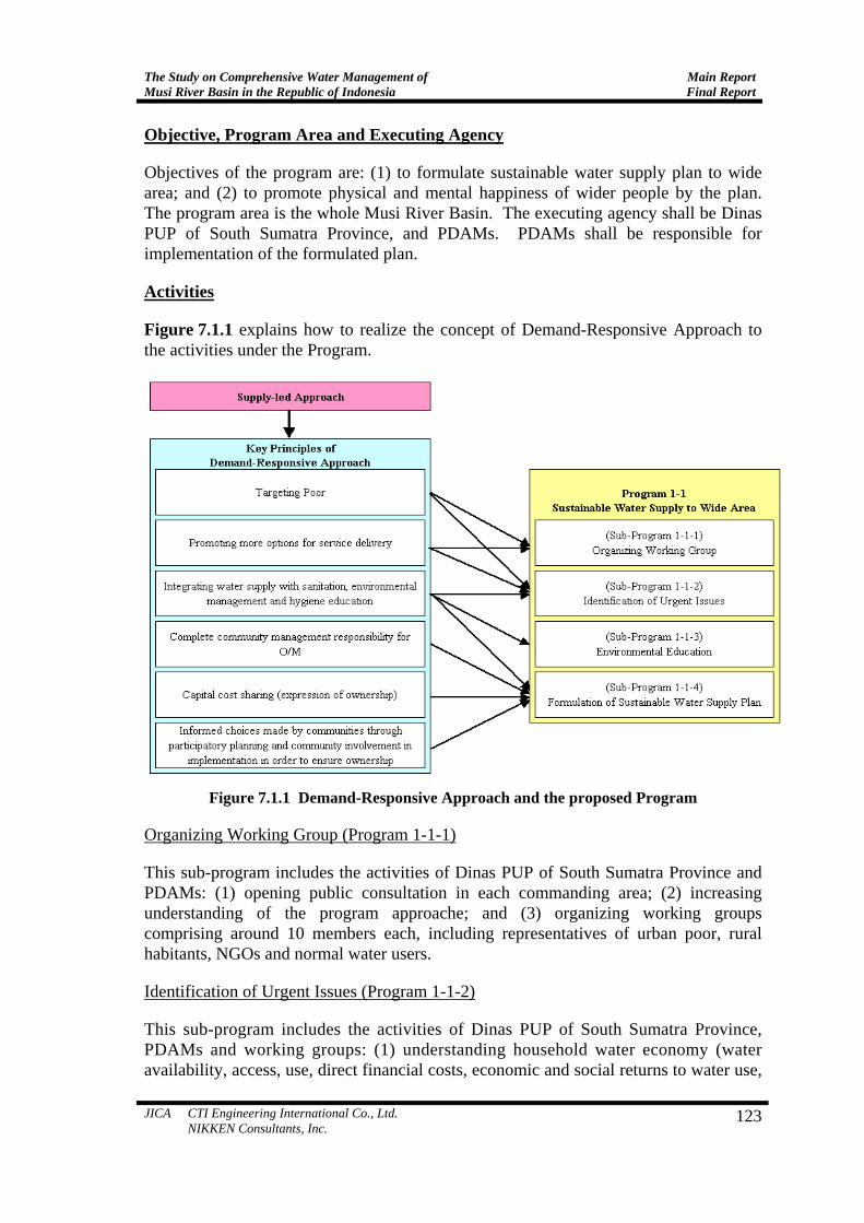
Figure 7.1.1 explains how to realize the concept of Demand-Responsive Approach to the activities under the Program.
Figure 7.1.1 Demand-Responsive Approach and the proposed Program
Organizing Working Group (Program 1-1-1)
This sub-program includes the activities of Dinas PUP of South Sumatra Province and PDAMs: (1) opening public consultation in each commanding area; (2) increasing understanding of the program approache; and (3) organizing working groups comprising around 10 members each, including representatives of urban poor, rural habitants, NGOs and normal water users.
Identification of Urgent Issues (Program 1-1-2)
This sub-program includes the activities of Dinas PUP of South Sumatra Province, PDAMs and working groups: (1) understanding household water economy (water availability, access, use, direct financial costs, economic and social returns to water use,
Main Report Final Report
The Study on Comprehensive Water Management ofMusi River Basin in the Republic of Indonesia
flexibility in household expenditure and labor availability, etc.); (2) identifying impacts of changes of water resources and for whom within and between households; (3) understanding relationship between water use and household poverty; and (4) identification of urgent and key issues.
Environmental Education (Program 1-1-3)
This sub-program includes the activities of Dinas PUP of South Sumatra Province, PDAMs and working groups: (1) understanding relationship between water supply, environmental management and public hygiene; and (2) formulating environmental and hygiene education program of how to change a way of life in order to improve their hygiene, etc.
Formulation of Sustainable Water Supply Plan (Program 1-1-4)
This sub-program includes the activities of Dinas PUP of South Sumatra Province, PDAMs and working groups: (1) identifying what intervention benefits which people and what cost; (2) identifying appropriate technological choices; (3) holding public consultation; and (4) formulating sustainable water supply plan to wider people including hygiene education program.
Cost and Beneficiaries
Program Cost
The following program cost should be burdened by the Dinas PUP.
• Plan formulation: 13 (person) × 18 (month) × 4 (day/month) × 150,000 (Rp./day) × 8 (PDAM) = Rp. 1,123.2 million
• PC: 100 (person/day) × 150,000 (Rp./day) × 2 (time) = Rp. 30 million
• Administration (5%): Rp. 57.7 million
• Total: Rp. 1,210.9 million
Beneficiaries
5.5 million rural and urban inhabitants in the Basin, who do not receive portable water supply (2000)
Implementation Schedule
Implementation period is 1.5 years.
7.1.6 Sustainable Irrigation and Swamp Development
This Sub-Section discusses on Sustainable Irrigation and Swamp Development (Program 1-2). “Study for Formulation of Irrigation Development Program, 1993, JICA” designated South Sumatra Province as a potential food resources area for the rice
124 JICA CTI Engineering International Co., Ltd. NIKKEN Consultants, Inc.

The Study on Comprehensive Water Management of Musi River Basin in the Republic of Indonesia
Main ReportFinal Report
self-reliance at the national level, giving 120% of the self-reliance rate of Zone 2 (South Sumatra, Jambi, Bengkulu and Lampung) and about 300,000ha of irrigation development in South Sumatra Province until 2018. The provincial goals of water resources development include supporting stabilization of the rice self-reliance.
In line with this context, this program, sustainable irrigation and swamp development, is proposed in order to promote stable self-reliance of rice and food security at provincial and national level. The development must be sustainable way, namely water resources utilization must proceed with control, ensuring the conservation of water resources and environment. Figure 7.1.2 shows concept flow of this sustainable development. In the concept flow, there are four main subjects, re-establishing development target, pre F/S, F/S and D/D.
In re-establishing development target (development area, target year, project location and investment cost, etc.) based on the Study for Formulation of Irrigation Development Program, the following viewpoint must be considered:
1st Round Public Consultation
Public Involvement
This Study: Potential Area in each Sub-Basin & Regency
Strategic Planning of Water Resources Development
D/D based on F/S
F/S based on Pre F/S
2nd Round Public Consultation
Pre F/S of Irrigation and Swamp Development based on Established Target through PC
Public Involvement
Re-establishing Development Target of the Province (Area, Year, Cost & Location)
Formulation of Irrigation Development Program, 1993, JICA
Sustenance of Self-sufficiency in Rice
Figure 7.1.2 Concept Flow of Sustainable Irrigation and Swamp Development
Potential Irrigation and Swamp Area
As a result of this Study, it has been concluded that full irrigation development and some swamp development in the Basin will meet the said 300,000ha of irrigation development. Potential development areas are summarized as follows:
Table 7.1.6 Potential Development Area in the Basin
Development Type Potential Development Area (ha in equivalent double cropping)
Technical 86,200 Semi Technical 28,600 Simple 4,540 Communal 87,200 Non-tidal 158,000 Tidal 219,000
JICA CTI Engineering International Co., Ltd. NIKKEN Consultants, Inc.
125

Main Report Final Report
The Study on Comprehensive Water Management ofMusi River Basin in the Republic of Indonesia
Figure 7.1.3 shows potential irrigation and swamp area, determined on the potential land and water resources, in each regency/municipality and sub-basin. The paddy demand is foreseeable based on the projected population and projection of per capita rice consumption, while the paddy supply depends upon the irrigation and swamp development speed determined by target year and target development area. Therefore, the target year, target development area and investment cost should be determined firstly by the national and provincial policies/intensions to food/rice security with mutual consent.
0
50,000
100,000
150,000
200,000
OKU OKI
Muaraenim LahatMURA
MUBAPalembang
Rejang L.
Regency / Municipality
(ha)
tidal
0
20,000
40,000
60,000
80,000
100,000
120,000
Musi1
Musi2
Musi3
Kelingi
Seman
gus
Lakita
n1
Lakita
n2M
usi4
Rawas1
Rawas2
Musi5
Harile
koM
usi6
Lemata
n1
Lemata
n2M
usi7
Ogan1
Ogan2
Komeri
ng1
Komeri
ng2M
usi8
Padan
g
Sub-Basin
(ha)
tidal
non-tidal
communal
simple
semi-tec
technical
non-tidal
communal
simple
semi-tec
technical
Figure 7.1.3 Potential Irrigation & Swamp Development Area by Regency and by Sub-basin
Objective, Program Area and Executing Agency
Objectives of the program are: (1) to promote stable self-reliance of rice and food security at provincial and national level; and (2) to carry out Pre F/S, F/S and D/D
126 JICA CTI Engineering International Co., Ltd. NIKKEN Consultants, Inc.
The Study on Comprehensive Water Management of Musi River Basin in the Republic of Indonesia
Main ReportFinal Report
aiming to realize sustainable irrigation and swamp development in South Sumatra Province.
Public consultation from the beginning stage of the irrigation and swamp development is indispensable based on Presidential Instruction N0.3/1999 (PKPI). The program area is South Sumatra Province. The executing agency shall be DGWR of Kimpraswil and Dinas PUP of South Sumatra Province. Related agencies shall be Provincial Government of Bengkulu, Jambi, and Lampung, and, regency and municipality governments in the Province.
Activities
Establishing Development Target of the Province (Program 1-2-1)
This sub-program includes the activities of DGWR and Dinas PUP: (1) determining target areas and year of irrigation and swamp development based on the results of this Study; (2) determining candidate locations for irrigation and swamp development; and (3) holding public consultation. Roles of communities, WUAs and local governments are important in the irrigation and swamp development. Public consultation will be held, mainly aiming at: providing community’s intension; participating in establishing development target and decision making; and, educating themselves on irrigation water conservation.
Implementation of Pre F/S (Program 1-2-2)
This sub-program includes the activities of DGWR and Dinas PUP: (1) preparation for Pre F/S; (2) executing Pre F/S; and (3) holding public consultation. Pre F/S will be carried out in order to clarify the irrigation and swamp development based on the established target. The scope of this pre F/S will include: survey on water, land and human resources; survey on soil conditions and cropping pattern; irrigation and drainage planning; natural and social environment; cost estimates and implementing schedule; and, economic and financial analysis.
Implementation of F/S (Program 1-2-3)
This sub-program includes the activities of DGWR and Dinas PUP: (1) Preparation for F/S; and (2) execution of F/S. F/S shall be carried out based on the Pre F/S. The scope of F/S shall include: supervision of sub-contracted work; collection and review of existing data and information; survey of project area (natural, socioeconomic and environmental condition); formulation of development plan; environmental study; formulation of implementation plan; cost estimation; and project evaluation.
Implementation of D/D (Program 1-2-4)
This sub-program includes the activities of DGWR and Dinas PUP: (1) Preparation for D/D; and (2) execution of D/D. D/D shall be carried out with the following scope:
JICA CTI Engineering International Co., Ltd. NIKKEN Consultants, Inc.
127

Main Report Final Report
The Study on Comprehensive Water Management ofMusi River Basin in the Republic of Indonesia
detail design and preparation of drawing; construction planning and cost estimates; and preparation of tender documents.
Cost and Beneficiaries
Program Cost
• Establishing Development Target: Establishment Rp. 13.5 million; PC Rp. 15 million; Administration Rp. 1.4 million; Total Rp. 29.9 million
• Pre F/S: Engineering Rp. 1,800 million; Administration Rp. 90 million; PC Rp. 10 million; Total 1,905 million
• F/S (for irrigation and swamp development area of 80,000ha): Engineering Rp. 16,000 million; Investigation Rp. 4,000 million; Administration Rp. 1,000 million; Total Rp. 21,000 million
• D/D (for the area of 80,000ha): Engineering (a) Rp. 45,000 million; Engineering (b) Rp. 18,000 million; Investigation Rp. 15,000 million; Administration Rp. 3.9 million; Total Rp. 81,900 million
• Total: Rp. 104,835 million
Beneficiaries
Direct, Basin population 6.9 million persons (2002); indirect, 206 million population of Indonesia (2000)
Implementation Schedule
Implementation period is 8.5 years.
7.1.7 Rainwater Utilization in Tidal Swamp Area
Rainwater Utilization in Tidal Swamp Area (Program 1-3) has been identified as follows: The rainwater (about 2,000 mm/year) will be stored during rainy season, and utilized for drinking and cooking during dry season. There are two facility alternatives of how to tap the rainwater, namely, individual water tank and communal rainwater pond. Based on the preliminary study, individual water tank is recommended because this method is already successfully practiced under afore-mentioned South Sumatra Swamp Improvement Project, JBIC.
With the rainwater storing facilities, only drinking and cooking water will be stored. Therefore, washing and bathing water will be still surface water. Under this situation, the focus is the water related diseases. Hence, sanitation facilities are necessary at the same time. Mostly, type of human waste disposal in the area is toilet on river/canal. Considering water conditions of the area, toilet with pit privy should be avoided because the pit is filled with water when tidal water is high. Therefore, septic tank should be designed to place on the ground.
128 JICA CTI Engineering International Co., Ltd. NIKKEN Consultants, Inc.

The Study on Comprehensive Water Management of Musi River Basin in the Republic of Indonesia
Main ReportFinal Report
Objective, Program Area and Executing Agency
Objectives of the program are: (1) to provide rainwater storing and sanitation facilities to transmigration farmers in tidal swamp area; and (2) to increase the physical and mental happiness of the farmers. The program areas shall be the tidal swamp area in South Sumatra Province. The executing agency shall be Dinas PUP of South Sumatra Province and Regency Governments of OKI, MUBA (new), and Banyuasin.
Activities
Preparation (Program 1-3-1)
This sub-program includes the activities of Regency Governments under the coordination of Dinas PUP: (1) surveying number of the target farmers, their present facilities of water supply and sanitation, and costs; and (2) opening public consultation.
Proving Rainwater Storing and Sanitation Facilities (Program 1-3-2)
This sub-program includes the activity of Regency Governments under the coordination of Dinas PUP: (1) providing one water tank and one septic tank to each subject household. Rainwater storing facilities (one polyethylene water tank, 3 m3) are to be provided to subject farm households to store rainwater during rain season, and use for drinking and cooking purposes during dry season. The function of the storing facilities is supplemental one because inhabitants possess some storing tanks already. Sanitation facilities (one septic tank placing on the ground) are to be provided to subject households in order to avoid water related diseases accrue from the surface water use for washing and bathing.
Cost and Beneficiaries
Program Cost
• Facilities: 2 million (water tank 1 mil; septic tank 1 mil) (Rp./HouseHold) × 92,000 (HH) = Rp. 184 billion: Oki (10%) 18.4; Muba (25%) 46; Banyuasin (65%) 119.6; Rp. billion, respectively.
• Preparation and Administration (8%): Rp. 14.7 billion: Province (1% of Facilities Cost) 1.8; Oki (10% of the rest) 1.3, Muba (25% of the rest) 3.2, Banyuasin (65% of the rest) 8.4, Rp. million, respectively.
• Total: Rp. 198.7 billion: Province 1.8; Oki 19.7; Muba 49.2; Banyuasin 128; Rp. billion, respectively.
Beneficiaries
Around 370,000 persons (92,000 households) in the tidal swamp area (2002) in former MUBA and OKI (mostly former MUBA)
JICA CTI Engineering International Co., Ltd. NIKKEN Consultants, Inc.
129
Main Report Final Report
The Study on Comprehensive Water Management ofMusi River Basin in the Republic of Indonesia
Implementation Schedule
Implementation period is 10 years.
7.1.8 Aquaculture Water Management
Aquaculture Water Management (Program 1-4) has been identified as follows: Aquaculture practiced in the Basin can be classified into fishpond, paddy field, fish cage and fence. The major issues relating water management occur in the aquaculture in fishpond located in paddy field especially in MURA, namely there are conflicts between aquaculture and irrigation. These conflicts are:
•
•
•
From irrigation side: irrigation water cannot reach to the downstream of irrigation system because the aquaculture use is not included in the scope of original system design.
From aquaculture side: quality and quantity of water are not stable due to the influence of irrigation.
From operational aspect: operation of checks and intake gates becomes complicated because their water use patterns are different.
Objective, Program Areas and Executing Agencies
Objectives of the program are: (1) to develop solving methods of conflicts between aquaculture and irrigation water uses; and (2) to realize equitable and sustainable regional development. In order to solve the conflicts, areas for aquaculture and irrigation are better to be separated from the viewpoint of water management, e.g., gate operation and farm conditions, etc. If land uses cannot be controlled, aquaculture areas are better to be gathered by reallocation or exchange of farm lots. Implementation of the program is to be carried out by regencies/municipalities. The program area shall be the whole Musi River Basin, and the executing agency shall be Water Resources Service, Agriculture Service, and Fishery Service of South Sumatra Province. Related agencies shall be Regency and Municipality Governments.
At present, conflicts between aquaculture and irrigation occur in the Basin. The following table shows present aquaculture areas:
Table 7.1.7 Present Aquaculture Area of Fishpond (ha)
OKU OKI Muaraenim Lahat MURA MUBA Palembang Pagaralam Prabumulih Rejang L. Total 3,550 164 409 1,552 703 275 29 169 12 545 7,408
Activities
Researching Solution Methods (Program 1-4-1)
This sub-program includes of the activities of Dinas PUP under the coordination with Agriculture and Estate Services of South Sumatra Province, Bengkulu Province, and
130 JICA CTI Engineering International Co., Ltd. NIKKEN Consultants, Inc.

The Study on Comprehensive Water Management of Musi River Basin in the Republic of Indonesia
Main ReportFinal Report
relevant Kabupatens and Kotas: (1) holding public consultation; (2) investigating situations of conflicts, including their background and history, locations, numbers of cases, land tenure system, etc.; and (3) surveying methods of reallocation or exchange of farm lots.
Disseminating of the Methods (Program 1-4-2)
This sub-program includes the activity of Dinas PUP: (1) disseminating the methods to regencies/municipalities.
Cost and Beneficiaries
Program Cost
• PC: 100 (person/day) × 150,000 (Rp./day) = Rp. 15 million
• Research and dissemination: 3 (person) × 24 (month) × 5 (day/month) × 150,000 (Rp./day) = Rp. 54 million
• Administration (5%): Rp. 3.5 million
• Total: Rp. 72.5 million
Implementation Schedule
Implementation period is 2 years.
7.1.9 Enhancing Water Utilization for Tourism
Enhancing Water Utilization for Tourism (Program 1-5) shall be as follows: Strategic Planning of Water Resources Development, South Sumatra Province, stipulates that the Government of South Sumatra Province develops and utilizes the water resources to support the developments of the superior sectors, including tourism sector. Being a highly labor-intensive industry, tourism is expected to make a significant contribution to the economies and significant role in generating employment opportunities to localities where it is promoted. There is therefore a need to enhance the water utilization for tourism for balanced and sustainable regional development in the Basin.
Objective, Program Area and Executing Agency
Objectives of the program are: (1) to support tourism development by promotion of water utilization; and (2) to realize balanced and sustainable regional development. The program area shall be the Musi River Basin (except Palembang because it has Karang Anyar Project already), and the executing agency shall be Dinas PUP of South Sumatra Province and Regency/Municipality Governments in the Basin.
JICA CTI Engineering International Co., Ltd. NIKKEN Consultants, Inc.
131

Main Report Final Report
The Study on Comprehensive Water Management ofMusi River Basin in the Republic of Indonesia
Activities
Survey, Investigation and Design (SID) (Program 1-5-1)
This sub-program includes the activities of Regency/Municipality Governments under the coordination of Dinas PUP: (1) opening public consultation; (2) selection of program site; (3) collection of natural, economical and social data including traffic and communication; and (4) SID of water network and financial analysis. Candidates of program sites are, as follows:
Table 7.1.8 Candidates of Tourism Resources for Program
Regency/ Municipality Candidates of the Program
OKU Ranau Lake, Bendali Rantau K OKI Teluk Gelam Lake, Lebung Karangan Muaraenim Gemuhak Hot Water, Segayam Lake Lahat Tepian Lematang, Ribang Gayau MURA Rayo Lake, Karya Sakti Hot Water MUBA (new) Sekayu Banyuasin Padang River Pagaralam Thebat Gheban, Lematang Water Fall Prabumulih Bunut Lake Rejang Lebong Talang Kering Lake, Air Sempiang Water Fall
Implementation (Program 1-5-2)
This sub-program includes the activities of Regency/Municipality Governments under the coordination of Dinas PUP South Sumatra Province with cooperation of Bengkulu Provincial Government: (1) implementation of Program; and (2) tourism education to society.
Cost and Beneficiaries
Program Cost
• SID and implementation: Rp. 5 billion (per site, assumed based on Karang Anyar) × 10 (sites) = Rp. 50 billion
• Administration (5%): Rp. Rp. 2,500 million: Province Rp. 250 million; Each Regency/Municipality Rp. 225 million
• Total: Rp. 52,500 million: Province Rp. 250 million; Each Regency/Municipality: Rp. 5,225 million
Beneficiaries
4.9 million population of South Sumatra Province (2001)
132 JICA CTI Engineering International Co., Ltd. NIKKEN Consultants, Inc.
The Study on Comprehensive Water Management of Musi River Basin in the Republic of Indonesia
Main ReportFinal Report
JICA CTI Engineering International Co., Ltd. NIKKEN Consultants, Inc.
133
Implementation Schedule
Implementation period is 5 years.
7.1.10 Modeling of Water Use Management
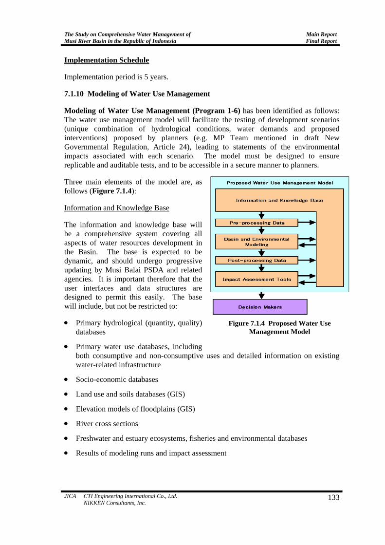
Modeling of Water Use Management (Program 1-6) has been identified as follows: The water use management model will facilitate the testing of development scenarios (unique combination of hydrological conditions, water demands and proposed interventions) proposed by planners (e.g. MP Team mentioned in draft New Governmental Regulation, Article 24), leading to statements of the environmental impacts associated with each scenario. The model must be designed to ensure replicable and auditable tests, and to be accessible in a secure manner to planners.
Three main elements of the model are, as follows (Figure 7.1.4):
Information and Knowledge Base
The information and knowledge base will be a comprehensive system covering all aspects of water resources development in the Basin. The base is expected to be dynamic, and should undergo progressive updating by Musi Balai PSDA and related agencies. It is important therefore that the user interfaces and data structures are designed to permit this easily. The base will include, but not be restricted to:
• Primary hydrological (quantity, quality) databases
• Primary water use databases, including both consumptive and non-consumptive uses and detailed information on existing water-related infrastructure
• Socio-economic databases
• Land use and soils databases (GIS)
• Elevation models of floodplains (GIS)
• River cross sections
• Freshwater and estuary ecosystems, fisheries and environmental databases
• Results of modeling runs and impact assessment
Figure 7.1.4 Proposed Water Use Management Model

Main Report Final Report
The Study on Comprehensive Water Management ofMusi River Basin in the Republic of Indonesia
Basin and Environmental Modeling
Containing the primary simulation models (hydrological, basin simulation and hydrodynamic models) and the secondary models (water quality, sediment and environment as required).
The hydrological model should have a strong conceptual and deterministic base, and should be a continuous simulation model, running on as long a period of homogeneous historical rainfall records as can be constructed. The model should be able to be run on daily time steps.
The basin simulation model will be the core of the Modeling. It is a tool through which the impacts of water resources developments, such as irrigation, hydropower, and wastewater discharge are synthesized on water availability and quality downstream. The model will permit integration of impacts from a wide variety of developments with complex or simple operational procedures. The model will be driven by inputs derived from observed stream-flow and data generated by the hydrological model. It is expected to run in a continuous simulation mode. It will represent the river system, major infrastructure, and diversions and return flows from uses from the main stream and its tributaries. The model will be demonstrated to be capable of modeling pollutant and sediment transport, albeit in a simplified manner. Multi-purpose reservoir simulations will be required, incorporating complex operational rules, and permitting synthesis of power production. Among other things, output from the model will include time series of river flows and quality at desired locations, reservoir operations, hydropower production, irrigation diversions and demands, and drainage returns.
The hydrodynamic model should extend from midstream include the river mouth delta and major swamp canals. The hydrodynamic model would be run with upstream inputs from the basin simulation and hydrological models. The hydrodynamic model will include water quality components. The model will include salinity, as saline intrusion is an impact of water resources development. Erosion/sedimentation, acidification and pollution are also important considerations.
Impact Assessment Tools
Most of the environmental and socio-economic impacts will be associated with the aquatic environment, and consideration must be given to the development of appropriate indicators, through which potential impacts can be captured. In line with this idea, tools for the determination and assessment of environmental and socio-economic impacts will be developed. The hydrodynamic model should provide primary data for development of the indicators. It will also be important to consider navigation requirements, and the potential impact of changes in flow on this.
Objective, Program Area and Executing Agency
Objectives of the program are: (1) to promote a mechanism to improve sustainable water management in the Basin; (2) to promote equitable and balanced water uses in the
134 JICA CTI Engineering International Co., Ltd. NIKKEN Consultants, Inc.
The Study on Comprehensive Water Management of Musi River Basin in the Republic of Indonesia
Main ReportFinal Report
Basin; and (3) to enhance conservation of environment of the Basin. The program is sublet to international consultants, and to contribute: (1) supporting decision making (not a substitute for decision making); (2) providing effective and replicable outputs; (3) transparent and flexible management; and (4) scenario management. The program area shall cover the whole Musi River Basin, and the executing agency shall be DGWR of Kimpraswil, and Dinas PUP of South Sumatra Province. Related agencies shall be Forestry Service of South Sumatra Province, Meteorological and Geophysical Agency (BMG) and Regional Technical Implementation Unit (UPTD).
Activities
Information and Knowledge Base Development (Program 1-6-1)
This sub-program includes: (1) review of relevant programs; (2) identify actual modeling needs and data requirement; (3) establishment of database structures, and computer and communication networks; (4) establishment of database access; (5) preparation of procurement packages; (6) information and knowledge base development; and (7) public consultation/workshop.
Basin Modeling Development (Program 1-6-2)
This sub-program includes: (1) hydrological review; (2) review of historic water resources development and water use; (3) review of available models; (4) design of modeling structure; (5) preparation of procurement packages; (6) development of models; and (7) workshop.
Environmental Analysis and Modeling (Program 1-6-3)
This sub-program includes: (1) identification of data needs; (2) tools for impact analysis; (3) environmental assessments; (4) scenario modeling and evaluation; and (5) workshop.
Cost and Beneficiaries
•
•
•
•
Engineering: 60 (m/m) × 200 (Rp. Million/m/m) = Rp. 12,000 million
Hardware, Software and Workshop: Rp. 900 million
Administration (5%): Rp. 645 million
Total: Rp. 13,545 million
Implementation Schedule
Implementation period is 2 years.
JICA CTI Engineering International Co., Ltd. NIKKEN Consultants, Inc.
135

Main Report Final Report
The Study on Comprehensive Water Management ofMusi River Basin in the Republic of Indonesia
No. Title I II III IV I II III IV I II III IV I II III IV I II III IV I II III IV I II III IV
Component 1: Water Use Management1-1 Sustainable water supply to wide area1-1-1 Organizing working group1-1-2 Identification of urgent issues1-1-3 Environmental education1-1-3 Formulation of sustainable water supply plan1-2 Sustainable irrigation and swamp development1-2-1 Establishing development target of the Province1-2-2 Implementation of Pre F/S1-2-3 Implementation of F/S1-2-4 Implementation of D/D1-3 Rainwater utilization in tidal swamp area1-3-1 Preparation1-3-2 Providing rainwater storing and sanitation facilities1-4 Aquaculture water management1-4-1 Researching solution methods1-4-2 Dissemination of the methods1-5 Enhancing water utilization for tourism1-5-1 SID1-5-2 Implementation1-6 Modeling of water use management1-6-1 Information and knowledge base management1-6-2 Basing modeling development1-6-3 Environmental analysis and modeling
6th Year 7th Year4th Year 5th YearPriority Program 1st Year 2nd Year 3rd Year
PreparationPreparation
Preparation
Figure 7.1.5 Implementation Plan of Water Use Management Programs
7.1.11 Selection of Priority Programs
Selection Criteria
Priority programs are selected based on the following category, and giving scores of high priority (score=5), middle (score=3) and low (score=1) for each category and sum up them: Prerequisite to Other Programs; Degree of Seriousness; Requirement of Early Start; and, Degree of Accelerating Economic Recovery of the Basin
Selection of Priority Programs
Scores of each program is determined using the criteria, as follows: Table 7.1.9 Score of Each Program
Program Pre-re quisite
Seriousness
Early Start
Accele- ration
Total Score
1-1 Sustainable Water S. to Wide Area 1 3 1 3 8 1-2 Sustainable I&S Development 5 3 3 5 16 1-3 Rainwater U. in Tidal Swamp Area 3 5 5 3 16 1-4 Aquaculture Water Management 3 5 5 3 16 1-5 Enhancing W. Utilization for Tourism 1 3 1 3 8 1-6 Modeling of Water Use Management 5 5 5 5 20
Based on the results, the following programs are selected as priority programs:
• • • •
Program 1-2: Sustainable Irrigation and Swamp Development Program 1-3: Rainwater Utilization in Tidal Swamp Area Program 1-4: Aquaculture Water Management Program 1-6: Modeling of Water Use Management
136 JICA CTI Engineering International Co., Ltd. NIKKEN Consultants, Inc.

The Study on Comprehensive Water Management of Musi River Basin in the Republic of Indonesia
Main ReportFinal Report
7.2 Component 2: Floodplain Management
7.2.1 Identification of Programs and Objectives
In the rainy season, the Musi River flows down in the wide floodplains along the Musi mainstream and major tributaries in the middle and downstream areas. Floodplains are important for the water resources because they serve for flood and erosion control, help maintaining high water quality, and contribute to sustaining groundwater supplies. Most of the floodplains in the Basin are swamp/marsh and tidal swamp rice fields. People’s lives in these areas are those fit to the natural phenomena of river inundation.
Topographically the portion of mountainous areas in the Musi River Basin is small, and it is rather difficult to find effective dam/reservoir sites to store water. Instead the basin has extensive natural retarding basins along the middle and lower reaches, serving for flood mitigation during rainy season and sustaining water supply during dry season for the lower basins including Palembang City.
Other issues of floodplain management in the Musi River Basin include those for flush floods in the mountainous areas and river bank erosion in the Musi mainstream and major tributaries. Thus the programs under the Component 2 have been identified as follows:
•
•
•
Floodplain Management
Flood Forecasting and Warning
Sustainable River Channel Management
The objectives of the Floodplain Management in the Musi River Basin are to maintain the original function of the river basin as well as to minimize damages by flooding and river to be in the basin.
7.2.2 Floodplain Management
Floodplain management should be considered as a program in a long span of 50-100 years, but it should be started before uncontrolled developments proceed in the floodplains. In this sense, Musi River Basin is still not yet late to start management, but coming ten years might affect greatly the future of the Basin. Floodplain management is applied in various countries as non-structure type measures of flood damage reduction (Annex H6.2.6). Floodplain management commonly includes flood damage mitigation (flood preparedness measures, emergency response measures, etc.), land use and zoning plans, flood forecasting and warning, disaster management (disaster reduction, flood fighting, etc.), etc. In order to maintain water-retarding function in floodplains, land use control and zoning are commonly applied. Of these, measures that are realistic in the Musi River Basin are zoning and land use control in the floodplains in the middle and lower basins, and flood warning and evacuation in the upstream flush flood areas.
JICA CTI Engineering International Co., Ltd. NIKKEN Consultants, Inc.
137
Main Report Final Report
The Study on Comprehensive Water Management ofMusi River Basin in the Republic of Indonesia
Existing Regulations
There exist the following laws and regulations for floodplains to be protected and conserved.
• • • •
•
•
Law No. 11/1974 (Water Resources)
Government Regulation No. 27/1991 (Swamps)
Government Regulation No. 35/1991 (Rivers)
Ministerial Regulation of Ministry of Public Works No. 63/PRT/1993 (River Channel, River Usage and Non-usage Areas, Old Unfunctional Rivers)
Ministerial Letter of Home Affairs No. 179/1996 (Organization Guidelines of Basin Water Resources Management Unit (Balai PSDA))
Presidential Letter No. 32/1990 (Protected Area Management)
Among others, the following are the declaration related to the floodplain management.
(1) Government Regulation No.27/1991 (Swamps)
In the Regulation, the followings are subject for conviction, namely, (i) to reclaim swamps and develop swamp reclamation channels without permission, (ii) to dump solid or suspended contaminants in or surrounding the swamp reclamation system.
(2) Ministerial Regulation of Ministry of Public Works No.63/PRT/1993 (River Channel, River Usage and Non-usage Areas, Old Unfunctional Rivers)
Ministerial Regulation defines river borders and decrees details of their utilization. River borders may not be used for: dumping of garbage, solid and suspended wastes, developing permanent buildings, houses, and commercial facilities. River borders with dike is at least 3 m (in urban areas) or 5 m (outside urban areas). River border without dikes is 10-30 m (in urban areas) or 50-100 m (outside urban areas). Tidal-influenced river border is at least 100 m and functions as green-belt.
River borders may not be used for: dumping of garbage, soil and suspended wastes, development of permanent buildings, houses, and commercial facilities. Land areas outside of authorized river areas may be used with permission from the government, users are subject to maintenance fee. Authorized river areas are (i) within 100 m from the river (for water retention areas), and (ii) floodplains. Authorized river areas may be used for certain usage with permission.
(3) Presidential Letter No.32/1990 (Protected Area Management)
Protected areas mainly function to protect environment and its sustainability that cover natural resources, etc. Among others, “Water retention areas (with heavy rainfall) are included as protected areas.
138 JICA CTI Engineering International Co., Ltd. NIKKEN Consultants, Inc.
The Study on Comprehensive Water Management of Musi River Basin in the Republic of Indonesia
Main ReportFinal Report
JICA CTI Engineering International Co., Ltd. NIKKEN Consultants, Inc.
139
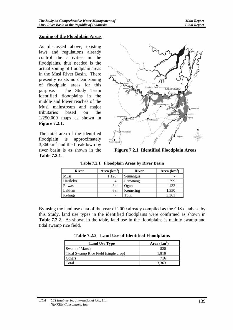
Zoning of the Floodplain Areas
As discussed above, existing laws and regulations already control the activities in the floodplains, thus needed is the actual zoning of floodplain areas in the Musi River Basin. There presently exists no clear zoning of floodplain areas for this purpose. The Study Team identified floodplains in the middle and lower reaches of the Musi mainstream and major tributaries based on the 1/250,000 maps as shown in Figure 7.2.1.
The total area of the identified floodplain is approximately 3,360km2 and the breakdown by river basin is as shown in the Table 7.2.1.
Table 7.2.1 Floodplain Areas by River Basin
River Area (km2) River Area (km2) Musi 1,126 Semangus - Harileko 4 Lematang 299 Rawas 84 Ogan 432 Lakitan 68 Komering 1,350 Kelingi - Total 3,363
By using the land use data of the year of 2000 already compiled as the GIS database by this Study, land use types in the identified floodplains were confirmed as shown in Table 7.2.2. As shown in the table, land use in the floodplains is mainly swamp and tidal swamp rice field.
Table 7.2.2 Land Use of Identified Floodplains Land Use Type Area (km2)
Swamp / Marsh 828 Tidal Swamp Rice Field (single crop) 1,819 Others 716 Total 3,363
Figure 7.2.1 Identified Floodplain Areas

Main Report Final Report
The Study on Comprehensive Water Management ofMusi River Basin in the Republic of Indonesia
Evaluation of Effect of Flood Retardation
Effect of flood retardation by the floodplains has been evaluated comparing the present flow duration curve with floodplains and the assumed one without floodplains. The present flow duration curve was obtained as an average of observed data in 1995, 1996, and 2000 at Tebing Abang station on the Musi River at just downstream of the Lematang River confluence. The flood retarding capacity was assumed at 1.7 billion m3 from the floodplain area of 3,363 km2 and an average depth of 0.5 m.
Figure 7.2.2 compares the flow duration curves under the present condition and without floodplains. From the illustration, the following have clarified:
•
•
•
The annual maximum daily discharge of 3,656 m3/s under the present condition would increase up to 4,040 m3/s under no-floodplain condition.
The present 365-day (12 months) discharge of 584 m3/s would decrease to 481 m3/s if no floodplains.
The 125-day discharge would be the same for both conditions under present and no-inundation.
Discharge-Duration Curve
0
500
1000
1500
2000
2500
3000
3500
4000
4500
0 50 100 150 200 250 300 350 400
Day
Dis
char
ge (
m3/se
c)
4,040 m3/sec
3,656 m3/sec
584 m3/sec
481 m3/sec
125th day
Existing Average Curve
Curve with Channel Improvement (No Inundation)
Figure 7.2.2 Comparison of Discharge Duration Curves with and without Floodplains
Zoning and Land Use Control Program (Program 2-1)
Zoning and Land Use Control Program consists of the following sub-programs.
(1) Confirmation of the Land Use Control Area
Land use control area proposed by the Study Team is 1/250,000 topographic map basis as discussed above. Detailed study using remote sensing methods for the confirmation of the necessary land use control area shall be conducted.
140 JICA CTI Engineering International Co., Ltd. NIKKEN Consultants, Inc.

The Study on Comprehensive Water Management of Musi River Basin in the Republic of Indonesia
Main ReportFinal Report
The primary objective of remote sensing methods for mapping flood-prone areas is to provide with a practical and cost-effective way to identify following items of floodplain: Where the floodplain and flood-prone areas are; How often the floodplain will be covered by water; How long the floodplain will be covered by water; At what time of year flooding can be expected.
With remote sensing methods, the extent of floodplains and flood-prone areas can be identified at small to intermediate map scales (up to 1:50,000) over entire river basins. Most satellite coverage for a single full scene extends over a large area (usually more than 33,000km2).
(2) Zoning of the Area
After the confirmation of the area, zoning shall be conducted in the spatial plan of the relevant Kabupaten and Kotamadya. Socialization of the spatial plan and explanation to the public for the necessity and importance of the floodplain management is important.
(3) Execution
Land use control shall be executed. Periodical patrol for the proper land use shall be conducted. The subject floodplains are basically maintained for the present use of non-tidal irrigation, swamps, etc., thus these areas shall better be incorporated into the provincial rice production designated areas for sustainable maintenance. Periodical patrol for the proper land use shall be conducted.
Implementation schedule of Zoning and Land Use Control Program is shown in Figure 7.2.3. Implementation cost has been estimated at Rp. 78 million (US$0.009 million).
I II III IV I II III IV I II III IV I II III IV I II III IV4th Year 5th Year1st Year 2nd Year 3rd Year
Title
Execution
Confirmation of the land use control area
Zoning of the area
Land Use and Zoning Plan
Figure 7.2.3 Implementation Schedule of Zoning and Land Use Control Program
7.2.3 Flood Forecasting and Warning
Flood forecasting and warning can be applied in the area where flush floods occur. Detailed information is not available for the flush flood in mountain areas, and more study is needed to identify what is needed. Dinas PU Pengairan of South Sumatra Province identified the following possibility of flood forecasting and warning system introduction. Flood Forecasting and Warning Program (Program 2-2) shall be as follows:
JICA CTI Engineering International Co., Ltd. NIKKEN Consultants, Inc.
141

Main Report Final Report
The Study on Comprehensive Water Management ofMusi River Basin in the Republic of Indonesia
Since not much information is available for the flush flood in the mountainous areas, inventory survey should firstly be conducted based on the proposal as shown in Table 7.2.3. Warning system against flush flood is established by use of automatic rain gage and GSM-digital mobile phone, which is economical than use of traditional Argos Satellite System or INMARSAT Satellite System. The composition of the system is shown in Figure 7.2.4.
Table 7.2.3 Possible Location for Flood Forecasting and Warning System
Gage Location Receiver Decision of Warning
Control
(Dinas PU District)
(Dinas PU District)
(Dinas PU Province)
OKU Muaradua Kisam Muaradua Baturaja Palembang Pulau Beringin Muaradua Baturaja Palembang Pasar Banding Agung Muaradua Baturaja Palembang Pengandonan Baturaja Palembang
Lahat Tebing Tinggi Lahat Palembang Padang Tepung Pagar Alam Lahat Palembang Pendopo Pagar Alam Lahat Palembang Tanjung Sakti Pagar Alam Lahat Palembang Kota Agung Lahat Palembang
MURA Surulangun Muara Rupit Lubuk Linggau Palembang Muara Kelingi Lubuk Linggau Palembang Muara Lakitan Lubuk Linggau Palembang
Figure 7.2.4 Flood Forecasting and Warning System
Implementation schedule of Flood Forecasting and Warning Program is shown in Figure 7.2.5. Implementation cost has been estimated at Rp. 5,843 million (US$0.647 million).
I II III IV I II III IV I II III IV1st Year 2nd Year 3rd Year
Title
Execution
Inventory Survey
Installation of Warning System
Flood Forecasting and Warning System
Figure 7.2.5 Implementation Schedule of Flood Forecasting and Warning System
7.2.4 Sustainable River Channel Management
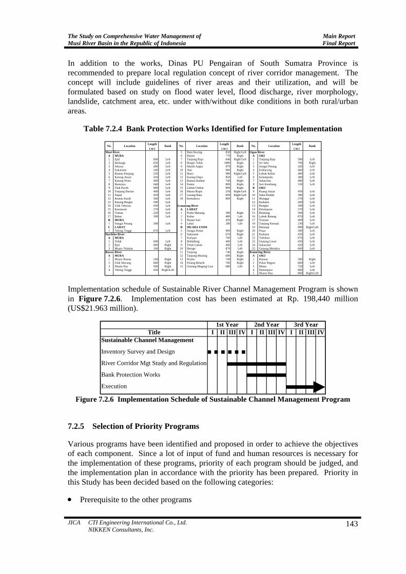
Bank erosions occur in the Musi mainstream and major tributaries. Riverbank protection works are presently conducted by Dinas PU Pengairan of each Kabupaten using APBD. The works include gabion revetment, concrete revetment, gabion jetty, bamboo net jetty, etc. and designing and construction technique are already well established. Thus Sustainable River Channel Management Program (Program 2-3) has been identified to carry out the sustainable channel management under the present system continuously. Bank protection works identified for future implementation are listed in Table 7.2.4.
142 JICA CTI Engineering International Co., Ltd. NIKKEN Consultants, Inc.
The Study on Comprehensive Water Management of Musi River Basin in the Republic of Indonesia
Main ReportFinal Report
In addition to the works, Dinas PU Pengairan of South Sumatra Province is recommended to prepare local regulation concept of river corridor management. The concept will include guidelines of river areas and their utilization, and will be formulated based on study on flood water level, flood discharge, river morphology, landslide, catchment area, etc. under with/without dike conditions in both rural/urban areas.
Table 7.2.4 Bank Protection Works Identified for Future Implementation
Length Length Length( m ) ( m ) ( m )
Musi River 5 Batu Kucing 830 Right/Left Ogan RiverA MUBA 6 Balam 770 Right A OKI1 Epil 600 Left 7 Tanjung Raja 640 Right/Left 1 Tanjung Raja 580 Left2 Bailangu 650 Left 8 Bingin Teluk 1880 Right 2 Sri Jabo 700 Right3 Sekayu 400 Left 9 Mandi Angin 870 Right 3 Sungai Pinang 420 Left4 Sukarame 240 Left 10 Alai 900 Right 4 Embacang 460 Left5 Rantau Panjang 230 Left 11 Biaro 980 Right/Left 5 Lubuk Keliat 400 Left6 Karang Anyar 420 Left 12 Karang Dapo 850 Left 6 Kalampadu 380 Left7 Karang Waru 400 Left 13 Rantau Kadam 740 Right 7 Sukacinta 480 Left8 Bumiayu 640 Left 14 Pantai 800 Right 8 Seri Kembang 520 Left9 Ulak Paceh 900 Left 15 Lubuk Umbai 900 Right B OKU
10 Tanjung Durian 400 Left 16 Muara Rupit 250 Right/Left 9 Kuang Anyar 450 Left11 Napal 450 Left 17 Lesung Batu 600 Right/Left 10 Suka Pindah 380 Left12 Rantau Kasih 360 Left 18 Kertadewa 800 Right 11 Munggu 270 Left13 Karang Ringin 500 Left 12 Kedaton 260 Left14 Ulak Teberau 430 Left Lematang River 13 Bunglai 180 Left15 Kasmaran 270 Left A LAHAT 14 Peninjauan 370 Left16 Toman 220 Left 1 Prabu Menang 380 Right 15 Belatung 360 Left17 Babat 300 Left 2 Kebur 480 Left 16 Lubuk Batang 870 LeftB MURA 3 Banjar Sari 450 Right 17 Terusan 400 Left1 Sungai Pinang 580 Left 4 Lahat 280 Left 18 Tanjung Kemala 230 LeftC LAHAT B MUARA ENIM 19 Baturaja 980 Right/Left1 Tebing Tinggi 870 Left 5 Sungai Rotan 960 Right 20 Pusar 300 Left
Harileko River 6 Sukarami 670 Right 21 Kedaton 450 LeftA MUBA 7 Kuripan 700 Left 22 Tubohan 870 Left1 Teluk 600 Left 8 Belimbing 400 Left 23 Gunung Liwat 450 Left2 Epil 400 Right 9 Teluk Lubuk 400 Left 24 Sukarame 420 Left3 Muara Teladan 100 Right 10 Beruge 870 Left 25 Gunung Meraksa 600 Left
Rawas River 11 Tanjung 740 Right Komering RiverA MURA 12 Tanjung Muning 680 Right A OKU1 Muara Rawas 240 Right 13 Perjito 740 Right 1 Rasuan 580 Right2 Ulak Macang 660 Right 14 Pinang Belarik 700 Right 2 Pulau Negara 600 Left3 Dusun Pau 500 Right 15 Gunung Megang Luar 680 Left 3 Matas 720 Left4 Tebing Tinggi 420 Right/Left 4 Damarpura 960 Left
5 Muara Dua 860 Right/Left
No. Location BankLocation BankNo. Location Bank No.
Implementation schedule of Sustainable River Channel Management Program is shown in Figure 7.2.6. Implementation cost has been estimated at Rp. 198,440 million (US$21.963 million).
I II III IV I II III IV I II III IVSustainable Channel Management
Inventory Survey and Design
River Corridor Mgt Study and Regulation
Bank Protection Works
Execution
1st Year 2nd Year 3rd YearTitle
Figure 7.2.6 Implementation Schedule of Sustainable Channel Management Program
7.2.5 Selection of Priority Programs
Various programs have been identified and proposed in order to achieve the objectives of each component. Since a lot of input of fund and human resources is necessary for the implementation of these programs, priority of each program should be judged, and the implementation plan in accordance with the priority has been prepared. Priority in this Study has been decided based on the following categories:
• Prerequisite to the other programs
JICA CTI Engineering International Co., Ltd. NIKKEN Consultants, Inc.
143

Main Report Final Report
The Study on Comprehensive Water Management ofMusi River Basin in the Republic of Indonesia
• • •
• • •
1
2
3
Degree of seriousness
Requirement of early start
Economic feasibility, cost scale etc.
As a result of study on the component of floodplain management in the previous chapter, the following three programs were developed:
Program 2-1: Zoning and Land Use Control Program
Program 2-2: Flood Forecasting and Warning Program
Program 2-3: Sustainable River Channel Management Program
Discussions were made to give priority on the above programs for their implementation as presented below.
Deterioration of the river regime will worsen the water deficit situation in the water balance in the Musi River Basin. Thus, the conservation of floodplains through zoning for land use control and building control, and the maintenance of the present river regime is a basin wide request. Furthermore, land use control and building control in the zoned area should be started as early as possible, since the uncontrolled development may progress due to the absence of the zone. Land use and zoning program should be given higher priority.
Flood forecasting and warning program needs more investigation at each site. Sustainable channel management program shall be conducted with the continuous and sustainable manner by Dinas PU Pengairan of South Sumatra Province. Thus the priority of these two programs in the comprehensive water management is judged low. Priority of floodplain management (Component 2 of the Master Plan for Musi River Basin Comprehensive Water Management) is shown in Table 7.2.5.
Table 7.2.5 Priority of Floodplain Management
Prerequisiteto Other
Programs
Degree ofSeriousness
Requirementof Early
StartCost Scale Total Priority
Order
1 Land Use and Zoning(Program 2-1) 5 3 5 5 18
2 Flood Forecasting andWarning (Program 2-2) 1 3 5 5 14
3 Sustainable ChannelManagement (Program 2-3) 1 3 5 3 12
Note) Score 5 (High Priority); 3 (Middle Priority); 1 (Low Priority)
Programs of FloodplainManagement
Thus land use and zoning program (Program 2-1) was selected as priority project of floodplain management (Component 2).
144 JICA CTI Engineering International Co., Ltd. NIKKEN Consultants, Inc.