Embed Size (px)
Citation preview
Chapter 6: Existing Conditions 169
Chapter 6:
Existing Conditions 2002
INTRODUCTION
Today, more than sixty years after the CCC left Platt National Park, the Platt District is a designed landscape that retains much of its intended character and uses. Nestled within a larger, mostly wooded landscape, the former park’s streams, swimming holes, campgrounds, and picnic areas still retain the feeling of a cool oasis set in the broad, dry prairies of South Central Oklahoma.
Existing conditions of the Platt District were recorded in a set of digital plans, completed in AutoCAD. Topographic base data for these plans was provided by the 1984 aerial survey, which was digitized in AutoCAD from twenty-four by thirty-six inch sheets specifically for this project. Additional baseline information was derived from overlaying this survey data on aerial photographs from 1969 and 1999. Fieldwork to check and refine this data was then conducted, primarily in the summers of 2001 and 2002, although ISU students surveyed campgrounds and did plant counts in the falls of 2001 and 2002.
The resulting set of existing conditions plans record the Platt District’s character-defining features. They are printed at varying scales to fit an eleven by seventeen-inch format for inclusion in this document. The set begins with an overall district plan (Drawing 14). This plan depicts the spatial organization, circulation systems and water features of the entire district. Detail plans (Drawings 15-24) then delineate in more detail significant individual areas within the Platt District. Features captured on these drawings include overall layout and spatial organization, topography (at a ten-foot contour interval), circulation (paths and walks), water features (fountains, dams, and pools), structures (buildings, walls), small scale features, and vegetation (woodland edges, designed plantings). This chapter primarily deals with the designed, or planted, vegetation of the Platt District. The existing conditions of the “natural” vegetation—the balance of vegetation along creeks, banks, and uplands—is considered in greater
detail in Chapter 10, the district vegetation management plan
The text below, which generally follows the organization laid out in previous chapters, describes the existing conditions and features depicted in the drawings in narrative form. In general, descriptions focus on describing the character-defining aspects of the features and assessing current feature conditions, rather than providing detailed construction information such as shingle sizes, number of steps, etcetera. Such detailed description is noted in the history chapters. It should be noted that if a generic feature type (e.g., “views and vistas” “small scale features”) is not listed under a landscape, then that feature is not present in that landscape. Photographs accompanying the text are intended to further capture 2002 conditions, though a few photographs were taken in 2004. Photographs in this chapter were taken by the authors, with the exception of those dating to 2004; these were taken by Ken Ruhnke.
A link between this chapter and the following analysis chapter are a set of matrices, which appear in the analysis chapter. These matrices summarize each component landscape’s features by noting feature condition and status as contributing and non-contributing to National Register significance.
DRAWING 14: OVERALL EXISTING CONDITIONS PLAN
Travertine and Rock Creeks
Travertine and Rock Creeks flow through the district from east to west and are a major component of the overall district landscape.
UseThe two creeks today are places for swimming, wading as well as for appreciating nature and scenic beauty. No swimming is allowed in Travertine Creek upstream from the Nature Center. Because of recreational bathing use, bacteria monitoring in the creeks was begun in 2001. The areas where counts are taken include most popular swimming areas.
Cult
ural L
andsc
ape R
eport
for th
e Plat
t Histo
ric D
istric
t - C
hicka
saw N
ation
al Re
creati
on A
rea170 Chapter 6: Existing Conditions 171
Spatial OrganizationTravertine and Rock Creeks are the backbone around which all of the district’s developed features are structured. The two creeks form a line running east-west through the district and all but a few features (notably the Superintendent’s Residence and Employee Residence 2) are organized along this line. The two creeks essentially determine the organization of the district, since all features respond to their original location.
TopographyThe overall elevation drop from the source of Travertine Creek at Buffalo Springs at about elevation 1080 to where Rock Creek exits from the park at about elevation 910 is about 170 feet. Stream banks along the creek are generally steep, if not vertical, and erosion and undercutting of banks is a problem throughout the entire water course. Erosion due to compaction by visitor use at dams and low water crossings is particularly notable and problematic.
Revetment walls have been added to the stream channel in various locations over time; many of these have been naturalized with vegetation and are difficult to locate and distinguish from natural conditions.
VegetationThe creek banks are generally lushly vegetated (Figure 6-1 and Figure 6-2), due to the proximity to water. Vegetation is dominated by water-loving woody and herbaceous vegetation such as horsetail, poison ivy, greenbrier and honeysuckle. Sycamore and ash are common stream-side trees.
Structures/Water Features/Small-scale featuresLocated along the entire water course are a series of waterfalls, which might, depending on one’s perspective, be considered structures or water features. As noted in the history chapters, some of these falls are natural rock outcroppings and travertine formations while others are
Figure 6-1. Lushly vegetated banks of Travertine Creek near Cold Springs Campground, 2002.
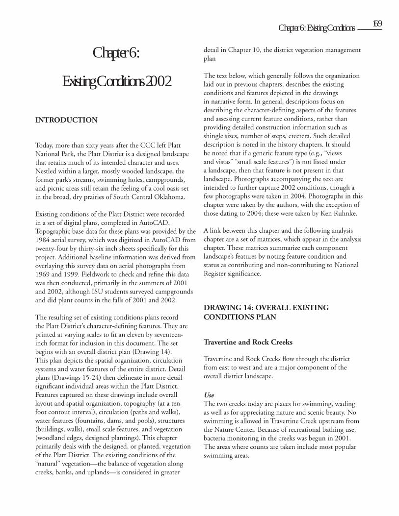
Figure 6-3. Upper dam at Bear Falls, 2002
Figure 6-2. Rock Creek just above Rock Creek Causeway, 2002.
Figure 6-4. Lower dam at Garfield Falls, 2002.
Cult
ural L
andsc
ape R
eport
for th
e Plat
t Histo
ric D
istric
t - C
hicka
saw N
ation
al Re
creati
on A
rea
170 Chapter 6: Existing Conditions 171
constructed, being either enhancements of existing falls or completely new, engineered features.
Just downstream from the arched stone footbridge near Buffalo Springs are three small stone dams spaced approximately ten feet apart. These seem to be related to the Buffalo Spring enclosure and are described in greater detail in a following section.
The two dams and swimming area at Little Niagara Falls are constructed features. As the centerpiece of that recreational landscape, these falls are described below with the rest of that landscape’s features. Between Little Niagara and Sycamore Crossing, however, are a series of shallow, natural falls. These are also popular with bathers.
Near Cold Springs Campground there are four boulder dams, two each at Bear Falls (Figure 6-3) and Garfield Falls (Figure 6-4). These four dams and their two swimming holes are some of the most heavily used in the park and their surrounds show significant compaction and bank erosion.
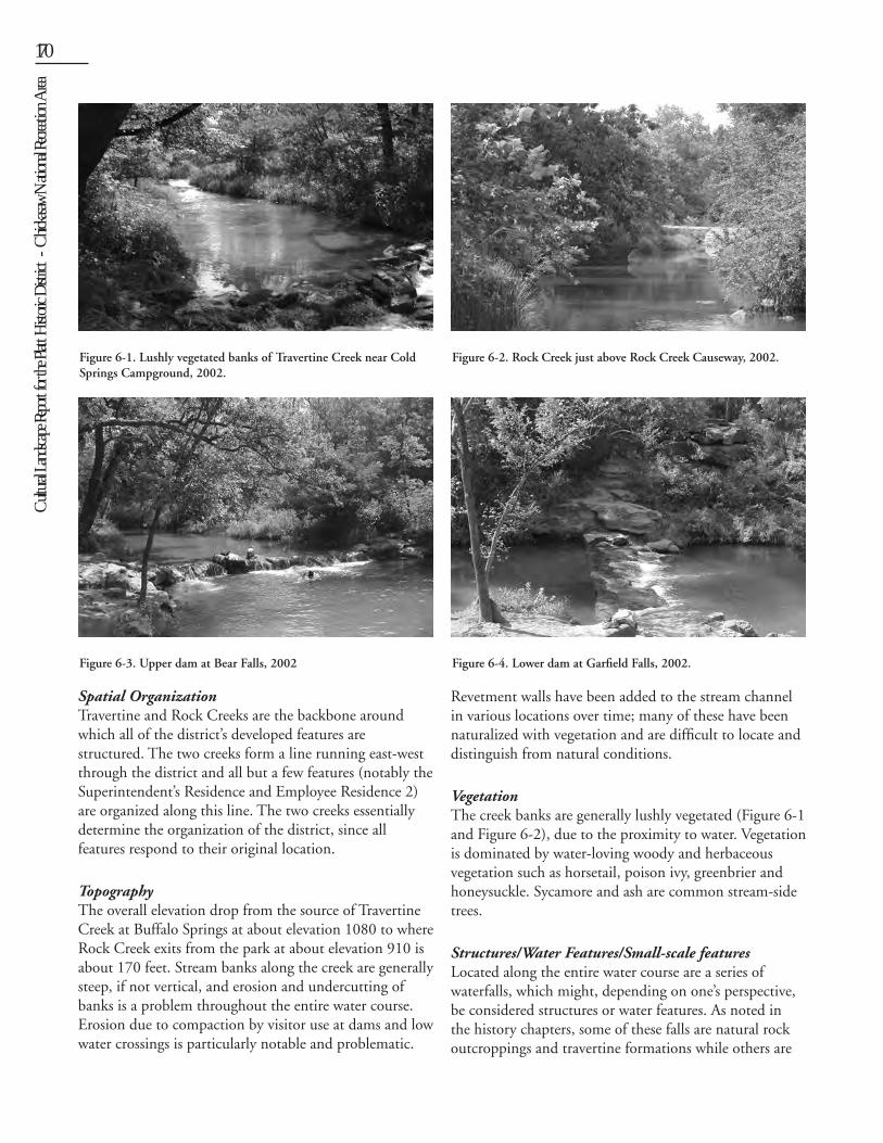
The Panther Falls dam and swimming hole, located between Cold Springs and Central Campground, is the oldest in the park (Figure 6-5). This five-foot high, curved concrete wall is in good condition, though the adjacent picnic area is heavily used, with compacted bare soil instead of turf. The south bank of the swimming hole is very steep and swimmers often jump from a ledge into the pool below.
Adjacent to the east loop in Central Campground is the Central Campground dam (Figure 6-6). A shallow swimming hole is located above this dam. Though the
approach down to this dam is heavily compacted, the area is less impacted from visitor use than are other swimming areas. A second falls is located downstream from the first; also used for swimming, this dam does not appear to have been constructed.
There are no additional constructed dams along Travertine Creek downstream from Central Campground. However, other significant bathing areas include falls along the creek between Travertine Bridge (Highway 177) and the beach below Black Sulphur Springs at the confluence of Travertine and Rock Creeks (Figure 6-7). This area receives silt and sand from normal and flood water conditions along rock creek and bathers have been observed here the past two summers. Bacterial counts are consistently higher here than at other monitored sites. The source of bacteria is unknown though it could likely originate somewhere along Rock Creek as it passes through the city of Sulphur.
Figure 6-6. Central Campground dam and swimming hole, 2001.Figure 6-5. Panther Falls 2001.
Figure 6-7. Beach area at confluence of Rock and Travertine Creeks, 2002.
Cult
ural L
andsc
ape R
eport
for th
e Plat
t Histo
ric D
istric
t - C
hicka
saw N
ation
al Re
creati
on A
rea172 Chapter 6: Existing Conditions 173
There are no specific designated or designed areas for swimming along Rock Creek, although wading and swimming are permitted and often seen.
Perimeter Road
Though it accesses all elements within the district, the perimeter road is also a separate landscape. Though constructed in pieces, it was designed as a whole, linear landscape with its own character-defining features. The perimeter road is 6.32 miles long.
UseThe perimeter road is the primary vehicular access within the district, linking all individual elements and defining developed areas.
Spatial OrganizationThe perimeter road circumscribes the park, following and, in some areas even crossing, the park’s boundary. The only place it does not follow the boundary is in the Buffalo and Antelope Spring area, making these areas accessible only by foot. The road functions as something of a spine off of which component landscapes are accessed; these are located both within and outside the area circumscribed by the road. The northern half of the road more or less follows the east-west line of Travertine and Rock Creeks through the district. The southern half responds to the boundary line and topography.
TopographyThe curvilinear alignment of the perimeter road corresponds directly to both overall and local topography. This is particularly evident in steep areas such as Bromide
Hill, where the road follows the contours as it wraps around the hill and passes the Townsite Overlook. The road was originally designed to have a maximum grade of 8.25 percent; however some stretches, such as near Bromide Hill, are a bit steeper. The road’s maximum radius is approximately 2,450 feet and its minimum radius approximately 69 feet. In fitting the roadway to the landscape, road side slopes are graded back to smoothly blend with existing grades at a slope no less than 2:1. The roadway is generally sheet-drained, though curbing and swales have been installed along the east side of the road on Bromide Hill and along the approaches to the Rock Creek causeway to prevent side slope erosion and undermining. Curbing has also been installed for similar reasons at the north intersection with Highway 177 at Flower Park.
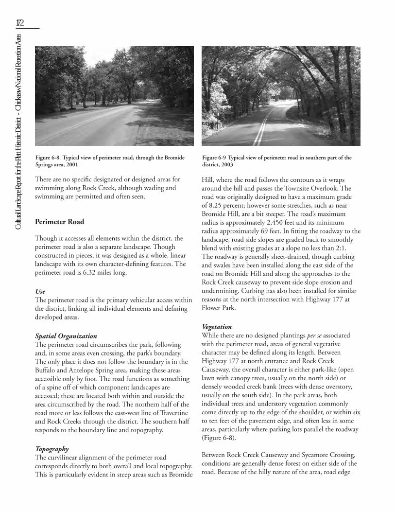
VegetationWhile there are no designed plantings per se associated with the perimeter road, areas of general vegetative character may be defined along its length. Between Highway 177 at north entrance and Rock Creek Causeway, the overall character is either park-like (open lawn with canopy trees, usually on the north side) or densely wooded creek bank (trees with dense overstory, usually on the south side). In the park areas, both individual trees and understory vegetation commonly come directly up to the edge of the shoulder, or within six to ten feet of the pavement edge, and often less in some areas, particularly where parking lots parallel the roadway (Figure 6-8).
Between Rock Creek Causeway and Sycamore Crossing, conditions are generally dense forest on either side of the road. Because of the hilly nature of the area, road edge
Figure 6-8. Typical view of perimeter road, through the Bromide Springs area, 2001.
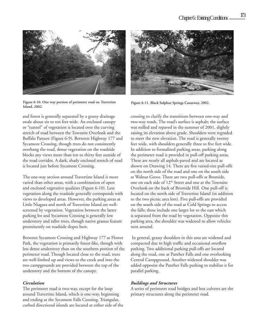
Figure 6-9 Typical view of perimeter road in southern part of the district, 2003.
Cult
ural L
andsc
ape R
eport
for th
e Plat
t Histo
ric D
istric
t - C
hicka
saw N
ation
al Re
creati
on A
rea
172 Chapter 6: Existing Conditions 173
and forest is generally separated by a grassy drainage swale about six to ten feet wide. An enclosed canopy or “tunnel” of vegetation is located over the curving stretch of road between the Townsite Overlook and the Buffalo Pasture (Figure 6-9). Between Highway 177 and Sycamore Crossing, though trees do not consistently overhang the road, dense vegetation on the roadside blocks any views more than ten to thirty feet outside of the road corridor. A dark, shady enclosed stretch of road is located just before Sycamore Crossing.
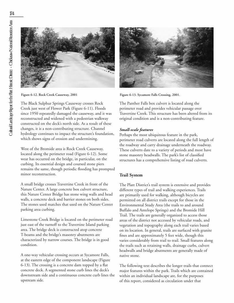
The one-way section around Travertine Island is more varied than other areas, with a combination of open and enclosed vegetative qualities (Figure 6-10). Less vegetation along the roadside generally corresponds with views to developed areas. However, the parking areas at Little Niagara and north of Travertine Island are well-screened by vegetation. Vegetation between the latter parking lot and Sycamore Crossing is generally low understory and taller trees, though native grasses feature prominently on roadside slopes here.
Between Sycamore Crossing and Highway 177 at Flower Park, the vegetation is primarily forest-like, though with less dense understory than on the southern portion of the perimeter road. Though located close to the road, trees are well-limbed up and views to the creek and into the two campgrounds are provided between the top of the understory and the bottom of the canopy.
CirculationThe perimeter road is two-way, except for the loop around Travertine Island, which is one-way, beginning and ending at the Sycamore Falls Crossing. Triangular, curbed directional islands are located at either side of the
crossing to clarify the transitions between one-way and two-way roads. The road’s surface is asphalt; the surface was milled and repaved in the summer of 2001, slightly raising its elevation above grade. Shoulders were regraded to meet the new elevation. The road is generally twenty feet wide, with shoulders generally three to five feet wide. In addition to formalized parking areas, parking along the perimeter road is provided in pull-off parking areas. These are nearly all asphalt-paved and are located as shown on Drawing 14. There are five varied-size pull-offs on the north side of the road and one on the south side at Walnut Grove. There are two pull-offs at Bromide, one on each side of 12th Street and one at the Townsite Overlook on the back of Bromide Hill. One pull-off is located on the north side of Travertine Island (in addition to the two picnic area lots). Five pull-offs are provided on the south side of the road at Cold Springs to access the falls; these include one larger lot to the east which is separated from the road by vegetation. Opposite this parking area, the shoulder was widened to allow vehicles turn around.
In general, grassy shoulders in this area are widened and compacted due to high traffic and occasional overflow parking. Two additional parking pull-offs are located along the road, one at Panther Falls and one overlooking Central Campground. Another widened shoulder was added opposite the Panther Falls parking to stabilize it for parallel parking.
Buildings and StructuresA series of perimeter road bridges and box culverts are the primary structures along the perimeter road.
Figure 6-10. One way portion of perimeter road on Travertine Island, 2002.
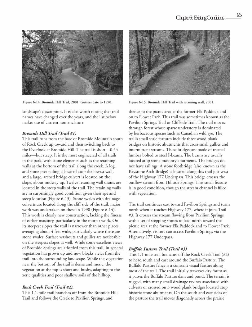
Figure 6-11. Black Sulphur Springs Causeway, 2002.
Cult
ural L
andsc
ape R
eport
for th
e Plat
t Histo
ric D
istric
t - C
hicka
saw N
ation
al Re
creati
on A
rea174 Chapter 6: Existing Conditions 175
The Black Sulphur Springs Causeway crosses Rock Creek just west of Flower Park (Figure 6-11). Floods since 1950 repeatedly damaged the causeway, and it was reconstructed and widened with a pedestrian walkway constructed on the deck’s north side. As a result of these changes, it is a non-contributing structure. Channel hydrology continues to impact the structure’s foundation, which shows signs of erosion and undermining.
West of the Bromide area is Rock Creek Causeway, located along the perimeter road (Figure 6-12). Some wear has occurred on the bridge, in particular, on the curbing. Its essential design and coursed stone piers remains the same, though periodic flooding has prompted minor reconstruction.
A small bridge crosses Travertine Creek in front of the Nature Center. A large concrete box culvert structure, this Nature Center Bridge has stone wing walls and head walls, a concrete deck and barrier stones on both sides. The stones used matches that used on the Nature Center parking area curbing.
Limestone Creek Bridge is located on the perimeter road just east of the turnoff to the Travertine Island parking area. The bridge deck is constructed atop concrete T-beams and the bridge’s masonry abutments are characterized by narrow courses. The bridge is in good condition.
A one-way vehicular crossing occurs at Sycamore Falls, at the eastern edge of the component landscape (Figure 6-13). The crossing is a concrete dam topped by a flat concrete deck. A segmented stone curb lines the deck’s downstream side and a continuous concrete curb lines the upstream side.
The Panther Falls box culvert is located along the perimeter road and provides vehicular passage over Travertine Creek. This structure has been altered from its original condition and is a non-contributing feature.
Small-scale featuresPerhaps the most ubiquitous feature in the park, perimeter road culverts are located along the full length of the roadway and carry drainage underneath the roadway. These culverts date to a variety of periods and most have stone masonry headwalls. The park’s list of classified structures has a comprehensive listing of road culverts.
Trail System
The Platt District’s trail system is extensive and provides different types of trail and walking experiences. Trails are primarily used for walking, although bicycles are permitted on all district trails except for those in the Environmental Study Area (the trails to and around Buffalo and Antelope Springs) and the Bromide Hill Trail. The trails are generally organized to access those areas of the district not accessed by vehicular roads, and vegetation and topography along each trail varies based on its location. In general, trails are surfaced with granite fines and are approximately 5 feet wide, though this varies considerably from trail to trail. Small features along the trails such as retaining walls, drainage curbs, culvert headwalls and bridge abutments are generally made of native stone.
The following text describes the longer trails that connect major features within the park. Trails which are contained within an individual landscape are, for the purposes of this report, considered as circulation under that
Figure 6-12. Rock Creek Causeway, 2001 Figure 6-13. Sycamore Falls Crossing, 2001.
Cult
ural L
andsc
ape R
eport
for th
e Plat
t Histo
ric D
istric
t - C
hicka
saw N
ation
al Re
creati
on A
rea
174 Chapter 6: Existing Conditions 175
landscape’s description. It is also worth noting that trail names have changed over the years, and the list below makes use of current nomenclature.
Bromide Hill Trail (Trail #1) This trail runs from the base of Bromide Mountain south of Rock Creek up toward and then switching back to the Overlook at Bromide Hill. The trail is short—0.54 miles—but steep. It is the most engineered of all trails in the park, with stone elements such as the retaining walls at the bottom of the trail along the creek. A log and stone pier railing is located atop the lowest wall, and a large, arched bridge culvert is located on the slope, about midway up. Twelve retaining wall drains are located in the steep walls of the trail. The retaining walls are in surprisingly good condition given their age and steep location (Figure 6-15). Stone swales with drainage culverts are located along the cliff side of the trail; major work was undertaken on these in 1990 (Figure 6-14). This work is clearly new construction, lacking the finesse of earlier masonry, particularly in the mortar work. On its steepest slopes the trail is narrower than other places, averaging about 4 feet wide, particularly where there are stone swales. Surface washouts and gullies are noticeable on the steepest slopes as well. While some excellent views of Bromide Springs are afforded from this trail, in general vegetation has grown up and now blocks views from the trail into the surrounding landscape. While the vegetation near the bottom of the trail is dense and mesic, the vegetation at the top is short and bushy, adapting to the xeric qualities and poor shallow soils of the hilltop.
Rock Creek Trail (Trail #2). This 1.1-mile trail branches off from the Bromide Hill Trail and follows the Creek to Pavilion Springs, and
thence to the picnic area at the former Elk Paddock and on to Flower Park. This trail was sometimes known as the Pavilion Springs Trail or Cliffside Trail. The trail moves through forest whose sparse understory is dominated by herbaceous species such as Canadian wild rye. The trail’s small scale features include three wood plank bridges on historic abutments that cross small gullies and intermittent streams. These bridges are made of treated lumber bolted to steel I-beams. The beams are usually located atop stone masonry abutments. The bridges do not have railings. A stone footbridge (also known as the Keystone Arch Bridge) is located along this trail just west of the Highway 177 Underpass. This bridge crosses the outflow stream from Hillside Springs. This small feature is in good condition, though the stream channel is filled with vegetation.
The trail continues east toward Pavilion Springs and turns north when it reaches Highway 177, where it joins Trail #3. It crosses the stream flowing from Pavilion Springs with a set of stepping stones to lead north toward the picnic area at the former Elk Paddock and to Flower Park. Alternatively, visitors can access Pavilion Springs via the Highway 177 Underpass.
Buffalo Pasture Trail (Trail #3)This 1.1-mile trail branches off the Rock Creek Trail (#2) to head south and east around the Buffalo Pasture. The Buffalo Pasture fence is a constant visual feature along most of the trail. The trail initially traverses dry forest as it passes the Buffalo Pasture dam and pond. The terrain is rugged, with many small drainage ravines associated with culverts or crossed on 3 wood plank bridges located atop historic stone abutments. On the south and east sides of the pasture the trail moves diagonally across the prairie
Figure 6-14. Bromide Hill Trail, 2001. Gutters date to 1990. Figure 6-15. Bromide Hill Trail with retaining wall, 2001.
Cult
ural L
andsc
ape R
eport
for th
e Plat
t Histo
ric D
istric
t - C
hicka
saw N
ation
al Re
creati
on A
rea176 Chapter 6: Existing Conditions 177
upland toward Highway 177, passing through terrain dominated by cedar, deciduous trees, and native prairie grasses.
The trail then heads north paralleling Highway 177, past the Bison viewing area to the Headquarters Building and Hillside Spring. Beyond Hillside Spring it meets Trail #2 and heads toward Flower Park.
Pavilion Springs Spur Trail (Trail #5)This short, 0.5-mile trail leads from Pavilion Springs to meet Trail #4 along Travertine Creek. The trail begins off the northern edge of the Pavilion Springs parking area and heads east across a plank and pipe rail bridge and up a set of stone masonry steps with boulder cheek walls. The steps are in good condition, though the crushed granite surfacing between longer steps tends to wash out. The trail leads through oak woodland to meet Trail #4. An extension of Trail #5 to the southeast runs to meet the perimeter road. Without a specific destination, this trail is not particularly well-used.
Travertine Creek Trail (Trail #4)The trail has also been known as the Antelope and Buffalo Springs Trail. At 2.13 miles, this is the longest trail within the district, running from Travertine Bridge near Flower Park to Buffalo Spring. The trail begins at a set of curving stone masonry steps at the southeast corner of the intersection of the perimeter road and Highway 177. The steps are in good condition, though the crushed and compacted granite surfacing between longer steps tends to wash out. The trail then runs east, more or less following the course of Travertine Creek. There is one major pipe rail and plank bridge on a large historic stone abutment over a deep gully. Excellent views of the creek are provided, especially near Cold Springs where swimmers can be seen at Panther Falls. Lost Falls, and Garfield Falls. A stepping stone crossing connects the trail to the entrance at Cold Springs Campground. The stones of this crossing have moved over time, however, and it is not an easy set of stones to cross. A low masonry wall with three steps on the south side of the creek is preventing the trail from eroding into the creek, but the whole crossing area is suffering from severe erosion. Removals of large trees from the 2000-2001 ice storm damage also seem to have impacted the area, further destabilizing soil and increasing erosion.
The trail continues east to Sycamore Crossing, where it splits along two alignments as it heads to the Nature
Center. One alignment runs to Little Niagara then on to the north side of the Nature Center parking area. The other alignment runs due east through low woods to the south bay of the parking area. The two alignments join at the Nature Center, where the trail crosses the creek and heads east to Antelope Springs and thence to Buffalo Springs. The interpretive loop trails #14 (Prairie Loop Trail), #15 (Tall Oaks Trail), and #16 (Dry Creek Trail) intersect with the Travertine Creek Trail in the Environmental Study area and Trail #9 is comprised of a short stretch leading back to Antelope Springs from Buffalo Springs. These are described in greater detail under Buffalo and Antelope Springs.
Veteran’s Trail (Trail #21)Veteran’s Trail runs from Pavilion Springs past Employee Residence #2 to the Veteran’s Center. The trail is 1.20 miles long and leads past acres of cedar and prairie grass as it traverses the prairie uplands. The trail follows the realignment of the town sewer line and as a result, manholes are a common feature along the trail. Three benches are also located along the trail. The trail crosses the perimeter road and then emerges through a small gap in the boundary fence at the Veteran’s Center.
DRAWING 15: BROMIDE AREA EXISTING CONDITIONS
Bromide Springs and Bromide Hill
Bromide Springs and Bromide Hill are located in the western part of the Platt District along the park’s perimeter road between Rock Creek Campground and Walnut Grove. The area is bounded to the north by Lindsay Avenue. The perimeter road forms area’s western and southern boundary, while Rock Creek establishes the eastern boundary. The area is divided into a large level picnic area on the north side of Rock Creek and a steep hill, where the Bromide Hill overlook and parking area are located, on the south side of the creek. The whole area is approximately fifty nine acres, with Bromide Springs containing approximately twenty-eight acres and Bromide Hill, thirty-one acres.
UsesToday, the area is primarily used for passive recreation such as walking, hiking, and picnicking. The traditional
Cult
ural L
andsc
ape R
eport
for th
e Plat
t Histo
ric D
istric
t - C
hicka
saw N
ation
al Re
creati
on A
rea
176 Chapter 6: Existing Conditions 177
use of the Bromide Springs Pavilion for collecting and drinking mineral water was lost with the loss of active wells. Today, the pavilion is sometimes used as a backdrop for music performances or, unauthorized, as a site for group picnics during rainy weather. Viewing the town of Sulphur is a popular activity on Bromide Hill, and this area is also sometimes used by local teens as an evening hangout. Local children sometimes wade in the circular pool of the 12th Street fountain.
Spatial OrganizationThe most significant designed aspect of spatial organization is the area’s axial relationship with the town of Sulphur. The 12th Street Fountain is located on axis with 12th Street, forming a grand entrance to the area and to the whole former park.
In general, the area is divided into two major spaces: Bromide Hill, defined by topography and the creek; and the level terrace on which the picnic area is located. The picnic area is further subdivided into zones by vehicular roads.
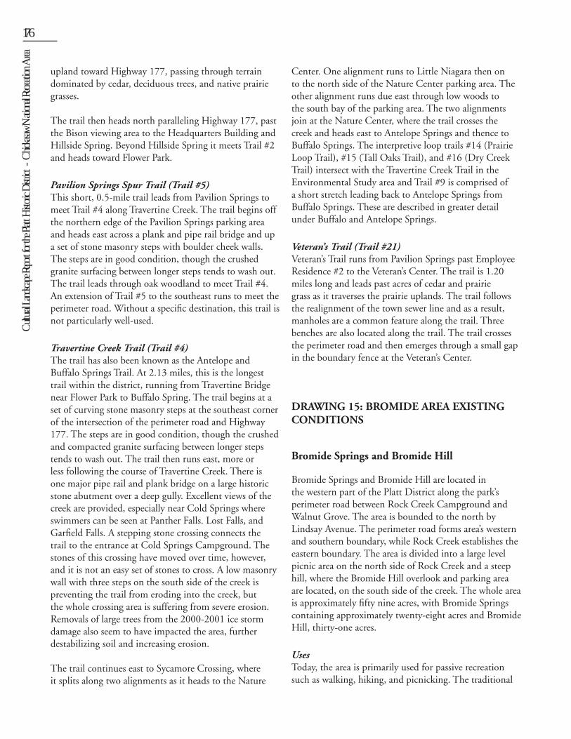
TopographyDrawing 15 shows the area’s topography, including the level floodplain terrace and the steep (almost vertical) escarpment of Bromide Hill rising almost 160 feet above Rock Creek. The elevations across the area range from 916 feet at Rock Creek near Bromide Pavilion to 1070 feet at the Bromide Hill overlook to 1073 feet at the summit of Bromide Hill (Figure 6-16). The design of the area appears to have generally taken advantage of natural topography rather than creating new topographical features.
VegetationThe vegetation in the area correlates with topographic conditions. The steeply sloped areas along Rock Creek and Bromide Hill contain naturalized vegetation with both over and understory vegetation. These vegetative communities are described in greater detail in Chapter 10. The flat terrace at the base of the hill is today mostly mature shade trees in lawn, providing a more maintained or park-like setting, rather than a “natural” or forest-like setting. The designed nature of these plantings is most strongly expressed at the 12th Street fountain, where soapberry trees are located more or less symmetrically around the enclosing walls of the fountain plaza. Two perennial beds containing iris and day lily are also located near the Bromide Springs Pavilion.
In November 2001, Iowa State University (ISU) students conducted a rudimentary tree inventory of the shade trees in the level area of Bromide Springs. The area was divided into ten plots corresponding to areas on the 1936 survey of Bromide Springs (NP-PLA-5036), and groups of students counted and identified trees with diameters of more than eighteen inches standing in open lawn. All areas were counted twice, and numbers for each plot averaged and then compared to counts for the same plot as indicated on the 1936 survey. Although the methodology was crude, the inventory gives an idea of trends occurring in the campground, as seen in Table 6-1. The tree counts revealed that today there are approximately 742 major shade trees in the area, in
SpeciesNumber
1936Percent 1936
Number 2001
Percent 2001
oak 516 67% 209 28%
elm 93 12% 182 25%
hackberry (hk) 32 4% 178 24%
catalpa 1 0% 38 5%
cedar 34 4% 37 5%
ash (a) 16 2% 22 3%chinaberry/soapberry
0% 18 2%
osage orange 7 1% 12 2%
chittamwood 10 1% 8 1%
bitternut hickory 0% 8 1%
walnut 17 2% 7 1%
sycamore 0% 5 1%
mulberry 1 0% 4 1%
plum 1 0% 3 0%
pecan 0% 3 0%
cottonwood 1 0% 2 0%
boxelder 0% 2 0%
redbud 0% 2 0%
black locust 0% 1 0%
unknown 0% 1 0%
bj 27 4% 0%
ck 1 0% 0%
pa 7 1% 0%
Persimmon (p) 4 1% 0%
Total 768 100% 742 100%
Table 6-1. Tree counts in the Bromide area, from the 1936 survey and 2001 field work.
Cult
ural L
andsc
ape R
eport
for th
e Plat
t Histo
ric D
istric
t - C
hicka
saw N
ation
al Re
creati
on A
rea178 Chapter 6: Existing Conditions 179
comparison to 768 located on the survey in 1936. This indicates only a slight decline in numbers over the years. More interesting, in contrast, is the information gleaned about the composition of tree species in the area. Tree composition has been drastically altered. Today the overall composition of the three major species is approximately 28% oak , 25% elm, and 24% hackberry. In 1936 these percentages were approximately 67% oak, 12% elm, and 4% hackberry. Thus, there has been a shift over time away from mature oak toward colonization species. This is not surprising, if one considers that the area was originally more savanna-like, with grass and oak species predominating. Today, however, with fire suppression combined with aging of mature oak, colonization species such as hackberry are better able to seed themselves and thrive.
The loss of oak will likely continue if replacement of oak species does not occur. Many of the mature trees—many of which are oaks—within the picnic area are showing
signs of age and stress from the 2000 ice storm. Though major tree work was undertaken in the months following the storm, some trees are in poor condition and need additional pruning and structural work.
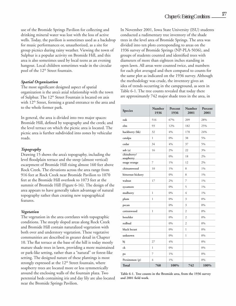
CirculationThe vehicular circulation system in Bromide Springs is composed of two asphalt loop roads accessed from the district’s perimeter road. Twelfth Street, terminating at the fountain, is another, more formal access to the area. The west loop provides access to the trailer dumping station, Bromide Ranger Station, and Bromide Springs Pavilion (Figure 6-17). The southern part of the loop widens to provide parking near the pavilion. The wider eastern loop circumscribes most of the area between the perimeter road and the creek and has a second roadway that accesses the Travertine Ranger Station and the comfort station. Parking is provided along the loop road and at two small lots in front of the two buildings. Roadways and park areas are separated by large boulders, as shown in
Figure 6-16. View east from Bromide Hill, 2001. This viewshed is an important district feature.
Figure 6-17. Typical vehicular circulation at Bromide Springs.
Figure 6-18. Bromide Hill Parking Area, 2004. Note historic stone walls.
Cult
ural L
andsc
ape R
eport
for th
e Plat
t Histo
ric D
istric
t - C
hicka
saw N
ation
al Re
creati
on A
rea
178 Chapter 6: Existing Conditions 179
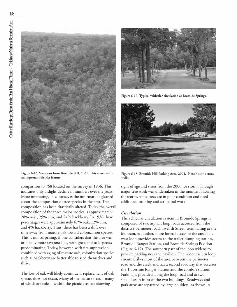
Drawing 15. Vehicular access to Bromide Hill is provided by the perimeter road and a small oval parking area at the top of the hill (Figure 6-18).
Pedestrian circulation in the picnic area is an informal network of gravel paths connecting major features. The more “engineered” Bromide Hill Trail (Trail #1) links the pavilion with the Bromide Hill overlook. A short network of gravel trails also leads up steps from the Bromide Hill parking area to the overlook; this route is not ADA accessible. Pedestrian links are provided from this area to both Rock Creek and Buffalo Pasture Trails (#2 and #3). A more informal trail leads from the top of Bromide Hill to Rock Creek Campground; and a short maintained trail provides access from the Rock Creek Causeway near Rock Creek Campground to the pedestrian low water crossing at the base of Bromide Hill.
Buildings and Structures The buildings at Bromide Springs represent several architectural styles from different National Park Service eras. There are five extant historic buildings in the area.
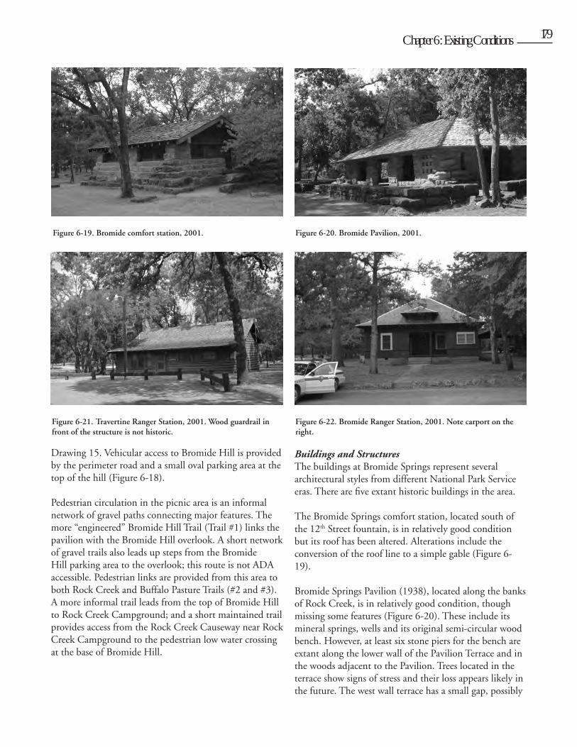
The Bromide Springs comfort station, located south of the 12th Street fountain, is in relatively good condition but its roof has been altered. Alterations include the conversion of the roof line to a simple gable (Figure 6-19).
Bromide Springs Pavilion (1938), located along the banks of Rock Creek, is in relatively good condition, though missing some features (Figure 6-20). These include its mineral springs, wells and its original semi-circular wood bench. However, at least six stone piers for the bench are extant along the lower wall of the Pavilion Terrace and in the woods adjacent to the Pavilion. Trees located in the terrace show signs of stress and their loss appears likely in the future. The west wall terrace has a small gap, possibly
Figure 6-20. Bromide Pavilion, 2001.Figure 6-19. Bromide comfort station, 2001.
Figure 6-21. Travertine Ranger Station, 2001. Wood guardrail in front of the structure is not historic.
Figure 6-22. Bromide Ranger Station, 2001. Note carport on the right.
Cult
ural L
andsc
ape R
eport
for th
e Plat
t Histo
ric D
istric
t - C
hicka
saw N
ation
al Re
creati
on A
rea180 Chapter 6: Existing Conditions 181
where a tree once stood, though no photos of this wall from the period of significance have been located. A new wood shake roof, duplicating the original, was added to the building in 1998.
Located in the eastern portion of the picnic area, the Travertine Ranger Station (presently used as Resource Management Office) is a wood frame building with a concrete foundation and a small porch on its south side (Figure 6-21). Lead abatement was underway on building in the summer of 2002. Today it is painted NPS brown and is used as ranger offices.
The Bromide Ranger Station, located west of the pavilion, is of wood frame construction with a limestone-faced foundation (Figure 6-22). It has been altered and its current windows are non-historic.
The Bromide Ranger Station Garage is a simple building in fair condition located behind the ranger station. It is in need of lead abatement. The Bromide Ranger Station Carport, a non-historic structure, consists of a wood shingled roof supported by wood posts and is in good condition. It is similar to the other carports at park residences. A winch is currently installed in this structure.
Water FeaturesTwo designed water features are important elements in the area.
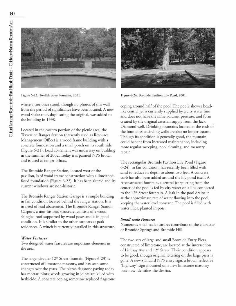
The large, circular 12th Street fountain (Figure 6-23) is constructed of limestone masonry, and has seen some changes over the years. The plaza’s flagstone paving today has mortar joints; weeds growing in joints are killed with herbicide. A concrete coping sometime replaced flagstone
coping around half of the pool. The pool’s shower head-like central jet is currently supplied by a city water line and does not have the same volume, pressure, and form created by the original artesian supply from the Jack Diamond well. Drinking fountains located at the ends of the fountain’s encircling walls are also no longer extant. Though its condition is generally good, the fountain could benefit from increased maintenance, including more regular sweeping, pool cleaning, and masonry repair.
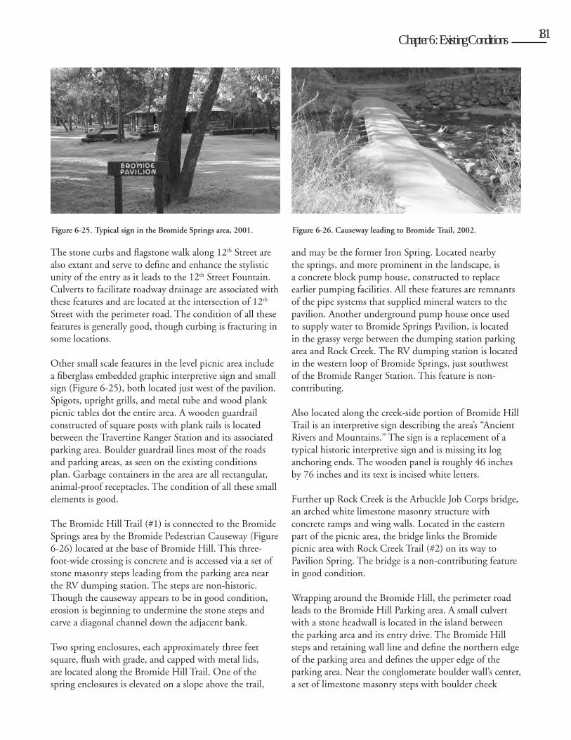
The rectangular Bromide Pavilion Lily Pond (Figure 6-24), in fair condition, has recently been filled with sand to reduce its depth to about two feet. A concrete curb has also been added around the lily pond itself. A reconstructed fountain, a central jet spurting from the center of the pool is fed by city water on a line connected to the 12th Street fountain. A leak in the pool drains it at the approximate rate of water flowing into the pool, keeping the water level constant. The pool is filled with water lilies, planted in pots.
Small-scale FeaturesNumerous small-scale features contribute to the character of Bromide Springs and Bromide Hill.
The two sets of large and small Bromide Entry Piers, constructed of limestone, are located at the intersection of Lindsay Ave and 12th Street. Their condition appears to be good, though original lettering on the large piers is gone. A new standard NPS entry sign, a brown reflective “highway” sign mounted on a new limestone masonry base now identifies the district.
Figure 6-23. Twelfth Street fountain, 2001. Figure 6-24. Bromide Pavilion Lily Pond, 2001.
Cult
ural L
andsc
ape R
eport
for th
e Plat
t Histo
ric D
istric
t - C
hicka
saw N
ation
al Re
creati
on A
rea
180 Chapter 6: Existing Conditions 181
The stone curbs and flagstone walk along 12th Street are also extant and serve to define and enhance the stylistic unity of the entry as it leads to the 12th Street Fountain. Culverts to facilitate roadway drainage are associated with these features and are located at the intersection of 12th Street with the perimeter road. The condition of all these features is generally good, though curbing is fracturing in some locations.
Other small scale features in the level picnic area include a fiberglass embedded graphic interpretive sign and small sign (Figure 6-25), both located just west of the pavilion. Spigots, upright grills, and metal tube and wood plank picnic tables dot the entire area. A wooden guardrail constructed of square posts with plank rails is located between the Travertine Ranger Station and its associated parking area. Boulder guardrail lines most of the roads and parking areas, as seen on the existing conditions plan. Garbage containers in the area are all rectangular, animal-proof receptacles. The condition of all these small elements is good.
The Bromide Hill Trail (#1) is connected to the Bromide Springs area by the Bromide Pedestrian Causeway (Figure 6-26) located at the base of Bromide Hill. This three-foot-wide crossing is concrete and is accessed via a set of stone masonry steps leading from the parking area near the RV dumping station. The steps are non-historic. Though the causeway appears to be in good condition, erosion is beginning to undermine the stone steps and carve a diagonal channel down the adjacent bank.
Two spring enclosures, each approximately three feet square, flush with grade, and capped with metal lids, are located along the Bromide Hill Trail. One of the spring enclosures is elevated on a slope above the trail,
and may be the former Iron Spring. Located nearby the springs, and more prominent in the landscape, is a concrete block pump house, constructed to replace earlier pumping facilities. All these features are remnants of the pipe systems that supplied mineral waters to the pavilion. Another underground pump house once used to supply water to Bromide Springs Pavilion, is located in the grassy verge between the dumping station parking area and Rock Creek. The RV dumping station is located in the western loop of Bromide Springs, just southwest of the Bromide Ranger Station. This feature is non-contributing.
Also located along the creek-side portion of Bromide Hill Trail is an interpretive sign describing the area’s “Ancient Rivers and Mountains.” The sign is a replacement of a typical historic interpretive sign and is missing its log anchoring ends. The wooden panel is roughly 46 inches by 76 inches and its text is incised white letters.
Further up Rock Creek is the Arbuckle Job Corps bridge, an arched white limestone masonry structure with concrete ramps and wing walls. Located in the eastern part of the picnic area, the bridge links the Bromide picnic area with Rock Creek Trail (#2) on its way to Pavilion Spring. The bridge is a non-contributing feature in good condition.
Wrapping around the Bromide Hill, the perimeter road leads to the Bromide Hill Parking area. A small culvert with a stone headwall is located in the island between the parking area and its entry drive. The Bromide Hill steps and retaining wall line and define the northern edge of the parking area and defines the upper edge of the parking area. Near the conglomerate boulder wall’s center, a set of limestone masonry steps with boulder cheek
Figure 6-25. Typical sign in the Bromide Springs area, 2001. Figure 6-26. Causeway leading to Bromide Trail, 2002.
Cult
ural L
andsc
ape R
eport
for th
e Plat
t Histo
ric D
istric
t - C
hicka
saw N
ation
al Re
creati
on A
rea182 Chapter 6: Existing Conditions 183
walls leads visitors to end portion of Bromide Hill Trail. A second set of steps leading to Bromide Hill Trail are located just to the east. Constructed in the 1980s, these additional steps are a non-contributing feature of the component landscape. Other small scale features in the area include a somewhat dilapidated railing and concrete steps at the overlook’s edge .
Views and VistasThe view from the Bromide Hill Overlook is probably the most important viewshed in the park, providing a wide vista over the park and the town of Sulphur into the distance.
DRAWING 16: WALNUT GROVE
Walnut Grove
Walnut Grove is located in the western half of the Platt District, just west of Black Sulphur Springs. It is an open, grassy, partially shaded picnic area of about twenty-five acres, bounded on the north and west by a wooded hillside that leads up to residential Sulphur. On the south side, the area is bounded by the perimeter road and Rock Creek
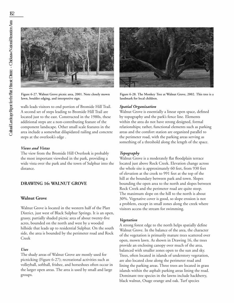
UsesThe shady areas of Walnut Grove are mostly used for picnicking (Figure 6-27); recreational activities such as volleyball, softball, frisbee, and horseshoes often occur in the larger open areas. The area is used by small and large groups.
Spatial OrganizationWalnut Grove is essentially a linear open space, defined by topography and the park’s fence line. Elements within the area do not have strong designed, formal relationships; rather, functional elements such as parking areas and the comfort station are organized parallel to the perimeter road, with the parking areas serving as something of a threshold along the length of the space.
TopographyWalnut Grove is a moderately flat floodplain terrace located just above Rock Creek. Elevation change across the whole site is approximately 60 feet, from 930 feet of elevation at the creek to 991 feet at the top of the hill at the boundary between park and town. Slopes bounding the open area to the north and slopes between Rock Creek and the perimeter road are quite steep. The maximum slope on the hill to the north is about 30%. Vegetative cover is good, so slope erosion is not a problem, except in small zones along the creek where visitors access the stream for swimming.
VegetationA strong forest edge to the north helps spatially define Walnut Grove. In the balance of the area, the character of the vegetation is primarily mature trees scattered over open, mown lawn. As shown in Drawing 16, the trees provide an enclosing canopy over much of the area, balanced with smaller zones open to the sun and sky. Trees, often located in islands of understory vegetation, are also located close along the perimeter road and lining the parking areas. Three trees are located in grass islands within the asphalt parking areas lining the road. Dominant tree species in the lawns include hackberry, black walnut, Osage orange and oak. Turf species
Figure 6-27. Walnut Grove picnic area, 2001. Note closely mown lawn, boulder edging, and interpretive sign.
Figure 6-28. The Monkey Tree at Walnut Grove, 2002. This tree is a landmark for local children.
Cult
ural L
andsc
ape R
eport
for th
e Plat
t Histo
ric D
istric
t - C
hicka
saw N
ation
al Re
creati
on A
rea
182 Chapter 6: Existing Conditions 183
include native grasses such as buffalo grass, gramas, and little bluestem in sunny areas, though Bermuda grass dominates. Shady areas under trees along the perimeter road and near the comfort station also contain Canadian wild rye, known for its shade tolerance.
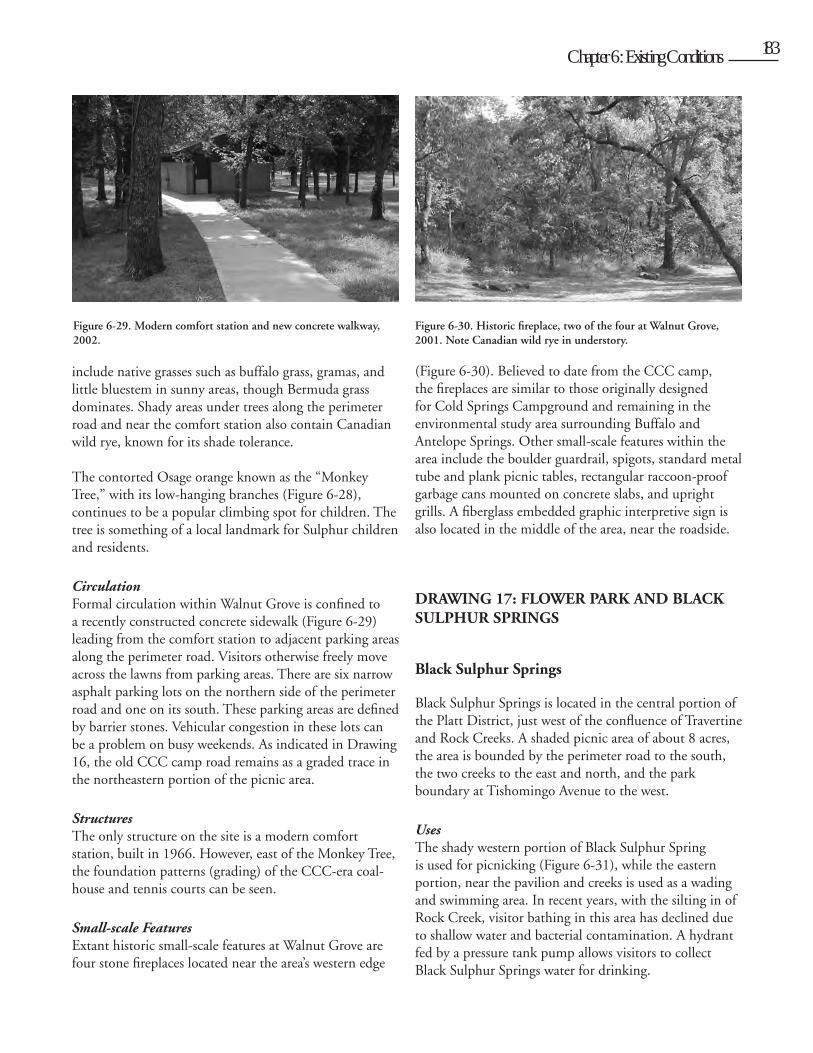
The contorted Osage orange known as the “Monkey Tree,” with its low-hanging branches (Figure 6-28), continues to be a popular climbing spot for children. The tree is something of a local landmark for Sulphur children and residents.
CirculationFormal circulation within Walnut Grove is confined to a recently constructed concrete sidewalk (Figure 6-29) leading from the comfort station to adjacent parking areas along the perimeter road. Visitors otherwise freely move across the lawns from parking areas. There are six narrow asphalt parking lots on the northern side of the perimeter road and one on its south. These parking areas are defined by barrier stones. Vehicular congestion in these lots can be a problem on busy weekends. As indicated in Drawing 16, the old CCC camp road remains as a graded trace in the northeastern portion of the picnic area.
StructuresThe only structure on the site is a modern comfort station, built in 1966. However, east of the Monkey Tree, the foundation patterns (grading) of the CCC-era coal-house and tennis courts can be seen.
Small-scale Features Extant historic small-scale features at Walnut Grove are four stone fireplaces located near the area’s western edge
(Figure 6-30). Believed to date from the CCC camp, the fireplaces are similar to those originally designed for Cold Springs Campground and remaining in the environmental study area surrounding Buffalo and Antelope Springs. Other small-scale features within the area include the boulder guardrail, spigots, standard metal tube and plank picnic tables, rectangular raccoon-proof garbage cans mounted on concrete slabs, and upright grills. A fiberglass embedded graphic interpretive sign is also located in the middle of the area, near the roadside.
DRAWING 17: FLOWER PARK AND BLACK SULPHUR SPRINGS
Black Sulphur Springs
Black Sulphur Springs is located in the central portion of the Platt District, just west of the confluence of Travertine and Rock Creeks. A shaded picnic area of about 8 acres, the area is bounded by the perimeter road to the south, the two creeks to the east and north, and the park boundary at Tishomingo Avenue to the west.
UsesThe shady western portion of Black Sulphur Spring is used for picnicking (Figure 6-31), while the eastern portion, near the pavilion and creeks is used as a wading and swimming area. In recent years, with the silting in of Rock Creek, visitor bathing in this area has declined due to shallow water and bacterial contamination. A hydrant fed by a pressure tank pump allows visitors to collect Black Sulphur Springs water for drinking.
Figure 6-29. Modern comfort station and new concrete walkway, 2002.
Figure 6-30. Historic fireplace, two of the four at Walnut Grove, 2001. Note Canadian wild rye in understory.
Cult
ural L
andsc
ape R
eport
for th
e Plat
t Histo
ric D
istric
t - C
hicka
saw N
ation
al Re
creati
on A
rea184 Chapter 6: Existing Conditions 185
Spatial Organization.Black Sulphur Springs is basically organized into two spaces - the picnic area to the west and the spring area and beach to the east. Another, smaller picnic area is located south of the perimeter road. The asphalted entry and parking area, defined by curbs, is a transitional space dividing the two larger spaces.
TopographyThe topography throughout the picnic and parking areas to the west is essentially level. To the east, the Black Sulphur Spring Pavilion is situated atop a slight hill or rise which then slopes at about 6% gently down to Rock Creek.
VegetationLittle extant formally designed vegetation seems to be retained throughout the area. A character-defining aspect of the vegetation is the high percentage of canopy over most of the western picnic area. A shrubby redbud may be a remnant of a more extensive island planting, though this is not documented. A cluster of trees around the Black Sulphur Springs Pavilion may also be considered character-defining. These trees, which provide cooling, dappled shade around the pavilion, are seen in historic photographs; the large Osage orange behind the pavilion is clearly seen in many. However, some of the trees in close proximity to the pavilion are large enough to potentially damage the structure. Two clusters of cedars located near the pavilion appear to date from the 1930s, based on age and size.
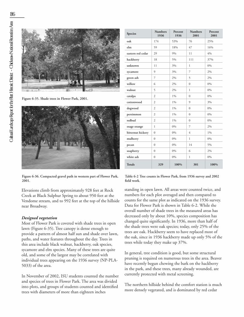
CirculationVehicular circulation features in the area include two parking areas. The first is the formal asphalt parking area with stone curbs that accesses the pavilion (Figure 6-33). The second is located west of the first and primarily provides access to the comfort station. Vehicles access the picnic area on a gravel loop road that leads off the pavilion parking lot.
Formalized pedestrian circulation includes the flagstone walk that lines the east side of the pavilion parking lot and connects to the pavilion and the sidewalk along the north edge of Black Sulphur Causeway. The flagstone walk and curbing is in relatively good condition. A new concrete walk leads from the parking area west of the comfort station. An old road trace north of the comfort station is used today as a trail and leads from Tishomingo Avenue outside the park through a gap in the park fence to the picnic area.
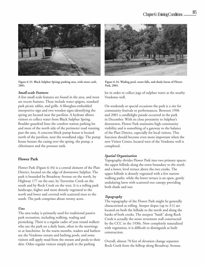
StructuresBlack Sulphur Spring Pavilion (Figure 6-32) is the only historic structure in the area. The pavilion is in fair condition, as the building’s stucco finish likely needs protection and lead abatement. The structure’s metal tile roof has also deteriorated. The pavilion’s central fountain has been filled with concrete and its water supply turned off.
Near the picnic area to the west is a modern comfort station. Built in 1966, it is in good condition and is considered a non-contributing structure.
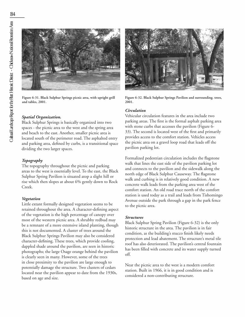
Figure 6-31. Black Sulphur Springs picnic area, with upright grill and tables, 2001.
Figure 6-32. Black Sulphur Springs Pavilion and surrounding. trees, 2001.
Cult
ural L
andsc
ape R
eport
for th
e Plat
t Histo
ric D
istric
t - C
hicka
saw N
ation
al Re
creati
on A
rea
184 Chapter 6: Existing Conditions 185
Small-scale FeaturesA few small scale features are found in the area, and most are recent features. These include water spigots, standard park picnic tables, and grills. A fiberglass-embedded interpretive sign and two wooden signs identifying the spring are located near the pavilion. A hydrant allows visitors to collect water from Black Sulphur Spring. Boulder guardrail lines the comfort station parking lot and most of the north side of the perimeter road running past the area. A concrete block pump house is located north of the pavilion, near the woodland edge. The pump house houses the casing over the spring, the pump, a chlorinator and the pressure tank.
Flower Park
Flower Park (Figure 6-34) is a central element of the Platt District, located on the edge of downtown Sulphur. The park is bounded by Broadway Avenue on the north, by Highway 177 on the east, by Travertine Creek on the south and by Rock Creek on the west. It is a rolling park landscape, higher and more densely vegetated to the north and lower and covered with scattered trees to the south. The park comprises about twenty acres.
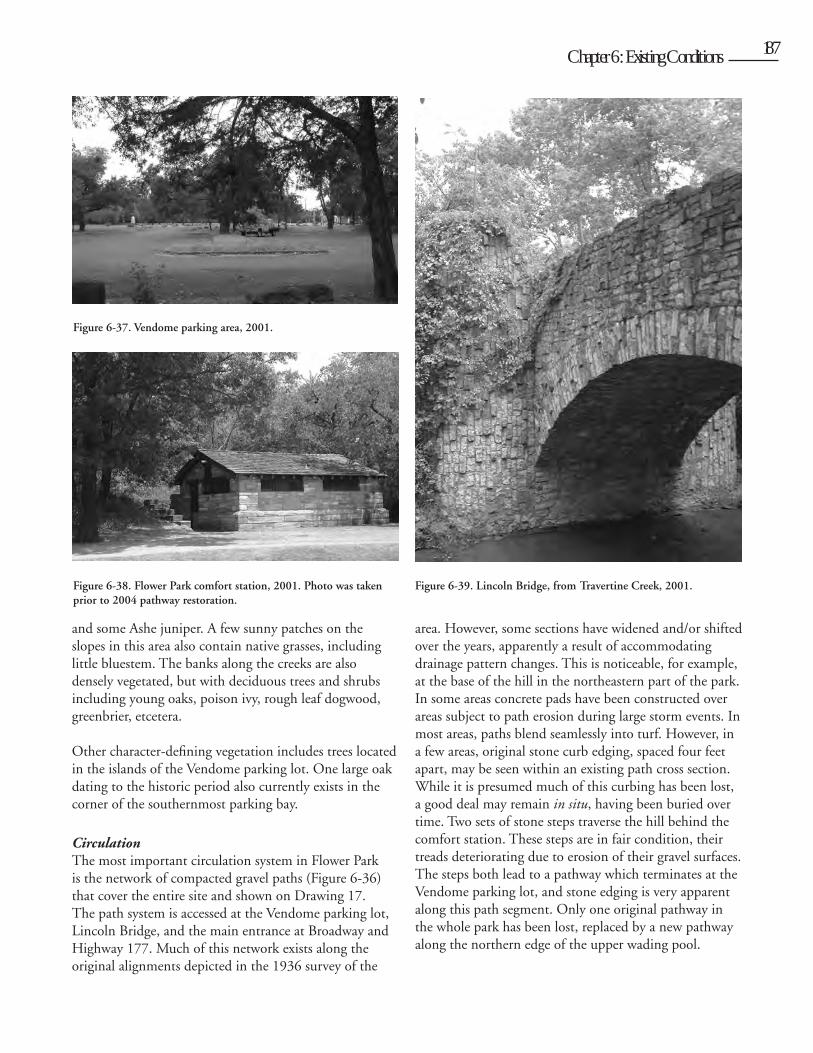
Uses The area today is primarily used for traditional passive park recreation, including walking, wading and picnicking. There is a regular cadre of year round walkers who use the park on a daily basis, often in the mornings or at lunchtime. In the warm months, waders and bathers use the Vendome stream and bathing pools, and some visitors still apply mud from the stream and pools to their skin. Other regular visitors simply park in the parking
lot in order to collect jugs of sulphur water at the nearby Vendome well.
On weekends or special occasions the park is a site for community festivals or performances. Between 1996 and 2001 a candlelight parade occurred in the park in December. With its close proximity to Sulphur’s downtown, Flower Park maintains high community visibility and is something of a gateway to the balance of the Platt District, especially for local visitors. This function should become even more important when the new Visitor Center, located west of the Vendome well is completed.
Spatial OrganizationTopography divides Flower Park into two primary spaces: the upper hillside along the town boundary to the north and a lower, level terrace above the two creeks. The upper hillside is densely vegetated with a few narrow walking paths, while the lower terrace is an open, gently undulating lawn with scattered tree canopy providing both shade and sun.
Topography The topography of the Flower Park might be generally characterized as rolling. Steeper slopes (up to 3:1) are located on both the hillside to the north and along the banks of both creeks. The steepest “bank” along Rock Creek is actually the stone revetment wall constructed by the CCC in the 1930s. Now completely naturalized with vegetation, it is difficult to distinguish as built construction.
Overall, almost 70 feet of elevation change separates Rock Creek from the hilltop along Broadway Avenue.
Figure 6-33. Black Sulphur Springs parking area, with stone curb, 2001.
Figure 6-34. Wading pool, water falls, and shady lawns of Flower Park, 2001.
Cult
ural L
andsc
ape R
eport
for th
e Plat
t Histo
ric D
istric
t - C
hicka
saw N
ation
al Re
creati
on A
rea186 Chapter 6: Existing Conditions 187
Elevations climb from approximately 928 feet at Rock Creek at Black Sulphur Spring to about 950 feet at the Vendome stream, and to 992 feet at the top of the hillside near Broadway.
Designed vegetationMost of Flower Park is covered with shade trees in open lawn (Figure 6-35). Tree canopy is dense enough to provide a pattern of almost half sun and shade over lawn, paths, and water features throughout the day. Trees in this area include black walnut, hackberry, oak species, sycamore and elm species. Many of these trees are quite old, and some of the largest may be correlated with individual trees appearing on the 1936 survey (NP-PLA-5033) of the area.
In November of 2002, ISU students counted the number and species of trees in Flower Park. The area was divided into plots, and groups of students counted and identified trees with diameters of more than eighteen inches
standing in open lawn. All areas were counted twice, and numbers for each plot averaged and then compared to counts for the same plot as indicated on the 1936 survey. Data for Flower Park is shown in Table 6-2. While the overall number of shade trees in the measured areas has decreased only by about 10%, species composition has changed quite significantly. In 1936, more than half of the shade trees were oak species; today, only 25% of the trees are oak. Hackberry seem to have replaced most of the oak, since in 1936 hackberry made up only 5% of the trees while today they make up 37%.
In general, tree condition is good, but some structural pruning is required on numerous trees in the area. Beaver have recently begun chewing the bark on the hackberry in the park, and these trees, many already wounded, are currently protected with metal screening.
The northern hillside behind the comfort station is much more densely vegetated, and is dominated by red cedar
Figure 6-35. Shade trees in Flower Park, 2001.
SpeciesNumbers
1936Percent 1936
Numbers2001
Percent 2001
oak 174 53% 76 25%
elm 59 18% 47 16%
eastern red cedar 29 9% 11 4%
hackberry 18 5% 111 37%
unknown 11 3% 1 0%
sycamore 9 3% 7 2%
green ash 7 2% 5 2%
willow 6 2% 0 0%
walnut 5 2% 1 0%
catalpa 2 1% 0 0%
cottonwood 2 1% 9 3%
dogwood 2 1% 0 0%
persimmon 2 1% 0 0%
redbud 2 1% 0 0%
osage orange 1 0% 7 2%
bitternut hickory 0 0% 4 1%
mulberry 0 0% 1 0%
pecan 0 0% 14 5%
soapberry 0 0% 6 2%
white ash 0 0% 1 0%
Totals 329 100% 301 100%
Table 6-2 Tree counts in Flower Park, from 1936 survey and 2002 field work.
Figure 6-36. Compacted gravel path in western part of Flower Park, 2001.
Cult
ural L
andsc
ape R
eport
for th
e Plat
t Histo
ric D
istric
t - C
hicka
saw N
ation
al Re
creati
on A
rea
186 Chapter 6: Existing Conditions 187
and some Ashe juniper. A few sunny patches on the slopes in this area also contain native grasses, including little bluestem. The banks along the creeks are also densely vegetated, but with deciduous trees and shrubs including young oaks, poison ivy, rough leaf dogwood, greenbrier, etcetera.
Other character-defining vegetation includes trees located in the islands of the Vendome parking lot. One large oak dating to the historic period also currently exists in the corner of the southernmost parking bay.
Circulation The most important circulation system in Flower Park is the network of compacted gravel paths (Figure 6-36) that cover the entire site and shown on Drawing 17. The path system is accessed at the Vendome parking lot, Lincoln Bridge, and the main entrance at Broadway and Highway 177. Much of this network exists along the original alignments depicted in the 1936 survey of the
area. However, some sections have widened and/or shifted over the years, apparently a result of accommodating drainage pattern changes. This is noticeable, for example, at the base of the hill in the northeastern part of the park. In some areas concrete pads have been constructed over areas subject to path erosion during large storm events. In most areas, paths blend seamlessly into turf. However, in a few areas, original stone curb edging, spaced four feet apart, may be seen within an existing path cross section. While it is presumed much of this curbing has been lost, a good deal may remain in situ, having been buried over time. Two sets of stone steps traverse the hill behind the comfort station. These steps are in fair condition, their treads deteriorating due to erosion of their gravel surfaces. The steps both lead to a pathway which terminates at the Vendome parking lot, and stone edging is very apparent along this path segment. Only one original pathway in the whole park has been lost, replaced by a new pathway along the northern edge of the upper wading pool.
Figure 6-37. Vendome parking area, 2001.
Figure 6-38. Flower Park comfort station, 2001. Photo was taken prior to 2004 pathway restoration.
Figure 6-39. Lincoln Bridge, from Travertine Creek, 2001.
Cult
ural L
andsc
ape R
eport
for th
e Plat
t Histo
ric D
istric
t - C
hicka
saw N
ation
al Re
creati
on A
rea188 Chapter 6: Existing Conditions 189
Vehicular circulation in Flower Park is limited to the Vendome parking lot (Figure 6-37), which accommodates about 100 cars, which is more than adequate for regular visitors. However, the lot will be slightly redesigned as part of the new Visitor Center project and may provide less parking area. The parking lot is currently accessed from a boulder-lined entry off Broadway Avenue. The lot’s asphalt surfacing is deteriorated and its stone curbing is failing in a few, though not many, locations.
Another small parking area is located south of Lincoln Bridge, just off the perimeter road. This parking area accommodates about six vehicles oriented nose-in and is lined with boulders.
Structures Three historic structures are extant in Flower Park. The Flower Park comfort station (Figure 6-38) is located at the base of the southwest slope of the hillside in Flower Park. The building is in relatively good condition though the original hip-on-gable roofline has been altered to a simple gable. The Gothic-Revival style Lincoln Bridge (Figure 6-39) is still an elegant entry feature to Flower Park and is in good condition despite its age. The bridge retains four flagpoles installed in 1976, replacing those removed in the 1930s. The Main Entrance, in contrast, has seen more change. The gateway’s original, semicircular stone walls and two large piers were damaged and removed in the 1970s. Today only a pair of low piers and walls flank both sides of Highway 177.
Further down Highway 177 is the Travertine Bridge, a major piece of park engineering. Regularly reviewed by state highway engineers, the bridge is in good condition,
although some efflorescence is visible underneath the bridge.
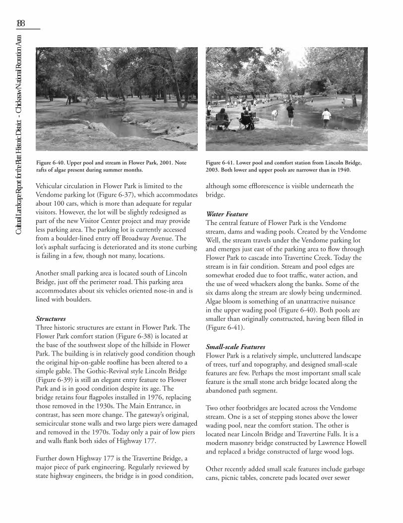
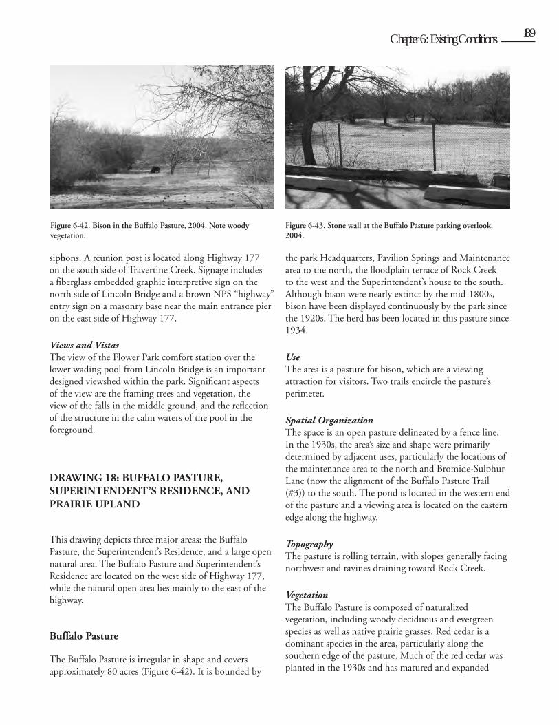
Water FeatureThe central feature of Flower Park is the Vendome stream, dams and wading pools. Created by the Vendome Well, the stream travels under the Vendome parking lot and emerges just east of the parking area to flow through Flower Park to cascade into Travertine Creek. Today the stream is in fair condition. Stream and pool edges are somewhat eroded due to foot traffic, water action, and the use of weed whackers along the banks. Some of the six dams along the stream are slowly being undermined. Algae bloom is something of an unattractive nuisance in the upper wading pool (Figure 6-40). Both pools are smaller than originally constructed, having been filled in (Figure 6-41).
Small-scale FeaturesFlower Park is a relatively simple, uncluttered landscape of trees, turf and topography, and designed small-scale features are few. Perhaps the most important small scale feature is the small stone arch bridge located along the abandoned path segment.
Two other footbridges are located across the Vendome stream. One is a set of stepping stones above the lower wading pool, near the comfort station. The other is located near Lincoln Bridge and Travertine Falls. It is a modern masonry bridge constructed by Lawrence Howell and replaced a bridge constructed of large wood logs.
Other recently added small scale features include garbage cans, picnic tables, concrete pads located over sewer
Figure 6-40. Upper pool and stream in Flower Park, 2001. Note rafts of algae present during summer months.
Figure 6-41. Lower pool and comfort station from Lincoln Bridge, 2003. Both lower and upper pools are narrower than in 1940.
Cult
ural L
andsc
ape R
eport
for th
e Plat
t Histo
ric D
istric
t - C
hicka
saw N
ation
al Re
creati
on A
rea
188 Chapter 6: Existing Conditions 189
siphons. A reunion post is located along Highway 177 on the south side of Travertine Creek. Signage includes a fiberglass embedded graphic interpretive sign on the north side of Lincoln Bridge and a brown NPS “highway” entry sign on a masonry base near the main entrance pier on the east side of Highway 177.
Views and VistasThe view of the Flower Park comfort station over the lower wading pool from Lincoln Bridge is an important designed viewshed within the park. Significant aspects of the view are the framing trees and vegetation, the view of the falls in the middle ground, and the reflection of the structure in the calm waters of the pool in the foreground.
DRAWING 18: BUFFALO PASTURE, SUPERINTENDENT’S RESIDENCE, AND PRAIRIE UPLAND
This drawing depicts three major areas: the Buffalo Pasture, the Superintendent’s Residence, and a large open natural area. The Buffalo Pasture and Superintendent’s Residence are located on the west side of Highway 177, while the natural open area lies mainly to the east of the highway.
Buffalo Pasture
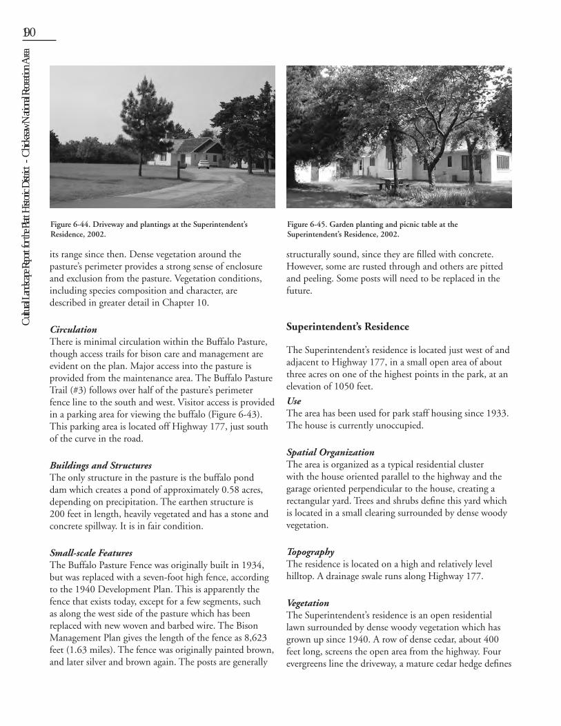
The Buffalo Pasture is irregular in shape and covers approximately 80 acres (Figure 6-42). It is bounded by
the park Headquarters, Pavilion Springs and Maintenance area to the north, the floodplain terrace of Rock Creek to the west and the Superintendent’s house to the south. Although bison were nearly extinct by the mid-1800s, bison have been displayed continuously by the park since the 1920s. The herd has been located in this pasture since 1934.
UseThe area is a pasture for bison, which are a viewing attraction for visitors. Two trails encircle the pasture’s perimeter.
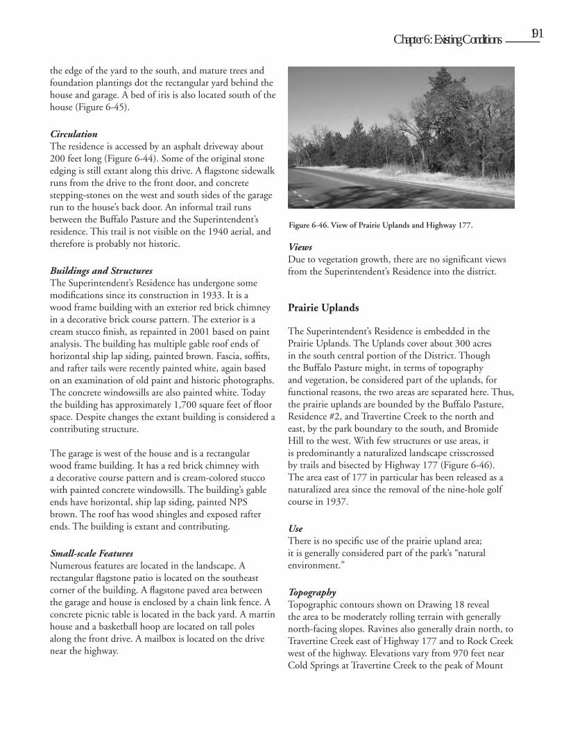
Spatial OrganizationThe space is an open pasture delineated by a fence line. In the 1930s, the area’s size and shape were primarily determined by adjacent uses, particularly the locations of the maintenance area to the north and Bromide-Sulphur Lane (now the alignment of the Buffalo Pasture Trail (#3)) to the south. The pond is located in the western end of the pasture and a viewing area is located on the eastern edge along the highway.
TopographyThe pasture is rolling terrain, with slopes generally facing northwest and ravines draining toward Rock Creek.
VegetationThe Buffalo Pasture is composed of naturalized vegetation, including woody deciduous and evergreen species as well as native prairie grasses. Red cedar is a dominant species in the area, particularly along the southern edge of the pasture. Much of the red cedar was planted in the 1930s and has matured and expanded
Figure 6-42. Bison in the Buffalo Pasture, 2004. Note woody vegetation.
Figure 6-43. Stone wall at the Buffalo Pasture parking overlook, 2004.
Cult
ural L
andsc
ape R
eport
for th
e Plat
t Histo
ric D
istric
t - C
hicka
saw N
ation
al Re
creati
on A
rea190 Chapter 6: Existing Conditions 191
its range since then. Dense vegetation around the pasture’s perimeter provides a strong sense of enclosure and exclusion from the pasture. Vegetation conditions, including species composition and character, are described in greater detail in Chapter 10.
CirculationThere is minimal circulation within the Buffalo Pasture, though access trails for bison care and management are evident on the plan. Major access into the pasture is provided from the maintenance area. The Buffalo Pasture Trail (#3) follows over half of the pasture’s perimeter fence line to the south and west. Visitor access is provided in a parking area for viewing the buffalo (Figure 6-43). This parking area is located off Highway 177, just south of the curve in the road.
Buildings and StructuresThe only structure in the pasture is the buffalo pond dam which creates a pond of approximately 0.58 acres, depending on precipitation. The earthen structure is 200 feet in length, heavily vegetated and has a stone and concrete spillway. It is in fair condition.
Small-scale FeaturesThe Buffalo Pasture Fence was originally built in 1934, but was replaced with a seven-foot high fence, according to the 1940 Development Plan. This is apparently the fence that exists today, except for a few segments, such as along the west side of the pasture which has been replaced with new woven and barbed wire. The Bison Management Plan gives the length of the fence as 8,623 feet (1.63 miles). The fence was originally painted brown, and later silver and brown again. The posts are generally
structurally sound, since they are filled with concrete. However, some are rusted through and others are pitted and peeling. Some posts will need to be replaced in the future.
Superintendent’s Residence
The Superintendent’s residence is located just west of and adjacent to Highway 177, in a small open area of about three acres on one of the highest points in the park, at an elevation of 1050 feet.
UseThe area has been used for park staff housing since 1933. The house is currently unoccupied.
Spatial OrganizationThe area is organized as a typical residential cluster with the house oriented parallel to the highway and the garage oriented perpendicular to the house, creating a rectangular yard. Trees and shrubs define this yard which is located in a small clearing surrounded by dense woody vegetation.
TopographyThe residence is located on a high and relatively level hilltop. A drainage swale runs along Highway 177.
VegetationThe Superintendent’s residence is an open residential lawn surrounded by dense woody vegetation which has grown up since 1940. A row of dense cedar, about 400 feet long, screens the open area from the highway. Four evergreens line the driveway, a mature cedar hedge defines
Figure 6-44. Driveway and plantings at the Superintendent’s Residence, 2002.
Figure 6-45. Garden planting and picnic table at the Superintendent’s Residence, 2002.
Cult
ural L
andsc
ape R
eport
for th
e Plat
t Histo
ric D
istric
t - C
hicka
saw N
ation
al Re
creati
on A
rea
190 Chapter 6: Existing Conditions 191
the edge of the yard to the south, and mature trees and foundation plantings dot the rectangular yard behind the house and garage. A bed of iris is also located south of the house (Figure 6-45).
CirculationThe residence is accessed by an asphalt driveway about 200 feet long (Figure 6-44). Some of the original stone edging is still extant along this drive. A flagstone sidewalk runs from the drive to the front door, and concrete stepping-stones on the west and south sides of the garage run to the house’s back door. An informal trail runs between the Buffalo Pasture and the Superintendent’s residence. This trail is not visible on the 1940 aerial, and therefore is probably not historic.
Buildings and StructuresThe Superintendent’s Residence has undergone some modifications since its construction in 1933. It is a wood frame building with an exterior red brick chimney in a decorative brick course pattern. The exterior is a cream stucco finish, as repainted in 2001 based on paint analysis. The building has multiple gable roof ends of horizontal ship lap siding, painted brown. Fascia, soffits, and rafter tails were recently painted white, again based on an examination of old paint and historic photographs. The concrete windowsills are also painted white. Today the building has approximately 1,700 square feet of floor space. Despite changes the extant building is considered a contributing structure.
The garage is west of the house and is a rectangular wood frame building. It has a red brick chimney with a decorative course pattern and is cream-colored stucco with painted concrete windowsills. The building’s gable ends have horizontal, ship lap siding, painted NPS brown. The roof has wood shingles and exposed rafter ends. The building is extant and contributing.
Small-scale FeaturesNumerous features are located in the landscape. A rectangular flagstone patio is located on the southeast corner of the building. A flagstone paved area between the garage and house is enclosed by a chain link fence. A concrete picnic table is located in the back yard. A martin house and a basketball hoop are located on tall poles along the front drive. A mailbox is located on the drive near the highway.
ViewsDue to vegetation growth, there are no significant views from the Superintendent’s Residence into the district.
Prairie Uplands
The Superintendent’s Residence is embedded in the Prairie Uplands. The Uplands cover about 300 acres in the south central portion of the District. Though the Buffalo Pasture might, in terms of topography and vegetation, be considered part of the uplands, for functional reasons, the two areas are separated here. Thus, the prairie uplands are bounded by the Buffalo Pasture, Residence #2, and Travertine Creek to the north and east, by the park boundary to the south, and Bromide Hill to the west. With few structures or use areas, it is predominantly a naturalized landscape crisscrossed by trails and bisected by Highway 177 (Figure 6-46). The area east of 177 in particular has been released as a naturalized area since the removal of the nine-hole golf course in 1937.
UseThere is no specific use of the prairie upland area; it is generally considered part of the park’s “natural environment.”
Topography Topographic contours shown on Drawing 18 reveal the area to be moderately rolling terrain with generally north-facing slopes. Ravines also generally drain north, to Travertine Creek east of Highway 177 and to Rock Creek west of the highway. Elevations vary from 970 feet near Cold Springs at Travertine Creek to the peak of Mount
Figure 6-46. View of Prairie Uplands and Highway 177.
Cult
ural L
andsc
ape R
eport
for th
e Plat
t Histo
ric D
istric
t - C
hicka
saw N
ation
al Re
creati
on A
rea192 Chapter 6: Existing Conditions 193
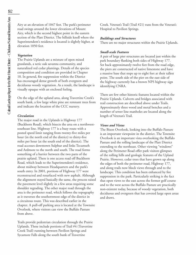
Airy at an elevation of 1047 feet. The park’s perimeter road swings around the lower elevations of Mount Airy, which is the second highest point in the eastern section of the Platt District. The hillside knoll where the Superintendent’s residence is located is slightly higher, at elevation 1050 feet.
Vegetation The Prairie Uplands are a mixture of open mixed grasslands, a xeric oak savanna community, and naturalized red cedar plantings. Details of the species composition and condition are provided in Chapter 10. In general, fire suppression within the District has encouraged dense growth of both evergreen and deciduous woody vegetation. As a result, the landscape is visually opaque with an enclosed feeling.
On the edge of the upland area, along Travertine Creek’s south bank, a few large white pine are remnant trees from and indicate the location of the CCC nursery.
Circulation The major road in the Uplands is Highway 177 (Buckhorn Road), which bisects the area on a northwest-southeast line. Highway 177 is a busy route with a posted speed limit ranging from twenty-five miles per hour (in the north end of the district) to thirty-five miles per hour (at the south end of the district). The road accesses downtown Sulphur and links Tecumseh and Ardmore to the north and south. The road forms something of a barrier between the two parts of the prairie upland. There is one access road off Buckhorn Road, which leads to the Superintendent’s residence, about midway between Headquarters and the park’s south entry. In 2001, portions of Highway 177 were reconstructed and resurfaced with new asphalt. Although the alignment stayed basically the same, the process raised the pavement level slightly in a few areas requiring some shoulder regrading. The other major road through the area is the perimeter road, which follows the topography as it traverses the southernmost edge of the district in a circuitous route. This was described earlier in the chapter. A pull-off parking area is located at the Townsite Overlook, where visitors can view the Buffalo Pasture from above.
Trails provide pedestrian circulation through the Prairie Uplands. These include portions of Trail #4 (Travertine Creek Trail) running between Pavilion Springs and Sycamore Falls along the south bank of Travertine
Creek. Veteran’s Trail (Trail #21) runs from the Veteran’s Hospital to Pavilion Springs.
Buildings and StructuresThere are no major structures within the Prairie Uplands.
Small-scale FeaturesA pair of large pier structures are located just within the park boundary flanking both sides of Highway 177. Set back approximately twelve feet from the road edge, the piers are constructed of native limestone and have a massive base that steps up to eight feet at their tallest point. The south side of the pier on the east side of the highway currently has a brown NPS highway sign identifying CNRA.
There are few other historic features located within the Prairie Uplands. Culverts and bridges associated with trail construction are described above under Trails. Approximately three wood and metal benches and a number of sewer line manholes are located along the length of Veteran’s Trail.
Views and VistasThe Bison Overlook, looking into the Buffalo Pasture is an important viewpoint in the district. The Townsite Overlook is an important vista overlooking the Buffalo Pasture and the rolling landscape of the Platt District extending to the northeast. Other viewing “windows” along the Perimeter Road offer park visitors glimpses of the rolling hills and geologic features of the Upland Prairie. However, cedar trees that have grown up along the edges of both the perimeter road, Highway 177, and along trails now block views through and to the landscape. This condition has been enhanced by fire suppression in the park. Particularly striking is the fact that open views to the east across the former golf course and to the west across the Buffalo Pasture are practically non-existent today, because of woody vegetation, both deciduous and evergreen that has covered large open areas and draws.
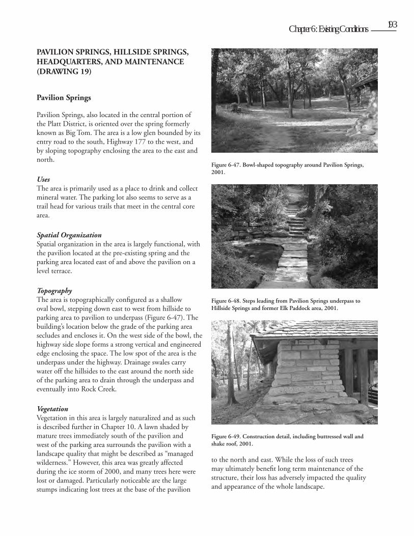
Cult
ural L
andsc
ape R
eport
for th
e Plat
t Histo
ric D
istric
t - C
hicka
saw N
ation
al Re
creati
on A
rea
192 Chapter 6: Existing Conditions 193
PAVILION SPRINGS, HILLSIDE SPRINGS, HEADQUARTERS, AND MAINTENANCE (DRAWING 19)
Pavilion Springs
Pavilion Springs, also located in the central portion of the Platt District, is oriented over the spring formerly known as Big Tom. The area is a low glen bounded by its entry road to the south, Highway 177 to the west, and by sloping topography enclosing the area to the east and north.
UsesThe area is primarily used as a place to drink and collect mineral water. The parking lot also seems to serve as a trail head for various trails that meet in the central core area.
Spatial OrganizationSpatial organization in the area is largely functional, with the pavilion located at the pre-existing spring and the parking area located east of and above the pavilion on a level terrace.
TopographyThe area is topographically configured as a shallow oval bowl, stepping down east to west from hillside to parking area to pavilion to underpass (Figure 6-47). The building’s location below the grade of the parking area secludes and encloses it. On the west side of the bowl, the highway side slope forms a strong vertical and engineered edge enclosing the space. The low spot of the area is the underpass under the highway. Drainage swales carry water off the hillsides to the east around the north side of the parking area to drain through the underpass and eventually into Rock Creek.
VegetationVegetation in this area is largely naturalized and as such is described further in Chapter 10. A lawn shaded by mature trees immediately south of the pavilion and west of the parking area surrounds the pavilion with a landscape quality that might be described as “managed wilderness.” However, this area was greatly affected during the ice storm of 2000, and many trees here were lost or damaged. Particularly noticeable are the large stumps indicating lost trees at the base of the pavilion
to the north and east. While the loss of such trees may ultimately benefit long term maintenance of the structure, their loss has adversely impacted the quality and appearance of the whole landscape.
Figure 6-47. Bowl-shaped topography around Pavilion Springs, 2001.
Figure 6-48. Steps leading from Pavilion Springs underpass to Hillside Springs and former Elk Paddock area, 2001.
Figure 6-49. Construction detail, including buttressed wall and shake roof, 2001.
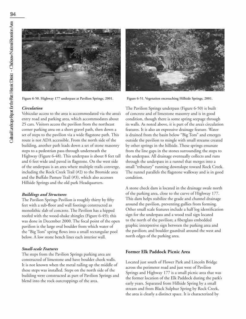
Cult
ural L
andsc
ape R
eport
for th
e Plat
t Histo
ric D
istric
t - C
hicka
saw N
ation
al Re
creati
on A
rea194 Chapter 6: Existing Conditions 195
CirculationVehicular access to the area is accommodated via the area’s entry road and parking area, which accommodates about 25 cars. Visitors access the pavilion from the northeast corner parking area on a short gravel path, then down a set of steps to the pavilion via a wide flagstone path. This route is not ADA accessible. From the north side of the building, another path leads down a set of stone masonry steps to a pedestrian pass-through underneath the Highway (Figure 6-48). This underpass is about 8 feet tall and 6 feet wide and paved in flagstone. On the west side of the underpass is an area where multiple trails converge, including the Rock Creek Trail (#2) to the Bromide area and the Buffalo Pasture Trail (#3), which also accesses Hillside Springs and the old park Headquarters.
Buildings and StructuresThe Pavilion Springs Pavilion is roughly thirty by fifty feet with a sub-floor and wall footings constructed as monolithic slab of concrete. The Pavilion has a hipped roofed with the wood-shake shingles (Figure 6-49); this was done in December 2000. The focal point of the open pavilion is the large oval boulder from which water of the “Big Tom” spring flows into a small rectangular pool below. A low stone bench lines each interior wall.
Small-scale FeaturesThe steps from the Pavilion Springs parking area are constructed of limestone and have boulder cheek walls. It is not known when the metal railing up the middle of these steps was installed. Steps on the north side of the building were constructed as part of Pavilion Springs and blend into the rock outcroppings of the area.
The Pavilion Springs underpass (Figure 6-50) is built of concrete and of limestone masonry and is in good condition, though there is some spring seepage through its walls. As noted above, it is part of the area’s circulation features. It is also an expressive drainage feature. Water is drained from the basin below “Big Tom” and emerges outside the pavilion to mingle with small streams created by other springs in the hillside. These springs emanate from the line gaps in the stones surrounding the steps to the underpass. All drainage eventually collects and runs through the underpass in a runnel that merges into a small “tributary” running downslope toward Rock Creek. The runnel parallels the flagstone walkway and is in good condition.
A stone check dam is located in the drainage swale north of the parking area, close to the curve of Highway 177. This dam helps stabilize the grade and channel drainage around the pavilion, preventing gullies from forming. Other small scale features include a half log identification sign for the underpass and a wood trail sign located to the north of the pavilion; a fiberglass embedded graphic interpretive sign between the parking area and the pavilion; and boulder guardrail around the west and north edges of the parking area.
Former Elk Paddock Picnic Area
Located just south of Flower Park and Lincoln Bridge across the perimeter road and just west of Pavilion Springs and Highway 177 is a small picnic area that was the former location of the Elk Paddock during the park’s early years. Separated from Hillside Spring by a small stream and from Black Sulphur Spring by Rock Creek, the area is clearly a distinct space. It is characterized by
Figure 6-50. Highway 177 underpass at Pavilion Springs, 2001. Figure 6-51. Vegetation encroaching Hillside Springs, 2001.
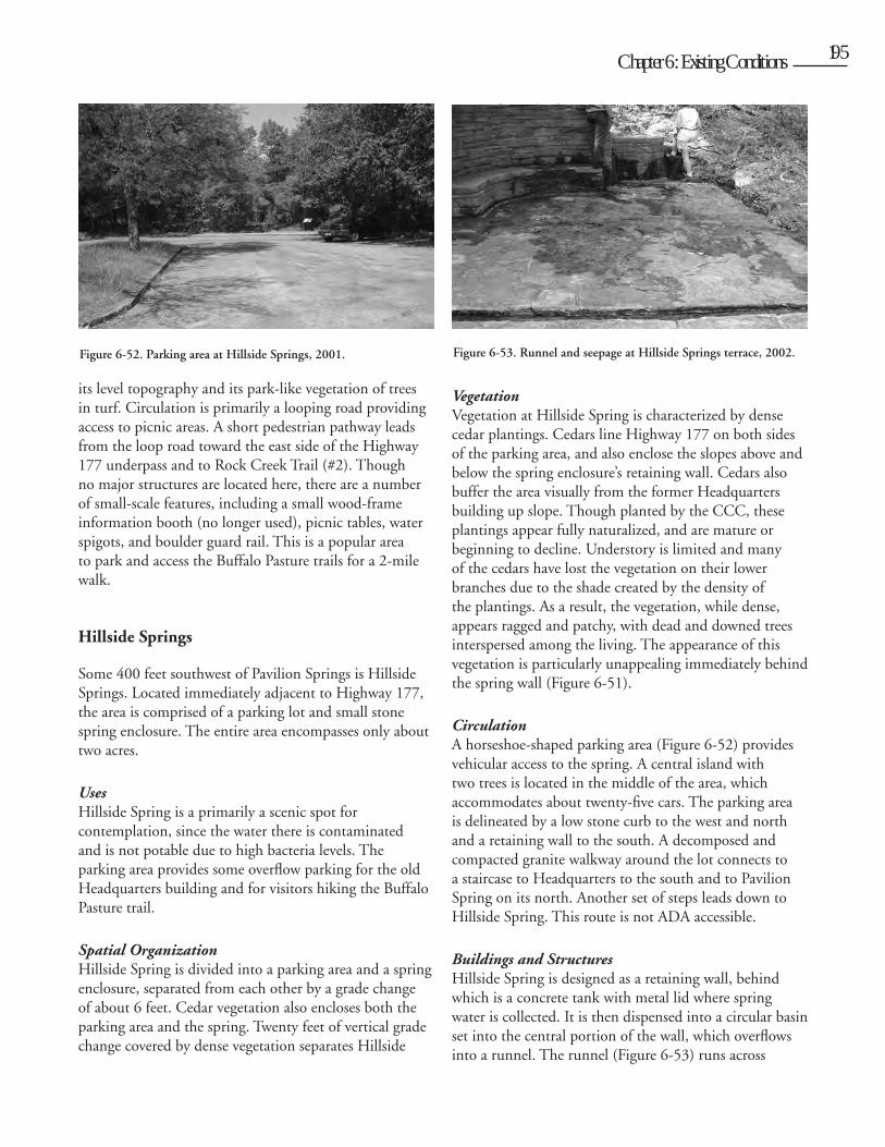
Cult
ural L
andsc
ape R
eport
for th
e Plat
t Histo
ric D
istric
t - C
hicka
saw N
ation
al Re
creati
on A
rea
194 Chapter 6: Existing Conditions 195
its level topography and its park-like vegetation of trees in turf. Circulation is primarily a looping road providing access to picnic areas. A short pedestrian pathway leads from the loop road toward the east side of the Highway 177 underpass and to Rock Creek Trail (#2). Though no major structures are located here, there are a number of small-scale features, including a small wood-frame information booth (no longer used), picnic tables, water spigots, and boulder guard rail. This is a popular area to park and access the Buffalo Pasture trails for a 2-mile walk.
Hillside Springs
Some 400 feet southwest of Pavilion Springs is Hillside Springs. Located immediately adjacent to Highway 177, the area is comprised of a parking lot and small stone spring enclosure. The entire area encompasses only about two acres.
UsesHillside Spring is a primarily a scenic spot for contemplation, since the water there is contaminated and is not potable due to high bacteria levels. The parking area provides some overflow parking for the old Headquarters building and for visitors hiking the Buffalo Pasture trail.
Spatial OrganizationHillside Spring is divided into a parking area and a spring enclosure, separated from each other by a grade change of about 6 feet. Cedar vegetation also encloses both the parking area and the spring. Twenty feet of vertical grade change covered by dense vegetation separates Hillside
Spring from the former headquarters area both physically and visually, making it a secluded spot.
TopographyHillside Spring is essentially a retaining wall set into shallow ravine on the north-facing slope of the highest point in the center of the district. The slope above the spring is moderately steep, averaging about 13%. Water from the spring drains down into the ravine leading toward Rock Creek.
VegetationVegetation at Hillside Spring is characterized by dense cedar plantings. Cedars line Highway 177 on both sides of the parking area, and also enclose the slopes above and below the spring enclosure’s retaining wall. Cedars also buffer the area visually from the former Headquarters building up slope. Though planted by the CCC, these plantings appear fully naturalized, and are mature or beginning to decline. Understory is limited and many of the cedars have lost the vegetation on their lower branches due to the shade created by the density of the plantings. As a result, the vegetation, while dense, appears ragged and patchy, with dead and downed trees interspersed among the living. The appearance of this vegetation is particularly unappealing immediately behind the spring wall (Figure 6-51).
CirculationA horseshoe-shaped parking area (Figure 6-52) provides vehicular access to the spring. A central island with two trees is located in the middle of the area, which accommodates about twenty-five cars. The parking area is delineated by a low stone curb to the west and north and a retaining wall to the south. A decomposed and compacted granite walkway around the lot connects to a staircase to Headquarters to the south and to Pavilion Spring on its north. Another set of steps leads down to Hillside Spring. This route is not ADA accessible.
Buildings and StructuresHillside Spring is designed as a retaining wall, behind which is a concrete tank with metal lid where spring water is collected. It is then dispensed into a circular basin set into the central portion of the wall, which overflows into a runnel. The runnel (Figure 6-53) runs across
Figure 6-52. Parking area at Hillside Springs, 2001. Figure 6-53. Runnel and seepage at Hillside Springs terrace, 2002.
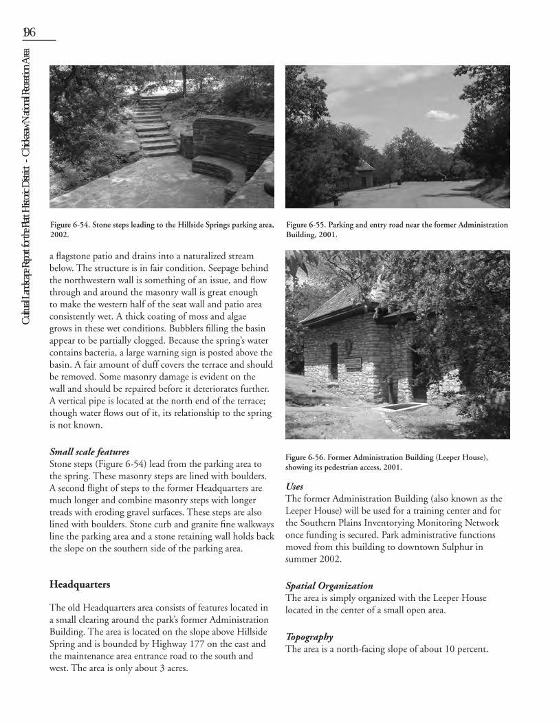
Cult
ural L
andsc
ape R
eport
for th
e Plat
t Histo
ric D
istric
t - C
hicka
saw N
ation
al Re
creati
on A
rea196 Chapter 6: Existing Conditions 197
a flagstone patio and drains into a naturalized stream below. The structure is in fair condition. Seepage behind the northwestern wall is something of an issue, and flow through and around the masonry wall is great enough to make the western half of the seat wall and patio area consistently wet. A thick coating of moss and algae grows in these wet conditions. Bubblers filling the basin appear to be partially clogged. Because the spring’s water contains bacteria, a large warning sign is posted above the basin. A fair amount of duff covers the terrace and should be removed. Some masonry damage is evident on the wall and should be repaired before it deteriorates further. A vertical pipe is located at the north end of the terrace; though water flows out of it, its relationship to the spring is not known.
Small scale featuresStone steps (Figure 6-54) lead from the parking area to the spring. These masonry steps are lined with boulders. A second flight of steps to the former Headquarters are much longer and combine masonry steps with longer treads with eroding gravel surfaces. These steps are also lined with boulders. Stone curb and granite fine walkways line the parking area and a stone retaining wall holds back the slope on the southern side of the parking area.
Headquarters
The old Headquarters area consists of features located in a small clearing around the park’s former Administration Building. The area is located on the slope above Hillside Spring and is bounded by Highway 177 on the east and the maintenance area entrance road to the south and west. The area is only about 3 acres.
UsesThe former Administration Building (also known as the Leeper House) will be used for a training center and for the Southern Plains Inventorying Monitoring Network once funding is secured. Park administrative functions moved from this building to downtown Sulphur in summer 2002.
Spatial OrganizationThe area is simply organized with the Leeper House located in the center of a small open area.
TopographyThe area is a north-facing slope of about 10 percent.
Figure 6-55. Parking and entry road near the former Administration Building, 2001.
Figure 6-56. Former Administration Building (Leeper House), showing its pedestrian access, 2001.
Figure 6-54. Stone steps leading to the Hillside Springs parking area, 2002.
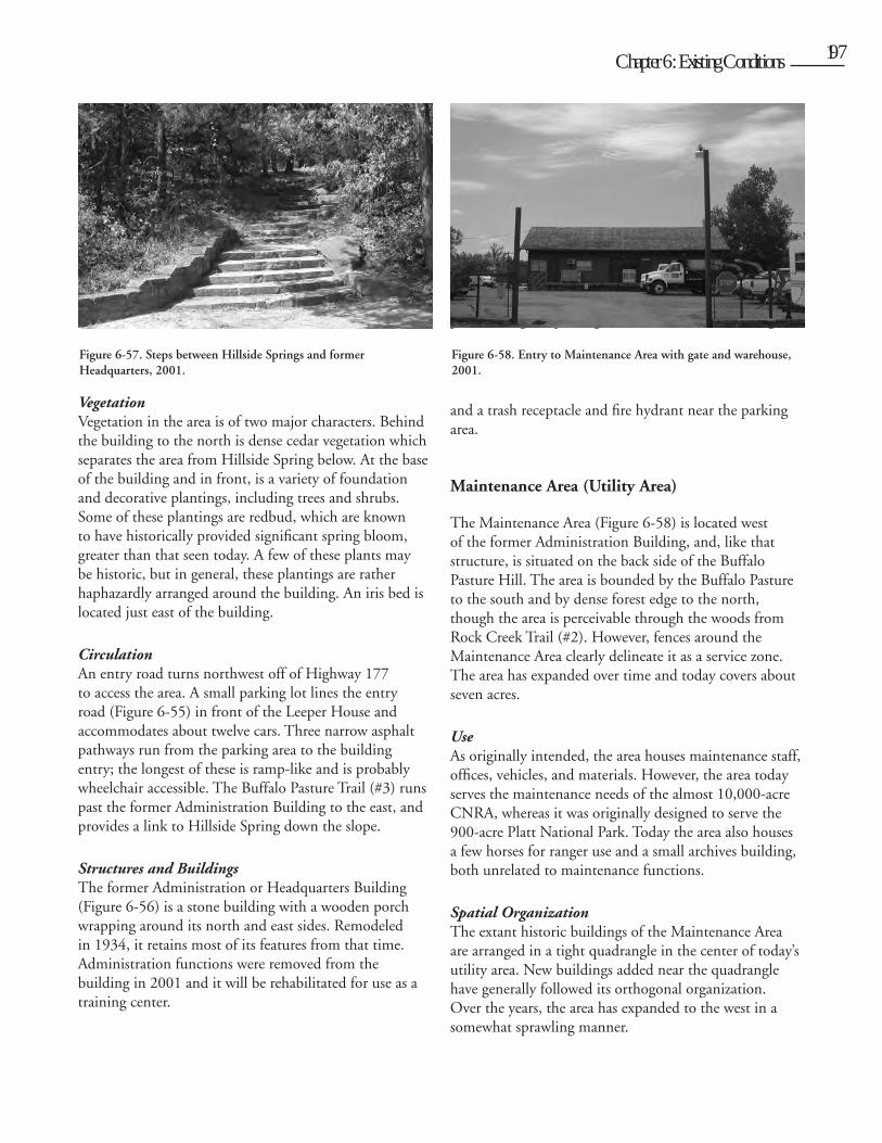
Cult
ural L
andsc
ape R
eport
for th
e Plat
t Histo
ric D
istric
t - C
hicka
saw N
ation
al Re
creati
on A
rea
196 Chapter 6: Existing Conditions 197
VegetationVegetation in the area is of two major characters. Behind the building to the north is dense cedar vegetation which separates the area from Hillside Spring below. At the base of the building and in front, is a variety of foundation and decorative plantings, including trees and shrubs. Some of these plantings are redbud, which are known to have historically provided significant spring bloom, greater than that seen today. A few of these plants may be historic, but in general, these plantings are rather haphazardly arranged around the building. An iris bed is located just east of the building.
CirculationAn entry road turns northwest off of Highway 177 to access the area. A small parking lot lines the entry road (Figure 6-55) in front of the Leeper House and accommodates about twelve cars. Three narrow asphalt pathways run from the parking area to the building entry; the longest of these is ramp-like and is probably wheelchair accessible. The Buffalo Pasture Trail (#3) runs past the former Administration Building to the east, and provides a link to Hillside Spring down the slope.
Structures and BuildingsThe former Administration or Headquarters Building (Figure 6-56) is a stone building with a wooden porch wrapping around its north and east sides. Remodeled in 1934, it retains most of its features from that time. Administration functions were removed from the building in 2001 and it will be rehabilitated for use as a training center.
Small-scale FeaturesA set of broad, terrace-like steps are located in the lawn north of the building, and join with the steps (Figure 6-57) leading to Hillside Spring. Hidden in the woods just east of the former Administration building are some remnant stepping-stones which were once a part of a trail leading across Highway 177 to the former Employee Residence Group. The stepping-stones are covered with duff and are not easily located.Other small-scale features in the area include a satellite dish located to the northwest of the building, boulders placed along the parking area in front of the building,
and a trash receptacle and fire hydrant near the parking area.
Maintenance Area (Utility Area)
The Maintenance Area (Figure 6-58) is located west of the former Administration Building, and, like that structure, is situated on the back side of the Buffalo Pasture Hill. The area is bounded by the Buffalo Pasture to the south and by dense forest edge to the north, though the area is perceivable through the woods from Rock Creek Trail (#2). However, fences around the Maintenance Area clearly delineate it as a service zone. The area has expanded over time and today covers about seven acres.
UseAs originally intended, the area houses maintenance staff, offices, vehicles, and materials. However, the area today serves the maintenance needs of the almost 10,000-acre CNRA, whereas it was originally designed to serve the 900-acre Platt National Park. Today the area also houses a few horses for ranger use and a small archives building, both unrelated to maintenance functions.
Spatial OrganizationThe extant historic buildings of the Maintenance Area are arranged in a tight quadrangle in the center of today’s utility area. New buildings added near the quadrangle have generally followed its orthogonal organization. Over the years, the area has expanded to the west in a somewhat sprawling manner.
Figure 6-57. Steps between Hillside Springs and former Headquarters, 2001.
Figure 6-58. Entry to Maintenance Area with gate and warehouse, 2001.
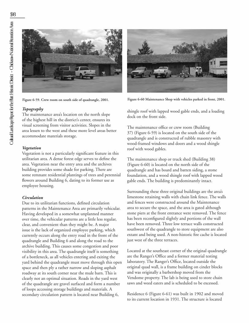
Cult
ural L
andsc
ape R
eport
for th
e Plat
t Histo
ric D
istric
t - C
hicka
saw N
ation
al Re
creati
on A
rea198 Chapter 6: Existing Conditions 199
TopographyThe maintenance area’s location on the north slope of the highest hill in the district’s center, ensures its visual screening from visitor activities. Slopes in the area lessen to the west and these more level areas better accommodate materials storage.
VegetationVegetation is not a particularly significant feature in this utilitarian area. A dense forest edge serves to define the area. Vegetation near the entry area and the archives building provides some shade for parking. There are some remnant residential plantings of trees and perennial flowers around Building 6, dating to its former use as employee housing.
CirculationDue to its utilitarian functions, defined circulation patterns in the Maintenance Area are primarily vehicular. Having developed in a somewhat unplanned manner over time, the vehicular patterns are a little less regular, clear, and convenient than they might be. A major issue is the lack of organized employee parking, which currently occurs along the entry road in the front of the quadrangle and Building 6 and along the road to the archive building. This causes some congestion and poor visibility in this area. The quadrangle itself is something of a bottleneck, as all vehicles entering and exiting the yard behind the quadrangle must move through this open space and then ply a rather narrow and sloping asphalt roadway at its south corner near the mule barn. This is clearly not an optimal situation. Roads in the yard west of the quadrangle are gravel surfaced and form a number of loops accessing storage buildings and materials. A secondary circulation pattern is located near Building 6,
where a small loop road behind Building #38 accesses the archive building.
Buildings and StructuresThe former Mule Barn (Building #36), located on the west side of the quadrangle, is currently used as warehouse space and receiving dock. Its basement also serves for equipment storage. Situated on a slope, its front and back entries are at different grades; today the back entry accommodates vehicles rather than mules. The building is constructed of stone and wood, has a wood
shingle roof with lapped wood gable ends, and a loading dock on the front side. The maintenance office or crew room (Building 37) (Figure 6-59) is located on the south side of the quadrangle and is constructed of rubble masonry with wood-framed windows and doors and a wood shingle roof with wood gables.
The maintenance shop or truck shed (Building 38) (Figure 6-60) is located on the north side of the quadrangle and has board and batten siding, a stone foundation, and a wood shingle roof with lapped wood gable ends. The building is predominantly intact.
Surrounding these three original buildings are the area’s limestone retaining walls with chain link fence. The walls and fences were constructed around the Maintenance area to secure the space, and the area is gated although stone piers at the front entrance were removed. The fence has been reconfigured slightly and portions of the wall have been removed. Three low terrace walls constructed southwest of the quadrangle to store equipment are also extant and being used. A non-historic fire cache is located just west of the three terraces.
Located at the southeast corner of the original quadrangle are the Ranger’s Office and a former material testing laboratory. The Ranger’s Office, located outside the original quad wall, is a frame building on cinder blocks and was originally a barbershop moved from the Vendome property. The lab is being used to store chain saws and weed eaters and is scheduled to be excessed.
Residence 6 (Figure 6-61) was built in 1902 and moved to its current location in 1931. The structure is located
Figure 6-59. Crew room on south side of quadrangle, 2001. Figure 6-60 Maintenance Shop with vehicles parked in front, 2001.
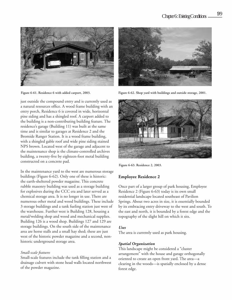
Cult
ural L
andsc
ape R
eport
for th
e Plat
t Histo
ric D
istric
t - C
hicka
saw N
ation
al Re
creati
on A
rea
198 Chapter 6: Existing Conditions 199
just outside the compound entry and is currently used as a natural resources office. A wood frame building with an entry porch, Residence 6 is covered in wide, horizontal pine siding and has a shingled roof. A carport added to the building is a non-contributing building feature. The residence’s garage (Building 11) was built at the same time and is similar to garages at Residence 2 and the Bromide Ranger Station. It is a wood frame building, with a shingled gable roof and wide pine siding stained NPS brown. Located west of the garage and adjacent to the maintenance shop is the climate-controlled archives building, a twenty-five by eighteen-foot metal building constructed on a concrete pad.
In the maintenance yard to the west are numerous storage buildings (Figure 6-62). Only one of these is historic: the earth-sheltered powder magazine. This concrete rubble masonry building was used as a storage building for explosives during the CCC era and later served as a chemical storage area. It is no longer in use. There are numerous other metal and wood buildings. These include 3 storage buildings and a tank fueling station just west of the warehouse. Further west is Building 128, housing a metal/welding shop and wood and mechanical supplies. Building 126 is a wood shop. Buildings 127 and 129 are storage buildings. On the south side of the maintenance area are horse stalls and a small hay shed; these are just west of the historic powder magazine and a second, non-historic underground storage area.
Small-scale featuresSmall-scale features include the tank filling station and a drainage culvert with stone head walls located northwest of the powder magazine.
Employee Residence 2
Once part of a larger group of park housing, Employee Residence 2 (Figure 6-63) today is its own small residential landscape located southeast of Pavilion Springs. About two acres in size, it is essentially bounded by its embracing entry driveway to the west and south. To the east and north, it is bounded by a forest edge and the topography of the slight hill on which it sits.
UsesThe area is currently used as park housing.
Spatial OrganizationThis landscape might be considered a “cluster arrangement” with the house and garage orthogonally oriented to create an open front yard. The area—a clearing in the woods—is spatially enclosed by a dense forest edge.
Figure 6-61. Residence 6 with added carport, 2003. Figure 6-62. Shop yard with buildings and outside storage, 2001.
Figure 6-63. Residence 2, 2003.
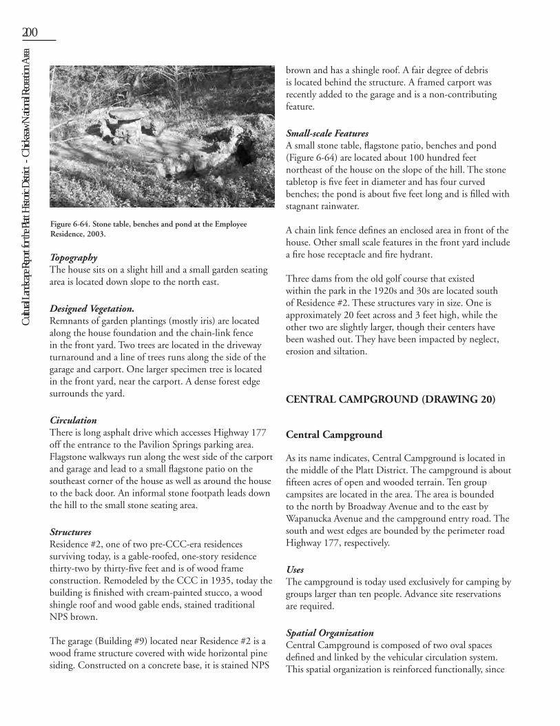
Cult
ural L
andsc
ape R
eport
for th
e Plat
t Histo
ric D
istric
t - C
hicka
saw N
ation
al Re
creati
on A
rea200 Chapter 6: Existing Conditions 201
TopographyThe house sits on a slight hill and a small garden seating area is located down slope to the north east.
Designed Vegetation.Remnants of garden plantings (mostly iris) are located along the house foundation and the chain-link fence in the front yard. Two trees are located in the driveway turnaround and a line of trees runs along the side of the garage and carport. One larger specimen tree is located in the front yard, near the carport. A dense forest edge surrounds the yard.
CirculationThere is long asphalt drive which accesses Highway 177 off the entrance to the Pavilion Springs parking area. Flagstone walkways run along the west side of the carport and garage and lead to a small flagstone patio on the southeast corner of the house as well as around the house to the back door. An informal stone footpath leads down the hill to the small stone seating area.
StructuresResidence #2, one of two pre-CCC-era residences surviving today, is a gable-roofed, one-story residence thirty-two by thirty-five feet and is of wood frame construction. Remodeled by the CCC in 1935, today the building is finished with cream-painted stucco, a wood shingle roof and wood gable ends, stained traditional NPS brown.
The garage (Building #9) located near Residence #2 is a wood frame structure covered with wide horizontal pine siding. Constructed on a concrete base, it is stained NPS
brown and has a shingle roof. A fair degree of debris is located behind the structure. A framed carport was recently added to the garage and is a non-contributing feature.
Small-scale FeaturesA small stone table, flagstone patio, benches and pond (Figure 6-64) are located about 100 hundred feet northeast of the house on the slope of the hill. The stone tabletop is five feet in diameter and has four curved benches; the pond is about five feet long and is filled with stagnant rainwater.
A chain link fence defines an enclosed area in front of the house. Other small scale features in the front yard include a fire hose receptacle and fire hydrant.
Three dams from the old golf course that existed within the park in the 1920s and 30s are located south of Residence #2. These structures vary in size. One is approximately 20 feet across and 3 feet high, while the other two are slightly larger, though their centers have been washed out. They have been impacted by neglect, erosion and siltation.
CENTRAL CAMPGROUND (DRAWING 20)
Central Campground
As its name indicates, Central Campground is located in the middle of the Platt District. The campground is about fifteen acres of open and wooded terrain. Ten group campsites are located in the area. The area is bounded to the north by Broadway Avenue and to the east by Wapanucka Avenue and the campground entry road. The south and west edges are bounded by the perimeter road Highway 177, respectively.
UsesThe campground is today used exclusively for camping by groups larger than ten people. Advance site reservations are required.
Spatial OrganizationCentral Campground is composed of two oval spaces defined and linked by the vehicular circulation system. This spatial organization is reinforced functionally, since
Figure 6-64. Stone table, benches and pond at the Employee Residence, 2003.
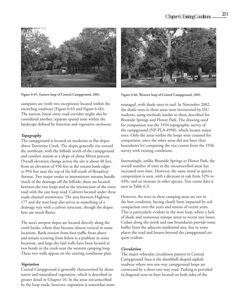
Cult
ural L
andsc
ape R
eport
for th
e Plat
t Histo
ric D
istric
t - C
hicka
saw N
ation
al Re
creati
on A
rea
200 Chapter 6: Existing Conditions 201
campsites are (with two exceptions) located within the encircling roadways (Figure 6-65 and Figure 6-66). The narrow, linear entry road corridor might also be considered another, separate spatial zone within the landscape defined by function and vegetative enclosure.
Topography The campground is located on moderate to flat slopes above Travertine Creek. The slopes generally rise toward the northeast, with the hillside north of the campground and comfort station at a slope of about fifteen percent. Overall elevation change across the site is about 40 feet, from an elevation of 950 feet at the stream bank edges to 994 feet near the top of the hill south of Broadway Avenue. Two major swales or intermittent streams handle much of the drainage off the hillside; these are located between the two loops and at the intersection of the entry road with the east loop road. Culverts located under these roads channel stormwater. The area between Highway 177 and the west loop also serves as something of a drainage way with a culvert structure, though the slopes here are much flatter.
The area’s steepest slopes are located directly along the creek banks, where they become almost vertical in some locations. Bank erosion from foot traffic from above and stream scouring from below is a problem in some locations, and large dry laid walls have been located at two bends in the creek near the western camping loop. These two walls appear on the existing conditions plan.
Vegetation Central Campground is generally characterized by dense native and naturalized vegetation, which is described in greater detail in Chapter 10. In the areas circumscribed by the loop roads, however, vegetation is somewhat more
managed, with shade trees in turf. In November 2002, the shade trees in these areas were inventoried by ISU students, using methods similar to those described for Bromide Springs and Flower Park. The drawing used for comparison was the 1934 topographic survey of the campground (NP-PLA-4998), which locates major trees. Only the areas within the loops were counted for comparison, since the other areas did not have clear boundaries for comparing the tree counts from the 1936 survey with existing conditions.
Interestingly, unlike Bromide Springs or Flower Park, the overall number of trees in the circumscribed areas has increased over time. However, the same trend in species composition is seen, with a decrease in oak from 52% to 43%, and an increase in other species. Tree count data is seen in Table 6-3.
However, the trees in these camping areas are not in the best condition, having clearly been impacted by soil compaction over the years and storms of recent years. This is particularly evident in the west loop, where a lack of shade and numerous stumps attest to recent tree losses. Cedars along the north and east boundaries provide some buffer from the adjacent residential area, but in some places the road and houses beyond the campground are quite evident.
Circulation The major vehicular circulation pattern in Central Campground Area is the dumbbell-shaped asphalt roadway where two one-way campground loops are connected by a short two-way road. Parking is provided in diagonal nose-in bays located on both sides of the
Figure 6-65. Eastern loop of Central Campground, 2001. Figure 6-66. Western loop of Central Campground, 2001.
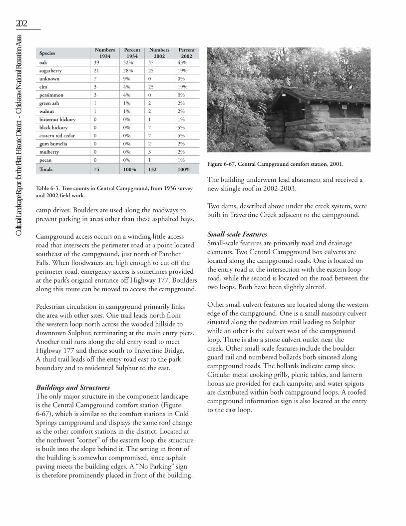
Cult
ural L
andsc
ape R
eport
for th
e Plat
t Histo
ric D
istric
t - C
hicka
saw N
ation
al Re
creati
on A
rea202 Chapter 6: Existing Conditions 203
camp drives. Boulders are used along the roadways to prevent parking in areas other than these asphalted bays.
Campground access occurs on a winding little access road that intersects the perimeter road at a point located southeast of the campground, just north of Panther Falls. When floodwaters are high enough to cut off the perimeter road, emergency access is sometimes provided at the park’s original entrance off Highway 177. Boulders along this route can be moved to access the campground.
Pedestrian circulation in campground primarily links the area with other sites. One trail leads north from the western loop north across the wooded hillside to downtown Sulphur, terminating at the main entry piers. Another trail runs along the old entry road to meet Highway 177 and thence south to Travertine Bridge. A third trail leads off the entry road east to the park boundary and to residential Sulphur to the east.
Buildings and StructuresThe only major structure in the component landscape is the Central Campground comfort station (Figure 6-67), which is similar to the comfort stations in Cold Springs campground and displays the same roof change as the other comfort stations in the district. Located at the northwest “corner” of the eastern loop, the structure is built into the slope behind it. The setting in front of the building is somewhat compromised, since asphalt paving meets the building edges. A “No Parking” sign is therefore prominently placed in front of the building.
The building underwent lead abatement and received a new shingle roof in 2002-2003.
Two dams, described above under the creek system, were built in Travertine Creek adjacent to the campground.
Small-scale FeaturesSmall-scale features are primarily road and drainage elements. Two Central Campground box culverts are located along the campground roads. One is located on the entry road at the intersection with the eastern loop road, while the second is located on the road between the two loops. Both have been slightly altered.
Other small culvert features are located along the western edge of the campground. One is a small masonry culvert situated along the pedestrian trail leading to Sulphur while an other is the culvert west of the campground loop. There is also a stone culvert outlet near the creek. Other small-scale features include the boulder guard rail and numbered bollards both situated along campground roads. The bollards indicate camp sites. Circular metal cooking grills, picnic tables, and lantern hooks are provided for each campsite, and water spigots are distributed within both campground loops. A roofed campground information sign is also located at the entry to the east loop.
Figure 6-67. Central Campground comfort station, 2001.
Table 6-3. Tree counts in Central Campground, from 1936 survey and 2002 field work.
SpeciesNumbers
1934Percent 1934
Numbers 2002
Percent 2002
oak 39 52% 57 43%
sugarberry 21 28% 25 19%
unknown 7 9% 0 0%
elm 3 4% 25 19%
persimmon 3 4% 0 0%
green ash 1 1% 2 2%
walnut 1 1% 2 2%
bitternut hickory 0 0% 1 1%
black hickory 0 0% 7 5%
eastern red cedar 0 0% 7 5%
gum bumelia 0 0% 2 2%
mulberry 0 0% 3 2%
pecan 0 0% 1 1%
Totals 75 100% 132 100%

Cult
ural L
andsc
ape R
eport
for th
e Plat
t Histo
ric D
istric
t - C
hicka
saw N
ation
al Re
creati
on A
rea
202 Chapter 6: Existing Conditions 203
COLD SPRINGS CAMPGROUND (DRAWING 21)
Cold Springs Campground
Cold Springs Campground is located in the eastern portion of the Platt District, along the banks of Travertine Creek. A wooded area of approximately twenty acres, it is bounded on the south by the perimeter road and the creek and to the north by the park fence.
UsesThe campground is used for camping and campsites available on a first-come, first served basis. Two large sites accommodate larger groups (Figure 6-68), with reservations taken for groups larger than ten individuals. Family reunions often occur at this campground.
Spatial OrganizationCold Springs Campground is an oblong-shaped area, defined by a perimeter road. The area is subdivided into two linear, banana-shaped areas by a central road leading into the campground. Midway along the central road, two spurs lead to both sides of the perimeter loop, dividing the banana-shaped areas into two halves. Thus, the campground is divided into four major spaces. The two spaces to the east are served by one comfort station, and the two spaces to the west are served by a second comfort station, which, from a functional standpoint divides the area into two zones, east and west. Sixty-five campsites are located along the three roadways, generally alternating entrances to the left and right. Campsites are more or less circular and are separated from the
driveways by boulders. This organization of camping areas subscribes to principles of campground design set out in the classic NPS handbook, Park and Recreation Structures. At the campground entrance is a more open space containing two group sites and a parking area serving the host site, community building, and checking station (Figure 6-69).
Topography The campground is relatively level, with a slight rise toward the northeast. The flatness of the area causes some drainage problems in heavy storms. A drainage swale (almost a ditch) runs along the back of the campground, between the northern row of sites and the park boundary. This swale catches surface drainage from the south-facing slope north of the campground and directs it around the campground to the west and east.
Vegetation The vegetation in the campground is predominantly native overstory trees, including oaks and hackberry. Cedar is common along the northern edge of the campground, likely as a result of 1930s boundary plantings. The overstory is only in fair condition, and many mature trees were lost or damaged by the 2000 ice storm. Understory vegetation is reduced compared to other parts of the district, mostly because of the heavy visitor use the area receives. Foot traffic between campsites is heavy and small shrubs and forbs are quickly trampled. This reduces privacy between sites and in some areas, campsites are clearly visible from the perimeter road due to lack of vegetative screening. Shrubby vegetation tends to be denser around the campground perimeters, where foot traffic is less.
Figure 6-68. Group campsite and large wood and concrete picnic tables, 2002.
Figure 6-69. Entry area at Cold Springs Campground, with former community house, 2002.
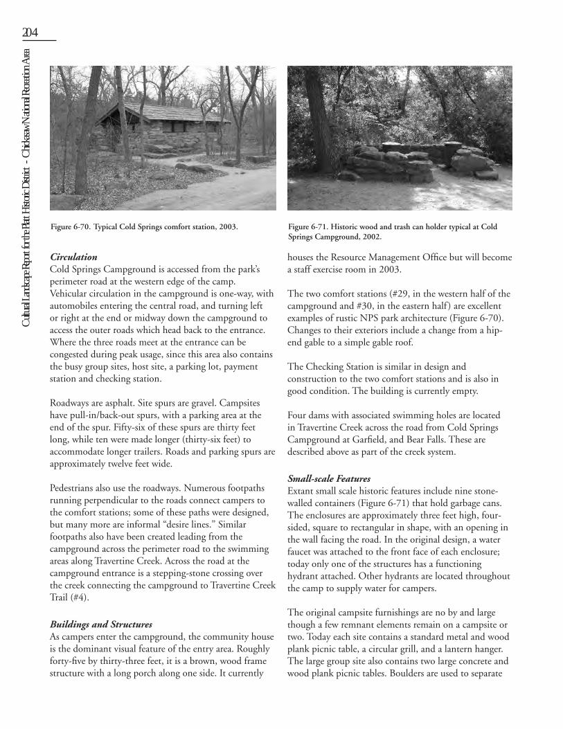
Cult
ural L
andsc
ape R
eport
for th
e Plat
t Histo
ric D
istric
t - C
hicka
saw N
ation
al Re
creati
on A
rea204 Chapter 6: Existing Conditions 205
Circulation Cold Springs Campground is accessed from the park’s perimeter road at the western edge of the camp. Vehicular circulation in the campground is one-way, with automobiles entering the central road, and turning left or right at the end or midway down the campground to access the outer roads which head back to the entrance. Where the three roads meet at the entrance can be congested during peak usage, since this area also contains the busy group sites, host site, a parking lot, payment station and checking station.
Roadways are asphalt. Site spurs are gravel. Campsites have pull-in/back-out spurs, with a parking area at the end of the spur. Fifty-six of these spurs are thirty feet long, while ten were made longer (thirty-six feet) to accommodate longer trailers. Roads and parking spurs are approximately twelve feet wide.
Pedestrians also use the roadways. Numerous footpaths running perpendicular to the roads connect campers to the comfort stations; some of these paths were designed, but many more are informal “desire lines.” Similar footpaths also have been created leading from the campground across the perimeter road to the swimming areas along Travertine Creek. Across the road at the campground entrance is a stepping-stone crossing over the creek connecting the campground to Travertine Creek Trail (#4).
Buildings and StructuresAs campers enter the campground, the community house is the dominant visual feature of the entry area. Roughly forty-five by thirty-three feet, it is a brown, wood frame structure with a long porch along one side. It currently
houses the Resource Management Office but will become a staff exercise room in 2003.
The two comfort stations (#29, in the western half of the campground and #30, in the eastern half ) are excellent examples of rustic NPS park architecture (Figure 6-70). Changes to their exteriors include a change from a hip-end gable to a simple gable roof.
The Checking Station is similar in design and construction to the two comfort stations and is also in good condition. The building is currently empty.
Four dams with associated swimming holes are located in Travertine Creek across the road from Cold Springs Campground at Garfield, and Bear Falls. These are described above as part of the creek system.
Small-scale FeaturesExtant small scale historic features include nine stone-walled containers (Figure 6-71) that hold garbage cans. The enclosures are approximately three feet high, four-sided, square to rectangular in shape, with an opening in the wall facing the road. In the original design, a water faucet was attached to the front face of each enclosure; today only one of the structures has a functioning hydrant attached. Other hydrants are located throughout the camp to supply water for campers.
The original campsite furnishings are no by and large though a few remnant elements remain on a campsite or two. Today each site contains a standard metal and wood plank picnic table, a circular grill, and a lantern hanger. The large group site also contains two large concrete and wood plank picnic tables. Boulders are used to separate
Figure 6-70. Typical Cold Springs comfort station, 2003. Figure 6-71. Historic wood and trash can holder typical at Cold Springs Campground, 2002.
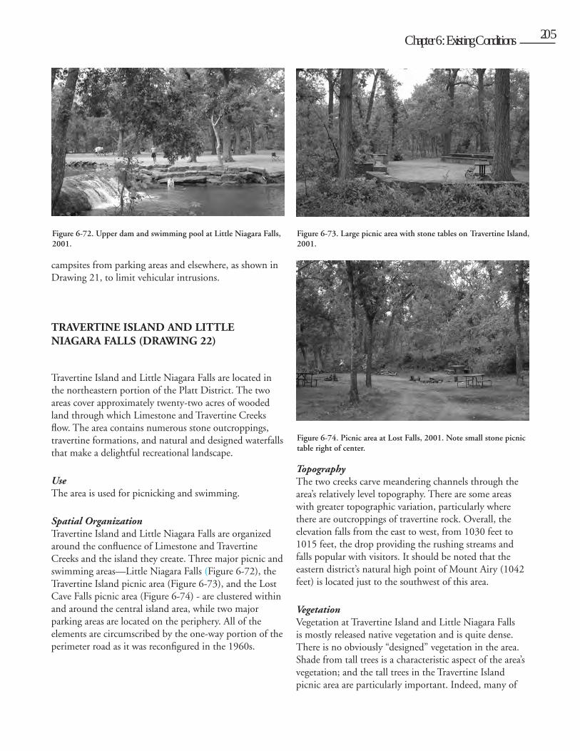
Cult
ural L
andsc
ape R
eport
for th
e Plat
t Histo
ric D
istric
t - C
hicka
saw N
ation
al Re
creati
on A
rea
204 Chapter 6: Existing Conditions 205
campsites from parking areas and elsewhere, as shown in Drawing 21, to limit vehicular intrusions.
TRAVERTINE ISLAND AND LITTLE NIAGARA FALLS (DRAWING 22)
Travertine Island and Little Niagara Falls are located in the northeastern portion of the Platt District. The two areas cover approximately twenty-two acres of wooded land through which Limestone and Travertine Creeks flow. The area contains numerous stone outcroppings, travertine formations, and natural and designed waterfalls that make a delightful recreational landscape.
UseThe area is used for picnicking and swimming.
Spatial OrganizationTravertine Island and Little Niagara Falls are organized around the confluence of Limestone and Travertine Creeks and the island they create. Three major picnic and swimming areas—Little Niagara Falls (Figure 6-72), the Travertine Island picnic area (Figure 6-73), and the Lost Cave Falls picnic area (Figure 6-74) - are clustered within and around the central island area, while two major parking areas are located on the periphery. All of the elements are circumscribed by the one-way portion of the perimeter road as it was reconfigured in the 1960s.
Topography The two creeks carve meandering channels through the area’s relatively level topography. There are some areas with greater topographic variation, particularly where there are outcroppings of travertine rock. Overall, the elevation falls from the east to west, from 1030 feet to 1015 feet, the drop providing the rushing streams and falls popular with visitors. It should be noted that the eastern district’s natural high point of Mount Airy (1042 feet) is located just to the southwest of this area.
Vegetation Vegetation at Travertine Island and Little Niagara Falls is mostly released native vegetation and is quite dense. There is no obviously “designed” vegetation in the area. Shade from tall trees is a characteristic aspect of the area’s vegetation; and the tall trees in the Travertine Island picnic area are particularly important. Indeed, many of
Figure 6-73. Large picnic area with stone tables on Travertine Island, 2001.
Figure 6-72. Upper dam and swimming pool at Little Niagara Falls, 2001.
Figure 6-74. Picnic area at Lost Falls, 2001. Note small stone picnic table right of center.
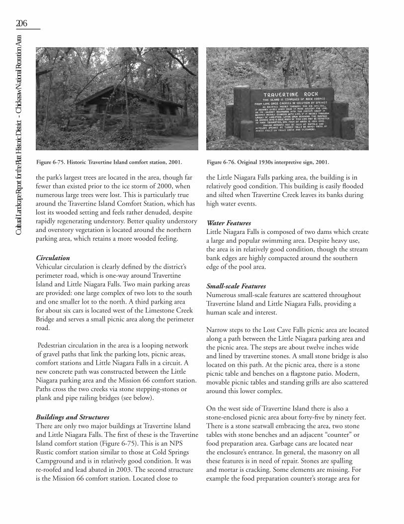
Cult
ural L
andsc
ape R
eport
for th
e Plat
t Histo
ric D
istric
t - C
hicka
saw N
ation
al Re
creati
on A
rea206 Chapter 6: Existing Conditions 207
the park’s largest trees are located in the area, though far fewer than existed prior to the ice storm of 2000, when numerous large trees were lost. This is particularly true around the Travertine Island Comfort Station, which has lost its wooded setting and feels rather denuded, despite rapidly regenerating understory. Better quality understory and overstory vegetation is located around the northern parking area, which retains a more wooded feeling.
Circulation Vehicular circulation is clearly defined by the district’s perimeter road, which is one-way around Travertine Island and Little Niagara Falls. Two main parking areas are provided: one large complex of two lots to the south and one smaller lot to the north. A third parking area for about six cars is located west of the Limestone Creek Bridge and serves a small picnic area along the perimeter road.
Pedestrian circulation in the area is a looping network of gravel paths that link the parking lots, picnic areas, comfort stations and Little Niagara Falls in a circuit. A new concrete path was constructed between the Little Niagara parking area and the Mission 66 comfort station. Paths cross the two creeks via stone stepping-stones or plank and pipe railing bridges (see below).
Buildings and StructuresThere are only two major buildings at Travertine Island and Little Niagara Falls. The first of these is the Travertine Island comfort station (Figure 6-75). This is an NPS Rustic comfort station similar to those at Cold Springs Campground and is in relatively good condition. It was re-roofed and lead abated in 2003. The second structure is the Mission 66 comfort station. Located close to
the Little Niagara Falls parking area, the building is in relatively good condition. This building is easily flooded and silted when Travertine Creek leaves its banks during high water events.
Water FeaturesLittle Niagara Falls is composed of two dams which create a large and popular swimming area. Despite heavy use, the area is in relatively good condition, though the stream bank edges are highly compacted around the southern edge of the pool area.
Small-scale FeaturesNumerous small-scale features are scattered throughout Travertine Island and Little Niagara Falls, providing a human scale and interest.
Narrow steps to the Lost Cave Falls picnic area are located along a path between the Little Niagara parking area and the picnic area. The steps are about twelve inches wide and lined by travertine stones. A small stone bridge is also located on this path. At the picnic area, there is a stone picnic table and benches on a flagstone patio. Modern, movable picnic tables and standing grills are also scattered around this lower complex.
On the west side of Travertine Island there is also a stone-enclosed picnic area about forty-five by ninety feet. There is a stone seatwall embracing the area, two stone tables with stone benches and an adjacent “counter” or food preparation area. Garbage cans are located near the enclosure’s entrance. In general, the masonry on all these features is in need of repair. Stones are spalling and mortar is cracking. Some elements are missing. For example the food preparation counter’s storage area for
Figure 6-75. Historic Travertine Island comfort station, 2001. Figure 6-76. Original 1930s interpretive sign, 2001.
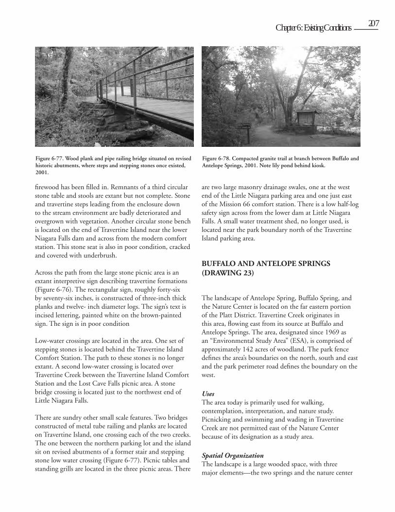
Cult
ural L
andsc
ape R
eport
for th
e Plat
t Histo
ric D
istric
t - C
hicka
saw N
ation
al Re
creati
on A
rea
206 Chapter 6: Existing Conditions 207
firewood has been filled in. Remnants of a third circular stone table and stools are extant but not complete. Stone and travertine steps leading from the enclosure down to the stream environment are badly deteriorated and overgrown with vegetation. Another circular stone bench is located on the end of Travertine Island near the lower Niagara Falls dam and across from the modern comfort station. This stone seat is also in poor condition, cracked and covered with underbrush.
Across the path from the large stone picnic area is an extant interpretive sign describing travertine formations (Figure 6-76). The rectangular sign, roughly forty-six by seventy-six inches, is constructed of three-inch thick planks and twelve- inch diameter logs. The sign’s text is incised lettering, painted white on the brown-painted sign. The sign is in poor condition
Low-water crossings are located in the area. One set of stepping stones is located behind the Travertine Island Comfort Station. The path to these stones is no longer extant. A second low-water crossing is located over Travertine Creek between the Travertine Island Comfort Station and the Lost Cave Falls picnic area. A stone bridge crossing is located just to the northwest end of Little Niagara Falls.
There are sundry other small scale features. Two bridges constructed of metal tube railing and planks are located on Travertine Island, one crossing each of the two creeks. The one between the northern parking lot and the island sit on revised abutments of a former stair and stepping stone low water crossing (Figure 6-77). Picnic tables and standing grills are located in the three picnic areas. There
are two large masonry drainage swales, one at the west end of the Little Niagara parking area and one just east of the Mission 66 comfort station. There is a low half-log safety sign across from the lower dam at Little Niagara Falls. A small water treatment shed, no longer used, is located near the park boundary north of the Travertine Island parking area.
BUFFALO AND ANTELOPE SPRINGS (DRAWING 23)
The landscape of Antelope Spring, Buffalo Spring, and the Nature Center is located on the far eastern portion of the Platt District. Travertine Creek originates in this area, flowing east from its source at Buffalo and Antelope Springs. The area, designated since 1969 as an “Environmental Study Area” (ESA), is comprised of approximately 142 acres of woodland. The park fence defines the area’s boundaries on the north, south and east and the park perimeter road defines the boundary on the west.
UsesThe area today is primarily used for walking, contemplation, interpretation, and nature study. Picnicking and swimming and wading in Travertine Creek are not permitted east of the Nature Center because of its designation as a study area.
Spatial OrganizationThe landscape is a large wooded space, with three major elements—the two springs and the nature center
Figure 6-77. Wood plank and pipe railing bridge situated on revised historic abutments, where steps and stepping stones once existed, 2001.
Figure 6-78. Compacted granite trail at branch between Buffalo and Antelope Springs, 2001. Note lily pond behind kiosk.
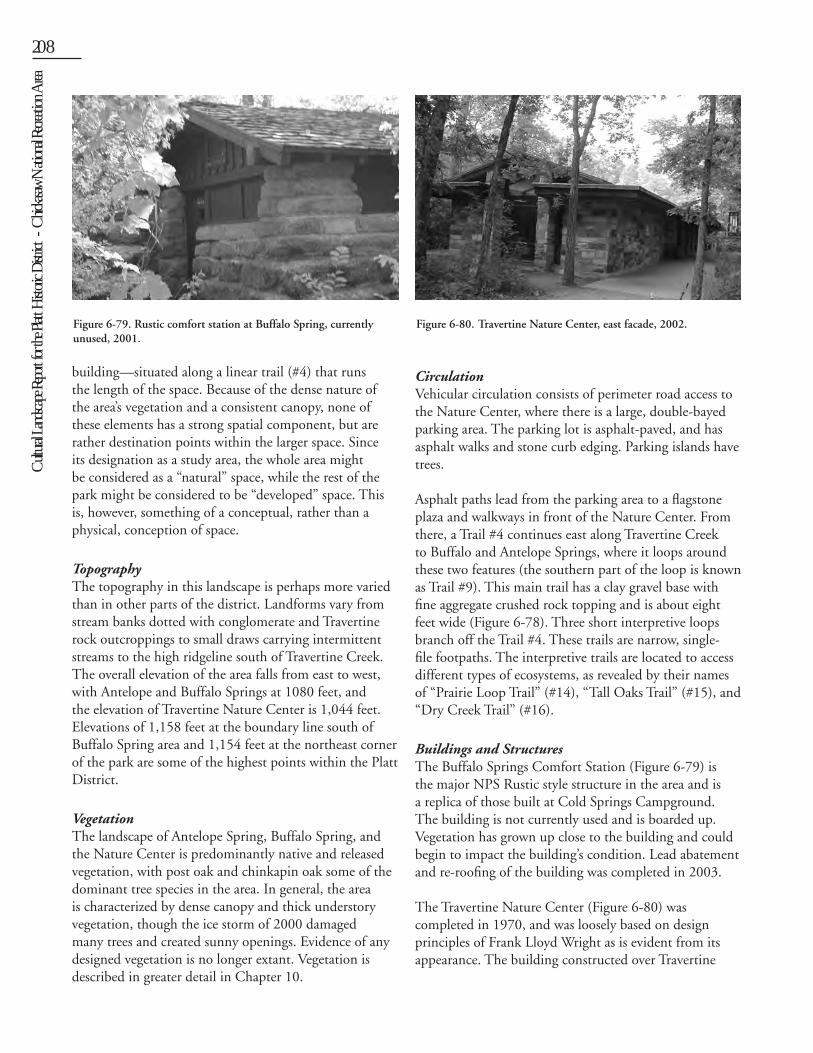
Cult
ural L
andsc
ape R
eport
for th
e Plat
t Histo
ric D
istric
t - C
hicka
saw N
ation
al Re
creati
on A
rea208 Chapter 6: Existing Conditions 209
building—situated along a linear trail (#4) that runs the length of the space. Because of the dense nature of the area’s vegetation and a consistent canopy, none of these elements has a strong spatial component, but are rather destination points within the larger space. Since its designation as a study area, the whole area might be considered as a “natural” space, while the rest of the park might be considered to be “developed” space. This is, however, something of a conceptual, rather than a physical, conception of space.
TopographyThe topography in this landscape is perhaps more varied than in other parts of the district. Landforms vary from stream banks dotted with conglomerate and Travertine rock outcroppings to small draws carrying intermittent streams to the high ridgeline south of Travertine Creek. The overall elevation of the area falls from east to west, with Antelope and Buffalo Springs at 1080 feet, and the elevation of Travertine Nature Center is 1,044 feet. Elevations of 1,158 feet at the boundary line south of Buffalo Spring area and 1,154 feet at the northeast corner of the park are some of the highest points within the Platt District.
Vegetation The landscape of Antelope Spring, Buffalo Spring, and the Nature Center is predominantly native and released vegetation, with post oak and chinkapin oak some of the dominant tree species in the area. In general, the area is characterized by dense canopy and thick understory vegetation, though the ice storm of 2000 damaged many trees and created sunny openings. Evidence of any designed vegetation is no longer extant. Vegetation is described in greater detail in Chapter 10.
Circulation Vehicular circulation consists of perimeter road access to the Nature Center, where there is a large, double-bayed parking area. The parking lot is asphalt-paved, and has asphalt walks and stone curb edging. Parking islands have trees.
Asphalt paths lead from the parking area to a flagstone plaza and walkways in front of the Nature Center. From there, a Trail #4 continues east along Travertine Creek to Buffalo and Antelope Springs, where it loops around these two features (the southern part of the loop is known as Trail #9). This main trail has a clay gravel base with fine aggregate crushed rock topping and is about eight feet wide (Figure 6-78). Three short interpretive loops branch off the Trail #4. These trails are narrow, single-file footpaths. The interpretive trails are located to access different types of ecosystems, as revealed by their names of “Prairie Loop Trail” (#14), “Tall Oaks Trail” (#15), and “Dry Creek Trail” (#16).
Buildings and StructuresThe Buffalo Springs Comfort Station (Figure 6-79) is the major NPS Rustic style structure in the area and is a replica of those built at Cold Springs Campground. The building is not currently used and is boarded up. Vegetation has grown up close to the building and could begin to impact the building’s condition. Lead abatement and re-roofing of the building was completed in 2003.
The Travertine Nature Center (Figure 6-80) was completed in 1970, and was loosely based on design principles of Frank Lloyd Wright as is evident from its appearance. The building constructed over Travertine
Figure 6-79. Rustic comfort station at Buffalo Spring, currently unused, 2001.
Figure 6-80. Travertine Nature Center, east facade, 2002.
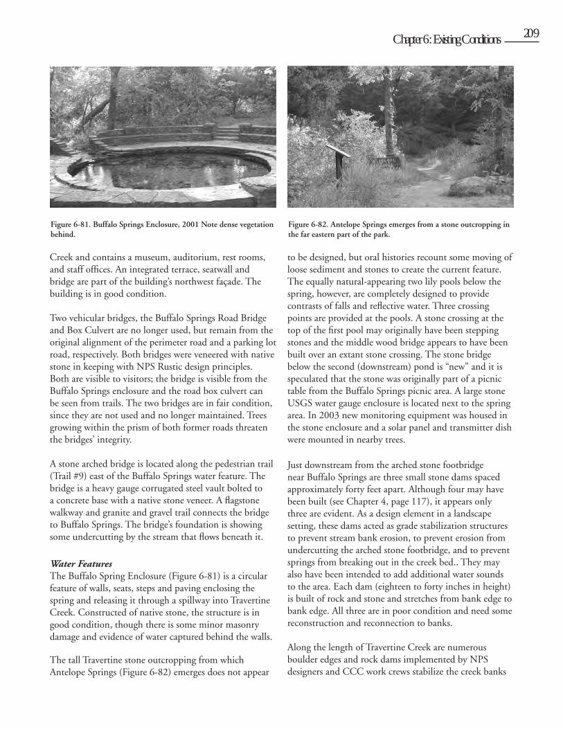
Cult
ural L
andsc
ape R
eport
for th
e Plat
t Histo
ric D
istric
t - C
hicka
saw N
ation
al Re
creati
on A
rea
208 Chapter 6: Existing Conditions 209
Creek and contains a museum, auditorium, rest rooms, and staff offices. An integrated terrace, seatwall and bridge are part of the building’s northwest façade. The building is in good condition.
Two vehicular bridges, the Buffalo Springs Road Bridge and Box Culvert are no longer used, but remain from the original alignment of the perimeter road and a parking lot road, respectively. Both bridges were veneered with native stone in keeping with NPS Rustic design principles. Both are visible to visitors; the bridge is visible from the Buffalo Springs enclosure and the road box culvert can be seen from trails. The two bridges are in fair condition, since they are not used and no longer maintained. Trees growing within the prism of both former roads threaten the bridges’ integrity.
A stone arched bridge is located along the pedestrian trail (Trail #9) east of the Buffalo Springs water feature. The bridge is a heavy gauge corrugated steel vault bolted to a concrete base with a native stone veneer. A flagstone walkway and granite and gravel trail connects the bridge to Buffalo Springs. The bridge’s foundation is showing some undercutting by the stream that flows beneath it.
Water FeaturesThe Buffalo Spring Enclosure (Figure 6-81) is a circular feature of walls, seats, steps and paving enclosing the spring and releasing it through a spillway into Travertine Creek. Constructed of native stone, the structure is in good condition, though there is some minor masonry damage and evidence of water captured behind the walls.
The tall Travertine stone outcropping from which Antelope Springs (Figure 6-82) emerges does not appear
to be designed, but oral histories recount some moving of loose sediment and stones to create the current feature. The equally natural-appearing two lily pools below the spring, however, are completely designed to provide contrasts of falls and reflective water. Three crossing points are provided at the pools. A stone crossing at the top of the first pool may originally have been stepping stones and the middle wood bridge appears to have been built over an extant stone crossing. The stone bridge below the second (downstream) pond is “new” and it is speculated that the stone was originally part of a picnic table from the Buffalo Springs picnic area. A large stone USGS water gauge enclosure is located next to the spring area. In 2003 new monitoring equipment was housed in the stone enclosure and a solar panel and transmitter dish were mounted in nearby trees.
Just downstream from the arched stone footbridge near Buffalo Springs are three small stone dams spaced approximately forty feet apart. Although four may have been built (see Chapter 4, page 117), it appears only three are evident. As a design element in a landscape setting, these dams acted as grade stabilization structures to prevent stream bank erosion, to prevent erosion from undercutting the arched stone footbridge, and to prevent springs from breaking out in the creek bed.. They may also have been intended to add additional water sounds to the area. Each dam (eighteen to forty inches in height) is built of rock and stone and stretches from bank edge to bank edge. All three are in poor condition and need some reconstruction and reconnection to banks.
Along the length of Travertine Creek are numerous boulder edges and rock dams implemented by NPS designers and CCC work crews stabilize the creek banks
Figure 6-81. Buffalo Springs Enclosure, 2001 Note dense vegetation behind.
Figure 6-82. Antelope Springs emerges from a stone outcropping in the far eastern part of the park.
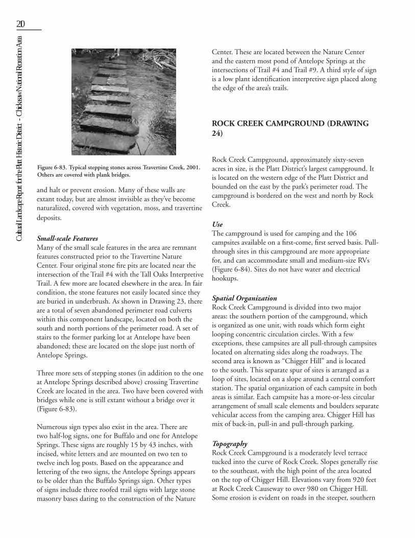
Cult
ural L
andsc
ape R
eport
for th
e Plat
t Histo
ric D
istric
t - C
hicka
saw N
ation
al Re
creati
on A
rea210 Chapter 6: Existing Conditions 211
and halt or prevent erosion. Many of these walls are extant today, but are almost invisible as they’ve become naturalized, covered with vegetation, moss, and travertine deposits.
Small-scale FeaturesMany of the small scale features in the area are remnant features constructed prior to the Travertine Nature Center. Four original stone fire pits are located near the intersection of the Trail #4 with the Tall Oaks Interpretive Trail. A few more are located elsewhere in the area. In fair condition, the stone features not easily located since they are buried in underbrush. As shown in Drawing 23, there are a total of seven abandoned perimeter road culverts within this component landscape, located on both the south and north portions of the perimeter road. A set of stairs to the former parking lot at Antelope have been abandoned; these are located on the slope just north of Antelope Springs.
Three more sets of stepping stones (in addition to the one at Antelope Springs described above) crossing Travertine Creek are located in the area. Two have been covered with bridges while one is still extant without a bridge over it (Figure 6-83).
Numerous sign types also exist in the area. There are two half-log signs, one for Buffalo and one for Antelope Springs. These signs are roughly 15 by 43 inches, with incised, white letters and are mounted on two ten to twelve inch log posts. Based on the appearance and lettering of the two signs, the Antelope Springs appears to be older than the Buffalo Springs sign. Other types of signs include three roofed trail signs with large stone masonry bases dating to the construction of the Nature
Center. These are located between the Nature Center and the eastern most pond of Antelope Springs at the intersections of Trail #4 and Trail #9. A third style of sign is a low plant identification interpretive sign placed along the edge of the area’s trails.
ROCK CREEK CAMPGROUND (DRAWING 24)
Rock Creek Campground, approximately sixty-seven acres in size, is the Platt District’s largest campground. It is located on the western edge of the Platt District and bounded on the east by the park’s perimeter road. The campground is bordered on the west and north by Rock Creek.
UseThe campground is used for camping and the 106 campsites available on a first-come, first served basis. Pull-through sites in this campground are more appropriate for, and can accommodate small and medium-size RVs (Figure 6-84). Sites do not have water and electrical hookups.
Spatial OrganizationRock Creek Campground is divided into two major areas: the southern portion of the campground, which is organized as one unit, with roads which form eight looping concentric circulation circles. With a few exceptions, these campsites are all pull-through campsites located on alternating sides along the roadways. The second area is known as “Chigger Hill” and is located to the south. This separate spur of sites is arranged as a loop of sites, located on a slope around a central comfort station. The spatial organization of each campsite in both areas is similar. Each campsite has a more-or-less circular arrangement of small scale elements and boulders separate vehicular access from the camping area. Chigger Hill has mix of back-in, pull-in and pull-through parking.
TopographyRock Creek Campground is a moderately level terrace tucked into the curve of Rock Creek. Slopes generally rise to the southeast, with the high point of the area located on the top of Chigger Hill. Elevations vary from 920 feet at Rock Creek Causeway to over 980 on Chigger Hill. Some erosion is evident on roads in the steeper, southern
Figure 6-83. Typical stepping stones across Travertine Creek, 2001. Others are covered with plank bridges.
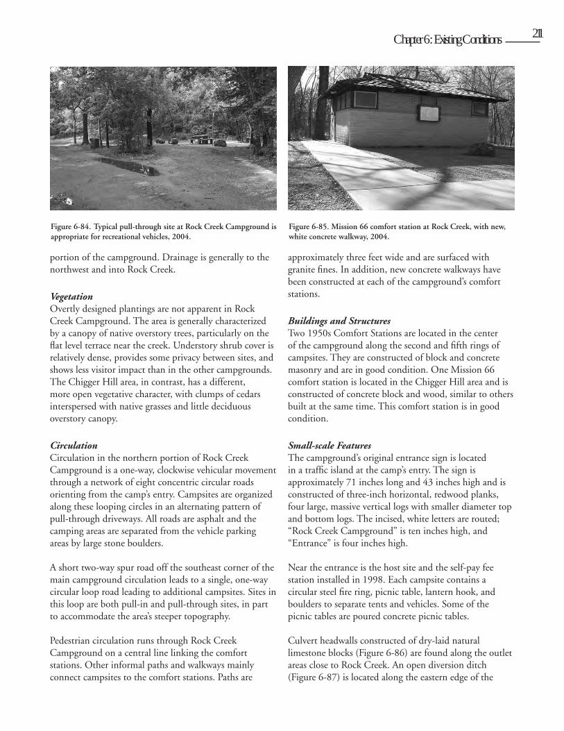
Cult
ural L
andsc
ape R
eport
for th
e Plat
t Histo
ric D
istric
t - C
hicka
saw N
ation
al Re
creati
on A
rea
210 Chapter 6: Existing Conditions 211
portion of the campground. Drainage is generally to the northwest and into Rock Creek.
VegetationOvertly designed plantings are not apparent in Rock Creek Campground. The area is generally characterized by a canopy of native overstory trees, particularly on the flat level terrace near the creek. Understory shrub cover is relatively dense, provides some privacy between sites, and shows less visitor impact than in the other campgrounds. The Chigger Hill area, in contrast, has a different, more open vegetative character, with clumps of cedars interspersed with native grasses and little deciduous overstory canopy.
CirculationCirculation in the northern portion of Rock Creek Campground is a one-way, clockwise vehicular movement through a network of eight concentric circular roads orienting from the camp’s entry. Campsites are organized along these looping circles in an alternating pattern of pull-through driveways. All roads are asphalt and the camping areas are separated from the vehicle parking areas by large stone boulders.
A short two-way spur road off the southeast corner of the main campground circulation leads to a single, one-way circular loop road leading to additional campsites. Sites in this loop are both pull-in and pull-through sites, in part to accommodate the area’s steeper topography. Pedestrian circulation runs through Rock Creek Campground on a central line linking the comfort stations. Other informal paths and walkways mainly connect campsites to the comfort stations. Paths are
approximately three feet wide and are surfaced with granite fines. In addition, new concrete walkways have been constructed at each of the campground’s comfort stations.
Buildings and StructuresTwo 1950s Comfort Stations are located in the center of the campground along the second and fifth rings of campsites. They are constructed of block and concrete masonry and are in good condition. One Mission 66 comfort station is located in the Chigger Hill area and is constructed of concrete block and wood, similar to others built at the same time. This comfort station is in good condition.
Small-scale FeaturesThe campground’s original entrance sign is located in a traffic island at the camp’s entry. The sign is approximately 71 inches long and 43 inches high and is constructed of three-inch horizontal, redwood planks, four large, massive vertical logs with smaller diameter top and bottom logs. The incised, white letters are routed; “Rock Creek Campground” is ten inches high, and “Entrance” is four inches high.
Near the entrance is the host site and the self-pay fee station installed in 1998. Each campsite contains a circular steel fire ring, picnic table, lantern hook, and boulders to separate tents and vehicles. Some of the picnic tables are poured concrete picnic tables.
Culvert headwalls constructed of dry-laid natural limestone blocks (Figure 6-86) are found along the outlet areas close to Rock Creek. An open diversion ditch (Figure 6-87) is located along the eastern edge of the
Figure 6-84. Typical pull-through site at Rock Creek Campground is appropriate for recreational vehicles, 2004.
Figure 6-85. Mission 66 comfort station at Rock Creek, with new, white concrete walkway, 2004.
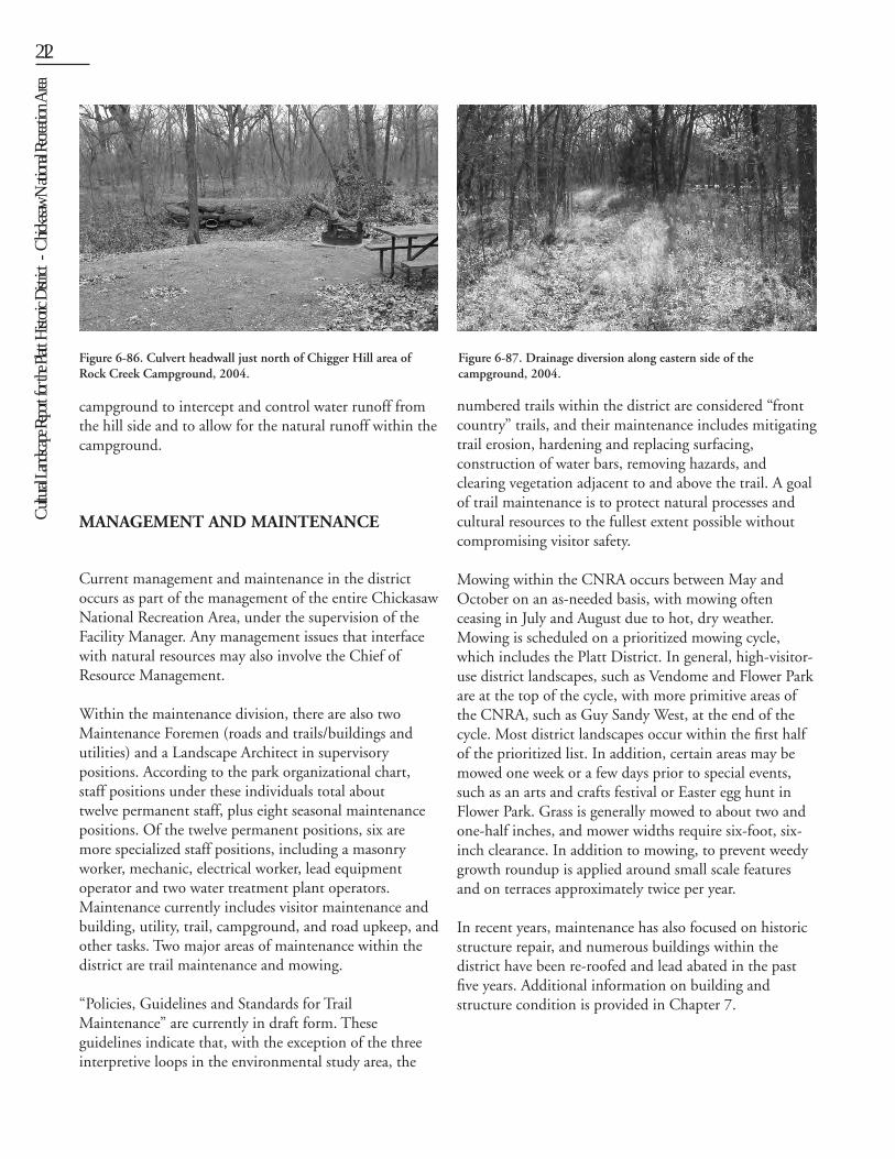
Cult
ural L
andsc
ape R
eport
for th
e Plat
t Histo
ric D
istric
t - C
hicka
saw N
ation
al Re
creati
on A
rea212
campground to intercept and control water runoff from the hill side and to allow for the natural runoff within the campground.
MANAGEMENT AND MAINTENANCE
Current management and maintenance in the district occurs as part of the management of the entire Chickasaw National Recreation Area, under the supervision of the Facility Manager. Any management issues that interface with natural resources may also involve the Chief of Resource Management.
Within the maintenance division, there are also two Maintenance Foremen (roads and trails/buildings and utilities) and a Landscape Architect in supervisory positions. According to the park organizational chart, staff positions under these individuals total about twelve permanent staff, plus eight seasonal maintenance positions. Of the twelve permanent positions, six are more specialized staff positions, including a masonry worker, mechanic, electrical worker, lead equipment operator and two water treatment plant operators. Maintenance currently includes visitor maintenance and building, utility, trail, campground, and road upkeep, and other tasks. Two major areas of maintenance within the district are trail maintenance and mowing.
“Policies, Guidelines and Standards for Trail Maintenance” are currently in draft form. These guidelines indicate that, with the exception of the three interpretive loops in the environmental study area, the
numbered trails within the district are considered “front country” trails, and their maintenance includes mitigating trail erosion, hardening and replacing surfacing, construction of water bars, removing hazards, and clearing vegetation adjacent to and above the trail. A goal of trail maintenance is to protect natural processes and cultural resources to the fullest extent possible without compromising visitor safety.
Mowing within the CNRA occurs between May and October on an as-needed basis, with mowing often ceasing in July and August due to hot, dry weather. Mowing is scheduled on a prioritized mowing cycle, which includes the Platt District. In general, high-visitor-use district landscapes, such as Vendome and Flower Park are at the top of the cycle, with more primitive areas of the CNRA, such as Guy Sandy West, at the end of the cycle. Most district landscapes occur within the first half of the prioritized list. In addition, certain areas may be mowed one week or a few days prior to special events, such as an arts and crafts festival or Easter egg hunt in Flower Park. Grass is generally mowed to about two and one-half inches, and mower widths require six-foot, six-inch clearance. In addition to mowing, to prevent weedy growth roundup is applied around small scale features and on terraces approximately twice per year.
In recent years, maintenance has also focused on historic structure repair, and numerous buildings within the district have been re-roofed and lead abated in the past five years. Additional information on building and structure condition is provided in Chapter 7.
Figure 6-87. Drainage diversion along eastern side of the campground, 2004.
Figure 6-86. Culvert headwall just north of Chigger Hill area of Rock Creek Campground, 2004.