Embed Size (px)
Citation preview

i
Chapter 24
VEHICLES AND TRAFFIC
TRAFFIC SCHEDULES
Article 10. Schedules.
Division 1. Speed Limits.
Section 24-253. Schedule 1. 10 mile per hour limit. Section 24-253.1. Schedule 1.1. 15 mile per hour limit. Section 24-254. Schedule 2. 20 mile per hour limit. Section 24-255. Schedule 3. 25 mile per hour limit. Section 24-256. Schedule 4. 30 mile per hour limit. Section 24-257. Schedule 5. 35 mile per hour limit. Section 24-258. Schedule 6. Reserved. Section 24-259. Schedule 7. 40 mile per hour limit. Section 24-260. Schedule 8. 45 mile per hour limit. Section 24-261. Schedule 9. Reserved. Section 24-262. Schedule 10. 50 mile per hour limit. Section 24-263. Schedule 11. 55 mile per hour limit.
Division 2. Moving Vehicles.
Section 24-264. Schedule 12. Stop intersections. Section 24-265. Schedule 13. Yield locations. Section 24-266. Schedule 14. Through streets. Section 24-267. Schedule 15. One way streets. Section 24-268. Schedule 16. Turn right anytime with caution. Section 24-269. Schedule 17. Right turns only. Section 24-270. Schedule 18. Left turns only. Section 24-271. Schedule 19. Prohibited left turn areas. Section 24-272. Schedule 20. Prohibited right turn areas. Section 24-273. Schedule 21. Permitted U-turn areas. Section 24-274. Schedule 22. Prohibited U-turn areas. Section 24-274.1. Schedule 22.1. Traffic signal systems.
Division 3. Bus Stops and Public Road Taxi Stands.
Section 24-275. Schedule 23. Bus stop locations. Section 24-275.1. Schedule 23.1. Public road taxi stand locations.

ii
Division 4. Pedestrians.
Section 24-276. Schedule 24. Crosswalks. Section 24-277. Schedule 25. Safety zones. Section 24-278. Schedule 26. Roads closed to pedestrian traffic.
Division 5. Parking.
Section 24-279. Schedule 27. Parking on pavement prohibited at all times. Section 24-280. Schedule 28. No parking at anytime. Section 24-281. Schedule 29. Parking prohibited during certain hours on
certain streets; tow-away zone. Section 24-282.1. Schedule 30.1. 15 minute parking areas. Section 24-282.2. Schedule 30.2. 36 minute parking areas. Section 24-283. Schedule 31. 1 hour parking areas. Section 24-284. Schedule 32. 2 hour parking areas. Section 24-284.1. Schedule 32.1. 8 hour parking areas. Section 24-285. Schedule 33. 24 hour parking areas. Section 24-286. Schedule 34. No stopping, standing or parking areas. Section 24-286.1. Schedule 34.1. Angle parking permitted areas.
Division 6. Loading Zones.
Section 24-287. Schedule 35. Passenger loading zones. Section 24-288. Schedule 36. Freight loading zones. Section 24-288.1. Schedule 36.1. Active loading and unloading zones.
Division 7. Parking Meter Zones.
Section 24-289. Schedule 37. 36 minute parking meter zones. Section 24-290. Schedule 38. 1 hour parking meter zones. Section 24-291. Schedule 39. 2 hour parking meter zones. Section 24-291.1. Schedule 39.1. 2 hour parking meter zones. Section 24-292. Schedule 40. 8 hour parking meter zones.
Division 8. Restrictions on Certain Vehicles.
Section 24-293. Schedule 41. Use of certain streets by certain vehicles restricted.
Division 9. Bicycles.
Section 24-294. Schedule 42. Bicycle lanes. Section 24-295. Schedule 43. Bicycle routes.

iii
Division 10. Tow or Tow-Away Zones.
Section 24-296. Schedule 44. Reserved.
Article 11. Schedules -- Private Streets.
Division 1. Speed Limits.
Section 24-297. Schedule 1. 10 mile per hour limit. Section 24-298. Schedule 2. 15 mile per hour limit. Section 24-299. Schedule 3. 20 mile per hour limit. Section 24-300. Schedule 4. 25 mile per hour limit. Section 24-301. Schedule 5. 30 mile per hour limit. Section 24-302. Schedule 6. 35 mile per hour limit. Section 24-303. Schedule 7. Reserved. Section 24-304. Schedule 8. Reserved. Section 24-305. Schedule 9. Reserved. Section 24-306. Schedule 10. Reserved.
Division 2. Moving Vehicles.
Section 24-307. Schedule 11. Stop intersections. Section 24-308. Schedule 12. Through streets. Section 24-309. Schedule 13. Prohibited right turn areas. Section 24-310. Schedule 14. Truck routes. Section 24-311. Schedule 15. Reserved.

This page intentionally left blank.
VEHICLES AND TRAFFIC § 24-253
24A-1
Chapter 24
VEHICLES AND TRAFFIC
TRAFFIC SCHEDULES
Division 1. Speed Limits.
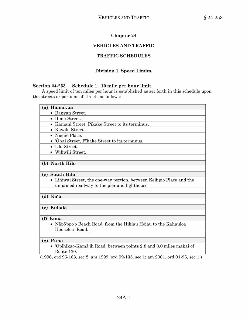
Section 24-253. Schedule 1. 10 mile per hour limit. A speed limit of ten miles per hour is established as set forth in this schedule upon
the streets or portions of streets as follows: (a) Hāmākua
• Banyan Street. • Ilima Street. • Kamani Street, Pīkake Street to its terminus. • Kawila Street. • Nienie Place. • ‘Ōhai Street, Pīkake Street to its terminus. • Ulu Street. • Wiliwili Street.
(b) North Hilo (c) South Hilo
• Lihiwai Street, the one-way portion, between Keliipio Place and the unnamed roadway to the pier and lighthouse.
(d) Ka‘ū (e) Kohala (f) Kona
• Nāpō‘opo‘o Beach Road, from the Hikiau Heiau to the Kahauloa Houselots Road.
(g) Puna
• ‘Opihikao-Kamā‘ili Road, between points 2.8 and 3.0 miles makai of Route 130.
(1996, ord 96-163, sec 2; am 1999, ord 99-135, sec 1; am 2001, ord 01-96, sec 1.) 24-253
§ 24-253.1 HAWAI‘I COUNTY CODE
24A-2
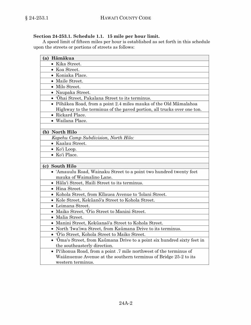
Section 24-253.1. Schedule 1.1. 15 mile per hour limit. A speed limit of fifteen miles per hour is established as set forth in this schedule
upon the streets or portions of streets as follows: (a) Hāmākua
• Kika Street. • Koa Street. • Koniaka Place. • Maile Street. • Milo Street. • Naupaka Street. • ‘Ōhai Street, Pakalana Street to its terminus. • Pōhākea Road, from a point 2.4 miles mauka of the Old Māmalahoa
Highway to the terminus of the paved portion, all trucks over one ton. • Rickard Place. • Wailana Place.
(b) North Hilo
Kapehu Camp Subdivision, North Hilo: • Kaalau Street. • Ko‘i Loop. • Ko‘i Place.
(c) South Hilo
• ‘Amauulu Road, Wainaku Street to a point two hundred twenty feet mauka of Waimalino Lane.
• Hāla‘i Street, Haili Street to its terminus. • Hina Street. • Kohola Street, from Kīlauea Avenue to ‘Iolani Street. • Kole Street, Kekūanō‘a Street to Kohola Street. • Leimana Street. • Maiko Street, ‘Ō‘io Street to Manini Street. • Malia Street. • Manini Street, Kekūanaō‘a Street to Kohola Street. • North ‘Iwa‘iwa Street, from Kaūmana Drive to its terminus. • ‘Ō‘io Street, Kohola Street to Maiko Street. • ‘Ōma‘o Street, from Kaūmana Drive to a point six hundred sixty feet in
the southeasterly direction. • Pi‘ihonua Road, from a point .7 mile northwest of the terminus of
Waiānuenue Avenue at the southern terminus of Bridge 25-2 to its western terminus.

VEHICLES AND TRAFFIC § 24-253.1
24A-3
(d) Ka‘ū (e) Kohala (f) Kona
• Ali‘i Drive, from Palani Road to Walua Road (vicinity of Kona Hilton Hotel).
• Hōnaunau Beach Road. • Miloli‘i Access Road, from a point four miles west of State Highway
Route 11 to its southern terminus in Miloli‘i Village. • Old Māmalahoa Highway, Kaloko Drive to Onaona Drive. • Palani Road, from Kuakini Highway to Ali‘i Drive. • Walua Road, Wikolia Street to Sunset Drive.
(g) Puna
• Ka‘ohe Homestead Road, from Route 130 for a distance of .5 mile. • Maluhia Road.
(1996, ord 96-163, sec 2; am 1996, ord 96-145, sec 1; am 1997, ord 97-11, sec 1; am 1999, ord 99-65, sec 6; ord 99-85, sec 1; am 2001, ord 01-62, sec 1; ord 01-119, sec 1; am 2008, ord 08-43, sec 1; ord 08-99, sec 1; am 2009, ord 09-108, sec 2, ord 09-147, sec 2.)24-253.1
Section 24-254. Schedule 2. 20 mile per hour limit. A speed limit of twenty miles per hour is established as set forth in this schedule
upon the streets or portions of streets as follows: (a) Hāmākua
• Kamani Place, Pakalana Street to its terminus. • Mauna Loa Street. • Old Honoka‘a-Waipi‘o Road, from its intersection with the State
Highway (FAS 240) on the Honoka‘a side of Kukuihaele Village to the Waipi‘o Valley Lookout.
(b) North Hilo (c) South Hilo
• Aipuni Street. • ‘Alae Street, between Laimana Street and Hāla‘i Street. • Anderton Camp Road in Pāpa‘ikou, from the Māmalahoa Highway for a
distance of 1,700 feet in the mauka direction. • Hilo Country Club Drive. • Hōkū Street.

§ 24-254 HAWAI‘I COUNTY CODE
24A-4
(d) Ka‘ū (e) Kohala
• East Makuahine Street. • Hōkū‘ula Road. • Iwikuamo‘o Drive. • Keiki Place. • Konokohau Road. • Kupunahine Street. • Kupunakane Street. • Laelae Road. • Makuakane Street. • Mo‘opuna Place. • Spencer Road. • West Makuahine Street.
(f) Kona (Subdivision included at end)
• Kealakaa Street in the school zone fronting Kealakehe Elementary School, from a point five hundred ninety feet north of Palani Road and extending one thousand six hundred forty feet in the northerly direction while speed limit sign beacons are flashing.
• Middle Ke‘ei Road, from Nāpō‘opo‘o Road to the Māmalahoa Highway. • Painted Church Road, Middle Ke‘ei Road to Ke Ala O Keawe Road. • Pu‘uhonua Road, from the Kahauloa Houselots Road to the City of
Refuge. • Walua Road, Akoni Drive to Kuakini Highway.
Lono Kona Subdivision, North Kona: • Ala Onaona Street. • Alahou Street. • Alaka‘i Street. • Alanoe Place. • Kalawa Street. • Lamaokeola Street.
(g) Puna
• Government Beach Road from Papaya Farms Road to its northwestern terminus.
• Haa Place. • Haa Street.

VEHICLES AND TRAFFIC § 24-254
24A-5
(g) Puna (Continued) • Haunani Road, from a point six hundred thirty-five feet northwest of
Maile Avenue to its northwestern terminus. • Kaiewe Place. • Kea‘au Loop, from the access road serving the new Kea‘au Self Help
Subdivision to Route 11. • Mahiʻai Road, from Amaumau Road to its southwestern terminus. • North Oshiro Road, from Route 11 to Komo Street.
(1996, ord 96-163, sec 2; am 1996, ord 96-139, sec 1; am 1997, ord 97-119, sec 1; am 2005, ord 05-148, sec 1; am 2009, ord 09-133, sec 2; ord 09-137, sec 2; am 2012, ord 12-82, sec 2; am 2014, ord 14-44, sec 2; am 2015, ord15-20, sec 2.)24-254
Section 24-255. Schedule 3. 25 mile per hour limit. A speed limit of twenty-five miles per hour is established as set forth in this
schedule upon streets or portions of streets as follows: (a) Hāmākua
• Āhualoa Homestead Road. • Lehua Street in Honoka‘a, from the junction of Lehua and Plumeria
Streets to Māmane Street. • Māmalahoa Highway (Āhualoa Road), from Honoka‘a to the Hawai‘i
Belt Road at Waimea. • Pakalana Street in Honoka‘a, from a point four hundred feet mauka of
Kukui Street to Māmane Street. • Plumeria Street in Honoka‘a, from Hawai‘i Belt Road entrance to Lehua
Street. • Pōhākea Road, from the Old Māmalahoa Highway to the terminus of
the paved portion. (b) North Hilo
• Laupāhoehoe Beach Road access road. • Old Government Main Road in ‘O‘ōkala, North Hilo, between the 29.4
and 30.5 mile markers of the Hawai‘i Belt Road, Route 19, for a distance of one and six-tenths miles.
(c) South Hilo (Subdivision included at end)
• Ainaola Drive, from Malaai Road to its terminus in the mauka direction.
• Akolea Road, from Haleloke Street to Kaūmana Drive.

§ 24-255 HAWAI‘I COUNTY CODE
24A-6
(c) South Hilo (Continued. Subdivisions included at end.) • Aupuni Street, Kīlauea Avenue to Pauahi Street. • Banyan Drive. • Banyan Way, from Kalaniana‘ole Avenue to Banyan Drive. • Chin Chuck Road, beginning at a point 1.6 miles west of the Hawai‘i
Belt Road and extending .7 mile in the westerly direction to the end of the paved section of Chin Chuck Road.
• Haleloke Street. • Hualālai Villa, on the following streets:
- Hale Nani Place. - Hale Nani Street.
• Kaiwiki Road, beginning at a point 0.6 mile mauka of the Old Hawai‘i Belt Road and extending to its mauka terminus.
• All streets within the area bounded by Kamehameha Avenue, Ponahawai Street, Kino‘ole Street, and Wailuku Drive.
• Kawailani Street, from its western terminus to a point one hundred sixty-five feet east of Makani Circle.
• Kūkūau Street, from Komohana Street to Kapi‘olani Street. • Lanakila Homes area, all streets. • Lihiwai Street, from Kamehameha Avenue to the unnamed roadway
into the pier and lighthouse. • Māmalahoa Highway in Papa‘ikou, from Yoshiyama Store to
Kalaniana‘ole School. • Pi‘ihonua Road, beginning from its start at the southern terminus of
Bridge 25-2, extending to a point approximately .7 mile in the northerly direction.
• Waiānuenue Avenue, from Akolea Road to its terminus at the southern terminus of Bridge 25-2.
• Waiānuenue Avenue, from Hala‘i Street to Bayfront Highway. • Wainaku Street. • Wiliwili Street, from Kaūmana Drive to Uluwai Street.
‘Alae Point Subdivision, South Hilo: • Kahoa Street. • Makakai Place. • Nahala Street.
Mohouli Subdivision in Waiākea, South Hilo: • Hilina‘i Street. • Hoopuni Street. • Iloko Street.
VEHICLES AND TRAFFIC § 24-255
24A-7
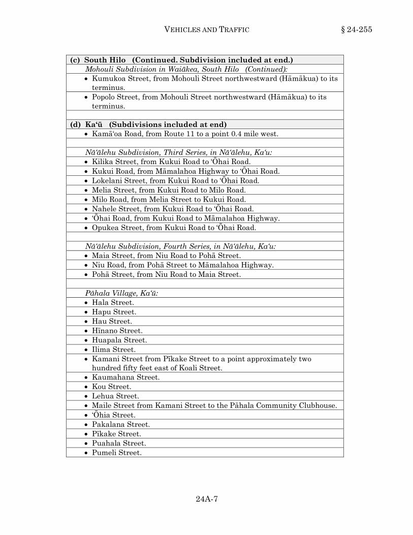
(c) South Hilo (Continued. Subdivision included at end.) Mohouli Subdivision in Waiākea, South Hilo (Continued): • Kumukoa Street, from Mohouli Street northwestward (Hāmākua) to its
terminus. • Popolo Street, from Mohouli Street northwestward (Hāmākua) to its
terminus. (d) Ka‘ū (Subdivisions included at end)
• Kamā‘oa Road, from Route 11 to a point 0.4 mile west.
Nā‘ālehu Subdivision, Third Series, in Nā‘ālehu, Ka‘u: • Kilika Street, from Kukui Road to ‘Ōhai Road. • Kukui Road, from Māmalahoa Highway to ‘Ōhai Road. • Lokelani Street, from Kukui Road to ‘Ōhai Road. • Melia Street, from Kukui Road to Milo Road. • Milo Road, from Melia Street to Kukui Road. • Nahele Street, from Kukui Road to ‘Ōhai Road. • ‘Ōhai Road, from Kukui Road to Māmalahoa Highway. • Opukea Street, from Kukui Road to ‘Ōhai Road.
Nā‘ālehu Subdivision, Fourth Series, in Nā‘ālehu, Ka‘u: • Maia Street, from Niu Road to Pohā Street. • Niu Road, from Pohā Street to Māmalahoa Highway. • Pohā Street, from Niu Road to Maia Street.
Pāhala Village, Ka‘ū: • Hala Street. • Hapu Street. • Hau Street. • Hīnano Street. • Huapala Street. • Ilima Street. • Kamani Street from Pīkake Street to a point approximately two
hundred fifty feet east of Koali Street. • Kaumahana Street. • Kou Street. • Lehua Street. • Maile Street from Kamani Street to the Pāhala Community Clubhouse. • ‘Ōhia Street. • Pakalana Street. • Pīkake Street. • Puahala Street. • Pumeli Street.

§ 24-255 HAWAI‘I COUNTY CODE
24A-8
(e) Kohala • Paniolo Avenue, from Waikoloa Road to Paniolo Place. • Puakō Beach Road, from a point five hundred feet makai of the Rubbish
Dump Road southerly to its terminus. (f) Kona
• Ali‘i Drive, from Māmalahoa Bypass Highway to its southern terminus. • Ali‘i Drive, from the property line between parcels 7-8-014:005 and
7-8-014:006 to Mākole‘ā Street. • Hawai‘i Belt Road (Highway 11), from a point two hundred thirty-five
feet north of Haukapila Street to a point one thousand feet south of Hale Ke‘eke‘e Place.
• Hawai‘i Belt Road (Highway 11), from the terminus of the State Highway in Honalo to a point five thousand one hundred feet in the southerly direction.
• Hualālai Road, North Kona, from Ali‘i Drive to the Old Māmalahoa Highway.
• Kealakaa Street. • Keanalehu Drive. Keauhou Bay Resort area, North Kona: • ‘Ehukai Street. • Hōlua Road. • The cul-de-sac street off Kamehameha III Road in Area 5. • Kamehameha III Road, makai of Ali‘i Drive. • Unnamed south access road (Access Road B) from Ali‘i Drive into the
Keauhou Bay area. • Konawaena School Road, from Māmalahoa Highway to the school. • Kuakini Highway, beginning at a point four hundred feet south of
Hualālai Road to its terminus at the Old Kona Airport. • Manawale‘a Street. • Miloli‘i Access Road, from State Highway Route 11 to a point four miles
in the westerly direction. • Nāpō‘opo‘o Road. • Palani Road, from Queen Ka‘ahumanu Highway to Kuakini Highway.
(g) Puna
• Alaula Street. • ‘Ale Road. • Ali‘i ‘Ānela Street. • Ali‘i Kāne Street, from Hawai‘i Belt Road to a point 0.6 miles in the
southerly direction.

VEHICLES AND TRAFFIC § 24-255
24A-9 SUPP. 3 (1-2018)
(g) Puna (Continued) • Ali‘i Koa Street. • Amaumau Road. • Anuhea Street. • Hāpu‘u Road, from Nānāwale Boulevard to Maui Road. • Haunani Road, from Highway 11 to a point six hundred thirty-five feet
northwest of Maile Avenue. • Huina Road, beginning at a point 0.8 mile west of Volcano Highway and
extending 1.6 miles to Luhi Road. • Kahakai Boulevard, from the property line between parcels 1-5-9:09
and 1-5-9:59 and extending fifty eight feet northeast of ‘A‘ama Street. • Kēhau Road, from Nānāwale Boulevard to Maui Road. • Kōloa Maoli Road. • Kukui Camp Road, from the Hawai‘i Belt Road to its terminus. • Mahi‘ai Road, from its northeastern terminus to Amaumau Road. • Moho Road • Mokuna Street. • North Ala Road, Route 11 to Huina Road. • North Glenwood Road, from Route 11 to a point 2.2 miles in the
westerly direction. • North Kulani Road, Route 11 to Pacific Paradise Gardens Subdivision. • Old Volcano Highway, in Volcano Village. • Old Volcano Road. • Old Volcano Road in Kea‘au Village, from its intersection with Highway
11, approximately 0.2 mile north of Mile Post 8, and extending in a northerly direction to its intersection with Kea‘au Loop Road, in the vicinity of Mile Post 7.
• ‘Opihikao-Kamā‘ili Road, between a point 3 miles makai of Route 130 and Route 137.
• ‘Opihikao-Kamā‘ili Road, between points 1.1 and 2.8 miles makai of Route 130.
• Pa Ali‘i Street. • Pāhoa Road, from a point 0.75 miles Pāhoa of Kahakai Boulevard to the
Kapoho Pāhoa-Kalapana Road junction. • Pāhoa Solid Waste Disposal Road, known as the Pāhoa By Pass Road,
for its entire length. • Pohoiki Road, between a point 1.55 miles makai of Route 132 and
Route 137. • South Kūlani Road, from a point three hundred feet northwest of bridge
18-1 to its southeastern terminus.
§ 24-255 HAWAI‘I COUNTY CODE
SUPP. 6 (7-2019) 24A-10
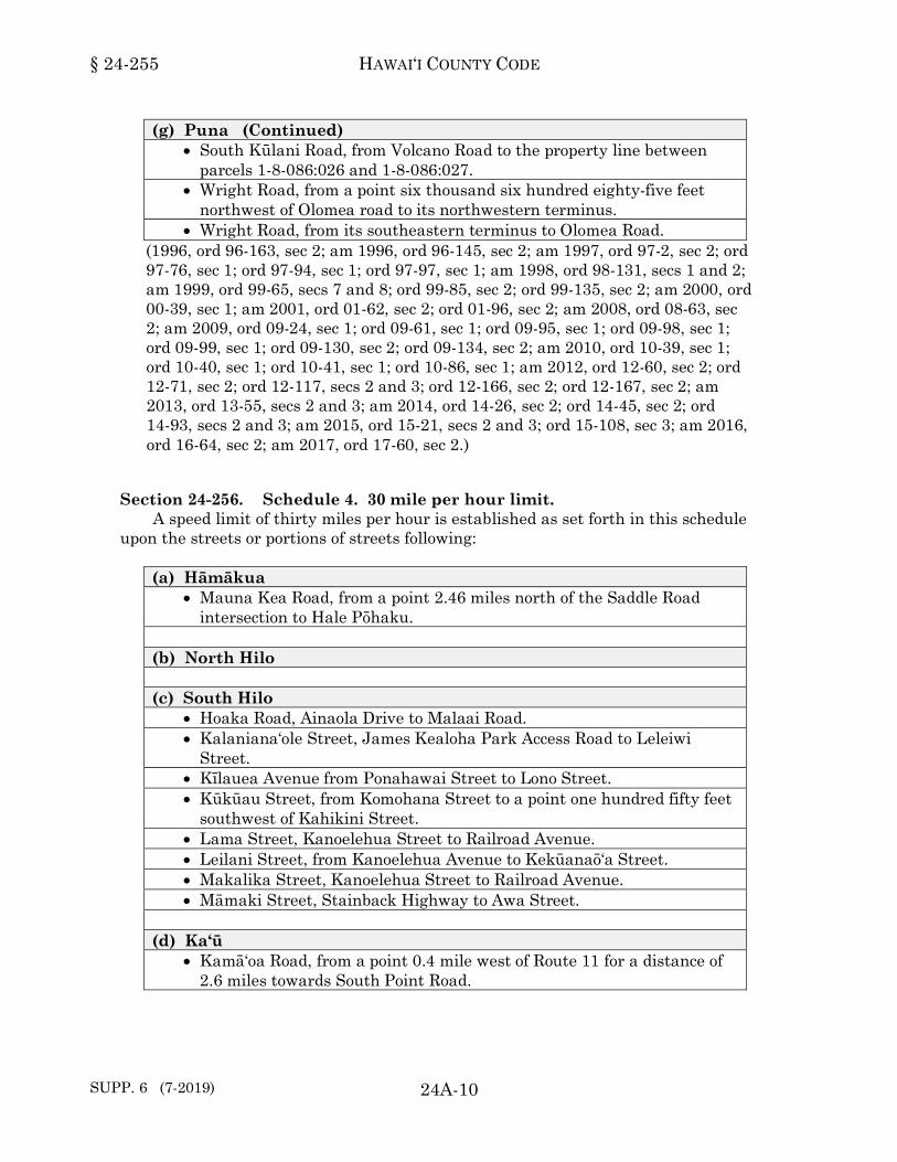
(g) Puna (Continued) • South Kūlani Road, from Volcano Road to the property line between
parcels 1-8-086:026 and 1-8-086:027. • Wright Road, from a point six thousand six hundred eighty-five feet
northwest of Olomea road to its northwestern terminus. • Wright Road, from its southeastern terminus to Olomea Road.
(1996, ord 96-163, sec 2; am 1996, ord 96-145, sec 2; am 1997, ord 97-2, sec 2; ord 97-76, sec 1; ord 97-94, sec 1; ord 97-97, sec 1; am 1998, ord 98-131, secs 1 and 2; am 1999, ord 99-65, secs 7 and 8; ord 99-85, sec 2; ord 99-135, sec 2; am 2000, ord 00-39, sec 1; am 2001, ord 01-62, sec 2; ord 01-96, sec 2; am 2008, ord 08-63, sec 2; am 2009, ord 09-24, sec 1; ord 09-61, sec 1; ord 09-95, sec 1; ord 09-98, sec 1; ord 09-99, sec 1; ord 09-130, sec 2; ord 09-134, sec 2; am 2010, ord 10-39, sec 1; ord 10-40, sec 1; ord 10-41, sec 1; ord 10-86, sec 1; am 2012, ord 12-60, sec 2; ord 12-71, sec 2; ord 12-117, secs 2 and 3; ord 12-166, sec 2; ord 12-167, sec 2; am 2013, ord 13-55, secs 2 and 3; am 2014, ord 14-26, sec 2; ord 14-45, sec 2; ord 14-93, secs 2 and 3; am 2015, ord 15-21, secs 2 and 3; ord 15-108, sec 3; am 2016, ord 16-64, sec 2; am 2017, ord 17-60, sec 2.)24-255
Section 24-256. Schedule 4. 30 mile per hour limit. A speed limit of thirty miles per hour is established as set forth in this schedule
upon the streets or portions of streets following: (a) Hāmākua
• Mauna Kea Road, from a point 2.46 miles north of the Saddle Road intersection to Hale Pōhaku.
(b) North Hilo (c) South Hilo
• Hoaka Road, Ainaola Drive to Malaai Road. • Kalaniana‘ole Street, James Kealoha Park Access Road to Leleiwi
Street. • Kīlauea Avenue from Ponahawai Street to Lono Street. • Kūkūau Street, from Komohana Street to a point one hundred fifty feet
southwest of Kahikini Street. • Lama Street, Kanoelehua Street to Railroad Avenue. • Leilani Street, from Kanoelehua Avenue to Kekūanaō‘a Street. • Makalika Street, Kanoelehua Street to Railroad Avenue. • Māmaki Street, Stainback Highway to Awa Street.
(d) Ka‘ū
• Kamā‘oa Road, from a point 0.4 mile west of Route 11 for a distance of 2.6 miles towards South Point Road.

VEHICLES AND TRAFFIC § 24-256
24A-11 SUPP. 6 (7-2019)
(e) Kohala • Kawaihae Road (FAP Route 19), Māmalahoa Highway to the beginning
of the State Highway. • Māmalahoa Highway in Waimea, from Lindsey Road to a point five
thousand five hundred feet in the Honoka‘a direction, in the vicinity of Fukushima Store.
(f) Kona
• Ali‘i Drive, from Mākole‘ā Street to Kamehameha III Road. • Ali‘i Drive, from Wālua Road to the property line between parcels
7-8-014:005 and 7-8-014:006. • Hawai‘i Belt Road (Highway 11), from a point five thousand one
hundred feet south of the terminus of the State Highway in Honalo to a point two hundred thirty-five feet north of Haukapila Street.
• Hawai‘i Belt Road (Highway 11), from a point one thousand feet south of Hale Keʻekeʻe Place to the beginning of the State Highway in Captain Cook.
• Māmalahoa Highway, from Honokōhau (Palani) Junction to the Keauhou Junction.
(g) Puna
• Government Beach Road, from Pāhoa-Kapoho Road to Papaya Farms Road.
• Huina Road, Volcano Highway to a point 0.8 mile west. • Kalapana-Kapoho Beach Road, from a point six thousand three
hundred sixty-one feet south of Kapoho Kai Drive to its southern terminus.
• North Kūlani Road, Pacific Paradise Gardens Subdivision to Ihope Road.
• Pāhoa Road, from Kahakai Boulevard for a distance of 0.75 mile in the Pāhoa direction.
(1996, ord 96-163, sec 2; am 1997, ord 97-76, sec 2; ord 97-97, sec 2; am 1998, ord 98-131, secs 3 and 4; am 2003, ord 03-95, sec 1; am 2008, ord 08-63, sec 1; am 2009, ord 09-96, sec 1; am 2012, ord 12-74, sec 2; ord 12-75, sec 2; ord 12-83, sec 2; am 2014, ord 14-94, secs 2 and 3; am 2016, ord 16-51, sec 2; am 2019, ord 19-42, sec 1.)24-256
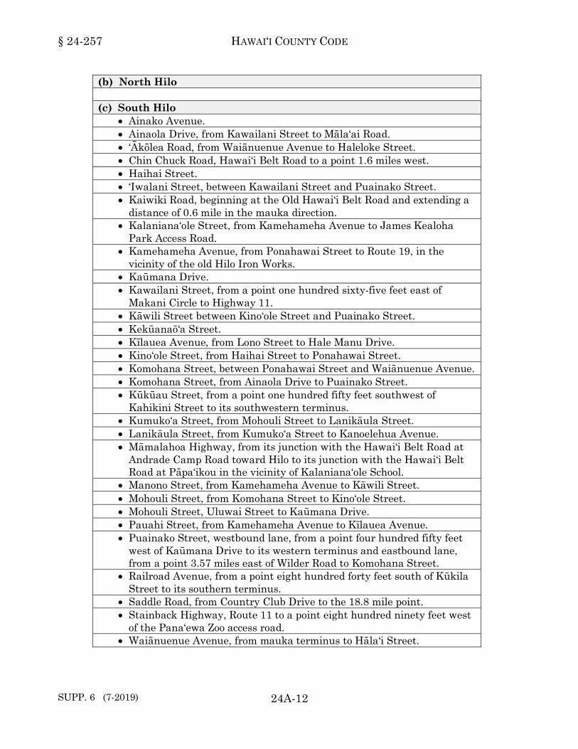
Section 24-257. Schedule 5. 35 mile per hour limit. A speed limit of thirty-five miles per hour is established as set forth in this schedule
upon the streets or portions of streets as follows: (a) Hāmākua
§ 24-257 HAWAI‘I COUNTY CODE
SUPP. 6 (7-2019) 24A-12
(b) North Hilo (c) South Hilo
• Ainako Avenue. • Ainaola Drive, from Kawailani Street to Māla‘ai Road. • ‘Ākōlea Road, from Waiānuenue Avenue to Haleloke Street. • Chin Chuck Road, Hawai‘i Belt Road to a point 1.6 miles west. • Haihai Street. • ‘Iwalani Street, between Kawailani Street and Puainako Street. • Kaiwiki Road, beginning at the Old Hawai‘i Belt Road and extending a
distance of 0.6 mile in the mauka direction. • Kalaniana‘ole Street, from Kamehameha Avenue to James Kealoha
Park Access Road. • Kamehameha Avenue, from Ponahawai Street to Route 19, in the
vicinity of the old Hilo Iron Works. • Kaūmana Drive. • Kawailani Street, from a point one hundred sixty-five feet east of
Makani Circle to Highway 11. • Kāwili Street between Kino‘ole Street and Puainako Street. • Kekūanaō‘a Street. • Kīlauea Avenue, from Lono Street to Hale Manu Drive. • Kino‘ole Street, from Haihai Street to Ponahawai Street. • Komohana Street, between Ponahawai Street and Waiānuenue Avenue. • Komohana Street, from Ainaola Drive to Puainako Street. • Kūkūau Street, from a point one hundred fifty feet southwest of
Kahikini Street to its southwestern terminus. • Kumuko‘a Street, from Mohouli Street to Lanikāula Street. • Lanikāula Street, from Kumuko‘a Street to Kanoelehua Avenue. • Māmalahoa Highway, from its junction with the Hawai‘i Belt Road at
Andrade Camp Road toward Hilo to its junction with the Hawai‘i Belt Road at Pāpa‘ikou in the vicinity of Kalaniana‘ole School.
• Manono Street, from Kamehameha Avenue to Kāwili Street. • Mohouli Street, from Komohana Street to Kino‘ole Street. • Mohouli Street, Uluwai Street to Kaūmana Drive. • Pauahi Street, from Kamehameha Avenue to Kīlauea Avenue. • Puainako Street, westbound lane, from a point four hundred fifty feet
west of Kaūmana Drive to its western terminus and eastbound lane, from a point 3.57 miles east of Wilder Road to Komohana Street.
• Railroad Avenue, from a point eight hundred forty feet south of Kūkila Street to its southern terminus.
• Saddle Road, from Country Club Drive to the 18.8 mile point. • Stainback Highway, Route 11 to a point eight hundred ninety feet west
of the Pana‘ewa Zoo access road. • Waiānuenue Avenue, from mauka terminus to Hāla‘i Street.

VEHICLES AND TRAFFIC § 24-257
24A-13 SUPP. 4 (7-2018)
(d) Ka‘ū • South Point Road.
(e) Kohala
• Māmalahoa Highway (Highway 190), from Lindsey Road to the end of the County-maintained portion eighty-one feet south of Lalamilo Farm Road.
• Mānā Road, from Māmalahoa Highway for a distance of two thousand two hundred feet.
• Paniolo Avenue from Paniolo Place to its terminus. • Puakō Beach Road, from the Queen Ka‘ahumanu Highway to a point
five hundred feet makai of the Rubbish Dump Road. • Waikoloa Road, beginning at ‘Auwaiakeakua Gulch Bridge and
extending 1.1 miles in the mauka direction. (f) Kona
• Ali‘i Drive, from Kamehameha III Road to Māmalahoa Bypass Highway.
• Hina-Lani Street, Māmalahoa Highway (Route 190) to ‘Anini Street. • Hiona Street. • Ka‘iminani Drive, from Ane Keohokālole Highway to Highway 190. • Ka‘iminani Drive, from Highway 19 to Lau‘i Street. • Ka‘iminani Drive, Queen Ka‘ahumanu Highway to Lau‘i Street. • Kaloko Drive, from the Hawai‘i Belt Road (Route 190) to a point .5 mile
in the easterly direction. • Kamehameha III Road, from Kuakini Highway to Ali‘i Drive. • Kuakini Highway, from a point four hundred feet south of Hualālai
Road to the property line between the parcels identified as Tax Map Key Numbers (3) 7-5-017:005 and (3) 7-5-017:002.
• Palani Road, from FASC Route 180 (Hōlualoa Road) to Queen Ka‘ahumanu Highway.
(g) Puna
• Ainaloa Boulevard, from Highway 130 to Stardust Drive. • Hāpu‘u Road, from Maui Road to its northern terminus. • Kahakai Boulevard, from a point fifty eight feet northeast of ‘A‘ama
Street to its northeastern terminus. • Kalapana-Kapoho Beach Road, from its northern terminus to Kapoho
Kai Drive. • Kēhau Road, from Maui Road to its northern terminus. • Leilani Estates Avenue.

§ 24-257 HAWAI‘I COUNTY CODE
SUPP. 6 (7-2019) 24A-14
(g) Puna (Continued) • Nānāwale Boulevard. • North Kūlani Road, Ihope Road to Stainback Highway. • ‘Opihikao-Kamā‘ili Road, between Route 130 and a point 1.1 miles in
the makai direction. • Pāhoa-Kapoho Road, from a point seven hundred fifty feet west of
Kalapana-Kapoho Beach Road to its eastern terminus. • Pohoiki Road, between Route 132 and a point 1.55 miles in the makai
direction. • Route 132, from Route 130 to the Pohoiki Road Junction. • South Glenwood Road, from Route 11, to a point 0.86 mile in the
southeasterly direction. • South Kopua Road. • South Kūlani Road, from the property line between parcels 1-8-086:026
and 1-8-086:027 and extending three hundred feet northwest of Bridge 18-1.
• Wright Road, from Olomea Road and extending six thousand six hundred eighty-five feet northwest of Olomea Road.
(1996, ord 96-163, sec 2; am 1997, ord 97-2, sec 1; ord 97-94, sec 2; ord 97-96, sec 1; am 1998, ord 98-42, sec 1; ord 98-101, sec 1; am 1999, ord 99-84, sec 1; ord 99-135, sec 3; am 2000, ord 00-39, sec 2; ord 00-96, secs 1 and 2; am 2001, ord 01-62, sec 3; am 2003, ord 03-8, secs 1 and 2; ord 03-95, sec 2; am 2009, ord 09-12, sec 1; am 2010, ord 10-78, sec 1; ord 10-86, sec 2; am 2012, ord 12-61, sec 2; ord 12-100, sec 2; ord 12-118, sec 2; am 2013, ord 13-33, sec 2; ord 13-54, sec 2; am 2014, ord 14-27, sec 2; am 2015, ord 15-28, sec 2; ord 15-108, sec 2; am 2016, ord 16-53, sec 2; ord 16-64, sec 3; am 2017, ord 17-10, sec 2; ord 17-60, sec 3; am 2018, ord 18-38, secs 1 and 2; am 2019, ord 19-41, sec 1.) 24-257
Section 24-258. Schedule 6. Reserved.*
* Editor's Note: Since this schedule duplicated schedule 5, the streets listed under this schedule were moved to schedule 5.24-258
Section 24-259. Schedule 7. 40 mile per hour limit. A speed limit of forty miles per hour is established as set forth in this schedule
upon the streets and portions of streets as follows: (a) Hāmākua
• Mauna Kea Road, from Saddle Road intersection to a point 2.45 miles north.
(b) North Hilo

VEHICLES AND TRAFFIC § 24-259
24A-15
(c) South Hilo • Ponahawai Street, from a point 0.2 mile mauka of Kapi‘olani Street to
Komohana Street. • Puainako Street, westbound lane, from a point 3.30 miles west of
Komohana Street to a point four hundred fifty feet west of Kaūmana Drive and eastbound lane from its western terminus to a point 0.46 mile east of Wilder Road.
(d) Ka‘ū
• Kamā‘oa Road, from a point three miles west of Route 11 to South Point Road.
(e) Kohala (f) Kona
• Kaloko Drive, from a point .5 mile east of Hawai‘i Belt Road (Route 190) to its eastern terminus.
(g) Puna
(1996, ord 96-163, sec 2; am 1997, ord 97-97, sec 3; am 1998, ord 98-101, sec 2; ord 98-131, secs 5 and 6; am 2010, ord 10-78, sec 2.)24-259
Section 24-260. Schedule 8. 45 mile per hour limit. A speed limit of forty-five miles per hour is established as set forth in this schedule
upon the streets and portions of streets as follows: (a) Hāmākua (b) North Hilo (c) South Hilo
• Komohana Street, from Puainako Street to Ponahawai Street. • Mohouli Street, Komohana Street to Uluwai Street. • Puainako Street, eastbound lane, from a point 3.44 miles east of Wilder
Road to a point seven hundred feet in the easterly direction. (d) Ka‘ū (e) Kohala
• Māmalahoa Highway in Waimea, from Mud Lane to a point five thousand five hundred feet Honoka‘a (Fukushima Store) of the Waimea to Hāwī Road.

§ 24-260 HAWAI‘I COUNTY CODE
SUPP. 4 (7-2018) 24A-16
(e) Kohala (Continued) • Saddle Road, from the 18.8 mile point to the Māmalahoa Highway in
South Kohala. • Waikoloa Road, from a point 1.1 miles mauka of ‘Auwaiakeakua Gulch
Bridge and extending 1.7 miles in the mauka direction. • Waikoloa Road, Queen Ka‘ahumanu Highway to ‘Auwaiakeakua Gulch
Bridge. (f) Kona
• Hina-Lani Street, Anini Street to Kamanu Street. • Ka‘iminani Drive, from Ane Keohokālole Highway to Lau‘i Street. • Kuakini Highway, from the property line between the parcels identified
as Tax Map Key Numbers (3) 7-5-017:005 and (3) 7-5-017:002 to Highway 11.
• Māmalahoa Bypass Highway. (g) Puna
• Kahakai Boulevard, Highway 130 to the property line between parcels 1-5-9:09 and 1-5-9:59.
• Kalapana-Kapoho Beach Road, from Kapoho Kai Drive and extending six thousand three hundred sixty-one feet in the southerly direction.
• Māmalahoa Highway in Kea‘au, from Milo Street to the lower Kea‘au Connection.
(1996, ord 96-163, sec 2; am 1998, ord 98-42, sec 2; ord 98-88, sec 1; ord 98-130, sec 1; am 1999, ord 99-84, sec 2; am 2000, ord 00-96, sec 3; am 2003, ord 03-8, sec 3; am 2009, ord 09-11, sec 1; am 2010, ord 10-78, sec 3; ord 10-86, sec 3; am 2012, ord 12-62, sec 2; ord 12-115, sec 2; am 2013, ord 13-53, sec 2; am 2016, ord 16-52, sec 2; am 2017, ord 17-11, sec 2; am 2018, ord 18-39, sec 1.) 24-260
Section 24-261. Schedule 9. Reserved.*
* Editor's Note: Since this schedule duplicated schedule 8, the streets listed under this schedule were moved to schedule 8. 24-261
Section 24-262. Schedule 10. 50 mile per hour limit. A speed limit of fifty miles per hour is established as set forth in this schedule upon
the streets or portions of streets as follows: (a) Hāmākua (b) North Hilo

VEHICLES AND TRAFFIC § 24-262
24A-17
(c) South Hilo (d) Ka‘ū (e) Kohala (f) Kona (g) Puna
(1996, ord 96-163, sec 2.)24-262
Section 24-263. Schedule 11. 55 mile per hour limit. A speed limit of fifty-five miles per hour is established as set forth in this schedule
upon streets or portions of streets as follows: (a) Hāmākua (b) North Hilo (c) South Hilo
• Puainako Street, westbound lane, from Komohana Street to a point 3.30 miles in the westerly direction and eastbound lane, from a point 0.46 miles east of Wilder Road to a point 2.98 miles in the easterly direction.
(d) Ka‘ū (e) Kohala
• Waikoloa Road, from a point 2.8 miles mauka of ‘Auwaiakeakua Gulch Bridge to Route 190.
(f) Kona (g) Puna
• Pāhoa-Kapoho Road, westbound lane, from Kalapana-Kapoho Beach Road to Pohoiki Road and eastbound lane, from Pohoiki Road and extending seven hundred fifty feet west of Kalapana-Kapoho Beach Road.
(1996, ord 96-163, sec 2; am 1998, ord 98-88, sec 2; ord 98-130, sec 2; am 2010, ord 10-78, sec 4; am 2012, ord 12-99, sec 2.)24-263
§ 24-264 HAWAI‘I COUNTY CODE
SUPP. 5 (1-2019) 24A-18
Division 2. Moving Vehicles.
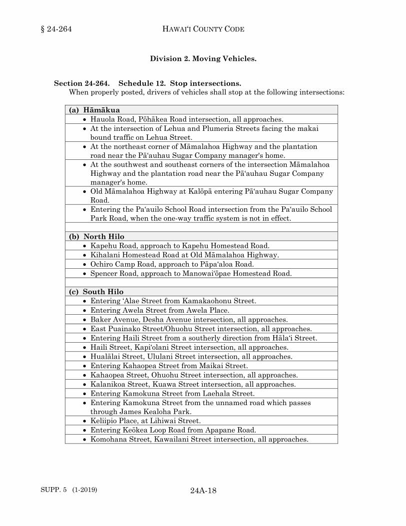
Section 24-264. Schedule 12. Stop intersections. When properly posted, drivers of vehicles shall stop at the following intersections: (a) Hāmākua
• Hauola Road, Pōhākea Road intersection, all approaches. • At the intersection of Lehua and Plumeria Streets facing the makai
bound traffic on Lehua Street. • At the northeast corner of Māmalahoa Highway and the plantation
road near the Pā‘auhau Sugar Company manager's home. • At the southwest and southeast corners of the intersection Māmalahoa
Highway and the plantation road near the Pā‘auhau Sugar Company manager's home.
• Old Māmalahoa Highway at Kalōpā entering Pā‘auhau Sugar Company Road.
• Entering the Pa‘auilo School Road intersection from the Pa‘auilo School Park Road, when the one-way traffic system is not in effect.
(b) North Hilo
• Kapehu Road, approach to Kapehu Homestead Road. • Kihalani Homestead Road at Old Māmalahoa Highway. • Ochiro Camp Road, approach to Pāpa‘aloa Road. • Spencer Road, approach to Manowai‘ōpae Homestead Road.
(c) South Hilo
• Entering ‘Alae Street from Kamakaohonu Street. • Entering Awela Street from Awela Place. • Baker Avenue, Desha Avenue intersection, all approaches. • East Puainako Street/Ohuohu Street intersection, all approaches. • Entering Haili Street from a southerly direction from Hāla‘i Street. • Haili Street, Kapi‘olani Street intersection, all approaches. • Hualālai Street, Ululani Street intersection, all approaches. • Entering Kahaopea Street from Maikai Street. • Kahaopea Street, Ohuohu Street intersection, all approaches. • Kalanikoa Street, Kuawa Street intersection, all approaches. • Entering Kamokuna Street from Laehala Street. • Entering Kamokuna Street from the unnamed road which passes
through James Kealoha Park. • Keliipio Place, at Lihiwai Street. • Entering Keōkea Loop Road from Apapane Road. • Komohana Street, Kawailani Street intersection, all approaches.

VEHICLES AND TRAFFIC § 24-264
24A-19 SUPP. 8 (7-2020)
(c) South Hilo (Continued) • Kūkūau Street, both approaches to Kapi‘olani Street. • Kūkūau Street, both approaches to Kino‘ole Street. • Kūkūau Street, both approaches to Komohana Street. • Kūkūau Street, both approaches to Mohouli Street. • Kūkūau Street, both approaches to Ululani Street. • Entering Laimana Street from ‘Alae Street. • Entering Lanihuli Street from Lei Street. • The unnamed roadway into the pier and lightouse, at Lihiwai Street. • Entering Manulele Street from Oliana Street. • Entering Mikokoi Street from Awela Street. • Ohuohu Street, Ho‘ohua Street intersection, all approaches. • Entering Pōhaku Street from Kūkila Street. • Entering Ponahawai Street from Punahoa Street. • Pua Avenue, Desha Avenue intersection, all approaches.
(d) Ka‘ū
• Kamani Street, Pīkake Street intersection, all approaches. (e) Kohala
• Hi‘iaka Street, southwest approach to Hale Ali‘i Street and ‘Āinahua Alanui Street.
• Entering Hōkū‘ula Road from Lindsey Road. • Entering Kamoa Road from Serrao Road. • Entering Kamuela-Kawaihae Road from Kawaihae Park Road at
Kohala. • Mānā Place, approach to Mānā Road. • At the Puako-Kawaihae-Rockefeller junction, entering the Hāpuna Bay
Access Road (Hawai‘i Project No. G-3257-01-60) at South Kohala, from the Old Puakō-Kawaihae Road, moving in the Kawaihae direction, except on right turn movement when such movement may be made with care to avoid collision.
(f) Kona
• Entering the intersection of Ali‘i Drive and Hualālai Road from both approaches of Ali‘i Drive and the mauka approach of Hualālai Road.
• Ali‘i Drive, eastbound approach to Māmalahoa Bypass Highway. • Ali‘i Drive, Lunapule Road intersection, all approaches. • Ali‘i Drive, Royal Poinciana Drive intersection, all approaches. • Haleki‘i Street westbound approach to Māmalahoa Bypass Highway. • Kaiwi Street, Luhia Street intersection, all approaches. • Konalani Street into Ala Keanawai at Kailua-Kona.

§ 24-264 HAWAI‘I COUNTY CODE
24A-20
(f) Kona (Continued) • Kuakini Highway, Kaiwi Street intersection, all approaches, except the
right-turn lane on Kuakini Highway northbound approach to Kaiwi Street which shall be a yield condition.
• Kuakini Highway, Makala Boulevard intersection, all approaches. • Middle Ke‘ei Road, Painted Church Road intersection, all approaches. • Nāpō‘opo‘o Road/Middle Ke‘ei Road intersection, all approaches. • Entering the intersection of Palani Road and Ali‘i Drive from the
northern approach of Ali‘i Drive (from the direction of Kailua Wharf). • Entering the intersection of Palani Road and Kuakini Highway from
both approaches of Kuakini Highway and the makai approach of Palani Road.
• Pualani Street/Wikolia Street intersection, all approaches. • Rock Bottom Road, both approaches to Middle Ke‘ei Road.
(g) Puna (Subdivisions included at end)
• Entering Ali‘i Papa Street from Huaka‘i Street. • Entering Anuhea Street from Ali‘i Papa Street. • Entering Anuhea Street from Anuhea Place. • Entering Anuhea Street from Puolani Street. • Entering Anuhea Street from Wohi Place. • Entering the Kahakai Boulevard-Pūnāwai Street intersection from the
northeastern leg of Kahakai Boulevard and from Pūnāwai Street, the southwestern leg of the intersection.
• Kalapana to Honolulu Landing Beach Road entering Kapoho to Kapoho Lighthouse Road (ER8(8)).
• The westerly leg, Kalapana towards Pāhoa lane, of the Pāhoa-Kalapana Road at the triangular intersection between the Kapoho-Kalapana Coastal Road and Pāhoa Kalapana Road.
• Entering Ka‘ohe Homestead Road from Cemetery Road. • Entering the Kapoho-Kalapana Coastal Road from the eastern leg of
the Pāhoa Kalapana Road at the triangular intersection between the Kapoho-Kalapana Coastal Road and the Pāhoa-Kalapana Road.
• Kapoho Lighthouse Road (portion of ER8(1)), entering the Kalapana to Honolulu Landing Beach Road.
• Entering Kea‘au Loop from Ha‘a Street. When posted, drivers of vehicles shall stop at the intersection of Ha‘a Street and Kea‘au Loop.
• Entering the Kurtistown Homestead Road (Post Office Road) intersection from the 13-Mile Road (Filipino Graveyard Road) in Kurtistown, Puna, Hawai‘i.
• Nānāwale Boulevard, Kēhau Road intersection, all approaches. • Entering ‘Ōla‘a New Tract Road from Peck Road. • Momona Road, approach to Huina Road.

VEHICLES AND TRAFFIC § 24-264
24A-21 SUPP. 8 (7-2020)
(g) Puna (Continued) Kaniahiku Houselots: • Entering Halelo Place from Mako Way. • Entering Halelo Place from Naele Road.
Kaniahiku Subdivision: • Entering Kauilani Road from Kaulalaau Road. • Entering Kaulalaau Road from Pū‘āla‘a Road.
(1996, ord 96-163, sec 2; am 1996, ord 96-145, sec 3; am 1999, ord 99-65, secs 9 and 10; am 2000, ord 00-38, sec 1; ord 00-49, sec 1; ord 00-71, sec 1; am 2001, ord 01-85, sec 1; ord 01-96, sec 3; am 2002, ord 02-46, sec 1; ord 02-47, secs 1 and 2; ord 02-55, sec 1; am 2006, ord 06-131, sec 1; am 2008, ord 08-44, sec 1; ord 08-61, sec 1; ord 08-62, secs 1 and 2; ord 08-122, sec 1; am 2009, ord 09-31, sec 1; ord 09-120, sec 2; ord 09-136, sec 2; am 2010, ord 10-74, sec 1; ord 10-85, sec 1; am 2011, ord 11-4, sec 1; ord 11-6, sec 1; ord 11-13, sec 1; ord 11-34, sec 1; ord 11-35, sec 1; am 2012, ord 12-116, sec 2; am 2013, ord 13-51, secs 2 and 3; am 2018, ord 18-92, sec 1; am 2020, ord 20-47, sec 1.)24-264
Section 24-265. Schedule 13. Yield locations. When properly sign posted, vehicles shall yield right-of-way at the following
locations: (a) Hāmākua
• Ka‘āpahu Road, east approach to Kalōpā Gulch Bridge, No. 44-7, eight hundred thirty-five feet northwest of Ho‘o Kahua Road.
• Ka‘āpahu Road, east approach to Kalōpā Gulch Bridge No. 44-7, one thousand two hundred twenty-seven feet northwest of Ho‘o Kahua Road.
• Kalōpā Road, eastbound approach to bridge adjacent to parcels 4-4-3:42, 4-4-4:6, 4-4-6:1, and 4-4-8:48.
• Kalōpā Road, westbound approach to bridge adjacent to parcels 4-4-2:5, 4-4-2:6, 4-4-9:3, and 4-4-9:8.
• Kalōpā Road, westbound approach to Bridge No. 44-9. • Kalōpā Road, westbound approach to Bridge No. 44-10. • Old Māmalahoa Highway, eastbound approach to Bridge No. 47-3. • Old Māmalahoa Highway, southbound approach to Bridge No. 47-1. • Old Māmalahoa Highway, southwestbound approach adjacent to parcel
4-6-011:046. • Old Māmalahoa Highway, westbound approach to bridge adjacent to
parcels 4-7-7:4, 4-7-7:19, and 4-7-7:90. • Old Māmalahoa Highway, westbound approach to bridge adjacent to
parcels 4-7-7:8 and 4-7-7:9. • Old Māmalahoa Highway, westbound approach to Bridge No. 47-2.

§ 24-265 HAWAI‘I COUNTY CODE
SUPP. 1 (1-2017) 24A-22
(a) Hāmākua (Continued) • Pa‘auilo Mauka Road, westbound and eastbound departures to Bridge
No. 43-8. • Pōhākea Homestead Road, makai bound at the narrow bridge (bridge
number 43-5), located 1.6 miles west of State Highway 19. (b) North Hilo
• Kihalani Homestead Road, mauka bound lane; the right turn from Old Māmalahoa Highway.
• Old Māmalahoa Highway, northbound approach to Bridge No. 29-2. • Old Māmalahoa Highway, southeastbound approach to Bridge No. 29-3. • Old Māmalahoa Highway, southbound approach to bridge adjacent to
parcels 3-5-9:19, 3-5-9:20, and 3-5-30:49. • Old Māmalahoa Highway, westbound approach to Bridge No. 35-1.
(c) South Hilo
• Ainaola Drive, north approach adjacent to parcels 2-4-007:049 and 2-4-007:053.
• Akolea Road, southbound approach to bridge adjacent to parcels identified by Tax Map Key Numbers (3) 2-5-006:130, 2-5-047:002, 2-5-056:041, and 2-5-056:043.
• Haihai Street, westbound, the right-turn lane to Ainaola Drive. • Kāhoa Street, northwest approach to Bridge No. 26-5. • Ka‘iulani Street at southbound approach to Bridge No. 23-3. • Kīlauea Avenue, north bound, at Bridge No. 22-7, approaching Haihai
Street. • Old Māmalahoa Highway, northbound approach to Bridge 27-2. • Old Māmalahoa Highway, northeastbound approach to Bridge 27-5. • Old Māmalahoa Highway, northeastbound approach to Bridge 27-6. • Old Māmalahoa Highway, northeastbound approach to Bridge 27-7. • Old Māmalahoa Highway, northeastbound approach to Bridge 27-8. • Old Māmalahoa Highway, southbound approach to Bridge 27-3. • Old Māmalahoa Highway, southbound approach to Bridge 27-4. • Waiānuenue Avenue, westbound, the through lane intersecting the
extension of Lele Street near Carvalho Park. (d) Ka‘ū
• Ka‘alāiki Road, northeast approach adjacent to parcels 9-5-008:001 and 9-5-008:010.
VEHICLES AND TRAFFIC § 24-265
24A-23 SUPP. 1 (1-2017)
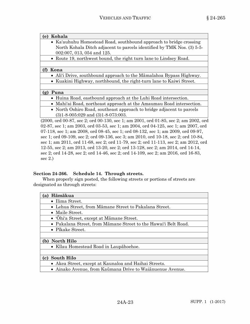
(e) Kohala • Ka‘auhuhu Homestead Road, southbound approach to bridge crossing
North Kohala Ditch adjacent to parcels identified by TMK Nos. (3) 5-5-002:007, 013, 054 and 125.
• Route 19, northwest bound, the right turn lane to Lindsey Road. (f) Kona
• Ali‘i Drive, southbound approach to the Māmalahoa Bypass Highway. • Kuakini Highway, northbound, the right-turn lane to Kaiwi Street.
(g) Puna
• Huina Road, eastbound approach at the Luhi Road intersection. • Mahi‘ai Road, northeast approach at the Amaumau Road intersection. • North Oshiro Road, southeast approach to bridge adjacent to parcels
(3)1-8-005:029 and (3)1-8-073:003. (2000, ord 00-87, sec 2; ord 00-130, sec 1; am 2001, ord 01-85, sec 2; am 2002, ord 02-87, sec 1; am 2003, ord 03-53, sec 1; am 2004, ord 04-125, sec 1; am 2007, ord 07-118, sec 1; am 2008, ord 08-45, sec 1; ord 08-132, sec 1; am 2009, ord 09-97, sec 1; ord 09-109, sec 2; ord 09-136, sec 3; am 2010, ord 10-18, sec 2; ord 10-84, sec 1; am 2011, ord 11-68, sec 2; ord 11-79, sec 2; ord 11-113, sec 2; am 2012, ord 12-55, sec 2; am 2013, ord 13-20, sec 2; ord 13-128, sec 2; am 2014, ord 14-14, sec 2; ord 14-28, sec 2; ord 14-46, sec 2; ord 14-109, sec 2; am 2016, ord 16-83, sec 2.)24-265
Section 24-266. Schedule 14. Through streets. When properly sign posted, the following streets or portions of streets are
designated as through streets: (a) Hāmākua
• Ilima Street. • Lehua Street, from Māmane Street to Pakalana Street. • Maile Street. • ‘Ōhi‘a Street, except at Māmane Street. • Pakalana Street, from Māmane Street to the Hawai‘i Belt Road. • Pīkake Street.
(b) North Hilo
• Kīlau Homestead Road in Laupāhoehoe. (c) South Hilo
• Akea Street, except at Kaunaloa and Haihai Streets. • Ainako Avenue, from Kaūmana Drive to Waiānuenue Avenue.

§ 24-266 HAWAI‘I COUNTY CODE
24A-24
(c) South Hilo (Continued) • Ainaola Drive, from Kawailani to its end in a westerly direction. • Alohalani Drive, except at Haihai Street and Kaunaloa Street. • ‘Amauulu Road, from Wainaku Avenue to its end. • Andrews Avenue. • Baker Avenue, Kalaniana‘ole Street to its southern terminus, except at
Desha Avenue. • Banyan Drive, except at Lihiwai Street and Kamehameha Avenue. • Bishop Street, from Kamehameha Avenue to Waiolama Canal. • Haihai Street, from Kino‘ole Street to the Ainaola Drive. • Haili Street, from Kino‘ole Street to Hāla‘i Street. • Hāla‘i Street, from Hāla‘i Hill to Waiānuenue Avenue, except at Haili
Street from a southerly (Puna) direction and at Punahele Street from a northerly (Hāmākua) direction.
• Hale Nani Street, from Kapi‘olani Street westerly to its end. • Heahea Street, from Ainaola Drive to its southern terminus. • Hema Street, except at Kapi‘olani Street. • Hīnano Street, except at Pi‘ilani, Kekūanaō‘a and Lanikāula Streets. • Hōkū Street, from Kīlauea Avenue to Kino‘ole Street. • Holomua Street, from Kāwili Street to Maka‘ala Street. • Hookano Street, from Kupulau Road to Ho‘olaule‘a Street. • Hualālai Street, from Kīlauea Avenue to Kino‘ole Street. • Ioana Street, from Wilder Road to its eastern terminus. • ‘Iolani Street. • Ipuka Street. • Ka‘akepa Street, from Pepe‘ekeo Street to its mauka terminus except at
the Hawai‘i Belt Road. • Kahaopea Street, except at Kino‘ole, Kīlauea and Kanoelehua Streets. • Kainehe Street, from Kamehameha Avenue to Aalapuna Street. • Ka‘iulani Street, from Waiānuenue Avenue to its end. • Kaiwiki Road, from Māmalahoa Highway to its end. • Kalaniana‘ole Street, from Kamehameha Avenue to its end. • Kalanikoa Street, from Lanikāula Street to Pi‘ilani Street, except at
Kekūanaō‘a Street. • Kamehameha Avenue, from Wailuku Drive to Kalaniana‘ole Street,
except entering intersection with Waiānuenue Avenue from a northerly (Pu‘u‘eo) direction.
• Kapaka Street, except at Haihai Street. • Kapi‘olani Street, from Ponahawai Street to its end in a southeasterly
direction. • Ka‘uhane Avenue. • Kaūmana Drive, from Hilo Country Club Road to Waiānuenue Avenue.

VEHICLES AND TRAFFIC § 24-266
24A-25
(c) South Hilo (Continued) • Kaunaloa Street. • Kawailani Street, from Kino‘ole Street to its end in the mauka
direction, except at Komohana Street. • Kāwili Street, from Kanoelehua Avenue to Kīlauea Avenue, except at
Manono Street. • Keawe Street, from Pu‘u‘eo Street to Kīlauea Avenue, except at
Wailuku Drive. • Kekūanaō‘a Street, from Kīlauea Avenue to Kanoelehua Avenue. • Keo Street, from Wilder Road to its eastern terminus. • Kīlauea Avenue, from Haili Street to Haihai Street, except at Mamo
Street. • Kilikina Street, from Ainako Avenue to its terminus. • Kilohana Street, from Kamehameha Avenue to Banyan Drive. • Kino‘ole Street, from Waiānuenue Avenue to Haihai Street. • Komohana Street, from Kawailani Street to Waiānuenue Avenue. • Kūkūau Street, from Kīlauea Avenue to its southern terminus, except
at Kino‘ole Street, Ululani Street, Kapi‘olani Street, Komohana Street, and Mohouli Street.
• Kula‘imano Road, from the Old Māmalahoa Highway to its mauka terminus except at the Hawai‘i Belt Road.
• Kumula Street, except at Ka‘akepa Street and at the mauka intersection with Kulala Street.
• Kumula Street, from the west intersection with Kulala Street and looping with Kulala Street, except at the Kula‘imano Homestead Road.
• Lahaina Street, except at Ainako Avenue and Kaūmana Drive. • Lama Street, except at its intersection with the Hawai‘i Belt Road. • Lanikāula Street, from Kīlauea Avenue to Kanoelehua Avenue, except
at Manono Street. • Laukapu Street, except at Kekūanaō‘a and Lanikāula Streets. • Loloa Drive, from Hawai‘i Belt Road westerly to its end. • Maka‘ala Street, from Kāwili Street to Kanoelehua Avenue. • Makahana Street, from Kula‘imano Road to Pepe‘ekeo Street. • Makalika Street, except at its intersection with the Hawai‘i Belt Road. • Mamo Street, from Kamehameha Avenue to Kino‘ole Street, except at
Keawe Street. • Manono Street, from Kamehameha Avenue to Kāwili Street, except at
Kekūanaō‘a Street and Lanikāula Street. • Mikioi Street, except at Paipai and No‘eau Streets. • Mililani Street, except at Kekūanaō‘a Street, Lanikāula Street, and
Pi‘ilani Street.

§ 24-266 HAWAI‘I COUNTY CODE
24A-26
(c) South Hilo (Continued) • Mohouli Street, from Kīlauea Avenue to Kaūmana Drive, except at
Kino‘ole Street, and Komohana Street. • Nēnē Street. • No‘eau Street, except at Pilipaa and Ohuohu Streets. • Nolemana Street, from Kaūmana Drive to Pakelekia Street. • Ohuohu Street, except at Kahaopea Street. • Onomea Street, except at Kapehu Street. • Operations Road. • Paipai Street, except at Pilipa‘a and Ohuohu Streets. • Pauahi Street, from Kīlauea Avenue to Kamehameha Avenue. • Pi‘ilani Street, from Kanoelehua Avenue to Wailoa State Park Road,
except at Manono Street. • Pilipa‘a Street, except at Kahaopea Street. • Ponahawai Street, from Kino‘ole Street to its end in the mauka
direction. • Pua Avenue, Kalaniana‘ole Street to Lyman Avenue, except at Desha
Avenue. • Pepe‘ekeo Street, except at Maukaloa Street and at the Old Māmalahoa
Highway. • Punahele Street, from Hāla‘i Street to Komohana Street; from
Komohana Street to Kaūmana Drive. • Pu‘u‘eo Street, from Wailuku Drive to Kauila Street. • Railroad Avenue, except at Leilani Street. • Terrace Circle, except at its intersection with Terrace Drive. • Terrace Drive. • Ululani Street, from Ponahawai Street southeasterly to its terminus,
except at Hualālai Street and Wailoa Street. • Waiānuenue Avenue, from Akolea Road to Kamehameha Avenue,
except where it intersects Kaūmana Drive. • Wailuku Drive, from Kamehameha Avenue to Ka‘iulani Street, except
at Keawe Street and Wainaku Avenue. • Wainaku Avenue, from Māmalahoa Highway to Wailuku Drive. • Wainohia Street, from Puainako Street to its southern terminus. • Wilder Road.
(d) Ka‘ū
• Hīnano Street, except at Huapala Street. • Huapala Street, except at Pīkake Street. • Ilima Street, except at Huapala Street. • Kamani Street, except at Pīkake Street. • Kukui Road, from the Māmalahoa Highway northerly to its end.

VEHICLES AND TRAFFIC § 24-266
24A-27
(d) Ka‘ū (Continued) • Maile Street, except at Kamani Street. • ‘Ōhai Road, except at the Māmalahoa Highway and Kukui Road. • ‘Ōhi‘a Street, except at Kamani and Pīkake Streets. • Pakalana Street, except at Pīkake Street. • Pīkake Street, except at Maile Street. • Puahala Street, except at Pakalana and Kamani Streets. • Pumeli Street, except at Puahala and Pakalana Streets.
(e) Kohala
• Kynnersley Road in Kohala, from its intersection with the Kamuela-Hāwī Road to the Niuli‘i-Māhukona Road.
• Lindsey Road, from the Waimea to Kawaihae Road to Hoku‘ula Road. • Pu‘u Nanea Street, from Pu‘u Nani Drive northerly to its end. • Pu‘u Nani Drive, from the Māmalahoa Highway northerly to its end. • Pu'u Pulehu Loop, the main road that forms a loop through Lakeland
Subdivision, in South Kohala, between its two terminals at Mamalahoa Highway.
• The Waimea to Kawaihae Road, from the Māmalahoa Highway at Waimea to Kawaihae.
(f) Kona
• Ali‘i Drive, from Palani Road except at Hualālai Road, southerly to its terminus.
• Captain Cook Road, from the Māmalahoa Highway easterly to its end. • Haku Nui Road, from Hind Drive easterly to its end. • Hind Drive, from Captain Cook Road northerly to its end. • Kealakaa Street, from Palani Road to its terminus. • Kuakini Highway in Kona, from Māmalahoa Highway to Palani Road. • The highway known as the Middle Road, from Kealakekua where it
intersects the Māmalahoa Highway to Keokea where it again intersects the Māmalahoa Highway in Kona.
• Palani Road, from the Hawai‘i Belt Road to Kuakini Highway. • Plumeria Road, except at Royal Poinciana Drive. • Royal Poinciana Drive, except at Ali‘i Drive. • Sea View Circle, within Kona Sea View Subdivision, except for
approximately two hundred thirty feet of the road from its access at Kuakini Highway.
(g) Puna
• ‘Ainaloa Boulevard, except at Route 130. • Alaula Street, Puolani Street to Ali‘i Kāne Street.

§ 24-266 HAWAI‘I COUNTY CODE
24A-28
(g) Puna (Continued) • Ali‘i Ānela Street, Route 11 to Alaula Street. • Ali‘i Kāne Street, except at Volcano Road. • Ali‘i Koa Street, Route 11 to Alaula Street. • Hāpu‘u Road, except at its intersection with Nānāwale Boulevard. • Haunani Street, at the Volcano. • Kahakai Boulevard, except at the "stop" controls at the makai approach
at Pūnāwai Street and at the Kea‘au-Pāhoa Road. • The highway known as the Kea‘au to Kapoho Road, from its
intersection with the Hawai‘i Belt Road in Kea‘au to Kapoho. • Kēhau Road, except at its intersection with Nānāwale Boulevard. • Lā‘au Loke Street, from the Kalapana-Kapoho Road to Mauka Nui
Street. • Maluhia Road, except at its intersection with Nānāwale Boulevard. • Māmalahoa Highway, from the 4-mile Bridge by way of Puna, to the
Honoli‘i Gulch, except where it intersects the following: - The Hawai‘i Belt Road. - Honohina Village Cutoff Road. - Honokōhau Cutoff Road. - Honomū Village Cutoff Road. - Kahuku Camp Cutoff Road. - Kanoelehua Cutoff Road. - The Kea‘au-Pāhoa Road. - Māmane Street in Honoka‘a.
• Moana Kai Pali Street, from the Kalapana-Kapoho Road to its southwestern terminus.
• Nānāwale Boulevard, except at its intersection with FASC Route 132 and at Kēhau Road.
• Ole‘ Ole Street, from the Kalapana-Kapoho Road to Mauka Nui Street. • Puolani Street, except at Anuhea Street. • Route 137, Route 130 to Route 132, except at Pohoiki Road and at the
Isaac Hale Beach Park driveway. • The highway known as the Saddle Road, from the Country Club Drive
in Hilo, to the Māmalahoa Highway at Kamuela in South Kohala. • Wright Road (FASP S-253 (1)).
(1996, ord 96-163, sec 2; am 1997, ord 97-62, secs 1 and 2; am 1999, ord 99-65, secs 11, 12, and 13; am 2001, ord 01-11, sec 1; ord 01-62, sec 4; ord 01-96, secs 4 and 5; am 2002, ord 02-47, secs 3 and 4; ord 02-55, sec 2.)24-266

VEHICLES AND TRAFFIC § 24-267
24A-29
Section 24-267. Schedule 15. One way streets. When properly posted, traffic shall move only in the direction indicated upon the
following streets or portions of streets: (a) Hāmākua
• Māmalahoa Highway in Pa‘auilo. All vehicular traffic shall move only from the Honoka‘a to the Hilo direction between the Cutoff Road on the Hilo side of the Catholic Church and the Hawai‘i Belt Road (Proj. DF-019-2(5)).
• ‘Ōhi‘a Street in Honoka‘a. All vehicular traffic shall move only in the northerly direction on the ‘Ōhi‘a Street extension between Māmane Street and ‘Ōhi‘a Street.
• Pa‘auilo School Park Road. All vehicular traffic shall move only from the Honoka‘a to Hilo direction between the Pa‘auilo Homestead Road and the Pa‘auilo School Road during the hours of 7:00 a.m. to 8:15 a.m. and 1:00 p.m. to 2:30 p.m. on school days.
• Pa‘auilo School Road. All vehicular traffic shall move only from the mauka to makai direction between the Pa‘auilo School Park Road and Māmalahoa Highway during the hours of 7:00 a.m. to 8:15 a.m. and 1:00 p.m. to 2:30 p.m. on school days.
• Pakalana Street in Honoka‘a. All vehicular traffic shall move only in the southerly (mauka) direction from Māmane Street to Kamani Street between the hours of 7:00 a.m. and 3:00 p.m. on school days only.
(b) North Hilo
• Māmalahoa Highway in Nīnole. All vehicular traffic shall move only from the Hilo to the Hāmākua direction.
(c) South Hilo • Bayfront Parking Lot Driveway located two hundred forty feet
Hāmākua of Mamo Street in the mauka direction. • A portion of Derby Street and Barenaba Street extension. All vehicular
traffic shall move only out (mauka to makai) into Kīlauea Avenue between Barenaba Street and Kīlauea Avenue.
• Furneaux Lane. All vehicular traffic shall move in the mauka direction, Kamehameha Avenue parking lot to Kīlauea Avenue.
• Holomalia Street. All vehicular traffic shall move only from makai to mauka between Ipuka Street and Popolo Street.
• Kalākaua Street. All vehicular traffic shall move in the mauka direction from Kamehameha Avenue to Kino‘ole Street.
• Kapi‘olani Street. All vehicular traffic shall move in the Puna direction between Waiānuenue Avenue and Haili Street, between the hours of 5:00 a.m. and 1:00 p.m. on Sundays.

§ 24-267 HAWAI‘I COUNTY CODE
SUPP. 4 (7-2018) 24A-30
(c) South Hilo (Continued) • Kapi‘olani Street. All vehicular traffic shall move in the Puna direction
from Waiānuenue Avenue to Haili Street between the hours of 7:15 a.m. and 8:00 a.m. on school days.
• Keawe Street. All vehicular traffic shall move in the Hāmākua direction from Kīlauea Avenue to Wailuku Drive.
• Keaukaha Road, from Kalaniana‘ole Street to Kamokuna Street. • Kekaulike Street. All vehicular traffic shall move in the Hāmākua
direction from Waiānuenue Avenue to Wailuku Drive. • Kīlauea Avenue. All vehicular traffic shall move in the Puna direction
from Haili Street to Mamo Street. • Kīlauea Avenue. All vehicular traffic shall move in the Hāmākua
direction from Ponahawai Street to Mamo Street. • Kino‘ole Street. All vehicular traffic shall move in the Puna direction
from Wailuku Drive to Ponahawai Street. • Kūkūau Street. All vehicular traffic shall move only from makai to
mauka between Kīlauea Avenue and Kino‘ole Street. • Lele Street. All vehicular traffic shall move in the Hāmākua direction,
Punahele Street to Kaūmana Drive. • Lihiwai Street. All vehicular traffic shall move in the westerly direction
from Keliipio Place to the roadway leading to the pier and lighthouse. • Māmalahoa Highway. All vehicular traffic shall move only from
Hāmākua to Puna between the Old Volcano Road leading to the Tuberculosis Rehabilitation Center and FAP F 2(3) (Kanoelehua Street Extension).
• Mo‘oheau Bus Terminal, the southernmost driveway, in the makai direction and the area fronting the bus terminal in the Hāmākua direction.
• Nawahi Lane. All vehicular traffic shall move only from makai to mauka between Kamehameha Avenue and Punahoa Street.
• Shipman Street. All vehicular traffic shall move in the makai direction from Kekaulike Street to Kamehameha Avenue.
• Ululani Street. All vehicular traffic shall move in the Hāmākua direction from Wailoa Street to Hualālai Street and from Waiānuenue Avenue to Wailuku Drive.
• Waiānuenue Avenue. All vehicular traffic shall move in the makai direction from Komohana Street to Kamehameha Avenue between the hours of 7:15 a.m. and 8:00 a.m. on school days.
• Wailuku Drive. All vehicular traffic shall move in the mauka direction from Kamehameha Avenue to Kino‘ole Street.
(d) Ka‘ū

VEHICLES AND TRAFFIC § 24-267
24A-31 SUPP. 4 (7-2018)
(e) Kohala (f) Kona
• Hōnaunau Beach Road. All vehicular traffic shall move in the northerly direction from the City of Refuge Access Road to Route 160.
• Likana Lane in Kailua-Kona. All vehicular traffic shall move only in a northerly direction between Ali‘i Drive and the driveway of the Kona Seaside Hotel.
• Sarona Road in Kailua-Kona. All vehicular traffic shall move in the easterly direction from Ali‘i Drive to a point approximately two hundred feet west of Kuakini Highway.
(g) Puna
(1996, ord 96-163, sec 2; am 1998, ord 98-85, sec 1; am 1999, ord 99-98, sec 1; am 2001, ord 01-96, sec 6; ord 01-119, sec 2; am 2003, ord 03-147, sec 1; am 2005, ord 05-90, sec 1; am 2008, ord 08-64, sec 1; am 2010, ord 10-87, sec 1; am 2012, ord 12-103, sec 2; am 2018, ord 18-4, sec 1.)24-267
Section 24-268. Schedule 16. Turn right anytime with caution. When signs are erected giving notice, the provisions of section 24-171 shall apply to
the following locations: (a) Hāmākua
• At the northeast corner of Māmalahoa Highway and the plantation road near the Pā‘auhau Sugar Company manager's home.
(b) North Hilo (c) South Hilo
• Noe Street at its intersection with Kalili Street, for vehicles headed in the Puna direction.
• Pohakulani Street at its intersection with Ainaola Drive for vehicles traveling in the Puna direction.
(d) Ka‘ū (e) Kohala (f) Kona
§ 24-268 HAWAI‘I COUNTY CODE
24A-32
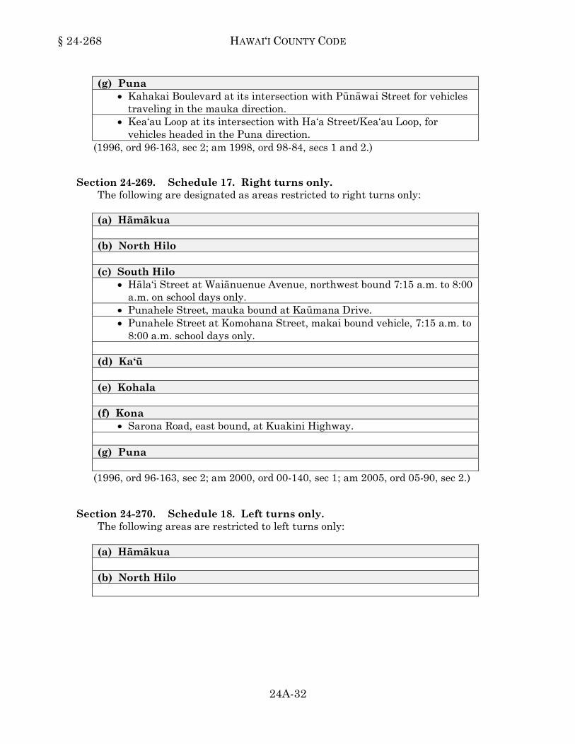
(g) Puna • Kahakai Boulevard at its intersection with Pūnāwai Street for vehicles
traveling in the mauka direction. • Kea‘au Loop at its intersection with Ha‘a Street/Kea‘au Loop, for
vehicles headed in the Puna direction. (1996, ord 96-163, sec 2; am 1998, ord 98-84, secs 1 and 2.)24-268
Section 24-269. Schedule 17. Right turns only. The following are designated as areas restricted to right turns only: (a) Hāmākua (b) North Hilo (c) South Hilo
• Hāla‘i Street at Waiānuenue Avenue, northwest bound 7:15 a.m. to 8:00 a.m. on school days only.
• Punahele Street, mauka bound at Kaūmana Drive. • Punahele Street at Komohana Street, makai bound vehicle, 7:15 a.m. to
8:00 a.m. school days only. (d) Ka‘ū (e) Kohala (f) Kona
• Sarona Road, east bound, at Kuakini Highway. (g) Puna
(1996, ord 96-163, sec 2; am 2000, ord 00-140, sec 1; am 2005, ord 05-90, sec 2.) 24-269
Section 24-270. Schedule 18. Left turns only. The following areas are restricted to left turns only: (a) Hāmākua (b) North Hilo

VEHICLES AND TRAFFIC § 24-270
24A-33
(c) South Hilo (d) Ka‘ū (e) Kohala (f) Kona (g) Puna
(1996, ord 96-163, sec 2.)24-270
Section 24-271. Schedule 19. Prohibited left turn areas. The following are designated as prohibited left turn areas: (a) Hāmākua (b) North Hilo (c) South Hilo
• Aupuni Street at Pauahi Street. • Banyan Way at Kalaniana‘ole Street. • Barenaba Lane at Kīlauea Avenue. • Kaūmana Drive, mauka bound at Punahele Street. • Kīlauea Avenue between Hualālai Street and Pauahi Street. • Kīlauea Avenue, north bound at Lanihuli Street. • Lanihuli Street at Kīlauea Avenue. • Mamo Street at Kamehameha Avenue. • Waiānuenue Avenue, for the mauka bound traffic entering the Hilo
Intermediate School, and for the makai bound traffic entering the Hilo High School parking lot and the track field between the hours of l:00 p.m. to 3:30 p.m. on school days only.
(d) Ka‘ū (e) Kohala (f) Kona
• Kuakini Highway, north bound at Sarona Road. • Route 180 at Route 11, for south bound motorists between the hours of
3:30 p.m. and 6:30 p.m., Monday through Friday except holidays.

§ 24-271 HAWAI‘I COUNTY CODE
24A-34
(g) Puna • Old ‘Ōla‘a-Pāhoa Road into Māmalahoa Highway in Kea‘au, opposite
the Kea‘au Service Station. (1996, ord 96-163, sec 2; am 2005, ord 05-90, sec 3; am 2007, ord 07-86, sec 1; am 2013, ord 13-127, sec 2.)24-271
Section 24-272. Schedule 20. Prohibited right turn areas. The following are designated as prohibited right turn areas when appropriate signs
or markings giving notice thereof shall be erected: (a) Hāmākua (b) North Hilo (c) South Hilo
• Waiānuenue Avenue, makai bound, into Komohana Street when traffic signal is red.
(d) Ka‘ū (e) Kohala (f) Kona
• Kahakai Road, at its northern intersection with Ali‘i Drive. (g) Puna
(1996, ord 96-163, sec 2; am 1998, ord 98-76, sec 1; am 1999, ord 99-25, sec 1.)24-272
Section 24-273. Schedule 21. Permitted U-turn areas. The following areas are designated as U-turn areas when appropriate signs giving
notice thereof shall be erected: (a) Hāmākua (b) North Hilo (c) South Hilo
• Intersection of Lihiwai Street and Liholiho Street.
VEHICLES AND TRAFFIC § 24-273
24A-35
(d) Ka‘ū (e) Kohala (f) Kona
• Within Ka‘ahumanu Square, Kailua-Kona. (g) Puna
(1996, ord 96-163, sec 2; am 2008, ord 08-141, sec 1.)24-273
Section 24-274. Schedule 22. Prohibited U-turn areas. The following are designated as prohibited U-turn areas when appropriate signs or
markings giving notice thereof shall be erected: (a) Hāmākua (b) North Hilo (c) South Hilo (d) Ka‘ū (e) Kohala (f) Kona (g) Puna
(1996, ord 96-163, sec 2.)24-274
Section 24-274.1. Schedule 22.1. Traffic signal systems. Traffic signal systems are hereby authorized as set forth in this schedule at the
streets and intersections described as follows: (a) Hāmākua (b) North Hilo (c) South Hilo
• Ainaola Drive/Haihai Street.

§ 24-274.1 HAWAI‘I COUNTY CODE
24A-36
(c) South Hilo (Continued) • Kamehameha Avenue/Pauahi Street. • Kaūmana Drive/Ainako Avenue. • Kāwili Street/Kapi‘olani Street. • Keawe Street/Haili Street. • Keawe Street/Mamo Street. • Kekūanāo‘a Street/Manono Street. • Kīlauea Avenue/Aupuni Street. • Kīlauea Avenue/Kawailani Street. • Kīlauea Avenue/Kāwili Street. • Kīlauea Avenue/Kekūanāo‘a Street. • Kīlauea Avenue/Lanikāula Street. • Kīlauea Avenue/Mohouli Street. • Kīlauea Avenue/Pauahi Street/Hualālai Street. • Kīlauea Avenue/Ponahawai Street. • Kino‘ole Street/Haili Street. • Kino‘ole Street/Hualālai Street. • Kino‘ole Street/Kamana Street. • Kino‘ole Street/Kawailani Street. • Kino‘ole Street/Kāwili Street. • Kino‘ole Street/Lanikāula Street. • Kino‘ole Street/Mohouli Street. • Kino‘ole Street/Ponahawai Street. • Komohana Street/Mohouli Street. • Komohana Street/Ponahawai Street. • Lanikāula Street/Manono Street. • Mohouli Street/Kumukoa Street. • Ohuohu Street, Mid-Block Crosswalk. • Ponahawai Street/Kapi‘olani Street. • Waiānuenue Avenue/Hilo High and Hilo Intermediate Schools. • Waiānuenue Avenue/Ka‘iulani Street. • Waiānuenue Avenue/Kaūmana Drive/Lele Street. • Waiānuenue Avenue/Keawe Street. • Waiānuenue Avenue/Kino‘ole Street. • Waiānuenue Avenue/Komohana Street.
(d) Ka‘ū (e) Kohala
• Highway 19/Pukalani Road. • Highway 19E/Kamāmalu Road. • Highway 19E/Lindsey Road.
(f) Kona
• Ali‘i Drive/Kaleiopapa Street. • Ali‘i Highway/Ali‘i Drive.
VEHICLES AND TRAFFIC § 24-274.1
24A-37
(f) Kona (Continued) • Haleki‘i Street, at mid-block crosswalk, two hundred seventy feet east
of Mamao Street. • Henry Street/Lanihau Shopping Center. • Henry Street/Walmart • Kamehameha III Road/Ali‘i Highway. • Kamehameha III Road at Hill Haven Subdivision. • Kuakini Highway/Hanama Street. • Kuakini Highway/Henry Street. • Kuakini Highway/Hualālai Road. • Kuakini Highway/Kalani Street. • Kuakini Highway/Palani Road. • Makala Boulevard, at the Kona Commons Driveway, one thousand five
hundred twenty-five feet southwest of Queen Ka‘ahumanu Highway. • Makala Boulevard, at the Kona Commons Driveway, one thousand one
hundred fifteen feet southwest of Queen Ka‘ahumanu Highway. • Makala Boulevard/Luhia Street. • Palani Road/Henry Street. • Palani Road/Lanihau Shopping Center. • Route 11/Haleki‘i Street. • Route 11/Konawaena Elementary School Road. • Route 11/Konawaena School Road.
(g) Puna
(1996, ord 96-163, sec 2; am 1997, ord 97-112, sec 1; am 2000, ord 00-86, secs 1 and 3; ord 00-123, sec 1; am 2002, ord 02-83, sec 1; am 2003, ord 03-164, sec 1; am 2009, ord 09-28, sec 1; ord 09-29, sec 1; ord 09-67, sec 1; ord 09-68, sec 1; ord 09-110, sec 2; ord 09-111, sec 2; ord 09-112, sec 2; am 2013, ord 13-56, sec 2.) 24-274.1
Division 3. Bus Stops and Public Road Taxi Stands.
Section 24-275. Schedule 23. Bus stop locations. When signs or markings are provided, bus stops in the County shall be located at
the following locations, and no person shall stop, stand, or park a vehicle therein: (a) Hāmākua
• Pakalana Street, west side, from a point four hundred sixty feet south of Highway 240 and extending eighty-five feet in the southerly direction, between the hours of 12:00 p.m. and 3:00 p.m. on school days only.
§ 24-275 HAWAI‘I COUNTY CODE
SUPP. 4 (7-2018) 24A-38
(b) North Hilo (c) South Hilo
• Aupuni Street, southwest side, from a point seven hundred seventy-three feet southeast of Pauahi Street and extending forty feet in the southeasterly direction.
• Banyan Drive, northwest (makai) side, from a point nine hundred thirteen feet northeast of the northern intersection of Lihiwai Street and extending eighty-seven feet in the northeasterly direction, between the hours of 6:00 a.m. and 6:00 p.m., Monday through Saturday.
• Banyan Drive, southeast (golf course) side from a point seven hundred nineteen feet northeast of the northern intersection of Lihiwai Street and extending ninety-one feet in the northeasterly direction, between the hours of 6:00 a.m. and 6:00 p.m., Monday through Sunday.
• East Kāwili Street, north side, beginning from a point one hundred eighteen feet west of the intersection of Hinano Street and East Kāwili Street and extending in the western direction for a distance of one hundred twenty feet, from 6:00 a.m. to 6:00 p.m., Monday through Saturday.
• East Kāwili Street, south side, beginning from a point ninety-three feet east of the intersection of Manono Street and East Kāwili Street and extending in the eastern direction for a distance of one hundred twenty feet, from 6:00 a.m. to 6:00 p.m., Monday through Saturday.
• Fronting the Hilo Bus Terminal Building at Mo‘oheau Park for a distance of eighty feet.
• Hualālai Street, Puna side, beginning at a point thirty feet makai of Kapi‘olani Street and extending sixty feet in the makai direction between the hours of 2:30 p.m. and 3:30 p.m. on school days only.
• Kamehameha Avenue, west side, beginning from a point sixty feet south of Kalākaua Street and extending fifty feet in the southerly direction, from 12:30 p.m. to 2:30 p.m., on school days.
• Kapi‘olani Street, east side, beginning from a point five feet north of the Church of Holy Apostles driveway and extending in the northern direction for a distance of forty feet.
• Kapi‘olani Street, west side, beginning from a point eighty-eight feet southeast of the Hāmākua entrance driveway of the University of Hawai‘i and extending in the southeastern direction for a distance of one hundred twenty feet, from 6:00 a.m. to 6:00 p.m. Monday through Saturday.

VEHICLES AND TRAFFIC § 24-275
24A-39
(c) South Hilo (Continued) • Kekūanaō‘a Street, south side, beginning from a point one hundred
thirty-seven feet east of the Kīlauea Avenue intersection and extending in the eastern direction for a distance of fifty feet.
• Kīlauea Avenue, west side, beginning from a point three hundred eighty three feet south of Kawailani Street and extending one hundred forty eight feet in the southerly direction.
• Lanikāula Street, Puna side, beginning from a point five hundred seventy-one feet makai of Kapi‘olani Street and extending one hundred sixty-one feet in the makai direction, from 7:00 a.m. to 8:00 a.m. and from 3:00 p.m. to 4:00 p.m. on school days.
• Mohouli Street, Hāmākua side, beginning at a point three hundred eighty feet mauka of Kīlauea Avenue and extending in the mauka direction for a distance of one hundred feet, from 7:00 a.m. to 8:00 a.m. and from 1:00 p.m. to 2:30 p.m. on school days.
• Shipman Street, adjacent to parcels 2-3-004:003 and 2-3-004:004, from 8:00 a.m. to 12:00 p.m., on school days.
• Waiānuenue Avenue, east side, beginning from a point sixty feet mauka of the Hāla‘i Street intersection, and extending in the makai direction for a distance of forty feet.
• Waiānuenue Avenue, Hāmākua side, at the Hilo High School beginning at its exit and extending for seventy-five feet in the westerly direction, from 1:30 p.m. to 3:00 p.m. on school days only.
• Waiānuenue Avenue, Puna side, beginning from a point eight hundred twelve feet makai of Laimana Street and extending two hundred twelve feet in the makai direction from 1:00 p.m. to 2:30 p.m. on school days.
• Waiānuenue Avenue, Puna side, beginning from a point sixty feet makai of Kino‘ole Street and extending eighty feet in the makai direction.
• Waiānuenue Avenue, Puna side, from the makai driveway of Hilo Intermediate School and extending one hundred eighty feet in the makai direction from 1:00 p.m. to 3:00 p.m. on school days.
• Waiānuenue Avenue, Puna side, lane within the unloading area at Hilo High School between the passenger shed fronting the Hilo High School cafeteria and the passenger shed near the exit of the unloading area, from 2:00 p.m. to 3:00 p.m. on school days.
• Waiānuenue Avenue, west side, beginning from a point sixty feet makai of the entrance to the Church of God, and extending in the mauka direction for a distance of forty feet.
• Waiānuenue Avenue, west side, beginning from the mauka side of the Hawai‘i Public Library exit driveway and extending in the mauka direction for a distance of fifty feet.
§ 24-275 HAWAI‘I COUNTY CODE
SUPP. 4 (7-2018) 24A-40
(d) Ka‘ū (e) Kohala
• Māmalahoa Highway, Route 190, south side, beginning from a point one hundred thirty feet east of the school driveway and extending two hundred fifty feet in the easterly direction from 7:00 a.m. to 8:00 a.m. and from 2:00 p.m. to 3:00 p.m. on school days.
(f) Kona
• Ali‘i Drive, makai side, beginning from a point nine feet north of the Hulihe‘e Palace yard driveway and extending in the northern direction for a distance of seventy-five feet.
• Palani Road, north side, beginning from a point ninety-five feet mauka of the mauka driveway of the Kailua Shopping Center and extending in the mauka direction for a distance of one hundred fifty feet.
• Palani Road, south side, beginning from a point two hundred fifty-eight feet mauka of the First Hawaiian Bank driveway and extending in the mauka direction for a distance of one hundred forty-five feet.
• Route 11, east side, from a point one-hundred ninety-seven feet north of Kinue Road and extending seventy-five feet in the northerly direction.
(g) Puna
• North Glenwood Road, beginning at a point 2.1 miles northwest of Highway 11 and extending one hundred feet in the northeasterly direction.
(1996, ord 96-163, sec 2; am 1996, ord 96-138, secs 1, 2, and 3; am 1998, ord 98-74, sec 1; ord 98-118, sec 1; am 2001, ord 01-9, sec 1; ord 01-66, sec 1; ord 01-67, sec 2; am 2003, ord 03-138, sec 1; am 2007, ord 07-167, sec 1; am 2008, ord 08-110, sec 1; am 2011, ord 11-119, sec 2; am 2012, ord 12-102, sec 2; ord 12-122, sec 2; am 2013, ord 13-34, sec 2; am 2014, ord 14-48, secs 2 and 3; ord 14-60, sec 2; am 2015, ord 15-4, sec 2; am 2018, ord 18-45, sec 1.)24-275
Section 24-275.1. Schedule 23.1. Public road taxi stand locations. When signs or markings are provided, public road taxi stands in the County shall
be located at the following locations, and no person shall stop, stand, or park a vehicle therein:
(a) Hāmākua (b) North Hilo
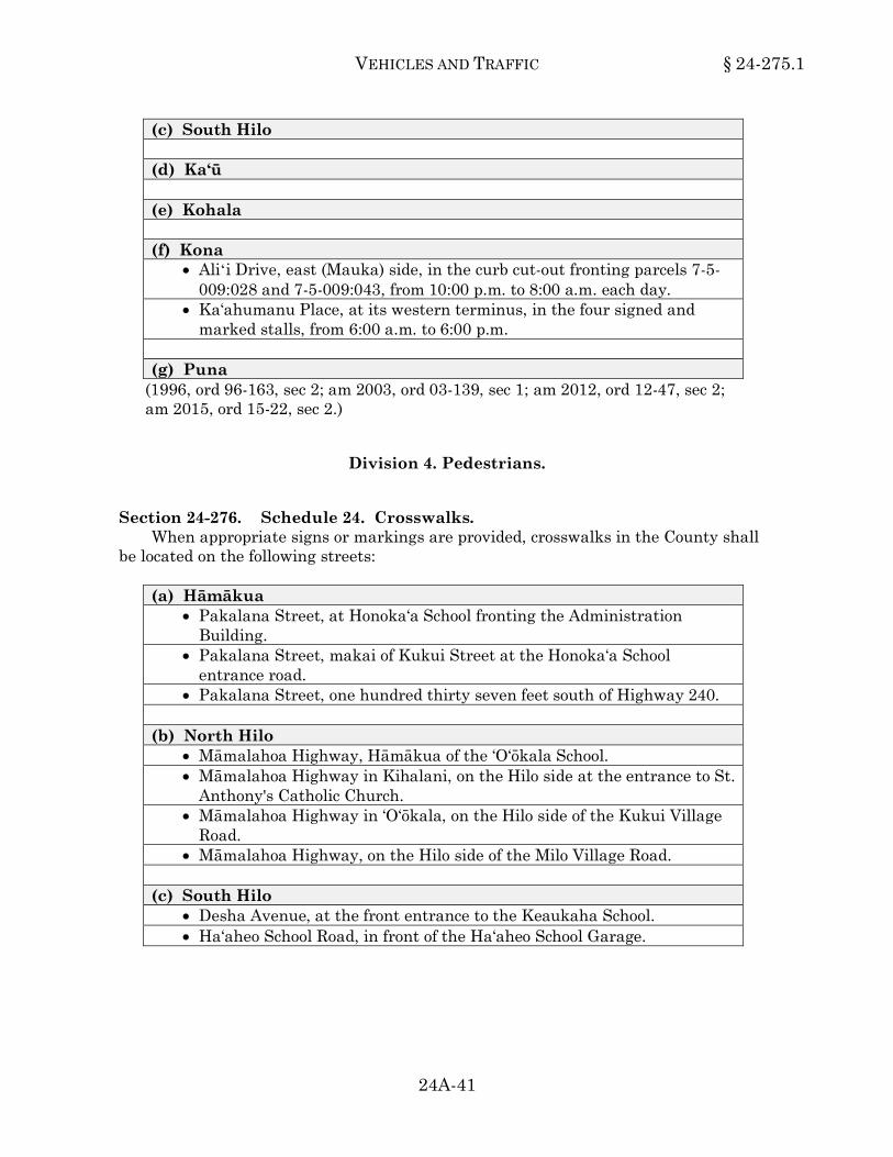
VEHICLES AND TRAFFIC § 24-275.1
24A-41
(c) South Hilo (d) Ka‘ū (e) Kohala (f) Kona
• Aliʻi Drive, east (Mauka) side, in the curb cut-out fronting parcels 7-5-009:028 and 7-5-009:043, from 10:00 p.m. to 8:00 a.m. each day.
• Ka‘ahumanu Place, at its western terminus, in the four signed and marked stalls, from 6:00 a.m. to 6:00 p.m.
(g) Puna
(1996, ord 96-163, sec 2; am 2003, ord 03-139, sec 1; am 2012, ord 12-47, sec 2; am 2015, ord 15-22, sec 2.)24-275.1
Division 4. Pedestrians.
Section 24-276. Schedule 24. Crosswalks. When appropriate signs or markings are provided, crosswalks in the County shall
be located on the following streets: (a) Hāmākua
• Pakalana Street, at Honoka‘a School fronting the Administration Building.
• Pakalana Street, makai of Kukui Street at the Honoka‘a School entrance road.
• Pakalana Street, one hundred thirty seven feet south of Highway 240. (b) North Hilo
• Māmalahoa Highway, Hāmākua of the ‘O‘ōkala School. • Māmalahoa Highway in Kihalani, on the Hilo side at the entrance to St.
Anthony's Catholic Church. • Māmalahoa Highway in ‘O‘ōkala, on the Hilo side of the Kukui Village
Road. • Māmalahoa Highway, on the Hilo side of the Milo Village Road.
(c) South Hilo
• Desha Avenue, at the front entrance to the Keaukaha School. • Ha‘aheo School Road, in front of the Ha‘aheo School Garage.

§ 24-276 HAWAI‘I COUNTY CODE
24A-42
(c) South Hilo (Continued) • Kamana Street, four hundred thirty-five feet southwest of Kino‘ole
Street. • Kamehameha Avenue, eight hundred forty feet east of Ponahawai
Street. • Kamehameha Avenue, midway between Kalākaua Street and Haili
Street. • Kapi‘olani Street, one hundred ninety feet Hāmākua of Haili Street. • Kaūmana Drive, in front of the Kaūmana School. • Kaūmana Drive, mauka of the Waiānuenue Avenue intersection. • Kīlauea Avenue, in front of the Hilo Hongwanji Temple. • Kino‘ole Street, in front of the Waiākeawaena School. • Māmalahoa Highway, in front of the Hakalau School Gym and
entrance. • Māmalahoa Highway, in front of the Honomū School. • Māmalahoa Highway, in front of Kalaniana‘ole School. • Māmalahoa Highway in Pāpa‘ikou on the Hilo side of the driveway to
Pāpa‘ikou Park. • Manono Street, in front of the Civic Auditorium. • Mohouli Street, at Kapi‘olani School. • Ohuohu Street, seven hundred twenty feet north of Puainako Street. • Old Māmalahoa Highway, in Pāpa‘ikou, approximately four hundred
feet north of the Kalaniana‘ole School ingress driveway. • Pua Avenue, on the mauka side entrance to the Keaukaha School. • Pua Street, in front of the Church of Jesus Christ of Latter-Day Saints. • Ululani Street, between St. Joseph's High School and St. Joseph's
Elementary School. • Waiānuenue Avenue, fronting the new parking lot for Hilo Hospital. • Waiānuenue Avenue, fronting the Yukio Okutsu Veterans Home. • Waiānuenue Avenue, in front of the Hilo High School. • Waiānuenue Avenue, in front of Pi‘ihonua Store. • Waiānuenue Avenue, in front of the Pi‘ihonua School. • Waiānuenue Avenue, mauka of the Kaūmana Drive intersection.
(d) Ka‘ū
• Old Government Road through Pāhala (Pāhala Loop Road), makai of Ka'u Meat Market.
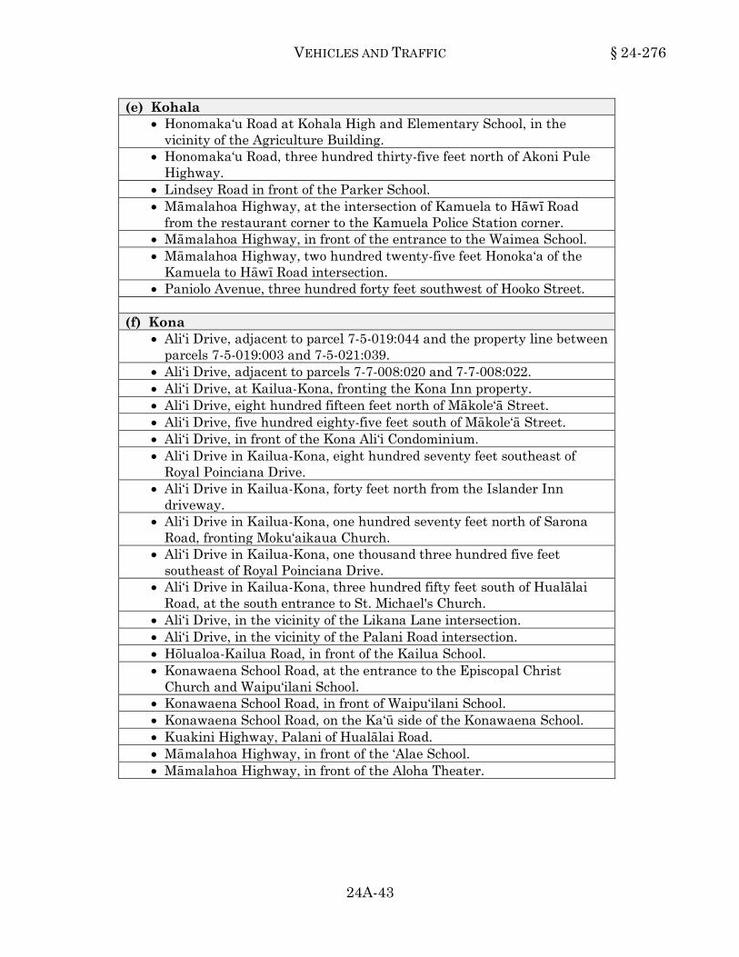
VEHICLES AND TRAFFIC § 24-276
24A-43
(e) Kohala • Honomaka‘u Road at Kohala High and Elementary School, in the
vicinity of the Agriculture Building. • Honomaka‘u Road, three hundred thirty-five feet north of Akoni Pule
Highway. • Lindsey Road in front of the Parker School. • Māmalahoa Highway, at the intersection of Kamuela to Hāwī Road
from the restaurant corner to the Kamuela Police Station corner. • Māmalahoa Highway, in front of the entrance to the Waimea School. • Māmalahoa Highway, two hundred twenty-five feet Honoka‘a of the
Kamuela to Hāwī Road intersection. • Paniolo Avenue, three hundred forty feet southwest of Hooko Street.
(f) Kona
• Ali‘i Drive, adjacent to parcel 7-5-019:044 and the property line between parcels 7-5-019:003 and 7-5-021:039.
• Ali‘i Drive, adjacent to parcels 7-7-008:020 and 7-7-008:022. • Ali‘i Drive, at Kailua-Kona, fronting the Kona Inn property. • Ali‘i Drive, eight hundred fifteen feet north of Mākole‘ā Street. • Ali‘i Drive, five hundred eighty-five feet south of Mākole‘ā Street. • Ali‘i Drive, in front of the Kona Ali‘i Condominium. • Ali‘i Drive in Kailua-Kona, eight hundred seventy feet southeast of
Royal Poinciana Drive. • Ali‘i Drive in Kailua-Kona, forty feet north from the Islander Inn
driveway. • Ali‘i Drive in Kailua-Kona, one hundred seventy feet north of Sarona
Road, fronting Moku‘aikaua Church. • Ali‘i Drive in Kailua-Kona, one thousand three hundred five feet
southeast of Royal Poinciana Drive. • Ali‘i Drive in Kailua-Kona, three hundred fifty feet south of Hualālai
Road, at the south entrance to St. Michael's Church. • Ali‘i Drive, in the vicinity of the Likana Lane intersection. • Ali‘i Drive, in the vicinity of the Palani Road intersection. • Hōlualoa-Kailua Road, in front of the Kailua School. • Konawaena School Road, at the entrance to the Episcopal Christ
Church and Waipu‘ilani School. • Konawaena School Road, in front of Waipu‘ilani School. • Konawaena School Road, on the Ka‘ū side of the Konawaena School. • Kuakini Highway, Palani of Hualālai Road. • Māmalahoa Highway, in front of the ‘Alae School. • Māmalahoa Highway, in front of the Aloha Theater.

§ 24-276 HAWAI‘I COUNTY CODE
24A-44
(f) Kona (Continued) • Māmalahoa Highway, in front of the Honokōhau School. • Māmalahoa Highway, in front of the Kalaoa School. • Māmalahoa Highway, in front of the Kona Civic Center in Captain
Cook. • Māmalahoa Highway, in front of the Kona Theater. • Māmalahoa Highway, in Hōlualoa, Kona, at the following locations:
- Hōlualoa Post Office. - Hōlualoa School. - Kona Arts Center.
• Māmalahoa Highway in the vicinity of Ben Franklin Store in Kainaliu, Kona.
• Palani Road in the vicinity of Kealakehe School. (g) Puna
• Haunani Road, in front of the Keākealani School. • Kahakai Boulevard, two hundred forty-two feet northwest of Pūnāwai
Street. • Kalapana-Kapoho Beach Road, one hundred fifteen feet northeast of the
property line between parcels 1-4-002:006 and 1-4-002:026. • Ka‘ohe Homestead Road, in Pāhoa, fronting the new Pāhoa School
cafeteria. • Ka‘ohe Homestead Road, in Pāhoa, in front of Pāhoa School
gymnasium. • Kea‘au-Pāhoa Road, three hundred fifty-five feet northwest of Ka‘ohe
Homestead Road. • Māmalahoa Highway, in ‘Ōla‘a, in front of the Kea‘au Store. • Māmalahoa Highway in ‘Ōla‘a, on the Volcano side of ‘Ōla‘a Ball Park
(Japanese New Camp) road. • ‘Ōla‘a to Kapoho Road, in Pāhoa, at the old Railroad right-of-way. • ‘Ōla‘a to Kapoho Road, in Pāhoa, between Morita Store and the Pāhoa
Post Office. • ‘Ōla‘a to Pāhoa Road, in front of the Shiigi Store at Pāhoa Village.
(1996, ord 96-163, sec 2; am 1997, ord 97-5, sec 1; am 1999, ord 99-98, sec 2; ord 99-162, secs 1 and 2; am 2000, ord 00-79, secs 1-3; am 2003, ord 03-133, sec 1; ord 03-138, sec 2; am 2009, ord 09-9, sec 1; ord 09-10, sec 1; am 2010, ord 10-7, sec 2; am 2011, ord 11-14, sec 1; am 2012, ord 12-34, sec 2; ord 12-63, sec 2; ord 12-73, sec 2; ord 12-133, sec 2; ord 12-137, sec 2; ord 12-160, sec 2; am 2014, ord 14-61, sec 2.)24-276

VEHICLES AND TRAFFIC § 24-277
24A-45
Section 24-277. Schedule 25. Safety zones. When appropriate signs or markings are provided, safety zones shall be located on
the following streets or portions of streets: (a) Hāmākua
• On the makai side of Māmalahoa Highway, from the Pa‘auilo Garage to the Pa‘auilo School Road.
• On the mauka side of Māmalahoa Highway, from the Pa‘auilo School Road to the Hawai‘i Belt Road, Project DF-019-2(5).
• On the Waipi‘o side of Pakalana Street from Māmane Street to Kukui Street.
(b) North Hilo
• On the makai side of Māmalahoa Highway in Laupāhoehoe from the Honoka‘a intersection with the Hawai‘i Belt Road to the Kihalani Homestead Road.
• On the mauka side of Māmalahoa Highway in Laupāhoehoe from the Kihalani Homestead Road to the Hilo side of the cutoff road to the Hawai‘i Belt Road.
(c) South Hilo
• On the Hāmākua side of Ainako Avenue between Kaūmana Drive and Lahi Street.
• Haihai Street, Hāmākua side, from Kino‘ole Street to Nālani Street. • On the east side of Kaūmana Drive from ‘I‘iwipōlena Street to Ainako
Avenue. • On the south (Puna) side of Kaūmana Drive from the vicinity of the
entrance to Kaūmana School to a point approximately four hundred feet west (mauka) of Laua‘e Road, a distance of approximately four thousand five hundred fifty feet.
• On the south side of Kawailani Street from Kino‘ole Street to Komohana Street.
• On the Puna side of Kūkūau Street from Kīlauea Avenue to Kino‘ole Street.
• On the makai side of Māmalahoa Highway from a point two hundred twenty feet Hāmākua of Anderton Camp Road to the entrance of Kalaniana‘ole School.
• On the makai side of Māmalahoa Highway from Pua Lane to the Ha‘aheo School Road.
• On the makai side of Māmalahoa Highway from the Spanish Camp Road to the Hakalau Store in Hakalau.

§ 24-277 HAWAI‘I COUNTY CODE
24A-46
(d) Ka‘ū • On the south side of Kamani Street between Pīkake Street and Puahale
Street in Pāhala. • On the south side of Kamani Street from the Ka'u Hospital access road
and extending mauka for approximately five hundred thirty-five feet to the Old Government Road makai of Maile Street.
(e) Kohala (f) Kona
• On the makai side of Ali‘i Drive from a point approximately five hundred feet south of Hualālai Road to the junction of Ali‘i Drive with the Kailua-Keauhou Middle Road (in the vicinity of the Kona Hilton Hotel).
• On the makai side of Māmalahoa Highway from Hōlualoa School traveling in a northerly direction for a distance of two miles.
• On the makai side of Māmalahoa Highway from the Konawaena School Road traveling in a northerly direction for a distance of two miles.
• On the mauka side of Māmalahoa Highway from Hōlualoa School traveling in a southerly direction for a distance of 1.2 miles.
• On the mauka side of Māmalahoa Highway from the Konawaena School Road traveling in a southerly direction for a distance of 1.9 miles.
(g) Puna
• On the makai side of Māmalahoa Highway in ‘Ōla‘a from the Old Slaughterhouse Road (Old Volcano Road) to Milo Street.
• On the mauka side of the ‘Ōla‘a-Kapoho Road, from the Pāhoa School (Homestead) Road, to a point on the Kapoho end of the Pāhoa Village.
(1996, ord 96-163, sec 2.)24-277
Section 24-278. Schedule 26. Roads closed to pedestrian traffic. The following are hereby established and designated as roads closed to pedestrian
traffic: (a) Hāmākua (b) North Hilo

VEHICLES AND TRAFFIC § 24-278
24A-47 SUPP. 4 (7-2018)
(c) South Hilo • Waiānuenue Avenue in South Hilo, from Kapi‘olani Street to Hāla‘i
Street, during the school hours of 7:00 a.m. to 8:00 a.m. and 2:00 p.m. to 3:00 p m., except at marked crosswalks.
(d) Ka‘ū (e) Kohala (f) Kona (g) Puna
(1996, ord 96-163, sec 2; am 2010, ord 10-82, sec 1; am 2013, ord 13-52, sec 2.)24-278
Division 5. Parking.
Section 24-279. Schedule 27. Parking on pavement prohibited at all times. When signs are erected giving notice thereof, no person shall at any time park a
vehicle upon any of the following described streets or portions of streets: (a) Hāmākua
• Loke Street, both sides, between Ohia Street and Miulana Place. (b) North Hilo (c) South Hilo
• Desha Avenue, both sides, between Andrews Avenue and Baker Avenue.
• Government Road (TMK 2-7-029), North Hāmākua side, from a point five hundred fifty-seven feet West of Old Māmalahoa Highway to Western terminus.
• Government Road (TMK 2-7-029), South Hilo side. • Hualilili Street, both sides, beginning at Kaūmana Drive and extending
one hundred sixty-eight feet in the southeasterly direction. • Ka‘ie‘ie Homestead Road, for its entire length. • Kīlauea Avenue, both sides, between Kawailani Street and Ohea Street. • The old Māmalahoa Highway, mauka side, beginning at the Plantation
Road and ending at the unnamed roadway leading into Onomea Park Subdivision.
• Pukihae Street, for its entire length.
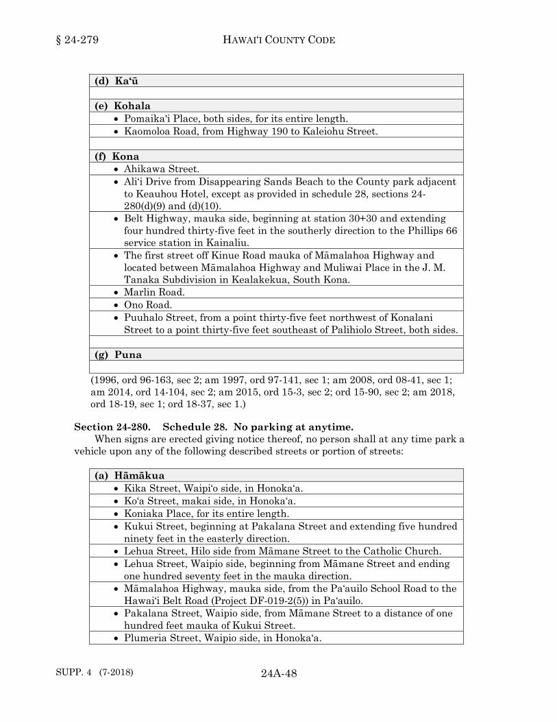
§ 24-279 HAWAI‘I COUNTY CODE
SUPP. 4 (7-2018) 24A-48
(d) Ka‘ū (e) Kohala
• Pomaika'i Place, both sides, for its entire length. • Kaomoloa Road, from Highway 190 to Kaleiohu Street.
(f) Kona
• Ahikawa Street. • Ali‘i Drive from Disappearing Sands Beach to the County park adjacent
to Keauhou Hotel, except as provided in schedule 28, sections 24-280(d)(9) and (d)(10).
• Belt Highway, mauka side, beginning at station 30+30 and extending four hundred thirty-five feet in the southerly direction to the Phillips 66 service station in Kainaliu.
• The first street off Kinue Road mauka of Māmalahoa Highway and located between Māmalahoa Highway and Muliwai Place in the J. M. Tanaka Subdivision in Kealakekua, South Kona.
• Marlin Road. • Ono Road. • Puuhalo Street, from a point thirty-five feet northwest of Konalani
Street to a point thirty-five feet southeast of Palihiolo Street, both sides. (g) Puna
(1996, ord 96-163, sec 2; am 1997, ord 97-141, sec 1; am 2008, ord 08-41, sec 1; am 2014, ord 14-104, sec 2; am 2015, ord 15-3, sec 2; ord 15-90, sec 2; am 2018, ord 18-19, sec 1; ord 18-37, sec 1.)24-279
Section 24-280. Schedule 28. No parking at anytime. When signs are erected giving notice thereof, no person shall at any time park a
vehicle upon any of the following described streets or portion of streets: (a) Hāmākua
• Kika Street, Waipi‘o side, in Honoka‘a. • Ko‘a Street, makai side, in Honoka‘a. • Koniaka Place, for its entire length. • Kukui Street, beginning at Pakalana Street and extending five hundred
ninety feet in the easterly direction. • Lehua Street, Hilo side from Māmane Street to the Catholic Church. • Lehua Street, Waipio side, beginning from Māmane Street and ending
one hundred seventy feet in the mauka direction. • Māmalahoa Highway, mauka side, from the Pa‘auilo School Road to the
Hawai‘i Belt Road (Project DF-019-2(5)) in Pa‘auilo. • Pakalana Street, Waipio side, from Māmane Street to a distance of one
hundred feet mauka of Kukui Street. • Plumeria Street, Waipio side, in Honoka‘a.
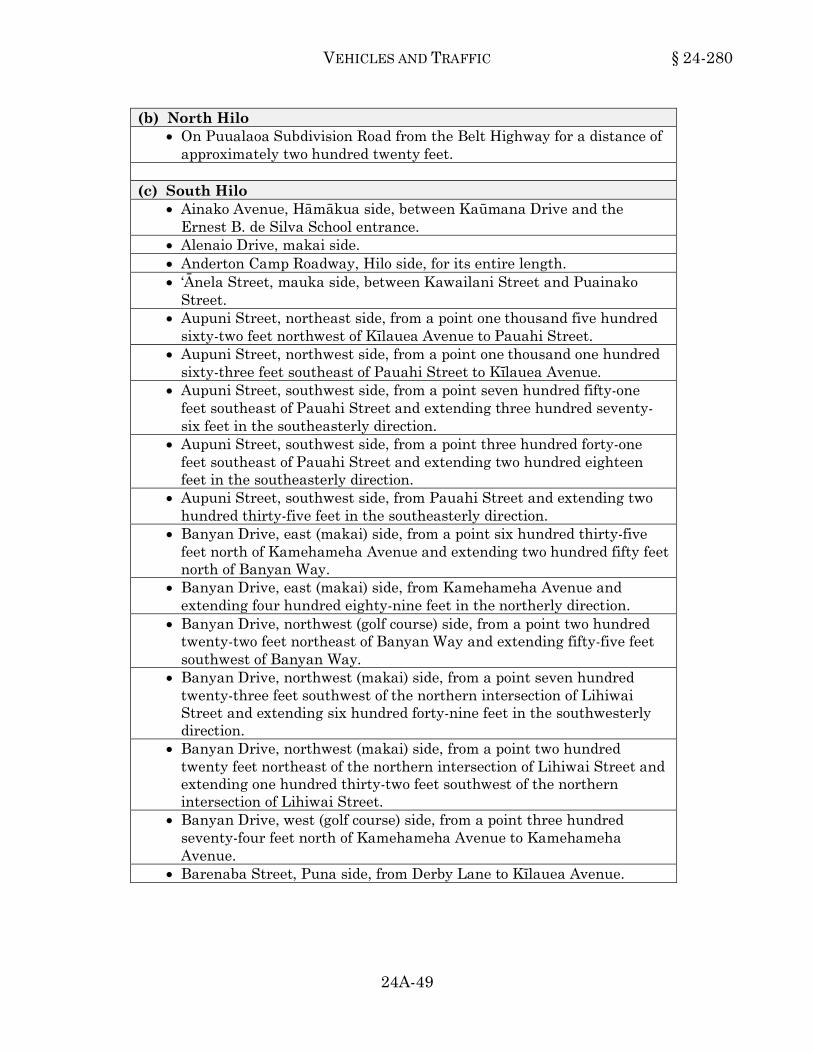
VEHICLES AND TRAFFIC § 24-280
24A-49
(b) North Hilo • On Puualaoa Subdivision Road from the Belt Highway for a distance of
approximately two hundred twenty feet. (c) South Hilo
• Ainako Avenue, Hāmākua side, between Kaūmana Drive and the Ernest B. de Silva School entrance.
• Alenaio Drive, makai side. • Anderton Camp Roadway, Hilo side, for its entire length. • ‘Ānela Street, mauka side, between Kawailani Street and Puainako
Street. • Aupuni Street, northeast side, from a point one thousand five hundred
sixty-two feet northwest of Kīlauea Avenue to Pauahi Street. • Aupuni Street, northwest side, from a point one thousand one hundred
sixty-three feet southeast of Pauahi Street to Kīlauea Avenue. • Aupuni Street, southwest side, from a point seven hundred fifty-one
feet southeast of Pauahi Street and extending three hundred seventy-six feet in the southeasterly direction.
• Aupuni Street, southwest side, from a point three hundred forty-one feet southeast of Pauahi Street and extending two hundred eighteen feet in the southeasterly direction.
• Aupuni Street, southwest side, from Pauahi Street and extending two hundred thirty-five feet in the southeasterly direction.
• Banyan Drive, east (makai) side, from a point six hundred thirty-five feet north of Kamehameha Avenue and extending two hundred fifty feet north of Banyan Way.
• Banyan Drive, east (makai) side, from Kamehameha Avenue and extending four hundred eighty-nine feet in the northerly direction.
• Banyan Drive, northwest (golf course) side, from a point two hundred twenty-two feet northeast of Banyan Way and extending fifty-five feet southwest of Banyan Way.
• Banyan Drive, northwest (makai) side, from a point seven hundred twenty-three feet southwest of the northern intersection of Lihiwai Street and extending six hundred forty-nine feet in the southwesterly direction.
• Banyan Drive, northwest (makai) side, from a point two hundred twenty feet northeast of the northern intersection of Lihiwai Street and extending one hundred thirty-two feet southwest of the northern intersection of Lihiwai Street.
• Banyan Drive, west (golf course) side, from a point three hundred seventy-four feet north of Kamehameha Avenue to Kamehameha Avenue.
• Barenaba Street, Puna side, from Derby Lane to Kīlauea Avenue.

§ 24-280 HAWAI‘I COUNTY CODE
SUPP. 3 (1-2018) 24A-50
(c) South Hilo (Continued) • East Puainako Street, south side, from Pilipaa Street to Ohuohu Street. • Furneaux Lane, Hāmākua side, between Keawe Street and Kīlauea
Avenue. • Haihai Street, from ʻIwalani Street to Kīlauea Avenue. • Haili Street, Hāmākua side, between Kino‘ole Street and Kapi‘olani
Street. • Haili Street, Hāmākua side, from Kapi‘olani Street for a distance of
eighty-five feet in the mauka direction. • Haili Street, Puna side, from Kapi‘olani Street for a distance of one
hundred feet in the mauka direction. • Haili Street, Puna side, from Kapi‘olani Street for a distance of one
hundred ten feet in the makai direction. • Hālaulani Place, Puna side. • Hale Street, makai side, for its entire length. • Hale Street, mauka side, from Kahema Street and extending eighty-five
feet towards Waiānuenue Avenue. • Hawai‘i Belt Road connecting road in Pāpa‘ikou, Puna side, connecting
road from Hawai‘i Belt Road to Old Māmalahoa Highway. • Hilo Bus Terminal at Mo‘oheau Park, mauka side, between the two
driveways and along the Puna and makai side of the terminal. • Hilo Civic Auditorium Complex, along the roadways of the complex,
except where parking stalls are provided. • Hilo High School, Hāmākua side lane within the unloading area off
Waiānuenue Avenue. • Hina Street, both sides, beginning at its dead end and extending eighty-
five feet in the northeasterly direction. • Hōkū Street, Hāmākua side, from Kīlauea Avenue to the first driveway. • Hōkū Street, Puna side. • Honu Street. • Hualālai Street, Hāmākua side, beginning at Kīlauea Avenue and
extending two hundred twenty-three feet in the mauka direction. • Hualālai Street, northwest side, beginning at a point nine hundred
twenty feet southwest of Kīlauea Avenue and extending three hundred sixty-seven feet in the southwesterly direction.
• Hualālai Street, Puna side, Pana‘ewa Street to Kīlauea Avenue. • Hualālai Street, southwest side, beginning at a point three hundred
fifty-three feet northeast of Ululani Street and extending three hundred seventy-two feet in the northeasterly direction.

VEHICLES AND TRAFFIC § 24-280
24A-51
(c) South Hilo (Continued) • ‘Iliahi Street, Hāmākua side, from Pu‘u‘eo Street to Wainaku Avenue. • Kahaoi Road, both sides, from Laehala Street to its terminus. • Kahema Street, both sides, starting at Hale Street and extending
eighty-five feet in the mauka direction. • Kahoa Road, mauka side, from the Maile Stream Bridge for a distance
of one thousand one hundred feet in the Hilo direction. • Ka‘iulani Street, both sides, beginning from Wailuku Drive and
extending nine hundred feet in the mauka direction. • Ka‘iulani Street, makai side, from Waiānuenue Avenue to Wailuku
Drive. • Kaiwiki Road, Hāmākua side, at Wainaku Camp 2 from the gym road
intersection to a point approximately one thousand fifty feet makai. • Kaiwiki Road, Hāmākua side, in Kaiwiki Camp. • Kaiwiki Road, Puna side, at Wainaku Camp 2 from the gym road
intersection to a point approximately one hundred forty feet makai. • Kalaniana‘ole Street, north side, from a point eight hundred ninety-one
feet west of Onekahakaha Beach Road and extending seven hundred forty-five feet in the westerly direction.
• Kalaniana‘ole Street, north side, from a point fifty-seven feet east of Leleiwi Street and extending five hundred feet in the westerly direction.
• Kalaniana‘ole Street, north side, from a point five hundred eighteen feet east of Banyan Way extending five hundred eighty-one feet in the westerly direction.
• Kalaniana‘ole Street, north side, from a point five hundred eighty feet west of Oeoe Street and extending five hundred seventy-one feet in the westerly direction.
• Kalaniana‘ole Street, north side, from a point three hundred fifteen feet west of Uwau Street and extending four hundred ninety-three feet in the westerly direction.
• Kalaniana‘ole Street, south side, from a point one hundred eight feet west of Lokoaka Street to Leleiwi Street.
• Kalaniana‘ole Street, south side, from Kamehameha Avenue to a point sixty-three feet west of the Seaside Restaurant driveway.
• Kamehameha Avenue, mauka side, from a point seventy feet northwest of Shipman Street to Wailuku Drive.
• Kamehameha Avenue, mauka side, from Ponahawai Street for a distance of one hundred sixty feet in the Hāmākua direction.
• Kamehameha Avenue, north side from the State right-of-way, a point .3 mile west of Manono Street, to a point seven hundred thirty-eight feet west of Pauahi Street.
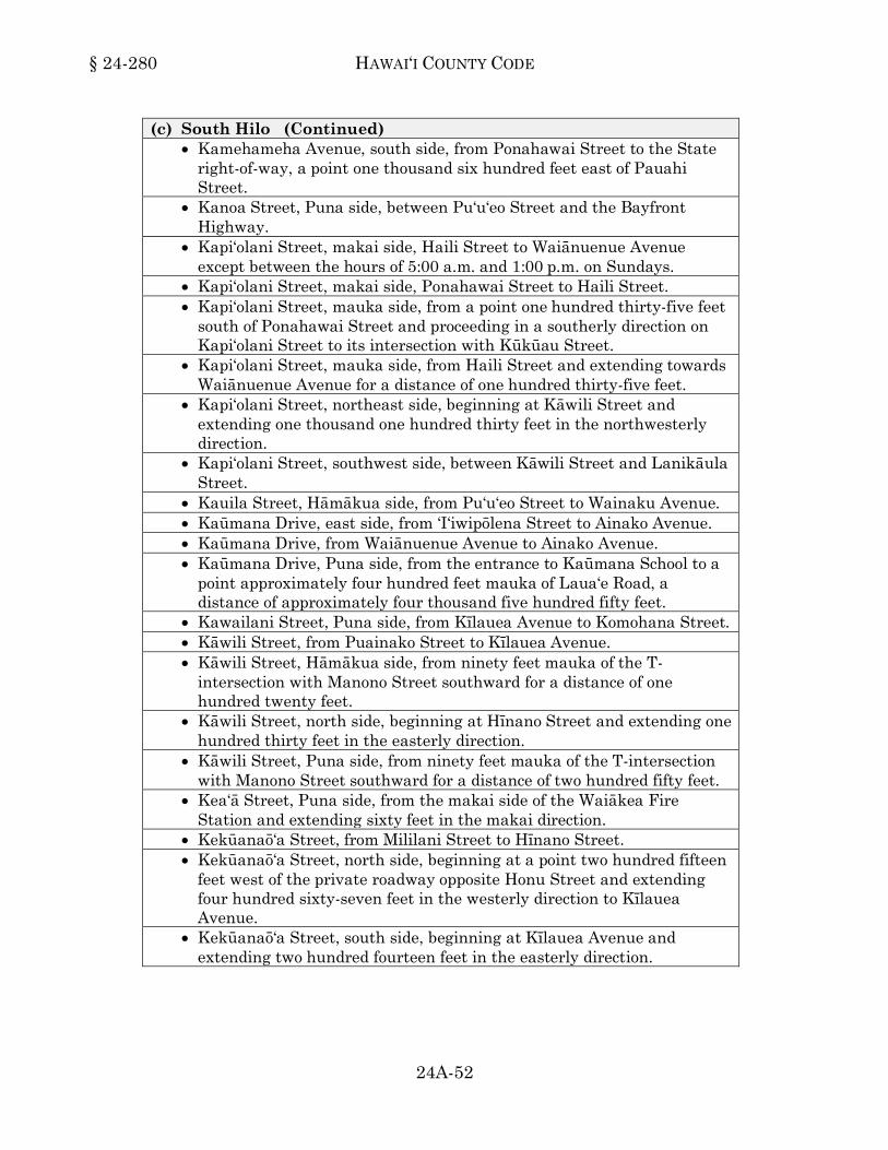
§ 24-280 HAWAI‘I COUNTY CODE
24A-52
(c) South Hilo (Continued) • Kamehameha Avenue, south side, from Ponahawai Street to the State
right-of-way, a point one thousand six hundred feet east of Pauahi Street.
• Kanoa Street, Puna side, between Pu‘u‘eo Street and the Bayfront Highway.
• Kapi‘olani Street, makai side, Haili Street to Waiānuenue Avenue except between the hours of 5:00 a.m. and 1:00 p.m. on Sundays.
• Kapi‘olani Street, makai side, Ponahawai Street to Haili Street. • Kapi‘olani Street, mauka side, from a point one hundred thirty-five feet
south of Ponahawai Street and proceeding in a southerly direction on Kapi‘olani Street to its intersection with Kūkūau Street.
• Kapi‘olani Street, mauka side, from Haili Street and extending towards Waiānuenue Avenue for a distance of one hundred thirty-five feet.
• Kapi‘olani Street, northeast side, beginning at Kāwili Street and extending one thousand one hundred thirty feet in the northwesterly direction.
• Kapi‘olani Street, southwest side, between Kāwili Street and Lanikāula Street.
• Kauila Street, Hāmākua side, from Pu‘u‘eo Street to Wainaku Avenue. • Kaūmana Drive, east side, from ‘I‘iwipōlena Street to Ainako Avenue. • Kaūmana Drive, from Waiānuenue Avenue to Ainako Avenue. • Kaūmana Drive, Puna side, from the entrance to Kaūmana School to a
point approximately four hundred feet mauka of Laua‘e Road, a distance of approximately four thousand five hundred fifty feet.
• Kawailani Street, Puna side, from Kīlauea Avenue to Komohana Street. • Kāwili Street, from Puainako Street to Kīlauea Avenue. • Kāwili Street, Hāmākua side, from ninety feet mauka of the T-
intersection with Manono Street southward for a distance of one hundred twenty feet.
• Kāwili Street, north side, beginning at Hīnano Street and extending one hundred thirty feet in the easterly direction.
• Kāwili Street, Puna side, from ninety feet mauka of the T-intersection with Manono Street southward for a distance of two hundred fifty feet.
• Kea‘ā Street, Puna side, from the makai side of the Waiākea Fire Station and extending sixty feet in the makai direction.
• Kekūanaō‘a Street, from Mililani Street to Hīnano Street. • Kekūanaō‘a Street, north side, beginning at a point two hundred fifteen
feet west of the private roadway opposite Honu Street and extending four hundred sixty-seven feet in the westerly direction to Kīlauea Avenue.
• Kekūanaō‘a Street, south side, beginning at Kīlauea Avenue and extending two hundred fourteen feet in the easterly direction.

VEHICLES AND TRAFFIC § 24-280
24A-53
(c) South Hilo (Continued) • Kīlauea Avenue, makai side, from East Ohea Street to Kūkūau Street. • Kīlauea Avenue, makai side, from Kawailani Street for a distance of
five hundred feet in the Puna direction. • Kīlauea Avenue, mauka side, from Kawailani Street for a distance of
one hundred sixty feet in the Puna direction. • Kīlauea Avenue, mauka side, from Kūkūau Street to a point six
hundred sixty feet Puna of Hualālai Street. • Kīlauea Avenue, west side, from a point two hundred twenty feet south
of Barenaba Lane to West Ohea Street. • Kino‘ole Street, between Olonā Street and Lono Street. • Kino‘ole Street, east (makai) side, from a point ninety-five feet north
(Hāmākua) of Mamo Street to Mamo Street. • Kino‘ole Street, makai side, beginning at Hōkū Street and extending
seven hundred five feet in the Hāmākua direction. • Kino‘ole Street, makai side, beginning from Kūkūau Street and
extending sixty-five feet in the Hāmākua direction. • Kino‘ole Street, makai side, from a point one hundred eighty-eight feet
south of Mohouli Street to a point seventy-one feet north of Mohouli Street.
• Kino‘ole Street, makai side, from a point three hundred thirty-seven feet north of the Puna boundary of Waiākeawaena School to a point one hundred feet north of Kawailani Street.
• Kino‘ole Street, makai side, from Haihai Street to the Puna boundary of Waiākeawaena School.
• Kino‘ole Street, makai side, from Mohouli Street and extending for a distance of one hundred thirty feet in the Hāmākua direction.
• Kino‘ole Street, mauka side, beginning at a point four hundred sixty-five feet Hāmākua of Hualālai Street and extending four hundred ten feet in the Hāmākua direction.
• Kino‘ole Street, mauka side, beginning at a point seven hundred forty-one feet Puna of Kūkūau Street and extending seven hundred five feet in the Puna direction.
• Kino‘ole Street, mauka side, from Kawailani Street to a point seven hundred twenty five feet in the Puna direction.
• Kino‘ole Street, mauka side, from Wailoa Street and extending in the Hāmākua direction for one hundred sixty-seven feet.
• Kino‘ole Street, one hundred twenty-five feet on the Puna side and two hundred twenty-five feet on the Hāmākua side of Hilo Lanes road exit.
• Kohola Street, Hāmākua side. • Kole Street. • Kūkūau Street, Hāmākua side, between Kino‘ole Street and Kapi‘olani
Street.

§ 24-280 HAWAI‘I COUNTY CODE
24A-54
(c) South Hilo (Continued) • Kūkūau Street, Puna side, from a point two hundred twenty-five feet
mauka of Kīlauea Avenue to Ululani Street. • Kumukoa Street, southwest (Puna) side, from a point one hundred
thirty feet northwest of the northwest end of bridge 24-1 to its southeastern terminus.
• Lanakila Homes area, except where parking spaces are designated or special parking areas are provided.
• Lanikāula Street, both sides, beginning at a point five hundred three feet east of Kalili Street and extending nine hundred sixty-seven feet in the easterly direction.
• Lanikāula Street, both sides, from Kīlauea Avenue easterly for a distance of one hundred fifty feet.
• Lanikāula Street, Hāmākua side, beginning at the driveway to the Church of the Holy Cross and extending one hundred ten feet in the makai direction.
• Lanikāula Street, Puna side, between the 'U' of the driveway fronting the University of Hawai‘i - Hilo College Administration Building.
• Lanikāula Street, Puna side, from the entrance gate to Schultz Siding for a distance of forty feet toward Railroad Avenue and one hundred fifty feet toward Kanoelehua Avenue.
• Lanikāula Street, southwest (Puna) side, from its northwestern terminus at the southeast end of bridge 24-1 and extending three hundred sixteen feet northeast of Kapiolani Street.
• Lehua Street, Hāmākua side, from Pu‘u‘eo Street to Wainaku Avenue. • Lei Street, makai side. • Lele Street, makai side between Punahele Street and Kaūmana Drive. • Maiko Street. • Māmalahoa Highway in Pāpa‘ikou, makai side, from a point two
hundred twenty feet Hāmākua of Anderton Camp Road to the entrance of Kalaniana‘ole School.
• Māmalahoa Highway, makai side, beginning at a point three hundred seventy-five feet north of the Pāpa‘ikou Transfer Station access road and extending five hundred twelve feet in the northerly direction to the unnamed government roadway.
• Manini Street. • Manono Street, beginning at a point five hundred feet north of Leilani
Street and extending seven hundred twenty feet in the northerly direction.
• Manono Street, Hāmākua side, from Kamehameha Avenue to Pi‘ilani Street.
• Manono Street, Puna side, between the entrance and exit of the Civic Auditorium.

VEHICLES AND TRAFFIC § 24-280
24A-55 SUPP. 3 (1-2018)
(c) South Hilo (Continued) • Mauna Kea Street, makai side. • Mauna Loa Street, makai side. • Mohala Place, Hāmākua side, for its entire length. • Mohouli Street, both sides, beginning at a point one hundred eighty-two
feet northeast of Kino‘ole Street and extending four hundred eighty-five feet in the southwesterly direction.
• Mohouli Street, Hāmākua side, beginning at Kīlauea Avenue and extending one hundred fifty-five feet in the mauka direction.
• Mohouli Street, northwest (Hāmākua) side, from a point four hundred twenty-three feet northeast of Kupuna Place and extending seven hundred sixty feet in the southwesterly direction.
• Mohouli Street, northwest (Hāmākua) side, from a point one hundred eighty-eight feet northeast of Kumukoa Street to a point ninety-five feet southwest of Kumukoa Street.
• Mohouli Street, southeast (Puna) side, from a point one hundred feet southwest of Kumukoʻa Street to a point two hundred feet northeast of Kumukoʻa Street.
• Nawahi Lane, Puna side. • ‘Ōhai Street, Hāmākua side, from Pu‘u‘eo Street to Wainaku Avenue. • Ohuohu Street, Puainako Street to Maka‘ala Street. • Pana‘ewa Street, makai side. • Pauahi Street, Hāmākua side, from Kamehameha Avenue for a
distance of two hundred fifty feet in the mauka direction, and from a point two hundred thirty feet makai of Aupuni Street to Kīlauea Avenue.
• Pauahi Street, Puna side, from Kamehameha Avenue for a distance of two hundred fifty feet in the mauka direction.
• Pi‘ihonua Road, both sides, beginning from the northern terminus of Bridge 25-1, extending .5 mile in the northwesterly direction.
• Ponahawai Street, from Kino‘ole Street to a point seventy-five feet mauka of Ululani Street.
• Ponahawai Street, on the Hāmākua side, beginning at Kapi‘olani Street and extending one hundred fifty-two feet in the mauka direction.
• Ponahawai Street, Puna side, beginning at a point three hundred feet makai of Kino‘ole Street and extending five hundred thirteen feet in the makai direction.
• Punahele Street, southeast side, from Komohana Street to Hāla‘i Street.
• Punahoa Street, makai side, beginning from a point sixty-nine feet Hāmākua of Mamo Street and extending seventy-eight feet in the Hāmākua direction.
• Punahoa Street, makai side, beginning from point two hundred sixty-seven feet Hāmākua of Mamo Street to Furneaux Lane.
• Punahoa Street, makai side, Ponahawai Street to Mamo Street.

§ 24-280 HAWAI‘I COUNTY CODE
24A-56
(c) South Hilo (Continued) • Punahoa Street, mauka side, Ponahawai Street to Furneaux Lane. • Pu‘u‘eo Street, makai side, beginning at a point one hundred twenty
feet Puna of ‘Ōhai Street and extending in the Hāmākua direction for a distance of one hundred fifty feet Hāmākua of ‘Ōhai Street.
• Pu‘u‘eo Street, makai side, from ‘Iliahi Street to Kauila Street. • Railroad Avenue, west side, beginning at a point one hundred seventy-
five feet north of Kūkila Street and extending four hundred seventy-four feet in the southerly direction.
• Shipman Street, beginning at a point two hundred ten feet east of Keawe Street and extending forty feet in the easterly direction towards Kamehameha Avenue.
• South ‘Iwa‘iwa Street. • Uhu Street. • Ululani Street, makai side, beginning at a point five hundred two feet
Hāmākua of Kūkūau Street and extending two hundred eighty-five feet in the Hāmākua direction.
• Ululani Street, mauka side, between Waiānuenue Avenue and Wailoa Street.
• Waiānuenue Avenue, both sides, from the mauka access to Rainbow Drive to Waiau Street.
• Waiānuenue Avenue, from Kaūmana Drive to Hāla‘i Street. • Waiānuenue Avenue, from Keawe Street to a point one hundred feet
mauka of Ululani Street. • Waiānuenue Avenue, Hāmākua side, beginning at a point one hundred
three feet mauka of Ululani Street, and extending in the mauka direction for a distance of three hundred ninety-three feet.
• Waiānuenue Avenue, Hāmākua side, beginning at a point one thousand three hundred twenty feet west of Ka‘iulani Street and extending seven hundred fifty six feet in the westerly direction.
• Waiānuenue Avenue, north (Hāmākua side), from Kaūmana Drive to Rainbow Drive.
• Waiānuenue Avenue, Puna side, from Kapi‘olani Street for a distance of one hundred feet in the makai direction.
• Wailuku Drive, Hāmākua side, from Keawe Street to Ka‘iulani Street. • Wailuku Drive, Puna side, Kamehameha Avenue to Keawe Street. • Wainaku Avenue, mauka side, beginning at Pukihae Bridge No. 1 and
extending two hundred forty-five feet in the Puna direction. • Wainaku Street, Kaiwiki Road to Ha‘aheo Road. • Wainaku Street, makai side, beginning at a point two hundred eighty-
two feet north of Lehua Street and extending one hundred eighty feet in the northerly direction.
• W. Kawili Street, from W. Puainako Street to Kapiolani Street. • Wilson Street, Puna side.
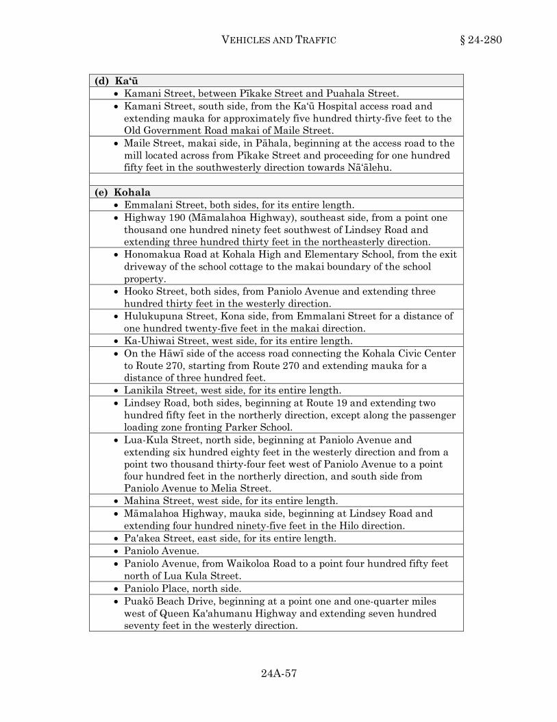
VEHICLES AND TRAFFIC § 24-280
24A-57
(d) Ka‘ū • Kamani Street, between Pīkake Street and Puahala Street. • Kamani Street, south side, from the Ka‘ū Hospital access road and
extending mauka for approximately five hundred thirty-five feet to the Old Government Road makai of Maile Street.
• Maile Street, makai side, in Pāhala, beginning at the access road to the mill located across from Pīkake Street and proceeding for one hundred fifty feet in the southwesterly direction towards Nā‘ālehu.
(e) Kohala
• Emmalani Street, both sides, for its entire length. • Highway 190 (Māmalahoa Highway), southeast side, from a point one
thousand one hundred ninety feet southwest of Lindsey Road and extending three hundred thirty feet in the northeasterly direction.
• Honomakua Road at Kohala High and Elementary School, from the exit driveway of the school cottage to the makai boundary of the school property.
• Hooko Street, both sides, from Paniolo Avenue and extending three hundred thirty feet in the westerly direction.
• Hulukupuna Street, Kona side, from Emmalani Street for a distance of one hundred twenty-five feet in the makai direction.
• Ka-Uhiwai Street, west side, for its entire length. • On the Hāwī side of the access road connecting the Kohala Civic Center
to Route 270, starting from Route 270 and extending mauka for a distance of three hundred feet.
• Lanikila Street, west side, for its entire length. • Lindsey Road, both sides, beginning at Route 19 and extending two
hundred fifty feet in the northerly direction, except along the passenger loading zone fronting Parker School.
• Lua-Kula Street, north side, beginning at Paniolo Avenue and extending six hundred eighty feet in the westerly direction and from a point two thousand thirty-four feet west of Paniolo Avenue to a point four hundred feet in the northerly direction, and south side from Paniolo Avenue to Melia Street.
• Mahina Street, west side, for its entire length. • Māmalahoa Highway, mauka side, beginning at Lindsey Road and
extending four hundred ninety-five feet in the Hilo direction. • Pa'akea Street, east side, for its entire length. • Paniolo Avenue. • Paniolo Avenue, from Waikoloa Road to a point four hundred fifty feet
north of Lua Kula Street. • Paniolo Place, north side. • Puakō Beach Drive, beginning at a point one and one-quarter miles
west of Queen Ka'ahumanu Highway and extending seven hundred seventy feet in the westerly direction.

§ 24-280 HAWAI‘I COUNTY CODE
SUPP. 1 (1-2017) 24A-58
(e) Kohala (Continued) • Route 19, northeast side, from a point two hundred forty-four feet
northwest of the Route 19/Route 190 junction and extending five hundred thirty-seven feet in the northwesterly direction.
• Route 19, southwest side, from the Route 19/Route 190 junction and extending seven hundred forty-two feet in the northwesterly direction.
• ‘Uala Street, west side, for its entire length. (f) Kona
• Aliʻi Drive, east (mauka) side, from a point five hundred eighty-one feet south of Mākoleʻā Street and extending seventy-five feet north of Mākoleʻā Street.
• Aliʻi Drive, east (mauka) side, from a point forty-two feet south of the southern intersection of Kahakai Road with Aliʻi Drive and extending two hundred three feet north of Walua Road.
• Ali‘i Drive, east (mauka) side, from a point three hundred seven feet north of Mākole‘ā Street and extending one thousand three hundred thirty-five feet north of Mākole‘ā Street.
• Ali‘i Drive in Kailua-Kona, makai side, between Kailua Bay Wharf and Hualālai Reef Road.
• Ali‘i Drive in Kailua-Kona, makai side, from a point approximately four hundred feet south of Hualālai Road to the junction of Ali‘i Drive with Kailua-Keauhou Middle Road, in the vicinity of the Kona Hilton Hotel.
• Ali‘i Drive in Kona, makai side, beginning at a point one hundred thirty feet south of the southern driveway of the Kona Isle Condominium and extending three hundred thirty-six feet in a northerly direction.
• Ali‘i Drive, makai side, beginning at a point five hundred feet Ka'u side of Lunapule Road and extending three hundred fifty feet in the Ka'u direction.
• Ali‘i Drive, makai side, for a distance of one hundred feet on either side of each driveway into Kahalu‘u Beach Park.
• Ali‘i Drive, makai side, for a distance of one hundred feet on either side of each driveway to the Kona Magic Sands Apartment building and the driveway to White Sands Beach.
• Ali‘i Drive, northeast (mauka) side, from Kamehameha III Road and extending eight hundred forty-six feet northwest of Aliʻi Highway.
• Aliʻi Drive, northeast (mauka) side, from a point nine hundred forty-four feet southeast of Lunapule Road and extending four hundred sixty-nine feet southeast of Lunapule Road.
• Aliʻi Drive, northeast (mauka) side, from a point ninety feet south of the northern intersection of Kahakai Road with Aliʻi Drive to its northern terminus, except for the parking in the curb cut-out fronting parcels identified by Tax Map Key Numbers (3) 7-5-009:028 and 7-5-009:043 and the signed and marked loading zones outside of the designated loading zone times.

VEHICLES AND TRAFFIC § 24-280
24A-59 SUPP. 2 (7-2017)
(f) Kona (Continued) • Aliʻi Drive, northeast (mauka) side, from a point seven hundred eighty
feet southeast of Queen Kalama Avenue and extending two thousand nine hundred five feet southeast of Royal Poinciana Drive.
• Aliʻi Drive, northeast (mauka) side, from a point two thousand six hundred ninety-five feet southeast of Royal Poinciana Drive and extending seventy-five feet northwest of Royal Poinciana Drive, except for the parking fronting the parcel identified by Tax Map Key Number (3) 7-6-015:009.
• Aliʻi Drive, northeast (mauka) side, from the property line between parcels identified by Tax Map Key Numbers (3) 7-5-020:072 and 7-5-020:073 and extending two thousand nine hundred thirty-five feet southeast of Lunapule Road.
• Ali‘i Drive, west (makai side), from a point seventy-five feet north of Kaleiopapa Street and extending four hundred twenty-two feet in the southerly direction.
• Belt Highway, mauka side, beginning at Station 8+00 across the Honalo Shopping Center and extending 0.4 mile in the southerly direction.
• Captain Cook, on the west side of Route 11, beginning at a point 0.15 mile south of Nāpō‘opo‘o Road (Palipoko Road) intersection for a distance of four hundred feet in a southerly direction.
• Haleki‘i Street, both sides, from a point four hundred ten feet west of Muli Street and extending one hundred sixty feet in the westerly direction.
• Hanama Place, from its terminus to a point one hundred eighty feet in the southerly direction, except the fifty-five foot section on the makai side fronting the Kailua Trade Center.
• Hanama Place, on the southeast side from Kuakini Highway and extending makai for a distance of four hundred feet.
• Hina-Lani Street, from Queen Ka‘ahumanu Highway to Ane Keohokālole Highway.
• Hōnaunau Beach Road, both sides, from City of Refuge Access Road and extending three hundred fifty feet west.
• Hōnaunau Beach Road, east side, from a point two hundred ninety feet north of the Hōnaunau Boat Ramp and extending three hundred seventeen feet in the northerly direction.
• Hooper Road, Māmalahoa Highway to its northern terminus. • Hualālai Road, between Kuakini Highway and Ali‘i Drive. • Kahakai Road, both sides, except the six hundred forty foot section on
the mauka side fronting the Kona Hilton Hotel parking lot. • Kahauloa Road, north (makai) side.
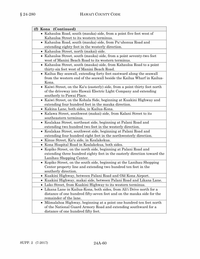
§ 24-280 HAWAI‘I COUNTY CODE
SUPP. 2 (7-2017) 24A-60
(f) Kona (Continued) • Kahauloa Road, south (mauka) side, from a point five feet west of
Kahauloa Street to its western terminus. • Kahauloa Road, south (mauka) side, from Puʻuhonua Road and
extending eighty feet in the westerly direction. • Kahauloa Street, north (makai) side. • Kahauloa Street, south (mauka) side, from a point seventy-two feet
west of Manini Beach Road to its western terminus. • Kahauloa Street, south (mauka) side, from Kahauloa Road to a point
thirty-six feet west of Manini Beach Road. • Kailua Bay seawall, extending forty feet eastward along the seawall
from the western end of the seawall beside the Kailua Wharf in Kailua-Kona.
• Kaiwi Street, on the Ka'u (easterly) side, from a point thirty feet north of the driveway into Hawaii Electric Light Company and extending southerly to Pawai Place.
• Kaiwi Street, on the Kohala Side, beginning at Kuakini Highway and extending four hundred feet in the mauka direction.
• Kakina Lane, both sides, in Kailua-Kona. • Kalawa Street, southwest (makai) side, from Kalani Street to its
southeastern terminus. • Kealakaa Street, northeast side, beginning at Palani Road and
extending two hundred two feet in the westerly direction. • Kealakaa Street, southwest side, beginning at Palani Road and
extending four hundred eight feet in the northwesterly direction. • Kinue Street, Ka'u side, in Kealakekua. • Kona Hospital Road in Kealakekua, both sides. • Kopiko Street, on the north side, beginning at Palani Road and
extending three hundred eighty feet in the easterly direction toward the Lanihau Shopping Center.
• Kopiko Street, on the south side, beginning at the Lanihau Shopping Center property line and extending two hundred ten feet in the southerly direction.
• Kuakini Highway, between Palani Road and Old Kona Airport. • Kuakini Highway, makai side, between Palani Road and Likana Lane. • Lako Street, from Kuakini Highway to its western terminus. • Likana Lane in Kailua-Kona, both sides, from Ali‘i Drive north for a
distance of one hundred fifty-seven feet and on the mauka side for the remainder of the lane.
• Māmalahoa Highway, beginning at a point one hundred ten feet north of the National Guard Armory Road and extending southward for a distance of one hundred fifty feet.

VEHICLES AND TRAFFIC § 24-280
24A-60.1 SUPP. 2 (7-2017)
(f) Kona (Continued) • Māmalahoa Highway, makai side, beginning at Keōpuka Road and
extending one hundred forty-two feet in the northerly direction. • Māmalahoa Highway, makai side, beginning at the south prolongation
of Kīloa Road and extending one hundred twenty feet in the northerly direction.
• Manawale‘a Street, both sides. • Manini Beach Road, east (mauka) side, from a point nine hundred
seventy feet south of Puʻuhonua Road to Kahauloa Road. • Manini Beach Road, north (makai) side, from Puʻuhonua Road and
extending eight hundred fifty-five feet in the southwesterly direction. • Manini Beach Road, south (mauka) side, from Puʻuhonua Road and
extending nine hundred five feet in the southwesterly direction. • Manini Beach Road, west (makai) side, from a point one thousand feet
south of Puʻuhonua Road and extending one hundred twenty-five feet in the southerly direction.
• Manini Beach Road, west (makai) side, from a point one thousand one hundred fifty feet south of Puʻuhonua Road and extending fifty feet in the southerly direction.
• Manini Beach Road, west (makai) side, from a point one thousand two hundred forty feet south of Puʻuhonua Road to Kahauloa Road.
• Melelina Street, on the makai side between Nani Kailua Drive and Aloha Kona Drive.
• Nahenahe Loop, mauka side, beginning at St. Paul Road and extending for one hundred sixty feet in the northerly direction.
• Nāpō‘opo‘o Beach Road, on the makai side, beginning at the Nāpō‘opo‘o Road intersection and extending to the northern terminus.
• Nāpō‘opo‘o Beach Road, on the mauka side, beginning at the Nāpō‘opo‘o Road intersection and extending three hundred thirty feet in the northerly direction.
• An old government lane in Kailua-Kona, located between the Kama‘āina Lodge and the Ocean View Inn.
• Onipa‘a Street, Le‘ale‘a Street to Kealakehe School parking lot. • Palani Road, north side, from a point fifty feet mauka of the Kailua
Rubbish Dump Road to a point fifty feet makai of the Kailua Rubbish Dump Road.
• Sarona Road in Kailua-Kona, both sides.
HAWAI‘I COUNTY CODE
SUPP. 1 (1-2017) 24A-60.2
This page intentionally left blank.
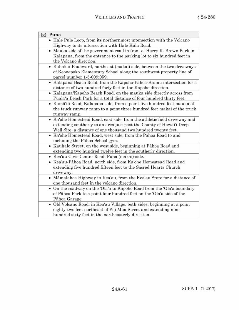
VEHICLES AND TRAFFIC § 24-280
24A-61 SUPP. 1 (1-2017)
(g) Puna • Hale Pule Loop, from its northernmost intersection with the Volcano
Highway to its intersection with Hale Kula Road. • Mauka side of the government road in front of Harry K. Brown Park in
Kalapana, from the entrance to the parking lot to six hundred feet in the Volcano direction.
• Kahakai Boulevard, northeast (makai) side, between the two driveways of Keonepoko Elementary School along the southwest property line of parcel number 1-5-009:059.
• Kalapana Beach Road, from the Kapoho-Pāhoa-Kaimū intersection for a distance of two hundred forty feet in the Kapoho direction.
• Kalapana/Kapoho Beach Road, on the mauka side directly across from Puala‘a Beach Park for a total distance of four hundred thirty feet.
• Kamā‘ili Road, Kalapana side, from a point five hundred feet mauka of the truck runway ramp to a point three hundred feet makai of the truck runway ramp.
• Ka‘ohe Homestead Road, east side, from the athletic field driveway and extending southerly to an area just past the County of Hawai‘i Deep Well Site, a distance of one thousand two hundred twenty feet.
• Ka‘ohe Homestead Road, west side, from the Pāhoa Road to and including the Pāhoa School gym.
• Kauhale Street, on the west side, beginning at Pāhoa Road and extending two hundred twelve feet in the southerly direction.
• Kea‘au Civic Center Road, Puna (makai) side. • Kea‘au-Pāhoa Road, north side, from Ka‘ohe Homestead Road and
extending five hundred fifteen feet to the Sacred Hearts Church driveway.
• Māmalahoa Highway in Kea‘au, from the Kea‘au Store for a distance of one thousand feet in the volcano direction.
• On the roadway on the ‘Ōla‘a to Kapoho Road from the ‘Ōla‘a boundary of Pāhoa Park to a point four hundred feet on the ‘Ōla‘a side of the Pāhoa Garage.
• Old Volcano Road, in Kea‘au Village, both sides, beginning at a point eighty-two feet northeast of Pili Mua Street and extending nine hundred sixty feet in the northeasterly direction.

§ 24-280 HAWAI‘I COUNTY CODE
SUPP. 3 (1-2018) 24A-62
(g) Puna (Continued) • Ka‘ū side of roadway in the vicinity of the old Nakamura Store in
Kapoho on both sides of curve of Pāhoa-Kumukahi Lighthouse Road for a distance of eight hundred twenty feet west from a point approximately one thousand one hundred fifty feet northwest of Project marker F.A.P. No. S-4132 and ER-8.
• Mauka side between Pāhoa town and the school. • Route 130, east side, beginning at Kahakai Boulevard and extending
three hundred fifty feet in the southerly direction toward Pāhoa Village. (1996, ord 96-163, sec 2; am 1996, ord 96-155, sec 1; am 1997, ord 97-25, sec 1; ord 97-28, secs 1 and 2; ord 97-58, sec 1; ord 97-109, sec 1; ord 97-110, sec 1; ord 97-123, sec 1; ord 97-129, secs 1 and 2; am 1998, ord 98-31, secs 1, 2, and 3; ord 98-40, sec 2; ord 98-62, sec 1; ord 98-73, secs 1 and 2; ord 98-74, secs 2, 3, 4, and 5; ord 98-85, sec 2; ord 98-89, secs 1 and 2; am 1999, ord 99-62, sec 1; ord 99-84, sec 3; ord 99-90, sec 1; ord 99-92, secs 1 and 2; ord 99-128, sec 1; ord 99-134, secs 1-5; am 2000, ord 00-12, sec 1; ord 00-29, secs 1 and 2; ord 00-79, sec 4; ord 00-80, sec 1; ord 00-129, sec 1; ord 00-130, sec 2; am 2001, ord 01-8, sec 1; ord 01-9, sec 3; ord 01-119, sec 3; am 2002, ord 02-91, sec 1; am 2004, ord 04-25, secs 1 and 2; am 2008, ord 08-174, sec 1; am 2009, ord 09-22, sec 1; ord 09-61, sec 2, ord 09-145, sec 2; am 2010, ord 10-3, sec 2; am 2011, ord 11-15, sec 1; ord 11-33, sec 1; ord 11-89, sec 2; ord 11-120, sec 2; am 2012, ord 12-2, sec 2; ord 12-8, sec 2; ord 12-22, sec 2; ord 12-48, sec 2; ord 12-104, sec 2; ord 12-121, sec 2; am 2013, ord 13-1, sec 2; ord 13-69, sec 2; ord 13-71, sec 2; am 2014 ord 14-7, sec 2; ord 14-29, sec 2; ord 14-47, sec 2; ord 14-49, secs 2, 3, and 4; ord 14-62, sec 2; am 2015, ord 15-14, secs 2 and 3; ord 15-89, sec 2; ord 15-92, sec 2, ord 15-107, sec 2; ord 15-112, sec 2; am 2016, ord 16-1, secs 2, 3, and 4; ord 16-25, sec 2; ord 16-78, secs 2 and 3; am 2017, ord 17-27, sec 2; ord 17-51, sec 2; ord 17-52, sec 2.) 24-280
Section 24-281. Schedule 29. Parking prohibited during certain hours on certain streets; tow-away zone.
When signs are erected giving notice thereof, no person shall stop, stand or park a vehicle between the hours specified herein upon any of the streets or parts of streets as follows:
(a) Hāmākua (b) North Hilo
• Old Māmalahoa Highway, mauka side, at Pāpa‘aloa, beginning at a point two hundred thirty-three feet on the Hilo side of Kaiwilahilahi Bridge for a distance of one hundred fifty-four feet in the Hilo direction from 7:00 a.m. to 5:00 p.m.

VEHICLES AND TRAFFIC § 24-281
24A-63 SUPP. 2 (7-2017)
(c) South Hilo • ‘Alae Street, both sides, from Laimana Street to Hāla‘i Street between
the hours of 7:15 a.m. to 8:00 a.m. and 2:30 p.m. to 3:30 p.m. on school days.
• Banyan Drive, north (makai) side, from a point one thousand three hundred seventy-two feet southwest of the northern intersection of Lihiwai Street and extending one hundred seventy-six feet in the westerly direction, between the hours of 11:00 p.m. and 5:00 a.m.
• Banyan Drive, northeast (makai) side, from a point nine hundred seventy-two feet northwest of Banyan Way and extending two hundred twenty feet northeast of the northern intersection of Lihiwai Street, except for the designated no parking anytime areas, loading zone, and bus stop, between the hours of 9:00 a.m. and 11:00 a.m. on Tuesdays.
• Banyan Drive, northwest (makai) side, from a point one hundred thirty-two feet southwest of the northern intersection of Lihiwai Street and extending five hundred ninety-one feet in the southwesterly direction, between the hours of 11:00 p.m. and 5:00 a.m.
• Banyan Drive, south (golf course) side, from the southern intersection of Lihiwai Street and extending one hundred forty-one feet southwest of the northern intersection of Lihiwai Street, between the hours of 11:00 p.m. and 5:00 a.m.
• Banyan Drive, southeast (golf course) side, from a point one hundred forty-one feet southwest of the northern intersection of Lihiwai Street and extending four hundred thirteen feet north on Banyan Way, except for the designated no parking anytime areas and bus stop, between the hours of 9:00 a.m and 11:00 a.m. on Thursdays.
• Banyan Drive, west (golf course) side, from a point four hundred thirteen feet north of Banyan Way and extending one hundred ninety-one feet in the southwesterly direction, between the hours of 11:00 p.m. and 5:00 a.m.
• Banyan Way, northwest (golf course) side, from a point fifty-five feet southwest of Banyan Way and extending three hundred seventy-four feet north of Kamehameha Avenue, between the hours of 11:00 p.m. and 5:00 a.m.

§ 24-281 HAWAI‘I COUNTY CODE
SUPP. 8 (7-2020) 24A-64
(c) South Hilo (Continued) • Haili Street, Puna side, between Kino‘ole Street and Ululani Street
from 7:15 a.m. to 8:00 a.m. on school days. • Hualālai Street, Puna side, between Ululani Street and the makai side
of the St. Joseph School Cafeteria from 7:15 a.m. to 8:00 a.m. on school days; 1:45 p.m. to 2:30 p.m. on Mondays, Tuesdays, Thursdays and Fridays when school is in session; and 12:45 p.m. to 1:30 p.m. on Wednesdays when school is in session.
• Kahoa Street, east side, from a point four hundred twenty-five feet north of Nahala Street and extending five hundred ninety-five feet north from 10:00 p.m. to 5:00 a.m.
• Kalaniana‘ole Street, south side, from a point eighty-three feet east of the Seaside Restaurant driveway to a point one hundred eight feet west of Lokoaka Street.
• Kalaniana‘ole Street, south side, from a point sixty-three feet west of the Seaside Restaurant driveway and extending one hundred fifty-eight feet in the easterly direction except between the hours of 5:00 p.m. and 10:00 p.m.
• Kalili Street, from a point one hundred forty-four feet south of Noe Street and extending four hundred forty-three feet in the southerly direction from 11:00 p.m. to 6:00 a.m.
• Kīlauea Avenue, Hāmākua-mauka side, adjacent to the Hilo Hongwanji Temple driveway between the hours of 2:00 p.m. and 5:30 p.m. from Mondays to Fridays and 7:30 a.m. to 12:00 noon on Sundays.
• Lanihuli Street, northwest (Hāmākua) side, from a point one hundred seventy-seven feet southwest of Kino‘ole Street to its southwestern terminus.
• Lihiwai Street, east side, Banyan Drive to Lili‘uokalani Park Perimeter Road between the hours of 11:00 p.m. and 5:00 a.m.
• Lili‘uokalani Park Perimeter Road, beginning at a point seven hundred twenty-five feet west of Banyan Drive to Lihiwai Street between the hours of 11:00 p.m. and 5:00 a.m.
• Mohouli Street, Pu‘u‘eo side, in front of the children's shelter area for a distance of seventy-five feet mauka of the old driveway into Kapi‘olani School from 7:15 a.m. to 8:00 a.m. on school days; 1:45 p.m. to 2:30 p.m. on Mondays, Tuesdays, Thursdays and Fridays when school is in session; and 12:45 p.m. to 1:30 p.m. on Wednesdays when school is in session.
• Pi‘ihonua Road, both sides, beginning at the northern terminus of Bridge 25-2 to the southern terminus of Bridge 25-1, between the hours of 6:00 p.m. and 6:00 a.m.
• Pūnāwai Street, between 7:00 a.m. and 8:00 a.m. except Saturdays, Sundays and public holidays.
• Pu‘u‘eo Street, 4:00 a.m. to 6:00 a.m. on Mondays.
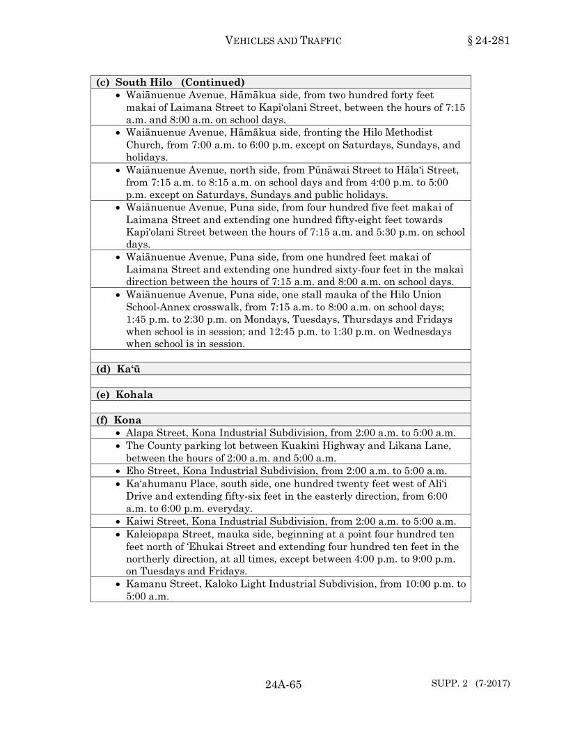
VEHICLES AND TRAFFIC § 24-281
24A-65 SUPP. 2 (7-2017)
(c) South Hilo (Continued) • Waiānuenue Avenue, Hāmākua side, from two hundred forty feet
makai of Laimana Street to Kapi‘olani Street, between the hours of 7:15 a.m. and 8:00 a.m. on school days.
• Waiānuenue Avenue, Hāmākua side, fronting the Hilo Methodist Church, from 7:00 a.m. to 6:00 p.m. except on Saturdays, Sundays, and holidays.
• Waiānuenue Avenue, north side, from Pūnāwai Street to Hāla‘i Street, from 7:15 a.m. to 8:15 a.m. on school days and from 4:00 p.m. to 5:00 p.m. except on Saturdays, Sundays and public holidays.
• Waiānuenue Avenue, Puna side, from four hundred five feet makai of Laimana Street and extending one hundred fifty-eight feet towards Kapi‘olani Street between the hours of 7:15 a.m. and 5:30 p.m. on school days.
• Waiānuenue Avenue, Puna side, from one hundred feet makai of Laimana Street and extending one hundred sixty-four feet in the makai direction between the hours of 7:15 a.m. and 8:00 a.m. on school days.
• Waiānuenue Avenue, Puna side, one stall mauka of the Hilo Union School-Annex crosswalk, from 7:15 a.m. to 8:00 a.m. on school days; 1:45 p.m. to 2:30 p.m. on Mondays, Tuesdays, Thursdays and Fridays when school is in session; and 12:45 p.m. to 1:30 p.m. on Wednesdays when school is in session.
(d) Ka‘ū (e) Kohala (f) Kona
• Alapa Street, Kona Industrial Subdivision, from 2:00 a.m. to 5:00 a.m. • The County parking lot between Kuakini Highway and Likana Lane,
between the hours of 2:00 a.m. and 5:00 a.m. • Eho Street, Kona Industrial Subdivision, from 2:00 a.m. to 5:00 a.m. • Ka‘ahumanu Place, south side, one hundred twenty feet west of Ali‘i
Drive and extending fifty-six feet in the easterly direction, from 6:00 a.m. to 6:00 p.m. everyday.
• Kaiwi Street, Kona Industrial Subdivision, from 2:00 a.m. to 5:00 a.m. • Kaleiopapa Street, mauka side, beginning at a point four hundred ten
feet north of ‘Ehukai Street and extending four hundred ten feet in the northerly direction, at all times, except between 4:00 p.m. to 9:00 p.m. on Tuesdays and Fridays.
• Kamanu Street, Kaloko Light Industrial Subdivision, from 10:00 p.m. to 5:00 a.m.
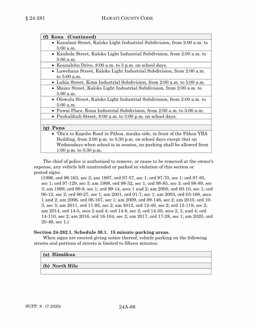
§ 24-281 HAWAI‘I COUNTY CODE
SUPP. 8 (7-2020) 24A-66
(f) Kona (Continued) • Kanalani Street, Kaloko Light Industrial Subdivision, from 2:00 a.m. to
5:00 a.m. • Kauhola Street, Kaloko Light Industrial Subdivision, from 2:00 a.m. to
5:00 a.m. • Keanalehu Drive, 8:00 a.m. to 3 p.m. on school days. • Lawehana Street, Kaloko Light Industrial Subdivision, from 2:00 a.m.
to 5:00 a.m. • Luhia Street, Kona Industrial Subdivision, from 2:00 a.m. to 5:00 a.m. • Maiau Street, Kaloko Light Industrial Subdivision, from 2:00 a.m. to
5:00 a.m. • Olowalu Street, Kaloko Light Industrial Subdivision, from 2:00 a.m. to
5:00 a.m. • Pawai Place, Kona Industrial Subdivision, from 2:00 a.m. to 5:00 a.m. • Puohulihuli Street, 8:00 a.m. to 3:00 p.m. on school days.
(g) Puna
• ‘Ōla‘a to Kapoho Road in Pāhoa, mauka side, in front of the Pāhoa YBA Building, from 2:00 p.m. to 5:30 p.m. on school days except that on Wednesdays when school is in session, no parking shall be allowed from 1:00 p.m. to 5:30 p.m.
The chief of police is authorized to remove, or cause to be removed at the owner's
expense, any vehicle left unattended or parked in violation of this section or posted signs.
(1996, ord 96-163, sec 2; am 1997, ord 97-57, sec 1; ord 97-70, sec 1; ord 97-85, sec 1; ord 97-129, sec 3; am 1998, ord 98-32, sec 1; ord 98-85, sec 3; ord 98-89, sec 3; am 1999, ord 99-8, sec 1; ord 99-14, secs 1 and 2; am 2000, ord 00-10, sec 1; ord 00-12, sec 2; ord 00-27, sec 1; am 2001, ord 01-7, sec 1; am 2003, ord 03-168, secs 1 and 2; am 2006, ord 06-167, sec 1; am 2009, ord 09-146, sec 2; am 2010, ord 10-3, sec 3; am 2011, ord 11-92, sec 2; am 2012, ord 12-49, sec 2; ord 12-119, sec 2; am 2014, ord 14-5, secs 2 and 4; ord 14-6, sec 2; ord 14-50, secs 2, 3, and 4; ord 14-110, sec 2; am 2016, ord 16-104, sec 2; am 2017, ord 17-28, sec 1; am 2020, ord 20-46, sec 1.)24-281
Section 24-282.1. Schedule 30.1. 15 minute parking areas. When signs are erected giving notice thereof, vehicle parking on the following
streets and portions of streets is limited to fifteen minutes: (a) Hāmākua (b) North Hilo

VEHICLES AND TRAFFIC § 24-282.1
24A-67
(c) South Hilo • Kīlauea Avenue, mauka side, from a point sixty-four feet Puna of
Wilson Street to a point one hundred three feet in the Puna direction, from 7:00 a.m. to 12:00 noon.
(d) Ka‘ū (e) Kohala (f) Kona (g) Puna
• Pāhoa Village Road, south side, from a point three hundred twenty-six feet west of Kauhale Street to a point one hundred seventeen feet in the easterly direction.
(1999, ord 99-127, sec 1; am 2009, ord 09-121, sec 2.)24-282.1
Section 24-282.2. Schedule 30.2. 36 minute parking areas. When signs are erected giving notice thereof, vehicle parking on the following
streets and portions of streets is limited to thirty-six minutes: (a) Hāmākua (b) North Hilo (c) South Hilo (d) Ka‘ū (e) Kohala (f) Kona (g) Puna
(1996, ord 96-163, sec 2; am 1999, ord 99-127, sec 2.)24-282.2

§ 24-283 HAWAI‘I COUNTY CODE
24A-68
Section 24-283. Schedule 31. 1 hour parking areas. When signs are erected giving notice thereof, vehicle parking on the following
streets and portions of streets is limited to one hour: (a) Hāmākua (b) North Hilo (c) South Hilo
• Keawe Street, from Haili Street to Mamo Street. • Kīlauea Avenue, southwest side, beginning from a point thirty-eight
feet south of Aupuni Street and extending three hundred twelve feet in the southerly direction, except for those areas designated as No Parking Zones and Freight Loading Zones, between the hours of 8:00 a.m. and 8:00 p.m. from Mondays to Fridays.
(d) Ka‘ū (e) Kohala (f) Kona
• Māmalahoa Highway in Kainaliu, from Okamura Store to the Ka‘ū side of Aloha Theater.
(g) Puna
(1996, ord 96-163, sec 2; am 1997, ord 97-109, sec 2; am 2000, ord 00-89, sec 3; am 2006, ord 06-167, sec 2.)24-283
Section 24-284. Schedule 32. 2 hour parking areas. When signs are erected giving notice thereof, vehicle parking on the following
streets and portions of streets is limited to two hours: (a) Hāmākua (b) North Hilo
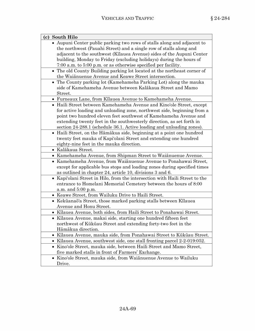
VEHICLES AND TRAFFIC § 24-284
24A-69
(c) South Hilo • Aupuni Center public parking two rows of stalls along and adjacent to
the northwest (Pauahi Street) and a single row of stalls along and adjacent to the southwest (Kīlauea Avenue) sides of the Aupuni Center building, Monday to Friday (excluding holidays) during the hours of 7:00 a.m. to 5:00 p.m. or as otherwise specified per facility.
• The old County Building parking lot located at the northeast corner of the Waiānuenue Avenue and Keawe Street intersection.
• The County parking lot (Kamehameha Parking Lot) along the mauka side of Kamehameha Avenue between Kalākaua Street and Mamo Street.
• Furneaux Lane, from Kīlauea Avenue to Kamehameha Avenue. • Haili Street between Kamehameha Avenue and Kino‘ole Street, except
for active loading and unloading zone, northwest side, beginning from a point two hundred eleven feet southwest of Kamehameha Avenue and extending twenty feet in the southwesterly direction, as set forth in section 24-288.1 (schedule 36.1. Active loading and unloading zones).
• Haili Street, on the Hāmākua side, beginning at a point one hundred twenty feet mauka of Kapi‘olani Street and extending one hundred eighty-nine feet in the mauka direction.
• Kalākaua Street. • Kamehameha Avenue, from Shipman Street to Waiānuenue Avenue. • Kamehameha Avenue, from Waiānuenue Avenue to Ponahawai Street,
except for applicable bus stops and loading zones during specified times as outlined in chapter 24, article 10, divisions 3 and 6.
• Kapi‘olani Street in Hilo, from the intersection with Haili Street to the entrance to Homelani Memorial Cemetery between the hours of 8:00 a.m. and 5:00 p.m.
• Keawe Street, from Wailuku Drive to Haili Street. • Kekūanaō‘a Street, those marked parking stalls between Kīlauea
Avenue and Honu Street. • Kīlauea Avenue, both sides, from Haili Street to Ponahawai Street. • Kīlauea Avenue, makai side, starting one hundred fifteen feet
northwest of Kūkūau Street and extending forty-two feet in the Hāmākua direction.
• Kīlauea Avenue, mauka side, from Ponahawai Street to Kūkūau Street. • Kīlauea Avenue, southwest side, one stall fronting parcel 2-2-019:052. • Kino‘ole Street, mauka side, between Haili Street and Mamo Street,
five marked stalls in front of Farmers’ Exchange. • Kino‘ole Street, mauka side, from Waiānuenue Avenue to Wailuku
Drive.

§ 24-284 HAWAI‘I COUNTY CODE
24A-70
(c) South Hilo (Continued) • Kino‘ole Street, northeast (makai) side, the first seven stalls southeast
of Ponahawai Street. • Kino‘ole Street, northeast side, from Kalākaua Street to a point two
hundred seventy-nine feet southeast of Mamo Street, except for freight loading zone, beginning from a point two hundred thirty-five feet southeast of Haili Street and extending forty-six feet in the southeasterly direction from 5:00 a.m. to 3:00 p.m., Monday through Friday, as set forth in section 24-288, schedule 36, freight loading zones; southwest side, from Waiānuenue Avenue to Haili Street.
• Kino‘ole Street, southwest (mauka) side, the first seven stalls southeast of Ponahawai Street excluding the freight loading zone as set forth in section 24-288 (Schedule 36, Freight Loading Zones).
• Mamo Street, except for active loading and unloading zone access on Wednesdays and Saturdays, as set forth in section 24-288.1, schedule 36.1, active loading and unloading zones.
• Ponahawai Street, Hāmākua side, from Kamehameha Avenue to Kino‘ole Street; Puna side, from Kīlauea Avenue to Kino‘ole Street.
• Ponahawai Street, southeast side, from a point one hundred seventy-six feet northeast of Kīlauea Avenue and extending one hundred two feet in the northeasterly direction.
• Punahoa Street. • Shipman Street. • Ululani Street, from Haili Street to the Hilo Hotel property. • Ululani Street, from Waiānuenue Avenue to Wailuku Drive. • Waiānuenue Avenue, from a point one hundred feet from Ululani Street
to Ka‘iulani Street. • Waiānuenue Avenue, from Keawe Street to Kamehameha Avenue. • Wailuku Drive, from Ululani Street to Ka‘iulani Street.
(d) Ka‘ū (e) Kohala (f) Kona
• Ali‘i Drive in Kailua-Kona from Palani Road to and including Rueben’s Restaurant from 9:00 a.m. to 6:00 p.m., except on Sundays and holidays.
• Māmalahoa Highway, both sides, through Kainaliu Town, between the hours of 8:00 a.m. and 5:00 p.m.
• Palani Road, any marked parking stalls, between Kuakini Highway and Ali‘i Drive, between the hours of 9:00 a.m. and 6:00 p.m., except Sundays and holidays.

VEHICLES AND TRAFFIC § 24-284
24A-71
(f) Kona (Continued) • West Hawai‘i Civic Center public parking four rows of stalls west of
Building G, two partial rows north of Building E, and four rows east of the parking structure, Monday to Friday (excluding holidays) during the hours of 7:00 a.m. to 5:00 p.m. or as otherwise specified per facility.
(g) Puna
• Highway 130, north side, beginning at a point one thousand six hundred ten feet west of the Kapoho-Kalapana junction and extending seven hundred forty-five feet in the westerly direction.
(1996, ord 96-163, sec 2; am 1997, ord 97-28, sec 3; am 2000, ord 00-89, sec 5; ord 00-131, secs 1 and 2; am 2003, ord 03-4, sec 2; am 2008, ord 08-111, sec 1; am 2009, ord 09-122, sec 2; am 2011, ord 11-32, sec 1; am 2012, ord 12-120, sec 2; am 2013, ord 13-2, sec 2; am 2014, ord 14-15, secs 2 and 4; ord 14-63, sec 2; am 2016, ord 16-6, sec 1.)24-284
Section 24-284.1. Schedule 32.1. 8 hour parking areas. When signs are erected giving notice thereof, vehicle parking on the following
streets and portions of streets is limited to eight hours: (a) Hāmākua (b) North Hilo (c) South Hilo
• The County parking lot (Bayfront Parking Lot) along the makai side of Kamehameha Avenue between Kalākaua Street and Mamo Street.
• Haili Street, Puna side, from Kino‘ole Street, to Ululani Street. • Hilo Armory parking lots, mauka and makai. • Kamehameha Avenue, from Shipman Street to Wailuku Drive. • Kīlauea Avenue, makai side, starting two hundred forty-nine feet
northwest of Kūkūau Street to Ponahawai Street. • Kino‘ole Street, makai side, from a point two hundred sixty-nine feet
southeast of Mamo Street to Ponahawai Street. • Kino‘ole Street, mauka side, from Haili Street to Ponahawai Street,
except those five marked stalls in front of Farmers' Exchange. • Nawahi Lane. • Ponahawai Street, southeast side, from a point three hundred five feet
northeast of Kīlauea Avenue and extending two hundred seventy feet in the northeasterly direction.
• Wailuku Drive, Kamehameha Avenue to Kino‘ole Street.

§ 24-284.1 HAWAI‘I COUNTY CODE
24A-72
(d) Ka‘ū (e) Kohala (f) Kona (g) Puna
(2000, ord 00-89, sec 7; ord 00-131, sec 3; am 2008, ord 08-108, sec 1; am 2013, ord 13-3, sec 2.)24-284.1
Section 24-285. Schedule 33. 24 hour parking areas. When signs are erected giving notice thereof, vehicle parking in the following areas
is limited to twenty-four hours: (a) Hāmākua
• Waipi‘o Valley Lookout parking area. (b) North Hilo (c) South Hilo (d) Ka‘ū (e) Kohala (f) Kona (g) Puna
(1996, ord 96-163, sec 2.)24-285
Section 24-286. Schedule 34. No stopping, standing or parking areas. When signs or markings are erected giving notice thereof, no vehicle shall stop,
stand or park on the following streets or portions of streets: (a) Hāmākua (b) North Hilo

VEHICLES AND TRAFFIC § 24-286
24A-73
(c) South Hilo • Kapi‘olani Street, on the makai side, Haili Street to Waiānuenue
Avenue, between 7:15 a.m. and 8:00 a.m. on school days. • Waiānuenue Avenue, both sides, from a point two hundred forty feet
makai of Laimana Street to Pūnāwai Street between the hours of 7:15 a.m. and 8:00 a.m. on school days.
• Waiānuenue Avenue, Puna side, beginning at a point one thousand twenty-four feet makai of Laimana Street and extending ninety feet in the makai direction.
(d) Ka‘ū (e) Kohala (f) Kona
• In Captain Cook, on the west side of Route 11, beginning at a point 0.15 mile south of Nāpō‘opo‘o Road (Palipoko Road) intersection in a southerly direction to Hind Drive.
• Ka‘ahumanu Place, north side, except for signed and marked ADA accessible parking stalls and loading zone.
(g) Puna
(1996, ord 96-163, sec 2; am 2012, ord 12-50, sec 2.)24-286
Section 24-286.1. Schedule 34.1. Angle parking permitted areas. When properly marked or signed, the following streets or portions of streets are
designated as angle parking areas: (a) Hāmākua (b) North Hilo (c) South Hilo
• Aheahe Street. • Ailuna Street. • ‘Akahi Street. • Hema Street. • Holomalia Street. • Ipuka Street. • Kalākaua Street.

§ 24-286.1 HAWAI‘I COUNTY CODE
24A-74
(c) South Hilo (Continued) • Kamehameha Avenue, from Waiānuenue Avenue to Wailuku Drive. • Kekaulike Street. • Kupukupu Street. • Lanihuli Street, from the property line between parcels 2-2-021:025 and
2-2-021:043 to its western terminus, in the marked stalls. • Shipman Street. • Ululani Street, from its southern terminus to Hualālai Street. • Wailuku Drive, from Kamehameha Avenue to Keawe Street.
(d) Ka‘ū (e) Kohala (f) Kona
(1998, ord 98-2, sec 2; am 2012, ord 12-72, sec 2.)24-286.1
Division 6. Loading Zones.
Section 24-287. Schedule 35. Passenger loading zones. When signs are erected giving notice thereof, loading or unloading of passengers at
the curb will be permitted on the following streets and portions of streets: (a) Hāmākua
• Pakalana Street: - On the Waimea side of Pakalana Street fronting the covered walkway
at Honoka‘a Elementary School in Hāmākua. (b) North Hilo (c) South Hilo
• Desha Avenue, southeast side, from a point one hundred ninety-seven feet northeast of Pua Avenue and extending seventy five feet in the northeasterly direction (fronting Keaukaha Elementary School).
• Hualālai Street, Puna side, beginning at a point three hundred twenty feet mauka of Kino‘ole Street and extending in the mauka direction for a distance of sixty-five feet, from 7:15 a.m. to 8:00 a.m. and from 1:45 p.m. to 2:30 p.m. on school days only.

VEHICLES AND TRAFFIC § 24-287
24A-75
(c) South Hilo (Continued) • Kamehameha Avenue at:
- Furneaux Lane. - Haili Street. - Kalākaua Street. - Mamo Street.
• Kamehameha Avenue, storefront parking lot, southwest (mauka) side, one hundred sixty-six feet northwest of Haili Street and extending one hundred fifty-six feet in the northwesterly direction, between the hours of 6:00 a.m. and 8:00 a.m. on school days only.
• Kapi‘olani Street: - Mauka side, from a point forty-nine feet Puna of the Veterans
Cemetery Access Road and extending one hundred ninety-six feet in the Puna direction from 7:15 a.m. to 8:00 a.m. and from 2:30 p.m. to 3:30 p.m. on school days.
- Mauka side, from a point thirty feet Puna of Waiānuenue Avenue and extending two hundred ninety feet in the Puna direction from 7:15 a.m. to 8:00 a.m. and from 1:00 p.m. to 3:00 p.m. on school days.
- Mauka side, from a point three hundred twenty feet Puna of Waiānuenue Avenue and extending one hundred seventeen feet in the Puna direction from 7:00 a.m. to 3:00 p.m. on school days.
• Keawe Street at: - Haili Street. - Kalākaua Street. - Mamo Street.
• Keawe Street, west side, from a point one hundred eighty feet north of Kalākaua Street and extending twenty feet in the northerly direction, from 6:00 a.m. to 6:00 p.m.
• Kīlauea Avenue at: - Barenaba Lane. - The Puna entrance to the Hilo Shopping Center. - Hoku Street. - Hualālai Street. - Kamana Street. - Kūkūau Street. - Ponahawai Street.
• Kīlauea Avenue, mauka side, from a point five hundred thirty-one feet south of Kawailani Street and extending eighty-seven feet in the southerly direction from 7:00 a.m. to 7:30 a.m. and from 1:00 p.m. to 2:30 p.m. on school days.
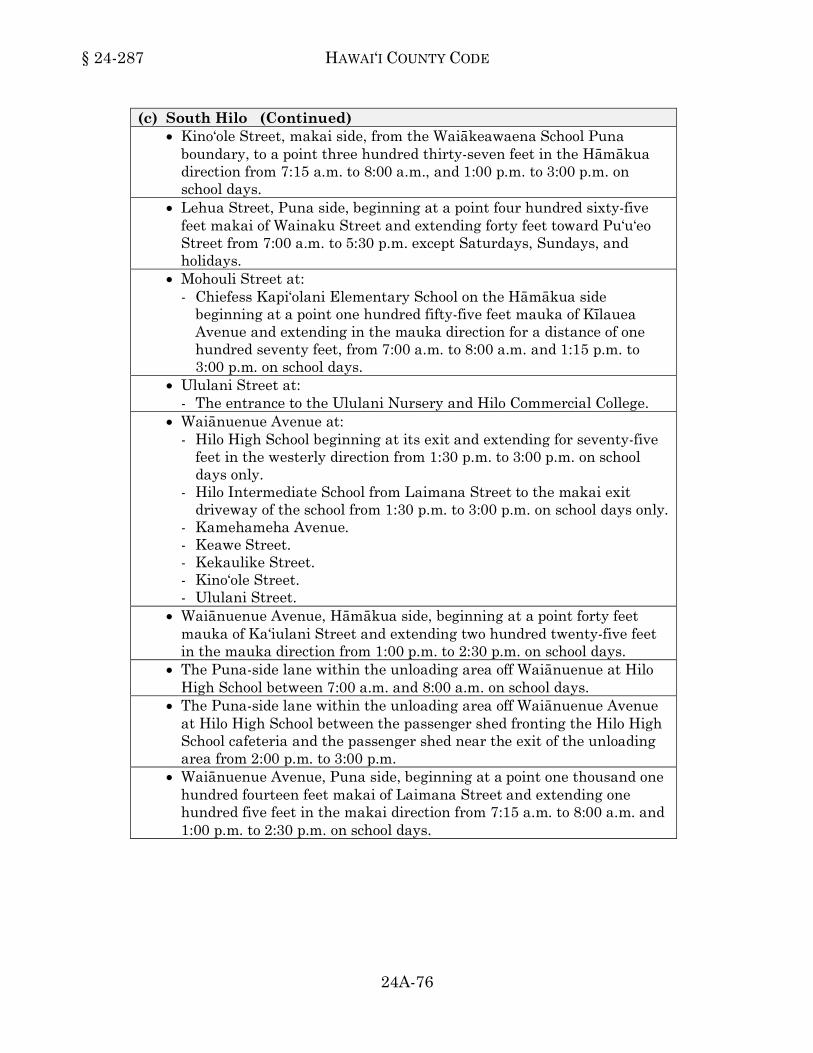
§ 24-287 HAWAI‘I COUNTY CODE
24A-76
(c) South Hilo (Continued) • Kino‘ole Street, makai side, from the Waiākeawaena School Puna
boundary, to a point three hundred thirty-seven feet in the Hāmākua direction from 7:15 a.m. to 8:00 a.m., and 1:00 p.m. to 3:00 p.m. on school days.
• Lehua Street, Puna side, beginning at a point four hundred sixty-five feet makai of Wainaku Street and extending forty feet toward Pu‘u‘eo Street from 7:00 a.m. to 5:30 p.m. except Saturdays, Sundays, and holidays.
• Mohouli Street at: - Chiefess Kapi‘olani Elementary School on the Hāmākua side
beginning at a point one hundred fifty-five feet mauka of Kīlauea Avenue and extending in the mauka direction for a distance of one hundred seventy feet, from 7:00 a.m. to 8:00 a.m. and 1:15 p.m. to 3:00 p.m. on school days.
• Ululani Street at: - The entrance to the Ululani Nursery and Hilo Commercial College.
• Waiānuenue Avenue at: - Hilo High School beginning at its exit and extending for seventy-five
feet in the westerly direction from 1:30 p.m. to 3:00 p.m. on school days only.
- Hilo Intermediate School from Laimana Street to the makai exit driveway of the school from 1:30 p.m. to 3:00 p.m. on school days only.
- Kamehameha Avenue. - Keawe Street. - Kekaulike Street. - Kino‘ole Street. - Ululani Street.
• Waiānuenue Avenue, Hāmākua side, beginning at a point forty feet mauka of Ka‘iulani Street and extending two hundred twenty-five feet in the mauka direction from 1:00 p.m. to 2:30 p.m. on school days.
• The Puna-side lane within the unloading area off Waiānuenue at Hilo High School between 7:00 a.m. and 8:00 a.m. on school days.
• The Puna-side lane within the unloading area off Waiānuenue Avenue at Hilo High School between the passenger shed fronting the Hilo High School cafeteria and the passenger shed near the exit of the unloading area from 2:00 p.m. to 3:00 p.m.
• Waiānuenue Avenue, Puna side, beginning at a point one thousand one hundred fourteen feet makai of Laimana Street and extending one hundred five feet in the makai direction from 7:15 a.m. to 8:00 a.m. and 1:00 p.m. to 2:30 p.m. on school days.

VEHICLES AND TRAFFIC § 24-287
24A-77
(d) Ka‘ū (e) Kohala
• Lindsey Road, east side, from a point fifty feet north of Route 19 and extending one hundred twelve feet north from 7:15 a.m. to 8:00 a.m. and 2:00 p.m. to 3:30 p.m. on school days.
(f) Kona
• Ali‘i Drive, north (mauka) side, from a point two hundred thirty-two feet west of Likana Lane and extending forty-six feet in the westerly direction, 7:00 a.m. to 3:00 p.m. each day.
• Ka‘ahumanu Place, north side, first marked diagonal stall, one hundred twenty-two feet west of Ali‘i Drive, from 6:00 a.m. to 6:00 p.m.
• Ka‘ahumanu Place, south side, one hundred twenty feet west of Ali‘i Drive and extending fifty six feet in the easterly direction, from 6:00 a.m. to 6:00 p.m. everyday.
(g) Puna
• Ka‘ohe Homestead Road, Kea‘au side, in front of the Pāhoa School gymnasium extending for forty feet.
1996, ord 96-163, sec 2; am 1996, ord 96-155, sec 2; am 1997, ord 97-70, sec 2; am 1999, ord 99-98, sec 3; ord 99-134, sec 6; am 2000, ord 00-12, sec 3; ord 00-130, sec 3; am 2001, ord 01-9, sec 2; ord 01-30, sec 1; am 2003, ord 03-41, sec 1; ord 03-138, sec 3; am 2004, ord 04-46, sec 1; ord 04-101, sec 1; am 2005, ord 05-59, sec 1; am 2008, ord 08-109, sec 1; am 2012, ord 12-51, sec 2; ord 12-88, sec 2; ord 12-96, sec 2; ord 12-157, sec 2; am 2015, ord 15-5, sec 2.)24-287
Section 24-288. Schedule 36. Freight loading zones. When signs are erected giving notice thereof, stopping, standing, or parking a
vehicle in a freight and loading zone except for unloading or loading of materials is prohibited on the following streets and portions of streets:
(a) Hāmākua (b) North Hilo (c) South Hilo
• Banyan Drive, beginning at a point one hundred eighty-two feet west of the Hilo Hawaiian Hotel entry driveway and extending forty-four feet in the westerly direction.

§ 24-288 HAWAI‘I COUNTY CODE
24A-78
(c) South Hilo (Continued) • Banyan Drive, east (makai) side, from a point four hundred twenty-six
feet north of Banyan Way and extending seventy-one feet in the northerly direction.
• Banyan Drive, northwest (makai) side, from a point three hundred thirty-four feet northeast of the northern intersection of Lihiwai Street and extending forty-four feet in the northeasterly direction.
• Hanama Place, at its terminus. The fifty-five foot section on the makai side fronting the Kailua Trade Center.
• Hualālai Street, Puna side, directly in front of the St. Joseph School Cafeteria.
• Kalākaua Street, Puna side, from a point two hundred sixty-two feet mauka of the Kamehameha Avenue parking lot and extending twenty feet in the mauka direction.
• Kamehameha Avenue, mauka side, from a point one hundred fifty feet Puna of Waiānuenue Avenue and extending thirty feet in the Puna direction.
• Keawe Street, makai side, Puna of Haili Street, twenty-five feet. • Keawe Street, makai side, Pu‘u‘eo of Mamo Street, twenty-five feet. • Keawe Street, southwest (mauka) side, from a point ninety-one feet
southeast of Kalākaua and extending twenty-two feet in the northwesterly direction.
• Kīlauea Avenue, mauka side, beginning at a point fifty feet southeast of Barenaba Street and extending thirty feet in the southeasterly direction.
• Kīlauea Avenue, mauka side, beginning at a point five hundred eighty-seven feet Puna of Hualālai Street and extending forty-four feet in the Puna direction.
• Kīlauea Avenue, mauka side, beginning from a point thirty feet Puna of Mamo Street and extending in the Puna direction for a distance of thirty feet.
• Kīlauea Avenue, mauka side, beginning from a point two hundred seventy feet Puna side of Mamo Street and extending forty-four feet in the Puna direction.
• Kīlauea Avenue, southwest side, beginning from a point sixty-four feet northwest of Ponahawai Street and extending forty feet in the northwesterly direction.
• Kino‘ole Street, beginning 148.39 feet Puna of Haili Street, fifty feet. • Kino‘ole Street, mauka side, beginning from a point one hundred
twenty-four feet Hāmākua of Haili Street and extending forty-two feet in the Hāmākua direction.

VEHICLES AND TRAFFIC § 24-288
24A-79
(c) South Hilo (Continued) • Kino‘ole Street, northeast side, beginning from a point two hundred
thirty-five feet southeast of Haili Street and extending forty-six feet in the southeasterly direction from 5:00 a.m. to 3:00 p.m., Monday through Friday.
• Kino‘ole Street, southwest (mauka) side, from a point two hundred ninety-seven feet southeast of Ponahawai Street and extending fifty-two feet in the southeasterly direction.
• Kūkūau Street, Hāmākua side, beginning thirty feet mauka of Kīlauea Avenue, forty-five feet.
• Nawahi Lane, Hāmākua side, from a point thirty feet mauka of Kamehameha Avenue and extending sixty-two feet in the mauka direction.
• Ponahawai Street, northwest side, from a point nineteen feet southwest of Punahoa Street, and extending thirty-two feet in the southwesterly direction.
• Punahoa Street, makai side, beginning from a point one hundred forty-seven feet Hāmākua of Mamo Street and extending one hundred twenty feet in the Hāmākua direction.
• Pu‘u‘eo Street, mauka side, from a point thirty feet Hāmākua of ‘Ōha‘i Street and extending fifty feet in the Hāmākua direction.
• Ululani Street, makai side, from the Hāmākua driveway into McDonald's Restaurant and extending in the Puna direction for a distance of thirty feet.
• Waiānuenue Avenue, Puna side, beginning at a point two hundred seventy-one feet makai of Keawe Street and extending forty feet toward Kamehameha Avenue.
• Wainaku Street, mauka side, from a point forty-two feet south of ‘Amauulu Street and extending forty-four feet in the southerly direction.
(d) Ka‘ū (e) Kohala (f) Kona
• Ali‘i Drive, east (mauka) side, from a point three hundred fifty-eight feet north of Sarona Road and extending thirty-four feet in the northerly direction, 7:00 a.m. to 3:00 p.m. each day.
• Ali‘i Drive, north (mauka) side, from a point five-hundred thirty-three feet west of Likana Lane and extending forty-five feet in the westerly direction, 7:00 a.m. to 3:00 p.m. each day.
§ 24-288 HAWAI‘I COUNTY CODE
24A-80
(f) Kona (Continued) • Ali‘i Drive, north (mauka) side, from a point two-hundred seventy-eight
feet west of Likana Lane and extending sixty feet in the westerly direction, 7:00 a.m. to 3:00 p.m. each day.
• Ali‘i Drive, southwest (makai) side, beginning from a point one hundred fifty-five feet southeast of Kakina Lane, and extending seventy-seven feet in the southeasterly direction, 7:00 a.m. to 3:00 p.m. each day.
• Ali‘i Drive, southwest (makai) side, from a point four hundred sixty-one feet southeast of Likana Lane and extending ninety-nine feet in the southeasterly direction, in the curb cut-out, 7:00 a.m. to 3:00 p.m. each day.
• Ali‘i Drive, west side, from a point three hundred-twenty feet south of Hualālai Road and extending sixty feet in the southerly direction, from 4:00 a.m. to 10:30 a.m., excluding Sundays and holidays.
• Belt Highway in Kainaliu, at Oshima Store. • Hanama Place, at its terminus. The fifty-five foot section on the makai
side fronting the Kailua Trade Center. • Likana Lane, east side, from the edge of the County parking lot nearest
Ali‘i Drive and extending northwesterly for forty-four feet between the hours of 8:00 a.m. and 4:00 p.m. except Sundays and public holidays.
• Palani Road, northeast (mauka) side, from a point forty feet northwest of Ka‘ahumanu Place and extending forty-one feet in the northwesterly direction, 7:00 a.m. to 3:00 p.m. each day.
• Sarona Road, south side, beginning from a point one hundred eighty-two feet east of Ali‘i Drive and extending one hundred feet in the easterly direction.
(g) Puna
• Kauhale Street, west side, beginning at a point three hundred ninety feet south of Highway 130 and extending forty-four feet in the southerly direction.
• Pāhoa Road, makai side, beginning at a point three-tenths of a mile Hilo side of the Kapoho-Kalapana junction and extending twenty-six feet in the Hilo direction.
1996, ord 96-163, sec 2; am 1997, ord 97-18, sec 1; ord 97-72, sec 1; ord 97-109, sec 3; am 1998, ord 98-73, sec 3; ord 98-134, secs 1 and 2; am 1999, ord 99-75, sec 1; ord 99-82, sec 1; ord 99-92, sec 3; am 2000, ord 00-37, sec 1; ord 00-129, sec 2; am 2001, ord 01-08, sec 2; ord 01-67, sec 1; am 2004, ord 04-44, sec 1; am 2005, ord 05-59, sec 2; am 2008, ord 08-8, sec 1; ord 08-173, sec 1; am 2011, ord 11-30, sec 1; ord 11-80, sec 2; am 2012, ord 12-9, sec 2; ord 12-97, sec 3; ord 12-98, sec 2; ord 12-101, sec 2; ord 12-148, sec 2; am 2014, ord 14-16, sec 2; ord 14-30, sec 2; ord 14-51, secs 2 and 3; ord 14-100, sec 2; ord 14-105, sec 2; am 2015, ord 15-6, sec 2; ord 15-7, sec 2; am 2016, ord 16-74, sec 2.)24-288

VEHICLES AND TRAFFIC § 24-288.1
24A-81
Section 24-288.1. Schedule 36.1. Active loading and unloading zones. When signs are erected giving notice thereof, active loading or unloading shall be
permitted on the following streets and portions of streets: (a) Hāmākua
• Pakalana Street, west side, five hundred eighty-nine feet south of Highway 240 and extending eighty-nine feet in the southerly direction, between the hours of 12:00 p.m. and 3:00 p.m. on school days only.
(b) North Hilo (c) South Hilo
• Haili Street, northwest side, beginning from a point two hundred eleven feet southwest of Kamehameha Avenue and extending twenty feet in the southwesterly direction.
• Kamehameha Avenue, mauka side, beginning from a point ninety-four feet west of Mamo Street and extending forty-four feet in the westerly direction, from 5:00 a.m. to 4:00 p.m., on Wednesdays and Saturdays.
• Kamehameha Avenue, mauka side, beginning from a point one hundred eleven feet northwest of Shipman Street and extending fifty-eight feet in the northwesterly direction.
• Keawe Street, west (mauka) side, from a point twenty-seven feet north (Hāmākua) of Mamo Street and extending eighteen feet in the northerly (Hāmākua) direction.
• Kīlauea Avenue, southwest side, beginning from a point thirty feet southeast of Wilson Street and extending forty feet in the southeasterly direction, from 7:00 a.m. to 6:00 p.m.
• Mamo Street, both sides, from Kamehameha Avenue to Punahoa Street, from 5:00 a.m. to 4:00 p.m., on Wednesdays and Saturdays.
• Punahoa Street, northeast (makai) side, from a point fifteen feet northwest of Mamo Street and extending ninety feet in the northwesterly direction.
(d) Ka‘ū (e) Kohala (f) Kona
• Manawale‘a Street, north side, beginning from a point three hundred sixty-three feet west of Kealakaa Street and extending one hundred thirty-seven feet in the westerly direction, for a period not to exceed fifteen minutes, from 7:00 a.m. to 8:00 a.m. and 2:00 p.m. to 3:00 p.m. on school days.

§ 24-288.1 HAWAI‘I COUNTY CODE
24A-82
(f) Kona (Continued) • Manawale‘a Street, south side, beginning from a point three hundred
twelve feet west of Kealakaa Street and extending forty-eight feet in the westerly direction, for a period not to exceed fifteen minutes, from 7:00 a.m. to 8:00 a.m. and 2:00 p.m. to 3:00 p.m. on school days.
• Kahauloa Road, at its western terminus. (g) Puna
(1996, ord 96-163, sec 2; am 1998, ord 98-73, sec 4; am 2008, ord 08-95, sec 1; ord 08-140, sec 1; am 2009, ord 09-122, sec 3; am 2010, ord 10-105, sec 2; ord 10-106, sec 1; am 2011, ord 11-91, sec 2; am 2012, ord 12-64, sec 2; am 2014, ord 14-64, sec 2; am 2015, ord 15-8, sec 2; ord 15-91, sec 2.)24-288.1
Division 7. Parking Meter Zones.
Section 24-289. Schedule 37. 36 minute parking meter zones. Thirty-six minute parking meter zones are established upon those streets or
portions of streets described in this schedule upon which the parking of vehicles shall be regulated by parking meters at the rates of ten cents for twelve minutes and twenty-five cents for thirty-six minutes:
(a) Hāmākua (b) North Hilo (c) South Hilo
• Kekaulike Street, from Waiānuenue Avenue to Wailuku Drive. • The makai side of Kino‘ole Street, from Waiānuenue Avenue to Wailuku
Drive. (d) Ka‘ū (e) Kohala (f) Kona (g) Puna
(1996, ord 96-163, sec 2; am 2002, ord 02-57, sec 5; am 2014, ord 14-17, sec 2.)24-289

VEHICLES AND TRAFFIC § 24-290
24A-83
Section 24-290. Schedule 38. 1 hour parking meter zones. One hour parking meter zones are established upon those streets or portions of
streets described in this schedule upon which the parking of vehicles shall be regulated by parking meters at the rate of ten cents per hour:
(a) Hāmākua (b) North Hilo (c) South Hilo (d) Ka‘ū (e) Kohala (f) Kona (g) Puna
(1996, ord 96-163, sec 2; am, 2000, ord 00-89, sec 2; am 2002, ord 02-57, sec 6.)24-290
Section 24-291. Schedule 39. 2 hour parking meter zones. Two hour parking meter zones are established upon those streets or portions of
streets described in this schedule upon which the parking of vehicles shall be regulated by parking meters at the rate of ten cents per hour:
(a) Hāmākua (b) North Hilo (c) South Hilo (d) Ka‘ū (e) Kohala (f) Kona

§ 24-291 HAWAI‘I COUNTY CODE
24A-84
(g) Puna
(1996, ord 96-163, sec 2; am 1996, ord 96-155, sec 3; am 1997, ord 97-28, sec 4; am 1998, ord 98-40, sec 1; am 2000, ord 00-89, sec 4; am 2002, ord 02-57, sec 7.)24-291
Section 24-291.1. Schedule 39.1. 2 hour parking meter zones. Two hour parking meter zones are established upon those streets or portions of
streets described in this schedule upon which the parking of vehicles shall be regulated by parking meters at the rates of five cents for fifteen minutes; ten cents for thirty minutes; and twenty-five cents for seventy-five minutes:
(a) Hāmākua (b) North Hilo (c) South Hilo
• The County Building parking lot at the corner of Aupuni Street and Pauahi Street, during the regular working hours of the County.
(d) Ka‘ū (e) Kohala (f) Kona (g) Puna
(1996, ord 96-163, sec 2; am 2014, ord 14-18, sec 2.)24-291.1
Section 24-292. Schedule 40. 8 hour parking meter zones. The following areas are designated as maximum eight hour parking at the rate of
five cents per hour: (a) Hāmākua (b) North Hilo
VEHICLES AND TRAFFIC § 24-292
24A-85
(c) South Hilo (d) Ka‘ū (e) Kohala (f) Kona (g) Puna The following areas are designated as maximum eight hour parking at the rate of
twenty-five cents per two-hours: (a) Hāmākua (b) North Hilo (c) South Hilo
• Aupuni Center parking lot, specifically marked single row of stalls fronting Kīlauea Avenue, Monday to Friday (excluding holidays) during the hours of 7:00 a.m. to 5:00 p.m. or as otherwise specified per facility.
(d) Ka‘ū (e) Kohala (f) Kona (g) Puna
(1996, ord 96-163, sec 2; am 2000, ord 00-89, sec 6; am 2002, ord 02-57, sec 8; am 2003, ord 03-4, sec 1.)24-292

§ 24-293 HAWAI‘I COUNTY CODE
24A-86
Division 8. Restrictions on Certain Vehicles.
Section 24-293. Schedule 41. Use of certain streets by certain vehicles restricted.
The following classes of vehicles are precluded from the use of the designated streets when appropriate signs giving notice thereof are erected:
(a) Hāmākua
• Pakalana Street, from Lehua Street to Māmane Street, makai bound only: (1) Any vehicle with a gross vehicle weight rating (GVWR) of more than
ten thousand pounds shall not travel in the makai-bound direction. (2) This restriction shall be lifted during emergencies as may be
declared by the office of civil defense. • Waipi‘o Valley Access Road.
(1) Restricted to four-wheel drive vehicles only. (2) Any vehicle with a gross vehicle weight rating (GVWR) of more than
ten thousand pounds shall not travel on this road. This restriction shall not be applicable to utility, emergency or delivery vehicles providing services to business establishments and residents in Waipi‘o Valley.
(3) Vehicle shall be engaged in four-wheel drive mode. (4) Makai-bound vehicle shall yield to mauka-bound vehicle. (5) These restrictions may be lifted during emergency situations as
deemed necessary by the Civil Defense Agency. (b) North Hilo (c) South Hilo (d) Ka‘ū (e) Kohala

VEHICLES AND TRAFFIC § 24-293
24A-87
(f) Kona (1) Vehicles having a gross vehicle weight rating of three or more tons
shall not be permitted to use the hereinafter designated streets. These provisions shall not be applicable to local area origin/destination traffic and vehicles providing services to residents of the hereinafter designated streets. Further, these restrictions shall be lifted during the period of any emergency declared by the civil defense agency. • Haleki‘i Street in the South Kona District. • Kupuna Street in the North Kona District. • Lako Street in the North Kona District. • Manawa Street in the South Kona District. • Nape Street in the South Kona District.
(2) Vehicles having a gross vehicle weight rating of five or more tons shall not be permitted to use the hereinafter designated streets. These provisions shall not be applicable to local area origin/destination traffic and vehicles providing services to residents of the hereinafter designated streets. Further, these restrictions shall be lifted during the periods of any emergency declared by the civil defense agency. • Kaiminani Drive in the North Kona District.
(3) Bicycles, mopeds, and motor scooters shall not be permitted to use the hereinafter designated streets:
(g) Puna
(1996, ord 96-163, sec 2; am 2001, ord 01-70, secs 1 and 2; am 2006, ord 06-164, sec 2; am 2010, ord 10-83, sec 1; am 2013, ord 13-70, secs 2 and 3.)24-293
Division 9. Bicycles.
Section 24-294. Schedule 42. Bicycle lanes. The following areas are bicycle lanes: (a) Hāmākua (b) North Hilo (c) South Hilo
• Kāwili Street, both sides, between Puainako Street and Kīlauea Avenue.

§ 24-294 HAWAI‘I COUNTY CODE
24A-88
(d) Ka‘ū (e) Kohala (f) Kona
• Kuakini Highway, mauka side, between Palani Road and the Old Kona Airport.
• Kuakini Highway, both sides, between Palani Road and Hualālai Road. • Manawale‘a Street, both sides.
(g) Puna
(1996, ord 96-163, sec 2; am 2008, ord 08-94, sec 1; am 2009, ord 09-23, sec 1.)24-294
Section 24-295. Schedule 43. Bicycle routes. The following areas are bicycle routes: (a) Hāmākua (b) North Hilo (c) South Hilo
• Kalaniana‘ole Street, Kamehameha Avenue to Lokoaka Street. • Kapi‘olani Street, both directions, between Kāwili Street and Lanikāula
Street. • Kāwili Street, both directions, between Kīlauea Avenue and Hawai‘i
Community College. (d) Ka‘ū (e) Kohala (f) Kona (g) Puna
(1996, ord 96-163, sec 2; am 1997, ord 97-130, sec 1.)24-295
Division 10. Tow or Tow-Away Zones.
Section 24-296. Schedule 44. Reserved.*
* Editor's Note: Since this schedule duplicated schedule 29, the streets listed under this schedule were moved to schedule 29.24-296

VEHICLES AND TRAFFIC § 24-297
24A-89
Article 11. Schedules -- Private Streets.
Division 1. Speed Limits.
Section 24-297. Schedule 1. 10 mile per hour limit. A speed limit of ten miles per hour is established as set forth in this schedule upon
the private streets or portions of private streets as follows: (a) Hāmākua (b) North Hilo (c) South Hilo (d) Ka‘ū (e) Kohala (f) Kona (g) Puna
(1999, ord 99-65, sec 14.)24-297
Section 24-298. Schedule 2. 15 mile per hour limit. A speed limit of fifteen miles per hour is established as set forth in this schedule
upon the private streets or portions of private streets as follows: (a) Hāmākua (b) North Hilo (c) South Hilo (d) Ka‘ū (e) Kohala (f) Kona

§ 24-298 HAWAI‘I COUNTY CODE
24A-90
(g) Puna Ainaloa Subdivision • All streets, unless otherwise indicated.
Fern Forest Subdivision. • All unpaved roads and unpaved sections of roads.
Hawaiian Paradise Park Subdivision. • All unpaved roads.
Nānāwale Estates Subdivision. • All streets, unless otherwise indicated.
Orchidland Estates Subdivision. • All unpaved roads and unpaved sections of roads.
(1999, ord 99-65, sec 14; am 2001, ord 01-62, sec 5; am 2013, ord 13-81, sec 2; am 2014, ord 14-66, sec 2; am 2016, ord 16-63, sec 2.)24-298
Section 24-299. Schedule 3. 20 mile per hour limit. A speed limit of twenty miles per hour is established as set forth in this schedule
upon the private streets or portions of private streets as follows: (a) Hāmākua (b) North Hilo (c) South Hilo (d) Ka‘ū (e) Kohala (f) Kona (g) Puna
Fern Acres Subdivision. • All streets except for Hibiscus Street, Lehua Street, Pīkake Street,
Plumeria Street, and Pūhala Street. (1999, ord 99-65, sec 14; am 2014, ord 14-65, sec 2.)24-299
VEHICLES AND TRAFFIC § 24-300
24A-91
Section 24-300. Schedule 4. 25 mile per hour limit. A speed limit of twenty-five miles per hour is established as set forth in this
schedule upon the private streets or portions of private streets as follows: (a) Hāmākua (b) North Hilo (c) South Hilo (d) Ka‘ū
Hawaiian Ocean View Estates Subdivision • All streets.
(e) Kohala (f) Kona (g) Puna
Ainaloa Subdivision. • Ainaloa Drive, from Ainaloa Way to Stardust Drive.
Fern Acres Subdivision • Hibiscus Street. • Lehua Street. • Plumeria Street. • Pīkake Street. • Pūhala Street.
Fern Forest Subdivision • All paved roads and paved sections of roads.
Hawaiian Paradise Park Subdivision, all paved roads except for: • Kaloli Drive • Maku‘u Drive • Paradise Drive • Shower Drive
Mauna Loa Estates Subdivision. • All streets.

§ 24-300 HAWAI‘I COUNTY CODE
24A-92
(g) Puna (Continued) Nānāwale Estates Subdivision. • Flower Road. • Forest Road. • Hāpu‘u Road, from Forest Road to Nānāwale Boulevard. • Kapuna Road. • Kēhau Road, from Forest Road to Nānāwale Boulevard. • Mauna Ke‘a Road. • Seaview Road.
Orchidland Estates Subdivision • All paved roads and paved sections of roads.
(1999, ord 99-65, sec 14; am 1999, ord 99-136, sec 1; am 2001, ord 01-62, sec 6; am 2013, ord 13-82, sec 2; am 2014, ord 14-66, sec 3; ord 14-88, sec 2; am 2016, ord 16-63, sec 3.)24-300
Section 24-301. Schedule 5. 30 mile per hour limit. A speed limit of thirty miles per hour is established as set forth in this schedule
upon the private streets or portions of private streets as follows: (a) Hāmākua (b) North Hilo (c) South Hilo (d) Ka‘ū (e) Kohala (f) Kona (g) Puna
(1999, ord 99-65, sec 14.)24-301
Section 24-302. Schedule 6. 35 mile per hour limit. A speed limit of thirty-five miles per hour is established as set forth in this schedule
upon the private streets or portions of private streets as follows: (a) Hāmākua

VEHICLES AND TRAFFIC § 24-302
24A-93
(b) North Hilo (c) South Hilo (d) Ka‘ū (e) Kohala (f) Kona (g) Puna
• Hawaiian Paradise Park Subdivision. • Kaloli Drive. • Maku‘u Drive. • Paradise Drive. • Shower Drive.
(1999, ord 99-65, sec 14; am 2013, ord 13-90, sec 2.)24-302
Section 24-303. Schedule 7. Reserved. (1999, ord 99-65, sec 14.)24-303
Section 24-304. Schedule 8. Reserved. (1999, ord 99-65, sec 14.)24-304
Section 24-305. Schedule 9. Reserved. (1999, ord 99-65, sec 14.)24-305
Section 24-306. Schedule 10. Reserved. (1999, ord 99-65, sec 14.)24-306
Division 2. Moving Vehicles.
Section 24-307. Schedule 11. Stop intersections. When properly posted, drivers of vehicles shall stop at the following intersection: (a) Hāmākua

§ 24-307 HAWAI‘I COUNTY CODE
24A-94
(b) North Hilo (c) South Hilo (d) Ka‘ū
Hawaiian Ocean View Estates Subdivision • Entering Aloha Boulevard from Bamboo Lane. • Entering Aloha Boulevard from Catamaran Lane. • Entering Aloha Boulevard from Ginger Blossom Lane. • Entering Aloha Boulevard from Hawai‘i Boulevard (4 way stop). • Entering Aloha Boulevard from Hula Lane. • Entering Aloha Boulevard from ‘Iolani Lane. • Entering Aloha Boulevard from ‘Iwalani Parkway. • Entering Aloha Boulevard from King Kamehameha Boulevard (4 way
stop). • Entering Aloha Boulevard from Koa Lane. • Entering Aloha Boulevard from Lehua Lane. • Entering Aloha Boulevard from Leilani Parkway. • Entering Aloha Boulevard from Lotus Blossom Lane. • Entering Aloha Boulevard from Marlin Boulevard (4 way stop). • Entering Aloha Boulevard from Orchid Parkway. • Entering Aloha Boulevard from Paradise Parkway. • Entering Aloha Boulevard from Pineapple Parkway. • Entering Aloha Boulevard from Plumeria Lane. • Entering Aloha Boulevard from Reef Parkway. • Entering Aloha Boulevard from Tiki Lane. • Entering Aloha Boulevard from Tradewind Boulevard (4 way stop). • Entering Aloha Boulevard from Tree Fern Lane. • Entering ‘Ānuenue Drive from Reef Parkway. • Entering Bamboo Lane from ‘Ānuenue Drive. • Entering Bamboo Lane from Coconut Drive. • Entering Bamboo Lane from Coral Parkway. • Entering Bamboo Lane from Ocean View Parkway. • Entering Bamboo Lane from ‘Ōhi‘a Drive. • Entering Bamboo Lane from Outrigger Drive. • Entering Bamboo Lane from Sea Breeze Parkway. • Entering Bamboo Lane from Seaview Drive. • Entering Bamboo Lane from Walaka Drive. • Entering Catamaran Lane from Donola Drive. • Entering Catamaran Lane from Hukilau Drive. • Entering Catamaran Lane from Keaka Parkway.
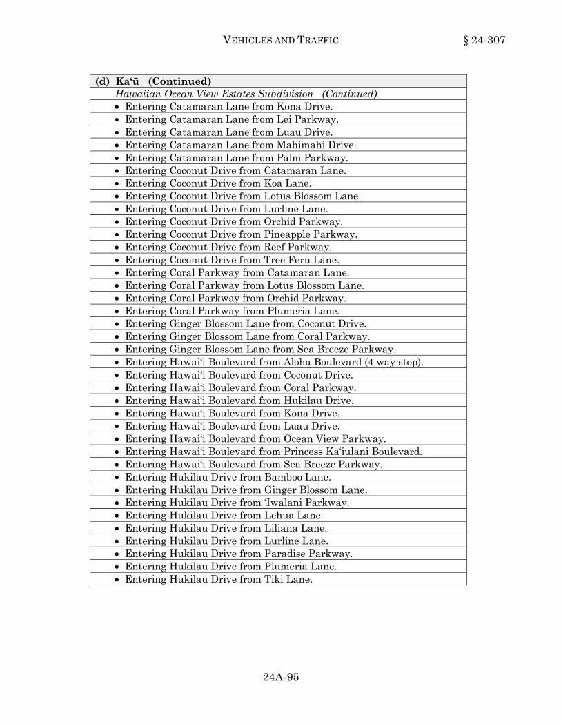
VEHICLES AND TRAFFIC § 24-307
24A-95
(d) Ka‘ū (Continued) Hawaiian Ocean View Estates Subdivision (Continued) • Entering Catamaran Lane from Kona Drive. • Entering Catamaran Lane from Lei Parkway. • Entering Catamaran Lane from Luau Drive. • Entering Catamaran Lane from Mahimahi Drive. • Entering Catamaran Lane from Palm Parkway. • Entering Coconut Drive from Catamaran Lane. • Entering Coconut Drive from Koa Lane. • Entering Coconut Drive from Lotus Blossom Lane. • Entering Coconut Drive from Lurline Lane. • Entering Coconut Drive from Orchid Parkway. • Entering Coconut Drive from Pineapple Parkway. • Entering Coconut Drive from Reef Parkway. • Entering Coconut Drive from Tree Fern Lane. • Entering Coral Parkway from Catamaran Lane. • Entering Coral Parkway from Lotus Blossom Lane. • Entering Coral Parkway from Orchid Parkway. • Entering Coral Parkway from Plumeria Lane. • Entering Ginger Blossom Lane from Coconut Drive. • Entering Ginger Blossom Lane from Coral Parkway. • Entering Ginger Blossom Lane from Sea Breeze Parkway. • Entering Hawai‘i Boulevard from Aloha Boulevard (4 way stop). • Entering Hawai‘i Boulevard from Coconut Drive. • Entering Hawai‘i Boulevard from Coral Parkway. • Entering Hawai‘i Boulevard from Hukilau Drive. • Entering Hawai‘i Boulevard from Kona Drive. • Entering Hawai‘i Boulevard from Luau Drive. • Entering Hawai‘i Boulevard from Ocean View Parkway. • Entering Hawai‘i Boulevard from Princess Ka‘iulani Boulevard. • Entering Hawai‘i Boulevard from Sea Breeze Parkway. • Entering Hukilau Drive from Bamboo Lane. • Entering Hukilau Drive from Ginger Blossom Lane. • Entering Hukilau Drive from ‘Iwalani Parkway. • Entering Hukilau Drive from Lehua Lane. • Entering Hukilau Drive from Liliana Lane. • Entering Hukilau Drive from Lurline Lane. • Entering Hukilau Drive from Paradise Parkway. • Entering Hukilau Drive from Plumeria Lane. • Entering Hukilau Drive from Tiki Lane.
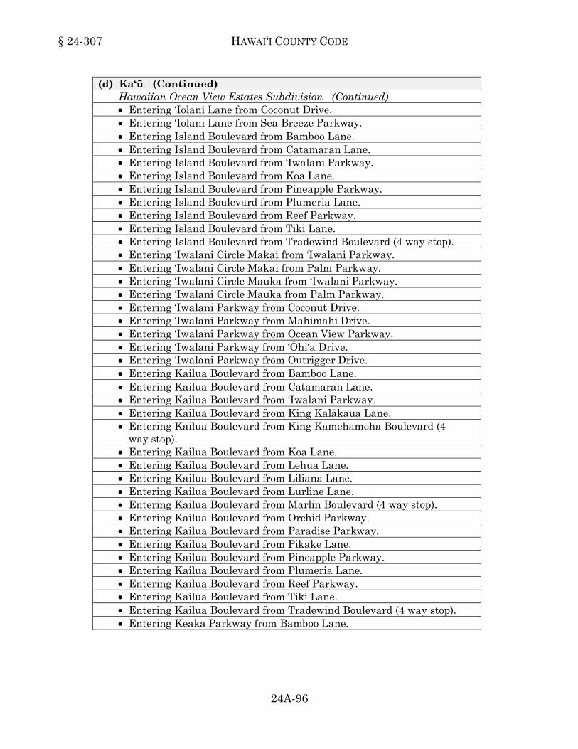
§ 24-307 HAWAI‘I COUNTY CODE
24A-96
(d) Ka‘ū (Continued) Hawaiian Ocean View Estates Subdivision (Continued) • Entering ‘Iolani Lane from Coconut Drive. • Entering ‘Iolani Lane from Sea Breeze Parkway. • Entering Island Boulevard from Bamboo Lane. • Entering Island Boulevard from Catamaran Lane. • Entering Island Boulevard from ‘Iwalani Parkway. • Entering Island Boulevard from Koa Lane. • Entering Island Boulevard from Pineapple Parkway. • Entering Island Boulevard from Plumeria Lane. • Entering Island Boulevard from Reef Parkway. • Entering Island Boulevard from Tiki Lane. • Entering Island Boulevard from Tradewind Boulevard (4 way stop). • Entering ‘Iwalani Circle Makai from ‘Iwalani Parkway. • Entering ‘Iwalani Circle Makai from Palm Parkway. • Entering ‘Iwalani Circle Mauka from ‘Iwalani Parkway. • Entering ‘Iwalani Circle Mauka from Palm Parkway. • Entering ‘Iwalani Parkway from Coconut Drive. • Entering ‘Iwalani Parkway from Mahimahi Drive. • Entering ‘Iwalani Parkway from Ocean View Parkway. • Entering ‘Iwalani Parkway from ‘Ōhi‘a Drive. • Entering ‘Iwalani Parkway from Outrigger Drive. • Entering Kailua Boulevard from Bamboo Lane. • Entering Kailua Boulevard from Catamaran Lane. • Entering Kailua Boulevard from ‘Iwalani Parkway. • Entering Kailua Boulevard from King Kalākaua Lane. • Entering Kailua Boulevard from King Kamehameha Boulevard (4
way stop). • Entering Kailua Boulevard from Koa Lane. • Entering Kailua Boulevard from Lehua Lane. • Entering Kailua Boulevard from Liliana Lane. • Entering Kailua Boulevard from Lurline Lane. • Entering Kailua Boulevard from Marlin Boulevard (4 way stop). • Entering Kailua Boulevard from Orchid Parkway. • Entering Kailua Boulevard from Paradise Parkway. • Entering Kailua Boulevard from Pikake Lane. • Entering Kailua Boulevard from Pineapple Parkway. • Entering Kailua Boulevard from Plumeria Lane. • Entering Kailua Boulevard from Reef Parkway. • Entering Kailua Boulevard from Tiki Lane. • Entering Kailua Boulevard from Tradewind Boulevard (4 way stop). • Entering Keaka Parkway from Bamboo Lane.

VEHICLES AND TRAFFIC § 24-307
24A-97
(d) Ka‘ū (Continued) Hawaiian Ocean View Estates Subdivision (Continued) • Entering Keaka Parkway from Orchid Parkway. • Entering King Kalākaua Lane from Mahimahi Drive. • Entering King Kalākaua Lane from Ocean View Parkway. • Entering King Kamehameha Boulevard from Aloha Boulevard (4
way stop). • Entering King Kamehameha Boulevard from Coconut Drive. • Entering King Kamehameha Boulevard from Coral Parkway. • Entering King Kamehameha Boulevard from Donola Drive. • Entering King Kamehameha Boulevard from Hukilau Drive. • Entering King Kamehameha Boulevard from Kailua Boulevard (4
way stop). • Entering King Kamehameha Boulevard from Keaka Parkway. • Entering King Kamehameha Boulevard from Kona Drive. • Entering King Kamehameha Boulevard from Lei Parkway. • Entering King Kamehameha Boulevard from Luau Drive. • Entering King Kamehameha Boulevard from Mahimahi Drive. • Entering King Kamehameha Boulevard from Moana Drive. • Entering King Kamehameha Boulevard from Ocean View Parkway. • Entering King Kamehameha Boulevard from ‘Ōhi‘a Drive. • Entering King Kamehameha Boulevard from Outrigger Lane. • Entering King Kamehameha Boulevard from Palm Parkway. • Entering King Kamehameha Boulevard from Princess Ka‘iulani
Boulevard (4 way stop). • Entering King Kamehameha Boulevard from Sea Breeze Parkway. • Entering King Kamehameha Boulevard from Walaka Drive. • Entering Koa Lane from Coral Parkway. • Entering Koa Lane from Hukilau Drive. • Entering Koa Lane from Lei Parkway. • Entering Koa Lane from Mahimahi Drive. • Entering Koa Lane from Palm Parkway. • Entering Koa Lane from Poinciana Drive. • Entering Koa Lane from Sea Breeze Parkway. • Entering Kona Drive from Bamboo Lane. • Entering Kona Drive from Ginger Blossom Lane. • Entering Kona Drive from Koa Lane. • Entering Kona Drive from Leilani Parkway. • Entering Kona Drive from Paradise Parkway. • Entering Kona Drive from Pineapple Parkway. • Entering Kona Drive from Tiki Lane. • Entering Lehua Lane from Coconut Drive.

§ 24-307 HAWAI‘I COUNTY CODE
24A-98
(d) Ka‘ū (Continued) Hawaiian Ocean View Estates Subdivision (Continued) • Entering Lehua Lane from Coral Drive. • Entering Lehua Lane from Keaka Parkway. • Entering Lehua Lane from Kona Drive. • Entering Lehua Lane from Luau Drive. • Entering Lehua Lane from Ocean View Parkway. • Entering Lehua Lane from Sea Breeze Parkway. • Entering Lei Parkway from Bamboo Lane. • Entering Lei Parkway from Lurline Lane. • Entering Lei Parkway from Plumeria Lane. • Entering Lei Parkway from Tiki Lane. • Entering Leilani Circle Makai from Leilani Parkway. • Entering Leilani Circle Makai from Sea Breeze Parkway. • Entering Leilani Circle Mauka from Leilani Parkway. • Entering Leilani Circle Mauka from Sea Breeze Parkway. • Entering Leilani Parkway from Coconut Drive. • Entering Leilani Parkway from Coral Parkway. • Entering Leilani Parkway from Ocean View Drive. • Entering Liliana Lane from ‘Ōhi‘a Drive. • Entering Liliana Lane from Palm Parkway. • Entering Lotus Blossom Circle Makai from Lotus Blossom Lane. • Entering Lotus Blossom Circle Makai from Luau Drive. • Entering Lotus Blossom Circle Mauka from Lotus Blossom Lane. • Entering Lotus Blossom Circle Mauka from Luau Drive. • Entering Lotus Blossom Lane from Hukilau Drive. • Entering Lotus Blossom Lane from Keaka Parkway. • Entering Lotus Blossom Lane from Kona Drive. • Entering Lotus Blossom Lane from Palm Parkway. • Entering Luau Drive from Orchid Parkway. • Entering Luau Drive from Paradise Parkway. • Entering Luau Drive from Tiki Lane. • Entering Luau Lane from Bamboo Lane. • Entering Luau Lane from Koa Lane. • Entering Lurline Lane from Mahimahi Drive. • Entering Lurline Lane from Ocean View Parkway. • Entering Mahimahi Drive from Bamboo Lane. • Entering Mahimahi Drive from Liliana Lane. • Entering Mahimahi Drive from Paradise Parkway. • Entering Mahimahi Drive from Pikake Lane. • Entering Mahimahi Drive from Pineapple Parkway.

VEHICLES AND TRAFFIC § 24-307
24A-99
(d) Ka‘ū (Continued) Hawaiian Ocean View Estates Subdivision (Continued) • Entering Mahimahi Drive from Tiki Lane. • Entering Marlin Boulevard from Aloha Boulevard (4 way stop). • Entering Marlin Boulevard from Coconut Drive. • Entering Marlin Boulevard from Hukilau Drive. • Entering Marlin Boulevard from Kailua Boulevard (4 way stop). • Entering Marlin Boulevard from Lei Parkway. • Entering Marlin Boulevard from Mahimahi Drive. • Entering Marlin Boulevard from Ocean View Parkway. • Entering Marlin Boulevard from ‘Ōhi‘a Drive. • Entering Marlin Boulevard from Outrigger Drive. • Entering Marlin Boulevard from Palm Parkway. • Entering Moana Drive from Tiki Drive. • Entering Ocean View Parkway from Catamaran Lane. • Entering Ocean View Parkway from Koa Lane. • Entering Ocean View Parkway from Liliana Lane. • Entering Ocean View Parkway from Lotus Blossom Lane. • Entering Ocean View Parkway from Pineapple Parkway. • Entering Ocean View Parkway from Reef Parkway. • Entering ‘Ōhi‘a Drive from Catamaran Lane. • Entering ‘Ōhi‘a Drive from King Kalākaua Lane. • Entering ‘Ōhi‘a Drive from Koa Lane. • Entering ‘Ōhi‘a Drive from Lurline Lane. • Entering ‘Ōhi‘a Drive from Pineapple Parkway. • Entering ‘Ōhi‘a Drive from Reef Parkway. • Entering Orchid Circle Makai from Ocean View Parkway. • Entering Orchid Circle Makai from Orchid Parkway. • Entering Orchid Circle Mauka from Ocean View Parkway. • Entering Orchid Circle Mauka from Orchid Parkway. • Entering Orchid Parkway from Hukilau Drive. • Entering Orchid Parkway from Kona Drive. • Entering Orchid Parkway from Mahimahi Drive. • Entering Orchid Parkway from Palm Parkway. • Entering Orchid Parkway from Walaka Drive. • Entering Outrigger Drive from Catamaran Lane. • Entering Outrigger Drive from Koa Lane. • Entering Outrigger Drive from Lurline Lane. • Entering Outrigger Drive from Pineapple Parkway. • Entering Palm Parkway from Bamboo Lane. • Entering Palm Parkway from King Kalākaua Lane.
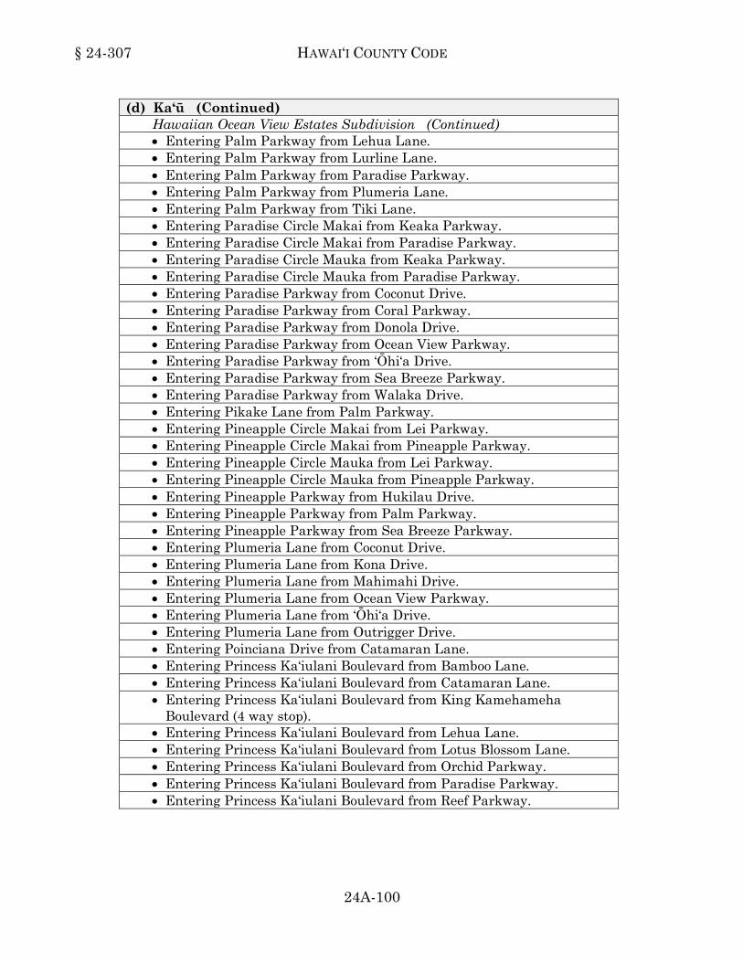
§ 24-307 HAWAI‘I COUNTY CODE
24A-100
(d) Ka‘ū (Continued) Hawaiian Ocean View Estates Subdivision (Continued) • Entering Palm Parkway from Lehua Lane. • Entering Palm Parkway from Lurline Lane. • Entering Palm Parkway from Paradise Parkway. • Entering Palm Parkway from Plumeria Lane. • Entering Palm Parkway from Tiki Lane. • Entering Paradise Circle Makai from Keaka Parkway. • Entering Paradise Circle Makai from Paradise Parkway. • Entering Paradise Circle Mauka from Keaka Parkway. • Entering Paradise Circle Mauka from Paradise Parkway. • Entering Paradise Parkway from Coconut Drive. • Entering Paradise Parkway from Coral Parkway. • Entering Paradise Parkway from Donola Drive. • Entering Paradise Parkway from Ocean View Parkway. • Entering Paradise Parkway from ‘Ōhi‘a Drive. • Entering Paradise Parkway from Sea Breeze Parkway. • Entering Paradise Parkway from Walaka Drive. • Entering Pikake Lane from Palm Parkway. • Entering Pineapple Circle Makai from Lei Parkway. • Entering Pineapple Circle Makai from Pineapple Parkway. • Entering Pineapple Circle Mauka from Lei Parkway. • Entering Pineapple Circle Mauka from Pineapple Parkway. • Entering Pineapple Parkway from Hukilau Drive. • Entering Pineapple Parkway from Palm Parkway. • Entering Pineapple Parkway from Sea Breeze Parkway. • Entering Plumeria Lane from Coconut Drive. • Entering Plumeria Lane from Kona Drive. • Entering Plumeria Lane from Mahimahi Drive. • Entering Plumeria Lane from Ocean View Parkway. • Entering Plumeria Lane from ‘Ōhi‘a Drive. • Entering Plumeria Lane from Outrigger Drive. • Entering Poinciana Drive from Catamaran Lane. • Entering Princess Ka‘iulani Boulevard from Bamboo Lane. • Entering Princess Ka‘iulani Boulevard from Catamaran Lane. • Entering Princess Ka‘iulani Boulevard from King Kamehameha
Boulevard (4 way stop). • Entering Princess Ka‘iulani Boulevard from Lehua Lane. • Entering Princess Ka‘iulani Boulevard from Lotus Blossom Lane. • Entering Princess Ka‘iulani Boulevard from Orchid Parkway. • Entering Princess Ka‘iulani Boulevard from Paradise Parkway. • Entering Princess Ka‘iulani Boulevard from Reef Parkway.
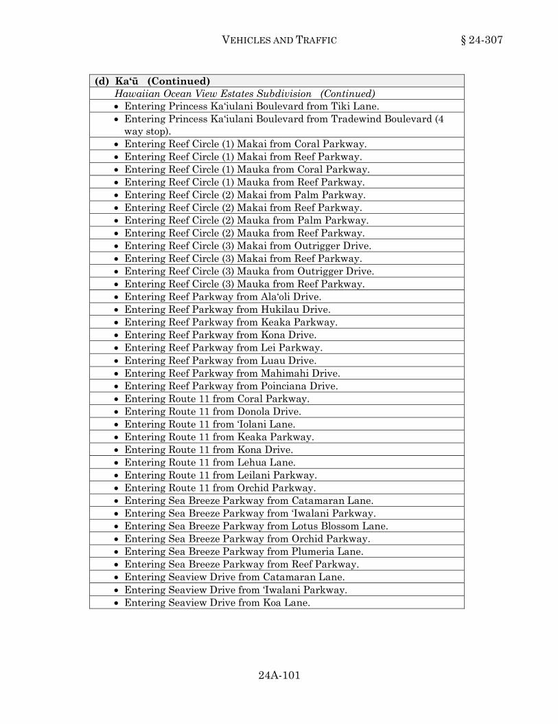
VEHICLES AND TRAFFIC § 24-307
24A-101
(d) Ka‘ū (Continued) Hawaiian Ocean View Estates Subdivision (Continued) • Entering Princess Ka‘iulani Boulevard from Tiki Lane. • Entering Princess Ka‘iulani Boulevard from Tradewind Boulevard (4
way stop). • Entering Reef Circle (1) Makai from Coral Parkway. • Entering Reef Circle (1) Makai from Reef Parkway. • Entering Reef Circle (1) Mauka from Coral Parkway. • Entering Reef Circle (1) Mauka from Reef Parkway. • Entering Reef Circle (2) Makai from Palm Parkway. • Entering Reef Circle (2) Makai from Reef Parkway. • Entering Reef Circle (2) Mauka from Palm Parkway. • Entering Reef Circle (2) Mauka from Reef Parkway. • Entering Reef Circle (3) Makai from Outrigger Drive. • Entering Reef Circle (3) Makai from Reef Parkway. • Entering Reef Circle (3) Mauka from Outrigger Drive. • Entering Reef Circle (3) Mauka from Reef Parkway. • Entering Reef Parkway from Ala‘oli Drive. • Entering Reef Parkway from Hukilau Drive. • Entering Reef Parkway from Keaka Parkway. • Entering Reef Parkway from Kona Drive. • Entering Reef Parkway from Lei Parkway. • Entering Reef Parkway from Luau Drive. • Entering Reef Parkway from Mahimahi Drive. • Entering Reef Parkway from Poinciana Drive. • Entering Route 11 from Coral Parkway. • Entering Route 11 from Donola Drive. • Entering Route 11 from ‘Iolani Lane. • Entering Route 11 from Keaka Parkway. • Entering Route 11 from Kona Drive. • Entering Route 11 from Lehua Lane. • Entering Route 11 from Leilani Parkway. • Entering Route 11 from Orchid Parkway. • Entering Sea Breeze Parkway from Catamaran Lane. • Entering Sea Breeze Parkway from ‘Iwalani Parkway. • Entering Sea Breeze Parkway from Lotus Blossom Lane. • Entering Sea Breeze Parkway from Orchid Parkway. • Entering Sea Breeze Parkway from Plumeria Lane. • Entering Sea Breeze Parkway from Reef Parkway. • Entering Seaview Drive from Catamaran Lane. • Entering Seaview Drive from ‘Iwalani Parkway. • Entering Seaview Drive from Koa Lane.

§ 24-307 HAWAI‘I COUNTY CODE
24A-102
(d) Ka‘ū (Continued) Hawaiian Ocean View Estates Subdivision (Continued) • Entering Seaview Drive from Pineapple Parkway. • Entering Seaview Drive from Plumeria Lane. • Entering Seaview Drive from Reef Parkway. • Entering Tiki Lane from Coconut Drive. • Entering Tiki Lane from Coral Parkway. • Entering Tiki Lane from Donola Drive. • Entering Tiki Lane from Keaka Parkway. • Entering Tiki Lane from Ocean View Parkway. • Entering Tiki Lane from ‘Ōhi‘a Drive. • Entering Tiki Lane from Outrigger Drive. • Entering Tiki Lane from Sea Breeze Parkway. • Entering Tradewind Boulevard from Aloha Boulevard (4 way stop). • Entering Tradewind Boulevard from ‘Ānuenue Drive. • Entering Tradewind Boulevard from Coconut Drive. • Entering Tradewind Boulevard from Coral Parkway. • Entering Tradewind Boulevard from Hukilau Drive. • Entering Tradewind Boulevard from Island Boulevard (4 way stop). • Entering Tradewind Boulevard from Kailua Boulevard (4 way stop). • Entering Tradewind Boulevard from Kona Drive. • Entering Tradewind Boulevard from Lei Parkway. • Entering Tradewind Boulevard from Luau Drive. • Entering Tradewind Boulevard from Mahimahi Drive. • Entering Tradewind Boulevard from Ocean View Parkway. • Entering Tradewind Boulevard from ‘Ōhi‘a Drive. • Entering Tradewind Boulevard from Outrigger Drive. • Entering Tradewind Boulevard from Palm Parkway. • Entering Tradewind Boulevard from Poinciana Drive. • Entering Tradewind Boulevard from Princess Ka‘iulani Boulevard (4
way stop). • Entering Tradewind Boulevard from Sea Breeze Parkway. • Entering Tradewind Boulevard from Sea View Drive. • Entering Tree Fern Lane from Coconut Drive. • Entering Tree Fern Lane from Kona Drive. • Entering Walaka Drive from Catamaran Lane.
(e) Kohala (f) Kona

VEHICLES AND TRAFFIC § 24-307
24A-103
(g) Puna Ainaloa Subdivision. • Entering Ainaloa Boulevard from Ainaloa Way. • Entering King Kamehameha Boulevard from Kuleana Street. • Entering King Kamehameha Boulevard from Menehune Way.
Mauna Loa Estates Subdivision. • Lanihuli Road at Third Street.
Nānāwale Estates Subdivision. • Camden Circle, entering Tutu Lane. • Cameo Circle, entering Leisure Lane. • Center Circle, entering Leisure Lane. • Colby Circle, entering Priscilla Road. • Colleen Circle, entering Tutu Lane. • Coral Circle, entering Tutu Lane. • Cottage Circle, entering Priscilla Road. • Crestview Circle, entering Priscilla Road. • Hibiscus Road, entering Lehua Road. • Lehua Circle, entering Lehua Road. • Pīkake Road, entering Hibiscus Road. • Tutu Lane, entering Priscilla Road.
(1999, ord 99-65, sec 14; am 1999, ord 99-136, sec 2; am 2001, ord 01-62, sec 7.)24-307
Section 24-308. Schedule 12. Through streets. When properly sign posted, the following private streets or portions of private
streets are designated as through streets: (a) Hāmākua
• Old Railroad Way • Old Sugar Mill Road
(b) North Hilo (c) South Hilo
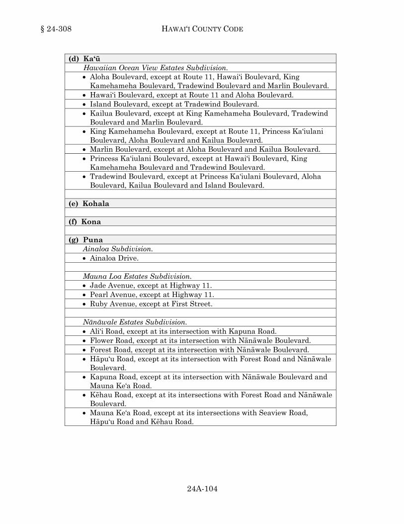
§ 24-308 HAWAI‘I COUNTY CODE
24A-104
(d) Ka‘ū Hawaiian Ocean View Estates Subdivision. • Aloha Boulevard, except at Route 11, Hawai‘i Boulevard, King
Kamehameha Boulevard, Tradewind Boulevard and Marlin Boulevard. • Hawai‘i Boulevard, except at Route 11 and Aloha Boulevard. • Island Boulevard, except at Tradewind Boulevard. • Kailua Boulevard, except at King Kamehameha Boulevard, Tradewind
Boulevard and Marlin Boulevard. • King Kamehameha Boulevard, except at Route 11, Princess Ka‘iulani
Boulevard, Aloha Boulevard and Kailua Boulevard. • Marlin Boulevard, except at Aloha Boulevard and Kailua Boulevard. • Princess Ka‘iulani Boulevard, except at Hawai‘i Boulevard, King
Kamehameha Boulevard and Tradewind Boulevard. • Tradewind Boulevard, except at Princess Ka‘iulani Boulevard, Aloha
Boulevard, Kailua Boulevard and Island Boulevard. (e) Kohala (f) Kona (g) Puna
Ainaloa Subdivision. • Ainaloa Drive.
Mauna Loa Estates Subdivision. • Jade Avenue, except at Highway 11. • Pearl Avenue, except at Highway 11. • Ruby Avenue, except at First Street.
Nānāwale Estates Subdivision. • Ali‘i Road, except at its intersection with Kapuna Road. • Flower Road, except at its intersection with Nānāwale Boulevard. • Forest Road, except at its intersection with Nānāwale Boulevard. • Hāpu‘u Road, except at its intersection with Forest Road and Nānāwale
Boulevard. • Kapuna Road, except at its intersection with Nānāwale Boulevard and
Mauna Ke‘a Road. • Kēhau Road, except at its intersections with Forest Road and Nānāwale
Boulevard. • Mauna Ke‘a Road, except at its intersections with Seaview Road,
Hāpu‘u Road and Kēhau Road.

VEHICLES AND TRAFFIC § 24-308
24A-105
(g) Puna (Continued) Nānāwale Estates Subdivision. (Continued) • Mayzee Road, except at its intersections with Kapuna Road and
Maluhia Road. • Seaview Road, except at its intersection with Nānāwale Boulevard.
(1999, ord 99-65, sec 14; am 1999, ord 99-136, sec 3; am 2001, ord 01-62, sec 8; am 2008, ord 08-40, sec 1.)24-308
Section 24-309. Schedule 13. Prohibited right turn areas. When properly sign posted, the following private streets or portions of private
streets are designated as prohibited right turn areas: (a) Hāmākua (b) North Hilo (c) South Hilo (d) Ka‘ū
Hawaiian Ocean View Estates Subdivision. • Ocean View water fill station road entering Lehua Lane.
- Any vehicle with a gross vehicle weight rating (GVWR) of more than ten thousand pounds.
(e) Kohala (f) Kona (g) Puna
(1999, ord 99-65, sec 14; am 2012, ord 12-65, sec 1.)24-309
Section 24-310. Schedule 14. Truck routes. When properly sign posted, the following private streets or portions of private
streets are designated as truck routes: (a) Hāmākua (b) North Hilo
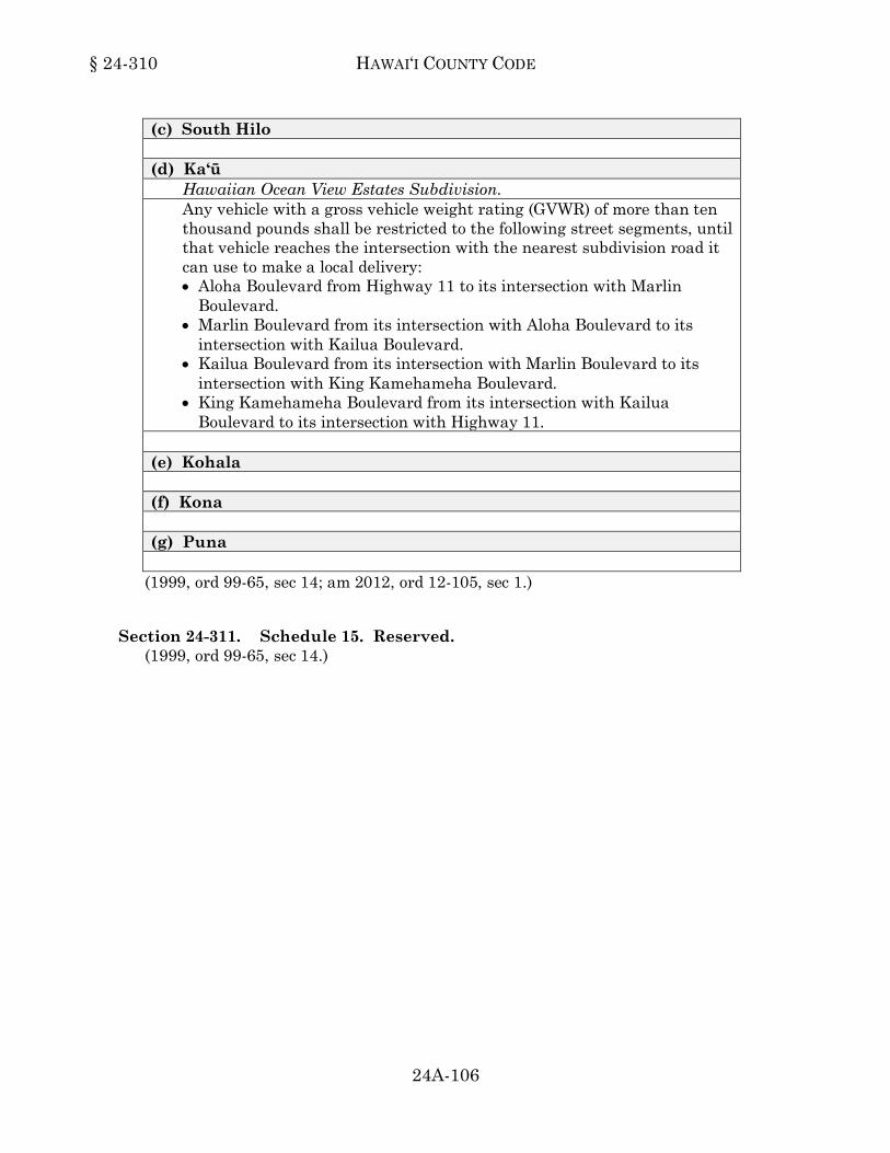
§ 24-310 HAWAI‘I COUNTY CODE
24A-106
(c) South Hilo (d) Ka‘ū
Hawaiian Ocean View Estates Subdivision. Any vehicle with a gross vehicle weight rating (GVWR) of more than ten thousand pounds shall be restricted to the following street segments, until that vehicle reaches the intersection with the nearest subdivision road it can use to make a local delivery: • Aloha Boulevard from Highway 11 to its intersection with Marlin
Boulevard. • Marlin Boulevard from its intersection with Aloha Boulevard to its
intersection with Kailua Boulevard. • Kailua Boulevard from its intersection with Marlin Boulevard to its
intersection with King Kamehameha Boulevard. • King Kamehameha Boulevard from its intersection with Kailua
Boulevard to its intersection with Highway 11. (e) Kohala (f) Kona (g) Puna
(1999, ord 99-65, sec 14; am 2012, ord 12-105, sec 1.)24-310
Section 24-311. Schedule 15. Reserved. (1999, ord 99-65, sec 14.)24-311