Embed Size (px)
Citation preview
INLAND ACID SULFATE SOIL SYSTEMS ACROSS AUSTRALIA
Fawcett Jon, Rob Fitzpatrick, Rob Norton 2008. Inland Acid Sulfate Soils of The Spring Zones Across the Eastern Dundas Tableland, South Eastern Australia. In Inland Acid Sulfate Soil Systems Across Australia (Eds. Rob Fitzpatrick and Paul Shand). pp 268-280. CRC LEME Open File Report No. 249. (Thematic Volume) CRC LEME, Perth, Australia. CHAPTER 18 INLAND ACID SULFATE SOILS OF THE SPRING ZONES ACROSS THE EASTERN DUNDAS TABLELAND, SOUTH EASTERN AUSTRALIA Jon Fawcett1,2, Rob Fitzpatick3 and Rob Norton1,
1The School of Agriculture and Food Systems, The University of Melbourne. Private Bag 260, Horsham Victoria 3401, Australia. 2Primary Industries Research Victoria, PO Box 3100, Bendigo DC, Victoria 3554, Australia. 3CSIRO Land and Water/CRC LEME, Private Bag 2, Glen Osmond SA 5064, Australia. INTRODUCTION Land degradation in the form of salinisation, acidic waters and associated soil erosion affects 5300 hectares, or seven per cent, of the Eastern Dundas Tablelands (EDT) (Figure 1) (Munroe 1998). Located within degraded zones are permanently flowing springs that are covered in iron precipitates and salt efflorescence. Within the discharge zones, conditions exist for formation of acid sulfate soils (ASS). The ASS identified are only located in discharge zones connected to the regional groundwater flow system that have been shown to be “primary discharge zones” (Fawcett 2004, Fawcett et al 2008) because these are know to have discharged prior to European land clearing. This case study outlines the hydrogeological and soil-landscape toposequence processes associated with springs that contain the ASS and illustrate the impact inland ASS have on soil degradation and water quality in this region.
%
%
%
%
%
%
%
%
#
Perth
Hobart
Sydney
Darwin
Adelaide
Brisbane
MelbourneHamilton
%Hamilton
Grampians NPEast
DundasTablelands
RocklandsReservoir
Glen elg
River
Hopk ins Ri ver
0 10 20 30 40
Kilometres
N
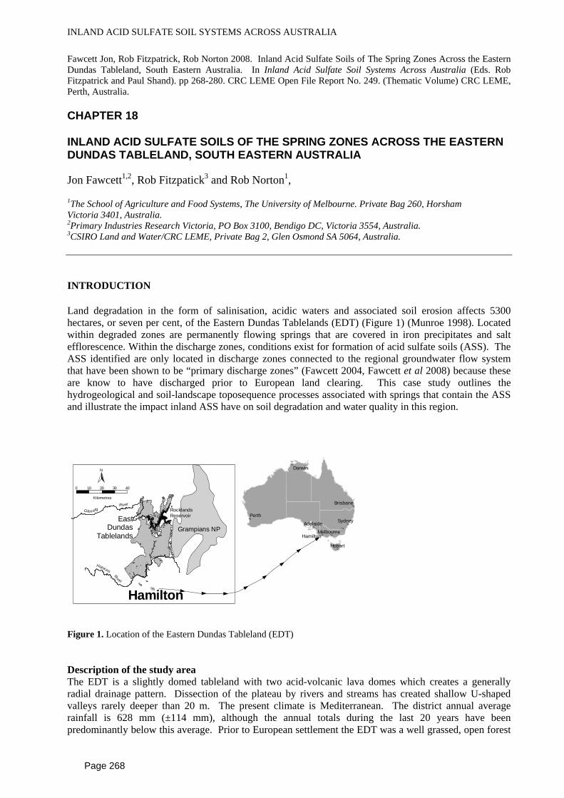
Figure 1. Location of the Eastern Dundas Tableland (EDT) Description of the study area The EDT is a slightly domed tableland with two acid-volcanic lava domes which creates a generally radial drainage pattern. Dissection of the plateau by rivers and streams has created shallow U-shaped valleys rarely deeper than 20 m. The present climate is Mediterranean. The district annual average rainfall is 628 mm (±114 mm), although the annual totals during the last 20 years have been predominantly below this average. Prior to European settlement the EDT was a well grassed, open forest
Page 268
INLAND ACID SULFATE SOIL SYSTEMS ACROSS AUSTRALIA
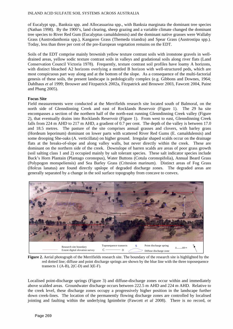
of Eucalypt spp., Banksia spp. and Allocasuarina spp., with Banksia marginata the dominant tree species (Nathan 1998). By the 1900’s, land clearing, sheep grazing and a variable climate changed the dominant tree species to River Red Gum (Eucalyptus camaldulensis) and the dominant native grasses were Wallaby Grass (Austrodanthonia spp.), Kangaroo Grass (Themeda triandra) and Spear Grass (Austrostipa spp.). Today, less than three per cent of the pre-European vegetation remains on the EDT. Soils of the EDT comprise mainly brownish yellow texture contrast soils with ironstone gravels in well-drained areas, yellow sodic texture contrast soils in valleys and gradational soils along river flats (Land Conservation Council Victoria 1978). Frequently, texture contrast soil profiles have loamy A horizons, with distinct bleached A2 horizons overlying a mottled B horizon with well-structured peds, which are most conspicuous part way along and at the bottom of the slope. As a consequence of the multi-factorial genesis of these soils, the present landscape is pedologically complex (e.g. Gibbons and Downes, 1964; Dahlhaus et al 1999; Brouwer and Fitzpatrick 2002a, Fitzpatrick and Brouwer 2003, Fawcett 2004, Paine and Phang 2005). Focus Site Field measurements were conducted at the Merrifields research site located south of Balmoral, on the north side of Glenndinning Creek and east of Rocklands Reservoir (Figure 1). The 29 ha site encompasses a section of the northern half of the north-east running Glenndinning Creek valley (Figure 2), that eventually drains into Rocklands Reservoir (Figure 1). From west to east, Glenndinning Creek falls from 224 m AHD to 217 m AHD, a gradient of 0.7 per cent. The depth of the valley is between 17.0 and 18.5 metres. The pasture of the site comprises annual grasses and clovers, with barley grass (Hordeum leporinum) dominant on lower parts with scattered River Red Gums (E. camaldulensis) and some drooping She-oaks (A. verticillata) on higher ground. Irregular shaped scalds occur on the drainage flats at the breaks-of-slope and along valley walls, but never directly within the creek. These are dominant on the northern side of the creek. Downslope of barren scalds are areas of poor grass growth (soil salting class 1 and 2) occupied mainly by salt tolerant species. These salt indicator species include Buck’s Horn Plantain (Plantago coronopus), Water Buttons (Cotula coronopifolia), Annual Beard Grass (Polypogon monspeliensis) and Sea Barley Grass (Critesion marinum). Distinct areas of Fog Grass (Holcus lanatus) are found directly upslope of degraded discharge zones. The degraded areas are generally separated by a change in the soil surface topography from concave to convex.
E
F
A
B
SS
S
c
D
DCResearch site boundary Extent digital elevation survey Diffuse discharge zone
Toposequence transects
S
S Point discharge spring
Glenndinnig creek
0 100 mN
Figure 2. Aerial photograph of the Merrifields research site. The boundary of the research site is highlighted by the
red dotted line; diffuse and point discharge springs are shown by the blue line with the three toposequence transects 1 (A-B), 2(C-D) and 3(E-F).
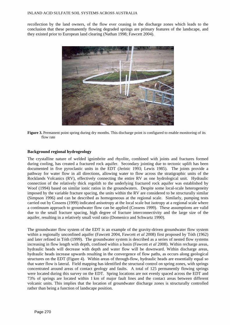
Localised point-discharge springs (Figure 3) and diffuse-discharge zones occur within and immediately above scalded areas. Groundwater discharge occurs between 222.5 m AHD and 224 m AHD. Relative to the creek level, these discharge zones occupy a progressively higher position in the landscape further down creek-lines. The location of the permanently flowing discharge zones are controlled by localised jointing and faulting within the underlying Ignimbrite (Fawcett et al 2008). There is no record, or
Page 269
INLAND ACID SULFATE SOIL SYSTEMS ACROSS AUSTRALIA
recollection by the land owners, of the flow ever ceasing in the discharge zones which leads to the conclusion that these permanently flowing degraded springs are primary features of the landscape, and they existed prior to European land clearing (Nathan 1998; Fawcett 2004).
Figure 3. Permanent point spring during dry months. This discharge point is configured to enable monitoring of its
flow rate Background regional hydrogeology
The crystalline nature of welded ignimbrite and rhyolite, combined with joints and fractures formed during cooling, has created a fractured rock aquifer. Secondary jointing due to tectonic uplift has been documented in five pyroclastic units in the EDT (Jerinic 1993; Lewis 1985). The joints provide a pathway for water flow in all directions, allowing water to flow across the stratigraphic units of the Rocklands Volcanics (RV), effectively connecting the entire RV as one hydrological unit. Hydraulic connection of the relatively thick regolith to the underlying fractured rock aquifer was established by Woof (1994) based on similar ionic ratios in the groundwaters. Despite some local-scale heterogeneity imposed by the variable fracture spacing, the units within the RV are considered to be structurally similar (Simpson 1996) and can be described as homogeneous at the regional scale. Similarly, pumping tests carried out by Cossens (1999) indicated anisotropy at the local scale but isotropy at a regional scale where a continuum approach to groundwater flow can be applied (Cossens 1999). These assumptions are valid due to the small fracture spacing, high degree of fracture interconnectivity and the large size of the aquifer, resulting in a relatively small void ratio (Domenico and Schwartz 1990).
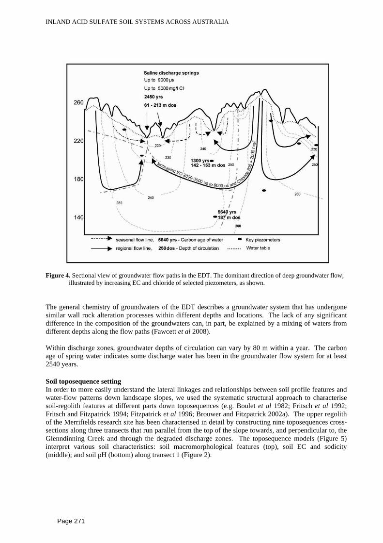
The groundwater flow system of the EDT is an example of the gravity-driven groundwater flow system within a regionally unconfined aquifer (Fawcett 2004, Fawcett et al 2008) first proposed by Tóth (1962) and later refined in Tóth (1999). The groundwater system is described as a series of nested flow systems increasing in flow length with depth, confined within a basin (Fawcett et al 2008). Within recharge areas, hydraulic heads will decrease with depth and water flow will be downward. Within discharge areas, hydraulic heads increase upwards resulting in the convergence of flow paths, as occurs along geological structures on the EDT (Figure 4). Within areas of through-flow, hydraulic heads are essentially equal so that water flow is lateral. Field mapping has identified the structural control on spring zones, with springs concentrated around areas of contact geology and faults. A total of 125 permanently flowing springs were located during this survey on the EDT. Spring locations are not evenly spaced across the EDT and 73% of springs are located within 1 km of major fault lines and the contact areas between different volcanic units. This implies that the location of groundwater discharge zones is structurally controlled rather than being a function of landscape position.
Page 270
INLAND ACID SULFATE SOIL SYSTEMS ACROSS AUSTRALIA
Figure 4. Sectional view of groundwater flow paths in the EDT. The dominant direction of deep groundwater flow,
illustrated by increasing EC and chloride of selected piezometers, as shown. The general chemistry of groundwaters of the EDT describes a groundwater system that has undergone similar wall rock alteration processes within different depths and locations. The lack of any significant difference in the composition of the groundwaters can, in part, be explained by a mixing of waters from different depths along the flow paths (Fawcett et al 2008). Within discharge zones, groundwater depths of circulation can vary by 80 m within a year. The carbon age of spring water indicates some discharge water has been in the groundwater flow system for at least 2540 years. Soil toposequence setting In order to more easily understand the lateral linkages and relationships between soil profile features and water-flow patterns down landscape slopes, we used the systematic structural approach to characterise soil-regolith features at different parts down toposequences (e.g. Boulet et al 1982; Fritsch et al 1992; Fritsch and Fitzpatrick 1994; Fitzpatrick et al 1996; Brouwer and Fitzpatrick 2002a). The upper regolith of the Merrifields research site has been characterised in detail by constructing nine toposequences cross-sections along three transects that run parallel from the top of the slope towards, and perpendicular to, the Glenndinning Creek and through the degraded discharge zones. The toposequence models (Figure 5) interpret various soil characteristics: soil macromorphological features (top), soil EC and sodicity (middle); and soil pH (bottom) along transect 1 (Figure 2).
Page 271

INLAND ACID SULFATE SOIL SYSTEMS ACROSS AUSTRALIA
Figure 5. Topsequence for transect A_B (Figure 2), Hydrological soil systems toposequences–a, Soil salinity and
sodicity toposequence - b and Soil sodicity toposequence – c. a b and c refer to the top, middle and lower toposequence respectively..
Page 272
INLAND ACID SULFATE SOIL SYSTEMS ACROSS AUSTRALIA
The presence of well-developed bleached A2 horizons within texture contrast soils directly below discharge areas suggests that lateral through flow and seasonal waterlogging of the topsoil occurs (Brouwer and Fitzpatrick 2002b; Fitzpatrick and Brouwer 2003). The water flow is consistent with monitored groundwater data (Fawcett et al 2009). The yellow/orange mottles within the tabletop and mid-slope positions indicate a well drained environment, where vertical unsaturated flow down to the water table will dominate. The presence of reduced mottle colours within the discharge areas indicates prolonged saturation of the regolith (Bigham et al 2002) as would be expected because the discharge zones are permanently saturated. The absence of strong, horizontally-orientated mottling patterns within discharge zones suggests the area has remained saturated and has not undergone changing groundwater levels, which have been thought to cause horizontal mottling patterns (Brouwer and Fitzpatrick 2002; Fitzpatrick and Brouwer 2003, Paine and Phang 2005). This supports the proposal that these discharge zones on the EDT are permanent features, rather than seasonal or a development since land clearing. The presence of strongly reduced mottles alongside brighter coloured red mottles in hydrological soil systems 5 and 6, is indicative of more oxidising conditions and suggests reduction of the subsoil may be localised. It is proposed that the zones of intense reduction exist mainly along groundwater flow paths. Salt accumulation and distribution Areas of high salinity (more than 8 ECse) create a teardrop shape that extended downslope (Figure 3) from the regional groundwater discharge zones and these spread downslope as a consequence of seasonal discharge. This process enlarges the area affected by soil salinity and generates some salt wash-off into waterways. Areas of high salinity (8–15.9 ECse) extended upslope of the immediate area of groundwater discharge within all toposequences. Salts accumulate as a result of evapotranspiration above scalded zones during periods of high seasonal watertables. Soil acidity and sodicity In general, the soils of the site were in the pH range of 5 to 6. Extremely acid soils were confined to the immediate area of diffuse and point flowing discharge zones. The soil chemical processes that drive the acidity are presumably also confined to discharge zones. The majority of the soils within the transects were classified as sodic (ESP >15%). It would be expected within acidic soils available aluminum would be present and cause an overestimation of the CEC of the soils. Soils that disperse completely occur across a range of pH values while they were confined to soil ECse of less than 2 ds/m. Of the 267 soil samples taken from transects across a degraded discharge zone and analysed for pH, EC and dispersion, EC had a significant effect on preventing dispersion (p<0.001) as expected, but there was no significant effect of pH on dispersion (p>0.14). Identifying Inland Acid Sulfate Soils (ASS) Acid sulfate soils with predominantly sulfidic materials (i.e. potential ASS materials) and minor sulfuric materials as defined by Isbell (2000) occur within spring zones of the EDT but are not as obvious as those identified in coastal or large scale wetland settings. The conditions for their formation only exist within discharge zones associated with the regional groundwater system, which may only be several meters in size (Figure 3). Field observations and the following laboratory analyses using Isbell (2000) were used to identify the presence of sulfidic materials (potential acid sulfate soil materials or PASS material) and sulfuric material (actual ASS material) at the Merrifields research site: (i) pH before and after incubation of moist samples for 8 weeks and treatment with hydrogen peroxide, (ii) mineralogical identification of various iron sulfide and iron oxyhydroxide minerals and (iii) detailed measurements of discharge water chemistry. Water chemistry of surface water within scalded regions was sampled via a series of surface drains, with groundwater chemistry sampled via a series of shallow piezometers and drain inserted into a 6 m deep trench within and around degraded springs. Detailed redox, pH and EC measurements of spring discharge water were taken along two transects through a disturbed discharge zone (Figure 6). Run one, is where discharge water evaporated and iron scalding was present and Run two is where the discharge rate was sufficient to enable water to freely drain away from the scalded zone.
Page 273

INLAND ACID SULFATE SOIL SYSTEMS ACROSS AUSTRALIA
Figure 6. Location of sampling point runs from artificially created discharge point for redox, EC and pH. Field observations A summary of observations taken from 1998 to 2004 at the Merrifields site associated with the degraded discharge zones helped identify the presence of redox process that suggest the presence of iron reducing bacteria and these observations are summarised in Table 1. Table 1. Summary of field observations on Acid Sulfate Soils at the Merrifields site on the Eastern Dundas
Tablelands. Permanent diffuse
discharge zones Seasonal discharge zones Permanent point discharge
zones Wet periods
Sealing and clogging of soil pores by illuviated material and iron precipitants, erosion of highly sodic soils along exposed sections
Erosion of highly sodic soils, waterlogging of low-lying areas and sealing and clogging of soil pores by illuviated layer silicates and iron oxide-rich materials
Little evidence of active degradation during wet periods
Dry periods
Accumulation and concentration of salts, salt efflorescence on soil surfaces driven by evaporation. Periodic sealing and clogging of soil pores by illuviated layer silicates and iron oxide-rich materials. Erosion of the sodic top soil during storm events
Accumulation and concentration of salts combined with salt efflorescence, loosening of surface soil by the expansion of thernaldite and wind and water erosion of highly sodic soils during storm events
Accumulation and concentration of salts combined with minor salt efflorescences. The periphery of the discharge zone may erode during storm events.
Page 274

INLAND ACID SULFATE SOIL SYSTEMS ACROSS AUSTRALIA
The thin oil-like substance observed on the surface of water, reflecting light and giving a distinct oil-slick appearance, is formed by iron oxidising bacteria (Fitzpatrick et al 1996; Fitzpatrick and Self 1997). The red-yellow gelatinous material consists of ferrihydrite within filaments of iron oxidising bacteria (Gallionella and Leptothrix). Ferrihydrite is held within the Gallionella and Leptothrix bacteria growing on discharge waters (Fitzpatrick et al 1996) and is altered to less complex iron minerals as the gelatinous material dries. Subsequently, yellow coloured goethite and red coloured haematite deposits form on the soil surface (Fitzpatrick et al 1996; Fitzpatrick and Self 1997; Bigham et al 2002). This process is repeated as wet and dry periods occur from winter through to spring, with the iron rich layers accumulating. When the iron deposits are subjected to anaerobic conditions in the presence of organic matter, they may be remobilised and deposited further downslope which enlarges the iron rich scald. Thin iron rich crusts form where permanent diffuse discharge water evaporates and the soil surface dries (Fitzpatrick et al 1996). Ferrous iron must exist in the discharged waters for the bacteria to grow. The iron deposits appear to be most abundant after a period of high rainfall followed by several weeks of dry weather. This is likely to be due to an increase of ferrous ions in discharge waters as ferrous sulfide, which is oxidised and made available to bacteria to be recrystallised. Chemical and Laboratory results The average pH of the deep trench discharge and shallow groundwater varied from 4.6 to 5.9, which is the general pH range of groundwaters across the Eastern Dundas Tableland (Fawcett 2004). The pH of the surface waters ranged from very acidic (pH<3.2) to almost neutral (pH 6.2). In general, the surface waters were more acidic than the deep trench water discharge. This observation suggests that processes within the soil of the discharge zones caused a drop in the pH of groundwater discharge. The concentration of salts generally increased along away from the main discharge point (Figure 7) although the concentrations within the permanently wet zone, soil mound, and the edge of the soil mound (see Figure 4) ranged from 6.6 dS/m to 10.4 dS/m across the three monitoring periods. The highest EC concentrations for each monitored period were consistently along the iron scalded section of run 1, with 20 of the 32 measurements over 11 dS/m and 15.9 dS/m being the highest concentration. The pH of discharge waters ranged from 2.8 to 6.8 (Figure 7). Values less than 4 occurred mainly along scalded sections of run 2, ranged from 4 to 6 along the permanently wet sections, and were greater than 5 to 7 within the soil mound and the edge of the soil mound. Along the end of the scalded section of run 1, no pH values above 4 were measured (Figure 7). The redox potential of the discharge waters during the monitoring period (i.e. the winter months) ranged from 81 to 614 mV (Figure 7) and there appeared to be no trend within different surface locations, unlike the EC and pH measurements. These observations show that the highest salt concentrations and the most acidic discharge water measured from the disturbed discharge zone were where water flowed through a soil mound at a rate insufficient to maintain surface saturation (Figure 7). In contrast, where water was able to pond and flow freely down slope away from the scalded region, iron scalding did not occur. Salinities were lower and waters were less acidic. The low pH measurements at this site occurred within a sandy loam soil with high sodicity (>6 % ESP). Within Australia, Rengasamy (2002) identified 86% of sodic soils have an alkaline pH but in this location, high ESP is associated with more acid pH. Fitzpatrick and Self (1997) concluded that the formation of sulfide minerals is dependent on soil Eh and pH. The pH and Eh data collected were plotted onto stability diagrams for ferrous and ferric minerals for each period that was measured (Fawcett 2004). Along the soil mound within the discharge area and the permanently wet region, the surface environment occurred mainly within the stability field of ferric oxides and we identified ferrihydrite in this region using combined SEM images and powder X-ray diffraction analysis. However, several measurements of the permanently wet area plot were within the stability field of ferric sulfate and ferrous sulfate. It is therefore apparent that the Eh and pH conditions of the discharge zone do support the production of sulfate rich iron minerals.
Page 275

INLAND ACID SULFATE SOIL SYSTEMS ACROSS AUSTRALIA
0
4
8
12
16
20EC
dS
/m
LegendJune 1997August 1997June 1998
0
200
400
600
800
mV
-15 -5 5 15-10 0 10
Distance metres
0
2
4
6
8
10
12
14
pHiron scalding edge of
permantly wet zone
edge of soil mound
soil mound
permanenty wet discharge zone
Figure 7. EC, Eh and pH of discharge waters of explosion experiment. Run 1 is indicated by negative distances, run
2 indicated by positive distances. Main discharge point occurs at 0 metres The pH drop, as seen in run 1 (Figure 7) and measured in surface drains, must be a consequence of the oxidation of the iron sulfide materials. These ranges of pH and redox measured indicate a non-tidal saline-sulfidic seep, as described and detailed by Fitzpatrick et al (1996) in the Adelaide Hills. Those authors developed a conceptual model that described the nature of these environments, the observations of saline and sulfidic features, the local hydrogeology, and surface and sub-surface Eh, pH and EC. Conditions at the Merrifields research site are compatible with those in that model, and we conclude that these degraded discharge zones are in fact areas consisting of acid sulfate soils with sulfidic materials. It also appears the break down of soil structure and subsequent erosion within the discharge sites can be attributed to the development of sulfidic material with no or very little soil structure (e.g. Fitzpatrick and Skwarnecki 2003), high salinities, the formation of salt efflorescences and the production of high acidity.
Page 276
INLAND ACID SULFATE SOIL SYSTEMS ACROSS AUSTRALIA
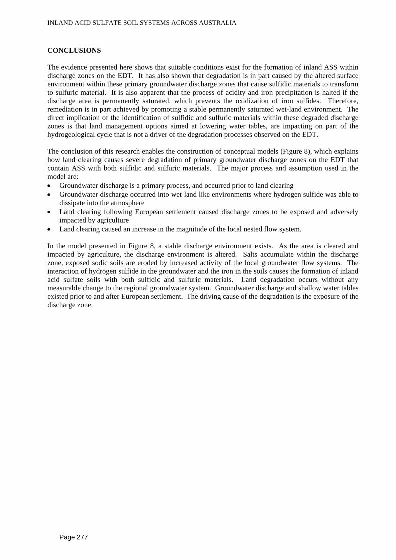
CONCLUSIONS The evidence presented here shows that suitable conditions exist for the formation of inland ASS within discharge zones on the EDT. It has also shown that degradation is in part caused by the altered surface environment within these primary groundwater discharge zones that cause sulfidic materials to transform to sulfuric material. It is also apparent that the process of acidity and iron precipitation is halted if the discharge area is permanently saturated, which prevents the oxidization of iron sulfides. Therefore, remediation is in part achieved by promoting a stable permanently saturated wet-land environment. The direct implication of the identification of sulfidic and sulfuric materials within these degraded discharge zones is that land management options aimed at lowering water tables, are impacting on part of the hydrogeological cycle that is not a driver of the degradation processes observed on the EDT. The conclusion of this research enables the construction of conceptual models (Figure 8), which explains how land clearing causes severe degradation of primary groundwater discharge zones on the EDT that contain ASS with both sulfidic and sulfuric materials. The major process and assumption used in the model are: • Groundwater discharge is a primary process, and occurred prior to land clearing • Groundwater discharge occurred into wet-land like environments where hydrogen sulfide was able to
dissipate into the atmosphere • Land clearing following European settlement caused discharge zones to be exposed and adversely
impacted by agriculture • Land clearing caused an increase in the magnitude of the local nested flow system. In the model presented in Figure 8, a stable discharge environment exists. As the area is cleared and impacted by agriculture, the discharge environment is altered. Salts accumulate within the discharge zone, exposed sodic soils are eroded by increased activity of the local groundwater flow systems. The interaction of hydrogen sulfide in the groundwater and the iron in the soils causes the formation of inland acid sulfate soils with both sulfidic and sulfuric materials. Land degradation occurs without any measurable change to the regional groundwater system. Groundwater discharge and shallow water tables existed prior to and after European settlement. The driving cause of the degradation is the exposure of the discharge zone.
Page 277
INLAND ACID SULFATE SOIL SYSTEMS ACROSS AUSTRALIA
marsh-like springs located along interception of sub soil structures
sub verticalstructure
Horizontal structure
H2S
A horizon
B horizon
regional groundwater system-3-4 dS/m , partially reducedpH 4.5 to 5.5
Water table
local groundwaterflow system 6 -9 dS/m
surface elevation contour
Groundwater flow to discharge zones flows through Saline/sodic soil, but does not intercept iron rich zonesH2S dissipates into the atmosphere
bacterial growthforms on discharge watersFerrihydritegels
free iron onsurface ofdischarge zoneforms overferrous sulfide
Dry MonthsEvaporation and oxidation of discharge water causes ironprecipitates ( Ferrihydrite and Schwertmannite ) and calciumsulfate salts to form. The oxidation of ferrous sulfide causessevere acidity (pH<4).Salts accumulates via evaporation directly within permanentlyflowing discharge zones
seasonal break-of-slopedischarge erodes sodic soils
seasonal high water table
seasonal low water table
seasonal lateral flow spreads saltsconcentrated over summer downslope
Wet monthsH2S in groundwater mobilises iron withinthe soil zone, iron sulfides form that whenoxidised cause severe acidity (pH<4)
ferric iron mobilisedby reduced groundwater
seasonal discharge spreads saline(>10 dS/m) and acidic (pH <4) waterdown-slope
regional groundwater system-3-4 dS/m , partially reduced (H 2S)pH 4.5 to 5.5
iron clogging in soil poresiron crusts on soil surface
salt efflorescence(gypsum) form onsoil surface
iron and saline rich scalding degradespermanent flowing discharge zonessurrounded by eroding sodic soils
permanent flowingdischarge zonesurrounded by iron andsaline scalding
local groundwaterflow system6-9 dS/m , pH 4.8 to 8.1
reduced iron oxidisesand precipitates insoil pores and on the soil surfaceSchwertmanniteand Ferrihydrite
Soil (ECse dS/m > 16pH <5
Gleyed claySaline, sodicand sulfate rich Gleyed clay
Saline, sodicand sulfate rich
permanent groundwater flow
soil salinity >8 dS/m
Seasonal groundwater flow
iron rich soil
permanent groundwater flow
soil salinity >8 dS/m
Seasonal groundwater flow
iron rich soil
Conceptual landscape model illustrating key hydrogeological and soil and water chemical process pre-cleared groundwater discharge zone
Conceptual landscape model illustrating key hydrogeological and soil and water chemical process post-cleared groundwater discharge zone
Figure 8. Conceptual model ACKNOWLEDGEMENTS This research has been supported by the Dame Elisabeth Murdoch Trust, Mr Geoff Handbury, CSIRO Land and Water and The Balmoral Landcare Group. The authors would like to recognize the contribution of the Smith family at Merrifields for providing the field site and the input of Dr William Gardner into the project development.
Page 278
INLAND ACID SULFATE SOIL SYSTEMS ACROSS AUSTRALIA
REFERENCES
Bigham JM, Fitzpatrick RW and Schulze DG, 2002. Iron Oxides. In J.B. Dixon and D. G. Schulze (Editors). Soil Mineralogy with Environmental Applications. Soil Science Society America Book Series No 7. SSSA, Madison, Wisconsin. p 323 – 366Boquier G (1971) "Genèse et évolution de deux toposéquences de sols tropicaux du Tchad. Interprétation biogéodynamique". Thèse Sciences Strasbourg et Mémoires. ORSTOM, 62, 1973, 350 p.
Boulet R, Humbel FX and Lucas Y, 1982. Analyse structural et cartographie en pédologie: II Une méthode d’analyse prenant en compte l’organisation tridimensionnelle des couvertures pédologiques. Cahiers ORSTOM, série Pédologie 19, 323-339.
Brouwer J and Fitzpatrick RW, 2002a. Interpretation of morphological features in a salt-affected duplex soil toposequence with an altered soil water regime in western Victoria. Aust. J. Soil Research. 40: 903-926.
Brouwer J and Fitzpatrick RW, 2002b. Restricting layers, flow paths and correlation between duration of soil saturation and soil morphological features along a hillslope with an altered soil water regime in western Victoria. Australian Journal of Soil Research 40:927-946.
Cossens B, 1999. Groundwater systems of the Eastern Dundas Tablelands. B.App.Sci. (Hons.) University of Ballarat, Australia (Unpublished).
Dahlhaus PG, MacEwan RJ, Nathan EL and Morand VJ, 2000. Salinity on the southeastern Dundas Tableland, Victoria. Australian Journal of Earth Sciences, 47: 3-11.
Domenico PA and Schwartz FW, 1990. Physical and Chemical Hydrogeology. John Wiley and Sons, Sydney
Fawcett J, 2004. Processes and implications of scald formation on the EDT: A case study. PhD, The University of Melbourne (Unpublished).
Fawcett J, Dahlhaus P, Norton R, Fitzpatrick RW, 2009. Hydrogeology related to groundwater discharge zones on the Eastern Dundas Tableland, South Eastern Australia, providing a better understanding of dryland salinity processes. Hydrogeology Journal (Submitted).
Fitzpatrick RW and Brouwer J, 2003. Gatum, Dundas Tableland, south-west Victoria. Regolith Models of Soil-Water Landscape Degradation. In: R. Anand and P. De Broekert (Editors). Regolith-Landscape Evolution Across Australia: A compilation of regolith-landscape case studies and landscape evolution models. Cooperative Research Centre for Landscape Environments and Mineral Exploration (CRC LEME) Monograph. (http://leme.anu.edu.au/). pp. 6.
Fitzpatrick RW, Fritsch E and Self PG, 1996. Interpretation of soil features produced by ancient and modern processes in degrading landscapes: V. Development of saline sulphidic features in non-tidal seepage areas. Geoderma 69, 1-29.
Fitzpatrick RW and Self PG, 1997. Iron oxyhydroxides, sulfides and oxyhydroxysulfates as indicators of acid sulfate surface weathering environment. p. 227-240. In K Auerswald, H Stanjek and JM Bigham (Editors.). Soils and Environment: Soil Processes from Mineral to Landscape Scale, Advances in GeoEcology 30. Catena Verlag, Reiskirchen, Germany.
Fitzpatrick RW and Skwarnecki M, 2003. Mount Torrens, eastern Mount Lofty Ranges, South Australia: Regolith Models of Soil-Water Landscape Degradation. In: R. Anand and P. De Broekert (Editors). Regolith-Landscape Evolution Across Australia: A compilation of regolith-landscape case studies and landscape evolution models. Cooperative Research Centre for Landscape Environments and Mineral Exploration (CRC LEME) Monograph. (http://leme.anu.edu.au/). pp. 5.
Fritsch E, Peterschmitt E and Herbillon AJ, 1992. A structural approach to the regolith: Identification of structures, analysis of structural relationships and interpretations. Sciences Géologiques, 45(2), 77-97.
Fritsch E and Fitzpatrick RW, 1994. Interpretation of soil features produced by ancient and modern processes in degraded landscapes: I A new method for constructing conceptual soil-water-landscape models. Australian Journal of Soil Research 32, 889-907.
Page 279

INLAND ACID SULFATE SOIL SYSTEMS ACROSS AUSTRALIA
Gibbons FR and Downes RG, 1964. A study of the land in south-western Victoria. Soil Conservation Authority, Kew, Victoria Australia.
Isbell RF, 2002. The Australian Soil Classification. CSIRO Australia.
Jerinic FL, 1993. A hydrogeological study of dryland salinity in the Bulart region, western Victoria. B.App.Sci.(Hons.), Ballarat University, Australia (Unpublished).
Lewis MF, 1985. Factors affecting the development of dryland salinity in a catchment on the Dundas Tableland, Western Victoria. Land Protection Service internal report, Dept. of Conservation, Forests and Lands, Victoria.
Munroe M, 1998. Salinity discharge mapping for the Dundas Tableland in the Glenelg Salinty Region. Department of Natural Resources and Environment, Victoria.
Nathan EL, 1998. Dundas Landscapes and Dryland Salinity. M.App.Sci., University of Ballarat, Australia (Unpublished).
Paine MD and Phang C, 2005. Dundas Tableland, Victoria. In: R.R. Anand and P. De Broekert, (Editors.). Regolith Landscape Evolution Across Australia. A compilation of regolith landscape case studies with regolith landscape evolution models. Cooperative Research Centre for Landscape Environments and Mineral exploration. pp 242-245.
Rengasamy P, 2002. Transient soil salinity and subsoil constraints to dryland farming in Australian sodic soils: an overview. Australian Journal of Experimental Agriculture 42, 1-11.
Tóth J, 1962. A theoretical analysis of groundwater flow in small drainage basins. Journal of Geophysical Research 68, 4795-4812.
Tóth J, 1999. Groundwater as a geological agent: An overview of the causes, processes, and manifestations. Hydrogeology Journal 7, 1-14.
Page 280