Embed Size (px)
Citation preview
1
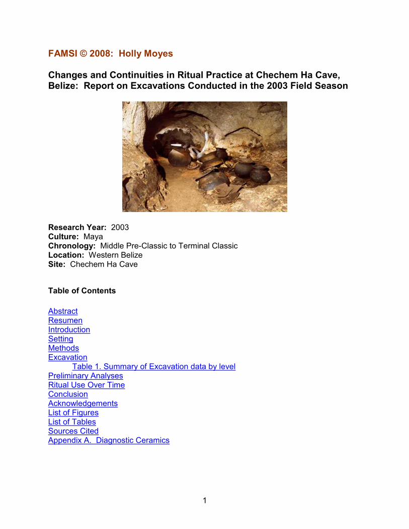
FAMSI © 2008: Holly Moyes Changes and Continuities in Ritual Practice at Chechem Ha Cave, Belize: Report on Excavations Conducted in the 2003 Field Season
Research Year: 2003 Culture: Maya Chronology: Middle Pre-Classic to Terminal Classic Location: Western Belize Site: Chechem Ha Cave
Table of Contents
Abstract Resumen Introduction Setting Methods Excavation Table 1. Summary of Excavation data by level Preliminary Analyses Ritual Use Over Time Conclusion Acknowledgements List of Figures List of Tables Sources Cited Appendix A. Diagnostic Ceramics
2
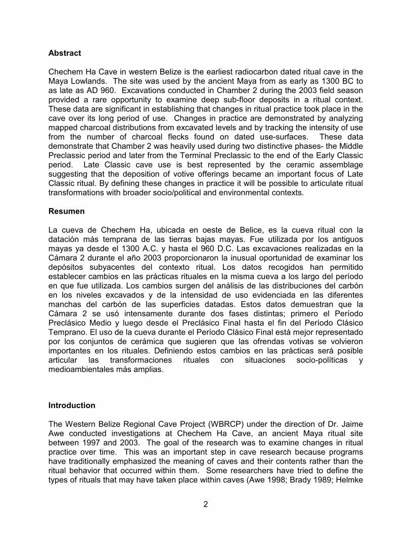
Abstract
Chechem Ha Cave in western Belize is the earliest radiocarbon dated ritual cave in the Maya Lowlands. The site was used by the ancient Maya from as early as 1300 BC to as late as AD 960. Excavations conducted in Chamber 2 during the 2003 field season provided a rare opportunity to examine deep sub-floor deposits in a ritual context. These data are significant in establishing that changes in ritual practice took place in the cave over its long period of use. Changes in practice are demonstrated by analyzing mapped charcoal distributions from excavated levels and by tracking the intensity of use from the number of charcoal flecks found on dated use-surfaces. These data demonstrate that Chamber 2 was heavily used during two distinctive phases- the Middle Preclassic period and later from the Terminal Preclassic to the end of the Early Classic period. Late Classic cave use is best represented by the ceramic assemblage suggesting that the deposition of votive offerings became an important focus of Late Classic ritual. By defining these changes in practice it will be possible to articulate ritual transformations with broader socio/political and environmental contexts.
Resumen
La cueva de Chechem Ha, ubicada en oeste de Belice, es la cueva ritual con la datación más temprana de las tierras bajas mayas. Fue utilizada por los antiguos mayas ya desde el 1300 A.C. y hasta el 960 D.C. Las excavaciones realizadas en la Cámara 2 durante el año 2003 proporcionaron la inusual oportunidad de examinar los depósitos subyacentes del contexto ritual. Los datos recogidos han permitido establecer cambios en las prácticas rituales en la misma cueva a los largo del período en que fue utilizada. Los cambios surgen del análisis de las distribuciones del carbón en los niveles excavados y de la intensidad de uso evidenciada en las diferentes manchas del carbón de las superficies datadas. Estos datos demuestran que la Cámara 2 se usó intensamente durante dos fases distintas; primero el Período Preclásico Medio y luego desde el Preclásico Final hasta el fin del Período Clásico Temprano. El uso de la cueva durante el Período Clásico Final está mejor representado por los conjuntos de cerámica que sugieren que las ofrendas votivas se volvieron importantes en los rituales. Definiendo estos cambios en las prácticas será posible articular las transformaciones rituales con situaciones socio-políticas y medioambientales más amplias.
Introduction
The Western Belize Regional Cave Project (WBRCP) under the direction of Dr. Jaime Awe conducted investigations at Chechem Ha Cave, an ancient Maya ritual site between 1997 and 2003. The goal of the research was to examine changes in ritual practice over time. This was an important step in cave research because programs have traditionally emphasized the meaning of caves and their contents rather than the ritual behavior that occurred within them. Some researchers have tried to define the types of rituals that may have taken place within caves (Awe 1998; Brady 1989; Helmke
3
& Awe 1998, 2001; Moorehart 2002a, 2002b; Pohl 1981; Pohl & Pohl 1983, Reents-Budet & MacLeod 1997; Stone 1995), but despite years of research, little is known about ritual practice or its continuity and change over time. One of the reasons for this is that that chronology in caves is difficult to establish. Major artifacts and features are often surface deposits that become co-mingled. Although ceramic chronologies can provide estimates of when a cave was utilized, the palimpsest nature of these deposits interferes with the determination of absolute dates from preserved or charred organic remains. In some cases the investigation of both sub-surface deposits and radiocarbon dating may help sort out chronologies, but unlike surface sites, the enclosed cave environment often prevents a thick sediment buildup. The deep sub-floor deposits in Chechem Ha Cave were exceptional and provided a rare opportunity to evaluate undisturbed deposits in a cave context. The 2003 excavations in Chamber 2 funded by FAMSI, were initiated to examine changes in ritual practice within the chamber during the course of its long-term use from the early part of the Middle Preclassic through the Late Classic period. A new methodology described below examines changes in the intensity of use of the chamber over time as well as differences in the choice of activity areas. This method is paired with an intensive dating program.
Setting
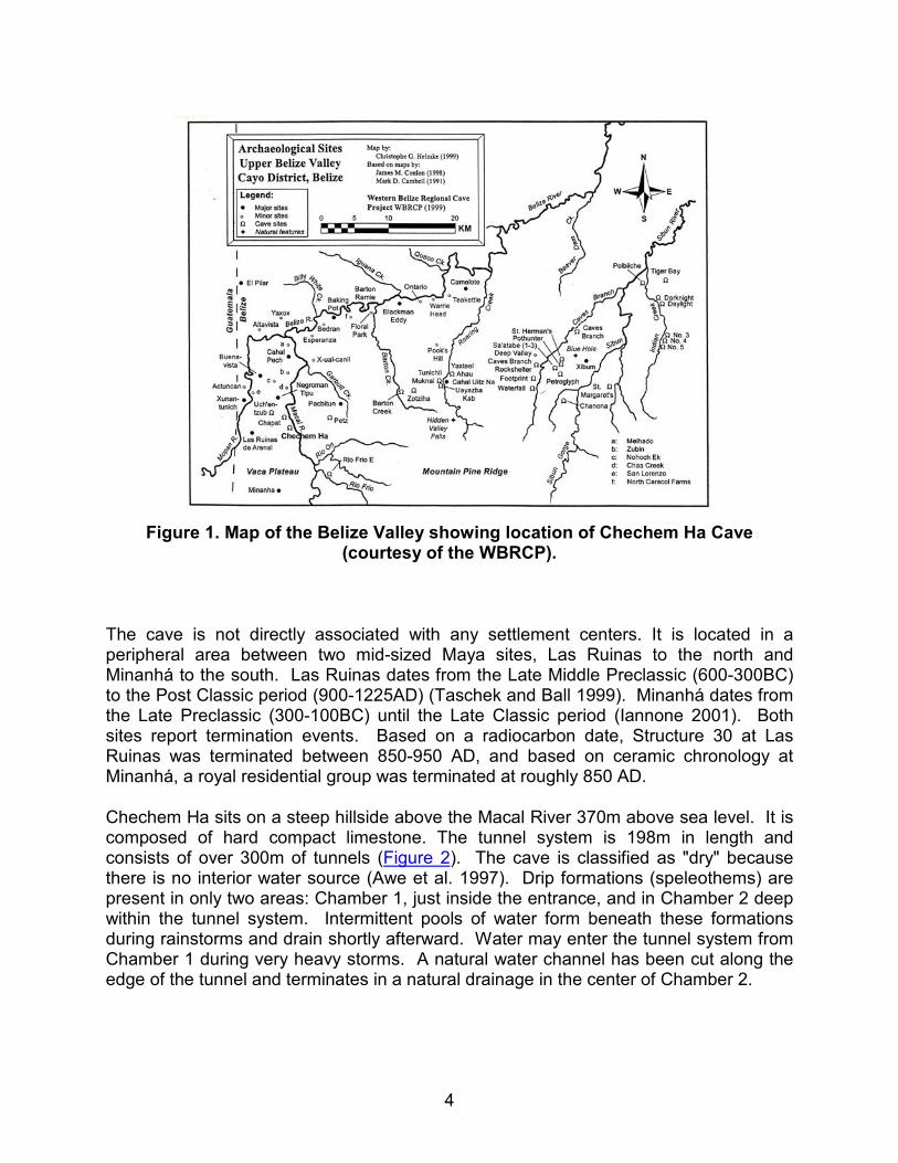
Chechem Ha is a complex cave system located in western Belize (Figure 1). It is an un-looted ancient Maya ritual site discovered in 1989, and may be one of the most remarkable finds in Maya cave archaeology. Although the cave was opened for tourism long before archaeological investigations commenced, conscientious curation by the owners has preserved much of the data and the cave still offers a fruitful venue for the study of ancient ritual practice.
4
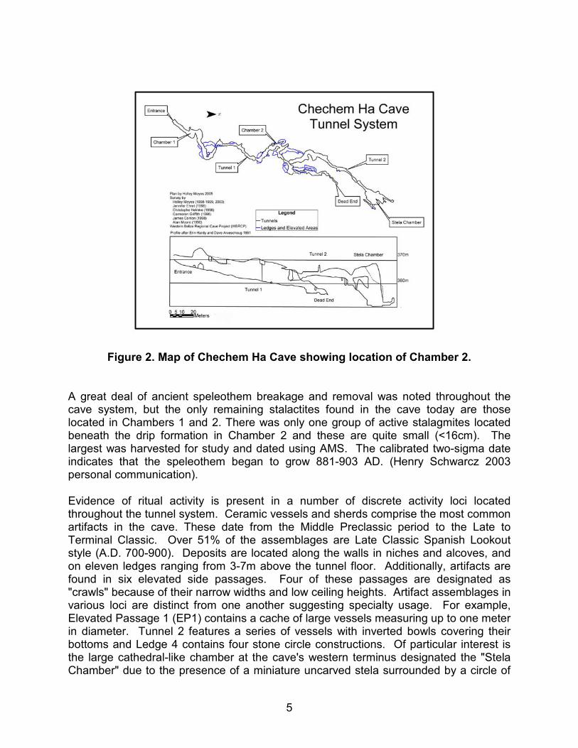
Figure 1. Map of the Belize Valley showing location of Chechem Ha Cave
(courtesy of the WBRCP).
The cave is not directly associated with any settlement centers. It is located in a peripheral area between two mid-sized Maya sites, Las Ruinas to the north and Minanhá to the south. Las Ruinas dates from the Late Middle Preclassic (600-300BC) to the Post Classic period (900-1225AD) (Taschek and Ball 1999). Minanhá dates from the Late Preclassic (300-100BC) until the Late Classic period (Iannone 2001). Both sites report termination events. Based on a radiocarbon date, Structure 30 at Las Ruinas was terminated between 850-950 AD, and based on ceramic chronology at Minanhá, a royal residential group was terminated at roughly 850 AD.
Chechem Ha sits on a steep hillside above the Macal River 370m above sea level. It is composed of hard compact limestone. The tunnel system is 198m in length and consists of over 300m of tunnels (Figure 2). The cave is classified as "dry" because there is no interior water source (Awe et al. 1997). Drip formations (speleothems) are present in only two areas: Chamber 1, just inside the entrance, and in Chamber 2 deep within the tunnel system. Intermittent pools of water form beneath these formations during rainstorms and drain shortly afterward. Water may enter the tunnel system from Chamber 1 during very heavy storms. A natural water channel has been cut along the edge of the tunnel and terminates in a natural drainage in the center of Chamber 2.
5
Figure 2. Map of Chechem Ha Cave showing location of Chamber 2.
A great deal of ancient speleothem breakage and removal was noted throughout the cave system, but the only remaining stalactites found in the cave today are those located in Chambers 1 and 2. There was only one group of active stalagmites located beneath the drip formation in Chamber 2 and these are quite small (<16cm). The largest was harvested for study and dated using AMS. The calibrated two-sigma date indicates that the speleothem began to grow 881-903 AD. (Henry Schwarcz 2003 personal communication).
Evidence of ritual activity is present in a number of discrete activity loci located throughout the tunnel system. Ceramic vessels and sherds comprise the most common artifacts in the cave. These date from the Middle Preclassic period to the Late to Terminal Classic. Over 51% of the assemblages are Late Classic Spanish Lookout style (A.D. 700-900). Deposits are located along the walls in niches and alcoves, and on eleven ledges ranging from 3-7m above the tunnel floor. Additionally, artifacts are found in six elevated side passages. Four of these passages are designated as "crawls" because of their narrow widths and low ceiling heights. Artifact assemblages in various loci are distinct from one another suggesting specialty usage. For example, Elevated Passage 1 (EP1) contains a cache of large vessels measuring up to one meter in diameter. Tunnel 2 features a series of vessels with inverted bowls covering their bottoms and Ledge 4 contains four stone circle constructions. Of particular interest is the large cathedral-like chamber at the cave's western terminus designated the "Stela Chamber" due to the presence of a miniature uncarved stela surrounded by a circle of
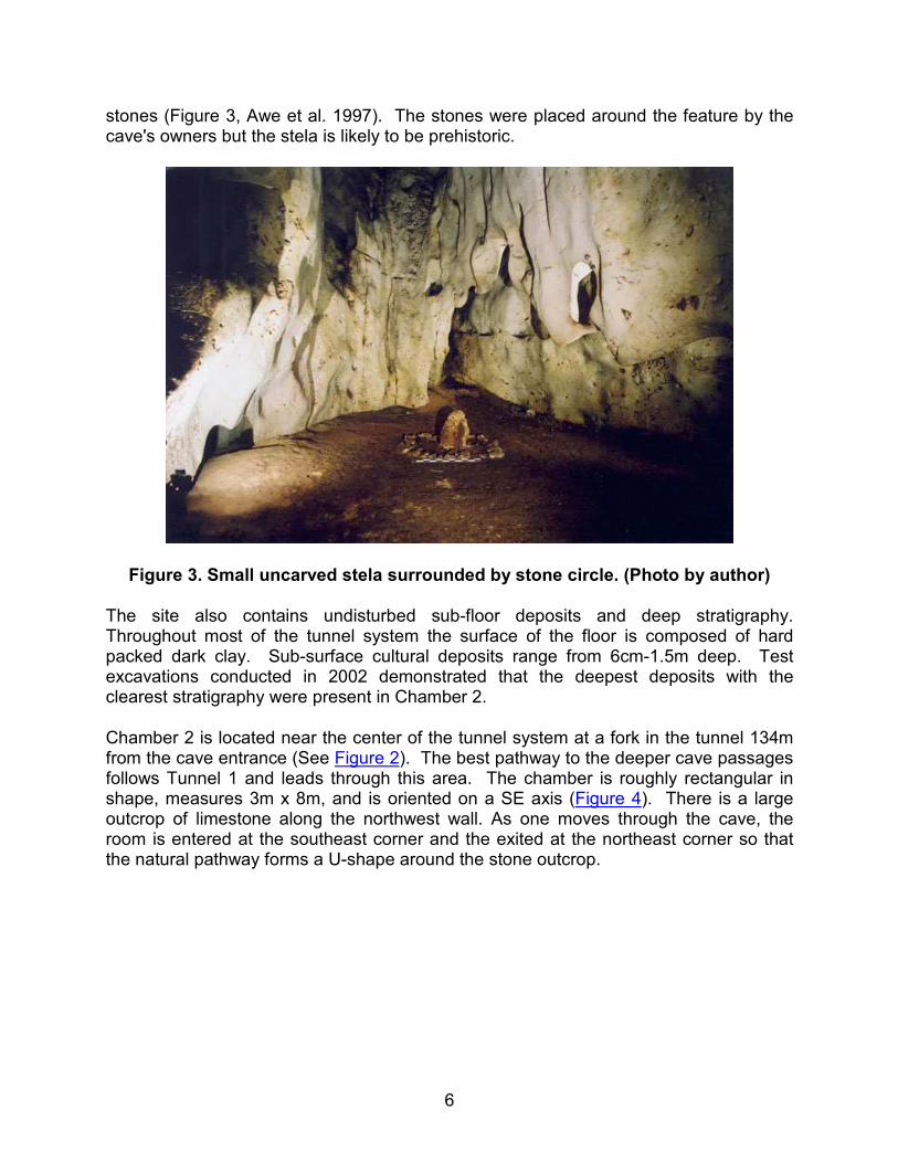
6
stones (Figure 3, Awe et al. 1997). The stones were placed around the feature by the cave's owners but the stela is likely to be prehistoric.
Figure 3. Small uncarved stela surrounded by stone circle. (Photo by author)
The site also contains undisturbed sub-floor deposits and deep stratigraphy. Throughout most of the tunnel system the surface of the floor is composed of hard packed dark clay. Sub-surface cultural deposits range from 6cm-1.5m deep. Test excavations conducted in 2002 demonstrated that the deepest deposits with the clearest stratigraphy were present in Chamber 2.
Chamber 2 is located near the center of the tunnel system at a fork in the tunnel 134m from the cave entrance (See Figure 2). The best pathway to the deeper cave passages follows Tunnel 1 and leads through this area. The chamber is roughly rectangular in shape, measures 3m x 8m, and is oriented on a SE axis (Figure 4). There is a large outcrop of limestone along the northwest wall. As one moves through the cave, the room is entered at the southeast corner and the exited at the northeast corner so that the natural pathway forms a U-shape around the stone outcrop.
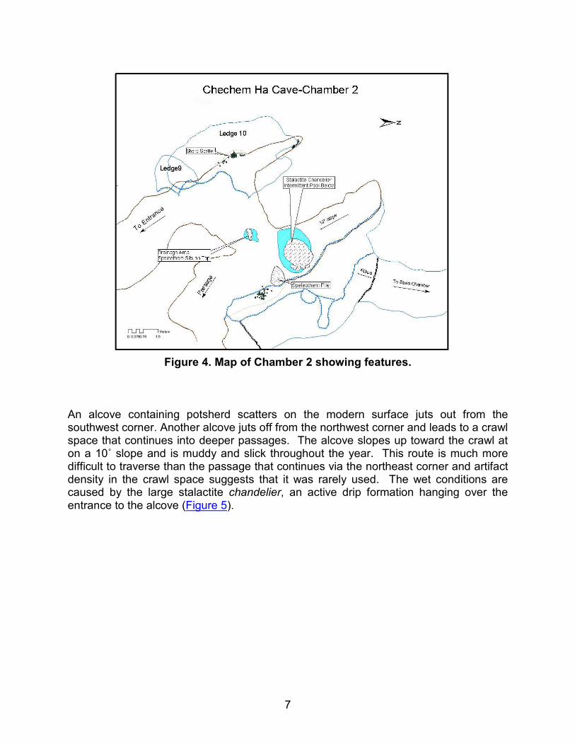
7
Figure 4. Map of Chamber 2 showing features.
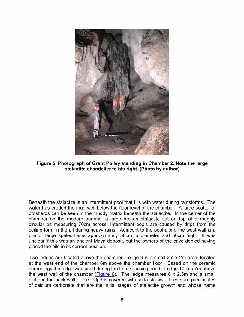
An alcove containing potsherd scatters on the modern surface juts out from the southwest corner. Another alcove juts off from the northwest corner and leads to a crawl space that continues into deeper passages. The alcove slopes up toward the crawl at on a 10˚ slope and is muddy and slick throughout the year. This route is much more difficult to traverse than the passage that continues via the northeast corner and artifact density in the crawl space suggests that it was rarely used. The wet conditions are caused by the large stalactite chandelier, an active drip formation hanging over the entrance to the alcove (Figure 5).
8
Figure 5. Photograph of Grant Polley standing in Chamber 2. Note the large stalactite chandelier to his right. (Photo by author)
Beneath the stalactite is an intermittent pool that fills with water during rainstorms. The water has eroded the mud well below the floor level of the chamber. A large scatter of potsherds can be seen in the muddy matrix beneath the stalactite. In the center of the chamber on the modern surface, a large broken stalactite sat on top of a roughly circular pit measuring 70cm across. Intermittent pools are caused by drips from the ceiling form in the pit during heavy rains. Adjacent to the pool along the west wall is a pile of large speleothems approximately 50cm in diameter and 50cm high. It was unclear if this was an ancient Maya deposit, but the owners of the cave denied having placed the pile in its current position.
Two ledges are located above the chamber. Ledge 9 is a small 2m x 2m area, located at the west end of the chamber 6m above the chamber floor. Based on the ceramic chronology the ledge was used during the Late Classic period. Ledge 10 sits 7m above the west wall of the chamber (Figure 6). The ledge measures 6 x 2.5m and a small niche in the back wall of the ledge is covered with soda straws. These are precipitates of calcium carbonate that are the initial stages of stalactite growth and whose name
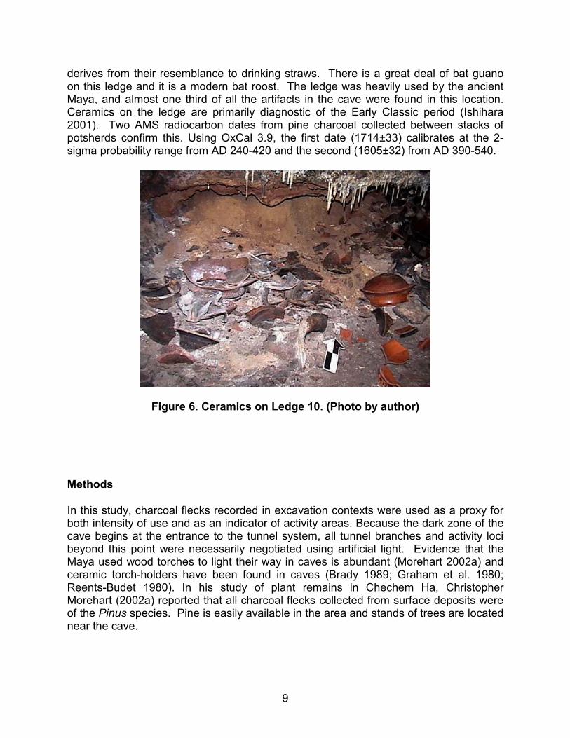
9
derives from their resemblance to drinking straws. There is a great deal of bat guano on this ledge and it is a modern bat roost. The ledge was heavily used by the ancient Maya, and almost one third of all the artifacts in the cave were found in this location. Ceramics on the ledge are primarily diagnostic of the Early Classic period (Ishihara 2001). Two AMS radiocarbon dates from pine charcoal collected between stacks of potsherds confirm this. Using OxCal 3.9, the first date (1714±33) calibrates at the 2-sigma probability range from AD 240-420 and the second (1605±32) from AD 390-540.
Figure 6. Ceramics on Ledge 10. (Photo by author)
Methods
In this study, charcoal flecks recorded in excavation contexts were used as a proxy for both intensity of use and as an indicator of activity areas. Because the dark zone of the cave begins at the entrance to the tunnel system, all tunnel branches and activity loci beyond this point were necessarily negotiated using artificial light. Evidence that the Maya used wood torches to light their way in caves is abundant (Morehart 2002a) and ceramic torch-holders have been found in caves (Brady 1989; Graham et al. 1980; Reents-Budet 1980). In his study of plant remains in Chechem Ha, Christopher Morehart (2002a) reported that all charcoal flecks collected from surface deposits were of the Pinus species. Pine is easily available in the area and stands of trees are located near the cave.
10
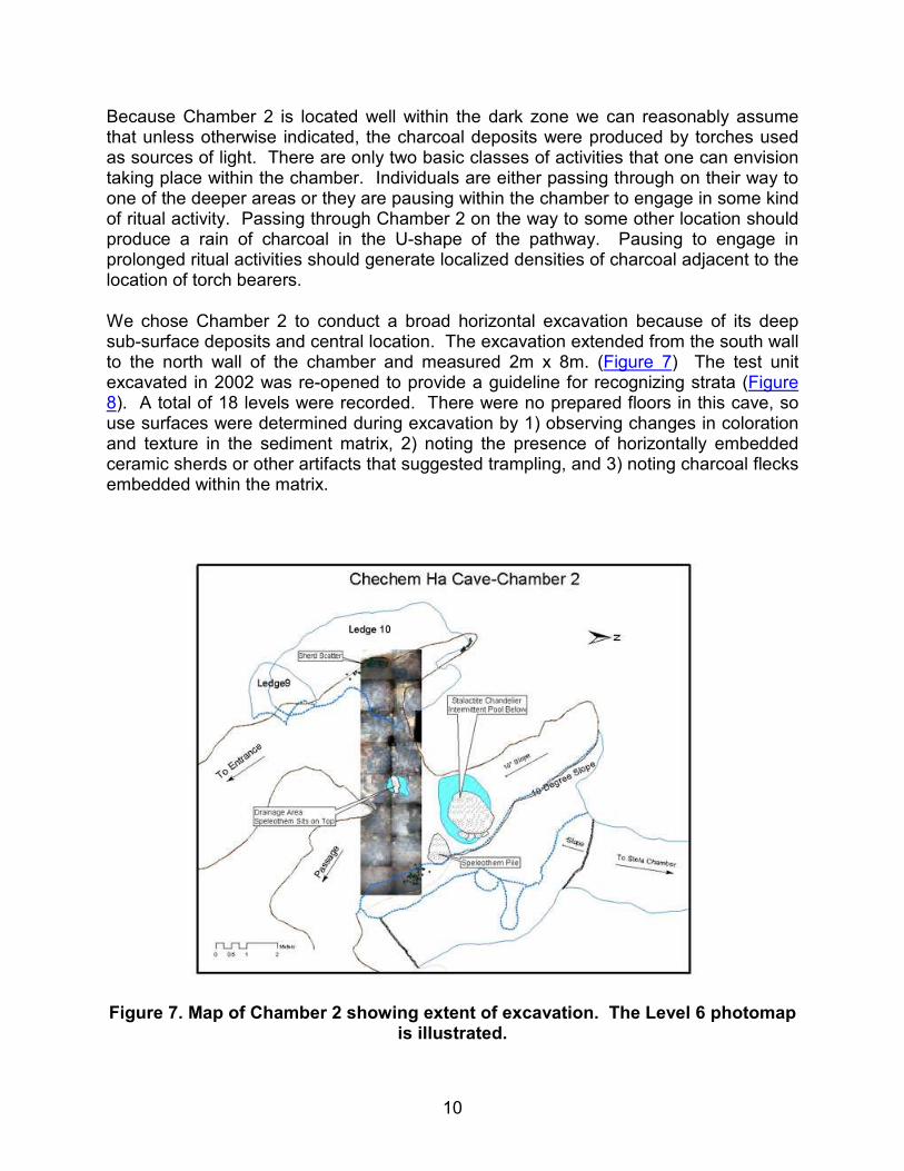
Because Chamber 2 is located well within the dark zone we can reasonably assume that unless otherwise indicated, the charcoal deposits were produced by torches used as sources of light. There are only two basic classes of activities that one can envision taking place within the chamber. Individuals are either passing through on their way to one of the deeper areas or they are pausing within the chamber to engage in some kind of ritual activity. Passing through Chamber 2 on the way to some other location should produce a rain of charcoal in the U-shape of the pathway. Pausing to engage in prolonged ritual activities should generate localized densities of charcoal adjacent to the location of torch bearers.
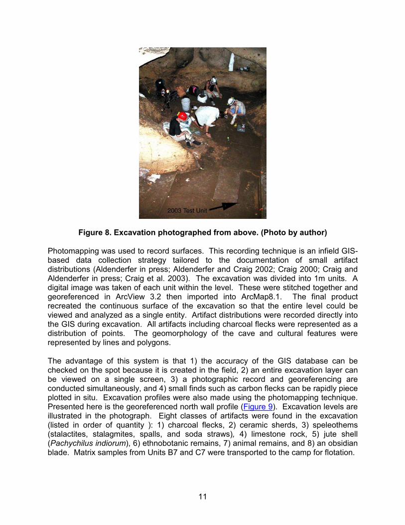
We chose Chamber 2 to conduct a broad horizontal excavation because of its deep sub-surface deposits and central location. The excavation extended from the south wall to the north wall of the chamber and measured 2m x 8m. (Figure 7) The test unit excavated in 2002 was re-opened to provide a guideline for recognizing strata (Figure 8). A total of 18 levels were recorded. There were no prepared floors in this cave, so use surfaces were determined during excavation by 1) observing changes in coloration and texture in the sediment matrix, 2) noting the presence of horizontally embedded ceramic sherds or other artifacts that suggested trampling, and 3) noting charcoal flecks embedded within the matrix.
Figure 7. Map of Chamber 2 showing extent of excavation. The Level 6 photomap
is illustrated.
11
Figure 8. Excavation photographed from above. (Photo by author)
Photomapping was used to record surfaces. This recording technique is an infield GIS-based data collection strategy tailored to the documentation of small artifact distributions (Aldenderfer in press; Aldenderfer and Craig 2002; Craig 2000; Craig and Aldenderfer in press; Craig et al. 2003). The excavation was divided into 1m units. A digital image was taken of each unit within the level. These were stitched together and georeferenced in ArcView 3.2 then imported into ArcMap8.1. The final product recreated the continuous surface of the excavation so that the entire level could be viewed and analyzed as a single entity. Artifact distributions were recorded directly into the GIS during excavation. All artifacts including charcoal flecks were represented as a distribution of points. The geomorphology of the cave and cultural features were represented by lines and polygons.
The advantage of this system is that 1) the accuracy of the GIS database can be checked on the spot because it is created in the field, 2) an entire excavation layer can be viewed on a single screen, 3) a photographic record and georeferencing are conducted simultaneously, and 4) small finds such as carbon flecks can be rapidly piece plotted in situ. Excavation profiles were also made using the photomapping technique. Presented here is the georeferenced north wall profile (Figure 9). Excavation levels are illustrated in the photograph. Eight classes of artifacts were found in the excavation (listed in order of quantity ): 1) charcoal flecks, 2) ceramic sherds, 3) speleothems (stalactites, stalagmites, spalls, and soda straws), 4) limestone rock, 5) jute shell (Pachychilus indiorum), 6) ethnobotanic remains, 7) animal remains, and 8) an obsidian blade. Matrix samples from Units B7 and C7 were transported to the camp for flotation.
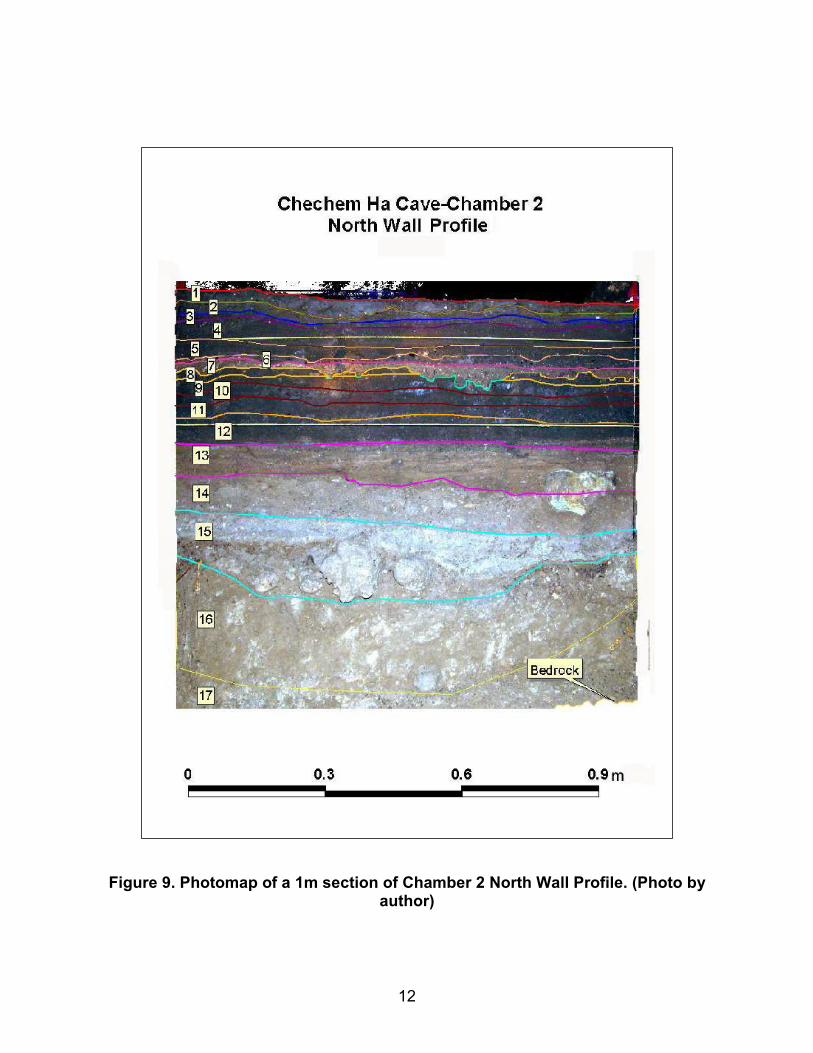
12
Figure 9. Photomap of a 1m section of Chamber 2 North Wall Profile. (Photo by
author)
13
Charcoal flecks recorded and mapped on use surfaces represent a slice of time and create a picture of spatial usage on a horizontal surface. Numbers of flecks are indicative of the intensity of use on individual surfaces whereas the charcoal recovered from flotation indicates the intensity of usage between levels. Charcoal from the flotation was weighed in order to estimate changes in the amounts between levels. It is likely that these are underestimated due to charcoal breakage during flotation and that the flecks recorded on use-surfaces are a better proxy. To ensure temporal control each level was dated using pine charcoal. A sample from each surface was sent to the AMS dating facility at the University of Arizona. Results were calibrated using Oxcal 3.9 and reported at the two-sigma range.
Excavation
Although more than one matrix type is present in each level, laboratory analysis indicated that, with the exception of Level 7, the primary texture characterization throughout the excavation was clay. Several observations suggested that 2:1 clays (shrink/swell) were present in the matrix: 1) we noted crack patterns on the surfaces of many areas, 2) the sediment was very sticky, and 3) samples brought from the field shrank considerably when dried. Preliminary XRD analysis indicates that the sediment contains mixed clays which include 2:1 varieties as well as kaolinites. Besides the heavy clays, the entire deposit contains bat guano in varying percentages within each layer as well as differing amounts of limestone marl.
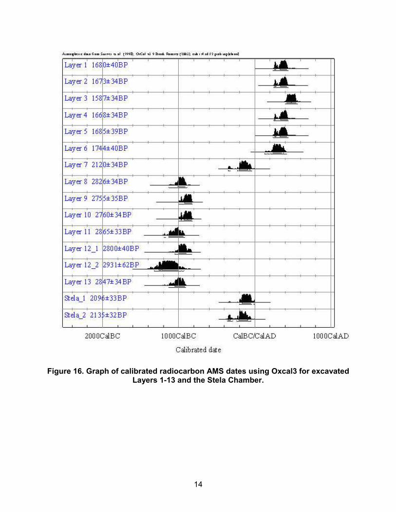
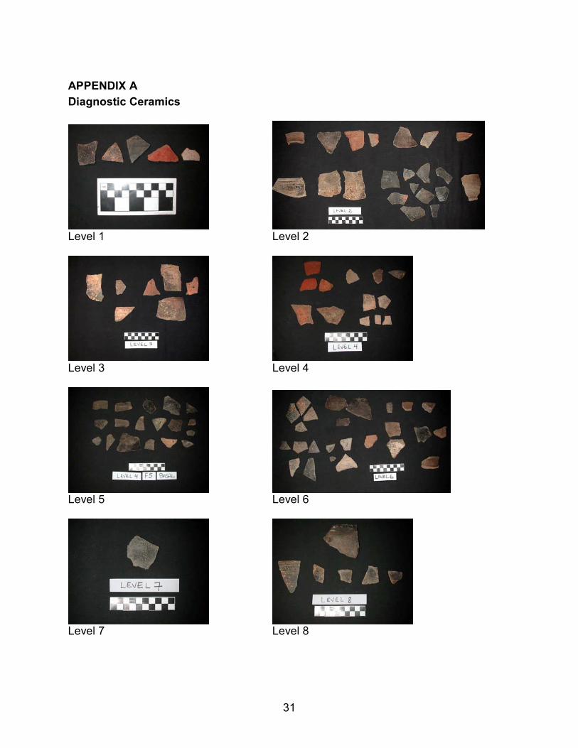
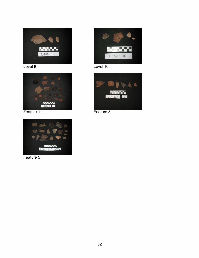
Below is a brief description of each level that includes the most interesting findings in each. Diagnostic ceramics are pictured in Appendix A. The excavation data is compiled in Table 1. Although there is overlap at the two-sigma range some of the AMS dates (See Figure 16), the stratigraphy of the excavation was clear and layers do not appear to be mixed to any significant degree (See Figure 9).
14
Figure 16. Graph of calibrated radiocarbon AMS dates using Oxcal3 for excavated Layers 1-13 and the Stela Chamber.
15
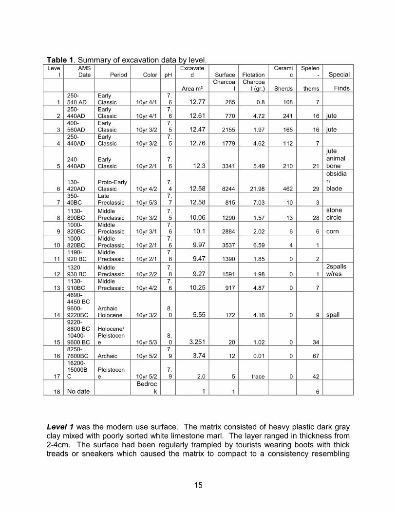
Table 1. Summary of excavation data by level. Leve
l AMS Date Period Color pH
Excavated Surface Flotation
Ceramic
Speleo- Special
Area m² Charcoa
l Charcoal (gr.) Sherds thems Finds
1 250- 540 AD
Early Classic 10yr 4/1
7.6 12.77 265 0.8 108 7
2 250-440AD
Early Classic 10yr 4/1
7.6 12.61 770 4.72 241 16 jute
3 400-560AD
Early Classic 10yr 3/2
7.5 12.47 2155 1.97 165 16 jute
4 250-440AD
Early Classic 10yr 3/2
7.5 12.76 1779 4.62 112 7
5 240-440AD
Early Classic 10yr 2/1
7.6 12.3 3341 5.49 210 21
jute animal bone
6 130-420AD
Proto-Early Classic 10yr 4/2
7.4 12.58 8244 21.98 462 29
obsidian blade
7 350-40BC
Late Preclassic 10yr 5/3
7.7 12.58 815 7.03 10 3
8 1130-890BC
Middle Preclassic 10yr 3/2
7.5 10.06 1290 1.57 13 28
stone circle
9 1000-820BC
Middle Preclassic 10yr 3/1
7.6 10.1 2884 2.02 6 6 corn
10 1000-820BC
Middle Preclassic 10yr 2/1
7.6 9.97 3537 6.59 4 1
11 1190- 920 BC
Middle Preclassic 10yr 2/1
7.8 9.47 1390 1.85 0 2
12 1320 930 BC
Middle Preclassic 10yr 2/2
7.8 9.27 1591 1.98 0 1
2spalls w/res
13 1130-910BC
Middle Preclassic 10yr 4/2
7.6 10.25 917 4.87 0 7
14
4690-4450 BC 9600-9220BC
Archaic Holocene 10yr 3/2
8.0 5.55 172 4.16 0 9 spall
15
9220-8800 BC 10400-9600 BC
Holocene/ Pleistocene 10yr 5/3
8.0 3.251 20 1.02 0 34
16 8250-7600BC Archaic 10yr 5/2
7.9 3.74 12 0.01 0 67
17
16200-15000BC
Pleistocene 10yr 5/2
7.9 2.0 5 trace 0 42
18 No date Bedroc
k 1 1 6
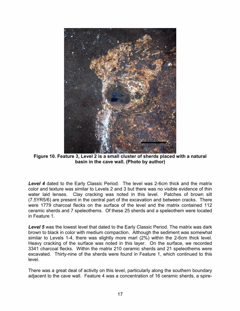
Level 1 was the modern use surface. The matrix consisted of heavy plastic dark gray clay mixed with poorly sorted white limestone marl. The layer ranged in thickness from 2-4cm. The surface had been regularly trampled by tourists wearing boots with thick treads or sneakers which caused the matrix to compact to a consistency resembling
16
modeling clay. In the center of the chamber in the area we noted above as a natural drain was an oval shaped pit measuring 60 x 80cm designated Feature 1. The matrix within the pit was wetter than that of the rest of the level and this continued throughout every level to bedrock. On top of the pit sat a stalactite fragment measuring 55 x 72cm.
The plastic matrix of the layer literally peeled away revealing the shiny smooth surface of Level 2 below. On the modern surface 265 charcoal flecks were recorded. Within the unit matrix there were 108 ceramic sherds and seven small soda straws. Data recovered from the flotation of Unit B7 is likely to be underestimated due to the heavy clay matrix and problems with deflocculating this sample. This level is probably of limited analytical value because of the impact of modern usage.
Level 2 dated to the Early Classic Period. The surface of this layer was unusual because the texture was smooth and shiny. The color was dark gray similar to Level 1, was mixed with 1% marl, and was 1-2cm in thickness. Although the matrix was primarily clay, thin lenses of sand and silt were present in the northwest area of the excavation. These thin strata can be seen in the north wall profile (See Figure 9). Preliminary analysis of the unit's micromorphology suggests that these deposits were water-laid. On the Level 2 surface there were 770 charcoal flecks. The layer contained 241 ceramic sherds, a single spire-lopped jute shell, and 16 speleothems all of which were small soda straws.
Level 3 dated to the Early Classic Period. It consisted of a clay or clay-like matrix of medium compaction containing 1% fine marl. The color was dark grayish brown and the level was 1-2cm thick. Thin lenses of water laid silt and sand were also present in this level particularly in the center and the northwest areas of the excavation. There were 2155 charcoal flecks recorded on the surface of the level. The matrix contained 165 ceramic sherds, 16 small speleothems, and a single spire-lopped jute shell. Two features were present and both were located in the northwestern part of the excavation. In this area, the cave wall slopes inward and there was little sediment covering the bedrock. Ceramic sherds were deposited on the bedrock in two small natural depressions measuring 8-10cm in diameter (Figure 10, Feature 3). This type of feature has also been noted in surface deposits throughout the cave.
17
Figure 10. Feature 3, Level 2 is a small cluster of sherds placed with a natural
basin in the cave wall. (Photo by author)
Level 4 dated to the Early Classic Period. The level was 2-6cm thick and the matrix color and texture was similar to Levels 2 and 3 but there was no visible evidence of thin water laid lenses. Clay cracking was noted in this level. Patches of brown silt (7.5YR5/6) are present in the central part of the excavation and between cracks. There were 1779 charcoal flecks on the surface of the level and the matrix contained 112 ceramic sherds and 7 speleothems. Of these 25 sherds and a speleothem were located in Feature 1.
Level 5 was the lowest level that dated to the Early Classic Period. The matrix was dark brown to black in color with medium compaction. Although the sediment was somewhat similar to Levels 1-4, there was slightly more marl (2%) within the 2-6cm thick level. Heavy cracking of the surface was noted in this layer. On the surface, we recorded 3341 charcoal flecks. Within the matrix 210 ceramic sherds and 21 speleothems were excavated. Thirty-nine of the sherds were found in Feature 1, which continued to this level.
There was a great deal of activity on this level, particularly along the southern boundary adjacent to the cave wall. Feature 4 was a concentration of 16 ceramic sherds, a spire-
18
lopped jute shell, and an animal bone fragment. There was burning a good deal of charcoal associated with this deposit. Some of the wood was only partially charred. Adjacent to the wall and 30cm north of Feature 4 was Feature 5. This was a concentration of 74 ceramic sherds, a spire-lopped jute shell, and a great deal of carbonized wood. Interestingly, both of these deposits were located directly below sherd concentrations found on the modern surface
Level 6 dated to the Proto-Early Classic Period. The sediment in this layer was clay or clay-like, dark grayish brown in color, and mixed with 20% marl. Orange to brown (7.5yr4/4) patches of silt were also present throughout the level. Although the level was only 1-3cm thick, the amount of charcoal from the intra layer flotation was much higher than in other layers (21.98gr). The matrix also contained 462 ceramic sherds and 29 speleothems. Additionally, the numbers of charcoal flecks on the surface of the level were the highest recorded in the excavation (8244). A stalagmite was encountered on this level. Although speleothems were found on all levels, this was the first time that we encountered a stalagmite in the excavation.
Features 4 and 5 both originated on this level and were used continuously through Level 4. An obsidian blade fragment was found under a cobble at the base of Feature 5.
Level 7 dated to the Late Preclassic Period. The sediment on this level was less compacted as compared with others, the color was light brown to yellowish brown, was 1-2cm thick, and contained 4% marl. An XRD analysis of this deposit demonstrated that, although the deposit had the texture of clay loam, it is almost entirely organic. The high phosphate (16.13%) and elevated copper content (300 ppm) of this level further suggested that it was composed primarily of bat guano. On the surface there were 815 charcoal flecks and from the matrix only 10 ceramic sherds and 3 speleothems were recovered.
Level 8 dated to the Middle Preclassic Period. The sediment was very dark grayish brown, medium compaction, 1-3cm thick, and was mixed with 2% marl. Crack patterns were present throughout the matrix. On the surface of the level there were 1290 charcoal flecks and in the matrix there were 13 ceramic sherds and 28 speleothems. The speleothems within this level were larger than in levels 1-7. A circle of 14 cobble-sized limestone rocks and one speleothem was found adjacent to the east wall of the cave. This feature was located directly below Feature 4 on Level 5.
Level 9 dated to the Middle Preclassic Period. The matrix was very dark gray, contained little marl, was 2-4cm thick, and exhibited medium to heavy compaction. Patches of different dark yellowish brown matrix mixed with poorly sorted sand were also found on this level. On the surface of the level 2884 charcoal flecks were recorded and there were 6 ceramic sherds and 6 speleothems collected from the matrix. Two well-preserved corn kernels were recovered from flotation.
19
Level 10 dated to the Middle Preclassic Period. The matrix was dark brown to black in color, 2-3cm thick, and contained little marl. There were numerous crack patterns in this layer and lighter colored sediment filled the cracks. On the surface of this level were 3537 charcoal flecks and in the matrix, 4 ceramic sherds and 1 speleothem. This was stratigraphically the lowest level in the excavation that contained ceramic sherds.
Level 11 dated to the Middle Preclassic Period. The matrix was very similar to that of Level 10 but was mixed with slightly more marl. It was 2-4cm thick. There were 1390 charcoal flecks present on the surface and 2 speleothems found in the matrix.
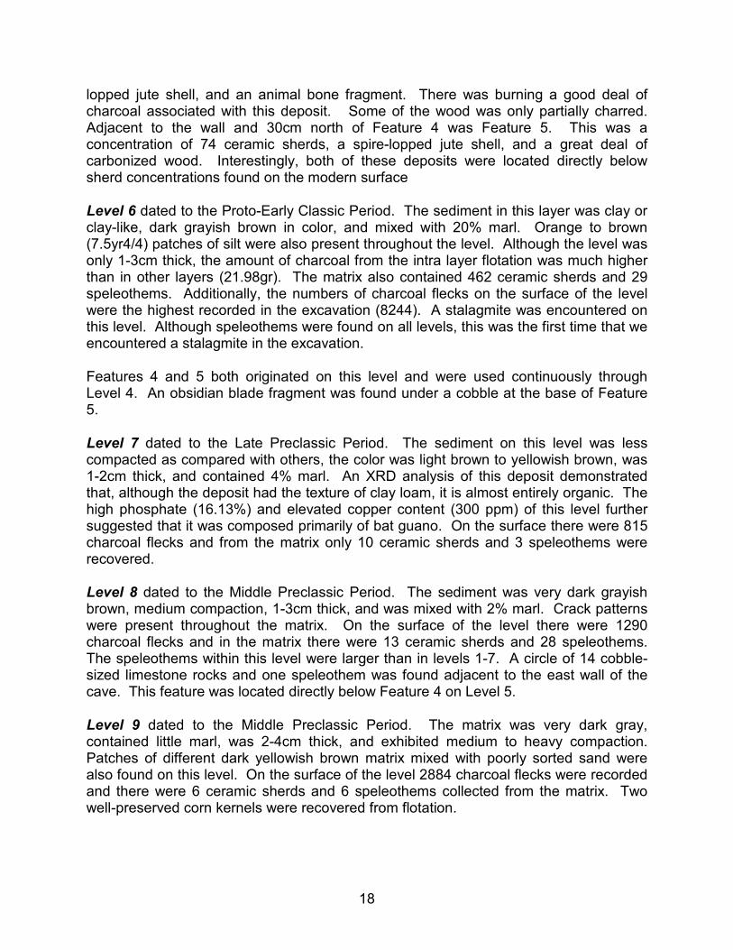
Level 12 dated to the Middle Preclassic Period. The 5-7cm thick sediment was very dark brown and exhibited medium compaction. There were 1591 charcoal flecks on the surface and one speleothem in the matrix. In the 2002 test excavation, two bowl-shaped speleothem spalls were found sitting in an upright position on the surface (Figure 11). Both contained a black sticky residue. The first spall (a) was round and measured 6cm in diameter and 3cm in height. The second (b) was triangular in shape measuring 5 x 4cm and 2.5cm in height.
Figure 11. Two bowl-shaped speleothem spalls containing residue found sitting
in an upright position on the use surface of Level 12. (Photo by author)
Level 13 dated to the Middle Preclassic Period. The sediment had a high concentration of marl (22%) and the color was dark grayish brown. This layer was 6-10cm thick and a water channel ran through it. The channel originated in the east side of the excavation
20
and continued to the north wall. Seven speleothems were recorded in this level and all were located in the channel. There were 917 charcoal flecks located on the surface.
Levels 14-17 date prior to the Maya era. The sediment from Level 14 was very dark grayish brown containing 11% marl and was 8-10cm thick. Crack patterns were distinct on this level. Nine small speleothems and soda straws and a spall were found in the channel. The spall resembled those found in Level 12 but did not contain residue. There were 172 flecks of charcoal recorded on the surface. This level dates to the Archaic Period so it is feasible that these flecks could be anthropogenic. The lower levels date much earlier in time.
Level 15, 16, 17, and 18 were composed of a similar matrix. The color of the sediment was brown to grayish brown, contained almost 40% marl, and was very wet throughout. In the field, it appeared to have a greenish gray cast. The marl was friable and some of the pebbles were colored green. Cobble-sized mudstone was also present. Layer 15 is located at the same level as the intermittent pool beneath the stalactite chandelier below surface of the tunnel floor. This suggests that it may have collected water from seepage beneath the floor when the pool filled during rainstorms. This could account for the very wet conditions of the basal layers of the excavation. Although it was unclear as to whether these levels were cultural, charcoal was present throughout the matrix of Level 15, small flecks were present in Level 16 and a few flecks were found in Level 17.
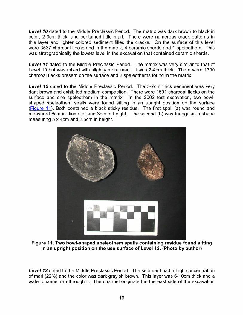
All of the lower levels contained numerous large speleothems. Some are visible in the north wall profile (See Figure 9). Thirty four speleothems were collected in Level 15, 67 in Level 16 (Figure 12), and 42 in Level 17. They were not spread throughout the excavation but were found in clusters. In Levels 16, 17, and 18 the clusters were directly on top of one another suggesting that they were stacked. Many of the speleothems were large stalagmites. Although stalactites could conceivably fall from the ceiling, it is highly unlikely that stalagmites could have arrived at their current position without assistance. Additionally, the placement of the speleothems within the excavation is reminiscent of the speleothem pile located on the modern surface. Bedrock was reached at Level 18. Six speleothems including three stalagmites and a spall were collected on this level. There was one small piece of charcoal on the cave floor that was too small to date.
21
Figure 12. Large speleothems collected from the surface of Level 16. These
included both stalactites and stalagmites. (Photo by author)
Preliminary Analyses
To evaluate the variation in the use of space within the chamber, charcoal distributions were analyzed and compared using the point data recorded in the field for each level. The goal of the analysis was to find areas that had distributions of charcoal that are denser than one would expect. Levels 6 and 7 are used to demonstrate the method and present preliminary findings. These two levels were selected because they were dissimilar. On the surface of Level 6 there are 10 times as many fragments of charcoal and in the matrix 31 times as many ceramic sherds than in Level 7. These differences are striking and indicate a major change in the intensity of activity between these two adjacent levels that can be described numerically.
The analysis was carried out in the GIS (Craig et al. 2004). Traditional clustering algorithms are inappropriate for the analysis since the goal was to locate and examine unexpected densities not clusters. A new method using observed and expected density maps was employed to produce Density Difference maps. These were created by subtracting the expected densities from the observed densities. To create the density map of the observed data, nearest feature distances were calculated to determine the minimum distance between two points using the ArcView 3.4. This value was used as the search radius in calculating density to avoid producing densities composed of single objects. The resulting raster is the Observed Density Count.
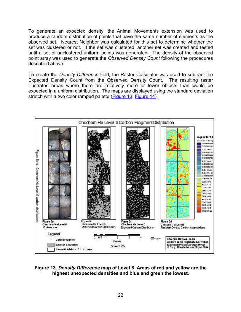
22
To generate an expected density, the Animal Movements extension was used to produce a random distribution of points that have the same number of elements as the observed set. Nearest Neighbor was calculated for this set to determine whether the set was clustered or not. If the set was clustered, another set was created and tested until a set of unclustered uniform points was generated. The density of the observed point array was used to generate the Observed Density Count following the procedures described above.
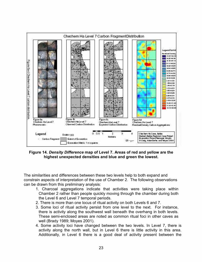
To create the Density Difference field, the Raster Calculator was used to subtract the Expected Density Count from the Observed Density Count. The resulting raster illustrates areas where there are relatively more or fewer objects than would be expected in a uniform distribution. The maps are displayed using the standard deviation stretch with a two color ramped palette (Figure 13, Figure 14).
Figure 13. Density Difference map of Level 6. Areas of red and yellow are the highest unexpected densities and blue and green the lowest.
23
Figure 14. Density Difference map of Level 7. Areas of red and yellow are the
highest unexpected densities and blue and green the lowest.
The similarities and differences between these two levels help to both expand and constrain aspects of interpretation of the use of Chamber 2. The following observations can be drawn from this preliminary analysis:
1. Charcoal aggregations indicate that activities were taking place within Chamber 2 rather than people quickly moving through the chamber during both the Level 6 and Level 7 temporal periods.
2. There is more than one locus of ritual activity on both Levels 6 and 7. 3. Some loci of ritual activity persist from one level to the next. For instance, there is activity along the southwest wall beneath the overhang in both levels. These semi-enclosed areas are noted as common ritual foci in other caves as well (Brady 1989; Moyes 2001).
4. Some activity loci have changed between the two levels. In Level 7, there is activity along the north wall, but in Level 6 there is little activity in this area. Additionally, in Level 6 there is a good deal of activity present between the
24
stalactite chandelier and the intermittent pool/drain in the center of the chamber. These preliminary results suggest that there may have been a shift in ritual behavior to a greater intensity of water-related rituals during the Level 6 time period (130-420 AD).
Ritual Use over Time
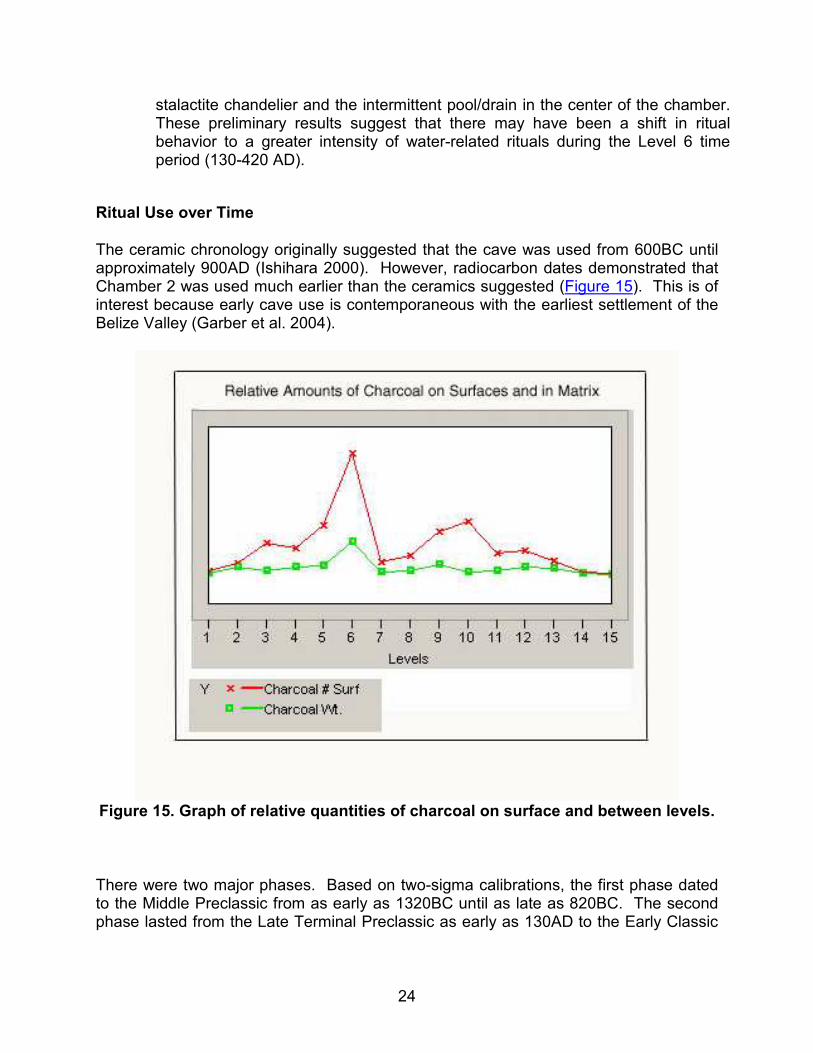
The ceramic chronology originally suggested that the cave was used from 600BC until approximately 900AD (Ishihara 2000). However, radiocarbon dates demonstrated that Chamber 2 was used much earlier than the ceramics suggested (Figure 15). This is of interest because early cave use is contemporaneous with the earliest settlement of the Belize Valley (Garber et al. 2004).
Figure 15. Graph of relative quantities of charcoal on surface and between levels.
There were two major phases. Based on two-sigma calibrations, the first phase dated to the Middle Preclassic from as early as 1320BC until as late as 820BC. The second phase lasted from the Late Terminal Preclassic as early as 130AD to the Early Classic
25
as late as 560AD. The chamber received little or no usage from approximately 820BC until at least 130AD.
These phases correlate well with changes in the intensity of usage. The number of charcoal flecks per excavated level ranged from 265 to 8,244. A correction to the raw data was made because the excavated surface areas were not identical on each level. As the excavations progressed the cave walls curved inward and spatial areas narrowed toward the bottom. The total charcoal counts were divided by the area of the level to produce a use-intensity index. Figure 15 is a graph illustrating the results. Actual values are found in Table 1.
From the charcoal index we see that heavy cave use first occurred in the Middle Preclassic period in Levels 9 and 10 (1000-820BC). This drops off considerably by Level 8. There is very little use of the chamber in the Late Preclassic period represented by Level 7 (350-40BC). It is of interest that during this time the Stela Chamber was used. This area is the deepest most remote area of the cave.
Use sharply increased to its peak in the Terminal Preclassic/Early Classic Level 6 (130-420AD). After this, cave use decreased over the Early Classic period. By the Late Classic there is very little charcoal in the chamber. However, Late Classic ceramic sherds are found on the chamber floor indicating that the chamber was certainly used at this time. Also, recall that 51% of the entire ceramic assemblage dated to the Late Classic period. The lack of charcoal from torches coupled with the abundance of Late Classic ceramics suggests that rites during this period were of limited duration with few participants. These rites focused heavily on the deposition of objects within the cave.
A number of other observations can be made from these preliminary data. For instance, in the initial period of cave use, no ceramics were imported into the site. Ceramic sherds first appear in Level 10 (1000-820BC) but the cave was utilized at least 100 years or more prior to this date. Along with the introduction of ceramics into the cave was evidence of agricultural rituals. In Level 9 (1000-820BC) two corn kernels were recovered in the flotation.
The earliest cave use (Levels 11-13) appears to have focused on the removal, stacking, and opportunistic use of speleothems. The use of stalagmites illustrates the intensity of this practice. The most recent level to contain a stalagmite is Level 6 (130-420AD). Because no large stalagmites are left standing in the entire cave system today, this suggests that by the Early Classic period all of the cave's stalagmites had either broken naturally or had been harvested by ancient people. Additionally, the small stalagmite harvested from underneath the speleothem dated by Schwarcz did not begin to grow until the Late Classic period. This provides additional evidence to suggest that the cave was completely stripped of stalagmites by this time. This one example could was only able to grow in the absence of humans.
An interesting continuity in ritual practice was demonstrated by artifact placement both along the west boundary of the excavation and in the area of the central drainage pit
26
(Feature 1). Adjacent to the west cave wall beneath the overhang, a shard scatter was found on the modern surface. Located directly below the modern scatter in Level 5 (240-440AD) were two caches of artifacts and evidence of intense burning. Both of these features originated in Level 6 (130-420AD). Below these features near bedrock was the stone circle in Level 8 (1130-890BC). It is interesting that the most elaborate deposits discovered in the excavation were located beneath the surface scatter. In the second area, a large stalactite fragment sat on the modern surface on top of the depression in the center of the chamber. We noted ceramic sherds in this area on each level continuously to the depth of Level 5. This suggests two possibilities. Either the locations of these areas are favored based on geomorphic features and/or cognitive models or they are significant ritual activity areas because of their previous use invoking models of social memory.
Conclusion
Work at Chechem Ha is the first study to formally address changes in ritual practice over time in caves. The preliminary analyses clearly demonstrate that changes do exist, some of which are quite dramatic. By defining these changes it is then possible to articulate ritual transformations with broader socio/political and environmental contexts (see Moyes 2006). This type of detailed case study is instrumental in understanding how and when caves were used by the ancient Maya and it is only through insights into actual cave use that we may hope to fully comprehend the ritual life of the ancient Maya.
Acknowledgements
I would like to thank Dr. Jaime Awe director of the Western Belize Regional Cave Project (WBRCP) for providing me with the opportunity to carry out this work. The permit for the project was provided by the Belize Department of Archaeology (now the Institute of Archaeology, NICH), and thanks go to Dr. Alan Moore, George Thompson, Brian Woodeye, and John Morris. I am especially grateful to my friends Antonio Morales and Lea Plytez for making the crew welcome in their home, to their son William Plytez for his work in the curation of the cave, and to our workers Jesùs and Armando Morales who graciously did most of the heavy lifting. Thanks go to Mark Aldenderfer who provided equipment for the project. Finally I would like to thank the 2003 crew: Jim Aimers, Mark Aldenderfer, Nathan Craig, Tony Menoa, Grant Polley, and Connie Price.
Sources Cited
Aldenderfer, Mark in press Scientific visualization, archaeology, and geovisualization. In Future Directions
in GIS, edited by Scott Branting. Archaeopress, Oxford.
27
Aldenderfer, Mark and Nathan Craig 2002 A GIS-based in-field data recording system for archaeological excavation. 13th
Annual Workshops in Archaeometry, University at Buffalo. Awe, Jaime J. 1998 The Western Belize Regional Cave Project: Objectives, Context, and Problem
Orientation. In The Western Belize Regional Cave Project, A Report of the 1997 Field Season, edited by Jaime J. Awe, pp. 1-21, Dept. of Anthropology, Occasional Paper No.1, University of New Hampshire, Durham.
Awe, Jaime, Sherry Gibbs, and Cameron Griffith 1997 Stelae and Megalithic Monuments in the Caves of Western Belize. Paper
presented at the 62nd Annual Meeting of the Society for American Archaeology, Nashville, Tenn.
Brady, James Edward 1989 Investigation of Maya Ritual Cave Use with Special Reference to Naj Tunich,
Peten, Guatemala. Unpublished Ph.D. dissertation, Department of Anthropology, University of California, Los Angeles.
Craig, Nathan 2000 Real-Time GIS Construction and Digital Data Recording of the Jiskairumoko
Excavation, Peru: The Society for American Archaeology Bulletin, v.18, no.1, p.24-28.
Craig, Nathan and Mark Aldenderfer in press Future directions in the recording of archaeological excavations using GIS. In
Future Directions in GIS, Edited by Scott Branting, Archaeopress, Oxford. Craig, Nathan, Mark Aldenderfer, and Holley Moyes 2004 Rapid Piece Plotting of Small Artifact Distributions in Domestic and Ritual
Activity Areas Using GIS. Paper presented at the Society for American Archaeology 69th Annual Meetings, Montreal, Canada.
Garber, James F., M. Kathryn Brown, Jaime J. Awe, and Christopher Hartman 2004 Middle Formative Prehistory of the Central Belize Valley: An Examination of
Architecture, Material Culture, and Sociopolitical Change at Blackman Eddy. In The Ancient Maya of the Belize Valley: Half a Century of Archaeological Research, edited by James F. Garber, pp. 25-47, University Press of Florida, Gainesville.
Graham, Elizabeth, Logan McNatt, and Mark A. Gutchen 1980 Excavations in Footprint Cave, Belize. Journal of Field Archaeology 7: 153-172.
28
Helmke, Christophe and Jaime J. Awe 1998 Preliminary Analysis of Pictographs, Petroglyphs, and Sculptures of Actun
Uayazba Kab, Cayo District, Belize. In The Western Belize Regional Cave Project, A Report of the 1997 Field Season, Edited by Jaime J. Awe, pp. 141-199, Dept. of Anthropology, Occasional Paper No.1, University of New Hampshire, Durham.
1999 Exploration and Investigations of the Sinkhole Tunnels, Actun Tunichil Muknal, Belize. In The Western Belize Regional Cave Project: A Report of the 1998 Field Season, edited by Jaime Awe, pp 146-165, Department of Anthropology Occasional Paper No. 2, Durham, University of New Hampshire.
2001 An Interpretation of the Pictographs and Petroglyphs of Actun Uayazba Kab: Implications for Ancient Maya Cave Rituals. Paper presented at the 66th Annual Meeting of the Society for American Archaeology, New Orleans.
Iannone, Gyles 2001 Fall of the House of Minanhá: A Case of Late Classic Political Disruption in West
Central Belize. In Archaeological Investigations in the North Vaca Plateau, Belize: Progress Report of the Third (2001) Field Season, edited by Gyles Iannone, Ryan Primrose, Adam Menzies, and Lisa McParland, pp.127-133, Peterborough, Dept. of Anthropology, Trent University.
Ishihara, Reiko 2000 An Investigation of the Ancient Maya Ritual Cave Activity at Actun Chechem Ha,
Cayo District, Belize. Unpublished Honors Thesis, University of Tsukuba, Japan. Morehart, Christopher T. 2002a Ancient Maya Ritual Cave Utilization: A Paleoethnobotanical Perspective.
Unpublished Master's Thesis, Department of Anthropology, Florida State University, Tallahassee.
2002b Plants of the Underworld: Ritual Plant Use in Ancient Maya Cave Ceremonies. Report submitted to the Foundation for the Advancement of Mesoamerican Studies, Inc. http://www.famsi.org/reports/morehart/morehart.htm
Moyes, Holley 2001 The Cave as a Cosmogram: The Use of GIS in an Intrasite Spatial Analysis of
The Main Chamber of Actun Tunichil Muknal, A Maya Ceremonial Cave in Western Belize. M.A. Thesis, Florida Atlantic University, Boca Raton, Florida.
2006 The Sacred Landscape as a Political Resource: A Case Study of Ancient Maya Cave Use at Chechem Ha Cave, Belize, Central America. Unpublished Ph.D. dissertation, Department of Anthropology, University at Buffalo, New York.
29
Pohl, Mary 1981 Ritual Continuity and Transformation in Mesoamerica: Reconstructing the
Ancient Maya Cuch Ritual. American Antiquity 46:513-529. Pohl, Mary and John Pohl 1983 Ancient Maya Cave Ritual. Archaeology 36(3):28-51.
Reents-Budet, Doris Jane 1980 The Prehistoric Pottery from Petroglyph Cave, Caves Branch Valley,El Cayo
District, Belize, Central America. Unpublished M.A. Thesis, Department of Anthropology. University of Texas, Austin.
Reents-Budet, Doris Jane and Barbara MacLeod 1997 The Archaeology of Petroglyph Cave, Cayo District, Belize. Unpublished
manuscript on file at the Department of Archaeology, Belize. Stone, Andrea 1995 Images of the Underworld: Naj Tunich and the Tradition of Maya Cave Painting.
University of Texas Press, Austin. Taschek, T. Jennifer and Joseph W. Ball 1999 Las Ruinas de Arenal: Preliminary Report on a Subregional Major Center in the
Western Belize Valley (1991-1992 Excavations). Ancient Mesoamerica 10:215-235.
List of Figures
Figure 1. Map of the Belize Valley showing location of Chechem Ha Cave (courtesy of the WBRCP). Figure 2. Map of Chechem Ha Cave showing location of Chamber 2. Figure 3. Small uncarved stela surrounded by stone circle. (Photo by author) Figure 4. Map of Chamber 2 showing features. Figure 5. Photograph of Grant Polley standing in Chamber 2. Note the large stalactite chandelier to his right. (Photo by author) Figure 6. Ceramics on Ledge 10. (Photo by author) Figure 7. Map of Chamber 2 showing extent of excavation. The Level 6 photomap is illustrated. Figure 8. Excavation photographed from above. (Photo by author) Figure 9. Photomap of a 1m section of the North Wall Profile, Chamber 2. (Photo by author) Figure 10. Feature 3, Level 2 is a small cluster of sherds placed with a natural basin in the cave wall. (Photo by author) Figure 11. Two bowl-shaped speleothem spalls containing residue found sitting in an upright position on the use surface of Level 12. (Photo by author)
30
Figure 12. Large speleothems collected from the surface of Level 16. These included both stalactites and stalagmites. (Photo by author). Figure 13. Density Difference map of Level 6. Areas of red and yellow are the highest unexpected densities and blue and green the lowest. Figure 14. Density Difference map of Level 7. Areas of red and yellow are the highest unexpected densities and blue and green the lowest. Figure 15. Graph of calibrated radiocarbon AMS dates using Oxcal3 for excavated Layers 1-13 and the Stela Chamber. Figure 16. Graph of relative quantities of charcoal on surface and in between levels.
List of Tables
Table 1. Summary of excavation data by level.
31
APPENDIX A
Diagnostic Ceramics
Level 1 Level 2
Level 3 Level 4
Level 5 Level 6
Level 7 Level 8
32
Level 9 Level 10
Feature 1 Feature 3
Feature 5