Embed Size (px)
Citation preview

##
########### ##################
ÊÚ
ÊÚÊÚ
ÊÚ
ÊÚÊÚ
ÊÚ
ÊÚ ÊÚÊÚ
ÊÚ ÊÚ
ÊÚ
ÊÚ
ÊÚ
ÊÚ
ÊÚ
0 500 1000 KILOMETERS
Rangoon
Mandalay
Thailand
Bangladesh
India
Myanmar
IndianOcean
10
15
20
25
1051009585
Central Burma BasinAssessment Unit 80480101
Other geologic province boundary
Irrawaddy Geologic Province 8048
Central Burma Basin Assessment Unit 80480101
8035

Page 1
USGS PROVINCE: Irrawaddy (8048) Myanmar GEOLOGIST: C.J. Wandrey TOTAL PETROLEUM SYSTEMS: Eocene to Miocene Composite (804801) ASSESSMENT UNITS: Central Burma Basin (80480101) DESCRIPTION: This assessment unit is located in the north and central basins of Myanmar. It is an oil prone onshore basin developed parallel to the converging continental and marine plate boundaries. The rocks that comprise this assessment unit include the Eocene Laungshe Shale, Tilin and Pondaung Sandstones, and the Oligocene-Miocene Pegu Group, which exceeds 6500 m. This group includes interbedded sandstones, shales, and coals of deltaic to fluvial facies, and shallow marine shales, limestones, and sandstones. SOURCE ROCKS: Source rocks include the Upper Eocene-Lower Oligocene shales of the Yaw, Shwezetaw and Okhmintaung formations. Total organic carbon content is generally low where sampled (>1.7 percent). Organic content is primarily terrestrially sourced Type III kerogens. MATURATION: Maturities are generally low from Ro 0.2 to 1.5 percent where sampled outside of this assessment unit to the south in the Gulf of Martaban. GENERATION AND MIGRATION: The onset of generation probably occurred in late Miocene. Migration is primarily short, updip, and vertical through fault and fracture systems associated with the plate collision. These fault systems have been periodically reactivated through the present. RESERVOIR ROCKS: Interbedded sandstones of the Pegu Group are the primary reservoirs. Permeability ranges from less than 32 mD to as high as 3200 mD. Porosity ranges from less than 20 percent to 30 percent. The Eocene Ponduang and Tilin sandstones may also have reservoir potential and have a combined thickness of as much as 3500 m. including the interbedded shales. TRAPS AND SEALS: Traps include anticlines, faulted anticlines, fault truncations, and stratigraphic traps. Seals include interbedded Oligocene and Miocene shales and clays, and the thick clays of the Upper Miocene and Pliocene Irrawaddy Group. Structures in the Chindwin Basin area and stratigraphic traps developed in alluvial and deltaic systems have been only lightly explored and may have significant potential. REFERENCES: Bender, Friedrich, 1983, Geology of Burma, in Bender, F., Jacobshagen, V., de Jong, J. D., and
Lutig, G., eds., The regional geology of the Earth series, Volume16: Berlin, 293 p. Brunnschweiler, R.O., 1974, in Spencer, A.M., ed., Mesozoic-Cenozoic orogenic belts
Indoburman Ranges–Data for orogenic studies: Geologic Society of London Special Publication 4, p. 279-299.

Page 2
Curray, J.R., Moore, D.G., Lawver, L.A., Emmel, F.J., Raitt, R.W., Henry, M., and Kieckhefer, R., 1979, Tectonics of the Andaman Sea and Burma, in Watkins, J.S., Montadert, L. and Dickerson, P.W., eds., Geological and geophysical investigations of continental margins: American Association of Petroleum Geologists Memoir 29, p. 189-198.
Kingston, John, 1986, Undiscovered petroleum resources of South Asia: U.S. Geological Survey Open-File Report 86-80, 131 p.

80480101
80480101Assessment unitcode and boundary
8035
8048
Assessment Unit - 80480101Central Burma Basin
EXPLANATION
HydrographyShorelineGeologic province code and boundaryCountry boundaryGas field centerpointOil field centerpoint
Projection: Robinson. Central meridian: 0
150 KILOMETERS
96 98
18
20
22
24
26
28
Myanmar (Burma)
Mandalay
India
China

SEVENTH APPROXIMATIONNEW MILLENNIUM WORLD PETROLEUM ASSESSMENTDATA FORM FOR CONVENTIONAL ASSESSMENT UNITS
Date:………………………….. 8/18/99Assessment Geologist:…….. C.J. WandreyRegion:……………………….. South Asia Number: 8Province:……………………… Irrawaddy Number: 8048Priority or Boutique.………… BoutiqueTotal Petroleum System:…… Eocene to Miocene Composite Number: 804801Assessment Unit:…………… Central Burma Basin Number: 80480101* Notes from Assessor Lower 48-all growth function.
CHARACTERISTICS OF ASSESSMENT UNIT
Oil (<20,000 cfg/bo overall) or Gas (>20,000 cfg/bo overall):… Oil
What is the minimum field size?………. 1 mmboe grown (>1mmboe)(the smallest field that has potential to be added to reserves in the next 30 years)
Number of discovered fields exceeding minimum size:………… Oil: 12 Gas: 4 Established (>13 fields) X Frontier (1-13 fields) Hypothetical (no fields)
Median size (grown) of discovered oil fields (mmboe):1st 3rd 5.2 2nd 3rd 6.1 3rd 3rd
Median size (grown) of discovered gas fields (bcfg):1st 3rd 83 2nd 3rd 60 3rd 3rd
Assessment-Unit Probabilities: Attribute Probability of occurrence (0-1.0)1. CHARGE: Adequate petroleum charge for an undiscovered field > minimum size……………… 1.02. ROCKS: Adequate reservoirs, traps, and seals for an undiscovered field > minimum size…… 1.03. TIMING OF GEOLOGIC EVENTS: Favorable timing for an undiscovered field > minimum size 1.0
Assessment-Unit GEOLOGIC Probability (Product of 1, 2, and 3):……...…….....…. 1.0
4. ACCESSIBILITY: Adequate location to allow exploration for an undiscovered field > minimum size……………………………………………………..………………..……..………… 1.0
UNDISCOVERED FIELDS
Oil fields:…………………………………min. no. (>0) 5 median no. 30 max no. 90Gas fields:……………………………….min. no. (>0) 2 median no. 15 max no. 45
Size of Undiscovered Fields: What are the anticipated sizes (grown) of the above fields?:
Oil in oil fields (mmbo)………………..……min. size 1 median size 6 max. size 500Gas in gas fields (bcfg):……………………min. size 6 median size 30 max. size 900
(variations in the sizes of undiscovered fields)
(uncertainty of fixed but unknown values)Number of Undiscovered Fields: How many undiscovered fields exist that are > minimum size?:
Page 1
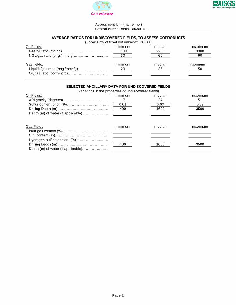
Assessment Unit (name, no.)Central Burma Basin, 80480101
AVERAGE RATIOS FOR UNDISCOVERED FIELDS, TO ASSESS COPRODUCTS
Oil Fields: minimum median maximum Gas/oil ratio (cfg/bo)………………………...……… 1100 2200 3300 NGL/gas ratio (bngl/mmcfg)…………………....…. 30 60 90
Gas fields: minimum median maximum Liquids/gas ratio (bngl/mmcfg)….…………..…….. 20 35 50 Oil/gas ratio (bo/mmcfg)………………………….…
SELECTED ANCILLARY DATA FOR UNDISCOVERED FIELDS(variations in the properties of undiscovered fields)
Oil Fields: minimum median maximum API gravity (degrees)…………………….…………. 17 34 51 Sulfur content of oil (%)………………………...….. 0.01 0.03 0.23 Drilling Depth (m) ……………...…………….…….. 400 1600 3500 Depth (m) of water (if applicable)……………...…..
Gas Fields: minimum median maximum Inert gas content (%)……………………….....…… CO2 content (%)……………………………….....… Hydrogen-sulfide content (%)………………...……. Drilling Depth (m)…………………………………… 400 1600 3500 Depth (m) of water (if applicable)………………….
(uncertainty of fixed but unknown values)
Page 2

Assessment Unit (name, no.)Central Burma Basin, 80480101
ALLOCATION OF UNDISCOVERED RESOURCES IN THE ASSESSMENT UNITTO COUNTRIES OR OTHER LAND PARCELS (uncertainty of fixed but unknown values)
1. Myanmar represents 100 areal % of the total assessment unit
Oil in Oil Fields: minimum median maximum Richness factor (unitless multiplier):……….…..… Volume % in parcel (areal % x richness factor):… 100 Portion of volume % that is offshore (0-100%)…… 0
Gas in Gas Fields: minimum median maximum Richness factor (unitless multiplier):…………..…. Volume % in parcel (areal % x richness factor):… 100 Portion of volume % that is offshore (0-100%)…… 0
Page 3

0
1
2
3
4
5
6
7
8
1-<2 2-<4 4-<8 8-<16 16-<32 32-<64 64-<128 128-<256
256-<512
512-<1024
1024-<2048
2048-<4096
OIL-FIELD SIZE (MMBO)
UN
DIS
CO
VE
RE
D O
IL F
IEL
DS
(N
o.)
Minimum field size: 1 MMBO
Mean number ofundiscovered fields: 33.4
Central Burma Basin, AU 80480101 Undiscovered Field-Size Distribution

0
1
2
3
4
5
6
6-<12 12-<24 24-<48 48-<96 96-<192 192-<384 384-<768 768-<1536
1536-<3072
3072-<6144
6144-<12288
GAS-FIELD SIZE (BCFG)
UN
DIS
CO
VE
RE
D G
AS
FIE
LD
S (
No
.)
Minimum field size: 6 BCFG
Mean number ofundiscovered fields: 16.7
Central Burma Basin, AU 80480101 Undiscovered Field-Size Distribution