Embed Size (px)
Citation preview
Circular 155 1977
Geologic appraisal of deep coals,
San Juan Basin, New Mexico
by John W. Shomaker and
Michael R. Whyte
New Mexico Bureau of Mines & Mineral Resources
A DIVISION OF
NEW MEXICO INSTITUTE OF MINING & TECHNOLOGY
Circular 155
New Mexico Bureau of Mines & Mineral Resources
A DIVISION OF
NEW MEXICO INSTITUTE OF MINING & TECHNOLOGY
Geologic appraisal of deep coals,
San Juan Basin, New Mexico
by JOHN W. SHOMAKER and MICHAEL R. WHYTE
This report is the result of a cooperative project funded in part by
the U.S. Bureau of Mines under grant G0122108 and by the New
Mexico Energy Resources Board under grant BEF 124.
SOCORRO 1977
1 1
Published by Authority of State of New Mexico, NMSA 1953 Sec. 63-1-4 Printed by University of New Mexico Printing Plant, November 1977
Available from New Mexico Bureau of Mines & Mineral Resources, Socorro, NM 87801 Price $4.00
Contents QUALITY OF COALS 14
FRUITLAND FORMATION 14
MENEFEE FORMATION 14
ESTIMATES OF RESERVES AND RESOURCES 15
FRUITLAND FORMATION 15
MENEFEE FORMATION 15
Hogback Mountain tongue 15
ECONOMICS OF FUTURE PROSPECTS 20
REFERENCES 20
TABLES 22
APPENDICES 28
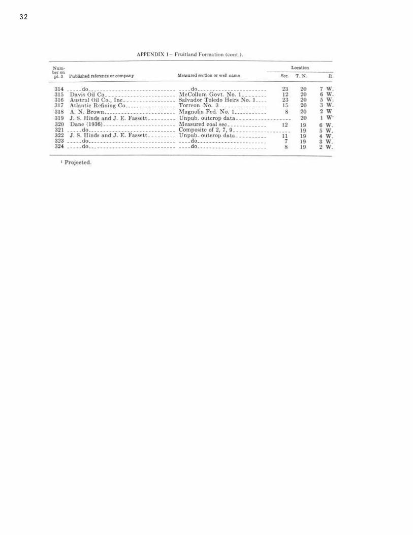
1—Measured sections and drill-hole data
for Fruitland Formation 28
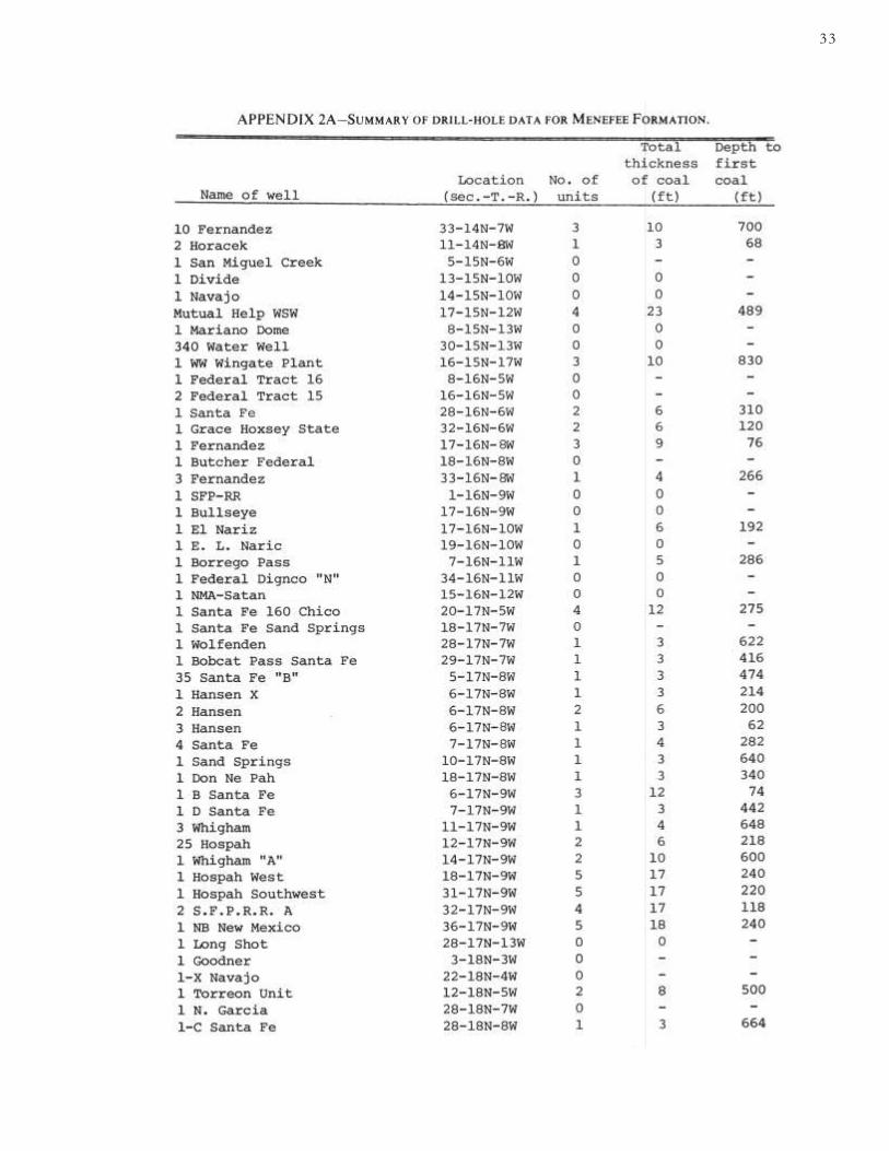
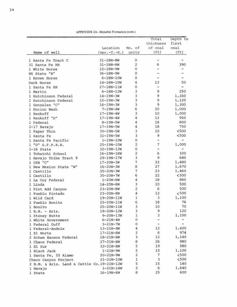
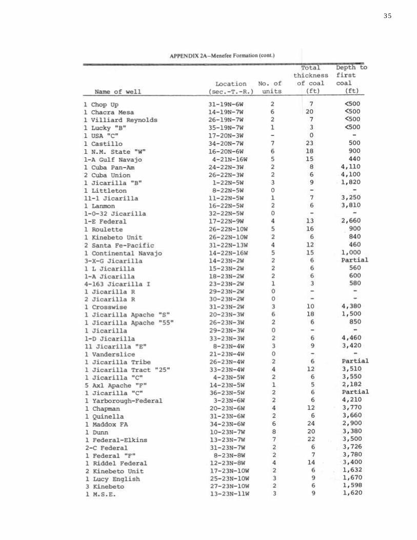
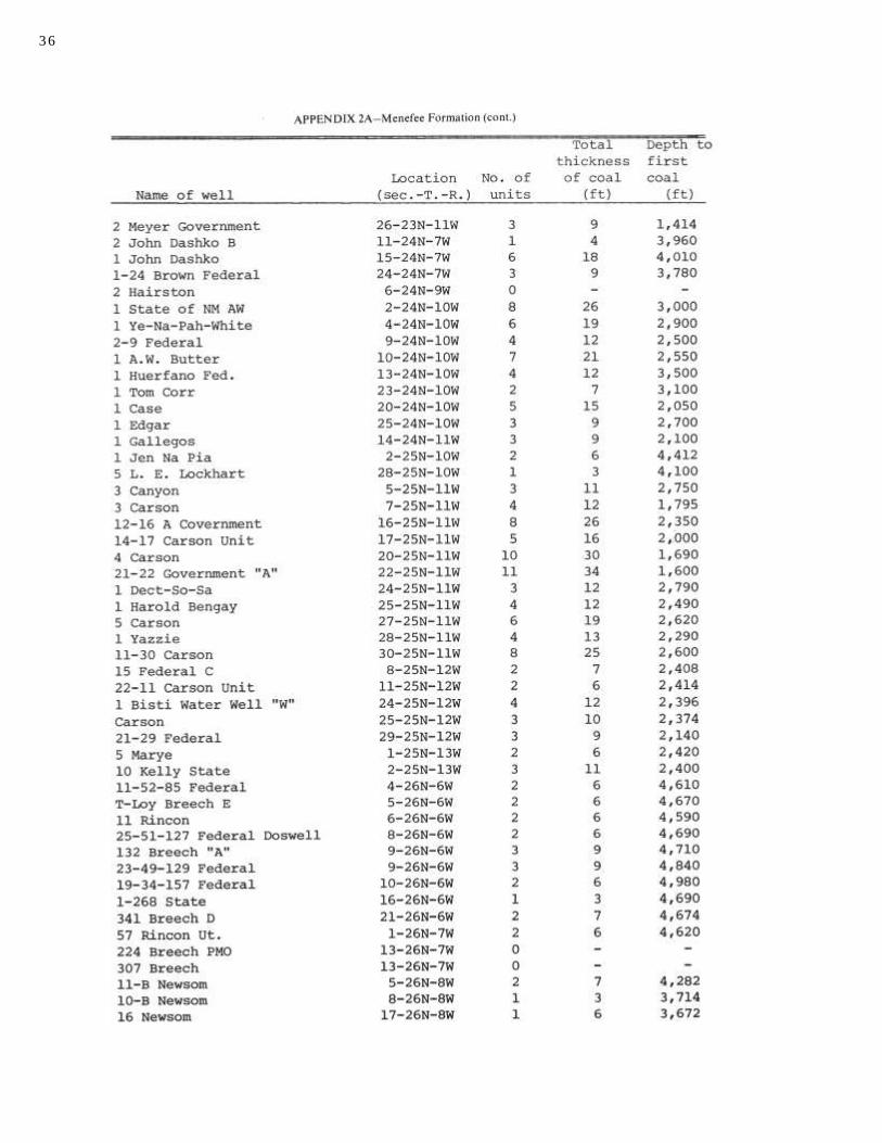
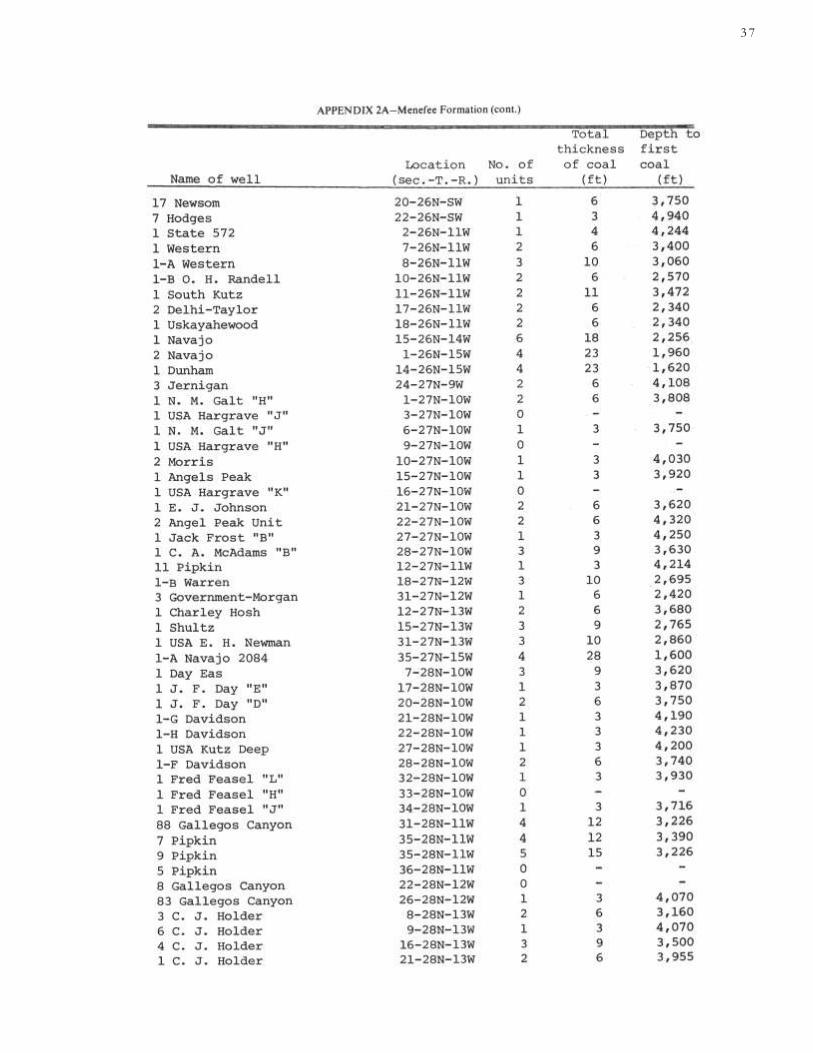
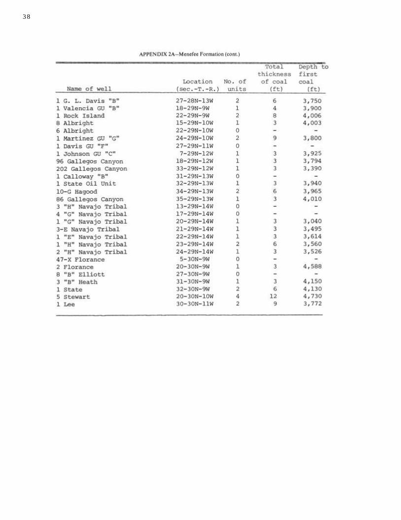
2A—Drill-hole data for Menefee Formation 33
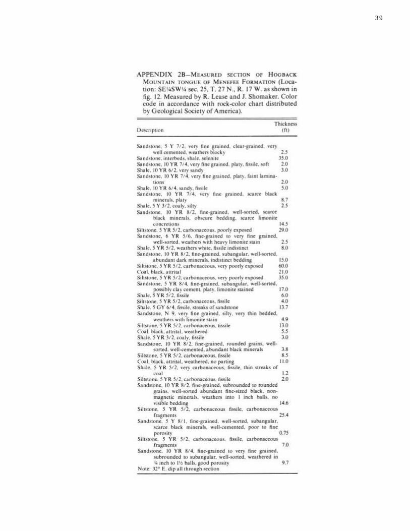
2B—Measured section for Hogback Mountain tongue 39
TABLES
1—Analyses of Fruitland coal 22 4—Coal resources of Menefee Formation (north) 26
2—Analyses of Menefee coal 25 5—Coal resources of Menefee Formation (south) 26
3—Coal resources of Fruitland Formation 26 6—Coal resources of Hogback Mountain tongue 27
FIGURES
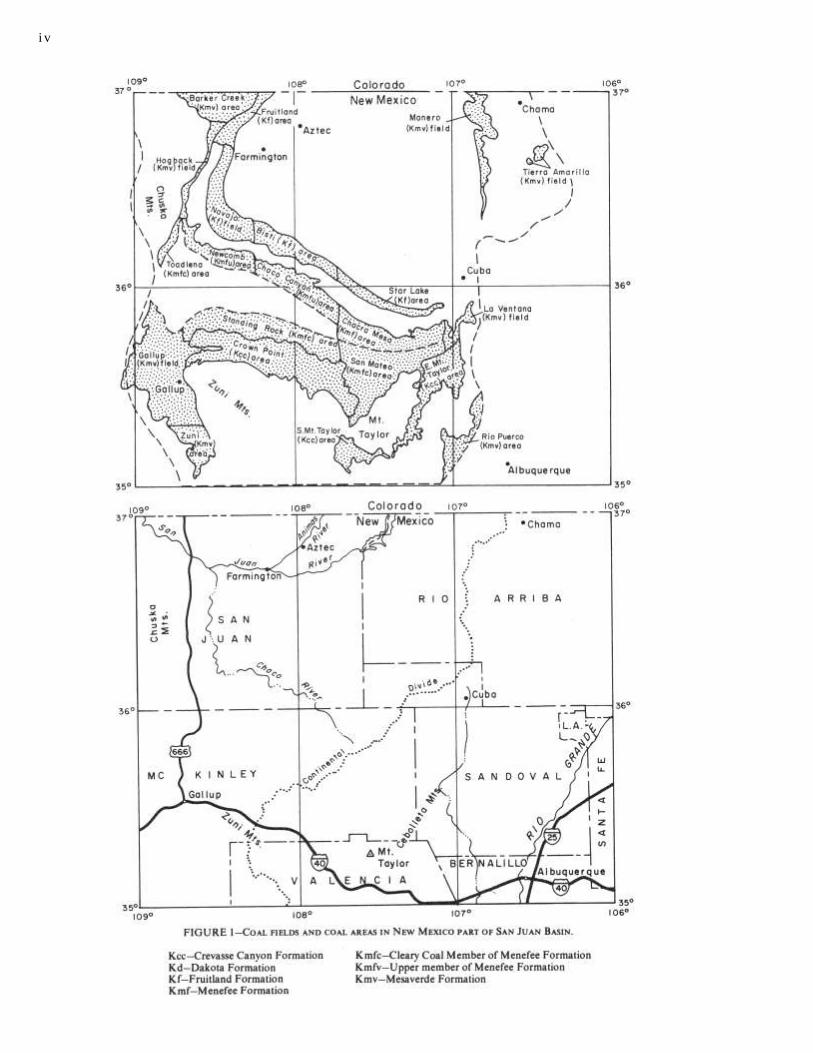
1—Index map with coal areas iv
2—Structure map 7
3—Stratigraphic section 9
4—Log comparison 12
5—Core log of DC-2 13
6—Core log of DC-3 13
7—Isopachous map of Fruitland overburden 15
8—Isopachous map of individual Fruitland seams 15 9—
Isopachous map of Fruitland coal 15
10—Isopachous map of Menefee (north) coal 16 11—
Isopachous map of Menefee (south) coal 16 12—Isopachous
map of Hogback Mountain tongue coal 17 13—Cross sections
of Hogback Mountain tongue 18
111
ABSTRACT 5
INTRODUCTION 5
PURPOSE AND SCOPE
5 PREVIOUS STUDIES
6 GEOGRAPHY 6
STRUCTURE OF SAN JUAN BASIN 8
STRATIGRAPHY 8
SEDIMENTARY SEQUENCES 9
PALEOENVIRONMENTS 10
UNIFORM CLASSIFICATION OF COAL
RESOURCES 11
BASIC GEOLOGIC DATA 12
CORE TESTS 12
WELL-LOG ANALYSES 12
i v
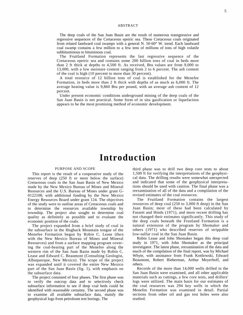
ABSTRACT
The deep coals of the San Juan Basin are the result of numerous transgressive and regressive sequences of the Cretaceous epeiric sea. These Cretaceous coals originated from related landward coal swamps with a general N. 50-60° W. trend. Each landward coal swamp contains a few million to a few tens of millions of tons of high volatile subbituminous to bituminous coal.
The Fruitland Formation represents the last regressive sequence of the Cretaceous epeiric sea and contains some 200 billion tons of coal in beds more than 2 ft thick at depths to 4,500 ft. As received, Btu values are from 9,000 to 13,000, with a low moisture content ranging from 2 to 6 percent. The ash content of the coal is high (10 percent to more than 30 percent).
A total resource of 12 billion tons of coal is established for the Menefee Formation, in beds more than 2 ft thick with depths of as much as 6,000 ft. The average heating value is 9,860 Btu per pound, with an average ash content of 12 percent.
Under present economic conditions underground mining of the deep coals of the San Juan Basin is not practical. Some form of in situ gasification or liquefaction appears to be the most promising method of economic development.
Introduction PURPOSE AND SCOPE
This report is the result of a cooperative study of the reserves of deep (250 ft or more below the surface) Cretaceous coals in the San Juan Basin of New Mexico made by the New Mexico Bureau of Mines and Mineral Resources and the U.S. Bureau of Mines under grant G-0122108, with additional funding by the New Mexico Energy Resources Board under grant 124. The objectives of the study were to outline areas of Cretaceous coals and to determine the resources available township by township. The project also sought to determine coal quality as definitely as possible and to evaluate the economic position of the coals.
The project expanded from a brief study of coal in the subsurface in the Hogback Mountain tongue of the Menefee Formation begun by Robin C. Lease (then with the New Mexico Bureau of Mines and Mineral Resources) and from a surface mapping program cover-ing the coal-bearing part of the Menefee along the western rim of the San Juan Basin made by Robin C. Lease and Edward C. Beaumont (Consulting Geologist, Albuquerque, New Mexico). The scope of the project was expanded until it covered the entire New Mexico part of the San Juan Basin (fig. 1), with emphasis on the subsurface data.
The project consisted of four phases. The first phase was to verify the outcrop data and to selectively check subsurface information to see if deep coal beds could be identified with reasonable certainty. The second phase was to examine all available subsurface data, mainly the geophysical logs from petroleum test borings. The
third phase was to drill two deep core tests to about 1,500 ft for verifying the interpretations of the geophysi-cal data. The drilling results were somewhat unexpected and indicated that some of the geophysical interpreta-tions should be used with caution. The final phase was a reexamination of all of the data and a compilation of the revised estimates of the coal resources.
The Fruitland Formation contains the largest resources of deep coal (250 to 3,000 ft deep) in the San Juan Basin; most of these had been calculated by Fassett and Hinds (1971), and more recent drilling has not changed their estimates significantly. This study of the deep coals beneath the Fruitland Formation is a natural extension of the program by Shomaker and others (1971) who described reserves of strippable low-sulfur coal in the San Juan Basin.
Robin Lease and John Shomaker began this deep coal study in 1971, with John Shomaker as the principal investigator. The latest phase, reexamination of the data and much of the compilation of the final report, was by Michael Whyte, with assistance from Frank Kottlowski, Edward Beaumont, Robert Bieberman, Arthur Meyerhoff, and others.
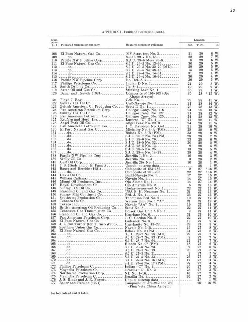
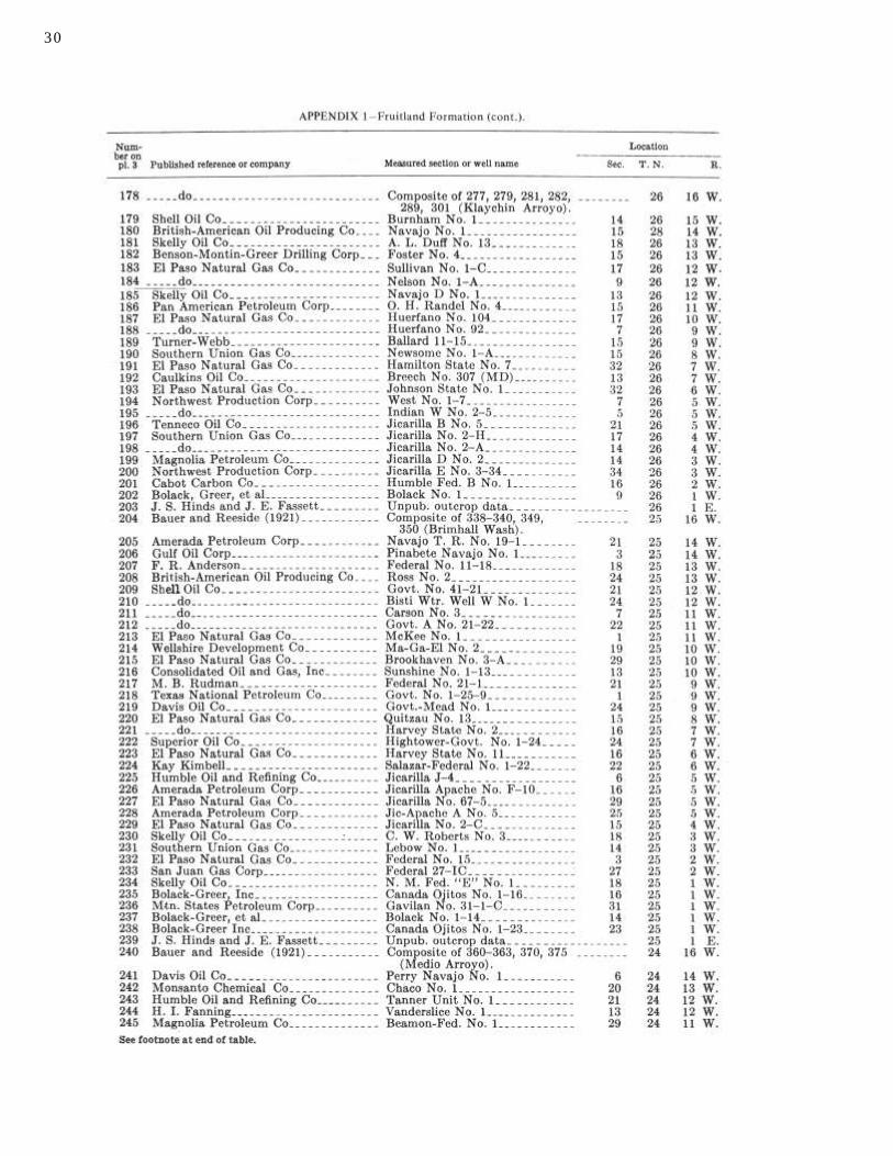
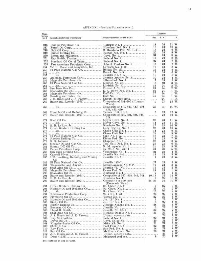
Records of the more than 14,000 wells drilled in the San Juan Basin were examined, and all other applicable materials such as cuttings, a few core tests, and drillers' logs were utilized. The main basis for our estimates of the coal resources was 294 key wells in which the Menefee Formation was examined in detail. Partial sections from other oil and gas test holes were also studied.
5
6
PREVIOUS STUDIES
Gardner (1909 a-c, 1910) mapped the "Laramie
Formation" in parts of the northern and southern San
Juan Basin; however, the Fruitland Formation was
defined and named by Bauer (1916) in a paper on the
stratigraphy of the western San Juan Basin. Bauer and
Reeside (1921) described the occurrence of coals in the
Fruitland Formation in the western and southwestern
parts of the basin, and Reeside (1924) summarized
earlier data in his paper on the western part of the
basin; Dane (1936) mapped the southeastern part of the
basin and noted that Fruitland rocks are not present on
the east side of the basin.
The following geologists mapped outcrops of Fruit -
land Formation in other parts of the basin: Dane (1946,
1948), Wood, Kelley, and MacAlpin (1948), Zapp
(1949), Barnes (1953), Barnes, Baltz, and Hayes (1954),
Hayes and Zapp (1955), Beaumont and O'Sullivan
(1955), O'Sullivan and Beaumont (1957), Baltz, Ash,
and Anderson (1966), Fassett (1966), Hinds (1966), and
Baltz (1967).
The following geologists have discussed and illus-
trated the subsurface occurrence of Fruitland Formation:
Silver (1950, 1951), Bozanic (1955), Kilgore (1955),
Baltz (1962, 1967), and Fassett (1964). Hinds (1964)
discussed quality coals of the Fruitland Formation. The
most comprehensive study to date was done by Fassett
and Hinds (1971).
In what is now termed the Menefee Formation, coal
has been studied in the outcrops around the San Juan
Basin for many years. The first treatment of the entire
basin was that of F. C. Schrader (1906), but earlier
mention of the coals was made by Storrs (1902) in the
Twenty-second Annual Report of the Geological Survey
and in the still earlier reports of the Wheeler and
Hayden surveys.
Early reports were by Taff(1907) on the Durango
coal district, Shaler (1907) on the western part of the
Durango-Gallup coal field, Gardner (1909a) on the coal
field between Gallina and Raton Spring in the eastern
San Juan Basin, Gardner (1909b) on the coal field
between Durango and Monero, Gardner (1909c) on the
coal field between Gallup and San Mateo, Gardner
(1910) on the coal field between San Mateo and Cuba,
and Collier (1919) on the coal south of Mancos in
Montezuma County, Colorado.
Relatively detailed work on the coals in the southern
part of the San Juan Basin was done by Sears (1925) for
the Gallup-Zuni Basin, Sears (1934) for the area
eastward from Gallup to Mount Taylor, Dane (1936) for
the La Ventana-Chacra Mesa coal field, and Hunt (1936)
for the Mount Taylor coal field.
Beginning in the late 1940's and early 1950's, map-
ping of the coal geology, principally on a quadrangle
basis, led to the reports by Zapp (1949) of the Durango
area, Beaumont (1954) of the Beautiful Mountain area,
Allen and Balk (1954) of the Fort Defiance and Tohatchi
quadrangles, Beaumont (1955) of the Ship Rock and
Hogback quadrangles, O'Sullivan (1955) of the Naschitti
quadrangle, Beaumont and O'Sullivan (1955) of the
Kirtland quadrangle area, Zieglar (1955) of the Toadlena
quadrangle, and O'Sullivan and Beaumont (1957) of the
western San Juan Basin. The first attempt to deal quantitatively with the coal
resources in the Menefee Formation was the compilation
by Read and others (1950). The basis of this work was
extensive mapping by U.S. Geological Survey workers.
Although they gave an estimate for the total resource in
the entire formation regardless of depth, the estimate is
based almost entirely upon outcrop data. Resources and
reserves of Menefee coal within stripping depth, but not
deeper, were summarized for the entire basin by
Shomaker, Beaumont, and Kottlowski (1971).
The Menefee occurring in Colorado was studied both as to strippable and deep reserves and resources by Shomaker and Holt (1973). The scope of that study was generally the same as the present study of the Menefee in New Mexico.
The revision of New Mexico Bureau of Mines and
Mineral Resources Open-file Report 34 (Shomaker,
1973) is incorporated in the present report.
Coal associated with the Dakota Sandstone has been
mentioned by many authors, but a systematic study has
never been undertaken to determine deep resources in
the New Mexico part of the San Juan Basin. Shomaker,
Beaumont, and Kottlowski (1971) discussed potentially
strippable areas in New Mexico and Colorado, and
Shomaker and Holt (1973) considered the Dakota at
depth in the Colorado part of the San Juan Basin.
GEOGRAPHY
The north-south-trending continental divide lies
along the eastern side of the San Juan Basin. The main
streams of the San Juan Basin are the San Juan River
and the Animas River. The San Juan River flows
southwestward through the Colorado part of the basin
and into northern New Mexico to the town of Blanco;
from Blanco it flows westward across the basin and
joins the Colorado River in Utah. The Animas River
flows south through Durango, Colorado, into New
Mexico and joins the San Juan River at Farmington,
New Mexico. The La Plata River flows south near the
west rim of the basin and joins the San Juan River in
Farmington about 2 mi below the Animas-San Juan
junction. There are many intermediate streams; the
largest are the Chaco River and Canyon Largo. The
Chaco River drains the southern and western part of
the basin, while Canyon Largo drains the south-central
part of the basin and joins the San Juan at the town of
Blanco.
The San Juan Basin lies in the Navajo physiographic
section of the Colorado Plateau province. The San Juan
Basin has a topographic relief of nearly 3,000 ft with
altitudes ranging from slightly more than 8,000 ft in the
northern part of the basin to about 5,100 ft on the west
side where the San Juan River crosses the basin rim.
The Hogback monocline, which rims the basin on the
northwest, north, and east sides, rises as much as 700 ft
above the adjoining country on the west side of the
basin (fig. 2). This is the most prominent physiographic
feature of the San Juan Basin. For the most part, the
San Juan Basin is a country of sandstone ribs and shale
flats with sand sheets and local sand dunes near the dry
washes. The sedimentary beds dip gently and have been
subjected to arid climate ruled by spring and autumn
winds and sparse summer thunderstorms. The other
distinctive physiographic landscape forms are: the table
end mesa, rock terrace, dry arroyo, cuesta, canyon and
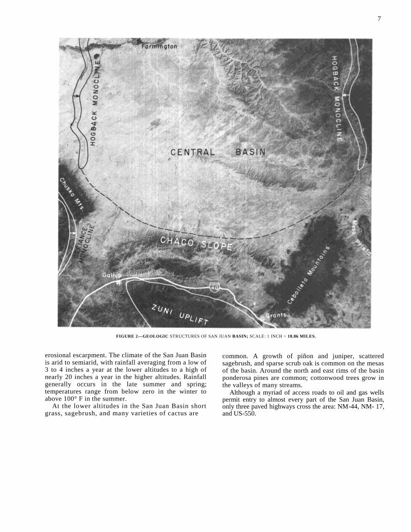
FIGURE 2—GEOLOGIC STRUCTURES OF SAN JUAN BASIN; SCALE: 1 INCH = 18.86 MILES.
erosional escarpment. The climate of the San Juan Basin is arid to semiarid, with rainfall averaging from a low of 3 to 4 inches a year at the lower altitudes to a high of nearly 20 inches a year in the higher altitudes. Rainfall generally occurs in the late summer and spring; temperatures range from below zero in the winter to above 100° F in the summer.
At the lower altitudes in the San Juan Basin short grass, sagebrush, and many varieties of cactus are
common. A growth of piñon and juniper, scattered sagebrush, and sparse scrub oak is common on the mesas of the basin. Around the north and east rims of the basin ponderosa pines are common; cottonwood trees grow in the valleys of many streams.
Although a myriad of access roads to oil and gas wells permit entry to almost every part of the San Juan Basin, only three paved highways cross the area: NM-44, NM- 17, and US-550.
7
Structure of San Juan Basin The San Juan Basin (fig. 2) is the southeastern part
of the Colorado Plateau physiographic province and
makes up the eastern half of the Navajo section,
mainly in northwestern New Mexico, but extending
into southwestern Colorado. The central-plains part of
the basin is underlain by almost horizontal strata and
is dissected by sandy arroyos. This central part begins
at about 36° N. latitude and reaches northward to
Durango, with its eastern boundary the monoclines and
anticlines, extending northward from the Nacimiento
uplift, and with the western boundary at the Hogback
monocline and its southward extensions.
The Nacimiento uplift, a thrust block that has moved
westward at steep angles over basinal strata, abruptly borders
the basin on the east.
The southern margin of the San Juan Basin is the
most complex; the almost horizontal strata of the
Central Basin dip at slightly higher angles (and thus,
locally dip too steeply to allow extensive strip
mining) southward along the Chaco slope, which
encompasses the area from 36° N. latitude southward
beyond Grants. East of Grants is the junction of the Chaco slope from
the west, the Acoma embayment from the south, and the Rio Grande fault belt from the east. In this area, on the southeast flank of the San Juan Basin, are the faults
and folds of the uranium-producing Ambrosia Lake
district, the Mount Taylor syncline overlain by the
Cenozoic lavas of Mount Taylor and Cebolleta Mesa,
and the Rio Puerco fault belts.
The most striking structural features of the San Juan
Basin are hogback ridges, called monoclines by Kelley
(1951). These hogbacks are caused by steep dips of the
strata on the outer, basinward limb of an anticline and
the accompanying inner synclinal bend. The Hogback
monocline is essentially continuous from the northwest
side of the central basin, around the north rim, and then
southward to the west edge of the Nacimiento uplift.
The most spectacular exposures are where the San Juan
River cuts the hogback between Shiprock and Farm-
ington.
The entire Hogback monocline, a horseshoe-shaped figure opening southward, does bring the coal-bearing
strata into a belt, 1 mi to 5 mi wide, in which the beds dip too steeply for any appreciable amount of coal to be
strip-mined. Outside of this belt, the strata dip relatively gently into the central basin, with the dips becoming
more and more steep outward, especially on the Chaco slope. The center of the central basin is actually in the
geographically northeastern part of the San Juan Basin,
near Archuleta, New Mexico.
Stratigraphy The Dakota Sandstone is highly variable in structure,
texture, and composition (fig. 2). It is characterized
more by a persistent combination of features than by the
persistence of any given bed. The base is commonly,
but by no means universally, marked by a conglomerate;
the top is in many places a coarse, brown or gray
sandstone bed, but it may be a group of interbedded
sandstones and shale or wholly yellow or gray sandy
shale. Coal lenses prevail in the middle of the Dakota
but are found in all positions from top to bottom. The
formation is everywhere lenticular; lenses and wedges
of sandstone, conglomerate, shale, and coal a few
inches to tens of feet thick overlap, appear, and
disappear. The thickness of the Dakota is variable and
ranges from 54 ft to a little over 200 ft.
The Mancos Shale consists of gray to dark-gray
carbonaceous marine shales that overlie the Dakota
Sandstone and elsewhere rest upon the pre-Dakota
rocks. The Mancos splits southwestward into three main
units on the north flank of the Zuni uplift. The highest
unit is the Satan Tongue that thins westward and
becomes indistinguishable from the Mesaverde. The
middle unit, called the Mulatto Tongue, extends south -
west to the vicinity of Gallup and becomes inseparable
from the Mesaverde. The lowest unit extends far west
and also is recognizable as far south as Silver City, New
Mexico. The thickness of the Mancos Shale ranges from
400 ft to 2,000 ft. The first persistent regressive sandstone that inter-
tongues with the lower part of the Mancos Shale is
called the Gallup Sandstone. The Gallup Sandstone
consists of three persistent massive sandstones and
interbedded shale and coal that ranges from 180 to 250
ft thick. The base of the Gallup Sandstone is often
transitional into the Mancos Shale.
The Dilco Coal Member of the Crevasse Canyon
Formation contains many of the valuable coal beds in
the western part of the San Juan Basin. This member is
between 240 and 300 ft thick in the Gallup-Zuni Basin
and is gradually replaced northeastward by sandstone
and shale. Over a large area in the San Juan Basin the
Dilco is directly overlain by the Mulatto Tongue of the
Mancos Shale.
The Dalton Sandstone Member of the Crevasse
Canyon Formation is the littoral sandstone enclosing
the Mulatto Tongue of the Mancos Shale. The Dalton
Sandstone Member splits into two tongues northeast -
ward, the lower tongue intervening between the
Mulatto Tongue of the Mancos Shale and the Dilco
Coal Member for a few miles before lensing out. The
main body of the Dalton, an upper sandstone tongue, is
the regressive sandstone lying above the Mulatto Sand -
stone Member and ranges from 70 to 180 ft.
The Gibson Coal Member of the Crevasse Canyon
Formation consists of 150 to 175 ft of clay, irregular
sandstone, and coal.
In the southern part of the San Juan Basin, the Point Lookout Sandstone is split into two members by the
8
9
Satan Tongue of the Mancos Shale. The lower member is called the Hosta Tongue of the Point Lookout Sandstone. The Hosta Tongue consists of a massive bed of medium-grained sandstone 200 ft thick. The upper member is the Point Lookout Sandstone and consists of a massive bed of medium-grained sandstone ranging from 100 to 300 ft thick.
The Point Lookout Sandstone is overlain by the Cleary Coal Member of the Menefee Formation. The Cleary Coal Member consists of coal, shale, and sand-stone and is 400 ft thick. The upper member of the Menefee Formation wedges out to the north and the east and consists of shale and sandstone to 800 ft thick. The Hogback Mountain tongue of the Menefee Formation is equivalent to and in part enclosed by the La Ventana sandstone. The tongue is a sequence of lenticular sandstones, shales, and coals. Another coal-bearing sequence analogous to the Hogback Mountain tongue was deposited landward from the Chacra sandstone; however, erosion has removed all but the northwestern end of this coal-bearing tongue.
The Cliff House Sandstone, Chacra sandstone, and La Ventana sandstone are deposits of the transgressive transition zone between the marine Lewis Shale and the largely nonmarine Menefee Formation. These deposits differ from the regressive sandstones in that they are not continuous sand bodies but rather a continuous zone of sand lenses which intertongue deeply into both the Lewis Shale and the Menefee Formation.
The Pictured Cliffs Sandstone is the uppermost marine unit in the San Juan Basin and records the final withdrawal of the Cretaceous sea. The Pictured Cliffs Sandstone is medium to fine grained and grades northeastward into the Lewis Shale. Thickness ranges from 50 to 400 ft. Outcrops occur on the north, west, and south sides of the San Juan Basin.
Behind and above the nearshore sands of the Pictured Cliffs Sandstone is 200 to 300 ft of the coal-bearing Fruitland Formation. The Fruitland is composed of interbedded sandstone, siltstone, shale, carbonaceous shale, carbonaceous sandstone, coal, and (at places in the lower part) thin limestone beds composed almost entirely of shells of brackish-water pelecypods; most individual beds pinch out laterally usually within a few hundred feet. The thick coal beds are confined to the lower third of the formation.
SEDIMENTARY SEQUENCES
The general relationships of the coal-bearing units with other rocks of Cretaceous age are shown in fig. 3. The oldest rocks in the sequence belong to the Dakota Sandstone, a complex assemblage of nearshore marine sands; barrier island, delta, and beach deposits; and marsh and swamp sediments (including coal), along with sandy coastal plain and floodplain deposits. The Dakota represents an encroachment of the sea from north to south and thus rises slightly in the stratigraphic section from north to south across the San Juan Basin.
The transgression continued, moving the shoreline south and southwestward until it stood in southwestern New Mexico. During that time, the area which would later become the San Juan Basin was occupied by a shallow sea, and marine shales of the lowermost Man-cos Shale were deposited upon the Dakota. The north
ward regression of the sea resulted in deposition of the Gallup Sandstone in several tongues, each representing a short-distance regression-transgression cycle. The youngest of these still preserved resulted from a retreat of somewhat greater distance such that coal-swamp deposits followed the position of the shoreline well northward into what is now the San Juan Basin. These coals are assigned to the Dilco Coal Member of the Crevasse Canyon Formation. Above them is a trans-gressive sandstone (known as the "stray") representing the southward encroachment of the sea after deposition of the Dilco.
About the time the shoreline advanced beyond the basin, uplift took place in the northern part of the area, interrupting the succession of advances and retreats for a short period and resulting in some erosion of the Gallup-Dilco-"stray" sequence. After the effect of uplift had subsided, the entire area was left covered by marine waters in which the Mulatto Tongue of the Mancos Shale (and its lateral equivalents further seaward) were deposited.
The next retreat of the sea resulted in deposition of beach sands of the Dalton Sandstone Member of the Crevasse Canyon and their landward equivalents, the coal swamp and floodplain deposits of the Gibson Coal Member. As the retreat came to a halt and advance began again, the Hosta Tongue of the Point Lookout Sandstone was laid down, again associated with the landward equivalents assigned to the Gibson Coal Member.
Near the southern rim of the present basin, the
1 0
advance again slowed and stopped, and the beach environment again moved seaward, creating the Point Lookout Sandstone. The continental deposits laid down behind the retreating beach included the coal-swamp materials of the Cleary Coal Member of the Menefee Formation. This regression proceeded relatively smoothly to still another turnaround near the northeasterly limits of the basin in Colorado.
On the way south again, the products of the new transgression by the beach environment are termed the Cliff House Sandstone. This transgression was less orderly than earlier ones, and the Cliff House is thus composed of several benches (each the result of a period of slower overall movement) separated by thin zones that record periods of more rapid southwestward move-ment of the shore. Near the middle of the present basin, there was an interruption in the pattern: the shoreline moved rapidly southwestward, then returned to near its former position and remained near there for a long period. The result is a thin tongue of marine Mancos Shale which overlies a very thin Cliff House Sandstone (representing the rapid shift of shoreline and consequent rapid deepening of water), all overlain by a thick beach and bar sandstone body (representing the long stillstand of the shore).
The thick sandstone is referred to as the La Ventana Tongue of the Cliff House. It is a long narrow sandstone body which lies on a straight depositional strike line across the basin. To the southwest, the landward equivalent of the La Ventana is a coal-rich section of the Menefee Formation; the seaward equivalent is a part of the Lewis Shale. This part of the Lewis is progressively less sandy to the northeast until indistinguishable from the remainder of the formation above and below.
After the La Ventana stillstand ended, the shoreline again moved southwestward. There was a rapid trans-gression, represented by a thin transgressive sandstone, then another period of stillstand and slow transgression, which produced the Chacra tongue of the Cliff House. The Chacra is thus analogous to the La Ventana but thinner. Coal is associated with the Chacra because the equivalent Menefee Formation floodplain and coastal plain environments included coal swamps.
After the culminating transgression, represented by the highest sandstones of the Chacra, the shoreline retreated northeastward once more. The final regressive sandstone is the Pictured Cliffs Sandstone (the south-western and lowest extremity of which merges with the Chacra). The landward equivalents of the Pictured Cliffs beach deposits belong to the Fruitland Formation and are coal bearing.
Throughout the Cretaceous the direction of trans-gression and regression and the trend of the shoreline, and hence the depositional strike of the beds, remained remarkably constant. Though there is much variation in detail, the general trend through most of the cycles averaged N. 50° W. to N. 60° W. The foregoing outline of the history of the Cretaceous rocks of the basin is intended only to furnish a framework to aid in under-standing the nomenclature of the geologic units. A more detailed treatment can be found in a paper by Beaumont in Shomaker, Beaumont, and Kottlowski (1971, p. 15-30).
PALEOENVIRONMENTS
The southwestern land mass, onto which the Cretaceous sea repeatedly encroached and then retreated, provided rather uniform materials to sed-imentation. Further, the climate seems to have remained generally the same throughout the period so that the depositional environments were similar throughout, and the orderly progression from one environment to the next (land to sea) was fairly predictable.
These environments and their characteristic sedi-ments include: 1) floodplains, including fluviatile sands, silts, and muds; 2) coastal swamps, with carbonaceous shales, silts, thin sands, and peat; 3) deltas, beaches, and offshore bars, all characterized by clean sands and minor silts and muds, and 4) the bottom of the shallow sea, with muds, very fine sands and silts, and calcareous material.
In general, the floodplain deposits, which include most of the Menefee Formation and the noncoalbearing parts of the Dilco Coal Member, the Gibson Coal Member, and the Fruitland Formation. The deposits consist of drab-gray, greenish-gray and brownish-gray shales, soft-white and light-tan poorly sorted sandstones, and brown and gray-brown carbonaceous shales. These beds are interpreted to have been de-posited on a very broad, gently sloping coastal plain with little relief. Most of the beds are riverborne sediments, with considerable carbonaceous material derived from vegetative cover. A substantial quantity of lake-bottom sediment is present along with innumerable thin, lenticular sandstone bodies, which may represent channel sediments in wide, slow-moving rivers. There are coaly beds among the floodplain deposits, and these are doubtless the products of freshwater swamp and lake-margin swamp environments that occurred sporadically on the floodplain.
The coastal swamp environment, resulting in com-mercial coal accumulations, consisted primarily of freshwater swamps. These swamps were very near the marine shore and were supported by heavy precipita -tion and a climate conducive to rapid growth of vegetation. The low sulfur content of these coals is the fundamental criterion by which the coals are inter -preted to be principally freshwater swamp deposits, rather than the products of marshes connected with (and sometimes inundated by) marine waters.
The coal swamps may be considered analogous in many ways to the present-day Okefenokee Swamp in southeastern Georgia. The general environment may have been very similar, but the swamp environment was probably much more extensive and more persistent in the San Juan Basin area of the Late Cretaceous than in the Atlantic Coastal Plain of the present. The cause of this may be the rapidity with which the sea advanced and retreated during the Late Cretaceous; the repeated advances and accompanying strong nearshore erosion kept the coastal plain adjusted to a uniform seaward slope. Time intervals between retreat and succeeding advance were insufficient for dissection of the coastal plain.
The swamp environment included great expanses of shallow water in which vegetation grew profusely; beneath the surface, peat accumulated as dead vegetal matter. The high ash content of the San Juan Basin
11
coals may indicate that rainfall was very high and that a great volume of surface drainage entered the swamps from the landward (southwest) margins, depositing much silt-size and clay-size material and discharging to the sea through shallow, low-gradient streams that drained the seaward (northwest) margins of the swamps. The streams probably carried considerable volumes of coarse, sand-size material at various times, resulting in lens-shaped sandstone bodies within the coal-bearing section.
Differential compaction played an important part in the early development of the peat, accounting for some of the irregularity of the present-day coal beds. Highly concentrated vegetal material was compressed to vol-ume much smaller than that of the original clay-rich sediment; sand bodies lost far less volume. In this way, the bedding of sediments, particularly near the margins of the swamps and near the courses of through-flowing streams, became more and more distorted.
Just seaward of the coal swamps lay accumulations of sand associated with beach, lagoon, barrier bar, and nearshore marine environments. A band of windblown,
intermittently stabilized sand was behind the beach. These sands are represented in the Upper Cretaceous rocks of the San Juan Basin by the Gallup Sandstone, the Dalton Sandstone Member, the Hosta Tongue and the main body of the Point Lookout Sandstone, the Cliff House Sandstone with its associated La Ventana and Chacra tongues, and the Pictured Cliffs Sandstone. As mentioned, all of these from the Dalton upward are homogenetic equivalents, simply recording the back-and-forth passage of the shore environment with chang-ing shore position. Probably the freshwater swamps occupied the sites of former lagoons (between the beaches and barrier bars) which remained as topogra-phic lows when the marine waters retreated.
Given a very gently sloping, uniform surface with sediments of the floodplain variety, transgression of the sea would result in progressive covering of preexisting materials with sand; the sand to supply the process must be furnished by streams carrying copious quantities of water and draining source areas with abundant sediment.
Uniform classification of
coal resources The uniform classification for energy resource com-
modities as adopted by the U.S. Geological Survey and the U.S. Bureau of Mines is followed in the present report. According to this classification, coal reserves
include only coal that has been: 1) measured within an error of 20 percent by closely-spaced drilling and sample analysis, or 2) indicated partly by sample analysis and partly by reasonable geologic projection, or 3) inferred in unexplored extensions and geologic projections of measured and indicated reserves and is economically minable at the time of determination. All other estimates of tonnage in place are classified as resources consisting of: 1) hypothetical coal (in known districts) or, 2) speculative coal (in as yet undiscovered districts), or 3) subeconomic (not economically min-able).
Aside from certain strippable reserves along the southern margin of the Menefee Formation and strip-pable reserves of the Fruitland Formation, all the coal discussed in this report is classified either as submar-ginal indicated reserves or resources. Nowhere else is drilling sufficiently dense to establish reserves; given current economic limitations, virtually none of the coal can be profitably mined with the present technology and market conditions.
After the total thickness of coal was determined from geophysical logs, isopach maps were prepared, and contour lines showing approximate depths to the top of the first coal were drawn. Areas of equal coal thickness in each depth category were measured with a planimeter and the area in acres was multiplied by a factor of 1,770 tons per ac-ft.
Basic geologic data CORE TESTS
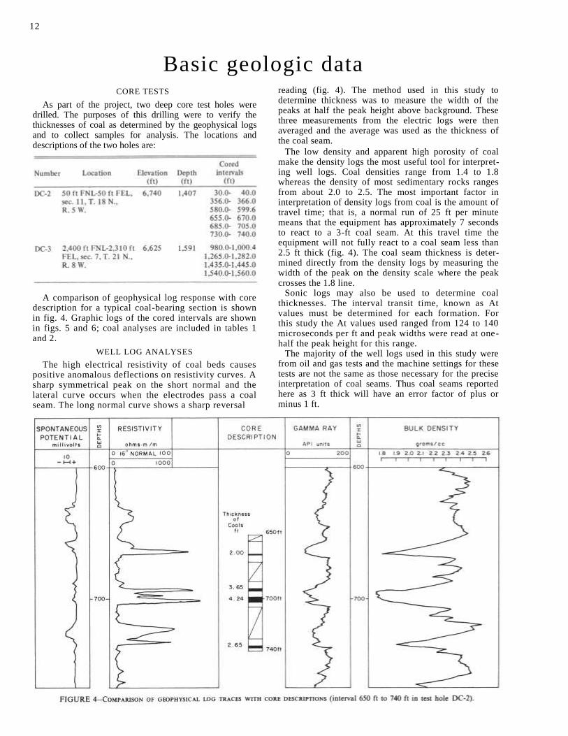
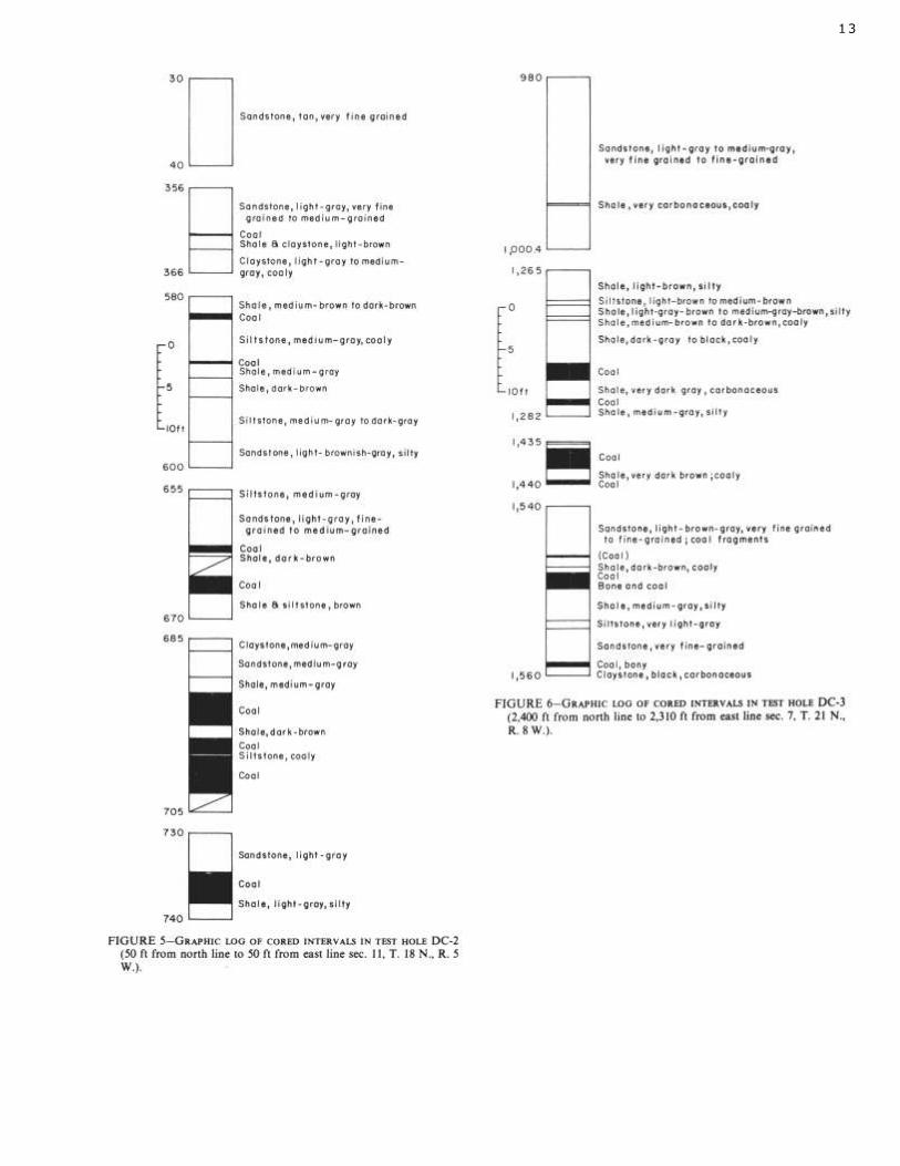
As part of the project, two deep core test holes were drilled. The purposes of this drilling were to verify the thicknesses of coal as determined by the geophysical logs and to collect samples for analysis. The locations and descriptions of the two holes are:
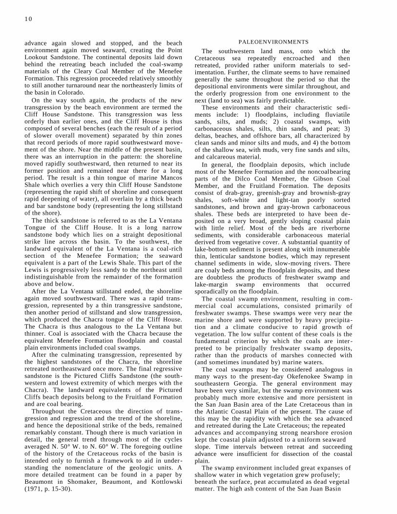
A comparison of geophysical log response with core description for a typical coal-bearing section is shown in fig. 4. Graphic logs of the cored intervals are shown in figs. 5 and 6; coal analyses are included in tables 1 and 2.
WELL LOG ANALYSES
The high electrical resistivity of coal beds causes positive anomalous deflections on resistivity curves. A sharp symmetrical peak on the short normal and the lateral curve occurs when the electrodes pass a coal seam. The long normal curve shows a sharp reversal
reading (fig. 4). The method used in this study to determine thickness was to measure the width of the peaks at half the peak height above background. These three measurements from the electric logs were then averaged and the average was used as the thickness of the coal seam.
The low density and apparent high porosity of coal make the density logs the most useful tool for interpret-ing well logs. Coal densities range from 1.4 to 1.8 whereas the density of most sedimentary rocks ranges from about 2.0 to 2.5. The most important factor in interpretation of density logs from coal is the amount of travel time; that is, a normal run of 25 ft per minute means that the equipment has approximately 7 seconds to react to a 3-ft coal seam. At this travel time the equipment will not fully react to a coal seam less than 2.5 ft thick (fig. 4). The coal seam thickness is deter-mined directly from the density logs by measuring the width of the peak on the density scale where the peak crosses the 1.8 line.
Sonic logs may also be used to determine coal thicknesses. The interval transit time, known as At values must be determined for each formation. For this study the At values used ranged from 124 to 140 microseconds per ft and peak widths were read at one-half the peak height for this range.
The majority of the well logs used in this study were from oil and gas tests and the machine settings for these tests are not the same as those necessary for the precise interpretation of coal seams. Thus coal seams reported here as 3 ft thick will have an error factor of plus or minus 1 ft.
12
13
Quality of coals FRUITLAND FORMATION
The coal of the Fruitland Formation is hard, brittle, and black; it decomposes, or slacks, on exposure to weather and cannot be stored for long periods. Many woody charcoal fragments and small lumps of fossil resin may be found. Iron sulfide can be observed in the form of small grains and veinlets of pyrite and marca-site.
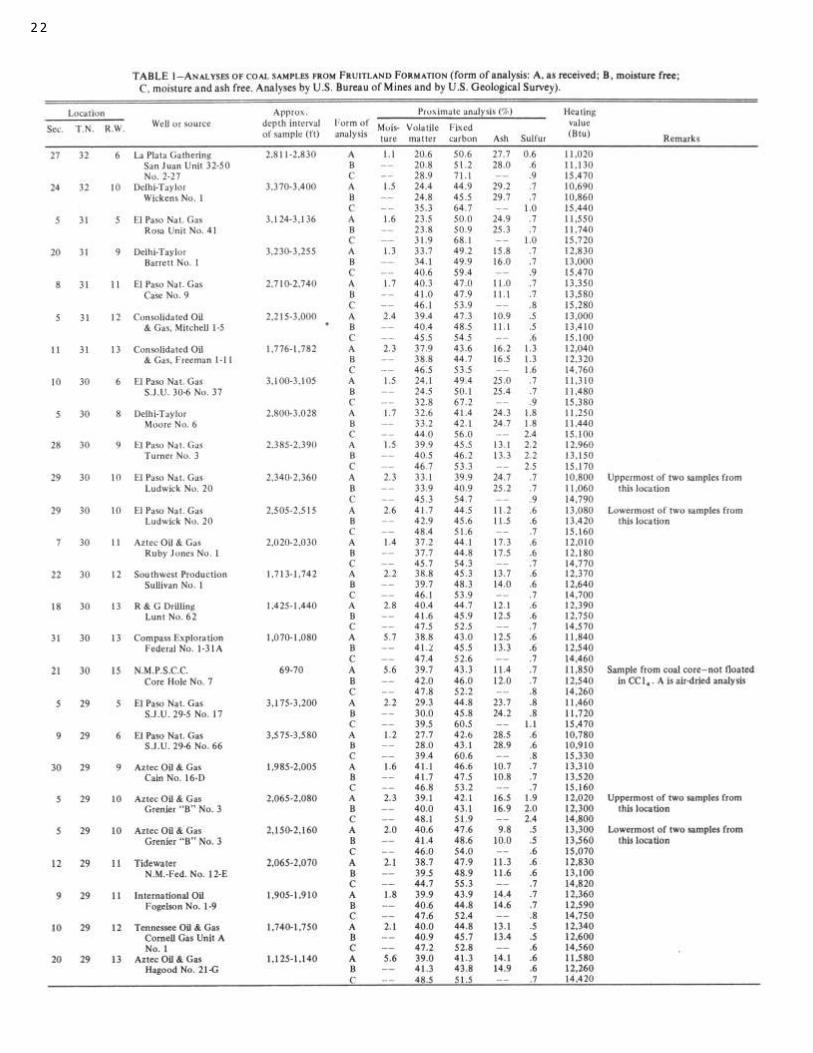
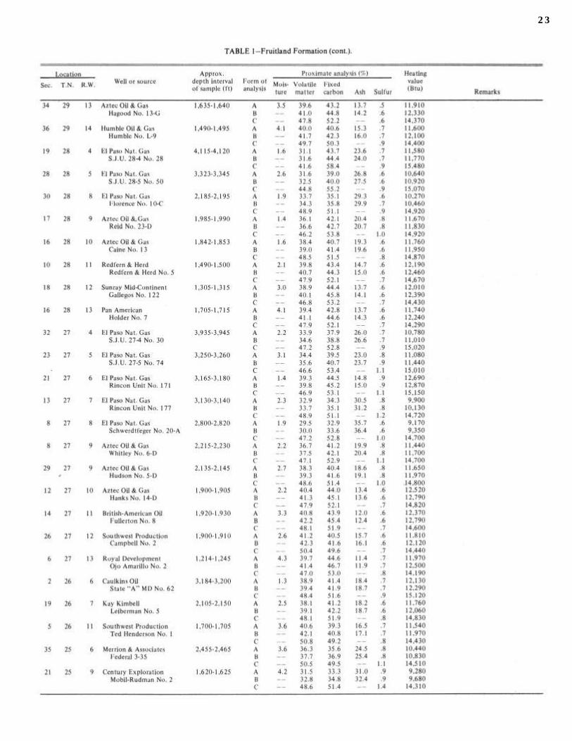
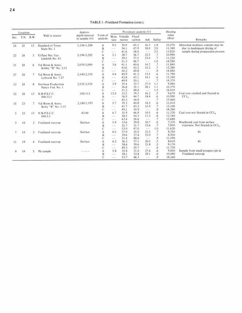
Table 1 (after Fassett and Hinds, 1971) shows analysis of 67 samples of Fruitland coals taken from 65 locations in the San Juan Basin.
The fresh unweathered coals from the Fruitland Formation have a moisture content generally in the range of 2-5 percent (Fassett and Hinds, 1971). Sulfur content is consistently somewhat less than 1 percent.
There are three general zones of ash distribution across the San Juan Basin. An irregular area in the west-central part of the basin contains coal with an ash content of 8 percent to 15 percent. An intermediate zone in a strip running north-south near the central part of the basin has an ash content of 15-20 percent; an eastern zone has ash in amounts exceeding 20 percent. This distribution shows only that, in general, the east half of the basin area received a greater amount of detrital matter, but the zones do not follow depositional trends and are seemingly unrelated to bed thickness, fixed-carbon to volatile ratios, absolute (moisture and ash free) Btu values, or the relative ages of the coal beds.
The absolute Btu values vary between 9,000 in the southwestern part of the basin to 15,720 in the north-west. The values can be plotted and contoured to produce a map containing zones of Btu values. These zones parallel almost exactly the zones of deposition and the structural axis of the present basin.
Fruitland coal of the San Juan Basin is considered subbituminous in New Mexico and low-grade bitumi-nous in Colorado. Based solely on percentage of fixed
carbon and heating value on a mineral-matter-free basis, most coal in the northern half of the basin would range from high-volatile to medium-volatile bituminous in rank. Because of the known slacking tendency of the coal in the western part of the basin and the very high ash content in the east half of the basin, all the Fruitland coal is considered subbituminous in this report.
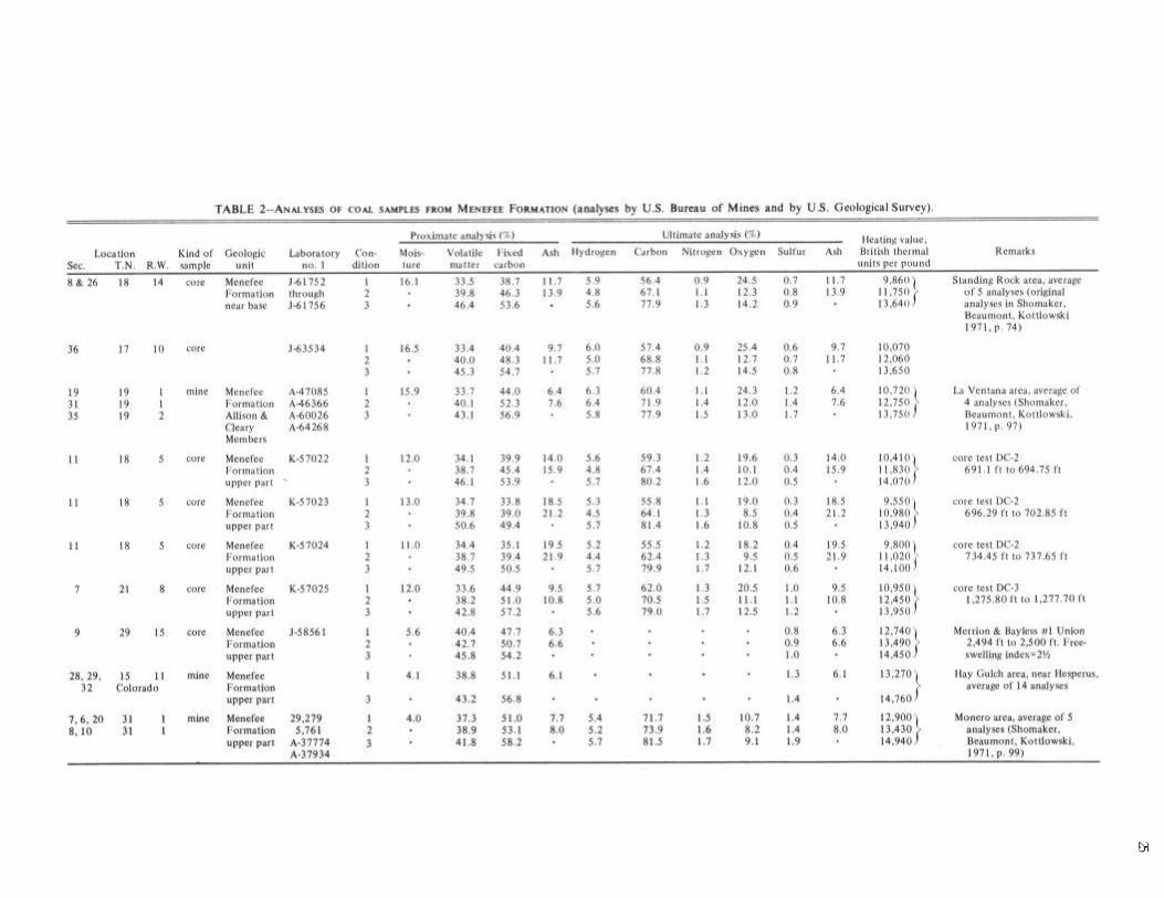
MENEFEE FORMATION
In general, the quality of coal in the Menefee Formation improves northward from the southern edge of the basin. In the vicinity of Standing Rock (fig. 1), the coal is subbituminous A with average heating value of about 9,860 Btu per lb and an ash content of about 12 percent. Near La Ventana the coal is either subbituminous A or high-volatile C bituminous. Coal from the two drillholes DC-2 and DC-3 (figs. 5 and 6) is high-volatile C bituminous rank, whereas in a core from a well further northwest in sec. 9, T. 29 N., R. 15 W., the coal is high-volatile B bituminous. As received at the laboratory, the heating value was 12,740 Btu per lb and ash content was 6.3 percent. At the north end of the basin, at Hesperus and at Monero, almost all of the analyses indicate high-volatile A bituminous.
Sulfur content is lowest in the southern part of the basin, generally less than 1 percent, and higher and more erratic in the northern part. Individual sulfur analyses reach 3.5 percent in both the Hesperus and Monero area, but the average sulfur content is probably less than 1.5 percent.
Typical analyses from various areas are shown in table 2. Only active mines and core samples are included because samples taken at prospect pits and small intermittently worked wagon mines are generally somewhat weathered and not representative of actual commercial coal production.
14
Estimates of reserves and resources FRUITLAND FORMATION
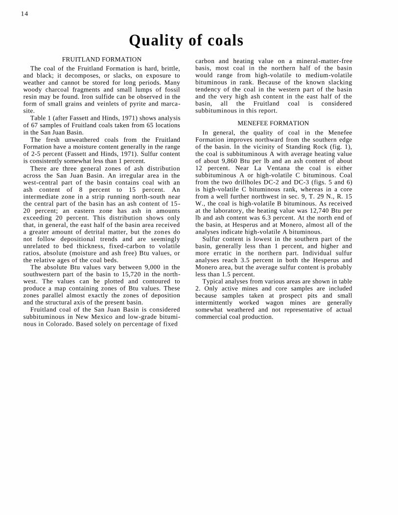
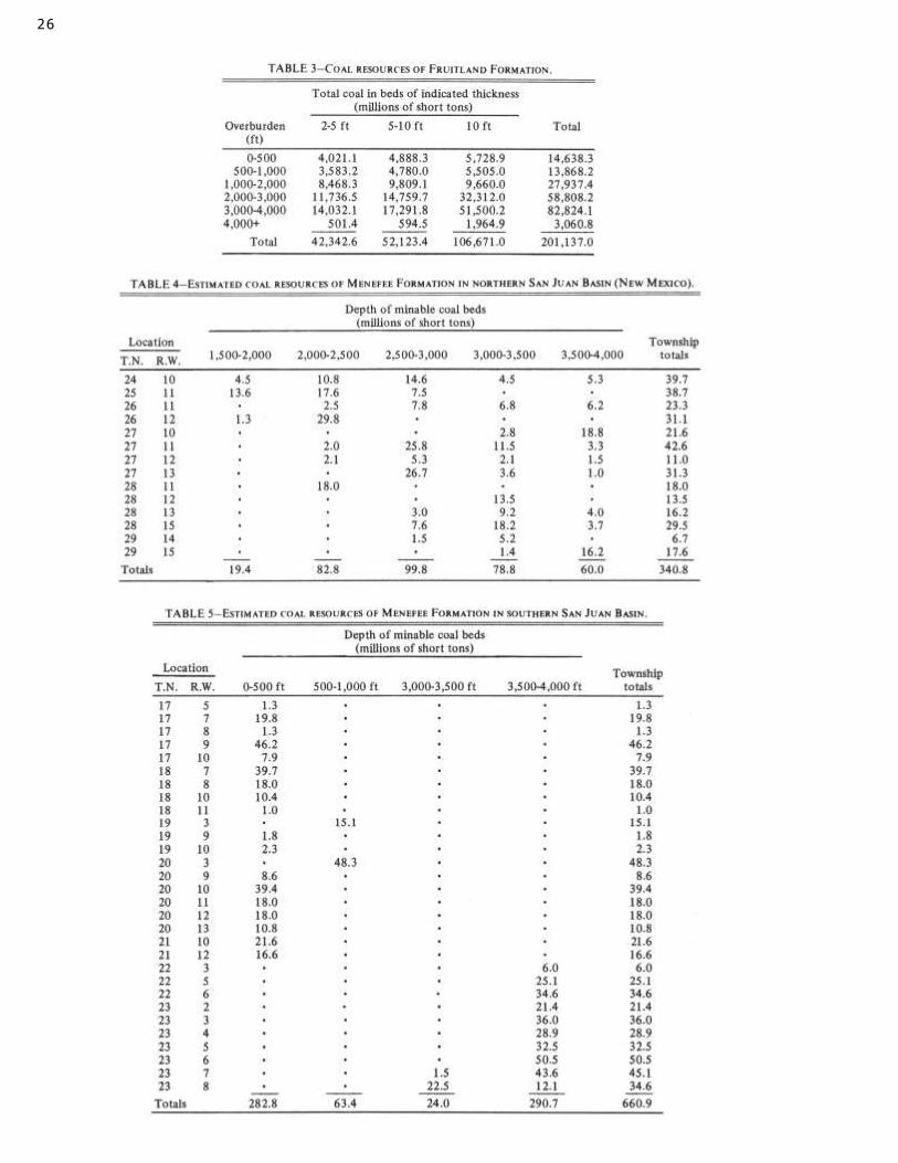
About 200 billion tons (Fassett and Hinds, 1971) of coal is contained in the Fruitland Formation between its outcrop and its deepest point of slightly more than 4,000 ft below the surface (fig. 6). Estimates of these coal resources are based on the assumption that all the coal in the formation is subbituminous and has an average weight of 1,132,560 tons per mi-ft (1,770 tons per ac-ft).
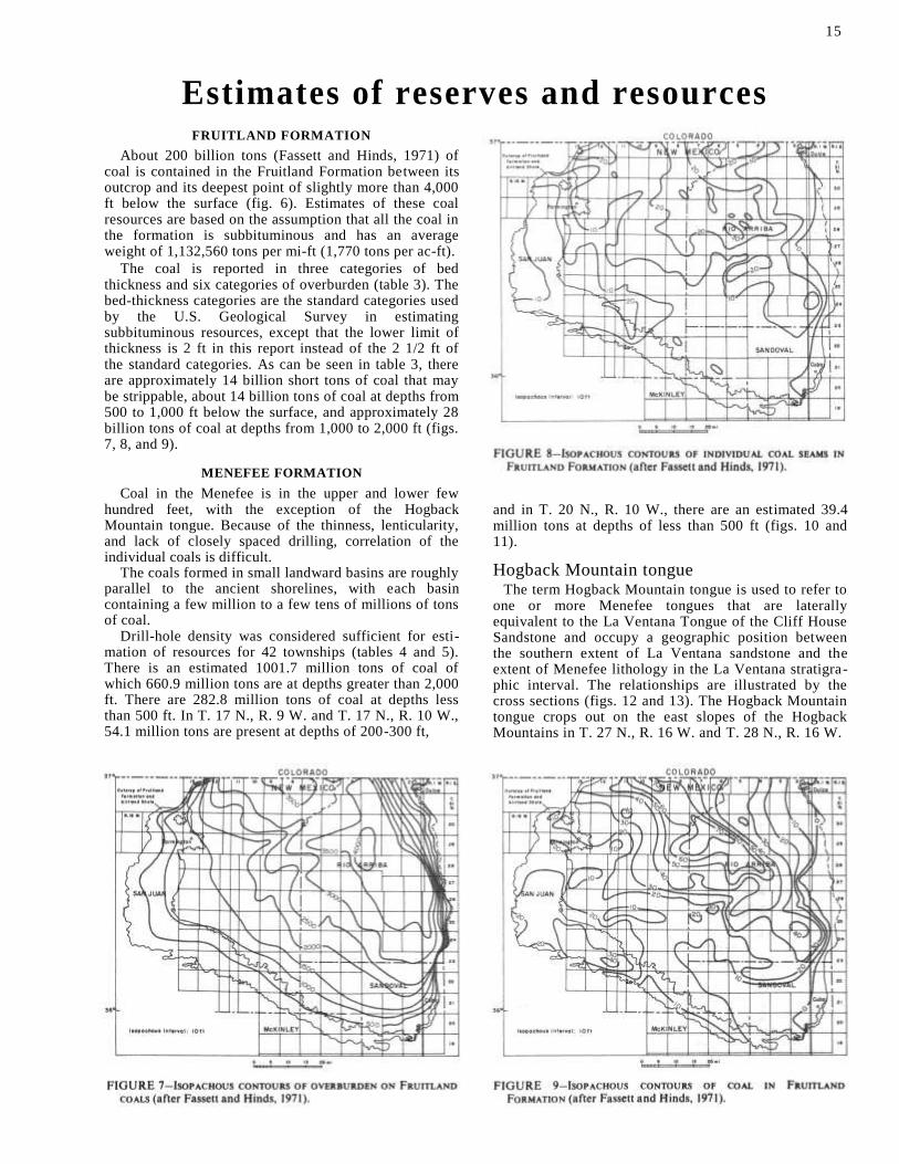
The coal is reported in three categories of bed thickness and six categories of overburden (table 3). The bed-thickness categories are the standard categories used by the U.S. Geological Survey in estimating subbituminous resources, except that the lower limit of thickness is 2 ft in this report instead of the 2 1/2 ft of the standard categories. As can be seen in table 3, there are approximately 14 billion short tons of coal that may be strippable, about 14 billion tons of coal at depths from 500 to 1,000 ft below the surface, and approximately 28 billion tons of coal at depths from 1,000 to 2,000 ft (figs. 7, 8, and 9).
MENEFEE FORMATION
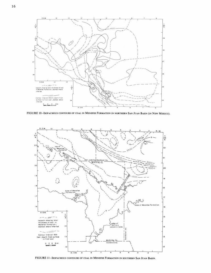
Coal in the Menefee is in the upper and lower few hundred feet, with the exception of the Hogback Mountain tongue. Because of the thinness, lenticularity, and lack of closely spaced drilling, correlation of the individual coals is difficult.
The coals formed in small landward basins are roughly parallel to the ancient shorelines, with each basin containing a few million to a few tens of millions of tons of coal.
Drill-hole density was considered sufficient for esti-mation of resources for 42 townships (tables 4 and 5). There is an estimated 1001.7 million tons of coal of which 660.9 million tons are at depths greater than 2,000 ft. There are 282.8 million tons of coal at depths less than 500 ft. In T. 17 N., R. 9 W. and T. 17 N., R. 10 W., 54.1 million tons are present at depths of 200-300 ft,
and in T. 20 N., R. 10 W., there are an estimated 39.4 million tons at depths of less than 500 ft (figs. 10 and 11).
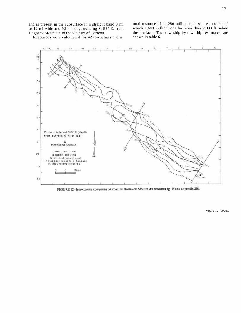
Hogback Mountain tongue The term Hogback Mountain tongue is used to refer to
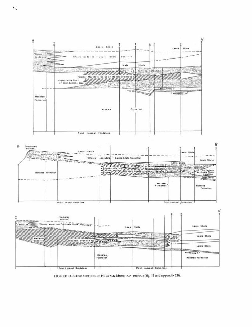
one or more Menefee tongues that are laterally equivalent to the La Ventana Tongue of the Cliff House Sandstone and occupy a geographic position between the southern extent of La Ventana sandstone and the extent of Menefee lithology in the La Ventana stratigra-phic interval. The relationships are illustrated by the cross sections (figs. 12 and 13). The Hogback Mountain tongue crops out on the east slopes of the Hogback Mountains in T. 27 N., R. 16 W. and T. 28 N., R. 16 W.
15
16
17
and is present in the subsurface in a straight band 3 mi to 12 mi wide and 92 mi long, trending S. 53° E. from Hogback Mountain to the vicinity of Torreon.
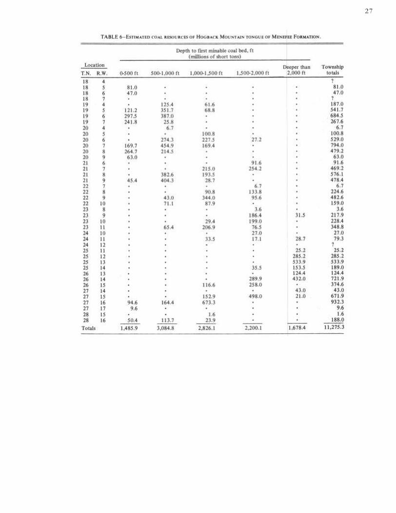
Resources were calculated for 42 townships and a
total resource of 11,280 million tons was estimated, of which 1,680 million tons lie more than 2,000 ft below the surface. The township-by-township estimates are shown in table 6.
Figure 13 follows
1 8
Economics of future prospects To meet the expanding energy requirements of the
nation, the demand for and selling price of coal has risen steadily since 1970. The cost of coal varies with the mining method and with each operation. In 1974 the national average cost of strip-mined coal was $11.11 per ton. Underground coal in 1974 cost $19.86 per ton (U.S. Bureau of Mines, 1974). With ongoing inflation in coal mining costs, the contract price of strip-mined coal per ton in 1985 may well be $20 (Arnold and others, 1977).
The coals in the southern and southeastern part of the San Juan Basin, as near Star Lake and Bisti, will have additional costs for washing and transportation. These
coals will probably require washing to cut down on the high ash content. This will cost $1.50 to $3.00 per ton depending mainly on costs for obtaining the water from deep wells (Paul Weir Company, 1975). Also, to develop these coal deposits a 70-mi railroad costing $50 million is planned from Prewitt to Star Lake, New Mexico.
The depth of the Menefee coals will probably require new exotic methods of production-for example, in situ gasification or solution mining. While these methods are not economically feasible now, research into new process technology is in various stages.
References Allen, J. E., and Balk, R., 1954, Mineral resources of Fort Defiance and
Tohatchi quadrangles, Arizona and New Mexico: New Mexico Bureau of Mines and Mineral Resources, Bull. 36, 192 p.
Arnold, E. C., 1977, New Mexico's energy resources '77-annual report of the office of the State Geologist: New Mexico Bureau of Mines and Mineral Resources, Circ. 148, 27 p.
Baltz, E. H., Jr., 1962, Stratigraphy and geologic structure of uppermost Cretaceous and Tertiary rocks of the east-central part of the San Juan Basin, New Mexico: U.S. Geological Survey, Open-file Rept., 278 p.
, 1967, Stratigraphy and regional implications of part of Upper Cretaceous and Tertiary rocks, east-central San Juan Basin, New Mexico: U.S. Geological Survey, Prof. Paper 552, 101 p.
Baltz, E. H., Jr., Ash, S. R., and Anderson, R. Y., 1966, History of nomenclature and stratigraphy of rocks adjacent to the Cretaceous-Tertiary boundary, western San Juan Basin, New Mexico: U.S. Geological Survey, Prof. Paper 524-D, 23 p.
Barnes, F. C., 1950, History of development and production of oil and gas in the San Juan Basin: New Mexico Geological Society, Guidebook 1st field conference, p. 144-148
Barnes, Harley, 1953, Geology of the Ignacio area, Ignacio and Pagosa Springs quadrangles, La Plata and Archuleta Counties, Colorado: U.S. Geological Survey, Oil and Gas Inv. Map OM-138
Barnes, Harley, Baltz, E. H., Jr., and Hayes, P. T., 1954, Geology and fuel resources of the Red Mesa area, La Plata and Montezuma Counties, Colorado: U.S. Geological Survey, Oil and Gas Inv. Map OM-149
Bauer, C. M., 1916, Stratigraphy of a part of the Chaco River valley: U.S. Geological Survey, Prof. Paper 98-P, p. 271-278 [1917]
Bauer, C. M., and Reeside, J. B., Jr., 1921, Coal in the middle and eastern parts of San Juan County, New Mexico: U.S. Geological Survey, Bull. 716-G, p. 155-237
Beaumont, E. C., 1954, Preliminary geologic map of the Beautiful Mountain anticline, San Juan County, New Mexico: U.S. Geological Survey, Oil and Gas Inv. Map OM-147
, 1955, Preliminary geologic map of the Ship Rock and Hogback quadrangles, San Juan County, New Mexico: U.S. Geological Survey, Oil and Gas Inv. Map OM-147
, 1971, Stratigraphic distribution of coal in San Juan Basin, in
Strippable low-sulfur coal resources of the San Juan Basin in New Mexico and Colorado: New Mexico Bureau of Mines and Mineral Resources, Mem. 25, p. 15-30
Beaumont, E. C., Dane, C. H., and Sears, J. D., 1956, Revised nomenclature of Mesaverde Group in San Juan Basin, New Mexico: American Association of Petroleum Geologists, Bull., v. 40, no. 9, p. 2149-2162
Beaumont, E. C., and O'Sullivan, R. B., 1955, Preliminary geologic map of the Kirtland quadrangle, San Juan County, New Mexico: U.S. Geological Survey, Coal Inv. Map C-32
Bozanic, Dan, 1955, A brief discussion on the subsurface Cretaceous rocks of the San Juan Basin: Four Corners Geological Society, Guidebook 1st field conference, p. 89-107
Burgener, J. A., 1953, The stratigraphy and sedimentation of the Pictured Cliffs Sandstone and Fruitland Formation, Upper Cretaceous of the San Juan Basin: M.S. thesis, University of Illinois, 59 p.
Collier, A. J., 1919, Coal south of Mancos, Montezuma County, Colorado: U.S. Geological Survey, Bull. 691-K, p. 293-310
Dane, C. H., 1936, The La Ventana-Chacra Mesa coal field: U.S. Geological Survey, Bull. 860-C. p. 81-161
1946, Stratigraphic relations of Eocene, Paleocene, and latest Cretaceous formations of eastern side of San Juan Basin, New Mexico: U.S. Geological Survey, Oil and Gas Inv. Prelim. Chart 24
, 1948, Geology and oil possibilities of the eastern side of San Juan Basin, Rio Arriba County, New Mexico: U.S. Geological Survey, Oil and Gas Inv. Prelim. Map 78 Fassett, J. E., 1964, Subsurface geology of the Upper Cretaceous
Kirtland and Fruitland Formations of the San Juan Basin, New Mexico and Colorado: U.S. Geological Survey, Open-file Rept.,
93 p.
, 1966, Geologic map of the Mesa Portales quadrangle, Sandoval County, New Mexico: U.S. Geological Survey, Geol. Quad. Map GQ-590
Fassett, J. E., and Hinds, J. S., 1971, Geology and fuel resources of the Fruitland Formation and Kirtland Shale of the San Juan Basin, New Mexico and Colorado: U.S. Geological Survey, Prof. Paper 676, 76 p.
Gardner, J. H., 1909a, The coal field between Gallina and Raton Spring, New Mexico in the San Juan coal region, in Coal fields of Colorado, New Mexico, Utah, Oregon, and Virginia: U.S. Geological Survey, Bull. 341-C, p. 335-351
, 1909b, The coal field between Durango, Colorado, and Monero, New Mexico, in Coal fields of Colorado, New Mexico, Utah, Oregon, and Virginia: U.S. Geological Survey, Bull. 341-C, p. 352-363
, 1909c, The coal field between Gallup and San Mateo, New Mexico, in Coal fields of Colorado, New Mexico, Utah, Oregon, and Virginia: U.S. Geological Survey, Bull. 341-C, p. 364-378
, 1910, The coal field between San Mateo and Cuba, New Mexico, in Coal fields in Colorado and New Mexico: U.S. Geological Survey, Bull. 318-C, p. 461-473
Hayes, P. T., and Zapp, A. D., 1955, Geology and fuel resources of the Upper Cretaceous rocks of the Barker dome-Fruitland area, San Juan County, New Mexico: U.S. Geological Survey, Oil and Gas Inv. Map OM-144
Hinds, J. S., 1964, Btu values of Fruitland Formation coal deposits in Colorado and New Mexico, as determined from rotary-drill cuttings, in Geological Survey research 1964: U.S. Geological Survey, Prof. Paper 501-D, p. D90-D94 [1965]
, 1966, Geologic map of the Johnson Trading Post quadrangle, Sandoval County, New Mexico: U.S. Geological Survey, Geol. Quad.
Map GQ-591 Hollenshead, C. T., and Pritchard, R. L., 1961, Geometry of
producing Mesaverde sandstones, San Juan Basin, in Geometry of
19
2 0
sandstone bodies-a symposium, 45th annual meeting: Tulsa,
Oklahoma, American Association of Petroleum Geologists, p.
98-118
Holmes, W. H., 1877, Report [on the San Juan district, Colorado]: U.S. Geological and Geographical Survey Terr., 9th ann. rept., p. 237-276
Hunt, C. B., 1936, The Mount Taylor coal field: U.S. Geological Survey, Bull. 860-B, p. 31-80
Kelley, V. C., 1951, Tectonics of the San Juan Basin: New Mexico Geological Society, Guidebook 2nd field conference, p. 124-131
Kilgore, L. W., 1955, Geology of the Durango area, La Plata County, Colorado: Four Corners Geological Society, Guidebook 1st field conference, 1955: p. 118-124
O'Sullivan, R. B., 1955, Preliminary geologic map of the Naschitti quadrangle, San Juan and McKinley Counties, New Mexico: U.S. Geological Survey, Coal Inv. Map C-31
O'Sullivan, R. B., and Beaumont, E. C., 1957, Preliminary geologic map of western San Juan Basin, San Juan and McKinley Counties, New Mexico: U.S. Geological Survey, Oil and Gas Inv. Map OM-190
Paul Weir Co., 1976, Mining cost estimates, typical mines (hypothetical) strip and underground, State of New Mexico: Report to the Energy Resources Board, p. 14
Read, C. B., Duffner, R. T., Wood, G. H., and Zapp, A. D., 1950, Coal resources of New Mexico: U.S. Geological Survey, Circ. 89, 24 p.
Reeside, J. B., Jr., 1924, Upper Cretaceous and Tertiary formations of the western part of the San Juan Basin of Colorado and New Mexico: U.S. Geological Survey, Prof. Paper 134, p. 1-70
Schrader, F. C., 1906, The Durango-Gallup coal field of Colorado and New Mexico: U.S. Geological Survey, Bull. 285-F, p. 241-258
Sears, J. D., 1925, Geology and coal resources of the Gallup-Zuni Basin, New Mexico: U.S. Geological Survey, Bull. 767, 52 p.
, 1934, The coal field from Gallup eastward toward Mount Taylor, with a measured section of pre-Dakota (?) rocks near Navajo Church: U.S. Geological Survey, Bull. 860-A, p. 1-29
Sears, J. D., Hunt, C. B., and Dane, C. H., 1936, Geology and fuel resources of the southern part of the San Juan Basin, New Mexico: U.S. Geological Survey, Bull. 860, 166 p.
Shaler, M. K., 1907, A reconnaissance survey of the western part of the Durango-Gallup coal field of Colorado and New Mexico: U.S. Geological Survey, Bull. 316F, p. 376-426
Shomaker, J. W., 1973, Coal reserves of Hogback Mountain tongue of Menefee Formation, San Juan Basin, New Mexico: New Mexico Bureau of Mines and Mineral Resources, Open-file Rept. 34, 6 p.
Shomaker, J. W., Beaumont, E. C., and Kottlowski, F. E., 1971, Strippable low sulfur coal resources of the San Juan Basin in New Mexico and Colorado: New Mexico Bureau of Mines and Mineral Resources, Mem. 25, 189 p.
Shomaker, J. W., and Holt, R. D., 1973, Coal resources of Southern Ute and Ute Mountain Ute Indian Reservations, Colorado and New Mexico: New Mexico Bureau of Mines and Mineral Resources, Circ. 134, 22 p.
Silver, Caswell, 1950, The occurrence of gas in the Cretaceous rocks of the San Juan Basin, New Mexico and Colorado: New Mexico Geological Society, Guidebook 1st field conference, p. 109-123
Storrs, L. S., 1902, The Rocky Mountain coal fields: U.S. Geological Survey, 22nd ann. rept., p. 415-471
Taff, J. A., 1907, The Durango coal district, Colorado: U.S. Geological Survey, Bull. 316E, p. 331-337
Wood, G. H., Kelley, V. C., and MacAlpin, A. J., 1948, Geology of the southern part of Archuleta County, Colorado: U.S. Geological Survey, Oil and Gas Inv. Prelim. Map 81
Zapp, A D., 1949, Geology and coal resources of the Durango area, La Plata and Montezuma Counties, Colorado: U.S. Geological Survey, Oil and Gas Inv. Prelim. Map 109
Zieglar, D. L., 1955, Preliminary geologic map of the Toadlena quadrangle, San Juan County, New Mexico: U.S. Geological Survey, Coal Inv. Map C-30

Tables and Appendices
2 2
2 3
2 4
25
26
27

2 8
29
30
31
3 2
33
3 4
3 5
3 6
3 7
3 8
3 9

Type faces: Text in 10 pt. Times Roman, leaded one point References in 8 pt. Press Roman, leaded one point Display heads in 24 pt. Times Roman, letterspaced
Appendices: Camera-ready copy furnished by NM Bureau of Mines & Mineral Resources
Presswork: Miehle Single Color Offset
Binding: Saddlestitched with softbound cover
Paper: Cover on 651b. Talisman Cover Text on 60 lb. White Offset

Sh
om
aker &
Wh
yte
DE
EP
CO
AL
S, S
AN
JUA
N B
AS
IN
New
Mex
ico B
ureau
Min
es & M
ineral R
esou
rces C
ircular 1
55