Embed Size (px)
Citation preview
CARTOGRAPHY REVEALED: MULTICULTURALITY AND REGIONAL
IDENTITIES OF THE BORDERLANDS
Borna Fuerst-Bjeliš *
Abstract: Borderlands are typical spaces where a multiplicity imperial and thus cultural, religious and ethnic contacts produces a multiplicity of perceptions and images. Through a number of examples of the Croatian borderlands, the main aim is to reveal the symbolic layer of the map that leads us into the process of imagining the past and constructing regional identities in the multicultural realities. Keywords: borderlands; Croatia; history of cartography; multiculturalism; regional identities.
CARTOGRAFIA REVELADA : MULTICULTURALIDADE E IDENTIDADES
REGIONAIS DAS FRONTEIRAS Resumo: Fronteiras são espaços tipicos onde a multiplicidade imperial e, deste modo, os contatos culturais, religiosos e étnicos produzem uma multiplicidade de percepções e imagens. Através de vários exemplos das fronteiras da Croácia, o objetivo principal deste trabalho é revelar o estrato simbólico do mapa que nos leva para o processo de imaginação do passado e construir identidades regionais em realidades multiculturais. Palavras-chave: fronteiras; Croacia; historia da cartografia; multiculturalismo; identidades regionais.
CARTOGRAPHIE REVELEE: MULTICULTURALITE ET IDENTITES
REGIONALES DES FRONTIERES Résumé: Les frontières sont des espaces où la multiplicité impériale et, de cette façon, les contacts culturels, réligieux et ethniques ont produit une multiplicité des perceptions et des images. A travers de plusiers exemples retirés des frontières de la Croatie, cet article veut montrer les couches symboliques de la carte, capable de nous amener à imaginer le passé et batîr des identités régionales à l'intérieur des realités multiculturelles. Mots-clés: frontières; Croatie; histoire de la cartographie; multiculturalisme; identité régionales.
* Professor at the University of Zagreb (Zagreb, Croatia). E-mail : [email protected]
Borna Fuerst-Bjeliš, Cartography revealed: multiculturality and regional identities of the borderlands Revista Continentes (UFRRJ), ano 5, n.4, 2014, p. 8-22 (ISSN 2317-8825)
Revista Continentes (UFRRJ), ano 3, n.5, 2014 (ISSN 2317-8825)
Borna Fuerst-Bjeliš, Cartography revealed: multiculturality and regional identities of the borderlands
9
Introduction
Maps always represent much more than merely physical nature and inventory of
space. Maps understood and considered as social construction of reality have a
number of layers, including the symbolic one. They are conveyors of meanings,
messages and perceptions of the world – and not only of an individual cartographer,
but also of common societal and cultural values. They reveal what may be called the
spirit of time: philosophical, political, religious and general socio-cultural context.
Understood as images, maps can be used on one hand as a tool of disseminating
messages, as well as a medium in constructing identities, and, on the other hand as a
source in analyzing the perceptions of past places, territories and societies.
Researching past images through maps is of particular interest in multicultural spaces,
where a variety of different cultures, religious systems, complex ethnic structures and
imperial systems have met. Borderlands are such typical spaces where a multiplicity of
contacts reflect and produce a multiplicity of perceptions, images and identities.
Early modern period in Croatian history is burdened with frequent changes of borders
between three imperial systems1 with different religious systems2 and cultural
traditions that have intertwined on the Croatian territory.
Maps could and often did represent an image with multiple layers of meaning and
perceptions, such as distinction of social groups, related systems of beliefs,
territorialization and de-territorialization of borderland communities; construction of
regional identities; and comprehension of the temporality of the border and the
continuity of Croatian territory.
Questioning regional identities in the multiculturality of borderlands was based
primarily on deconstructing the maps of the time; tracing the rhetoric of map and its
symbolic meaning. Key elements were place-names as they are as much related to an
1 Habsburg Monarchy, Venetian Republic and Ottoman Empire.
2 Christianity and Islam.
Revista Continentes (UFRRJ), ano 3, n.5, 2014 (ISSN 2317-8825)
Borna Fuerst-Bjeliš, Cartography revealed: multiculturality and regional identities of the borderlands
10
invisible social world and to ideology as they are to the material world that can be seen
and measured.
The research is based on the cartographic originals of the time from the map
collections of the Croatian State Archives, The National and University Library and the
Museum of Croatian History, as well as on the numerous published facsimiles
(MARKOVIĆ, 1993, 1998; KOZLIČIĆ, 1995; MALEKOVIĆ, 1992).
Constructed realities
Image–reality dualism of the map opposes subjective and objective spaces, unreal and
real geographies, mental images and cartographic representations. Maps as
geographic representations have been commonly accepted as realistic, although
constructed according to the conventions of artificial perspective (COSGROVE, 1998).
However, geographic “reality” is not a nonimage, as argued by Phillips (1993). “Reality”
is also humanly constructed and merely conventional, and the “truth” is constructed,
theoretically and politically committed. At this point we start to question the
“unquestionable scientific objectivity” of the cartographic representation of the world
and to question the map as a “mirror of reality” (FUERST-BJELIŠ, 2012). Recent
researches show a break between a model of cartography as a communication system,
and one in which knowledge is constructed (CRAMPTON, 1996, 2001).
On the other hand, the subjectivity of images has been questioned by iconographers
and iconologists as well (PHILLIPS, 1993). Images are not merely mental
representations, they can be read as explicitly social (or political) texts. Iconography
defines images as a sign system and locates them at the social level (PANOFSKY,1983).
Although some scholars anticipated the idea of map as a socially constructed image
earlier (KORZYBSKI in WRIGHT, 1942), it was J. B. Harley who formulated a broad
strategy for understanding how maps redescribe the world, like any other document,
in terms of relations of power and of cultural practices, preferences and priorities
(HARLEY, 2001). “…Maps are at least as much an image of the social order as they are
Revista Continentes (UFRRJ), ano 3, n.5, 2014 (ISSN 2317-8825)
Borna Fuerst-Bjeliš, Cartography revealed: multiculturality and regional identities of the borderlands
11
measurements of a phenomenal world of objects” (HARLEY, 1989). In his seminal work
on deconstructing the map Harley argues that deconstruction as discourse analysis,
demands a closer and deeper reading of the cartographic text and may be regarded as
a search for alternative meaning. It means reading between the lines of the map – “in
the margins of the text” and a search for metaphor and rhetoric in the textuality of the
map (HARLEY, 1989).
Based on the iconographic studies by E. Panofsky (1983), Harley has defined a number
of semantic layers of the map. The symbolic one often has ideological connotations. It
refers to power relationships, distinction of social groups and system of beliefs, to
worldviews and to what may be called as a spirit of time.
Spatial, temporal and cultural context
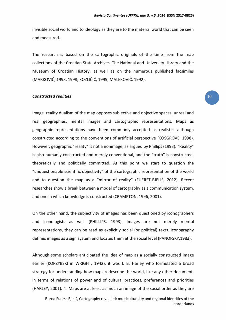
In the course of three centuries (16th – 19th), the territory of Early Modern Croatia
was determined by the borderlands of three imperial systems of the time: Habsburg
Monarchy, Ottoman Empire and Venetian Republic (Figure1). Borders were,
consequently, significantly influential in political, social, cultural, and demographic
sense.
Triple border conditioned a true multicultural surrounding. Croatian territory was a
“meeting point” of Western and Eastern world, Christianity and Islam as well as
maritime and continental traditions. Frequent changes of borderlines were followed by
population shifts and migration, introduction of new (other) social and cultural groups,
as well as leading to mixed cultural, religious, ethnic groups and lifestyles in
borderlands. Appreciation of these differences, sense of uniqueness and perception of
otherness, through the territorialization, conditioned the creation of spatial images
and eventually resulted in regional identity.
Revista Continentes (UFRRJ), ano 3, n.5, 2014 (ISSN 2317-8825)
Borna Fuerst-Bjeliš, Cartography revealed: multiculturality and regional identities of the borderlands
12
Figure 1: Croatia and triple border, 18th century. Source: REGAN, K. ed. (2003).
Otherness, territory and regional concept
Maps reveal a number of images that reflect social recognition and territorialization
through the distinction of social otherness and, on the other hand, perceptions of
territorial continuity in the circumstances of border fluctuation, through the distinction
of territorial otherness. These images are related to concepts that are embedded in
maps and leading eventually to the construction of regional concept and identity. That
is appreciation of differences, uniqueness and otherness that, through the
territorialization, result in specific spatial images and regional identity (FUERST-BJELIŠ,
ZUPANC, 2007; FUERST-BJELIŠ, 2011).
Morlacchia and Little Wallachia
The image of the ultimate western borderlands area of Ottoman Empire with Venetian
Republic and Habsburg Monarchy is related to the recognition of Morlacchi /Vlachs, a
Revista Continentes (UFRRJ), ano 3, n.5, 2014 (ISSN 2317-8825)
Borna Fuerst-Bjeliš, Cartography revealed: multiculturality and regional identities of the borderlands
13
distinct social group as other. Their presence in the borderlands is a consequence of
the population shifts due to the warfare and border fluctuations. Autochthonous
sedentary population abandoned land and migrated towards more secure areas, while
a large portion of the Croatian borderlands became a destination of new semi-nomadic
pastoral communities from the Dinaric mountain hinterland. These borderlands
communities are generally called Vlachs or Morlacchi in the Venetian tradition. These
communities partly immigrated to the borderlands area spontaneously, combining the
pastoral economy with military service, while they were partly colonized and settled by
the official politics of Venice and Habsburgs.
The toponyms Morlaccha or Morlacchia with a number of some other corresponding
forms, such as Morlacca, Morlacha, Murlacha and Morlakia can be found on the maps
as early as the 16th century (Figure 2).
Figure 2: Bonifačić’s Map of the surroundings of Zadar and Šibenik with the region of Morlacha, 1573, facsimile. Source: MARKOVIĆ (1993).
Originating from the Venetian term for social community, the derived toponymic
forms became a common name for the border region for more than three hundred
years in circumstances where three imperial forces met. Throughout the course of
Revista Continentes (UFRRJ), ano 3, n.5, 2014 (ISSN 2317-8825)
Borna Fuerst-Bjeliš, Cartography revealed: multiculturality and regional identities of the borderlands
14
centuries, the term Morlacchi has been related to the territory they have settled. The
term has gradually got the spatial connotation (FUERST-BJELIŠ, 1999-2000, 2011,
2012).
Territorialization is seen as a reflection of perceived otherness of Morlacchi and Vlach
community; primarily through different social organization, religion, lifestyle and
customs in relation to the prevailing population. Perception of otherness and
uniqueness is the basis of regionality and regional identity that is leading to the
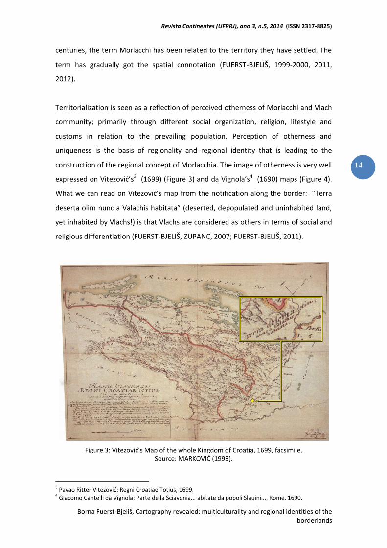
construction of the regional concept of Morlacchia. The image of otherness is very well
expressed on Vitezović’s3 (1699) (Figure 3) and da Vignola’s4 (1690) maps (Figure 4).
What we can read on Vitezović’s map from the notification along the border: “Terra
deserta olim nunc a Valachis habitata” (deserted, depopulated and uninhabited land,
yet inhabited by Vlachs!) is that Vlachs are considered as others in terms of social and
religious differentiation (FUERST-BJELIŠ, ZUPANC, 2007; FUERST-BJELIŠ, 2011).
Figure 3: Vitezović’s Map of the whole Kingdom of Croatia, 1699, facsimile. Source: MARKOVIĆ (1993).
3 Pavao Ritter Vitezović: Regni Croatiae Totius, 1699.
4 Giacomo Cantelli da Vignola: Parte della Sciavonia... abitate da popoli Slauini..., Rome, 1690.
Revista Continentes (UFRRJ), ano 3, n.5, 2014 (ISSN 2317-8825)
Borna Fuerst-Bjeliš, Cartography revealed: multiculturality and regional identities of the borderlands
15
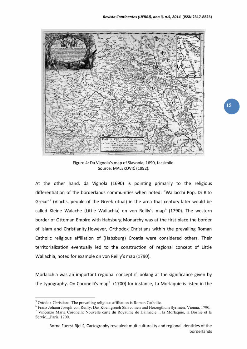
Figure 4: Da Vignola’s map of Slavonia, 1690, facsimile. Source: MALEKOVIĆ (1992).
At the other hand, da Vignola (1690) is pointing primarily to the religious
differentiation of the borderlands communities when noted: “Wallacchi Pop. Di Rito
Greco”5 (Vlachs, people of the Greek ritual) in the area that century later would be
called Kleine Walache (Little Wallachia) on von Reilly’s map6 (1790). The western
border of Ottoman Empire with Habsburg Monarchy was at the first place the border
of Islam and Christianity.However, Orthodox Christians within the prevailing Roman
Catholic religious affiliation of (Habsburg) Croatia were considered others. Their
territorialization eventually led to the construction of regional concept of Little
Wallachia, noted for example on von Reilly’s map (1790).
Morlacchia was an important regional concept if looking at the significance given by
the typography. On Coronelli’s map7 (1700) for instance, La Morlaquie is listed in the
5 Ortodox Christians. The prevailing religious affiliation is Roman Catholic.
6 Franz Johann Joseph von Reilly: Das Koenigreich Sklavonien und Herzogthum Syrmien, Vienna, 1790.
7 Vincenzo Maria Coronelli: Nouvelle carte du Royaume de Dalmacie..., la Morlaquie, la Bosnie et la
Servie...,Paris, 1700.
Revista Continentes (UFRRJ), ano 3, n.5, 2014 (ISSN 2317-8825)
Borna Fuerst-Bjeliš, Cartography revealed: multiculturality and regional identities of the borderlands
16
title of the map along with Bosnia, Serbia, Hungary and Croatia. In addition, in famous
French encyclopedia edited by Diderot and D’Alembert8 (1782), La Morlaquie was
given the same significance as other lands i.e. Bosnia and Serbia (MIROŠEVIĆ, FARIČIĆ,
2011).
With the disappearance of triple border conditions by the end of the wars with
Ottoman Empire, the context of significance within which the Morlacchi/Vlach
community have been evaluated throughout the centuries, was dissolved.
This change is clearly recognizable in the disappearance of toponyms associated with
Morlacchi and Vlachs. Constructed in the multicultural border circumstances of the
16th – 19th centuries, they disappear from the maps with the change of circumstances
that created them. Following the change in the rhetoric of the maps, we can read
about the territorialization as well as about the de-territorialization of borderland
communities. Cognition of social and cultural otherness along with the
(de)territorialization of communities led to the (de)construction of regional concepts.
Contested identities of border regions
The issue of old and new border in the areas subdued to frequent changes throughout
the history opens the question of identity of a border region. The research has shown
that in spite of newly established political order and new borderlines, the perception
of tradition and historicity of lands and territory still exists as a mental map in
collective memory. Sense of common history and origin that is embedded in such
regions reflects the image/mental map different to the actual status (FUERST-BJELIŠ,
1996, 1998). Probability of the existence of different versions of such mental map is
much higher in the areas marked by significant changes through their historical and
geographical development (MIROŠEVIĆ, FARIČIĆ, 2011).
8 Encyclopédie, ou dictionnaire raisonné des sciences, des arts et des métiers, D. Diderot et J.
D'Alembert (eds), Bern et Lausanne, 1782.
Revista Continentes (UFRRJ), ano 3, n.5, 2014 (ISSN 2317-8825)
Borna Fuerst-Bjeliš, Cartography revealed: multiculturality and regional identities of the borderlands
17
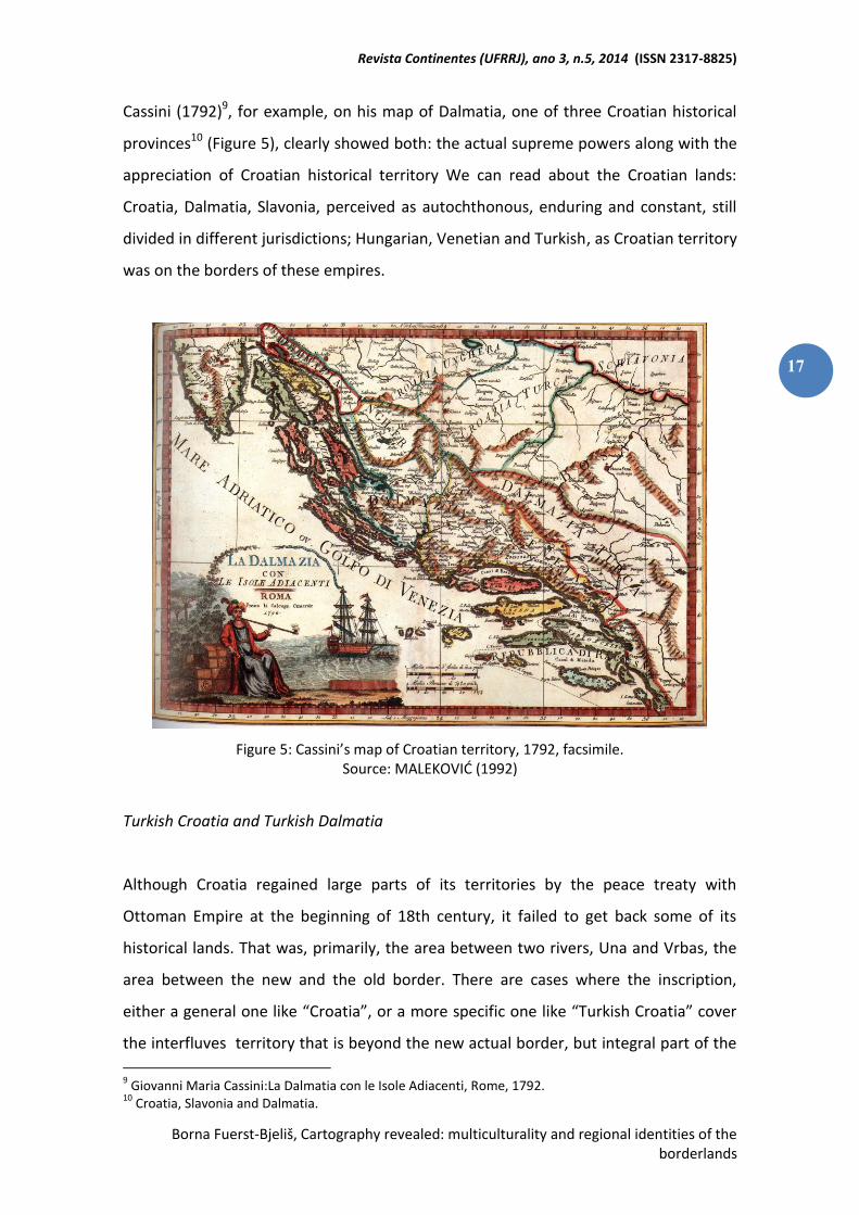
Cassini (1792)9, for example, on his map of Dalmatia, one of three Croatian historical
provinces10 (Figure 5), clearly showed both: the actual supreme powers along with the
appreciation of Croatian historical territory We can read about the Croatian lands:
Croatia, Dalmatia, Slavonia, perceived as autochthonous, enduring and constant, still
divided in different jurisdictions; Hungarian, Venetian and Turkish, as Croatian territory
was on the borders of these empires.
Figure 5: Cassini’s map of Croatian territory, 1792, facsimile. Source: MALEKOVIĆ (1992)
Turkish Croatia and Turkish Dalmatia
Although Croatia regained large parts of its territories by the peace treaty with
Ottoman Empire at the beginning of 18th century, it failed to get back some of its
historical lands. That was, primarily, the area between two rivers, Una and Vrbas, the
area between the new and the old border. There are cases where the inscription,
either a general one like “Croatia”, or a more specific one like “Turkish Croatia” cover
the interfluves territory that is beyond the new actual border, but integral part of the
9 Giovanni Maria Cassini:La Dalmatia con le Isole Adiacenti, Rome, 1792.
10 Croatia, Slavonia and Dalmatia.
Revista Continentes (UFRRJ), ano 3, n.5, 2014 (ISSN 2317-8825)
Borna Fuerst-Bjeliš, Cartography revealed: multiculturality and regional identities of the borderlands
18
historical Croatian territory. There is quite a number of maps of different political
backgrounds and cartographic traditions that are equally sharing the same image of
Turkish Croatia at the ultimate western borderlands of Ottoman Empire, as well as
Turkish Dalmatia at the southern borderlands i.e. M. Schimek’ s map (1788), J. von
Reilly’s maps (1790), map edited by Artaria and Comp. (1807), J. Szeman’s map (1826),
E. Zuchery’s map (1848), Halavanja’s map (1851) (MARKOVIĆ, 1993, 1998; MALEKOVIĆ
ed., 1992).
Searching for metaphors will lead us to the perception of temporality of border
fluctuation in these centuries of their frequent changes. Consequently, the territory of
Turkish Croatia represents a mental map of the interfluves as integral Croatian
territory in spite of the newly established border, as well as it is for Turkish Dalmatia
on the south. This is an image of the new borderline as a temporary condition in
relation to the “real historical” border. The image include the awareness of a
temporality of the borders and understanding and appreciation of the continuity of
Croatian territoriality, including Dalmatia as Croatian historical land (Turkish
CROATIA/DALMATIA; emphasized by the author). At the other hand, the image reveal
the distinction of cultural otherness (TURKISH Croatia/Dalmatia, emphasized by the
author) that is grounded in the distinction of “Turkish”/Muslim as Other and the
distinction of Christian Croatia versus Muslim Croatia. Thus, the image is pointing out
to the awareness of different religious identities of the twofold region.
These examples open two levels of reading: old and new border as real historical
border versus temporary border; distinction of different religious and cultural
identities, Christian versus Muslim Croatia. The consciousness of the otherness and
uniqueness as related to the territoriality is leading to the construction of regional
identity. These elements are formative elements of regional identity and the regional
concept in both examples: in Morlacchia as well as in Turkish Croatia and Dalmatia
(FUERST-BJELIŠ, ZUPANC, 2007; FUERST-BJELIŠ, 2011).
Revista Continentes (UFRRJ), ano 3, n.5, 2014 (ISSN 2317-8825)
Borna Fuerst-Bjeliš, Cartography revealed: multiculturality and regional identities of the borderlands
19
Reflections
Still, the development and reflection of these regional concepts are different. Turkish
Croatia has undergone the process of conceptual translation. By the mid 19th century
it has changed the name into Bosanska Krajina11 . While the old name of Turkish
Croatia emphasized the Croatian territoriality of different religious and cultural
identity, the name of Bosanska Krajina is emphasizing the border character of the
territory. Turkish Croatia / Bosanska Krajina retained its borderland character even
later through the participation in the organization of Military Border that additionally
sustained the image of otherness in terms of a particular military mentality, apart from
multiculturalism. Still, Bosanska Krajina, as a regional concept, has preserved territorial
coverage with an image of otherness and uniqueness in the multicultural and
multiethnic sense. There has been a change in spatial image that conditioned the
change, but also the preservation of regional identity and concept.
Turkish Dalmatia, at the other hand, along with the Austrian occupation of Ottoman
territory in 19th century, gradually gave priority to the, until then, subordinated
regional concept of Herzegovina. Still today, Herzegovina has distinct identity as a
region within the Republic of Bosnia & Herzegovina, and it is culturally strongly
bounded with Croatian region of Dalmatia, showing the development of multiple
identities of the borderlands region.
Morlacchia and Little Wallachia have experienced the dissolution. The change in the
multicultural architecture of the space and community as well as disappearance of
triple border by the 19th century have led to the change of the spatial image and in
this particular case conditioned the disappearance of the regional identity and
concept. All these examples of socio-cultural images and spatial and regional concepts
are common to all relevant European cartographies, regardless of different (and often
opposed) political affiliations, interests and attitudes towards the borderlands. They
11
Krajina has a meaning of borderlands.
Revista Continentes (UFRRJ), ano 3, n.5, 2014 (ISSN 2317-8825)
Borna Fuerst-Bjeliš, Cartography revealed: multiculturality and regional identities of the borderlands
20
are not imposed from above, from the centers of political power, but reflect an
internal and local knowledge and perceptions.
Conclusion
Borderlands are typical spaces where a multiplicity of contacts reflect and produce a
multiplicity of perceptions and images.
Map deconstruction was employed as a basic research strategy, signifying a search for
alternative meaning, metaphor and rhetoric in the textuality of the map. Key elements
of analysis were place-names and smaller cartographic transcriptions and objections as
they are as much related to an invisible social world and to ideology as they are to the
material world that can be seen and measured.
These images reflect social recognition and territorialization through the distinction of
social otherness and, on the other hand, perceptions of territorial continuity in
circumstances of border fluctuation, through the distinction of territorial otherness.
The consciousness of the otherness and uniqueness as related to territoriality is
leading to the construction of regional identity. These elements are formative
elements of regional identity and the regional concept in examples discussed: in
Morlacchia and Little Wallachia as well as in Turkish Croatia and Dalmatia. These
regional concepts, however, have undergone throughout different developments and
have different reflections in present time. Morlacchia and Little Wallachia, as regional
concepts, have been dissoluted with the change of the multiethnic and multicultural
triple border circumstances and the change in spatial image by the 19th century. On
the contrary, Turkish Croatia, as a regional concept, has preserved territorial coverage
with an image of multiculturalism till present time, but with the stronger accentuation
of its borderlands character under the new name of Bosanska Krajina. The
preservation of regional concept of Turkish Croatia / Bosanska Krajina is considerably
due to the longer persistence of borderlands development even later through the
Military Border and linking military and multicultural components of regional identity.
Revista Continentes (UFRRJ), ano 3, n.5, 2014 (ISSN 2317-8825)
Borna Fuerst-Bjeliš, Cartography revealed: multiculturality and regional identities of the borderlands
21
Former Turkish Dalmatia as present Herzegovina within the Republic Bosnia &
Herzegovina has retained strong cultural bonds with the region Dalmatia within the
Republic of Croatia, based on the sense of shared common history and identity.
References
COSGROVE, D. E. Social Formation and Symbolic Landscape. Madison, London: The University of Wisconsin Press (1998). (1996). CRAMPTON, J.W. Bordering on Bosnia. GeoJournal, vol. 39 (1993). CRAMPTON, J.W. Maps as social constructions: power, communication and visualization. Progress in Human Geography, vol. 25/2 (2001). FUERST-BJELIŠ, B. Pristup definiciji prostornog pojma tradicionalne regije. Zbornik radova 1. Hrvatskog geografskog kongresa, Zagreb (1996). FUERST-BJELIŠ, B. Turopolje – položaj tradicionalne regije u sustavu geografske regionalizacije. Acta geographica Croatica, vol. 33 (1998). FUERST-BJELIŠ, B. Toponimija i percepcija u prostoru Triplex Confiniuma: Morlakija. Radovi, vol. 32-33 (1999-2000). FUERST-BJELIŠ, B. Slike i mijene regionalnoga identiteta - geografska imena na kartama ranoga novoga vijeka; odabrani primjeri. Zbornik radova s Prvoga nacionalnog znanstvenog savjetovanja o geografskim imenima, Zadar (2011). FUERST-BJELIŠ, B. Imaging the Past: Cartography and Multicultural Realities of Croatian Borderlands, Cartography - A Tool for Spatial Analysis, InTech, DOI: 10.5772/46223 (2012). FUERST-BJELIŠ, B., ZUPANC, I. Images of the Croatian Borderlands: Selected Examples of Early Modern Cartography. Hrvatski Geografski Glasnik, vol. 69/1 (2007). HARLEY, J. B. The New Nature of the Maps, Essays in the History of Cartography. Baltimore: The Johns Hopkins University Press (2001). HARLEY, J. B. Deconstructing the Map. Cartographica, vol. 26/2 (1989). KOZLIČIĆ, M. Kartografski spomenici Hrvatskog Jadrana. Zagreb: AGM.(1995). MALEKOVIĆ, V. Borders of Croatia on maps from 12th to 20th century. Zagreb: The Museum of Arts and Crafts (1992). MARKOVIĆ, M. Descriptio Croatiae. Zagreb: Naprijed (1993).
Revista Continentes (UFRRJ), ano 3, n.5, 2014 (ISSN 2317-8825)
Borna Fuerst-Bjeliš, Cartography revealed: multiculturality and regional identities of the borderlands
22
MARKOVIĆ, M. Descriptio Bosnae et Hercegovinae. Zagreb: AGM (1998). MIROŠEVIĆ, L., FARIČIĆ, J. Perception of Dalmatia in selected foreign lexicographic publication. Geoadria, vol. 16/11 (2011). PANOFSKY, E. Meaning in the Visual Arts. Chicago: University of Chicago Press (1983). PHILLIPS, R. The language of images in geography. Progress in Human Geography, vol. 17/2 (1993). REGAN, K. (ed). Hrvatski povijesni atlas. Zagreb: Hrvatski leksikografski zavod "Miroslav Krleža” (2003). WRIGHT, J. Map makers are human: comments on the subjective in maps. The Geographical Review, vol. 32 (1942).
ESTIMATIVA DA PRODUÇÃO DE SEDIMENTOS E ANÁLISE DE
CENÁRIOS DAS ÁREAS PRIORITÁRIAS À RECUPERAÇÃO
AMBIENTAL NA BACIA HIDROGRÁFICA DO RIO JAGUARI
(MG/SP)
Eduardo Vedor de Paula João Guimarães**
Diogo Rossi Ibaixe***
Resumo: Os custos com tratamento de água mostram-se crescentes, sobretudo, nas bacias hidrográficas que revelam algo grau de intervenção, tal como ocorre na bacia do rio Jaguari (MG/SP). A conservação de recursos hídricos mediante ações de infraestrutura verde revela-se como sendo uma excelente alternativa. Constituiu como objetivo do presente estudo efetuar a comparação entre o cenário atual de produção de sedimentos, com um cenário hipotético que contemplou a restauração florestal de ambientes degradados. Palavras-chave: Recuperação ambiental; Produção de sedimentos; Bacias hidrográficas, Sistemas de informações geográficas.
ESTIMATION OF THE SEDIMENTS YIELDED AND SCENARIO ANALYSIS OF PRIORITY AREAS TO ENVIRONMENTAL RECOVERY IN RIVER
JAGUARI (MG/SP) Abstract: Water treatment costs are rising, mainly in the hydrographic basin showing a high degree of intervention, as it is the case with the Rio Jaguari (MG/SP). The conservation of hydric resources through green infrastructure actions reveals itself as being an excellent alternative. The purpose of this study has been comparing the current scenario of sediment production to a hypothetical scenario that includes the reforestation of degraded environments. Keywords: Environmental recovering; Sediments yielded; Hydrographic basin, Geographic information system.
Professor Adjunto do Departamento de Geografia da UFPR. E-mail: [email protected] **
Fauna & Flora International. E-mail: [email protected] ***
BRIIX (Brazil’s Impact Investment Exchange). E-mail: [email protected]
Eduardo Vedor de Paula; João Guimarães; Diogo Rossi Ibaixe, Estimativa da produção de sedimentos e análise de cenários das áreas prioritárias à recuperação ambiental na bacia hidrográfica do rio Jaguari (MG/SP). Revista
Continentes (UFRRJ), ano 5, n.4, 2014, p. 23-44 (ISSN 2317-8825)