Embed Size (px)
Citation preview
sacramento county general plan updatepublic outreach process
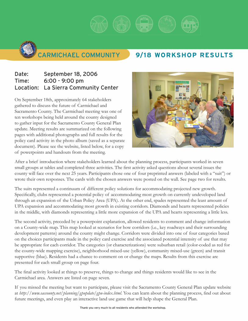
CarmiChael COmmUNiTy 9/18 WorKshop results
Date: September 18, 2006Time: 6:00 - 9:00 pmlocation: la Sierra Community Center
Thank you very much to all residents who attended the workshop.
On September 18th, approximately 64 stakeholders gathered to discuss the future of Carmichael and Sacramento County. The Carmichael meeting was one of ten workshops being held around the county designed to gather input for the Sacramento County General Plan update. Meeting results are summarized on the following pages with additional photographs and full results for the policy card activity in the photo album (saved as a separate document). Please see the website, listed below, for a copy of powerpoints and handouts from the meeting.
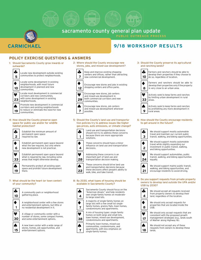
After a brief introduction where stakeholders learned about the planning process, participants worked in seven small groups at tables and completed three activities. The first activity asked questions about several issues the county will face over the next 25 years. Participants chose one of four preprinted answers (labeled with a “suit”) or wrote their own responses. The cards with the chosen answers were posted on the wall. See page two for results.
The suits represented a continuum of different policy solutions for accommodating projected new growth. Specifically, clubs represented a potential policy of accommodating most growth on currently undeveloped land through an expansion of the Urban Policy Area (UPA). At the other end, spades represented the least amount of UPA expansion and accommodating most growth in existing corridors. Diamonds and hearts represented policies in the middle, with diamonds representing a little more expansion of the UPA and hearts representing a little less.
The second activity, preceded by a powerpoint explanation, allowed residents to comment and change information on a County-wide map. This map looked at scenarios for how corridors (i.e., key roadways and their surrounding development patterns) around the county might change. Corridors were divided into one of four categories based on the choices participants made in the policy card exercise and the associated potential intensity of use that may be appropriate for each corridor. The categories (or characterizations) were suburban retail (color-coded as red for the county-wide mapping exercise), neighborhood mixed-use (yellow), community mixed-use (green) and transit supportive (blue). Residents had a chance to comment on or change the maps. Results from this exercise are presented for each small group on page four.
The final activity looked at things to preserve, things to change and things residents would like to see in the Carmichael area. Answers are listed on page seven.
If you missed the meeting but want to participate, please visit the Sacramento County General Plan update website at http://www.saccounty.net/planning/gpupdate/gpu-index.html. You can learn about the planning process, find out about future meetings, and even play an interactive land use game that will help shape the General Plan.
sacramento county general plan updatePUBLIC OUTREACH PROCESS
9/18 WORKSHOP RESULTSCARMICHAEL
1: Should Sacramento County grow inwards or outwards?
POLICY EXERCISE QUESTIONS & ANSWERS
5
19
10
23
2: Where should the County encourage new stores, jobs, and mixed-use development?
3: Should the County preserve its agricultural and ranching lands?
4: How should the County preserve open space for public use and/or for wildlife habitat protection?
5: Should the County’s land use and transporta- tion policies try to address issues like higher gas prices, auto emissions, or climate change?
6: How should the County encourage residents to get around in the future?
7: What should be the heart (or town center) of your community?
8: By 2030, what types of housing should be available in Sacramento County?
9: Do you support requests from private property owners to develop land outside the UPA and/or USB by 2030?
2
19
6
33
10
15
1
30
7
7
12
29
10
9
8
33
1
22
4
28
3
21
2
24
4
7
7
38
4
18
8
17
Land use and transportation decisions should not try to address these concerns because there are more appropriate solutions.
These concerns should have a minor infl uence on land use and transportation decisions.
Addressing these concerns is an important part of land use and transportation decision making.
These concerns should drive land use and transportation decisions because these decisions affect people’s ability to walk, bike, and take transit.
Establish the minimum amount of permanent open space required by law.
Establish permanent open space beyond what the law requires, but only where new development is not practical.
Establish permanent open space beyond what is required by law, including some areas that might otherwise develop.
Permanently protect all existing open space and prohibit future development there.
Locate new development outside existing communities to protect neighborhoods.
Locate some development in existing neighborhoods, with most future development in planned and new communities.
Locate most development in commercial corridors and new communities, with some development in existing neighborhoods.
Promote new development in commercial corridors and existing neighborhoods to reduce or eliminate the need for new communities.
Keep and improve existing shopping centers and offi ces, rather than attracting new commercial development.
Encourage new stores and jobs in existing shopping centers and offi ce parks.
Encourage new stores, job centers and mixed-use development in both commercial corridors and new communities.
Encourage new stores, job centers and mixed-use development wherever possible.
Farmers and ranchers should be able to develop their properties if they choose to do so, regardless of location.
Actively seek to keep farms and ranches by limiting urban development in rural areas.
Actively seek to keep farms and ranches by prohibiting any more development in rural areas.
A community park or neighborhood gathering place.
A neighborhood center with a few stores and entertainment options, but little or no residential development in it.
A village or community center with a number of stores, some compact homes, and some entertainment options.
A new town center with a wide range of stores, homes, job opportunities, and entertainment options.
Sacramento County should focus on the “American dream,” and help residents own single-family homes on moderate-to-large sized lots.
A majority of single-family homes on large lots with a few small lot single-family homes, granny fl ats, town homes, condominiums and apartments.
A mix of housing types: single family homes on both large and small lots, town homes, mixed-use development, condominiums and apartments.
Primarily town homes, mixed-use communities, condominiums, and apartments, with less emphasis on single-family homes.
We should accept all requests received from property owners to develop their land, regardless of the location.
We should only accept requests for properties that are located inside the USB.
We should only accept requests that are consistent with the proposed growth management strategies (e.g., lands south of Mather along Highway 16).
We should not accept any of these requests from owners to develop these lands.
We should support mostly automobile travel and maintain our current public transit, walking, and biking opportunities.
We should support mostly automobile travel while slightly expanding our investment in public transit, walking, and biking opportunities.
We should support automobiles, public transit, walking, and biking opportunities equally.
We should support mainly public transit, walking, and biking opportunities, and encourage residents to avoid driving.
Farmers and ranchers should be able to develop their properties only if the property is very close to an urban area.

sacramento county general plan updatepublic outreach process
�
CarmiChael COmmUNiTy 9/18 WorKshop results
Policy exercise (cont.)hand written answers from policy exercise:
Question 1i don’t trust the county to get any of the actions right. i’d prefer to let cities be formed in the existing urbanized unincorporated area and challenge the cit-ies to solve the problems jointly. Promote some development by redesigning whole communities to make them have increased green space and higher density on corridors. also get more and better public transportation – especially with light rail going thought Carmichael. Don’t allow a lot (just some) new growth into new areas. hold the line somewhere on taking away agrarian and flood plain land. Choices invalid, uninformed and biasedlocate some development in new neighborhoods, some in existing neighborhoods and some on com-mercial corridors but respect to the directed neigh-bors affected by any changes. Promote existing neighborhoods with more public transit.
Question 2The economy of 2030 will be very different from the manufacturing era economy of today. in the knowl-edge economy work is decentralized and more em-phasis is placed on quality of life in localized areas. See www.smartcommunities.orgClubs except disagree with tradeoff statement. also improve transportation. hearts except with additional comment, “improve existing shopping centers and expand them.”hearts except with comment, “With more public transit and neighborhood shuttles.”more public transit if new stores and job – need to plan together (?)
Question 3Clubs with additional comment, “if utilities are avail-able.”Preserve agriculture lands for air quality.
Question 4Develop a network of open space connected by cor-ridors to promote connectivity of habitats. Promote a diversity of open space habitats in proximity to urban spaces.
•
•
••
•
•
•
•
•
•
•
•
•
Question 5Sacramento County doesn’t care about air qual-ity i doubt it ever will. Climate change is underway already. We need new cities to tackle this issue.
Question 7a lively mixed use center and park or neighborhood plaza.None of the above. This is not a centered town/vil-lage. This is not a policy topic for the general plan. hearts with additional comment, “Sort of like new town center, but with more entertainment.”Clubs with additional comment, “Plus public trans-portation.”it may be difficult to establish a community center in Carmicahel due to the increased traffic on Fair Oaks, unless Carmichael Park can fit the description.
Question 8Wide mix of housing choices but do not use “granny flats” as excuse to greatly increase residential den-sity without infrastructure to support it. more owner-ship units. We have plenty of apartments already. hearts with additional comment, “Changes must respect existing residences.” hearts with additional comment “retain existing large lots.”hearts with additional comment that large lots are 10,000 square feet or more.
Question 9hearts except change wording in tradeoffs to read, “additional cost to citizens [developers] to provide public water, sewer, transit to all areas….”We should consider requests based on appropriate-ness to habitats, transportation and job growth. This type of blanket choice is ill conceived and suggests there are not better choices.Do not change the USB! Only modify boundary after buildout of the existing UPa.
•
•
•
•
•
•
•
•
•
•
•
•
•

CarmiChael COmmUNiTy 9/18 WorKshop results
sacramento county general plan update
public outreach process
�
Corridor Characterization exercise are you comfortable with the characterization for future developing in the corridor nearest you?
Table One (Heart)
Fair Oaks CentralPossible community mixed use?Not a stop friendly area currently (?)Can’t safely get from point a to point B currentlylike neighborhood mixed use more people can live hereCommunity design standards importantredevelop existing areas first
Jackson area 1later on development after other areasWater issues
Fair Oaks eastNot enough traffic to be a corridorlike existing characterremove from map, not a corridor
Fulton aveChanged from Neighborhood mixed use to community mixed-use (use intensified)
auburn Boulevard eastexclude southern of corridor (keep as pasture land)
area CConcerns that planes still fly
Watt aveSouth side community mixed use (S. of marconi)
Table Two (Heart)
Need to provide better transit to complement growth on corridorsProvide more frequency of transit serviceBus service directly to downtown area- not to the light rail stationBetter bus service in neighborhood areaNeed community identity- sense of placeimpact fees on new development to pay for enhanced transitWalkable connection within neighborhood and commercial areasConnecting parcels- increase activities- better pedestrian support
•••••••
••
•••
•
•
•
•
•
••
•••
•
•
Don’t displace traffic from Fair Oaks Blvd to neighborhood streetsmore people in corridors versus new growth areasDon’t develop Jackson BJackson a - Only if adequate transit roadways are providedBeltway needed in S. County area
Table Three (Spade)
Note: Table three had 26 heart cards and 25 spade cards.
After looking at both maps, they decided to use the spade
map.
Watt avenue Central changed from community mixed use to transit supportive (use intensified)auburn Boulevard West changed from neighborhood mixed use to transit supportive (use intensified)Fair Oaks Boulevard Central changed from community mixed use to transit supportive (use intensified)auburn Boulevard east changed from community mixed use to transit supportive (use intensified)Greenback lane changed from neighborhood mixed use to either community mixed use or transit supportive (use intensified)Stockton Boulevard Central changed from community mixed use to transit supportive (use intensified)
•
•••
•
•
•
•
•
•
•

9/18 WorKshop results
sacramento county general plan updatepublic outreach process
�
CarmiChael COmmUNiTy 9/18 WorKshop results
Table Three - Continued
likehigher densityWould like to change “green” to “blue” (use intensified)DislikeConcern about increase crime with higher density
Dislikemixed use in area C (airplane noise)
ChangeChange Stockton Blvd (11) to “blue” Change Greenback (5) to “green” or “blue”Change auburn Blvd (7) to “blue”
County-wide Summaryrapid TransitDensity to support transitappropriate non-residential development adjacent to airportincreased bike and pedestrian facilities- separated from car/truck trafficminority: Fair Oaks- have lower density, but more transit
Table Four (Heart)
Commercial CorridorsConcern about blight in mixed usemixed use can be more affordableensure current residents benefit from mixed usemore housing to support local businesses transient now (along Fair Oaks)Public transportation bikeways, and pedestrian access importantyou need to have a cluster of stores so you can run many errands (Target)Streets not nice to walk (mud)may need parking garages
••
••
•
•••
•••
•
•
••••
•
•
••
Parking must feel safe (open, lighted) parking behind stores does not always feel safeNew developments should not contribute to trafficNo sidewalks in semi-rural (hidden river vista) areasNo bridge (river crossing)Florin rd is blightedmore frequent bussesConcern that density is too low for transitGroup was ok with the characterization of corridors and did not change the colors (intensity of use). Preserve Oaks in area Dremove backout parking onto Fair Oaksanything along the auburn ave east corridor would be an improvementNo new bridge
Table Five (Heart)
Change (2) auburn Blvd east to Transit supportive (use intensified)Consider mixed use along madison from auburn to San Juanincrease Watt ave Central to transit supportive (use intensified)New growth area a avoid airport flight pathDo not encroach on Vernal pools and environmental sensitive areasaccommodate all new growth within current UPa before allowing development in new growth areasensure new growth areas planned with adequate transitDevelopers to pay for transportation facilitiesNew growth should be less subdivisionChange Greenback from neighborhood mixed use to community mixed use (use intensified)
•
•••••••
•••
•
•
•
•
••
•
•
•••
Corridor Characterization exercise(cont.)

CarmiChael COmmUNiTy 9/18 WorKshop results
sacramento county general plan update
public outreach process
�
Table Six (Heart)
areas a, C and D are within path of air flight, can they be used for residential?Good areas for development: we accept Drevitalize existing areas that now are in a declining stateThere should be a balance between the development of corridors and other county amenities like parksWould like to see some co-housing as it creates a sense of communityDevelopment taken out from zone “a”- change 3 Fair Oaks from yellow to greenCreate a corridor within the area- transit hubCreate incentive so that property owners along corridor are really motivated to improve themGreenback lane from Neighborhood mixed Use to Community mixed Use (use intensified)Fair Oaks Boulevard from Neighborhood mixed Use to Community mixed Use (use intensified)Franklin Boulevard area – Does proposal mix with industrial use? Consider airport constraintsJackson and Bradshaw – Consolidate higher density with transit hub with constraints of airport and transit hub
•
••
•
•
•
••
•
•
•
•
Table Seven (Heart)
more parkway access (all agreed)Possibly neighborhood or community mixed use in CarmichaelNeeds to be a there, theremaybe one community mixed use in Carmichaellike transit supportive on rail linesProtect industrial resourcesaggressively protect Sac metroBicycle and pedestrian corridors away from trafficarea C - Jobs and transit, opportunity to annexPreserve Sac metro ag land
Fair Oaks Boulevard eastCapture dollars of existing through trafficaccess by bike and pedestrian okayDraw people in from their directions (?)
auburn Boulevard eastmore mass transit in corridormaybe a community mixed use Keep neighborhood character
Fair Oaks Boulevard Centralappropriate usesinfill developmentOpen space and parksNeighborhood lvl (?)Quality (?)Concept plan / process
area DPreserve as open spacemore development in corridors
airportPotential cargo airport userevenue for countyProtect industrial uses
area BPhase Put road network in firstmaster planned smart growth communityTraffic impacts...addressair quality impacts
••
••••••••
•••
•••
••••••
••
•••
•••••

9/18 WorKshop results
sacramento county general plan updatepublic outreach process
�
CarmiChael COmmUNiTy 9/18 WorKshop results
Community mapping exerciseTable One
Preserve:Winding rural/country roads (1)large lots with open- retain, no re-zoning (2)Parks and open spaces (3)rural atmosphere (4)maintain trees/tree cover (5)Carmichael “secluded” from other cities (6)
Change:look of Fair Oaks Blvd (1)less lower income businesses (2)Service accessible by walking (3)Fair Oaks Blvd walk able, bike able, transit accessible (4)Green space and trees along Fair Oaks Blvd (5)
Transit option over the american river (6)
Table Two
Preserve:american river ParkwaySemi-rural characterlarge-lot residentialKeep and improve parks/ green spacesmaintain and upkeep library and schoolminority opinionincrease densities in certain, limited locations
Change:Change Fair Oaks Blvd to neighborhood mixed usemore diversity in retailincrease bus service, more bike lanes and sidewalksPedestrian friendly intersectioneliminate speeding and cut-through traffic in neighborhood/better enforcementTraffic calming Underground utility poles- streetscape improvement
like to see changed:Creek returned to their natural settingBookstoresrestaurants/Brew PubsCarmichael Park improved - new poolrestaurants along the riverUpscale hotelmore bike lanesTransit center/park and ride lot
••••••
••••
•
•
••••••••
•••••
••
••••••••
Corridorsel Camino
marconi
Table Three
Preserve: Carmichael Parkamerican river Parkwaylibraryla Sierra Community Center
Change: Fair Oaks Blvd- Start overmore traffic signalsmore traffic off Fair Oaks and onto Garfield and CaliforniaPedestrian overpassmore neighborhood parksContinuous, functional sidewalks
What we would like to see:restaurants (Paragary’s)BookstoreBrew Pubmovie Theater (art films)Upscale/Natural Food Grocery StoreUpscale antique Stores
Other Corridorsarden Way (arden-arcade)
madison ave (not all in agreement)
Fair Oaks/howe ave
Table Four
Preserve:Preserve Parkway (make sure it is safe)Save semi-rural character (large lots)Parks, open space and creeks
Change:Need more sidewalksmore parking (along major roads)more economic development (Fair Oaks and auburn)more entertainment and culturalmore shade trees, prettiermore access to american river CollegeNo oversized houses
•
•
••••
•••
•••
••••••
•
•
•••
•••••••

CarmiChael COmmUNiTy 9/18 WorKshop results
sacramento county general plan update
public outreach process
�
Table four - continued
New things:Target at Fair Oaks and marconiexpand la Sierra Community Center (increase public transit)medians to help people cross
Community Corridorsmake marconi safe
madison could use some appearance improvements
Table Five
What we like:agricultural communityangel hoffman Parkamerican river ParkwayCommunity ParksCommunity identity (rural character)Flood plain needs to be a permanent barrierGood shoppingPost officeNorth bound transitlibraries Walkable areas around Winding Way
Things to change:Traffic congestionPedestrian un-friendly (wide streets, lack of crossings)Need more public transitretain lot sizeNeed more design standards
Things we like to see:Need nice restaurantsNeed town center/perhaps along Fair OaksBike networklink Parkway to communityNeed to be maintained
Table Six
Preserve:Parks (all neighborhood parks)Bike trailsThe riverParkwaysCreate a good connection between parks and others
••
•
•
•
•••••••••••
••
•••
•••••
•••••
Trees along Fair OaksGood auto accessmaintain the bluffs
Change:Change stores and design standards along Fair OaksWhat we like to see:Create more walkable areas- centers that are pedestrian friendly Particularly Fair Oaksmore bike trailsBetter access to parkways
Table Seven
Cityhood for adren arcadeTransit and bike line along american riveradd a pedestrian and bike bridge across the american river near Folsom Blvd Transit areaSidewalks along Garfield ave, College Oak and Winding WayBike connection (not on major roads) from lincoln ave east to Fair Oaks ave SouthCommunity building at center of Fair Oaks Boulevard Central CorridorConnect all community facilities with pedestrian and bike paths
PreserveCa??? Park (spelling?)la Sierra Communty CenterNew libraryancil hoffman
NewCreate a heart for the community including the park, la Sierra and library with transit shuttles
Changemore bike accessrestaurantshotels
CorridorsNo new suggestions
•••
•••
••••
•••
•
•
•
•
••••
•
•••
•
Community mapping exercise (cont.)