Embed Size (px)
Citation preview
Carmichael Coal Mine and Rail Project Traffic Impact Assessment
July 2013
B12345
Traffic and Transport Engineering Division
Prepared for Adani Mining Pty Ltd
Page | i B12345 Carmichael Coal Mine and Rail Project| Adani Mining Pty Ltd Commercial in Confidence Page | i
COMMERCIAL IN CONFIDENCE
All intellectual property rights, including copyright, in designs developed and documents created Brown Consulting QLD Pty Ltd remain the property of this company. Any use made of such design or document without the prior written approval of Brown Consulting QLD Pty Ltd will constitute an infringement of the rights of the company which reserves all legal rights and remedies in respect of any such infringement.
The information, including any intellectual property, contained in this proposal is confidential and proprietary to the Company. It may only be used by the person to whom it is provided for the stated purpose for which it is provided and must not be imparted to any third person without the prior written approval of the Company. The Company reserves all legal rights and remedies in relation to any infringement of its rights in respect of its confidential information.
©
Brown Consulting (QLD) Pty Ltd Level 6, 199 Grey Street
PO Box 10349 Adelaide Street BRISBANE QLD 4101
Ph: (07) 3895 3444
2013
DOCUMENT CONTROL
B12345CTTIAR01.JvP.jm
Issue Date Issue Details Author Checked Approved
O 26 July 2013 Final JvP JvP JvP
Page | ii B12345 Carmichael Coal Mine and Rail Project| Adani Mining Pty Ltd Commercial in Confidence Page | ii
Table of Contents
1. Introduction and Context ............................................................................................................................ 1
1.1 Overview .................................................................................................................................................... 1
1.2 Key Assumptions and Development Principles .......................................................................................... 5
1.2.1 Construction Phase ........................................................................................................................ 5
1.2.2 Operations Phase ........................................................................................................................... 5
1.3 References and Data Sources ..................................................................................................................... 6
2. Existing Transport Network ......................................................................................................................... 7
2.1 State Controlled Road Network ................................................................................................................. 7
2.1.1 Peak Downs Highway (33A, 33B) ................................................................................................. 10
2.1.2 Gregory Developmental Road (98A, 98B) .................................................................................... 12
2.1.3 Flinders Highway (14A) ................................................................................................................ 14
2.1.4 Kilcummin-Diamond Downs Road (5309) .................................................................................... 15
2.2 Local Road Network ................................................................................................................................. 15
2.2.1 Moray - Carmichael Road ............................................................................................................. 15
2.2.2 Moray - Bulliwallah Road ............................................................................................................. 16
2.2.3 Elgin - Moray Road ....................................................................................................................... 16
2.3 Multi-Combination Vehicles and Higher Mass Limits .............................................................................. 17
2.3.1 Introduction and definitions ........................................................................................................ 17
2.3.2 Higher Mass Limits ....................................................................................................................... 18
Expansion of the higher mass limits network .......................................................................................... 18
2.4 Public Transport Services ......................................................................................................................... 29
3. Development Traffic .................................................................................................................................. 35
3.1 Introduction .............................................................................................................................................. 35
3.2 Construction Phase................................................................................................................................... 35
3.2.1 Rail and quarries .......................................................................................................................... 35
3.2.2 Mine ............................................................................................................................................. 36
3.3 Operations Phase ..................................................................................................................................... 36
3.3.1 Rail and quarries .......................................................................................................................... 36
3.3.2 Mine ............................................................................................................................................. 37
3.4 Estimated Development Volumes ............................................................................................................ 37
4. Traffic Network Assessment ...................................................................................................................... 41
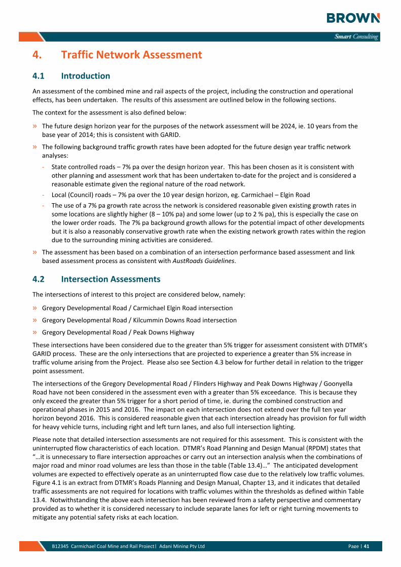
4.1 Introduction .............................................................................................................................................. 41
4.2 Intersection Assessments ......................................................................................................................... 41
4.2.1 Gregory Development Road/ Carmichael Elgin Road Intersection .............................................. 42
4.2.2 Gregory Developmental Road / Kilcummin Downs Road intersection ........................................ 43
4.2.3 Gregory Developmental Road / Peak Downs Highway ................................................................ 43
4.3 Road link assessments .............................................................................................................................. 43
5. Other Impacts and Issues .......................................................................................................................... 48
Page | iii B12345 Carmichael Coal Mine and Rail Project| Adani Mining Pty Ltd Commercial in Confidence Page | iii
5.1 Noise ......................................................................................................................................................... 48
5.2 Flooding Assessment ................................................................................................................................ 49
5.3 Hazard and Risk Assessment .................................................................................................................... 50
5.3.1 Hazard Identification .................................................................................................................... 50
5.3.2 Mitigation and Management ....................................................................................................... 50
5.4 Cumulative Impacts .................................................................................................................................. 51
6. Mitigation Measures ................................................................................................................................. 52
6.1 Introduction .............................................................................................................................................. 52
6.2 Traffic ........................................................................................................................................................ 52
6.3 Noise ......................................................................................................................................................... 52
6.4 Flooding .................................................................................................................................................... 53
7. Conclusions and Recommendations ........................................................................................................... 54
TABLES
Table 2.1 Crash History – Peak Downs Highway - between the Gregory Developmental Road and Bruce Highway (2005-2009)..................................................................................................................................................................... 10
Table 2.2 Crash History – Gregory Developmental Road (2005-2009) ........................................................................... 12
Table 2.3 Crash History – Flinders Highway (2005-2009) ............................................................................................... 15
Table 3.1: Rail construction key transport movements - Summary ............................................................................... 36
Table 4.1: Road link volume and capacity analyses (2015 and 2024), impacted road links ........................................... 46
Table 4.2: Level of Service thresholds (rural roads, level terrain) .................................................................................. 47
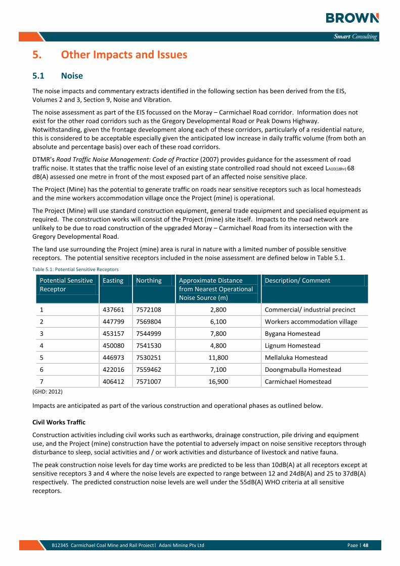
Table 5.1: Potential Sensitive Receptors ........................................................................................................................ 48
Table 5.2: Stream Gauging Stations ................................................................................................................................ 49
FIGURES
Figure 1.1: Locality Plan - Carmichael Coal Mine and Rail Project .................................................................................... 3
Figure 1.2: Regional Context - Carmichael Coal Mine and Rail Project (Map courtesy of Qld DTMR) ............................. 4
Figure 2.1: Mackay/ Whitsunday Region - DTMR ............................................................................................................. 8
Figure 2.2: Northern Region - DTMR ................................................................................................................................ 9
Figure 2.3: Peak Downs Highway .................................................................................................................................... 11
Figure 2.4: Peak Downs Highway/ Goonyella Road Intersection (looking westbound) ................................................. 11
Figure 2.5: Gregory Developmental Road (looking south at intersection with Twin Hills Road) ................................... 13
Figure 2.6: Gregory Developmental Road/ Elgin Road Intersection (looking southbound) ........................................... 13
Figure 2.7: Gregory Developmental Road/ Flinders Highway Intersection (looking westbound) .................................. 14
Figure 2.8: Moray – Carmichael Road ............................................................................................................................. 16
Figure 2.9: Multi-Combination Routes in Queensland – Section 3 ................................................................................. 19
Page | iv B12345 Carmichael Coal Mine and Rail Project| Adani Mining Pty Ltd Commercial in Confidence Page | iv
Figure 2.10: Multi-Combination Routes in Queensland – Section 5 ............................................................................... 20
Figure 2.11: Multi-Combination Routes in Queensland – Section 8 ............................................................................... 21
Figure 2.12: Multi-Combination Routes in Queensland – Section 10 ............................................................................. 22
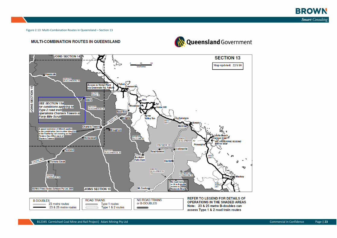
Figure 2.13: Multi-Combination Routes in Queensland – Section 13 ............................................................................. 23
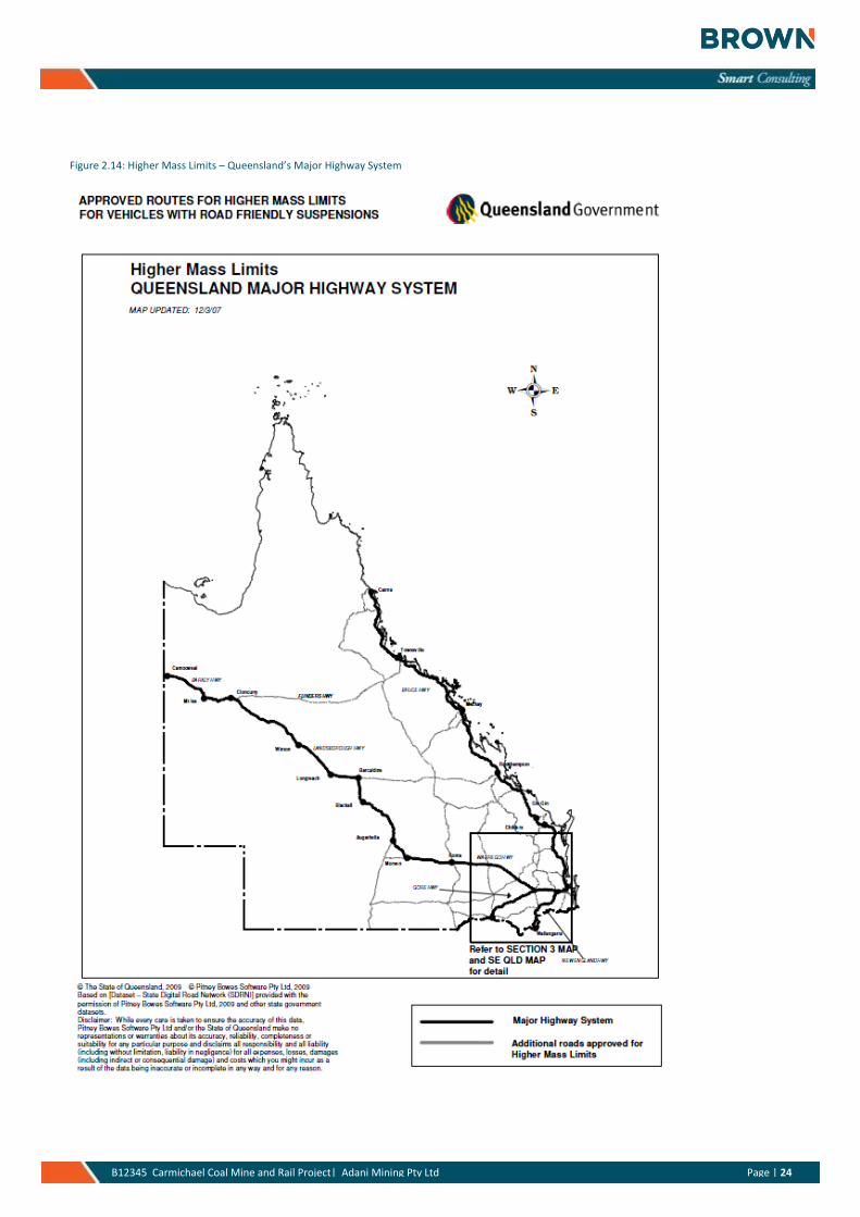
Figure 2.14: Higher Mass Limits – Queensland’s Major Highway System ...................................................................... 24
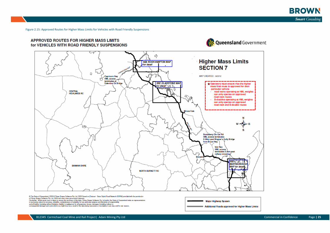
Figure 2.15: Approved Routes for Higher Mass Limits for Vehicles with Road Friendly Suspensions ............................ 25
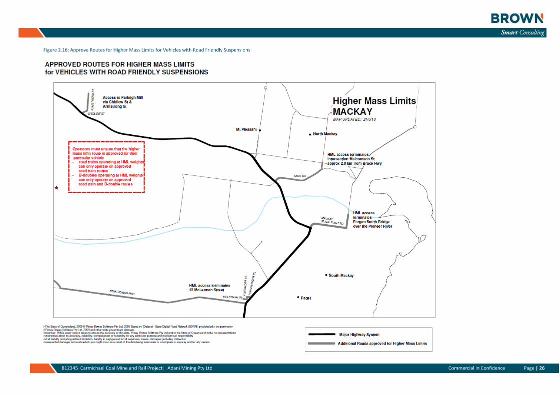
Figure 2.16: Approve Routes for Higher Mass Limits for Vehicles with Road Friendly Suspensions .............................. 26
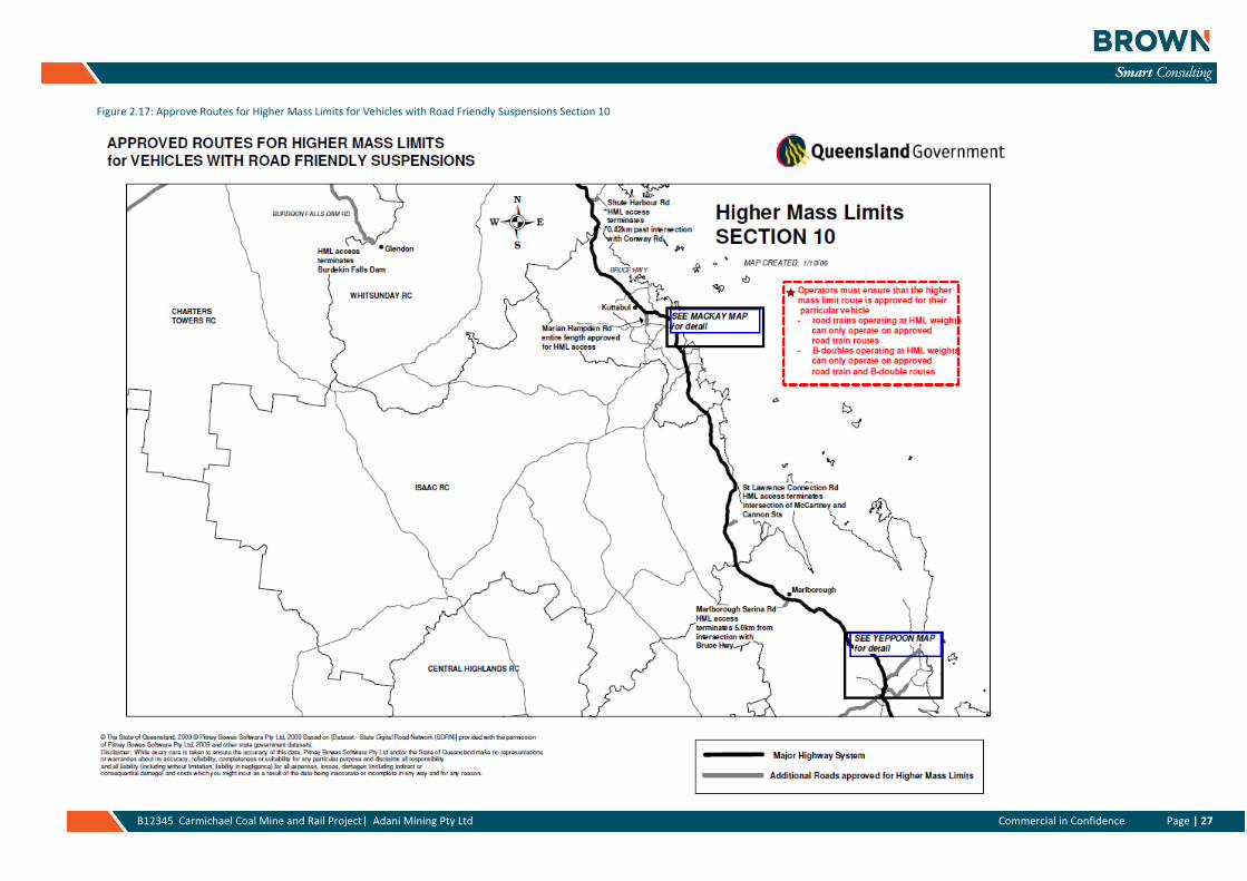
Figure 2.17: Approve Routes for Higher Mass Limits for Vehicles with Road Friendly Suspensions Section 10 ............ 27
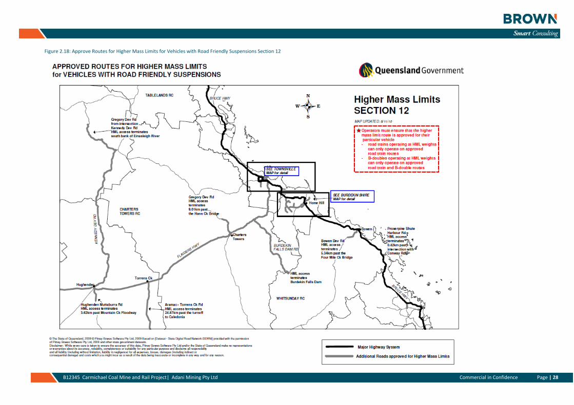
Figure 2.18: Approve Routes for Higher Mass Limits for Vehicles with Road Friendly Suspensions Section 12 ............ 28
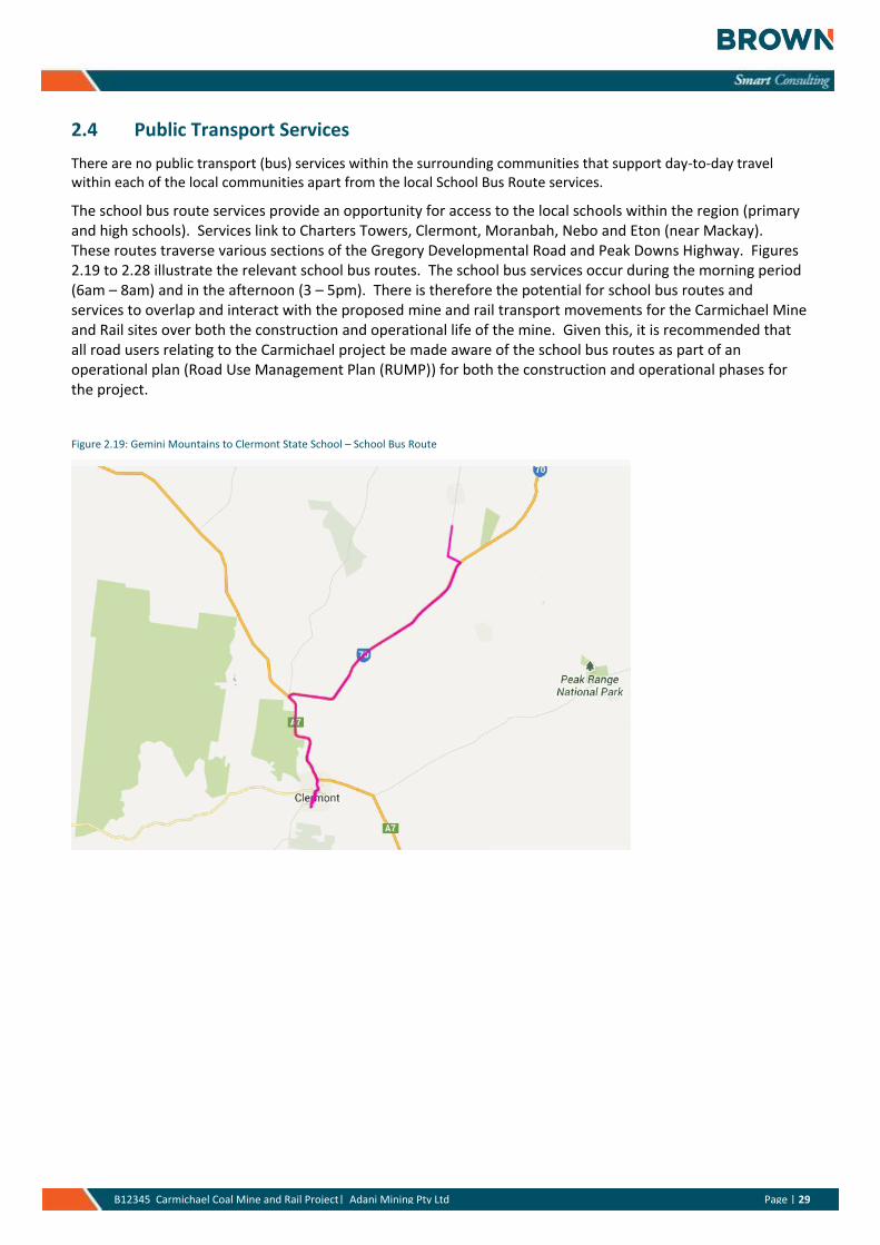
Figure 2.19: Gemini Mountains to Clermont State School – School Bus Route ............................................................. 29
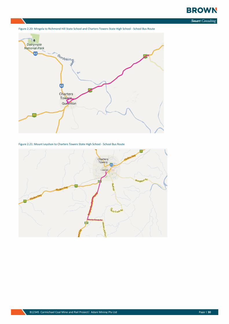
Figure 2.20: Mingela to Richmond Hill State School and Charters Towers State High School - School Bus Route ........ 30
Figure 2.21: Mount Leyshon to Charters Towers State High School - School Bus Route ............................................... 30
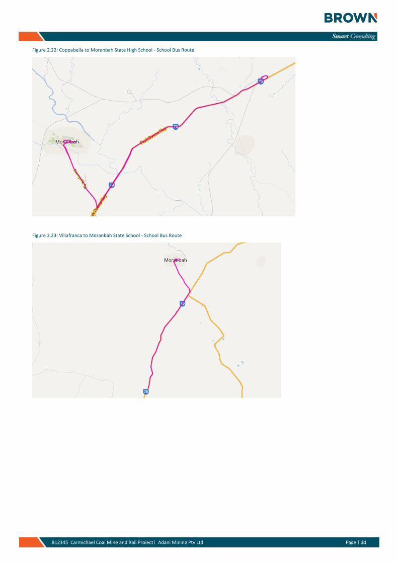
Figure 2.22: Coppabella to Moranbah State High School - School Bus Route ................................................................ 31
Figure 2.23: Villafranca to Moranbah State School - School Bus Route ......................................................................... 31
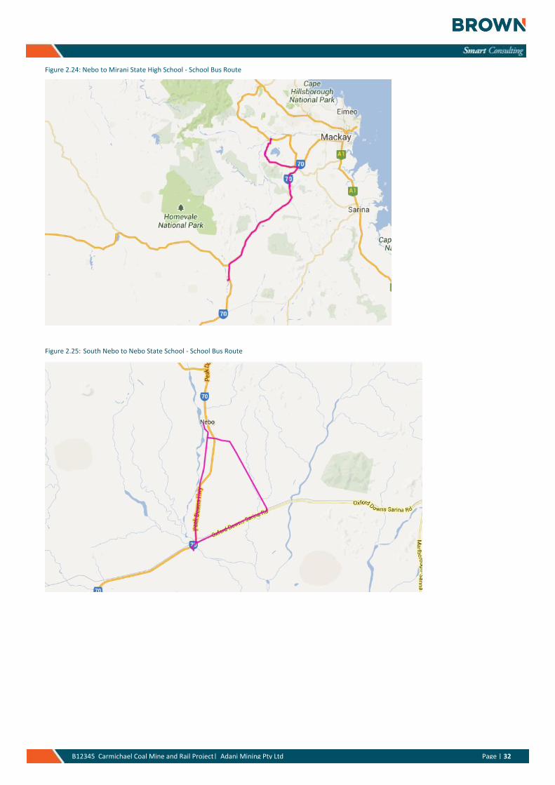
Figure 2.24: Nebo to Mirani State High School - School Bus Route ................................................................................ 32
Figure 2.25: South Nebo to Nebo State School - School Bus Route ............................................................................... 32
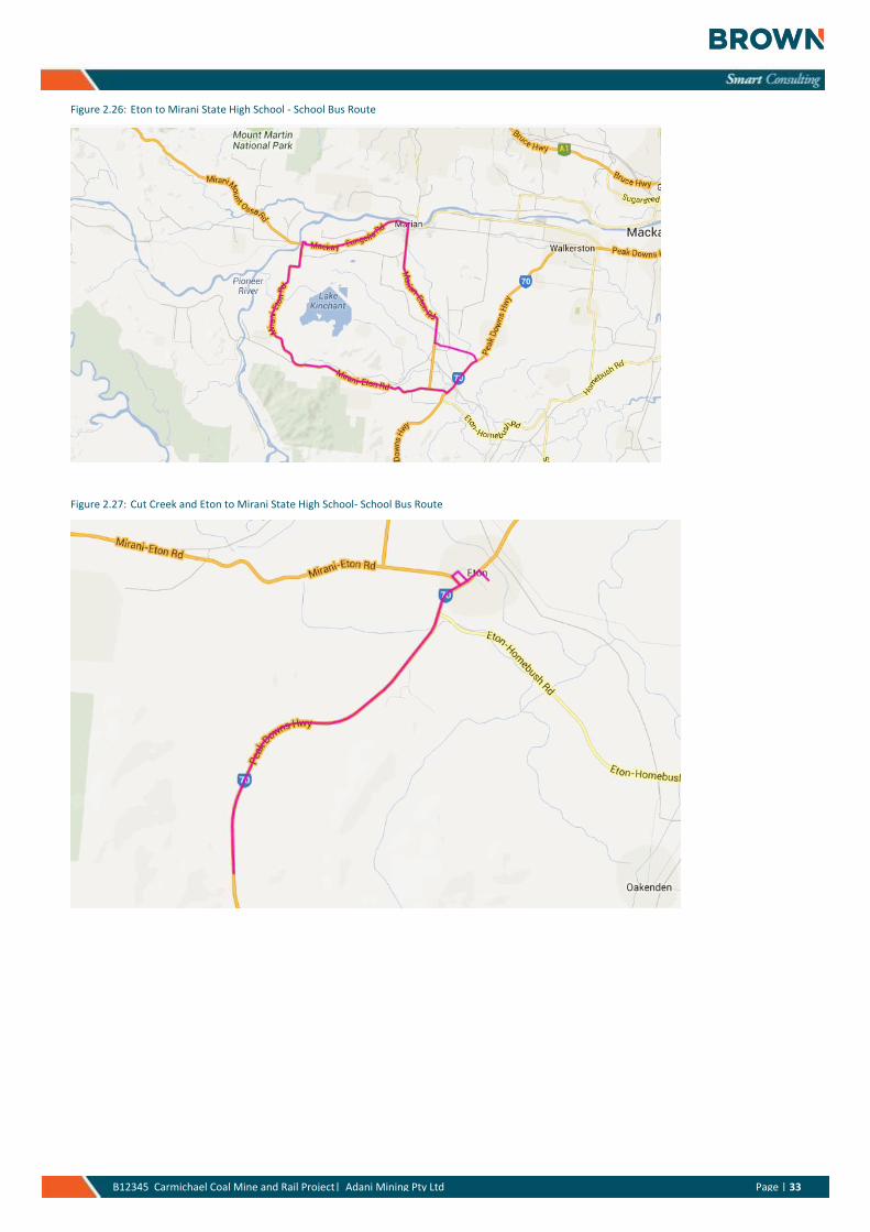
Figure 2.26: Eton to Mirani State High School - School Bus Route ................................................................................. 33
Figure 2.27: Cut Creek and Eton to Mirani State High School- School Bus Route .......................................................... 33
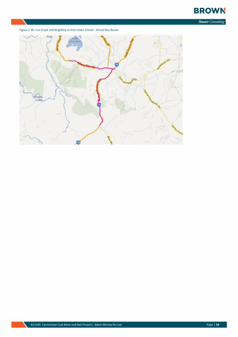
Figure 2.28: Cut Creek and Brightley to Eton State School - School Bus Route ............................................................. 34
Figure 3.1: 2014 Estimated Daily Development Traffic Volumes (vehicles per day, total two-way) .............................. 38
Figure 3.2: 2015 Estimated Daily Development Traffic Volumes (vehicles per day, total two-way) .............................. 38
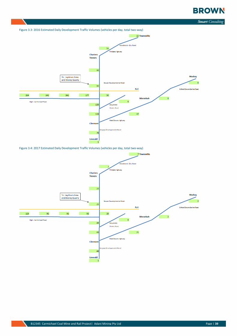
Figure 3.3: 2016 Estimated Daily Development Traffic Volumes (vehicles per day, total two-way) .............................. 39
Figure 3.4: 2017 Estimated Daily Development Traffic Volumes (vehicles per day, total two-way) .............................. 39
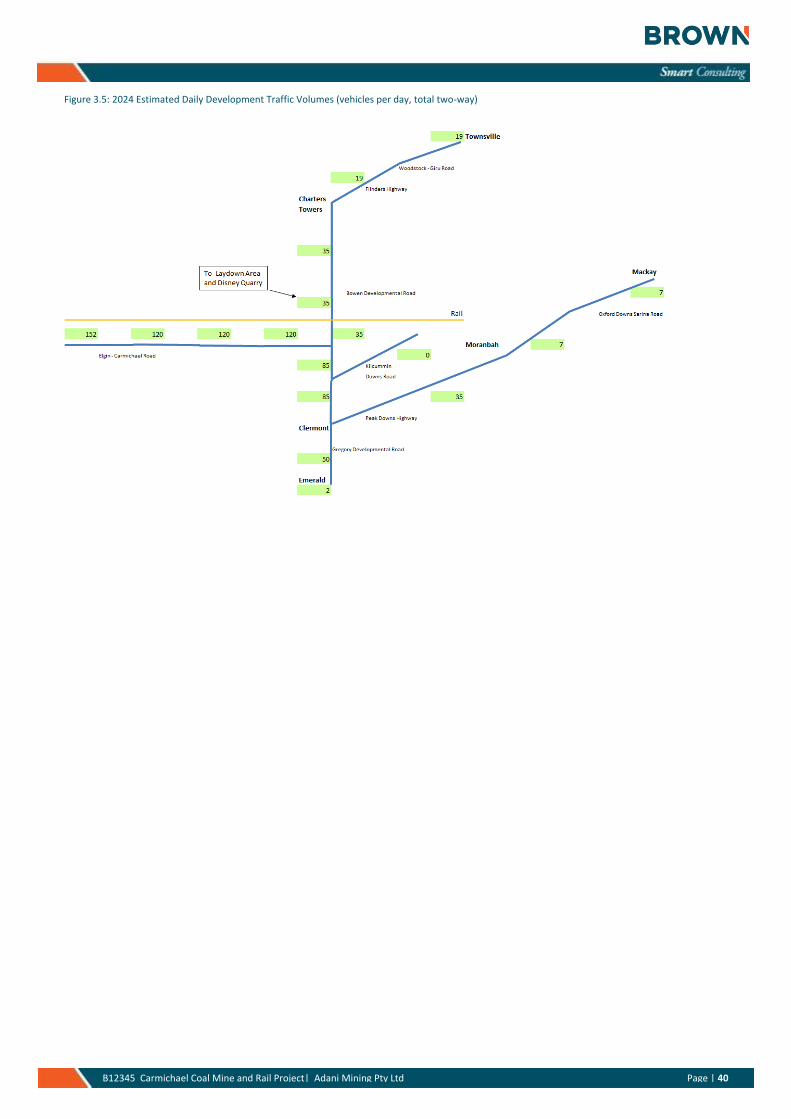
Figure 3.5: 2024 Estimated Daily Development Traffic Volumes (vehicles per day, total two-way) .............................. 40
Figure 4.1: Intersection Capacity – Uninterrupted Flow Conditions .............................................................................. 42
Figure 4 2: Turn Warrants for a design speed>=100km/h .............................................................................................. 42
Figure 4 3: 2015 Development Volumes (worst case over ten year design period) as a proportion of 2015 Background Traffic Volume (% increases shown) ............................................................................................................................... 44
Figure 4 4: 2024 Development Volumes (ten year design period) as a proportion of 2024 Background Traffic Volume (% increases shown) ....................................................................................................................................................... 44
APPENDICES
Appendix A References
Appendix B Key Development Data Inputs - summary
Page | 1 B12345 Carmichael Coal Mine and Rail Project| Adani Mining Pty Ltd Page | 1
1. Introduction and Context
1.1 Overview
Brown Consulting have prepared the following report on behalf of Adani Report Mining Pty Ltd for the
Carmichael Coal Project.
Adani Mining Pty Ltd (Adani, the Proponent), commenced an Environmental Impact Statement (EIS) process for
the Carmichael Coal Mine and Rail Project (the Project) in 2010. On 26 November 2010, the Queensland (Qld)
Office of the Coordinator General declared the Project a ‘significant project’ and the Project was referred to the
Commonwealth Department of Sustainability, Environment, Water, Population and Communities (DSEWPaC)
(referral No. 2010/5736). The Project was assessed to be a controlled action on the 6 January 2011 under
section 75 and section 87 of the Commonwealth Environment Protection and Biodiversity Conservation Act
1999 (EPBC Act). The controlling provisions for the Project include:
» World Heritage properties (sections 12 & 15A)
» National Heritage places (sections 15B & 15C)
» Wetlands (Ramsar) (sections 16 & 17B)
» Listed threatened species and communities (sections 18 & 18A)
» Listed migratory species (sections 20 & 20A)
» The Great Barrier Reef Marine Park (GBRMP) (sections 24B & 24C)
» Protection of water resources (sections 24D & 24E).
The Qld Government’s EIS process has been accredited for the assessment under Part 8 of the EPBC Act in
accordance with the bilateral agreement between the Commonwealth of Australia and the State of
Queensland.
The Proponent prepared an EIS in accordance with the Terms of Reference (ToR) issued by the Qld
Coordinator-General in May 2011 (Qld Government, 2011). The EIS process is managed under section 26(1) (a)
of the State Development and Public Works Act 1971 (SDPWO Act), which is administered by the Qld
Government’s Department of State Development, Infrastructure and Planning (DSDIP).
The EIS, submitted in December 2012, assessed the environmental, social and economic impacts associated
with developing a 60 million tonne (product) per annum (Mtpa) thermal coal mine in the northern Galilee
Basin, approximately 160 kilometres (km) north-west of Clermont, Central Queensland, Australia. Coal from the
Project will be transported by rail to the existing Goonyella and Newlands rail systems, operated by Aurizon
Operations Limited (Aurizon). The coal will be exported via the Port of Hay Point and the Point of Abbot Point
over the 60 year (90 years in the EIS) mine life.
Project components are as follows:
» The Project (Mine): a greenfield coal mine over EPC 1690 and the eastern portion of EPC 1080, which
includes both open cut and underground mining, on mine infrastructure and associated mine processing
facilities (the Mine) and the Mine (offsite) infrastructure including a workers accommodation village and
associated facilities, a permanent airport site, an industrial area and water supply infrastructure
Page | 2 B12345 Carmichael Coal Mine and Rail Project| Adani Mining Pty Ltd Page | 2
» The Project (Rail): a greenfield rail line connecting to mine to the existing Goonyella and Newlands rail
systems to provide for the export of coal via the Port of Hay Point (Dudgeon Point expansion) and the Port
of Abbot Point, respectively including:
- Rail (west): a 120 kilometre (km) dual gauge portion running west from the Mine site east to Diamond
Creek
- Rail (east): a 69 km narrow gauge portion running east from Diamond Creek connecting to the Goonyella
rail system south of Moranbah.
- Quarries: The use of five (5) local quarries to extract quarry materials for construction and operational
purposes.
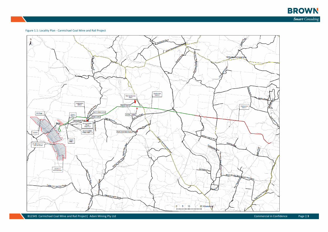
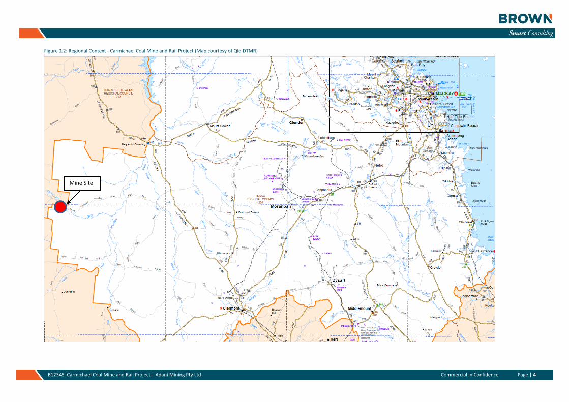
The Project (Mine) site is located along the Moray - Carmichael Road, refer Figure 1.1 below. The nearest
regional towns to the Project are Clermont, located to the south, and Moranbah to the east, refer Figure 1.2
below.
The contents of this report has drawn on various existing information and data resources, including reports
developed for the Environmental Impact Statement (EIS).
This report provides information on the expected traffic generated by the full development and also outlines
the assessment of the adjoining traffic network. The report is consistent with the requirements of Queensland
Transport and Main Roads’ (DTMR’s) Guidelines for Assessment of Road Impacts of Development (GARID).
It is understood that this report will be used as an input into the Supplementary Environmental Impact
Statement (SEIS) for the project.
Page | 3 B12345 Carmichael Coal Mine and Rail Project| Adani Mining Pty Ltd Commercial in Confidence Page | 3
Figure 1.1: Locality Plan - Carmichael Coal Mine and Rail Project
Page | 4 B12345 Carmichael Coal Mine and Rail Project| Adani Mining Pty Ltd Commercial in Confidence Page | 4
Figure 1.2: Regional Context - Carmichael Coal Mine and Rail Project (Map courtesy of Qld DTMR)
Mine Site
Page | 5 B12345 Carmichael Coal Mine and Rail Project| Adani Mining Pty Ltd Page | 5
1.2 Key Assumptions and Development Principles
During the construction (establishment) and operational phases it is understood that the Carmichael Coal project will function as defined below. This information is further expanded in Section 3 (Development Traffic), particularly in relation to the resultant traffic generation anticipated from the development consistent with the key assumptions and principles defined below.
1.2.1 Construction Phase
» Construction is expected to occur effectively 24 hours per day, 7 days per week – 363 days per year
» It is expected that a significant proportion of the workforce will operate on a fly in, fly out (FIFO) basis. FIFO activity will initially be from the existing Airport at Doongmabulla and later the proposed Airport site to be located adjacent to the mine site. Some FIFO will also be via Moranbah for rail construction in the eastern sections (eg. Camp 1). FIFO will be a key requirement for working on the project. This is primarily due to the large distances that would be required to be travelled by workers to / from the various work sites and the potential risk (road safety) that this long distance travel may have on each worker either before or after each shift.
» Generally workforce access to each site will be via bus / coach for all locations – the primary route for the majority of local movements will be the Moray - Carmichael Road.
» Consumables for the mining construction will be sourced locally, wherever possible, so as to support the surrounding community, eg. Clermont, Moranbah and Emerald. While it is not expected that all materials for the Project will be able to be sourced in the local area, consideration will be given to the transport requirements of materials with an aim to minimise both heavy and oversize vehicle traffic generation on the road network. Other key source locations will include Mackay and Townsville and to a lesser extent, for particular equipment and components, either Brisbane and / or Rockhampton.
» Maintenance of mine equipment, and not construction equipment, will primarily be undertaken on-site at the Mine Infrastructure Area and / or in the Off-Lease Industrial Area. Maintenance of equipment for the rail and quarries will occur on-site and not at the Mine Infrastructure Area.
» The FIFO workers will be housed in camp locations consistent with their role in the construction work, eg. rail construction workers will be located at the rail camps whereas those workers related to the mine will be located at the mine camp.
Section 3 of this report provides a breakdown of the proposed construction arrangements including a summary breakdown of the anticipated materials associated with the construction phase.
1.2.2 Operations Phase
» An open cut and underground coal mine producing approximately 60Mtpa at the peak
» Anticipated mine lifespan of 60 years
» Coal produced will be railed via the Project (Rail) line and connect with the existing rail line located west of Moranbah with a final connection on to the Abbot Point or Hay Point Coal Terminals
» Mining will be performed by utilising a truck and excavator method of mining
» Coal to be crushed, washed and screened on site prior to haulage
» Operations are expected to occur effectively 24 hours per day, 7 days per week - a 363 days per year operation
» It is expected that a significant proportion of the workforce will operate on a fly in, fly out (FIFO) basis. FIFO activity will initially be from the existing Airport at Doongmabulla and later the proposed Airport site to be located adjacent to the mine site. FIFO will be a key requirement for working on the project. This is primarily due to the large distances that would be required to be travelled by workers to / from the various work sites and the potential risk (road safety) that this long distance travel may have on each worker either before or after each shift.
Page | 6 B12345 Carmichael Coal Mine and Rail Project| Adani Mining Pty Ltd Page | 6
» Workforce access to the Project site will be via bus / coach for all locations – the primary route for the majority of local movements will be the Moray - Carmichael Road.
» Consumables for the mining operations will be sourced locally, wherever possible, so as to support the surrounding community, eg. Clermont, Moranbah and Emerald. While it is not expected that all materials for the Project will be able to be sourced in the local area, consideration will be given to the transport requirements of materials with an aim to minimise both heavy and oversize vehicle traffic generation on the road network. Other key source locations will include Mackay and Townsville and to a lesser extent, for particular equipment and components, either Brisbane and / or Rockhampton.
» Maintenance of equipment is expected to primarily be undertaken on-site at the Mine Infrastructure Area and / or in the Off-Lease Industrial Area. Do note also that the Borrow 7 quarry is anticipated to be in operation for the life of the mine. Any maintenance of equipment associated with the Borrow 7 quarry will be undertaken on the quarry site. Maintenance of trains and related activities will be undertaken at the maintenance facility on Moray Downs.
» The FIFO workers will be housed in the Mine Workers Accommodation Village during the operational phase.
Section 3 of this report provides a breakdown of the proposed operational phase arrangements including a summary breakdown of the anticipated materials associated with the operational phase.
1.3 References and Data Sources
For the purposes of this assessment various references and data sources were utilised as inputs into the development of this project report. The key inputs are defined below and are also detailed in Appendix A: References:
» EIS, Volume 1, Chapter 8 Cumulative Impacts
» EIS, Volume 2, Chapter 6 Water Resources
» EIS, Volume 2, Chapter 9 Noise and Vibration
» EIS, Volume 2, Chapter 11 Transport
» EIS, Volume 2, Chapter 12 Hazard and Risk
» EIS, Volume 3, Chapter 6 Water Resources
» EIS, Volume 3, Chapter 9 Noise and Vibration
» EIS, Volume 3, Chapter 11 Transport
» EIS, Volume 3, Chapter 12 Hazard and Risk
» EIS, Volume 4, AG Rail Transport Assessment
» EIS, Volume 4, W Mine Transport Assessment
» Report for Carmichael Coal Mine and Rail Project, Land Use, 20 September 2012
» Adani Rail/Mining Camp, Transport Statement – Mine Camp, prepared for Adani Mining Pty Ltd, October 2012
» Adani Rail/Mining Camp, Transport Statement – Camp 1, prepared for Adani Mining Pty Ltd, October 2012
» Adani Rail/Mining Camp, Transport Statement – Camp 2, prepared for Adani Mining Pty Ltd, November 2012
» Adani Rail/Mining Camp, Transport Statement – Camp 3, prepared for Adani Mining Pty Ltd, October 2012
» Carmichael Coal Mine Project, Back Creek Quarry Proposal, Traffic Engineering Report, TTM, April 2013
» Carmichael Coal Mine Project, Borrow 7 Quarry Proposal, Traffic Engineering Report, TTM, April 2013
» Carmichael Coal Mine Project, Disney Quarry Proposal, Traffic Engineering Report, TTM, April 2013
» Carmichael Coal Mine Project, Moray Pit Quarry Proposal, Traffic Engineering Report, TTM, April 2013
» Carmichael Coal Mine Project, North Creek Quarry Proposal, Traffic Engineering Report, TTM, April 2013
» Carmichael Mine Road Upgrade Detailed Design, Adani Mining Pty Ltd, Parsons Brinckerhoff, Detailed Design Report, 8 February 2013
Page | 7 B12345 Carmichael Coal Mine and Rail Project| Adani Mining Pty Ltd Page | 7
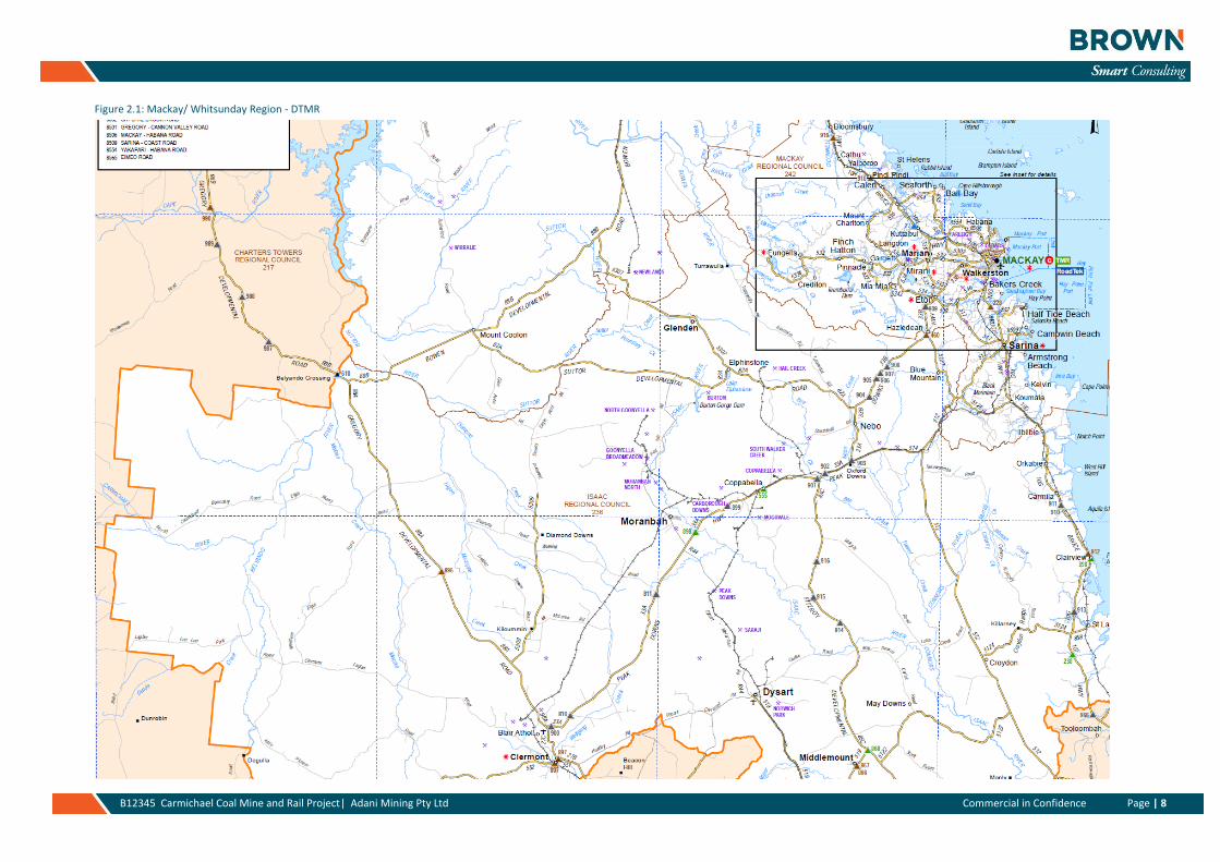
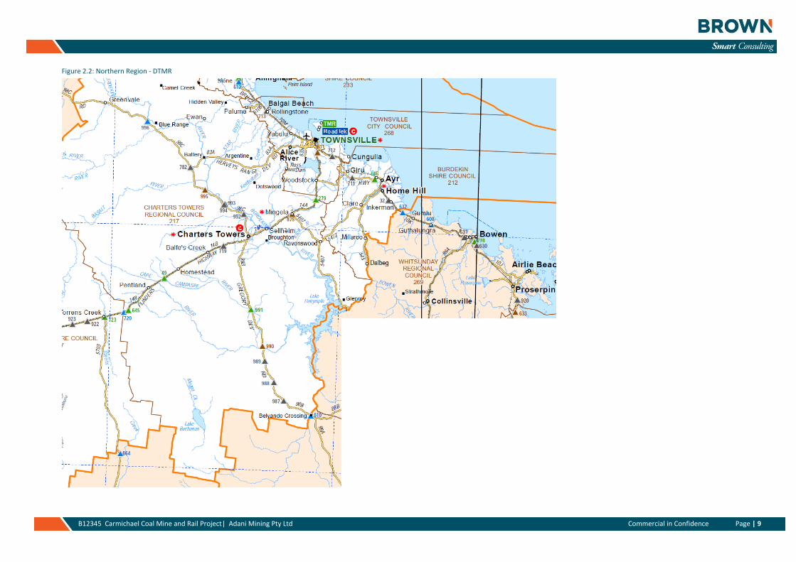
2. Existing Transport Network
The Project’s Rail corridor will traverse one state-controlled road, namely the Gregory Developmental Road, and also a number of other public local roads. The local roads are under the jurisdiction of the Isaac Regional Council (IRC). The Project (Mine) site itself will primarily impact the Moray – Carmichael Road. An outline of the features associated with the key routes is presented in the following sections. Please note that further material is available from the EIS Volumes 2 and 3, Section 11 Transport.
2.1 State Controlled Road Network
The state controlled road (SCR) network will provide the major longer distance access function for the project for construction materials and equipment and to also support the operational phases of the project into the future. The SCR network links the project to the coast at Mackay and Townsville and also further afield to Brisbane and Rockhampton. Each of these locations are anticipated to provide inputs to the project either during the construction or operational phase or both.
Figures 2.1 and 2.2 below provide an overall plan of the roads within the two DTMR regions that the Project is anticipated to impact; these are maps for the Mackay / Whitsunday Region and Northern Region. These roads show the roads that are controlled by DTMR and those that are under the jurisdiction of the various Regional Councils, eg. Isaac Regional Council. The key SCR network roads that are anticipated to be impacted include the Peak Downs Highway, Gregory Developmental Road and Flinders Highway.
The traffic count and crash data that is presented in the following sections is the latest data (received July 2013) and it has been acquired from DTMR or from other reports as defined by each of the references.
Page | 8 B12345 Carmichael Coal Mine and Rail Project| Adani Mining Pty Ltd Commercial in Confidence Page | 8
Figure 2.1: Mackay/ Whitsunday Region - DTMR
Page | 9 B12345 Carmichael Coal Mine and Rail Project| Adani Mining Pty Ltd Commercial in Confidence Page | 9
Figure 2.2: Northern Region - DTMR
Page | 10 B12345 Carmichael Coal Mine and Rail Project| Adani Mining Pty Ltd Page | 10
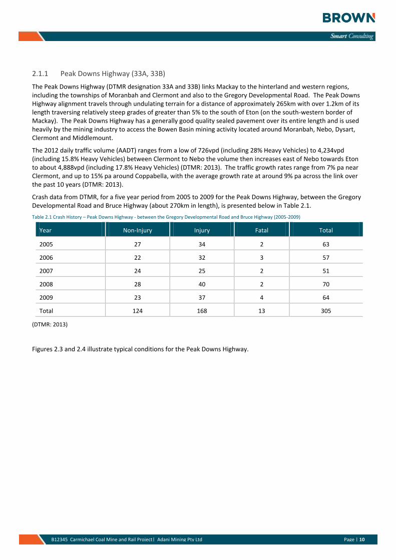
2.1.1 Peak Downs Highway (33A, 33B)
The Peak Downs Highway (DTMR designation 33A and 33B) links Mackay to the hinterland and western regions, including the townships of Moranbah and Clermont and also to the Gregory Developmental Road. The Peak Downs Highway alignment travels through undulating terrain for a distance of approximately 265km with over 1.2km of its length traversing relatively steep grades of greater than 5% to the south of Eton (on the south-western border of Mackay). The Peak Downs Highway has a generally good quality sealed pavement over its entire length and is used heavily by the mining industry to access the Bowen Basin mining activity located around Moranbah, Nebo, Dysart, Clermont and Middlemount.
The 2012 daily traffic volume (AADT) ranges from a low of 726vpd (including 28% Heavy Vehicles) to 4,234vpd (including 15.8% Heavy Vehicles) between Clermont to Nebo the volume then increases east of Nebo towards Eton to about 4,888vpd (including 17.8% Heavy Vehicles) (DTMR: 2013). The traffic growth rates range from 7% pa near Clermont, and up to 15% pa around Coppabella, with the average growth rate at around 9% pa across the link over the past 10 years (DTMR: 2013).
Crash data from DTMR, for a five year period from 2005 to 2009 for the Peak Downs Highway, between the Gregory Developmental Road and Bruce Highway (about 270km in length), is presented below in Table 2.1.
Table 2.1 Crash History – Peak Downs Highway - between the Gregory Developmental Road and Bruce Highway (2005-2009)
Year Non-Injury Injury Fatal Total
2005 27 34 2 63
2006 22 32 3 57
2007 24 25 2 51
2008 28 40 2 70
2009 23 37 4 64
Total 124 168 13 305
(DTMR: 2013)
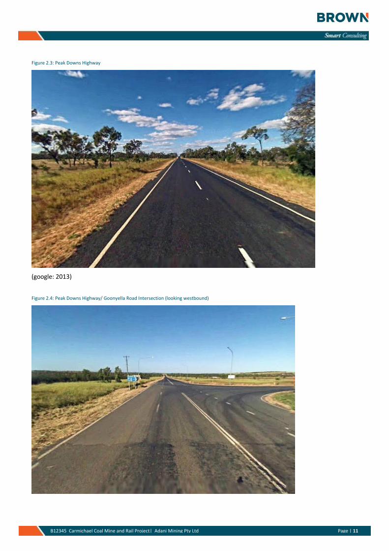
Figures 2.3 and 2.4 illustrate typical conditions for the Peak Downs Highway.
Page | 11 B12345 Carmichael Coal Mine and Rail Project| Adani Mining Pty Ltd Page | 11
Figure 2.3: Peak Downs Highway
(google: 2013)
Figure 2.4: Peak Downs Highway/ Goonyella Road Intersection (looking westbound)
Page | 12 B12345 Carmichael Coal Mine and Rail Project| Adani Mining Pty Ltd Page | 12
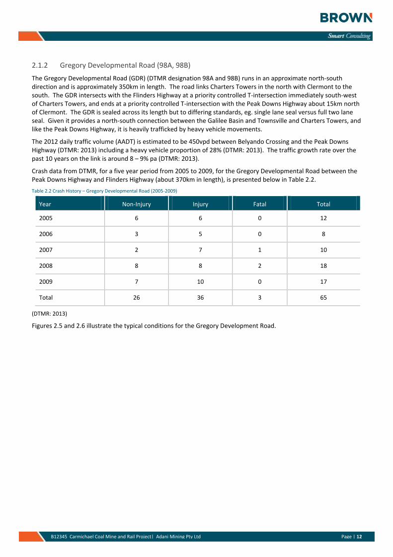
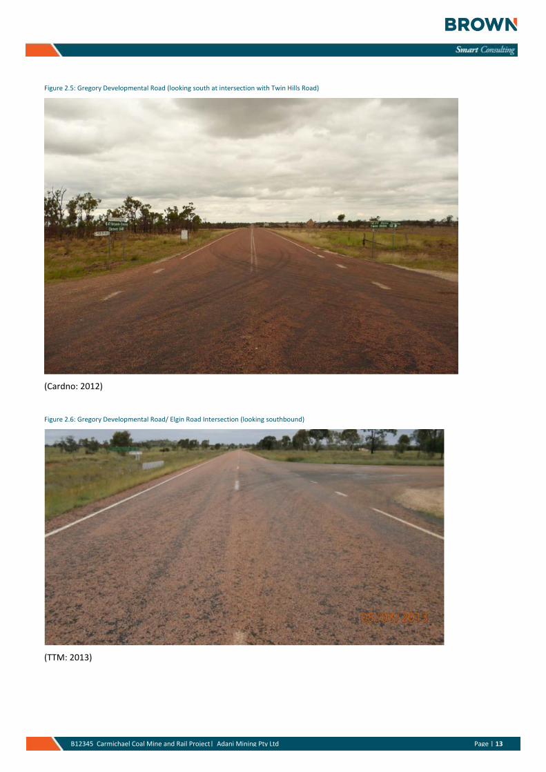
2.1.2 Gregory Developmental Road (98A, 98B)
The Gregory Developmental Road (GDR) (DTMR designation 98A and 98B) runs in an approximate north-south direction and is approximately 350km in length. The road links Charters Towers in the north with Clermont to the south. The GDR intersects with the Flinders Highway at a priority controlled T-intersection immediately south-west of Charters Towers, and ends at a priority controlled T-intersection with the Peak Downs Highway about 15km north of Clermont. The GDR is sealed across its length but to differing standards, eg. single lane seal versus full two lane seal. Given it provides a north-south connection between the Galilee Basin and Townsville and Charters Towers, and like the Peak Downs Highway, it is heavily trafficked by heavy vehicle movements.
The 2012 daily traffic volume (AADT) is estimated to be 450vpd between Belyando Crossing and the Peak Downs Highway (DTMR: 2013) including a heavy vehicle proportion of 28% (DTMR: 2013). The traffic growth rate over the past 10 years on the link is around 8 – 9% pa (DTMR: 2013).
Crash data from DTMR, for a five year period from 2005 to 2009, for the Gregory Developmental Road between the Peak Downs Highway and Flinders Highway (about 370km in length), is presented below in Table 2.2.
Table 2.2 Crash History – Gregory Developmental Road (2005-2009)
Year Non-Injury Injury Fatal Total
2005 6 6 0 12
2006 3 5 0 8
2007 2 7 1 10
2008 8 8 2 18
2009 7 10 0 17
Total 26 36 3 65
(DTMR: 2013)
Figures 2.5 and 2.6 illustrate the typical conditions for the Gregory Development Road.
Page | 13 B12345 Carmichael Coal Mine and Rail Project| Adani Mining Pty Ltd Page | 13
Figure 2.5: Gregory Developmental Road (looking south at intersection with Twin Hills Road)
(Cardno: 2012)
Figure 2.6: Gregory Developmental Road/ Elgin Road Intersection (looking southbound)
(TTM: 2013)
Page | 14 B12345 Carmichael Coal Mine and Rail Project| Adani Mining Pty Ltd Page | 14
2.1.3 Flinders Highway (14A)
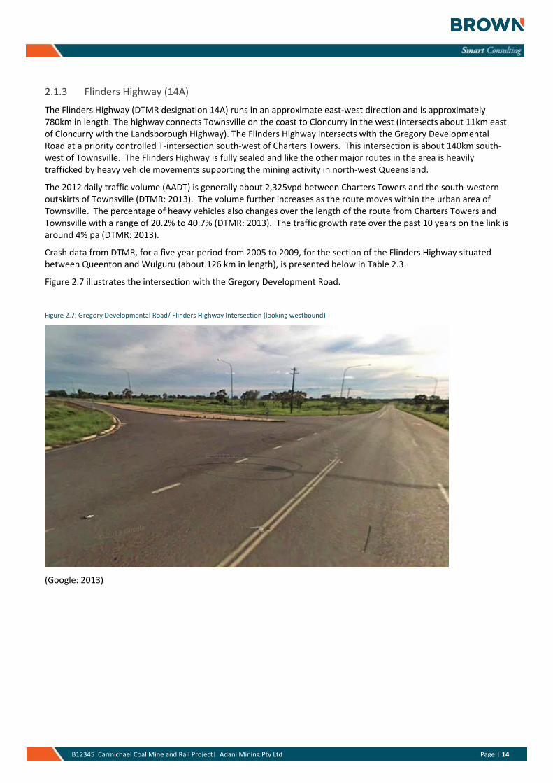
The Flinders Highway (DTMR designation 14A) runs in an approximate east-west direction and is approximately 780km in length. The highway connects Townsville on the coast to Cloncurry in the west (intersects about 11km east of Cloncurry with the Landsborough Highway). The Flinders Highway intersects with the Gregory Developmental Road at a priority controlled T-intersection south-west of Charters Towers. This intersection is about 140km south-west of Townsville. The Flinders Highway is fully sealed and like the other major routes in the area is heavily trafficked by heavy vehicle movements supporting the mining activity in north-west Queensland.
The 2012 daily traffic volume (AADT) is generally about 2,325vpd between Charters Towers and the south-western outskirts of Townsville (DTMR: 2013). The volume further increases as the route moves within the urban area of Townsville. The percentage of heavy vehicles also changes over the length of the route from Charters Towers and Townsville with a range of 20.2% to 40.7% (DTMR: 2013). The traffic growth rate over the past 10 years on the link is around 4% pa (DTMR: 2013).
Crash data from DTMR, for a five year period from 2005 to 2009, for the section of the Flinders Highway situated between Queenton and Wulguru (about 126 km in length), is presented below in Table 2.3.
Figure 2.7 illustrates the intersection with the Gregory Development Road.
Figure 2.7: Gregory Developmental Road/ Flinders Highway Intersection (looking westbound)
(Google: 2013)
Page | 15 B12345 Carmichael Coal Mine and Rail Project| Adani Mining Pty Ltd Page | 15
Table 2.3 Crash History – Flinders Highway (2005-2009)
Year Non-Injury Injury Fatal Total
2005 9 7 2 18
2006 5 16 2 23
2007 5 16 0 21
2008 6 11 0 17
2009 8 10 2 20
Total 33 60 6 99
(DTMR: 2013)
2.1.4 Kilcummin-Diamond Downs Road (5309)
Kilcummin-Diamond Downs Road (DTMR designation 5309) runs in an approximate north-south alignment. The Kilcummin Diamond Downs Road is a state-controlled road which turns into an IRC local controlled road in the vicinity of the Project (Rail), namely Eaglefield Road. Continuing south from the intersection with Eaglefield Road, the Kilcummin-Diamond Downs Road intersects with the Gregory Developmental Road at a priority controlled T-intersection located to the north of Miclere. The turn-off to Kilcummin-Diamond Downs Road is about 28km north of the intersection of the Peak Downs Highway with the Gregory Developmental Road.
The 2012 daily traffic volume (AADT) is estimated to be about 74vpd along the Kilcummin-Diamond Downs Road including a heavy vehicle proportion of about 23% (DTMR:2013). The traffic growth rate over the past 10 years on the link is around 2% pa (DTMR: 2013).
Traffic crash data from DTMR indicates that there was one crash over the five year period (2005 – 2009) and this crash occurred about 2.5km north of the proposed access point to the Rail Camp 1. It involved one vehicle veering off on a straight unsealed section of the road (DTMR: 2013).
2.2 Local Road Network
The IRC has jurisdiction of the local council roads within the area of interest for this project. The key features of the three main local roads are outlined below.
2.2.1 Moray - Carmichael Road
Moray - Carmichael Road will be the primary access to the Mine and other supporting infrastructure located west of the Gregory Developmental Road. The road runs in an approximate east-west alignment and is approximately 115km in length. The road forms a priority controlled T-intersection with Moray - Bulliwallah Road at its eastern end and forms a priority controlled T-intersection with Ulcanbah Road at its western end. Moray -Carmichael Road traverses the Project (Mine) site.
This route is of particular importance because it will provide the road access to the mine site. The route is unsealed and is only trafficable in dry conditions. It is understood that Adani is in discussions with the IRC regarding the long term maintenance and development of the Moray - Carmichael Road from its intersection with the Gregory Development Road to where it intersects with the western boundary of EPC 1690. The Moray - Carmichael Road will be progressively upgraded in accordance with the agreement deed with Council (GHD: 2012).
The current Moray – Carmichael Road runs through the mine site and will continue to do so. It is understood Adani have committed to maintaining public access to the road through the mine site at all times. The alignment of the
Page | 16 B12345 Carmichael Coal Mine and Rail Project| Adani Mining Pty Ltd Page | 16
road may move from time to time to accommodate mining activity, however it will continue to be open to the public and meet the required engineering standard. Adani will also be working with landholders along the route and the IRC to realign the road in places to provide a better alignment to safely accommodate mining traffic (GHD: 2012).
The 2012 daily traffic volume (AADT) range for Moray – Carmichael Road is 14 to 56vpd (including about 54% heavy vehicles) (Cardno: 2012) (TTM: 2013). A conservative value of 20vpd has been utilised as the baseline for the purposes of the assessment.
Traffic crash data indicates that there has been no crashes recorded along this section of road (Cardno: 2012).
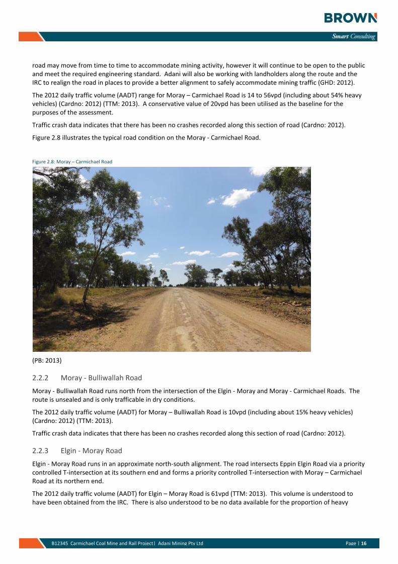
Figure 2.8 illustrates the typical road condition on the Moray - Carmichael Road.
Figure 2.8: Moray – Carmichael Road
(PB: 2013)
2.2.2 Moray - Bulliwallah Road
Moray - Bulliwallah Road runs north from the intersection of the Elgin - Moray and Moray - Carmichael Roads. The route is unsealed and is only trafficable in dry conditions.
The 2012 daily traffic volume (AADT) for Moray – Bulliwallah Road is 10vpd (including about 15% heavy vehicles) (Cardno: 2012) (TTM: 2013).
Traffic crash data indicates that there has been no crashes recorded along this section of road (Cardno: 2012).
2.2.3 Elgin - Moray Road
Elgin - Moray Road runs in an approximate north-south alignment. The road intersects Eppin Elgin Road via a priority controlled T-intersection at its southern end and forms a priority controlled T-intersection with Moray – Carmichael Road at its northern end.
The 2012 daily traffic volume (AADT) for Elgin – Moray Road is 61vpd (TTM: 2013). This volume is understood to have been obtained from the IRC. There is also understood to be no data available for the proportion of heavy
Page | 17 B12345 Carmichael Coal Mine and Rail Project| Adani Mining Pty Ltd Page | 17
vehicles for this road. Notwithstanding, the volume of 61vpd is considered high relative to the Moray – Carmichael Road and may not be representative of a long term average on the road link.
It is understood that no traffic crash data is available for this road link. Notwithstanding, it is expected that the number of crashes would be relatively low and likely be consistent with the surrounding road network, eg. Moray - Carmichael Road and Moray – Bulliwallah Road each of which have had no crashes over the recorded 5 year period.
2.3 Multi-Combination Vehicles and Higher Mass Limits
2.3.1 Introduction and definitions
Heavy vehicles, including multi-combination vehicles such as B-Doubles, are expected to be an integral element within the freight and logistics chain for the development of the project. Given this context the relevant requirements for MCV’s needs to be considered. Outlined below is a brief discussion on some of the key definitions and constraints regarding the use of these vehicle types across the road network.
A B-Double is defined as a combination consisting of a prime mover towing two semi-trailers. The prime mover and the two trailers are combined by two fifth wheel (turntable) assemblies. The double articulation is the main distinguishing feature of a B-Double.
A B-Double can have an overall length of 26 metres or less. Allowable axle group spacings and additional operating conditions are provided in Queensland Transport Guideline for Multi-combination Vehicles in Queensland (Road Trains, B-doubles, B-triples, AB-triples) (Form Number 1). A maximum Gross Combination Mass (GCM) of 62.5 tonnes without Road Friendly Suspension (RFS), and a maximum GCM of 68 tonnes with RFS when operating under Queensland Transport Performance Guidelines for Higher Mass Limits for Vehicles with Road Friendly Suspensions (Form Number 10).
A Road Train is defined as a combination, other than a B-Double, consisting of a rigid vehicle (which may be a prime mover) towing two or more trailers. A converter dolly supporting a semi-trailer is counted as one trailer. There are two groups of road trains in Queensland; Type 1 Road Trains and Type 2 Road Trains.
A Conventional Type 1 Road Train operates at an overall length of 36.5 metres or less. Allowable axle group spacings are provided in Queensland Transport Guideline for Multicombination Vehicles in Queensland (Road Trains, B-doubles, B-triples, AB-triples) (Form Number 1). A maximum GCM of 82.5 tonnes without RFS, and a maximum GCM of 90.5 tonnes with RFS when operating under Queensland Transport Performance Guidelines for Higher Mass Limits for Vehicles with Road Friendly Suspensions (Form Number 10).
Conventional Type 1 Road Trains are also referred to as ‘Double Road Trains’ or ‘A-Double Road Trains’ in other Australian States and Territories. A B-Triple is an innovative Type 1 Road Train that operates at an overall length of 36.5 metres or less.
A Conventional Type 2 Road Train operates at an overall length of more than 36.5 metres, but not more than 53.5 metres. Allowable axle group spacings are provided in Queensland Transport Guideline for Multi-combination Vehicles in Queensland (Road Trains, B-doubles, B-triples, AB-triples) Form Number 1. A maximum GCM of 122.5 tonnes without RFS, and a maximum GCM of 135.5 tonnes with RFS when operating under Queensland Transport Performance Guidelines for Higher Mass Limits for Vehicles with Road Friendly Suspensions (Form Number 10). Conventional Type 2 Road Trains are also referred to as ‘Triple Road Trains’ or ‘A-Triple Road Trains’ in other Australian States and Territories. An AB-Triple that operates at an overall length of 44 metres or less is an innovative Type 2 Road Train.
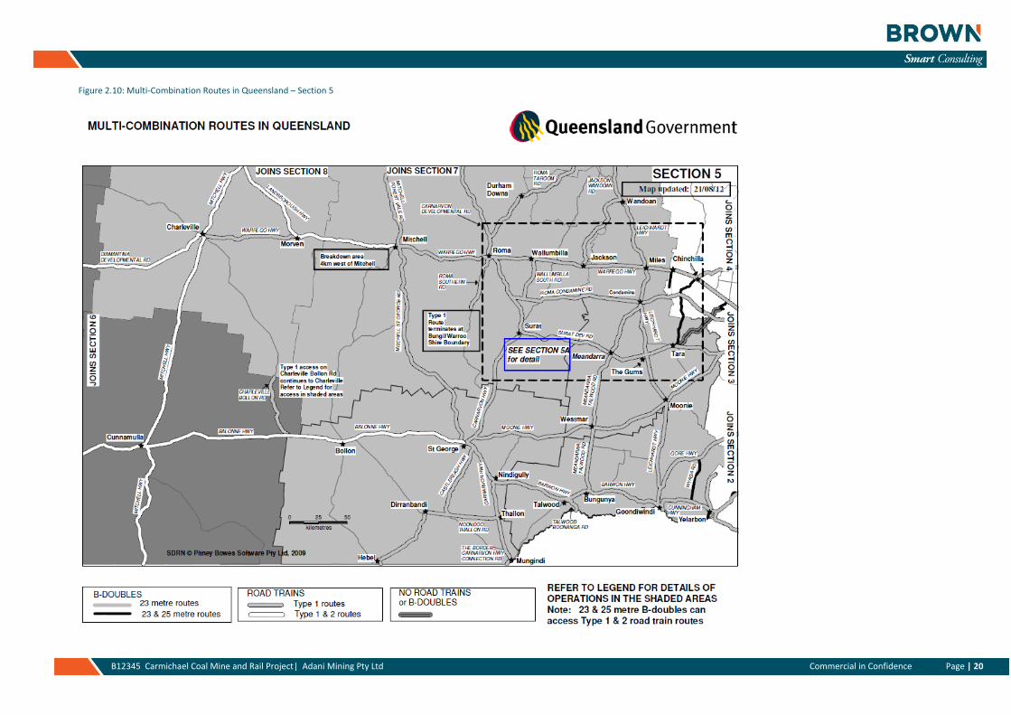
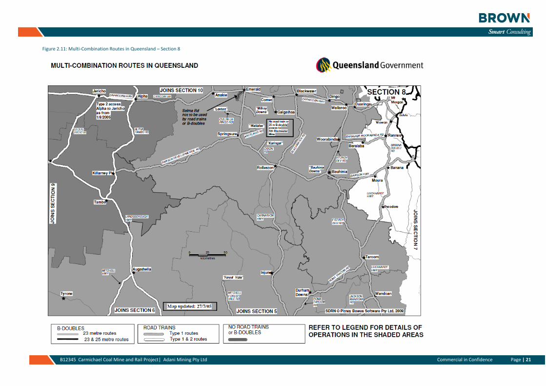
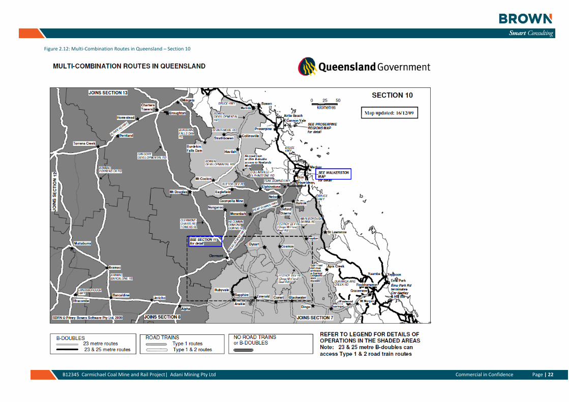
Figures 2.9 to 2.13 illustrate the relevant MCV Routes for this project.
The key points of relevance to the Carmichael Coal Mine and Rail project are:
» Type 1 and 2 road train routes exist between Clermont and Townsville via the Gregory Developmental Road and the Flinders Highway to the Port of Townsville.
» B-Doubles (23m and 25m) can operate on all of the state controlled network sections that would likely be utilised by the project during the construction and operations phases
Page | 18 B12345 Carmichael Coal Mine and Rail Project| Adani Mining Pty Ltd Page | 18
» Road train routes are unavailable in SEQ from Brisbane to Toowoomba; this restricts the use of the Warrego Highway from Brisbane to Toowoomba for these vehicle types. Type 1 routes commence west of Toowoomba then out to Roma and north to Emerald and Clermont.
» The Peak Downs Highway is a Type 1 Road train route from Hazeldean (west of Eton near Mackay) to the intersection with the Gregory Developmental Road north of Clermont.
» The Capricorn Highway is a Type 1 Road train route from Rockhampton to Emerald.
2.3.2 Higher Mass Limits
From August 2010 changes to the higher mass limits policy now allow operators to apply for additional higher mass limits access on routes that are not already approved as a road train or B-double route as previously required (Figures 2.14 to 2.18 illustrate the HML routes). When operating at higher mass limits, operators must ensure that the higher mass limit route is approved for their particular vehicle combination, in particular:
» Road trains operating at higher mass limit weights can only operate on approved road train routes as per the multi-combination approved routes with any conditions being applied to the route having to be adhered to.
» B-doubles operating at higher mass limit weights can only operate on approved road train and B-double routes as per the multi-combination approved routes with any conditions being applied to the route having to be adhered to.
Queensland has a policy that allows vehicles fitted with road-friendly suspension to carry more freight on routes that are capable of accepting higher masses. Higher mass limits (HML) were first introduced to Queensland on 2 July 1999. Initially, the scheme was limited to the former national highway system and connecting 23m and 25m B-double routes within a radial distance of 500m. In December 2002, the Queensland Government introduced a policy framework that allowed extensions based upon agreement from the road asset owner.
The Intelligent Access Program (IAP) is now available for vehicles operating at higher mass limits. This national program provides heavy vehicles with improved access to the Australian road network in return for monitoring compliance with specific access conditions. This is done by installing vehicle telematics in participating vehicles which includes a combination of global positioning systems, in-vehicle sensors, and additional communication technology. Enrolment in IAP is a mandatory requirement for HML.
Expansion of the higher mass limits network
» The Queensland and Commonwealth Governments have entered into a Bilateral Infrastructure Agreement (BIFA) in accordance with the AusLink program. The agreement encourages a staged rollout of extensions to the existing higher-mass-limit network in conjunction with additional responsibilities for road transport operators.
» On 1 October 2006, the Queensland Government expanded the number of higher-mass-limit approved routes to meet its obligations under the Australian Government's AusLink program.
» Queensland's current policy for requesting extensions will still apply while Bilateral Infrastructure Agreement obligations for both the Queensland Government and road freight industry are met. Higher-mass-limit routes are approved only after an agreement to use the road has been obtained from the road owner, and the proposal has been endorsed by the Department of Transport and Main Roads.
The key points of relevance to the Carmichael Coal Mine and Rail project are:
» The Federal Highway network is approved for use by Higher Mass Limit (HML) vehicles.
» The Gregory Developmental Road and Peak Downs Highway are not approved for HML vehicles. Should these routes be required to be used by HML a separate application is required for these routes. This will go through to DTMR for their review and is subject to their approval.
» The Flinders Highway from Townsville to Charters Towers is approved for HML vehicles.
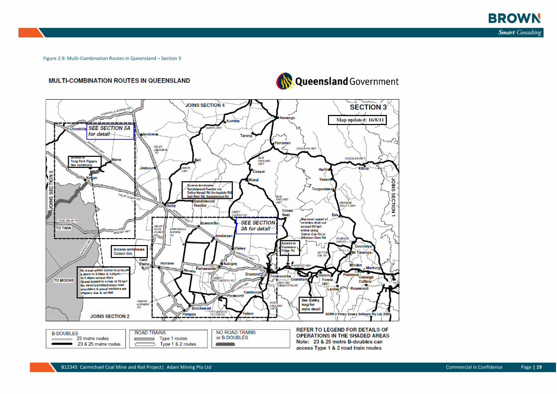
Page | 19 B12345 Carmichael Coal Mine and Rail Project| Adani Mining Pty Ltd Commercial in Confidence Page | 19
Figure 2.9: Multi-Combination Routes in Queensland – Section 3
Page | 20 B12345 Carmichael Coal Mine and Rail Project| Adani Mining Pty Ltd Commercial in Confidence Page | 20
Figure 2.10: Multi-Combination Routes in Queensland – Section 5
Page | 21 B12345 Carmichael Coal Mine and Rail Project| Adani Mining Pty Ltd Commercial in Confidence Page | 21
Figure 2.11: Multi-Combination Routes in Queensland – Section 8
Page | 22 B12345 Carmichael Coal Mine and Rail Project| Adani Mining Pty Ltd Commercial in Confidence Page | 22
Figure 2.12: Multi-Combination Routes in Queensland – Section 10
Page | 23 B12345 Carmichael Coal Mine and Rail Project| Adani Mining Pty Ltd Commercial in Confidence Page | 23
Figure 2.13: Multi-Combination Routes in Queensland – Section 13
Page | 24 B12345 Carmichael Coal Mine and Rail Project| Adani Mining Pty Ltd Page | 24
Figure 2.14: Higher Mass Limits – Queensland’s Major Highway System
Page | 25 B12345 Carmichael Coal Mine and Rail Project| Adani Mining Pty Ltd Commercial in Confidence Page | 25
Figure 2.15: Approved Routes for Higher Mass Limits for Vehicles with Road Friendly Suspensions
Page | 26 B12345 Carmichael Coal Mine and Rail Project| Adani Mining Pty Ltd Commercial in Confidence Page | 26
Figure 2.16: Approve Routes for Higher Mass Limits for Vehicles with Road Friendly Suspensions
Page | 27 B12345 Carmichael Coal Mine and Rail Project| Adani Mining Pty Ltd Commercial in Confidence Page | 27
Figure 2.17: Approve Routes for Higher Mass Limits for Vehicles with Road Friendly Suspensions Section 10
Page | 28 B12345 Carmichael Coal Mine and Rail Project| Adani Mining Pty Ltd Commercial in Confidence Page | 28
Figure 2.18: Approve Routes for Higher Mass Limits for Vehicles with Road Friendly Suspensions Section 12
Page | 29 B12345 Carmichael Coal Mine and Rail Project| Adani Mining Pty Ltd Page | 29
2.4 Public Transport Services
There are no public transport (bus) services within the surrounding communities that support day-to-day travel within each of the local communities apart from the local School Bus Route services.
The school bus route services provide an opportunity for access to the local schools within the region (primary and high schools). Services link to Charters Towers, Clermont, Moranbah, Nebo and Eton (near Mackay). These routes traverse various sections of the Gregory Developmental Road and Peak Downs Highway. Figures 2.19 to 2.28 illustrate the relevant school bus routes. The school bus services occur during the morning period (6am – 8am) and in the afternoon (3 – 5pm). There is therefore the potential for school bus routes and services to overlap and interact with the proposed mine and rail transport movements for the Carmichael Mine and Rail sites over both the construction and operational life of the mine. Given this, it is recommended that all road users relating to the Carmichael project be made aware of the school bus routes as part of an operational plan (Road Use Management Plan (RUMP)) for both the construction and operational phases for the project.
Figure 2.19: Gemini Mountains to Clermont State School – School Bus Route
Page | 30 B12345 Carmichael Coal Mine and Rail Project| Adani Mining Pty Ltd Page | 30
Figure 2.20: Mingela to Richmond Hill State School and Charters Towers State High School - School Bus Route
Figure 2.21: Mount Leyshon to Charters Towers State High School - School Bus Route
Page | 31 B12345 Carmichael Coal Mine and Rail Project| Adani Mining Pty Ltd Page | 31
Figure 2.22: Coppabella to Moranbah State High School - School Bus Route
Figure 2.23: Villafranca to Moranbah State School - School Bus Route
Page | 32 B12345 Carmichael Coal Mine and Rail Project| Adani Mining Pty Ltd Page | 32
Figure 2.24: Nebo to Mirani State High School - School Bus Route
Figure 2.25: South Nebo to Nebo State School - School Bus Route
Page | 33 B12345 Carmichael Coal Mine and Rail Project| Adani Mining Pty Ltd Page | 33
Figure 2.26: Eton to Mirani State High School - School Bus Route
Figure 2.27: Cut Creek and Eton to Mirani State High School- School Bus Route
Page | 34 B12345 Carmichael Coal Mine and Rail Project| Adani Mining Pty Ltd Page | 34
Figure 2.28: Cut Creek and Brightley to Eton State School - School Bus Route
Page | 35 B12345 Carmichael Coal Mine and Rail Project| Adani Mining Pty Ltd Page | 35
3. Development Traffic
3.1 Introduction
The following section outlines the proposed construction and operational phase traffic generation demands. This information has been utilised in the development of the subsequent traffic network assessment section (Section 4) of this report.
In summary, the project’s construction phase is expected to occur over a 3 year period from April 2014 to the March 2017. Operations are also anticipated to commence in parallel with the construction works from 2015 onwards.
Each of the estimated movement categories associated with the construction and operational phases are outlined below. Appendix B also includes particular details in relation to the mine construction and operations activities and how these relate to transport movements across the road network.
3.2 Construction Phase
The anticipated sequence of activity associated with the construction phase is outlined below. It is defined as rail and mine due to the differing location and demands anticipated with each aspect of the proposed development during the construction phase.
The quarry operations and rail camps will function for the period of construction from 2014 to 2016.
3.2.1 Rail and quarries
» Rail construction sequenced over 27 months, just over a 2 year period
- Sleepers from Townsville via Gregory Developmental Road to laydown area in 2015
- Rail from Mackay via Peak Downs Highway and Gregory Developmental Road to laydown area in 2015
- Ballast from Borrow 7 quarry using the rail access corridor generally in 2015
- Girders from Mackay via Peak Downs Highway and Gregory Developmental Road to laydown area generally in 2015
- Culverts from Mackay via Peak Downs Highway and Gregory Developmental Road to laydown area in 2014 and 2015
- Concrete Batching Plant movements from the Off-Site Industrial Area, near the Mine site, via the rail maintenance access road also with possibly some movements from Clermont via the Gregory Developmental Road to the laydown area in 2014 and 2015
- Earthworks, capping and bulk fill hauled within the rail access corridor from the Borrow 7 quarry in 2014 and 2015
» Quarries
- Five quarries will be utilised for materials during construction, namely Moray, North Creek, Back Creek, Borrow 7 and Disney quarries
- The majority of the anticipated quarry movements will utilise the dedicated rail maintenance access road to support the construction work sites
- Ballast and earthworks (bulkfill and capping) will be sourced from the Borrow 7 quarry located just west of the Gregory Developmental Road. These quarry movements will be via the dedicated rail maintenance access road and as such these haulage movements will not be on the local or state controlled road networks.
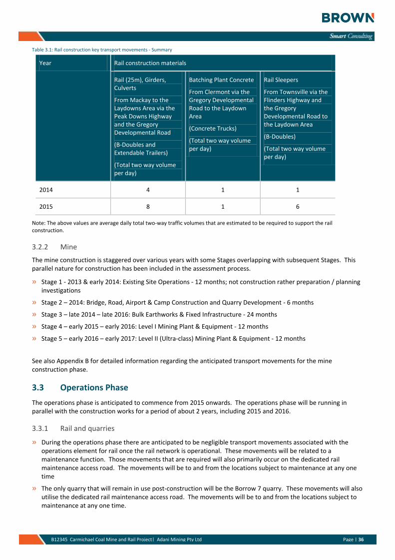
Table 3.1 below outlines the summary inputs arising on the road network due to the rail construction works.
Page | 36 B12345 Carmichael Coal Mine and Rail Project| Adani Mining Pty Ltd Page | 36
Table 3.1: Rail construction key transport movements - Summary
Year Rail construction materials
Rail (25m), Girders, Culverts
From Mackay to the Laydowns Area via the Peak Downs Highway and the Gregory Developmental Road
(B-Doubles and Extendable Trailers)
(Total two way volume per day)
Batching Plant Concrete
From Clermont via the Gregory Developmental Road to the Laydown Area
(Concrete Trucks)
(Total two way volume per day)
Rail Sleepers
From Townsville via the Flinders Highway and the Gregory Developmental Road to the Laydown Area
(B-Doubles)
(Total two way volume per day)
2014 4 1 1
2015 8 1 6
Note: The above values are average daily total two-way traffic volumes that are estimated to be required to support the rail construction.
3.2.2 Mine
The mine construction is staggered over various years with some Stages overlapping with subsequent Stages. This parallel nature for construction has been included in the assessment process.
» Stage 1 - 2013 & early 2014: Existing Site Operations - 12 months; not construction rather preparation / planning investigations
» Stage 2 – 2014: Bridge, Road, Airport & Camp Construction and Quarry Development - 6 months
» Stage 3 – late 2014 – late 2016: Bulk Earthworks & Fixed Infrastructure - 24 months
» Stage 4 – early 2015 – early 2016: Level I Mining Plant & Equipment - 12 months
» Stage 5 – early 2016 – early 2017: Level II (Ultra-class) Mining Plant & Equipment - 12 months
See also Appendix B for detailed information regarding the anticipated transport movements for the mine construction phase.
3.3 Operations Phase
The operations phase is anticipated to commence from 2015 onwards. The operations phase will be running in parallel with the construction works for a period of about 2 years, including 2015 and 2016.
3.3.1 Rail and quarries
» During the operations phase there are anticipated to be negligible transport movements associated with the operations element for rail once the rail network is operational. These movements will be related to a maintenance function. Those movements that are required will also primarily occur on the dedicated rail maintenance access road. The movements will be to and from the locations subject to maintenance at any one time
» The only quarry that will remain in use post-construction will be the Borrow 7 quarry. These movements will also utilise the dedicated rail maintenance access road. The movements will be to and from the locations subject to maintenance at any one time.
Page | 37 B12345 Carmichael Coal Mine and Rail Project| Adani Mining Pty Ltd Page | 37
3.3.2 Mine
» The operational phase will involve a ramp-up in operations for the various elements of infrastructure consistent with mine output ramping up to the 60Mtpa level.
» The coal will be hauled from the Project (Mine) via the rail line and as such the road impacts associated with the development during the operational phase will primarily be limited to movements associated with access to / from the airport for the FIFO workforce (using buses) and movements associated with deliveries to support the day-to-day operation of the Project (Mine) and Project (off-site infrastructure) including the workers accommodation village.
See also Appendix B for detailed information regarding the anticipated transport movements for the mine operations phase.
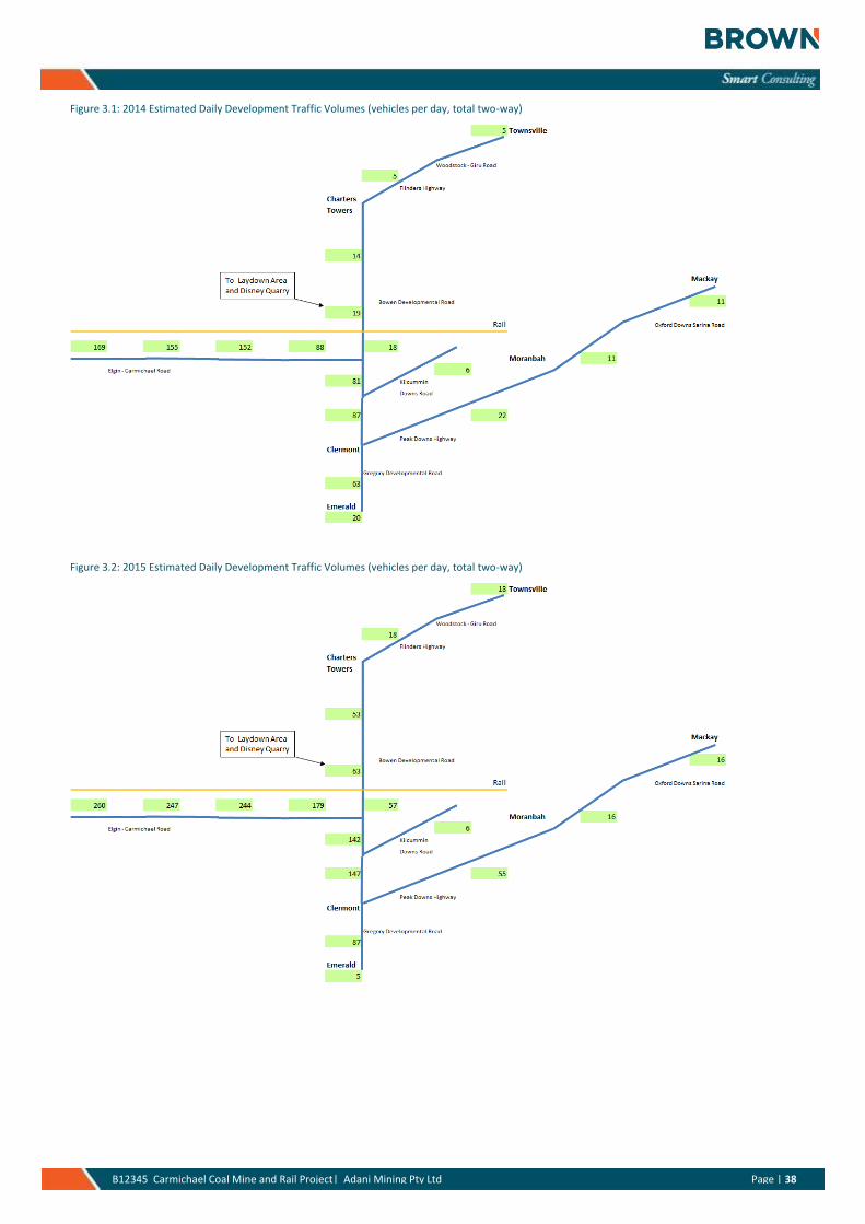
3.4 Estimated Development Volumes
The estimated daily traffic volumes arising from the anticipated traffic demands during each of the horizon years are presented below in Figures 3.1 to 3.5. These volumes represent the cumulative effects from the Project. It is anticipated that 2015 will be the peak year for the expected impacts from the development. From 2015 the impacts reduce to those primarily associated with the operational phase rather than the combined construction and operational effects. The development volume results indicate that the two most consistently highly trafficked links will be the section of the Gregory Developmental Road from the Peak Downs Highway to the Carmichael – Elgin Road intersection and also the Carmichael – Elgin Road itself. The development is anticipated to result in a peak contribution in 2015 of up to 260 vehicles per day at the worst location along the Carmichael – Elgin Road with the Gregory Developmental Road worst case location being 226 vehicles per day also in 2015. Section 4 of this report provides more detail in terms of the traffic assessment of the development.
Page | 38 B12345 Carmichael Coal Mine and Rail Project| Adani Mining Pty Ltd Page | 38
Figure 3.1: 2014 Estimated Daily Development Traffic Volumes (vehicles per day, total two-way)
Figure 3.2: 2015 Estimated Daily Development Traffic Volumes (vehicles per day, total two-way)
Page | 39 B12345 Carmichael Coal Mine and Rail Project| Adani Mining Pty Ltd Page | 39
Figure 3.3: 2016 Estimated Daily Development Traffic Volumes (vehicles per day, total two-way)
Figure 3.4: 2017 Estimated Daily Development Traffic Volumes (vehicles per day, total two-way)
Page | 40 B12345 Carmichael Coal Mine and Rail Project| Adani Mining Pty Ltd Page | 40
Figure 3.5: 2024 Estimated Daily Development Traffic Volumes (vehicles per day, total two-way)
Page | 41 B12345 Carmichael Coal Mine and Rail Project| Adani Mining Pty Ltd Page | 41
4. Traffic Network Assessment
4.1 Introduction
An assessment of the combined mine and rail aspects of the project, including the construction and operational effects, has been undertaken. The results of this assessment are outlined below in the following sections.
The context for the assessment is also defined below:
» The future design horizon year for the purposes of the network assessment will be 2024, ie. 10 years from the base year of 2014; this is consistent with GARID.
» The following background traffic growth rates have been adopted for the future design year traffic network analyses:
- State controlled roads – 7% pa over the design horizon year. This has been chosen as it is consistent with other planning and assessment work that has been undertaken to-date for the project and is considered a reasonable estimate given the regional nature of the road network.
- Local (Council) roads – 7% pa over the 10 year design horizon, eg. Carmichael – Elgin Road
- The use of a 7% pa growth rate across the network is considered reasonable given existing growth rates in some locations are slightly higher (8 – 10% pa) and some lower (up to 2 % pa), this is especially the case on the lower order roads. The 7% pa background growth allows for the potential impact of other developments but it is also a reasonably conservative growth rate when the existing network growth rates within the region due to the surrounding mining activities are considered.
» The assessment has been based on a combination of an intersection performance based assessment and link based assessment process as consistent with AustRoads Guidelines.
4.2 Intersection Assessments
The intersections of interest to this project are considered below, namely:
» Gregory Developmental Road / Carmichael Elgin Road intersection
» Gregory Developmental Road / Kilcummin Downs Road intersection
» Gregory Developmental Road / Peak Downs Highway
These intersections have been considered due to the greater than 5% trigger for assessment consistent with DTMR’s GARID process. These are the only intersections that are projected to experience a greater than 5% increase in traffic volume arising from the Project. Please also see Section 4.3 below for further detail in relation to the trigger point assessment.
The intersections of the Gregory Developmental Road / Flinders Highway and Peak Downs Highway / Goonyella Road have not been considered in the assessment even with a greater than 5% exceedance. This is because they only exceed the greater than 5% trigger for a short period of time, ie. during the combined construction and operational phases in 2015 and 2016. The impact on each intersection does not extend over the full ten year horizon beyond 2016. This is considered reasonable given that each intersection already has provision for full width for heavy vehicle turns, including right and left turn lanes, and also full intersection lighting.
Please note that detailed intersection assessments are not required for this assessment. This is consistent with the uninterrupted flow characteristics of each location. DTMR’s Road Planning and Design Manual (RPDM) states that “…it is unnecessary to flare intersection approaches or carry out an intersection analysis when the combinations of major road and minor road volumes are less than those in the table (Table 13.4)…” The anticipated development volumes are expected to effectively operate as an uninterrupted flow case due to the relatively low traffic volumes. Figure 4.1 is an extract from DTMR’s Roads Planning and Design Manual, Chapter 13, and it indicates that detailed traffic assessments are not required for locations with traffic volumes within the thresholds as defined within Table 13.4. Notwithstanding the above each intersection has been reviewed from a safety perspective and commentary provided as to whether it is considered necessary to include separate lanes for left or right turning movements to mitigate any potential safety risks at each location.
Page | 42 B12345 Carmichael Coal Mine and Rail Project| Adani Mining Pty Ltd Page | 42
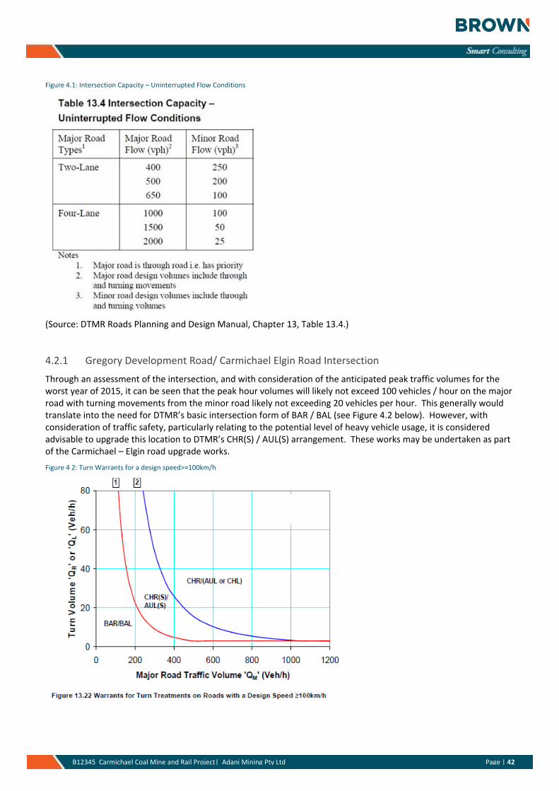
Figure 4.1: Intersection Capacity – Uninterrupted Flow Conditions
(Source: DTMR Roads Planning and Design Manual, Chapter 13, Table 13.4.)
4.2.1 Gregory Development Road/ Carmichael Elgin Road Intersection
Through an assessment of the intersection, and with consideration of the anticipated peak traffic volumes for the worst year of 2015, it can be seen that the peak hour volumes will likely not exceed 100 vehicles / hour on the major road with turning movements from the minor road likely not exceeding 20 vehicles per hour. This generally would translate into the need for DTMR’s basic intersection form of BAR / BAL (see Figure 4.2 below). However, with consideration of traffic safety, particularly relating to the potential level of heavy vehicle usage, it is considered advisable to upgrade this location to DTMR’s CHR(S) / AUL(S) arrangement. These works may be undertaken as part of the Carmichael – Elgin road upgrade works.
Figure 4 2: Turn Warrants for a design speed>=100km/h
Page | 43 B12345 Carmichael Coal Mine and Rail Project| Adani Mining Pty Ltd Page | 43
4.2.2 Gregory Developmental Road / Kilcummin Downs Road intersection
Through an assessment of the intersection, and with consideration of the anticipated peak traffic volumes for the worst year of 2015, it can be seen that the peak hour volumes will likely not exceed 100 vehicles / hour on the major road with turning movements from the minor road likely not exceeding 20 vehicles per hour. This generally would translate into the need for the basic intersection form of BAR / BAL (see Figure 4.2 above). This intersection arrangement is considered adequate for this location because of the short period during which the intersection will experience higher than normal traffic volumes. This period coincides with the construction works and particularly the Rail Camp 1 site located along Kilcummin Downs Road. Given this context the existing basic intersection form BAR / BAL is considered adequate to support the development traffic volumes. Notwithstanding, from a traffic safety perspective it is recommended that “Trucks Turning” signs be installed at this intersection location for the duration of the construction works.
4.2.3 Gregory Developmental Road / Peak Downs Highway
Through an assessment of the intersection, and with consideration of the anticipated peak traffic volumes for the worst year of 2015, it can be seen that the peak hour volumes will likely not exceed 100 vehicles / hour on the major road with turning movements from the minor road likely not exceeding 20 vehicles per hour. This generally would translate into the need for the basic intersection form of BAR / BAL (see Figure 4.2 above). However, the existing intersection arrangement already includes provision for both protected right and left turn movements as part of its existing arrangements and as such no intersection upgrading is required for this location.
4.3 Road link assessments
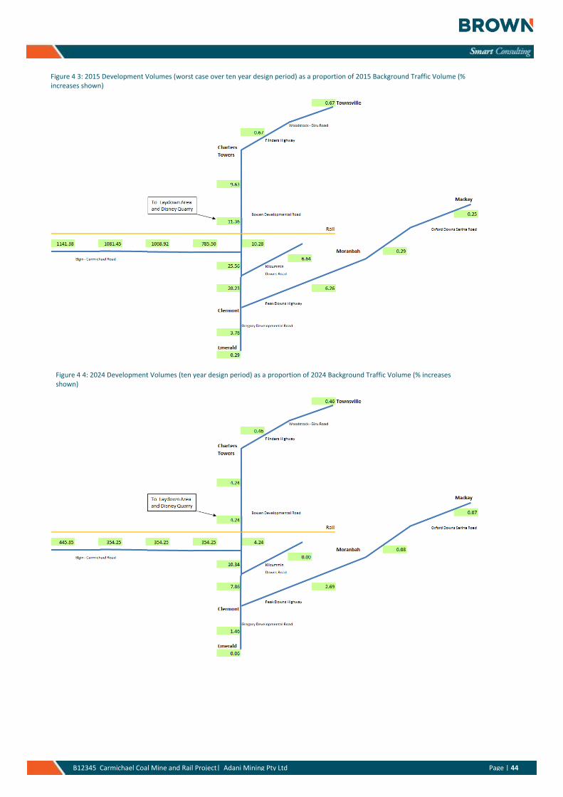
DTMR’s greater than 5% increase in traffic volume trigger was used to determine which road links required an assessment. The links that were found to need to be assessed were:
» Gregory Developmental Road (Peak Downs Highway to Flinders Highway, Charters Towers)
» Carmichael – Elgin Road (Gregory Developmental Road to Mine Site)
» Kilcummin Downs Road (Gregory Developmental Road to Rail Camp 1 turnoff)
» Peak Downs Highway (Gregory Developmental Road to Goonyella Road, Moranbah)
Page | 44 B12345 Carmichael Coal Mine and Rail Project| Adani Mining Pty Ltd Page | 44
Figure 4 3: 2015 Development Volumes (worst case over ten year design period) as a proportion of 2015 Background Traffic Volume (% increases shown)
Figure 4 4: 2024 Development Volumes (ten year design period) as a proportion of 2024 Background Traffic Volume (% increases shown)
Page | 45 B12345 Carmichael Coal Mine and Rail Project| Adani Mining Pty Ltd Page | 45
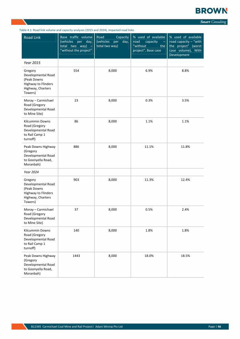
Based on the estimated traffic generated (refer Section 3) by the construction and operational phases estimates of the likely level of impact on the existing road network and its capacity has been undertaken. The results from these analyses are presented below in Table 4.1.
For the purposes of the analyses an estimate of the road capacity for the key impacted road links has been established as well as a comparison with the existing traffic volumes on each impacted road link. This has been undertaken for the worst case year of 2015 (combination of both construction and operational phases) and also for ten years into the future (2024) for the operational phase, consistent with GARID. The capacity calculations are based on the Road Planning and Design Manual, Chapter 5, Traffic Parameters and Human Factors, August 2004. The road type of relevance to this project is a rural two-lane, two-way road (refer Section 5.2.4.4). The roads of interest generally consist of the following cross-sections; rural road, single lane carriageway, generally narrow 1m shoulders, sealed and rural road, single lane carriageway, unsealed. These routes are generally within either flat or undulating terrain with limited steep grade sections.
The road capacity has been estimated based on the Road Planning and Design Manual, Chapter 5, Traffic Parameters and Human Factors, August 2004, Section 5.2.4.4 and Table 5.4. The capacity has been based on an assumed Level of Service (LOS) of C which equates to 800 veh/h total two-way or for the purposes of the assessment 8,000vpd (using a 10% peak to daily factor). For unsealed gravel sections this capacity may reduce to half of this capacity value (refer Capacity Reduction Factors, Section 5.2.4.2). This is only applicable to unsealed sections, this is particularly the case for the existing unsealed Moray – Carmichael Road; although do note for the purposes of the calculations it has been assumed the existing Moray - Carmichael Road will have been upgraded resulting in a higher capacity threshold value of 8,000 vehicles per day.
Page | 46 B12345 Carmichael Coal Mine and Rail Project| Adani Mining Pty Ltd Page | 46
Table 4.1: Road link volume and capacity analyses (2015 and 2024), impacted road links
Road Link Base traffic volume (vehicles per day, total two way) – “without the project”
Road Capacity (vehicles per day, total two way)
% used of available road capacity – “without the project”, Base case
% used of available road capacity – “with the project” (worst case volume), With Development
Year 2015
Gregory Developmental Road (Peak Downs Highway to Flinders Highway, Charters Towers)
554 8,000 6.9% 8.8%
Moray – Carmichael Road (Gregory Developmental Road to Mine Site)
23 8,000 0.3% 3.5%
Kilcummin Downs Road (Gregory Developmental Road to Rail Camp 1 turnoff)
86 8,000 1.1% 1.1%
Peak Downs Highway (Gregory Developmental Road to Goonyella Road, Moranbah)
886 8,000 11.1% 11.8%
Year 2024
Gregory Developmental Road (Peak Downs Highway to Flinders Highway, Charters Towers)
903 8,000 11.3% 12.4%
Moray – Carmichael Road (Gregory Developmental Road to Mine Site)
37 8,000 0.5% 2.4%
Kilcummin Downs Road (Gregory Developmental Road to Rail Camp 1 turnoff)
140 8,000 1.8% 1.8%
Peak Downs Highway (Gregory Developmental Road to Goonyella Road, Moranbah)
1443 8,000 18.0% 18.5%
Page | 47 B12345 Carmichael Coal Mine and Rail Project| Adani Mining Pty Ltd Page | 47
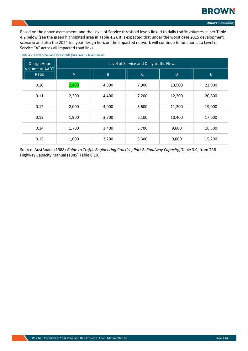
Based on the above assessment, and the Level of Service threshold levels linked to daily traffic volumes as per Table 4.2 below (see the green highlighted area in Table 4.2), it is expected that under the worst case 2015 development scenario and also the 2024 ten year design horizon the impacted network will continue to function at a Level of Service “A” across all impacted road links.
Table 4.2: Level of Service thresholds (rural roads, level terrain)
Design Hour Volume to AADT
Ratio
Level of Service and Daily traffic Flows
A B C D E
0.10 2,400 4,800 7,900 13,500 22,900
0.11 2,200 4,400 7,200 12,200 20,800
0.12 2,000 4,000 6,600 11,200 19,000
0.13 1,900 3,700 6,100 10,400 17,600
0.14 1,700 3,400 5,700 9,600 16,300
0.15 1,600 3,200 5,300 9,000 15,200
Source: AustRoads (1988) Guide to Traffic Engineering Practice, Part 2: Roadway Capacity, Table 3.9, from TRB Highway Capacity Manual (1985) Table 8.10.
Page | 48 B12345 Carmichael Coal Mine and Rail Project| Adani Mining Pty Ltd Page | 48
5. Other Impacts and Issues
5.1 Noise
The noise impacts and commentary extracts identified in the following section has been derived from the EIS, Volumes 2 and 3, Section 9, Noise and Vibration.
The noise assessment as part of the EIS focussed on the Moray – Carmichael Road corridor. Information does not exist for the other road corridors such as the Gregory Developmental Road or Peak Downs Highway. Notwithstanding, given the frontage development along each of these corridors, particularly of a residential nature, this is considered to be acceptable especially given the anticipated low increase in daily traffic volume (from both an absolute and percentage basis) over each of these road corridors.
DTMR’s Road Traffic Noise Management: Code of Practice (2007) provides guidance for the assessment of road traffic noise. It states that the traffic noise level of an existing state controlled road should not exceed LA10(18hr) 68 dB(A) assessed one metre in front of the most exposed part of an affected noise sensitive place.
The Project (Mine) has the potential to generate traffic on roads near sensitive receptors such as local homesteads and the mine workers accommodation village once the Project (mine) is operational.
The Project (Mine) will use standard construction equipment, general trade equipment and specialised equipment as required. The construction works will consist of the Project (mine) site itself. Impacts to the road network are unlikely to be due to road construction of the upgraded Moray – Carmichael Road from its intersection with the Gregory Developmental Road.
The land use surrounding the Project (mine) area is rural in nature with a limited number of possible sensitive receptors. The potential sensitive receptors included in the noise assessment are defined below in Table 5.1.
Table 5.1: Potential Sensitive Receptors
Potential Sensitive Receptor
Easting Northing Approximate Distance from Nearest Operational Noise Source (m)
Description/ Comment
1 437661 7572108 2,800 Commercial/ industrial precinct
2 447799 7569804 6,100 Workers accommodation village
3 453157 7544999 7,800 Bygana Homestead
4 450080 7541530 4,800 Lignum Homestead
5 446973 7530251 11,800 Mellaluka Homestead
6 422016 7559462 7,100 Doongmabulla Homestead
7 406412 7571007 16,900 Carmichael Homestead
(GHD: 2012)
Impacts are anticipated as part of the various construction and operational phases as outlined below.
Civil Works Traffic
Construction activities including civil works such as earthworks, drainage construction, pile driving and equipment use, and the Project (mine) construction have the potential to adversely impact on noise sensitive receptors through disturbance to sleep, social activities and / or work activities and disturbance of livestock and native fauna.
The peak construction noise levels for day time works are predicted to be less than 10dB(A) at all receptors except at sensitive receptors 3 and 4 where the noise levels are expected to range between 12 and 24dB(A) and 25 to 37dB(A) respectively. The predicted construction noise levels are well under the 55dB(A) WHO criteria at all sensitive receptors.
Page | 49 B12345 Carmichael Coal Mine and Rail Project| Adani Mining Pty Ltd Page | 49
Construction Traffic
The main traffic that will be generated through the construction phase will be from plant, equipment and material deliveries. Potential traffic generated noise would be highest at noise monitoring Receptor 7 (Carmichael Homestead). The estimated traffic generated noise at this location was approximately 12 dB(A) below the DTMR criteria of 68 dB(A)L10,18hr. As such the potential impacts of traffic generated noise are expected to fall within the DTMR criteria at all sensitive receptors
Operations Traffic
Traffic generation due to the operation of the mine is expected to occur on the re-aligned Moray Carmichael Road accessing the Gregory Developmental Road. Whilst the detailed design of the final road alignment is to be determined, realignment is only likely to have an impact in the vicinity of Receptor 2 (Workers Accommodation Village) as the other receptors are not in proximity to the Moray Carmichael Road along the proposed haulage routes.
Potential traffic generated noise is predicted highest at Receptor 7 (Carmichael Homestead). The estimated traffic generated noise at this location was approximately 9 dB(A) below the DTMR criteria of 68 dB(A)L10,18hr. As such the potential impacts of traffic generated noise are expected to fall within the DTMR criteria at all sensitive receptors.
Given the relatively low projected traffic volumes, traffic noise is predicted to be below the relevant DTMR criteria at the nearest sensitive receptor or monitoring location.
5.2 Flooding Assessment
The flooding assessment work as part of the Project has understood to have focussed on the internal mine area and the key external road network element, ie. the Moray – Carmichael Road corridor. Information does not exist for the other road corridors such as the Gregory Developmental Road or Peak Downs Highway. Notwithstanding, given that there is no proposal to change the alignment or other physical features of the other roadways this is considered to be acceptable especially given the anticipated low increase in daily traffic volume (from both an absolute and percentage basis) over each of these road corridors.
The flooding impacts identified in the following section have been derived from the Carmichael Mine Road Upgrade Detailed Design – Detailed Design Report, 8 February 2013.
There are three stream gauging stations located within the Belyando River basin. Details of these gauging stations are provided in Table 5.2.
Table 5.2: Stream Gauging Stations
Location Station Period of Record
Length of Record (Years)
Catchment Area (km²)
Unit discharge (m³/s/km²)
Belyando River at Mt. Douglas 120301A 1949 - 1975 26 35,471 0.12
Mistake Creek at Charlton 120306A 1968 – 1993 25 2,583 0.29
Mistake Creek at Twin Hills 120309A 1976 - present 35 8,048 0.08
The Belyando Anabranch, Belyando River and Moray Anabranch crossings are part of a flat, braided and complicated catchment.
A unit discharge of less than 0.25 m3/s/km2 indicates that a stream gauge is not recording data correctly or that an upstream water storage is affecting the results. The unit discharges of gauges 120301A and 120309A fall below this threshold and the gauges were deemed unfit for use in flood frequency analysis.
The key finding from the hydraulic assessment work for the Moray – Carmichael Road corridor is that an ARI 1 immunity of all crossings of the Moray – Carmichael Road is expected to results in an AATC or no more than 3 days.
Page | 50 B12345 Carmichael Coal Mine and Rail Project| Adani Mining Pty Ltd Page | 50
Upgrading the major crossings at Mistake Creek, the Belyando Anabranch, Belyando River and Moray Anabranch to an ARI 2 will decrease the AATC to 1 day or less.
5.3 Hazard and Risk Assessment
The potential hazards and risks arising from roads and traffic related to the projects construction and operational phases have been identified in the EIS, Volume 2, Chapter 12 – Hazard and Risk and Volume 3, Chapter 12 – Hazard and Risk. The key findings are as defined below.
5.3.1 Hazard Identification
Transport of hazardous substances constitutes on and off site Project (Mine) activities and form a part of the risk assessment. The routes from Townsville via the Flinders Highway and Gregory Development Road and Mackay via the Peak Downs Highway, Suttor Developmental Road, Bowen Developmental Road and Gregory Developmental Road are anticipated to be utilised as the haulage route for hazardous substances, consumables and machinery.
There will be light vehicle movements at the workers accommodation village, including food transport, linen laundering, fuel supplies, waste management contractors and maintenance servicemen.
Diesel trucks will be utilised during both the construction and operations phases.
Trucks carrying explosives will also traverse the Peak Downs Highway and Gregory Developmental Road. The explosives contactor will be responsible for transport, storage, handling and use of explosives.
Increased heavy vehicle traffic from the project along public transport corridors, including school bus corridors, presents a potential safety risk. Although an assessment of traffic volumes indicates that volumes are within the capacity of the roads, increased traffic volumes associated with the Project do have a minor potential to increase the likelihood of traffic crashes.
The Project (rail) will cross dedicated public road reserves (constructed and unconstructed) and private (farm) trails, and stock crossings which may impact on the operation of those networks.
5.3.2 Mitigation and Management
Transportation of hazardous substances will comply with the Australian Code for Transport of Dangerous Goods by Road and Rail 7th edition (ADG Code).
Each crossing location has been assessed to determine whether the respective individual crossing should be retained or closed, and in the case of the retained crossings, to identify the appropriate treatment option, which may include separation (rail under road or rail over road), at-grade active control, at-grade passive control or road realignment.
Traffic management issues will be addressed through the preparation and implementation of construction and operation Traffic Management Plans. These will be developed during the detailed design phase. The Traffic Management Plans will be developed in consultation with the Department of Transport and Main Roads, police and local authorities. Initiatives to be undertaken as part of the development and execution of Traffic Management Plans are included in Volume 4 Appendix W Mine Transport Assessment and Rail Transport Report at Volume 4, Appendix AG. The Project will comply with the requirements under the Department of Transport and Main Roads (DTMR), namely the Road Planning and Design Manual, DTMR Manual of Uniform Traffic Control Devices, Austroads Guide to Traffic Management and particularly for the rail elements Australian Rail Track Corporation Level Crossings – Configuration Standards.
Page | 51 B12345 Carmichael Coal Mine and Rail Project| Adani Mining Pty Ltd Page | 51
5.4 Cumulative Impacts
The potential cumulative negative impacts on roads, traffic and safety have been identified in the EIS, Volume 1, Chapter 8 – Cumulative Impacts and the impacts are expected to include:
» traffic disruption along the Gregory Developmental Road, Peak Downs Highway (from Mackay) and the Flinders Highway (from Townsville) during construction,
» increased traffic during mine operations on the Gregory Developmental Road, including safety of tourist traffic not familiar with large heavy vehicles on narrow roads,
» increased maintenance requirements on local and state roads as a result of mine construction and Operation,
» delays to traffic, including emergency services as a result of level crossings along the rail corridor,
» the construction of level crossings along the route may result in potential conflicts between rail and road traffic that will need to be managed by installing appropriate safety warning measures. These level crossings may result in delays to emergency services, school bus routes, stock movements (vehicle and foot), and local traffic.
The peak traffic generation during the construction phase of the Project is likely to be associated with the transporting of plant, equipment and material deliveries. The main traffic generated through the operation phase will be from plant, equipment and material deliveries. This traffic is anticipated to impact the Flinders Highway and Gregory Developmental Road. The State road network will be cumulatively impacted from the construction and operation of multiple mines and rail lines concurrently. The estimated traffic generated by the Project (Mine and rail construction and operations) is likely to exceed the threshold of a five per cent increase in annual average daily traffic along sections of the Gregory Developmental Road, Peak Downs Highway and Moray – Carmichael Road, see Section 4.3. Adani will consult with Department of Transport and Main Roads (DTMR) to establish how these impacts should be managed and to identify agreed mitigation measures. It is expected that other proponents will be having similar discussions which will enable DTMR to identify appropriate measures to mitigate cumulative road transport impacts.
Page | 52 B12345 Carmichael Coal Mine and Rail Project| Adani Mining Pty Ltd Page | 52
6. Mitigation Measures
6.1 Introduction
From the traffic assessment that has been undertaken it can be concluded that various traffic management measures, both infrastructure and non-infrastructure, will be required to support the proposed Project.
The proposed mitigation measures are outlined below and these measures are intended to ameliorate the various impacts that are anticipated from the Project.
6.2 Traffic
» Upgrade the existing Carmichael – Elgin Road to become a sealed, single lane carriageway so as to provide a trafficable road under most rain event conditions and minimise the risk of closure. The intersection forms with Carmichael – Elgin Road should be BAR / BAL as a minimum although consideration may be given to upgrading particular locations to CHR(S)/AUL(S) if during the design process it is found relatively poor levels of sight distance will be achieved. This is to minimise the safety risk to road users at these locations particularly given the mix of heavy vehicles across the impacted network.
» Upgrade the existing Carmichael – Elgin Road / Gregory Developmental Road intersection – as part of the upgrade works for the Carmichael – Elgin Road it is recommended that the existing intersection be upgraded to include protected right turn and left movements at this intersection. This is recommended to ensure the safe operation of the intersection into the future.
» Signage at the Gregory Developmental Road / Kilcummin Downs Road – it is recommended that during the course of the construction period (2014 and 2015), including the life of the Rail Camp 1, “Trucks Turning” signage be installed at the intersection so as to advise road users of the potential for heavy vehicles to be negotiating this intersection. This is recommended for safety reasons rather than a capacity requirement.
» Upgrade Kilcummin Downs Road / Rail Camp 1 Site access – it is recommended that the proposed site access location be upgraded to allow for a protected right turn into the site access. This is to minimise the safety risk to road users at this location particularly given the mix of heavy vehicles across the impacted network.
» Signage located at the intersection of the Peak Downs Highway with the Gregory Developmental Road and also north of the proposed Disney Quarry along the Gregory Developmental Road to advise motorists of the construction activities along this road section.
» The Gregory Developmental Road and Peak Downs Highway are not approved for HML vehicles. Should these routes be required to be used by HML a separate application is required for these routes. This will go through to DTMR for their review and is subject to their approval.
» A bus fleet will be required to support both the construction and operational phases of the project. The buses will primarily transport the workforce to / from the Airport(s) (FIFO) and each work site.
6.3 Noise
No mitigation measures are recommended because the anticipated noise levels will meet the DTMR guidelines (see also section 5.1).
Page | 53 B12345 Carmichael Coal Mine and Rail Project| Adani Mining Pty Ltd Page | 53
6.4 Flooding
Various options have been considered for the development of the Moray – Carmichael Road corridor to mitigate the impacts of flooding events (PB: 2013). These options include:
» Realignment 1 – North of existing Back Creek crossings
» Realignment 2 - East of Mistake Creek to meet up with Twin Hills Road
» Realignment 3 - North of existing alignment to meet with existing crossing area at Moray Anabranch
» Realignment 4 – South of existing crossing at Moray Anabranch
» Realignment 5 - South of North Creek and the proposed rail alignment and through the mining lease
From the flooding and staging assessment that has been undertaken for the Moray – Carmichael Road corridor it has been found that the option that is both the lowest capital and net present cost includes realignments 2, 4 and 5. This results in the shortest final stretch of road so will also result in the lowest cost for long term maintenance and fastest travel time from Gregory Developmental Road to the Project (mine) site. It is recommended that this alignment is used in the finalisation of the preliminary design.
Page | 54 B12345 Carmichael Coal Mine and Rail Project| Adani Mining Pty Ltd Page | 54
7. Conclusions and Recommendations
From the traffic assessment that has been undertaken it can be concluded that:
» The key road links that are anticipated to be impacted with traffic volumes greater than 5% (consistent with GARID requirements) are the Peak Downs Highway (Moranbah to the Gregory Developmental Road), Gregory Developmental Road (from the Peak Downs Highway to the Laydown Area and Disney Quarry) and the Moray Carmichael Road.
» If considered only from a traffic capacity perspective there are likely to be limited intersection impacts. However, to achieve safety improvements it is recommended that upgrades be considered at major intersections, in particular the Gregory Developmental Road / Moray Elgin Road intersection so that all movements are protected turns consistent with DTMR’s CHR(S)/AUL(S) arrangements.
The proposed mitigation measures to address any anticipated deficiencies are defined below:
» Upgrade the existing Carmichael – Elgin Road to become a sealed, single lane carriageway so as to provide a trafficable road under most rain event conditions and minimise the risk of closure. The intersection forms with Carmichael – Elgin Road should be DTMR BAR / BAL as a minimum although consideration may be given to upgrading particular locations to DTMR CHR(S)/AUL(S) if during the design process it is found relatively poor levels of sight distance will be achieved. This is to minimise the safety risk to road users at these locations particularly given the mix of heavy vehicles across the impacted network.
» Upgrade the existing Carmichael – Elgin Road / Gregory Developmental Road intersection – as part of the upgrade works for the Carmichael – Elgin Road it is recommended that the existing intersection be upgraded to include protected right turn and left movements at this intersection. This is recommended to ensure the safe operation of the intersection into the future.
» Signage at the Gregory Developmental Road / Kilcummin Downs Road – it is recommended that during the course of the construction period (2014 and 2015), including the life of the Rail Camp 1, “Trucks Turning” signage be installed at the intersection so as to advise road users of the potential for heavy vehicles to be negotiating this intersection. This is recommended for safety reasons rather than a capacity requirement.
» Upgrade Kilcummin Downs Road / Rail Camp 1 Site access – it is recommended that the proposed site access location be upgraded to allow for a protected right turn into the site access. This is to minimise the safety risk to road users at this location particularly given the mix of heavy vehicles across the impacted network.
» Signage located at the intersection of the Peak Downs Highway with the Gregory Developmental Road and also north of the proposed Disney Quarry along the Gregory Developmental Road to advise motorists of the construction activities along this road section.
» The Gregory Developmental Road and Peak Downs Highway are not approved for HML vehicles. Should these routes be required to be used by HML a separate application is required for these routes. This will go through to DTMR for their review and is subject to their approval.
» A bus fleet will be required to support both the construction and operational phases of the project. The buses will primarily transport the workforce to / from the Airport(s) (FIFO) and to each work site.
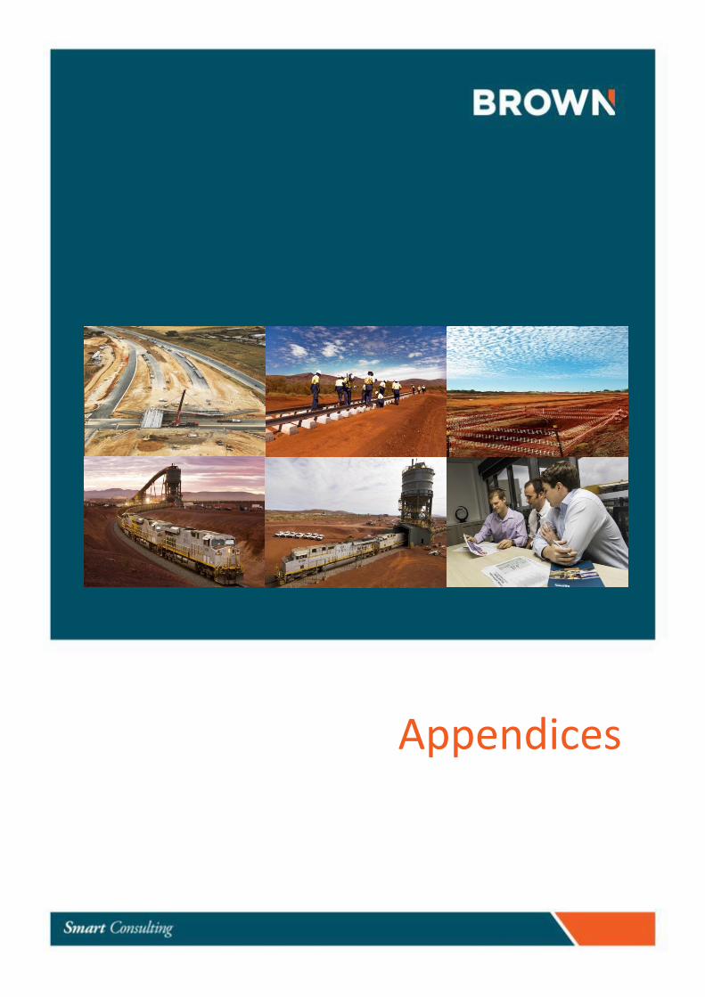
Page | 1
Appendices
Page | 1 B12345 Carmichael Coal Mine and Rail Project| Adani Mining Pty Ltd Commercial in Confidence
Appendix A References
Page | 2 B12345 Carmichael Coal Mine and Rail Project| Adani Mining Pty Ltd Commercial in Confidence
Appendix A: References
» AustRoads, 1988, Guide to Traffic Engineering Practice, Part 2: Roadway Capacity
» Cardno, 2012, Adani Rail/Mining Camp, Transport Statement – Mine Camp, October 2012. Report for Adani Mining Pty Ltd
» Cardno, 2012, Adani Rail/Mining Camp, Transport Statement – Camp 1, October 2012. Report for Adani Mining Pty Ltd
» Cardno, 2012, Adani Rail/Mining Camp, Transport Statement – Camp 2, November 2012. Report for Adani Mining Pty Ltd
» Cardno, 2012, Adani Rail/Mining Camp, Transport Statement – Camp 3, October 2012. Report for Adani Mining Pty Ltd
» GHD, 2013, Carmichael Coal Mine and Rail Project, Environmental Impact Statement (EIS) – Volume 1, Chapter 8 – Cumulative Impacts. Report for Adani Mining Pty Ltd.
» GHD, 2013, Carmichael Coal Mine and Rail Project, Environmental Impact Statement (EIS) – Volume 2, Chapter 6 – Water Resources. Report for Adani Mining Pty Ltd.
» GHD, 2013, Carmichael Coal Mine and Rail Project, Environmental Impact Statement (EIS) – Volume 2, Chapter 9 – Noise and Vibration. Report for Adani Mining Pty Ltd.
» GHD, 2013, Carmichael Coal Mine and Rail Project, Environmental Impact Statement (EIS) – Volume 2, Chapter 11 – Transport. Report for Adani Mining Pty Ltd.
» GHD, 2013, Carmichael Coal Mine and Rail Project, Environmental Impact Statement (EIS) – Volume 2, Chapter 12 – Hazard and Risk. Report for Adani Mining Pty Ltd.
» GHD, 2013, Carmichael Coal Mine and Rail Project, Environmental Impact Statement (EIS) – Volume 3, Chapter 6 – Water Resources. Report for Adani Mining Pty Ltd.
» GHD, 2013, Carmichael Coal Mine and Rail Project, Environmental Impact Statement (EIS) – Volume 3, Chapter 9 – Noise and Vibration. Report for Adani Mining Pty Ltd.
» GHD, 2013, Carmichael Coal Mine and Rail Project, Environmental Impact Statement (EIS) – Volume 3, Chapter 11 – Transport. Report for Adani Mining Pty Ltd.
» GHD, 2013, Carmichael Coal Mine and Rail Project, Environmental Impact Statement (EIS) – Volume 3, Chapter 12 – Hazard and Risk. Report for Adani Mining Pty Ltd.
» GHD, 2013, Carmichael Coal Mine and Rail Project, Environmental Impact Statement (EIS) – Volume 4, Appendix AG Rail Transport Assessment. Report for Adani Mining Pty Ltd.
» GHD, 2013, Carmichael Coal Mine and Rail Project, Environmental Impact Statement (EIS) – Volume 4, Appendix W Mine Transport Assessment. Report for Adani Mining Pty Ltd.
» GHD, 2013, Carmichael Coal Mine and Rail Project, Environmental Impact Statement (EIS) – Volume 4, Appendix W Mine Transport Assessment. Report for Adani Mining Pty Ltd.
» GHD, 2012, Report for Carmichael Coal Mine and Rail Project, Land Use, 20 September 2012. Report for Adani Mining Pty Ltd.
» Parsons Brinckerhoff, 2013, Carmichael Mine Road Upgrade Detailed Design, Detailed Design Report, 8 February 2013. Report for Adani Mining Pty Ltd.
» Queensland Transport and Main Roads (2006), Guidelines for Assessment of Road Impacts of Development (GARID), The State of Queensland (Department of Main Roads)
» Queensland Transport and Main Roads (2006), Road Planning and Design Manual (RPDM) – Intersections at Grade (Chapter 13), Department of Main Roads
Page | 3 B12345 Carmichael Coal Mine and Rail Project| Adani Mining Pty Ltd Commercial in Confidence
» Queensland Transport and Main Roads (2013), Multi-combination routes and zones in Queensland: Retrieved 17th July 2013 from http://www.tmr.qld.gov.au/business-industry/Heavy-vehicles/Multi-combination-vehicles/Maps/
» Queensland Transport and Main Roads (2013), Queensland state-controlled roads and region maps: Retrieved 12th January 2013 from http://www.tmr.qld.gov.au/~/media/Travelandtransport/Maps%20and%20guides/Queensland%20maps/Queensland%20region%20maps/
» TTM, 2013, Carmichael Coal Mine Project, Back Creek Quarry Proposal, Traffic Engineering Report, April 2013. Report for Adani Mining Pty Ltd.
» TTM, 2013, Carmichael Coal Mine Project, Borrow 7 Quarry Proposal, Traffic Engineering Report, April 2013. Report for Adani Mining Pty Ltd.
» TTM, 2013, Carmichael Coal Mine Project, Disney Quarry Proposal, Traffic Engineering Report, April 2013. Report for Adani Mining Pty Ltd.
» TTM, 2013, Carmichael Coal Mine Project, Moray Pit Quarry Proposal, Traffic Engineering Report, April 2013. Report for Adani Mining Pty Ltd.
» TTM, 2013, Carmichael Coal Mine Project, North Creek Quarry Proposal, Traffic Engineering Report, April 2013. Report for Adani Mining Pty Ltd.
Page | 4 B12345 Carmichael Coal Mine and Rail Project| Adani Mining Pty Ltd Commercial in Confidence
Appendix B Key Mine Development Data Inputs - Summary
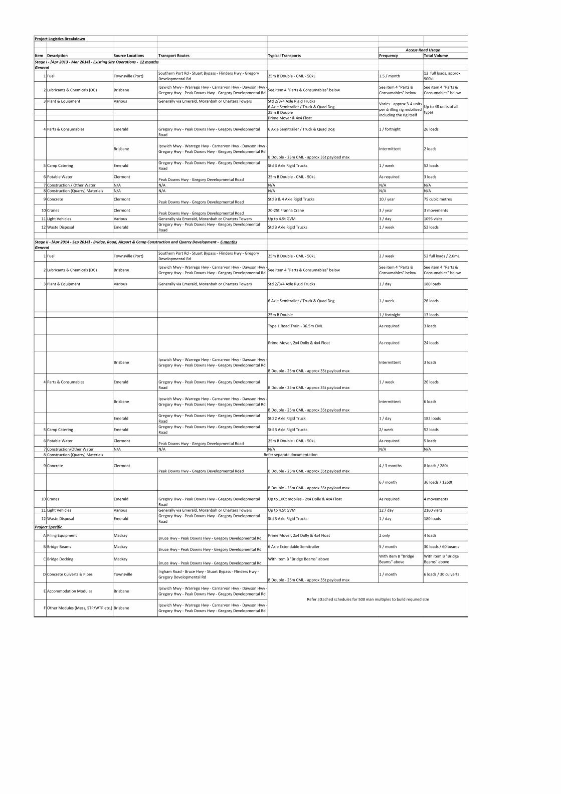
Project Logistics Breakdown
Item Description Source Locations Transport Routes Typical Transports Frequency Total Volume
Stage I ‐ [Apr 2013 ‐ Mar 2014] ‐ Existing Site Operations ‐ 12 months
General
1 Fuel Townsville (Port)Southern Port Rd ‐ Stuart Bypass ‐ Flinders Hwy ‐ Gregory
Developmental Rd25m B Double ‐ CML ‐ 50kL 1.5 / month
12 full loads, approx
900kL
2 Lubricants & Chemicals (DG) BrisbaneIpswich Mwy ‐ Warrego Hwy ‐ Carnarvon Hwy ‐ Dawson Hwy ‐
Gregory Hwy ‐ Peak Downs Hwy ‐ Gregory Developmental RdSee item 4 "Parts & Consumables" below
See item 4 "Parts &
Consumables" below
See item 4 "Parts &
Consumables" below
3 Plant & Equipment Various Generally via Emerald, Moranbah or Charters Towers Std 2/3/4 Axle Rigid Trucks
6 Axle Semitrailer / Truck & Quad Dog
25m B Double
Prime Mover & 4x4 Float
4 Parts & Consumables Emerald Gregory Hwy ‐ Peak Downs Hwy ‐ Gregory Developmental
Road
6 Axle Semitrailer / Truck & Quad Dog 1 / fortnight 26 loads
BrisbaneIpswich Mwy ‐ Warrego Hwy ‐ Carnarvon Hwy ‐ Dawson Hwy ‐
Gregory Hwy ‐ Peak Downs Hwy ‐ Gregory Developmental Rd
B Double ‐ 25m CML ‐ approx 35t payload max
Intermittent 2 loads
5 Camp Catering EmeraldGregory Hwy ‐ Peak Downs Hwy ‐ Gregory Developmental
RoadStd 3 Axle Rigid Trucks 1 / week 52 loads
6 Potable Water ClermontPeak Downs Hwy ‐ Gregory Developmental Road
25m B Double ‐ CML ‐ 50kL As required 3 loads
7 Construction / Other Water N/A N/A N/A N/A N/A
8 Construction (Quarry) Materials N/A N/A N/A N/A N/A
9 Concrete ClermontPeak Downs Hwy ‐ Gregory Developmental Road
Std 3 & 4 Axle Rigid Trucks 10 / year 75 cubic metres
10 Cranes ClermontPeak Downs Hwy ‐ Gregory Developmental Road
20‐25t Franna Crane 3 / year 3 movements
11 Light Vehicles Various Generally via Emerald, Moranbah or Charters Towers Up to 4.5t GVM 3 / day 1095 visits
12 Waste Disposal EmeraldGregory Hwy ‐ Peak Downs Hwy ‐ Gregory Developmental
RoadStd 3 Axle Rigid Trucks 1 / week 52 loads
Stage II ‐ [Apr 2014 ‐ Sep 2014] ‐ Bridge, Road, Airport & Camp Construction and Quarry Development ‐ 6 months
General
1 Fuel Townsville (Port)Southern Port Rd ‐ Stuart Bypass ‐ Flinders Hwy ‐ Gregory
Developmental Rd25m B Double ‐ CML ‐ 50kL 2 / week 52 full loads / 2.6mL
2 Lubricants & Chemicals (DG) BrisbaneIpswich Mwy ‐ Warrego Hwy ‐ Carnarvon Hwy ‐ Dawson Hwy ‐
Gregory Hwy ‐ Peak Downs Hwy ‐ Gregory Developmental RdSee item 4 "Parts & Consumables" below
See item 4 "Parts &
Consumables" below
See item 4 "Parts &
Consumables" below
3 Plant & Equipment Various Generally via Emerald, Moranbah or Charters Towers Std 2/3/4 Axle Rigid Trucks 1 / day 180 loads
6 Axle Semitrailer / Truck & Quad Dog 1 / week 26 loads
25m B Double 1 / fortnight 13 loads
Type 1 Road Train ‐ 36.5m CML As required 3 loads
Prime Mover, 2x4 Dolly & 4x4 Float As required 24 loads
BrisbaneIpswich Mwy ‐ Warrego Hwy ‐ Carnarvon Hwy ‐ Dawson Hwy ‐
Gregory Hwy ‐ Peak Downs Hwy ‐ Gregory Developmental Rd
B Double ‐ 25m CML ‐ approx 35t payload max
Intermittent 3 loads
4 Parts & Consumables Emerald Gregory Hwy ‐ Peak Downs Hwy ‐ Gregory Developmental
Road B Double ‐ 25m CML ‐ approx 35t payload max
1 / week 26 loads
BrisbaneIpswich Mwy ‐ Warrego Hwy ‐ Carnarvon Hwy ‐ Dawson Hwy ‐
Gregory Hwy ‐ Peak Downs Hwy ‐ Gregory Developmental Rd
B Double ‐ 25m CML ‐ approx 35t payload max
Intermittent 6 loads
EmeraldGregory Hwy ‐ Peak Downs Hwy ‐ Gregory Developmental
RoadStd 2 Axle Rigid Truck 1 / day 182 loads
5 Camp Catering EmeraldGregory Hwy ‐ Peak Downs Hwy ‐ Gregory Developmental
RoadStd 3 Axle Rigid Trucks 2/ week 52 loads
6 Potable Water ClermontPeak Downs Hwy ‐ Gregory Developmental Road
25m B Double ‐ CML ‐ 50kL As required 5 loads
7 Construction/Other Water N/A N/A N/A N/A N/A
8 Construction (Quarry) Materials
9 Concrete ClermontPeak Downs Hwy ‐ Gregory Developmental Road B Double ‐ 25m CML ‐ approx 35t payload max
4 / 3 months 8 loads / 280t
B Double ‐ 25m CML ‐ approx 35t payload max
6 / month 36 loads / 1260t
10 Cranes Emerald Gregory Hwy ‐ Peak Downs Hwy ‐ Gregory Developmental
Road
Up to 100t mobiles ‐ 2x4 Dolly & 4x4 Float As required 4 movements
11 Light Vehicles Various Generally via Emerald, Moranbah or Charters Towers Up to 4.5t GVM 12 / day 2160 visits
12 Waste Disposal EmeraldGregory Hwy ‐ Peak Downs Hwy ‐ Gregory Developmental
RoadStd 3 Axle Rigid Trucks 1 / day 180 loads
Project Specific
A Piling Equipment MackayBruce Hwy ‐ Peak Downs Hwy ‐ Gregory Developmental Rd
Prime Mover, 2x4 Dolly & 4x4 Float 2 only 4 loads
B Bridge Beams MackayBruce Hwy ‐ Peak Downs Hwy ‐ Gregory Developmental Rd
6 Axle Extendable Semitrailer 5 / month 30 loads / 60 beams
C Bridge Decking MackayBruce Hwy ‐ Peak Downs Hwy ‐ Gregory Developmental Rd
With item B "Bridge Beams" aboveWith item B "Bridge
Beams" above
With item B "Bridge
Beams" above
D Concrete Culverts & Pipes TownsvilleIngham Road ‐ Bruce Hwy ‐ Stuart Bypass ‐ Flinders Hwy ‐
Gregory Developmental RdB Double ‐ 25m CML ‐ approx 35t payload max
1 / month 6 loads / 30 culverts
E Accommodation Modules BrisbaneIpswich Mwy ‐ Warrego Hwy ‐ Carnarvon Hwy ‐ Dawson Hwy ‐
Gregory Hwy ‐ Peak Downs Hwy ‐ Gregory Developmental Rd
F Other Modules (Mess, STP/WTP etc.) BrisbaneIpswich Mwy ‐ Warrego Hwy ‐ Carnarvon Hwy ‐ Dawson Hwy ‐
Gregory Hwy ‐ Peak Downs Hwy ‐ Gregory Developmental Rd
Varies ‐ approx 3‐4 units
per drilling rig mobilised
including the rig itself
Up to 48 units of all
types
Access Road Usage
Refer attached schedules for 500 man multiples to build required size
Refer separate documentation
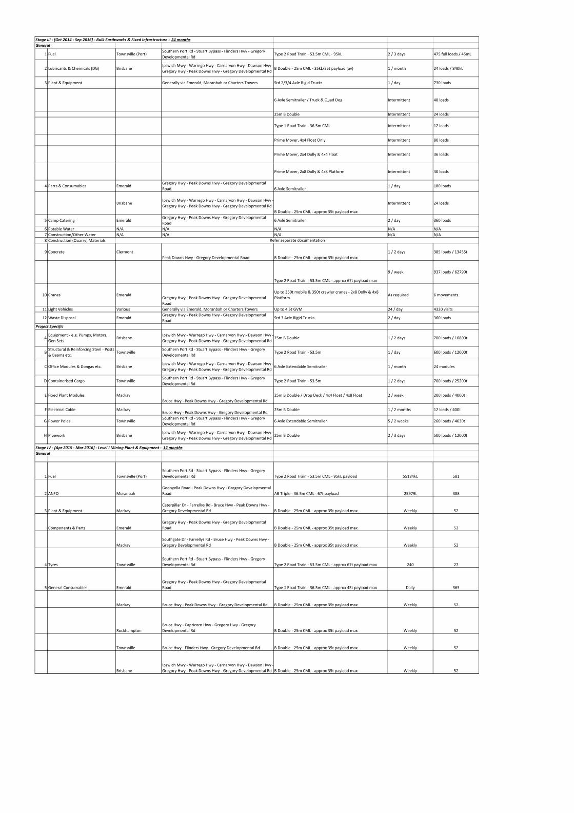
Stage III ‐ [Oct 2014 ‐ Sep 2016] ‐ Bulk Earthworks & Fixed Infrastructure ‐ 24 months
General
1 Fuel Townsville (Port)Southern Port Rd ‐ Stuart Bypass ‐ Flinders Hwy ‐ Gregory
Developmental RdType 2 Road Train ‐ 53.5m CML ‐ 95kL 2 / 3 days 475 full loads / 45mL
2 Lubricants & Chemicals (DG) BrisbaneIpswich Mwy ‐ Warrego Hwy ‐ Carnarvon Hwy ‐ Dawson Hwy ‐
Gregory Hwy ‐ Peak Downs Hwy ‐ Gregory Developmental RdB Double ‐ 25m CML ‐ 35kL/35t payload (av) 1 / month 24 loads / 840kL
3 Plant & Equipment Generally via Emerald, Moranbah or Charters Towers Std 2/3/4 Axle Rigid Trucks 1 / day 730 loads
6 Axle Semitrailer / Truck & Quad Dog Intermittent 48 loads
25m B Double Intermittent 24 loads
Type 1 Road Train ‐ 36.5m CML Intermittent 12 loads
Prime Mover, 4x4 Float Only Intermittent 80 loads
Prime Mover, 2x4 Dolly & 4x4 Float Intermittent 36 loads
Prime Mover, 2x8 Dolly & 4x8 Platform Intermittent 40 loads
4 Parts & Consumables EmeraldGregory Hwy ‐ Peak Downs Hwy ‐ Gregory Developmental
Road 6 Axle Semitrailer1 / day 180 loads
BrisbaneIpswich Mwy ‐ Warrego Hwy ‐ Carnarvon Hwy ‐ Dawson Hwy ‐
Gregory Hwy ‐ Peak Downs Hwy ‐ Gregory Developmental Rd
B Double ‐ 25m CML ‐ approx 35t payload max
Intermittent 24 loads
5 Camp Catering EmeraldGregory Hwy ‐ Peak Downs Hwy ‐ Gregory Developmental
Road6 Axle Semitrailer 2 / day 360 loads
6 Potable Water N/A N/A N/A N/A N/A
7 Construction/Other Water N/A N/A N/A N/A N/A
8 Construction (Quarry) Materials
9 Concrete Clermont
Peak Downs Hwy ‐ Gregory Developmental Road B Double ‐ 25m CML ‐ approx 35t payload max
1 / 2 days 385 loads / 13455t
Type 2 Road Train ‐ 53.5m CML ‐ approx 67t payload max
9 / week 937 loads / 62790t
10 Cranes EmeraldGregory Hwy ‐ Peak Downs Hwy ‐ Gregory Developmental
Road
Up to 350t mobile & 350t crawler cranes ‐ 2x8 Dolly & 4x8
PlatformAs required 6 movements
11 Light Vehicles Various Generally via Emerald, Moranbah or Charters Towers Up to 4.5t GVM 24 / day 4320 visits
12 Waste Disposal EmeraldGregory Hwy ‐ Peak Downs Hwy ‐ Gregory Developmental
RoadStd 3 Axle Rigid Trucks 2 / day 360 loads
Project Specific
AEquipment ‐ e.g. Pumps, Motors,
Gen SetsBrisbane
Ipswich Mwy ‐ Warrego Hwy ‐ Carnarvon Hwy ‐ Dawson Hwy ‐
Gregory Hwy ‐ Peak Downs Hwy ‐ Gregory Developmental Rd25m B Double 1 / 2 days 700 loads / 16800t
BStructural & Reinforcing Steel ‐ Posts
& Beams etc.Townsville
Southern Port Rd ‐ Stuart Bypass ‐ Flinders Hwy ‐ Gregory
Developmental RdType 2 Road Train ‐ 53.5m 1 / day 600 loads / 12000t
C Office Modules & Dongas etc. BrisbaneIpswich Mwy ‐ Warrego Hwy ‐ Carnarvon Hwy ‐ Dawson Hwy ‐
Gregory Hwy ‐ Peak Downs Hwy ‐ Gregory Developmental Rd6 Axle Extendable Semitrailer 1 / month 24 modules
D Containerised Cargo TownsvilleSouthern Port Rd ‐ Stuart Bypass ‐ Flinders Hwy ‐ Gregory
Developmental RdType 2 Road Train ‐ 53.5m 1 / 2 days 700 loads / 25200t
E Fixed Plant Modules Mackay
Bruce Hwy ‐ Peak Downs Hwy ‐ Gregory Developmental Rd
25m B Double / Drop Deck / 4x4 Float / 4x8 Float 2 / week 200 loads / 4000t
F Electrical Cable MackayBruce Hwy ‐ Peak Downs Hwy ‐ Gregory Developmental Rd
25m B Double 1 / 2 months 12 loads / 400t
G Power Poles TownsvilleSouthern Port Rd ‐ Stuart Bypass ‐ Flinders Hwy ‐ Gregory
Developmental Rd6 Axle Extendable Semitrailer 5 / 2 weeks 260 loads / 4630t
H Pipework BrisbaneIpswich Mwy ‐ Warrego Hwy ‐ Carnarvon Hwy ‐ Dawson Hwy ‐
Gregory Hwy ‐ Peak Downs Hwy ‐ Gregory Developmental Rd25m B Double 2 / 3 days 500 loads / 12000t
Stage IV ‐ [Apr 2015 ‐ Mar 2016] ‐ Level I Mining Plant & Equipment ‐ 12 months
General
1 Fuel Townsville (Port)
Southern Port Rd ‐ Stuart Bypass ‐ Flinders Hwy ‐ Gregory
Developmental Rd Type 2 Road Train ‐ 53.5m CML ‐ 95kL payload 55184kL 581
2 ANFO Moranbah
Goonyella Road ‐ Peak Downs Hwy ‐ Gregory Developmental
Road AB Triple ‐ 36.5m CML ‐ 67t payload 25979t 388
3 Plant & Equipment ‐ Mackay
Caterpillar Dr ‐ Farrellys Rd ‐ Bruce Hwy ‐ Peak Downs Hwy ‐
Gregory Developmental Rd B Double ‐ 25m CML ‐ approx 35t payload max Weekly 52
Components & Parts Emerald
Gregory Hwy ‐ Peak Downs Hwy ‐ Gregory Developmental
Road B Double ‐ 25m CML ‐ approx 35t payload max Weekly 52
Mackay
Southgate Dr ‐ Farrellys Rd ‐ Bruce Hwy ‐ Peak Downs Hwy ‐
Gregory Developmental Rd B Double ‐ 25m CML ‐ approx 35t payload max Weekly 52
4 Tyres Townsville
Southern Port Rd ‐ Stuart Bypass ‐ Flinders Hwy ‐ Gregory
Developmental Rd Type 2 Road Train ‐ 53.5m CML ‐ approx 67t payload max 240 27
5 General Consumables Emerald
Gregory Hwy ‐ Peak Downs Hwy ‐ Gregory Developmental
Road Type 1 Road Train ‐ 36.5m CML ‐ approx 45t payload max Daily 365
Mackay Bruce Hwy ‐ Peak Downs Hwy ‐ Gregory Developmental Rd B Double ‐ 25m CML ‐ approx 35t payload max Weekly 52
Rockhampton
Bruce Hwy ‐ Capricorn Hwy ‐ Gregory Hwy ‐ Gregory
Developmental Rd B Double ‐ 25m CML ‐ approx 35t payload max Weekly 52
Townsville Bruce Hwy ‐ Flinders Hwy ‐ Gregory Developmental Rd B Double ‐ 25m CML ‐ approx 35t payload max Weekly 52
Brisbane
Ipswich Mwy ‐ Warrego Hwy ‐ Carnarvon Hwy ‐ Dawson Hwy ‐
Gregory Hwy ‐ Peak Downs Hwy ‐ Gregory Developmental Rd B Double ‐ 25m CML ‐ approx 35t payload max Weekly 52
Refer separate documentation
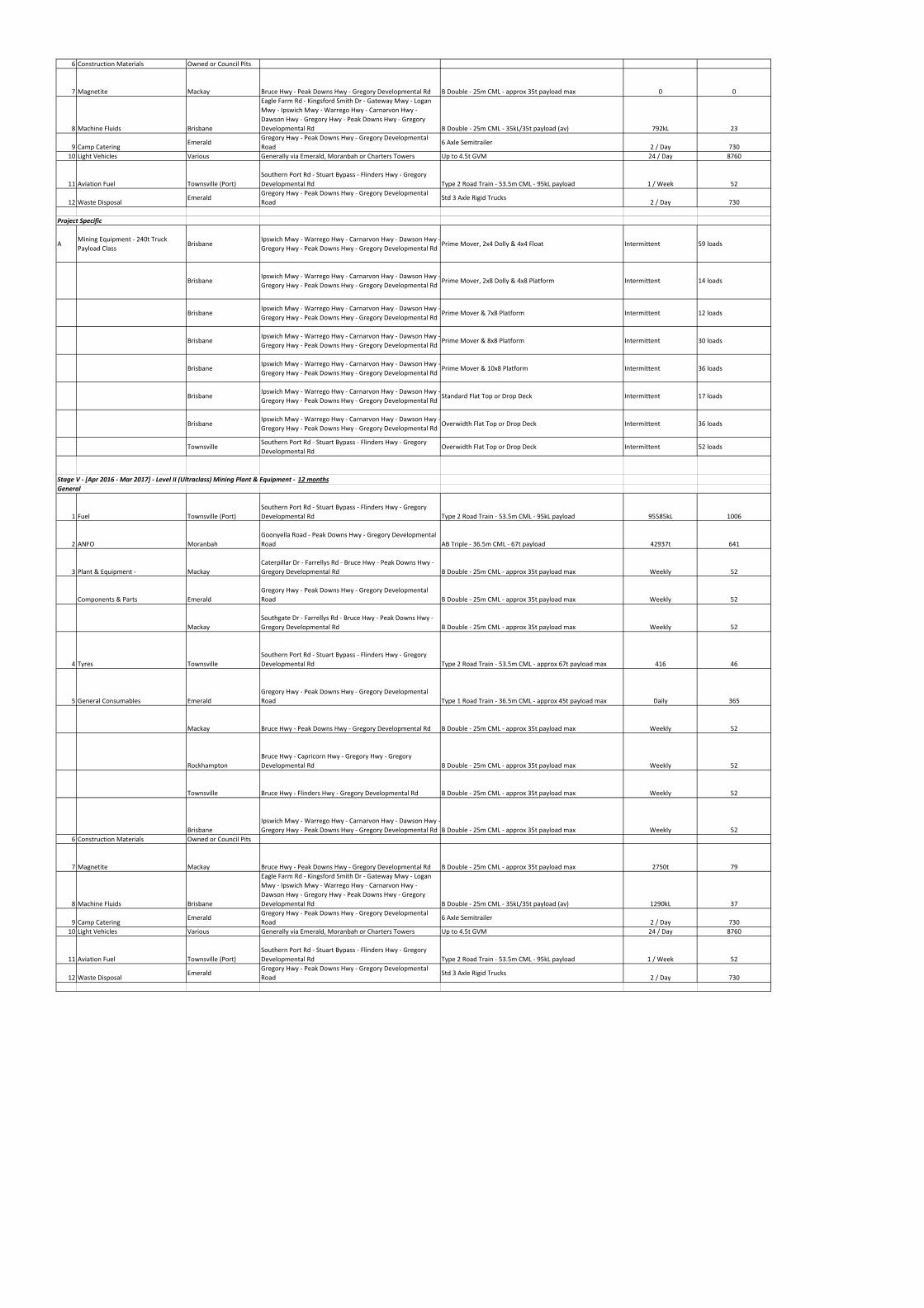
6 Construction Materials Owned or Council Pits
7 Magnetite Mackay Bruce Hwy ‐ Peak Downs Hwy ‐ Gregory Developmental Rd B Double ‐ 25m CML ‐ approx 35t payload max 0 0
8 Machine Fluids Brisbane
Eagle Farm Rd ‐ Kingsford Smith Dr ‐ Gateway Mwy ‐ Logan
Mwy ‐ Ipswich Mwy ‐ Warrego Hwy ‐ Carnarvon Hwy ‐
Dawson Hwy ‐ Gregory Hwy ‐ Peak Downs Hwy ‐ Gregory
Developmental Rd B Double ‐ 25m CML ‐ 35kL/35t payload (av) 792kL 23
9 Camp CateringEmerald
Gregory Hwy ‐ Peak Downs Hwy ‐ Gregory Developmental
Road6 Axle Semitrailer
2 / Day 730
10 Light Vehicles Various Generally via Emerald, Moranbah or Charters Towers Up to 4.5t GVM 24 / Day 8760
11 Aviation Fuel Townsville (Port)
Southern Port Rd ‐ Stuart Bypass ‐ Flinders Hwy ‐ Gregory
Developmental Rd Type 2 Road Train ‐ 53.5m CML ‐ 95kL payload 1 / Week 52
12 Waste DisposalEmerald
Gregory Hwy ‐ Peak Downs Hwy ‐ Gregory Developmental
RoadStd 3 Axle Rigid Trucks
2 / Day 730
Project Specific
AMining Equipment ‐ 240t Truck
Payload ClassBrisbane
Ipswich Mwy ‐ Warrego Hwy ‐ Carnarvon Hwy ‐ Dawson Hwy ‐
Gregory Hwy ‐ Peak Downs Hwy ‐ Gregory Developmental RdPrime Mover, 2x4 Dolly & 4x4 Float Intermittent 59 loads
BrisbaneIpswich Mwy ‐ Warrego Hwy ‐ Carnarvon Hwy ‐ Dawson Hwy ‐
Gregory Hwy ‐ Peak Downs Hwy ‐ Gregory Developmental RdPrime Mover, 2x8 Dolly & 4x8 Platform Intermittent 14 loads
BrisbaneIpswich Mwy ‐ Warrego Hwy ‐ Carnarvon Hwy ‐ Dawson Hwy ‐
Gregory Hwy ‐ Peak Downs Hwy ‐ Gregory Developmental RdPrime Mover & 7x8 Platform Intermittent 12 loads
BrisbaneIpswich Mwy ‐ Warrego Hwy ‐ Carnarvon Hwy ‐ Dawson Hwy ‐
Gregory Hwy ‐ Peak Downs Hwy ‐ Gregory Developmental RdPrime Mover & 8x8 Platform Intermittent 30 loads
BrisbaneIpswich Mwy ‐ Warrego Hwy ‐ Carnarvon Hwy ‐ Dawson Hwy ‐
Gregory Hwy ‐ Peak Downs Hwy ‐ Gregory Developmental RdPrime Mover & 10x8 Platform Intermittent 36 loads
BrisbaneIpswich Mwy ‐ Warrego Hwy ‐ Carnarvon Hwy ‐ Dawson Hwy ‐
Gregory Hwy ‐ Peak Downs Hwy ‐ Gregory Developmental RdStandard Flat Top or Drop Deck Intermittent 17 loads
BrisbaneIpswich Mwy ‐ Warrego Hwy ‐ Carnarvon Hwy ‐ Dawson Hwy ‐
Gregory Hwy ‐ Peak Downs Hwy ‐ Gregory Developmental RdOverwidth Flat Top or Drop Deck Intermittent 36 loads
TownsvilleSouthern Port Rd ‐ Stuart Bypass ‐ Flinders Hwy ‐ Gregory
Developmental RdOverwidth Flat Top or Drop Deck Intermittent 52 loads
Stage V ‐ [Apr 2016 ‐ Mar 2017] ‐ Level II (Ultraclass) Mining Plant & Equipment ‐ 12 months
General
1 Fuel Townsville (Port)
Southern Port Rd ‐ Stuart Bypass ‐ Flinders Hwy ‐ Gregory
Developmental Rd Type 2 Road Train ‐ 53.5m CML ‐ 95kL payload 95585kL 1006
2 ANFO Moranbah
Goonyella Road ‐ Peak Downs Hwy ‐ Gregory Developmental
Road AB Triple ‐ 36.5m CML ‐ 67t payload 42937t 641
3 Plant & Equipment ‐ Mackay
Caterpillar Dr ‐ Farrellys Rd ‐ Bruce Hwy ‐ Peak Downs Hwy ‐
Gregory Developmental Rd B Double ‐ 25m CML ‐ approx 35t payload max Weekly 52
Components & Parts Emerald
Gregory Hwy ‐ Peak Downs Hwy ‐ Gregory Developmental
Road B Double ‐ 25m CML ‐ approx 35t payload max Weekly 52
Mackay
Southgate Dr ‐ Farrellys Rd ‐ Bruce Hwy ‐ Peak Downs Hwy ‐
Gregory Developmental Rd B Double ‐ 25m CML ‐ approx 35t payload max Weekly 52
4 Tyres Townsville
Southern Port Rd ‐ Stuart Bypass ‐ Flinders Hwy ‐ Gregory
Developmental Rd Type 2 Road Train ‐ 53.5m CML ‐ approx 67t payload max 416 46
5 General Consumables Emerald
Gregory Hwy ‐ Peak Downs Hwy ‐ Gregory Developmental
Road Type 1 Road Train ‐ 36.5m CML ‐ approx 45t payload max Daily 365
Mackay Bruce Hwy ‐ Peak Downs Hwy ‐ Gregory Developmental Rd B Double ‐ 25m CML ‐ approx 35t payload max Weekly 52
Rockhampton
Bruce Hwy ‐ Capricorn Hwy ‐ Gregory Hwy ‐ Gregory
Developmental Rd B Double ‐ 25m CML ‐ approx 35t payload max Weekly 52
Townsville Bruce Hwy ‐ Flinders Hwy ‐ Gregory Developmental Rd B Double ‐ 25m CML ‐ approx 35t payload max Weekly 52
Brisbane
Ipswich Mwy ‐ Warrego Hwy ‐ Carnarvon Hwy ‐ Dawson Hwy ‐
Gregory Hwy ‐ Peak Downs Hwy ‐ Gregory Developmental Rd B Double ‐ 25m CML ‐ approx 35t payload max Weekly 52
6 Construction Materials Owned or Council Pits
7 Magnetite Mackay Bruce Hwy ‐ Peak Downs Hwy ‐ Gregory Developmental Rd B Double ‐ 25m CML ‐ approx 35t payload max 2750t 79
8 Machine Fluids Brisbane
Eagle Farm Rd ‐ Kingsford Smith Dr ‐ Gateway Mwy ‐ Logan
Mwy ‐ Ipswich Mwy ‐ Warrego Hwy ‐ Carnarvon Hwy ‐
Dawson Hwy ‐ Gregory Hwy ‐ Peak Downs Hwy ‐ Gregory
Developmental Rd B Double ‐ 25m CML ‐ 35kL/35t payload (av) 1290kL 37
9 Camp CateringEmerald
Gregory Hwy ‐ Peak Downs Hwy ‐ Gregory Developmental
Road6 Axle Semitrailer
2 / Day 730
10 Light Vehicles Various Generally via Emerald, Moranbah or Charters Towers Up to 4.5t GVM 24 / Day 8760
11 Aviation Fuel Townsville (Port)
Southern Port Rd ‐ Stuart Bypass ‐ Flinders Hwy ‐ Gregory
Developmental Rd Type 2 Road Train ‐ 53.5m CML ‐ 95kL payload 1 / Week 52
12 Waste DisposalEmerald
Gregory Hwy ‐ Peak Downs Hwy ‐ Gregory Developmental
RoadStd 3 Axle Rigid Trucks
2 / Day 730
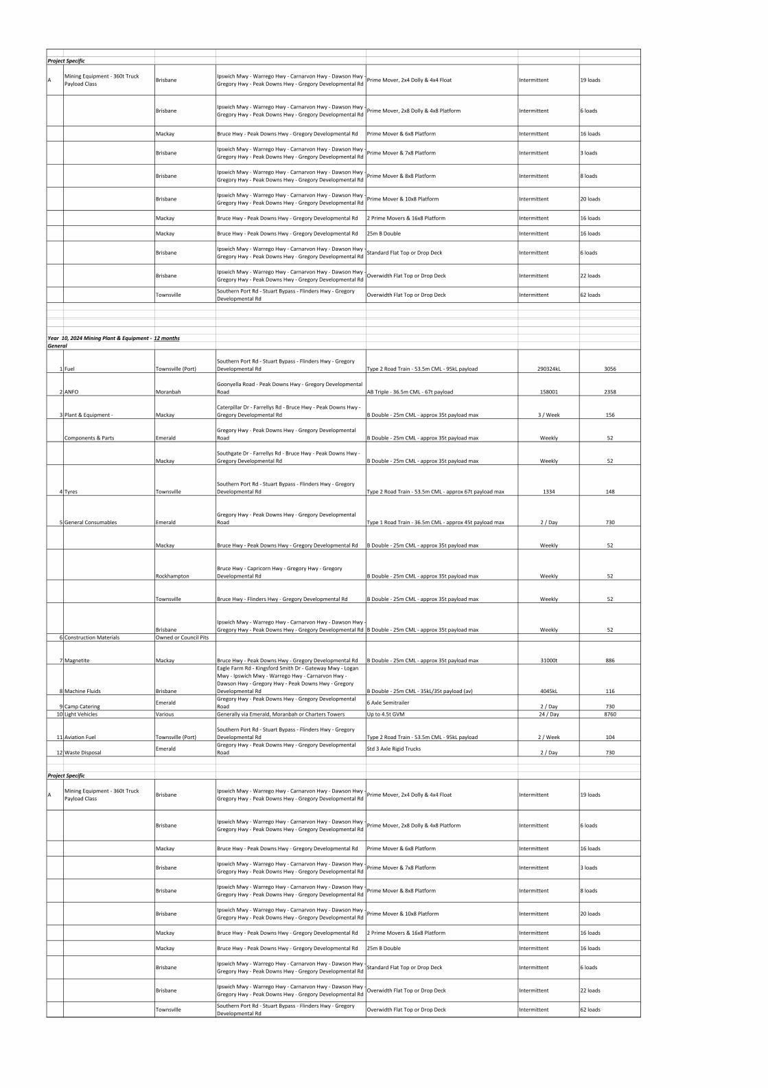
Project Specific
AMining Equipment ‐ 360t Truck
Payload ClassBrisbane
Ipswich Mwy ‐ Warrego Hwy ‐ Carnarvon Hwy ‐ Dawson Hwy ‐
Gregory Hwy ‐ Peak Downs Hwy ‐ Gregory Developmental RdPrime Mover, 2x4 Dolly & 4x4 Float Intermittent 19 loads
BrisbaneIpswich Mwy ‐ Warrego Hwy ‐ Carnarvon Hwy ‐ Dawson Hwy ‐
Gregory Hwy ‐ Peak Downs Hwy ‐ Gregory Developmental RdPrime Mover, 2x8 Dolly & 4x8 Platform Intermittent 6 loads
Mackay Bruce Hwy ‐ Peak Downs Hwy ‐ Gregory Developmental Rd Prime Mover & 6x8 Platform Intermittent 16 loads
BrisbaneIpswich Mwy ‐ Warrego Hwy ‐ Carnarvon Hwy ‐ Dawson Hwy ‐
Gregory Hwy ‐ Peak Downs Hwy ‐ Gregory Developmental RdPrime Mover & 7x8 Platform Intermittent 3 loads
BrisbaneIpswich Mwy ‐ Warrego Hwy ‐ Carnarvon Hwy ‐ Dawson Hwy ‐
Gregory Hwy ‐ Peak Downs Hwy ‐ Gregory Developmental RdPrime Mover & 8x8 Platform Intermittent 8 loads
BrisbaneIpswich Mwy ‐ Warrego Hwy ‐ Carnarvon Hwy ‐ Dawson Hwy ‐
Gregory Hwy ‐ Peak Downs Hwy ‐ Gregory Developmental RdPrime Mover & 10x8 Platform Intermittent 20 loads
Mackay Bruce Hwy ‐ Peak Downs Hwy ‐ Gregory Developmental Rd 2 Prime Movers & 16x8 Platform Intermittent 16 loads
Mackay Bruce Hwy ‐ Peak Downs Hwy ‐ Gregory Developmental Rd 25m B Double Intermittent 16 loads
BrisbaneIpswich Mwy ‐ Warrego Hwy ‐ Carnarvon Hwy ‐ Dawson Hwy ‐
Gregory Hwy ‐ Peak Downs Hwy ‐ Gregory Developmental RdStandard Flat Top or Drop Deck Intermittent 6 loads
BrisbaneIpswich Mwy ‐ Warrego Hwy ‐ Carnarvon Hwy ‐ Dawson Hwy ‐
Gregory Hwy ‐ Peak Downs Hwy ‐ Gregory Developmental RdOverwidth Flat Top or Drop Deck Intermittent 22 loads
TownsvilleSouthern Port Rd ‐ Stuart Bypass ‐ Flinders Hwy ‐ Gregory
Developmental RdOverwidth Flat Top or Drop Deck Intermittent 62 loads
Year 10, 2024 Mining Plant & Equipment ‐ 12 months
General
1 Fuel Townsville (Port)
Southern Port Rd ‐ Stuart Bypass ‐ Flinders Hwy ‐ Gregory
Developmental Rd Type 2 Road Train ‐ 53.5m CML ‐ 95kL payload 290324kL 3056
2 ANFO Moranbah
Goonyella Road ‐ Peak Downs Hwy ‐ Gregory Developmental
Road AB Triple ‐ 36.5m CML ‐ 67t payload 158001 2358
3 Plant & Equipment ‐ Mackay
Caterpillar Dr ‐ Farrellys Rd ‐ Bruce Hwy ‐ Peak Downs Hwy ‐
Gregory Developmental Rd B Double ‐ 25m CML ‐ approx 35t payload max 3 / Week 156
Components & Parts Emerald
Gregory Hwy ‐ Peak Downs Hwy ‐ Gregory Developmental
Road B Double ‐ 25m CML ‐ approx 35t payload max Weekly 52
Mackay
Southgate Dr ‐ Farrellys Rd ‐ Bruce Hwy ‐ Peak Downs Hwy ‐
Gregory Developmental Rd B Double ‐ 25m CML ‐ approx 35t payload max Weekly 52
4 Tyres Townsville
Southern Port Rd ‐ Stuart Bypass ‐ Flinders Hwy ‐ Gregory
Developmental Rd Type 2 Road Train ‐ 53.5m CML ‐ approx 67t payload max 1334 148
5 General Consumables Emerald
Gregory Hwy ‐ Peak Downs Hwy ‐ Gregory Developmental
Road Type 1 Road Train ‐ 36.5m CML ‐ approx 45t payload max 2 / Day 730
Mackay Bruce Hwy ‐ Peak Downs Hwy ‐ Gregory Developmental Rd B Double ‐ 25m CML ‐ approx 35t payload max Weekly 52
Rockhampton
Bruce Hwy ‐ Capricorn Hwy ‐ Gregory Hwy ‐ Gregory
Developmental Rd B Double ‐ 25m CML ‐ approx 35t payload max Weekly 52
Townsville Bruce Hwy ‐ Flinders Hwy ‐ Gregory Developmental Rd B Double ‐ 25m CML ‐ approx 35t payload max Weekly 52
Brisbane
Ipswich Mwy ‐ Warrego Hwy ‐ Carnarvon Hwy ‐ Dawson Hwy ‐
Gregory Hwy ‐ Peak Downs Hwy ‐ Gregory Developmental Rd B Double ‐ 25m CML ‐ approx 35t payload max Weekly 52
6 Construction Materials Owned or Council Pits
7 Magnetite Mackay Bruce Hwy ‐ Peak Downs Hwy ‐ Gregory Developmental Rd B Double ‐ 25m CML ‐ approx 35t payload max 31000t 886
8 Machine Fluids Brisbane
Eagle Farm Rd ‐ Kingsford Smith Dr ‐ Gateway Mwy ‐ Logan
Mwy ‐ Ipswich Mwy ‐ Warrego Hwy ‐ Carnarvon Hwy ‐
Dawson Hwy ‐ Gregory Hwy ‐ Peak Downs Hwy ‐ Gregory
Developmental Rd B Double ‐ 25m CML ‐ 35kL/35t payload (av) 4045kL 116
9 Camp CateringEmerald
Gregory Hwy ‐ Peak Downs Hwy ‐ Gregory Developmental
Road6 Axle Semitrailer
2 / Day 730
10 Light Vehicles Various Generally via Emerald, Moranbah or Charters Towers Up to 4.5t GVM 24 / Day 8760
11 Aviation Fuel Townsville (Port)
Southern Port Rd ‐ Stuart Bypass ‐ Flinders Hwy ‐ Gregory
Developmental Rd Type 2 Road Train ‐ 53.5m CML ‐ 95kL payload 2 / Week 104
12 Waste DisposalEmerald
Gregory Hwy ‐ Peak Downs Hwy ‐ Gregory Developmental
RoadStd 3 Axle Rigid Trucks
2 / Day 730
Project Specific
AMining Equipment ‐ 360t Truck
Payload ClassBrisbane
Ipswich Mwy ‐ Warrego Hwy ‐ Carnarvon Hwy ‐ Dawson Hwy ‐
Gregory Hwy ‐ Peak Downs Hwy ‐ Gregory Developmental RdPrime Mover, 2x4 Dolly & 4x4 Float Intermittent 19 loads
BrisbaneIpswich Mwy ‐ Warrego Hwy ‐ Carnarvon Hwy ‐ Dawson Hwy ‐
Gregory Hwy ‐ Peak Downs Hwy ‐ Gregory Developmental RdPrime Mover, 2x8 Dolly & 4x8 Platform Intermittent 6 loads
Mackay Bruce Hwy ‐ Peak Downs Hwy ‐ Gregory Developmental Rd Prime Mover & 6x8 Platform Intermittent 16 loads
BrisbaneIpswich Mwy ‐ Warrego Hwy ‐ Carnarvon Hwy ‐ Dawson Hwy ‐
Gregory Hwy ‐ Peak Downs Hwy ‐ Gregory Developmental RdPrime Mover & 7x8 Platform Intermittent 3 loads
BrisbaneIpswich Mwy ‐ Warrego Hwy ‐ Carnarvon Hwy ‐ Dawson Hwy ‐
Gregory Hwy ‐ Peak Downs Hwy ‐ Gregory Developmental RdPrime Mover & 8x8 Platform Intermittent 8 loads
BrisbaneIpswich Mwy ‐ Warrego Hwy ‐ Carnarvon Hwy ‐ Dawson Hwy ‐
Gregory Hwy ‐ Peak Downs Hwy ‐ Gregory Developmental RdPrime Mover & 10x8 Platform Intermittent 20 loads
Mackay Bruce Hwy ‐ Peak Downs Hwy ‐ Gregory Developmental Rd 2 Prime Movers & 16x8 Platform Intermittent 16 loads
Mackay Bruce Hwy ‐ Peak Downs Hwy ‐ Gregory Developmental Rd 25m B Double Intermittent 16 loads
BrisbaneIpswich Mwy ‐ Warrego Hwy ‐ Carnarvon Hwy ‐ Dawson Hwy ‐
Gregory Hwy ‐ Peak Downs Hwy ‐ Gregory Developmental RdStandard Flat Top or Drop Deck Intermittent 6 loads
BrisbaneIpswich Mwy ‐ Warrego Hwy ‐ Carnarvon Hwy ‐ Dawson Hwy ‐
Gregory Hwy ‐ Peak Downs Hwy ‐ Gregory Developmental RdOverwidth Flat Top or Drop Deck Intermittent 22 loads
TownsvilleSouthern Port Rd ‐ Stuart Bypass ‐ Flinders Hwy ‐ Gregory
Developmental RdOverwidth Flat Top or Drop Deck Intermittent 62 loads
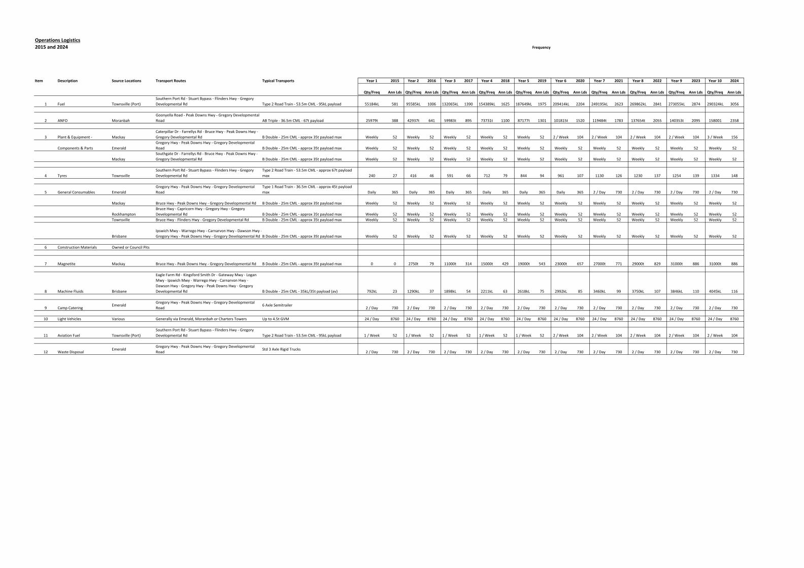
Operations Logistics
2015 and 2024
Item Description Source Locations Transport Routes Typical Transports Year 1 2015 Year 2 2016 Year 3 2017 Year 4 2018 Year 5 2019 Year 6 2020 Year 7 2021 Year 8 2022 Year 9 2023 Year 10 2024
Qty/Freq Ann Lds Qty/Freq Ann Lds Qty/Freq Ann Lds Qty/Freq Ann Lds Qty/Freq Ann Lds Qty/Freq Ann Lds Qty/Freq Ann Lds Qty/Freq Ann Lds Qty/Freq Ann Lds Qty/Freq Ann Lds
1 Fuel Townsville (Port)
Southern Port Rd ‐ Stuart Bypass ‐ Flinders Hwy ‐ Gregory
Developmental Rd Type 2 Road Train ‐ 53.5m CML ‐ 95kL payload 55184kL 581 95585kL 1006 132065kL 1390 154389kL 1625 187649kL 1975 209414kL 2204 249195kL 2623 269862kL 2841 273055kL 2874 290324kL 3056
2 ANFO Moranbah
Goonyella Road ‐ Peak Downs Hwy ‐ Gregory Developmental
Road AB Triple ‐ 36.5m CML ‐ 67t payload 25979t 388 42937t 641 59983t 895 73731t 1100 87177t 1301 101815t 1520 119484t 1783 137654t 2055 140353t 2095 158001 2358
3 Plant & Equipment ‐ Mackay
Caterpillar Dr ‐ Farrellys Rd ‐ Bruce Hwy ‐ Peak Downs Hwy ‐
Gregory Developmental Rd B Double ‐ 25m CML ‐ approx 35t payload max Weekly 52 Weekly 52 Weekly 52 Weekly 52 Weekly 52 2 / Week 104 2 / Week 104 2 / Week 104 2 / Week 104 3 / Week 156
Components & Parts Emerald
Gregory Hwy ‐ Peak Downs Hwy ‐ Gregory Developmental
Road B Double ‐ 25m CML ‐ approx 35t payload max Weekly 52 Weekly 52 Weekly 52 Weekly 52 Weekly 52 Weekly 52 Weekly 52 Weekly 52 Weekly 52 Weekly 52
Mackay
Southgate Dr ‐ Farrellys Rd ‐ Bruce Hwy ‐ Peak Downs Hwy ‐
Gregory Developmental Rd B Double ‐ 25m CML ‐ approx 35t payload max Weekly 52 Weekly 52 Weekly 52 Weekly 52 Weekly 52 Weekly 52 Weekly 52 Weekly 52 Weekly 52 Weekly 52
4 Tyres Townsville
Southern Port Rd ‐ Stuart Bypass ‐ Flinders Hwy ‐ Gregory
Developmental Rd
Type 2 Road Train ‐ 53.5m CML ‐ approx 67t payload
max 240 27 416 46 591 66 712 79 844 94 961 107 1130 126 1230 137 1254 139 1334 148
5 General Consumables Emerald
Gregory Hwy ‐ Peak Downs Hwy ‐ Gregory Developmental
Road
Type 1 Road Train ‐ 36.5m CML ‐ approx 45t payload
max Daily 365 Daily 365 Daily 365 Daily 365 Daily 365 Daily 365 2 / Day 730 2 / Day 730 2 / Day 730 2 / Day 730
Mackay Bruce Hwy ‐ Peak Downs Hwy ‐ Gregory Developmental Rd B Double ‐ 25m CML ‐ approx 35t payload max Weekly 52 Weekly 52 Weekly 52 Weekly 52 Weekly 52 Weekly 52 Weekly 52 Weekly 52 Weekly 52 Weekly 52
Rockhampton
Bruce Hwy ‐ Capricorn Hwy ‐ Gregory Hwy ‐ Gregory
Developmental Rd B Double ‐ 25m CML ‐ approx 35t payload max Weekly 52 Weekly 52 Weekly 52 Weekly 52 Weekly 52 Weekly 52 Weekly 52 Weekly 52 Weekly 52 Weekly 52
Townsville Bruce Hwy ‐ Flinders Hwy ‐ Gregory Developmental Rd B Double ‐ 25m CML ‐ approx 35t payload max Weekly 52 Weekly 52 Weekly 52 Weekly 52 Weekly 52 Weekly 52 Weekly 52 Weekly 52 Weekly 52 Weekly 52
Brisbane
Ipswich Mwy ‐ Warrego Hwy ‐ Carnarvon Hwy ‐ Dawson Hwy ‐
Gregory Hwy ‐ Peak Downs Hwy ‐ Gregory Developmental Rd B Double ‐ 25m CML ‐ approx 35t payload max Weekly 52 Weekly 52 Weekly 52 Weekly 52 Weekly 52 Weekly 52 Weekly 52 Weekly 52 Weekly 52 Weekly 52
6 Construction Materials Owned or Council Pits
7 Magnetite Mackay Bruce Hwy ‐ Peak Downs Hwy ‐ Gregory Developmental Rd B Double ‐ 25m CML ‐ approx 35t payload max 0 0 2750t 79 11000t 314 15000t 429 19000t 543 23000t 657 27000t 771 29000t 829 31000t 886 31000t 886
8 Machine Fluids Brisbane
Eagle Farm Rd ‐ Kingsford Smith Dr ‐ Gateway Mwy ‐ Logan
Mwy ‐ Ipswich Mwy ‐ Warrego Hwy ‐ Carnarvon Hwy ‐
Dawson Hwy ‐ Gregory Hwy ‐ Peak Downs Hwy ‐ Gregory
Developmental Rd B Double ‐ 25m CML ‐ 35kL/35t payload (av) 792kL 23 1290kL 37 1898kL 54 2211kL 63 2618kL 75 2992kL 85 3460kL 99 3750kL 107 3846kL 110 4045kL 116
9 Camp CateringEmerald
Gregory Hwy ‐ Peak Downs Hwy ‐ Gregory Developmental
Road6 Axle Semitrailer
2 / Day 730 2 / Day 730 2 / Day 730 2 / Day 730 2 / Day 730 2 / Day 730 2 / Day 730 2 / Day 730 2 / Day 730 2 / Day 730
10 Light Vehicles Various Generally via Emerald, Moranbah or Charters Towers Up to 4.5t GVM 24 / Day 8760 24 / Day 8760 24 / Day 8760 24 / Day 8760 24 / Day 8760 24 / Day 8760 24 / Day 8760 24 / Day 8760 24 / Day 8760 24 / Day 8760
11 Aviation Fuel Townsville (Port)
Southern Port Rd ‐ Stuart Bypass ‐ Flinders Hwy ‐ Gregory
Developmental Rd Type 2 Road Train ‐ 53.5m CML ‐ 95kL payload 1 / Week 52 1 / Week 52 1 / Week 52 1 / Week 52 1 / Week 52 2 / Week 104 2 / Week 104 2 / Week 104 2 / Week 104 2 / Week 104
12 Waste DisposalEmerald
Gregory Hwy ‐ Peak Downs Hwy ‐ Gregory Developmental
RoadStd 3 Axle Rigid Trucks
2 / Day 730 2 / Day 730 2 / Day 730 2 / Day 730 2 / Day 730 2 / Day 730 2 / Day 730 2 / Day 730 2 / Day 730 2 / Day 730
Frequency