Embed Size (px)
Citation preview
Canadian Postal Products Guide®
2015.03 (Census 2011 Geography)
Product Guide

Information in this document is subject to change without notice and does not represent a commitment on the part of the vendor or its representatives. No part of this document may be reproduced or transmitted in any form or by any means, electronic or mechanical, including photocopying, without the written permission of Pitney Bowes, 26 Wellington Street East, Suite 500, Toronto, Ontario M5E 1S2.
© 2015 Pitney Bowes. All rights reserved. The Canada Postal Points File, the Six-Digit Postal Code Points file, and the Forward Sortation Area (FSA) boundaries and points files, are all individual products trademarked by Pitney Bowes.
© 2006-2015 TomTom. All rights reserved. This material is proprietary and the subject of copyright protection, database right protection and other intellectual property rights owned by TomTom or its suppliers. The use of this material is subject to the terms of a license agreement. Any unauthorized copying or disclosure of this material will lead to criminal and civil liabilities.
Adobe Acrobat® is a registered trademark of Adobe Systems Incorporated in the United States.
All other products named herein may be trademarks of their respective manufacturers and are hereby recognized. Trademarked names are used editorially, to the benefit of the trademark owner, with no intent to infringe on the trademark.
Disclaimer
The postal code records, six-digit postal code points, and FSA boundaries/points furnished by Pitney Bowes, are accepted for use by the recipient on the understanding that Pitney Bowes makes no warranties, expressed or implied, concerning the accuracy, completeness, reliability or suitability of this information or the supporting data.
Pitney Bowes shall be under no liability whatsoever resulting from the use of this information. The postal records, points and boundaries contained within the above mentioned files should not be relied upon as the sole basis for solving a problem in situations where an incorrect decision may result in injury to persons or damage to property.
Further Information
Corporate Headquarters Pitney Bowes, One Global View, Troy, New York 12180.Voice: (518) 285-6000Sales Info Hotline: (800) 327-8627Government Sales Hotline: (800) 619-2333Technical Support Hotline: (518) 285-7283Technical Support E-mail: [email protected]
http://www.pb.com/software
May 2015
Table of Contents
Chapter 1: Overview of Canadian Postal Products. . . . . . . . . . . . . . . . . . . . . . . . . . . . . . . .5
Introduction to Canadian Postal Codes . . . . . . . . . . . . . . . . . . . . . . . . . . . . . . . . . . . . . .6
Canada Postal Points File . . . . . . . . . . . . . . . . . . . . . . . . . . . . . . . . . . . . . . . . . . . . . . . . .6
Six-Digit Postal Code Points . . . . . . . . . . . . . . . . . . . . . . . . . . . . . . . . . . . . . . . . . . . . . . .7
Forward Sortation Area (FSA) Boundaries/Points . . . . . . . . . . . . . . . . . . . . . . . . . . . . .7
Installation . . . . . . . . . . . . . . . . . . . . . . . . . . . . . . . . . . . . . . . . . . . . . . . . . . . . . . . . . . . . . .8
Sources of Information . . . . . . . . . . . . . . . . . . . . . . . . . . . . . . . . . . . . . . . . . . . . . . . . . . . .8
Updates . . . . . . . . . . . . . . . . . . . . . . . . . . . . . . . . . . . . . . . . . . . . . . . . . . . . . . . . . . . . . . . .8
Coverage Area and Geographic Area . . . . . . . . . . . . . . . . . . . . . . . . . . . . . . . . . . . . . . . .8
Coverage Date . . . . . . . . . . . . . . . . . . . . . . . . . . . . . . . . . . . . . . . . . . . . . . . . . . . . . . . . . . .8
Datum . . . . . . . . . . . . . . . . . . . . . . . . . . . . . . . . . . . . . . . . . . . . . . . . . . . . . . . . . . . . . . . . . .8
Chapter 2: Canada Postal Points File: Version 2015.03 . . . . . . . . . . . . . . . . . . . . . . . . . . . .9
Product Specifications . . . . . . . . . . . . . . . . . . . . . . . . . . . . . . . . . . . . . . . . . . . . . . . . . . .10
Data Description . . . . . . . . . . . . . . . . . . . . . . . . . . . . . . . . . . . . . . . . . . . . . . . . . . . . . . . .10
Postal and Census Linkage . . . . . . . . . . . . . . . . . . . . . . . . . . . . . . . . . . . . . . . . . . . . . .10Block Face Assignment. . . . . . . . . . . . . . . . . . . . . . . . . . . . . . . . . . . . . . . . . . . . . . . . . . . . . . 11
Multiple Points . . . . . . . . . . . . . . . . . . . . . . . . . . . . . . . . . . . . . . . . . . . . . . . . . . . . . . . . . . . . . 11
Caveats. . . . . . . . . . . . . . . . . . . . . . . . . . . . . . . . . . . . . . . . . . . . . . . . . . . . . . . . . . . . . . . .11
General Caveat . . . . . . . . . . . . . . . . . . . . . . . . . . . . . . . . . . . . . . . . . . . . . . . . . . . . . . .11
Table Structure . . . . . . . . . . . . . . . . . . . . . . . . . . . . . . . . . . . . . . . . . . . . . . . . . . . . . . . . .11
Chapter 3: Six-Digit Postal Code Points: Version 2015.03 . . . . . . . . . . . . . . . . . . . . . . . . .12
Product Specifications . . . . . . . . . . . . . . . . . . . . . . . . . . . . . . . . . . . . . . . . . . . . . . . . . . .12
Caveats. . . . . . . . . . . . . . . . . . . . . . . . . . . . . . . . . . . . . . . . . . . . . . . . . . . . . . . . . . . . . . . .12
Table Structure . . . . . . . . . . . . . . . . . . . . . . . . . . . . . . . . . . . . . . . . . . . . . . . . . . . . . . . . .13
Chapter 4: FSA Boundaries/Points:Version 2015.03 . . . . . . . . . . . . . . . . . . . . . . . . . . . . . . . . . . . . . . . . . . . . . . . . . . . . . . . . . . .14
Product Specification . . . . . . . . . . . . . . . . . . . . . . . . . . . . . . . . . . . . . . . . . . . . . . . . . . . .14
Caveats. . . . . . . . . . . . . . . . . . . . . . . . . . . . . . . . . . . . . . . . . . . . . . . . . . . . . . . . . . . . . . . .15
Alternate Assignments of Postal Code FSAs To FSA Boundaries . . . . . . . . . . . . . . . .16
Secondary DA Assignments for Unlinked FSAs . . . . . . . . . . . . . . . . . . . . . . . . . . . . . .17
Table Structure . . . . . . . . . . . . . . . . . . . . . . . . . . . . . . . . . . . . . . . . . . . . . . . . . . . . . . . . .18
Boundary . . . . . . . . . . . . . . . . . . . . . . . . . . . . . . . . . . . . . . . . . . . . . . . . . . . . . . . . . . . .18Column Descriptions . . . . . . . . . . . . . . . . . . . . . . . . . . . . . . . . . . . . . . . . . . . . . . . . . . . . . . . . 18
Centroid . . . . . . . . . . . . . . . . . . . . . . . . . . . . . . . . . . . . . . . . . . . . . . . . . . . . . . . . . . . . .18Column Descriptions . . . . . . . . . . . . . . . . . . . . . . . . . . . . . . . . . . . . . . . . . . . . . . . . . . . . . . . . 18
Chapter 5: Using the Boundaries . . . . . . . . . . . . . . . . . . . . . . . . . . . . . . . . . . . . . . . . . . . . .19
Locating a Boundary. . . . . . . . . . . . . . . . . . . . . . . . . . . . . . . . . . . . . . . . . . . . . . . . . . . . .20
Canadian Postal Products Guide 2015.03 iii

Table of Contents
Identifying a Boundary . . . . . . . . . . . . . . . . . . . . . . . . . . . . . . . . . . . . . . . . . . . . . . . . . . . 21
Labeling a Boundary. . . . . . . . . . . . . . . . . . . . . . . . . . . . . . . . . . . . . . . . . . . . . . . . . . . . . 22
Combining Boundaries. . . . . . . . . . . . . . . . . . . . . . . . . . . . . . . . . . . . . . . . . . . . . . . . . . . 23
Chapter A: Data Support and Feedback . . . . . . . . . . . . . . . . . . . . . . . . . . . . . . . . . . . . . . . 26
Feedback Process. . . . . . . . . . . . . . . . . . . . . . . . . . . . . . . . . . . . . . . . . . . . . . . . . . . . . . . 26
iv Canadian Postal Products Guide 2015.03
1
Overview of Canadian Postal ProductsFollowing a general introduction to Canadian postal codes, this chapter describes the three individual Canadian postal products covered in this guide (Canada Postal Points File, Six-Digit Postal Code Points and Forward Sortation Area (FSA) Boundaries/Points).
The descriptions are followed by the general installation procedure, and all the other information that is common to all three products (for example, sources and coverage).
In this chapter:
Introduction to Canadian Postal Codes . . . . . . . . . . . . . . . . . . . . . .6 Canada Postal Points File . . . . . . . . . . . . . . . . . . . . . . . . . . . . . . . . .6 Six-Digit Postal Code Points . . . . . . . . . . . . . . . . . . . . . . . . . . . . . . .7 Forward Sortation Area (FSA) Boundaries/Points . . . . . . . . . . . . .7 Installation . . . . . . . . . . . . . . . . . . . . . . . . . . . . . . . . . . . . . . . . . . . . .8 Sources of Information . . . . . . . . . . . . . . . . . . . . . . . . . . . . . . . . . . .8 Updates . . . . . . . . . . . . . . . . . . . . . . . . . . . . . . . . . . . . . . . . . . . . . . . .8 Coverage Area and Geographic Area. . . . . . . . . . . . . . . . . . . . . . . .8 Coverage Date . . . . . . . . . . . . . . . . . . . . . . . . . . . . . . . . . . . . . . . . . .8 Datum . . . . . . . . . . . . . . . . . . . . . . . . . . . . . . . . . . . . . . . . . . . . . . . . .8
For the current specifications, and any caveats relating to the individual products, refer as appropriate to Canada Postal Points File: Version 2015.03 in Chapter 2 on page 9, Six-Digit Postal Code Points: Version 2015.03 in Chapter 3 on page 12, or FSA Boundaries/Points: Version 2015.03 in Chapter 4 on page 14.
Introduction to Canadian Postal Codes
Introduction to Canadian Postal Codes
A Canadian postal code consists of a string of six alphanumeric characters, in the format AnA nAn (where A is a letter and n is a digit, with a space typically separating the third and fourth characters). An example is K1A 0B1, which is Canada Post's Ottawa headquarters.
The first three characters of a postal code are referred to collectively as a Forward Sortation Area (FSA), with the last three characters denoting a Local Delivery Unit (LDU).
Pitney Bowes’ Six-Digit Postal Code Points file provides the six-character postal codes both with and without the space separator (refer to Table Structure in Chapter 3 on page 13).
Canada Postal Points FileThe Canada Postal Points File is a nationwide point database of every postal code in Canada, created by Pitney Bowes. The Canada Postal Points File includes data inputs from TomTom® and Canada Post.
The addresses created by TomTom® consist of postal codes and their corresponding address ranges. Addresses are then geocoded using TomTom® MultiNet® North America, Inc. to place the points at street-level accuracy, thereby facilitating the mapping and demographic analysis of customer records.
Dissemination Area (DA) codes are assigned to all the geocoded postal codes by Pitney Bowes.
CAUTION: See Data Description in Chapter 2 on page 10 for important information regarding DA assignments.
The six-character postal codes are linked in the Canada Postal Points File with all levels of the 2011 standard census geography. This is done by establishing a link between the FSALDU and the Dissemination Area (DA). The DA polygon is the lowest level in the census hierarchy, so, once the link to the FSALDU is made, all other census levels can be determined.
The address associated with a postal code does not always represent the location of those receiving mail using that postal code. This is particularly the case in rural areas, where rural route service and post office pickup are commonly used to deliver mail (i.e. where Delivery Mode Type (DMT) = “H”). Also, postal codes with a DMT of “K” (group of post office boxes) or “M” (one post office box) are generally linked to the location of a post office on the Canada Postal Points File, as opposed to the physical location of customers who rent a post office box.
Pitney Bowes further enhances/reassigns postal codes that were Street-coded, block and/or Forward Sortation Area (FSA) centroids.
6 Canadian Postal Products Guide 2015.03
Six-Digit Postal Code Points
The 2003 Federal Electoral Districts (FED) are also included as a geographic link in the Canada Postal Points File.
2003 FED boundaries are not a standard level of census geography.
The Canada Postal Points File is maintained in a geographic projection under North American Datum 1983 (NAD83), using the Canadian National Topographic (CNT) conversion method.
Six-Digit Postal Code Points
The following four fields are extracted from the Canada Postal Points File referred to above, in order to create the Six-Digit Postal Code Points file: Fsaldu, Fsa_Ldu, Latitude and Longitude (refer to Table Structure in Chapter 3 on page 13). As a result, the file contains the single most representative points for all Canadian postal codes, and provides the associated latitude/longitude coordinates that facilitate the mapping of customer records.
Whilst the Six-Digit Postal Code Points file provides the best location for a particular postal code, it does not contain links to the census hierarchy or postal delivery attributes found in the Canada Postal Points File.
Forward Sortation Area (FSA) Boundaries/Points
A Forward Sortation Area (FSA) corresponds to the first three digits of a Canadian six-digit postal code, designating a postal delivery area.
Whilst the file contains both the urban and rural areas, rural areas are commonly identified with zero as the second digit.
FSAs are defined by a variety of sources, usually geographic, linking postal geography with Dissemination Area (DA) boundaries. The geographic polygon boundary file supplied by Pitney Bowes represents the graphical boundary and centroid files for all of Canada's FSAs.
The creation of the boundary file involves snapping FSA boundaries to 2011 DAs where no alternative descriptions are available. This is of particular benefit in rural areas where available postal maps are much more generalized. In order to limit the bias created by overlapping boundaries, the distribution of postal codes and street segments across DAs was used to determine the direction in which a split should take place. FSA boundaries are created from the approximate distribution of the first three digits of postal codes.
The centroids were created from the FSA boundary file, with each one constituting a single geographic location identified with an FSA. Where an FSA was made up of two or more polygons, the location of the centroid describing the largest portion of the FSA was retained.
Canadian Postal Products Guide 2015.03 7
Installation
Installation
All the three data products described in this chapter are supplied uncompressed on the product media. You can access the particular data with which you have been supplied, by either using it with Pitney Bowes’ mapping products direct from the media, or copying the data to your hard drive for faster file access.
Sources of Information
Canada Post Corporation, TomTom® , and Pitney Bowes.
Updates
Semi-annual for all three products.
Coverage Area and Geographic Area
Canada/National
Coverage Date
As specified in Canada Postal Points File: Version 2015.03 in Chapter 2 on page 9, Six-Digit Postal Code Points: Version 2015.03 in Chapter 3 on page 12, and FSA Boundaries/Points: Version 2015.03 in Chapter 4 on page 14.
Datum
Latitude/Longitude - North American Datum 1983 (NAD83).
8 Canadian Postal Products Guide 2015.03
2
Canada Postal Points File: Version 2015.03The March 2015 release of Pitney Bowes’ Canada Postal Points File contains
947,243 postal code records. This file is created from the TomTom® Postal Point (PL) Layer File.
The Canada Postal Points File continues to:
• link each six-character postal code with all levels of the 2011 standard census geography.
• provide latitude/longitude coordinates for easy mapping and demographic analysis of customer records.
In this chapter:
Product Specifications . . . . . . . . . . . . . . . . . . . . . . . . . . . . . . . . . .10 Data Description. . . . . . . . . . . . . . . . . . . . . . . . . . . . . . . . . . . . . . . .10 Caveats . . . . . . . . . . . . . . . . . . . . . . . . . . . . . . . . . . . . . . . . . . . . . . .11 Table Structure . . . . . . . . . . . . . . . . . . . . . . . . . . . . . . . . . . . . . . . . .11
Product Specifications
Product Specifications
• 947,243 postal code records (Total File)
• 860,098 (Unique)
• 87,145 (Multiple)
• Over 890,000 postal codes assigned to a block face
• 2011 Census Geography concordance.
• March 2015 Postal Currency
Data Description
The Canada Postal Points File contains a field—Sng_fsaldu—that can assist you in providing a location coordinate for a postal code (FSALDU), and in linking that coordinate to all levels of Canadian census geography. To achieve a unique number of postal code records, you need to select those records where the Sng_fsaldu is equal to “1”.
Postal codes where Sng_fsaldu is equal to “1” (unique postal codes) are considered the most representative locations for the FSALDUs in Canada. A coordinate that is identified as unique may be either the only possible location for the point, or the most representative point out of a number of multiple locations that could be identified for the same FSALDU.
TomTom® creates a postal centroid that represents the single "most representative point" for each postal code in Canada.
There are 860,098 unique records as of March 2015.
Geocoding software cannot normally distinguish the preferred location when presented with more than one possible match. At best, the first location coordinate might be assigned. At worst, there could be thousands or millions of ungeocoded records in the output database. Check your geocoder's handling of multiple candidate records, or else avoid these problems by geocoding with the unique postal codes - refer to General Caveat below.
Postal and Census Linkage
The primary goal of using the Canada Postal Points File is to link a postal code point to census geography by establishing a link between the FSALDU and the Dissemination Area (DA). (Refer to Canada Postal Points File in Chapter 1 on page 6.)
In some cases, however, a postal code may serve customers in more than one DA. In order to portray all postal-census links, multiple records need to be created in order to maintain all FSALDU-DA relationships. The multiple postal codes provide alternate postal code coordinates and linkages to standard Canadian census geographic codes to supplement the single most representative coordinates (and Census geography linkages) for postal codes in Canada. This is a limitation of linking postal and census geography. There are two examples of this multiple linkage described overleaf: Block Face Assignment and Multiple Points.
10 Canadian Postal Products Guide 2015.03
Caveats
Block Face Assignment
In most cases, block face assignment results in a single point location representing all households along an uninterrupted street segment. Dense block face assignments in urban areas follow the familiar grid pattern of streets and provide a very useful geocoding tool. However, very long block faces may cross DA boundaries.
Multiple Points
If there are multiple (i.e. non block-face) postal codes associated with individual DA polygons, their positions may also be based on a FSA geographic centroids, which may in turn cause two or more different postal codes to occupy the same coordinates.
Caveats
General Caveat
When geocoding client postal codes, you should be aware that there may be more than one valid delivery location for a particular postal code.
Table Structure
See Canada_Postal_Points_variables.xls in the docs\ folder on the product media for a complete list of the variables in this data product. This file is a Microsoft Excel spreadsheet. If you do not have Microsoft Excel, then you can download the Excel Viewer after clicking here.
Canadian Postal Products Guide 2015.03 11
3
Six-Digit Postal Code Points: Version 2015.03The March 2015 release of the Six-Digit Postal Code file contains 860,098 records. This file is an extract of the 2015.03 Canada Postal Points File described in Canada Postal Points File: Version 2015.03 in Chapter 2 on page 9.
In this chapter:
Product Specifications . . . . . . . . . . . . . . . . . . . . . . . . . . . . . . . . . .12 Caveats . . . . . . . . . . . . . . . . . . . . . . . . . . . . . . . . . . . . . . . . . . . . . . .12 Table Structure . . . . . . . . . . . . . . . . . . . . . . . . . . . . . . . . . . . . . . . . .13
Product Specifications
• 860,098 total postal code records
• Over 2,700 new postal codes
Caveats
When geocoding client postal codes, you should be aware that there may be more than one valid delivery location for a particular postal code.
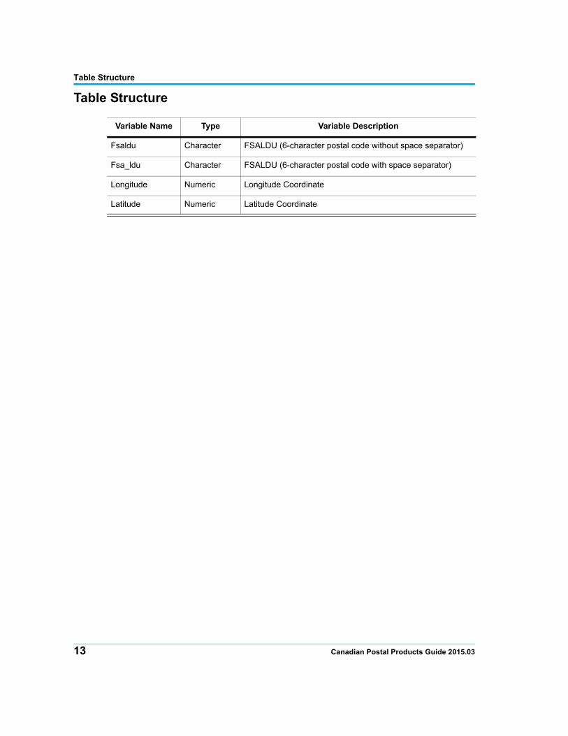
Table Structure
Table Structure
Variable Name Type Variable Description
Fsaldu Character FSALDU (6-character postal code without space separator)
Fsa_ldu Character FSALDU (6-character postal code with space separator)
Longitude Numeric Longitude Coordinate
Latitude Numeric Latitude Coordinate
13 Canadian Postal Products Guide 2015.03
4
FSA Boundaries/Points:Version 2015.03The March 2015 release of Pitney Bowes’ polygon boundary file contains the graphical boundary and centroid files for 1,641 FSAs.
In this chapter:
Product Specification . . . . . . . . . . . . . . . . . . . . . . . . . . . . . . . . . . .14 Caveats . . . . . . . . . . . . . . . . . . . . . . . . . . . . . . . . . . . . . . . . . . . . . . .15 Table Structure . . . . . . . . . . . . . . . . . . . . . . . . . . . . . . . . . . . . . . . . .18
Product Specification
1,641 FSAs in Canada.
1,641 FSAs have centroids and boundaries.
1,607 FSAs are assigned to one or more DA centroids.
The following 34 FSAs have zero data links:
E2R, G1A, G7T, H3B, H4S, H4T, H4Y, H4Z, H5A, H5B, K1A, L4V, L5P, L5S, L5T, L9J, M5H, M5K, M5L, M5W, M5X, M7A, M7Y, N8V, P0Y, R1B, R3H, S6W, T1Z, T3N, T5V, T6S, V7X, V7Y.
Refer to Secondary DA Assignments for Unlinked FSAs on page 17.
Caveats
Caveats
FSAs were not designed to respect standard geographic boundaries, except at the provincial level. Nevertheless, there are occurrences when FSAs may cross provincial boundaries, such as in Flin Flon, Manitoba/Saskatchewan; Lloydminster, Saskatchewan/Alberta; and Makaoo 120 Indian Reserve, Saskatchewan/Alberta.
The Pitney Bowes methodology focuses on the ability to assign DAs to the most appropriate FSAs and to locate and update the FSA boundaries that show the greatest degree of change. (This degree of change is based on the quantity of postal codes associated with particular FSAs that fall within different FSA boundaries.)
This approach involves some of the following basic compromises:
• FSAs do not respect Dissemination Area (DA) boundaries, and there are numerous occurrences of DAs that have mail delivered through two different FSAs. In these situations, all of the households in a DA are assigned to one, and only one, FSA within a DA attribute table.
• Although FSAs are often delineated by street boundaries, there are numerous occasions where a single FSA is used for both sides of the delineating street. Since DAs are more likely to be delineated by a street, the DA will likely be split when creating the FSA boundary, to incorporate the proper distribution of the FSA.
• FSAs are intended for mail delivery and sorting, and occasionally have no spatial reference. This explains the differences in the number of actual FSAs versus those with boundaries. These non-spatial FSAs are included since some household-based databases aggregate to these FSAs.
• There are also a number of FSAs that do not dominate the distribution of postal codes within a DA and therefore cannot be assigned by majority rule to any DA. However, they may have a boundary based on overall distribution of the points, and on the fact that the FSA boundary file does not follow a DA boundary. Several of these postal code points not assigned a DA are also found within alternate FSA boundaries. A table of possible matches follows.
15 Canadian Postal Products Guide 2015.03
Caveats
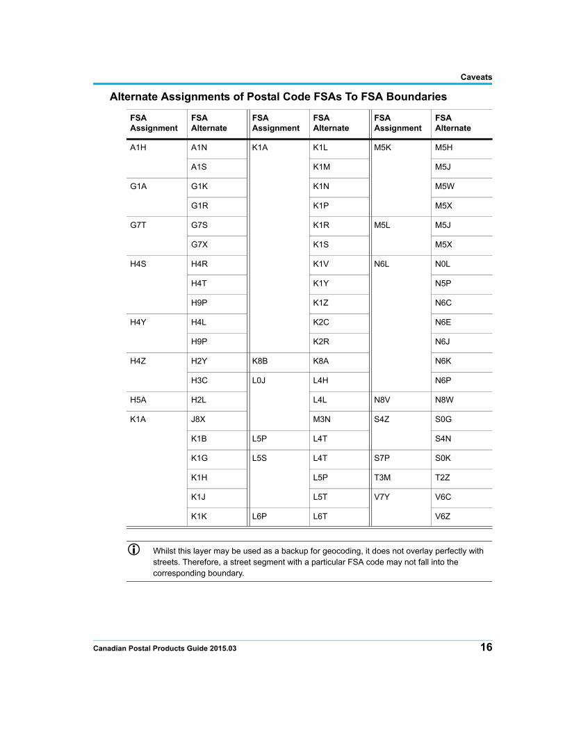
Alternate Assignments of Postal Code FSAs To FSA Boundaries
Whilst this layer may be used as a backup for geocoding, it does not overlay perfectly with streets. Therefore, a street segment with a particular FSA code may not fall into the corresponding boundary.
FSA Assignment
FSA Alternate
FSA Assignment
FSA Alternate
FSA Assignment
FSA Alternate
A1H A1N K1A K1L M5K M5H
A1S K1M M5J
G1A G1K K1N M5W
G1R K1P M5X
G7T G7S K1R M5L M5J
G7X K1S M5X
H4S H4R K1V N6L N0L
H4T K1Y N5P
H9P K1Z N6C
H4Y H4L K2C N6E
H9P K2R N6J
H4Z H2Y K8B K8A N6K
H3C L0J L4H N6P
H5A H2L L4L N8V N8W
K1A J8X M3N S4Z S0G
K1B L5P L4T S4N
K1G L5S L4T S7P S0K
K1H L5P T3M T2Z
K1J L5T V7Y V6C
K1K L6P L6T V6Z
Canadian Postal Products Guide 2015.03 16

Caveats
Secondary DA Assignments for Unlinked FSAs
There are 34 FSAs that have no DA assignments (refer to Product Specification on page 14). Demographic data that is aggregated from DA level to FSA would show these 34 unlinked FSAs as zero-filled records.
To assist you in identifying alternate DA assignments for these unlinked FSAs, Pitney Bowes has, in each case, assigned the most representative 2011 Dissemination Area (where possible).
The DAs in the following table have a primary FSA assignment other than the FSAs shown.
FSA DA FSA DA FSA DA
E2R 13010059 L5T 35211696 T1Z 48061980
G1A 24230183 L9J 35431326 T3N 48062289
G7T 24940366 M5H 35200855 T5V 48111959
H3B 24661283 M5K 35200855 T6S 48111587
H4S 24663423 M5L 35200855 V7X 59150850
H4T 24663419 M5W 35204650 V7Y 59153845
H4Y 24662432 M5X 35200855
H4Z 24661107 M7A 35204604
H5A 24661283 M7Y 35204750
H5B 24662115 N8V 35370655
K1A 35060408 P0Y 35600267
L4V 35211697 R1B 46130105
L5P 35211696 R3H 46111177
L5S 35211696 S6W 47150249
17 Canadian Postal Products Guide 2015.03
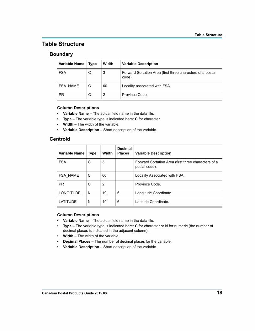
Table Structure
Table Structure
Boundary
Column Descriptions• Variable Name – The actual field name in the data file.
• Type – The variable type is indicated here: C for character.
• Width – The width of the variable.
• Variable Description – Short description of the variable.
Centroid
Column Descriptions• Variable Name – The actual field name in the data file.
• Type – The variable type is indicated here: C for character or N for numeric (the number of decimal places is indicated in the adjacent column).
• Width – The width of the variable.
• Decimal Places – The number of decimal places for the variable.
• Variable Description – Short description of the variable.
Variable Name Type Width Variable Description
FSA C 3 Forward Sortation Area (first three characters of a postal code).
FSA_NAME C 60 Locality associated with FSA.
PR C 2 Province Code.
Variable Name Type WidthDecimal Places Variable Description
FSA C 3 Forward Sortation Area (first three characters of a postal code).
FSA_NAME C 60 Locality Associated with FSA.
PR C 2 Province Code.
LONGITUDE N 19 6 Longitude Coordinate.
LATITUDE N 19 6 Latitude Coordinate.
Canadian Postal Products Guide 2015.03 18

5
Using the BoundariesThe examples given in this chapter highlight some MapInfo Professional functions that relate specifically to Forward Sortation Area (FSA) boundaries. The chapter is not intended, however, to be a tutorial.
In this chapter:
Locating a Boundary . . . . . . . . . . . . . . . . . . . . . . . . . . . . . . . . . . . .20 Identifying a Boundary . . . . . . . . . . . . . . . . . . . . . . . . . . . . . . . . . .21 Labeling a Boundary . . . . . . . . . . . . . . . . . . . . . . . . . . . . . . . . . . . .22 Combining Boundaries . . . . . . . . . . . . . . . . . . . . . . . . . . . . . . . . . .23
Locating a Boundary
Locating a Boundary
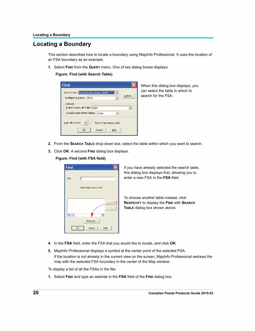
This section describes how to locate a boundary using MapInfo Professional. It uses the location of an FSA boundary as an example.
1. Select FIND from the QUERY menu. One of two dialog boxes displays:
Figure: Find (with Search Table)
2. From the SEARCH TABLE drop-down box, select the table within which you want to search.
3. Click OK. A second FIND dialog box displays.
Figure: Find (with FSA field)
4. In the FSA field, enter the FSA that you would like to locate, and click OK.
5. MapInfo Professional displays a symbol at the center point of the selected FSA.
If the location is not already in the current view on the screen, MapInfo Professional redraws the map with the selected FSA boundary in the center of the Map window.
To display a list of all the FSAs in the file:
1. Select FIND and type an asterisk in the FSA field of the FIND dialog box.
When this dialog box displays, you can select the table in which to search for the FSA.
If you have already selected the search table, this dialog box displays first, allowing you to enter a new FSA in the FSA field.
To choose another table instead, click RESPECIFY to display the FIND with SEARCH TABLE dialog box shown above.
20 Canadian Postal Products Guide 2015.03
Identifying a Boundary
2. Click OK.
You can also type the first couple of characters of the desired FSA so that the list displays the FSAs that begin with those characters. If one of these FSAs is selected, its boundary is selected on the map.
Identifying a Boundary
This section describes how to identify a boundary using MapInfo Professional. It uses the identification of an FSA boundary as an example.
You can determine the FSA of any displayed boundary by using the Info button in a Map window:
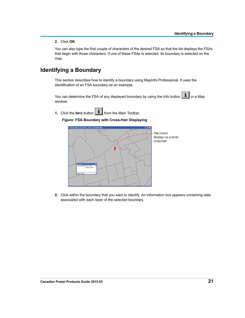
1. Click the INFO button from the Main Toolbar.
Figure: FSA Boundary with Cross-Hair Displaying
2. Click within the boundary that you want to identify. An information box appears containing data associated with each layer of the selected boundary.
Canadian Postal Products Guide 2015.03 21
Labeling a Boundary
Labeling a Boundary
This section describes how to label a boundary using MapInfo Professional. It uses the labeling of an FSA boundary as an example.
FSA boundaries can be labeled using several different methods:
• Use the LABEL button and select the boundary you want to label. The label appears at the boundary or point specified. To change the font and size of individual labels, double-click on the label to display the LABEL STYLE dialog box.
• You can also type your own map annotations using the TEXT button .
• You can display labels automatically within FSA boundaries, by proceeding as follows:
1. Open the FSA boundaries table.
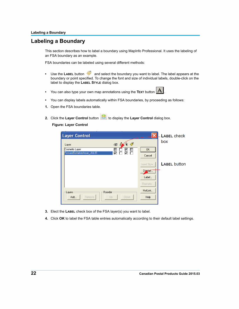
2. Click the Layer Control button to display the Layer Control dialog box.
Figure: Layer Control
3. Elect the LABEL check box of the FSA layer(s) you want to label.
4. Click OK to label the FSA table entries automatically according to their default label settings.
22 Canadian Postal Products Guide 2015.03
Combining Boundaries
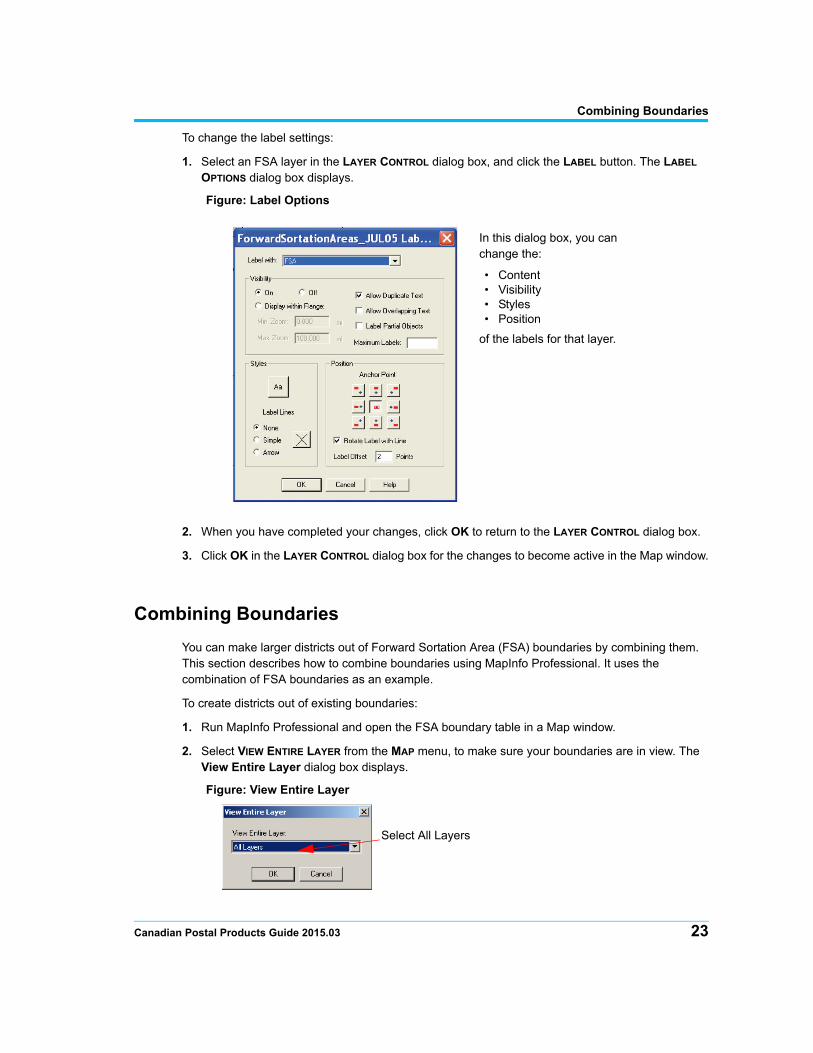
To change the label settings:
1. Select an FSA layer in the LAYER CONTROL dialog box, and click the LABEL button. The LABEL OPTIONS dialog box displays.
Figure: Label Options
2. When you have completed your changes, click OK to return to the LAYER CONTROL dialog box.
3. Click OK in the LAYER CONTROL dialog box for the changes to become active in the Map window.
Combining Boundaries
You can make larger districts out of Forward Sortation Area (FSA) boundaries by combining them. This section describes how to combine boundaries using MapInfo Professional. It uses the combination of FSA boundaries as an example.
To create districts out of existing boundaries:
1. Run MapInfo Professional and open the FSA boundary table in a Map window.
2. Select VIEW ENTIRE LAYER from the MAP menu, to make sure your boundaries are in view. The View Entire Layer dialog box displays.
Figure: View Entire Layer
In this dialog box, you can change the:
• Content• Visibility• Styles• Position
of the labels for that layer.
Select All Layers
Canadian Postal Products Guide 2015.03 23
Combining Boundaries
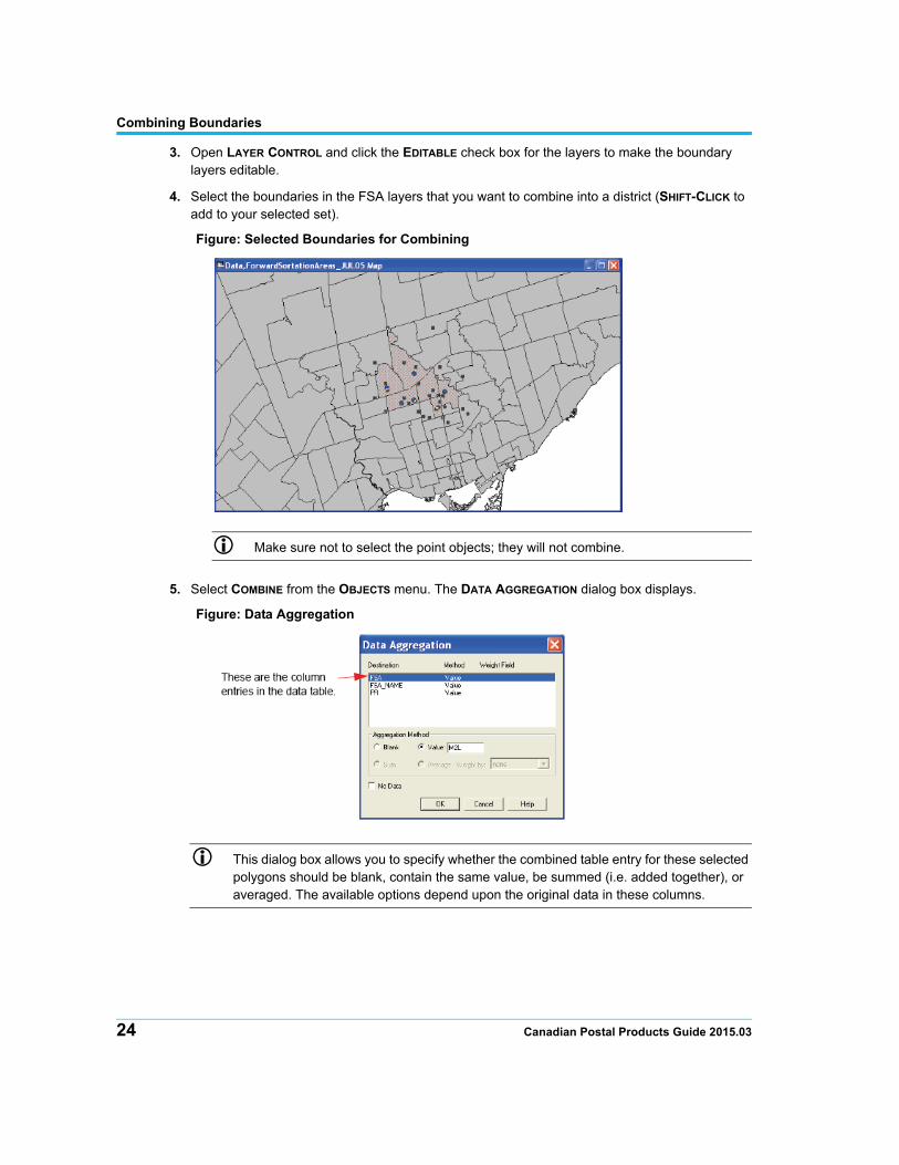
3. Open LAYER CONTROL and click the EDITABLE check box for the layers to make the boundary layers editable.
4. Select the boundaries in the FSA layers that you want to combine into a district (SHIFT-CLICK to add to your selected set).
Figure: Selected Boundaries for Combining
Make sure not to select the point objects; they will not combine.
5. Select COMBINE from the OBJECTS menu. The DATA AGGREGATION dialog box displays.
Figure: Data Aggregation
This dialog box allows you to specify whether the combined table entry for these selected polygons should be blank, contain the same value, be summed (i.e. added together), or averaged. The available options depend upon the original data in these columns.
24 Canadian Postal Products Guide 2015.03
Combining Boundaries
6. Click each column entry in this dialog box and specify how the data should be evaluated for the new object. Select from the following options:
BlankSelect this option to treat the entries in this column as blank.
ValueSelect this option to give the entries in this column the same specified value. Type the value for this entry in the field beside the VALUE button. If you select this option and do not specify a value in the field provided, MapInfo Professional assumes that you want to retain the original value in the table.
SumSelect this option to add the values of the original objects together. The original values must not be of type Character.
AverageSelect this option to average the values contained in the original objects.
Weighted byWhen you choose AVERAGE, you can also choose a column or the boundary area to be used as a weighting factor.
No DataSelect this option when you do not want any data brought over from the original objects.
7. Once you have completed the DATA AGGREGATION dialog box, click OK.
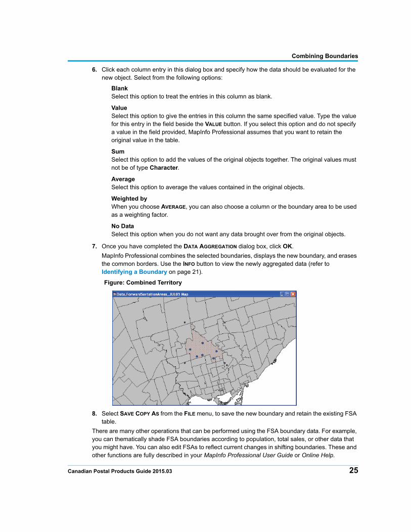
MapInfo Professional combines the selected boundaries, displays the new boundary, and erases the common borders. Use the INFO button to view the newly aggregated data (refer to Identifying a Boundary on page 21).
Figure: Combined Territory
8. Select SAVE COPY AS from the FILE menu, to save the new boundary and retain the existing FSA table.
There are many other operations that can be performed using the FSA boundary data. For example, you can thematically shade FSA boundaries according to population, total sales, or other data that you might have. You can also edit FSAs to reflect current changes in shifting boundaries. These and other functions are fully described in your MapInfo Professional User Guide or Online Help.
Canadian Postal Products Guide 2015.03 25

A
Data Support and FeedbackPitney Bowes continues to enhance the data support and feedback facilities available to our clients. An infrastructure has been developed to streamline the handling of customer feedback regarding data products and to ensure that appropriate responses are provided, with corrective action being taken where appropriate.
For the various types of possible feedback, and their submission, refer to the form on the next page.
Feedback Process
The process is as follows:
1. Completion of Feedback Form by Client: The electronic form on the following page has a Send button that you can use to send the Data Production Team general comments concerning any of the data products described in this guide.
You can also email comments (and associated screenshots) directly to the following email address:
2. Handling: All customers are sent confirmation of receipt of email feedback, and then subsequently notified of the type and timetable of the corrective action (where appropriate). Dependent on the type of feedback, the report may be actioned immediately or scheduled for routine maintenance action as part of the next scheduled release.
The Feedback Database keeps track of progress on each item. Follow-up action and advice are provided wherever necessary.
Appendix A: Data Support and Feedback
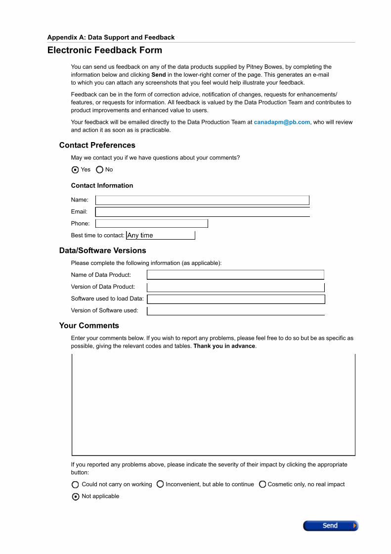
Electronic Feedback FormYou can send us feedback on any of the data products supplied by Pitney Bowes, by completing the information below and clicking Send in the lower-right corner of the page. This generates an e-mailto which you can attach any screenshots that you feel would help illustrate your feedback.
Feedback can be in the form of correction advice, notification of changes, requests for enhancements/ features, or requests for information. All feedback is valued by the Data Production Team and contributes to product improvements and enhanced value to users.
Your feedback will be emailed directly to the Data Production Team at [email protected], who will reviewand action it as soon as is practicable.
Contact PreferencesMay we contact you if we have questions about your comments?
Yes No
Contact Information
Name:
Email:
Phone:
Best time to contact:
Data/Software VersionsPlease complete the following information (as applicable):
Name of Data Product:
Version of Data Product:
Software used to load Data:
Version of Software used:
Your CommentsEnter your comments below. If you wish to report any problems, please feel free to do so but be as specific as possible, giving the relevant codes and tables. Thank you in advance.
If you reported any problems above, please indicate the severity of their impact by clicking the appropriate button:
Could not carry on working Inconvenient, but able to continue Cosmetic only, no real impact
Not applicable