Embed Size (px)
Citation preview

&RORUDGR�*HRORJLFDO�6XUYH\'LYLVLRQ�RI�0LQHUDOV�DQG�*HRORJ\'HSDUWPHQW�RI�1DWXUDO�5HVRXUFHV
'HQYHU��&RORUDGR����
,1)250$7,21�6(5,(6���
$QQXDO�5HSRUW����²����
6QRZ�DQG�$YDODQFKH&RORUDGR�$YDODQFKH�,QIRUPDWLRQ�&HQWHU

&RYHU��$�ODUJH�QDWXUDO�KDUG�VODE�DYDODQFKH�RQ�'HFHPEHU�����������LQ�6WDIIRUG�*XOFK�RQ�(ON0RXQWDLQ�QHDU�9DLO�3DVV��7KH�DYDODQFKH�UDQ�RQ�WKH�LFH�FUXVW�WKDW�IRUPHG�RQ�1RYHPEHU����DQG�LVGLVFXVVHG�LQ�WKLV�UHSRUW��7KH�VNLHUV�ZHUH�QRW�LQYROYHG�LQ�WKH�DYDODQFKH��3KRWR�E\�6FRWW�7RHSIHU�

,QIRUPDWLRQ�6HULHV���
6QRZ�DQG�$YDODQFKH&RORUDGR�$YDODQFKH�,QIRUPDWLRQ�&HQWHU
$QQXDO�5HSRUW����²����
&RORUDGR�*HRORJLFDO�6XUYH\'LYLVLRQ�RI�0LQHUDOV�DQG�*HRORJ\'HSDUWPHQW�RI�1DWXUDO�5HVRXUFHV
'HQYHU��&RORUDGR����


)25(:25'
)RUHZRUGCGS Information Series 56 is the Annual Report of the Colorado Avalanche InformationCenter for the winter of 1999–2000. It describes the operations of the CAIC and the importantevents of the winter season.
Partial funding for this report came from the Colorado Severance Tax Operations Fund.Severance taxes are derived from the production of gas, oil, coal, and minerals.
Knox WilliamsDirector of the Colorado Avalanche Information Center
Vicki CowartState Geologist and Director


'LUHFWRU·V�5HSRUW
To our sponsors and patrons:
The fiscal year just past (1999–2000) marked not only a new millennium but also a newera for the Colorado Avalanche Information Center. Call it the era of Severance TaxFunding, and it is historic, for it represents the first direct State funding for the AvalancheCenter in its 17 years as a state program.
Severance tax is paid by the producers of gas, oil, coal and some minerals, and goes intoan operational account to be used for (among other things) the legislative charge ofmitigating geologic hazards, which includes avalanche hazards. The Minerals, Energy,and Geology Policy Advisory Board (MEGA Board) has oversight responsibility of thefund and recommended the CAIC’s proposal, which was then approved by the ColoradoGeneral Assembly.
The additional funding amounted to $116,000. The funds will help in four basic areas: (1)forecasting, (2) education/outreach, (3) data management, and (4) program management.See the section of this report entitled Severance Tax Projects for full details.
Clearly, severance tax funding cannot be our sole source of revenue. We must continue tomaintain and increase funding from more traditional sources so as to maintain thestability and viability and important partnerships that sustain the Avalanche Center. Butthis much is certain: Severance tax funding will greatly help us reach our forecasting andeducational goals, and we thank Colorado’s extractive resource industry and the MEGABoard for making this happen.
Changing subjects, I want to highlight an important publication that we produced thisyear. It is Avalanche Wise: Your Guide to Avalanche Safety in Colorado (CGS SpecialPublication 48). It is an attractive, full-color, 24-page booklet of basic avalanche safety.Funding for this booklet was provided by the family of Ethan Morris Gell, a ski patrollerat Beaver Creek who tragically died far too young of a congenital heart defect. This yearwe distributed several thousand copies at our avalanche awareness talks and through theCGS publications group. Avalanche Wise will be a staple publication for years to come.
The CAIC has completed its seventeenth year of operation, and we continue to meet ourclients needs and to meet the demand for our services. As always I want to thank all oursponsors who make our mission of avalanche safety possible. And I want to thank mystaff of forecasters for the professionalism they bring to the job everyday. Nick Logan,Dale Atkins, Scott Toepfer, Mark Mueller, Lee Metzger, Rob Hunker, Andy Gleason,Halsted Morris, and Jerry Roberts—thank you all. It’s a pleasure to work with you.
Knox WilliamsDirector


&217(176
I. EXECUTIVE SUMMARY...................................................................................................1
II. FUNDING AND BUDGET .................................................................................................2
III. OPERATIONS ...................................................................................................................5
IV. WEATHER AND AVALANCHE SYNOPSIS................................................................7
SNOWFALL...............................................................................................................................7Table 1. 1999–2000 snowfall in inches ..............................................................................9
AVALANCHES ..........................................................................................................................9AVALANCHE DANGER AND WARNINGS .................................................................................10AVALANCHE ACCIDENTS .......................................................................................................10
Table 2. 1999–2000 Summary of avalanches, hazard days, and accidents .....................11Figure 1. Colorado’s accident trend in the last 10 years...............................................12
Table 3. Colorado avalanche accidents, 1999–2000 .......................................................13
V. DETAILED WINTER SUMMARY ................................................................................14
NOVEMBER............................................................................................................................14DECEMBER ............................................................................................................................14JANUARY ...............................................................................................................................15FEBRUARY.............................................................................................................................16MARCH..................................................................................................................................17APRIL.....................................................................................................................................18
VI. INFORMATION ACQUISITION..................................................................................20
DAILY WEATHER, SNOWPACK AND AVALANCHE DATA ........................................................20WESTWIDE AVALANCHE NETWORK.......................................................................................20ACCIDENT INVESTIGATION.....................................................................................................21
VII. DISSEMINATION OF HAZARD FORECASTS........................................................22
PUBLIC HOTLINES..................................................................................................................22E-MAIL TO FRIENDS, OBSERVERS AND FORECASTERS............................................................22WEB SITE...............................................................................................................................23
Figure 2. Public forecast dissemination........................................................................23RADIO BROADCASTS..............................................................................................................23NOAA COLORADO WEATHERWIRE.......................................................................................24NEWS MEDIA.........................................................................................................................24

&217(176
VIII. PUBLIC EDUCATION................................................................................................ 25
AVALANCHE COURSES.......................................................................................................... 25Figure 3. Avalanche education..................................................................................... 25
Table 4. Avalanche talks and seminars, 1999–2000........................................................ 26PROFESSIONAL CONFERENCES .............................................................................................. 27PUBLICATIONS....................................................................................................................... 28WEB SITE .............................................................................................................................. 28AVALANCHE EDUCATION MATERIALS .................................................................................. 28
IX. FORECASTING FOR COLORADO’S HIGHWAYS................................................. 29
Table 5. Avalanches reaching Colorado highways, ........................................................ 29CDOT/SILVERTON FORECAST OFFICE .................................................................................. 30CDOT/PAGOSA SPRINGS FORECAST OFFICE......................................................................... 32CDOT/EISENHOWER TUNNEL FORECAST OFFICE ................................................................. 35CDOT/WESTERN SLOPE FORECAST OFFICE.......................................................................... 38
X. SEVERANCE TAX PROJECTS..................................................................................... 41

6(&7,21�,��������������������������������������������������������������������(;(&87,9(�6800$5<
�
([HFXWLYH�6XPPDU\Mission: The Colorado Avalanche Information Center promotes safety by reducing the impactof avalanches on recreation, industry, and transportation in the State through a program offorecasting and education.
Administration: The Center is a program of the Colorado Geological Survey of theDepartment of Natural Resources.
Funding: The Center is funded by Severance Tax and cash-funded by grants and donations.In FY 99-00, total revenues were $519,554.
Housing: The main office of the Avalanche Center is at the National Weather ServiceForecast Office in Boulder. Offices for CDOT operations are located in Silverton, PagosaSprings, Carbondale, and the Eisenhower Tunnel.
Staff: Total staff was 11. Four forecasters shared the duties of a 7-day work week during thewinter season at the main office in Boulder. Two forecasters were the Silverton office, two atthe Eisenhower Tunnel, one at Pagosa Springs, and one at Carbondale; they provided specifictraining and forecasting for CDOT. One staff member, under contract, taught classes as part ofthe outreach program.
Avalanche events of 1999–2000: Winter had a hard time getting started and brought minimalsnowfall until mid-December. Snow in January, February, and March was above normal foralmost all mountain areas, and avalanche activity was near-normal during these months. Themountain snowpack was shallower than normal almost all winter in the southern and centralmountains. A total of 1,666 avalanches was reported to the Center (23 percent below theaverage of 2,160). There were few large storms, few extensive avalanche cycles, and no largedestructive avalanches. Avalanche Warnings were posted on 22 days (10 below normal).There were eight avalanche deaths ( two above normal), because with a shallow snow cover, itwas easy for backcountry recreationists to trigger avalanches much of the winter. Propertydamage was nil.
Dissemination of forecasts via hotlines, Internet, e-mail, and radio broadcasts: The publicmade 65,927 calls to the CAIC hotlines this winter. In addition, we sent 98,000 forecasts viae-mail to Friends of the CAIC, and there were 192,000 hits on our web site forecast page. Thatis a total of about 356,000 send outs of our forecast messages. Finally, about 11 mountainradio stations broadcast our hotline messages daily.
Media contacts: As Colorado’s spokes-agency for avalanche matters, we received or initiated210 contacts with broadcast and print media.
Public education: We presented 79 avalanche seminars to 3,267 people. Additionally, weproduced two educational publications, and we send an informational newsletter three times ayear to Friends of the CAIC.

6(&7,21�,,�����������������������������������������������������������������)81',1*�$1'�%8'*(7
�
)XQGLQJ�DQG�%XGJHWFor FY 1999–2000, funding came from severance tax and from donations, grants, andcontracts as listed below. Additionally, in-kind support is listed.
State $385,340 Newt Wheatley Foundation 600CDOT contract for services 245,000 COR Adventures 600CDOT grant 22,000 Ft. Collins Mountain Shop 550Parks, Snowmobile Fund 2,000 Steamboat Powder Cats 450Severance Tax Fund 116,340 Colorado School of Mines 450
International Alpine School 350Federal $24,000 Colorado Outward Bound School 300US Forest Service 24,000 Neptune Mountaineering 288
Vail Associates 150Local Government $4,603 Buena Vista Snowmobile Club 150Town of Breckenridge 2,000 Loveland Basin 120Town of Frisco 1,000 Mountain Miser 100Summit Co. District Court 978Town of Dillon 500 Ski-related Businesses $14,710Town of Vail 500 Greg Craig (NOLS) 5,000Town of Silverthorne 350 A Basin Enduro 1,828La Plata County 75 Tenth Mountain Hut Association 1,550
Backcountry Access 1,500Ski Resorts $32,900 People Productions 1,070Colorado Ski Country USA 20,000 REI 1,000Vail Associates 2,000 Rescue Technology 1,000Breckenridge 2,000 Mountain Chalet 862Telluride 2,000 Rocky Mountain Rescue 500Winter Park 1,500 Fort Lewis Outdoor Pursuits 400Steamboat 1,500Arapahoe Basin 1,000 Other Donors $13,169Copper Mountain 1,000 Koessler Foundation 5,000Keystone 1,000 Summit Foundation 3,437Aspen Pro Patrol 500 Peter Jamieson 1,985Monarch 300 Justin Colonna Memorial Fund 1,000Berthoud Pass 100 Knorr House 800
Leslie Ross/Dam Brewery 496Friends of the CAIC $25,110 Terry Bianchi/Daily Grind 451
Avalanche Seminars $19,722 Total Funding $519,554National Avalanche Foundation 6,632Colorado Mountain Club 2,625 Estimated In-kind Support $120,000Colorado Snowmobile Assoc. 1,557 Colorado Geological Survey 30,000Silverton Avalanche School 1,480 National Weather Service 30,000Summit County Rescue 1,000 Field observations 30,000Summit Huts 825 CDOT 20,000Steamboat Ski Haus 795 Hotline sponsors 10,000Mountain Rescue Aspen 700
Grand Total $639,554

6(&7,21�,,�����������������������������������������������������������������)81',1*�$1'�%8'*(7
�
Friends of the CAIC
The number of Friends totaled 645 for 1999–2000. We thank each and every one for thegrassroots support necessary to sustain the CAIC. We offered two levels of service, for $30 or$45, but many of our friends generously gave an extra donation amount. Below is a list ofspecial friends that donated $100 or more.
Aspen Alpine GuidesAaron BorkJohn ChampouxDavid and April ChristensonDiana and Roy ConovitzDoc and Ann CornwallJackson DennisNorman “Doug” DouglasPhilippe DunoyerAl EvansSherry and Tim GainesTom HaysRichard JohnsonLost Wonder HutAnnyce MayerKevin McCallHalsted MorrisKurt MorscherJoe PuchekJulie and George RasmussenPeter RexTim ReinholtzLaura and Steve RossetterSan Juan Ski CompanyJane StormRandall StreufertCheryl TeutonPaul TurnerCharles Ziskin

6(&7,21�,,�����������������������������������������������������������������)81',1*�$1'�%8'*(7
�
Where the Money Came From
Snowmobile Fund $2,000
Severance Tax $116,340
CDOT $267,000
Miscellaneous $13,169
Ski Industry $32,900
Ski-related Businesses $14,710
Local Government $4,603
Friends of the CAIC $25,110
Avalanche Seminars $19,722
US Forest Service $24,000
How the Money Was Spent
Development Projects $44,000
Program Administration
$72,000Education/Outreach
$40,000
Backcountry & Ski Area Forecasting
$42,000
CDOT Forecasting $251,000

6(&7,21�,,,����������������������������������������������������������������������������23(5$7,216
�
2SHUDWLRQVAdministration: The CAIC is a program of the Geological Survey under the directorship ofState Geologist Vicki Cowart. The Center is cash-funded by grants and donations and fromthe Severance Tax Operational Fund.
Housing: The CAIC central office is with the National Weather Service in Boulder. ForCDOT forecasting operations, the Center maintains offices in Silverton, Pagosa Springs,Carbondale, and the Eisenhower Tunnel.
Season: From November–April, the Center is fully operational seven days a week and isstaffed with 11 forecasters/educators. From May–October, the Center is closed and three staffmembers work part-time providing only administrative and other necessary services.
Purposes: The purposes of the Center are to:
• monitor the changing weather, snow cover, and avalanche conditions in the Coloradomountains (see Data Sites below);
• provide mountain weather and avalanche risk information to the public, via recordedhotline messages and via the Internet and e-mail (see Section VII);
• warn of dangerous avalanche conditions by issuing Avalanche Warning Bulletins viathe NOAA Colorado Weatherwire and news media (see Section VII);
• provide the Colorado Department of Transportation weather and snowpack data forreducing avalanche hazards along mountain highways (see Section IX);
• provide avalanche education through slide talks, seminars, videos, publications, andmedia contacts (see Section VIII);
• be the focal point and spokes-agency in state government for all avalanche matters;• provide specialized forecasts and consulting to sponsoring agencies; and• investigate all significant avalanche accidents (see Section VI).
Staffing and Duties at the Main Office: Personnel for the 1999–2000 season were KnoxWilliams (Director), Nick Logan (Associate Director), Dale Atkins, and Scott Toepfer.Collectively, this staff has more than 100 years of snow and avalanche experience. The Centerwas manned daily from 4:30 am to 3:30 pm, from opening day on November 6, 1999, untilclosing on April 30, 2000.
The forecasters are responsible for:• monitoring mountain weather, snow, and avalanche conditions;• logging all incoming data from observers;• evaluating field data and National Weather Service data;• making daily snow stability evaluations and forecasts;• updating public hotlines daily;• issuing forecasts for five highway areas daily;• issuing and terminating Avalanche Warnings when warranted;

6(&7,21�,,,����������������������������������������������������������������������������23(5$7,216
�
• initiating or responding to calls from the news media; and• handling special requests from sponsors/clients.
Highway Forecast Offices: The CAIC maintains four mountain offices to provide specificforecasting and training services to CDOT maintenance personnel. Section IX gives details ofthis program. These offices are operational from November 1 to April 30, with forecastingservices available earlier or later as needed.
• 6LOYHUWRQ: This office is staffed by forecasters Andy Gleason and Jerry Roberts, whocoordinate the forecasting for the avalanche reduction program for CDOT along US550 from Coal Bank Hill to Red Mountain Pass, Colorado 145 over Lizard Head Pass,and Colorado 110 along Cement Creek.
• 3DJRVD�6SULQJV: This office is staffed by forecaster Mark Mueller and providesforecasting for the avalanche reduction program along US 160 over Wolf Creek Pass,US 50 over Monarch Pass, and Colorado 17 over Cumbres and La Manga Passes.
• (LVHQKRZHU�7XQQHO: This office is staffed by forecasters Lee Metzger and StuSchaefer and is the forecast center for CDOT’s avalanche reduction program inDistrict 1. The primary area of responsibility is the I-70 corridor from Georgetown toVail, US 6 over Loveland Pass, and US 40 over Berthoud Pass. Outlying areas ofresponsibility are Colorado 82 over Independence Pass and Colorado 14 over CameronPass.
• :HVWHUQ�6ORSH: This office is in Carbondale and is staffed by forecaster Rob Hunker.It is responsible for forecasting for Colorado 133 over McClure Pass, Colorado 139over Douglas Pass, and Colorado 65 on Grand Mesa.
Data Sites: The Center maintains a network of observation sites for providing weather,snowpack, and avalanche data to the forecast office. Altogether there are about 35 mannedsites, 20 of which are ski areas and the remainder are highway and backcountry sites. TheCenter has long supported a contract observer at Gothic, and this year began a network ofback-country observers. The Highway Forecast Offices maintain and access data from remoteweather stations, and also use the NRCS Snotel sites.
Education: One mission of the Center is to provide avalanche education opportunities tocitizens, tourists, and avalanche practitioners. We do this through talks and field seminars.Additionally, forecasters maintain frequent contact with news media personnel to give broad(and accurate) coverage of current avalanche conditions. Such news stories both inform andenhance avalanche education with the public. Section VIII details our efforts toward publiceducation and safety.
Publications: The Center publishes avalanche-related articles and produces videos as needand opportunity arise. Section VIII details this year's publications.
Friends Association: The Center manages a grassroots support group called “Friends of theCAIC” which totaled 645 members in 1999–2000. For an annual donation of $30 or $45, theFriends receive three issues of The Beacon newsletter and receive the daily forecast via e-mailonce or twice a day.

6(&7,21�,9���������������������������������������:($7+(5�$1'�$9$/$1&+(�6<6236,6
�
:HDWKHU�DQG�$YDODQFKH�6\QRSVLVAs the winter of 1999–2000 approached, Colorado’s avalanche and snow workers werecautiously optimistic for a snowy winter. A strong La Niña (El Niño’s opposite twin that hadformed in the Pacific in 1998–99) remained intact with its abnormally cold waters in theeastern tropical Pacific Ocean. La Niña winters bring a bias for storms coming from thenorthwest and tend to bring wetter conditions to the northern half of Colorado and drierconditions to the southern half, and warmer temperatures for the entire state.
Avalanche conditions depend on snowfall patterns in Colorado: not only where and how muchsnow falls, but also when it falls. (Snowfall patterns obviously affect the tourism andagriculture industries, too.) Experience from recent La Niña’s showed a nasty split personalityof drought and deluge. The winter of 1999–2000 was no different.
In its wake La Niña left behind a Colorado winter that snowfall and avalanche statistics wouldlabel it as an average to below-average winter; however, variability was the operative wordduring the past winter. The end-of-the-season statistics tell of a dull winter, but with closerscrutiny the winter was quite remarkable. Some months were very dry and others were verywet, and temperatures were very warm. Once again periods of drought and deluge dominatedColorado’s winter weather and avalanche conditions.
This winter seasonal snowfall for the northern, central and southern mountains1 was slightlybelow normal. The number of reported avalanches was well below normal, the number ofavalanche warning periods and days were also well below normal. Avalanche deaths slightlyexceeded the long-term average, and property damage was nil.
The winter of 1999–2000 was very warm. Preliminary data released from the NationalClimatic Data Center (NCDC) showed the December to February period was the warmestU.S. winter on record. Nationwide, November 1999, was the century’s warmest. In Coloradomonthly average temperatures were well above normal. The warmest months were November,January and February when monthly average temperatures ranged from 4 to 10 degrees (F)above normal. During each of those three months rain fell in parts of the Colorado mountains.
6QRZIDOOWinter was slow to start in Colorado, and in the eyes of many observers did not truly getunderway until December. What little snow fell in October nearly all melted away by the endof the month. The snow-drought worsened in November. Most sites experienced one of thedriest Novembers on record. For the month observers reported a dismal 2–18 in. of snowfall.
1 The geographical regions called northern, central, and southern mountains of Colorado are used extensively in thisreport. The extend from the Wyoming border to a line from Denver to Hoosier Pass (just south of Breckenridge) to GlenwoodSprings, as the southern boundary. This boundary roughly follows the I-70 corridor but dips south in the area of Breckenridge toinclude the Ten Mile Range. The central mountains extend south from the Denver-Hoosier Pass-Glenwood Springs line to asouthern boundary line from Pueblo to Montrose. The southern mountains lie between this Pueblo-Montrose line and the NewMexico border.

6(&7,21�,9���������������������������������������:($7+(5�$1'�$9$/$1&+(�6<6236,6
�
Fortunes for most sites changed in December when storms driven by northwest flow favoredthe northern mountains. These storms brought enough snow to blanket the central mountainsand the north side of the San Juans, however. Winter continued to snub the south side of theSan Juans where a desiccated Wolf Creek Pass and Purgatory received a measly 8 in. and 10in., respectively. Though snowfall in the southern mountains was far below average, there wasone remarkable exception. An early December storm brought 61 in. of snow to Cuchara Passin the Sangre de Cristo Mountains during a 28-hour period. The rest of the Coloradomountains remained unlucky, receiving but 3–13 in.
In January winter struck with vengeance when an active northwest storm track brought snowto all mountain areas. January 2000 was nearly identical to January 1999, and many sitesreported more than 80 in. of snowfall. Though January snowfalls were not nearly asimpressive as in 1996, two sites in January 2000, amassed more than 100 in. of snow.
Generous snows fell on all mountains in February and temperatures stayed mild. For themonth most sites received above-normal snows. Historically Colorado’s coldest temperaturesoccur in February but not this year. Only on three mornings did temperatures—at only a fewsites—dip below zero degrees (F).
Winter storms continued to smother the mountains during March. For the second month in arow most mountain areas received above-normal snows. During the month mild, spring-likeweather could only briefly interrupt the string of winter-like storms.
After a snowy start to April, winter finally relinquished its hold on the Colorado mountains.During the first few days of April the mountain snowpack reached it deepest depths of theseason, about two weeks earlier than average. After this period storms were few and farbetween and the snow cover melted quickly under the warm spring sun. By the end of themonth snowfall for all sites was well below normal and the snow cover was melting fast.Winter returned one last time with a short-lived mid-May storm, but by then the snow wasmelting fast. On June 1, the snow cover had shrunk to only 12 percent of normal.
As mentioned earlier the periods of drought and deluge dominated Colorado’s winter weather.Most people will remember the dry start and end to the season; however, the middle wintermonths were very snowy. Note in Table 1 the percent-of-normal totals for December–March.All sites but one received above normal snowfall. Wolf Creek Pass was the only have-notwith 73 percent of normal. Only a few sites have long-term snowfall records for the sixmonths of November–April. When the dry November and April are added the percent-of-normal values drop to 84–97 percent of normal. Not bad for a winter that started off as one ofthe driest on record!
Table 1 below shows monthly and seasonal snowfalls for all sites that regularly reported datato the Avalanche Center this year.

6(&7,21�,9���������������������������������������:($7+(5�$1'�$9$/$1&+(�6<6236,6
�
Table 1. 1999–2000 snowfall in inches.
Total % of Total % ofNov Dec Jan Feb Ma
rApr Dec-Mar Normal Nov-Apr Normal
Northern Mountains Arapahoe Basin 11 42 85 61 51 34 239 126 284 97 Bear Lake (RMNP) 15 29 70 49 51 22 199 124 236 97 Berthoud Pass 10 68 95 76 85 17 324 351 Breckenridge 14 44 86 47 45 222 111 Copper Mountain 16 49 79 59 65 42 252 136 310 Eldora 14 40 60 55 33 40 188 242 Keystone 9 42 80 52 52 13 226 248 Loveland Basin 15 52 78 78 66 56 274 345 Steamboat 78 113 83 50 324 133 Vail 18 58 101 72 70 26 301 117 345 Winter Park 17 65 94 67 56 19 282 111 318 87
Central Mountains Aspen Mountain 34 54 51 56 195 114 Aspen Snowmass 11 37 71 56 80 12 244 267 Crested Butte 14 21 70 67 61 219 130 Gothic 15 26 70 82 68 27 246 102 288 84 Irwin Lodge 31 98 116 76 321 McClure Pass 2 28 55 65 48 13 196 211 Monarch 7 30 63 40 89 23 222 117 252
Southern Mountains Purgatory 10 40 72 74 20 196 108 Red Mountain Pass 13 31 52 60 76 31 219 107 263 89 Telluride 27 56 66 85 234 124 Wolf Creek 8 44 60 76 188 73 Wolf Creek Highway 7 8 28 57 85 21 178 206
$YDODQFKHVThis winter a total of 1,666 avalanches were reported to the Center from November to May.This number is 23 percent below the average of 2,160. Table 2 shows the monthly distributionof these events.
In November only three avalanches were reported, a record low number for avalanche futilityin November. All three fell in the Loveland Pass area. December produced relatively fewavalanches (189), mainly because of few old-snow weak layers. The absence of Novembersnows meant the depth-hoar and upper-level faceted-grain formation was very localized andmostly confined to high elevation north-facing slopes and gullies. By the end of Decemberweak layers in the shallow snow cover became widespread, creating an unstable snow coverthroughout the mountains. This weak base and January’s heavy snows produced a very activeavalanche month with 645 reported avalanches. Abundant snows in February continued toproduce avalanches, but by the end of the month most of the deep instabilities had been

6(&7,21�,9���������������������������������������:($7+(5�$1'�$9$/$1&+(�6<6236,6
��
When the snows finally arrived in December, four accidents were reported, of which two claimed lives.
removed by earlier avalanche activity or were consolidating from warm, spring-liketemperatures. Though heavy snows fell in March only 289 avalanches were reported. Mostavalanches were direct action and involved only recent storm-snow, but some deep-instabilities still lingered. By April the lack of new snow and weak layers resulted in relativelyfew avalanches. In the absence of any significant weak layers the snowpack quickly meltedaway in May, and by June it was nearly gone.
$YDODQFKH�'DQJHU�DQG�:DUQLQJVTable 2 shows the daily hazard ratings (low, moderate, considerable, high, extreme) for thenorthern, central, and southern mountains on a days-per-month basis. The table also showsavalanche counts, accidents, and warning periods by month.
The 22 Avalanche Warning days were well under the long-term average of 32 days. (Awarning day is one on which the danger was rated high or extreme and an Avalanche Warningwas issued.)
$YDODQFKH�$FFLGHQWVThe last part of Table 2 is a monthly listing of avalanches involving people and property in1999–2000. During the winter of 1999–2000 the number of people caught (44) was far belowthe 1990s average of 64. This decrease can likely be attributed to the absence of snow in theearly season and the absence of persistent weak layers later in the season. The 9 people partlyburied were below the 1990s average of 14. The 11 buried matched the decade average of 11.The number injured was below average, but the number killed (8) exceeded the 1990s averageof 6. No property was reported damaged.
Table 3 lists all avalanche accidents reported this winter. The fatal accidents are italicized.Avalanche Centerpersonnel try toinvestigate all fatalaccidents (see SectionVI). It is remarkable tonote the grouping of accidents by month. No avalanche accidents were reported duringOctober and November. When the snows finally arrived in December, four accidents werereported, of which two claimed lives. Heavy snows on a weak snow snowpack createddangerous conditions in January and a significant number of accidents occurred. BothFebruary and March were active avalanche months resulting in accidents. By April the strongsnowpack resulted in few avalanches and few accidents.
Figure 1 represents a 10-year look at the number of people caught and killed in avalancheseach winter. A most interesting feature of this past winter was that the number of victimscaught decreased; however, the number killed increased. This could be attributed to bad luck,but another explanation can be inferred. A shallow snow cover exposes an avalanche victim tomore rocks and other obstacles. Thus the consequences of getting caught in a lean snow year

6(&7,21�,9���������������������������������������:($7+(5�$1'�$9$/$1&+(�6<6236,6
��
may be more serious. The 1999–2000 data show 32 percent fewer people caught, but thenumber of injured victims decreased only 18 percent, and the number killed jumped 31percent.
Table 2. 1999–2000 summary of avalanches, hazard days, and accidents.
Oct Nov Dec Jan Feb Mar Apr May TotalAvalanches reported 3 182 645 427 289 114 6 1666Days with 1 or more slab avalanches 2 19 28 25 25 15 2 116Avalanche warning periods 0 0 2 2 3 1 0 8Days with warning in effect 0 0 9 5 6 2 0 22
NORTHERN MOUNTAINS Days with danger rated… LOW 14 9 0 0 0 0 23 MODERATE 0 5 8 9 27 20 69 CONSIDERABLE 0 8 15 13 4 4 44 HIGH 0 9 8 7 0 2 26 EXTREME 0 0 0 0 0 0 0
CENTRAL MOUNTAINS Days with danger rated… LOW 14 18 0 0 2 0 34 MODERATE 0 13 13 8 26 20 80 CONSIDERABLE 0 0 17 16 3 3 39 HIGH 0 0 1 5 0 0 6 EXTREME 0 0 0 0 0 0 0
SOUTHERN MOUNTAINS Days with danger rated… LOW 14 19 4 0 2 1 40 MODERATE 0 12 10 8 19 19 68 CONSIDERABLE 0 0 14 17 8 2 41 HIGH 0 0 3 4 2 1 10 EXTREME 0 0 0 0 0 0 0
AVALANCHE ACCIDENTS People caught 0 0 4 16 9 12 3 44 People partly buried 0 0 1 7 2 0 1 11 People buried 0 0 2 4 2 2 0 10 People injured 0 0 1 1 2 0 1 5 People killed 0 0 2 3 0 2 1 8 Vehicles caught 0 0 0 0 0 0 0 0 Property sites damaged 0 0 0 0 0 0 0 0

6(&7,21�,9���������������������������������������:($7+(5�$1'�$9$/$1&+(�6<6236,6
��
Figure 1. Colorado’s accident trend in the last 10 years.
Colorado’s Accident TrendLast 10 Years
0
20
40
60
80
100
120
90-91 91-92 92-93 93-94 94-95 95-96 96-97 97-98 98-99 99-00
Winter
0
2
4
6
8
10
12
14
People Caught Fatalities

6(&7,21�,9���������������������������������������:($7+(5�$1'�$9$/$1&+(�6<6236,6
��
Table 3. Colorado avalanche accidents, 1999–2000 (italics indicate fatal accident).
Date Location Details12/14 Cameron Pass, Diamond Peak 1 backcountry skier caught, buried and killed12/18 South Arapaho Peak 1 hiker caught and partly buried2
12/19 Berthoud Pass 1 backcountry skier caught12/21 Quandary Peak 1 backcountry skier caught, buried and killed1/16 Stevens Gulch (nr Torreys Pk.) 1 climber caught1/19 Telluride 1 patroller caught and partly buried1/19 Loveland Basin 3 ski patrollers caught, 2 partly buried, 1 injured1/19 Loveland Valley 1 ski patroller caught1/22 Berthoud Pass 1 backcountry skier caught and partly buried1/23 Aspen 1 snowcat skier caught and buried1/23 Jones Pass (nr Berthoud Pass) 1 snowshoer caught, buried and killed1/25 Arapahoe Basin 1 out-of-area snowboarder caught, buried and
killed1/25 Aspen, Hurricane Bowl 1 backcountry skier caught, buried and killed1/25 Aspen Highlands 1 worker caught1/25 Telluride 1 ski patroller caught1/30 Vail 1 out-of-bounds snowboarder caught and partly
buried2/3 Breckenridge 1 out-of-bounds snowboarder caught2/19 Vail Pass 1 snowmobiler caught2/21 Wolf Creek Pass 1 out-of-area skier caught, partly buried and injured2/23 Flattops, Blair Mountain 1 snowmobiler caught and buried2/24 Silverton 2 ice climbers caught, 1 partly buried, 1 buried2/27 Loveland Pass 1 backcountry skier caught2/29 Loveland Basin 1 patroller caught and injured3/8 Wolf Creek Pass 1 patroller caught3/10 Snowmass 1 backcountry skier caught3/11 Breckenridge 1 patroller caught3/14 Loveland Pass, Grizzly Peak 1 backcountry snowboarder and dog caught3/17 Aspen Highlands 2 out-of-area skiers caught, buried and killed3/19 Red Mountain Pass 1 backcountry skier caught3/21 Loveland Pass 1 CDOT loader caught3/29 Breckenridge 3 ski patrollers caught3/29 Breckenridge 1 ski patroller caught4/16 Loveland Pass 1 backcountry skier caught4/21 Arapahoe Basin 2 backcountry skiers caught, 1 injured and 1 killed
2 After this accident it was presumed—but not with complete certainty—that one man had also been buried in the avalanche and remainedmissing during the winter. This man was found in early June well away from the avalanche. It is unlikely that he was ever caught in theavalanche but had become separated in white-out conditions from his companion before the avalanche.

6(&7,21�9�������������������������������������������������������'(7$,/('�:,17(5�6800$5<
��
'HWDLOHG�:LQWHU�6XPPDU\
1RYHPEHUWell, what can we say about November? With miniscule snowfall, most of us would ratherforget about it. High pressure dominated the Great Basin and Colorado for most of the month,and very warm temperatures were recorded statewide. Gothic reported six record hightemperature days in a row, reaching 62 degrees on the fourteenth. The CAIC had opened thefirst week of November but promptly closed until there was snow on the ground and there wassomething to forecast.
On the twentieth a cold front moved in from the northwest and brought the only significantstorm of the month (and reopened the CAIC). By the morning of the twenty-third storm totalswere 22 in. at Steamboat, 13 in. at Vail, 14 in. at Gothic, and 9 in. at Telluride. Another lightdusting of snow fell on the twenty-sixth, but some unlucky sites along the Ten Mile and GoreRanges, and around Steamboat Springs got light rain. It was enough rain that it produced asolid 1/8-inch-thick crust that could easily support the weight of a skier and lots of additionalsnow. The crust would later cause avalanche problems in December. November came to anend with a strong ridge of high pressure firmly entrenched over the state.
There were only three avalanches (size 2 or larger) reported in November, and these fell alongLoveland Pass on November 26 and 27. Snowpack depth was less than a foot in the northernmountains, and only about 5 in. in the central and southern mountains by the end ofNovember. Snowfall was 25–40 percent of normal in the northern mountains and 13–29percent in the central and southern mountains. There were no reported avalanche incidents inNovember.
'HFHPEHUBy early December many folks were in panic mode, while others were lubricating the chainson their bicycles. The storm track continued unabated over Alaska, but Colorado was high anddry.
December, however, started favorably with an approaching storm on the horizon. On thesecond, third, and fourth, all mountain sites picked up light snow daily, getting 1–5 in. eachmorning; however, vigorous upslope conditions hit the Sangre de Cristo Mountains. Duringan 28-hour period from the third to the fourth, 61 in. of snow smothered Cuchara Pass. By thetime the storm ended, up to 7 ft of snow encased the ground. As the trough of low pressuremoved eastward on the fourth, our mountains saw a return to fair weather until the seventh.Then a series of storms from the northwest lined up and took aim at Colorado. These broughtmore or less continuous snow for the northern mountains until the twenty-third. On those 16days, Steamboat Springs recorded 62 in.;Vail, 46 in.; and Winter Park, 44 in. of new snow.This storm system saved the Christmas ski season for resorts in the northern mountains and

6(&7,21�9�������������������������������������������������������'(7$,/('�:,17(5�6800$5<
��
The first avalanche fatality…only the fifteenth recorded slide of the season.
made for some remarkable avalanches that released on the November rain crust. Several verylarge slab avalanches up to 2,000 ft across released in the Copper Mountain and Vail Passareas.
Unfortunately the Central and Southern mountains did not fair as well. Only 23 in. of snowfell at Gothic, 19 in. at Telluride, and a meager 3.5 in. at Wolf Creek Pass.
This storm cycle contributed to the first avalanche cycle of the winter in the northernmountains, and two people lost their lives to avalanches. The first avalanche fatality of theseason was on the fourteenth on Cameron Pass west of Fort Collins, when a backcountry skierdied. It was only the fifteenth recorded slideof the season. Then on December 21 abackcountry skier was killed in anavalanche on Quandary Peak south ofBreckenridge. The fatal avalanches resultedfrom a deposit of fresh slab snow on top of faceted snow at the bottom of the snow cover.(Note: At that time, a third fatal avalanche was reported on the eighteenth when a hiker wasthought to be killed in an avalanche on South Arapahoe Peak west of Boulder. However, thebody of the missing man was found in June 2000, 1.5 mi from the avalanche site.)
December, the last month of the old millennium, ended under a dome of high pressure and athin, weak snowpack. For the month of December no avalanche warnings were issued, and135 avalanches were reported in the northern mountains, 29 in the central mountains, and 21in the southern mountains. For the month, four people were caught in slides, and two peoplewere buried and killed.
Monthly snowfall was as follows: In the northern mountains, Bear Lake in Rocky MountainNational Park, 87 percent of normal; A Basin, Breckenridge, and Vail, all 95 percent; CopperMountain and Winter Park, both 110 percent; and Steamboat, 120 percent. In the centralmountains, Crested Butte and Gothic, 50 percent; Monarch, 75 percent; and Aspen Mountain,89 percent. In the southern mountains, Wolf Creek, 14 percent; Purgatory, 23 percent;Telluride, 71 percent; and Red Mountain Pass, 74 percent. The bias of northwest flow onsnowfall is evident from these percentages.
Two months of below-normal snowfall to start the winter (except for a few sites in December)had produced a thin and very weak snow cover in the back-country, with portions of thesouthern mountains having a patchy snow cover at best. The faceted snow grains that made upthe snowpack had set the back-country up for widespread shallow avalanches that would beeasy to trigger … if and when storms put a slab layer on top of the faceted layer.
-DQXDU\Snow in January would bring us back to a normal winter, at least in the northern portion of thestate, while the central and southern mountains would at least see a decent boost to snowdepths. The New Year began with snow falling at long last in the San Juan Mountains. WolfCreek Pass reported 28 in. of new snow on the second, a great way to start the new year.Steamboat had 15 in. on the third, and Powderhorn on Grand Mesa picked up 22 in. A brief,

6(&7,21�9�������������������������������������������������������'(7$,/('�:,17(5�6800$5<
��
1-day period of high pressure was followed by the next incoming two-day storm on Januaryfifth. All sites in the northern mountains got 5–10 in., with 2–5 in. falling in the central and0–2 in. in the southern mountains.
The next storm was not far behind, and from the January 9–14 the northern mountains wouldagain find themselves in the storm track. The central mountains would see some snow and thedrought- stricken San Juans would suffer through another near miss. Thirty-seven inches fellat Steamboat and 17 in. at Vail, but only 3 in. at Silverton and 4 in. at McClure Pass. Thisstorm led to the first Avalanche Warning of the season being issued for the Steamboat zone onthe January 10–12.
A brief spring-like thaw invaded the San Juans on the thirteenth, with a high temperature of44 degrees recorded at 11,000 ft on Red Mountain Pass, and them a dirty ridge (high pressurewith lots of mid-level clouds) set up over Colorado for the next three days. Warmtemperatures would remain the norm. But these would be the last of the high pressure daysuntil the end of the month as new snow would be recorded each day until the thirty-first.Winter Park was swimming in new snow, with 58 in. during this period, while Gothic nearCrested Butte reported an even 4 ft, but the San Juans were once again on the low end as WolfCreek Pass got 22 in.
On the whole, all mountain sites saw more snowy days than clear days in January, but thestorm systems on a general westerly wind flow favored the northern half of the state. In thenorthern mountains all sites got 135–170 percent of normal snowfall; in the central mountains,110–150 percent; while in the southern mountains, Telluride got 120 percent; Purgatory, 97percent; and Wolf Creek, 68 percent. The winter had turned around, smiles were back, andfinally the bikes and golf clubs were returned to their proper winter closets.
Another event of note in January was the long wind cycle of mid January when winds rarelydropped below 30 mi per hour for over a week at high elevations in all mountain areas. Thisproduced a thick dense slab on top of the weak, faceted snowpack at the ground. Thecombination of snow and wind led to the second Avalanche Warning for the Summit County,Eagle County, and Berthoud Pass area on January 23–28. Three avalanche deaths occurredfrom January 23–25. On the twenty-third, a snowshoer was killed at Jones Pass near BerthoudPass; on the twenty-fifth, an out-of-area snowboarder was killed at A Basin; and also on thetwenty-fifth, a backcountry skier was killed near Aspen. The combination of wind slab on topof facets once more proved to be deadly.
In all, 16 people were caught in slides, with 1 injured, 4 buried, and 3 killed. A total of 257slides were reported in the northern, 195 in the central, and 201 in the southern mountains.
)HEUXDU\Snow in February was a little slow to start, but the month would finish strong and allmountain areas would benefit from a moist storm track. But it wasn’t until the tenth that thestorm cycle would return to Colorado, as high pressure, mostly clear skies and mildtemperatures dominated the first 10 days of the month.

6(&7,21�9�������������������������������������������������������'(7$,/('�:,17(5�6800$5<
��
…no avalanche fatalities, a rare occurrence for February.
Snow did return on the tenth, and new snow would be recorded at all mountain sites every daythrough the nineteenth. Steamboat reported 67 in. in the 10-day storm cycle, while A Basingot 46 in., Bear Lake, 42 in., Vail, 47 in., Gothic, 73 in., Telluride, 35 in. and Purgatory, 40 in.Eldora reported the largest single-day snowfall with 22 in. on the eighteenth. Many of thesedays had only light winds at best, so powder snow was to be found everywhere. And so wereavalanches, with 254 being reported in the 10-day span. We had Avalanche Warnings in effecton the February 13–15.
The next storm cycle was not far behind. On the twenty-second snow started and ended on thetwenty-sixth. This storm brought moderate snowfall but some strong winds. Snow totals weretypically 8–12 in., but Winter Park and Vail totaled 20 in. and Purgatory got 21 in. On bothFebruary 25 and 26 winds gusted to 60 mph, causing heavy blowing snow at high elevations.This led to an Avalanche Warning for the southern mountains on the February 24–25, and 52avalanches were reported on these two days.
High pressure and fair weather returned until the twenty-eighth, but as 2000 was a leap yearwe had one more day for February. A Southern Mountain storm moved in right on cue and1–7 in. of new snow fell on this bonus ski day.
For February, the northern mountains reported 149 slides, the central mountains, 114, and thesouthern mountains,164. The big news was that there were no avalanche fatalities, a rare
occurrence for February. Nine people were caughtin slides, two were injured, and two were buried.Snowfall was well above normal: in the northernmountains, Breckenridge, 105 percent; Bear Lake,110 percent; Winter Park, 120 percent; Vail, 125
percent; A Basin, 135 percent; and Copper Mountain, 140 percent; in the central mountains,Monarch, 87 percent; Aspen Mountain, 115 percent; Gothic, 125 percent; and Crested Butte,160 percent; in the southern mountains, Wolf Creek, 94 percent; Red Mountain Pass, 125percent; Telluride, 145 percent; and Purgatory, 155 percent.
0DUFKMarch came in like a lion cub, with light snow (3–6 in.) falling in the southern and centralmountains on March 2 as a weak closed low moved east from Las Vegas. High pressure slidback into place on the third, but then another Four Corners low began to set up on the fifth.This brought moderate snowfall to the southern mountains on March 6–10. Storm totals were33–41 in. at all sites in the San Juan Mountains, and this led to the largest avalanche cycle ofthe winter in the San Juans (about 85 slides) and an Avalanche Warning on March 7–9.
In the central and northern mountains, light snow fell daily from March 6–13. Accumulationsfor this storm period were: Monarch, 29 in.; Gothic, 40 in.; Winter Park and Steamboat, 30in.; Copper Mountain, 37 in.; and Vail, 39 in. Avalanche activity was moderate: 52 slides in7 days.
A powerful upslope storm swept across the east side of the Continental Divide on thefifteenth, with 23 in. reported at Estes Park and Allen’s Park, 17 in. at Bear Lake, and 13 in. at

6(&7,21�9�������������������������������������������������������'(7$,/('�:,17(5�6800$5<
��
Eldora. This was followed by a dome of high pressure that built over the west coast on March17 and placed Colorado in strong northwest wind flow for three days. Snowfall was scantfrom this system, ranging from 2 in. at several sites to 11 in. on Red Mountain Pass, but windscaused blowing snow from the snow accumulation of the storms on March 6–13. Theseconditions led to a fatal avalanche on the seventeenth near Aspen Highlands when two out-of-area skiers triggered a large hardslab avalanche that carried both of them to their deaths.
A strong closed low set up on the twentieth and clobbered the San Juans. By the morning ofthe twenty-first, 12–20 in. of new snow had fallen in the San Juans. This led to an AvalancheWarning for March 21–22.
Several weak systems interrupted high pressure over the state through the twenty-seventh, atwhich time a deeper trough crossed into Colorado from the Great Basin and brought snow tothe end of the month. On the thirtieth snowfall increased at Wolf Creek, and in about 24 hoursWolf Creek recorded 25 in. of new snow. We issued an Avalanche Warning for the area onthe thirty-first, but there was surprisingly little avalanche activity and we dropped the warningon April 1.
Avalanche incidents in March totaled 12 people caught, and two buried and killed. There were91 slides reported from the Northern, 38 from the Central, and 147 from the southernmountains. Snowfall was mostly above normal: in the northern mountains, Winter Park, 82percent; Breckenridge, 85 percent; A Basin, Steamboat, and Vail, all 100 percent; Bear Lake,120 percent; and Copper Mountain, 125 percent; in the central mountains, Aspen Mountain,105 percent; Gothic, 110 percent; Crested Butte, 150 percent; and Monarch, 160 percent; inthe southern mountains, Wolf Creek, 105 percent; Red Mountain Pass, 120 percent; Telluride,125 percent; and Purgatory, 150 percent.
$SULOAs April began, this New Mexico-tracking storm produced upslope snows along the Contin-ental Divide. It wasn’t a strong storm, but Purgatory got 12 in. and Eldora got 5 in. of upslopesnow on the first. On the second a strong cold front from Canada moved south and kicked theNew Mexico storm off to the east. This storm was also short lived and blessed all themountains with 2–10 in.
A large dome of high pressure then built over the West Coast placing Colorado on a strongnorthwest flow. This kept temperatures cool in the mountains until the ninth (and broughtsnow showers to the northern mountains on the sixth to the seventh) when the high pressureridge axis finally moved over the state. With the exception of snow showers on the eleventh,warm temperatures would remain the norm until the fourteenth when a deep, upper leveltrough and cold front invaded the state. This brought a short end to the high-pressure springskiing statewide. There were 9.5 in. of new snow in two days at Copper Mountain, 6 in. inSilverton, and 10 in. at Irwin Lodge.
April16–22 were rather uneventful, with two days of high pressure followed by two days ofcold-front-induced snowfall (with up to 5 in.) followed by two days of high pressure. Thencame the afternoon of the twenty-second. In an intense convective flurry, 18 in. would fall at

6(&7,21�9�������������������������������������������������������'(7$,/('�:,17(5�6800$5<
��
Snowfall rates of 4-inches an hour…
both Copper Mountain and Vail, and 12-16 in. in other parts of Summit County and atBerthoud Pass and Winter Park. Snowfall rates of 4 in. an hour were reported in this first realconvective thunder-snow event of the season. Water contents in the new snow ranged from 12to 15 percent, making this more a maritime event than a Colorado event. Lightning shut down
all ski areas on the afternoon of the twenty-second, and then power outages resultedthroughout the area as heavy, wet snow
pulled down power lines. It also prompted us to issue an Avalanche Warning for the northernmountains on Easter Sunday.
This spectacular and destructive storm proved to be winter’s last hurrah, as the rest of themonth was uneventful. The only other attempt at a storm proved to die with a whimper on thelast day of the month and brought only a trace to 3 in. of snow and freezing rain to thenorthern mountains.
April snowfall was below normal at all sites: Winter Park, 44 percent; Bear Lake, 50 percent;Gothic, 56 percent; A Basin, 60 percent; and Copper Mountain, 82 percent. Avalanches, too,were few: there were 80 avalanches reported in the Northern, 8 in the Central, and 26 in thesouthern mountains. Avalanches caught only three persons in two separate slides. One was asmall slide on Loveland Pass on the sixteenth that caught a backcountry skier. The other slidenear A Basin—after the ski area had closed for the day—caused serious injuries to two out-of-bounds skiers. Friends were able to evacuate the men to their car and transport them to aDenver hospital. One man was treated for broken bones; the other man sadly suffered fatalinjuries and died in the hospital two days later.

6(&7,21�9,����������������������������������������������������,1)250$7,21�$&48,6,7,21
��
,QIRUPDWLRQ�$FTXLVLWLRQ
'DLO\�:HDWKHU��6QRZSDFN�DQG�$YDODQFKH�'DWDThe Avalanche Center relies on incoming data to make accurate assessments of currentavalanche stability, and to make mountain weather and avalanche hazard forecasts. There aretwo main sources of these data—the Colorado observer network and the National WeatherService.
Colorado Observer Network: the Center has established a network of about 33 mannedobservation sites in the Colorado mountains. Twenty-one sites are developed ski areas, fromwhich snow-safety personnel report current weather, snowpack and avalanche data. Theremaining sites are highway, heli-ski, and backcountry sites from which volunteers or contractobservers report to the Center.
Snowmobile Observer Network: In cooperation with the Colorado Snowmobile Associationthe Center two season’s ago established a volunteer network of observers. Trained by theCenter’s staff, recreational snowmobilers take a few snow and avalanche observations duringthe course of their usual riding activities. Their observations are then e-mailed or faxed to theCenter. This new network supplies the Center with information and data from many distantmountain areas and has created a partnership unique in the avalanche industry.
Backcountry Observers Network: We contracted with eight observers to provide additionaldata to the Center, which we used to provide more detail and accuracy to our forecasts.
Remote Weather Net: The Center has established a network of remote, high-elevationweather stations. The seven stations are located on Mt. Abrams, Red Mountain, Lizard Head,Wolf Creek, Loveland, Berthoud, and McClure passes. Forecasters can access stations viacomputer modem giving forecasters real-time data any time during the day or night.Forecasters can also access similar stations located at several ski areas.
National Weather Service: Avalanche Center staff has access to all products and expertise ofthe NWS staff. Computerized weather maps, satellite imagery, radar data, and radiosonde dataare all available from the state-of-the-art AWIPS workstations. Also available are informationfrom manned and remote weather stations, and written analyses and forecasts. Additionally,discussions with NWS forecasters in interpreting data and products are an immense help.
:HVWZLGH�$YDODQFKH�1HWZRUNAs a cooperative member in the Westwide Avalanche Network (www.avalanche.org) theColorado Avalanche Information Center serves as a repository for avalanche accident data forthe United States. Information on avalanche accidents is stored in a database at the Center andare used by Center personnel on a real-time basis and also for later analysis. Trends inavalanche accidents, relationships between survival and burial times and depths, and types ofrescues are essential information to be passed on to snow scientists, search and rescue teams,

6(&7,21�9,����������������������������������������������������,1)250$7,21�$&48,6,7,21
��
and the public. Lectures, field seminars, media contacts, and publications by Center personnelare some of the methods for disseminating this information.
Additionally, the Center responds to about 30 requests a year for raw or tabulated data. Theserequests come from the ski industry, the Forest Service, universities, snow researchers,consultants, and lawyers.
$FFLGHQW�,QYHVWLJDWLRQAvalanche Center personnel try to investigate all significant avalanche accidents and fatalaccidents. This winter the Center staff visited several accident sites. Information obtainedfrom field data, witnesses, survivors, and rescuers is used for current stability evaluation andfor future educational purposes.

6(&7,21�9,,������������������������������',66(0,1$7,21�2)�+$=$5'�)25(&$676
��
'LVVHPLQDWLRQ�RI�+D]DUG�)RUHFDVWVThe Colorado Avalanche Information Center provides vital information to the public,specialized audiences, and sponsors. Following are the means by which the Center dispersesinformation on mountain weather, avalanche, and snowpack conditions.
3XEOLF�+RWOLQHVData from some 35 field-observation sites are used to prepare forecasts for eight hotlines inColorado. People can call for three types of information: an up-to-date mountain weatherforecast, a current snow condition report, and an avalanche hazard evaluation. Long-timephone sponsors include the USFS in Denver, Aspen and Minturn; the Mountain Shop in Ft.Collins; the Mountain Chalet in Colorado Springs; Pine Needle Mountaineering in Durangoand the Summit County Rescue Group in Summit County.
This winter a total of 65,927 calls was placed to the hotlines, 3,059 more than last year. Thefollowing table breaks down the call counts by location. The hotlines in Aspen and Vail donot have counters.
Location Phone # Number of callsDenver 303-275-5360 23,243Fort Collins 970-482-0457 3,552
Colorado Springs 719-520-0020 6,027
Summit County 970-668-0600 16,354
Durango 970-247-8187 16,751Aspen 970-827-5687 N/A
Vail 970-920-1664 N/A
(�PDLO�WR�)ULHQGV��2EVHUYHUV�DQG�)RUHFDVWHUVOur grassroots support organization, “Friends of the CAIC,” was comprised of some 642members, almost 100 more than last year. For a contribution of $25, “Friends” who have e-mail receive a daily mountain weather forecast and snowpack evaluation. Instituted thisseason, Friends who donated $45 or more also received an afternoon forecast via e-mail.About 252 members took advantage of this, which added substantially to our budget. CAICobservers and highway forecasters also get the forecast via e-mail. We have found this to bean effective and efficient way to distribute CAIC’s regular updates. “Friends” also use e-mailto communicate address changes, make suggestions, and report avalanche occurrences andaccident information to the CAIC. Approximately 98,000 forecasts were sent via e-mail to ourFriends.

6(&7,21�9,,������������������������������',66(0,1$7,21�2)�+$=$5'�)25(&$676
��
:HE�6LWHThe Center’s own web site (www.caic.state.co.us) consists of 20+ different pages with a textinformation, pictures, and links that can be used by backcountry travelers, students and snowworkers. The most popular page is the daily-forecast page. It received 192,000 contacts by theend of May, an increase of more than 87,000 over last year.
Figure 2 below shows CAIC’s total product dissemination growth from all outlets. Note howhotline use has declined as e-mailed forecasts increased beginning in 1997–98. CAIC’s Website has become very popular in a short time and an increasing number of people are nowgetting the daily forecast via e-mail through our “Friends of the CAIC” program.
Figure 2. Public forecast dissemination.
5DGLR�%URDGFDVWVThe Avalanche Center continues to enjoy a large listening audience through dedicated radiostations in mountain communities. This is especially beneficial to regions where long distancetelephone calls to an avalanche hotline would be inconvenient and costly. While some stationsbroadcast our message daily, others have been most helpful by broadcasting AvalancheWarnings and Special Avalanche Advisories when necessary. Some stations conveying thesebulletins include public radio KVNF-FM in Paonia, KOTO in Telluride, KVMT in Vail,KFMU in Steamboat, and KYSL-FM in Frisco.
Public Forecast DisseminationLast 10 Years
0
50,000
100,000
150,000
200,000
250,000
300,000
350,000
400,000
90-91 91-92 92-93 93-94 94-95 95-96 96-97 97-98 98-99 99-00
Year
Web hits
TravelBank
Hotlines

6(&7,21�9,,������������������������������',66(0,1$7,21�2)�+$=$5'�)25(&$676
��
12$$�&RORUDGR�:HDWKHUZLUHDuring times when the avalanche danger is rated high or extreme, CAIC forecasters issueAvalanche Warning bulletins twice daily until the danger subsides and an Avalanche WarningTermination Bulletin is dispensed. Special Avalanche Advisories are issued when theavalanche danger could increase significantly if a storm forecast verifies. These bulletins aretransmitted to the news media via the National Oceanic and Atmospheric Administration(NOAA) Weatherwire. Eight separate warning periods covered 22 days and several, one-daySpecial Advisories were issued this winter.
1HZV�0HGLDThroughout the winter avalanche-related incidents draw the public’s, and therefore themedia’s, attention. These events usually involve people, property, highways, or anomalousmountain weather conditions. When this occurs, CAIC forecasters are obligated to respond to,and sometimes initiate contacts. Television, radio, newspaper, and magazine reporters fromColorado, other states and other countries are provided accurate information for broad newscoverage. This winter the Center made 207 contacts with the media. For reasons of timeliness,the daily forecast is not issued through the printed media. However, it is not uncommon forthe media to follow up on avalanche warnings, special advisories and accidents.

6(&7,21�9,,,���������������������������������������������������������������38%/,&�('8&$7,21
��
3XEOLF�(GXFDWLRQA prime responsibility of the Avalanche Center is to provide education about avalanches.Education is key to reducing avalanche accidents. Our education objective is achieved throughthe following means:
$YDODQFKH�&RXUVHVDemand for avalanche education has increased in recent years. This season courses began onSeptember 17, and the last talk was given on May, 1. By the end of the season the Center staffhad spoken on 79 different occasions to some 3,267 people. Figure 3 shows the number ofcourses taught and participants for the last 10 winters while Table 4 lists the details.
The courses vary from 1-hour seminars to multi-day field workshops. Table 4 lists all of theprograms presented by CAIC staff. The scope and content varied from a simple over view ofavalanche hazard to multi-day programs covering mountain meteorology, avalanche terrainrecognition, the Colorado snowpack, methods of safe winter travel, and survival and rescuetechniques. Students this winter included backcountry enthusiasts, professional ski patrollers,search and rescue volunteers, law enforcement officers, snow-cat ski guides, members of skiand snowmobile clubs, the Colorado Mountain Club, USFS and the Colorado Department ofTransportation.
Through our agreement with CDOT the Avalanche Center staff provided specialized trainingto CDOT winter maintenance personnel on avalanche awareness, rescue, safety, andavalanche reporting.
Figure 3. Avalanche education.
Avalanche EducationLast 10 Years
0
20
40
60
80
100
90-91 91-92 92-93 93-94 94-95 95-96 96-97 97-98 98-99 99-00
Year
0
1,000
2,000
3,000
4,000
5,000
Courses Participants

6(&7,21�9,,,���������������������������������������������������������������38%/,&�('8&$7,21
��
Table 4. Avalanche talks and seminars, 1999–2000.
Date Personnel Group Participants9/17 KW UNC Department of Earth Sciences, Greeley 309/23 KW Skyline H.S., Longmont 509/23 DA ICAR, Europe 3010/12 DA AAAP 15010/23 DA General Awareness, Mountain Miser 8211/1–5 KW,NL,DA National Avalanche School, Incline Village, NV 20511/5 LM & SS CDOT, Hidden Valley 4011/6 DA International Technical Rescue Seminar 20011/13 NL General Awareness, Buena Vista Snowdrifters 3511/15 RH CDOT, beacon training, Patrol 15 511/18 DL General Awareness, Friends of Ridgway St. Park 2511/18 NL General Awareness, Mountain Chalet, Colo. Spgs. 6511/19 ST & HM Crested Butte Search & Rescue 7011/23 AG CDOT, beacon practice, Cascade barn 311/24 AG CDOT, beacon practice, Ouray barn 311/24 DL CDOT, beacon practice, Telluride barn 411/24 DL CDOT, beacon practice, Rico barn 411/24 ST General Awareness, Vail Library 6011/24 MM CDOT, Pagosa Spgs. barn 1012/1 DA, LM, SS, HM CDOT, Hidden Valley 1712/2 AG, DL CDOT, annual avalanche training 1612/2 MM CDOT, Monarch Pass 912/4 DA Advanced Avalanche Rescue Seminar, Summit Co. 1712/4–5 ST & NL Basic Avalanche Rescue Seminar, Summit Co. 5512/6 MM CDOT, Wolf Creek Summit 712/7 KW General Awareness, Mtn. Shop, Ft. Collins 3512/7 DL CDOT, beacon training, Rico & Telluride 912/8 MM General Awareness, Pagosa Spgs. 4112/11–12 ST Beacon Clinic, Francie’s Cabin 1212/13 MM CDOT, La Manga Pass 1012/15 AG General Awareness, Columbine Mid. Sch., Montrose 10412/15 DL CDOT, beacon training, Cascade barn 512/16 AG Beacon training, Silverton Search & Rescue 2212/16 & 18 ST Backcountry course, Bent Gate, Golden 1012/18 DA, NL, HM Colo. Mtn. Club instructors clinic, W side Ike Tunnel 3812/13–14 KW Int'l Avalanche Conference, St Vincent, Italy 16012/22 ST Staff training, Vail XC Ski School 201/4 DA Loveland Ski Patrol 81/4-5 ST, HM Colorado Snowmobile Association, Buena Vista 211/7 RH CDOT, Patrol 15 71/7-9 ST, AG General Awareness, Telluride 451/8 AG Beacon training, Silverton Avalanche School 101/10 AG Prescott College group 71/12 DA Neptune Mountaineering 681/13 RH CDOT, Patrols 3 & 7 101/13–14 ST Beacon Clinic, Breckenridge 701/14–15 NL Ski Haus, Steamboat Spgs/Rabbit Ears P. 801/16 DL Awareness & field clinic, Hermosa Snowmobile Club 101/17 ST General Awareness, Vail 101/18 RH CDOT, Patrol 20 7

6(&7,21�9,,,���������������������������������������������������������������38%/,&�('8&$7,21
��
Table 4. Continued
Date Personnel Group Participants1/18 RH, SS CDOT, Patrols 21 & 22 81/18-19 KW COR Adventure, Denver 301/18 & 20 DA, KW Colorado Mountain Club, Golden 421/19 NL, LM General Awareness, Breckenridge Elementary Sch. 381/21 RH CDOT, Patrol 6 51/21–22 ST Backcountry Course, Aspen Search & Rescue 1101/22–24 AG, DL Silverton Avalanche School 801/26 DA Neptune Mountaineering 1101/28 ST Beacon Clinic, Vail Ski Patrol 121/28-30 AG, NL Silverton Avalanche School 671/26 & 29 KW, HM Mountain Shop, Ft Collins 302/2–3 ST, NL, HM Summit Co. Pro Course, Breckenridge 122/3 MM San Juan Outdoor Club, Pagosa Spgs. 342/4 LM General Awareness, Breckenridge Elementary Sch. 252/4–6 AG, ST Silverton Avalanche School, Level 2 362/7, 10 &25 AG Avalanche Awareness, Sterling College group 82/8-9 KW,HM Colorado Mountain Club, Golden 402/11–12 NL Wilderness Medical Society, Breckenridge 3002/15–16 ST, HM Gore Range Mtn. Works, Vail 102/20 LM US Forest Service, Fairplay 352/22 & 24 DA, NL Colorado Mountain Club, Golden 403/2–5 ST AAG/Estin Hut 153/7 RH CDOT, Patrol 15 43/7-8 NL COR Adventure, Denver 153/28–30 ST Patagonia Staff Training 224/12 RH CDOT, Patrol 16 54/13 RH CDOT, Patrol 22 84/17 ST Metro State Meteorology Dept., Denver 255/1 DA Colorado Mountain Club, Golden 90
79 Courses Total 3,267
To teach these courses, CAIC forecasters invested 471 hours in teaching, 169 hours inpreparation, and 172 hours driving to the sites of the courses.
3URIHVVLRQDO�&RQIHUHQFHVThe Center’s staff was busy attending and presenting at several national and internationalconferences:
Dale Atkins presented a winter-season outlook at the annual workshop of the AmericanAssociation of Avalanche Professionals at Alta, Utah, in October.
Dale Atkins presented a paper on probing efficiency at the International Technical RescueSymposium in Fort Collins, Colorado, in November.

6(&7,21�9,,,���������������������������������������������������������������38%/,&�('8&$7,21
��
Dale Atkins presented a paper on accident trends in U.S. at the 1999 International AlpineRescue Commission’s annual meeting in Germany.
Knox Williams presented a paper on avalanche forecasting at the Aosta Valley Conference onAvalanches in Saint Vincent, Italy, in December.
Knox Williams and Mark Mueller attended the International Glaciology Society’s Conferenceon Snow and Avalanches in Innsbruck, Austria, in May.
Nick Logan and Dale Atkins participated in the Winter Annual Meeting of the WildernessMedical Society in Breckenridge, Colorado, in February. Atkins wrote course materials andLogan was a guest lecturer.
3XEOLFDWLRQVAtkins, D. 1999. “The Probe Efficiency Index: A Measure of Avalanche Rescue ProbeMethods.” Proceedings of the International Technical Rescue Symposium. Fort Collins,Colorado. November 5–7, 1999.
Atkins, D. 2000. “The Probe Efficiency Index and Better Ways to Do the Coarse Probe.” TheAvalanche Review. Vol. 18, No. 3.
Elder, K. and D. Atkins. 1999. “AAAP Avalanche Course Guidelines.” The AvalancheReview. Vol. 18, No. 2.
Mueller, M. 1999. “Austrian Avalanche Tourism and Skiing.” The Avalanche Review. Vol.18, No. 1.
Page, C., D. Atkins, L. Shockley, and M. Yaron. 1999. “Avalanche Deaths in the UnitedStates: A 45-Year Analysis.” Wilderness and Environmental Medicine: Vol. 10, No. 3,p. 146–151.
Williams, K. 1999. “An Overview of Avalanche Forecasting in North America.” Aosta ValleyConference on Avalanches. St Vincent, Italy. December 13-14, 1999.
Williams, K. and D. Atkins. 1999. Avalanche Wise: Your Guide to Avalanche Safety inColorado. Special Publication No. 48, The Colorado Geological Survey. Denver, Colorado.
:HE�6LWHThe Center’s web page (www.caic.state.co.us) received a new look this season. The siteprovides avalanche and weather information useful to novices and experts alike. In addition tothe popular daily forecast page Internet surfers can get information, pictures, and graphics onall sorts of avalanche and weather related topics.
$YDODQFKH�(GXFDWLRQ�0DWHULDOVFor the 13th winter, avalanche accident slide sets and rescue videos developed by Dale Atkinsof the CAIC staff were again available and used by avalanche educators throughout the U.S.

6(&7,21�,;��������������������������)25(&$67,1*�)25�&2/25$'2·6�+,*+:$<6
��
)RUHFDVWLQJ�IRU�&RORUDGR·V�+LJKZD\VIn 1992, Silverton was chosen for the location of the first CAIC–CDOT avalanche forecastoffice. Following a successful trial run under heavy winter conditions, the StatewideAvalanche Reduction Plan officially took effect on October 1, 1993. Now six CAIC avalancheforecasters are based in Silverton, Pagosa Springs, Carbondale and the Eisenhower Tunnel.They prepare daily stability evaluations, provide recommendations for avalanche reductionand road closures, maintain weather and avalanche records and conduct avalanche training forhighway personnel. CDOT provides the funds necessary to run this program.
Table 5 shows the impact of avalanches this season on Colorado Mountain highways. It liststhe number of natural and explosive-triggered avalanches reaching roadways. Read further tolearn more about the operation and winter’s events for each forecast region.
Table 5. Avalanches reaching Colorado highways (does not include bank-slips).
Forecast Office Inclusive Highways NaturalAvalanches
TriggeredAvalanches
Total
Silverton US 550 Ouray to CoalBank Pass; US 145 LizardHead Pass; Colo. 110(Silverton to Gladstone)
43 112 155
EisenhowerTunnel
US 40 Berthoud Pass; US6 Loveland Pass;I-70 Georgetown to VailColo. 82 IndependencePass
9 48 57
Pagosa Springs US 160 Wolf Creek Pass;US 50 Monarch Pass;Colo. 17 Cumbres and LaManga passes
0 1 1
Western Slope Colo. 133 McClure Pass;Colo. 139 Douglas Pass;Colo. 65 Grand Mesa;Colo. 24 Tennessee Pass;Colo. 82 Shale Bluffs,Snowmass Canyon;I-70 Glenwood Canyon
0 7 7
Total 220
6(&7,21�,;��������������������������)25(&$67,1*�)25�&2/25$'2·6�+,*+:$<6
��
&'27�6LOYHUWRQ�)RUHFDVW�2IILFHThe Silverton Forecast Office has completed its eighth winter monitoring and forecastingavalanches for some 97 slide paths along the US 550 corridor from Coal Bank Pass north toOuray. Additionally, this office is responsible for avalanche forecasts along Colorado 145,Lizard Head Pass. Colorado 110 (Silverton to Gladstone) is also inspected for avalancheactivity and snowfall accumulations.
The forecasters work closely with plow drivers who contribute valuable storm data and slideobservations to help formulate the forecasts. Training, including procedures for avalancherescue and personal safety, is provided to CDOT workers and others. This winter leadforecaster Andy Gleason and Jerry Roberts prepared daily evaluations to keep CDOT apprisedof avalanche conditions in their region.
SynopsisThis season started out slowly with very little snowfall at the end of 1999. Unfortunately, thisis the best scenario for depth hoar growth in the snowpack. By the beginning of the new year afew feet of faceted snow blanketed the ground. This contributed significantly to a widespreadavalanche cycle with the first big storm. Snow began falling consistently in January andcontinued until the end of March. The snowpack percent of average increased to nearly 100percent in most areas by the end of March. The exceptions were Molas and Coal Bank passesthat never got above 65 percent of normal. April was a dry month and average snowpackdepths decreased to well below normal in most areas. The north side of Red Mt Pass was theexception at 99 percent of normal. More avalanche control was conducted this season than inyears past, due to a more aggressive approach by CDOT. Jerry Roberts joined the SilvertonForecast Office this season. His expertise and experience on Red Mtn. Pass was a welcomebenefit to the avalanche forecasting program. This year we hosted two interns from Fort LewisCollege and Prescott College. They conducted avalanche research on various stability tests inthe field.
Weather and Snowpack HighlightsThe season started out slow with very little snowfall until January. Even by mid-January thesnowpack was only 40 percent of average or lower. It looked like we were in a typical La Ninaweather pattern. The storms were coming out of the northwest and brought little more thanlight moisture. Then in January, storms became more consistent and snowfall increased asweather patterns shifted to the southwest and the southwest flow brought more moisture to theSan Juans. February temperatures were quite mild at times which helped stabilize much of thesnowpack. March produced some large “San Juaner” storms when closed low pressuresystems rotated over the Four Corners region. These brought as much as 42 in. of snow in afew days. April was warm and windy. In many places it was warm enough to create anisothermal snowpack and winds reached up to 90 mph on the peaks. The table below showsthe season’s snow totals.

6(&7,21�,;��������������������������)25(&$67,1*�)25�&2/25$'2·6�+,*+:$<6
��
Snow and Water Equivalent
Station Totalsnowfall (in.)
Total waterequivalent (in.)
Comments
Red Mountain Pass 273.0 23.82 78% of normal at seasons end*Molas Pass 222.2 19.22 65% of normal at seasons end*Coal Bank Pass 234.2 22.34 65% of normal at seasons end*Monument / Idarado 186.0 16.10 99% of normal at seasons end*Lizard Head Pass 88% of normal at seasons endGladstone-CO Hwy 110 181.8 16.91 NA
* all data based on SNOTEL yearly averages on 4-30-00Note: Basin wide percent of average 64 percent.
With meager snowfall early in the year, a weak basal layer of depth hoar developed thatlingered in the snowpack for most of the season. The first big storm in January created a
significant avalanche cycle. Many avalanches ran to ground and most of the depth hoar wascleaned out of the avalanche starting zones. Snow fell more consistently during mid-winterand the resulting snowpack was more stable. February storms brought a moderate amount ofsnow. Periods of clear, warm weather between storms helped to stabilize much of the lowersnowpack. As a result, when a series of large “San Juaner” storms moved through in March,most of the avalanche activity was confined to the upper snowpack. April was warm and therewas a wet-slide cycle in the beginning of the month when temperatures rose and the snowpackbecame isothermal. Many of these avalanches occurred late in the afternoon and some as lateas 8 o’clock at night. In one instance the Brooklyns ran and hit Highway 550 at 7:30 in theevening.
Avalanche MitigationAvalanche control missions were conducted on 23 days this season, most in February andMarch. The 105 mm Howitzer and helicopter were used for avalanche mitigation this winterand the Blue Point Group on Red Mountain Pass was specifically hit hard using theavalauncher. Control work was very successful this season due to a new approach by CDOTwhereby explosive tests were done on a more regular basis. The resulting avalanches wereoften smaller and less spectacular, running only to the edge of the road. However, this iseffective control work for three reasons. First, it keeps snow from building to dangerousdepths in the avalanche starting zones. Second, there is a minimum amount of debris on thehighway for cleanup. And third, the road is closed for less time overall. While there are morespot closures, there are fewer full gate closures.
Highway closures
Red Mountain Pass Molas/Coal Bank passes Lizard Head PassSpot closures 20.25 hours 9.00 hours 1 hourFull gate closures 33.50 hours 6.75 hours 0 hours

6(&7,21�,;��������������������������)25(&$67,1*�)25�&2/25$'2·6�+,*+:$<6
��
Comments from Silverton residents were positive about this efficient procedure. During theprevious season, which had more snowfall, Red Mtn. Pass had 110 hours of full gate closure.This year there were 33.5 hours of full gate closure and 20 hours of spot closures. Althoughthe two winters were different in snowpack and weather patterns, the new approach to controlwork by CDOT contributed significantly to the fewer number of hours that the pass wasclosed.
Avalanches Reaching the Road (size 2 or larger) and Length of Centerline Covered
Highway Natural Triggered Depths and length of debris at centerlineHwy 550/RMP[Hit road]
42 89 1–10 ft x 10,215'(2,105 ft of total was from natural releases)
Hwy 550/RMP[did not hit road]
27 119 NA
Hwy 550Molas/Coal Bank
11 95 One natural hit road. 23 triggered hit road.1–6 ft x 1,620 ft
CO 145/Lizard HeadPass
3 4 None hit the road.
CO 110 to Gladstone 5 1 None hit the road.
Avalanche IncidentsThere were only two avalanche incidents reported in the forecast area this season. The firstwas near Eureka at the end of February. It happened on an ice climb named Stairway toHeaven when two ice climbers were caught in a slab avalanche. One was partially buried anddug himself out and then recovered his partner who was completely buried. Both survived.The other incident occurred in Porphyry Gulch near Red Mountain Pass on March 19th. Askier was caught in a small slide, partially buried, and escaped uninjured.
Media Contacts and Avalanche TrainingForecasters in the Silverton office made twelve media contacts this season. Many were withlocal newspapers on articles involving avalanche forecasting and control work along Highway550. Other notable media contacts included NBC television on avalanche forecasting forHighway 550 and the Philadelphia Inquirer on backcountry avalanche safety and awarenessrelating to the avalanche fatalities on the east coast this winter.
Avalanche training reached 490 people this winter, including CDOT personnel and thegeneral public. The forecasters dedicated some 206 hours preparing for, and teaching courses.
&'27�3DJRVD�6SULQJV�)RUHFDVW�2IILFHThis office is located in the CDOT maintenance barn in Pagosa Springs and staffed by MarkMueller. The office has completed its seventh winter of forecasting for US 160, Wolf CreekPass; US 50, Monarch Pass; and Colorado 17, Cumbres and La Manga passes.

6(&7,21�,;��������������������������)25(&$67,1*�)25�&2/25$'2·6�+,*+:$<6
��
SynopsisSeasonal snowfall amounts were well below normal at Wolf Creek Pass and Cumbres/LaManga passes, but near normal at Monarch Pass. Avalanche activity effecting the highwayswas limited and reflected the lack of snowfall. Highway Avalanche Advisories were issuedfrom November 22 to April 21. Several pre-emptive avalanche control missions wereconducted but no highway closures were necessary for avalanche danger.
Weather and Snowpack Highlights
The forecast La Nina conditions and less than normal precipitation were, unfortunately, all tooaccurate this winter. Maximum snow depths were not achieved until the end of March or thebeginning of April at all sites.
At Wolf Creek, Cumbres and La Manga passes snowfall in November and December was nearrecord minimums. The largest snowfalls arrived late in the season which was similar to theprevious winter. Maximum snow depth at Wolf Creek Pass was 72 in. on April 1. Consideringthat the snow depth on January 1, 2000 was only 8 in., this was quite a rebound from thedismal start. On April 19, during a strong but dry storm, a peak wind gust of 98 mph wasrecorded at the anemometer site (11,800 ft) at the top of the Wolf Creek ski area. This is thefastest velocity recorded here in six seasons.
At Monarch the season started dry but a northwesterly, upper air flow in January helped bring200-percent-of-normal precipitation for the month and a 60-in. storm caused the season’s firstavalanche cycle. March also brought 200-percent-of-normal precipitation that caused somesurface avalanches to reach the highway and avalanche control work was required. MonarchPass finished the season with near-normal precipitation.
Wolf Creek Pass Monthly Snowfall
8 8
28
57
85
26
4530
51 54 55 49
0
20
40
60
80
100
November December January February March April
Month
1999-2000 7-year Average
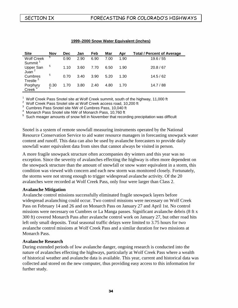
6(&7,21�,;��������������������������)25(&$67,1*�)25�&2/25$'2·6�+,*+:$<6
��
1999–2000 Snow Water Equivalent (inches)
Site Nov Dec Jan Feb Mar Apr Total / Percent of AverageWolf CreekSummit 1
5 0.90 2.90 6.90 7.00 1.90 19.6 / 55
Upper SanJuan 2
5 1.10 3.60 7.70 6.50 1.90 20.8 / 67
CumbresTrestle 3
5 0.70 3.40 3.90 5.20 1.30 14.5 / 62
PorphyryCreek 4
0.305
1.70 3.80 2.40 4.80 1.70 14.7 / 88
1 Wolf Creek Pass Snotel site at Wolf Creek summit, south of the highway, 11,000 ft2 Wolf Creek Pass Snotel site at Wolf Creek access road, 10,200 ft3 Cumbres Pass Snotel site NW of Cumbres Pass, 10,040 ft4 Monarch Pass Snotel site NW of Monarch Pass, 10,760 ft5 Such meager amounts of snow fell in November that recording precipitation was difficult
Snotel is a system of remote snowfall measuring instruments operated by the NationalResource Conservation Service to aid water resource managers in forecasting snowpack watercontent and runoff. This data can also be used by avalanche forecasters to provide dailysnowfall water equivalent data from sites that cannot always be visited in person.
A more fragile snowpack structure often accompanies dry winters and this year was noexception. Since the severity of avalanches effecting the highway is often more dependent onthe snowpack structure than the amount of snowfall or snow water equivalent in a storm, thiscondition was viewed with concern and each new storm was monitored closely. Fortunately,the storms were not strong enough to trigger widespread avalanche activity. Of the 20avalanches were recorded at Wolf Creek Pass, only four were larger than Class 2.
Avalanche MitigationAvalanche control missions successfully eliminated fragile snowpack layers beforewidespread avalanching could occur. Two control missions were necessary on Wolf CreekPass on February 14 and 26 and on Monarch Pass on January 27 and April 1st. No controlmissions were necessary on Cumbres or La Manga passes. Significant avalanche debris (8 ft x300 ft) covered Monarch Pass after avalanche control work on January 27, but other road hitsleft only small deposits. Total seasonal traffic delays were limited to 3.75 hours for twoavalanche control missions at Wolf Creek Pass and a similar duration for two missions atMonarch Pass.
Avalanche ResearchDuring extended periods of low avalanche danger, ongoing research is conducted into thenature of avalanches effecting the highways, particularly at Wolf Creek Pass where a wealthof historical weather and avalanche data is available. This year, current and historical data wascollected and stored on the new computer, thus providing easy access to this information forfurther study.

6(&7,21�,;��������������������������)25(&$67,1*�)25�&2/25$'2·6�+,*+:$<6
��
A related project is to identify snow stability trends that lead to avalanche activity effectingWolf Creek Pass. The most recent examination into historical weather and avalanche datashows that most late season storms, generally after mid-March, have had little or no effect onthe pass. This was born out this season (and the previous two seasons) when the winter’sbiggest storm came in late March. While there was significant new snow, there was no threatthe highway and avalanche control work was unnecessary. Other trends have been observedand documented and will be presented at the International Snow Science Workshop this Fall.
Snowpack conditions in the avalanche track are an important contributory factor for snow toreach the highway. Future research will concentrate on how to quantify these features for evenmore accurate avalanche forecasting.
Avalanche EducationSix avalanche awareness courses were given this winter, including ongoing training forCDOT personnel and two classes for the general public. See Table 4 for details.
&'27�(LVHQKRZHU�7XQQHO�)RUHFDVW�2IILFHThis was the seventh season of operation for this office which is housed in the CDOTengineers building (Road Control) at the west portal of the Eisenhower Tunnel. Leadforecaster Lee Metzger and coworker Stu Schaefer staffed the office.
The forecast area, CDOT Region 1, includes US 40, Berthoud Pass; US 6, Loveland Pass andInterstate 70 from Georgetown to Vail. Cameron and Independence passes are monitoredwhen required. Snowfall and weather data are gathered daily from snow study plots located atRoad Control, Berthoud Pass, Loveland Pass, Vail Pass and the highway shop near ArapahoeBasin. Forecasters are on duty from November 1 through April 30 but continue into May ifsnow conditions warrant.
SynopsisAs with other forecast regions, the season started very slow. Snowfall in November was thelowest ever recorded by this office and snow did not start to accumulate until mid-December.By the end of February, study plots were very close to average. But the weeks to followbrought a rapid decrease in snowpack depth. Season totals from Vail, Berthoud and RoadControl were 20–30 percent below normal at the end of April.
WeatherSnowfall is monitored from six study plots located throughout the forecast area. Five of thesesites have been collecting data since the office opened in 1993, building a database for futurereference. Snowfall amounts were significantly below average this winter. Vail Pass was 75percent of normal; Berthoud Pass, 82 percent and Road Control only 70 percent of normal.
Winds and temperatures are monitored from two weather stations located on Loveland andBerthoud passes. Temperature is also recorded at the Road Control study plot. Overall,temperatures were warmer this year. Strong winds this winter contributed greatly to theavalanche activity as snow drifted into avalanche starting zones.
6(&7,21�,;��������������������������)25(&$67,1*�)25�&2/25$'2·6�+,*+:$<6
��
Monthly Snowfall (inches)
Location Nov Dec Jan Feb Mar Apr TotalBerthoud Pass 14 37 63 65 44 29 252Loveland Pass, Tunnel Curve 10 34 59 45 41 21 210Road Control (Ike Tunnel) 5 26 48 43 33 25 180Vail Pass, summit 10 24 49 42 21 17 163Vail Pass, Narrows 13 24 56 39 17 4 153Arapahoe Basin 7 26 41 43 27 27 171
Monthly Snowfall for Primary Sites
0
10
20
30
40
50
60
70
Nov Dec Jan Feb Mar Apr
Month
Berthoud Pass
Loveland Pass, Tunnel Curve
Vail Pass, Summit
Snow and AvalancheDue to the very light snowfall early season, temperature gradients dominated the snowpack inall slide paths holding snow. Significant avalanche activity was expected as soon as a slabdeveloped on top of the ensuing depth hoar. This occurred in mid-January and avalanchecontrol work released slides that ran full depth to the ground, thus eliminating most of theunderlying weakness. Interestingly, many paths that traditionally run were able to endure thisslab and never failed at all. From then on, average and consistent snowfall created a fairlystrong snowpack and there was only minimal avalanche activity the rest of the season.
The Seven Sisters avalanche paths on Loveland Pass were a perpetual problem. They canproduce natural slides to the road with very little new snow and wind, which happened on a

6(&7,21�,;��������������������������)25(&$67,1*�)25�&2/25$'2·6�+,*+:$<6
��
few occasions this year. The vast majority of control work and road closures are due to theseseven slide paths. By March and April most avalanche paths had a moderate-to-strongsnowpack. With no major storms, the end of the winter came and went with little furtheractivity.
Avalanches Reaching the Road (size 2 or larger) and Length of Centerline Covered
Highway Natural Triggered Depths and total length of debrisat centerline (ft)
I-70/Georgetown to Vail 1 3 3 x 195US-6/Loveland Pass 8 37 3 x 1,340US-40/Berthoud Pass 0 7 3.5 x 10⁸Loop Rd (Ike Tunnel) 0 1 5 x 20
Office OperationsSignificant equipment upgrades were made this season. First, new phone lines enabled theforecasters to have a dedicated line to access remote weather stations. Second, an upgradedcomputer system was installed this spring. This combination will enable the forecasters tohave both e-mail and Internet capabilities next season.
Backcountry ObservationsMost backcountry avalanche observations were recorded in January and February whenenough weight from new snow finally collapsed the weak depth hoar near the ground. Thirtyslides were recorded in January and more than 20 in February. A small avalanche cycleoccurred in April when temperatures warmed rapidly, but most slides were shallow and small.
Avalanche IncidentsA skier-triggered slide in February reached the highway near the top of Loveland Pass but abeacon and probe search confirmed no one was in the slide. On April 2, after an insignificantsnowfall, Seven Sisters No. 4 and No. 6 released naturally. Five vehicles were trappedbetween the debris until a path could be cleared to evacuate them. No vehicles were hit by theavalanches. The forecast region had two backcountry avalanche fatalities in January, one eachon Berthoud and Loveland passes.
Avalanche EducationAvalanche training was done throughout the winter and more than 150 people were contacted.Many informal shop discussions were held about current avalanche conditions and avalanchebeacon operation. CDOT personnel were issued new Tracker DTS beacons this winter whichstimulated a great deal of interest in avalanche rescue practice.

6(&7,21�,;��������������������������)25(&$67,1*�)25�&2/25$'2·6�+,*+:$<6
��
&'27�:HVWHUQ�6ORSH�)RUHFDVW�2IILFHThe Western Slope Avalanche Forecast Office, based in Carbondale, provides avalancheforecasting services to Region III, Maintenance Section 2, for four highways in the centralColorado mountains. This office is also responsible for the opening of Independence Pass inthe Spring. Colorado 133 over McClure Pass near Marble is the primary area of responsibilitywith additional forecasting for Colorado 139, Douglas Pass; Colorado 65, Grand Mesa, andU.S. Highway 24 at Battle Mountain. Forecaster Rob Hunker issued 48 regular seasonAvalanche Hazard Advisories to CDOT from November 22 to April 11. Communicationbetween this office and CDOT was enhanced by the use of e-mail for the dissemination ofAdvisories and other correspondence. Also, CDOT standardized its avalanche beaconinventory by purchasing new Tracker DTS beacons for every patrol in the region. The simpleoperation of the “Tracker” boosted morale and confidence for all CDOT personnel. Thisoffice also commented through newspaper interviews on three occasions in regard to twobackcountry avalanche fatalities in the Aspen area.
WeatherDrought conditions were the fear and the reality from October through December. OnDecember 31 precipitation was 16 percent of average and the snowpack was only 32 percentof average. During the 10-day storm event of January, air temperatures were warmer thanaverage which produced periods of rain below 9000 ft. February and March snows wereregular but lacked a major storm event. In fact, no storm this winter was considered majorenough to create a significant avalanche danger to the highways. As the season progressed, theaverage McClure Pass snowpack depth and water content increased to 87 percent on March31. Wind speeds were generally average but the fastest velocity ever recorded from this site,46 mph, came on March 5. This year will be remembered as mild with just enough snow tocreate dangerous avalanche conditions. The following table shows monthly snowfall totals onMcClure Pass.

6(&7,21�,;��������������������������)25(&$67,1*�)25�&2/25$'2·6�+,*+:$<6
��
McClure Pass Monthly Snowfall
2
27.5
55
65
48.5
13
0
10
20
30
40
50
60
70
November December January February March April
Month
Snowpack and Avalanche SummaryThe sparse, early season snow cover was soon transformed into the classic, cohesionlessColorado depth hoar, forming a weak basil layer near the ground. This faceted grain growthcontinued through the early part of January before being destroyed by rain at elevations below8,500 ft. But above 9,000 ft., with heavier snows in January and February, a tender strengthversus stress relationship developed at the interface of the basal depth hoar layer and the slababove. This was complicated further with an ice crust and surface hoar shear planes in mid-pack.
In February faceted grain growth in the basal layer slowed and bridging developed in theoverriding slab. The danger persisted as a major storm event could surely collapse the slab.However, this heavy precipitation storm event did not occur. The regional snowpack gainedconsiderable strength during the first week of March and continued to do so through the restof the month.
There were only three road closures in Region 3 during the season, two on Grand Mesa(February 16 and March 23) for avalanche control work, and one on McClure Pass onFebruary 22. The latter, however, was due to a massive rockslide. A small wet looseavalanche cycle occurred on Battle Mountain on March 27 but the debris did not reach thehighway. This was another unusual winter for Grand Mesa because it is normally closed fromfive to nine times for avalanche control work. In fact, this was an unusual winter for all theavalanche areas on McClure, Douglas and Battle Mountain passes because no avalanchesreached these roads. Not even a significant wet avalanche cycle occurred this year. With dryconditions in early April, the snowpack began to melt out and the avalanche season ended bymid-April. An uneventful summary of road closures and avalanches reaching the highways isshown below.

6(&7,21�,;��������������������������)25(&$67,1*�)25�&2/25$'2·6�+,*+:$<6
��
Road Closures and Number of Avalanches Reaching the Road
Highway Natural Triggered Road Closures
CO 133/McClure Pass 0 0 1*
CO 65/Grand Mesa 0 7 2
CO 139/Douglas Pass 0 0 0
US 24/Battle Mountain 0 0 0
* rock slide

6(&7,21�;���������������������������������������������������������6(9(5$1&(�7$;�352-(&76
��
6HYHUDQFH�7D[�3URMHFWVWe used severance tax to fund several projects that will help us make better forecasts andexpand our outreach. Some had immediate results in the form of a product, while others wereprojects lasting more than a year and will produce deliverable results in the near future. Hereare brief descriptions of the projects.
Loveland Pass Safety BrochureIn December the CAIC produced and printed 1,000 copies of a new pamphlet entitledLoveland Pass Avalanche Areas. This pamphlet has photos and descriptions of the avalancheareas that are often skied and snowboarded on Loveland Pass, and it is our hope that thepamphlet will promote safety among the area’s frequent users. A second printing of 500copies was made when the original supply was quickly exhausted. Project leader, Nick Logan.
Weather and Avalanche DatabaseBeginning in 1983, the CAIC had recorded much of its incoming daily data in handwrittenlogs. For years we had wanted to transcribe the data but did not have the funds for the project.Finally severance tax funding gave us the opportunity to convert these 17 years of data to anAccess database. A data-entry operator converted 13 years of data this year, and the job willbe finished next fiscal year. These historical data will be available for retrieval by theforecasters, for research projects, and for developing nearest-neighbors models. Project leader,Nick Logan.
GIS Highway MapFor several years in the 1990s Dale Atkins developed a Highway Avalanche Atlas thatincluded every avalanche path in Colorado that could affect a state or federal highway. Nowwe are converting the atlas into a GIS product. This will eventually be available on CD-ROMand will have photos, maps, and physical and historical data attributes for these slide paths. Itwill be a valuable tool for CAIC forecasters, CDOT maintenance and engineering personnel,and land-use planners. About half the job was done this year, and it will be completed nextyear. Project leader, Dale Atkins.
Web Site UpgradeSeveral years ago Dale Atkins developed the CAIC web site on a shoestring. It was animmediate asset for us, for it made thousands of people aware of the services and productsthat we provided. Severance tax funds gave us the opportunity to give our site a cosmeticfacelift and more substance in the form of additional pages and content. Dale got the revisedweb site online in November with a more user-friendly format, more accident data, andinformation on products and publications. Project leader, Dale Atkins.
Web Site Clickable MapDale has been working on a clickable map that will show the 10 avalanche zones of theColorado mountains. The idea is for a user to click on a zone, town, or mountain range and getcurrent snow, weather, and avalanche data , and danger ratings. We want to display avalanchedanger in a graphic that shows the danger by elevation and aspect (compass bearing).

6(&7,21�;���������������������������������������������������������6(9(5$1&(�7$;�352-(&76
��
However, we ran into problems that delayed this project, but we expect it to be operationalnext year. Project leader, Dale Atkins.
Avalanche Forecast Model (Nearest-Neighbor Model)Nearest-neighbor avalanche forecast models have been used in Europe for 20 years (and atJackson Hole, Wyoming). With inputs of current snowfall, wind, temperature, snow depth(and other field data), the model searches an historical data base to find the 10 days in the dataset that nearest match the input data. The model then displays the avalanche activity thatoccurred on those 10 days, which gives the forecaster a heads-up on what could happen.
For 15 years we have talked of developing a nearest-neighbor model for specific sites inColorado, and now severance tax is making it happen. We have entered into a contract withthe Department of Geophysics at the Colorado School of Mines to test several models usingseveral data sets. We expect to have a test model for Red Mountain Pass, and perhapsBerthoud Pass, by December 2000. Project leader, Dale Atkins.
Back-country Observers NetworkFor many years the Utah Avalanche Forecast Center has relied on a small group of well-trained back-country skiers to gather snow and avalanche data, on a pay-per-observation basis.We have wanted to do the same in Colorado but never could afford to. Now we can. Last yearScott Toepfer found eight observers for key back-country areas, got them under contract, andhad them gather and send data to the CAIC forecast office in Boulder. Next year we will givefurther training to refine the observations in this continuing program. The data add detail andaccuracy to our daily hotline messages. Project leader, Scott Toepfer.
Avalanche EducatorWe hired Halsted Morris to teach 10–12 avalanche courses, which helped us meet the demandfor avalanche education by the public and took some of the burden off the forecast staff.Halsted did an excellent job, and next year will help coordinate our training calendar inaddition to teaching a full slate of classes.