Embed Size (px)
Citation preview
NEWSLETTER
Volume 28, 2008
Canadian Archaeological Association
Association Canadienne d’Archéologie
Bluff Mountain Rockshelter, Vision Quest and Pictograph
In this issue…. President’s Message Fieldwork News: Yukon British Columbia
Nunavut Alberta Newfoundland and Labrador
News & Announcements Books Available for Review Editor:
Colin Varley
Jacques Whitford Limited
2781 Lancaster Road, Suite 200
Ottawa, Ontario
K1B 1A7
(613) 738-6087
fax: (613) 738-0721
ISSN 1711-876X
Published by the Canadian
Archaeological Association ©
2008
Canadian Archaeological Association
Association Canadienne d’Archéologie CAA ACA
Executive/Conseil d’administration, 2008-2009
President/Président Royal Alberta Museum, 12845 - 102 Avenue, Edmonton, AB, T5N 0M6 Jack Brink tel: 780-453-9151 email: [email protected]
Vice President/ Archaeological Survey of Alberta, Edmonton, AB 3333 University Way, Vice président Prince George, British Columbia V2N 4Z9 tel: 250-960-6691; fax: 250-960-5545 Eric Dankjar email: [email protected]
Secretary-Treasurer/ 4 Salter Place, Whitehorse, Yukon Y1A 5R2 tel: 867-668-7131; fax: 867-667-8023 Secrétaire-trésorier email: [email protected] Jeff Hunston
Past-President/ Royal Saskatchewan Museum, 2445 Albert Street, Regina, Saskatchewan S4P 3V7 Président-sortant tel: 306-787-2815; fax: 306-787-2820 email: [email protected] Margaret G. Hanna
CAA Appointments/Responsables de comitée de l’ACA
Canadian Journal of Archaeology, Editor/Rédacteur du Journal canadien d’archéologie Gerry Oetelaar Department of Archaeology, University of Calgary, 2500University Drive NW Calgary, AB T2N 1N4 tel: 403-220-7629 Email: [email protected]
Canadian Archaeological Association Bulletin, Editor/Rédacteur du bulletin de l’Association Canadienne d’archéologie Colin Varley Jacques Whitford Limited. 2781 Lancaster Road, Suite 200 Ottawa, Ontario K1B 1A7 tel: 613-738-6087; fax: 613-738-0721 email: [email protected]
World Wide Web Editor/Editeur du site internet Jean-Luc Pilon 50 Oak, Aylmer, Quebec J9H 3Z3 tel: 819-776-8192 fax: 819-776-8300 Email: [email protected]
Aboriginal Heritage Committee/Patrimoine autochtone: Eldon Yellowhorn Department of Archaeology, Simon Fraser University, Burnaby, British Columbia V5A 1S6 Chair/président tel: 604-268-6669; fax 604-291-5666 email: [email protected]
Heritage and Legislation Policy Committee/Politique sur le patrimoine et la législation Greg Monks Department of Anthropology, University of Manitoba, Winnipeg, Manitoba R3T 5V5 Chair/président tel: 204-474-6327 email: [email protected]
Public Communications Awards Committee/Prix en communication publique David Denton Cree Regional Authority, 174 Boul. Dennison, Val D’or, Québec J9P 2K5 Chair/président tel: 819-825-9603; fax: 819-825-6892 email: [email protected]
Cultural Resource Management Committee/Comié de gestion des resources patrimoniales Currently inactive
Weetaluktuk Award Committee/Comité du Prix Weetaluktuk Caroline Phillips Project Archaeologist, Ontario Service Centre, Parks Canada, 111 Water Street East, Chair/président Cornwall, Ontario K6H 6S3 tel: 613-938-5905; fax: 613-938-6363 email: [email protected]
Book Editor/Éditeur des comptes rendus de lecture Alan McMillan Department of Archaeology, Simon Fraser University, Burnaby, British Columbia V5A 1S2 Chair/président tel: 604-527-5300; fax: 604-527-5095 email: [email protected]

Dear Colleagues and Friends, I hope that you all have had a productive summer, and are now settling into the autumn months. I am pleased to write to you as President of the CAA. I am truly honoured to hold this position, and during my tenure I will do my best to serve you and the Associa-tion. I look forward to continuing to communicate with you on topics of mutual interest. I want to take a few moments to tell you about some activities that I and other members of the Executive have been involved with in the months since our annual meeting in Peterborough. Perhaps most importantly, immediately after taking over from Dr. Marga-ret Hanna as President I needed to marshal the collective efforts of the Executive in put-ting together our application for funding from SSHRC for the continued support of our journal. Every three years SSHRC accepts applications for support of scholarly journals. This funding is critical to assist us with the high (and escalating) costs of printing hard
copies of the journal, and the deadline for submission was June 30, 2008. So this became the prime focus of our work, and the team of Gerry Oetelaar (Editor), Jeff Hunston (Secretary/Treasurer), George Nicholas (past-Editor), Margaret Hanna (past-President), and Eric Damkjar (Vice-President) put together what I believe is a very strong argument for continued funding. Among the highlights of our SSHRC application was an argu-ment for continued funds to print a hard copy of the journal. Increasingly, SSHRC is showing signs of favour-ing dissemination of scholarly materials by electronic means. While we feel that the CAA has moved in that direction—for example, having every single issue of our journal, even the most current, available in the mem-bers-only section of our website—we continue to argue that the great majority of our members still wish to receive a printed copy of the journal. However, in concert with this argument, our SSHRC application made a case for the need for a new electronic outlet for major archaeological monographs and reports—documents that might not find their way into con-ventional printed media. This includes site reports, theses and dissertations, analytical studies, policy reports, important CRM documents, and so forth. We proposed to SSHRC that the CAA would launch a new initiative with Athabasca University Press, a world leader in on-line, open-access educational publishing, whereby AUP would host a website of CAA Technical Reports (exact name to be decided later). The fully electronic publica-tion will employ the Open Journal System (OJS), a part of the Public Knowledge Project with which AUP is affiliated (see http://pkp.sfu.ca/?q=ojs). In a nutshell, monograph-length manuscripts will be submitted in pub-lication-ready format, vetted (AUP will only provide its imprint to peer reviewed papers) and then placed on-line on a website available to everyone free of charge. If this initiative is approved we will be looking for an Associate Editor to take on the duties of getting manuscripts to the on-line publisher. So if you are interested please let me know. Another activity that we have been busy with is coordinating the annual conferences for 2009 and 2010. The former will be in Thunder Bay on May 13 to 16, 2009, the latter in Calgary from April 28 to May 2, 2010. Volunteers at both venues have been busy booking hotels and planning activities that will guarantee all atten-dees interesting and rewarding conferences. Halifax has agreed to host the 2011 CAA conference, although no dates have yet been set. As President, I have also been reviewing the situation regarding the construction of the new Canadian Museum of Human Rights in Winnipeg. The project has generated considerable attention because the museum is being
A Message from the President
Vol. 28 2008 Page 3
built on top of a large, old, deep and complex ar-chaeological site. The “Forks Site,” near the conflu-ence of the Red and Assiniboine Rivers, is home to an array of pre and post-contact archaeological re-mains. To minimize damage, the new museum is to be constructed on hundreds of pilings. But distur-bance to the site will occur, and a mitigation pro-gram is currently underway. In addition, a concrete cap will cover part of the site area making it un-available for future research for many years to come. A number of CAA members have asked our organization to intercede, and I have spend consid-erable time gathering facts from principal individu-als in provincial and national governments and in the consulting field. A number of challenging issues have been raised including: (1) is capping an ar-chaeological site an acceptable form of avoidance, ensuring that the site will available for study hun-dreds of years from now, or is the loss of research access an unacceptable price to pay; and (2) if pro-vincial authorities charged with administering heri-tage legislation are satisfied with the level of site impact and required mitigation, is there a role for a national archaeological organization to voice its concern? As I continue to wrestle with these issues I welcome your comments and opinions. Finally, we have several openings for new volun-teers in the CAA. Dr. Jean-Luc Pilon, who has served the association with dedication for 14 years as our website editor, would, understandably, appre-ciate a rest. Accordingly, we are looking for some-one to take over the duties of CAA web Editor. In addition, Dr. Alan McMillan has served as Book Review Editor for a number of years and would like to step down. Please contact me if you are interested in helping with either of these two positions, and please remember that the Association can only func-tion if individuals step up and volunteer their time and service. I hope that this website will gain in importance in the coming years, that it will become a forum for debate and discussion. I hope that you all access it regularly. Please contact me with suggestions for
how it can be improved, and with your comments and suggestions on any matters that are of regional or national archaeological concern. Jack Brink President, CAA
CAA/ACA Newsletter
Vol. 28 2008 Page 4

Vol. 28 2008 Page 5
CAA/ACA Newsletter
Yukon Fieldwork NewsYukon Fieldwork NewsYukon Fieldwork NewsYukon Fieldwork News Editor: Ruth Gotthardt, Yukon Archaeologist
Berry Creek Moss Houses
Raymond J. Le Blanc, University of Alberta
In 1970, archaeologist W. N. Irving of the Univer-sity of Toronto recorded in his field notes that a trapper had found three winter houses on a wooded hillside of a small creek draining into the Porcupine River near Berry Creek, about 120 km upstream from Old Crow. The exact location of the brush fea-tures was not established until 1977 when a helicop-ter was used to search the likely location, which proved to be in dense bush, about 100 m in from the left bank of the Porcupine. A community-based archaeology project to investi-gate the site was initiated 2007 between University of Alberta archaeologists and the Vuntut Gwitchin First Nation Heritage Department, with funding support from the Government of Yukon, Historic Places Initiative. The work involved three young Gwitchin field workers, and visits by four elders accompanied by several Gwitchin youth. Once the features were relocated in July 2007, the
house structure was subjected to detailed work by removal of a dense moss cover to reveal an upper layer of steel axe-cut structural logs; almost no arti-facts were encountered during this operation. After mapping and photography, a portion of the northern
end of the feature was cleared of surface-visible logs, and the excavation was deep-ened. This produced a small amount of fau-nal material (caribou and fish) as well as a few artifacts, including a glass bead, some metal artifacts, a couple of stone objects and some red ochre fragments; a small cop-per trade pot was also found embedded in the surface vegetation just to the north of the feature. As work progressed, more bur-ied steel axe-cut logs were encountered, as well as the remains of some type of plat-form, possibly a bench, which was covered by almost 30 cm of clayey sediment. The artifacts suggest an early 20th century oc-cupation while the buried bench may indi-cate that the house had a moss, sod and earthen roof whose collapse buried the inte-
Excavating at the Berry Creek Moss Houses
Excavated Site Area
rior of the house. On-site discussions and interviews with the Gwitchin elders about the feature con-firmed the identity of the house as winter dwelling. Preliminary Archaeological Survey on the
Bonnet Plume River
Greg Hare, Yukon Archaeology Programme
In 2007, Yukon Government Cultural Services Branch undertook an overview heritage survey of the lower Bonnet Plume River, from Fair-child Lake to the Peel River, in northeast Yukon. The purpose of this survey was to con-duct a preliminary archaeological overview as-sessment of the lower river corridor, document built heritage resources along the route, and monitor the impact of seasonal river travellers on the Bonnet Plume. This overview survey was carried out by Sally Robinson and Barbara Hogan, of Yukon His-toric Sites and Greg Hare, of Yukon Heritage Resources Unit, with the assistance of wilder-ness river guide Blaine Walden, of Walden Outfitting and Guiding. As a result of this overview survey, two new ar-chaeological sites were documented, one previously recorded archaeological site was re-visited and sev-eral traditional or recent historic sites were re-corded. The new sites were located at the conflu-ence of Fairchild Creek and the Bonnet Plume River (LlTr-1) and at the south end of Margaret Lake (LiTt-1). A small hearth with lithic debitage and some faunal remains was radiocarbon dated to 2,370 +/- 40 BP. This overview will assist in developing a more de-tailed heritage survey strategy for the Bonnet Plume River, which has been designated a national heritage river under the Canadian Heritage Rivers System (CHRS).
Archaeological Investigations at the Site of
Trouble Hill, Central Yukon
Christian Thomas, Yukon Archaeology
Programme
The archaeological investigation at Trouble Hill (KdVd- 1) was a collaborative research project funded by Selkirk First Nation, Minto Explorations and the Government of Yukon. The field crew in-cluded Jessica Alfred and Curtis Joe of the Selkirk First Nation, Mary Jane Johnson of Parks Canada and Christian Thomas of the Yukon Government.
Trouble Hill is located on the bank of the Yukon River at the mouth of Minto Creek adjacent to the Minto Mine access road and is a traditional First Nation salmon fishing camp and the site of a trade feud between the Tutchone and the Chilkats. The project involved archaeological testing at KdVd-1 with the purpose of identifying remains of the fishing camp and locations of graves that may have been associated with the historic feud. The results of the project revealed that archaeological remains are present in two localities at Trouble Hill. The first locality investigated was the top of the Trouble Hill where several small scatters of stone tool chippings occurred that are consistent with the type of materi-als often associated with a lookout site. Excavations at the second locality resulted in the discovery of a multi- component camp site. The site contains evi-dence of no fewer than five different occupations spanning the last 4,000 years. Cultural remains that
CAA/ACA Newsletter
Vol. 28 2008 Page 6
Trouble Hill Site
were documented include several hearths, stone tools, salmon scales and caribou bone as well as the remains of several small fur bearing mammals. Archaeological Investigations at the Site the Tagish
Northwest Mounted Police Post
Victoria Castillo, Salix Heritage Consulting
The historic North West Mounted Police post known as Tagish post is identified as a Historic Site under the Carcross Tagish First Nation Final Agree-ment (Section 13.4.6.1)
Archaeological inventory and mapping was initiated in the 2007 field season to provide information on
historic resources at the site for future site planning and management. The project field crew included Victoria Castillo and Samantha Darling of Salix Heritage Consulting, Shannon Marks (Yukon Ar-chaeology Programme STEP student), and Vince Kemble and Erika Whelan of Carcross Tagish First Nation. 2007 fieldwork mapped a total of 29 struc-tural features and 22 middens at the site. Test exca-vations were completed in building outlines and re-sulted in a surprisingly small collection of artifacts, which may be a result of the brief occupation of the post (1898 to 1900) and/or the orderly maintenance of the site by the NWMP. Unusually high water lev-els prevented survey and mapping of suspected building features adjacent to the Tagish River; this is planned for the 2008 field season. Archaeological Excavations at Fort Selkirk I
Victoria Castillo, University of Alberta
Excavations at the site of the 1848 – 1851 Hudson’s Bay Company post of Old Fort Selkirk continued in the summer of 2007 as part of dissertation research by Victoria Castillo, Department of Anthropology, University of Alberta. Support for the project was provided by the Selkirk First Nation and the Yukon Archaeology Programme. The 2007 field crew of Dayna and Lyndelle Joe of Selkirk First Nation, as well as Shannon Marks and Peter Shnurr of the Yukon Archaeology Pro-gramme. The 2007 investigations focused on the further excavation of structural features that were identified during the previous year’s work, as well attempting to locate First Nation’s occupation areas and the fort’s palisade wall. The excavation phase of the project was directed at a large midden feature which contained an assortment of HBC artifacts and First Nation’s refuse and has resulted in the recov-ery of a large collection of butchered faunal re-mains, subsistence implements and discarded trade goods. The old fort’s palisade wall could not be lo-cated, but two wood posts and quantities of axe cut wood chips that may have been associated with the wall’s construction were identified.
CAA/ACA Newsletter
Vol. 28 2008 Page 7
HBC journals left by Robert Campbell suggest the that the palisade was disassembled and moved to second site of Fort Selkirk on the west bank of the Yukon River, just downstream of the Pelly River mouth. Archaeological Investigations at the Little John Site N.A. Easton, Yukon College and David Yesner, Uni-
versity of Alaska, Anchorage
Excavations of a Nenana Complex site continued in 2007, with the participation of the White River First Nation and the University of Alaska (Anchorage) Archaeology Field School. Radiocarbon dates on bison remains now suggest site occupation at about 12,000 B.P. Work at the site will continue in 2008.
Reconnaissance of Shipwrecks on the Yukon River John Pollack, Institute of Nautical Archaeology,
Texas A&M University
A second year of investigation of underwater wreck on the Yukon River was carried out by John Pol-lack, focussing on wreck in the Dawson area and on the wreck of the sternwheeler SS Klondike I in the Thirty Mile River. Investigations will continue in 2008.
CAA/ACA Newsletter
Vol. 28 2008 Page 8
Screening Soil at the Fort Selkirk 1 site

CAA/ACA Newsletter
Colin Grier (Department of Anthropology, Wash-
ington State University)
During May of 2007, Colin Grier of Washington State University spearheaded research investigations at DgRv-006 (the "Coon Bay site"), a previously recorded shell midden, burial and habitation site at Coon Bay on north Galiano Island. Funded by BC Parks, the project mapped and recorded archaeo-logical resources associated with the site. While sus-pected previously, intensive mapping, subsurface testing, and radiocarbon dating confirmed the pres-ence of a large (40 x 10 m) house platform behind the north facing beach. Radiocarbon dates indicate that the house deposits date to circa 800 BP. This adds significantly to our understanding of the post-Marpole period occupation in the immediate area. DgRv-003, the adjacent Marpole-age Dionisio Point site, was abandoned by roughly 1500 BP, and sub-sequent occupation of the area was thought to be limited primarily to seasonal gathering of sea urchin and other tidal pass resources. The existence of the 800 BP platform and house re-mains suggests a much more intensive occupation of the area during the Gulf of Georgia period. The investigations were assisted by Eric McLay (Coast Research), Simon Kaltenrieder (Pacific Heritage Research), Patrick Dolan (WSU) and Peko George of the Penelakut Tribe. Daryl Fedje (Parks Canada) & Quentin Mackie
(University of Victoria)
In 2007 we continued work on our collaborative Haida Gwaii Pleistocene-Holocene Transition pro-
ject. Field crew included the authors, Jenny Storey, Brendan Gray, Adrian Sanders. The focus of work was at two cave sites. This included a few days at the Gaadu Din 1 cave site excavating tests in a natu-ral trap. The trap is a small chamber immediately below the main chamber at Gaadu Din 1 where we had focused our efforts over the past few years. The ca. 1 metre square excavations produced a minimum of 7 brown bears with dates ranging from 12,000 to 11,000 14CBP. In 2007 we discovered a second cave with evidence of human activity. Gaadu Din 2 is a few hundred metres east of Gaadu Din 1 and at about 50 m higher elevation. Preliminary testing at the cave in-cluded three 50 cm square tests. Several artifacts were recovered, but little bone. A large spearpoint was associated with a charcoal date of 10,200 14CBP, a biface with a date of 10,300 BP and sev-eral biface resharpening flakes were recovered from immediately below charcoal dated to just over 11,000 BP. We will be returning to the Gwaii Haanas cave sites in 2008. The same crew plus Sean Brennan of the Haida Na-tion also worked on a reconnaissance and testing project on northeast Graham Island with a focus on Tow Hill and Argonaut Hill raised marine terraces. Reconnaissance was guided by a high resolution (1 m) bare earth terrain model derived from LIDAR remote sensing data. This was the field work com-ponent of Adrian Sanders MA thesis programme. Several inland mid-Holocene sites were discovered and tested.
Vol. 28 2008 Page 9
British Columbia British Columbia British Columbia British Columbia
Fieldwork NewsFieldwork NewsFieldwork NewsFieldwork News Editors: Trevor Orchard and Terence Clark
Quentin Mackie also noted that the new PhD pro-gram in Anthropology at UVic should be accepting students September of 2009. Also during the past year, Duncan McLaren completed his PhD, focused on early Holocene paleoenvironment and archae-ology in eastern Hecate Strait, while Darcy Mathewes continued his PhD field research on mor-tuary landscape of the greater Victoria area. Fi-nally, Quentin notes that UVic has hired archaeolo-gist Ann Stahl from SUNY-Binghamton as their new Chair of the Anthropology Department. Nicole Kilburn (Camosun College)
A short field project to find the immigrant worker settlements at Tod Inlet on the Saanich Peninsula was recently completed as the final, applied project for students in the Archaeology Field Assistant Pro-gram, a new program with a focus on CRM-based skills being offered at Camosun College in Victoria, BC. The historic occupancy of Tod Inlet has re-ceived no prior archaeological investigation, and the written record contains only scant details of life in this shanty village one hundred years ago. Chinese and Sikh men worked in the cement plant (also lo-cated in the inlet) and limestone quarries that would later become part of the world famous Butchart Gar-dens. Despite extensive blackberry bush ground cover, the survey successfully located several suspected “shanty” features, represented by minimal brick foundations and corrugated metal roofing materials, and three possible latrine holes. Two brick founda-tion structures matching historic descriptions of round Sikh cooking ovens were also found along with a huge midden and a widespread surface arti-fact scatter. Glass bottles were by far the most com-mon artifact type, but leather soled shoes, Asian brown glazed ceramic sherds and several blue enamel pots were also observed. Unfortunately the site has been a haven for bottle collectors over the past many decades, resulting in tremendous distur-bance. The looting is ongoing, despite the protec-tion offered by the Gowlland-Tod Provincial Park.
One outcome of the project will be a site-wide as-sessment of its condition to determine if future, more in-depth studies are merited. Students’ newly acquired compass and hipchain skills were put to the test through dense vegetation, which was a great test of their competency. The project has been a success on all fronts! Morgan Ritchie (Simon Fraser University)
This past summer, the Simon Fraser University (SFU) Field School conducted archaeological inves-tigations in Chehalis traditional territory on the Har-rison River in Southwestern B.C. During our time living and working on the Chehalis Reserve, we were very involved with the community. When we weren’t surveying or excavating, we were being toured around their traditional territory, participat-ing in ceremonies and being taught traditional crafts. In return, we had the opportunity to share about the discipline of archaeology and how it in-forms our understanding of their heritage. 2007 was the final year of the Fraser Valley Ar-chaeological Project that has explored the nature of identity and social interaction among ancient com-munities in the lower Fraser River watershed. The archaeological investigations on the Harrison River were directed by Dana Lepofsky and centered on the research projects of graduate students Chris Springer and Morgan Ritchie. These projects will provide a means to view the Fraser Valley work within a broader social context of regional interac-tion. Morgan Ritchie’s Master’s research is a survey of a four kilometer stretch of the Harrison River between Morris Creek and Wiloughby Point. This stretch of is river is the heartland of the Chehalis people and has ubiquitous settlements and use-areas along the shoreline and on mid-river islands. Following from the Fraser Valley Project efforts to trace shifting social identity using data from house structures, we attempted: 1) to determine the internal arrangement and composition of settlements on the Harrison
CAA/ACA Newsletter
Vol. 28 2008 Page 10
River and 2) to examine the relationship of each set-tlement to the physical and cultural landscape. Chris Springer’s Master’s research is an examina-tion of how cultural identity and household organi-zation are associated with the form and contents of a pithouse. In total, we excavated nearly 3/4ths of a pithouse that was destined to be eroded by the Che-halis River. The excavation revealed three main oc-cupations each showing distinctive house styles -highlighting the shifting nature of cultural expres-sion. Together, these projects reveal occupation, identity and interaction on multiple scales for the Harrison River and larger Fraser River region. The field school was a great success and an invaluable learn-ing experience for everyone involved. Acknowledgments: We would like to thank the Chehalis Indian Band for hosting our large group and being so involved in our research. We are par-ticularly grateful to Chief Willie Charlie, Gordon Mohs and James Leon who made this field school possible and took time from their busy schedules to share stories and knowledge with us. SFU staff Shannon Wood and Heather Robertson who helped organize the logistics also deserve recognition. Trevor Orchard (McMaster University)
In August of 2007, Trevor Orchard, along with Glo-ria Spirou, conducted fieldwork involving a combi-nation of site survey, the visitation and assessment of known sites, and the sampling of shell midden deposits through systematic auger sampling at a to-tal of 11 locations at six sites in eastern Gwaii Haanas National Park Reserve and Haida Heritage Site, Southern Haida Gwaii. Building on Orchard’s previously completed PhD research which exam-ined late Holocene and early contact period sites in the region, the 2007 fieldwork targeted locations at slightly higher elevations dating to the mid-Holocene.
Auger samples were collected from sites in Burnaby Narrows, western Juan Perez Sound, and on north-ern Lyell Island. Radiocarbon dates for two of these auger sampling locations indicate a basal occupation of roughly 2,000 BP, with two additional locations dating roughly 3,000 BP. Radiocarbon dates for two other locations point to occupations within the past 1,000 years, while other tested deposits have not yet been dated. Ongoing analyses of matrices collected through auger sampling are providing pre-liminary insight into patterns of faunal resource use spanning the past 3,000 years of human occupation in eastern Gwaii Haanas. Archer CRM partnership Summary of 2007 field
season
Archer CRM identified and recorded a total of 103 new archaeological sites in the interior of BC and 79 new archaeological sites in the North East area of BC during the 2007 field season. Significant ex-cavations or further investigation took place at five of these sites, FlRq-009, FlRq-013, HbRf-002 HbRf-083 and GaSd-010. Two further archaeological sites were revisited and numerous post 1846 CMT sites and traditional use sites were recorded. Archer CRM - Coastal Archaeology Summary 2007
Field Season
Paul Harrison, B.A., L.L.B.
Archer CRM Partnership
During the 2004, 2005, 2006 and 2007 field sea-sons, Archer CRM Partnership conducted numerous Archaeological Impact Assessments of a variety of proposed developments throughout the North Coast, including the Douglas Channel (Kitimat), Kitwanga, Nass Valley, Prince Rupert and Terrace areas. Work has also been conducted in the Dease Lake region. As a result of our work, a wide variety of archaeological site types have been identified. While the majority of sites recorded by Archer CRM Partnership between 2004 and 2007 consisted of tapered and rectangular bark stripped cedar trees, which are commonly recorded in the northwest coast culture area, several less common archaeo-
CAA/ACA Newsletter
Vol. 28 2008 Page 11
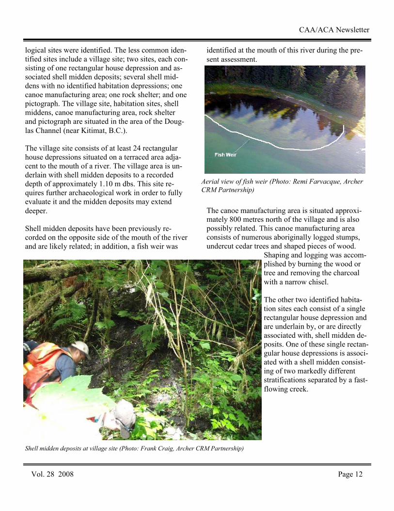
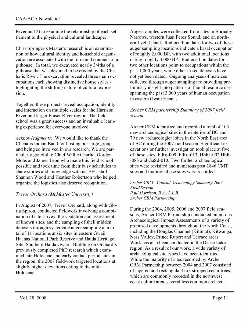
logical sites were identified. The less common iden-tified sites include a village site; two sites, each con-sisting of one rectangular house depression and as-sociated shell midden deposits; several shell mid-dens with no identified habitation depressions; one canoe manufacturing area; one rock shelter; and one pictograph. The village site, habitation sites, shell middens, canoe manufacturing area, rock shelter and pictograph are situated in the area of the Doug-las Channel (near Kitimat, B.C.). The village site consists of at least 24 rectangular house depressions situated on a terraced area adja-cent to the mouth of a river. The village area is un-derlain with shell midden deposits to a recorded depth of approximately 1.10 m dbs. This site re-quires further archaeological work in order to fully evaluate it and the midden deposits may extend deeper. Shell midden deposits have been previously re-corded on the opposite side of the mouth of the river and are likely related; in addition, a fish weir was
identified at the mouth of this river during the pre-sent assessment.
The canoe manufacturing area is situated approxi-mately 800 metres north of the village and is also possibly related. This canoe manufacturing area consists of numerous aboriginally logged stumps, undercut cedar trees and shaped pieces of wood.
Shaping and logging was accom-plished by burning the wood or tree and removing the charcoal with a narrow chisel. The other two identified habita-tion sites each consist of a single rectangular house depression and are underlain by, or are directly associated with, shell midden de-posits. One of these single rectan-gular house depressions is associ-ated with a shell midden consist-ing of two markedly different stratifications separated by a fast-flowing creek.
CAA/ACA Newsletter
Vol. 28 2008 Page 12
Shell midden deposits at village site (Photo: Frank Craig, Archer CRM Partnership)
Aerial view of fish weir (Photo: Remi Farvacque, Archer
CRM Partnership)
CAA/ACA Newsletter
Vol. 28 2008 Page 13
The oldest midden deposits at this site are loose and dry, extending to an estimated 3.00 metres dbs and are overlain with approximately 1.20 m dbs of stratified soils. The other identified shell midden deposits (with or without identified, associated habi-tation depressions) were generally identified to a maximum depth of approximately 1.50 metres dbs and typically begin at the surface or within 0.1 m dbs. The rock shelter is approximately 30 m x 20 m x 5 m and is relatively dry and well drained inside, suit-able for human habitation. It is visible from the ocean and would have attracted people in precontact times (Figure 4). No subsurface testing was con-ducted because the shelter is con-sidered to be a site and may be avoided by the proposed develop-ment; subsurface testing could de-stroy potentially intact and strati-fied remains. The pictograph consists of geo-metric patterns (circular and square) drawn in red ochre, on a uniquely smooth and curved rock face accessible only by boat . Archer CRM - Summary of Excava-
tion Aidan Burford, B.Sc., RPCA, Archer
CRM Partnership
As a result of an AIA five archaeological sites, FlRq-009, 010, 011, 012 and 013 were identified within the City of Prince George. Excavation was proposed for FlRq-009 and FlRq-013. It is most likely that all five sites were part of a much larger archaeological site of un-known proportions that has been heavily impacted by modern city development. FlRq-009
During the early summer of 2007, Archer CRM Partnership carried out excavations at FlRq-009. A
total of 28 m2 was excavated, this resulted in the recovery of 421 pieces of lithic debitage and in-cluded 29 expedient and formed tools. Artifact dis-tribution and suggest occupation was sporadic and ephemeral. The portion of the site investigated proved to be heavily disturbed and significant por-tions have been destroyed. FlRq-013
During the winter of 2006 and 2007, Archer CRM Partnership, in conjunction with Lheidli T’ enneh First Nation, conducted the largest excavation ever conducted in the Prince George area at FlRq-013. Excavation staff totaled 30 and total of 145 m2 of
the site was excavated and a total of 31,662 artifacts were recovered. This site is located within one of few areas of intact forest cover with the city limits of Prince George. Excavations were carried out in order to fulfill initial engi-neering planning require-ments for widening of the Simon Fraser Bridge. Initial subsurface testing and visual inspection recorded 68 cul-tural depressions, a sparse lithic scatter and a total site area of 10,970 m2. However, subsequent evaluation re-vealed that the site con-tained a deeply buried
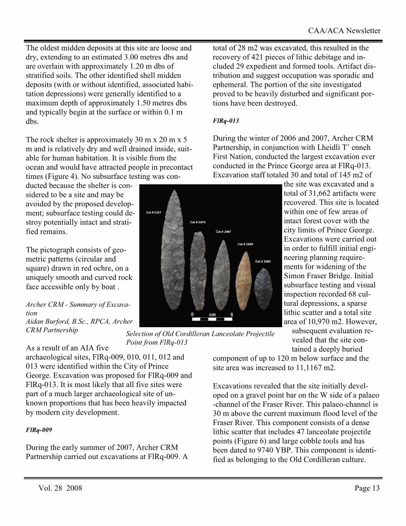
component of up to 120 m below surface and the site area was increased to 11,1167 m2. Excavations revealed that the site initially devel-oped on a gravel point bar on the W side of a palaeo-channel of the Fraser River. This palaeo-channel is 30 m above the current maximum flood level of the Fraser River. This component consists of a dense lithic scatter that includes 47 lanceolate projectile points (Figure 6) and large cobble tools and has been dated to 9740 YBP. This component is identi-fied as belonging to the Old Cordilleran culture.
Selection of Old Cordilleran Lanceolate Projectile
Point from FlRq-013
CAA/ACA Newsletter
Vol. 28 2008 Page 14
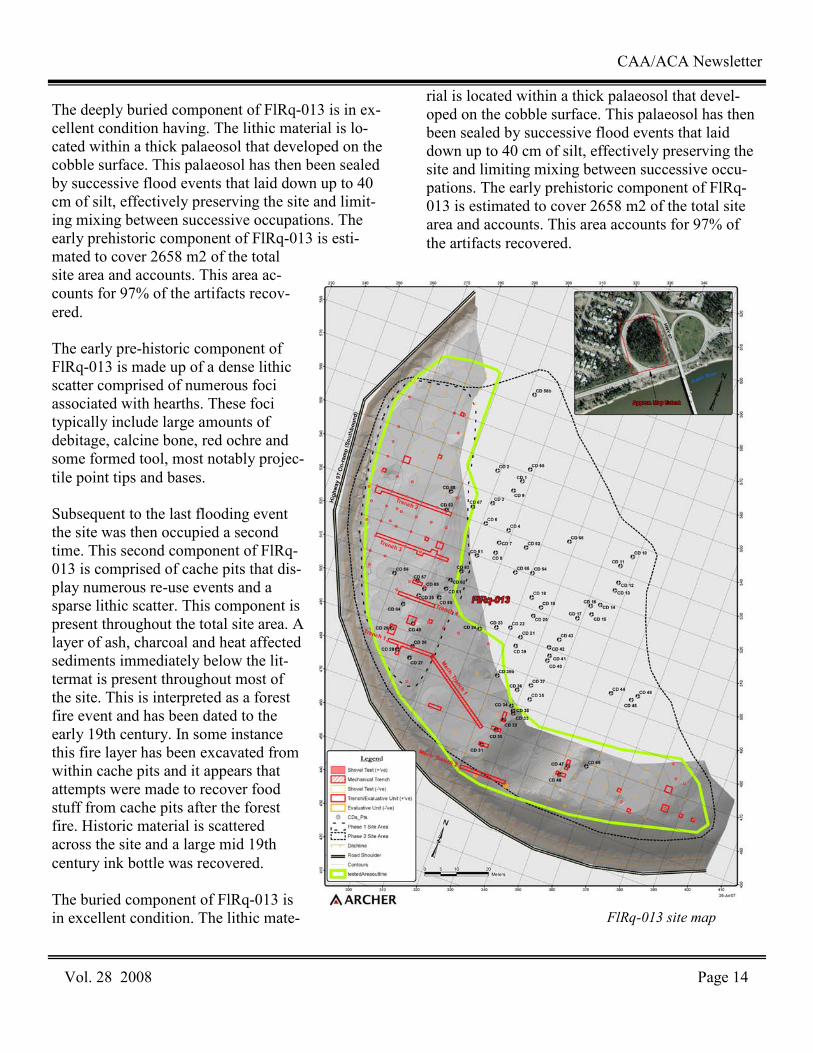
The deeply buried component of FlRq-013 is in ex-cellent condition having. The lithic material is lo-cated within a thick palaeosol that developed on the cobble surface. This palaeosol has then been sealed by successive flood events that laid down up to 40 cm of silt, effectively preserving the site and limit-ing mixing between successive occupations. The early prehistoric component of FlRq-013 is esti-mated to cover 2658 m2 of the total site area and accounts. This area ac-counts for 97% of the artifacts recov-ered. The early pre-historic component of FlRq-013 is made up of a dense lithic scatter comprised of numerous foci associated with hearths. These foci typically include large amounts of debitage, calcine bone, red ochre and some formed tool, most notably projec-tile point tips and bases. Subsequent to the last flooding event the site was then occupied a second time. This second component of FlRq-013 is comprised of cache pits that dis-play numerous re-use events and a sparse lithic scatter. This component is present throughout the total site area. A layer of ash, charcoal and heat affected sediments immediately below the lit-termat is present throughout most of the site. This is interpreted as a forest fire event and has been dated to the early 19th century. In some instance this fire layer has been excavated from within cache pits and it appears that attempts were made to recover food stuff from cache pits after the forest fire. Historic material is scattered across the site and a large mid 19th century ink bottle was recovered. The buried component of FlRq-013 is in excellent condition. The lithic mate-
rial is located within a thick palaeosol that devel-oped on the cobble surface. This palaeosol has then been sealed by successive flood events that laid down up to 40 cm of silt, effectively preserving the site and limiting mixing between successive occu-pations. The early prehistoric component of FlRq-013 is estimated to cover 2658 m2 of the total site area and accounts. This area accounts for 97% of the artifacts recovered.
FlRq-013 site map
CAA/ACA Newsletter
Vol. 28 2008 Page 15
The early pre-historic component of FlRq-013 is made up of a dense lithic scatter comprised of nu-merous foci associated with hearths. These foci typically include large amounts of debitage, calcine bone, red ochre and some formed tool, most nota-bly projectile point tips and bases. Subsequent to the last flooding event the site was then occupied a second time. This second compo-nent of FlRq-013 is comprised of cache pits that display numerous re-use events and a sparse lithic scatter. This component is present throughout the total site area. A layer of ash, charcoal and heat affected sediments immediately below the litter-mat is present throughout most of the site. This is interpreted as a forest fire event and has been dated to the early 19th century. In some instance this fire layer has been excavated from within cache pits and it appears that attempts were made to recover food stuff from cache pits after the for-est fire. Historic material is scattered across the site and a large mid 19th century ink bottle was recovered. HbRf-002 & HbRf-083
During the summer of 2007 Archer CRM partner-ship conducted and AIA along a section of High-way 97. As a result of this excavation a new ar-chaeological site, HbRf-083 was recorded and HbRf-002 was enlarged to 680 m x 300 m. During the late winter of 2008 a program of systematic data recovery was applied to both sites. Results of fur-ther work at HbRf-002 revealed that the site within the study area had largely been destroyed by recent agricultural and construction events. However, at HbRf-083 it was discovered that construction activi-ties had caused a thick dump of clay had sealed in-tact remain for length 1500 m. As a result of this work 712 lithic artifacts including 3 projectile points were recovered comparable to points from late components of Charlie Lake Cave, HbRf-039. Importantly, it was found that flood deposits from nearby Fish Creek have sealed culturally bearing sediments in portions of the site. Further investiga-tion is proposed to take place early in the summer of
2008 with cooperation from Blueberry River First Nation, Doig River First Nation, Halfway River First Nation, Saulteau First Nation and West Mo-berly First Nation.
GaSd-10
This previously recorded site is located at the E end of Fraser Lake close to the Fraser River. Numerous other archaeaological sites are recorded in the vicin-ity. The site is located within the Nadleh Village and the area has a long history of occupation. Pro-posed bridge construction prompted an archaeologi-cal investigation. Subsurface testing revealed that the area of excavation had been extensively dis-turbed by previous bridge construction. A total of three m2 units were placed within the impact foot-print and a total of 102 lithic artefacts were recov-ered including one projectile point.
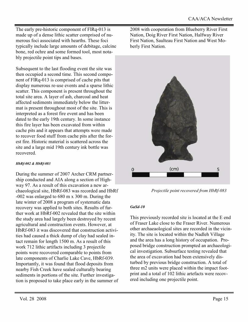
Projectile point recovered from HbRf-083
Sanirajak Archaeology Project
Karen Wittke, University of Toronto
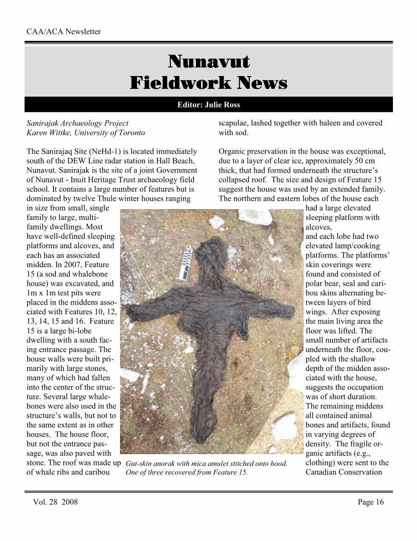
The Sanirajaq Site (NeHd-1) is located immediately south of the DEW Line radar station in Hall Beach, Nunavut. Sanirajak is the site of a joint Government of Nunavut - Inuit Heritage Trust archaeology field school. It contains a large number of features but is dominated by twelve Thule winter houses ranging in size from small, single family to large, multi-family dwellings. Most have well-defined sleeping platforms and alcoves, and each has an associated midden. In 2007, Feature 15 (a sod and whalebone house) was excavated, and 1m x 1m test pits were placed in the middens asso-ciated with Features 10, 12, 13, 14, 15 and 16. Feature 15 is a large bi-lobe dwelling with a south fac-ing entrance passage. The house walls were built pri-marily with large stones, many of which had fallen into the center of the struc-ture. Several large whale-bones were also used in the structure’s walls, but not to the same extent as in other houses. The house floor, but not the entrance pas-sage, was also paved with stone. The roof was made up of whale ribs and caribou
scapulae, lashed together with baleen and covered with sod. Organic preservation in the house was exceptional, due to a layer of clear ice, approximately 50 cm thick, that had formed underneath the structure’s collapsed roof. The size and design of Feature 15 suggest the house was used by an extended family. The northern and eastern lobes of the house each
had a large elevated sleeping platform with alcoves, and each lobe had two elevated lamp/cooking platforms. The platforms’ skin coverings were found and consisted of polar bear, seal and cari-bou skins alternating be-tween layers of bird wings. After exposing the main living area the floor was lifted. The small number of artifacts underneath the floor, cou-pled with the shallow depth of the midden asso-ciated with the house, suggests the occupation was of short duration. The remaining middens all contained animal bones and artifacts, found in varying degrees of density. The fragile or-ganic artifacts (e.g., clothing) were sent to the Canadian Conservation
CAA/ACA Newsletter
Vol. 28 2008 Page 16
Nunavut Nunavut Nunavut Nunavut
Fieldwork NewsFieldwork NewsFieldwork NewsFieldwork News Editor: Julie Ross
Gut-skin anorak with mica amulet stitched onto hood.
One of three recovered from Feature 15.

Institute in Ottawa, while the remaining artifacts and animal bones will be analyzed at the University of Toronto. Human remains were also discovered in the house. Following consultations with the community, the Government of Nunavut and the Inuit Heritage Trust, the excavations were allowed to continue and the human remains were reburied in the feature. Students were employed through the Inuit Heritage Trust’s Mentoring Program. The students received training in archaeological techniques (e.g., excavat-ing and recording archaeological data), mapping and surveying using a theodolite, and field conser-vation of artifacts and animal bones. Community members visited NeHd-1 often during the excava-tions, and a large group of elders and their families visited the site for an afternoon. All local students (Grades 6 to 12) also visited NeHd-1 to see the house fully excavated, and a community evening was held in the local school where a selection of the artifacts were put on display. Mingo Lake Archaeology Project Dr. S. Brooke Milne,
University of Manitoba
In July 2007, a team from the University of Manitoba, McMaster University, and the Hamlet of Igloolik con-ducted archaeological excavation and recon-naissance along the northwest shore of Mingo Lake in the inte-rior of south-central Baf-fin Island. Three weeks were spent excavating two Palaeo-Eskimo tent ring features at the LdFa-1 site while another week was spent surveying and testing additional sites
within the immediate area. LdFa-1 is a large, multi-component Palaeo-Eskimo site containing occupa-tions dating to the Pre-Dorset and Dorset periods. There are at least 27 well defined tent ring features at the site, and the recovered material as-semblages include abundant stone tools and debi-tage, preserved organic artifacts including fine bone needles, and ample faunal remains most of which are caribou. The objectives of the 2007 work were to excavate two tent ring structures at LdFa-1 to assess the spa-tial distribution of artifact and faunal remains within them, their respective season of occupation, and their cultural affiliation. All diagnostic artifacts re-covered indicate a Pre-Dorset cultural affiliation. Numerous burins, burin spalls, microblades, and finely made endblades were found along with a sur-prising amount of debitage. Preliminary assessment of the distribution of these artifacts suggests that tool-production activities were concentrated outside the dwellings. Two small hearths containing frag-ments of burnt bone and debitage were also found in close proximity to these tool-making activity areas.
CAA/ACA Newsletter
Vol. 28 2008 Page 17
Excavations at House 4, LdFa-1, Mingo Lake Project
This evidence together is suggestive of a summer occupation where warm weather would facilitate people “taking” their activities outside. Diagnostic Dorset stone tools found include a neph-rite burin-like tool (BLT), tiny crystal-quartz end-scrapers, and notched asymmetrical knives. Addi-tional survey conducted along the Mingo Lake shoreline resulted in the identification of another seven sites, four of which are confirmed to be Pa-laeo-Eskimo. Test pits at these sites yielded abun-dant stone artifacts including burins, burin spalls, side and endscrapers, and various types of projectile points. The faunal material recovered from the tests consists entirely of caribou. Maguse Lake Archaeology Project
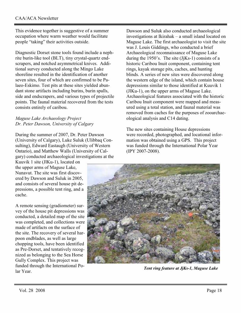
Dr. Peter Dawson, University of Calgary
During the summer of 2007, Dr. Peter Dawson (University of Calgary), Luke Suluk (Ulibbaq Con-sulting), Edward Eastaugh (University of Western Ontario), and Matthew Walls (University of Cal-gary) conducted archaeological investigations at the Kuuvik 1 site (JlKu-1), located on the upper arms of Maguse Lake, Nunavut. The site was first discov-ered by Dawson and Suluk in 2005, and consists of several house pit de-pressions, a possible tent ring, and a cache. A remote sensing (gradiometer) sur-vey of the house pit depressions was conducted, a detailed map of the site was completed, and collections were made of artifacts on the surface of the site. The recovery of several har-poon endblades, as well as large chopping tools, have been identified as Pre-Dorset, and tentatively recog-nized as belonging to the Sea Horse Gully Complex. This project was funded through the International Po-lar Year.
Dawson and Suluk also conducted archaeological investigations at Ikirahak – a small island located on Maguse Lake. The first archaeologist to visit the site was J. Louis Giddings, who conducted a brief Archaeological reconnaissance of Maguse Lake during the 1950’s. The site (JjKs-1) consists of a historic Caribou Inuit component, containing tent rings, kayak storage pits, caches, and hunting blinds. A series of new sites were discovered along the western edge of the island, which contain house depressions similar to those identified at Kuuvik 1 (JlKu-1), on the upper arms of Maguse Lake. Archaeological features associated with the historic Caribou Inuit component were mapped and meas-ured using a total station, and faunal material was removed from caches for the purposes of zooarchae-ological analysis and C14 dating. The new sites containing House depressions were recorded, photographed, and locational infor-mation was obtained using a GPS. This project was funded through the International Polar Year (IPY 2007-2008).
CAA/ACA Newsletter
Vol. 28 2008 Page 18
Tent ring feature at JjKs-1, Maguse Lake
Archaeological Inventory: Little Whale River
Christian Roy, Cree Regional Authority
The 2007 Little Whale River/Richmond Gulf Ar-chaeology Project was carried out in July and Au-gust with the assistance of a team of four Cree and Inuit technicians hired from the local communities of Kuujjuarapik/Whapmagoostui and Umiujaq. The objective of the 2007 archaeological surveying at the mouth of the Little Whale River was to locate the various es-tablishments erected by the HBC, first on the north shore of the river during the second half of the 18th cen-tury (1750-1759 and 1793), and on the south shore where the latest trading post was operated between 1851 and 1891. On the north shore of the river, 69 test-pits of 50 x 50 cm were excavated on a gently rising terrace to the west of a small stream flowing into Little Whale River. Thirty-eight additional test pits were excavated near three rectangular depres-sions. The test units yielded evidence of wooden posts and a range of artifacts, such as forged nails and other metal implements, clay pipes fragments and some green colored glass wine bottle shards. Numerous ceramic fragments were also unearthed, including a creamware bowl and a small plate, and a red coarse earthenware cooking pot. These materials suggest a Euro-Canadian occupation dating to the last quarter of the 18th century and correspond to the HBC’s 1793 ill-fated attempt to re-establish it-self in the area, when six of its employees were killed.
The 19th century establishment was located using a map drawn by Alexander McDonald in the 1850’s. It was situated on the south shore of the river be-tween a small creek to the west and a high terrace rising behind the site to the east. No sub-surface testing was done; however, various features includ-ing depressions (cellars) and mounds were identi-fied, and numerous artifacts (e.g., barrel straps,
chain, cut nails, bricks, glass and ceramic shards, etc.) were noted on the beach below the establish-ment. The presence of nine large iron tanks used for boil-ing whale blubber left confirmed the identity of the site as the location of the trading post and, more specifically, its oil house built in the western portion of the site. Whale hunting was a very important economic activity at Little Whale River House be-tween 1854 and 1870.
CAA/ACA Newsletter
Vol. 28 2008 Page 19
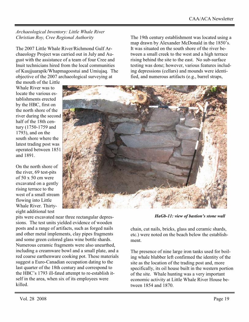
HaGb-11: view of bastion’s stone wall

Archaeological Evaluation of Richmond Fort
(HaGb-11), Cairn Island
Christian Roy, Cree Regional Authority
As part of the joint Cree-Inuit archaeological project in the proposed Richmond Gulf – Clearwater Lake Park area, the goal of the 2007 archaeological inves-tigations on Cairn Island was to evaluate the site of Richmond Fort (HaGb-11), the first HBC establish-ment erected in the area in 1750. Located during the 2006 field season, on the same site as the 20th cen-tury HBC and Revillon Frères trading posts, Rich-mond Fort is located on the south shore of Cairn Island, directly to the east of a small cove leading to the narrows. This establishment was operated from 1750 to 1758 when it was removed to Little Whale River, only to be closed the next year due to continuing poor fur returns. The specific objectives of the 2007 archaeo-logical evaluation of Richmond Fort were to define the extent of the site and to locate the walls of the enclosure, to position the main buildings, including the habitation and some of its bastions, to collect a larger sample of cultural material that could confirm the period of occupation and define the lifestyle of its occupants, and finally to draw an accurate site plan of HaGb-11 with its natural and archaeological features. Inspection of the site revealed the re-mains of the southwest bastion erected in 1750. Interestingly, the bastion dis-plays a batter, a typical wall construc-tion technique often seen in military architecture. A second stone alignment, running northsouth, may mark the foundation of the eastern wall of the workshops. Further excavations will be needed here to expose this stonework and document its characteristics. The excavation of 21 test pits allowed the identification of activity areas, es-pecially the portion of the site where the workshops were erected. Artifacts
recovered included forged nails and building hard-ware, iron tools and barrel straps, ammunition for flintlock guns, and at least two pieces of artillery of different calibers. Clay pipe fragments with marks, glass beads, glass shards from wine bottles, ceramic fragments of early London type stoneware, cream-colored refined earthenware and British tinglazed earthenware were also found. These assemblages suggest that the mid-18th cen-tury occupation of the site is undisturbed by the modern trading posts built further up or down the terrace. The extent of the 18th century occupation and the importance of Richmond Fort underscore the need for further investigations to better under-stand the spatial organization of this large establish-ment and to get a more comprehensive picture of the activities conducted on site and the lifestyle of its occupants.
IPY in Nunavik: Hopewell Islands
Pierre M. Desrosiers, Avataq Cultural Institute
Surveys and excavations were undertaken in the Hopewell Islands area by the Avataq Cultural Institute as part of its involvement in the Interna-tional Polar Year. A team of about twenty people partici-pated in the excavation of a multi-component site on Drayton Island (IbGk-3), and conducted a brief archaeologi-cal site survey of the area. The project team included Inuit support staff, nine Inuit students, and two European students. The Inuit students (Natalie Echalook, Abraham Kasudluak Mina, Abilie Wil-liams, Magan Kasudluak, Stephan Mina, Tommy Niviaxie, Allie Acu-liak, Moses Idlout and Susie Mina) completed a four week
CAA/ACA Newsletter
Vol. 28 2008 Page 20
Excavations at IbGk-3
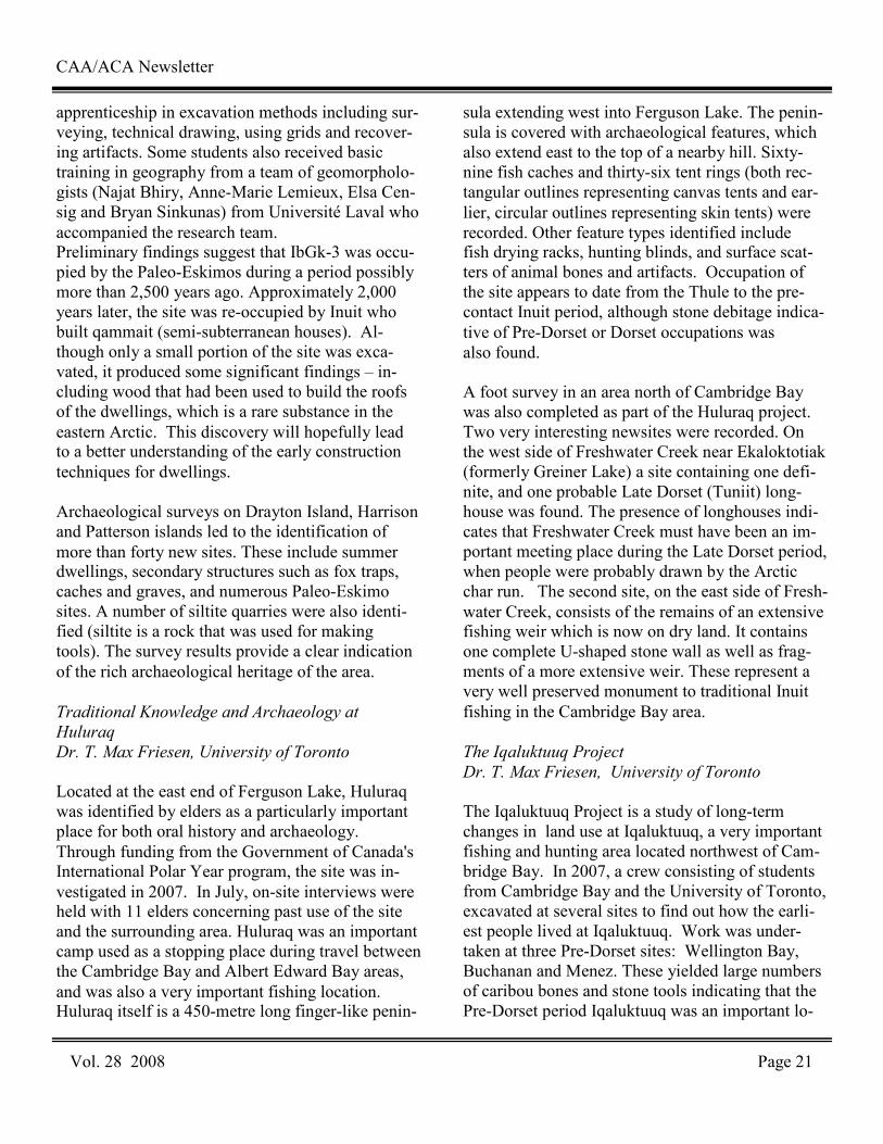
apprenticeship in excavation methods including sur-veying, technical drawing, using grids and recover-ing artifacts. Some students also received basic training in geography from a team of geomorpholo-gists (Najat Bhiry, Anne-Marie Lemieux, Elsa Cen-sig and Bryan Sinkunas) from Université Laval who accompanied the research team. Preliminary findings suggest that IbGk-3 was occu-pied by the Paleo-Eskimos during a period possibly more than 2,500 years ago. Approximately 2,000 years later, the site was re-occupied by Inuit who built qammait (semi-subterranean houses). Al-though only a small portion of the site was exca-vated, it produced some significant findings – in-cluding wood that had been used to build the roofs of the dwellings, which is a rare substance in the eastern Arctic. This discovery will hopefully lead to a better understanding of the early construction techniques for dwellings. Archaeological surveys on Drayton Island, Harrison and Patterson islands led to the identification of more than forty new sites. These include summer dwellings, secondary structures such as fox traps, caches and graves, and numerous Paleo-Eskimo sites. A number of siltite quarries were also identi-fied (siltite is a rock that was used for making tools). The survey results provide a clear indication of the rich archaeological heritage of the area. Traditional Knowledge and Archaeology at
Huluraq
Dr. T. Max Friesen, University of Toronto
Located at the east end of Ferguson Lake, Huluraq was identified by elders as a particularly important place for both oral history and archaeology. Through funding from the Government of Canada's International Polar Year program, the site was in-vestigated in 2007. In July, on-site interviews were held with 11 elders concerning past use of the site and the surrounding area. Huluraq was an important camp used as a stopping place during travel between the Cambridge Bay and Albert Edward Bay areas, and was also a very important fishing location. Huluraq itself is a 450-metre long finger-like penin-
sula extending west into Ferguson Lake. The penin-sula is covered with archaeological features, which also extend east to the top of a nearby hill. Sixty-nine fish caches and thirty-six tent rings (both rec-tangular outlines representing canvas tents and ear-lier, circular outlines representing skin tents) were recorded. Other feature types identified include fish drying racks, hunting blinds, and surface scat-ters of animal bones and artifacts. Occupation of the site appears to date from the Thule to the pre-contact Inuit period, although stone debitage indica-tive of Pre-Dorset or Dorset occupations was also found. A foot survey in an area north of Cambridge Bay was also completed as part of the Huluraq project. Two very interesting newsites were recorded. On the west side of Freshwater Creek near Ekaloktotiak (formerly Greiner Lake) a site containing one defi-nite, and one probable Late Dorset (Tuniit) long-house was found. The presence of longhouses indi-cates that Freshwater Creek must have been an im-portant meeting place during the Late Dorset period, when people were probably drawn by the Arctic char run. The second site, on the east side of Fresh-water Creek, consists of the remains of an extensive fishing weir which is now on dry land. It contains one complete U-shaped stone wall as well as frag-ments of a more extensive weir. These represent a very well preserved monument to traditional Inuit fishing in the Cambridge Bay area.
The Iqaluktuuq Project
Dr. T. Max Friesen, University of Toronto
The Iqaluktuuq Project is a study of long-term changes in land use at Iqaluktuuq, a very important fishing and hunting area located northwest of Cam-bridge Bay. In 2007, a crew consisting of students from Cambridge Bay and the University of Toronto, excavated at several sites to find out how the earli-est people lived at Iqaluktuuq. Work was under-taken at three Pre-Dorset sites: Wellington Bay, Buchanan and Menez. These yielded large numbers of caribou bones and stone tools indicating that the Pre-Dorset period Iqaluktuuq was an important lo-
CAA/ACA Newsletter
Vol. 28 2008 Page 21
The Peter Bayne Project
Tom Gross
In 2007 a small expedition team spent seven days in the field on Cape Felix, King William Island. A camp was established in Collinson Inlet near Cape Jane and surveys were conducted for sites described in the Baynes story. The Bayne story refers to a flat topped mound, and a low ridge that slopes to the south east whose crest is formed of projecting rocks. All these features suggest the hill at Cape Jane Franklin which has a very flat smooth top and large fractured limestone rock around its perimeter. No new finds resulted from the 2007 surveys and further investigation of the area is planned. Ukkusiksalik National Park Survey
Margaret Bertulli, Parks Canada
Over a two-week period in August, a helicopter sur-vey was conducted to re-locate and record sites was conducted in Ukkusiksalik National Park. As the third year of a three-year project, the objective was to record selected sites at the mouth of Wager Bay and on Roes Welcome Sound. Paula Hughson and Jason Hudson of the Nunavut Field Unit; David and Mary Tuktudjuk of Repulse Bay; and Katelyn Tatty of Rankin Inlet assisted with the project. Logistical support was provided by the of Polar Continental Shelf Project. Work in the project’s first year con-centrated on Ford and Brown lakes at the western end of Wager Bay and, in the second year, on the main body of the bay. In contrast to 2006, polar bear sightings were infrequent but poor weather with rain and fog hampered the crew’s efforts. Eight sites were recorded and photographed in de-tail. The sites are located at Berthie Harbour, Cape Dobbs and the Qaurnak River. Rock features such as tent rings, qammait and qayaq rests predomi-nated. Two semisubterranean Thule winter houses were unusual in that they were located inland on the Qaurnak River at the western end of Wager Bay. Very few artifacts were seen. An ulu handle with a copper or brass shaft and wooden grip was collected from a pond on site at Douglas Harbour to protect it from deterioration.
Ukkusiksalik National Park Cleanup
Jason Hudson, Parks Canada
Under the provisions of the Inuit Impact and Bene-fits Agreement, the Hudson’s Bay Company post located on Ford Lake was identified for cleanup and surrounding area to be removed from the site. These items were not related to the H.B.C. occupa-tion but associated with more recent activities of visitors and occupants of the site. The objects in-cluded machinery parts, household items, uphol-stered furniture, and empty fuel barrels. Goods asso-ciated with the activities of the H.B.C. that were left on site included stove parts, fuel barrels that dated near to the H.B.C. time period, a built-in wall cabinet, shelving, and structural material. On August 9, 2007 the clean up crew from Rankin Inlet arrived at the H.B.C. post to remove the piles of material from the site, load the items onto the barges, transport the material out of the park, and deposit it at the landfill site in Repulse Bay. The crew loaded the debris onto barges, using plastic wrap and the old empty fuel barrels as containers for some of the loose items. Parks Canada identi-fied two other locations requiring clean up. A shel-tered site at Reversing Falls was used to stockpile items from the H.B.C. post. These items were re-moved. On Nuvudlik Island, several empty fuel bar-rels lay scattered about and these were also removed from the park. Helluland Archaeology Project
Dr. Pat Sutherland, Canadian Museum of
Civilization
Helluland was the name given by the Norse to the most northerly of three lands to the west of Greenland which they visited, and is thought to re-fer to Baffin Island and the adjacent regions of the eastern Canadian Arctic. In July, archaeological investigations were carried out east of the hamlet of Kimmirut, from Cape Tanfield to East Bluff on southern Baffin Island. The work was funded by the Canadian Museum of Civilization and the Interna-
CAA/ACA Newsletter
Vol. 28 2008 Page 22
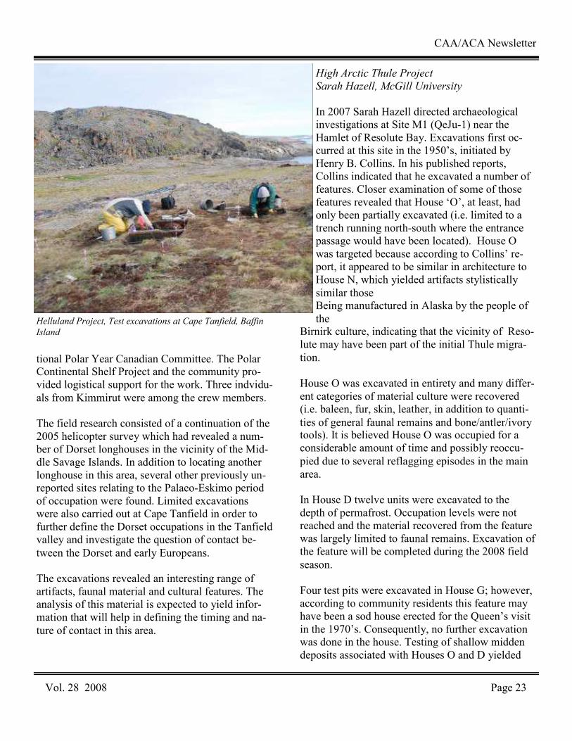
tional Polar Year Canadian Committee. The Polar Continental Shelf Project and the community pro-vided logistical support for the work. Three indvidu-als from Kimmirut were among the crew members. The field research consisted of a continuation of the 2005 helicopter survey which had revealed a num-ber of Dorset longhouses in the vicinity of the Mid-dle Savage Islands. In addition to locating another longhouse in this area, several other previously un-reported sites relating to the Palaeo-Eskimo period of occupation were found. Limited excavations were also carried out at Cape Tanfield in order to further define the Dorset occupations in the Tanfield valley and investigate the question of contact be-tween the Dorset and early Europeans. The excavations revealed an interesting range of artifacts, faunal material and cultural features. The analysis of this material is expected to yield infor-mation that will help in defining the timing and na-ture of contact in this area.
High Arctic Thule Project
Sarah Hazell, McGill University
In 2007 Sarah Hazell directed archaeological investigations at Site M1 (QeJu-1) near the Hamlet of Resolute Bay. Excavations first oc-curred at this site in the 1950’s, initiated by Henry B. Collins. In his published reports, Collins indicated that he excavated a number of features. Closer examination of some of those features revealed that House ‘O’, at least, had only been partially excavated (i.e. limited to a trench running north-south where the entrance passage would have been located). House O was targeted because according to Collins’ re-port, it appeared to be similar in architecture to House N, which yielded artifacts stylistically similar those Being manufactured in Alaska by the people of the
Birnirk culture, indicating that the vicinity of Reso-lute may have been part of the initial Thule migra-tion. House O was excavated in entirety and many differ-ent categories of material culture were recovered (i.e. baleen, fur, skin, leather, in addition to quanti-ties of general faunal remains and bone/antler/ivory tools). It is believed House O was occupied for a considerable amount of time and possibly reoccu-pied due to several reflagging episodes in the main area. In House D twelve units were excavated to the depth of permafrost. Occupation levels were not reached and the material recovered from the feature was largely limited to faunal remains. Excavation of the feature will be completed during the 2008 field season. Four test pits were excavated in House G; however, according to community residents this feature may have been a sod house erected for the Queen’s visit in the 1970’s. Consequently, no further excavation was done in the house. Testing of shallow midden deposits associated with Houses O and D yielded
CAA/ACA Newsletter
Vol. 28 2008 Page 23
Helluland Project, Test excavations at Cape Tanfield, Baffin
Island
mostly faunal material. The reconstruction of houses at the site will take place in 2008. Central Northwest Passage Archaeology Project
Dr. James Savelle, McGill University
Archaeological investigations, in conjunction with geological investigations, were carried out between July 10th and August 2nd, 2007, on southeastern Somerset Island and eastern Boothia Peninsula. These investigations represent the continuation of a long-term project that focuses on an Assessment of the relationship between initial and subsequent Paleoeskimo and Thule and historic Inuit occupa-tions in the eastern Canadian Arctic and changing paleoenvironmental conditions. While previous studies have documented Paleoeskimo (ca. 4000-1000 B.P.) and Thule and historic Inuit sites in these areas, a systematic attempt to investigate varying intensities of prehistoric occupations, and relate these to changing environmental conditions, have been few, and none had previously been conducted on eastern Boothia Peninsula.
Field surveys were undertaken in three areas: south-eastern Somerset Island between Hazard Inlet and Idlout Point, and Abernethy Bay and Murray Bay on eastern Boothia Peninsula. The nature and amount of data collected at each site varied accord-ing to field priorities at the time of examination. Several test excavations were conducted at a num-ber of sites, and items recovered were restricted to charcoal, bone, wood and other materials suitable for dating purposes. A total of 85 sites or site comprising 254 features ere recorded; several of these sites (primarily Thule) had previously been reported, but most had not. While the occupation of the study area spans essen-tially the entire temporal range of human occupation known for this region of the Arctic, our preliminary results suggest that there are definite occupation ‘pulses’, similar to those described elsewhere in the Canadian Arctic. This is especially true for the Pa-leoeskimo occupations, which previously had been considered to be relatively stable throughout the oc-cupation period in this area.
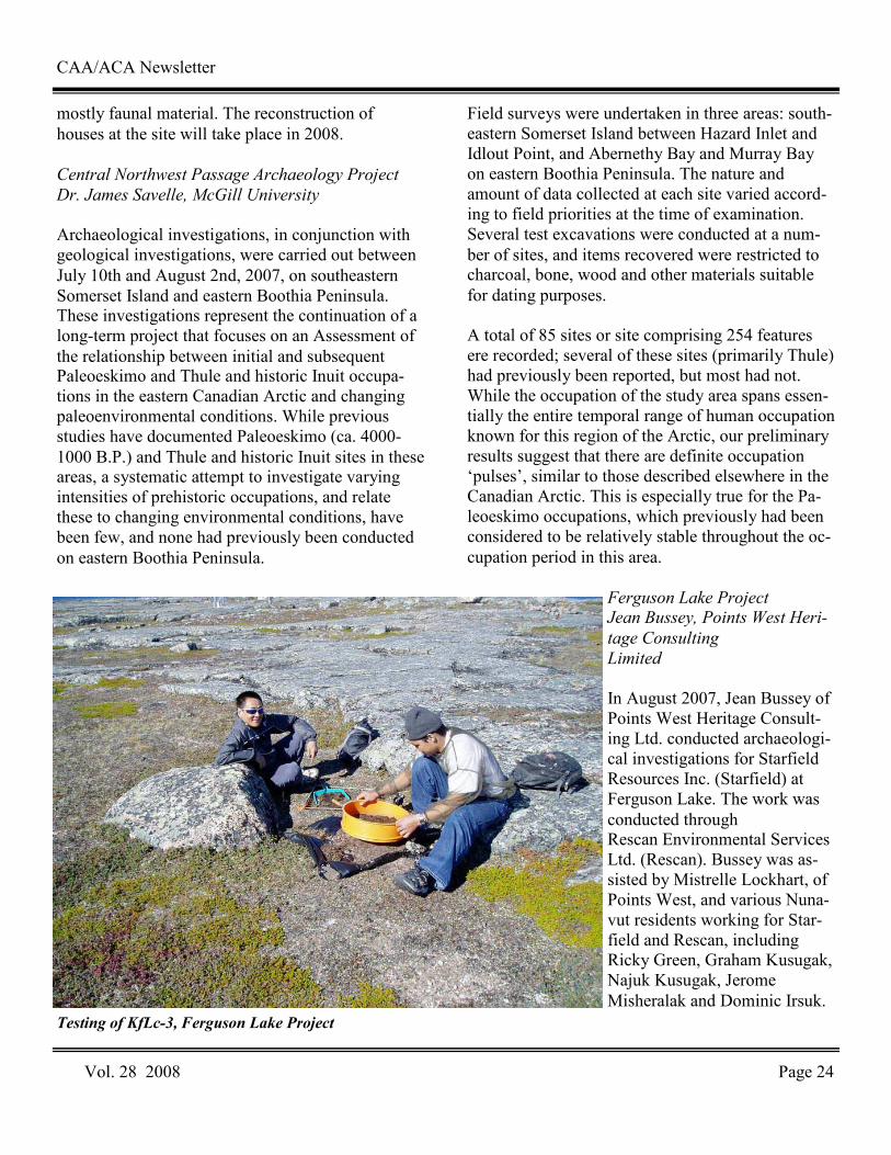
Ferguson Lake Project Jean Bussey, Points West Heri-
tage Consulting
Limited
In August 2007, Jean Bussey of Points West Heritage Consult-ing Ltd. conducted archaeologi-cal investigations for Starfield Resources Inc. (Starfield) at Ferguson Lake. The work was conducted through Rescan Environmental Services Ltd. (Rescan). Bussey was as-sisted by Mistrelle Lockhart, of Points West, and various Nuna-vut residents working for Star-field and Rescan, including Ricky Green, Graham Kusugak, Najuk Kusugak, Jerome Misheralak and Dominic Irsuk.
CAA/ACA Newsletter
Vol. 28 2008 Page 24
Testing of KfLc-3, Ferguson Lake Project
The 2007 season was the third consecutive year that archaeological field work was conducted at Fergu-son Lake. The major objective was to determine if archaeological sites were present within proposed development and exploration areas. A secondary objective involved the revisit of recorded sites to assess their status. In addition, members of the re-cently formed Ferguson Lake Natives Group were invited to the study area to view traditional camping areas they had used in the past and to visit archaeo-logical sites. Within the Ferguson Lake project area, seven new archaeological sites were discov-ered near proposed exploration areas; several of these sites will be assessed through subsurface test-ing or more detailed examination in 2008 and may be mitigated through systematic data recovery. One previously recorded site, KfLc-3, located near the new camp, was assessed as part of the 2007 in-vestigations. It is proposed that in 2008 either the location containing this site will be protected by the installation of permanent fencing or systematic data recovery involving excavation and surface collec-tion will be conducted. As part of the site assess-ment, subsurface testing was undertaken to deter-mine the depth and content of this archaeological site. Although the buried archaeological material was generally less than 15 cm deep, large quantities of flakes were encountered in portions of KfLc-3 indicating that additional work is required if protec-tion is not feasible. As a result of the two tours conducted in 2007, four traditional camp locations were examined. One of these four locations also contains evidence of pre-historic use. These sites are not threatened by activi-ties associated with the Starfield Project because they are located many kilometers from current development and exploration areas. Archaeological Impact Assessment - Bear Island
Radar Site
Dr. David Blower, Golder Associates Limited
At Bear Island it was observed that all facilities had been removed leaving only refuse in most of the
previous facility and structure areas. Because of this, the assessment of individual structures and possible impacts became redundant. It was also noted that clean-up of the station and roads would not impact areas that were not already impacted by the former DEW station and any ancillary opera-tions that were conducted to support the construc-tion and operation of the station on the island. The Bear Island AIA concentrated on the zones around the facility remains, borrow source, roads, beach landing area, adjacent areas and several areas of concern identified by members of the PWCGS team. No heritage resources were previously identi-fied on the island, but the several potential sites identified by team members were visited to deter-mine whether they were heritage resource sites or not. None of these were confirmed as sites, and only one new ring site was identified and recorded on the island, GbHg-1. GbHg-1 is located on the edge of a borrow source quarry. Originally there may have been more than one ring, but previous gravel extraction of the borrow source has come within one metre of the existing ring and there is nothing to indicate that more than one ring ever existed here. The ring is incomplete, approxi-mately 70 – 80 % exists, and an opening on the southeast side remains. The location was flagged for exclusion from further borrow source extraction and should appear on the surveyed maps being cre-ated during the field program. It is recommended that avoidance of GbHg-1 be conducted during the decommissioning of Bear Island, and that it remain unmarked once the operation is complete. It is also recommended that any future disturbances planned for Bear Island continue to avoid GbHg-1.
Site
CAA/ACA Newsletter
Vol. 28 2008 Page 25
AREVA Kiggavik/Sissons Project
Brad Novecosky, Golder Associates Limited
The Kiggavik/Sissons project is a uranium explora-tion project located approximately 80 km west of Baker Lake, Nunavut. The Kiggavik property con-tains 17 mineral leases (3,972 ha) and the Sissons property is located south of the Kiggavik property and consists of 20 mineral leases (12,725 ha). The primary purpose of the survey was to address the immediate infrastructure needs of the current drilling program and camp. Secondly, a general re-connaissance was completed to determine heritage potential of region. The field crew consisted of Brad Novecosky and Dr. David Blower of Golder Associ-ates Ltd. They were assisted by Travis Mannik of Baker Lake. Prior to the field work, Blower and Novecosky attended a meeting of the Kiggavik Community Liason Committee, and gave a presen-tation on the proposed archaeological field work and answered questions from the committee. The reconnaissance focused on several main areas of interest. These areas included an existing runway located approximately 12 km west of the main camp, an alternate runway north of this location, the Sissons and Kiggavik ore body areas, fuel cache, and the area surrounding the camp. Four potential permanent runways were also investi-gated as well as the south end of Skinny Lake where it is proposed that the water intake for the mill may be located. Finally, a brief helicopter survey was completed of the proposed all-season road corridor to Baker Lake. During the archaeological recon-naissance, a total of 17 previously unrecorded sites were identified. The largest concentrations of sites were found in the vicinity of Skinny and Aberdeen Lakes. At Skinny Lake, sites identified during this survey included small sites containing chipping de-bris. Several previously recorded sites along the shores of Skinny Lake were also revisited. These contained numerous tent rings, hearths and artifacts. Near Aberdeen Lake, a large site was discovered along an ancient beach ridge. A large lithic scatter was observed over a distance of approximately 500
m. This site includes several formed stone tools including projectile points, and bifacial knives. On August 10th, following the field work, a public meeting was held at the community center in Baker Lake. A PowerPoint presentation describing the re-sults of the fieldwork was given and photos, maps and artifacts from the project area were available for the public to view.
Hope Bay Belt Project
Gabriella Prager. Points West Heritage Consulting
Limited
The Hope Bay Belt Project is located in the central Arctic east of Bathurst Inlet, about 160 km south-west of Cambridge Bay. In 2007, Points West Heri-tage Consulting Ltd. continued archaeological as-sessments on behalf of Miramar Mining Ltd. This season’s core field crew consisted of Gabriella Prager (Project Director) and Carol Rushworth of Points West; local residents assisting with the pro-ject were: Richard Ehakataitok and Devon Oniak from Cambridge Bay, and Noah Qingnaqtuq from Spence Bay. Archaeological assessments focused on the northern portion of the Hope Bay Belt and comprised three main tasks:
1. Specific drill locations and larger exploration areas identified by Miramar for proposed 2007 exploration drilling were assessed/surveyed for archaeological sites;
2. A proposed road route between Windy camp and Doris North was assessed, by overview assessment for archaeological potential and ground reconnaissance of selected sections; and
r Isl3. Two previously recorded sites (NaNh-14,
NaNh-40) located within the Madrid intensive exploration zone were mitigated by detailed mapping, intensive surface survey and excava-tion.
CAA/ACA Newsletter
Vol. 28 2008 Page 26
The surveys revealed eight previously unrecorded archaeological sites containing stone features in-cluding circles, hearths, and caches - all fairly typi-cal of the types previously identified in this region. One perforated and carved antler artifact was col-lected. Six of the sites are situated within a band extending from Roberts Bay south to Wolverine Lake, one site was found west of the north end of Aimaoktak Lake near another high density area, and the remaining site was recorded east of Ogama Lake. In the nine seasons of field work conducted in the Belt, a total of 185 archaeological sites have been recorded within the narrow project study area, indicating a fairly high level of use.
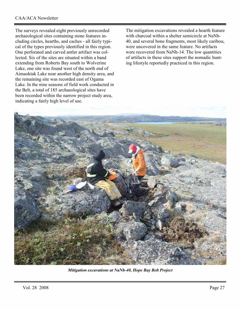
The mitigation excavations revealed a hearth feature with charcoal within a shelter semicircle at NaNh-40, and several bone fragments, most likely caribou, were uncovered in the same feature. No artifacts were recovered from NaNh-14. The low quantities of artifacts in these sites support the nomadic hunt-ing lifestyle reportedly practiced in this region.
CAA/ACA Newsletter
Vol. 28 2008 Page 27
Mitigation excavations at NaNh-40, Hope Bay Belt Project
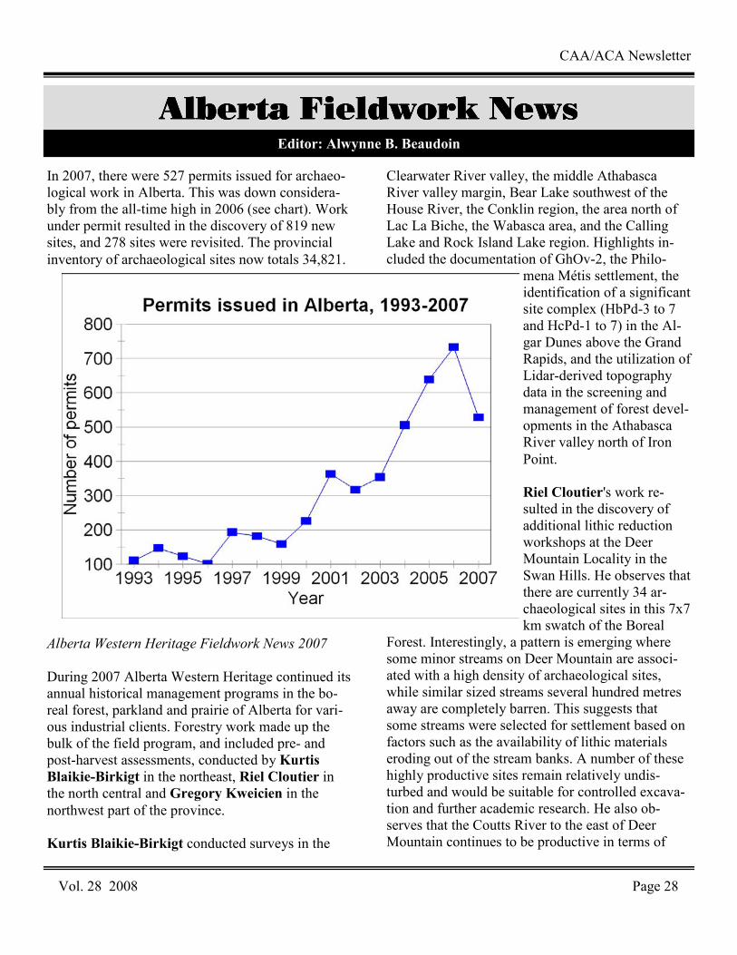
In 2007, there were 527 permits issued for archaeo-logical work in Alberta. This was down considera-bly from the all-time high in 2006 (see chart). Work under permit resulted in the discovery of 819 new sites, and 278 sites were revisited. The provincial inventory of archaeological sites now totals 34,821.
Alberta Western Heritage Fieldwork News 2007
During 2007 Alberta Western Heritage continued its annual historical management programs in the bo-real forest, parkland and prairie of Alberta for vari-ous industrial clients. Forestry work made up the bulk of the field program, and included pre- and post-harvest assessments, conducted by Kurtis Blaikie-Birkigt in the northeast, Riel Cloutier in the north central and Gregory Kweicien in the northwest part of the province. Kurtis Blaikie-Birkigt conducted surveys in the
Clearwater River valley, the middle Athabasca River valley margin, Bear Lake southwest of the House River, the Conklin region, the area north of Lac La Biche, the Wabasca area, and the Calling Lake and Rock Island Lake region. Highlights in-cluded the documentation of GhOv-2, the Philo-
mena Métis settlement, the identification of a significant site complex (HbPd-3 to 7 and HcPd-1 to 7) in the Al-gar Dunes above the Grand Rapids, and the utilization of Lidar-derived topography data in the screening and management of forest devel-opments in the Athabasca River valley north of Iron Point. Riel Cloutier's work re-sulted in the discovery of additional lithic reduction workshops at the Deer Mountain Locality in the Swan Hills. He observes that there are currently 34 ar-chaeological sites in this 7x7 km swatch of the Boreal
Forest. Interestingly, a pattern is emerging where some minor streams on Deer Mountain are associ-ated with a high density of archaeological sites, while similar sized streams several hundred metres away are completely barren. This suggests that some streams were selected for settlement based on factors such as the availability of lithic materials eroding out of the stream banks. A number of these highly productive sites remain relatively undis-turbed and would be suitable for controlled excava-tion and further academic research. He also ob-serves that the Coutts River to the east of Deer Mountain continues to be productive in terms of
Vol. 28 2008 Page 28
CAA/ACA Newsletter
Alberta Fieldwork NewsAlberta Fieldwork NewsAlberta Fieldwork NewsAlberta Fieldwork News Editor: Alwynne B. Beaudoin
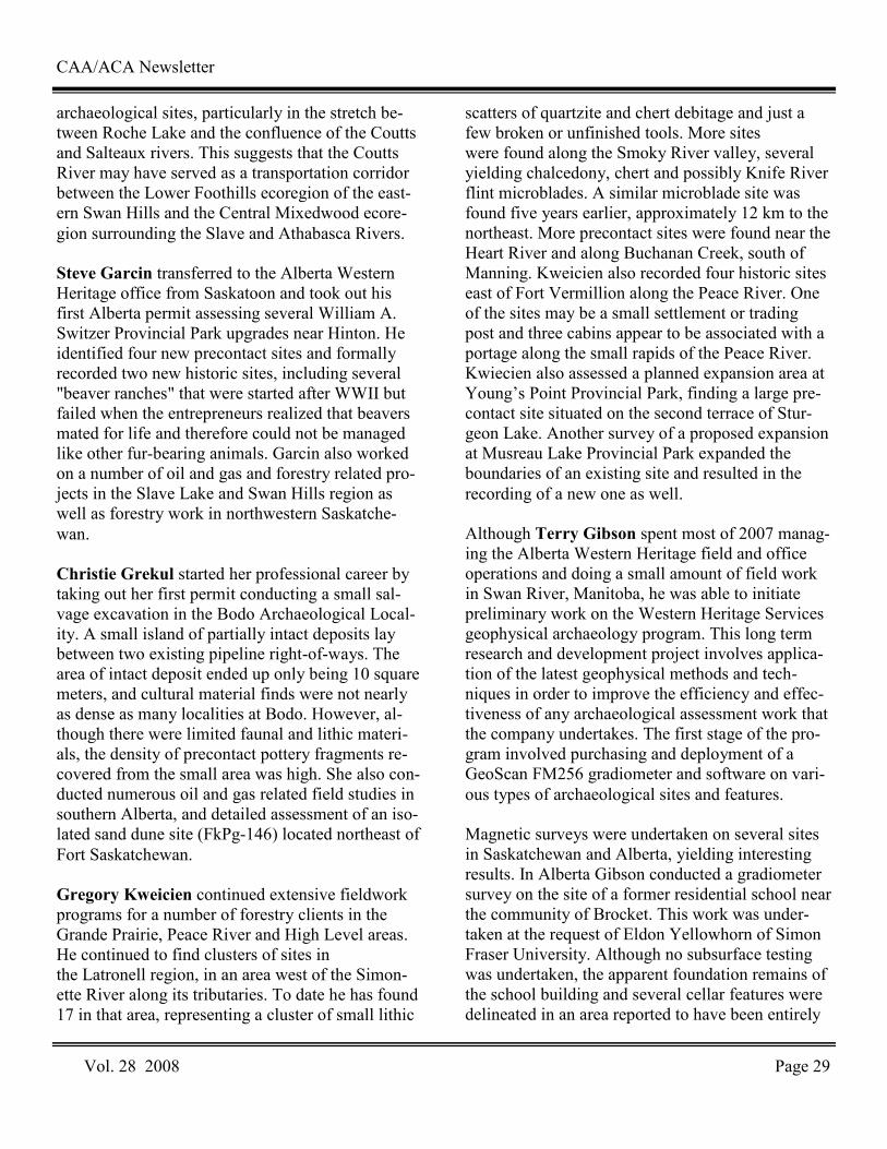
Vol. 28 2008 Page 29
CAA/ACA Newsletter
archaeological sites, particularly in the stretch be-tween Roche Lake and the confluence of the Coutts and Salteaux rivers. This suggests that the Coutts River may have served as a transportation corridor between the Lower Foothills ecoregion of the east-ern Swan Hills and the Central Mixedwood ecore-gion surrounding the Slave and Athabasca Rivers. Steve Garcin transferred to the Alberta Western Heritage office from Saskatoon and took out his first Alberta permit assessing several William A. Switzer Provincial Park upgrades near Hinton. He identified four new precontact sites and formally recorded two new historic sites, including several "beaver ranches" that were started after WWII but failed when the entrepreneurs realized that beavers mated for life and therefore could not be managed like other fur-bearing animals. Garcin also worked on a number of oil and gas and forestry related pro-jects in the Slave Lake and Swan Hills region as well as forestry work in northwestern Saskatche-wan. Christie Grekul started her professional career by taking out her first permit conducting a small sal-vage excavation in the Bodo Archaeological Local-ity. A small island of partially intact deposits lay between two existing pipeline right-of-ways. The area of intact deposit ended up only being 10 square meters, and cultural material finds were not nearly as dense as many localities at Bodo. However, al-though there were limited faunal and lithic materi-als, the density of precontact pottery fragments re-covered from the small area was high. She also con-ducted numerous oil and gas related field studies in southern Alberta, and detailed assessment of an iso-lated sand dune site (FkPg-146) located northeast of Fort Saskatchewan. Gregory Kweicien continued extensive fieldwork programs for a number of forestry clients in the Grande Prairie, Peace River and High Level areas. He continued to find clusters of sites in the Latronell region, in an area west of the Simon-ette River along its tributaries. To date he has found 17 in that area, representing a cluster of small lithic
scatters of quartzite and chert debitage and just a few broken or unfinished tools. More sites were found along the Smoky River valley, several yielding chalcedony, chert and possibly Knife River flint microblades. A similar microblade site was found five years earlier, approximately 12 km to the northeast. More precontact sites were found near the Heart River and along Buchanan Creek, south of Manning. Kweicien also recorded four historic sites east of Fort Vermillion along the Peace River. One of the sites may be a small settlement or trading post and three cabins appear to be associated with a portage along the small rapids of the Peace River. Kwiecien also assessed a planned expansion area at Young’s Point Provincial Park, finding a large pre-contact site situated on the second terrace of Stur-geon Lake. Another survey of a proposed expansion at Musreau Lake Provincial Park expanded the boundaries of an existing site and resulted in the recording of a new one as well. Although Terry Gibson spent most of 2007 manag-ing the Alberta Western Heritage field and office operations and doing a small amount of field work in Swan River, Manitoba, he was able to initiate preliminary work on the Western Heritage Services geophysical archaeology program. This long term research and development project involves applica-tion of the latest geophysical methods and tech-niques in order to improve the efficiency and effec-tiveness of any archaeological assessment work that the company undertakes. The first stage of the pro-gram involved purchasing and deployment of a GeoScan FM256 gradiometer and software on vari-ous types of archaeological sites and features. Magnetic surveys were undertaken on several sites in Saskatchewan and Alberta, yielding interesting results. In Alberta Gibson conducted a gradiometer survey on the site of a former residential school near the community of Brocket. This work was under-taken at the request of Eldon Yellowhorn of Simon Fraser University. Although no subsurface testing was undertaken, the apparent foundation remains of the school building and several cellar features were delineated in an area reported to have been entirely
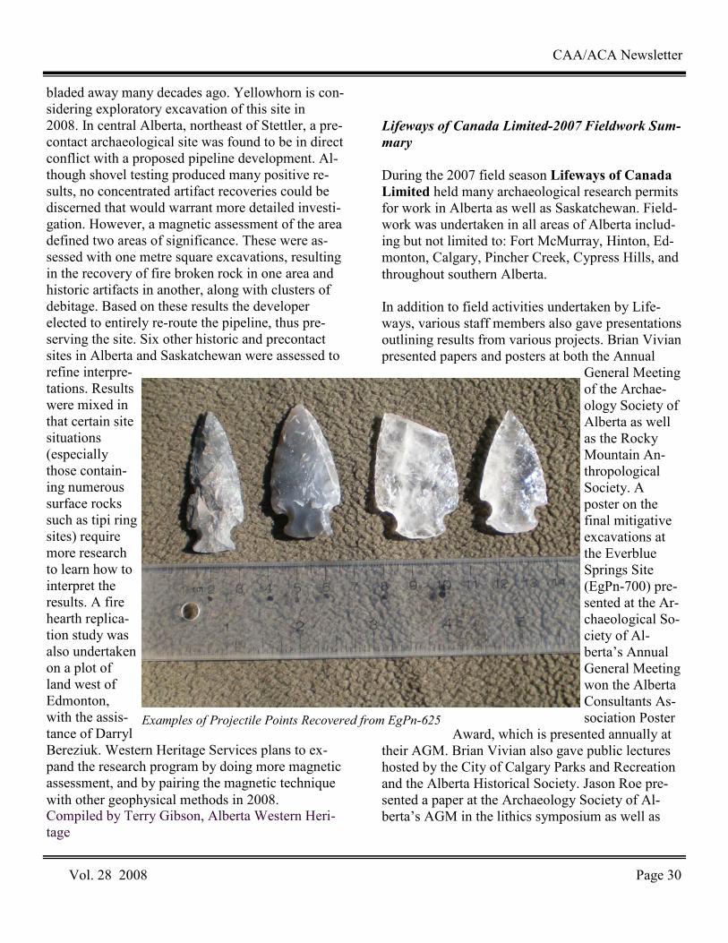
bladed away many decades ago. Yellowhorn is con-sidering exploratory excavation of this site in 2008. In central Alberta, northeast of Stettler, a pre-contact archaeological site was found to be in direct conflict with a proposed pipeline development. Al-though shovel testing produced many positive re-sults, no concentrated artifact recoveries could be discerned that would warrant more detailed investi-gation. However, a magnetic assessment of the area defined two areas of significance. These were as-sessed with one metre square excavations, resulting in the recovery of fire broken rock in one area and historic artifacts in another, along with clusters of debitage. Based on these results the developer elected to entirely re-route the pipeline, thus pre-serving the site. Six other historic and precontact sites in Alberta and Saskatchewan were assessed to refine interpre-tations. Results were mixed in that certain site situations (especially those contain-ing numerous surface rocks such as tipi ring sites) require more research to learn how to interpret the results. A fire hearth replica-tion study was also undertaken on a plot of land west of Edmonton, with the assis-tance of Darryl Bereziuk. Western Heritage Services plans to ex-pand the research program by doing more magnetic assessment, and by pairing the magnetic technique with other geophysical methods in 2008. Compiled by Terry Gibson, Alberta Western Heri-tage
Lifeways of Canada Limited-2007 Fieldwork Sum-
mary
During the 2007 field season Lifeways of Canada Limited held many archaeological research permits for work in Alberta as well as Saskatchewan. Field-work was undertaken in all areas of Alberta includ-ing but not limited to: Fort McMurray, Hinton, Ed-monton, Calgary, Pincher Creek, Cypress Hills, and throughout southern Alberta. In addition to field activities undertaken by Life-ways, various staff members also gave presentations outlining results from various projects. Brian Vivian presented papers and posters at both the Annual
General Meeting of the Archae-ology Society of Alberta as well as the Rocky Mountain An-thropological Society. A poster on the final mitigative excavations at the Everblue Springs Site (EgPn-700) pre-sented at the Ar-chaeological So-ciety of Al-berta’s Annual General Meeting won the Alberta Consultants As-sociation Poster
Award, which is presented annually at their AGM. Brian Vivian also gave public lectures hosted by the City of Calgary Parks and Recreation and the Alberta Historical Society. Jason Roe pre-sented a paper at the Archaeology Society of Al-berta’s AGM in the lithics symposium as well as
CAA/ACA Newsletter
Vol. 28 2008 Page 30
Examples of Projectile Points Recovered from EgPn-625
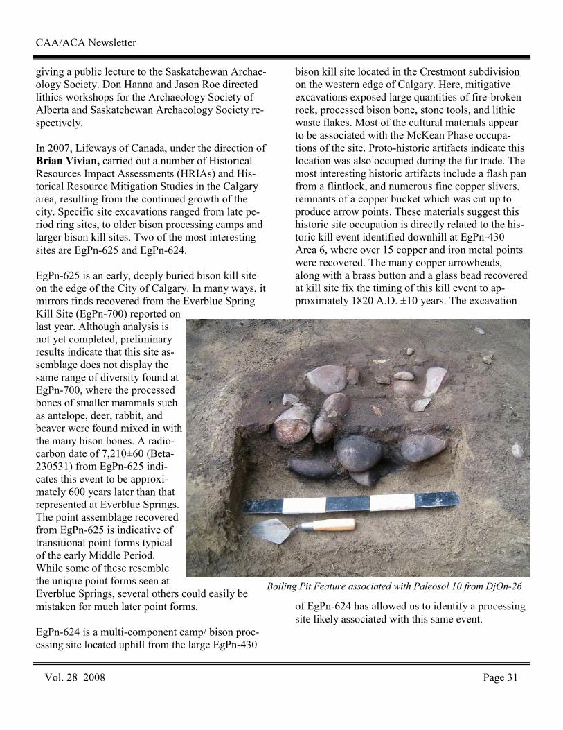
giving a public lecture to the Saskatchewan Archae-ology Society. Don Hanna and Jason Roe directed lithics workshops for the Archaeology Society of Alberta and Saskatchewan Archaeology Society re-spectively. In 2007, Lifeways of Canada, under the direction of Brian Vivian, carried out a number of Historical Resources Impact Assessments (HRIAs) and His-torical Resource Mitigation Studies in the Calgary area, resulting from the continued growth of the city. Specific site excavations ranged from late pe-riod ring sites, to older bison processing camps and larger bison kill sites. Two of the most interesting sites are EgPn-625 and EgPn-624. EgPn-625 is an early, deeply buried bison kill site on the edge of the City of Calgary. In many ways, it mirrors finds recovered from the Everblue Spring Kill Site (EgPn-700) reported on last year. Although analysis is not yet completed, preliminary results indicate that this site as-semblage does not display the same range of diversity found at EgPn-700, where the processed bones of smaller mammals such as antelope, deer, rabbit, and beaver were found mixed in with the many bison bones. A radio-carbon date of 7,210±60 (Beta-230531) from EgPn-625 indi-cates this event to be approxi-mately 600 years later than that represented at Everblue Springs. The point assemblage recovered from EgPn-625 is indicative of transitional point forms typical of the early Middle Period. While some of these resemble the unique point forms seen at Everblue Springs, several others could easily be mistaken for much later point forms. EgPn-624 is a multi-component camp/ bison proc-essing site located uphill from the large EgPn-430
bison kill site located in the Crestmont subdivision on the western edge of Calgary. Here, mitigative excavations exposed large quantities of fire-broken rock, processed bison bone, stone tools, and lithic waste flakes. Most of the cultural materials appear to be associated with the McKean Phase occupa-tions of the site. Proto-historic artifacts indicate this location was also occupied during the fur trade. The most interesting historic artifacts include a flash pan from a flintlock, and numerous fine copper slivers, remnants of a copper bucket which was cut up to produce arrow points. These materials suggest this historic site occupation is directly related to the his-toric kill event identified downhill at EgPn-430 Area 6, where over 15 copper and iron metal points were recovered. The many copper arrowheads, along with a brass button and a glass bead recovered at kill site fix the timing of this kill event to ap-proximately 1820 A.D. ±10 years. The excavation
of EgPn-624 has allowed us to identify a processing site likely associated with this same event.
CAA/ACA Newsletter
Vol. 28 2008 Page 31
Boiling Pit Feature associated with Paleosol 10 from DjOn-26
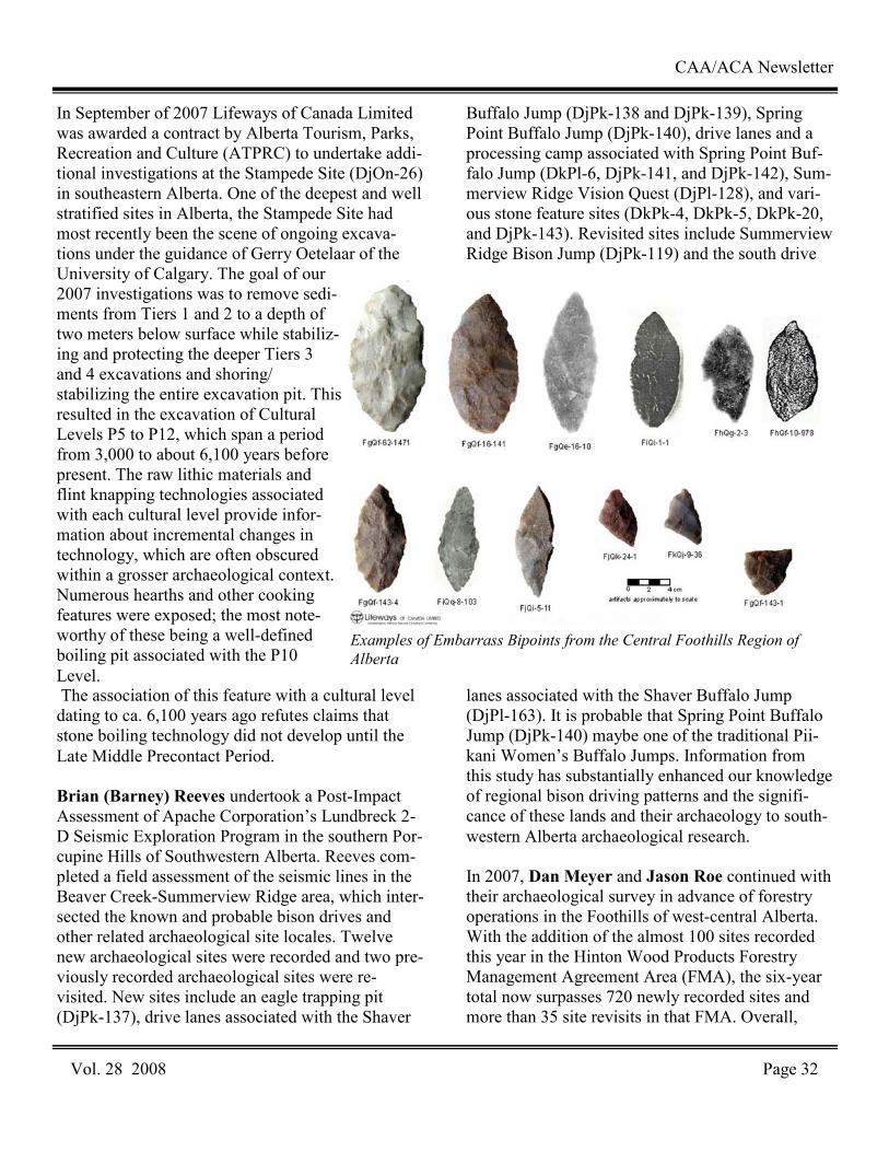
In September of 2007 Lifeways of Canada Limited was awarded a contract by Alberta Tourism, Parks, Recreation and Culture (ATPRC) to undertake addi-tional investigations at the Stampede Site (DjOn-26) in southeastern Alberta. One of the deepest and well stratified sites in Alberta, the Stampede Site had most recently been the scene of ongoing excava-tions under the guidance of Gerry Oetelaar of the University of Calgary. The goal of our 2007 investigations was to remove sedi-ments from Tiers 1 and 2 to a depth of two meters below surface while stabiliz-ing and protecting the deeper Tiers 3 and 4 excavations and shoring/stabilizing the entire excavation pit. This resulted in the excavation of Cultural Levels P5 to P12, which span a period from 3,000 to about 6,100 years before present. The raw lithic materials and flint knapping technologies associated with each cultural level provide infor-mation about incremental changes in technology, which are often obscured within a grosser archaeological context. Numerous hearths and other cooking features were exposed; the most note-worthy of these being a well-defined boiling pit associated with the P10 Level. The association of this feature with a cultural level dating to ca. 6,100 years ago refutes claims that stone boiling technology did not develop until the Late Middle Precontact Period. Brian (Barney) Reeves undertook a Post-Impact Assessment of Apache Corporation’s Lundbreck 2-D Seismic Exploration Program in the southern Por-cupine Hills of Southwestern Alberta. Reeves com-pleted a field assessment of the seismic lines in the Beaver Creek-Summerview Ridge area, which inter-sected the known and probable bison drives and other related archaeological site locales. Twelve new archaeological sites were recorded and two pre-viously recorded archaeological sites were re-visited. New sites include an eagle trapping pit (DjPk-137), drive lanes associated with the Shaver
Buffalo Jump (DjPk-138 and DjPk-139), Spring Point Buffalo Jump (DjPk-140), drive lanes and a processing camp associated with Spring Point Buf-falo Jump (DkPl-6, DjPk-141, and DjPk-142), Sum-merview Ridge Vision Quest (DjPl-128), and vari-ous stone feature sites (DkPk-4, DkPk-5, DkPk-20, and DjPk-143). Revisited sites include Summerview Ridge Bison Jump (DjPk-119) and the south drive
lanes associated with the Shaver Buffalo Jump (DjPl-163). It is probable that Spring Point Buffalo Jump (DjPk-140) maybe one of the traditional Pii-kani Women’s Buffalo Jumps. Information from this study has substantially enhanced our knowledge of regional bison driving patterns and the signifi-cance of these lands and their archaeology to south-western Alberta archaeological research. In 2007, Dan Meyer and Jason Roe continued with their archaeological survey in advance of forestry operations in the Foothills of west-central Alberta. With the addition of the almost 100 sites recorded this year in the Hinton Wood Products Forestry Management Agreement Area (FMA), the six-year total now surpasses 720 newly recorded sites and more than 35 site revisits in that FMA. Overall,
Vol. 28 2008 Page 32
CAA/ACA Newsletter
Examples of Embarrass Bipoints from the Central Foothills Region of
Alberta
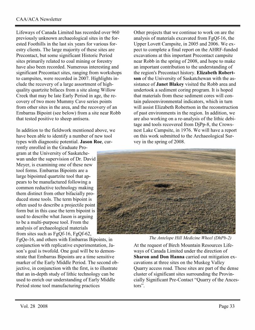
Lifeways of Canada Limited has recorded over 960 previously unknown archaeological sites in the for-ested Foothills in the last six years for various for-estry clients. The large majority of these sites are Precontact, but some significant Historic Period sites primarily related to coal mining or forestry have also been recorded. Numerous interesting and significant Precontact sites, ranging from workshops to campsites, were recorded in 2007. Highlights in-clude the recovery of a large assortment of high-quality quartzite bifaces from a site along Willow Creek that may be late Early Period in age, the re-covery of two more Mummy Cave series points from other sites in the area, and the recovery of an Embarras Bipoint (see below) from a site near Robb that tested positive to sheep antisera. In addition to the fieldwork mentioned above, we have been able to identify a number of new tool types with diagnostic potential. Jason Roe, cur-rently enrolled in the Graduate Pro-gram at the University of Saskatche-wan under the supervision of Dr. David Meyer, is examining one of these new tool forms. Embarras Bipoints are a large bipointed quartzite tool that ap-pears to be manufactured following a common reductive technology making them distinct from other bifacially pro-duced stone tools. The term bipoint is often used to describe a projectile point form but in this case the term bipoint is used to describe what Jason is arguing to be a multi-purpose tool. From the analysis of archaeological materials from sites such as FgQf-16, FgQf-62, FgQe-16, and others with Embarras Bipoints, in conjunction with replicative experimentation, Ja-son’s goal is twofold. One goal will be to demon-strate that Embarras Bipoints are a time sensitive marker of the Early Middle Period. The second ob-jective, in conjunction with the first, is to illustrate that an in-depth study of lithic technology can be used to enrich our understanding of Early Middle Period stone tool manufacturing practices
Other projects that we continue to work on are the analysis of materials excavated from FgQf-16, the Upper Lovett Campsite, in 2005 and 2006. We ex-pect to complete a final report on the AHRF-funded excavations at this important Precontact campsite near Robb in the spring of 2008, and hope to make an important contribution to the understanding of the region's Precontact history. Elizabeth Robert-son of the University of Saskatchewan with the as-sistance of Janet Blakey visited the Robb area and undertook a sediment coring program. It is hoped that materials from these sediment cores will con-tain paleoenvironmental indicators, which in turn will assist Elizabeth Robertson in the reconstruction of past environments in the region. In addition, we are also working on a re-analysis of the lithic debi-tage and tools recovered from DjPp-8, the Crows-nest Lake Campsite, in 1976. We will have a report on this work submitted to the Archaeological Sur-vey in the spring of 2008.
At the request of Birch Mountain Resources Life-ways of Canada Limited under the direction of Sharon and Don Hanna carried out mitigation ex-cavations at three sites on the Muskeg Valley Quarry access road. These sites are part of the dense cluster of significant sites surrounding the Provin-cially Significant Pre-Contact “Quarry of the Ances-tors”.
CAA/ACA Newsletter
Vol. 28 2008 Page 33
The Antelope Hill Medicine Wheel (DhPb-2)
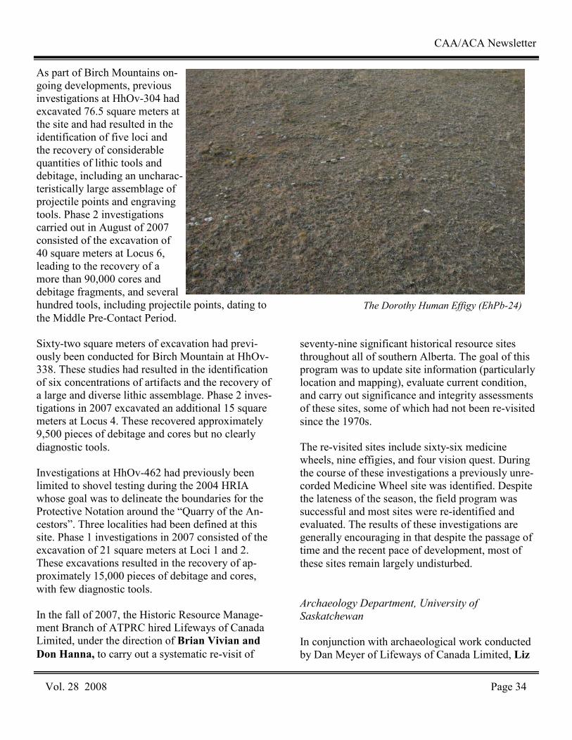
As part of Birch Mountains on-going developments, previous investigations at HhOv-304 had excavated 76.5 square meters at the site and had resulted in the identification of five loci and the recovery of considerable quantities of lithic tools and debitage, including an uncharac-teristically large assemblage of projectile points and engraving tools. Phase 2 investigations carried out in August of 2007 consisted of the excavation of 40 square meters at Locus 6, leading to the recovery of a more than 90,000 cores and debitage fragments, and several hundred tools, including projectile points, dating to the Middle Pre-Contact Period. Sixty-two square meters of excavation had previ-ously been conducted for Birch Mountain at HhOv-338. These studies had resulted in the identification of six concentrations of artifacts and the recovery of a large and diverse lithic assemblage. Phase 2 inves-tigations in 2007 excavated an additional 15 square meters at Locus 4. These recovered approximately 9,500 pieces of debitage and cores but no clearly diagnostic tools. Investigations at HhOv-462 had previously been limited to shovel testing during the 2004 HRIA whose goal was to delineate the boundaries for the Protective Notation around the “Quarry of the An-cestors”. Three localities had been defined at this site. Phase 1 investigations in 2007 consisted of the excavation of 21 square meters at Loci 1 and 2. These excavations resulted in the recovery of ap-proximately 15,000 pieces of debitage and cores, with few diagnostic tools. In the fall of 2007, the Historic Resource Manage-ment Branch of ATPRC hired Lifeways of Canada Limited, under the direction of Brian Vivian and Don Hanna, to carry out a systematic re-visit of
seventy-nine significant historical resource sites throughout all of southern Alberta. The goal of this program was to update site information (particularly location and mapping), evaluate current condition, and carry out significance and integrity assessments of these sites, some of which had not been re-visited since the 1970s. The re-visited sites include sixty-six medicine wheels, nine effigies, and four vision quest. During the course of these investigations a previously unre-corded Medicine Wheel site was identified. Despite the lateness of the season, the field program was successful and most sites were re-identified and evaluated. The results of these investigations are generally encouraging in that despite the passage of time and the recent pace of development, most of these sites remain largely undisturbed.
Archaeology Department, University of
Saskatchewan
In conjunction with archaeological work conducted by Dan Meyer of Lifeways of Canada Limited, Liz
CAA/ACA Newsletter
Vol. 28 2008 Page 34
The Dorothy Human Effigy (EhPb-24)
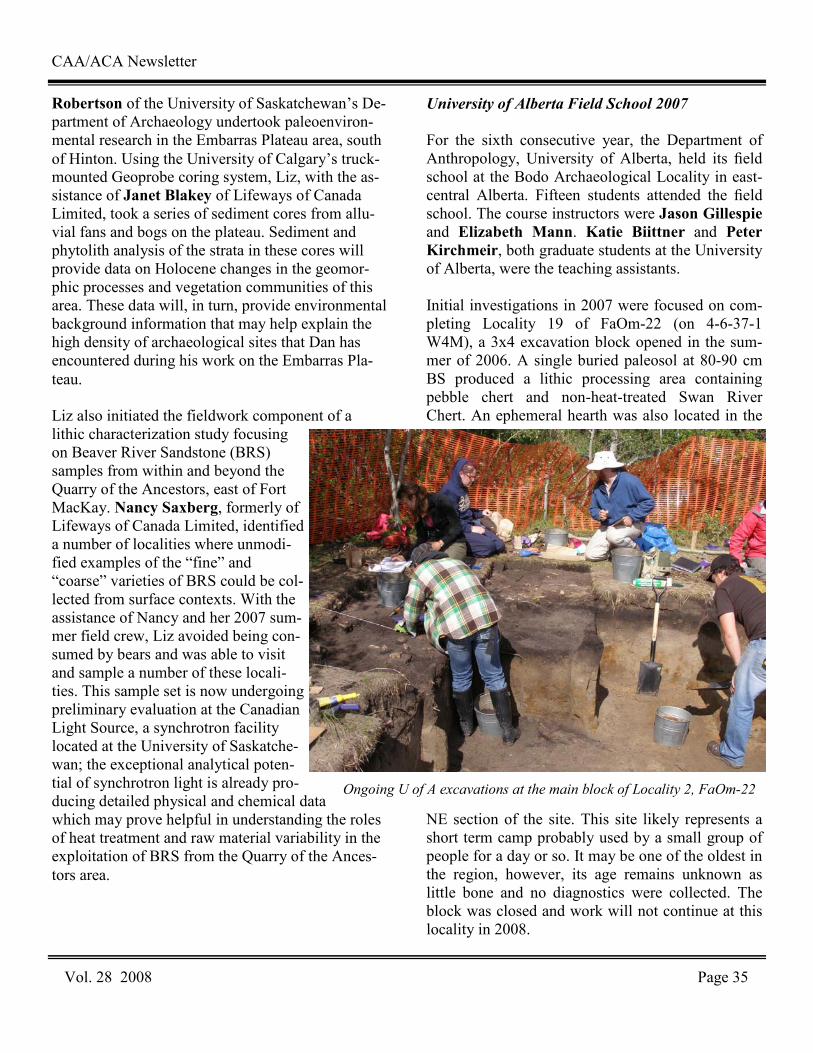
Robertson of the University of Saskatchewan’s De-partment of Archaeology undertook paleoenviron-mental research in the Embarras Plateau area, south of Hinton. Using the University of Calgary’s truck- mounted Geoprobe coring system, Liz, with the as-sistance of Janet Blakey of Lifeways of Canada Limited, took a series of sediment cores from allu-vial fans and bogs on the plateau. Sediment and phytolith analysis of the strata in these cores will provide data on Holocene changes in the geomor-phic processes and vegetation communities of this area. These data will, in turn, provide environmental background information that may help explain the high density of archaeological sites that Dan has encountered during his work on the Embarras Pla-teau. Liz also initiated the fieldwork component of a lithic characterization study focusing on Beaver River Sandstone (BRS) samples from within and beyond the Quarry of the Ancestors, east of Fort MacKay. Nancy Saxberg, formerly of Lifeways of Canada Limited, identified a number of localities where unmodi-fied examples of the “fine” and “coarse” varieties of BRS could be col-lected from surface contexts. With the assistance of Nancy and her 2007 sum-mer field crew, Liz avoided being con-sumed by bears and was able to visit and sample a number of these locali-ties. This sample set is now undergoing preliminary evaluation at the Canadian Light Source, a synchrotron facility located at the University of Saskatche-wan; the exceptional analytical poten-tial of synchrotron light is already pro-ducing detailed physical and chemical data which may prove helpful in understanding the roles of heat treatment and raw material variability in the exploitation of BRS from the Quarry of the Ances-tors area.
University of Alberta Field School 2007 For the sixth consecutive year, the Department of Anthropology, University of Alberta, held its field school at the Bodo Archaeological Locality in east-central Alberta. Fifteen students attended the field school. The course instructors were Jason Gillespie and Elizabeth Mann. Katie Biittner and Peter Kirchmeir, both graduate students at the University of Alberta, were the teaching assistants. Initial investigations in 2007 were focused on com-pleting Locality 19 of FaOm-22 (on 4-6-37-1 W4M), a 3x4 excavation block opened in the sum-mer of 2006. A single buried paleosol at 80-90 cm BS produced a lithic processing area containing pebble chert and non-heat-treated Swan River Chert. An ephemeral hearth was also located in the
NE section of the site. This site likely represents a short term camp probably used by a small group of people for a day or so. It may be one of the oldest in the region, however, its age remains unknown as little bone and no diagnostics were collected. The block was closed and work will not continue at this locality in 2008.
CAA/ACA Newsletter
Vol. 28 2008 Page 35
Ongoing U of A excavations at the main block of Locality 2, FaOm-22

Work also continued in Locality 2 of FaOm-22, where a large excavation block has been under in-vestigation since 2003. This past summer, seven new metre square units were opened along the west-ern and southern edges of the block (totaling 27 units). The site appears to have three components. Initial results of the upper component continue to show dense deposits of burnt and unburnt bone (including several articulated bone units), lithics, and numerous pottery fragments in this Late Prehis-toric Period living floor/processing site. Bone and artifact density appears to increase in the SW sec-tions of the block. This upper bone bed may be di-vided into two distinct components with further in-vestigation. The two lower components showed lim-ited amounts of bone and some lithics, including several diagnostics. The middle component may be Old Women’s and the lowest component possible Sandy Creek. These lower components appear to be living floors rather than kill or processing sites. Work will continue in this block during the 2008 field school program. Three new metre square units were also opened in the southern section of Locality 2, adjacent to a pre-existing test unit, resulting in a 2x2 excavation block. This block produced at least two, and maybe three, cultural components. The upper level con-tained scattered bone and lithics, but no diagnostics. This level is likely very Late Prehistoric or Proto-historic. The second level produced a very nice hearth, a lot of bone and several Old Women's style projectile points and pottery, the latter having stylis-tic differences from those found in the main block. The lowest level contained only scattered bone and lithics along with two possible Sandy Creek style projectile points. This stratigraphic sequence is similar to the one found in the main block, suggest-ing further work may connect the two blocks. Exca-vation will continue in the 2008 season in this block. Concurrent with the excavation program was an on-going surface survey on a portion of FaOm-1. The field school students conducted a survey and test pit
program on NE 32-36-1 W4M, located to the east of FaOm-22. This program resulted in numerous finds of fire-cracked-rock, bone fragments, pottery and lithics including projectile points, retouched tools and flakes/shatter. Due to the positive results, addi-tional sub-surface testing will continue in this area during the 2008 field season. Once again the public aspect of this program played a high profile. The Bodo Archaeological Society (BAS) was very active in promoting the site, with almost daily public school tours during the field school as well as a Guest Speaker series during the summer months. They hosted an evening to cele-brate National Aboriginal Day on June 21st, and on July 1st held their 6th Annual Open House, which included a tour of the field labs and the site excava-tions. The school tours and Open Houses were a great success, attracting almost 1000 visitors to the site.
CAA/ACA Newsletter
Vol. 28 2008 Page 36

2007 Season, Hopedale Archaeology Project
Beatrix Arendt, University of Virginia
The 2007 field season in Hopedale, Labrador was a preliminary survey of Inuit sod houses and middens in and around the Moravian mission. This report discusses preliminary findings from two projects conducted near the Moravians mission in Hopedale and on two islands in the region. This work is part of my doctoral research at the University of Virginia investigating the influence of German Moravian missionaries on changing Inuit culture. In the 18th century, German Moravian missionaries arrived in Labrador with the hopes of offering civili-zation and Christian enlightenment to the Inuit. Thirty years after the establishment of the first Mo-ravian mission, many Labrador Inuit moved to the missions, converted to Christianity, and fully en-gaged in a European economic market. However, archaeological evidence from excavated Inuit de-posits in Labrador confirms documentary records that Inuit incorporated European materials and prac-tices while maintaining many Inuit traditions. My dissertation research proposes to systematically compare archaeological records from 18th- and 19th-century Inuit sites to explore complex social, eco-nomic and religious dynamics that served as the fac-tors for the transformation of Inuit culture during the 19th centuries. Working with David Igloliorte, director of the Hopedale Moravian Museum, and Nunatsiavut archaeologist Lena Onalik, the Hopedale Archae-ology Project (HAP) included a community-outreach component. The community goals of the program include providing training and employment opportunities for Inuit students in the field of ar-chaeology, working with local communities and his-
torical societies to identify archaeological and his-torical resources, working with local Labrador teachers to incorporate archaeology into the curricu-lum, and help foster pride in Labrador culture and heritage. As part of the community archaeology project, artifacts and photographs from the sum-mer’s work were exhibited at an open house in the Hopedale Mission building at the end of the season. The 2007 field season was divided into two stages that included excavation and survey during July and August. The first stage was a three-week excavation in search of 19th-century Moravian midden located near the Hopedale Moravian mission buildings; the second stage was a two-week survey and excavation project on Kernertaluk and Anniowaktok Islands located near Hopedale. Hopedale Moravian Midden (GiCb-05)
Excavations in search of the Moravian midden were based on artifacts found by Dr. Loring in 2002. During the erection of a telephone pole located north of the mission buildings, construction workers unearthed a number of historic materials including 19th-century ceramic fragments. Dr. Loring noted the appearance of historic materials and suggested this was the location of a Moravian midden. Mora-vians introduced centralized middens as an attempt to control discard patterns and introduce hygienic habits to the Inuit, who previously discarded their refuse in middens located directly in front of indi-vidual houses. Other than noting its location and collecting a few artifacts, Loring did not investigate further due to time constraints. Additional archaeological evidence for middens located behind the mission buildings is based on earlier excavations conducted at another Labrador mission. In the 1990s, Dr. Loring and Melanie
Vol. 28 2008 Page 37
CAA/ACA Newsletter
Newfoundland and LabradorNewfoundland and LabradorNewfoundland and LabradorNewfoundland and Labrador
Fieldwork NewsFieldwork NewsFieldwork NewsFieldwork News Editor: Stephen Hull
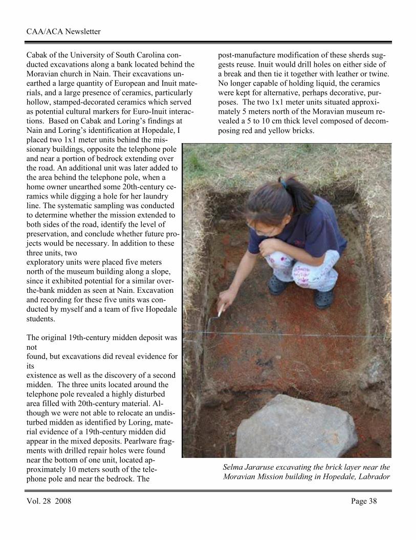
CAA/ACA Newsletter
Vol. 28 2008 Page 38
Cabak of the University of South Carolina con-ducted excavations along a bank located behind the Moravian church in Nain. Their excavations un-earthed a large quantity of European and Inuit mate-rials, and a large presence of ceramics, particularly hollow, stamped-decorated ceramics which served as potential cultural markers for Euro-Inuit interac-tions. Based on Cabak and Loring’s findings at Nain and Loring’s identification at Hopedale, I placed two 1x1 meter units behind the mis-sionary buildings, opposite the telephone pole and near a portion of bedrock extending over the road. An additional unit was later added to the area behind the telephone pole, when a home owner unearthed some 20th-century ce-ramics while digging a hole for her laundry line. The systematic sampling was conducted to determine whether the mission extended to both sides of the road, identify the level of preservation, and conclude whether future pro-jects would be necessary. In addition to these three units, two exploratory units were placed five meters north of the museum building along a slope, since it exhibited potential for a similar over-the-bank midden as seen at Nain. Excavation and recording for these five units was con-ducted by myself and a team of five Hopedale students. The original 19th-century midden deposit was not found, but excavations did reveal evidence for its existence as well as the discovery of a second midden. The three units located around the telephone pole revealed a highly disturbed area filled with 20th-century material. Al-though we were not able to relocate an undis-turbed midden as identified by Loring, mate-rial evidence of a 19th-century midden did appear in the mixed deposits. Pearlware frag-ments with drilled repair holes were found near the bottom of one unit, located ap-proximately 10 meters south of the tele-phone pole and near the bedrock. The
post-manufacture modification of these sherds sug-gests reuse. Inuit would drill holes on either side of a break and then tie it together with leather or twine. No longer capable of holding liquid, the ceramics were kept for alternative, perhaps decorative, pur-poses. The two 1x1 meter units situated approxi-mately 5 meters north of the Moravian museum re-vealed a 5 to 10 cm thick level composed of decom-posing red and yellow bricks.
Selma Jararuse excavating the brick layer near the
Moravian Mission building in Hopedale, Labrador
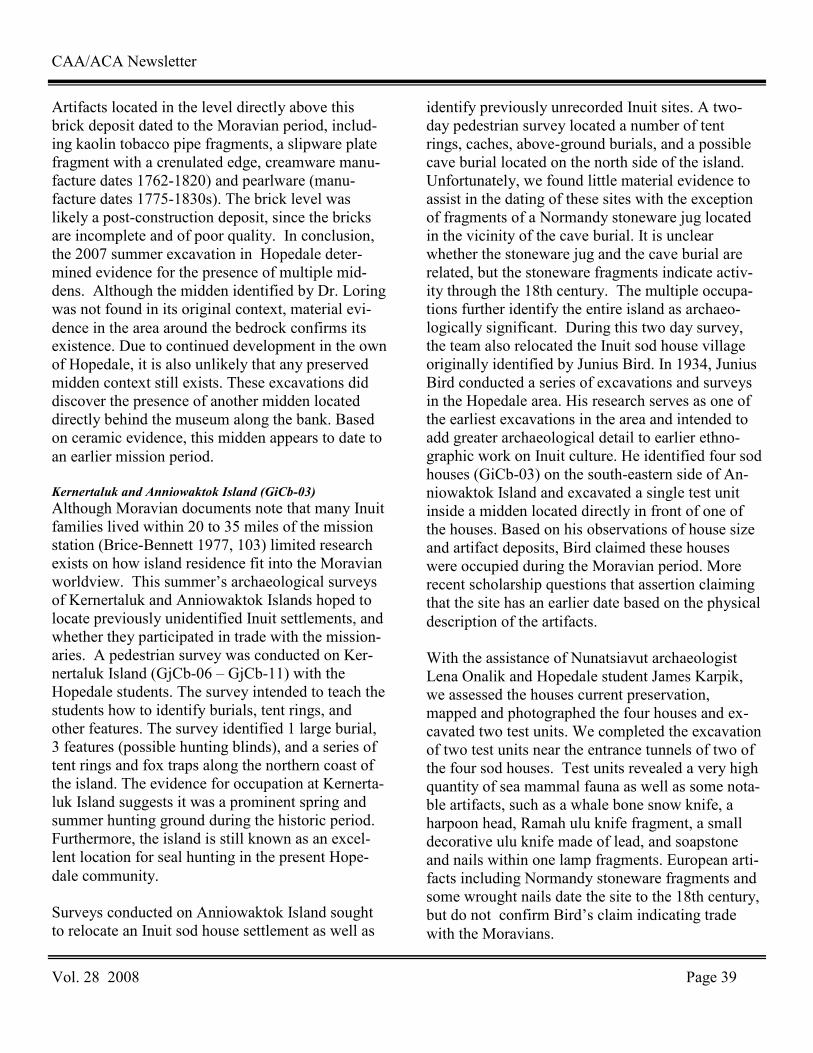
CAA/ACA Newsletter
Vol. 28 2008 Page 39
Artifacts located in the level directly above this brick deposit dated to the Moravian period, includ-ing kaolin tobacco pipe fragments, a slipware plate fragment with a crenulated edge, creamware manu-facture dates 1762-1820) and pearlware (manu-facture dates 1775-1830s). The brick level was likely a post-construction deposit, since the bricks are incomplete and of poor quality. In conclusion, the 2007 summer excavation in Hopedale deter-mined evidence for the presence of multiple mid-dens. Although the midden identified by Dr. Loring was not found in its original context, material evi-dence in the area around the bedrock confirms its existence. Due to continued development in the own of Hopedale, it is also unlikely that any preserved midden context still exists. These excavations did discover the presence of another midden located directly behind the museum along the bank. Based on ceramic evidence, this midden appears to date to an earlier mission period. Kernertaluk and Anniowaktok Island (GiCb-03)
Although Moravian documents note that many Inuit families lived within 20 to 35 miles of the mission station (Brice-Bennett 1977, 103) limited research exists on how island residence fit into the Moravian worldview. This summer’s archaeological surveys of Kernertaluk and Anniowaktok Islands hoped to locate previously unidentified Inuit settlements, and whether they participated in trade with the mission-aries. A pedestrian survey was conducted on Ker-nertaluk Island (GjCb-06 – GjCb-11) with the Hopedale students. The survey intended to teach the students how to identify burials, tent rings, and other features. The survey identified 1 large burial, 3 features (possible hunting blinds), and a series of tent rings and fox traps along the northern coast of the island. The evidence for occupation at Kernerta-luk Island suggests it was a prominent spring and summer hunting ground during the historic period. Furthermore, the island is still known as an excel-lent location for seal hunting in the present Hope-dale community. Surveys conducted on Anniowaktok Island sought to relocate an Inuit sod house settlement as well as
identify previously unrecorded Inuit sites. A two-day pedestrian survey located a number of tent rings, caches, above-ground burials, and a possible cave burial located on the north side of the island. Unfortunately, we found little material evidence to assist in the dating of these sites with the exception of fragments of a Normandy stoneware jug located in the vicinity of the cave burial. It is unclear whether the stoneware jug and the cave burial are related, but the stoneware fragments indicate activ-ity through the 18th century. The multiple occupa-tions further identify the entire island as archaeo-logically significant. During this two day survey, the team also relocated the Inuit sod house village originally identified by Junius Bird. In 1934, Junius Bird conducted a series of excavations and surveys in the Hopedale area. His research serves as one of the earliest excavations in the area and intended to add greater archaeological detail to earlier ethno-graphic work on Inuit culture. He identified four sod houses (GiCb-03) on the south-eastern side of An-niowaktok Island and excavated a single test unit inside a midden located directly in front of one of the houses. Based on his observations of house size and artifact deposits, Bird claimed these houses were occupied during the Moravian period. More recent scholarship questions that assertion claiming that the site has an earlier date based on the physical description of the artifacts. With the assistance of Nunatsiavut archaeologist Lena Onalik and Hopedale student James Karpik, we assessed the houses current preservation, mapped and photographed the four houses and ex-cavated two test units. We completed the excavation of two test units near the entrance tunnels of two of the four sod houses. Test units revealed a very high quantity of sea mammal fauna as well as some nota-ble artifacts, such as a whale bone snow knife, a harpoon head, Ramah ulu knife fragment, a small decorative ulu knife made of lead, and soapstone and nails within one lamp fragments. European arti-facts including Normandy stoneware fragments and some wrought nails date the site to the 18th century, but do not confirm Bird’s claim indicating trade with the Moravians.
CAA/ACA Newsletter
Vol. 28 2008 Page 40
Work at this site also revealed architectural ele-ments, such as large boulders, wooden planks house’s entryway. Based on these excavations, I plan to return to Anniowaktok next summer to gather additional data on the occupation and life at the sod house village Summary
Test excavations and surveys in the Hopedale area reveal the material evidence of a multi-dimensional Labrador landscape. Identifying unrecorded Inuit sites and testing earlier hypotheses about sod house occupations demonstrate the area’s complexity as both mission and prominent hunting ground. Con-tinued research hopes to highlight how Inuit con-tinually adapted to a changing landscape while add-ing to a growing body of research on early historic Inuit life in central Labrador. A Labrador Métis Sod Structure In Southern Labra-
dor (FkBg-24)
Matthew Beaudoin, Memorial University of
Newfoundland
During the summer of 2007 I excavated FkBg-24, a 19th century sod house on North River, near Cart-wright, Labrador as part of my MA research. This site was first identified by Dr. Lisa Rankin in 2002 as part of the Porcupine Strand Archaeology Pro-ject. With my crew of Ryan Anderson, Susan Arsenault, Amelia Fay, Tamara Hurley and Jessica Pace we spent 8 weeks living in a cabin at North River and excavating 55m2 in and around the house structure. This project is part of a larger project headed by Dr. Lisa Rankin to develop a better un-derstanding of the post-contact period in Southern Labrador. My addition is the first excavation spe-cifically targeted at a Labrador Métis sod structure. While there have most likely been Labrador Métis sod structures excavated prior to this project, they have been identified as either European or Inuit structures. The Labrador Métis are identified as the descendents of mixed English and Inuit marriages and are present throughout the Southern Labrador coast.
This sod house has been identified as having been built and owned by Charles Williams, an English settler from Plymouth England. Genealogical data, church records and historic maps indicate that Charles Williams married a Labrador Inuit woman named Mary, and became one of the earliest re-corded Labrador Métis families in the area. The Williams family is recorded to have inhabited this structure from the middle of the 19th century until near the end of the century. This sod structure was most likely inhabited from the early fall to late spring as a salmon fishing and trapping site. FkBg-24 consists of a sod house structure that has sod walls that measure between one and two meters thick and we were able to set up a 10m by 4m inside of the walls. A ditch is present around the structure, and is likely the result of piling up the sods to insu-late the walls. There is a door opening in the center of the long axis wall facing due south with a stone stove platform in the center of the opposing wall. Evidence suggests that there was a wooden floor, walls and roof. There is also evidence of window glass. In one end of the house there is evidence of animal bone, barrels and chests for storage and in the other there is evidence for a storage pit that was possibly used as a root cellar. The stratigraphy sug-gests that the east end of the structure collapsed first, possibly due to fire, which allowed the west end of the structure to fill with windblown sand. 3 meters to the north of the structure is a 1 meter deep saw pit that is 1m wide by 3 meters long. The artifacts collected represent a well diversified domestic assemblage. Over 3000 artifacts were re-covered that give insight into food preparation, hunting, fishing and clothing. Some of the large numbers of artifacts found were British gunflints, lead shot, musket balls, cutlery, metal and bone but-tons and glass beads. The ceramics recovered are primarily whiteware, and there appears to be more hollowware vessels than flatware. The presence of several inkwells and ceramics with text suggest that there were members of the household who were lit-erate. Also, the presence of medicine jars and ce-ramics with mending holes suggests that the resi-dents were isolated for periods of the year and were
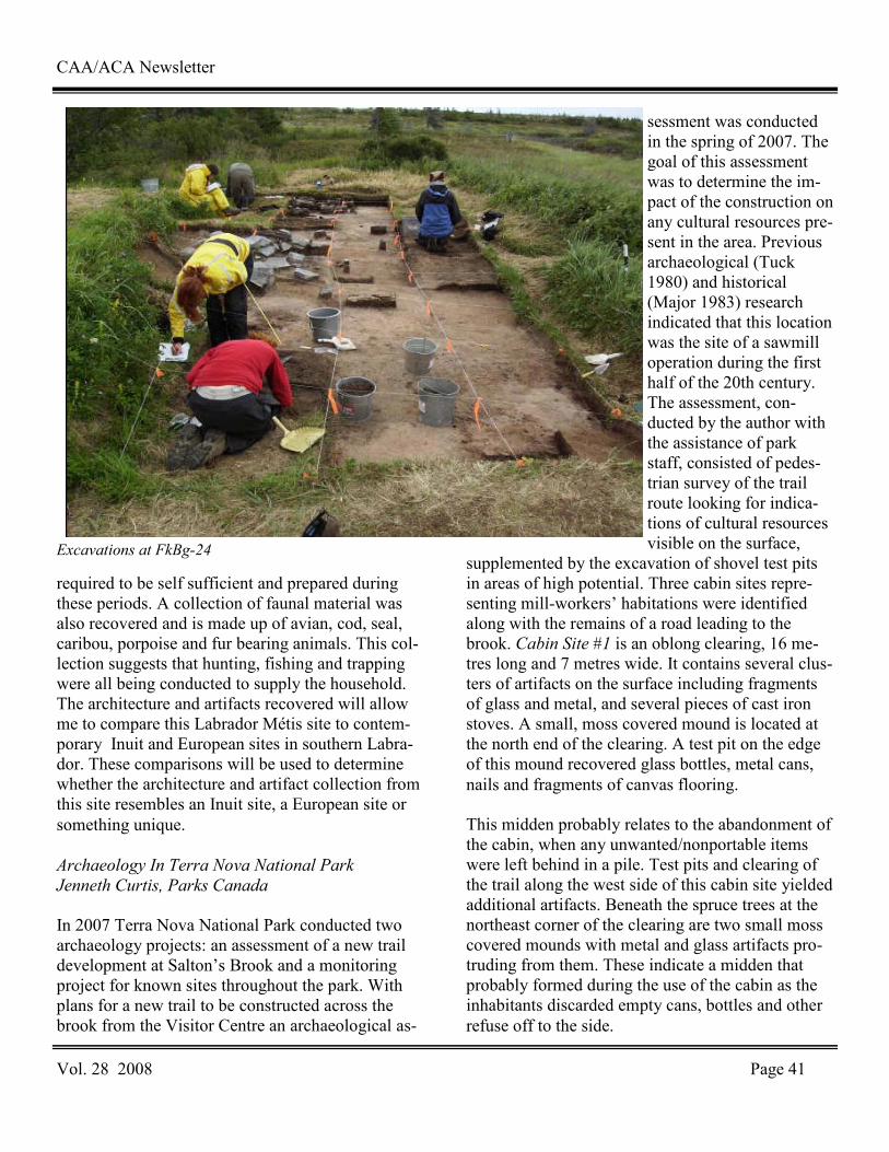
CAA/ACA Newsletter
Vol. 28 2008 Page 41
required to be self sufficient and prepared during these periods. A collection of faunal material was also recovered and is made up of avian, cod, seal, caribou, porpoise and fur bearing animals. This col-lection suggests that hunting, fishing and trapping were all being conducted to supply the household. The architecture and artifacts recovered will allow me to compare this Labrador Métis site to contem-porary Inuit and European sites in southern Labra-dor. These comparisons will be used to determine whether the architecture and artifact collection from this site resembles an Inuit site, a European site or something unique. Archaeology In Terra Nova National Park
Jenneth Curtis, Parks Canada
In 2007 Terra Nova National Park conducted two archaeology projects: an assessment of a new trail development at Salton’s Brook and a monitoring project for known sites throughout the park. With plans for a new trail to be constructed across the brook from the Visitor Centre an archaeological as-
sessment was conducted in the spring of 2007. The goal of this assessment was to determine the im-pact of the construction on any cultural resources pre-sent in the area. Previous archaeological (Tuck 1980) and historical (Major 1983) research indicated that this location was the site of a sawmill operation during the first half of the 20th century. The assessment, con-ducted by the author with the assistance of park staff, consisted of pedes-trian survey of the trail route looking for indica-tions of cultural resources visible on the surface,
supplemented by the excavation of shovel test pits in areas of high potential. Three cabin sites repre-senting mill-workers’ habitations were identified along with the remains of a road leading to the brook. Cabin Site #1 is an oblong clearing, 16 me-tres long and 7 metres wide. It contains several clus-ters of artifacts on the surface including fragments of glass and metal, and several pieces of cast iron stoves. A small, moss covered mound is located at the north end of the clearing. A test pit on the edge of this mound recovered glass bottles, metal cans, nails and fragments of canvas flooring. This midden probably relates to the abandonment of the cabin, when any unwanted/nonportable items were left behind in a pile. Test pits and clearing of the trail along the west side of this cabin site yielded additional artifacts. Beneath the spruce trees at the northeast corner of the clearing are two small moss covered mounds with metal and glass artifacts pro-truding from them. These indicate a midden that probably formed during the use of the cabin as the inhabitants discarded empty cans, bottles and other refuse off to the side.
Excavations at FkBg-24
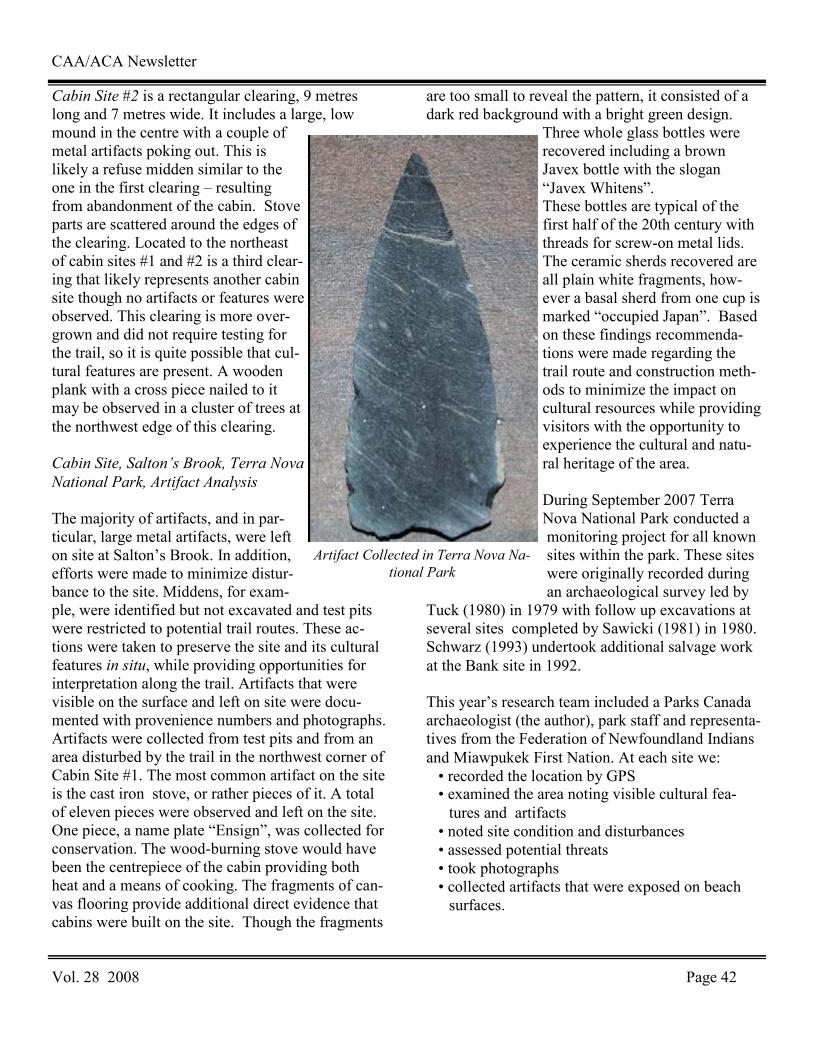
CAA/ACA Newsletter
Vol. 28 2008 Page 42
Cabin Site #2 is a rectangular clearing, 9 metres long and 7 metres wide. It includes a large, low mound in the centre with a couple of metal artifacts poking out. This is likely a refuse midden similar to the one in the first clearing – resulting from abandonment of the cabin. Stove parts are scattered around the edges of the clearing. Located to the northeast of cabin sites #1 and #2 is a third clear-ing that likely represents another cabin site though no artifacts or features were observed. This clearing is more over-grown and did not require testing for the trail, so it is quite possible that cul-tural features are present. A wooden plank with a cross piece nailed to it may be observed in a cluster of trees at the northwest edge of this clearing. Cabin Site, Salton’s Brook, Terra Nova
National Park, Artifact Analysis
The majority of artifacts, and in par-ticular, large metal artifacts, were left on site at Salton’s Brook. In addition, efforts were made to minimize distur-bance to the site. Middens, for exam-ple, were identified but not excavated and test pits were restricted to potential trail routes. These ac-tions were taken to preserve the site and its cultural features in situ, while providing opportunities for interpretation along the trail. Artifacts that were visible on the surface and left on site were docu-mented with provenience numbers and photographs. Artifacts were collected from test pits and from an area disturbed by the trail in the northwest corner of Cabin Site #1. The most common artifact on the site is the cast iron stove, or rather pieces of it. A total of eleven pieces were observed and left on the site. One piece, a name plate “Ensign”, was collected for conservation. The wood-burning stove would have been the centrepiece of the cabin providing both heat and a means of cooking. The fragments of can-vas flooring provide additional direct evidence that cabins were built on the site. Though the fragments
are too small to reveal the pattern, it consisted of a dark red background with a bright green design.
Three whole glass bottles were recovered including a brown Javex bottle with the slogan “Javex Whitens”. These bottles are typical of the first half of the 20th century with threads for screw-on metal lids. The ceramic sherds recovered are all plain white fragments, how-ever a basal sherd from one cup is marked “occupied Japan”. Based on these findings recommenda-tions were made regarding the trail route and construction meth-ods to minimize the impact on cultural resources while providing visitors with the opportunity to experience the cultural and natu-ral heritage of the area. During September 2007 Terra Nova National Park conducted a monitoring project for all known sites within the park. These sites were originally recorded during an archaeological survey led by
Tuck (1980) in 1979 with follow up excavations at several sites completed by Sawicki (1981) in 1980. Schwarz (1993) undertook additional salvage work at the Bank site in 1992. This year’s research team included a Parks Canada archaeologist (the author), park staff and representa-tives from the Federation of Newfoundland Indians and Miawpukek First Nation. At each site we: • recorded the location by GPS • examined the area noting visible cultural fea-tures and artifacts
• noted site condition and disturbances • assessed potential threats • took photographs • collected artifacts that were exposed on beach surfaces.
Artifact Collected in Terra Nova Na-
tional Park
CAA/ACA Newsletter
Vol. 28 2008 Page 43
Among the 21 recorded sites are 9 Aboriginal sites, 11 Historic sites, and 1 site with both Aboriginal and Historic components. The Aboriginal sites represent 5000 years of human history in the park and all of the cultural groups known to have inhabited Newfoundland. Several of the sites are multi-component thus 5 Maritime Archaic, 4 Palaeoeskimo (both Groswater and Dor-set), and 1 Recent Indian component are present. In addition 4 sites could not be assigned to a specific group due to a lack of diagnostic artifacts. These sites are characterised by scatters of lithic tools and flakes that are emerging from along the eroding coastline. Traces of charcoal at some of the sites hint at the presence of buried cultural features. The collected artifacts include a biface, two endblades, a bevelled-slate tool, and a chert core. The Historic sites include 6 sawmill sites represent-ing the importance of the lumber industry to this area during the first half of the 20th century. These range from small processing stations to large sites with living areas. Five additional historic sites are represented by traces of various structures. The re-sults of this monitoring project have thus provided up-to-date location and condition information that will form the basis for further cultural resource management. The Cow Cove and French Island Tickle
Excavations - 2007 Field School
John Erwin, Memorial University
The 2007 Memorial University Archaeological Field School continued excavation at Cow Cove 3 (EaBa- 16) and the French Island Tickle (EaBa-19) sites. Following two days of orientation in St. John’s on June 25-26, students joined staff in Coachman’s Cove on June 29 to set up camp and prepare the sites for excavation. Excavations began on July 1, 2007, with the opening of eleven 1x1 square units at Cow Cove 3. As in previous years, students were provided training and experience in archaeological field and laboratory work. The focus of the 2007 field school was on the excavation of
Cow Cove 3, a multi-component Groswater and Dorset Palaeoeskimo site which has been the sub-ject of five previous seasons of student excavations from 2002-2006. Students gained additional experi-ence through the limited excavation of French Is-land Tickle, a site containing both historic (French) and prehistoric (Dorset Palaeoeskimo) components. Cow Cove 3 Excavation Results
Since the initial season of excavation in 2002, our work at the Cow Cove 3 site has revealed the pres-ence of Groswater and Dorset Palaeoeskimo compo-nents, including the remains of a single Dorset house structure with associated open-air activity ar-eas. Our excavations have also resulted in the recov-ery of thousands of chert, rhyolite and chalcedony waste flakes, hundreds of stone tools, and a handful of organic tools belonging to both the Dorset and Groswater cultures. The 2007 investigations at Cow Cove 3 focused on the partial infill of the checkerboard excavation which was opened up in 2006 along the eastern boundary of the site. The purpose of this investiga-tion was to further determine the relationship of the Groswater and Dorset occupations, and to investi-gate an area which had produced organic preserva-tion and the first evidence of organic tools on the site. In summary, a total of eleven 1m x 1m square units was excavated in 2007, bringing the total num-ber of units excavated at Cow Cove 3 to 130. The excavation along the eastern margins of the site con-tinued to reveal areas of open-air lithic reduction and organic tool manufacturing activities, as well as evidence for soapstone working. Hundreds of soap-stone flakes and numerous faunal remains were found throughout much of the excavated area in 2007. A few examples of utilized soapstone vessels were also recovered, which represents the first di-rect evidence of soapstone vessel use on the site. A single small worked piece of bone which appears to be a portion of a leister or fish spear was the only organic tool recovered during the 2007 field sea-son.
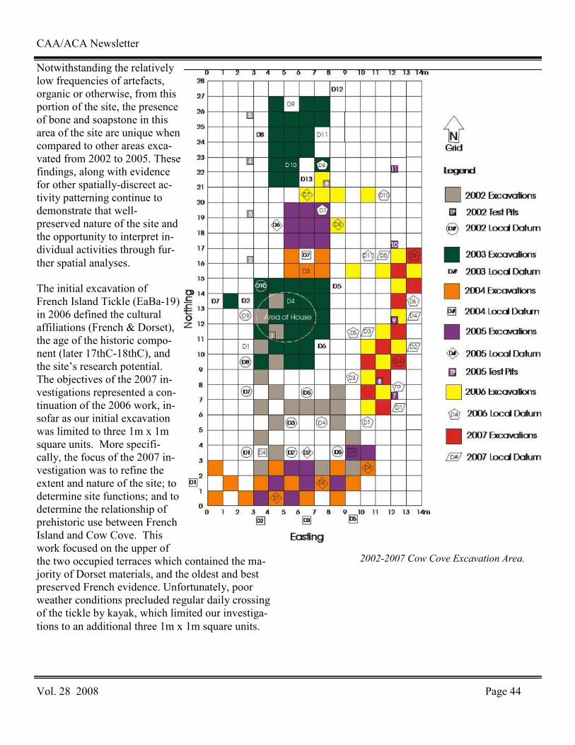
CAA/ACA Newsletter
Vol. 28 2008 Page 44
Notwithstanding the relatively low frequencies of artefacts, organic or otherwise, from this portion of the site, the presence of bone and soapstone in this area of the site are unique when compared to other areas exca-vated from 2002 to 2005. These findings, along with evidence for other spatially-discreet ac-tivity patterning continue to demonstrate that well-preserved nature of the site and the opportunity to interpret in-dividual activities through fur-ther spatial analyses.
The initial excavation of French Island Tickle (EaBa-19) in 2006 defined the cultural affiliations (French & Dorset), the age of the historic compo-nent (later 17thC-18thC), and the site’s research potential. The objectives of the 2007 in-vestigations represented a con-tinuation of the 2006 work, in-sofar as our initial excavation was limited to three 1m x 1m square units. More specifi-cally, the focus of the 2007 in-vestigation was to refine the extent and nature of the site; to determine site functions; and to determine the relationship of prehistoric use between French Island and Cow Cove. This work focused on the upper of the two occupied terraces which contained the ma-jority of Dorset materials, and the oldest and best preserved French evidence. Unfortunately, poor weather conditions precluded regular daily crossing of the tickle by kayak, which limited our investiga-tions to an additional three 1m x 1m square units.
2002-2007 Cow Cove Excavation Area.
CAA/ACA Newsletter
Vol. 28 2008 Page 45
Excavations At DiBd-1: A Beaches Complex Site At
Birchy Lake, Interior Newfoundland
Donald H. Holly Jr., Eastern Illinois University and
John Erwin, Archaeological Research Associates
In May of 2007 excavations were conducted at a small Beaches Complex site (DiBd-1) at Birchy Lake—a narrow 20 kilometre long lake situated at the base of the Baie Verte Peninsula in north central Newfoundland. The site was first discovered in the summer of 2005 in the course of an archaeological survey of the lake. This survey, together with our recent excavation of DiBd-1, was conceived as part of a broader investigation aimed at exploring hunter-gatherer settlement and subsistence strategies in the interior of the island. We discovered six new sites in 2005. Most were spot finds. We often found arti-facts strewn across exposed beaches and sometimes underwater. As a consequence of hydroelectric op-erations, the lakeshore has suffered considerable erosion. All of the sites we located in 2005 are peri-odically inundated or else have been destroyed. The loss of these sites is unfortunate, as our survey yielded material suggesting the presence of Mari-time Archaic Indian, Groswater Paleoeskimo, and (early) Recent Indian peoples on the lake in antiq-uity. Our 2007 excavations centered on DiBd-1 (Birchy Lake-9), a site that in 2005 seemed to offer the promise of some in-situ deposits. And indeed, our excavation in 2007 revealed as much; although the topsoil has been largely stripped away, cultural ma-terial remained buried—albeit just beneath the sur-face of the soil. In a few places, tuft-like islands of rooty-vegetation jut out of the surface of the site. They are all that remain of the pre-flood surface. We excavated ten 1x1 meter and two 50cm x 50cm units over the course of five days. Our pace was slowed by the discovery of a large deposit of cal-cined bone-mash and charcoal-stained soil. The fea-ture was roughly oval in shape, three meters long, a meter wide, and oriented northeast-southwest. Bone mash was found throughout the feature and to a depth of about five centimetres, but the densest con-centrations of bone mash appeared to occur along its
perimeter. We also identified four vaguely-circular deposits of charcoal stained soil in the feature. The hearths were located close to the edge of the feature too. The bone mash we encountered at DiBd-1 re-calls similar deposits found at Beothuk sites in the interior and at Innu sites in Quebec and Labrador. Raymond LeBlanc described the faunal material he unearthed at Wigwam Brook, a historic Beothuk site on the Exploit’s River, as consisting of “…small particles of bone and bone powder”. His de-scription is certainly apt here. We estimate that we collected 32,409 pieces of calcined bone, and that on average each individual piece weighed only .28 grams. LeBlanc suggested that the bone mash de-posits at Wigwam Brook were formed in the proc-ess of rendering grease. We concur, and believe that our feature reflects similar activities. Grease ren-dering begins with the mashing of bones, which are then placed in boiling water to extract the grease. Given the general absence of pottery at Recent In-dian sites, it is likely that birch bark containers were used for this purpose. Of course, this would have necessitated the use of hot stones to heat the water. We found ample evidence of stones used in this way. Fire-cracked rock was found throughout the feature. In addition, we identified four deposits of charcoal stained soil that likely represent the re-mains of expedient hearths built for the purpose of heating stones. After grease is rendered, it is col-lected by adding cold water or snow. The cold water causes the grease of land mammals in particular to congeal, at which point it was collected. The con-tents of the vessels were subsequently discarded—we imagine in the process forming the feature we discovered at DiBd-1. We recovered most of the artifacts that we found within and along the perimeter of the feature. The artifacts included bifaces, scrapers, projectile points, cores, utilized flakes and lithic debitage. Most of the artifacts and debitage consisted of chert-presumably obtained on the island-but fifteen percent of the debitage and five formal tools were fashioned from Ramah chert. The most impressive of these is a side-notched projectile point, of which the proximal portion remains.
CAA/ACA Newsletter
Vol. 28 2008 Page 46
Another side-notched projectile point was found at the site during the 2005 survey. This point is made of a fine-grained beige chert and is complete. The DiBd-1 artifact assemblage also includes scrapers, triangular bifaces, and large biface fragments. The material is typical of the Beaches complex. The most interesting object that we unearthed this season was a small piece of bone. The bone bears an engraved set of parallel lines on both sides—eight on one side, nine on the other. We found the object in the bone mash feature, in the midst of thousands of pieces of mashed calcined bone. Yet, this object does not appear to have received the same treat-ment—it has been worked and it’s in good condi-tion. Its function, however, is unknown; it might have been a bone point, or a pendant, or maybe even some sort of divination device. Whatever it is, it is a special piece. It might represent the earliest example of engraved bone at a Recent Indian site on the is-land. DiBd-1 stands to make an important contribu-tion to our understanding of the Beaches complex and to Recent Indian adaptations in the interior at a time when Dorset PaleoEskimo peoples frequented the nearby shores. As such, our hope is to return to the site in 2008 and conduct additional excavations in a small surviving portion of the site immediately adjacent to the bone-mash feature. With any luck, we will be able to identify additional features and unearth artifacts that will help shed light on this im-portant period in Newfoundland prehistory.
Groswater And Dorset Paleoeskimo Research On
The Dog Peninsula, Bird Cove
Latonia Hartery, University of Calgary
Bird Cove’s scenic Dog Peninsula was the setting for the 2007 field season of the Bird Cove-Pond Cove Archaeology Project. Dorset and Groswater Paleoeskimo sites, named Fisherman Cove-1 (EgBf-13) and Fisherman Cove-2(EgBf-14), respectively, were excavated over the course of a month. Fisher-man Cove-1 is located just east of Dog Point, and lies roughly 7m asl on a flat terrace. It was exca-vated to further the project goal of understanding Dorset Paleoeskimo settlement and subsistence
strategies in this part of the Bird Cove Archaeology District (Bird Cove to Pond Cove). The site was first shovel tested by David Reader in 1997, and in 2007 this initial investigation was followed up by a test excavation to determine site function. Based on the limited number of squares in this excavation it is difficult to fully understand the function of the site, but enough material was recovered to suggest Fish-erman Cove-1 was a small and temporary campsite. Unlike most other Dorset sites in our research area there are no faunal remains. This likely results from the lower layers of the site not possessing large dolomite and limestone rocks through which bones percolate downward, and become protected by these calcium rich rocks. Instead, the lowest stratum of Fisherman Cove-1 contains beach and pebbles, packed tightly together, with a few large rocks ar-ranged culturally. Although no organic remains were found, a variety of finely crafted tools were recovered, including a quartz crystal microblade, flaked and fashioned into a point, and a quartz crys-tal scraper, types commonly found in Dorset sites in Bird Cove. Debitage includes distant and near source material, ranging from Ramah chert to New-foundland cherts from Port au Port, Cow Head and the Bird Cove region. Several lithic artifacts from the assemblage were isolated for testing as part of the Arctic Phytolith Project, which is based out of Bird Cove and also began in 2007. This project de-termines prehistoric plant use on a microscopic level through tool edge residue analysis. Plant col-lection and samples taken for the project are set to include Nunavut and Greenland as well as New-foundland and Labrador. The second site, Fisherman Cove-2, is a Groswater site whose previous testing had revealed interesting results, including a caribou hoof amulet recovered from the middle of a hearth feature. The site is likely one of the smallest Groswater sites recorded in Newfoundland. This season we finished excava-tions at the site, uncovering the hearth in its entirety, and finding additional artifacts, such as end and side blades. Fisherman Cove-2 is of great interest largely due to the conjunction of a single hearth fea-ture, the hoof amulet, pockets of red ochre with

CAA/ACA Newsletter
Vol. 28 2008 Page 47
tools contained inside, as well as finely crafted tools, both used and unused. Many of the end blades recovered, whether complete or broken, have a high degree of serration, similar to those in Philips Gar-den West. Side blades also exhibit the same charac-teristic. Knives are also abundant whereas micro-blades were practically non-existent. Taken as a whole, the evidence indicates that something of spiritual significance may have taken place at this location. To date, most of the investigations in Bird Cove have related to subsistence, settlement and economic reconstruction but this site, once fully re-searched, may provide insight on cosmology, and the intermingling of ritual and economy, within the Groswater Paleoeskimo culture. Summary of 2007 Fieldwork at Iglosiatik and
Komaktorvik Fiord
Peter Whitridge, Memorial University and
James Woollett, Université Laval
In July Peter Whitridge (Memorial University of Newfoundland) and a crew from Nain (Gabriel Suarak, Brendon Dicker) and MUN (Don Butler, Dave Knill) carried out archaeological mapping, geochemical sampling and test excavation at the site of Iglosiatik, on an island southeast of Nain. Iglosi-atik is a winter village that appears to have been first occupied during the early colonization of the central Labrador coast by precontact Inuit groups from further north. It was previously investigated by Susan Kaplan, who excavated two semi-subterranean winter houses in the early 1990s, and revisited, sampled, and tested in 2007 as part of an effort to document the Inuit understanding of the Labrador environment during the early settlement period. Four test pits were excavated to sterile, pro-ducing both precontact (slate harpoon head end blade) and contact era material (iron nails). In early August the crew returned to Nain and joined up with James Woollett and students from Université Laval (Maryse Clouthier-Gelinas, Guil-laume Leclerc), as well as bear monitors (John An-dersen, John Merkeratsuk) and another field assis-
tant (Dennis Merkeratsuk) from Nain. This group travelled by longliner to northern Labrador and set up camp next to the Inuit winter site of Komaktor-vik 1 (IhCw-01), which was first investigated by the Torngat Archaeology Project in the late 1970s and later revisited and further tested by William Fitz-hugh. Test excavations were conducted next to pre-contact and historic Inuit winter houses at the west-ern and eastern ends of the site, generating assem-blages that spanned the Middle Dorset through later historic periods. The site appears to have been occu-pied over a much longer period, but more intermit-tently, than analogous sod house sites in nearby Nachvak Fiord, likely reflecting an interesting di-mension of episodic Inuit settlement expansion and retraction. It also exhibits a distinctive progression of house styles that culminates in an unusual late historic variety of house group, composed of tiny, discrete dwellings with radiating entrance tunnels, that is duplicated at the nearby winter site of Big Head 1 (IiCw-03), at the mouth of Kangalaksiorvik Fiord. Testing and sampling were also conducted at the latter site, and numerous small Paleoeskimo and Inuit sites recorded or revisited in the surrounding area. Excavation of the Recent Indian Site, Robert’s
Cove-1
Robyn Fleming, Memorial University
The site DjAv-5, known as Robert’s Cove 1, was first recorded in 1987 after an archaeological survey of Western Notre Dame Bay and Green Bay was conducted. Artifacts recovered from the 1987 sur-vey indicated the site was occupied by a Recent In-dian group, likely the Little Passage Complex. Robert’s Cove-1 was believed to be a habitation site however excavation of the site in the summer of 2007 challenged this hypothesis. A team from Me-morial University spent a total of eight weeks exca-vating the site. At various points throughout the summer the team consisted of John Higdon, Corey Hutchings, Rebecca Knapp, Lindsay Swinarton, and the author.
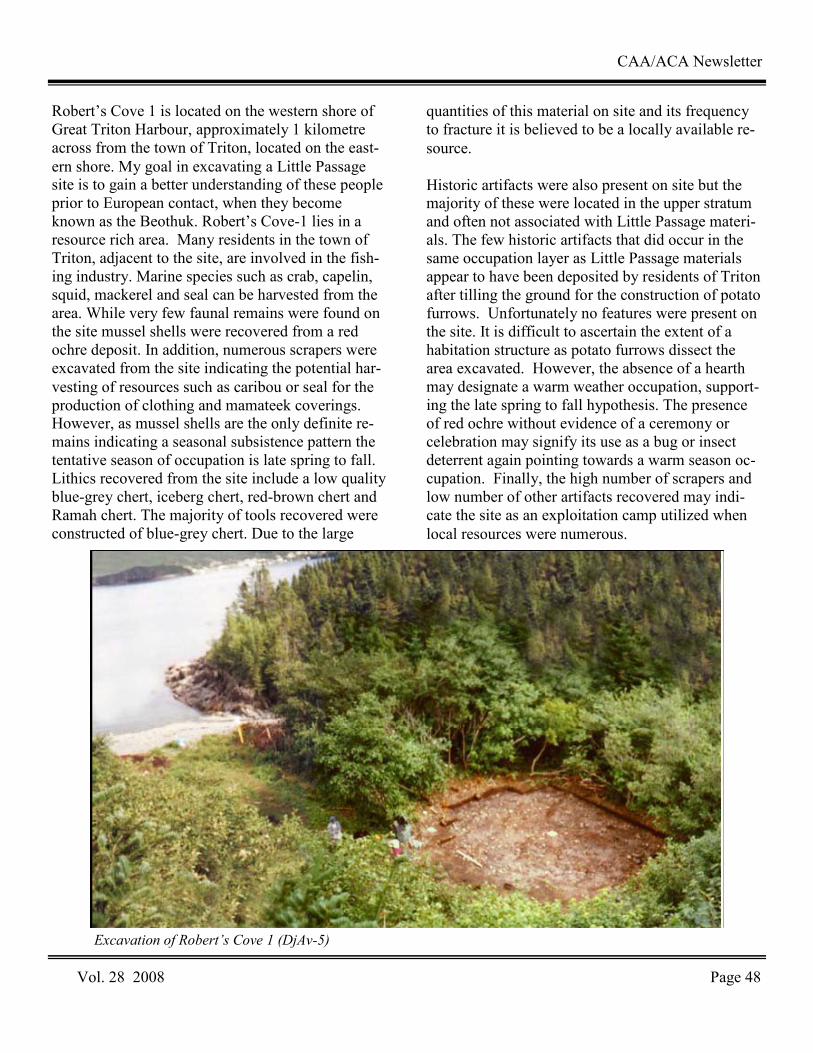
CAA/ACA Newsletter
Vol. 28 2008 Page 48
Robert’s Cove 1 is located on the western shore of Great Triton Harbour, approximately 1 kilometre across from the town of Triton, located on the east-ern shore. My goal in excavating a Little Passage site is to gain a better understanding of these people prior to European contact, when they become known as the Beothuk. Robert’s Cove-1 lies in a resource rich area. Many residents in the town of Triton, adjacent to the site, are involved in the fish-ing industry. Marine species such as crab, capelin, squid, mackerel and seal can be harvested from the area. While very few faunal remains were found on the site mussel shells were recovered from a red ochre deposit. In addition, numerous scrapers were excavated from the site indicating the potential har-vesting of resources such as caribou or seal for the production of clothing and mamateek coverings. However, as mussel shells are the only definite re-mains indicating a seasonal subsistence pattern the tentative season of occupation is late spring to fall. Lithics recovered from the site include a low quality blue-grey chert, iceberg chert, red-brown chert and Ramah chert. The majority of tools recovered were constructed of blue-grey chert. Due to the large
quantities of this material on site and its frequency to fracture it is believed to be a locally available re-source. Historic artifacts were also present on site but the majority of these were located in the upper stratum and often not associated with Little Passage materi-als. The few historic artifacts that did occur in the same occupation layer as Little Passage materials appear to have been deposited by residents of Triton after tilling the ground for the construction of potato furrows. Unfortunately no features were present on the site. It is difficult to ascertain the extent of a habitation structure as potato furrows dissect the area excavated. However, the absence of a hearth may designate a warm weather occupation, support-ing the late spring to fall hypothesis. The presence of red ochre without evidence of a ceremony or celebration may signify its use as a bug or insect deterrent again pointing towards a warm season oc-cupation. Finally, the high number of scrapers and low number of other artifacts recovered may indi-cate the site as an exploitation camp utilized when local resources were numerous.
Excavation of Robert’s Cove 1 (DjAv-5)

CAA/ACA Newsletter
Vol. 28 2008 Page 49
Archaeological Survey and Excavations at L’Anse
Aux Meadows, National Historic Site nada
Todd Kristensen, Memorial University and
Jenneth Curtis, Parks Canada
Parks Canada conducted archaeological excavations and survey work for three weeks in June at L’Anse aux Meadows, National Historic Site , on the north-ern tip of Newfoundland’s Northern Peninsula. Two main components guided archaeological re-search at the site. The first component involved a renewed interest by Parks Canada and Memorial University of Newfoundland in the aboriginal occu-pations within the boundaries of L’Anse aux Mead-ows National Historic Site. Though the Norse mate-rial earned the site its UNESCO status, a rich his-tory of Native occupation exists including the Mari-time Archaic, Groswater and Dorset Palaeoeskimo, and Recent Indian. New data from archaeological survey and targeted excavations of prehistoric Abo-riginal occupation areas will be combined with ex-isting information on Native occupations at the site and incorporated in to the current body of archaeo-logical knowledge of the National Historic Site and surrounding area. It is hoped that these efforts will result in a more complete and encompassing recon-struction of the prehistory and history of L’Anse aux Meadows. The second component of the 2007 fieldwork involved a number of small-scale excava-tion units in and adjacent to the Norse occupation area. The excavation of those units was motivated by: 1) a need to relocate Norse doorways in the re-constructed ruins, 2) a reassessment of previously determined cultural features near the shore of Epaves Bay, and 3) an independent research project that required sampling for invertebrate remains. Fieldwork relating to the Aboriginal occupation was led by Parks Canada archaeologist Jenneth Curtis with assistance from Tony Adler (University of Washington) and Todd Kristensen (Memorial Uni-versity of Newfoundland). Excavations of the Norse structures were led by Birgitta Wallace (Archaeologist Emeritus, Parks Canada).
Aboriginal Occupations
Portions of the lower marine terrace west of Black Duck Brook and the Norse site were excavated in an effort to re-establish the site grid employed during previous Parks Canada excavations in the 1970s. The proper identification of previously determined Aboriginal occupation areas depended on the re-location of site benchmarks and excavated units. Two permanent site benchmarks were identified and used to re-locate the site grid. Three 1 m² test units were then strategically placed to intersect the edges of previous excavation areas. One unit successfully encountered an excavation boundary while a second unit failed to detect any excavation areas or cultural material. A third unit encountered a previously un-documented cultural feature consisting of an ar-rangement of rock slabs. The stones likely represent a Dorset Palaeoeskimo axial feature (Figure 2). Fur-ther excavations are necessary to determine the fea-ture’s significance. Old grid stakes and visible rectangular depressions from previous excavations were also identified. This information will be combined with data gathered from the three test units to guide future excavations on the lower terrace. A random sampling strategy was employed in an archaeological survey of pre-historic sites west of Epaves Bay. Shovel tests were excavated on transects extending inland (south) from the shore. Test pits were dug at incremental distances from the current shoreline to ensure that a variety of landform types would be sampled. Addi-tional shovel tests were placed in zones of high po-tential as determined by slope, aspect, view, prox-imity to freshwater, and landform type. A number of depressions were also encountered though no cul-tural material was recovered from shovel tests placed in and around the depressions. One site was identified that consists of a rock feature visible on the surface.
CAA/ACA Newsletter
Vol. 28 2008 Page 50
The nature of the rock feature and the depressions is unknown but may relate to historic cultivation and grazing in the cove. One shovel test in the vicinity of the previously mentioned rock feature yielded a single flake of Ramah chert. In addition, a local resident of Ship Cove (approximately 8 km west of L’Anse aux Meadows) discovered a large biface of Ramah Chert in a backyard garden and permitted an inspection by Parks Canada staff during the 2007 field season Baccalieu Trail Archaeology, 2007
William Gilbert, Baccalieu Trail Heritage
Corporation
Field work began this year on May 22 and contin-ued until November 2. During the first week (May 22- 25) we undertook some improvement work at the Beothuk site at Russell’s Point, repairing and painting the fence and planting trees around the boundary of the site, and did some further testing at the Custer’s Head site in Hant’s Harbour. The Cus-ter’s Head site was first discovered in 2004 and has both a Recent Indian and a late 17th/early18th cen-tury component. In 2005 we uncovered the footing of what appears to be a late 17th century house. In May we returned and did some more digging in an attempt to determine the dimensions of this struc-ture. Between May 28 and July 27 we conducted more survey work and excavations on Dildo Island. There is a large Dorset Eskimo site on the Island and excavations were conducted there between 1996 and 1999. Radiocarbon samples recovered from the Palaeoeskimo site indicate that it was occupied be-tween AD 70 and AD 720. Over the past six years we have discovered that there is also a large Indian site on the Island. We began work on the Indian site in 2001 and between then and 2004 we uncovered a Recent Indian dwell-ing, a stone feature that appears to be a sweat lodge, and a five metre long Recent Indian fireplace. Ra-diocarbon samples from the fireplace show that the site was occupied around AD 800 and an analysis of the bones from the fireplace indicate that it was a base camp occupied during the spring and summer months.
We returned in 2007 and conducted more survey work in an effort to locate more Indian material. Four more Recent Indian fireplaces were uncovered all dating from roughly AD 800. We also discov-ered another Indian camp farther south that appears to date from about AD 1200 or 1300. The Hefford Plantation in New Perlican was discovered during an archaeological survey of that town in 2001 and excavations have been conducted at the site every year since then. The site was first settled by William Hefford and his family in 1675 and appears to have been occupied continually since that time. Over the past six years we have dug in five different areas on the site and uncovered over 20,000 artifacts and the remains of one structure that was destroyed by fire sometime late in the seventeenth century. This season we concentrated our work on Area E located in a grassy meadow at the north end of the site. Excavations here produced evidence of an oc-cupation during the late 17th and early 18th century. A large number of animal bones, teeth and jaw frag-ments were recovered suggesting that this may have been a place where animals were butchered. The remains of a post found in the last few days of the excavation may be part of a structure that once stood in Area E: possibly a barn. Cupids Cupids is the site of the first English settlement in Canada established by the London and Bristol Com-pany of Merchant Venturers in 1610. The site was discovered in 1995 and excavations have been on-going at the site every year since then. Over that time we have uncovered the remains of four build-ings, including the dwelling house and storehouse erected by the colony’s first governor, John Guy, in 1610, a number of related features, and over 122,000 artifacts. This year the site at Cupids was open to visitors seven days a week from June 9 until October 12 and excavations were conducted be-tween September 24 and November 2. During this period the excavation was extended south in an ef-fort to uncover more evidence of the enclosure erected by John Guy in 1610. As well, the excava-tion of a building (Structure 2) first discovered in 1999 was completed.

CAA/ACA Newsletter
Vol. 28 2008 Page 51
Structure 2 was a small build-ing (9ft x 15ft) located just three feet south of and paral-lel to the storehouse erected by John Guy in 1610. Al-though small, Structure 2 ob-viously had glazed windows. Numerous fragments of light-green, seventeenth-century window glass have been re-covered from the building including two complete panes, or ‘quarries’ found in the northwest corner of the building. A number of these quarries would have been fit-ted together with lead strips, sometimes referred to as ‘cames’, anchored to iron frames and fitted into wooden casements to form a window. Large numbers of wrought iron nails that must have originally been used in the construction of the building were also found. Other arti-facts recovered from Struc-ture 2 include shards from various types of coarse earth-enware vessels and fragments of seventeenth century case bottles and shaft and globe bottles. Several trade beads have also been recovered. One of the most exciting dis-coveries at Cupids this season was also the most unex-pected. While moving some wood next to the back dirt pile, we uncovered a six ft. (1.83m) long and 27 ½ inches (69.8cm) wide headstone. At least two lines of a well-weathered inscription are visible although it has yet to be deciphered. According to Dr. Jerry Po-cius, the stone likely dates from the early 18th cen-tury and was probably carved in Dorset, England. We do not know whether the stone marks a solitary
grave or is part of a larger cemetery but next season we will open up more of this area and see if we can uncover any other evidence of burials.
The early 18th century headstone found at Cupids.
CAA/ACA Newsletter
Vol. 28 2008 Page 52
News & AnnouncementsNews & AnnouncementsNews & AnnouncementsNews & Announcements
Il est désormais possible de consulter les collections ethnohistoriques et archéologiques de Pointe-à-Callière sur Internet. Le réseau Info-Muse de la So-ciété des musées québécois et Artefacts Canada du Réseau canadien d'information sur le patrimoine ont dernièrement ajouté à leur contenu plus de 1000 fiches techniques d'information numérisées par Pointe-à-Callière. Fortement marqué par la présence des vestiges in situ et des collections archéologiques issues des fouilles menées sur le lieu de fondation de Mon-tréal, le Musée a développé un thème intégrateur, soit celui de Montréal, carrefour d'échanges et de commerce. Ce thème sert de référence dans le développement de ses collections. Au fil des ans, le Musée est devenu propriétaire d'une collection des plus intéressante qui nous aide à documenter les périodes du Fort de Ville-Marie, du château de Cal-lière et des occupations subséquentes. Le collection-nement d'objets ethnohistoriques se fait par des ac-quisitions lors de la réalisation des expositions per-manentes et des expositions temporaires ainsi que par des dons relatifs à l'histoire de Montréal. En rendant accessibles ses collections à un plus large public, Pointe-à-Callière souhaite faciliter le réseautage avec des professionnels et des organis-mes oeuvrant en muséologie, en archéologie, en his-toire ou autres domaines connexes favorisant ainsi des échanges de ressources. Il compte aussi con-tribuer à l'économie du savoir puisque ces contenus, normalement réservés aux spécialistes, sont accessi-bles au grand public. Par la mise en ligne de ses collections, le Musée souhaite faire connaître les résultats des recherches
archéologiques et historiques menées sur les sites de la pointe à Callière depuis plusieurs années, intensi-fier le sentiment d'appartenance de la collectivité à la culture locale et à encourager la protection et la mise en valeur des composantes culturelles du terri-toire. Les collections ethnohistoriques et archéologiques de Pointe-à-Callière sont disponibles sur : * Le site Internet de Pointe-à-Callière : http://www.pacmusee.qc.ca/pages/histoire/collections.aspx?lang=FR-CA * Le réseau Info-Muse de la Société des musées québécois : http://infomuse.smq.qc.ca/Infomuse/f_MasterLayout.cgi * Artefacts Canada : http://www.rcip.gc.ca/Francais/Artefacts_Canada/index.html Le projet d'informatisation, numérisation et diffu-
sion nationale des collections de Pointe-à-Callière
a été rendu possible grâce à une contribution finan-
cière du programme Francommunautés virtuelles
d'Industrie Canada.
Conservation treatment is needed in most collec-tions at some time, whether due to accidental dam-age, vandalism, or physical deterioration of collec-tions. But few institutions have long-term relation-ships with conservators, and even fewer have con-servators on staff. As a result, few museum personnel have experience dealing with conservators and with the treatment process. And even those who do are often unsure about how to proceed in order to ensure a satisfac-tory treatment outcome. Custodians have an important role to play in treat-ment decisions because treatments must be respon-
New Book on Conservation
Les collections ethnohistoriques et
archéologiques de Pointe-à-Callière
maintenant disponibles pour consulta-

sive to the values and use of collections in their cur-rent context. The optimal treatment for an object depends on many different considerations including its physical environment, its treatment history, its current rate of deterioration, its rarity and market value, and its potential use for exhibition. Without a meaningful discussion of these issues between conservator and custodian, even a treatment that is technically flawless can prove to be unsatisfactory. This is an important issue for anthropological and archaeological collections because they embody many different meanings, and the optimal condition of objects used for different types of exhibitions and for research may vary widely. In addition, research-ers need to understand the condition and conserva-tion history of the objects they study. Conservation Treatment Methodology is a practical guide to decision-making for conservation treat-ments of all kinds of cultural material. Because many of the issues involved – the values, meaning, and use of collections - are not about the technical aspects of conservation, the book establishes a com-mon ground on which conservators and custodians can work together. Chapters also deal with the role of long-term preservation in treatment decisions, a vital matter for those responsible for the welfare of collections.
CAA/ACA Newsletter
Vol. 28 2008 Page 53
CAA/ACA Newsletter
Vol. 28 2008 Page 54
Pointe-à-Callière, the Montréal Museum of Archaeology and History, will be presenting Costa Rica, Land of
Wonders from November 4, 2008 to April 19, 2009. The exhibition, produced by Pointe-à-Callière in partner-ship with the Museo Nacional de Costa Rica, in San José, brings to Canada for the first time some 230 pre-cious gold, jade, ceramic and sculpted stone artifacts, all of them of a rare and splendid beauty. This is the largest exhibition on this subject ever produced outside of Costa Rica. Welcome to the “rich coast.” Costa Rica, Land of Wonders looks at the history of this country over a period of approximately 2,000 years, from 500 BC to Columbus’ arrival in 1502. Visitors will learn about the diversity of its main regions, as they ad-mire artifacts from each one: superbly executed human- and animal-effigy vessels, finely carved jade pendants, splendid gold finery and stone items symbolizing the traditions of the country’s peoples. The discoveries to be made are stunning in every respect. This land that was long considered a mere offshoot of the brilliant Olmec, Maya, Inca and other civilizations to the north and south actually developed its own remarkable esthetic signature. The voyage back in time will also look at the appearance and evolution of increasingly powerful chiefdoms in Costa Rican agricultural societies. An exotic encounter Visitors are bound to be fascinated by the beauty of this country and its wildlife, depicted in many of the pieces in the exhibition. As they explore a space evoking the tropical forest and the mysteries of a little-known civili-zation, they will come to realize that the archaeology of Pre-Columbian Costa Rica has truly earned it its desig-nation as the “rich coast.” Archaeological treasures come to Canada for the first time ever Most of the artifacts from the Museo Nacional de Costa Rica have never been shown outside of Costa Rica be-fore. Their tremendous esthetic appeal and technical mastery make them true masterpieces. Some of the items in the exhibition are unique to Costa Rican culture, and have no equivalents in other Pre-Columbian Ameri-
can societies: for instance, finely sculpted stone grinding tables – metates – and mysterious stone spheres, many of them impressively large. Costa Rican archaeology Economic development in Costa Rica in the late 19th century led to the discovery of a large number of graves. Unfortunately, many archaeological artifacts left the country and made their way into private collections. Other factors also erased traces of the past, including the acidic soil, torrential rainfall and land development. So although Costa Rican archaeologists have unearthed enough artifacts to make it possible to establish a context for items used by the elite, there is still much work to be done to gain a greater understanding of the day-to-day life of these early populations. Today the Costa Rican government is intent on protect-ing the country’s archaeological heritage. All objects found must be turned over to the collection of the Museo Nacional de Costa Rica, salvage digs are required before any construction and archaeological sites are protected by law – a job made easier now that Costa Ricans them-selves are more aware of their importance. Fruitful collaboration This exceptional selection of artifacts, the largest ever displayed in Canada, could never have been brought here without the tremendous collaboration of the Museo Na-cional de Costa Rica. The San José museum is making accessible to the North American public the little-known but immensely fascinating history of a country whose artifacts pay tribute to the bonds between man and na-ture. This is a gratifying partnership for Pointe-à-Callière, helping it with its mission of introducing local audiences to the world’s major civilizations. Another major contributor to the project was archaeologist Claude Chapdelaine, a professor at the Université de Montréal who has conducted archaeological research in Latin America for many years. A very special publication The catalogue, produced by Pointe-à-Callière in partner-ship with the Museo Nacional de Costa Rica, is one of the few works written in French on Costa Rican archae-ology. The 80-page, abundantly illustrated catalogue pre-sents all the items in the exhibition, along with a discus-sion of Pre-Columbian archaeology. Published in French and Spanish, it will be available at the Museum gift shop once the exhibition opens.
New Exhibit
Costa Rica—Land of Wonders
Montréal Museum of Archaeology

CAA/ACA Newsletter
Vol. 28 2008 Page 55
The Association des archéologues du Québec (AAQ) has recently published in its Hors Série collection a the-matic issue dedicated to New France archaeology to underline Québec City 400th anniversary of foundation. Entitled Dreams of the Americas: Overview of New France Archaeology / Rêves d’Amériques : Regard sur l’archéologie de la Nouvelle-France, this 242 pages volume presents 13 papers, either in French or in English, by leading scholars and archaeologists from both Canada and the US. With a preface by Marcel Moussette of Laval University, this issue provides a comprehensive overview of New France archaeology in the St. Law-rence valley, as well as in other parts (Acadia, Pays d’en Haut, Illinois, Louisiana, etc.) of North America.
CAA/ACA Newsletter
Vol. 28 2008 Page 56
The Canadian Journal of Archaeology publishes reviews of books dealing with any aspect of Canadian archae-ology or by Canadian archaeologists, books on other areas that would be of interest to a considerable number of Cana-dian archaeologists, and books of general interest dealing with archaeological issues, theory, or methods. Members inter-ested in doing reviews should check the CAA website occasionally, as the list of books available will be updated periodi-cally. Contact the book review editor (Alan McMillan) at [email protected] with requests or questions. Reviews can be submitted by email attachment in Word format. Check recent issues of the journal for organization and format. Review-ers should plan to complete and submit their reviews within a maximum of six months to allow for timely publication in the journal.
Books Available for Review Arnold, Denise Y. and Christine A Hastorf 2008. Heads of State: Icons, Power, and Politics in the Ancient and Modern Andes. Left Coast Press, Walnut Creek, CA (distributed in Canada by UBC Press, Vancouver).
Bailey, Geoff and Penny Spikins (editors) 2008. Mesolithic Europe. Cambridge University Press, New York. Barham, Lawrence and Peter Mitchell 2008. The First Africans: African Archaeology from the Earliest Toolmakers to Most Recent Foragers. Cambridge World Archaeology, Cambridge University Press, New York, NY.
Chacon, Richard J. and Rubén G. Mendoza (editors) 2007. North American Indigenous Warfare and Ritual Violence. University of Arizona Press, Tucson. (can be reviewed with companion volume Latin American Indigenous Warfare and Ritual Violence, with the same editors and publisher).
Davis, Miriam C. 2008. Dame Kathleen Kenyon: Digging Up the Holy Land. Left Coast Press, Walnut Creek, CA. Dillehay, Tom D. 2007. Monuments, Empires, and Resistance: The Araucanian Polity and Ritual Narratives. Cambridge Case Stud-ies in Archaeology, Cambridge University Pres, New York.
Fairclough, Graham, Rodney Harrison, John H. Jameson Jnr, and John Schofield (editors) 2008. The Heritage Reader. Routledge, New York.
Fish, Suzanne K., Paul R. Fish, and M. Elisa Villalpando (editors) 2008. Trincheras Sites in Time, Space, and Society. University of Arizona Press, Tucson.
Howard, Phil 2007. Archaeological Surveying and Mapping: Recording and Depicting the Landscape. Routledge, London and New York.
Hurcombe, Linda M. 2007. Archaeological Artefacts as Material Culture. Routledge, London and New York. Jones, Andrew 2007. Memory and Material Culture. Cambridge University Press, New York. Kehoe, Alice Beck and Thomas C. Pleger 2007. Archaeology: A Concise Introduction. Waveland Press, Long Grove, IL. Kehoe, Alice Beck 2008. Controversies in Archaeology. Left Coast Press, Walnut Creek, CA (distributed in Canada by UBC Press, Vancouver).
Books Available for Review
December 2008
Lister, Adrian and Paul Bahn 2007. Mammoths: Giants of the Ice Age (revised edition). University of California Press, Berkeley and Los Angeles.
Nelson, Sarah Milledge (editor) 2007. Women in Antiquity: Theoretical Approaches to Gender and Archaeology. Gender and Ar-chaeology Series, AltaMira Press, Rowman and Littlefield Publishers, Lanham MD.
Robb, John 2007. The Early Mediterranean Village: Agency, Material Culture, and Social Change in Neolithic Italy. Cambridge Studies in Archaeology, Cambridge University Press, New York.
Rothfield, Lawrence (editor) 2008. Antiquities Under Siege: Cultural Heritage Protection After the Iraq War. AltaMira Press, Lanham MD.
Rowley-Conway, Peter 2007. From Genesis to Prehistory: The Archaeological Three Age System and its Contested Reception in Denmark, Britain, and Ireland. Oxford Studies in the History of Archaeology, Oxford University Press, Oxford.
Roy, Christian and Hélène Côté (editors) 2008. Rêves d’Amériques: Regard sur L’archéologie de la Nouvell-France/ Dreams of the Americas: Overview of New France Archaeology. Collection Hors Série 2, Archéologiques, Association des archéologues du Québec, Québec.
Sanz, Inés Domingo, Dánae Fiore, and Sally K. May (editors) 2008. Archaeologies of Art: Time, Place, and Identity. Left Coast Press, Walnut Creek, CA (distributed in Canada by UBC Press, Vancouver).
Schlanger, Nathan and Jarl Nordbladh (editors) 2008. Archives, Ancestors, Practices: Archaeology in the Light of its History. Berghahn Books, New York and Oxford.
Shaw, Justine M. 2008. White Roads of the Yucatán: Changing Landscapes of the Yucatec Maya. University of Arizona Press, Tuc-son.
Snead, James E. 2008. Ancestral Landscapes of the Pueblo World. University of Arizona Press, Tucson. Souvatzi, Stella G. 2008. A Social Archaeology of Households in Neolithic Greece: An Anthropological Approach. Cambridge University Press, New York.
Stark, Miriam T., Brenda J. Bowser, and Lee Horne (editors) 2008. Cultural Transmission and Material Culture: Breaking Down Boundaries. Uni-versity of Arizona Press, Tucson.
Tarlow, Sarah 2007. The Archaeology of Improvement in Britain, 1750-1850. Cambridge Studies in Archaeology, Cambridge University Press, New York.
Vol. 28 2008 Page 57

CAA/ACA Newsletter
Please send submissions as attachments or (for short announcements and classifieds) as email messages directly to the Newsletter editor ([email protected]) or to your regional fieldwork news editor, listed below. Non-electronic items can also be sent to:
Colin Varley, CAA Newsletter Editor Jacques Whitford Limited
2781 Lancaster Road, Suite 200 Ottawa, Ontario K1B 1A7
Illustrations are gladly accepted either as hardcopy to the above address, or as .jpeg at-tachments via email. All photographs and drawings will be returned. Please provide a caption for each image.
Deadlines:
Spring Issue (Fieldwork News) Fall Issue (CAA News and announcements)
February 15 to the Regional September 15 to the Newsletter Editor Fieldwork News Coordinators
Regional Fieldwork News Editors Atlantic Region Stephen Hull Provincial Archaeology Office, Newfoundland <[email protected]>
Ontario Vacant Regional Fieldwork News Editor required Québec Adrian Burke University of Montreal, <[email protected]>
Manitoba/Saskatchewan Peggy McKeand Alberta Western Heritage, <[email protected]>
Alberta Alwynne B. Beaudoin Royal Alberta Museum <[email protected]>
British Columbia Terence Clark, University of Toronto Trevor J. Orchard McMaster University <[email protected]>
Yukon Ruth Gotthardt Government of Yukon, <[email protected]
Northwest Territories Tom Andrews Government of the Northwest Territories, <[email protected]>
Nunavut Julie Ross Government of Nunavut, <[email protected]
Information for Contributors
Vol. 28 2008 Page 58
The Newsletter of the Canadian Archaeological Association (CAA) is published twice a year as Spring and Fall issues. Subscription is free with membership in the CAA. Contents of the Newsletter may not reflect the viewpoint of the CAA. Your membership in the CAA is due on January 1, 2009. In order to receive your two issues of the Newsletter, the Canadian Journal of Archaeology, and maintain your logon account on the CAA Bulletin Board, you should es-tablish or renew your membership as soon as possible. Le Bulletin de l’association canadienne d’ archéologie est publié deux fois par année: au printemps et à l’autonne. Le matériel publié dans le Bulletin ne représente pas nécessaire-ment l’opinion oficielle de l’Associasion canadienne d’archéologie. Votre cotisation annuelle à l’Associasion canadienne d’archéologie arrive à terme en date du 1 er janvier 2006. Afin de re-cevoir les deux prochains bulletins et le noveau numéro du Journal canadien d’ archéologie, et pour continuer d’avoir accès au Babillard électronique, nous vous encourageons à renouveler votre adhesion, pour l’année 2006, le plus tôt possible.
Student/Étudiant ($35.00) Regular/Régulier ($75.00)
Instiutional/Institutionnel ($100.00) (Canadian Funds)
Make cheques payable to the Canadian Archaeological Association/Faire le chèque pay-able à l’ordre de l’Associasion d’archéologie canadienne. Please send a cheque or money order to/Envoyer votre payment à l’adresse suivante:
Secretary-Treasurer/Secrétaire-trésorier: Jeff Hunston c/o 4 Salter Place Whitehorse, Yukon
Y1A 5R2
Tel: (867) 668-7131 (home) (867)-667-5363 (work)
Fax: (867) 667-8023
Email: [email protected]; or [email protected] Memberships can now be renewed and acquired over our “secure” web site via credit card (VISA and Mastercard accepted)/Vous pouvez dorénavant revouveler votre adhésion à l'ACA en ligne grâce à notre nouveau service d'accès sécuritaire. Nous acceptons les cartes VISA et Mastercard.