Embed Size (px)
Citation preview
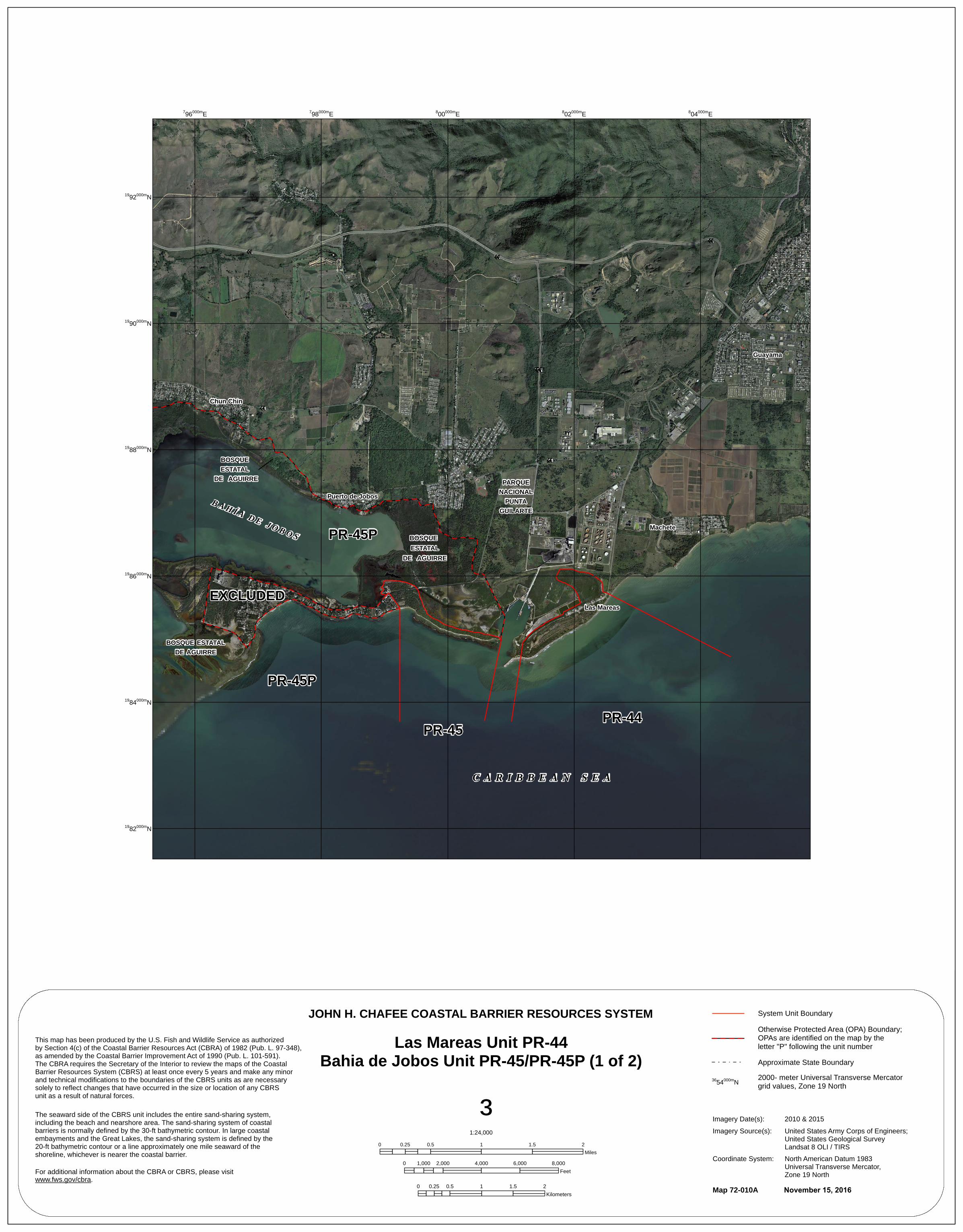
C A R I B B E A N S E A
PR-45 PR-44
PR-45P
BOSQUE ESTATALDE AGUIRRE
EXCLUDEDLas Mareas
B A H Í A D E J O B O S PR-45P BOSQUE ESTATAL
DE AGUIRRE
PARQUENACIONAL
PUNTAGUILARTE
Machete
BOSQUE ESTATAL
DE AGUIRRE
Puerto de Jobos
¬«3
¬«3Chun Chin
¬«7707
Guayama
¬«53¬«53
¬«53
1982000mN
1984000mN
1986000mN
1988000mN
1990000mN
1992000mN
796000mE 798000mE 800000mE 802000mE 804000mE
This map has been produced by the U.S. Fish and Wildlife Service as authorizedby Section 4(c) of the Coastal Barrier Resources Act (CBRA) of 1982 (Pub. L. 97-348),as amended by the Coastal Barrier Improvement Act of 1990 (Pub. L. 101-591). The CBRA requires the Secretary of the Interior to review the maps of the Coastal Barrier Resources System (CBRS) at least once every 5 years and make any minor and technical modifications to the boundaries of the CBRS units as are necessary solely to reflect changes that have occurred in the size or location of any CBRS unit as a result of natural forces.
The seaward side of the CBRS unit includes the entire sand-sharing system,including the beach and nearshore area. The sand-sharing system of coastal barriers is normally defined by the 30-ft bathymetric contour. In large coastal embayments and the Great Lakes, the sand-sharing system is defined by the 20-ft bathymetric contour or a line approximately one mile seaward of theshoreline, whichever is nearer the coastal barrier.
For additional information about the CBRA or CBRS, please visit www.fws.gov/cbra.
Map 72-010A November 15, 2016
JOHN H. CHAFEE COASTAL BARRIER RESOURCES SYSTEM
Las Mareas Unit PR-44Bahia de Jobos Unit PR-45/PR-45P (1 of 2)
³1:24,000
0 0.5 1 1.5 20.25Miles
0 2,000 4,000 6,000 8,0001,000Feet
0 0.5 1 1.5 20.25Kilometers
Imagery Date(s):Imagery Source(s):
Coordinate System:
3654000mN 2000- meter Universal Transverse Mercator grid values, Zone 19 North
System Unit BoundaryOtherwise Protected Area (OPA) Boundary; OPAs are identified on the map by the letter "P" following the unit numberApproximate State Boundary
2010 & 2015United States Army Corps of Engineers; United States Geological Survey Landsat 8 OLI / TIRSNorth American Datum 1983 Universal Transverse Mercator, Zone 19 North


![It's Easy to Play Ballads (Piano) 45p[1]](https://img.pdfslide.us/doc/110x75/577cda291a28ab9e78a4f513/its-easy-to-play-ballads-piano-45p1.jpg)