Embed Size (px)
Citation preview

May 16, 2013 www.camsys.com
C-470 Corridor Coalition Traffic Modeling
Ingress/Egress
prepared for
Douglas County
prepared by
Cambridge Systematics, Inc.
in association with
Wilson & Company
draft
white paper


C-470 Corridor Coalition Traffic Modeling DRAFT White Paper – Ingress/Egress
Cambridge Systematics, Inc. 3
INTRODUCTION
White Paper Purpose
The objectives of this white paper are to:
Describe the planning process for ingress/egress;
Establish the design criteria for ingress/egress; and
Identify the preferred ingress/egress alternative that will be further tested.
Figure 1 depicts a flow chart of the planning process. The first step was to establish deign criteria. Second, all of the potential ingress/egress locations were identified, serving as a menu of possible options to consider for access point selection. The next step involved matching those locations to market needs. Discussions were held around the results of these three steps, and the C-470 Coalition Working Group selected a preferred design concept for further testing.
Figure 1 Planning Process Flow Chart
Project Overview
The purpose of this project is to expand the capacity and increase mobility along approximately 14 miles of C-470 from I-25 to Kipling Boulevard (Douglas County) by the construction of one to two Express Toll Lanes in each direction. The project will include the reconstruction of all lanes in order to accommodate the two additional lanes in the center of the freeway. Access to and from the new express toll lanes will be limited and controlled through the use of tolling equipment. The project limits are shown in Figure 2.
establish design criteria
locate potential ingress/eggress
locations
match ingress /egress
locations to markets
prepare final concept for
further testing

C-470 Corridor Coalition Traffic Modeling DRAFT White Paper – Ingress/Egress
4 Cambridge Systematics, Inc.
Figure 2 Study Area
Key features of the Project and proposed operation is as follows:
Vehicle Exemptions. All vehicles will be tolled except registered vanpools. There will be no other vehicle exemptions.
Toll Collection. Tolls will be collected through automatic transponders; photo tolling is yet to be determined.
Toll Price Setting. Tolls will be fixed variable. Toll prices will be set and there will be different rates based on different levels of congestion.
Hours of Operation. The system will be in operation 24 hours per day 7 days per week.
DESIGN CRITERIA
Ingress/Egress Design Types
Typical design types are provided in Figure 3, which comes from the April 2011 Policy Memo from Caltrans. Three access types are presented: 1) combined ingress/egress weave zone, 2) combined ingress/egress weave lane, and 3) separated ingress/egress merge lane. The type of access on the far left is simplistic in that it does not provide an auxiliary lane for weaving. The Coalition Working Group made a decision that this option has least desirable configuration, and prefers to move toward one of the options to the right, where an auxiliary lane is provided for weaving.

C-470 Corridor Coalition Traffic Modeling DRAFT White Paper – Ingress/Egress
Cambridge Systematics, Inc. 5
Figure 3 Access Types with Minimum Recommended Opening Lengths and Weaving Distances

C-470 Corridor Coalition Traffic Modeling DRAFT White Paper – Ingress/Egress
6 Cambridge Systematics, Inc.
Ingress/Egress Location Criteria
Simply put, the location criteria must allow adequate lane-changing distance from the service interchange on-ramp to the managed lane ingress, and from the managed lane egress to the desired service interchange off-ramp. Beyond the provision of adequate weaving space, the design also must comply with state requirements for minimum signage distances. Also, the Coalition Working Group decided that the ingress/egress should be designed to accommodate trips of 3 miles or longer.
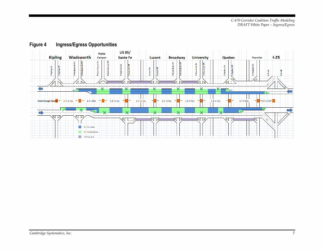
Ingress/Egress Opportunity Locations
Figure 4 shows the potential locations that were identified for ingress/egress points in the corridor segment. The green arrows represent all of the potential opportunities for access. In previous project meetings, this plan was known as Option Orange: Maximum Access. Due to signage and operations, it is not feasible to construct all of these ingress/egress locations together into one plan. However, the locations shown in this drawing were the basis for discussion during the ingress/egress location selection process.
C-470 Corridor Coalition Traffic Modeling DRAFT White Paper – Ingress/Egress
Cambridge Systematics, Inc. 7
Figure 4 Ingress/Egress Opportunities


C-470 Corridor Coalition Traffic Modeling DRAFT White Paper – Ingress/Egress
Cambridge Systematics, Inc. 9
INGRESS/EGRESS ALTERNATIVES Two alternatives were presented to help select the ingress/egress locations. The first is shown in Figure 5, which presents a plan with a moderate level of ingress/egress along the segment. Again, the ingress/egress points are depicted by green arrows. In previous project discussions, this plan was known as Option Apple: Moderate Access. The moderate access option was designed to target the 3-6 mile trip. The benefit of this options is that fewer access points are more likely to result in more efficient traffic operations. The disadvantage is that there are some clear gaps in areas where access should be accommodated—some interchanges and movements are not served. In particular, the eastbound direction has too long of a gap between Broadway and Quebec.

C-470 Corridor Coalition Traffic Modeling DRAFT White Paper – Ingress/Egress
10 Cambridge Systematics, Inc.
Figure 5 Moderate Access Option

C-470 Corridor Coalition Traffic Modeling DRAFT White Paper – Ingress/Egress
Cambridge Systematics, Inc. 11
The second alternative is shown in Figure 6, which presents a plan with separate locations for ingress and egress. Again, the ingress and egress points are depicted by green arrows. In previous project discussions, this plan was known as Option Banana: Ins And Outs. The benefit is that this layout option provides the most simplistic operations with either a sole merge or sole diverge movement and no weaving. This access option has the strongest potential for improving traffic operations, however it limits access even more than the moderate access option.

C-470 Corridor Coalition Traffic Modeling DRAFT White Paper – Ingress/Egress
12 Cambridge Systematics, Inc.
Figure 6 Ins-and-Outs Option

C-470 Corridor Coalition Traffic Modeling DRAFT White Paper – Ingress/Egress
Cambridge Systematics, Inc. 13
MARKET NEEDS During the selection process for ingress/egress locations, the market needs must be considered. DRCOG’s Focus model was used to gauge the demands for the corridor. The average trip lengths for the PM peak period in 2035 was found to be approximately 21 miles for autos and approximately 16 miles for trucks. Notably, about 75% of C-470 traffic start or end the trip east of U.S.-285 and about 75% start or end the trip west of Parker Road.
In the PM peak period, the westbound traffic composition is shown in Figure 7.
Figure 7 Westbound PM Peak Period Traffic Composition
Thru Trips 16%
Local to Kipling/west 29%
I-25 to Local 32%
Local to Local 22%
-
2,000
4,000
6,000
8,000
10,000
12,000
14,000
121 Chatfield 85 Lucent Broadway University Quebec Yosemite I-25
VPH
After Interchange on C-470

C-470 Corridor Coalition Traffic Modeling DRAFT White Paper – Ingress/Egress
14 Cambridge Systematics, Inc.
The eastbound traffic composition is shown in Figure 8.
Figure 8 Eastbound PM Peak Period Traffic Composition
PREFERRED INGRESS/EGRESS ALTERNATIVE During Project Meeting #3 held on March 12, 2013, the Coalition Working Group reviewed the pros and cons of the alternatives, complied with the selection criteria, and considered the market needs to identify the preferred alternative for further analysis. The Working Group decided to blend the desirable pieces of the moderate and ins/outs options to create the preferred alternative shown in Figure 9.
Thru Trips 18%
Local to I-25 39%
Kipling to Local 24%
Local to Local 18%
-
2,000
4,000
6,000
8,000
10,000
12,000
14,000
Kipling 121 85 Lucent Broadway University Quebec Yosemite
VPH
After Interchange on C-470

C-470 Corridor Coalition Traffic Modeling DRAFT White Paper – Ingress/Egress
Cambridge Systematics, Inc. 15
Figure 9 Preferred Ingress/Egress Alternative S
Kip
ling
On
S K
iplin
g O
ff
Luce
nt
On
Luce
nt
Off
S B
roar
dw
ay O
n
S B
roar
dw
ay O
ff
S U
niv
ersi
ty O
n
S U
niv
ersi
ty O
ff
S Q
ueb
ec O
n
S Q
ueb
ec O
ff
S Yo
sem
ite
On
I-25
On
I-25
Off
Interchange Spacing:
EL - No Access
EL - Ingress/Egress
Full Aux Lane
Ram
p L
oca
tio
n
S K
ipli
ng
Off
S K
ipli
ng
On
S W
adsw
ort
h O
ff
S W
adsw
ort
h O
n
W C
har
fie
ld (
WB
)
S Sa
nta
Fe
Off
S Sa
nta
Fe
On
(fl
y)
Luce
nt
Off
Luce
nt
On
S B
roar
dw
ay O
ff
S B
roar
dw
ay O
n
S U
niv
ers
ity
Off
S U
niv
ers
ity
On
S Q
ue
be
c O
ff
S Q
ue
be
c O
n
S Y
ose
mit
e O
ff
I-2
5 O
ff
I-2
5 O
n
Kipling WadsworthPlatte
Canyon
US 85/
Sante Fe Lucent University Quebec Yosemite I-25
Wad
swo
rth
Pla
tte
Can
yon
S Sa
nta
Fe
Off
Broadway
1.4 miles 1.6 miles 1.6 miles 1.5 miles 3.1 miles 1.4 miles 0.6 miles1.4 miles 1.2 miles
Yo
sme
tie
Kip
ling
Wad
swo
rth
San
te F
e
Eric
kso
n
Luce
nt
Bro
adw
ay
Un
ive
rsit
y
Co
lora
do
Qu
eb
ec
Acr
es
Gre
en

C-470 Corridor Coalition Traffic Modeling DRAFT White Paper – Ingress/Egress
16 Cambridge Systematics, Inc.