Embed Size (px)
Citation preview

Dr.-Ing. Saber M. Elsayed: PIANC De Paepe-Willems Award 2019 Page 1 of 15
New Integral Modelling and Analysis Approach for Storm Surge-Induced Barrier Breaching, Coastal Inundation and Subsequent Vertical Saltwater Intrusion
By
Saber M. Elsayed
Division of Hydromechanics and Coastal Engineering,
Leichtweiß Institute for Hydraulic Engineering and Water Resources, TU-Braunschweig, Braunschweig, Germany,
Email: [email protected]
Keywords: Coastal barriers breaching; Coastal inundation; Storm-driven saltwater intrusion; Subsurface drainage.
Abstract
Europe and many other countries are often surrounded by coastal defences (e.g. protective dunes) in order to protect coastal areas from threats of storm surges and flooding. However, during extreme surges, the higher water levels may temporally threaten these defences. As a result, they may be overtopped/breached, inducing hinterland flooding and subsequent vertical saltwater intrusion (VSWI) behind the breached barriers due to the vertical infiltration of inundating seawater into the fresh groundwater.
In this study1, a new integral methodology is developed to reliably assess the possible implications of storm surges on the safety of coastal barriers (CBS) and the implications of possible breaching for flood propagation as well as for accompanied contamination of coastal aquifers due to the VSWI. The modelling methodology consists of an improved XBeach code (Roelvink et al., 2009) weakly coupled with the SEAWAT model (Langevin et al., 2008). XBeach simulates successively breaching of CBS and the subsequent flooding while SEAWAT simulates the VSWI. To achieve reliable modelling of coastal erosion and breaching, some XBeach improvements and extensions are formulated and validated using, among others, unique large-scale dataset for dune erosion. The methodology is then applied to a case study, showing that coastal floods represent a serious threat to coastal aquifers which are extremely important water resources. A flood of a few hours may contaminate coastal aquifers for decades, thus reducing the agricultural yield and hindering the sustainable development in coastal areas. Probably, this is the foremost study that attempts to mitigate storm-induced VSWI through the use and modelling of a subsurface drainage network (SSDN). Besides improving the agricultural yield, the use of an SSDN significantly shortened the natural remediation interval required for aquifers recovery. The multiple flow domains make this study quite relevant for the coastal engineering community, for flood risk managers, for groundwater suppliers as well as for sustainable development planners.
1. Introduction
Natural disasters (e.g. extreme storm surges) and consequences of climate change on coastal areas represent serious threats to safety of coastal defences as well as to coastal groundwater resources. Due to global warming and possible increase of frequency and intensity of coastal storms, many coastal systems may experience accelerated erosion, barrier breaching, flooding and subsequent VSWI into coastal aquifers. Natural CBS as indicated in Fig (1.a) represent an important component of
1 The presented study was conducted within the author's doctoral studies at the Leichtweiß-Institute from June 2014 to August 2017. This article summarizes the main findings of the author’s doctoral dissertation (Elsayed, 2017), which is freely available under https://doi.org/10.24355/dbbs.084-201710161043. The main outcomes of this dissertation are published in three journal papers (Elsayed and Oumeraci, 2018, 2017, 2016). Moreover, they are
discussed in 4 international conferences (the ICCE 2018, the USA; the 5th IAHR Europe congress, Italy; The XBeach X conference, the Netherlands; the INECEP summer school, Mexico). Furthermore, details of this dissertation are available in five technical reports which are also freely available on the author’s page on ResearchGate (https://www.researchgate.net/profile/Saber_Elsayed2)
Dr.-Ing. Saber M. Elsayed: PIANC De Paepe-Willems Award 2019 Page 2 of 15
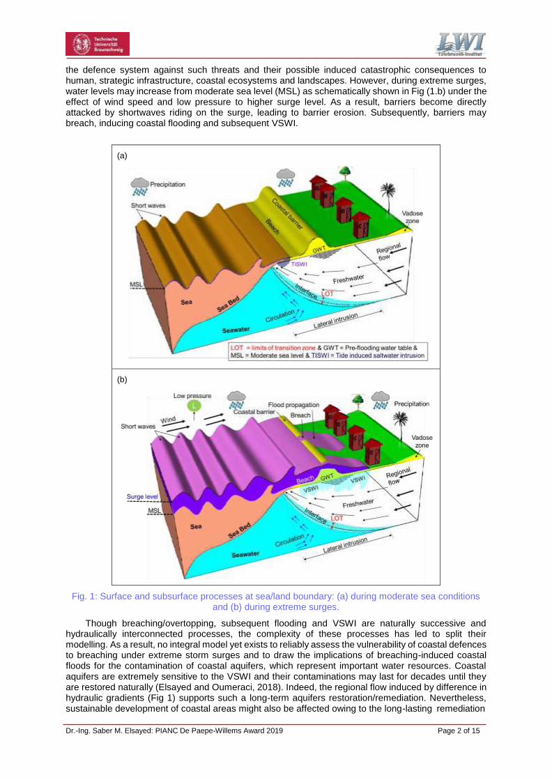
the defence system against such threats and their possible induced catastrophic consequences to human, strategic infrastructure, coastal ecosystems and landscapes. However, during extreme surges, water levels may increase from moderate sea level (MSL) as schematically shown in Fig (1.b) under the effect of wind speed and low pressure to higher surge level. As a result, barriers become directly attacked by shortwaves riding on the surge, leading to barrier erosion. Subsequently, barriers may breach, inducing coastal flooding and subsequent VSWI.
(a)
(b)
Fig. 1: Surface and subsurface processes at sea/land boundary: (a) during moderate sea conditions and (b) during extreme surges.
Though breaching/overtopping, subsequent flooding and VSWI are naturally successive and hydraulically interconnected processes, the complexity of these processes has led to split their modelling. As a result, no integral model yet exists to reliably assess the vulnerability of coastal defences to breaching under extreme storm surges and to draw the implications of breaching-induced coastal floods for the contamination of coastal aquifers, which represent important water resources. Coastal aquifers are extremely sensitive to the VSWI and their contaminations may last for decades until they are restored naturally (Elsayed and Oumeraci, 2018). Indeed, the regional flow induced by difference in hydraulic gradients (Fig 1) supports such a long-term aquifers restoration/remediation. Nevertheless, sustainable development of coastal areas might also be affected owing to the long-lasting remediation
Dr.-Ing. Saber M. Elsayed: PIANC De Paepe-Willems Award 2019 Page 3 of 15
Processes inducing barrier erosion from the seaward side Processes inducing barrier erosion from the landward side
Combined flow
Seepage/ piping
Wave rundown
Shoreward side
Hydrodynamic processes that may
induce a barrier breach initiation
Seaward side
Wave
breaking impact/ collision
Seawater overflow/
inundation
Wave overtopping /overwash
Wave run- up
and the need for more treatment costs. Therefore, there is an urgent need to an integral modelling/prediction tool that can successively and reliably (i) simulate the breaching/overtopping of earthen CBS, (ii) predict the inland discharge and its propagation in the hinterland and (iii) accurately estimate extent of VSWI and related aquifers remediation. Thus, an appropriate mitigation measure might be suggested to mitigate the VSWI and to shorten the natural remediation time. Therefore, the main objectives of this study are (i) to provide an improved understanding of breaching of CBS, induced inundation and subsequent VSWI, (ii) to address the modelling of these processes in an integral and well-validated approach, (iii) to draw the implications of coastal floods for groundwater contamination, and (iv) to examine the suitability and performance of an SSDN as a mitigation measure of the VSWI. To achieve these objectives, a new modelling approach (Elsayed, 2017) is developed. The proposed approach utilises an improved version of the widely used open-source code XBeach (Roelvink et al., 2009) for simulating overtopping/breaching of CBS and subsequent flooding and SEAWAT (Langevin et al., 2008) for simulating the VSWI. The components of the model system are systematically validated with large-scale tests for dune erosion and further diverse data from the literature, and the entire approach is applied to a case study. The rationale behind this model system is discussed below.
2. The XBEACH-SEAWAT model system
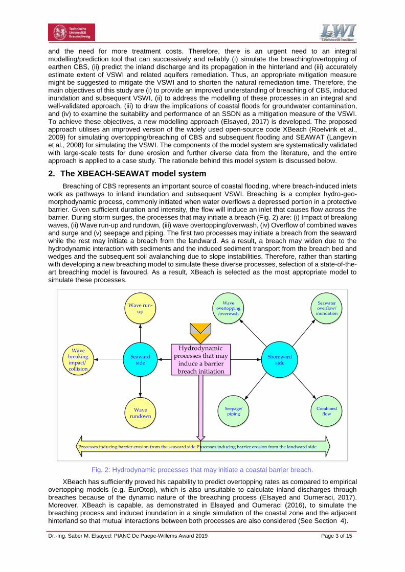
Breaching of CBS represents an important source of coastal flooding, where breach-induced inlets work as pathways to inland inundation and subsequent VSWI. Breaching is a complex hydro-geo- morphodynamic process, commonly initiated when water overflows a depressed portion in a protective barrier. Given sufficient duration and intensity, the flow will induce an inlet that causes flow across the barrier. During storm surges, the processes that may initiate a breach (Fig. 2) are: (i) Impact of breaking waves, (ii) Wave run-up and rundown, (iii) wave overtopping/overwash, (iv) Overflow of combined waves and surge and (v) seepage and piping. The first two processes may initiate a breach from the seaward while the rest may initiate a breach from the landward. As a result, a breach may widen due to the hydrodynamic interaction with sediments and the induced sediment transport from the breach bed and wedges and the subsequent soil avalanching due to slope instabilities. Therefore, rather than starting with developing a new breaching model to simulate these diverse processes, selection of a state-of-the- art breaching model is favoured. As a result, XBeach is selected as the most appropriate model to simulate these processes.
Fig. 2: Hydrodynamic processes that may initiate a coastal barrier breach.
XBeach has sufficiently proved his capability to predict overtopping rates as compared to empirical overtopping models (e.g. EurOtop), which is also unsuitable to calculate inland discharges through breaches because of the dynamic nature of the breaching process (Elsayed and Oumeraci, 2017). Moreover, XBeach is capable, as demonstrated in Elsayed and Oumeraci (2016), to simulate the breaching process and induced inundation in a single simulation of the coastal zone and the adjacent hinterland so that mutual interactions between both processes are also considered (See Section 4).

Dr.-Ing. Saber M. Elsayed: PIANC De Paepe-Willems Award 2019 Page 4 of 15
Thus, XBeach represents currently the most appropriate tool to predict breaching dimensions and inland discharges required to reliably predict extents of inundation and VSWI. Nevertheless, due to its simple groundwater module, XBeach cannot account for subsurface mass transport. Therefore, XBeach is unidirectionally coupled with SEAWAT (Langevin et al., 2008) as a subsurface model, which is capable to simulate fully coupled groundwater flow and solute transport in porous media. Thus, the XBeach- SEAWAT approach represents an integral surface-subsurface model system capable of (i) simulating coastal erosion and breaching as well as the induced inundation and (ii) considering the implications of breaching/overtopping-induced inundation for groundwater contamination and subsequent natural remediation. SEAWAT is selected among other solute transport models (e.g. SUTRA) because it includes a ready to use drainage package that can be adapted to simulate the subsurface drainage as a measure to mitigate the VSWI as elaborated in the following sections.
3. Breaching of CBS: limitations and proposed novel processes
3.1. Assessment of XBeach
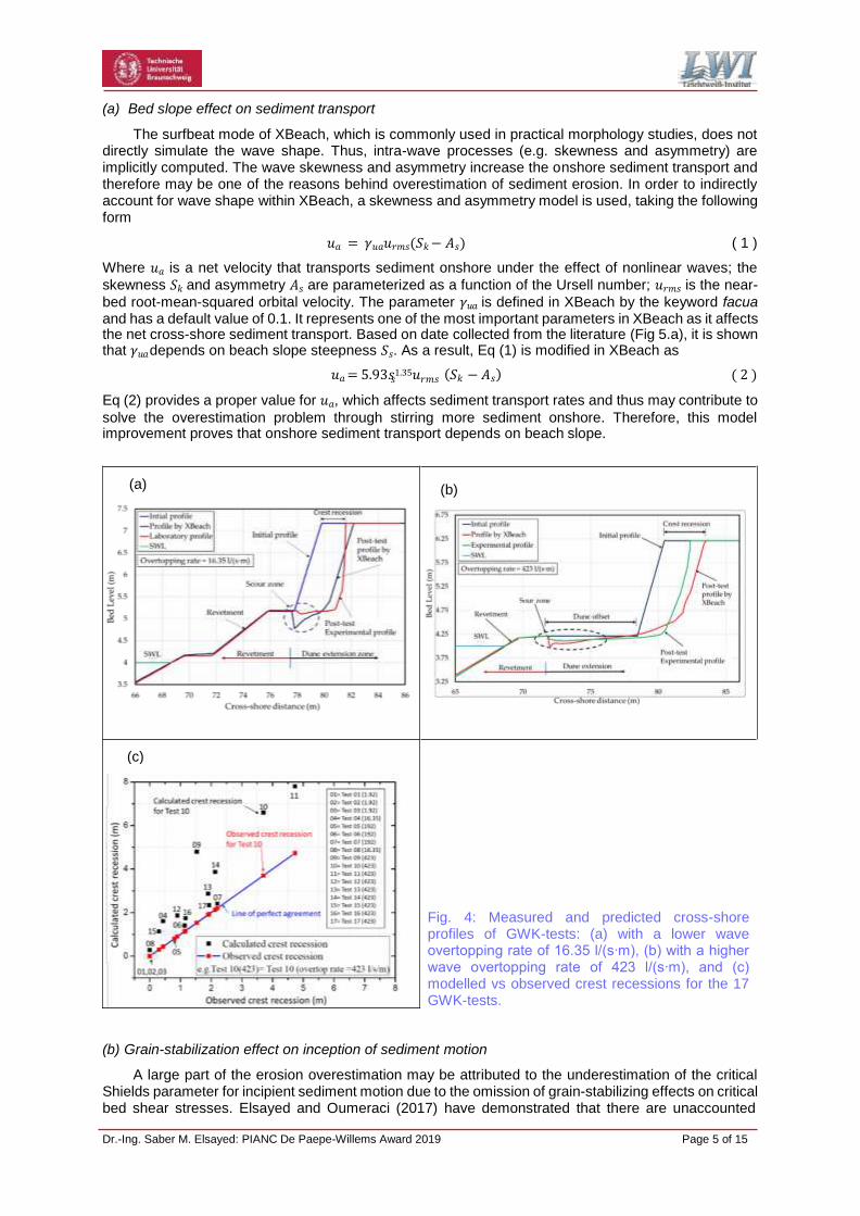
The performance of XBeach is examined using a unique dataset from 17 large-scale tests for dune erosion (hereafter called GWK-tests), which were performed in the large-scale flume (GWK) in Hannover to physically simulate the erosion of the dunes western of Wangerooge Island, northern Germany. GWK- tests were performed on five cross-shore profiles subject to the same wave conditions (significant height of 1.1 m and peak period of 6.6 s) and different still water levels so that a wide range of wave overtopping rates could be achieved. For all profiles, the dune extension with a frontal slope of 1:1 is built behind the revetment with different dune offset (Fig 3).
(a) (b) (c)
Fig. 3: Physical model setup and dune offset in GWK-tests: (a) without offset, (b) with 3.33 m wide offset and (c) with 6.66 m wide offset.
Using a non-modified XBeach (revision 4812), GWK-tests are reproduced. The results (Fig 4) showed a relatively reasonable prediction capability for the scour behind the revetment and the frontal dune erosion, thus illustrating XBeach suitability to simulate coastal erosion. However, the results revealed that the prediction performance got worse for higher overtopping rates (e.g. Fig 4.b for a rate of 423 l/s/m) than for lower wave overtopping rates (e.g. Fig 4.a for a rate of 16.35 l/s/m). This overestimation is verified (Fig 4.c) by comparing the observed and the modelled crest recession for all the 17 GWK-tests.
Both crest recession (Fig 4.c) and scour size behind the revetment crest (e.g. Fig 4.a and 4.b) are overestimated by about 70 % in average. However, the mismatch between observed and calculated profiles vanishes with lower overtopping rates and also with increasing the dune offset. Overcoming/reducing such overestimation represent the primary motivation for implementing further physically-based improvements in XBeach before using it in breaching simulations.
3.2 Improvement of XBeach
Rather than using non-physically based limiters to overcome the erosion overestimation, which is common with XBeach for high flow velocity regimes (e.g. McCall et al., 2010), and in order to improve its prediction capability in terms of erosion and overwash, two physical processes responsible for these overestimations are identified: (i) the wave nonlinearity effect on sediment transport, which is described in XBeach by a calibration factor for the time-averaged flow due to wave skewness and asymmetry and (ii) the considerable excess of the shear stress actually required to initiate the sediment particle motion as compared to that predicted by the common Shields’ criterion for incipient motion. The importance of examining these two processes arises because they are the governing processes of sediment stirring in XBeach. Therefore, the following related improvements are introduced and implemented in XBeach.
Dr.-Ing. Saber M. Elsayed: PIANC De Paepe-Willems Award 2019 Page 5 of 15
𝑠
(c)
Fig. 4: Measured and predicted cross-shore profiles of GWK-tests: (a) with a lower wave overtopping rate of 16.35 l/(s∙m), (b) with a higher wave overtopping rate of 423 l/(s∙m), and (c) modelled vs observed crest recessions for the 17 GWK-tests.
(b) (a)
(a) Bed slope effect on sediment transport
The surfbeat mode of XBeach, which is commonly used in practical morphology studies, does not directly simulate the wave shape. Thus, intra-wave processes (e.g. skewness and asymmetry) are implicitly computed. The wave skewness and asymmetry increase the onshore sediment transport and therefore may be one of the reasons behind overestimation of sediment erosion. In order to indirectly account for wave shape within XBeach, a skewness and asymmetry model is used, taking the following form
𝑢𝑎 = 𝛾𝑢𝑎𝑢𝑟𝑚𝑠(𝑆𝑘 − 𝐴𝑠) ( 1 )
Where 𝑢𝑎 is a net velocity that transports sediment onshore under the effect of nonlinear waves; the
skewness 𝑆𝑘 and asymmetry 𝐴𝑠 are parameterized as a function of the Ursell number; 𝑢𝑟𝑚𝑠 is the near-
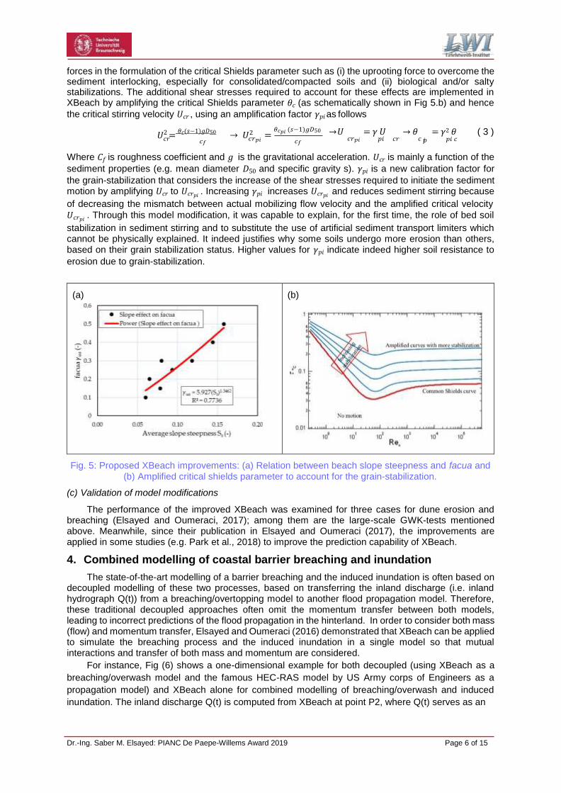
bed root-mean-squared orbital velocity. The parameter 𝛾𝑢𝑎 is defined in XBeach by the keyword facua and has a default value of 0.1. It represents one of the most important parameters in XBeach as it affects the net cross-shore sediment transport. Based on date collected from the literature (Fig 5.a), it is shown that 𝛾𝑢𝑎 depends on beach slope steepness 𝑆𝑠. As a result, Eq (1) is modified in XBeach as
𝑢𝑎 = 5.93𝑠1.35𝑢
𝑟𝑚𝑠 (𝑆𝑘 − 𝐴𝑠) ( 2 )
Eq (2) provides a proper value for 𝑢𝑎, which affects sediment transport rates and thus may contribute to
solve the overestimation problem through stirring more sediment onshore. Therefore, this model improvement proves that onshore sediment transport depends on beach slope.
(b) Grain-stabilization effect on inception of sediment motion
A large part of the erosion overestimation may be attributed to the underestimation of the critical Shields parameter for incipient sediment motion due to the omission of grain-stabilizing effects on critical bed shear stresses. Elsayed and Oumeraci (2017) have demonstrated that there are unaccounted
Dr.-Ing. Saber M. Elsayed: PIANC De Paepe-Willems Award 2019 Page 6 of 15
forces in the formulation of the critical Shields parameter such as (i) the uprooting force to overcome the sediment interlocking, especially for consolidated/compacted soils and (ii) biological and/or salty stabilizations. The additional shear stresses required to account for these effects are implemented in XBeach by amplifying the critical Shields parameter 𝜃𝑐 (as schematically shown in Fig 5.b) and hence
the critical stirring velocity 𝑈𝑐𝑟 , using an amplification factor 𝛾𝑝𝑖 as follows
𝑈2 = 𝜃𝑐(𝑠−1)𝑔𝐷50
→ 𝑈2 = 𝜃𝑐𝑝𝑖 (𝑠−1)𝑔𝐷50
→ 𝑈
= 𝛾 𝑈
→ 𝜃
= 𝛾2 𝜃
( 3 )
𝑐𝑟 𝑐𝑓 𝑐𝑟𝑝𝑖 𝑐𝑓 𝑐𝑟𝑝𝑖 𝑝𝑖 𝑐𝑟 𝑐 𝑝𝑖 𝑝𝑖 𝑐
Where 𝐶𝑓 is roughness coefficient and 𝑔 is the gravitational acceleration. 𝑈𝑐𝑟 is mainly a function of the
sediment properties (e.g. mean diameter 𝐷50 and specific gravity s). 𝛾𝑝𝑖 is a new calibration factor for
the grain-stabilization that considers the increase of the shear stresses required to initiate the sediment motion by amplifying 𝑈𝑐𝑟 to 𝑈𝑐𝑟𝑝𝑖 . Increasing 𝛾𝑝𝑖 increases 𝑈𝑐𝑟𝑝𝑖 and reduces sediment stirring because
of decreasing the mismatch between actual mobilizing flow velocity and the amplified critical velocity
𝑈𝑐𝑟𝑝𝑖 . Through this model modification, it was capable to explain, for the first time, the role of bed soil
stabilization in sediment stirring and to substitute the use of artificial sediment transport limiters which cannot be physically explained. It indeed justifies why some soils undergo more erosion than others, based on their grain stabilization status. Higher values for 𝛾𝑝𝑖 indicate indeed higher soil resistance to
erosion due to grain-stabilization.
(a)
(b)
Fig. 5: Proposed XBeach improvements: (a) Relation between beach slope steepness and facua and (b) Amplified critical shields parameter to account for the grain-stabilization.
(c) Validation of model modifications
The performance of the improved XBeach was examined for three cases for dune erosion and breaching (Elsayed and Oumeraci, 2017); among them are the large-scale GWK-tests mentioned above. Meanwhile, since their publication in Elsayed and Oumeraci (2017), the improvements are applied in some studies (e.g. Park et al., 2018) to improve the prediction capability of XBeach.
4. Combined modelling of coastal barrier breaching and inundation
The state-of-the-art modelling of a barrier breaching and the induced inundation is often based on decoupled modelling of these two processes, based on transferring the inland discharge (i.e. inland hydrograph Q(t)) from a breaching/overtopping model to another flood propagation model. Therefore, these traditional decoupled approaches often omit the momentum transfer between both models, leading to incorrect predictions of the flood propagation in the hinterland. In order to consider both mass (flow) and momentum transfer, Elsayed and Oumeraci (2016) demonstrated that XBeach can be applied to simulate the breaching process and the induced inundation in a single model so that mutual interactions and transfer of both mass and momentum are considered.
For instance, Fig (6) shows a one-dimensional example for both decoupled (using XBeach as a
breaching/overwash model and the famous HEC-RAS model by US Army corps of Engineers as a
propagation model) and XBeach alone for combined modelling of breaching/overwash and induced
inundation. The inland discharge Q(t) is computed from XBeach at point P2, where Q(t) serves as an
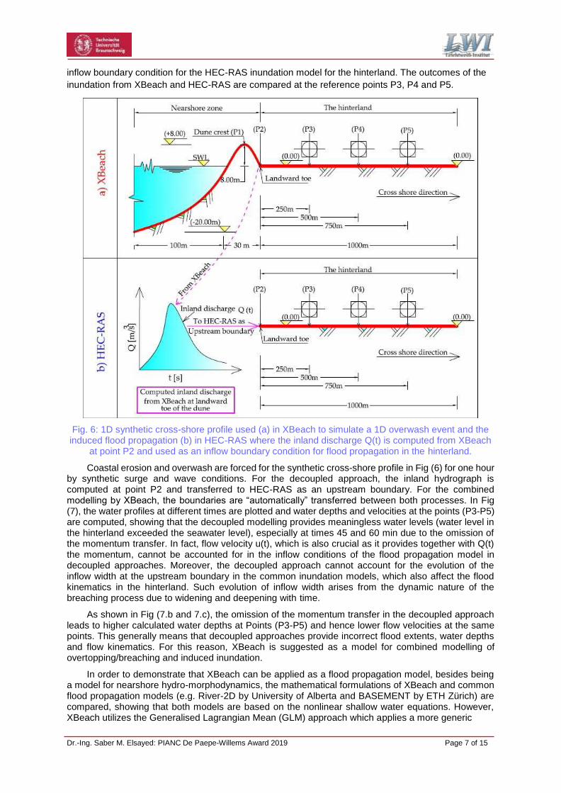
Dr.-Ing. Saber M. Elsayed: PIANC De Paepe-Willems Award 2019 Page 7 of 15
inflow boundary condition for the HEC-RAS inundation model for the hinterland. The outcomes of the
inundation from XBeach and HEC-RAS are compared at the reference points P3, P4 and P5.
Fig. 6: 1D synthetic cross-shore profile used (a) in XBeach to simulate a 1D overwash event and the induced flood propagation (b) in HEC-RAS where the inland discharge Q(t) is computed from XBeach
at point P2 and used as an inflow boundary condition for flood propagation in the hinterland.
Coastal erosion and overwash are forced for the synthetic cross-shore profile in Fig (6) for one hour by synthetic surge and wave conditions. For the decoupled approach, the inland hydrograph is computed at point P2 and transferred to HEC-RAS as an upstream boundary. For the combined modelling by XBeach, the boundaries are “automatically” transferred between both processes. In Fig (7), the water profiles at different times are plotted and water depths and velocities at the points (P3-P5) are computed, showing that the decoupled modelling provides meaningless water levels (water level in the hinterland exceeded the seawater level), especially at times 45 and 60 min due to the omission of the momentum transfer. In fact, flow velocity u(t), which is also crucial as it provides together with Q(t) the momentum, cannot be accounted for in the inflow conditions of the flood propagation model in decoupled approaches. Moreover, the decoupled approach cannot account for the evolution of the inflow width at the upstream boundary in the common inundation models, which also affect the flood kinematics in the hinterland. Such evolution of inflow width arises from the dynamic nature of the breaching process due to widening and deepening with time.
As shown in Fig (7.b and 7.c), the omission of the momentum transfer in the decoupled approach leads to higher calculated water depths at Points (P3-P5) and hence lower flow velocities at the same points. This generally means that decoupled approaches provide incorrect flood extents, water depths and flow kinematics. For this reason, XBeach is suggested as a model for combined modelling of overtopping/breaching and induced inundation.
In order to demonstrate that XBeach can be applied as a flood propagation model, besides being a model for nearshore hydro-morphodynamics, the mathematical formulations of XBeach and common flood propagation models (e.g. River-2D by University of Alberta and BASEMENT by ETH Zürich) are compared, showing that both models are based on the nonlinear shallow water equations. However, XBeach utilizes the Generalised Lagrangian Mean (GLM) approach which applies a more generic

Dr.-Ing. Saber M. Elsayed: PIANC De Paepe-Willems Award 2019 Page 8 of 15
(c) (b)
(a)
representation of the bed shear stresses and the depth-averaged velocities rather than the Eulerian representation that is commonly used in the common propagation models. The GLM approach unambiguously splits a motion into a mean part (Eulerian) and an oscillatory part (Lagrangian), providing a mixed Eulerian–Lagrangian description for the flow field but appointed to fixed Eulerian coordinates. Therefore, GLM applies to any problem, whose governing equations are given in Eulerian form (e.g. common propagation models), with a more thorough representation of the real processes. The latter means that XBeach can also function as a flood propagation model and may, therefore, be applied to simulate, in combination and successively, the breaching/overtopping and induced inundation over a single mesh containing nearshore bathymetry and hinterland topography. As a result, the aforementioned drawbacks of the decoupled approach are overcome.
Fig. 7: Comparison of outcomes using decoupled and combined overwash and inundation modelling.
In order to validate the previously improved XBeach for the combined modelling, it is applied to the Het Zwin breaching and inundation test (Elsayed and Oumeraci, 2016). The outcomes well-illustrated that XBeach is capable to accurately predict breach dimensions and the flow kinematics and depths in the hinterland. The main outcome of this phase is that a well-validated and improved XBeach is now available to provide a reliable assessment of the safety of coastal sand barriers and to reliably predict the flood propagation in coastal areas.
Dr.-Ing. Saber M. Elsayed: PIANC De Paepe-Willems Award 2019 Page 9 of 15
(e) (d)
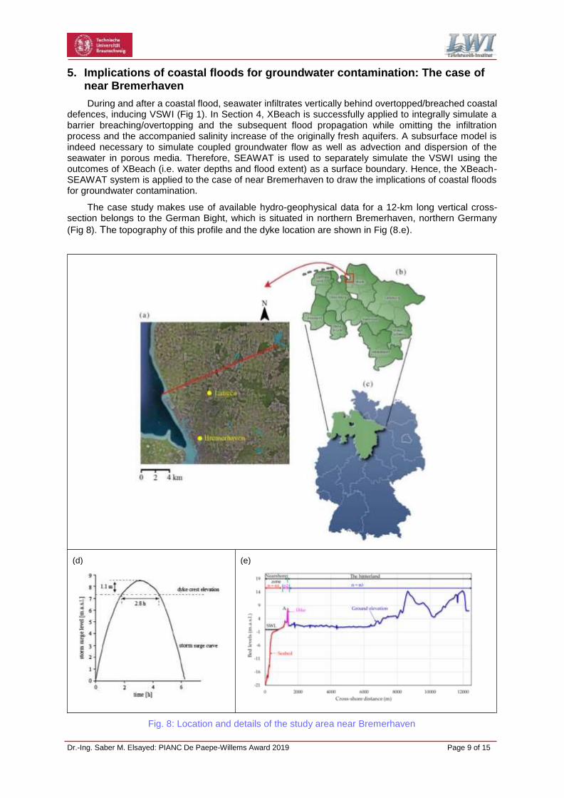
5. Implications of coastal floods for groundwater contamination: The case of near Bremerhaven
During and after a coastal flood, seawater infiltrates vertically behind overtopped/breached coastal defences, inducing VSWI (Fig 1). In Section 4, XBeach is successfully applied to integrally simulate a barrier breaching/overtopping and the subsequent flood propagation while omitting the infiltration process and the accompanied salinity increase of the originally fresh aquifers. A subsurface model is indeed necessary to simulate coupled groundwater flow as well as advection and dispersion of the seawater in porous media. Therefore, SEAWAT is used to separately simulate the VSWI using the outcomes of XBeach (i.e. water depths and flood extent) as a surface boundary. Hence, the XBeach- SEAWAT system is applied to the case of near Bremerhaven to draw the implications of coastal floods for groundwater contamination.
The case study makes use of available hydro-geophysical data for a 12-km long vertical cross- section belongs to the German Bight, which is situated in northern Bremerhaven, northern Germany
(Fig 8). The topography of this profile and the dyke location are shown in Fig (8.e).
Fig. 8: Location and details of the study area near Bremerhaven
Dr.-Ing. Saber M. Elsayed: PIANC De Paepe-Willems Award 2019 Page 10 of 15
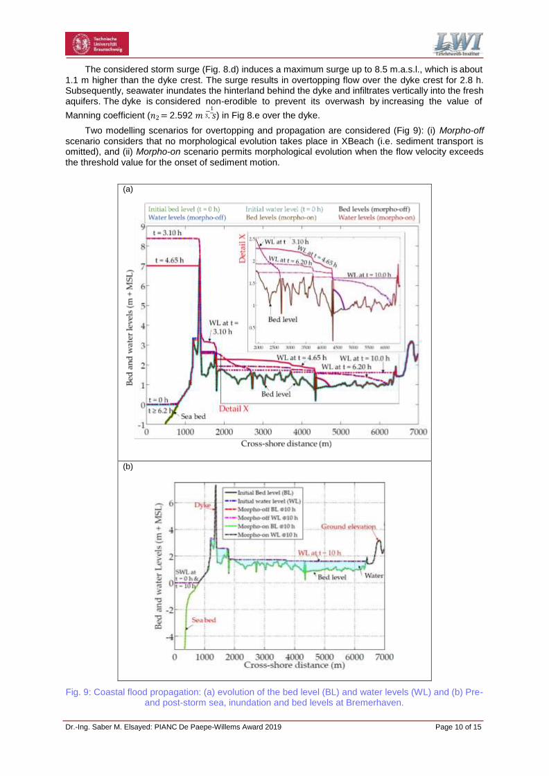
The considered storm surge (Fig. 8.d) induces a maximum surge up to 8.5 m.a.s.l., which is about 1.1 m higher than the dyke crest. The surge results in overtopping flow over the dyke crest for 2.8 h. Subsequently, seawater inundates the hinterland behind the dyke and infiltrates vertically into the fresh aquifers. The dyke is considered non-erodible to prevent its overwash by increasing the value of
−1
Manning coefficient (𝑛2 = 2.592 𝑚 3. 𝑠) in Fig 8.e over the dyke.
Two modelling scenarios for overtopping and propagation are considered (Fig 9): (i) Morpho-off scenario considers that no morphological evolution takes place in XBeach (i.e. sediment transport is omitted), and (ii) Morpho-on scenario permits morphological evolution when the flow velocity exceeds the threshold value for the onset of sediment motion.
(a)
(b)
Fig. 9: Coastal flood propagation: (a) evolution of the bed level (BL) and water levels (WL) and (b) Pre- and post-storm sea, inundation and bed levels at Bremerhaven.

Dr.-Ing. Saber M. Elsayed: PIANC De Paepe-Willems Award 2019 Page 11 of 15
The extremely high Manning value over the dyke zone limits indeed the flow velocity over it to be always (i.e. in both Morpho-on and Morpho-off scenarios) under the threshold value for the onset of sediment motion. As a result, no morphological evolution takes place with both scenarios and hence the inland discharge is identical for both scenarios (= 2196 m3 with a salt concentration of 2500 mg/l). As a result, 54.9 tonnes of salt are supplied to the hinterland and then vertically to the aquifers. Fig (9.a) compares the evolution of the bed and water levels for both simulation scenarios, showing that the flood extents are identically increasing with the time marching until water flow is blocked after 10 hours at a cross-shore distance of 6400 m because of the local increase of the ground elevation. Therefore, the flood extends 5000 m behind the dyke for both simulation scenarios. Fig (9.b) clearly shows the flood extent through comparing the initial (at t = 0 h) and the final (at t = 10 h) bed and water levels for both simulation scenarios.
The flood extent and water depth from Fig 9 are used as a surface boundary to simulate the VSWI using SEAWAT. Elsayed (2017) reported that the overtopped seawater takes 4 days to infiltrate behind the dyke into the aquifer and to induce a disorder of the salt mass budget in the aquifers due to this coastal flood. The flow directions and salt concentrations in the aquifers are shown in Fig (10) after 1 day, 3 months, 1 year and 20 years, where the salt-freshwater interface is represented by the 50% iso- concentration contour, and the iso-concentration contour of 500 mg/l (2%) represents the maximum salt concentration for drinkable water according to the World Health Organization (WHO).
Fig. 10: Salt distribution in Bremerhaven aquifers after 1 day, 3 months, 1 year and 20 years. Arrows represent flow directions.
Dr.-Ing. Saber M. Elsayed: PIANC De Paepe-Willems Award 2019 Page 12 of 15
Before the flood event, only lateral intrusion induced by the hydraulic interconnectivity between sea and groundwater prevails. After flooding, the saltwater infiltrates into the aquifer along the 5-km flood extent and the salt spreads vertically because the infiltrating saltwater is heavier than the prevailing freshwater in the aquifer. Even after 3 months and one year, the salt diffusion is still in the vertical direction. Therefore, saltwater moves vertically beneath the flood extent until it mixes with the fresh water over the entire aquifer depth. Saltwater infiltration deviates seaward under the effect of the regional flow (Fig 1). Such seaward directed flow and infiltrated precipitation generate an effective hydraulic barrier to impede further inland migration of saltwater and provide a downgradient freshwater discharge for saltwater dilution and flushing counteracting the effects of storm surge on the extent of VSWI (as shown by comparing panels of 1 and 20 years in Fig (10)). This dilation process results in a very slow process of natural remediation until the aquifer is remediated totally.
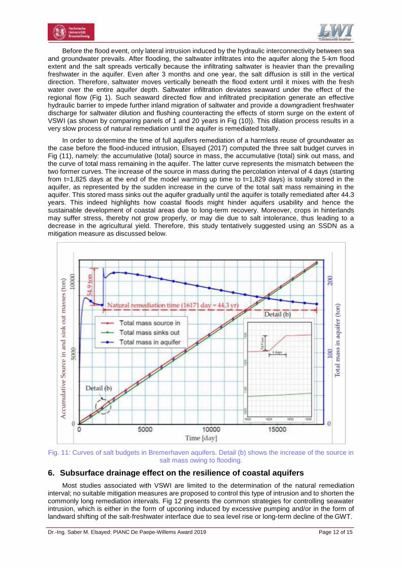
In order to determine the time of full aquifers remediation of a harmless reuse of groundwater as the case before the flood-induced intrusion, Elsayed (2017) computed the three salt budget curves in Fig (11), namely: the accumulative (total) source in mass, the accumulative (total) sink out mass, and the curve of total mass remaining in the aquifer. The latter curve represents the mismatch between the two former curves. The increase of the source in mass during the percolation interval of 4 days (starting from t=1,825 days at the end of the model warming up time to t=1,829 days) is totally stored in the aquifer, as represented by the sudden increase in the curve of the total salt mass remaining in the aquifer. This stored mass sinks out the aquifer gradually until the aquifer is totally remediated after 44.3 years. This indeed highlights how coastal floods might hinder aquifers usability and hence the sustainable development of coastal areas due to long-term recovery. Moreover, crops in hinterlands may suffer stress, thereby not grow properly, or may die due to salt intolerance, thus leading to a decrease in the agricultural yield. Therefore, this study tentatively suggested using an SSDN as a mitigation measure as discussed below.
Fig. 11: Curves of salt budgets in Bremerhaven aquifers. Detail (b) shows the increase of the source in salt mass owing to flooding.
6. Subsurface drainage effect on the resilience of coastal aquifers
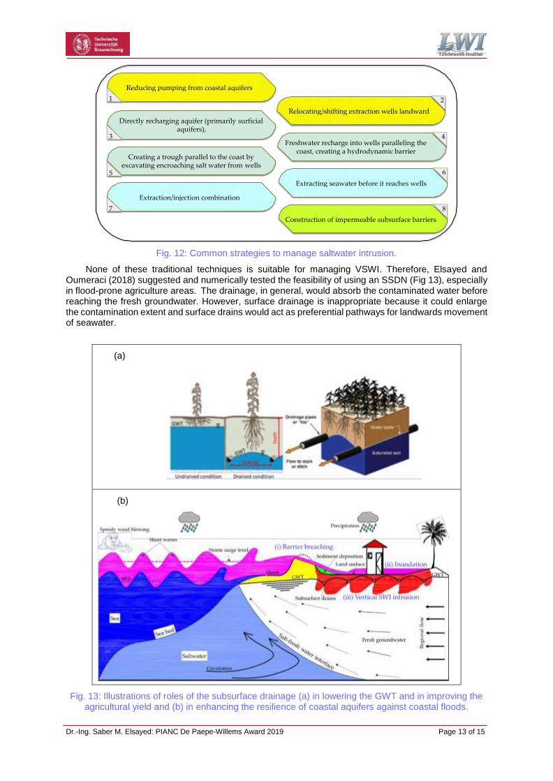
Most studies associated with VSWI are limited to the determination of the natural remediation interval; no suitable mitigation measures are proposed to control this type of intrusion and to shorten the commonly long remediation intervals. Fig 12 presents the common strategies for controlling seawater intrusion, which is either in the form of upconing induced by excessive pumping and/or in the form of landward shifting of the salt-freshwater interface due to sea level rise or long-term decline of the GWT.
Dr.-Ing. Saber M. Elsayed: PIANC De Paepe-Willems Award 2019 Page 13 of 15
Fig. 12: Common strategies to manage saltwater intrusion.
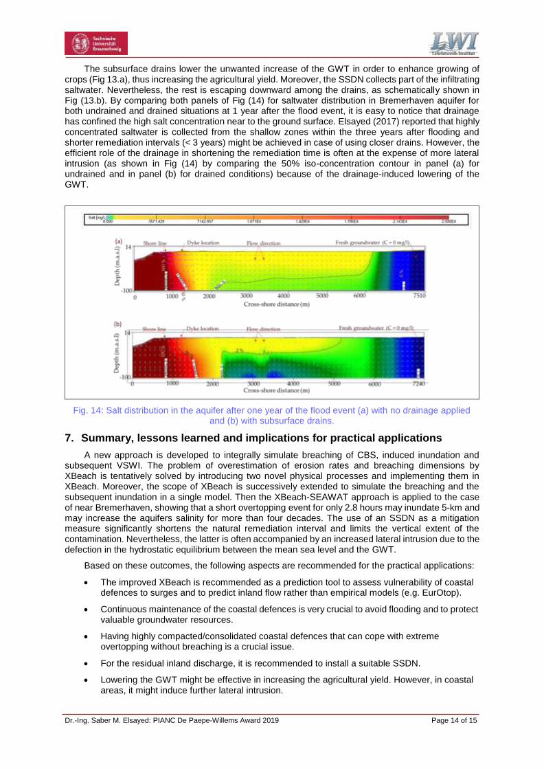
None of these traditional techniques is suitable for managing VSWI. Therefore, Elsayed and Oumeraci (2018) suggested and numerically tested the feasibility of using an SSDN (Fig 13), especially in flood-prone agriculture areas. The drainage, in general, would absorb the contaminated water before reaching the fresh groundwater. However, surface drainage is inappropriate because it could enlarge the contamination extent and surface drains would act as preferential pathways for landwards movement of seawater.
(a)
(b)
Fig. 13: Illustrations of roles of the subsurface drainage (a) in lowering the GWT and in improving the agricultural yield and (b) in enhancing the resilience of coastal aquifers against coastal floods.
Reducing pumping from coastal aquifers
1 2
Relocating/shifting extraction wells landward
Directly recharging aquifer (primarily surficial aquifers),
3 4 Freshwater recharge into wells paralleling the
coast, creating a hydrodynamic barrier Creating a trough parallel to the coast by
excavating encroaching salt water from wells 5 6
Extracting seawater before it reaches wells
Extraction/injection combination
7 8
Construction of impermeable subsurface barriers
Dr.-Ing. Saber M. Elsayed: PIANC De Paepe-Willems Award 2019 Page 14 of 15
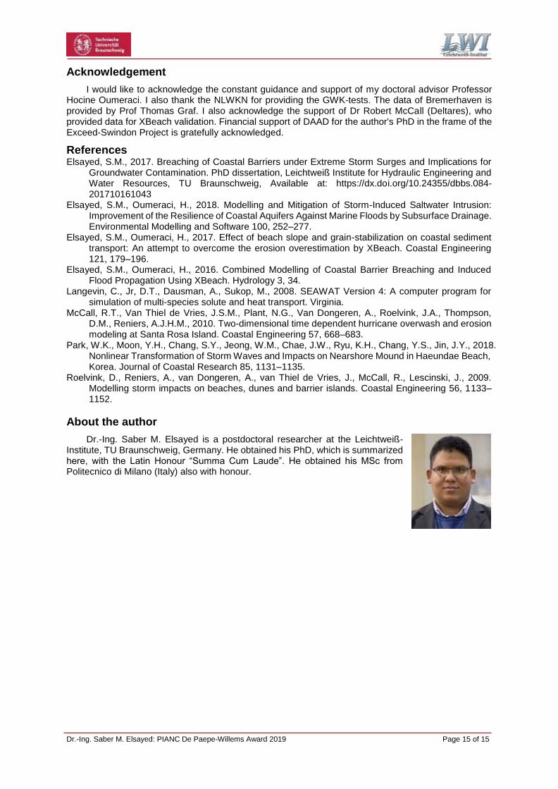
The subsurface drains lower the unwanted increase of the GWT in order to enhance growing of crops (Fig 13.a), thus increasing the agricultural yield. Moreover, the SSDN collects part of the infiltrating saltwater. Nevertheless, the rest is escaping downward among the drains, as schematically shown in Fig (13.b). By comparing both panels of Fig (14) for saltwater distribution in Bremerhaven aquifer for both undrained and drained situations at 1 year after the flood event, it is easy to notice that drainage has confined the high salt concentration near to the ground surface. Elsayed (2017) reported that highly concentrated saltwater is collected from the shallow zones within the three years after flooding and shorter remediation intervals (< 3 years) might be achieved in case of using closer drains. However, the efficient role of the drainage in shortening the remediation time is often at the expense of more lateral intrusion (as shown in Fig (14) by comparing the 50% iso-concentration contour in panel (a) for undrained and in panel (b) for drained conditions) because of the drainage-induced lowering of the GWT.
Fig. 14: Salt distribution in the aquifer after one year of the flood event (a) with no drainage applied and (b) with subsurface drains.
7. Summary, lessons learned and implications for practical applications
A new approach is developed to integrally simulate breaching of CBS, induced inundation and subsequent VSWI. The problem of overestimation of erosion rates and breaching dimensions by XBeach is tentatively solved by introducing two novel physical processes and implementing them in XBeach. Moreover, the scope of XBeach is successively extended to simulate the breaching and the subsequent inundation in a single model. Then the XBeach-SEAWAT approach is applied to the case of near Bremerhaven, showing that a short overtopping event for only 2.8 hours may inundate 5-km and may increase the aquifers salinity for more than four decades. The use of an SSDN as a mitigation measure significantly shortens the natural remediation interval and limits the vertical extent of the contamination. Nevertheless, the latter is often accompanied by an increased lateral intrusion due to the defection in the hydrostatic equilibrium between the mean sea level and the GWT.
Based on these outcomes, the following aspects are recommended for the practical applications:
The improved XBeach is recommended as a prediction tool to assess vulnerability of coastal defences to surges and to predict inland flow rather than empirical models (e.g. EurOtop).
Continuous maintenance of the coastal defences is very crucial to avoid flooding and to protect valuable groundwater resources.
Having highly compacted/consolidated coastal defences that can cope with extreme overtopping without breaching is a crucial issue.
For the residual inland discharge, it is recommended to install a suitable SSDN.
Lowering the GWT might be effective in increasing the agricultural yield. However, in coastal areas, it might induce further lateral intrusion.
Dr.-Ing. Saber M. Elsayed: PIANC De Paepe-Willems Award 2019 Page 15 of 15
Acknowledgement
I would like to acknowledge the constant guidance and support of my doctoral advisor Professor Hocine Oumeraci. I also thank the NLWKN for providing the GWK-tests. The data of Bremerhaven is provided by Prof Thomas Graf. I also acknowledge the support of Dr Robert McCall (Deltares), who provided data for XBeach validation. Financial support of DAAD for the author's PhD in the frame of the Exceed-Swindon Project is gratefully acknowledged.
References Elsayed, S.M., 2017. Breaching of Coastal Barriers under Extreme Storm Surges and Implications for
Groundwater Contamination. PhD dissertation, Leichtweiß Institute for Hydraulic Engineering and Water Resources, TU Braunschweig, Available at: https://dx.doi.org/10.24355/dbbs.084- 201710161043
Elsayed, S.M., Oumeraci, H., 2018. Modelling and Mitigation of Storm-Induced Saltwater Intrusion: Improvement of the Resilience of Coastal Aquifers Against Marine Floods by Subsurface Drainage. Environmental Modelling and Software 100, 252–277.
Elsayed, S.M., Oumeraci, H., 2017. Effect of beach slope and grain-stabilization on coastal sediment transport: An attempt to overcome the erosion overestimation by XBeach. Coastal Engineering 121, 179–196.
Elsayed, S.M., Oumeraci, H., 2016. Combined Modelling of Coastal Barrier Breaching and Induced Flood Propagation Using XBeach. Hydrology 3, 34.
Langevin, C., Jr, D.T., Dausman, A., Sukop, M., 2008. SEAWAT Version 4: A computer program for simulation of multi-species solute and heat transport. Virginia.
McCall, R.T., Van Thiel de Vries, J.S.M., Plant, N.G., Van Dongeren, A., Roelvink, J.A., Thompson, D.M., Reniers, A.J.H.M., 2010. Two-dimensional time dependent hurricane overwash and erosion modeling at Santa Rosa Island. Coastal Engineering 57, 668–683.
Park, W.K., Moon, Y.H., Chang, S.Y., Jeong, W.M., Chae, J.W., Ryu, K.H., Chang, Y.S., Jin, J.Y., 2018. Nonlinear Transformation of Storm Waves and Impacts on Nearshore Mound in Haeundae Beach, Korea. Journal of Coastal Research 85, 1131–1135.
Roelvink, D., Reniers, A., van Dongeren, A., van Thiel de Vries, J., McCall, R., Lescinski, J., 2009. Modelling storm impacts on beaches, dunes and barrier islands. Coastal Engineering 56, 1133– 1152.
About the author
Dr.-Ing. Saber M. Elsayed is a postdoctoral researcher at the Leichtweiß- Institute, TU Braunschweig, Germany. He obtained his PhD, which is summarized here, with the Latin Honour “Summa Cum Laude”. He obtained his MSc from Politecnico di Milano (Italy) also with honour.